Embed Size (px)
Citation preview

Trimble Kestrel SeismoGeodetic System
(Model SG160-09)
SGMonitor Users Guide Version 4.0.1.0
6/15/2015
P/N:97333-00-UG Rev B
This manual provides installation and basic operating procedures for the SGMonitor program.
Trimble Navigation Limited
1600 Tenth Street Suite A Plano, Texas 75074 Tel: 214-440-1265 Support phone: 1-888-879-2207 Email:[email protected] www.trimble.com/infrastructure

Version 4.0.1.0 SGMonitor Users Guide 6/15/2015 P/N:97333-00-UG Rev B
ii Trimble Navigation Limited
Legal Notices
Corporate Office
Trimble Navigation Limited 935 Stewart Drive Sunnyvale CA 94085 USA www.trimble.com
Copyright and Trademarks
© 2014, Trimble Navigation Limited. All rights reserved. Trimble and Globe & Triangle logo are trademarks of Trimble Navigation Limited, registered in the United States and in other countries. iPOD™ touch is a trademark of Apple Inc., registered in the U.S. and other countries. All other trademarks are the property of their respective owners.
Release Notice
This is the 2015.06.15 Revision B of the SGMonitor (97333-00-UG). It applies to version 4.0.1.0 of the Trimble Kestrel System SG160-09. Product warranty information
For applicable product warranty information, please refer to the Warranty Card included with this Trimble product, or consult your Trimble dealer.

Version 4.0.1.0 SGMonitor Users Guide 6/15/2015 P/N:97333-00-UG Rev B
Trimble Navigation Limited iii
Notation Conventions The following notation conventions are used throughout Trimble documentation:
Notation Description
ASCII Indicates the entry conforms to the American Standard Code for Information Interchange definition of character (text) information.
Binary Indicates the entry is a raw, numeric value. Hex Indicates hexadecimal notation. This is used with both ASCII characters (0 – 9, A – F) and
numeric values. BCD Indicates the entry is a numeric value where each four bits represents a decimal digit. FPn Indicates the entry is the ASCII representation of a floating-point number with n places
following the decimal point. <n> Indicates a single 8-bit byte. When the contents are numeric, it indicates a hexadecimal
numeric value; i.e. <84> represents hexadecimal 84 (132 decimal). When the contents are capital letters, it represents a named ASCII control character; i.e. <SP> represents a space character, <CR> represents a carriage return character and <LF> represents a line feed character.
MSB Most Significant Byte of a multi-byte value. MSbit Most Significant Bit of a binary number. LSB Least Significant Byte of a multi-byte value. LSbit Least Significant Bit (bit 0) of a binary number. YYYY Year as a 4-digit number DDD Day of year HH Hour of day in 24-hour format MM Minutes of hour SS Seconds of minute TTT Thousandths of a second (milliseconds) IIII Unit ID number
n, nS nano, nanoSecond; 10-9 = 0.000000001 u, uS micro, microSecond; 10-6 = 0.000001 m, mS milli, milliSecond; 10-3 = 0.001 K, KHz Kilo, KiloHertz; 103 = 1,000 M, MHz Mega, MegaHertz; 106 = 1,000,000 G, GHz Giga, GigaHertz; 109 = 1,000,000,000 Kb, KB Kilobit, KiloByte; 210 = 1,024 Mb, MB Megabit, MegaByte; 220 = 1,048,576 Gb, GB Gigabit, GigaByte; 230 = 1,073,741,824

Version 4.0.1.0 SGMonitor Users Guide 6/15/2015 P/N:97333-00-UG Rev B
iv Trimble Navigation Limited
Software Version:
Current software and documentation is available on our web site. Some early units may require hardware modifications to use the latest software. Contact Trimble if you have any queries on the compatibility of your unit(s) and the current software release.
Portions copyright 1994, 1995, 1996, 1997, 1998, 1999, 2000, 2001,2002 by Cold Spring Harbor Laboratory. Funded under Grant P41-RR02188 by the National Institutes of Health.
Portions copyright 1996, 1997, 1998, 1999, 2000, 2001, 2002 by Boutell.Com, Inc.
Portions relating to GD2 format copyright 1999, 2000, 2001, 2002 Philip Warner.
Portions relating to PNG copyright 1999, 2000, 2001, 2002 Greg Roelofs.
Portions relating to gdttf.c copyright 1999, 2000, 2001, 2002 John Ellson ([email protected]).
Portions relating to gdft.c copyright 2001, 2002 John Ellson ([email protected]).
Portions copyright 2000, 2001, 2002, 2003, 2004, 2005, 2006, 2007, 2008 Pierre-Alain Joye ([email protected]).
Portions relating to JPEG and to color quantization copyright 2000, 2001, 2002, Doug Becker and copyright (C) 1994, 1995, 1996, 1997, 1998, 1999, 2000, 2001, 2002, Thomas G. Lane. This software is based in part on the work of the Independent JPEG Group. See the file README-JPEG.TXT for more information.
Portions relating to WBMP copyright 2000, 2001, 2002 Maurice Szmurlo and Johan Van den Brande
Permission has been granted to copy, distribute and modify gd in any context without fee, including a commercial application, provided that this notice is present in user-accessible supporting documentation.
This does not affect your ownership of the derived work itself, and the intent is to assure proper credit for the authors of gd, not to interfere with your productive use of gd. If you have questions, ask. "Derived works" includes all programs that utilize the library. Credit must be given in user-accessible documentation.
THIS SOFTWARE IS PROVIDED "AS IS." THE COPYRIGHT HOLDERS DISCLAIM ALL WARRANTIES, EITHER EXPRESS OR IMPLIED, INCLUDING BUT NOT LIMITED TO IMPLIED WARRANTIES OF MERCHANTABILITY AND FITNESS FOR A PARTICULAR PURPOSE, WITH RESPECT TO THIS CODE AND ACCOMPANYING DOCUMENTATION.
ALTHOUGH THEIR CODE DOES NOT APPEAR IN GD, THE AUTHORS WISH TO THANK DAVID KOBLAS, DAVID ROWLEY, AND HUTCHISON AVENUE SOFTWARE CORPORATION FOR THEIR PRIOR CONTRIBUTIONS.
About this manual:
This SGMonitor software manual provides a detailed overview of the operations and setup of the SGMonitor program. It covers the following broad operational topics:

Version 4.0.1.0 SGMonitor Users Guide 6/15/2015 P/N:97333-00-UG Rev B
Trimble Navigation Limited v
• SGMonitor (SeismoGeodetic Network Monitor) provides an up-to-date status report of a network of 160 units to the user.
• SGMonitor - Console program that connects to RTPD and requests status from all connected 160’s.
• SGMonitor - Listens for incoming Client connections on a user settable port and acts as an html server on this port.
• SGMonitor - Serves up html pages that can be displayed in any standard web browser.

Version 4.0.1.0 SGMonitor Users Guide 6/15/2015 P/N:97333-00-UG Rev B
vi Trimble Navigation Limited
Contents
1 General Description ................................................................................ 1 SSMonitor Network Monitor ..................................................................................................... 1 1.1
Trimble Kestrel System Requirements ...................................................................................... 1 1.2
2 SGMonitor Configuration for Windows .................................................... 2 Edit the sgmonitor.ini file .......................................................................................................... 2 2.1
Running SGMonitor from a command prompt ........................................................................ 2 2.2
3 SGMonitor for Linux ................................................................................ 3 Edit the sgmonitor.ini file .......................................................................................................... 3 3.1
Running SGMonitor from a command prompt ........................................................................ 3 3.2
4 SGMonitor for Solaris.............................................................................. 4 Edit the sgmonitor.ini file .......................................................................................................... 4 4.1
Running SGMonitor from a command prompt ........................................................................ 4 4.2
5 SGMonitor for MacOS .............................................................................. 5 Edit the sgmonitor.ini file .......................................................................................................... 5 5.1
Running SGMonitor from a command prompt ........................................................................ 5 5.2
6 Editing the sgmonitor.ini file .................................................................. 6 Modifying the sgmonitor.ini file ............................................................................................... 6 6.1
Complete listing of sgmonitor.ini file ....................................................................................... 9 6.2
7 SGMonitor operation ............................................................................. 13 Map View screen ...................................................................................................................... 13 7.1
SGMonitor List screen .............................................................................................................. 14 7.2
List View Status screen ...................................................................................................... 15 7.2.1
Temperature, Power and Backup power Histograms ..................................................... 16 7.2.2
Media Status and Response Intervals Histograms ........................................................... 17 7.2.3
GNSS Status ........................................................................................................................ 18 7.2.4
Settings Screen of SGMonitor.................................................................................................. 19 7.3
Entering limits .................................................................................................................... 20 7.3.1
Setting Station Location .................................................................................................... 21 7.3.2
Entering Map Image parameters ...................................................................................... 22 7.3.3
8 Using High Resolution Maps ................................................................. 23 Getting a High Resolution Map............................................................................................... 23 8.1
900 Meter Resolution Maps .............................................................................................. 23 8.1.1
90 Meter Resolution Maps ................................................................................................ 24 8.1.2
Displaying a High Resolution Map .......................................................................................... 24 8.2
9 Index .................................................................................................... 25
10 Release Notes: Version 4.0.1.0 (June 15, 2015) .................................... 27 SGMONITOR: Modification to Build 32 and 64 bit Platforms .......................................................... 28 SGMONITOR: Modification to Allow Spaces in Directory\Path ........................................................ 28
11 Release Notes Version 0.0.0.4 (April 28, 2015) .................................... 29

Version 4.0.1.0 SGMonitor Users Guide 6/15/2015 P/N:97333-00-UG Rev B
Trimble Navigation Limited vii
1. Initial Release ............................................................................................................................ 29


Version 4.0.1.0 SGMonitor Users Guide 6/15/2015 P/N:97333-00-UG Rev B
Trimble Navigation Limited 1
1 General Description
SSMonitor Network Monitor 1.1SGMonitor (SeismoGeodetic Network Monitor) provides an up-to-date status report of a network of Trimble Kestrel Systems to the user. SGMonitor is a console program that connects to RTPD and requests status from all connected Trimble Kestrel Systems. SGMonitor also listens for incoming Client connections on a user settable port and acts as an html server on this port. SGMonitor serves up html pages that can be displayed in any standard web browser.
SGMonitor provides both a map and list view as well as details for each particular Trimble Kestrel System. Most fields in the SGMonitor List View provide easy to read, Green, Yellow, and Red indicators for quick station status checks. The Green, Yellow, and Red thresholds are editable allowing each user to customize the warning levels to meet their needs.
SGMonitor also maintains a ring buffer on disk for the status of each Trimble Kestrel System. The ring buffer holds at least 3 days worth of status for each DAS. SGMonitor can display this 3 days worth of status as a histogram plot.
Trimble Kestrel System Requirements 1.2SGMonitor supports the following software platforms:
Microsoft™ Windows
Red Hat™ Linux 9.0 or higher
SUN™ Solaris 8 (SPARC) or higher
MacOS X
Note: RTPD should be installed prior to installation of SGMonitor.
Note: The machine that is running SGMonitor must be setup as a “CmndClientIPAddr” in the rtpd.ini file so that SGMonitor has permission to send it’s status requests through RTPD. See the RTPD manual “Configuration options - rtpd.ini file” for more information.
Version 4.0.1.0 SGMonitor Users Guide 6/15/2015 P/N:97333-00-UG Rev B
2 Trimble Navigation Limited
2 SGMonitor Configuration for Windows
Edit the sgmonitor.ini file 2.1Before execution of the SGMonitor program, the sgmonitor.ini file MUST be modified with an editor.
Most of the settings in the sgmonitor.ini file are already set to acceptable default settings except for Step 2 (RTPD IP address).
For complete instructions, see Section 6.
Running SGMonitor from a command prompt 2.2To run SGMonitor from a command prompt:
1. Open a command window in the c:/reftek/bin directory.
2. At the command line type sgmonitor sgmonitor.ini and <CR>.
3. Minimize the command prompt.
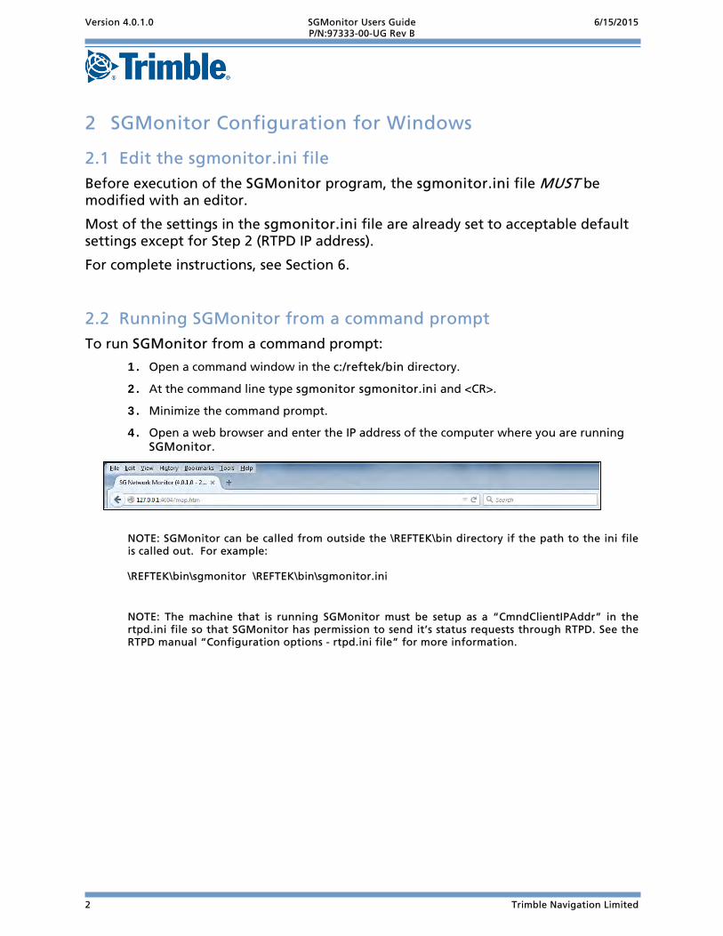
4. Open a web browser and enter the IP address of the computer where you are running SGMonitor.
NOTE: SGMonitor can be called from outside the \REFTEK\bin directory if the path to the ini file is called out. For example: \REFTEK\bin\sgmonitor \REFTEK\bin\sgmonitor.ini
NOTE: The machine that is running SGMonitor must be setup as a “CmndClientIPAddr” in the rtpd.ini file so that SGMonitor has permission to send it’s status requests through RTPD. See the RTPD manual “Configuration options - rtpd.ini file” for more information.

Version 4.0.1.0 SGMonitor Users Guide 6/15/2015 P/N:97333-00-UG Rev B
Trimble Navigation Limited 3
3 SGMonitor for Linux
Edit the sgmonitor.ini file 3.1Before execution of the SGMonitor program, the sgmonitor.ini file MUST be modified with an editor.
Most of the settings in the sgmonitor.ini file are already set to acceptable default settings except for Step 2 (RTPD IP address).
For complete instructions, see Section 6.
Running SGMonitor from a command prompt 3.2To run SGMonitor from a command prompt:
1. Open a terminal window in the /home/reftek/bin directory.
2. At the command line type ./sgmonitor sgmonitor.ini and <CR>.
3. Minimize the command prompt.
4. Open a web browser and enter the IP address of the computer where your running SGMonitor.
NOTE: SGMonitor can be called from outside the /home/reftek/bin directory if the path to the ini file is called out. IE /home/reftek/bin/sgmonitor /home/reftek/bin/sgmonitor.ini
NOTE: The machine that is running SGMonitor must be setup as a “CmndClientIPAddr” in the rtpd.ini file so that SGMonitor has permission to send it’s status requests through RTPD. See the RTPD manual “Configuration options - rtpd.ini file” for more information.

Version 4.0.1.0 SGMonitor Users Guide 6/15/2015 P/N:97333-00-UG Rev B
4 Trimble Navigation Limited
4 SGMonitor for Solaris
Edit the sgmonitor.ini file 4.1Before execution of the SGMonitor program, the sgmonitor.ini file MUST be modified with an editor.
Most of the settings in the sgmonitor.ini file are already set to acceptable default settings except for Step 2 (RTPD IP address).
For complete instructions, see Section 6.
Running SGMonitor from a command prompt 4.2To run SGMonitor from a command prompt:
1. Open a terminal window in the /export/home/reftek/bin directory.
2. At the command line type ./sgmonitor sgmonitor.ini and <CR>.
3. Minimize the command prompt.
4. Open a web browser and enter the IP address of the computer where your running SGMonitor.
NOTE: SGMonitor can be called from outside the /export/home/reftek/bin directory if the path to the ini file is called out. IE /export/home/reftek/bin /export/home/reftek/bin/sgmonitor.ini
NOTE: The machine that is running SGMonitor must be setup as a “CmndClientIPAddr” in the rtpd.ini file so that SGMonitor has permission to send it’s status requests through RTPD. See the RTPD manual “Configuration options - rtpd.ini file” for more information.

Version 4.0.1.0 SGMonitor Users Guide 6/15/2015 P/N:97333-00-UG Rev B
Trimble Navigation Limited 5
5 SGMonitor for MacOS
Edit the sgmonitor.ini file 5.1Before execution of the SGMonitor program, the sgmonitor.ini file MUST be modified with an editor.
Most of the settings in the sgmonitor.ini file are already set to acceptable default settings except for Step 2 (RTPD IP address).
For complete instructions, see Section 6.
Running SGMonitor from a command prompt 5.2To run SGMonitor from a command prompt:
1. Open a terminal window in the /Users/reftek/bin directory.
2. At the command line type ./sgmonitor sgmonitor.ini and <CR>.
3. Minimize the command prompt.
4. Open a web browser and enter the IP address of the computer where your running SGMonitor.
NOTE: SGMonitor can be called from outside the /Users/reftek/bin directory if the path to the ini file is called out. IE /Users/reftek/bin/sgmonitor /Users/reftek/bin/sgmonitor.ini
NOTE: The machine that is running SGMonitor must be setup as a “CmndClientIPAddr” in the rtpd.ini file so that SGMonitor has permission to send it’s status requests through RTPD. See the RTPD manual “Configuration options - rtpd.ini file” for more information.

Version 4.0.1.0 SGMonitor Users Guide 6/15/2015 P/N:97333-00-UG Rev B
6 Trimble Navigation Limited
6 Editing the sgmonitor.ini file The user MUST edit the sgmonitor.ini file before running SGMonitor. A few values in the file are different depending on platform, but most values are the same for all platforms.
For an example sgmonitor.ini file, see section 6.2.
Modifying the sgmonitor.ini file 6.1To configure the sgmonitor.ini file:
1. Open the sgmonitor.ini file in a text editor (such as notepad or vi). WARNING: The command text is case sensitive within the .ini file.
2. Find the following line and change the IP address to that of the machine running RTPD.
SGmonitor.RtpdIP= 69.15.146.174
3. Check the port number on which RTPD is listening for Client connections. This is almost
always left as the default 2543.
SGmonitor.RtpdPort= 2543
4. If necessary, change the SGMonitor port for html pages. This is the port on which SGMonitor will listen for client connections, and serve up html pages. This port should be a free port on the machine running SGMonitor. Usually port 4000 is a good choice.
SGmonitor.HttpPort= 4000
5. Set the maximum number of allowed web client connections to SGMonitor at one time.
SGmonitor.MaxHttpClients= 30
6. Certain SGMonitor settings can be changed through the browser. These include all the
Green, Yellow, Red alarm settings and the station locations, as well as all the Map View settings.
In order for a Web Client to be able to change any of these settings, add the clients IP address to the following list. As many clients as necessary can be listed. Note: Any web client is allowed to connect to SGMonitor and view the settings screen, but if they are not in the following list then the screen will be in READ ONLY mode.
SGmonitor.IPSettings= 127.0.0.1
Version 4.0.1.0 SGMonitor Users Guide 6/15/2015 P/N:97333-00-UG Rev B
Trimble Navigation Limited 7
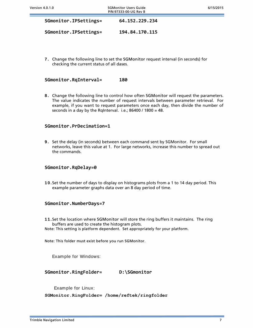
SGmonitor.IPSettings= 64.152.229.234
SGmonitor.IPSettings= 194.84.170.115
7. Change the following line to set the SGMonitor request interval (in seconds) for
checking the current status of all dases.
SGmonitor.RqInterval= 180
8. Change the following line to control how often SGMonitor will request the parameters. The value indicates the number of request intervals between parameter retrieval. For example, if you want to request parameters once each day, then divide the number of seconds in a day by the RqInterval. i.e.; 86400 / 1800 = 48.
SGmonitor.PrDecimation=1
9. Set the delay (in seconds) between each command sent by SGMonitor. For small networks, leave this value at 1. For large networks, increase this number to spread out the commands.
SGmonitor.RqDelay=0
10. Set the number of days to display on histograms plots from a 1 to 14 day period. This example parameter graphs data over an 8 day period of time.
SGmonitor.NumberDays=7
11. Set the location where SGMonitor will store the ring buffers it maintains. The ring buffers are used to create the histogram plots.
Note: This setting is platform dependent. Set appropriately for your platform.
Note: This folder must exist before you run SGMonitor.
Example for Windows:
SGmonitor.RingFolder= D:\SGmonitor
Example for Linux: SGMonitor.RingFolder= /home/reftek/ringfolder
Version 4.0.1.0 SGMonitor Users Guide 6/15/2015 P/N:97333-00-UG Rev B
8 Trimble Navigation Limited
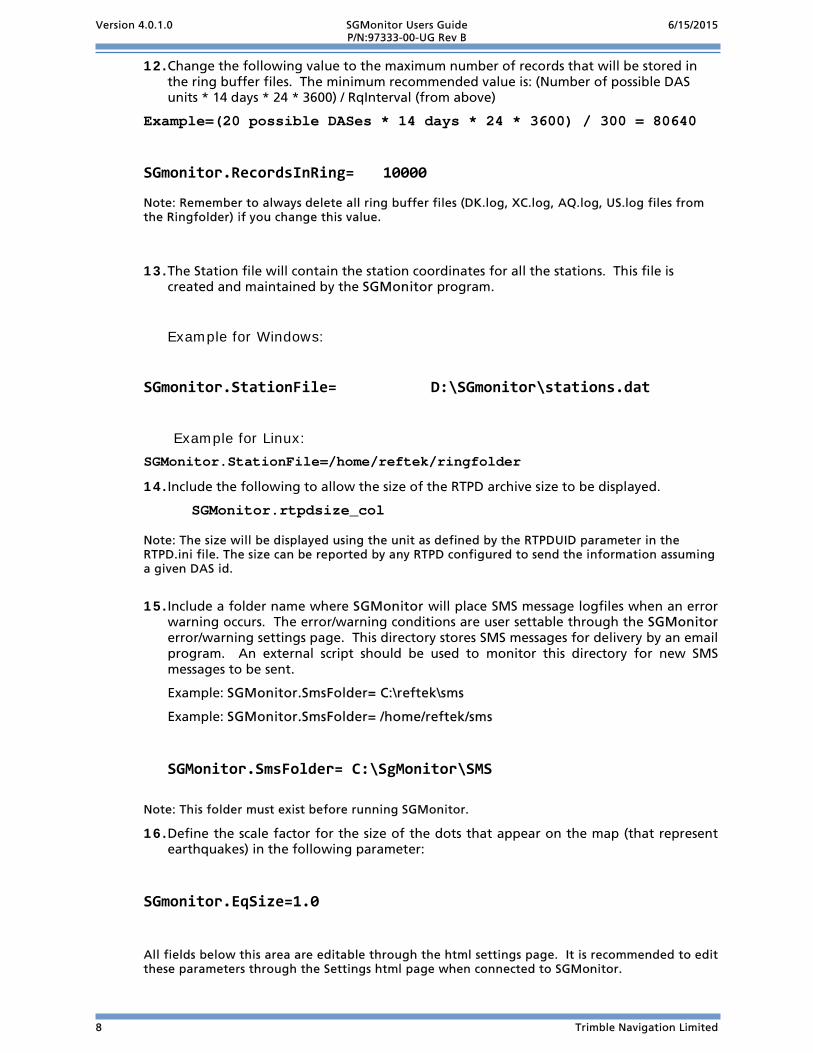
12. Change the following value to the maximum number of records that will be stored in the ring buffer files. The minimum recommended value is: (Number of possible DAS units * 14 days * 24 * 3600) / RqInterval (from above)
Example=(20 possible DASes * 14 days * 24 * 3600) / 300 = 80640
SGmonitor.RecordsInRing= 10000
Note: Remember to always delete all ring buffer files (DK.log, XC.log, AQ.log, US.log files from the Ringfolder) if you change this value.
13. The Station file will contain the station coordinates for all the stations. This file is created and maintained by the SGMonitor program.
Example for Windows:
SGmonitor.StationFile= D:\SGmonitor\stations.dat
Example for Linux: SGMonitor.StationFile=/home/reftek/ringfolder
14. Include the following to allow the size of the RTPD archive size to be displayed.
SGMonitor.rtpdsize_col Note: The size will be displayed using the unit as defined by the RTPDUID parameter in the RTPD.ini file. The size can be reported by any RTPD configured to send the information assuming a given DAS id.
15. Include a folder name where SGMonitor will place SMS message logfiles when an error warning occurs. The error/warning conditions are user settable through the SGMonitor error/warning settings page. This directory stores SMS messages for delivery by an email program. An external script should be used to monitor this directory for new SMS messages to be sent.
Example: SGMonitor.SmsFolder= C:\reftek\sms
Example: SGMonitor.SmsFolder= /home/reftek/sms
SGMonitor.SmsFolder= C:\SgMonitor\SMS Note: This folder must exist before running SGMonitor.
16. Define the scale factor for the size of the dots that appear on the map (that represent earthquakes) in the following parameter:
SGmonitor.EqSize=1.0 All fields below this area are editable through the html settings page. It is recommended to edit these parameters through the Settings html page when connected to SGMonitor.

Version 4.0.1.0 SGMonitor Users Guide 6/15/2015 P/N:97333-00-UG Rev B
Trimble Navigation Limited 9
Complete listing of sgmonitor.ini file 6.2#
#Ini file is case sensitive & parameter name should start from
#first character in the line, '=' character should present!!!!
#
#_________________________________________________________________________
#
#IP number of running RTPD
#
#SGmonitor.RtpdIP= 127.0.0.1
SGmonitor.RtpdIP= 69.15.146.174
#SGmonitor.RtpdIP= 72.54.154.54
#_________________________________________________________________________
#Antenne.ini lookup file
SGmonitor.AntennaIni=C:\SHARE\R2014\SGMONITOR-0.0.0.3\antenna.ini
#_________________________________________________________________________
#
#Port number of running RTPD
#
SGmonitor.RtpdPort= 2543
SGmonitor.Pmask= 20000 #HEX packet Mask
SGmonitor.Smask= 0000 #HEX stream Mask ex. stream=3 Mask=0004!!
#_________________________________________________________________________
#
#Port for web clients connections to SGmonitor
#
SGmonitor.HttpPort= 4000
#_________________________________________________________________________
#Maximum number of web clients connections to SGmonitor
#
SGmonitor.MaxHttpClients= 30
#_________________________________________________________________________
#
#IPs of clients who can change settings on the fly
#all other clients will have the same screen but in read only mode!!!
#
SGmonitor.IPSettings= 127.0.0.1

Version 4.0.1.0 SGMonitor Users Guide 6/15/2015 P/N:97333-00-UG Rev B
10 Trimble Navigation Limited
SGmonitor.IPSettings= 64.152.229.234
SGmonitor.IPSettings= 194.84.170.115 #_________________________________________________________________________
#
#Request interval in seconds for checking current status of all dases
#
SGmonitor.RqInterval= 180 #_________________________________________________________________________
#
#Folder with ring buffers for plots
#!!!! This Folder Must exists before you run SGmonitor!!!!
#
SGmonitor.RingFolder= D:\SGmonitor #_________________________________________________________________________
#
#Number of days for Plots
#
SGmonitor.NumberDays=7 #_________________________________________________________________________
#
#Number of records in ring Buffers,
#recommended value = (Number of possible dases * NumberDays*24*3600)/RqInterval
#!!!! always delete all ring buffers (DK.log,XC.log,AQ.log,US.log)
#if you change this value
#
SGmonitor.RecordsInRing= 10000 #_________________________________________________________________________
#
#file which contains station coordinates
#(!!!!at least the folder must exists!!!)
#
SGmonitor.StationFile= D:\SGmonitor\stations.dat #_________________________________________________________________________
#
#Map image parameters delimited by comma without spaces:
#HorisontalImageSize(pixels),VerticalImageSize(pixels),
#Central Latitude of Image(degrees),Central Longitude of Image(degrees),
#Map Scale(Number of kilometers in one pixel),
Version 4.0.1.0 SGMonitor Users Guide 6/15/2015 P/N:97333-00-UG Rev B
Trimble Navigation Limited 11
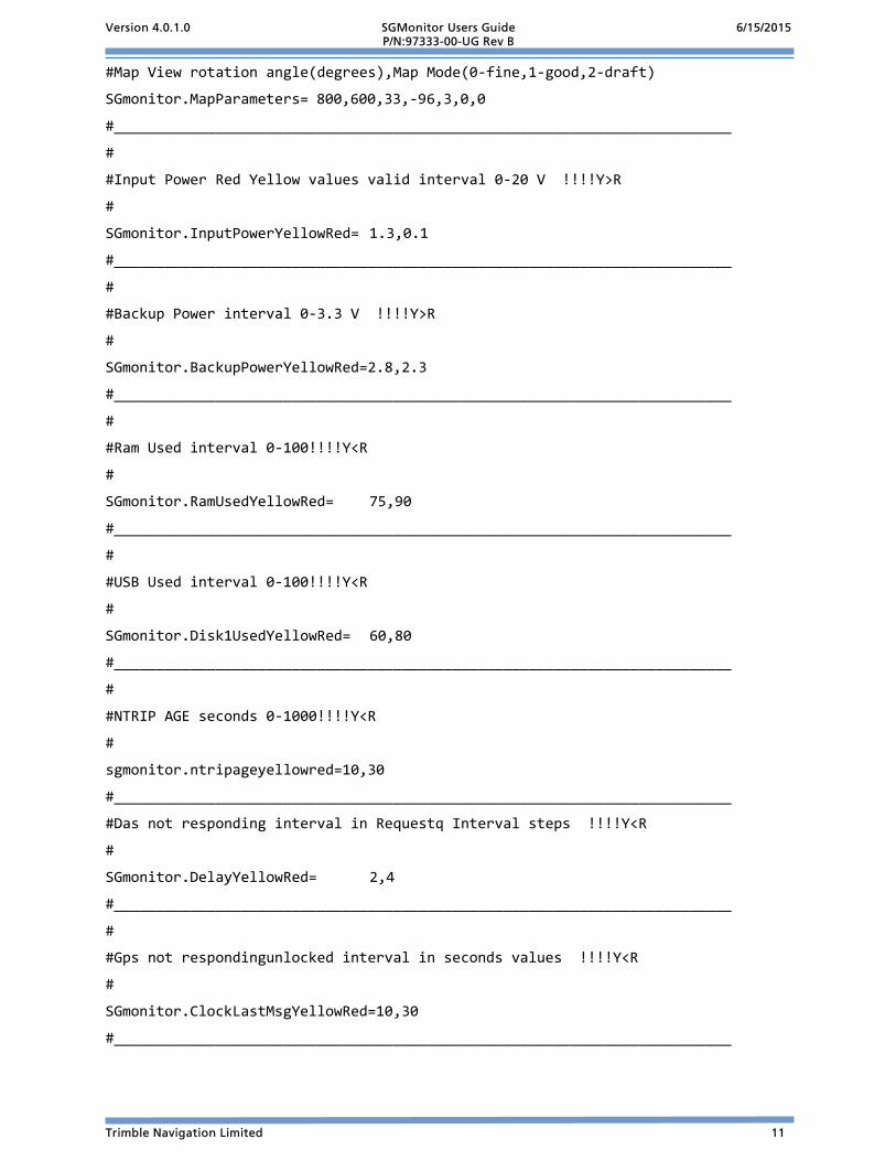
#Map View rotation angle(degrees),Map Mode(0-fine,1-good,2-draft)
SGmonitor.MapParameters= 800,600,33,-96,3,0,0
#_________________________________________________________________________
#
#Input Power Red Yellow values valid interval 0-20 V !!!!Y>R
#
SGmonitor.InputPowerYellowRed= 1.3,0.1
#_________________________________________________________________________
#
#Backup Power interval 0-3.3 V !!!!Y>R
#
SGmonitor.BackupPowerYellowRed=2.8,2.3
#_________________________________________________________________________
#
#Ram Used interval 0-100!!!!Y<R
#
SGmonitor.RamUsedYellowRed= 75,90
#_________________________________________________________________________
#
#USB Used interval 0-100!!!!Y<R
#
SGmonitor.Disk1UsedYellowRed= 60,80
#_________________________________________________________________________
#
#NTRIP AGE seconds 0-1000!!!!Y<R
#
sgmonitor.ntripageyellowred=10,30
#_________________________________________________________________________
#Das not responding interval in Requestq Interval steps !!!!Y<R
#
SGmonitor.DelayYellowRed= 2,4
#_________________________________________________________________________
#
#Gps not respondingunlocked interval in seconds values !!!!Y<R
#
SGmonitor.ClockLastMsgYellowRed=10,30
#_________________________________________________________________________

Version 4.0.1.0 SGMonitor Users Guide 6/15/2015 P/N:97333-00-UG Rev B
12 Trimble Navigation Limited
#
#Clock error - difference between das location in station file
#& average location from gps in meters !!!!Y<R
SGmonitor.LocationYellowRed= 100,200
#_________________________________________________________________________
#Starting html page 0-MapView 1-ListView
SGmonitor.DefaultPage=1
#_________________________________________________________________________
#The name of script to generate earthquake.dat file for earthquake plot
SGmonitor.EqScript=generate_eqdat.bat
#Event circle scaling
SGmonitor.EqSize= 1.0 #_________________________________________________________________________
#seconds delay between sending each request to RTPD
SGmonitor.RqDelay= 0 #interval of sending Parameter Requests will be =PrDecimation*RqInterval
SGmonitor.PrDecimation= 1 #_________________________________________________________________________
#Folder for Sms Log files
#!!!! This Folder Must exists before Yor run rtpmonitor!!!!
SGMonitor.SmsFolder= C:\SgMonitor\SMS #_________________________________________________________________________
#Sms Activity Flags ; eight bits 0 or 1
#InputPower,BackupPower,Delay,Ram,Disk1,NtripAge,LastClockMsg,Location
SGMonitor.SmsAction=00000000
#_________________________________________________________________________

Version 4.0.1.0 SGMonitor Users Guide 6/15/2015 P/N:97333-00-UG Rev B
Trimble Navigation Limited 13
7 SGMonitor operation
Map View screen 7.1The SGMonitor map screen displays a map of unit locations on a map and their current status (Red, Green, and Yellow).
1. To check the status of an individual Trimble Kestrel System, select the List button..
Switch to List View
Change to Settings Page

Version 4.0.1.0 SGMonitor Users Guide 6/15/2015 P/N:97333-00-UG Rev B
14 Trimble Navigation Limited
SGMonitor List screen 7.2The SGMonitor List screen shows the status summary of each Trimble Kestrel System. By selecting the bold letters in each status column it is possible to select and view a histogram for each particular status. The histogram includes the user-specified number of worth of status for a particular Trimble Kestrel System.
Map View
Settings Temperature and power links
Unit status display
Response Delay
Media Status
Sat. Vehicle
GNSS
RTP Status
NTRIP AGE

Version 4.0.1.0 SGMonitor Users Guide 6/15/2015 P/N:97333-00-UG Rev B
Trimble Navigation Limited 15
List View Status screen 7.2.1
The Unit Status screen shows an updated status report of settings for individual Trimble Kestrel System units. Tap within the Unit ID area to select a Trimble Kestrel System.
Open a window showing the updated status:
Select Unit

Version 4.0.1.0 SGMonitor Users Guide 6/15/2015 P/N:97333-00-UG Rev B
16 Trimble Navigation Limited
Temperature, Power and Backup power Histograms 7.2.2
This Trimble Kestrel System status screen displays views showing Backup power level (Volts), Temperature (C°) and Input power (Volts) to the Trimble Kestrel System over a time period (in hours).
Select within the power area to open the views.

Version 4.0.1.0 SGMonitor Users Guide 6/15/2015 P/N:97333-00-UG Rev B
Trimble Navigation Limited 17
Media Status and Response Intervals Histograms 7.2.3
The media status displays shows the response interval (in seconds), amount of RAM used (as a % of total), and amount of USB space used over a 72 hour time period.
Select within the RAM area to open the media status displays.
Version 4.0.1.0 SGMonitor Users Guide 6/15/2015 P/N:97333-00-UG Rev B
18 Trimble Navigation Limited
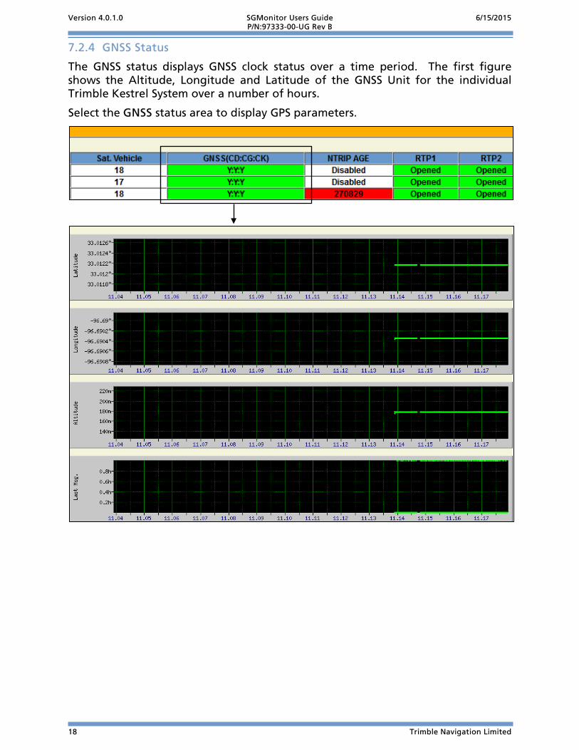
GNSS Status 7.2.4
The GNSS status displays GNSS clock status over a time period. The first figure shows the Altitude, Longitude and Latitude of the GNSS Unit for the individual Trimble Kestrel System over a number of hours.
Select the GNSS status area to display GPS parameters.

Version 4.0.1.0 SGMonitor Users Guide 6/15/2015 P/N:97333-00-UG Rev B
Trimble Navigation Limited 19
Settings Screen of SGMonitor 7.3The Settings Screen allows the user to set the Green, Yellow, and Red limits to use. Also provided are map image parameters settings to adjust the SGMonitor Map View display.
To Set the Alarms from the Map View, List View, or Unit displays
1. Click on the Settings button in the upper-left hand corner of the web browser window.
The top section of the settings screen is known as the Alarm settings section. These settings control when the SGMonitor program will change each Trimble Kestrel System status indicator between Green, Yellow, and Red.
Key Field Alarm Settings Description
1 SMS Log If checked SMS messages are generated for the checked parameter and placed in a directory for delivery when the specified level occurs.
2 Yellow The point at which SGMonitor will change its color indicator from Green to Yellow. Note the column on the far right is the unit column which also provides the acceptable value ranges for each parameter.
3 Red The point at which SGMonitor will change its color indicator from Yellow to Red. 4 Input Voltage When the Trimble Kestrel System value falls below these values the status
indicator color is changed. 5 Backup Voltage When the Trimble Kestrel System value falls below these values the status
indicator color is changed. 6 Delay (N) When the Trimble Kestrel System does not respond for N times the request
interval (seconds) the status indicator color is changed. 7 RAM Used When the Trimble Kestrel System value rises above these values (0-100% integer)
the status indicator color is changed. 8 USB Used When the Trimble Kestrel System value rises above these values (0-100% integer)
the status indicator color is changed. 9 NTRIP Age When the Trimble Kestrel System value rises above these values (0-100% integer)
the status indicator color is changed. 10 Reference Clock
Last Message When the Trimble Kestrel System time since last GPS lock rises above these values the status indicator color is changed (Specified in hours, with 1 decimal place of resolution).
11 Location Error When the Trimble Kestrel System units reported GPS position error rises above these values the status indictor color is changed (0-1000 Meters). As compared to the value stored in the Station Locations list below.
Note: These values will only be saved to the .ini file if the computer you are using is listed in the .ini as having permission to change these values. See the example ini file in each installation section.
1
2 4
5 6
7 8
9 10
11
3

Version 4.0.1.0 SGMonitor Users Guide 6/15/2015 P/N:97333-00-UG Rev B
20 Trimble Navigation Limited
Entering limits 7.3.1
1. Set a Yellow limit value for each Trimble Kestrel System parameter field, as shown below. When this value is exceeded that field will change to Yellow on the Map View display.
2. Set the Red limit value for each Trimble Kestrel System parameter field, as shown below. When this value is exceeded that field will change to Red on the main monitor display.
3. Select the SMS Log setting box to send a message to the designated folder.
4. Select the Submit Alarm Settings to saved the limits.

Version 4.0.1.0 SGMonitor Users Guide 6/15/2015 P/N:97333-00-UG Rev B
Trimble Navigation Limited 21
Setting Station Location 7.3.2
SGMonitor uses the station location values submitted by the user to calculate the location error. The location error is the difference in location that the GPS is reporting to the Trimble Kestrel System. The user stored Station Location is used by SGMonitor for plotting the Trimble Kestrel System location in the Map View.
Note: If the user does not submit locations for a particular Trimble Kestrel System, that Trimble Kestrel System will report a location error and be in the “Red” warning condition. Note: Station locations are stored in the station location file that is specified in the rtpmonitor.ini file in the following line:
SGMonitor.StationFile= C:\reftek\ringfolder
1. Enter a value for each field of a Trimble Kestrel System location.
2. Select the Submit arrow after each complete line is entered.
Key Field Station Field Description
1 DAS UNIT DAS ID 2 Error (m) Currently calculated error 3 GPS Latitude Per GPS status - User editable 4 GPS Longitude Per GPS status - User editable 5 GPS Altitude Per GPS status - User editable 6 Submit Stores values from Lat, Long, and Alt fields for each DAS to the Station
Location file. 7 STA Location Currently stored location values.
Note: If not sighted, use the GPS position from the station submit, and monitor over time.
1 2 3 4 5 6 7
Version 4.0.1.0 SGMonitor Users Guide 6/15/2015 P/N:97333-00-UG Rev B
22 Trimble Navigation Limited
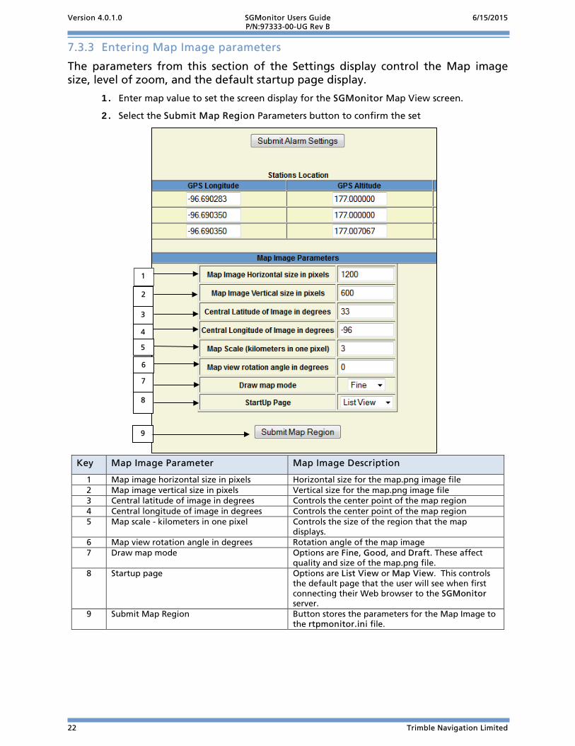
Entering Map Image parameters 7.3.3
The parameters from this section of the Settings display control the Map image size, level of zoom, and the default startup page display.
1. Enter map value to set the screen display for the SGMonitor Map View screen.
2. Select the Submit Map Region Parameters button to confirm the set
Key Map Image Parameter Map Image Description
1 Map image horizontal size in pixels Horizontal size for the map.png image file 2 Map image vertical size in pixels Vertical size for the map.png image file 3 Central latitude of image in degrees Controls the center point of the map region 4 Central longitude of image in degrees Controls the center point of the map region 5 Map scale - kilometers in one pixel Controls the size of the region that the map
displays. 6 Map view rotation angle in degrees Rotation angle of the map image 7 Draw map mode Options are Fine, Good, and Draft. These affect
quality and size of the map.png file. 8 Startup page Options are List View or Map View. This controls
the default page that the user will see when first connecting their Web browser to the SGMonitor server.
9 Submit Map Region Button stores the parameters for the Map Image to the rtpmonitor.ini file.
2
3
6
7
4
9
5
8
1

Version 4.0.1.0 SGMonitor Users Guide 6/15/2015 P/N:97333-00-UG Rev B
Trimble Navigation Limited 23
8 Using High Resolution Maps A low resolution map (globe.alt) is distributed with SGMonitor. High resolution maps are also available. Because of the size of the map files, these are not distributed with SGMonitor, but can be downloaded from the Internet for the user’s region of interest.
Getting a High Resolution Map 8.1
There are two basic sets of high resolution map data that can be used with SGMonitor, one with 900 meter resolution and one with 90 meter resolution. Please view the README file contained in the links below for a list of coordinates.
900 Meter Resolution Maps 8.1.1
The 900 meter resolution map data is available from the following site:
ftp://topex.ucsd.edu/pub/srtm30_plus/
There are several other places on the Internet that provide this information. If this page is not available, you can do a search for srtm30 data.
The files from this site have names similar to the following: e020n40.Bathmetry.srtm. Download the file containing the region of interest and place it in the SGmonitor directory. Then rename the file using the same primary name but with the "dem" extension. For example, rename e020n40.Bathmetry.srtm to E020N40.dem. NOTE: Since names are case sensitive for Unix, use upper case in the file name and lower case in the extention.
Version 4.0.1.0 SGMonitor Users Guide 6/15/2015 P/N:97333-00-UG Rev B
24 Trimble Navigation Limited
90 Meter Resolution Maps 8.1.2
The 90 meter resolution map data is available from the following site:
http://dds.cr.usgs.gov/srtm/version2_1/SRTM3/
There are several places on the Internet that provide this information. If this page is not available, you can do a search for srtm3 version2 data.
The map files from this site have names similar to the following: N39E023.hgt. However, the map file will most likely be in a zip file with a similar name. Download the file containing the region of interest into the rtpmonitor directory. Unzip the file if necessary.
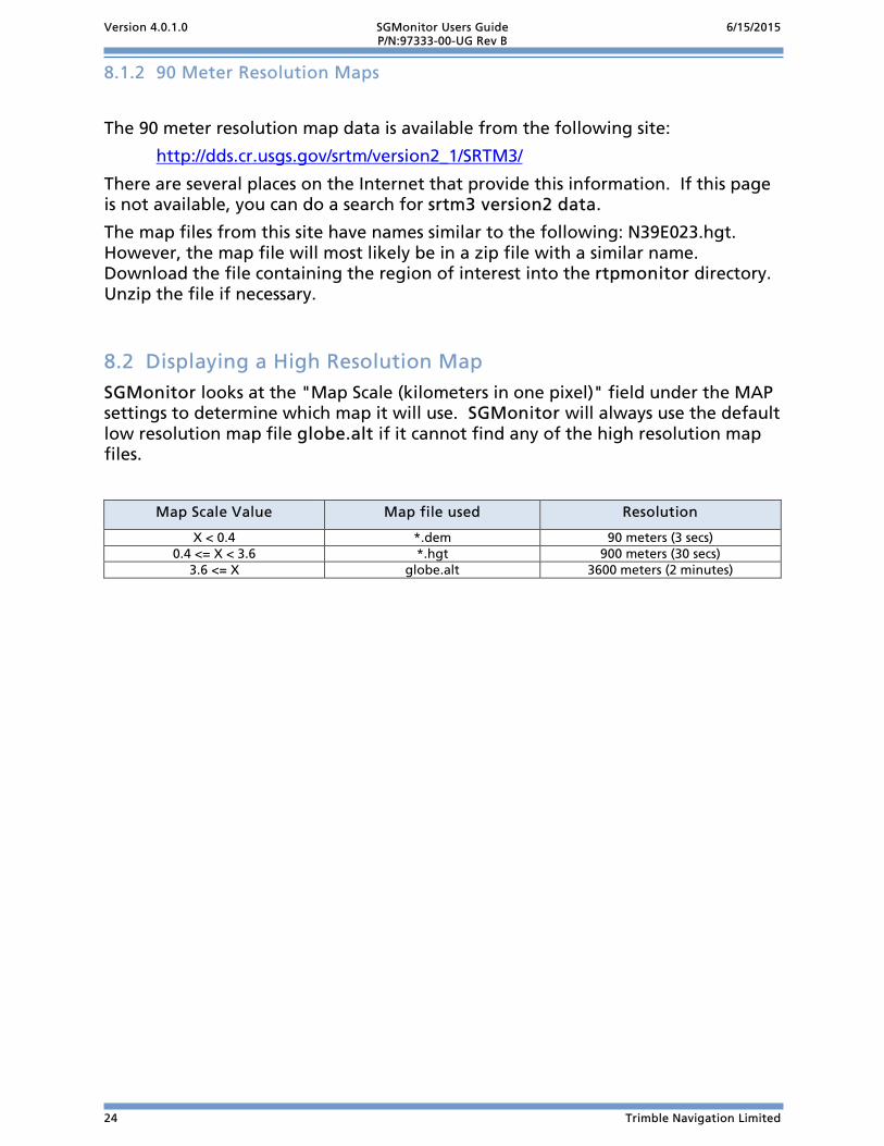
Displaying a High Resolution Map 8.2SGMonitor looks at the "Map Scale (kilometers in one pixel)" field under the MAP settings to determine which map it will use. SGMonitor will always use the default low resolution map file globe.alt if it cannot find any of the high resolution map files.
Map Scale Value Map file used Resolution
X < 0.4 *.dem 90 meters (3 secs) 0.4 <= X < 3.6 *.hgt 900 meters (30 secs)
3.6 <= X globe.alt 3600 meters (2 minutes)

Version 4.0.1.0 SGMonitor Users Guide 6/15/2015 P/N:97333-00-UG Rev B
Trimble Navigation Limited 25
9 Index
E entering limits ......................................................... 20 entering map image parameters ........................... 22
G GPS status ................................................................ 18
H high resolution map ............................................... 23
90 meter resolution ............................................ 24 900 meter resolution .......................................... 23 displaying ............................................................ 24
L Linux
ini settings ............................................................. 3 operating SGMonitor ........................................... 3
list view screen ........................................................ 14
M MacOS
ini settings ............................................................. 5 starting SGMonitor ............................................... 5
map screen .............................................................. 13 media status ............................................................ 17
R rtpmonitor.ini
RingFolder ............................................................. 7 SMS folder ............................................................. 7
S setting station locations ......................................... 21 settings screen......................................................... 19 SGMonitor
provides ................................................................. 1 Trimble Kestrel System requirements .................. 1
sgmonitor.ini edit ini file ......................................................... 2, 6 example listing ...................................................... 9 IPSettings ............................................................... 6 RTPD IP .................................................................. 6
Solaris ini settings ............................................................. 4 starting SGMonitor ............................................... 4
U unit status screen .................................................... 15
backup power level ............................................ 16 input power ........................................................ 16 temperature ........................................................ 16
W Windows
ini settings ............................................................. 2 starting SGMonitor ............................................... 2

Version 4.0.1.0 SGMonitor Users Guide 6/15/2015 P/N:97333-00-UG Rev B
26 Trimble Navigation Limited
This Page Left Intentionally Blank

Version 4.0.1.0 SGMonitor Users Guide 6/15/2015 P/N:97333-00-UG Rev B
Trimble Navigation Limited 27
10 Release Notes: Version 4.0.1.0 (June 15, 2015) This section of this manual lists and describes the functional modifications made to the SGMonitor software version 0.0.0.4 to create version 4.0.1.0 follows:
1. SGMONITOR: Modification to Build 32 and 64 bit Platforms
2. SGMONITOR: Modification to Allow Spaces in Directory\Path

Version 4.0.1.0 SGMonitor Users Guide 6/15/2015 P/N:97333-00-UG Rev B
28 Trimble Navigation Limited
Please review all release notes between the firmware version you are running and the version you wish to install.
SGMONITOR: Modification to Build 32 and 64 bit Platforms
Modification to build programs for both 32 and 64 bit platforms.
SGMONITOR: Modification to Allow Spaces in Directory\Path
Modification to allow spaces to be used when specifying the directory\path names in the .ini file. Double Quotes are required when spaces are used.

Version 4.0.1.0 SGMonitor Users Guide 6/15/2015 P/N:97333-00-UG Rev B
Trimble Navigation Limited 29
11 Release Notes Version 0.0.0.4 (April 28, 2015)
This section of this manual lists the initial release of SGMonitor software version 0.0.0.4:
1. Initial Release

Trimble Navigation Limited
1600 Tenth Street Suite A Plano, Texas 75074 Tel: 214-440-1265 Fax: 972-578-0045 www.trimble.com/infrastructure