Embed Size (px)
Citation preview
Introduction
The Victorian Exploring Expedition, officially renamed the Burke and Wills Expedition in November 1861 by Sir Henry Barkly, the Governor of Victoria, was the most intricately planned, and lavishly equipped exploratory party ever dispatched on Australian territory. Although it met its primary objective (to beat South Australia to the Gulf of Carpentaria), it did so at a high price; seven members of the party died, including the leader and his second-in-command. Why it failed in this way has been debated ever since (Clune 1937; Moorehead 1963; Colwell 1971; Murgatroyd 2002), but poor leadership and ‘plain bad luck’ contributed significantly.
As the Expedition was to plot a viable route to the Gulf of Carpentaria, trees were marked at strategic intervals to allow others to follow a clearly marked route. Instructions issued by the Exploration Committee, dated 18 August 1860, specifically included ‘…you will mark your routes…by leaving records, sowing seeds, building cairns, and marking trees at as many points as possible’ (Burke and Wills Commission 1861–2). With the passage of time, few of the Burke and Wills Expedition trees survive, although several significant ones do. This account describes some of the trees that mark that historic, but fateful journey.
Peter SaengerSchool of Environmental Science and Management, Southern Cross University, Lismore, NSW 2480
Trees associated with the Burke and Wills Expedition
Chapter 16—Australia’s Ever-changing Forests VI: Proceedings of the Eighth National Conference on Australian Forest History. Brett J. Stubbs et al. (ed.).© 2012, ISBN 978-0-9757906-2-5
2 SAENGER
Figure 1: The ‘Burke and Wills Clump’, the site of their Camp XIV, is situated approximately 14 miles south-east of Swan Hill, Victoria, on the Murray Valley Highway.
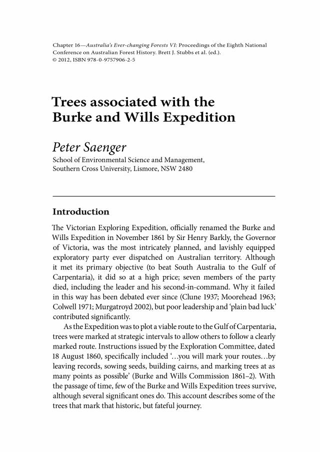
Figure 2: The ‘Swan Hill Tree’, a giant Moreton Bay Fig tree (Ficus macrophylla) located in Curlewis Street, Swan Hill, was supposedly planted by Robert O’Hara Burke in September 1860. It has been listed on the register of Significant Trees of Victoria because of its size.

BURKE AND WILLS EXPEDITION 3
The ‘Burke and Wills Clump’
Dr Ludwig Becker, the Expedition artist, ethnographer and naturalist, recorded that on 5 September, the party ‘arrived at a belt of timber between lake Tatchiwap (dry) and lake Boga, there we camped…We met many visitors on the road, coming from far off stations to have a look at the camels…’ (Tipping 1979). This stand of Black Box (Eucalyptus largiflorens) trees (35° 29' 14" S, 143° 42' 3" E) approximately 14 miles south-east of Swan Hill, has long been held to be the site of Camp XIV on the northward journey (Fig. 1), and in October 1999 it was inscribed on the Register of the National Estate (Media Release, Sen. Robert Hill, 25 October, 1999) as one of the few known places physically associated with the Burke and Wills Expedition, even though no marked trees remain at the site. It represents one of 54 recognised campsites between Melbourne and Cooper Creek.
The ‘Swan Hill Tree’
Known locally as the ‘Burke and Wills Tree’ (Fig. 2), this giant (approximately 30 m high) Moreton Bay Fig tree (Ficus macrophylla) is reputed to have been planted by Robert O’Hara Burke, while he was in Swan Hill from 6–12 September 1860, supposedly as the guest of Dr Benjamin Gummow F.R.C.S.E., the first resident doctor of the township from 1857 to 1872. Although the explorers were given a public dinner in the Lower Murray Inn, chaired by Dr Gummow, no tree-planting ceremony is mentioned in the journals of any expedition members. Nevertheless, the size of the fig tree suggests that it was planted around the 1860s, and it has been listed on the Register of Significant Trees of Victoria.
The ‘Pamamaroo Trees’
After Burke’s advance party left Menindee on Friday 19 October, William Hodgkinson and Dr Becker ‘went up the Darling to look for a good camping ground, returning at night’ (Tipping 1979). On the following Monday, the stores party ‘left Minindie with part of store and arrived at the junction of Bamamero Creek with the Darling, after 8 miles travelling. In the afternoon the men & camels went back to Minindie. I [Ludwig Becker] remained behind and after storing safely

4 SAENGER
the goods brought up, I put myself under shelter by pitching my tent on a spot high & dry & near a cluster of beautiful Gum-trees’. While Becker wrote that ‘it is uncertain how long we will remain here with the stores, perhaps for several weeks or more’, these coolibahs (Eucalyptus microtheca) at the junction of Pamamaroo Creek and the Darling River were to be home to the stores party, until William Wright had been confirmed as third-in-command by the Committee, and stirred his party into action on 26 January 1861, more than three months after Burke’s departure (Tipping 1979; Edmond 2009). These stately, but unmarked trees are still there, as featured by Ludwig Becker (Fig. 3) in several of his ‘Darling Depôt’ scenes.
The ‘Dig Tree’
The ‘Dig Tree’ (Eucalyptus microtheca) is the most renowned relic of the Burke and Wills Expedition, and survives to this day on Cooper Creek, just inside the Queensland border. Cooper Creek was discovered in August 1845 by John Harris Browne, Surgeon of Sturt’s Expedition, while scouting ahead of Sturt’s main party camped on Strzelecki Creek.
Figure 3: The ‘Pamamaroo Trees’: Depôt Junction: The Bamamoro Cr. with the Darling. Ludwig Becker, 1 November 1860. Watercolour 12.6 x 17.7 cm, State Library of Victoria.
BURKE AND WILLS EXPEDITION 5
A day later, Sturt arrived at Cooper Creek, ultimately naming it ‘as proof of my great respect for Mr Cooper, the Judge of South Australia. I would gladly have laid this creek down as a river, but as it had no current I did not feel myself justified in so doing’ (Sturt 1849, p.230).
Cooper Creek is an intermittent stream in Queensland’s Channel Country. Rising as the Barcoo on the northern slopes of the Warrego Range, it receives its principal tributary, the Thomson, from which point it is known as Cooper Creek. It discharges to Lake Eyre only during exceptional floods, following intense rainfall in its 300,000 square-kilometre catchment area. Its large perennial waterholes made Cooper Creek ‘the cross-road’ of early inland exploration.
In October 1846, Thomas Mitchell, the Surveyor-General, had named a westward flowing river, which he believed would flow into the Gulf of Carpentaria, after ‘my gracious sovereign, Queen Victoria’. However, a year later, Edmund Kennedy followed the Victoria River, and arrived at what he concluded to be the upper reaches of Cooper Creek. Tracing it downstream for several days, Kennedy concluded that his mentor had indeed been incorrect, and the Victoria River ceased to exist in south-western Queensland. Instead, the Thomson and the Barcoo Rivers were named, and upon their confluence reverted to Sturt’s name—Cooper Creek. Kennedy’s most southerly point was at the junction at 27° 13' 49" S (Beale 1970).
It may also be that Leichhardt, on his fatal journey in 1848, turned south-west at the junction of the Thompson and Barcoo Rivers, and marked several trees along Cooper Creek (Pike 1978; Connell 1980; Simpson 2007), before going up the Thompson River to reach the Flinders River. Ten years later, A. C. Gregory searched unsuccessfully for traces of Leichhardt on Cooper Creek.
The Victorian Exploring Expedition left Melbourne in August 1860 and headed north, reaching Cooper Creek at 27° 29' 24" S and 142° 49' 17" E on 11 November 1860. Several thrusts northwards were undertaken from this camp in a vain search for an easy route north. Camp LXIII was over-run by rats, and Burke and Wills proceeded downstream, looking for a better site at which to establish a depot. On 6 December their depot, Camp LXV, was established at 27° 37' 17" S, 141° 04' 40" E, where the ‘Dig Tree’ still stands (Fig. 4).
Burke and Wills departed from the depot on Sunday 16 December 1860, for the Gulf of Carpentaria, leaving a depot party under William

6 SAENGER
Brahe to await their return. Burke and Wills reached the shores of the Gulf of Carpentaria on 11 February 1861, although the dense mangroves prevented them from obtaining a view of the open waters of the Gulf. Their most northerly campsite was at Camp CXIX, on the Bynoe River. They commenced their southerly return from Camp CXIX on 13 February 1861, and staggered back to the depot at Cooper Creek, with one of their party, John Gray, dying in the Coongie Lakes district on 17 April 1861.
After waiting at the depot slightly over four months, Brahe and his depot party departed Camp LXV around 10 am on 21 April 1861 for Menindee. Burke and Wills arrived at Camp LXV around 7:30 pm on the same day to find it deserted. According to Hogg (1961a; 1961b; 1964, p.170), ‘[t]hey found, nailed to a tree, a piece of wood, on which was scrawled the message…DIG 8 FT. W. AP. 21’. According to Clune (1937), Moorehead (1963), Feeken et al. (1970), Colwell (1971) and Bonyhady (2002) the inscription read: ‘DIG 3 FT. N.W.’ or ‘DIG 3 FT. N.W. APR. 21 1861’. Others (Welch 1861–62; Davis 1863; Favenc 1888) give it simply as ‘DIG’ although the newspapers of the time reported it as ‘DIG, April 21’ (Anon 1861). Others (White 1992; Murgatroyd 2002;
Figure 4: The ‘Dig Tree’ survives on the banks of Cooper Creek on Nappa Merrie Station, taken up by John Conrick in 1873. A small reserve around the tree is managed by S. Kidman & Co. Ltd, the station lessee, on behalf of the Royal Historical Society of Queensland and the Bulloo Shire Council. It is also listed on the Register of the National Estate and the Queensland Heritage Register.

BURKE AND WILLS EXPEDITION 7
Corke 2009), relying on earlier reports, suggested that the inscription read ‘DIG UNDER’ or ‘DIG UNDER 40 Ft W’ and indicated that Alfred Howitt had added his initials and an arrow to indicate his direction of movement. Beale (2007) included a photograph, supposedly of the DIG tree, showing ‘DIG 2 FT N’; neither credits nor the origin of the photograph are acknowledged, but it certainly does not depict the DIG tree. Numerous other variations of the supposed inscriptions on the ‘Dig Tree’ were listed by White (1992, pp. 25–28).
According to Brahe’s evidence to the Royal Commission (1861–2) concerning where he buried the provisions, the tree was simply marked with ‘DIG’:
259. Was it close by a tree?—Yes, at one corner of the stockade, outside the stockade.260. And you marked it?—Yes, we marked it “Dig”.261. Did you mark your initials on it?—No; I marked another tree with a single “B” and the number of the camp; and the other side I marked “16th [actually 6th] December 1860,” and “21st April 1861”.262. What means did you take to conceal that you had disturbed the surface of the earth?—I covered it carefully, and strewed some horse-dung over it. I chose the place where we used to tie up the horses and I thought if the natives did see the place they would think the ground was disturbed by the horses being tied up there.The earliest observations support the simple inscription of ‘DIG’;
in a letter to the Argus, dated 14 March 1908, John Conrick, who took up Nappa Merrie Station in 1873, wrote that it stated ‘A H (AH combined), “DIG” under, and a broad arrow’. Soon after, in 1879–80, a Queensland surveyor named Alexander Salmond was surveying runs in the south-west of the State. After working along the Bulloo River, he visited Cooper Creek, making sketches around the depot, including the earliest sketch of the ‘Dig Tree’, now in the John Oxley Library (JOL Ref. Code 6404 Box 10921; see also Kitson and McKay 2006). It shows two blazes with inscriptions; on the main trunk, only the word ‘DIG’ is in the centre, and the initials ‘AH’ (conjoined) at the top, and an arrow pointing to the right at the bottom (Fig. 5), the latter both added by Alfred Howitt. No evidence of any additional words or figures is shown. This is further clarified in a letter to J. E. Palmer dated 17 January 1922 (JOL Ref. Code 6404 Box 10921), in which Salmond provides a sketch of the ‘Dig Tree’ clearly showing ‘AH’ (conjoined over ‘DIG’) over an

8 SAENGER
Figure 5: Computer-enhanced image of Alexander Salmond’s sketch of the ‘Dig Tree’ drawn in 1879, showing the blaze with the dates, and the other blaze showing only ‘AH’ (conjoined) over ‘DIG’ over an arrow pointing to the right. (JOL Ref. Code 6404 Box 10921).
Figure 6: The ‘B’ over ‘LXV’ camp designation on the ‘Dig Tree’ at the depot site is the only inscription still clearly legible.

BURKE AND WILLS EXPEDITION 9
arrow erroneously pointing to the left. On the side branch, Salmond’s sketch and letter sketch clearly show the second blaze with the two dates—‘DEC 6-60’ over ‘APR 21-61’.
The blazes in Salmond’s sketch conform to those shown in early photographs (even though the writing cannot be clearly deciphered in the photographs), particularly nla.pic-an23492483 and nla.pic-24164858. There are three separate blazes with inscriptions on the ‘Dig Tree’: on the main trunk, one simply consists of ‘B’ over ‘LXV’, which is still legible today (Fig. 6); on the opposite side of the main trunk is the ‘DIG’ inscription, which is overgrown and no longer decipherable; and on a side branch is the inscription with the arrival and departure date, visible in early photographs but now only a scar.
From the depot, Burke and Wills departed south-west from Camp LXV on 23 April 1861, hoping to follow A. C. Gregory’s 1858 route in search of Leichhardt, past Mount Hopeless to Adelaide. Early in May, Brahe’s party heading south, encountered Wright’s party heading north. As a result, Brahe and Wright briefly revisited Camp LXV and collected a few plant specimens (Willis 1962), while Burke, Wills and King were further downstream, struggling towards Mount Hopeless. Having failed to detect signs of the return of Burke’s party, Brahe and Wright returned to Bulloo, and thence to Menindee. Wills left Burke and King to deposit further journals and notes at Camp LXV late in May, reaching the depot on 30 May, noting that ‘no traces of any one except blacks having been here since we left’ (Wills, unpublished journal). He rejoined the others by early June. The rest is history: late June–early July 1861, Burke and Wills both died amidst plenty on Cooper Creek, suffering a Vitamin B deficiency disease, brought on by consuming large quantities of improperly prepared nardoo, Marsilea drummondii, a starchy fern food of the Aborigines. Only King survived three more months through the kindness of the Yantruwunta, until he was found, barely alive, by Edwin Welch, the surveyor of the Victorian relief party, led by Alfred Howitt. While waiting for King to recover sufficiently to travel back to Menindee, Howitt located and buried the remains of Wills and Burke, before returning to Camp LXV to finally dig up the cache. He re-buried the cache and added his initials (AH conjoined) and an arrow to the inscription on the tree.
Howitt and King arrived back at Menindee on 28 October 1861, and

10 SAENGER
Figure 7:Burke’s memorial tree and marker. According to Fenner (1928), only McKinlay’s marks were visible, as the Howitt blaze was buried by a metre of sand and silt. Various fences—wooden pole, wire-cable or barbed wire—have existed around this tree.
Figure 8:The ‘Face Tree’ was carved in 1898 by a travelling photographer, John Dick.
BURKE AND WILLS EXPEDITION 11
five weeks later, the South Australian relief party led by John McKinlay arrived at the main channel of the Cooper. McKinlay found Wills’s grave, Howitt’s abandoned camp at Quiapidrie, and Burke’s grave by Yidniminka Waterhole. Finally, in December 1862, Howitt again returned to the Cooper depot, setting up camp at Kullyamurra Waterhole, and returning to Adelaide with the bones of the dead explorers.
The ‘Burke and Wills Memorial Trees’
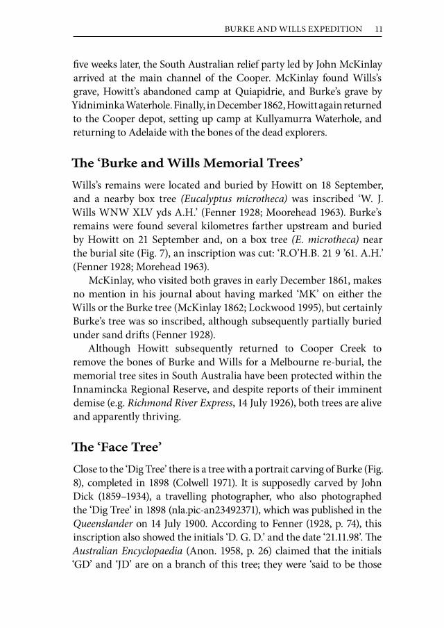
Wills’s remains were located and buried by Howitt on 18 September, and a nearby box tree (Eucalyptus microtheca) was inscribed ‘W. J. Wills WNW XLV yds A.H.’ (Fenner 1928; Moorehead 1963). Burke’s remains were found several kilometres farther upstream and buried by Howitt on 21 September and, on a box tree (E. microtheca) near the burial site (Fig. 7), an inscription was cut: ‘R.O’H.B. 21 9 ’61. A.H.’ (Fenner 1928; Morehead 1963).
McKinlay, who visited both graves in early December 1861, makes no mention in his journal about having marked ‘MK’ on either the Wills or the Burke tree (McKinlay 1862; Lockwood 1995), but certainly Burke’s tree was so inscribed, although subsequently partially buried under sand drifts (Fenner 1928).
Although Howitt subsequently returned to Cooper Creek to remove the bones of Burke and Wills for a Melbourne re-burial, the memorial tree sites in South Australia have been protected within the Innamincka Regional Reserve, and despite reports of their imminent demise (e.g. Richmond River Express, 14 July 1926), both trees are alive and apparently thriving.
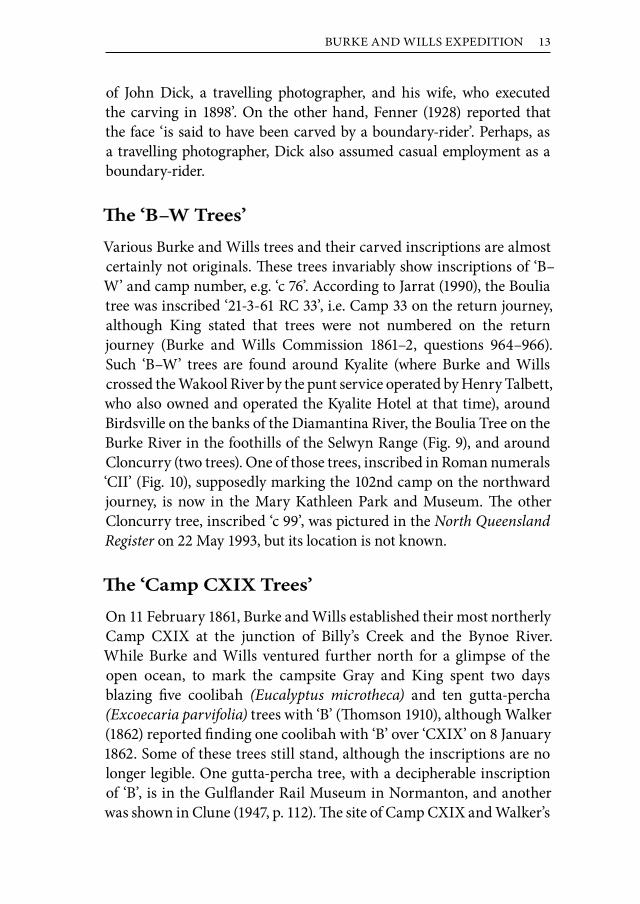
The ‘Face Tree’
Close to the ‘Dig Tree’ there is a tree with a portrait carving of Burke (Fig. 8), completed in 1898 (Colwell 1971). It is supposedly carved by John Dick (1859–1934), a travelling photographer, who also photographed the ‘Dig Tree’ in 1898 (nla.pic-an23492371), which was published in the Queenslander on 14 July 1900. According to Fenner (1928, p. 74), this inscription also showed the initials ‘D. G. D.’ and the date ‘21.11.98’. The Australian Encyclopaedia (Anon. 1958, p. 26) claimed that the initials ‘GD’ and ‘JD’ are on a branch of this tree; they were ‘said to be those

12 SAENGER
Figure 9:The remains of the ‘B–W’ tree on the Burke River (22° 05' 23" S, 140° 06' 47" E), near Digby Peaks. Jarrat (1990), who was able to decipher the inscription, reported that the tree had been fatally injured by roadworks.
Figure 10:‘B–W’ Tree from Camp CII, inscribed ‘CII’ over ‘1861’, supposedly the ‘Bath camp’ on the Corella River, 30 miles west of Cloncurry. This remnant is now located in the Mary Kathleen Park and Museum, Cloncurry.
BURKE AND WILLS EXPEDITION 13
of John Dick, a travelling photographer, and his wife, who executed the carving in 1898’. On the other hand, Fenner (1928) reported that the face ‘is said to have been carved by a boundary-rider’. Perhaps, as a travelling photographer, Dick also assumed casual employment as a boundary-rider.
The ‘B–W Trees’
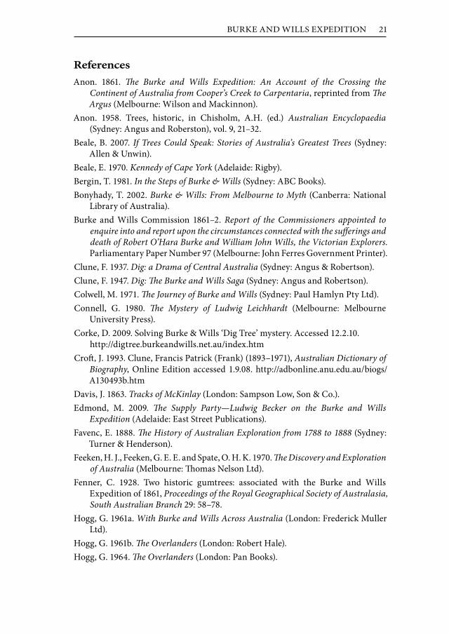
Various Burke and Wills trees and their carved inscriptions are almost certainly not originals. These trees invariably show inscriptions of ‘B–W’ and camp number, e.g. ‘c 76’. According to Jarrat (1990), the Boulia tree was inscribed ‘21-3-61 RC 33’, i.e. Camp 33 on the return journey, although King stated that trees were not numbered on the return journey (Burke and Wills Commission 1861–2, questions 964–966). Such ‘B–W’ trees are found around Kyalite (where Burke and Wills crossed the Wakool River by the punt service operated by Henry Talbett, who also owned and operated the Kyalite Hotel at that time), around Birdsville on the banks of the Diamantina River, the Boulia Tree on the Burke River in the foothills of the Selwyn Range (Fig. 9), and around Cloncurry (two trees). One of those trees, inscribed in Roman numerals ‘CII’ (Fig. 10), supposedly marking the 102nd camp on the northward journey, is now in the Mary Kathleen Park and Museum. The other Cloncurry tree, inscribed ‘c 99’, was pictured in the North Queensland Register on 22 May 1993, but its location is not known.
The ‘Camp CXIX Trees’
On 11 February 1861, Burke and Wills established their most northerly Camp CXIX at the junction of Billy’s Creek and the Bynoe River. While Burke and Wills ventured further north for a glimpse of the open ocean, to mark the campsite Gray and King spent two days blazing five coolibah (Eucalyptus microtheca) and ten gutta-percha (Excoecaria parvifolia) trees with ‘B’ (Thomson 1910), although Walker (1862) reported finding one coolibah with ‘B’ over ‘CXIX’ on 8 January 1862. Some of these trees still stand, although the inscriptions are no longer legible. One gutta-percha tree, with a decipherable inscription of ‘B’, is in the Gulflander Rail Museum in Normanton, and another was shown in Clune (1947, p. 112). The site of Camp CXIX and Walker’s

14 SAENGER
Figure 12: (A) ‘Landsborough Tree’ remnant preserved on Rocklands Station, near Camooweal, inscribed ‘broad arrow’ over ‘L’ over ‘C26’ over ‘Dec 30’ over ‘1861’. (B) ‘Landsborough Tree’ remnant preserved on Gregory (Planet) Downs, inscribed ‘broad arrow’ over ‘CVI’ over large ‘L’ over ‘(18)61’.
Figure 11: The surviving tree marked by Walker ‘FW’ over ‘12 Jan’ over ‘1862’ at his camp near Burke and Wills’s most northerly Camp CXIX. It is possible, as suggested by Thomson (1910), that this tree had also been inscribed with ‘B’ over ‘CXIX’.
A B

BURKE AND WILLS EXPEDITION 15
camp on the Bynoe River has been listed on the Queensland Heritage Register (No. 602156).
The Searchers’ Trees
Each of the four Burke and Wills search parties (Howitt, Landsborough, Walker and McKinlay) blazed trees to mark their routes. The ‘Burke Memorial Tree’ is one surviving example, which showed both Howitt’s and McKinlay’s conjoined initials (Fenner 1928).
Walker’s search party camped close to Camp CXIX early in January 1862, and blazed several coolibah trees (Eucalyptus microtheca) 1.2 km north of Camp CXIX, one of which remains standing (Fig. 11). Today, no inscription can be made out, but Thomson (1910) incorporated a photograph of this tree with the bark overgrowth removed, showing ‘FW’ over ‘12 Jan’ over ‘1862’. It was thought by Thomson (1910) that Walker’s inscribed tree had originally carried the ‘B’ over ‘CXIX’.
Landsborough was probably the most prolific tree blazer; a few of his many inscriptions have been preserved by station owners when trees have died, and these historic remnants (Fig. 12) can still be deciphered. The tree at the depot site on the Albert River, marked ‘DIG’, remained alive (Fig. 13) until destroyed by arsonists in 2002. Only one other known Landsborough tree is still alive; it is on Station Creek, a tributary of the Flinders River, at Hughenden (Fig. 14). It was blazed by Walker on 22 October 1861, as he headed north to the Albert River, and was blazed by Landsborough on 17 March 1862, as he headed south from the Albert River. The inscriptions are now overgrown and can no longer be seen.
Discussion
Many of the trees associated in the public’s perception with the Burke and Wills Expedition are not or cannot be directly tied to the expedition. They include, for example, the Swan Hill fig tree and the ‘Face Tree’ at Camp LXV.
Others, such as the various ‘B–W’ trees, are highly questionable in terms of their connectedness to the Burke and Wills Expedition on several grounds. The Victorian Exploring Expedition was only officially renamed the Burke and Wills Expedition in November 1861 by Sir Henry Barkly, the Governor of Victoria, well after the deaths

16 SAENGER
Figure 14: Coolibah tree on Station Creek, a tributary of the Flinders River, on the outskirts of Hughenden, inscribed by both Frederick Walker and William Landsborough, leaders of the two Queensland relief expeditions.
Figure 13: Landsborough’s ‘DIG’ tree, marking the site on the Albert River, just outside Burketown, where a depot had been established and a food cache buried. Sadly, arsonists destroyed this tree in 2002.

BURKE AND WILLS EXPEDITION 17
of Burke and Wills. Thus, all camp inscriptions were of ‘B’ only, and the camp number was always in Roman numerals e.g. the ‘Dig’ tree at camp LXV.
The ages of the inscriptions on the ‘B–W’ trees are undoubtedly less than the 150 years they should be if made in 1860–61. For example, photographs taken by the author of the ‘B–W’ tree on the Diamantina River outside Birdsville in 1974 and again in 2000 (Fig. 15A and B) indicate that if the tree was inscribed in 1860, it was then 114 years old in 1974, and 140 years old in 2000. It shows virtually no deterioration after 114 years, but was almost illegible after 140 years. The amount of deterioration over the 26 years suggests that the inscription is considerably more recent. Similarly, the bark overgrowth of inscriptions strongly suggests their recent origin. For example, the bark overgrowth in Figure 10 has virtually hidden the inscription of ‘B–W’ over ‘CII’ over ‘1861’, yet a photograph of the tree from 1961, when it was supposedly 100 years old (North Queensland Register, 3 May 1985), clearly shows the entire inscription. Thus, the bulk of the bark overgrowth has occurred since the 1960s.
The most likely explanation for the ‘B–W’ trees is that they are
Figure 15: The ‘B–W’ tree on the Diamantina River outside Birdsville in 1974 (A) and again in 2000 (B), showing the extent of deterioration over the intervening 26 years, which strongly suggests that the inscription is considerably more recent than 1860.
A B

18 SAENGER
relatively recent, and were probably marked by an enthusiastic historian, who traced the Burke and Wills route and marked the camp sites where they were believed to be located. Others have called them ‘fakes’ (Bergin 1981) or ‘vandalism’ (White 1992).
Numerous tracings of the original route of Burke and Wills have been undertaken, the earliest by Frank Clune, who followed the route in 1935–36 (his photograph collection is in the NLA at nla.pic-vn3302582). Clune, amateur historian and author of Dig—a Drama of Central Australia, first published in 1937, according to the Australian Dictionary of Biography had ‘an ability to ferret out information, but
Figure 16:Photographs from the Frank Clune collection in the National Library of Australia (pic-vn3506775-v and pic-vn3506785-v), which respectively show ‘B’ over ‘LXV’ (top) and ‘B’ over ‘DIG’ over ‘3 FT’ (right). However, close inspection of the bark patterns show that these are the same tree (compare with Figure 6), and that black marking has been used to fudge the ‘DIG’ over ‘3 FT’ section of the inscription.

BURKE AND WILLS EXPEDITION 19
a desire to embroider it’ (Croft 1993). It seems highly likely, therefore, that he marked the campsites as and when he thought he had located them.
The fact that Frank Clune ‘embroidered’ his history is shown by two of his photographs from the NLA (Fig. 16), which show ‘B’ over ‘LXV’ (also shown in Clune 1947, p. 97) and ‘B’ over ‘DIG’ over ‘3 FT’. A third version appeared in Clune 1947, p. 113, showing only ‘B’ over ‘DIG’. Close inspection of the bark patterns, however, show that it is the same tree in all three photographs, and that black marking has been used to fudge the ‘DIG’ over ‘3 FT’ section of the inscription.
The uncertainty surrounding the inscriptions on the ‘Dig Tree’ apparently results from what could be termed the Longstaff legacy. In 1900 (later Sir) John Longstaff was commissioned by the trustees of the National Gallery of Victoria to produce a large historical depiction of the arrival of Burke’s party at Camp LXV on their return from the Gulf of Carpentaria. It took Longstaff seven years of painting in London, far removed from the sounds, sights and smells of the Australian bush, to complete this undertaking. Born in Clunes, Victoria, in 1862, he had seen little of the bush when he went to Paris at the age of twenty-five, and there is no evidence that his research was anything more than artistic, although he unsuccessfully tried to obtain a photograph of Cooper Creek (Joske 1994). The finished painting shows a dark, brooding atmosphere with a recognisable face (Longstaff had specialised as a portrait painter) in an unlikely ‘bush-setting’, with no sign of Cooper Creek. Most importantly, it shows the inscription, on a gnarled oak-like tree as saying ‘DIG 9 FT W AP 21’, not just ‘DIG’ as Samuel Thomas Gill had shown in his more-or-less contemporaneous paintings. Longstaff’s artistic but highly inaccurate re-creation more than forty years after the event (it was completed in 1908) has provided the impetus for the diverse inscriptions imaginatively, but erroneously, cited by many sources.
The inaccurate Longstaff painting stirred controversy and prompted the Conrick letter to the Argus, referred to earlier. In a detailed analysis, White (1992) has examined the evidence for other variations of the supposed inscriptions on the ‘Dig Tree’ and dismissed all distance and direction indicators. This is supported by the Salmond sketch (Fig. 5), which dates from 1879. White (1992) argued that Brahe might have added ‘under’ to the ‘DIG’ inscription as an afterthought, and Corke

20 SAENGER
(2009) suggested that a member of Howitt’s 1862 party to recover the skeletal remains, added the word ‘under’ to bury material for other parties in the area. However, Salmond’s sketch, and the copy of it made by a Miss F. E. DeMole in 1893, now in the collections of the Royal Historical Society of Queensland, shows that if ‘under’ had been added, it was less deeply incised and was no longer decipherable by the 1870s.
Be that as it may, the ‘DIG Tree’ is the last survivor of the original numbered campsite trees of the Victorian Exploring Expedition, with a legible inscription of the camp number (Fig. 6). Other blazed trees with indecipherable inscriptions survive, e.g. blazed trees at camp LII (Wheeler 1987) and the blazed trees at Camp CXIX. Other campsites have been identified, without the benefit of blazes, e.g. Camp XIV. Other original numbered campsite trees survive on old photographs (e.g. Frank Clune’s Camp XLIV at Yancannia Creek, nla.pic-vn3506770-v) or on old survey charts (e.g. ‘Camp B’ over ‘XL’ over ‘1860’ on a River Red Gum, Eucalyptus camaldulensis, near Mootwingee, shown on an 1887 chart by Lands Department Surveyor Bell). Most others have been lost through the agencies of time, fire, flood, white ants, or human activity over the intervening 150 years.
In addition, a few memorial trees remain (e.g. Burke’s original grave site and the ‘Face Tree’), and a handful of marked trees of the search expeditions still exist. Although all of these trees have been given some level of protection, losses still occur. Unfortunately, most so-called ‘Burke and Wills’ trees are ‘fakes’ of relatively recent origin.
Acknowledgements
It is a pleasure to thank Narelle and Gavin Miller of Rocklands Station, and Tess and David Arnold of Gregory Downs (Planet Downs) for granting access to the ‘Landsborough Tree’ remnants, and Bob Forsyth of Mount Isa, who, like Frank Clune, has ‘an ability to ferret out information’ and to share it. Hayley Freemantle, Project Officer of the Royal Geographical Society of Queensland assisted with locating old references, and Brett Stubbs of Southern Cross University provided constructive comments on an earlier version of the manuscript.
BURKE AND WILLS EXPEDITION 21
ReferencesAnon. 1861. The Burke and Wills Expedition: An Account of the Crossing the
Continent of Australia from Cooper’s Creek to Carpentaria, reprinted from The Argus (Melbourne: Wilson and Mackinnon).
Anon. 1958. Trees, historic, in Chisholm, A.H. (ed.) Australian Encyclopaedia (Sydney: Angus and Roberston), vol. 9, 21–32.
Beale, B. 2007. If Trees Could Speak: Stories of Australia’s Greatest Trees (Sydney: Allen & Unwin).
Beale, E. 1970. Kennedy of Cape York (Adelaide: Rigby).Bergin, T. 1981. In the Steps of Burke & Wills (Sydney: ABC Books).Bonyhady, T. 2002. Burke & Wills: From Melbourne to Myth (Canberra: National
Library of Australia).Burke and Wills Commission 1861–2. Report of the Commissioners appointed to
enquire into and report upon the circumstances connected with the sufferings and death of Robert O’Hara Burke and William John Wills, the Victorian Explorers. Parliamentary Paper Number 97 (Melbourne: John Ferres Government Printer).
Clune, F. 1937. Dig: a Drama of Central Australia (Sydney: Angus & Robertson).Clune, F. 1947. Dig: The Burke and Wills Saga (Sydney: Angus and Robertson).Colwell, M. 1971. The Journey of Burke and Wills (Sydney: Paul Hamlyn Pty Ltd).Connell, G. 1980. The Mystery of Ludwig Leichhardt (Melbourne: Melbourne
University Press).Corke, D. 2009. Solving Burke & Wills ‘Dig Tree’ mystery. Accessed 12.2.10. http://digtree.burkeandwills.net.au/index.htm Croft, J. 1993. Clune, Francis Patrick (Frank) (1893–1971), Australian Dictionary of
Biography, Online Edition accessed 1.9.08. http://adbonline.anu.edu.au/biogs/A130493b.htm
Davis, J. 1863. Tracks of McKinlay (London: Sampson Low, Son & Co.).Edmond, M. 2009. The Supply Party—Ludwig Becker on the Burke and Wills
Expedition (Adelaide: East Street Publications).Favenc, E. 1888. The History of Australian Exploration from 1788 to 1888 (Sydney:
Turner & Henderson).Feeken, H. J., Feeken, G. E. E. and Spate, O. H. K. 1970. The Discovery and Exploration
of Australia (Melbourne: Thomas Nelson Ltd).Fenner, C. 1928. Two historic gumtrees: associated with the Burke and Wills
Expedition of 1861, Proceedings of the Royal Geographical Society of Australasia, South Australian Branch 29: 58–78.
Hogg, G. 1961a. With Burke and Wills Across Australia (London: Frederick Muller Ltd).
Hogg, G. 1961b. The Overlanders (London: Robert Hale).Hogg, G. 1964. The Overlanders (London: Pan Books).

22 SAENGER
Jarrat, P. 1990. There’s a Track Winding Back—Rediscovering Australia (Sydney: Pan Macmillan Publishers).
Joske, P. 1994. Debonair Jack: a Biography of Sir John Longstaff (Melbourne: Claremont).
Kitson, W. S. and McKay, J. M. 2006. Surveying Queensland 1839–1945: A Pictorial History (Brisbane: Queensland Department of Natural Resources and Water, and the Queensland Museum).
Lockwood, K. 1995. Big John—the Extraordinary Adventures of John McKinlay 1819–1872 (Melbourne: State Library of Victoria).
McKinlay, J. 1862. McKinlay’s Journal of Exploration in the Interior of Australia (Burke Relief Expedition) (Melbourne: F.F. Bailliere).
Moorehead, A. 1963. Cooper’s Creek (London: Hamish Hamilton).Murgatroyd, S. 2002. The Dig Tree (Melbourne: The Text Publishing Company).Pike, G. 1978. Queensland Frontier (Adelaide: Rigby Limited).Simpson, B. 2007. In Leichhardt’s Footsteps: an Investigation into one of Australia’s
Most Enduring Mysteries (Sydney: ABC Books).Sturt, C. 1849. Narrative of an Expedition into Central Australia (London: T. and
W. Boone).Thomson, J. P. 1910. Expedition to the Gulf of Carpentaria, Queensland Geographical
Journal 25: 53–74.Tipping, M. (ed.) 1979. Ludwig Becker—Artist & Naturalist with the Burke & Wills
Expedition (Melbourne: Melbourne University Press on behalf of The Library Council of Victoria).
Walker, F. 1862. Walker’s Diary 16 December 1861 to 25 January 1862 as published in the Sydney Morning Herald, 19 June 1862.
Welch, E. J. 1861–62. Diary. Mitchell Library, ML C332.Wheeler, G. 1987. Rendezvous at Camp 52 with Burke and Wills, GEO Australian
Geographical Magazine 9: 51–61.White, J. 1992. Burke and Wills—the Stockade and the Tree (Melbourne: Victoria
University of Technology/Footprint Press).Willis, J. H. 1962. The botany of the Victorian Exploring Expedition (September
1860–June 1861) and relief contingents from Victoria (July 1861–November 1862), Proceedings of the Royal Society of Victoria 75: 247–268.
Wills, W. J., not dated. Journal of trip from Cooper Creek towards Adelaide. Online Edition accessed 18.7.08. http://www.nla.gov.au/epubs/wills/pages/transcript01.html