Embed Size (px)
Citation preview

Transportation Master Plan
Welcome to our 2nd Open House.The District of Mission is developing a Transportation Master Plan and wants to hear from you.
This Open House provides some information on:
• the study process
• how we currently travel daily within and to/from Mission
• our forecast future traffic demands.
We welcome your comments on proposed long-term plans for travel by road, transit, walking and cycling in Mission.
Please be sure to fill out the questionnaire/comment sheet provided so that we can collect your ideas.
More information on the Transportation Master Plan is available at: www.mission.ca/transportation.

The Transportation Master Plan will need to support and be integrated with the Official Community Plan (OCP) updated in 2008, and assist with achieving the following transportation-related objectives of the OCP:
Provide a safe, balanced and integrated transportation system giving consideration to all modes of transportation – pedestrian, public transit, private vehicle, bicycles and other alternative modes;
Provide an efficient, safe and pleasant road network to meet the existing and future needs of the community;
Support a public transit system that provides a convenient alternative to the automobile, and promotes transit-supportive land-use development;
Encourage walking within the community and provide for a safe, convenient and pleasant environment for pedestrians; and
Support cycling as an important travel mode and work towards a comprehensive, District-wide system of trails and facilities for cyclists.
Transportation Master Plan Objectives
Note: The Official Community Plan is currently being updated.

Mission has an integrated multi-modal transportation system that provides a range of linked transportation options and services, including vehicular transport and public transit, as well as safe and efficient means for pedestrians and cyclists to move throughout the community and beyond to neighbouring communities. (Source: OCP 2008)
Planning for Sustainable Transportation
Planning Priority by ModeHigh Priority
Low Priority
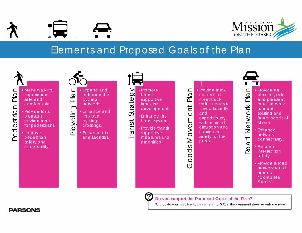
Elements and Proposed Goals of the Plan
Ped
estri
an P
lan •Make walking
experience safe and comfortable.
•Provide for a pleasant environment for pedestrians.
•Improve pedestrian safety and accessibility.
Bicy
clin
g Pl
an
•Expand and enhance the cycling network.
•Enhance and improve cycling crossings.
•Enhance trip end facilities. Tr
ansit
Stra
tegy •Promote
transit-supportive land-use development.
•Enhance the transit system.
•Provide transit supportive measures and amenities.
Goo
ds M
ovem
ent P
lan •Provide truck
routes that meet truck traffic needs to flow efficiently and expeditiously, with minimal disruption and maximum safety for the public.
Road
Net
wor
k Pl
an
•Provide an efficient, safe and pleasant road network to meet existing and future needs of Mission.
•Enhance network connectivity.
•Enhance intersection safety.
•Provide a road network for all modes, “Complete Streets”.
Do you support the Proposed Goals of the Plan?To provide your feedback, please refer to Q#1 in the comment sheet or online survey.

Project Overview
Phase 1 – Launching and Visioning - built community awareness, identified community concerns and aspirations, and developed a shared vision, objectives, and goals for transportation.
Phase 2 – Understanding Existing Conditions -gained an understanding of the existing conditions for walking, cycling, transit, and automobile travel. This phase also identified issues and opportunities, and confirmed what is needed to achieve goals.
Phase 3 – Planning - forecast growth, prepared travel projections, and identified gaps for each mode. Long term plans for each mode has also been prepared.
Phase 4 – Prioritizing - will assess and prioritize projects, prepare cost estimates, and develop a phasing plan for the short, medium, and long term.
Phase 1
•Launching & Visioning•Fall 2014
Phase 2
•Understanding Existing Conditions•Winter / Spring 2015
Phase 3
•Planning•Summer / Fall 2015
Phase 4
•Prioritizing•Winter 2015

How We Move Around and Where We Commute
(Source: FVRD 2014)

Population and Employment Forecasts
(Source: FVRD 2014)
Mission is located within the Fraser Valley, which has consistently been one of the fastest growing regions in British Columbia.
Over the next 30 years, population and employment opportunities in Mission are forecast to grow by over 50 percent.
Source: FVRD Regional Growth Strategy DRAFT – July 2014
Demographic Forecasts by Traffic Zone
2011 2026 2041Population 37,347 45,600 55,678Employment 16,059 20,520 25,612

Traffic Forecasts2013 AM Peak Hour
2013 PM Peak Hour
2045 AM Peak Hour
2045 PM Peak Hour

Long-Term Road Network PlanProposed Road Network
CharacteristicRoad Classification
Arterial Collector LocalExpected Traffic
Demands (vehicle / day)
5,000 + 1,000 – 8,000 < 1,000
Traffic and Connectivity
Regional and crosstown traffic
connecting to major destinations (e.g. one
municipality to another)and highways
Neighbourhood traffic connecting to arterials
Local traffic connecting to individual properties
and collectors
Typical Travel Lanes 2 – 4 lanes plus turn lanes at intersections
2 lanes plus turn lanes at intersections 1 – 2 lanes
Typical Pavement Width 14 – 20 m 12 – 15 m 8.5 – 12 mProperty Access Limited No limitations No limitations
Intersection Controls Generally traffic signals or roundabouts
Generally stop controlled or roundabouts
Stop controlled
Transit Services Yes. Primary and local transit Yes. Local transit No
Typical Intersection Spacing 400 m 60 m 60 m
Sidewalks 2 sides 2 sides 1 side
Typical Bicycling Accommodation
Bike lanes, cycle tracks, multi-use paths or paved shoulders
Bike lanes, shared use lanes or paved
shoulders
Shared use road, traffic calming support as
appropriate
Do you support the Proposed Road Network?To provide your feedback, please refer to Q#2 in the comment sheet or online survey.
Proposed Road Network Hierarchy
Provincial Highways: under the jurisdiction of the Ministry of Transportation & Infrastructure and are intended to provide for inter-regional travel.

Truck Route Network: The District has a designated truck route network through
Mission that balances the needs of businesses and resource extraction industries with the desire to minimize the impact of truck traffic on neighbourhoods and other sensitive land uses.
Trucks within the District are required to use the truck route network for travel across the municipality, and then proceed directly from the closest truck route to their final destination via other municipal roads.
The existing truck route network accommodates truck traffic, with minimal disruption and maximum safety for the public.
No changes to the truck route network are proposed.
Long Term Goods Movement PlanTruck Route Network
Do you support the Truck Route Network?To provide your feedback, please refer to Q#3 in the comment sheet or online survey.

Supportive Measures Strategies For the Frequent Transit Network Service routes along Highway 7 and
Highway 11, queue jumper lanes and transit signal phases to be considered at key intersections that experience undue queuing and delay. Alternatively, transit signal priority to be considered for future Frequent Transit Network routes within Mission and adjacent areas serviced by the routes.
Passenger waiting area amenities (bus shelters, trash bins, pedestrian scale lighting, and transit route information) to be provided at all transit stops along the future Frequent Transit Network and along key local transit routes.
Long-Term Future Transit Options
(Source: Abbotsford-Mission Transit Future Plan)
Do you support the Future Transit Options?To provide your feedback, please refer to Q#4 in the comment sheet or online survey.
Future Transit OptionsTransit Network Strategies: Key local transit routes to be upgraded to two-way routes. Currently,
these routes service 80 percent of the internal transit trips in Mission but are circuitous for transit patrons wishing to travel against the current route direction.
Some local transit routes hours of service to be extended to include evenings and weekends (including Sundays).
Transit service on all local routes to be provided on Statutory Holidays consistent with service being provided for Sundays.
The planned future local transit route along Highway 7 (to Maple Ridge and Pitt Meadows) to be combined with the Westcoast Express Train-Bus route. This will provide a highway bus service connecting Mission with the Coquitlam Centre Light Rail Rapid Transit station. The highway bus service to be provided seven days a week and have hours of operation consistent with the hours of the Light Rail Transit service. Route to include stops in Maple Ridge, Pitt Meadows, and Port Coquitlam.

Recommended Steps Upgrade and improve sidewalks in all
commercial and industrial urban core areas in Mission’s Downtown and popular retail/service destinations.
Prioritize sidewalk improvements within 1 km of schools, parks, and recreation & leisure centres.
Prioritize provision of sidewalks within a block of transit stops within suburban and urban areas of Mission.
Serve all rural transit stops using wide shoulders and landing pads.
Explore opportunities to build new sidewalks or upgrade existing sidewalks through other projects to reduce costs.
Subdivision Control Bylaw to require sidewalks in new developments or redevelopments.
Long Term Pedestrian PlanProposed Sidewalk Network
Do you support the proposed sidewalk network?To provide your feedback, please refer to Q#5 in the comment sheet or online survey.
Recommended Pedestrian Facilities Downtown commercial and industrial core urban areas: Construct sidewalks on both sides of the street on all roads. Suburban residential neighbourhoods: Provide sidewalks on both sides of all arterial and collector roads and on at least one side of local roads. Rural neighbourhoods: Provide a wide shoulder on each side of each collector or arterial streets that will accommodate bicycles and pedestrians.

Addressing Barriers to Cycling Improve safety and awareness; More bike lanes and better dedicated bicycle
facilities; More trails or paths (specifically along the river); More bicycle parking; and Improved connectivity.
Long Term Bicycling PlanProposed Bicycling Network
Bicycle Facility Design OptionsLeast protected Most protected
SHARED LANE MARKINGS
BIKE LANE CYCLE TRACK:At-grade, protected with parking
BUFFERED BIKE LANE
CYCLE TRACK:Raised and protected
CYCLE TRACK:Raised and curb separated
CYCLE TRACK:At-grade, protected with flexible bollards
Travel Lane 1.2 mMin.
Side-walk
Travel Lane 1.5 –2.1 m
Side-walk
Travel Lane 1.5 –2.1 m
Side-walk
0.6-1.8m
Parking Lane 1.5 –2.1 m
Side-walk
1.0-1.8m
Travel Lane 1.5 –2.1 m
Side-walk
1.0-1.8m
Travel Lane 2.0 – 3.0 m Side-walk
Travel Lane 2.0 – 3.0 m Side-walk
1.0-1.8m
Centerline of pavement marking placed at least 1.2 m from curb
Complete curb separation or optional mountable curb
• Positions cyclists in the travel lane.
• Alerts motorists to the presence of cyclists.
• Encourages cyclists to ride an appropriate distance away from the ‘door zone’ on streets with parking.
• Should never be used as a replacement for bicycle lanes.
• Exclusive bicycle travel lane increases safety and promotes proper riding.
• Reduces possibility that motorists will tray into cyclists’ path.
• Visual reminder of cyclists’ right to the road.
• Provides cushion of space to mitigate friction with motor vehicle traffic.
• Allows cyclists to pass one another or avoid obstacles without encroaching into the travel lane.
• Increases motorist shy distance from cyclists in the bike lane.
• Requires additional roadway space and maintenance.
• Dedicates and protects space for cyclists and improves perceived comfort and safety.
• Reduces risk of ‘dooring’ compared to a bike lane, and eliminates the risk of a doored cyclist being run over by a motor vehicle.
• Low implementation cost through use of existing pavement using parking lane as a barrier.
• Use along roadways with high motor vehicle volumes and/or speeds.
• Provides similar benefits as a cycle track with an on-street parking buffer.
• Best used on roads with high speeds and long distances between intersections and driveways.
• Innovative bicycle-friendly design needed at intersections to reduce conflicts between turning motorists and cyclists.
• Width should not be taken from pedestrian zone.
• Change in level clearly demarcates space for different users and reduces conflicts between cyclists and pedestrians.
• Where cyclists may enter or leave the cycles track, or where motorists cross at a driveway, the curb should be mountable with a small 45 degree ramp, allowing cyclist turning movements.
• Cycle track should be 5 to 7.5 cm above street-level, and sidewalk should be an additional 5 to 7.5 cm above cycle track.
• Maintenance of cycle track requires specialized sweepers.
• Where opportunities exist, buffer zone may be expanded to include bicycle parking.
• Where curb-side parking exists, the buffer between cycle track and parking should be at least 1.0 m wide.
Do you support the proposed bicycle network?To provide your feedback, please refer to Q#6 in the comment sheet or online survey.

Thank youFor attending this Public Open House.
Your comments and ideas are important for preparing the Transportation Master Plan for Mission.
Ways to provide your feedback:
Submit a comment sheet at this Open House
Fill in the online survey on the project website www.mission.ca/transportation
Thank you for taking the time to attend this open house!
Transportation Master Plan