Embed Size (px)
Citation preview

- -145
TRANSPORTATION ELEMENT
Because of the community’s geographical location on the San Diego waterfront, proximity todowntown San Diego, and its older urban and mixed-use characteristics that have beenmentioned at length, transportation plays a major role in the community’s development.Practically all known forms of transportation have an important role in the community and itsfuture development. Transportation modes for the Barrio Logan/Harbor 101 community fallinto the following categories: Automobile Transportation (freeways, major streets, collectorstreets, local streets), Public Transportation in the form of rail (MTDB) and BusTransportation, Industry-related Transportation (rail, trucking and shipping) andPedestrian/Bicycle Open Space-Related Transportation (recreational transit, bicycle andpedestrian). Generally, because of the many existing transportation modes in the community,major circulation conflicts exist.

- -146
- -147
AUTOMOBILE TRANSPORTATION
EXISTING CONDITIONS
Automobile transportation plays a critical role in the Barrio Logan area, as evidenced by thefact that there are three existing freeways in this community, I-5, State Route 75 (SR-75) andState Route 15 (SR-15). In addition, the area includes several major streets that serve theregion, including National Avenue, Harbor Drive and Main Street. Although Barrio Logan isone of the smallest community planning areas, it has a large amount of land area devoted totransportation. Of particular significance are the limited number of access and exit ramps toI-5 and SR-75, and the 45-degree rotation of the grid street pattern, which create uniquetraffic operation problems. This entire area was bisected in the 1960s when I-5 wasconstructed and, despite several vehicular and pedestrian overpasses, is heavily influenced bythis physical and psychic barrier and this means of mobility.
Street Systems
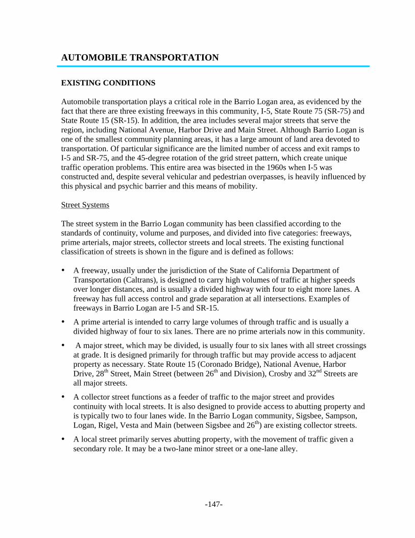
The street system in the Barrio Logan community has been classified according to thestandards of continuity, volume and purposes, and divided into five categories: freeways,prime arterials, major streets, collector streets and local streets. The existing functionalclassification of streets is shown in the figure and is defined as follows:
• A freeway, usually under the jurisdiction of the State of California Department ofTransportation (Caltrans), is designed to carry high volumes of traffic at higher speedsover longer distances, and is usually a divided highway with four to eight more lanes. Afreeway has full access control and grade separation at all intersections. Examples offreeways in Barrio Logan are I-5 and SR-15.
• A prime arterial is intended to carry large volumes of through traffic and is usually adivided highway of four to six lanes. There are no prime arterials now in this community.
• A major street, which may be divided, is usually four to six lanes with all street crossingsat grade. It is designed primarily for through traffic but may provide access to adjacentproperty as necessary. State Route 15 (Coronado Bridge), National Avenue, HarborDrive, 28th Street, Main Street (between 26th and Division), Crosby and 32nd Streets areall major streets.
• A collector street functions as a feeder of traffic to the major street and providescontinuity with local streets. It is also designed to provide access to abutting property andis typically two to four lanes wide. In the Barrio Logan community, Sigsbee, Sampson,Logan, Rigel, Vesta and Main (between Sigsbee and 26th) are existing collector streets.
• A local street primarily serves abutting property, with the movement of traffic given asecondary role. It may be a two-lane minor street or a one-lane alley.

- -148
TABLE 1CITY OF SAN DIEGO
STREET DESIGN STANDARDS (1977)Appendix I (to Council Policy 600-4)
Functional Street ClassificationNumberOf Lanes
ApproximateMax. ADT
R.O.W.Widths
Curb(or other
width)MedianWidth
ShoulderWidth
MinimumRadius of
CurveMaximum
GradePrimary Arterial 6 47,000 122’ (1) 102’ 14’ 8’ 1,000’ 6%
4 28,000 98’ (1) 78’ 14’ 8-10’ (4) 1,000’ 6%Major Street 6 (2) 32,000 122’ (3) 102’ 14’ 8-10’ (4) 1,000’ 7%
4 25,000 98’ (3) 102’ 14’ 8-10’ (4) 1,000’ 7%4 18,000 88-98’ (5) 68-78’ 4’ 8-10’ (4) 1,000’ 7%
Collector Street 4 10,000 84-98’ (5) 64-78’ 0-14’ 8-10’ (4) 500’ 12% (6)2 5,000 60-70’ (7) 40-50’ (7) 0’ 8-13’ 300’ 12% (6)
Local StreetIndustrial 2 5,000 70’ 50’ 0’ 13’ 200’ 8%Commercial 4 10,000 84’ 64’ 0’ 8’ 200’ 8%
2 5,000 60’ 40’ 0’ 8’ 200’ 8%Residential 2 5,000 60’ 40’ 0’ 8’ 100’ 15%
2 1,500 56’ 36’ 0’ 8’ 100’ 15%2 700 52’ (9) 32’ (9) 0’ 8’ 100’ 15%2 200 50’ (9) 30’ (9) 0’ 8’ 100’ 15%
Bikeways 0’Separated Facility 2 - 12’ 8-10’ (10) 0’ - 15’ 7%Within Street R/W (11) 2 - 10-16’ (12) 10’ (13) 0’ - 15’ Grade of StreetWithin Roadway 2 - - 5-8’ 0’ - 15’ Grade of Street
Alley 2 - 20’ 20’ 0’ - 100’ 7%Sidewalk 2 (15) - - 4-5’ (16) 0’ - - Grade of Street
1. Full control of access from abutting property.2. Used only where property owners elect and are authorized to construct additional lanes to convert a four-lane primary arterial to a major street in order to gain access.3. Access and parking control at critical locations. Additional width required for double left-turn lanes.4. 10’ where state or federal design standards apply.5. 98’ required where left turn lanes are needed.6. 8% in commercial areas.7. 70’ R.O.W. and 50’ curb width in industrial areas.8. Frontage roads or other single loaded streets: R.O.W. and curb widths may be reduced in residential areas to provide streets of 47/32’ (5,000 ADT), 43/28’ (1,500 ADT) and 41/26’ (700 & 200 ADT). R.O.W. may be
reduced to 5’ in commercial or industrial areas with no decrease in curb width.9. Where no parking will be allowed, curb-to-curb width may be reduced to 24’ with right-of-way width of 44’ (R.O.W. 34’ where sidewalks are provided separately from streets.)
10. 10’ facility where substantial amount of traffic volume is anticipated (e.g., near schools).11. Located in curb to property line area.12. 16’provides for 6’ landscaped separation between bikeway and roadway along major/primary arterials.13. Street lights, hydrants, etc., accommodated within 10’ paved area.14. One-way traffic on each shoulder, no parking. Separation from traffic lane varies from 6’ white line to 2’ island.15. Sidewalk on each side except single loaded streets.16. Minimum clear unobstructed width – 4’ residential areas, 5’ in commercial and industrial areas (excludes curb top width, fire hydrants, light poles, transformers, etc.*NOTE: These are standards applicable primarily to newly developing areas without unusual terrain problems. In difficult terrain and in older developed areas where flexibility is lost, they may represent only desirable goalsthat the designer attempts to achieve.
- -149
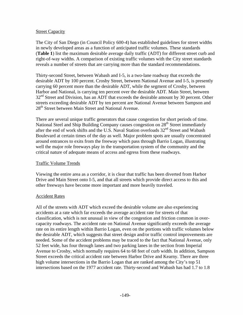
Street Capacity
The City of San Diego (in Council Policy 600-4) has established guidelines for street widthsin newly developed areas as a function of anticipated traffic volumes. These standards(Table 1) list the maximum desirable average daily traffic (ADT) for different street curb andright-of-way widths. A comparison of existing traffic volumes with the City street standardsreveals a number of streets that are carrying more than the standard recommendations.
Thirty-second Street, between Wabash and I-5, is a two-lane roadway that exceeds thedesirable ADT by 100 percent. Crosby Street, between National Avenue and I-5, is presentlycarrying 60 percent more than the desirable ADT, while the segment of Crosby, betweenHarbor and National, is carrying ten percent over the desirable ADT. Main Street, between32nd Street and Division, has an ADT that exceeds the desirable amount by 30 percent. Otherstreets exceeding desirable ADT by ten percent are National Avenue between Sampson and28th Street between Main Street and National Avenue.
There are several unique traffic generators that cause congestion for short periods of time.National Steel and Ship Building Company causes congestion on 28th Street immediatelyafter the end of work shifts and the U.S. Naval Station overloads 32nd Street and WabashBoulevard at certain times of the day as well. Major problem spots are usually concentratedaround entrances to exits from the freeway which pass through Barrio Logan, illustratingwell the major role freeways play in the transportation system of the community and thecritical nature of adequate means of access and egress from these roadways.
Traffic Volume Trends
Viewing the entire area as a corridor, it is clear that traffic has been diverted from HarborDrive and Main Street onto I-5, and that all streets which provide direct access to this andother freeways have become more important and more heavily traveled.
Accident Rates
All of the streets with ADT which exceed the desirable volume are also experiencingaccidents at a rate which far exceeds the average accident rate for streets of thatclassification, which is not unusual in view of the congestion and friction common in over-capacity roadways. The accident rate on National Avenue significantly exceeds the averagerate on its entire length within Barrio Logan, even on the portions with traffic volumes belowthe desirable ADT, which suggests that street design and/or traffic control improvements areneeded. Some of the accident problems may be traced to the fact that National Avenue, only52 feet wide, has four through lanes and two parking lanes in the section from ImperialAvenue to Crosby, which normally requires 64 to 68 feet of curb width. In addition, SampsonStreet exceeds the critical accident rate between Harbor Drive and Kearny. There are threehigh volume intersections in the Barrio Logan that are ranked among the City’s top 51intersections based on the 1977 accident rate. Thirty-second and Wabash has had 1.7 to 1.8

- -150

- -151
accidents per million vehicles entering the intersection in each of the past three years,ranking number 38 in 1977; and the intersection of Crosby and Harbor has had 1.6 to 2.5accidents per million vehicles in 1975 to 1977, ranking number 51 in 1977.
Traffic Control
There are 15 signalized intersections in Barrio Logan, all of which are traffic actuated andtherefore able to detect and respond to varying intersection traffic volumes. The two signalsat 32nd and Wabash and 32nd and Harbor are interconnected and operate a system to optimizetraffic flow through both intersections. In addition, eight of the traffic signals have protectedleft-turn phases for one or more directions. All but five of the intersections in the BarrioLogan area have some form of existing traffic control, either a traffic signal, stop signs oryield signs. Three of those intersections have four-way stops presently in operation:Beardsley and National; Crosby and National; and Logan and Sampson.
The intersections of Beardsley and National, Beardsley and Logan, Main and Sampson andCrosby and National have been studied to see how they rank compared to other intersectionsawaiting possible signalization. Crosby and National has 180 intersections ahead of it on thepriority specified traffic characteristics and criteria, and the other three have over 210intersections ahead of them on the priority list. The City, however, is only able to installabout five to ten signals per year because of financial limitations.
Parking
There is a serious parking shortage directly related to some of the major industrial employers,particularly National Steel and Ship Building Company, where most employees park on Citystreets and walk a number of blocks to their place of employment. There is, in fact, a highdemand for on-street parking in most of Barrio Logan. There are no parking meters orparking restrictions on the street in this area and on-street parking spaces have a highoccupancy rate. Recent studies made by NASSCO and the U. S. Navy specifically point outthe need to develop a comprehensive parking program for this area.
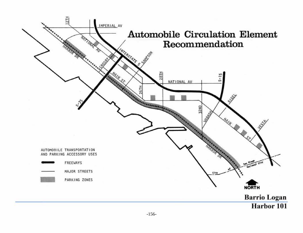
RECOMMENDATIONS
The 1995 forecast of traffic volumes for the Barrio Logan community, based on the proposedcommunity plan, show an increase on almost every street in Barrio Logan/Harbor 101community. This increase over the 1977 volumes can be as little as ten percent or, on somemajor streets, over 100 percent. Specific recommendations for streets and intersections basedon these forecast volumes follow.
Careful freeway management techniques should be established to increase the freewaycapacity and minimize the impacts of projected increases in traffic.
There will be significant increase in traffic on Freeway I-5, particularly in the portion southof SR-15, where 175,000 vehicles per day are expected. This will necessitate careful freewaymanagement techniques on the part of Caltrans to minimize congestion and traffic

- -152

- -153
stoppages, including the possibility of ramp metering, additional travel lanes or othermeasures. It will also be necessary that parallel major streets, such as Main Street and HarborDrive, be monitored carefully by the City to enhance the capacity and safety of this entiretraffic corridor. The anticipated operation by the Metropolitan Transit Development Board(MTDB) of a light rail transit system in this corridor will be an additional asset and shouldfurther enhance mobility.
Harbor Drive should be redesigned and reconstructed to accommodate more efficientlythe expected traffic, as well as other modes of transportation that will be utilizing thealignment under the proposals of this Plan.
Harbor Drive, a vital link with downtown San Diego, will be at capacity by 1995, carrying 25to 28 thousand vehicles as congestion increases on I-5. To carry these anticipated volumes, itis imperative that any modifications or improvements to Harbor Drive, including bikewayand truck routes, either preserve or increase the number of through lanes. The redesign of on-street parking and the planned development of parking reservoir areas, as well as minimizingdriveways and intersections with other streets as part of the Plan effort, are two strategies thatmay be necessary under this Plan’s timeframe.
Measures to increase street capacity should avoid costly street widenings and landpurchases. Actions for primary consideration should include on-street parkinglimitations during peak traffic hours, striping turn lanes, and interconnecting trafficsignals.
Main Street, between 32nd Street and Division
This section of Main Street is forecast to have a significant increase in traffic volumes with23,000 average daily trips expected by 1995. The existing street width, which is generally 52feet, with parking allowed on both sides of the street, will prove inadequate to handle thesevolumes without serious congestion and delay. Measures to increase the capacity includingsome widening of the street on the west side which is owned by the U.S. Navy, trafficmanagement techniques and the striping of left turn lanes and/or additional through lanesshould be investigated by the City's traffic operations section.
Main Street, Sigsbee to Sampson
This portion of Main Street, a collector street with a 52-foot curb-to-curb width, is onlyforecast to carry 4,000 average daily trips, a minimal increase over existing volumes. Thestreet is not a through street in that it terminates in a T-intersection at Sigsbee. Thedevelopment of the Plan’s proposed Educational/Cultural Center in the area of Newton,Harbor Drive, Sigsbee and Beardsley, may necessitate the closing of that portion of MainStreet between Sigsbee and Beardsley. The closing of this portion of Main Street woulddivert 3,000-4,000 trips onto parallel streets, mainly Harbor Drive, National Avenue and to alesser degree, Newton Avenue.

- -154

- -155
National Avenue
National Avenue is forecast to have 14,000 vehicles per day, which is almost twice theexisting volume. The 52-foot curb-to-curb street width on National Avenue can probablyaccommodate this volume if it is managed and operated so as to maximize capacity. Aninvestigation of measures to increase capacity should be conducted by the City's TrafficOperations Section examining alternatives for restriping the portion of National Avenue thatis only striped for two through lanes and the select prohibition of parking at peak periods andin certain locations on one or both sides as necessary.
The following intersections are recommended for investigation for traffic operationsbased on the travel forecast:
Crosby and Logan
Because both Crosby and Logan Avenues are forecast to experience increases in volume andin view of the existing congestion at this intersection, an investigation should be conducted todetermine how intersection capacity and efficiency should be increased. A modification ofthe phasing, the addition of through lanes, or the construction of right turn slots andtemporary parking prohibition, are possibilities that warrant consideration.
Crosby and National
Because of the same reasons as listed above and the anticipated increase in National's trafficvolumes, this intersection, presently a four-way stop, will need to be improved with regard tocapacity during this Plan's time-span.
28th and Harbor
Because both Harbor Drive and 28th Street will have higher volumes than they do presently,and because of the congestion that exists now during certain times of the day, aninvestigation into the efficiency of this traffic signal should be conducted. Considerations oftransportation management tools such as those previously mentioned should be considered.
Reinforce and enhance linkages to surrounding communities.
Beautify the major access points into the Barrio Logan/Harbor 101 community, particularlythe regional access points, the freeways and the street links Harbor Drive, National Avenue,Imperial Avenue, Commercial, Crosby, 28th, 32nd, Rigel, Vesta and Main Street.
Provide ways and means to make efficient use of the scarce land area by properutilization of circulation routes.
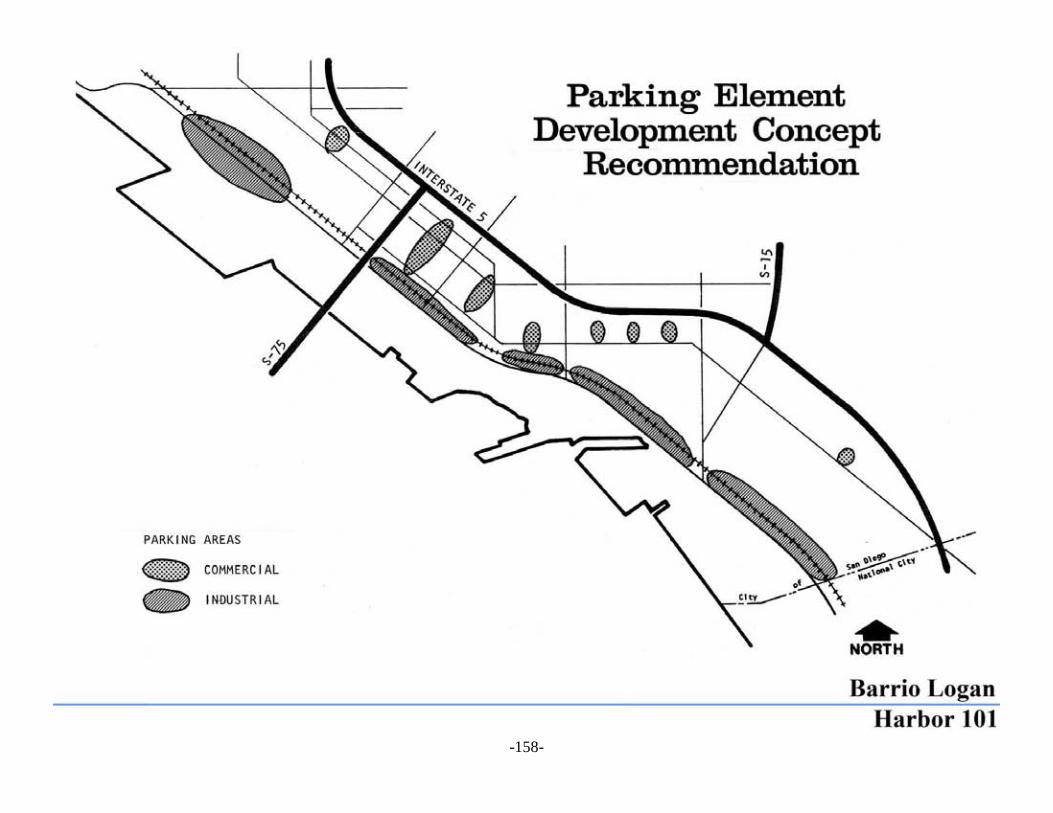
Provide parking areas where automobile storage, parking and related uses can beconcentrated. By doing this, some land presently used for parking can be reused for expandedindustrial, residential and other activities as may be found necessary without need
- -156

- -157
to undertake major improvements and land clearing. By organizing major access routes andestablishing parking areas, parking conflicts on residential streets may be reduced. Therailroad right-of-way should be consolidated and excess lands put to other use in those areasnot needed by the MTDB transit system for trackage and stations.
Streets that are not major or collector streets should be designed for access to the individualproperties. Possibilities exist in these areas after further study for narrowing and cul-de-sacing. Those street areas not necessary for automobile use could be reused as small plazas,pocket parks, and even new building and development areas.
Parking activities should be envisioned as accessory uses to the automobiletransportation system. This Plan recommends the delineation of parking areas alongHarbor Drive primarily and other areas as necessary to accommodate othercommercial and community facilities’ parking needs.
The Plan recommends the development of a parking system delineating the most desirablelocations for such a system. The size and number of cars to be accommodated in each areashould be the subject of a subsequent survey and proposal resulting from specificredevelopment studies.
Industry employee-related parking should be developed in a linear fashion along HarborDrive and the extension of Commercial Street into the proposed new industrial park. It isimportant to consider that the height and scale of the parking should not overshadowsurrounding development. Parking structures should be preferably removable temporaryparking structures that can be added onto or removed as demand warrants; or with permanentbut reusable structures which can be converted to other building use. The ground floors couldbe used for employee-related commercial services, eating establishments, gasoline stations,auto repair shops and other service uses.
Commercial-related parking should be developed to serve the commercial uses particularlyalong the Logan and National Avenues and Main Street areas. Off-street parking could bedeveloped in small parking lots off the main street and cross-streets that are not critical to themajor circulation system in the community could be closed to through traffic and used asparking areas.
The Navy's commercial and industrial areas provide their own parking. The industry-relatedparking is already located along Harbor Drive, although its layout at present is veryinefficient. The commercial area could accommodate its parking needs into the same HarborDrive parking reservoir concept.
Consideration should be given to prohibit all-day parking in residential neighborhoods. Thisaction should be coupled with the establishment of parking facilities for industrial workers inorder to reduce disruption to the residential and business community.
Because the existing street system will be called upon to serve the increasing transportationneeds of the region, including pedestrian, bicycle, transit and vehicular traffic, it will be bothimpractical and unsafe in the long-term to use all streets for the storage of parked vehicles.
- -158

- -159
Local employers, the Port District and its tenants should provide sufficient off-street parkingfor both employees and customers, so the streets can be better used for the safe and efficientmovement of people.
It is recommended that the extension of Commercial Street at Harbor Drive be studied as partof the industrial park development. A potential extension of Commercial Street inconjunction with the industrial park development proposal would provide additional neededaccess to the industrial development minimizing some effects on the remainder of thecommunity’s street system.
Off-street parking guidelines shall be established for all new development and incorporatedinto the implementation ordinances.

- -160

- -161
PUBLIC TRANSPORTATION
EXISTING CONDITIONS
The Barrio Logan area is quite well served by public transportation with five San Diegotransit bus routes passing through the area. Three routes, Number 29, 32 and 100 connectwith destinations to the south including Chula Vista, Imperial Beach and San Ysidro whileRoute Number 9/19 provides a link with Coronado via the Coronado Bay Bridge. Route 11serves as a link with Southeast San Diego and Spring Valley. In addition, all five routesconnect with downtown San Diego and other points in the City. Route 100 is an expressroute using I-5 for part of its route between downtown and Imperial Beach. Most majoremployers and Naval facilities in Barrio Logan are on or near a San Diego Transit route.Headways on all bus routes are usually 30 minutes or less but the peak ratio of passengers tonumber of seats (seated capacity) is quite high for Routes 9 and 32. Studies done by SanDiego Transit Corporation show bus use to be very high in this community when comparedto the rest of the City, making this a high transit-dependent community.
Negotiations are underway between the San Diego Arizona and Eastern railroad and theMTDB to purchase the railroad properties in order to develop a light rail transit link betweendowntown San Diego and the U.S./Mexican Border to the south. MTDB’s proposals havebeen given approval by the City Council and the agency is proceeding to purchase anddevelop the property. The light rail transit plans envision a rail link generally along HarborDrive and three stations within the Barrio Logan/Harbor 101 community planning area.
RECOMMENDATIONS
Establish a multi-modal transportation system throughout the community.
The multi-modal transportation system concept should be designed throughout thecommunity not only to accommodate the automobile, but to accommodate publictransportation, especially buses and light rail as proposed by MTDB with proper connectionswith related pedestrian and bicycle circulation networks.
Existing bus routes should be improved as much as possible to provide more service tothe community’s residential and working populations.
This Plan recommends the maintenance of existing routes and expansion of their servicehours and headways as this becomes economically viable to provide greater and moredependable service to both residential and working communities. The concentration ofindustry in this generally small area is an underdeveloped public transit asset, as is thetransit-oriented local resident population. Future emphasis on bus and rail transportation inthis community could do much to help minimize transportation over-dependence on theautomobile, particularly for inter-community transportation, easterly of the MTDB light railtransit. When this light rail system is completed, the bus routes should be modified to provideaccess to the transit stations from the surrounding community.
- -162
This Plan recommends the support of the proposed light rail transit alignment fromdowntown San Diego to the U.S./Mexican border.
The MTDB is in the process of purchasing the necessary railroad right-of-way from theArizona and Eastern Railroad to implement a light rail transportation system, the first phaseof which will include a link between downtown San Diego and San Ysidro. The BarrioLogan/Harbor 101 community is within that alignment. This Plan supports and encouragesthe implementation of that proposal. The Plan’s land use decisions are designed toaccommodate and reinforce that alignment by establishing the greatest density of industrialdevelopment and the community facility (Educational /Cultural Center) locations in closerelationship to that proposed transit system’s alignment. Therefore, the MTDB light railproposal would serve the Plan’s industrial use proposals and development (the new industrialpark) the Bay Access and Industrial Development proposals, the Educational/Cultural Centerproposal, and the Housing proposals.
This Plan recommends that the light rail transit station locations be located to serve thePlan’s specific land use recommendations.
This Plan recommends that a transit terminal be developed within the proposed industrialpark, as well as within the Chicano Park Area. This proposal would locate two stations. Onestation should be designed to directly serve the industrial park, estimated to generateapproximately 2,000 jobs, and the 10th Avenue Marine Terminal, which by itself represents asource of transit-dependent population from the ships berthed at the docks. The other stationshould be located to serve the Plan’s recommended Educational/Cultural Center that alsolinks to Chicano Park and the Bay Access area, as well as adjacent rehabilitated majorindustry and also provides direct links to the heart of the community’s residential areas.
- -163
INDUSTRY-RELATED TRANSPORTATION
EXISTING CONDITIONS
Due to the extensive industrial development in the community, transportation modesservicing the industrial uses are often in conflict with other community movement systems. Aparticular cause of conflict is the industrial trucks and their use of streets throughout thecommunity that also serve the residents, employees and other smaller community business.In addition to the fact that the streets are not designed to accommodate the large trucks, toooften, traffic signs are torn down by a moving truck. There are noise effects and pedestriansafety issues to consider.
The railroad also intersects the community and serves industrial activities and adjacentcommunity areas, particularly to the south. Several railroad links cross the BarrioLogan/Harbor 101 area. Their main function is to transport industrial cargo. A largeswitchyard is also located in the northeastern portion of the community partially within PortDistrict lands. Although somewhat reduced, due to the redevelopment of most industrialactivities to residential uses in the Centre City community planning area, railroad cargotransportation will still play a part in the transportation system of the Barrio Logan/Harbor101 community, particularly in relation to the Port District's interests in the 10th AvenueMarine Terminal and other major tidelands industrial users.
Shipping is another major industrial-oriented transportation system, which within thiscommunity plan, is controlled by the U.S. Navy and the San Diego Unified Port District. Theshipping industry is critical to the well-being of the region's industry and its expansion ingeneral. The further distribution of goods and services carried by this shipping industryrequire the interrelationship of other already mentioned transportation systems such as rail,trucking, public transportation and road access.
RECOMMENDATIONS
Discourage through traffic circulation and noise-producing vehicles from their use oflocal streets.
The Plan recommends that truck access particularly, be established through prescribed streetsproperly designed to accommodate these vehicles and not affecting the residential andbusiness sector of the community.
Develop commercial truck routes to eliminate the use of residential streets as throughtruck routes.
Develop traffic routes for inter- and intra-community truck traffic. Accessibility for trucksand industry service vehicles should be limited to those streets that directly serve the majorindustrial/commercial centers. There are two types of truck service, large trucks serving theindustry which should limit their movement to K and Imperial streets which have specially

- -164

- -165
designed freeway truck access ramps, and Harbor Drive, Commercial Street and WabashBoulevard. Smaller trucks serving commercial business should limit their movements toLogan Avenue, National, 26th Street, Main Street, Crosby, 28th, 32nd, and Vesta, as well asuse the other mentioned truck routes that are to be considered the through truck routes.Further distributive service should be from these corridors. Consideration could also be givenin the future to truck operational hours in order to avoid traffic conflicts with residentialneeds and commuter access.
Industrial rail access should be continued with an efficient use made of the existingright-of-way.
Rail access should be maintained to serve the major industrial areas along the waterfront andprovide continued access to the industrial areas in the communities to the south of the BarrioLogan/Harbor 101 community.
Reinforce the shipping industry along the waterfront through careful coordination andinterface with related transportation systems.
Given the fact that shipping transportation is located along the waterfront, the developmentof the Harbor Drive corridor is a critical element to the development of this industry.Therefore, the development and design of transportation systems along the Harbor Drivecorridor is a key recommendation of this Plan. This development should include auto access,industrial rail access and trucking as a key distributive transportation systems critical to thedevelopment of shipping. In addition, the MTDB rail transit and the bus system becomeimportant in providing additional access possibilities to personnel of the shipping industrythat often are transit-dependent.
Other related considerations are the location of industrial uses served by the shippingindustry along this same corridor and the storage needs required by shipping. In this respect,the 10th Avenue Terminal becomes a major consideration not only as an origin anddestination source, but also in terms of needs for warehousing in relation to the shippingindustry's expansion needs. For that purpose, this Plan recommends that the industrial parkdevelopment adjacent to the 10th Avenue Terminal consider this site as a potential expansionarea for the 10th Avenue Terminal described in the Industrial Element of this Plan.

- -167
PEDESTRIAN/BICYCLE/OPEN SPACE-RELATED TRANSPORTATION
Non-motorized forms of transportation including bicycling have experienced an increase inpopularity recently in response to concerns about both personal and environmental health.The result has been a boom in bicycling, walking, jogging and horseback riding. Even thoughbicycling is both for transportation and recreation, bikeways are nevertheless an importantpart of the circulation system. Bikeways are generally divided into three categories based onthe degree of improvement and access control. These include bicycle paths, bicycle lanes andbicycle routes. The City of San Diego is involved in a program of establishing a citywidesystem of bikeways, the goal of which is to link all of the community bikeways with thecitywide system.
Bicyclists are limited at present, to signed bicycle routes on narrow, heavily traveled streetswith on-street parking. There are no bicycle paths or lanes at present. A major north-southbicycle route exists along Harbor Drive and other bicycle routes of community significanceare along Main Street (between Sigsbee and Division), National Avenue (between Crosbyand the edge of Barrio Logan), Crosby Street (between Main and I-5), 32nd Street(proceeding north from Wabash) and Vesta Street north of Main Street.
There are a number of freeway crossings only for non-motorized transportation allowinggreater access and safety for pedestrians and bicyclists. These cross I-5 at Beardsley Street,Dewey Street and 30th Street, helping to unite areas bisected by the freeway.
Because of the development patterns, Barrio Logan does not have a separate riding andhiking trail system. Pedestrian activities are confined to the existing sidewalk system, thecondition of which ranges from poor to average. Most streets in the area have sidewalks,Harbor Drive being a significant exception. In addition to the three interstatepedestrian/bicycle overpasses mentioned earlier, there are three other pedestrian overpasses,one on Harbor Drive, at 32nd Street; one on Harbor Drive at 1200 feet south of 32nd Street;and one on 32nd Street at Harbor Drive which is connected to the bridge over Harbor Drive atthis location.
Eight of the traffic signals in the Barrio Logan area have pedestrian phases which respond topedestrians who use the push-button detector and which then provide sufficient time to safelycross the street. Those eight signals and all pedestrian overpasses are shown “Pedestrian-Oriented Traffic Control.”
In summary, pedestrian circulation in Barrio Logan is hampered and less enjoyable becauseof the numerous pedestrian-vehicle conflicts encountered and the absence of pedestrian trails(other than sidewalks).
- -168

- -169
RECOMMENDATIONS
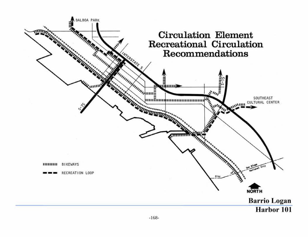
This Plan recommends that bikeways be developed to follow routes that link tosurrounding communities as well as to major open spaces.
The Plan recommends the completion of the proposed Harbor Drive bikeway link and thefurther development of other links through the community to the Southeast San Diego,Centre City and Balboa Park areas, as well as through Chollas Creek to the inlandcommunities and canyons.
Pedestrian areas should be carefully designed to link the different communityneighborhoods, community facilities and to interface all other transportation modes.
The pedestrian environment in the Barrio Logan/Harbor 101 community should be enhancedand reinforced. It is important that pedestrian paths be integrated both with the open spacesystem, the neighborhoods, and the activity centers in the community including the transitstations and the parking reservoir areas. It should be remembered that a car/driver becomes apedestrian once the vehicle reaches its destination. This recommendation particularly affectsthe public right-of-way areas in terms of beautification possibilities and general communityenhancement.
This Plan recommends that a major beautification and landscaping effort be madealong the major transportation corridors.
A beautification and tree planting campaign should be pursued along I-5 with landscapingand mounding wherever possible to mitigate the freeway's environmental impacts on thecommunity. Caltrans has present plans for I-5 landscaping which this Plan supports andalong Harbor Drive and the major streets that link the Barrio Logan/Harbor 101 communityto surrounding communities. Plant materials should be drought-resistant. Much of this workwould be undertaken by Caltrans, MTDB, the City, and Port District.
It is recommended that consideration be given to the extension of Center City’sproposed recreational transit link into the Barrio Logan/Harbor 101 community.
This Plan recommends that the proposed Centre City system, if realized financially, beextended along Harbor Drive, and from the Fifth Avenue Gaslamp Quarter to Chicano Parkand Logan Avenue to 12th Avenue and Balboa Park. A further and future extension of thislink could include Chollas Creek and East San Diego under I-5 and SR-15 to the SoutheastEducation/Cultural Center and the inland open space and Canyon systems.
IMPLEMENTATION RECOMMENDATIONS
The most important transportation implementation recommendation includes the redesignand reconstruction of Harbor Drive. This corridor will be the one most affected by increasedtraffic volumes resulting from this Plan. It will also be the most affected from the fact thatpractically all transportation recommendations include this corridor in their proposals.

- -170

- -171
The corridor will include the design for accommodation of truck lanes, the integration of theMTDB light rail transit, maintenance of the industrial rail transit, inclusion of bus routes andstops, and the development of the industrial employee parking proposal, together with theincorporation of the regional bicycle route, and the necessary pedestrian links and crossings.Completion of this single project would implement the greatest portion of the transportationelement, leaving other recommendations to administrative and management methods whichare reasonably simple to implement and less costly. Implementation of this project will alsoinvolve the greatest number of agencies such as the City, Port District, MTDB, Caltrans, theU.S. Navy, and other related agencies such as the Bridge Authority, Coastal Commission,School District, Community Colleges, and private enterprises (in relation to therecommended parking district). The coordination of all of these agencies could be mostefficiently realized through the redevelopment process so that all actions are planned andcoordinated from a central point.
Assessment districts for parking should be coordinated by the redevelopment agency with theparticipation of other agencies and private enterprise as these are affected. The City of SanDiego, through its redevelopment agency, should also coordinate the administrative andmanagement actions recommended in this Plan with all affected parties.