Embed Size (px)
Citation preview

TRANSPORT ASSESSMENT
Guidelines for Development Proposals
in Northern Ireland
Published 9th November 2006
(Please note that this version is the same as the original version dated October 2006 made available through the Department for Regional Development website.)


Transport Assessment Guidelines for Development Proposals in Northern Ireland
Contents
CONTENTS PAGE
1. INTRODUCTION 1
Who Should Read the Guidelines? 1
Role of the Government, Developers and Public Transport Operators 1
Equality Impact Assessment 2
2. TRANSPORT ASSESSMENT OVERVIEW 3
Purpose of Transport Assessment 3
Comparison of Transport Assessment and Traffic Impact Assessments 3
3 THE TRANSPORT ASSESSMENT PROCESS: A SUMMARY 5
The Transport Assessment Form 5
Guidance for Deciding Whether a Detailed Transport Assessment is Required 5
Scoping Discussions 6
Methods for Implementing and Monitoring Measures Identified by a Transport Assessment 7
4 PREPARING A DETAILED TRANSPORT ASSESSMENT 11
Stage 1 - Assessing the Travel Characteristics of a Development 11
Stage 2 - Influencing Travel to the Development 16
Stage 3 - Appraising and Mitigating Impacts 29
5 DATA AVAILABLE IN NORTHERN IRELAND 35
Journey Time and Distance Data 35
Public Transport Data 36
General Data 38

Transport Assessment Guidelines for Development Proposals in Northern Ireland
Contents
APPENDICES PAGE
APPENDIX A 41
Transport Assessment Form
APPENDIX B 47
Further Reading
APPENDIX C 51
General Procedure For Assessing Proposed Parking Levels
APPENDIX D 53
Supplementary Guidance Relating To Traffic Impact Analysis
Transport Assessment Guidelines for Development Proposals in Northern Ireland
1
1. INTRODUCTION
1.1 The objective of this Guide is to assist in the preparation of Transport Assessments for development proposals in Northern Ireland, the policy context for which is set out in Planning Policy Statement 13: Transportation and Land Use and Planning Policy Statement 3: Access, Movement and Parking1.
Who Should Read the Guidelines?
1.2 All those involved in the transport and land-use development process in Northern Ireland, including:
• developers and their consultants involved in preparing proposals for new developments or the re-development of existing sites;
• staff within the Department for Regional Development (DRD) and the Department of the Environment (DOE) with responsibility for land-use planning and transport issues;
• District Councils, given their statutory consultee role in the development control process;
• public transport providers / operators in Northern Ireland; • those who may need or wish to understand the Transport Assessment process -
including members of the public who may be affected by proposed developments and groups with specific interests in transport.
Role of the Government, Developers and Public Transport Operators
Government
1.3 The Department of the Environment (DOE) is responsible for planning control in Northern Ireland. The Planning Service, an agency within the Department, administers its planning functions. The Department’s statutory planning functions are contained in the Planning (Northern Ireland) Order 1991 and associated subordinate legislation.
1.4 DOE Planning Service prepares development plans which may be in the form of area plans, local plans or subject plans and they apply the regional policies at the appropriate local level. Development plans inform all interested bodies of the policy framework and land use proposals that will be used to guide development decisions within their local area. They provide a firm basis for rational and consistent decisions on planning applications and provide a measure of certainty about which types of development will and will not be permitted. Development plans are the primary means of reconciling any potential conflicts between the need for development and the need to protect the built and natural environment.
1.5 The Department for Regional Development (DRD) is responsible for strategic planning and transport policy development in Northern Ireland. Roads Service is an agency of the DRD and has responsibility for roads.
1 For Planning Policy Statements see Planning Service website at http://www.planningni.gov.uk/

Transport Assessment Guidelines for Development Proposals in Northern Ireland
2
1.6 The DRD’s functions include:
• strategic planning; • transportation strategy; • transport policy and support; • ports and airports policy; • roads and water policy; • providing and maintaining roads; and • providing and maintaining water and sewerage services.
1.7 Planning Service and DRD staff are available to advise developers on the Transport Assessment process.
Developers
1.8 Developers are responsible for undertaking a Transport Assessment for a proposed development or re-development. A Transport Assessment Form (Appendix A) must be submitted with each planning application. Its purpose is to screen out those applications where no further information on the transport impacts is needed and help identify applications where developers will be asked by Planning Service to prepare a detailed Transport Assessment.
Public transport operators
1.9 Developers should discuss their proposals with public transport operators at an early stage in order to consider:
• the site access arrangements and infrastructure requirements for public transport services2; and
• whether new public transport services or alterations to existing services are needed to provide the appropriate level of public transport accessibility for the site.
Equality Impact Assessment
1.10 When preparing these guidelines for public consultation, DRD screened the document and concluded that there would be no significant implications for equality of opportunity or community relations arising from the contents. Therefore it was considered that an Equality Impact Assessment was not required.
2 Guidelines for Planning for Public Transport in Developments (The Institution of Highways and Transportation, 1999)
Transport Assessment Guidelines for Development Proposals in Northern Ireland
3
2. TRANSPORT ASSESSMENT OVERVIEW
Definition of Transport Assessment
A Transport Assessment is a comprehensive review of all the potential transport impacts of a proposed development or re-development, with an agreed plan to mitigate any adverse consequences.
Purpose of Transport Assessment
2.1 The purpose of Transport Assessment is to provide enough information for DOE and DRD to understand how the proposed development is likely to function in transport terms. Assessing the transport impacts in a systematic manner contributes towards understanding how more sustainable travel patterns might be achieved through changing travel behaviour. Transport Assessment also subsumes the former process of Traffic Impact Assessment.
2.2 The preparation and detail of a Transport Assessment will vary depending on the location, scale and nature of the proposed development. Transport Assessment should, where appropriate, propose a package of measures designed to promote access to the site by walking, cycling and public transport, while reducing the role of car access as much as possible.
2.3 Early discussions between the developer, DOE Planning Service and DRD will help determine the degree of detail to be contained in the Transport Assessment and avoid lengthening the decision making process.
2.4 Planning Service may require changes to the proposal in order to facilitate more sustainable travel patterns, which may include providing improved transport infrastructure and/or services. Planning conditions and other legal agreements will be used to ensure that agreed transportation measures are put in place by developers.
Comparison of Transport Assessment and Traffic Impact Assessment
2.5 The key difference is that Transport Assessments cover all modes of transport from a person-trip perspective, with the emphasis on walking, cycling and public transport whereas Traffic Impact Assessments generally concentrated on accommodating car trips (to ensure that the traffic impacts associated with a new development would be accommodated) and gave only limited attention to accessibility by non-car modes.
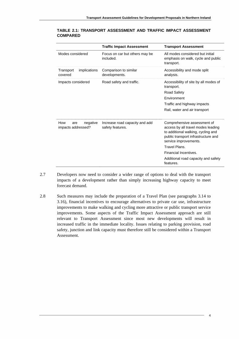
2.6 Table 2.1 below summarises the main differences.
Transport Assessment Guidelines for Development Proposals in Northern Ireland
4
TABLE 2.1: TRANSPORT ASSESSMENT AND TRAFFIC IMPACT ASSESSMENT COMPARED
Traffic Impact Assessment Transport Assessment
Modes considered Focus on car but others may be included.
All modes considered but initial emphasis on walk, cycle and public transport.
Transport implications covered
Comparison to similar developments.
Accessibility and mode split analysis.
Impacts considered Road safety and traffic. Accessibility of site by all modes of transport. Road Safety Environment Traffic and highway impacts Rail, water and air transport
How are negative impacts addressed?
Increase road capacity and add safety features.
Comprehensive assessment of access by all travel modes leading to additional walking, cycling and public transport infrastructure and service improvements. Travel Plans. Financial Incentives. Additional road capacity and safety features.
2.7 Developers now need to consider a wider range of options to deal with the transport impacts of a development rather than simply increasing highway capacity to meet forecast demand.
2.8 Such measures may include the preparation of a Travel Plan (see paragraphs 3.14 to 3.16), financial incentives to encourage alternatives to private car use, infrastructure improvements to make walking and cycling more attractive or public transport service improvements. Some aspects of the Traffic Impact Assessment approach are still relevant to Transport Assessment since most new developments will result in increased traffic in the immediate locality. Issues relating to parking provision, road safety, junction and link capacity must therefore still be considered within a Transport Assessment.
Transport Assessment Guidelines for Development Proposals in Northern Ireland
5
3. THE TRANSPORT ASSESSMENT PROCESS: A SUMMARY
The Transport Assessment Form
3.1 A Transport Assessment Form (TAF) (Appendix A) must be completed in conjunction with each planning application.
3.2 The TAF is in 4 Parts. Part A must be completed for all developments or redevelopments and contains a number of questions related to the nature and scale of the development. Its purpose is to screen out those applications where no further information on the transport impacts of the proposal is required.
3.3 Where the answer to any of the questions in Part A of the TAF is yes, Parts B, C and D must also be completed. The purpose of parts B, C and D is to provide information to enable Planning Service, in consultation with Roads Service, to decide whether a detailed Transport Assessment is required.
3.4 A detailed Transport Assessment will be required where the development or re-development is considered to be likely to have significant transport implications, no matter the size. The coverage and detail of the Transport Assessment should reflect the scale and the likely extent of transport impacts of the proposed scheme.
Guidance for Deciding Whether a Detailed Transport Assessment is Required
3.5 As a guide, proposals exceeding the following parameters may have sufficient transport impacts to require the completion of a detailed Transport Assessment.
Size: the size thresholds set out in the table below.
Use Thresholds above which a Detailed Transport Assessment may be required
Food retail 1,000m2 Gross Floor Area
Non-food retail 1,000m2 Gross Floor Area
Cinemas and conference facilities 1,000m2 Gross Floor Area
Leisure facilities 1,000m2 Gross Floor Area
Business 2,500m2 Gross Floor Area
Industry 5,000m2 Gross Floor Area
Distribution and warehousing 10,000m2 Gross Floor Area
Hospitals 2,500m2 Gross Floor Area
Higher and further education 2,500m2 Gross Floor Area
Stadia 1,500 seats
Housing 100 dwellings
Location: sites that do not conform with Development Plan policy or accessibility criteria that may be contained in the Development Plan. These sites are likely to be those only easily accessible by car, generally located on the edges of urban areas, in
Transport Assessment Guidelines for Development Proposals in Northern Ireland
6
green belts, out-of-town, near motorway junctions. Applicants should refer to PPS12 Housing in Settlements, PPS13 Transportation and Land Use and PPS3 Access, Movement and Parking. Activity: 100 or more vehicle movements in the peak hour.
Other considerations: where the Planning Service and the Roads Service consider the proposals raise significant transport implications, such as where the development is likely to: • generate significant traffic at peak times in a congested area, a sensitive location or
an important traffic route or road junction; • generate significant freight movements; • generate traffic late at night in a residential area, particularly lorries; • raise significant concerns over road safety.
3.6 The guidance outlined above also refers to developments involving changes of use or alterations or intensification of an existing use.
Scoping Discussions
3.7 Throughout the process of securing planning permission, the main point of contact for the developer will be with the Planning Service. However other bodies, such as Roads Service and public transport providers, may also need to be involved, depending on the nature, scale and location of the proposal. Early discussions with these parties will help to save time later in the planning process by ensuring that all issues have been covered in the Transport Assessment. For example, these discussions could cover issues such as:
• the requirements for complying with the Development Plan policies in order to promote sustainable transport;
• the scope of information needed from a developer; • the availability of local data that may assist in the preparation of a Transport
Assessment.
3.8 These discussions should also be used to identify measures needed to promote a wider choice of access to the site particularly by non-car modes, including:
• improvements or modifications to pedestrian access (including facilities for people with impaired mobility);
• improvements or modifications to cycle access; • improvements or modifications to public transport services; • the need for a Travel Plan3 and Service Vehicle Plan; and
3 Making Smarter Choices Work (DfT, 2005)

Transport Assessment Guidelines for Development Proposals in Northern Ireland
7
• the use of planning conditions and planning and other legal agreements to secure these measures.
3.9 On-going liaison between developers and the Planning Service will enable agreement as to the nature and scale of the development so that later, and potentially more expensive, changes will not be needed.
Methods for Implementing and Monitoring Measures Identified by a Transport Assessment
Implementing measures
3.10 The key to implementation is to make sure that those actions and measures, which are described as being part of the proposed development, are properly specified when planning permission is granted. On-site infrastructure proposals should be clearly shown on the plans and drawings accompanying the planning application. Other measures and actions, for example bus routes or bus stops, identified in the Transport Assessment, to be provided or funded by developers, will be secured through planning conditions or, where appropriate, a planning or other legal agreement.
3.11 Planning permission may also be subject to a condition preventing the development from going ahead until works necessary to facilitate the development, such as transport infrastructure improvements or other improvements, for example, road widening, have been carried out.
3.12 Planning or other legal agreements may be necessary where, for example, development necessitates the provision of off-site transport infrastructure or where developers are expected to provide financial contributions towards the implementation of transport measures, such as improvements in public transport services. The provision or improvement of transport infrastructure or measures may be provided by virtue of a Planning Agreement under Article 40 of the Planning (NI) Order 1991 or an Agreement under Article 122 of the Roads (NI) Order 1993 or Private Streets legislation.
3.13 Submitting a Travel Plan alongside the Planning Application may help to outline how the developer envisages mitigating any adverse transport impacts.
Travel Plans
3.14 A Travel Plan may be required if the development is a significant travel generator. A Travel Plan may also be required for small developments as a mitigation measure to reduce car dependency. Planning Service, in consultation with Roads Service, will advise when a Travel Plan is required.
3.15 A Travel Plan may include measures tailored to the development proposal, for example, off-site car parks or contract bus services. Travel Plans provide co-ordination of transport related measures and will be more effective in changing travel patterns than individual initiatives. Information obtained through the Transport Assessment process on travel patterns may form part of the Travel Plan.

Transport Assessment Guidelines for Development Proposals in Northern Ireland
8
3.16 Travel Plans are often submitted to demonstrate how the developer expects to mitigate transport impacts. A Travel Plan should include a clear set of targets, which are easy to measure and relate directly to the planning application. The monitoring of Travel Plans will be required and arrangements need to be agreed as part of the planning decision.
Servicing Plans
3.17 A Transport Assessment should set out how the site will be serviced. Information on the anticipated number and scheduling of delivery vehicles is required. This should demonstrate how any larger vehicles would use the site, and how adverse impacts are being addressed.
Change of Use
3.18 Even where the initial occupier is known some land uses, such as offices, could change over time. For example, an office used as a telephone call-centre could change into a training centre for the same occupier but with significantly different transport consequences.
3.19 As a change of use (involving the need for planning permission) could easily result in different travel characteristics, a Transport Assessment may be requested.
Speculative Development
3.20 Speculative development raises a particular issue since it may be unclear who the eventual occupier of a development will be. While some developments may only be useable for one purpose, others, such as industrial units or offices, could be used with radically different intensities with different transport impacts.
3.21 Speculative development and outline planning applications pose difficulties since the ultimate occupier or details of the scheme will not be identified as part of the application. Such proposals must be handled carefully to ensure that the benefits of the Transport Assessment process are not lost. Relevant points to note are:
• Transport Assessment may incorporate some elements which require implementation by the final occupier to be successful, such as financial inducements to encourage behavioural change. Other elements may be self-enforcing, for example, restrictions on parking provision.
• for outline planning applications developers should ensure that the description of the development is sufficient to enable the main transport impacts to be identified and assessed. The Transport Assessment should indicate the conditions to be attached on any outline planning consent to ensure that any subsequent applications maintain the conditions of the original application.
• one approach for the developer will be to consider the worst likely case. If the resulting trip generation is acceptable then any other outcome can be regarded as acceptable.
• planning permission normally rests with the land and not the occupier. Planning or other legal agreements will be enforceable against the person who entered into the agreement and in the case of registered Article 40 planning agreements any person who derives title from that person..
Transport Assessment Guidelines for Development Proposals in Northern Ireland
9
3.22 It may be appropriate to confine the Transport Assessment only to infrastructure matters that can be provided by the developer and require a Travel Plan to encourage behavioural change from the occupier. The developer would be required to take on responsibility for the Travel Plan prior to passing it to the occupier.
3.23 As part of the overall process, the occupier would also be responsible for carrying out post-implementation monitoring to ensure that travel plans are developing as intended or to help identify courses of action required through modifications to the Travel Plan.
Cumulative Impact
3.24 With several minor proposals in close proximity, a detailed Transport Assessment of the cumulative impact of the proposals may be more appropriate than one for each proposal in isolation. If Planning Service wishes to promote several minor developments near each other, it should aim, in consultation with Roads Service, to assess the cumulative transport issues arising from the entire scheme, ideally at the time the site or area is being designated in the Development Plan.
3.25 Conversely, where proposals may emerge independently from one another, rather than as a single proposal, the situation is more complex. This can give rise to a domino effect when one successful application leads to further proposals, as may occur with housing. Planning Service may be able to foresee when this is likely to occur (or react when it starts to happen), by aiming to assess the sites together, possibly as part of an area-wide development brief or master plan.
Monitoring measures
3.26 It will be essential for the developer or occupier to monitor measures identified through the Transport Assessment / Travel Plan process. This may, for example, involve measuring the modal share to see if targets are being achieved or measuring the level of parking utilisation.
3.27 Monitoring may be required for an agreed period and may be stipulated as part of the planning decision. It could involve the building occupier submitting an annual or bi-annual report to the Planning Service presenting the outcome of perhaps regular monitoring exercises. The occupier of the development will be required to meet the costs of any monitoring.

Transport Assessment Guidelines for Development Proposals in Northern Ireland
10
Examples of various targets that can be used for monitoring
number of vehicles entering a site; the modal share (walking, cycling, public transport, car) of those visiting the
development; parking usage (e.g. proportion of available parking used); on-street parking on surrounding roads; the maximum number or proportion of single occupancy vehicles entering the
site; the level of car-sharing; and/or the provision of travel (e.g. public transport) information to staff and customers.

Transport Assessment Guidelines for Development Proposals in Northern Ireland
4. PREPARING A DETAILED TRANSPORT ASSESSMENT
4.1 A Detailed Transport Assessment for a development or redevelopment should have 3 key stages as outlined in Figure 4.1 below. The process is developed within this chapter.
11
FIGURE4.1 KEY STAGES OF A DETAILED TRANSPORT ASSESSMENT
z Assessment of travel characteristicsAccessibility by different modesCalculate numbers who could reach it
Measures to influence travel to the site Location and scal e Layout and design Promoting individual modesManaging car use and parkingAwareness raising and marketing
Incentives to individuals
Assessment of impactsImpacts on safety, congestion, environment, loc l accessibility, parking, and local comm unity
a
1
2
3
Alter scale, design or layout? Strengthen measures to
influence travel to the site? Redesign parking and
road layout? Mitigate for impacts? Travel Plans
Public Transport Commuter Initiatives
Stage 1 - Assessing the Travel Characteristics of a Development
4.2 The role of the Transport Assessment is to provide Planning Service and Roads Service with a good understanding of how the transport aspects of the development will function. The first stage to be undertaken, possibly before the scoping discussions, is a site visit.
The site visit
4.3 One or more site visits may be needed to examine aspects such as:
• accessibility within the site boundaries. For larger developments it will be necessary to consider the travel time across the functional area of the development: from the boundary of the site with public access routes to the 'entrance' of the building(s). The site visit may suggest other layouts for the building(s) and locations of doors and entrances to the site which could save time and provide better quality access by non-car modes;
• accessibility on foot to the site from the surrounding locality, bus stops, bus and train stations;

Transport Assessment Guidelines for Development Proposals in Northern Ireland
12
• accessibility for people with mobility impairments: for example, provision of dropped kerbs or tactile paving and the quality of lighting4.
• pedestrian crossings and safety: including whether alternative layouts on the surrounding highways might reduce conflicts between pedestrians and motorised traffic or cycles;
• access by bicycle: identifying opportunities for improving cycle access including cycle lanes, junction and crossing improvements;
• access from bus stops (and bus or railway stations): calculating walking times from bus stops or stations and considering whether new bus stops are required or existing ones need to be relocated; and
• access for vehicular traffic (buses, if appropriate, cars and lorries): identifying potential conflicts with non-vehicular modes, as well as possible local congestion problems.
Measurement of accessibility to and from the site
4.4 Determining the accessibility of a site will require calculating the travel time (at peak and off-peak times) by different modes of access: walking, cycling, public transport and car. Travel time assessments determine the catchment area of a development by different modes; areas within which one can reach a development within set times or time-bands (e.g. 30 mins). Catchment areas can be shown by lines on maps (isochrones) which connect points equal in time from a given location. The choice of time-band may vary, in line with the use and scale of the development: people may be prepared to travel further for some activities, for example, to a regional shopping centre than to a local shop.
• Walking and cycling: these seek to establish the catchment area for walking and cycling - the places from which pedestrians or cyclists can reach a development within a set time. Journeys of up to 1 kilometre for walking and up to 4 kilometres for cycling are normally appropriate. A two-stage process is recommended: estimating time by analysis of maps; then checking the actual times of people travelling these routes, which will help take account of factors such as the time required to cross roads or walk/cycle up hills.
• Public transport: can be calculated by a combination of analysis of timetables and maps. However this should be complemented by observation of walking times to actual (or potential) bus stops. A 30 minute door to door travel time (including the walk, wait, journey time, and walk to the destination) is an appropriate choice of time-band by public transport for most types of development although it may also be helpful to consider a 45 minute door to door travel time. For developments of regional importance 1 hour may be appropriate.
• Car (or other motorised vehicles) access: can be calculated in various ways, including analysis of maps and route planning software. It should include estimates of the in-vehicle travel time: walking to the vehicle; searching for a parking space; and walking from the vehicle to the site entrance plus likelihood of known congestion on route. Time estimates for other motorised vehicles - motorcycles, mopeds, light vans, HGVs - can be assumed to be the same.
4 Development Control Advice Note 11 (Revised) – Access for All: Designing for an Accessible Environment (DOE, 2003)
Transport Assessment Guidelines for Development Proposals in Northern Ireland
13
Housing
4.5 For housing developments a different approach is needed since it is a generator of journeys rather than an attractor. The travel time assessment should measure the time taken to reach services (e.g. shops, schools, employment centres etc.) from the housing development, but the basic methods used will be the same. Travel times across the development site for larger housing developments may be significant, and separate analyses may be needed for different parts of a very large development.
Estimating the travel generated and likely modal split
4.6 The estimation of how many people will travel to the site and by what mode (or in the case of housing, from the site) can be undertaken by several methods. Here only the simple approach is described. This requires consideration of the:
• location of the site including: how many people are living within the travel time isochrones by each mode;
and
the likely propensity of people within each catchment to use the proposed facility.
• size of the catchment area: larger catchment areas (often for larger developments) imply a higher modal share for car-use but also offer more potential for public transport use.
• use of the development including: whether people need to carry bulky items to or from it; and whether people will be likely to visit the site as part of a linked-trip to other
locations, for example for pass-by shopping. • design and layout within the site: how it helps or hinders access by different
modes and adds to or reduces travel times. • measures taken to influence modal split and how they are likely to influence the
choice of mode.
4.7 Within a Transport Assessment it will only be possible to make broad estimations using these factors.
Available databases
4.8 Estimating travel generation and modal split requires appropriate data. However the suitability of data for Transport Assessments is of variable quality, with much depending on the type of area that a development is proposed in, and the resources available to the developer undertaking the assessment. Chapter 5 describes the data available in Northern Ireland.
4.9 Trip generation databases are an important source of information on car travel. Unless the data contains information on non-car modes, they should be employed with caution in Transport Assessments – possibly as a starting point for the base level of travel and modal share for example. In addition, their use may tend to replicate past
Transport Assessment Guidelines for Development Proposals in Northern Ireland
14
travel patterns, thus encouraging developers to provide for more car travel than is necessary, rather than promoting sustainable modes.
4.10 Nevertheless, for the present, these databases remain necessary tools, since they provide more information on behaviour than other surveys. Furthermore they are now being changed to allow inclusion of data for modes other than the car.
Trip rate
4.11 Two technical terms should be understood:
• “Trip generation” refers to trips which enter and leave the particular development. • “Trip rates” refer to the intensity of travel due to the development and are defined
in terms of: the number of trips in comparison to the “size” of the development (for
example floor area or number of employees); and
for a particular time period (for example peak hour or weekday).
4.12 The selection of a trip rate is important in estimating the travel generation of a site. The following factors need to be taken into account in selecting a rate for the size of the catchment;
• the propensity to walk/cycle; • the type, quality and frequency of public transport provision; • the level of on-site parking restraint; • whether there are parking controls in the vicinity of the scheme; • the potential for linked trip opportunities; and • for retail sites, competition within the locality.
4.13 In preparing Transport Assessments it is important to consider a wide range of trip rates. Depending on the nature of the development it is likely that a lower (50th) or a higher (85th) rate will be appropriate for most developments. Care must be taken when using the lower rate, that lower car use can actually be achieved. All rates used will need reasonable explanation and justification in the Transport Assessment.
Research on measures to influence modal split
4.14 Many research projects have been undertaken to measure the effect on modal split of measures varying from new light rail networks to traffic calming, and persuasion campaigns. Research findings sometimes contradict one another, and it must be recognised that many measures designed to encourage access by means other than the car will only have a minor effect when introduced on their own. As part of a package of measures, however, their impact can make a significant positive impact. Research to investigate the combined impact of a range of measures is emerging and in the future will be of use in preparing Transport Assessments.
Transport Assessment Guidelines for Development Proposals in Northern Ireland
15
Person-trip travel surveys
4.15 It is important to undertake a person-trip based assessment for all developments for which a detailed Transport Assessment is required. The main sources of person trip data in Northern Ireland are currently the Travel Survey for Northern Ireland, the Census and other local movement surveys. However, these surveys are not primarily designed for use in Transport Assessments and should be used with care. (More details about various data sources for Northern Ireland can be found in Chapter 5).
• The Travel Survey for Northern Ireland (TSNI) contains detailed information and can be useful for estimating trip generation from housing developments. However, it records journey purposes (such as "shopping") rather than trips to development types (e.g. "corner shop", "supermarket", or "town centre"), and it cannot be used for detailed local analysis.
• The Northern Ireland Census 2001 deals with home-based work journeys only, and records only the mode of travel for the main part of the journey. This can obscure information which is of use in a Transport Assessment, such as the mode used to leave or arrive at a development.
• Local movement surveys can vary in their value depending on the purposes for which they have been carried out and the detail included.
4.16 A major benefit of the TSNI and the Census is that there is information on all modes, in contrast with the focus on car use that is common in vehicle databases. However, the TSNI and Census cover trips from housing, so a likely difficulty will lie in estimating trips to and from other land uses - although this can be overcome. Developers are recommended to enquire as to the availability of local data.
Estimating modal split
4.17 Modal split estimates can draw on catchment area analysis, comparing travel behaviour with activity elsewhere and supported by data on the likely travel behaviour. However, it may be possible to make good estimates with less emphasis on these techniques by comparisons with similar existing developments, and including the effect of proposed measures to influence travel in the proposal. In seeking suitable sites, one should look for comparable locations, scale, public transport provision and non-car accessibility.
4.18 Using these techniques should provide estimates of the numbers travelling to the site, their choice of mode, and the overall modal split.
4.19 Realistic estimates of access by non-car modes should be provided.

Transport Assessment Guidelines for Development Proposals in Northern Ireland
16
Stage 2 - Influencing Travel to the Development
Location
4.20 Choosing an accessible location will determine whether there is real opportunity to promote sustainable development and the policy objectives of PPS15.
4.21 Ideally, the assessment of accessibility by different modes should be undertaken for a number of possible sites before decisions are made on possible locations and site layouts. Sites identified in Development Plans for future development or re-development for those activities which generate a significant number of trips should be those most easily accessible by non-car modes.
Scale
4.22 The scale of the development will also influence travel behaviour. It will determine the size of the catchment area of the site and the likely modal split. Generally small developments tend to have small catchment areas, however, this depends on the use. In good locations, easily accessible by walking and cycling, these modes could be used for a relatively large proportion of trips.
4.23 Generally the larger a development, the larger the catchment area and, as a result, the number and proportion of car trips. However this depends on competing opportunities. Larger developments however, may also provide the opportunity to improve public transport access, as they generate substantial passenger movements making it more economic to provide new public transport services or to divert existing services to the site. It may also be easier to provide improved facilities for pedestrian and cycle access to larger developments since they have more space available for the necessary facilities.
Intensity of use
4.24 Planning policy requires that the location of key travel generating uses support more sustainable travel patterns. This means the maximum use of the most accessible sites and more intensive development at those sites with good walking, cycling and public transport accessibility.
Mixed-use developments
4.25 Mixed-use development can also promote sustainable transport, particularly walking and cycling, by encouraging multi-purpose trips and reducing the overall distances travelled by car. For example:
• larger housing developments can be designed to include shops or services within walking or cycling distance;
5 Planning Policy Statement 1- General Principles (DOE, 1998)

Transport Assessment Guidelines for Development Proposals in Northern Ireland
17
• larger workplaces can include on-site shops and services, such as sandwich bars, to reduce the need for employees to travel at lunchtime and shared parking provision; and
• hospitals and colleges can provide housing for students or key workers within easy walking/cycling distance.
4.26 Mixed-use developments can pose special problems for preparing Transport Assessments. Mixed-use development may not lead to less car use because people may not use the local services provided. They do provide opportunities for less car-dependent lifestyles. Calculating catchments and modal split to mixed-use developments will require judgements as to the likelihood of the attraction of the facilities provided on the site.
Layout and design of the development
4.27 The design of all developments and re-developments should give priority to access on foot, by cycle and by public transport (including the access needs of people with a mobility impairment) before considering access by private cars. It should also be noted that the private car is very important to some people with a mobility impairment and care should be taken to ensure that their specific mobility is not restricted when access is being considered. For developments requiring servicing, access arrangements for deliveries must also be considered.
4.28 Good design and layout of a development can significantly improve the ease of access by non-car modes. The detailed design will differ with each type of development, the particular site and it’s setting.
4.29 Detailed design of the development requires:
• the entrance(s) to be as close as possible to pedestrian routes and crossings, compatible with safe design, to allow easy access from both sides of the highway. Entrances should also be sited near to bus stops where there are existing bus services, or to bus or railway stations when appropriate. Account must also be taken of access by taxi and, where appropriate, design must consider measures such as drop-off zones, covered waiting areas and communication points. Pedestrian/cycle access is to be given priority;
• walking routes to be direct to and within the development, providing safe and secure routes which must be suitable for use by people with mobility impairments;
• links to cycle networks, with secure cycle parking adjacent to the main entrance; and
• access by car, including from the car park, not to be given priority over other modes.

Transport Assessment Guidelines for Development Proposals in Northern Ireland
18
Design factors that influence accessibility
Location
the nature of the place where development is to occur; how it relates to its surroundings, especially movement routes;
Site
the network of spaces and movement patterns; the orientation and location of buildings within the site; the access arrangements within the site; the ease of pedestrian access to the site; the ease of cycling to the site; the location of the site with respect to public transport services; and the location and provision of parking.
Promoting access on foot
4.30 Walking6,7 is the main mode of transport for many people, especially in urban areas. It is the most sustainable mode and requires relatively little investment in new infrastructure to make it attractive. The importance of walking is often understated because the journeys are often short and it is difficult to measure.
4.31 Good access to developments on foot is very important. Walking to a well-sited development can be significant and is also important for longer trips by public transport, which will normally begin and end with a walk. The key measures to encourage walking involve planning and designing pedestrian routes to and within the site.
4.32 It is essential that developments provide for the accessibility needs of people travelling on foot, with a mobility impairment, carrying heavy loads, escorting young children etc. Some 20% of the population have some degree of impairment8. Detailed advice on the design of facilities for pedestrians is provided in Providing for Journeys on Foot9.
Pedestrian or access audits
4.33 Good pedestrian access must be planned and designed into a new development from the outset, in decisions on location, design and layout. Safety, personal security, gradients and the needs of those with reduced mobility should be given particular priority.
6 Walking Northern Ireland – An Action Plan (DRD, 2003) 7 Encouraging Walking and Cycling: Success Stories (DfT 2005) 8 Inclusive Mobility: a guide to best practice on access to pedestrian and transport infrastructure (DfT, 2002) 9 Providing for Journeys on Foot (IHT, 2000)
Transport Assessment Guidelines for Development Proposals in Northern Ireland
19
4.34 Pedestrian or access audits10 of the proposed development can help ensure access is pedestrian-friendly and provides for people with mobility impairments.
Pedestrian access - key questions
Is, or could, the development become a significant attractor and generator of trips on foot? (e.g. a college, school or stadium)
Is the development located on existing or potential pedestrian desire lines? (e.g. between a housing estate and shops)
What are the likely level of pedestrian flows, at peak and off-peak times? (e.g. a cinema will have a peak flow at different times to most shops)
What types of pedestrians are likely to use the routes? (e.g. schools will attract young people, hospitals the elderly)
Pedestrian routes and footways
4.35 It is important to identify the existing and anticipated desire lines, crossing locations, volume and type of pedestrian activity, to influence the design of pedestrian access to the site.
Good access routes for pedestrians:
comprise a comprehensive, safe, direct, well-signed and well-lit network; safely and comfortably accommodate considerable fluctuations in flow levels; provide easy access on foot from the site to other major developments; provide for personal security; have pavement width (minimum 2.0m) so that pedestrians need not walk on
the carriageway, and so those in wheelchairs can use them easily. (High pedestrian flows, for example in shopping areas and adjacent to schools, will require wider footway provision);
are adequately surfaced with suitable drainage; and avoid additional walking distances, excessive gradients or require pedestrians
to walk through car parks or to follow indirect footpaths.
4.36 Some activities will attract significant peak pedestrian flows which will require special design and generous provision of space including:
• public transport interchanges (bus, rail stations); • educational establishments (schools, colleges); • leisure activities (theatres, cinemas, night clubs, etc); and
10 See http://www.nrac.org.uk/ for the National Register of Access Consultants or the Construction Industry Research and Information Association at http://www.ciria.org.uk/ for further information.

Transport Assessment Guidelines for Development Proposals in Northern Ireland
20
• sports stadia.
4.37 Pedestrian routes must be easy to negotiate by those who are blind or visually impaired or who are wheelchair users as well as those unable to walk easily. People carrying luggage or with prams or pushchairs should also benefit from improvements to pedestrian facilities. This requires adequate pavement widths, dropped kerbs, tactile surfaces11 avoidance of steep inclines, seating at regular intervals etc.
Pedestrian crossings
4.38 Pedestrian crossings should be planned as an integral part of the development. There are several types (e.g. Zebra, Pelican): the appropriate choice will depend upon local circumstances. Crossings should either be raised or include dropped kerbs, to enable use by people with mobility impairments. Footway build-outs and refuges can also aid pedestrians to cross a road.
Improving personal security
4.39 Improving personal security should be given high priority. Fear of crime, particularly personal assault, is a significant deterrent, especially for unaccompanied women, and after dark. The incidence and fear of crime can be reduced by:
• more direct pedestrian routes (e.g. without underpasses, detours etc.) • improved or additional street lighting; • increasing visibility and surveillance, by removing obstructions, such as
overhanging vegetation, or modifying the alignment of routes so that pedestrians are more easily seen;
• open aspect of design; and • CCTV in areas such as town centres.
Promoting access on bicycle
4.40 Access to a development by cycle will depend on the local topography, the nature of the development, and the culture of cycling. The potential of cycling is probably greatest for journeys to work and to school, but is also considerable for other activities including sports and leisure, and for local journeys for personal business such as shopping and visiting friends.
Design for cycling
4.41 Detailed advice on the design of cycle facilities is provided in Cycle-Friendly Infrastructure 12 , Cycling by Design13 and National Cycle Network – Guidelines and Practical Details: Issue 214.
11 Guidance on the use of Tactile Paving Surfaces (DfT, 2002) 12 Cycle-Friendly Infrastructure (IHT, 1996) 13 Cycling by Design (Scottish Executive, 1999) www.scotland.gov.uk/library2/cbd/cbd-00.asp

Transport Assessment Guidelines for Development Proposals in Northern Ireland
21
4.42 In order to encourage cycling the following are needed:
• safe cycling routes to the site (both well designed, safe and secure on-road routes as well as off-road routes where appropriate or feasible);
• secure cycle parking and other facilities on the site (e.g. showers/lockers for employees);
4.43 The appropriate design for cycling will depend on the anticipated number of cyclists, the speed and volume of motor vehicles, the functions of the route and the physical opportunities present. It should also take account of the number of lorries, sight distances, on-street parking, the number and type of junctions and accesses to properties. It is important to consider which routes cyclists will use and whether they can share carriageways safely with other people or vehicles.
4.44 Junctions can be particularly hazardous for cyclists, so it is important they are well designed. Junction designs that are cycle-friendly are also likely to be pedestrian-friendly.
• Layouts that place cyclists outside the driver's normal field of view are likely to be hazardous, while those placing cyclists within view tend to be safer.
• Free-flowing arrangements, particularly nearside turning and merge lanes for vehicles, are particularly hazardous for cyclists.
• Advanced Stop Lines provide a waiting area for cyclists between two stop lines - one for drivers and one for cyclists, so that waiting cyclists are ahead of motor vehicles and can be seen easily.
4.45 Cycle crossings can improve safety for cyclists and are essential on main cycle routes.
Safety issues
4.46 Cycling on the footway is common, but often endangers pedestrians, particularly the elderly and people with a visual impairment. Converting the footway to shared use is a last resort and should only be applied in instances where visibility is good, adequate footway width exists and where no off-road or on-carriageway solution can be found.
4.47 To avoid conflict at bus stops, different coloured cycle lanes can be used at the stop; or rumble strips provided to guide cyclists away.
4.48 Conflict may also arise between motorcyclists/moped users and others, especially if they use facilities provided for pedal cyclists. If there is any possibility of any potential conflict between vehicles and cyclists (or pedestrians), a safety audit should be undertaken.
Cycle parking and other facilities
4.49 Cyclists require secure parking. Ideally this should be lockers or, for example, Sheffield stands. Cycle parking should be:
14 National Cycle Network – Guidelines and Practical Details: Issue 2 (Sustrans/Ove Arup, 1997)
Transport Assessment Guidelines for Development Proposals in Northern Ireland
22
• in an easily accessible and convenient position; • well signed and well lit; • designed for easy parking and release of cycles; • close to the entrance to the building; • overlooked from the building windows to promote security; and • covered (though not to obscure vision from the building).
Cycling to work
4.50 Providing showers and changing facilities can also encourage cycling, for example in work places. It is important to create a culture where cycling is encouraged. Financial incentives, such as cycle purchase loans and cycle mileage allowances, will help support physical measures in encouraging cycling.
Promoting public transport access
4.51 For many developments public transport, usually buses, will be the main potential alternative to the private car, since many visitors will need to travel relatively long distances and are therefore less likely to walk or cycle. Only large developments are likely to lead to the need to increase rail provision (although improving walking access, cycling links and bus links to rail stations may be required for many smaller sites).
4.52 Good location is the key to promoting public transport use, but its provision (and use) can also be encouraged through better information and awareness, good site layout, bus priority measures etc.
4.53 New developments, particularly larger ones, may provide the opportunity to modify existing public transport services or add new ones. The aim should be to provide good quality services, which people will want to use and they need to be available when residents move into new developments, otherwise the habit of using private cars will become ingrained and the change to public transport will be more difficult to achieve. Important features include:
• a network that serves people's travel needs effectively; • safe and accessible stations and stops, with easy access for people with a mobility
impairment. Inclusive Mobility provides guidance on public transport infrastructure.
• services which operate at suitable times and appropriate frequencies; • convenient and useful information for potential users; and • good quality vehicles and infrastructure.
4.54 To serve a site properly, public transport must serve areas from which people wish to travel to the site. A public transport travel time assessment can help establish the potential demand. Ideally services should link to centres where other public transport services can be accessed and park and ride sites.
Transport Assessment Guidelines for Development Proposals in Northern Ireland
23
Public transport information
4.55 Good information is essential if people are to choose to travel by public transport. Clear and easy to use timetables, route maps, and area maps are the simplest and most convenient sources. Once again Inclusive Mobility provides guidance in this area for people with a mobility or visual impairment.
4.56 Real time information can be displayed at bus stops, bus and railway stations. Real time bus information can also be displayed in large retail developments which are open for most of the hours that buses operate. Where a real time system is not appropriate, perhaps due to cost, timetable based information screens may be considered.
Timing of public transport services
4.57 As far as possible, services need to be co-ordinated with the activity they serve. This is particularly important for infrequent services (more than 20 minute intervals). Services that operate too late for people to get to work or cease too soon to provide access to leisure activities will not be used.
Improving access for bus users
4.58 The proposed siting of bus stops needs to be considered as early as possible to ensure that they can be positioned safely. Discussions should be held between the developer/property owner, Planning Service and Roads Service, bus operators and the police, to determine the most suitable location.
4.59 Operators may resist extra stops being placed on a route since it may slow buses and may require timetabling changes. A diversion off an existing route will also add extra journey time. If the density of a development is relatively high, a direct bus route with short walks to the final destinations becomes feasible.
4.60 Bus stops need to be as close as possible to trip generators and attractors. Bus stops should, ideally, be located:
• to minimise walking distances, yet maximise the potential catchment areas. Ideally, walking distances to bus stops should be shorter than that to the competing car park, and no more than 400 metres. Walking distances need to be much shorter for people with mobility impairments (e.g. sheltered housing);
• on pedestrian routes to and from the main bus trip generators; • on a road that allows a direct and, wherever possible, an un-congested bus route; • close to pedestrian crossing facilities; • on routes with easy physical access for people with mobility impairments; • close to junctions and on their exit sides, to facilitate passenger interchange with
other buses, but without interfering with junction capacity or compromising road safety;
• not directly in front of banks or building societies, where security vehicles need to park; and
• away from residential and other sensitive frontages, where noise and disturbance are undesirable.
Transport Assessment Guidelines for Development Proposals in Northern Ireland
24
4.61 In practice, it may not be possible to meet all these criteria, in which case, priority should be given to ensuring safety and meeting the needs of people with reduced mobility.
4.62 Where buildings are set back from the road (and therefore the bus route) these must be integrated by direct footpaths. These should be well surfaced, well lit, without steep inclines or barriers, which are difficult to negotiate, and, if possible, protected from the weather. It is preferable that individuals should not have to cross major traffic flows to reach a stop.
4.63 Developers should demonstrate that they have fully considered the needs of individuals with mobility impairments. For example, with the case above, a building set back from the road, the Planning Service may require it to be more conveniently located adjacent to the road. This issue may also be dealt with through a safety audit.
4.64 Developers should aim to accommodate all types of bus, wherever possible, although this may not be appropriate for some residential developments. Smaller buses can gain access to places, which are not easily accessible to larger buses, such as narrow residential roads with on-street parking and highways that are affected by weight and height restrictions. However, there may be operational difficulties in ensuring that smaller vehicles are always available to serve a development.
4.65 There is an increasing use of low floor vehicles, which provide much easier access for all passengers but particularly people with mobility impairments, older people and those with young children. The benefits of low floor vehicles can only be fully realised where these vehicles can easily pull alongside the kerb at bus stops. The installation of raised kerbs at bus stops further assists boarding and alighting.
4.66 Where potential bus use is low, or there are many small potential destinations, a “hail and ride” bus service may be suitable, in which passengers hail the bus from the footway or ask the driver to stop to set them down at any point along the route.
Bus priority and traffic management
4.67 Delays to buses resulting from congestion, either within the development or at the junctions with the surrounding road network, must be minimised. Peak period congestion in urban areas leads to inefficient services.
4.68 Wherever possible bus priority measures should therefore be included in larger developments from the start of the design and planning process. This may involve providing bus lanes, bus-only roads or special junction designs. Bus-only links allow buses to follow a direct route through a development, while excluding other through traffic.
New or diverted bus services
4.69 A bus route through a development should be as direct as possible, with entry and exit points that fit with the surrounding network of bus routes. Destinations should be located either side of the bus route with only short walks to the bus stops. It may also be possible to provide a bus service to integrate with rail services.

Transport Assessment Guidelines for Development Proposals in Northern Ireland
25
4.70 The walking distance will typically be about 1.3 times the straight-line distance to the bus stop, and safe pedestrian crossing points should be supplied near each stop. However, it is better to provide bus routes that are simple and direct than to divert bus routes merely to shorten walking distances.
Access to rail services
4.71 With developments served by rail, the aim should be to provide safe, direct and convenient pedestrian and cycleroutes to and from the development, with suitable entrances and layout within the development site. Generally, people are willing to walk twice as far to or from a station than a bus stop - up to 800 m for rail compared to 400 m for bus. Cycle parking should be provided at stations.
4.72 If a new station or additional services are envisaged, early consultation with the railway operator as well as the Planning Service will be essential. Where a new station is under consideration for an existing line, the choice of possible station locations will be limited by the track layout and by railway operating issues.
Managing car use and parking
Traffic impact
4.73 While the aim is to encourage non-car access to developments it is inevitable that vehicle use will be generated. For some developments traffic generation could be considerable. In such cases and as an integral part of the Transport Assessment a developer may be required to provide additional information in the form of traffic impact analysis. This analysis should be sufficient to enable the Planning Service and Roads Service to reach a view on the likely impact of the development on traffic flows locally. The Institution of Highways and Transportation publication Guidelines for Traffic Impact Assessment should be used by developers in the preparation of such analysis.
4.74 Following traffic impact analysis changes to the highway network may be required. Provision could include:
• Alterations to traffic light phasing • Additional lane provision at junctions • New light-controlled junctions • New roundabouts • New road access into the site • Appropriate traffic calming
4.75 Such provision should only be considered after provision for non-car modes has been fully explored and integrated into the development proposal.
4.76 Vehicle access design must provide for the needs of large vehicles and abnormal loads that may be attracted to the development. In some circumstances turning circles and dedicated parking will be needed for HGVs.

Transport Assessment Guidelines for Development Proposals in Northern Ireland
26
Vehicular access and parking
4.77 Since all developments are likely to generate additional traffic (or lead to the diversion of existing traffic) the Transport Assessment must address their needs. Managing car access and parking will continue to be an important part of influencing travel choice. Measures should be introduced to minimise the need for parking, yet provide for the good design and location of parking and access arrangements.
Managing the number of parking spaces
4.78 Parking levels15 in new developments need to be controlled in order to promote sustainable transport choices; the availability, type and cost of parking is important in determining travel choices. Furthermore controlling the level of parking will also reduce the land-take of the development, providing the potential for more concentrated development.
4.79 Parking arrangements adjacent to development should be addressed in the Transport Assessment. The developer should consider parking arrangements in the surrounding area and the area immediately adjacent to the site.
Location of parking and access routes
4.80 On-site parking should be designed so as not to obstruct pedestrian and cycle routes or access to public transport. Provision should be made for accessing the main entrance by foot, by cycle and by people with a mobility impairment. For example, parking for people with a mobility impairment should be as close to the main entrance as possible with the recommended number of places (see PPS3 – Access, Movement and Parking and Development Control Advice Note 11 (ft) – Access for All: Designing for an Accessible Environment).
Travel plans
4.81 Travel Plans may be used to supplement the Transport Assessment process. Travel Plans can influence travel patterns and often the ideal opportunity for introducing such changes is when organisations are expanding or relocating to new premises.
4.82 The suitability of measures to encourage behavioural change will relate to the main functions of the development, and whether it is primarily:
• a workplace, with mostly regular journeys, where there can be strong influence over behaviour16;
• a development where much travel will result from visitors (such as for shopping, entertainment etc) where there is less contact with users, and a marketing approach may be more effective;
15 Refer to Planning Policy Statement 3 for parking standards (DOE, 2005)
16 Walk in to work out: how to improve your health by walking or cycling to work (DfT 2003) and Cycle-Friendly Employers' Information Sheet (Sustrans)

Transport Assessment Guidelines for Development Proposals in Northern Ireland
27
• a residential area where most journeys will be those made by residents, and there is the ability to contact people at home; and
• a development with a mix of these functions such as a hospital, or a mixed-use development.
Awareness raising and marketing
4.83 Awareness raising and marketing can support the Travel Plan and other measures to change travel patterns, including infrastructure alterations, such as the promotion of cycle parking routes. People need to understand why such measures are being used, and what the travel choices to the site are17.
4.84 Examples of awareness raising, marketing and information activities include:
• campaigns encouraging walking and cycling, perhaps for health reasons; • campaigns on events such as cycle to work days; • campaigns discouraging car use; • public transport information regularly delivered to households and employers; • direct marketing of public transport including personalised advice on how to use
public transport for journeys with free travel for a set period; and • the use of techniques such as Travel Blending (using travel diaries to help prompt
changes in travel behaviour) to raise awareness of the impacts of travel decisions, and how they can be changed.
4.85 Information on possible measures is available on the Travelwise Northern Ireland web-site http://www.travelwiseni.com/.
Behavioural change initiatives
4.86 Other initiatives designed to encourage behavioural change include:
• Car sharing schemes, in which car sharers have priority parking spaces are an increasingly common and cost effective measure. If this is done there is a need for a database, and someone to run it. Some companies now offer software to simplify this.
• Car park permit schemes can be used to ensure that only those who need a parking space will get one. Application forms can include questions on aspects of working (other than home location) which are of importance, such as late working, or regular need for a car during work hours.
• Bicycle User's Groups can be set up in workplaces or residential areas to ensure measures are put in place to make cycling more convenient, and to encourage others to cycle.
• Schools can set up 'walking bus' schemes which have escorted walking groups from various pick up points in an area.
17 A Travel Plan Resource Pack for Employers (DRD Roads Service 2003) and Two wheels work: A good practice guide for developing and implementing Wheels to Work schemes (Countryside Agency, 2002)
Transport Assessment Guidelines for Development Proposals in Northern Ireland
28
Changing working practices
4.87 One effective method of reducing the need to travel requires changing working practices. Tele-working (for example working at home once or twice a week), tele-conferencing and flexi-time working can all help to reduce the need to travel to a site, particularly during congested periods. New occupants of a development often have a good opportunity to introduce different working methods when they move into new premises. Another approach is to introduce a "compressed" working week whereby employees work longer hours but fewer days.
4.88 Companies might also provide facilities to enable staff to shop via the Internet thus avoiding the need for extra journeys from the site. While this may help to reduce local congestion it is not yet known whether this will cause a net reduction in total vehicular travel.
Incentives to individuals
4.89 Incentives to individuals can complement physical and organisational measures as part of a package of measures to influence travel patterns.
4.90 Appropriate incentives will vary and are likely to be most effective with a package of incentives to walk, cycle and use public transport combined with financial disincentives to car use and constraints on car parking.
4.91 Various types of financial incentives can be offered to those who walk and cycle, or agree not to take a car to work.. Examples are, company supported cycle purchase schemes or relocation packages which can favour employees who choose housing, which has easy non-car access to the site. Alternatively, local public transport operators may offer special benefits for new season tickets on local services.
4.92 Many organisations offer direct incentives to use public transport by providing loans or subsidising season tickets. Such tickets normally provide benefits to holders beyond the journey to work, with some bus operators offering transferable tickets for use on any service within the operating areas. Alternatively, companies might find it more effective to organise their own works buses directly, which can then be tailored to the needs of the individual organisation. Incentives to encourage more sustainable travel benefit from increasingly favourable taxation arrangements.
4.93 Company car policy has often encouraged individuals to drive to work or on work-based trips. The taxation arrangements for company cars has changed significantly so that it can be better for individuals to give up company cars and take other travel incentives instead. Company car policy can also be changed by:
• identifying those staff with most need of company car benefits; • changing the nature of the car-use benefits, for example the travel mileage rates; • replacing the benefits with other measures relating to other modes, such as cycle
allowances; and • encouraging the use of taxis as an alternative to car use.

Transport Assessment Guidelines for Development Proposals in Northern Ireland
29
4.94 For housing developments, discounted public transport tickets may be offered, and special introductory offers to new residents can be beneficial to operators. Negotiations with operators may also redefine ticket zone boundaries to benefit residents of the development.
Stage 3 - Appraising and Mitigating Impacts
4.95 The final stage of a Transport Assessment involves:
• assessment of the transport impacts, and • devising approaches to minimise or deal with the impacts.
Accessibility and integration impacts with the local community
4.96 Impacts under accessibility and integration include:
• access to transport systems, the local area and community severance; and • integration between transport systems and with other land uses.
Changes in accessibility
4.97 New developments can have both positive and negative impacts on accessibility (which may be intended or unintended) including access to transport systems, the local area and community focus and cohesion:
• access to transport systems: changes which should be identified and appraised as part of the Transport Assessment include: the location of access points and links by foot and cycle to the wider public transport and road networks; the creation of new public transport nodes or links provided to serve the development that will benefit others; access for freight to the road and rail networks;
• access to the local area: such changes should have been identified in the measurement of accessibility in the first two parts of the Transport Assessment. In most cases this should support the development (providing accessibility and social inclusion benefits to local people), but such analysis may highlight measures which can further enhance access to the local area; and
• community severance: it is possible that a development might simultaneously increase access to the site, whilst creating a barrier to access within the local community. The assessment should identify any effects, which the proposed development could have on the cohesiveness of communities. These impacts include:
whether the development itself or changes to transport infrastructure act as a barrier to movement and previously used routes; and,
whether the level of traffic accessing the site or using nearby roads make links between parts of the community more difficult.
4.98 Conversely, the development may help to unify a community by creating a new community focus.
Transport Assessment Guidelines for Development Proposals in Northern Ireland
30
Integration impacts
4.99 Transport policy emphasises the need to integrate the different modes of transport with land-use, and development proposals provide one opportunity for achieving this objective. Transport Assessments should clearly identify how the proposal will influence interchange between modes in the area. Where large flows of people are forecast there may well be impacts on the efficiency of interchanges, and for developments such as arenas and stadia these may affect interchanges at some distance from the proposed site. Many of the improvements to foot, cycle and public transport described above will help address any identified problems.
4.100 The Transport Assessment should also identify how the proposed development would affect activities within the local area. For instance, mixed-use development may provide for linked trips without the need for additional car journeys. Some developments may mean that certain functions are within walking distance where previously a journey out of the area would have been needed. The opposite can also apply, particularly in relation to single-use, car orientated development, such as business parks located on a by-pass.
Safety and security impacts
4.101 The two main areas of safety impacts that should be assessed are:
• the risk of traffic related collisions for those using and passing by the site, and • feelings of insecurity for those using and passing by the site.
4.102 Changes in the risk of collisions result from changes to the level and mix of traffic, the layout of footways, cycle-ways and roadways, and accesses to roadways. These can be appraised before the introduction of the development by means of a safety audit.
4.103 The most direct indicator of safety is the number of recorded collisions. For larger developments it may be possible to predict likely impacts on the number of collisions based on data relating to collisions on different types of road, and junction designs.
4.104 For most smaller developments this is not suitable, nor does it cover all aspects of safety relating to collisions. In these situations it is necessary to look for design factors, which are likely to lead to conflict between different users.
4.105 A range of design and social factors determines perceptions of risk and personal security depending on the characteristics of areas that pedestrians use. Design factors include:
• characteristics of site perimeters (such as whether solid walls are used, and the design features of entrances and exits);
• surveillance systems (such as CCTV, and staff with the role of surveillance); • informal surveillance (relating to visibility lines from busy areas); • landscaping (relating to visibility, and 'cover' for intruders); • lighting and visibility (such as placement of pillars, recesses, and quality of
lighting),

Transport Assessment Guidelines for Development Proposals in Northern Ireland
31
• the provision of emergency call facilities; • how busy the area feels: a greater presence of people leads to greater feelings of
security; and • good sight lines, and a lack of ‘dead ends’.
Environmental impacts
4.106 The environmental impacts of a development proposal are generally outside the remit of a Transport Assessment, as they would have been considered through the Environmental Impact Assessment (EIA). In the case where no EIA has been undertaken, additional information may be required on environmental issues.
Highway and traffic impacts
4.107 The Transport Assessment must cover traffic and highway issues and parking.
4.108 While a key aim is to promote access by sustainable modes and to reduce car dependency, there will in many cases still be highway and traffic impacts to address and deal with as part of the planning application. However, it is particularly important to ensure that all the ways to promote sustainable modes and reduce car-use, have been fully explored and utilised. Other traffic management measures should also be considered before looking to increase highway capacity.
4.109 If an initial assessment of the proposal indicates that the predicted traffic levels are still unacceptably high, it should indicate a need to re-consider whether further measures to reduce the level of traffic generation are necessary.
4.110 When increases in road capacity are considered necessary and acceptable the design should give priority to walking, cycling and public transport.
Traffic impact analysis
4.111 Transport Assessments must identify the volume, distribution and assignment of vehicle trips related to the development and set this within the context of existing traffic movements in the locality. The guidance on traffic impact analysis referred to in paragraph 4.73, sets out best practice in this area, but the following should be noted:
• Extent of the Transport Assessment should be sufficient to identify significant traffic effects. These impacts may be some distance from the development.
• The significance of a traffic impact depends not only on the percentage increase of traffic but the available capacity. A 10% increase on a lightly trafficked road may not be significant, whereas a 1% increase on a congested road will be.
• Principles for establishing the acceptability of mitigation measures for development impacts will be advised by Roads Service during scoping discussions. These principles, which will relate to the importance of the road junctions and/or links within the road network and to the current level of congestion, include:
Maintaining 10% reserve capacity at the design year; or
Providing for 5 years growth; or

Transport Assessment Guidelines for Development Proposals in Northern Ireland
32
Restoring the flow/capacity ratio to the level prior to the development traffic.
Normally, it would be expected that the road network would not experience any net detriment at the design year following the implementation of the development proposal.
• Phasing of development should also be taken into account. In the case of housing, this may require testing at a number of future dates to align transport provision with increasing demands. This could also link with a timetable for developer contributions;
• Future effects of other measures to increase travel by non-car modes should be taken into account. These may form part of a planning agreement or Travel Plan due to be implemented over time;
• Catchment and locational features should be clearly related to trip generation assumptions. Whereas the size of the catchment area will determine traffic generation, the location will determine the level of diverted and pass-by traffic; and
• Retail impacts can be complex. Account should be taken of the potential for growth in some retail markets (e.g. non-food) but not in others (e.g. food). Retail developments can exert downward pressure on trip making as markets mature, but this depends on the scale and catchment of the store.
4.112 Whilst traffic impact analysis should focus on peak periods, in line with current junction-testing techniques, the effects of peak spreading and the impact during inter-peak periods should not be ignored. The Transport Assessment should indicate days and times when the combination of development and non-development traffic will peak. Daily travel information and traffic time profiles are useful in the following areas:
• identifying busy hours for testing; • assessing bus and rail service viability; and • assessing car parking accumulations over time.
4.113 The models and procedures for testing the effect of traffic levels are not expected to change significantly, since they are based on the ways traffic is observed to flow. Micro-simulation software is developing and may provide useful tools.
4.114 More traditional methods may be pertinent. They:
• focus on road traffic impacts, so it is important not to let them deflect attention from provision for other modes;
• need to be validated against current traffic behaviour (such as link and turning flows, queues and delays, etc) before they are used to predict trends; but
• are particularly useful where a major change to traffic movements is contemplated.
4.115 Supplementary guidance relating to various aspects of traffic impact analysis is included in Appendix D to assist developers and consultants in understanding Roads Service’s technical requirements. The Roads Service document, Transport Assessment / Traffic Impact Assessment Guidelines, published in 2001, has been superseded by these guidelines.
Transport Assessment Guidelines for Development Proposals in Northern Ireland
33
Parking impacts
4.116 On-site parking provision should conform with policies set out in PPS13, PPS3, and in the relevant Development Plan.
4.117 In addition to current parking policy, consideration must be given to the parking strategy, where one exists, for the city or town. A parking strategy will include estimated levels of future parking provision and demand as well as proposed locations for future provision. It is important therefore that any proposed development is assessed against these levels and locations. The general procedure by which proposed schemes are assessed against parking strategies is shown in the flow diagram in Appendix C.
4.118 The analysis of parking should focus on the requirement for parking, as an output of the design of the development, once other measures have been fully taken into account. It should highlight whether there is potential to level the peaks of parking demand, for instance through shared use of spaces between parts which have different peaks of demand. On-site parking controls and charges may also need to be introduced by the developer and / or occupier to encourage turnover of parking space.
4.119 Restrictions on on-site parking may lead to overflow parking in the surrounding area. Off-site parking provision and controls may need to be included in the Transport Assessment.

Transport Assessment Guidelines for Development Proposals in Northern Ireland
34
This page is intentionally blank.
Transport Assessment Guidelines for Development Proposals in Northern Ireland
35
5. DATA AVAILABLE IN NORTHERN IRELAND
5.1 For those undertaking a Transport Assessment the type of analysis required will vary between proposed developments.
5.2 Data is of variable quality, with much depending on the type of area in which a development is proposed and the resources available to the developer undertaking the assessment. Data exists to analyse and predict modal split, but it may require significant resources and expertise to analyse, and the accuracy of forecasts may be unreliable.
5.3 Existing data sources will adapt over time to include additional data, and new data sources may be created so that in future developers will be able to draw on a wider range of information than currently exists.
5.4 Data on travel behaviour from which modal split predictions might be made is good at the national level, but only at the level of trip making for different journey purposes. For journeys by non-car modes to specific developments (especially ‘new types’ of development such as multiplex cinemas) data is poor.
Journey Time and Distance Data
5.5 Journey times and distances should be used to calculate isochrones and to determine catchment areas. A large number of sources are available, ranging from simple paper based maps to electronic transport models.
5.6 A distinction between data sources can be made on the basis of how journey time information is supplied. Some data sources/software packages supply information on an interrogative basis, i.e. for specific pairs of origins and destinations at a time. For instance, a rail journey planner can be used to provide journey times between two stations on the rail network. Other data sources/ systems will be able to provide journey times for a range of origin-destination (O-D) pairs at a time. Transport models for instance, where available, can be used to supply journey time matrices for car or public transport modes for any combination of O-D’s in a study area.
Road networks
Traffic information
5.7 Roads Service may be able to provide existing traffic count information. Automatic Traffic Counts (ATC) including vehicle classification and speed, Turning Movement Counts (TMC) and pedestrian counts. Where this is available there is a standard charge per site for providing ATC, TMC and pedestrian information. Roads Service divisional offices may be able to supply traffic signal information at a cost per site.
Ordnance Survey data
5.8 Ordnance Survey (OS) mapping for Northern Ireland provides an extensive range of digital vector information, produced from its Northern Ireland Survey and mapping

Transport Assessment Guidelines for Development Proposals in Northern Ireland
36
archive. Information is held within a general-purpose digital topographic database available on OS website http://www.osni.gov.uk/
5.9 Other databases are available on the OSNI website including information on the road network, location of developments, public facilities, gazetteer of place names, local government districts, enumeration districts and other trip attractors.
Deriving walk and cycle times
5.10 Road networks can be used to derive walk and cycle access times. Distances between origin and destination pairs via the network are calculated and converted into time using an assumed average travel speed. It will generally be necessary to use the most detailed networks available but the following should be remembered:
• All roads in the network (including motorways and inappropriate roads) will be included in the calculation, but paths and other shortcuts will not.
• Euclidean (straight line) distances may be calculated with assumed average speeds, but that would not take into account the characteristics of the actual walking network, such as hills or pedestrian crossings.
5.11 Such data has to be viewed as inadequate for realistic walking and cycling catchment area calculation, unless specially adapted.
Deriving car drive times
5.12 A number of software packages are available (within GIS systems) which perform shortest path calculations through road networks and convert distances into times. In most cases the road network is divided into different road types and a database containing typical speeds by road type is used to derive link times. Routing algorithms are used to calculate a shortest path. Off-peak travel times and free flow traffic conditions are usually used in calculations. For the purposes of a Transport Assessment it might be necessary to represent a network for the AM or PM peak period. Although road speeds can be customised to reflect local conditions, the process to validate journey times in a network might be time-consuming.
5.13 An example of a software package to calculate road journey times is Autoroute. It is suitable to derive journey times at a national level. It includes major roads only and uses 10 categories of roads in its journey time calculation. Autoroute is used on an interrogative basis and only allows the user to look at one origin-destination pair at a time.
Public Transport Data
5.14 There are various paper-based data sources available providing information on public transport networks. In Northern Ireland, Translink has information on routes operating. Often printed timetables are provided.
5.15 Information on the bus and rail networks in Northern Ireland can be found on the Translink website http://www.translink.co.uk or by contacting the call centre at 028 9066 6630.

Transport Assessment Guidelines for Development Proposals in Northern Ireland
37
5.16 Calculating journey times through a public transport network is more complicated. It is not just a matter of selecting routes served by buses and using average bus speeds as various other elements need to be taken into account, including:
• The time to walk to a bus stop/ station; • Wait time at the bus stop; • The travel time spent on the bus; • Interchange time (if relevant); and • The time to walk from the bus stop to reach a destination.
Deriving public transport journey times
5.17 Currently, data and software to provide door-to-door public transport journey times is not readily available without a large degree of effort, unless special local exercises have been undertaken.
5.18 Information about railway station locations and railway lines is widely available in digital format for use with GIS. Electronic data on bus stop locations is becoming more commonplace, although databases tend to exist mainly for the larger urban areas. Alternatively, public transport operators may be able to supply information on bus stop locations. Data on service patterns and frequencies will generally be paper based and locally available. Walking times to and from rail stations and bus stops can be calculated in a similar way as described under the heading ‘Deriving walk and cycle times’.
Bus and coach statistics
5.19 Information on buses and coaches in Northern Ireland includes data on journey types for operators including Ulsterbus and Metro. Trends can be ascertained on distances travelled by vehicles, numbers of bus passenger journeys, passenger receipts, public transport support, vehicle stock and staffing. The most recent information on bus transport can be found in Northern Ireland Road and Rail Transport Bulletins and in Northern Ireland Annual Transport Statistics. Both these publications can be accessed through the DRD website http://www.drdni.gov.uk/.
Rail journey planner
5.20 The Translink journey planner can be used to provide up to date travel time information between any two stations served by the NI Rail network. Service patterns and frequencies can also be derived. This can be accessed through the Translink website http://www.translink.co.uk/
Bus journey planner
5.21 The bus journey planner can also be located on the Translink website http://www.translink.co.uk/.

Transport Assessment Guidelines for Development Proposals in Northern Ireland
38
Transport modelling software
5.22 Transport modelling packages may be used for performing routing calculations through public transport networks. For each O-D combination journey time, wait time, interchange time and walk time will be reported and can be included in journey time matrices. However setting up a transport model might be a complex and laborious task and, depending on the size of the study area, could require a significant resource commitment.
5.23 A number of software packages are available to provide information about public transport journey times. Most of these will be able to provide information on an interrogative basis providing journey details for one O-D combination at a time. These might be helpful in the case of smaller developments.
General Data
5.24 Information on locations of population, and facilities such as schools, hospitals, etc. will be needed to calculate catchment areas, especially for housing developments. Information on land-use and facilities will also be useful when estimating trips that can be diverted from existing facilities to new developments.
Land information
5.25 The Land Registers of Northern Ireland (LRNI) is an Executive Agency within the Department of Finance and Personnel. The Agency provides land information and registration services and can be located at http://www2.dfpni.gov.uk/lrni.asp.
Northern Ireland Statistics and Research Agency
5.26 The NI Statistics and Research Agency (NISRA) is Northern Ireland’s official statistics organisation. The Agency also has responsibility for the registration of births, marriages, adoptions and deaths in Northern Ireland. Their website http://www.nisra.gov.uk/ contains information on a comprehensive range of official Northern Ireland statistics as well as information about the Census and the General Register Office.
The Northern Ireland Census 2001
5.27 In Northern Ireland the Census was carried out by the Northern Ireland Statistics and Research Agency. The Census is a count of all people and households in Northern Ireland. It provides essential statistical information, informing the planning and funding of public services, including health, education and transport. Results also support research and business. Information will be available from the Northern Ireland level down to small geographical areas.
Census Special Workplace Statistics (CSWS)
5.28 The 1991 and 2001 Censuses asked about people’s place and address of work, and mode used to travel to work. Means of Travel to Work shows the mode of transport normally used for the longest part, by distance, of the journey to work. Data for a random stratified 10% sample of the 1991 Census was coded and this forms the

Transport Assessment Guidelines for Development Proposals in Northern Ireland
39
CSWS. This data provides a useful source for analysing modal split according to distance, type of area and other characteristics, but would require much in-depth analysis by experts to provide useful information for developers carrying out a Transport Assessment.
5.29 CSWS provides information about persons in employment by their area of residence. The ‘resident population’ base is restricted to those who are employees or who are self-employed. It covers the full address of the workplace and how the longest part of the journey by distance of the person’s trip to work is made. Workplace address postcodes are used for the location. The distance to work has been calculated as a crow fly-related distance between the co-ordinates of the home and workplace. This data can be useful for assessing the realism of predictions made about mode split and catchments (although for work journeys this is a limitation). Access to Census related information can be done through the Office of National Statistics, http://www.statistics.gov.uk/
Travel Survey for Northern Ireland (TSNI)
5.30 The Travel Survey for Northern Ireland is produced annually. The methodology used in the survey is based on the National Travel Survey used in Great Britain.
Commercially held geo-coded data on facilities
5.31 Geo-coded retail and service datasets are available from a variety of companies. They may use existing databases of such information and ‘add value’ to them by undertaking further research, cleaning and checking data, classifying and summarising records, and geo-coding. MapInfo sells databases for various land uses including post offices, banking and finance, hotels etc, public houses, petrol stations, food retailers, clothing and footwear, newsagents, household goods stores, services and estate agents.
Trip rates and travel behaviour
5.32 One of the methods to estimate the likely amount of traffic a new development might generate is to compare a development with similar existing developments assuming that trip generation will be similar. For this purpose a number of trip databases have been compiled. It is envisaged that these databases will continue to have a similar role in the Transport Assessment process, though they will have to adapt to provide the information that will be useful for travel by all modes, and to provide stronger links between catchment areas and modal split.
5.33 The Travel Survey for Northern Ireland is also of use, as well as other sources of data on travel behaviour.
Visits to tourist attractions
5.34 The database of Visits to tourist attractions contains information on number of visitors to United Kingdom tourist attractions with more than 10,000 visitors in the year. It includes a brief summary text, followed by many tables, showing the more successful sites by type of attraction. More detailed presentation of the survey information is contained in Sightseeing in the United Kingdom, Office for National Statistics and can be accessed at http://www.statistics.gov.uk/.

Transport Assessment Guidelines for Development Proposals in Northern Ireland
40
This page is intentionally blank.
Transport Assessment Guidelines for Development Proposals in Northern Ireland
41
APPENDIX A
Transport Assessment Form
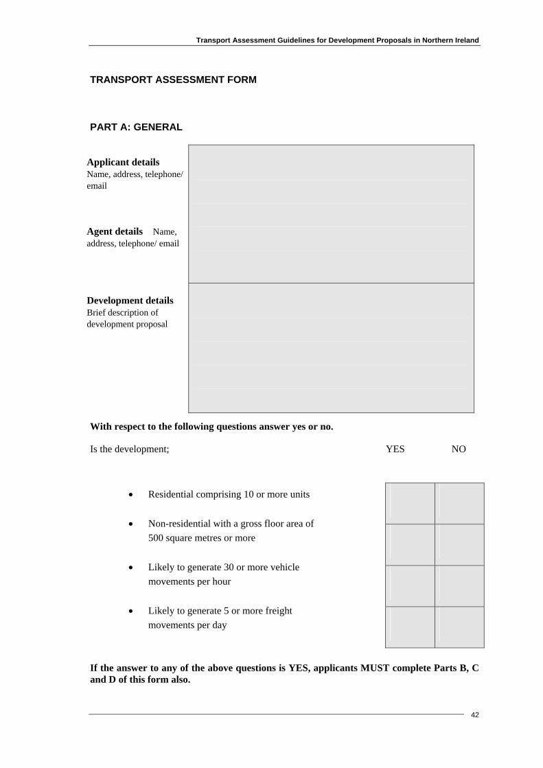
Transport Assessment Guidelines for Development Proposals in Northern Ireland
TRANSPORT ASSESSMENT FORM
PART A: GENERAL
Applicant details Name, address, telephone/ email
Agent details Name, address, telephone/ email
Development details Brief description of development proposal
With respect to the following questions answer yes or no.
Is the development; YES NO
42
• Residential comprising 10 or more units
• Non-residential with a gross floor area of 500 square metres or more
• Likely to generate 30 or more vehicle movements per hour
• Likely to generate 5 or more freight
movements per day
If the answer to any of the above questions is YES, applicants MUST complete Parts B, C and D of this form also.
Transport Assessment Guidelines for Development Proposals in Northern Ireland
43
PART B: TRAVEL CHARACTERISTICS
1. How many journeys will be made to the site each day? Please provide an estimate of the number of journeys to the site by each transport mode, walk, cycle, public transport, car, taxi and freight vehicles.
Walk
Cycle
Car driver
Car passenger
Taxi
Public transport – bus/train, (please specify)
HGVs – please indicate the type/size of vehicles
Comments
2. Will there be any peak times for traffic accessing the site? Please provide details.
Transport Assessment Guidelines for Development Proposals in Northern Ireland
44
PART C: TRANSPORT IMPACTS
Describe below the transport impacts of the development. For example, consideration should be given to the effect on transport infrastructure, possible increased risks of accidents, busier junctions, increased parking in the surrounding area, noise generation, air quality and the effect transport may have on the surrounding townscape, landscape and natural and historic environment etc.

Transport Assessment Guidelines for Development Proposals in Northern Ireland
45
PART D: MEASURES TO MITIGATE IMPACTS/ INFLUENCE TRAVEL TO THE SITE
Describe below what measures will be taken to influence travel to and from the site and within it. For example, consideration should be given to promoting walking and cycling (eg. by providing pedestrian and cycle routes and crossings), encouraging the use of public transport (eg. improved services, new stops, better information), minimising car-parking provision, ensuring good access through design, providing facilities for people with mobility impairments, supporting travel initiatives such as car-sharing, ensuring minimal and efficient freight movement etc.

Transport Assessment Guidelines for Development Proposals in Northern Ireland
46
This page is intentionally blank.
Transport Assessment Guidelines for Development Proposals in Northern Ireland
47
APPENDIX B
Further Reading

Transport Assessment Guidelines for Development Proposals in Northern Ireland
48
Further Reading
General
Moving Forward - Northern Ireland Transport Policy Statement (DOE 1998)
Shaping our Future - Regional Development Strategy for Northern Ireland 2025 (DRD 2001)
Regional Transportation Strategy for Northern Ireland 2002 - 2012 (DRD 2002)
Creating Places - achieving quality in residential developments (DOE/DRD 2000)
Northern Ireland Road Safety Strategy 2002 – 2012 (DOE/DRD/Investing for Health/PSNI
Design Manual for Roads and Bridges (Highways Agency)
Planning Policy Statements and Development Control Advice Notes - see Planning Service website at http://www.planningni.gov.uk
Guidelines for Traffic Impact Assessment (IHT, 1994)
Guidelines for Planning for Public Transport in Developments (IHT, 1999)
Inclusive Mobility: a guide to best practice on access to pedestrian and transport infrastructure (DfT, 2002)
Making Smarter Choices Work (DfT 2005)
Cycling and Walking
Northern Ireland Cycling Strategy (DRD 2000)
Walk in to work out: how to improve your health by walking or cycling to work (DfT 2003)
Cycle-Friendly Infrastructure (IHT, 1996)
Cycling by Design (Scottish Exe. 1999) http://www.scotland.gov.uk/library2/cbd/cbd-00.asp
National Cycle Network – Guidelines and Practical Details: Issue 2 (Sustrans/Ove Arup, 1997)
Walking Northern Ireland – An Action Plan (The NI Walking Forum in association with DRD 2003)
Transport Assessment Guidelines for Development Proposals in Northern Ireland
49
Encouraging Walking - advice to local authorities (DETR, 2000)
Providing for Journeys on Foot (IHT, 2000)
Guidance on the Use of Tactile Paving Surfaces (DfT 2002)
Employers
Travelwise Northern Ireland website at http://www.travelwiseni.com/
A Travel Plan resource pack for employers (DRD Roads Service, 2003)
Two wheels work: a good practice guide for developing and implementing Wheels to Work schemes (The Countryside Agency, 2002)
Cycle-Friendly Employers Information Sheet (Sustrans)

Transport Assessment Guidelines for Development Proposals in Northern Ireland
50
This page is intentionally blank.

Transport Assessment Guidelines for Development Proposals in Northern Ireland
51
APPENDIX C
General Procedure For Assessing Proposed Parking Levels

Transport Assessment Guidelines for Development Proposals in Northern Ireland
How does the proposed parking supply compare with current parking
standards?
Proposal should be normally declined, unless TA provides assurance that the impacts have been properly dealt
with.
Proposed Development with Transport Assessment
Does the TA include a comprehensive assessment of the
current parking situation?
Is the development within an area of
Parking Restraint?
Is the location of the proposed parking supply
compatible with the Parking Strategy?
Is the total parking supply or demand in the 'Development Situation' less than those
specified in the Parking Strategy?
TA should be revised accordingly
Yes
No
Exceeds
Falls short No
Yes
Yes
No
No
Yes
Proposed Development should normally be acceptable on parking
grounds
Complies
General Procedure For Assessing Proposed Parking Levels
52

Transport Assessment Guidelines for Development Proposals in Northern Ireland
53
APPENDIX D
Supplementary Guidance Relating To Traffic Impact Analysis
Transport Assessment Guidelines for Development Proposals in Northern Ireland
54
THE FOLLOWING BRIEF NOTES RELATING TO VARIOUS ASPECTS OF TRAFFIC IMPACT ANALYSIS (TIA) HAVE BEEN PREPARED TO ASSIST DEVELOPERS AND CONSULTANTS IN UNDERSTANDING ROADS SERVICE’S TECHNICAL REQUIREMENTS. 1 PURPOSE: 1.1 The purpose of this Guidance Note is:
a) To supplement the IHT Guidelines referred to in paragraph 4.73.
b) To provide information that will assist the completion of TIA.
c) To indicate where Roads Service will require those preparing TIA to adopt variations from the IHT Guidelines to reflect local conditions.
d) To provide consultants and developers with information that will assist them in understanding how Roads Service deals with TIA.
2 STRUCTURE OF TIA: 2.1 Consultants should structure their TIA using the headings in Chapter 3 of the IHT
Guidelines. In addition the TIA should contain the following:
a) An introduction which should include the Planning Application number to which the TIA relates, the past planning history of the site and a reference to any meetings with Roads Service about the application.
b) A section giving the conclusions of the TIA. This should refer to any measures required to mitigate against the effects of the development. In particular the consultant should list what works / measures the developer is providing. Conclusions should include any assumptions used and have clear cross-references to the main body of the TIA.
c) Appendices containing drawings, tables, computer analysis, output, etc., all of which should be in a logical order and cross-referenced to the main body of the TIA.
3 SUBMISSION OF TIA: 3.1 TIA when submitted must be through Planning Service and will be an element of the
Transport Assessment process. Developers or their consultants should, in addition, submit three copies directly to Roads Service. Additional copies may be required.
3.2 In addition to hard copies of documentation submitted, Roads Service encourages
consultants to submit a copy of the document in electronic format (Microsoft Word format is preferred) to assist evaluation.
3.3 Computer modelling should be submitted in electronic format in a print file format.
Transport Assessment Guidelines for Development Proposals in Northern Ireland
55
With programs such as LINSIG, sketches of lane labelling, etc. must be included. 4 CONTACT INFORMATION: 4.1 The initial contact with Roads Service regarding a new Planning Application should
always be with the relevant Development Control Section. The Development Control Officer dealing with the application may then direct the developer or his agent to another officer who will deal with the aspects relating to the TIA for the application. Contacts can be discussed at the same time as the scope of the TIA.
4.2 Development Control Officers deal with the internal layouts, number of parking
spaces, sightlines and DC planning history for the site/area. As such it can be seen that the Development Control Officer is an important first contact and can discuss fundamental planning issues before further work is instigated. TIA should, of course include proposals, explanations and layouts, number of parking spaces etc.
4.3 Development Control Officers can explain the stages and staff involved in assessing
TIA in simple terms. The Planning Service role can also be explained. 5 AMENDED TIA: 5.1 Amendments may be required to TIA. As TIA is a supporting document to a planning
application the public must have access to any amendments. In order to facilitate this, consultants should, where necessary, submit new sections and a revised conclusion or a new complete stand alone document containing all the alterations amendments, additions and background papers. These should include clear references to an original document. Roads Service will confirm when it is necessary to submit information through Planning Service.
6 EXISTING CONDITIONS: Traffic Information: 6.1 Roads Service is prepared to accept count information less than three years old,
providing a location has not experienced significant development or infrastructure change.
6.2 Traffic surveys should not generally be carried out in July, August and the last two
weeks of December or during other holiday periods. Surveys should usually be carried out between 07:45 and 09:15, and between 16:45 and 18:15. Data should be recorded every 15 minutes and notes made at relevant periods of queues, interaction of junctions, usage of pedestrian facilities, weather, site specific data (eg doctor’s surgery at end of crossing) etc.

Transport Assessment Guidelines for Development Proposals in Northern Ireland
56
6.3 A summary of the base survey information should be provided and must include dates, times and methods used. Weekday surveys should normally be carried out on Tuesdays, Wednesdays and Thursdays. A Friday survey may also be necessary if the development is for retailing.
6.4 Roads Service may have “proposed works” in the area that could, for example, affect
traffic survey information. Contact with the appropriate Section Office is advised. Descriptions and Drawings: 6.5 It is vital to have a good description and drawings of the existing traffic situation on
all links and junctions within the area of influence. Information on pedestrians (including the ambulant disabled), public transport, cycling and commercial traffic should be included as well as identification of reserve capacities, interaction of junctions, queues (average and maximum), delays, critical links/movements and junctions. Base survey information, including geometry, should be included in the TIA. Times of peak hours should be clearly calculated and stated.
6.6 Fonts used in traffic flow diagrams should be sufficiently large to allow the numbers
and text to be clearly read. 6.7 It is vital that drawings included for unmodified junctions in the area of influence
have sufficient detail to allow decisions to be taken. 1/1250 scale is sugggested as the absolute minimum.
Accident Information: 6.8 Accident statistics for the area (drawing conclusions) are required. See Road Safety
section. 7 PROPOSED DEVELOPMENT: 7.1 Indicate the year of opening. Indicate opening of phases and final opening, if
applicable. 7.2 Include a copy of the planning application and reference previous applications on the
same site (as appendices). 7.3 Provide a tabular breakdown of the Gross Floor Area (GFA) for land use/uses. Retail
Floor Area should be listed if applicable and available. 7.4 Provide times / details of shift working arrangements. 7.5 Clearly indicate the total number of car parking spaces to be provided by numbering.

Transport Assessment Guidelines for Development Proposals in Northern Ireland
57
7.6 Provide a site layout plan (minimum scale 1:500) of the development showing proposed access arrangements, local junctions and existing site details. This may be based on a topographical survey or an OS base.
8 MODAL CHOICE / TRIP ATTRACTION: 8.1 For trip attraction the TRICS Datacard should not be used other than for a very
preliminary estimate of use. In calculating trip rates considerable care should be taken to ensure that the correct parameter settings are chosen (e.g. for a shopping centre with a petrol filling station, ensure that shopping centres without filling stations are omitted). A list of de-selected sites should be included in the TIA, together with justification for the sites chosen.
8.2 To ensure a robust assessment, the 85th percentile generation figure should be
employed in the analysis of the traffic impact. In certain circumstances, and with justification, a lesser figure may be acceptable, but this will require agreement with the local Roads Service Division.
8.3 One recurring difficulty in relation to traffic generation relates to whether local data
or global data from databases should be used. Local data has its advantages in that it is more likely to reflect the particular, unique circumstances in Northern Ireland. On the other hand a larger database will have information from a considerable number of sites thus allowing a more credible generation figure to be calculated (e.g. 85th percentile). Weighing up the local data against global data can be difficult. The developer should present a reasoned argument within the TIA on the traffic generation figure to be employed. Reference to rates previously accepted will not normally be taken as fair justification for their use. The need for a robust analysis of the impact of the development proposal is considered vital.
9 TRIP DISTRIBUTION: 9.1 Distribution and assignment should be separate sections as recommended in the IHT
Guidelines. Distribution is an important stage in the assessment as the impacts on links and functions follow from it.
9.2 A distribution consistent with that used for a Retail Impact Assessment should be
used. 9.3 To assist distribution calculations it may be useful to carry out origin and destination
surveys at a local site similar to the proposed development. Use of existing local turning movements or volumes to estimate a distribution for a new development is not recommended in the Guidelines.
9.4 The application of universal and generalised discounting factors should be avoided. In
this regard there has been considerable research, presented at TRICS conferences and
Transport Assessment Guidelines for Development Proposals in Northern Ireland
58
available from other sources. Care should be taken to ensure that all research is presented in the proper context and is directly related to the development proposal.
9.5 It should be emphasised that travel distance isochrones (contours of equal travel
time), appropriate to the size of the development, should be applied. 9.6 It should be emphasised that detailed consideration should also be given to the
components used in a gravity model, e.g. the exponent for time should be a function of the development’s nature and catchment’s transportation characteristics.
9.7 Sensitivity tests will enable Roads Service to ensure that different case scenarios are
tested and evaluated and that upper and lower bounds for highway performance are established. It may also be necessary to carry out sensitivity testing on different variables used in a gravity model.
10 TRIP ASSIGNMENT: 10.1 It should be emphasised that assignment methods should be clearly separated from
distribution. The method used should be stated, e.g. manual or network model. 11 ASSESSMENT YEARS: 11.1 Retail information should be provided to determine if there is growth in development
traffic. 12 HIGHWAY IMPACT: 12.1 Consultants should identify the time period with the greatest overall traffic flows i.e.
consider weekday am/pm peaks, Saturday peak and development peak as necessary. Calculations should be clearly shown and choices stated.
12.2 There should be a logical sequence of traffic flow diagrams and a percentage impact
drawing for individual movements (with calculations shown). Fonts used in traffic flow diagrams should be sufficiently large to allow the numbers and text to be clearly read.
12.3 Validation of modelling is required. 12.4 At an early stage Consultants should make Roads Service aware of their views on
congestion, or the lack of it, on links in the study area. Roads Service will consider their views and provide clear guidance on this issue.
12.5 1:500 drawings detailing the geometric parameters at existing / proposed junctions,
should be submitted in support of junction testing. Existing and proposed details should be clearly shown to enable the extent of the works to be clearly seen and to
Transport Assessment Guidelines for Development Proposals in Northern Ireland
59
show that proposals are achievable and constructable, within the land available. It is not sufficient to show only kerb lines; footways and future boundaries are needed.
12.6 Junction testing with direct data option using short input time periods may be
required, where the TRL suite of computer programs is used. 12.7 Detailed conclusions should be drawn from all junction testing. RFCs, queues
(average and maximum) and delay information (average and maximum) should all be used to this end.
12.8 Consultants should confirm that design standards applied to roads and junctions
associated with developments meet Design Manual for Roads and Bridges (DMRB) Standards. Proposals for departures and relaxations from standards should be made clear and shall have been approved in accordance with Roads Service procedures.
13 ROAD SAFETY: 13.1 The PSNI provides limited road accident details. When the scope of the TIA is being
discussed, consultants will be made aware of proposals for minor works, traffic management, accident remedial, traffic calming, bus priority, cycle provision, etc. This information may be of relevance to safety considerations.
14 INTERNAL LAYOUT: 14.1 Good access road penetration of sites is necessary to avoid queues from developments
interfering with traffic on public roads. 14.2 The swept paths of specific HGVs should be shown on drawings. 15 PARKING LAYOUT: 15.1 Parking layouts at 1:500 scale must be provided with the TIA. The spaces on the
drawing must be counted and labelled. 15.2 Clear tabular breakdowns of the number of parking spaces being provided are
required.