Embed Size (px)
Citation preview

HAL Id: hal-01103795https://hal.archives-ouvertes.fr/hal-01103795
Submitted on 15 Jan 2015
HAL is a multi-disciplinary open accessarchive for the deposit and dissemination of sci-entific research documents, whether they are pub-lished or not. The documents may come fromteaching and research institutions in France orabroad, or from public or private research centers.
L’archive ouverte pluridisciplinaire HAL, estdestinée au dépôt et à la diffusion de documentsscientifiques de niveau recherche, publiés ou non,émanant des établissements d’enseignement et derecherche français ou étrangers, des laboratoirespublics ou privés.
Transport and Land Use Interaction: A French Case ofSuburban Development in the Lille Metropolitan Area
(LMA)Liu Liu, Alain l’Hostis
To cite this version:Liu Liu, Alain l’Hostis. Transport and Land Use Interaction: A French Case of Suburban Developmentin the Lille Metropolitan Area (LMA). Transportation Research Procedia, Elsevier, 2014, SustainableMobility in Metropolitan Regions. mobil.TUM 2014. International Scientific Conference on Mobilityand Transport. Conference Proceedings, 4, pp.120 - 139. �10.1016/j.trpro.2014.11.011�. �hal-01103795�

Transportation Research Procedia 4 ( 2014 ) 120 – 139
2352-1465 © 2014 The Authors. Published by Elsevier B.V. This is an open access article under the CC BY-NC-ND license (http://creativecommons.org/licenses/by-nc-nd/3.0/).Selection and peer-review under responsibility of Technische Universität Münchendoi: 10.1016/j.trpro.2014.11.011
Available online at www.sciencedirect.com
ScienceDirect
Mobil. TUM 2014 “Sustainable Mobility in Metropolitan Regions”, May 19-20, 2014
Transport and Land use interaction: a French case of suburban development in the Lille Metropolitan Area (LMA)
Liu Liu a, L’Hostis Alain b1a LVMT – IFSTTAR/TVES – Université Lille 1, 20 rue Élisée Reclus, Villeneuve d’Ascq, 59655, France
b LVMT – IFSTTAR/Université Paris-Est, 20 rue Élisée Reclus, Villeneuve d’Ascq, 59655, France
Abstract
Transit Oriented Development as sustainable mobility strategy is not part of French policy, in practice or in academic literature,even though a certain number of projects follow some of its principles. Reciprocally, from abroad, French experiences are not recognized as TOD, even when they could be. Scientific literature is needed in this direction. This is the focus of this paper.This paper identifies two realizations that can be qualified as TOD implementations according to criteria that we have defined previously in a Franco-German research program (Bahn.Ville). For each of these two cases, while their transport network is examined, we also study their insertion into the urban environment at a local level. The interaction between land use and transportsystem is the focal point of this study through a reading of planning documents, geospatial data specific processing and analysis,and on-site investigations. Parallel analysis is undertaken on the processes of realization. In both cases, we look into cooperation between public and private actors from multiple sectors and on different scales. Combining actual planning strategies, we examinepolicies of metropolitan level that support similar realizations in the future, not only in the field of transport, but also on housing and economic activities. Therefore, we present existing and future instruments for the implementation of TOD in the Lille Metropolitan Area. New planning tools, such as “DIVAT” and “Contrat d’axe”, are designed in the intent of defining intersectoralpolicies of transport and urbanism. These tools are currently being introduced and put into practice in Lille Metropolis. © 2014 The Authors. Published by Elsevier B. V. Selection and peer-review under responsibility of Technische Universität München.
Keywords: Lille Metropolitan Area (LMA); Transit Oriented Development (TOD); case study; Transport/Urbanism Interaction; integrated policies
* Liu LIU. Tel.: +33- (0)32-043-8492; fax: +33- (0)32-043-8359. E-mail address: [email protected]
© 2014 The Authors. Published by Elsevier B.V. This is an open access article under the CC BY-NC-ND license (http://creativecommons.org/licenses/by-nc-nd/3.0/).Selection and peer-review under responsibility of Technische Universität München

121 Liu Liu and L’Hostis Alain / Transportation Research Procedia 4 ( 2014 ) 120 – 139
1. Introduction
The arrival of new transport infrastructure always influences land use patterns and vice versa. The evolving urban form and transport system exercise mutually impacts on human mobility. Direct observations of the changing environment can be made both on landscape and mobility patterns, and their impacts are illustrated via indicators, such as density of population and jobs, modal share and territorial attractiveness.
When we started to investigate sustainable mobility and associated urban forms, we found that there is a broad consensus in European transport professional and political circles that coordinating transportation and urban planning is a prerequisite for achieving sustainable urban development. In this context, TOD is promoted as one of the “sustainable models”. Its principles are heralded as a way to control urban sprawl, equilibrate modal share, and foster the use of public transport. So we made an inquiry to determine if there is a metropolitan region in France in which similar principles have been applied and the measurable impacts of these principles, which is the main objective of our paper.
This paper starts by a presentation of two integrated systems of urban and transport development, both in the territory of the Lille Metropolitan Area where urban projects have occurred in recent years. The analysis will then be conducted on these two cases in order to measure the short-term impacts adduced by the interaction between land use and transport system. Depending on geographical localization of the new transport infrastructure, its connection to the rest of transport system, its urban environment, and its processes of realization, we propose a set of criteria for measuring the relevance of both transport and urban projects in a short term just after urban transformation, and that of transport networks. Finally, referring to theoretical basis (TOD and New Urbanism) and the local political planning, we propose possible suggestions for further development of this metropolitan area.
Nomenclature
AA Armentières Area EA Euralille Area LMA Lille Metropolitan Area TOD Transit Oriented Development
2. Presentation of terrains
The Lille Metropolitan Area is home for almost 1.2 million people (2006) and is located in the north of France, on the French-Belgian border. It is composed of 87 municipalities with large gaps in terms of dwelling density. The city of Lille is the principal center of the LMA, followed by several secondary poles like Roubaix, Tourcoing, Villeneuve d’Ascq and Armentières. But in recent years, we have observed demographical difficulties in several secondary poles while the municipality of Lille is actually absorbing urban dynamics.
We have identified two specific sites in which development of transport network and urban regeneration are both engaged, but with big differences between them. We are conscious of the fact that the coordination between urban planning and public transport is often complicated by the specificities of regional and metropolitan transport projects and the area served. While space around central stations in big cities is the common focus of ambitious redevelopment projects, regional stations and their surrounds usually attract less interest. It is in suburbs around smaller train stations that the art of integrated urban planning and transport planning has been neglected. That is why we have chosen two areas with great contrast regarding station scale and urban dynamics. One is the international business district of Euralille 1, right next to the center of the city of Lille surrounding the central train stations; and the other is the districtof Armentières regional train station, on the north-west boundary of the metropolis.

122 Liu Liu and L’Hostis Alain / Transportation Research Procedia 4 ( 2014 ) 120 – 139
Fig. 1. Localization of two studied terrains in Lille Metropolitan Area and associated railway network (L.Liu, 2014).
There is no need to insist on the importance of the municipality of Lille which is located at the crossroads of three European capitals (London, Paris and Brussels); the municipality of Armentières signifies its geographical importance on a much more reduced scale. It belongs to the Lille Metropolitan Area; which itself belongs to the Nord-Pas de Calais region. The latter is situated on the French-Belgian border with more than 25,000 inhabitants (2011). The population density of Armentières is 40 inhabitant/ha.
Without a doubt, the patronage of a train station is tightly associated with travel demand, hence the attractiveness of its catchment zone. While the system of train stations of Euralille absorbs the major dynamics of the metropolis, the train station of Armentières merely seek to satisfy local transit demand. The train station of Armentières is about 14 km to the north-west of Lille and 20 km to the airport of Lille-Lesquin. The rail service in Armentières started in 1849 as a stop on the line connecting Lille and Dunkerque, the third most important railroad in the region. It constitutes the entrance into Lille Metropolitan Area from the north-west.
Urban projects are undertaken on both sites as well as the reorganization of transport networks with a vague scope. In order to conduct a rigorous study on each site, we defined a theoretical perimeter representing “catchment area”.
Euralille Area (EA) – InternationalBusiness District of Euralille 1
Armentières Area (AA) – District ofArmentières train station

123 Liu Liu and L’Hostis Alain / Transportation Research Procedia 4 ( 2014 ) 120 – 139
We created a circle with a radius of 800m1 from the localization of each train station, for 2 stations of Lille and one of Armentières. Two circles around Lille train stations defined the most influential area of the system of train stations, which is called Euralille Area (EA); the one created around Armentières train station is called simply Armentières train station Area (AA). In the following section, we describe major transformations in each studied area.
3. Urban transformations
3.1. Euralille Area (EA) – International business district of Euralille 1
In the North-east of the city of Lille, the regeneration of EA occurred on the abandoning of ancient military reserves, vacated successively during the 1980s. The fortification belt was replaced by road and railway networks. The first phase of the Euralille project – called Euralille 1 – is situated on the buffer zone of those transport infrastructures, and extends to more than 2 kilometers. In this zone of about 85 hectares, a second train station – Lille Europe – was constructed in addition to the old one, Lille Flandres. This new system of train stations incorporated Lille into the European High-speed Railroad network and made Lille a real crossroads of three European capitals.
Fig. 2. Four areas composing the whole site of Euralille 1 project and our predefined influential area of Lille Europe and Lille Flandres, the so-called EA (L.Liu, 2014).
An urban project of vast dimension began in 1989 (the construction began officially in 1991) and is divided into two temporal and spatial stages. The global project is now under its prolonged phase but, in this paper, we lead our study on the first stage of Euralille’s transformation (Euralille 1), covering four sub-districts listed in the following table.
1 Bertolini (1998). Based on study of Lucas Bertolini and the German-French project Bahn.Ville, circle with a radius of 800 meters from the transit station defines generally the area where the influence on urban functions is the most prominent. The perimeter of vocabulary “catchment zone” of a transit system may vary considerably, so we avoid using this term by calling our studied areas with specific names.

124 Liu Liu and L’Hostis Alain / Transportation Research Procedia 4 ( 2014 ) 120 – 139
Table 1. Surface and period of each operational area in the Euralille 1 project (Euralille – Chroniques d'une métropole en mutation, (Ed.). D. Carré éditeur, 2009)
Central Area (37.63 ha) Romarin Area (19.30 ha) Saint-Maurice Area (4.04 ha) Chaude-Rivière Area (25.45 ha)
1989 – 1995 11990 – 1998 then 1999 – 2008 1997 – 2006 2001 – 2010
Indeed, launched in 1988 by Pierre Mauroy, mayor of Lille and former prime minister, Euralille was expected to lead the conurbation of Lille up to a European metropolis by being equipped with a first-class business centre. At that time, nowadays famous architects were invited for the design of the new train station and its whole environment, namely Rem Koolhas, Jean Nouvel and Christian de Portzamparc.
Table 2. Realization year of three most important amenities in the global project (Euralille – Chroniques d'une métropole en mutation, (Ed.). D. Carré éditeur, 2009)
Amenities – Train station Lille Europe Commercial Centre Lille Grand Palais
1994 1994 1994
The influential area of the train stations’ system, called the Euralille Area (EA), happens to encircle the operational area of the global project, which verifies the relevance of our predefined perimeter.
3.2. Armentières Area (AA) – District of Armentières train station
It is also the case for the Armentières train station Area (AA). If we look at this terrain on a local scale, the train station is 800 meters from the city center, within a previously mostly deserted zone now dedicated to an urban renewal project. This zone is almost enclosed by our chosen perimeter, occupying half of it.
Fig. 3. The municipality of Armentières, the area in which urban project is involved and the catchment zone of the train station (L.Liu, 2014).

125 Liu Liu and L’Hostis Alain / Transportation Research Procedia 4 ( 2014 ) 120 – 139
As mentioned, Armentières is one of the secondary poles of the LMA. Moreover, formerly a commercial area with restaurants and hotels during the late 19th and early 20th centuries, the AA was once a lively area of the city of Armentières. But this site has particularly suffered from industrial delocalization and needed revitalization.
In order to give a new impetus to this area, the municipality of Armentières has promoted a global project which combines regeneration of economic activities and development of public services. The construction of a new cinema and entertainment complex, rebuilding of retail and restoration business, mixed with a variety of housing and services (operation « Villas Lumière ») can be classified as a regeneration of economic activities. Public services were also developed, such as the construction of a multimedia library (named l’Albatros), the renewed intermodal hub, an underground crossing, the extension of Family allowance office (la Caisse d’Allocations Familiales, CAF) and Local health insurance office (la Caisse Primaire d’Assurance Maladie, CPAM) and, finally, conversion of abandoned buildings to housings (residence Del’Arte).
The transformation of the area began in 2006. Some elements of the overall project sprang up between 2006 and 2008 while others have been abandoned. The intermodal hub, the underground crossing, the multimedia library, the CPAM and the CAF, and the construction of housing (30 units of social or private housing) were achieved before 2008. However, the operation « Villas Lumière » is not yet finalized, nor the cinema complex, which should be launched this year (2014).
In addition to buildings, we should mention the current state of transport infrastructure on the north side of Armentières train station. Composed of a bus station, an car park with 450 spaces and a bike park, the multimodal hub is intended to create a flow density connecting the train station to the city center.
4. Methodology
4.1. Evaluation criteria
Rather than use an international academic definition of sustainable development as criteria, we will base our work on criteria identified in the Franco-German research action project Bahn.Ville 2 to define an urban development addressing sustainable mobility and oriented towards rail.
Regional railway Service Rail service must be able to produce a competitive offer in comparison with automobile transport on main origin-
destination flows across the population catchment area. Quantitative (frequency, capacity) and qualitative (equipment, informative kit) components should be considered while examining the comfort of railway service.
A transit-oriented urban development Peter Calthorpe2, urban planner and author of Transit Oriented Development’s initial concept, describes his
approach to sustainable urban form as “…moderate and high-density housing, along with complementary public uses, jobs, retail and services are concentrated in mixed-use developments at strategic points along the regional transit systems”. Even though there is no consensus on the definition of TOD, urban planners are almost in agreement on TOD principles, namely the famous 3D principles – Density, Diversity and Design. In other words, a transit-oriented urban development must keep high-density housing, a diversity of urban functions and attractive urban design while offering a qualified transit service. However, our study is not intended to clarify TOD definition or to develop TOD characteristics, but is aimed at analyzing if our examples follow approved TOD principles.
Connection with urban transport system and neighborhood environment The quality of connection between our studied areas and their neighborhoods is guaranteed by mechanical transfer
and accessibility of active modes. For mechanical transfer, the interconnection between urban and interurban transport
2 Urban planner, author of « Next American Metropolis Ecology, Community, and the American Dream», 1993 (New York: Princeton Architectural Press).

126 Liu Liu and L’Hostis Alain / Transportation Research Procedia 4 ( 2014 ) 120 – 139
is an important element in our evaluation grid. It includes physical connection (parking and other intermodal infrastructure), integration rate of public transport and informative systems. Other than mass transit, districts around train stations are also “… specific sections of the city … with a diversified collection of buildings and open spaces”. Many authors like Lucas Bertolini 3 insist on the importance of local paths in these public spaces so that a qualified circulation of active modes can be ensured.
Commitment for a common future Urban planning involves actors of several political levels. A common culture and objective for the operation is a
necessary condition for an approved realization. The dialogue and communication between actors from different levels (from the local authority to national government, passing by conurbation and regional community) is the central subject of this criterion. We consider their financial investment in order to understand the participation of each, observe their coordination in order to realize each of their contributions.
Integrated planning processes Urban policies such as housing policy, transport policy and strategy of economic development are all instruments
which can be mobilized in an urban operation. Interventions of different sectors during the period of the operation manifest the joint practice of these instruments and the relevance of their coordination.
While the first three criteria are aimed at qualifying the achievement of urban form and efficiency of the transport system, the last two criteria intend to examine the governance and coordination during the planning process. The whole includes mobility analysis, as well as an investigation of urban development.
4.2. Data and source
We have collected data of two types. On the one hand, information about the operation and associated policies comes from a range of planning documents of local authorities and the press. These documents include commercialization brochures, official websites of local government, websites dedicated for operations, presentations of operational actors, surveys of local inhabitants and, of course, a range of policy documents. As views from stakeholders, this first type of data could be discussed. So our second source is mainly raw statistic data. Hence on the other hand, we collected quantitative information from INSEE – National Institute of Statistics and Economic Studies for socioeconomic analyses (Housing – 2010, working – 2009) and from the Mobility Survey of the region Nord-Pas de Calais (l’Enquête Ménage Déplacement de la région Nord Pas-de-Calais – EMD 2009) for traffic and mobility patterns. Our second type of source mainly confirms the first one.
Dwelling and working densities are the first indicators of the attractiveness of each area. They are calculated by redistributing socioeconomic date into a Geographic Information System. Housing and working information are associated with national standard units by specific zoning (Code INSEE/IRIS) and are input into Qgis. By crossing this geographical unit with our predefined perimeter contained in the other layer, we selected and redistributed socioeconomic data in our studied areas.
In order to measure the diversity of our influential areas, two layers are superposed. One layer contains information of land use so that it divides the land into tiny parcels of different categories according to their function; and the other the circle defining the influential zone. Their intersection gives us the percentage of each land category occupying our studied terrains. Calculated densities and diversity are shown in the evaluation under the second criteria.
For traffic and mobility patterns, we specifically took a census of modal splits in our studied areas with the EMD of the region, particularly the survey of LMA, in order to compare them with the metropolitan average. We split each influential area into small zones and calculated the generated flows from each tiny zone to the outside of the catchment area. Then we aggregated these flows and obtained a graph with trips originating from each influential area. Results with this method are shown when each area is evaluated with the third and the fourth criteria.
3 Bertolini (1998).

127 Liu Liu and L’Hostis Alain / Transportation Research Procedia 4 ( 2014 ) 120 – 139
Finally, it seems important to mention the temporal barriers of our study. We would like to test the revitalization of our studied areas with quantitative results, so with reliable data sources. Therefore, the Mobility Survey of region Nord Pas-de-Calais 2009 is identified as the main document to observe changes in mobility patterns. Aggregating several mobility surveys of inferior perimeters (conurbation level), this database includes investigations within LMA and those between conurbations at the regional scale. But the mobility survey of LMA itself was carried out during 2005, so it requires a calibration while being aggregated into the regional mobility survey with respect to demographical evolution rates calculated by the National Institute of Statistics and Economic Studies (INSEE). As well as for other mobility surveys of other conurbations, this database did not consider mobility changes brought by new urban operations or operations in progress between 2005 and 2009 in LMA. It means that we only have estimated measurements on mobility patterns in which operations of our studied areas are not completely incorporated. Before 2009, the urban project of Armentières was only partially realized and the Euralille project was proceeding on its second stage. So we can by no means obtain a realistic and quantitative raw data source if the next Mobility survey is not conducted, and have no way of verifying the estimated mobility patterns until several years later. This time lag is the main limit of our methodology while leading case studies, but it is also the normal complexity of research on urban projects because we always have to define the temporal scope of their impact. Furthermore, we can also understand that long-term influences would not have been measured even in the next survey since it may take a long time for recent urban projects to “integrate” into the whole system. So we only have first-stage results of our studied areas obtained while the areas were half-way through their process of conversion, however, rigorous methods was used.
5. Results
5.1. Armentières Area
Regional railway Service As mentioned, Armentières is located on the boundary of the LMA with essentially regional traffic connecting
Lille and Dunkerque. Traffic through the Armentières train station is foremost regional and has increased from 3,300 passengers (on and off the train) per day in 2005 to 4,600 in 2009. Even if we consider that this rise is underestimated4,Armentières still becomes the second regional train station in the LMA today with an intra-regional traffic of 5,000 pass/day in 2012, after the central station Lille-Flandres. Armentières moves to the tenth place among all railway stations in the region.
Traffic between Lille and Dunkerque through Armentières is also shared by the A25 motorway, competing with the railway service. With the Mobility Survey of the Nord Pas-de-Calais region, we were able to identify 22,500 trips by private vehicles, which is five times more than the railway traffic volume. In other words, the railway service shares 17% of total traffic between the Lille and Dunkerque corridor, making the Lille-Dunkerque connection the third most important railroad in the region in terms of volume and modal share..
A transit-oriented urban development Different from the city of Lille, Armentières is characterized by a suburban environment within a limited territory
(621.6 ha). With the latest socioeconomic data collected in 2009 and 2010, we calculated density of households, of population, and that of jobs in our catchment zone of AA, listed in the following table.
Table 3. Number and density of households and jobs in the Armentières train station Area (AA) (L.Liu, 2014).
AA (201.1ha) Household Residential population Total jobs Commercial jobs
Amount 3600 7850 2 200 900
Density 17.9 hh./ha 39.0 inh./ha 11 jobs/ha -
4 Refer to the reason that we mentioned in the previous paragraph on the limit of data and source.

128 Liu Liu and L’Hostis Alain / Transportation Research Procedia 4 ( 2014 ) 120 – 139
There are no clear criteria of density range to qualify as a TOD environment, but, compared to the average dwelling density of the LMA (18inh./ha.), the residential density of AA is clearly superior. As mentioned, the impacts of urban operations were not considered in this survey. So, we consider that the calculations of dwelling and working densities are underestimated.
From another type of source, the latest Local Transport Plan of the LMA (Fig.4, Plan de Déplacement Urbain – PDU 2006) gave us a dynamic view of the demographic situation from 1998 to 2006 in the city of Armentières.
Demographical evolution is significant: we count fewer unemployed, pensioners and other inactive people; much fewer adolescents (less than 18 years old); but a significant increase in active people (less than 35 years old or more than 49 years old). Even if this table does not refer to the time period until 2010, we may estimate that the city tries to maintain a similar tendency. Indeed, by achieving last-step constructions of new housing, shops and cultural venues (such as cinema complex), the renewal urban project seeks to recover the attractiveness of Armentières by absorbing ‘affluent families5’. From the latest information of the city’s official website, the AA continues to create a mix combining commercial uses, housing, public services, natural spaces and job opportunities.
Fig. 4. Evolution of the population’s structure in Armentières (PDU6, 2010).
Connection with urban transport system and neighborhood environment Actually, for the same period, which is from 1998 to 2006, the city of Armentières was facing a decline in terms
of mobility and losing public transport modal share. During this period, mobility for all modes in Armentières is above the average level among all suburbs of Lille, and decreases slightly.
Armentières is one of three areas in LMA in which automobile mobility grew strongly (+12%), while in the eastern suburbs and north-west of Lille, the decline in car use is particularly high (from -13% to -18%). Although Armentières does not have a very high car share, this area has shown the largest increase in car use in the LMA. On the contrary, urban public transport (UPT) mobility is low in Armentières (11%) and only modest growth (+12%) was observed, compared to other secondary centers in the LMA (two other secondary centers have shown an increase of more than 50% on UPT mobility) because the rise of UPT mobility concerns most of the territories in the LMA. Bicycle mobility is very low in the city of Armentières (0.04) and this part is still declining, even if there is an average decrease in bicycle mobility in the LMA. Pedestrian mobility stays high in Armentières (1.36), but fell between 1998 and 2009 (-10%). Overall, 58% of journeys of local inhabitants are made by car, 34% on foot, 2.7% by UPT, and only 0.9% by bicycle.
5 It refers to a French socio-economic category classified by INSEE, National Institute of Statistics and Economic Studies, different from National Statistics Socio-economic Classification of United Kingdom..
6 “PDU 2010-2020 l'Etat Des Lieux”, April 2011,http://www.lillemetropole.fr/gallery_files/pdu/2011/01.pdf..

129 Liu Liu and L’Hostis Alain / Transportation Research Procedia 4 ( 2014 ) 120 – 139
Taking figure 4 into account, changes in mobility patterns are somehow related to evolutions in the population’s structure. We may explain the decline of mobility for all modes by the reduction in the number of inhabitants and the decrease in bicycle mobility by the reduction in the proportion of students and young people. Moreover, the increasing number of people of working age can lead to an important growth of car use and to the reduction of active modes. These are normal effects related to population restructuration.
These problems lead the LMA authority and regional council to pay attention to Armentières’s transport network and its connection to the rest of the entire territory. Hence, the area near the train station of Armentières (AA) as starting point. Most importantly, we quote new infrastructures devoted for intermodal transfer and the integration of tariffs between various travel modes. That is why we present here the qualitative evolution of the AA since 2006, and its quantitative results in terms of modal share calculated from the regional EMD 2009, showing the mobility patterns of the AA around 2005. Modal split in the AA is quite different from that of the whole city.
A brand new station forecourt is fitted out on the north side of the railway lines, opening to the whole city of Armentières. On the easternmost side of the forecourt, a car park for 450 spaces on three levels is available and free, for the time being7. A bicycle storage facility with a capacity of 38 bicycles is also open on the west side of the forecourt, right opposite the new bus shelter with six platforms, three reserve docks, an operating site and a short-term car park, the whole equipped for a train-bus connection. In between, pedestrian connections are reorganized in order to secure and facilitate pedestrian flows near the station.
Leaving the gate of the station building, a public square is equipped with benches and trees. It gives access to the city center through a one-way street, which allows only pedestrians and bicycles, so that active modes can get straight to the city center. The bus terminal, sheltered with a conspicuous structure, is located just in the east of the square from the station exit, easy to access for active modes. Buses and bikes also benefit from reserved roads facilitating their movements.
Some kind of tariff-integrated service was carried out a long time ago, but with the arrival of an electromagnetic card, the tariff-integration for public transport passenger service has recently been completed. Today, it offers the possibility to travel in the LMA by using the same card to make a sequence of journeys between several travel modes (rail+bus+shared bike for example).
With our own method of calculation on the AA, we also obtained a modal split more favorable to public transport from raw data of the regional mobility survey. They are shown in figure 4, quite different from those of the whole city (table 4). Even if the automobile share is predominant, we measured a much higher share of UPT than that of the municipality. We are still waiting for the future survey which could tell us the evolution of modal share including the first impacts of the newly-built infrastructures and of integrated tariff service. In addition, AA has less automobile shares than the metropolitan average level.
Table 4. Comparison of modal share in the city of Armentières with that of flux originated from AA (EMD LMA and of the region Nord Pas-de-Calais 2009, PDU 2010)
Modal split Walk Bike Public Transport Auto
Armentières 34% 0.90% 2.70% 58%
AA 19.0% 2.0% 8.4% 70.6%
7 Bertolini (1998).

130 Liu Liu and L’Hostis Alain / Transportation Research Procedia 4 ( 2014 ) 120 – 139
Fig. 5. Modal share of all flux with departure from Armentières train Station Area (EMD LMA and of the region Nord Pas-de-Calais 2009)
In spite of the existence of intermodal infrastructures and integrated tariff, the service associated to transport still needs improvement, such as the information system. Inside the train station and outside in the intermodal hub, communication tools are not fully fledged. Up to now, there are only train timetables on a wall in the railway station building which, in addition, are not easy to find for occasional users. In order to know the schedule of buses, passengers have to go to the bus terminal where they can find a dynamic table indicating the arrival of the next buses.
Finally, tariffs for intermodal exchange should be reconsidered. Up to now, the car park is free for all users, as opposed to charged bicycle parking. Nowadays, the car park is mostly used as a P+R for railway passengers, but the bike parking is rarely fully occupied8.
Therefore, further improvements can largely be made on the information system, possibly in the form of human service as the presence of helping agents or in the form of self-service for multimodal and spontaneous itineraries. We believe that, with the completion of constructions and communication system, the physical connection between the forecourt of the station and the rest of the city can be improved, allowing the share between active modes, urban buses, individual vehicles and trains to be more balanced in the near future.
Commitment for a common future The region of Nord Pas-de-Calais (NPdC) and the authority of Lille Metropolitan Area are two key actors for the
global project of Armentières. The Regional Council made a policy of selecting and financing intermodal hubs at the regional level which leads local authorities to work again on the connection of their territory to the rest of the region9.However, the Regional Council has no explicit competence in the urban development of these nodes because its jurisdiction is limited to the development planning of railway infrastructures. So, the authority of Lille Metropolitan Area, which manages not only urban development but also local transport network in its territory, may choose to follow the regional development plan. That is what LMA authority has determined to do: a policy tending to organize the urban public transport around major intermodal hubs at a metropolitan level has been applied. A strong initiative to improve the public transport network in train stations’ areas is ascribed to LMA.
The AA has been identified as the location of a new intermodal hub in the very first Mobility Plan of Lille Metropolitan Area in 2000. Besides the new infrastructure of intermodal hub, the previously existing bus system was reinforced not only next to the train station, but also in the town center, the whole managed by the shareholder of LMA. Without a doubt, this initiative is highly supported by the regional authority. The construction of the intermodal
8 Analysis based on the interview of the parking’s manager in 2013.9 The regional council established a regional scheme for transport infrastructure and service (“Schéma Régionale des Infrastructures et des
Transports”, 2004) in which the development of intermodal hubs near train stations is recommended.
Walk;19,0%
Bike; 2,0%
Auto;70,6%
Bus; 3,9%
Metro;1,1%
Train;3,4%
Modal Share of trips originated from AA
Walk
Bike
Auto
Bus
Metro
Train

131 Liu Liu and L’Hostis Alain / Transportation Research Procedia 4 ( 2014 ) 120 – 139
hub of Armentières and the renewal project around the hub is a case where both policies meet in the location, and where regional and metropolitan transports are articulated.
Besides the regional council and the LMA authority, transport authorities and operators are widely involved in the project concerning the operational process. As the national railway operator and owner of a part of the regional rail infrastructures, SNCF is required to take an active part in the project. The exchange hub, the essential intermodal infrastructure, was planned to be built on an old parcel of land owned by SNCF that the company refused to make available before the project. After a high level political intervention, the agreement was signed three months before the beginning of all operations. Meanwhile, the local transport operator is also naturally engaged in the local transport network. In the scope of a delegated public service, the authority of LMA assigned the management of the bus terminal to the metropolitan transport authority in order to facilitate the whole operation. Accordingly, “Transpole”, the operator of transport in the metropolis, is also in charge of both the management and the maintenance of the bus terminal.
As Transpole operates the metropolitan transport network and SNCF operates the regional railway network, the quality of their coordination can be evaluated from the organization of intermodal exchange. The consistency between the train and bus schedules shows a mutual engagement and an efficient collaboration between the transport authorities at different levels.
Finally, with respect to funding, the authority of LMA is a major funder with almost half of the whole investment. The Regional Council has invested 14% and the General Council of the Northern Department 11%. ERDF – European Regional Development Fund (FEDER – Fonds Européen de Développement Régional) and the Inter-regional Fund invested 13% and 14% respectively. Rather than monetary investment (3%), SNCF has made land contribution instead, as mentioned earlier.
Fig. 6. Financial contribution of shareholders in the Armentières intermodal hub (L’Hostis.A, 2013)
In this part, we listed the implication of each actor and the cooperation between actors of different levels for the same objective, on a political, operational and financial point of view. Their mutual commitment made an impact both on the construction of local infrastructures and on the territorial connection.
Integrated planning processes We understood from the last paragraph that actors at different levels and from various sectors took part at different
times, but worked together in the whole process. The regional council conducted preliminary studies on the mobility demand and on the need for urban revitalization. Once the sites were identified, the railway infrastructure owner (RFF), the railway operator (SNCF) and local authorities were involved in their own jurisdiction. We can have a retrospective view on the progress of the overall project of Armentières with the following table illustrating the integrated process.
LMCU 4 849 473 €
45%
SNCF 266 786 €
3%
Conseil Général (Dépt du Nord)
1 145 203 € 11%
Regional Council 1 446 901 €
14%
FEDER1 315 560 €
13%INTERREG 3B
1 434 615 € 14%
132 Liu Liu and L’Hostis Alain / Transportation Research Procedia 4 ( 2014 ) 120 – 139
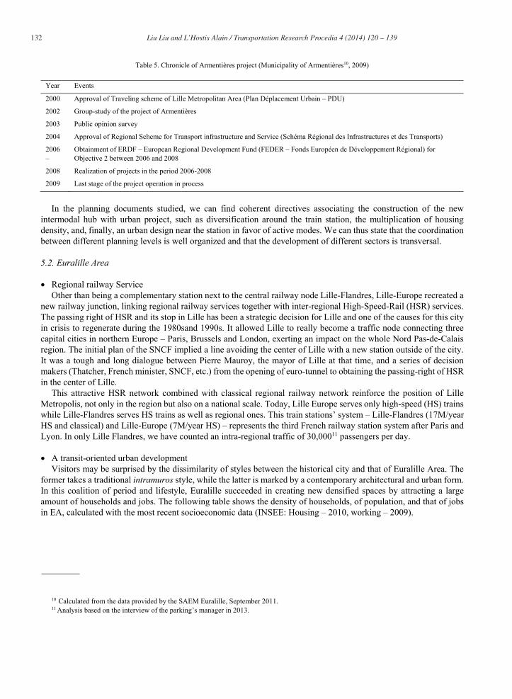
Table 5. Chronicle of Armentières project (Municipality of Armentières10, 2009)
Year Events
2000 Approval of Traveling scheme of Lille Metropolitan Area (Plan Déplacement Urbain – PDU)
2002 Group-study of the project of Armentières
2003 Public opinion survey
2004 Approval of Regional Scheme for Transport infrastructure and Service (Schéma Régional des Infrastructures et des Transports)
2006–
2008
Obtainment of ERDF – European Regional Development Fund (FEDER – Fonds Européen de Développement Régional) for Objective 2 between 2006 and 2008
Realization of projects in the period 2006-2008
2009 Last stage of the project operation in process
In the planning documents studied, we can find coherent directives associating the construction of the new intermodal hub with urban project, such as diversification around the train station, the multiplication of housing density, and, finally, an urban design near the station in favor of active modes. We can thus state that the coordination between different planning levels is well organized and that the development of different sectors is transversal.
5.2. Euralille Area
Regional railway Service Other than being a complementary station next to the central railway node Lille-Flandres, Lille-Europe recreated a
new railway junction, linking regional railway services together with inter-regional High-Speed-Rail (HSR) services. The passing right of HSR and its stop in Lille has been a strategic decision for Lille and one of the causes for this city in crisis to regenerate during the 1980sand 1990s. It allowed Lille to really become a traffic node connecting three capital cities in northern Europe – Paris, Brussels and London, exerting an impact on the whole Nord Pas-de-Calais region. The initial plan of the SNCF implied a line avoiding the center of Lille with a new station outside of the city. It was a tough and long dialogue between Pierre Mauroy, the mayor of Lille at that time, and a series of decision makers (Thatcher, French minister, SNCF, etc.) from the opening of euro-tunnel to obtaining the passing-right of HSR in the center of Lille.
This attractive HSR network combined with classical regional railway network reinforce the position of Lille Metropolis, not only in the region but also on a national scale. Today, Lille Europe serves only high-speed (HS) trains while Lille-Flandres serves HS trains as well as regional ones. This train stations’ system – Lille-Flandres (17M/year HS and classical) and Lille-Europe (7M/year HS) – represents the third French railway station system after Paris and Lyon. In only Lille Flandres, we have counted an intra-regional traffic of 30,00011 passengers per day.
A transit-oriented urban development Visitors may be surprised by the dissimilarity of styles between the historical city and that of Euralille Area. The
former takes a traditional intramuros style, while the latter is marked by a contemporary architectural and urban form. In this coalition of period and lifestyle, Euralille succeeded in creating new densified spaces by attracting a large amount of households and jobs. The following table shows the density of households, of population, and that of jobs in EA, calculated with the most recent socioeconomic data (INSEE: Housing – 2010, working – 2009).
10 Calculated from the data provided by the SAEM Euralille, September 2011.11 Analysis based on the interview of the parking’s manager in 2013.

133 Liu Liu and L’Hostis Alain / Transportation Research Procedia 4 ( 2014 ) 120 – 139
Table 6. Number and density of households and jobs in the Euralille Area (EA) (Authors production)
EA (271.4ha) Household Residential population Total jobs Commercial jobs
Amount 12 700 21 600 45 500 30 500
Density 46.8 hh./ha 79.6 inh./ha 167.6 jobs/ha 112.4 Cjb./ha
Households and jobs in Table 6 are well-distributed into spaces combining commercial uses, public services, industry and natural space. The following table 7 shows a layout of land uses in the four distinct areas in the Euralille 1 project (2009).
Table 7. Land Use of different areas in the Eurallille 1 (LIU.L, 2009)
Land Use (2009) Central Area (37.63 ha)
Romarin Area (19.30 ha)
Saint-Maurice Area (4.04 ha)
Chaude-Rivière Area (25.45 ha)
Mixed 6.6% 0.0% 0.0% 0.0%
Housing 3.2% 60.4% 98.7% 1.2%
Industry 12.4% 0.0% 0.0% 0.0%
Commerce/Tertiary 26.0% 0.0% 0.0% 0.0%
Public service 24.7% 34.3% 0.0% 32.2%
Construction 0.0% 5.3% 0.0% 36.4%
Nature 27.0% 0.0% 1.3% 30.1%
Apart from transport infrastructures, we can effectively observe a large presence of public service, housing and natural spaces. Housing is more present in the east part of Euralille, concentrated in two areas – Romarin and Saint-Maurice with mixed housing types12, while commerce and services also find their place in newly constructed blocks. These new constructions have a great capacity for commercial uses with a large shopping center, the second largest in LMA, and are also used for business development. In the perimeter of Urban Master Plan (SCOT 2010), it is considered that 25% of new offices were built in Euralille in the last ten years and this part of new constructions is considered as a potential for development appealing for new investments. Today, more than 60% of parcels are occupied by private real estate actors in EA. This area becomes an iconic symbol not only among HST stations’ area development, but also among the cities’ large projects. It contributes to make Lille metropolis the third market for offices after Paris and Lyon in France.
We showed quantitative results illustrating the density and diversity of the area, but the design factor requires qualitative assessment. Indeed, is the EA easy to reach for all users13? From the local inhabitants’ survey, we learned that most inhabitants consider that they have an easy access to a diversity of urban functions without the necessity of possessing a car. They are highly satisfied with their living conditions and plan to live in the EA for the next few years. However, the attractiveness of the EA may also be explained by its diversity of supply and hence its demographical composition. Single or couple-structured apartments are dominant as well as service housing which is aimed at young families and, thus, generates high residential turnover of these many small housing units.
We can now say that EA offers a dense and pleasant urban environment, with equipped services and mixed functions as a place to live. This whole area is recognized by inhabitants of the territory as having brought a major change in the city’s image.
12 We have a classification of housings until 2009 about the entire site of Euralille 1, with a table in the annexe.13 We did not explore visitors’ perception of the area but it may be a next step of the study.

134 Liu Liu and L’Hostis Alain / Transportation Research Procedia 4 ( 2014 ) 120 – 139
Connection with urban transport system and neighborhood environment The city of Lille has two metro lines, two tram lines and more than one hundred bus lines serving the central city and its suburban area. The railway station of Lille-Flandres is just at the meeting points of the two underground metro lines and tram lines with a great number of bus stops at ground level. Lille Europe is one stop from Lille-Flandres on one metro line in the direction of the north-east. It is also connected with the tram lines with a half-level difference because travelers should go upstairs in order to leave the train platform and to re-access to the ground level on the west. The building of Lille Europe is a complex structure where halls are situated at an intermediate level between two ground levels on the west, lower than that on the east. But we can get access easily to bus stations by simply leaving the station building, and bus stops are right in front of the gates.
Fig. 7. Aerial view of Euralille 1, Orientation to the north on the right (SPL-Euralille14, 2014)
It is also difficult to imagine the existence of a huge car park containing more than 4,000 spaces for private cars, because Euralille is just on the nearest extension of the old city-center. This area is especially characterized by the presence of important road and rail infrastructures, making extreme challenges for urban planners to reduce the cut-off effects of the ring road and railway beam. But with a multilevel interchange, the ring roads were partially concealed by an urban boulevard. And by using an overpass, automobile circulation and pedestrian flux are separated into two levels connecting the two main stations.
So pedestrians may get access to the diversity of functions via high quality public spaces or improved footpaths linking the 2 stations and the town center. The itinerary for active modes is organized on an open space (Place François Mitterand) connecting Lille-Flandres and Lille-Europe without stairs, enabling wheelchairs and bicycles, for example, to travel across. Along this west-east footpath, we have a large park on the north side and a shopping mall to the south, the so-called Euralille shopping center. While occasional travelers may find this itinerary a bit confusing, despite efforts in the signaling of the itinerary, local inhabitants follow this road as routine.
Apart from this connection between rail stations, the facility of access to the city center is also ensured. The old station is only 500 meters from the Grand Place and Lille-Europe less than one kilometer if travelers prefer to pass by Lille-Flandres. There is another possibility to go straight into the city-center by going across the shopping mall Euralille and then by taking a footbridge over the Lille-Flandres train station. This itinerary is also largely used by local inhabitants, especially when they need to make a sequence of journeys in which they could go shopping or to the gymnasium on their way.
Bicycle-only lanes exist between the train stations too, but they are not completed for the link to the city center. Improvements can still be made for bike, roller or scooter users in terms of infrastructure and of secure service.
In order to portray the impact of the urban form mentioned, we complete our detailed description with quantitative results: the modal share of trips originating from the whole EA. They are calculated from raw statistic data of the mobility survey of LMA 2005 and of the NPdC region 2009, shown in figure 8. We then compare them with modal
14 Official website of the global project Euralille: http://www.spl-euralille.fr/.

135 Liu Liu and L’Hostis Alain / Transportation Research Procedia 4 ( 2014 ) 120 – 139
split of other areas, area of the whole project Euralille 1 in 2007 and in 2009, the Armentières train station Area AA(same sources), and, finally, the LMA in 2006 (PDU 2010). We saw that EA is the area with the lowest auto-use, highest PT-use, and a high share of active modes. The part shared by Public Transport even overtakes the one shared by automobile (including regional train). We may hence summarize that the EA is not only a place to live, but also a hub of fluent mobility.
Table 8. Comparison of modal shares, in Euralille 1 project, with that of flux originated from EA and from AA, and with the average shares in LMA (EMD LMA and of the region Nord Pas-de-Calais 2009, PDU 2010)
Modal Split (Home-work/study) Auto TC Active modes
Euralille 1 (2007) 49% 31% 16%
Euralille 1 (2009) 40% 39% 20%
EA (2009 all motifs) 37% 44% 19%
AA (2009) 71% 9% 21%
LMA (2006) 75% 12% 9%
Fig. 8. Modal share of all flux with departure from Euralille Area (EMD LMA 2005 and of the region Nord Pas-de-Calais 2009).
Commitment for a common future Different from the AA, the main actors in EA are the metropolitan transport authority and local planning authorities,
which are municipalities and inter-municipal bodies. As these projects are considered to have further impacts in the region, we can also find financial help of the higher authorities as the department, the region, and implications of other forms from private stakeholders. It is also necessary to mention that the EA concerns several municipalities in LMA, including the physical perimeters of Lille and La Madeleine. This global project also influences indirectly secondary urban centers, such as the towns of Roubaix, Tourcoing, and Villeneuve-d’Ascq. During the creation of SAEM15
(called SPL – Euralille today), the participation of each public shareholder is listed below. The region took part in urban planning mainly by formulating regional planning and transport schemes. But in this project, the regional council is only engaged financially in the project, instead of deciding the implementation of the new train station. As
15 S.A.E.M (or SEM latterly appeared in the text): Société Anonyme d’Economie Mixte, an anonymous company whose capital is owned bypublic and private entities, but the part owned by one or several public entities is in the majority. For our studied project, the society changed its name latterly to SPL – Euralille (Société Publique Locale). The change of a few letters means that shareholders are now only public partners for the extended project on process, composed of local authorities and urban conurbation authority.
Walk17% Bike
2%
Auto37%Bus
3%
Metro23%
Tram2%
Train (Regionallevel)16%
Modal share of trips originated from EA
Walk
Bike
Auto
Bus
Metro
Tram
Train (Regional level)

136 Liu Liu and L’Hostis Alain / Transportation Research Procedia 4 ( 2014 ) 120 – 139
mentioned, the urban planning remains primarily the responsibility of municipalities and inter-municipal bodies. Other stakeholders involved in the organization of regional rail transport are RFF, owner and manager of the French national railway network, thus responsible for railway infrastructure development; and SNCF, the national railway company and the sole manager of regional services, which also operates the stations.
Table 9. Percentage of held capital (SPL Euralille official website, Nos Actionnaires. Available from: < http://www.spl-euralille.fr/qui-sommes-nous.html>. [November 2013].
Shareholder Share part
Authority of Lille Metropolitan Area (Lille Métropole) 30.52%
Municipality of Lille (La ville de Lille) 30.38%
The Nord Pas-de-Calais region (La région NPdC) 10.28%
The northern Department (Le département du Nord) 10.28%
Municipality of La Madeleine 4.63%
Municipality of Roubaix 4.63%
Municipality of Tourcoing 4.63%
Effectively, authorities of all levels are motivated for a common objective. But other than public partners, the specificity of Euralille 1 is that it was financially helped not only by local authorities; by national investment, but also by railway operator SNCF which is a private company with public capital. Furthermore, the original establishment of a public-private venture (SEM) allowed the sale of public land to private developers with strict control programs. The EA, and of course the project Euralille 1, provided a possibility for stakeholders to tackle an integrated task together, to get together and discuss their interests, with a common aim of proposing contextual and feasible solutions.
Integrated planning processes The EA reshaped the city of Lille by a huge urban project of construction and revitalization which has gone through
a series of difficult periods including economic crisis. The EA would not have taken form it has today without determined political interventions and financial management. In order to follow the complex progress of the global project, a chronicle helps us to understand essential events affecting the regeneration of EA.
Table 10. Euralille chronicle for essential events (Euralille Chroniques d'une métropole en mutation (Ed.). D. Carré éditeur, 2009).
Year Events
1987 Confirmation of High-speed Railway in the north Europe passing by Lille
1988 February: creation of the study group “Euralille - Métropole Rem Koolhass - OMA Agency”, laureate of international consultation for the master plan of studied area
1990 Creation of SAEM16 Euralille, Appointment of Jean-Paul Baïetto as the general director; Creation of ZAC17 “Euralille 1” (“ZAC du Centre international d’affaires des gares”)
1993 Arrival of High-Speed Train to Lille-Flanders, ancient train station
16 Société d'économie mixte is usually the most significant type of public enterprises in France. It has been statutory since 1983. A Société d'économie mixte requires at least seven shareholders. Characteristically some of them are private organizations, such as banks, companies or the chamber of commerce or industry. By law between 50% and 85% of the capital share has to be held by public authorities, i.e. the state or local authorities. In the exercise of their tasks SEM are not limited to the territory of the respective local authority, on the contrary, they compete with private enterprises.
17 ZAC : Zone d’Aménagement Concerté, an integrated development zone within which a designed public authority or a destined publicinstitution decides to intervene in the land’s and equipment’s development, including those this institution/authority has acquired or will acquire in order to grant them later to public or private users. Same status as S.A.E.M, refer to the footnote 17.

137 Liu Liu and L’Hostis Alain / Transportation Research Procedia 4 ( 2014 ) 120 – 139
Year Events
1994 June to September: delivery of the first stage of Stations’ Triangle formed by the station Lille-Europe, the commercial centre and their superstructure, and the congress centre (Lille Grand Palais)
1995 Mission ended for the chief urban planner of OMA agency
1996 First financial restructuring related to the real estate crisis
1997 Appointment of the architect-planner of Saint-Maurice Area after a short consultation of Xaveer Geyter Laloux + Lebecq, andFabienne Fendrich (Landscape planner)
1998 March: Jean-Louis Subileau became the general director of SAEM Euralille, second financial restructuring of the operation
1999 Follow up of the commercialization of ZAC “Euralille 1”
January: Opening of the deviated East-ring road
July: Appointment of the team Dusapin-Leclercq associated with the Landscape Agency TER, laureate of the conceptual design for the ancient site of “Euralille 2” (Site de la foire)
2000 Realization of the master plan for the Romarin Area by François Grether
March: Creation of ZAC “Euralille 2”
Conversion of Boulevards Hoover-Dubuisson into an urban boulevard
2001 May: first stone of an office building in the Saint-Maurice Area
2002 Study of the development plan of the Chaude-Rivière Area with Floris Alkemade and Ove Arup
Delivery of business city by François and Marie Delhay (Cité des affaires)
2006 Delivery of the first cutting of the master plan of the regional head office
Launch of first constructions in the Chaude-Rivière Area with the headquarter of Saving Society (Caisse d’épargne)
2007 Delivery of the first offices and housings in the program of Euralille 2
Concession of the ZAC “Porte de Valenciennes” and entrusting SAEM Euralille with its development
Concession of the ZAC “l’Union” and entrusting the association “SAEM Euralille-SEM (Same status as S.A.E.M, refer to the footnote 15) Ville renouvellé” with its development
2008 Launch of construction of the fifth tower and of the Casino in the Chaude-Rivière Area
Beginning of ZAC “Porte de Valenciennes”
Indeed, the whole area may be characterized by being an instrument for the urban marketing of LMA, but this instrument is well used and succeeded in drawing attention from actors of all fields and encouraged cooperation. Twenty years of management for the global project needed participation in all sectors, such as economy, environment, culture, heritage and social equilibrium. Since the reflection of each area, each planning process integrated mutual work. For example, during the design phase of Chaude-Rivière Area, the SAEM organized a sketch competition of macro-lot among tandems of Developer-architect. This is one of the experiences quotable for the conception of a large site.
6. Conclusions
As we can see, these two urban projects match our defined criteria relatively well, which means that we can observe successful integrated projects in Lille Metropolitan Area joining transport reorganization and urban development. EA can be considered as a major TOD area based on a new HST station built in the extension of the urban core of the Lille agglomeration while AA can be considered as a regional TOD « to be confirmed » with strong transit supply (40 trains per day per direction) and as a bet on an urban renewal articulating the exchange pole with the center town. They marked a good beginning for integrated land use and transport projects on the national scale.
Actually, the planning process was strictly controlled in both areas studied. And the achievement of more urban projects supporting sustainable mobility still needs strong political interventions, particularly in the coordination between transport, urbanism and housing policies. Meanwhile, French local authorities have invented new mechanisms, as the Contrat d’axe (Corridor Contract) and DIVAT (Disc for valorizing transport Axis). The

138 Liu Liu and L’Hostis Alain / Transportation Research Procedia 4 ( 2014 ) 120 – 139
mechanism includes a period of negotiation between public transport and urban planning stakeholders for a localized public transport project that leads to the conclusion of a contractual agreement between the transport and planning actors: the transport authority undertakes to improve transport service and the local planning authorities undertake to promote urban density around public transport, as well as multimodal access to stations.
Indeed, in its objectives and methods, these instruments resemble TOD: They promote mixed-use development within walking distance of a transit stop that encourages travel by public transport (Calthorpe, 1993) and the method is ‘place-based’ and ‘project-based’ to foster the emergence of integrated projects suited to local context. The main characteristic of this type of TOD is the stakeholders involved: TOD is commonly a public-private partnership, whereas the two instruments propose a negotiated process and agreement largely between public actors at different decision-making levels. In this, French TOD seem to be closer to the concept of ‘Public Transit-Oriented Development’.
Today, we have planning instruments equivalent to DIVAT in several metropolitan areas aiming at achieving rational densities, diversity and enjoyable urban design. Corridor Contract seems to help to open new prospects for better coordination between land-use and transport planning, with greater sensitivity to local context. The housing policy in the LMA partially based on DIVAT (Disques de Valorisation des Axes de Transports, Valorisation zones around transit lines, is a planning document elaborated by the LMA in order to identify renewal zones in several stages) is, moreover, an encouraging sign for urban planners. They are creating new interactions and regulation between the transport and land-use institutions and stakeholders, which may favor more coherent policies.
However, there is still a wide gap between theory and practice, even in countries known for strong planning. Institutional fragmentation between sectors and scales of governance is often identified as the main barrier to converting strategic planning objectives into effective action. Significant questions remain about the implementation of the instruments and their tangible outcomes. So for the next step, we focus our work on possible outcomes of these instruments with recently emerged instrument such as LUTI models by testing various incentives.
References
Beauvais, J.-M., 2013. Evaluation des aménagements centrés autour des gares, E.d. PREDIT – Groupe opérationnel (GO) n°3, Mobilités dans les régions urbaines.
Bertolini, L., Curtis, C, C.&Renne, J., 2009. Transit Oriented Development. Making It Happen. Ashgate publishing limited. (Ed.). England and ashgate publishing company USA.
Bertolini, L., 1998. Cities on rails: the redevelopment of railway station areas. (Ed.). Spon Press. Bertolini, L. & Tan, W., 2010. Barriers to Transit Oriented Developments in the Netherlands: A luxury problem?, 24th AESOP Annual Conference.
Helsinki, Finland: AESOP. Calthorpe, P., 1993. The Next American Metropolis: Ecology, Community and the American Dream. Carré, D., 2009. Euralille: chroniques d’une métropole en mutation (1988-2008), Chroniques urbaines. (Ed.). D. Carré éditeur. CERTU - PST Rhône-Alpes, 2011. Mobilités et dynamiques des localisations. Où en est la modélisation ? CERTU, 1996. REVIEW OF EXISTING LAND-USE TRANSPORT MODELS. Cervero, R., 1998. Transit Metropolis, a global inquiry. Cervero, R. & Kockelman, K., 1997. Travel demand and the 3 Ds: Density, Diversity and Design. (Ed.). Transportation Research D 2.Chorus, P. & Bertolini, L., 2011. An application of the node place model to explore the spatial development dynamics. (Ed.). THE JOURNAL OF
TRANSPORT AND LAND USE, Vol. 4, N°1 [Spring 2011] pp. 45-58. CNU, 2013. Charter of the new urbanism, (Ed.). Congress For the New Urbanism - Emily Tallen Editor. Comité interministériel d'aménagement du territoire (CIAT), Schéma directeur national des liaisons ferroviaires à grande vitesse (National
Development Program for High-speed Railways), adopted the 14 mai 1991&published the 1st April 1992. Conesa, A., 2012. TOD and Polycentricity : common goals with different results ? Lessons from multilevel accessibility measures in Lille
metropolitan area. Conseil Régional Nord-Pas de Calais, Directive Régionale d’Aménagement – Maîtrise de la périurbanisation (Regional Planning Directive -
Controlling the Suburbanization), 16. Nov. 2009 Conseil Régional NPDC, 2010. Enquête régionale mobilité et déplacements 2009 (ERMD) - base régionale (Mobility Survey of the region Nord-
Pas de Calais). Conseil Régional NPDC, 2010. Enquête régionale mobilité et déplacements 2009. Evaluation de la base régionale (Evaluation document). Conseil Régional NPdC, Schéma Directeur d’Aménagement et d’Urbanisme – SDAU 2000 (Regional Development Scheme). Conseil Régional NPDC, 2013a. Schéma Régional d’Aménagement et de Développement Durable du Territoire (SRADDT). Conseil Régional NPDC, 2013. Schéma Régional des Transports et des Mobilités.

139 Liu Liu and L’Hostis Alain / Transportation Research Procedia 4 ( 2014 ) 120 – 139
Crozet, Y., Orfeuil, J. P. & Massot, M., s.d. Mobilité urbaine : cinq scenarios pour un débat. (Ed.). Direction de la recherche et des affaires scientifiques et techniques - Centre de perspective et de veille scientifique.
Depière, C., 2013. « Pour une stratégie foncière dans les DIVAT de la communauté urbaine de Lille ». In: Rapport final - Tome 2: Les gares, pôles d'échanges et leurs quartiers. Lille: Laboratoire TVES E.A 4477 Université de Lille 1 Sciences et Technologies, LATCH - Ecole nationalesupérieure d'architecture et de paysage de Lille, p. 565 571.
Dupuy, G., 1991. L'urbanisme des réseaux - Théories et méthodes. (Ed.). Armand Colin, Paris. Ewing, R. & Cervero, R., 2010. Travel and the Built Environment: a Synthesis. Journal of the American Planning Association, Volume 76, No. 3,
pp. pp. 265-294. Gallez, C. & Kaufmann, V., 2010. La coordination urbanisme-transport vue par le local : regards croisés sur quatre agglomérations suisses et
françaises. Ville, Rail et Transports, Volume 507, pp. 38-45. Gallez, C., Kaufmann, V., Maksim, H. & Thébert, M., 2010. Coordinating transportation and urban planning: from ideologies to local realities.
Darmstadt, International Conference Urban Research Association (EURA) - Undestranding Cities Dynamics. Groux, A. & Menerault, P., 2011. Les quartiers de la gare : moteurs du renouvellement urbain. Etudes Foncières, Volume 150, pp. 31-56. L’Agence de développement et d’urbanisme de Lille Métropole, Les habitants d’Euralille , Enquête 2009 (Neighbourhood Survey of Euralille 1–
ADULM), juin 2010. Leysens, T., 2011. Reconfiguration des réseaux de transport et renouveau urbain : l’enjeu d'un urbanisme orienté vers le rail. (Ed.). PhD Thesis -
Université Lille1 - Sciences et Technologies. L'Hostis, A., 2009. Rapport final du Projet Bahn.Ville 2 sur un urbanisme orienté vers le rail. Lille Métropole, Plan de Déplacements Urbains – PDU 2010-2020 : l’Etat des lieux (Traveling scheme of Lille Metropolitan Area), adopted in
April 2011. Lille Métropole, 2012. Programme Local de l'Habitat 2012/2018. Maupu, J., 2006. La ville creuse pour un urbanisme durable. (Ed.). Le Harmattan. Menerault, P., 2013. « Nouvelle vague: rechercher sur les gares lilloises et perspectives. » In “Rapport final - Tome 2: Les gares, pôles d'échanges
et leurs quartiers”. Lille: Laboratoire TVES E.A 4477 Université de Lille 1 Sciences et Technologies, LATCH - Ecole nationale supérieure d'architecture et de paysage de Lille, pp. 457 - 477.
Métropole, A. de développement et d’urbanisme de L., Euralille, S. anonyme d’économie mixte, 2010. Les habitants d’Euralille: enquête 2009. Offner, J., 1993. Les « effets structurants » du transport : mythe politique, mystification scientifique. Espace géographique, 22(22-3), pp. 233 - 242. Syndicat Mixte du SCOT de Lille Métropole, Schéma de Cohérence Territoriale – (Urban Master Plans), http://www.scot-lille-
metropole.org/spip.php?rubrique4, latest consult in 2014. Tan, W., 2012. Understanding successful implementation of transit-oriented development: initial findings from the cases of Perth, Portland and
Vancouver.