Embed Size (px)
Citation preview

Transport and Communications Bulletin for Asia and the Pacific No. 89, 2019
1
Star Ratings for life-saving road improvements in India
Jigesh Bhavsar, Albin Tharakan, Luke Rogers, Greg Smith, and Rob McInerney
Key Words: Road Safety, Star Ratings, 3-Star or better, Safer Roads, Saving Lives
1. Introduction
Each year road crashes in India result in enormous levels of death and serious injury. 147,913 people were killed and over 470,975 were seriously injured in road crashes in India in 2017 (MoRTH 2018). With road traffic fatalities now the leading cause worldwide of death for children and young adults of 5 to 29 years of age and 93 percent of road traffic deaths occurring in low and middle-income countries (WHO 2018), key partners in global road safety have come together in an attempt to tackle this public health crisis through accelerated investment in road safety and by fundamentally changing the way we design, build and maintain road infrastructure networks around the world. The International Road Assessment Programme, iRAP, works in partnership with government and non-government organisations to inspect high-risk roads and develop Star Ratings and Safer Roads Investment Plans, provide training, technology and support that will build and sustain national, regional and local capability and tracks road safety performance so that funding agencies can assess the benefits of their investments (iRAP 2019a). iRAP assessments have been used to star rate roads in 29 out 53 ESCAP member countries, including India. This large scale of activity is consistent with the United Nations’ adoption of targets that will see most travel occurring on roads rated 3-stars or better for all road users by 2030 (WHO, 2016). The Intergovernmental Agreement on the Asian Highway Network encouraged the UN Member countries to ensure that new roads of the Asian Highway network are 3-star or better for all road users and that more than 75 per cent of travel on existing roads is 3-star or better for all road users (UNESCAP 2016).
ABSTRACT
iRAP assessments have been used to star rate roads in more than half of the 53 ESCAP member countries. Globally, iRAP assessments have now been undertaken in over 100 countries. This large scale of activity is consistent with the United Nations’ adoption of targets that will see most travel occurring on roads rated 3-stars or better for all road users by 2030.
With support from the World Bank Global Road Safety Facility (GRSF) and as part of the Bloomberg Initiative for Global Road Safety (BIGRS), some 17,000km of national, state and city roads have been star rated in India which, according to World Health Organization (WHO) estimates, is where more than one in five of the world’s road deaths occur.
The results of the assessments, which include safety Star Ratings and cost and benefit estimates for numerous safety treatment options along each road, are being considered in road designs, upgrades and construction. Two examples are discussed in detail in this paper: the first is in Karnataka and the second in Gujarat. In each of these, iRAP assessments were performed for the existing road (baseline), at the design stage (design) and after the upgrades were made (post-construction). Investments in infrastructure safety countermeasures were implemented resulting in improvements in Star Ratings. These investments have reportedly led to a halving in road deaths on the road in Karnataka (while crash data has not yet been reported for the road in Gujarat). The approach taken in India serves as a valuable model for other UNESCAP member countries to consider.

Transport and Communications Bulletin for Asia and the Pacific No. 89, 2019
2
iRAP, in partnership with the Ministry of Road Transport and Highways, National Highways Authority of India, the World Bank, Bloomberg Philanthropies, Private Concessionaires and State Governments has assessed over 17,000km of roads in India. The iRAP assessments in India are conducted by the local programme, IndiaRAP, which is hosted by the Asian Institute of Transport Development (AITD) in Delhi with support from FedEx Express. IndiaRAP draws on local technical expertise and works to build capacity among local stakeholders (iRAP 2017).
2. Star Ratings and Safer Roads Investment Plan Process
Figure 1 illustrates the process used to undertake Star Ratings and Safer Roads Investment Plans, which can be used as part of a systematic, proactive approach to road infrastructure risk assessment and renewal based on research about where severe crashes are likely to occur and how they can be prevented (iRAP 2019b). The production of Star Ratings and Safer Road Investment Plans involve data collection, survey and analysis processes. The iRAP assessments make use of road attribute data for more than 50 variables at 100 metre intervals along a road or design (iRAP 2015). For roads, this data is compiled through road surveys that collect digital images of the road using high-resolution cameras as it is driven. After the images are collected, they are viewed by trained coders to record the road attributes.
Figure 1: The iRAP Star Rating and Safer Roads Investment Plan process
Star Ratings are a simple and objective measure of the level of safety which is ‘built-in’ to the road. Five-star road segments are the safest while one-star are the least safe. Star Ratings are produced for four different road user groups, if present on the assessed road network, viz. (i) vehicle occupant, (ii) motorcyclist, (iii) pedestrian and (iv) bicyclist (iRAP 2013).The safest roads, 4- and 5-stars, have road safety attributes that are appropriate for the prevailing traffic speeds (iRAP 2014). Road infrastructure attributes on a safe road might include separation of opposing traffic by a wide median or barrier, good line-marking and intersection design, wide lanes and sealed (paved) shoulders, roadsides free of unprotected hazards such as poles, and good provision for bicyclists and pedestrians such as footpaths, bicycle lanes and pedestrian crossings. The least safe roads (1- and 2-star) do not have road safety attributes that are appropriate for the prevailing traffic speeds. These are often single-carriageway roads with frequent curves and intersections, narrow lanes, unsealed shoulders, poor line markings, hidden intersections and unprotected roadside hazards such as trees, poles and steep embankments close to the side of the road. They also do not adequately accommodate for bicyclists and pedestrians with the use of footpaths, bicycle paths and crossings (refer Figure 2).

Transport and Communications Bulletin for Asia and the Pacific No. 89, 2019
3
Figure 2: Star Rating of roads – what makes a road safe?
Star Ratings can be completed worldwide, in urban and rural areas, without reference to detailed crash data which is often unavailable in low-income and middle-income countries or is sparse in high-performing high-income countries striving for vision zero outcomes. Whereas Star Ratings indicate the level of safety offered by road infrastructure to its users, Safer Roads Investment Plans are a prioritised list of countermeasures that can cost-effectively improve Star Ratings and reduce infrastructure-related risk. The plans are based on an economic analysis of a range of countermeasures, which is undertaken by comparing the cost of implementing the countermeasure with the reduction in crash costs that would result from its implementation. The plans contain extensive planning and engineering information such as road attribute records, countermeasure proposals and economic assessments for 100 metre segments of a road network. Star Rating and investment plans can be produced for existing roads, designs and newly constructed or upgraded roads. Validation studies have shown that the crash costs per kilometre travelled are approximately halved with each incremental improvement in Star Rating (ITF 2016).

Transport and Communications Bulletin for Asia and the Pacific No. 89, 2019
4
Figure 3: Relationship between Star Rating and crash rates per kilometre travelled
3. iRAP Assessments in India
Some 17,000km of national, state and city roads have been star rated in Assam, Andhra Pradesh, Delhi, Gujarat, Haryana, Karnataka, Kerala, Maharashtra, Rajasthan, Tamil Nadu, Telangana and Uttar Pradesh. The assessment results, which are summarised in Figure 4, show that most travel occurs on roads rated 1- or 2-stars for all road users, although the percentage of road rated 3-stars or better tends to be better for vehicle occupants than for motorcyclists, pedestrians and bicyclists. The reasons for these results – and a significant reason for the level of trauma on Indian roads - include that 95 percent of the roads where pedestrians are likely to use the road have no formal footpaths and 55 percent of the roads where traffic is traveling at 80km/h is undivided - a key risk factor in head-on crashes.

Transport and Communications Bulletin for Asia and the Pacific No. 89, 2019
5
Figure 4: Summary results for 17,000km of highways
The iRAP assessments also show that with targeted investment in safety countermeasures, thousands of deaths and serious injuries would be prevented. At the largest scale, an investment of INR 32,000 crores in treatments such as traffic calming, footpaths, pedestrian crossings, paved shoulders and intersection enhancements would prevent 10 lakh deaths and serious injuries over 20 years.
3.1.1. Demonstration corridors
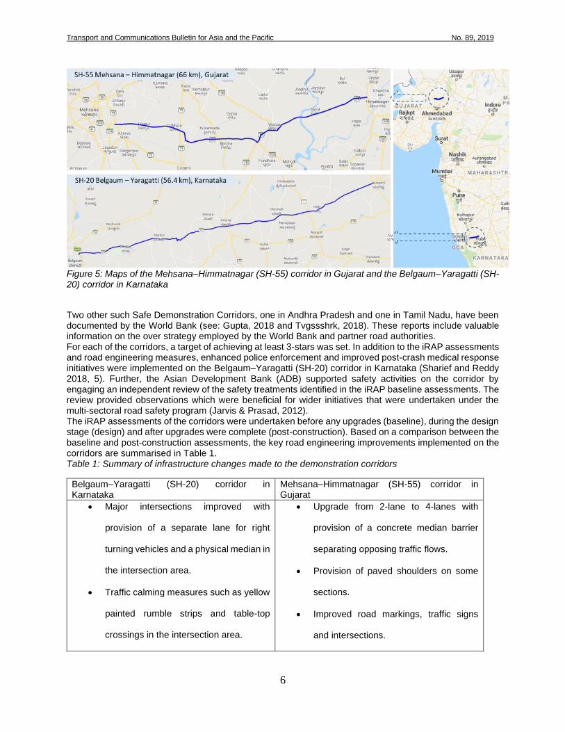
To help improve the star ratings of national and state highways assessed - and therefore reduce risk - Safe Demonstration Corridors have become a regular feature of road projects financed by the World Bank. Two such demonstration corridors are in the states of Karnataka and Gujarat:
1. The Belgaum–Yaragatti (SH-20) corridor in Karnataka is 56.4km long and was part of the Second
Karnataka State Highway Improvement Project (World Bank 2011).
2. The Mehsana–Himmatnagar (SH-55) corridor in Gujarat is 59km long and was part of the Gujarat
State Highway Improvement Project-II (World Bank 2013).
Transport and Communications Bulletin for Asia and the Pacific No. 89, 2019
6
Figure 5: Maps of the Mehsana–Himmatnagar (SH-55) corridor in Gujarat and the Belgaum–Yaragatti (SH-20) corridor in Karnataka
Two other such Safe Demonstration Corridors, one in Andhra Pradesh and one in Tamil Nadu, have been documented by the World Bank (see: Gupta, 2018 and Tvgssshrk, 2018). These reports include valuable information on the over strategy employed by the World Bank and partner road authorities. For each of the corridors, a target of achieving at least 3-stars was set. In addition to the iRAP assessments and road engineering measures, enhanced police enforcement and improved post-crash medical response initiatives were implemented on the Belgaum–Yaragatti (SH-20) corridor in Karnataka (Sharief and Reddy 2018, 5). Further, the Asian Development Bank (ADB) supported safety activities on the corridor by engaging an independent review of the safety treatments identified in the iRAP baseline assessments. The review provided observations which were beneficial for wider initiatives that were undertaken under the multi-sectoral road safety program (Jarvis & Prasad, 2012). The iRAP assessments of the corridors were undertaken before any upgrades (baseline), during the design stage (design) and after upgrades were complete (post-construction). Based on a comparison between the baseline and post-construction assessments, the key road engineering improvements implemented on the corridors are summarised in Table 1. Table 1: Summary of infrastructure changes made to the demonstration corridors
Belgaum–Yaragatti (SH-20) corridor in Karnataka
Mehsana–Himmatnagar (SH-55) corridor in Gujarat
• Major intersections improved with
provision of a separate lane for right
turning vehicles and a physical median in
the intersection area.
• Traffic calming measures such as yellow
painted rumble strips and table-top
crossings in the intersection area.
• Upgrade from 2-lane to 4-lanes with
provision of a concrete median barrier
separating opposing traffic flows.
• Provision of paved shoulders on some
sections.
• Improved road markings, traffic signs
and intersections.
Transport and Communications Bulletin for Asia and the Pacific No. 89, 2019
7
• Traffic calming measures such as table-
top crossings and/or speed hump in the
urban areas.
• Provision of overtaking lanes in the hilly
areas.
• Streetlights, pedestrian markings and
bus bays in the urban areas and major
intersections in rural areas.
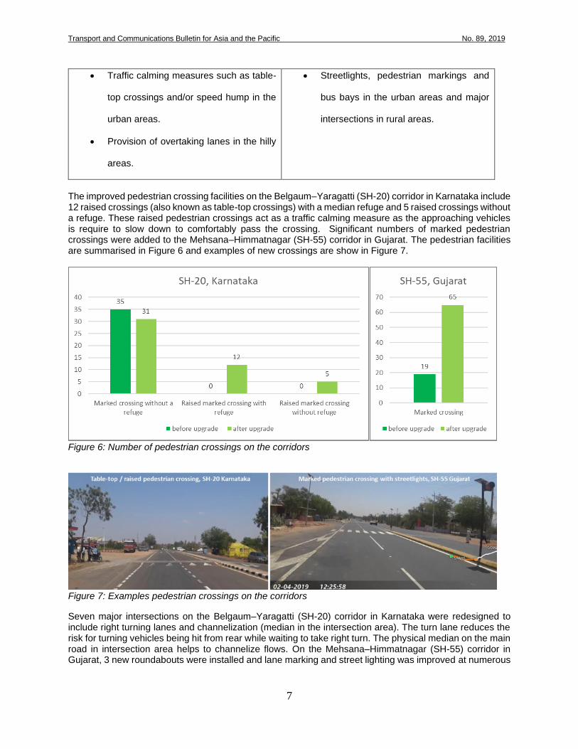
The improved pedestrian crossing facilities on the Belgaum–Yaragatti (SH-20) corridor in Karnataka include 12 raised crossings (also known as table-top crossings) with a median refuge and 5 raised crossings without a refuge. These raised pedestrian crossings act as a traffic calming measure as the approaching vehicles is require to slow down to comfortably pass the crossing. Significant numbers of marked pedestrian crossings were added to the Mehsana–Himmatnagar (SH-55) corridor in Gujarat. The pedestrian facilities are summarised in Figure 6 and examples of new crossings are show in Figure 7.
Figure 6: Number of pedestrian crossings on the corridors
Figure 7: Examples pedestrian crossings on the corridors
Seven major intersections on the Belgaum–Yaragatti (SH-20) corridor in Karnataka were redesigned to include right turning lanes and channelization (median in the intersection area). The turn lane reduces the risk for turning vehicles being hit from rear while waiting to take right turn. The physical median on the main road in intersection area helps to channelize flows. On the Mehsana–Himmatnagar (SH-55) corridor in Gujarat, 3 new roundabouts were installed and lane marking and street lighting was improved at numerous

Transport and Communications Bulletin for Asia and the Pacific No. 89, 2019
8
intersections. Intersection categories are summarised in Figure 8 and examples of improved intersections are show in Figure 9.
Figure 8: Number of intersections on the corridors
Figure 9: Intersection with turn-lane on the Belgaum–Yaragatti (SH-20) corridor in Karnataka and a roundabout on the Mehsana–Himmatnagar (SH-55) corridor in Gujarat
On the Belgaum–Yaragatti (SH-20) corridor in Karnataka traffic calming, such as thermoplastic rumble strips, speed humps and the previously-mentioned table-top type crossings, serve to slow traffic near intersections and in areas where pedestrians are present. As shown in Figure 10, 11 percent of the corridor now has traffic calming, compared to none before. Figure 10 also shows an example of one of the calming facilities.

Transport and Communications Bulletin for Asia and the Pacific No. 89, 2019
9
Figure 10: Traffic calming measures on the Belgaum–Yaragatti (SH-20) corridor in Karnataka
Part of the Belgaum–Yaragatti (SH-20) corridor in Karnataka passes through a hilly section where an additional lane has been provided so that light vehicles can more safely overtake heavy vehicles. The length of additional lanes added is shown in Figure 11, as is an example of one of the so-called “2+1” sections of road.
Figure 11: Additional lanes on the Belgaum–Yaragatti (SH-20) corridor in Karnataka
The Mehsana–Himmatnagar (SH-55) corridor in Gujarat is now dual carriageway (2+2 lanes) with a concrete safety barrier in the median and paved shoulders for almost its entire length. The concrete barrier in the median reduces risk of head-on collisions while paved shoulder reduces the risk of run-off road crashes. Median type and paved shoulder categories are summarised in Figure 12 and examples of a section with median barrier and paved shoulder is show in Figure 13. It is noted that other things being equal the addition of traffic lanes is likely to result in an increase in traffic operating speeds. Such an increase in speeds was taken into account in the assessments.

Transport and Communications Bulletin for Asia and the Pacific No. 89, 2019
10
Figure 12: Medians and paved shoulders on the Mehsana–Himmatnagar (SH-55) corridor in Gujarat
Figure 13: Concrete median barrier and paved shoulder on the Mehsana–Himmatnagar (SH-55) corridor in Gujarat
Delineation – lane marking and signs – has been significantly improved on the Mehsana–Himmatnagar (SH-55) corridor in Gujarat. This helps to guide drivers and riders along the road safely. Street lighting has also been added to a section of the corridor. Streetlighting helps to improve safety at pedestrian crossings and for people walking along the roadside and reduces risk at intersections. Delineation and street lighting categories are summarised in Figure 14 and an examples of a section with adequate delineation and street lighting is show in Figure 15.

Transport and Communications Bulletin for Asia and the Pacific No. 89, 2019
11
Figure 14: Streetlight and delineation (road markings and signs) on the Mehsana–Himmatnagar (SH-55) corridor in Gujarat
Figure 15: Example of Streetlight and delineation (road markings and signs) on the Mehsana–Himmatnagar (SH-55) corridor in Gujarat
3.1.2. Star Ratings
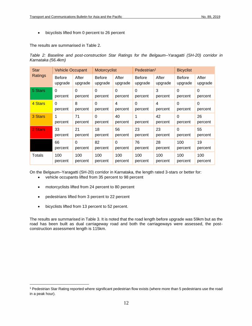
The assessments showed that the changes made to the corridors improved the Star Ratings. On the Belgaum–Yaragatti (SH-20) corridor in Karnataka, the length rated 3-stars or better for:
• vehicle occupants lifted from 1 percent to 79 percent
• motorcyclists lifted from 0 percent to 44 percent
• pedestrians lifted from 1 percent to 49 percent
Transport and Communications Bulletin for Asia and the Pacific No. 89, 2019
12
• bicyclists lifted from 0 percent to 26 percent
The results are summarised in Table 2.
Table 2: Baseline and post-construction Star Ratings for the Belgaum–Yaragatti (SH-20) corridor in Karnataka (56.4km)
Star
Ratings
Vehicle Occupant Motorcyclist Pedestrian1 Bicyclist
Before
upgrade
After
upgrade
Before
upgrade
After
upgrade
Before
upgrade
After
upgrade
Before
upgrade
After
upgrade
5 Stars 0
percent
0
percent
0
percent
0
percent
0
percent
3
percent
0
percent
0
percent
4 Stars 0
percent
8
percent
0
percent
4
percent
0
percent
4
percent
0
percent
0
percent
3 Stars 1
percent
71
percent
0
percent
40
percent
1
percent
42
percent
0
percent
26
percent
2 Stars 33
percent
21
percent
18
percent
56
percent
23
percent
23
percent
0
percent
55
percent
1 Star 66
percent
0
percent
82
percent
0
percent
76
percent
28
percent
100
percent
19
percent
Totals 100
percent
100
percent
100
percent
100
percent
100
percent
100
percent
100
percent
100
percent
On the Belgaum–Yaragatti (SH-20) corridor in Karnataka, the length rated 3-stars or better for:
• vehicle occupants lifted from 35 percent to 98 percent
• motorcyclists lifted from 24 percent to 80 percent
• pedestrians lifted from 3 percent to 22 percent
• bicyclists lifted from 13 percent to 52 percent.
The results are summarised in Table 3. It is noted that the road length before upgrade was 59km but as the road has been built as dual carriageway road and both the carriageways were assessed, the post-construction assessment length is 115km.
1 Pedestrian Star Rating reported where significant pedestrian flow exists (where more than 5 pedestrians use the road
in a peak hour).

Transport and Communications Bulletin for Asia and the Pacific No. 89, 2019
13
Table 3: Baseline and post-construction Star Ratings for the Mehsana–Himmatnagar (SH-55) corridor in Gujarat 2
Star
Ratings
Vehicle Occupant Motorcyclist Pedestrian3 Bicyclist
Before
upgrade
After
upgrade
Before
upgrade
After
upgrade
Before
upgrade
After
upgrade
Before
upgrade
After
upgrade
5 Stars 0
percent
1
percent
0
percent
0
percent
0
percent
4
percent
0
percent
0
percent
4 Stars 2
percent
6
percent
0
percent
2
percent
0
percent
2
percent
0
percent
5
percent
3 Stars 33
percent
91
percent
24
percent
78
percent
3
percent
16
percent
13
percent
47
percent
2 Stars 16
percent
2
percent
27
percent
19
percent
14
percent
42
percent
29
percent
46
percent
1 Star 49
percent
0
percent
49
percent
1
percent
83
percent
36
percent
59
percent
2
percent
Totals 100
percent
100
percent
100
percent
100
percent
100
percent
100
percent
100
percent
100
percent
Figure 16-22 show examples of the baseline and post-construction star ratings at a series of locations on the corridors.
2 Smoothed Star Ratings are reported in the table except for pedestrian. Smoothed Star Ratings are averaged over
longer lengths in order to produce more meaningful results as the Star Ratings may differ every 100m of road length. 3 Pedestrian Star Rating reported where significant pedestrian flow exists (where more than 5 pedestrians use the road
in a peak hour)

Transport and Communications Bulletin for Asia and the Pacific No. 89, 2019
14
Figure 16 Baseline and post-construction image, Km 22.2 on the Belgaum–Yaragatti (SH-20) corridor in Karnataka

Transport and Communications Bulletin for Asia and the Pacific No. 89, 2019
15
Figure 17: Improved intersection and pedestrian facility, Km 43.5 on the Belgaum–Yaragatti (SH-20) corridor in Karnataka

Transport and Communications Bulletin for Asia and the Pacific No. 89, 2019
16
Figure 18: Improved road with 2+1 lane and curve delineation, Km 19.5 on the Belgaum–Yaragatti (SH-20) corridor in Karnataka

Transport and Communications Bulletin for Asia and the Pacific No. 89, 2019
17
Figure 19: Baseline and post-construction images of an intersection, Km 46.9 on the Belgaum–Yaragatti (SH-20) corridor in Karnataka

Transport and Communications Bulletin for Asia and the Pacific No. 89, 2019
18
Figure 20: Baseline and post-construction images, Km 118.3 on the Mehsana–Himmatnagar (SH-55) corridor in Gujarat

Transport and Communications Bulletin for Asia and the Pacific No. 89, 2019
19
Figure 21: Baseline and post-construction image of an intersection, Km 126.9 on the Mehsana–Himmatnagar (SH-55) corridor in Gujarat

Transport and Communications Bulletin for Asia and the Pacific No. 89, 2019
20
Figure 22: Baseline and post-construction images of pedestrian facilities, Km 134.2 on the Mehsana–Himmatnagar (SH-55) corridor in Gujarat

Transport and Communications Bulletin for Asia and the Pacific No. 89, 2019
21
3.1.3. Deaths and injuries
During the baseline iRAP assessments, independent crash data collection studies were commissioned on to develop a better understanding of both the level of trauma and the types of crashes that occur (JPRI 2012a). The study on the Belgaum–Yaragatti (SH-20) corridor in Karnataka showed that about two-third (63 percent) of the crashes resulted in fatality or grievous injury. The proportion of vehicles involved in these crashes were 30 percent trucks, 27 percent cars and 16 percent farm tractors. A study on a road that is very similar to Mehsana–Himmatnagar (SH-55) corridor in Gujarat showed a high proportion of head-on crashes (39 percent) followed by pedestrian hit by vehicle (26 percent). Reported crash data for the years immediately prior to improvements to the Belgaum–Yaragatti (SH-20) corridor in Karnataka and immediately after the improvements was initially documented by Sahrief and Reddy (2018) and subsequently by Kumar, Tvgssshrk and Tadimalla (2019). The results, summarised in Figure 23, indicate a reduction in annual average deaths from 49.5 to 22.5 (a 54 percent reduction) and a reduction in annual average injuries from 290.5 to 166.5 (a 42 percent reduction). That is, an average of 27 deaths and 124 injuries prevented per year. Notably, the iRAP baseline and post-construction assessments estimated that a 53 percent reduction in deaths and serious injuries would occur.
Figure 23: Annual deaths injuries on Belgaum–Yaragatti (SH-20) corridor in Karnataka, 2015-2018
It is acknowledged that this sample size – just two years before and after the improvements – is relatively small and therefore may be subject to variation, but these preliminary findings are encouraging. Further, it is noted that the reduction is attributable to only the infrastructure improvements but also multi-sectoral interventions that were mentioned earlier. At the time of writing, crash data had not yet been reported for the Mehsana–Himmatnagar (SH-55) corridor in Gujarat. However, the iRAP estimated reduction in deaths and severe injury on the corridor calculated by comparing the baseline and post-construction scenario is 24 percent.
309
50
272
49
208
22
125
23
0
50
100
150
200
250
300
350
Injuries Deaths
2015 2016 2017 2018

Transport and Communications Bulletin for Asia and the Pacific No. 89, 2019
22
4. Business case for large-scale investment in safety
The iRAP assessments that have been performed to date, and the outcomes the demonstration corridors, show that significant progress towards achievement of the Global Road Safety Performance Targets is achievable. Extrapolating across India, a business case analysis estimates that 75 per cent travel on 3-star or better roads by year 2030 will require investment of some 0.3 percent of India’s Gross Domestic Product (GDP) per year but will result in 40 percent reduction of deaths and severe injuries. Over 18 million deaths and serious injuries would be avoided over the 20-year life of the road upgrades, with the economic benefit of crash costs avoided amounting to 6 times the cost of investment (iRAP 2018).
5. Conclusion
The scale and rising number of road deaths in India is surely a public health crisis which needs a systematic approach involving better planning, designing and operation of roads. A systematic assessment of major roads in India conducted by iRAP through the locally established programme, IndiaRAP, in partnership with the Ministry of Road Transport and Highways, National Highways Authority of India, the World Bank, Bloomberg Philanthropies, Private Concessionaires and State Governments has revealed lack of safe infrastructure for road users including vulnerable users like pedestrians and bicyclists. The Star Rating of roads has helped the authorities to understand the safety level of existing roads, identify the targeted road safety interventions and vet road designs to encourage inclusion of economically viable and effective safety treatments in road upgrades. The case study of two roads, one in the state of Karnataka and another in Gujarat, reveals that implementing targeted road safety treatments improved the road length rated 3-star or better. For instance, the road length with 3-star or better for vehicle occupant increased from 35 percent to 98 percent and for motorcyclist it increased from 24 percent to 80 percent after the Mehsana–Himmatnagar (SH-55) corridor in Gujarat was upgraded. Similarly, after upgrades to the Belgaum–Yaragatti (SH-20) corridor in Karnataka were complete, the road length with 3-star or better increased from just 1 percent to 79 percent for vehicle occupant and for pedestrian 79 percent of the urban road length achieved 3-star or better safety ratings. There has been a 54 percent reduction in deaths and 42 percent reduction in injuries – equating to 27 deaths and 124 injuries prevented per year – Belgaum–Yaragatti (SH-20) corridor in Karnataka. The experience in Karnataka and Gujarat are a strong basis for scaling-up targeted safety interventions in India and indeed the approach taken in India serves as a valuable model for other UNESCAP member countries to consider.

Transport and Communications Bulletin for Asia and the Pacific No. 89, 2019
23
References
Gupta, M. (2018). Road safety action pays off, and “demonstration corridors” are here to prove it. Available from https://blogs.worldbank.org/transport/road-safety-action-pays-and- demonstration-corridors-are-here-prove-it. Accessed on 10 October 2019. iRAP. (2013). iRAP Methodology Fact Sheet4: Crash Types. Available from http://resources.irap.org/Methodology/iRAP%20model%20factsheet%204%20- %20Crash%20types.pdf. Accessed 9 May 2019. ITF. (2016). Zero Road Deaths and Serious Injuries: Leading a Paradigm Shift to a Safe System. Paris: OECD. Jarvis, J., & Prasad, K. (2012). Support the Implementation of the Institutional Development and Strengthening Action Plan (IDSAP) Adopted by the Government of Karnataka TA-7667 (IND) ,Summary Reviw Report of iRAP recommendations for SCDP. VicRoads. JPRI. (2012a). iRAP Baseline Data Collection in India, Final Report - Karnataka Phase. Coimbatore. JPRI. (2012b). iRAP Baseline Data Collection in India, Final Report - Gujarat Phase. Coimbatore. Kumar, A., Tvgssshrk, P. and Tadimalla, S., R. (2019). Human lives need not be lost in road crashes—much less at current levels. Available from https://blogs.worldbank.org/transport/human-lives-need-not-be-lost-road-crashes-much-less- current-levels-0. Accessed 10 October 2019. MoRTH. (2018). Road Accidents in India - 2017. New Delhi: Transport Research Wing, Ministry of Road Transport and Highways Govt. of India. Rogers, L. (2015). iRAP India Project Summary. New Delhi: iRAP. Rogers, L., Smith, G., Devika, K., Kumar, P. H., & Prakash, G. (2012). Star Rating Road Designs: Performance Indicators for Roads in India. Bengaluru: iRAP and KSHIP. Available from https://www.irap.org/2012/12/star-rating-road-designs-india/ Sharief, M., & Reddy, K. (2018). Implementation of Safe Corridor Demonstration Program in Stretch of SH-20 from Yaragatti to Belgaum. Journal of the Indian Roads Congress, 79-3, pp. 5-8. Tvgssshrk, P. (2018). Building safer roads through better design and better contracts. Available from https://blogs.worldbank.org/transport/building-safer-roads-through-better-design-and-better- contracts. Accessed 10 October 2019. UNESCAP.(2016). Asian Highway Design Standards For Road Safety Annex-II bis Available from
https://www.unescap.org/sites/default/files/AH%20Design%20Standards%20for%20Raod
%20Safety%20-
%20Adopted%20Annex%20II%20bis.pdf.%20Accessed%207%20May%202019. Unknown. (2013). Second Gujarat State Highway Project. Available from http://projects.worldbank.org/P114827/gujarat-state-highway-project-ii?lang=en. Accessed 9 May 2019.
Unknown. (2014). iRAP Methodology Fact Sheet1: Overview. Available from iRAP http://resources.irap.org/Methodology/iRAP%20model%20factsheet%201%20- %20Overview.pdf. Accessed 9 May 2019.

Transport and Communications Bulletin for Asia and the Pacific No. 89, 2019
24
Unknown. (2015). iRAP Methodology Fact Sheet3: Road Attributes. Available from http://resources.irap.org/Methodology/iRAP%20model%20factsheet%203%20- Road%20attributes.pdf. Accessed 9 May 2019. Unknown. (2017). New Indian Road Assessment Programme to Save Lives. Available from https://www.irap.org/2017/11/new-indian-road-assessment-programme-to-save-lives/. Accessed 9 May 2019. Unknown. (2018). The Business Case for Safer Roads. Available from https://www.vaccinesforroads.org/business-case-for-safer-roads/. Accessed 9 May 2019. Unknown. (2019a). Available from https://www.irap.org/. Accessed 9 May 2019. Unknown. (2019b). iRAP Specification, Manuals and User Manual Update. Available from http://resources.irap.org/Specifications/iRAP_Coding_Manual_Drive_on_Left.pdf. Accessed 9 May 2019.
World Health Organization. (2016). Developing global targets for road safety risk factors and service delivery mechanisms. Available from https://www.who.int/violence_injury_prevention/road_traffic/road-safety-targets/en/. Accessed 10 October 2019. World Health Organization. (2018). Global Status Report on Road Safety. World Bank. (2011). Project Appraisal Document for the Second Karnataka State Highway Improvement Project. Available from http://documents.worldbank.org/curated/en/827871468042298605/pdf/590890PAD0P10710 only1910BOX358303B0.pdf. Accessed 7 May 2019.