Embed Size (px)
Citation preview

Transforming 19th Century Archives into 21st Century Analytical Maps
Kayeleigh Sharp & Mark Wagner Southern Illinois University, Center For Archaeological Investigations Carbondale

Trail of Tears 1838-1839Cherokee removal & southern Illinois

• Regional Extent • Lifeways and Culture• Writing and Publication• Treaties and Allies
Who were the Cherokee?
TOT-SI, Kayeleigh Sharp & Mark Wagner ESRI UC 2014
Cherokee Phoenix (Harris 1828)
Cherokee Territorial Limits (Royce 1884)
Se-Quo-Yah (Bowen 1838)

Andrew Jackson and Indian Removal
TOT-SI, Kayeleigh Sharp & Mark Wagner ESRI UC 2014
“The e 1828 election of President Andrew Jackson, who made his name as Thee 828 election of President Andrew Jackson, who made his name as 18an Indian fighter, marked a change in federal policies. As part of his plans an Indian fighter, marked a change in federal policies. As part of his plans for the United States, he was determined to remove the remaining tribes for the United States, he was determinedfrom the east and relocate them in the
TOT SI K
d to rem
TOT
nede e west.”
l i h Sh & M k
move the rem
l
rem ” (NPS 2014)
Routes adapted from Trail of Tears National Historic Trail (NPS 2009)Andrew Jackson (Ritchie 1860)

Nunaihi-Duna-Dlo-lilu-i:TThe Trail Where They Cried “During the harsh winter of
1838-1839 over 13,000 Cherokee Indians passed through southern Illinois on their Trail of Tears. Many perished from cold and hunger on this long, painful journey from their home in the Smoky Mountains to new government-designated lands in eastern Oklahoma. It took almost three months during the winter to cross the 60 cold and rainy miles between the Ohio and Mississippi Rivers in southern Illinois.” (US Forest Service)
TOT-SI, Kayeleigh Sharp & Mark Wagner ESRI UC 2014
Photo courtesy of Kayeleigh Sharp

Archival Research into Cherokee Trail of Tears-Related Sites in Southern Illinois
TOT-SI, Kayeleigh Sharp & Mark Wagner ESRI UC 2014
Objectives:
(1) Look at various cultural resources potentially associated with the Cherokee Trail of Tears route through southern Illinois including structures, camp grounds, cemeteries and other facilities recorded in archives;
(2) Provide locational information on sites and map them;
(3) Summarize historical and/or archaeological information;
(4) Elucidate some key aspects of the Trail of Tears experience in southern Illinois“Trail Finders” Mr. and Mrs. John G.
Mulcaster and L. O. Trigg (Saint Louis Post Dispatch 1935)

TOTSI GISTrail of Tears Southern Illinois
Archival Research and Geodatabase
Common Needs for Building a Geodatabase
TOT-SI, Kayeleigh Sharp & Mark Wagner ESRI UC 2014
Like other GIS projects, the TOT-SI archival research project demanded a solution for storing various types of spatial data and non-spatial data in a centralized location and the ability to apply rules, define geospatial models and maintain data integrity.
http://www.esri.com/software/arcgis/geodatabase
TOT-SI, Kayeleigh Sharp & Mark Wagner ESRI UC 2014
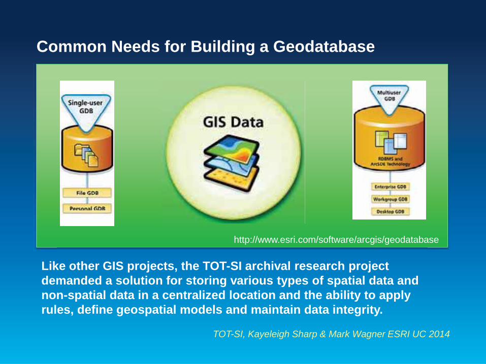
Previous Work
Recent data recorded in a variety of archaeological, geophysical and historical investigations was brought together in a centralized repository for the first time.
Wagner and McCorvie 2003
Henson 2010
Hacker et al. 2010 Illinois Chapter of the Trail of Tears
Trail of Tears Across Pope County, Illinoisp
Map by Kayeleigh Sharp, courtesy of Sharp & Wagner (2014)

Other State and National Spatial Data Resources
Illinois Public Domain Land Tract Sales (ISA 2012b) Public Land
Survey System (PLSS)
+ =

Primary Resource: Archival Data from the 1800s
TOT-SI, Kayeleigh Sharp & Mark Wagner ESRI UC 2014
The TOTSI geodatabase combined new data derived from maps and documents that are nearly two centuries old.
First-hand accounts of 1838-1839 Cherokee relocation (Butrick 1998)
Federal Township Plats of Illinois from the early 1800s (ISA 2012a)
Circuit court, property tax and business license records from the 1830s (Annable n.d., Dexter 1996; 1997; 2003)

The TOT-SI Geodatabase
A centralized repository of newly combined archival and spatial data resources
TOT-SI, Kayeleigh Sharp & Mark Wagner ESRI UC 2014
Federal Township Plats of Illinois (1804-1891)(ISA 2012a)
Published transcriptions( e.g., Annablen.d., Dexter 1996; 1997; 2003)& original tax records from the 1830s
Atlas of Union Co., (Lake 1881)
Federal Township Plats of Illinois (1804 1891)
Public Domain Land Tract Sales Database (ISA 2012b) & much more…

Key Contributions and Advantages of
Using ArcGIS

Storing & Mapping Multiple Types of Archival Data
TOT-SI, Kayeleigh Sharp & Mark Wagner ESRI UC 2014
“…when the Cherokee came along in droves and made their camp in the woods along the creek near the present Nimmo home ...near it was a large flour mill of 2 stories run by water power
…. between the mound and the present highway bridge (After her father’s recollection, Frances (Morgan) Wiggins (Wiggins 1934, SCRC, Morris Library)
Map by Kayeleigh Sharp, courtesy of Sharp & Wagner (2014) Morgan Farm (Jonesboro Gazette 1934), Photo courtesy of the Cairo Public Library
Bridge (Hornbuckle 1934), Photo courtesy of the Cairo Public Library

Reconstructing Routes Using Mosaicked Datasets
TOT-SI, Kayeleigh Sharp & Mark Wagner ESRI UC 2014
Map by Kayeleigh Sharp, courtesy of Sharp & Wagner (2014)M b K l i h Sh t f Sh & W (2014)

Resolving Accessibility Questions Using Network Analyst
TOT-SI, Kayeleigh Sharp & Mark Wagner ESRI UC 2014
Map by Kayeleigh Sharp, courtesy of Sharp & Wagner (2014)

Offering a More Complete Vision of the Cherokee Experience along the Trail of Tears in Southern Illinois by Transforming 19th Century Archives into 21st Century Analytical Maps using Esri’s ArcGIS
TOT-SI, Kayeleigh Sharp & Mark Wagner ESRI UC 2014
Map by Kayeleigh Sharp, courtesy of Sharp & Wagner (2014)

References CitedAnnable, E. L. n.d. . Pope County, Illinois: Forgotten Records.
Anonymous. n.d. The Trail of Tears Across Pope County, Illinois (Brochure). . ed. I. C. o. t. T. o. T. Association.
Bowen, J. T. (1838) Se-Quo-Yah / R.T. ; drawn, printed & coloured at I.T. Bowen's Lithographic Establishment, No. 94 Walnut St. Philad[elphi]a : Published by F.W. Greenoughhttp://www.loc.gov/pictures/resource/cph.3g02566/ (last accessed 27 Jun. 2014 ).
Butrick, R. D. S. 1998. The Journal of Rev. Daniel S. Butrick, May 19, 1838 – April 1, 1839: Cherokee Removal, Monograph One. Park Hill, Oklahoma.
Dexter, D. 1996 Early Courthouse Records, 1820-1918, Union County, Illinois, Genealogical Information, Vol. 2. Carterville, Illinois.
---. 1997. Early Courthouse Records, 1820-1918, Union County, Illinois, Genealogical Information, Vol. 3. Carterville, Illinois.
---. 2003. Early Courthouse Records 1839-1918. Union County, Illinois, Genealogical Information, Vol. 4. Carterville, Illinois.
Saint Louis Post Dispatch, S. L. P. 1935. Trail Finders. St. Louis, Missouri.
Gazette, J. 1934. The Cherokee Trail. November 16, 1934, newspaper clipping contained in the 1934 Daughters of the American Revolution Scrapbook. Cairo Public Library, Cairo, Illinois.
Hacker, G., E. Annable, J. Musgrave, J. Schwegman & C. Ruffner. 2010. Trail of Tears in Johnson County: Documenting the Trail of Tears in Johnson County. Johnson County Genealogical and Historical Society.
Harris, I. H. (1828 ) June 18, 1828 Cherokee Phoenix. http://www.loc.gov/exhibits/treasures/trr125.html (last accessed 27 Jun 2014).
Henson, H. 2010 Geophysical Investigation at Camp Ground Cemetery and Church near Anna, Illinois, April 2010. Department of Geology, Southern Illinois University, Carbondale.
Hornbuckle, M. C. A. 1934. D.A.R. Group Retraces Old Indian Trail. November 26, 1934, newspaper clipping from the Cairo Citizen contained in the 1934 Daughters of the American Revolution Scrapbook. Cairo Public Library, Cairo, Illinois.
ISA, Illinois State Archives. 2012a. Federal Township Plats of Illinois (1804-1891). ed. J. White.
---. 2012b. Illinois Public Domain Land Tract Sales. ed. J. White.
Lake, D. J. 1881. An Atlas of Union County, Illinois. . Philadelphia: D. J. Lake and Company.
NPS, National Park Service (2009) Trail of Tears National Historic Trail Map. http://www.nps.gov/trte/upload/TRTE_ContextMap_20091104.jpg (last accessed 27 Jun. 2014 ).
--- (2014) Setting the Stage. http://www.nps.gov/nr/twhp/wwwlps/lessons/118trail/118setting.htm (last accessed 27 Jun. 2014 ).
Ritchie, A. H. (1860) Andrew Jackson / painted by D.M. Carter ; engraved by A.H. Ritchie. New York : Ritchie & Co., c1860. http://www.loc.gov/pictures/item/96521663/ (last accessed 27 Jun. 2014).
Royce, C. C. (1884) Map of the former territorial limits of the Cherokee "Nation of" Indians; Map showing the territory originally assigned Cherokee "Nation of" Indians. [S.l.].Scale [ca. 1:1,000,000]. 1 map on 2 sheets: col. ; 72 x 80 cm. and 52 x 76 cm. G3861.E1 1884 .R6 TIL http://lccn.loc.gov/99446145 (last accessed 27 Jun 2014).
Wagner, M. J. & M. McCorvie. 2003. Archival and Historical Investigations for the Cherokee Trail of Tears in Union County, Illinois. Carbondale, Illinois: Center for Archaeological Investigations, Southern Illinois University Carbondale, Technical Report 03-2.
Wiggins, F. 1934. Typed June 5, 1934 Interview. Carbondale, IL: Special Collections Research Center, Morris Library, Southern Illinois University Carbondale.

Acknowledgements: We wish to acknowledge a number of individuals and institutions without whose assistance this project could not have been completed. Foremost among these are the members of the Illinois Trail of Tears chapter including Sandy Boaz, Joe Crabb, Gary Hacker, Harvey Henson, and Jon Musgrave, the United States Forest Service archaeologists Mary R. McCorvie and Heather Carey for providing information regarding segments of the trail that crossed through Forest Service land, Union County researcher Darrel Dexter, who over the years has transcribed and published numerous primary archival documents from the Union County Courthouse, Louise Ogg and Monica Smith of Cairo, Illinois, for directing us to and letting us photograph the information in the 1930s DAR scrapbooks at the Cairo Public Library, the staff of the Map Library and Special Collections at Morris Library, Southern Illinois University Carbondale (SIUC); Illinois State Archives, Springfield; the Illinois Regional Archives Depository (IRAD) at SIUC; John A. Logan College, Carterville; the Abraham Lincoln Presidential Library, Springfield; and the Chicago Historical Society and the staffs of the Union, Johnson, and Pope County courthouses that provided us with access and introduction to the land records, county commissioner notes, and other documents housed in those courthouses.
Thank You