Embed Size (px)
Citation preview
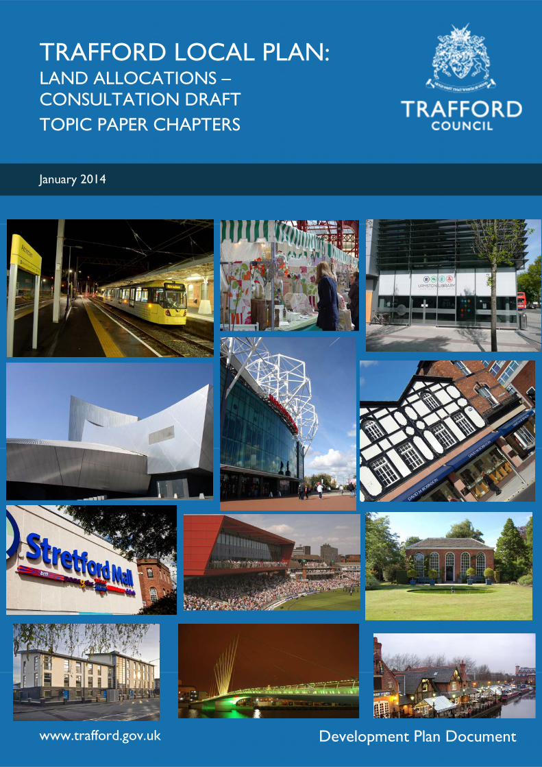
TRAFFORD LOCAL PLAN: LAND ALLOCATIONS – CONSULTATION DRAFT TOPIC PAPER CHAPTERS
www.trafford.gov.uk
January 2014
Development Plan Document
This document can also be made available in alternative formats, including large
print and Braille. For further details please contact the LDF Help-line on 0161 912
4475
Trafford Local Plan: Land Allocations
Topic Paper Chapters
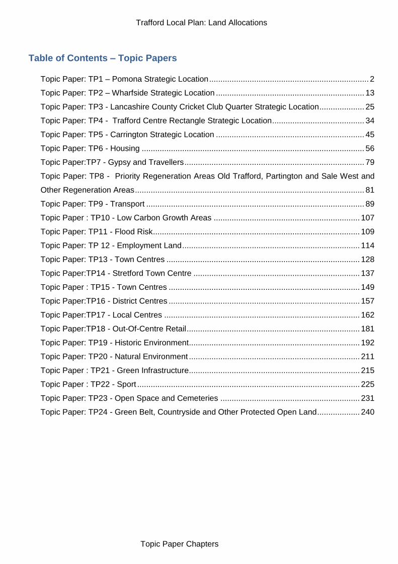
Table of Contents – Topic Papers
Topic Paper: TP1 – Pomona Strategic Location ....................................................................... 2
Topic Paper: TP2 – Wharfside Strategic Location .................................................................. 13
Topic Paper: TP3 - Lancashire County Cricket Club Quarter Strategic Location .................... 25
Topic Paper: TP4 - Trafford Centre Rectangle Strategic Location ......................................... 34
Topic Paper: TP5 - Carrington Strategic Location .................................................................. 45
Topic Paper: TP6 - Housing ................................................................................................... 56
Topic Paper:TP7 - Gypsy and Travellers ................................................................................ 79
Topic Paper: TP8 - Priority Regeneration Areas Old Trafford, Partington and Sale West and
Other Regeneration Areas ...................................................................................................... 81
Topic Paper: TP9 - Transport ................................................................................................. 89
Topic Paper : TP10 - Low Carbon Growth Areas ................................................................. 107
Topic Paper: TP11 - Flood Risk ............................................................................................ 109
Topic Paper: TP 12 - Employment Land ............................................................................... 114
Topic Paper: TP13 - Town Centres ...................................................................................... 128
Topic Paper:TP14 - Stretford Town Centre .......................................................................... 137
Topic Paper : TP15 - Town Centres ..................................................................................... 149
Topic Paper:TP16 - District Centres ..................................................................................... 157
Topic Paper:TP17 - Local Centres ....................................................................................... 162
Topic Paper:TP18 - Out-Of-Centre Retail ............................................................................. 181
Topic Paper: TP19 - Historic Environment ............................................................................ 192
Topic Paper: TP20 - Natural Environment ............................................................................ 211
Topic Paper : TP21 - Green Infrastructure ............................................................................ 215
Topic Paper : TP22 - Sport ................................................................................................... 225
Topic Paper: TP23 - Open Space and Cemeteries .............................................................. 231
Topic Paper: TP24 - Green Belt, Countryside and Other Protected Open Land ................... 240
Trafford Local Plan: Land Allocations
Topic Paper Chapters
Topic Paper: TP1 – Pomona Strategic Location 1.0 Current Position 1.1 The Strategic Location remains largely vacant and available for development.
1.2 The planning permission for 546 residential dwellings (H/58948) on the south
western end of the site has technically been implemented (through the construction of a drainage channel) although the building of the apartment blocks has not yet commenced. This technical implementation means that the planning permission now exists in perpetuity.
1.3 The only existing active uses within the Strategic Location are the scrap metal reclamation businesses (Bennett Bros. and Mancunian Spring Co.) between the Bridgewater Canal and the railway viaduct. In addition, Adamson House, a small-scale office development lies at the far western end of the Strategic Location next to the Pomona Metrolink station.
1.4 The majority of the site is in a single ownership, that of the Manchester Ship
Canal Company / Peel Holdings, and this would enable most of the site to be developed out. However, the scrap metal yards would need to be acquired to complete the whole opportunity site (c.0.4 hectares of the full 10.8 hectare site).
1.5 There are a number of potential constraints to the site including the existing
viaduct whereby vehicular access routes are restricted by the existing arches. In addition, a below ground parking strategy will not be feasible due to remediation issues associated with infill of docks and contamination from previous industrial uses.
1.6 Telecommunications, gas and electricity providers do not foresee any
infrastructure constraints, and any requirements for reinforcement will be agreed directly with developers. United Utilities (UU) do not foresee any water provision issues for Trafford and its predicted growth. Reinforcement of the local water supply network may be necessary in this location. There are sewer capacity issues to the immediate East of Pomona Island, which signals a need to consider drainage issues.
1.7 The Bridgewater Canal opened in 1761 and was the first canal to be built in
Britain without following an existing watercourse. The canal is a recognised historical regional asset and on a list of UNESCO “tentative world heritage sites”. The canal has the potential to be an attractive environment utilised for a range of leisure, tourist and cultural activities.
1.8 The Location includes a Grade II listed structure known as Brindley‟s Weir.
This is Mid-18th Century culvert basin and drain sump, designed to allow the Corn Brook to flow under the Bridgewater Canal. The structure comprises a pear-shaped basin, approximately 25 metres long, bounded on the west side by the canal and on the east by the embankment wall of the Cornbrook railway junction. At its centre is a circular drain sump, about 5 metres in diameter. The brook enters the basin at its north east corner, and flows into
Trafford Local Plan: Land Allocations
Topic Paper Chapters
the drain via a deep channel well below the level of the enclosing setts. At times of spate, the basin could accommodate large volumes of water and prevent scouring of the canal embankment. The basin and drain sump represent an important example of ancillary canal engineering associated with James Brindley, one of the most important engineers of the canal era.
1.9 The site is very accessible by public transport, with two Metrolink stations directly serving the site, and will be accessible to local shops and services and to the major employment areas within the Regional Centre and Trafford Park. Development of this site for mixed employment uses on the scale proposed will generate increased demand for and usage of existing public transport services, and further enhance the viability of these for the benefit of all patrons. Development would also open up the waterfront for safe use by pedestrians and cyclists, providing an additional important link in the network of routes in the Irwell River Park area and beyond.
2.0 UDP Policy Framework 2.1 Pomona is identified as a mixed-use Strategic Development Site under UDP
Proposal E13. Specifically, Pomona is classified as a Sub-Regional Site for “…high quality strategic employment opportunities…” The policy is explicit that development which supports the strategic nature and quality of the site will generally be allowed. It is also clear that development must be “…adequately served by a sustainable integrated transport network accessible by all sectors of the community…”
2.2 Under this policy, Pomona was “…identified as a suitable site for mixed
commercial and residential development, It has the benefit of a water-side location and ready access to the Altrincham-Bury and Cornbrook-Eccles Metrolink lines. It adjoins the Castlefield-St. Georges area within Manchester that has been/is being developed with a similar mix of uses.”
2.3 In addition, the role of Pomona within Trafford Park is detailed in Proposal TP2 which states that “…the Council will permit new and replacement development for office accommodation, leisure and tourism and housing in accordance with the provisions of Proposal E13 and Proposal H3…”
2.4 The policy details the reclamation of this former docks site by Trafford Park Development Corporation and some of the infrastructure put in such as the Metrolink line/station and the Ship Canal-Bridgewater Canal lock link. It is positive about the development of commercial and leisure uses on this site similar to that which has come forward at Castlefield in Manchester and at Salford Quays.
2.5 Pomona is also identified in Proposal H3 as a housing site (HOU5) capable of delivering 600 dwellings over the period April 2006 to March 2016. The allocation for this site was carried forward from the May 1996 adopted Plan. The justification for the Proposal states that: “…the Council will expect prospective developers to prepare a comprehensive Master Community Development Plan before their development is proceeded with. This Plan will be required to illustrate the intended distribution of housing, community facilities and other land uses on the site and the proposed pedestrian, cyclist,
Trafford Local Plan: Land Allocations
Topic Paper Chapters
public and private transport access arrangements to and within the development.”
2.6 Pomona lies within the Old Trafford Priority Regeneration Area as shown on the Proposals Map. Although it is not specifically referred to in Proposal H10, the objectives for improvement set out in this policy do apply to Pomona.
2.7 Pomona is also identified within Policy E6 Tourism Related Development
where the range of developments acceptable to the Council in this area will include:
Visitor attractions that complement the existing facilities;
Visitor accommodation;
Facilities and infrastructure that assist in providing information to tourists;
Further environmental and public access improvements around the tourism attractions and related facilities that are already in place.
3.0 National Planning Policy Framework (NPPF) 3.1 In very general terms, the National Planning Policy Framework (NPPF)
promotes the sustainable development of sites such as Pomona. The following sections of the NPPF may provide particularly relevant guidance for the development within the Pomona Strategic Location:
Building a strong, competitive economy;
Promoting Sustainable Transport;
Delivering a wide choice of high quality homes;
Requiring good design;
Meeting the challenge of climate change, flooding and coastal change; 4.0 The Core Strategy Framework 4.1 With the adopted Trafford Local Plan: Core Strategy, Pomona is identified as
being within the Regional Centre of the Manchester City Region (paragraph 2.10 and Appendix 1). The Regional Centre is the primary economic driver of the Manchester City Region, ensuring that the Regional Centre continues to provide the main focus for business, retail, leisure, cultural and tourism development in the City Region. In Trafford, Pomona, Wharfside (including Mediacity:uk and the Manchester United stadium) all play a significant role in one or more of these types of development and provide opportunities for growth in these sectors.
4.2 The Core Strategy is explicit (paragraph 2.13) that proposals for residential development in the Regional Centre will be acceptable when they are part of mixed use employment schemes, comprising a good range of housing sizes, types, tenures and affordability and where they contribute to the vitality and viability of the Regional Centre. Additionally the expansion of the knowledge economy throughout the Regional Centre is a priority.
4.3 Pomona is identified within the Place Objectives for Old Trafford which seeks to maximise the potential of Pomona Island to create sustainable development within the Regional Centre (OTO8).
Trafford Local Plan: Land Allocations
Topic Paper Chapters
4.4 The main Core Strategy policy relevant to Pomona is SL1 which identifies it as a Strategic Location where significant change and/or development is planned.
4.5 The Policy identifies Pomona as a major opportunity site within the Regional Centre and proposes a new mixed-use commercial and residential district to complement the offers of the City Centre and Salford Quays. In particular (SL1.2), the proposal seeks to deliver:
10 Ha of employment activity;
800 residential units;
New commercial leisure facilities, including an hotel;
Small scale ancillary retail and bar/restaurant uses;
Appropriate new community facilities to support those people using the development;
A substantial new area of open space for informal recreation; and,
New and improved pedestrian links.
4.6 Policy SL1.4 is specific that “…the design of development proposals in this Location should reflect its Regional Centre status, with a high density, high-rise built form.” However, the policy also states that “…a proportion of the residential development should be suitable for families, either in terms of size or type, having regard to Policy L2.” (SL1.6).
4.7 There are also a number of requirements for development on Pomona, including:
Flood Risk Assessment to demonstrate that the development will be safe, without increasing flood risk elsewhere, and that it will where possible reduce flood risk overall;
An assessment of potential contamination and any necessary remediation;
The provision of suitable pedestrian and cycle links to and from the existing Metrolink stations, key bus routes and to the wider Irwell River Park area;
The provision of a new informal recreation facility, centred around the canal basin;
Improvements to local highway network and public transport infrastructure;
A contribution towards the provision of a new 1-form primary school to serve the new residential community in this and the surrounding area;
The provision of ancillary community facilities;
A contribution towards the provision of additional utility capacity;
Protect, preserve and enhance the grade II Brindley‟s Weir and its setting;
An assessment of biodiversity must be carried out prior to development and appropriate sites for nature conservation must be provided to compensate for any loss.
4.8 Policy SL1.7 is clear that uses vulnerable to flooding such as residential must
be located outside of Flood Zone 3.
4.9 The contribution that Pomona is planned to make to housing development targets is set out in Policy/Table L1 with 350 dwellings planned for delivery
Trafford Local Plan: Land Allocations
Topic Paper Chapters
between 2011 and 2016 and 450 between 2016 and 2021. All these dwellings are provided upon previously-developed land.
4.10 As Pomona lies within the Old Trafford Priority Regeneration Area as shown on the Adopted UDP Proposals Map, it has to be considered as to whether it should be brought forward into the Old Trafford PRA as defined in the Land Allocations Plan. This consideration is made in more detail in the Topic Paper for L3: Regeneration and Reducing Inequalities.
4.11 Pomona is also identified as a focus for employment in Policy W1 – Economy. Policy W1.5 identifies the Regional Centre including Pomona as a focus for B1 office uses. Table W1 plans for 10 hectares of employment development on Pomona over the Plan Period.
5.0 Irwell River Park Planning Guidance 5.1 This guidance was produced jointly by Manchester, Salford and Trafford
Councils to see the restoration of the River to create a new and exciting urban park, focusing on its spectacular industrial and architectural achievements, attracting new waterfront development and activities and linking neighbourhoods and communities with the heart of the Regional Centre.
5.2 Although the Guidance is non-statutory, it is explicitly set within the planning policy framework provided by the Regional Spatial Strategy and the adopted Unitary Development Plans for Salford, Manchester and Trafford. As such it is used by each Local Planning Authority as a material consideration in determining applications for planning permission and other matters in the Irwell City Park area.
5.3 The guidance splits the park into 6 zones, of which Pomona Ordsall is number 5. It provides general guidance to development in terms of urban design, accessibility, green infrastructure and activity.
5.4 Policy ICP29 deals specifically with Zone 5 – Pomona Ordsall and suggests 7 principal elements of new and improved infrastructure of which the following 2 are relevant to Pomona:
A new pedestrian bridge and green boulevard linking Ordsall/East Ordsall Lane and the Pomona site extending south over the Bridgewater Canal to Cornbrook Metrolink Station.
Creation of new public realm within the Pomona redevelopment site including an area of greenspace at the northern end and a public square around the proposed marina in the former dock.
5.5 The project is now known as Irwell River Park1.
6.0 Trafford Park Growth Strategy 6.1 This was commissioned in 2012 by the Trafford Park Business
Neighbourhood Shadow Management Board to provide a framework of actions to promote and unlock growth in Trafford Park. It covered a wide
1 http://www.irwellriverpark.com/
Trafford Local Plan: Land Allocations
Topic Paper Chapters
range of recommendations relating to business support, promotion and skills but also made some recommendations relating to spatial and site opportunities.
6.2 The Growth Strategy identifies a number of Development Opportunities which have capacity for development or intensification (Appendix B) including Pomona. It also identifies Character Areas (Appendix C) where specific urban design approaches should be used.
6.3 For Pomona / Cornbrook, the Strategy concluded that the site had “…the potential to deliver in the region of 800 mostly flatted new residential units and 10 hectares of employment land. This site sits within the Irwell River Park boundary and will provide opportunities for increased linkages (particularly pedestrian and cycle) between Trafford Park and Manchester and Salford centres. A short/medium strategy for access and environmental improvement should be developed whilst the development market recovers.”
6.4 In terms of urban design guidance, the Strategy recommended that Pomona be developed in line with the policies and principles identified in the Irwell City Park Planning Guidance.
7.0 Pomona Island Masterplan / Cornbrook Hub Regeneration Framework 7.1 The Pomona Island Masterplan2 was commissioned by the site‟s owner Peel
Holdings to guide and promote the high quality regeneration of the waterside environment adjacent to the Manchester Ship Canal and the Bridgewater Canal.
7.2 The masterplan framework sets out guidance for development in the following terms:
Urban structure and grain;
Landmarks and frontages;
Proposed land use;
Height, massing and density;
Open space and public realm strategy;
Movement and accessibility;
Phasing of development; and
Sustainable development.
7.3 The masterplan proposed a high density mixed use approach to development in the area with housing arranged along the Ship Canal frontage with office and hotel uses alongside the railway viaduct.
7.4 The production of a masterplan was a requirement of the planning permission (H/58948) for 546 residential units on part of the site and was essential for the discharge of a condition of that permission and also formed part of the s106 agreement signed in May 2007. The masterplan was developed in consultation with the Local Planning Authority and was agreed in June 2008. Whilst the production of the masterplan was a condition on the permission and paragraph 2.4 of the s106 agreement states that any application on the land
2 Pomona Island Masterplan – Final Report (Peel/Taylor Young June 2008)
Trafford Local Plan: Land Allocations
Topic Paper Chapters
must be consistent with the Masterplan unless otherwise agreed, the masterplan was not subject to wider public consultation and was not formally adopted by the Council. As such, it does not represent planning guidance for the site.
7.5 In 2012 Peel commissioned a Regeneration Framework for the Cornbrook Hub3. The site is located within the Regional Centre in a strategically important location at the south western gateway to Manchester City Centre. Located within the site is the Cornbrook Metrolink station – a key element of the City Region‟s public transport network. The Regeneration Framework area straddles the boundary between Trafford Borough and the City of Manchester and the western part lies within the Pomona Strategic Location.
7.6 The Regeneration Framework proposes the following:
Redevelopment of the site to deliver a range of uses designed to complement the existing and planned residential communities of the surrounding areas including locations such as Pomona Island and Ordsall Riverside. A variety of uses including retail, commercial, office space, hotel, residential accommodation and community facilities will be considered appropriate;
A new landmark development on the A56 – a sign post to Manchester City Centre, Trafford, Media City:UK, Pomona Island and an enhanced Cornbrook Metrolink Station (this development is proposed outside of Trafford within the City of Manchester);
High quality commercial accommodation for uses including offices, hotels and retail operators;
Reinforcement of public investment in public transport and infrastructure around Cornbrook Metrolink Station;
The relocation of land uses which are incompatible with existing and future uses of adjoining sites. There is also an opportunity to reuse the Victorian railway arches in a contemporary and innovative manner;
Improved permeability through the site providing local residents with improved access to the Bridgewater Canal and Irwell River Park.
7.7 The Regeneration Framework proposes approx. 10,000sqm of office
floorspace in the part of the site within Trafford Borough. This is consistent with the Pomona Island Masterplan and the overall Core Strategy Policy SL1 for the Pomona Strategic Location.
7.8 The Regeneration Framework is currently in draft form and is still subject to further discussion with Trafford and Manchester City Councils.
8.0 Call for Sites / Consultation Responses 8.1 This part of the topic paper highlights some key representations and site
submissions of relevance to employment and a possible response in the Land Allocations Plan to the issues raised.
8.2 LAS-1244-104 – Canmoor – “It is important that provision is made for ancillary retail uses within a Strategic Location in order to make it competitive against
3 Cornbrook Hub Regeneration Framework (Peel/5plus November 2012)
Trafford Local Plan: Land Allocations
Topic Paper Chapters
other employment locations in terms of being able to attract a highly skilled workforce as well as meeting the need for sustainable development.” The need for small-scale retail development to support new residential or employment development and the benefits of mixed-use development in sustainability terms are accepted. The Strategic Location policy for Pomona in the Core Strategy allows for small-scale retail uses to support the planned development.
8.3 LAS-1045-420 – Peel – “The boundary of the Pomona Strategic Location should run along the northern edge of the Manchester Ship Canal. Extending as far east as the Woden Street footbridge and as far west as the point at which the Metrolink line crosses the canal. The southern boundary follows the northern edge of the Metrolink line.” This boundary is logical and reasonable and can be used as the basis for the allocation in the Land Allocations Plan albeit the boundary should be extended westwards beyond the Metrolink bridge to include the land along Pomona Strand up to the White City Gyratory.
8.4 CFS12-1045-76 – Peel – Pomona Island – “…proposing a variation of the amount of employment (from 10ha to7ha) to accommodate an increase in the level of residential development (from 800 to 1,500 dwellings). Peel calculates that this site could accommodate 1,500 residential dwellings, which are deliverable over the plan period, with the additional 700 dwellings being delivered in the period 2021/2 – 2025/6, (the Core Strategy currently indicates that no new dwellings will be delivered in this period). The revised flood risk maps demonstrate that all of the land within this Strategic Location, previously designated as being within FZ3 is now located within FZ2. As such, previous restrictions regarding the suitable uses of the site have now been lifted and the whole of the site should be considered suitable for residential development.”
8.5 The Council recognises there has been a change in the position regarding flood risk on the site which may open up the potential for more residential development on Pomona. It should be noted that the provision of 800 dwellings on Pomona was considered to be justified and appropriate in the Core Strategy and Peel have not put forward any evidence to demonstrate that there is a consistent under-supply of housing in the Borough to require an increase on Pomona. However, the potential for more housing on Pomona is considered as a potential option below.
8.6 CFS12-1045-145 – Peel – “The Cornbrook triangle site is a significant development and regeneration opportunity site in a prominent location relative to the Metrolink, rail and highway corridors and adjacent to the Cornbrook transport interchange… (and)...the part of the site which falls within Trafford should be allocated for high quality office/employment development.”
8.7 This would potentially be consistent with Core Strategy Policy SL1.
9.0 Housing 9.1 The Council considers that the Strategic Location could potentially deliver a
higher housing figure of 1,100 units during the plan period. However it is
Trafford Local Plan: Land Allocations
Topic Paper Chapters
acknowledged that this site has capacity beyond the Plan period, with the potential to deliver approximately 1500 units in total.
9.2 Potentially releasing additional housing land at this location reflects its highly sustainable nature within the Regional Centre and its ability to deliver sufficient additional levels of amenity space to meet the needs of an increased community.
10.0 Employment 10.1 The Council‟s PPS4 Assessment for B1 Office Floorspace in Trafford
Technical Note (September 2010) forecast a need (based on the most optimistic Accelerated Growth forecast from the GMFM) for around 181,000sqm gross of office floorspace in Trafford up to 2026. The PPS4 study then calculated that there was 86,226sqm of office floorspace already completed/committed and the town centres could potentially accommodate a further 26,100sqm. This left a residual need of around 69,000sqm that would need to be developed in the most sustainable locations outside of town centres.
10.2 The PPS4 Study then looked at a range of possible out-of-centre locations (Section 6) and concluded that Pomona and Wharfside were the most sustainable locations and should be the preferred locations for out-of-centre office development in Trafford and could accommodate around 41,400sqm of the residual required office floorspace between them.
10.3 In terms of potential impact on existing centres, the study concluded that Pomona and Wharfside both lie within the Regional Centre and, as such have a catchment area which would extend across the city region but, in particular, may affect planned investment in Manchester City Centre. However, differences in the locations are distinct and are likely to be attractive to different sectors of the office market. Office development in Wharfside in particular is closely linked to the development of Mediacity:uk so is unlikely to impact directly on planned schemes in Manchester City Centre. The City Centre office market is well-established and strong with excellent prospects for growth4 and so is likely to withstand (even benefit from) office development in other parts of the Regional Centre. Further office development outside of the City Centre is unlikely to undermine its overall vitality and viability given its large and diverse retail / leisure / employment function.
10.4 Office development in Pomona and Wharfside may affect further development in the Salford Quays / Central Salford area which, although not identified as centres, are identified for office development. It is considered that office development in this area (particularly Salford Quays) is well established with high growth potential and the amount of development proposed in Pomona and Wharfside will not undermine the further growth of this location but may instead be at a level that will complement and strengthen the existing offer.
10.5 It is acknowledged that this amount of floorspace does not necessarily relate to the 10ha proposed in CS Policy SL1 taking into account the suggested plot ratios in the GM work. However it does allow for flexibility in what comes
4 Greater Manchester Employment Land Position Statement (2010)
Trafford Local Plan: Land Allocations
Topic Paper Chapters
forward on the site. Peel‟s ambition for the site involves more residential and Core Strategy Policy SL1 was adopted when there were still doubts over the extent of flood risk on the site and the figure of 10ha for employment was adopted to reflect the possibility that much of the site may not be developable for residential. However, the Council could consider an option involving more residential on the site and consequently a lower area of land being identified for employment purposes.
11.0 Open Space 11.1 Pomona lies within an area deficient in accessible open space and, in
combination with the significant amount of housing development proposed, this generates a further need for open space. The scale of development is such that the Core Strategy Policies have identified new open space as a condition of development in line with the standards in R5. The Land Allocation Plan should provide further guidance as to the more specific requirements of these new spaces to fit in with the existing Parks hierarchy and facilities provided.
11.2 Using the standards in R5 and the housing needs requirements in L2 the amount of open space required for large residential areas can be worked out. For Pomona the 800 planned new homes generate the need for 2.2 hectares of open space. This constitutes a Neighbourhood Park incorporating a play area, sports facilities and ornamental gardens. Given the relative inaccessibility of the site to surrounding areas due to the barriers formed by the canals, railway and the A56, it is considered that this open space must be provided within the Pomona Strategic Location.
12.0 Viability Appraisal 12.1 The Trafford CIL Economic Viability Study Addendum Report (September
2013) assessed the viability of development on Pomona for a mix of primarily residential with retail uses at ground floor; Offices only; and a mix of primarily offices and a hotel, with ancillary community and retail uses at ground floor.
12.2 Given its proximity to both Manchester City Centre and Mediacity:uk, the study concluded (Section 6.3) that it is likely that residential sales values will be higher than those assumed in other „cold market areas‟ and would suggest these will be more akin to those achieved by residential schemes in Mediacity:uk, Castlefield and other southern areas of the regional centre. Similarly, office rental values are more likely to reflect those achieved in the Mediacity:uk/Salford Quays markets than those found at more peripheral business park locations.
12.3 The study showed that viability varies across the scheme, with residential shown to be viable in current market conditions and other parcels (such as employment unviable. Taken as a whole, the Pomona Island Strategic Location is shown to be viable for development (particularly residential), albeit marginally so. Viability of development on the site is likely to improve as wider economic conditions improve.
Trafford Local Plan: Land Allocations
Topic Paper Chapters
13.0 Defining the Boundary of Pomona 13.1 As set out above, Pomona is a highly constrained site and the canals and
railway viaduct create very clear and rigid boundaries to this „island‟ site. As such the boundary suggested by Peel Holdings is logical and reasonable and can be used as the basis for the allocation in the Land Allocations Plan albeit the boundary should be extended westwards beyond the Metrolink bridge to include the land along Pomona Strand up to the White City Gyratory. Therefore, the consideration of options is based on the amount and type of development within the site rather than any options for a bigger or smaller site area.
14.0 Conclusion 14.1 All the realistic options developed from the information in this topic paper have
been subject to independent Sustainability Appraisal (SA). The Sustainability Appraisal Report (November 2013) and associated Appendices contains the detailed results of individual appraisals of all realistic options for policies and sites and sets out the mitigation required to address any negative sustainability impacts. Specific appraisals relevant on this topic paper can be found in section 4.1 and Appendix A of this document. A summary of the SA and the reasons for choosing the preferred option are set out in the Options Appraisal Report. These documents and the information in this topic paper support the individual policies proposed in the Local Plan: Land Allocations Plan draft for consultation. The policies proposed are demonstrated to be sustainable.
Trafford Local Plan: Land Allocations
Topic Paper Chapters
Topic Paper: TP2 – Wharfside Strategic Location 15.0 Current Position 15.1 Wharfside is a key strategic part of Trafford lying as it does within the
Regional Centre on the south bank of the Manchester Ship Canal, opposite Salford Quays. It is a diverse area where old and new industrial buildings sit close to major visitor attractions such as Manchester United Football Club, the Imperial War Museum North and The Quays. The area is also in close proximity to the BBC North complex in Salford which is the centrepiece of the Mediacity:uk concept. With existing and new pedestrian bridge crossings the area has the potential to expand on and benefit from the economic growth associated with Mediacity:uk.
15.2 The area also has significant potential to provide development linked to the main visitor attractions and enhance the visitor experience to the area. Whilst many of the existing sites are in active use, the density of development is low and there are significant opportunities to address dereliction and under-use of some sites within the area. For all these reasons, but primarily for its economic and tourism potential to enhance the Regional Centre, it is considered that the development of Wharfside is central to the Core Strategy.
15.3 Trafford Wharfside is a large area with scores of different sites, facilities and landowners. However, there has been some consolidation of ownership in recent years and opportunity areas within the Strategic Location exist for the areas owned by Peel Holdings and Manchester United Football Club as follows.
15.4 Peel own the majority of the sites on the strip of land between Trafford Wharf Road and the Manchester Ship Canal and are looking to expand opportunities generated by the successful Mediacity:UK development. This has already been begun with the development of ITV on the former South Bank site but further opportunities for mixed B1a office and residential development along this strip could be considered as sites come forward. Some residential apartment buildings may be appropriate although care needs to be taken with residential development along this strip in order to minimise effects on the amenity/operation of sensitive neighbouring uses such as ITV (in order to minimise views into the Coronation Street set), Rank Hovis on the south side of Trafford Wharf Road and the Telecity high security data storage facility.
15.5 Much of the land south of Wharfside Way is now in the ownership of Manchester United FC and has resulted in more land being brought into use for car parking, etc. Whilst further expansion of capacity at the Stadium is unlikely, it is considered that over the plan period there will be further opportunities for club-related commercial development including the potential relocation of the Museum from the Sir Alex Ferguson Stand to a purpose built facility nearby. It is therefore appropriate that the land close to Stadium is identified for club-related operational and commercial development.
15.6 The land between Trafford Wharf Road and Wharfside Way is almost entirely in commercial / light industrial use although there are a number of vacant and
Trafford Local Plan: Land Allocations
Topic Paper Chapters
underused sites fronting on Wharfside Way which could come potentially forward for mixed commercial/residential uses. In addition, Canmoor own significant amounts of land on the south side of Wharfside Way and there may be opportunities to bring forward mixed development along this stretch.
15.7 There remain further opportunities for the redevelopment of sites at the eastern end of Wharfside including the Victoria Warehouse and Wharf End sites where, historically at least, there have been major redevelopment proposals for mixed residential schemes. Despite being in active use, there remains the opportunity for the redevelopment of the Victoria Warehouse site for a high quality gateway scheme.
15.8 The potential provision of residential dwellings within the Wharfside Strategic Location is consistent with the latest flood risk maps from the Environment Agency which indicate that some of the land at Wharfside closest to the Ship Canal is located within Flood Zone 2 with the rest in Flood Zone 1. As such the development of „more vulnerable uses‟ such as residential would be appropriate within this Strategic Location.
15.9 The Bridgewater Way Scheme along the Bridgewater Canal will provide an
important function for the canal corridor adjacent to this Location, as an alternative sustainable mode of transport (walking/cycling) throughout the Borough, connecting it with Salford, Warrington and Manchester. A Water Taxi scheme will provide an alternative sustainable form of transport connecting the Trafford Wharfside Location with Media City and Salford Quays, and wider links to the Trafford Centre, Trafford Quays and the Regional Centre.
15.10 Telecommunications, gas and electricity providers do not foresee any infrastructure constraints, and any requirements for reinforcement will be agreed directly with developers. UU do not foresee any water provision issues for Trafford and its predicted growth. Reinforcement of the local water supply network may be necessary in this location. The area to the South of Wharfside has severe sewer capacity problems and surface water from new development must not be allowed into the foul/combined sewer.
16.0 UDP Policy Framework 16.1 Wharfside is identified as a mixed-use Strategic Development Site under UDP
Proposal E13. Specifically, Wharfside is classified as a Sub-Regional Site (SR2) for “…high quality strategic employment opportunities…” The policy is explicit that development which supports the strategic nature and quality of the site will generally be allowed. It is also clear that development must be “…adequately served by a sustainable integrated transport network accessible by all sectors of the community…”
16.2 Under this policy, Wharfside was “…made up of a number of individual
parcels of development land, most of which have already been developed or have planning permission for development for prestige business uses. The area has the benefit of a waterside location and ready access to existing and planned improvements to the public transport infrastructure.”
Trafford Local Plan: Land Allocations
Topic Paper Chapters
16.3 In addition, the role of Wharfside within Trafford Park is detailed in Proposal TP5 which states that “…the Council will permit the development of offices, high technology and light industrial premises, hotel, tourism and leisure facilities and similar appropriate development of a quality that reflects the urban high amenity nature of the area in accordance with the provisions of Proposal E13…”
16.4 In addition, the Proposal is clear that “…development proposals that may prejudice the provisions of the Metrolink extension or the provision of new stations to serve the area will not be approved.”
16.5 The policy details the reclamation and improvement of this former docks site
by Trafford Park Development Corporation and some of the investment such as “…the provision of new and improved highways, land assembly, reclamation, landscaping and the environmental improvement of certain existing buildings and the provision of the Wharfside Promenade walkway adjacent to the Ship Canal turning basin.”
16.6 The justification for the Proposal also sets out a number of detailed objectives for the Strategic Area, including:
Encouraging proposals that include measures for the further enhancement of the Wharfside Promenade walkway in the site development scheme;
When considering proposals for development within the above sites the Council will, where appropriate, seek to protect established viable businesses;
the refurbishment or redevelopment of the Victoria Warehouse site and of other older industrial buildings at the eastern entrance to Wharfside;
The Manchester Ship Canal and the Bridgewater Canal are important assets that should be maintained and used to their full potential.
16.7 In addition, UDP Proposal TP13 for The Manchester United Stadium Area
details that the Council will support the continued use and improvement of the area for football stadium and associated hospitality, conference, club store and spectator/ visitor car park use by Manchester United Football Club.
16.8 The Proposal allows for the expansion of the spectator capacity of the football stadium or any significant new hospitality, conference, club store facilities provided that the development is acceptable in traffic and design terms. In addition it seeks to limit the expansion of car parking within and adjoining the Stadium Area.
16.9 Wharfside is also identified within Policy E6 Tourism Related Development which seeks to “…encourage and support developments that enhance the emerging tourism destination within the Wharfside Strategic Area especially where they encourage linkages between the Imperial War Museum-North, the Manchester United Football Club Stadium and Museum developments, the Lowry and other facilities at Salford Quays in Salford…”
16.10 “The range of developments acceptable to the Council in this area will include:
Visitor attractions that complement the existing facilities;
Visitor accommodation;
Trafford Local Plan: Land Allocations
Topic Paper Chapters
Facilities and infrastructure that assist in providing information to tourists;
Further environmental and public access improvements around the tourism attractions and related facilities that are already in place.”
17.0 National Planning Policy Framework (NPPF) 17.1 In very general terms, the National Planning Policy Framework (NPPF)
promotes the sustainable development of sites such as Wharfside. The following sections of the NPPF may provide particularly relevant guidance for the development within the Pomona Strategic Location:
Building a strong, competitive economy;
Promoting Sustainable Transport;
Delivering a wide choice of high quality homes;
Requiring good design;
Meeting the challenge of climate change, flooding and coastal change; 18.0 The Core Strategy Framework 18.1 With the adopted Trafford Local Plan: Core Strategy, Wharfside is identified
as being within the Regional Centre of the Manchester City Region (paragraph 2.10 and Appendix 1). The Regional Centre is the primary economic driver of the Manchester City Region, ensuring that the Regional Centre continues to provide the main focus for business, retail, leisure, cultural and tourism development in the City Region. In Trafford, Pomona, Wharfside (including Mediacity:uk and the Manchester United stadium) all play a significant role in one or more of these types of development and provide opportunities for growth in these sectors.
18.2 The Core Strategy is explicit (paragraph 2.13) that proposals for residential development in the Regional Centre will be acceptable when they are part of mixed use employment schemes, comprising a good range of housing sizes, types, tenures and affordability and where they contribute to the vitality and viability of the Regional Centre. Additionally the expansion of the knowledge economy throughout the Regional Centre is a priority.
18.3 Wharfside is identified within the Place Objectives for Trafford Park. In particular, TPO1 identifies the need to maximise the potential of the area to meet Trafford‟s housing needs, to support the growth of the City Region and to create sustainable residential development as part of high quality mixed use redevelopment/development schemes, supported by local community facilities. TPO9 aims to maximise the potential of visitor attractions such as the Imperial War Museum North, including the provision of supporting facilities such as hotels, bars, restaurants, etc. to meet needs and retain visitor spend in the area.
18.4 The main Core Strategy policy relevant to Wharfside is SL2 which identifies it as a Strategic Location where significant change and/or development is planned.
18.5 The Policy proposes to create a major mixed-use area of regional and international significance with a focus on opportunities for new economic
Trafford Local Plan: Land Allocations
Topic Paper Chapters
(particularly digital and media industries), leisure (hotels and visitor attractions) and residential development.
18.6 The Council considers that this Location can deliver:
In the Mediacity:uk area: high quality mixed-use development for employment activity (10 hectares of mainly B1 office and light industrial uses), leisure (including hotels) residential development (900 units) and an appropriate scale of supporting retail and community uses;
A high quality, high density, multi-storey mixed-use redevelopment of Victoria Warehouses. The mixed-use redevelopment to comprise: residential apartments; commercial office accommodation; hotel accommodation; and ancillary leisure and retail accommodation; and
In the Manchester United stadium area: development that supports the existing football stadium and associated hospitality, conference, retail and visitor facilities.
18.7 There are also a number of requirements for development on Wharfside,
including:
The provision of a new high-frequency public transport system for the area;
The provision of a strategic processional route, suitable for a variety of users that will link Mediacity:uk to Irwell River Park, MUFC, and the LCCC Area and to existing and future public transport infrastructure improvements and canal crossings;
A new bridge crossing that will provide a link within the Irwell River Park scheme;
The provision of a new 1-form primary school by 2021 to serve the new residential community in this and the surrounding area (including SL1 Pomona Island and SL3 LCCC Quarter);
A Flood Risk Assessment must demonstrate that the development will be safe, without increasing flood risk elsewhere, and that it will where possible reduce flood risk overall;
Uses identified in national guidance as being more vulnerable to flooding must be located outside Flood Zone 3;
Design of development at Victoria Warehouses should be high quality given its strategic position as a gateway to The Quays and Trafford Borough. In particular, any tall buildings should be well-designed and iconic.
18.8 Policy SL2.5 is clear that a proportion of the residential development should
be suitable for families, either in terms of size or type.
18.9 The contribution that Wharfside is planned to make to housing development targets is set out in Policy/Table L1 with 400 dwellings planned for delivery between 2011 and 2016, 300 between 2016 and 2021 and 200 between 2021 and 2026. All these dwellings are provided upon previously-developed land.
18.10 Wharfside is also identified as a focus for employment in Policy W1 –
Economy. Policy W1.5 identifies the Regional Centre including Wharfside as a focus for B1 office uses. Table W1 plans for 10 hectares of employment development on Wharfside over the Plan Period.
Trafford Local Plan: Land Allocations
Topic Paper Chapters
18.11 Wharfside lies within the Trafford Park Low Carbon Growth Area as designated in Core Strategy Policy L5.5.
18.12 Under Core Strategy Policy R6, the Council will encourage and support the culture and tourism offer and related developments in, amongst other places, the Regional Centre, particularly within Trafford Wharfside.
19.0 Irwell City Park Planning Guidance 19.1 This guidance was produced jointly by Manchester, Salford and Trafford
Councils to see the restoration of the River to create a new and exciting urban park, focusing on its spectacular industrial and architectural achievements, attracting new waterfront development and activities and linking neighbourhoods and communities with the heart of the Regional Centre.
19.2 Although the Guidance is non-statutory, it is explicitly set within the planning policy framework provided by the Regional Spatial Strategy and the adopted Unitary Development Plans for Salford, Manchester and Trafford. As such it is used by each Local Planning Authority as a material consideration in determining applications for planning permission and other matters in the Irwell River Park area.
19.3 The guidance splits the park into 6 zones, of which The Quays including the part of Wharfside to the north of Wharfside Way is number 6. It provides general guidance to development in terms of urban design, accessibility, green infrastructure and activity.
19.4 Policy ICP30 deals specifically with Zone 6 – The Quays and suggests 10 principal elements of new and improved infrastructure of which the following 6 are relevant to Wharfside:
Improvements and repairs to existing walkways at Clippers Quay Waterfront, Trafford Park Waterfront and within Salford Quays, including new lighting and tree planting;
A new pedestrian bridge at Clippers Quay linking the Salford and Trafford banks (precise location to be defined);
A new pedestrian bridge at mediacity:uk linking the Quays Point development with the Imperial War Museum North site (now completed);
Enhancements to the Trafford Road Bridge including improved lighting and pedestrian access;
Provision of an area of new public realm at The Hub in Trafford linking the City Park to the Old Trafford Stadium Spine;
Extension and improvement of the Imperial War Museum North Waterfront (now completed);
19.5 The project is now known as Irwell River Park5.
20.0 Mediacity:UK & Quays Point Planning Guidance
5 http://www.irwellriverpark.com/
Trafford Local Plan: Land Allocations
Topic Paper Chapters
20.1 This Planning Guidance was prepared jointly by Salford City Council and Trafford Council to guide the creation of a modern digital city of global significance. Although the Guidance is non-statutory, it is explicitly set within the planning policy framework provided by the Regional Spatial Strategy and the adopted Unitary Development Plans and Core Strategy for Salford and Trafford. As such it is used by each Local Planning Authority as a material consideration in determining applications for planning permission and other matters in the Mediacity:UK area.
20.2 As with the Irwell City Park Planning Guidance, this planning guidance applies to the part of Wharfside to the north of Wharfside Way. It provides area-specific guidance relevant to development in Trafford Wharfside terms of mix of uses (Policy MC:UK2); urban form, density and massing(Policy MC:UK4); public realm (Policy MC:UK6); pedestrian connectivity (Policy MC:UK8).
21.0 Trafford Park Growth Strategy 21.1 This was commissioned in 2012 by the Trafford Park Business
Neighbourhood Shadow Management Board to provide a framework of actions to promote and unlock growth in Trafford Park. It covered a wide range of recommendations relating to business support, promotion and skills but also made some recommendations relating to spatial and site opportunities.
21.2 The Growth Strategy identifies a number of Development Opportunities which have capacity for development or intensification (Appendix B) including parts of Wharfside. It also identifies Character Areas (Appendix C) where specific urban design approaches should be used.
21.3 For the parts of Wharfside along the Manchester Ship Canal, the Strategy suggests that land and buildings should be identified to accommodate media, creative industry and leisure related occupiers. In addition, there should be an emphasis on “…reinforcing the existing culture/media offer and providing a high quality environment which links to Pomona/the Regional Centre and broadens the circuit of leisure activities which is developing at Wharfside.” The Growth Strategy identifies a particular opportunity for the development of the docks immediately to the west of the ITV development.
21.4 In terms of urban design guidance, the Strategy recommended that Wharfside be developed in line with the policies and principles identified in the Irwell City Park and Mediacity:UK Planning Guidance. In addition it considers an approach to sustainable development based on BREEAM principles.
22.0 Call for Sites / Consultation Responses 22.1 This part of the topic paper highlights some key representations and site
submissions of relevance to employment and a possible response in the Land Allocations Plan to the issues raised.
22.2 LAS-1244-104 – Canmoor – “It is important that provision is made for ancillary retail uses within a Strategic Location in order to make it competitive against other employment locations in terms of being able to attract a highly skilled
Trafford Local Plan: Land Allocations
Topic Paper Chapters
workforce as well as meeting the need for sustainable development.” The need for small-scale retail development to support new residential or employment development and the benefits of mixed-use development in sustainability terms are accepted. The Strategic Location policy for Wharfside in the Core Strategy allows for small-scale retail uses to support the planned development.
22.3 LAS-1045-421 – Peel – “The suggested boundary for the northern component of the Trafford Wharfside Strategic Location is largely based upon the boundary as included in the Further Consultation on the Core Strategy Preferred Options (2009) consultation document, with a small extension to the west to include the Dry Docks and oil refinery site which includes the oil storage depot located on the southern side of Trafford Wharf Road. The inclusion of these two sites is suggested because they are currently non-compatible with the surrounding uses, especially considering the prominence of the Ship Canal frontage as a site for re-development. There is confidence that re-development opportunities will be brought forward for these sites within the Plan Period. In respect of the remainder of the Strategic Location to the south of Trafford Wharf Road, and subject to the boundary above being agreed, support is given to the boundary as previously identified by the Council in the 2009 draft Core Strategy document.”
22.4 The support for the majority of the previously identified boundary is noted. The additional two sites proposed which would extend the boundary westwards are in quite heavy industrial use (essentially an oil terminal) which whilst they have become less compatible with land uses to the east as Mediacity:uk and ITV has developed they are still very much consistent with the traditional Trafford Park industrial uses to the west.
22.5 In terms of current uses, the dry docks to the immediate east of the Valero oil refinery site represent a potential buffer between „new‟ and „old‟ uses and so the proposal to also include that site within the mixed-use Wharfside Strategic Location may not be appropriate in order to reduce the potential for conflict between different uses. In addition, the Regional Centre boundary stops at the ITV site so it may not be appropriate to extend the Wharfside boundary beyond this as this would be inconsistent with its designation in the Core Strategy.
22.6 Also, the representator has provided no evidence as to how or what could be delivered on either the dry docks or oil refinery site and whilst Peel do own the dry docks, they do not own the oil refinery which has recently been bought by Valero Energy Corporation which is a Fortune 500 international manufacturer and a marketer of transportation fuels, other petrochemical products, and power who are clearly interested in operating the facility at Trafford Park. Therefore, there are significant doubts that the site could come forward for the type of commercial or residential uses appropriate to Trafford Wharfside. However, the opportunity to extend the Wharfside are to include these sites is considered as a potential option for the Plan below.
Trafford Local Plan: Land Allocations
Topic Paper Chapters
22.7 CFS07-1041-48 – TfGM – White City Rail Station – “(TfGM) is investigating the possibility of relocating MUFC Halt to a new site east of the present station with pedestrian links to Pomona and Trafford Bar Metrolink Tram-stops, bus stops on Chester Road and to Old Trafford football ground.” Whilst this is an allocation under Proposals T11 and TP11 of the Trafford UDP, it now forms no part of TfGM‟s LTP3 Local Transport Plan (May 2012) and therefore should be considered as no longer required.
22.8 CFS07-1095-68 – Howard Holdings – Victoria Warehouse – “The site is
currently occupied by a number of red brick warehouse buildings which are of little historical interest and do not meet the requirements of modern business for industrial and commercial related purposes, nor do they readily lend themselves to conversion. A mixed use redevelopment comprising residential, office space, a hotel and other ancillary land uses (including retail/leisure/health/community) would help revitalise the Trafford Park area, improve connectivity, contribute towards creating a more sustainable community and form a critical part of the regeneration of the Manchester Ship Canal Corridor as well as the regeneration of both the Trafford and Salford sides of the Canal.”
22.9 Howard Holdings, the then owners of Victoria Warehouse, went into administration in 2009. The subsequent owners have not sought a comprehensive redevelopment scheme for the site but have converted the prominent easternmost warehouse building into a „backpacker‟ style hotel and nightclub. The brick warehouse unit in the middle of the site appears to remain in low-grade storage uses and the vacant land to the west of the site is now used by Manchester United for car parking. Whilst the site has therefore come into more active use since its designation in the Core Strategy, there is still the opportunity over the plan period for the comprehensive redevelopment to create a high density gateway development as envisaged by previous owners and Core Strategy Policy SL2.
22.10 CFS07-1045-75 – Peel – Trafford Wharfside – commercial and residential led mixed-use development. This is potentially consistent with the uses identified in Core Strategy Policy SL2 Trafford Wharfside.
23.0 Housing 23.1 The Council considers that the Strategic Location could potentially deliver a
housing figure of 900 units during the plan period. It is acknowledged that there is currently no residential community within this area although it is anticipated that there will be a market for apartment led residential development in line with that developed in the part of Mediacity:UK within Salford, as the economy moves out of recession. The Council‟s viability appraisal also indicates that residential development would be viable in this location (see below).
24.0 Employment 24.1 Wharfside is an historic area of Trafford Park with great potential for change in
the future driven by, on the one hand, the presence of Manchester United FC and, on the other, the emergence of MediacityUK. As such, whilst the area
Trafford Local Plan: Land Allocations
Topic Paper Chapters
benefited from significant improvements in infrastructure under the Trafford Park Development Corporation and is still home to many traditional manufacturing industries, there is, sometimes conflicting, pressure for space for newer industries such as media or creative businesses, tourism-related development including visitor facilities such as hotels and matchday parking and residential development to reflect its role within the Regional Centre.
24.2 Core Strategy Policy SL2 seeks to balance these different uses to create a major mixed use area of regional and international significance. Wharfside covers an area of 85 hectares and since 1998 11 hectares of this have been developed for employment uses with 8ha currently available.
24.3 The Council‟s PPS4 Assessment for B1 Office Floorspace in Trafford Technical Note (September 2010) forecast a need (based on the most optimistic Accelerated Growth forecast from the GMFM) for around 181,000sqm gross of office floorspace in Trafford up to 2026. The PPS4 study then calculated that there was 86,226sqm of office floorspace already completed/committed (including 7,000sqm within Wharfside) and the town centres could potentially accommodate a further 26,100sqm. This left a residual need of around 69,000sqm that would need to be developed in the most sustainable locations outside of town centres.
24.4 The PPS4 Study then looked at a range of possible out-of-centre locations (Section 6) and concluded that Pomona and Wharfside were the most sustainable locations and should be the preferred locations for out-of-centre office development in Trafford and could accommodate around 41,400sqm of the residual required office floorspace between them.
24.5 In terms of potential impact on existing centres, the study concluded that Pomona and Wharfside both lie within the Regional Centre and, as such have a catchment area which would extend across the city region but, in particular, may affect planned investment in Manchester City Centre. However, differences in the locations are distinct and are likely to be attractive to different sectors of the office market. Office development in Wharfside in particular is closely linked to the development of Mediacity:uk so is unlikely to impact directly on planned schemes in Manchester City Centre. The City Centre office market is well-established and strong with excellent prospects for growth and so is likely to withstand (even benefit from) office development in other parts of the Regional Centre. Further office development outside of the City Centre is unlikely to undermine its overall vitality and viability given its large and diverse retail / leisure / employment function.
24.6 Office development in Pomona and Wharfside may affect further development in the Salford Quays / Central Salford area which, although not identified as centres, are identified for office development. It is considered that office development in this area (particularly Salford Quays) is well established with high growth potential and the amount of development proposed in Pomona and Wharfside will not undermine the further growth of this location but may instead be at a level that will complement and strengthen the existing offer.
24.7 It is considered that an estimate of 25,000sqm of office floorspace (not including the 13,000sqm that already has permission) to come forward over
Trafford Local Plan: Land Allocations
Topic Paper Chapters
the plan period is reasonable and achievable in market terms and would support the expansion of Mediacity into Trafford whilst not swamping the market or pushing out established industry. It would also allow for residential opportunities (as part of mixed-use development) to come forward.
24.8 It is acknowledged that this amount of floorspace does not necessarily relate to the 10ha proposed in CS Policy SL1 taking into account the suggested plot ratios in the GM work. However, it is considered to be consistent with the size of the area, historic development rates and the amount of available land. It also reflects the potential that not all the employment that will come forward will be „landless‟ B1 offices – creative and media industries may require larger plots for soundstages, etc. The ITV studios development is a good example – 9156sqm of B1 floorspace on a 3.3ha site is a plot ratio of 28% - lower even than some industrial development.
25.0 Open Space 25.1 Wharfside lies within an area deficient in accessible open space and, in
combination with the significant amount of housing development proposed, this generates a further need for open space. The scale of development is such that the Core Strategy Policies have identified new open space as a condition of development in line with the standards in R5. The Land Allocation Plan should provide further guidance as to the more specific requirements of these new spaces to fit in with the existing Parks hierarchy and facilities provided.
25.2 Using the standards in R5 and the housing needs requirements in L2 the amount of open space required for large residential areas can be worked out. For Wharfside, the 900 planned new homes generate the need for 2.3 hectares of open space. This constitutes a Neighbourhood Park incorporating a play area, sports facilities and ornamental gardens. Given the relative inaccessibility of the site to surrounding areas due to the barriers formed by the canals, railway and the A56, it is considered that this open space must be provided within the Wharfside Strategic Location.
26.0 Viability Appraisal 26.1 The Trafford CIL Economic Viability Study Addendum Report (September
2013) assessed the viability of development on Wharfside of 8 different types of development parcels as follows, in order to show the viability of different types of development that may be proposed:
a mix of office and industrial uses;
Industrial/distribution development only;
A mix of office, residential, hotel, ancillary retail and community uses;
A mix of employment and residential uses;
A mix of offices, residential, a hotel and ancillary retail uses;
A mix of employment residential uses;
Residential-led development with some offices and a hotel;
Residential development only. 26.2 The study concluded that there were significant variations in viability across
the different development parcels. The assessment shows that residential
Trafford Local Plan: Land Allocations
Topic Paper Chapters
elements of the development proposed at Trafford Wharfside perform considerably better than employment elements, reflecting wider economic conditions and uncertainties seen across the country as a result of the recent recession. It does indicate that office development as part of a residential led scheme would be viable however. Non-speculative office or employment development, where there is an identified occupier (such as with ITV) can be considered viable however.
27.0 Conclusion 27.1 All the realistic options developed from the information in this topic paper have
been subject to independent Sustainability Appraisal (SA). The Sustainability Appraisal Report (November 2013) and associated Appendices contains the detailed results of individual appraisals of all realistic options for policies and sites and sets out the mitigation required to address any negative sustainability impacts. Specific appraisals relevant on this topic paper can be found in section 4.2 and Appendix B of this document. A summary of the SA and the reasons for choosing the preferred option are set out in the Options Appraisal Report. These documents and the information in this topic paper support the individual policies proposed in the Local Plan: Land Allocations Plan draft for consultation. The policies proposed are demonstrated to be sustainable.
Trafford Local Plan: Land Allocations
Topic Paper Chapters 25
Topic Paper: TP3 - Lancashire County Cricket Club Quarter Strategic Location 28.0 Current Position 28.1 The Lancashire County Cricket Club (LCCC) and surrounding area is one of
the most visited places in the Borough. It contains a major international sporting attraction in the Cricket Club, is adjacent to Manchester United Football Club and also contains a number of important community facilities such as Trafford Town Hall, Trafford College and the Stretford Leisure Centre. However, the area is fragmented by a number of large footprint single uses and a significant opportunity exists to improve the visitor experience for its sporting attractions and to create a new residential neighbourhood.
28.2 Development in this area will support the regeneration of the City Region Inner Area through the creation of a new sustainable mixed-use neighbourhood in a highly accessible location. Designation as a Strategic Location helps promote urban regeneration and the creation of an inclusive, safe and sustainable community for the people of Old Trafford, through the active reuse of vacant brownfield sites, underused land and the improvement of existing facilities and services. It will also support the regeneration of one of the Borough‟s main visitor and sporting attractions (the Cricket Club) and the reuse of the Borough‟s principal administrative building, both of which have significant cultural, civic and historic value.
28.3 However, there has been a very substantial amount of development in this area over the last year, which has brought many of the planned for improvements to the sporting, community and administrative facilities in the area. Improvements to the cricket stadium are well advanced - the new media centre and spectator facilities are complete - in time for the Ashes test in August 2013. In addition, the Club recently agreed a 10 year sponsorship deal with Emirates airline for the naming rights of the stadium – now known as Emirates Old Trafford. This could enable the delivery of further commercial improvements (e.g. visitor accommodation, retail opportunities) which would secure the future of the club and the area.
28.4 The improvements to the cricket stadium were linked to the development of a new Tesco Extra store on the former playing fields to the east of Stretford Leisure Centre. The store opened in November 2012 and essentially means this site is fully developed out now and would not be available for housing during the plan period.
28.5 In April 2013, the refurbished Grade II listed Trafford Town Hall was reopened with a new extension and parking facilities. The improvements include enhanced customer service and staff facilities and public realm including the sunken garden area. As with the Tesco site, this redevelopment of the Town Hall for an improved administrative base for the Council means this site would not be available for other uses during the plan period.
28.6 Similar enhancements have recently been made to Stretford High School including the development of a new sports campus which is also linked to Stretford Leisure Centre. There remains potential for the redevelopment of the
Trafford Local Plan: Land Allocations
Topic Paper Chapters 26
Stretford Leisure Centre site over the plan period however. There are also some planned improvements to the Trafford College site associated with planning permission for housing on its Trafford Park campus site so it is likely that this site will not come forward for housing development, at least in the early part of the plan period. There are no known proposals for Stretford Police Station although the Ambulance Service now jointly use the site.
28.7 It is clear therefore, that the core area of the LCCC Quarter – the land bounded by the Metrolink line, Sir Brian Statham Way/Warwick Road, Chester Road and Great Stone Road is, by and large, developed out and would not be brought forward for housing development during the plan period.
28.8 However, there is potential for redevelopment on some sites along Warwick Road, Chester Road and Great Stone Road, particularly those older office buildings which may no longer provide the type of floorspace to meet modern requirements. Historically, these types of buildings have been converted to residential uses (e.g. Warwickgate House) and it is anticipated that, following the relaxation of permitted development rights from B1 office to C3 residential in May 2013, more of these older types of office buildings will be converted to residential. However, it remains unclear what level of market demand exists for this type of development, at least in the short term.
28.9 However, it is considered that a number of sites could have potential to come forward for housing or mixed development over the plan period. Together, these sites have the potential to deliver the 400 residential units planned for in Core Strategy Policy SL3 and to contribute to the creation of the balanced urban neighbourhood envisaged through the LCCC Quarter Masterplan.
28.10 The other main opportunity within this Strategic Location remains the provision of a Strategic Processional Route along Sir Brian Statham Way and Warwick Road. The redevelopment of the Cricket Club and the Town Hall have opened up and brought more active uses to these frontages which would help support improvements to the public realm. Under Core Strategy Policy SL3, development in the area is required to make a contribution to the provision of a strategic processional route, suitable for a variety of users with a high quality public realm area incorporating green infrastructure. It is therefore essential that the appropriate proportion of CIL funding generated by development in this area goes towards delivering this processional route, in order to support the area‟s status as a major visitor destination.
28.11 The Leisure Review acknowledges that the development of a new replacement facility at Stretford Leisure Centre, including a swimming pool, sports hall and fitness facility is being considered. Tree planting will also be required in order to mitigate the loss of vegetation as a result of developments. Suitable mitigation measures will ensure that the proposals do not result in a cumulative erosion of habitats and thus generally lead to a decreased level of biodiversity in the wider Old Trafford area.
28.12 Telecommunications, gas and electricity providers do not foresee any infrastructure constraints, and any requirements for reinforcement will be agreed directly with developers. UU do not foresee any water provision issues for Trafford and its predicted growth. Reinforcement of the local water supply network may be necessary in this location. There are sewer capacity issues to
Trafford Local Plan: Land Allocations
Topic Paper Chapters 27
the immediate west of the LCCC Quarter, which signals a need to consider drainage issues.
28.13 Increases in intake are required in 2 present primary schools to accommodate existing needs. This will see an increase in spaces by 50 in 2011 and 170 by 2016. Need for a new 2 form entry primary school (1 form required by 2016, 2 forms by 2021) - this will serve new pupils within Old Trafford and the Trafford Wharfside and LCCC Quarter Locations. Existing secondary schools can accommodate some of the pupils.
29.0 UDP Policy Framework 29.1 Although the Lancashire County Cricket Club ground itself was not designated
in the Revised Trafford UDP, the land immediately opposite it to the North of Talbot Road formed the allocated Gorse Hill Priority Regeneration Area (Policy A1 / Proposal H9) and the land immediately opposite the stadium to the east of Sir Brian Statham Way was part of the Old Trafford Priority Regeneration Area (Policy A1 / Proposal H10).
29.2 Under Policy A1, the Council committed itself as a matter of priority to the
regeneration of urban areas such as Gorse Hill and Old Trafford “…via the development and redevelopment of land, the conversion and refurbishment of available buildings, landscaping and other environmental improvements, the construction of improvements to the local transport infrastructure and other support measures.”
29.3 Proposal H9 for Gorse Hill Priority Regeneration Area is particularly concerned with improving the area‟s housing stock and quality of environment; mitigating the effects of traffic and industry; and continuing the programme of environmental improvements along Chester Road (A56). In addition, “…opportunities will be taken to:
i) Clear pockets of unsatisfactory housing; ii) Provide some off-street car parking as part of a programme to tackle the parking/congestion problems throughout Gorse Hill; iii) Improve Gorse Hill Park and the recreation ground at Nansen Road; iv) Examine ways of minimising the impact of industry and other infrastructure, in particular the Euro-Freight Terminal, on residential areas.”
29.4 Since the adoption of the UDP, much work has been done to improve the
housing stock of the area and implement improvements to Gorse Hill Park and the wider environment although there remain issues around car parking and the impact of industry on the residential areas.
29.5 Proposal H10 for the Old Trafford Priority Regeneration Area seeks to improve the quality of the area‟s housing stock, the local environment, facilities for pedestrians, cyclists and public transport and recreational and other facilities available to the local community. In addition, the policy seeks to mitigate the effects on the area of local and through traffic and promote the redevelopment and re-use of unused, under-used or derelict land and buildings for residential, business and community purposes.
29.6 More specifically, the policy states that “…opportunities will be taken to (amongst other things):
Trafford Local Plan: Land Allocations
Topic Paper Chapters 28
remove dereliction and obsolescence;
undertake selective area renewal;
provide new food retail store facilities on Chester Road (adjoining Stretford Leisure Centre) (NB this is included in Proposal H10 in error and should form part of Policy H9 for Gorse Hill which covers this site);
29.7 Most of the actions for the Old Trafford Priority Regeneration Area relate to
improvements to the residential neighbourhoods well to the east of the cricket ground and so are less relevant for consideration in proposals in the LCCC area.
29.8 Part of the area is identified as the Trafford Bar Main Office Development Area under Proposal E10. This Proposal seeks to ensure that applications for office development in the defined areas are suitable in terms of amenity and access, etc. and also that, where the loss of office floorspace is proposed, it is fully justified in terms of market demand and supply.
29.9 There are a number of pieces of Protected Open Space (allocated under UDP Policy OSR5) around the LCCC Area, including Gorse Hill Park which was also proposed for improvement of Outdoor Sports Facilities under Proposal OSR8. Land immediately to the east of Stretford Leisure Centre designated as protected open space has subsequently been developed as part of the new Tesco Extra on Chester Road.
30.0 National Planning Policy Framework (NPPF) 30.1 In very general terms, the National Planning Policy Framework (NPPF)
promotes the sustainable development of sites such as the Lancashire County Cricket Club area. The following sections of the NPPF may provide particularly relevant guidance for the development within the LCCC Quarter Strategic Location:
Building a strong, competitive economy;
Promoting Sustainable Transport;
Delivering a wide choice of high quality homes;
Requiring good design;
Promoting healthy communities; 31.0 The Core Strategy Framework 31.1 With the adopted Trafford Local Plan: Core Strategy, the Lancashire County
Cricket Club Quarter is identified as being within the Inner Area of the Manchester City Region (paragraph 2.10 and Appendix 1). The Core Strategy is explicit (paragraph 2.14) that the Inner Area “…will be a focus for residential development, securing a significant increase in their population to support major regeneration activity and the improvement of community facilities and the creation of sustainable mixed communities, appealing to a broad range of new and existing residents.”
31.2 LCCC Quarter is identified within the Place Objectives for Old Trafford. In particular, OTO11 seeks to maximise the potential of Lancashire County Cricket Club as a visitor attraction and its potential to lead major regeneration in the area.
Trafford Local Plan: Land Allocations
Topic Paper Chapters 29
31.3 The main Core Strategy policy relevant to LCCC Quarter is SL3 which identifies it as a Strategic Location where significant change and/or development is planned.
31.4 The Policy identifies the significance of Cricket Club but notes that “…the area is fragmented by a number of large footprint single uses and a significant opportunity exists to improve the visitor experience for its sporting attractions and to create a new residential neighbourhood.” There is a need to promote linkages with existing communities in the area and help to provide a balance between the different, and sometimes conflicting, land uses.
31.5 The Policy seeks mixed-use development to create a new, high quality
residential neighbourhood, centred around an improved stadium at Lancashire County Cricket Club. The Council considers that this Location can deliver:
A redeveloped LCCC sports stadium with ancillary sports and leisure facilities;
400 residential units comprising predominantly accommodation suitable for families;
A redeveloped and renovated Trafford Town Hall providing new accommodation for Trafford Council and administrative functions;
Improvements to education, community and commercial facilities (including a superstore); and
Improvements to the local highway network and better linkages with public transport infrastructure.
31.6 There are also a number of requirements for development in LCCC Quarter,
including:
The provision of community facilities to support the new community, including school provision, health facilities;
A contribution to the provision of a strategic processional route, suitable for a variety of users with a high quality public realm area incorporating green infrastructure along Warwick Road and Brian Statham Way to enhance visitor experience and to link to existing and future public transport improvements;
To protect, preserve and enhance the listed Trafford Town Hall and its setting and secure its use for civic and community purposes;
To contribute towards the provision of additional utility capacity, including the reinforcement of the local waste water treatment works;
To incorporate features to enhance the level of biodiversity in the area, such as green roofs and appropriate landscaping; and
Provision of affordable housing in accordance with Policy L2. 31.7 The contribution that LCCC Quarter is planned to make to housing
development targets is set out in Policy/Table L1 with 60 dwellings planned for delivery between 2011 and 2016, 300 between 2016 and 2021 and 40 between 2021 and 2026.
31.8 The Council has produced a Development Framework for the LCCC Quarter. This provides more detail about the key opportunities within the area alongside further evidence for the delivery of this Proposal (see Section 4.0 below).
Trafford Local Plan: Land Allocations
Topic Paper Chapters 30
31.9 Under Core Strategy Policy R6, the Council will encourage and support the culture and tourism offer and related developments in, amongst other places, the Lancashire County Cricket Club Quarter Strategic Location.
32.0 Lancashire County Cricket Club Quarter Masterplan6 32.1 In 2010, Trafford Council‟s Growth Delivery Team commissioned a
development framework for the area in and around the Lancashire County Cricket Club (LCCC) Quarter, in order to proactively explore residential development opportunities with the aim of accelerating the rate of housing development.
32.2 The Masterplan proposed 6 Strategic Principles for development in the area:
Placemaking and community building – concerned with creating a location of choice that is mixed, safe and managed;
Rethinking traffic function and movement - to reverse the image of an environment dominated by vehicular traffic „passing through‟;
Spatial restructuring: connections and corridors - so that development connects into and integrates with surrounding neighbourhoods, and that streets define sense of place and environmental quality;
A transformed public realm experience – particularly the „processional route‟, along Warwick Road and the creation of new local open spaces;
Large scale events and liveability – not just about managing negative impacts such as noise, highways congestion, car parking and littering, but about drawing out the potential positives;
Meeting environmental sustainability requirements - development here must demonstrate a commitment to sustainable design and construction;
32.3 The Strategic Principles were used to guide an Area Framework for
development and design. The Area Framework was made up of 8 components:
Overall development opportunity;
Housing offer;
Integrated transport strategy;
Specific opportunity sites;
Key public realm projects;
Strategic character areas;
Land use framework;
Design framework.
32.4 This illustrative masterplanning revealed the potential – and tested the likelihood – of bringing different sites together for comprehensive regeneration, based on careful coordination of sites, public realm and infrastructure elements. The accompanying implementation strategy7 provided an understanding of the potential for partnerships with key landowners/occupiers – aligning aspirations and demonstrating potential for change in the medium-long term.
6 Lancashire County Cricket Club Quarter: Development Framework (AECOM/DTZ 2010)
7 LCCC Development Framework: Implementation Strategy (DTZ/AECOM 2010)
Trafford Local Plan: Land Allocations
Topic Paper Chapters 31
32.5 With uncertainties over site availability and given the issues and potential conflicts outlined throughout the document, LCCC Quarter Masterplan promoted a „tiered‟ delivery approach for sites according to the relative prospect of development. The Masterplan anticipated that all plots within tiers 1 and 2 could be delivered, and with a „design-led‟ approach (i.e. inclusive of apartment development) could yield approximately 428 units.
32.6 However, all of the Tier 1 sites (LCCC, Trafford Town Hall and Tesco Extra) have recently been developed/redeveloped and cannot be considered as being available for housing development during the plan period. There remains some potential amongst the identified Tier 2, 3 and 4 sites for a mix of 2, 3 and 4-bed dwellings at densities within the range of 30 to 150 dph.
32.7 The LCCC Quarter Masterplan also identified the need for the north-south Strategic Processional Route as an essential element of the public realm infrastructure, alongside improvements to Talbot Road and Chester Road.
33.0 Call for Sites / Consultation Responses 33.1 This part of the topic paper highlights some key representations and site
submissions of relevance to the Location and a possible response in the Land Allocations Plan to the issues raised.
33.2 LAS-1242-101 – Derwent Holdings – “There is support for the recognition of the need to deliver new development within Old Trafford. However, it is considered that the promotion of mixed use development within only the areas of Pomona and the Lancashire County Cricket Club Quarter would fail to deliver a number of the strategic objectives set out within the adopted Core Strategy including objectives SO2 and SO6. Instead it is suggested that mixed use development should be promoted across the whole area and specifically in areas which are accessible by a range of means of transport.”
33.3 LAS-1242-103 – Derwent Holdings – “Objective SO6 seeks to reduce the need to travel and promote significant levels of development in the most sustainable locations in the borough. Whilst the location of both Pomona and Lancashire County Cricket Club Quarter is not questioned in sustainability terms, there are a number of other locations within Old Trafford that are also sustainable and would assist in meeting this strategic objective. This includes the area around Trafford Bar Metrolink Station and along key bus routes including Chester Road and Talbot Road.”
33.4 LAS-1242-104 – Derwent Holdings - “It is considered important that areas of Old Trafford, other than just Pomona and the Lancashire County Cricket Club Quarter, are considered appropriate for employment development, along with other uses, where these are in a sustainable location.”
33.5 These 3 submissions are essentially making the same point and, while they refer to LCCC, are more concerned with allowing flexibility on land to the east of the Cricket Club along Talbot Road. This area is largely outside of what is considered to be the LCCC Quarter although potential allocations within these areas will need to be clearly defined and complementary to each other.
Trafford Local Plan: Land Allocations
Topic Paper Chapters 32
33.6 CFS07-1057-62 – Lancashire County Cricket Club – “The proposals for a world class state of the art cricket arena, training and sporting facilities, together with related commercial, education and community uses, residential, retail, leisure, hotels, conferencing, public realm and infrastructure would deliver employment growth and associated commercial development. The improved community facilities would help secure participation from all sections of the community in sport, including young people and children, helping to deliver a healthy and inclusive local environment. The site comprises brownfield land which is well served by public transport, making it a highly sustainable location.”
33.7 This representation was submitted at a time when the Cricket Club was still developing its proposals for improving the Cricket Ground. Following the grant of planning permission for the stadium improvements and associated Tesco Extra store, which have now been largely implemented, any allocation for the cricket ground should seek to protect and enhance the facilities that have been developed there, rather than seek large scale improvements.
33.8 CFS12-1240-143 – Cooperative Estates – “The B&Q store site has an existing use value including a tenant with an unexpired lease term of more than 8 years. This in itself is a constraint on development in the short to medium term. A key consideration in terms of the deliverability of the site is whether any allocation acknowledges the site‟s existing use value. As an investment property, The Co-operative Estates would not be willing to relinquish any value as part of any future redevelopment of the site and this should be taken into consideration when advancing the Land Allocations Document.
33.9 The future potential use of the site identified in the LCCC Quarter Masterplan (Plot 12) to provide 28 apartments and a significant multi-storey car park simply does not recognise the existing use value attributable to the land. Whilst we recognise that the Masterplan document identifies possible ways of maximising development opportunities and a means of illustrating potential for transformation, comprehensive restructuring as part of the LCCC Quarter concept, the Land Allocations Document now needs to recognise that the indicative uses will not be deliverable if they are brought forward as envisaged in the Masterplan document.”
33.10 Essentially, this representation indicates that the potential this site has for housing could not be delivered within at least the first ten years of the Plan Period. It is considered, however, that in the long term, the site may not be viable in its current form for the current retail use – it is relatively small for a modern B&Q store - B&Q recently announced they are closing their store in Altrincham which is relatively small and old - and was not originally designed as a retail unit. Therefore, designation of the site for mixed housing and retail may be appropriate in order to maintain the land value but also direct it towards contributing to housing needs.
34.0 Viability Appraisal 34.1 The Trafford CIL Economic Viability Study Addendum Report (September
2013) did not assess the viability of development on The Lancashire County Cricket Club Quarter Strategic Location on the basis that it is already partially developed and the remainder of development in the location largely comprises
Trafford Local Plan: Land Allocations
Topic Paper Chapters 33
development such as housing and apartments that are assessed in general terms. This Location lies within a cold market area for housing and so would mean that market conditions would need to improve before development here would become viable.
35.0 Conclusion 35.1 All the realistic options developed from the information in this topic paper have
been subject to independent Sustainability Appraisal (SA). The Sustainability Appraisal Report (November 2013) and associated Appendices contains the detailed results of individual appraisals of all realistic options for policies and sites and sets out the mitigation required to address any negative sustainability impacts. Specific appraisals relevant on this topic paper can be found in section 4.3 and Appendix C of this document. A summary of the SA and the reasons for choosing the preferred option are set out in the Options Appraisal Report. These documents and the information in this topic paper support the individual policies proposed in the Local Plan: Land Allocations Plan draft for consultation. The policies proposed are demonstrated to be sustainable.
Trafford Local Plan: Land Allocations
Topic Paper Chapters 34
Topic Paper: TP4 - Trafford Centre Rectangle Strategic Location 36.0 Current Position 36.1 The location is predominantly a brownfield development location (with the
exception of greenfield land at the Trafford Quays site). The Trafford Centre Rectangle has the potential to provide a range of employment opportunities to meet the economic regeneration and development needs of the Borough and to contribute towards the economic prosperity of the City Region. Given that there are few sites in the borough (other than Trafford Quays) that are of sufficient size to deliver a mix of high quality residential accommodation that will help meet Trafford‟s identified housing needs up to and, potentially, beyond the end of the Plan period, using land efficiently within this Location will reduce the need to release further greenfield land elsewhere in the Borough.
36.2 The following developments all have existing planning consents and could therefore begin within the first phase of the plan period: • Residential and commercial development at Trafford Quays; • Commercial office development adjacent to Junction 10 of the M60; • The 4* hotel and conference facility at Junction 9 of the M60; and • The WGIS highway scheme.
37.0 UDP Policy Framework 37.1 The Trafford Centre and its Vicinity is covered in Chapter 10 of the Revised
Adopted Trafford UDP which seeks to build on the economic regeneration potential of the Trafford Centre and how it can support growth and regeneration in the City Region.
37.2 In particular, Part II Proposal TCA1 - The Trafford Centre and its Vicinity states that “…Within the area identified on the Proposals Map the Council will permit development as follows: -
AREA TCA1A - The further development of sports and leisure uses on the Regional Sports Centre site.
AREA TCA1B - The consolidation, improvement and modernisation of existing businesses, industry, storage and distribution uses.
AREA TCA1C - The development of non food bulky goods retail warehousing subject to satisfactory arrangements being put in place to bring about the early construction of the extension of Metrolink through Trafford Park to the Trafford Centre (see Proposal T11).
37.3 In addition, the Proposal is clear that “…The Trafford Centre is not to be
formally classified and treated as an established town centre…” and “…no need for further retail expansion of the Trafford Centre has been demonstrated or is expected during the Plan period.”
Trafford Local Plan: Land Allocations
Topic Paper Chapters 35
37.4 Proposal TCA1A requires that proposals for sports and leisure development within that area have to demonstrate that “…there is a need for the development and that a sequential approach to site selection has been adopted…” and that “…it will be adequately served by sustainable integrated transport network accessible by all sectors of the community”.
37.5 Proposal TCA1 is also clear that “…until such time as the requisite statutory
powers are granted for the extension of the Trafford Park Metrolink route into the area from the Trafford Centre, provision for the extension will be in the form of a safeguarded corridor.”
37.6 The justification for the Proposal emphasises that “…the Council wishes to build upon the high quality shopping, leisure and sporting facilities which have been developed in the area in a way which is sustainable and achieves a high quality of urban development and a high level of amenity…” and that “…Investment in improved transport infrastructure, particularly the improvement of public transport provision (see Proposal T11) will underpin a phased approach to the sustainable regeneration of the area.” The Justification also refers to the provision of an “…additional low level bridging of the Ship Canal in the vicinity of the Trafford Centre and the Barton strategic site in Salford…” as an element of improved transport infrastructure. This scheme is now known as the Western Gateway Improvement Scheme (WGIS).
37.7 Proposal T11 High Quality Public Transport Network Improvements refers to
the development of (amongst other things):
“…a private sector financed Metrolink extension through Trafford Park to the Trafford Centre from the existing Phase 1 Metrolink line at Cornbrook (as indicated on the Proposals Map). The Council will also support the possible extension of this line through Trafford Quays across the Manchester Ship Canal to the Barton Strategic Site and Eccles in Salford (see Proposal TP11)”;
New Metrolink stations on the Trafford Park extension at Wharfside, Village, Mosley Road, Park Way, and the Trafford Centre (as indicated on the Proposals Map);
Trafford Centre: a new station and the provision of passenger rail services utilising the Ship Canal (freight) Railway (see Proposal TP11E);”
37.8 Under Proposal TP12 the Council was seeking the development of an
Industrial Heritage and Interpretation Centre within the Barton-upon-Irwell Conservation Area, adjacent to the Barton Swing Aqueduct. Under this Proposal, “…the Council will not permit any other development in the area that may prejudice the development of the Industrial Heritage and Interpretation Centre or the Conservation Area.”
38.0 National Planning Policy Framework (NPPF) 38.1 In very general terms, the National Planning Policy Framework (NPPF)
promotes the sustainable development of areas such as the Trafford Centre Rectangle. The following sections of the NPPF may provide particularly relevant guidance for the development within the Trafford Centre Rectangle Strategic Location:
Building a strong, competitive economy;
Trafford Local Plan: Land Allocations
Topic Paper Chapters 36
Promoting sustainable transport;
Delivering a wide choice of high quality homes;
Requiring good design;
Meeting the challenge of climate change, flooding and coastal change;
Conserving and enhancing the historic environment 39.0 The Core Strategy Framework 39.1 Within the adopted Trafford Local Plan: Core Strategy, Trafford Centre
Rectangle is identified as being within the Inner Area of the Manchester City Region (paragraph 2.10 and Appendix 1). The Core Strategy is explicit (paragraph 2.14) that the Inner Area “…will be a focus for residential development, securing a significant increase in their population to support major regeneration activity and the improvement of community facilities and the creation of sustainable mixed communities, appealing to a broad range of new and existing residents.”
39.2 Trafford Centre Rectangle is identified within the Place Objectives for Trafford Park. In particular, TPO1 identifies the need to maximise the potential of the area to meet Trafford‟s housing needs, to support the growth of the City Region and to create sustainable residential development as part of high quality mixed use redevelopment/development schemes, supported by local community facilities. TPO5 seeks to ensure the new communities in Trafford Park are provided with sufficient and good quality open space for recreational purposes. TPO9 aims to maximise the potential of visitor attractions such as the Trafford Centre, including the provision of supporting facilities such as hotels, bars, restaurants, etc. to meet needs and retain visitor spend in the area. TPO10 seeks to ensure that new developments do not have a significant adverse impact on the vitality and viability of the Regional Centre and/or the retail hierarchy in the North of the Borough. TPO21 seeks to protect and enhance the Barton Swing Aqueduct, All Saints Church and the Presbytery and their settings. In addition, the Place Objective for Urmston URO13 aims to manage the congestion in the vicinity of the Trafford Centre.
39.3 The main Core Strategy policy relevant to Trafford Centre Rectangle is SL4 which identifies it as a Strategic Location where significant change and/or development is planned.
39.4 The Policy proposes to deliver a major mixed-use development including a new residential neighbourhood together with commercial, leisure, community facilities and substantial improvements to the public transport infrastructure.
39.5 The Council considers that this Location can deliver:
1,050 residential units comprising, predominantly, accommodation suitable for families, on the land known as “Trafford Quays”, commercial office (B1) space and, community facilities;
15 hectares of land for employment activity, a proportion of which is suitable for high quality commercial (B1) development, in line with Policy W1;
New community facilities to support those people using the development; and
A high quality (4* minimum) hotel and conference facility, in the region of 200 bed spaces located close to Junction 9 of the M60.
Trafford Local Plan: Land Allocations
Topic Paper Chapters 37
39.6 There are also a number of requirements for development in Trafford Centre
Rectangle, including:
Significant improvements to public transport infrastructure including an integrated, frequent public transit system;
The provision of the Western Gateway Infrastructure Scheme (WGIS);
A Flood Risk Assessment must demonstrate that the development will be safe, without increasing flood risk elsewhere, and that it will where possible reduce flood risk overall. Uses identified in national guidance as being more vulnerable to flooding such as residential, certain leisure uses, healthcare and educational facilities must be located outside Flood Zone 3;
Contribution towards the provision of additional utility capacity, including the reinforcement of the local waste water treatment works;
Improvements to both the physical and environmental qualities of the Manchester Ship Canal, the Bridgewater Canal and the Barton Bridge Swing Aqueduct;
Provision, where appropriate, to maintain, and/or enhance the Manchester Ship Canal and the Bridgewater Canal for leisure and transportation purposes; and
The preservation or enhancement of the Barton-upon-Irwell Conservation Area, and its wider setting.
39.7 Policy SL4.5 sets out specific requirements for development at the Trafford
Quays site, as follows:
That two thirds of the housing to be provided is made up of family accommodation;
Community facilities including convenience retail, school provision and health facilities of a scale appropriate to the needs of the new community;
An attractive, direct pedestrian link across Trafford Boulevard, connecting Trafford Quays to the Trafford Centre Bus Station, and the Trafford Centre;
The routing, through the site, of local public transport provision;
Provision of affordable housing to be made in accordance with Policy L2;
To protect, preserve and enhance the setting of Pugin‟s Grade I listed Church of All Saints and the Grade II Presbytery;
An assessment of biodiversity must be carried out prior to development and appropriate sites for nature conservation must be provided to compensate for any loss; and
That residential development is not located in areas of potentially poor air quality.
39.8 The contribution that Trafford Centre Rectangle is planned to make to housing
development targets is set out in Policy/Table L1 with 250 dwellings planned for delivery between 2011 and 2016, another 250 between 2016 and 2021 and 550 between 2021 and 2026. All these dwellings are provided upon previously-undeveloped land. This Location is expected to deliver a significant contribution towards the Borough‟s identified need for family accommodation.
39.9 Scope for increasing the level of residential and commercial development beyond that included in the Proposal will be determined in the light of monitoring work carried out in relation to Policies L1 and W1 of this Plan and
Trafford Local Plan: Land Allocations
Topic Paper Chapters 38
the satisfactory provision of identified infrastructure requirements and appropriate mitigation measures. Such provision will be determined by way of future reviews of this Plan, this could include the redevelopment of the ”Container Base” on Barton Dock Road.
39.10 Policy L4.1 dealing with Sustainable Transport and Accessibility seeks to ensure that “…as appropriate, development proposals within less sustainable locations throughout the Borough, including sites within the Strategic Locations of Carrington and Trafford Centre Rectangle, and the Partington Priority Regeneration Area will deliver, or significantly contribute towards the delivery of, measures to secure infrastructure and services that will improve access to more sustainable transport choices.”
39.11 Trafford Centre Rectangle lies within the Trafford Park Low Carbon Growth
Area as designated in Core Strategy Policy L5.5.
39.12 Trafford Centre Rectangle is also identified as a focus for employment in Policy W1 – Economy. Policy W1.5 identifies Trafford Centre Rectangle as an appropriate location for B1 office uses where it is accessible by sustainable transport modes. Table W1 plans for 15 hectares of employment development within Trafford Centre Rectangle over the Plan Period.
39.13 Under Core Strategy Policy R6, the Council will encourage and support the culture and tourism offer and related developments in, amongst other places, the Trafford Centre Rectangle Strategic Location.
40.0 Trafford Park Growth Strategy 40.1 This was commissioned in 2012 by the Trafford Park Business
Neighbourhood Shadow Management Board to provide a framework of actions to promote and unlock growth in Trafford Park. It covered a wide range of recommendations relating to business support, promotion and skills but also made some recommendations relating to spatial and site opportunities.
40.2 The Growth Strategy identifies a number of Development Opportunities which have capacity for development or intensification (Appendix B) including parts of Trafford Centre Rectangle. It also identifies Character Areas (Appendix C) where specific urban design approaches should be used.
40.3 In terms of development opportunities within the Trafford Centre Rectangle, the Growth Strategy identified Trafford Quays as a major mixed residential and commercial opportunity and “by introducing a greater diversity of uses the development of this site will consolidate the character of The Trafford Centre Rectangle as a more mixed use area. The opportunity to intensify pedestrian activity must be promoted and access to the waterfront (including the new link to The Trafford Centre) opened up. Development must also provide an enhanced context for the listed All Saints Church and a quality „gateway‟ to Trafford Park from Eccles.”
40.4 In addition, the Growth Strategy also identified Container Base at Trafford Centre off Barton Dock Road/Park Way Junction and Land along Park Way (including the former Kratos site) as being currently underutilised sites
Trafford Local Plan: Land Allocations
Topic Paper Chapters 39
with scope for intensification of uses or more appropriate uses. It notes that “… the longer term relocation of the current occupier of this site to a more suitable location holds the potential to create a high quality gateway to The Trafford Centre from Junction 9 of the M60. Peel is developing a hotel tower on a triangle of land immediately off J9 of the M60. A land swap would enable the rationalisation of Trafford Centre parking in this area and the development of a series of sites along Park Way. This would provide a strong gateway off the M60 and, with good outward facing development, an improved route towards Park Way Circle.”
40.5 In terms of urban design guidance, the Strategy recommended that Trafford Quays be developed as a high quality residential neighbourhood which maximises its waterfront location through reference to „BREEAM Communities‟ assessment tool and other relevant guidance.
41.0 Call for Sites / Consultation Responses 41.1 This part of the topic paper highlights some key representations and site
submissions of relevance to employment and a possible response in the Land Allocations Plan to the issues raised.
41.2 LAS-1244-104 – Canmoor – “It is important that provision is made for ancillary retail uses within a Strategic Location in order to make it competitive against other employment locations in terms of being able to attract a highly skilled workforce as well as meeting the need for sustainable development.” The need for small-scale retail development to support new residential or employment development and the benefits of mixed-use development in sustainability terms are accepted. The Strategic Location policy for Trafford Centre Rectangle in the Core Strategy allows for small-scale retail uses to support the planned development.
41.3 LAS-1249-101 – Peel & Capital Shopping Centres (now Intu) – “It is considered that the proposed boundary for the Trafford Centre Rectangle Strategic Location should reflect the natural boundary of the Strategic Location as it follows the four main barriers which enclose the site; the M60, Manchester Ship Canal, Parkway dual carriageway (A5081) and the Bridgewater Canal.” It is agreed that this would be a very logical boundary for this Strategic Location as it well defined in terms of physical features but also covers all the existing key facilities and opportunity sites and represents a clear delineation between different uses such as residential to the south and industrial to the north and east.
41.4 CFS07-1041-47 – Land next to the Trafford Centre – TfGM – This site was identified in 2007 as a potential Park & Ride facility. It has subsequently been used as such (for example during the 2012 Olympics) although it has not been specifically identified in the Land Allocations Plan as it is not a specific proposal in the Local Transport Plan.
41.5 CFS07-1045-79 - Trafford Centre Rectangle site(i) Bridgewater Centre Trafford Park – Peel – identified for a mix of uses. The site falls within the Trafford Centre Rectangle area within which a mix of uses is acceptable, in accordance with Core Strategy Policy SL4, therefore it is considered that a specific allocation for this site is not required.
Trafford Local Plan: Land Allocations
Topic Paper Chapters 40
41.6 CFS07 – 1045 - 80 - Trafford Centre Rectangle site(ii) South of Taylor Road
Trafford Park Park – Peel – identified for a mix of uses. The site falls within the Trafford Centre Rectangle area within which a mix of uses is acceptable, in accordance with Core Strategy Policy SL4, therefore it is considered that a specific allocation for this site is not required.
41.7 CFS07 – 1045 - 81 - Trafford Centre Rectangle Site(iii) - Canal Side Argos Depot Trafford Park Park – Peel – identified for a mix of uses. The site falls within the Trafford Centre Rectangle area within which a mix of uses is acceptable, in accordance with Core Strategy Policy SL4, therefore it is considered that a specific allocation for this site is not required. In addition, the property has since been converted to the EventCity conference centre.
41.8 CFS07 – 1045 - 82 - Trafford Centre Rectangle Site (iv) Container Base, Barton Dock Road, Trafford Park – Peel – identified for a mix of uses. The site falls within the Trafford Centre Rectangle area within which a mix of uses is acceptable, in accordance with Core Strategy Policy SL4, therefore it is considered that a specific allocation for this site is not required.
41.9 CFS07 - 1045 – 83 - Trafford Centre Rectangle Site(v) Kratos Barton Dock Road, Trafford Park – Peel – identified for a mix of uses. The site falls within the Trafford Centre Rectangle area within which a mix of uses is acceptable, in accordance with Core Strategy Policy SL4, therefore it is considered that a specific allocation for this site is not required. There are currently outstanding applications for a mixed office and hotel scheme on this site.
41.10 CFS07 - 1045 - 84 - Trafford Centre Rectangle Hotel Site Trafford Park – This site has permission for a 200-bed 4* hotel which was recently renewed and it is specifically identified within Core Strategy Policy SL4.
41.11 CFS07 - 1045 – 85 - CFS12 - 1249 - 85 – Peel - Trafford Centre Rectangle Trafford Quays Trafford Park – Peel – this site is identified in Core Strategy Policy SL4 as the major development opportunity within the Trafford Centre Rectangle for a mixed residential and commercial development on a greenfield site. As such, it is proposed for allocation in the Land Allocations Plan consistent with the submission made by Peel and Policy SL4.
41.12 CFS12 - 1249 – 145 - Trafford Quays Leisure Village – Peel - this site has seen a number of major leisure facilities come forward over the last 10 years and it is considered that there remains some further development potential within the site. As such, it is proposed that this site is allocated for leisure and supporting uses in line with Peel‟s submission and CS Policy SL4.
41.13 CFS12 - 1249 - 146 - Land at Junction 10 M60 – Peel – this site is proposed for office development in line with the existing permission for 12,000sqm of B1 office floorspace on the site. It is considered that, as permission already exists on the site, in line with Peel‟s submission and the site falls within the Trafford Centre Rectangle area within which a mix of uses is acceptable, in accordance with Core Strategy Policy SL4, a specific allocation for this site is not required.
42.0 Housing
Trafford Local Plan: Land Allocations
Topic Paper Chapters 41
42.1 The Council considers that the Strategic Location could potentially deliver a housing figure of 1,050 units on the Trafford Quays site during the plan period. It is acknowledged that there is currently no residential community within this area although it is anticipated that there will be a significant market opportunity for a new high residential community, as the economy moves out of recession. The Council‟s viability appraisal also indicates that residential development would be viable in this location (see below).
43.0 Employment 43.1 Core Strategy Policies W1 and SL4 identified the Trafford Centre Rectangle
as a focus for employment development, with the delivery of 15ha of employment land, a proportion of which would be suitable for B1 office development where it was accessible and met other relevant criteria in national planning guidance.
43.2 Trafford Centre Rectangle is a mixed area of employment, retail, leisure and proposed residential uses. Although there has been limited employment land development over the last few years (just 2.3 hectares or 1% of the total area), there are currently 9 hectares of land available for development (which reflects recent permissions granted to Peel Holdings at Trafford Quays and Junction 10), and 22 hectares of currently developed land with potential for redevelopment. Therefore a proposed figure of 15 hectares of employment land to come forward over the next 15 years is still achievable given the current high level of employment land supply.
43.3 The Council‟s PPS4 Assessment for B1 Office Floorspace in Trafford Technical Note (September 2010) forecast a need (based on the most optimistic Accelerated Growth forecast from the GMFM) for around 181,000sqm gross of office floorspace in Trafford up to 2026. The PPS4 study then calculated that there was 86,226sqm of office floorspace already completed/committed (including 27,870sqm within Trafford Centre Rectangle) and the town centres could potentially accommodate a further 26,100sqm. This left a residual need of around 69,000sqm that would need to be developed in the most sustainable locations outside of town centres.
43.4 The PPS4 Study then looked at a range of possible out-of-centre locations (Section 6) and concluded that Trafford Centre Rectangle, along with Trafford Park and Old Trafford should be less preferred locations for out-of-centre office development in Trafford and could accommodate around 20,700sqm of the residual required office floorspace between them.
43.5 In terms of potential impact on existing centres, office development within Trafford Park, Trafford Centre Rectangle and Old Trafford, whilst at a lower level than that proposed in Pomona / Wharfside, may still have impacts on existing centres. Too much speculative office development in these locations could affect investment in and the vitality and viability of centres such as Manchester, Stretford and Eccles. There is a particular concern that over-provision within the Trafford Centre Rectangle could affect schemes within Manchester City Centre given the similarities in attractions for the higher end of the office market. However, it is considered that the proposed lower level of supply in these areas would limit any negative impacts on existing centres.
Trafford Local Plan: Land Allocations
Topic Paper Chapters 42
43.6 It is considered that a target of 40,000sqm of high quality B1 office floorspace within the Trafford Centre Rectangle Strategic Location is an appropriate level of provision that can meet the objectives for the area and will not adversely impact upon existing centres. This level of provision matches the outstanding commitments for office development at Trafford Quays and at Junction 10 of the M60 which amount to approximately 5 hectares of employment land development. It would also allow for residential opportunities (as part of mixed-use development) to come forward.
44.0 Open Space 44.1 Trafford Quays will deliver 250 houses phase 1, 250 house phase 2 and 550
phase 3. All these houses will generate open space needs for approximately 1,600 residents generating the need for 2 hectares of open space meeting NEAP standard. This should be delivered as a medium sized Neighbourhood Park incorporating a play area, sports facilities and ornamental gardens.
45.0 Environmental Quality 45.1 Information submitted by the landowner by way of the Council‟s consultation
on the Preferred Option in June 2009 suggests that there are no obstacles or prohibitive costs to the development of the Trafford Quays development area resulting from the underlying geology, and analysis work has not revealed any widespread contamination as might be expected for a greenfield site. Notwithstanding this information, a phase one contaminated land report would be required at planning application stage.
45.2 In terms of air quality, it is anticipated that appropriate balancing measures will mitigate impact from the commercial and residential development. The Location‟s worst air quality areas are adjacent to Trafford Boulevard and Barton Bridge, therefore residential development should not face these roads.
46.0 Historic Environment 46.1 An archaeological evaluation was undertaken for the Water Taxi proposal
which has the benefit of planning permission. It requires some further work in relation to the former Dumplington Hall site next to Trafford Boulevard. The former settlement of Bromyhurst, which has medieval origins, will require further archaeological work ahead of any development.
46.2 A desk based assessment has been carried out for the Trafford Quays development area. Although no follow up evaluation or excavation work has been carried out to date, it is not anticipated that these outstanding archaeology issues would prevent development. Development at the Trafford Quays development area will need to respect the strong visual impact and setting of All Saint‟s Church (Listed Grade I), All Saints presbytery (Listed Grade II) and Barton Bridge swing aqueduct and control tower (Listed Grade 2*), and the Barton upon Irwell conservation area. The school house should also be retained. Furthermore, the Bridgewater Canal is on the UNESCO “tentative world heritage sites” list.
47.0 Utilities and Waste
Trafford Local Plan: Land Allocations
Topic Paper Chapters 43
47.1 Telecommunications, gas and electricity providers do not foresee any infrastructure constraints, and any requirements for reinforcement will be agreed directly with developers. UU do not foresee any water provision issues for the Trafford Centre Rectangle area and its predicted growth. A full waste management plan for construction waste will need to be agreed prior to any development taking place.
47.2 Opportunities for the provision of on-site renewable or low carbon generation in new developments will need to be discussed with developers. Trafford Quays is identified as an area in need of a Utility Impact Assessment. Key constraints are: - The Thirlmere Aqueduct and Easement; The Trafford Centre Storm water drain; high voltage electricity cable connections to the Primary Substation in the eastern corner of the site and; various other utility services within the corridor of the public highway known as Old Barton Road. A preliminary drainage strategy prepared on behalf of Peel holdings suggests that Trafford Quays site‟s drainage requirements can adequately be provided for. Proposals should incorporate SUDS where appropriate within Trafford Centre Rectangle, to reduce water runoff into water courses and reduce the risk of flooding from sewers in order to maintain water quality of the Ship Canal.
48.0 Social Infrastructure 48.1 Trafford‟s Children and Young Persons Service have indicated that although
transportation to schools may be an issue and contributions to transportation may be required to ensure the sustainability of the site, the children that would result from the proposal to develop 1050 dwellings could be accommodated through the present primary schools taking the increase in pupils and a new secondary school would be required by 2021 which would also serve new pupils within Old Trafford and the Wharfside, LCCC and Trafford Centre Rectangle locations. The implications for school provision in relation to any residential provision beyond that proposed in this Plan period, would need to be assessed.
48.2 The existing GP practices are operating at overcapacity and would not able to absorb the additional demand arising from the development. Developer contributions to health facilities will therefore be required as part of a residential development. Discussions with the Trafford Clinical Commissioning Group will be needed to establish the type and size of facilities.
49.0 Viability Appraisal 49.1 The Trafford CIL Economic Viability Study Addendum Report (September
2013) assessed the viability of development in Trafford Centre Rectangle of different types of development parcels as follows, in order to show the viability of different types of development that may be proposed:
c1050 residential units comprising of a mix of both apartments and townhouses. The affordable housing target that has been assumed for this development is 30%, equating to 315 units.
provision to be c68,000 sq. m of office space, two hotels and ancillary retail, community uses and car parking split into the following elements: 1. Residential development (both townhouses and apartments) with ancillary retail
Trafford Local Plan: Land Allocations
Topic Paper Chapters 44
2. A 230 bedroom, 4*+ hotel 3. Office development with ancillary retail uses 4. Office development with ancillary retail uses 5. Office development only 6. A 150 bedroom mid-range hotel
49.2 The study concluded that residential development in this location is likely to be
viable. The hotels proposed are both viable, although the mid-market hotel is at the margins of viability, suggesting that the additional value generated by a higher quality hotel exceeds the additional costs of developing to the higher specification required.
49.3 The assessments also show that speculative office development in this location is not currently viable, in line with findings elsewhere in this respect (see Employment Topic Paper). Again, realistic improvements to market conditions or the securing or pre-lets could see these elements become viable.
49.4 The Economic Viability Study considered a number of specific sites (including Trafford Quays) that, in economic viability terms, appeared to out-perform their generic market location expectation and therefore would be able to deliver significant proportions of affordable housing, even at future CfSH levels. The study concluded that under normal market conditions Trafford Quays would remain viable with a 30% affordable housing provision. However given that the study was based upon broad development assumptions, the study concluded that sites such as Trafford Quays should be reappraised once more detailed site specific information is available and prior to negotiating affordable housing provision and other contributions.
50.0 Conclusion 50.1 All the realistic options developed from the information in this topic paper have
been subject to independent Sustainability Appraisal (SA). The Sustainability Appraisal Report (November 2013) and associated Appendices contains the detailed results of individual appraisals of all realistic options for policies and sites and sets out the mitigation required to address any negative sustainability impacts. Specific appraisals relevant on this topic paper can be found in section 4.4 and Appendix D of this document. A summary of the SA and the reasons for choosing the preferred option are set out in the Options Appraisal Report. These documents and the information in this topic paper support the individual policies proposed in the Local Plan: Land Allocations Plan draft for consultation. The policies proposed are demonstrated to be sustainable.
Trafford Local Plan: Land Allocations
Topic Paper Chapters 45
Topic Paper: TP5 - Carrington Strategic Location 51.0 UDP Policy Framework 51.1 The UDP allocates Carrington as an employment Priority Regeneration Area
(PRA) Policy E15, which supports the development of: 51.1.1 business park and light industrial, manufacturing industry and
warehousing and distribution facilities; 51.1.2 remote off-airport car parking, passenger baggage terminal
facilities and airfreight handling facilities for Manchester Airport; and 51.1.3 provide new inland port and wharfage facilities.
51.2 The policy supports the operational use of the Manchester Ship Canal and
transport infrastructure improvements to the local highway network, with enhanced transport facilities for buses, cycles and pedestrians.
51.3 The policy safeguards the following transport routes: 51.3.1 the provision of a new southern highways link to the A6144; 51.3.2 the provision of a new vehicular and pedestrian bridge links
across the Manchester Ship Canal to the A57; 51.3.3 the reinstatement of the rail freight access into the area along
the route of the Altrincham-Irlam route; 51.3.4 the reinstatement of the Altrincham-Irlam railway line for
passenger and freight traffic; and 51.3.5 the provision of new passenger rail stations on the re-instated
Altrincham-Irlam railway.
51.4 The policy encourages and promotes improvements to the landscape, environment, ecological and amenity improvements: 51.4.1 along the banks of the Manchester Ship Canal; 51.4.2 along the main road, rail and other access corridors serving the
locality; 51.4.3 on the open land at Carrington Moss between the eastern
boundary of the Carrington main employment development area and the western boundary of the residential area of Sale; and
51.4.4 on the open land in the vicinity and to the south of Sinderland Brook.
51.5 The UDP Transport policies which refer to Carrington are Policies T8 and T9.
These policies support the improvement of the highway network, in particular the A6144 junction improvement with Isherwood Road. A route from the A6144 Carrington Spur to the A6144 Manchester link road extension is safeguarded, along with a Manchester Ship Canal crossing linking the A6144 and A57 connecting to the link road extension.
52.0 National Planning Policy Framework (NPPF) 52.1 The NPPF identifies priorities for a range of elements which will be integral to
the development of Strategic Locations including: sustainable economic development, sustainable transport, high quality communications

Trafford Local Plan: Land Allocations
Topic Paper Chapters 46
infrastructure, delivering a wide choice of quality homes, good design and promoting good health.
52.2 To secure economic growth the NPPF states Local Plans (para 21) should include:
a clear economic vision and strategy for their area which encourages economic growth;
identification of strategic sites, for local and inward investment;
support for existing business sectors, taking account of whether they are expanding or contracting and, where possible, identify and plan for new or emerging sectors;
plan positively for the location, promotion and expansion of clusters or networks of knowledge driven, creative or high technology industries; and
identify priority areas for economic regeneration, infrastructure provision and environmental enhancement.
52.3 The NPPF (para 22) states that policies should avoid the long term protection
of sites allocated for employment use where there is no reasonable prospect of a site being used for that purpose and that land allocations should be regularly reviewed.
52.4 For sustainable transport the NPPF identifies the need to reduce the need to travel by the smarter use of technology, with the transport system to be balanced in favour of sustainable transport modes, giving people a real choice about how to travel. Para 32 states a Transport Assessment and Travel Plan should accompany all development proposals which will generate significant amounts of movement. Local Plans should consider if: 52.4.1 opportunities for sustainable transport modes have been taken
up depending on the nature and location of the site, to reduce the need for major transport infrastructure;
52.4.2 safe and suitable access to the site can be achieved for all people; and
52.4.3 improvements can be undertaken within the transport network that cost effectively limits the significant impacts of the development. Where the cumulative impact of developments is severe, the development should be refused on transport grounds.
52.5 The Local Plan should protect and exploit opportunities for the use of
sustainable transport modes for the movement of goods or people. Para 35 states developments should be located and designed, where practical, to: 52.5.1 accommodate the efficient delivery of goods and supplies; 52.5.2 give priority to pedestrian and cycle movements, and have
access to high quality public transport facilities; and 52.5.3 create safe and secure layouts which minimise conflicts
between traffic and cyclists or pedestrians, avoiding street clutter and where appropriate establishing home zones.
52.6 For large scale residential developments in particular (para 38), planning
policies should promote a mix of uses in order to provide opportunities to undertake day to day activities including work on site. Where practical within large scale developments, key facilities such as primary schools and local shops should be located within walking distance of most dwellings.
Trafford Local Plan: Land Allocations
Topic Paper Chapters 47
52.7 The provision of high quality communication infrastructure is identified in the NPPF (para 42) as being essential for sustainable economic growth and, also having a vital role in enhancing the provision of local community facilities and services. Local Plans should support the expansion of electronic communications networks, including telecommunications and high speed broadband.
52.8 The Strategic Location of Carrington will deliver a wide choice of high quality homes, in line with NPPF and has been identified as part of Trafford‟s supply of specific developable broad locations for growth (para 47). The types of homes (size, type, tenure and range) should be based on current and future demographic trends, market trends and the needs of different groups in the community.
52.9 The NPPF states that good design is the key aspect to deliver a sustainable development and is indivisible from good planning. Key elements which should be integrated within developments are listed in para 58. The use of design codes is supported where it could help deliver high quality outcomes.
52.10 The NPPF recognises the importance of facilitating social interaction and creating healthy, inclusive communities in particular in paragraphs 69 and 70.
53.0 The Core Strategy Framework 53.1 Policy SL5 identifies Carrington as a location for significant residential
development, together with employment, educational, health and recreational facilities. This will be supported by substantial improvements to both public and road infrastructure.
53.2 The Core Strategy identifies the need for Carrington and Partington to support each other via improved: transport links, public transport; job opportunities; community facilities; retail facilities; and quality recreational areas. It is identified as a location which offers the opportunity to reduce the isolation of both Carrington and Partington by creating a major mixed use sustainable community.
53.3 Within the Core Strategy a number of Place Objectives for Carrington are set, which provide the framework for future development, including a new large-scale residential community. The key objectives to be delivered include: residential and employment offer, community facilities, accessibility and transport and recreational offer.
53.4 The objectives identify there is a need to deliver a high quality sustainable mixed use development. Carrington should also support local community facilities located in Partington and provide new/improved facilities to accommodate the new community. Good transport connections should be developed with the rest of the borough and beyond to ensure that Carrington is well connected for employment, leisure and retail purposes. A good recreational offer is to be provided via the provision of new green and open spaces and improvements to green corridors from the development to the surrounding open countryside and green assets, including the Trans-Pennine-Trail. The opportunity to deliver low-carbon energy provision is to be further investigated due to the scale of the new development proposed.
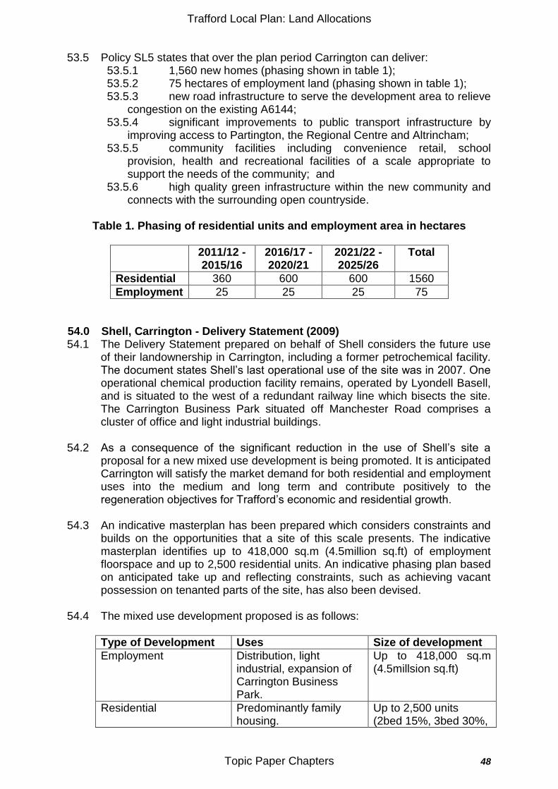
Trafford Local Plan: Land Allocations
Topic Paper Chapters 48
53.5 Policy SL5 states that over the plan period Carrington can deliver:
53.5.1 1,560 new homes (phasing shown in table 1); 53.5.2 75 hectares of employment land (phasing shown in table 1); 53.5.3 new road infrastructure to serve the development area to relieve
congestion on the existing A6144; 53.5.4 significant improvements to public transport infrastructure by
improving access to Partington, the Regional Centre and Altrincham; 53.5.5 community facilities including convenience retail, school
provision, health and recreational facilities of a scale appropriate to support the needs of the community; and
53.5.6 high quality green infrastructure within the new community and connects with the surrounding open countryside.
Table 1. Phasing of residential units and employment area in hectares
2011/12 - 2015/16
2016/17 - 2020/21
2021/22 - 2025/26
Total
Residential 360 600 600 1560
Employment 25 25 25 75
54.0 Shell, Carrington - Delivery Statement (2009) 54.1 The Delivery Statement prepared on behalf of Shell considers the future use
of their landownership in Carrington, including a former petrochemical facility. The document states Shell‟s last operational use of the site was in 2007. One operational chemical production facility remains, operated by Lyondell Basell, and is situated to the west of a redundant railway line which bisects the site. The Carrington Business Park situated off Manchester Road comprises a cluster of office and light industrial buildings.
54.2 As a consequence of the significant reduction in the use of Shell‟s site a proposal for a new mixed use development is being promoted. It is anticipated Carrington will satisfy the market demand for both residential and employment uses into the medium and long term and contribute positively to the regeneration objectives for Trafford‟s economic and residential growth.
54.3 An indicative masterplan has been prepared which considers constraints and builds on the opportunities that a site of this scale presents. The indicative masterplan identifies up to 418,000 sq.m (4.5million sq.ft) of employment floorspace and up to 2,500 residential units. An indicative phasing plan based on anticipated take up and reflecting constraints, such as achieving vacant possession on tenanted parts of the site, has also been devised.
54.4 The mixed use development proposed is as follows:
Type of Development Uses Size of development
Employment Distribution, light industrial, expansion of Carrington Business Park.
Up to 418,000 sq.m (4.5millsion sq.ft)
Residential Predominantly family housing.
Up to 2,500 units (2bed 15%, 3bed 30%,
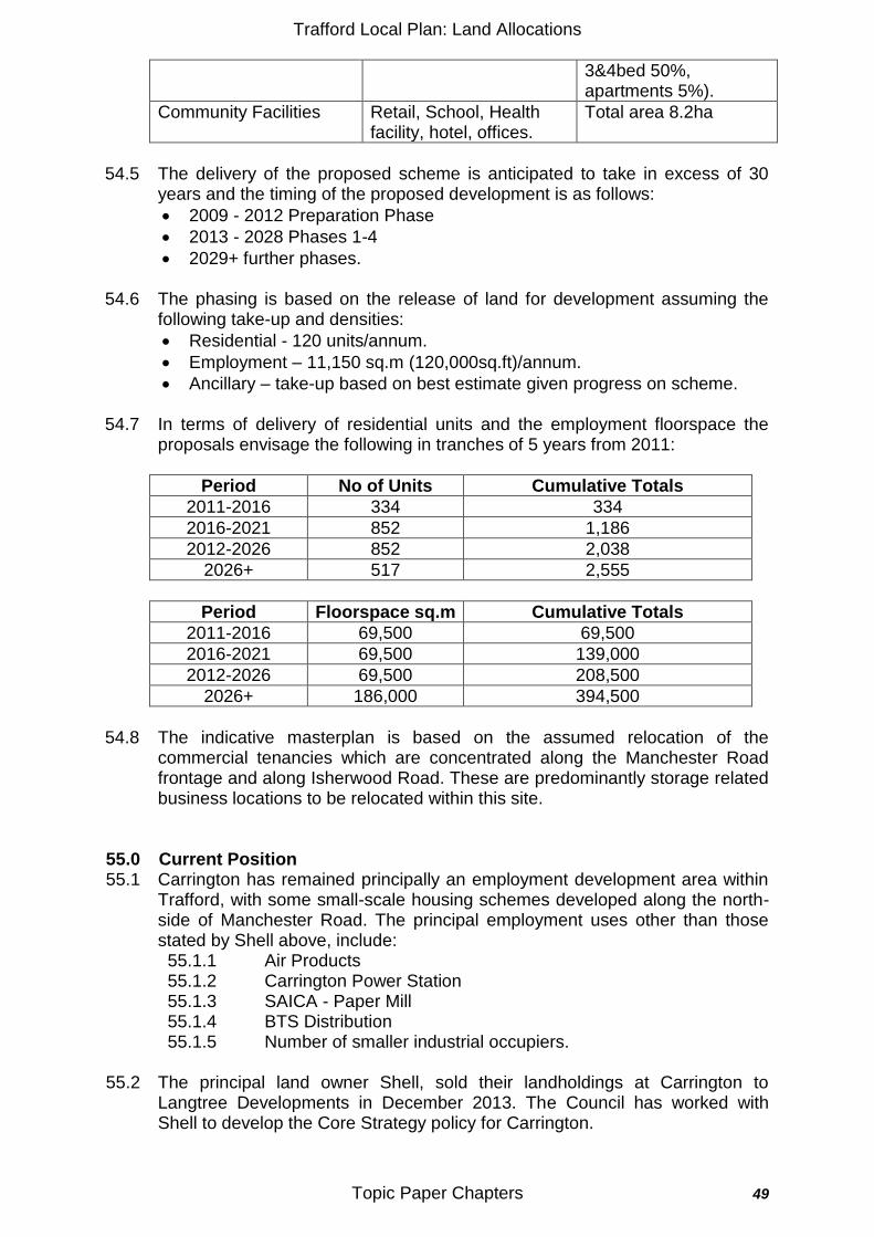
Trafford Local Plan: Land Allocations
Topic Paper Chapters 49
3&4bed 50%, apartments 5%).
Community Facilities Retail, School, Health facility, hotel, offices.
Total area 8.2ha
54.5 The delivery of the proposed scheme is anticipated to take in excess of 30
years and the timing of the proposed development is as follows:
2009 - 2012 Preparation Phase
2013 - 2028 Phases 1-4
2029+ further phases.
54.6 The phasing is based on the release of land for development assuming the following take-up and densities:
Residential - 120 units/annum.
Employment – 11,150 sq.m (120,000sq.ft)/annum.
Ancillary – take-up based on best estimate given progress on scheme.
54.7 In terms of delivery of residential units and the employment floorspace the proposals envisage the following in tranches of 5 years from 2011:
Period No of Units Cumulative Totals
2011-2016 334 334
2016-2021 852 1,186
2012-2026 852 2,038
2026+ 517 2,555
Period Floorspace sq.m Cumulative Totals
2011-2016 69,500 69,500
2016-2021 69,500 139,000
2012-2026 69,500 208,500
2026+ 186,000 394,500
54.8 The indicative masterplan is based on the assumed relocation of the
commercial tenancies which are concentrated along the Manchester Road frontage and along Isherwood Road. These are predominantly storage related business locations to be relocated within this site.
55.0 Current Position 55.1 Carrington has remained principally an employment development area within
Trafford, with some small-scale housing schemes developed along the north-side of Manchester Road. The principal employment uses other than those stated by Shell above, include: 55.1.1 Air Products 55.1.2 Carrington Power Station 55.1.3 SAICA - Paper Mill 55.1.4 BTS Distribution 55.1.5 Number of smaller industrial occupiers.
55.2 The principal land owner Shell, sold their landholdings at Carrington to
Langtree Developments in December 2013. The Council has worked with Shell to develop the Core Strategy policy for Carrington.
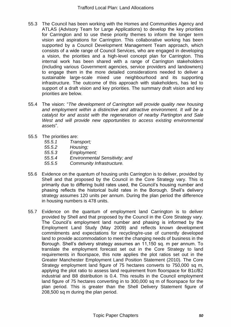
Trafford Local Plan: Land Allocations
Topic Paper Chapters 50
55.3 The Council has been working with the Homes and Communities Agency and
ATLAS (Advisory Team for Large Applications) to develop the key priorities for Carrington and to use these priority themes to inform the longer term vision and aspirations for Carrington. This collaborative working has been supported by a Council Development Management Team approach, which consists of a wide range of Council Services, who are engaged in developing a vision, the priorities and a high-level concept plan for Carrington. This internal work has been shared with a range of Carrington stakeholders (including various Government agencies, service providers and landowners) to engage them in the more detailed considerations needed to deliver a sustainable large-scale mixed use neighbourhood and its supporting infrastructure. The outcome of this approach with stakeholders, has led to support of a draft vision and key priorities. The summary draft vision and key priorities are below.
55.4 The vision: “The development of Carrington will provide quality new housing and employment within a distinctive and attractive environment. It will be a catalyst for and assist with the regeneration of nearby Partington and Sale West and will provide new opportunities to access existing environmental assets”.
55.5 The priorities are: 55.5.1 Transport; 55.5.2 Housing; 55.5.3 Employment; 55.5.4 Environmental Sensitivity; and 55.5.5 Community Infrastructure.
55.6 Evidence on the quantum of housing units Carrington is to deliver, provided by
Shell and that proposed by the Council in the Core Strategy vary. This is primarily due to differing build rates used, the Council‟s housing number and phasing reflects the historical build rates in the Borough. Shell‟s delivery strategy assumes 120 units per annum. During the plan period the difference in housing numbers is 478 units.
55.7 Evidence on the quantum of employment land Carrington is to deliver provided by Shell and that proposed by the Council in the Core Strategy vary. The Council‟s employment land number and phasing is informed by the Employment Land Study (May 2009) and reflects known development commitments and expectations for recycling/re-use of currently developed land to provide accommodation to meet the changing needs of business in the Borough. Shell‟s delivery strategy assumes an 11,150 sq. m per annum. To translate the employment forecast set out in the Core Strategy to land requirements in floorspace, this note applies the plot ratios set out in the Greater Manchester Employment Land Position Statement (2010). The Core Strategy employment land figure of 75 hectares converts to 750,000 sq m, applying the plot ratio to assess land requirement from floorspace for B1c/B2 industrial and B8 distribution is 0.4. This results in the Council employment land figure of 75 hectares converting in to 300,000 sq m of floorspace for the plan period. This is greater than the Shell Delivery Statement figure of 208,500 sq m during the plan period.
Trafford Local Plan: Land Allocations
Topic Paper Chapters 51
55.8 The quantum of residential units and employment land will be reconciled with the purchaser of the site. The key delivery factors for the mixed used development at Carrington are the critical mass needed to support a community, the infrastructure and the market conditions and demand.
56.0 Land Allocations Plan consultation submissions 56.1 This part of the topic paper highlights the representations and site
submissions received for the Shaping the Plan (August 2012) specifically on Carrington and a draft Council response to the issues raised for consideration in the Land Allocations Plan.
56.2 LAS-1026-240 – Shell - The employment development at Carrington needs to be considered as part of the whole development and not in isolation. The key elements of the development of Carrington will be considered holistically, as set out in the Core Strategy Policy. Historically the origins of the redevelopment of Carrington lie within an Eco-Town aspiration, but the importance of the investment in to employment delivery is equally critical to the success of Carrington. The policy identifies a range of infrastructure and community needs and linkages to be delivered to develop a sustainable mixed use community.
56.3 LAS-1026-242 – Shell - Carrington has the potential in the medium term to develop as a retail centre that serves the new development and surrounding area. The plan's proposed retail hierarchy should allow for this to happen as part of the evolution and growth of the new community at Carrington. The retail provision will be of a scale to serve the local community of Carrington and complementary to the Partington Shopping Centre.
56.4 LAS-1026-239 – Shell - The details of development at Carrington such as densities should be decided on a site by site basis across the Borough to reflect the character of the area as well as the development needs taking into account the specifics of each site. Carrington offers the opportunity to create a "new" community which will regenerate both Carrington and Partington and it will be important to create a close working relationship between all parties that can react to changing circumstances and opportunities to ensure that the development of this site is viable and can be delivered in a timely and efficient manner. Core Strategy Policy SL5 identifies a holistic phased development of Carrington with a new community and it needs being met locally. The dwelling type and size and the type of employment uses will be justified by key evidence base documents. The density and scale of residential development will vary across the Location, with higher density development located near the Community Hub and lower density development towards the outer edge of the boundary facing the Green Belt. To enable delivery of Carrington in accordance with the phasing table that will require co-ordinated working between different parties and this will be encouraged and, where appropriate, facilitated by the Council to ensure timely delivery of development in Carrington.
56.5 LAS-1026-238 - Shell - Support for the identified key land uses for Carrington. The mixed use development is supported.
Trafford Local Plan: Land Allocations
Topic Paper Chapters 52
56.6 LAS-1292-101 – Essar Oil UK Ltd - There is a need to take the Major Accident Hazard pipelines into account during the site selection process, particularly in terms of any sites in the proximity of the Carrington Jetty pipelines and/or the Stanlow to Carrington Common Easement Pipeline. Consideration should also be given to showing the route(s) on the new Local Plan Policies Map. The location of major accident hazard pipelines and the extent of Health and Safety Executive consultation zones will be considered as part of the development of Carrington and the Land Allocations Plan. The representation of Major Accident Hazard pipelines and/or substances on the Land Allocations Plan policies plan is dealt with in a separate Topic Paper.
56.7 LAS-1019-142 – United Utilities - The type of development on regeneration sites can have a major impact on the existing water supply and sewerage infrastructure capacity, in addition to the delivery of short and long-term investment plans for future sustainable water supply and sewerage infrastructure. For example: changes in use and density of regeneration sites can increase the water supply demand and the sewerage discharge rates, therefore having a negative impact on the historical water supply and sewerage infrastructure. The delivery of regeneration sites in a truly plan led, sustainable and co-ordinated manner is questioned, particularly in terms of sustainable water supply and sewerage infrastructure. The infrastructure requirements for the development of Carrington will be undertaken as set out in the Policy SL5 Implementation Table. Close liaison with stakeholders including utility providers will be undertaken in the development of the policy for the Carrington Strategic Location.
56.8 LAS-1045-422 – Peel - There is support for the creation of a sustainable mixed use development at Carrington, reflecting the components set out in Policy SL5 of the Core Strategy. It is suggested that the boundary for this Strategic Location should as a minimum include the area formerly designated as an Industrial Area, plus the remainder of Open Land outside the Green Belt. It may also be appropriate to treat the Green Belt boundaries around the Strategic Location with some flexibility to ensure the creation of a sustainable development and the meeting of development and infrastructure/greenspace needs. There is support for an expansion of the UDP Policy E15 boundary to provide greater flexibility to deliver a sustainable Strategic Location, but the Green Belt will be protected from development in accordance with Core Strategy Policy R4.
57.0 Defining the Carrington Strategic Location Boundary 57.1 The Carrington Strategic Location boundary is to be of a scale large enough
to deliver a range of Trafford objectives and priorities. Including delivering: 57.1.1 A sustainable quality mixed used development which considers
equally economic and housing priorities, offering a range of employment and residential options;
57.1.2 Infrastructure required to support a major mixed use development: 57.1.3 A range of supporting community services; 57.1.4 A well connected development to other areas within Trafford and
Greater Manchester via public transport (including active travel) options and road infrastructure, to help reduce the isolation of communities in both Carrington and Partington;
Trafford Local Plan: Land Allocations
Topic Paper Chapters 53
57.1.5 A layout and design which is considerate of the diverse range of uses and its potential impact on neighbouring occupiers;
57.1.6 Quality open and play space and links to recreational assets; and 57.1.7 The provision of low cost, low carbon energy to both homes and
businesses will ensure a modern, competitive working and living environment.
What is the Existing Boundary
57.2 The Trafford UDP (2006) boundary for the Carrington PRA covers an area in excess of 380 hectares, which is predominantly the previously developed land. There is an area of land which adjoins the Carrington PRA identified in the Trafford UDP (2006) Policy C8 Protected Open Land and not within the Green Belt; this area may be required to meet development needs beyond 2016. It is protected from all but limited essential development, within the plan period, to enable it to make the maximum potential contribution to meeting these as yet unquantified needs.
57.3 The existing PRA is bounded by the Mersey Valley to the north, the Green Belt to the east and south and the Manchester Ship Canal and the railway line between Carrington and Partington to the west. The land within the PRA is primarily previously developed land, which includes Shell petrochemical works, National Grid works, SAICA paper mill and Carrington power station. Opportunities for Change
57.4 The opportunities for change in Carrington include: 57.4.1 The extent of the boundary - how it borders with the Partington PRA
and the UDP Policy C8 land to the south; 57.4.2 The residential development and community infrastructure - to offer
a high quality live, work and relax choice to those who want to live, work or relax in Trafford. It is to be developed with consideration of the housing needs of both Trafford and Greater Manchester, offering a wide range of housing types and tenures. This priority was discussed by the Development Management Team and at the stakeholder and landowner event, both concluded the need to: provide a range of housing mix and tenures; deliver a high quality development; improve linkages with Partington and to surrounding countryside;
57.4.3 The quantum of employment development - the future employment offer will be primarily B2 and B8 uses to support the industrial locations within Trafford and Greater Manchester. There is the opportunity to deliver large scale and large floor plate employment developments at this location, along with accommodation of a range of employment uses. In accordance with Core Strategy Policy W1.5, B1 office development would only be appropriate where it is accessible by sustainable transport modes. This priority was discussed by the Development Management Team and at the stakeholder and landowner event, both concluded need to market appropriately the significant employment development opportunities for a range of employment premises;
57.4.4 New road infrastructure to serve the Strategic Location and relieve congestion on the A6144 and further investigation of a new canal crossing across the Manchester Ship Canal. This priority was discussed by the Development Management Team and at the
Trafford Local Plan: Land Allocations
Topic Paper Chapters 54
stakeholder and landowner event, both concluded transport improvements were needed, via: public transport improvements by increasing connectivity with Partington; road infrastructure; and improved active travel routes;
57.4.5 To offer good quality walk and/or cycle routes which link the built development with the recreational routes to the north and south (Mersey Valley and Trans-Pennine-Trail) and to sites of environmental importance. This priority was discussed by the Development Management Team and at the stakeholder and landowner event, both concluded the development to be environmentally sustainable, with an integrated energy approach and to improve connections to surrounding countryside; and
57.4.6 To be well connected via a quality public transport offer to destinations that offer job, retail and leisure opportunities. Along with a range of more local community facilities of a scale which allows support of the existing and proposed facilities in Partington.
What Options Exist to Modify the Boundary:
57.5 The boundary options for the Strategic Location of Carrington are:
Option 1 - To retain the UDP Policy E15 Carrington PRA boundary.
Option 2 - To widen the UDP Policy Carrington E15 boundary to include the Policy C8 land to the south of Carrington.
Option 3 - To broaden Option 2, to include the land in eastern Partington.
57.6 Boundary Option 1 retains the current UDP Policy E15 Carrington PRA boundary. The scale of land within the boundary can accommodate the quantum of residential and economic development proposed within the Core Strategy. It offers little opportunity to make direct links with Partington as the boundary stops at the railway embankment and therefore limits the scope to increase the physical connections between Carrington and Partington.
57.7 Boundary Option 2 increases the boundary from that set out in Option 1 to also include the Policy C8 land to the south of Carrington, which is identified in the Trafford UDP as protected open land. This option allows for the future use of this land to be assessed as part of the long-term future development of Carrington and for the potential alignment of the new road infrastructure.
57.8 Option 3 boundary includes option 2 and increases the location boundary to include Policy E7 Main Industrial Area (UDP) and adjoining Partington open space and recreational land (OSR7(ii) and 12(iv). This will allow for greater flexibility in the development of Carrington and offers the opportunity for better connectivity with Partington, provides scope for strong links between the two communities and support for Partington community and its services. This option results in the boundaries for the Carrington Strategic Location and Partington PRA to overlapping, to help develop strong links between these communities via transport, recreation, facilities and services.
57.9 The Strategic Location boundary options need to offer flexibility in the
development of Carrington. The location is to deliver a sustainable community in an attractive countryside setting, with the offer of quality, frequent public transport provision including active-travel routes. Carrington will provide a quality family housing environment and a work environment which is of a
Trafford Local Plan: Land Allocations
Topic Paper Chapters 55
scale that offers a range of economic uses to be located without having a negative impact on residential and community use areas including active travel routes.
58.0 Conclusion 58.1 All the realistic options developed from the information in this topic paper have
been subject to independent Sustainability Appraisal (SA). The Sustainability Appraisal Report (November 2013) and associated Appendices contains the detailed results of individual appraisals of all realistic options for policies and sites and sets out the mitigation required to address any negative sustainability impacts. Specific appraisals relevant on this topic paper can be found in section 4.5 and Appendix E of this document. A summary of the SA and the reasons for choosing the preferred option are set out in the Options Appraisal Report. These documents and the information in this topic paper support the individual policies proposed in the Local Plan: Land Allocations Plan draft for consultation. The policies proposed are demonstrated to be sustainable.
Trafford Local Plan: Land Allocations
Topic Paper Chapters 56
Topic Paper: TP6 - Housing 59.0 UDP Policy Framework
59.1 Much of the UDP Housing policy framework for housing was superseded upon
adoption of the Core Strategy in January 2012. Policy H1 – Land Release for Development and Policy H2 – Location and Phasing of New Housing Development were both superseded by Policy L1 of the Core Strategy, together with Proposal H5 – Improvement of Houses and Proposal H6 – Sub-division of Houses. Proposal H8 – Affordable Housing was superseded by Policy L2 of the Core Strategy. The remaining UDP housing policies remain in place until superseded by the Land Allocations‟ Plan. These are summarised below.
59.2 Proposal H3 – Land Release for New Housing Development. Identified 18
sites on the Proposals Map for housing development, some of which were identified for mixed residential and employment schemes. The status of these is set out in Appendix 1.
59.3 Proposal H4 – Release of Other Land for Development states that the Council will normally grant planning permission for the development and redevelopment of other suitable land within the built up area for residential purposes, subject to certain criteria.
59.4 Proposal H7 – Accommodation for Elderly Persons states that within the built up area the Council will normally grant planning permission to convert property to residential care homes and nursing homes for the elderly subject to a number of criteria.
59.5 Proposal H9 – Priority Regeneration Area: Gorse Hill, states that the council will improve the area‟s housing stock and quality of environment and will clear pockets of unsatisfactory housing.
59.6 Proposal H10 – Priority Regeneration Area: Old Trafford states that the Council will improve the quality and diversity of the area‟s housing stock and promote the redevelopment and reuse of buildings.
59.7 Proposal H11 – Priority Regeneration Area: Partington states that the Council will improve the quality of the area‟s housing stock.
60.0 Current Position
60.1 Of the 18 UDP site specific residential land allocations only four remain undeveloped. This section summarises progress that has been made to date in respect of these residential land allocations.
60.2 HOU5 – Land at Pomona, Old Trafford – This site was identified in the UDP for part release between April 2006 and March 2011 for 300 units and between April 2011 and March 2016 for a further 300 units. This site still
Trafford Local Plan: Land Allocations
Topic Paper Chapters 57
remains undeveloped but has been identified in the Adopted Core Strategy as a Strategic Location and an extant planning permission exists in relation to 546 units on part of the site.
60.3 HOU7 – Land at Lucy Street - The site was identified in the UDP for 35 units in phase 2 (release between April 2006 to March 2011). Although development has taken place on part of this site, redevelopment opportunities remain for further residential development. The site is identified in the Old Trafford Master Plan and as such it is expected to contribute towards the overall housing growth in that area as identified in Policy L3 of the Trafford Core Strategy.
60.4 HOU10 – Land at Cross Street, Sale – The site was identified in the UDP for 30 units in phase 2 (release between April 2006 to March 2011) of the Plan. In June 2007 a Planning Development Brief was produced for land at Cross Street in order to provide a detailed planning and urban design framework. Redevelopment has yet to take place on this site still, however the Council remains committed to promoting a residential led regeneration scheme on the site.
60.5 HOU14– Land at Woodfield Road, Broadheath – The site was identified in the UDP for 150 units in phase 2 (release between April 2006 to March 2011. Development has taken place on part of this site such as the Urban Splash development and the more recent Bloor Homes development. Part of the remaining site is the subject of a current planning application for a residential led mixed use development and as such is expected to contribute towards housing growth in that area.
60.6 A full list of the UDP allocations and their current status is included in Appendix 1.
61.0 The Core Strategy Framework
61.1 The Core Strategy Vision is clear that the focus for housing growth will be within the urban area, primarily in the north east of the Borough and the principal town centre, Altrincham. It also lists the 5 strategic locations which are identified as areas for change.
61.2 Strategic Objective SO1 sets out to meet housing need across the Borough. It seeks to promote sufficient high quality housing in sustainable locations, of a size, density and tenure needed to meet the borough‟s needs and to contribute towards those of the city region.
61.3 In addition to Strategic Objective SO1, the Core Strategy sets out a number of Place Objectives which have specific relevance to the provision of new homes. Of particular note are:
TPO1 – To maximise the potential of the Wharfside and Trafford Centre Rectangle Locations to meet Trafford‟s housing needs, to support the growth of the City Region and to create sustainable residential development as part of high quality mixed use
Trafford Local Plan: Land Allocations
Topic Paper Chapters 58
redevelopment/development schemes, supported by local community facilities.
OTO1 – To improve the quality, mix and type of residential offer;
STO1 – To establish a better balance in housing types and tenure to meet peoples needs in the area;
STO2 - To maximise opportunities for the re-use or redevelopment of unused, under used or derelict land for mixed, housing and/or employment schemes;
URO1, ALO5 – To limit new residential growth to meeting local needs, particularly for affordable housing, with general „market housing‟ (in sustainable locations, well served by public transport) supporting local needs and regeneration priorities;
URO2, ALO6 – To ensure that the local character of the area is not undermined by new residential development, particularly in terms of existing plot sizes;
MVO1 – To protect the fringes of this area from inappropriate residential development that would harm the character of the landscape.
SAO1 – To provide a more sustainable balance of housing types and tenures to meet the needs of the community.
SAO3 – To secure appropriate levels of residential development within the town centre.
ALO1 – To manage effectively, high levels of residential development pressure;
ALO6 – To ensure that the local character of the area is not undermined by new residential development, particularly in terms of existing plot sizes;
To maximise the potential of the Norman Road site to help meet Trafford‟s housing needs and create high quality sustainable residential-led mixed use development in this area;
RCO1 – To safeguard and protect from inappropriate residential development, the character; appearance; and amenity of Warburton, Dunham Town and Dunham Woodhouses and the Greenbelt;
PAO1 – To provide an appropriate level of new residential development to tackle population decline and achieve sustainable growth;
PAO2 – To maximise the potential of vacant and derelict sites for housing;
CAO1 – To create high quality, sustainable residential development as part of high quality mixed use redevelopment scheme.
61.4 Policy SL1 – Pomona Island Strategic Location proposes a new mixed
commercial and residential district to complement the offers of the city centre and Salford Quays/Mediacity:uk. The Core Strategy identifies that this Location will deliver a minimum of 800 residential units as part of a mixed use development.
61.5 Policy SL2 – Trafford Wharfside Strategic Location proposes a major mixed-use area of regional and international significance. The Core Strategy identifies that this location will deliver at least 900 residential units as part of the mixed use development.
Trafford Local Plan: Land Allocations
Topic Paper Chapters 59
61.6 Policy SL3 – Lancashire County Cricket Club Quarter Strategic Location proposes a major mixed use development with a new high quality residential neighbourhood centred around an improved stadium at LCCC. The Core Strategy states that the development will deliver at least 400 residential units.
61.7 Policy SL4 – Trafford Centre Rectangle Strategic Location proposes a major mixed use development providing a new residential neighbourhood. The Core Strategy identifies that this Location will deliver at least 1050 residential units within the Plan period, but also acknowledges that it has potential to deliver growth beyond that.
61.8 Policy SL5 – Carrington Strategic Location proposes a new mixed use sustainable community. The Council considers that this location can deliver at least 1560 residential units, but also acknowledges that it has potential to deliver growth beyond that.
61.9 Policy L1 of the Core Strategy is the overarching policy relating to the supply of land for new residential development. It sets out the scale and distribution of new housing provision within the Borough over plan period. Up to 2026 the policy seeks to deliver sufficient land to accommodate a minimum 12,210 new dwellings, based on the minimum indicative development target set out in Table L1 of the Policy. The minimum indicative development target figure was derived from the land supply identified in the SHLAA which supported the preparation of Core Strategy. It demonstrated sufficient flexibility in delivering the combined targets of the Regional Spatial Strategy (RSS) 10,400 units, and the 20% uplift associated with the Growth Point status establishing an overall plan period target of 11,450. Of this housing land target, 80% should be delivered on brownfield land.
61.10 Table L1 of the Core Strategy illustrates the spatial distribution of this land together with indicative phasing over the 15 year period. Approximately 40% of the land is to be released within the Regional Centre and Inner Area, with 60% within the South City Region area. Within the South City Region area half of the land to be released will support key regeneration priorities set out in Policy L3 and/or strengthen and support Trafford‟s 4 town centres.
61.11 Policy L2 of the Core Strategy sets out the Councils objectives for securing the right mix of housing types and sizes to meet the demands of the community. It sets out a target split of 70:30; small:large (3+ beds) with 50% of the “small” homes being accommodation suitable for families.
61.12 In order to meet the identified affordable housing need within the Borough, the Council will seek to achieve a target split of 60:40; market:affordable housing. This target will be achieved through a geographically variable target, ranging from 5% in “cold market” areas, through 20% in “moderate” market locations to 40% in “hot” market locations.
61.13 In terms of older persons accommodation with specific reference to the “frail
elderly” of the Borough, Policy L2 of the Core Strategy states that the Council will seek to meet their needs through allowing 4% (approximately 500 units) of the overall housing land target to be developed as new housing for older
Trafford Local Plan: Land Allocations
Topic Paper Chapters 60
person households. The Core Strategy states that appropriate sites will be identified in the Land Allocations‟ Plan.
61.14 Policy L3 of the Core Strategy sets out the Councils objectives for securing
regeneration benefits and reducing inequalities in the Borough‟s regeneration areas. In terms of housing development Policy L3 specifically states the following:
Old Trafford – Housing led redevelopment/regeneration will be promoted. Specifically development will provide approximately 1000 (net) new residential units;
Partington – Development and redevelopment will be supported which will provide, or contribute towards the provision of, approximately 850 units. A portion of this will be provided on a substantially vacant/unused 16 hectare greenfield site abutting the Manchester Ship Canal, the development of which will help facilitate the redevelopment of Partington shopping centre;
Sale West – Within Sale West development and redevelopment will be supported in order to regenerate this former Manchester City Council “overspill” housing estate. The Council will seek the net addition of 100 residential units during the plan period.
61.15 Whilst Policy W2 of the Core Strategy primarily deals with the retail hierarchy
in Trafford, it also details the minimum level of new homes anticipated to be delivered in the town centres over the plan period. It states that within Sale Town Centre at least 100 residential units will be delivered, and within Stretford at least 250 residential units. Although it anticipates that Altrincham Town Centre is capable of delivering a minimum of 250 residential units, it should be noted that it is anticipated that Altrincham Town Centre will be the subject of a business neighbourhood plan and it is therefore currently outside the remit of the Land Allocations Plan.
62.0 National Planning Policy Framework 62.1 Section 6 of the National Planning Policy Framework, (NPPF), establishes
national guidance in relation to the supply of housing. Local planning authorities (LPAs) are required to ensure that their local plan meets the needs for market and affordable housing in the housing market area, including identifying key sites which are critical to the delivery of the housing strategy over the plan period.
62.2 LPAs must also illustrate the expected rate of housing delivery through a housing trajectory for the plan period.
62.3 NPPF also states that LPAs must set out their own approach to housing density to reflect local circumstances. LPAs may make an allowance for windfall sites in the five year supply, if they have compelling evidence that such sites have consistently become available in the local area and will continue to provide a reliable source of supply.
62.4 NPPF also requires LPAs to make provision to bring back in to residential use empty housing and buildings in line with local housing and empty buildings strategies. NPPF states that approval should normally be granted for change
Trafford Local Plan: Land Allocations
Topic Paper Chapters 61
to residential use from commercial buildings where there is an identified need for additional housing and that there are not strong economic reasons why such development would be inappropriate.
62.5 Additionally NPPF states that LPAs should consider including policies to resist inappropriate development in residential gardens.
63.0 Housing Land Monitoring
Progress in relation to the overall housing land target 63.1 The housing trajectory at Appendix 2 illustrates that between the start of the
Core Strategy Plan Period (2008/09) and April 2013, 1188 units have been built. Based on the total annual housing land target set out in Policy L1 of the Core Strategy for the five year period up to 2012/13 (3238) it represents a shortfall of 2050 homes or more than 60%. However the Core Strategy Housing Trajectory, accepted by the Core Strategy independent Inspector to be realistic, assumed a slower rate of delivery in the early years of the Plan Period. Based on that projected number of completions (2,300 units), the recent build rate represents a shortfall of 1112 new homes (approximately 50%). Therefore, although this monitoring indicates an upward trend in completions since 2009/2010, it there remains a significant shortfall in delivery of new homes against the Borough‟s projected number of completions of 2300 and 3238, based on Policy L1‟s minimum indicative development target. Progress in Relation to the Previously Developed Land Target
63.2 Policy L1 of the Core Strategy sets out a target of 80% of all new residential development to be on previously developed land (PDL). The December 2012 AMR indicates that between 2008/09 (the start of the Plan Period) and 2011/12, some 945 units were constructed on PDL, equating to 70% of new housing developed having been delivered on PDL.
63.3 Current data included within the SHLAA indicates that some 82% of new residential will be provided on PDL. Progress in relation to the Affordable Housing Target
63.4 Since 2008/09, the start of the Plan Period, 613 (gross) affordable housing units have been built. This equates to approximately 50% of the 1188 units actually built over the same period. Although this represents a shortfall of 682 units, compared against the overall target of 40% /1295 units of the total annual housing land target, set out in Policy L1 of the Core Strategy for the five year period up to 2013/14 it equates to almost 75% of the overall 40% affordable housing target as expressed against the Core Strategy housing trajectory. Progress in relation to the spatial distribution of housing development
63.5 Data relating to completions recorded in 2012/13 indicates that 23% of development has taken place in the Regional Centre and Inner Areas, with 77% within the South City Region area.
64.0 Land Allocations Submissions 64.1 In August 2012 the Council published the “Shaping the Plan” document; the
first consultation document in relation to the Trafford Local Plan: Land
Trafford Local Plan: Land Allocations
Topic Paper Chapters 62
Allocations. The following comments were received on matters relating to residential development.
64.2 Representator 1019 made the following comments:
The delivery of an overall affordable housing target of 40% is questioned given the Government‟s new instruction to remove the need for developers to provide affordable homes on new developments. The affordable housing target is set within the Trafford Local Plan: Core Strategy and relates to the Trafford Housing Market Assessment. The Inspector found Policy L2 to be justified, effective and consistent with national policy. Therefore this policy will continue to be applied to all qualifying residential development.
What assurances are there that the requirements of the National Planning Policy Framework will be met in relation to the delivery of sustainable water supply and sewerage infrastructure to meet future capacity needs and in a truly plan led, sustainable and co-ordinated manner? Policy L5 of the Trafford Core Strategy seeks to ensure that new development will mitigate and reduce its impact on climate change factors such as pollution and flooding and maximise its sustainability through improved environmental performance of buildings, lower carbon emissions and renewable or decentralised energy generation. Policy L5 seeks to encourage the application of good design principles and construction techniques to achieve these objectives. Such good design will incorporate passive solar gain, green roofs and walls, rain water harvesting and Sustainable Urban Drainage Systems. The Core Strategy policies for each of the Strategic Locations also make appropriate reference to the requirement for further investment in water supply and sewerage infrastructure to meet forecast demands arising from further development, including new housing. Where site specific opportunities exist, appropriate design guidance will be included within the Land Allocations Plan to further ensure the implementation of Core Strategy Policy L5, the Core Strategy policies for each of the Strategic Locations and the requirements of NPPF.
64.3 Representator 1051 made the following comment:
The approach being promoted is consistent with the Core Strategy. It should be noted that this representator has land given to it and which it continues to hold for investment purposes at Broad Oak Farm to the south east of Carrington. That land could be considered for residential use. It is noted that the representor considers that the approach being promoted in the Land Allocations Plan is consistent with the Core Strategy. However, in terms of land at Broadoak Farm, it should be noted that this land is protected by Policies R4.7 and R4.8 of the Trafford Core Strategy. Specifically, it is protected open land, excluded from the Green Belt and not allocated for development in the Core Strategy or the Land Allocations Plan. Although the Core Strategy acknowledges
Trafford Local Plan: Land Allocations
Topic Paper Chapters 63
that this land may be required to meet development needs beyond the Plan period, it would be premature and contrary to the Core Strategy to allocate this site for residential development through the Land Allocations Plan. Further details in relation to the assessment of this site can be found in the SA: Options Appraisal report.
64.4 Representator 1106 made the following comment:
An allowance should be made for the provision of small-scale retail uses in all strategic locations and locations for residential development. As advocated in paragraph 17 of the NPPF, mixed use development can bring significant benefits in creating sustainable communities. Retail development in particular can make a contribution towards creating sustainable communities by providing for local top-up needs within easy access of residential areas and, importantly, deliver economic growth by providing job opportunities within the local area. Furthermore, retail uses are often less sensitive than residential development in terms of amenity and can, therefore, act as a buffer between traditional employment uses and residential areas. As detailed in the Trafford Core Strategy, the Strategic Locations will incorporate appropriate community facilities (including retail) to support the needs of the residents. The provision of such services in other locations identified for residential development will be dependent on the scale of housing proposed and the existing availability of such services.
64.5 Representator 1239 made the following comment:
Should a boundary change to the Green Belt in the vicinity of Ridgeway Nurseries, Timperley be deemed inappropriate it is requested that the site is allocated for residential purposes; thus enabling the regeneration of the site through recycling potentially derelict land and according with the fifth purpose that the Green Belt serves; “to assist in urban regeneration, by encouraging the recycling of derelict and other urban land.” It is considered that the redevelopment of this sustainable suburban location would make a positive contribution to the provision of housing in Trafford without the need for a more strategic release of Green Belt land. In accordance with Policy R4 of the Trafford Local Plan: Core Strategy, no changes to the Green Belt boundary are proposed through the Trafford Local Plan: Land Allocations Plan. Insufficient evidence has been provided to demonstrate the need to alter this policy, therefore it is not proposed to allocate this site. Further details in relation to the assessment of this site can be found in the SA: Options Appraisal report.
The council cannot currently demonstrate a 5 year housing land supply. The 2011 SHLAA identifies that there is a „total potential land supply‟ for the period 2011/12 to 2015/16 of 4,695 dwellings, which equates to a 6.8 year supply against the requirement of 3,470 set by the Core Strategy. However, paragraph 47 of the NPPF requires that the supply must be deliverable within the next 5 years. The housing trajectory at Page 23 of the 2011 AMR sets out the council‟s projected completions over the Core Strategy plan period. For the period 2011/12 to 2015/16, the anticipated completions are just 3,050. That equates to just a 4.4 year supply. Furthermore, that does not include the additional 5% also
Trafford Local Plan: Land Allocations
Topic Paper Chapters 64
required by the NPPF, which would further increase the 5 year requirement. The absence of a 5 year supply is a material consideration in support of the proposal to remove the Ridgeway Nurseries from the Green Belt. The NPPF is clear at paragraph 49 that relevant policies for the supply of housing should not be considered up-to-date if the local planning authority cannot demonstrate a 5 year supply. Housing proposals should be considered in the context of the presumption in favour of sustainable development. It is considered that the site at Clay Lane is deliverable, subject to the granting of planning permission. The Council considers that the 2013 SHLAA review demonstrates that sufficient, appropriate land has been identified to meet the housing land needs of the borough, including a five year land supply in accordance with NPPF. Therefore in accordance with Policy R4 of the Trafford Local Plan: Core Strategy, it is not proposed to allocate this site. Further details in relation to the assessment of this site can be found in the SA: Options Appraisal report.
64.6 In addition a number of sites were submitted in 2007 and in 2012 for residential development through the Call for Sites process. Further details in relation to the assessment of these sites can be found in the SA: Options Appraisal report.
65.0 Opportunities for Change
Housing Land Supply Position 65.1 A Strategic Housing Land Availability Assessment (SHLAA) is a technical
study to inform future planning policy development. It also assists in the monitoring of whether there is an adequate supply of deliverable housing land. The SHLAA is a key component of the evidence base to support the delivery of sufficient land for housing; to meet the community‟s need for more homes; and to inform housing policy within the Trafford Local Plan.
65.2 The SHLAA underpinned the phasing and distribution set out in Policy L1 of the Trafford Core Strategy.
65.3 The Council publishes its Strategic Housing Land Availability Assessment (SHLAA) annually, with the 2013 review being published alongside the Draft Land Allocations Plan in February 2014. The 2013 review provides an updated data to April 2013, with regard to planning status and progress in relation to construction of units. Additionally it reflects sites which have been identified and discounted by way of the emerging Land Allocations Plan, the details of newly identified sites can be found in the Land Allocations‟ Plan SA Options Appraisal Report, January 2014.
65.4 The 2013 assessment identifies 4493 units as being deliverable over the five year period 2013/14 to 2017/8. This first five year supply is made up of 2306 units which currently have the benefit of planning permission and 2187 units which currently sit outside of the planning process, but which are considered to be deliverable within five years. Additionally the SHLAA identifies 3017 units in the five year period 2018/19 to 2022/23. This figure is made up of 752
Trafford Local Plan: Land Allocations
Topic Paper Chapters 65
units which have planning permission and 2265 units which are outside of the planning process. It is considered that these meet the criteria of NPPF in that they are considered developable, in suitable locations and that there is a reasonable prospect that they can be developed as anticipated. In relation to the five year period through to 2027/28 (i.e. the 11-15 year supply), the SHLAA identifies 2147 units. This equates to a supply of 9657 units over remaining part of the plan period.
65.5 The SHLAA indicates that 9657 units will come forward over the plan period, this combined with the 1188 units which have been built since 2008 equates to 10,845 units over the plan period. Compared against the Core Strategy‟s minimum indicative development target this indicates a shortfall of approximately 1,365 units, and compared against the actual RSS and Growth Point combined target it equates to a shortfall of 605 units over the plan period.
65.6 Similarly analysis of the sites identified in the SHLAA, indicates that 49% of land will be released in the Regional Centre and Inner Areas, and 51% within the South City Region area.
65.7 Whilst the SHLAA provides details of the supply of deliverable sites in accordance with the NPPF, it is necessary to consider which sites should actually be allocated for residential development in the Land Allocations‟ Plan. In determining an appropriate site size threshold, consideration will need to be given to the advice in the NPPF that local planning authorities should identify key sites which are critical to the delivery of the housing strategy. Which Sites Should be Allocated in the Plan
65.8 Table L1 of the Core Strategy indicates that Trafford‟s Regional Spatial Strategy (RSS) target was set at 10,400 for the Plan period. However Greater Manchester was awarded “Growth Point” status, which equated to a 20% uplift to this housing target up to 2018. Reflecting the RSS target and the 20% uplift, Table L1 of the Core Strategy establishes a minimum indicative development target of 12,210.
65.9 Policy L1 anticipates that these sites will be identified through the Land
Allocations Plan. Taking into account the build rate to date since the start of the Plan Period (2008/09), some 11,000 units should be identified over the plan period. However it is important to note that NPPF does not require all identified sites to be specifically allocated on the Policies Map, as such it is considered that it would be appropriate to identify a site size threshold and to determine which sites above that threshold could be considered critical to the delivery of the housing strategy and which sites would be appropriate to be allocated.
65.10 The SA results of all the site appraisals can be found in the SA Report and its Appendices. For each of the sites found to be sustainable additional evidence was considered to determine whether a site should be allocated and what the preferred option for its use should be. In relation to residential sites, this included compliance with NPPF, the Core Strategy Policy, and the need to:
Carry out an assessment of the sites' suitability, achievability and availability for development ;
Trafford Local Plan: Land Allocations
Topic Paper Chapters 66
release land in accordance with the Trafford Core Strategy spatial priorities. In particular, 40% of the land to be released within the Regional Centre and the Inner Areas and 60% to be released within the South City Region area, in accordance with Policy L1 of the Trafford Core Strategy;
Manage housing delivery in line with the indicative approach outlined in Policy L1 of the Core Strategy;
Apply an appropriate density ratio;
Ensure the efficient use of land to achieve the Council‟s 80% previously developed land target;
Meet the Borough‟s housing needs as expressed in Policy L2 of the Trafford Core Strategy;
Create sustainable communities and minimise the need for travel. Site Viability
65.11 The Council has commissioned two viability studies, one to support the preparation of its Core Strategy affordable housing policy and one to support the introduction of the Trafford Community Infrastructure Levy (CIL). The affordable housing study appraised 100 sites, whereas the CIL study related, in the main, to notional sites. Both studies made a wide range of assumptions in terms of appraisal inputs. These assumptions related to factors such as land costs, build costs, fees, densities and planning obligations, etc.
65.12 The economic viability study prepared to support Core Strategy Policy L2 demonstrated that three distinct property market areas exist in Trafford, ranging from the “coldest” in the north east of the borough, Carrington and Partington, through to the hottest in the south of the borough. In order to ensure that sites remained viable with the addition of affordable housing and other planning obligations set out in Core Strategy Policy L8, a geographically variable affordable housing target was set.
65.13 Since that time, economic viability work was conducted to support the introduction of the Trafford Community Infrastructure Levy. This viability work similarly found that three distinct market areas exist in Trafford, albeit resulting in slightly different charging zones to those applied in affordable housing terms. Furthermore, it demonstrated that residential development in Trafford is economically viable, taking into account affordable housing contributions in line with policy, together with an allowance for other site specific planning obligations. Once a CIL rate is applied, it demonstrated geographically variable levels of profitability, with developments for houses, particularly those in the south of the borough, being the most profitable and apartments in the cold market areas being the least profitable, and therefore least viable.
65.14 Whilst this viability work did not appraise each individual site which is proposed for allocation it demonstrated in a robust manner that residential development remains viable within Trafford, even in the cold market areas, providing that geographically varied planning obligations and CIL charges are applied. Density Assumptions
65.15 NPPF advises that it is for local planning authorities to determine density ratios in their own areas, based on local circumstances.
Trafford Local Plan: Land Allocations
Topic Paper Chapters 67
65.16 For some time now, the SHLAA has made assumptions about anticipated densities for sites identified without planning permission. In order to establish these densities, housing commitment data, for sites of 10 or more units, was reviewed. Based on the outcome of this work, historically, the SHLAA anticipated that the following densities will be achieved:
Houses – 40 units per hectare
Apartments – 140 units per hectare
Mixed houses and apartments – 50 units per hectare
65.17 In terms of densities to be applied to mixed housing and apartment schemes and apartment only schemes, adjustments were made to take account of exceptionally low density developments such as that at Stamford Brook, Broadheath and very high development density apartment schemes which had achieved in excess of 250 units per hectare.
65.18 Since that time, consultants who undertook viability work to support the Trafford Community Infrastructure Levy (CIL) reviewed recent housing commitment data afresh. This review indicated minor changes in average density ratios; consequently the assumptions applied in relation to the Trafford CIL have been revised from those historically used in the SHLAA, incorporating geographical sensitivities linked to the geographical sub areas in the Trafford Core Strategy.
65.19 In line with Core Strategy Policy L2, for the purposes of the Land Allocations Plan and SHLAA the “Cold” market locations are Old Trafford, Partington and Carrington; “Moderate” market locations are Urmston, Stretford and, Sale; “Hot” market locations are Altrincham, the Mersey Valley and the Rural Communities. Trafford Park was not identified as any specific market location, however, for the purposes of CIL, it was identified as a cold area. Therefore to be consistent density assumptions for cold areas would be applied to sites within Trafford Park, where no further site specific information is known.
65.20 The viability sensitivity work underpinning the Trafford CIL incorporated the following development density assumptions in relation to houses:
“Cold” market sub-area: 40 dwellings per ha
“Moderate” market sub-area: 38 dwellings per ha; and
“Hot” market sub-area: 36 dwellings per ha.
65.21 The viability sensitivity work underpinning the Trafford CIL incorporated the following development density assumptions in relation to apartments:
“Cold” market sub-area: 80 dwellings per ha
“Moderate” market sub-area: 80 dwellings per ha;
“Hot” market sub-area: 70 dwellings per ha; and
Large sites (above 10Ha): 240 dwellings per ha 65.22 The higher density ratio for apartments on larger sites was based on the type
of development that was anticipated to come forward on these types of sites. This was arrived at following an analysis of documents such as the Pomona Island Masterplan.
65.23 An analysis of recent developments suggests that the assumptions applied to the CIL viability work more closely reflects developments on the ground in
Trafford Local Plan: Land Allocations
Topic Paper Chapters 68
relation to housing only and apartment only schemes. The CIL evidence did not make assumptions in relation to mixed housing and apartment schemes, however, analysis of recent commitments reveals that assumptions applied historically within the SHLAA, to such schemes, reflect current average development densities.
65.24 Both sets of density assumptions were based on local circumstances therefore, both would be in line with guidance contained in NPPF. However given the fact that the assumptions adopted for CIL are considered to relate more closely to the spatial priorities of the Trafford Core Strategy and rely on more up to date evidence, it is proposed that they will form the basis of the Land Allocations Plan in terms of housing only and apartment only developments. However, in terms of mixed housing and apartment schemes, the assumptions historically used in the SHLAA, of 50 units per hectare, will be applied to such sites in the Land Allocations‟ Plan.
65.25 The revised density assumptions have been used during the production of the
2013 SHLAA Review.
Housing Land Site Size Threshold 65.26 The SHLAA includes all sites with one or more dwelling, therefore in order to
determine an appropriate site size threshold for the Plan an analysis of the site sizes has been carried out.
65.27 Table 5 of the SHLAA provides a summary of potential sites by site size. It indicates that the largest source of supply (56%) will come from a relatively small number of large sites (sites of 2.5 hectares or more in size). It further indicates that only 17% of sites are below 0.4 Ha.
65.28 Given the above analysis, it is considered appropriate to set a 0.4 Ha threshold for specific allocation within the Land Allocations‟ Plan. However, where such sites are currently under construction, or undergoing a phased development, it may be appropriate to identify only those parts which remain undeveloped, even where the site area is less than 0.4 Ha.
65.29 NPPF advises local planning authorities to identify “key sites which are critical to the delivery of the housing strategy over the Plan period, however it does not define the term “critical site”. Therefore the next section of this paper considers whether it would be appropriate, in the context of Trafford, to allocate all identified sites, above the 0.4 HA threshold, on the Policies Map.
65.30 The options below range from allocating only those sites, above 0.4Ha in the Strategic Locations, the priority regeneration areas and the town centres with the remainder being identified through the SHLAA; through allocating these sites together with either the first five years‟ supply from the SHLAA; the first ten years‟ supply from SHLAA to allocating all identified sites within SHLAA, above the 0.4 HA threshold. Option 1 - Allocate Only Those sites within key areas above 0.4ha
65.31 This option would result in the specific allocation of all sites above 0.4 ha at the following places:
The Strategic Locations;
Trafford Local Plan: Land Allocations
Topic Paper Chapters 69
The regeneration areas of Partington and Old Trafford and;
The Town Centres
65.32 Based on the data within the SHLAA,. A summary table relating to the outcomes of this option can be found in appendix 3
65.33 The remaining housing land target will be made up from sites within the SHLAA, which shows a deliverable 5 and 10 year supply of sites in line with NPPF.
65.34 Under this option a total of 37 sites would be allocated providing a total of 7356 units. The remainder of the supply would be made up of 297 sites within the SHLAA which would provide a total of 2400 units. Option 2 - Allocate sites within key areas above 0.4ha, plus sites in the First Five Years’ Supply within the SHLAA, above 0.4Ha
65.35 This option would result in the specific allocation of all sites above 0.4ha at the following places:
The Strategic Locations;
The regeneration areas of Partington and Old Trafford;
The Town Centres;
Five year supply within the SHLAA 65.36 The remaining housing land target will be made up from sites within the
SHLAA below 0.4ha which show a deliverable 5 and 10 year supply in line with NPPF.
65.37 Under this option a total of 46 sites would be allocated providing a total of 7770 units. The remainder of the supply would be made up of 288 sites which would provide a total of 1986 units. Option 3 - Allocate sites within key areas above 0.4Ha, plus sites in the First Ten Years’ Supply of the SHLAA, above 0.4Ha
65.38 This option would result in the specific allocation of all sites above 0.4ha in the following places:
The Strategic Locations;
The regeneration areas of Partington and Old Trafford;
The Town Centres;
The five year supply within SHLAA;
The five to ten year supply within SHLAA
65.39 In this option a total of 48 sites would be allocated which would provide a total of 7980 units. The remainder of the supply would be made up of 286 sites within the SHLAA, which would provide a total of 1776 units. Option 4 - Allocate sites within key areas above 0.4Ha, plus all sites in the SHLAA above 0.4 Ha
65.40 This option would result in the specific allocation of all sites above 0.4ha in the following places:
The Strategic Locations;
The regeneration areas of Partington and Old Trafford;
The Town Centres;
Trafford Local Plan: Land Allocations
Topic Paper Chapters 70
The five year supply within the SHLAA;
The five to ten year supply within the SHLAA;
All remaining SHLAA sites over 0.4ha 65.41 In this option a total of 48 sites would be allocated which would provide a total
of 7980 units. The remainder of the supply would be made up of 286 sites within SHLAA, which would provide a total of 1776 units. The Preferred Allocation Option
65.42 It is considered that it would be most appropriate to adopt option 4, thereby allocating all sites identified in SHLAA above the threshold. Such an approach is considered to be consistent with NPPF guidance to allocate sites which are critical to the delivery of the housing strategy. It should be noted, however, that this would result in a shortfall of 1365 units even accounting for those sites which have been included within the SHLAA following the outcome of the work summarised in the SA Options Appraisal report.
65.43 Trafford Core Strategy Table L1 sets out a proposed phasing strategy for the delivery of housing over the plan period. Given that the Land Allocations‟ Plan needs to be consistent with the Core Strategy, it is proposed to maintain the phasing in accordance with Policy L1 of the Core Strategy.
65.44 Due to the nature of these options, in that they all assume the need to identify
sufficient land to meet the needs expressed in Core Strategy Policies L1 and L2, and merely seek to determine what should be “critical” in local terms, no specific SA was carried out of the options. It should be noted, however, that individual site specific SAs were carried out for each of the sites proposed for allocation and each of those proposed through the “Call-for-Sites” consultations, similarly, Policy HO1 was appraised as a whole. The details of these assessments can be found in section 4.6 and Appendix F of the SA Report which supports the Land Allocations‟ Plan, January.
Addressing the Shortfall
65.45 Given the identified shortfall, spatial distribution and phasing of the identified supply consideration has been given to bringing forward development capacity at Pomona Island which is within the Regional Centre and is a large brownfield site. The SA Options report considers alternative options in relation to this site and concludes that increasing the anticipated level of development by 300 units would provide a sustainable option and thus contribute to meeting the shortfall.
65.46 NPPF states that LPAs may make an allowance for windfall sites in the five year supply, if they have compelling evidence that such sites have consistently become available in the local area and will continue to provide a reliable source of supply.
65.47 “Windfall” development is the development of sites not previously identified for residential development. The Core Strategy did not make a specific allowance for windfall development, therefore although Trafford continues to experience such development it is not proposed to rely heavily on such a source for additional supply. However, in the light of recent changes to permitted development rights, and the evidence locally, it is proposed to make an
Trafford Local Plan: Land Allocations
Topic Paper Chapters 71
allowance specifically in relation to the continuing upward trend of the conversion of office buildings to residential apartments. It is anticipated that this trend will continue, over the plan period and based on past development rates, it is likely to contribute in the region of 50 units per annum.
65.48 Other currently unidentified sites which come forward over the plan period, will continue to provide additional flexibility in delivering the borough‟s housing land supply target.
65.49 All “windfall” sites will be subject to certain specific development management criteria contained within Policy HO2 of the Land Allocations‟ Plan to ensure that it would result in sustainable development; an SA was carried out of this policy and can be found in section 4.6 and Appendix F of the SA Report, which supports the Land Allocations‟ Plan, January 2014.
65.50 In adopting such an approach it is considered that sufficient land can be identified to meet the housing land target, compared against the actual RSS and Growth Point combined target. The Provision of Sites to meet the Identified Need for Homes for the Frail Elderly
65.51 Policy L1 of the Core Strategy states that the Land Allocations‟ Plan will identify sites to meet the needs of this group of the population, approximately 500 homes.
65.52 Two options exist for the identification of this land. Firstly, identifying specific sites suitable for frail elderly accommodation only, and secondly preparing a criteria based policy against which to judge planning applications for such developments, together with an indication as to which of the specific site allocations could be appropriate for such development, but not precluding non specific housing.
65.53 Whilst the first option would ensure that sufficient sites could be allocated to meet this need over the plan period, it could result in a number of sites being sterilised in the short term or until providers have been identified. It would also not take account of the fact that sites smaller than the 0.4 Ha threshold could be suitable for such development.
65.54 Given the desire to ensure that the plan remains sufficiently flexible and does not sterilise development sites, it is proposed to prepare a criteria based policy together with the identification of those sites which could be considered suitable for older persons‟ accommodation, i.e. that they are considered to have met the basic criteria set out in the policy. It should be noted that due to the nature of these options, it was not considered appropriate to carry out an SA of the options, however Policy HO3 itself has however been assessed, the results of which can be found in section 4.6 and Appendix F of the SA Report which supports the Land Allocations‟ Plan, January 2014.
Summary of the Sustainability Appraisal
Trafford Local Plan: Land Allocations
Topic Paper Chapters 72
65.55 Details of the individual, site specific sustainability appraisals can be found in the SA Options‟ Report and the SA Report and Appendices which support the Land Allocations‟ Plan. In addition an SA was carried out on each of the three housing policies, HO1, HO2 and HO3. The detailed results of these can be found in section 4.6 of the report and Appendix F
66.0 Conclusion
66.1 It is proposed to allocate a total of 48 sites, above a 0.4 Ha threshold, providing a total of 8280 units within the Land Allocations‟ Plan. This combined with the 1776 units (derived from some 286 smaller sites within the SHLAA) together with the windfall allowance of approximately 500 units and the 1188 units completed to date sufficient land has been identified to meet the needs expressed in Policies L1 and L2 of the Core Strategy.
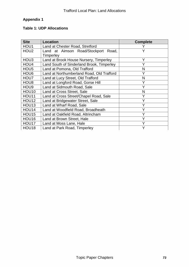
Trafford Local Plan: Land Allocations
Topic Paper Chapters 73
Appendix 1 Table 1: UDP Allocations
Site Location Complete
HOU1 Land at Chester Road, Stretford Y
HOU2 Land at Aimson Road/Stockport Road, Timperley
Y
HOU3 Land at Brook House Nursery, Timperley Y
HOU4 Land South of Sinderland Brook, Timperley Y
HOU5 Land at Pomona, Old Trafford N
HOU6 Land at Northumberland Road, Old Trafford Y
HOU7 Land at Lucy Street, Old Trafford N
HOU8 Land at Longford Road, Gorse Hill Y
HOU9 Land at Sidmouth Road, Sale Y
HOU10 Land at Cross Street, Sale N
HOU11 Land at Cross Street/Chapel Road, Sale Y
HOU12 Land at Bridgewater Street, Sale Y
HOU13 Land at Wharf Road, Sale Y
HOU14 Land at Woodfield Road, Broadheath Y
HOU15 Land at Oakfield Road, Altrincham Y
HOU16 Land at Brown Street, Hale Y
HOU17 Land at Moss Lane, Hale Y
HOU18 Land at Park Road, Timperley Y
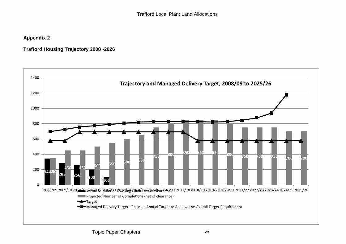
Trafford Local Plan: Land Allocations
Topic Paper Chapters 74
Appendix 2 Trafford Housing Trajectory 2008 -2026
344 283 256 200
105
350 450 450 500 550 600 650
750 800 850 850 850 800 750 750 750 700 700
0
200
400
600
800
1000
1200
1400
2008/09 2009/10 2010/11 2011/12 2012/13 2013/14 2014/15 2015/16 2016/17 2017/18 2018/19 2019/20 2020/21 2021/22 2022/23 2023/24 2024/25 2025/26
Trajectory and Managed Delivery Target, 2008/09 to 2025/26
Actual Number of Dwellings Built (net of clearance)
Projected Number of Completions (net of clearance)
Target
Managed Delivery Target - Residual Annual Target to Achieve the Overall Target Requirement
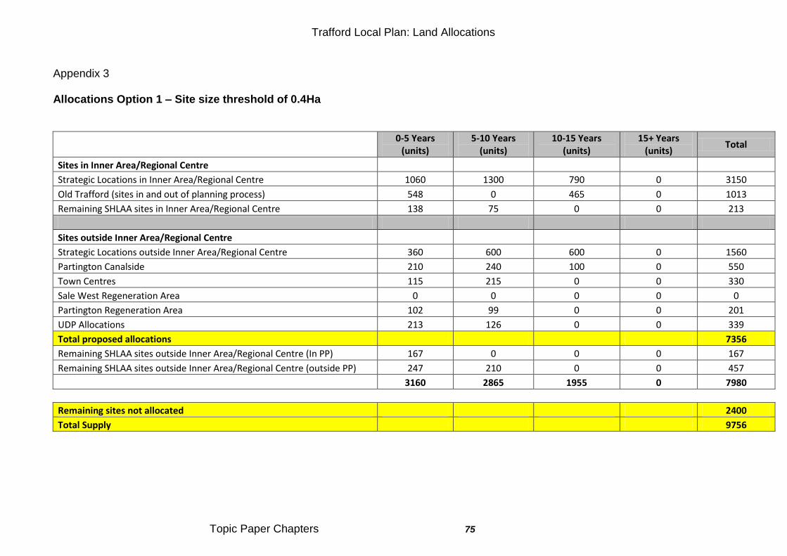
Trafford Local Plan: Land Allocations
Topic Paper Chapters 75
Appendix 3 Allocations Option 1 – Site size threshold of 0.4Ha
0-5 Years
(units) 5-10 Years
(units) 10-15 Years
(units) 15+ Years
(units) Total
Sites in Inner Area/Regional Centre
Strategic Locations in Inner Area/Regional Centre 1060 1300 790 0 3150
Old Trafford (sites in and out of planning process) 548 0 465 0 1013
Remaining SHLAA sites in Inner Area/Regional Centre 138 75 0 0 213
Sites outside Inner Area/Regional Centre
Strategic Locations outside Inner Area/Regional Centre 360 600 600 0 1560
Partington Canalside 210 240 100 0 550
Town Centres 115 215 0 0 330
Sale West Regeneration Area 0 0 0 0 0
Partington Regeneration Area 102 99 0 0 201
UDP Allocations 213 126 0 0 339
Total proposed allocations 7356
Remaining SHLAA sites outside Inner Area/Regional Centre (In PP) 167 0 0 0 167
Remaining SHLAA sites outside Inner Area/Regional Centre (outside PP) 247 210 0 0 457
3160 2865 1955 0 7980
Remaining sites not allocated 2400
Total Supply 9756
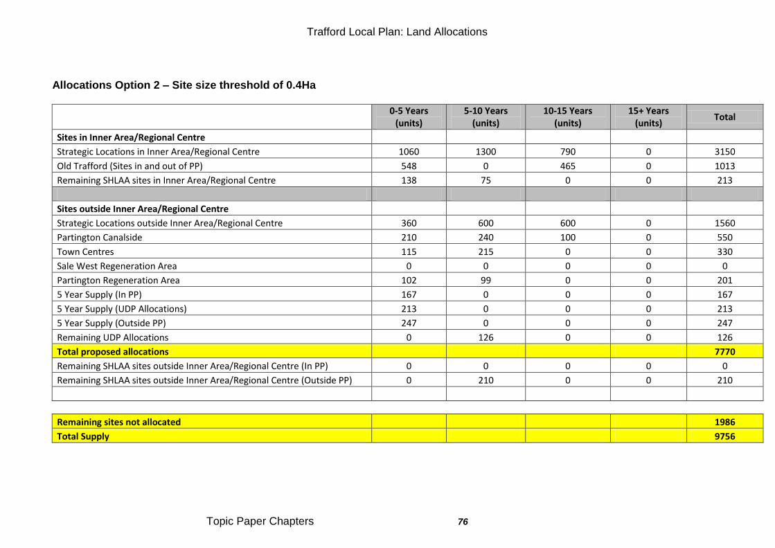
Trafford Local Plan: Land Allocations
Topic Paper Chapters 76
Allocations Option 2 – Site size threshold of 0.4Ha
0-5 Years
(units) 5-10 Years
(units) 10-15 Years
(units) 15+ Years
(units) Total
Sites in Inner Area/Regional Centre
Strategic Locations in Inner Area/Regional Centre 1060 1300 790 0 3150
Old Trafford (Sites in and out of PP) 548 0 465 0 1013
Remaining SHLAA sites in Inner Area/Regional Centre 138 75 0 0 213
Sites outside Inner Area/Regional Centre
Strategic Locations outside Inner Area/Regional Centre 360 600 600 0 1560
Partington Canalside 210 240 100 0 550
Town Centres 115 215 0 0 330
Sale West Regeneration Area 0 0 0 0 0
Partington Regeneration Area 102 99 0 0 201
5 Year Supply (In PP) 167 0 0 0 167
5 Year Supply (UDP Allocations) 213 0 0 0 213
5 Year Supply (Outside PP) 247 0 0 0 247
Remaining UDP Allocations 0 126 0 0 126
Total proposed allocations 7770
Remaining SHLAA sites outside Inner Area/Regional Centre (In PP) 0 0 0 0 0
Remaining SHLAA sites outside Inner Area/Regional Centre (Outside PP) 0 210 0 0 210
Remaining sites not allocated 1986
Total Supply 9756
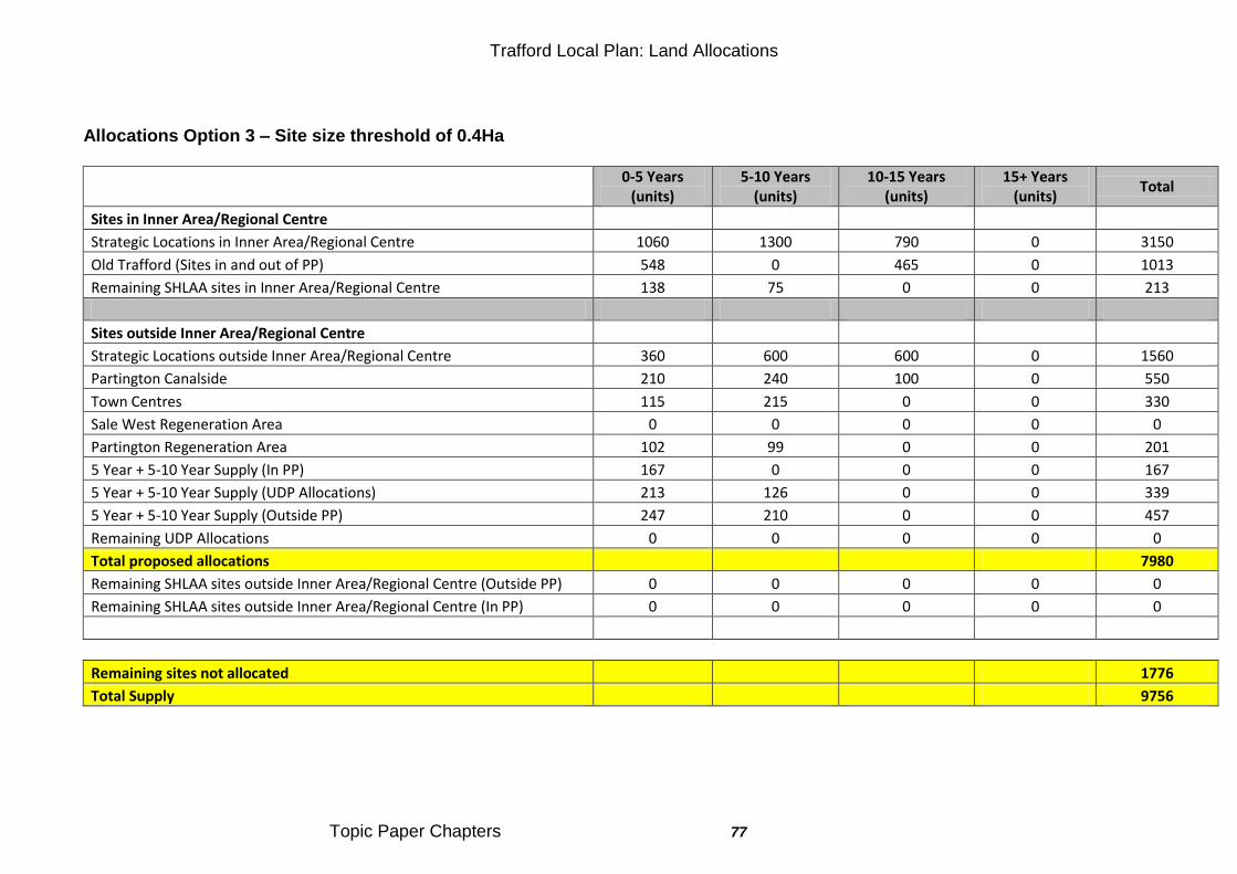
Trafford Local Plan: Land Allocations
Topic Paper Chapters 77
Allocations Option 3 – Site size threshold of 0.4Ha
0-5 Years
(units) 5-10 Years
(units) 10-15 Years
(units) 15+ Years
(units) Total
Sites in Inner Area/Regional Centre
Strategic Locations in Inner Area/Regional Centre 1060 1300 790 0 3150
Old Trafford (Sites in and out of PP) 548 0 465 0 1013
Remaining SHLAA sites in Inner Area/Regional Centre 138 75 0 0 213
Sites outside Inner Area/Regional Centre
Strategic Locations outside Inner Area/Regional Centre 360 600 600 0 1560
Partington Canalside 210 240 100 0 550
Town Centres 115 215 0 0 330
Sale West Regeneration Area 0 0 0 0 0
Partington Regeneration Area 102 99 0 0 201
5 Year + 5-10 Year Supply (In PP) 167 0 0 0 167
5 Year + 5-10 Year Supply (UDP Allocations) 213 126 0 0 339
5 Year + 5-10 Year Supply (Outside PP) 247 210 0 0 457
Remaining UDP Allocations 0 0 0 0 0
Total proposed allocations 7980
Remaining SHLAA sites outside Inner Area/Regional Centre (Outside PP) 0 0 0 0 0
Remaining SHLAA sites outside Inner Area/Regional Centre (In PP) 0 0 0 0 0
Remaining sites not allocated 1776
Total Supply 9756
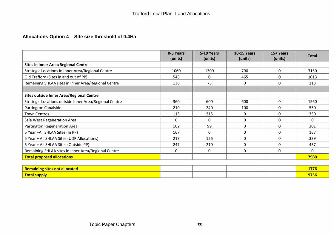
Trafford Local Plan: Land Allocations
Topic Paper Chapters 78
Allocations Option 4 – Site size threshold of 0.4Ha
0-5 Years
(units) 5-10 Years
(units) 10-15 Years
(units) 15+ Years
(units) Total
Sites in Inner Area/Regional Centre
Strategic Locations in Inner Area/Regional Centre 1060 1300 790 0 3150
Old Trafford (Sites in and out of PP) 548 0 465 0 1013
Remaining SHLAA sites in Inner Area/Regional Centre 138 75 0 0 213
Sites outside Inner Area/Regional Centre
Strategic Locations outside Inner Area/Regional Centre 360 600 600 0 1560
Partington Canalside 210 240 100 0 550
Town Centres 115 215 0 0 330
Sale West Regeneration Area 0 0 0 0 0
Partington Regeneration Area 102 99 0 0 201
5 Year +All SHLAA Sites (In PP) 167 0 0 0 167
5 Year + All SHLAA Sites (UDP Allocations) 213 126 0 0 339
5 Year + All SHLAA Sites (Outside PP) 247 210 0 0 457
Remaining SHLAA sites in Inner Area/Regional Centre 0 0 0 0 0
Total proposed allocations 7980
Remaining sites not allocated 1776
Total supply 9756
Trafford Local Plan: Land Allocations
Topic Paper Chapters 79
Topic Paper:TP7 - Gypsy and Travellers 67.0 UDP Policy Framework 67.1 There is no reference to providing for the needs of Gypsy, Roma and
Travellers and Traveling Showpeople in the Trafford UDP adopted 2006.
68.0 NPPF 68.1 The Government sets out its policy position on traveller sites in both the
National Planning Policy Framework (NPPF) and its supplementary Planning Policy for Traveller Sites. It provides guidance for local planning authorities, and some of the key factors to be considered are set out below:
To make their own assessment of need for planning purposes;
To work collaboratively with other local authorities;
To plan for sites over a reasonable timescale;
To increase the number of sites in appropriate locations with planning permission, to address under-provision and maintain an appropriate level of supply;
Plan-making should protect the Green Belt from inappropriate development; and
To promote private traveller site provision while recognising that there will always be those travellers who cannot provide their own sites.
68.2 The NPPF requires local planning authorities to identify and update annually, a supply of specific deliverable sites sufficient to provide five years‟ worth of sites against their locally set targets. Also to identify a supply of specific developable sites or broad locations for growth, for six to ten years and, where possible, for 15 years and protect the local amenity and environment.
69.0 The Core Strategy Framework 69.1 The adopted Core Strategy (Policy L2) sets a criteria-based policy to assess
Gypsy, Roma and Traveller and Travelling Showpeople accommodation planning applications. This policy position was developed from reviewing national guidance (Designing Gypsy and Traveller Sites 2008). It includes guidance on pitch numbers per site, impact on amenity of adjacent occupiers and locational requirements.
70.0 Current Position 70.1 Currently provision is being provided by a privately owned site in Carrington
which provides 17 pitches. A planning application for an expansion of the site to the east (Carrington House) was submitted in May 2010 for an additional 10 pitches. The planning application was subsequently withdrawn due to lack of information from the applicant.
70.2 The Council along with all Greater Manchester Local Authorities have commissioned an update of the 2007/08 Gypsy and Traveller Accommodations Assessment. This study will add to the 2007/08 work, by providing evidence on the current and future accommodation needs and
Trafford Local Plan: Land Allocations
Topic Paper Chapters 80
demand of both the Gypsy and Travellers communities (this includes both Gypsy and Travellers and Travelling Showpeople in accordance with Statutory Instrument 2006 No.3190). Also the findings will report on the need for the provision of other services to support the communities.
71.0 Call for Sites / Consultation Responses 71.1 There were no specific comments made about the Gypsy Traveller
communities during the Shaping the Plan consultation August 2012.
72.0 Conclusion All the realistic options developed from the information in this topic paper have been subject to independent Sustainability Appraisal (SA). The Sustainability Appraisal Report and associated Appendices contains the detailed results of individual appraisals of all realistic options for policies and sites and sets out the mitigation required to address any negative sustainability impacts. Specific appraisals relevant on this topic paper can be found in section 4.7 and Appendix G of this document. A summary of the SA and the reasons for choosing the preferred option are set out in the Options Appraisal Report. These documents and the information in this topic paper support the individual policies proposed in the Local Plan: Land Allocations Plan draft for consultation. The policies proposed are demonstrated to be sustainable. They will ensure sufficient sports facilities are protected and delivered to meet present and future needs. As set out above alternative options were not considered to be realistic.
Trafford Local Plan: Land Allocations
Topic Paper Chapters 81
Topic Paper: TP8 - Priority Regeneration Areas Old Trafford, Partington and Sale West and Other Regeneration Areas 73.0 UDP Policy Framework
Old Trafford 73.1 The UDP identifies Old Trafford as a Priority Regeneration Area (PRA) for
housing, with action to be taken to improve and regenerate the area with consideration of: housing stock and tenure, recreational facilities and other community facilities (with improvements to local parks and fields, the development of develop a community facility within the Old Trafford Primary School and supporting shops on Ayres Road and Seymour Grove, and a new retail store on Chester Road). Along with all modes of transport and the improvements to the local environment with derelict buildings being brought back into use for community, business or residential use.
73.2 The UDP allocates two sites for housing within the Old Trafford PRA, (HOU 6) Land at Northumberland Road and (HOU7) Land at Lucy Street, the ownerships are unknown and neither has undergone any development in accordance with the UDP allocation. Partington
73.3 The UDP identifies Partington as a Priority Regeneration Area (PRA) for housing, with action to be taken to improve and regenerate the area with consideration of: housing stock, shopping facilities, recreational facilities and other community facilities and develop urban/rural environmental links. Along with improvements to public transport and the local environment with derelict buildings being brought back into use for community, business or residential use. Along with the identification of a local building to be used as a Resource Centre by local community groups and develop the existing Opportunities Centre as a local employment training centre. Sale West
73.4 Sale West is not identified as a PRA in the UDP. The UDP allocates one site for housing - land at Sidmouth Road (HOU9). This site has been redeveloped for residential use. The Council is working with the local community to secure effective neighbourhood regeneration. Primarily to tackle the problems of social exclusion and poor environmental quality. Measures include improvements to the housing stock and residential environments, enhanced community facilities and effective neighbourhood management, refurbished shopping facilities and the development of better public transport links in an area where lack of adequate links has compounded the problems of poor economic activity. Other Regeneration Areas
Trafford Local Plan: Land Allocations
Topic Paper Chapters 82
73.5 The UDP does not identify any specific Regeneration Areas (RA) other than the four Town Centres, which each have bespoke town centre policies within the UDP.
74.0 The Core Strategy Framework 74.1 The Core Strategy Policy L3 Regeneration and Reducing Inequalities
identifies Priority Regeneration Areas (PRA) as those areas which are in the top 10% of the most deprived in the country, as identified by the Indices of Multiple Deprivation (IMD). Applying the IMD criteria, Old Trafford, Partington and Sale West are identified as PRAs. Old Trafford
74.2 In Old Trafford the policy states housing led development will promote quality and diversity of housing stock, improve access to the Regional Centre and Trafford Park and provide further commercial, cultural and community facilities. Specifically development will provide approximately over 1,000 (net) new residential units, small scale office development and small scale retail facilities to meet local needs. Partington
74.3 In Partington, the policy states housing led development will promote quality and diversity of housing stock, improve access to the Regional Centre and Trafford Park and provide further commercial, cultural and community facilities. Specifically development will provide approximately over 1,000 (net) new residential units, small scale office development, small scale retail facilities to meet local needs.
Sale West
74.4 In Sale West, the policy states development should focus on improvements to the residential mix and quality, the neighbourhood centre, public realm and access to employment opportunities. The Council seeks a net addition of 100 residential units. The housing will be designed to a high standard, with particular emphasis on improving the relationship between buildings and the street and the quality of the neighbourhood open space.
74.5 This allocation represents the opportunity to focus improvement and development on this former Council estate to remodel it and improve the mix of housing offer available to the local community. Development will provide the opportunity to improve public access and to encourage walking and cycling, provide enhanced linkages to employment opportunities and to enhance the quality, appearance and utility of the local environment for the benefit of the local community. Other Regeneration Areas
74.6 The Core Strategy identifies Regeneration Areas, as areas which are in the worst 20% of the most deprived in the country, as identified in the Indices of Multiple Deprivation (IMD).
75.0 Call for Sites / Consultation Responses Old Trafford
Trafford Local Plan: Land Allocations
Topic Paper Chapters 83
75.1 LAS-1242-105 - Derwent Holdings - the IMD should not be used to set the boundary for the PRA as this would not take account of the opportunity surrounding areas offer to assist in the regeneration of Old Trafford. The PRA boundary should include employment opportunities for the residential areas within the PRA, including the White City Retail Park and 39 Talbot Road. The boundary for the PRA is not limited purely to the IMD SOA boundaries, it has been broadened to include opportunities to improve accessibility, employment and health. The key focus for the regeneration area is to provide a wide enough boundary to provide scope for regeneration developments and local population to support services & facilities. The sites of White City and 39 Talbot Road are included in this PRA boundary.
75.2 LAS-1242-101 - Derwent Holdings - supported the recognition of the need to deliver new development within Old Trafford. However, it is considered that the promotion of mixed use development within only the areas of Pomona and the Lancashire County Cricket Club Quarter would fail to deliver a number of the strategic objectives set out within the adopted Core Strategy including objectives SO2 and SO6. Instead it is suggested that mixed use development should be promoted across the whole area and specifically in areas which are accessible by a range of means of transport. The development of mixed use developments are supported where they are deemed to provide regeneration benefits to the PRA e.g. the Extra Care Facility in Old Trafford.
75.3 LAS-1242-103 - Derwent Holdings - stated objective SO6 seeks to reduce the need to travel and promote significant levels of development in the most sustainable locations in the borough. Whilst the location of both Pomona and Lancashire County Cricket Club Quarter is not questioned in sustainability terms, there are a number of other locations within Old Trafford that are also sustainable and would assist in meeting this strategic objective. This includes the area around Trafford Bar Metrolink Station and along key bus routes including Chester Road and Talbot Road. The Land Allocations Policy sets out the support for improved public transport provision to areas of employment, education and training.
75.4 LAS-1242-102 - Derwent Holdings - stated objective SO2 seeks to ensure the regeneration of the most disadvantaged communities in the borough. As Old Trafford is identified as a Priority Regeneration Area (Core Strategy Policy L3), it is considered that restricting mixed-use development to specific areas of this regeneration area would fail to deliver the regeneration of the wider PRA. The development of mixed use developments are supported where they are deemed to provide regeneration benefits to the PRA e.g. the Extra Care Facility in Old Trafford.
75.5 LAS-1019-142 – United Utilities - The type of development on regeneration sites can have a major impact on the existing water supply and sewerage infrastructure capacity, in addition to the delivery of short and long-term investment plans for future sustainable water supply and sewerage infrastructure. For example: Changes in use and density of regeneration sites can increase the water supply demand and the sewerage discharge rates, therefore having a negative impact on the historical water supply and sewerage infrastructure. The delivery of regeneration sites in a truly plan led, sustainable and co-ordinated manner is questioned, particularly in terms of
Trafford Local Plan: Land Allocations
Topic Paper Chapters 84
sustainable water supply and sewerage infrastructure. The draft Land Allocations Plan sets out more detail about the type, scale and location of development across the borough and in designated regeneration areas. The consideration of infrastructure provision to support the regeneration areas is key to sustainable development and will be developed in liaison with key infrastructure providers. Partington
75.6 LAS-1045-423 - Peel - It is suggested that the Regeneration Area for Partington could follow the line of the „green loop‟, with the Manchester Ship Canal forming the northern boundary and the disused railway the east. The „green loop‟ could form a natural boundary to the Partington Regeneration Area which effectively contains the settlement within which regeneration efforts should be prioritised. If the inclusion of additional land within the Priority Regeneration Area is considered necessary by the Council, for example to provide additional housing land, this could be added to the boundary. The options for the PRA boundary for Partington are considered below.
75.7 LAS-1019-142 – United Utilities - The type of development on regeneration sites can have a major impact on the existing water supply and sewerage infrastructure capacity, in addition to the delivery of short and long-term investment plans for future sustainable water supply and sewerage infrastructure. For example: Changes in use and density of regeneration sites can increase the water supply demand and the sewerage discharge rates, therefore having a negative impact on the historical water supply and sewerage infrastructure. The delivery of regeneration sites in a truly plan led, sustainable and co-ordinated manner is questioned, particularly in terms of sustainable water supply and sewerage infrastructure. The draft Land Allocations Plan sets out more detail about the type, scale and location of development across the borough and in designated regeneration areas. The consideration of infrastructure provision to support the regeneration areas is key to sustainable development and will be developed in liaison with key infrastructure providers. Sale West
75.8 The consultation stage on the Local Plan Land Allocations Plan raised no direct comments regarding the Priority Regeneration Area of Sale West. Other Regeneration Areas
75.9 The consultation responses primarily focus on priority regeneration areas, with comments including: suggesting criteria for defining the boundary; to those promoting mixed used development in sustainable locations. Along with consideration of infrastructure requirements in particular water and waste water supply to support the proposed new development.
76.0 Current Position 76.1 Trafford has 138 Lower Super Output Areas (LSOA), of which 11% are in the
IMD top 10% most deprived areas. The following sets out the key indicators for each PRA:
Trafford Local Plan: Land Allocations
Topic Paper Chapters 85
Old Trafford key indicators include employment, health, income and crime reporting;
Partington key indicators include crime, employment, health and income; and
Sale West key indicators include employment, health and income. Old Trafford
76.2 Old Trafford is predominantly a residential area which is located within the Inner Area and close to both Trafford Park and Manchester City Centre. Key sites have come forward for development such as Essex Way and more recently the area of land off Bold Street has seen apartment blocks demolished and in preparation for redevelopment. Partington
76.3 A Partington Area Action Plan was commenced in 2007 which identified key issues and development opportunities in the local area. An Issues and Options paper was consulted on, which included four housing growth options. In 2008 the Council approved an outline planning application for a large-scale canal-side residential scheme, which will provide 550 new homes. Also a planning application was approved for the redevelopment of the shopping centre. A second residential planning application was submitted in 2012 and is to be incorporated with the outline approved canalside residential scheme. Due to viability reasons an alternative engineering solution for the proposed stabilisation of the canal bank has been proposed therefore reducing the size of the developable area of the site. In 2009, it was decided following advice from Government Office North West to progress the forward planning of Partington through the Core Strategy. Sale West
76.4 Sale West is a predominantly residential area with: a community facility; small scale retail provision; areas of formal open space; access to the Trans-Pennine-Trail; and the new formal Dainewell Park. There is an element of housing provided and managed by Registered Providers. Other Regeneration Areas
76.5 Trafford is divided into 138 areas within the IMD, known as Lower Super Output Areas. The following areas report to be in the IMD 20% most deprived for a range of indicators:
76.5.1 Broadheath; 76.5.2 Broomwood; 76.5.3 Gorse Hill; 76.5.4 Longford; 76.5.5 Sale Moor; and 76.5.6 Stretford.
76.6 Each of the above areas report indicators including crime, employment and
education to be in the top 20% most deprived.
77.0 Opportunities for Change
Old Trafford
Trafford Local Plan: Land Allocations
Topic Paper Chapters 86
77.1 The aim of the Old Trafford Masterplan is to repair urban structure, to replace social housing that is to be demolished and develop opportunities for housing development and a more mixed tenure neighbourhoods. The masterplan divides Old Trafford in to nine neighbourhood areas (Tamworth, Chorlton Road, Hullard, The Rivers, The Cliftons, Shrewsbury Street, Stretford Road, Fahey‟s Depot and St George‟s Gate), with plans to redevelop wider areas including some demolition. The masterplan identified the development of 1,358 new homes (386 demolitions) with a subsequent increase in population of the area under 4,000 to 7,272 people. The masterplan acknowledges that this quantity and type of development would place pressure on local services.
77.2 Following the production of the Old Trafford Masterplan (October 2009), the Tamworth neighbourhood area has been granted outline consent for the construction of 170 new residential units. The Stretford neighbourhood has 62 units approved and are under construction.
77.3 There are nine neighbourhood areas identified in the Old Trafford Masterplan where significant new development is proposed within the plan period, they are:
77.3.1 Tamworth - demolition of four apartment blocks and replaced with new residential units, with refurbishment of a further three apartment blocks. Redevelopment to commence in the early phase of the development plan.
77.3.2 Chorlton Road - redevelopment of area. 77.3.3 Hullard - new development fronting Chester Road, new housing
between Empress Court and shops and Virgil Street. 77.3.4 Rivers - opportunities to change road layout and re-orientation of
houses with scope for small scale in-fill and development of communal areas.
77.3.5 Cliftons and Shrewsbury Street - Extra Care facility linked with a new multi-use community hub including a GP surgery pharmacy, library, nursery and changing facility for those using the sports field.
77.3.6 Stretford Road - Essex Way has delivered 62 two and three bed affordable houses and apartments.
77.3.7 Faheys Depot - mixed use development. 77.3.8 St Georges - development options being considered with the
land owner.
77.4 Of the sites listed above, two are progressing with proposals: the Extra Care facility along Shrewsbury Street, linked to a new multi-use community hub, will provide a range of facilities needed in Old Trafford including improved health-care, community facilities and accommodation for the older persons; and the Fahey Depot site has been granted planning permission for a mixed use development, which offers opportunities for local employment.
77.5 Considering the IMD data there is a need to improve accessibility to areas of employment and training to help reduce these key indices of deprivation. This could be achieved via the introduction of active travel routes which connect residential areas with areas of employment, leisure, public transport and community facilities and increase footfall along these routes will help reduce crime via self-surveillance. In particular improvements to connections to the Regional Centre, Trafford Park and River Irwell/Irwell River Park.
Trafford Local Plan: Land Allocations
Topic Paper Chapters 87
Partington
77.6 The planning applications for the canalside residential development and the shopping centre redevelopment scheme are key to the regeneration of Partington. As they provide not only a new shopping centre in a sustainable location but also an additional quantum of residential population to support the shopping centre. The residential scheme will deliver a Green Loop of infrastructure, which surrounds Partington connecting its existing open spaces and a canalised promenade via a walking and cycling route.
77.7 There are a number of derelict sites which could be redeveloped for various purposes, the sites include Ortonbrook, the former Greyhound PH site along Manchester Road and the Wood Lane open space sites. Sale West
77.8 The Core Strategy policy identifies the former Council estate within Sale West to be the focus for improvement and the allocation of Priority Regeneration Area. The key opportunities for change are to improve accessibility to town centres particularly Altrincham and Sale via public transport to provide opportunities for training, employment, education and retail/leisure. More locally, improvements to walking access routes to the Trans-Pennine Trail and open countryside and where appropriate for cycling. The existing Sale West community facility could benefit from a redevelopment/reconfiguration scheme, to allow the community to better utilise the facility and possibly via the delivery of a multi-use resource.
78.0 Defining the Priority Regeneration Area Boundary What defines a Priority Regeneration Area?
78.1 The Core Strategy defines PRAs to be those neighbourhoods that are in the worst 10% of most deprived in the country as identified in the Index of Multiple Deprivation. What is the Existing Boundary?
78.2 The existing boundary for Old Trafford within the UDP is defined by the urban area of Old Trafford being identified as one of the most deprived areas of the Borough.
78.3 There is no existing boundary for Sale West set within the UDP.
78.4 The existing boundary for Partington is set within the UDP is defined by the Bucklow St Martins ward boundary as the most deprived area of the Borough.
78.5 There are no boundaries for the smaller Regeneration Areas set in the UDP. What Options Exist to Modify the Boundaries?
78.6 The following 2 options are proposed for each of the boundaries of the 3 priority regeneration areas, based on the current (2010) IMD data:
Option 1 - All the LSOA that have multiple IMD criteria in the top 20% most deprived; or
Option 2 - All the LSOA that have multiple IMD criteria in the top 20% most deprived and widened to include an established neighbourhood.
Trafford Local Plan: Land Allocations
Topic Paper Chapters 88
78.7 The following 2 options are proposed for each of the boundaries of the 6
regeneration areas, based on the current (2010) IMD data:
Option 1 - All the LSOA that have multiple IMD criteria in the top 10% most deprived; or
Option 2 - All the LSOA that have multiple IMD criteria in the top 10% most deprived and widened to include an established neighbourhood.
79.0 Conclusion 79.1 All the realistic options developed from the information in this topic paper have
been subject to independent Sustainability Appraisal (SA). The Sustainability Appraisal Report (November 2013) and associated Appendices contains the detailed results of individual appraisals of all realistic options for policies and sites and sets out the mitigation required to address any negative sustainability impacts. Specific appraisals relevant on this topic paper can be found in section 4.8 and Appendix H of this document. A summary of the SA and the reasons for choosing the preferred option are set out in the Options Appraisal Report. These documents and the information in this topic paper support the individual policies proposed in the Local Plan: Land Allocations Plan draft for consultation. The policies proposed are demonstrated to be sustainable
Trafford Local Plan: Land Allocations
Topic Paper Chapters 89
Topic Paper: TP9 - Transport 80.0 UDP Policy Framework 80.1 Trafford lies in the south west of the Greater Manchester conurbation, south of
the Manchester Ship Canal between Salford and Manchester, and astride the M60 orbital motorway and the A56 radial route.
80.2 Car ownership in the Borough is high and coupled with the demands generated by the substantial concentrations of industry and commerce, places considerable pressure on the local road network. The public rail, Metrolink and bus networks provide an alternative to the private car and lorry as a means of moving people and goods from place to place in volume.
80.3 Future public and private investment in local transport infrastructure to support the existing pattern of land uses and to serve new development, will be crucial to the future economic wellbeing of the Borough and to the contribution it can make to economic and community regeneration across the conurbation.
80.4 The policies and proposals of the Unitary Development Plan (UDP) chapter on transport and movement seek to establish a coherent balanced strategy to cater, in an environmentally sensitive and sustainable way, for the likely travel demands of residents, to improve the efficiency, effectiveness and safety of the local public transport and highway networks and to aid the physical, economic and community regeneration of the Borough and wider conurbation area.
80.5 The objectives in the transport and movement chapter in the UDP correspond with the broad objectives of the Greater Manchester Local Transport Plan (LTP). It proposes public transport and local road improvement schemes, within the context of the LTP. In addition, improvement schemes are put forward to bring about the development of a well maintained and clearly marked network of footpaths and cycle ways to provide a safe convenient and healthy alternative means of travel for short distance journeys. The remaining proposals then seek to encourage and make provision for growth in the movement of freight by rail and waterway/canal and to support the further growth of activity anticipated at Manchester Airport, in the interests of securing a more balanced transport system capable of meeting the economic needs of the area in a socially and environmentally responsible way.
81.0 Current Position 81.1 This section summarises what has happened since the adoption of the UDP,
including what “allocations” have been completed. It also sets out what is still to happen, including what allocations may need to be carried forward and those that may no longer be considered as appropriate to support the development strategy set out in the Local Plan.
81.2 In order to reflect the priority that is given to modes of travel within the movement hierarchy, the allocations in the UDP are dealt with in the following order: pedestrian and cycle route network; integrated public transport network;
Trafford Local Plan: Land Allocations
Topic Paper Chapters 90
and then, the highway network. It concludes with policies on the sustainable movement of goods and off airport parking, which are also covered by the transport and movement chapter. Pedestrian and Cycle Route Network
81.3 The proposals in the UDP were to develop a network of pedestrian and cycle routes and associated facilities, to provide convenient and safe access linking residential areas to shopping, employment, entertainment, tourist and leisure facilities located in the town, district, local and neighbourhood centres and other regeneration areas that can provide an alternative means of transport to the private car for short distance journeys. Trans Pennine Trail
81.4 A key cycle route within the Borough is the Trans Pennine Trail (national cycle route 62). The Council will continue to safeguard and enhance this recreational route as part of a strategic network of routes including the Bridgewater Canal, Bollin Valley Way and Mersey Valley Way. Bridgewater Way
81.5 The Council has committed to developing a cycle link along the Bridgewater Canal, called the Bridgewater Way scheme. The Bridgewater Way is a major regeneration project which ultimately aims to provide a high quality route for walkers and cyclists over the complete 65km length of the Bridgewater Canal between Runcorn, Leigh and Manchester City Centre. The cornerstone of the project is a major upgrade to the canal towpath, which as well as greatly improving conditions for walkers, will enable cyclists to use the path for the first time. However, a key element is also improving access points to the towpath and links between the canal and community facilities.
81.6 Approximately 20km of the route along the Bridgewater Canal runs through Trafford. It has been split into 8 phases and to date 5km of the route have been completed in three phases between Sale and Stretford, along with the additional kilometres of accessible links to the canal towpath. The remainder of the phases: between the Manchester Ship Canal and Park Way in Trafford Park (phase 4a); to Watersmeeting (phase 4b); from Marsland Road in Sale to Altrincham (phase 5); to Manchester United (phase 6); from Manchester United to Cornbrook (phase 7); and from the A56 to the Warrington Boundary (phase 8), are proposed to be safeguarded and allocated through the Land Allocations Plan.
81.7 The catalyst for this scheme was substantial funding secured through the sustainable transport charity Sustrans: £662,000 under „Links to Schools‟, and, £250,000 from their „Connect 2‟ programme. This funding was matched by contributions from the Council and the Bridgewater Canal Trust in order to deliver the first three phases, which opened in 2010 and 2011. It enabled work on the highway to improve access to the canal for walkers and cyclists and to provide safe routes to schools.
81.8 The opening of these sections of towpath has seen a transformational change in the patterns of use associated with the towpath. An increase in the number of cyclists of around 370% has been observed, along with an 80% increase in the number of pedestrians. This level of success has led to future phases of
Trafford Local Plan: Land Allocations
Topic Paper Chapters 91
the Bridgewater Way being prioritised for delivery through a number of funding streams. Brooks Drive
81.9 Brooks Drive is a narrow but important linear feature in the urban landscape and was identified on the UDP Proposals Map as a wildlife corridor and a recreational route. It is still the intention of the Council to protect and enhance its environmental and recreational qualities. It provides an important link to the countryside and its open character will be retained and improved. At present it does not have any recorded public right of way status, but the Council will clarify the public right of way status of this important linear feature as part of its protection/enhancement actions.
81.10 Local routes linking to the strategic network and improved linkages between existing public rights of way, including the enhancement of Brooks Drive, Timperley, between Fairywell Brook and Dobbinets Lane, as a recreational route, will continue to be supported. Improving access is fundamental and protecting and enhancing footpaths and other rights of way provides a greater choice of recreational routes for cyclists, horse-riders and walkers alike. Integrated Public Transport Network
81.11 The proposals in the UDP were to support and encourage the development of a sustainable integrated transport network that is accessible and offers a choice of modes of travel. Also, to secure the development of a high quality integrated public transport network to meet the business, leisure and other needs of all sectors of the local community and visitors. Metrolink
81.12 The proposals encourage and promote the improvement and extension of the Metrolink light rail network within the Borough. The following allocations have been completed: the extension of the Metrolink to MediaCity:UK, which opened in September 2010, and the Old Trafford Metrolink Depot which was completed in spring 2011.
81.13 The extension of the Metrolink from Trafford Bar to Manchester Airport is currently being developed, with part of the line to St Werburgh‟s Road in Chorlton (including a stop at Firswood in Trafford) opening in July 2011. The next phase of this extension to East Didsbury then opened in 2013. The remaining section of the line to Manchester Airport is scheduled to open in 2016. The route of this extension will be allocated through the Land Allocations Plan.
81.14 A route for the Metrolink extension through Trafford Park to the Trafford Centre and potentially beyond and into Salford (from the existing line at Cornbrook) will also need to be allocated through the Land Allocations Plan, and protected from future development proposals that may affect its delivery.
81.15 The objectives of the scheme are to encourage growth, regeneration and enable modal shift. Metrolink will deliver a high frequency sustainable tram service through the centre of Trafford Park, and the proposals present an ideal opportunity to integrate with a number of sustainable transport services at various points throughout the Park.
Trafford Local Plan: Land Allocations
Topic Paper Chapters 92
81.16 The Trafford Park Growth Strategy seeks to support investment in the areas
around the proposed Metrolink stops encouraging higher density and more intensive development, which is appropriate for locations served by Metrolink. These proposals will complement each other in attracting more activity and footfall whilst maximising the business case for the future Metrolink scheme.
81.17 Funding for the implementation of the Metrolink route through Trafford Park is anticipated via the Greater Manchester City Deal, which is subject to finalisation. It is expected that a public consultation on the proposed route through Trafford Park will be undertaken in 2014.
81.18 The proposals at Port Salford and the delivery of the Western Gateway Infrastructure Scheme (WGIS) will also provide some of the necessary infrastructure to enable the Metrolink network to be extended across the Manchester Ship Canal and into Salford in the future, subject to funding.
81.19 The Council will also continue to safeguard the proposed South Manchester/Airport western loop extension of the Metrolink through Davenport Green to Manchester Airport. Transport for Greater Manchester (TfGM) still retains powers in perpetuity for the construction, operation and maintenance of the „western loop‟ extension, for possible future development. This extension of the Metrolink was deferred following a national government funding announcement and concerns over the affordability of the South Manchester extension. Metrolink, Rail and Bus Stations/Stops
81.20 The following stations/stops will continue to be safeguarded and allocated through the Land Allocations Plan to support future growth of a high quality integrated public transport network in the Borough:
Sale Water Park: a halt/stop for access to Sale Water Park from the existing Metrolink line.
New Metrolink stops on the Trafford Park extension at Wharfside, Imperial War Museum, Village, Parkway Circle, EventCity and the Trafford Centre (formerly Wharfside, Village, Mosley Road, Park Way, and the Trafford Centre).
New Metrolink stops on the Manchester Airport extension at Sale Moor and Davenport Green.
Improvements to and development of the current Metrolink, Rail and Bus Interchanges, Stations and Stop, and their environs.
81.21 In terms of the remaining allocations, these have been reviewed in regard to
the development proposals set out in the Core Strategy, the potential site allocations in the Land Allocations Plan and the priorities set out in LTP3, to establish if they need to continue to be safeguarded and/or allocated to support sustainable growth over the Plan period. The following allocations will continue to be safeguarded:
The route of the Altrincham – Irlam railway line. 81.22 The following allocations will be removed from the plan as they are no longer
deemed a priority for delivery in the LTP, or defined as critical infrastructure required to support planned development in the Core Strategy:
Trafford Local Plan: Land Allocations
Topic Paper Chapters 93
Timperley: a new walk in station on the Railtrack Line to serve Timperley;
White City, Old Trafford: a new station on the Railtrack Line in the vicinity of the White City junction;
Trafford Centre: a new station and the provision of passenger rail services utilising the Ship Canal (freight) Railway; and,
South Brooklands: a new station with walk and ride facilities on the existing Metrolink line.
Quality Bus Corridors
81.23 The priority schemes for action in the UDP were the whole of the A56 and the route from Stockport via Didsbury Road (A5145) through Chorlton, Stretford and then via Urmston Lane (B5213) into Urmston. The bus stop infrastructure along and across the quality bus corridor network has been improved along with the frequency of buses on these routes. These corridors will continue to be safeguarded in the Land Allocations Plan and will be complemented with a number of junction improvement schemes to deliver significant capacity improvements and bus priority measures to address congestion and reduce the environmental impact along these routes.
81.24 Commuters using the A56 suffer from extended journey times during peak times and contribute to congestion levels along this major A-Road. Future development along the A56 will be influenced by development guidance set out in the A56 Corridor Development Guidelines SPD. Highway Network
81.25 The proposals in the UDP were to protect and support the maintenance and improvement of the Trunk Road Network, in recognition of its status as a national and regional asset and the Primary and Local Highway Network to ensure they all operate in a safe, efficient and environmentally sensitive manner. Strategic and primary road network
81.26 Trafford enjoys good connectivity to the strategic road network (SRN). Two motorways directly serve Trafford; the M60 Manchester orbital motorway runs through the northern part of the Borough, and the M56 Manchester to Chester route forms part of the Borough‟s boundary with Manchester close to Manchester airport. The following junctions on these motorways are within (or partially within in the case of those on the M56) the Borough:
M60 junction 6 (Sale east, A6144);
M60 junction 7 (Sale west/Stretford, A56);
M60 junction 8 (Carrington, A6144);
M60 junction 9 (Trafford Park/Urmston/Trafford Centre, A5081);
M60 junction 10 (Trafford Park/Urmston/Trafford Centre, B5214);
M56 junction 5 (Manchester Airport);
M56 junction 6 (Hale/Wilmslow, A538).
81.27 In full, the routes which comprise the Primary Route Network (PRN) in Trafford are:
A56 M56 junction 7 to Manchester city centre (to Manchester boundary);
Trafford Local Plan: Land Allocations
Topic Paper Chapters 94
A560 Altrincham town centre to M56 junction 2 via Timperley (to Manchester boundary);
A5145 Edge Lane, Stretford to Chorlton (to Manchester boundary);
A5081 White City to M60 junction 9 via Trafford Park;
A5063 White City to M602 junction 3 (to Salford boundary).
81.28 There were two improvement schemes proposed to the Trunk and Primary Route Network in the UDP:
M60 widening (junctions 5 – 8);
M56 junction 6 and airport access improvement.
81.29 In 2006, the M60 junctions 5 to 8 widening project took place. This involved the section between junctions 5 and 6 being widened from three to four lanes each way and the section between junctions 6 and 8 being widened from two to three lanes each way with an additional two-lane collector/distributor road on either side of the main carriageways. Access for junctions 6 to 8 is only from the collector/distributor road. As part of this project, some of the junctions were extensively re-modelled and the A6144(M) motorway, which connected to the M60 at junction 8, was downgraded and lost its motorway status.
81.30 The M56 junction 6 and airport access improvement scheme is still required to be implemented, in accordance with a condition relating to passengers numbers that was imposed by the Secretary of State in granting planning permission for a second runway at Manchester Airport. The alignment of the proposals needs to be updated and allocated through the Land Allocations Plan. Local road network – junction improvements
81.31 To support the maintenance and improvement of the local route network in the Borough, the following improvements from the UDP have been completed:
A56 Chester Road/Barton Road junction improvement;
Sale Town Centre gyratory improvement;
A56 Washway Road/Sibson Road junction improvement and associated works;
George Richards Way and associated spur roads;
Altrincham Eastern Improvement Route; and the
Altrincham Road/Brooklands Road junction improvement. 81.32 Of the remaining list of improvement schemes on the local route network set
out in the UDP, the following still require to be safeguarded and/or allocated in the Land Allocations Plan:
A6144 Manchester Road/Isherwood Road junction improvement;
A56 Manchester Road/Park Road junction improvement; and the
Manchester Road/Sinderland Road Link. 81.33 Finally, the A56 Manchester Road/Woodfield Road Link has not been
completed and is unlikely to come forward (in line with its current designation) as a result of development proposals that have already been implemented at Woodfield Road, Broadheath. Therefore, this is deemed as no longer being a requirement and will not be brought forward for allocation in the Land Allocations Plan.
Trafford Local Plan: Land Allocations
Topic Paper Chapters 95
Safeguarded routes
81.34 Given the development proposals for Carrington and Trafford Centre Rectangle strategic locations set out in the Core Strategy, the following routes will continue to be safeguarded through the Land Allocations Plan, to support the sustainable development of the Borough:
A6144(M) Carrington Spur – A6144 Manchester Road link-road extension;
A6144 Manchester Road – A57 Cadishead Way (Salford) Manchester Ship Canal bridge and link road;
New link road and canal crossing route in the vicinity of the Trafford Centre.
Sustainable Movement of Goods
81.35 The proposals in the UDP were to support and encourage the protection, improvement and development of the rail and water freight transport network and associated inter-modal freight transport facilities in order to assist in the more sustainable and efficient movement of goods. Rail freight
81.36 In considering proposals for new business and commercial development, the UDP allowed for the following rail freight development:
Improvements and additions to the internal Trafford Park railway network;
Development of new purpose built rail served inter-modal freight facilities and any necessary improvements and additions to the railway network to support such developments;
Rail freight handling facilities at industrial premises where they meet the specified criteria.
81.37 Currently, less than ten freight trains pass through Greater Manchester during
a week day, but by 2030 this is forecast to increase to 15 to 20 trains. The Northern Hub is intended to deliver the freight capacity required to accommodate forecast future growth. For example, additional platforms at Piccadilly station and enhanced capacity on the Oxford Road corridor will provide 2 off peak freight paths per hour.
81.38 The Council will support and promote the proposals set out in LTP3 and in Network Rail‟s Route Utilisation Strategies (RUS) and infrastructure plans for the conurbation, in relation to passenger and freight movement by rail.
81.39 The requirements for safeguarding and/or allocating any additional land through the Land Allocations Plan, where appropriate, for rail freight and related development, will be informed through evidence base work and the Greater Manchester Freight Study. Inland waterways
81.40 The proposals in the UDP support the development of inland waterways and associated freight transport infrastructure, including protecting and promoting them to maximise the opportunities they offer:
The Manchester Ship Canal will be promoted as a sustainable freight transport route for the movement of freight and people.
Trafford Local Plan: Land Allocations
Topic Paper Chapters 96
The Bridgewater Canal, in view of its historic value, will be promoted for leisure and educational purposes.
81.41 Significant commercial proposals, including the planned development of a
multi-modal freight interchange at Port Salford, will set the way for much greater use of the Manchester Ship Canal for freight movement. Alongside this, the Mersey Ports and Manchester Ship Canal growth plan seek to improve and enhance the development of the water transport network.
81.42 The Manchester Ship Canal links Liverpool and Manchester. The 36-mile route currently operates „as one‟ with the Port of Liverpool. Together, the Port of Liverpool and Manchester Ship Canal combined handles more than 39 million tonnes of cargo each year. Forecasts for the future operation of Mersey Ports and the Manchester Ship Canal indicate a growth in tonnage of 70 per cent by 2030.
81.43 The Bridgewater Canal is a significant historic feature that forms part of a canal network of strategic importance. It is an important visual feature in the landscape and acts as a valuable wildlife and recreational route through the Borough, for both water-borne transport and users of the towpath. The Bridgewater Way regeneration scheme has been a cornerstone in upgrading the towpath and improving access, via Connect 2 funds and the Local Sustainable Transport Fund (LSTF), for walkers and cyclists. The Council has also supported a number of development proposals coming forward that promote linkages onto the canal towpath to encourage further interaction along this waterway.
81.44 These waterways will continue to be safeguarded and/or allocated for the sustainable movement of goods and people, and for leisure purposes in relation to the Bridgewater Canal, in the Land Allocations Plan. Off Airport Car Parking
81.45 The UDP sets out criteria for making decisions in relation to applications for the use of land for off-airport car parking. As Manchester Airport continues to grow, especially in light of the increasing passenger numbers and development proposals such as Airport City and the Manchester Airport City Enterprise Zone, the demand for airport parking will increase. Some of this pressure for parking can be expected to affect Trafford because of its close proximity to the airport. The Council will continue to control and guide suitable proposals to appropriate locations through the Land Allocations Plan. National Planning Policy Framework
81.46 This section provides an overview of the policy direction as set out in the National Planning Policy Framework (NPPF). It includes guidance relating to what local planning authorities and Local Plans should provide for in terms of transport.
81.47 Transport policies have an important role to play in facilitating sustainable development, but also in contributing to wider sustainability and health objectives. Smarter use of technologies can reduce the need to travel. The transport system needs to be balanced in favour of sustainable transport modes, giving people a real choice about how they travel.
Trafford Local Plan: Land Allocations
Topic Paper Chapters 97
81.48 Local authorities should work with neighbouring authorities and transport
providers to develop strategies for the provision of viable infrastructure necessary to support sustainable development, including large scale facilities such as rail freight interchanges, roadside facilities for motorists or transport investment necessary to support strategies for the growth of ports, airports or other major generators of travel demand in their areas.
81.49 Plans and decisions should ensure developments that generate significant movement are located where the need to travel will be minimised and the use of sustainable transport modes can be maximised. Plans should protect and exploit opportunities for the use of sustainable transport modes for the movement of goods or people.
81.50 Local planning authorities should identify and protect where there is robust
evidence, sites and routes which could be critical in developing infrastructure to widen transport choice.
82.0 The Core Strategy Framework 82.1 Core Strategy Policy L4 seeks to promote the development and maintenance
of a sustainable integrated transport network that is accessible and offers a choice of modes of travel to all sectors of the local community and visitors. Improving accessibility is essential to building sustainable communities and creating a competitive and efficient labour market within the sub region.
82.2 Sustainable development is at the core of the Plan and the transport policy seeks to prioritise the location of development within the most sustainable areas, where possible. Where development proposals come forward within less sustainable locations, it ensures that they will deliver, or significantly contribute towards the delivery of, measures to secure infrastructure and services that will improve access to more sustainable transport choices.
82.3 It sets out a framework within the transport hierarchy for walking and cycling, public transport and the highway network. Promoting active travel through walking and cycling through the development of a network of pedestrian and cycle routes and associated facilities. Securing improvements to the frequency and reliability of the public transport network and to support the further development of a high quality integrated public transport network. For the protection, maintenance and improvement of the Strategic Road Network and the Primary and Local Highway Authority Networks to ensure they operate in a safe, efficient and environmentally sustainable manner. To safeguard and promote the improvement and development of the road, rail and water freight transport network and associated inter-modal freight transport facilities to assist the sustainable and efficient movement of goods.
82.4 The policy also makes reference to the procedure for safeguarding highway and public transport routes and infrastructure. Schemes for improvements to the highway network and high quality public transport network including routes to be safeguarded to enable the development strategy to come forward, will be identified and allocated through the Land Allocations Plan.
83.0 Call for Sites / Consultation Responses
Trafford Local Plan: Land Allocations
Topic Paper Chapters 98
83.1 This part of the topic paper highlights some key representations of relevance to transport, and options for possible responses in the Land Allocations Plan.
83.2 1211 – 202 – RLAM – “Policy R4 (4.4) requires the Davenport Green site to be accessible by transport modes other than the private car. The Council must set out its specific aspirations for access, and how it envisages these being achieved. It will be important to work with the land owner in addressing these matters.”
83.3 The Highways Agency has secured pinch-point funding to replace Thorley Lane Bridge, which provides primary access to the site, by March 2015. Weight restrictions are currently in place because of concerns relating to the structural soundness of the bridge. The replacement bridge deck will also provide a platform for future potential phases of Metrolink to Manchester Airport via Davenport Green.
83.4 The Council is working closely with the land owner on a development brief to ensure that the site comes forward during the Plan period, and is accessible by a choice of means of transport. This brief will also address recent national announcements regarding High Speed 2 and the potential Manchester Airport station, which is currently situated within this site.
83.5 1026 – 243 – Shell Ltd – “The provision and funding of infrastructure will need to be linked to CIL.”
83.6 The Council is preparing a Community Infrastructure Levy (CIL) concurrently with the Land Allocations Plan. The Trafford CIL aims to strike an appropriate balance between providing infrastructure to support the delivery of the Local Plan and ensuring that the rates do not affect development viability across the area as a whole. Infrastructure requirements are being fully considered as part of the preparation of CIL and the Land Allocations Plan.
83.7 1073 – 284 – Highways Agency – “Allocated sites should be located in more sustainable locations with good public transport links. As set out in the LDF Core Strategy Protocol, unrestrained growth from development must not impact on the Strategic Road Network and the hierarchy of interventions should play a full part in the options that may come forward as part of the Core Strategy process. The hierarchy of interventions is: Ensure land is developed in sustainable areas first; where this is not possible for other overriding reasons or there are still residual car based impacts that need mitigating, travel planning techniques should be explored. Improvements to the public transport network should then be explored. Only as a last resort would pure highway infrastructure capacity improvements be acceptable.”
83.8 Sustainable development is at the core of the Local Plan and the transport policy in the Core Strategy seeks to prioritise the location of development within the most sustainable areas, where possible. Where development proposals come forward within less sustainable locations, it will ensure that they will deliver, or significantly contribute towards the delivery of, measures to secure infrastructure and services that will improve access to more sustainable transport choices. These potential transport improvements and/or
Trafford Local Plan: Land Allocations
Topic Paper Chapters 99
enhancement schemes will be safeguarded and allocated through the Land Allocations Plan, to ensure that development is delivered sustainably.
83.9 1041 – 170 – TfGM – “A policies map could show planned improvements to transport infrastructure such as the Altrincham Interchange.”
83.10 The policies map will show planned enhancements to transport infrastructure throughout the Borough. This will include improvements and enhancements to walking and cycling provision and facilities, and to the public transport and highway networks within the Borough.
83.11 1041 – 169 – TfGM – “The Land Allocations Plan could consider the safeguarding or protecting from development, of former rail alignments that may be used for future transport infrastructure.”
83.12 The route of the Altrincham – Irlam railway line is proposed to be safeguarded from development for potential use as a recreational route. Consideration will also be given to proposals for future public transport schemes in the short-term to support development in the Carrington area. However, the line will be protected from any development preventing its re-use in the long-term as a railway for passenger and freight traffic.
83.13 1041 – 168 – TfGM – “There is general support for Trafford Council's recognition that improvements to the existing transport infrastructure will be required to enable sustainable development at the Strategic Locations as set out in the LIP. The LTP3 Trafford Local Area Implementation Plan also provides some early indication of the likely transport requirements of the Strategic Locations.”
83.14 The preparation of the Land Allocations Plan will be informed by evidence base documents including LTP3 and the Local Area Implementation Plan for Trafford. Ensuring that development is delivered sustainably is at the core of the Local Plan.
84.0 Opportunities for Change 84.1 This section will consider what new sites and/or opportunities are available for
transport infrastructure improvement schemes and/or enhancements, how the Council is intending to develop this policy area and the outcomes of recent evidence base work. These will help to inform the transport allocations in the Land Allocations Plan. Local Transport Plan
84.2 The Local Transport Plan (LTP) is led by the key priorities set out in the Greater Manchester Strategy (GMS), which was originally published in 2009 and was recently refreshed in 2013. These priorities are also heavily based around the need to deliver sustainable economic growth and reduce carbon emissions. These twin themes flow throughout LTP3.
84.3 The overall aim of the LTP is to identify a clear programme of investment in cost-effective transport schemes that create maximum economic benefit whilst improving social and economic outcomes. To aid delivery on this, a series of 5 objectives for the LTP has been formulated:
Trafford Local Plan: Land Allocations
Topic Paper Chapters 100
To ensure that the transport network supports the Greater Manchester economy to improve the life chances of residents and the success of business;
To ensure that carbon emissions from transport are reduced in line with UK Government targets, to minimise the impact of climate change;
To ensure that the transport system facilitates active, healthy lifestyles; that the number of casualties is reduced and that other adverse health impacts are minimised;
To ensure that the design and maintenance of the transport network and provision of services supports sustainable neighbourhoods and public spaces and provides equality of transport opportunities; and
To maximise value for money in the provision and maintenance of transport infrastructure and services.
Local Area Implementation Plan
84.4 The Local Area Implementation Plan (LAIP) for Trafford supports the overall LTP for Greater Manchester by providing the detailed local proposals in Trafford for the period to 2015. It also sets out the Council‟s long term vision for the local transport network in Trafford and how it will support on-going sustainable development. It also provides a more detailed Implementation Plan for the short to medium term, which sets out a number of specific work areas and schemes which are seen as priorities in the four year period to March 2015.
84.5 In terms of the Local Plan, the LAIP for Trafford provides an early indication of the likely transport network requirements of the Strategic Locations, and considers other areas and sites specifically identified for growth that could have implications for the transport network. It notes that a number of these sites all have the potential to create additional patronage on the Altrincham Metrolink line. Therefore, monitoring patronage and capacity issues on this line will be essential, with a view to securing additional capacity at the appropriate time, should it be required.
84.6 All of the above have been key drivers in formulating Trafford‟s approach to transport planning. A series of „Local Delivery Challenges‟ for transport in Trafford have been identified and these include:
Tackling congestion on main roads and at key junctions;
Reducing the number of people killed & injured on Trafford‟s roads;
Improving bus services and increasing bus patronage;
Making it easier for people to get to key services;
Increasing levels of walking and cycling;
Maintaining the highway network;
Improving local air quality by reducing harmful emissions from transport, and minimising the wider adverse environmental impacts of the transport network;
Working in partnership with TfGM to increase the capacity and enhance the quality of Metrolink services, to deliver the new Altrincham Interchange and, subject to funding, improvements to Hale and Flixton rail stations.
Transport Modelling
Trafford Local Plan: Land Allocations
Topic Paper Chapters 101
84.7 TfGM‟s Highways Forecast and Analysis Service (HFAS), formerly the Greater Manchester Transport Unit (GMTU), were commissioned by the 10 Greater Manchester authorities in 2009 to undertake a conurbation-wide transport modelling assessment (Phase 1). This assessment would show the combined impact of development proposed in each of the 10 local authorities Core Strategy proposals.
84.8 Phase 1 (Trafford Transport Impacts Study) of the transport modelling work considered three scenarios:
Do Minimum – this assumes that levels of economic, demographic and transport trends (on car ownership etc.) will continue as forecast, but that there would be no additional development after 2011 and no changes to the transport network beyond the schemes already committed.
LDF Development Proposals – this added the GM local authorities‟ best estimates (based on information available at February 2009) of the likely development over the Plan period to the assumptions in the “Do Minimum” scenario.
Greater Manchester Proposals – this added a package of transport interventions that were planned within the Transport Fund to the assumptions in the “LDF Development Proposals” scenario.
84.9 From this modelling exercise five key specific issues emerged in the Trafford
area. These are:
Growth in traffic and increase in journey times between Junction 5 and 11 of the M60;
Carrington;
CO2 Emissions;
Increase in traffic and journey times on key public transport corridors;
Increase in overall car use and reduction in public transport use across the modelling period.
84.10 When considering the outputs from this Phase 1 modelling work it should be
noted that:
The options modelled for the GM authorities may not reflect entirely the options that have been progressed through to current consultation/adopted versions of Core Strategies.
The work takes no account of the Highways Agency‟s proposals for the motorway or of private schemes such as the Western Gateway Improvement Scheme (WGIS), with the potential of linking Salford and Trafford in the vicinity of the Trafford Centre in future.
The reports provide a snapshot of the implications on the transport networks, but taken in isolation, they have significant limitations as a basis for making decisions.
84.11 Therefore whilst this work provided a sound basis for the emerging LDF
documents across GM at the time, caution needed to be applied in terms of drawing final conclusions. To further explore and sustainably resolve the issues, it was agreed that further modelling work (Phases 2a and 2b) would be carried out, specific to Trafford.
Trafford Local Plan: Land Allocations
Topic Paper Chapters 102
84.12 The Phase 2a work looked in more detail at the mitigation measures needed to offset these identified concerns for the first 5 years of the Plan period (to 2016). Further work is yet to be commissioned (Phase 2b) in order to address issues beyond the first 5 years to the end of the Plan period, and to support the preparation and delivery of the Land Allocations Plan.
84.13 It is intended that the outcomes of the Phase 2a work will be shared with developers, who will be invited to participate in the Phase 2b modelling work, which will be undertaken in Summer 2014. The outcomes of the Phase 2b modelling work will then be used to inform the preparation of the next iteration of the Land Allocations Plan for consultation. Greater Manchester Transport Protocol
84.14 The Council will continue to work with the Highways Agency and TfGM to identify and prioritise the required highway and public transport infrastructure provision and any necessary mitigation measures to support the sustainable delivery of the Local Plan.
84.15 The GM Protocol attempts to co-ordinate work between the Agency, TfGM and GM Authorities in preparing the necessary sustainable mitigation measures to minimise car based impact upon the SRN and to promote more sustainable travel patterns. It is also agreed that the thrust of the GM Protocol will form the basis for Phase 2b of the transport modelling work.
84.16 It is also agreed in the protocol that the Council, the Agency and TfGM are committed to engaging with the developers of the Strategic Locations identified within the Core Strategy, in the Phase 2b transport modelling work.
84.17 Evidence work completed to date and future evidence based work, including the Phase 2b transport modelling work, will continue to influence the identification of infrastructure and schemes required to support the delivery of the Core Strategy and to inform the allocations and/or routes for safeguarding through the preparation of the Land Allocations Plan. Active Travel Network
84.18 The following active travel network schemes have been identified for allocation and delivery or safeguarding during the Local Plan period: Strategic Processional Route
84.19 The provision of a strategic processional route suitable for a variety of users that will link Mediacity:uk to Irwell River Park, Manchester United Football Club (MUFC), Lancashire County Cricket Club (LCCC) and to existing and future public transport infrastructure improvements and canal crossings, is a development requirement of the Trafford Wharfside strategic location. As such, it is proposed to allocate this route through the Land Allocations Plan. GM Cycle Strategy & Trafford Cycle Strategy
84.20 TfGM is currently leading on the production of a new Cycle Strategy for Greater Manchester. This document is intended to steer development of the cycle network in Greater Manchester over the coming 20 years. Trafford Council is closely involved in the development of this document. Following the adoption of the Greater Manchester Cycle Strategy, Trafford Council will
Trafford Local Plan: Land Allocations
Topic Paper Chapters 103
produce a revised local cycle strategy for the Borough. This will aim to target investment where it is most needed in order to improve our core network of cycle routes aimed at making cycling the mode of choice for journeys under 5km.
84.21 The extent and pace of improvements to the local cycle network will be
dependent upon funding opportunities. Any development in Trafford will be expected to ensure high quality provision for cyclists and convenient connectivity to the cycle network. Public Transport Network
84.22 The following public transport network schemes have been identified for allocation and delivery or safeguarding during the Local Plan period: Metrolink
84.23 Metrolink has a proven track record of taking car trips off the road (reducing congestion). By extending the network, it is expected that congestion along the adjacent road corridors will continue to reduce. It will also contribute towards regeneration schemes, improve access to jobs from a number of deprived areas and improve access to Manchester Airport. In Trafford, the proposed extensions will also support key areas of change, including the Trafford Centre Rectangle strategic location and development at Davenport Green. The proposed Metrolink extension routes will be safeguarded and allocated in the Land Allocations Plan. Bus
84.24 Investment in bus priority along the Quality Bus Corridor network, to improve reliability, vehicles, waiting facilities and the passenger experience, has led to increased patronage, according to LTP3 findings. As such, the Council will continue to invest in the bus network, particularly on main radial and cross conurbation routes within the Borough to provide residents and visitors with a choice of mode of travel. Altrincham Interchange
84.25 A new public transport interchange at Altrincham will make connections between different public transport modes easier. It forms a key element of regeneration plans for the town centre, including the Altair development. The new application for Altair (81115/O/2013) was submitted to the Council in July 2013. It is for a mixed use development, including extensions to the existing Altrincham Ice Rink, a new leisure centre, bowling alley, residential, offices, food and non-food retail and restaurants, cafes, and drinking and hot food establishments. Heavy Rail
84.26 The Greater Manchester rail protocol outlines the expectations for engagement between the Department for Transport (DfT), Network Rail and Greater Manchester across the range of decision making processes. The protocol provides an operational framework to ensure that mechanisms for funding, specification and delivery available to both DfT and Greater Manchester are used in ways that deliver the best outputs in terms of a rail network to meet our economic and transport objectives.
Trafford Local Plan: Land Allocations
Topic Paper Chapters 104
84.27 The route of the Altrincham – Irlam railway line is proposed to be safeguarded from development for potential use as a recreational route. Consideration will also be given to proposals for future public transport schemes in the short-term, to support development in the Carrington area. This line offers a potential opportunity to provide greater accessibility by public transport to the area, which has limited choice and flexibility in the form of current public transport offer. However, the line will be protected from any development preventing its re-use in the long-term as a railway for passenger and freight traffic.
84.28 Consideration will also be given to safeguarding land for future development,
such as the potential High Speed 2 (HS2) alignment through Trafford, including the Manchester Airport station at Davenport Green. Details for this scheme are at the very early stages and need to be consulted upon and the policy position will need to reflect the outcome of these consultations accordingly in due course. Freight
84.29 The Greater Manchester Freight Study looks at freight issues at a national and local level, both now and in the future. It focuses on the intrinsic links between freight and the economy and the different modes including road, rail, water and air. Using empirical evidence and information gleaned from a comprehensive stakeholder interview programme, it forecasts future freight and logistics trends up to 2032.
84.30 This study has allowed TfGM to increase its knowledge of freight issues and how they relate to the Greater Manchester economy. This in turn, will help to inform the allocations and safeguarding requirements in regard to freight transport in Trafford within the Land Allocations Plan. Water Taxi
84.31 An application (H/66647) for a water taxi servicing stops along the Manchester Ship Canal from the Trafford Centre through to Salford Quays has been granted planning permission and is currently under construction. The consented new canal arm and basin connect into the Manchester Ship Canal providing the opportunity for a Water Taxi facility that can connect the Trafford Quays site (within the Trafford Centre Rectangle strategic location) with Salford Quays, Media City and central Manchester. The water taxi route will be safeguarded and allocated in the Land Allocations Plan. Park & Ride
84.32 Park and ride has an important role to play in managing the impact of car travel at peak commuting times and in increasing patronage on public transport. The LAIP notes the opportunities for Trafford in relation to the extension of the Metrolink network to Manchester Airport, currently scheduled to open in 2016. A small part of the route of this extension falls within Trafford, close to Sale Water Park, with potential park and ride opportunities in this area associated with this line. In addition, the new line will provide greater public transport connectivity between parts of Trafford and Manchester airport, presenting a number of wider opportunities. The Council working with partners will ensure that accessibility to the new line is maximised.
Trafford Local Plan: Land Allocations
Topic Paper Chapters 105
84.33 The application (77780/FULL/2011) for the construction of a car park (300 spaces, including 16 disabled spaces) to provide a park and ride facility adjacent to the proposed Metrolink stop at Sale Water Park was approved in April 2012. It includes a pedestrian access route between the park and ride facility and the Metrolink stop. This land will be safeguarded in the Land Allocations Plan for the provision of a park and ride scheme associated with the extension of the Metrolink to Manchester Airport.
Highway Network
84.34 The following highway network schemes have been identified for allocation and delivery or safeguarding during the Local Plan period: M60 MMS
84.35 The LAIP identifies that the section of the M60 between junctions 8 and 12 suffers from severe congestion at peak times. The M60 Managed Motorway Scheme between J8 and J12 constitutes the use of the hard shoulder to extend the provision of a 4th lane running in both directions during peak times. Significant delays are predicted on this stretch by 2025. WGIS
84.36 The Western Gateway Infrastructure Scheme (WGIS) involves the existing Trafford Way cul-de-sac becoming part of the consented WGIS, providing a connection via the new WGIS Bridge over the Manchester Ship Canal into Salford. This avoids use of the M60 and Barton Bridge for local accessibility. The scheme involves a mixture of new local roads, closure of some slip roads at Junctions 10 and 11 of the M60, and changes to slip roads and the mainline on the motorway. Access to the Trafford Quays site, the Trafford Centre and the Trafford Quays Leisure Village (and parts of Trafford Park) from the North and West will be removed from Barton Bridge (M60) and transferred onto the new local road WGIS Bridge. The full WGIS traffic analyses included major „notional‟ development at Trafford Quays, pending any specific allocation or planning application.
85.0 Conclusion 85.1 The transport policy approach has been developed and informed by existing
development requirements, strategic transport modelling work and committed schemes set out in regional and sub-regional strategies. The identified transport infrastructure and services have been subject to independent Sustainability Appraisal (SA). The SA Report (November 2013) and associated appendices contain the detailed results of individual appraisals and sets out the mitigation required to address any negative sustainability impacts. Specific appraisals relevant to this topic paper can be found in section 4.9 and Appendix I of the SA Report (November 2013). A summary of the SA and the reasons for choosing the preferred options are set out in the Options Appraisal Report. These documents alongside the information in this topic paper support the individual policies proposed in the Trafford Local Plan: Land Allocations draft document for consultation. Together this information demonstrates that the proposed policies are sustainable.
85.2 In terms of the transport modelling work, a further stage of this work (Phase 2b) is expected to be completed during the preparation of the Trafford Local Plan: Land Allocations document to support the allocations being put forward.
Trafford Local Plan: Land Allocations
Topic Paper Chapters 106
Any further transport infrastructure and services identified through this process will be subject to SA and included within later iterations of the document. Whilst there may be options put forward for the transport infrastructure and services yet to be identified through the preparation of this document, these will need to fit with the provisions and operational framework within which transport decisions are made. As such, it is likely that there will only be a limited number of realistic options that will actually be deliverable, this means that in most cases there will only be a single realistic option available. Where transport decisions are made, these will be done so in partnership with all the relevant transport bodies including the Department for Transport (DfT), the Highways Agency (HA), Transport for Greater Manchester (TfGM) and the Local Highway Authority, as appropriate.
Trafford Local Plan: Land Allocations
Topic Paper Chapters 107
Topic Paper : TP10 - Low Carbon Growth Areas 86.0 UDP Policy Framework 86.1 The UDP provides a development management policy on renewable energy
facilities. This policy has regard to the physical built development such as scale, also its impact on the amenity of nearby residents and the adverse effect on the character of the area.
87.0 The NPPF 87.1 The NPPF supports the reduction of greenhouse gas emissions in new
developments and for building sustainability to be undertaken in consistence with the national standards.
88.0 The Core Strategy Framework 88.1 The Core Strategy identifies a range of areas where there is potential for
developments to deliver lower carbon emissions than those required by current Building Regulations. These areas were determined by the by virtue of the scale, the mix of uses and density of residential/mixed use developments proposed. The areas are identified as Low Carbon Growth Areas (LCGA) and are spatially located in Altrincham Town Centre, Carrington and Trafford Park (Low Carbon Study April 2011).
88.2 The policy does not require new schemes to deliver low carbon energy generating infrastructure as part of the development. If infrastructure is delivered within the LCGA, then in order to reduce carbon emissions developments are encouraged to connect, if it is viable.
88.3 The Low Carbon Study (April 2011) analyses a range of technology options for each LCGA case study, the policy does not prescribe the types of large-scale or micro-generation technologies to be delivered in each LCGA. Supporting planning documentation will be provided to help guide a reduction in carbon emissions from new developments, via a range of measures including good design, installation of decentralised energy generation, retrofit measures and utilising developer contributions to reduce carbon emissions of new development.
89.0 Call for Sites / Consultation Responses 89.1 There were no specific comments made about the LCGAs during the Shaping
the Plan consultation August 2012. 90.0 Defining the Boundary 90.1 The boundaries for the LCGAs where derived from analysis of energy data
from the Office of National Statistics (ONS), which used energy consumption data from Middle Super Output Areas. The MSOA provided a breakdown of energy consumption (kWh) for both gas and electricity. The MSOA boundaries for each of the spatial locations have been used to develop the boundary for each LCGA. In the case of Altrincham, the Lower Level Super Output Area
Trafford Local Plan: Land Allocations
Topic Paper Chapters 108
data has been used, as the town centre area covers two MSOAs. The boundaries are defined by the Low Carbon Study (April 2011).
90.2 No options have been assessed, as the boundaries are based on energy data set by ONS.
90.3 The Low Carbon Study (2011) did also assess Old Trafford as a LCGA, the Old Trafford LCGA included strategic locations: Pomona Island; and LCCC. During the Core Strategy Examination and as part of further viability work, it was concluded that for new developments to deliver higher carbon emission reductions, would not be viable as it is a cold market area. Therefore Old Trafford LCGA was removed from the Core Strategy.
91.0 Viability Appraisal 91.1 The viability appraisal for the Planning Obligations policy during the Core
Strategy Examination found that it was unviable to require new developments to contribute towards all planning obligations. Therefore the obligation to reduce carbon emissions in advance of national standards was removed. The policy only requires an assessment to be undertaken subject to new energy generation infrastructure being delivered in the LCGAs at the time the relevant planning application is determined.
92.0 Conclusion 92.1 All the realistic options developed from the information in this topic paper have
been subject to independent Sustainability Appraisal (SA). The Sustainability Appraisal Report and associated Appendices contains the detailed results of individual appraisals of all realistic options for policies and sites and sets out the mitigation required to address any negative sustainability impacts. Specific appraisals relevant on this topic paper can be found in section 4.10 and Appendix J of this document. A summary of the SA and the reasons for choosing the preferred option are set out in the Options Appraisal Report. These documents and the information in this topic paper support the individual policies proposed in the Local Plan: Land Allocations Plan draft for consultation. The policies proposed are demonstrated to be sustainable.
Trafford Local Plan: Land Allocations
Topic Paper Chapters 109
Topic Paper: TP11 - Flood Risk 93.0 UDP Policy Framework
93.1 The Trafford Unitary Development Plan (UDP) currently has a number of policies of relevance to different aspects of flooding but does not provide a comprehensive framework addressing flood risk from all sources, its management and mitigation.
93.2 The key UDP policies are Proposal ENV13 (River Valley Floodplains), which focuses on development within river valleys, and Proposal D1 (All New Development) which contains a criterion (xi) relating to foul and surface water runoff, groundwater and access to adequate water supply.
93.3 Proposal ENV13 only applies to main rivers, as indicated on Environment Agency mapping, and does not cover ordinary watercourses in the Borough. Nor does the UDP make reference to flood risk from canals and other artificial water bodies, such as reservoirs.
93.4 The current Policies Map shows Environment Agency indicative flood plains in Trafford. This information is now many years out of date and is different from the current Flood Zone mapping shown on the Agency‟s website.
94.0 Current Position
94.1 Since the UDP was adopted in 2006, the policy context on flood risk has developed considerably. At a European level, Directive 2007/60/EC on the assessment and management of flood risks led to the introduction of The Flood Risk Regulations 2009, whilst the severe floods in England in 2007 led to the Pitt Review (2008) and subsequent Flood and Water Management Act 2010. These have collectively raised the profile of flooding, how it can be managed and mitigated, and laid new duties on local authorities. The planning system is now expected to play a key role in addressing flood risk by ensuring that development takes place in appropriate locations and takes full recognition of the likely effects of climate change.
94.2 Though the National Planning Policy Framework (NPPF) has simplified the policy and guidance which previously operated, the key elements relating to flood risk have been retained in the NPPF and related Technical Guidance. These include the need for an overall sequential approach in considering development in relation to flood risk, and the application of the Sequential Test and Exception Test where necessary in identifying specific sites.
95.0 The Core Strategy Framework
95.1 Core Strategy Policy L5 (Climate Change) now provides a comprehensive
framework for ensuring that flood risk from all sources is considered and used
Trafford Local Plan: Land Allocations
Topic Paper Chapters 110
to guide development in Trafford. Appropriate linkages are made with the Council‟s Strategic Flood Risk Assessment (SFRA), which comprises a Greater Manchester Level 1 study undertaken in 2008 and a more detailed level 2/Hybrid study undertaken for Manchester, Salford and Trafford in 2010/2011.
95.2 Since the Core Strategy was adopted in January 2012, the evidence base on flood risk has developed further with outputs from the Greater Manchester Surface Water Management Plan (SWMP) and initial mapping of ordinary watercourses for the Trafford Local Flood Risk Management Strategy. Further discussions on more recent modelling of flood risk from the Bridgewater Canal are ongoing. In addition, a successful legal challenge by Peel Holdings/Manchester Ship Canal Company to the Environment Agency‟s modelling of flood risk from the Manchester Ship Canal and its depiction on the Agency‟s national Flood Map has led to revisions to the Flood Zones in a number of areas. Collectively this information now needs to be read alongside the SFRA, and in some instances supersedes elements of it for planning purposes.
96.0 Opportunities for Change
96.1 In developing further this policy area the Council has considered:
the feasibility of updating the flood risk information currently identified in the Local Plan and shown on the Policies Map;
the desirability of identifying, and safeguarding, areas for flood management;
the desirability of identifying constraints on development adjacent to watercourses due to flood risk and water management issues.
97.0 Development of Potential Options
(a) Updating the flood risk information What are the existing boundaries on the Local Plan Policies Map?
97.1 The current Policies Map identifies indicative flood plains based on early
Environment Agency mapping. This body of information has now been superseded and the Environment Agency‟s Flood Map, based on more accurate modelling, is updated on a quarterly basis.
What potential options exist to amend the boundaries?
97.2 Initially, three potential options were considered for identifying flood risk areas in the Land Allocations Plan and depicting this information on the Policies Map:-
Trafford Local Plan: Land Allocations
Topic Paper Chapters 111
(i) Show all areas at risk of flooding identified in the SFRA (and more recent
mapping) on the Policies Map.
97.3 Whilst this approach would enable comprehensive information on flood risk as
a key constraint on development to be identified, it would represent a duplication of data contained in other documents. In practical terms, showing all sources of flood risk on the one Policies Map alongside the various land allocations would also be likely to present difficulties in presentation and interpretation. Keeping the areas up to date would be a major challenge. For these reasons, this potential option was not considered to be realistic.
(ii) Show only areas at risk of main river flooding on the Policies Map.
97.4 This approach would be a continuation of that adopted for the UDP Proposals
Map and whilst it would be more selective than option (i) the areas identified would become out of date relatively quickly, given that the Agency updates its Flood Map on a regular basis. For this reason, this potential option was not considered to be realistic.
(iii) Do not show any areas at risk of flooding on the Policies Map and rely
on existing signposting in the Core Strategy to the various documents
which contain this information.
97.5 The advantage of this approach is that the Core Strategy already refers to the
various sources of information on flood risk, which are updated on a regular basis, but the Policies Map itself would not show these details and would therefore not be out of date and in need of constant revision. This would maintain the functionality and enhance the life expectancy of the Policies Map.
97.6 Realistically this is the only practicable option and does not require further
action through the Land Allocations Plan.
(b) Identifying and safeguarding areas for flood management What are the existing boundaries on the Local Plan Policies Map?
97.7 At present the Policies Map does not identify and safeguard areas for flood management. In line with paragraph 100 of the National Planning Policy Framework, the Environment Agency has made a representation requesting that its flood storage areas within the Borough are identified and safeguarded from development through the Land Allocations Plan.
What potential options exist ?
97.8 There are two potential options for identifying and safeguarding areas for flood
management in the Land Allocations Plan and depicting this information on the Policies Map:-
Trafford Local Plan: Land Allocations
Topic Paper Chapters 112
(i) Identify the areas in the text of the Land Allocations Plan and show
them on the Policies Map using a specific designation.
97.9 There are two areas used by the Environment Agency for flood storage in
Trafford. These are at Sale Water Park and Salisbury Road playing fields in Timperley. Safeguarding these areas by only permitting development within them if it would not have an adverse impact on their functioning as flood management areas, will not itself be at unacceptable risk from flooding and will provide adequate access for maintenance purposes would be consistent with the National Planning Policy Framework (paragraph 100).
(ii) Do not identify flood management areas
(c) Identifying constraints on development adjacent to watercourses due to flood risk and water management issues
What are the existing boundaries on the Local Plan Policies Map?
97.10 As outlined in paragraph 5.1, the current Policies Map identifies indicative flood plains based on early Environment Agency mapping and cross- references to Proposal ENV13 (River Valley Floodplains) of the Trafford UDP. This body of information has now been superseded and the Environment Agency‟s Flood Map, based on more accurate modelling, is updated on a quarterly basis. In addition, Proposal ENV13 has been superseded by Core Strategy Policy L5 (Climate Change).
97.11 The Environment Agency has made a representation requesting a comprehensive policy approach in the Land Allocations Plan that would constrain development adjacent to watercourses, due to flood risk and water management issues. However, subsequent discussions have clarified the Agency‟s position that such development can be satisfactorily controlled using their own powers and that their wider concerns for improving the water environment could be addressed by the Council through other policies relating to green infrastructure and/or the natural environment.
What potential options exist to amend the boundaries?
97.12 Initially, two potential options were considered for identifying constraints on
development adjacent to watercourses due to flood risk and water management issues in the Land Allocations Plan and depicting this information on the Policies Map:-
(i) Identify constraints on development adjacent to watercourses due to flood risk and water management issues in the text of the Land Allocations Plan and show them on the Policies Map using a specific designation.
97.13 Notwithstanding that the Environment Agency has subsequently clarified their
view on the potential policy approaches, the incorporation of a new policy in the Land Allocations Plan would potentially duplicate the Agency‟s own
Trafford Local Plan: Land Allocations
Topic Paper Chapters 113
powers which is contrary to national guidance. Identification of a precise buffer around the watercourses, to which the development constraints would apply, would also be reliant on comprehensive and accurate watercourse centre-line and bank top data which are currently not available. For these reasons, this potential option was not considered to be realistic.
(ii) Do not identify constraints on development adjacent to watercourses due to flood risk and water management issues in the text of the Land Allocations Plan, or show them on the Policies Map using a specific designation, but refer to broader water environment considerations in other policies relating to green infrastructure and/or the natural environment.
97.14 This approach would avoid unnecessary duplication of powers between the
Council and other agencies, and would not be reliant on comprehensive and accurate data that are not currently available. However, it would indicate the Council‟s approach towards protecting and enhancing the water environment as part of the Land Allocations Plan‟s detailed policies relating to green infrastructure and/or the natural environment.
Realistically this is the only practicable approach and does not require further, specific development of flood risk policy or allocations through the Land Allocations Plan.
Proposed Options
97.15 Of the potential options (b) Identifying and safeguarding areas for flood management is considered to be the only realistic option.
98.0 Conclusion
98.1 All the realistic options developed from the information in this topic paper have been subject to independent Sustainability Appraisal (SA). The Sustainability Appraisal Report and associated Appendices contains the detailed results of individual appraisals of all realistic options for policies and sites and sets out the mitigation required to address any negative sustainability impacts. Specific appraisals relevant on this topic paper can be found in section 4.11 and Appendix K of this document. A summary of the SA and the reasons for choosing the preferred option are set out in the Options Appraisal Report. These documents and the information in this topic paper support the individual policies proposed in the Local Plan: Land Allocations Plan draft for consultation.
Trafford Local Plan: Land Allocations
Topic Paper Chapters 114
Topic Paper: TP 12 - Employment Land 99.0 Introduction 99.1 Only the boundaries and site allocations for Trafford Park Core, Broadheath
and other local areas such as Old Trafford, Sale and Timperley are considered in this Topic Paper. The boundaries of employment sites in Pomona, Wharfside, Trafford Centre Rectangle, Carrington and the Town Centres are considered in the respective topic papers for those areas.
100.0 UDP Policy Framework 100.1 The main policy relevant to the allocation of employment land is Part II
Proposal E7 – Main Industrial Areas. This policy confirms that proposals for B1, B2 and B8 uses will be permitted in the E7 areas and provides some further development management guidance to ensure development is appropriate. The policy also requires a specific approach to the development of other uses in Broadheath and refers to more specific policies for the Carrington and Trafford Park industrial areas which are dealt with below.
100.2 Further policies deal with proposals for employment development outside of the Main Industrial Areas (E8) and small industrial/nursery units (E9).
100.3 The UDP also has specific policies for office development both within and
outside of the defined Main Office Development Areas of Sale, Altrincham and Trafford Bar (E10) but also within other town and district centres and the Main Industrial Areas (E11 and E12). All of these policies included specific development management criteria to manage the impact of any proposals for office development.
100.4 UDP Proposal E13 sets out a hierarchy of Strategic Development Sites largely within the defined Main Industrial Areas set out in Proposal E7. The hierarchy constitutes one Major High Amenity Site (Davenport Green), four Sub-Regional Sites, four Local Sites and two Developed Sites. The policy is explicit that development which supports the strategic nature and quality of the site will generally be allowed.
100.5 Proposal E14 provides some detailed development management criteria for
the Davenport Green Major High Amenity Site including some strict controls relating to: the type and quality of B1 office development proposed; the limitation by legal agreement to certain occupiers; the provision of a Rural Park; traffic impact; and the application of Green Belt policies.
100.6 Proposal E15 provides more detailed development management criteria for
the Priority Regeneration Area of Carrington (as defined in UDP Policy A1). 100.7 Further policies concerned with employment land are contained within
Chapter 9 of the UDP dealing with Trafford Park and specific areas or features within it, namely:
Trafford Local Plan: Land Allocations
Topic Paper Chapters 115
Proposal TP1 - Trafford Park Core Industrial Area
Proposal TP2 - Pomona Strategic Development Area
Proposal TP3 - Hadfield Street Industrial Improvement Area and Empress Street Conservation Area
Proposal TP4 - Cornbrook Business Park
Proposal TP5 - Wharfside Strategic Area
Proposal TP6 - The Village Business Park and Centre
Proposal TP7 - Electric Park Strategic Site
Proposal TP8 - Thompson Road Local Strategic Site
Proposal TP9 - The World Freight Centre
Proposal TP10 - The Trafford Park Ecology Park
Proposal TP11 - Trafford Park Rail Corridors
Proposal TP12 - Barton-upon-Irwell Conservation Area and Industrial Heritage and Interpretation Centre
Proposal TP13 - The Manchester United Stadium Area 100.8 As with Policies E14 and E15, each of these Trafford Park policies provides
location-specific policy and development management guidance.
100.9 In total, there are approximately 1000 hectares of land allocated in the UDP specifically for employment purposes and a further 400 hectares for a mix of employment and other uses (including town centres).
100.10 A number of sites within Trafford Park were identified under UDP Policy ENV32 as Priority Sites for Reclamation for Development. Some have since been developed and all are proposed to be included in the land allocated for employment development within Trafford Park.
101.0 National Planning Policy Framework (NPPF) 101.1 The National Planning Policy Framework (NPPF) sets a priority for securing
economic growth and requires Local Plans (para 21) to, amongst other things:
Set criteria, or identify strategic sites, for local and inward investment;
Plan positively for the location, promotion and expansion of clusters or networks of knowledge driven, creative or high technology industries;
Identify priority areas for economic regeneration
101.2 It goes on to say that policies should avoid the long term protection of sites allocated for employment use where there is no reasonable prospect of a site being used for that purpose (para 22). In such cases, applications for alternative uses should be treated on their merits having regard to market signals and the relative need for different land uses.
101.3 It is also clear that land allocations should be regularly reviewed.
101.4 In terms of developing policies in their Local Plans, NPPF recommends (para 160) that local planning authorities “…should have a clear understanding of business needs within the economic markets operating in and across their area.” This can only be achieved by working with neighbouring authorities, the business community and with Local Enterprise Partnerships to understand
Trafford Local Plan: Land Allocations
Topic Paper Chapters 116
needs, address barriers to investment in order to have a robust evidence base to support the Local Plan.
101.5 The evidence base should include (amongst other things) an assessment of:
the quantitative and qualitative needs for land or floorspace for all foreseeable types of economic development over the plan period;
the existing and future supply of land available for economic development and its sufficiency and suitability to meet the identified needs.;
the capacity of existing centres to accommodate new town centre development;
locations of deprivation which may benefit from planned remedial action; and
the needs of the food production industry and any barriers to investment that planning can resolve.
101.6 Reviews of land available for economic development should be undertaken at the same time as, or combined with, Strategic Housing Land Availability. Assessments and should include a reappraisal of the suitability of previously allocated land (para 161).
102.0 The Core Strategy Framework 102.1 Economic growth is a key element of the Core Strategy‟s Vision for Trafford
which states that: “Trafford will have a high performing economy that makes a significant contribution to the North West Region and Greater Manchester City Region by continuing to attract and retain internationally competitive businesses, maintaining a strong local business base and positioning itself as a centre for enterprise.”
102.2 It identifies the urban area, primarily the north of the Borough and Altrincham Town Centre, as being the focus for economic growth and emphasises the provision of high quality industrial and commercial premises for existing new and expanding businesses in well-served locations such as Trafford Park and others to support the local, City Region and Regional economies.
102.3 The focus on economic growth is also reflected in a number of the Strategic Objectives, in particular SO3 – Meet Employment Need and SO4 - Revitalise Town Centres and in many of the Place Objectives, particularly those for Trafford Park and Carrington.
102.4 The main Core Strategy policy relevant to employment land is Policy W1 – Economy. This policy is explicitly concerned with proposals for B1 Office, B2 general industry and B8 storage/distribution and other similar uses. It seeks to focus these uses in 7 particular areas of the Borough:
Pomona Island;
Trafford Wharfside;
Trafford Park Core
Trafford Centre Rectangle;
Carrington;
Broadheath; and
Trafford Local Plan: Land Allocations
Topic Paper Chapters 117
Town Centres
102.5 In addition, Davenport Green is identified for an exemplar, very high quality, sustainable B1 business/office employment development in accordance with Policy R4.4.
102.6 In addition, the Policy gives an indication of the amount of employment land that should come forward in each of these places over the plan period. It also provides some guidance for the type of employment development that is most appropriate in each of the places (e.g. B1 office development should be focussed in Pomona and Wharfside given their location in the Regional Centre).
102.7 The Policy also provides some guidance where there are proposals for employment development outside of identified employment areas (W1.11) and where there are applications for non-employment development on existing employment sites (W1.12).
102.8 In addition, the Policy provides some development management guidance on dealing with proposals for hazardous installations (W1.13).
102.9 More details around employment land proposals can also be found in the Policies for a number of the Strategic Locations, as set out below.
102.10 Policies for Pomona (SL1) and Wharfside (SL2) both seek to create high quality mixed commercial and residential districts, with Wharfside in particular being an area of regional and international significance with a focus on digital and media industries, leisure and residential development.
102.11 Policy SL4 Trafford Centre Rectangle proposes the development of 15 hectares of employment land, a proportion of which is suitable for high quality commercial B1 Office development, as part of the mixed use development of the area.
102.12 Policy SL5 Carrington outlines the transformation of this extensive, partly redundant industrial area to a new mixed residential and commercial community. In addition to 1500 new homes, the policy also allows for the development of 75 hectares of employment development.
102.13 Trafford Park is designated as a Low Carbon Growth Area in Core Strategy Policy L5.5.
103.0 Trafford Employment Land Studies 103.1 The Trafford Employment Land Study (May 2009) presented the Council with
an estimate of the likely future extent of demand for employment development land across the Borough over the period to 2026 and an appraisal of the supply of land potentially suitable and available to accommodate that demand over that period. It provided the evidence to justify Policy W1 of the Core Strategy.
Trafford Local Plan: Land Allocations
Topic Paper Chapters 118
103.2 A short review of the 2009 study has been undertaken to update the suitable and available land supply data set out in the Study Report to an April 2013 base to assist the Trafford Local Plan: Land Allocations preparation process. The review updates the planning and development status of the sites listed in the three tables to take account of the passage of time and the adoption of the policies within the Trafford Core Strategy. The opportunity has also been taken to add new sites to the tables that have come forward through the development management process and on-site survey work.
103.3 In summary the current and potential employment sites supply position at March 2013 is as follows:
An overall supply of 314 hectares (776 acres) of land – of which:
264 hectares (652 acres) is identified as the base supply of land that is currently available to meet the employment development needs of the Borough, and,
50 hectares (124 acres) is identified as not readily available but to be retained as a potential additional source of supply to meet the future employment development needs of the Borough or as being available for mixed employment/other use development;
103.4 77% (176 hectares) of the available supply is in Carrington, although this is
only made up of 5 large sites, which reflects the nature of the land in this location. The majority of the individual sites (24 out of 33) can be found in Trafford Park although this only amounts to 41.5 hectares in total. Further significant available supply can be found in Old Trafford (4.6 hectares) and on 2 sites in Broadheath (5.9 hectares).
103.5 In addition, the GM Employment Land Position Statement (2010) was produced to assess how the proposed employment land figure for Greater Manchester in RSS Policy W3 could be divided across the 10 districts.
103.6 For Trafford, the Position Statement recognised that “…there are further opportunities to develop the capacity of the Trafford Park Core Industrial area as a sub-regional resource providing sustainable long-term employment growth opportunities to support economic regeneration, improved skills levels and development within and beyond the Borough.”
103.7 It noted that Trafford has the highest job growth forecasts in the GMFM in the sub-region, other than Manchester City. Consequently, it suggested that the top end of the ELR projections be used to estimate „need‟ for the period 2007-26. The suggested figure of 170ha (+/-10%) reflected the highly positive growth forecasts in key industrial sectors. Whilst this was below what recent past take up rates might suggest, it noted that a „blip‟ in recent development rates had distorted the short term picture.
103.8 The Council‟s PPS4 Assessment for B1 Office Floorspace in Trafford Technical Note (September 2010) forecast a need (based on the most optimistic Accelerated Growth forecast from the GMFM) for around 181,000sqm gross of office floorspace in Trafford up to 2026. The PPS4 study then calculated that there was 86,226sqm of office floorspace already completed/committed (including 17,579sqm within Trafford Park, 735sqm in Broadheath, and 7,281sqm in Old Trafford) and the town centres could
Trafford Local Plan: Land Allocations
Topic Paper Chapters 119
potentially accommodate a further 26,100sqm. This left a residual need of around 69,000sqm that would need to be developed in the most sustainable locations outside of town centres.
103.9 The PPS4 Study then looked at a range of possible out-of-centre locations (Section 6) and concluded that Trafford Park and Old Trafford, along with Trafford Centre Rectangle, should be less preferred locations for out-of-centre office development in Trafford and could accommodate around 20,700sqm of the residual required office floorspace between them. The study also concluded that the least preferred out-of-centre locations for office development were Carrington, Broadheath, Sale and Timperley which could accommodate around 6,900sqm of the residual required office floorspace between them.
103.10 In terms of potential impact on existing centres, office development within Trafford Park, Trafford Centre Rectangle and Old Trafford, whilst at a lower level than that proposed in Pomona / Wharfside, may still have impacts on existing centres. Too much speculative office development in these locations could affect investment in and the vitality and viability of centres such as Manchester, Stretford and Eccles. However, it is considered that the proposed lower level of supply in these areas would limit any negative impacts on existing centres.
103.11 The level of office development proposed in the study in Carrington, Broadheath, Sale and Timperley was considered to be at such a low level as to have minimal effects on existing centres. It noted that there was a particular need to ensure that office development in Broadheath is kept at a low level to limit any impact on investment or the vitality and viability of the office market of Altrincham Town Centre given its proximity and similarity of locational characteristics.
103.12 It is considered that a target of 30,000sqm of B1 office floorspace within Trafford Park Core (not including the 13,000sqm that already has permission) to come forward over the plan period is reasonable and achievable in market terms and is an appropriate level of provision that can meet the objectives for the area and will not adversely impact upon existing centres.
103.13 It is considered that a target of 3,000sqm of B1 office floorspace within Broadheath (not including the 735sqm that already has permission) to come forward over the plan period is reasonable and achievable in market terms and is an appropriate level of provision that can meet the objectives for the area and will not adversely impact upon existing centres.
103.14 It is considered that a specific target for the development of B1 office floorspace within Old Trafford, Sale, Timperley and Altrincham is not required given the low levels of development anticipated here (and bearing in mind the approximately 7,500sqm that already has permission, mostly in Old Trafford). It is considered that this is an appropriate level of provision that can meet the objectives for the areas and will not adversely impact upon existing centres.
Trafford Local Plan: Land Allocations
Topic Paper Chapters 120
103.15 The development potential of Davenport Green is not accounted for within this assessment of office floorspace as it is considered to be a special opportunity which could come forward in the plan period to meet needs associated with Airport City and/or Medipark rather than being required to meet need identified through the PPS4 Office Study.
104.0 Trafford Park Growth Strategy 104.1 This was commissioned in 2012 by the Trafford Park Business
Neighbourhood Shadow Management Board to provide a framework of actions to promote and unlock growth in Trafford Park. It covered a wide range of recommendations relating to business support, promotion and skills but also made some recommendations relating to spatial and site opportunities.
104.2 The Growth Strategy identifies a number of Development Opportunities (Appendix B) including individual sites (e.g. Site 4 Trafford Point at Twining Road) or wider areas (e.g. Site 5 Around Parkway Circle or Site 11 The Village) which have capacity for development or intensification. It also identifies Character Areas (Appendix C) where specific urban design approaches should be used.
105.0 Call for Sites / Consultation Responses 105.1 This part of the topic paper highlights some key representations and site
submissions of relevance to employment and a response in the Land Allocations Plan to the issues raised. Representations and submitted sites that relate to development within Town Centres, Strategic Locations or other designations outside of Core Strategy Policy W2 are dealt with in the Topic Papers covering those policy areas.
105.2 CFS07-1045-4 Peel Investments – proposed vacant industrial site on Craven Road, Broadheath for residential development. Residential granted on appeal but subsequently developed for employment uses (scrap metal salvage). It is therefore considered this site should be allocated for employment uses within the Broadheath Industrial Area.
105.3 CFS07-1268-49 Viridor Waste Management – proposed allocation as waste management facility on Trafford Park Road. It is considered that this site is within the Trafford Park Core area and therefore use as waste management facility would be consistent with the general proposed allocation for employment uses.
105.4 CFS07-1270-53 Popecrown – proposed redevelopment of vacant offices and warehouse (formerly Bayer) on Manchester Road for mix of commercial uses (retail, hotel, offices, etc.). This site remains vacant and derelict. Although this proposal would result in the loss of a substantial employment site it is considered that largely residential use would be appropriate on this site given the need for affordable and family housing in the Altrincham area and the creation of a residential neighbourhood on adjacent sites (at Stamford Brook and the Trafford College owned site to the west.
Trafford Local Plan: Land Allocations
Topic Paper Chapters 121
105.5 CFS07-1271-55 Indigo Planning – proposed redevelopment of mixed commercial/industrial sites on Chester Road / Cornbrook Road for residential uses or mixed residential with offices and commercial retail. Site is not allocated in UDP and would, in principle, be suitable for a mixed residential / commercial scheme. The site is identified as a key gateway site in SPD4 A56 Corridor Development Guidelines, is in low grade use and semi derelict in parts so would benefit redevelopment for higher value uses.
105.6 CFS07-1045-78 Peel Holdings – proposed redevelopment of Viaduct Road site in Broadheath for residential from scrap metal yard. It is considered that a mixed use allocation incorporating retail and residential uses may be appropriate on this site.
105.7 CFS07-1178-112 Trafford Council – proposed redevelopment of existing semi-industrial uses on Wharf Road Broadheath to residential. It is considered that residential use would be appropriate on this site given the need for affordable and family housing in the Altrincham area and the largely residential nature of surrounding properties.
105.8 CFS12-1036-5 L&M – propose allocation of site for residential development plus ancillary B1 office development. Although this proposal would result in the loss of a substantial employment site it is considered that residential use would be appropriate on this site given the need for affordable and family housing in the Altrincham area and the recent shift in land use from employment to residential along Woodfield Road (e.g. Urban Splash Budenburg and the Bloor Homes scheme on the former Woodfield House). It will be important to retain some B1 employment floorspace on this site, however, in order to make the development more sustainable and also to reflect the historic nature of the area.
105.9 CFS12-1161-114 Daniel Anthony & Partners – propose allocation of existing redundant industrial unit on Deansgate Lane, Timperley for residential development. Although this proposal would result in the loss of a substantial employment site it is considered that residential use would be appropriate on this site given the need for affordable and family housing in the Altrincham area and the recent shift in land use from employment to residential in the vicinity (e.g. former Rotalac Plastics site redeveloped for affordable apartments). However, any residential development should be carefully considered with relation to existing industrial uses on adjacent sites.
105.10 CFS12-1045-152 Peel Investments Ltd. – propose land to south of Barton Bridge be allocated for employment on the basis that the 4.2 acre site would make a significant contribution towards the overall employment land supply in the Borough. It is considered that, as this site was not previously allocated for employment in the UDP, is outside the defined Manchester City Region Inner Area, and there is sufficient available employment land within existing employment sites to meet projected demand, there is not sufficient justification to allocate this new site for employment uses.
105.11 CFS12-1242-153 Derwent Holdings – propose allocation of 39 Talbot Road for offices, small scale commercial (e.g. retail), leisure, hotel or
Trafford Local Plan: Land Allocations
Topic Paper Chapters 122
residential use. It is considered that this site can be allocated for residential development
105.12 CFS12-1211-66 RLAM – propose allocation of Davenport Green site for B1 employment development. It is considered that this is consistent with Core Strategy Policies R4.4 and W1.3.
105.13 CFS12-1051-157 National Trust – propose allocation of Dairyhouse Lane Broadheath site for employment development. It is considered appropriate that the Dairyhouse Lane site is allocated for employment uses in the Land Allocations Plan.
105.14 CFS12-1246-71 CSM Ltd – propose allocation of existing Bakemark factory on Skerton Road Old Trafford for residential development. Although this proposal would result in the loss of a substantial employment site it is considered that residential use would be appropriate on this site given the redundant nature of the existing factory and the need for housing-led regeneration in the Manchester City Region Inner Area.
105.15 LAS-1211-201 RLAM – “…it will be important to qualify the Council‟s interpretation of „high quality‟ and „exemplar‟ development…for Davenport Green” The Council has set out more details as to what constitutes „high quality‟ and „exemplar‟ in the draft policy for Davenport Green (see below).
105.16 LAS-1242-104 Derwent Holdings – “…areas of Old Trafford, other than Pomona and LCCC Quarter, are considered appropriate for employment, and other uses…support for the retention of a policy covering land previously designated as being within the Old Trafford main office development area (former UDP Policy E10), including the site at 39 Talbot Road this policy should be revised to support a mix of uses including office development, small scale commercial uses.” It is considered that this is a reasonable proposal as there are a number of employment areas within Old Trafford that are not explicitly covered by CS Policy W1. It is proposed to allocate a number of smaller areas as local employment sites such as:
Hadfield Street Industrial Area;
Cornbrook Business Park;
Longford Trading Estate.
105.17 LAS-1243-105 Legal & General – “…the existing proposal for Trafford Park Core Area (Proposal TP1 of the UDP) is restrictive and should be made more flexible.” Trafford Park is the core employment area in Trafford and should be retained for employment uses as reflected in Policy W1 of the Core Strategy. There is some flexibility within the employment use classes of B1, B2 and B8 to meet business needs and it may be appropriate to allow „similar appropriate uses‟ as was the case with UDP Proposal TP1. It is part of the overall Core Strategy that other parts of Trafford Park (e.g. Wharfside, Trafford Centre Rectangle) are more focussed on a wider range of uses but on this basis it is essential to maintain the land for employment uses in the Trafford Park Core. However, it may be appropriate to consider some flexibility within certain parts of the park such as The Village to allow for small-scale retail uses (e.g. banks, cafes) to provide support services for workers.
Trafford Local Plan: Land Allocations
Topic Paper Chapters 123
105.18 LAS-1051-223 National Trust – “It is considered that the vacant land at Dairyhouse Lane should continue to be allocated for employment purposes.” Given there is very limited other land currently available within the Broadheath Industrial Estate, it is considered appropriate that the Dairyhouse Lane site is allocated for employment uses in the Land Allocations Plan, despite its greenfield status, to allow for future expansion of the employment area.
106.0 Viability Appraisal 106.1 The Trafford CIL Economic Viability Study Addendum Report (September
2013) assessed the viability of office and industrial development in Trafford both currently and if market conditions change as the economy moves out of recession.
106.2 The study concluded (Section 5) that speculative development of offices in town centre locations in Trafford were currently shown to be unviable. The high costs involved in bringing forward such developments, along with constrained rental values and high yields, mean that the costs outweigh the values achievable.
106.3 However, assuming the greatest improvements tested – a 1% improvement in yield and a 10% increase in rent – town centre office development shows a surplus on cost. This suggests that it is possible in some areas for town centre office proposals to be brought forward where a significant market improvement takes place.
106.4 There appears to be greater scope for improvements in market conditions and/or the attractions of pre-lets to lead to business park office development becoming viable. Given the relatively lower costs of bringing forward business park developments, a lesser variation in rents and yields are required to improve viability to a point where development may be considered viable.
106.5 Industrial developments in Trafford Park appear to show levels of improved viability as market conditions improve. However, this is not the case in the other industrial areas of Trafford. At an improvement of 1% in yield and 10% increase in rent, a surplus of 11.5% is achieved for development within Trafford Park.
106.6 However, even assuming a 1% improvement in yield and a 10% increase in rent, industrial developments outside of Trafford Park still show a significant deficit of -16.76% on cost. This suggests that it is unlikely for any industrial proposals outside of Trafford Park to be brought forward until there are significant market improvements.
106.7 In summary, speculative office and industrial development in Trafford is largely viable during reasonable economic conditions, particularly in Trafford Park and for office park development. Office development within town centres is likely to be viable once the economy has recovered. However, speculative industrial development outside of Trafford Park is largely unviable, even in good market conditions.
Trafford Local Plan: Land Allocations
Topic Paper Chapters 124
107.0 Opportunities for Change 107.1 By and large, the allocated employment areas and sites from the UDP have
maintained their commercial use and extent. The loss of employment land to other uses has been relatively limited although there has been some erosion of existing employment areas in the south of the Borough where there has been pressure for housing development (e.g. Canal Road, Timperley) or retail (e.g. Aldi in Broadheath).
107.2 Whilst Trafford Park, for example, has shown a healthy recycling or „churn‟ of much of its redundant industrial land to other employment uses (e.g. from manufacturing to storage/distribution such as at Electric Park), there has been a less significant shift in employment uses at Carrington as Shell have over time been gradually decommissioning their chemical operations there and only largely temporary uses such as off-airport car parking have come in their wake. This has led to the opportunity promoted through the Core Strategy to create a new mixed commercial and residential community at Carrington.
107.3 In addition, 7 of the 11 Strategic Development Sites in UDP Proposal E13 have been wholly or partly developed out although a number have not yet been developed, namely:
RS1 – Davenport Green;
LS1 – Thomson Road, Trafford Park;
SR3 – Pomona; and
LS4 – Chester Road / Newton Street, Stretford
107.4 Two of these undeveloped allocations - Davenport Green and Pomona - have been specifically identified in the Core Strategy and therefore will form part of the Land Allocations Plan. It will be important to consider whether the remaining 2 UDP allocations should be carried forward into the Land Allocations Plan.
107.5 The vast majority of the current available supply (98%) shown in the Employment Land Study Update is located within the employment places identified in Core Strategy Policy W1.3 with only sites in Old Trafford not explicitly referred to in the policy. It may be appropriate, therefore, for certain sites or areas within Old Trafford to be designated in the Land Allocations Plan as local sites in accordance with Policy W1.11.
107.6 The current level of available supply (264 hectares) is more than sufficient to meet the target in W1 of 190 hectares of employment land to be developed up to 2026 in order to meet projected needs. However, it may be appropriate for some of the currently identified potential land supply to be included in the Land Allocations Plan to allow flexibility in case some currently available sites do not come forward in whole or part for employment purposes.
107.7 Whilst most of the sites identified in the Employment Land Study Update are likely to be included within a general employment allocation in the Land Allocations Plan, a number of specific sites may be identified for allocation as being of a significant or strategic nature. For example, Site 72116 Twining Road B is a large vacant warehouse surrounded by hardstanding and covers the bulk of the UDP Strategic Development Site LS1 Thomson Road, Trafford Park and it was also identified in the Trafford Park Growth Strategy as an

Trafford Local Plan: Land Allocations
Topic Paper Chapters 125
Opportunity Site (Site 4 Trafford Point). As this UDP site has not been developed it may well be appropriate to carry the allocation forward in to the Land Allocations Plan.
108.0 Proposed Options for Employment Land 108.1 Option 1: Maintain UDP Allocations – This option essentially would
maintain the „status quo‟ and retain all the boundaries shown in the Employment and Trafford Park Chapters of the Revised Adopted Trafford UDP 2006 without alteration except for those covered by other Core Strategy Policy Designations such as Strategic Locations or Town Centre. In summary, this includes all the following UDP allocations:
Proposal E7 – Main Industrial Areas;
Proposal E10 – Main Office Development Areas;
Proposal E13 – Strategic Development Sites (excluding SR2, SR3 and SR4 which are now identified within Strategic Locations and LS4 which is included within Stretford Town Centre);
Proposal TP1 – Trafford Park Core Industrial Area;
Proposal TP3 – Hadfield Street Industrial Improvement Area and Empress Street Conservation Area;
Proposal TP4 – Cornbrook Business Park;
Proposal TP6 – The Village Business Park and Centre;
Proposal TP7 – Electric Park Strategic Site;
Proposal TP8 – Thompson Road Local Strategic Site;
Proposal TP9 – The World Freight Centre
108.2 This is broadly in line with Core Strategy Policy W1 as it covers all the main employment places identified in that policy, with the exception of smaller sites in Old Trafford, Sale and Timperley. There is scope within Policy W1.11, however, to identify smaller sites in the Land Allocations Plan such as the Longford Trading Estate in Stretford or the Canal Road Industrial Estate in Timperley and this is what is proposed under this option, again without altering the boundaries shown in the UDP.
108.3 Option 2: Decrease Employment Allocations – This option proposes reducing the extent of the UDP Employment Allocations to take account of those sites that have now been or have planning permission for non-employment uses and in order to maximise residential opportunities on employment sites in certain locations (e.g. Altrincham, Old Trafford) where there is a significant need for affordable and family housing or regeneration in line with Core Strategy Policies L1, L2 and L3. The areas proposed for allocation under this option include all those set out under Option 1, except for the following:
Empress Street Conservation Area (Hadfield Street Industrial Area is retained);
Former Bakemark Factory site on Skerton Road, Old Trafford;
Ayres Road/Warwick Road South Industrial Area;
Trafford Bar Office Development Area;
Britannia Road Industrial Area, Sale (retained with reduced site area to exclude land west of Britannia Road);
Sale Office Development Area;
Trafford Local Plan: Land Allocations
Topic Paper Chapters 126
Canal Road Industrial Estate, Timperley (retained with reduced site area to exclude land south of the disused railway viaduct);
Altrincham Office Development Area
108.4 Option 3: Increase Employment Allocations This option proposes increasing the extent of the UDP Employment Allocations in order to ensure that there is sufficient employment land in reserve should available sites within the existing allocations not come forward. This option includes all the areas referred to in Option 1 plus the following areas which could be considered for employment:
Land at Chester Road / Cornbrook Park Road / Virgil Street, Old Trafford;
Land at Chorlton Road / Cornbrook Street, Old Trafford;
Land at Talbot Road, Stretford;
Land at Barton Bridge, Davyhulme;
Land at junction of Cross Street / Dane Road / Glebelands Road, Sale;
Land at Woodfield Road, Broadheath, Altrincham;
108.5 Given the large amount and extent of boundary and site variations covered by these 3 options, they are not illustrated on a plan appended to this document. Reference should be made to the descriptions of sites listed above and the UDP Proposals Map.
109.0 Proposed Options for Davenport Green 109.1 The Core Strategy identifies 36.5 Ha of land at Davenport Green which will be
protected from development unless it can be demonstrated that the proposals for development will deliver an exemplar, very high quality, sustainable B1 business/office employment related development which satisfies the criteria set out in Policy R4.4 of the Trafford Local Plan: Core Strategy including the delivery of a “rural park” on the adjacent 99.1 Ha of land in the Green belt.
109.2 In respect of this overarching Policy, the Core Strategy includes an “inset Proposals Map”, at Appendix 4. The main strategic objectives for this policy, including the land to which it relates, transport infrastructure, environmental safeguards, landscape protection and enhancement have therefore been set by the Core Strategy and were subject to SA during the production of that part of the Local Plan. There are therefore no realistic options in respect of these aspects of the policy.
109.3 However options do exist in relation to matters in respect of the definition of the exemplar development, these are outlined below.
109.4 It is important to note that the actual quantum of development will be determined in accordance with the criteria set in Core Strategy Policy R4.4. However, it is necessary to consider what level of land cover could equate to exemplar development. Evidence prepared on behalf of the Council in relation to the Trafford CIL indicated that in normal style business park development 40% of the development area would be developed. Given this evidence in relation to building density ratios, three options have been considered, to reflect the need for an exemplar development:
Trafford Local Plan: Land Allocations
Topic Paper Chapters 127
Option 1: No more than 20% of the Development Area, (i.e. approximately 7.28 Ha) shall be occupied by buildings (including above ground parking structures).
Option 2: No more than 30% of the Development Area, (i.e. approximately 11 Ha) shall be occupied by buildings (including above ground parking structures).
Option 3: Up to 50% of the development area to be occupied by buildings (including above ground parking structures) has also been considered in order to reflect initial discussions with the landowner.
110.0 Conclusion 110.1 All the realistic options developed from the information in this topic paper have
been subject to independent Sustainability Appraisal (SA). The Sustainability Appraisal Report (November 2013) and associated Appendices contains the detailed results of individual appraisals of all realistic options for policies and sites and sets out the mitigation required to address any negative sustainability impacts. Specific appraisals relevant on this topic paper can be found in section 4.12 and Appendix L of this document. A summary of the SA and the reasons for choosing the preferred option are set out in the Options Appraisal Report. These documents and the information in this topic paper support the individual policies proposed in the Local Plan: Land Allocations Plan draft for consultation. The policies proposed are demonstrated to be sustainable.
Trafford Local Plan: Land Allocations
Topic Paper Chapters 128
Topic Paper: TP13 - Town Centres The established shopping centre hierarchy in Trafford establishes four town centres; Altrincham, Sale, Stretford and Urmston.
Sale 111.0 UDP Policy Framework
111.1 Policy S1 – New Shopping Development, of the Revised Trafford Unitary
Development Plan states that town and district centres, and defined non-food retail warehouse parks will be the preferred locations for new retail developments within the Borough.
111.2 Proposal S5 – Development in Town and District Shopping Centres provides for the expansion and improvement of Altrincham Town Centre together with the incremental growth, consolidation and improvement of the other three town centres.
111.3 Proposal S7 – Development in Sale Town Centre, provides site specific
planning guidance within Sale Town Centre as indicated on the Inset Proposals Map with the overall purpose being to consolidate and enhance the vitality and viability of Sale Town Centre.
111.4 Proposal S13 – Non shop service uses within Town and District shopping centres provides planning policy guidance in relation to the change of use of ground floor A1 retail units to non-shop uses.
112.0 Current Position
112.1 S7 (i) – the area in the vicinity of Sale Town Hall and the Bridgewater Canal-side area. This site has now been developed in line with the requirements set out in the UDP and includes Council offices, community facilities, commercial, car parking, residential and new public open space.
112.2 S7 (ii) – land between the A56 and Hayfield Street. The area of land on the corner of School Road and Hayfield Street has been redeveloped providing town centre units currently occupied by Class A1 and A3 uses and residential apartments. Many of the premises (units 9 – 15) fronting the A56 are currently vacant and in urgent need of refurbishment or redevelopment.
112.3 S7 (iii) – Six Acre Centre – now known as The Square has not seen any improvements or upgrading in recent years. The Square hosts a mix of town centre type units yet there are a high number of vacant units and which must be a consideration when looking to consolidate and enhance an important retail segment of Sale Town Centre.
Trafford Local Plan: Land Allocations
Topic Paper Chapters 129
112.4 Efforts have recently been made to enhance the appearance and operation of Sale Metrolink Station on School Road.
112.5 Highway improvements have taken place at the traffic lights junction on School Road, Springfield Road and Tatton Road which have led to improved linkages with the retail shopping on School Road and the developments around Sale Town Hall.
112.6 Finally UDP Policy S7 sets out to promote a high standard of building design which has been achieved in the high quality developments that have taken place in Sale Town Centre, particularly the redevelopment of the area in the vicinity of Sale Town Hall and beside the Bridgewater Canal.
113.0 The Core Strategy Framework
113.1 Strategic Objective SO4 sets out to revitalise town centres. It seeks to maintain a clear hierarchy of vibrant, diverse and distinct shopping centres across the borough to be the focus for commercial, retail and leisure uses to meet the needs of the local population.
113.2 The Core Strategy includes a number of Place Objectives which have specific relevance to Sale Town Centre. Of particular note are:
SAO4: To tackle the barrier that the A56 creates to pedestrian movement between residential and commercial areas.
SAO6: To increase access to jobs for residents of the Sale West estate.
SAO9: To improve the appearance and quality of green and open space for recreational purposes.
SAO10: To ensure residents in Sale have the skills and the ability to access jobs in Trafford Park, Carrington, Altrincham and the Regional Centre.
SAO12: To ensure the provision of adequate local retail provision in Sale West and Sale Moor.
SAO13: To promote and enhance the role of Sale Town Centre – in particular to provide opportunities to support the growth of economic clusters.
SAO15: To maximise the role of the Bridgewater Canal to provide new recreational and biodiversity opportunities
SAO17: To secure improvements to the quality of public transport provision particularly along the A56 and in the Sale West estate to encourage less reliance on the car.
SAO18: To manage the high levels of congestion and pollution along the A56.
113.3 Policy W2 of the Core Strategy reaffirms the retail hierarchy in Trafford,
identifying Altrincham as the principal of the four town centres with Sale, along with Stretford and Urmston as „Other Town Centres‟. Within these centres there will be a focus on the retail offer as well as diversification to other uses such as office and leisure.
Trafford Local Plan: Land Allocations
Topic Paper Chapters 130
113.4 The Core Strategy anticipates that over the Plan Period the following will be delivered in Sale Town Centre:
Improvements to the mix and quality of the existing retail offer.
New retail floorspace (4,000sqm);
New commercial office accommodation (3,000sqm);
Additional leisure, hotel and community facility development; and
Additional residential accommodation (100 units).
113.5 Whilst the Core Strategy sets the strategic framework for the town centre, it does not define the town centre boundary, or specific site boundaries. It will be the role of the land allocations plan to define these, together with the primary shopping area and the primary and secondary frontages.
114.0 Trafford Retail Study
114.1 The Trafford Retail and Leisure Study was published in 2007 and, whilst expenditure on retail is expected to grow over the Plan period, the study concludes that the current planned expansions within the Borough‟s town centres and other existing commitments will largely meet this anticipated growth. The Core Strategy Policy W2 therefore does not propose or identify any new sites for large scale growth in the retail sector other than those identified in the Retail Study. Instead it makes proposals to consolidate and enhance the retail offer available within Trafford‟s town, district and local centres and identify scope for the expansion of the hotel, leisure and evening economy sectors – particularly high quality and family-oriented facilities – in them all.
114.2 The Trafford Retail and Leisure Study (2007) considered that there was no overriding requirement or need for any additional convenience retail in Sale.
115.0 Call for Sites / Consultation Responses
115.1 This part of the topic paper highlights some key representations and site
submissions of relevance to Town Centres and a possible response in the Land Allocations Plan to the issues raised.
115.2 LAS-1106-111 – Sainsburys Supermarkets – “Support for the retention of the town and district centre boundaries as defined on the UDP proposal map as a minimum, however, there would be no support for a reduction to any of the existing boundaries because this would be contrary to the pro growth and sustainable development messages stated in the NPPF. Also it should be noted that whilst NPPF identifies that there may be a need to expand existing town centre boundaries, this should be informed by a robust evidence base.”
115.3 The options for revision to the Sale Town Centre boundary are set out below.
115.4 CFS12-1241-144 – Maloneview (Sale) Limited – The Square Shopping Centre, Sale – a series of important asset enhancement measures for the
Trafford Local Plan: Land Allocations
Topic Paper Chapters 131
Shopping Centre which Maloneview hope will improve its appearance, retail offer, attraction and role in the town centre. The proposal would include increased retail floorspace, new office and leisure accommodation, and associated improvements to access, car parking and public realm.
122.1 Options for this site are considered below. 116.0 Opportunities for Change
The Square Shopping Centre including Friars Court/Sibson Road/Springfield Road area
116.1 The Square Shopping Centre has approximately 50 retail shops with a mix of well-known and some independent retailers, multi-storey car parking and is highly accessible being just a few minutes walk from Sale Metro Station and bus services.
116.2 In recent years The Square has become quite dated and in need of refurbishment or redevelopment in order to create new shopping facilities that will attract new retailers. The number of vacant units has increased in The Square compared to units on School Road that have thrived resulting in a lower vacancy rate of 8.1% compared to 24.5% in The Square.
116.3 Friars Court is a Council-owned building that will soon become redundant due to the refurbishment and redevelopment of Trafford Town Hall and the subsequent movement of services out of this building. There is also an area of underused and unallocated green space which might also be included in any proposals for this site. Units bounded by Washway Road, School Road and Hayfield Street
116.4 These are a mix of Council-owned and private units, a number of which are currently mainly vacant and in urgent need for refurbishment or redevelopment. These units include 1 – 19a Washway Road and 81 – 95 School Road.
116.5 The first-floor unit at Number 13 is occupied by the Citizens Advice Bureau who the Council‟s Asset Management team are looking to relocate and number 15 Washway Road, previously occupied by Reeds Rains Estate Agents, has recently become vacant. The rest of the units comprise mainly A2 use classes with some A1 units. The site itself is a gateway site into the town centre. Markets
116.6 Opportunities to create a new market area within Sale Town Centre. Likely sites would be School Road and The Square shopping Centre where the old indoor market in Sale was historically accommodated before it was disestablished. A market area could assist in revitalising units within The Square for example, by creating an active public space within the centre of
Trafford Local Plan: Land Allocations
Topic Paper Chapters 132
this shopping zone. It may well be that an occasional market would be preferable rather than a regular and permanent fixture.
117.0 Defining the Primary Shopping Area
117.1 The Revised Trafford UDP does not specifically define a “Primary Shopping
Area”. Instead it identifies the town centre Main and Other Important Shopping Frontages, in Appendix H.
117.2 NPPF makes it clear that LPAs should not only define the extent of town centres in their plans, but also the primary shopping areas. It states that this should be based on a clear definition of primary and secondary frontages in designated centres. It also states that LPAs should set policies that make clear which uses will be permitted in such locations.
117.3 The Glossary of Terms in NPPF defines a primary shopping area as an area where retail development is concentrated (generally comprising the primary and those secondary frontages which are adjoining and closely related to the primary shopping frontage).
117.4 Currently the primary shopping frontages detailed in Appendix H of the UDP stretch the length of the majority of School Road, The Square shopping centre and also Sainsburys supermarket. The existing secondary frontages (also detailed in Appendix H of the UDP) mainly occupy the units on Northenden Road, School Road opposite Sale Town Hall and units towards the A56 (evens) and Ashfield Road.
117.5 As part of this work, it is proposed to consolidate the retail heart of the town centre to include The Square Shopping Centre. Should this area be identified as the extent of the Primary Shopping Area within Sale, it would result in a reduction in primary shopping frontages by approximately 50% from those identified in the UDP.
118.0 Defining the Primary Shopping Frontages
118.1 Appendix H of the Revised UDP identifies the Main Shopping Frontages.
118.2 NPPF states that primary shopping frontages are likely to include a high
proportion of retail uses which may include food, drinks, clothing and household goods.
118.3 An analysis of the use classes that exist in those frontages currently identified as Main Shopping Frontages within the UDP reveals that 74% of these frontages are made up of A1 uses, with the rest being other main town centre uses.
118.4 Given the NPPF‟s definition of a primary shopping frontage and the changes in use class of some units in the existing frontage, it is proposed that the primary shopping frontage will reduce in size to include:
All units in The Square Shopping Centre - 87% Class A1 uses.
Units 29 – 75 School Road – 67% Class A1 uses.
Trafford Local Plan: Land Allocations
Topic Paper Chapters 133
Tesco and Sainsburys supermarkets.
119.0 Defining the Secondary Shopping Frontages
119.1 Appendix H of the Revised UDP identifies the Secondary frontages.
119.2 NPPF states that secondary shopping frontages provide greater opportunities
for a diversity of uses such as restaurants, cinemas and businesses.
119.3 An analysis of the use classes that exist in those frontages currently identified as other important frontages within the UDP reveals that 41% of these frontages are made up of A1 uses, with the rest being other main town centre uses.
119.4 Given the NPPF‟s definition of a secondary shopping frontage and the changes in use class of some units in the existing primary shopping frontage, it is proposed that the secondary shopping frontage will increase in size to include:
All existing units in the other shopping frontage designation in the UDP (41% A1 use classes).
Units 18 - 94 School Road (currently primary shopping frontage) – 61% Class A1 uses, the rest being other main town centre uses.
Units 2 – 6 Hereford Street - 1 x A1 use class and 1 x A3 use class. 119.5 By increasing the secondary shopping frontages whilst at the same time
reducing the primary frontages and concentrating the retail heart to The Square Shopping Centre, this will allow for a greater diversity of town centre uses in and around Sale with the aim being to attract a wider range of people to the town centre.
120.0 Defining the Town Centre Boundary
120.1 Town Centre Health Checks were undertaken in July 2012 in order to assess
the vitality and viability of Trafford‟s Town centres. The current town centre boundaries are depicted on the Council‟s Unitary Development Plan Adopted Proposals Map 2006 and a number of alternative boundary changes have been illustrated for consultation purposes. What defines a Town Centre
120.2 The Trafford Core Strategy identifies the retail hierarchy in Trafford. Four town centres are identified with Altrincham being the principal one with Sale, Stretford and Urmston as „Other Town Centres‟. Government guidance states that town centres should be at the heart of their communities. They should remain competitive by providing customer choice and a diverse retail offer and they should reflect the individuality of the town.
120.3 Guidance states that Local Planning Authorities should allocate a range of suitable sites to meet the scale and type of retail, leisure, commercial, office, tourism, cultural, community and residential development needed in the town
Trafford Local Plan: Land Allocations
Topic Paper Chapters 134
centre. LPAs should ensure that these needs are met in full and where necessary it may be appropriate to extend the boundary of a town centre to ensure that the needs are met.
What is the Existing Boundary
120.4 The existing boundary is defined in the Revised Trafford UDP (2006), The existing boundary includes all the major opportunities for change, identified above. The most notable areas containing town centre uses which are currently excluded from the town centre are the commercial office space, leisure facilities and retail units along Washway Road. What Options Exist for the Town Centre Boundary Option 1 Maintaining the boundary unchanged
120.5 The first option considered was to maintain existing town centre boundary as defined on the UDP Proposals Map. This option would see no increase or decrease to the town centre. It is important to consider whether any restriction on modifying the town centre boundary would have a negative impact on the centre‟s economic growth potential. Option 2
2-19 Hope Road including the Kings Ransom Public House
120.6 The units in this frontage are predominantly Class A1 and A5 town centre uses; in addition a large care home facility with three ground floor retail units has recently been completed. It is appropriate to consider what, if any advantages or indeed disadvantages would result if they were to be included within the town centre, either to the individual properties or the town as a whole. Consideration will need to be given what impact there would be in the adjacent land uses.
120.7 The inclusion of the Kings Ransom could be seen as a positive contributor to Sale Town Centre as it is a popular canal-side public house that attracts customers from outside of Sale. Option 3 54 – 82 Washway Road and 54 – 58 Ashfield Road
120.8 The units in this frontage are predominantly Class A1 and A2 town centre uses. It is appropriate to consider what, if any advantages or indeed disadvantages would result if they were to be included within the town centre, either to the individual properties or the town as a whole. Consideration will need to be given what impact there would be in the adjacent land uses.
Trafford Local Plan: Land Allocations
Topic Paper Chapters 135
Office and commercial area adjacent to Washway Road (A56) and Jackson House on Sibson Road
120.9 Historically this area was included within the Main Office Zone under Proposal E10 of the UDP. However this policy has now been superseded by Policy W1 of the Core Strategy, therefore at present these properties are unallocated.
120.10 Units 54 – 82 Cross Street and 54 – 58 Ashfield Road predominantly consist of
A1 and A2 uses and includes the former Topps Tiles building. 120.11 Units 27 – 45 Cross Street contain a mix of A1 to A5 town centre uses and are
situated between the Magistrates Court and Crossgate House which is a B1 office block. Residential units on York Road, Brighton Grove and Howells Avenue make up the rest of this section of the A56.
120.12 Units 57 – 75 Cross Street contain a mix of A1 to A5 town centre uses and
followed by a three-storey office block at 77 – 79 Cross Street. Residential units make up the rest of this section on York Avenue and Atkinson Road.
120.13 Marshall House B1 offices on the corner of Park Road, The Volunteer Public
House and Dunham House B1 offices on Cross Street is the furthest north of the proposed town centre extension.
120.14 Units 2 – 30 Washway Road and units 1 – 15 Ashton Lane contain a mix of
town centre uses from A1, A2, A3, and A5. The LA Fitness Centre (Use Class D2) in the building of the old Odeon cinema which is Grade II Listed, dominates this frontage. The Telephone Exchange building (Use Class B1) completes this section.
120.15 Oaklands House contains B1 office floor space and starts this stretch of units
on Washway Road. Other uses include the Amblehurst Hotel (Use Class C1), A1 uses and Mecca Bingo (Use Class D2).
120.16 The final section to the south from 60 to 80 Washway Road contain a mix of
A1, A2, A3 and A5 uses with 100 Washway Road which is a vacant office block subject to a planning application for residential apartments, yet to be determined.
120.17 Jackson‟s House is a large B1 office block on the corner of Washway Road and
Sibson Road. Units 43 – 59 Washway Road run alongside Jackson House and comprise of A1, A2, A3 and A5 uses.
121.0 Conclusion 121.1 All the realistic options developed from the information in this topic paper have
been subject to independent Sustainability Appraisal (SA). The Sustainability Appraisal Report (November 2013) and associated Appendices contains the detailed results of individual appraisals of all realistic options for policies and sites and sets out the mitigation required to address any negative sustainability impacts. Specific appraisals relevant on this topic paper can be found in section 4.13 and Appendix M of this document. A summary of the SA and the reasons for choosing the preferred option are set out in the Options Appraisal Report.
Trafford Local Plan: Land Allocations
Topic Paper Chapters 136
These documents and the information in this topic paper support the individual policies proposed in the Local Plan: Land Allocations Plan draft for consultation. The policies proposed are demonstrated to be sustainable.
Trafford Local Plan: Land Allocations
Topic Paper Chapters 137
Topic Paper:TP14 - Stretford Town Centre 122.0 UDP Policy Framework 122.1 Under Policy A1, Stretford Town Centre is identified as a Priority
Regeneration Area which will be achieved via the development and redevelopment of land, the conversion and refurbishment of available buildings, landscaping and other environmental improvements, the construction of improvements to the local transport infrastructure and other support measures.
122.2 Under Policy S1 – New Shopping Development, the Council will permit retail development within established town centres in order to extend choice, improve quality and efficiency and where it would not undermine the vitality and viability of any other centre. The policy is clear that town and district centres, and defined non-food retail warehouse parks will be the preferred locations for development that is likely to generate many trips with local centres providing for more day to day needs.
122.3 Policy S3 sets out a number of criteria for improving centres within Trafford including improving accessibility to and within centres and environmental improvements. UDP Policies S1 and S3 have now been replaced by Core Strategy Policy W2.
122.4 Proposal S5 – Development in Town and District Shopping Centres provides for the incremental growth, consolidation and improvement of the other three town centres, including Stretford.
122.5 Proposal S8 – Development in Stretford Town Centre, provides site specific
planning guidance as indicated on the Inset Proposals Map with the overall purpose being to consolidate and enhance the vitality and viability of Stretford Town Centre. The policy states that “within the town centre, the Council will promote and grant planning permission for development predominantly for retail purposes.”
122.6 “Outside the town centre the Council will favour proposals that promote:
The redevelopment of the properties along Edge Lane and the A56 frontages for town centre related activities;
The development of the Newton Street / Lacy Street Car Park for business use;
The revitalisation of the leisure use of the listed Essoldo building;
The productive redevelopment of the former Stretford Station building;
The improvement of the appearance and utility of the land located between the Altrincham Metrolink line and the Bridgewater Canal.”
122.7 Proposal S8 also sought to improve security, landscaping and urban design in
the town centre and enhance links between shops, community facilities and public transport as well as improving the land between the Metrolink line and the canal.
Trafford Local Plan: Land Allocations
Topic Paper Chapters 138
122.8 Under Proposal S13, proposals for the change of use of ground floor premises from Class A1 to Classes A2/A3 within main shopping frontages will be considered against the following criteria: -
Their particular effect on, or contribution to, the character, diversity and vitality of the centre;
The need to maintain a high proportion of Class A1 uses within these frontages and prevent the introduction of excessive concentrations of other uses;
The need for the frontages of the premises themselves to be treated in a fashion appropriate to a shopping centre.
122.9 Proposals for such changes of use within other important shopping frontages
will normally be permitted, provided that the character, diversity and vitality of the area as an important shopping frontage is not harmed, and, the frontage of the premises concerned is treated in a fashion appropriate to a shopping area.
122.10 Under Proposal E13 – Strategic Development Sites, the Newton Street
car park is identified as a Local Site for employment (LS4). This site “…has been identified by the Council as a suitable development site for business use that would augment the retail and commercial functions of the town centre. It has the benefit of ready access to the proposed A56 Quality Bus Corridor (see Proposal T11) and the Altrincham-Bury Metrolink line. It is also located adjacent to the Bridgewater Canal and the Stretford-Sale Linear Park proposal described in Proposal OSR6.”
123.0 National Planning Policy Framework (NPPF) 123.1 The National Planning Policy Framework (NPPF) seeks to ensure the vitality
of town centres. It requires planning policies to be positive, to help manage change and growth of centres over the plan period and to promote competitive town centre environments.
123.2 In particular (para 23), it requires local plans to, amongst other things:
Recognise centres as the heart of their communities;
Define a network and hierarchy of centres that is resilient to economic change;
define the extent of town centres and primary shopping areas, based on a clear definition of primary and secondary frontages and set policies that make clear which uses will be permitted in such locations;
Promote competitive centres that provide customer choice and a diverse retail offer;
allocate a range of suitable sites to meet the scale and type of retail, leisure, commercial, office, tourism, cultural, community and residential development needed in town centres. It is important that needs for retail, leisure, office and other main town centre uses are met in full and are not compromised by limited site availability;
allocate appropriate edge of centre sites for main town centre uses that are well connected to the town centre where suitable and viable town centre sites are not available;
retain and enhance existing markets, ensuring that markets remain attractive and competitive;
Trafford Local Plan: Land Allocations
Topic Paper Chapters 139
recognise that residential development can play an important role in ensuring the vitality of centres and set out policies to encourage residential development on appropriate sites; and
where town centres are in decline, local planning authorities should plan positively for their future to encourage economic activity.
123.3 Under paragraph 40, local authorities should seek to improve the quality of
parking in town centres so that it is convenient, safe and secure, including appropriate provision for motorcycles.
123.4 In drawing up Local Plans, the NPPF is clear (para 158) that local planning authorities must use an adequate, up-to-date and relevant evidence base. In particular, local planning authorities must consider the role and function of town centres and the relationship between them, including any trends in the performance of centres and the capacity of existing centres to accommodate new town centre development;
123.5 In the Glossary (page 57), „town centres‟ are defined as including the primary shopping area and areas predominantly occupied by main town centre uses within or adjacent to the primary shopping area.
123.6 The primary shopping area (page 55) is the defined area where retail
development is concentrated (generally comprising the primary and those secondary frontages which are adjoining and closely related to the primary shopping frontage). Primary frontages are likely to include a high proportion of retail uses which may include food, drinks, clothing and household goods. Secondary frontages provide greater opportunities for a diversity of uses such as restaurants, cinemas and businesses.
123.7 For retail purposes, edge of centre is defined (page 52) as a location that is
well connected and up to 300 metres of the primary shopping area. For all other main town centre uses, it is a location within 300 metres of a town centre boundary. For office development, this includes locations outside the town centre but within 500 metres of a public transport interchange. In determining whether a site falls within the definition of edge of centre, account should be taken of local circumstances.
123.8 On page 53, main town centre uses are defined as retail development
(including warehouse clubs and factory outlet centres); leisure, entertainment facilities the more intensive sport and recreation uses (including cinemas, restaurants, drive-through restaurants, bars and pubs, night-clubs, casinos, health and fitness centres, indoor bowling centres, and bingo halls); offices; and arts, culture and tourism development (including theatres, museums, galleries and concert halls, hotels and conference facilities).
124.0 The Core Strategy Framework 124.1 Strategic Objective SO4 sets out to revitalise town centres. It seeks to
maintain a clear hierarchy of vibrant, diverse and distinct shopping centres across the borough to be the focus for commercial, retail and leisure uses to meet the needs of the local population.
Trafford Local Plan: Land Allocations
Topic Paper Chapters 140
124.2 The Core Strategy includes a number of Place Objectives which have specific relevance to Stretford Town Centre. Of particular note are:
STO2: To maximize opportunities for the re-use or redevelopment of unused, under used or derelict land for mixed, housing and/or employment schemes;
STO6: To explore opportunities to realise the full development / redevelopment potential of the town centre and surrounding area;
STO8: To focus economic activity on the town centre to provide employment for local residents;
STO9: To enhance the retail offer of the town centre, maximising opportunities for the re-use or redevelopment of unused, under used or derelict land including diversification to other uses including offices, leisure, cultural and residential;
STO10: To secure a more balanced provision of retail and leisure development within the town centre area;
STO15: To address high levels of congestion through the area, particularly along the A56;
STO16: To address poor air quality in the area, particularly along the A56;
STO23: To promote the reuse of existing historic buildings such as the Essoldo Cinema.
124.3 The town centres in Trafford, including Stretford, are identified in CS Policy
W1 as being a focus for employment development, particularly offices. Table W1 identifies a total of 5 hectares of employment land to be provided in the 4 town centres during the plan period.
124.4 Policy W2 of the Core Strategy reaffirms the retail hierarchy in Trafford, identifying Altrincham as the principal of the four town centres with Stretford, along with Sale and Urmston as „Other Town Centres‟. Within these centres there will be a focus on the consolidation and improvement of the convenience and comparison retail offer, as well as diversification to other uses such as offices, services, leisure, cultural and residential, as appropriate.
124.5 Core Strategy Policy W2.6 states that “In Stretford, the regeneration of the town centre and adjacent area will be the focus. The Council considers that the following can be delivered:
New/improved retail floorspace to enhance the offer of the town centre, in particular within Stretford Mall and immediate vicinity;
New/updated commercial office accommodation and family-oriented leisure facilities;
New residential (apartment and family) accommodation (250 units);
Public realm enhancements and accessibility improvements around the A56 Chester Road – A5145 Edge Lane / Kingsway junction and between the town centre and the Metrolink station; and
Securing the active reuse and preservation of the Essoldo building.”
124.6 Whilst the Core Strategy sets the strategic framework for the town centre, it does not define the town centre boundary, or specific site boundaries. It will be the role of the land allocations plan to define these, together with the primary shopping area and the primary and secondary frontages.
Trafford Local Plan: Land Allocations
Topic Paper Chapters 141
124.7 Policy W2 states (W2.11) that within all centres (including Town Centres):
Sustainable urban design will be a priority, with a particular emphasis on encouraging a mix of uses appropriate to the centre, active frontages and high quality in the design and finish of the public realm;
Changes of use from A1 retail to other uses should be carefully considered in terms of their impact on the function, character, vitality and viability of the centre;
Where appropriate, new development within town centres should include a variety of unit sizes in order to encourage diversity in the retail offer; and
The need to make appropriate provision for the preservation and enhancement of prominent, historic buildings.
125.0 Trafford Retail Study 125.1 The Trafford Retail and Leisure Study was published in 2007 and, whilst
expenditure on retail was expected to grow over the Plan period, the study concluded that the current planned expansions within the Borough‟s town centres and other existing commitments will largely meet this anticipated growth. The Core Strategy Policy W2 therefore does not propose or identify any new sites for large scale growth in the retail sector other than those identified in the Retail Study. Instead it makes proposals to consolidate and enhance the retail offer available within Trafford‟s town, district and local centres and identify scope for the expansion of the hotel, leisure and evening economy sectors – particularly high quality and family-oriented facilities – in them all.
125.2 The Trafford Retail and Leisure Study (2007) identified that Stretford Town Centre was in need of urgent improvements. It considered (para 13.37) that the overall shopping experience was detracted by a combination of several factors:
The exterior façade of the Mall and the existing centre layout configuration, which is visually unattractive and creates an inward looking centre which „turns its back‟ on one of the most prominent retail frontages (A56) within the Borough;
The lack of permeability through the town centre with pedestrian accessibility to the Mall cut-off from surrounding residential areas by several major arterial routes (Chester Road / Kingsway);
Poor car parking and highways access arrangements preventing the town centre from capturing a significant quantum of passing trade;
The lack of a diversity of uses within the town centre, including residential uses; and
The lack of a higher order foodstore anchor for the town centre with the existing Tesco Metro being a first generation store, which does not accommodate a full non-food offer.
125.3 The study considered 2 options for Stretford Town Centre (page 148). Firstly,
a package of physical improvements including urban design improvements to the exterior façade, more prominent signage and the development of a coherent access / movement strategy to improve the permeability of the town centre should be developed in order to guide the regeneration of the existing
Trafford Local Plan: Land Allocations
Topic Paper Chapters 142
facilities. This design-led policy framework, which could potentially be brought forward through an area-specific policy, should also include public realm improvements such as the creation of a public square and the reconfiguration of the existing external areas surrounding the Mall, such as the present car parking areas, in order to create an efficient parking and access layout. Secondly, the Council could actively pursue the comprehensive redevelopment of Stretford Mall through encouraging a greater mix of land uses including residential to create a vibrant and sustainable town centre.
125.4 The study concluded (para 16.10) that the Stretford Area was underperforming in terms of convenience retail provision with most people (68%) travelling outside of the area for their main food shop and as such required urgent intervention to address identified quantitative and qualitative deficiencies. However, it is considered that these deficiencies have been addressed by the development of the 15,500sqm Tesco Extra on Chester Road. There may, however, remain the potential to enhance the local food shopping offer of Stretford Town Centre to ensure any local needs are met during the plan period.
125.5 In relation to non-bulky comparison goods, the study recommended (para 16.33) that much of the quantitative deficiency would be met by the Tesco Extra store although the Council should actively support a qualitative uplift in the offer of Stretford Mall, either through comprehensive redevelopment or investment in physical and other townscape improvements.
125.6 In terms of leisure, the study recommended (para 16.48) that the evening economy provision clearly needs significant improvement beyond the existing snooker hall and public house provision and that the Council should work in partnership with the Mall owners to address this deficiency.
125.7 The Retail Study also recommended that the Council considers the preparation of a Shopping and Shop Front Supplementary Planning Document (SPD) to further expand on existing UDP frontage policies. An SPD could specifically address the following points:
To ensure a balance is maintained between A1 and non-A1 uses in secondary shopping frontages. An over-concentration policy could be constructed whereby the total proportion of non-retail units along any secondary frontage, should not exceed a specified percentage (e.g. 50%) of the total shopping frontage, taking into account both existing and committed changes of use;
To prevent not more than 3 adjoining shop units or a certain distance (e.g. 15 metres) of any continuous frontage being occupied by non-A1 uses; and
To prevent proposals that isolates individual shop units and creates a deserted and inactive shopping frontage during the day.
125.8 The preparation of an SPD would enable the Council to formulate individual „trigger‟ points for each centre so as to identify as to where the balance between retail and non-retail uses may impact on the vitality and viability of a centre as a retail destination.
Trafford Local Plan: Land Allocations
Topic Paper Chapters 143
126.0 Call for Sites / Consultation Responses 126.1 This part of the topic paper highlights some key representations and site
submissions of relevance to Town Centres and a possible response in the Land Allocations Plan to the issues raised.
126.2 LAS-1106-111 – Sainsburys Supermarkets – “Support for the retention of the town and district centre boundaries as defined on the UDP proposal map as a minimum, however, there would be no support for a reduction to any of the existing boundaries because this would be contrary to the pro growth and sustainable development messages stated in the NPPF. Also it should be noted that whilst NPPF identifies that there may be a need to expand existing town centre boundaries, this should be informed by a robust evidence base.” The options for revision to the Stretford Town Centre boundary are set out below.
126.3 CFS12-1045-74 – Peel Holdings – Edge Lane, Stretford – “The site comprises the Stretford Metrolink station and areas of hardstanding on the site of a former boat works. Peel propose that the existing UDP allocation of the site for „Area for Improvement‟, specifically the improvement of the appearance and utility of the land located between the Altrincham Metrolink line and the Bridgewater Canal, is carried forward in this Allocations DPD. However, an extended boundary would provide Peel with the opportunity to deliver the comprehensive regeneration of the site, befitting its gateway location. Improvements would include works to the Metrolink and the former boat yard site which would help to deliver the regeneration aims of Core Strategy Policy W2.” Options for this site are considered below.
126.4 CFS07-1178-95 – Trafford Council – Newton Street / Lacy Street Car Park, Stretford - “Mixed use Residential (Use Class C3), Office (Use Class A2, B1) & Retail (Use Class A1) / Leisure (Use Class D2)” Options for this site are considered below.
127.0 Emerging Stretford Town Centre Masterplan 127.1 The Council is currently developing a Town Centre Masterplan for Stretford
with stakeholders and the public in order to provide a coherent framework for the Council, property owners, prospective developers, existing occupiers and community stakeholders in order to assist in realising the opportunities that exist in the Masterplan area over the next 10-15 years.
127.2 The vision for Stretford Town Centre, as set out in the draft Masterplan8, is: „To create, within the Stretford Town Centre Masterplan area, a prosperous, vibrant, attractive and safe destination that provides facilities throughout the day and evening to meet the needs of the community whilst maximising the opportunities provided by its key assets‟.
127.3 The primary objective of the Masterplan is to address the challenges faced by Stretford Town Centre and provide a prosperous, vibrant, attractive and safe destination. In summary the objectives of the Masterplan are to:
8 Draft Stretford Town Centre Masterplan (July 2013)
Trafford Local Plan: Land Allocations
Topic Paper Chapters 144
bring forward development that realises the full potential of Stretford Town Centre and the surrounding area;
create a strong sense of place within the town centre;
improve key gateways;
develop unused, under used or derelict land for a mix of uses;
promote the refurbishment, enhancement and reuse of historic buildings such as the Essoldo Cinema and Stretford Public Hall;
enhance the retail, leisure and services offer in the town centre, particularly the evening economy;
deliver additional employment activity within the town centre;
provide residential development and a better balance in housing types;
attract visitors using major cultural and leisure attractions in the surrounding area to Stretford Town Centre;
maximise the role of recreational assets and green space including the Bridgewater Canal, Trans Pennine Trail and Victoria Park;
deliver environmentally sustainable development;
provide clear signage throughout Stretford Town Centre;
address poor air quality and congestion along the A56;
improve pedestrian and cycle routes through the area and access by public transport;
create a safe and secure town centre where crime and anti-social behaviour is actively discouraged and reduced;
reduce economic deprivation within the surrounding area; and
ensure the town centre fulfils its role as a vibrant social hub for the whole community.
127.4 Three options for the Masterplan area boundary were considered:
Option One: the existing Stretford Town Centre boundary, as defined by the Trafford Unitary Development Plan (UDP) Proposals Map.
Option Two: the existing Stretford Town Centre boundary, in addition to a section of the Bridgewater Canal, Streford Metrolink Station, the Essoldo Cinema, Stretford Public Hall, Lacy Street/Newton Street Car Park and adjoining employment uses, The Drum Public House, St Matthew‟s Church, Stretford Library and Mitford Street Clinic/Bennett Street Surgery.
Option Three: as Option Two, in addition to a section of Barton Road between Stothard Road and Stretford House, also encompassing Wellington Street, Church Street and Chapel Lane.
127.5 Option One is a very tightly drawn boundary that limits the extent of the Town
Centre to essentially just the Mall and, by and large, just retail uses.
127.6 The rationale for the boundary in Option Two is to take a wider approach and include a broader range of town centre type uses and also incorporate some gateways into the area, key landmark buildings, community facilities such as the public library and health centre, the Metrolink Station and the Bridgewater Canal whilst ensuring development can be concentrated around a strong town centre core. Option Two was selected as the boundary for the consultation on the Town Centre Masterplan on the basis that it covered the key buildings and sites that needed to be addressed as part of the Masterplan.
Trafford Local Plan: Land Allocations
Topic Paper Chapters 145
127.7 Option 3 drew the boundary even further still to include some retail units and community facilities away from the retail core.
127.8 Ten priority development sites have been identified within the Masterplan area where there are opportunities for intervention or new development to help address the challenges faced by Stretford Town Centre and meet the vision and objectives of the Masterplan. The sites selected are those within the Masterplan area that are either within the Council‟s ownership, vacant land or buildings, or sites of strategic importance.
127.9 The development sites identified within the Masterplan are as follows. Further details of the sites and development options can be found in the draft Masterplan:
Site 1: Stretford Mall
Site 2: Arndale House
Site 3: Stretford Public Hall
Site 4: Essoldo Cinema
Site 5: Lacy Street/Newton Street Car Park
Site 6: Former Boatyard Site, Edge Lane
Site 7: Royal Canal Works Site, Edge Lane
Site 8: Stretford Metrolink Station Building
Site 9: Stretford Library and Mitford Street Clinic/Bennett Street Surgery
Site 10: The Drum Public House
127.10 The A56/Chester Road and associated traffic dominate the town centre environment. The existing subways which provide access across the A56 Chester Road are unattractive, unsightly and associated with fear of crime and anti-social behaviour. As a consequence there are issues surrounding pedestrian access to Stretford Mall and linkages to other sites within the Masterplan area.
127.11 The subways provide opportunities for a number of interventions to deliver more attractive pedestrian access into the heart of the town centre. The preferred option focuses on the replacement of the subways between Newton Street Car Park/Stretford Mall and Stretford Public Hall/Stretford Mall (where the highest levels of pedestrian footfall have been identified) and their replacement with surface level pedestrian crossing points. Furthermore this could be delivered at a considerably lower cost than the replacement of all four subways. The replacement of the two remaining subways with surface level pedestrian crossings may be completed as part of later development phases should additional funding and resources become available.
127.12 Kingsway is a dual carriageway road that runs directly to the north of Stretford Mall and connects Barton Road with Chester Road. There are existing surface level pedestrian crossing points between the Mall and Pinnington Lane and at the Kingsway/Barton Road junction. There is an existing subway on Kingsway between the health centre and Stretford Mall, which is not currently well used. The Masterplan proposes that this could be removed as there are existing alternative pedestrian crossing points at this location.
Trafford Local Plan: Land Allocations
Topic Paper Chapters 146
127.13 Over the last few years, development within Stretford Town Centre has largely been dictated by market conditions and delivered in a piecemeal manner. This approach is rejected, as it would be highly unlikely to deliver the step change the town centre requires. If this option were pursued without other significant interventions Stretford would be expected to continue to decline in comparison with other competing centres and would fail to make full use of its existing assets. Furthermore this option would not achieve the objectives of the Core Strategy.
127.14 The Masterplan was subject to an informal consultation with the Stretford M32 group and the Stretford Town Centre Partnership prior to full public consultation. The Council then undertook a public consultation on the draft Stretford Town Centre Masterplan from 24 July 2013 for a period of eight weeks concluding on 11 September 2013. The aim of the consultation process was to involve local people in the development of the draft Masterplan and enable them to shape its priorities, establish the views of the community and other key stakeholders, reconcile conflicting objectives where possible, and identify sensitive issues.
127.15 As the consultation is still ongoing, it is considered that the policies for
Stretford Town Centre in the draft Local Plan: Land Allocations should largely reflect the issues and recommendations of the draft Stretford Town Centre Masterplan, both in terms of the identified development sites and other recommendations relating to land use, public realm improvements, etc. Any comments and changes made to the Stretford Town Centre Masterplan arising from the public consultation will also be reflected in any revisions to the draft Land Allocations Plan, alongside any further comments made as part of the consultation on the draft Land Allocations Plan.
128.0 Defining the town centre elements 128.1 In line with the National Planning Policy Framework, the Council needs to
define within the Land Allocations Plan the boundary of Stretford Town Centre along with the Primary Shopping Area and Primary and Secondary Frontages within the town centre.
128.2 In NPPF, „town centres‟ are defined as including the primary shopping area and areas predominantly occupied by main town centre uses within or adjacent to the primary shopping area. The primary shopping area is the defined area where retail development is concentrated. Primary frontages are likely to include a high proportion of retail uses which may include food, drinks, clothing and household goods. Secondary frontages provide greater opportunities for a diversity of uses such as restaurants, cinemas and businesses.
128.3 Local Planning Authorities should allocate a range of suitable sites to meet the scale and type of retail, leisure, commercial, office, tourism, cultural, community and residential development needed in the town centre. LPAs should ensure that these needs are met in full and where necessary it may be appropriate to extend the boundary of a town centre to ensure that the needs are met.
Trafford Local Plan: Land Allocations
Topic Paper Chapters 147
128.4 The current town centre boundaries are depicted on the Council‟s Unitary Development Plan Adopted Proposals Map 2006. In Stretford, the town centre boundary is drawn tightly and only includes Stretford Mall with the boundary running along Kingsway, the A56 Chester Road, Wellington Street and the rear of Barton Road. The Main Shopping Frontages defined in Appendix H of the UDP are solely the internal ground floor mall units with some Other Important Shopping Frontages identified on King Street and the external mall units fronting onto the A56.
128.5 As the town centre boundary is defined in relation to the Primary Shopping Area and as the Primary Shopping Area (PSA) is defined in relation to the Primary and Secondary Frontages, it is appropriate to look at the frontages first and work from the „inside out‟ to define the PSA and then the town centre boundary.
128.6 From the latest town centre health check data it can be seen that, although there are a very high number of vacant units within Stretford Mall (32%), the majority of the occupied units are in A1 Retail use (80%). This level of A1 Retail in Stretford is much higher than other centres in Trafford which tend to have around 40% to 50% of their occupied units in retail use which reflects the purpose built shopping centre nature of the Mall. The proportion of A1 Retail units in the other shopping frontages within Stretford is also high although there is more diversity within the units that front onto the A56.
128.7 Given this high level of A1 Retail within the Mall, it is proposed that the entirety of Stretford Mall, including the units along King Street and the A56 are proposed as the Primary Shopping Area within the Land Allocations Plan which would replace the tightly drawn town centre boundary from the UDP. The proposed Primary Frontages in the Land Allocations Plan are all the internal ground floor units within the Mall and the Secondary Frontages are the units on King Street and fronting the A56. This is consistent with the defined frontages from the UDP.
129.0 Proposed Options for Town Centre Boundary 129.1 As detailed in Sections 7.4 to 7.7 above, three options for the Masterplan
boundary were considered and subject to Sustainability Appraisal. It is considered appropriate that these 3 options also be assessed in terms of Sustainability Objectives in order identify a preferred option for the Town Centre Boundary:
Option One: the existing Stretford Town Centre Boundary, as defined by the Trafford Unitary Development Plan (UDP) Proposals Map.
Option Two: the existing Stretford Town Centre Boundary, in addition to a section of the Bridgewater Canal, Streford Metrolink Station, the Essoldo Cinema, Streford Public Hall, Lacy Street/Newton Street Car Park and adjoining employment uses, The Drum Public House, St Matthews Church, and Stretford Library and Mitford Street Clinic/Bennett Street Surgery.
Option Three: as Option Two, in addition to a section of Barton Road between Stothard Road and Stretford House, also encompassing Wellington Street, Church Street and Chapel Lane.
Trafford Local Plan: Land Allocations
Topic Paper Chapters 148
130.0 Conclusion 130.1 All the realistic options developed from the information in this topic paper have
been subject to independent Sustainability Appraisal (SA). The Sustainability Appraisal Report (November 2013) and associated Appendices contains the detailed results of individual appraisals of all realistic options for policies and sites and sets out the mitigation required to address any negative sustainability impacts. Specific appraisals relevant on this topic paper can be found in section 4.13 and Appendix M of this document. A summary of the SA and the reasons for choosing the preferred option are set out in the Options Appraisal Report. These documents and the information in this topic paper support the individual policies proposed in the Local Plan: Land Allocations Plan draft for consultation. The policies proposed are demonstrated to be sustainable.
Trafford Local Plan: Land Allocations
Topic Paper Chapters 149
Topic Paper : TP15 - Town Centres
130.2 The established shopping centre hierarchy in Trafford establishes four town centres; Altrincham, Sale, Stretford and Urmston.
Urmston
131.0 UDP Policy Framework
131.1 Policy S1 – New Shopping Development, of the Revised Trafford Unitary Development Plan states that town and district centres, and defined non-food retail warehouse parks will be the preferred locations for new retail developments within the Borough.
131.2 Proposal S5 – Development in Town and District Shopping Centres provides for the expansion and improvement of Altrincham Town Centre together with the incremental growth, consolidation and improvement of the other three town centres.
131.3 Proposal S9 – Development in Urmston Town Centre, provides site specific planning guidance within Urmston Town Centre as indicated on the Inset Proposals Map with the overall purpose being to consolidate and enhance the vitality and viability of Urmston Town Centre.
131.4 Proposal S13 – Non shop service uses within Town and District shopping centres provides planning policy guidance in relation to the change of use of ground floor A1 retail units to non-shop uses.
132.0 Current Position
132.1 Urmston Town Centre, more specifically Eden Square (previously known as Urmston Moorfield Walk Precinct) has recently undergone a major redevelopment including a large food superstore and a new primary shopping area with residential units above. The redevelopment has very recently completed therefore, it is not anticipated that there will be any further substantial change within Urmston Town Centre during the Plan period. The Core Strategy does however, identify the potential to redevelop some smaller scale sites such as Victoria Parade.
132.2 Highway improvements have taken place at the traffic lights junctions on Station Road-Crofts Bank Road-Flixton Road-Railway Road, Station Road-Higher Road and Station Road-Church Road-Stretford Road which have led to improved linkages to the Main Shopping frontages within the town centre.
132.3 Finally UDP Policy S9 sets out to promote a high standard of building design which has been achieved in the high quality developments that have taken place in Urmston Town Centre, particularly the redevelopment of Eden Square shopping centre which includes the new library and a food superstore.
Trafford Local Plan: Land Allocations
Topic Paper Chapters 150
133.0 The Core Strategy Framework
133.1 Strategic Objective SO4 sets out to revitalise town centres. It seeks to maintain a clear hierarchy of vibrant, diverse and distinct shopping centres across the borough to be the focus for commercial, retail and leisure uses to meet the needs of the local population.
133.2 The Core Strategy includes a number of Place Objectives which have specific relevance to Urmston Town Centre. Of particular note are:
URO2: To ensure the local character of the area is not undermined by new residential development, particularly in terms of existing plot sizes.
UR04: To ensure new developments help to reduce the incidents of crime and anti-social behaviour in areas such as Woodsend Circle and Humphrey Park station.
URO5: To improve the quality of green and open space for recreational purposes.
URO6: To ensure residents in Urmston have the skills and the ability to access jobs in Trafford Park, and the Regional Centre.
URO10: To protect and enhance sites of biodiversity opportunities, for example Millennium Nature Reserve and Wellacre Country Park.
URO11: To secure improvements to east-west public transport linkages.
URO13: To manage the congestion in the vicinity of the Trafford Centre and parking problems associated with Trafford General Hospital.
133.3 Policy W2 of the Core Strategy reaffirms the retail hierarchy in Trafford,
identifying Altrincham as the principal of the four town centres with Urmston, along with Stretford and Sale as „Other Town Centres‟. Within these centres there will be a focus on the retail offer as well as diversification to other uses such as office and leisure.
133.4 Whilst the Core Strategy sets the strategic framework for the town centre, it
does not define the town centre boundary, or specific site boundaries. It will be the role of the land allocations plan to define these, together with the primary shopping area and the primary and secondary frontages.
134.0 Trafford Retail Study
134.1 The Trafford Retail and Leisure Study was published in 2007 and, whilst expenditure on retail is expected to grow over the Plan period, the study concludes that the current planned expansions within the Borough‟s town centres and other existing commitments will largely meet this anticipated growth. The Core Strategy Policy W2 therefore does not propose or identify any new sites for large scale growth in the retail sector other than those identified in the Retail Study. Instead it makes proposals to consolidate and enhance the retail offer available within Trafford‟s town, district and local centres and identify scope for the expansion of the hotel, leisure and evening economy sectors – particularly high quality and family-oriented facilities – in them all.
Trafford Local Plan: Land Allocations
Topic Paper Chapters 151
134.2 The Trafford Retail and Leisure Study (2007) considered that the redevelopment of Urmston Town Centre which is now complete and includes Sainsburys supermarket, would address identified deficiencies in the convenience and comparison retail offer that were identified in the Study.
134.3 The Retail Study recommended that policies should be focussed on delivering qualitative benefits to the wider town centre, including detailed consideration of the redevelopment potential of key development opportunity sites on the southern side of the town centre. This has led to the identification of key sites for redevelopment in Urmston Town Centre through this Local Plan, as well as the focus being to improve pedestrian flow around the town so the rest of the town centre may benefit from improved footfall generated as a result of the redevelopment of Eden Square Shopping Centre.
135.0 Call for Sites / Consultation Responses
135.1 This part of the topic paper highlights some key representations and site submissions of relevance to Town Centres and a possible response in the Land Allocations Plan to the issues raised.
135.2 LAS-1106-111 – Sainsburys Supermarkets – “Support for the retention of the
town and district centre boundaries as defined on the UDP proposal map as a minimum, however, there would be no support for a reduction to any of the existing boundaries because this would be contrary to the pro growth and sustainable development messages stated in the NPPF.
135.3 CFS12-1235-137 – Network Rail – Land adjacent to railway station, off Station
Road – “The site comprises the Urmston Train Station car park, access roads and single storey retail units. Network Rail envisages a multi-level, mixed-use development comprising station car parking, station access, retail units and residential apartments. Continued access and car parking facilities for railway station users would need to be accommodated within any development scheme. Deliverability will be dependent upon all parties with a legal interest in the site engaging to explore the viability of development opportunities.
135.4 Options for this site are considered below.
136.0 Opportunities sites for change
Victoria Parade including Units 2 to 10 Higher Road
136.1 Victoria Parade is a cul-de-sac of approximately 14 retail units consisting predominantly A1 and A3 uses. There are a number of vacant units and the parade is in need of redevelopment or refurbishment. It is an Other Important Frontage as defined by appendix H of the UDP.
136.2 It is identified in the Core Strategy as a possible site for redevelopment. Opportunities could transform this small, enclosed square of shops along with those units on Higher Road into a more open-plan public square containing boutique-type independent shops, cafés, and an improved public realm with
Trafford Local Plan: Land Allocations
Topic Paper Chapters 152
amenity space where people would want to spend time rather than just shop. Residential units above would complement the retail offer.
136.3 Units 2 to 10 Higher Road comprise A1, A2, A3 and D2 uses which physically adjoin Victoria Parade and would naturally be included and compliment any redevelopment of the parade and public realm works. Introducing provision of parking spaces would encourage people to stop and use these shops conveniently.
136.4 The units in Victoria Parade are in multiple ownership meaning a strategic approach would be required if redevelopment of the site was to take place.
136.5 Recommendation – allocate as a mixed use site comprising retail, residential and public realm improvements.
Urmston Market, Railway Road
136.6 Urmston market is privately owned and has been established for nearly 80 years and consists of an indoor food hall and an outside open market. The stalls and facilities are dated and require refurbishment in order to revitalise the market area in Urmston.
136.7 Crofts Bank Road and Railway Road act as physical barriers to pedestrian movement across the town centre. Opportunities should be explored to improve connectivity and pedestrian flow between key areas, in particularly between Eden Square Shopping Centre and the market area. This could be achieved through improvements to pedestrian environment in order to ensure safe, efficient and attractive routes for pedestrian movement.
136.8 Recommendation – allocate for redevelopment/improvements Units 2 - 10 Station Road, Urmston Railway Station car park and public house
136.9 This site consists predominantly of A1 units which, although are not so pleasing to the eye in terms of appearance, they are all occupied and so would appear viable as they are.
136.10 Opportunities to improve the junction here and introduce provision of short stay parking in order to encourage people to stop and use these shops would help sustain the viability of these units. As all of the units are occupied they may just require some aesthetic uplift in their frontage as they are a primary shopping frontage and are on a main route into the town centre.
136.11 Recommendation – allocate as a mixed use site comprising retail, residential uses community facilities while maintaining access and car parking in relation to Urmston train station.
137.0 Infrastructure and Movement
137.1 Urmston has very recently undergone a major redevelopment of the town
square and all phases of development are now complete. The Eden Square
Trafford Local Plan: Land Allocations
Topic Paper Chapters 153
shopping centre contains ground floor retail units with residential on the first floor, a large Sainsbury‟s store and adjoining two-layer car park.
137.2 Because of this recent development it would be easy to be content with the vitality and viability of the town centre as a whole. Despite this redevelopment, there are a high number of vacant units in other key areas of the town centre such as Station Road and Victoria Parade. It is vital for the rest of the town centre to „tap into‟ and benefit from this increased footfall created as a result of the redevelopment of Eden Square Shopping Centre. This could be achieved by creating a more civilised public realm concerned with the movement of people, vehicles and cycles in and around Urmston conveniently.
137.3 A number of junctions within Urmston are dominated by cars and prioritise traffic movement, rather than pedestrians. The result of this is it is often hard for people moving around the town to cross conveniently. In order to enable the flow and movement of people around key areas of the town, improvements to specific junctions and pedestrian crossings will need to take place. These include:
Crofts Bank Road – between Hilton Avenue and Primrose Avenue. This will improve pedestrian movement between the eastern entrance to Eden Square and the Library and the northern entrance to the market.
Crofts Bank Road/Station Road/Flixton Road/Railway Road – These roads physically and psychologically dominate and divide the town of Urmston, prioritising vehicular movement over pedestrian flow around the town. In particular, improved pedestrian movement north/south linking the railway station and services on Station Road with those services on Crofts Bank Road. The flow of pedestrians east/west could also be improved making it easier for shoppers to go from Flixton Road to the market and vice versa.
Flixton Road – by re-positioning the pedestrian crossing near Park Road South further towards the entrance to the train station and Golden Way which is the southern entrance to Eden Square, would improve the efficiency of movement across this busy road.
Station Road/Higher Road – Units on Station Road have been identified as an opportunity site for redevelopment. As part of that redevelopment, improvements to the street scene, pedestrian crossing and introduce provision of short stay parking in order to encourage people to stop and use these shops. The removal of traffic signals could improve more efficient movement.
Station Road/Gloucester Road – at present there is no pedestrian crossing here making it difficult for pedestrians to access retail units down Gloucester Road from the opposite side on Station Road and vice versa.
138.0 Defining the Primary Shopping Area
Trafford Local Plan: Land Allocations
Topic Paper Chapters 154
138.1 The Revised Trafford UDP does not specifically define a “Primary Shopping Area”. Instead it identifies the town centre Main and Other Important Shopping Frontages, in Appendix H.
138.2 NPPF makes it clear that LPAs should not only define the extent of town centres in their plans, but also the primary shopping areas. It states that this should be based on a clear definition of primary and secondary frontages in designated centres. It also states that LPAs should set policies that make clear which uses will be permitted in such locations.
138.3 The Glossary of Terms in NPPF defines a primary shopping area as an area where retail development is concentrated (generally comprising the primary and those secondary frontages which are adjoining and closely related to the primary shopping frontage).
138.4 Currently the primary shopping frontages detailed in Appendix H of the UDP are 2 – 40 Flixton Road, the old shopping square (excluding the old library and council offices), 2 – 10 Station Bridge and 2 – 20 Station Road. The rest of the units within the existing town centre boundary are identified as secondary frontages (also detailed in Appendix H of the UDP).
138.5 As part of this work, it is proposed to consolidate the retail heart in Eden Square Shopping Centre which includes all units within Eden Square, including Sainsburys supermarket and the library. Should this area be identified as the extent of the Primary Shopping Area within Urmston, it would result in a reduction in primary shopping frontages by losing those on Station Road and Station Bridge which are identified in the UDP.
139.0 Defining the Primary Shopping Frontages
139.1 Appendix H of the Revised UDP identifies the Main Shopping Frontages.
139.2 NPPF states that primary shopping frontages are likely to include a high proportion of retail uses which may include food, drinks, clothing and household goods.
139.3 An analysis of the use classes that exist in those frontages currently identified as Main Shopping Frontages within the UDP reveals that 67% of these frontages are made up of A1 uses, with the rest being other main town centre uses.
139.4 Given the NPPF‟s definition of a primary shopping frontage and the changes in use class of some units in the existing frontage, it is proposed that will alter the primary shopping frontage to include:
All units in Eden Square Shopping Centre - 63% Class A1 uses.
Units 2 - 40 Flixton Road and Units 1 – 23 Crofts Bank Road – 54% Class A1 uses.
Sainsburys supermarket.
Total A1 use classes in this option would be 58%.
140.0 Defining the Secondary Shopping Frontages
Trafford Local Plan: Land Allocations
Topic Paper Chapters 155
140.1 Appendix H of the Revised UDP identifies the Secondary frontages.
140.2 NPPF states that secondary shopping frontages provide greater opportunities for a diversity of uses such as restaurants, cinemas and businesses.
140.3 An option to consider would be to keep the secondary shopping frontage as it is. An analysis of the use classes that exist in those frontages currently identified as other important frontages within the UDP reveals that 60% of these frontages are made up of A1 uses, with the rest being other main town centre uses.
140.4 Given the NPPF‟s definition of a secondary shopping frontage and the changes in use class of some units in the existing primary shopping frontage, another option is proposed that will alter the secondary shopping frontage in size to include:
All existing units in the other shopping frontage designation in the UDP (60% A1 use classes).
Units 2 – 20 Station Road (currently primary shopping frontage) – 61% Class A1 uses, the rest being other main town centre uses.
Units 2 – 6 Hereford Street - 1 x A1 use class and 1 x A3 use class.
141.0 Defining the Town Centre Boundary
141.1 Town Centre Health Checks were undertaken in July 2012 in order to assess the vitality and viability of Trafford‟s Town centres. The current town centre boundaries are depicted on the Council‟s Unitary Development Plan Adopted Proposals Map 2006 and a number of alternative boundary changes have been illustrated for consultation purposes.
What defines a Town Centre?
141.2 The Trafford Core Strategy identifies the retail hierarchy in Trafford. Four town centres are identified with Altrincham being the principal one with Sale, Stretford and Urmston as „Other Town Centres‟. Government guidance states that town centres should be at the heart of their communities. They should remain competitive by providing customer choice and a diverse retail offer and they should reflect the individuality of the town.
141.3 Guidance states that Local Planning Authorities should allocate a range of suitable sites to meet the scale and type of retail, leisure, commercial, office, tourism, cultural, community and residential development needed in the town centre. LPAs should ensure that these needs are met in full and where necessary it may be appropriate to extend the boundary of a town centre to ensure that the needs are met.
What is the Existing Boundary?
141.4 The existing boundary is defined in the Revised Trafford UDP (2006), and includes all the major opportunities for change, identified above. The most notable areas containing town centre uses which are currently excluded from the town centre are units on Church Road and Crofts Bank Road.
What Options Exist for the Town Centre Boundary? Option 1: Maintain the boundary unchanged from the UDP
Trafford Local Plan: Land Allocations
Topic Paper Chapters 156
141.5 This option would see no increase or decrease to the town centre. It will be important to consider whether such an option would hinder or enhance the prospects of achieving the aspirations of Urmston Town Centre.
Option 2: 6–14 Church Road
141.6 The units in this frontage are predominantly Class A1 town centre uses and are served by a dedicated lay-by for parking. It is appropriate to consider what, if any advantages or indeed disadvantages would result if they were to be included within the town centre, either to the individual properties or the town as a whole. Consideration will need to be given what impact there would be on the adjacent land uses.
Option 3: 26–34 Crofts Bank Road
141.7 Units 26-28 are a medical centre and adjoining clinic and although not „main town centre uses‟ as defined by NPPF, they are next to units 30 – 34 Crofts Bank Road which are offices. It is appropriate to consider what, if any advantages or indeed disadvantages would result if they were to be included within the town centre, either to the individual properties or the town as a whole. Consideration will need to be given what impact there would be in the adjacent land uses.
147.1 Conclusion
141.8 All the realistic options developed from the information in this topic paper have been subject to independent Sustainability Appraisal (SA). The Sustainability Appraisal Report (November 2013) and associated Appendices contains the detailed results of individual appraisals of all realistic options for policies and sites and sets out the mitigation required to address any negative sustainability impacts. Specific appraisals relevant on this topic paper can be found in section 4.13 and Appendix M of this document. A summary of the SA and the reasons for choosing the preferred option are set out in the Options Appraisal Report. These documents and the information in this topic paper support the individual policies proposed in the Local Plan: Land Allocations Plan draft for consultation. The policies proposed are demonstrated to be sustainable.
Trafford Local Plan: Land Allocations
Topic Paper Chapters 157
Topic Paper:TP16 - District Centres
142.0 Introduction 142.1 All three of Trafford district centres have proved viable and healthy with low
vacancy rates recorded year on year. They perform an important local function to nearby residential areas and contain a variety of main town centre uses.
143.0 UDP Policy Framework 143.1 Under Policy S1 – New Shopping Development, the Council will permit retail
development within established town centres in order to extend choice, improve quality and efficiency and where it would not undermine the vitality and viability of any other centre. The policy is clear that town and district centres, and defined non-food retail warehouse parks will be the preferred locations for development that is likely to generate many trips with local centres providing for more day to day needs.
143.2 Proposal S5 – Development in Town and District Shopping Centres provides for the incremental growth, consolidation and improvement of the district centre roles of Timperley, Sale Moor and Hale.
143.3 Under Proposal S13, proposals for the change of use of ground floor premises from Class A1 to Classes A2/A3 within main shopping frontages will be considered against the following criteria: -
Their particular effect on, or contribution to, the character, diversity and vitality of the centre;
The need to maintain a high proportion of Class A1 uses within these frontages and prevent the introduction of excessive concentrations of other uses;
The need for the frontages of the premises themselves to be treated in a fashion appropriate to a shopping centre.
144.0 The Core Strategy Framework
144.1 Strategic Objective SO4 seeks to maintain a clear hierarchy of vibrant, diverse and distinct shopping centres across the borough to be the focus for commercial, retail and leisure uses to meet the needs of the local population.
144.2 The Core Strategy includes a number of Place Objectives, some of which has specific relevance to Trafford‟s district centres. Of particular note is:
SA012: To ensure the provision of adequate local retail provision in Sale West and Sale Moor.
144.3 Policy W2 of the Core Strategy reaffirms the retail hierarchy in Trafford,
identifying Altrincham as the principal of the four town centres with Urmston, along with Stretford and Sale as „Other Town Centres‟.
Trafford Local Plan: Land Allocations
Topic Paper Chapters 158
144.4 Next in the hierarchy are the district centres of the borough. Within these centres there will be a focus on convenience retailing of an appropriate scale with opportunities for service uses and small-scale independent retailing that meets the function and character of the local communities.
144.5 The Trafford Core Strategy identifies the retail hierarchy in Trafford and the three district centres of Hale, Sale Moor and Timperley are identified.
144.6 District centres will generally contain a supermarket, a post office and a range of non-retail services such as banks, restaurants and cafes, as well as local public facilities such as a library.
144.7 The existing boundaries are defined in the Revised Trafford UDP (2006).
144.8 Policy W2 states (W2.11) that within all centres:
Sustainable urban design will be a priority, with a particular emphasis on encouraging a mix of uses appropriate to the centre, active frontages and high quality in the design and finish of the public realm;
Changes of use from A1 retail to other uses should be carefully considered in terms of their impact on the function, character, vitality and viability of the centre; and
The need to make appropriate provision for the preservation and enhancement of prominent, historic buildings.
144.9 Whilst the Core Strategy sets the strategic framework for the district centres, it
does not define the district centre boundaries, or specific site allocation boundaries. It will be the role of the land allocations plan to define these.
144.10 There will also be a requirement for a policy relating to the district centres that ensures that the centres as a whole maintain a high level of A1 uses.
145.0 National Planning Policy Framework (NPPF) 145.1 The National Planning Policy Framework (NPPF) seeks to ensure the vitality of
centres. It requires planning policies to be positive, to help manage change and growth of centres over the plan period and to promote competitive centre environments.
145.2 In the Glossary (page 57), references to town centres or centres apply to city centres, town centres, district centres and local centres.
145.3 In particular (para 23), it requires local plans to, amongst other things: 145.4 Recognise centres as the heart of their communities;
Define a network and hierarchy of centres that is resilient to economic change;
Promote competitive centres that provide customer choice and a diverse retail offer;
Recognise that residential development can play an important role in ensuring the vitality of centres and set out policies to encourage residential development on appropriate sites; and
Trafford Local Plan: Land Allocations
Topic Paper Chapters 159
Where centres are in decline, local planning authorities should plan positively for their future to encourage economic activity.
145.5 In drawing up Local Plans, the NPPF is clear (para 158) that local planning
authorities must use an adequate, up-to-date and relevant evidence base. In particular, local planning authorities must consider the role and function of centres and the relationship between them, including any trends in the performance of centres and the capacity of existing centres to accommodate new town centre development.
145.6 Edge of centre is defined (page 52) as a location that is well connected and up to 300 metres of the centre boundary. For office development, this includes locations outside the centre but within 500 metres of a public transport interchange. In determining whether a site falls within the definition of edge of centre, account should be taken of local circumstances.
145.7 On page 53, main town centre uses are defined as retail development (including warehouse clubs and factory outlet centres); leisure, entertainment facilities the more intensive sport and recreation uses (including cinemas, restaurants, drive-through restaurants, bars and pubs, night-clubs, casinos, health and fitness centres, indoor bowling centres, and bingo halls); offices; and arts, culture and tourism development (including theatres, museums, galleries and concert halls, hotels and conference facilities).
146.0 Trafford Retail Study
146.1 The retail study identifies deficiencies in Sale Moor in respect to the existing convenience retail offer. It recommends that the Council encourage a foodstore within this district centre.
146.2 With respect to the district centre boundaries, the retail study recommends that the Council updates the boundary for Hale to reflect the recent Tesco Express development and considers a minor extension to the boundary within Sale Moor to reflect the development opportunity site identified in our area specific assessment.
147.0 Call for Sites / Consultation Responses
147.1 This part of the topic paper highlights some key representations and site submissions of relevance to district centres and a possible response in the Land Allocations Plan to the issues raised.
147.2 LAS-1106-111 – Sainsburys Supermarkets – “Support for the retention of the
town and district centre boundaries as defined on the UDP proposal map as a minimum, however, there would be no support for a reduction to any of the existing boundaries because this would be contrary to the pro growth and sustainable development messages stated in the NPPF.”
147.3 The options for any revisions to the district centre boundaries are set out below.
Trafford Local Plan: Land Allocations
Topic Paper Chapters 160
148.0 Opportunity sites for change
148.1 Trafford Core Strategy Policy W2.8 specifies a particular need for a small to medium-sized supermarket within Sale Moor District Centre.
148.2 At present, the only significant site opportunity within the District Centre is the existing car wash site (including car park to rear), Northenden Road a car wash facility occupies this site and there is a public car park to the rear.
148.3 As such this site could be allocated as a mixed use site comprising retail and residential elements. Utilising this site for a small to medium-sized supermarket, this will address the convenience retail needs of the local community in and around Sale Moor, as well as encouraging residential development in the area.
149.0 Proposed Options for the District Centre Boundaries
149.1 As the Trafford Retail Study did not identify the need for significant expansion of any of the three District Centres and there have been no representations asking the Council to consider drawing significantly wider boundaries for the District Centres, it is considered that options for revising the boundaries of the 3 District Centres should be limited to the following 2 options:
Option 1 – retain the existing UDP District Centre boundaries; and
Option 2 – revise the boundaries to reflect any changes within or on the edge of the centres and consolidation of town centre uses. In some cases this will involve small expansions of the boundary to take in town centre facilities and in some cases the retraction of the boundary where former town centres uses have been redeveloped for other uses such as residential, as appropriate.
Hale District Centre
149.2 The most notable areas containing town centre uses which are currently excluded from Hale District Centre is the Tesco Express store on the corner of Ashley Road and Cambridge Road and Piccolino‟s restaurant on the corner of Ashley Road and Crescent Road. Both these units were converted by their current occupier from a retail use so it is unknown why these sites were not previously included within the District Centre boundary. It therefore seems appropriate that this is corrected to reflect the retail function of these properties.
149.3 It is considered that there are no other town centre facilities that would need to be brought into the District Centre boundary although there are some small alterations proposed to reflect current physical features etc.
Sale Moor District Centre
149.4 The most notable properties containing town centre uses which are currently excluded from Sale Moor District Centre are 180 to 184 (evens) Northenden Road. These units are on the edge of the existing centre and contain main town centre uses which include hairdressers, takeaway and a restaurant. All these units have been in retail use for many years so it is unknown why these sites were not previously included within the District Centre boundary. It therefore
Trafford Local Plan: Land Allocations
Topic Paper Chapters 161
seems appropriate that this is corrected to reflect the retail function of these properties.
Timperley District Centre
149.5 There are no significant properties that were not already included within the district centre boundary. However, minor amendments are proposed to reflect current property boundaries, the most notable of which is to include the whole of the District Centre car park off Baker Street to the rear of the library.
150.0 Conclusion 150.1 All the realistic options developed from the information in this topic paper have
been subject to independent Sustainability Appraisal (SA). The Sustainability Appraisal Report (November 2013) and associated Appendices contains the detailed results of individual appraisals of all realistic options for policies and sites and sets out the mitigation required to address any negative sustainability impacts. Specific appraisals relevant on this topic paper can be found in section 4.14 and Appendix N of this document. A summary of the SA and the reasons for choosing the preferred option are set out in the Options Appraisal Report. These documents and the information in this topic paper support the individual policies proposed in the Local Plan: Land Allocations Plan draft for consultation. The policies proposed are demonstrated to be sustainable.
Trafford Local Plan: Land Allocations
Topic Paper Chapters 162
Topic Paper:TP17 - Local Centres 151.0 UDP Policy Framework 151.1 Local Centre Proposals in the UDP were governed by Part I Policy S4 which
was concerned with maintaining “…local and neighbourhood shopping centre provision to the degree necessary to ensure that there are adequate facilities conveniently located to serve the day to day needs of the Borough's residents.” This Policy has now been replaced by Core Strategy Policy W2.9.
151.2 The main policy relevant to the designation of Local and Neighbourhood Centres is Part II Proposal S10 – Local and Neighbourhood Shopping Centres. The primary purpose of the policy is to maintain and enhance the retail function of the Local and Neighbourhood Shopping Centres as listed in Appendix K of the UDP and indicated on the Proposals Map.
151.3 The Proposal refers to a number of development control criteria that proposals for retail development should meet, including that it should be of a scale appropriate to the centre, can be integrated into the centre, does not impact on established residential areas, is acceptable in design terms and there is a demonstrable need for it.
151.4 The Proposal also allows for development on the edge of Local or Neighbourhood Centres only where it has been demonstrated that there is no suitable site within the existing centre.
151.5 Finally, the Proposal identifies a new Local Centre to be provided on Sinderland Road in Broadheath to serve the Stamford Brook housing development. This allocation has subsequently been implemented with the development of the Waitrose and associated shops in that location.
151.6 In the Justification text, Local Centres are defined as: “…(catering) primarily for the day to day needs of the nearby area or those passing by, but may also cater for more limited specialist needs from a wider area. They contain 10 or more units within Class A1 of the Use Classes Order and generally include, for example, newsagents/confectioners, chemist, post office, grocers/mini-market, baker and butcher.
151.7 Neighbourhood Centres are defined as: “…(providing) a similar role to that of Local Shopping Centres being easily accessible to all the community and cater for the daily or casual needs of nearby residents. They consist of 5 or more adjacent or closely associated shop units, the majority of which are currently in A1 use or are vacant. This threshold is lower in certain areas where it is known that access to retail facilities is a contributory factor towards social exclusion.”
151.8 Proposal S10 is also clear that it does not identify most of the retail units along the A56 as Local or Neighbourhood Centres on the basis that it would encourage the further proliferation of significant traffic generating uses.
Trafford Local Plan: Land Allocations
Topic Paper Chapters 163
151.9 Finally, Proposal S14 provides development management guidance for proposals to change the use of A1 units to A2/A3 within Local and Neighbourhood Centres. Proposals which cause significant harm to the character, diversity and vitality of the centre‟s principal role as a shopping centre available to local residents will not be encouraged.
152.0 National Planning Policy Framework (NPPF) 152.1 The National Planning Policy Framework (NPPF) seeks to ensure the vitality
of town (including local) centres. It requires planning policies to be positive, to help manage change and growth of centres over the plan period and to promote competitive town centre environments.
152.2 In particular (para 23), it requires local plans to, amongst other things:
Recognise centres as the heart of their communities;
Define a network and hierarchy of centres that is resilient to economic change;
Define the extent of centres and set policies that make clear which uses will be permitted in such locations;
Promote competitive centres that provide customer choice and a diverse retail offer;
Allocate a range of suitable sites to meet the scale and type of town centre uses that are required in full;
152.3 The NPPF also requires planning policies that aim to achieve places that promote healthy communities through strong neighbourhood centres, amongst other things (para 69).
152.4 In drawing up Local Plans, the NPPF is clear (para 158) that local planning authorities must use an adequate, up-to-date and relevant evidence base. In particular, local planning authorities must consider the role and function of town centres and the relationship between them, including any trends in the performance of centres and the capacity of existing centres to accommodate new town centre development;
152.5 In the Glossary (page 57), „town centres‟ are areas defined on the local authority‟s proposal map, including the primary shopping area and areas predominantly occupied by main town centre uses within or adjacent to the primary shopping area. References to town centres or centres apply to city centres, town centres, district centres and local centres but exclude small parades of shops of purely neighbourhood significance.
152.6 In June 2012, CLG published guidance9 and research10 on local shopping
facilities. Within this guidance, a „Neighbourhood Parade‟ is defined as:
Group of between 5 and 40 shops in one or more continuous rows
Mainly local customer base, with strong local links and local visibility, rather than being somewhere people would travel to
9 Parades to be Proud of: Strategies to support local shops (DCLG 2012)
10 Parades of Shops – Towards an understanding of performance and prospects (DCLG/GENECON
2012)
Trafford Local Plan: Land Allocations
Topic Paper Chapters 164
Those on radial routes between centres have the potential to draw passing trade through high visibility
Higher number of independent businesses with evidence of independent retail shops operating successfully alongside multiples by differentiating their offer.
Largely retail based though some may have local services e.g. hairdressers, pharmacies, estate agents, etc.
152.7 The research reports that by 2012 total neighbourhood retail floorspace in the
UK represents around 15% of total UK retail floorspace, equating to a fall of -5.5%, although this is below the decline seen in the town centre of -14% over the same period. However neighbourhood stores are much more efficient in terms of sales densities than town centre stores. In recent years, the larger food store operators have moved into the neighbourhood retailing market. This has provided a competitive challenge for independent convenience goods retailers. The research also highlights a trend for top-up shopping which is expected to continue to drive footfall into neighbourhood parades, particularly given reduced disposable incomes, the drive to minimise waste and high fuel costs.
152.8 The guidance identifies four distinct types of neighbourhood parades that
reflect their role, function and spatial location and form:
Local neighbourhood parade – located in the heart of a residential community, with circa 5-10 units, providing walk-in convenience shopping and limited local services.
Local neighbourhood hub – larger in scale than a neighbourhood parade, with a wide range of retail and service outlets but with other public services clustered within the vicinity, typically including health, education and leisure services with a catchment beyond the immediate neighbourhood;
Radial parade – cluster of small retail and service outlets in linear form along radial routes into urban centres, with high visibility to passing traffic. Typically a secondary shopping area to main town centre and attracting trade from a residential hinterland as well as passing trade.
Radial destination – As per Radial Parade but with a wider catchment based on distinctive market factors or visitor appeal creating a recognised destination (but not a town centre) for specialised goods/services or shopping experience.
152.9 The guidance concludes that the make-up and functionality of neighbourhood
parades is highly localised – many traders are themselves local residents, often family businesses and customers tend to be regular and often known by name, their social function is often valued as highly as their retail service and offer. The place-shaping role of neighbourhood parades in terms of community cohesion and local housing markets should also be carefully considered. Policy responses should therefore be tailored to local circumstances and capable of local adaptation.
153.0 The Core Strategy Framework 153.1 Specific guidance within the Core Strategy relating to Local Centres is
contained with Policy W2. The policy refers to a network of local centres
Trafford Local Plan: Land Allocations
Topic Paper Chapters 165
where the focus will be on convenience retail facilities and services to meet local needs (W2.9).
153.2 In particular, the Policy refers to the need to redevelop the existing local centres in Partington and Hale Barns to create modern shopping centres including a medium-sized supermarket and other retail units (W2.10). The need for a redeveloped local shopping centre is also reflected in Core Strategy Policy L3.4.
153.3 Policy W2 states (W2.11) that within all centres (including Local Centres): • Sustainable urban design will be a priority, with a particular emphasis on encouraging a mix of uses appropriate to the centre, active frontages and high quality in the design and finish of the public realm; • Changes of use from A1 retail to other uses should be carefully considered in terms of their impact on the function, character, vitality and viability of the centre; • Where appropriate, new development within town centres should include a variety of unit sizes in order to encourage diversity in the retail offer; and • The need to make appropriate provision for the preservation and enhancement of prominent, historic buildings.
154.0 Trafford Retail Study 154.1 The Trafford Retail and Leisure Study was published in 2007 and, whilst
expenditure on retail is expected to grow over the Plan period, the study concludes that the current planned expansions within the Borough‟s town centres and other existing commitments will largely meet this anticipated growth. The Core Strategy Policy W2 therefore does not propose or identify any new sites for large scale growth in the retail sector other than those identified in the Retail Study. Instead it makes proposals to consolidate and enhance the retail offer available within Trafford‟s town, district and local centres and identify scope for the expansion of the hotel, leisure and evening economy sectors – particularly high quality and family-oriented facilities – in them all.
154.2 The Retail Study was largely focussed on the four main town centres in the Borough and their wider catchment areas and did not consider Local Centres or local neighbourhood needs in detail except in one or two cases.
154.3 A detailed area specific assessment was made for Partington which concluded that the existing Local Centre was failing to meet local shopping needs and the quantitative and particularly, qualitative deficiency in its foodstore provision resulting in unsustainable main food shopping patterns. Especially given the historic deprivation in the area, the study concluded that there was a need to provide through the development plan process, a new medium sized foodstore (c2,500sqm).
154.4 Planning permission has subsequently been granted for a new shopping centre although the initial scheme including a medium-sized supermarket did not attract a foodstore operator. The landowners subsequently revised the scheme (Ref. No. 79361/RM/2012) with a reduced foodstore element (down to 374sqm) as this had been the only size that had generated interest from an
Trafford Local Plan: Land Allocations
Topic Paper Chapters 166
operator. Whilst a foodstore of this size would, along with other shops in the local centre, go some way to providing day-to-day shopping needs, it does not meet the identified need for a suitable main food shopping facility. It is therefore considered that the allocation for Partington Local Centre should retain the objective to provide a medium-sized foodstore in the centre.
154.5 The retail study also looked in some detail at the appropriate level of local retail provision in Broadheath. It concluded that given the identified need for new convenience provision to meet local needs, the Council should ensure that new local centre on Sinderland Road is brought forward to address the identified deficiency in convenience retail offer within Broadheath. However, it recommended that:
Any new foodstore provision is of an appropriate scale to the status of Broadheath as a local centre;
The net sales area and floorspace composition (convenience / comparison) of any new foodstore is tightly controlled by way of planning; and
The provision of a new foodstore must be allied to the provision of additional local centre unit accommodation in order to avoid the provision of a standalone foodstore.
154.6 The site was developed in 2009 for a Waitrose and five unit shops. It is
considered that this was of an appropriate scale and type to meet the local centre allocation and the needs identified in the Retail Study. It is therefore appropriate that it is recognised as a Local Centre in the Land Allocations Plan.
154.7 With respect to Hale Barns Local Centre, the Retail Study concluded that it was evident that there was scope for a qualitative improvement in the existing convenience offer within the centre in order to meet locally arising need. It concluded that any new provision within Hale Barns would be likely to retain expenditure that is presently flowing to the main foodstores in Altrincham and potentially retain expenditure leaking outside of the Borough. However, notwithstanding this need, provision would need to be of a scale that reflects Hale Barns‟ position as a local centre within the local retail hierarchy and which meets the spending arising within its natural catchment.
154.8 It is considered that the proposal granted planning permission in 2010 (Ref. No. 76125/FULL/2010) for a foodstore of 2730sqm, additional retail floorspace of 1022sqm and 24 residential units is of an appropriate type and scale to meet the qualitative deficiencies identified in the Retail Study. It is considered that any allocation for Hale Barns Local Centre should reflect the scale of development proposed in the planning permission.
155.0 Call for Sites / Consultation Responses 155.1 This part of the topic paper highlights some key representations and site
submissions of relevance to Local Centres and a possible response in the Land Allocations Plan to the issues raised.
155.2 LAS-1106-109 – Sainsburys Supermarkets – “An allowance should be made for the provision of small-scale retail uses in all strategic locations and
Trafford Local Plan: Land Allocations
Topic Paper Chapters 167
locations for residential development. As advocated in paragraph 17 of the NPPF, mixed use development can bring significant benefits in creating sustainable communities. Retail development in particular can make a contribution towards creating sustainable communities by providing for local top-up needs within easy access of residential areas and, importantly, deliver economic growth by providing job opportunities within the local area. Furthermore, retail uses are often less sensitive than residential development in terms of amenity and can, therefore, act as a buffer between traditional employment uses and residential areas.”
155.3 The need for small-scale retail development to support new residential or employment development and the benefits of mixed-use development in sustainability terms are accepted. Some of the Strategic Location policies in the Core Strategy have been drafted to allow for small-scale retail uses to support planned development. It may be appropriate to identify new Local Centres where there are existing shops in areas close to planned growth in order to formalise the role retail could play in the sustainable development of these areas.
155.4 LAS-1106-112 – Sainsburys Supermarkets – “The consultation report does not make reference to or ask for comments regarding the boundaries of defined local centres. Local centre boundaries are defined on the UDP Proposals Map and it is requested that these are consulted upon, revised where necessary and carried through to the Site Allocations DPD. The next round of consultation should specifically seek views on this issue. Local Centres provide for the top-up shopping needs of local communities and help to contribute towards the creation of sustainable communities that are less reliant upon private car travel to access everyday services and amenities.”
155.5 It is recognised that the Shaping the Plan document does not refer to Local Centres. Local Centres are clearly part of the retail hierarchy as set out in Core Strategy Policy W2 which also makes clear (paragraph 19.12) that the precise boundaries of all centres will be detailed in the Land Allocations Plan. The Local Centre policies in the draft Land Allocations Plan will detail all proposed Local Centres including their proposed boundaries for consultation and comment.
155.6 LAS-1026-242 – Shell – “Carrington has the potential in the medium term to develop as a retail centre that serves the new development and surrounding area. The plan's proposed retail hierarchy should allow for this to happen as part of the evolution and growth of the new community at Carrington.”
155.7 There is no proposal in the Core Strategy to allocate a new Local Centre in Carrington. However, consideration will be given to the identification of a new Local Centre for Carrington as part of the wider development scheme within the Land Allocations Plan.
155.8 LAS-1244-104 – Canmoor – “It is important that provision is made for ancillary retail uses within a Strategic Location in order to make it competitive against other employment locations in terms of being able to attract a highly skilled workforce as well as meeting the need for sustainable development.” See response to LAS-1106-109 above.
Trafford Local Plan: Land Allocations
Topic Paper Chapters 168
155.9 CFS07-1040-41 – Cross Street, Sale – Proposed for residential with
commercial (including retail) floorspace on the Cross Street frontage. This site is proposed for inclusion within the Cross Street Local Centre.
155.10 CFS07-1270-53 – Former Bayer site, Manchester Road, West Timperley – proposed for a mix of uses including some retail. This site is now proposed for residential development.
155.11 CFS07-1272-56 – Dalton House, Cross Street, Sale - proposed for a mix of uses including some retail. This property has been converted to ground floor retail uses and is proposed for inclusion in the Cross Street Local Centre.
155.12 CFS07-1207-58 – The Square Shopping Centre, Hale Barns – redevelopment for new shopping centre. This site is proposed for inclusion within the Hale Barns Local Centre.
155.13 CFS12-1245-156 – Site of former Greyhound PH, Manchester Road, Partington – proposed for Retail Use (and, thereby, inclusion in Partington Local Centre). The site is too small to be individually allocated and is considered to be too separated from the rest of the Local Centre for inclusion within it.
156.0 Current Position 156.1 The make-up of local and neighbourhood centres in the borough is constantly
changing as shops close down and new ones (or new uses) move in. Conversely, there is often a lot of continuity as some retailers have been trading from the same local centre for many years – decades even.
156.2 There are more than 60 local shopping centres in Trafford and these are listed in the schedule in Appendix A. This schedule identifies each centre, its size, the amount of vacancies, the key shops and facilities there and then suggests how it could be dealt with in the Land Allocations Plan. Most centres from the UDP are proposed for allocation in some form in the Land Allocations Plan although some centres are now too small or have been demolished (such as Sale West). Other new centres or groups of shops that were not included in the UDP are also identified and assessed for inclusion.
156.3 The schedule is based on survey work undertaken by the Council in summer 2013 although for those centres where there has been recent significant change (e.g. Hale Barns where The Square Shopping Centre has now been demolished) the January 2014 position is recorded.
157.0 Proposed Options 157.1 This section sets out 3 main options for consideration in the draft Land
Allocations Plan and for appraisal against sustainability objectives. They take account of the issues raised above and the representations received and sites submitted in response to earlier consultations.
Trafford Local Plan: Land Allocations
Topic Paper Chapters 169
157.2 Option 1: Maintain UDP Allocations – This option essentially would maintain the „status quo‟ and retain all of the Local and Neighbourhood Centres identified in Proposal S10 and Appendix K of the Revised Adopted Trafford UDP 2006. There would be a necessary change in references in that all those described in the UDP as Neighbourhood Centres would be classified as Local Centres in the Land Allocations Plan as „Neighbourhood Centre‟ is no longer a formal classification in NPPF. There would also be minor alterations to which units are in or out of the centre to reflect changes in the uses of the centres over time and those centres which no longer exist (such as Sale West) would be removed. This is broadly in line with Core Strategy Policy W2.
157.3 Option 2: Reduce Local Centre Allocations – This option proposes reducing the amount of centres identified in the Land Allocations Plan. This would be achieved by raising the threshold to 10 units which would effectively mean many smaller neighbourhood centres would not be allocated and therefore protected. This would, however, allow more flexibility for those smallest centres to adapt and develop and would still enable the protection and promotion of bigger centres which may better serve their communities.
157.4 Option 3: Increase Local Centre Allocations This option proposes increasing the amount of centres designated in the Land Allocations Plan. The existing Local and Neighbourhood Centres in the UDP would be retained with the alterations set out in Option 1 but with the addition of a number of new Local Centres.
157.5 The new Local Centres would be any new groups of shops that have developed since the adoption of the UDP but would also include a number of existing groupings of shops, particularly along the A56 in Sale and Altrincham such as those immediately to the south of the Cross Street/Dane Road/Glebelands Road junction, the Washway Road/Urban Road/Barkers Lane junction and the Manchester Road/Navigation Road/Woodfield Road area.
157.6 At present, these areas are classed as out-of-centre so there are significant implications in giving them planning status as Local Centres in that it would potentially give them preference for new retail applications. However, by designating them, it reflects the reality of what is currently there, it recognises the role they play in serving local communities and could potentially protect against the further expansion of out-of-centre retail.
158.0 Conclusion 158.1 All the realistic options developed from the information in this topic paper have
been subject to independent Sustainability Appraisal (SA). The Sustainability Appraisal Report (November 2013) and associated Appendices contains the detailed results of individual appraisals of all realistic options for policies and sites and sets out the mitigation required to address any negative sustainability impacts. Specific appraisals relevant on this topic paper can be found in section 4.15 and Appendix O of this document. A summary of the SA and the reasons for choosing the preferred option are set out in the Options Appraisal Report. These documents and the information in this topic paper support the individual
Trafford Local Plan: Land Allocations
Topic Paper Chapters 170
policies proposed in the Local Plan: Land Allocations Plan draft for consultation. The policies proposed are demonstrated to be sustainable.
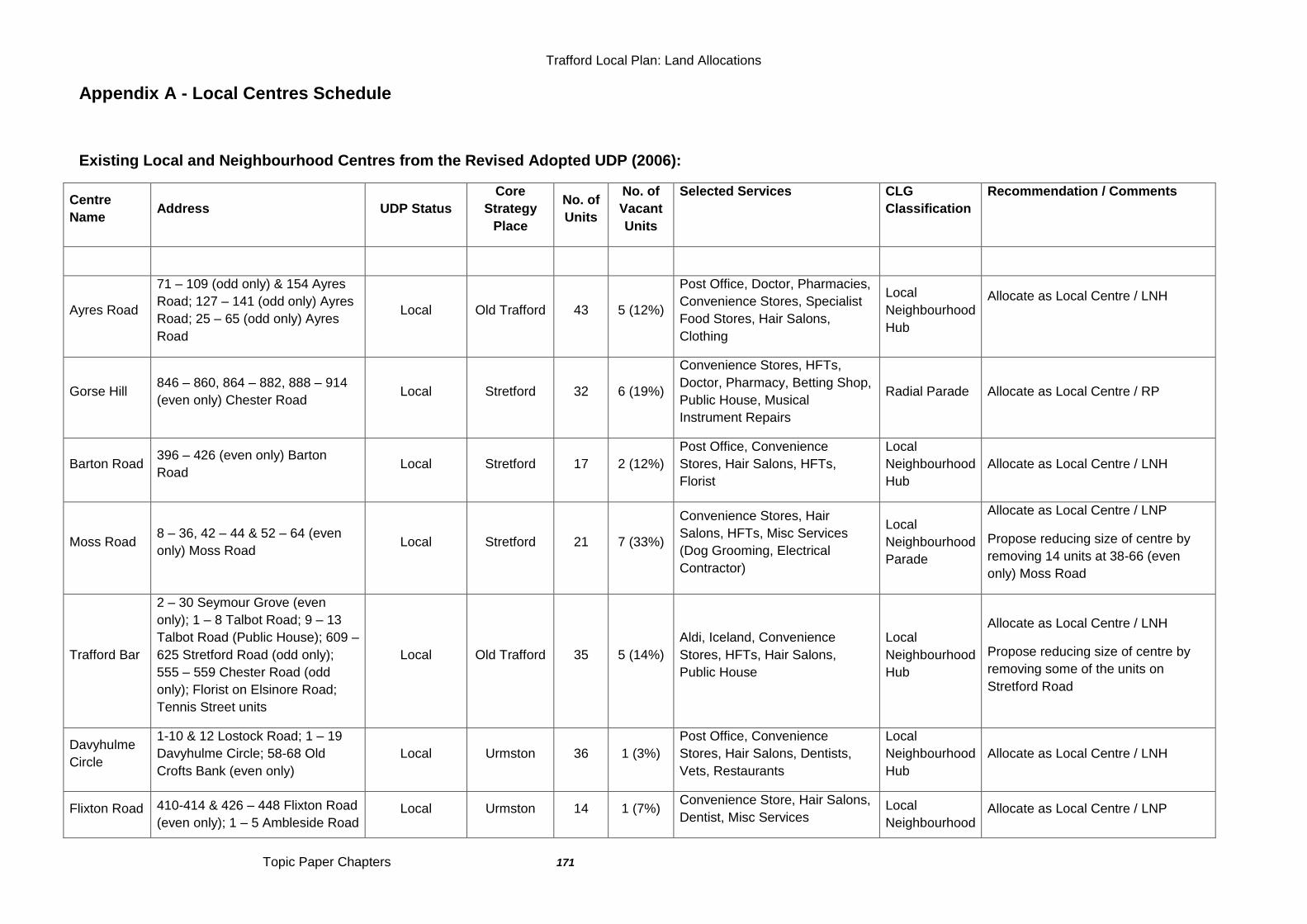
Trafford Local Plan: Land Allocations
Topic Paper Chapters 171
Appendix A - Local Centres Schedule
Existing Local and Neighbourhood Centres from the Revised Adopted UDP (2006):
Centre
Name Address UDP Status
Core
Strategy
Place
No. of
Units
No. of
Vacant
Units
Selected Services CLG
Classification
Recommendation / Comments
Ayres Road
71 – 109 (odd only) & 154 Ayres
Road; 127 – 141 (odd only) Ayres
Road; 25 – 65 (odd only) Ayres
Road
Local Old Trafford 43 5 (12%)
Post Office, Doctor, Pharmacies,
Convenience Stores, Specialist
Food Stores, Hair Salons,
Clothing
Local
Neighbourhood
Hub
Allocate as Local Centre / LNH
Gorse Hill 846 – 860, 864 – 882, 888 – 914
(even only) Chester Road Local Stretford 32 6 (19%)
Convenience Stores, HFTs,
Doctor, Pharmacy, Betting Shop,
Public House, Musical
Instrument Repairs
Radial Parade Allocate as Local Centre / RP
Barton Road 396 – 426 (even only) Barton
Road Local Stretford 17 2 (12%)
Post Office, Convenience
Stores, Hair Salons, HFTs,
Florist
Local
Neighbourhood
Hub
Allocate as Local Centre / LNH
Moss Road 8 – 36, 42 – 44 & 52 – 64 (even
only) Moss Road Local Stretford 21 7 (33%)
Convenience Stores, Hair
Salons, HFTs, Misc Services
(Dog Grooming, Electrical
Contractor)
Local
Neighbourhood
Parade
Allocate as Local Centre / LNP
Propose reducing size of centre by
removing 14 units at 38-66 (even
only) Moss Road
Trafford Bar
2 – 30 Seymour Grove (even
only); 1 – 8 Talbot Road; 9 – 13
Talbot Road (Public House); 609 –
625 Stretford Road (odd only);
555 – 559 Chester Road (odd
only); Florist on Elsinore Road;
Tennis Street units
Local Old Trafford 35 5 (14%)
Aldi, Iceland, Convenience
Stores, HFTs, Hair Salons,
Public House
Local
Neighbourhood
Hub
Allocate as Local Centre / LNH
Propose reducing size of centre by
removing some of the units on
Stretford Road
Davyhulme
Circle
1-10 & 12 Lostock Road; 1 – 19
Davyhulme Circle; 58-68 Old
Crofts Bank (even only)
Local Urmston 36 1 (3%)
Post Office, Convenience
Stores, Hair Salons, Dentists,
Vets, Restaurants
Local
Neighbourhood
Hub
Allocate as Local Centre / LNH
Flixton Road 410-414 & 426 – 448 Flixton Road
(even only); 1 – 5 Ambleside Road Local Urmston 14 1 (7%)
Convenience Store, Hair Salons,
Dentist, Misc Services Local
Neighbourhood Allocate as Local Centre / LNP
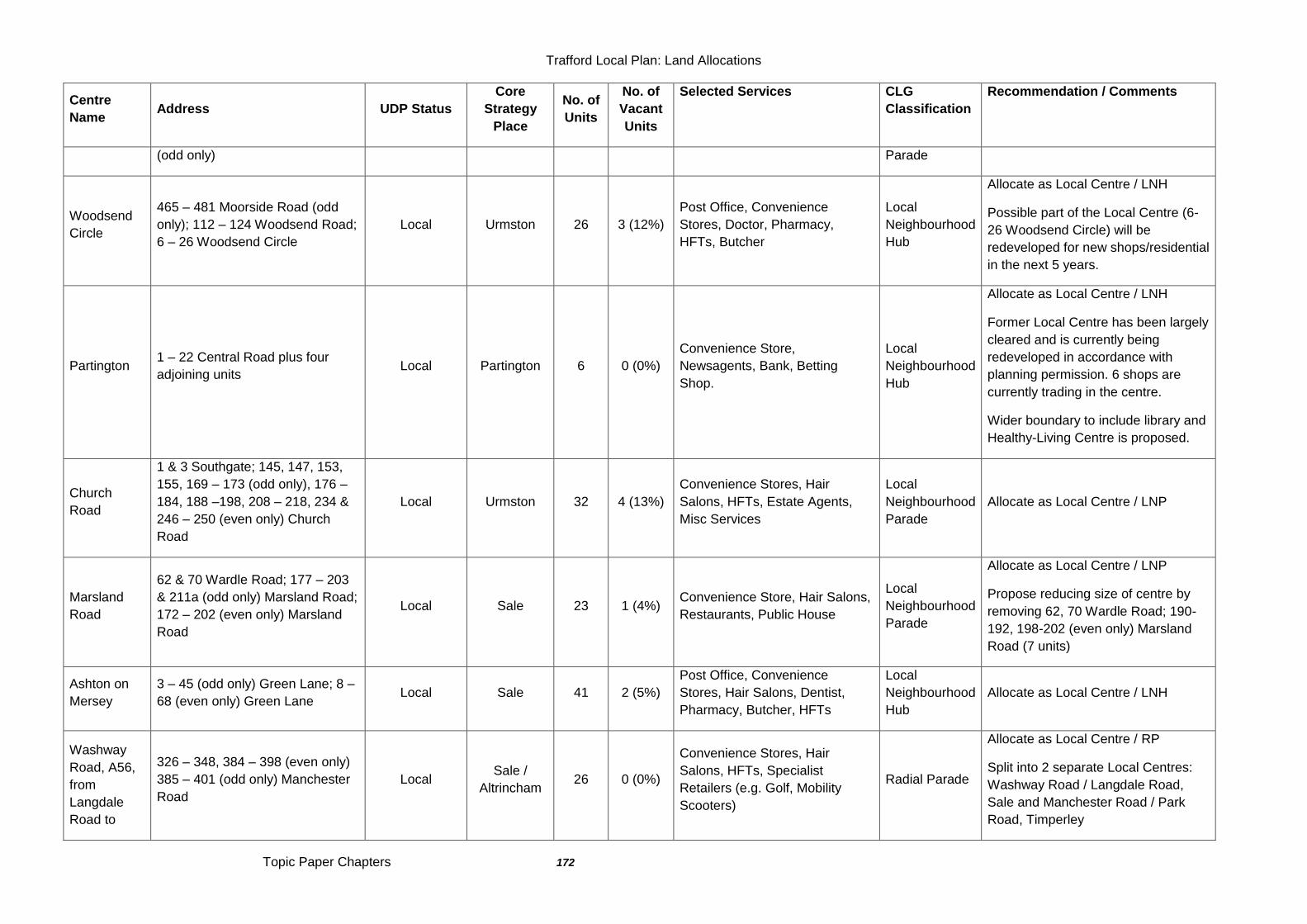
Trafford Local Plan: Land Allocations
Topic Paper Chapters 172
Centre
Name Address UDP Status
Core
Strategy
Place
No. of
Units
No. of
Vacant
Units
Selected Services CLG
Classification
Recommendation / Comments
(odd only) Parade
Woodsend
Circle
465 – 481 Moorside Road (odd
only); 112 – 124 Woodsend Road;
6 – 26 Woodsend Circle
Local Urmston 26 3 (12%)
Post Office, Convenience
Stores, Doctor, Pharmacy,
HFTs, Butcher
Local
Neighbourhood
Hub
Allocate as Local Centre / LNH
Possible part of the Local Centre (6-
26 Woodsend Circle) will be
redeveloped for new shops/residential
in the next 5 years.
Partington 1 – 22 Central Road plus four
adjoining units Local Partington 6 0 (0%)
Convenience Store,
Newsagents, Bank, Betting
Shop.
Local
Neighbourhood
Hub
Allocate as Local Centre / LNH
Former Local Centre has been largely
cleared and is currently being
redeveloped in accordance with
planning permission. 6 shops are
currently trading in the centre.
Wider boundary to include library and
Healthy-Living Centre is proposed.
Church
Road
1 & 3 Southgate; 145, 147, 153,
155, 169 – 173 (odd only), 176 –
184, 188 –198, 208 – 218, 234 &
246 – 250 (even only) Church
Road
Local Urmston 32 4 (13%)
Convenience Stores, Hair
Salons, HFTs, Estate Agents,
Misc Services
Local
Neighbourhood
Parade
Allocate as Local Centre / LNP
Marsland
Road
62 & 70 Wardle Road; 177 – 203
& 211a (odd only) Marsland Road;
172 – 202 (even only) Marsland
Road
Local Sale 23 1 (4%) Convenience Store, Hair Salons,
Restaurants, Public House
Local
Neighbourhood
Parade
Allocate as Local Centre / LNP
Propose reducing size of centre by
removing 62, 70 Wardle Road; 190-
192, 198-202 (even only) Marsland
Road (7 units)
Ashton on
Mersey
3 – 45 (odd only) Green Lane; 8 –
68 (even only) Green Lane Local Sale 41 2 (5%)
Post Office, Convenience
Stores, Hair Salons, Dentist,
Pharmacy, Butcher, HFTs
Local
Neighbourhood
Hub
Allocate as Local Centre / LNH
Washway
Road, A56,
from
Langdale
Road to
326 – 348, 384 – 398 (even only)
385 – 401 (odd only) Manchester
Road
Local Sale /
Altrincham 26 0 (0%)
Convenience Stores, Hair
Salons, HFTs, Specialist
Retailers (e.g. Golf, Mobility
Scooters)
Radial Parade
Allocate as Local Centre / RP
Split into 2 separate Local Centres:
Washway Road / Langdale Road,
Sale and Manchester Road / Park
Road, Timperley
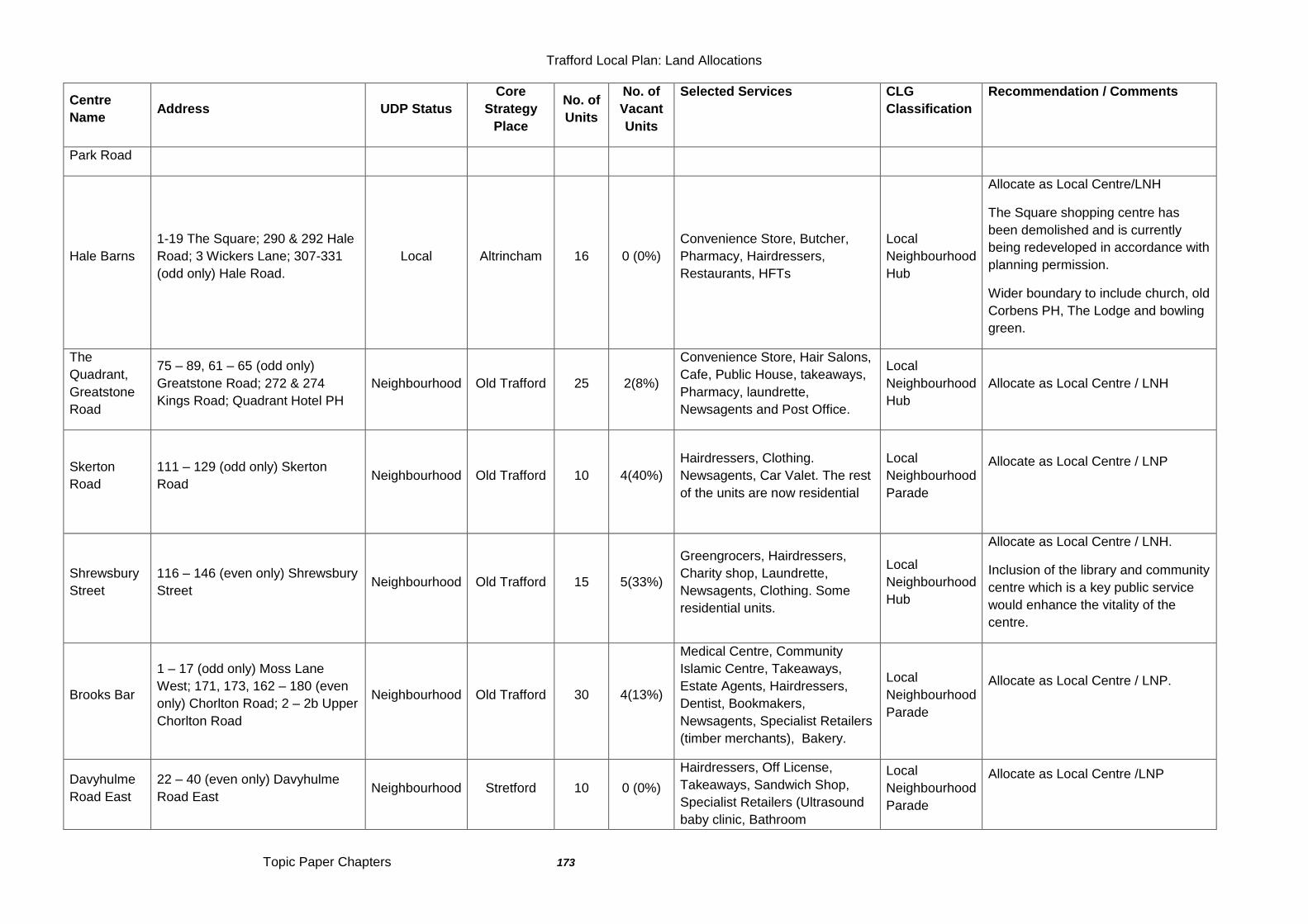
Trafford Local Plan: Land Allocations
Topic Paper Chapters 173
Centre
Name Address UDP Status
Core
Strategy
Place
No. of
Units
No. of
Vacant
Units
Selected Services CLG
Classification
Recommendation / Comments
Park Road
Hale Barns
1-19 The Square; 290 & 292 Hale
Road; 3 Wickers Lane; 307-331
(odd only) Hale Road.
Local Altrincham 16 0 (0%)
Convenience Store, Butcher,
Pharmacy, Hairdressers,
Restaurants, HFTs
Local
Neighbourhood
Hub
Allocate as Local Centre/LNH
The Square shopping centre has
been demolished and is currently
being redeveloped in accordance with
planning permission.
Wider boundary to include church, old
Corbens PH, The Lodge and bowling
green.
The
Quadrant,
Greatstone
Road
75 – 89, 61 – 65 (odd only)
Greatstone Road; 272 & 274
Kings Road; Quadrant Hotel PH
Neighbourhood Old Trafford 25 2(8%)
Convenience Store, Hair Salons,
Cafe, Public House, takeaways,
Pharmacy, laundrette,
Newsagents and Post Office.
Local
Neighbourhood
Hub
Allocate as Local Centre / LNH
Skerton
Road
111 – 129 (odd only) Skerton
Road
Neighbourhood Old Trafford 10 4(40%)
Hairdressers, Clothing.
Newsagents, Car Valet. The rest
of the units are now residential
Local
Neighbourhood
Parade
Allocate as Local Centre / LNP
Shrewsbury
Street
116 – 146 (even only) Shrewsbury
Street Neighbourhood Old Trafford 15 5(33%)
Greengrocers, Hairdressers,
Charity shop, Laundrette,
Newsagents, Clothing. Some
residential units.
Local
Neighbourhood
Hub
Allocate as Local Centre / LNH.
Inclusion of the library and community
centre which is a key public service
would enhance the vitality of the
centre.
Brooks Bar
1 – 17 (odd only) Moss Lane
West; 171, 173, 162 – 180 (even
only) Chorlton Road; 2 – 2b Upper
Chorlton Road
Neighbourhood Old Trafford 30 4(13%)
Medical Centre, Community
Islamic Centre, Takeaways,
Estate Agents, Hairdressers,
Dentist, Bookmakers,
Newsagents, Specialist Retailers
(timber merchants), Bakery.
Local
Neighbourhood
Parade
Allocate as Local Centre / LNP.
Davyhulme
Road East
22 – 40 (even only) Davyhulme
Road East Neighbourhood Stretford 10 0 (0%)
Hairdressers, Off License,
Takeaways, Sandwich Shop,
Specialist Retailers (Ultrasound
baby clinic, Bathroom
Local
Neighbourhood
Parade
Allocate as Local Centre /LNP
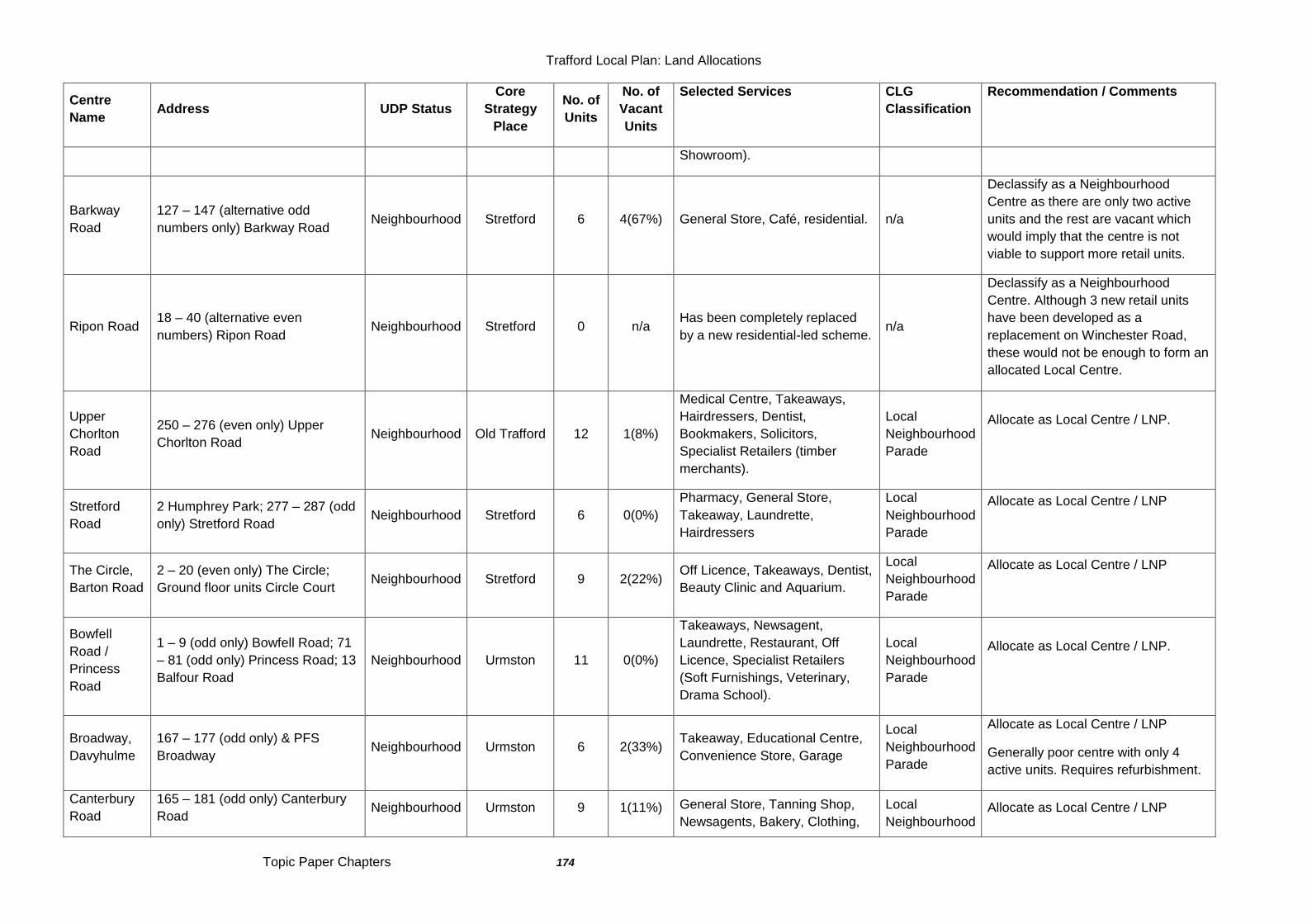
Trafford Local Plan: Land Allocations
Topic Paper Chapters 174
Centre
Name Address UDP Status
Core
Strategy
Place
No. of
Units
No. of
Vacant
Units
Selected Services CLG
Classification
Recommendation / Comments
Showroom).
Barkway
Road
127 – 147 (alternative odd
numbers only) Barkway Road Neighbourhood Stretford 6 4(67%) General Store, Café, residential. n/a
Declassify as a Neighbourhood
Centre as there are only two active
units and the rest are vacant which
would imply that the centre is not
viable to support more retail units.
Ripon Road 18 – 40 (alternative even
numbers) Ripon Road Neighbourhood Stretford 0 n/a
Has been completely replaced
by a new residential-led scheme. n/a
Declassify as a Neighbourhood
Centre. Although 3 new retail units
have been developed as a
replacement on Winchester Road,
these would not be enough to form an
allocated Local Centre.
Upper
Chorlton
Road
250 – 276 (even only) Upper
Chorlton Road Neighbourhood Old Trafford 12 1(8%)
Medical Centre, Takeaways,
Hairdressers, Dentist,
Bookmakers, Solicitors,
Specialist Retailers (timber
merchants).
Local
Neighbourhood
Parade
Allocate as Local Centre / LNP.
Stretford
Road
2 Humphrey Park; 277 – 287 (odd
only) Stretford Road Neighbourhood Stretford 6 0(0%)
Pharmacy, General Store,
Takeaway, Laundrette,
Hairdressers
Local
Neighbourhood
Parade
Allocate as Local Centre / LNP
The Circle,
Barton Road
2 – 20 (even only) The Circle;
Ground floor units Circle Court Neighbourhood Stretford 9 2(22%)
Off Licence, Takeaways, Dentist,
Beauty Clinic and Aquarium.
Local
Neighbourhood
Parade
Allocate as Local Centre / LNP
Bowfell
Road /
Princess
Road
1 – 9 (odd only) Bowfell Road; 71
– 81 (odd only) Princess Road; 13
Balfour Road
Neighbourhood Urmston 11 0(0%)
Takeaways, Newsagent,
Laundrette, Restaurant, Off
Licence, Specialist Retailers
(Soft Furnishings, Veterinary,
Drama School).
Local
Neighbourhood
Parade
Allocate as Local Centre / LNP.
Broadway,
Davyhulme
167 – 177 (odd only) & PFS
Broadway Neighbourhood Urmston 6 2(33%)
Takeaway, Educational Centre,
Convenience Store, Garage
Local
Neighbourhood
Parade
Allocate as Local Centre / LNP
Generally poor centre with only 4
active units. Requires refurbishment.
Canterbury
Road
165 – 181 (odd only) Canterbury
Road Neighbourhood Urmston 9 1(11%) General Store, Tanning Shop,
Newsagents, Bakery, Clothing,
Local
Neighbourhood Allocate as Local Centre / LNP
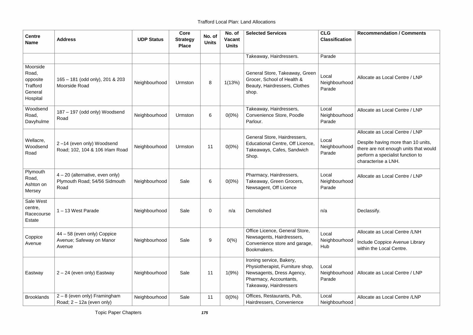
Trafford Local Plan: Land Allocations
Topic Paper Chapters 175
Centre
Name Address UDP Status
Core
Strategy
Place
No. of
Units
No. of
Vacant
Units
Selected Services CLG
Classification
Recommendation / Comments
Takeaway, Hairdressers. Parade
Moorside
Road,
opposite
Trafford
General
Hospital
165 – 181 (odd only), 201 & 203
Moorside Road Neighbourhood Urmston 8 1(13%)
General Store, Takeaway, Green
Grocer, School of Health &
Beauty, Hairdressers, Clothes
shop.
Local
Neighbourhood
Parade
Allocate as Local Centre / LNP
Woodsend
Road,
Davyhulme
187 – 197 (odd only) Woodsend
Road Neighbourhood Urmston 6 0(0%)
Takeaway, Hairdressers,
Convenience Store, Poodle
Parlour.
Local
Neighbourhood
Parade
Allocate as Local Centre / LNP
Wellacre,
Woodsend
Road
2 –14 (even only) Woodsend
Road; 102, 104 & 106 Irlam Road Neighbourhood Urmston 11 0(0%)
General Store, Hairdressers,
Educational Centre, Off Licence,
Takeaways, Cafes, Sandwich
Shop.
Local
Neighbourhood
Parade
Allocate as Local Centre / LNP
Despite having more than 10 units,
there are not enough units that would
perform a specialist function to
characterise a LNH.
Plymouth
Road,
Ashton on
Mersey
4 – 20 (alternative, even only)
Plymouth Road; 54/56 Sidmouth
Road
Neighbourhood Sale 6 0(0%)
Pharmacy, Hairdressers,
Takeaway, Green Grocers,
Newsagent, Off Licence
Local
Neighbourhood
Parade
Allocate as Local Centre / LNP
Sale West
centre,
Racecourse
Estate
1 – 13 West Parade Neighbourhood Sale 0 n/a Demolished n/a Declassify.
Coppice
Avenue
44 – 58 (even only) Coppice
Avenue; Safeway on Manor
Avenue
Neighbourhood Sale 9 0(%)
Office Licence, General Store,
Newsagents, Hairdressers,
Convenience store and garage,
Bookmakers.
Local
Neighbourhood
Hub
Allocate as Local Centre /LNH
Include Coppice Avenue Library
within the Local Centre.
Eastway 2 – 24 (even only) Eastway Neighbourhood Sale 11 1(9%)
Ironing service, Bakery,
Physiotherapist, Furniture shop,
Newsagents, Dress Agency,
Pharmacy, Accountants,
Takeaway, Hairdressers
Local
Neighbourhood
Parade
Allocate as Local Centre / LNP
Brooklands 2 – 8 (even only) Framingham
Road; 2 – 12a (even only) Neighbourhood Sale 11 0(0%) Offices, Restaurants, Pub,
Hairdressers, Convenience
Local
Neighbourhood Allocate as Local Centre /LNP
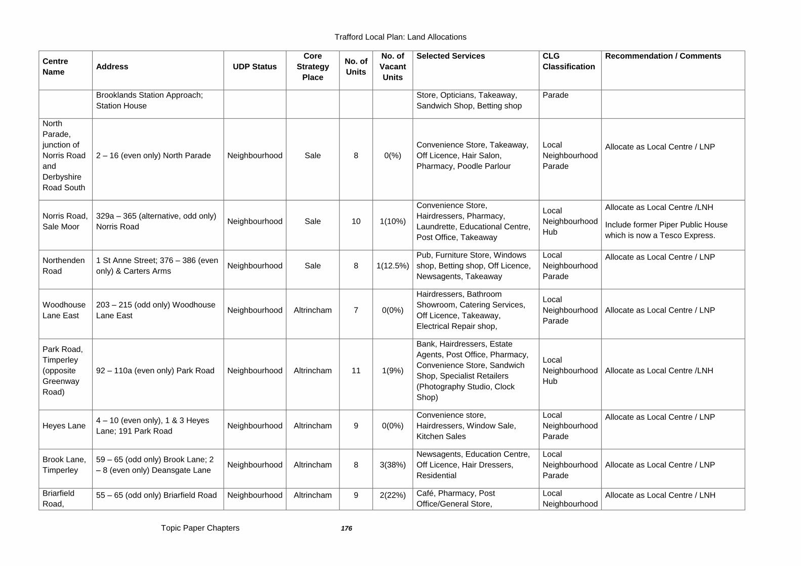
Trafford Local Plan: Land Allocations
Topic Paper Chapters 176
Centre
Name Address UDP Status
Core
Strategy
Place
No. of
Units
No. of
Vacant
Units
Selected Services CLG
Classification
Recommendation / Comments
Brooklands Station Approach;
Station House
Store, Opticians, Takeaway,
Sandwich Shop, Betting shop
Parade
North
Parade,
junction of
Norris Road
and
Derbyshire
Road South
2 – 16 (even only) North Parade Neighbourhood Sale 8 0(%)
Convenience Store, Takeaway,
Off Licence, Hair Salon,
Pharmacy, Poodle Parlour
Local
Neighbourhood
Parade
Allocate as Local Centre / LNP
Norris Road,
Sale Moor
329a – 365 (alternative, odd only)
Norris Road Neighbourhood Sale 10 1(10%)
Convenience Store,
Hairdressers, Pharmacy,
Laundrette, Educational Centre,
Post Office, Takeaway
Local
Neighbourhood
Hub
Allocate as Local Centre /LNH
Include former Piper Public House
which is now a Tesco Express.
Northenden
Road
1 St Anne Street; 376 – 386 (even
only) & Carters Arms Neighbourhood Sale 8 1(12.5%)
Pub, Furniture Store, Windows
shop, Betting shop, Off Licence,
Newsagents, Takeaway
Local
Neighbourhood
Parade
Allocate as Local Centre / LNP
Woodhouse
Lane East
203 – 215 (odd only) Woodhouse
Lane East Neighbourhood Altrincham 7 0(0%)
Hairdressers, Bathroom
Showroom, Catering Services,
Off Licence, Takeaway,
Electrical Repair shop,
Local
Neighbourhood
Parade
Allocate as Local Centre / LNP
Park Road,
Timperley
(opposite
Greenway
Road)
92 – 110a (even only) Park Road Neighbourhood Altrincham 11 1(9%)
Bank, Hairdressers, Estate
Agents, Post Office, Pharmacy,
Convenience Store, Sandwich
Shop, Specialist Retailers
(Photography Studio, Clock
Shop)
Local
Neighbourhood
Hub
Allocate as Local Centre /LNH
Heyes Lane 4 – 10 (even only), 1 & 3 Heyes
Lane; 191 Park Road Neighbourhood Altrincham 9 0(0%)
Convenience store,
Hairdressers, Window Sale,
Kitchen Sales
Local
Neighbourhood
Parade
Allocate as Local Centre / LNP
Brook Lane,
Timperley
59 – 65 (odd only) Brook Lane; 2
– 8 (even only) Deansgate Lane Neighbourhood Altrincham 8 3(38%)
Newsagents, Education Centre,
Off Licence, Hair Dressers,
Residential
Local
Neighbourhood
Parade
Allocate as Local Centre / LNP
Briarfield
Road, 55 – 65 (odd only) Briarfield Road Neighbourhood Altrincham 9 2(22%) Café, Pharmacy, Post
Office/General Store,
Local
Neighbourhood Allocate as Local Centre / LNH
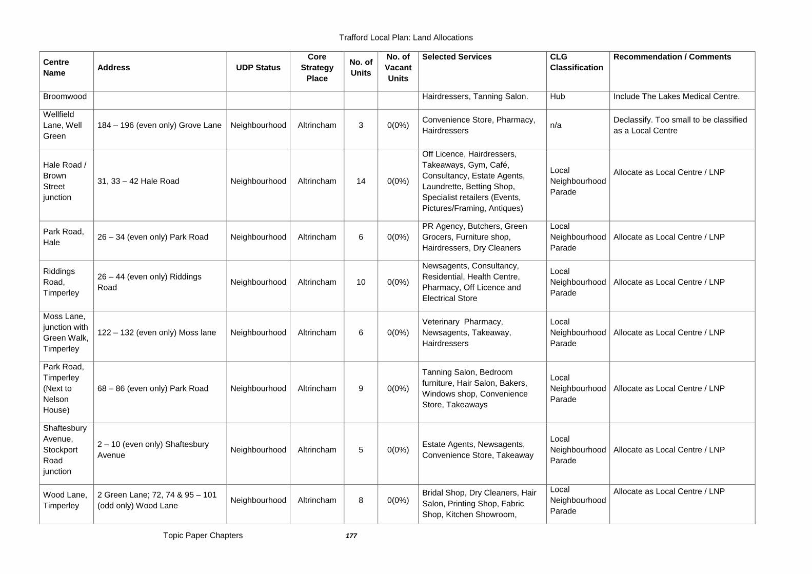
Trafford Local Plan: Land Allocations
Topic Paper Chapters 177
Centre
Name Address UDP Status
Core
Strategy
Place
No. of
Units
No. of
Vacant
Units
Selected Services CLG
Classification
Recommendation / Comments
Broomwood Hairdressers, Tanning Salon. Hub Include The Lakes Medical Centre.
Wellfield
Lane, Well
Green
184 – 196 (even only) Grove Lane Neighbourhood Altrincham 3 0(0%) Convenience Store, Pharmacy,
Hairdressers n/a
Declassify. Too small to be classified
as a Local Centre
Hale Road /
Brown
Street
junction
31, 33 – 42 Hale Road Neighbourhood Altrincham 14 0(0%)
Off Licence, Hairdressers,
Takeaways, Gym, Café,
Consultancy, Estate Agents,
Laundrette, Betting Shop,
Specialist retailers (Events,
Pictures/Framing, Antiques)
Local
Neighbourhood
Parade
Allocate as Local Centre / LNP
Park Road,
Hale 26 – 34 (even only) Park Road Neighbourhood Altrincham 6 0(0%)
PR Agency, Butchers, Green
Grocers, Furniture shop,
Hairdressers, Dry Cleaners
Local
Neighbourhood
Parade
Allocate as Local Centre / LNP
Riddings
Road,
Timperley
26 – 44 (even only) Riddings
Road Neighbourhood Altrincham 10 0(0%)
Newsagents, Consultancy,
Residential, Health Centre,
Pharmacy, Off Licence and
Electrical Store
Local
Neighbourhood
Parade
Allocate as Local Centre / LNP
Moss Lane,
junction with
Green Walk,
Timperley
122 – 132 (even only) Moss lane Neighbourhood Altrincham 6 0(0%)
Veterinary Pharmacy,
Newsagents, Takeaway,
Hairdressers
Local
Neighbourhood
Parade
Allocate as Local Centre / LNP
Park Road,
Timperley
(Next to
Nelson
House)
68 – 86 (even only) Park Road Neighbourhood Altrincham 9 0(0%)
Tanning Salon, Bedroom
furniture, Hair Salon, Bakers,
Windows shop, Convenience
Store, Takeaways
Local
Neighbourhood
Parade
Allocate as Local Centre / LNP
Shaftesbury
Avenue,
Stockport
Road
junction
2 – 10 (even only) Shaftesbury
Avenue Neighbourhood Altrincham 5 0(0%)
Estate Agents, Newsagents,
Convenience Store, Takeaway
Local
Neighbourhood
Parade
Allocate as Local Centre / LNP
Wood Lane,
Timperley
2 Green Lane; 72, 74 & 95 – 101
(odd only) Wood Lane Neighbourhood Altrincham 8 0(0%)
Bridal Shop, Dry Cleaners, Hair
Salon, Printing Shop, Fabric
Shop, Kitchen Showroom,
Local
Neighbourhood
Parade
Allocate as Local Centre / LNP
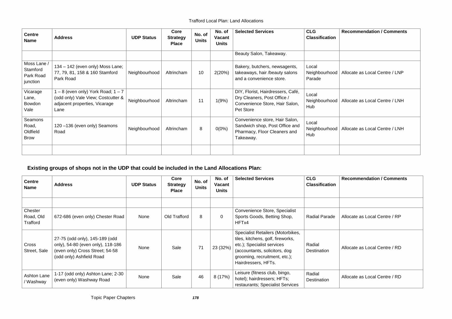
Trafford Local Plan: Land Allocations
Topic Paper Chapters 178
Centre
Name Address UDP Status
Core
Strategy
Place
No. of
Units
No. of
Vacant
Units
Selected Services CLG
Classification
Recommendation / Comments
Beauty Salon, Takeaway.
Moss Lane /
Stamford
Park Road
junction
134 – 142 (even only) Moss Lane;
77, 79, 81, 158 & 160 Stamford
Park Road
Neighbourhood Altrincham 10 2(20%)
Bakery, butchers, newsagents,
takeaways, hair /beauty salons
and a convenience store.
Local
Neighbourhood
Parade
Allocate as Local Centre / LNP
Vicarage
Lane,
Bowdon
Vale
1 – 8 (even only) York Road; 1 – 7
(odd only) Vale View; Costcutter &
adjacent properties, Vicarage
Lane
Neighbourhood Altrincham 11 1(9%)
DIY, Florist, Hairdressers, Café,
Dry Cleaners, Post Office /
Convenience Store, Hair Salon,
Pet Store
Local
Neighbourhood
Hub
Allocate as Local Centre / LNH
Seamons
Road,
Oldfield
Brow
120 –136 (even only) Seamons
Road Neighbourhood Altrincham 8 0(0%)
Convenience store, Hair Salon,
Sandwich shop, Post Office and
Pharmacy, Floor Cleaners and
Takeaway.
Local
Neighbourhood
Hub
Allocate as Local Centre / LNH
Existing groups of shops not in the UDP that could be included in the Land Allocations Plan:
Centre
Name Address UDP Status
Core
Strategy
Place
No. of
Units
No. of
Vacant
Units
Selected Services CLG
Classification
Recommendation / Comments
Chester
Road, Old
Trafford
672-686 (even only) Chester Road None Old Trafford 8 0
Convenience Store, Specialist
Sports Goods, Betting Shop,
HFTx4
Radial Parade Allocate as Local Centre / RP
Cross
Street, Sale
27-75 (odd only), 145-189 (odd
only), 54-80 (even only), 118-186
(even only) Cross Street; 54-58
(odd only) Ashfield Road
None Sale 71 23 (32%)
Specialist Retailers (Motorbikes,
tiles, kitchens, golf, fireworks,
etc.); Specialist services
(accountants, solicitors, dog
grooming, recruitment, etc.);
Hairdressers, HFTs.
Radial
Destination Allocate as Local Centre / RD
Ashton Lane
/ Washway
1-17 (odd only) Ashton Lane; 2-30
(even only) Washway Road None Sale 46 8 (17%)
Leisure (fitness club, bingo,
hotel); hairdressers; HFTs;
restaurants; Specialist Services
Radial
Destination Allocate as Local Centre / RD
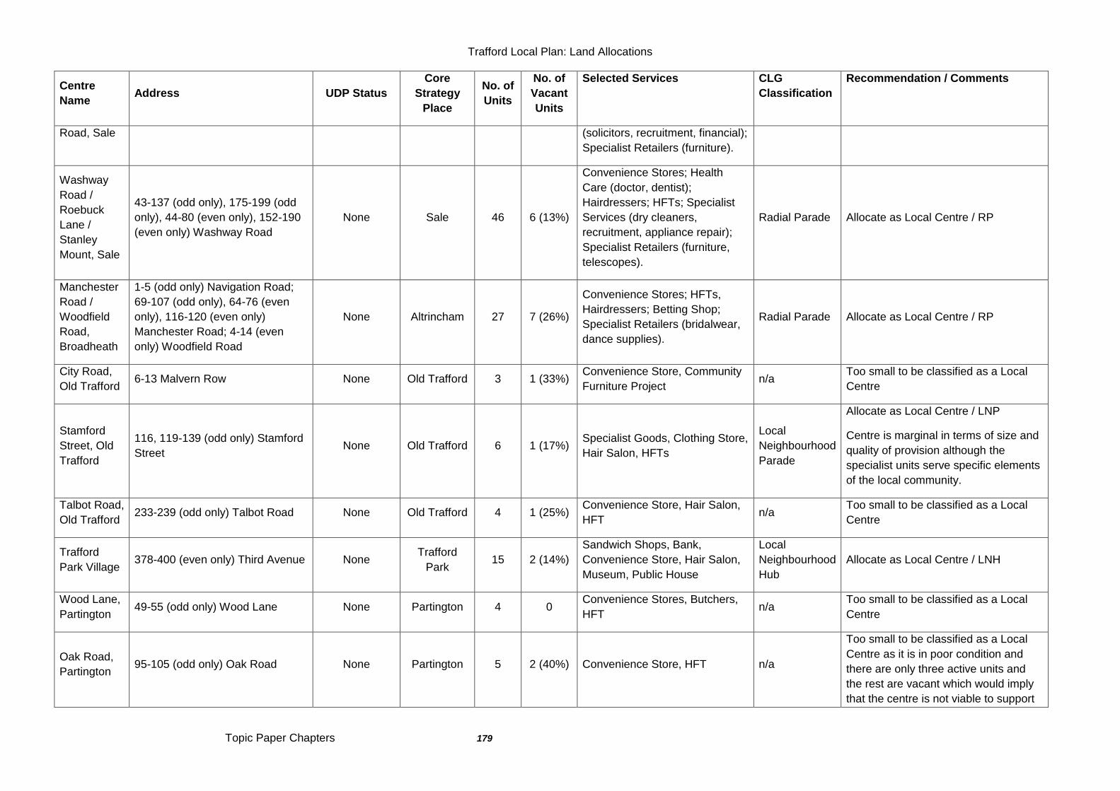
Trafford Local Plan: Land Allocations
Topic Paper Chapters 179
Centre
Name Address UDP Status
Core
Strategy
Place
No. of
Units
No. of
Vacant
Units
Selected Services CLG
Classification
Recommendation / Comments
Road, Sale (solicitors, recruitment, financial);
Specialist Retailers (furniture).
Washway
Road /
Roebuck
Lane /
Stanley
Mount, Sale
43-137 (odd only), 175-199 (odd
only), 44-80 (even only), 152-190
(even only) Washway Road
None Sale 46 6 (13%)
Convenience Stores; Health
Care (doctor, dentist);
Hairdressers; HFTs; Specialist
Services (dry cleaners,
recruitment, appliance repair);
Specialist Retailers (furniture,
telescopes).
Radial Parade Allocate as Local Centre / RP
Manchester
Road /
Woodfield
Road,
Broadheath
1-5 (odd only) Navigation Road;
69-107 (odd only), 64-76 (even
only), 116-120 (even only)
Manchester Road; 4-14 (even
only) Woodfield Road
None Altrincham 27 7 (26%)
Convenience Stores; HFTs,
Hairdressers; Betting Shop;
Specialist Retailers (bridalwear,
dance supplies).
Radial Parade Allocate as Local Centre / RP
City Road,
Old Trafford 6-13 Malvern Row None Old Trafford 3 1 (33%)
Convenience Store, Community
Furniture Project n/a
Too small to be classified as a Local
Centre
Stamford
Street, Old
Trafford
116, 119-139 (odd only) Stamford
Street None Old Trafford 6 1 (17%)
Specialist Goods, Clothing Store,
Hair Salon, HFTs
Local
Neighbourhood
Parade
Allocate as Local Centre / LNP
Centre is marginal in terms of size and
quality of provision although the
specialist units serve specific elements
of the local community.
Talbot Road,
Old Trafford 233-239 (odd only) Talbot Road None Old Trafford 4 1 (25%)
Convenience Store, Hair Salon,
HFT n/a
Too small to be classified as a Local
Centre
Trafford
Park Village 378-400 (even only) Third Avenue None
Trafford
Park 15 2 (14%)
Sandwich Shops, Bank,
Convenience Store, Hair Salon,
Museum, Public House
Local
Neighbourhood
Hub
Allocate as Local Centre / LNH
Wood Lane,
Partington 49-55 (odd only) Wood Lane None Partington 4 0
Convenience Stores, Butchers,
HFT n/a
Too small to be classified as a Local
Centre
Oak Road,
Partington 95-105 (odd only) Oak Road None Partington 5 2 (40%) Convenience Store, HFT n/a
Too small to be classified as a Local
Centre as it is in poor condition and
there are only three active units and
the rest are vacant which would imply
that the centre is not viable to support

Trafford Local Plan: Land Allocations
Topic Paper Chapters 180
Centre
Name Address UDP Status
Core
Strategy
Place
No. of
Units
No. of
Vacant
Units
Selected Services CLG
Classification
Recommendation / Comments
more retail units.
Warwick
Road South
88-94 (even only) Warwick Road
South, 48-50 (even only) Rye
Bank Road
None Old Trafford 5 0
Convenience Store, Dentist, Off
Licence, Hair Salon, Motor
Spares
Local
Neighbourhood
Parade
Allocate as Local Centre / LNP
Sinderland
Road /
Draybank
Road,
Broadheath
Units 2-12 Draybank Road Proposal MD1 Altrincham 7 1 (14%) Waitrose, Dry Cleaners, Carpets,
Horse supplies
Local
Neighbourhood
Parade
Allocate as Local Centre / LNP
Trafford Local Plan: Land Allocations
Topic Paper Chapters 181
Topic Paper:TP18 - Out-Of-Centre Retail 159.0 Current Position
159.1 The planning history of the three main retail warehouse parks in Trafford are
relatively complex, particularly in recent years where a number of applications have either sought to exploit earlier relatively unrestricted permissions or have sought greater flexibility in the range of goods that can be sold beyond the established „bulky‟ comparison goods. This section sets out the current position and the key planning permissions on each of the 3 retail parks which establish their current retail offer and are relevant for consideration in the Trafford Local Plan: Land Allocations. Altrincham Retail Park
159.2 The retail warehouses around Atlantic Street and George Richards Way in Broadheath developed in a number of phases in the 1980s and 1990s and replaced much of the existing employment uses and rail infrastructure in the area.
159.3 The B&Q store on Atlantic Street was originally granted planning permission in 1982 (H15460) and constructed in 1983. Although the decision notice indicated that there were no conditions restricting the range of goods that could be sold within the store, an associated Section 52 agreement limited sales to DIY and associated bulky goods only. Subsequent permissions extended the DIY store to 6,937sqm. In June 2001, a legal agreement was entered into with Trafford Council preventing the use of the store for food sales for consumption off the premises. At the same time the original s52 agreement was discharged. In May 2013, an application was submitted to the Council by Morrisons supermarket for the redevelopment of the existing B&Q to a food store after B& Q announced that the unit was no longer suitable for their business. This application was refused in July 2013 and a JR of the decision has been submitted.
159.4 The Bridgewater Retail Park on Viaduct Road currently comprising the Halfords store and Autocentre and two adjacent vacant units does not form part of the Altrincham Retail Park allocated in Proposal S12 of the Trafford UDP. The Council granted full planning permission in September 1987 (ref. H25576) for the demolition of existing industrial buildings and the erection of a 4,041 sq. m (43,500 sq. ft) non-food retail warehouse for the sale of DIY goods etc. The planning permission contains no restrictions on the range of goods which can be sold from the existing retail floorspace, nor are there any known restrictions on the minimum unit size of units, sub-division of the units or insertion of mezzanine floors (albeit mezzanine floorspace is now largely subject to the same control as any other floorspace). Schedule 2 of a Section 52 Agreement dated 7 September 1987 restricted the sale of goods from the land to a limited range, including vehicle sales, DIY goods, floor coverings, gardening equipment, etc. These units include unimplemented permissions for mezzanine floors. The other two units have remained vacant since September 2001 and June 2009, having previously been occupied most recently by Carpet World and Roseby‟s respectively. In March 2013, the Council received
Trafford Local Plan: Land Allocations
Topic Paper Chapters 182
an application for the refurbishment of the Retail Park to deliver modern retail park floorspace, and the relaxation of the restrictions on the range of goods that can be sold so that a discount retailer selling a wide range of general merchandise, ambient food and products for the home, and a retailer selling pets and pet related products can trade from the refurbished premises.
159.5 The Crown Estates-owned Altrincham Retail Park was permitted through two planning approvals granted in 1994 and built in 1995. Permission (H/OUT/038342) granted October 1994 led to the construction of the L-shaped terrace (Toys R Us to Currys) while permission (H/OUT/39995) granted November 1994 led to the construction of the Homebase unit. In April 2010 permission (H/71396) was granted on appeal for the erection of four retail units (total 800 square metres) for purposes within Class A1 (Shops) and/or Class A3 (Restaurants and Cafes). This permission has not yet been implemented. The lawful provision of mezzanines within a number of units was upheld on appeal in October 2012 (77816/CLOPD/2011).
159.6 The Retail Park is currently fully occupied and well-used with a range of high street retailers present including recognised bulky goods retailers such as Homebase, Pets at Home, Toys R Us, CarpetRight and Currys PC World along with more non-bulky comparison goods retailers such as Boots, Asda Living, Sports Direct and TK Maxx. The retail offer of the park is supplemented by restaurant uses including a drive-thru McDonalds and Pizza Hut. Trafford Retail Park
159.7 Trafford Retail Park was originally permitted in 1996 for retail and business use including 9290sqm of non-food retail warehousing with 2787sqm garden centre (Class A1), business uses (Class B1 and B8); car showrooms and ancillary workshop(s), petrol filling station and shop, fast food restaurants (Class A3) and included a condition restricting the use of all units to non-food retail only. Subsequent applications resulted in permission for unrestricted non-food retail in units nos. 2, 3, 6, 8A and 8B although with a cap on the total amount of floorspace to be used for certain non-food items including books, clothing and cosmetics. In October 2011 permission was granted on appeal to allow a small part of one of the units to be used for the sale of „ambient‟ (non-fresh) food and drink in order to accommodate the retailer Home Bargains.
159.8 In May 2012, permission (H/OUT/71053) was granted on appeal for a 7,246sqm gross foodstore to the south of Neary Way with subsequent permission for a petrol filling station also being granted on this site.
159.9 Trafford Retail Park contains a mix of bulky and non-bulky retail outlets such
as Dunelm, Boots, TK Maxx, Carpetright, Pets at Home and Carphone Warehouse although there are a couple of vacant units within the park including one formerly occupied by the electrical retailer Comet. The park is also home to a number of food operators including Pizza Hut, KFC and McDonalds. White City Retail Park
159.10 The existing White City Retail Park was developed pursuant to the grant of planning permission by Trafford Park Development Corporation in
Trafford Local Plan: Land Allocations
Topic Paper Chapters 183
1988 and included non-food retail units, leisure units and restaurants. Subsequently the eastern section comprising retail and leisure units was demolished and replaced with new non-food retail units following the grant of planning permission on 20 January 2003 (Ref: H/54806). These newer units (J, I and H) are presently occupied by „Currys‟, „Furniture Village‟ and „CSL‟ respectively. An additional permitted unit (H1) has never been constructed. In addition, the Council issued a certificate of lawfulness of proposed use or development (CLOPUD) on 5 August 2008 (Ref: H/CLD/69691) confirming that the use of the three newer retail units (J, I and H) at the eastern end of the retail park included the retail sale of food.
159.11 In February 2008, permission (H/68876) was granted for the demolition of the existing Homebase unit and 683 Chester Road and construction of 4 no. retail units with a total gross floorspace of 6660 square metres. This permission was implemented through the construction of foundations and base works in 2011 although the retail stores have not yet been built.
159.12 In February 2011, an application (74483/FULL/2009) for the erection of a new foodstore (9036 sqm gross) and two new non-food retail units (2357 sqm) was dismissed at appeal. Essentially, this application was seeking to reconfigure the retail park to include a foodstore using the open A1 floorspace permitted under the 2003 permission. Subsequently, permission (75379/FULL/2010) was upheld on appeal in November 2011 for the refurbishment of 9 existing units and the creation of a new unit. The total floorspace in the units was restricted to no more than 12421 square metres gross floorspace including no more than 9170 square metres ground floor gross floorspace and no more than 3251 square metres of mezzanine floorspace and the retail units are for the sale of non-food comparison goods only and there shall be no sale of food or convenience goods from the units at any time.
159.13 Of the three retail warehouse parks in Trafford, White City is probably
the most dated in appearance and has a significant number of vacant units (4 out of 12) not including the large cleared area where Homebase used to be. The remaining retailers are all traditional bulky furniture and electrical retail warehouse type operators including Currys, Furniture Village, SCS and Dreams. It is recognised, however, that with recent permissions the owners are seeking to refurbish the units and attract a wider range of comparison retailers. In addition, of the 3 retail parks though, White City is the only one with heritage value in that it is the site of the former Manchester Botanic Gardens which hosted the Art Treasures Exhibition of 1857. The gateway of the Botanic Gardens still stands at the edge of the retail park and is a Grade II listed structure. During its history, White City has also been the site of an amusement park and a sports stadium for Athletics, Greyhound and Stock Car Racing.
159.14 The Castlemore Retail Park lies to the north of the A56 Chester Road and is under separate ownership from the rest of White City Retail Park. It was originally granted permission on appeal in 1998 with reserved matters for 3,720sqm of retail floorspace granted in 2004 and construction soon after. These main retail units are occupied by the furniture retailers DFS, Harveys and Bensons for Beds. In addition, there are two standalone restaurant units
Trafford Local Plan: Land Allocations
Topic Paper Chapters 184
Harry Ramsden‟s and a drive thru KFC. A recent planning permission allowed for a small extension (108sqm) to the front of the retail unit now occupied by Harveys. The Evans Halshaw Ford motor car showroom and garage also lies within the White City Retail Park as defined in UDP Proposal S12. Other Out-of-Centre Retail Facilities
159.15 There are a number of other standalone out-of-centre retail warehouse and bulky goods facilities across the Borough. These include:
Tesco Extra store, Chester Road, Stretford;
PC World, Chester Road, Stretford;
B&Q, Great Stone Road, Stretford;
B&Q, Redclyffe Road, Trafford Park;
Asda Supercentre, Barton Dock Road, Trafford Park
Costco, Barton Dock Road, Trafford Park
Parker‟s Garden Centre, Carrington Road, Urmston
Altrincham Garden Centre, Green Lane, Timperley
159.16 It may be appropriate to consider defining each of these facilities within the Land Allocations Plan to ensure that, as with the 3 retail warehouse parks, they maintain their primary function and further development of these facilities does not adversely affect any centres within Trafford in accordance with other policies within the Trafford Local Plan. The 3 sites listed above within Stretford are dealt with within the LCCC Quarter Strategic Location policies and the 3 facilities in Trafford Park within the Trafford Centre Rectangle policies.
159.17 This leaves the 2 main garden centres at Urmston and Altrincham. Whilst the majority of the goods sold within these facilities are bulky – plants, garden furniture, etc. there has been some concern in recent years that the retail offer has diversified and a range of non-bulky goods and services are available. It is considered that these should remain ancillary to the primary purpose of the facility and shouldn‟t be expanded to the point where they may affect the vitality and viability of nearby centres.
160.0 UDP Policy Framework 160.1 Under Policy S1 – New Shopping Development, the Council will permit retail
development within established town centres in order to extend choice, improve quality and efficiency and where it would not undermine the vitality and viability of any other centre. The policy is clear that town and district centres, and defined non-food retail warehouse parks will be the preferred locations for development that is likely to generate many trips with local centres providing for more day to day needs. Proposals for new out-of-centre or edge-of-centre retail development must also be clearly evidenced in terms of need and that there are no sequentially-preferable sites within existing centres.
160.2 Policy S1 also sets out that “…the Council will seek to avoid the sporadic siting of comparison bulky goods units outside the existing town, district, local and neighbourhood shopping centres and defined non-food retail warehouse parks, particularly along road corridors.”
Trafford Local Plan: Land Allocations
Topic Paper Chapters 185
160.3 Under Proposal S11, Proposals for retail development not on land within town and district centres (or on retail warehouse parks) would not be permitted unless, amongst other things:
There is a demonstrable need for further retail development locally that cannot be met by existing provision in the Borough;
It can be demonstrated that a sequential approach to site selection has been adopted;
It has been demonstrated that the development would not have a serious adverse effect on the vitality and viability of any town or district centre within or outside Trafford.
The scheme would be highly accessible by a choice of means of transport allowing for the minimisation of car use;
The development would not lead to the sporadic siting of comparison goods shopping units along a road corridor;
There is no realistic chance of the site being developed for any other use for which it may be allocated specifically in this Plan;
160.4 Under Proposal S12, non-food retail warehouse development will be concentrated within the three existing retail warehouse parks at White City, Trafford and Altrincham and the Barton Square area identified on the Proposals Map. Other than within these areas, the Council will not permit the sporadic siting of comparison/bulky goods units outside existing town, district, local and neighbourhood shopping centres or along road corridors.
161.0 National Planning Policy Framework (NPPF) 161.1 The National Planning Policy Framework (NPPF) seeks to ensure the vitality
of town centres. It requires planning policies to be positive, to help manage change and growth of centres over the plan period and to promote competitive town centre environments.
161.2 In particular (para 23), it requires local plans to, amongst other things:
Recognise centres as the heart of their communities;
Define a network and hierarchy of centres that is resilient to economic change;
Promote competitive centres that provide customer choice and a diverse retail offer;
allocate a range of suitable sites to meet the scale and type of retail, leisure, commercial, office, tourism, cultural, community and residential development needed in town centres. It is important that needs for retail, leisure, office and other main town centre uses are met in full and are not compromised by limited site availability;
allocate appropriate edge of centre sites for main town centre uses that are well connected to the town centre where suitable and viable town centre sites are not available;
set policies for the consideration of proposals for main town centre uses which cannot be accommodated in or adjacent to town centres;
161.3 In drawing up Local Plans, the NPPF is clear (para 158) that local planning
authorities must use an adequate, up-to-date and relevant evidence base. In particular, the needs for land or floorspace for economic development, including for retail and leisure development; local planning authorities must
Trafford Local Plan: Land Allocations
Topic Paper Chapters 186
consider the role and function of town centres and the relationship between them, including any trends in the performance of centres and the capacity of existing centres to accommodate new town centre development;
161.4 In the Glossary (page 57), „town centres‟ are defined as including the primary shopping area and areas predominantly occupied by main town centre uses within or adjacent to the primary shopping area.
161.5 For retail purposes, edge of centre is defined (page 52) as a location that is
well connected and up to 300 metres of the primary shopping area. For all other main town centre uses, it is a location within 300 metres of a town centre boundary. For office development, this includes locations outside the town centre but within 500 metres of a public transport interchange. In determining whether a site falls within the definition of edge of centre, account should be taken of local circumstances.
161.6 On page 54, Out of centre is defined as a location which is not in or on the
edge of a centre but not necessarily outside the urban area while Out of town is a location out of centre that is outside the existing urban area.
161.7 On page 53, main town centre uses are defined as retail development
(including warehouse clubs and factory outlet centres); leisure, entertainment facilities the more intensive sport and recreation uses (including cinemas, restaurants, drive-through restaurants, bars and pubs, night-clubs, casinos, health and fitness centres, indoor bowling centres, and bingo halls); offices; and arts, culture and tourism development (including theatres, museums, galleries and concert halls, hotels and conference facilities).
162.0 The Core Strategy Framework 162.1 Strategic Objective SO4 sets out to revitalise town centres. It seeks to
maintain a clear hierarchy of vibrant, diverse and distinct shopping centres across the borough to be the focus for commercial, retail and leisure uses to meet the needs of the local population.
162.2 Policy W2 of the Core Strategy reaffirms the retail hierarchy in Trafford,
identifying Altrincham as the principal of the four town centres with Stretford, Sale and Urmston as „Other Town Centres‟. Within these centres there will be a focus on the consolidation and improvement of the convenience and comparison retail offer, as well as diversification to other uses such as offices, services, leisure, cultural and residential, as appropriate.
162.3 Under Policy W2.13, “…outside the centres identified above, there will be a
presumption against the development of retail, leisure and other town centre-type uses except where it can be demonstrated that they satisfy the tests outlined in current Government Guidance.” Essentially, these are the sequential and impact tests referred to in NPPF paragraphs 24 to 27.
162.4 Under Policy W2.14, “…proposals to expand any of the three existing retail
warehouse parks (White City, Trafford and Altrincham) should be justified against the tests set out in national guidance. Further development within the
Trafford Local Plan: Land Allocations
Topic Paper Chapters 187
retail warehouse parks should be limited to the sale of bulky comparison goods only.”
163.0 Trafford Retail Study 163.1 The Trafford Retail and Leisure Study was published in 2007 and, whilst
expenditure on retail is expected to grow over the Plan period, the study concluded that the current planned expansions within the Borough‟s town centres and other existing commitments would largely meet this anticipated growth. The Core Strategy Policy W2 therefore does not propose or identify any new sites for large scale growth in the retail sector other than those identified in the Retail Study. Instead it makes proposals to consolidate and enhance the retail offer available within Trafford‟s town, district and local centres and identify scope for the expansion of the hotel, leisure and evening economy sectors – particularly high quality and family-oriented facilities – in them all.
163.2 With respect to the Altrincham Catchment Area, the study concluded (p112) that the town centre was meeting some element of the bulky goods expenditure but otherwise the catchment was dominated by Altrincham Retail Park which accounted for 60% of the spend in this area and even 44% of the spending from the Sale catchment area. The Wyevale Garden Centre at Timperley also draws a reasonable level of trade from the catchment. Based on a large projected increase in expenditure capacity in this area the study concluded that, without commitments being realised, capacity could reach 26,000sqm by 2021.
163.3 For Sale, the study concluded that most of the expenditure generated in the
catchment went elsewhere (mainly to Altrincham Retail Park) and most of the identified capacity would be met by commitments outside of the catchment area. For the Stretford catchment area, the White City Retail Park meets the bulk of the market share (50%) and there is some capacity for new bulky goods retail floorspace (c11,000sqm by 2021). For the Urmston catchment area, much of the demand for bulky goods was met at Trafford Retail Park and the Trafford Centre including associated retail facilities such as Costco. It was anticipated that the bulk of the increase in expenditure capacity up to 2021 would be met by the Barton Square development which opened in 2008.
163.4 The study concluded (p130) that, given the existing strength of out-of-centre
retail parks (Altrincham, Trafford and White City) in the Borough, which are all predominantly bulky-goods orientated, there are no realistic opportunities to significantly increase existing market shares or the performance of the principal town centres in terms of bulky goods provision.
163.5 Whilst opportunities to provide for bulky goods retailing within the town
centres should be encouraged, if there is commercial interest, the study recommended that the provision of new sites within town centres for bulky goods development should not be a priority for the Council.
163.6 Instead, the study recommended (p184) that “…any additional bulky goods
development that cannot be met within the respective town centres should continue to be focussed on the existing retail park destinations, subject to
Trafford Local Plan: Land Allocations
Topic Paper Chapters 188
demonstrating compliance with the relevant (national) policy tests. To this extent, we consider that the existing UDP policy framework, which seeks to prevent the development of standalone retail warehouse units across the borough, should be maintained in order to enhance the potential for linked shopping trips.“
163.7 In addition, the study recommended that “…given that there has been a recent
trend towards the change of use of existing bulky goods orientated retail warehouses to non-bulky uses by virtue of previously granted open A1 consents, whilst the Council cannot resist the change in the nature of retail operation in such instances, we recommend that the Council effectively condition all new developments to restrict the type of goods sold from retail warehouses and should seek to resist attempts to relax restrictive conditions. It will be important for the Council to attempt to retain as many retail warehouses in bulky goods use. “
163.8 In conclusion, the Retail Study is clear that comparison retail development
should be considered within the town centres first but it does recognise that the existing retail warehouse parks do play a role in providing a particular type of retail. However, the study is clear that new development in the retail warehouse parks should be limited to bulky-comparison goods only to prevent them going to other uses which would compete with the town centre offer.
164.0 Call for Sites / Consultation Responses 164.1 This part of the topic paper highlights some key representations and site
submissions of relevance to Local Centres and a possible response in the Land Allocations Plan to the issues raised.
164.2 LAS-1251-102 – Mike Shields Altrincham Forward – “The principal causes of the decline of Altrincham Town Centre, as a primary retail location, are considered to be the impact of the Trafford Centre and other out-of-town developments particularly at Broadheath but also the expansion of petrol filling stations and garden centres to embrace a wide range of retail activity; the growing importance of internet shopping and the extended recession still being experienced. It is therefore important that planning policies seek to consolidate the Town Centre as a Primary Retail location and resist any further expansion of (a) out-of-town retail in all its forms and (b) any expansion of the general retail footprint of ATC itself.” – The comments on out-of-centre retail and the impact of the Altrincham Retail Park are noted.
164.3 LAS-1242-105 – Derwent Holdings Ltd – “Support for the recognition of Old Trafford as a Priority Regeneration Area. However, the Indices of Multiple Deprivation (IMD) data should not be used to set the boundaries of this area because this would not take into account surrounding areas that are well related to the PRA which could assist in the regeneration of these areas. This should include those areas that can provide employment opportunities for the residential areas within the PRA including sites at White City Retail Park and on Talbot Road.” - The consideration of whether White City Retail Park should be included within the Old Trafford Priority Regeneration Area is contained within the Topic Paper on Regeneration Areas.
Trafford Local Plan: Land Allocations
Topic Paper Chapters 189
164.4 CFS07-1264-32 – Old Cascade Motors site, Neary Way, Urmston – site is vacant and a target for vandals – should be brought into active use. – The comments are noted. This part of Trafford Retail Park now has planning permission for a 7,246sqm supermarket (see below).
164.5 CFS12-1045-73 – Trafford Retail Park, Neary Way, Urmston – “Peel proposes that the allocation of this site should reflect the mix of comparison and convenience retailers that currently occupy and have been approved on this site (including a 7,246sqm supermarket and unrestricted A1 retail uses in some units), and not act as a barrier to further development (by limiting the retail park to bulky goods only). However, Peel acknowledges that the Council will want to retain some control over the uses on this site, especially with regards to the development of supermarkets.” – Any new allocation for Trafford Retail Park will have to reflect the existing position on the Park although certain controls may be appropriate to maintain its primary use as retail warehouse park for the sale of bulky goods.
164.6 CFS07-1045-80 - Viaduct Road, Broadheath – “The site comprises a small canalside retail park area and associated parking/servicing area, an adjacent social club and a scrap yard. The site is brownfield land located in a sustainable urban location, close to public transport routes and retail/employment areas. The canalside location provides an opportunity for an attractive residential development and the improvement of the A56 frontage. The site is currently in active use for retail. The site‟s sustainable location and the benefits to be accrued from redevelopment are such that housing is a suitable use. It is therefore requested that the site is allocated for residential purposes.” – This site does not form part of the allocated Altrincham Retail Park although it has been an established retail warehouse location since its construction in 1995 and is known as the Bridgewater Retail Park. Consideration will be given as to whether it should, at least partly be allocated for housing development.
164.7 CFS12-1242-157 – White City Retail Park, Old Trafford – “Retail park provides an important retail facility for the area, generates employment opportunities for local people and is located within a sustainable location with good levels of access by public transport”. Retail park use should be retained. – Comments noted.
165.0 Proposed Options for the Retail Warehouse Park Boundaries 165.1 In line with Core Strategy Policy W2.14, the Council needs to define within the
Land Allocations Plan the boundaries of the 3 existing retail warehouse parks in order to identify them as suitable locations for bulky goods retailing facilities. It may also be appropriate to consider changes to the existing boundaries from the UDP and assess these changes in sustainability terms. Altrincham Retail Park
165.2 In relation to Altrincham Retail Park, the UDP boundary includes all the retail facilities west of the A56 to the north and south of George Richards Way and Atlantic Street. This area is currently fully occupied and well-used although it is noted that the B&Q store on Atlantic Street is potentially available as B&Q have indicated the intention to close this store. The UDP boundary does not,
Trafford Local Plan: Land Allocations
Topic Paper Chapters 190
however, include the Aldi store on Davenport Lane or the Bridgewater Retail Park to the east of the A56. It is proposed that the boundary is extended to include the Aldi and some minor alterations to exclude smaller properties along Huxley Street and the row of retail units along the A56 (135-147, 153, 173-175 Manchester Road (odd only) are made in order to exclude some residential units from the Retail Park and provide a clearer boundary between older properties that were there before the retail park and have a different function in retail terms from the retail park as they are not suitable for modern bulky goods retailing. It is proposed that the Bridgewater Retail Park and adjoining land is subject to a separate allocation for mixed-use development including retail and residential.
165.3 The potential opportunity arising from the closure of the B&Q unit should be considered as an option to reduce the boundary of the Retail Park and increase the boundary of the adjacent Broadheath Employment Area. This would make more land available to meet the employment needs identified in Core Strategy Policy W1 although the impact upon the ability of the retail park to accommodate the need for bulky goods retail floorspace also needs to be considered. Trafford Retail Park
165.4 Trafford Retail Park is well defined and reasonably well-used although there are currently a couple of vacant units. Although the land south of Neary Way is cleared and vacant it is proposed to retain it within the allocated retail park – essentially carrying forward the boundary from the UDP. However, any policy for Trafford Retail Park may be explicit that this part of the retail park is retained specifically for a foodstore. Therefore, there are no proposals to expand or reduce the boundary of the retail park from the UDP as there are no other realistic options for change. Consequently, there is no requirement to appraise boundary options in relation to sustainability objectives. White City Retail Park
165.5 There may be more potential for change at White City Retail Park given the greater number of vacancies here and its position next to the LCCC Quarter Strategic Location where opportunities for residential development are being sought. However, given that the planning permission for retail units on the old Homebase site has been implemented (see above) and the owners are actively marketing the whole site for retail warehousing, it is considered that it is not an option to remove this site from the retail park boundary. Retention of this site within the retail park also requires a slight amendment to the UDP boundary to reflect that the Homebase permission incorporated an adjacent site on Chester Road. However, it is proposed that the Evans Halshaw site could be removed from the retail park boundary as it is not a pure retail warehouse use.
165.6 Therefore 2 options have been assessed in the Sustainability Appraisal as follows:
Option 1: Maintain existing boundary as defined on the UDP Proposals Map
Option 2: Extend the boundary to include an adjacent site on Chester Road to reflect the Homebase permission and amend the boundary to exclude the Evans Halshaw site on the opposite side of Chester Road.
Trafford Local Plan: Land Allocations
Topic Paper Chapters 191
166.0 Conclusion 166.1 All the realistic options developed from the information in this topic paper have
been subject to independent Sustainability Appraisal (SA). The Sustainability Appraisal Report (November 2013) and associated Appendices contains the detailed results of individual appraisals of all realistic options for policies and sites and sets out the mitigation required to address any negative sustainability impacts. Specific appraisals relevant on this topic paper can be found in section 4.16 and Appendix P of this document. A summary of the SA and the reasons for choosing the preferred option are set out in the Options Appraisal Report. These documents and the information in this topic paper support the individual policies proposed in the Local Plan: Land Allocations Plan draft for consultation. The policies proposed are demonstrated to be sustainable.
Trafford Local Plan: Land Allocations
192 Topic Paper Chapters
Topic Paper: TP19 - Historic Environment 167.0 UDP Policy Framework 167.1 The majority of UDP Policy protecting the historic environment was replaced by Core
Strategy Policy R1 Historic Environment. Most specifically this covers ENV23, 24 and 25. R1 partially replaced ENV21 and 22 in terms of protecting Conservation Areas. However it is for the Land Allocations Plan to allocate the boundaries of these and replace those in the UDP. Trafford currently has 21 conservation areas (CA) which are identified in, the Revised Trafford Unitary Development Plan. The Land Allocation Plan also proposes to identify and protect other heritage assets and archaeological features to support Core Strategy Policy R1.
168.0 National Planning Policy Context 168.1 The Planning (Listed Buildings and Conservation Areas) Act 1990 and the National
Planning Policy Framework provide the legislative and national policy framework for Conservation Area appraisals and management plans. The NPPF (paragraph 126) states:11
168.2 Local planning authorities should set out in their Local Plan a positive strategy for the conservation and enjoyment of the historic environment, including heritage assets most at risk through neglect, decay or other threats. In doing so, they should recognize that heritage assets are an irreplaceable resource and conserve them in a manner appropriate to their significance. In developing this strategy, local planning authorities should take into account:
the desirability of sustaining and enhancing the significance of heritage assets and putting them to viable uses consistent with their conservation;
the wider social, cultural, economic and environmental benefits that conservation of the historic environment can bring;
the desirability of new development making a positive contribution to local character and distinctiveness;
and opportunities to draw on the contribution made by the historic environment to the character of a place.
168.3 NPPF (Annex 2) defines a heritage asset as, “A building, monument, site, place, area or landscape identified as having a degree of significance meriting consideration in planning decisions, because of its heritage interest. Heritage asset includes designated heritage assets and non-designated heritage assets identified by the local planning authority (including local listing)”. The guidance also states that a designated heritage asset is one that is classed as “A World Heritage Site, Scheduled Monument, Listed Building, Protected Wreck Site, Registered Park or Garden, Registered Battlefield or Conservation Area designated as such under the relevant legislation.”12 A non-designated Heritage Asset is a building, monument,
11
Department of Communities and Local Government, National Planning Policy Framework. (Department of Communities and Local Government, 2012) para126. 12
Department of Communities and Local Government, National Planning Policy Framework. (Department of Communities and Local Government, 2012) Annex 2.
Trafford Local Plan: Land Allocations
193 Topic Paper Chapters
site, place, area or landscape identified as having a degree of significance that is not protected under legislative framework.
Conservation Area Policy Guidance
168.4 Work on appraising Conservation areas and establishing appropriate boundaries is also supported by a plethora of guidance from English Heritage. The following was used in the appraisal work.
Measuring and Assessing Change in Conservation Areas 2005
Guidance on Conservation Area Appraisals 2006
Guidance on the Management of Conservation Areas 2006
Understanding Place: An Introduction 2010
Understanding Place: Historic Area Assessments in a Planning and Development Context 2010
Understanding Place: Historic Area Assessments: Principles and Practice 2010; Understanding Place: Conservation Area Designation, Appraisal and Management 2011
Understanding Place: Character and Context in Local Planning 2011
Streets for All
Conservation Principles Policies and Guidance
The English Heritage document Conservation Principles, published in 2008, provides policies and guidance for identifying significance. Four heritage values are assigned through which a site or place can be interpreted; evidential, historical, communal and aesthetic.
Further guidance has been issued by English Heritage in the suite of documents Understanding Place with a view to setting out approaches to undertake assessments of historic areas allowing a greater understanding of the character of a place and its capacity for change. In particular Understanding Place - Historic Area Assessments: Principles and Practice stresses the importance in „identifying and understanding particular qualities, and what these add to our lives, is central to our engagement with our history and culture‟. As referenced in Understanding Place - Historic Area Assessments: Principles and Practice, Power of Place published by English Heritage, „stressed the positive impact of local and „ordinary‟ heritage – what might be termed the buildings and spaces in between „monuments‟ – on the quality of people‟s lives and its central role in constructing local identity.‟
169.0 Current Position 169.1 The Conservation Area Appraisals that supported the UDP are out of date and need
reviewing. In addition Management Plans are needed to support these appraisals. Initially nine conservation areas have been identified as priorities. Five of the conservation areas are located in Altrincham and are considered to be a priority as a result of major investment and development plans being progressed within the town centre. These are Old Market Place, Goose Green, Stamford New Road, George Street and The Downs. The other four conservation areas, Bowdon, the Devisdale, Ashley Heath and South Hale, have been identified as having the most significant threats in terms of development pressures and the potential need for boundary changes. These appraisals will support any proposals for boundary changes for the Allocations Plan. The remaining 11 appraisals will be carried out in 2014 and will
Trafford Local Plan: Land Allocations
194 Topic Paper Chapters
support further iterations of the Allocations Plan if any boundary changes are proposed.
169.2 The Appraisals contain a wealth of information about the areas heritage assets, including an audit, identifying landmark buildings and other buildings which contribute positively to the conservation area; an audit of the public realm; an assessment of key views and vistas in to and out of the conservation areas and; an assessment of threats. The management plans will provide policy to address threats highlighted in the appraisals including policies relating to public realm, traffic management and green infrastructure.
169.3 In addition, consultation of the Historic Environment Record for Bowdon maintained
by the Greater Manchester Archaeological Advisory Service (GMAAS) has been undertaken and also assessment of the Trafford Urban Historic Landscape Characterisation Project 2008.This evidence will further support the appraisals.
170.0 The Core Strategy Framework
170.1 Core Strategy Policy R1.3 sets out that the Council will update CAAs and identify the
CAs in the Land Allocations Plan and on the Policies Map .In addition it states the requirements that developers must meet for any planning application within CAs. The Policy also sets out the Councils position on protecting and enhancing heritage assets and what types of features are considered to be heritage assets. It is proposed the Land Allocation Plan should identify these assets specifically where possible and allocate them on the Policies Map.
171.0 Opportunities for Change 171.1 The NPPF and best practice guidance produced by English Heritage states that the
boundaries of existing Conservation Areas should be kept under review. Parts which are no longer special should be excluded. Where drawn too tightly, the Conservation Areas should be extended to include more recent phases or plots associated with buildings of historic interest.
171.2 In addition, consultation of the Historic Environment Record for Bowdon maintained by the Greater Manchester Archaeological Advisory Service (GMAAS) has been undertaken and also assessment of the Trafford Urban Historic Landscape Characterisation Project 2008. A public Realm Strategy for Altrincham Town Centre (April 2013) has also be produced which is also a context document for the Altrincham CAAs and identifies enhancement opportunities.
171.3 It is now recognised that Conservation Area boundaries need to be seen within a
wider context of urban development. Designated areas should provide protection to buildings that were perhaps not previously considered to be of architectural merit and to the spaces between buildings, such as streets and neutral areas. It is also the case that further information can come to light about the historic importance of buildings and spaces.
171.4 Within this context the sections below summarise the important issues and features
of the CAAS that have been reviewed and then sets out the changes to the boundaries that are proposed to be allocated in the Land Allocations Plan. Full
Trafford Local Plan: Land Allocations
195 Topic Paper Chapters
copies of the CAAs and Management Plans are available separately to support the Allocations Plan. The Altringham Town Centre CAAs are combined for the purposes of this document in terms of their assessment of issues and features as they border each other and share similar issues and features of significance. Individual boundary changes are identified separately.
Altrincham Town Centre Conservation Areas
171.5 Altrincham has been a market town for over 700 years, with a rich history. It has an enviable built and cultural heritage, including 5 conservation areas, with attractive period – particularly Victorian and Edwardian – buildings, streets, alleys/ginnels and squares. Together these define Altrincham as a special place, providing local interest and an inherent identity and character. Rather than prevent new development, the town‟s heritage will inform the shape and form of new investment in the town. An appropriate mix of old and new will be encouraged, reinforcing the importance of safeguarding and celebrating the very best of Altrincham.
171.6 Below is a summary of the key issues and development principles which have
emerged through the conservation area appraisals and should be taken account of in new development within the town centre, and in particular within in the five conservation areas:
A number of individual structures (including buildings and boundary walls) are demonstrating levels of decay and dereliction; opportunities should be explored to address these matters.
Vacancy rates are an issue; opportunities should be explored to address this balancing the need to adapt properties to today‟s needs while retaining the historic character.
Intrusive modern additions and alterations to historic structures (including boundary treatments) have had negative impacts on historic assets in the town. Architectural detail should be retained through new development, including the painting of stonework, roof lines and door and window details.
Alterations to the rear of properties should reflect the historic character of the area.
Alterations to shop fronts should reflect the historic character of the area.
New development should be of a high quality to reflect the design aesthetics and/or to reflect historic character of the area.
A number of open spaces, both public and private, are in a state of disrepair; opportunities should be explored to address these matters.
Street surfaces are made up of a variety of materials, which detract from the heritage assets of the town; opportunities should be explored to address this.
Current street furniture, including signage, is having a significant negative impact on the historic character of the area; opportunities should be explored to address this.
High volumes of traffic are having negative effects on the character of many of Altrincham‟s historic assets; opportunities should be explored to address this.
A number of historic ginnels are in a state of disrepair, with poor surfaces and examples of inappropriate materials having been used, with resultant negative impacts on the character of the area. Opportunities should be explored to address this.
Trafford Local Plan: Land Allocations
196 Topic Paper Chapters
The provision of parking (both on and off-street) should be designed in order not to detract from the historic character of the area.
171.7 Altrincham has a number of buildings and frontages which play important part in the
town‟s heritage, not all of which are formally listed. The conservation area appraisals detail these buildings and frontages which make a positive contribution to the conservation areas. The properties and frontages include
Properties in the Old Market Place;
Properties along Market Street, including the Market Hall and Altrincham Town Hall;
The original buildings within Goose Green;
The Bricklayers Arms on George Street;
Properties along Stamford new Road, including Stamford House;
Altrincham Station and the clock tower;
Properties along the Downs and;
Properties along Oxford Road.
171.8 Views and vistas also play an important role in the town‟s heritage. The conservation area appraisals detail key views and vistas which include
Along market Street;
Into and out of the Old Market Place;
Into and within Goose Green;
Along George Street;
Along Stamford New Road and Railway Street;
Along the Downs towards Railway Street
171.9 The Conservation Area Appraisals not only identify positive aspects within the conservation areas, but also they identify those areas which currently display negative aspects; these areas include:
Land off Greenwood Street
Land at Central Way;
Land at Lloyd Square;
Land at Back Grafton Street
George Street 171.10 The George Street Conservation Area was designated by Trafford Council on
the 12th March 1987. It has been classified by English Heritage as a Conservation Area at Risk. The condition is categorized as poor (second to lowest on scale of 1-5). Furthermore the area is judged vulnerable as it is also on a deteriorating trend.
171.11 A - It is proposed that the Conservation Area boundary be extended to include the buildings along the east side of George Street,
171.12 B inclusive of 3-13 Shaws Road and. 171.13 C - 10-18 Regent Street 171.14 D - It is also proposed that the Conservation Area boundary be extended to
include no 2a and 2b Cross Street, extensions to no. 69 George Street
Trafford Local Plan: Land Allocations
197 Topic Paper Chapters
171.15 Many of the buildings in the proposed extensions retain elements of historic
character that will enhance the overall character of the Conservation Area. The inclusion of these structures will also, in some cases, provide a buffer zone around the Conservation Area, to protect the delicate character of this area and ensure that no further inappropriate development takes place.
Old Market Place
171.16 The Old Market Place Conservation Area was designated on the 8th of February 1973. It was extended on the 12th of September 1985 and a second time on the 1st of April 1992. The 1985 extension incorporated St George‟s Church and the Church Street frontage to the north, Church Walk, Albert Place, High Bank, the Unitarian Chapel to the west and the Town Hall, Conservative Club and Market Hall to the south. The further extension in 1992 encompassed the southeast side of Greenwood Street, Altrincham General Hospital and Regent Road (Map 1). In 2012 the Old Market Place Conservation Area was placed on the English Heritage „Heritage at Risk Register‟ classified as a Conservation Area at Risk. The condition is categorized as poor (second to lowest on scale of 1-5). Furthermore the area is judged to be vulnerable due to a deteriorating trend.
171.17 The following areas have been proposed for inclusion into the Conservation Area:-
171.18 A - The northern section of Church Walk, gate posts to the former Townfield
House, Beech Hurst, Groombridge House and the historic buildings adjoining St George‟s churchyard are proposed for inclusion.
171.19 B - Both sides of Victoria Street, the North side of Stamford Street and the
buildings on the Northeast side of Stamford Street and the structures on both sides of Springfield Road are proposed for inclusion. These Victorian shops, public houses and residential properties retain sufficient elements of historic character to warrant inclusion into the Conservation Area.
171.20 C - Numbers 10 – 22 Shaw‟s Road are to be included. These low key
Victorian shops reflect the character of nearby Market Street and Greenwood Street. With sympathetic signage and shop fronts they would enhance this key area.
171.21 D - 28 High Street is proposed for inclusion. The brick and timber detailing
reflects that on 19-21 High Street which are included in the Conservation Area. The use of header bricks on the front elevation also reflects that on No 11 Market Street.
171.22 E - 1-8 Groby Road, Lindsey on Groby Road, The Knowles and Stoneleigh on
Dunham Road and Doonfoot on Regent Road are also proposed for inclusion. These residences all retain a great deal of historic character, are well conserved and reflect the growing wealth of the Middle/ Upper Classes during the late Victorian/Edwardian Period. For these reasons they warrant inclusion into the Conservation Area.
171.23 F - The properties on the northwest side of Groby Place are proposed for
inclusion. The main character of Groby Place is found in the two pairs of large white
Trafford Local Plan: Land Allocations
198 Topic Paper Chapters
brick, early Victorian villas. There are more recent infill developments. Parkfield House at the end of the cul-de-sac is well set back and has a large garden with mature trees, adding to the greenery within the conservation area. Two original lighting columns with more recent lanterns are present.
171.24 G - Church Walk is what remains of an ancient path joining Old Market Place
with the Wheatsheaf and is a peaceful lane around the rear of the church. The buildings to the north of St. Georges including the former St. George‟s School appear as a group of buildings together with the church.
171.25 H - It is proposed to include the south side of Townfield Road and east side of
Richmond Road. The properties on Richmond Road were built around 1903 transversely across the former open field strips. The rear of the properties can be seen from the main road and the back gardens were truncated when road widening took place. The properties on the eastern side of Richmond road have slate roofs, sash windows, decorative dentil detailing, stone string courses and finials on pointed roofs over the bays. The houses along The Mount are also proposed for inclusion, these late 19th/ early 20th Century properties retain a high level of historic character. The properties on both Townfield Road and Richmond Road have well preserved boundary walls. Together with inclusion of these properties in the conservation area it would be appropriate to serve an Article 4 direction to protect the windows, doors and boundary walls, posts and extensions. Goose Green
171.26 Goose Green Conservation Area was designated a Conservation Area by Altrincham Borough Council on 4th February, 1973. The boundaries of the Conservation Area have not been extended.
171.27 It is proposed that the Conservation Area boundary be altered such that:
171.28 A - to include the bridge to the southeast of the Conservation Area due to the historic brick wall with stone copings and extended to the south to the building lines of the structures to this side of the area.
171.29 B - Also proposed for inclusion is the green space to the northeast of the area, but the modern development of flats beyond this and the cinema and car park development along Denmark Street is not included as it is of an inappropriate character and has a negative impact in the setting of the Conservation Area.
171.30 C - The structure to the south of number 22 Back Grafton Street is also proposed for inclusion, as it is thought to date to the end of the 19th century. This is currently in a state of dereliction.
171.31 D - Number 2 Goose Green, which is internally connected to no. 3, is currently within the Stamford New Road Conservation Area. It is proposed that it is removed from Stamford New Road Conservation Area and included into the Goose Green Conservation Area.
Trafford Local Plan: Land Allocations
199 Topic Paper Chapters
171.32 E - It is also proposed that the boundary enclosing an area to the south be altered so that boundary is aligned to include the new development, nos.15-20 Goose Green.
Stamford New Road
171.33 Stamford New Road was designated a Conservation Area by Trafford Council on 16th June, 1987. It has been classified by English Heritage as a Conservation Area at Risk. The condition is categorized as poor (second to lowest on scale of 1-5). Furthermore the area is judged vulnerable as it is also on a deteriorating trend. Stamford New Road Conservation Area comprises Railway Street and Stamford New Road, including Grafton Street and parts of Moss Lane and Cross Street.
171.34 it is proposed that the Conservation Area boundary be extended to include:
A - the structures and open spaces to the east of Back Grafton Street, including the strip of trees;
B- the railway bridge on Moss Lane; C- the railway tracks to the extent of the railway platform; D- the historic associated railway structures to the west and east side of the
tracks; E - the forecourt of the bus station to the road line; F - the former bowling green to the rear of Nicholson‟s, 46 Railway Street; G - 7a-15 Regent Road and the southwest side of Regent Road up to New Street.
171.35 It is also proposed to remove no. 2 Goose Green from Stamford New Road
and add it into the Goose Green Conservation Area as it is connected internally to no. 3 Goose Green. The Devisdale
171.36 The Devisdale Conservation Area was designated as a Conservation Area by Trafford Council on the 4th of July 1974. This is a predominantly residential area with a few public or commercial properties including several churches, a golf club, a lawn tennis club and residential care homes.
171.37 The previous planning guidance identifies five Sub Areas within the Conservation Area. Sub Area A is comprised of the northern most part of the Conservation Area. The boundary of the it extends from Bonville Road in the west to Racefield Road This adjoins Sub Area B, which extends from Racefield Road to the properties on the west side of New Street . Sub Areas A and B abut Sub Area D, which is in the centre of the Conservation Area and is comprised of the open green space known as The Devisdale and an area of Green Belt land to the west of Dunham Road. Sub Area C is below Sub Area D and it forms the southern boundary of the Conservation Area. It is comprised of Victorian, Edwardian and mid 20th – early 21st century residential development. The area is predominantly modern in character and it is comprised of the land to the south of The Devisdale extending south to include the modern cul de sac developments that extend from Park Road along The Springs, Pinewood, Chasefield and Edgemoor, six properties to the east side of Barry Rise and the next two properties to the west of Barry Rise. Sub Area E is situated to the west side of Dunham Road, the southern section of the Sub Area extends to the west to incorporate three property boundaries and an area of open
Trafford Local Plan: Land Allocations
200 Topic Paper Chapters
green space. To the north it contains a small area of green open space to the west and then the boundary rises to incorporate the four properties, a cul de sac development and four other properties.
171.38 Since designation there has been significant infill development within the Conservation Area, and the similarities and differences of these designated Sub Areas has been reassessed. As a result there are now four character zones proposed for the existing Conservation Area and proposed extensions to the Conservation Area.
171.39 The Conservation Area is named after The Devisdale, an historic area of unenclosed flat land on the summit of Bowdon Hill, although this name does not appear on maps until 1971. The Conservation Area includes the steeper, more wooded north slope of Bowdon Hill and the gentler west slope descending towards Dunham Massey. The area was located within the township of Dunham Massey and its identity can be seen as an extension of Dunham Park.
171.40 The planning of the area was closely controlled by the Earl of Stamford to create an appropriate social neighbourhood to nearby Dunham Park. Its development in the second half of the 19th century was characterised by houses on a grand scale, set in large plots at a low density with magnificent gardens, sweeping drives and coach houses for the „Cottontots‟. This development was a consequence of the advent of the railway, prosperity in Manchester and the desire to move to healthier surroundings among those who could afford to.
171.41 There are many large, fine, individual residences in the area, in a variety of architectural styles. Some of the houses are the work of renowned architects.
171.42 The creation of a new parish; it is named after the Earl of Stamford‟s sister. 171.43 The area was from Victorian times characterised by a lively and vigorous
social, sporting, intellectual and artistic community life. While there was extensive social mixing between Bowdon and Dunham, social events would have taken place in the large houses. The spacious grounds often included croquet lawns, later tennis courts – apparently at one time there were over 70 private croquet lawns in Bowdon. Bowdon Lawn Tennis Club was founded in 1877.
171.44 While some of the roads and paths date back to earlier periods, many of the
roads were laid down at the time of the Victorian development and bear the names of local people of influence. Although it overlays the earlier Turf Lane, St Margaret‟s Road is an example of Victorian suburban planning, with its curved length lined with trees. The area is bisected by Dunham Road, including the section historically known as Shepherd‟s Brow.
171.45 The area is characterised by its gradients and associated views. There are important views out to the north across the Mersey Basin. Similarly St. Margaret‟s Church Tower is a landmark from outside and inside the area. The wide tree lined roads within the Conservation Area, such as St. Margaret‟s Road and Green Walk, also offer important views.
Trafford Local Plan: Land Allocations
201 Topic Paper Chapters
171.46 Names of houses and local roads refer to “Racefield” suggesting there was horse racing on The Devisdale (Tithe map/1831 map). From the 1860s The Devisdale was used for the annual Altrincham Show, one of the largest agricultural shows in England. Some animals would arrive by train to Hale Station and be driven up Stamford Road. Altrincham Show was only discontinued in the 1960s.
171.47 A much valued open space, The Devisdale was gifted by the Earl of Stamford to the people of Altrincham in the 1930s. Since then it has been sadly reduced in size but it is now a heavily used venue for dog walking, pedestrians and joggers, and accommodates sports pitches as well as community events, such as Diamond Jubilee celebrations. The Devisdale is also on a popular pedestrian route to Dunham Massey.
171.48 The area is characterised by the boundary treatment of the properties and the mature trees both on the roads and in the spacious gardens of the houses. Streets are lined with low garden walls of large stone blocks, with hedges of various species above and trees along the boundary.
171.49 The Conservation Area provides numerous and varied habitats for wildlife. It is
proposed to make the following amendments to the boundary:-
A - Include properties on Bradgate Road, Foxhill, Hill Rise, Bonville Road, Dorset Road and the properties and open space to the south of Oldfield Road/Lane;
B - Include properties to the east and west of Bow Green Road and to the north of Stanhope Road; and
Remove the plot at the top of The Downs/bottom of Woodville Road, including The Narrows, which is now occupied by the 1908 Telephone Exchange and later buildings and the houses on Cedar Avenue, and transfer these to The Downs Conservation Area
Trafford Local Plan: Land Allocations
Topic Paper Chapters 202
The Downs
171.50 The Downs was designated a Conservation Area by Trafford Council on 8th February, 1973, comprising The Downs and the area to its north including Wellington Place, New Street, Lyme Grove and most of Norman‟s Place. The Conservation Area was extended on 4th July, 1974, to include the area to the south including St. John‟s Road, Albert Square, Delamer Road, part of Ashley Road and the north side of Cavendish Road. It was further extended in 1988 to include the northeast side of Ashley Road and the north of Oxford Road.
171.51 The special character of The Downs Conservation Area derives from the following elements:
171.52 Altrincham has a long history as part of a communication and transport
network, going back two thousand years. The Downs was part of this when, during the Civil War, Prince Rupert moved his army from Shrewsbury to York and stopped on the Downs. The development of the Downs area was greatly influenced by the advent of the railway, with the terminus station being located just outside the Conservation Area.
171.53 The conservation area is located between the settlements of Altrincham
and Bowdon and has grown up around the two routes between the two settlements, the Narrows (leading into Bowdon Road and on to Bowdon Church, earlier known as Burying Road) and The Downs. The significance of the route is still recognised each year today when the Altrincham Carnival procession moves down The Downs to the town centre.
171.54 The Downs Conservation Area has three distinct character areas: one
being the core area, closer to the town centre which has a more urban feel, with large on-street Victorian buildings in commercial uses; one with Georgian and early Victorian terraced housing on different plot sizes, with small town gardens or larger gardens built for a mixture of social classes; and the third area, much of it developed in the second half of the 19th century, with large semi-detached and detached villas in mature gardens.
171.55 There are extensive views out of the area from The Downs, due to its
location on the southern slope of the ridge, and the flatness of the surrounding area. These views have been recently diminished by the construction of a tall building just outside the Conservation Area. There are also attractive enclosed views within the Area.
171.56 An area has a long association with education, both private and public.
Since the late 18th century there have been a series of Sunday schools, church schools and private schools. The buildings, one still operating as a school, contribute to the Conservation Area.
171.57 The development of the area was piecemeal but controlled by strict
covenants, resulting in significant control over quality and density. Small builders developed individual sites, so that the effect combines individuality with harmony. Traditional craftsmanship embodied in original building materials (primarily brick
Trafford Local Plan: Land Allocations
Topic Paper Chapters 203
and Welsh slate) with architectural and decorative features, developed by a number of entrepreneurs, ensured a balance of variety and harmony.
171.58 The area has a large number of listed buildings, comprising two substantial detached residences, four groups of early 19th century terraced housing, two churches and a boundary stone, in addition to buildings of local architectural or historic interest.
171.59 Despite the lack of public open spaces, the size, maturity and quality of
the many gardens and the plants and trees they contain is a significant asset to the views from the street. Particularly in the southern part of the Conservation Area, the range of trees reflects the Victorian interest in unusual species.
171.60 It is proposed that the Conservation Area boundary be amended in the
following places: 171.61 A - To include the plot at the top of The Downs/bottom of Woodville Road,
including The Narrows, which is now occupied by the 1908 Telephone Exchange and associated later buildings and the houses on Cedar Avenue, which are currently part of The Devisdale Conservation Area. This plot was originally a single house and garden, whose northern boundary was The Narrows and the southern boundary is Woodville Road, the rear of plots on The Downs and New Street. The 1908 building makes a positive contribution to the area and The Narrows is integral to the Conservation Area, hence the importance of including this section.
171.62 B - To include Cedar Court, now part of the Devisdale Conservation Area,
which also lies on the south side of the Narrows and was historically part of the development of New Street; 76-80 New Street are pre-1898 and two houses on Cedar Court are pre-1910 and the post-war development of Copperfield Court on the site of the old umbrella factory.
171.63 C - To include all of the L-shaped building of 16 The Downs (currently the
rear section is not included). The adjacent Bowling Green is more appropriate for inclusion in the New Stamford Road Conservation Area.
171.64 D - To include the area of garden on the south side of New Street, on the
site of a historic path through to Wellington Place.
171.65 E - To include the north side of New Street west of 24 New Street, comprising new terraced housing, the New Street Chapel and adjacent offices (now vacant), the site of one of the first schools in Altrincham, the Wesleyan School associated with the Wesleyan Chapel on Chapel Street (demolished). New Street is the only remaining street of the earlier Chapel Walks area of working class housing and should therefore be included in its entirety, with the exception of the modern housing development on the northeast side (however any future redevelopment, being on the curtilage of a conservation area, could not be detrimental to the character of the Conservation Area.
171.66 F - To include the row of Victorian commercial buildings on the south side
of Lloyd Street (4-16), which all appear on the 1852 Board of Health Plan. They
Trafford Local Plan: Land Allocations
Topic Paper Chapters 204
are good quality terraced buildings which make a positive contribution to the Conservation Area (Photograph 54).
171.67 G - To include the rest of Oxford Road and Hale Road from Oxford Road up to Ashley Road. The character of Oxford Road is not homogenous. The upper east side (19-45), adjacent to the Club theatre is now more commercial in character and fits in with Character Zone B whereas the west side (Photograph 56) and the lower east side are more residential in character as is the section of Hale Road proposed for inclusion; the roads provide a combination of late Victorian terraces and semi-detached villas, fitting with the character of Character Zone C. Bowdon
171.68 Bowdon was designated a Conservation Area by Trafford Council on 6thFebruary, 1973, comprising broadly the area around St. Mary‟s Church including Church Brow and Richmond Road, The Firs, the top of Stamford Road and the area to its south known as Rosehill, including the eastern half of East Downs Road. The Conservation Area was extended on 4th July, 1974, to include Stamford Road and eastern half of Langham Road.
171.69 Proposed Boundary Extension A: To include the area north of Stamford Road (but excluding the three houses on the corner of Cavendish Road and Ashley Road), west of Ashley Road and south of Cavendish Road, which forms a pocket of high quality housing, surrounded by three conservation areas. Currently the boundary not only bisects St. Mary‟s Road but also a group of houses built as a single development in 1929. This area includes a number of Arts and Crafts houses, substantial Victorian Gothic and Queen Anne-style houses set in large plots with gardens with mature trees. The streetscape, dominated by the characteristic low stone walls and hedges, the frequent appearance of setts in driveways and gutters and the presence of mature trees in several roads is also in the character of the Conservation Area. It also includes the open land of Bowdon Bowling and Lawn Tennis Club, which was founded in 1873, although bowling may have taken place on or near the same land much earlier.
171.70 Proposed Boundary Extension B: To include Bowdon Cricket Club, the houses on the west side of Grange Road down to York Road, 69-73 South Downs Road and the area between South Down Road and Langham Road (66/66a – 72 South Downs Road, 25-33 Langham Road). Bowdon Cricket Club moved to its location on South Downs Road in 1865; the original pavilion was built in 1874. South Downs Cottage, appears on the 1838 Tithe Map. The row of semi-detached houses on Grange Road were built between 1910-1936; they are similar in scale and plots size to those already included in Grange Road.
171.71 Proposed Boundary Extension C: To include the area southwest of Vale Road, specifically Apsley Grove (plots on the west side), Wellesley House, Albertine Cottage and Soap Cottage, plots on the north side of Vale Road and Yew Tree House/Marlows on the south side, Holly House, Vale House and Apsley Cottage on the west side of Vale Road and the four plots on the east side of Vale Road, between the current southern boundary and Ashworth Close. This
Trafford Local Plan: Land Allocations
Topic Paper Chapters 205
proposed extension includes two historic buildings, similar to those elsewhere in the character zone and a number of fine mid 19th century detached and semi-detached houses in classical style, similar to those on Stamford Road. There is also a fine view up to the church from Apsley Grove; the church dominates this street as it does Church Brow.
171.72 To re-draw the boundary on Ledyard Close. Currently the boundary cuts
through the front gardens of the three modern houses on the north side of Ledyard Close which are not considered to be in the character of the Conservation Area. It is proposed that the boundary should be pulled in to plot line of the rear boundary of the houses on Langham Road. South Hale
171.73 South Hale was designated as a Conservation Area on the 25th of February 1986, and has not been extended since. The special character of South Hale Conservation Area derives from the following elements:
This area was part of an important communication network dating back to
Roman times. Not only is this area linked to an important Roman Road, it is
thought there was a second route leading southeast towards the area of Hale
Station, Hale Barns and beyond. Roman coins were found along Hale Road.
In the medieval period South Hale was an agricultural community of
dispersed farmsteads, a common historic form of settlement in the area of
Cheshire.
The medieval farm land was overlaid and extended by an early Victorian and
very prosperous suburban community. Development in this area took place
between the 1840s and 1930s. This is reflected in the large number of
residences dating from these periods. The Conservation Area provides a
fascinating spectrum of substantial residential properties.
The special interest of the Conservation Area is enhanced by the cumulative
effect created by its spaciousness, the mature landscaping and the
compatibility of natural and man-made features.
South Hale enjoys beautiful views out of the Conservation Area towards the
River Bollin. The topography, sloping down towards the river affects the
views out of the Conservation Area. It is noticeable that Hale Road steadily
climbs from Hale achieving a height of over 64 metres at the eastern end of
Hale Barns. Some of the roads in the area rise to a similar height, Hill Top
rises to a height of 62.2 metres and as the road continues south west
towards the junction with Bankhall Lane, the topography descends to a
height of 55.2 metres13. The undulating landscape creates a semi rural
character within the Conservation Area.
There are many fine individual residences built in the area, in a variety of
architectural styles and from a variety of periods including Victorian,
13
Ordnance Survey surface levels above the Newlyn Datum taken from plan SJ 7886 & SJ 7986 surveyed 1965.
Trafford Local Plan: Land Allocations
Topic Paper Chapters 206
Edwardian and modern. Some of these houses are the work of renowned
architects such as Edgar Wood and Henry Goldsmith.
The housing comprises a combination of semi-detached and detached
properties. The materials include red and brown brick, some are partially or
fully rendered, this is common with the arts and crafts houses. There is a
high level of architectural integrity and detail.
Houses are set in gardens, which are characterised by a variety of mature
trees and shrubs. The low proportion of the gardens given over to hard
standing and the space around the properties give South Hale it‟s
characteristic of spaciousness.
The area is characterized by tree lined streets (many with grass verges) and
some areas of on-street planting.
The area was historically characterised by low garden walls, with hedges of
various species above and trees along the boundary or hedgerows of holy or
box. Many of these historic boundary treatments remain today, also some
driveways retain their cobbles, which extend onto the street line, forming part
of the pavement.
The area provides a habitat for wildlife and is characterised by the sound of
birdsong. Many of the streets are lined with trees and gardens contain many
mature trees of diverse species and shrubs.
171.74 Taking this into account, it is proposed that the Conservation Area
boundary be amended in the following places:
171.75 Proposed Boundary Extension A: To include all structures along Ollerbarrow Road, with the exception of the two late 20th century properties to the south end of the street. The proposed extension will extend northwards and incorporate the129-135 Hale Road, numbers 1-11 along the left hand side of Queens Road and 127- 133 along the left side of Claremont Grove. These structures date to the mid Victorian to early Edwardian Period and retain sufficient architectural detail to warrant inclusion in to the Conservation Area.
171.76 Proposed Boundary Extension B: To include the properties along both sides of Bower Road up to number 134. These structures reflect other properties in the Conservation Area in terms of age, materials and style. They have retained a high level of historic architectural detail, are of high quality and warrant inclusion in to the Conservation Area.
171.77 Proposed Boundary Extension C: To include numbers 8 and 24 Warwick Drive. Both of these properties reflect elements of architectural detail and of other properties along Warwick Road, they are of a high quality and level of historic character. They warrant inclusion into the Conservation Area.
171.78 Proposed Boundary Extension D: To include numbers 61-73 Park Road in between Appleton Road and Lindop Road. These properties date to the Edwardian period and retain sufficient architectural detail and level of historic architectural character to warrant inclusion into the Conservation Area.
Trafford Local Plan: Land Allocations
Topic Paper Chapters 207
171.79 Proposed Boundary Extension E: To include number 29 and 31 Arthog Road. These properties are very similar in style, materials and form to others included in this area of the Conservation Area.
171.80 Proposed Boundary Extension F: To include numbers 221, 219 and 217 Hale Road and number 2 Egerton Road. These properties contribute to the character of the area, retain a high level of historic architectural detail and are of high quality. They also contribute to the setting of designated heritage assets.
171.81 Proposed Boundary Extension G: To include St Peters Assembly Rooms on Cecil Road.
171.82 To re-draw the boundary on Riddings Road. Currently the boundary includes all of the structures along the left side of the street. As some of these are mid to late 20th century and not of sufficient character or quality to warrant inclusion, it is proposed that numbers 7-15 be excluded.
171.83 To re-draw to the boundary on Laburnum Lane. The boundary currently extends to include a 21st century development called Laburnum Court. It is proposed that the boundary be re-drawn to exclude this development.
171.84 To re-draw the boundary on Bank Hall Lane and Rappax Road. This section of the Conservation Area currently contains numerous pockets of mid to late 20th century development that are not of sufficient quality or historic architectural character to warrant inclusion in to the Conservation Area. It is proposed that number 74 Bank Hall Lane, all of the properties along Lynwood and Meridale and numbers 2,2a,4,4a Rappax Road be removed. The sandstone boundary walls that line Rappax Road are not proposed for exclusion.
171.85 To re-draw the boundary on Carrwood. This southern most section of the Conservation Area contains numerous late 20th early 21st properties that are not in keeping with the character of the Conservation Area. It is proposed that the boundary line be re-drawn to the south of numbers 44 on the left hand side of the road and 153 on the right hand side of the road.
Ashley Heath
171.86 The Ashley Heath Conservation Area was designated as a Conservation Area by Trafford Council on the 4th of July 1974. The Conservation Area was extended on 5th of April 1987 by Trafford Borough Council. This is a purely residential area, the central focus of which is South Downs Road. Two sub areas are identified within the Conservation Area. Sub Area A comprised the land to the north of the Conservation Area and extends as far south as the south side of South Downs Drive. At the time of designation this area contained mainly large residential buildings of Edwardian date, on large plots with attractive planting and examples of mature trees. The density of construction was low, and the placement of the plots irregular. Sub Area B was formed by the remaining land within the Conservation Area to the south of Sub Area A. Sub Area B contained a mixture of Victorian and modern residential properties in a variety of architectural styles. These houses are still sited at low densities and have a large plot size and attractive planting, but the plot sizes are smaller than those in Sub Area A.
Trafford Local Plan: Land Allocations
Topic Paper Chapters 208
171.87 Since designation there has been significant infill development within the area, and the similarities and differences of these designated Sub Areas has been reassessed. As a result there are now two Character Zones proposed for the existing Conservation Area and proposed Conservation Area. The special character of Ashley Heath Conservation Area derives from the following elements:
Ashley Heath Conservation Area was formerly an agricultural settlement that was substantially developed for residential use over a short time period from 1850s to 1908. The prevalence of large detached properties in substantial grounds charts the influx of the upper and middle class population in the area.
Many of the properties in the Conservation Area retain a high level of historic architectural detail. Including original windows, doors, ridge tiles, finials, black and white timber detailing and polychromatic brick work.
Traditional craftsmanship embodied in original building materials (primarily brick and sandstone) ensured a balance of variety and harmony.
There are attractive views in Character Zone A of the area from Ashley Mill Lane North looking south across pasture land. There are also attractive views along the north section of South Downs Road. These views are limited to certain areas, as the topography of the area affects the views along the road. However, the rise in the road to the northwest and the winding nature of the road adds to the secluded character of the area. Within Character Zone B there are attractive views across the River Bollin and into the Conservation Area from the pathway that runs from north-west to south-east along the river. There are also attractive views over green open land from the north of the Convent.
The Conservation Area has some significant listed buildings. Moss Farmhouse, the cruck framed Moss Barn and Moss Cottage are 16th and 17th century properties that document the former agricultural nature of this area. The Old House is an excellent example of timber frame architecture, which due to its position in the landscape, and striking black and white timber detailing, has landmark quality.
The size, maturity and quality of the many gardens and the plants and trees they contain are a significant asset to the views from the street. Particularly along South Downs Road, where the trees create a rural, secluded character.
171.88 It is proposed that the Conservation Area boundary be amended in the following places:
171.89 Proposed Boundary Extension A: To include the open space to the south of Ashley Mill Lane North. This open space affords impressive key views out of the Conservation Area to the south west across attractive open green space. This was historically an agricultural area, only developed from the mid 19th century. This open space is listed on the Tithe map as a number of plots owned by John Robinson and occupied by a Mrs. Marriot.
171.90 Proposed Boundary Extension B: To include Woodhatch, The Ridge and Owl Pen along the south side of York Drive, and Carremore and York Cottage to the north side of the road. This extension would also include numbers 51, 53, 55 and 60 South Downs Road. This proposed extension contains buildings of a variety of dates. All properties, with the exception of Carremore and number 55, are historic dating from the 16th century to the 1930s. Each property suggested
Trafford Local Plan: Land Allocations
Topic Paper Chapters 209
for inclusion is a high quality building in its own landscaped garden and is of sufficient special interest to warrant inclusion into the Conservation Area.
171.91 Proposed Boundary Extension C: To include the Church of St Emilie, The Convent of St Emilie, the Lady of the Vale Nursing Home and the Lodge. Also within this proposed extension are the areas of open green space to the north of the Convent as far as Theobald Road and the large tract of open green space to the south of the Convent, extending southwards to the line and including the pathway along Ashley Mill Lane North. This proposed extension would terminate in the west at the line of and including the pathway that runs along the east side of the River Bollin on a north-west south-east axis. This proposed extension contains numerous key views into and out of the Conservation Area. In light of a recent archaeological find spot being located in a field to the North of Ashley Mill Lane North there may be a deeper historic significance to this area than previously realised. The pathway that runs along the line of the Bollin also appears to be an historic track way, as it appears on the tithe map. This section will need to consider what new sites are available, how the Council is intending to develop this policy area.
172.0 It is proposed to re-draw the boundary to exclude Blenheim Close 173.0 Heritage assets 173.1 Listed buildings are already identified and mapped on the English Heritage
website. Putting them on the policies map would make them unclear due to its scale and being able to see them amongst other allocations would be difficult. Therefore realistically it is proposed the best option for the Land Allocations Plan is to protect them with reference to the list held by English Heritage.
173.2 Trafford has 3 Historic Parks and Gardens identified by English Heritage at Dunham Park, Sale and Brooklands Cemetery and Stamford Park. It is proposed these would be easily identifiable on the Policies Map and are therefore proposed to be added.
173.3 In terms of archaeological features. Trafford has 1 scheduled Ancient Monument
at Watch Hill. This was identified on the UDP mapping and will be carried forward to the Land Allocation Policies Map.
174.0 Consultation Comments and Consideration of Options 174.1 As part of the Shaping the Plan Land Allocations consultation in August 2012 the
following comments were received:-
174.2 Bowdon Conservation Group -The boundary of the Bowdon Conservation Area should be amended so that part of its eastern boundary runs along the back of the gardens of the houses on the eastern side of Portland Road. This will result in Portland Road, Winton Road, *Enville Road, Belgrave Road, *St Mary‟s Road and *Cavendish Road (* those parts of these roads not already in the Conservation Area) being included. These roads are typical of Bowdon containing in the main a mixture of large detached and semi-detached houses of Victorian, Edwardian and slightly later periods on good sized plots with typical boundary treatments and good tree cover. When the area has been reappraised
Trafford Local Plan: Land Allocations
Topic Paper Chapters 210
as part of the CAA review these areas are proposed to be included in the new draft boundary for Bowdon Conservation Area. The north section of Enville Road is currently included in the Devisdale CA boundary and the north side of Cavendish Road is located currently in The Downs CA boundary.
174.3 Also a comment was received stating that it is important that work on historic assets ensures that their wider settings are considered and that work is not limited to designated boundaries. It is important that each Conservation Area has an up to date Conservation Area Appraisal and Management Plan and that appropriate consideration is given to the use and enforcement of Article 4 Directions to ensure that key characteristics are not eroded over time. To date 9 of the CAs have been reappraised in 2012/13 and the remaining 12 are due to be appraised 2013/14.
174.4 Comments also requested that the Environmental and Historic Assets must be protected by controlling/restricting development with planning policies and planning application conditions. This is already carried out through Core Strategy R1. The HE policy will set out the location of the assets to be protected.
175.0 Conclusion All the realistic policy options and individual boundary options developed from the information in this topic paper have been subject to independent Sustainability Appraisal (SA). The Sustainability Appraisal Report and associated Appendices contains the detailed results of individual appraisals and sets out the mitigation required to address any negative sustainability impacts. Specific appraisals relevant to this topic paper can be found in section 4.17 and Appendix Q of this document. A summary of the SA and the reasons for choosing the preferred option are set out in the Options Appraisal Report. The individual Conservation Area boundary extensions that are proposed are shown in the Options Appraisal Appendices. These documents and the information in this topic paper support the individual policies proposed in the Local Plan: Land Allocations Plan draft for consultation.
Trafford Local Plan: Land Allocations
Topic Paper Chapters 211
Topic Paper: TP20 - Natural Environment 176.0 UDP Policy Framework 176.1 The importance of Trafford‟s environmental assets are recognised in the
Environment Chapter of the UDP. These assets play an important role in not only the ecology of the area but also in the health and wellbeing of residents and visitors to Trafford. The importance of protecting these from new development and the pressure of daily use, is evident not only in the high number of assets listed but in the regular assessment needed to ensure the value and quality is maintained for future generations.
176.2 There are a number of UDP policies protecting different elements of the natural environment including, landscape features, hedgerows and trees, river valleys, wildlife corridors and particular important sites that have been designated such as SBIs, ancient woodland, scheduled ancient monuments etc. Particular features and areas are more specifically named for protection and enhancement and these are listed in Appendices, C, D and E. Specific UDP Policies covered in this Topic Paper to be replaced by the Land Allocations Plan are:
o ENV9 – Sites of Importance for Nature Conservation, o ENV10 – Wildlife Cooridoors, o ENV19 – Special Landscape Features, o ENV27 – Road Corridors(part covered by landscaped sites in Stretford) o ENV32- Derelict Land Reclaimation ( part that covers derelict land for
environmental improvement) 177.0 Current Position 177.1 The multi-functional role of the natural environment is now more widely
recognised, particularly its benefits for climate change adaptation and mitigation, biodiversity, the local economy and the physical and mental health of the local population. The decline or loss of particular spaces, species or habitats can therefore have detrimental effects on the wider environment, for example through flooding, raised urban temperatures, deteriorating water quality and reduced local food production. Also recognised is the wider benefit of natural assets, for example the importance of trees to combat effects of climate change by providing shade and shelter.
177.2 Trafford has 2 SSSIs Brookheys Covert along Sinderland Brook and a woodland area within Dunham Park. There has been little change in these assets. There have also been only a few changes to SBIs in terms of number with 2 SBIs being lost from the designation in the Carrington area at Red House Lane (Meadows) and Dark Lane Tip. There are also some changes to the quality. Trafford has 50 SBIs and these are classified into 3 grades; A – of Regional or County importance, B – of District importance and C of importance within the geographical locality. In 2011/12 Trafford had 8 grade A sites, 19 grade B sites and 23 grade C.
177.3 Additional designations have been made with the introduction of Local
Nature Reserves, recognising the value natural areas have as places for
Trafford Local Plan: Land Allocations
Topic Paper Chapters 212
people to visit and enjoy. 1 addition Local Nature Conservation Site is proposed at Sunny bank Wood, Bowdon. Many trees have been planted and woodlands created, but the borough still has areas of low tree cover, so the need to maintain existing woodlands and increase tree cover in priority areas remains. With more development pressure likely on these assets, their protection is even more important in order to ensure that enhancement opportunities are possible as part of new development.
177.4 NPPF also recognises in Policy that the planning system should not only protect but enhance the natural environment. Also, where Nature Improvement Areas (NIA) are identified, only particular types of development will be appropriate. Carrington falls within the GM Wetland NIA. This is covered in more detail in the GI topic paper.
177.5 The 7 Character Areas identified in ENV17 and the Landscaped views in ENV19 and protected partially by R2 of the Core Strategy are still relevant and could be carried forward to the Land Allocations Plan
177.6 Since the UDP, further work has also been carried out across Greater Manchester to establish an Ecological Framework, which identifies different areas for wildlife opportunity in areas where there are clusters of habitats, significant garden areas and areas important for rare species. Priority areas for protection and enhancement in parts of Trafford are also identified, where there are opportunities through new development and/or land management to enhance biodiversity as part of a network. Three of these areas, Wellacre, Carrington Mosslands and Stretford Meadows, have been identified in Trafford in the GI topic paper as GI Opportunity Areas.
178.0 The Core Strategy Framework 178.1 Policy R2 replaces the majority of the UDP natural environment policies.
However R3 Green Infrastructure covers some e.g. ENV10 Wildlife corridors. R2 sets out responsibilities for developers to detail how their proposals will protect and enhance landscape character and assets, not only in the immediate location of the asset, but also its surroundings. There is a further responsibility to carry out an ecological assessment for all development within or in close proximity to the assets listed. The assets listed include designated sites as well as woodland, trees and areas of open water. UDP Policy ENV9 – Sites of Importance for Nature Conservation, ENV19 - Special Landscape Features, ENV17 Areas of Landscape Protection and ENV25 Road Corridors (Stretford) are only partially replaced by the Core Strategy and are proposed for inclusion in the Land Allocations Plan.
179.0 Opportunities for Change
179.1 Representations received have suggested the significance of Rivers and watercourses such as The Mersey, Baguley Brook and Timperley Brook should be considered for protection and enhancement and an 8 metre buffer protected alongside watercourses. Representation was also made seeking retention of all currently protected sites. Another representation said that Planning policies should take a strategic approach to the conservation, enhancement and restoration of geodiversity and promote opportunities for the incorporation of geodiversity interest as part of development. Also any development proposals should avoid designated sites, avoid damage to
Trafford Local Plan: Land Allocations
Topic Paper Chapters 213
existing biodiversity features, and create opportunities for enhancing biodiversity through the delivery of Local Biodiversity Action Plan (LBAP) targets.
179.2 Natural England emphasised that Landscape character should be taken into account when allocating sites for development. Particular consideration should be given to impacts on designated landscapes and NPPF policies should be adhered to. Impacts on National Trails should also be considered. A landscape character approach should be used to underpin and guide decisions on all development and set out criteria based policies for different landscape character areas in order to maintain and enhance local character and distinctiveness. New development should build-in landscape features and reflect the landscape context of the development. Landscape assessments should be undertaken for all proposed site allocations.
179.3 Taking into account the new evidence from the Ecological Framework and work detailed in the Green Infrastructure (GI)Topic Paper, it is possible that the Land Allocations Plan not only identifies for protection the assets listed from the UDP but extends these further to include those listed in Policy R2 such as water courses, Historic Parks, Local Nature Reserves and Woodlands. Special Landscape Features such as King George V Pool and trees on Davyhulme Golf course that are protected in UDP Policy ENV 19 but mapped under ENV9. Some of the less common existing designations under the UDP could also be carried forward into the Land Allocations or covered by a more appropriate designation TPO, GI, Historic Park or Conservation Area.
179.4 An annual program of SBI reviews is made by The Ecology Unit and small changes to site areas and grading are made. Small changes to the Policies Map will be made in a further iteration of the Land Allocations Plan to reflect the most up to date review results.
179.5 Review of the key under which protected sites are mapped is needed to ensure a clear interpretation and to recognise the hierarchical importance of sites (this would be in keeping with paragraph 113 of NPPF). It is also proposed to identify areas for wildlife enhancement that would not preclude development but would include areas where biodiversity enhancement could be facilitated by development. More detail can be found in the GI Topic Paper. These Biodiversity Opportunity areas could be identified with boundaries on the Policies Map. However it would be more appropriate to consider these under R3 GI as they are considered to be more aligned to enhancement opportunities rather than asset protection.
180.0 Defining the options for natural assets 180.1 It is considered that realistically there are few options for the protection of
natural assets as they all need to be identified and protected by policy to be compliant with NPPF and the Core Strategy. Policies to identify the Landscape Character Areas and Landscape Views are still considered to be relevant as they were set out in the UDP so these policies would be carried forward without options. The options proposed for Natural Assets are more around categorisation and presentation of these in the clearest way. The protection of natural assets and areas identified for enhancement is quite complicated under the UDP with a large number of different allocations and
Trafford Local Plan: Land Allocations
Topic Paper Chapters 214
classifications mapped separately. Some of these allocations only cover a few sites e.g. landscaped areas along A56 at Stretford (ENV27) and reclamations sites (ENV32) but have a separate key on the proposals map. Therefore for clarity it is proposed that these could be presented differently in the LADPD. It is proposed there are 2 options
180.2 The next iterations of the Policies Map will show the small changes to SBI site areas following receipt of the most up to date mapping. This information is presently held separately for development management processes.
180.3 The policies for Landscape Character Areas and Landscape Views are demonstrated to be sustainable and are appropriate to carry forward from the UDP without consideration of alternative options.
181.0 Conclusion 181.1 All the realistic options developed from the information in this topic paper have
been subject to independent Sustainability Appraisal (SA). The Sustainability Appraisal Report and associated Appendices contains the detailed results of individual appraisals of all realistic options for policies and sites and sets out the mitigation required to address any negative sustainability impacts. Specific appraisals relevant on this topic paper can be found in section 4.18 and Appendix R of this document. A summary of the SA and the reasons for choosing the preferred option are set out in the Options Appraisal Report. These documents and the information in this topic paper support the individual policies proposed in the Local Plan: Land Allocations Plan draft for consultation. The policies proposed are demonstrated to be sustainable.
Trafford Local Plan: Land Allocations
215 Topic Paper Chapters
Topic Paper : TP21 - Green Infrastructure
181.2 Green Infrastructure is concerned with conserving, developing and
maintaining a network of open spaces and environmental assets as an integral part of our built environment, improving quality of life and fostering economic growth. Much of our GI is accessible and includes river valleys and other existing strategic greenspace and ecological networks and corridors. It is a mixture of urban and rural greenspace.
181.3 It should have multi-functional benefits and can include such strategic spatial functions as adaptation to climate change, managing flood risk, managing ecological frameworks, conserving historic landscapes, providing strategic recreational corridors, greening/enhancing the image of major transport corridors and strategic regeneration areas and sites. Such strategic networks and resources will also have a series of local public benefits or outcomes for quality of life, environmental quality, access to greenspace etc.
182.0 UDP Policy Framework 182.1 In the UDP the term green Infrastructure was not in existence and individual
policies covered different elements of what is understood to be Green Infrastructure (GI) today. Therefore The Land Allocations Plan will replace the parts of the UDP Policies in the Open Space and Environment chapters of the UDP not covered by Core Strategy R2 and R3. More specifically it will replace :-
OSR6 - Protected Linear Land,
OSR10 - Allotments,
OSR12 - Country Parks and Informal Recreation Areas,
OSR13 – Sale Water Park,
ENV10 – Wildlife corridors
ENV15 – Community Forest,
ENV16 – Tree planting,
ENV32 - Derelict Land Reclamation ( part that covers derelict land for environmental improvement)
183.0 Current Position 183.1 The former landfill site in the Green Belt, Stretford Meadows (Lesley Road
Tip) was protected under OSR 11 as an area to be promoted for a golf course. However this has been partially replaced by R3 of the Core Strategy where the area is promoted for development as a woodland/meadow recreation area as part of the Mersey Valley Strategic Green Infrastructure.
183.2 Land for green Infrastructure is covered by sites protected as open space and more specifically by UDP policies OS6 - Protected Linear Land, ENV10 – Wildlife Corridors and C4 - Green Belt. However since the UDP adoption research has been carried out to identify the strategic importance of GI across Greater Manchester and a GM GI Framework produced. In Trafford the strategic GI has been identified as the Mersey Valley M60 corridor and The Bollin Valley from Dunham Massey through to the Airport (just to the edge of
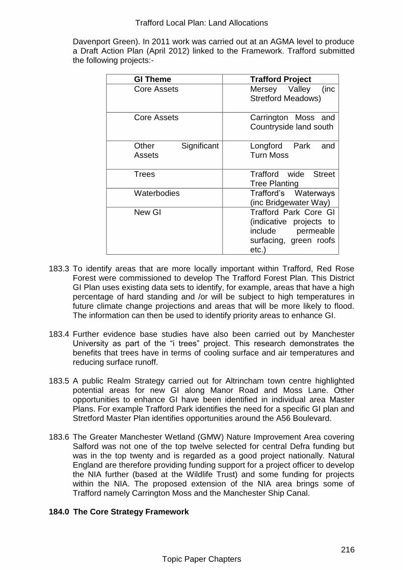
Trafford Local Plan: Land Allocations
216 Topic Paper Chapters
Davenport Green). In 2011 work was carried out at an AGMA level to produce a Draft Action Plan (April 2012) linked to the Framework. Trafford submitted the following projects:-
GI Theme Trafford Project
Core Assets Mersey Valley (inc Stretford Meadows)
Core Assets Carrington Moss and Countryside land south
Other Significant Assets
Longford Park and Turn Moss
Trees Trafford wide Street Tree Planting
Waterbodies Trafford‟s Waterways (inc Bridgewater Way)
New GI Trafford Park Core GI (indicative projects to include permeable surfacing, green roofs etc.)
183.3 To identify areas that are more locally important within Trafford, Red Rose
Forest were commissioned to develop The Trafford Forest Plan. This District GI Plan uses existing data sets to identify, for example, areas that have a high percentage of hard standing and /or will be subject to high temperatures in future climate change projections and areas that will be more likely to flood. The information can then be used to identify priority areas to enhance GI.
183.4 Further evidence base studies have also been carried out by Manchester University as part of the “i trees” project. This research demonstrates the benefits that trees have in terms of cooling surface and air temperatures and reducing surface runoff.
183.5 A public Realm Strategy carried out for Altrincham town centre highlighted potential areas for new GI along Manor Road and Moss Lane. Other opportunities to enhance GI have been identified in individual area Master Plans. For example Trafford Park identifies the need for a specific GI plan and Stretford Master Plan identifies opportunities around the A56 Boulevard.
183.6 The Greater Manchester Wetland (GMW) Nature Improvement Area covering Salford was not one of the top twelve selected for central Defra funding but was in the top twenty and is regarded as a good project nationally. Natural England are therefore providing funding support for a project officer to develop the NIA further (based at the Wildlife Trust) and some funding for projects within the NIA. The proposed extension of the NIA area brings some of Trafford namely Carrington Moss and the Manchester Ship Canal.
184.0 The Core Strategy Framework
Trafford Local Plan: Land Allocations
217 Topic Paper Chapters
184.1 Policy R3 - Green Infrastructure sets out the Council‟s intention to work with partners to develop an integrated network of high quality and multi–functional GI and will seek appropriate contributions towards this from new development. The policy also promotes Stretford Meadows, which is a former landfill site located in the Mersey Valley, as a woodland/ meadow recreation area.
185.0 Opportunities for Change 185.1 Given the definition of GI it would be appropriate to look at carrying forward
UDP allocations that cover larger areas of more informal recreation areas (semi natural green space) and countryside sites in Trafford and rename them as GI sites. This would cover sites in the UDP such as ENV10 Wildlife Corridors, OSR13 Sale Water Park, ENV32 – countryside sites for reclamation in OSR 12 , Wellacre, Altrincham Sewage Works, land adjacent to Broadway( including disused railway land) land NE of Partington, The Mersey Valley (Urmston Meadows, Stretford Meadows etc) and land at Roaring Gate Lane (Davenport Green). It could also cover OSR 11 sites as although golf courses are a sports facility, they fulfil a key GI role linking green space together and providing important biodiversity and access functions.
185.2 The land identified and protected as protected linear land and wildlife corridor in the UDP could also be renamed as GI. However land protected under UDP OSR 6 as protected linear land has a role in contributing to the supply of recreational open space to meet standards in R5. Therefore it would be appropriate to allocated this land as protected open space in addition to it being identified as GI. Land that is not presently protected or identified as GI but is adjacent to, within a certain buffer distance from, or is located between large areas of existing GI (i.e. a gap in the network) could be identified as potential land for GI enhancement i.e. GI opportunity areas. Research carried out by Manchester University on the heat urban effect and the “i” trees project on the benefits of trees to combat climate change, supports extending and enhancing GI. Work carried out as part of the GM Surface Water Management Plan 2012/13 has identified areas more at risk from surface water flooding. This would also support GI enhancements that could assist in alleviating flooding issues.
185.3 The Red Rose Forest have worked with the Council to map the following areas where GI interventions will have maximum impact and add the most value in terms of existing biodiversity and climate change issues:-
Areas with high levels of hard surface area which are more likely to be effected by increases in temperature,
Areas in flood zones 2 and 3, as identified on the latest Environment Agency mapping, and/or areas projected to be affected by surface water flooding,
Part of the active travel network of cycleways and footpaths,
Existing sites of local wildlife and biological interest or sites adjacent to these.
185.4 These maps are included in the Appendix. However further work on
combining this information into 1 map and finalising an effective and clear way to display this on the Policies Map is on-going and will be available in a further iteration of the Land Allocations Plan. Its purpose would be to highlight the
Trafford Local Plan: Land Allocations
218 Topic Paper Chapters
areas where opportunities for enhanced GI would be desirable. These areas
maybe around existing buildings, open spaces or land identified for new
development but where a GI intervention would complement rather than conflict with these primary uses. For example cycle/footpaths linking to the existing GI, more tree planting or habitat diversity, green roofs to provide stepping stones for bird species, permeable paving and SUDS to mitigate potential surface and river flooding.
185.5 The Council already seeks enhanced landscapes often in the form of trees as part of its planning obligations SPD1 linked to Core Strategy Policy L8 and R5. It would be appropriate to provide more guidance within a development management policy in the Land Allocations Plan in light of the above research and evidence. This could broaden the types of interventions appropriate from trees to wildlife meadows, green roofs etc.
185.6 In addition to these specific improvements that will mitigate the impact of individual developments a policy to identify large opportunity areas is also proposed. More specific strategic opportunity areas are set out in the Environment Topic paper for 3 large areas in Trafford that were designated by the Ecology Unit as Biodiversity Opportunity Areas in the GM Ecological Framework. In these areas GI interventions could be more significant and have wider benefits.
185.7 Areas allocated for major development such as the Strategic Locations and areas of change such as Altrincham Town Centre, more specifically the area east of the railway tracks, will have opportunities for enhancing GI.
185.8 Natural England commented on the “Shaping the Plan” document that one important function of GI is the provision of new opportunities for access to open space. They also stated Natural England's "standards for accessible natural greenspace" (ANGSt) should be used to ensure new and existing housing has appropriate access to nature and that "Nature Nearby, Accessible Greenspace Guidance" (March 2010) provides useful information on this matter. Green Infrastructure (GI) should be an integral part of the creation of sustainable communities. They also said the SHLAA process can provide a useful starting point to consider GI provision and the allocation of new housing sites and policy development through the Local Plan. CABE Space Guidelines "Start with the Park" (2005) outlines the importance of planning around greenspaces, with consideration being given to the context of local landscape character and contribution to the wider GI network. The provision of new GI should be considered at an early stage to ensure it is deliverable at plan stage.
185.9 These comments promote an approach that is in accordance with Trafford‟s Policy on GI in the Core Strategy where standards have been introduced for semi natural greenspace in R5 for new development. The Land Allocations Plan could expand this further through policies to identify more specific GI needs to support new housing allocations. Allotments
185.10 The UDP policy on allotments in ENV10 is still valid. Demand for allotments has increased in recent years and more provision has been made.
Trafford Local Plan: Land Allocations
219 Topic Paper Chapters
Waiting lists are slightly down in 2013 to 566 for the whole borough with the Sale area having the longest waiting list. There are difficulties of funding and maintenance with the provision of new sites for allotments but there are opportunities to provide these in a different way as detailed below.
185.11 Policy opportunities for expanding allotments therefore are that they could be provided within the Strategic Locations, on garden extension land or agricultural land and run as private companies with agreements in place to ensure appropriate community provision.
185.12 New allotment space has also been created at:
Peveril Road, Broadheath – 10 plots
Pickering Lodge, Timperley - 16 plots
Balmoral, Urmston – 31 plots
Moor Nook, Sale – 70 plots
185.13 Therefor it is proposed that by providing a policy in the Land Allocations similar to that in the UDP that protects existing allotments and identifies specific opportunities for new allotments adequate provision to meet present and future needs can be made.
186.0 Developing the Potential Options 186.1 Opportunities to improve GI on the sites identified as protected GI sites are as
follows:-
Wellacre, Flixton - This site has potential for informal recreation within a Community Forest setting, with some provision for agriculture. Enhancements could include habitat creation/management and visitor facilities
Altrincham Sewage Works - The site has the potential to provide active travel routes between Sale West and Carrington
Urmston Meadows (from the M60 to the River Mersey west of Willow Farm) - The Council will continue to protect this existing countryside area for nature conservation and informal recreation, but will encourage the improvement of visitor facilities in the area, such as a landscaped car park, as part of the Community Forest and Mersey Valley
Land adjacent to Broadway (up to and including the disused railway line north east of Partington) - This area has the potential to be enhanced for biodiversity and opened up to provide an open space for the Carrington Strategic Location.
Open land south of the M60 Motorway, Sale - The Council will continue to seek to develop this area primarily for informal recreation and enhanced biodiversity within a Community Forest setting, strengthening multi-user access links to and from the site.
Land west of Roaring Gate Lane, Davenport Green - If the development proposal in Core Strategy Policy W1.9 and R4.4 is implemented, the Council will require that the 99.1 hectares of land surrounding the development site be conserved, enhanced and managed for ecological interest and farming, with limited public access including some recreational use.
Trafford Local Plan: Land Allocations
220 Topic Paper Chapters
Stretford Meadows - As set out in Policy R3.5
Carrington Mosslands - This area has the potential for mossland restoration and creation of footpath and cycle links across the area to link Sale West with Carrington and Partington
Consultation Responses
186.2 A representation was received suggesting Stretford Meadows had the potential for development. However the area is Green Belt and a former landfill, development would not be in line with policy so this is not considered a realistic option.
187.0 Conclusion All the realistic options developed from the information in this topic paper have been subject to independent Sustainability Appraisal (SA). The Sustainability Appraisal Report and associated Appendices contains the detailed results of individual appraisals of all realistic options for policies and sites and sets out the mitigation required to address any negative sustainability impacts. Specific appraisals relevant on this topic paper can be found in section 4.19 and Appendix S of this document. A summary of the SA and the reasons for choosing the preferred option are set out in the Options Appraisal Report. These documents and the information in this topic paper support the individual policies proposed in the Local Plan: Land Allocations Plan draft for consultation. The policies proposed are demonstrated to be sustainable. They will ensure sufficient sports facilities are protected and delivered to meet present and future needs. As set out above alternative options were not considered to be realistic.
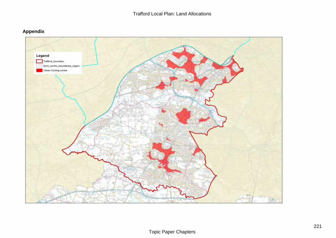
Trafford Local Plan: Land Allocations
221 Topic Paper Chapters
Appendix
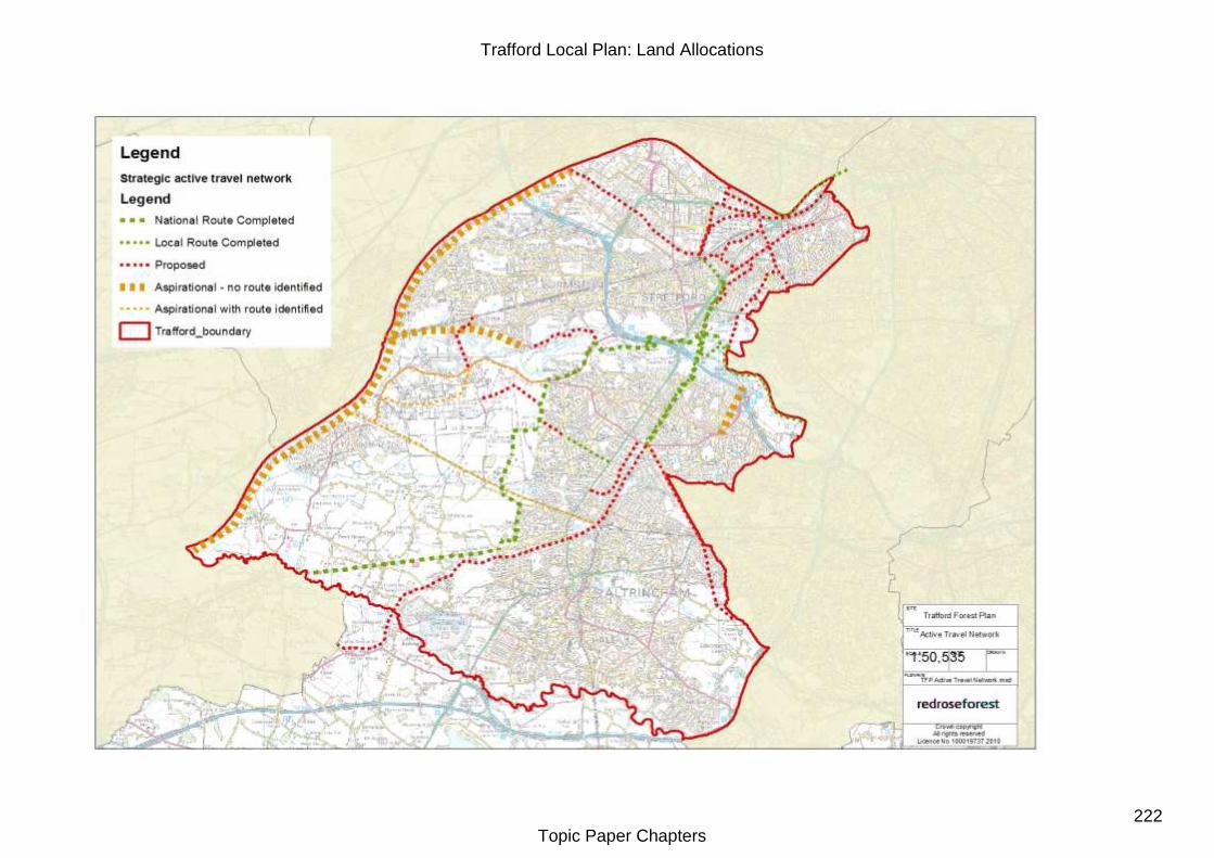
Trafford Local Plan: Land Allocations
222 Topic Paper Chapters
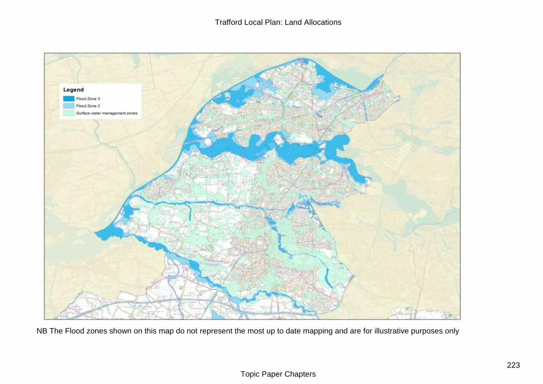
Trafford Local Plan: Land Allocations
223 Topic Paper Chapters
NB The Flood zones shown on this map do not represent the most up to date mapping and are for illustrative purposes only
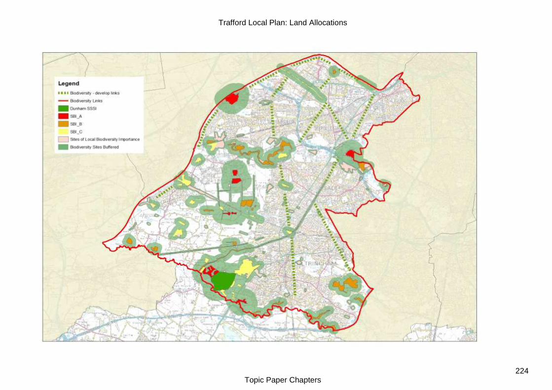
Trafford Local Plan: Land Allocations
224 Topic Paper Chapters
Trafford Local Plan: Land Allocations
Topic Paper Chapters 225
Topic Paper : TP22 - Sport 188.0 UDP Policy Framework 188.1 Policy ORS7 and 8 in the UDP covers Sport. It identifies particular sports
facilities and specific areas for improvement. The majority of these have been completed and will not need to be carried forward in the Land Allocations Plan. The majority of these were improvements to pitch drainage, but also involved the introduction of new all weather pitches, new/ refurbished changing facilities etc.
188.2 Policy OSR 11 promotes the Lesley Road former tip as suitable for a new golf course and sets criteria for other new proposals for golf courses. Demand for golf courses has now been met in Trafford and no new course is foreseen to be needed in the future as there is adequate capacity in the existing clubs. The former tip at Lesley Road (Stretford Meadows) is proposed as an informal recreation site in Policy R3 of the Core Strategy and is covered in the Green Infrastructure topic paper.
188.3 Policy OSR 18 sets criteria for the development of district Outdoor Sports Stadium that has not to date been proposed and is unlikely to be needed within the plan period.
188.4 Policy OSR 19 sets criteria for the development of major indoor sports
facilities in the urban area. This is also not considered to be needed as demand for new facilities has been met within schools and parks as set out below.
189.0 Current Position 189.1 The PPG17 Assessment of Needs Report 2005 concluded Trafford had
sufficient open space to meet its needs. This included sports area. The assessment also consulted many of the boroughs sports groups. In addition an audit of the quantity and quality of the main outdoor sports was carried out – Outdoor Sports facilities study March 2009. The Study identified that quantity of sports provision was met but quality was lacking in a number of areas particularly changing facilities and pitch drainage. Further work on understanding current and future needs for outdoor sports is being done as part of a Trafford Playing Pitch Strategy planned for completion 2013/2014.
189.2 Indoor sports needs were assessed in the Trafford Leisure Management Review 2008. It identified a small deficiency in pay to play provision for swimming pools and health and fitness provision. In addition it identified the public pools in Trafford require investment to ensure they will be fit for purpose in the future. Sports Hall provision has a very small surplus. An assessment of needs for indoor sports is being considered for commission in 2013/2014.
189.3 Sports facilities in the last 10 years have improved and there have been some
impressive new state of the art facilities that provide a very high quality of provision for a variety of sports uses. Trafford have produced a Sport and
Trafford Local Plan: Land Allocations
Topic Paper Chapters 226
Leisure Strategy (2013-17) that will coordinate actions for improvements into the future.
190.0 The Core Strategy Framework 190.1 In order to address deficiencies a standard has been introduced for future
development to contribute to outdoor sport, swimming pools and health and fitness provision. A hierarchy policy establishes the type of facilities for indoor sport that should be established across areas of Trafford. In addition better use needs to be made of existing community and school buildings to increase participation in sport. Changes in Sports Facilities
190.2 As with open space some facilities have only been able to be upgraded by allowing a small part of an area either under used or derelict to be developed for an alternative use. This has allowed funding to be made available to provide improvements to the remaining facilities and in the majority of cases extended use. For example at Moss Road Social Club derelict tennis courts were developed for affordable housing with provision of new public open space and upgraded bowling green facilities made on adjacent space.
190.3 Sometimes different users of open spaces can conflict. For example football pitches can clash with dog walkers. With increasing demands on existing spaces and tight maintenance budgets the need to share resources can go a long way to ensuring areas are used cost effectively and to their maximum in the future . This has been particularly successful in Seymour Park where new facilities have been provided with the Sports Barn which has become a regional facility. Also new facilities at Stretford High School not only provide school pupils with high quality sports facilities but are open to community use out of school hours.
190.4 There has also been an increase in provision of artificial pitches on school sites since the 2009 Outdoor Sports Study, with 6 schools adding pitches at Woodheys Primary, Ashton on Mersey, Sale Grammar, Old Trafford Community School, Stretford High and St Ambrose College. Planning permissions have also being approved for pitches at Wellington School, Timperley and Kings Road School, Stretford. Other applications are also likely in response to funding being made available from Sport England as part of the Olympics legacy. These pitches offer great potential for out of school use by clubs, offering a more local and sustainable way to improve the quality of facilities than converting grassed areas in park areas to artificial surfaces.
190.5 High quality facilities do come at a small cost to the user and although better, some users will still look to the cheapest option i.e. local parks. Care needs to be taken to get a balance of affordable football facilities for different user groups from informal kick about to formal league matches. The Land Allocations Plan could further encourage these types of initiatives by identifying opportunities for shared uses and developing guidelines to ensure sites are zoned appropriately to minimise conflicts of use. However these would need to be flexible to be able to respond to future changing demands e.g. FA introducing changes to junior 5 a side pitch sizes 2014.
Trafford Local Plan: Land Allocations
Topic Paper Chapters 227
190.6 There are no specific proposals identified that would benefit from carrying forward UDP policies OSR18 and OSR 19. The reason being that during the UDP there were no proposals brought forward for this type of Sports Stadium development and there is unlikely to be in the near future due to this type of development being built within Trafford e.g. LCC or outside Trafford to meet demand e.g. Manchester City ( Etihad ) stadium and Salford Reds. In the long term the criteria in these policies is covered in R5, NPPF and any future proposals could be considered under a more general Land Allocations Policy .
190.7 Some sports have seen a decline in the quality of facilities as needs change
and maintenance demands are high. This has particularly affected private bowling facilities and public tennis courts. Bowling has seen a change from casual greens associated with pubs to greens in parks and a few dedicated good quality clubs.
190.8 These improvements and changes in requirements for sports facilities has resulted in some losses or changes in boundaries from those set out in the UDP. These changes will need to be reflected on the Land Allocations Policies Map. The sites affected are:-
Moss Road Social Club, Stretford - changed boundaries
Woodford Road Bowling Green – Area no longer POS
Albert Place bowling Green – part of area no longer POS
Seymour Park Sports Barn - no boundary change
Stretford Trade and Labour Club bowling - Area is now housing and no longer POS
Stretford High School disused Playing Fields – changed boundary ( Tesco)
South Trafford College expansion land – no longer needed for future college needs and permission granted for housing to facilitate college improvements
191.0 Opportunities for Change 191.1 In order to meet the increasing demand for quality facilities against increasing
maintenance budgets and competition for new funding an ongoing programme of improvements across sports facilities will be needed potentially using opportunities relating to economies of scale by prioritising enhancement of larger hub sites and possibly reducing reliance upon single site pitches and smaller facilities. The outcome of the Playing Pitch Strategy will help to inform a more detailed action plan for prioritising enhancements. However this approach must ensure local facilities are maintained to Core Strategy accessibility standards as set out in R5. This may include directing investment towards identified upgrades required ensuring pitches and ancillary facilities are of an appropriate quality and design to improve carrying capacity in serving the current and projected future need / demand requirements of Trafford.
191.2 In protecting existing facilities within a clear hierarchy Trafford will ensure the appropriate distribution of different scales and types of facilities across Trafford to serve and be accessible to local residents. The quality of facilities such as the provision of changing facilities needs to be appropriate to the needs of users on outdoor sports sites to ensure they are used to their full
Trafford Local Plan: Land Allocations
Topic Paper Chapters 228
potential. This will then take pressure away from the more casual use of some pitches e.g. in parks that are not appropriate for the levels of league matches that they are presently used for. In making necessary improvements to the higher tier of facilities it may be necessary to rationalise smaller scale facilities that would be better located or used by more residents as part of a larger more diverse facility. However any rationalisation must be justified with the appropriate assessment of current and future demand to ensure the sports needs of residents are fully satisfied.
191.3 More information on sports use by individual clubs in each sport would be needed to guide upgrades in facilities further, particularly in relation to upgrades that propose a loss of pitch quantity to improve quality e.g. all weather pitches.
191.4 Sport England made comments to the Shaping the Plan consultation in August 2012 stating that if Trafford considered any of its sports facilities surplus to need then this should be backed up by an up to date and robust evidence base. Sport England considers Trafford do not have this comprehensive evidence base in terms of supply and demand from users of both indoor and outdoor sports facilities. More specifically if Trafford were to declare any playing pitches surplus it would need to have an up to date playing pitch strategy. As detailed above this work has now been commissioned.
191.5 Trafford did not receive any representations suggesting any loss of sports facilities in current use but received site allocation suggestions in 2012 for housing on the former Darley tennis club site and the derelict bowling green at Albert Place. However as these sites are under the 0.4 hectares that has been chosen for allocating sites these sites have not been considered for allocation. More information can be found in the Housing topic paper. As a result of the call for sites 2007 a representation also requested a designation of protected open space to the Cavendish Road Sports field and tennis courts used by Bowdon Preparatory School for Girls.
191.6 The following areas allocated for sports use at present that are either derelict or underused due to their poor quality. Opportunities exist to either reallocate these areas to other uses or improve their quality to meet present and future needs.
Overgrown pitches - Manchester Road (Open Space Assessment 2005 reference P42) - protected open space at Carrington ,
Turn Moss – some areas not used as poorly drained
Flixton House, -poor quality football pitch
Derelict bowling green to rear of Royal Ave and Liberal Club, Urmston
Albert Place derelict bowling Green (in Conservation Area), Altrincham
Darley Road tennis Club, Old Trafford
Unused playing pitch areas within schools – e.g. Wellacre Academy spare pitch, Stretford Grammar poorly drained pitch
Opportunities to Improve Sports facilities 191.7 In order to meet the sports facility needs of new development in the Strategic
locations new facilities will need to be provided or nearby existing facilities upgraded or expanded. Opportunities for these that could be explored are:-
Trafford Local Plan: Land Allocations
Topic Paper Chapters 229
Existing pitches or OSR7ii land either under used or not used at present - Manchester Road ( P42) - protected open space at Carrington , poor quality football pitch at Flixton House, land off Broadway ( National grid) Partington
Existing Protected linear space not used at present – Valley Road (next to Flixton FC), land next to Broadheath Primary
School sites with excess playing fields and/or the potential to upgrade facilities for community use are a real opportunity as more funding is available from Sport England to enable these improvements. The challenge for Trafford is to ensure these improvements are in areas where there is most need and where facilities can meet demand most effectively – For example is it more effective to prioritise secondary schools with poor facilities at present, e.g. Stretford Grammar or primary schools? Or prioritise those schemes that would offer the best community use. Broadoak School in Partington could provide more facilities for residential developments in Partington and Carrington. Wellacre Academy has the potential to develop further high quality facilities for wider community use.
New provision within large areas of new development – Pomona, Carrington and Trafford Quays.
Expansion/ adaptation of existing facilities close to areas planned for large housing developments – For example community access to private sports facilities at the Trafford Centre for residents of Trafford Quays e.g. JJB Sports or across into Salford at Salford Reds. Other duty to cooperate opportunities may also exist at Media City to provide facilities for developments at Trafford Wharfside or to improve facilities in Hulme, Manchester for access by residents in old Trafford.
There are also opportunities for new development at Carrington to look at potential access to Manchester City‟s‟ Training Ground when it moves or developing partnership projects with Manchester United.
Cavendish Road playing fields are currently used as Sports fields by the School and as such would be protected under Policy R5 of the Core Strategy. They should therefore be allocated as Protected Open Space in line with other school playing fields.
192.0 Potential Policy Options 192.1 Opportunities for improving quality will not be identified on the policies map to
enable a more flexible approach to be taken in responding to and meeting future demands. It is considered an Action Plan linked to the Sports and Leisure Strategy which is regularly updated is the best place to identify planned improvements. It is proposed the LADPD establishes the above opportunities within policy, protects existing facilities, school playing fields and golf courses and seeks to encourage sports facility hubs across Trafford to ensure equality of accessibility to high quality facilities.
192.2 New or expanded facilities required by major new development will be provided in line with standards in R5.
192.3 Also policy would set out that any future losses of facilities deemed surplus would be evidenced by up to date supply and demand evidence and in the case of playing fields a playing pitch strategy.
Trafford Local Plan: Land Allocations
Topic Paper Chapters 230
193.0 Conclusion
The policy approach has been developed from the information in this topic paper has been subject to independent Sustainability Appraisal (SA). The Sustainability Appraisal Report and associated Appendices contains the detailed results of individual appraisals of all realistic options for policies and sites and sets out the mitigation required to address any negative sustainability impacts. Specific appraisals relevant on this topic paper can be found in section 4.20 and Appendix T of this document. The reasons why there are not considered to be any realistic option are set out in the Options Appraisal Report. These documents and the information in this topic paper support the individual policies proposed in the Local Plan: Land Allocations Plan draft for consultation. The policies proposed are demonstrated to be sustainable. They will ensure sufficient sports facilities are protected and delivered to meet present and future needs. As set out above alternative options were not considered to be realistic.
Trafford Local Plan: Land Allocations
231 Topic Paper Chapters
Topic Paper: TP23 - Open Space and Cemeteries
Trafford residents have access to extensive and varied open space protected by Policy R5 in the Core Strategy and allocations on the UDP proposals map. Several studies have looked at the quantity and quality of this open space and sought the views of local residents in its management. These are detailed below and form the evidence for a Land Allocations Policy. This will replace the UDP open space policies and give more detail to Core Strategy Policy R5.
194.0 Policy Framework 194.1 UDP Policy - The UDP contains policies OSR1-19 of which Policy OSR1,
3, 4 and 9 have been replaced by Core Strategy R5. The majority of the other Policies have been partly replaced by R5 and R3 but require review before being deleted, amended or replaced by the Land Allocations Plan. A couple of policies are covered by L4 and these will be discussed further in the transport paper (OSR 14, 15, 16, 17). This section of the paper covers open space policies OSR 5 – Protection of Open Space and OSR 7 - Improvement and Provision of Informal Recreation and Children‟s Play Space Provision that are proposed for protection on the Policies Map. Open space covered by other OSR Policies is discussed in separate topic papers for Sport and Green Infrastructure.
194.2 Policy OSR5 in the UDP defines the categories of open space and their
function with specific importance attached to Town Parks. 194.3 NPPF Policy - Paragraph 74 states open space should be protected
unless an up to date assessment shows it is surplus to requirements, its loss will be replaced by better provision in a suitable location or its development is for alternative sports or recreational use which outweighs the loss.
195.0 Current Position 195.1 Since UDP Policy was written a PPG 17 Assessment was carried out
“Trafford‟s Green and Open Spaces – An Assessment of Need “(June 2005) which detailed the amount of open space, its quality and how it is used by residents. This concludes generally that Trafford has sufficient open space against national standards and residents consulted felt there were enough green spaces for them to use. However there were deficiencies in some of the more urban areas particularly Old Trafford.
195.2 The study also identified many areas where the quality and quantity of
some facilities was poor. For example, Partington is an area sufficient in open space but its quality is poor. Also the quality and quantity of play areas in some areas was poor.
195.3 The quantity side of the work was updated in 2009 as an evidence base to
set local standards for new development in the Core Strategy. The position
Trafford Local Plan: Land Allocations
232 Topic Paper Chapters
had changed very little from 2005. This section will summarise what has happened since the UDP, including which of and how the sites listed in OSR7 have been improved.
195.4 There will always be a need for alterations to protected open space to
meet changing circumstances, and unidentified needs of the Borough. The aim of planning policy is to ensure that these changes result in an overall net improvement to the quality and use of Trafford‟s open space resource.
195.5 In the last 10 years new public open spaces have been created at:
Timperley Green – Local Park - 2.21 hectares
Stamford Brook – Semi natural green space – 7 hectares
Stretford Marina
Promenade Park (Trafford Wharfside)
Woodhouse Lane, Sale West,
Humphrey Park, Urmston,
Anesbury Avenue, Sale Moor
Cornbrook Park Road, Old Trafford
Stapleford Close, Sale Moor
Shaftesbury Avenue, Timperley 195.6 OSR7 also identified areas where provision and improvements to
children‟s play provision were planned. Most of these were completed and are set out below. However an area was identified as OSR7ii in the Trafford Centre Rectangle area for an interpretation centre. This is now no longer planned and this area will be deleted from any open space use.
195.7 Significant improvements have been made to open spaces and play areas
at:
Woodsend Park, Flixton – skatepark; MUGA; play areas and wildlife garden
Davyhulme Park, Urmston – skate park and play areas
Ashton Park, Sale – MUGA, tennis courts and play areas
Walton Park, Sale – MUGA and play areas
Longford Park, Stretford – play areas, ornamental gardens and footpaths
Victoria Park, Stretford – play areas, tennis courts and sculpture garden
Lostock Park – skate bowl, play area and mini pitch
Seymour Park, Old Trafford – play areas and MUGAs
Hullard Park, Old Trafford – play areas and infrastructure
Stamford Park, Altrincham – footpaths and play areas
Navigation Rd Park, Altrincham – skate park, play areas and sports facilities
Cross Lane Park, Partington – skate park, MUGA, bmx course and play area
Trafford Local Plan: Land Allocations
233 Topic Paper Chapters
195.8 There has also been some loss of protected open space but this has been
small and not affected the overall quantity of space against standards needed. However these small losses have often been in areas where the space is of a poor quality and poorly used. Developing part of the space has enabled improvements in the quality of facilities, either on remaining areas of open space or adjoining areas. Specific sites where this has been achieved or is planned are ;- Beech Ave Playing Fields, Timperley - loss of derelict bowling green and former play area to provide affordable housing, compensated by a commuted sum for a new play area.
Stokoe Avenue - loss of some open space for affordable housing, community building and rowing club, mitigated by improvements to remaining open space and enhanced canal side public realm
Partington Canal side - loss of unmaintained linear open space for housing, compensated by provision of multi use „green loop‟ around Partington, linking greenspaces
Land to north of Bowdon Cricket, Hockey and Squash Club (New car parking for improved sports club facilities nearby will result in a reduction in size of an area of unmaintained open space but allow improvements to the quality of the remaining part and improved off road pedestrian links e.g. to local primary school)
195.9 These changes will need to be reflected in Land Allocations Plan and
Policies Map where planning permissions have been implemented. Proposals for planned changes to protected open space will be set out below with justification and consideration of options, (where realistic).
196.0 The Core Strategy Framework 196.1 Policy R5 states the Council will address key areas of quality and quantity
of open space by adoption of standards and actions. The policy will protect existing open space, secure a hierarchy of greenspace serving local communities, protect a network of appropriately located children‟s play spaces and also secure provision of cemetery space. To meet this policy, the key issues for the Land Allocations to cover are:
To identify, map and define the boundaries of existing open spaces that need protection.
To give policy guidance on the quality and facilities these open spaces should contain.
To identify potential new areas of open space
To identify different open space categories to specify a particular open space function e.g. allotments, cemeteries, formal park
To consider a policy where change of use from open space to a development use of all or part of a site in line with Core Strategy Policy R5, i.e. if it is surplus to need, underused and/or of poor
Trafford Local Plan: Land Allocations
234 Topic Paper Chapters
quality and if there will be a net gain in meeting overall open space needs through a land swap or improvements to facilities on the remaining open space.
197.0 The opportunities to improve Open Space and meet future needs 197.1 The Council has produced a Greenspace Strategy (January 2010). This
sets out the way forward for the Council to manage its open spaces and its recommendations and actions need to be reflected in the Core Strategy and Land Allocations Plan.
197.2 As set out in the Greenspace Strategy the Core Strategy seeks to establish
a hierarchy of greenspaces to meet residents‟ needs. This hierarchy is detailed in the Greenspace Strategy, identifying specific parks, associated levels of provision and desired accessibility:-
Park Distance ( m)
Country Park 4000
Borough Park 2000
Town Parks 1000
Neighbourhood Parks 600
Local Park 300
Play space 300
197.3 Each level of greenspace hierarchy has a recommended level of provision
covering features such as toilets, play areas, youth provision, sports pitches/courts and horticulture as set in the table below:-
Country Park Major leisure attraction, varied landscape features e.g. natural/semi natural woodlands and plantations, sites for nature conservation, multi-functional open space and recreational routes. A range of opportunities for cycling, walking, horse riding, play, events, interpretation and visitor facilities. Site based staff present.
Borough Park Large parks of district-wide significance, well located for pedestrian/public transport, with appropriate level of facilities for active and informal recreation e.g. play, sport, gardens, pet‟s corner, interpretation, toilets and events space. Site based staff present.
Town Park Medium/large parks with distinct catchment area linked to townships of Stretford, Sale, Altrincham, Urmston and Partington. Range of facilities including play, sport, gardens, toilets. Site based staff present in most cases.
Neighbourhood Park
Medium sized parks serving the neighbourhood within which they are located, often including features such as play areas, sports facilities and ornamental gardens. Site based staff present in some cases.
Local Park Smaller green spaces located within residential areas, accessible on foot and containing features such as bedding displays, play areas, informal sports facilities, seating and soft landscape/nature areas. Non staffed.
Trafford Local Plan: Land Allocations
235 Topic Paper Chapters
197.4 Policy supporting open spaces on the Land Allocations Plan could detail this provision as minimum facilities that will be expected or sought in each park to the appropriate quality standard. In areas where residents that are not within the stated catchment area of the named parks, there are a number of different approaches available to improve standards in order to address local needs. Sale Water Park and Dunham Park are excluded and dealt with separately below. Residential areas that are outside of the catchment of a local park in the hierarchy exist in the following areas:
Urmston and Davyhulme
Sale West
Timperley
Hale Barns
Bowdon
S Hale
197.5 In addition to the parks and open spaces referred to in the Greenspace Strategy, Dunham Massey (National Trust) and Sale Water Park incorporating Trafford Watersports Centre attract significant numbers of visitors from outside the Trafford area. These sites are likely to be put under more pressure in the future to provide a high quality recreational experience. Both have the potential for designation as Country Parks and will need further investment to sustain them. It is noted that permission has recently been granted for new visitors' facilities at Dunham Massey.
197.6 In addition to current uses at Sale Water Park there is likely to be
increased use and also new opportunities with the planned opening of the metro link line from Manchester to Wythenshawe and the park and ride facility that are adjacent to the east side of the water park. This will enable a large number of visitors to access the site by public transport from densely populated urban housing areas. Thus providing them with a countryside experience and opportunities to access water sports, outdoor sports, outdoor education activities, nature conservation and a variety of opportunities to utilise the greenspace for physical activities such as walking and cycling. Planning for these visitors and facilities will require changes and investment. The site is designated Green Belt and therefore has very limited options for development of its outdoor space. However, improvements to the existing water sports facilities could attract funding. Policy to guide this could be of benefit to the wider park and its visitors. Sale Water Park is also considered to be a key area of green infrastructure and is covered in the GI policy.
197.7 The Land Allocations Plan will also need to consider allocating open space
that is now being used as open space but was not officially allocated in the UDP. This accounts for 1 main site Dainewell Park – allocated as white land but used as a community football pitch, this former playing field of the closed Manor High School was proposed and accepted as a site for designation as a Queen Elizabeth II park as part of the Queens Jubilee celebrations and is now a Neighbourhood Park. This needs to be formally allocated as protected open space.
Trafford Local Plan: Land Allocations
236 Topic Paper Chapters
197.8 New areas of open space will need to be provided in areas where there will
be significant new housing development that is not within the catchment of an accessible existing open space in the park hierarchy. This will be primarily in the Strategic Locations of Pomona, Trafford Quays and Carrington. The scale of development is such that the Core Strategy Policies have identified new open space as a condition of development in line with the standards in R5. The Land Allocation Plan could provide further guidance as to the more specific requirements of these new spaces to fit in with the existing Parks hierarchy and facilities provided.
197.9 Using the standards in R5 and the housing needs requirements in L2 the
amount of open space required for large residential areas can be worked out. An updated residential capacity table has been worked out from data sourced from the 2011 Census. This shows the capacity of 2 and 3 bedroomed houses is slightly down but the capacity of 1 bed properties is slightly up. A capacity for 5 bedroom plus can also now be used.
1 bedroom
1.3 persons
2 bedrooms
1.8 persons
3 bedrooms
2.5 persons
4 bedrooms
3.1 persons
5 bedrooms or more
3.5 persons
Source – 2011 Census
197.10 Using guidance in the Greenspace Strategy more detailed design prescriptions could also be provided:-
197.11 Trafford Quays will deliver 250 houses phase 1, 250 house phase 2 and
550 phase 3. All these houses will generate open space needs for approximately 1,600 residents generating the need for 2 hectares of open space meeting NEAP standard. This should be delivered as a medium sized Neighbourhood Park incorporating a play area, sports facilities and ornamental gardens.
197.12 Carrington 1,500 homes generating the need for 4.8 hectares of open
space. This would best be provided as a Town Park that includes a range of
Trafford Local Plan: Land Allocations
237 Topic Paper Chapters
play, sport, gardens and toilets. With site based staff. In addition 2 small local parks would be needed contain small play area, sports area, seating and soft landscaping.
197.13 Pomona – 1,100 new homes generating the need for 2.5 hectares of open
space 197.14 Wharfside – 900 new homes generating the need for 2.3 hectares of open
space 197.15 LCC – 400 new homes. This area is close to high quality open space at
Gorse Hill Park and opportunities for new open space are likely to be met by existing provision and opportunities for new open space limited. However improvements to the quality of existing and green infrastructure provision should be sought as appropriate as discussed below.
197.16 Additionally these areas offer opportunities in terms of new types of open
space, for example allotments, climate change adaptation and mitigation measures and also creating and strengthening links to and between the wider GI network.
197.17 The following sites are presently allocated for open space but are either
not accessible or used. They could be brought into use or considered for other options e.g. housing or open space with housing. Other potential sites that are open space for sports use are listed separately in the sports section.
The Land off Broadway ( National grid) Partington
Valley Road (next to Flixton FC) - existing Protected linear open space ( OSR6) not used at present –,
Open Space land next to Broadheath Primary, Broadheath
Land locked site to rear of Our Lady of Lordes School, Partington
2 Strips of land bordering the railway at Station Road and Thiremere Avenue, Stretford
Mill Bank Fields - Land locked site behind Partington Housing Association. Used informally by the community as occasional pitches.
Peaks Nook, Carrington
197.18 Defining the potential solutions for addressing the balance of areas sufficient/deficient in quantity of open space, Improving Open Space quality and increasing accessibility
197.19 A In areas of sufficiency or high sufficiency protect and maintain
current greenspace, but in areas of deficiency or areas of major new development look to increase provision where possible by allocating new areas and /or providing access to currently inaccessible open space e.g.
197.20 Expansion of Promenade Park and open space creation at Pomona Island
(falling within the „River Park Quays‟ and „River Park Central‟ zones
Trafford Local Plan: Land Allocations
238 Topic Paper Chapters
respectively within the Irwell River Park plan) to serve new residential development planned for Trafford Wharfside and Pomona. Improvements to meet Neighbourhood Park scale/standard open space within the linear park setting plus outdoor sports provision and allotment space.
Trafford Quays – Trafford Centre Rectangle – Neighbourhood Park standard open space plus allotment provision
Carrington – Town Park standard provision plus two local park scale/standard open spaces and outdoor sports facilities depending on residential layout.
Strategic Green Infrastructure sites such as Stretford Meadows could provide more formal open space functions on parts of the site closest to housing areas through provision of surfaced paths, play area etc.
B Make improvements to existing parks and open space in areas of deficiency by:-
Improve the Local Parks to upgrade facilities and encourage people to travel further distances e.g. upgrade Kingsway Park and Broadway Park from Local to Neighbourhood Park.
Make improvements to Neighbourhood Parks falling below relevant quality standards e.g. Broomwood Park, Gorse Hill Park, Abbotsfield Park
Improving facilities on other open spaces within the areas of deficiency that are either absent from the greenspace hierarchy or fall within a different category than formal parks (e.g. semi natural or linear greenspace). Particular examples are:-, new play provision at Beech Avenue Playing Fields to address deficiency and countryside and urban fringe sites e.g. Wellacre, Priory Gardens, Stretford Meadows and Sale Water Park could potentially accommodate new features and facilities.
C Designate specific sites e.g. Sale Water Park as a Country Park and major hub for recreation alongside a policy that supports and guides appropriate development of facilities and investment to provide for a quality facility suitable for use by large numbers of visitors.
D In areas sufficient in open space look to re allocated under or un used open space to housing but mitigate its loss by using receipts to upgrade existing poor quality facilities. This would only really be an option where there is the control for open space upgrades to be tied into the conditions of development, therefore on larger allocated housing sites only. This option should therefore be considered as part of site allocation options for housing sites if there are insufficient brownfield housing sites. Taking existing unused open space sites out of an open space designation and un allocating them would not be in compliance with Core Strategy Policy R5. However release of these sites to alternative uses can be made in particular circumstances on a case by case basis if the mitigation measures of improving other open spaces out ways the loss. By taking them out of open space protection the control to ensure this mitigation would be lost. This would be the case for Stokoe Avenue where an allocation of housing land on the open space land must be mitigated by improvements to the remaining open space adjacent to the site.
Trafford Local Plan: Land Allocations
239 Topic Paper Chapters
197.21 In terms of realistic policy options for open space it is likely a combination
of the potential solutions listed in A,B and C above would be appropriate in different circumstances and areas of the Borough. Therefore it is appropriate to combine them as one Option. Option D is not considered to be realistic as would not be compliant with Core Strategy R5.
197.22 Cemeteries 197.23 The Core Strategy outlined capacity for cemetery provision as being
adequate for 8 years in Sale and 6 years in Dunham, 2 years in Urmston and 2 years for Stretford. More recent projections adjust these as 10 for Sale 6 for Dunham, 4 for Urmston and 2 for Stretford. However as one site fills up the demand on the others increases thereby reducing their capacity. The Council has responsibility for ensuring adequate burial space for its residents. If this cannot be found within the borough a paid arrangement must be made within another authority. Therefore addition space is needed within the next 15 years.
197.24 Defining the potential policy solutions 197.25 Policy options are therefore new burial provision secured as part of major
new development in the larger strategic locations such as Trafford Quays or Carrington, extensions to existing cemeteries or new provision on other suitable land such as farm land adjacent to Dunham Massey. A proposal for an area of National Trust Land has been identified as suitable for extension of the Dunham Cemetery. This would be multi faith and meet the needs of the whole borough for 40 to 50years.
197.26 Conclusion 197.27 All the realistic options developed from the information in this topic paper
have been subject to independent Sustainability Appraisal (SA). The Sustainability Appraisal Report and associated Appendices contains the detailed results of individual appraisals of all realistic options for policies and sites and sets out the mitigation required to address any negative sustainability impacts. Specific appraisals relevant on this topic paper can be found in section 4.21 and Appendix U of this document. A summary of the SA and the reasons for choosing the preferred option are set out in the Options Appraisal Report. These documents and the information in this topic paper support the individual policies proposed in the Local Plan: Land Allocations Plan draft for consultation.
Trafford Local Plan: Land Allocations
Topic Paper Chapters 240
Topic Paper: TP24 - Green Belt, Countryside and Other Protected Open Land 198.0 UDP Policy Framework 198.1 The Policy in the UDP sets out the extent of the Green Belt in Trafford that is
protected namely in 4 broad areas:-
Land south of Hale and Bowdon in the Bollin Valley,
Land to the west of Bowdon, Broadheath and Sale and East of Carrington, Partington and the Ship Canal,
land along the Mersey Valley running through Trafford from the Ship Canal to the Manchester boundary,
Land along Timperley Brook between Timperley, Hale and Wythenshawe. 198.2 It contains guidance on the limited circumstances for development in the
Green Belt for agriculture, building conversions and recreation. The policy also allocates protected open land south of Partington and south of Shell in Carrington to be developed only to meet exceptional need that cannot be met elsewhere in the borough and that may be required in the future to be allocated for development.
199.0 Current Position 199.1 Over the last 10 years the Green Belt has remained intact although has been
subject to pressure in a number of areas. More specifically this has been for housing development in the Timperley Wedge and inappropriate large scale recreation/ leisure development in the Mersey Valley. The policy has successfully protected land from this development and Trafford continues to have large areas of attractive open countryside areas that enhance Trafford‟s image as a sort after place to live and work.
199.2 Of the 12 UDP Countryside Policies 10 have been completely replace by Policy R4 of the Core Strategy and Policy C4 – Green Belt and Policy C8 Protected Open Land have been partly replaced. The Land Allocation Plan will replace the remainder of these policies by identifying on the Policies Map the areas to be covered by Green Belt and Other Protected Open Land.
199.3 Changes in national policy as a result of NPPF replacing PPG 2 has resulted
in little policy change other than to a few particular circumstances. Development that is not inappropriate in the Green Belt now covers some specific areas. For example NPPF states local transport infrastructure that can demonstrate a requirement for a Green Belt location, development brought forward under a Community Right to Build Order can be appropriate. Also exceptions to construction of new buildings as inappropriate now allows for a replacement of a building provided it is of the same use and not materially larger than the one it replaces.
200.0 The Core Strategy Framework
Trafford Local Plan: Land Allocations
Topic Paper Chapters 241
200.1 Policy R4 of the Core Strategy continues to protect the Green Belt from inappropriate development, sets guidance for agricultural land and carry‟s forward policy for the protection of Other Protected Open Land (POL) for development needs beyond the Plan period. Although the UDP policy considered these areas of protected open land maybe needed beyond 2015 the Core Strategy demonstrated there was sufficient land identified elsewhere to meet housing and employment needs till 2021. The areas of POL south of Partington and Shell sit comfortably with long term sustainable development as they are adjacent to Partington and Carrington. Both these areas are identified in the Core Strategy for considerable regeneration and development in the next 15 years. Therefore by continuing the allocation of this land as protected open land it will reduce the need for the Council to consider alterations to the Green Belt boundary in the future.
200.2 Policy R4 also contains a further policy protection for Countryside land at Davenport Green. This will protect the land as detailed in Appendix 4 of the Core Strategy from development unless there are proposals for development that will deliver an exemplar, very high quality B1 business/ office employment related development that satisfies strict criteria set out in Policy R4.4.
201.0 Opportunities for Change and Representations Received 201.1 Representations were received to the Core Strategy and have again been
repeated in the recent Land Allocations Scoping consultation for the release of land from the Green Belt for housing development. These are dealt with in the Housing Topic Paper.
201.2 A representation was also received suggesting two boundary options for changing the Green Belt boundary. Boundary Option A suggested, the Green Belt boundary should be redefined to locate down Clay lane; thus excluding the eastern element of the parcel of land bordering Ridgeway Road and the A5144 that consists of a predominantly residential element with a clearly defined urban form. This would also release the eastern element of the parcel of land including Bowdon Rugby Club from the Green Belt. A second option was suggested for a boundary change should option A be deemed inappropriate. This Option B suggested the predominantly built up area be removed from the Green Belt.
201.3 Representations have also been received requesting the existing Green Belt
is retained and that the economic and other benefits of the best and most versatile agricultural land should be taken into account. It was also suggested where significant development of agricultural land is demonstrated to be necessary; areas of poorer quality land should be used in preference to that of higher quality (NPPF paragraph 112).
201.4 Comments were also received stating that for the Rural Communities it is proposed that appropriate protection needs to be maintained for the valued environmental assets, including landscape character. It should be noted that there are likely to be modest consequences arising from the National Trust's review of its overall Estate and the need to ensure that farm businesses are viable and important vernacular buildings have a viable future.
Trafford Local Plan: Land Allocations
Topic Paper Chapters 242
201.5 In January 2013, the preferred plans for the second phase of the national High Speed Rail network were announced, see plan below. This announcement detailed the continuation of the High Speed 2 network to the north of England, including a spur to Manchester Piccadilly, via stops at Crewe and Manchester Airport. The Manchester Airport stop is detailed to be located on land within Trafford. HS2
201.6 Two areas of Green Belt are affected by HS2
201.7 The Government has provided an opportunity for HS2 Ltd to engage with local authorities affected by the proposals, along with key environment and heritage organisations. As part of this process the Council will be considering the potential implications associated with the announced route, stations and depots including identifying any necessary mitigation measures. However, until such time that the formal public consultation is announced, it is not appropriate for the Council to reach a formal decision in respect of these matters.
202.0 Conclusion 202.1 The policy approach has been developed from the information in this topic
paper has been subject to independent Sustainability Appraisal (SA). The Sustainability Appraisal Report and associated Appendices contains the detailed results of individual appraisals of all realistic options for policies and sites and sets out the mitigation required to address any negative sustainability impacts. Specific appraisals relevant on this topic paper can be found in section 4.22 and Appendix V of this document. The reasons for setting out why alternatives options are not considered to be realistic are set out in the Options Appraisal Report. These documents and the information in this topic paper support the individual policies proposed in the Local Plan: Land Allocations Plan draft for consultation.