Embed Size (px)
Citation preview

TOWNSHIP OF BLACK RIVER-MATHESON OFFICIAL PLAN AND ZONING BY-LAW REVIEW 2016
FINAL BACKGROUND REPORT July 2016 Matheson
Holtyre Ramore
Val Gagné Shillington
Val Gagné South

Front and back cover photos source: www.blackriver-matheson.com
TOWNSHIP OF BLACK RIVER-MATHESON
OFFICIAL PLAN AND ZONING BY-LAW REVIEW 2016
FINAL BACKGROUND REPORT
July 2016
PREPARED FOR: Township of Black River-Matheson Heather Smith, Clerk-Treasurer P.O. Box 601, 429 Park Lane Matheson, ON P0K 1N0 T: (705) 273-2313 www.blackriver-matheson.com
PREPARED BY: MMM Group Limited, a WSP Company 1145 Hunt Club Road, Suite 300 Ottawa, ON K1V 0Y3 T: (613) 736-7200 www.mmmgrouplimited.com
IN ASSOCIATION WITH: CGIS Spatial Solutions 52 South Street Perth, ON K7H 2G7 T: (613) 368-4321 www.cgis.com


TOWNSHIP OF BLACK RIVER-MATHESON | OFFICIAL PLAN AND ZONING BY-LAW REVIEW
MMM GROUP LIMITED, a WSP Company | Final Background Report | July 2016 i
TABLE OF CONTENTS
1.0 INTRODUCTION............................................................................................. 1
1.1 Community and Aboriginal Engagement ................................................................................ 2
2.0 COMMUNITY OVERVIEW ............................................................................... 2
2.1 Background ............................................................................................................................. 2
2.2 Population ............................................................................................................................... 3
2.3 Land Use .................................................................................................................................. 3
2.4 Transportation ......................................................................................................................... 5
2.5 Economy .................................................................................................................................. 5
2.6 Resources ................................................................................................................................ 6
2.7 Cultural Heritage ...................................................................................................................... 7
2.8 Natural Features ...................................................................................................................... 7
2.9 Community Survey Results ..................................................................................................... 8
3.0 PROVINCINAL PLANNING CONTEXT ............................................................ 10
3.1 Planning Act ........................................................................................................................... 10
3.2 Smart Growth for Our Communities Act, 2015 (Bill 73) ........................................................... 10
3.3 Provincial Policy Statement, 2014 .......................................................................................... 12
3.4 Strong Communities through Affordable Housing Act, 2011 .................................................. 14
3.5 Growth Plan for Northern Ontario, 2011 ................................................................................ 14
3.6 MTO Guidelines ..................................................................................................................... 17
4.0 GROWTH MANAGEMENT ANALYSIS ........................................................... 17
4.1 Methodology ......................................................................................................................... 17
4.2 Household and Population Forecast ....................................................................................... 19
4.3 Residential Land Demand ..................................................................................................... 20
4.4 Existing Residential Land Supply ............................................................................................ 21
4.5 Employment Land Demand ................................................................................................... 21
5.0 EXISTING MUNICIPAL PLANNING DOCUMENTS .......................................... 23
5.1 Black River-Matheson Needs/Gap Analysis (2011) ................................................................. 24
5.2 Township of Black River-Matheson 5-Year Accessibility Plan (2013) ...................................... 25

TOWNSHIP OF BLACK RIVER-MATHESON | OFFICIAL PLAN AND ZONING BY-LAW REVIEW
ii MMM GROUP LIMITED, a WSP Company | Final Background Report | July 2016
5.3 Township of Black River-Matheson Community Profile (June 2013) ....................................... 25
5.4 Situational Analysis for the Township of Black River-Matheson (July 2013) ........................... 26
5.5 A Community Economic Development Strategic Plan (October 2013) .................................. 26
5.6 Township of Black River-Matheson Energy Management Plan (2014-2018) .......................... 28
5.7 Cochrane District Social Services Administration Board 10 Year Housing Plan: A Blueprint for
Sustainability (2014) .............................................................................................................. 28
6.0 AMENDMENTS AND APPROVED POLICIES .................................................. 30
7.0 CONCLUSION ............................................................................................... 32
LIST OF TABLES
Table 1: Uncommitted Reserve Capacities of Water Treatment (WT) and Wastewater Treatment
(WWT) Facilities in the Township ........................................................................................................... 4
Table 2: Vacant Residential and Employment Land Supply ................................................................... 19
Table 3: Residential Land Demand Analysis .......................................................................................... 21
Table 4: Employment Rates ................................................................................................................. 22
Table 5: Status of Community Economic Development Plan Priorities ................................................. 27
Table 6: List of Zoning By-law Amendments since 2010 ....................................................................... 30
APPENDICES Appendix A – Community Survey Results
Appendix B – 2014 Provincial Policy Statement Review Table
Appendix C – MTO Guidelines Review Table
Appendix D – Township of Black River-Matheson Vacant Land Supply Maps

TOWNSHIP OF BLACK RIVER-MATHESON | OFFICIAL PLAN AND ZONING BY-LAW REVIEW
MMM GROUP LIMITED, a WSP Company | Final Background Report | July 2016 1
1.0 INTRODUCTION
The Township of Black River-Matheson is undertaking the legislated review of its Official Plan and
Zoning By-law pursuant to Sections 17, 26 and 34 of the Planning Act, RSO 1990, as amended. The
current Official Plan was adopted in 2007 and approved by the Ministry of Municipal Affairs and
Housing in January 2009. The current Zoning By-law No. 22-2010 was adopted by Township Council
in 2010 and is in effect.
The objective of Official Plan and Zoning By-law reviews are to ensure that the most current
provincial and municipal planning policy objectives are incorporated into municipal planning
documents. Since the approval of the current Official Plan, a new Provincial Policy Statement has
been issued, as well as a provincial Growth Plan for Northern Ontario and other legislative changes
that are described in this report. Through the review process, municipalities can also revise existing
policies to adapt to changes in the local context and achieve the intended planning goals. The review
process also provides an opportunity to incorporate Official Plan Amendments and Zoning By-law
Amendments into the parent documents.
This Background Report has been prepared to provide direction to the Township of Black River-
Matheson’s Official Plan and Zoning By-law review by describing the current community profile,
providing a growth management analysis, and identifying policies and zoning provisions that may be
missing or require updating. The planning horizon for the Official Plan is 20 years (i.e. to the year
2036).
Section 2.0 of this report, provides a community overview of the Township of Black River-Matheson
and its unique urban townsites and land use characteristics. Section 3.0 outlines recent
modifications to key provincial planning documents including relevant legislation, plans, and
guidelines and recent revisions to the Planning Act arising from Bill 73 and the 2014 Provincial Policy
Statement (PPS), with recommended policy changes to be incorporated into the updated Official
Plan and Zoning By-law. Section 4.0 includes a growth management analysis to identify vacant land
and housing requirements to the year 2036. Section 5.0 summarizes other municipal planning
documents that must be considered when updating the Official Plan and Zoning By-law. Finally, this
report contains a table summarizing approved Official Plan and Zoning By-law amendments, which
require consolidation during the Official Plan and Zoning By-law review process.
In addition, four Appendices are included in this report. Appendix A contains the results of the
Community Survey undertaken during the Official Plan review process. Appendices B and C contain a
detailed analysis of the existing Official Plan with reference to the 2014 PPS and relevant Ministry of
Transportation (MTO) guidelines. Appendix D contains vacant land maps prepared to support the
growth management analysis.

TOWNSHIP OF BLACK RIVER-MATHESON | OFFICIAL PLAN AND ZONING BY-LAW REVIEW
2 MMM GROUP LIMITED, a WSP Company | Final Background Report | July 2016
1.1 Community and Aboriginal Engagement
Stakeholder and community engagement is integral to the review process. It is designed to inform,
listen to and engage the community to ensure their input is incorporated into the updated Official
Plan and Zoning By-law.
As part of the community engagement process, a project website was developed and hosted on the
Township’s website, and provides project information, including the Background Report, draft
Official Plan and draft Zoning By-law, as they become available. Project flyers were developed and
distributed in the Township’s quarterly newsletter to advertise Public Open Houses and public
meetings held to provide information and obtain input on relevant issues and on the draft Official
Plan and draft Zoning By-law. A community-wide survey was administered through the Township’s
website, to seek input on community concerns and priorities to be addressed as part of the Official
Plan and Zoning By-law review. Finally, a Special Meeting of Council will be combined with a
Statutory Public Meeting to present the final draft of the Official Plan, and a separate Statutory
Public Meeting will be held to present the final draft of the Zoning By-law. These meetings will
provide an opportunity for members of the public to review and comment on the documents.
As part of the community engagement process, the Township’s Mennonite community, who have
been integral in re-establishing the agricultural community in Black River-Matheson, have been
active in the review process. The Official Plan and Zoning By-law review process also includes
engagement with Wahgoshig First Nation, Nishnawbe Aski Nation, Matachewan First Nation, the
Timmins Métis Council and Métis Nation of Ontario.
2.0 COMMUNITY OVERVIEW
2.1 Background
The Township of Black River-Matheson is located in the Cochrane District in Northeastern Ontario.
The Township is bound by the City of Timmins approximately 65 km to the west, the Town of
Iroquois Falls approximately 35 km to the north, and by unorganized territory to the south and east.
The Township has a land area of 1,163 km2 and consists of four main townsites: Matheson, Ramore,
Holtyre and Val Gagné. Matheson is both the largest townsite and the administrative centre of the
Township at the junction of Trans-Canada Highway #11 and Provincial Highway #101. The rural area
includes the communities of Shillington and Val Gagné South.
The Township’s population has its ancestry from the British Isles, France, other European counties
and the United States, as well as a recent influx of residents of Asian descent. Over 40% of the
Township’s residents are bilingual in English and French. The Wahgoshig First Nation Reserve is
located approximately 40 km east of Matheson with a population of 234.

TOWNSHIP OF BLACK RIVER-MATHESON | OFFICIAL PLAN AND ZONING BY-LAW REVIEW
MMM GROUP LIMITED, a WSP Company | Final Background Report | July 2016 3
The Black River-Matheson Planning Area was originally established in 1973 and consisted of the
Township of Black River-Matheson and the unincorporated Townships of Guibord, McCool, Michaud,
and Munro. The first Official Plan for this Planning Area was approved in 1977. In 2002, the Planning
Area was redefined and the unincorporated Townships were removed. However, in January 2005, a
portion of the geographic Township of Guibord was annexed to the Township of Black River-
Matheson and comprises part of the current Planning Area.
2.2 Population
As in other small Ontario communities, the Township of Black River-Matheson has experienced slight
and steady population decline over the past several years. The Statistics Canada 2011 Census lists
the population of the Township as 2,410, which represents a decrease of 8.0% from the 2006
population of 2,619. According to the Township’s Official Plan, the 2006 populations for each of the
four townsites was as follows: Matheson – 789; Ramore – 248; Val Gagné – 195; and Holtyre – 164.
More recent figures were not available as part of the Community Profile published by Statistics
Canada following the 2011 Census.
In the 2011 Census, 63% of residents (1,525) identified English as their mother tongue, while 32%
(760) identified French. Forty residents identified both English and French as their mother tongues.
43% of residents (1,025) identified as having knowledge of both English and French, which is
significantly higher than the Ontario average of 11%. Non-official languages were identified as the
mother tongues of a further 85 residents and include German, Afrikaans, Chinese, Finnish,
Cantonese, Dutch, Malay, Swahili, and other languages.
Approximately 195 residents identified as Aboriginal in 2011, with 30 residents identifying as First
Nations single identity, and 165 identifying as Métis single identity. Eighty residents identified as
immigrants to Canada.
2.3 Land Use
The Township of Black River-Matheson is comprised of the four urban townsites of Holtyre,
Matheson, Ramore and Val Gagné, which will be referred to as Settlement Areas in the Official Plan
to be consistent with the 2014 PPS. The Township also contains the rural communities of Shillington
and Val Gagné South, and an expansive rural area comprised of all or part of 14 geographic
townships. The four townsites function as service centres, while land in the rural area is
characterized by forested land, agricultural activities, mining activities, resort commercial and
seasonal development on area lakes, and areas which support outdoor recreation, hunting and
fishing. A large part of the rural area is Crown land.
Development is generally directed to the urban townsites where various residential housing types,
public and institutional uses (e.g. schools, places of worship, parks, playgrounds and recreation
facilities, libraries, hospitals and care facilities), commercial uses (e.g. retail, wholesale, offices,

TOWNSHIP OF BLACK RIVER-MATHESON | OFFICIAL PLAN AND ZONING BY-LAW REVIEW
4 MMM GROUP LIMITED, a WSP Company | Final Background Report | July 2016
restaurants, tourist services, hotels, general business activities), and industrial uses (e.g.
warehousing, manufacturing, storage, repair) are available. Designated land uses in the townsites
include Residential Neighbourhood, General Commercial, Industrial, Parks and Open Space, and
Natural Hazard Lands.
Designated land uses beyond the four townsites include Rural Area, Shoreline Area, Human-made
Hazard Lands, Natural Hazard Lands, and Sensitive Areas. While limited residential, commercial and
industrial uses are permitted in the Rural Area, development is primarily intended to be related to
natural resource activities such as forestry, agriculture, mining, aggregate extraction and recreation.
Rural non-farm residential development has developed along area highways and year-round
maintained Township roads. The Mennonite community consists of approximately 60-80 people.
This community has revitalized the agricultural industry in the Township. The majority of their land
holdings have access via year round roads.
Municipal water and wastewater services are available in the four townsite urban areas. Municipal
water services are also available in the rural community of Val Gagné South. The following table
presents the uncommitted reserve capacities of the municipal water and wastewater treatment
facilities in the Township, based on information provided by the Ontario Clean Water Agency.
Table 1: Uncommitted Reserve Capacities of Water Treatment (WT) and Wastewater Treatment (WWT) Facilities in the Township
SERVICE DESIGN CAPACITY CU METRES / DAY % OF TOTAL CAPACITY
Holtyre WT 259 200 75%
Holtyre WWT 227 225 1%
Matheson WT 1710 1310 75%
Matheson WWT 1045 700 45%
Ramore WT 864 779 90%
Ramore WWT 274 87 70%
Val Gagné WT 230 130 45%
Val Gagné WWT 189 111 59%
The Township contains four landfill sites within municipal boundaries, located in Matheson, Ramore,
Val Gagné, and Butler Lake. An additional inactive landfill site is located outside of the Township’s
jurisdiction in Munro, but it is under the Township’s responsibility. The Matheson landfill is at
capacity and is undergoing an environmental screening process for expansion. An Environmental
Screening Report was submitted to the Ministry of the Environmental and Climate Change (MOECC)
in 2016. The Val Gagné landfill also requires expansion, but will be addressed once the
environmental screening project is completed for the Matheson landfill. The Township will be
completing a landfill life expectancy report in fall 2016 on all the other sites.

TOWNSHIP OF BLACK RIVER-MATHESON | OFFICIAL PLAN AND ZONING BY-LAW REVIEW
MMM GROUP LIMITED, a WSP Company | Final Background Report | July 2016 5
The 2011 Census documented 1,040 housing units within the Township, of which 92% (955) were
single-detached dwellings, 6.25% (65) were low rise apartment buildings, 1% (10) were semi-
detached dwellings, and 0.5% (5) were moveable dwellings (e.g. mobile homes).
The Township offers a variety of recreation opportunities, including the Vern Miller Memorial
Community Centre, which contains an indoor rink, fitness centre and community meeting rooms.
Other recreation facilities include outdoor rinks in Holtyre, Ramore and Val Gagné; Val Gagné Ball
Park; playgrounds in Matheson, Holtyre and Ramore; a boat launch in Matheson which provides
access to the Black River water way; the Black River Golf and Country facility; and the Curling Club at
the Floyd Hembruff Civic Centre. The Township also contains five recreational lakes. The Matheson
Rotary Club maintains a 1.75 km long Interpretive Trail which runs along MacDougall Street to
Second Street, down Monahan Road and along the railroad tracks back to MacDougall Street.
World-class snowmobile trails are located throughout the Township.
Other community facilities include two public libraries in Matheson and Ramore and nine places of
worship in Shillington, Holtyre, Ramore, Val Gagné, and Matheson. John H. Kennedy Elementary
School is the only public elementary school in Matheson and École Catholique Ste-Thérèse is the
only French-language Catholic elementary school in Ramore. Nearby public and Catholic high schools
are located outside of the Township in Iroquois Falls and Timmins. Bingham Memorial Hospital is
located in Matheson and includes the Rosedale Center, an extended care facility. The Township also
maintains the Thelma Miles Historical Museum, which represents the history of the Black River-
Matheson communities from 1900 to 1945.
While the Township has land for employment uses, there does not appear to be any large clusters of
industrial/employment parks.
2.4 Transportation
Highway 101 runs west-east through the Township and connects to Iroquois Falls at Highway 11. Bus
service is available in the Township via Ontario Northland, with a bus stop located at Tanny
Convenience Store on McDougall Street in Matheson. Airports are located in Timmins and Rouyn-
Noranda, Quebec. The Township has also initiated a Community Transportation Pilot Program which
offers seniors transportation services from the townsites.
2.5 Economy
The Township of Black River-Matheson has historically relied on mining and forestry as its primary
economic drivers. Traditional industries have also included agriculture, fishing and hunting. The
Township has identified mining and mineral exploration, residential construction, and agriculture as
three main priority industries. In recent years, farming has been revitalized in the Township owing to
the establishment of a Mennonite community, as well as the efforts of the Northeastern Community

TOWNSHIP OF BLACK RIVER-MATHESON | OFFICIAL PLAN AND ZONING BY-LAW REVIEW
6 MMM GROUP LIMITED, a WSP Company | Final Background Report | July 2016
Network in promoting agricultural production and farming in the region. As of 2013, the Mennonite
community has purchased approximately 2,428 ha of land.
In the 2006 Census, the Cochrane District reported a total of 184 farms, with 38% of the total
farmland base used for crop production.
In the 2011 Census, the Township reported a labour force of 2,015 people, a labour force
participation rate of 58.8%, and an unemployment rate of 15.6%. The employment sectors with the
greatest proportion of the labour force include trades, transport and equipment operators and
related occupations (23%); business, finance and administration occupations (14%); sales and
service occupations (13%); management occupations (12%); and occupations in education, law and
social, community and government services (10%). Mining, quarrying, and oil and gas extraction
represents the industry with the highest proportion of employed residents (19%), followed by
construction (9.7%), educational services (9.7%), and health care and social assistance (9.3%).
According to the Township’s 2013 Community Profile, 44% of the labour force living in Black River-
Matheson work outside of the Township, including Timmins, Iroquois Falls and Temiskaming Shores.
Major private employers in the Township include Primero Mining Corporation and Kirkland Lake
Gold, both in the mining sector. Major public employers in the Township include the Bingham
Memorial Hospital, the municipal government, and the two elementary schools.
2.6 Resources
Areas of mineral aggregate potential are identified throughout the Township, with the largest area
covering the geographic townships of Bowman, Playfair and Black.
The Township is located in the Archean Abitibi Greenstone Belt, which is a minerally rich and highly
productive gold and base metal mining region. Large areas of mineral resource potential are
primarily located in the northwest and northeast portions of the Township. The Official Plan
identifies 13 areas of mineral deposits. Five mines in Black River-Matheson yield gold, with
exploration for other minerals underway. Based on information provided by the Ministry of
Northern Development and Mines (MNDM, Northeast Region), the Township contains patented
land, non-patented mining claims, Crown Land, Conservation Reserve and Provincial Park lands and
other withdrawn land. There are approximately 50 known and recorded abandoned mine site
locations.
Based on data from the MNDM’s Metallic Mineral Potential Estimation Tool, lands covering nearly
the entire Township scored a maximum estimate score of 100 and are considered to have high
potential for metallic mineral resources.

TOWNSHIP OF BLACK RIVER-MATHESON | OFFICIAL PLAN AND ZONING BY-LAW REVIEW
MMM GROUP LIMITED, a WSP Company | Final Background Report | July 2016 7
Based on information provided by the Regional Resident Geologist at MNDM Kirkland Lake, the
following recent exploration projects are planned or underway in the Township:
Kirkland Lake Gold Taylor Mine - The mine is expected to go into production in late 2015;
Eastway International Ross Mine – There is a plan to reprocess tailings;
Victoria Gold Mines Golden Arrow Gold Project – A bulk sample was taken from the pit in
2014; and
Primero’s Grey Fox Project – There is a scoping study underway to determine the full value
of the property, scheduled to be completed by the end of 2015. The company is undergoing
the environmental permitting process, with a plan to remove overburden and likely to mine.
2.7 Cultural Heritage
There are currently no buildings in the Township of Black River-Matheson designated under Part IV
of the Ontario Heritage Act.
According to information provided by the Ministry of Tourism, Culture and Sport, there are five
registered archaeological sites located within the Township, two of which are post-contact
Aboriginal cemeteries.
2.8 Natural Features
The Township contains over 150 lakes and rivers within its municipal boundaries. Provincial parks in
the vicinity of the Township but beyond the municipal boundaries include Abitibi de Troyes
Provincial Park, Esker Lakes Provincial Park, Wildgoose Outwash Deposit Provincial Park, Kettle Lakes
Provincial Park, and Thackeray Provincial Nature Reserve.
The Shallow River Poplar Outwash Conservation Reserve (C1611) is located in the northeast corner
of the Township, approximately 10 km northeast of the Matheson townsite, and represents a
development constraint in the Township’s Official Plan. The reserve is a 396 ha parcel of Crown land.
The reserve supports important waterfowl staging areas, early wintering areas for moose and a dike
structure. This reserve cannot be used for commercial forest harvest, mining or hydroelectric power
development.
Information on designated features in the Township was obtained from the Ministry of Natural
Resources and Forestry (MNRF) and Natural Heritage Information Centre database mapping. MNRF
confirmed that the Township contains one Provincially Significant Wetland (PSW) surrounding
Moose Lake, and that the Township does not contain any confirmed significant Areas of Natural and
Scientific Interest (ANSIs) that are not already protected within a park or conservation reserve.
Based on information provided by the MNRF Kirkland Lake District, there are no known occurrences
of recommended significant wildlife habitat within the Township, although most significant wildlife
habitats are not known and are not mapped.
TOWNSHIP OF BLACK RIVER-MATHESON | OFFICIAL PLAN AND ZONING BY-LAW REVIEW
8 MMM GROUP LIMITED, a WSP Company | Final Background Report | July 2016
2.9 Community Survey Results
A Community Survey was conducted via Survey Monkey, in conjunction with the Public Open House
for the Township of Black River-Matheson Draft Official Plan held on September 15, 2015. The
Community Survey focused on gaining community input on the proposed Official Plan Guiding
Principles and Objectives set out in Section 2.2 of the Plan.
A total of eight (8) survey responses were completed online or by hard copy and submitted to the
Township. Of the 8 respondents, 3 were from Matheson, 2 from Shillington, 1 from Ramore, and 2
from the Rural Area. A summary of the completed survey results is included in Appendix A.
The following is a summary of comments received regarding the Principles and their associated
objectives:
Principle 1 – Design for Complete and Healthy Communities
In addition to protecting and providing for recreational features, the Township should
replace the ball diamond in Matheson and include a soccer pitch.
There are no facilities in Matheson for children and youth in the summer since the ball field
was removed by Public Works.
The encouragement of recreational opportunities requires the availability of recreational
facilities.
Swimming lessons in a local lake should be re-introduced, as the Township has not
successfully managed to bus a sufficient number of children to the Iroquois Falls pool.
Hiring of a new Parks and Recreation coordinator may provide opportunities.
Principle 2 – Respect and Recognize Cultural Resources
Suggested that the Township encourage activities involving both the Francophone and
Wahgoshig First Nation communities, including cultural and sporting events.
Suggested a municipally sponsored picnic with events for children.
Suggested the Township’s July 1 Fireworks display event be expanded by organizing a First
Nations Annual Canoe Race at the Black River waterfront.
Suggested that agricultural heritage be prioritized, and that roads should be opened and
maintained for accessibility and future growth.
Suggested creating an Agricultural Special Committee or an Economic Director.
Principle 3 – Protect and Enhance Agricultural Activities
Suggested that the Township review its seasonal and maintained roads policy to provide
improved access to County roads to facilitate the growth and expansion of the Township’s
agricultural industry, considering the recent settlement of Mennonite families and a cash

TOWNSHIP OF BLACK RIVER-MATHESON | OFFICIAL PLAN AND ZONING BY-LAW REVIEW
MMM GROUP LIMITED, a WSP Company | Final Background Report | July 2016 9
cropper, as well as the Ontario Cattlemen’s Association looking to increase the number of
beef cattle farms.
Suggested that the Township and the Chamber of Commerce facilitate more interaction
between local businesses and the farming community through a monthly or bimonthly
meeting to provide opportunities for networking, voicing concerns and visions for the
future, new business ideas, etc.
Expressed concern that other Townships are soliciting the agricultural community’s
attention and that the Township of Black River-Matheson must act to retain the agricultural
community’s interest.
Suggested that multiple dwellings be permitted on a single farm without the need for
severances.
Principle 4 – Encourage Economic Diversification
Suggested the need for Township staff with economic development knowledge and
experience (i.e. Economic Development Officer).
Suggested that the municipal property located on Second Avenue northwest of Techpro that
can be developed as an Industrial Park.
Suggested the Township purchase the former railway station to develop a ‘brownfield’
business location.
Suggested it would be counter-productive to encourage satellites trades facilities within the
District, as Northern College recently opened a new trades center in South Porcupine.
Suggested the Township explore joint business ventures with the Mennonite community to
promote tourism.
Suggested that Northern College should provide agricultural education.
Suggested that the Township needs an aggressive focus on directing and linking economic
opportunities to the community, including a position for a Director of Economic
Development, in order to encourage growth.
Principle 5 – Preserve the Natural Environment
Suggested that energy efficient buildings be encouraged to reduce the Township’s carbon
footprint, help the environment and mitigate global warming.
Suggested that the shoreline of lakes and riverfronts must continue to be protected, but
that shoreline development must be allowed to proceed (e.g. on Elliott Lake) due to the
potential tax benefits to the Townships.
Suggested that the Township must be environmentally responsible but that the Township
should be open to residential shoreline growth and development.
Principle 6 – Promote Community and Aboriginal Engagement
Interested in what joint projects will be initiated to achieve the objectives associated with
this Principle.

TOWNSHIP OF BLACK RIVER-MATHESON | OFFICIAL PLAN AND ZONING BY-LAW REVIEW
10 MMM GROUP LIMITED, a WSP Company | Final Background Report | July 2016
Reiterated the need for an Economic Development Officer.
Suggested that unmaintained roads should be opened for use by the Mennonite
community.
3.0 PROVINCINAL PLANNING CONTEXT
3.1 Planning Act
The Planning Act is the legislation establishing the rules for land use planning in Ontario and
describes how land uses may be controlled in the province’s communities. The Act sets out the legal
requirements regarding planning considerations including:
The requirement to consider provincial interests;
The preparation of official plans and planning policies to guide future development;
The range of tools municipalities may use to facilitate planning;
The regulation and control of land use through zoning by-laws and minor variances;
The rights of local citizens to be notified of planning proposals, to provide input to municipal
council, and to appeal certain decisions to the Ontario Municipal Board (OMB) or municipal
Local Appeal Body, as applicable; and
The requirement for approval authorities or the OMB to have regard for decisions made by
municipal councils and approval authorities on the same planning matters.
3.2 Smart Growth for Our Communities Act, 2015 (Bill 73)
The Smart Growth for Our Communities Act, 2015 (Bill 73), will come into effect on July 1, 2016 and
will result in significant amendments to the Planning Act, along with the Development Charges Act.
The Province is anticipated to issue a series of regulatory amendments, as well as a transition
regulation, on July 1, 2016.
In broad terms, the reforms introduced by Bill 73 are intended to give citizens the opportunity for
greater and more meaningful input in determining how their communities will grow, and to give
municipalities more tools to fund community services and growth.
Bill 73 amends the Planning Act in the following manner:
The Provincial Policy Statement (PPS) is to be reviewed every 10 years instead of every 5
years.
New Official Plans are to be reviewed every 10 years, and then every 5 years thereafter until
the plan is replaced.
TOWNSHIP OF BLACK RIVER-MATHESON | OFFICIAL PLAN AND ZONING BY-LAW REVIEW
MMM GROUP LIMITED, a WSP Company | Final Background Report | July 2016 11
In addition to existing matters of provincial interest, planning decisions must have regard to
the promotion of built form that is i) well designed, ii) encourages a sense of place; and iii)
provides for public spaces that are of high quality, accessible, attractive, vibrant and safe.
Decision makers must now explain what effect, if any, a written or oral submission from the
public relating to a planning matter had on the decision that they made.
Official Plans are now required to contain a description of the measures and procedures for
consulting the public with regard to proposed amendments to Official Plans, proposed
Zoning By-laws and amendments, Plans of Subdivision and proposed Consents.
New requirements have been introduced around managing and reporting on finances for
Section 37 funds.
Enabling payment in lieu of parkland dedication policies now requires municipalities to
prepare a ‘Parks Plan’. The intent is to ensure that municipalities are only accepting cash-in-
lieu if there is no need for additional parkland. In addition, the calculation of the payment is
now based on a ratio of 1 hectare for every 500 dwelling units, rather than 1 hectare for
every 300 dwelling units.
Global appeals of an Official Plan are not permitted. In other words, an entire Official Plan
document cannot be appealed, and appeals must target specific policies.
Appeals of part of an Official Plan in relation to certain specified matters are prohibited.
Prohibited matters include: forecasted population and employment growth as set out in a
Growth Plan.
Decision makers can now employ dispute resolution techniques in the event of an appeal.
Municipalities are entitled to an additional 60 days to engage in alternative dispute
resolution to resolve appeals prior to forwarding the matter to the Ontario Municipal Board
(OMB).
The OMB is now required to ‘have regard to’ information and material the municipal Council
or authority received in relation to a matter under consideration. This applies to appeals in
which an approval authority failed to make a decision within the specified timeframe under
the Planning Act.
The 180-day period to give Notice of a Decision with respect to an Official Plan or
amendment to an Official Plan can be extended by up to 90 days. In the case of an
amendment request under Section 22 of the Planning Act, the person or public body that
made the request may extend the period by written notice to the approval authority. In all
other cases, the municipality or the approval authority may extend the period by written
notice. Notice must be given prior to the expiry of the 180-day period, and only one (1)
extension is permitted. Additionally, the extension may be terminated at any time by
another written notice issued by the party who issued or received the notice of extension.

TOWNSHIP OF BLACK RIVER-MATHESON | OFFICIAL PLAN AND ZONING BY-LAW REVIEW
12 MMM GROUP LIMITED, a WSP Company | Final Background Report | July 2016
After an appellant files an appeal of a plan where the approval authority fails to make a
decision within 180 days (or as may be extended), the approval authority may give a notice
requiring those who wish to appeal to do so within 20 days of the notice.
New restrictions have been introduced in regard to amending a new Official Plan or a new
Comprehensive Zoning By-law for two (2) years after approval. Applicants must receive
Council’s consent to make an application. Council can pass a resolution to allow applicants
or a class of applicants to make amendments.
Similar to the restriction above, there are restrictions on further applications for Minor
Variances to any land, building or structure for two (2) years after a previous Minor Variance
was approved, unless a Council declares by resolution that an application can proceed.
Further, municipalities can now pass by-laws that outline additional criteria for approving
minor variances, beyond the four (4) tests of the Planning Act. Similarly, the Province can
prescribe criteria through regulations.
A Council may pass a Development Permit By-law to restrict persons from applying to
amend the relevant Official Plan policies or Development Permit By-law within five years of
the by-law being passed. However, Council can override this restriction.
The updated Official Plan for the Township of Black River-Matheson will contemplate and reflect the
new Provincial direction in a locally appropriate manner in so far as:
Official Plan reviews;
Matters of provincial interest;
Consultation and public input on planning applications;
Restriction of certain development applications within specific timeframes of Official Plan
and Zoning By-law approvals;
Official Plan appeals and the timing thereof; and
Development Permit Systems.
3.3 Provincial Policy Statement, 2014
Under Section 3 of the Planning Act, the Province may issue policy statements on matters related to
planning that are of provincial interest. The most recent Provincial Policy Statement (PPS) came into
effect on April 30, 2014 and provides policy direction on matters of provincial interest relevant to
land use planning and development.
The PPS provides for appropriate development while protecting resources of provincial interest,
public health and safety, and the quality of the natural and built environment. Section 3 of the
Planning Act stipulates that decisions affecting planning matters “shall be consistent with” the PPS.

TOWNSHIP OF BLACK RIVER-MATHESON | OFFICIAL PLAN AND ZONING BY-LAW REVIEW
MMM GROUP LIMITED, a WSP Company | Final Background Report | July 2016 13
The Township’s Official Plan policies need to be consistent with the PPS. The new PPS includes
significant changes that:
Promote integrated planning processes and coordination between municipalities and other
agencies and levels of government;
Recognize additional elements of healthy communities, such as community design and
planning for all ages;
Add a new rural policy section to support healthy, integrated, and viable rural areas;
Enhance protection for major industries and facilities from new and incompatible uses and
support long-term planning for employment areas;
Require new development on private servicing to demonstrate that it will not negatively
impact surface and ground water;
Encourage green infrastructure and strengthens stormwater management requirements;
Strengthen protection of agriculture from impacts of non-farm development; and
Promote the consideration of Aboriginal interests in planning.
The PPS is divided into three sections:
1) Building Strong Healthy Communities;
2) Wise Use and Management of Resources; and
3) Protecting Public Health and Safety.
The PPS generally focuses growth and development within urban and rural settlement areas, while
supporting the viability of rural areas. It supports efficient development patterns to optimize the use
of land, resources and public investment in public service facilities and infrastructure. These patterns
promote a mix of housing (including affordable housing), employment, recreation, parks and open
spaces, and transportation choices that increase the use of active transportation and transit before
other modes of travel. They also promote strong, liveable and healthy communities that encourage
and enhance human health and social well-being, are economically and environmentally sound, and
are resilient to climate change.
The PPS also recognizes that the wise use and management of Ontario’s natural heritage, water,
agricultural, mineral, cultural heritage, and archaeological resources over the long term is a key
provincial interest. These resources must be managed sustainably to conserve biodiversity, protect
essential ecological processes, provide for food and material production, minimize environmental
and social impacts, and meet long-term population needs.
Finally the PPS aims to protect the health and safety of the population by directing development
away from areas of natural and human-made hazards. This preventative approach also supports
provincial and municipal financial well-being and minimizes cost, risk, and social disruption.

TOWNSHIP OF BLACK RIVER-MATHESON | OFFICIAL PLAN AND ZONING BY-LAW REVIEW
14 MMM GROUP LIMITED, a WSP Company | Final Background Report | July 2016
A detailed analysis of the new 2014 PPS policies that are relevant to the Township’s Official Plan is
included in Appendix B. These policies will be considered and shall be implemented through revised
provisions in the Zoning By-law, as appropriate.
3.4 Strong Communities through Affordable Housing Act, 2011
Through the Strong Communities through Affordable Housing Act, 2011, which took effect on
January 1, 2012, several sections of the Planning Act were amended to strengthen municipal-level
provisions for affordable housing. The Act’s main policies include:
Requiring municipalities to set official plan policies and zoning by-law provisions to permit
second units in detached, semi-detached and row houses, and in ancillary structures;
Eliminating the ability to appeal the establishment of these policies and provisions, except
when they are included in five-year legislated official plan updates; and
Granting authority to the Minister of Municipal Affairs and Housing to create standards
regarding second units.
Second units are self-contained residential units that include kitchen and bathroom facilities, and
include accessory or basement apartments, secondary suites, in-law flats, and garden suites
contained within a separate garage structure.
The current Township Official Plan does not currently include policies permitting second units as a
generally permitted use. However, a Zoning By-law Amendment was adopted in 2014 to permit
Doddy houses as an accessory single residential dwelling attached by an enclosed walkway to a
permitted detached residential dwelling throughout the Township in the Rural zone. To address the
intent of this Act, it is recommended that the Official Plan be revised to include provisions regarding
second units and garden suites, as well as related provisions regarding Doddy houses.
3.5 Growth Plan for Northern Ontario, 2011
The Growth Plan for Northern Ontario is a 25-year plan that came into effect in 2011, subsequent to
the Township’s most recent Official Plan. This Growth Plan was prepared under Ontario’s Places to
Grow Act (2005), which provides that the Province may identify and designate areas for which
strategic growth plans can be developed. The Growth Plan focuses on attracting and sustaining
growth in north communities, and is intended to be used a strategic framework that will guide
decision-making in Northern Ontario for the next 25 years.
The Growth Plan is structured around six key policy areas which contribute to the region’s long-term
sustainability and prosperity: Economy; People; Communities; Aboriginal Peoples; Infrastructure;
and Environment. The Growth Plan is focused on the following six key guiding principles:

TOWNSHIP OF BLACK RIVER-MATHESON | OFFICIAL PLAN AND ZONING BY-LAW REVIEW
MMM GROUP LIMITED, a WSP Company | Final Background Report | July 2016 15
1) Creating a highly productive region, with a diverse, globally competitive economy that offers
a range of career opportunities for all residents.
2) Developing a highly educated and skilled workforce to support an evolving knowledge-based
economy and excellence in the trades.
3) Partnering with Aboriginal peoples to increase educational and employment opportunities.
4) Delivering a complete network of transportation, energy, communications, social and
learning infrastructure to support strong, vibrant communities.
5) Demonstrating leadership in sustainable growth and environmental management.
6) Establishing innovative partnerships to maximize resources and ensure this Plan achieves its
ambitious vision and is fiscally sustainable.
Economy
The Plan supports the development of a strong, resilient and more diversified northern economy
through policies which are intended to support growth and diversity in the region’s traditional
resource-based industries, as well as the development of new and emerging economic sectors that
have the greatest potential to result in job growth and opportunities in the North. Economic
development strategies will focus on existing and emerging priority sectors, including:
Advanced manufacturing;
Agriculture, aquaculture and food processing;
Arts, culture and creative industries;
Digital economy;
Forestry and value-added forestry-related industries;
Health sciences;
Minerals sector and mining supply and services;
Renewable energy and services;
Tourism;
Transportation, aviation and aerospace; and
Water technology and services.
People
The Growth Plan identifies people as Northern Ontario’s most important resource, and focuses on
supporting under-represented groups such as youth, displaced workers, Francophones, Aboriginal
peoples, newcomers and persons with disabilities. The policies of the Plan are intended to create
new opportunities for all residents to contribute to their communities, including increased
accessibility and relevance of education and training and access to health care services.
Communities
The policies of the Growth Plan support community planning that balances the priorities of human,
economic, and environmental health. Official Plans, community economic plans and participating in

TOWNSHIP OF BLACK RIVER-MATHESON | OFFICIAL PLAN AND ZONING BY-LAW REVIEW
16 MMM GROUP LIMITED, a WSP Company | Final Background Report | July 2016
community planning efforts are identified as effective tools to ensure the future economy and long-
term sustainability of communities reflects the views of citizens and businesses. Municipalities are
encouraged to align their Official Plans with strategies which focus on achieving the following
objectives:
Economic, social and environmental sustainability;
Accommodation of the diverse needs of all residents, now and in the future;
Optimized use of existing infrastructure;
A high quality of place; and
A vibrant, welcoming and inclusive community identity that builds on unique local features
(Policy 4.2.1).
Aboriginal Peoples
The Growth Plan recognizes the unique role of Aboriginal peoples in the development of the region,
and seeks to involve Aboriginal communities and organizations in economic development and to
improve the capacity of these communities to participate in economic development planning. The
Growth Plan encourages Aboriginal participation and knowledge-sharing in existing land use
planning and policy processes (Policy 7.5.1).
Infrastructure
The Growth Plan supports efficient and modern infrastructure as being critical to the future of
Northern Ontario. The Plan requires that infrastructure planning, land use planning and
infrastructure investments are coordinated (Policy 5.2.1), and emphasizes optimizing the
transportation system, increasing access to education and training, investing in information and
communications technology, maintaining the reliability of energy transmission and distribution
systems, and accommodating renewable energy generation. The Plan also requires that
infrastructure planning and investments contribute to a culture of conservation by utilizing
approaches and technologies that reduce energy and water use, increase efficiencies, and promote
intensification and brownfield site redevelopment, whenever feasible (Policy 5.2.4.).
Environment
The Growth Plan supports the sustainable development of natural resources with a balanced
approach to environment, social and economic health, and recognizes the need for climate change
mitigation and adaptation, which is of particular importance to the North. The Plan also reflects the
values and benefits that the natural environment in the North provides to people, the Northern
economy and the province. Policies include protecting surface water features and groundwater
features (Policy 6.3.2); incorporating climate change mitigation and adaptation considerations
(Policy 6.3.3); protecting air quality, water quality and quantity, and natural heritage (Policy 6.3.4);
and fostering a culture of conservation and demonstrating environmental leadership through the
adopting of sustainability practices (Policy 6.4.1).

TOWNSHIP OF BLACK RIVER-MATHESON | OFFICIAL PLAN AND ZONING BY-LAW REVIEW
MMM GROUP LIMITED, a WSP Company | Final Background Report | July 2016 17
3.6 MTO Guidelines
The Ministry of Transportation (MTO) document entitled ‘Guidelines for Municipal Official Plan
Preparation and Review’ is intended to assist municipalities in understanding MTO’s interests in
municipal Official Plans. The document includes recommendations for both general and specific
policies and for mapping. A detailed analysis of the Township Official Plan in the context of these
guidelines is presented in Appendix C.
4.0 GROWTH MANAGEMENT ANALYSIS
As part of the Township’s 5-year comprehensive review process, a growth management analysis is
required to identify the land supply and the potential for residential demand and employment for
the planning horizon to 2036.
McSweeney & Associates prepared a Situational Analysis report for the Township in July 2013. The
Situational Analysis was prepared using the most current data available at the time of the report,
which included data from the 2006 and 2011 Censuses from Statistics Canada and the
Superdemographics 2012 from Manifold Data Mining Inc. The household and population figures are
based on the information provided in McSweeney’s July 2013 report (“McSweeney’s report”). The
growth management analysis relied on the information provided in the McSweeney report.
The result of this analysis will confirm whether there is an adequate land supply to meet the
potential residential and employment demand. If the land supply is not sufficient to accommodate
the demand, then an expansion to the Township’s settlement area boundaries may be required as
part of the 5-year Official Plan review.
4.1 Methodology
Vacant Land Supply
Specifically, the analysis considered vacant lands that are located within the settlement area
boundaries defined as the four urban townsites of Matheson, Ramore, Val Gagne and Holtyre. In
keeping with the 2014 Provincial Policy Statement, the term “settlement area” will be used rather
than “townsite”.
Using the Township’s GIS mapping, Vacant Land Maps found in Appendix D were created by
identifying parcels for residential uses that met the respective minimum lot area requirements
under the corresponding zones. According to the Residential (R1) Zone, the required minimum lot
area is 450 m². The minimum lot area requirement in the Apartment Residential (R2) zone is 900 m².
All vacant lands that are zoned in the Township’s Comprehensive Zoning By-law No. 22-2010 for
employment uses were identified and mapped. The vacant lands results also correspond to the

TOWNSHIP OF BLACK RIVER-MATHESON | OFFICIAL PLAN AND ZONING BY-LAW REVIEW
18 MMM GROUP LIMITED, a WSP Company | Final Background Report | July 2016
MPAC vacant land property data that was provided to the Township as of July 22, 2015. For the
purposes of the analysis, the vacant lands fall into Residential and Employment with the
corresponding zones:
Residential:
o R1 – Residential o R2 – Apartment Residential
Employment:
o C1 – General Commercial o C2 – Highway Commercial o C3 – Tourist Commercial o S1 – Institutional o M1 – General Industrial
The vacant lands form the basis of the available land supply in the Township for the next planning
horizon period of 20 years to 2036.
Analysis of Vacant Land Supply
The analysis of vacant land supply is meant to determine whether the Township has existing,
designated and available residential and employment land to accommodate potential growth within
the existing urban townsites. The information provided below is based on the Vacant Land Maps
(Appendix D) prepared by CGIS in October 2015.
The following table summarizes the amount of vacant land available within each of the four
settlement areas in the Township of Black River-Matheson.

TOWNSHIP OF BLACK RIVER-MATHESON | OFFICIAL PLAN AND ZONING BY-LAW REVIEW
MMM GROUP LIMITED, a WSP Company | Final Background Report | July 2016 19
Table 2: Vacant Residential and Employment Land Supply
SETTLEMENT AREA
LAND ZONED R1
LAND ZONED R2
LAND ZONED C1/C2/C3
LAND ZONED S1
LAND ZONED M1
# of parcels
area # of parcels
area # of parcels
area # of parcels
area # of parcels
area
MATHESON 78 18.30
ha 0 parcels 19 11.21
ha 6 0.90
ha 4 0.50
ha
RAMORE 24 6.14
ha 0 parcels 10 1.46
ha 15 1.11
ha 1 0.01
ha
HOLTYRE 41 4.49
ha 0 parcels 29 1.18
ha 2 0.06
ha 7 0.55
ha
VAL GAGNE 15 6.21
ha 0 parcels 4 0.83
ha 0 0
SUBTOTAL
158 parcels
35.14 ha (87
acres)
0 parcels 62 parcels
14.68 ha (36 acres)
23 parcels
2.07 ha (5 acres)
12 parcels
1.06 ha (2.6 acres)
Total Residential: 158 parcels 35.14 ha (87 acres)
Total Employment: 97 parcels 17.81 ha (44 acres)
Vacant Land Supply Summary
The analysis shows that there are 35.14 hectares of land within the four settlement areas available
for residential uses and 17.81 hectares of land within the four settlement areas available for
employment uses.
4.2 Household and Population Forecast
According to McSweeney’s report, the population from the 2011 Census date was 2,431. The
McSweeney report projected a population of 2,050 to the year 2022. This indicates that the
projected population is anticipated to decrease by 15% over 11 years (2011 to 2022). For the
purpose of this analysis, it is assumed that the 15% population change would continue until the
projected year of 2036. Therefore, the population projection in 2036 would be 1,654.
Based on McSweeney’s report, the number of dwelling units in 2012 was 1,056. Of the total number
of dwelling units, 84.6% owned the dwellings and 15.4% rented the dwellings. This results in a total
of 893 dwelling units which were owned (1,056 x 0.846) and 163 dwelling units which were rented
(1.056 x 0.154).
The breakdown and mix of the 1,056 dwelling units in 2012 was not provided. For the purpose of
this analysis, the breakdown of housing types is based on the 2011 data. The 2011 data showed that
approximately 93.5 % of the existing housing types are considered to be low-density (i.e. single
TOWNSHIP OF BLACK RIVER-MATHESON | OFFICIAL PLAN AND ZONING BY-LAW REVIEW
20 MMM GROUP LIMITED, a WSP Company | Final Background Report | July 2016
detached, semi-detached, mobile homes) and that the balance of 6.5% of the existing housing types
is in the form of apartment dwellings.
The average household size was 2.16 (i.e. persons/household), which is lower than the provincial-
wide average household size of 2.57.
Assuming the average household size of 2.16, and the projected population of 1.654, the potential
demand for dwelling units would be 766 (1654 / 2.16) in the year 2036. Of the 766 dwelling units,
approximately 93.5% of the housing demand is anticipated to be in the form of low-density housing
(i.e. single-detached, semi-detached, duplex), while the remaining 6.5% is forecasted in the form of
medium and high-density housing forms. This would result in 716 units (766 x 0.935) in the form of
low-density housing and 50 units (766 x 0.065) in the form of medium-high density housing.
4.3 Residential Land Demand
In order to meet the projected demand and the requirements for residential lands, a density
calculation is required. A method of calculating densities is to use the minimum lot area from the R1
zone which is 450 m² (0.045 ha) which corresponds to a density of 22 units per net ha (1 hectare
divided by 0.045 ha). This number is intended to represent low density. Another method is to
calculate the average density of low-density single-detached residential areas in a settlement area in
Black River-Matheson to determine the existing density at which these areas have been developed.
For this analysis, seven R1 zoned residential areas in the Matheson settlement area were used as an
example. The average net density was 16 units per net hectare. This represents a more realistic
density for the potential future unit count.
For the density calculation for medium – high density housing forms in the context of Black River-
Matheson, the minimum lot area from the R2 zone was used which is 900 m² (0.089 ha), which
corresponds to a density of 11 units per net ha (1 hectare divided by 0.089 ha).
The actual amount of land required will depend on the housing mix and densities achieved in Black
River-Matheson. The results of this analysis are summarized in the table below.

TOWNSHIP OF BLACK RIVER-MATHESON | OFFICIAL PLAN AND ZONING BY-LAW REVIEW
MMM GROUP LIMITED, a WSP Company | Final Background Report | July 2016 21
Table 3: Residential Land Demand Analysis
HOUSING TYPES HOUSING TYPE PROPORTION
LAND DEMAND
Units Net Density
(u/ha)
Land Requirement
(ha)
LOW DENSITY 93.5% 716 16 44.75
MEDIUM-HIGH DENSITY
6.5% 50 11 4.54
*Net Residential Land Demand 49.29 ha
Gross Residential Land Demand (add 25%) 61.61 ha
*The net area applies a gross-down factor of 25% for roads, parks, etc.
Using the projected housing requirement of 766 units, the projected housing type mix, and the
assumed development densities, it is anticipated that there will be a need for 49.29 net hectares of
land (61.61 gross hectares) for new residential development.
4.4 Existing Residential Land Supply
The existing supply of occupied residential land (i.e. land zoned R1 and R2) is 41.46 net ha (55.28
gross ha). Table 2 illustrates that the vacant residential land supply is 35.14 net ha (87 gross ha).
Therefore the total amount of residential land supply is 76.6 net ha (142.28 gross ha).
Since the population projection is anticipated to decrease from 2,431 to 1,654 and therefore the
number of dwelling units is anticipated to decrease from 1,056 to 766, there will be less demand for
residential land. The current supply of 76.6 net ha (142.28 gross ha) and the projected demand of
49.29 net ha (61.61 gross ha) results in an oversupply of land of 27.31 net ha (80.67 gross ha).
It is important to note that there are additional residential lots which are currently vacant but are
smaller than the required minimum lot area of 450 m² in the R1 zone as per the Township’s Zoning
By-law. As a result, these non-complying lots are not considered part of the vacant land supply
survey.
4.5 Employment Land Demand
According to McSweeney’s report, there were 969 jobs in the Township of Black River-Matheson in
2012. This number has decreased from 1,075 in 2006 and from 1,065 in 2001. The population 15
years and over by labour force activity also declined over these years, as illustrated below. The
population related employment method was used which is employment driven by population
increase/decrease. In the case of the Township, the population is projected to decrease therefore
the number of jobs is projected to decrease.

TOWNSHIP OF BLACK RIVER-MATHESON | OFFICIAL PLAN AND ZONING BY-LAW REVIEW
22 MMM GROUP LIMITED, a WSP Company | Final Background Report | July 2016
An employment rate for the identified years was calculated, which is the employed divided by the
population 15 years and over (i.e. 1065/2240 = 0.475).
Table 4: Employment Rates
YEAR 2001 2006 2012
Pop'n 15 yrs (and over by labour force activity)
2240 2165 2089
Employed (in the labour force) 1065 1075 969
Employment rate 0.475 0.497 0.464
The blended employment rate which is the average of the 3 numbers was calculated to be 0.479
(0.475 + 0.497 + 0.464 /3).
The percentage of the population in the labour force is 86% (labour force in 2012 was 2,089 /
population in 2011 of 2,431 x 100%). The projected population in 2036 is 1,654. Assuming that the
labour force is fairly constant at 86%, the projected population to be in the labour force in 2036
would be 1,422.
Applying the blended employment rate of 0.479 to the projected labour force number of 1,422, the
number of jobs in 2036 would be 681 (1,422 x 0.479). Therefore the employment projection (i.e.
number of jobs) in 2036 is anticipated to decrease by 288 jobs for a total of 681 jobs (969-288).
Employment Density Assumption
To estimate the demand for employment lands, an employment density was used. Employment
density is the number of existing jobs divided by the gross hectare of occupied employment land. In
2012, the number of existing jobs was 969. The gross hectare of occupied employment lands is 49.5
ha (122 acres). This number was calculated based on land zoned C1, C2, C3, M1 and S1. Therefore
the employment density is 19.58 (969 existing jobs / 49.5 occupied land).
The vacant land supply from Table 2 is 17.81 ha. By applying the employment density of 19.58, the
projected number of employees that could be accommodated on the vacant land would be 348
employees (employment density of 19.58 multiplied by vacant employment land of 17.81).
Total Employment Supply
The projected total employment supply is 1,317 (969 in 2012 + 348 in 2036). The residual number
of jobs is 636 (1,317 total employment supply – 681 projected number of jobs in 2036). The residual
employment land supply is 32.48 gross ha (636 / 19.58). Therefore the total amount of employment
land required to meet the projected employment demand to 2036 is 32.48 gross ha.
TOWNSHIP OF BLACK RIVER-MATHESON | OFFICIAL PLAN AND ZONING BY-LAW REVIEW
MMM GROUP LIMITED, a WSP Company | Final Background Report | July 2016 23
There are 49.5 ha of occupied employment land and 17.81 ha of vacant employment land for a total
of 67.31 gross ha for employment uses to the 2036. Since the analysis has shown that 32.48 gross
ha is required to meet the projected employment demand of 681 jobs in 2036, there is a sufficient
supply of employment land.
Summary
In summary, the result of the growth management analysis has a population projection of 1,654 to
the year 2036, which would generate a demand of 766 dwelling units. The results of the vacant
residential land supply analysis indicate that there is sufficient land zoned as R1 and R2 to
accommodate the projected housing unit demand to the year 2036, while leaving some additional
supply if demand increases due to new economic drivers.
The employment projection of 681 jobs to the year 2036 would require 32.48 gross ha of land. The
vacant employment land analysis indicates that there is sufficient land zoned as C1, C2, C3, M1, and
S1 to accommodate the employment projections to the year 2036, while leaving some additional
supply if new businesses are established in the area.
Therefore, no boundary expansion is required to any of the four settlement areas in the Township.
5.0 EXISTING MUNICIPAL PLANNING DOCUMENTS
Numerous documents prepared for and by the Township of Black River-Matheson contain policy
recommendations or conclusions that must be considered and reflected in the Official Plan and
Zoning By-law review. This section summarizes the available studies and identifies the
recommendations to be incorporated into Official Plan policies and to guide revisions or additions to
the Zoning By-law provisions.
The studies are as follows:
Black River-Matheson Needs/Gap Analysis (2011);
Township of Black River-Matheson 5-Year Accessibility Plan (2013);
Township of Black River-Matheson Community Profile (June 2013);
Situational Analysis for the Township of Black River – Matheson (July 2013);
A Community Economic Development Strategic Plan (October 2013);
Township of Black River-Matheson Energy Management Plan (2014-2018); and
Cochrane District Social Services Administration Board 10 Year Housing Plan: A Blueprint for
Sustainability (2014).

TOWNSHIP OF BLACK RIVER-MATHESON | OFFICIAL PLAN AND ZONING BY-LAW REVIEW
24 MMM GROUP LIMITED, a WSP Company | Final Background Report | July 2016
5.1 Black River-Matheson Needs/Gap Analysis (2011)
The purpose of the Black River-Matheson Needs/Gap Analysis, prepared by McSweeney &
Associates in 2011, was to examine the Township’s target industrial sectors to determine barriers to
investment and identify the gap between the Township’s economic vision and its current position. A
Needs/Gap Analysis model was prepared to identify the order of priority of issues affecting the
Township’s competitiveness in its three main industrial sectors of mining and mineral exploration,
residential construction and agricultural production. The model identifies the gaps that need to be
addressed in sequential order to increase the Township’s success with the three priority industrial
sectors, beginning with base resource needs and resource access, to supporting infrastructure,
community support, and finally, regional support.
According to the model results, the following main areas emerged as existing gaps within the
Township:
1) Lack of, or limited, municipality infrastructure, including:
No current supply of ‘shovel-ready’ industrial land;
Very limited supply of available industrial buildings;
Very limited availability and diversity of housing stock;
No ‘shovel-ready’ residential building lots;
Lack of enforcement of property standards;
Unrealistically low housing prices due to poor housing quality affecting the marketing of new
home construction;
Degradation of downtowns/main streets; and
Lack of a high school limiting the number of families willing to relocate or stay in the
Township.
2) Gaps with respect to Investment Readiness and Investment Attraction:
Limited community assets needed to attract and fulfill needs of investment opportunities;
Planning or strategic development gaps, including:
o Housing Demand Analysis;
o Community Strategy;
o Economic Development Website;
o Economic Strategy;
o Quick Facts Brochure;
o A Templated Response for replying to investment inquiries;
o Phase 2 of the Industrial Minerals Feasibility Study;
o Supply and Demand Study for Industrial Land; and
o A Marketing Strategy to showcase the area’s competitive advantages.

TOWNSHIP OF BLACK RIVER-MATHESON | OFFICIAL PLAN AND ZONING BY-LAW REVIEW
MMM GROUP LIMITED, a WSP Company | Final Background Report | July 2016 25
Township Council and Administration may not completely appreciate the benefits and
urgency of collaborating both locally and regionally.
It is apparent that the 2011 Needs/Gap Analysis influenced the development of the Community
Economic Development Strategic Plan in 2013 and the identification of strategic priorities for
implementation over five years to 2018.
5.2 Township of Black River-Matheson 5-Year Accessibility Plan (2013)
The Township’s 5-Year Accessibility Plan identifies various barriers to accessibility affecting Township
organizations and presents strategies for their removal or prevention for implementation. Barriers
identified include:
Architectural and physical barriers at specific locations (e.g. Township Administration Office,
Thelma Miles Museum, Knights of Columbus Pioneer Hall);
Organizational barriers (e.g. Requirements for provincial Accessibility training for staff and
volunteers and for the development, implementation and maintenance of policies governing
how an organization will achieve accessibility);
Technology barriers (e.g. Requirements for organization websites to conform to the World
Wide Web Consortium Web Content Accessibility Guidelines 2.0); and
Information and communication barriers (e.g. Publicly available Emergency Procedures and
Plans).
5.3 Township of Black River-Matheson Community Profile (June 2013)
The Township’s Community Profile (2013) presents an overview of the Township using three major
sources of data, including the 2006 and 2011 Censuses and Superdemographics 2012 from Manifold
Data Mining Inc. While this is not a policy document and does not contain policy recommendations,
the Community Profile contains useful statistics and information regarding the following topics
which have helped to inform this Background Report and the Official Plan Review:
Demographics, including population data, language and mobility characteristics, level of
education and income information;
Labour Force, including occupation, industry, place of work, and general wage information;
Key industries and largest employers;
Transportation facilities;
Taxes and utilities, including property and income tax rates, electricity, natural gas, waste
management, water and sanitary sewer, and communications infrastructure;
Building and development fees;
Business support programs and services; and

TOWNSHIP OF BLACK RIVER-MATHESON | OFFICIAL PLAN AND ZONING BY-LAW REVIEW
26 MMM GROUP LIMITED, a WSP Company | Final Background Report | July 2016
Information related to the quality of life in the Township, including housing characteristics,
health and social services, education, protective services, recreation, tourism and events,
and local media.
5.4 Situational Analysis for the Township of Black River-Matheson (July 2013)
The Situational Analysis for the Township of Black River-Matheson, prepared by McSweeney &
Associates in 2013, presents a statistical analysis of demographic, labour force, and economic
development trends in the Township, as well as population forecasts for the Township and economic
forecasts for Canada and Ontario. The report presents findings from the 2001, 2006, and 2011
Censuses and Superdemographics 2012 from Manifold Data Mining Inc. and provides a statistical
overview of the following data pertaining to the Township:
Population and age structure;
Education levels;
Mobility and commuting trends;
Labour force participation, employment and unemployment rates; industry and
occupations;
Average per capital and household incomes; and
Household and dwelling characteristics.
A summary of these statistics has been incorporated in the Township’s Community Profile (2013)
and has helped to inform this Background Report and the Official Plan Review, including
assumptions and population forecasts required to conduct the growth management analysis.
5.5 A Community Economic Development Strategic Plan (October 2013)
The purpose of the Community Economic Development Strategic Plan, prepared by McSweeney &
Associates in 2013, is to explore opportunities to foster a stronger economy and financial
sustainability, create a more cohesive community, and contribute to improved quality of life in the
Township. The Strategic Plan include an analysis of the Township’s Strengths, Weaknesses,
Opportunities and Threats (SWOT) and identifies a series of strategic directions and actions to be
implemented over the course of five years, with the goal of supporting a more sustainable economy
and stronger local economic development.
The Strategic Plan includes the following Vision Statement, which was prepared to demonstrate
where the Township will focus their efforts to foster positive sustainable economic development
growth:
Through effective and active communication in combination with positive community
building efforts, Black River-Matheson will be a strong, vibrant and united community.
TOWNSHIP OF BLACK RIVER-MATHESON | OFFICIAL PLAN AND ZONING BY-LAW REVIEW
MMM GROUP LIMITED, a WSP Company | Final Background Report | July 2016 27
Residents will be engaged in making their community a better place to live and businesses
will be provided with the opportunity and the environment to grow and thrive.
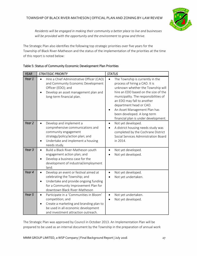
The Strategic Plan also identifies the following top strategic priorities over five years for the
Township of Black River-Matheson and the status of the implementation of the priorities at the time
of this report is noted below:
Table 5: Status of Community Economic Development Plan Priorities
YEAR STRATEGIC PRIORITY STATUS
Year 1 Hire a Chief Administrative Officer (CAO) and Community Economic Development Officer (EDO); and
Develop an asset management plan and long-term financial plan.
The Township is currently in the process of hiring a CAO. It is unknown whether the Township will hire an EDO based on the size of the municipality. The responsibilities of an EDO may fall to another department head or CAO.
An Asset Management Plan has been developed. A long-term financial plan is under development.
Year 2 Develop and implement a comprehensive communications and community engagement strategy/policy/action plan; and
Undertake and implement a housing needs study.
Not yet developed.
A district housing needs study was completed by the Cochrane District Social Services Administration Board in 2014.
Year 3 Build a Black River-Matheson youth engagement action plan; and
Develop a business case for the development of industrial/employment land.
Not yet developed.
Not yet developed.
Year 4 Develop an event or festival aimed at celebrating the Township; and
Undertake and provide ongoing funding for a Community Improvement Plan for downtown Black River-Matheson
Not yet developed.
Not yet undertaken.
Year 5 Participate in a ‘Communities in Bloom’ competition; and
Create a marketing and branding plan to be used in all economic development and investment attraction outreach.
Not yet undertaken.
Not yet developed.
The Strategic Plan was approved by Council in October 2013. An Implementation Plan will be
prepared to be used as an internal document by the Township in the preparation of annual work

TOWNSHIP OF BLACK RIVER-MATHESON | OFFICIAL PLAN AND ZONING BY-LAW REVIEW
28 MMM GROUP LIMITED, a WSP Company | Final Background Report | July 2016
plans and to identify those who will be responsible to lead and support specific actions, the level of
investment required, performance measures and a timeline for delivery.
5.6 Township of Black River-Matheson Energy Management Plan (2014-2018)
The Township of Black River-Matheson Energy Management Plan has been developed to assist the
Township in reducing energy consumption and mitigating energy-related costs across municipal
operations and facilities. The Plan targets reducing electricity consumption by an average of 2% a
year in all municipal operations and investigating energy efficient systems in the rehabilitation and
replacement of municipal facilities.
The Plan summarizes the Township’s current energy consumption and Greenhouse Gas Emissions
(GHG) by facility, identifies the municipality’s aspiration to show leadership in the promotion of
renewable energy systems, and details specific programs, processes and projects aimed at energy
efficiency, such as the installation of motion sensors and water-efficient fixtures. Objectives of the
Plan include:
Creating a culture of conservation within the Township;
Demonstrating sound operating and maintenance practices to enhance implemented
energy efficiencies;
Implementing energy audits at specific municipal facilities over the next five years; and
Exploring new ideas and trends related to energy management.
5.7 Cochrane District Social Services Administration Board 10 Year Housing Plan: A
Blueprint for Sustainability (2014)
The Cochrane District Social Services Administration Board (CDSSAB) prepared a 10 Year Housing
Plan to fulfill the requirement under the Housing Services Act, with the goal of providing a blueprint
to create sustainable communities in the district. The Housing Plan provides recommendations at
the federal, provincial and municipal levels.
The Housing Plan was developed through an analysis of qualitative and quantitative data, as well as
consultations conducted with residents and sector stakeholders in the 11 member municipalities
through focus groups, consultation sessions, social and electronic media, and online surveys. Key
issues identified during the consultations included concerns regarding:
the need for supportive housing for the aging population and the services required to allow
aging-in-place and the prevention of premature entry to long-term care facilities;
the need for supportive housing for persons with mental health or addictions issues, victims
of domestic violence, or those with mobility restrictions;
issues of housing affordability as a result of average market rents being at all-time highs and
vacancy rates at all-time lows in many communities; and

TOWNSHIP OF BLACK RIVER-MATHESON | OFFICIAL PLAN AND ZONING BY-LAW REVIEW
MMM GROUP LIMITED, a WSP Company | Final Background Report | July 2016 29
the impacts of a lack of affordable housing on community economic development.
In the context of the Housing Plan, ‘affordable housing’ is defined as being characterized by any
form of permanent accommodation (e.g. rental, ownership, etc.) where the monthly mortgage or
rent expense does not exceed 30% of gross monthly income; the term ‘affordability’ is not limited to
use in the context of low to moderate income households. ‘Supportive housing’ is defined as
housing that can occur in any accommodation type but is characterized by the services provided to
the tenant to enable them to remain housed in the unit.
Quantitative data analysis was focused on the areas of demographics, economics and housing.
Demographic trends show an aging population, resulting in pressure on support services associated
with care for seniors, as well as a general decline in population for municipalities along Highway 11
and a potential cause-and-effect relationship with the status of economic health in many
communities. The strategy for sustainability includes the CDSSAB assuming the role of service
system manager to address the following key service considerations: declining or stagnant
population; supportive housing; the Aboriginal population; victims of domestic violence; youth;
homelessness; accessibility; and economic trends.
17 recommendations were identified as a result of the Housing Plan, aimed at municipalities,
stakeholder organizations, service providers, and provincial ministries. At the municipal level, the
Plan includes the following recommendations of particular relevance to the planning processes in
the member municipalities:
Member municipalities must take advantage of the opportunities presented by the
Cochrane District Local Housing Corporation (CDHLC) development initiative through formal
communication and including housing services personnel at the local planning level;
Member municipalities should consider opportunities to create affordable housing in the
decision-making process when considering the disposal of public lands, with the
acknowledgement that the CDLHC has the capacity to develop property and generate
revenue to be reinvested in municipalities. Further, municipal planning representatives
should work with CDLHC personnel to develop decision-making criteria to enable the timely
development of affordable housing;
Member municipalities and representatives from local school boards must meet with CDLHC
staff to discuss the creation of a community land trust to optimize development potential
and coordinate public assets;
Municipal councils must commit to using appropriate planning tools wherever possible to
facilitate the creation of affordable housing;
The CDSSAB, CDLHC and all member municipalities should support the recommendations of
‘The State of Homelessness in Canada’ report (2013):

TOWNSHIP OF BLACK RIVER-MATHESON | OFFICIAL PLAN AND ZONING BY-LAW REVIEW
30 MMM GROUP LIMITED, a WSP Company | Final Background Report | July 2016
o Communities should develop and implement clear plans to end homelessness,
supported by all levels of government;
o All levels of government must work to increase the support of affordable housing;
o Communities and all levels of government should embrace ‘Housing First’;
o Eliminating chronic and episodic homelessness should be prioritized;
o Ending Aboriginal homelessness should be prioritized as both a distinct category of
action and part of the overall strategy to end homelessness; and
o Introduce more comprehensive data collection, performance monitoring, analysis
and research.
As most of the CDSSAB member municipalities lack sufficient capacity to provide the economic and
service supports which would be needed to substantiate housing development, the CDSSAC is
currently preparing a District-wide strategy to address secondary market requirements in order to
support initial housing development and long-term sustainability.
6.0 AMENDMENTS AND APPROVED POLICIES
There have been no Official Plan Amendments since the current Official Plan was adopted in 2007.
The following table lists the Zoning By-law Amendments since the adoption of the current Zoning By-
law in 2010, which have not been consolidated and which may need to be addressed in the Official
Plan review. The amendments below will be consolidated during the Zoning By-law review.
Table 6: List of Zoning By-law Amendments since 2010
Title ZONING BY-LAW No. 22-2010
Required Text Change Required Schedule Change
2010 Amendments
By-law No. 32-2010
Amends zone classification from Institutional (S1) zone to Residential (R1) zone for subject property.
Amend from S1 zone to R1 zone on Schedule A.
2011 Amendments
By-law No. 21-2011
Amends zone classification from General Commercial (C1) zone to Highway Commercial (C2) zone for subject property.
Amend from C1 zone to C2 zone on Schedule A.
By-law No. 29-2011
Amends zone classification from Residential (R1) zone to General Commercial (C1) zone for subject property.
Amend from R1 zone to C1 zone on Schedule A.
By-law No. 30-2011
Amends zone classification from Residential (R1) zone to Institutional (S1) zone for subject property.
Amend from R1 zone to S1 zone on Schedule A.

TOWNSHIP OF BLACK RIVER-MATHESON | OFFICIAL PLAN AND ZONING BY-LAW REVIEW
MMM GROUP LIMITED, a WSP Company | Final Background Report | July 2016 31
Title ZONING BY-LAW No. 22-2010
Required Text Change Required Schedule Change
2013 Amendments
By-law No. 2013-25
Amend zone classification from Residential (R1) zone to Special Apartment Residential (R2-3) zone for subject property. New zone provisions for min. lot frontage, min. lot depth, min. front yard setback, min. exterior side yard setback; min. interior side yard setback, min. rear yard setback, max. lot coverage, and max. main buildings per lot.
Amend from R1 zone to R2-3 zone on Schedule A.
By-law No. 2013-32
Amend zone designation from Resident (R1) zone to Special Apartment Residential (R2-4) zone. New zone provisions for permitted uses and min. lot frontage.
Amend from R1 zone to R2-4 zone on Schedule A.
2014 Amendments
By-law No. 2014-05
Amend zone classification from Industrial (M1) zone to Highway Commercial (C2) zone for subject property.
Amend from M1 zone to C2 zone on Schedule A.
By-law No. 2014-21
Amend zone classification from General Commercial (C1) zone to Residential (R1) zone for subject property.
Amend from C1 zone to R1 zone on Schedule A.
By-law No. 2014-22
Amend zone classification from Rural (RU) zone to General Commercial (C1) zone for subject property.
Amend from RU zone to C1 zone.
By-law No. 2014-30
Rural (RU) zone: permits a doddy house or duplex as a permitted use and applies to the whole municipality. Doddy house is defined as an accessory single residential dwelling attached by an enclosed walkway to a permitted detached residential dwelling. Walkway is defined as a covered or roofed pedestrian thoroughfare used to connect two or more buildings.
No amendment to Schedule A required.
2015 Amendments
By-law No. 2015-11
Amend zone classification from Rural (RU) zone to General Commercial (C1) zone for subject property.
Amend from RU zone to C1 zone on Schedule A.
By-law No. 2015-31
Amend zone designation from General Commercial (C1) zone to Residential (R1) zone for subject property.
Amend from C1 zone to R1 zone on Schedule A.

TOWNSHIP OF BLACK RIVER-MATHESON | OFFICIAL PLAN AND ZONING BY-LAW REVIEW
32 MMM GROUP LIMITED, a WSP Company | Final Background Report | July 2016
Title ZONING BY-LAW No. 22-2010
Required Text Change Required Schedule Change
By-law No. 2015-32
Amend zone designation from Industrial (M1) zone to Special Highway Commercial (C2-1) zone for subject property. New zone provisions for permitted uses.
Amend from M1 zone to C2-1 zone on Schedule A.
By-law No. 2015-35
Amend zone designation from Rural (RU) zone to Institutional (S1) zone for subject property.
Amend from RU zone to S1 zone on Schedule A.
By-law No. 2015-36
Amend zone designation from Rural (RU) zone to Institutional (S1) zone for subject property.
Amend from RU zone to S1 zone on Schedule A.
By-law No. 2015-40
Amend zone designation from Industrial (M1) zone to Highway Commercial (C2) zone for subject property.
Amend from M1 zone to C2 zone on Schedule A.
7.0 CONCLUSION
This Background Report is intended to provide background information and to guide the review of
the Township of Black River-Matheson Official Plan and Zoning By-law. It contains several
recommendations regarding policies and provisions that may currently be missing or require
updating based on the 2014 Provincial Policy Statement, and other relevant municipal or agency
policies. It also includes a growth management analysis for the Township which concludes that,
overall, the Township contains a sufficient supply of vacant residential and employment lands to
accommodate projected future growth. The Zoning By-law review will consider these policy changes
and be updated to implement the policies and reflect current best practices for development.

TOWNSHIP OF BLACK RIVER-MATHESON | OFFICIAL PLAN AND ZONING BY-LAW REVIEW
MMM GROUP LIMITED, a WSP Company | Final Background Report | July 2016 A-1
APPENDIX A – Community Survey Results

TOWNSHIP OF BLACK RIVER-MATHESON | OFFICIAL PLAN AND ZONING BY-LAW REVIEW
A-2 MMM GROUP LIMITED, a WSP Company | Final Background Report | July 2016

TOWNSHIP OF BLACK RIVER-MATHESON | OFFICIAL PLAN AND ZONING BY-LAW REVIEW
MMM GROUP LIMITED, a WSP Company | Final Background Report | July 2016 A-3

TOWNSHIP OF BLACK RIVER-MATHESON | OFFICIAL PLAN AND ZONING BY-LAW REVIEW
A-4 MMM GROUP LIMITED, a WSP Company | Final Background Report | July 2016

TOWNSHIP OF BLACK RIVER-MATHESON | OFFICIAL PLAN AND ZONING BY-LAW REVIEW
MMM GROUP LIMITED, a WSP Company | Final Background Report | July 2016 A-5
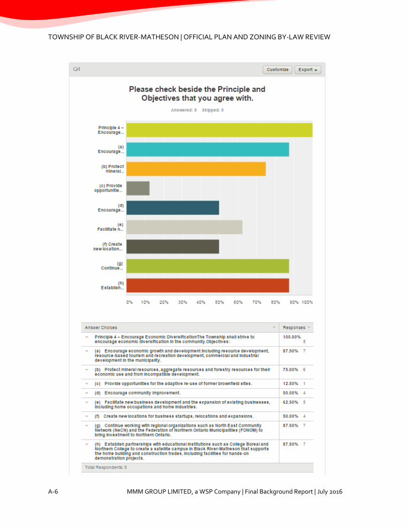
TOWNSHIP OF BLACK RIVER-MATHESON | OFFICIAL PLAN AND ZONING BY-LAW REVIEW
A-6 MMM GROUP LIMITED, a WSP Company | Final Background Report | July 2016

TOWNSHIP OF BLACK RIVER-MATHESON | OFFICIAL PLAN AND ZONING BY-LAW REVIEW
MMM GROUP LIMITED, a WSP Company | Final Background Report | July 2016 A-7

TOWNSHIP OF BLACK RIVER-MATHESON | OFFICIAL PLAN AND ZONING BY-LAW REVIEW
A-8 MMM GROUP LIMITED, a WSP Company | Final Background Report | July 2016
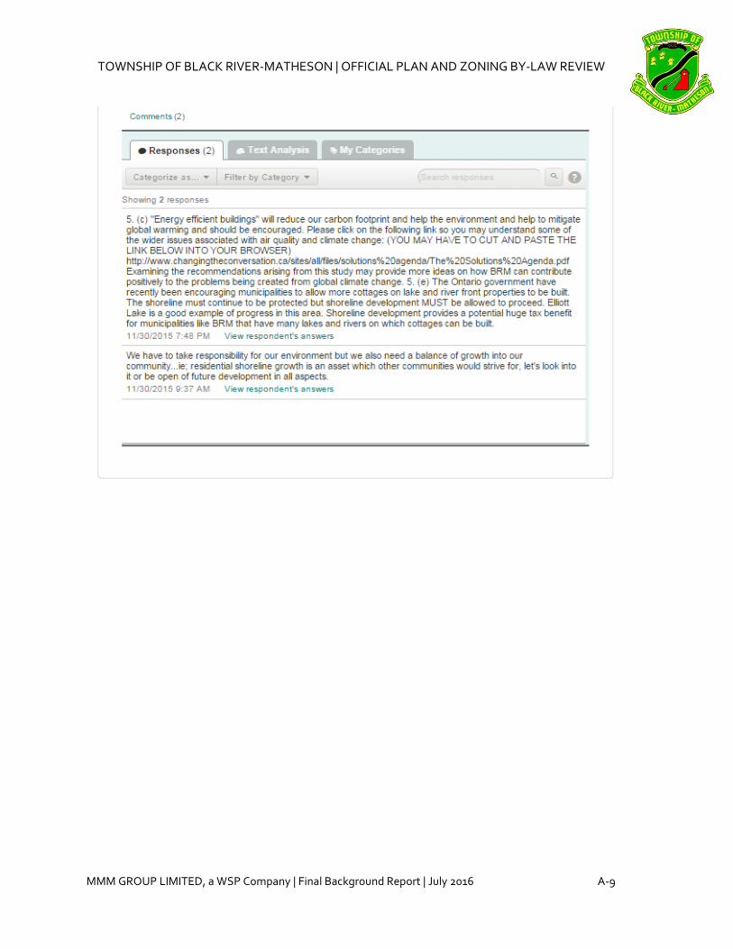
TOWNSHIP OF BLACK RIVER-MATHESON | OFFICIAL PLAN AND ZONING BY-LAW REVIEW
MMM GROUP LIMITED, a WSP Company | Final Background Report | July 2016 A-9

TOWNSHIP OF BLACK RIVER-MATHESON | OFFICIAL PLAN AND ZONING BY-LAW REVIEW
A-10 MMM GROUP LIMITED, a WSP Company | Final Background Report | July 2016

TOWNSHIP OF BLACK RIVER-MATHESON | OFFICIAL PLAN AND ZONING BY-LAW REVIEW
MMM GROUP LIMITED, a WSP Company | Final Background Report | July 2016 A-11


TOWNSHIP OF BLACK RIVER-MATHESON | OFFICIAL PLAN AND ZONING BY-LAW REVIEW
MMM GROUP LIMITED, a WSP Company | Final Background Report | July 2016 B-1
APPENDIX B – 2014 Provincial Policy Statement Review Table
The 2014 Provincial Policy Statement (PPS) amended the 2005 PPS and came into effect on April 30,
2014. The following table summarizes new and/or revised PPS policies from the 2014 version, along
with a list of the current Township of Black River-Matheson Official Plan policies that must therefore
be addressed during the review.
2014 Provincial Policy Statement Review
SECTION AND POLICY RELEVANT EXISTING OP SECTION ISSUES TO BE ADDRESSED
1.0 Building Strong Healthy Communities
1.1.1 Healthy, liveable and safe communities are sustained by: b) accommodating an appropriate range and mix of residential (including second units, affordable housing and housing for older persons), employment (including industrial and commercial), institutional (including places of worship, cemeteries and long-term care homes), recreation, park and open space, and other uses to meet long-term needs; e) promoting cost-effective development patterns and standards to minimize land consumption and servicing costs; f) improving accessibility for persons with disabilities and older persons by identifying, preventing and removing land use barriers which restrict their full participation in society; g) ensuring that necessary infrastructure, electricity generation facilities and transmission and distribution systems, and public service facilities are or will be available to meet current and projected needs; h) promoting development and land use patterns that conserve biodiversity and consider the impacts of changing climate.
Section 2.6 Basis of Plan, Policy 2.6.11 – addresses goal of a rational land use pattern and the guiding of development in accordance with this pattern. Section 2.7 Objectives, Policy 2.7.2 – promotes a logical, orderly, attractive and cost-effective development and land use pattern. Section 3 Land Use Policies Section 3.6 Land Development Section 4.2 Residential Neighbourhood, Policy 4.2.3 permits affordable housing and accommodation for all segments of the population through residential intensification and by encouraging a variety and mix of housing types. Section 6 Services, Facilities and Roads
Add reference to ‘compact development’ in Section 3.6, which refers to development built in a more compact form in order to make more efficient use of land and services (e.g. a subdivision with smaller setbacks).
Add reference to promoting compact development and second units in Section 3. Add policy related to improving accessibility for persons with disabilities and older persons. Add policy related to climate change and development.
1.1.2 Sufficient land shall be made available to accommodate an appropriate range and
Section 2.6 Basis of Plan, Policy 2.6.3 – addresses expectation that any permanent population
Add forecasted growth over the planning period

TOWNSHIP OF BLACK RIVER-MATHESON | OFFICIAL PLAN AND ZONING BY-LAW REVIEW
B-2 MMM GROUP LIMITED, a WSP Company | Final Background Report | July 2016
SECTION AND POLICY RELEVANT EXISTING OP SECTION ISSUES TO BE ADDRESSED
mix of land uses to meet projected needs for a time horizon of up to 20 years. However, where an alternate time period has been established for specific areas of the Province as a result of a provincial planning exercise or a provincial plan, that time frame may be used for municipalities within the area. Within settlement areas, sufficient land shall be made available through intensification and redevelopment and, if necessary, designated growth areas. Nothing in policy 1.1.2 limits the planning for infrastructure and public service facilities beyond a 20-year time horizon.
growth is expected to occur in the urban townsites; Policy 2.6.7 - confirms that water and sewer reserve capacities are sufficient to handle any growth anticipated over the planning period; Policy 2.6.10 – encourages new growth and development and states the intention that sufficient land be designated for development purposes. Section 3.6 Land Development – addresses the intent to ensure sufficient land and a choice of development sites is available to meet anticipated development needs; encourages a minimum 10-year supply of land designated for residential development and intensification.
Confirm vacant land supply to accommodate growth projections. Delineate settlement area boundaries of the urban townsites and update Schedules. The 2014 PPS refers to built-up areas (i.e. cities, towns, villages and hamlets) as urban or rural settlement areas, and encourages growth to be focused within their boundaries.
1.1.3.1 Settlement areas shall be the focus of growth and development, and their vitality and regeneration shall be promoted.
Section 2.6 Basis of Plan, Policy 2.6.3 – addresses expectation that any permanent population growth is expected to occur in the urban townsites; 2.6.11 – addresses the need to undertake improvements and enhance the general attractiveness of the municipality, including the prevent of under serviced or unsightly development. Section 7 Community Improvement, Policy 7.3 – designates the four urban townsites as Community Improvement Areas.
Section 7 may be amended to emphasize the promotion of the vitality and regeneration of the four urban townsites.
1.1.3.2 Land use patterns within settlement areas shall be based on: a) densities and a mix of land uses which: 4. support active transportation; 5. are transit-supportive, where transit is planned, exists or may be developed; and 6. are freight-supportive; and
Section 2.6 Basis of Plan, Policy 2.6.11 – addresses the goal of a rational land use pattern. Section 2.7 Objectives, Policy 2.7.2 – promotes a logical, orderly, attractive and cost-effective development and land use pattern.
Policies should be added to support active transportation within in the urban townsites. Policies should be added to encourage appropriate mixes and/or range of land uses.

TOWNSHIP OF BLACK RIVER-MATHESON | OFFICIAL PLAN AND ZONING BY-LAW REVIEW
MMM GROUP LIMITED, a WSP Company | Final Background Report | July 2016 B-3
SECTION AND POLICY RELEVANT EXISTING OP SECTION ISSUES TO BE ADDRESSED
b) a range of uses and opportunities for intensification and redevelopment in accordance with the criteria in policy 1.1.3.3, where this can be accommodated.
Section 3.6 Land Development – encourages a minimum 10-year supply of land designated for residential development and intensification. Section 4.2 Residential Neighbourhood, Policy 4.2.3 – addresses residential intensification to help meet the needs of affordable housing.
Policies should be added to generally promote intensification and redevelopment in accordance with PPS Policy 1.1.3.3, not just for affordable housing.
1.1.3.3 Planning authorities shall identify appropriate locations and promote opportunities for intensification and redevelopment where this can be accommodated taking into account existing building stock or areas, including brownfield sites, and the availability of suitable existing or planned infrastructure and public service facilities required to accommodate projected needs. Intensification and redevelopment shall be directed in accordance with the policies of Section 2: Wise Use and Management of Resources and Section 3: Protecting Public Health and Safety.
Section 3.5 Affordable Housing and Section 4.2 Residential Neighbourhood, Policy 4.2.3 – address residential infilling and intensification to help meet the needs of affordable housing.
Policies should be added to generally promote intensification and redevelopment in accordance with PPS Policy 1.1.3.3, not just for affordable housing.
1.1.3.5 Planning authorities shall establish and implement minimum targets for intensification and redevelopment within built-up areas, based on local conditions. However, where provincial targets are established through provincial plans, the provincial target shall represent the minimum target for affected areas.
Section 3.5 Affordable Housing Section 4.2 Residential Neighbourhood, Policy 4.2.3
Minimum targets for residential intensification and redevelopment within the urban townsites should be identified.
1.1.4 (Preamble to Rural Areas in Municipalities section)
Section 5 Rural Area No changes to current policies are required based on preamble text.
1.1.4.1 Healthy, integrated and viable rural areas should be supported by: a) building upon rural character, and leveraging rural amenities and assets; b) promoting regeneration, including the
Section 2.6 Basis of Plan, Policy 2.6.9 - recognizes mining, forestry, agriculture and tourism as important economic activities. 2.7 Objectives, Policy 2.7.3 – encourages economic growth and development include
Consider a general policy related to rural character, amenities and assets (e.g. encouraging development in rural areas to be in keeping with the rural character of existing lot sizes and design features, encouraging doddy

TOWNSHIP OF BLACK RIVER-MATHESON | OFFICIAL PLAN AND ZONING BY-LAW REVIEW
B-4 MMM GROUP LIMITED, a WSP Company | Final Background Report | July 2016
SECTION AND POLICY RELEVANT EXISTING OP SECTION ISSUES TO BE ADDRESSED
redevelopment of brownfield sites; c) accommodating an appropriate range and mix of housing in rural settlement areas; d) encouraging the conservation and redevelopment of existing rural housing stock on rural lands; e) using rural infrastructure and public service facilities efficiently; f) promoting diversification of the economic base and employment opportunities through goods and services, including value-added products and the sustainable management or use of resources; g) providing opportunities for sustainable and diversified tourism, including leveraging historical, cultural, and natural assets; h) conserving biodiversity and considering the ecological benefits provided by nature; and i) providing opportunities for economic activities in prime agricultural areas, in accordance with policy 2.3.
resource development, resource-based tourism and recreation development; Policy 2.7.4 protects prime agricultural areas, mineral resources, aggregate resources and forestry resources for their economic use and from incompatible development. Section 3.14 Forestry – recognizes the importance of forestry to the economy. Section 5.2 Rural Area, Policy 5.2.1 – addresses secondary agricultural uses that produce value added agricultural products. Section 5.3 Shoreline Area Section 5.6 Sensitive Areas Section 5.7 Special Policies for Mineral Resource Development in Rural Area – recognizes economic importance of mineral resource extraction and permits other uses providing they do not preclude future extraction.
houses, etc.) Consider adding policies related to the redevelopment of brownfields sites and the conservation and redevelopment of existing rural housing stock.
1.1.4.3 When directing development in rural settlement areas in accordance with policy 1.1.3, planning authorities shall give consideration to rural characteristics, the scale of development and the provision of appropriate service levels.
The rural communities of Shillington and Val Gagne South are identified in Policy 2.6.1, but development is not directed to rural settlement areas.
No changes to current policies are required.
1.1.5.1 When directing development on rural lands, a planning authority shall apply the relevant policies of Section 1: Building Strong Healthy Communities, as well as the policies of Section 2: Wise Use and Management of Resources and Section 3: Protecting Public Health and Safety.
Section 5 Rural Area covers rural lands, as no rural settlement areas are identified.
No changes to current policies are required.
1.1.5.2 On rural lands located in municipalities, permitted uses are:
Section 5.2 Rural Area – addresses permitted uses.
Cemeteries should be added as a permitted use.

TOWNSHIP OF BLACK RIVER-MATHESON | OFFICIAL PLAN AND ZONING BY-LAW REVIEW
MMM GROUP LIMITED, a WSP Company | Final Background Report | July 2016 B-5
SECTION AND POLICY RELEVANT EXISTING OP SECTION ISSUES TO BE ADDRESSED
a) the management or use of resources; b) resource-based recreational uses (including recreational dwellings); c) limited residential development; d) home occupations and home industries; e) cemeteries; and f) other rural land uses.
1.1.5.3 Recreational, tourism and other economic opportunities should be promoted.
Section 2.6 Basis of Plan, Policy 2.6.10 – addresses intent that sufficient land be designated for recreational and tourism purposes. Section 2.7 Objectives, Policy 2.7.3 encourages economic growth and development including resource-based tourism and recreation development. Section 5.3 Shoreline Area – allows for recreation dwellings and tourist commercial uses. Section 7 Community Improvement, Policy 7.2 a) identifies maintenance and improvement of recreational facilities.
No changes to current policies are required.
1.1.5.4 Development that is compatible with the rural landscape and can be sustained by rural service levels should be promoted.
Section 2.6 Basis of Plan, Policy 2.6.8 – directs that Rural areas will be serviced by means of private individual sewage systems and water supplies, with the exception of Val Gagne [South?] which has a public water system. Section 5.2 Rural Area, Preamble – states that residential development shall generally be related to land uses such as the management
Add text to Policy 5.2.4 on residential dwellings in the Rural Area, to address compatibility with the rural landscape.

TOWNSHIP OF BLACK RIVER-MATHESON | OFFICIAL PLAN AND ZONING BY-LAW REVIEW
B-6 MMM GROUP LIMITED, a WSP Company | Final Background Report | July 2016
SECTION AND POLICY RELEVANT EXISTING OP SECTION ISSUES TO BE ADDRESSED
or use of resources, resource-based recreation activities and other rural land uses; Policy 5.2.4 c) and d) address requirements for private sewage disposal and potable water supply. Section 6.2 Private Individual Sewage and Water Services, Policy 6.2.1 – intends that all development in the Rural Area be serviced by private individual sewage and water services.
1.1.5.5 Development shall be appropriate to the infrastructure which is planned or available, and avoid the need for the unjustified and / or uneconomical expansion of this infrastructure.
Section 5.2, Policy 5.2.7 – directs that development in the Rural Area shall not result in the undue extension or expansion of the Townsite Areas. Section 6.1 Municipal Water and Sewage Services, Policy 6.1.1 – directs that new development or redevelopment in areas where an adequate level of municipal services and facilities cannot be provided or ensured is considered premature; Policy 6.1.2 – states that no extension of any municipal water or sewage system shall be made beyond the boundary of any Townsite Urban Area.
No changes to the current policies are required.
1.1.5.6 Opportunities should be retained to locate new or expanding land uses that require separation from other uses.
Separation distances are addressed in Section 4.4 Industrial; Section 3.9 Land Use Compatibility and Buffering; and Section 5.2 Rural Area, Policy 5.2.9.
No changes to current policies are required.
1.1.5.7 Opportunities to support a diversified rural economy should be promoted by protecting agricultural and other resource-related uses and directing nonrelated development to areas where it will minimize constraints on these uses.
Section 2.6 Basis of Plan, Policy 2.6.9 - recognizes mining, forestry, agriculture and tourism as important economic activities. 2.7 Objectives, Policy 2.7.3 – encourages economic growth and development include resource development,
No changes to current policies are required.

TOWNSHIP OF BLACK RIVER-MATHESON | OFFICIAL PLAN AND ZONING BY-LAW REVIEW
MMM GROUP LIMITED, a WSP Company | Final Background Report | July 2016 B-7
SECTION AND POLICY RELEVANT EXISTING OP SECTION ISSUES TO BE ADDRESSED
resource-based tourism and recreation development; Policy 2.7.4 protects prime agricultural areas, mineral resources, aggregate resources and forestry resources for their economic use and from incompatible development. Section 3.14 Forestry – recognizes the importance of forestry to the economy. Section 5.7 Special Policies for Mineral Resource Development in Rural Area – recognizes economic importance of mineral resource extraction and permits other uses providing they do not preclude future extraction. Section 8.2.2 Consents in the Rural Area – proposed severances cannot restrict the potential for resource-related economic activities.
1.1.5.8 Agricultural uses, agriculture-related uses, on-farm diversified uses and normal farm practices should be promoted and protected in accordance with provincial standards.
Section 5.2 Rural Area, Policy 5.2.1 – identifies agricultural uses as primary uses in the Rural Area; secondary agricultural uses and agriculture-related uses are also permitted.
Policy should be amended to reflect the full PSS definition of ‘agriculture-related uses.” Reference to on-farm diversified uses and normal farm practices should be added.
1.1.5.9 New land uses, including the creation of lots, and new or expanding livestock facilities, shall comply with the minimum distance separation formulae.
Section 5.2 Rural Area, Policy 5.2.9 – directs that all development within the rural Area will comply with the Provincial Agricultural Minimum Distance Separation Formula.
No changes to current policies are required.
1.2.1 A coordinated, integrated and comprehensive approach should be used when dealing with planning matters within municipalities, across lower, single and / or upper-tier municipal boundaries, and with other orders of government, agencies and boards including:
References appear throughout the Official Plan to applicable provincial legislation and policy.
No changes to the current policies are required.

TOWNSHIP OF BLACK RIVER-MATHESON | OFFICIAL PLAN AND ZONING BY-LAW REVIEW
B-8 MMM GROUP LIMITED, a WSP Company | Final Background Report | July 2016
SECTION AND POLICY RELEVANT EXISTING OP SECTION ISSUES TO BE ADDRESSED
a) managing and / or promoting growth and development; b) economic development strategies; c) managing natural heritage, water, agricultural, mineral, and cultural heritage and archaeological resources; d) infrastructure, electricity generation facilities and transmission and distribution systems, multimodal transportation systems, public service facilities and waste management systems; e) ecosystem, shoreline, watershed, and Great Lakes related issues; f) natural and human-made hazards; g) population, housing and employment projections, based on regional market areas; and h) addressing housing needs in accordance with provincial policy statements such as the Ontario Housing Policy Statement.
1.2.2 Planning authorities are encouraged to coordinate planning matters with Aboriginal communities.
The Official Plan does not contain policies related to Aboriginal communities or interests.
Add specific reference to Aboriginal interests in Section 2.7 of the Plan and reflect Aboriginal interests in land use planning in Section 3, including in Section 3.13 Cultural Heritage Resources in which Aboriginal communities have specific interests.
1.2.3 Planning authorities should coordinate emergency management and other economic, environmental and social planning considerations to support efficient and resilient communities.
The Official Plan does not contain policies related to emergency management.
Add policy regarding emergency management and essential public services.
1.2.6.1 Major facilities and sensitive land uses should be planned to ensure they are appropriately designed, buffered and / or
Section 3.9 Land Use Compatibility and Buggering – addresses development affected by noise, provincial
No changes to current policies are required.
TOWNSHIP OF BLACK RIVER-MATHESON | OFFICIAL PLAN AND ZONING BY-LAW REVIEW
MMM GROUP LIMITED, a WSP Company | Final Background Report | July 2016 B-9
SECTION AND POLICY RELEVANT EXISTING OP SECTION ISSUES TO BE ADDRESSED
separated from each other to prevent or mitigate adverse effects from odour, noise and other contaminants, minimize risk to public health and safety, and to ensure the long-term viability of major facilities.
standards and guidelines, highway setbacks, and minimum separation from pits and quarries.
1.3.1 Planning authorities shall promote economic development and competitiveness by: a) providing for an appropriate mix and range of employment and institutional uses to meet long-term needs; b) providing opportunities for a diversified economic base, including maintaining a range and choice of suitable sites for employment uses which support a wide range of economic activities and ancillary uses, and take into account the needs of existing and future businesses; c) encouraging compact, mixed-use development that incorporates compatible employment uses to support liveable and resilient communities; and d) ensuring the necessary infrastructure is provided to support current and projected needs.
Section 2.6 Basis of Plan, Policy 2.6.9; 2.7 Objectives, Policy 2.7.3 and 2.7.4; and 5.7 Special Policies for Mineral Resource Development in Rural Area all address economic development. Section 2.6 Basis of Plan, Policy 2.6.10 – addresses intent to designate sufficient land for institutional and resource development purposes. Section 4.3 General Commercial – addresses intent to foster the business function of the central business areas in the urban townsites by promoting all types of commercial uses. The Official Plan designates employment lands as General Commercial and Industrial.
Policy references to the promotion of mixed-use development should be added.
1.3.2.3 Planning authorities shall protect employment areas in proximity to major goods movement facilities and corridors for employment uses that require those locations.
The Official Plan designates employment lands as General Commercial and Industrial.
Policy references to the promotion of mixed-use development should be added.
1.3.2.4 Planning authorities may plan beyond 20 years for the long-term protection of employment areas provided lands are not designated beyond the planning horizon identified in policy 1.1.2.
The Official Plan designates employment lands as General Commercial and Industrial.
Policy references to the promotion of mixed-use development should be added.
1.5.1 Healthy, active communities should be promoted by: a) planning public streets, spaces and facilities to be safe, meet the needs of pedestrians, foster social interaction and
Section 4 Townsite Urban Area, 4.5 Parks and Open Space – identifies the objective of providing adequate parks, open space and recreation facilities, with special effort to link waterfront areas and other
Consider adding policies related to: trails in the Township; meeting the needs of pedestrians and promoting active transportation; and provincial parks and
TOWNSHIP OF BLACK RIVER-MATHESON | OFFICIAL PLAN AND ZONING BY-LAW REVIEW
B-10 MMM GROUP LIMITED, a WSP Company | Final Background Report | July 2016
SECTION AND POLICY RELEVANT EXISTING OP SECTION ISSUES TO BE ADDRESSED
facilitate active transportation and community connectivity; b) planning and providing for a full range and equitable distribution of publicly-accessible built and natural settings for recreation, including facilities, parklands, public spaces, open space areas, trails and linkages, and, where practical, water-based resources; c) providing opportunities for public access to shorelines; and d) recognizing provincial parks, conservation reserves, and other protected areas, and minimizing negative impacts on these areas.
open space and parks with the existing built up community. Section 5.3 Shoreline Area – permits shoreline development in designated areas, including for recreational dwellings and tourist commercial uses. Section 5.6 Sensitive Areas – designates sensitive areas in the Township to preserve, protect and/or manage lands having sensitive features, as supported by the associated policies. Section 6.7 Municipal Parks – states that municipal parks will be established when funds have been accumulated from both municipal funds and through provisions of the Section 51.1 of the Planning Act.
conservation areas/reserves located within the Township’s boundaries.
1.6.1 Infrastructure, electricity generation facilities and transmission and distribution systems, and public service facilities shall be provided in a coordinated, efficient and cost-effective manner that considers impacts from climate change while accommodating projected needs. Planning for infrastructure, electricity generation facilities and transmission and distribution systems, and public service facilities shall be coordinated and integrated with land use planning so that they are: a) financially viable over their life cycle, which may be demonstrated through asset management planning; and b) available to meet current and projected needs.
Section 3 Land Use Policies – contains policies related to electric power facilities and natural gas pipelines. Section 6 Services, Facilities and Roads – contains policies related to water and wastewater infrastructure, stormwater management infrastructures, municipal roads and provincial highways, and waste disposal sites.
No changes to the current policies are required.
1.6.2 Planning authorities should promote green infrastructure to complement infrastructure.
The Official Plan does not contain references to green infrastructure.
Consider adding policies to promote green infrastructure.

TOWNSHIP OF BLACK RIVER-MATHESON | OFFICIAL PLAN AND ZONING BY-LAW REVIEW
MMM GROUP LIMITED, a WSP Company | Final Background Report | July 2016 B-11
SECTION AND POLICY RELEVANT EXISTING OP SECTION ISSUES TO BE ADDRESSED
1.6.3 Before consideration is given to developing new infrastructure and public service facilities: a) the use of existing infrastructure and public service facilities should be optimized; and b) opportunities for adaptive re-use should be considered, wherever feasible.
Section 6.1 Municipal Water and Sewage Services, Policy 6.1.1 – directs that new development or redevelopment in areas where an adequate level of municipal services and facilities cannot be provided or ensured is considered premature; Policy 6.1.2 – states that no extension of any municipal water or sewage system shall be made beyond the boundary of any Townsite Urban Area.
Consider adding policies related to the optimization of existing public service facilities or opportunities for adaptive re-use.
1.6.5 Public service facilities should be co-located in community hubs, where appropriate, to promote cost-effectiveness and facilitate service integration, access to transit and active transportation.
The Official Plan does not direct the location of public service facilities. Section 2.6 Basis of Plan, Policy 2.6.3 – directs that the urban townsites will function as service centres for their local populations.
Consider adding a policy related to the location of public service facilities in community hubs.
1.6.6.4 Where municipal sewage services and municipal water services or private communal sewage services and private communal water services are not provided, individual on-site sewage services and individual onsite water services may be used provided that site conditions are suitable for the long-term provision of such services with no negative impacts. In settlement areas, these services may only be used for infilling and minor rounding out of existing development.
Section 6.1 Municipal Water and Sewage Services, Policy 6.1.1 – directs that new development or redevelopment in areas where an adequate level of municipal services and facilities cannot be provided or ensured is considered premature; Policy 6.1.2 – states that no extension of any municipal water or sewage system shall be made beyond the boundary of any Townsite Urban Area; Policy 6.1.3 – states that all development in the Townsite Urban Areas will be connected to municipal water and sewer services. Section 6.2 Private Individual Sewage and Water Services, Policy 6.2.1 – addresses intent that all development in Rural Area be serviced by private individual sewage and water services; Policy 6.2.3 – states that the Township will not
Policy to be reviewed for consistency.

TOWNSHIP OF BLACK RIVER-MATHESON | OFFICIAL PLAN AND ZONING BY-LAW REVIEW
B-12 MMM GROUP LIMITED, a WSP Company | Final Background Report | July 2016
SECTION AND POLICY RELEVANT EXISTING OP SECTION ISSUES TO BE ADDRESSED
assume ownership of communal servicing systems, which may have the effect of precluding future proposed development where communal water and sewage servicing system is required.
1.6.6.5 Partial services shall only be permitted in the following circumstances: a) where they are necessary to address failed individual on-site sewage services and individual on-site water services in existing development; or b) within settlement areas, to allow for infilling and minor rounding out of existing development on partial services provided that site conditions are suitable for the long-term provision of such services with no negative impacts.
Section 2.6 Basis of Plan, Policy 2.6.8 – directs that Rural areas will be serviced by means of private individual sewage systems and water supplies, with the exception of Val Gagne [South?] which has a public water system. Section 6.2 Private Individual Sewage and Water Services – addresses intent that all development in Rural Area be serviced by private individual sewage and water services.
Consider adding policies related to the permission of partial servicing under certain circumstances.
1.6.6.7 Planning for stormwater management shall: a) minimize, or, where possible, prevent increases in contaminant loads; b) minimize changes in water balance and erosion; c) not increase risks to human health and safety and property damage; d) maximize the extent and function of vegetative and pervious surfaces; and e) promote stormwater management best practices, including stormwater attenuation and re-use, and low impact development.
Section 6.3 Storm Drainage
More specific language should be added regarding PPS Policy 1.6.6.7 a) through e).
1.6.7.2 Efficient use shall be made of existing and planned infrastructure, including through the use of transportation demand management strategies, where feasible.
Section 6.4 Roads Section 6.5 Unopened Roads and Private Roads – limits the opening of new roads unless it is in the public interest or
No changes to the current policies are required.

TOWNSHIP OF BLACK RIVER-MATHESON | OFFICIAL PLAN AND ZONING BY-LAW REVIEW
MMM GROUP LIMITED, a WSP Company | Final Background Report | July 2016 B-13
SECTION AND POLICY RELEVANT EXISTING OP SECTION ISSUES TO BE ADDRESSED
meets certain criteria.
1.6.7.3 As part of a multimodal transportation system, connectivity within and among transportation systems and modes should be maintained and, where possible, improved including connections which cross jurisdictional boundaries.
The Official Plan does not contain reference to multimodal transportation systems. Section 6.4 Roads
References to transportation connections to neighbouring municipalities should be considered, as well as reference to the Township’s Community Transportation Pilot Program for seniors.
1.6.7.4 A land use pattern, density and mix of uses should be promoted that minimize the length and number of vehicle trips and support current and future use of transit and active transportation.
The Official Plan does not contain references to transit and active transportation. The Township does not have a transit system.
Policies should be added to encourage active transportation, especially in the urban townsites. Consider adding policies related to compact development in Section 3.6.
1.6.8.1 Planning authorities shall plan for and protect corridors and rights-of-way for infrastructure, including transportation, transit and electricity generation facilities and transmission systems to meet current and projected needs.
Section 3.1 General Land Use Policies – permits the essential operations of utilities, pipelines and transportation agencies in any land use. Section 3.3 Electric Power Facilities – provides that electric power transmission and distribution facilities are permitted in all land use designations. Section 3.15 Natural Gas Pipeline – protects the corridor of the TransCanada pipeline from development that may affect its safety and integrity of operations. Section 6.4 Roads
No changes to the current policies are required.
1.7.1 Long-term economic prosperity should be supported by: a) promoting opportunities for economic development and community investment-readiness;
Section 2.6 Basis of Plan, Policy 2.6.9 - recognizes mining, forestry, agriculture and tourism as important economic activities. 2.7 Objectives, Policy 2.7.3 – encourages economic growth
Consider adding policies related to brownfield site redevelopment and telecommunications infrastructure (e.g. policies to enable public infrastructure to serve the greater public good and to

TOWNSHIP OF BLACK RIVER-MATHESON | OFFICIAL PLAN AND ZONING BY-LAW REVIEW
B-14 MMM GROUP LIMITED, a WSP Company | Final Background Report | July 2016
SECTION AND POLICY RELEVANT EXISTING OP SECTION ISSUES TO BE ADDRESSED
b) optimizing the long-term availability and use of land, resources, infrastructure, electricity generation facilities and transmission and distribution systems, and public service facilities; c) maintaining and, where possible, enhancing the vitality and viability of downtowns and mainstreets; d) encouraging a sense of place, by promoting well-designed built form and cultural planning, and by conserving features that help define character, including built heritage resources and cultural heritage landscapes; e) promoting the redevelopment of brownfield sites; f) providing for an efficient, cost-effective, reliable multimodal transportation system that is integrated with adjacent systems and those of other jurisdictions, and is appropriate to address projected needs to support the movement of goods and people; g) providing opportunities for sustainable tourism development; h) providing opportunities to support local food, and promoting the sustainability of agri-food and agri-product businesses by protecting agricultural resources, and minimizing land use conflicts; i) promoting energy conservation and providing opportunities for development of renewable energy systems and alternative energy systems, including district energy; j) minimizing negative impacts from a changing climate and considering the ecological benefits provided by nature; and k) encouraging efficient and coordinated communications and telecommunications
and development include resource development, resource-based tourism and recreation development; Policy 2.7.4 protects prime agricultural areas, mineral resources, aggregate resources and forestry resources for their economic use and from incompatible development. Section 3.14 Forestry – recognizes the importance of forestry to the economy. Section 5.5 Human-Made Hazard Lands, Policy 5.5.4 – related to redevelopment of potentially contaminated sites and requirements for a Record of Site Condition and remediation activities. Section 5.7 Special Policies for Mineral Resource Development in Rural Area – recognizes economic importance of mineral resource extraction and permits other uses providing they do not preclude future extraction. Section 7 Community Improvement – includes policies to promote the improvement and revitalization of downtown commercial areas, existing buildings and structures; to encourage the preservation, rehabilitation, renewal and reuse of cultural heritage resources; to main the municipality as a desirable place to live. The Official Plan does not contain policies related to brownfields, energy conservation, climate change, sustainable tourism, or
ensure that hydroelectric corridors, stations, and secondary land uses, etc. are generally permitted. Add policy to encourage sustainable tourism development and local food production. Add policies related to energy conservation and climate change.

TOWNSHIP OF BLACK RIVER-MATHESON | OFFICIAL PLAN AND ZONING BY-LAW REVIEW
MMM GROUP LIMITED, a WSP Company | Final Background Report | July 2016 B-15
SECTION AND POLICY RELEVANT EXISTING OP SECTION ISSUES TO BE ADDRESSED
infrastructure. telecommunications infrastructure.
1.8 Planning authorities shall support energy conservation and efficiency, improved air quality, reduced greenhouse gas emissions, and climate change adaptation through land use and development patterns which: a) promote compact form and a structure of nodes and corridors; b) promote the use of active transportation and transit in and between residential, employment (including commercial and industrial) and institutional uses and other areas; c) focus major employment, commercial and other travel-intensive land uses on sites which are well served by transit where this exists or is to be developed, or designing these to facilitate the establishment of transit in the future; d) focus freight-intensive land uses to areas well served by major highways, airports, rail facilities and marine facilities; e) improve the mix of employment and housing uses to shorten commute journeys and decrease transportation congestion; f) promote design and orientation which: 1. maximizes energy efficiency and conservation, and considers the mitigating effects of vegetation; and 2. maximizes opportunities for the use of renewable energy systems and alternative energy systems; and g) maximize vegetation within settlement areas, where feasible.
The Official Plan does not contain policies related to energy conservation and efficiency, air quality, or climate change. The Township does not have a transit system.
Add policies to support energy conservation, improvement of air quality and climate change adaptation, including in urban design. Add policies related to compact development in Section 3.6. Add policies to promote active transportation.
2. Wise Use and Management of Resources
2.2.1 Planning authorities shall protect, improve
Section 2.7.15 Objectives – promote the protection of the
Policies should be added to address municipal

TOWNSHIP OF BLACK RIVER-MATHESON | OFFICIAL PLAN AND ZONING BY-LAW REVIEW
B-16 MMM GROUP LIMITED, a WSP Company | Final Background Report | July 2016
SECTION AND POLICY RELEVANT EXISTING OP SECTION ISSUES TO BE ADDRESSED
or restore the quality and quantity of water by: a) using the watershed as the ecologically meaningful scale for integrated and long-term planning, which can be a foundation for considering cumulative impacts of development; b) minimizing potential negative impacts, including cross-jurisdictional and cross-watershed impacts; c) identifying water resource systems consisting of ground water features, hydrologic functions, natural heritage features and areas, and surface water features including shoreline areas, which are necessary for the ecological and hydrological integrity of the watershed; d) maintaining linkages and related functions among ground water features, hydrologic functions, natural heritage features and areas, and surface water features including shoreline areas; e) implementing necessary restrictions on development and site alteration to: 1. protect all municipal drinking water supplies and designated vulnerable areas; and 2. protect, improve or restore vulnerable surface and ground water, sensitive surface water features and sensitive ground water features, and their hydrologic functions; f) planning for efficient and sustainable use of water resources, through practices for water conservation and sustaining water quality; g) ensuring consideration of environmental lake capacity, where applicable; and
quality and quantity of surface water and groundwater in the municipality. Section 5.2 Rural Area, Policy 5.2.4 (d) – regarding residential dwellings and requirements for potable water supply. Section 5.3 Shoreline Area, Policy 5.3.5 – regarding single recreation dwellings and tourist commercial development and lake capacity. Section 5.6 Sensitive Areas – regarding sensitive areas (e.g. water locations) of ecological, geological, archeological or historical importance and their functions. Section 6.2 Private Individual Sewage and Water Services, Policy 6.2.5 – regarding applications for subdivision development and requirements for a groundwater impact assessment, and a lake capacity calculation if the development is proposed on a water impact lot. Section 6.3 Storm Drainage – regarding adequate storm drainage facilities for new development and requirements for a stormwater management plan for new plans of subdivision and major development proposals.
drinking water supply and source water protection considerations Policies could be added to Section 5.3 to emphasize the importance of maintaining linkages and hydrological functions. The 2014 PPS focuses on protecting source water and encourages policies that give consideration to natural linkages and hydrological functions of natural heritage and water features (e.g. linkages between wetlands and supporting watercourses). General policies could be added to address water conservation practices.

TOWNSHIP OF BLACK RIVER-MATHESON | OFFICIAL PLAN AND ZONING BY-LAW REVIEW
MMM GROUP LIMITED, a WSP Company | Final Background Report | July 2016 B-17
SECTION AND POLICY RELEVANT EXISTING OP SECTION ISSUES TO BE ADDRESSED
h) ensuring stormwater management practices minimize stormwater volumes and containment loads, and maintain or increase the extent of vegetative and pervious surfaces.
2.3.1 Prime agricultural areas shall be protected for long-term use for agriculture. Prime agricultural areas are areas where prime agricultural lands predominate. Specialty crop areas shall be given the highest priority for protection, followed by Canada Land Inventory Class 1, 2, and 3 lands, and any associated Class 4 through 7 lands within the prime agricultural area, in this order of priority.
Section 2.7.4 Objectives identifies the protection of prime agricultural areas for their economic use and from incompatible development
There are no existing designated prime agricultural areas in the Township. Based on OMAFRA’s delineation of agricultural areas south of Val Gagné, Class 3 soils in this area have been identified and will be shown in the proposed Agricultural Area designation with associated policies.
2.3.2 Planning authorities shall designate prime agricultural areas and specialty crop areas in accordance with guidelines developed by the Province, as amended from time to time.
No applicable policy or designation.
There are no existing designated prime agricultural areas in the Township. Based on OMAFRA’s delineation of agricultural areas south of Val Gagné, Class 3 soils in this area have been identified and will be shown in the proposed Agricultural Area designation with associated policies.
2.4.2.1 Mineral mining operations and petroleum resource operations shall be identified and protected from development and activities that would preclude or hinder their expansion or continued use or which would be incompatible for reasons of public health, public safety, or environmental impact.
Section 5.7 Special Policies for Mineral Resource Development in Rural Area, Policy 5.7 c) – permits other uses such as forestry and other resource-related compatible uses, recreation, parks and open space, and wildlife management on lands with mineral resource potential, provided they do not preclude future extraction. Schedules
MMAH/MNDM confirmed that there are no petroleum resources within the Township. No changes to the current policies are required.
2.4.2.2 Known mineral deposits, known petroleum resources and significant areas of mineral potential shall be identified and
Section 5.7 Special Policies for Mineral Resource Development in Rural Area, Policy 5.7 c) – permits other uses such as
Policy could be amended to add PPS policy 2.4.2.2 a) through c).

TOWNSHIP OF BLACK RIVER-MATHESON | OFFICIAL PLAN AND ZONING BY-LAW REVIEW
B-18 MMM GROUP LIMITED, a WSP Company | Final Background Report | July 2016
SECTION AND POLICY RELEVANT EXISTING OP SECTION ISSUES TO BE ADDRESSED
development and activities in these resources or on adjacent lands which would preclude or hinder the establishment of new operations or access to the resources shall only be permitted if: a) resource use would not be feasible; or b) the proposed land use or development serves a greater long-term public interest; and c) issues of public health, public safety and environmental impact are addressed.
forestry and other resource-related compatible uses, recreation, parks and open space, and wildlife management on lands with mineral resource potential, provided they do not preclude future extraction. Schedules
The need to make reference to petroleum resources will be confirmed with MMAH/MNDM.
2.5.1 Mineral aggregate resources shall be protected for long-term use and, where provincial information is available, deposits of mineral aggregate resources shall be identified.
Section 2.7.4 Objectives Section 3.12 Aggregate Areas Schedules
Stronger policy language regarding protection of mineral aggregates could be added in Section 3.12.
2.5.2.3 Mineral aggregate resource conservation shall be undertaken, including through the use of accessory aggregate recycling facilities within operations, wherever feasible.
3.12 Aggregate Areas
Section 3.12 could be expanded to include more specific policies on mineral aggregate resources.
2.5.3.1 Progressive and final rehabilitation shall be required to accommodate subsequent land uses, to promote land use compatibility, to recognize the interim nature of extraction, and to mitigate negative impacts to the extent possible. Final rehabilitation shall take surrounding land use and approved land use designations into consideration.
Section 3.12 Aggregate Areas Section 5.5 Human-made Hazard Lands, Policy 5.5.2 - only permits development on, abutting or adjacent to lands affected by mine hazards, or former mining operations or mineral aggregate operations if rehabilitation measures to address and mitigate known or suspected hazards are under-way or have been completed.
Section 3.12 could be expanded to include more specific policies on mineral aggregate resources.
2.5.4.1 In prime agricultural areas, on prime agricultural land, extraction of mineral aggregate resources is permitted as an interim use provided that the site will be rehabilitated back to an agricultural condition. Complete rehabilitation to an agricultural condition is not required if: a) outside of a specialty crop area, there is a substantial quantity of mineral
Section 2.7.4 Objectives – identifies the protection of prime agricultural areas and mineral aggregate resources for their economic use and from incompatible development. Section 5 Rural Area – OP does not contain prime agricultural or agricultural designation.
There are no existing designated prime agricultural areas in the Township. Based on OMAFRA’s delineation of agricultural areas south of Val Gagné, Class 3 soils in this area have been identified and will be shown in the proposed Agricultural Area
TOWNSHIP OF BLACK RIVER-MATHESON | OFFICIAL PLAN AND ZONING BY-LAW REVIEW
MMM GROUP LIMITED, a WSP Company | Final Background Report | July 2016 B-19
SECTION AND POLICY RELEVANT EXISTING OP SECTION ISSUES TO BE ADDRESSED
aggregate resources below the water table warranting extraction, or the depth of planned extraction in a quarry makes restoration of pre-extraction agricultural capability unfeasible; b) in a specialty crop area, there is a substantial quantity of high quality mineral aggregate resources below the water table warranting extraction, and the depth of planned extraction makes restoration of pre-extraction agricultural capability unfeasible; c) other alternatives have been considered by the applicant and found unsuitable. The consideration of other alternatives shall include resources in areas of Canada Land Inventory class 4 through 7 lands, resources on lands identified as designated growth areas, and resources on prime agricultural lands where rehabilitation is feasible. Where no other alternatives are found, prime agricultural lands shall be protected in this order of priority: specialty crop areas, Canada Land Inventory Class 1, 2, and 3 lands; and d) agricultural rehabilitation in remaining areas is maximized.
designation with associated policies.
2.6.4 Planning authorities should consider and promote archaeological management plans and cultural plans in conserving cultural heritage and archaeological resources.
Section 3.12 Cultural Heritage Resources
Consider adding reference to the preparation of a Township archaeological management plan and/or cultural plan for the conservation of archaeological and cultural heritage resources.
3.0 Protecting Public Health and Safety
3.1.3 Planning authorities shall consider the potential impacts of climate change that may increase the risk associated with natural hazards.
No applicable policy.
Add policy related to the relationship between climate change and increasing risks of natural hazards.
3.1.8 Development shall generally be directed to areas outside of lands that are unsafe for development due to the presence of
No applicable policy.
Add policy related to development and wildland fire hazards.

TOWNSHIP OF BLACK RIVER-MATHESON | OFFICIAL PLAN AND ZONING BY-LAW REVIEW
B-20 MMM GROUP LIMITED, a WSP Company | Final Background Report | July 2016
SECTION AND POLICY RELEVANT EXISTING OP SECTION ISSUES TO BE ADDRESSED
hazardous forest types for wildland fire. Development may however be permitted in lands with hazardous forest types for wildland fire where the risk is mitigated in accordance with wildland fire assessment and mitigation standards.
Consider adding wildland fire hazard mapping as an Appendix to the OP.
4.0 Implementation and Interpretation
4.3 This Provincial Policy Statement shall be implemented in a manner that is consistent with the recognition and affirmation of existing Aboriginal and treaty rights in section 35 of the Constitution Act, 1982.
Section 3.11 Provincial Policy Statement
Add reference to Aboriginal and treaty rights in section 35 of the Constitution Act in Section 3.11.
4.6 This Provincial Policy Statement shall be implemented in a manner that is consistent with the Ontario Human Rights Code and the Canadian Charter of Rights and Freedoms.
Section 3.11 Provincial Policy Statement
Add specific reference to these statutes in Section 3.11.
4.10 A wide range of legislation, regulations, policies, and plans may apply to decisions with respect to Planning Act applications. In some cases, a Planning Act proposal may also require approval under other legislation or regulation, and policies and plans issued under other legislation may apply.
Section 9 Implementation
A general policy should be added to Section 9 to address the potential approval requirements of other legislation or regulations and policies and plans issued under other legislation for Planning Act applications.
4.11 In addition to land use approvals under the Planning Act, infrastructure may also require approval under other legislation and regulations. An environmental assessment process may be applied to new infrastructure and modifications to existing infrastructure under applicable legislation. There may be circumstances where land use approvals under the Planning Act may be integrated with approvals under other legislation, for example, integrating the planning processes and approvals under the Environmental Assessment Act and the Planning Act, provided the intent and requirements of both Acts are met.
Section 6 Services, Facilities and Roads, Policy 6.1.4 - addresses the planning of municipal waste disposal facilities in accordance with the requirements of the Environmental Assessment Act, and MOE Certificate of Approval requirements for liquid waste disposal facilities.
A general policy should be added to Section 6 to address environmental assessment and other legislative/regulatory requirements for new infrastructure.
4.12 Provincial plans shall be read in conjunction with this Provincial Policy
Section 3.11 Provincial Policy Statement
The OP does not currently make reference to provincial plans which are
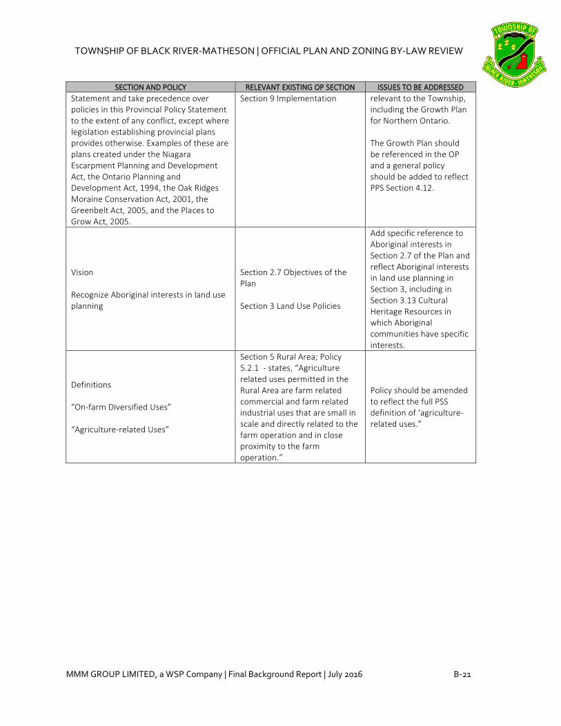
TOWNSHIP OF BLACK RIVER-MATHESON | OFFICIAL PLAN AND ZONING BY-LAW REVIEW
MMM GROUP LIMITED, a WSP Company | Final Background Report | July 2016 B-21
SECTION AND POLICY RELEVANT EXISTING OP SECTION ISSUES TO BE ADDRESSED
Statement and take precedence over policies in this Provincial Policy Statement to the extent of any conflict, except where legislation establishing provincial plans provides otherwise. Examples of these are plans created under the Niagara Escarpment Planning and Development Act, the Ontario Planning and Development Act, 1994, the Oak Ridges Moraine Conservation Act, 2001, the Greenbelt Act, 2005, and the Places to Grow Act, 2005.
Section 9 Implementation relevant to the Township, including the Growth Plan for Northern Ontario. The Growth Plan should be referenced in the OP and a general policy should be added to reflect PPS Section 4.12.
Vision Recognize Aboriginal interests in land use planning
Section 2.7 Objectives of the Plan Section 3 Land Use Policies
Add specific reference to Aboriginal interests in Section 2.7 of the Plan and reflect Aboriginal interests in land use planning in Section 3, including in Section 3.13 Cultural Heritage Resources in which Aboriginal communities have specific interests.
Definitions “On-farm Diversified Uses” “Agriculture-related Uses”
Section 5 Rural Area; Policy 5.2.1 - states, “Agriculture related uses permitted in the Rural Area are farm related commercial and farm related industrial uses that are small in scale and directly related to the farm operation and in close proximity to the farm operation.”
Policy should be amended to reflect the full PSS definition of ‘agriculture-related uses.”


TOWNSHIP OF BLACK RIVER-MATHESON | OFFICIAL PLAN AND ZONING BY-LAW REVIEW
MMM GROUP LIMITED, a WSP Company | Final Background Report | July 2016 C-1
APPENDIX C – MTO Guidelines Review Table
The following table outlines key recommendations from the Ministry of Transportation (MTO)
Guidelines for Municipal Official Plan Preparation and Review. The final column provides a
recommended response on the need for policy modification.
MTO Guidelines Review
GUIDELINE RELEVANT OP SECTION ISSUES TO BE ADDRESSED 3.1 Policies and Provisions to Address Local Growth and Development Adjacent to and in the Vicinity of Provincial Highway
Where new growth and development are proposed, MTO will require a general statement be included in the OP indicating that a traffic study will be conducted.
Section 3.6 Land Development Section 6.4 Roads Section 9 Implementation
If new growth and development are proposed, reference to a future transportation study should be added.
A policy should be included indicating that direct access onto a provincial highway will be restricted.
Section 6.4 Roads
Policy 6.4.3 states, “All of Highway 11 and Highway 101 west of Matheson are controlled access highways. Direct access to Highway 11, and Highway 101 west of Matheson will be restricted and no new entrances will be permitted, except as approved by the Ministry of Transportation.” No further changes are required.
The following policy should be included under the General Provisions section of the OP, to notify landowners adjacent to a provincial highway of the mandate of MTO: "In addition to all the applicable municipal requirements, all proposed development located adjacent to and in the vicinity of a provincial highway within MTO's permit control area under the Public Transportation and Highway Improvement Act (PTHIA) will also be subject to MTO approval.”
Section 6.4 Roads
Policy 6.4.5 states, “In addition to the applicable municipal requirements, all development located adjacent to provincial highways are also subject to the requirements and permits of the Ministry of Transportation.” Policy may be amended to include ‘in the vicinity of a provincial highway within the MTO’s permit control area.”
3.2 General Official Plan Mapping Provisions
All existing highways, interchanges and intersections under the jurisdiction of
Schedules To be addressed on Schedules, as applicable.

TOWNSHIP OF BLACK RIVER-MATHESON | OFFICIAL PLAN AND ZONING BY-LAW REVIEW
C-2 MMM GROUP LIMITED, a WSP Company | Final Background Report | July 2016
GUIDELINE RELEVANT OP SECTION ISSUES TO BE ADDRESSED MTO should be accurately shown on all land use schedules and maps in the OP. All highway routes and their numbers should be clearly visible and legible.
All highways should be clearly identified as 'Provincial Highways' in the legends of all schedules in the OP. It should be clear to the public that these routes are under the jurisdiction of the province and, as such, are subject to the policies, standards and safety requirements of MTO. Where applicable, both the local name and the highway number should be shown.
Schedules To be addressed on Schedules, as applicable.
All future provincial highways, interchanges and intersections should be shown on all land use schedules.
Schedules To be addressed on Schedules, as applicable.
Interchanges or intersections along provincial highways that are proposed by the municipality shall be identified as such on the legend, indicating that these are not MTO initiatives.
Schedules To be addressed on Schedules, as applicable.
3.3 Specific MTO Policies for Official Plans
3.3.1 MTO’s Permit Control Area under the Public Transportation and Highway Improvement Act (PTHIA)
Any development located within MTO’s permit control area under the PTHIA is subject to MTO review and approval prior to the issuance of entrance, building and land use permits, which must be obtained prior construction.
Section 6.4 Roads
Policy 6.4.5 states, “In addition to the applicable municipal requirements, all development located adjacent to provincial highways are also subject to the requirements and permits of the Ministry of Transportation.” No further changes are required.
3.3.2 Highway Geometrics
Highway geometrics such as right-of-way widths or number of lanes should not be addressed or mentioned in OPs. OPs should indicate that right-of-way widths for a provincial highway will be determined by MTO.
Section 6.4 Roads
The OP does not include highway geometrics. The OP should directly state that right-of-way widths for a provincial highway will be determined by MTO.
3.3.3 Proposed Access Connections onto a Provincial Highways
Any new proposed access connection (e.g. public road or signalized intersection) that is shown or mentioned in the OP and that is located on a municipal crossroad and within the vicinity of a provincial highway, intersection or interchange ramp
Section 6.4 Roads
If new access connections to Highway 11 or Highway 101 are proposed, a policy to this effect should be added.

TOWNSHIP OF BLACK RIVER-MATHESON | OFFICIAL PLAN AND ZONING BY-LAW REVIEW
MMM GROUP LIMITED, a WSP Company | Final Background Report | July 2016 C-3
GUIDELINE RELEVANT OP SECTION ISSUES TO BE ADDRESSED terminal must meet MTO's access management practices and principles.
3.3.5 Lot Design of Proposed Subdivisions Abutting a Provincial Highway
In the section of the OP dealing with plans of subdivision, a policy should be included indicating that where a draft plan of subdivision is proposed adjacent to a provincial highway, the layout of the subdivision should be designed such that the lots back onto the provincial highway and front onto a local internal street.
Section 3.6 Land Development Section 6.4 Roads Section 8.1 Plans of Subdivision
Policy 6.4.5 states, “In addition to the applicable municipal requirements, all development located adjacent to provincial highways are also subject to the requirements and permits of the Ministry of Transportation.” An additional general policy should be considered in Section 3.6, Section 6.4, or Section 8.1 regarding the layout of a subdivision adjacent to a provincial highway.
3.3.6 Outdoor Storage on Properties Abutting Provincial Highways
Municipalities are encouraged to include policies that ensure that outdoor storage and loading areas are visually screened or appropriately located and not visible to the travelling public.
Section 3.9 Land Use Compatibility and Buffering Section 4 Townsite Urban Area Section 5 Rural Area
Policy 4.3.5 states, “No open storage shall be permitted adjacent to residential uses or in any front or side yard.” Policy 5.2.2 regarding home based industries states, “[...] Home industries shall not change the residential character of the residence or become a nuisance to other properties in the form of […] outside appearance of the dwelling or accessory building and the outside storage of goods shall be prohibited.” A general policy related to outdoor storage and loading in proximity to provincial highways should be considered in Section 3.9 or in Sections 4 and 5.
3.3.7 Home Occupations, Industries and Businesses Located Adjacent to Provincial Highways
The following policy is suggested with respect to home occupations and businesses: "Entrances serving home occupations, industry or businesses located adjacent to provincial highways require the approval of MTO. Typically, MTO will require that the property owner obtain an entrance permit and a sign permit if
Section 3 Land Use Policies Section 6.4 Roads
Policy 6.4.3 states, “All of Highway 11 and Highway 101 west of Matheson are controlled access highways. Direct access to Highway 11, and Highway 101 west of Matheson will be restricted and no new entrances will be permitted, except as approved by the Ministry of

TOWNSHIP OF BLACK RIVER-MATHESON | OFFICIAL PLAN AND ZONING BY-LAW REVIEW
C-4 MMM GROUP LIMITED, a WSP Company | Final Background Report | July 2016
GUIDELINE RELEVANT OP SECTION ISSUES TO BE ADDRESSED necessary. As a condition of these permits, MTO requires the property owner to acknowledge that the use of their existing entrance cannot be converted to a commercial entrance in the future and that an additional entrance will not be permitted to accommodate the home occupations, industry or business. In addition, MTO would not support a future severance that would result in a separate entrance to a business and one for the retained parcel."
Transportation.” Policy 6.4.5 states, “In addition to the applicable municipal requirements, all development located adjacent to provincial highways are also subject to the requirements and permits of the Ministry of Transportation.” An additional general policy should be considered in Section 3 or Section 6.4 regarding entrances serving home occupations, industry or businesses located adjacent to provincial highways and requirements for MTO approval.
3.3.8 Access from Properties beyond MTO’s Permit Control Area
Only one highway entrance for each lot of record that has frontage on a provincial highway is allowed, unless that property can gain access from an adjacent municipal road.
Section 3 Land Use Policies Section 6.4 Roads
Policy 6.4.3 states, “All of Highway 11 and Highway 101 west of Matheson are controlled access highways. Direct access to Highway 11, and Highway 101 west of Matheson will be restricted and no new entrances will be permitted, except as approved by the Ministry of Transportation.” Policy 6.4.5 states, “In addition to the applicable municipal requirements, all development located adjacent to provincial highways are also subject to the requirements and permits of the Ministry of Transportation.” An additional general policy should be considered in Section 6.4 regarding restrictions on the number of highway entrances per lot of record with frontage on a provincial highway.
MTO will not allow an existing entrance that provides access to one property owner’s lot of record to be utilized by an abutting property owner, whose land
Section 3 Land Use Policies Section 6.4 Roads
Policy 6.4.3 states, “All of Highway 11 and Highway 101 west of Matheson are controlled access highways. Direct access to

TOWNSHIP OF BLACK RIVER-MATHESON | OFFICIAL PLAN AND ZONING BY-LAW REVIEW
MMM GROUP LIMITED, a WSP Company | Final Background Report | July 2016 C-5
GUIDELINE RELEVANT OP SECTION ISSUES TO BE ADDRESSED lies beyond MTO’s permit control area and does not have frontage on a provincial highway. MTO will restrict new entrances that would provide access over one property owner’s lot of record to service an abutting property owner’s lot of record that does not have frontage on a provincial highway.
Highway 11, and Highway 101 west of Matheson will be restricted and no new entrances will be permitted, except as approved by the Ministry of Transportation.” Policy 6.4.5 states, “In addition to the applicable municipal requirements, all development located adjacent to provincial highways are also subject to the requirements and permits of the Ministry of Transportation.” An additional general policy should be considered in Section 3 or Section 6.4 regarding restrictions on the use of one property owner’s access with frontage on a provincial highway by an abutting property owner who does not have frontage.
MTO will restrict back lots from using other waterfront property owners’ entrances and will require that new cottages or development will only be permitted to access the provincial highway from existing public roads or new public roads.
Section 3 Land Use Policies Section 6.4 Roads Section 8.2.2 Consents in the Rural Area
Policy 8.2.2 (d) states, “in the case of tourist development, seasonal cottage development and resource related development, the proposed lot has adequate access to a public road or public access point […]” No further changes are required.
3.3.9 Stormwater Management
In the section of OP dealing with stormwater management, a policy should be included indicating that a stormwater management plan or report must be reviewed and approved by MTO for those developments located adjacent to or in the vicinity of a provincial highway, where drainage would impact a highway downstream.
Section 6.3 Storm Drainage
Recommended policy should be added to Section 6.3 following the existing policy which requires that storm water management plan may be required for new plans of subdivision and major development proposals.
3.3.10 Trail Crossings
If the OP includes a trail plan or makes reference to trails crossing a provincial highway, the municipality should be aware that any proposals for snowmobile or trail crossings will
N/A A new Trails section should be added to the OP.

TOWNSHIP OF BLACK RIVER-MATHESON | OFFICIAL PLAN AND ZONING BY-LAW REVIEW
C-6 MMM GROUP LIMITED, a WSP Company | Final Background Report | July 2016
GUIDELINE RELEVANT OP SECTION ISSUES TO BE ADDRESSED require the prior approval of MTO. Crossings may be permitted subject to restrictions. Trails running along MTO right-of-way will not be permitted.
3.3.11 Wayside Pits and Quarries; Portable Asphalt and Concrete Plants
Every OP with a rural component should contain the following general statement from the PPS (Section 2.5.5.1): "Wayside pits and quarries, portable asphalt plants and portable concrete plants used on public authority contracts shall be permitted, without the need for an official plan amendment, rezoning or development permit under the Planning Act in all areas, except those areas of existing development or particular environmental sensitivity which have been determined to be incompatible with extraction and associated activities." Wayside pits and quarries and portable asphalt and concrete plants should be identified as permitted uses in all land use designations of the OP with the exception of residential areas and those areas of the OP designated as environmentally sensitive.
Section 3.7 Wayside Pits and Quarries Section 3.8 Portable Asphalt Plants
Section 3.7 states, “Wayside pits and quarries shall be permitted without the need for an official plan amendment, re-zoning or a development permit under the Planning Act in all areas except those areas of existing development or particular environmental sensitivity which have been determined to be incompatible with extraction and associated activities. Section 3.8 states, “Portable asphalt plants and portable cement plants used by a public authority or its agent shall be permitted without the need for an official plan amendment, re-zoning or a development permit under the Planning Act in all areas except those areas of existing development or particular environmental sensitivity which have been determined to be incompatible with extraction and associated activities. No further changes are required.
3.3.12 MTO Patrol Yards
With respect to MTO patrol yard, the following policy should be added where a patrol yard exists: “Only those land uses that are compatible with the operational of a patrol yard will be permitted to locate adjacent to and in close proximity to the patrol yard(s) located on Lot(s) ___, Concession(s) ___.”
N/A
The Township contains a MTO patrol yard in Matheson, located on Lot 4, Concession 6 in the geographic township of Bowman. Add policy wording as recommended in 3.3.12 to identify the location of the MTO patrol yard.

TOWNSHIP OF BLACK RIVER-MATHESON | OFFICIAL PLAN AND ZONING BY-LAW REVIEW
MMM GROUP LIMITED, a WSP Company | Final Background Report | July 2016 D-1
APPENDIX D – Township of Black River-Matheson Vacant Land
Supply Map

Note: The base information on this plan was prepared from avariety of map sources and was used by permission of theTownship of Black River-Matheson. It is not a legal plan ofsurvey. For precise location of plan features recourse shouldbe had to the original source data.
Digital Map Created By:
CGIS Spatial Solutions
52 South Street
Perth, ON K7H 2G7
TEL: 613-368-4321
www.cgis.com
Settlement Area Boundary
Parcel
Vacant Land - Zoned R1
(18.30 ha)
Vacant Land - Zoned R2
(N/A)
Vacant Land - Zoned C1/C2/C3
(11.21 ha)
Vacant Land - Zoned S1
(0.90 ha)
Vacant Land - Zoned M1
(0.50 ha)
Township of
Black River-Matheson
Draft Vacant Land Inventory
Matheson
100m 150m 200m 250m50m
Marilyn Ave
Hough Rd
Poplar Rd
P
a
r
k
L
n
H
i
g
h
w
a
y
1
1
Highway 11
Railway St
MacDougall St
Second St
Second St
Bowman Ave
C
a
r
r
A
v
e
Vimy Ridge Rd
Fourth A
ve
Fourth A
ve
Sm
ith Ln
Second A
ve
Third A
ve
Fifth A
ve
Sixth A
ve
Seventh A
ve
Eighth A
ve
Arena A
ve
Tenth A
ve
Q
u
i
n
n
C
r
e
s
Leslie
Cr
Black River
Draft Date: October 9, 2015
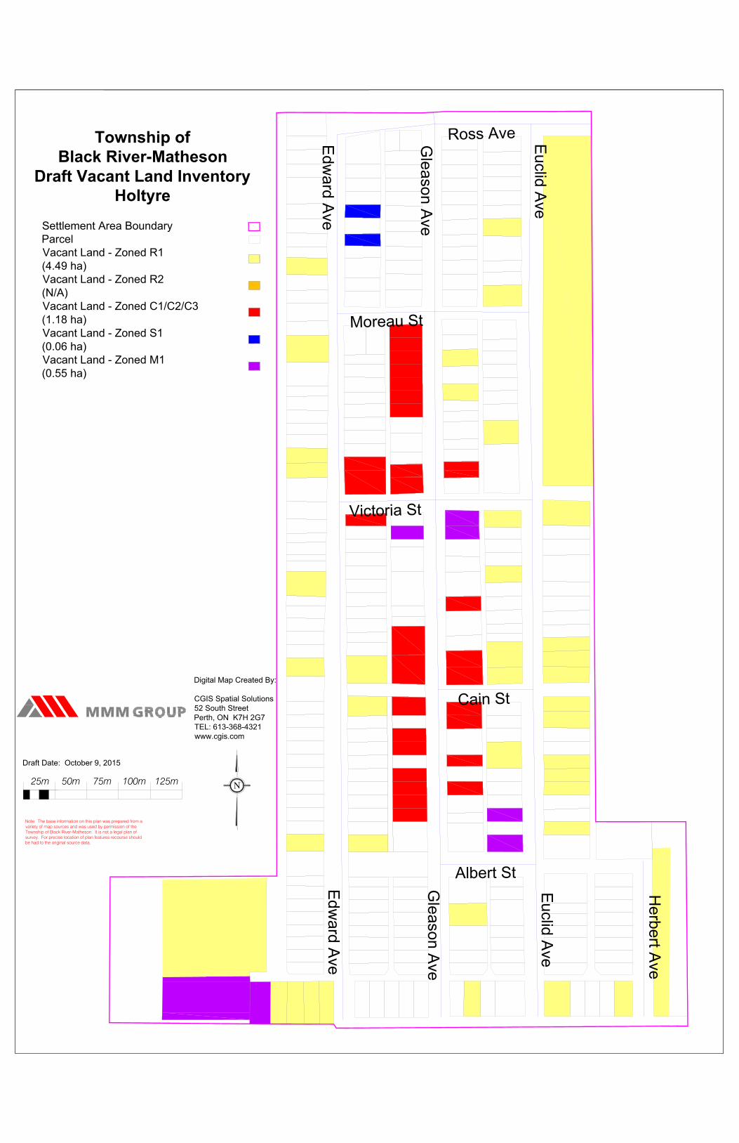
Note: The base information on this plan was prepared from avariety of map sources and was used by permission of theTownship of Black River-Matheson. It is not a legal plan ofsurvey. For precise location of plan features recourse shouldbe had to the original source data.
Digital Map Created By:
CGIS Spatial Solutions
52 South Street
Perth, ON K7H 2G7
TEL: 613-368-4321
www.cgis.com
Settlement Area Boundary
Parcel
Vacant Land - Zoned R1
(4.49 ha)
Vacant Land - Zoned R2
(N/A)
Vacant Land - Zoned C1/C2/C3
(1.18 ha)
Vacant Land - Zoned S1
(0.06 ha)
Vacant Land - Zoned M1
(0.55 ha)
Township of
Black River-Matheson
Draft Vacant Land Inventory
Holtyre
50m 75m 100m 125m25m
Edw
ard A
ve
Edw
ard A
ve
Gleason A
ve
Gleason A
ve
Euclid A
ve
Euclid A
ve
Herbert A
ve
Moreau St
Victoria St
Cain St
Albert St
Ross Ave
Draft Date: October 9, 2015

Note: The base information on this plan was prepared from avariety of map sources and was used by permission of theTownship of Black River-Matheson. It is not a legal plan ofsurvey. For precise location of plan features recourse shouldbe had to the original source data.
Digital Map Created By:
CGIS Spatial Solutions
52 South Street
Perth, ON K7H 2G7
TEL: 613-368-4321
www.cgis.com
Settlement Area Boundary
Parcel
Vacant Land - Zoned R1
(6.14 ha)
Vacant Land - Zoned R2
(N/A)
Vacant Land - Zoned C1/C2/C3
(1.46 ha)
Vacant Land - Zoned S1
(1.11 ha)
Vacant Land - Zoned M1
(0.01 ha)
Township of
Black River-Matheson
Draft Vacant Land Inventory
Ramore
50m 75m 100m 125m25m
Blue Jay R
d S
outh
H
ig
h
w
a
y
1
1
Rheaum
e A
ve
David A
ve
M
c
In
ty
r
e
A
v
e
T
im
m
in
s
A
v
e
F
e
r
g
u
s
o
n
A
v
e
F
e
r
g
u
s
o
n
A
v
e
C
h
a
m
p
a
g
n
e
S
t
E
n
n
is
S
t
D
e
n
n
in
g
S
t
K
n
o
x
S
t
S
t J
o
s
e
p
h
S
t
L
e
d
u
c
S
t
B
a
s
tie
n
S
t
Draft Date: October 9, 2015

Note: The base information on this plan was prepared from avariety of map sources and was used by permission of theTownship of Black River-Matheson. It is not a legal plan ofsurvey. For precise location of plan features recourse shouldbe had to the original source data.
Digital Map Created By:
CGIS Spatial Solutions
52 South Street
Perth, ON K7H 2G7
TEL: 613-368-4321
www.cgis.com
Settlement Area Boundary
Parcel
Vacant Land - Zoned R1
(6.21 ha)
Vacant Land - Zoned R2
(N/A)
Vacant Land - Zoned C1/C2/C3
(0.83 ha)
Vacant Land - Zoned S1
(N/A)
Vacant Land - Zoned M1
(N/A)
Township of
Black River-Matheson
Draft Vacant Land Inventory
Val Gagne
50m 75m 100m 125m25m
P
r
i
n
c
i
p
a
l
e
S
t
P
r
in
c
ip
a
le
S
t
Dum
ont S
t
Labonte Ave
Nushka Ave
Church Ave
Theriault St
Boisvert Ave
Val G
agne R
d S
outh
Pierre M
orin S
t
Lessard S
t
Draft Date: October 9, 2015