Embed Size (px)
Citation preview

TOWN PLAN OF CONSERVATION AND DEVELOPMENT
PLANNING AND ZONING COMMISSION TOWN OF WESTON, CONNECTICUT - JULY 1, 2010

Acknowledgments
The cover is a photograph of a historical barn in town that was constructed in 1838 as part of Chestnut Farm, located on Lyons Plain Road.
The photographs in this publication are provided by Joan Lewis.
Planning & Zoning Commission, Town of Weston, CT
1
Town of Weston
Plan of Conservation and Development
Prepared by the Weston Planning & Zoning Commission:
Stephan Grozinger, Chairman Jane Connolly, Vice Chairman
Donald L. Saltzman David Allen Ridge Young Katie Gregory
Joe Limone Paul Heifetz
Dr. Dan Gilbert
With the assistance of: Joan Lewis, Administrative Assistant
Victoria Farr, Land Use Intern Tracy Kulikowski, Land Use Director
Dr. J. Thomas Failla, Conservation Commissioner
July 1, 2010
2

Table of Contents Page Introduction 4 Natural Resources
Trees 5 Water 6 Sub-Watersheds Map 8 Open Space 10 Land Use Map 11
Economic Development
Home Occupations 12 The Center of Weston 12 Fromson-Strassler 17 Other Economic Development Considerations 19
Housing Development
Generally 20 Large Houses and Accessory Uses 21 Accessory Housing 22 Hydrants Map 23 Senior Housing 24 Affordable Housing 25
Community Facilities
Recreation 25 Other Facilities and Infrastructure 27
Transportation
Pedestrian Facilities 29 Bicycles 29 Public Transportation 31 Weston’s Roads 31 Traffic Volume 33
Implementation 33 Appendices
Appendix I—Questionnaire 35 Appendix II—Maps 37
3

Introduction Section 8-23 of the Connecticut General Statutes provides that:
At least once every 10 years, the [Planning and Zoning] commission shall prepare or amend and shall adopt a plan of conservation and development for the municipality. Following adoption, the commission shall regularly review and maintain such plan … Such plan of conservation and development shall be a statement of policies, goals and standards for the physical and economic development of the municipality.1
The Weston Planning and Zoning Commission, in conjunction with the Weston Conservation Commission (the “Committee”), endeavored to make the 2010 Plan, above all else, a concise, relevant, and dynamic document that would be referenced routinely over the course of the next decade. 2 As such, we decided to make a dramatic change from previous plans and dispense with descriptions of Weston’s history and avoid descriptions of Weston’s current state of affairs to the extent possible. Instead, the Committee sought to focus on the future; making recommendations for further discussion, research and—if determined to be appropriate—implementation. All of this was done with an eye towards addressing three questions raised time and again by Weston homeowners:
How can Weston better protect its water supply, natural resources and rural character? How can economic development help Weston control property taxes? How can Weston better utilize its facilities to the benefit of all Weston residents?
The Committee dedicated itself to soliciting the opinions of Weston residents concerning the issues addressed by the Plan. To this end, the Committee hosted several workshops with the public. The first such meeting was attended by about 200 Weston residents and was conducted by a private consulting group the Committee engaged to help discern the public’s general views. The Committee held several additional meetings with the public to discuss various more specific aspects of the Plan, such as residential development, commercial development and natural resources. The Committee also invited numerous board and commission chairs and agency heads to speak with the Committee, spoke with several public interest groups and encouraged residents to correspond in writing with the Committee. Perhaps the touchstone of the Committee’s efforts to ascertain the community’s position on issues affecting the Plan was the distribution of a questionnaire (the “Questionnaire”) posing 14 questions via an insert in The Weston Forum. Seven hundred and thirty-seven (737) questionnaires were returned. The results of the Questionnaire are attached as Appendix 1 and are in footnotes throughout the Plan.3
1 Connecticut General Statutes §8-23(a)(1) and §8-23(d)(1). 2 During the development of the 2010 Plan of Conservation and Development, the Planning and Zoning Commission was comprised of Paul Heifetz, Donald Saltzman, Dr. Dan Gilbert, Stephan Grozinger, Jane Connolly, Ridge Young, Katie Gregory, Joe Limone, and Dave Allen. The Conservation Commission was represented by Dr. J. Thomas Failla. Tracy Kulikowski, Weston’s Land Use Director, and Joan Lewis, Administrative Assistant to the Planning and Zoning and Conservation Commissions, were also instrumental in preparing the Plan. 3Due to statutory time constraints, the Committee decided to proceed to issue the Plan prior to the publication of the results from the 2010 United States Census. It is the Committee’s intention, however, to revise the Plan, as needed, to reflect relevant data disclosed by that census.
4
Weston is a unique community with extraordinary resources, but it also faces significant challenges. While the Plan is not a legally binding document, it is the Committee’s hope that the Plan inspires ideas, provokes discussions and helps guide Weston’s development and conservation efforts in a manner that preserves and protects the things that make Weston a unique and remarkable place to live. It is also our hope that the Plan will assist Weston to meet its challenges, creatively and decisively.
Natural Resources
Weston’s greatest treasure is its natural resources. Its landscape is dominated by large, mature trees and open space that is unsurpassed in Fairfield County. Our residents depend on a natural environment for their well-being. Virtually all of us draw our household water from wells that tap into natural groundwater and aquifers. All of us rely on septic systems that depend principally on natural processes to purify waste water and recharge our groundwater and aquifers.
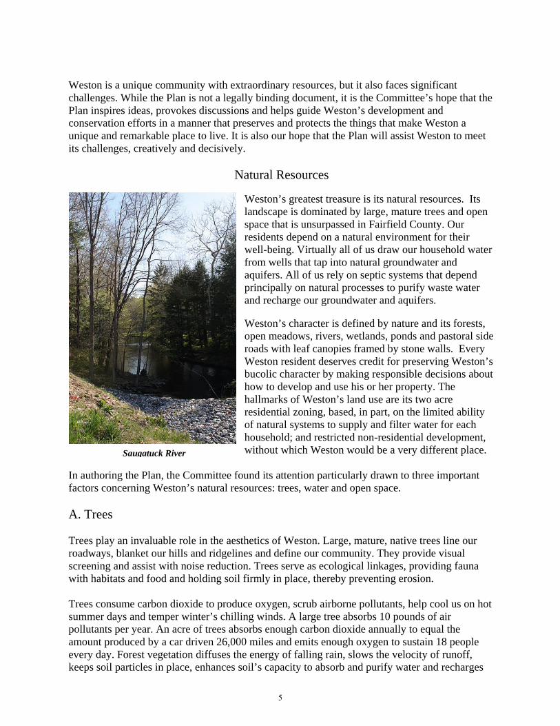
Weston’s character is defined by nature and its forests, open meadows, rivers, wetlands, ponds and pastoral side roads with leaf canopies framed by stone walls. Every Weston resident deserves credit for preserving Weston’s bucolic character by making responsible decisions about how to develop and use his or her property. The hallmarks of Weston’s land use are its two acre residential zoning, based, in part, on the limited ability of natural systems to supply and filter water for each household; and restricted non-residential development, without which Weston would be a very different place.Saugatuck River
In authoring the Plan, the Committee found its attention particularly drawn to three important factors concerning Weston’s natural resources: trees, water and open space. A. Trees Trees play an invaluable role in the aesthetics of Weston. Large, mature, native trees line our roadways, blanket our hills and ridgelines and define our community. They provide visual screening and assist with noise reduction. Trees serve as ecological linkages, providing fauna with habitats and food and holding soil firmly in place, thereby preventing erosion. Trees consume carbon dioxide to produce oxygen, scrub airborne pollutants, help cool us on hot summer days and temper winter’s chilling winds. A large tree absorbs 10 pounds of air pollutants per year. An acre of trees absorbs enough carbon dioxide annually to equal the amount produced by a car driven 26,000 miles and emits enough oxygen to sustain 18 people every day. Forest vegetation diffuses the energy of falling rain, slows the velocity of runoff, keeps soil particles in place, enhances soil’s capacity to absorb and purify water and recharges
5

groundwater supplies. Between rainfalls, vegetation moderates moisture and evaporation and helps control standing and subsurface waters that breed disease carrying insects. Vegetative buffers also absorb fertilizers and pesticides that some residents use on lawns and gardens. Land cleared of trees typically erodes at a rate of 50 tons per acre per year, which is 250 times greater than normal woodland erosion. Erosion hinders new plant growth and chokes the cycle of growth in wetlands, ponds, streams and rivers. Despite the fact that Weston’s land use agencies regularly receive complaints of runoff and flooding caused by the removal of trees, most respondents to the Questionnaire did not wish to have the Planning and Zoning Commission impose regulations limiting the removal of trees from private property.4 In light of that result, but recognizing the importance of trees to Weston’s health and character, the Committee makes the following recommendations: 1. Weston’s Beautification Committee should continue to seek to preserve large, mature, native
trees (to the extent consistent with public safety) and should plant trees on public property as part of an organized and sustained effort.
2. Weston’s residents are encouraged to preserve trees on their property to the extent possible,
to plant additional and/or replacement trees and, when doing so, to plant large, native species such as maple, oak and beech rather than small ornamental or non-native species.
B. Water With few exceptions, Weston households, schools, government buildings and commercial establishments rely on wells. Wells pump aquifer and groundwater supplies that are recharged by annual rainfalls that average about 46 inches. A secondary source for wells comes from water cleansed in our septic systems and processed further by natural filtration through the sand, gravel and hard rock fissures. Depending on soil type, about one-third of rainfall infiltrates the groundwater supply. At this rate, and allowing for recharge from recycled water, two acres of land are needed to supply an average Weston household of approximately 3.3 persons with sufficient water to meet their daily needs.
4 When asked in the Questionnaire whether tree removal on private property should be regulated, 469 respondents (64 percent) opposed the idea, 188 (26 percent) favored it, and 71 (10 percent) had no opinion. See Appendix 1.
6

Saugatuck Reservoir
The ecosystem that supports Weston lies well beyond the town’s borders. Approximately 97 percent of Weston’s 13,000 plus acres represents more than 23 percent of the Saugatuck River watershed ecosystem. The remainder, about 400 acres, falls within the Norwalk River watershed in the northwestern section of town. The Saugatuck River watershed covers approximately 90 square miles in 11 Fairfield County towns, including Weston. Within that watershed, 30 percent or more than 17,000 acres are protected from development, including 15,000 acres surrounding the Saugatuck and Aspetuck reservoirs. The Planning and Zoning Commission and the Conservation Commission are charged with protecting Weston’s water resources. Both commissions have refined their regulations and enforcement in recent years. For example, the Planning and Zoning Commission enacted a regulation requiring an engineered groundwater recharging system for new structures. It also adopted Aquifer Protection Area regulations for the Coleytown well field in southwestern Weston. The Conservation Commission, pursuant to State environmental statutes, reviews and regulates activities that impact wetlands and watercourses throughout Weston. Both Commissions will consider further regulation in a measured manner to respond to threats to Weston’s water supply and aquifers. Given the crucial role that water plays in our daily lives, Low Impact Development (“LID”) methodology should be embraced in our planning, development and regulatory practices. LID is a sustainable stormwater management approach that controls both rainfall and runoff at its source and distributes water throughout a site. Classically, water is channeled through drainpipes and larger conduits downstream away from the land. Simply put, an LID approach
7

")53
")53
")57
")53
")57
£¤7
Weston Sub-Watersheds2010 Weston Plan of Conservation and Development
Disclaimer: This map is intended for general planning purposes only. Source: NRCS 2005 Soil Survey Data for Fairfield County; DEP 2005 Wetlands, Local Basisns,Aquifer Protection Area, Natural Diversity Database 2008, and Hydrography datasets.
Norwalk River
W Cobbs Mill Brook
West Saugatuck
Godfrey Brook
North Brook Complex
SaugatuckReservoir
Jennings Brook
Beaver Brook
Davidge Brook
Kettle Creek
Saugatuck River
below resevoir
Aspetuck River
Norwalk River
West Saugatuck
Held Pond
West Saugatuck
Aspetuck River
Saugatuck River
below resevoir
.0 0.5 1 1.5 20.25 Miles
Prepared April 14, 2010 by
LegendWatercourseRegulated Wetlands 8
uses both natural devices (vegetation, native trees, etc.) and structural devices (roofs, paved parking lots and other surfaces) to maintain natural drainage patterns and to channel and filter water into the ground and streams or collect it for reuse. This approach reduces pollution, recharges groundwater, streams, wetlands and aquifers and stabilizes water flow. The goal of LID is to leave an area with as little negative impact from development as possible on water, water quality, water flow and wells. 5 Finally, in discussions with the Committee, poorly maintained household underground fuel oil tanks were identified by the Westport/Weston Health District as the number one threat to groundwater resources. In light of the foregoing, the Committee makes the following recommendations:
1. The Conservation Commission should explore LID methodology and, together with the Planning and Zoning Commission, promulgate regulations for Weston that embrace that approach, including revisiting and strengthening regulations controlling changes in rates and direction of runoff from roadways and lots; encouraging retention of existing forests, outcrops, ridges and stone walls; urging selective rather than clear-cutting of trees; and updating the Weston Environmental Resources Manual (1976).
2. The Select Committee on Sustainability, the Conservation Commission, the
Westport/Weston Health District, and the Town Engineer should monitor the potability of water throughout Weston in a comprehensive, systematic and sustained manner and report its findings regularly to the Board of Selectmen. Of particular concern should be the identification and remediation of poorly maintained septic systems and poorly maintained underground fuel oil tanks, the effect of the use of chemical fertilizers and pesticides on property within watersheds and the growing potential for localized pollution of surface water by an ever increasing waterfowl and deer population.
3. Residents should be cognizant of the polluting effect of household chemicals and lawn
fertilizers and seek to minimize their impact. Town Government should provide information regarding, and access to less polluting alternatives. For instance, Town Government should consider the feasibility of providing an area to residents for discarding household compostables, leaves and other lawn detritus and for retrieving compost for gardens and lawns.
4. Given that Town facilities represent a majority of the non-residential development in
Weston, Town Government should actively seek opportunities to reduce pollution of the aquifer and surface groundwater from those facilities.
5. The Planning and Zoning Commission should ensure that future subdivision road
systems and parking lots include engineered systems to recharge groundwater and reduce the introduction of roadway pollutants to groundwater.
5 Guillette, Anne. “Achieving Sustainable Site Design through Low Impact Development Practices.” www.wdbg.org/resources/lidsitedesign.php. See also, CT Guidelines for Soil Erosion and Sediment Control (CT DEP 2002).
9
6. The Select Committee on Sustainability, the Conservation Commission, the Westport/Weston Health District, and the Town Engineer should monitor availability of water throughout Weston in a comprehensive, systematic and sustained manner to ensure water use in Weston does not outstrip the supply.
7. Town Government, together with the Conservation Commission, should act to protect
and enhance significant fish and wildlife habitats, feeding areas, travel corridors and the ecology of rivers and streams.
C. Open Space “Open Space” is generally defined as natural and human influenced landscapes that remain relatively undisturbed. Open space may consist of several land categories, ranging from pristine preserves of high ecological significance to active recreational trails and playgrounds. Land reserved in Weston for watershed and conservation purposes alone totals 2,866 acres (more than 20 percent of Weston). The importance of open space to a town like Weston cannot be overstated. It is integral to our character and limits density in a manner that may be critical to the sustainability of our aquifers. Weston’s open space provides many benefits to our community, direct and indirect, short- and long‐term. Varied recreation areas, including ball fields, scenic trails, and working landscapes contribute to Weston’s character and quality of life. Weston’s open spaces range from large preserves like Devil’s Den and Trout Brook (which protect underground water resources and allow natural habitats to remain intact and ecologically healthy) to small playgrounds and parks like Keene Park on River Road. These provide a place for recreation, exercise, personal revitalization and socialization. Recognizing the importance of open space to Weston as a community, at the public hearings and in the Questionnaire, Weston residents voiced their commitment to acquiring more open space and maintaining that which is already ours.6 “Cluster development” is defined by Connecticut law as “a building pattern concentrating units on a particular portion of a parcel so that at least one-third of the parcel remains as open space to be used exclusively for recreational, conservation and agricultural purposes.”7 Cluster development is one method of preserving open space while allowing development. In light of the foregoing, the Committee makes the following recommendations:
1. Town Government should actively seek opportunities to purchase or solicit the donation of additional open space.
2. Town Government should encourage private conservation of open space. For instance,
the Planning and Zoning Commission may wish to explore permitting cluster
6 When asked in the Questionnaire about using tax dollars to purchase land for conservation, 440 respondents (60 percent) favored, 239 (32 percent) opposed, and 46 (6 percent) had no opinion. See Appendix 1. 7 C.G.S. §8-18
10

Newto
wn Tp
ke
State Hwy 5
3
State
Hwy 5
7
Godfrey Rd
VL Fo
rge Rd
Georg
etown
Rd
Good
Hill
Rd
State Hwy 136
Valley
Forge
RdWest
port R
d
Lyons
Plain Rd
US Hwy 7 Steep Hill Rd
Davis
Hill
Rd
Danbury
Rd
Old H
yde R
d
Lords Hwy
Old R
eddin
g Rd
Westport Tpke
Scho
ol Rd
Birch
Hill R
d
Mathe
r St
11 O
Cloc
k Rd
Westo
n Rd
Wells Hill Rd
Easton Rd
Cannon Rd
Langner Ln
Old Easton Tpke
Treadwell Ln
Pent
Rd
Old Mill Rd
Catbr
iar Rd
Catbr
ier Rd
Norfield Rd
Fanto
n Hill
Rd
Suns
et Dr
Seele
y Rd
Alwyn Ln
Farrell Rd
Honey Hill Rd
Salem Rd Kellogg Hill Rd
Kettle
Cree
k Rd
Greenfie
ld Dr
Codfish Ln
White
Birch
Rd
Calvin Rd
Tannery Ln
Octob
er Hl
Gilbe
rt Hwy
Mills Ln
Septe
mber
Ln
Raven
wood
Dr
Scribner Hill Rd
Phea
sant
Hill R
d
Freeb
orn Rd
Button
ball Ln
Greenlea Ln
Coley
Rd
Kramer Ln
Bradle
y Rd
Martin Rd
Riverbank R
d
Blueb
erry H
ill Rd
Old K
ings H
wy
Thorp Dr
Michaels Way
Wampum Hill Rd
Fern Valley Rd
Laurel Lk
Rogu
es Rd
g
Lyons Plains Rd
Wyld Wood Rd
Toba
cco R
d
Old H
yde R
oad E
xt
River Rd
Tubb
s Spri
ng D
r
Cindy
Ln
Hart L
n
Sachem Rd
Merry Ln
Ladder Hill Rd
Old Orchard Dr
Nove
mber
Trl
Katydid Ln
Wildw
ood L
n
Cardina
l Dr
Norfie
ld Wo
ods R
d
Churc
h Ln
Oak Ln
White Oak LnHillside Rd
Walnu
t Ln
Bayb
erry L
ane E
xt
Glory
Rd
Skylark Ln
Slumber Ln
VL Fo
rge Ln
Moun
tain R
d
Aspe
tuck H
ill Ln
Gray
s Farm
Rd
Broo
kwoo
d Ln
Wood Hill Rd
Bernh
ard D
r
Saw Mill Rd
Lakes
ide Dr
Woodland Dr
Old F
arm R
d
Doret
hy R
d
Walker Ln
Walden Woods Ln
Buck
Hill
Rd
Orchard Dr
Twin
Walls
Ln
Grey
Fox L
n
Hemlock Rdg
Dillon Pass
Curiosity Ln
Richm
ond H
ill Rd
Hill Farm Rd
Black Alder Ln
Jana
Dr
Ledg
ewoo
d Dr
Singing Oaks
Dr
Waterbury St
Deer
Run T
rl
Hurlbutt
St
Oakwood Dr
Uppe
r Pari
sh Dr
October Dr
Driveway
Cedar Hls
Timbe
r Top
Trl
Cricket Ln
Winthrop Hls
Moun
tain V
iew D
r
Forest Rd
Samuelson Rd
Hilltop
Ln
Rockhou
se Rd
Treasure Rd
Cortese
Dr
Deep
wood
Ln
Stillwater Ln
Hedg
erow
Cmn
Fresh
Mea
dow
RdBanks Dr
Maureen Dr
Stonehenge Rd
Stonec
liff Rd
Timoth
y Rd
Pilgrim Ln
Glen Ln
Marshall Ln
Eque
strian
Dr
Rolling Ridge Rd
Wedd
ington
Ln
Bally
moss
Scatacook Trl
Old F
ield R
d
Bittersweet RdCharles Path
Brier
Broo
k Rd
Adams Way
Lee Allen Ln
Mayflower Ln
Woodland Way
Trout
Broo
k Ln
Whippoorwill Ln
Lyons
Plains
Rd
Ladder Hill R
d
Freeborn Rd
Lords Hwy
Old Farm Rd
Kellogg Hill Rd
Laure
l Lk
")57
2010 Weston Plan of Conservation and DevelopmentLand Use
LegendWater
Residential UsesBusiness UsesConservation & WatershedFarm & Nursery GardeningPrivate RecreationPublic UsesSemi-Public UsesTown Parks & Open SpaceVacant
Disclaimer: This map is intended for general planning purposes only. Source: DEP 2005 Hydrography Datasets; Land Use MapBook, Town of Weston; South Western Regional Planning Agency Fairfield County Roads
0 0.5 1 1.5 20.25 Miles
. Prepared April 27, 2010 by
11

development in exchange for dedicating an undeveloped portion of a subdivision tract to open space8.
3. The Planning and Zoning Commission recently enacted a regulation allowing
subdividers of large parcels to pay 10 percent of the value of the subdivision to a special open space fund in lieu of dedicating a portion of the subdivision to open space. As these funds accrue, Town Government should actively identify parcels of particular ecological or aesthetic importance and purchase them outright or obtain conservation rights.
Economic Development
A. Home Occupations Weston’s current zoning regulations permit home occupations. Owners can hire a single employee (in addition to themselves) as of right and hire an additional employee with special permit approval. A certain amount of space in each home can be dedicated to business purposes. After much discussion and public input concerning these restrictions, the Committee believes that the existing regulations are appropriate—neither too restrictive nor overly permissive—and balance the community’s residential needs against those of a business in a residential setting. The Questionnaire indicated that Weston contains a remarkable number of home occupations: 15 percent of the respondents indicated that a home occupation was active within their household.9 The presence of a large number of home occupations is beneficial to Weston. Weston homes that are occupied during business hours support local businesses, furnish a certain amount of security for our neighborhoods and provide a pool of valuable candidates for Weston’s volunteer services including its emergency services. Furthermore, home occupations require virtually no additional infrastructure. Because of the limitations imposed on home occupations by Weston’s Zoning Regulations, they create neither traffic nor parking problems. They do not detract from Weston’s residential character and are, for the most part, virtually invisible to neighbors. The Committee believes that home occupations are to be encouraged. B. The Center of Weston Weston’s commercial spaces are strictly limited by its zoning regulations. Weston is divided into two districts: 1) the Two-Acre Residential and Farming District and 2) the Neighborhood Shopping Center District. All of Weston is in the Residential and Farming District, except the single six acre parcel commonly known as “Weston Center” which comprises its Neighborhood Shopping Center District. Within the Residential and Farming District, certain non-residential 8 See, From Planning to Action: Biodiversity Conservation in Connecticut Towns, WCS/MCA Technical Paper No. 10. By Michael W. Klemens, Marjorie F. Shansky and Henry J. Gruner, MCA (2006) 9 When asked whether the respondent conducted a business in his/her home, 108 (15 percent) responded in the affirmative. See Appendix 1.
12
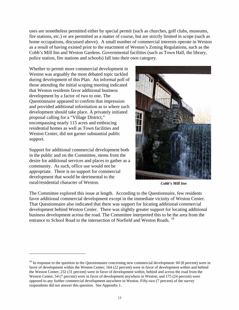
uses are nonetheless permitted either by special permit (such as churches, golf clubs, museums, fire stations, etc.) or are permitted as a matter of course, but are strictly limited in scope (such as home occupations, discussed above). A small number of commercial interests operate in Weston as a result of having existed prior to the enactment of Weston’s Zoning Regulations, such as the Cobb’s Mill Inn and Weston Gardens. Governmental facilities (such as Town Hall, the library, police station, fire stations and schools) fall into their own category. Whether to permit more commercial development in Weston was arguably the most debated topic tackled during development of this Plan. An informal poll of those attending the initial scoping meeting indicated that Weston residents favor additional business development by a factor of two to one. The Questionnaire appeared to confirm that impression and provided additional information as to where such development should take place. A privately initiated proposal calling for a “Village District,” encompassing nearly 115 acres and embracing residential homes as well as Town facilities and Weston Center, did not garner substantial public support. Support for additional commercial development both in the public and on the Committee, stems from the desire for additional services and places to gather as a community. As such, office use would not be appropriate. There is no support for commercial development that would be detrimental to the rural/residential character of Weston. Cobb’s Mill Inn The Committee explored this issue at length. According to the Questionnaire, few residents favor additional commercial development except in the immediate vicinity of Weston Center. That Questionnaire also indicated that there was support for locating additional commercial development behind Weston Center. There was slightly greater support for locating additional business development across the road. The Committee interpreted this to be the area from the entrance to School Road to the intersection of Norfield and Weston Roads. 10
10 In response to the question in the Questionnaire concerning new commercial development: 60 (8 percent) were in favor of development within the Weston Center; 164 (22 percent) were in favor of development within and behind the Weston Center; 232 (31 percent) were in favor of development within, behind and across the road from the Weston Center; 54 (7 percent) were in favor of development anywhere in Weston; and 175 (24 percent) were opposed to any further commercial development anywhere in Weston. Fifty-two (7 percent) of the survey respondents did not answer this question. See Appendix 1.
13

Weston Center
1. The Area within Weston Center. Additional development within the existing boundaries of Weston Center appears to be impossible unless the zoning regulations are changed to permit less parking per square foot of retail space. This is not only because new foundations may displace existing parking, but also because Weston Center currently has fewer parking spaces than the regulations require for the businesses presently operating there. It is the Committee’s recommendation that any proposed change to those regulations should be preceded by a thorough, professional traffic and parking study. This study should ensure that any further development would not overburden parking areas or create traffic hazards both on the property and on Weston Road. The Committee does not believe that such an expansion would have any real impact on Weston’s tax burden. 2. The Area Behind Weston Center It is the Committee’s understanding that Weston Center and the area immediately behind it is privately owned by the same entity (or shares commonality of ownership). The area behind the Center is comprised of approximately seven undeveloped acres. The Committee has no opinion as to whether that area is suitable for further development and would await an application to the Planning and Zoning Commission before making any recommendation. Nevertheless, the foregoing traffic considerations would apply as would a review and re-evaluation of other rules set forth in Section 322 of Weston’s Zoning Regulations. Again, given the size of this area, the Committee does not believe significant tax relief would be generated by such development. 3. The Area Across the Road from Weston Center The area that received the greatest support for possible additional development lies between the entrance to School Road and the intersection of Norfield and Weston Roads. That land is comprised of approximately 5.5 acres and, except for a private home on the corner of that intersection, is owned by the Town of Weston. Although the Committee expects development
14

of this area would generate a small amount of revenue, the primary goal would be to provide more services and to provide a community gathering place in the center of Weston. There are significant issues that require detailed study with regard to further development of this area. First, it currently contains the school bus depot and an athletic field which may need to be relocated or sacrificed if the area is developed. It also includes the Onion Barn, a historical structure and community facility which would need to be integrated into any development plan. Secondly, traffic is already a problem in the area as its serves as the primary north-south route through Weston, contains an entrance to the school campus and also contains the entrance to Weston Center. Thirdly, safety and security must be a primary concern given the proximity to the schools; if the area was developed, there would be no geographical barrier between that development and the schools; currently, Weston Road provides a physical barrier between the schools and Weston Center. Finally, the area is small, and water, septic and parking would need to be accommodated. There are, however, significant positive aspects to expanding business to this area. Its proximity to the school campus and to the Town Hall complex makes possible the installation of a sidewalk between these areas (a proposal that had strong support both from the public and among the Committee members). The school administration supports relocation of the bus depot, an area which the public and the Committee agree is an eyesore and a gross underutilization of the land. Parking lots associated with the Town Hall complex and parking behind the Onion Barn could be used by new businesses at certain times of day. Furthermore, such development could provide the additional services and social opportunities sought by Weston residents. Perhaps the greatest advantage of this area is that the land is largely publically owned and, as a result, the Town could derive direct non-tax revenue from its development, and the Town could very closely control the uses it is put to and the manner in which it is developed. For instance, the Town could ground lease the area to one or more tenants who would construct improvements at their own cost. The rents and other benefits derived from these leases (and any ancillary parking or septic easements granted to the tenants on adjacent land) would be significantly greater than property taxes imposed on privately held land. Furthermore, although the aesthetics of privately held land can be regulated to a certain extent (for instance, prohibiting plate glass windows), some elements that would be of critical importance to retaining Weston’s character cannot be successfully regulated (such as signage). Land owned by Weston can be controlled as any owner controls his or her land and Weston could virtually dictate the use and appearance of any structures. Clearly, any structure or structures built in the proposed area would have to appear entirely residential and should complement the Greek Revival style residential structures that already exist in the area. They should be situated immediately adjacent to the street and sidewalk (rather than behind a parking lot) in order to accentuate and not diminish Weston’s historic and small-town character. They should be situated so as to preserve the existing athletic fields. With regard to commercial development in or around the Weston Center, the Committee makes the following recommendations:
15

1. No action is currently required to the existing regulatory scheme. If a proposal for development within, adjacent to, or across the street from Weston Center is advanced, the Planning and Zoning Commission could address the changes needed to its regulations. Waiting until a development plan is proposed allows the Planning and Zoning Commission to work with solid proposals and facts rather than hypothetical situations.
2. The Planning and Zoning Commission, together with the Board of Education and Public
Works, should determine if the school bus depot can be moved to another location. 3. The Planning and Zoning Commission should ascertain whether the problems with
potential development of the area across the street from Weston Center can be resolved, whether such development is economically attractive and, when a plan is more fully developed, the breadth of public support. Any such study must include traffic and parking studies.
4. Before substantial resources are committed to the study of potential development of the
area across the street from Weston Center, the community’s views should be elicited as to what sorts of services should be provided and whether they justify the expense. Other means of increasing community-orientated services in the area should also be explored, such as narrowing the scope of uses permitted in the Neighborhood Shopping Center. Finally, making existing facilities more readily available to the public as described elsewhere in this Plan, may make further development unnecessary.
5. Critical to the implementation of any such development, in or around Weston Center, is
the appointment of a committee to oversee the process with professional guidance.
6. The purposes and efficacy of inclusion of Town-owned land in a Historic District should be evaluated.
Weston Historical Society
16

C. Fromson-Strassler Great concern has been expressed regarding the tax burden shouldered by Weston homeowners. While this has been brought to the forefront by the current recession, it is a problem which will only become more acute over time. Expenditures will inevitably rise over the course of the next decade and beyond. As demonstrated by recent events, we should not assume housing values and the Grand List will rise proportionately to meet such expenses. As illustrated by the chart below11, Weston is an overwhelmingly residential town with virtually no commercial tax base. As such, the tax burden falls squarely on Weston homeowners.
Town Percent Grand List Commercial/Industrial
Per Capita Tax
Weston 0.7 $5,116 Darien 6.4 $4,075 New Canaan 5.1 $4,560 Wilton 12.0 $4,624 Easton 2.2 $4,092 Westport 12.0 $4,822 Ridgefield 8.8 $3,962 Redding 5.2 $3,825 Greenwich 10.1 $3,748 Newtown 6.5 $2,929 Monroe 6.5 $2,490 Fairfield 8.9 $3,096 Brookfield 15.0 $2,711 Trumbull 13.8 $2,880 Bethel 13.5 $2,329 Shelton 17.2 $2,049 Stratford 15.4 $2,434 Stamford 25.3 $2,674 Norwalk 18.6 $2,441 Danbury 24.7 $1,622 Bridgeport 17.0 $1,509
Weston residents currently pay the highest per capita property taxes in Connecticut. Conversely, as to the percentage of commercial taxes collected to assist the resident tax base, Weston stands 168th of the 169 towns in Connecticut.12 As noted, permitting a few small commercial uses to be undertaken in the center of town will not have an appreciable long-term effect on the tax burden. Ground leasing town land in the area discussed above would have a greater impact, but would not be a permanent fix.
11 Connecticut Economic Resource Center, Inc. (www.cerc.com). 12 Selectman David Muller, The Weston Forum, Feb.11, 2010, p.13A, col. 3.
17

The Committee discussed at length whether the Fromson-Strassler property should be considered for development of a substantial office complex or other non-residential use employing Nyala Farms in Westport, Boehringer Ingelheim in Ridgefield, and Meadow Ridge in Georgetown as models.
The Fromson-Strassler property consists of approximately 85 acres and lies in the upper northwest corner of Weston on the Wilton town line. Although much of it is comprised of wetlands, steep slopes, shallow depths to bedrock and high water tables, it appears that 20 acres to 25 acres, located generally on the north-south axis along the Wilton town line, could be buildable. Fromson-Strassler is currently accessible from Upper Parish Road but might also be accessed at one or more points along Georgetown Road or from Wilton. It is owned by the Town and is not subject to any deed restriction. The property’s location near existing water, sewer, and gas lines and its proximity to Routes 107 and 7 make the creation of an infrastructure for such a project appear feasible. The Committee is advised that development of the Gilbert and Bennett Mill property (in the Redding section of Georgetown) into mixed commercial and residential use will include the formation of a Transportation Oriented District along the Metro-North Danbury train line and existing north-south bus service on Route 7. Those plans may necessitate the enlargement of adjacent roadways by the Connecticut Department of Transportation which may benefit the Fromson-Strassler property. As to the development itself, the Town of Weston could ground lease this parcel on a long-term (for example, 100 years) net basis, which means the tenant undertakes all responsibility for development costs. Because of the size and location of the Fromson-Strassler parcel, a substantial complex could be hidden from the view of adjacent property owners and, thus, have
18

a minimal impact on Weston’s current character. As a ground lessor, the Town could control the specifications of the project, such as its size, design, height, bulk, and use. If the commercial enterprise only required a portion of the parcel, perhaps senior housing or a cemetery/memorial park could be located on the remainder. We are proposing this idea for further discussion, debate, and study; we are not recommending it outright at this time. Obviously, a project such as this will have an impact on its neighborhood and although Weston can work hard to minimize that impact, significant sacrifices will have to be made. Nonetheless, if the Town were to ground lease this parcel for development, after a period of little or no revenue (to compensate the ground lessee for development costs), the Town of Weston would own a very significant revenue source for the foreseeable future.
We are very cognizant of the fact that feelings run very high with regard to commercial development anywhere in Weston. If we proceed, we must proceed with utmost caution. Nonetheless, we feel that responsible government requires that this issue be fully explored now so that, if it is accepted, the long procexecuting it can begin. Weston Public Library
ess of
The first step in exploring this idea further is to form a committee to lead that exploration and to report to the Board of Selectmen and, critically, to one or more Town Meetings. It is anticipated that if the project is undertaken, the committee would become permanent and would manage the Town’s interest in the ground lease and any other Town-owned, income-producing property (including, for instance, the cell towers) to maximize value while protecting Weston’s character, and would do so with the assistance of a professional property management firm. With regard to the Fromson-Strassler property, the Committee recommends the following:
1. The Planning and Zoning Commission should explore the feasibility of developing the Fromson-Strassler land and ascertain public support.
Weston Town Hall
2. If such development is found feasible, the Committee, together
with the Board of Finance, should analyze whether an outright sale or a long-term ground lease would be more beneficial to Weston.
D. Other Economic Development Considerations In addition to exploring ways to increase revenue, Weston must find ways to creatively decrease spending. Opportunities likely exist both on the intra-town level and on the inter-town level. Town Government should continue to explore ways in which services provided separately to the schools and to the general administration
19
can be integrated to save money. Also, The Town of Weston should discuss with surrounding towns ways in which to regionalize functions of government. Any opportunity should be carefully analyzed, including tax assessment, tax collection, town clerk functions, and public works. In addition, we should seek to engage in more pooled purchasing of material and services with other towns, even those that are not contiguous to us. For clarity, although we believe government functions should be regionalized to the extent practical, government units should remain independent. Planning and other functions of municipal government should remain local to preserve home rule and accountability.
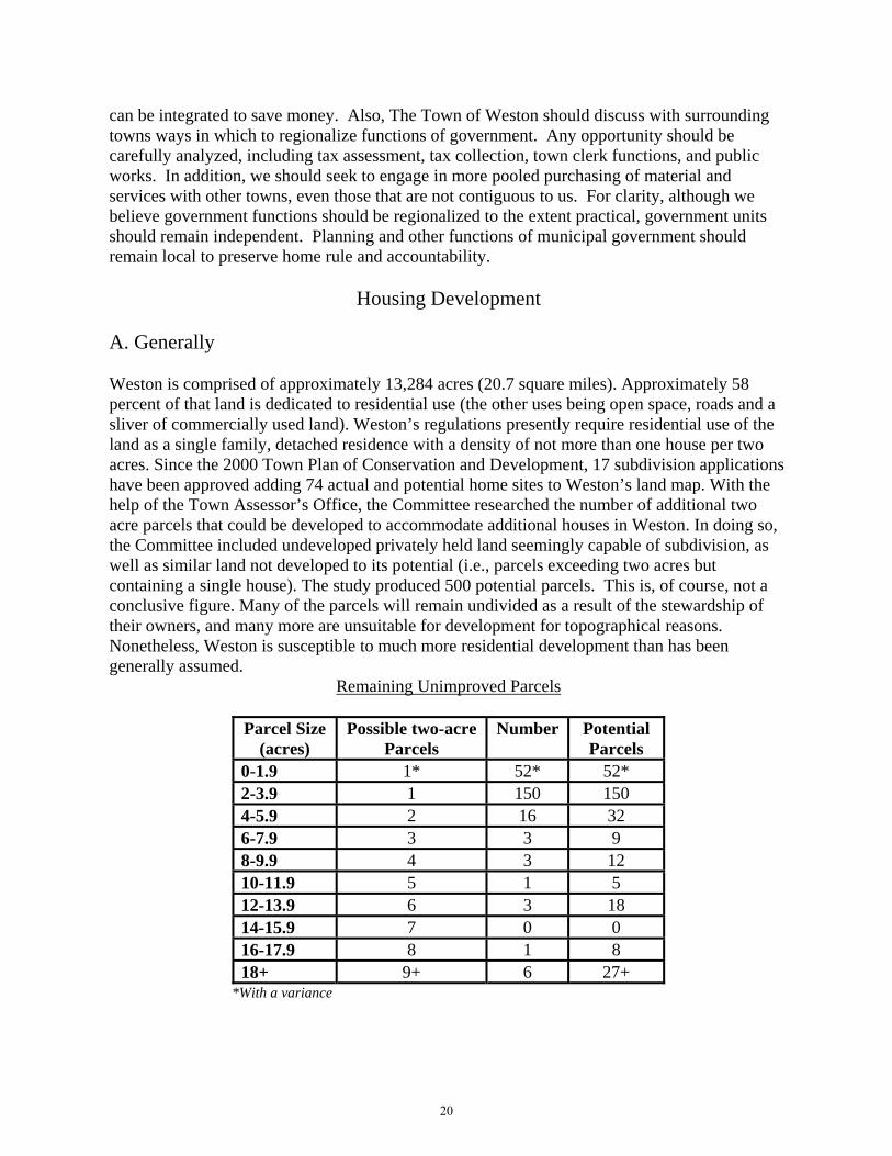
Housing Development A. Generally Weston is comprised of approximately 13,284 acres (20.7 square miles). Approximately 58 percent of that land is dedicated to residential use (the other uses being open space, roads and a sliver of commercially used land). Weston’s regulations presently require residential use of the land as a single family, detached residence with a density of not more than one house per two acres. Since the 2000 Town Plan of Conservation and Development, 17 subdivision applications have been approved adding 74 actual and potential home sites to Weston’s land map. With the help of the Town Assessor’s Office, the Committee researched the number of additional two acre parcels that could be developed to accommodate additional houses in Weston. In doing so, the Committee included undeveloped privately held land seemingly capable of subdivision, as well as similar land not developed to its potential (i.e., parcels exceeding two acres but containing a single house). The study produced 500 potential parcels. This is, of course, not a conclusive figure. Many of the parcels will remain undivided as a result of the stewardship of their owners, and many more are unsuitable for development for topographical reasons. Nonetheless, Weston is susceptible to much more residential development than has been generally assumed.
Remaining Unimproved Parcels
Parcel Size (acres)
Possible two-acre Parcels
Number Potential Parcels
0-1.9 1* 52* 52* 2-3.9 1 150 150 4-5.9 2 16 32 6-7.9 3 3 9 8-9.9 4 3 12 10-11.9 5 1 5 12-13.9 6 3 18 14-15.9 7 0 0 16-17.9 8 1 8 18+ 9+ 6 27+
*With a variance
20

Lots Improved by a Dwelling in Excess of Four Acres
Parcel Size (acres)
Possible Additional Parcels
Number Potential Parcels
4-5.9 1 63 63 6-7.9 2 20 40 8-9.9 3 6 18 10-11.9 4 3 12 12-13.9 5 3 15 14-15.9 6 1 6 16-17.9 7 1 7 18+ 8+ 2 16+
B. Large Houses and Accessory Uses The chart below illustrates the size of houses in Weston: Size (sq ft)
0-1500 1501-3000 3001-4500 4501-6000 6001-7500 7501-9000 9001+
Number 707 1526 1112 428 157 50 21 Source: Assessor, 2008 According to the Questionnaire results, Weston residents do not want to further regulate the size of Weston houses nor do they favor a reduction in the percentage of each lot that can be dedicated to such uses as playing courts, swimming pools and pool houses.13 The Committee acknowledges that Weston is an attractive, sustainable community because of the good choices made by individual homeowners about their own lots. Nonetheless, during the information gathering phase of this Plan, the Committee was advised of numerous complaints about the change in water runoff that often accompanies installation of pools and the like. Increases in impervious and semi-impervious surfaces that accompany further developed lot coverage (such as roofs, paved areas, sports and recreational facilities and manicured lawns without appropriate controls) have serious implications for runoff, erosion and other conditions that can adversely affect neighboring properties as well as the natural environment. The Committee believes that the Planning and Zoning Commission, together with the Conservation Commission, should study ways to alleviate such problems, such as requiring natural buffering and the use of permeable surfaces where appropriate.
13 In response to the query whether Weston lots are overdeveloped (with pools, playing courts, pool houses, etc), 131 (18 percent) responded in the affirmative, 512 (69 percent) responded in the negative, and 84 (11 percent) had no opinion. See Appendix 1.
21

Very large homes present a fire suppression challenge. Weston has few pressurized hydrants. The fire department essentially relies on natural water bodies and a modest number of fire ponds. The Committee believes that the Planning and Zoning Commission ought to very carefully study reasonable measures to ensure fire suppression infrastructure proximate to large homes and subdivisions is sufficient. For instance, sprinklers may be
required for large homes, swimming pools may be required to serve double-duty as fire ponds, and cisterns and fire ponds may need to be installed in close proximity to the largest homes. Also, the height of homes, businesses, and municipal structures should continue to be strictly regulated to permit the fire department to access the highest points with its present equipment. Roads also must be designed to allow for access by fire apparatus and tanker relays by having generous turn-arounds and hammerheads and deadends should be discouraged. The fire department’s efforts to systematically serve the entire Town with fire ponds and cisterns shoube supported
House on Old Redding Road
ld
With respect to residential housing, the Committee recommends the following:
1. The Planning and Zoning Commission and Conservation Commission should investigate ways to limit erosion and increased or altered runoff.
2. The Planning and Zoning Commission, in conjunction with the Weston Volunteer Fire
Department, should study ways to ensure that Weston’s fire suppression infrastructure can accommodate large homes and subdivisions.
3. Town Government should continue to support the efforts of the Weston Volunteer Fire
Department to systematically and strategically locate cisterns and fire ponds. C. Accessory Housing Weston’s zoning regulations permit accessory apartments that are small and located within the primary dwelling. The Questionnaire indicated that Weston’s residents are nearly equally divided when asked whether they would support the use of a stand-alone building as an accessory apartment.14 Many residents are concerned that density would increase and strain
14 In response to the question whether a stand alone building should be permitted to be used as an apartment or guest house, 330 (45 percent) favored such use, 311 (42 percent) opposed it, and 86 (12 percent) had no opinion. See Appendix 1.
22

ÑÑ
ÑÑ
ÑÑ
Ñ
Ñ
Ñ
Ñ
Ñ
ÑÑ
Ñ
Ñ
ÑÑ
Ñ
Ñ
Ñ
ÑÑ
Ñ
Ñ
Ñ
ÑÑ
Ñ
ÑÑÑ Ñ
ÑÑ
Ñ
Ñ
Ñ
Ñ
Ñ
Ñ
Ñ
Ñ
Ñ
Ñ
Ñ
Ñ Ñ
ÑÑÑ
Ñ
Ñ
Ñ
ÑÑÑ
ÑÑ
ÑÑ Ñ
Ñ
Ñ
Ñ
Ñ
Ñ
Ñ
Ñ
Ñ
Ñ
Ñ
Ñ
Ñ
ÑÑ
ÑÑ
ÑÑ
Ñ
Ñ
Ñ ÑÑÑ ÑÑ
Newto
wn Tp
ke
State Hwy 5
3
State
Hwy 5
7
Godfrey Rd
VL Fo
rge Rd
Georg
etown
Rd
Good
Hill
Rd
State Hwy 136
Valley
Forge
RdWest
port R
d
Lyons
Plain Rd
US Hwy 7
Steep Hill RdDa
vis H
ill Rd
Danbury
Rd
Old H
yde R
d
Lords Hwy
Old R
eddin
g Rd
Westport Tpke
Scho
ol Rd
Birch
Hill R
d
Mathe
r St
11 O
Cloc
k Rd
Westo
n Rd
Wells Hill Rd
Easton Rd
Cannon Rd
Langner Ln
Old Easton Tpke
Treadwell Ln
Pent
Rd
Old Mill Rd
Catbr
ier Rd
Catbr
iar Rd
Norfield Rd
Fanto
n Hill
Rd
Suns
et Dr
Seele
y Rd
Alwyn Ln
Farrell Rd
Honey Hill Rd
Salem Rd Kellogg Hill Rd
Kettle
Cree
k Rd
Greenfie
ld Dr
Codfish Ln
White
Birch
Rd
Calvin Rd
Tannery Ln
Octob
er Hl
Gilbe
rt Hwy
Mills Ln
Septe
mber
Ln
Raven
wood
Dr
Scribner Hill Rd
Phea
sant
Hill R
d
Freeb
orn Rd
Button
ball Ln
Greenlea Ln
Coley
Rd
Chicken
St
Kramer Ln
Bradle
y Rd
Martin Rd
Riverbank R
d
Blueb
erry H
ill Rd
Old K
ings H
wy
Thorp Dr
Michaels Way
Wampum Hill RdFern Valley Rd
Laurel Lk
Rogu
es Rd
g
Lyons Plains Rd
Toba
cco R
d
Old H
yde R
oad E
xt
River Rd
Tubb
s Spri
ng D
r
Cindy
Ln
Hart L
n
Sachem Rd
Merry Ln
Ladder Hill Rd
Old Orchard Dr
Nove
mber
TrlKatydid Ln
Wildw
ood L
n
Cardina
l Dr
Norfie
ld Wo
ods R
d
Churc
h Ln
Oak Ln
White Oak Ln
Hillside RdWa
lnut L
n
Bayb
erry L
ane E
xt
Glory
Rd
Skylark Ln
Slumber Ln
VL Fo
rge Ln
Moun
tain R
d
Aspe
tuck H
ill Ln
Gray
s Farm
Rd
Broo
kwoo
d Ln
Wyld
Woo
d Rd
Wood Hill Rd
Bernh
ard D
r
Saw Mill Rd
Lakes
ide Dr
Old F
arm R
d
Walker Ln
Doret
hy R
dWalden Woods Ln
Buck
Hill
Rd
Orchard Dr
Twin
Walls
Ln
Grey
Fox L
n
Hemlock Rdg
Dillon Pass
Curiosity Ln
Richm
ond H
ill Rd
Hill Farm Rd
Black Alder Ln
Jana
Dr
Ledg
ewoo
d Dr
Singing Oaks
Dr
Waterbury St
Deer
Run T
rl
Hurlbutt
St
Oakwood Dr
Uppe
r Pari
sh Dr
October Dr
Driveway
Cedar Hls
Timbe
r Top
Trl
Cricket Ln
Winthrop Hls
Moun
tain V
iew D
r
Forest Rd
Samuelson Rd
Hilltop
Ln
Rockhou
se Rd
Treasure Rd
Cortese
Dr
Deep
wood
Ln
Stillwater Ln
Hedg
erow
Cmn
Fresh
Mea
dow
Rd
Banks Dr
Maureen Dr
Stonehenge Rd
Stonec
liff Rd
Timoth
y Rd
Pilgrim Ln
Glen Ln
Marshall Ln
Eque
strian
Dr
Rolling Ridge Rd
Wedd
ington
Ln
Bally
moss
Scatacook Trl
Old F
ield R
d
Bittersweet RdCharles Path
Brier
Broo
k Rd
Adams Way
Lee Allen Ln
Mayflower Ln
Woodland Way
Trout
Broo
k Ln
Whippoorwill Ln
Lyons
Plains
Rd
Ladder Hill R
d
Freeborn Rd
Lords Hwy
Old Farm Rd
Kellogg Hill Rd
Laure
l Lk
")57
Hydrant Locations2010 Weston Plan of Conservation and Development
.0 0.6 1.20.3
Miles
Prepared April 15, 2010 by
Disclaimer: This map is intended for general planning purposes only. Source: DEP 2005 Hydrography datasets; and Hydrant Data, Weston Volunteer Fire Department.
Legend
RoadsWatercourse
Ñ Dry HydrantÑ OtherÑ Pressurized Hydrant
23

public and natural resources, most notably school enrollment and water and septic use. Those who support such use typically cite the desire among residents to have family close by, but perhaps not living within the same structure, and the attractiveness of a quintessentially New England ‘compound’ made up of a primary residence with additional ancillary structures around it. Additionally, restricting accessory structures limits a homeowner’s ability to add value to their property and impacts the tax base. The Committee believes the Planning and Zoning Commission should continue to study this issue. With respect to accessory housing, the Committee recommends the following:
1. The Planning and Zoning Commission should continue to study the benefits and
burdens of accessory housing in light of the Questionnaire results. D. Senior Housing Many of Weston’s seniors face significant challenges to their desire to continue to call Weston their home. Those with fixed incomes are particularly impacted by any increase in property taxes. Others confront physical limitations that often come with age. Given the paucity of single level housing stock (which grows thinner with every tear-down) and the staggering cost of converting such houses to be handicap accessible, seniors face a quintessential Hobson’s choice. The Committee explored the possibility of providing subsidized townhouse style housing for Weston seniors, looking to The Ballard Green senior housing community in Ridgefield as one such model. Town sponsored (i.e. tax supported) senior housing, however, was opposed in the Questionnaire.15 Nonetheless, the issue remains an important one to a large, growing segment of our community.16 With respect to senior housing, the Committee recommends the following:
1. The Committee encourages the exploration of senior housing solutions with private developers so as to avoid any impact on Town funds, such as securing a developer to purchase land or possibly ground lease Town-owned land.
2. The possibility of changing Weston’s Zoning Regulations to provide for cluster housing
for the elderly should be investigated. 3. Other ways to better house and serve our seniors, such as permitting larger houses to be
utilized so as to provide housing for a few senior families, should also be explored. In this latter instance, rules could be promulgated, such as limiting the number of individuals permitted to inhabit such a house, limiting the number of cars on the property, etc. In other words, the impact could be as minimal as it is invisible.
15 In response to the question concerning the development of Town sponsored senior housing, 300 (41 percent) favored it, 351 (48 percent) opposed, and 78 (11 percent) had no opinion. See Appendix 1. 16 At the “Town Speak-Up” held on February 6, 2010, it was stated that 65percent of Weston’s adult population is comprised of “empty nesters,” and that the vast majority of those residents desire to remain in Weston. The Weston Forum, Feb.11, 2010, p.13A, col.5.
24
E. Affordable Housing Weston is a community of many ages and incomes. Under Section 8-2 of the Connecticut General Statutes, zoning regulations “must promote housing choice and economic diversity in housing, including housing for both low and moderate income households.” In furtherance of this goal, Town Plans of Conservation and Development are required to provide for and promote affordable housing opportunities. Under current law, to be deemed an affordable housing unit, the unit must be “deed restricted” for 40 years. The law further requires that the unit be sold or leased at or below prices that will preserve it as housing for which persons or families pay 30 percent or less of their annual income. Such annual income must be less than or equal to 80 percent of the area’s median income (or the state median income, if it is less).17 The statute currently allows developers whose proposed project includes at least 30 percent affordable housing units, and whose application for such a development is denied, to virtually disregard local zoning restrictions. Such a proposed project might be defeated, however, if there is proof of inadequate water supply, inadequate sewage disposal and fire safety problems. If at least ten percent of a town’s housing stock is affordable, that town is exempt from the statute. According to the Connecticut Department of Economic and Community Development, Weston has 3,532 housing units. To be exempt from the statute, Weston would need 353 affordable units in place. Weston currently has only one housing unit that meets the guidelines of the Affordable Housing statute. In light of the foregoing, with respect to senior and affordable housing, the Committee recommends the appointment by Town Government of an Affordable Housing Committee and a Senior Housing Committee to:
1. Focus on meeting the housing needs of senior citizens, town employees, younger
residents and others with low or moderate incomes. 2. Research the availability of funding for affordable and senior housing from non-profit
organizations, government agencies and private sources. 3. Examine ways to provide more affordable housing options given Weston’s rugged
terrain, the water carrying capacity of the land, septic and leaching requirements and erosion concerns.
Community Facilities
A. Recreation Weston enjoys 582 acres of Town land for public recreation, 130 of which comprise the school campus. Weston has a variety of ball fields, numerous playgrounds, tennis courts, an indoor swimming pool, an outdoor swimming pond, a multitude of walking trails, and rivers, streams and a reservoir for fishing. These recreational areas are supplemented by the Aspetuck Country
17 According to the Connecticut Housing Finance Authority Maximum Gross Rent and Income Limits, the area’s medium income for a family of four is $122,300. To qualify for a four bedroom affordable housing unit in Weston, a family’s income cannot exceed $98,500 and the monthly rent for that unit cannot exceed $2,304. See CHFA.org.
25
Club, the Weston Field Club, the Weston Gun Club, and the Weston Racquet Club, all of which are private clubs available for use by their members.
Morehouse Farm Park
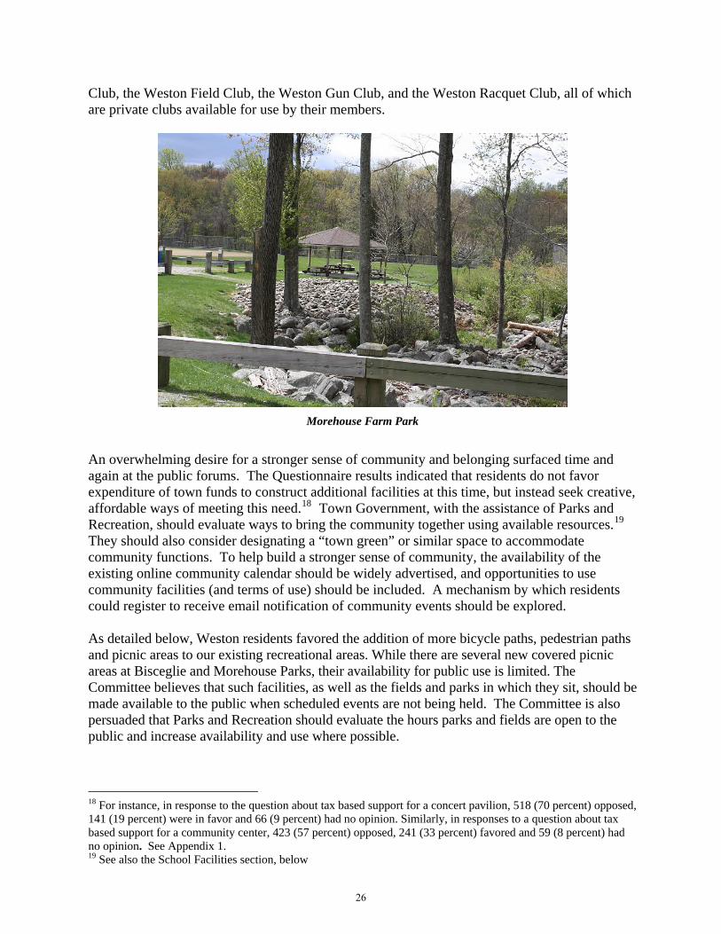
An overwhelming desire for a stronger sense of community and belonging surfaced time and again at the public forums. The Questionnaire results indicated that residents do not favor expenditure of town funds to construct additional facilities at this time, but instead seek creative, affordable ways of meeting this need.18 Town Government, with the assistance of Parks and Recreation, should evaluate ways to bring the community together using available resources.19 They should also consider designating a “town green” or similar space to accommodate community functions. To help build a stronger sense of community, the availability of the existing online community calendar should be widely advertised, and opportunities to use community facilities (and terms of use) should be included. A mechanism by which residents could register to receive email notification of community events should be explored. As detailed below, Weston residents favored the addition of more bicycle paths, pedestrian paths and picnic areas to our existing recreational areas. While there are several new covered picnic areas at Bisceglie and Morehouse Parks, their availability for public use is limited. The Committee believes that such facilities, as well as the fields and parks in which they sit, should be made available to the public when scheduled events are not being held. The Committee is also persuaded that Parks and Recreation should evaluate the hours parks and fields are open to the public and increase availability and use where possible.
18 For instance, in response to the question about tax based support for a concert pavilion, 518 (70 percent) opposed, 141 (19 percent) were in favor and 66 (9 percent) had no opinion. Similarly, in responses to a question about tax based support for a community center, 423 (57 percent) opposed, 241 (33 percent) favored and 59 (8 percent) had no opinion. See Appendix 1. 19 See also the School Facilities section, below
26

B. Other Facilities and Infrastructure 1. In General The Town of Weston takes much pride in the small town character and appearance of its facilities and service offerings. One purpose of the Plan is to evaluate strategic long-term options for use of physical space to meet present and future community needs. Town Hall complex, located on Norfield Road near the intersection of Route 57, is comprised of Town Hall, the library, police headquarters, communications center and one of Weston’s two fire houses, which also includes Weston’s Emergency Medical Service. A thorough analysis of the physical condition of town facilities for Weston was the subject of a report compiled in 2008 by Kaestle-Boos. Given fiscal constraints, the focus of the Capital Committee and Town Government is on maintenance, repair and where necessary, replacement, rather than the construction of new facilities. For example, a new roof, doors and windows are being installed in 2010 at the Middle School. Likewise, reconstruction of the Valley Forge Bridge has been undertaken, having been necessitated by its age and poor condition. Middle School wetlands mitigation and Revson Field projects are also under consideration and are driven by necessity and cost. In the coming years, the facility housing the Weston Police Department should be studied to ascertain its need of repair, renovation or replacement. Town Government should continue to monitor and prioritize repairs, renovations and necessary expansions to ensure our current facilities are well maintained. 2. School Facilities
The facilities on the school campus have recently undergone substantial expansion with the construction of the Intermediate School and partial renovation of and addition to the High School. While the Middle School is undergoing major capital improvements, such as a new roof, the Committee does not anticipate that further expansion will be necessary in the coming decade. As previously noted, the Committee recommends that the bus depot be relocated: its position contributes to traffic problems, it is an unattractive gateway to the heart of Weston, and is a poor use of prime Town-owned real estate. Town Government, together with the Board of Education, should determine if the buses can be moved to another location in Weston, such as the Transfer Station or the Public Works Garage, or if they can be moved entirely outside of Weston.
Hurlbutt Elementary School Weston Intermediate School
27

The school facilities represent a tremendous resource for students in Weston. Many individuals with whom the Committee spoke while preparing the Plan suggested that those facilities should be made more available to the Weston’s non-student public. Specifically, it was suggested that, to the extent space becomes available in the future, the Senior Center could be expanded to encompass a larger part of East House at Hurlbutt Elementary School. It was further suggested that, on weekend evenings, that space could be utilized as a Teen Center. To supplement the Weston Public Library facilities, the computer labs within the schools might also be made available to the public on a limited basis. Auditoriums, gymnasiums, the workout room at the High School, the Middle School pool—all should be, or continue to be, made available to the general public and their availability should be publicized. Efforts should be made to ensure that the process of reserving those spaces is streamlined and does not include unnecessary obstacles for Weston’s own community groups. The need for and, if needed, the cost of such requirements as security deposits and insurance certificates should be investigated so as to guarantee affordable access to such facilities. The Committee makes the following recommendations:
1. The Facilities Subcommittee of the Board of Education, expanded for this purpose to include a number of other interested citizens, should explore the expanded use of school facilities for the community as a whole including:
(a) expanded use of parts of East House in Hurlbutt Elementary School for seniors and teens;
(b) use of the High School gym by residents a few nights a week for “pick-up” basketball games and the like;
(c) use of the Middle School pool for exercise class for residents/seniors; (d) use of the High School workout room for residents and seniors; (e) use of the High School cafeteria for town wide social events; and (f) use of smaller rooms in schools for various community functions.
2. The expanded Subcommittee should explore the feasibility of installing picnic benches and barbecues on school property for use by Weston residents when schools are not in session.
3. The expanded Subcommittee should investigate the possibility of leasing, for profit,
school facilities (i.e., pool, gym, etc.) for private functions. 4. The expanded Subcommittee, together with the Town Attorney, should review relevant
labor contracts to ascertain what duties attendant to the foregoing uses can be undertaken by responsible adult residents on a volunteer basis.
5. Examine ways to broaden community interaction, including movie nights, progressive
dinners, outdoor performances in theater, dance and music and a community fair to benefit all four schools.
28

Transportation A. Pedestrian Facilities Weston residents largely rely on their cars to get to their chosen destinations, although there are some who prefer to bicycle or walk. Weston has no mass transit and no sidewalks. 20 The public expressed a great deal of interest in developing a system of sidewalks along School Road to the Town Hall complex as well as more routes for bicycle use. The desire to connect the schools, the Town Hall complex, Weston Center, school parks and the public library appears motivated by the desire to enhance the small town feel of Weston and to enable travel among these places by foot. The Committee believes that walking in these central areas of town should be encouraged. An idea that anecdotally received a great deal of support was a program to close a road to vehicular access on a small number of days during the summer to provide a safe area to walk, bicycle, and gather. The Town once closed School Road for this purpose and the Committee feels this should be explored as a possibility, if school activities permit. Another alternative is to close Valley Forge Road between the intersection of Davis Hill Road and the end of the Valley Forge Road at Newtown Turnpike. There are small parking areas at each end, there are no houses along its length, and it is one of the most attractive roads in Weston. One lane could be dedicated to walkers, while another could be open to bicyclists. Consequently, the Committee recommends the following:
1. The Board of Selectmen should appoint a committee to study, in consultation with the Town Engineer, Police Department, Board of Education, and the Board of Finance, the feasibility and cost of installing walking/biking paths connecting key locations in the center of Town.
2. If that committee determines that such a project is physically and economically feasible and enhances the quality of life in Weston, such construction should go forward.
3. The Board of Selectmen should close School Road or Valley Forge Road several
Sundays each summer for pedestrian and bicycle traffic.
B. Bicycles Many members of the public voiced concern with the hazards of biking on certain roads in Weston.21 It was proposed that bike lanes be added to Weston’s already narrow roads. This suggestion would entail widening roads and, in some instances, using the power of eminent domain over private property to accomplish that goal. The Committee believes that the Town is 20 Weston participates in the State funded program known as “Dial-A-Ride.” This service provides transportation to seniors primarily for local medical appointments. 21 Weston residents consistently raised their voices about this problem at each of the public meetings held on the Plan.
29

not in a position to undertake this project at this time, nor does it support the use of condemnation of private property for this purpose. The Committee believes bicycling should not only be supported, but should be encouraged in Weston. In fact, as of October 1, 2010, one percent of the transportation funds provided to a town by the State must be used for facilities for all users including bicyclists and pedestrians pursuant to Public Act 09-154.
A cyclist in Weston
The Committee recommends as follows:
1. The Board of Selectmen should appoint a Bicycle Committee, which, in consultation with the Town Engineer, the Police Department, the Police Commission and the Fire Department, should:
(a) Categorize Weston roads for bicycle use: (a) Beginner/family friendly; (b) Intermediate cyclist; (c) Advanced cyclist; and (d) Dangerous, all with the explicit understanding that these are suggested categories only and are not so officially sanctioned by the Town.
(b) Maintain a resource of bike trails, roads, and other routes for cyclists, such information to be made available on the Town website.
(c) Identify and propose appropriate roads, if any, for the installation of “Share the Road” signs.
(d) Identify opportunities, if any, during regular road maintenance to provide a wide, well-paved shoulder(s) without impinging on private property rights.
(e) Install bicycle racks strategically.
30
C. Public Transportation The Southwest Regional Planning Association, of which Weston is a part, identified the Weston Center area as a potential “Transportation Oriented District.” While bus service to Westport shopping and train station was favored in the Questionnaire, efforts to institute such connections have been stymied by practical considerations. 22 There is no bus service in Weston, nor does it have a taxi service to deliver people to a bus stop. There are no parking facilities to park the cars of those who would avail themselves of these connections. Further, Weston roads provide slow travel to Weston Center from many areas of town. Weston also has one of the lowest population densities in the region. The 2000 U.S. Census showed that most Weston residents drive to work, while nearly half stay in Weston. The Committee has no reason to believe this will change in the 2010 Census. Plans for the mixed use development of the Gilbert and Bennett Mill factory in the Redding section of Georgetown include the formation of a Transportation Oriented District along the Metro-North Danbury train line and existing north-south bus service on Route 7. Weston residents in the Georgetown area should benefit from increased availability of such services and connections. D. Weston’s Roads Weston's road system consists of 13 miles maintained by Connecticut, 76 miles maintained the Weston Highway Department, and 30 miles of private roads maintained by abutting property owners.23 State Routes 57 and 53 are considered well-maintained, but certain deficiencies exist that affect safety. Some years ago, the State straightened a dangerous curve at the intersection of White Oak Lane on Route 57, approximately one-half mile north of the Cobb's Mill Bridge intersection. This improvement, however, has resulted in significantly increased speed along that section of road. Virtually all of Weston’s roads are paved. A small segment (1.04 miles) is either dirt or gravel. Based on a study conducted in 2009, the condition of Town roads is as follows:
Good: 69.76 miles Fair: 5.7 miles Poor: 0.44 miles
22 In response to the question regarding daily bus service to the Westport station, 342 (46 percent) were in favor, 290 (39 percent) were opposed, and 94 (13 percent) had no opinion. See Appendix 1. 23 Roads are generally classified in four categories, based on function: Limited Access Highways are intended for long-distance, through traffic. There is no access to individual properties from such roads (i.e. the Merritt Parkway). Major Roads carry relatively heavy traffic between nearby population and economic centers (i.e. State Routes 53 and 57). Collector Roads collect traffic from minor roads and feed it to major roads. Collector roads carry moderate traffic, interconnect sections of town, are the principal means of circulation in residential areas and provide access to abutting properties (i.e. Steep Hill Road, Good Hill Road, and Godfrey Road). Minor Roads are all roads, public or private, not previously classified; they provide direct access to private properties and may serve minor traffic movement.
31

Cartbridge Road Bridge
Most of Weston's roads were constructed prior to 1940, when width and alignment standards were far less stringent than they are today. With few exceptions, these early roads have not been substantially improved. Consequently, a portion of Weston's roads is poorly suited to the demands of modern traffic. Narrow road widths reduce traffic-carrying capacity and the margin for driver error. Lateral obstructions (retaining walls, bridge abutments, parked cars, etc.) may further narrow the roadway. There are virtually no road shoulders. Frequent curves require reductions in speed. Godfrey Road (both East and West) recently had the highest accident rates due, in part, to road alignment. Route 57 presented the most safety problems in that it appears to invite excessive speed and presents visibility challenges. While a deadend road, or cul-de-sac, provides an attractive approach to residential properties, access to interior lots can prove troublesome. The ability to provide police, fire, and emergency medical services may be impaired or foreclosed if entry is blocked. Providing an additional road connection allows an alternate means of access. Having generous turn-arounds and hammerheads that accommodate fire apparatus and tanker relays will also alleviate this problem. Standards are employed in Weston's Subdivision Regulations to reduce the drawbacks of deadend roads. In light of the foregoing, the Committee recommends that Town Government, together with the Police Department, Police Commission and the Town Engineer, should consider and, if appropriate, implement the following:
1. The Committee realizes that realignment and widening projects as well as constructing byroads for deadend roads may be necessary to increase safety. However, such projects should be closely monitored by Town Government to ensure they do not result in a change in Weston’s bucolic character (i.e. tree or stone wall removal) and do not encourage, no less result in, increased speed.
2. The long-range maintenance program for Town roads should continue to mitigate road
deterioration and heightened costs of remediation.
3. Traffic impact on Weston roads resulting from regional trends should be addressed by a strong program of traffic control and enforcement.
4. The Planning and Zoning Commission, together with the Fire Department, Police
Department and Town Engineer, should promulgate regulations for all Weston roads to ensure ease of emergency access.
32

E. Traffic Volume Although Weston is a small town, it is confronted with local traffic congestion at various times of the day. The morning appears to have the most acute congestion. A significant number of parents drive their children to school at the peak of the work commute. Additionally, Weston employs 473 people, many at the schools, others at the Town Hall complex; 83 percent of those employees commute to Weston from other towns. Weston is not a destination so much as it is a place that traffic passes through. Weston is seeing an increase in regional through-trips over roads not designed for heavy traffic volume (i.e. use of Cannondale Road to access Route 7; use of Kellogg Hill and Wells Hill Roads to cut through from Easton and Redding). Increased traffic is due to the commercial buildup in communities to our north, south and west and a corresponding increase in population all around Weston. The main roads impacted are State Routes 57 and 53, as well as Lyons Plains Road. Although most town roads appear capable of handling local traffic, an increase in through-traffic will cause excessive road wear and require increased maintenance. There has been concern of increased traffic along Route 57 with the development of the Gilbert and Bennett property in the Redding section of Georgetown. Studies of existing and projected traffic patterns, however, do not foretell a substantial change in traffic. In fact, prolonged construction on Route 7 between Wilton and Danbury has already increased north-south traffic on Route 57 without major complications. Weekend and evening traffic may increase as individuals seek out services and amenities offered by the multi-use project when and if it is completed. Presently, the completion date has been postponed until economic conditions warrant resumption of development. In light of the foregoing, the Committee recommends the following:
1. To alleviate in-town traffic congestion and its attendant pollution, the Board of Education should continue to actively promote the use of school buses by students and carpooling by employees.
2. Town Government, together with the Town Engineer, Police Commission and Police
Department, should monitor any plans by the State to improve Route 57 to ensure that any changes do not encourage the growth of through-traffic and do not impair the bucolic character of Weston.
Implementation
Implementation of the strategies and recommendations of this Plan is essential for the planning process to have meaning and value. The Planning and Zoning Commission will retain primary responsibility for promoting and coordinating implementation of the Plan’s recommendations. The Commission cannot implement the Plan on its own, however. Many recommendations require active cooperation with other boards, commissions and departments. Following the Plan’s adoption, the Planning and Zoning Commission will contact the boards and commissions whose cooperation we need.
33

Although the Committee sought to place all its recommendations in context by including them in the narrative portion of the Plan, for ease of reference many of the key recommendations are reproduced below. In addition, the chart designates the agency whose cooperation and commitment Planning and Zoning will endeavor to obtain.
No. Recommendation Responsible Agency24
1. Examine LID methodology for possible inclusion in land use regulations.
CC & P&Z
2. Institute water potability monitoring program. CC, SCS & WWHD 3. Institute water volume monitoring program. CC, SCS & WWHD 4. Explore municipal composting program. P&Z & CC 5. Examine possible regulation requiring engineered
systems to control runoff from new subdivision roads and parking lots.
P&Z
6. Explore cluster housing regulations. P&Z 7. Examine whether the bus depot can be moved. P&Z, BOE & DPW 8. Examine feasibility of additional development in the
center of Weston. P&Z & BOS
9. Examine feasibility of development of Fromson-Strassler.
P&Z & BOS
10. Explore sharing of services among town agencies, regionalized services and pooled purchasing.
BOS & BOE
11. Examine possible regulation of erosion and runoff. P&Z & CC 12. Explore further development of fire ponds and
cisterns. BOS, P&Z, FM
13. Explore accessory housing. P&Z 14. Examine ways to increase non-student access to
school facilities. BOE
15. Appoint committee to explore pedestrian/biking trails, including occasional closure of School Road and Valley Forge, and study means of providing greater bicycle access.
BOS
24 BOS = Board of Selectmen; CC = Conservation Commission; P&Z = Planning and Zoning Commission; BOE = Board of Education; DPW = Department of Public Works; FM = Fire Marshal; SCS = Select Comte. on Sustainability; WWHD = Westport/Weston Health District
34

APPENDIX I
Questionnaire There were 14 questions on the town-wide questionnaire for the 2010 Town Plan of Conservation and Development. For the first nine questions, respondents were asked to check whether they favored, opposed, or had no opinion about the statement. 1. Use of taxpayer dollars to purchase land for conservation.
Favor 440. Oppose 239. No opinion 46.
2. Use of taxpayer dollars to build a concert stage or pavilion on town property. Favor 141. Oppose 518. No opinion 66.
3. Use of taxpayer dollars to build a community center. Favor 241. Oppose 423. No opinion 59.
4. Providing daily bus service between Weston and the Westport train station. Favor 342. Oppose 290. No opinion 94.
5. Dedicating town land for a cemetery or memorial garden. Favor 341. Oppose 274. No opinion 115.
6. Development of town sponsored affordable housing for qualified persons. Favor 192. Oppose 457. No opinion 76.
7. Development of town sponsored senior housing. Favor 300. Oppose 351. No opinion 78.
8. Enacting regulations restricting tree removal from private properties. Favor 188. Oppose 469. No opinion 71.
9. Permitting a stand alone building to be used as an apartment or guest house. Favor 330. Oppose 310. No opinion 86.
10. In your opinion, are Weston’s residential lots overdeveloped (i.e., excessively invested with pools, recreational courts, pool houses, sheds, etc?)
Yes 131. No 512. No opinion 104.
11. Turning to the question of further commercial development in Weston, which one of the following statements best reflects your opinion:
175 agreed. There should be no more commercial development in Weston.
35
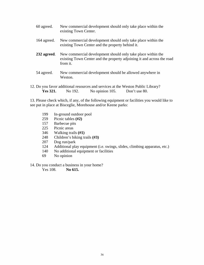
60 agreed. New commercial development should only take place within the existing Town Center.
164 agreed. New commercial development should only take place within the
existing Town Center and the property behind it. 232 agreed. New commercial development should only take place within the
existing Town Center and the property adjoining it and across the road from it.
54 agreed. New commercial development should be allowed anywhere in
Weston. 12. Do you favor additional resources and services at the Weston Public Library?
Yes 321. No 192. No opinion 105. Don’t use 80.
13. Please check which, if any, of the following equipment or facilities you would like to see put in place at Bisceglie, Morehouse and/or Keene parks:
199 In-ground outdoor pool 259 Picnic tables (#2) 157 Barbecue pits 225 Picnic areas 346 Walking trails (#1) 248 Children’s biking trails (#3) 207 Dog run/park 124 Additional play equipment (i.e. swings, slides, climbing apparatus, etc.) 140 No additional equipment or facilities 69 No opinion
14. Do you conduct a business in your home?
Yes 108. No 615.
36

APPENDIX II
Maps
37

")53
")53
")57
")53
£¤7
LegendWatercourse
50 foot Waterbody Setback
Aquifer Projection Area
Natural Diversity Areas
Regulated Wetlands
Steep Slopes (>10%)
Open Space
FEMA Flood Zones 2010
Source:USGS 1/3 Arc Second National Elevation Dataset; NRCS 2005 Soil Survey Data for Fairfield County; DEP 2005 Wetlands, Aquifer Protection Area, Natural Diversity Database 2008,and Hydrography datasets; FEMA Digital Flood Insurance Flood Zone Data; SWRPA 2007 Open Space Inventory; Weston Zoning Regulations; DEP Inland Wetland and Watercourse Regulations.
.0 0.5 1 1.5 20.25 Miles
Prepared April 14, 2010 by
Limitations for Development2010 Weston Plan of Conservation and Development
38

")53
")53
")57
")53
£¤7
Zoning2010 Weston Plan of Conservation and Development
Disclaimer: This map is intended for general planning purposes only. Source: Source: Zoning Map, Town of Weston, Sanborn Map Company, Inc. July 1, 1965, and Data Accumulation Plan, Weston Road & Willow Drive prepared for Weston Shopping Center Associates, LLC. December, 15, 2006.
.0 0.5 1 1.5 20.25 Miles
Prepared April 14, 2010 by
LegendRoadsWatercourseNeighborhood Shopping Center DistrictTwo Acre Residential and Farming District
39

7300
6500
8000
9200 13900
5400
10600
4000
14700
" )53
" )57
" )53
" )57
" )136
9198
8190
10080
1751411592
6804
13356
5040
18522
" )53
" )53
" )57
" )53
" )57
" )136
t u7
Tra
ffic
Vo
lum
e an
d V
olu
me-
to-C
apac
ity
Rat
io
2010
Wes
ton
Pla
n of
Con
serv
atio
n an
d D
evel
opm
ent
2008
203
0
.P
repa
red
on
Apr
il 15
, 20
10 b
y
00.
51
1.5
20.
25
Mile
s
Se
vere
Con
gest
ion
(v/c
= >
1.0)
Mo
dera
te C
ong
estio
n (v
/c =
0.8
-1.0
)
Ma
rgin
al C
onge
stio
n (v
/c =
0.6
-0.8
)
Volu
me-
to-C
apac
ity R
atio
No
Con
gest
ion
(v/c
= <
0.6)
Aver
age
Dai
ly T
raffi
c (A
DT)
Loca
l Roa
d
15,0
01 -
20,
000
10,0
01 -
15,
000
5,0
01 -
10,
000
1,4
00 -
5,0
00
Dis
clai
mer
: Thi
s m
ap is
inte
nded
for
gen
era
l pla
nnin
g p
urp
oses
onl
y. S
ourc
es: C
onn
ectic
ut D
epar
tmen
t of
Tra
nspo
rtat
ion
, Hig
hw
ays
and
Con
gest
ion
Scr
een
ing
and
Mo
nito
ring
Rep
ort,
Tow
n R
oad
Map
s (T
RU
); C
onn
ectic
utD
epar
tme
nt o
f Env
ironm
enta
l Pro
tect
ion,
Env
iron
men
tal G
IS D
ata
for
Con
ne
ctic
ut;
40