Embed Size (px)
Citation preview

town and country bikeways six loops of the lake champlain bikeways network in chittenden county, vermont
town and country
chittenden county, vermont
lake champlain bikeways

Disclaimer: Users assume all risks, inherent and not inherent, in the use of materials recommending routes of the Lake Champlain Bikeways network and all affiliated organizations, and individuals disclaim any and all liability on their part for damages or injuries to persons or property should they occur. Routes are chosen, designated and/or signed because: they are popular, or are preferred, or provide continuous routes to destinations, or are lightly traveled, or are scenic, or have more room for cars and bikes, or possess a combination of these attributes.
table of contents
• lake champlain bikeways network map 1
• chittenden county 2
• map legend and climate data 3
• little country hills 4
• cycle the city 6
• covered bridges 8
• mountain views 10
• roads less traveled 12
• north of the big hills 14
• the lake champlain region at a glance 16
• visitor information and bicycle services 17
• chittenden county attractions 18
• making connections 19
• safety guidelines 20
• about lake champlain bikeways 21
Credits: cover - Burlington Waterfront/Skye Chalmers; inside cover - Pleasant Valley, Underhill/Andre Jenny

Cycle
the C
ity (10.6
)
Island Line
(13.0
) S
tone
Castle
s (13.4
) Island
Life (11.6
)
A Trail to
Two
Be
aches (15
.8)
A Le
gacy o
f Ancie
nt Sto
ne (10
.1)
Liquid
Elixir (11.7)
Acre
s of A
pp
les (2
4.4
) M
onum
ents, M
ills & M
usic (47.4)
Wate
r's Edg
e Trail (2
1.8)
Rap
id D
esce
nt (16.9
) R
iver Fo
rks Trail (11.6)
Surro
unde
d b
y Wate
r (13.7
)
Ro
lling R
eb
er R
amb
le (18
.6)
Wo
man S
uffrage
Way (3
0.8
) C
oo
n Mo
untain Circuit (18
.5)
Mo
untain-Co
ast Co
nnecto
r (28
) W
et &
Wild
(36
.3)
Iron to
Iron (2
6.1
)
Sto
ny Lone
som
e (16
.5)
Fort to
Fort (16
.9)
Ad
irond
ack Maratho
n Trail (26
.2)
Re
be
ls’ Re
treat (4
2.5
) O
tter C
ree
k Wand
ering
(33
.9)
Missisq
uoi V
alley R
ail Trail (26
.4)
Joe
's Rand
om
Sco
ot (3
8.1
) Land
of M
ilk and H
one
y (33
.9)
Halfw
ay to H
eave
n (17.9)
Tow
n and C
ountry (3
1.3)
Mills to
Mansio
ns (40
.9)
Gap
to G
ap (6
2.8
) M
oo
salamo
o M
eand
er (4
2.3
) A
me
rica’s First Victo
ry (18.8
)
The C
limb
er (3
8.0
) O
ver the
Hills and
Far Aw
ay (45
.2)
The Flatland
er (2
1.1)
Point A
u Ro
che Fam
ily Rid
e (6
.1)
The W
illiam H
. Mine
r Sto
ry (35
.3)
Ch
am
ble
y
St. Je
an
-sur-R
iche
lieu
Ca
na
da
Un
ited
Sta
tes
St. A
lba
ns
Bu
rling
ton
Pla
ttsbu
rgh
Ticon
de
rog
a
Wh
iteh
all
Ship
to S
hore
(20
.4)
Internatio
nal Affairs (2
6.8
)
Cham
plain C
oast C
ape
r (35
.8)
Lake C
armi D
airy Circuit (2
8.6
)
Ped
al Pow
er Pano
ramas (3
3.2
)
Mo
untains of M
aple
(35
.0)
LIttle C
ountry H
ills (19.1
) C
ove
red
Brid
ge
s (29
.1)
Ro
ads Le
ss Travele
d (2
2.2
)
No
rth of the
Big
Hills (2
5.7
)
Mo
untain Vie
ws (3
8.4
)
1,63
6 to
tal
ne
two
rk m
iles
49
inte
rpre
tive
the
me
loo
ps
no
rthe
rn a
diro
nd
ack
coa
st bik
ew
ays
ad
iron
da
ck co
ast b
ike
wa
ysn
orth
we
st da
irylan
dch
am
pla
in isla
nd
s bik
ew
ays
tow
n & co
untry rides
he
art o
f verm
on
t bik
ew
ays
lake champlain bikeways

chittenden countyLocated on the east shore of Lake Champlain and less than an hours drive south of the Canadian border, Chittenden County is the major commercial hub of the State of Vermont. Centered around Burlington, the states largest city, the county provides a complete package of facilities and attractions that make it a wonderful place to live or visit. The Burlington Bike Path is nationally known as a wonderful way to enjoy the lake front and it is only a small part of the regional bike path network.
Frequently overlooked is the vast area of the county that remains lovely farmland with classic Vermont scenery just waiting to be explored. This brochure provides suggestions for this kind of exploration throughout the county as a unique trip within the many environments of Burlington itself.
Burlington Waterfront/Skye Chalmers
2
3
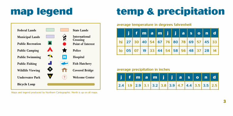
Bicycle Loop
map legend temp & precipitation
Maps and legend produced by Northern Cartographic. North is up on all maps.
j f m a m j j a s o n d
hi 27 30 40 54 67 76 80 78 69 57 45 33
lo 05 07 19 33 44 54 58 56 48 37 28 14
j f m a m j j a s o n d
2.4 1.9 2.9 3.1 3.2 3.8 3.9 4.7 4.4 3.5 3.5 2.5
average temperature in degrees fahrenheit
average precipitation in inches

little country hills - 19.1 milesmoderate 4
mile 0.0 Start: Shelburne Green across from Shelburne Country Store.0.0 South on Falls Rd.0.7 Continue straight onto Mt. Philo Rd. at 4 way STOP signs.4.5 L on Charlotte-Hinesburg Rd. to Hinesburg at red blinking light.10.5 L on Route 116 (food).11.4 L on Shelburne-Hinesburg Rd at traffic light.15.7 L on Irish Hill Rd. at 4 way STOP.16.8 Straight at Spear St. and 4 way STOP and down steep hill.17.8 R on Falls Rd. at 4 way STOP.19.1 Shelburne
0300
600 900
1,200
0 4 6 8 12 16 18
miles
feet

route description The Shelburne Museum entrance is on Route 7 south of the starting point at the top of the hill. It is best reached by following the route and turning right at the 0.7 point and then turning right on Route 7 at the traffic light. You may wish to park there and visit the museum before or after your ride. You may ride right past the cheese factory which is on the left of route 116 in Hinesburg but it is there.
This ride contains many climbs but they are not long and the downhills are real nice. From Shelburne village the route goes quickly through suburban neighborhoods to country homes and then into farm country before reaching Hinesburg. The reverse occurs as you return to Shelburne.
A nice extension to this ride is to ride from the center of Shelburne out to Shelburne Point past Shelburne Farms. Out and back is 9.1 miles. 5
The Ticonderoga at Shelburne Museum, Shelburne/Andre Jenny

cycle the city - 10.6 miles moderate - This route is signed. 6
mile 0.0 Start: Lake Champlain Ferry Dock (Local Motion). North on Burlington Bike Path.2.5 R at Leddy Park and leave parking lot at exit.3.1 R on North Ave. use of sidewalk is advised.3.3 Cross North Ave. and enter Ethan Allen Park3.8 R at fork4.3 Cross bridge and soon turn left to Ethan Allen Homestead.4.7 L and follow green posts with bicycle icon through the intervale. The intervale section is not paved and can be muddy in wet weather. Be cautious on downhill section there is a VERY tight turn. Paved option starts here.7.6 Cross Riverside Ave.8.1 Cross Pearl St.8.4 At College St. turn L onto bike path through UVM campus. Cross Main St. and stay on path. Return to Prospect St. and look for Maple St. soon after.8.6 R on Maple St.8.8 L on Willard St.9.3 R and down on Howard St.9.7 R on Pine St.10.2 L on Maple St.10.4 R on Bike Path.10.6 End of ride.
100200
300 400
0 2 4 6 8 10
miles
feet
Breakwater
ECH
O
Cen
ter
Loca
l Mot
ion
Pede
stria
nBr
idge
Adam
s
St.
Allen
St.
Apple
tree
Point
Rd.
Arch
ibald
St.
Bank
St.
Battery St.
Beachc
rest R
d.
Birc
hcliff
Pkw
y.
Bona
nza P
k.
Brad
ley
St.
Briss
on C
t.
Broo
kes A
v.
Buell
St.
Canfield St.
Cher
ry
St.
Church St.
Cliff
S
t.
Colle
ge
St.
Colle
ge
St.
Countr
y Club
Rd.
Crescent Rd.
Cumberland Rd.
Curtis Av.
Depot St.
Dodds
Ct.
East Av.
East Terr.
Edge
wood
Dr.
Edinb
orou
gh D
r.
Elm
S
t.
Elmwood Av.
Ethan Allen Pkwy.
Fairfi
eld Dr.
St.
Farri
ngton
Pkw
y.
Fern St.
Flyn
nAv
.
Fores
t St.
Gazo A
v.
Goose
Ct.
Gove
Ct.
St.
Hayward St.
Heineberg Dr.
Howa
rd
S
t.
Hyde St.
Institu
te Rd.
Intervale
Av.
Interv
ale Rd.
Ivy Ln
.James A
v.
Jame
s Av.
Killar
ney D
r.
King
St.
Lafountain St.
Lake St.
Lake
side
Av.
Lakeview Terr.
Lakew
ood Pkw
y.
Lavigne Rd.
Ledd
y Park
Rd.
Ledg
eRd
.
Leon
ard St.
Locu
st St
.
Loom
is
S
t.
MacRae
Rd.
Malletts Bay Av.
Malletts Bay Av.
Man
hatta
n Dr
.Ma
nhatt
an D
r.
Mansfield Av.
Map
le
St.
Map
le
St.
Main
St.
Main
St.
Brook Dr.
Rivermount Ter.Rockland St.
Moo
re D
r.
Muirfield Rd.
North Champlain St.
N Gate Rd.
North Prospect St.
North Union St.South Union
St.
NVi
ew D
r.
North Willard St.
N.Williams
North
North Av.
North A
v.
North A
v.
North Av.
North Av.
North Cove Rd.
North St.
North
St.
North
St.
Oak
St.
Oakcrest D
r.
Park St.
Parsons Rd.
Pear
l
St
.Pe
arl
St.
Peru
St.
Pine I
sland
Rd.
Pine
Pl.
Pine
St.
Pine St. Pine St.
Pitkin St.
Pom
eroy
Pros
pect
Hill
Pkwy
.
Randy L
n.
Reve
re C
t.
Ridgew
ood D
r.
Rive
rside
Av.
Rive
rside
Av.
South Champlain St.
South Prospect St.South
ProspectSt.
South Willard St.
South Williams St.
South Winooski . Av.
Sarat
oga A
v.
MallettsBay
Av.
Sher
man
St.
Shore
Rd.
Spear St.
Spring St.
StPaul St. Paul St.
St. Paul St.
Starr F
arm Bea
ch Rd.
Starr F
arm Rd.
Summit St.
Suns
et Cliff
Rd.
Suns
et
C
t.
University Pl.
Unive
rsity
Rd.
Van Patten Pkwy.
Village
Gree
n.
W.
Alle
n
S
t.
W. C
anal
St.
W. S
pring
St.
Walnut St.
Ward S
t.
Washington St.
West
St.
Wildwoo
d Dr.
Rd.
Rd.
Macrae
Bean
Rd.
Winooski Av.
pa
ved
op
tio
n
(sa
me
ove
rall
mil
ea
ge
) 4
.7
Co
ntin
ue s
trai
ght
on
bik
e p
ath.
6.9
A
t to
p o
f hi
ll L
on
Man
hatt
en
Dri
ve a
t S
t Lo
uis
St.
7.0
R
on
Inte
rval
e A
ve.
7.2
L
on
Arc
hib
ald
St.
7.6
R
on
No
rth
Pro
spe
ct S
t.8
.1
Cro
ss P
ear
l St.
and
fo
llow
dir
ect
ions
at
left
.

route description The Cycle the City loop starts near the ferry dock on the waterfront in downtown Burlington and a stop at Local Motion is a great way to get additional maps or answers to any ques-tions before the trip. The route quickly leaves the commercial area as it heads north along ascending a small hill in Ethan Allen Park the opportunity exists for a great view from the site of the tower on the left side of the trail.
Next is down through the woods, you will think that you left the City and onto the Intervale, a flood plain of the Winooski River. Both paved and unpaved options exist at this point prior to climbing to the University of Vermont campus and the historic hill section of the City. Linger along the way to appreciate the variety and history that Burlington has to offer prior to the rapid descent back to the Lake.
7Ethan Allen Park/Greg Farnham

Ridge
covered bridges - 29.1 milesmoderate
mile 0.0 Start: Shelburne Village Square across from Shelburne Country Store. Head south on Falls Rd.1.4 L staying on Falls Rd.1.9 R on Thomas Rd. immediately after crossing bridge.2.9 Bear R on Spear St. 6.1 L on Prindle Rd. - the next 3 miles are well maintained unpaved roads through lovely countryside. Stay straight and arrive at the Quinlan Bridge in 3 miles of paved road.9.6 R on Roscoe Rd. 9.7 Sequin Bridge10.8 R on Lewis Creek Rd.12.2 L on Spear St. after Quinlan Bridge14.3 L at Mt. Philo Rd. (Caution at next corner)14.8 R on Old Hollow Rd.15.1 Cross Route 7 (caution) - store.16.2 R on Greenbush Rd.20.3 L in Charlotte onto Ferry Rd. at Old Brick Store.21.3 R on Lake St. following Champlain Bikeway signs.23.1 Holmes Creek Bridge at Charlotte beach.24.5 L on Greenbush Rd28.0 Cross Route 728.4 L on Falls Rd29.1 Shelburne.
8
100250
400 550
0 5 10 15 20 25 30
miles
feet

route descriptionThis loop includes many additional experiences of great variety. Just south of the start on Route 7 is the Shelburne Museum where one can spend a day viewing its collection of Vermont culture. It should be noted that only 3 bridges are on the exact route shown above but 2 others are very close. The Cambridge Bridge is a part of the Shelburne Museum on Route 7, within 2 blocks of the starting point. If you turn left at the 15.1 mile point at Route 7, see dotted line, the Spade Farm Bridge can be found in Ferrisburgh 1.5 miles south. Just south of Greenbush Road is the Rokeby Museum on the left and on the right a camel can sometimes be found in the pasture.
The unpaved Prindle Road leads to a whole different world where it is hard to imagine that downtown Burlington is never more than 15 miles away. The Sequin Bridge, the classic Vermont covered bridge in that it is small, isolated and well preserved, is the feature of the loop.
9Sequin Bridge/Lou Bresee

mountain views - 38.4 mileschallenging 10
mile 0.0 Start: Jericho - parking at Jericho Elem. School. Proceed east on Route 15 to Underhill.2.4 R to Underhill Center just past Mill River Park.7.1 Top of the hill - enjoy the ride down.11.6 R to Jeffersonville on Upper Valley Rd.15.9 L on Church St.16.1 L on Route 15 in Jeffersonville. 19.1 R on Route 104.25.5 Bear L to Route 128.25.6 L on Route 128 in Fairfax.31.7 Continue on Route 128 in Westford.35.8 L on Weed Rd. after yellow blinking light.37.3 Lon Route 15 to Jericho.38.4 Jericho Elem. School.
0300
600 900
1,200
0 5 10 15 20 25 30 35 40miles
fee
t

11
route description Mount Mansfield is the dominate peak in the northern part of Chittenden County and can be seen from many places. Its appearance changes not only with the seasons but with the time of day so each visit has the potential to be different. The ride through Pleasant Valley is typical of the landscape that exists near many of Vermont’s mountains where lush farmland exists just under majestic peaks.
In addition to the mountain views, this loop provides an opportunity to visit several covered bridges in the Jeffersonville-Cambridge area and appreciate the importance of water power in the early days of each of the towns visited. A visit to the Red Mill in Jericho is a good introduction as to how these mills were constructed and functioned. It is also a good place to be introduced to Snowflake Bently, the man who demonstrated that no two snowflakes were alike.
First snow on Mount Mansfield/Andre Jenny

roads less traveled - 22.4 mileschallenging 12
mile 0.0 Start: at Park and Ride ¼ mile north of intersection of Routes 7 and 2. South on Route 7.0.4 R on Route 2 - be careful of traffic entering/ leaving the Interstate.0.9 R on Jasper Mine Rd.1.2 R on Mayo Rd.4.2 L on Bear Trap Rd. over the bridge.4.6 R on Sanderson Rd. at top of hill.7.7 R on Lake Rd. and cross over the Interstate.9.2 Bear R onto Route 7.10.0 L on Main St. in Milton toward Westford.10.6 R on East Rd. 17.9 R on Route 2A in Colchester.18.8 Bear R on Route 7.22.2 Park and Ride.
0100
200 300
400
0 5 10 15 20 25miles
feet

13
route description The main roads north of Burlington are Interstate 89 and Rte. 7 but, with a few exceptions, Roads Less Traveled offers country road riding. The western part of the route goes along the Lamoille River with its hydro electric plants and home for the UVM crew training center. The dam at the north end of the village of Milton creates Arrowhead Lake which feeds water to the power plant on the opposite side of Rt.7. The spray from the spillway can be refreshing on a hot day if the wind is right or chilling on a cool day.
A brief excursion among the side streets in Milton will reveal architecture which documents the town’s historic past. The Town of Colchester is one of the fastest growing regions in Vermont but it is its historic center, as shown 100 years ago, that is entered after the rolling farmland on the ride from Milton. Admire the churches and homes in this area and get some refreshment from a local store prior to returning to the Park and Ride to end the trip.
Colchester Church/Colchester Historical Society

north of the big hills - 25.7 milesmoderate 14
mile 0.0 Start: Go south from Richmond Town Park over bridge.0.3 R past the Round Church on Huntington Rd.1.0 Straight up the hill on Huntington Rd.2.4 Top of hill.6.6 Huntington (store).7.4 R on Hinesburg Hollow Rd.12.5 R on Route 116 (store).16.4 R on Mechanicsville Rd. 17.3 R on Richmond Rd. 23.2 R at Fays Corner on Hinesburg Rd.24.7 L on Huntington Rd. 25.4 L at the Round Church on Bridge Rd.25.7 Richmond Town Park.
0300
600 900
1200
0 5 10 15 20 25miles
feet

route descriptionThe “big hills” for bicyclists in the area are the Green mountain gaps and several of the popular ones are located just south of this loop in Addison County. This route is, however, challenging for the average bicyclist with several long steady, but not to steep, climbs. After the long climb out of Richmond, the Audubon Center and the Birds of Vermont Museum can be found on the Sherman Hollow Rd. on the right. Both facilities offer a way to enjoy the natural environment of Vermont.
The towns of Richmond, Huntington and Hinesburg are all different but each preserves the historical culture as it emerges into the 21st century. It is easy to imagine that before the age of paved roads and automobiles each of these places was a community unto itself with a church and town hall as its center of activity. 15
Old Round Church, Richmond/Andre Jenny

16
• Lake Champlain: 120 miles long, 12 miles wide, 580 miles of shoreline, and the most historic body of fresh water in North America
• a 363-mile route around the entire Lake called the "Champlain Bikeway"
• 1636 miles of theme loops ranging from 10 to 60 miles along a vast network of quiet back roads
• Adirondack Mountains to the west—Green Mountains to the east
• Taconic Mountains to the south—Richelieu River to the north
• agricultural landscapes, historic hamlets, and picturesque villages
• gently rolling terrain to undeniably hilly
• scenic Lake crossings by way of ferry system
• museums, forts, and historic attractions
• within a few hours drive from Boston, Montreal, and New York City
• accessible via plane, train, bus, car, and, of course, bicycle!
an interconnected, international network of bicycle routes around Lake Champlain
in New York, Vermont and Quebec.
Lake Champlain/Gary Randorf
the lake champlain region at a glance

If you are planning a bicycling trip to Chittenden County, take advantage of the wealth of information that is available through Local Motion, a non-profit organization promoting all forms of non-motorized transportation: 802-652-2453, www.localmotion.org and www.champlainbikeways.org For information on where to eat and stay, call the Lake Champlain Regional Chamber of Commerce: 877-686-5253. Check the website for listings and a calendar of things to do in the area at www.vermont.org. Bikes are available for rental, as well as repair, equipment and amenities in Burlington, South Burlington, Richmond and Winooski.
17
visitor information and bicycle services
Church Street Marketplace, Burlington/Chapin Spencer

local attractions Chittenden County, Vermont’s northwest public transportation entrance offers air, rail and bus service. Regional attractions include:
Parks SitesSand Bar State Park Shelburne MuseumMount Philo State Park Shelburne FarmsLeddy Park ECHONorth Beach City Park Fleming MuseumEthan Island Park Centennial FieldRed Rocks Park The Round ChurchBattery Park Monitor BarnsOakledge Park Overlook Park
18
for more information on bicycling in chittenden county:Local Motion and Lake Champlain Bikeways1 Steele St. #103, Burlington, VT 05401, 800-652-2453, [email protected] and [email protected] visit Lake Champlain Regional Chamber of Commerce 60 Main St., Burlington, VT 05401, [email protected]
Antique car show at Shelburne Museum, Shelburne/Andre Jenny

Cyclists enjoying Chittenden County can explore other cycling destinations through day trips.
The Missisquoi Valley Rail Trail winds its way through 26.4 miles of pastoral farm lands in Franklin County from St. Albans east to Richford, paralleling the Missisquoi River for much of its length. Visitor amenities are available in St. Albans, Sheldon, Enosburg Falls, East Berkshire and Richford. For more visitor information, contact the Franklin County Regional Chamber of Commerce at 802-524-2444 or visit www.mvrailtrail.com.
Promoters of the Island Line Trail envision a trail connecting downtown Burlington, the Champlain Islands’ orchards and vineyard, Quebec’s Valley of the Forts, and Montreal. Currently, the trail includes 1.5 miles from Martin Road to Lake Champlain in South Hero and 13 miles from Oakledge Park in Burlington to Causeway Park in Colchester. The trail segments are linked on August weekends when a bicycle ferry operates across “The Cut”. For more information, contact Local Motion at 802-652-2453.
19
The Stowe Bike Path is an internationally recognized 5.5 mile greenway with numerous picnic and swimming areas. The path is open for bicycling, hiking, strolling and skiing 365 days a year. The paved trail starts in Stowe Village, next to the Stowe Congregational Church. It winds its way through woods and meadows and crosses the West Branch River 11 times on arched wooden bridges. Numerous shops, lodges, and restaurants are accessible from the path. For information and a map, visit www.stowevillage.com/BikePath/index.
Connect with La Route Verte (the Green Route), Canada’s 4,000-kilometer bicycle network from the Richford customs station on Route 139. This portion of the route features a hint of New England, many of the best inns in the county, menus that are tasteful as they are tasty, enchanting villages, vineyards that produce increasingly notable wines and irresistibly charming country roads. La Route Verte can also be reached by crossing the Missisquoi Bay Bridge on Route 78 in Swanton and heading west to the Rouses Point, NY custom station.
making connections

safety guidelinesScenic roads are traveled by both motorists and bicyclists. Use extra cau-tion on sections of narrow, winding or unpaved roadway. Bicycle routes do not indicate a level of safety. As a bicyclist, follow traffic laws and ride in a safe and controlled manner. Bicycles are considered vehicles by law and have the right to use public roads. You are ultimately responsible for operating your bicycle under all conditions.
when cycling, please follow these guidelines: source: Mad about Cycling
1. WEAR A HELMET.2. Ride with the flow of traffic.3. When using travel lanes, follow motor vehicle laws. Obey all traffic signs and signals. Do not cut corners.4. Use clear hand signals when making turns or stopping.5. Ride in a straight line at least 3 feet from parked cars or curbs.6. If you must ride at night, use lights and reflectors.7. Ride defensively! Be aware of motorists’ actions.8. Be aware of train tracks and other road conditions.9. Ride single file. 10. Carry items in panniers or a handle-bar pack. 11. Wear cycling gloves.
20
Cyclists touring the Champlain Bikeway/Gary Randorf

21
Lake Champlain Bikeways promotes bicycling throughout the Lake Champlain regions of New York, Vermont and Québec for the purposes of increasing opportunities for bicycle recreation and transportation, improving the quality of life, enhancing the economic vitality, advocating for sustainable communities, encouraging healthy lifestyles and raising public awareness and appreciation of inherent scenic, historic, cultural, natural, and recreational resources throughout the area.
A 501(c)(3) non-profit organization, Bikeways depends on contributions from individuals, businesses and organizations to carry out our mission. We are proud to be able to provide helpful information and brochures for cyclists who come to the Champlain Valley to enjoy our beautiful countryside, vistas and hospitality. We currently provide this information at no charge when
requested through our Clearinghouse at www.champlainbikeways.org. If we are to continue to provide this service and pursue our other goals of encouraging bicycling in the basin, we need the support of like-minded bicyclists. Be a part of the movement! Please contribute via credit card at PayPal.com (payable to “[email protected]"), or send your check to: Lake Champlain Bikeways, c/o Local Motion Trailside Center, 1 Steele Street #103, Burlington, VT 05401. Your donation is tax deductible.
A variety of Lake Champlain Bikeways publications, as well as other regional bicycling information, is available through our web site at www.champlainbikeways.org or by phone at 802-652-BIKE (2453).
about lake champlain bikeways

Town & Country Bikeways was developed through a partnership among Lake Champlain Bikeways, Local Motion, Chittenden County Regional Planning Commission, the Chittenden County Metropolitan Planning Organization, Vermont Department of Forests, Parks and Recreation, Lake Champlain Byways Council and local bike enthusiasts. The Lake Champlain Basin Program and Vermont Department of Tourism provided financial assistance. The partners of this brochure support the efforts of Lake Champlain Bikeways. We are proud to be included in their 1,636-mile network.
acknowledgements