Embed Size (px)
Citation preview
EAEA-11 conference 2013 . (Track 3) Conceptual Representation: exploring the layout of the built environment | 401
Towards a visualization of attractiveness: urban centrality as a multifactorial process
Cutini, Valerio 1 Rabino, Giovanni 2 Keywords: centrality; attractiveness; configuration
1. Dipartimento di Ingegneria Civile, University of Pisa, Pisa, Italy
2. Dipartimento di Architettura e Studi Urbani (DAStU), Politecnico di Milano, Milano, Italy
Abstract The notion of urban centrality is commonly and widely used – sometimes abused – with reference to several meanings, aimed at different purposes: to complain about the poor vitality of urban edge areas that, despite any effort in projecting and working out redevelopment and renewal plans, still appear lacking in movement and activities; to report and denounce the weakening of appeal of urban historic cores, which frequently empty with the traditionally located activities that shift toward new development areas; to advertise development plans in external areas that, despite their actual distance and isolation, are expected to get so appealing as to compete with the inner cores. In all cases, what appears to characterise the notion of centrality is the (lacking, wished or expected) appeal towards activities, that is their actual attractiveness. A wide scientific literature shares the assumption of the notion of centrality in terms of attractiveness: roughly speaking, a central urban place is a place where activities seek a location, and the struggle for a central location is assumed as the ordering principle of the internal geography of towns. This is a somewhat tautological approach (‘a central place is a central place’), and can’t account for the factors that determine such attractiveness. Setting aside the undoubted influence of the located activities, this paper focuses on the role of urban space: on the way it is perceived and used. For this purpose, a configurational approach will here be assumed, so as to investigate on the role of the grid configuration, assumed as primary in determining the distribution of attractiveness. The idea is that the use of a configurational approach will allow to understand centrality as a process (related to the continuous development of the urban grid), rather than to describe it as a state (depending on the presence and mutual interaction of activities). On the one hand, the evidences of researches on a significant case study (Leghorn) appear to prove the reliability of such assumption, so as to attest centrality as a spatial process and the primary role of the urban grid in its making, thus confirming the findings of other studies on the configurational approach. On the other hand, the same findings make to emerge that the notion of centrality is not so monolithic as expected, in that urban spaces appear to differently attract different kinds of activities, so as to determine global centres as well as local ones.
Cutini V., Rabino G.
| EAEA-11 conference 2013 . (Track 3) Conceptual Representation: exploring the layout of the built environment 402
Introduction This paper concerns the theme of urban centrality, and it’s aimed at overcoming the ambiguity
of a notion that has been used in so many different contexts, with so different meanings, as to become a vague tòpos, or even a diffused catchphrase: such ambiguity appears quite surprising, if compared with the prompt and clear perception of centrality one receives in his daily urban experience, making somehow self-evident what a centre actually is: a prominent location characterized by a close concentration of activities and density of movement. A flash back to one of its primigenial meanings – centrality as a matter of attractiveness towards activities (Alonso, 1964) – is here proposed, declining it according to a configurational view: in that the urban space itself, instead of the located activities, will here be assumed as the primary element in the distribution of attractiveness/centrality. Such a radical change of view over urban phenomena is going to involve some significant results: - that the material consistency of an urban settlement – that is its open space as well as the
complex of blocks which define it – implicitly contains a strong indication, if not even a pre-condition, for the actual use of each of its parts;
- that any (even minor) change of the material consistency of the settlement – some street interruption, some transformation of blocks and buildings, some housing development – will be likely to determine noticeable effects on a wide range of urban variables, including the distribution of pedestrian and vehicular movement, the location of economic activities, the real estate values, and so on;
- that urban design, intended as the shaping of both geometry and morphology of buildings, blocks, streets and squares, cannot be regarded as a merely aesthetic issue, but as a technical planning operation, narrowly related with functional and social-economic matters. Looking from this specific point of view, thus assuming the grid configuration as the primary
element of urban phenomena, leads towards to investigating around the notion of spatial centrality. Furthermore, it ought to be stressed that a configurational approach assumes the features of any spatial element as depending on its topological relation with all the others, thus appraising the urban grid as a spatial network: what suggests to briefly discuss the – not univocal – notions the term of centrality has gone assuming in theories and techniques of network analysis.
Backgrounds The pioneering researches on the issues of centrality as a matter of relations (and hence
networks) can be tracked down in social studies, and introduced in the late ‘40s (Bavelas, 1948) in order to evaluate the prominence of an individual in a social network (Borgatti, 2005; Borgatti, 2006); since then, the notion of relational centrality has been widely investigated in social network analysis (Wasserman & Faust, 1994), so as to provide and discuss several kinds of competing concepts. All based on the general assumption of a strong dependence of centrality on nearness, three major measures of centrality appear recurring in network structure analysis, representing and reproducing three respective relational conditions (Landherr et al., 2010); the same variables will be successively declined into strictly configurational terms, in order to evaluate their actual capability of reproducing the distribution of urban attractiveness towards activities.
The degree parameter is the simplest measure of network centrality; for an element q, degree is the number of edges that contain q, that is the number of neighbours of q:
deg(q) = |{x ∈ E|q ∈ x}| = |{t ∈ V | {q, t} ∈ E}| = |∂{q}| The degree represents the point of view that assumes as the more prominent (and hence
attractive) element the most generously provided with direct connections (Nieminen, 1974), and its measures can be given in absolute terms (the actual number of connections) or in normalized terms (the ratio of such number to the total number of spatial elements); it could be suggested that, as the number of a network member’s direct contacts, degree can be regarded as a useful

Towards a visualization of attractiveness
EAEA-11 conference 2013 . (Track 3) Conceptual Representation: exploring the layout of the built environment | 403
indicator of centrality, in that it reproduces the capability of a spatial element to work as a network hub.
The betweenness parameter is defined as the frequency of an element in the shortest paths connecting all pairs of elements of the grid, or, in other words, the number of shortest paths that run through the observed element. It represents the point of view that assumes the prominence of an element as provided by the density of indirect connection passing through it (Freeman, 1977); it could be suggested that betweenness reproduces the capability of an element to work as a go-between, intercepting external connections.
The closeness parameter, defined as the topological proximity of an element to all the others, represents the point of view that assumes accessibility as the primary element of spatial prominence (Freeman, 1979; Sabidussi, 1966); it could be suggested that closeness reproduces the capability of an element to work as a terminal (either an origin or a destination), which can easily reach (or be easily reached from) all the others. In other words, while betweenness is referred to ‘through’ connection, closeness is clearly related to ‘to and from’ connections. Also betweenness and closeness can be expressed both in absolute terms (number of connections via the element, mean topological distance with respect to all the others) and in relative (i.e. normalized) ones, which actually appear far more significant, as not dependent on the dimension of the system.
Fig. 1 Different notions of network centrality in the same graph: degree (a), betweenness (b), closeness (c)

Cutini V., Rabino G.
| EAEA-11 conference 2013 . (Track 3) Conceptual Representation: exploring the layout of the built environment 404
As it can be seen, those mentioned above appear hence to represent three different kinds (or, what’s better saying, declinations) of centrality, applied in social network analysis in different context, with different purposes and completely different results. Such parameters have been widely tested and discussed, in order to better reproduce the level of interconnectedness of actors in social networks. The graphs in Fig. 1 shows the different distribution of their values in the same system, in order to highlight how different, and differently located, centres (in red) can actually result in the same graph.
The configurational approach allows to easily pass from a social network scenery into a spatial one, thus focusing on the grid of the paths of an urban settlement and assuming as nodes the interconnected spatial elements of its network. In concrete terms, it means to assume as the observed network the system of the mutually intersected axial lines, which cover the whole urban grid and connect its convex spaces (Hillier & Hanson, 1984). The connected elements here become spatial elements, so that the urban grid can be reduced either into a system of axial lines (Hillier, 1996), or into a system of vertices (Turner, 2001), or into a system of other different kinds of geometric element (Cutini, Petri & Santucci, 2004; Turner, 2007). Here observing the so-called axial map, three indices appear to respectively reproduce the same meanings so far presented.
Connectivity value, defined as the number of intersected lines of the observed one, stands for the configurational translation of degree; it’s a local indicator of centrality, in that it can be computed taking into account only the (topologic) neighbourhood of each line. Choice value, in its turn, can be easily seen as the configurational homologous of betweenness, in that it is defined as the frequency of the presence of a line in the shortest paths that mutually connect all couples of lines of the system, suitable to measuring how likely is to pass through an axial line; just like betweenness, choice does hence reproduce urban centrality as a go-between feature, since it materializes the capability of a spatial element (i.e. a line) to intercept through movement flows.
Fig 2 The distribution of connectivity (a), choice (b) and integration (c) in the lines of the axial map of Leghorn

Towards a visualization of attractiveness
EAEA-11 conference 2013 . (Track 3) Conceptual Representation: exploring the layout of the built environment | 405
Closeness can finally be transferred into the configurational parameter of integration value, which is defined as the mean topologic distance of the observed line with regard to all the other lines of the axial map; in that integration measures how easy is to get to an element from all the others. As directly related to the wide notion of accessibility, integration can be assumed as the most significant configurational value, and therefore the most used indicator of urban centrality. The possible (and even frequent) coexistence of different kinds of urban centralities is significantly reproduced by the outcome of configurational analysis, describing and reproducing the distribution of those three parameters in the same urban system. The results of the application on the settlement of Leghorn is here presented as a suitable case study to stress such point: in Fig. 2 the distribution of connectivity (a), choice (b) and integration (c) values is chromatically represented, so as to shown the coexistence of different kinds of centre within the same settlement.
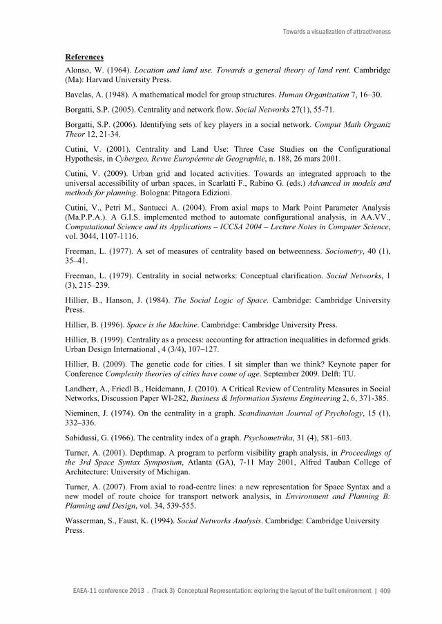
Fig. 3 The distribution of local (radius 3) integration in the axial map of Leghorn
Case study and results Several researches have shown integration value as a reliable indicator of centrality, in that it
results narrowly correlated with the actual distribution of economic activities, and can hence appears suitable for reproducing the attractiveness of each single element of the urban grid (Cutini, 2009). Nonetheless, it was stressed that also choice values can be somehow reproduce centrality: if we assume integration as a parameter to measure the to-movement potential of a line as a destination, choice can be regarded as suitable for measuring the through-potential of a line as a route (Hillier, 2009). On such basis, it could be argued that integration can reliably reproduce the actual distribution of attractiveness (that is, a centre as a close co-location of activities), as

Cutini V., Rabino G.
| EAEA-11 conference 2013 . (Track 3) Conceptual Representation: exploring the layout of the built environment 406
well as choice can narrowly reproduce the likely distribution of movement (a centre as a crowded location). In such a view, also the length of the trip plays a significant role, in that both indicators of centrality (integration and choice) are likely to change according to the radius of the analysis around each line. An easy way to take account for this aspect is to compare global (radius n) integration with local (radius 3) one, which allows to appreciate the presence of local centres, which are scattered all over the grid and appear to attract activities characterized by small range values, here exemplified in Fig. 3, referred to the case study of Leghorn.
So far it has been discussed the variety of the notion of urban centrality, when observed and investigated by configurational analysis, and it has been shown how many centres (and how many kinds of centres, too) can actually coexist in a same urban settlement, and how different (other than differently located) they can actually result. More in general, it was stated that urban centrality ought to be appraised as a spatial process, depending on the relations within the grid, rather than a functional or geometric state (Hillier, 1999).
Hereinafter a further step will be proposed, showing how their presence and position can change according to the variation of the radius of the analysis, from a tightly local working to a wider scale, up to the whole urban grid. In order to develop such point, we are going to use an angular segment analysis, that is a configurational technique that takes into account not only the intersection between lines, but also their mutual angle, so as to provide with bigger impedance values angles around (or below) 90° with respect to obtuse ones. Such analysis will be carried out varying the radius of counting, from the minimum value of 200 meters around the observed line up to 4000 meters, so as to cover the whole settlement extension; and the same urban case of Leghorn will be taken as our case study. The variation of configurational values according to the different radius of the analysis will then expected to show how centrality appears to change as the length of possible movements increases, from a very local scale (few hundred meters around a line) up to cover the whole extension of the grid.
Obviously, the distribution of connectivity value is not expected to vary with the measure of radius, in that it’s a local parameter, strictly depending on the surrounding lines and hence not influenced by the rest of the grid. In Fig. 4 and Fig. 5 the distribution of choice and integration values in the axial map of Leghorn according to different metric values of radius (200 mt, 400 mt, 800 mt, 1600 mt, 3000 mt, 4000 mt) is here presented, confirming the expected results. As the scale increases from 200 to 800 metres, the integration core of Leghorn appears extending from the neighbours of Piazza della Repubblica (Fig. 5, top left) up to the whole intra moenia area; for bigger radius values, the integration core leaves the historic centre and affects the main radial streets towards the more recent developments. Such pattern appears to roughly correspond to the actual distribution of activities, according to their respective market range. An analogous correspondence seems to result from the distribution of choice value, whose pattern appears to roughly reproduce the distribution of movement flows, according to their mode: being pedestrian movement particularly dense within the historic core (Fig. 4, on the top), resulting on the contrary more intense the vehicular movement flows along the external radial and tangential streets (Fig. 4, at the bottom).
Conclusions This paper shows how different configurational values can reproduce different kinds of urban
centrality, as they are conceptually intended, all sharing the common aspect of attractiveness towards activities and movement.
Moreover, the results above highlight the empirical evidence of the effects of multi-scales centralities on movement economies, showing how the distribution of integration and choice at different computation scales appears to correspond to the pattern of activities and movement with reference to the respective distance value. Urban centrality, at different scales, is then confirmed as a spatial process, depending on spatial relations and hence changeable according to the

Towards a visualization of attractiveness
EAEA-11 conference 2013 . (Track 3) Conceptual Representation: exploring the layout of the built environment | 407
development and transformation of the grid; what proves configurational analysis a a suitable tool for its understanding and comprehension.
Another challenge should be taken up: some further research would be necessary to understand and take account for the role the located activities do actually play in concurring to determine the pattern of different urban centralities, thus finally appraising centrality as a multi-scales and multifactorial process.
Fig. 4 The distribution of choice values in the lines of the axial map of Leghorn

Cutini V., Rabino G.
| EAEA-11 conference 2013 . (Track 3) Conceptual Representation: exploring the layout of the built environment 408
Fig. 5 The distribution of integration values in the lines of the axial map of Leghorn
Towards a visualization of attractiveness
EAEA-11 conference 2013 . (Track 3) Conceptual Representation: exploring the layout of the built environment | 409
References Alonso, W. (1964). Location and land use. Towards a general theory of land rent. Cambridge (Ma): Harvard University Press.
Bavelas, A. (1948). A mathematical model for group structures. Human Organization 7, 16–30.
Borgatti, S.P. (2005). Centrality and network flow. Social Networks 27(1), 55-71.
Borgatti, S.P. (2006). Identifying sets of key players in a social network. Comput Math Organiz Theor 12, 21-34.
Cutini, V. (2001). Centrality and Land Use: Three Case Studies on the Configurational Hypothesis, in Cybergeo, Revue Européenne de Geographie, n. 188, 26 mars 2001.
Cutini, V. (2009). Urban grid and located activities. Towards an integrated approach to the universal accessibility of urban spaces, in Scarlatti F., Rabino G. (eds.) Advanced in models and methods for planning. Bologna: Pitagora Edizioni.
Cutini, V., Petri M., Santucci A. (2004). From axial maps to Mark Point Parameter Analysis (Ma.P.P.A.). A G.I.S. implemented method to automate configurational analysis, in AA.VV., Computational Science and its Applications – ICCSA 2004 – Lecture Notes in Computer Science, vol. 3044, 1107-1116.
Freeman, L. (1977). A set of measures of centrality based on betweenness. Sociometry, 40 (1), 35–41.
Freeman, L. (1979). Centrality in social networks: Conceptual clarification. Social Networks, 1 (3), 215–239.
Hillier, B., Hanson, J. (1984). The Social Logic of Space. Cambridge: Cambridge University Press.
Hillier, B. (1996). Space is the Machine. Cambridge: Cambridge University Press.
Hillier, B. (1999). Centrality as a process: accounting for attraction inequalities in deformed grids. Urban Design International , 4 (3/4), 107–127.
Hillier, B. (2009). The genetic code for cities. I sit simpler than we think? Keynote paper for Conference Complexity theories of cities have come of age. September 2009. Delft: TU.
Landherr, A., Friedl B., Heidemann, J. (2010). A Critical Review of Centrality Measures in Social Networks, Discussion Paper WI-282, Business & Information Systems Engineering 2, 6, 371-385.
Nieminen, J. (1974). On the centrality in a graph. Scandinavian Journal of Psychology, 15 (1), 332–336.
Sabidussi, G. (1966). The centrality index of a graph. Psychometrika, 31 (4), 581–603.
Turner, A. (2001). Depthmap. A program to perform visibility graph analysis, in Proceedings of the 3rd Space Syntax Symposium, Atlanta (GA), 7-11 May 2001, Alfred Tauban College of Architecture: University of Michigan.
Turner, A. (2007). From axial to road-centre lines: a new representation for Space Syntax and a new model of route choice for transport network analysis, in Environment and Planning B: Planning and Design, vol. 34, 539-555.
Wasserman, S., Faust, K. (1994). Social Networks Analysis. Cambridge: Cambridge University Press.