Embed Size (px)
Citation preview

Towards a pan-European infrastructure for marine and ocean
data management +
Importance of standards
ByDick M.A. Schaap – Technical Coordinator SeaDataNet &
Coordinator EMODnet Bathymetry
Hydrography Day, The Netherlands, 26 June 2015,

Marine Data are relevant for many uses:
• Scientific Research to gain knowledge and insight
• Monitoring and assessment (water quality, climate status, stock assessment)
• Coastal Zone Management
• Modelling (including hindcast, now-cast, forecast)
• Dimensioning and supporting operations and activities at sea (shipping, offshore industry, dredging industry, ..)
• Implementation and execution of marine conventions for protection of the seas
• Implementation of international Directives, such as in Europe directives for water (WFD), marine strategy (MSFD), coastal zone management
Users originate from government, science sector, and industry, nationally and internationally
Good and harmonised marine data management on a large scale is very important

EU cost – benefit analysis: cost of marine observation in Europe is circa 400 Million Euro per year for space data and another 1 Billion Euro per year for in-situ data
Marine data acquisition

EU – MASTEU –MASTII EU-FP5 EU-FP6 EU-FP7
A pan-European infrastructure has been set up and is operated for managing marine and ocean data in a cooperation of National Oceanographic Data Centres (NODCs) and oceanographic data focal points from 35 countries bordering European seas
90sEDMEDEuronodimMEDATLASEDIOS
2002-2005Sea-Search
2006-2011SeaDataNet
2011-2015SeaDataNet II

NODCs as core partners in SeaDataNet
• National Oceanographic Data Centres (NODC’s) are mostly divisions of major national marine research institutes and based in 35 countries, surrounding the European seas
• NODC’s are experienced in managing data, which includes quality control, documenting, long term stewardship and publishing, for their own institute and for many other institutes in their country
• NODC’s are members of IOC-IODE and ICES for sharing global practices
• NODC’s are increasingly building national infrastructures on SeaDataNet basis to support their national networking

Portal with standards, tools, and services, both for users and data centres
http://www.seadatanet.org

Standards are instrumental
Set of common standards for the marine domain, adapting ISO and OGC standards and achieving INSPIRE compliance
Adoption of ISO 19115 – 19139 standard for describing metadata on data sets, research cruises, monitoring networks, and research projects => marine metadata profiles, schema’s, schematron rules
Controlled vocabularies for the marine domain (> 160.000 terms and > 60 lists), with international governance and web services
Standard data exchange formats: ODV ASCII and NetCDF (CF) fully supported by controlled vocabularies
Maintenance and dissemination of standard QA-QC procedures, together with IODE and ICES

Services and tools
Set of tools to be used by each data centre and freely available from the SeaDataNet portal: metadata editor, data conversion software, download manager, data analysis software, data interpolation software
Capacity building by training workshops for uptake of standards and tools by the data centres in order to achieve standardisation
Pan-European services for harmonised discovery, access, visualisation of data and data products
Common SeaDataNet Data Policy and SeaDataNet License

Pan-European Directory services

EDMO – Directory of Marine Organisations
> 3000 organisations; also population by USA and Australia (ODIP)

CDI service for discovery and unified access of data
Already 106 data centres connected and more underway

Cooperation for populating and wider deployment of the infrastructure
Adoption of SeaDataNet standards and services, including adaption in a range of EU projects for DG Research and DG Entreprise and Industry: Black Sea SCENE, Upgrade Black Sea SCENE, CaspInfo, Geo-Seas, CoCoNet, JERICO, JERICONext, Eurofleets, Eurofleets 2, Micro B3, CitClops, ClipC, AtlantOS, ENVRIplus, …….

Increase in time sept 2012 – June 2015
Pan-European directory services

CDI service for discovery and unified access of data

CDI Data Discovery & Access service
Coverage June 2015: > 1,76 million CDI entries from 106 data centres in 34 countries and 546 originators for physics, chemistry, geology, geophysics, bathymetry and biology; years 1800 – 2015; 85% unrestricted or under SeaDataNet licence

Cooperation and synergy
Strategic cooperation with: EuroGOOS, Copernicus Marine Service, POGO, EurOcean, OGP (SIMORC), USA and Australia (ODIP)
Partner in developing and building:As part of the Maritime Policy the EU proposed to take steps towards an overarching European Marine Observation and Data Network (EMODNet)
The initial Roadmap for EMODNet was released in April 2009

SeaDataNet as partner in developing and building: European Marine Observation and Data Network
2009 2010 2011 2012 2013 2014 2015 2016 2017 2018 2019 2020
Phase 1 – limited sea basins (ca 6 MEuro)
Phase 2 - low resolution (ca 16 MEuro)
Phase 3 - multi-resolution (> 100 – 200 MEuro)
PROTOTYPING:allows users to assess and improve product by trying it out
Resulting in uptake of SeaDataNet standards and expansion of the infrastructure of data centres giving data overview and access

CDI Data Discovery & Access service
June 2015: 106 data centres connected

19
Preparatory Actions 2008-2010
€6,450,000 spentsix portals now operational
Thematic EMODnet portals upgrading from pilots to operational and EU coverage
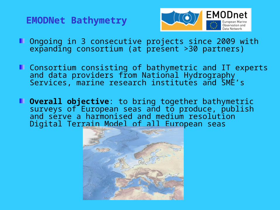
EMODNet Bathymetry
Ongoing in 3 consecutive projects since 2009 with expanding consortium (at present >30 partners)
Consortium consisting of bathymetric and IT experts and data providers from National Hydrography Services, marine research institutes and SME’s
Overall objective: to bring together bathymetric surveys of European seas and to produce, publish and serve a harmonised and medium resolution Digital Terrain Model of all European seas

EMODNet Bathymetry consortium

Process flow and services
Adoption ofSeaDataNet standards and services
Common method and software (Globe) used by all data providers and regional sea coordinators
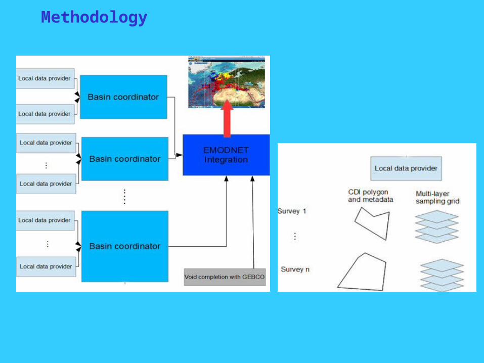
Methodology

Use of GLOBE software by most partners
Norwegian and Icelandic seas – Arctic – interim status

EMODNet Bathymetry – Regional DTMs
+ IPMA

Results so far
Up till today, 13883 survey CDI metadata records from 27 data centres and 166 data originators from 1816 to 2015 have been collated and imported into a dedicated EMODnet Bathymetry CDI data discovery and access service. This service was launched in May 2010 and has been upgraded over time with extra functionality
The SeaDataNet Data Products Catalogue service gives 42 metadata records about composite DTMs that have been used next to survey data sets
These survey data (circa 6000) and other gathered composite DTMs have been collated into regional EMODnet DTM’s (1/8 * 1/8 arc minutes) for all European regions by 9 regional working groups.
The harmonized EMODnet DTM is available for interactions and viewing as well as for downloading in 16 tiles in several formats via the Bathymetry Products portal service.
The dedicated EMODnet Bathymetry Products portal has been launched in May 2010. It sits atop of the central DTM database and interacts with the CDI service and Sextant service and provides OGC WMS services
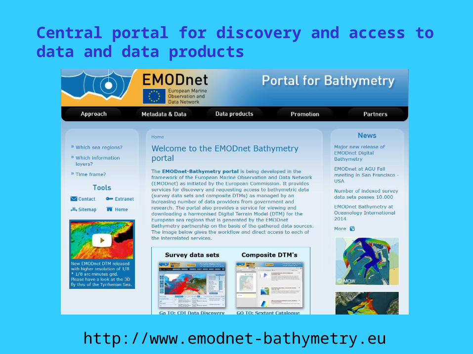
Central portal for discovery and access to data and data products
http://www.emodnet-bathymetry.eu

CDI overview of bathymetric data sets
http://www.emodnet-bathymetry.eu

DTM for European sea basins

DTM for European sea basins

CDI overlay to indicate surveys

CDI overlay to indicate surveys + retrieve CDI metadata per survey

Sources layer to indicate used surveys and composite DTMs
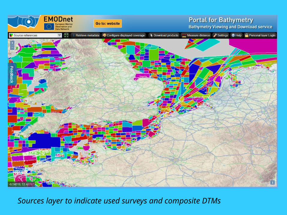
Sources layer to indicate used surveys and composite DTMs

Sources layer with pop-up showing metadata of specific data set

Zoom in for the North Sea and English Channel / Le Manche

Retrieve depths incl source reference and downloadable depth profiles

Download DTM tiles in various formats

Bathymetric DTM – 3D-Viewer
DTM loaded into 3D-Viewer as developed and freely downloadable from
Geo-Seas

Bathymetric DTM – 3D-Viewer
DTM loaded into 3D-Viewer as developed in Geo-Seas and freely downloadable

Successful approach
Providers of bathymetric data sets understand and are welcoming the applied approach
Data sets are gathered for internal use by regional consortium groups to compile the DTM product which can be viewed and downloaded without any registration
Data sets are described and included in the CDI Data Discovery and Access Service and composite DTMs in the Sextant Data Products Service.
Each cell in the DTM product gives information about the data sets used and leads to the CDI / Sextant service for more information about the data provider and options for requesting the data itself
This works as a shop window and results in more data providers coming forward

Next
New release of the EMODnet DTM at 1/8 * 1/8 arc minutes taking away some identified anomalies (after summer 2015)Further cooperation and synergy with GEBCO. New GEBCO 2015 has adopted EMODnet DTM and EMODnet has adopted GEBCO 2015 to cover gaps in survey coverage.New EMODnet DTM release will include 3 pilot High Resolution DTMs for coastal areas (Germany, France, Ireland) based upon combination of LIDAR and Multibeam dataThe viewing portal will be further improved and possibly end 2015 will also feature 3-D viewing (without plug-ins)Dedicated EMOdnet project has been launched for a European coastal mapping plan. There will be synergy with on-going Bathymetry projectNew Call expected from EMODnet for higher resolution bathymetry DTM for Europe to continue and deepen the activities (e.g. big data processing) and cooperation between HO’s, marine research institutes and industry.

www.emodnet.eu
www.seadatanet.org