Embed Size (px)
Citation preview
Total Maximum Daily Load (TMDL) Development
- pH (H+ Ion Mass) -
For
Craborchard Creek Watershed
(Hopkins County, Kentucky)
Kentucky Department for Environmental Protection
Division of Water
Frankfort, Kentucky
December 2003
Craborchard Creek Watershed pH TMDL Development
ii
Total Maximum Daily Load (TMDL) Development
- pH (H+ Ion Mass) -
For
Craborchard Creek Watershed
(Hopkins County, Kentucky)
Kentucky Department for Environmental Protection
Division of Water
Frankfort, Kentucky
List of Contributors
Dr. Lindell Ormsbee, Supervisor
Emily Zechman, Data Analysis and Report Preparation
The Natural Resources and Environmental Protection Cabinet does not discriminate on the basis of race, color, natural origin, sex, age, religion, or disability and provides on request, reasonable accommodations including auxiliary aids and services necessary to afford an individual with a disability an equal opportunity to participate in all services, programs, and activities.
Printed on Recycled Paper

Craborchard Creek Watershed pH TMDL Development
iii
Table of Contents
Page List of Contributors ii
Table of Contents iii
List of Figures and Tables iv
TMDL Fact Sheet v
Introduction 1
Problem Definition 6
Target Identification 7
Source Assessment 8
Model Development 10
TMDL Development 14
Permitting 17
Implementation/Remediation Strategy 19
Literature Cited 21
Appendix A: Mining Permits Numbering System 22
Craborchard Creek Watershed pH TMDL Development
iv
List of Figures and Tables Figures Page
1. Location of the Craborchard Creek Watershed ...............................................................1
2. Pond River Watershed, 8-digit HUC 05110006 .............................................................2
3. Disturbed areas in the Craborchard Creek Watershed ...................................................5
4. Sampling Sites monitored by Murray State personnel ..................................................9
5. Distribution function of total dissolved solids concentration for terrestrial waters .....10
6. Activity Coefficients of H+ as a function of ionic strength .........................................11
7. Relation between discharge and maximum ion loading for a pH of 6.0 ......................13
8. Relation between flow and ion load for Site 2 .............................................................14
Tables Page
1. Mining Permits in the Craborchard Creek Watershed ...................................................3
2. Murray State sampling results .......................................................................................9
3. Critical flow and corresponding TMDL (pH = 6) .......................................................16
4. Critical flow and corresponding predicted ion load (lbs/day) for Subbasin 2 .............16
5. TMDL Summary and reduction needed for Subbasin 2 ..............................................17
6. Waste Load and Load Allocation for Subbasin 2 .......................................................18

Craborchard Creek Watershed pH TMDL Development
v
Craborchard Creek, Kentucky
TMDL Fact Sheet
Project Name: Craborchard Creek
Location: Hopkins County, Kentucky
Scope/Size: Craborchard Creek, watershed 6893 acres (10.77 mi2). The listed segment was from river mile 0.0 to 7.6. The
TMDL is for the subbasin that extends from river mile 4.0 to 7.6. Data indicate that the segment from river mile 0.0 to 4.0 can be delisted.
Land Type: Forest, agricultural, barren/spoil
Type of Activity: Acid Mine Drainage (AMD) caused by Strip/Abandoned Mines
Pollutant(s): H+ Ion mass, Sulfuric Acid
TMDL Issues: Non-point sources
Water Quality
Standard/Target: pH shall not be less than six (6.0) or more than nine (9.0) and shall not fluctuate more than one and zero-tenths (1.0) pH unit over a 24-hour period. This standard is found within regulation 401 KAR 5:031.
Data Sources: Division of Water Sampling Data, Murray State University Sampling Data
Control Measures: Kentucky non-point source TMDL implementation plan, Kentucky Watershed Framework
Summary: The Kentucky Division of Water has previously determined that Craborchard Creek was not supporting its designated uses of primary and secondary contact recreation (swimming and wading), and warm water aquatic habitat (aquatic life). Therefore, the creek was placed on the 1998 and 2002 303(d) list for Total Maximum Daily Load (TMDL) development. Historically, the creek segment was characterized by a depressed pH, the result of acid mine drainage from strip and abandoned mining sites. Recent monitoring indicates that the downstream portion of

Craborchard Creek Watershed pH TMDL Development
vi
Craborchard Creek (designated as Subbasin 1) is currently meeting the water quality standards for pH for recreational use and aquatic habitat and can therefore be delisted. Subbasin 1 extends from river mile 0.0 to 4.0. Therefore, the TMDL has been determined for Subbasin 2 alone as recent monitoring shows that this segment remains impaired. Subbasin 2 extends from river mile 4.0 to 7.6. The period of lowest pH is at low-flow conditions; however, the period of greatest hydrogen ion load has been determined at a critical flow condition for selected subbasins of Craborchard Creek. For pH violations on such streams, the Kentucky DOW has determined that maximum daily mean flow having a 3-year exceedance frequency be used for setting the appropriate TMDL and associated loading reduction. However, for this TMDL the critical flow was defined from the observed data. This flow will be used for this TMDL.

Craborchard Creek Watershed pH TMDL Development
vii
TMDL Development: Total maximum daily loads in grams H+ ions per day were computed based on the allowable minimum pH value (6.0) for creeks and streams for recreation and aquatic life. The TMDL was done for grams of ions (subsequently converted to pounds per day) because the units for pH do not allow for the computation of a quantitatively useful load or reduction amount.
Reduction Needed for Subbasin 2 of Craborchard Creek = 0.142 lbs H+ Ions/day
Critical Flow Rate
(cfs)
TMDL for pH=6
(lbs/day)
Predicted Maximum
Load (lbs/day)
Reduction Needed
(lbs/day)
Subbasin 2 2.6 0.016 0.158 0.142
New Permitting in the Craborchard Creek Watershed
Permitting Other
Than in Subbasin 2: Permitting for locations in the Craborchard Creek Watershed other than in Subbasin 2 would require no special considerations related to 303(d). As shown by the values listed for Site CR1 in Table 2, all pH values were equal to or greater than 6.0. Remediation of the abandoned mine areas in Subbasin 2 should result in improved water quality at Site CR1.
New Permits in Subbasin 2: New permits (except for new remining permits) for
discharges to streams in Subbasin 2 of the Craborchard Creek watershed could be allowed anywhere in Subbasin 2, contingent upon the end-of-pipe pH being permitted at a range of 7.0 to 9.0 standard units. Water quality standards state that for meeting the designated uses of aquatic life and swimming, the pH value should not be less the 6.0, nor greater than 9.0. This range of 6.0 to 9.0 for pH is generally the value assigned for end-of-pipe effluent limits. However, because a stream impairment exists (low pH), new discharges can not cause or contribute to an existing impairment. A pH of 7.0 represents a neutral state between an acidic and a non-acidic condition. As such, a discharge having a pH of 7.0 to 9.0 standard units will not cause or contribute to the existing impairment. The discharge will not cause an impairment because the effluent discharge has a pH greater than 6.0 standard units. The discharge will not
Craborchard Creek Watershed pH TMDL Development
viii
contribute to the existing impairment because a pH of 7.0 represents a neutral condition with respect to acidity and effectively represents a background condition. The hydrogen ion load associated with a pH of 7.0 is insignificant (effectively zero) and therefore does not represent a contribution to the existing impairment. As such, new permits in Subbasin 2 having an effluent limit pH of 7.0 to 9.0 would not be assigned a hydrogen ion load as part of a Waste Load Allocation. There are no active permits in the Craborchard Creek Watershed that would contribute to the pH impairment.
Remining Permits in
Subbasin 2: New remining permits in Subbasin 2 may be approved on a case-by-case basis where streams are impaired because of low pH from abandoned mines. Permit approval is contingent on reclamation of the site after remining activities are completed. During remining, existing conditions of the water coming from the site must be maintained or improved. Reclamation of the site is the ultimate goal, but water quality standards (pH of 6.0 to 9.0 standard units) may not necessarily be met in the interim if the Commonwealth issues a variance to the discharger as defined by 401 Kentucky Administrative Regulation (KAR) 5:029. In instances where the Commonwealth issues a variance for a remining activity consistent with this regulation, hydrogen ion loads from this remining activity are allowed to exceed the waste load allocation. The variance allows an exception to the applicable water quality standard as well as the TMDL. Remining therefore constitutes a means whereby a previously disturbed and unreclaimed area can be reclaimed. The authority for remining is defined in Section 301(p) of the Federal Clean Water Act; Chapter 33, Section 1331(p) of the U.S. Code – Annotated (the Rahall Amendment to the Federal Clean Water Act); and the Kentucky Administrative Regulations (401 KAR 5:029 and 5:040). The eventual reclamation of the remining site should result in a reduction of the overall ion load (specifically the nonpoint source load) of the subbasin where the remining was done. The reclamation should also result in improved stream condition (increased pH) because a previously disturbed and unreclaimed area will be reclaimed. Follow-up, in-stream monitoring would need to be done at the subbasin outfall to determine the effect of reclamation
Craborchard Creek Watershed pH TMDL Development
ix
activities (following remining) on the overall ion load coming from the subbasin. This constitutes a phased TMDL, where a remedial measure (reclamation at the end of remining) would then need to be followed by in-stream monitoring to see how well the remedial measure did in improving the low pH condition for the subbasin. There are currently no active remining permits in the Craborchard Creek watershed.
Distribution of Load: Because there were no point source discharges during the
study period, the existing Hydrogen Ion load for the watershed was defined entirely as a load allocation and that is what is reflected in the TMDL table. Because new permits (pH 7.0 to 9.0) would not cause or contribute to the existing impairment and remining permits would be exempt from the TMDL requirements, no load has been provided for the waste load allocation category. Therefore, the table below allocates all of the load to the load allocation category. New permits having a minimum pH effluent limit of 7.0, and new remining permits with modified effluent limits for pH essentially represent no net change in conditions in the subwatershed with respect to pH.
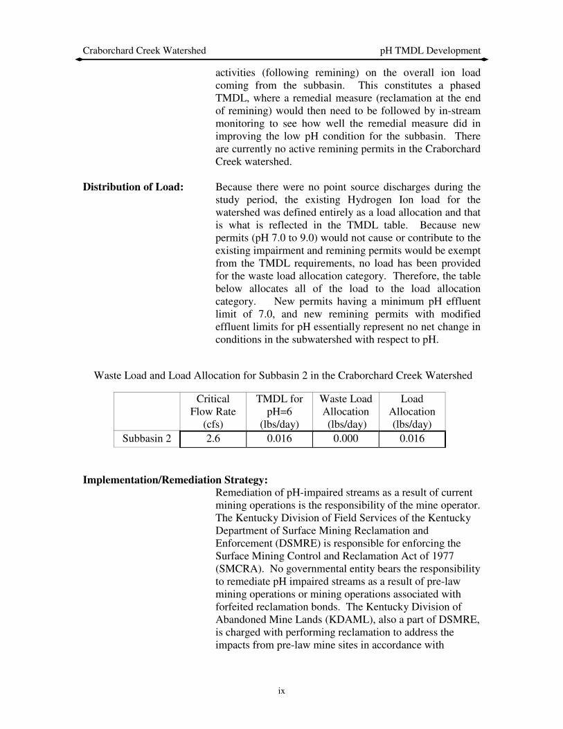
Waste Load and Load Allocation for Subbasin 2 in the Craborchard Creek Watershed
Critical Flow Rate
(cfs)
TMDL for pH=6
(lbs/day)
Waste Load Allocation (lbs/day)
Load Allocation (lbs/day)
Subbasin 2 2.6 0.016 0.000 0.016
Implementation/Remediation Strategy:
Remediation of pH-impaired streams as a result of current mining operations is the responsibility of the mine operator. The Kentucky Division of Field Services of the Kentucky Department of Surface Mining Reclamation and Enforcement (DSMRE) is responsible for enforcing the Surface Mining Control and Reclamation Act of 1977 (SMCRA). No governmental entity bears the responsibility to remediate pH impaired streams as a result of pre-law mining operations or mining operations associated with forfeited reclamation bonds. The Kentucky Division of Abandoned Mine Lands (KDAML), also a part of DSMRE, is charged with performing reclamation to address the impacts from pre-law mine sites in accordance with

Craborchard Creek Watershed pH TMDL Development
x
priorities established in SMCRA. SMCRA sets environmental problems as third in priority in the list of AML problem types. There are currently no planned remediation activities for the Craborchard Creek watershed. Two AML projects have been performed in the Craborchard Creek drainage area. The Craborchard Creek Reclamation Project was performed in 1987 at a cost of approximately $1.0 million. The project reclaimed approximately 109 acres of disturbed land by covering large coal slurry impoundments with earth, regrading eroded slopes and revegetating the entire area. The Zugg Borehole Reclamation Project was conducted in the same area as the previous project at a cost of approximately $12,000. This project involved plugging a borehole that continually discharged significant volumes of low quality water that damaged surrounding property.
Reclamation activities are underway at other locations within the state where water quality is affected by acid mine drainage (AMD). The success of the reclamation activities in these watersheds will first be evaluated before developing remediation strategies for other watersheds affected by AMD. The KDAML developed a reclamation project in response to documented sedimentation and flooding problems in the nearby Brier Creek Watershed. The project included reclamation of approximately 120 acres of barren or poorly vegetated areas affected by past strip mining. The project also entailed six acres of channel restoration to minimize sedimentation caused by erosion. The restoration of streams included construction of ditches and PVC coated gabion baskets utilized as velocity reducers and energy dissipaters; bale silt checks and silt trap dugouts were also utilized for sediment control. The reclamation project consisted of 67 acres of gradework to remove erosion gullies, redistribute sediment deposits, and prepare a surface to receive a soil cover. The area under consideration received a two foot soil cover layer, taken from 20 acres of watershed area designated for borrow. Gradework areas were treated with an application of agricultural limestone to neutralize acidic conditions and all areas were revegetated using a combination of seedbed preparation, agricultural limestone, fertilizer, seed, mulch, and crimping. The agricultural limestone provided a variety of particle sizes so that it dissolved at different rates and mobilized under a range of flow conditions. The

Craborchard Creek Watershed pH TMDL Development
xi
strategy employed at Brier Creek is similar in some respects to a project that is currently underway on Rock Creek and a tributary, White Oak Creek in McCreary County, Kentucky. This 12-acre project is part of the Kentucky Clean Water Action Plan. It involves the removal of coal refuse from the banks of Rock Creek, the establishment of a vegetative cover on other refuse areas in the watershed, and the application of limestone sand at selected locations to neutralize the effects of AMD.
The total cost for the Brier Creek project was $913,000.00 (i.e. $7600/acre) while the total cost of the Rock Creek project is estimated to be approximately $650,000 (i.e. $54,200/acre). Last year the total federal Kentucky AML budget allocation was approximately $17 million. However the bulk of these funds were used to support priority 1 (extreme danger of adverse effects to public health, safety, welfare, and property) and priority 2 (adverse effects to public health, safety, and welfare) projects. Based on the cost of current remediation efforts, it would appear that a significant increase in federal funding to the AML projects, particularly priority 3 projects, would be required in order for the AML program to play a significant part in meeting the TMDL implementation requirement associated with pH impaired streams in the state of Kentucky.
Just recently (June 2003), 319 funding (specifically Clean Water Action Plan funds) has been awarded to the KDAML. This grant is the Homestead Refuse Reclamation Project and includes reclamation of a portion of the upper Pleasant Run watershed. The project involves a 92-acre area. The total cost of the reclamation project is $1.26 Million, of which 60% is federal funds and 40% is supplied by the KDAML. The reclamation activities will be very similar to what was described above for the Brier Creek reclamation effort.

Craborchard Creek Watershed pH TMDL Development
1
Introduction
Section 303(d) of the Clean Water Act and EPA’s Water Quality Planning and Management Regulations (40 CFR Part 130) require states to develop total maximum daily loads (TMDLs) for their water bodies that are not meeting designated uses under technology-based controls for pollution. The TMDL process establishes the allowable loadings of pollutants or other quantifiable parameters for a water body based on the relationship between pollution sources and in-stream water quality conditions. This method exists so that states can establish water-quality based controls to reduce pollution from both point and nonpoint sources and restore and maintain the quality of their water resources (USEPA, 1991a). This report provides the TMDL for Craborchard Creek.
Location
The Craborchard Creek watershed is entirely contained within Hopkins County, in southwestern Kentucky (Figure 1). Hopkins County is bounded by the Tradewater River in the west, the Pond River in the east, Webster County in the northwest, and Christian County in the south.
Figure 1: Location of the Craborchard Creek Watershed
Craborchard Creek Watershed pH TMDL Development
2
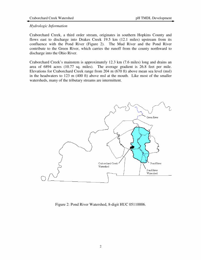
Hydrologic Information
Craborchard Creek, a third order stream, originates in southern Hopkins County and flows east to discharge into Drakes Creek 19.5 km (12.1 miles) upstream from its confluence with the Pond River (Figure 2). The Mud River and the Pond River contribute to the Green River, which carries the runoff from the county northward to discharge into the Ohio River. Craborchard Creek’s mainstem is approximately 12.3 km (7.6 miles) long and drains an area of 6894 acres (10.77 sq. miles). The average gradient is 26.8 feet per mile. Elevations for Craborchard Creek range from 204 m (670 ft) above mean sea level (msl) in the headwaters to 123 m (400 ft) above msl at the mouth. Like most of the smaller watersheds, many of the tributary streams are intermittent.
Figure 2: Pond River Watershed, 8-digit HUC 05110006.
Craborchard Creek Watershed pH TMDL Development
3
Geologic Information The Craborchard Creek watershed is in the Western Coal field physiographic region. The surface bedrock is of Pennsylvanian age. Formations of the Pennsylvanian age are mostly sandstone, siltstone, coal, and interbedded limestone and shale; alluvial deposits of siltstone and crossbedded sand or sandstone underlie the extensive lowland areas (USDA, 1977). The relief of the Craborchard Creek watershed ranges from nearly level to steep. Gently sloping to steep soils are found in the uplands and nearly level soils are found on the floodplain.
Landuse Information Coal, oil, and natural gas are among the natural resources of Hopkins County. The Craborchard Creek watershed contains two main landuses: resource extraction (mining and disturbed land area) and agriculture. Soils Information The Craborchard Creek watershed is dominated by nearly level loamy and clayey soils near to the mouth and level to steep loamy soils in the headwaters. The area is comprised mostly of Zanesville soils, with acidic tendencies and moderate to low permeability. Mining History
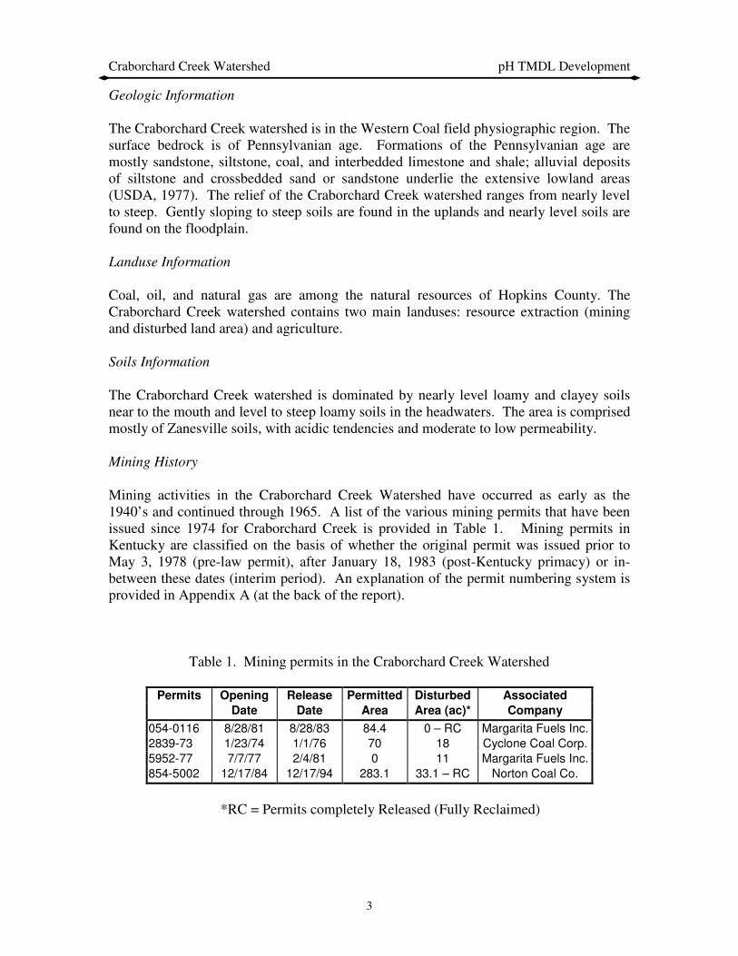
Mining activities in the Craborchard Creek Watershed have occurred as early as the 1940’s and continued through 1965. A list of the various mining permits that have been issued since 1974 for Craborchard Creek is provided in Table 1. Mining permits in Kentucky are classified on the basis of whether the original permit was issued prior to May 3, 1978 (pre-law permit), after January 18, 1983 (post-Kentucky primacy) or in-between these dates (interim period). An explanation of the permit numbering system is provided in Appendix A (at the back of the report).
Table 1. Mining permits in the Craborchard Creek Watershed
Permits Opening Release Permitted Disturbed Associated
Date Date Area Area (ac)* Company
054-0116 8/28/81 8/28/83 84.4 0 – RC Margarita Fuels Inc.
2839-73 1/23/74 1/1/76 70 18 Cyclone Coal Corp.
5952-77 7/7/77 2/4/81 0 11 Margarita Fuels Inc.
854-5002 12/17/84 12/17/94 283.1 33.1 – RC Norton Coal Co.
*RC = Permits completely Released (Fully Reclaimed)

Craborchard Creek Watershed pH TMDL Development
4
All permits are secured through reclamation bonds. A reclamation bond is a financial document submitted to the Office of Surface Mining prior to mine permit issuance. A bond guarantees mining and reclamation operations will be conducted by mining companies according to regulations and the terms of the approved permit. If a coal company cannot comply with these conditions, the bond is “forfeited” (paid to the Office of Surface Mining) for eventual use by the Division of Abandoned Mine Lands in reclaiming the mined area. Reclamation bonds may be submitted in the forms of cash, certificate of deposit, letter of credit or surety (insurance policy). A reclamation bond may be returned to a coal company by either of two methods: administrative or phase (on-ground reclamation). Administrative releases occur when new bonds are substituted for the original bonds. Administrative releases are also given for areas of a mine site that are permitted but never disturbed by mining or for areas that are included under a second more recently issued permit. Phase releases occur in three stages and according to specific reclamation criteria: Phase One – all mining is complete, and backfilling, grading and initial seeding of mined areas has occurred. Phase Two – a minimum of two years of growth on vegetated areas since initial seeding, the vegetation is of sufficient thickness to prevent erosion and pollution of areas outside the mine area with mine soils, and any permanent water impoundments have met specifications for future maintenance by the landowner. Phase Three – a minimum of five years of vegetative growth since initial seeding and the successful completion of reclamation operations in order for the mined area to support the approved postmining land use. Up to 60 percent of the original bond amount is released at phase one. An additional 25 percent is returned at phase two, with the remainder of the reclamation bond released at phase three. Once a permit is released and the reclamation bond returned, the state cannot require additional remediation action by the mining company unless it is determined that fraudulent documentation was submitted as part of the remediation process.
Monitoring History
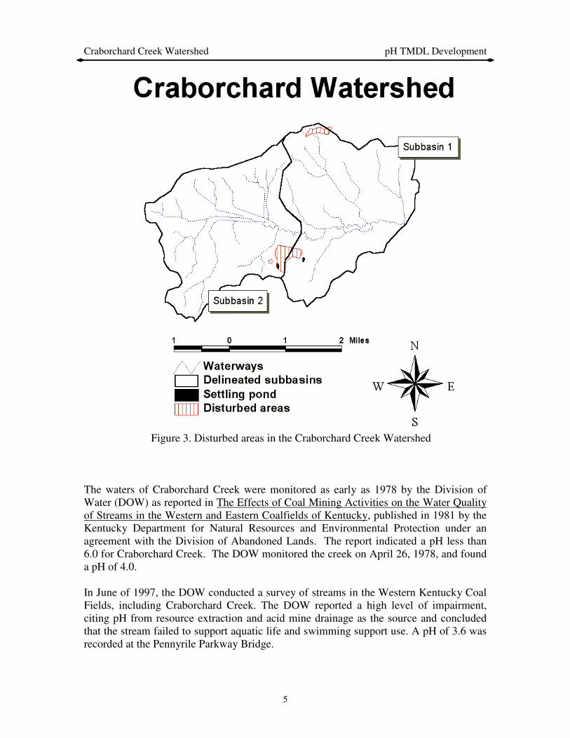
In 1974, the first permit was issued which allowed mining activities in the Craborchard Creek watershed. Table 1 lists the historical permits that have been opened and released in the Craborchard Creek watershed. Figure 3 shows the areas within the watershed that have been impacted by strip mines.
Craborchard Creek Watershed pH TMDL Development
5
Figure 3. Disturbed areas in the Craborchard Creek Watershed
The waters of Craborchard Creek were monitored as early as 1978 by the Division of Water (DOW) as reported in The Effects of Coal Mining Activities on the Water Quality of Streams in the Western and Eastern Coalfields of Kentucky, published in 1981 by the Kentucky Department for Natural Resources and Environmental Protection under an agreement with the Division of Abandoned Lands. The report indicated a pH less than 6.0 for Craborchard Creek. The DOW monitored the creek on April 26, 1978, and found a pH of 4.0. In June of 1997, the DOW conducted a survey of streams in the Western Kentucky Coal Fields, including Craborchard Creek. The DOW reported a high level of impairment, citing pH from resource extraction and acid mine drainage as the source and concluded that the stream failed to support aquatic life and swimming support use. A pH of 3.6 was recorded at the Pennyrile Parkway Bridge.
Craborchard Creek Watershed pH TMDL Development
6
AML Projects
Two AML projects have been performed in the Craborchard Creek drainage area. The Craborchard Creek Reclamation Project was performed in 1987 at a cost of approximately $1.0 million. The project reclaimed approximately 109 acres of disturbed land by covering large coal slurry impoundments with earth, regrading eroded slopes and revegetating the entire area. The Zugg Borehole Reclamation Project was conducted in the same area as the previous project at a cost of approximately $12,000. This project involved plugging a borehole that continually discharged significant volumes of low quality water that damaged surrounding property. Mining had begun at the Zugg Mine Site at least by 1946 with its opening as the Williams Coal Company #4 Mine. Mining continued under Nashville Coal Incorporated and subsequently by Island Creek Coal until 1965.
Problem Definition
The 1998 and 2002 303(d) list of waters for Kentucky (Ky. Dept. for Environmental Protection DOW, 1998) indicates 7.6 miles of Craborchard Creek, from the headwaters to the confluence with Drakes Creek in Muhlenberg County, does not meet its designated use for both contact recreation (swimming) and aquatic life because of low pH. The Craborchard Creek watershed provides a classic example of impairment caused by acid mine drainage (AMD). Bituminous coal mine drainage, like that found in the Craborchard Creek watershed, generally contains very concentrated sulfuric acid and may contain high concentrations of metals, especially iron, manganese, and aluminum. Acid mine drainage can ruin domestic and industrial water supplies, can decimate aquatic life and cause waters to be unsuitable for swimming (primary contact recreation). In addition to these problems, a depressed pH interferes with the natural stream self-purification processes. At low pH levels, the iron associated with AMD is soluble. However, in downstream reaches where the pH begins to improve, most of the ferric sulfate [Fe2(SO4)3] is hydrolyzed to essentially insoluble iron hydroxide [Fe(OH)3]. The stream bottom can become covered with a sterile orange or yellow-brown iron hydroxide deposit that is deleterious to benthic algae, invertebrates, and fish. The sulfuric acid in AMD is formed by the oxidation of sulfur contained in the coal and/or the rock or clay found above and below the coal seams. Most of the sulfur in the unexposed coal is found in a pyretic form as iron pyrite and marcasite (both having the chemical composition FeS2). In the process of mining, the iron sulfide (FeS2) is uncovered and exposed to the oxidizing action of oxygen in the air (O2), water, and sulfur-oxidizing bacteria. The end products of the reaction are as follows:
4 FeS2 + 14 O2 + 4 H20 + bacteria → 4 Fe + SO4 + 4 H2SO4 (1)
Craborchard Creek Watershed pH TMDL Development
7
The subsequent oxidation of ferrous iron and acid solution to ferric iron is generally slow. The reaction may be represented as:
4 FeSO4 + O2 + 2 H2SO4 → 2 Fe2(SO4)3 + 2 H2O (2) As the ferric acid solution is further diluted and neutralized in a receiving stream and the pH rises, the ferric iron [Fe3+ or Fe2(SO4)3] hydrolyses and ferric hydroxide [Fe(OH)3 ] may precipitate according to the reaction:
2 Fe2(SO4)3 + 12 H2O → 4 Fe(OH)3 + 6 H2SO4 (3) The brownish yellow ferric hydroxide (Fe(OH)3) may remain suspended in the stream even when it is no longer acidic. Although the brownish, yellow staining of the streambanks and water doesn’t cause the low pH, it does indicate that there has been production of sulfuric acid. The overall stoichiometric relationship is shown in equation (4):
4 FeS2 + 15 O2 + 14 H2O ←→ 8 H2SO4 + 4 Fe(OH)3 (4) This reaction (equation 4) indicates that a net of 4 moles of H+ are liberated for each mole of pyrite (FeS2) oxidized, making this one of the most acidic weathering reactions known.
Target Identification
The endpoint or goal of the TMDL is to achieve a pH concentration (and associated load in lbs/day) that allows for the sustainability of aquatic life and swimming uses in these stream reaches. The chronic pH criterion to protect Warm Water Aquatic Habitat Use in Kentucky requires that the pH remain not less than 6.0 or more than 9.0 (Title 401, Kentucky Administrative Regulations, Chapter 5:031). For a watershed impacted by AMD, the focus will be on meeting a pH of 6. In the case of violations caused by non-point sources on small intermittent streams, such standards must be evaluated based on an appropriate critical exceedance frequency (return interval) as opposed to a critical period or flow (e.g. 7Q10). For pH violations on such streams, the Kentucky DOW has determined that the maximum daily mean flow having a 3-year exceedance frequency be used for setting the appropriate TMDL and associated load reduction. In cases where the load and the resultant target indicator (i.e. pH) are directly proportional to discharge (flow rate), the exceedance frequency of the associated discharge can be directly related to the exceedance frequency of the target value (e.g. pH). As a result, the critical daily discharge and associated critical load may be obtained as a function of a specified flow exceedance frequency (e.g. 3 years). In some watersheds, however, as is the case of the Craborchard Creek watershed (see Figure 8), it has been observed that the ion load tends to increase as a function of flow, reach a maximum, and then decrease as the flow increases. It is hypothesized that these results reflect two competing physical processes. At lower flows and as a result of a first

Craborchard Creek Watershed pH TMDL Development
8
flush effect, it is hypothesized that ion loads are initially leached out of the spoil areas resulting in increasing ion loads. A maximum value of ion load is reached, and as the runoff volumes increase, it is hypothesized that the ion load in the spoil areas become depleted and therefore reduced because of flow dilution in the stream. As a result, ion load increases with increasing flow, reaches a maximum, and then decreases as flow continues to increase. Based on the observed data, a conservative estimate of the resulting maximum ion loads can now be obtained by selecting the maximum observed ion load at each station.
Source Assessment
Point Source Loads
There are no known permitted point source loads contributing to the existing pH violations in the watershed.
Non-Point Source Loads
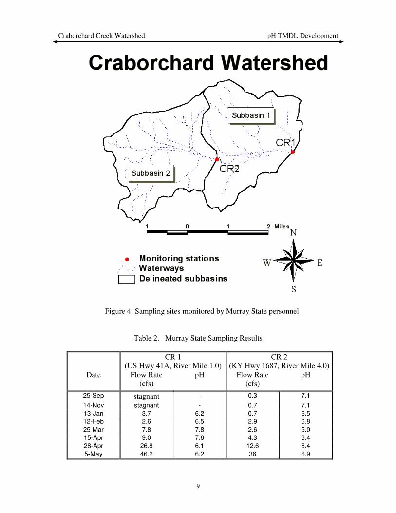
Minimal historical monitoring data is available for the Craborchard Creek Watershed. The possibility of detrimental effects of acid mine drainage is warranted by the four mining permits opened in Craborchard Creek Watershed, as seen in Table 1. However, the only historical monitoring on record is that taken by the DOW on April 26, 1978, and a pH of 4.0 was recorded. In order to provide a more recent characterization of the pH levels in the watershed, the University of Kentucky (as part of the study contract with the DOW) subcontracted with Murray State University to collect additional data from the watershed at the sites shown in Figure 4. A summary of the results obtained from these sites is shown in Table 2. The data from Site CR1indicate that there is not an impairment for Subbasin 1. Therefore, the segment from river mile 0.0 to 4.0 can be delisted. The TMDL will only be developed for Subbasin 2 based on the data collected at Site CR2.
Craborchard Creek Watershed pH TMDL Development
9
Figure 4. Sampling sites monitored by Murray State personnel
Table 2. Murray State Sampling Results
CR 1 (US Hwy 41A, River Mile 1.0)
CR 2 (KY Hwy 1687, River Mile 4.0)
Date Flow Rate (cfs)
pH Flow Rate (cfs)
pH
25-Sep stagnant - 0.3 7.1
14-Nov stagnant - 0.7 7.1
13-Jan 3.7 6.2 0.7 6.5
12-Feb 2.6 6.5 2.9 6.8
25-Mar 7.8 7.8 2.6 5.0
15-Apr 9.0 7.6 4.3 6.4
28-Apr 26.8 6.1 12.6 6.4
5-May 46.2 6.2 36 6.9
Craborchard Creek Watershed pH TMDL Development
10
Model Development
The magnitude of the associated hydrogen ion load in a water column (in terms of activity) can be determined by measuring the pH of the water. The relationship between hydrogen load and pH can be expressed as follows:
{H3O+} = 10-pH or more commonly { H+ } = 10-pH (5)
where pH is the negative log of the H+ ion activity in mol/L. To convert between the measured activity {H+} and the actual molar concentration [H+], the activity is divided by
an activity coefficient, γ.
[H+] = {H+}/γ (6)
The activity coefficient γ is dependent on the ionic strength µ of the source water under consideration. The ionic strength of a given source water can be approximated by estimating the TDS (total dissolved solids in mg/liter or ppm) and applying the following relationship:
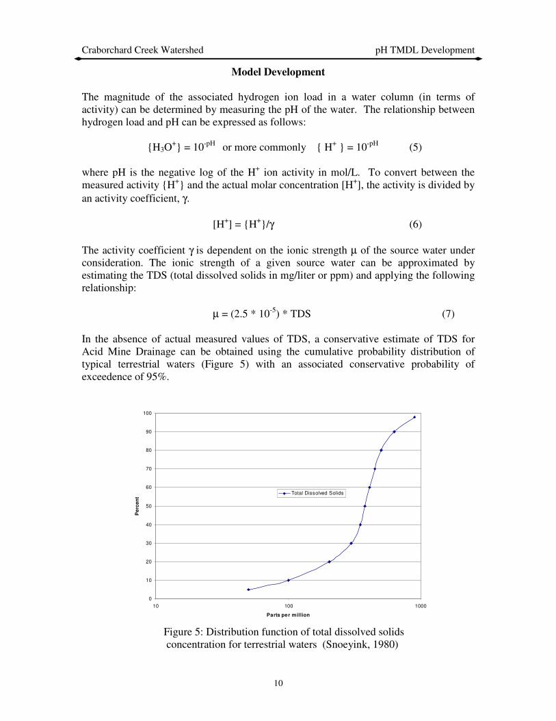
µ = (2.5 * 10-5) * TDS (7) In the absence of actual measured values of TDS, a conservative estimate of TDS for Acid Mine Drainage can be obtained using the cumulative probability distribution of typical terrestrial waters (Figure 5) with an associated conservative probability of exceedence of 95%.
Figure 5: Distribution function of total dissolved solids concentration for terrestrial waters (Snoeyink, 1980)
0
10
20
30
40
50
60
70
80
90
100
10 100 1000
Parts per million
Pe
rce
nt
Total Dissolved Solids

Craborchard Creek Watershed pH TMDL Development
11
Use of Figure 5 along with an exceedence probability of 95% yields a TDS value of approximately 900 ppm. Substitution of a TDS concentration of 900 ppm into equation 7 yields an ionic strength of 0.0225. Ionic strength can be converted to an associated activity coefficient using the functional relationship shown in Figure 6. Use of an ionic strength of 0.0225 yields an activity coefficient of 0.89.
Figure 6: Activity coefficients of H+ as a function of ionic strength (Snoeyink, 1980) The atomic weight of hydrogen is 1 gram per mole so the concentration of hydrogen ions in mol/L is also the concentration in g/L. Multiplying the concentration of hydrogen ions by the average flow rate for a given day results in a hydrogen ion load for that day in grams/day. As a result, for any given flow rate, there is a maximum ion load that the stream can assimilate before a minimum pH value of 6.0 is violated. Thus for any given day a TMDL may be calculated for that day using the average daily flow and a minimum pH standard of 6 units.
Hydrogen Loading Sample Calculation In order to demonstrate the hydrogen loading conversion procedure, use the following monitoring data:
• Critical discharge (Q) = 2.6 cfs
• Measured pH = 6.0
Hydrogen Ion
0.00001
0.0001
0.001
0.01
0.1
0.80.820.840.860.880.90.920.940.960.981
Activity Coefficient,
Ion
ic S
tren
gth
,
γγγγ

Craborchard Creek Watershed pH TMDL Development
12
The pH can be converted to a mole/liter measurement (i.e. moles [H+]/liter) by applying the following relationship: pH = -log {H+} The resulting moles of hydrogen is the anti-log of -6.0, which is 0.000001 moles/liter. The units need to be converted into grams/cubic ft. This is accomplished by applying the following conversion factors:
• There is one gram per mole of Hydrogen.
• 1 liter = 0.035314667 cubic feet (0.000001 moles/liter)*(1 gram/mole)*(1liter/0.035314667 ft3) = 0.0000283168 g/ft3 The goal is to achieve a loading rate in terms of g/day, or lbs./day. If the amount of hydrogen in grams/cubic foot is multiplied by the given flow rate in cubic feet/second and a conversion factor of 86,400 s/day, then the load is computed as: (0.0000283168 g/ft3)*(2.6 ft3/s)*(86400s/1day) = 6.36 g/day, or .014 lbs./day Assuming an activity correction factor of 0.89, the final load is 7.15 g/day, or .016 lbs./day:
6.36 g/day / 0.89 = 7.15 g/day, or .016 lbs./day This load is based on a pH of 6.0. The pH determination is based on a logarithmic scale such that as the pH decreases by one unit the number of moles per liter of hydrogen increases by 10. This obviously has a significant effect on the load and subsequent load reduction needed to attain a pH of 6.0. Using a flow, Q, of 2.6 cfs, the load reduction needed to attain a pH of 6.0 if the observed pH is 5.0 is .144 lbs./day. For an observed pH of 4.0, the reduction needed is 1.58 lbs./day. Because pH and equivalent hydrogen ion load can be related as a function of discharge (flow) and ionic strength, a functional relationship can be developed between discharge and the associated ion loading for a given pH value. By specifying a minimum pH value (e.g. 6) and a minimum activity correction factor (e.g. 0.89), an envelope of maximum ion loads may be obtained as a function of discharge (Figure 7). This figure thus provides a basis for establishing the maximum ion load for a given discharge.

Craborchard Creek Watershed pH TMDL Development
13
Figure 7. Relation between discharge and maximum ion loading for a pH of 6.0
Once a TMDL is developed for a watershed, the associated load reduction must be spatially allocated. One way to accomplish this objective is through unit load reductions as associated with different land uses within the watershed. The impacts of such reductions on the associated water quality standard can then be verified through mathematical simulation. Alternatively, separate TMDLs (and associated load reductions) can be developed for individual subbasins within the watershed. In the current study, a separate TMDL and associated load reduction were developed for Subbasin 2 (Figure 4). Based on a physical inspection of the watershed, it is hypothesized that the degradation of the pH in the stream is directly related to oxidation of sulfur that occurs as runoff flows over the spoil areas associated with previous mining activities in the basin. Using the most recent monitoring data, a plot of ion load with flow was developed (Figure 8) for site CR2. A plot was not made for Subbasin 1, because the data for site CR1 indicates that there is no violation of the pH standard (pH > 6.0; < 9.0.
Discharge vs. Maximum Ion Loading
Max. Load = 2.749 * Q
0
500
1000
1500
2000
2500
3000
0 200 400 600 800 1000 1200
Discharge (cfs)
Ma
xim
um
Io
n L
oa
din
g (
g/d
ay
)

Craborchard Creek Watershed pH TMDL Development
14
Figure 8. Relation between flow and ion load for Site 2
In examining Figure 8, it is observed that the ion load tends to increase as a function of flow, reach a maximum, and then decrease as the flow increases. It is hypothesized that these results reflect two competing physical processes. At lower flows, it is hypothesized that ion loads are initially leached out of the spoil areas resulting in increasing ion loads. A maximum value of ion load is reached, and as the runoff volumes increase, it is hypothesized that the ion loads in the spoil areas become depleted with increasing flow, reaches a maximum, then decreases as flow continues to increases. On the basis of the observed data, a conservative estimate of the resulting maximum ion load can be obtained by selecting the maximum observed ion load at site CR2.
TMDL Development
Theory
The Total Maximum Daily Load (TMDL) is a term used to describe the maximum amount of a pollutant a stream can assimilate without violating water quality standards and includes a margin of safety. The units of a load measurement are mass of pollutant per unit time (i.e. mg/hr, lbs./day). In the case of pH there is no associated mass unit (pH is measured in Standard Units).
Crab Orchard Site 2
0
10
20
30
40
50
60
70
80
0 10 20 30 40 50 60 70 80
Flow Rate (cfs)
H+
Io
n L
oad
(g
/day)
Critical Flow = 2.6 cfs
Maximum Ion Load = 71.5 g/day
= 0.158 lbs/day

Craborchard Creek Watershed pH TMDL Development
15
Total maximum daily loads (TMDLs) are comprised of the sum of individual waste load allocations (WLAs) for point sources, and load allocations (LAs) for both nonpoint sources and natural background levels for a given watershed. The sum of these components may not result in exceedance of water quality standards (WQSs) for that watershed. In addition, the TMDL must include a margin of safety (MOS), either implicitly or explicitly, that accounts for the uncertainty in the relation between pollutant loads and the quality of the receiving water body. Conceptually, this definition is denoted by the equation:
TMDL = Sum (WLAs) + Sum (LAs) + MOS (8)
Waste Load Allocations
There are no known permitted point sources in this watershed. As a result, the waste load allocations for the Craborchard Watershed is currently zero. Load Allocations
Load allocations for the Craborchard Creek Watershed are assumed to be directly related to acid mine drainage as a result of water leaching from abandoned mines. The total load allocation for Craborchard Creek is assumed to be an explicit function of the average daily flow in the stream and an associated pH standard of 6 units. The average daily flow is assumed to be represented by the flow corresponding to the maximum value of ion load. Predicted maximum daily load for Subbasin 2 within the watershed can be obtained using the maximum observed ion load shown in Figure 8. Margin of Safety
The margin of safety (MOS) is part of the TMDL development process (Section 303(d)(1)(C) of the Clean Water Act). There are two basic methods for incorporating the MOS (USEPA, 1991a):
1) Implicitly incorporate the MOS using conservative model assumptions to develop allocations, or
2) Explicitly specify a portion of the total TMDL as the MOS using the remainder for allocations.
In the current TMDL, the MOS is incorporated implicitly through the properties of water chemistry that determine the relationship between pH and hydrogen ion concentration. In
an electrically neutral solution (such as all natural systems), the activity coefficient (γ in eqn. 6) is assumed to be equal to 1.0, meaning that there is no quantitative difference between activity and molar concentration. In the case of AMD there obviously exists the possibility of additional ions in the water column that may affect the relationship between the measured activity and the associated ion load. Therefore, taking a conservative approach, a minimum activity correction factor of 0.89 is assumed. This means that at all
Craborchard Creek Watershed pH TMDL Development
16
values of pH the calculated hydrogen ion concentration is assumed to be higher than would normally be calculated under the assumption of a nominal activity correction factor. Overestimation of the potential loading rate requires a greater reduction and thus allows for an implicitly defined margin of safety. In addition, all pH degradation below the minimum threshold of 6 is assumed to be totally attributable to acid mine drainage. As a result, any load reductions for the watershed will be made irrespective of any natural background sources and thus provide a further conservative reduction strategy.
TMDL Determination
The TMDL for a given stream segment may be determined based on a critical discharge and the use of Figure 7. This value is then converted to pounds per day (Table 3). In determining the TMDL for station CR2 (Figure 4), the flow value corresponding to the maximum observed ion load was used as the critical discharge.
Table 3. Critical Flow and Corresponding TMDL (pH = 6.0)
Predicted Load
As indicated previously, the maximum ion load for Subbasin 2 is obtained from Figure 8 and is shown in Table 4.
Table 4. Critical Flow and Corresponding Predicted Ion Load (lbs./day) for Subbasin 2
Load Reduction Allocation
Translation of the TMDL in Table 3 into the daily load reduction for Subbasin 2 is accomplished by subtracting the TMDL from the predicted load. This value is shown in Table 5.
SubbasinFlow Rate
(cfs)
TMDL
(lbs/day)
2 2.6 0.016
SubbasinCritical Flow
Rate (cfs)
Predicted
Maximum
Load
(lbs/day)2 2.6 0.158
Craborchard Creek Watershed pH TMDL Development
17
Table 5. TMDL Summary and Reduction Needed for Subbasin 2
Permitting
Permitting Other Than in Subbasin 2
Permitting for locations in the Craborchard Creek Watershed other than in Subbasin 2 would require no special considerations related to 303(d). As shown by the values listed for Site CR1 in Table 2, all pH values were equal to or greater than 6.0. Remediation of the abandoned mine areas in Subbasin 2 should result in improved water quality at Site CR1.
New Permitting in the Craborchard Creek Watershed New permits (except for new remining permits) for discharges to streams in Subbasin 2 of the Craborchard Creek watershed could be allowed anywhere in Subbasin 2, contingent upon the end-of-pipe pH being permitted at a range of 7.0 to 9.0 standard units. Water quality standards state that for meeting the designated uses of aquatic life and swimming, the pH value should not be less the 6.0, nor greater than 9.0. This range of 6.0 to 9.0 for pH is generally the value assigned for end-of-pipe effluent limits. However, because a stream impairment exists (low pH), new discharges can not cause or contribute to an existing impairment. A pH of 7.0 represents a neutral state between an acidic and a non-acidic condition. As such, a discharge having a pH of 7.0 to 9.0 standard units will not cause or contribute to the existing impairment. The discharge will not cause an impairment because the effluent discharge has a pH greater than 6.0 standard units. The discharge will not contribute to the existing impairment because a pH of 7.0 represents a neutral condition with respect to acidity and effectively represents a background condition. The hydrogen ion load associated with a pH of 7.0 is insignificant (effectively zero) and therefore does not represent a contribution to the existing impairment. As such, new permits having an effluent pH limit of 7.0 to 9.0 would not be assigned a hydrogen ion load as part of a Waste Load Allocation. There are no active permits in the Craborchard Creek Watershed that would contribute to the pH impairment. Remining Permits
New remining permits in Subbasin 2 may be approved on a case-by-case basis where streams are impaired because of low pH from abandoned mines. Permit approval is contingent on reclamation of the site after remining activities are completed. During
Critical
Flow Rate
(cfs)
TMDL for
pH=6
(lb/day)
Predicted
Maximum
Load
(lb/day)
Reduction
Needed
(lbs/day)
Subbasin 2 2.6 0.016 0.158 0.142

Craborchard Creek Watershed pH TMDL Development
18
remining, existing conditions of the water coming from the site must be maintained or improved. Reclamation of the site is the ultimate goal, but water quality standards (pH of 6.0 to 9.0 standard units) may not necessarily be met in the interim if the Commonwealth issues a variance to the permittee as defined by 401 Kentucky Administrative Regulation (KAR) 5:029. In instances where the Commonwealth issues a variance for a remining activity consistent with this regulation, hydrogen ion loads from this remining activity are allowed to exceed the waste load allocation. The variance allows an exception to the applicable water quality standard as well as the TMDL. Remining therefore constitutes a means whereby a previously disturbed and unreclaimed area can be reclaimed. The authority for remining is defined in Section 301(p) of the Federal Clean Water Act; Chapter 33, Section 1331(p) of the U.S. Code – Annotated (the Rahall Amendment to the Federal Clean Water Act); and the Kentucky Administrative Regulations (401 KAR 5:029 and 5:040). The eventual reclamation of the remining site should result in a reduction of the overall ion load (specifically the nonpoint source load) of the subbasin where the remining was done. The reclamation should also result in improved stream condition (increased pH) because a previously disturbed and unreclaimed area will be reclaimed. Follow-up, in-stream monitoring would need to be done at the subbasin outfall to determine the effect of reclamation activities (following remining) on the overall ion load coming from the subbasin. This constitutes a phased TMDL, where a remedial measure (reclamation at the end of remining) would then need to be followed by in-stream monitoring to see how well the remedial measure did in improving the low pH condition for that subbasin. There are currently no active remining permits in the Craborchard Creek watershed. Distribution of Load
Because new permits (pH 7.0 to 9.0) would not cause or contribute to the existing impairment and remining permits would be exempt from the TMDL requirements, no load has been provided for the waste load allocation category. Therefore, the table below allocates all of the load to the load allocation category. New permits having a minimum pH effluent limit of 7.0, and new remining permits with modified effluent limits for pH essentially represent no net change in conditions in the subwatershed with respect to pH.
Table 6. Waste Load and Load Allocation for Subbasin 2
TMDL for Subbasin 2 of Craborchard Creek = 0.158 lbs H+ Ions/day
Critical Flow Rate
(cfs)
TMDL for pH=6
(lbs/day)
Waste Load Allocation (lbs/day)
Load Allocation (lbs/day)
Subbasin 2 2.6 0.016 0.000 0.016

Craborchard Creek Watershed pH TMDL Development
19
Implementation/Remediation Strategy
Remediation of pH-impaired streams as a result of current mining operations is the responsibility of the mine operator. The Kentucky Division of Field Services of the Kentucky Department of Surface Mining Reclamation and Enforcement (DSMRE) is responsible for enforcing the Surface Mining Control and Reclamation Act of 1977 (SMCRA). No governmental entity bears the responsibility to remediate pH impaired streams as a result of pre-law mining operations or mining operations associated with forfeited reclamation bonds. The Kentucky Division of Abandoned Mine Lands (KDAML), also a part of DSMRE, is charged with performing reclamation to address the impacts from pre-law mine sites in accordance with priorities established in SMCRA. SMCRA sets environmental problems as third in priority in the list of AML problem types. There are currently no planned remediation activities for the Craborchard Creek watershed. Two AML projects have been performed in the Craborchard Creek drainage area. The Craborchard Creek Reclamation Project was performed in 1987 at a cost of approximately $1.0 million. The project reclaimed approximately 109 acres of disturbed land by covering large coal slurry impoundments with earth, regrading eroded slopes and revegetating the entire area. The Zugg Borehole Reclamation Project was conducted in the same area as the previous project at a cost of approximately $12,000. This project involved plugging a borehole that continually discharged significant volumes of low quality water that damaged surrounding property. Reclamation activities are underway at other locations within the state where water quality is affected by acid mine drainage (AMD). The success of the reclamation activities in these watersheds will first be evaluated before developing remediation strategies for other watersheds affected by AMD. The KDAML developed a reclamation project in response to documented sedimentation and flooding problems in the nearby Brier Creek Watershed. The project included reclamation of approximately 120 acres of barren or poorly vegetated areas affected by past strip mining. The project also entailed six acres of channel restoration to minimize sedimentation caused by erosion. The restoration of streams included construction of ditches and PVC coated gabion baskets utilized as velocity reducers and energy dissipaters; bale silt checks and silt trap dugouts were also utilized for sediment control. The reclamation project consisted of 67 acres of gradework to remove erosion gullies, redistribute sediment deposits, and prepare a surface to receive a soil cover. The area under consideration received a two foot soil cover layer, taken from 20 acres of watershed area designated for borrow. Gradework areas were treated with an application of agricultural limestone to neutralize acidic conditions and all areas were revegetated using a combination of seedbed preparation, agricultural limestone, fertilizer, seed, mulch, and crimping. The agricultural limestone provided a variety of particle sizes so that it dissolved at different rates and mobilized under a range of flow conditions. The strategy employed at Brier Creek is similar in some respects to a project that is currently underway on Rock Creek and a tributary, White Oak Creek in McCreary County, Kentucky. This 12-acre project is part of the Kentucky Clean Water Action Plan. It involves the removal of coal refuse from the banks of Rock Creek, the establishment of a vegetative cover on other refuse areas in the

Craborchard Creek Watershed pH TMDL Development
20
watershed, and the application of limestone sand at selected locations to neutralize the effects of AMD.
The total cost for the Brier Creek project was $913,000.00 (i.e. $7600/acre) while the total cost of the Rock Creek project is estimated to be approximately $650,000 (i.e. $54,200/acre). Last year the total federal Kentucky AML budget allocation was approximately $17 million. However the bulk of these funds were used to support priority 1 (extreme danger of adverse effects to public health, safety, welfare, and property) and priority 2 (adverse effects to public health, safety, and welfare) projects. Based on the cost of current remediation efforts, it would appear that a significant increase in federal funding to the AML projects, particularly priority 3 projects, would be required in order for the AML program to play a significant part in meeting the TMDL implementation requirement associated with pH impaired streams in the state of Kentucky. Just recently (June 2003), 319 funding (specifically Clean Water Action Plan funds) has been awarded to the KDAML. This grant is the Homestead Refuse Reclamation Project and includes reclamation of a portion of the upper Pleasant Run watershed. The project involves a 92-acre area. The total cost of the reclamation project is $1.26 Million, of which 60% is federal funds and 40% is supplied by the KDAML. The reclamation activities will be very similar to what was described above for the Brier Creek reclamation effort.
Craborchard Creek Watershed pH TMDL Development
21
LITERATURE CITED
EPA, Clean Water Act, Section 303(d), 40 CFR Part 130, 1991. EPA, Technical Support Document for Water Quality-based Toxics Control, EPA 505/2-
90-001, March 1991. Kentucky Administrative Regulations, (2002) Title 401, Chapters 5:029, 5:031, and 5:040 Kentucky Department for Environmental Protection - Division of Water, 1998 303(d) list
of waters for Kentucky, Department for Environmental Protection. Ky. Natural Resources and Environmental Protection Cabinet, Frankfort KY. 1998
Kentucky Department for Environmental Protection - Division of Water, 2002 303(d) list
of waters for Kentucky, Department for Environmental Protection. Ky. Natural Resources and Environmental Protection Cabinet, Frankfort KY. 2003
Kentucky Division of Water, (1981) The Effects of Coal Mining Activities on the Water
Quality of Streams in the Western and Eastern Coalfields of Kentucky, Department for Environmental Protection, Kentucky Natural resources and Environmental Protection Cabinet.
Snoeyink, Jenkins, Water Chemistry, John Wiley & Sons, Inc., 1980, pp. 9, 74-82. USDA, Soil Survey of Hopkins County Kentucky, 1977

Craborchard Creek Watershed pH TMDL Development
22
APPENDIX A: MINING PERMITS NUMBERING SYSTEM
XXXX-XX Permit issued prior to May 3, 1978. Ex. 1357-76. The first four numbers represent the mine number. The last two numbers represent the year of issuance. XXX-XXXX Permit issues after May 3, 1978. The first three numbers indicate the location of the mine by county and the timing of the original permit issuance. (Ex. Hopkins County = 54). If the first three numbers correspond to the county number, the permit was originally issued during the interim program. If 200 has been added to the county number, the permit was originally issued prior to May 3, 1978, and carried through into the interim program. Ex. 254 (Hopkins) If 400 has been added to the county number the permit was issued prior to the Permanent Program and was to remain active after January 18, 1983. Ex. 454 or 654 (Hopkins) If 800 has been added to the county number: (1) the application is for a permit after January 18, 1983 or (2) two or more previously permitted areas have been combined into a single permit. Ex. 854 (Hopkins) The last four numbers indicate the type of mining activity being permitted. COAL 0000-4999 Surface Mining 5000-5999 Underground Mine 6000-6999 Crush/Load Facility 7000-7999 Haul Road Only 8000-8999 Preparation Plant 9000-9399 Refuse Disposal NON COAL 9400-9499 Limestone 9500-9599 Clay 9600-9699 Sand/Gravel 9700-9799 Oil Shale 9800-9899 Flourspar