Embed Size (px)
Citation preview

6B – Slide 1Topic 6B:Shorelines
Online Lecture:Shoreline Features
○ Estuaries
○ Wetlands
○ Deltas
○ Barrier Islands
○ Headlands & Coves
○ Sea Arches & Sea Stacks
○ Wave-Cut & Marine Terraces
○ Coastal Cliffs
Where do they come from?How do we use them?

6B – Slide 2
EstuaryOcean
Land
Estuaries
○ bodies of water partially surrounded by land
○ many names: bay, harbor, sound, mouth of a river, lagoon, etc.
○ where fresh & salty water meet
○ major cause of currents: tides
Estu
ary
Estuary
Land
HarborOcean

6B – Slide 3Estuaries & Humans
○ contain more life than the nearby ocean. Why?more nutrients:● washed off the land from 2+ sides● “trapped” in the estuary by the surrounding landNutrients are used by…
Used for shipping, industry,
recreation, waste
disposal, etc…
“Nurseries”
Also: salinity, water depth

6B – Slide 4Wetlands
○ covered by waterpart of the time, primarily due to tides(also: freshwater runoff from the land)
○ 2 kinds of coastal wetlands:
Where are each found?
common along the shorelines
of estuaries
salt marshes & mangrove forests
What do they look like?

6B – Slide 5Benefits of Wetlands
○ flood control: rain & storm surge○ protect shoreline from erosion by waves○ filter pollutants out of runoff: keep them
out of the ocean (= cleaner ocean)○ “nurseries” for marine life. How? Why?
like estuaries, plants absorb nutrients in runoff and…Also: salinity, hiding places
Pollutants are less biologically dangerous
in the sediments.
Major Food Source:
“Detritus”

6B – Slide 6Deltas○ A delta forms when a river brings down sand & mud
more quickly than waves carry it away– sand piles up at the mouth of the river,
eventually blocking it and causing it to shift(change course, to find a new way to the ocean).
– shifting & seasonal flooding allow rivers to spread sediments and nutrients over the land
Excellent Farmland
Nutrients ≠Sediments
Examples:Nile,
Mississippi,Sacramento-San Joaquin

6B – Slide 7Humans and Deltas
○ Build levees & dikes (piles of dirt) to protect buildings
○ Dredge (remove) sand from bottom of rivers so that ships can go up and down them
Result: land in deltas tends to sink. Why?
– water in the sediments is squeezed out by the weight of the stuff above
– no new land from sediments piling up
New Orleans is ≈ 8 ft below
sea level.
“like squeezing a sponge”

6B – Slide 8Barrier Islands
○ long, thin islands made of sand,typically oriented parallel to the coast.– separated from the land by an
estuary bordered by wetlands○ common along the eastern and
southern coasts of the United States
Estu
ary
Ocean
Main-Land
BarrierIslands
Living on Barrier Islands
Bar
rier I
slan
d
Barrier Is
land
Barrier Is
land

6B – Slide 9
Photographs of Headlands and Coves
Cove
Cove Cove
CoveCove
Cove Cove
Cove
Headland
Headland
Headland
Headland

6B – Slide 10Headlands and Coves
○ waves erode the “softer” rockin-between the “harder” rock more quickly, pushing back the land and creating coves
○ the places with “harder” rockare left sticking out into the ocean: in other words, they become headlands
At First
Wave Crests
Examples of “harder”and “softer” rocks?
#3
Note: wave refraction

6B – Slide 11Sea Arches & Sea Stacks
○ Sea arches & sea stacks can form if the rock behind the headland is “softer” &therefore erodes more quickly.
○ When too much of the material is eroded away, the arch collapses, & the“hard rock” is left standing on its own (is a sea stack)
Land
At First #2 #3 #4 #5
Wave Crests
Ocean Note: wave refraction
Arch
Sea Stack
Sea StackHeadland

6B – Slide 12Wave-Cut Terraces○ Waves erode
the shoreline, pushing back the cliffs and leaving behind a broad, flatarea called a wave-cut terrace.
What is a terrace?
After ErosionPushed Back
Wave-Cut Terrace
Cliff
Before Erosion
Wave-Cut Terrace
Wave-Cut Terrace
Marine Terrace

6B – Slide 13Marine Terraces I○ If sea level sinks dramatically, the flat area
is out of the water at the top of a cliff. It is now called a marine terrace.
After UpliftMarine TerraceBefore Uplift
Wave-Cut Terrace
What could cause a change
in sea level?
Marine Terrace
Marine Terrace
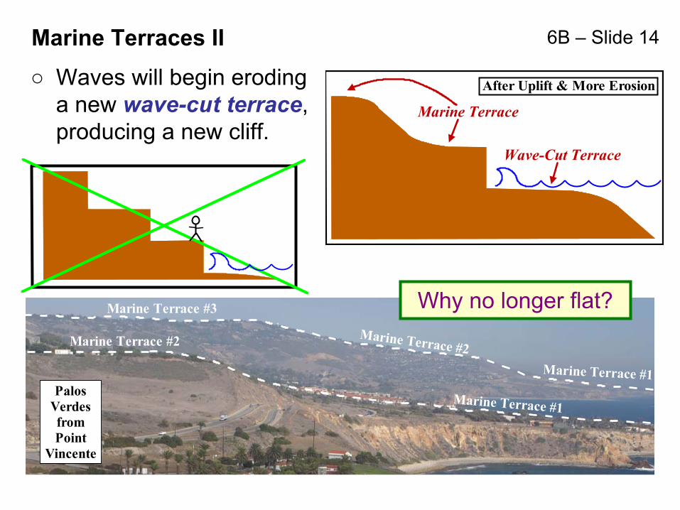
6B – Slide 14
PalosVerdesfromPoint
Vincente
Marine Terrace #3
Marine Terrace #2Marine Terrace #1
Marine Terrace #1
Marine Terrace #2
Marine Terraces II
○ Waves will begin eroding a new wave-cut terrace, producing a new cliff.
Why no longer flat?
After Uplift & More Erosion
Marine Terrace
Wave-Cut Terrace

6B – Slide 15Coastal Cliffs formed on the Bottom of the Ocean
Note the Layers
Evidence?
Sediments vs. Sedimentary Rocks: What’s the difference?

6B – Slide 16Formation of Coastal Cliffs
Layers
CoastalCliffs
FaultUplift
Riversand Runoff
Layers
Bodies of Organisms
Layers
Riversand Runoff
Layerof Sediments
#1 #2
#3 #4