Embed Size (px)
Citation preview

TDf
Ja
b
a
ARRA
KDDLWFN
I
o1atpaolwasa
(
0d
Land Use Policy 27 (2010) 815–826
Contents lists available at ScienceDirect
Land Use Policy
journa l homepage: www.e lsev ier .com/ locate / landusepol
op-down or bottom-up?ecentralization, natural resource management, and usufruct rights in the
orests and wetlands of western Uganda
oel Harttera,∗, Sadie J. Ryanb
Department of Geography, University of New Hampshire, 102 Huddleston Hall, 73 Main Street, Durham, NH 03824, USANational Center for Ecological Analysis and Synthesis (NCEAS), University of California, 735 State Street, Suite 300, Santa Barbara, CA 93101-5504, USA
r t i c l e i n f o
rticle history:eceived 7 May 2009eceived in revised form 5 November 2009ccepted 7 November 2009
eywords:e juree factoand tenure
etlandsorest fragments
a b s t r a c t
Natural resources, and their management, have played an important role in shaping Uganda’s nationalidentity since 1986. Through Uganda’s decentralization agenda, the perception of unprotected forests andwetlands have gone from being wasteland and essentially ignored in the political arena, to key elementsin securing livelihoods and important topics within political platforms. Despite the successes of govern-ment decentralization and legislated devolution of rights and responsibilities to the local level, mandatedregulations instituted by the central government can remain ignored or unheard of locally. What governslocal resource use is a combination of prescriptive national legislation and regulations, local by-laws,and perceived ownership. Usufruct rights of forests and wetlands largely depend on local circumstances,which are unique to individual communities or particular forests and wetlands. This paper describes theentwined recent history of decentralization and natural resource management legislation in Uganda. We
atural resources then present a case study of local perceptions of access and use of unprotected wetlands and forests inwestern Uganda. We show that there is confusion among local residents and village leaders with regardsto access and use of these areas despite prescribed national legislation. We suggest that better opera-tional success of resource management at the local level could be achieved by disseminating informationat multiple levels. This need is particularly pressing in the more remote areas of the country where forest
us pr
bhpl
2uoafc
and wetlands face enormoresources.
ntroduction
Rural livelihoods in sub-Saharan Africa are heavily dependentn the land and its resources (Abalu and Hassan, 1998; Scoones,998). Almost 70% of forest loss in sub-Saharan Africa is directlyttributable to unsustainable timber, charcoal or fuelwood extrac-ions, which will have large impacts on both biodiversity and theeople who rely on the land (Cordeiro et al., 2007). Uganda iscase in point; people are dependent on the land for economic
pportunity, energy, shelter, and sustenance to support their entireivelihood structure. Nearly 80% of the 27 million people are rural,
ho for the most part derive their livelihoods from farm-basedctivities. More than 80% (180,000 km2) of the land is used formall-scale farming (Mukiibi, 2001a). High rates of in-migrationnd natural growth led to Uganda’s population growing by 240%
∗ Corresponding author. Tel.: +1 603 862 7052.E-mail addresses: [email protected] (J. Hartter), [email protected]
S.J. Ryan).
tagapu
iM
264-8377/$ – see front matter © 2009 Elsevier Ltd. All rights reserved.oi:10.1016/j.landusepol.2009.11.001
essure from high population growth and heavy human reliance on natural
© 2009 Elsevier Ltd. All rights reserved.
etween 1960 and 2000. Population growth rates are among theighest in the world (about 3% annually; US Census Bureau, 2006),lacing further need on cultivatable land and resources to sustain
ivelihoods.In 2001, Ugandan forests and woodlands covered approximately
1% (49,000 km2) of the land surface, of which 60% remainednprotected under national legislation. The rest is vulnerable toverexploitation and agricultural encroachment, and country wide,n estimated 500 km2 (0.8%) are lost each year (NEMA, 2001). Theseorests provide ecological services such as stabilization of the locallimate, erosion control, nutrient uptake, and carbon sequestra-ion (Laurance and Bierregaard, 1997). Forest fragments also serves wildlife species corridors, habitat, and breeding and feedingrounds (Marsh, 2003; Onderdonk and Chapman, 2000). Thesereas are also important for commercial and subsistence purposes,
roviding fuelwood, timber, charcoal, poles, and non-timber prod-cts such as medicinal plants and supplemental food.Wetlands include all areas where plants grow and animals liven association with permanent or temporary flooding (Kisamba-
ugerwa and Nuwagaba, 1993). Uganda’s wetlands comprise

8 Use P
a(itaehaash
asaiutaear
ptidnpcrdlcaeoNg
rwqmBrstrrePfll
N
tnadsa
aewt1iDc
aei1ada
rmcdtAwt
omamtot
wt(twrfatIt((NFPA) was probably the weakest legislation in terms of the decen-tralization from central government to the local levels (Nsita,2003). Within the Act, only general parameters through which localinvolvement might be developed are acknowledged as essential.
1 Local council (LC) system was implemented to serve as institutions for localself-governance. It would enable Ugandans to participate in decision making at amore equal level regardless of gender, age, ethnicity or political affiliations, whilegiving local governments autonomy, meaning they have the legislative and execu-tive authority within their listed areas of jurisdiction. The LC system has five levelsof local government: village, parish, sub-county, county, and district. For more onthe LC system, see Saito (2003).
2 Decreed that all land in Uganda be vested in the state in trust for the people tofacilitate its use for economic and social development. It declared all land in Uganda
16 J. Hartter, S.J. Ryan / Land
bout 13% (∼30,000 km2) of the country’s total land surfaceMukiibi, 2001a). Wetlands have many environmental valuesncluding maintenance of water quality and volume, pollutant fil-ration, flood abatement, and serve as habitat for a diverse range ofquatic and terrestrial species (Bakema and Iyango, 2001; Crismant al., 2003; Mukiibi, 2001b). They are also important to the liveli-oods of surrounding communities in several ways. They providesubsistence resource base for water, thatch, handcraft materials,nd local medicines, and are commercially important, providing aource of revenue from visiting tourists, and medicinal plant andandcraft sales.
Along with the scattered fallow and bushlands, Uganda’s forestsnd wetlands are the main resource caches and essential for theurvival of the majority rural population (Gombya-Ssembajjwend Banana, 1998). Despite their documented social and ecolog-cal benefits (Hartter, in press), Uganda’s forests and wetlands arender serious threat of unsustainable conversion due to popula-ion growth, in-migration, and agricultural expansion (Chapman etl., 2001; Hamilton, 1984; Hartter and Southworth, 2009; Macleant al., 2003a). Drainage and conversion into other land uses suchs cultivation, woodlots, and pasture is common in order to offsetesource and land scarcity (Crisman et al., 2003).
The backdrop to this rural lifestyle and increasing populationressure is a tumultuous political history that gave way recentlyo a period of detente and decentralization of government. Sincets independence from Great Britain in 1962, Uganda experiencedecades of political instability and natural resource managementeglect. There have been eight changes of government since inde-endence, four of which were forced by military coups. Historically,hieftains had reign over land allocation, local law and naturalesource allocation. That changed after Uganda gained indepen-ence. After Idi Amin seized power in 1971, he stripped traditional
eaders of their powers (Mutibwa, 1992). Then, Yoweri Museveniame to power in 1986 after years of failed governments, civil war,bolishment of traditional kingdoms, and centralization of gov-rnment functions and powers. Recognizing the inextricable linkf rural peoples (his power-base) to the land, Museveni and hisational Resistance Movement (NRM) sought to re-establish theovernance of the country from the bottom up (Mutibwa, 1992).
A national policy of decentralization devolved rights andesponsibilities to the local government. At the same time, the focusas on transition of government powers. Natural resources conse-
uently received comparably less emphasis, leading to confusion,iscommunication, and neglect at multiple levels (Howard, 1991;
anana et al., 2004). A well-earned aversion to top-down nationalegulation enforcement can translate into uncoordinated localcale management of common goods. In this paper, we attempto trace the entwined histories of decentralization and naturalesource management in Uganda, in order to understand the cur-ent state of management. We then examine a case study of twothnic groups, the Batoro and the Bakiga, living near Kibale Nationalark in western Uganda. We present results of interviews with localarmers and village leaders, and to compare use of forests and wet-ands with the perceptions of access and regulation at the individualandholder and local management scales.
atural resource management and Museveni
When Museveni came to power, discussions began immediatelyo reorganize Uganda’s natural resource management. In the past,
atural resources had largely been ignored in the national politicalrena. Their status became more of a by-product of political agen-as, rather than a primary political platform. Museveni worked tolow the downward spiral of unmonitored resource destructionnd incorporate natural resource management into the nationalpc
tns
olicy 27 (2010) 815–826
genda. In 1989, the first notable proof of progress came with thestablishment of the National Wetlands Programme (NWP), whichas a mechanism to formulate a national policy for the conserva-
ion and management of wetlands (Bakema and Iyango, 2001). In993, the objective and operations of the NWP were expanded to
nclude issues relating to sustainable local wetlands management.espite these efforts, Uganda still lacked a cohesive framework tooordinate broader environmental issues.
In 1995, Uganda clearly stated its national environmentalgenda in the new constitution by asserting the significance ofnvironmental conservation and that natural resources are heldn trust by the government for the people of Uganda (Chapter5, Articles 237 and 245). Thus, a national natural resource man-gement agenda emerged in three important ways: a nationalecentralization policy, new legislation, and devolution of rightsnd responsibilities to the local level.
The implementation of the decentralization policy meant aeview and realignment of the environment and natural resourcesanagement sectors. More responsibilities were passed on to
ommunities. In 1997 the government’s national position onecentralization to break up central government and extend powero the local governments was ensured with the Local Governmentsct 1997 (Article 206 of the new Constitution). Local councils (LCs)ere given power to manage resources according to the Constitu-
ion (1995) and Local Governments Act 1997.1
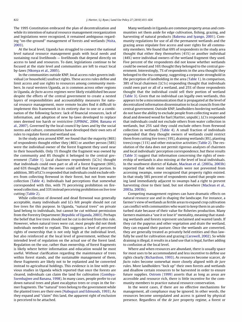
Decentralization came through the enactments of key piecesf legislation, which demonstrated the central government’s com-itment to devolution and building local government functions
nd land/resource management (Fig. 1). The Ugandan govern-ent’s objectives for natural resource management were twofold:
o restructure environmental management through reorganizationf land, resources, and wildlife ownership; and to address many ofhese issues locally through the LCs.
The National Environment Management Authority (NEMA)as established in 1995 by the National Environment Statute as
he “principal agency for the management of the environment”NEMA, 2001). Through new mandates, NEMA established the dis-rict environmental authority and management of local resourcesas devolved to the local councils. The 1998 Uganda Land Act
eversed the Land Reform Decree No. 3 of 19752 and re-recognizedour tenure systems (customary, freehold, leasehold, and mailo3),ffirmed that all land is vested in the people of Uganda, and fur-her acknowledged the need for protection of the environment.t charged any person that occupies or owns any piece of lando manage and utilize it in accordance with environmental lawsNEMA, 2001). The National Forestry Policy and Forestry Act 2001
ublic land belonging to the government and abolished the four types of land tenure:ustomary, freehold, leasehold, and mailo.
3 Mailo tenure was introduced as a result of the 1900 Buganda Agreement. Underhis agreement, land was divided between the Kabaka (King) of Buganda, otherotables and the Protectorate Government. The basic unit of sub-division was aquare mile (Gombya-Ssembajjwe and Banana, 1998).

J. Hartter, S.J. Ryan / Land Use Policy 27 (2010) 815–826 817
atura
FpismLcumw
owtatpwaph
uaotd2Lrgte
cOc
aalnopco
L
1BAlFfFppuiroTca(
cLg
Fig. 1. Key legislations in Uganda’s evolving n
urthermore, at the local level, each LC is responsible for overalllanning and implementation of development activities, includ-
ng environmental conservation. The NFPA provided only a loosetructure for communication, monitoring, and evaluating environ-ental issues, which primarily aimed at upward communication.
ocal involvement through local governments and citizens wouldollaborate with the National Forestry Authority with respect tose of government held forest reserves. Additionally, local govern-ents would collaborate with the district and sub-county councilsith smaller forests.
By the early 1990s Uganda had 70 statutes dealing with aspectsf environmental management and protection (Richardson, 1993)hile moving towards decentralization. These laws were essen-
ially resource management laws, concerned primarily with thellocation and distribution of rights to exploit resources amonghe various bureaucratic agencies. The environment was thenarceled out into separate laws governing the exploitation of water,etlands, forests, etc. (Richardson, 1993). The specific legislative
ctions of the Ugandan government since 1986 were necessary inroviding an overarching decentralized framework, in which land-olders could operate.
In general, the responsibility for land tenure administration andsufruct rights to land fell on local councils (Gombya-Ssembajjwend Banana, 1998; Nsamba-Gayiiya, 1999). Rights and rules devel-ped by the central government were handed down. In realityhough, the local situation was complicated. The national level lawsid not address local specifics nor account for variants (Bazaara,002; Banana et al., 2004; Nkonya et al., 2005). Furthermore, theocal Council Chairmen (LC1s) faced a difficult task of managingesources that sustained local livelihoods but which lacked clearovernance. LCs were handed down an operational framework sohey could manage resources and access, enforce compliance, and
ducate constituents (Bazaara, 2002).Until 1966 public lands were governed de facto by traditionalhiefs and rulers with little government influence (Place andtsuka, 2002). As a result, user rights developed through a pro-ess of popular consultation and arbitration amongst landholders
mttmo
l resource management at the national level.
nd local council members, and also are relics of customary tenurend tribal authority. Despite changes in government and new legis-ation, these traditions and norms persisted. To some degree, theseew mandates were followed, but generally they were followednly selectively by villages. The national decentralization policyroduced semi-autonomous local government units. The villagehairmen (LC1) thus chose to follow certain rules, ignore others,r create new ones based on local tradition, custom, or precedent.
ocal forest ownership, access, and useThe new constitution defined forest management based on the
964 Forest Act (Republic of Uganda, 1964), which was a relic ofritish colonial rule and hardly inclusive of rural Ugandan needs.ccording to the Forest Act, no one may reside, cultivate, or graze
ivestock in a reserve without the written permission of a Seniororest Officer (Banana et al., 2004). Certain species remain reservedor non-timber forest products and may only be cut with Nationalorestry Authority permission both on forest reserve lands and onrivate and communal lands. Local communities have some specialrivileges in the use of resources in unprotected forests. Individ-als may extract “minor forest products” – including fuelwood,
ndigenous medicines, poles, and other non-timber products – ineasonable quantities for their own domestic use without a permitr the payment of fees (Banana et al., 2001; Ntambirweki, 1998).he National Forests and Tree Planting Act of 2003 attempted tolarify ambiguities associated with larger tracts of forests — localnd central forest reserves, as well as those in protected areasNsita, 2003).
While these Acts were important in shaping state property,ommon and private property regimes remained ambiguous. Theocal Governments Statute 1993 decentralized forests, but localovernments were not prepared to engage in professional forest
anagement at the time (Nsita, 2003). To date, legislations con-inue to be focused at the state level and communities are lefto enact local by-laws (Nkonya et al., 2005). Little has also been
andated for private landholders — only that they have the rightf exclusion. They do not necessarily have the right to manage

8 Use P
tt(
L
meUtimtbwaaplrtmtmd
elpppiccaacUwaapddofacg
C
—taiaLaS
e
pt1spr
pK(rboi3
Kstl1bMsraadw
dtFl(ltptosK2c1iwh
ifom
I
This analysis draws on household interviews and interviewswith local village council leaders (LC1) that represented variouscommunities around KNP. This case study builds on recent work
18 J. Hartter, S.J. Ryan / Land
heir land unsustainably, but they do not have the legal obliga-ion to manage their land in the interest of the community eitherKisamba-Mugerwa and Nuwagaba, 1993).
ocal wetland ownership, access, and useThe management of wetlands is less defined than forest
anagement, and despite their importance in livelihoods, littlemphasis was placed on their sustainable use by the majority ofgandans (Bakema and Iyango, 2001). The 1995 Constitution and
he subsequent National Environment Act 1995 rationalized themportance of these areas to Ugandans and worked towards better
anagement (Nkonya et al., 2005). NEMA confirmed this by statinghat permanently inundated wetlands were public land, managedy NEMA (Republic of Uganda, 1995a). Prior to this, these areasere considered vested in the Uganda Land Commission (ULC)
nd subject to individual rights of reasonable use for domesticnd agricultural purposes (Richardson, 1993). In the past, peo-le treated wetlands more like wastelands or as a repository of
and for potential agricultural expansion (Mukiibi, 2001b). Untilecently, government policy encouraged the drainage of wetlandso reclaim them mostly for agricultural use, but also for other com-
ercial and subsistence-based activities (NEMA, 2001). Thoughheir existence was hinted at in legislative proceedings, the explicit
ention of swamps and marshes remained absent in legislativeirectives.
The Constitution in Article 237 Clause 2 (b) states that, “gov-rnment shall hold in trust for the people and protect naturalakes, rivers, wetlands, forest reserves game reserves, nationalarks and any land to be reserved for ecological and tourist pur-oses for the common good of all citizens” (Kakuru et al., 2001,. 9). The Ugandan government (Wetlands Division of the Min-
stry of Natural Resources) is therefore mandated to regulate andontrol wetland use activities. Permanently inundated wetlandsannot be privately held, but are instead held by the governmentnd managed by local councils. These areas should then be man-ged with the size of the wetland taken into account and so theommunity can have access to the wetland (Richardson, 1993).sers may harvest and collect resources – e.g., water, papyrus, fuel-ood – according to ‘wise use’ for domestic purposes (Bakema
nd Iyango, 2001). According to the National Wetlands Policy,ny activity that results in excluding water from the wetland isrohibited (Republic of Uganda, 1995b). Such activities include:igging channels, planting high water demanding trees in highensities, diversion of water entering a wetland, filling with soilr dumping of wastes, and burning (Maclean et al., 2003b). There-ore the three common land conversion practices: cutting papyrusnd planting trees for fuelwood (most commonly Eucalyptus spp.),ultivating crops, and planting pasture grass are deemed ille-al.
ase study: The Kibale landscape
Kibale National Park (KNP) is a good example of an island parka dense, closed-canopy forest surrounded by a large agricul-
ural population, large tea estates, and a vast network of wetlandsnd bottomland forest fragments. Outside KNP, a rapidly increas-ng population, agricultural expansion, and intensive smallholder
griculture place enormous pressure on the land and its resources.andholdings are small (average <5 ha), and 43% of the land within5 km periphery of the park is used for agriculture (Hartter andouthworth, 2009).The population in the sub-counties bordering the park is
xtremely high — almost 240,000 people in the 2002 census and
cf1
olicy 27 (2010) 815–826
rojected to exceed a quarter of a million by 2008.4 The popula-ion outside KNP has been growing extremely rapidly since the950s due to in-migration and natural increase, although this hastarted to slow in recent years as the area has become very denselyopulated (Uganda Bureau of Statistics, 2005), suggesting that it iseaching a saturation plateau.
The population in the two main districts that border theark and in which our survey regions are located (Kabarole andamwenge Districts) increased by 76% between 1980 and 2002
Uganda Bureau of Statistics, 2005); extrapolation of recent growthates in the area suggests that the district-level populations dou-led between 1980 and 2008. In our research areas within 5 kmf the park boundary, estimated population densities are approx-mately 260 individuals/km2 in the region west of the park and35 individuals/km2 on the east side (Hartter, 2009).
Two main ethnic groups occupy most of the land surroundingNP. The west side of KNP is dominated by the Batoro, who began toettle in the area around KNP during the first half of the 20th cen-ury (Naughton-Treves, 1999), although the Toro kingdom in thearger region dates back at least to the early 19th century (Steinhart,977). Much of the area east of the park is populated by the Bakiga,ut there are also Bakiga areas in parts of the west side of the park.ost current Bakiga residents, or their parents, arrived in the area
ometime between the 1950s and 1970s, and the oldest currentesidents say they arrived in the area in the 1930s (Goldman etl., 2009). The rehabilitation and expansion of tea estates in therea in the 1990s led to further in-migration to meet the increasedemand for tea workers and drew Bakiga migrants from south-estern Uganda (Mullan et al., 2008; Mulley and Unruh, 2004).
The once dominant moist, evergreen, closed-canopy forest thatominated the region has for the most part succumbed to agricul-ural expansion at least since 1959 (Gillespie and Chapman, 2006).or example, in Kabarole District, where the western part of KNPies, only 2501 km2 of forest remain but most is severely degradedNEMA, 2001). Nearly all of the forest found on potentially arableands has been converted to small-scale agriculture, tea, or pas-ure and soil degradation is a major concern (NEMA, 2001). In theatchwork landscape of western Uganda, agricultural intensifica-ion and extensification have left forests confined to the steep rimsf crater lakes and bottomlands. Wetlands have succumbed to aimilar fate. By 1964, an estimated 16 km2 of wetland areas inabarole have been reclaimed through drainage while currently4 km2 of wetlands have been reclaimed (NEMA, 2001). Kabaroleurrently has 8318 km2 of wetlands, a loss of nearly 1.6% since964 (NEMA, 2001) (although the undocumented loss of smaller,
nterstitial wetlands is likely to be much higher). The forests andetlands that remain range in size from 0.5 ha to a couple hundredectares (Hartter and Southworth, 2009).
The forest fragments and wetlands that remain are extremelymportant in supporting rural livelihoods. However, these forestragments outside KNP are not designated as local forest reservesr protected by any administrative (local or otherwise) regulatoryechanism.
nterview methodology
4 Census estimates are complicated by the continued of subdivisions of sub-ounties (as recent as February 2009), so exact counts in the study region are noteasible. These population estimates from the 2002 census represent only 5 of the3 sub-counties around KNP.

J. Hartter, S.J. Ryan / Land Use Policy 27 (2010) 815–826 819
ouseh
eqtHbmatrscb“swfoImii2wmpodmttry“
Wscm7
I
wiheoEsaanflab
L
s
Fig. 2. Location of east and west study areas and h
xamining resource use (Hartter, in press) to answer more detaileduestions about perceptions of access and regulation. A full descrip-ion of the geographic selection methodology can be found inartter (2009). Briefly, a five-kilometer perimeter around parkoundaries was defined as the general research area and then twoid-scale research areas for social science research on the east
nd west sides of the park (comprising approximately 110 km2 onhe west and 56 km2 on the east) were identified (Fig. 2). The twoegions differ to some extent in altitude, ethnic composition, andettlement and land use history. A set of 95 random geographicoordinates within these areas was selected, and those pointsecame the centers of 9 ha areas (circles with radii of 170 m) termedsuperpixels” (Goldman et al., 2008). Land cover, use, and holder-hip were surveyed for each superpixel, and interview respondentsere selected from among landholders in each of the superpixels
or which there were landholders (n = 68, 36 on the west and 32n the east sides of the park) (Fig. 2) (see Hartter, 2009 for details).n addition, we conducted 16 interviews with Local Council Chair-
en (LC1s) who represented some of the 60 villages we workedn. To establish trust and credibility within the communities, affil-ated researchers have been working in these communities since004; a pilot study was conducted May–August 2005, permissionsere obtained from local government officials and village chair-en (LC1), and a local field assistant was hired. The survey was
re-tested to assess clarity, perception of researchers, and trainingf field assistants (Kaswamila et al., 2007). Interviews were con-ucted in person by JH using a trained interpreter in one of theain local languages, Rutoro or Rukiga, or in English. Questions
o all respondents were mostly open-ended, allowing respondentso respond freely. Respondents could further expound on theiresponses. Although the researcher had worked in the area for 2ears, the researcher and his team were still likely perceived as anoutsider”, which inevitably affected data to some extent.
ftabm
old interview sites outside Kibale National Park.
Responses were then coded into categories during data analysis.hile many samples were quite small and did not lend them-
elves to rigorous statistical analyses, to compare results betweenategories of wealth, in regards to wetland and forest use and per-ission, a chi-square analysis was used. This was conducted in JMP
.02 software.
nterview responses
Most respondents (n = 130) used local forests (101, 78%) andetlands (120, 92%) as resource caches to provide firewood, build-
ng poles, medicinal plants, food, timber, water, materials forandcrafts (e.g., baskets, granaries, mats) (Hartter, in press). How-ver individual uses of nearby forests and wetlands differed; basedn access, extraction privileges, and individual household needs.ach of the unprotected forests and wetlands in the Kibale land-cape are governed differently: rights, privileges, and regulationsre based on a mixture of national level legislation, local by-laws,nd perceived land ownership rights. While the usufruct gover-ance of each forest and wetland is unique, there are general (both
ormal and informal) guidelines that are followed in the Kibaleandscape. We describe the local forest and wetland ownership,ccess, and use as perceived by local farmers and village leaderselow.
ocal forest ownership, access, and useThe majority of respondents (86%) believed that forests out-
ide KNP could be owned by an individual. Of those that found
orest fragments useful (n = 101), 46% of them used forests thathey believed were personally owned and 58% that were perceiveds owned by another individual (Table 1). Landholders commonlyelieved they “own” forested lands down-slope to the stream. Sinceost believed that these forests could be owned by an individual,
820 J. Hartter, S.J. Ryan / Land Use Policy 27 (2010) 815–826
Table 1Of 130 total respondents, 101 had forest fragments and 120 had wetlands that were useful to their household within 2 km. For each forest fragment and wetland therespondents used, they were asked to identify who was the perceived “owner” for at least the portion they used. Note: some households used more than one forest fragmentand/or wetland.
Who is the perceived owner? Forests (n = 101) Wetlands (n = 120)
Proportion (%) n Proportion (%) n
Individual 86 87 69 83• Respondent 46 46 41 53• Another individual 58 59 44 57
Community 1 1 2 2Central government 8 8 16 21Tea company 7 7 7 9
mcocthin(tl(rsrsa
bcpr(slunf(Iiltp
abcwi
scragahofmcrianapIp
L
s
TSp
Church
Local community conservation group
Do not know 0
any felt that they needed to provide permission for collection ofertain resources on their forest or to collect resources on the forestwned by another individual (Table 2). In some cases individualsollecting resources stated that they obtain permission from localea estates or landholders before collecting. Often non-destructivearvests are acceptable, such as non-timber forest products and
ndigenous medicines. Most individuals believed that all commu-ity members had a right to collect downed and dried firewood93%) and water (100%) and no owner had exclusive rights tohese areas if they were “natural” trees (not planted). However,andowners may exclude locals from gathering other resourcese.g., medicines, food, building poles, thatch, timber). Respondentseported that permission for non-timber forest products is lesstringent and often an arrangement can be worked out so that theseesources can be collected for subsistence use; while in most casespecific permission must be granted from the landholder for cuttingny trees for timber or building poles (endemic or exotic species).
Eighty percent of the respondents that found forests usefulelieved there were no limits on the amount of resources theyould take. Only 33% believed permission was needed for access toarticular forests to collect resources. However, some respondentseported that there were specific resources that they could not takeTable 2). A tri-level division of wealth, established in a previoustudy (Hartter, 2009, in press), via hierarchical cluster analysis ofand, number and type of livestock, and house construction, wassed to examine potential effects on the perceived permissioneeded. In all three categories, greater than 50% of respondents
elt that they did not need permission for use of forest fragmentsI. 65.52%; II. 71.19%; III. 68.46%) or wetlands (I. 82.76%; II. 64.41%;
II. 84.62%). There was not a statistically significant effect of wealthncrease on this response (forests X2 = 0.439, p = 0.80, n = 130; wet-ands X2 = 5.99, p = 0.05, n = 130). However, respondents suggestedhat use and conversion of these areas is often unobstructed toerceived wealthy landowners because local perceptions dictatebElgc
able 2ome “owners” of forests and/or wetlands restrict resource collection or certain activitierohibited.
Activity/resource Forests (n = 101)
Proportion (%)
Cut live trees for timber or poles 33Drain N/ABurn charcoal 11Sand/clay 7Fish N/ACrafts, thatching, medicinal plants 7Plant trees, crops 7Grazing livestock 7Collect fuelwood 7
1 1
1 1
0 5 6
higher social standing and political influence in the communityy these individuals. One respondent expressed a common per-eption among respondents, “What can we [small landholders] dohen those rich men cut the forests? They have money, know many
mportant people, and can do what they want.”This is indicative of respondents perception of land owner-
hip and rights and privileges associated with them, but also theurrent or impending future shortages of certain resources. Mostespondents believe that “destructive” uses were not allowed, suchs draining wetlands, cutting live trees, and burning charcoal. Ineneral respondents believed that “non-destructive” uses, suchs collecting fuelwood, water, medicines, food, and materials forandcrafts, were acceptable. These resources could be collectednly for household consumption and not collected on a larger scaleor commercial sale. In general, building poles and sand were per-
itted, but many respondents perceived that these could only beollected when an individual is building or repairing a house. Allespondents (100%) agreed that a person cannot exclude anotherndividual from collecting water and most (95%) also believed thatny individual had the right to collect firewood, as long as they doot cut trees. Building poles are often taken, but are typically notllowed. However, it is generally believed that an individual, whenermitted to cut poles, cannot cut the last of the poles in a forest.
f a person cuts natural trees, then sometimes he/she is required tolant trees.
ocal wetland ownership, access, and useMost respondents believed that all or a portion of wetlands out-
ide KNP could be owned by an individual, but a larger proportion
elieved also they belonged to the central government (Table 1).ven if individual ownership was a commonly held belief amongocals, only about one third of respondents felt permission must beranted for usufruct access to those areas. Respondents most oftenollect water, medicinal plants, fuelwood, thatch, and papyrus fors. Respondents report a variety of activities and resources from which they were
Wetlands (n = 120)
n Proportion (%) n
33 19 23N/A 8 911 8 97 7 8N/A 7 87 3 47 11 137 9 117 9 11

J. Hartter, S.J. Ryan / Land Use Policy 27 (2010) 815–826 821
Table 3LC1 perceptions of an individual’s rights regarding wetlands and forest fragments (n = 16), compared with landholder’s perceptions (n = 130).
Perception LC1s Landholders
Individuals can . . . Proportion (%) n Proportion (%) n
“own” part/all of wetland 38 6 85 110“own” part/all of forest 69 11 81 105sell their portion of wetland 25 4 N/Asell their portion of forest 63 10a N/Aexclude others from firewood collection in their wetland 25 4 8 11exclude others from firewood collection in their forest 38 6 5 7
0 0 0
ation. If the forest was on a hill, then a sale was permissible. If the forest was in theb
camslvlff
P
tdpvabooomi(
pidecitw
inattbwTml
araccd
Table 4LC1 rules for cutting natural trees and replanting rules (n = 16).
Response to cutting natural trees % n
Individual must replant 38 6Individual does not have to replant 62 10
Number of trees that should be planted when one tree is cut1 50 32 0 03 33 2
piB
D
lmewaiia
taltmtfplml
ellem
exclude others from water collection (wetland or forest) 0
a Note: Three respondents reported that sale of forest land depended on its locottomland, then a sale was not permissible.
rafts, and 97% of them said they could take as much of the resources they wanted. However, some resources/activities were not per-itted for collection in certain wetlands (Table 2). In the case of
maller wetlands (no particular size, but in practice about 0.5–3 ha),andholders whose land abuts these wetlands may exclude all har-ests except fuelwood and water. They consider these areas as theirand and they may cultivate crops or grow eucalyptus trees. As withorests, respondents believe that individuals cannot exclude othersrom collection of water in wetlands.
erceptions from local leadersVillage chairmen (LC1) perceived ownership of forests similarly
o local landholders, while the perceived ownership of wetlandsiffered (Table 3). In contrast to forests that can be public andrivate, wetlands remain in the public domain. Of the 16 LC1s inter-iewed, 11 (69%) believed that individuals could own part or all offorest, as did 85% of landholders. Among LC1s, 10 of those 11
elieved landholders could sell the forest they owned. In contrast,nly six (38%) of LC1s reported that individuals could own all or partf a wetland, while 81% of individual landholders did. Among LC1s,nly four reported sales rights to wetlands. This suggests an infor-ation lapse both among LC1s, in regards to wetlands, and a gap
n information sharing for landholders from their local legislationLC1s).
All LC1s believed that access to water was a basic right of alleople and no individual could exclude access on their land for
ndividuals collecting water (Table 3). However, they were moreivided on the collection of firewood in forests and wetlands. Forxample, only six (25%) of the 16 chairman believed that individualsould exclude others from firewood collection in wetlands, whichs in line with landholders’ minority response of only 8% perceivinghat individuals could exclude others from collecting firewood frometlands.
Fuelwood collection and cutting live trees is often a contentiousssue amongst those that have land and trees and those that doot. Given the increase in population and growing scarcity of landnd wood resources, many landholders prohibit or strictly limithe extraction of woody materials. Although cutting live trees forimber is generally not permitted, pole-sized trees (those used foruilding poles, approximately 4–6′′ dbh) can be cut. In many caseshen a tree is cut, then sometimes he/she is required to plant a tree.
hese rules are mere suggestions in terms of species and replace-ent quantity and generally not enforced and have been developed
ocally through the LC1’s training and personal beliefs (Table 4).Destructive uses in wetlands such as draining, planting crops,
nd cutting trees are not permitted according to national envi-
onmental legislation and LCs. However, if an individual’s land isdjacent to the wetland or perceives ownership, they often willonvert some of the wetlands to pasture, grow crops or trees, andut trees, whether or not this action is allowed. Regardless, the LC1so not say anything. When asked why he does not report such peo-hbetn
4 0 05 0 0>5 17 1
le, one chairman replied, “I used to report them in the past . . . Butf you keep reporting [your neighbors] then you will be hated” (J.yaruhanga, LC1 Makobyo Zone, pers. comm.).
iscussion
Uganda’s forests and wetlands continue to be threatened byand conversion and exploitation due to population growth, in-
igration, and agricultural expansion (Hamilton, 1984; Chapmant al., 2001; Maclean et al., 2003a, 2003b). Unprotected forests andetlands are often viewed by locals as “unclaimed” and “unused”
reas — opportunities to increase landholdings. The “use it or loset” mentality is evident as people convert or use lands because theres no security of resources for the future, and they perceive fewlternatives (Maclean et al., 2003a; Nkonya et al., 2005).
Local institutional arrangements can be more useful than cen-ral governments at providing rules related to access, harvesting,nd management because both the issue and response are derivedocally (Banana et al., 2005). They provide a forum that can respondo conflicts quickly and cost-effectively, and provide monitoring
ethods that are more efficient than those of centralized institu-ions (Ostrom, 1990). Devolved decision-making mechanisms canacilitate the active participation of communities, articulating localriorities and helping to ensure that programs are appropriate to
ocal needs (Francis and James, 2003). Without power, local govern-ents cannot gain the legitimacy they need to effectively represent
ocal populations (Ribot, 2003).Under the 1995 Ugandan constitution and the 1997 Local Gov-
rnments Act, local councils were given the power to manageocal resources. By having a strong national agenda, these regu-ations and values would be brought to the rural sector throughxtension services or trickle to the rural areas through word ofouth or through local councils (UPIMAC, 2004). This attention
elped not only to promote sustainable natural resource programs,ut also to garner support for the decentralized national gov-rnment. The national government’s move to confront an issuehat was vital to the rural majority, increased confidence in theewly established government and likely boosted political tenure.
8 Use P
Twai2
lsafb
vlbidlrinioanr
owttetaaeccwc
allftHirbiRiuwtivcSdmtti
mhmgnt(Fcebt3ct(adcddtwcrttoa(eIraIih2
nfctfitttfdt
frfrafa
22 J. Hartter, S.J. Ryan / Land
he 1995 Constitution embraced the plan of decentralization andhile its intention of natural resource management reorganization
nd legislations were recognized, it remained ambiguous regard-ng “on-the-ground” management of forests and wetlands (Nsita,003).
At the local level, Uganda has struggled to connect the nationalevel natural resource management goals with local needs andustaining rural livelihoods — livelihoods that depend directly onccess to land and resources. To date, legislations continue to beocused at the state level and communities are left to enact localy-laws (Nkonya et al., 2005).
In the communities outside KNP, local access rules govern indi-idual (or household) usufruct rights. These access rules define andimit access and use rights to resources among community mem-ers. In rural western Uganda, as is common across other regions
n Uganda, de facto access regimes were likely established becauseespite the efforts of the central government to create a nested
ayers of responsibilities and accountability measures for natu-al resource management, more remote locales find it difficult tomplement this framework in its entirety due to one or a combi-ation of the following factors: lack of financial resources, lack of
nformation, and adoption of new by-laws developed to replacenes deemed too harsh or restrictive (UPIMAC, 2004; Banana etl., 2007). Governed by the local council by-laws and by the socialorms and culture, communities have developed their own sets ofules to regulate forest and wetland use.
In the study area around KNP, we found that the majority (86%)f respondents thought either they (46%) or another person (58%)ere the individual owner of the forest fragment they used near
o their households. Only 1% thought the fragment was owned byhe community and 8% thought it belonged to the central gov-rnment (Table 1). Local chairmen respondents (LC1s) thoughthat individuals could own part or all of a forest fragment (69%),nd 63% thought that the owner could sell that forest portion. Inddition, 38% of LC1s responded that individuals could exclude oth-rs from collecting firewood in their forest, but not from waterollection (Table 4). Individuals had perceptions that somewhatorresponded with this, with 7% perceiving prohibition on fire-ood collection, and 33% instead perceiving prohibition on live tree
utting (Table 2).While collection of downed and dead firewood was generally
cceptable, many individuals and LCs felt people should not cutive trees for this purpose. In Uganda, “natural trees” on privateand belong to individuals, but cannot be cut without permissionrom the Forestry Department (Republic of Uganda, 2003). Perhapshe belief that live trees should not be cut is derived from this rule.owever, when natural trees were cut, most people did not think
ndividuals needed to replant. This suggests a level of perceivedights of ownership that is not only high at the individual level,ut also reinforced at the local level of government, without the
ntended level of regulation on the actual use of the forest land.egulation on the use, rather than ownership, of forest fragments
s likely where better information and education would be mostseful. Without clarification regarding the maintenance of treesithin forest stands, and the sustainable management of them,
hese fragments are likely not to be replanted and be convertednstead to agricultural holdings. This evidence is in line with pre-ious studies in Uganda which reported that once the forests areleared, individuals can claim the land for cultivation (Gombya-sembajjwe and Banana, 1998). In many cases, people prefer to cut
own natural trees and plant eucalyptus trees or crops in the for-er fragments. The “natural” trees belong to the government whilehe planted trees are their own (Nabuguzi and Edmunds, 1993). Ashey expand and “claim” this land, the apparent right of exclusions perceived to be attached.
m
mrp
olicy 27 (2010) 815–826
Many wetlands in Uganda are common property areas and com-unities set them aside for edge cultivation, fishing, grazing, and
arvesting of natural products (Bakema and Iyango, 2001). Com-unity regulations for use of all the permanent wetlands and the
razing areas stipulate free access and user rights for all commu-ity members. We found that 69% of respondents in the study areahought that either they themselves (41%) or another individual44%) were individual owners of the wetland fragment they used.ive percent of the respondents did not know whether wetlandsould be owned and 16% thought they belonged to the central gov-rnment. Interestingly, 7% of respondents in the area thought theyelonged to the tea company, suggesting a corporate stronghold inhe perception of landholding in the area (Table 1). In comparison,8% of local chairmen (LC1s) responding thought that individualsould own part or all of a wetland, and 25% of those respondentshought that the individual could sell their portion of wetlandTable 3). Given that no individual can legally own wetlands, thisppears to be a miscommunication that is propagated at the level ofecentralized information dissemination to local councils from theentral government. Outside KNP, landholders bordering wetlandso not have the ability to exclude people from collecting water andead and downed wood for fuel (Hartter, unpubl.). LC1s respondedhat individuals could not exclude others from water collection inetlands, but 25% said they could exclude others from firewood
ollection in wetlands (Table 4). A small fraction of individualsesponded that they thought owners of wetlands could restricthem from cutting live trees (19%), draining wetlands (8%), plantingrees/crops (11%) and other extractive activities (Table 2). The res-lution of the data does not permit rigorous analyses of chairmennd local individuals’ perception correspondence, but these resultsTable 3) suggest that information concerning the rights of own-rship of wetlands is also missing at the level of local individuals.n the southwest district of Kabale, Maclean et al. (2003a, 2003b)eported that while most individuals were not prevented fromccessing swamps, some recognized that property rights existed.n that study 58% percent of respondents stated that people own-ng land immediately adjacent to swamps had a right to preventarvesting close to their land, but not elsewhere (Maclean et al.,003a, 2003b).
Competing management regimes can have dramatic effects onatural resource use and in shaping the landscape. For instance, a
armer’s view of wetlands as fertile areas to expand crop cultivationan conflict with communities who want to keep them in an undis-urbed state because of their value for fisheries production. Manyarmers maintain a “use it or lose it” mentality, meaning that stand-ng wetlands and forests represent unclaimed and wasted lands. Ifhey cut the papyrus and other vegetation and drain the wetland,hey can expand their pasture. Once the wetlands are converted,hey are generally treated as privately held entities and thus law-ully be used for cultivation and grazing (Carswell, 2002). So whileraining is illegal, it results in a land use that is legal, further addingo confusion at the local level.
Where and when resources are abundant, there is usually spaceor most uses to be accommodated and less incentive to define useights clearly (Richardson, 1993). As resources become scarcer, deacto rules become somewhat more closely aligned with de jureules. More landholders “lock up” their own forests and wetlandsnd disallow certain resources to be harvested in order to ensureuture supplies. Ostrom (1999) asserts that as long as areas areccessible and resource rich, there is little incentive for the com-
unity members to practice natural resource conservation.In the worst cases, if there are no effective mechanisms foranagement, all compliance may be ignored. In other words, theesources become unregulated and access is gained by physicalresence. Regardless of the de jure property regime, a forest or

Use P
wa(vwcw
bnaatlluRd2utt
Wcc
finctoomMasi(m
TS
J. Hartter, S.J. Ryan / Land
etland can be subject to a de facto open access regime if therere no effective institutions and mechanisms to enforce the rulesBanana et al., 2001). A lack of accountability for these areas pro-ides little incentive for local communities to protect trees andater sources. As the confusion between management regimes
ontinues, exploitation and degradation of wetlands and forestsill likewise continue (Kisamba-Mugerwa and Nuwagaba, 1993).
The case study of KNP illustrates the present disconnectetween available information and desired legislation at theational and local levels. The division of roles and responsibilitiesmong the central government, the local government, landholders,nd local communities has led to confusion or non-compliance athe local level. The lack of clear definition and understanding ofand management responsibilities has fostered a situation whereocal communities have tended to lose control over determiningse of wetlands and forests (Banana and Turiho-Habwe, 1998;ichardson, 1993), all of which have contributed to the decline andegradation of forests and wetlands country-wide (Banana et al.,
004; Kisamba-Mugerwa and Nuwagaba, 1993). As an attempt tosefully reveal some of the confusion and perhaps slow the unsus-ainable ongoing practices in this study area, we have summarizedhe de jure and de facto access and restrictions in place (Table 5).p
it
able 5ummary of de jure and de facto access and harvest restrictions for usufruct access in (a) s
(a)
Resource Land tenure Access
Fuelwood (FW)
Privately held
De jure: open — mustprivately held land
De facto: do not haveCommunities may exmembers”
Building poles De jure: open — mustprivately held land
De facto: privately helbe obtained and owne
Timber Privately held (local govt). Naturaltrees belong to government,planted trees do not
De jure: private land hmust obtain permissi
De facto: Central ForeReserves — must obtaPrivate land holders —permission from land
(b)
Resource Land tenure Access
WaterHeld by central government “in trust” for people,but managed by local councils. Larger wetlandsare managed by National Environment Authority.Cannot be privately held
De jure: o
De facto: nCommuni“non-com
Medicinal plants De jure: oneeded ifDe facto: ineeded, b“non-comwetland olandholde
Handicraft materials De jure: ocollectingonly. HarvpermissioDe facto: ineeded, b“non-comwetland, o
olicy 27 (2010) 815–826 823
e hope that, in conjunction with the results of this survey of per-eived access and restrictions, some of the information mismatchan be reconciled.
While the national policies and legislations have provided aramework to include the natural resource agenda, they remainneffective at the local level. Weak law enforcement renders mostatural resources under the central government law and in someases open access, hence open to depletion if economic condi-ions so dictate (Banana et al., 2001; Nkonya et al., 2005). Limitedperating budgets and manpower force the district environmentalfficer to concentrate monitoring and enforcing efforts on large,ore accessible areas (Gombya-Ssembajjwe and Banana, 1998).oreover, heavy reliance on punitive measures and the top-down
pproach in enforcing state law can lead to poor compliance withtatutory law and limited local community participation in mon-toring and enforcing natural resource conservation regulationsNkonya et al., 2005). In this study, village chairmen said that a
ore effective way is through education and promotion of best
ractices.Hardin’s (1968) “Tragedy of the Commons” asserts that thenevitable result of shared use is benefits for one and that ultimatelyhese resources will succumb to pressure. Extensive commentary
mall forest fragments and (b) wetlands near Kibale.
Harvesting restrictions
obtain permission for De jure: may extract reasonable quantities fortheir own domestic use without a permit orthe payment of fees. Collect dead, downedwood or branches for FW
to obtain permission.clude “non-community
De facto: do not cut standing straight trees.Collect dead, downed wood or branches forFW. No limit
obtain permission for De jure: may extract reasonable quantities fortheir own domestic use without a permit orthe payment of fees
d lands, permission mustr may exclude
De facto: all cutting is not allowed withoutpermission
olders — individualson from landholder
De jure: all cutting is illegal unless properpermissions obtained stating specific amountor number
st Reserves, Local Forestin permission from LC.individuals must obtain
holder
De facto: all cutting is illegal unless properpermissions obtained stating specific amountor number
Harvesting restrictions
pen — no permission needed De jure: “wise use” of resources. Anyactivity that results in excluding waterfrom the wetland is prohibited
o permission needed, butties may excludemunity members”
De facto: no limit, but usually no diversionis allowed
pen — typically no permissionharvested at a small scale
De jure: “wise use” of resources
f large wetland, no permissionut Communities may excludemunity members”. If smallr collecting for commercial use,rs may/may not exclude
De facto: no limit for householdconsumption
pen — no permission needed iffor household consumptionesting large amounts requiresn
De jure: “wise use”
f large wetland, no permissionut Communities may excludemunity members”. If smallwners may/may not exclude
De facto: no limit for householdconsumption, but may be limited forcommercial use

8 Use P
sttpma
iwuscdiiKtmaaatati
imsctRrRie
lntpm2artsAegtflc
orospigwoH
mlmawa
moaTmepblotacrlmsutedp
allpatttttp
C
panigiartrd(Pm
24 J. Hartter, S.J. Ryan / Land
uggests Hardin’s claims do not hold true and that a communityhat shares resource pools has a strong incentive to protect themo the best of its ability, even if that means not maximizing currentroduction, because those resources will be essential to the com-unity’s survival for in the long-term future (Cox, 1985; Bromley
nd Cernea, 1989; Appell, 1993).Our results suggest that the latter commentary does not hold
n the Kibale landscape. The natural areas (forest fragments andetlands) have become “ticking clocks” because the growing pop-lation is consuming resources faster than the environment canustain them, and those areas that remain may eventually suc-umb to this pressure. Households tend to forego what will notirectly and immediately benefit their short-term gains, even if
t does decrease the long-term standard of living or sustainabil-ty of resources and livelihoods (Hyden, 1998). As is the case ofNP, many parks are surrounded by dense agricultural popula-
ions (DeFries et al., 2005). As the population grows, land is usedore intensively, and land parcels decrease in size as new farms
re established. This, in turn, means that more land is needed,nd remaining forest fragments and wetlands are converted togriculture or used more intensively to fill resource needs. Effec-ive institutions are needed to limit and regulate harvesting levelsnd management practices especially in park landscapes. Withouthem, forest and wetland resources can be overharvested and evenrreparably degraded (Banana et al., 2001).
To avoid the “tragedy”, and to avoid further weakening ofnstitutions that protect forest and wetland resources, sustainable
anagement of remaining forests and wetlands in the Kibale land-cape and elsewhere in Uganda must ensure that all affected andoncerned parties are involved in the policy process and feel thathey benefit from management decisions (Bikaako-Kajura, 2002;ichardson, 1993). Natural resources cannot be monitored andegulated strictly through levying central government legislation.esource sustainability depends on local rules and use-patterns;
ncentives and legislation created at the institutional level (Beckert al., 1995); and access to information.
In many cases, rural communities and their local councileaders are not informed of best management practices, norational legislation and other environmental statutes. Many ofhese communities, and especially the more remote ones, haveoor infrastructure and limited sources to obtain accurate infor-ation which affect their day-to-day livelihood strategies (Saito,
004). It is vital that this information is accurate. Furthermore,void in information dissemination may cause communities to
emain unaware of problems or mechanisms that can be usefulo address environmental issues. People may then lack an under-tanding of new legislation, policies, rights or new opportunities.zfar et al. (2001) report that 70% of Ugandans use community lead-rs as their main source of information on local issues. Therefore,etting the accurate information to local leaders is important sohey can act appropriately and consistently. As the pathways of deacto and de jure resource management continue to diverge, localeaders also may not disseminate the correct information to theironstituents.
Passing information must go both ways. Decision-makers areften out of touch with grassroots issues because they are faremoved geographically and socio-economically from them. More-ver, decision-makers are oftentimes working at a much largercale that is inclusive of many other communities lobbying forolitical attention. In other instances, decision-makers simply
gnore the issues moving upward through the channels of localovernment, regarding them as local problems not to be dealtith outside of the community. The national legislations, in the-
ry, empower individuals and devolve power to local governments.owever, sustainable natural resource management directives
tncmw
olicy 27 (2010) 815–826
ust be initiated from the grassroots level, where the prob-em(s) and solution(s) are perceived as local. Therefore, local level
anagement is the only viable option because no centralized man-gement system will ever be able to effectively control the largeetland surface area and all the wetland edges in Uganda (Bakema
nd Iyango, 2001).One of the most prominent factors underlying natural resource
anagement problems in Uganda has been said to be the lack ofr insufficient awareness of the functions and benefits of forestsnd wetlands (Bakema and Iyango, 2001; Maclean et al., 2003b).he abundance of natural resources may influence natural resourceanagement directly (Nkonya et al., 2005). More than that, how-
ver, is the perceived natural resource condition. High agriculturalotential increases the value of land. Numerous wetlands haveeen drained to grow crops. Good agricultural production is short-
ived in converted wetlands as the highly organic soils are rapidlyxidized and depleted of nutrients (Crisman et al., 1996). Despiteheir inability to produce high yields for many years, wetlandsre still considered highly productive lands and conversion torops continues. Therefore, information is needed at the grass-oots level to get people more informed and actively engaged inocal natural resource management issues. The addition of infor-
ation necessitates education and awareness. Nkonya et al. (2005)howed that promoting literacy can increase compliance with nat-ral resource management by-laws. The national legislations, inheory, empower individuals and devolve power to local gov-rnments. However, sustainable natural resource managementirectives must be initiated from the grassroots level, where theroblems and solutions are perceived as local.
We note that many of our conclusions are based on qualitativessessments: open-ended responses from surveys do not alwaysend themselves well to coding and statistical analyses. This mayimit the confidence one can attach to results, from quantitativeerspective. However, these open-ended survey responses permitmore nuanced and holistic understanding of the issues in ques-
ion. Therefore, we suggest that studies such as this one providehe means to identify the mismatches between perception, prac-ice and legislation. Dissemination of these results back to LCs and,hrough publication, to legislators at the national level, will createhe incentives to inform village chairmen and local individuals toromote more sustainable local resource management.
onclusion
Long overlooked, natural resource management has become arimary political platform rather than a by-product of past politicalgendas. Despite the relative success of decentralization at theational scale and legislated devolution of rights and responsibil-
ties to the local level, a disconnect remains between the centralovernment and local scales. Decentralization in Uganda is anmprovement from former natural resource management. Despite
legislated framework that has been constructed to devolveights and responsibilities to local governments/communities,he case of KNP illustrates confusion between managementegimes continues at the local level, perpetuating exploitation andegradation of wetlands and forest fragments throughout UgandaGombya-Ssembajjwe and Banana, 2000; Banana et al., 2001, 2007;aul et al., 2004; Nkonya et al., 2005). Heavy reliance on punitiveeasures and the top-down approach in enforcing state law leads
o poor compliance with statutory law and limited local commu-ity participation in monitoring and enforcing natural resourceonservation regulations. Therefore, sustainable natural resourceanagement directives must be initiated from the grassroots level,here the problems and solutions are perceived as local. So long

Use P
ar
A
(DtwE#SRcA
R
A
A
A
B
B
B
B
B
B
B
B
B
B
C
C
C
CC
C
D
F
G
G
G
G
G
HHH
H
H
H
H
K
K
K
L
M
M
M
M
M
M
M
M
N
N
J. Hartter, S.J. Ryan / Land
s discrepancy between de jure and de facto persists, long-termesource sustainability of these resources is jeopardized.
cknowledgements
Research was supported by National Science Foundation#0352008), University of Florida (UF) Center for African Studiesavid L. Niddrie Memorial Scholarship, and a Working Forests in
he Tropics Field Research Grant to JH. This work was conductedhile SJR was a Postdoctoral Associate at the National Center for
cological Analysis and Synthesis, a Center funded by NSF (GrantEF-0553768), the University of California, Santa Barbara, and thetate of California. Permissions were granted by the UF Institutionaleview Board, Uganda Wildlife Authority, Uganda National Coun-il for Science and Technology, and local council leaders. We thankgaba E. and Mwesigwe P. for their diligence in data collection.
eferences
balu, G., Hassan, R., 1998. Agricultural productivity and natural resource use inSouth Africa. Food Policy 23 (6), 477–490.
ppell, G.N., 1993. Hardin’s Myth of the Commons: the Tragedy of ConceptualConfusions. Working Paper 8. Social Transformation and Adaptation ResearchInstitute, Phillips, ME.
zfar, O., Kähkönen, S., Meagher, P., 2001. Conditions for Effective DecentralizedGovernance: a Synthesis of Research Findings. University of Maryland, IRIS Cen-ter, College Park, MD.
akema, R.J., Iyango, L., 2001. Engaging Local Users in the Management of WetlandResources: the Case of the National Wetlands Programme, Uganda. IUCN EasternAfrica Regional Office, Nairobi.
anana, A.Y., Vogt, N.D., Bahati, J., Gombya-Ssembajjwe, W., 2007. Decentralizedgovernance and ecological health: why local institutions fail to moderate defor-estation in Mpigi district of Uganda. Scientific Research and Essay 2 (10),434–445.
anana, A.Y., Gombya-Ssembajjwe, W.S., Bahati, J., 2005. Decentralisation of forestryresources in Uganda: Realities or Rhetoric? Convention on Biological Diversity.http://www.biodiv.org/programme/areas/forest/case-studies.asp.
anana, A.Y., Vogt, N.D., Gombya-Ssembajjwe, W., Bahati, J., 2004. Local governanceand forest conditions: the case of forest in Mpigi District of Uganda. In: Pre-sented at “The Commons in an Age of Global Transition: Challenges, Risks andOpportunities,” the Tenth Conference of the International Association for theStudy of Common Property, Oaxaca, Mexico, August 9–13.
anana, A.Y., Gombya-Ssembajjwe, W., Bahati, J., 2001. Explaining Deforestation:The Role of Forest Institutions in Ugandan Forests. A Policy Brief. UFRIC MakerereUniversity, Kampala.
anana, A.Y., Turiho-Habwe, P.G., 1998. Participation in use and management offorest resources in Uganda. In: Gibson, C., Banana, A.Y., Ntambirweki, J. (Eds.),Common Property Resources Management in East Africa. Proceedings of theRegional Symposium on Common Property Resources Management in EastAfrica. March 26–28, 1996, Kampala, pp. 140–156.
azaara, N., 2002. Politics, legal land reform and resource rights inUganda. Centre for Basic Research, Kampala. www.cbnrm.uwc.ac.za/paplrr/docs/CairoPAPLRRBazaara.
ecker, C.D., Banana, A.Y., Gombya-Ssembajjwe, W., 1995. Early detection of tropicalforest degradation: an IFRI pilot study in Uganda. Environmental Conservation22 (1), 31–38.
ikaako-Kajura, W., 2002. Property Rights, Community Participation and naturalResource Management: The Dynamics of the Tenure Question and Managementof Kibale Forest Park. Working Paper 24. Network of Ugandan Researchers andResearch Users, Kampala.
romley, D.W., Cernea, M.M., 1989. The Management of Common Property NaturalResources. Some Conceptual and Operational Fallacies. World Bank DiscussionPapers 57. Washington, DC.
arswell, G., 2002. Farmers and fallowing: agricultural change in Kigezi District,Uganda. The Geographical Journal 168, 130–140.
hapman, L.J., Balirwa, J., Bugenyi, F.W.B., Chapman, C., Crisman, T.L., 2001. Wetlandsof East Africa: biodiversity, exploitation, and policy perspectives. In: Gopal, B.,Junk, W.J., Davis, J.A. (Eds.), Biodiversity in Wetlands: Assessment, Function andConservation, vol. 2. Backhuys Publishers, Leiden, pp. 101–131.
ordeiro, N.J., Burgess, N.D., Dovie, D.B.K., Kaplin, B.A., Plumptre, A.J., Marrs, R.,2007. Conservation in areas of high population density in sub-Saharan Africa.Biological Conservation 134, 155–163.
ox, S.J.B., 1985. No tragedy on the Commons. Environmental Ethics 7, 49–62.risman, T.L., Chapman, L.J., Chapman, C.A., Kaufman, L.S., 2003. Conservation, Ecol-
ogy and Management of African Fresh Waters. University Press of Florida,Gainesville, FL.
risman, T.L., Chapman, L.J., Chapman, C.A., 1996. Conserving tropical wetlandsthrough sustainable use. Geotimes 41, 23–25.
N
N
olicy 27 (2010) 815–826 825
eFries, R., Hansen, A., Newton, A.C., Hansen, M.C., 2005. Increasing isolation of pro-tected areas in tropical forests over the past twenty years. Ecological Application15 (1), 19–26.
rancis, P., James, R., 2003. Balancing rural poverty reduction and citizen par-ticipation: the contradictions of Uganda’s decentralization program. WorldDevelopment 31 (2), 325–337.
illespie, T.R., Chapman, C.A., 2006. Prediction of parasite infection dynamics inprimate metapopulations based on attributes of forest fragmentation. Conser-vation Biology 20 (2), 441–448.
oldman, A., Hartter, J., Panikowski, A., 2009. Historic narrative and demographictrajectory around a forest park in East Africa. In: Paper Presented at 2009Meeting of the Florida Society of Geographers, St. Augustine, FL, January 24,2009.
oldman, A., Hartter, J., Southworth, J., Binford, M., 2008. The human landscapearound the island park: impacts and responses to Kibale National Park. In:Wrangham, R., Ross, E. (Eds.), Science and Conservation in African Forests:The Benefits of Longterm Research. Cambridge University Press, Cambridge, pp.129–144.
ombya-Ssembajjwe, W., Banana, A.Y., 2000. Successful forest management: theimportance of security of tenure and rule enforcement in Ugandan forest. In:Gibson Gibson, C.C., McKean, M.A., Ostrom, E. (Eds.), People and Forests. Com-munities, Institutions, and Governance. MIT Press, Cambridge, pp. 87–98.
ombya-Ssembajjwe, W., Banana, A.Y., 1998. Property rights and the sustainabilityof forests in Uganda. In: Presented at International Association for the Study ofCommon Property, Vancouver, British Columbia, Canada, June 10–14.
amilton, C.A., 1984. Deforestation in Uganda. Oxford University Press, Nairobi.ardin, G., 1968. The tragedy of the commons. Science 162 (3859), 1243–1248.artter, J. Resource use and ecosystem services in a forest park landscape. Society
& Natural Resources, in press.artter, J., 2009. Attitudes of rural communities toward wetlands and forest frag-
ments around Kibale National Park, Uganda. Human Dimensions of Wildlife: AnInternational Journal, 1533-158X, 14 (6), 433–447.
artter, J., Southworth, J., 2009. Dwindling resources and fragmentation of land-scapes around parks: wetlands and forest fragments around Kibale NationalPark, Uganda. Landscape Ecology 24 (5), 643–656.
oward, P.C., 1991. Nature Conservation in Uganda’s Tropical Forest Reserves. IUCN,Gland, Switzerland and Cambridge, UK.
yden, G. (Ed.), 1998. Governance Issues in Conservation and Development. CDFDiscussion Paper. Conservation & Development Forum, Gainesville, Florida, USA.
aswamila, A., Russell, S., McGibbon, M., 2007. Impacts of wildlife on household foodsecurity and income in northeastern Tanzania. Human Dimensions of Wildlife12, 391–404.
isamba-Mugerwa, W., Nuwagaba, A., 1993. Comparative and MultidimensionalAnalysis of Communal and Private Property Resources (Land) Tenure and RuralDevelopment in Uganda. Makerere Institute of Social Research, Kampala.
akuru, K., Musoke, R.O., Kyakuwaire, I., 2001. A Guide to the Environment ImpactAssessment in Uganda. Greenwatch, Kampala.
aurance, W.F., Bierregaard Jr., R.O. (Eds.), 1997. Tropical Forest Remnants – Ecology,Management, and Conservation of Fragmented Communities. The University ofChicago Press, Chicago, IL.
aclean, I., Tinch, R., Hassall, M., Boar, R., 2003a. Social and Economic Use of WetlandResources: a Case Study from Lake Bunyonyi, Uganda. Environmental Changeand Management Working Paper ECM 03-09. Centre for Social and EconomicResearch on the Global Environment, Norwich.
aclean, I., Tinch, R., Hassall, M., Boar, R., 2003b. Towards Optimal Use of TropicalWetlands: an Economic Valuation of Goods Derived from Papyrus Swamps inSouthwest Uganda. Environmental Change and Management Working PaperECM 03-10. Centre for Social and Economic Research on the Global Environment,Norwich.
arsh, L.K. (Ed.), 2003. Primates in Fragments: Ecology and Conservation. KluwerAcademic/Plenum Publishers, New York City, NY.
ukiibi, J.K. (Ed.), 2001a. Agriculture in Uganda. General information. Vol. 1.National Agricultural Research Organisation. Fountain Publishers Ltd., Kampala.
ukiibi, J.K. (Ed.), 2001b. Agriculture in Uganda. Forestry. Vol. 3. National Agricul-tural Research Organisation. Fountain Publishers Ltd., Kampala.
ullan, K., Goldman, A., Sterns, J., 2008. Smallholder tea marketing near KibaleNational Park in western Uganda. In: Proceedings of the Annual Meeting ofthe International Academy of African Business and Development (IAABD),Gainesville, FL, May 20–24, 2008.
ulley, B.G., Unruh, J.D., 2004. The role of off-farm employment in tropical for-est conservation: labor, migration, and small holder attitudes toward land inwestern Uganda. Journal of Environmental Management 71, 193–205.
utibwa, P., 1992. Uganda since Independence: A Story of Unfulfilled Hopes. AfricaWorld Press, Hong Kong.
abuguzi, E., Edmunds, D., 1993. Report on the Rapid Rural Appraisal for the KibaleForest. Access to Land and Other Natural Resources in Uganda: Research andPolicy Development Project, Research Paper No. 4. Makerere Institute of SocialResearch and Land Tenure Center, Kampala.
ational Environment Management Authority, 2001. State of Environment Report
for Uganda 2000/2001. Kampala.aughton-Treves, L., 1999. Whose animals? A history of property rights towildlife in Toro, western Uganda. Land Degradation & Development 10,311–326.
konya, E., Pender, J., Kato, E., Mugarura, S., Muwonge, J., 2005. Who Knows, WhoCares? Determinants of Enactment, Awareness and Compliance with Commu-

8 Use P
N
N
N
O
O
O
P
P
RRR
RR
R
S
S
S
S
U
Uganda Project Implementation & Management Centre (UPIMAC), 2004. Analysis
26 J. Hartter, S.J. Ryan / Land
nity Natural Resource Management Bylaws in Uganda. CAPRi Working Paper#41. Washington, DC.
samba-Gayiiya, E., 1999. Implementing Land Tenure Reform in Uganda: a ComplexTask Ahead. International Institute for Environment and Development, IssuePaper No. 84. London.
sita, A., 2003. Decentralisation and Forest Management in Uganda. In: Support of:The Intercessional Country-Led Initiative on Decentralisation, Federal Systemsof Forestry and National Forestry Programmes. Center for International ForestryResearch, Harare.
tambirweki, J., 1998. African customary law, common property and the emerg-ing environmental law in Uganda. In: Gibson, C., Banana, A.Y., Ntambirweki, J.(Eds.), Common Property Resources Management in East Africa. Proceedings ofthe Regional Symposium on Common Property Resources Management in EastAfrica. March 26–28, 1996, Kampala, pp. 28–42.
nderdonk, D.A., Chapman, C.A., 2000. Coping with forest fragmentation: the pri-mates of Kibale National Park, Uganda. International Journal of Primatology 21(4), 587–611.
strom, E., 1999. Self-governance and Forest Resources. Occasional Paper No. 20.Center for International Forestry Research, Jakarta.
strom, E., 1990. Governing the Commons: The Evolution of Institutions for Col-lective Action. Political Economy of Institutions and Decisions. CambridgeUniversity Press, New York City, NY.
aul, C., Kamusiime, H., Obaikol, E. Rugadya, M., 2004. Tenure in community
forests. A study on communal Land associations as forest management regimesin Budongo, Masindi. Land Research Series. Associates for Development.http://www.oxfam.org.uk/resources/learning/landrights/east.html.lace, F., Otsuka, K., 2002. Land tenure systems and their impacts on agriculturalinvestments and productivity in Uganda. The Journal of Development Studies38 (6), 105–128.
U
olicy 27 (2010) 815–826
epublic of Uganda, 2003. The National Forestry and Tree Planting Act. Kampala.epublic of Uganda, 1995a. The National Environmental Act, Cap 153. Kampala.epublic of Uganda, 1995b. National Policy for the Conservation and Management
of Wetland Resources. Ministry of Natural Resources, Kampala.epublic of Uganda, 1964. The forests act, Laws of Uganda, ch. 246. Kampala.ibot, J.C., 2003. Democratic decentralization of natural resources: institutional
choice and discretionary power transfers in Sub-Saharan Africa. Public Admin-istration and Development 23, 53–65.
ichardson, B., 1993. Environmental management in Uganda: the importance ofproperty law and local government in wetlands conservation. Journal of AfricanLaw 37 (2), 109–143.
aito, F., 2004. Community environmental conservation in Uganda: possibilities andlimitations of decentralized management. Journal of the Socio-Cultural ResearchInstitute, 1–22.
aito, F., 2003. Decentralization and Development Partnerships: Lessons fromUganda. Springer, Tokyo.
coones, I., 1998. Sustainable Rural Livelihoods: a Framework for Analysis. WorkingPaper 72. Institute of Development Studies, Brighton.
teinhart, E., 1977. Conflict and Collaboration in the Kingdoms of Western Uganda,1890–1907. Princeton University Press, Princeton, NJ.
ganda Bureau of Statistics, 2005. The 2002 Uganda Population and Housing Census,Main Report. Uganda Bureau of Statistics, Kampala.
of Natural Resource Use, Management and Interaction with Livelihoods in Tesoand Lango Farming Systems. Final Report. Kampala.
S Census Bureau, 2006. Uganda. International Data Base (IDB). Popula-tion Division/International Programs Center, Washington, DC. http://www.census.gov/ipc/www/idbnew.html.