Embed Size (px)
Citation preview
Total Maximum Daily Load Status Review Report
California Department of Transportation Division of Environmental Analysis
1120 N Street Sacramento, CA 95814
www.DOT.CA.gov/HQ/Env/Stormwater
CTSW-RT-15-316.01.2
October 1, 2015
For individuals with sensory disabilities, this document is available in alternate formats upon request. Please contact the Stormwater Liaison, California Department of Transportation, Division of Environmental Analysis, 1120 N Street – MS‐27, Sacramento, 95814. Phone (916) 653‐8896 (voice), or dial 711 to use a relay service. Visit our website at http://www.dot.ca.gov/hq/env/stormwater.

Table of Contents | Page i
Caltrans TMDL Status Review Report | October 2015
Table of Contents 1 Introduction ...................................................................................................................... 1
2 Reach Prioritization for Pollutant Categories ..................................................................... 3
3 TMDL Monitoring Activities .............................................................................................. 4 3.1 Overview ........................................................................................................................... 4 3.1.1 BMP Retrofit Project in Chollas Creek Watershed ....................................................... 4 3.1.2 Tahoe Alternate Traction Abrasives Evaluation ........................................................... 5 3.1.3 Tahoe Delaware Sand Filter Testing ............................................................................. 5 3.1.4 Tahoe Double Chamber Sand Vault Testing ................................................................. 5 3.1.5 District 3 Linear Filters – Low Impact Development/Green Infrastructure Pilot
Project .......................................................................................................................... 5
4 TMDL Compliance Measures ............................................................................................. 7 4.1 Overview ........................................................................................................................... 7 4.2 TMDL Implementation Activities ...................................................................................... 7 4.3 Compliance Unit Estimation Methodology ...................................................................... 7 4.3.1 Treatment BMPs .......................................................................................................... 7 4.3.2 Municipal Coordination ............................................................................................... 8 4.3.3 Fish Passage Remediation .......................................................................................... 10 4.3.4 Open/Gap‐Graded Asphalt Pavements ..................................................................... 10 4.3.5 Slope Stabilization Activities ...................................................................................... 10 4.3.6 Public Education......................................................................................................... 11 4.3.7 Cooperative Implementation Grant Program ............................................................ 11 4.3.8 Lake Tahoe Clarity TMDL ............................................................................................ 12
5 Additional Compliance Measures within TMDL Watersheds ........................................... 13
6 Summary of Adopted TMDLs not within Attachment IV .................................................. 14
7 Napa River and Sonoma Creek Sediment TMDLs............................................................. 15
8 Conclusion ...................................................................................................................... 16 8.1 Overall TMDL Compliance Achieved............................................................................... 16
9 References ...................................................................................................................... 21
Tables Table 4‐1: Summary of Compliance Unit Credit Equivalence ......................................................... 7 Table 4‐2: Treatment BMP Compliance Unit Summary per District ............................................... 8 Table 4‐3: Municipal Coordination Benefits and Examples ............................................................ 9 Table 4‐4: Municipal Coordination Compliance Unit Summary per District ................................... 9 Table 4‐5: Slope Stabilization Activities Summary per District ..................................................... 10 Table 4‐6: Public Education Activities Summary ........................................................................... 11
Table of Contents | Page ii
Caltrans TMDL Status Review Report | October 2015
Table 5‐1: TMDL Acres Treated Summary per District .................................................................. 13 Table 8‐1: TMDL Implementation Status ...................................................................................... 16
Appendices Appendix A – Compliance Units for Completed and Proposed Projects within TMDL Watersheds
Appendix B – Treatment BMPS for Completed and Proposed Projects within TMDL Watersheds
Appendix C – Caltrans Stream Crossing Survey Workplan for Napa River and Sonoma Creek
Section 1. Introduction | Page 1
Caltrans TMDL Status Review Report | October 2015
1 Introduction The State Water Resources Control Board (State Water Board) adopted the National Pollutant Discharge Elimination System (NPDES) Statewide Storm Water Permit for State of California Department of Transportation (Order WQ 2014‐0077‐DWQ) (Caltrans NPDES Permit), published September 19, 2012, effective July 1, 2013, and revised on May 20, 2014. Caltrans NPDES Permit Attachment IV (TMDL Requirements), Section III.A.3.b, requires Caltrans to submit a Total Maximum Daily Load (TMDL) Status Review Report to the State Water Board each year. This annual report describes the status of control measures Caltrans implemented to achieve compliance units and comply with Caltrans NPDES Permit requirements within the prioritized reaches during the reporting period (July 2015 – October 1, 2015).
This report complies with Provision E.4.b. Status Review Report in the Caltrans NPDES Permit, which states,
“The Department shall prepare a TMDL STATUS REVIEW REPORT to be submitted with each Annual Report. The TMDL Status Review Report shall include all information required in Attachment IV [of the Permit].
“Attachment IV of the Permit requires that the Department include the following information regarding implementation of control measures in the selected reaches for the upcoming reporting period in the TMDL STATUS REVIEW REPORT:
Name of the waterbody,
Associated TMDL(s),
Proposed control measures,
Proposed number of compliance units per control measure, and Projected schedule for installation of control measures with anticipated
beginning and ending dates.”
The Regional Water Quality Control Boards (Regional Water Boards), State Water Board, and the United States Environmental Protection Agency (U.S. EPA) have assigned Caltrans as a stakeholder in 84 TMDLs. Each year, Caltrans is required to achieve a minimum of 1,650 compliance units (CUs). A CU is defined as either
1. One acre of stormwater runoff (including run‐on) that is retained, treated or otherwise controlled before discharge to the relevant reach; or
2. $88,000 in funding contributed to a cooperative implementation effort to control polluted runoff.
For treatment of one acre, the CU credit is claimed in the Planning Initiation Document (PID) phase. For funding contribution to a cooperative implementation effort, the CU is credited when funding is transferred to the implementing agency. If the treatment controls are not implemented or modified by the date(s) specified in the PID, then the CU credit will be debited or adjusted.
To achieve compliance, Caltrans will implement stand‐alone best management practice (BMP) retrofits, fish passage remediation, stakeholder cooperative implementation, the State Water

Section 1. Introduction | Page 2
Caltrans TMDL Status Review Report | October 2015
Board Grant Program, design pollution prevention, erosion control, monitoring program‐related retrofits, post‐construction treatment beyond Permit requirements, and other pollution reduction practices.
Attachment IV of the Permit also requires a discussion of previous years’ activities in the TMDL Status Review Report, including:
a. The status of implementation activities, b. The location of the control measures, c. The size and type of BMPs that were installed, d. The effectiveness of the BMPs installed, including any pertinent monitoring data (e.g.,
influent vs. effluent data), e. A summary update of any cooperative implementation agreements (see Attachment IV,
section II.B.1), including those that are solely for each TMDL, f. A summary update of activities and/or actions that have been completed for any
cooperative implementation agreement for each TMDL, g. A summary update of projects initiated under the cooperative implementation grant
program (see Attachment IV, section II.B.2), h. A summary update of activities and/or actions that have been completed for any
projects under the cooperative implementation grant program, i. A summary of institutional control measures implemented to comply with Attachment
IV, j. A summary of TMDLs adopted during the past year where the Department is assigned a
Waste Load Allocation (WLA) or the Department is identified as a responsible party in the implementation plan,
k. A discussion, supported by data and analysis, of whether the Department considers work in the reach complete because it has met WLAs and other TMDL performance criteria.
Section 2. Reach Prioritization for Pollutant Categories | Page 3
Caltrans TMDL Status Review Report | October 2015
2 Reach Prioritization for Pollutant Categories Caltrans NPDES Permit Attachment IV, Section I, Part A, requires Caltrans to prioritize impaired reaches included in the 84 listed TMDLs for which Caltrans has been named a stakeholder. Caltrans conducted the prioritization for each pollutant category (metals, pathogens, sediment, trash, etc.) and each reach by evaluating the applicable receiving waters within the watershed. An initial analysis of the watersheds revealed 382 reaches within the 84 TMDLs. These delineated reaches were further evaluated based on the rating factors below identified within Table IV.1 of Caltrans NPDES Permit Attachment IV:
Impairment Status,
Department’s drainage area contributing to reach,
Proximity to Receiving Waters, and
Community environmental health impact.
After completion of the initial reach prioritization, the list was submitted to the State Water Board. The State Water Board coordinated efforts between Caltrans and the Regional Water Boards, and the State Water Board Executive Director approved the Reach Prioritization on August 15, 2015. Some of the other factors that were considered to refine the list included:
Cooperative efforts with other dischargers or projects within Areas of Special Biological Significance (ASBS),
Multiple TMDLs addressed through a single BMP,
TMDL deadlines specified in a Basin Plan,
Regional Water Board and State Water Board priorities,
Safety considerations, and
Multi‐benefit projects that contribute to water quality improvement.
Through consideration of several of these factors, the final prioritized list of reaches includes 298 reaches within the 84 TMDLs.
The implementation efforts primarily focused on addressing the higher priority reaches (i.e., the top third reaches); however, Caltrans capital improvement projects are scoped and programed five to ten years in advance. The Reach Prioritization list was finalized on August 11, 2015. Future projects will consider the final prioritization list. Appendix A lists compliance units for a combination of completed and proposed projects within TMDL watersheds, the Regions and Districts.
Section 3. TMDL Monitoring Activities | Page 4
Caltrans TMDL Status Review Report | October 2015
3 TMDL Monitoring Activities
3.1 Overview
As part of the Caltrans NPDES Permit requirements, Caltrans is required to conduct stormwater monitoring at Tier 1 and Tier 2 sites. Tier 1 sites include all locations that are part of the ASBS Special Protections Monitoring and all sites established pursuant to various TMDLs throughout the state. Eighteen sites in adopted TMDL watersheds were selected and monitored.
During the 2014‐2015 season, Caltrans coordinated with other agencies for monitoring activities at 183 sites in the following TMDLs that are listed in Attachment IV of the NPDES Permit:
Ballona Creek, Ballona Estuary, and Sepulveda Channel Bacteria TMDL
Ballona Creek Metals and Ballona Estuary Toxic Pollutants TMDL
Calleguas Creek Watershed Nitrogen, Organic Carbon and PCBs, and Toxicity TMDLs
Chollas Creek Diazinon and Dissolved Metals TMDL
Lake Elsinore and Canyon Lake Nutrient TMDL
Los Angeles River Metals TMDL
Los Peñasquitos Bacteria TMDL
Malibu Creek Bacteria TMDL
Marina del Rey Mothers Beach and Back Basins Bacteria TMDL
Marina del Rey Harbor Toxic Pollutants TMDL
Revolon Slough/Beardsley Wash Trash TMDL
San Diego River Watershed Bacteria TMDL
San Francisco Bay Mercury TMDL & PCBs TMDL
San Luis Rey River Watershed Bacteria TMDL
Santa Monica Bay Beaches Dry and Wet Weather Bacteria TMDL
Ventura River Algae TMDL
Ventura River Estuary Trash TMDL
Specific details and results of monitoring activities can be found in the Caltrans Annual Monitoring Results Report Fiscal Year 2014‐2015.
3.1.1 BMP Retrofit Project in Chollas Creek Watershed
As part of the BMP retrofit project in the Chollas Creek watershed, Caltrans installed four subsurface modular infiltration basins, one Austin sand filter and three biofiltration swales to treat runoff from 25 acres of impervious highway surfaces. During the 2014‐2015 rainy season, the modular infiltration basins removed 100% constituents from the water quality volume, comprising approximately 20 of the 25 acres treated by this retrofit project. Effluent monitoring results from three storm events during the 2014‐2015 season at the 28th Street biofiltration swale BMP (Station 11‐341) indicate that dissolved metals concentrations were consistently lower than concentrations reported for the influent. Averaged dissolved metals reductions ranged between 55% and 83%. Total suspended solids (TSS) and nutrients also showed reductions ranging from 10% to 60%. Toxicity to fathead minnow survival or growth was not
Section 3. TMDL Monitoring Activities | Page 5
Caltrans TMDL Status Review Report | October 2015
observed in any of the effluent samples, although influent samples significantly reduced fathead minnow growth. Flow data indicates that the 28th Street biofiltration swale consistently reduced the total volume of runoff during the 2014‐2015 monitoring season. Volume reductions during three storm events ranged between 17% and 78%. There was no positive detection for diazinon at any of the Chollas Creek monitoring locations during any storm event.
3.1.2 Tahoe Alternate Traction Abrasives Evaluation
An evaluation of alternate traction abrasives in Lake Tahoe identified several locally available abrasives. A laboratory evaluation conducted during 2012‐2013 demonstrated that these abrasives contained on average 86% lower fine particle concentrations. Water quality monitoring conducted during 2013‐2014 indicates that stormwater fine loads were about 60% lower in areas where alternate abrasives are used.
3.1.3 Tahoe Delaware Sand Filter Testing
Two Delaware sand filters (DSF) were installed to treat runoff from Highway (Hwy) 50 in South Lake Tahoe, California. Caltrans conducted water quality monitoring at one filter location (station DSF‐5) during the 2012‐2013 and 2013‐2014 wet seasons. Monitoring results indicated mean concentration reduction of 79% for fine sediment particle (FSP) counts, 45% for total nitrogen, and 84% for total phosphorus. Dissolved phosphorus concentrations slightly increased during the study. Load reductions averaged 71% for TSS and total nitrogen, 58% for total phosphorus, and 64% to 66% for FSP.
3.1.4 Tahoe Double Chamber Sand Vault Testing
Operational testing of retrofitted double chamber sand vaults in Lake Tahoe evaluated the constructability, functionality, and maintainability of two different configurations. The retrofits incorporated features to increase residence time and allow infiltration through weep holes in the base of the vaults. Both vertical and horizontal flow retrofits operated as designed by providing sedimentation, filtration, and flow bypass during large runoff events. Infiltration monitoring for the entire wet season indicated high infiltration rates at all sites. Water quality monitoring is planned for the 2015‐2016 wet season.
3.1.5 District 3 Linear Filters – Low Impact Development/Green Infrastructure Pilot Project
Five low impact development principles based linear filters were installed to evaluate performance in terms of concentration, volume and load reduction. These included: (1) linear filtration trench, (2) linear infiltration trench, (3) media filter drain, (4) bioretention trench, and (5) linear sand filter. Caltrans conducted water quality monitoring at all five linear filters for two storms during the 2014‐2015 wet season.
Preliminary evaluation of monitoring data from two storm events indicates that the bioretention trench (BRT) and linear sand filter (LSF) have good removals for metals, while the
Section 3. TMDL Monitoring Activities | Page 6
Caltrans TMDL Status Review Report | October 2015
linear infiltration filter trench (LiFT) is best for nutrient removal. The BRT appears to provide the best overall stormwater volume reduction.
Section 4. TMDL Compliance Measures | Page 7
Caltrans TMDL Status Review Report | October 2015
4 TMDL Compliance Measures
4.1 Overview
Caltrans is continuing its efforts to reduce pollutant discharges to receiving waters through ongoing compliance activities and by implementing a consistent statewide approach to address Caltrans NPDES Permit Attachment IV requirements for the named pollutants. To meet the TMDL and special requirements identified within Attachment IV, Caltrans has implemented a combination of strategies, including capital construction, improvement of current institutional practices, and participation in regional control efforts. In addition, Caltrans has maximized opportunities to incorporate treatment control devices as part of capital roadway improvement projects or standalone retrofit projects. This section provides the various measures Caltrans has implemented to address the requirements of Attachment IV.
4.2 TMDL Implementation Activities
Each year, Caltrans implements activities to improve water quality, comply with Permit requirements, and achieve 1650 CUs. As previously noted, a CU is one acre of stormwater runoff (including run‐on) that is retained, treated or otherwise controlled before discharge to the relevant reach, or $88,000 in funding contributed to a cooperative implementation effort to control polluted runoff. Table 4‐1 provides a brief summary of CU credit equivalence for all implemented measures.
Table 4-1: Summary of Compliance Unit Credit Equivalence
Post Construction Treatment BMPs* 1 acre treated = 1 CU
Municipal Coordination 1 acre treated = 1 CU or $88,000 = 1 CU
Fish Passage Projects TBD
Open/Gap-Graded Asphalt Pavements 1 acre treated = 1 CU
Slope Stabilization 1 acre treated = 1 CU
Public Education 10% annual CUs = 165 CUs
CU = compliance unit *Treatement beyond the minimum post‐construction requirment
Additional descriptions of each of the credit methods and equivalencies are provided in the sections below.
4.3 Compliance Unit Estimation Methodology
4.3.1 Treatment BMPs
Caltrans receives one CU for treating one acre of tributary drainage area for BMPs installed within Caltrans’ right‐of‐way that were implemented within TMDL watersheds to improve stormwater quality. This may be either retrofit construction or BMP treatment beyond the minimum post‐construction requirement.
Section 4. TMDL Compliance Measures | Page 8
Caltrans TMDL Status Review Report | October 2015
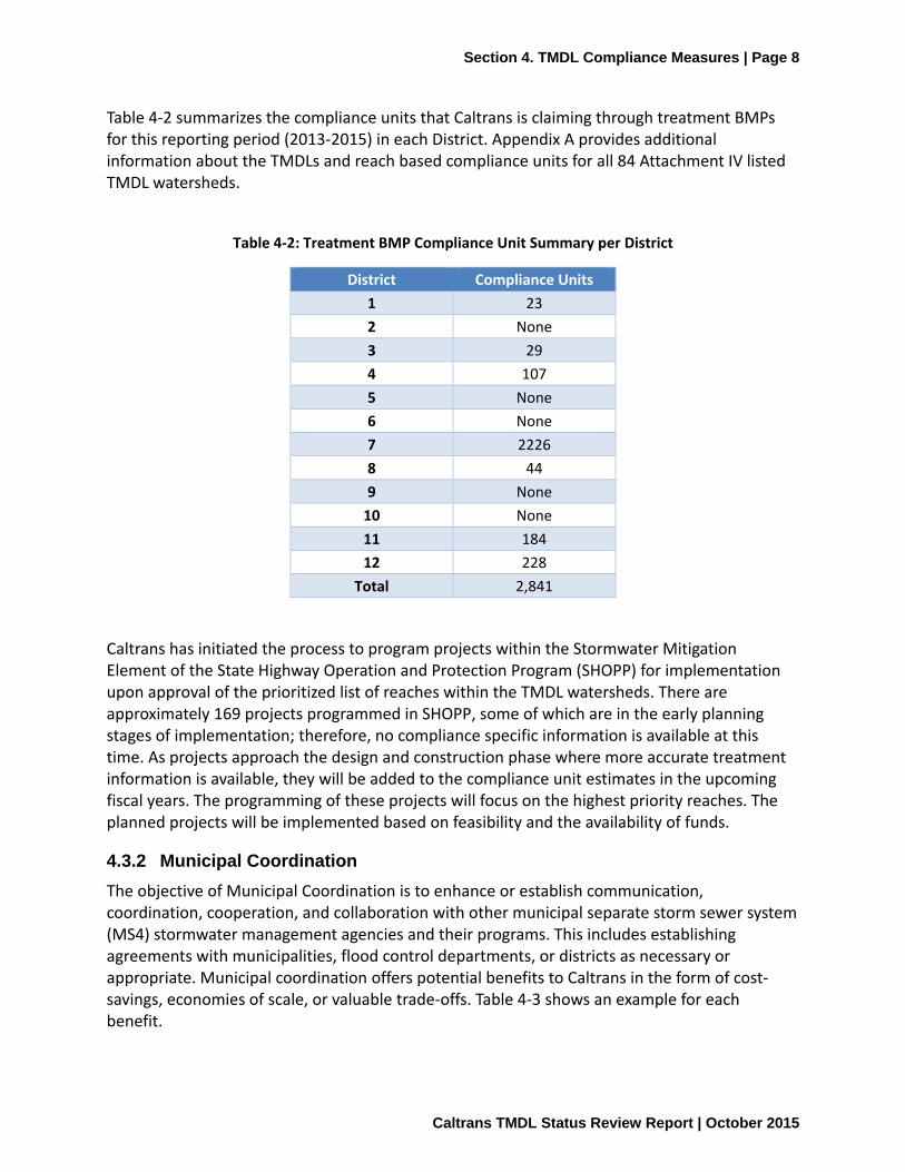
Table 4‐2 summarizes the compliance units that Caltrans is claiming through treatment BMPs for this reporting period (2013‐2015) in each District. Appendix A provides additional information about the TMDLs and reach based compliance units for all 84 Attachment IV listed TMDL watersheds.
Table 4-2: Treatment BMP Compliance Unit Summary per District
District Compliance Units
1 23
2 None
3 29
4 107
5 None
6 None
7 2226
8 44
9 None
10 None
11 184
12 228
Total 2,841
Caltrans has initiated the process to program projects within the Stormwater Mitigation Element of the State Highway Operation and Protection Program (SHOPP) for implementation upon approval of the prioritized list of reaches within the TMDL watersheds. There are approximately 169 projects programmed in SHOPP, some of which are in the early planning stages of implementation; therefore, no compliance specific information is available at this time. As projects approach the design and construction phase where more accurate treatment information is available, they will be added to the compliance unit estimates in the upcoming fiscal years. The programming of these projects will focus on the highest priority reaches. The planned projects will be implemented based on feasibility and the availability of funds.
4.3.2 Municipal Coordination
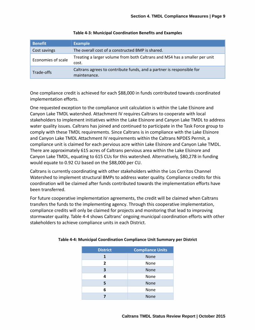
The objective of Municipal Coordination is to enhance or establish communication, coordination, cooperation, and collaboration with other municipal separate storm sewer system (MS4) stormwater management agencies and their programs. This includes establishing agreements with municipalities, flood control departments, or districts as necessary or appropriate. Municipal coordination offers potential benefits to Caltrans in the form of cost‐savings, economies of scale, or valuable trade‐offs. Table 4‐3 shows an example for each benefit.
Section 4. TMDL Compliance Measures | Page 9
Caltrans TMDL Status Review Report | October 2015
Table 4-3: Municipal Coordination Benefits and Examples
Benefit Example
Cost savings The overall cost of a constructed BMP is shared.
Economies of scale Treating a larger volume from both Caltrans and MS4 has a smaller per unit cost.
Trade‐offs Caltrans agrees to contribute funds, and a partner is responsible for maintenance.
One compliance credit is achieved for each $88,000 in funds contributed towards coordinated implementation efforts.
One requested exception to the compliance unit calculation is within the Lake Elsinore and Canyon Lake TMDL watershed. Attachment IV requires Caltrans to cooperate with local stakeholders to implement initiatives within the Lake Elsinore and Canyon Lake TMDL to address water quality issues. Caltrans has joined and continued to participate in the Task Force group to comply with these TMDL requirements. Since Caltrans is in compliance with the Lake Elsinore and Canyon Lake TMDL Attachment IV requirements within the Caltrans NPDES Permit, a compliance unit is claimed for each pervious acre within Lake Elsinore and Canyon Lake TMDL. There are approximately 615 acres of Caltrans pervious area within the Lake Elsinore and Canyon Lake TMDL, equating to 615 CUs for this watershed. Alternatively, $80,278 in funding would equate to 0.92 CU based on the $88,000 per CU.
Caltrans is currently coordinating with other stakeholders within the Los Cerritos Channel Watershed to implement structural BMPs to address water quality. Compliance credits for this coordination will be claimed after funds contributed towards the implementation efforts have been transferred.
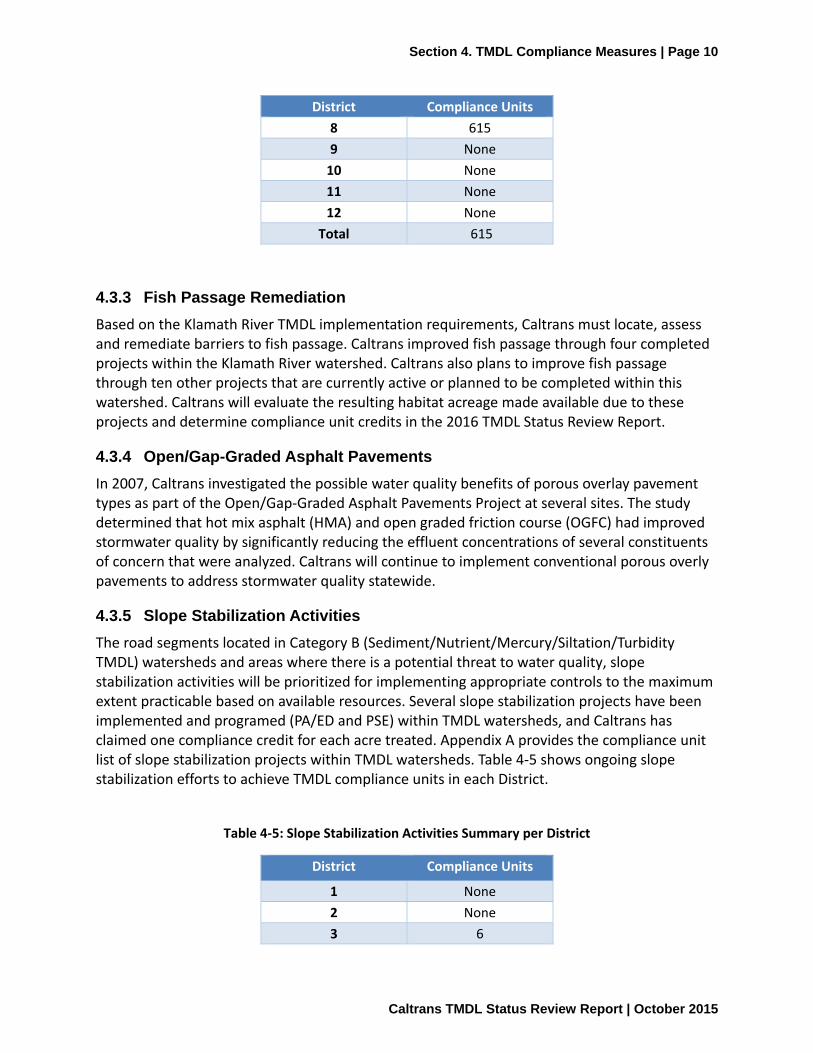
For future cooperative implementation agreements, the credit will be claimed when Caltrans transfers the funds to the implementing agency. Through this cooperative implementation, compliance credits will only be claimed for projects and monitoring that lead to improving stormwater quality. Table 4‐4 shows Caltrans’ ongoing municipal coordination efforts with other stakeholders to achieve compliance units in each District.
Table 4-4: Municipal Coordination Compliance Unit Summary per District
District Compliance Units
1 None
2 None
3 None
4 None
5 None
6 None
7 None
Section 4. TMDL Compliance Measures | Page 10
Caltrans TMDL Status Review Report | October 2015
District Compliance Units
8 615
9 None
10 None
11 None
12 None
Total 615
4.3.3 Fish Passage Remediation
Based on the Klamath River TMDL implementation requirements, Caltrans must locate, assess and remediate barriers to fish passage. Caltrans improved fish passage through four completed projects within the Klamath River watershed. Caltrans also plans to improve fish passage through ten other projects that are currently active or planned to be completed within this watershed. Caltrans will evaluate the resulting habitat acreage made available due to these projects and determine compliance unit credits in the 2016 TMDL Status Review Report.
4.3.4 Open/Gap-Graded Asphalt Pavements
In 2007, Caltrans investigated the possible water quality benefits of porous overlay pavement types as part of the Open/Gap‐Graded Asphalt Pavements Project at several sites. The study determined that hot mix asphalt (HMA) and open graded friction course (OGFC) had improved stormwater quality by significantly reducing the effluent concentrations of several constituents of concern that were analyzed. Caltrans will continue to implement conventional porous overly pavements to address stormwater quality statewide.
4.3.5 Slope Stabilization Activities
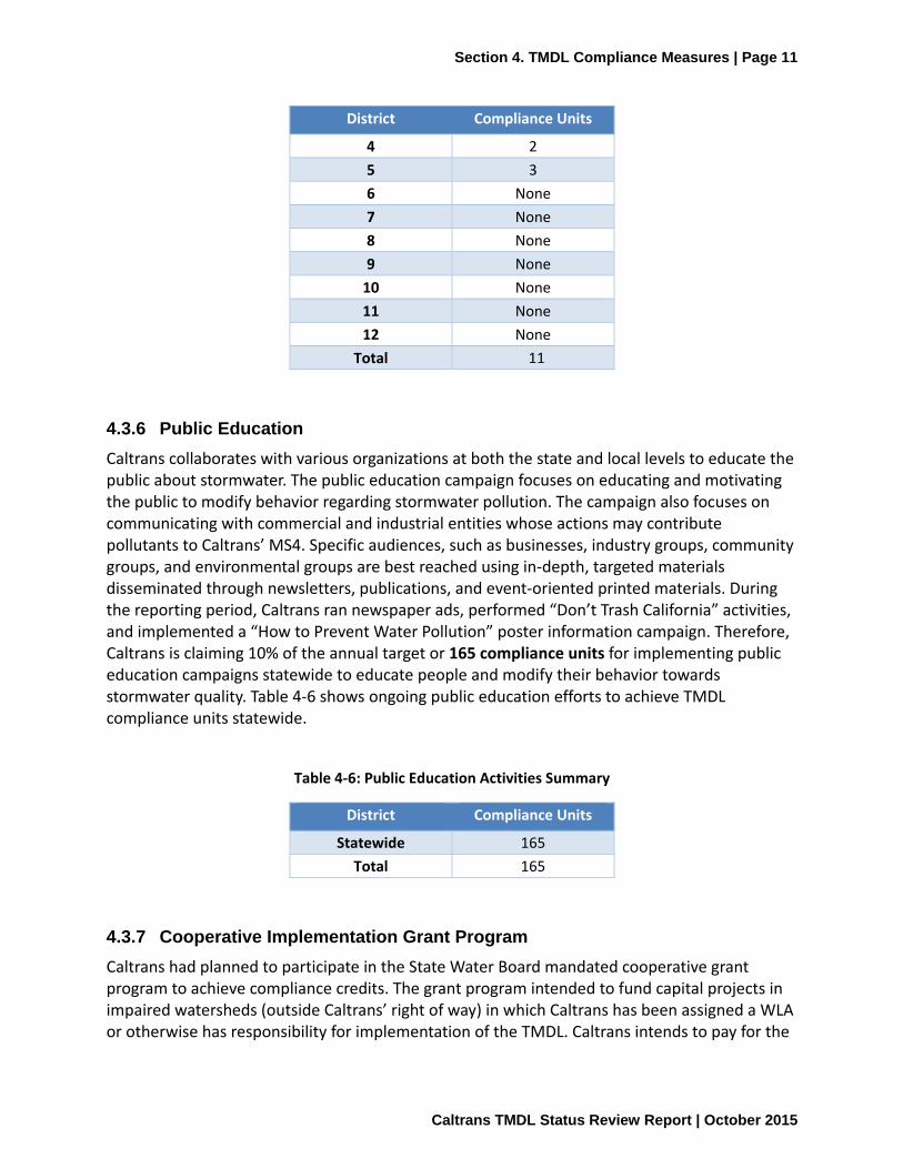
The road segments located in Category B (Sediment/Nutrient/Mercury/Siltation/Turbidity TMDL) watersheds and areas where there is a potential threat to water quality, slope stabilization activities will be prioritized for implementing appropriate controls to the maximum extent practicable based on available resources. Several slope stabilization projects have been implemented and programed (PA/ED and PSE) within TMDL watersheds, and Caltrans has claimed one compliance credit for each acre treated. Appendix A provides the compliance unit list of slope stabilization projects within TMDL watersheds. Table 4‐5 shows ongoing slope stabilization efforts to achieve TMDL compliance units in each District.
Table 4-5: Slope Stabilization Activities Summary per District
District Compliance Units
1 None
2 None
3 6
Section 4. TMDL Compliance Measures | Page 11
Caltrans TMDL Status Review Report | October 2015
District Compliance Units
4 2
5 3
6 None
7 None
8 None
9 None
10 None
11 None
12 None
Total 11
4.3.6 Public Education
Caltrans collaborates with various organizations at both the state and local levels to educate the public about stormwater. The public education campaign focuses on educating and motivating the public to modify behavior regarding stormwater pollution. The campaign also focuses on communicating with commercial and industrial entities whose actions may contribute pollutants to Caltrans’ MS4. Specific audiences, such as businesses, industry groups, community groups, and environmental groups are best reached using in‐depth, targeted materials disseminated through newsletters, publications, and event‐oriented printed materials. During the reporting period, Caltrans ran newspaper ads, performed “Don’t Trash California” activities, and implemented a “How to Prevent Water Pollution” poster information campaign. Therefore, Caltrans is claiming 10% of the annual target or 165 compliance units for implementing public education campaigns statewide to educate people and modify their behavior towards stormwater quality. Table 4‐6 shows ongoing public education efforts to achieve TMDL compliance units statewide.
Table 4-6: Public Education Activities Summary
District Compliance Units
Statewide 165
Total 165
4.3.7 Cooperative Implementation Grant Program
Caltrans had planned to participate in the State Water Board mandated cooperative grant program to achieve compliance credits. The grant program intended to fund capital projects in impaired watersheds (outside Caltrans’ right of way) in which Caltrans has been assigned a WLA or otherwise has responsibility for implementation of the TMDL. Caltrans intends to pay for the
Section 4. TMDL Compliance Measures | Page 12
Caltrans TMDL Status Review Report | October 2015
State Water Board’s cost of administering the grant program. For this grant program, one compliance credit will be obtained for each $88,000 that Caltrans contributed towards coordinated efforts to the State Water Board. Caltrans is continuing to work with the State Water Board to implement this program Caltrans has not achieved any compliance credits from this program at this time.
4.3.8 Lake Tahoe Clarity TMDL
The Caltrans NPDES Permit required Caltrans to prepare a Pollutant Load Reduction Plan (PLRP) detailing the Caltrans approach for meeting the first pollutant load reduction milestone specified by the Lake Tahoe TMDL. The major pollutant is FSP, defined as particles of sediment that are less than 16 microns in size. Caltrans is required to reduce FSP by 10% by September 30, 2016. For detailed information regarding the PLRP, refer to the Lake Tahoe PLRP developed on July 15, 2014 by Caltrans for the Lahontan Regional Water Board and the State Water Board. Currently, over 400 traction sand traps have been installed in the Lake Tahoe watershed.
Section 5. Additional Compliance Measures within TMDL Watersheds | Page 13
Caltrans TMDL Status Review Report | October 2015
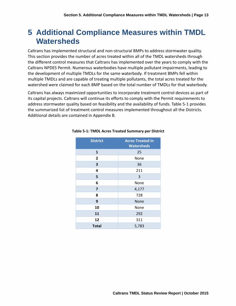
5 Additional Compliance Measures within TMDL Watersheds
Caltrans has implemented structural and non‐structural BMPs to address stormwater quality. This section provides the number of acres treated within all of the TMDL watersheds through the different control measures that Caltrans has implemented over the years to comply with the Caltrans NPDES Permit. Numerous waterbodies have multiple pollutant impairments, leading to the development of multiple TMDLs for the same waterbody. If treatment BMPs fell within multiple TMDLs and are capable of treating multiple pollutants, the total acres treated for the watershed were claimed for each BMP based on the total number of TMDLs for that waterbody.
Caltrans has always maximized opportunities to incorporate treatment control devices as part of its capital projects. Caltrans will continue its efforts to comply with the Permit requirements to address stormwater quality based on feasibility and the availability of funds. Table 5‐1 provides the summarized list of treatment control measures implemented throughout all the Districts. Additional details are contained in Appendix B.
Table 5-1: TMDL Acres Treated Summary per District
District Acres Treated in Watersheds
1 25
2 None
3 36
4 211
5 3
6 None
7 4,177
8 728
9 None
10 None
11 292
12 311
Total 5,783
Section 6. Summary of Adopted TMDLs not within Attachment IV | Page 14
Caltrans TMDL Status Review Report | October 2015
6 Summary of Adopted TMDLs not within Attachment IV
This section provides discusses TMDLs that were approved by the Regional Water Board, State Water Board, and U.S. EPA after the final adoption of Attachment IV on May 20, 2014.
Los Peñasquitos Lagoon Sediment TMDL
Los Peñasquitos Lagoon was first listed in the Clean Water Act Section 303(d) list in 2010. The applicable 303(d) listed impairment within Los Peñasquitos Lagoon is Sedimentation/Siltation. This impairment required the development of a TMDL by the Regional Water Board. San Diego Regional Water Board initiated the development of a sediment TMDL by a third party stakeholder group. A technical report (released on December 14, 2010) was developed on behalf of the City of San Diego and U.S. EPA. Caltrans is listed as a responsible party in this TMDL and is assigned a WLA. The San Diego Regional Water Board approved this TMDL on June 13, 2011. The State Water Board further approved this TMDL on January 21, 2014, and the Office of Administrative Law (OAL) approved it on July 14, 2014, which is also the effective date of this TMDL. U.S. EPA approved the TMDL on October 30, 2014.
Section 7. Napa River and Sonoma Creek Sediment TMDLs | Page 15
Caltrans TMDL Status Review Report | October 2015
7 Napa River and Sonoma Creek Sediment TMDLs
Caltrans NPDES Permit Attachment IV, Section 2 indicates that compliance with the Napa River and Sonoma Creek Sediment TMDLs shall be achieved by:
a. Submitting a plan and schedule for conducting stream crossing surveys; and
b. Submitting an implementation plan and schedule for repair and/or replacement of high
priority crossings/culverts.
Provided in Appendix C is the Caltrans Stream Crossing Survey Workplan for Napa River and
Sonoma Creek. Caltrans estimates there are 18 stream crossings along Sonoma Creek and 55
stream crossings along the Napa River. State Routes 12, 37, 116, and 121 have stream crossings
in the Sonoma Creek Watershed. State Routes 12, 29, 37, 80, 121, 128, and 221 have stream
crossings in the Napa River Watershed. These crossings range from multilane bridges over the
main reaches to small culverts along surrounding tributaries.
Section 8. Conclusion | Page 16
Caltrans TMDL Status Review Report | October 2015
8 Conclusion Caltrans will continue to implement projects and other pollution reduction practices within the TMDL watersheds to achieve the compliance units as required in Attachment IV of the Caltrans NPDES Permit. Achieving the compliance units is dependent on Caltrans’ budget allotted for the Stormwater Management Program and Caltrans’ ability to program projects with its limited funding while balancing other legal mandates and priorities. The annual funding will determine the number of control measures, projects, and other pollution reduction practices that can be implemented. Caltrans will continue addressing Attachment IV requirements and allocate resources needed to comply with the requirements of the Caltrans NPDES Permit. Caltrans will also continue efforts to reduce pollutant discharges to receiving waters throughout the state through its ongoing compliance activities and by implementing a consistent statewide approach for the named pollutants.
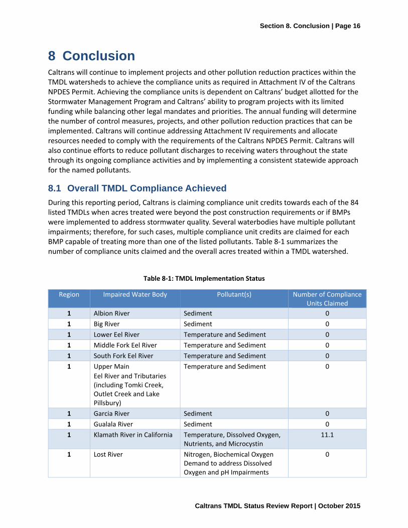
8.1 Overall TMDL Compliance Achieved
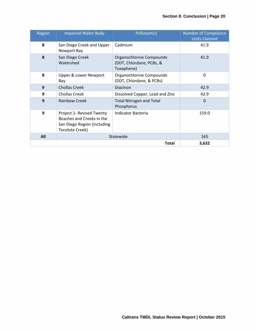
During this reporting period, Caltrans is claiming compliance unit credits towards each of the 84 listed TMDLs when acres treated were beyond the post construction requirements or if BMPs were implemented to address stormwater quality. Several waterbodies have multiple pollutant impairments; therefore, for such cases, multiple compliance unit credits are claimed for each BMP capable of treating more than one of the listed pollutants. Table 8‐1 summarizes the number of compliance units claimed and the overall acres treated within a TMDL watershed.
Table 8-1: TMDL Implementation Status
Region Impaired Water Body Pollutant(s) Number of Compliance Units Claimed
1 Albion River Sediment 0
1 Big River Sediment 0
1 Lower Eel River Temperature and Sediment 0
1 Middle Fork Eel River Temperature and Sediment 0
1 South Fork Eel River Temperature and Sediment 0
1 Upper Main
Eel River and Tributaries (including Tomki Creek, Outlet Creek and Lake Pillsbury)
Temperature and Sediment 0
1 Garcia River Sediment 0
1 Gualala River Sediment 0
1 Klamath River in California Temperature, Dissolved Oxygen, Nutrients, and Microcystin
11.1
1 Lost River Nitrogen, Biochemical Oxygen Demand to address Dissolved Oxygen and pH Impairments
0
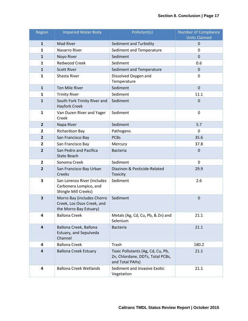
Section 8. Conclusion | Page 17
Caltrans TMDL Status Review Report | October 2015
Region Impaired Water Body Pollutant(s) Number of Compliance Units Claimed
1 Mad River Sediment and Turbidity 0
1 Navarro River Sediment and Temperature 0
1 Noyo River Sediment 0
1 Redwood Creek Sediment 0.6
1 Scott River Sediment and Temperature 0
1 Shasta River Dissolved Oxygen and Temperature
0
1 Ten Mile River Sediment 0
1 Trinity River Sediment 11.1
1 South Fork Trinity River and Hayfork Creek
Sediment 0
1 Van Duzen River and Yager Creek
Sediment 0
2 Napa River Sediment 5.7
2 Richardson Bay Pathogens 0
2 San Francisco Bay PCBs 35.6
2 San Francisco Bay Mercury 37.8
2 San Pedro and Pacifica State Beach
Bacteria 0
2 Sonoma Creek Sediment 0
2 San Francisco Bay Urban Creeks
Diazinon & Pesticide‐Related Toxicity
29.9
3 San Lorenzo River (includes Carbonera Lompico, and Shingle Mill Creeks)
Sediment 2.6
3 Morro Bay (includes Chorro Creek, Los Osos Creek, and the Morro Bay Estuary)
Sediment 0
4 Ballona Creek Metals (Ag, Cd, Cu, Pb, & Zn) and Selenium
21.1
4 Ballona Creek, Ballona Estuary, and Sepulveda Channel
Bacteria 21.1
4 Ballona Creek Trash 180.2
4 Ballona Creek Estuary Toxic Pollutants (Ag, Cd, Cu, Pb, Zn, Chlordane, DDTs, Total PCBs, and Total PAHs)
21.1
4 Ballona Creek Wetlands Sediment and Invasive Exotic Vegetation
21.1
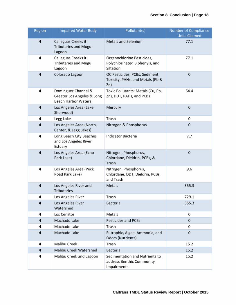
Section 8. Conclusion | Page 18
Caltrans TMDL Status Review Report | October 2015
Region Impaired Water Body Pollutant(s) Number of Compliance Units Claimed
4 Calleguas Creeks it Tributaries and Mugu Lagoon
Metals and Selenium 77.1
4 Calleguas Creeks it Tributaries and Mugu Lagoon
Organochlorine Pesticides, Polychlorinated Biphenyls, and Siltation
77.1
4 Colorado Lagoon OC Pesticides, PCBs, Sediment Toxicity, PAHs, and Metals (Pb & Zn)
0
4 Dominguez Channel & Greater Los Angeles & Long Beach Harbor Waters
Toxic Pollutants: Metals (Cu, Pb, Zn), DDT, PAHs, and PCBs
64.4
4 Los Angeles Area (Lake Sherwood)
Mercury 0
4 Legg Lake Trash 0
4 Los Angeles Area (North, Center, & Legg Lakes)
Nitrogen & Phosphorus 0
4 Long Beach City Beaches and Los Angeles River Estuary
Indicator Bacteria 7.7
4 Los Angeles Area (Echo Park Lake)
Nitrogen, Phosphorus, Chlordane, Dieldrin, PCBs, & Trash
0
4 Los Angeles Area (Peck Road Park Lake)
Nitrogen, Phosphorus, Chlordane, DDT, Dieldrin, PCBs, and Trash
9.6
4 Los Angeles River and Tributaries
Metals 355.3
4 Los Angeles River Trash 729.1
4 Los Angeles River Watershed
Bacteria 355.3
4 Los Cerritos Metals 0
4 Machado Lake Pesticides and PCBs 0
4 Machado Lake Trash 0
4 Machado Lake Eutrophic, Algae, Ammonia, and Odors (Nutrients)
0
4 Malibu Creek Trash 15.2
4 Malibu Creek Watershed Bacteria 15.2
4 Malibu Creek and Lagoon Sedimentation and Nutrients to address Benthic Community Impairments
15.2
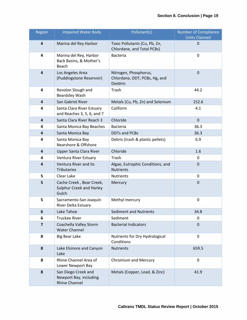
Section 8. Conclusion | Page 19
Caltrans TMDL Status Review Report | October 2015
Region Impaired Water Body Pollutant(s) Number of Compliance Units Claimed
4 Marina del Rey Harbor Toxic Pollutants (Cu, Pb, Zn, Chlordane, and Total PCBs)
0
4 Marina del Rey, Harbor Back Basins, & Mother’s Beach
Bacteria 0
4 Los Angeles Area (Puddingstone Reservoir)
Nitrogen, Phosphorus, Chlordane, DDT, PCBs, Hg, and Dieldrin
0
4 Revolon Slough and Beardsley Wash
Trash 44.2
4 San Gabriel River Metals (Cu, Pb, Zn) and Selenium 152.6
4 Santa Clara River Estuary and Reaches 3, 5, 6, and 7
Coliform 4.1
4 Santa Clara River Reach 3 Chloride 0
4 Santa Monica Bay Beaches Bacteria 36.3
4 Santa Monica Bay DDTs and PCBs 36.3
4 Santa Monica Bay Nearshore & Offshore
Debris (trash & plastic pellets) 6.9
4 Upper Santa Clara River Chloride 1.6
4 Ventura River Estuary Trash 0
4 Ventura River and its Tributaries
Algae, Eutrophic Conditions, and Nutrients
0
5 Clear Lake Nutrients 0
5 Cache Creek , Bear Creek, Sulphur Creek and Harley Gulch
Mercury 0
5 Sacramento‐San Joaquín River Delta Estuary
Methyl mercury 0
6 Lake Tahoe Sediment and Nutrients 34.8
6 Truckee River Sediment 0
7 Coachella Valley Storm Water Channel
Bacterial Indicators 0
8 Big Bear Lake Nutrients for Dry Hydrological Conditions
0
8 Lake Elsinore and Canyon Lake
Nutrients 659.5
8 Rhine Channel Area of Lower Newport Bay
Chromium and Mercury 0
8 San Diego Creek and Newport Bay, including Rhine Channel
Metals (Copper, Lead, & Zinc) 41.9
Section 8. Conclusion | Page 20
Caltrans TMDL Status Review Report | October 2015
Region Impaired Water Body Pollutant(s) Number of Compliance Units Claimed
8 San Diego Creek and Upper Newport Bay
Cadmium 41.9
8 San Diego Creek Watershed
Organochlorine Compounds (DDT, Chlordane, PCBs, & Toxaphene)
41.9
8 Upper & Lower Newport Bay
Organochlorine Compounds (DDT, Chlordane, & PCBs)
0
9 Chollas Creek Diazinon 42.9
9 Chollas Creek Dissolved Copper, Lead and Zinc 42.9
9 Rainbow Creek Total Nitrogen and Total Phosphorus
0
9 Project 1‐ Revised Twenty Beaches and Creeks in the San Diego Region (including Tecolote Creek)
Indicator Bacteria 159.0
All Statewide 165
Total 3,632

Section 9. References | Page 21
Caltrans TMDL Status Review Report | October 2015
9 References SWRCB. (2012, September 19). National Pollutant Discharge Elimination System (NPDES)
Statewide Storm Water Permit Waste Waste Discharge Requirements (WDRS) for State of California Department of Transportation. Order No. 2012‐0011‐DWQ, NPDES No. CAS000003. Retrieved from http://www.waterboards.ca.gov/board_decisions/adopted_orders/water_quality/2012/wqo2012_0011_dwq.pdf
Caltrans TMDL Status Review Report | October 2015
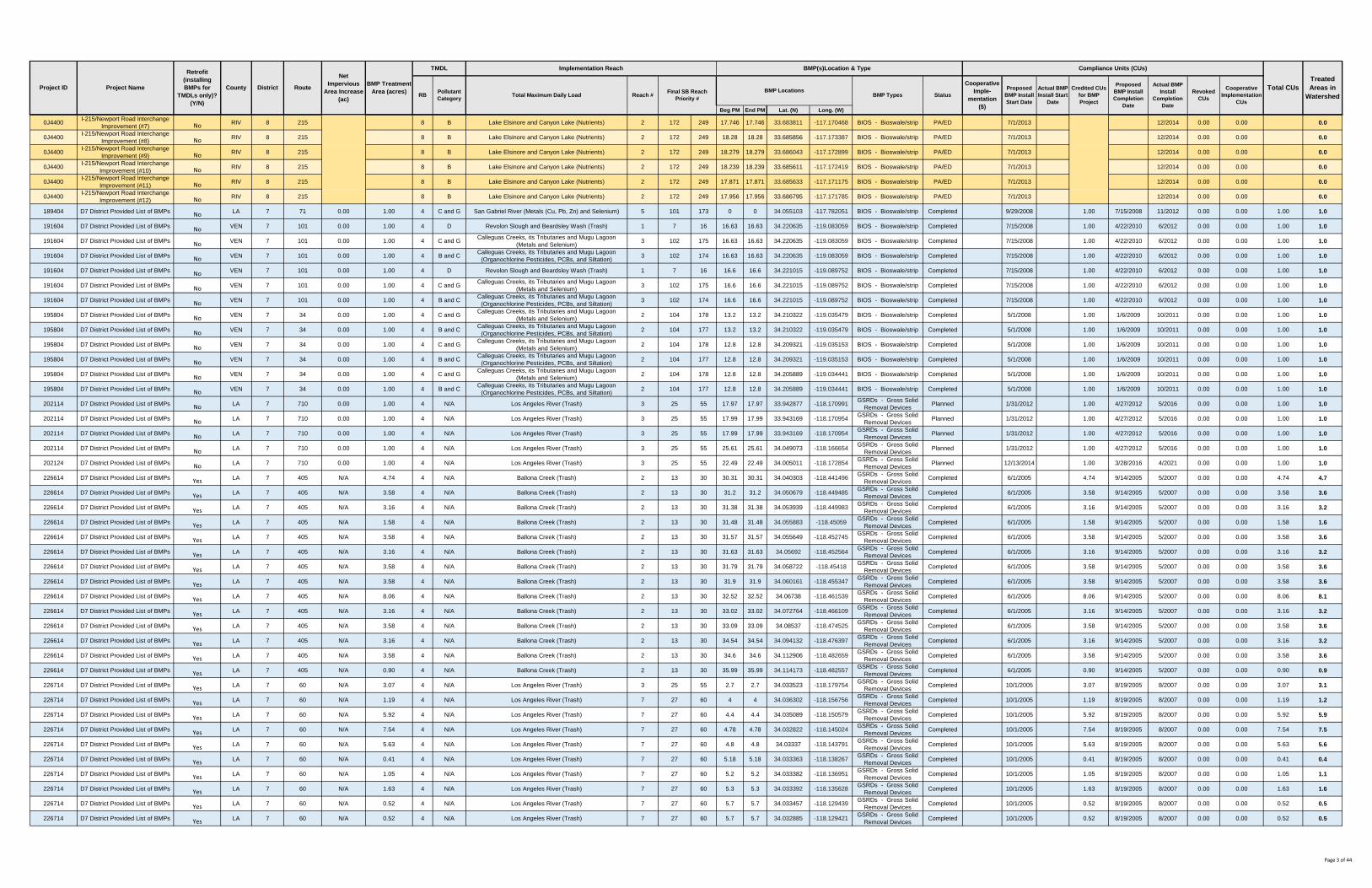
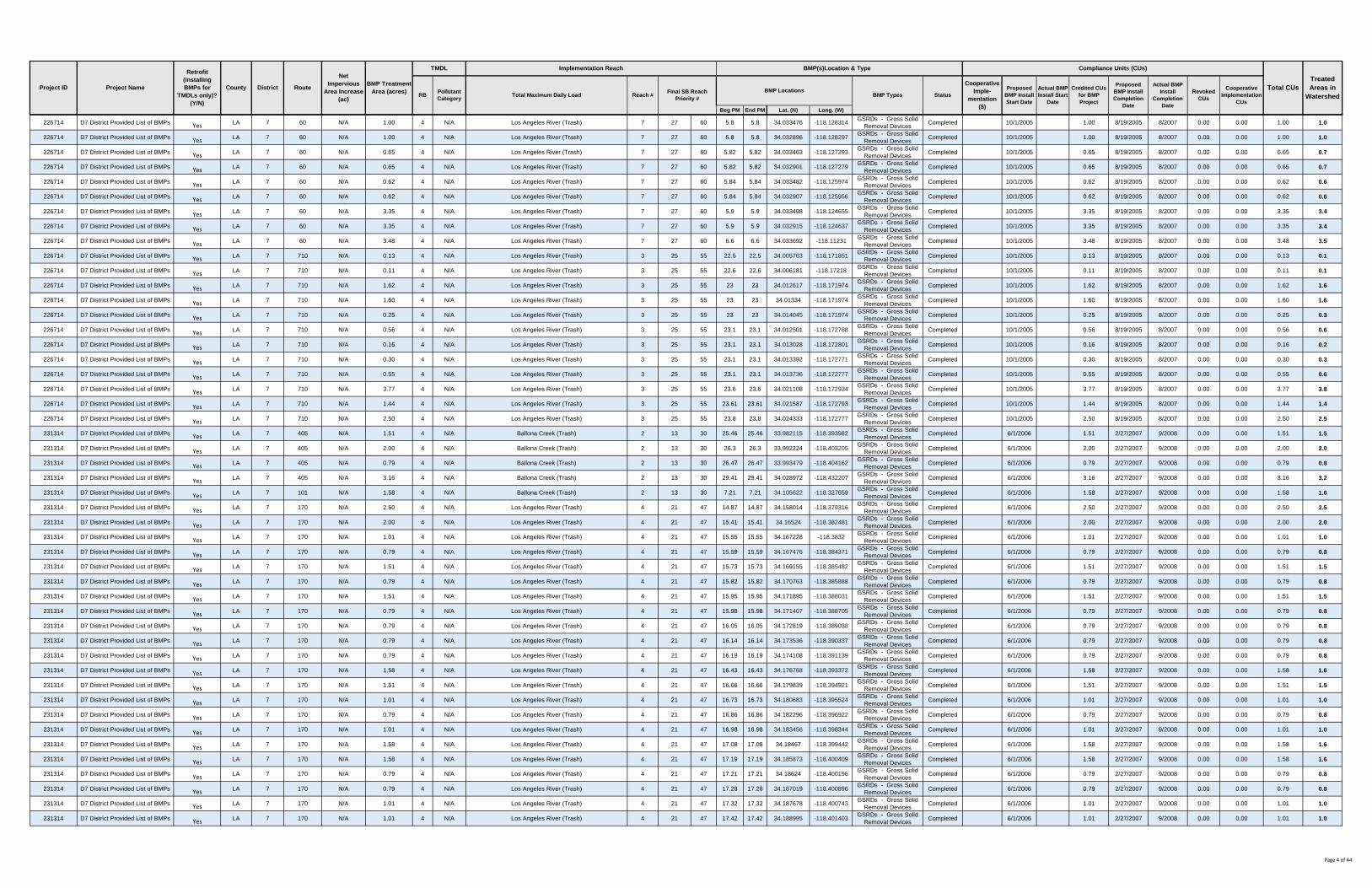
Appendix A – Compliance Units for Completed and Proposed Projects within TMDL Watersheds
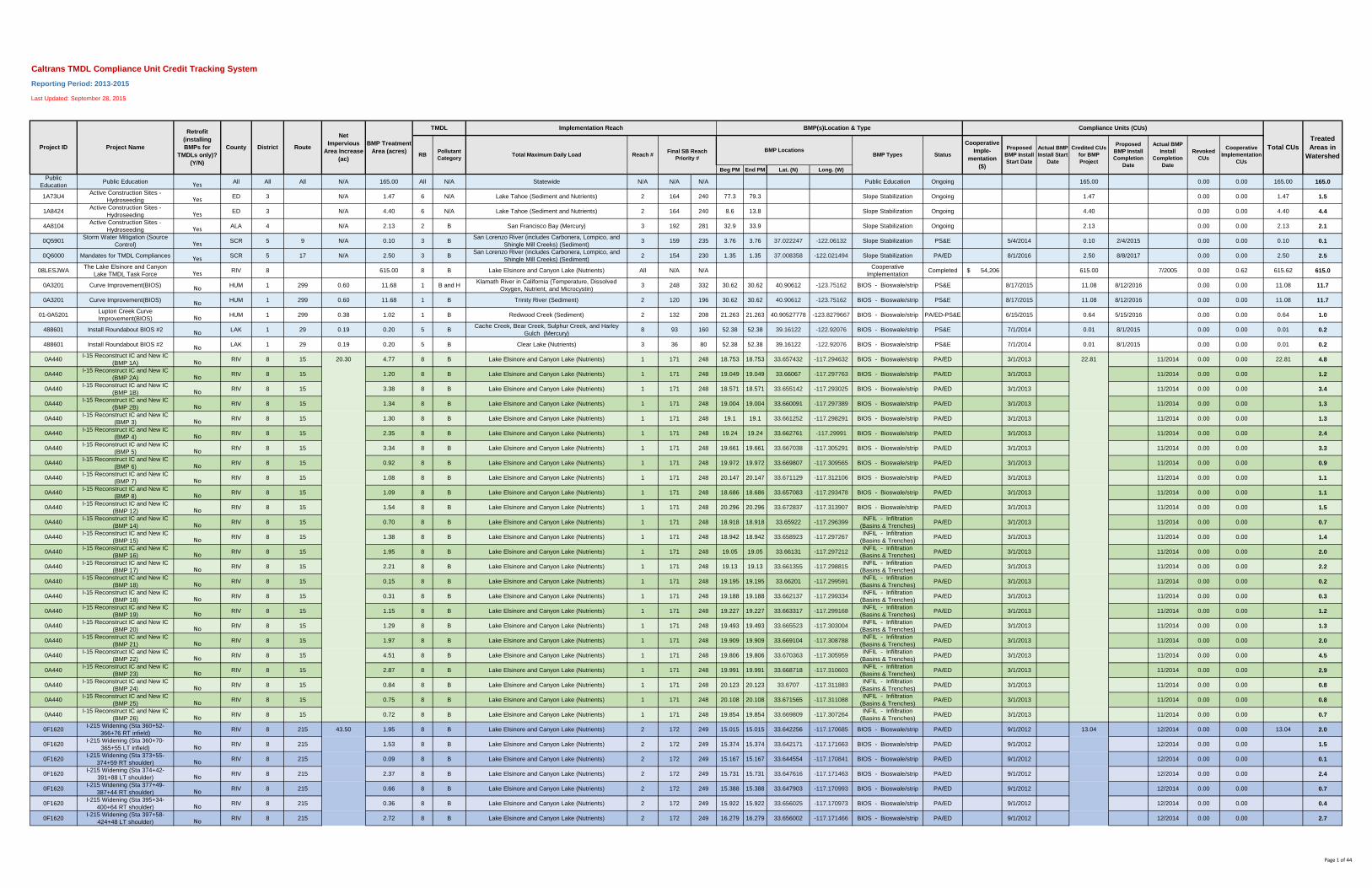
Caltrans TMDL Compliance Unit Credit Tracking System DO NOT SORT ONLY FILTERReporting Period: 2013-2015
Last Updated: September 28, 2015 No duplicates and verified
Beg PM End PM Lat. (N) Long. (W)
Public Education
Public Education Yes All All All N/A 165.00 All N/A Statewide N/A N/A N/A Public Education Ongoing 165.00 0.00 0.00 165.00 165.0
1A73U4Active Construction Sites -
Hydroseeding Yes ED 3 N/A 1.47 6 N/A Lake Tahoe (Sediment and Nutrients) 2 164 240 77.3 79.3 Slope Stabilization Ongoing 1.47 0.00 0.00 1.47 1.5
1A8424Active Construction Sites -
Hydroseeding Yes ED 3 N/A 4.40 6 N/A Lake Tahoe (Sediment and Nutrients) 2 164 240 8.6 13.8 Slope Stabilization Ongoing 4.40 0.00 0.00 4.40 4.4
4A8104Active Construction Sites -
Hydroseeding Yes ALA 4 N/A 2.13 2 B San Francisco Bay (Mercury) 3 192 281 32.9 33.9 Slope Stabilization Ongoing 2.13 0.00 0.00 2.13 2.1
0Q5901Storm Water Mitigation (Source
Control) Yes SCR 5 9 N/A 0.10 3 BSan Lorenzo River (includes Carbonera, Lompico, and
Shingle Mill Creeks) (Sediment)3 159 235 3.76 3.76 37.022247 -122.06132 Slope Stabilization PS&E 5/4/2014 0.10 2/4/2015 0.00 0.00 0.10 0.1
0Q6000 Mandates for TMDL Compliances Yes SCR 5 17 N/A 2.50 3 BSan Lorenzo River (includes Carbonera, Lompico, and
Shingle Mill Creeks) (Sediment)2 154 230 1.35 1.35 37.008358 -122.021494 Slope Stabilization PA/ED 8/1/2016 2.50 8/8/2017 0.00 0.00 2.50 2.5
08LESJWAThe Lake Elsinore and Canyon
Lake TMDL Task Force Yes RIV 8 615.00 8 B Lake Elsinore and Canyon Lake (Nutrients) All N/A N/ACooperative
ImplementationCompleted $ 54,206 615.00 7/2005 0.00 0.62 615.62 615.0
0A3201 Curve Improvement(BIOS) No HUM 1 299 0.60 11.68 1 B and HKlamath River in California (Temperature, Dissolved
Oxygen, Nutrient, and Microcystin)3 248 332 30.62 30.62 40.90612 -123.75162 BIOS - Bioswale/strip PS&E 8/17/2015 11.08 8/12/2016 0.00 0.00 11.08 11.7
0A3201 Curve Improvement(BIOS) No HUM 1 299 0.60 11.68 1 B Trinity River (Sediment) 2 120 196 30.62 30.62 40.90612 -123.75162 BIOS - Bioswale/strip PS&E 8/17/2015 11.08 8/12/2016 0.00 0.00 11.08 11.7
01-0A5201Lupton Creek Curve Improvement(BIOS) No HUM 1 299 0.38 1.02 1 B Redwood Creek (Sediment) 2 132 208 21.263 21.263 40.90527778 -123.8279667 BIOS - Bioswale/strip PA/ED-PS&E 6/15/2015 0.64 5/15/2016 0.00 0.00 0.64 1.0
488601 Install Roundabout BIOS #2 No LAK 1 29 0.19 0.20 5 BCache Creek, Bear Creek, Sulphur Creek, and Harley
Gulch (Mercury)8 93 160 52.38 52.38 39.16122 -122.92076 BIOS - Bioswale/strip PS&E 7/1/2014 0.01 8/1/2015 0.00 0.00 0.01 0.2
488601 Install Roundabout BIOS #2 No LAK 1 29 0.19 0.20 5 B Clear Lake (Nutrients) 3 36 80 52.38 52.38 39.16122 -122.92076 BIOS - Bioswale/strip PS&E 7/1/2014 0.01 8/1/2015 0.00 0.00 0.01 0.2
0A440I-15 Reconstruct IC and New IC
(BMP 1A) No RIV 8 15 20.30 4.77 8 B Lake Elsinore and Canyon Lake (Nutrients) 1 171 248 18.753 18.753 33.657432 -117.294632 BIOS - Bioswale/strip PA/ED 3/1/2013 22.81 11/2014 0.00 0.00 22.81 4.8
0A440I-15 Reconstruct IC and New IC
(BMP 2A) No RIV 8 15 1.20 8 B Lake Elsinore and Canyon Lake (Nutrients) 1 171 248 19.049 19.049 33.66067 -117.297763 BIOS - Bioswale/strip PA/ED 3/1/2013 11/2014 0.00 0.00 1.2
0A440I-15 Reconstruct IC and New IC
(BMP 1B) No RIV 8 15 3.38 8 B Lake Elsinore and Canyon Lake (Nutrients) 1 171 248 18.571 18.571 33.655142 -117.293025 BIOS - Bioswale/strip PA/ED 3/1/2013 11/2014 0.00 0.00 3.4
0A440I-15 Reconstruct IC and New IC
(BMP 2B) No RIV 8 15 1.34 8 B Lake Elsinore and Canyon Lake (Nutrients) 1 171 248 19.004 19.004 33.660091 -117.297389 BIOS - Bioswale/strip PA/ED 3/1/2013 11/2014 0.00 0.00 1.3
0A440I-15 Reconstruct IC and New IC
(BMP 3) No RIV 8 15 1.30 8 B Lake Elsinore and Canyon Lake (Nutrients) 1 171 248 19.1 19.1 33.661252 -117.298291 BIOS - Bioswale/strip PA/ED 3/1/2013 11/2014 0.00 0.00 1.3
0A440I-15 Reconstruct IC and New IC
(BMP 4) No RIV 8 15 2.35 8 B Lake Elsinore and Canyon Lake (Nutrients) 1 171 248 19.24 19.24 33.662761 -117.29991 BIOS - Bioswale/strip PA/ED 3/1/2013 11/2014 0.00 0.00 2.4
0A440I-15 Reconstruct IC and New IC
(BMP 5) No RIV 8 15 3.34 8 B Lake Elsinore and Canyon Lake (Nutrients) 1 171 248 19.661 19.661 33.667038 -117.305291 BIOS - Bioswale/strip PA/ED 3/1/2013 11/2014 0.00 0.00 3.3
0A440I-15 Reconstruct IC and New IC
(BMP 6) No RIV 8 15 0.92 8 B Lake Elsinore and Canyon Lake (Nutrients) 1 171 248 19.972 19.972 33.669807 -117.309565 BIOS - Bioswale/strip PA/ED 3/1/2013 11/2014 0.00 0.00 0.9
0A440I-15 Reconstruct IC and New IC
(BMP 7) No RIV 8 15 1.08 8 B Lake Elsinore and Canyon Lake (Nutrients) 1 171 248 20.147 20.147 33.671129 -117.312106 BIOS - Bioswale/strip PA/ED 3/1/2013 11/2014 0.00 0.00 1.1
0A440I-15 Reconstruct IC and New IC
(BMP 8) No RIV 8 15 1.09 8 B Lake Elsinore and Canyon Lake (Nutrients) 1 171 248 18.686 18.686 33.657083 -117.293478 BIOS - Bioswale/strip PA/ED 3/1/2013 11/2014 0.00 0.00 1.1
0A440I-15 Reconstruct IC and New IC
(BMP 12) No RIV 8 15 1.54 8 B Lake Elsinore and Canyon Lake (Nutrients) 1 171 248 20.296 20.296 33.672837 -117.313907 BIOS - Bioswale/strip PA/ED 3/1/2013 11/2014 0.00 0.00 1.5
0A440I-15 Reconstruct IC and New IC
(BMP 14) No RIV 8 15 0.70 8 B Lake Elsinore and Canyon Lake (Nutrients) 1 171 248 18.918 18.918 33.65922 -117.296399INFIL - Infiltration
(Basins & Trenches)PA/ED 3/1/2013 11/2014 0.00 0.00 0.7
0A440I-15 Reconstruct IC and New IC
(BMP 15) No RIV 8 15 1.38 8 B Lake Elsinore and Canyon Lake (Nutrients) 1 171 248 18.942 18.942 33.658923 -117.297267INFIL - Infiltration
(Basins & Trenches)PA/ED 3/1/2013 11/2014 0.00 0.00 1.4
0A440I-15 Reconstruct IC and New IC
(BMP 16) No RIV 8 15 1.95 8 B Lake Elsinore and Canyon Lake (Nutrients) 1 171 248 19.05 19.05 33.66131 -117.297212INFIL - Infiltration
(Basins & Trenches)PA/ED 3/1/2013 11/2014 0.00 0.00 2.0
0A440I-15 Reconstruct IC and New IC
(BMP 17) No RIV 8 15 2.21 8 B Lake Elsinore and Canyon Lake (Nutrients) 1 171 248 19.13 19.13 33.661355 -117.298815INFIL - Infiltration
(Basins & Trenches)PA/ED 3/1/2013 11/2014 0.00 0.00 2.2
0A440I-15 Reconstruct IC and New IC
(BMP 18) No RIV 8 15 0.15 8 B Lake Elsinore and Canyon Lake (Nutrients) 1 171 248 19.195 19.195 33.66201 -117.299591INFIL - Infiltration
(Basins & Trenches)PA/ED 3/1/2013 11/2014 0.00 0.00 0.2
0A440I-15 Reconstruct IC and New IC
(BMP 18) No RIV 8 15 0.31 8 B Lake Elsinore and Canyon Lake (Nutrients) 1 171 248 19.188 19.188 33.662137 -117.299334INFIL - Infiltration
(Basins & Trenches)PA/ED 3/1/2013 11/2014 0.00 0.00 0.3
0A440I-15 Reconstruct IC and New IC
(BMP 19) No RIV 8 15 1.15 8 B Lake Elsinore and Canyon Lake (Nutrients) 1 171 248 19.227 19.227 33.663317 -117.299168INFIL - Infiltration
(Basins & Trenches)PA/ED 3/1/2013 11/2014 0.00 0.00 1.2
0A440I-15 Reconstruct IC and New IC
(BMP 20) No RIV 8 15 1.29 8 B Lake Elsinore and Canyon Lake (Nutrients) 1 171 248 19.493 19.493 33.665523 -117.303004INFIL - Infiltration
(Basins & Trenches)PA/ED 3/1/2013 11/2014 0.00 0.00 1.3
0A440I-15 Reconstruct IC and New IC
(BMP 21) No RIV 8 15 1.97 8 B Lake Elsinore and Canyon Lake (Nutrients) 1 171 248 19.909 19.909 33.669104 -117.308788INFIL - Infiltration
(Basins & Trenches)PA/ED 3/1/2013 11/2014 0.00 0.00 2.0
0A440I-15 Reconstruct IC and New IC
(BMP 22) No RIV 8 15 4.51 8 B Lake Elsinore and Canyon Lake (Nutrients) 1 171 248 19.806 19.806 33.670363 -117.305959INFIL - Infiltration
(Basins & Trenches)PA/ED 3/1/2013 11/2014 0.00 0.00 4.5
0A440I-15 Reconstruct IC and New IC
(BMP 23) No RIV 8 15 2.87 8 B Lake Elsinore and Canyon Lake (Nutrients) 1 171 248 19.991 19.991 33.668718 -117.310603INFIL - Infiltration
(Basins & Trenches)PA/ED 3/1/2013 11/2014 0.00 0.00 2.9
0A440I-15 Reconstruct IC and New IC
(BMP 24) No RIV 8 15 0.84 8 B Lake Elsinore and Canyon Lake (Nutrients) 1 171 248 20.123 20.123 33.6707 -117.311883INFIL - Infiltration
(Basins & Trenches)PA/ED 3/1/2013 11/2014 0.00 0.00 0.8
0A440I-15 Reconstruct IC and New IC
(BMP 25) No RIV 8 15 0.75 8 B Lake Elsinore and Canyon Lake (Nutrients) 1 171 248 20.108 20.108 33.671565 -117.311088INFIL - Infiltration
(Basins & Trenches)PA/ED 3/1/2013 11/2014 0.00 0.00 0.8
0A440I-15 Reconstruct IC and New IC
(BMP 26) No RIV 8 15 0.72 8 B Lake Elsinore and Canyon Lake (Nutrients) 1 171 248 19.854 19.854 33.669809 -117.307264INFIL - Infiltration
(Basins & Trenches)PA/ED 3/1/2013 11/2014 0.00 0.00 0.7
0F1620I-215 Widening (Sta 360+52-
366+76 RT infield) No RIV 8 215 43.50 1.95 8 B Lake Elsinore and Canyon Lake (Nutrients) 2 172 249 15.015 15.015 33.642256 -117.170685 BIOS - Bioswale/strip PA/ED 9/1/2012 13.04 12/2014 0.00 0.00 13.04 2.0
0F1620I-215 Widening (Sta 360+70-
365+55 LT infield) No RIV 8 215 1.53 8 B Lake Elsinore and Canyon Lake (Nutrients) 2 172 249 15.374 15.374 33.642171 -117.171663 BIOS - Bioswale/strip PA/ED 9/1/2012 12/2014 0.00 0.00 1.5
0F1620I-215 Widening (Sta 373+55-
374+59 RT shoulder) No RIV 8 215 0.09 8 B Lake Elsinore and Canyon Lake (Nutrients) 2 172 249 15.167 15.167 33.644554 -117.170841 BIOS - Bioswale/strip PA/ED 9/1/2012 12/2014 0.00 0.00 0.1
0F1620I-215 Widening (Sta 374+42-
391+88 LT shoulder) No RIV 8 215 2.37 8 B Lake Elsinore and Canyon Lake (Nutrients) 2 172 249 15.731 15.731 33.647616 -117.171463 BIOS - Bioswale/strip PA/ED 9/1/2012 12/2014 0.00 0.00 2.4
0F1620I-215 Widening (Sta 377+49-
387+44 RT shoulder) No RIV 8 215 0.66 8 B Lake Elsinore and Canyon Lake (Nutrients) 2 172 249 15.388 15.388 33.647903 -117.170993 BIOS - Bioswale/strip PA/ED 9/1/2012 12/2014 0.00 0.00 0.7
0F1620I-215 Widening (Sta 395+34-
400+64 RT shoulder) No RIV 8 215 0.36 8 B Lake Elsinore and Canyon Lake (Nutrients) 2 172 249 15.922 15.922 33.656025 -117.170973 BIOS - Bioswale/strip PA/ED 9/1/2012 12/2014 0.00 0.00 0.4
0F1620I-215 Widening (Sta 397+58-
424+48 LT shoulder) No RIV 8 215 2.72 8 B Lake Elsinore and Canyon Lake (Nutrients) 2 172 249 16.279 16.279 33.656002 -117.171466 BIOS - Bioswale/strip PA/ED 9/1/2012 12/2014 0.00 0.00 2.7
RouteProject ID Project Name
Retrofit (installing BMPs for
TMDLs only)? (Y/N)
County District Credited CUs for BMP Project
Proposed BMP Install Completion
Date
Actual BMP Install
Completion Date
Net Impervious
Area Increase (ac)
BMP Treatment Area (acres)
TMDL Implementation Reach BMP(s)Location & Type
BMP LocationsBMP Types Status
Revoked CUs
Total CUsTreated Areas in
WatershedRBPollutant Category
Total Maximum Daily Load Reach #Final SB Reach
Priority #
Compliance Units (CUs)
Cooperative Imple-
mentation ($)
Cooperative Implementation
CUs
Proposed BMP Install Start Date
Actual BMP Install Start
Date
Page 1 of 44
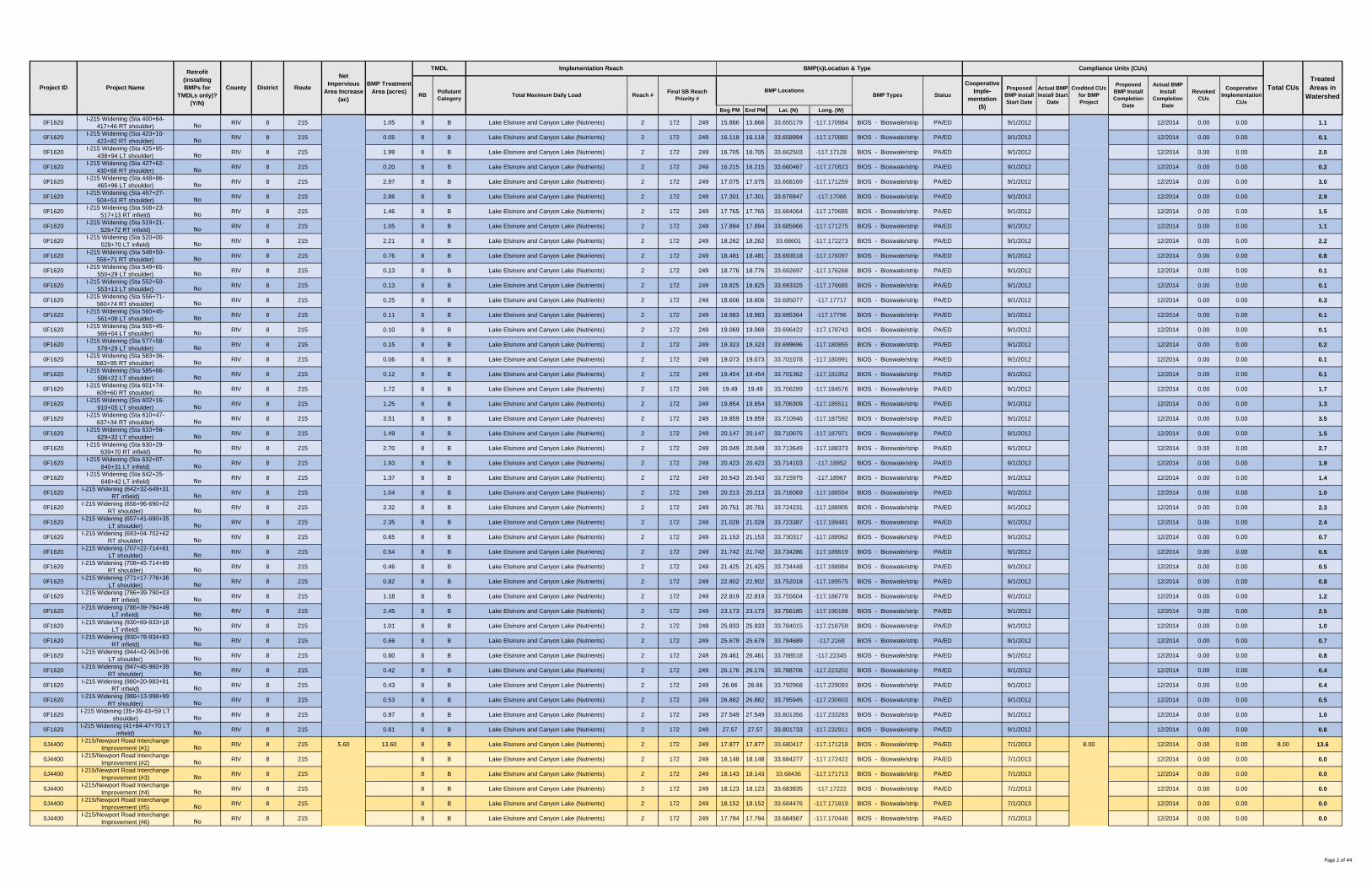
Beg PM End PM Lat. (N) Long. (W)
RouteProject ID Project Name
Retrofit (installing BMPs for
TMDLs only)? (Y/N)
County District Credited CUs for BMP Project
Proposed BMP Install Completion
Date
Actual BMP Install
Completion Date
Net Impervious
Area Increase (ac)
BMP Treatment Area (acres)
TMDL Implementation Reach BMP(s)Location & Type
BMP LocationsBMP Types Status
Revoked CUs
Total CUsTreated Areas in
WatershedRBPollutant Category
Total Maximum Daily Load Reach #Final SB Reach
Priority #
Compliance Units (CUs)
Cooperative Imple-
mentation ($)
Cooperative Implementation
CUs
Proposed BMP Install Start Date
Actual BMP Install Start
Date
0F1620I-215 Widening (Sta 400+64-
417+46 RT shoulder) No RIV 8 215 1.05 8 B Lake Elsinore and Canyon Lake (Nutrients) 2 172 249 15.866 15.866 33.655179 -117.170984 BIOS - Bioswale/strip PA/ED 9/1/2012 12/2014 0.00 0.00 1.1
0F1620I-215 Widening (Sta 423+10-
423+82 RT shoulder) No RIV 8 215 0.05 8 B Lake Elsinore and Canyon Lake (Nutrients) 2 172 249 16.118 16.118 33.658994 -117.170885 BIOS - Bioswale/strip PA/ED 9/1/2012 12/2014 0.00 0.00 0.1
0F1620I-215 Widening (Sta 425+95-
438+94 LT shoulder) No RIV 8 215 1.99 8 B Lake Elsinore and Canyon Lake (Nutrients) 2 172 249 16.705 16.705 33.662503 -117.17128 BIOS - Bioswale/strip PA/ED 9/1/2012 12/2014 0.00 0.00 2.0
0F1620I-215 Widening (Sta 427+62-
430+68 RT shoulder) No RIV 8 215 0.20 8 B Lake Elsinore and Canyon Lake (Nutrients) 2 172 249 16.215 16.215 33.660467 -117.170823 BIOS - Bioswale/strip PA/ED 9/1/2012 12/2014 0.00 0.00 0.2
0F1620I-215 Widening (Sta 448+86-
465+96 LT shoulder) No RIV 8 215 2.97 8 B Lake Elsinore and Canyon Lake (Nutrients) 2 172 249 17.075 17.075 33.668169 -117.171259 BIOS - Bioswale/strip PA/ED 9/1/2012 12/2014 0.00 0.00 3.0
0F1620I-215 Widening (Sta 457+27-
504+53 RT shoulder) No RIV 8 215 2.86 8 B Lake Elsinore and Canyon Lake (Nutrients) 2 172 249 17.301 17.301 33.676947 -117.17066 BIOS - Bioswale/strip PA/ED 9/1/2012 12/2014 0.00 0.00 2.9
0F1620I-215 Widening (Sta 508+23-
517+13 RT infield) No RIV 8 215 1.46 8 B Lake Elsinore and Canyon Lake (Nutrients) 2 172 249 17.765 17.765 33.684064 -117.170685 BIOS - Bioswale/strip PA/ED 9/1/2012 12/2014 0.00 0.00 1.5
0F1620I-215 Widening (Sta 519+21-
526+72 RT infield) No RIV 8 215 1.05 8 B Lake Elsinore and Canyon Lake (Nutrients) 2 172 249 17.894 17.894 33.685966 -117.171275 BIOS - Bioswale/strip PA/ED 9/1/2012 12/2014 0.00 0.00 1.1
0F1620I-215 Widening (Sta 520+00-
528+70 LT infield) No RIV 8 215 2.21 8 B Lake Elsinore and Canyon Lake (Nutrients) 2 172 249 18.262 18.262 33.68601 -117.172273 BIOS - Bioswale/strip PA/ED 9/1/2012 12/2014 0.00 0.00 2.2
0F1620I-215 Widening (Sta 548+50-
556+71 RT shoulder) No RIV 8 215 0.76 8 B Lake Elsinore and Canyon Lake (Nutrients) 2 172 249 18.481 18.481 33.693518 -117.176097 BIOS - Bioswale/strip PA/ED 9/1/2012 12/2014 0.00 0.00 0.8
0F1620I-215 Widening (Sta 549+65-
550+29 LT shoulder) No RIV 8 215 0.13 8 B Lake Elsinore and Canyon Lake (Nutrients) 2 172 249 18.776 18.776 33.692697 -117.176268 BIOS - Bioswale/strip PA/ED 9/1/2012 12/2014 0.00 0.00 0.1
0F1620I-215 Widening (Sta 552+50-
553+13 LT shoulder) No RIV 8 215 0.13 8 B Lake Elsinore and Canyon Lake (Nutrients) 2 172 249 18.825 18.825 33.693325 -117.176685 BIOS - Bioswale/strip PA/ED 9/1/2012 12/2014 0.00 0.00 0.1
0F1620I-215 Widening (Sta 556+71-
560+74 RT shoulder) No RIV 8 215 0.25 8 B Lake Elsinore and Canyon Lake (Nutrients) 2 172 249 18.606 18.606 33.695077 -117.17717 BIOS - Bioswale/strip PA/ED 9/1/2012 12/2014 0.00 0.00 0.3
0F1620I-215 Widening (Sta 560+45-
561+08 LT shoulder) No RIV 8 215 0.11 8 B Lake Elsinore and Canyon Lake (Nutrients) 2 172 249 18.983 18.983 33.695364 -117.17796 BIOS - Bioswale/strip PA/ED 9/1/2012 12/2014 0.00 0.00 0.1
0F1620I-215 Widening (Sta 565+45-
566+04 LT shoulder) No RIV 8 215 0.10 8 B Lake Elsinore and Canyon Lake (Nutrients) 2 172 249 19.069 19.069 33.696422 -117.178743 BIOS - Bioswale/strip PA/ED 9/1/2012 12/2014 0.00 0.00 0.1
0F1620I-215 Widening (Sta 577+58-
578+29 LT shoulder) No RIV 8 215 0.15 8 B Lake Elsinore and Canyon Lake (Nutrients) 2 172 249 19.323 19.323 33.699696 -117.180855 BIOS - Bioswale/strip PA/ED 9/1/2012 12/2014 0.00 0.00 0.2
0F1620I-215 Widening (Sta 583+36-
583+95 RT shoulder) No RIV 8 215 0.06 8 B Lake Elsinore and Canyon Lake (Nutrients) 2 172 249 19.073 19.073 33.701078 -117.180991 BIOS - Bioswale/strip PA/ED 9/1/2012 12/2014 0.00 0.00 0.1
0F1620I-215 Widening (Sta 585+66-
586+22 LT shoulder) No RIV 8 215 0.12 8 B Lake Elsinore and Canyon Lake (Nutrients) 2 172 249 19.454 19.454 33.701362 -117.181952 BIOS - Bioswale/strip PA/ED 9/1/2012 12/2014 0.00 0.00 0.1
0F1620I-215 Widening (Sta 601+74-
609+60 RT shoulder) No RIV 8 215 1.72 8 B Lake Elsinore and Canyon Lake (Nutrients) 2 172 249 19.49 19.49 33.706289 -117.184576 BIOS - Bioswale/strip PA/ED 9/1/2012 12/2014 0.00 0.00 1.7
0F1620I-215 Widening (Sta 602+16-
610+05 LT shoulder) No RIV 8 215 1.25 8 B Lake Elsinore and Canyon Lake (Nutrients) 2 172 249 19.854 19.854 33.706309 -117.185511 BIOS - Bioswale/strip PA/ED 9/1/2012 12/2014 0.00 0.00 1.3
0F1620I-215 Widening (Sta 610+47-
637+34 RT shoulder) No RIV 8 215 3.51 8 B Lake Elsinore and Canyon Lake (Nutrients) 2 172 249 19.859 19.859 33.710946 -117.187592 BIOS - Bioswale/strip PA/ED 9/1/2012 12/2014 0.00 0.00 3.5
0F1620I-215 Widening (Sta 610+58-
629+32 LT shoulder) No RIV 8 215 1.49 8 B Lake Elsinore and Canyon Lake (Nutrients) 2 172 249 20.147 20.147 33.710075 -117.187971 BIOS - Bioswale/strip PA/ED 9/1/2012 12/2014 0.00 0.00 1.5
0F1620I-215 Widening (Sta 630+29-
639+70 RT infield) No RIV 8 215 2.70 8 B Lake Elsinore and Canyon Lake (Nutrients) 2 172 249 20.049 20.049 33.713649 -117.188373 BIOS - Bioswale/strip PA/ED 9/1/2012 12/2014 0.00 0.00 2.7
0F1620I-215 Widening (Sta 632+07-
640+31 LT infield) No RIV 8 215 1.93 8 B Lake Elsinore and Canyon Lake (Nutrients) 2 172 249 20.423 20.423 33.714103 -117.18952 BIOS - Bioswale/strip PA/ED 9/1/2012 12/2014 0.00 0.00 1.9
0F1620I-215 Widening (Sta 642+25-
648+42 LT infield) No RIV 8 215 1.37 8 B Lake Elsinore and Canyon Lake (Nutrients) 2 172 249 20.543 20.543 33.715975 -117.18967 BIOS - Bioswale/strip PA/ED 9/1/2012 12/2014 0.00 0.00 1.4
0F1620I-215 Widening (642+32-649+31
RT infield) No RIV 8 215 1.04 8 B Lake Elsinore and Canyon Lake (Nutrients) 2 172 249 20.213 20.213 33.716069 -117.188504 BIOS - Bioswale/strip PA/ED 9/1/2012 12/2014 0.00 0.00 1.0
0F1620I-215 Widening (656+96-690+02
RT shoulder) No RIV 8 215 2.32 8 B Lake Elsinore and Canyon Lake (Nutrients) 2 172 249 20.751 20.751 33.724231 -117.188905 BIOS - Bioswale/strip PA/ED 9/1/2012 12/2014 0.00 0.00 2.3
0F1620I-215 Widening (657+41-690+35
LT shoulder) No RIV 8 215 2.35 8 B Lake Elsinore and Canyon Lake (Nutrients) 2 172 249 21.028 21.028 33.723387 -117.189481 BIOS - Bioswale/strip PA/ED 9/1/2012 12/2014 0.00 0.00 2.4
0F1620I-215 Widening (693+04-702+62
RT shoulder) No RIV 8 215 0.65 8 B Lake Elsinore and Canyon Lake (Nutrients) 2 172 249 21.153 21.153 33.730317 -117.188962 BIOS - Bioswale/strip PA/ED 9/1/2012 12/2014 0.00 0.00 0.7
0F1620I-215 Widening (707+22-714+81
LT shoulder) No RIV 8 215 0.54 8 B Lake Elsinore and Canyon Lake (Nutrients) 2 172 249 21.742 21.742 33.734286 -117.189619 BIOS - Bioswale/strip PA/ED 9/1/2012 12/2014 0.00 0.00 0.5
0F1620I-215 Widening (708+45-714+89
RT shoulder) No RIV 8 215 0.46 8 B Lake Elsinore and Canyon Lake (Nutrients) 2 172 249 21.425 21.425 33.734448 -117.188984 BIOS - Bioswale/strip PA/ED 9/1/2012 12/2014 0.00 0.00 0.5
0F1620I-215 Widening (771+17-776+36
LT shoulder) No RIV 8 215 0.82 8 B Lake Elsinore and Canyon Lake (Nutrients) 2 172 249 22.902 22.902 33.752018 -117.189575 BIOS - Bioswale/strip PA/ED 9/1/2012 12/2014 0.00 0.00 0.8
0F1620I-215 Widening (786+39-790+03
RT infield) No RIV 8 215 1.18 8 B Lake Elsinore and Canyon Lake (Nutrients) 2 172 249 22.819 22.819 33.755604 -117.188779 BIOS - Bioswale/strip PA/ED 9/1/2012 12/2014 0.00 0.00 1.2
0F1620I-215 Widening (786+39-794+49
LT infield) No RIV 8 215 2.45 8 B Lake Elsinore and Canyon Lake (Nutrients) 2 172 249 23.173 23.173 33.756185 -117.190188 BIOS - Bioswale/strip PA/ED 9/1/2012 12/2014 0.00 0.00 2.5
0F1620I-215 Widening (930+69-933+18
LT infield) No RIV 8 215 1.01 8 B Lake Elsinore and Canyon Lake (Nutrients) 2 172 249 25.933 25.933 33.784015 -117.216759 BIOS - Bioswale/strip PA/ED 9/1/2012 12/2014 0.00 0.00 1.0
0F1620I-215 Widening (930+78-934+83
RT infield) No RIV 8 215 0.66 8 B Lake Elsinore and Canyon Lake (Nutrients) 2 172 249 25.679 25.679 33.784689 -117.2168 BIOS - Bioswale/strip PA/ED 9/1/2012 12/2014 0.00 0.00 0.7
0F1620I-215 Widening (944+42-963+06
LT shoulder) No RIV 8 215 0.80 8 B Lake Elsinore and Canyon Lake (Nutrients) 2 172 249 26.461 26.461 33.788518 -117.22345 BIOS - Bioswale/strip PA/ED 9/1/2012 12/2014 0.00 0.00 0.8
0F1620I-215 Widening (947+45-960+39
RT shoulder) No RIV 8 215 0.42 8 B Lake Elsinore and Canyon Lake (Nutrients) 2 172 249 26.176 26.176 33.788706 -117.223202 BIOS - Bioswale/strip PA/ED 9/1/2012 12/2014 0.00 0.00 0.4
0F1620I-215 Widening (980+20-983+91
RT infield) No RIV 8 215 0.43 8 B Lake Elsinore and Canyon Lake (Nutrients) 2 172 249 26.66 26.66 33.792968 -117.229093 BIOS - Bioswale/strip PA/ED 9/1/2012 12/2014 0.00 0.00 0.4
0F1620I-215 Widening (986+13-998+99
RT shoulder) No RIV 8 215 0.53 8 B Lake Elsinore and Canyon Lake (Nutrients) 2 172 249 26.882 26.882 33.795945 -117.230603 BIOS - Bioswale/strip PA/ED 9/1/2012 12/2014 0.00 0.00 0.5
0F1620I-215 Widening (35+39-43+59 LT
shoulder) No RIV 8 215 0.97 8 B Lake Elsinore and Canyon Lake (Nutrients) 2 172 249 27.549 27.549 33.801356 -117.233283 BIOS - Bioswale/strip PA/ED 9/1/2012 12/2014 0.00 0.00 1.0
0F1620I-215 Widening (41+84-47+70 LT
infield) No RIV 8 215 0.61 8 B Lake Elsinore and Canyon Lake (Nutrients) 2 172 249 27.57 27.57 33.801733 -117.232911 BIOS - Bioswale/strip PA/ED 9/1/2012 12/2014 0.00 0.00 0.6
0J4400I-215/Newport Road Interchange
Improvement (#1) No RIV 8 215 5.60 13.60 8 B Lake Elsinore and Canyon Lake (Nutrients) 2 172 249 17.877 17.877 33.680417 -117.171218 BIOS - Bioswale/strip PA/ED 7/1/2013 8.00 12/2014 0.00 0.00 8.00 13.6
0J4400I-215/Newport Road Interchange
Improvement (#2) No RIV 8 215 8 B Lake Elsinore and Canyon Lake (Nutrients) 2 172 249 18.148 18.148 33.684277 -117.172422 BIOS - Bioswale/strip PA/ED 7/1/2013 12/2014 0.00 0.00 0.0
0J4400I-215/Newport Road Interchange
Improvement (#3) No RIV 8 215 8 B Lake Elsinore and Canyon Lake (Nutrients) 2 172 249 18.143 18.143 33.68436 -117.171713 BIOS - Bioswale/strip PA/ED 7/1/2013 12/2014 0.00 0.00 0.0
0J4400I-215/Newport Road Interchange
Improvement (#4) No RIV 8 215 8 B Lake Elsinore and Canyon Lake (Nutrients) 2 172 249 18.123 18.123 33.683935 -117.17222 BIOS - Bioswale/strip PA/ED 7/1/2013 12/2014 0.00 0.00 0.0
0J4400I-215/Newport Road Interchange
Improvement (#5) No RIV 8 215 8 B Lake Elsinore and Canyon Lake (Nutrients) 2 172 249 18.152 18.152 33.684476 -117.171819 BIOS - Bioswale/strip PA/ED 7/1/2013 12/2014 0.00 0.00 0.0
0J4400I-215/Newport Road Interchange
Improvement (#6) No RIV 8 215 8 B Lake Elsinore and Canyon Lake (Nutrients) 2 172 249 17.794 17.794 33.684567 -117.170446 BIOS - Bioswale/strip PA/ED 7/1/2013 12/2014 0.00 0.00 0.0
Page 2 of 44
Beg PM End PM Lat. (N) Long. (W)
RouteProject ID Project Name
Retrofit (installing BMPs for
TMDLs only)? (Y/N)
County District Credited CUs for BMP Project
Proposed BMP Install Completion
Date
Actual BMP Install
Completion Date
Net Impervious
Area Increase (ac)
BMP Treatment Area (acres)
TMDL Implementation Reach BMP(s)Location & Type
BMP LocationsBMP Types Status
Revoked CUs
Total CUsTreated Areas in
WatershedRBPollutant Category
Total Maximum Daily Load Reach #Final SB Reach
Priority #
Compliance Units (CUs)
Cooperative Imple-
mentation ($)
Cooperative Implementation
CUs
Proposed BMP Install Start Date
Actual BMP Install Start
Date
0J4400I-215/Newport Road Interchange
Improvement (#7) No RIV 8 215 8 B Lake Elsinore and Canyon Lake (Nutrients) 2 172 249 17.746 17.746 33.683811 -117.170468 BIOS - Bioswale/strip PA/ED 7/1/2013 12/2014 0.00 0.00 0.0
0J4400I-215/Newport Road Interchange
Improvement (#8) No RIV 8 215 8 B Lake Elsinore and Canyon Lake (Nutrients) 2 172 249 18.28 18.28 33.685856 -117.173387 BIOS - Bioswale/strip PA/ED 7/1/2013 12/2014 0.00 0.00 0.0
0J4400I-215/Newport Road Interchange
Improvement (#9) No RIV 8 215 8 B Lake Elsinore and Canyon Lake (Nutrients) 2 172 249 18.279 18.279 33.686043 -117.172899 BIOS - Bioswale/strip PA/ED 7/1/2013 12/2014 0.00 0.00 0.0
0J4400I-215/Newport Road Interchange
Improvement (#10) No RIV 8 215 8 B Lake Elsinore and Canyon Lake (Nutrients) 2 172 249 18.239 18.239 33.685611 -117.172419 BIOS - Bioswale/strip PA/ED 7/1/2013 12/2014 0.00 0.00 0.0
0J4400I-215/Newport Road Interchange
Improvement (#11) No RIV 8 215 8 B Lake Elsinore and Canyon Lake (Nutrients) 2 172 249 17.871 17.871 33.685633 -117.171175 BIOS - Bioswale/strip PA/ED 7/1/2013 12/2014 0.00 0.00 0.0
0J4400I-215/Newport Road Interchange
Improvement (#12) No RIV 8 215 8 B Lake Elsinore and Canyon Lake (Nutrients) 2 172 249 17.956 17.956 33.686795 -117.171785 BIOS - Bioswale/strip PA/ED 7/1/2013 12/2014 0.00 0.00 0.0
189404 D7 District Provided List of BMPs No LA 7 71 0.00 1.00 4 C and G San Gabriel River (Metals (Cu, Pb, Zn) and Selenium) 5 101 173 0 0 34.055103 -117.782051 BIOS - Bioswale/strip Completed 9/29/2008 1.00 7/15/2008 11/2012 0.00 0.00 1.00 1.0
191604 D7 District Provided List of BMPs No VEN 7 101 0.00 1.00 4 D Revolon Slough and Beardsley Wash (Trash) 1 7 16 16.63 16.63 34.220635 -119.083059 BIOS - Bioswale/strip Completed 7/15/2008 1.00 4/22/2010 6/2012 0.00 0.00 1.00 1.0
191604 D7 District Provided List of BMPs No VEN 7 101 0.00 1.00 4 C and GCalleguas Creeks, its Tributaries and Mugu Lagoon
(Metals and Selenium)3 102 175 16.63 16.63 34.220635 -119.083059 BIOS - Bioswale/strip Completed 7/15/2008 1.00 4/22/2010 6/2012 0.00 0.00 1.00 1.0
191604 D7 District Provided List of BMPs No VEN 7 101 0.00 1.00 4 B and CCalleguas Creeks, its Tributaries and Mugu Lagoon
(Organochlorine Pesticides, PCBs, and Siltation)3 102 174 16.63 16.63 34.220635 -119.083059 BIOS - Bioswale/strip Completed 7/15/2008 1.00 4/22/2010 6/2012 0.00 0.00 1.00 1.0
191604 D7 District Provided List of BMPs No VEN 7 101 0.00 1.00 4 D Revolon Slough and Beardsley Wash (Trash) 1 7 16 16.6 16.6 34.221015 -119.089752 BIOS - Bioswale/strip Completed 7/15/2008 1.00 4/22/2010 6/2012 0.00 0.00 1.00 1.0
191604 D7 District Provided List of BMPs No VEN 7 101 0.00 1.00 4 C and GCalleguas Creeks, its Tributaries and Mugu Lagoon
(Metals and Selenium)3 102 175 16.6 16.6 34.221015 -119.089752 BIOS - Bioswale/strip Completed 7/15/2008 1.00 4/22/2010 6/2012 0.00 0.00 1.00 1.0
191604 D7 District Provided List of BMPs No VEN 7 101 0.00 1.00 4 B and CCalleguas Creeks, its Tributaries and Mugu Lagoon
(Organochlorine Pesticides, PCBs, and Siltation)3 102 174 16.6 16.6 34.221015 -119.089752 BIOS - Bioswale/strip Completed 7/15/2008 1.00 4/22/2010 6/2012 0.00 0.00 1.00 1.0
195804 D7 District Provided List of BMPs No VEN 7 34 0.00 1.00 4 C and GCalleguas Creeks, its Tributaries and Mugu Lagoon
(Metals and Selenium)2 104 178 13.2 13.2 34.210322 -119.035479 BIOS - Bioswale/strip Completed 5/1/2008 1.00 1/6/2009 10/2011 0.00 0.00 1.00 1.0
195804 D7 District Provided List of BMPs No VEN 7 34 0.00 1.00 4 B and CCalleguas Creeks, its Tributaries and Mugu Lagoon
(Organochlorine Pesticides, PCBs, and Siltation)2 104 177 13.2 13.2 34.210322 -119.035479 BIOS - Bioswale/strip Completed 5/1/2008 1.00 1/6/2009 10/2011 0.00 0.00 1.00 1.0
195804 D7 District Provided List of BMPs No VEN 7 34 0.00 1.00 4 C and GCalleguas Creeks, its Tributaries and Mugu Lagoon
(Metals and Selenium)2 104 178 12.8 12.8 34.209321 -119.035153 BIOS - Bioswale/strip Completed 5/1/2008 1.00 1/6/2009 10/2011 0.00 0.00 1.00 1.0
195804 D7 District Provided List of BMPs No VEN 7 34 0.00 1.00 4 B and CCalleguas Creeks, its Tributaries and Mugu Lagoon
(Organochlorine Pesticides, PCBs, and Siltation)2 104 177 12.8 12.8 34.209321 -119.035153 BIOS - Bioswale/strip Completed 5/1/2008 1.00 1/6/2009 10/2011 0.00 0.00 1.00 1.0
195804 D7 District Provided List of BMPs No VEN 7 34 0.00 1.00 4 C and GCalleguas Creeks, its Tributaries and Mugu Lagoon
(Metals and Selenium)2 104 178 12.8 12.8 34.205889 -119.034441 BIOS - Bioswale/strip Completed 5/1/2008 1.00 1/6/2009 10/2011 0.00 0.00 1.00 1.0
195804 D7 District Provided List of BMPs No VEN 7 34 0.00 1.00 4 B and CCalleguas Creeks, its Tributaries and Mugu Lagoon
(Organochlorine Pesticides, PCBs, and Siltation)2 104 177 12.8 12.8 34.205889 -119.034441 BIOS - Bioswale/strip Completed 5/1/2008 1.00 1/6/2009 10/2011 0.00 0.00 1.00 1.0
202114 D7 District Provided List of BMPs No LA 7 710 0.00 1.00 4 N/A Los Angeles River (Trash) 3 25 55 17.97 17.97 33.942877 -118.170991GSRDs - Gross Solid
Removal DevicesPlanned 1/31/2012 1.00 4/27/2012 5/2016 0.00 0.00 1.00 1.0
202114 D7 District Provided List of BMPs No LA 7 710 0.00 1.00 4 N/A Los Angeles River (Trash) 3 25 55 17.99 17.99 33.943169 -118.170954GSRDs - Gross Solid
Removal DevicesPlanned 1/31/2012 1.00 4/27/2012 5/2016 0.00 0.00 1.00 1.0
202114 D7 District Provided List of BMPs No LA 7 710 0.00 1.00 4 N/A Los Angeles River (Trash) 3 25 55 17.99 17.99 33.943169 -118.170954GSRDs - Gross Solid
Removal DevicesPlanned 1/31/2012 1.00 4/27/2012 5/2016 0.00 0.00 1.00 1.0
202114 D7 District Provided List of BMPs No LA 7 710 0.00 1.00 4 N/A Los Angeles River (Trash) 3 25 55 25.61 25.61 34.049073 -118.166654GSRDs - Gross Solid
Removal DevicesPlanned 1/31/2012 1.00 4/27/2012 5/2016 0.00 0.00 1.00 1.0
202124 D7 District Provided List of BMPs No LA 7 710 0.00 1.00 4 N/A Los Angeles River (Trash) 3 25 55 22.49 22.49 34.005011 -118.172854GSRDs - Gross Solid
Removal DevicesPlanned 12/13/2014 1.00 3/28/2016 4/2021 0.00 0.00 1.00 1.0
226614 D7 District Provided List of BMPs Yes LA 7 405 N/A 4.74 4 N/A Ballona Creek (Trash) 2 13 30 30.31 30.31 34.040303 -118.441496GSRDs - Gross Solid
Removal DevicesCompleted 6/1/2005 4.74 9/14/2005 5/2007 0.00 0.00 4.74 4.7
226614 D7 District Provided List of BMPs Yes LA 7 405 N/A 3.58 4 N/A Ballona Creek (Trash) 2 13 30 31.2 31.2 34.050679 -118.449485GSRDs - Gross Solid
Removal DevicesCompleted 6/1/2005 3.58 9/14/2005 5/2007 0.00 0.00 3.58 3.6
226614 D7 District Provided List of BMPs Yes LA 7 405 N/A 3.16 4 N/A Ballona Creek (Trash) 2 13 30 31.38 31.38 34.053939 -118.449983GSRDs - Gross Solid
Removal DevicesCompleted 6/1/2005 3.16 9/14/2005 5/2007 0.00 0.00 3.16 3.2
226614 D7 District Provided List of BMPs Yes LA 7 405 N/A 1.58 4 N/A Ballona Creek (Trash) 2 13 30 31.48 31.48 34.055883 -118.45059GSRDs - Gross Solid
Removal DevicesCompleted 6/1/2005 1.58 9/14/2005 5/2007 0.00 0.00 1.58 1.6
226614 D7 District Provided List of BMPs Yes LA 7 405 N/A 3.58 4 N/A Ballona Creek (Trash) 2 13 30 31.57 31.57 34.055649 -118.452745GSRDs - Gross Solid
Removal DevicesCompleted 6/1/2005 3.58 9/14/2005 5/2007 0.00 0.00 3.58 3.6
226614 D7 District Provided List of BMPs Yes LA 7 405 N/A 3.16 4 N/A Ballona Creek (Trash) 2 13 30 31.63 31.63 34.05692 -118.452564GSRDs - Gross Solid
Removal DevicesCompleted 6/1/2005 3.16 9/14/2005 5/2007 0.00 0.00 3.16 3.2
226614 D7 District Provided List of BMPs Yes LA 7 405 N/A 3.58 4 N/A Ballona Creek (Trash) 2 13 30 31.79 31.79 34.058722 -118.45418GSRDs - Gross Solid
Removal DevicesCompleted 6/1/2005 3.58 9/14/2005 5/2007 0.00 0.00 3.58 3.6
226614 D7 District Provided List of BMPs Yes LA 7 405 N/A 3.58 4 N/A Ballona Creek (Trash) 2 13 30 31.9 31.9 34.060161 -118.455347GSRDs - Gross Solid
Removal DevicesCompleted 6/1/2005 3.58 9/14/2005 5/2007 0.00 0.00 3.58 3.6
226614 D7 District Provided List of BMPs Yes LA 7 405 N/A 8.06 4 N/A Ballona Creek (Trash) 2 13 30 32.52 32.52 34.06738 -118.461539GSRDs - Gross Solid
Removal DevicesCompleted 6/1/2005 8.06 9/14/2005 5/2007 0.00 0.00 8.06 8.1
226614 D7 District Provided List of BMPs Yes LA 7 405 N/A 3.16 4 N/A Ballona Creek (Trash) 2 13 30 33.02 33.02 34.072764 -118.466109GSRDs - Gross Solid
Removal DevicesCompleted 6/1/2005 3.16 9/14/2005 5/2007 0.00 0.00 3.16 3.2
226614 D7 District Provided List of BMPs Yes LA 7 405 N/A 3.58 4 N/A Ballona Creek (Trash) 2 13 30 33.09 33.09 34.08537 -118.474525GSRDs - Gross Solid
Removal DevicesCompleted 6/1/2005 3.58 9/14/2005 5/2007 0.00 0.00 3.58 3.6
226614 D7 District Provided List of BMPs Yes LA 7 405 N/A 3.16 4 N/A Ballona Creek (Trash) 2 13 30 34.54 34.54 34.094132 -118.476397GSRDs - Gross Solid
Removal DevicesCompleted 6/1/2005 3.16 9/14/2005 5/2007 0.00 0.00 3.16 3.2
226614 D7 District Provided List of BMPs Yes LA 7 405 N/A 3.58 4 N/A Ballona Creek (Trash) 2 13 30 34.6 34.6 34.112906 -118.482659GSRDs - Gross Solid
Removal DevicesCompleted 6/1/2005 3.58 9/14/2005 5/2007 0.00 0.00 3.58 3.6
226614 D7 District Provided List of BMPs Yes LA 7 405 N/A 0.90 4 N/A Ballona Creek (Trash) 2 13 30 35.99 35.99 34.114173 -118.482557GSRDs - Gross Solid
Removal DevicesCompleted 6/1/2005 0.90 9/14/2005 5/2007 0.00 0.00 0.90 0.9
226714 D7 District Provided List of BMPs Yes LA 7 60 N/A 3.07 4 N/A Los Angeles River (Trash) 3 25 55 2.7 2.7 34.033523 -118.179754GSRDs - Gross Solid
Removal DevicesCompleted 10/1/2005 3.07 8/19/2005 8/2007 0.00 0.00 3.07 3.1
226714 D7 District Provided List of BMPs Yes LA 7 60 N/A 1.19 4 N/A Los Angeles River (Trash) 7 27 60 4 4 34.036302 -118.156756GSRDs - Gross Solid
Removal DevicesCompleted 10/1/2005 1.19 8/19/2005 8/2007 0.00 0.00 1.19 1.2
226714 D7 District Provided List of BMPs Yes LA 7 60 N/A 5.92 4 N/A Los Angeles River (Trash) 7 27 60 4.4 4.4 34.035089 -118.150579GSRDs - Gross Solid
Removal DevicesCompleted 10/1/2005 5.92 8/19/2005 8/2007 0.00 0.00 5.92 5.9
226714 D7 District Provided List of BMPs Yes LA 7 60 N/A 7.54 4 N/A Los Angeles River (Trash) 7 27 60 4.78 4.78 34.032822 -118.145024GSRDs - Gross Solid
Removal DevicesCompleted 10/1/2005 7.54 8/19/2005 8/2007 0.00 0.00 7.54 7.5
226714 D7 District Provided List of BMPs Yes LA 7 60 N/A 5.63 4 N/A Los Angeles River (Trash) 7 27 60 4.8 4.8 34.03337 -118.143791GSRDs - Gross Solid
Removal DevicesCompleted 10/1/2005 5.63 8/19/2005 8/2007 0.00 0.00 5.63 5.6
226714 D7 District Provided List of BMPs Yes LA 7 60 N/A 0.41 4 N/A Los Angeles River (Trash) 7 27 60 5.18 5.18 34.033363 -118.138267GSRDs - Gross Solid
Removal DevicesCompleted 10/1/2005 0.41 8/19/2005 8/2007 0.00 0.00 0.41 0.4
226714 D7 District Provided List of BMPs Yes LA 7 60 N/A 1.05 4 N/A Los Angeles River (Trash) 7 27 60 5.2 5.2 34.033382 -118.136951GSRDs - Gross Solid
Removal DevicesCompleted 10/1/2005 1.05 8/19/2005 8/2007 0.00 0.00 1.05 1.1
226714 D7 District Provided List of BMPs Yes LA 7 60 N/A 1.63 4 N/A Los Angeles River (Trash) 7 27 60 5.3 5.3 34.033392 -118.135628GSRDs - Gross Solid
Removal DevicesCompleted 10/1/2005 1.63 8/19/2005 8/2007 0.00 0.00 1.63 1.6
226714 D7 District Provided List of BMPs Yes LA 7 60 N/A 0.52 4 N/A Los Angeles River (Trash) 7 27 60 5.7 5.7 34.033457 -118.129439GSRDs - Gross Solid
Removal DevicesCompleted 10/1/2005 0.52 8/19/2005 8/2007 0.00 0.00 0.52 0.5
226714 D7 District Provided List of BMPs Yes LA 7 60 N/A 0.52 4 N/A Los Angeles River (Trash) 7 27 60 5.7 5.7 34.032885 -118.129421GSRDs - Gross Solid
Removal DevicesCompleted 10/1/2005 0.52 8/19/2005 8/2007 0.00 0.00 0.52 0.5
Page 3 of 44
Beg PM End PM Lat. (N) Long. (W)
RouteProject ID Project Name
Retrofit (installing BMPs for
TMDLs only)? (Y/N)
County District Credited CUs for BMP Project
Proposed BMP Install Completion
Date
Actual BMP Install
Completion Date
Net Impervious
Area Increase (ac)
BMP Treatment Area (acres)
TMDL Implementation Reach BMP(s)Location & Type
BMP LocationsBMP Types Status
Revoked CUs
Total CUsTreated Areas in
WatershedRBPollutant Category
Total Maximum Daily Load Reach #Final SB Reach
Priority #
Compliance Units (CUs)
Cooperative Imple-
mentation ($)
Cooperative Implementation
CUs
Proposed BMP Install Start Date
Actual BMP Install Start
Date
226714 D7 District Provided List of BMPs Yes LA 7 60 N/A 1.00 4 N/A Los Angeles River (Trash) 7 27 60 5.8 5.8 34.033476 -118.128314GSRDs - Gross Solid
Removal DevicesCompleted 10/1/2005 1.00 8/19/2005 8/2007 0.00 0.00 1.00 1.0
226714 D7 District Provided List of BMPs Yes LA 7 60 N/A 1.00 4 N/A Los Angeles River (Trash) 7 27 60 5.8 5.8 34.032896 -118.128297GSRDs - Gross Solid
Removal DevicesCompleted 10/1/2005 1.00 8/19/2005 8/2007 0.00 0.00 1.00 1.0
226714 D7 District Provided List of BMPs Yes LA 7 60 N/A 0.65 4 N/A Los Angeles River (Trash) 7 27 60 5.82 5.82 34.033463 -118.127293GSRDs - Gross Solid
Removal DevicesCompleted 10/1/2005 0.65 8/19/2005 8/2007 0.00 0.00 0.65 0.7
226714 D7 District Provided List of BMPs Yes LA 7 60 N/A 0.65 4 N/A Los Angeles River (Trash) 7 27 60 5.82 5.82 34.032901 -118.127279GSRDs - Gross Solid
Removal DevicesCompleted 10/1/2005 0.65 8/19/2005 8/2007 0.00 0.00 0.65 0.7
226714 D7 District Provided List of BMPs Yes LA 7 60 N/A 0.62 4 N/A Los Angeles River (Trash) 7 27 60 5.84 5.84 34.033482 -118.125974GSRDs - Gross Solid
Removal DevicesCompleted 10/1/2005 0.62 8/19/2005 8/2007 0.00 0.00 0.62 0.6
226714 D7 District Provided List of BMPs Yes LA 7 60 N/A 0.62 4 N/A Los Angeles River (Trash) 7 27 60 5.84 5.84 34.032907 -118.125956GSRDs - Gross Solid
Removal DevicesCompleted 10/1/2005 0.62 8/19/2005 8/2007 0.00 0.00 0.62 0.6
226714 D7 District Provided List of BMPs Yes LA 7 60 N/A 3.35 4 N/A Los Angeles River (Trash) 7 27 60 5.9 5.9 34.033498 -118.124655GSRDs - Gross Solid
Removal DevicesCompleted 10/1/2005 3.35 8/19/2005 8/2007 0.00 0.00 3.35 3.4
226714 D7 District Provided List of BMPs Yes LA 7 60 N/A 3.35 4 N/A Los Angeles River (Trash) 7 27 60 5.9 5.9 34.032915 -118.124637GSRDs - Gross Solid
Removal DevicesCompleted 10/1/2005 3.35 8/19/2005 8/2007 0.00 0.00 3.35 3.4
226714 D7 District Provided List of BMPs Yes LA 7 60 N/A 3.48 4 N/A Los Angeles River (Trash) 7 27 60 6.6 6.6 34.033692 -118.11231GSRDs - Gross Solid
Removal DevicesCompleted 10/1/2005 3.48 8/19/2005 8/2007 0.00 0.00 3.48 3.5
226714 D7 District Provided List of BMPs Yes LA 7 710 N/A 0.13 4 N/A Los Angeles River (Trash) 3 25 55 22.5 22.5 34.005763 -118.171851GSRDs - Gross Solid
Removal DevicesCompleted 10/1/2005 0.13 8/19/2005 8/2007 0.00 0.00 0.13 0.1
226714 D7 District Provided List of BMPs Yes LA 7 710 N/A 0.11 4 N/A Los Angeles River (Trash) 3 25 55 22.6 22.6 34.006181 -118.17218GSRDs - Gross Solid
Removal DevicesCompleted 10/1/2005 0.11 8/19/2005 8/2007 0.00 0.00 0.11 0.1
226714 D7 District Provided List of BMPs Yes LA 7 710 N/A 1.62 4 N/A Los Angeles River (Trash) 3 25 55 23 23 34.012617 -118.171974GSRDs - Gross Solid
Removal DevicesCompleted 10/1/2005 1.62 8/19/2005 8/2007 0.00 0.00 1.62 1.6
226714 D7 District Provided List of BMPs Yes LA 7 710 N/A 1.60 4 N/A Los Angeles River (Trash) 3 25 55 23 23 34.01334 -118.171974GSRDs - Gross Solid
Removal DevicesCompleted 10/1/2005 1.60 8/19/2005 8/2007 0.00 0.00 1.60 1.6
226714 D7 District Provided List of BMPs Yes LA 7 710 N/A 0.25 4 N/A Los Angeles River (Trash) 3 25 55 23 23 34.014045 -118.171974GSRDs - Gross Solid
Removal DevicesCompleted 10/1/2005 0.25 8/19/2005 8/2007 0.00 0.00 0.25 0.3
226714 D7 District Provided List of BMPs Yes LA 7 710 N/A 0.56 4 N/A Los Angeles River (Trash) 3 25 55 23.1 23.1 34.012501 -118.172768GSRDs - Gross Solid
Removal DevicesCompleted 10/1/2005 0.56 8/19/2005 8/2007 0.00 0.00 0.56 0.6
226714 D7 District Provided List of BMPs Yes LA 7 710 N/A 0.16 4 N/A Los Angeles River (Trash) 3 25 55 23.1 23.1 34.013028 -118.172801GSRDs - Gross Solid
Removal DevicesCompleted 10/1/2005 0.16 8/19/2005 8/2007 0.00 0.00 0.16 0.2
226714 D7 District Provided List of BMPs Yes LA 7 710 N/A 0.30 4 N/A Los Angeles River (Trash) 3 25 55 23.1 23.1 34.013392 -118.172771GSRDs - Gross Solid
Removal DevicesCompleted 10/1/2005 0.30 8/19/2005 8/2007 0.00 0.00 0.30 0.3
226714 D7 District Provided List of BMPs Yes LA 7 710 N/A 0.55 4 N/A Los Angeles River (Trash) 3 25 55 23.1 23.1 34.013736 -118.172777GSRDs - Gross Solid
Removal DevicesCompleted 10/1/2005 0.55 8/19/2005 8/2007 0.00 0.00 0.55 0.6
226714 D7 District Provided List of BMPs Yes LA 7 710 N/A 3.77 4 N/A Los Angeles River (Trash) 3 25 55 23.6 23.6 34.021108 -118.172934GSRDs - Gross Solid
Removal DevicesCompleted 10/1/2005 3.77 8/19/2005 8/2007 0.00 0.00 3.77 3.8
226714 D7 District Provided List of BMPs Yes LA 7 710 N/A 1.44 4 N/A Los Angeles River (Trash) 3 25 55 23.61 23.61 34.021587 -118.172793GSRDs - Gross Solid
Removal DevicesCompleted 10/1/2005 1.44 8/19/2005 8/2007 0.00 0.00 1.44 1.4
226714 D7 District Provided List of BMPs Yes LA 7 710 N/A 2.50 4 N/A Los Angeles River (Trash) 3 25 55 23.8 23.8 34.024333 -118.172777GSRDs - Gross Solid
Removal DevicesCompleted 10/1/2005 2.50 8/19/2005 8/2007 0.00 0.00 2.50 2.5
231314 D7 District Provided List of BMPs Yes LA 7 405 N/A 1.51 4 N/A Ballona Creek (Trash) 2 13 30 25.46 25.46 33.982115 -118.393982GSRDs - Gross Solid
Removal DevicesCompleted 6/1/2006 1.51 2/27/2007 9/2008 0.00 0.00 1.51 1.5
231314 D7 District Provided List of BMPs Yes LA 7 405 N/A 2.00 4 N/A Ballona Creek (Trash) 2 13 30 26.3 26.3 33.992224 -118.403205GSRDs - Gross Solid
Removal DevicesCompleted 6/1/2006 2.00 2/27/2007 9/2008 0.00 0.00 2.00 2.0
231314 D7 District Provided List of BMPs Yes LA 7 405 N/A 0.79 4 N/A Ballona Creek (Trash) 2 13 30 26.47 26.47 33.993479 -118.404162GSRDs - Gross Solid
Removal DevicesCompleted 6/1/2006 0.79 2/27/2007 9/2008 0.00 0.00 0.79 0.8
231314 D7 District Provided List of BMPs Yes LA 7 405 N/A 3.16 4 N/A Ballona Creek (Trash) 2 13 30 29.41 29.41 34.028972 -118.432207GSRDs - Gross Solid
Removal DevicesCompleted 6/1/2006 3.16 2/27/2007 9/2008 0.00 0.00 3.16 3.2
231314 D7 District Provided List of BMPs Yes LA 7 101 N/A 1.58 4 N/A Ballona Creek (Trash) 2 13 30 7.21 7.21 34.105622 -118.327659GSRDs - Gross Solid
Removal DevicesCompleted 6/1/2006 1.58 2/27/2007 9/2008 0.00 0.00 1.58 1.6
231314 D7 District Provided List of BMPs Yes LA 7 170 N/A 2.50 4 N/A Los Angeles River (Trash) 4 21 47 14.87 14.87 34.158014 -118.379316GSRDs - Gross Solid
Removal DevicesCompleted 6/1/2006 2.50 2/27/2007 9/2008 0.00 0.00 2.50 2.5
231314 D7 District Provided List of BMPs Yes LA 7 170 N/A 2.00 4 N/A Los Angeles River (Trash) 4 21 47 15.41 15.41 34.16524 -118.382481GSRDs - Gross Solid
Removal DevicesCompleted 6/1/2006 2.00 2/27/2007 9/2008 0.00 0.00 2.00 2.0
231314 D7 District Provided List of BMPs Yes LA 7 170 N/A 1.01 4 N/A Los Angeles River (Trash) 4 21 47 15.55 15.55 34.167228 -118.3832GSRDs - Gross Solid
Removal DevicesCompleted 6/1/2006 1.01 2/27/2007 9/2008 0.00 0.00 1.01 1.0
231314 D7 District Provided List of BMPs Yes LA 7 170 N/A 0.79 4 N/A Los Angeles River (Trash) 4 21 47 15.59 15.59 34.167476 -118.384371GSRDs - Gross Solid
Removal DevicesCompleted 6/1/2006 0.79 2/27/2007 9/2008 0.00 0.00 0.79 0.8
231314 D7 District Provided List of BMPs Yes LA 7 170 N/A 1.51 4 N/A Los Angeles River (Trash) 4 21 47 15.73 15.73 34.169155 -118.385482GSRDs - Gross Solid
Removal DevicesCompleted 6/1/2006 1.51 2/27/2007 9/2008 0.00 0.00 1.51 1.5
231314 D7 District Provided List of BMPs Yes LA 7 170 N/A 0.79 4 N/A Los Angeles River (Trash) 4 21 47 15.82 15.82 34.170763 -118.385888GSRDs - Gross Solid
Removal DevicesCompleted 6/1/2006 0.79 2/27/2007 9/2008 0.00 0.00 0.79 0.8
231314 D7 District Provided List of BMPs Yes LA 7 170 N/A 1.51 4 N/A Los Angeles River (Trash) 4 21 47 15.95 15.95 34.171895 -118.388031GSRDs - Gross Solid
Removal DevicesCompleted 6/1/2006 1.51 2/27/2007 9/2008 0.00 0.00 1.51 1.5
231314 D7 District Provided List of BMPs Yes LA 7 170 N/A 0.79 4 N/A Los Angeles River (Trash) 4 21 47 15.98 15.98 34.171407 -118.388705GSRDs - Gross Solid
Removal DevicesCompleted 6/1/2006 0.79 2/27/2007 9/2008 0.00 0.00 0.79 0.8
231314 D7 District Provided List of BMPs Yes LA 7 170 N/A 0.79 4 N/A Los Angeles River (Trash) 4 21 47 16.05 16.05 34.172819 -118.389038GSRDs - Gross Solid
Removal DevicesCompleted 6/1/2006 0.79 2/27/2007 9/2008 0.00 0.00 0.79 0.8
231314 D7 District Provided List of BMPs Yes LA 7 170 N/A 0.79 4 N/A Los Angeles River (Trash) 4 21 47 16.14 16.14 34.173536 -118.390337GSRDs - Gross Solid
Removal DevicesCompleted 6/1/2006 0.79 2/27/2007 9/2008 0.00 0.00 0.79 0.8
231314 D7 District Provided List of BMPs Yes LA 7 170 N/A 0.79 4 N/A Los Angeles River (Trash) 4 21 47 16.19 16.19 34.174108 -118.391139GSRDs - Gross Solid
Removal DevicesCompleted 6/1/2006 0.79 2/27/2007 9/2008 0.00 0.00 0.79 0.8
231314 D7 District Provided List of BMPs Yes LA 7 170 N/A 1.58 4 N/A Los Angeles River (Trash) 4 21 47 16.43 16.43 34.176768 -118.393372GSRDs - Gross Solid
Removal DevicesCompleted 6/1/2006 1.58 2/27/2007 9/2008 0.00 0.00 1.58 1.6
231314 D7 District Provided List of BMPs Yes LA 7 170 N/A 1.51 4 N/A Los Angeles River (Trash) 4 21 47 16.66 16.66 34.179839 -118.394921GSRDs - Gross Solid
Removal DevicesCompleted 6/1/2006 1.51 2/27/2007 9/2008 0.00 0.00 1.51 1.5
231314 D7 District Provided List of BMPs Yes LA 7 170 N/A 1.01 4 N/A Los Angeles River (Trash) 4 21 47 16.73 16.73 34.180683 -118.395524GSRDs - Gross Solid
Removal DevicesCompleted 6/1/2006 1.01 2/27/2007 9/2008 0.00 0.00 1.01 1.0
231314 D7 District Provided List of BMPs Yes LA 7 170 N/A 0.79 4 N/A Los Angeles River (Trash) 4 21 47 16.86 16.86 34.182296 -118.396922GSRDs - Gross Solid
Removal DevicesCompleted 6/1/2006 0.79 2/27/2007 9/2008 0.00 0.00 0.79 0.8
231314 D7 District Provided List of BMPs Yes LA 7 170 N/A 1.01 4 N/A Los Angeles River (Trash) 4 21 47 16.98 16.98 34.183456 -118.398344GSRDs - Gross Solid
Removal DevicesCompleted 6/1/2006 1.01 2/27/2007 9/2008 0.00 0.00 1.01 1.0
231314 D7 District Provided List of BMPs Yes LA 7 170 N/A 1.58 4 N/A Los Angeles River (Trash) 4 21 47 17.08 17.08 34.18467 -118.399442GSRDs - Gross Solid
Removal DevicesCompleted 6/1/2006 1.58 2/27/2007 9/2008 0.00 0.00 1.58 1.6
231314 D7 District Provided List of BMPs Yes LA 7 170 N/A 1.58 4 N/A Los Angeles River (Trash) 4 21 47 17.19 17.19 34.185873 -118.400409GSRDs - Gross Solid
Removal DevicesCompleted 6/1/2006 1.58 2/27/2007 9/2008 0.00 0.00 1.58 1.6
231314 D7 District Provided List of BMPs Yes LA 7 170 N/A 0.79 4 N/A Los Angeles River (Trash) 4 21 47 17.21 17.21 34.18624 -118.400196GSRDs - Gross Solid
Removal DevicesCompleted 6/1/2006 0.79 2/27/2007 9/2008 0.00 0.00 0.79 0.8
231314 D7 District Provided List of BMPs Yes LA 7 170 N/A 0.79 4 N/A Los Angeles River (Trash) 4 21 47 17.28 17.28 34.187019 -118.400896GSRDs - Gross Solid
Removal DevicesCompleted 6/1/2006 0.79 2/27/2007 9/2008 0.00 0.00 0.79 0.8
231314 D7 District Provided List of BMPs Yes LA 7 170 N/A 1.01 4 N/A Los Angeles River (Trash) 4 21 47 17.32 17.32 34.187678 -118.400743GSRDs - Gross Solid
Removal DevicesCompleted 6/1/2006 1.01 2/27/2007 9/2008 0.00 0.00 1.01 1.0
231314 D7 District Provided List of BMPs Yes LA 7 170 N/A 1.01 4 N/A Los Angeles River (Trash) 4 21 47 17.42 17.42 34.188995 -118.401403GSRDs - Gross Solid
Removal DevicesCompleted 6/1/2006 1.01 2/27/2007 9/2008 0.00 0.00 1.01 1.0
Page 4 of 44
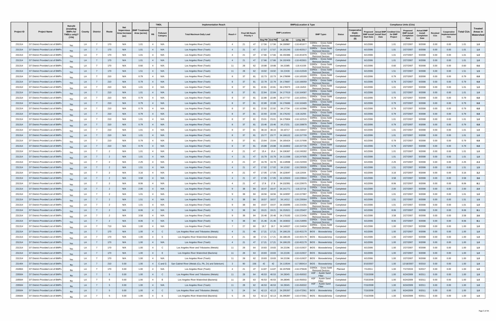
Beg PM End PM Lat. (N) Long. (W)
RouteProject ID Project Name
Retrofit (installing BMPs for
TMDLs only)? (Y/N)
County District Credited CUs for BMP Project
Proposed BMP Install Completion
Date
Actual BMP Install
Completion Date
Net Impervious
Area Increase (ac)
BMP Treatment Area (acres)
TMDL Implementation Reach BMP(s)Location & Type
BMP LocationsBMP Types Status
Revoked CUs
Total CUsTreated Areas in
WatershedRBPollutant Category
Total Maximum Daily Load Reach #Final SB Reach
Priority #
Compliance Units (CUs)
Cooperative Imple-
mentation ($)
Cooperative Implementation
CUs
Proposed BMP Install Start Date
Actual BMP Install Start
Date
231314 D7 District Provided List of BMPs Yes LA 7 170 N/A 1.01 4 N/A Los Angeles River (Trash) 4 21 47 17.56 17.56 34.190987 -118.401677GSRDs - Gross Solid
Removal DevicesCompleted 6/1/2006 1.01 2/27/2007 9/2008 0.00 0.00 1.01 1.0
231314 D7 District Provided List of BMPs Yes LA 7 170 N/A 1.01 4 N/A Los Angeles River (Trash) 4 21 47 17.57 17.57 34.191246 -118.402517GSRDs - Gross Solid
Removal DevicesCompleted 6/1/2006 1.01 2/27/2007 9/2008 0.00 0.00 1.01 1.0
231314 D7 District Provided List of BMPs Yes LA 7 170 N/A 1.01 4 N/A Los Angeles River (Trash) 4 21 47 17.66 17.66 34.192486 -118.401878GSRDs - Gross Solid
Removal DevicesCompleted 6/1/2006 1.01 2/27/2007 9/2008 0.00 0.00 1.01 1.0
231314 D7 District Provided List of BMPs Yes LA 7 170 N/A 1.01 4 N/A Los Angeles River (Trash) 4 21 47 17.66 17.66 34.192409 -118.402601GSRDs - Gross Solid
Removal DevicesCompleted 6/1/2006 1.01 2/27/2007 9/2008 0.00 0.00 1.01 1.0
231314 D7 District Provided List of BMPs Yes LA 7 170 N/A 0.60 4 N/A Los Angeles River (Trash) 11 28 62 19.88 19.88 34.22385 -118.41039GSRDs - Gross Solid
Removal DevicesCompleted 6/1/2006 0.60 2/27/2007 9/2008 0.00 0.00 0.60 0.6
231314 D7 District Provided List of BMPs Yes LA 7 170 N/A 1.51 4 N/A Los Angeles River (Trash) 11 28 62 19.92 19.92 34.22439 -118.410549GSRDs - Gross Solid
Removal DevicesCompleted 6/1/2006 1.51 2/27/2007 9/2008 0.00 0.00 1.51 1.5
231314 D7 District Provided List of BMPs Yes LA 7 210 N/A 0.79 4 N/A Los Angeles River (Trash) 8 37 81 22.73 22.73 34.178099 -118.165309GSRDs - Gross Solid
Removal DevicesCompleted 6/1/2006 0.79 2/27/2007 9/2008 0.00 0.00 0.79 0.8
231314 D7 District Provided List of BMPs Yes LA 7 210 N/A 0.79 4 N/A Los Angeles River (Trash) 8 37 81 22.79 22.79 34.178687 -118.166059GSRDs - Gross Solid
Removal DevicesCompleted 6/1/2006 0.79 2/27/2007 9/2008 0.00 0.00 0.79 0.8
231314 D7 District Provided List of BMPs Yes LA 7 210 N/A 1.01 4 N/A Los Angeles River (Trash) 8 37 81 22.81 22.81 34.178373 -118.16453GSRDs - Gross Solid
Removal DevicesCompleted 6/1/2006 1.01 2/27/2007 9/2008 0.00 0.00 1.01 1.0
231314 D7 District Provided List of BMPs Yes LA 7 210 N/A 1.01 4 N/A Los Angeles River (Trash) 8 37 81 22.84 22.84 34.177619 -118.164587GSRDs - Gross Solid
Removal DevicesCompleted 6/1/2006 1.01 2/27/2007 9/2008 0.00 0.00 1.01 1.0
231314 D7 District Provided List of BMPs Yes LA 7 210 N/A 0.79 4 N/A Los Angeles River (Trash) 8 37 81 22.88 22.88 34.177737 -118.163541GSRDs - Gross Solid
Removal DevicesCompleted 6/1/2006 0.79 2/27/2007 9/2008 0.00 0.00 0.79 0.8
231314 D7 District Provided List of BMPs Yes LA 7 210 N/A 0.79 4 N/A Los Angeles River (Trash) 8 37 81 22.89 22.89 34.176686 -118.163465GSRDs - Gross Solid
Removal DevicesCompleted 6/1/2006 0.79 2/27/2007 9/2008 0.00 0.00 0.79 0.8
231314 D7 District Provided List of BMPs Yes LA 7 210 N/A 0.79 4 N/A Los Angeles River (Trash) 8 37 81 22.92 22.92 34.17734 -118.162986GSRDs - Gross Solid
Removal DevicesCompleted 6/1/2006 0.79 2/27/2007 9/2008 0.00 0.00 0.79 0.8
231314 D7 District Provided List of BMPs Yes LA 7 210 N/A 0.79 4 N/A Los Angeles River (Trash) 8 37 81 22.93 22.93 34.176242 -118.16293GSRDs - Gross Solid
Removal DevicesCompleted 6/1/2006 0.79 2/27/2007 9/2008 0.00 0.00 0.79 0.8
231314 D7 District Provided List of BMPs Yes LA 7 210 N/A 1.01 4 N/A Los Angeles River (Trash) 8 37 81 23.01 23.01 34.175904 -118.162515GSRDs - Gross Solid
Removal DevicesCompleted 6/1/2006 1.01 2/27/2007 9/2008 0.00 0.00 1.01 1.0
231314 D7 District Provided List of BMPs Yes LA 7 210 N/A 0.79 4 N/A Los Angeles River (Trash) 8 37 81 23.46 23.46 34.17231 -118.158878GSRDs - Gross Solid
Removal DevicesCompleted 6/1/2006 0.79 2/27/2007 9/2008 0.00 0.00 0.79 0.8
231314 D7 District Provided List of BMPs Yes LA 7 210 N/A 1.01 4 N/A Los Angeles River (Trash) 8 37 81 38.16 38.16 34.16717 -118.158447GSRDs - Gross Solid
Removal DevicesCompleted 6/1/2006 1.01 2/27/2007 9/2008 0.00 0.00 1.01 1.0
231314 D7 District Provided List of BMPs Yes LA 7 210 N/A 1.01 4 N/A Los Angeles River (Trash) 8 37 81 23.77 23.77 34.166122 -118.157709GSRDs - Gross Solid
Removal DevicesCompleted 6/1/2006 1.01 2/27/2007 9/2008 0.00 0.00 1.01 1.0
231314 D7 District Provided List of BMPs Yes LA 7 210 N/A 0.79 4 N/A Los Angeles River (Trash) 8 37 81 23.84 23.84 34.165424 -118.157698GSRDs - Gross Solid
Removal DevicesCompleted 6/1/2006 0.79 2/27/2007 9/2008 0.00 0.00 0.79 0.8
231314 D7 District Provided List of BMPs Yes LA 7 210 N/A 0.79 4 N/A Los Angeles River (Trash) 8 37 81 23.88 23.88 34.164802 -118.157726GSRDs - Gross Solid
Removal DevicesCompleted 6/1/2006 0.79 2/27/2007 9/2008 0.00 0.00 0.79 0.8
231314 D7 District Provided List of BMPs Yes LA 7 2 N/A 1.01 4 N/A Los Angeles River (Trash) 4 21 47 15.4 15.4 34.106367 -118.249392GSRDs - Gross Solid
Removal DevicesCompleted 6/1/2006 1.01 2/27/2007 9/2008 0.00 0.00 1.01 1.0
231314 D7 District Provided List of BMPs Yes LA 7 2 N/A 1.01 4 N/A Los Angeles River (Trash) 4 21 47 15.79 15.79 34.111598 -118.247605GSRDs - Gross Solid
Removal DevicesCompleted 6/1/2006 1.01 2/27/2007 9/2008 0.00 0.00 1.01 1.0
231314 D7 District Provided List of BMPs Yes LA 7 2 N/A 2.25 4 N/A Los Angeles River (Trash) 4 21 47 16.78 16.78 34.118598 -118.232559GSRDs - Gross Solid
Removal DevicesCompleted 6/1/2006 2.25 2/27/2007 9/2008 0.00 0.00 2.25 2.3
231314 D7 District Provided List of BMPs Yes LA 7 2 N/A 1.51 4 N/A Los Angeles River (Trash) 4 21 47 17.02 17.02 34.12182 -118.230026GSRDs - Gross Solid
Removal DevicesCompleted 6/1/2006 1.51 2/27/2007 9/2008 0.00 0.00 1.51 1.5
231314 D7 District Provided List of BMPs Yes LA 7 2 N/A 3.16 4 N/A Los Angeles River (Trash) 4 21 47 17.05 17.05 34.123047 -118.22934GSRDs - Gross Solid
Removal DevicesCompleted 6/1/2006 3.16 2/27/2007 9/2008 0.00 0.00 3.16 3.2
231314 D7 District Provided List of BMPs Yes LA 7 2 N/A 3.58 4 N/A Los Angeles River (Trash) 4 21 47 17.05 17.05 34.125503 -118.228644GSRDs - Gross Solid
Removal DevicesCompleted 6/1/2006 3.58 2/27/2007 9/2008 0.00 0.00 3.58 3.6
231314 D7 District Provided List of BMPs Yes LA 7 2 N/A 8.06 4 N/A Los Angeles River (Trash) 4 21 47 17.8 17.8 34.132391 -118.229075GSRDs - Gross Solid
Removal DevicesCompleted 6/1/2006 8.06 2/27/2007 9/2008 0.00 0.00 8.06 8.1
231314 D7 District Provided List of BMPs Yes LA 7 2 N/A 2.00 4 N/A Los Angeles River (Trash) 9 38 84 18.47 18.47 34.141771 -118.22718GSRDs - Gross Solid
Removal DevicesCompleted 6/1/2006 2.00 2/27/2007 9/2008 0.00 0.00 2.00 2.0
231314 D7 District Provided List of BMPs Yes LA 7 2 N/A 1.01 4 N/A Los Angeles River (Trash) 9 38 84 18.56 18.56 34.143097 -118.227887GSRDs - Gross Solid
Removal DevicesCompleted 6/1/2006 1.01 2/27/2007 9/2008 0.00 0.00 1.01 1.0
231314 D7 District Provided List of BMPs Yes LA 7 2 N/A 1.51 4 N/A Los Angeles River (Trash) 9 38 84 18.57 18.57 34.14312 -118.226564GSRDs - Gross Solid
Removal DevicesCompleted 6/1/2006 1.51 2/27/2007 9/2008 0.00 0.00 1.51 1.5
231314 D7 District Provided List of BMPs Yes LA 7 2 N/A 1.01 4 N/A Los Angeles River (Trash) 9 38 84 19.07 19.07 34.150095 -118.224355GSRDs - Gross Solid
Removal DevicesCompleted 6/1/2006 1.01 2/27/2007 9/2008 0.00 0.00 1.01 1.0
231314 D7 District Provided List of BMPs Yes LA 7 2 N/A 8.06 4 N/A Los Angeles River (Trash) 9 38 84 19.21 19.21 34.152621 -118.225407GSRDs - Gross Solid
Removal DevicesCompleted 6/1/2006 8.06 2/27/2007 9/2008 0.00 0.00 8.06 8.1
231314 D7 District Provided List of BMPs Yes LA 7 2 N/A 3.58 4 N/A Los Angeles River (Trash) 9 38 84 20.48 20.48 34.170193 -118.223456GSRDs - Gross Solid
Removal DevicesCompleted 6/1/2006 3.58 2/27/2007 9/2008 0.00 0.00 3.58 3.6
231314 D7 District Provided List of BMPs Yes LA 7 2 N/A 8.06 4 N/A Los Angeles River (Trash) 9 38 84 21.46 21.46 34.183832 -118.218955GSRDs - Gross Solid
Removal DevicesCompleted 6/1/2006 8.06 2/27/2007 9/2008 0.00 0.00 8.06 8.1
231314 D7 District Provided List of BMPs Yes LA 7 710 N/A 1.00 4 N/A Los Angeles River (Trash) 7 27 60 19.7 19.7 34.140027 -118.154834GSRDs - Gross Solid
Removal DevicesCompleted 6/1/2006 1.00 2/27/2007 9/2008 0.00 0.00 1.00 1.0
231314 D7 District Provided List of BMPs Yes LA 7 170 N/A 1.00 4 C Los Angeles River and Tributaries (Metals) 4 21 49 17.21 17.21 34.186135 -118.402179 BIOS - Bioswale/strip Completed 6/1/2006 1.00 2/27/2007 9/2008 0.00 0.00 1.00 1.0
231314 D7 District Provided List of BMPs Yes LA 7 170 N/A 1.00 4 E Los Angeles River Watershed (Bacteria) 4 21 48 17.21 17.21 34.186135 -118.402179 BIOS - Bioswale/strip Completed 6/1/2006 1.00 2/27/2007 9/2008 0.00 0.00 1.00 1.0
231314 D7 District Provided List of BMPs Yes LA 7 170 N/A 1.00 4 N/A Los Angeles River (Trash) 4 21 47 17.21 17.21 34.186135 -118.402179 BIOS - Bioswale/strip Completed 6/1/2006 1.00 2/27/2007 9/2008 0.00 0.00 1.00 1.0
231314 D7 District Provided List of BMPs Yes LA 7 170 N/A 1.00 4 C Los Angeles River and Tributaries (Metals) 11 28 64 19.83 19.83 34.22196 -118.410637 BIOS - Bioswale/strip Completed 6/1/2006 1.00 2/27/2007 9/2008 0.00 0.00 1.00 1.0
231314 D7 District Provided List of BMPs Yes LA 7 170 N/A 1.00 4 E Los Angeles River Watershed (Bacteria) 11 28 63 19.83 19.83 34.22196 -118.410637 BIOS - Bioswale/strip Completed 6/1/2006 1.00 2/27/2007 9/2008 0.00 0.00 1.00 1.0
231314 D7 District Provided List of BMPs Yes LA 7 170 N/A 1.00 4 N/A Los Angeles River (Trash) 11 28 62 19.83 19.83 34.22196 -118.410637 BIOS - Bioswale/strip Completed 6/1/2006 1.00 2/27/2007 9/2008 0.00 0.00 1.00 1.0
231404 D7 District Provided List of BMPs No LA 7 210 0.00 1.00 4 C and G San Gabriel River (Metals (Cu, Pb, Zn) and Selenium) 3 90 156 42 42 34.119544 -117.866414 BIOS - Bioswale/strip Completed 3/10/2007 1.00 12/18/2007 9/2010 0.00 0.00 1.00 1.0
232804 D7 District Provided List of BMPs No LA 7 170 0.00 1.00 4 N/A Los Angeles River (Trash) 4 21 47 14.87 14.87 34.157939 -118.379639GSRDs - Gross Solid
Removal DevicesPlanned 7/1/2011 1.00 7/17/2015 5/2017 0.00 0.00 1.00 1.0
235504 D7 District Provided List of BMPs No LA 7 5 0.00 1.00 4 C Los Angeles River and Tributaries (Metals) 11 28 64 40.53 40.53 34.28045 -118.456502ASF - Austin Sand
FilterCompleted 7/15/2008 1.00 6/24/2009 9/2011 0.00 0.00 1.00 1.0
235504 D7 District Provided List of BMPs No LA 7 5 0.00 1.00 4 E Los Angeles River Watershed (Bacteria) 11 28 63 40.53 40.53 34.28045 -118.456502ASF - Austin Sand
FilterCompleted 7/15/2008 1.00 6/24/2009 9/2011 0.00 0.00 1.00 1.0
235504 D7 District Provided List of BMPs No LA 7 5 0.00 1.00 4 N/A Los Angeles River (Trash) 11 28 62 40.53 40.53 34.28045 -118.456502ASF - Austin Sand
FilterCompleted 7/15/2008 1.00 6/24/2009 9/2011 0.00 0.00 1.00 1.0
235504 D7 District Provided List of BMPs No LA 7 5 0.00 1.00 4 C Los Angeles River and Tributaries (Metals) 5 24 54 42.13 42.13 34.295397 -118.472561 BIOS - Bioswale/strip Completed 7/15/2008 1.00 6/24/2009 9/2011 0.00 0.00 1.00 1.0
235504 D7 District Provided List of BMPs No LA 7 5 0.00 1.00 4 E Los Angeles River Watershed (Bacteria) 5 24 53 42.13 42.13 34.295397 -118.472561 BIOS - Bioswale/strip Completed 7/15/2008 1.00 6/24/2009 9/2011 0.00 0.00 1.00 1.0
Page 5 of 44
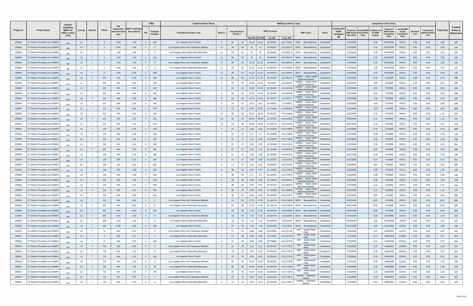
Beg PM End PM Lat. (N) Long. (W)
RouteProject ID Project Name
Retrofit (installing BMPs for
TMDLs only)? (Y/N)
County District Credited CUs for BMP Project
Proposed BMP Install Completion
Date
Actual BMP Install
Completion Date
Net Impervious
Area Increase (ac)
BMP Treatment Area (acres)
TMDL Implementation Reach BMP(s)Location & Type
BMP LocationsBMP Types Status
Revoked CUs
Total CUsTreated Areas in
WatershedRBPollutant Category
Total Maximum Daily Load Reach #Final SB Reach
Priority #
Compliance Units (CUs)
Cooperative Imple-
mentation ($)
Cooperative Implementation
CUs
Proposed BMP Install Start Date
Actual BMP Install Start
Date
235504 D7 District Provided List of BMPs No LA 7 5 0.00 1.00 4 N/A Los Angeles River (Trash) 5 24 52 42.13 42.13 34.295397 -118.472561 BIOS - Bioswale/strip Completed 7/15/2008 1.00 6/24/2009 9/2011 0.00 0.00 1.00 1.0
235504 D7 District Provided List of BMPs No LA 7 5 0.00 1.00 4 C Los Angeles River and Tributaries (Metals) 11 28 64 41 41 34.284367 -118.459172 BIOS - Bioswale/strip Completed 7/15/2008 1.00 6/24/2009 9/2011 0.00 0.00 1.00 1.0
235504 D7 District Provided List of BMPs No LA 7 5 0.00 1.00 4 E Los Angeles River Watershed (Bacteria) 11 28 63 41 41 34.284367 -118.459172 BIOS - Bioswale/strip Completed 7/15/2008 1.00 6/24/2009 9/2011 0.00 0.00 1.00 1.0
235504 D7 District Provided List of BMPs No LA 7 5 0.00 1.00 4 N/A Los Angeles River (Trash) 11 28 62 41 41 34.284367 -118.459172 BIOS - Bioswale/strip Completed 7/15/2008 1.00 6/24/2009 9/2011 0.00 0.00 1.00 1.0
235504 D7 District Provided List of BMPs No LA 7 5 0.00 1.00 4 C Los Angeles River and Tributaries (Metals) 11 28 64 41.22 41.22 34.285279 -118.459653 BIOS - Bioswale/strip Completed 7/15/2008 1.00 6/24/2009 9/2011 0.00 0.00 1.00 1.0
235504 D7 District Provided List of BMPs No LA 7 5 0.00 1.00 4 E Los Angeles River Watershed (Bacteria) 11 28 63 41.22 41.22 34.285279 -118.459653 BIOS - Bioswale/strip Completed 7/15/2008 1.00 6/24/2009 9/2011 0.00 0.00 1.00 1.0
235504 D7 District Provided List of BMPs No LA 7 5 0.00 1.00 4 N/A Los Angeles River (Trash) 11 28 62 41.22 41.22 34.285279 -118.459653 BIOS - Bioswale/strip Completed 7/15/2008 1.00 6/24/2009 9/2011 0.00 0.00 1.00 1.0
235904 D7 District Provided List of BMPs Yes LA 7 101 N/A 0.78 4 N/A Los Angeles River (Trash) 11 28 62 12.72 12.72 34.154087 -118.394113GSRDs - Gross Solid
Removal DevicesCompleted 5/22/2008 0.78 7/2/2008 4/2011 0.00 0.00 0.78 0.8
235904 D7 District Provided List of BMPs Yes LA 7 101 N/A 2.84 4 N/A Los Angeles River (Trash) 5 24 52 14.26 14.26 34.15651 -118.420327GSRDs - Gross Solid
Removal DevicesCompleted 5/22/2008 2.84 7/2/2008 4/2011 0.00 0.00 2.84 2.8
235904 D7 District Provided List of BMPs Yes LA 7 101 N/A 3.53 4 N/A Los Angeles River (Trash) 5 24 52 14.53 14.53 34.155887 -118.424786GSRDs - Gross Solid
Removal DevicesCompleted 5/22/2008 3.53 7/2/2008 4/2011 0.00 0.00 3.53 3.5
235904 D7 District Provided List of BMPs Yes LA 7 101 N/A 2.84 4 N/A Los Angeles River (Trash) 5 24 52 14.78 14.78 34.155293 -118.429138GSRDs - Gross Solid
Removal DevicesCompleted 5/22/2008 2.84 7/2/2008 4/2011 0.00 0.00 2.84 2.8
235904 D7 District Provided List of BMPs Yes LA 7 101 N/A 2.25 4 N/A Los Angeles River (Trash) 5 24 52 16.72 16.72 34.159777 -118.46201GSRDs - Gross Solid
Removal DevicesCompleted 5/22/2008 2.25 7/2/2008 4/2011 0.00 0.00 2.25 2.3
235904 D7 District Provided List of BMPs Yes LA 7 101 N/A 2.84 4 N/A Los Angeles River (Trash) 5 24 52 18.4 18.4 34.165531 -118.48875GSRDs - Gross Solid
Removal DevicesCompleted 5/22/2008 2.84 7/2/2008 4/2011 0.00 0.00 2.84 2.8
235904 D7 District Provided List of BMPs Yes LA 7 101 N/A 2.84 4 N/A Los Angeles River (Trash) 5 24 52 22.67 22.67 34.173858 -118.560526GSRDs - Gross Solid
Removal DevicesCompleted 5/22/2008 2.84 7/2/2008 4/2011 0.00 0.00 2.84 2.8
235904 D7 District Provided List of BMPs Yes LA 7 101 N/A 1.41 4 N/A Los Angeles River (Trash) 14 40 90 26.01 26.01 34.167207 -118.615968GSRDs - Gross Solid
Removal DevicesCompleted 5/22/2008 1.41 7/2/2008 4/2011 0.00 0.00 1.41 1.4
235904 D7 District Provided List of BMPs Yes LA 7 101 N/A 1.41 4 N/A Los Angeles River (Trash) 14 40 90 26.05 26.05 34.167027 -118.616502GSRDs - Gross Solid
Removal DevicesCompleted 5/22/2008 1.41 7/2/2008 4/2011 0.00 0.00 1.41 1.4
235904 D7 District Provided List of BMPs Yes LA 7 101 N/A 1.41 4 N/A Los Angeles River (Trash) 14 40 90 26.49 26.49 34.164715 -118.623705GSRDs - Gross Solid
Removal DevicesCompleted 5/22/2008 1.41 7/2/2008 4/2011 0.00 0.00 1.41 1.4
235904 D7 District Provided List of BMPs Yes LA 7 134 N/A 0.79 4 N/A Los Angeles River (Trash) 4 21 47 0.04 0.04 34.153648 -118.375869GSRDs - Gross Solid
Removal DevicesCompleted 5/22/2008 0.79 7/2/2008 4/2011 0.00 0.00 0.79 0.8
235904 D7 District Provided List of BMPs Yes LA 7 134 N/A 1.58 4 N/A Los Angeles River (Trash) 4 21 47 0.2 0.2 34.152609 -118.372883GSRDs - Gross Solid
Removal DevicesCompleted 5/22/2008 1.58 7/2/2008 4/2011 0.00 0.00 1.58 1.6
235904 D7 District Provided List of BMPs Yes LA 7 134 N/A 1.58 4 N/A Los Angeles River (Trash) 4 21 47 0.22 0.22 34.152605 -118.372828GSRDs - Gross Solid
Removal DevicesCompleted 5/22/2008 1.58 7/2/2008 4/2011 0.00 0.00 1.58 1.6
235904 D7 District Provided List of BMPs Yes LA 7 134 N/A 3.16 4 N/A Los Angeles River (Trash) 4 21 47 0.25 0.25 34.153388 -118.372331GSRDs - Gross Solid
Removal DevicesCompleted 5/22/2008 3.16 7/2/2008 4/2011 0.00 0.00 3.16 3.2
235904 D7 District Provided List of BMPs Yes LA 7 134 N/A 2.84 4 N/A Los Angeles River (Trash) 4 21 47 1.37 1.37 34.152839 -118.352884GSRDs - Gross Solid
Removal DevicesCompleted 5/22/2008 2.84 7/2/2008 4/2011 0.00 0.00 2.84 2.8
235904 D7 District Provided List of BMPs Yes LA 7 134 N/A 1.58 4 N/A Los Angeles River (Trash) 4 21 47 2.59 2.59 34.152828 -118.331842GSRDs - Gross Solid
Removal DevicesCompleted 5/22/2008 1.58 7/2/2008 4/2011 0.00 0.00 1.58 1.6
235904 D7 District Provided List of BMPs Yes LA 7 134 N/A 5.14 4 N/A Los Angeles River (Trash) 4 21 47 3.09 3.09 34.153847 -118.32353GSRDs - Gross Solid
Removal DevicesCompleted 5/22/2008 5.14 7/2/2008 4/2011 0.00 0.00 5.14 5.1
235904 D7 District Provided List of BMPs Yes LA 7 134 N/A 2.84 4 N/A Los Angeles River (Trash) 4 21 47 3.22 3.22 34.154375 -118.321364GSRDs - Gross Solid
Removal DevicesCompleted 5/22/2008 2.84 7/2/2008 4/2011 0.00 0.00 2.84 2.8
235904 D7 District Provided List of BMPs Yes LA 7 134 N/A 1.58 4 N/A Los Angeles River (Trash) 9 38 84 6.07 6.07 34.153802 -118.273235GSRDs - Gross Solid
Removal DevicesCompleted 5/22/2008 1.58 7/2/2008 4/2011 0.00 0.00 1.58 1.6
235904 D7 District Provided List of BMPs Yes LA 7 134 N/A 1.58 4 N/A Los Angeles River (Trash) 9 38 84 6.2 6.2 34.154532 -118.270973GSRDs - Gross Solid
Removal DevicesCompleted 5/22/2008 1.58 7/2/2008 4/2011 0.00 0.00 1.58 1.6
235904 D7 District Provided List of BMPs Yes LA 7 134 N/A 1.58 4 N/A Los Angeles River (Trash) 9 38 84 6.48 6.48 34.156285 -118.266531GSRDs - Gross Solid
Removal DevicesCompleted 5/22/2008 1.58 7/2/2008 4/2011 0.00 0.00 1.58 1.6
235904 D7 District Provided List of BMPs Yes LA 7 134 N/A 1.41 4 N/A Los Angeles River (Trash) 9 38 84 8.31 8.31 34.151714 -118.236333GSRDs - Gross Solid
Removal DevicesCompleted 5/22/2008 1.41 7/2/2008 4/2011 0.00 0.00 1.41 1.4
235904 D7 District Provided List of BMPs Yes LA 7 134 N/A 1.41 4 N/A Los Angeles River (Trash) 9 38 84 8.46 8.46 34.150894 -118.233804GSRDs - Gross Solid
Removal DevicesCompleted 5/22/2008 1.41 7/2/2008 4/2011 0.00 0.00 1.41 1.4
235904 D7 District Provided List of BMPs Yes LA 7 134 N/A 2.84 4 N/A Los Angeles River (Trash) 9 38 84 8.59 8.59 34.149329 -118.232631GSRDs - Gross Solid
Removal DevicesCompleted 5/22/2008 2.84 7/2/2008 4/2011 0.00 0.00 2.84 2.8
235904 D7 District Provided List of BMPs Yes LA 7 101 N/A 8.50 4 C Los Angeles River and Tributaries (Metals) 5 24 54 17.51 17.51 34.163718 -118.473529 BIOS - Bioswale/strip Completed 5/22/2008 8.50 7/2/2008 4/2011 0.00 0.00 8.50 8.5
235904 D7 District Provided List of BMPs Yes LA 7 101 N/A 8.50 4 E Los Angeles River Watershed (Bacteria) 5 24 53 17.51 17.51 34.163718 -118.473529 BIOS - Bioswale/strip Completed 5/22/2008 8.50 7/2/2008 4/2011 0.00 0.00 8.50 8.5
235904 D7 District Provided List of BMPs Yes LA 7 101 N/A 8.50 4 N/A Los Angeles River (Trash) 5 24 52 17.51 17.51 34.163718 -118.473529 BIOS - Bioswale/strip Completed 5/22/2008 8.50 7/2/2008 4/2011 0.00 0.00 8.50 8.5
243604 D7 District Provided List of BMPs No LA 7 405 0.00 1.00 4 C Los Angeles River and Tributaries (Metals) 1 19 45 7.16 7.16 33.824796 -118.20048 BIOS - Bioswale/strip Completed 10/15/2007 1.00 3/12/2008 2/2010 0.00 0.00 1.00 1.0
243604 D7 District Provided List of BMPs No LA 7 405 0.00 1.00 4 E Los Angeles River Watershed (Bacteria) 1 19 44 7.16 7.16 33.824796 -118.20048 BIOS - Bioswale/strip Completed 10/15/2007 1.00 3/12/2008 2/2010 0.00 0.00 1.00 1.0
243604 D7 District Provided List of BMPs No LA 7 405 0.00 1.00 4 N/A Los Angeles River (Trash) 1 19 43 7.16 7.16 33.824796 -118.20048 BIOS - Bioswale/strip Completed 10/15/2007 1.00 3/12/2008 2/2010 0.00 0.00 1.00 1.0
258914 D7 District Provided List of BMPs Yes LA 7 5 N/A 2.37 4 C Los Angeles River and Tributaries (Metals) 7 27 61 9.88 9.88 33.976901 -118.125799ASF - Austin Sand
FilterCompleted 7/15/2009 2.37 10/8/2009 12/2011 0.00 0.00 2.37 2.4
258914 D7 District Provided List of BMPs Yes LA 7 5 N/A 2.37 4 E Los Angeles River Watershed (Bacteria) 7 27 59 9.88 9.88 33.976901 -118.125799ASF - Austin Sand
FilterCompleted 7/15/2009 2.37 10/8/2009 12/2011 0.00 0.00 2.37 2.4
258914 D7 District Provided List of BMPs Yes LA 7 5 N/A 2.37 4 N/A Los Angeles River (Trash) 7 27 60 9.88 9.88 33.976901 -118.125799ASF - Austin Sand
FilterCompleted 7/15/2009 2.37 10/8/2009 12/2011 0.00 0.00 2.37 2.4
258914 D7 District Provided List of BMPs Yes LA 7 710 N/A 3.20 4 C Los Angeles River and Tributaries (Metals) 2 10 25 16.8 16.8 33.931443 -118.177979ASF - Austin Sand
FilterCompleted 7/15/2009 3.20 10/8/2009 12/2011 0.00 0.00 3.20 3.2
258914 D7 District Provided List of BMPs Yes LA 7 710 N/A 3.20 4 E Los Angeles River Watershed (Bacteria) 2 10 24 16.8 16.8 33.931443 -118.177979ASF - Austin Sand
FilterCompleted 7/15/2009 3.20 10/8/2009 12/2011 0.00 0.00 3.20 3.2
258914 D7 District Provided List of BMPs Yes LA 7 710 N/A 3.20 4 N/A Los Angeles River (Trash) 2 10 23 16.8 16.8 33.931443 -118.177979ASF - Austin Sand
FilterCompleted 7/15/2009 3.20 10/8/2009 12/2011 0.00 0.00 3.20 3.2
258914 D7 District Provided List of BMPs Yes LA 7 710 N/A 1.35 4 C Los Angeles River and Tributaries (Metals) 3 25 57 22.54 22.54 34.005704 -118.172259ASF - Austin Sand
FilterCompleted 7/15/2009 1.35 10/8/2009 12/2011 0.00 0.00 1.35 1.4
258914 D7 District Provided List of BMPs Yes LA 7 710 N/A 1.35 4 E Los Angeles River Watershed (Bacteria) 3 25 56 22.54 22.54 34.005704 -118.172259ASF - Austin Sand
FilterCompleted 7/15/2009 1.35 10/8/2009 12/2011 0.00 0.00 1.35 1.4
258914 D7 District Provided List of BMPs Yes LA 7 710 N/A 1.35 4 N/A Los Angeles River (Trash) 3 25 55 22.54 22.54 34.005704 -118.172259ASF - Austin Sand
FilterCompleted 7/15/2009 1.35 10/8/2009 12/2011 0.00 0.00 1.35 1.4
258914 D7 District Provided List of BMPs Yes LA 7 710 N/A 3.54 4 C Los Angeles River and Tributaries (Metals) 2 10 25 16.8 16.8 33.931205 -118.178031DetBas - Detention
BasinsCompleted 7/15/2009 3.54 10/8/2009 12/2011 0.00 0.00 3.54 3.5
258914 D7 District Provided List of BMPs Yes LA 7 710 N/A 3.54 4 E Los Angeles River Watershed (Bacteria) 2 10 24 16.8 16.8 33.931205 -118.178031DetBas - Detention
BasinsCompleted 7/15/2009 3.54 10/8/2009 12/2011 0.00 0.00 3.54 3.5
Page 6 of 44
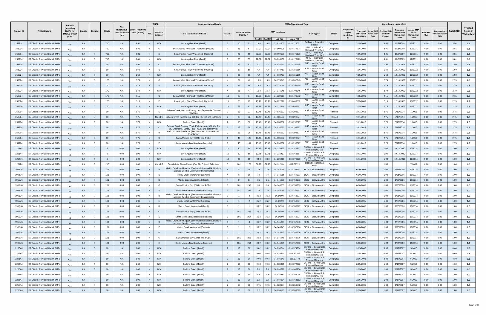
Beg PM End PM Lat. (N) Long. (W)
RouteProject ID Project Name
Retrofit (installing BMPs for
TMDLs only)? (Y/N)
County District Credited CUs for BMP Project
Proposed BMP Install Completion
Date
Actual BMP Install
Completion Date
Net Impervious
Area Increase (ac)
BMP Treatment Area (acres)
TMDL Implementation Reach BMP(s)Location & Type
BMP LocationsBMP Types Status
Revoked CUs
Total CUsTreated Areas in
WatershedRBPollutant Category
Total Maximum Daily Load Reach #Final SB Reach
Priority #
Compliance Units (CUs)
Cooperative Imple-
mentation ($)
Cooperative Implementation
CUs
Proposed BMP Install Start Date
Actual BMP Install Start
Date
258914 D7 District Provided List of BMPs Yes LA 7 710 N/A 3.54 4 N/A Los Angeles River (Trash) 2 10 23 16.8 16.8 33.931205 -118.178031DetBas - Detention
BasinsCompleted 7/15/2009 3.54 10/8/2009 12/2011 0.00 0.00 3.54 3.5
258914 D7 District Provided List of BMPs Yes LA 7 710 N/A 3.81 4 C Los Angeles River and Tributaries (Metals) 3 25 57 22.07 22.07 33.999108 -118.175173INFIL - Infiltration
(Basins & Trenches)Completed 7/15/2009 3.81 10/8/2009 12/2011 0.00 0.00 3.81 3.8
258914 D7 District Provided List of BMPs Yes LA 7 710 N/A 3.81 4 E Los Angeles River Watershed (Bacteria) 3 25 56 22.07 22.07 33.999108 -118.175173INFIL - Infiltration
(Basins & Trenches)Completed 7/15/2009 3.81 10/8/2009 12/2011 0.00 0.00 3.81 3.8
258914 D7 District Provided List of BMPs Yes LA 7 710 N/A 3.81 4 N/A Los Angeles River (Trash) 3 25 55 22.07 22.07 33.999108 -118.175173INFIL - Infiltration
(Basins & Trenches)Completed 7/15/2009 3.81 10/8/2009 12/2011 0.00 0.00 3.81 3.8
258924 D7 District Provided List of BMPs Yes LA 7 60 N/A 1.50 4 C Los Angeles River and Tributaries (Metals) 7 27 61 4.4 4.4 34.034763 -118.151165ASF - Austin Sand
FilterCompleted 7/15/2009 1.50 12/14/2009 11/2012 0.00 0.00 1.50 1.5
258924 D7 District Provided List of BMPs Yes LA 7 60 N/A 1.50 4 E Los Angeles River Watershed (Bacteria) 7 27 59 4.4 4.4 34.034763 -118.151165ASF - Austin Sand
FilterCompleted 7/15/2009 1.50 12/14/2009 11/2012 0.00 0.00 1.50 1.5
258924 D7 District Provided List of BMPs Yes LA 7 60 N/A 1.50 4 N/A Los Angeles River (Trash) 7 27 60 4.4 4.4 34.034763 -118.151165ASF - Austin Sand
FilterCompleted 7/15/2009 1.50 12/14/2009 11/2012 0.00 0.00 1.50 1.5
258924 D7 District Provided List of BMPs Yes LA 7 170 N/A 2.79 4 C Los Angeles River and Tributaries (Metals) 4 21 49 16.3 16.3 34.175045 -118.392245ASF - Austin Sand
FilterCompleted 7/15/2009 2.79 12/14/2009 11/2012 0.00 0.00 2.79 2.8
258924 D7 District Provided List of BMPs Yes LA 7 170 N/A 2.79 4 E Los Angeles River Watershed (Bacteria) 4 21 48 16.3 16.3 34.175045 -118.392245ASF - Austin Sand
FilterCompleted 7/15/2009 2.79 12/14/2009 11/2012 0.00 0.00 2.79 2.8
258924 D7 District Provided List of BMPs Yes LA 7 170 N/A 2.79 4 N/A Los Angeles River (Trash) 4 21 47 16.3 16.3 34.175045 -118.392245ASF - Austin Sand
FilterCompleted 7/15/2009 2.79 12/14/2009 11/2012 0.00 0.00 2.79 2.8
258924 D7 District Provided List of BMPs Yes LA 7 170 N/A 2.15 4 C Los Angeles River and Tributaries (Metals) 11 28 64 19.76 19.76 34.222316 -118.409692ASF - Austin Sand
FilterCompleted 7/15/2009 2.15 12/14/2009 11/2012 0.00 0.00 2.15 2.2
258924 D7 District Provided List of BMPs Yes LA 7 170 N/A 2.15 4 E Los Angeles River Watershed (Bacteria) 11 28 63 19.76 19.76 34.222316 -118.409692ASF - Austin Sand
FilterCompleted 7/15/2009 2.15 12/14/2009 11/2012 0.00 0.00 2.15 2.2
258924 D7 District Provided List of BMPs Yes LA 7 170 N/A 2.15 4 N/A Los Angeles River (Trash) 11 28 62 19.76 19.76 34.222316 -118.409692ASF - Austin Sand
FilterCompleted 7/15/2009 2.15 12/14/2009 11/2012 0.00 0.00 2.15 2.2
259204 D7 District Provided List of BMPs Yes LA 7 10 N/A 2.75 4 EBallona Creek, Ballona Estuary, and Sepulveda Channel
(Bacteria)2 13 31 13.46 13.46 34.036532 -118.298877
ASF - Austin Sand Filter
Planned 10/1/2013 2.75 3/19/2014 1/2016 0.00 0.00 2.75 2.8
259204 D7 District Provided List of BMPs Yes LA 7 10 N/A 2.75 4 C and G Ballona Creek (Metals (Ag, Cd, Cu, Pb, Zn) and Selenium) 2 13 32 13.46 13.46 34.036532 -118.298877ASF - Austin Sand
FilterPlanned 10/1/2013 2.75 3/19/2014 1/2016 0.00 0.00 2.75 2.8
259204 D7 District Provided List of BMPs Yes LA 7 10 N/A 2.75 4 N/A Ballona Creek (Trash) 2 13 30 13.46 13.46 34.036532 -118.298877ASF - Austin Sand
FilterPlanned 10/1/2013 2.75 3/19/2014 1/2016 0.00 0.00 2.75 2.8
259204 D7 District Provided List of BMPs Yes LA 7 10 N/A 2.75 4 CBallona Creek Estuary (Toxic Pollutants Ag, Cd, Cu, Pb,
Zn, Chlordane, DDTs, Total PCBs, and Total PAHs)2 13 29 13.46 13.46 34.036532 -118.298877
ASF - Austin Sand Filter
Planned 10/1/2013 2.75 3/19/2014 1/2016 0.00 0.00 2.75 2.8
259204 D7 District Provided List of BMPs Yes LA 7 10 N/A 2.75 4 BBallona Creek Wetlands (Sediment and Invasive Exotic
Vegetation)2 13 28 13.46 13.46 34.036532 -118.298877
ASF - Austin Sand Filter
Planned 10/1/2013 2.75 3/19/2014 1/2016 0.00 0.00 2.75 2.8
259204 D7 District Provided List of BMPs Yes LA 7 10 N/A 2.75 4 C Santa Monica Bay (DDTs and PCBs) 6 46 103 13.46 13.46 34.036532 -118.298877ASF - Austin Sand
FilterPlanned 10/1/2013 2.75 3/19/2014 1/2016 0.00 0.00 2.75 2.8
259204 D7 District Provided List of BMPs Yes LA 7 10 N/A 2.75 4 E Santa Monica Bay Beaches (Bacteria) 6 46 104 13.46 13.46 34.036532 -118.298877ASF - Austin Sand
FilterPlanned 10/1/2013 2.75 3/19/2014 1/2016 0.00 0.00 2.75 2.8
1218V4 D7 District Provided List of BMPs No LA 7 5 0.00 1.00 4 N/A Los Angeles River (Trash) 10 30 68 32.17 32.17 34.210375 -118.346367GSRDs - Gross Solid
Removal DevicesCompleted 10/1/2009 1.00 10/14/2010 12/2014 0.00 0.00 1.00 1.0
1218V4 D7 District Provided List of BMPs No LA 7 5 0.00 1.00 4 N/A Los Angeles River (Trash) 10 30 68 32.75 32.75 34.216437 -118.353617GSRDs - Gross Solid
Removal DevicesCompleted 10/1/2009 1.00 10/14/2010 12/2014 0.00 0.00 1.00 1.0
1218V4 D7 District Provided List of BMPs No LA 7 5 0.00 1.00 4 N/A Los Angeles River (Trash) 10 30 68 34.3 34.3 34.226311 -118.376023GSRDs - Gross Solid
Removal DevicesCompleted 10/1/2009 1.00 10/14/2010 12/2014 0.00 0.00 1.00 1.0
1264F4 D7 District Provided List of BMPs No LA 7 210 0.00 1.00 4 C and G San Gabriel River (Metals (Cu, Pb, Zn) and Selenium) 5 101 173 51.98 51.98 34.122144 -117.69721OTHER - Retention
BasinCompleted 1.00 7/2009 0.00 0.00 1.00 1.0
1965U4 D7 District Provided List of BMPs No LA 7 101 0.00 1.00 4 BMalibu Creek and Lagoon (Sedimentation and Nutrients to
address Benthic Community Impairments)4 8 19 36 36 34.146065 -118.759233 BIOS - Bioswale/strip Completed 6/10/2005 1.00 1/25/2006 11/2014 0.00 0.00 1.00 1.0
1965U4 D7 District Provided List of BMPs No LA 7 101 0.00 1.00 4 E Malibu Creek Watershed (Bacteria) 4 8 18 36 36 34.146065 -118.759233 BIOS - Bioswale/strip Completed 6/10/2005 1.00 1/25/2006 11/2014 0.00 0.00 1.00 1.0
1965U4 D7 District Provided List of BMPs No LA 7 101 0.00 1.00 4 D Malibu Creek Watershed (Trash) 4 8 17 36 36 34.146065 -118.759233 BIOS - Bioswale/strip Completed 6/10/2005 1.00 1/25/2006 11/2014 0.00 0.00 1.00 1.0
1965U4 D7 District Provided List of BMPs No LA 7 101 0.00 1.00 4 C Santa Monica Bay (DDTs and PCBs) 3 181 263 36 36 34.146065 -118.759233 BIOS - Bioswale/strip Completed 6/10/2005 1.00 1/25/2006 11/2014 0.00 0.00 1.00 1.0
1965U4 D7 District Provided List of BMPs No LA 7 101 0.00 1.00 4 E Santa Monica Bay Beaches (Bacteria) 3 181 264 36 36 34.146065 -118.759233 BIOS - Bioswale/strip Completed 6/10/2005 1.00 1/25/2006 11/2014 0.00 0.00 1.00 1.0
1965U4 D7 District Provided List of BMPs No LA 7 101 0.00 1.00 4 BMalibu Creek and Lagoon (Sedimentation and Nutrients to
address Benthic Community Impairments)3 1 3 36.2 36.2 34.14599 -118.763227 BIOS - Bioswale/strip Completed 6/10/2005 1.00 1/25/2006 11/2014 0.00 0.00 1.00 1.0
1965U4 D7 District Provided List of BMPs No LA 7 101 0.00 1.00 4 E Malibu Creek Watershed (Bacteria) 3 1 2 36.2 36.2 34.14599 -118.763227 BIOS - Bioswale/strip Completed 6/10/2005 1.00 1/25/2006 11/2014 0.00 0.00 1.00 1.0
1965U4 D7 District Provided List of BMPs No LA 7 101 0.00 1.00 4 D Malibu Creek Watershed (Trash) 3 1 1 36.2 36.2 34.14599 -118.763227 BIOS - Bioswale/strip Completed 6/10/2005 1.00 1/25/2006 11/2014 0.00 0.00 1.00 1.0
1965U4 D7 District Provided List of BMPs No LA 7 101 0.00 1.00 4 C Santa Monica Bay (DDTs and PCBs) 3 181 263 36.2 36.2 34.14599 -118.763227 BIOS - Bioswale/strip Completed 6/10/2005 1.00 1/25/2006 11/2014 0.00 0.00 1.00 1.0
1965U4 D7 District Provided List of BMPs No LA 7 101 0.00 1.00 4 E Santa Monica Bay Beaches (Bacteria) 3 181 264 36.2 36.2 34.14599 -118.763227 BIOS - Bioswale/strip Completed 6/10/2005 1.00 1/25/2006 11/2014 0.00 0.00 1.00 1.0
1965U4 D7 District Provided List of BMPs No LA 7 101 0.00 1.00 4 BMalibu Creek and Lagoon (Sedimentation and Nutrients to
address Benthic Community Impairments)3 1 3 36.2 36.2 34.145945 -118.762706 BIOS - Bioswale/strip Completed 6/10/2005 1.00 1/25/2006 11/2014 0.00 0.00 1.00 1.0
1965U4 D7 District Provided List of BMPs No LA 7 101 0.00 1.00 4 E Malibu Creek Watershed (Bacteria) 3 1 2 36.2 36.2 34.145945 -118.762706 BIOS - Bioswale/strip Completed 6/10/2005 1.00 1/25/2006 11/2014 0.00 0.00 1.00 1.0
1965U4 D7 District Provided List of BMPs No LA 7 101 0.00 1.00 4 D Malibu Creek Watershed (Trash) 3 1 1 36.2 36.2 34.145945 -118.762706 BIOS - Bioswale/strip Completed 6/10/2005 1.00 1/25/2006 11/2014 0.00 0.00 1.00 1.0
1965U4 D7 District Provided List of BMPs No LA 7 101 0.00 1.00 4 C Santa Monica Bay (DDTs and PCBs) 3 181 263 36.2 36.2 34.145945 -118.762706 BIOS - Bioswale/strip Completed 6/10/2005 1.00 1/25/2006 11/2014 0.00 0.00 1.00 1.0
1965U4 D7 District Provided List of BMPs No LA 7 101 0.00 1.00 4 E Santa Monica Bay Beaches (Bacteria) 3 181 264 36.2 36.2 34.145945 -118.762706 BIOS - Bioswale/strip Completed 6/10/2005 1.00 1/25/2006 11/2014 0.00 0.00 1.00 1.0
2266A4 D7 District Provided List of BMPs Yes LA 7 10 N/A 0.60 4 N/A Ballona Creek (Trash) 2 13 30 9.02 9.02 34.036644 -118.374304GSRDs - Gross Solid
Removal DevicesCompleted 2/15/2006 0.60 1/17/2007 5/2010 0.00 0.00 0.60 0.6
2266A4 D7 District Provided List of BMPs Yes LA 7 10 N/A 0.60 4 N/A Ballona Creek (Trash) 2 13 30 9.05 9.05 34.036561 -118.37367GSRDs - Gross Solid
Removal DevicesCompleted 2/15/2006 0.60 1/17/2007 5/2010 0.00 0.00 0.60 0.6
2266A4 D7 District Provided List of BMPs Yes LA 7 10 N/A 3.30 4 N/A Ballona Creek (Trash) 2 13 30 9.03 9.03 34.035543 -118.37434GSRDs - Gross Solid
Removal DevicesCompleted 2/15/2006 3.30 1/17/2007 5/2010 0.00 0.00 3.30 3.3
2266A4 D7 District Provided List of BMPs Yes LA 7 10 N/A 1.60 4 N/A Ballona Creek (Trash) 2 13 30 9.13 9.13 34.035395 -118.372522GSRDs - Gross Solid
Removal DevicesCompleted 2/15/2006 1.60 1/17/2007 5/2010 0.00 0.00 1.60 1.6
2266A4 D7 District Provided List of BMPs Yes LA 7 10 N/A 1.00 4 N/A Ballona Creek (Trash) 2 13 30 9.4 9.4 34.034898 -118.365966GSRDs - Gross Solid
Removal DevicesCompleted 2/15/2006 1.00 1/17/2007 5/2010 0.00 0.00 1.00 1.0
2266A4 D7 District Provided List of BMPs Yes LA 7 10 N/A 1.00 4 N/A Ballona Creek (Trash) 2 13 30 9.5 9.5 34.034387 -118.364095GSRDs - Gross Solid
Removal DevicesCompleted 2/15/2006 1.00 1/17/2007 5/2010 0.00 0.00 1.00 1.0
2266A4 D7 District Provided List of BMPs Yes LA 7 10 N/A 1.00 4 N/A Ballona Creek (Trash) 2 13 30 9.7 9.7 34.034234 -118.363112GSRDs - Gross Solid
Removal DevicesCompleted 2/15/2006 1.00 1/17/2007 5/2010 0.00 0.00 1.00 1.0
2266A4 D7 District Provided List of BMPs Yes LA 7 10 N/A 1.00 4 N/A Ballona Creek (Trash) 2 13 30 9.75 9.75 34.034084 -118.360852GSRDs - Gross Solid
Removal DevicesCompleted 2/15/2006 1.00 1/17/2007 5/2010 0.00 0.00 1.00 1.0
2266A4 D7 District Provided List of BMPs Yes LA 7 10 N/A 1.00 4 N/A Ballona Creek (Trash) 2 13 30 9.8 9.8 34.034115 -118.359623GSRDs - Gross Solid
Removal DevicesCompleted 2/15/2006 1.00 1/17/2007 5/2010 0.00 0.00 1.00 1.0
Page 7 of 44

Beg PM End PM Lat. (N) Long. (W)
RouteProject ID Project Name
Retrofit (installing BMPs for
TMDLs only)? (Y/N)
County District Credited CUs for BMP Project
Proposed BMP Install Completion
Date
Actual BMP Install
Completion Date
Net Impervious
Area Increase (ac)
BMP Treatment Area (acres)
TMDL Implementation Reach BMP(s)Location & Type
BMP LocationsBMP Types Status
Revoked CUs
Total CUsTreated Areas in
WatershedRBPollutant Category
Total Maximum Daily Load Reach #Final SB Reach
Priority #
Compliance Units (CUs)
Cooperative Imple-
mentation ($)
Cooperative Implementation
CUs
Proposed BMP Install Start Date
Actual BMP Install Start
Date
2266A4 D7 District Provided List of BMPs Yes LA 7 10 N/A 1.00 4 N/A Ballona Creek (Trash) 2 13 30 9.5 9.5 34.033623 -118.358703GSRDs - Gross Solid
Removal DevicesCompleted 2/15/2006 1.00 1/17/2007 5/2010 0.00 0.00 1.00 1.0
2266A4 D7 District Provided List of BMPs Yes LA 7 10 N/A 1.00 4 N/A Ballona Creek (Trash) 2 13 30 10 10 34.033711 -118.356963GSRDs - Gross Solid
Removal DevicesCompleted 2/15/2006 1.00 1/17/2007 5/2010 0.00 0.00 1.00 1.0
2266A4 D7 District Provided List of BMPs Yes LA 7 10 N/A 1.00 4 N/A Ballona Creek (Trash) 2 13 30 10.1 10.1 34.033721 -118.355446GSRDs - Gross Solid
Removal DevicesCompleted 2/15/2006 1.00 1/17/2007 5/2010 0.00 0.00 1.00 1.0
2266A4 D7 District Provided List of BMPs Yes LA 7 10 N/A 3.00 4 N/A Ballona Creek (Trash) 2 13 30 10.25 10.25 34.033744 -118.35429GSRDs - Gross Solid
Removal DevicesCompleted 2/15/2006 3.00 1/17/2007 5/2010 0.00 0.00 3.00 3.0
2266A4 D7 District Provided List of BMPs Yes LA 7 10 N/A 1.00 4 N/A Ballona Creek (Trash) 2 13 30 10.3 10.3 34.033735 -118.352422GSRDs - Gross Solid
Removal DevicesCompleted 2/15/2006 1.00 1/17/2007 5/2010 0.00 0.00 1.00 1.0
2266A4 D7 District Provided List of BMPs Yes LA 7 10 N/A 1.00 4 N/A Ballona Creek (Trash) 2 13 30 10.6 10.6 34.033958 -118.347829GSRDs - Gross Solid
Removal DevicesCompleted 2/15/2006 1.00 1/17/2007 5/2010 0.00 0.00 1.00 1.0
2266A4 D7 District Provided List of BMPs Yes LA 7 10 N/A 1.60 4 N/A Ballona Creek (Trash) 2 13 30 10.71 10.71 34.034207 -118.345507GSRDs - Gross Solid
Removal DevicesCompleted 2/15/2006 1.60 1/17/2007 5/2010 0.00 0.00 1.60 1.6
2266A4 D7 District Provided List of BMPs Yes LA 7 10 N/A 1.80 4 N/A Ballona Creek (Trash) 2 13 30 10.78 10.78 34.034253 -118.344321GSRDs - Gross Solid
Removal DevicesCompleted 2/15/2006 1.80 1/17/2007 5/2010 0.00 0.00 1.80 1.8
2266A4 D7 District Provided List of BMPs Yes LA 7 10 N/A 7.70 4 N/A Ballona Creek (Trash) 2 13 30 13.19 13.19 34.036611 -118.303504GSRDs - Gross Solid
Removal DevicesCompleted 2/15/2006 7.70 1/17/2007 5/2010 0.00 0.00 7.70 7.7
2266A4 D7 District Provided List of BMPs Yes LA 7 10 N/A 1.00 4 N/A Ballona Creek (Trash) 2 13 30 13.3 13.3 34.037403 -118.300516GSRDs - Gross Solid
Removal DevicesCompleted 2/15/2006 1.00 1/17/2007 5/2010 0.00 0.00 1.00 1.0
2266A4 D7 District Provided List of BMPs Yes LA 7 10 N/A 1.00 4 N/A Ballona Creek (Trash) 2 13 30 13.3 13.3 34.036698 -118.300533GSRDs - Gross Solid
Removal DevicesCompleted 2/15/2006 1.00 1/17/2007 5/2010 0.00 0.00 1.00 1.0
2266A4 D7 District Provided List of BMPs Yes LA 7 10 N/A 1.00 4 N/A Ballona Creek (Trash) 2 13 30 13.34 13.34 34.036664 -118.30004GSRDs - Gross Solid
Removal DevicesCompleted 2/15/2006 1.00 1/17/2007 5/2010 0.00 0.00 1.00 1.0
2266A4 D7 District Provided List of BMPs Yes LA 7 10 N/A 5.90 4 N/A Ballona Creek (Trash) 2 13 30 13.4 13.4 34.036543 -118.298872GSRDs - Gross Solid
Removal DevicesCompleted 2/15/2006 5.90 1/17/2007 5/2010 0.00 0.00 5.90 5.9
2266A4 D7 District Provided List of BMPs Yes LA 7 10 N/A 3.50 4 N/A Ballona Creek (Trash) 2 13 30 13.55 13.55 34.036506 -118.2961GSRDs - Gross Solid
Removal DevicesCompleted 2/15/2006 3.50 1/17/2007 5/2010 0.00 0.00 3.50 3.5
2266A4 D7 District Provided List of BMPs Yes LA 7 10 N/A 0.60 4 N/A Ballona Creek (Trash) 2 13 30 13.59 13.59 34.036503 -118.295513GSRDs - Gross Solid
Removal DevicesCompleted 2/15/2006 0.60 1/17/2007 5/2010 0.00 0.00 0.60 0.6
2266A4 D7 District Provided List of BMPs Yes LA 7 10 N/A 4.20 4 N/A Ballona Creek (Trash) 2 13 30 13.67 13.67 34.036493 -118.294231GSRDs - Gross Solid
Removal DevicesCompleted 2/15/2006 4.20 1/17/2007 5/2010 0.00 0.00 4.20 4.2
2266A4 D7 District Provided List of BMPs Yes LA 7 10 N/A 5.10 4 N/A Ballona Creek (Trash) 2 13 30 13.82 13.82 34.036579 -118.291822GSRDs - Gross Solid
Removal DevicesCompleted 2/15/2006 5.10 1/17/2007 5/2010 0.00 0.00 5.10 5.1
2266A4 D7 District Provided List of BMPs Yes LA 7 90 N/A 1.00 4 N/A Ballona Creek (Trash) 1 4 13 1.1 1.1 33.980996 -118.42734GSRDs - Gross Solid
Removal DevicesCompleted 2/15/2006 1.00 1/17/2007 5/2010 0.00 0.00 1.00 1.0
2266A4 D7 District Provided List of BMPs Yes LA 7 90 N/A 1.00 4 N/A Ballona Creek (Trash) 2 13 30 1.5 1.5 33.98284 -118.416803GSRDs - Gross Solid
Removal DevicesCompleted 2/15/2006 1.00 1/17/2007 5/2010 0.00 0.00 1.00 1.0
2266A4 D7 District Provided List of BMPs Yes LA 7 90 N/A 1.00 4 N/A Ballona Creek (Trash) 2 13 30 1.78 1.78 33.985912 -118.414249GSRDs - Gross Solid
Removal DevicesCompleted 2/15/2006 1.00 1/17/2007 5/2010 0.00 0.00 1.00 1.0
2266A4 D7 District Provided List of BMPs Yes LA 7 90 N/A 1.00 4 N/A Ballona Creek (Trash) 2 13 30 1.8 1.8 33.985675 -118.412778GSRDs - Gross Solid
Removal DevicesCompleted 2/15/2006 1.00 1/17/2007 5/2010 0.00 0.00 1.00 1.0
2266A4 D7 District Provided List of BMPs Yes LA 7 90 N/A 1.00 4 N/A Ballona Creek (Trash) 2 13 30 1.84 1.84 33.986035 -118.412283GSRDs - Gross Solid
Removal DevicesCompleted 2/15/2006 1.00 1/17/2007 5/2010 0.00 0.00 1.00 1.0
2266A4 D7 District Provided List of BMPs Yes LA 7 90 N/A 1.00 4 N/A Ballona Creek (Trash) 2 13 30 1.9 1.9 33.986521 -118.411583GSRDs - Gross Solid
Removal DevicesCompleted 2/15/2006 1.00 1/17/2007 5/2010 0.00 0.00 1.00 1.0
2266A4 D7 District Provided List of BMPs Yes LA 7 90 N/A 1.00 4 N/A Ballona Creek (Trash) 2 13 30 2 2 33.987349 -118.409876GSRDs - Gross Solid
Removal DevicesCompleted 2/15/2006 1.00 1/17/2007 5/2010 0.00 0.00 1.00 1.0
2266A4 D7 District Provided List of BMPs Yes LA 7 90 N/A 4.10 4 N/A Ballona Creek (Trash) 2 13 30 2.7 2.7 33.989067 -118.399309GSRDs - Gross Solid
Removal DevicesCompleted 2/15/2006 4.10 1/17/2007 5/2010 0.00 0.00 4.10 4.1
2267A4 D7 District Provided List of BMPs Yes LA 7 10 N/A 1.70 4 N/A Ballona Creek (Trash) 2 13 30 5.59 5.59 34.031374 -118.430901GSRDs - Gross Solid
Removal DevicesCompleted 7/1/2006 1.70 10/25/2007 4/2010 0.00 0.00 1.70 1.7
2267A4 D7 District Provided List of BMPs Yes LA 7 10 N/A 1.00 4 N/A Ballona Creek (Trash) 2 13 30 5.6 5.6 34.031105 -118.429599GSRDs - Gross Solid
Removal DevicesCompleted 7/1/2006 1.00 10/25/2007 4/2010 0.00 0.00 1.00 1.0
2267A4 D7 District Provided List of BMPs Yes LA 7 10 N/A 3.40 4 N/A Ballona Creek (Trash) 2 13 30 5.68 5.68 34.031391 -118.427932GSRDs - Gross Solid
Removal DevicesCompleted 7/1/2006 3.40 10/25/2007 4/2010 0.00 0.00 3.40 3.4
2267A4 D7 District Provided List of BMPs Yes LA 7 10 N/A 3.30 4 N/A Ballona Creek (Trash) 2 13 30 5.85 5.85 34.031464 -118.426307GSRDs - Gross Solid
Removal DevicesCompleted 7/1/2006 3.30 10/25/2007 4/2010 0.00 0.00 3.30 3.3
2267A4 D7 District Provided List of BMPs Yes LA 7 10 N/A 2.90 4 N/A Ballona Creek (Trash) 2 13 30 5.98 5.98 34.031429 -118.42394GSRDs - Gross Solid
Removal DevicesCompleted 7/1/2006 2.90 10/25/2007 4/2010 0.00 0.00 2.90 2.9
2267A4 D7 District Provided List of BMPs Yes LA 7 10 N/A 0.70 4 N/A Ballona Creek (Trash) 2 13 30 6.17 6.17 34.031535 -118.420768GSRDs - Gross Solid
Removal DevicesCompleted 7/1/2006 0.70 10/25/2007 4/2010 0.00 0.00 0.70 0.7
2267A4 D7 District Provided List of BMPs Yes LA 7 10 N/A 0.80 4 N/A Ballona Creek (Trash) 2 13 30 6.18 6.18 34.032073 -118.420698GSRDs - Gross Solid
Removal DevicesCompleted 7/1/2006 0.80 10/25/2007 4/2010 0.00 0.00 0.80 0.8
2267A4 D7 District Provided List of BMPs Yes LA 7 10 N/A 6.70 4 N/A Ballona Creek (Trash) 2 13 30 8.06 8.06 34.031647 -118.389066GSRDs - Gross Solid
Removal DevicesCompleted 7/1/2006 6.70 10/25/2007 4/2010 0.00 0.00 6.70 6.7
2267A4 D7 District Provided List of BMPs Yes LA 7 10 N/A 1.70 4 N/A Ballona Creek (Trash) 2 13 30 8.5 8.5 34.035175 -118.382911GSRDs - Gross Solid
Removal DevicesCompleted 7/1/2006 1.70 10/25/2007 4/2010 0.00 0.00 1.70 1.7
2267A4 D7 District Provided List of BMPs Yes LA 7 10 N/A 4.30 4 N/A Ballona Creek (Trash) 2 13 30 8.66 8.66 34.036213 -118.380777GSRDs - Gross Solid
Removal DevicesCompleted 7/1/2006 4.30 10/25/2007 4/2010 0.00 0.00 4.30 4.3
2267A4 D7 District Provided List of BMPs Yes LA 7 10 N/A 9.60 4 N/A Ballona Creek (Trash) 2 13 30 8.8 8.8 34.036411 -118.379415GSRDs - Gross Solid
Removal DevicesCompleted 7/1/2006 9.60 10/25/2007 4/2010 0.00 0.00 9.60 9.6
2267A4 D7 District Provided List of BMPs Yes LA 7 91 N/A 2.45 4 N/A Los Angeles River (Trash) 6 29 65 10.25 10.25 33.872429 -118.217359GSRDs - Gross Solid
Removal DevicesCompleted 7/1/2006 2.45 10/25/2007 4/2010 0.00 0.00 2.45 2.5
2267A4 D7 District Provided List of BMPs Yes LA 7 91 N/A 4.10 4 N/A Los Angeles River (Trash) 6 29 65 10.84 10.84 33.873005 -118.206847GSRDs - Gross Solid
Removal DevicesCompleted 7/1/2006 4.10 10/25/2007 4/2010 0.00 0.00 4.10 4.1
2267A4 D7 District Provided List of BMPs Yes LA 7 91 N/A 5.28 4 N/A Los Angeles River (Trash) 2 10 23 11.22 11.22 33.873328 -118.2003GSRDs - Gross Solid
Removal DevicesCompleted 7/1/2006 5.28 10/25/2007 4/2010 0.00 0.00 5.28 5.3
2267A4 D7 District Provided List of BMPs Yes LA 7 91 N/A 0.95 4 N/A Los Angeles River (Trash) 2 10 23 12.26 12.26 33.876486 -118.183476GSRDs - Gross Solid
Removal DevicesCompleted 7/1/2006 0.95 10/25/2007 4/2010 0.00 0.00 0.95 1.0
2267A4 D7 District Provided List of BMPs Yes LA 7 91 N/A 3.10 4 N/A Los Angeles River (Trash) 2 10 23 12.27 12.27 33.876488 -118.183065GSRDs - Gross Solid
Removal DevicesCompleted 7/1/2006 3.10 10/25/2007 4/2010 0.00 0.00 3.10 3.1
2267A4 D7 District Provided List of BMPs Yes LA 7 91 N/A 1.67 4 N/A Los Angeles River (Trash) 2 10 23 12.35 12.35 33.876538 -118.181629GSRDs - Gross Solid
Removal DevicesCompleted 7/1/2006 1.67 10/25/2007 4/2010 0.00 0.00 1.67 1.7
2267A4 D7 District Provided List of BMPs Yes LA 7 91 N/A 1.34 4 N/A Los Angeles River (Trash) 2 10 23 12.54 12.54 33.877218 -118.178469GSRDs - Gross Solid
Removal DevicesCompleted 7/1/2006 1.34 10/25/2007 4/2010 0.00 0.00 1.34 1.3
2267A4 D7 District Provided List of BMPs Yes LA 7 91 N/A 1.34 4 N/A Los Angeles River (Trash) 2 10 23 12.56 12.56 33.877217 -118.178065GSRDs - Gross Solid
Removal DevicesCompleted 7/1/2006 1.34 10/25/2007 4/2010 0.00 0.00 1.34 1.3
2267A4 D7 District Provided List of BMPs Yes LA 7 91 N/A 1.18 4 N/A Los Angeles River (Trash) 2 10 23 12.62 12.62 33.877234 -118.177167GSRDs - Gross Solid
Removal DevicesCompleted 7/1/2006 1.18 10/25/2007 4/2010 0.00 0.00 1.18 1.2
2267A4 D7 District Provided List of BMPs Yes LA 7 91 N/A 1.18 4 N/A Los Angeles River (Trash) 2 10 23 12.61 12.61 33.876554 -118.177208GSRDs - Gross Solid
Removal DevicesCompleted 7/1/2006 1.18 10/25/2007 4/2010 0.00 0.00 1.18 1.2
2267A4 D7 District Provided List of BMPs Yes LA 7 91 N/A 2.76 4 N/A Los Angeles River (Trash) 2 10 23 12.85 12.85 33.876551 -118.173223GSRDs - Gross Solid
Removal DevicesCompleted 7/1/2006 2.76 10/25/2007 4/2010 0.00 0.00 2.76 2.8
2267A4 D7 District Provided List of BMPs Yes LA 7 91 N/A 1.80 4 N/A Los Angeles River (Trash) 2 10 23 12.92 12.92 33.876382 -118.171965GSRDs - Gross Solid
Removal DevicesCompleted 7/1/2006 1.80 10/25/2007 4/2010 0.00 0.00 1.80 1.8
Page 8 of 44
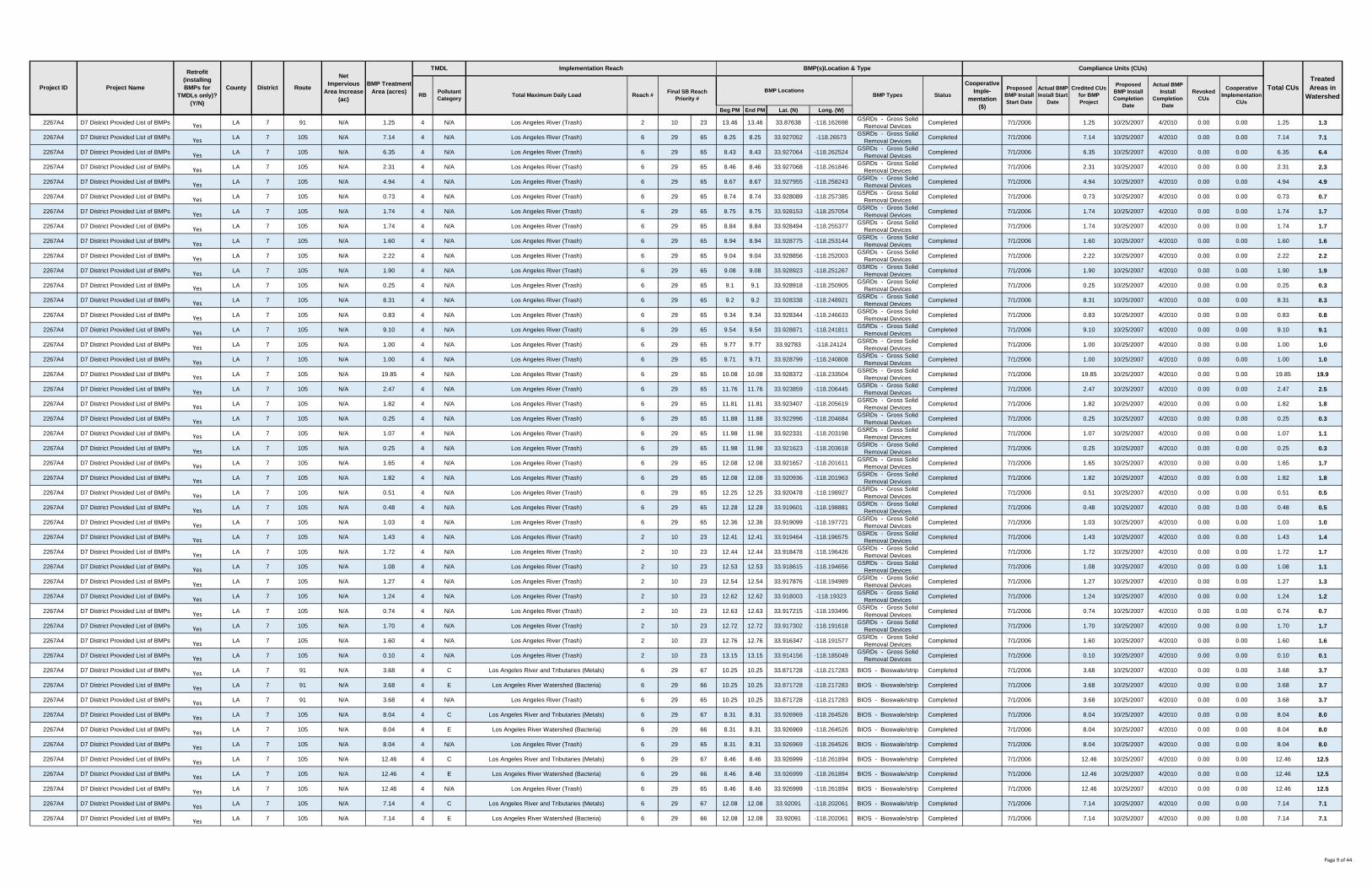
Beg PM End PM Lat. (N) Long. (W)
RouteProject ID Project Name
Retrofit (installing BMPs for
TMDLs only)? (Y/N)
County District Credited CUs for BMP Project
Proposed BMP Install Completion
Date
Actual BMP Install
Completion Date
Net Impervious
Area Increase (ac)
BMP Treatment Area (acres)
TMDL Implementation Reach BMP(s)Location & Type
BMP LocationsBMP Types Status
Revoked CUs
Total CUsTreated Areas in
WatershedRBPollutant Category
Total Maximum Daily Load Reach #Final SB Reach
Priority #
Compliance Units (CUs)
Cooperative Imple-
mentation ($)
Cooperative Implementation
CUs
Proposed BMP Install Start Date
Actual BMP Install Start
Date
2267A4 D7 District Provided List of BMPs Yes LA 7 91 N/A 1.25 4 N/A Los Angeles River (Trash) 2 10 23 13.46 13.46 33.87638 -118.162698GSRDs - Gross Solid
Removal DevicesCompleted 7/1/2006 1.25 10/25/2007 4/2010 0.00 0.00 1.25 1.3
2267A4 D7 District Provided List of BMPs Yes LA 7 105 N/A 7.14 4 N/A Los Angeles River (Trash) 6 29 65 8.25 8.25 33.927052 -118.26573GSRDs - Gross Solid
Removal DevicesCompleted 7/1/2006 7.14 10/25/2007 4/2010 0.00 0.00 7.14 7.1
2267A4 D7 District Provided List of BMPs Yes LA 7 105 N/A 6.35 4 N/A Los Angeles River (Trash) 6 29 65 8.43 8.43 33.927064 -118.262524GSRDs - Gross Solid
Removal DevicesCompleted 7/1/2006 6.35 10/25/2007 4/2010 0.00 0.00 6.35 6.4
2267A4 D7 District Provided List of BMPs Yes LA 7 105 N/A 2.31 4 N/A Los Angeles River (Trash) 6 29 65 8.46 8.46 33.927068 -118.261846GSRDs - Gross Solid
Removal DevicesCompleted 7/1/2006 2.31 10/25/2007 4/2010 0.00 0.00 2.31 2.3
2267A4 D7 District Provided List of BMPs Yes LA 7 105 N/A 4.94 4 N/A Los Angeles River (Trash) 6 29 65 8.67 8.67 33.927955 -118.258243GSRDs - Gross Solid
Removal DevicesCompleted 7/1/2006 4.94 10/25/2007 4/2010 0.00 0.00 4.94 4.9
2267A4 D7 District Provided List of BMPs Yes LA 7 105 N/A 0.73 4 N/A Los Angeles River (Trash) 6 29 65 8.74 8.74 33.928089 -118.257385GSRDs - Gross Solid
Removal DevicesCompleted 7/1/2006 0.73 10/25/2007 4/2010 0.00 0.00 0.73 0.7
2267A4 D7 District Provided List of BMPs Yes LA 7 105 N/A 1.74 4 N/A Los Angeles River (Trash) 6 29 65 8.75 8.75 33.928153 -118.257054GSRDs - Gross Solid
Removal DevicesCompleted 7/1/2006 1.74 10/25/2007 4/2010 0.00 0.00 1.74 1.7
2267A4 D7 District Provided List of BMPs Yes LA 7 105 N/A 1.74 4 N/A Los Angeles River (Trash) 6 29 65 8.84 8.84 33.928494 -118.255377GSRDs - Gross Solid
Removal DevicesCompleted 7/1/2006 1.74 10/25/2007 4/2010 0.00 0.00 1.74 1.7
2267A4 D7 District Provided List of BMPs Yes LA 7 105 N/A 1.60 4 N/A Los Angeles River (Trash) 6 29 65 8.94 8.94 33.928775 -118.253144GSRDs - Gross Solid
Removal DevicesCompleted 7/1/2006 1.60 10/25/2007 4/2010 0.00 0.00 1.60 1.6
2267A4 D7 District Provided List of BMPs Yes LA 7 105 N/A 2.22 4 N/A Los Angeles River (Trash) 6 29 65 9.04 9.04 33.928856 -118.252003GSRDs - Gross Solid
Removal DevicesCompleted 7/1/2006 2.22 10/25/2007 4/2010 0.00 0.00 2.22 2.2
2267A4 D7 District Provided List of BMPs Yes LA 7 105 N/A 1.90 4 N/A Los Angeles River (Trash) 6 29 65 9.08 9.08 33.928923 -118.251267GSRDs - Gross Solid
Removal DevicesCompleted 7/1/2006 1.90 10/25/2007 4/2010 0.00 0.00 1.90 1.9
2267A4 D7 District Provided List of BMPs Yes LA 7 105 N/A 0.25 4 N/A Los Angeles River (Trash) 6 29 65 9.1 9.1 33.928918 -118.250905GSRDs - Gross Solid
Removal DevicesCompleted 7/1/2006 0.25 10/25/2007 4/2010 0.00 0.00 0.25 0.3
2267A4 D7 District Provided List of BMPs Yes LA 7 105 N/A 8.31 4 N/A Los Angeles River (Trash) 6 29 65 9.2 9.2 33.928338 -118.248921GSRDs - Gross Solid
Removal DevicesCompleted 7/1/2006 8.31 10/25/2007 4/2010 0.00 0.00 8.31 8.3
2267A4 D7 District Provided List of BMPs Yes LA 7 105 N/A 0.83 4 N/A Los Angeles River (Trash) 6 29 65 9.34 9.34 33.928344 -118.246633GSRDs - Gross Solid
Removal DevicesCompleted 7/1/2006 0.83 10/25/2007 4/2010 0.00 0.00 0.83 0.8
2267A4 D7 District Provided List of BMPs Yes LA 7 105 N/A 9.10 4 N/A Los Angeles River (Trash) 6 29 65 9.54 9.54 33.928871 -118.241811GSRDs - Gross Solid
Removal DevicesCompleted 7/1/2006 9.10 10/25/2007 4/2010 0.00 0.00 9.10 9.1
2267A4 D7 District Provided List of BMPs Yes LA 7 105 N/A 1.00 4 N/A Los Angeles River (Trash) 6 29 65 9.77 9.77 33.92783 -118.24124GSRDs - Gross Solid
Removal DevicesCompleted 7/1/2006 1.00 10/25/2007 4/2010 0.00 0.00 1.00 1.0
2267A4 D7 District Provided List of BMPs Yes LA 7 105 N/A 1.00 4 N/A Los Angeles River (Trash) 6 29 65 9.71 9.71 33.928799 -118.240808GSRDs - Gross Solid
Removal DevicesCompleted 7/1/2006 1.00 10/25/2007 4/2010 0.00 0.00 1.00 1.0
2267A4 D7 District Provided List of BMPs Yes LA 7 105 N/A 19.85 4 N/A Los Angeles River (Trash) 6 29 65 10.08 10.08 33.928372 -118.233504GSRDs - Gross Solid
Removal DevicesCompleted 7/1/2006 19.85 10/25/2007 4/2010 0.00 0.00 19.85 19.9
2267A4 D7 District Provided List of BMPs Yes LA 7 105 N/A 2.47 4 N/A Los Angeles River (Trash) 6 29 65 11.76 11.76 33.923859 -118.206445GSRDs - Gross Solid
Removal DevicesCompleted 7/1/2006 2.47 10/25/2007 4/2010 0.00 0.00 2.47 2.5
2267A4 D7 District Provided List of BMPs Yes LA 7 105 N/A 1.82 4 N/A Los Angeles River (Trash) 6 29 65 11.81 11.81 33.923407 -118.205619GSRDs - Gross Solid
Removal DevicesCompleted 7/1/2006 1.82 10/25/2007 4/2010 0.00 0.00 1.82 1.8
2267A4 D7 District Provided List of BMPs Yes LA 7 105 N/A 0.25 4 N/A Los Angeles River (Trash) 6 29 65 11.88 11.88 33.922996 -118.204684GSRDs - Gross Solid
Removal DevicesCompleted 7/1/2006 0.25 10/25/2007 4/2010 0.00 0.00 0.25 0.3
2267A4 D7 District Provided List of BMPs Yes LA 7 105 N/A 1.07 4 N/A Los Angeles River (Trash) 6 29 65 11.98 11.98 33.922331 -118.203198GSRDs - Gross Solid
Removal DevicesCompleted 7/1/2006 1.07 10/25/2007 4/2010 0.00 0.00 1.07 1.1
2267A4 D7 District Provided List of BMPs Yes LA 7 105 N/A 0.25 4 N/A Los Angeles River (Trash) 6 29 65 11.98 11.98 33.921623 -118.203618GSRDs - Gross Solid
Removal DevicesCompleted 7/1/2006 0.25 10/25/2007 4/2010 0.00 0.00 0.25 0.3
2267A4 D7 District Provided List of BMPs Yes LA 7 105 N/A 1.65 4 N/A Los Angeles River (Trash) 6 29 65 12.08 12.08 33.921657 -118.201611GSRDs - Gross Solid
Removal DevicesCompleted 7/1/2006 1.65 10/25/2007 4/2010 0.00 0.00 1.65 1.7
2267A4 D7 District Provided List of BMPs Yes LA 7 105 N/A 1.82 4 N/A Los Angeles River (Trash) 6 29 65 12.08 12.08 33.920936 -118.201963GSRDs - Gross Solid
Removal DevicesCompleted 7/1/2006 1.82 10/25/2007 4/2010 0.00 0.00 1.82 1.8
2267A4 D7 District Provided List of BMPs Yes LA 7 105 N/A 0.51 4 N/A Los Angeles River (Trash) 6 29 65 12.25 12.25 33.920478 -118.198927GSRDs - Gross Solid
Removal DevicesCompleted 7/1/2006 0.51 10/25/2007 4/2010 0.00 0.00 0.51 0.5
2267A4 D7 District Provided List of BMPs Yes LA 7 105 N/A 0.48 4 N/A Los Angeles River (Trash) 6 29 65 12.28 12.28 33.919601 -118.198881GSRDs - Gross Solid
Removal DevicesCompleted 7/1/2006 0.48 10/25/2007 4/2010 0.00 0.00 0.48 0.5
2267A4 D7 District Provided List of BMPs Yes LA 7 105 N/A 1.03 4 N/A Los Angeles River (Trash) 6 29 65 12.36 12.36 33.919099 -118.197721GSRDs - Gross Solid
Removal DevicesCompleted 7/1/2006 1.03 10/25/2007 4/2010 0.00 0.00 1.03 1.0
2267A4 D7 District Provided List of BMPs Yes LA 7 105 N/A 1.43 4 N/A Los Angeles River (Trash) 2 10 23 12.41 12.41 33.919464 -118.196575GSRDs - Gross Solid
Removal DevicesCompleted 7/1/2006 1.43 10/25/2007 4/2010 0.00 0.00 1.43 1.4
2267A4 D7 District Provided List of BMPs Yes LA 7 105 N/A 1.72 4 N/A Los Angeles River (Trash) 2 10 23 12.44 12.44 33.918478 -118.196426GSRDs - Gross Solid
Removal DevicesCompleted 7/1/2006 1.72 10/25/2007 4/2010 0.00 0.00 1.72 1.7
2267A4 D7 District Provided List of BMPs Yes LA 7 105 N/A 1.08 4 N/A Los Angeles River (Trash) 2 10 23 12.53 12.53 33.918615 -118.194656GSRDs - Gross Solid
Removal DevicesCompleted 7/1/2006 1.08 10/25/2007 4/2010 0.00 0.00 1.08 1.1
2267A4 D7 District Provided List of BMPs Yes LA 7 105 N/A 1.27 4 N/A Los Angeles River (Trash) 2 10 23 12.54 12.54 33.917876 -118.194989GSRDs - Gross Solid
Removal DevicesCompleted 7/1/2006 1.27 10/25/2007 4/2010 0.00 0.00 1.27 1.3
2267A4 D7 District Provided List of BMPs Yes LA 7 105 N/A 1.24 4 N/A Los Angeles River (Trash) 2 10 23 12.62 12.62 33.918003 -118.19323GSRDs - Gross Solid
Removal DevicesCompleted 7/1/2006 1.24 10/25/2007 4/2010 0.00 0.00 1.24 1.2
2267A4 D7 District Provided List of BMPs Yes LA 7 105 N/A 0.74 4 N/A Los Angeles River (Trash) 2 10 23 12.63 12.63 33.917215 -118.193496GSRDs - Gross Solid
Removal DevicesCompleted 7/1/2006 0.74 10/25/2007 4/2010 0.00 0.00 0.74 0.7
2267A4 D7 District Provided List of BMPs Yes LA 7 105 N/A 1.70 4 N/A Los Angeles River (Trash) 2 10 23 12.72 12.72 33.917302 -118.191618GSRDs - Gross Solid
Removal DevicesCompleted 7/1/2006 1.70 10/25/2007 4/2010 0.00 0.00 1.70 1.7
2267A4 D7 District Provided List of BMPs Yes LA 7 105 N/A 1.60 4 N/A Los Angeles River (Trash) 2 10 23 12.76 12.76 33.916347 -118.191577GSRDs - Gross Solid
Removal DevicesCompleted 7/1/2006 1.60 10/25/2007 4/2010 0.00 0.00 1.60 1.6
2267A4 D7 District Provided List of BMPs Yes LA 7 105 N/A 0.10 4 N/A Los Angeles River (Trash) 2 10 23 13.15 13.15 33.914156 -118.185049GSRDs - Gross Solid
Removal DevicesCompleted 7/1/2006 0.10 10/25/2007 4/2010 0.00 0.00 0.10 0.1
2267A4 D7 District Provided List of BMPs Yes LA 7 91 N/A 3.68 4 C Los Angeles River and Tributaries (Metals) 6 29 67 10.25 10.25 33.871728 -118.217283 BIOS - Bioswale/strip Completed 7/1/2006 3.68 10/25/2007 4/2010 0.00 0.00 3.68 3.7
2267A4 D7 District Provided List of BMPs Yes LA 7 91 N/A 3.68 4 E Los Angeles River Watershed (Bacteria) 6 29 66 10.25 10.25 33.871728 -118.217283 BIOS - Bioswale/strip Completed 7/1/2006 3.68 10/25/2007 4/2010 0.00 0.00 3.68 3.7
2267A4 D7 District Provided List of BMPs Yes LA 7 91 N/A 3.68 4 N/A Los Angeles River (Trash) 6 29 65 10.25 10.25 33.871728 -118.217283 BIOS - Bioswale/strip Completed 7/1/2006 3.68 10/25/2007 4/2010 0.00 0.00 3.68 3.7
2267A4 D7 District Provided List of BMPs Yes LA 7 105 N/A 8.04 4 C Los Angeles River and Tributaries (Metals) 6 29 67 8.31 8.31 33.926969 -118.264526 BIOS - Bioswale/strip Completed 7/1/2006 8.04 10/25/2007 4/2010 0.00 0.00 8.04 8.0
2267A4 D7 District Provided List of BMPs Yes LA 7 105 N/A 8.04 4 E Los Angeles River Watershed (Bacteria) 6 29 66 8.31 8.31 33.926969 -118.264526 BIOS - Bioswale/strip Completed 7/1/2006 8.04 10/25/2007 4/2010 0.00 0.00 8.04 8.0
2267A4 D7 District Provided List of BMPs Yes LA 7 105 N/A 8.04 4 N/A Los Angeles River (Trash) 6 29 65 8.31 8.31 33.926969 -118.264526 BIOS - Bioswale/strip Completed 7/1/2006 8.04 10/25/2007 4/2010 0.00 0.00 8.04 8.0
2267A4 D7 District Provided List of BMPs Yes LA 7 105 N/A 12.46 4 C Los Angeles River and Tributaries (Metals) 6 29 67 8.46 8.46 33.926999 -118.261894 BIOS - Bioswale/strip Completed 7/1/2006 12.46 10/25/2007 4/2010 0.00 0.00 12.46 12.5
2267A4 D7 District Provided List of BMPs Yes LA 7 105 N/A 12.46 4 E Los Angeles River Watershed (Bacteria) 6 29 66 8.46 8.46 33.926999 -118.261894 BIOS - Bioswale/strip Completed 7/1/2006 12.46 10/25/2007 4/2010 0.00 0.00 12.46 12.5
2267A4 D7 District Provided List of BMPs Yes LA 7 105 N/A 12.46 4 N/A Los Angeles River (Trash) 6 29 65 8.46 8.46 33.926999 -118.261894 BIOS - Bioswale/strip Completed 7/1/2006 12.46 10/25/2007 4/2010 0.00 0.00 12.46 12.5
2267A4 D7 District Provided List of BMPs Yes LA 7 105 N/A 7.14 4 C Los Angeles River and Tributaries (Metals) 6 29 67 12.08 12.08 33.92091 -118.202061 BIOS - Bioswale/strip Completed 7/1/2006 7.14 10/25/2007 4/2010 0.00 0.00 7.14 7.1
2267A4 D7 District Provided List of BMPs Yes LA 7 105 N/A 7.14 4 E Los Angeles River Watershed (Bacteria) 6 29 66 12.08 12.08 33.92091 -118.202061 BIOS - Bioswale/strip Completed 7/1/2006 7.14 10/25/2007 4/2010 0.00 0.00 7.14 7.1
Page 9 of 44
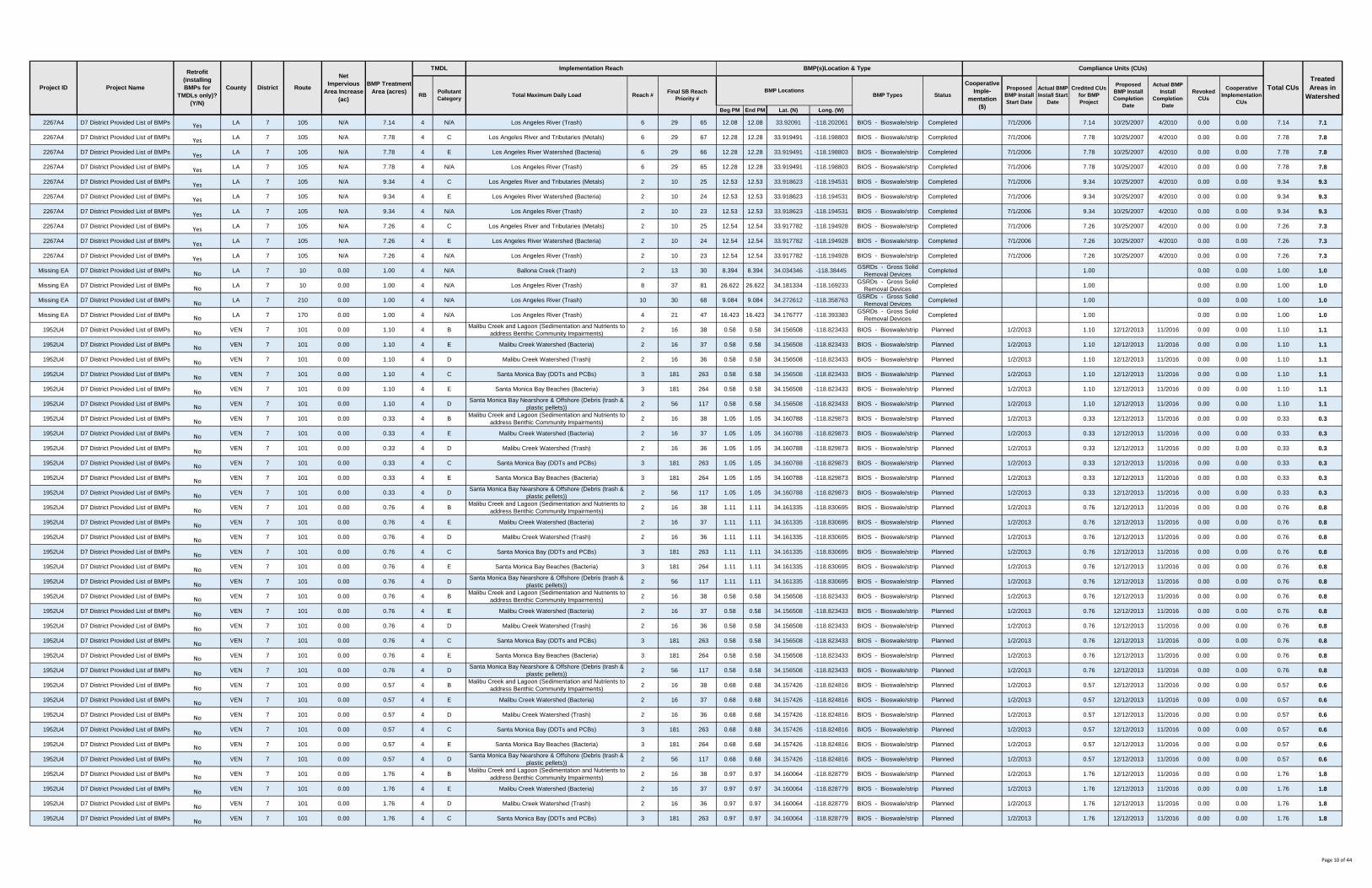
Beg PM End PM Lat. (N) Long. (W)
RouteProject ID Project Name
Retrofit (installing BMPs for
TMDLs only)? (Y/N)
County District Credited CUs for BMP Project
Proposed BMP Install Completion
Date
Actual BMP Install
Completion Date
Net Impervious
Area Increase (ac)
BMP Treatment Area (acres)
TMDL Implementation Reach BMP(s)Location & Type
BMP LocationsBMP Types Status
Revoked CUs
Total CUsTreated Areas in
WatershedRBPollutant Category
Total Maximum Daily Load Reach #Final SB Reach
Priority #
Compliance Units (CUs)
Cooperative Imple-
mentation ($)
Cooperative Implementation
CUs
Proposed BMP Install Start Date
Actual BMP Install Start
Date
2267A4 D7 District Provided List of BMPs Yes LA 7 105 N/A 7.14 4 N/A Los Angeles River (Trash) 6 29 65 12.08 12.08 33.92091 -118.202061 BIOS - Bioswale/strip Completed 7/1/2006 7.14 10/25/2007 4/2010 0.00 0.00 7.14 7.1
2267A4 D7 District Provided List of BMPs Yes LA 7 105 N/A 7.78 4 C Los Angeles River and Tributaries (Metals) 6 29 67 12.28 12.28 33.919491 -118.198803 BIOS - Bioswale/strip Completed 7/1/2006 7.78 10/25/2007 4/2010 0.00 0.00 7.78 7.8
2267A4 D7 District Provided List of BMPs Yes LA 7 105 N/A 7.78 4 E Los Angeles River Watershed (Bacteria) 6 29 66 12.28 12.28 33.919491 -118.198803 BIOS - Bioswale/strip Completed 7/1/2006 7.78 10/25/2007 4/2010 0.00 0.00 7.78 7.8
2267A4 D7 District Provided List of BMPs Yes LA 7 105 N/A 7.78 4 N/A Los Angeles River (Trash) 6 29 65 12.28 12.28 33.919491 -118.198803 BIOS - Bioswale/strip Completed 7/1/2006 7.78 10/25/2007 4/2010 0.00 0.00 7.78 7.8
2267A4 D7 District Provided List of BMPs Yes LA 7 105 N/A 9.34 4 C Los Angeles River and Tributaries (Metals) 2 10 25 12.53 12.53 33.918623 -118.194531 BIOS - Bioswale/strip Completed 7/1/2006 9.34 10/25/2007 4/2010 0.00 0.00 9.34 9.3
2267A4 D7 District Provided List of BMPs Yes LA 7 105 N/A 9.34 4 E Los Angeles River Watershed (Bacteria) 2 10 24 12.53 12.53 33.918623 -118.194531 BIOS - Bioswale/strip Completed 7/1/2006 9.34 10/25/2007 4/2010 0.00 0.00 9.34 9.3
2267A4 D7 District Provided List of BMPs Yes LA 7 105 N/A 9.34 4 N/A Los Angeles River (Trash) 2 10 23 12.53 12.53 33.918623 -118.194531 BIOS - Bioswale/strip Completed 7/1/2006 9.34 10/25/2007 4/2010 0.00 0.00 9.34 9.3
2267A4 D7 District Provided List of BMPs Yes LA 7 105 N/A 7.26 4 C Los Angeles River and Tributaries (Metals) 2 10 25 12.54 12.54 33.917782 -118.194928 BIOS - Bioswale/strip Completed 7/1/2006 7.26 10/25/2007 4/2010 0.00 0.00 7.26 7.3
2267A4 D7 District Provided List of BMPs Yes LA 7 105 N/A 7.26 4 E Los Angeles River Watershed (Bacteria) 2 10 24 12.54 12.54 33.917782 -118.194928 BIOS - Bioswale/strip Completed 7/1/2006 7.26 10/25/2007 4/2010 0.00 0.00 7.26 7.3
2267A4 D7 District Provided List of BMPs Yes LA 7 105 N/A 7.26 4 N/A Los Angeles River (Trash) 2 10 23 12.54 12.54 33.917782 -118.194928 BIOS - Bioswale/strip Completed 7/1/2006 7.26 10/25/2007 4/2010 0.00 0.00 7.26 7.3
Missing EA D7 District Provided List of BMPs No LA 7 10 0.00 1.00 4 N/A Ballona Creek (Trash) 2 13 30 8.394 8.394 34.034346 -118.38445GSRDs - Gross Solid
Removal DevicesCompleted 1.00 0.00 0.00 1.00 1.0
Missing EA D7 District Provided List of BMPs No LA 7 10 0.00 1.00 4 N/A Los Angeles River (Trash) 8 37 81 26.622 26.622 34.181334 -118.169233GSRDs - Gross Solid
Removal DevicesCompleted 1.00 0.00 0.00 1.00 1.0
Missing EA D7 District Provided List of BMPs No LA 7 210 0.00 1.00 4 N/A Los Angeles River (Trash) 10 30 68 9.084 9.084 34.272612 -118.358763GSRDs - Gross Solid
Removal DevicesCompleted 1.00 0.00 0.00 1.00 1.0
Missing EA D7 District Provided List of BMPs No LA 7 170 0.00 1.00 4 N/A Los Angeles River (Trash) 4 21 47 16.423 16.423 34.176777 -118.393383GSRDs - Gross Solid
Removal DevicesCompleted 1.00 0.00 0.00 1.00 1.0
1952U4 D7 District Provided List of BMPs No VEN 7 101 0.00 1.10 4 BMalibu Creek and Lagoon (Sedimentation and Nutrients to
address Benthic Community Impairments)2 16 38 0.58 0.58 34.156508 -118.823433 BIOS - Bioswale/strip Planned 1/2/2013 1.10 12/12/2013 11/2016 0.00 0.00 1.10 1.1
1952U4 D7 District Provided List of BMPs No VEN 7 101 0.00 1.10 4 E Malibu Creek Watershed (Bacteria) 2 16 37 0.58 0.58 34.156508 -118.823433 BIOS - Bioswale/strip Planned 1/2/2013 1.10 12/12/2013 11/2016 0.00 0.00 1.10 1.1
1952U4 D7 District Provided List of BMPs No VEN 7 101 0.00 1.10 4 D Malibu Creek Watershed (Trash) 2 16 36 0.58 0.58 34.156508 -118.823433 BIOS - Bioswale/strip Planned 1/2/2013 1.10 12/12/2013 11/2016 0.00 0.00 1.10 1.1
1952U4 D7 District Provided List of BMPs No VEN 7 101 0.00 1.10 4 C Santa Monica Bay (DDTs and PCBs) 3 181 263 0.58 0.58 34.156508 -118.823433 BIOS - Bioswale/strip Planned 1/2/2013 1.10 12/12/2013 11/2016 0.00 0.00 1.10 1.1
1952U4 D7 District Provided List of BMPs No VEN 7 101 0.00 1.10 4 E Santa Monica Bay Beaches (Bacteria) 3 181 264 0.58 0.58 34.156508 -118.823433 BIOS - Bioswale/strip Planned 1/2/2013 1.10 12/12/2013 11/2016 0.00 0.00 1.10 1.1
1952U4 D7 District Provided List of BMPs No VEN 7 101 0.00 1.10 4 DSanta Monica Bay Nearshore & Offshore (Debris (trash &
plastic pellets))2 56 117 0.58 0.58 34.156508 -118.823433 BIOS - Bioswale/strip Planned 1/2/2013 1.10 12/12/2013 11/2016 0.00 0.00 1.10 1.1
1952U4 D7 District Provided List of BMPs No VEN 7 101 0.00 0.33 4 BMalibu Creek and Lagoon (Sedimentation and Nutrients to
address Benthic Community Impairments)2 16 38 1.05 1.05 34.160788 -118.829873 BIOS - Bioswale/strip Planned 1/2/2013 0.33 12/12/2013 11/2016 0.00 0.00 0.33 0.3
1952U4 D7 District Provided List of BMPs No VEN 7 101 0.00 0.33 4 E Malibu Creek Watershed (Bacteria) 2 16 37 1.05 1.05 34.160788 -118.829873 BIOS - Bioswale/strip Planned 1/2/2013 0.33 12/12/2013 11/2016 0.00 0.00 0.33 0.3
1952U4 D7 District Provided List of BMPs No VEN 7 101 0.00 0.33 4 D Malibu Creek Watershed (Trash) 2 16 36 1.05 1.05 34.160788 -118.829873 BIOS - Bioswale/strip Planned 1/2/2013 0.33 12/12/2013 11/2016 0.00 0.00 0.33 0.3
1952U4 D7 District Provided List of BMPs No VEN 7 101 0.00 0.33 4 C Santa Monica Bay (DDTs and PCBs) 3 181 263 1.05 1.05 34.160788 -118.829873 BIOS - Bioswale/strip Planned 1/2/2013 0.33 12/12/2013 11/2016 0.00 0.00 0.33 0.3
1952U4 D7 District Provided List of BMPs No VEN 7 101 0.00 0.33 4 E Santa Monica Bay Beaches (Bacteria) 3 181 264 1.05 1.05 34.160788 -118.829873 BIOS - Bioswale/strip Planned 1/2/2013 0.33 12/12/2013 11/2016 0.00 0.00 0.33 0.3
1952U4 D7 District Provided List of BMPs No VEN 7 101 0.00 0.33 4 DSanta Monica Bay Nearshore & Offshore (Debris (trash &
plastic pellets))2 56 117 1.05 1.05 34.160788 -118.829873 BIOS - Bioswale/strip Planned 1/2/2013 0.33 12/12/2013 11/2016 0.00 0.00 0.33 0.3
1952U4 D7 District Provided List of BMPs No VEN 7 101 0.00 0.76 4 BMalibu Creek and Lagoon (Sedimentation and Nutrients to
address Benthic Community Impairments)2 16 38 1.11 1.11 34.161335 -118.830695 BIOS - Bioswale/strip Planned 1/2/2013 0.76 12/12/2013 11/2016 0.00 0.00 0.76 0.8
1952U4 D7 District Provided List of BMPs No VEN 7 101 0.00 0.76 4 E Malibu Creek Watershed (Bacteria) 2 16 37 1.11 1.11 34.161335 -118.830695 BIOS - Bioswale/strip Planned 1/2/2013 0.76 12/12/2013 11/2016 0.00 0.00 0.76 0.8
1952U4 D7 District Provided List of BMPs No VEN 7 101 0.00 0.76 4 D Malibu Creek Watershed (Trash) 2 16 36 1.11 1.11 34.161335 -118.830695 BIOS - Bioswale/strip Planned 1/2/2013 0.76 12/12/2013 11/2016 0.00 0.00 0.76 0.8
1952U4 D7 District Provided List of BMPs No VEN 7 101 0.00 0.76 4 C Santa Monica Bay (DDTs and PCBs) 3 181 263 1.11 1.11 34.161335 -118.830695 BIOS - Bioswale/strip Planned 1/2/2013 0.76 12/12/2013 11/2016 0.00 0.00 0.76 0.8
1952U4 D7 District Provided List of BMPs No VEN 7 101 0.00 0.76 4 E Santa Monica Bay Beaches (Bacteria) 3 181 264 1.11 1.11 34.161335 -118.830695 BIOS - Bioswale/strip Planned 1/2/2013 0.76 12/12/2013 11/2016 0.00 0.00 0.76 0.8
1952U4 D7 District Provided List of BMPs No VEN 7 101 0.00 0.76 4 DSanta Monica Bay Nearshore & Offshore (Debris (trash &
plastic pellets))2 56 117 1.11 1.11 34.161335 -118.830695 BIOS - Bioswale/strip Planned 1/2/2013 0.76 12/12/2013 11/2016 0.00 0.00 0.76 0.8
1952U4 D7 District Provided List of BMPs No VEN 7 101 0.00 0.76 4 BMalibu Creek and Lagoon (Sedimentation and Nutrients to
address Benthic Community Impairments)2 16 38 0.58 0.58 34.156508 -118.823433 BIOS - Bioswale/strip Planned 1/2/2013 0.76 12/12/2013 11/2016 0.00 0.00 0.76 0.8
1952U4 D7 District Provided List of BMPs No VEN 7 101 0.00 0.76 4 E Malibu Creek Watershed (Bacteria) 2 16 37 0.58 0.58 34.156508 -118.823433 BIOS - Bioswale/strip Planned 1/2/2013 0.76 12/12/2013 11/2016 0.00 0.00 0.76 0.8
1952U4 D7 District Provided List of BMPs No VEN 7 101 0.00 0.76 4 D Malibu Creek Watershed (Trash) 2 16 36 0.58 0.58 34.156508 -118.823433 BIOS - Bioswale/strip Planned 1/2/2013 0.76 12/12/2013 11/2016 0.00 0.00 0.76 0.8
1952U4 D7 District Provided List of BMPs No VEN 7 101 0.00 0.76 4 C Santa Monica Bay (DDTs and PCBs) 3 181 263 0.58 0.58 34.156508 -118.823433 BIOS - Bioswale/strip Planned 1/2/2013 0.76 12/12/2013 11/2016 0.00 0.00 0.76 0.8
1952U4 D7 District Provided List of BMPs No VEN 7 101 0.00 0.76 4 E Santa Monica Bay Beaches (Bacteria) 3 181 264 0.58 0.58 34.156508 -118.823433 BIOS - Bioswale/strip Planned 1/2/2013 0.76 12/12/2013 11/2016 0.00 0.00 0.76 0.8
1952U4 D7 District Provided List of BMPs No VEN 7 101 0.00 0.76 4 DSanta Monica Bay Nearshore & Offshore (Debris (trash &
plastic pellets))2 56 117 0.58 0.58 34.156508 -118.823433 BIOS - Bioswale/strip Planned 1/2/2013 0.76 12/12/2013 11/2016 0.00 0.00 0.76 0.8
1952U4 D7 District Provided List of BMPs No VEN 7 101 0.00 0.57 4 BMalibu Creek and Lagoon (Sedimentation and Nutrients to
address Benthic Community Impairments)2 16 38 0.68 0.68 34.157426 -118.824816 BIOS - Bioswale/strip Planned 1/2/2013 0.57 12/12/2013 11/2016 0.00 0.00 0.57 0.6
1952U4 D7 District Provided List of BMPs No VEN 7 101 0.00 0.57 4 E Malibu Creek Watershed (Bacteria) 2 16 37 0.68 0.68 34.157426 -118.824816 BIOS - Bioswale/strip Planned 1/2/2013 0.57 12/12/2013 11/2016 0.00 0.00 0.57 0.6
1952U4 D7 District Provided List of BMPs No VEN 7 101 0.00 0.57 4 D Malibu Creek Watershed (Trash) 2 16 36 0.68 0.68 34.157426 -118.824816 BIOS - Bioswale/strip Planned 1/2/2013 0.57 12/12/2013 11/2016 0.00 0.00 0.57 0.6
1952U4 D7 District Provided List of BMPs No VEN 7 101 0.00 0.57 4 C Santa Monica Bay (DDTs and PCBs) 3 181 263 0.68 0.68 34.157426 -118.824816 BIOS - Bioswale/strip Planned 1/2/2013 0.57 12/12/2013 11/2016 0.00 0.00 0.57 0.6
1952U4 D7 District Provided List of BMPs No VEN 7 101 0.00 0.57 4 E Santa Monica Bay Beaches (Bacteria) 3 181 264 0.68 0.68 34.157426 -118.824816 BIOS - Bioswale/strip Planned 1/2/2013 0.57 12/12/2013 11/2016 0.00 0.00 0.57 0.6
1952U4 D7 District Provided List of BMPs No VEN 7 101 0.00 0.57 4 DSanta Monica Bay Nearshore & Offshore (Debris (trash &
plastic pellets))2 56 117 0.68 0.68 34.157426 -118.824816 BIOS - Bioswale/strip Planned 1/2/2013 0.57 12/12/2013 11/2016 0.00 0.00 0.57 0.6
1952U4 D7 District Provided List of BMPs No VEN 7 101 0.00 1.76 4 BMalibu Creek and Lagoon (Sedimentation and Nutrients to
address Benthic Community Impairments)2 16 38 0.97 0.97 34.160064 -118.828779 BIOS - Bioswale/strip Planned 1/2/2013 1.76 12/12/2013 11/2016 0.00 0.00 1.76 1.8
1952U4 D7 District Provided List of BMPs No VEN 7 101 0.00 1.76 4 E Malibu Creek Watershed (Bacteria) 2 16 37 0.97 0.97 34.160064 -118.828779 BIOS - Bioswale/strip Planned 1/2/2013 1.76 12/12/2013 11/2016 0.00 0.00 1.76 1.8
1952U4 D7 District Provided List of BMPs No VEN 7 101 0.00 1.76 4 D Malibu Creek Watershed (Trash) 2 16 36 0.97 0.97 34.160064 -118.828779 BIOS - Bioswale/strip Planned 1/2/2013 1.76 12/12/2013 11/2016 0.00 0.00 1.76 1.8
1952U4 D7 District Provided List of BMPs No VEN 7 101 0.00 1.76 4 C Santa Monica Bay (DDTs and PCBs) 3 181 263 0.97 0.97 34.160064 -118.828779 BIOS - Bioswale/strip Planned 1/2/2013 1.76 12/12/2013 11/2016 0.00 0.00 1.76 1.8
Page 10 of 44
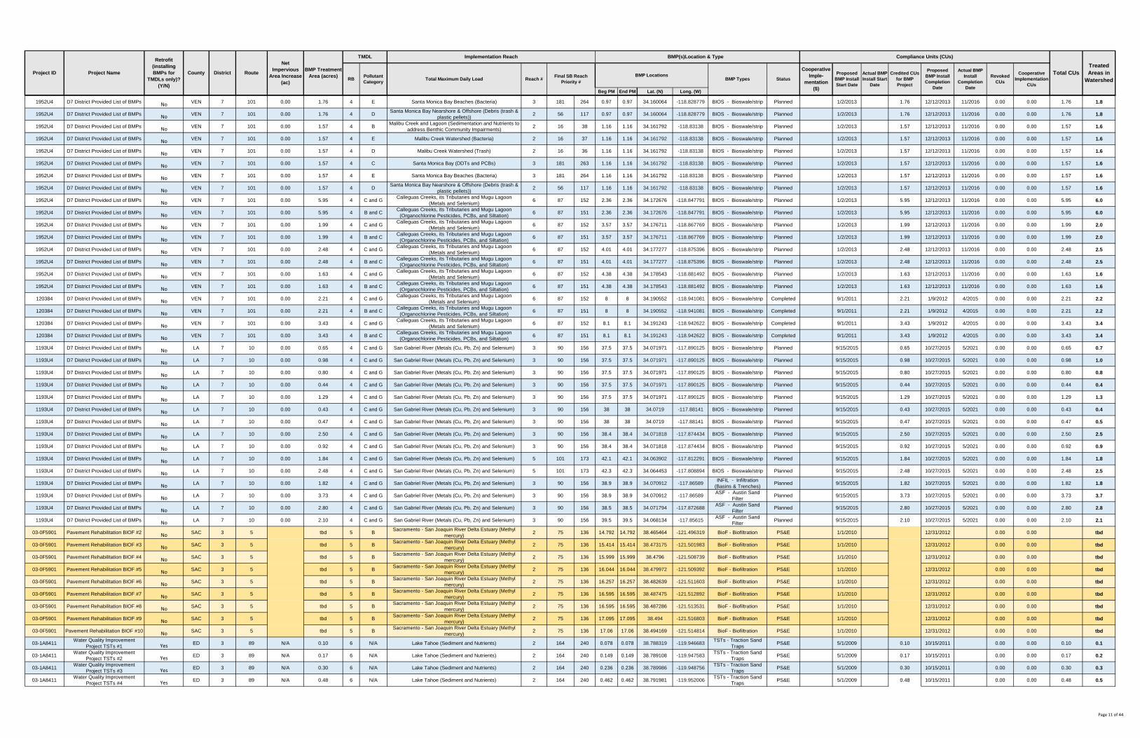
Beg PM End PM Lat. (N) Long. (W)
RouteProject ID Project Name
Retrofit (installing BMPs for
TMDLs only)? (Y/N)
County District Credited CUs for BMP Project
Proposed BMP Install Completion
Date
Actual BMP Install
Completion Date
Net Impervious
Area Increase (ac)
BMP Treatment Area (acres)
TMDL Implementation Reach BMP(s)Location & Type
BMP LocationsBMP Types Status
Revoked CUs
Total CUsTreated Areas in
WatershedRBPollutant Category
Total Maximum Daily Load Reach #Final SB Reach
Priority #
Compliance Units (CUs)
Cooperative Imple-
mentation ($)
Cooperative Implementation
CUs
Proposed BMP Install Start Date
Actual BMP Install Start
Date
1952U4 D7 District Provided List of BMPs No VEN 7 101 0.00 1.76 4 E Santa Monica Bay Beaches (Bacteria) 3 181 264 0.97 0.97 34.160064 -118.828779 BIOS - Bioswale/strip Planned 1/2/2013 1.76 12/12/2013 11/2016 0.00 0.00 1.76 1.8
1952U4 D7 District Provided List of BMPs No VEN 7 101 0.00 1.76 4 DSanta Monica Bay Nearshore & Offshore (Debris (trash &
plastic pellets))2 56 117 0.97 0.97 34.160064 -118.828779 BIOS - Bioswale/strip Planned 1/2/2013 1.76 12/12/2013 11/2016 0.00 0.00 1.76 1.8
1952U4 D7 District Provided List of BMPs No VEN 7 101 0.00 1.57 4 BMalibu Creek and Lagoon (Sedimentation and Nutrients to
address Benthic Community Impairments)2 16 38 1.16 1.16 34.161792 -118.83138 BIOS - Bioswale/strip Planned 1/2/2013 1.57 12/12/2013 11/2016 0.00 0.00 1.57 1.6
1952U4 D7 District Provided List of BMPs No VEN 7 101 0.00 1.57 4 E Malibu Creek Watershed (Bacteria) 2 16 37 1.16 1.16 34.161792 -118.83138 BIOS - Bioswale/strip Planned 1/2/2013 1.57 12/12/2013 11/2016 0.00 0.00 1.57 1.6
1952U4 D7 District Provided List of BMPs No VEN 7 101 0.00 1.57 4 D Malibu Creek Watershed (Trash) 2 16 36 1.16 1.16 34.161792 -118.83138 BIOS - Bioswale/strip Planned 1/2/2013 1.57 12/12/2013 11/2016 0.00 0.00 1.57 1.6
1952U4 D7 District Provided List of BMPs No VEN 7 101 0.00 1.57 4 C Santa Monica Bay (DDTs and PCBs) 3 181 263 1.16 1.16 34.161792 -118.83138 BIOS - Bioswale/strip Planned 1/2/2013 1.57 12/12/2013 11/2016 0.00 0.00 1.57 1.6
1952U4 D7 District Provided List of BMPs No VEN 7 101 0.00 1.57 4 E Santa Monica Bay Beaches (Bacteria) 3 181 264 1.16 1.16 34.161792 -118.83138 BIOS - Bioswale/strip Planned 1/2/2013 1.57 12/12/2013 11/2016 0.00 0.00 1.57 1.6
1952U4 D7 District Provided List of BMPs No VEN 7 101 0.00 1.57 4 DSanta Monica Bay Nearshore & Offshore (Debris (trash &
plastic pellets))2 56 117 1.16 1.16 34.161792 -118.83138 BIOS - Bioswale/strip Planned 1/2/2013 1.57 12/12/2013 11/2016 0.00 0.00 1.57 1.6
1952U4 D7 District Provided List of BMPs No VEN 7 101 0.00 5.95 4 C and GCalleguas Creeks, its Tributaries and Mugu Lagoon
(Metals and Selenium)6 87 152 2.36 2.36 34.172676 -118.847791 BIOS - Bioswale/strip Planned 1/2/2013 5.95 12/12/2013 11/2016 0.00 0.00 5.95 6.0
1952U4 D7 District Provided List of BMPs No VEN 7 101 0.00 5.95 4 B and CCalleguas Creeks, its Tributaries and Mugu Lagoon
(Organochlorine Pesticides, PCBs, and Siltation)6 87 151 2.36 2.36 34.172676 -118.847791 BIOS - Bioswale/strip Planned 1/2/2013 5.95 12/12/2013 11/2016 0.00 0.00 5.95 6.0
1952U4 D7 District Provided List of BMPs No VEN 7 101 0.00 1.99 4 C and GCalleguas Creeks, its Tributaries and Mugu Lagoon
(Metals and Selenium)6 87 152 3.57 3.57 34.176711 -118.867769 BIOS - Bioswale/strip Planned 1/2/2013 1.99 12/12/2013 11/2016 0.00 0.00 1.99 2.0
1952U4 D7 District Provided List of BMPs No VEN 7 101 0.00 1.99 4 B and CCalleguas Creeks, its Tributaries and Mugu Lagoon
(Organochlorine Pesticides, PCBs, and Siltation)6 87 151 3.57 3.57 34.176711 -118.867769 BIOS - Bioswale/strip Planned 1/2/2013 1.99 12/12/2013 11/2016 0.00 0.00 1.99 2.0
1952U4 D7 District Provided List of BMPs No VEN 7 101 0.00 2.48 4 C and GCalleguas Creeks, its Tributaries and Mugu Lagoon
(Metals and Selenium)6 87 152 4.01 4.01 34.177277 -118.875396 BIOS - Bioswale/strip Planned 1/2/2013 2.48 12/12/2013 11/2016 0.00 0.00 2.48 2.5
1952U4 D7 District Provided List of BMPs No VEN 7 101 0.00 2.48 4 B and CCalleguas Creeks, its Tributaries and Mugu Lagoon
(Organochlorine Pesticides, PCBs, and Siltation)6 87 151 4.01 4.01 34.177277 -118.875396 BIOS - Bioswale/strip Planned 1/2/2013 2.48 12/12/2013 11/2016 0.00 0.00 2.48 2.5
1952U4 D7 District Provided List of BMPs No VEN 7 101 0.00 1.63 4 C and GCalleguas Creeks, its Tributaries and Mugu Lagoon
(Metals and Selenium)6 87 152 4.38 4.38 34.178543 -118.881492 BIOS - Bioswale/strip Planned 1/2/2013 1.63 12/12/2013 11/2016 0.00 0.00 1.63 1.6
1952U4 D7 District Provided List of BMPs No VEN 7 101 0.00 1.63 4 B and CCalleguas Creeks, its Tributaries and Mugu Lagoon
(Organochlorine Pesticides, PCBs, and Siltation)6 87 151 4.38 4.38 34.178543 -118.881492 BIOS - Bioswale/strip Planned 1/2/2013 1.63 12/12/2013 11/2016 0.00 0.00 1.63 1.6
120384 D7 District Provided List of BMPs No VEN 7 101 0.00 2.21 4 C and GCalleguas Creeks, its Tributaries and Mugu Lagoon
(Metals and Selenium)6 87 152 8 8 34.190552 -118.941081 BIOS - Bioswale/strip Completed 9/1/2011 2.21 1/9/2012 4/2015 0.00 0.00 2.21 2.2
120384 D7 District Provided List of BMPs No VEN 7 101 0.00 2.21 4 B and CCalleguas Creeks, its Tributaries and Mugu Lagoon
(Organochlorine Pesticides, PCBs, and Siltation)6 87 151 8 8 34.190552 -118.941081 BIOS - Bioswale/strip Completed 9/1/2011 2.21 1/9/2012 4/2015 0.00 0.00 2.21 2.2
120384 D7 District Provided List of BMPs No VEN 7 101 0.00 3.43 4 C and GCalleguas Creeks, its Tributaries and Mugu Lagoon
(Metals and Selenium)6 87 152 8.1 8.1 34.191243 -118.942622 BIOS - Bioswale/strip Completed 9/1/2011 3.43 1/9/2012 4/2015 0.00 0.00 3.43 3.4
120384 D7 District Provided List of BMPs No VEN 7 101 0.00 3.43 4 B and CCalleguas Creeks, its Tributaries and Mugu Lagoon
(Organochlorine Pesticides, PCBs, and Siltation)6 87 151 8.1 8.1 34.191243 -118.942622 BIOS - Bioswale/strip Completed 9/1/2011 3.43 1/9/2012 4/2015 0.00 0.00 3.43 3.4
1193U4 D7 District Provided List of BMPs No LA 7 10 0.00 0.65 4 C and G San Gabriel River (Metals (Cu, Pb, Zn) and Selenium) 3 90 156 37.5 37.5 34.071971 -117.890125 BIOS - Bioswale/strip Planned 9/15/2015 0.65 10/27/2015 5/2021 0.00 0.00 0.65 0.7
1193U4 D7 District Provided List of BMPs No LA 7 10 0.00 0.98 4 C and G San Gabriel River (Metals (Cu, Pb, Zn) and Selenium) 3 90 156 37.5 37.5 34.071971 -117.890125 BIOS - Bioswale/strip Planned 9/15/2015 0.98 10/27/2015 5/2021 0.00 0.00 0.98 1.0
1193U4 D7 District Provided List of BMPs No LA 7 10 0.00 0.80 4 C and G San Gabriel River (Metals (Cu, Pb, Zn) and Selenium) 3 90 156 37.5 37.5 34.071971 -117.890125 BIOS - Bioswale/strip Planned 9/15/2015 0.80 10/27/2015 5/2021 0.00 0.00 0.80 0.8
1193U4 D7 District Provided List of BMPs No LA 7 10 0.00 0.44 4 C and G San Gabriel River (Metals (Cu, Pb, Zn) and Selenium) 3 90 156 37.5 37.5 34.071971 -117.890125 BIOS - Bioswale/strip Planned 9/15/2015 0.44 10/27/2015 5/2021 0.00 0.00 0.44 0.4
1193U4 D7 District Provided List of BMPs No LA 7 10 0.00 1.29 4 C and G San Gabriel River (Metals (Cu, Pb, Zn) and Selenium) 3 90 156 37.5 37.5 34.071971 -117.890125 BIOS - Bioswale/strip Planned 9/15/2015 1.29 10/27/2015 5/2021 0.00 0.00 1.29 1.3
1193U4 D7 District Provided List of BMPs No LA 7 10 0.00 0.43 4 C and G San Gabriel River (Metals (Cu, Pb, Zn) and Selenium) 3 90 156 38 38 34.0719 -117.88141 BIOS - Bioswale/strip Planned 9/15/2015 0.43 10/27/2015 5/2021 0.00 0.00 0.43 0.4
1193U4 D7 District Provided List of BMPs No LA 7 10 0.00 0.47 4 C and G San Gabriel River (Metals (Cu, Pb, Zn) and Selenium) 3 90 156 38 38 34.0719 -117.88141 BIOS - Bioswale/strip Planned 9/15/2015 0.47 10/27/2015 5/2021 0.00 0.00 0.47 0.5
1193U4 D7 District Provided List of BMPs No LA 7 10 0.00 2.50 4 C and G San Gabriel River (Metals (Cu, Pb, Zn) and Selenium) 3 90 156 38.4 38.4 34.071818 -117.874434 BIOS - Bioswale/strip Planned 9/15/2015 2.50 10/27/2015 5/2021 0.00 0.00 2.50 2.5
1193U4 D7 District Provided List of BMPs No LA 7 10 0.00 0.92 4 C and G San Gabriel River (Metals (Cu, Pb, Zn) and Selenium) 3 90 156 38.4 38.4 34.071818 -117.874434 BIOS - Bioswale/strip Planned 9/15/2015 0.92 10/27/2015 5/2021 0.00 0.00 0.92 0.9
1193U4 D7 District Provided List of BMPs No LA 7 10 0.00 1.84 4 C and G San Gabriel River (Metals (Cu, Pb, Zn) and Selenium) 5 101 173 42.1 42.1 34.063902 -117.812291 BIOS - Bioswale/strip Planned 9/15/2015 1.84 10/27/2015 5/2021 0.00 0.00 1.84 1.8
1193U4 D7 District Provided List of BMPs No LA 7 10 0.00 2.48 4 C and G San Gabriel River (Metals (Cu, Pb, Zn) and Selenium) 5 101 173 42.3 42.3 34.064453 -117.808894 BIOS - Bioswale/strip Planned 9/15/2015 2.48 10/27/2015 5/2021 0.00 0.00 2.48 2.5
1193U4 D7 District Provided List of BMPs No LA 7 10 0.00 1.82 4 C and G San Gabriel River (Metals (Cu, Pb, Zn) and Selenium) 3 90 156 38.9 38.9 34.070912 -117.86589INFIL - Infiltration
(Basins & Trenches)Planned 9/15/2015 1.82 10/27/2015 5/2021 0.00 0.00 1.82 1.8
1193U4 D7 District Provided List of BMPs No LA 7 10 0.00 3.73 4 C and G San Gabriel River (Metals (Cu, Pb, Zn) and Selenium) 3 90 156 38.9 38.9 34.070912 -117.86589ASF - Austin Sand
FilterPlanned 9/15/2015 3.73 10/27/2015 5/2021 0.00 0.00 3.73 3.7
1193U4 D7 District Provided List of BMPs No LA 7 10 0.00 2.80 4 C and G San Gabriel River (Metals (Cu, Pb, Zn) and Selenium) 3 90 156 38.5 38.5 34.071794 -117.872688ASF - Austin Sand
FilterPlanned 9/15/2015 2.80 10/27/2015 5/2021 0.00 0.00 2.80 2.8
1193U4 D7 District Provided List of BMPs No LA 7 10 0.00 2.10 4 C and G San Gabriel River (Metals (Cu, Pb, Zn) and Selenium) 3 90 156 39.5 39.5 34.068134 -117.85615ASF - Austin Sand
FilterPlanned 9/15/2015 2.10 10/27/2015 5/2021 0.00 0.00 2.10 2.1
03-0F5901 Pavement Rehabilitation BIOF #2 No SAC 3 5 tbd 5 BSacramento - San Joaquin River Delta Estuary (Methyl
mercury)2 75 136 14.792 14.792 38.465464 -121.496319 BioF - Biofiltration PS&E 1/1/2010 12/31/2012 0.00 0.00 tbd
03-0F5901 Pavement Rehabilitation BIOF #3 No SAC 3 5 tbd 5 BSacramento - San Joaquin River Delta Estuary (Methyl
mercury)2 75 136 15.414 15.414 38.473175 -121.501983 BioF - Biofiltration PS&E 1/1/2010 12/31/2012 0.00 0.00 tbd
03-0F5901 Pavement Rehabilitation BIOF #4 No SAC 3 5 tbd 5 BSacramento - San Joaquin River Delta Estuary (Methyl
mercury)2 75 136 15.999 15.999 38.4796 -121.508739 BioF - Biofiltration PS&E 1/1/2010 12/31/2012 0.00 0.00 tbd
03-0F5901 Pavement Rehabilitation BIOF #5 No SAC 3 5 tbd 5 BSacramento - San Joaquin River Delta Estuary (Methyl
mercury)2 75 136 16.044 16.044 38.479972 -121.509392 BioF - Biofiltration PS&E 1/1/2010 12/31/2012 0.00 0.00 tbd
03-0F5901 Pavement Rehabilitation BIOF #6 No SAC 3 5 tbd 5 BSacramento - San Joaquin River Delta Estuary (Methyl
mercury)2 75 136 16.257 16.257 38.482639 -121.511603 BioF - Biofiltration PS&E 1/1/2010 12/31/2012 0.00 0.00 tbd
03-0F5901 Pavement Rehabilitation BIOF #7 No SAC 3 5 tbd 5 BSacramento - San Joaquin River Delta Estuary (Methyl
mercury)2 75 136 16.595 16.595 38.487475 -121.512892 BioF - Biofiltration PS&E 1/1/2010 12/31/2012 0.00 0.00 tbd
03-0F5901 Pavement Rehabilitation BIOF #8 No SAC 3 5 tbd 5 BSacramento - San Joaquin River Delta Estuary (Methyl
mercury)2 75 136 16.595 16.595 38.487286 -121.513531 BioF - Biofiltration PS&E 1/1/2010 12/31/2012 0.00 0.00 tbd
03-0F5901 Pavement Rehabilitation BIOF #9 No SAC 3 5 tbd 5 BSacramento - San Joaquin River Delta Estuary (Methyl
mercury)2 75 136 17.095 17.095 38.494 -121.516803 BioF - Biofiltration PS&E 1/1/2010 12/31/2012 0.00 0.00 tbd
03-0F5901 Pavement Rehabilitation BIOF #10 No SAC 3 5 tbd 5 BSacramento - San Joaquin River Delta Estuary (Methyl
mercury)2 75 136 17.06 17.06 38.494169 -121.514814 BioF - Biofiltration PS&E 1/1/2010 12/31/2012 0.00 0.00 tbd
03-1A8411Water Quality Improvement
Project TSTs #1 Yes ED 3 89 N/A 0.10 6 N/A Lake Tahoe (Sediment and Nutrients) 2 164 240 0.078 0.078 38.788319 -119.946683TSTs - Traction Sand
TrapsPS&E 5/1/2009 0.10 10/15/2011 0.00 0.00 0.10 0.1
03-1A8411Water Quality Improvement
Project TSTs #2 Yes ED 3 89 N/A 0.17 6 N/A Lake Tahoe (Sediment and Nutrients) 2 164 240 0.149 0.149 38.789108 -119.947583TSTs - Traction Sand
TrapsPS&E 5/1/2009 0.17 10/15/2011 0.00 0.00 0.17 0.2
03-1A8411Water Quality Improvement
Project TSTs #3 Yes ED 3 89 N/A 0.30 6 N/A Lake Tahoe (Sediment and Nutrients) 2 164 240 0.236 0.236 38.789986 -119.948756TSTs - Traction Sand
TrapsPS&E 5/1/2009 0.30 10/15/2011 0.00 0.00 0.30 0.3
03-1A8411Water Quality Improvement
Project TSTs #4 Yes ED 3 89 N/A 0.48 6 N/A Lake Tahoe (Sediment and Nutrients) 2 164 240 0.462 0.462 38.791981 -119.952006TSTs - Traction Sand
TrapsPS&E 5/1/2009 0.48 10/15/2011 0.00 0.00 0.48 0.5
Page 11 of 44
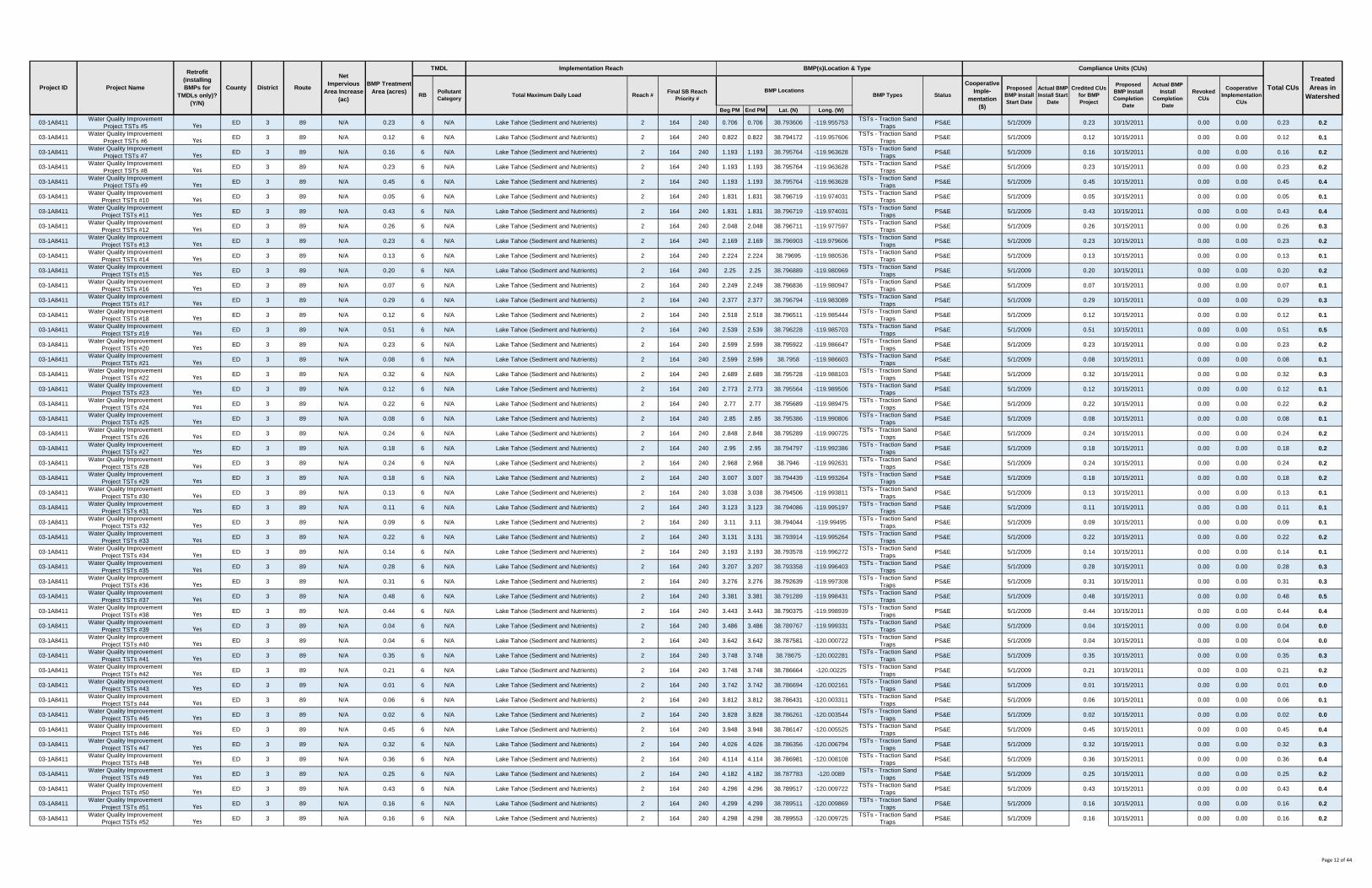
Beg PM End PM Lat. (N) Long. (W)
RouteProject ID Project Name
Retrofit (installing BMPs for
TMDLs only)? (Y/N)
County District Credited CUs for BMP Project
Proposed BMP Install Completion
Date
Actual BMP Install
Completion Date
Net Impervious
Area Increase (ac)
BMP Treatment Area (acres)
TMDL Implementation Reach BMP(s)Location & Type
BMP LocationsBMP Types Status
Revoked CUs
Total CUsTreated Areas in
WatershedRBPollutant Category
Total Maximum Daily Load Reach #Final SB Reach
Priority #
Compliance Units (CUs)
Cooperative Imple-
mentation ($)
Cooperative Implementation
CUs
Proposed BMP Install Start Date
Actual BMP Install Start
Date
03-1A8411Water Quality Improvement
Project TSTs #5 Yes ED 3 89 N/A 0.23 6 N/A Lake Tahoe (Sediment and Nutrients) 2 164 240 0.706 0.706 38.793606 -119.955753TSTs - Traction Sand
TrapsPS&E 5/1/2009 0.23 10/15/2011 0.00 0.00 0.23 0.2
03-1A8411Water Quality Improvement
Project TSTs #6 Yes ED 3 89 N/A 0.12 6 N/A Lake Tahoe (Sediment and Nutrients) 2 164 240 0.822 0.822 38.794172 -119.957606TSTs - Traction Sand
TrapsPS&E 5/1/2009 0.12 10/15/2011 0.00 0.00 0.12 0.1
03-1A8411Water Quality Improvement
Project TSTs #7 Yes ED 3 89 N/A 0.16 6 N/A Lake Tahoe (Sediment and Nutrients) 2 164 240 1.193 1.193 38.795764 -119.963628TSTs - Traction Sand
TrapsPS&E 5/1/2009 0.16 10/15/2011 0.00 0.00 0.16 0.2
03-1A8411Water Quality Improvement
Project TSTs #8 Yes ED 3 89 N/A 0.23 6 N/A Lake Tahoe (Sediment and Nutrients) 2 164 240 1.193 1.193 38.795764 -119.963628TSTs - Traction Sand
TrapsPS&E 5/1/2009 0.23 10/15/2011 0.00 0.00 0.23 0.2
03-1A8411Water Quality Improvement
Project TSTs #9 Yes ED 3 89 N/A 0.45 6 N/A Lake Tahoe (Sediment and Nutrients) 2 164 240 1.193 1.193 38.795764 -119.963628TSTs - Traction Sand
TrapsPS&E 5/1/2009 0.45 10/15/2011 0.00 0.00 0.45 0.4
03-1A8411Water Quality Improvement
Project TSTs #10 Yes ED 3 89 N/A 0.05 6 N/A Lake Tahoe (Sediment and Nutrients) 2 164 240 1.831 1.831 38.796719 -119.974031TSTs - Traction Sand
TrapsPS&E 5/1/2009 0.05 10/15/2011 0.00 0.00 0.05 0.1
03-1A8411Water Quality Improvement
Project TSTs #11 Yes ED 3 89 N/A 0.43 6 N/A Lake Tahoe (Sediment and Nutrients) 2 164 240 1.831 1.831 38.796719 -119.974031TSTs - Traction Sand
TrapsPS&E 5/1/2009 0.43 10/15/2011 0.00 0.00 0.43 0.4
03-1A8411Water Quality Improvement
Project TSTs #12 Yes ED 3 89 N/A 0.26 6 N/A Lake Tahoe (Sediment and Nutrients) 2 164 240 2.048 2.048 38.796711 -119.977597TSTs - Traction Sand
TrapsPS&E 5/1/2009 0.26 10/15/2011 0.00 0.00 0.26 0.3
03-1A8411Water Quality Improvement
Project TSTs #13 Yes ED 3 89 N/A 0.23 6 N/A Lake Tahoe (Sediment and Nutrients) 2 164 240 2.169 2.169 38.796903 -119.979606TSTs - Traction Sand
TrapsPS&E 5/1/2009 0.23 10/15/2011 0.00 0.00 0.23 0.2
03-1A8411Water Quality Improvement
Project TSTs #14 Yes ED 3 89 N/A 0.13 6 N/A Lake Tahoe (Sediment and Nutrients) 2 164 240 2.224 2.224 38.79695 -119.980536TSTs - Traction Sand
TrapsPS&E 5/1/2009 0.13 10/15/2011 0.00 0.00 0.13 0.1
03-1A8411Water Quality Improvement
Project TSTs #15 Yes ED 3 89 N/A 0.20 6 N/A Lake Tahoe (Sediment and Nutrients) 2 164 240 2.25 2.25 38.796889 -119.980969TSTs - Traction Sand
TrapsPS&E 5/1/2009 0.20 10/15/2011 0.00 0.00 0.20 0.2
03-1A8411Water Quality Improvement
Project TSTs #16 Yes ED 3 89 N/A 0.07 6 N/A Lake Tahoe (Sediment and Nutrients) 2 164 240 2.249 2.249 38.796836 -119.980947TSTs - Traction Sand
TrapsPS&E 5/1/2009 0.07 10/15/2011 0.00 0.00 0.07 0.1
03-1A8411Water Quality Improvement
Project TSTs #17 Yes ED 3 89 N/A 0.29 6 N/A Lake Tahoe (Sediment and Nutrients) 2 164 240 2.377 2.377 38.796794 -119.983089TSTs - Traction Sand
TrapsPS&E 5/1/2009 0.29 10/15/2011 0.00 0.00 0.29 0.3
03-1A8411Water Quality Improvement
Project TSTs #18 Yes ED 3 89 N/A 0.12 6 N/A Lake Tahoe (Sediment and Nutrients) 2 164 240 2.518 2.518 38.796511 -119.985444TSTs - Traction Sand
TrapsPS&E 5/1/2009 0.12 10/15/2011 0.00 0.00 0.12 0.1
03-1A8411Water Quality Improvement
Project TSTs #19 Yes ED 3 89 N/A 0.51 6 N/A Lake Tahoe (Sediment and Nutrients) 2 164 240 2.539 2.539 38.796228 -119.985703TSTs - Traction Sand
TrapsPS&E 5/1/2009 0.51 10/15/2011 0.00 0.00 0.51 0.5
03-1A8411Water Quality Improvement
Project TSTs #20 Yes ED 3 89 N/A 0.23 6 N/A Lake Tahoe (Sediment and Nutrients) 2 164 240 2.599 2.599 38.795922 -119.986647TSTs - Traction Sand
TrapsPS&E 5/1/2009 0.23 10/15/2011 0.00 0.00 0.23 0.2
03-1A8411Water Quality Improvement
Project TSTs #21 Yes ED 3 89 N/A 0.08 6 N/A Lake Tahoe (Sediment and Nutrients) 2 164 240 2.599 2.599 38.7958 -119.986603TSTs - Traction Sand
TrapsPS&E 5/1/2009 0.08 10/15/2011 0.00 0.00 0.08 0.1
03-1A8411Water Quality Improvement
Project TSTs #22 Yes ED 3 89 N/A 0.32 6 N/A Lake Tahoe (Sediment and Nutrients) 2 164 240 2.689 2.689 38.795728 -119.988103TSTs - Traction Sand
TrapsPS&E 5/1/2009 0.32 10/15/2011 0.00 0.00 0.32 0.3
03-1A8411Water Quality Improvement
Project TSTs #23 Yes ED 3 89 N/A 0.12 6 N/A Lake Tahoe (Sediment and Nutrients) 2 164 240 2.773 2.773 38.795564 -119.989506TSTs - Traction Sand
TrapsPS&E 5/1/2009 0.12 10/15/2011 0.00 0.00 0.12 0.1
03-1A8411Water Quality Improvement
Project TSTs #24 Yes ED 3 89 N/A 0.22 6 N/A Lake Tahoe (Sediment and Nutrients) 2 164 240 2.77 2.77 38.795689 -119.989475TSTs - Traction Sand
TrapsPS&E 5/1/2009 0.22 10/15/2011 0.00 0.00 0.22 0.2
03-1A8411Water Quality Improvement
Project TSTs #25 Yes ED 3 89 N/A 0.08 6 N/A Lake Tahoe (Sediment and Nutrients) 2 164 240 2.85 2.85 38.795386 -119.990806TSTs - Traction Sand
TrapsPS&E 5/1/2009 0.08 10/15/2011 0.00 0.00 0.08 0.1
03-1A8411Water Quality Improvement
Project TSTs #26 Yes ED 3 89 N/A 0.24 6 N/A Lake Tahoe (Sediment and Nutrients) 2 164 240 2.848 2.848 38.795289 -119.990725TSTs - Traction Sand
TrapsPS&E 5/1/2009 0.24 10/15/2011 0.00 0.00 0.24 0.2
03-1A8411Water Quality Improvement
Project TSTs #27 Yes ED 3 89 N/A 0.18 6 N/A Lake Tahoe (Sediment and Nutrients) 2 164 240 2.95 2.95 38.794797 -119.992386TSTs - Traction Sand
TrapsPS&E 5/1/2009 0.18 10/15/2011 0.00 0.00 0.18 0.2
03-1A8411Water Quality Improvement
Project TSTs #28 Yes ED 3 89 N/A 0.24 6 N/A Lake Tahoe (Sediment and Nutrients) 2 164 240 2.968 2.968 38.7946 -119.992631TSTs - Traction Sand
TrapsPS&E 5/1/2009 0.24 10/15/2011 0.00 0.00 0.24 0.2
03-1A8411Water Quality Improvement
Project TSTs #29 Yes ED 3 89 N/A 0.18 6 N/A Lake Tahoe (Sediment and Nutrients) 2 164 240 3.007 3.007 38.794439 -119.993264TSTs - Traction Sand
TrapsPS&E 5/1/2009 0.18 10/15/2011 0.00 0.00 0.18 0.2
03-1A8411Water Quality Improvement
Project TSTs #30 Yes ED 3 89 N/A 0.13 6 N/A Lake Tahoe (Sediment and Nutrients) 2 164 240 3.038 3.038 38.794506 -119.993811TSTs - Traction Sand
TrapsPS&E 5/1/2009 0.13 10/15/2011 0.00 0.00 0.13 0.1
03-1A8411Water Quality Improvement
Project TSTs #31 Yes ED 3 89 N/A 0.11 6 N/A Lake Tahoe (Sediment and Nutrients) 2 164 240 3.123 3.123 38.794086 -119.995197TSTs - Traction Sand
TrapsPS&E 5/1/2009 0.11 10/15/2011 0.00 0.00 0.11 0.1
03-1A8411Water Quality Improvement
Project TSTs #32 Yes ED 3 89 N/A 0.09 6 N/A Lake Tahoe (Sediment and Nutrients) 2 164 240 3.11 3.11 38.794044 -119.99495TSTs - Traction Sand
TrapsPS&E 5/1/2009 0.09 10/15/2011 0.00 0.00 0.09 0.1
03-1A8411Water Quality Improvement
Project TSTs #33 Yes ED 3 89 N/A 0.22 6 N/A Lake Tahoe (Sediment and Nutrients) 2 164 240 3.131 3.131 38.793914 -119.995264TSTs - Traction Sand
TrapsPS&E 5/1/2009 0.22 10/15/2011 0.00 0.00 0.22 0.2
03-1A8411Water Quality Improvement
Project TSTs #34 Yes ED 3 89 N/A 0.14 6 N/A Lake Tahoe (Sediment and Nutrients) 2 164 240 3.193 3.193 38.793578 -119.996272TSTs - Traction Sand
TrapsPS&E 5/1/2009 0.14 10/15/2011 0.00 0.00 0.14 0.1
03-1A8411Water Quality Improvement
Project TSTs #35 Yes ED 3 89 N/A 0.28 6 N/A Lake Tahoe (Sediment and Nutrients) 2 164 240 3.207 3.207 38.793358 -119.996403TSTs - Traction Sand
TrapsPS&E 5/1/2009 0.28 10/15/2011 0.00 0.00 0.28 0.3
03-1A8411Water Quality Improvement
Project TSTs #36 Yes ED 3 89 N/A 0.31 6 N/A Lake Tahoe (Sediment and Nutrients) 2 164 240 3.276 3.276 38.792639 -119.997308TSTs - Traction Sand
TrapsPS&E 5/1/2009 0.31 10/15/2011 0.00 0.00 0.31 0.3
03-1A8411Water Quality Improvement
Project TSTs #37 Yes ED 3 89 N/A 0.48 6 N/A Lake Tahoe (Sediment and Nutrients) 2 164 240 3.381 3.381 38.791289 -119.998431TSTs - Traction Sand
TrapsPS&E 5/1/2009 0.48 10/15/2011 0.00 0.00 0.48 0.5
03-1A8411Water Quality Improvement
Project TSTs #38 Yes ED 3 89 N/A 0.44 6 N/A Lake Tahoe (Sediment and Nutrients) 2 164 240 3.443 3.443 38.790375 -119.998939TSTs - Traction Sand
TrapsPS&E 5/1/2009 0.44 10/15/2011 0.00 0.00 0.44 0.4
03-1A8411Water Quality Improvement
Project TSTs #39 Yes ED 3 89 N/A 0.04 6 N/A Lake Tahoe (Sediment and Nutrients) 2 164 240 3.486 3.486 38.789767 -119.999331TSTs - Traction Sand
TrapsPS&E 5/1/2009 0.04 10/15/2011 0.00 0.00 0.04 0.0
03-1A8411Water Quality Improvement
Project TSTs #40 Yes ED 3 89 N/A 0.04 6 N/A Lake Tahoe (Sediment and Nutrients) 2 164 240 3.642 3.642 38.787581 -120.000722TSTs - Traction Sand
TrapsPS&E 5/1/2009 0.04 10/15/2011 0.00 0.00 0.04 0.0
03-1A8411Water Quality Improvement
Project TSTs #41 Yes ED 3 89 N/A 0.35 6 N/A Lake Tahoe (Sediment and Nutrients) 2 164 240 3.748 3.748 38.78675 -120.002281TSTs - Traction Sand
TrapsPS&E 5/1/2009 0.35 10/15/2011 0.00 0.00 0.35 0.3
03-1A8411Water Quality Improvement
Project TSTs #42 Yes ED 3 89 N/A 0.21 6 N/A Lake Tahoe (Sediment and Nutrients) 2 164 240 3.748 3.748 38.786664 -120.00225TSTs - Traction Sand
TrapsPS&E 5/1/2009 0.21 10/15/2011 0.00 0.00 0.21 0.2
03-1A8411Water Quality Improvement
Project TSTs #43 Yes ED 3 89 N/A 0.01 6 N/A Lake Tahoe (Sediment and Nutrients) 2 164 240 3.742 3.742 38.786694 -120.002161TSTs - Traction Sand
TrapsPS&E 5/1/2009 0.01 10/15/2011 0.00 0.00 0.01 0.0
03-1A8411Water Quality Improvement
Project TSTs #44 Yes ED 3 89 N/A 0.06 6 N/A Lake Tahoe (Sediment and Nutrients) 2 164 240 3.812 3.812 38.786431 -120.003311TSTs - Traction Sand
TrapsPS&E 5/1/2009 0.06 10/15/2011 0.00 0.00 0.06 0.1
03-1A8411Water Quality Improvement
Project TSTs #45 Yes ED 3 89 N/A 0.02 6 N/A Lake Tahoe (Sediment and Nutrients) 2 164 240 3.828 3.828 38.786261 -120.003544TSTs - Traction Sand
TrapsPS&E 5/1/2009 0.02 10/15/2011 0.00 0.00 0.02 0.0
03-1A8411Water Quality Improvement
Project TSTs #46 Yes ED 3 89 N/A 0.45 6 N/A Lake Tahoe (Sediment and Nutrients) 2 164 240 3.948 3.948 38.786147 -120.005525TSTs - Traction Sand
TrapsPS&E 5/1/2009 0.45 10/15/2011 0.00 0.00 0.45 0.4
03-1A8411Water Quality Improvement
Project TSTs #47 Yes ED 3 89 N/A 0.32 6 N/A Lake Tahoe (Sediment and Nutrients) 2 164 240 4.026 4.026 38.786356 -120.006794TSTs - Traction Sand
TrapsPS&E 5/1/2009 0.32 10/15/2011 0.00 0.00 0.32 0.3
03-1A8411Water Quality Improvement
Project TSTs #48 Yes ED 3 89 N/A 0.36 6 N/A Lake Tahoe (Sediment and Nutrients) 2 164 240 4.114 4.114 38.786981 -120.008108TSTs - Traction Sand
TrapsPS&E 5/1/2009 0.36 10/15/2011 0.00 0.00 0.36 0.4
03-1A8411Water Quality Improvement
Project TSTs #49 Yes ED 3 89 N/A 0.25 6 N/A Lake Tahoe (Sediment and Nutrients) 2 164 240 4.182 4.182 38.787783 -120.0089TSTs - Traction Sand
TrapsPS&E 5/1/2009 0.25 10/15/2011 0.00 0.00 0.25 0.2
03-1A8411Water Quality Improvement
Project TSTs #50 Yes ED 3 89 N/A 0.43 6 N/A Lake Tahoe (Sediment and Nutrients) 2 164 240 4.296 4.296 38.789517 -120.009722TSTs - Traction Sand
TrapsPS&E 5/1/2009 0.43 10/15/2011 0.00 0.00 0.43 0.4
03-1A8411Water Quality Improvement
Project TSTs #51 Yes ED 3 89 N/A 0.16 6 N/A Lake Tahoe (Sediment and Nutrients) 2 164 240 4.299 4.299 38.789511 -120.009869TSTs - Traction Sand
TrapsPS&E 5/1/2009 0.16 10/15/2011 0.00 0.00 0.16 0.2
03-1A8411Water Quality Improvement
Project TSTs #52 Yes ED 3 89 N/A 0.16 6 N/A Lake Tahoe (Sediment and Nutrients) 2 164 240 4.298 4.298 38.789553 -120.009725TSTs - Traction Sand
TrapsPS&E 5/1/2009 0.16 10/15/2011 0.00 0.00 0.16 0.2
Page 12 of 44
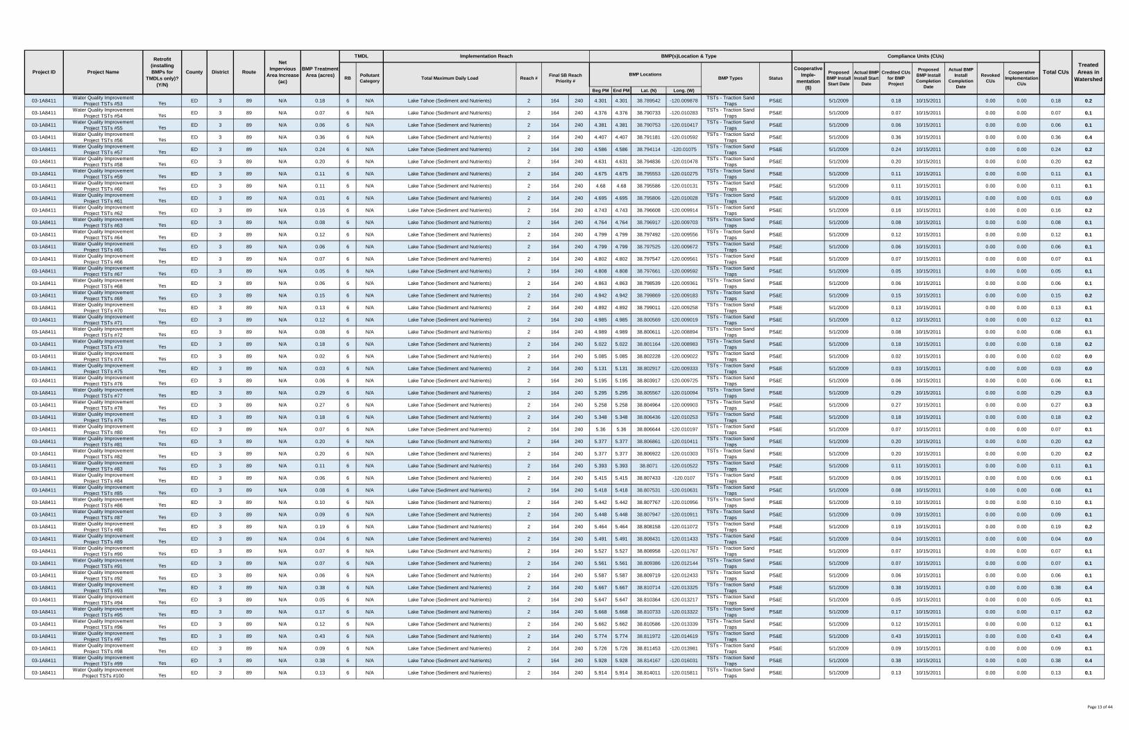
Beg PM End PM Lat. (N) Long. (W)
RouteProject ID Project Name
Retrofit (installing BMPs for
TMDLs only)? (Y/N)
County District Credited CUs for BMP Project
Proposed BMP Install Completion
Date
Actual BMP Install
Completion Date
Net Impervious
Area Increase (ac)
BMP Treatment Area (acres)
TMDL Implementation Reach BMP(s)Location & Type
BMP LocationsBMP Types Status
Revoked CUs
Total CUsTreated Areas in
WatershedRBPollutant Category
Total Maximum Daily Load Reach #Final SB Reach
Priority #
Compliance Units (CUs)
Cooperative Imple-
mentation ($)
Cooperative Implementation
CUs
Proposed BMP Install Start Date
Actual BMP Install Start
Date
03-1A8411Water Quality Improvement
Project TSTs #53 Yes ED 3 89 N/A 0.18 6 N/A Lake Tahoe (Sediment and Nutrients) 2 164 240 4.301 4.301 38.789542 -120.009878TSTs - Traction Sand
TrapsPS&E 5/1/2009 0.18 10/15/2011 0.00 0.00 0.18 0.2
03-1A8411Water Quality Improvement
Project TSTs #54 Yes ED 3 89 N/A 0.07 6 N/A Lake Tahoe (Sediment and Nutrients) 2 164 240 4.376 4.376 38.790733 -120.010283TSTs - Traction Sand
TrapsPS&E 5/1/2009 0.07 10/15/2011 0.00 0.00 0.07 0.1
03-1A8411Water Quality Improvement
Project TSTs #55 Yes ED 3 89 N/A 0.06 6 N/A Lake Tahoe (Sediment and Nutrients) 2 164 240 4.381 4.381 38.790753 -120.010417TSTs - Traction Sand
TrapsPS&E 5/1/2009 0.06 10/15/2011 0.00 0.00 0.06 0.1
03-1A8411Water Quality Improvement
Project TSTs #56 Yes ED 3 89 N/A 0.36 6 N/A Lake Tahoe (Sediment and Nutrients) 2 164 240 4.407 4.407 38.791181 -120.010592TSTs - Traction Sand
TrapsPS&E 5/1/2009 0.36 10/15/2011 0.00 0.00 0.36 0.4
03-1A8411Water Quality Improvement
Project TSTs #57 Yes ED 3 89 N/A 0.24 6 N/A Lake Tahoe (Sediment and Nutrients) 2 164 240 4.586 4.586 38.794114 -120.01075TSTs - Traction Sand
TrapsPS&E 5/1/2009 0.24 10/15/2011 0.00 0.00 0.24 0.2
03-1A8411Water Quality Improvement
Project TSTs #58 Yes ED 3 89 N/A 0.20 6 N/A Lake Tahoe (Sediment and Nutrients) 2 164 240 4.631 4.631 38.794836 -120.010478TSTs - Traction Sand
TrapsPS&E 5/1/2009 0.20 10/15/2011 0.00 0.00 0.20 0.2
03-1A8411Water Quality Improvement
Project TSTs #59 Yes ED 3 89 N/A 0.11 6 N/A Lake Tahoe (Sediment and Nutrients) 2 164 240 4.675 4.675 38.795553 -120.010275TSTs - Traction Sand
TrapsPS&E 5/1/2009 0.11 10/15/2011 0.00 0.00 0.11 0.1
03-1A8411Water Quality Improvement
Project TSTs #60 Yes ED 3 89 N/A 0.11 6 N/A Lake Tahoe (Sediment and Nutrients) 2 164 240 4.68 4.68 38.795586 -120.010131TSTs - Traction Sand
TrapsPS&E 5/1/2009 0.11 10/15/2011 0.00 0.00 0.11 0.1
03-1A8411Water Quality Improvement
Project TSTs #61 Yes ED 3 89 N/A 0.01 6 N/A Lake Tahoe (Sediment and Nutrients) 2 164 240 4.695 4.695 38.795806 -120.010028TSTs - Traction Sand
TrapsPS&E 5/1/2009 0.01 10/15/2011 0.00 0.00 0.01 0.0
03-1A8411Water Quality Improvement
Project TSTs #62 Yes ED 3 89 N/A 0.16 6 N/A Lake Tahoe (Sediment and Nutrients) 2 164 240 4.743 4.743 38.796608 -120.009914TSTs - Traction Sand
TrapsPS&E 5/1/2009 0.16 10/15/2011 0.00 0.00 0.16 0.2
03-1A8411Water Quality Improvement
Project TSTs #63 Yes ED 3 89 N/A 0.08 6 N/A Lake Tahoe (Sediment and Nutrients) 2 164 240 4.764 4.764 38.796917 -120.009703TSTs - Traction Sand
TrapsPS&E 5/1/2009 0.08 10/15/2011 0.00 0.00 0.08 0.1
03-1A8411Water Quality Improvement
Project TSTs #64 Yes ED 3 89 N/A 0.12 6 N/A Lake Tahoe (Sediment and Nutrients) 2 164 240 4.799 4.799 38.797492 -120.009556TSTs - Traction Sand
TrapsPS&E 5/1/2009 0.12 10/15/2011 0.00 0.00 0.12 0.1
03-1A8411Water Quality Improvement
Project TSTs #65 Yes ED 3 89 N/A 0.06 6 N/A Lake Tahoe (Sediment and Nutrients) 2 164 240 4.799 4.799 38.797525 -120.009672TSTs - Traction Sand
TrapsPS&E 5/1/2009 0.06 10/15/2011 0.00 0.00 0.06 0.1
03-1A8411Water Quality Improvement
Project TSTs #66 Yes ED 3 89 N/A 0.07 6 N/A Lake Tahoe (Sediment and Nutrients) 2 164 240 4.802 4.802 38.797547 -120.009561TSTs - Traction Sand
TrapsPS&E 5/1/2009 0.07 10/15/2011 0.00 0.00 0.07 0.1
03-1A8411Water Quality Improvement
Project TSTs #67 Yes ED 3 89 N/A 0.05 6 N/A Lake Tahoe (Sediment and Nutrients) 2 164 240 4.808 4.808 38.797661 -120.009592TSTs - Traction Sand
TrapsPS&E 5/1/2009 0.05 10/15/2011 0.00 0.00 0.05 0.1
03-1A8411Water Quality Improvement
Project TSTs #68 Yes ED 3 89 N/A 0.06 6 N/A Lake Tahoe (Sediment and Nutrients) 2 164 240 4.863 4.863 38.798539 -120.009361TSTs - Traction Sand
TrapsPS&E 5/1/2009 0.06 10/15/2011 0.00 0.00 0.06 0.1
03-1A8411Water Quality Improvement
Project TSTs #69 Yes ED 3 89 N/A 0.15 6 N/A Lake Tahoe (Sediment and Nutrients) 2 164 240 4.942 4.942 38.799869 -120.009183TSTs - Traction Sand
TrapsPS&E 5/1/2009 0.15 10/15/2011 0.00 0.00 0.15 0.2
03-1A8411Water Quality Improvement
Project TSTs #70 Yes ED 3 89 N/A 0.13 6 N/A Lake Tahoe (Sediment and Nutrients) 2 164 240 4.892 4.892 38.799011 -120.009258TSTs - Traction Sand
TrapsPS&E 5/1/2009 0.13 10/15/2011 0.00 0.00 0.13 0.1
03-1A8411Water Quality Improvement
Project TSTs #71 Yes ED 3 89 N/A 0.12 6 N/A Lake Tahoe (Sediment and Nutrients) 2 164 240 4.985 4.985 38.800569 -120.009019TSTs - Traction Sand
TrapsPS&E 5/1/2009 0.12 10/15/2011 0.00 0.00 0.12 0.1
03-1A8411Water Quality Improvement
Project TSTs #72 Yes ED 3 89 N/A 0.08 6 N/A Lake Tahoe (Sediment and Nutrients) 2 164 240 4.989 4.989 38.800611 -120.008894TSTs - Traction Sand
TrapsPS&E 5/1/2009 0.08 10/15/2011 0.00 0.00 0.08 0.1
03-1A8411Water Quality Improvement
Project TSTs #73 Yes ED 3 89 N/A 0.18 6 N/A Lake Tahoe (Sediment and Nutrients) 2 164 240 5.022 5.022 38.801164 -120.008983TSTs - Traction Sand
TrapsPS&E 5/1/2009 0.18 10/15/2011 0.00 0.00 0.18 0.2
03-1A8411Water Quality Improvement
Project TSTs #74 Yes ED 3 89 N/A 0.02 6 N/A Lake Tahoe (Sediment and Nutrients) 2 164 240 5.085 5.085 38.802228 -120.009022TSTs - Traction Sand
TrapsPS&E 5/1/2009 0.02 10/15/2011 0.00 0.00 0.02 0.0
03-1A8411Water Quality Improvement
Project TSTs #75 Yes ED 3 89 N/A 0.03 6 N/A Lake Tahoe (Sediment and Nutrients) 2 164 240 5.131 5.131 38.802917 -120.009333TSTs - Traction Sand
TrapsPS&E 5/1/2009 0.03 10/15/2011 0.00 0.00 0.03 0.0
03-1A8411Water Quality Improvement
Project TSTs #76 Yes ED 3 89 N/A 0.06 6 N/A Lake Tahoe (Sediment and Nutrients) 2 164 240 5.195 5.195 38.803917 -120.009725TSTs - Traction Sand
TrapsPS&E 5/1/2009 0.06 10/15/2011 0.00 0.00 0.06 0.1
03-1A8411Water Quality Improvement
Project TSTs #77 Yes ED 3 89 N/A 0.29 6 N/A Lake Tahoe (Sediment and Nutrients) 2 164 240 5.295 5.295 38.805567 -120.010094TSTs - Traction Sand
TrapsPS&E 5/1/2009 0.29 10/15/2011 0.00 0.00 0.29 0.3
03-1A8411Water Quality Improvement
Project TSTs #78 Yes ED 3 89 N/A 0.27 6 N/A Lake Tahoe (Sediment and Nutrients) 2 164 240 5.258 5.258 38.804964 -120.009903TSTs - Traction Sand
TrapsPS&E 5/1/2009 0.27 10/15/2011 0.00 0.00 0.27 0.3
03-1A8411Water Quality Improvement
Project TSTs #79 Yes ED 3 89 N/A 0.18 6 N/A Lake Tahoe (Sediment and Nutrients) 2 164 240 5.348 5.348 38.806436 -120.010253TSTs - Traction Sand
TrapsPS&E 5/1/2009 0.18 10/15/2011 0.00 0.00 0.18 0.2
03-1A8411Water Quality Improvement
Project TSTs #80 Yes ED 3 89 N/A 0.07 6 N/A Lake Tahoe (Sediment and Nutrients) 2 164 240 5.36 5.36 38.806644 -120.010197TSTs - Traction Sand
TrapsPS&E 5/1/2009 0.07 10/15/2011 0.00 0.00 0.07 0.1
03-1A8411Water Quality Improvement
Project TSTs #81 Yes ED 3 89 N/A 0.20 6 N/A Lake Tahoe (Sediment and Nutrients) 2 164 240 5.377 5.377 38.806861 -120.010411TSTs - Traction Sand
TrapsPS&E 5/1/2009 0.20 10/15/2011 0.00 0.00 0.20 0.2
03-1A8411Water Quality Improvement
Project TSTs #82 Yes ED 3 89 N/A 0.20 6 N/A Lake Tahoe (Sediment and Nutrients) 2 164 240 5.377 5.377 38.806922 -120.010303TSTs - Traction Sand
TrapsPS&E 5/1/2009 0.20 10/15/2011 0.00 0.00 0.20 0.2
03-1A8411Water Quality Improvement
Project TSTs #83 Yes ED 3 89 N/A 0.11 6 N/A Lake Tahoe (Sediment and Nutrients) 2 164 240 5.393 5.393 38.8071 -120.010522TSTs - Traction Sand
TrapsPS&E 5/1/2009 0.11 10/15/2011 0.00 0.00 0.11 0.1
03-1A8411Water Quality Improvement
Project TSTs #84 Yes ED 3 89 N/A 0.06 6 N/A Lake Tahoe (Sediment and Nutrients) 2 164 240 5.415 5.415 38.807433 -120.0107TSTs - Traction Sand
TrapsPS&E 5/1/2009 0.06 10/15/2011 0.00 0.00 0.06 0.1
03-1A8411Water Quality Improvement
Project TSTs #85 Yes ED 3 89 N/A 0.08 6 N/A Lake Tahoe (Sediment and Nutrients) 2 164 240 5.418 5.418 38.807531 -120.010631TSTs - Traction Sand
TrapsPS&E 5/1/2009 0.08 10/15/2011 0.00 0.00 0.08 0.1
03-1A8411Water Quality Improvement
Project TSTs #86 Yes ED 3 89 N/A 0.10 6 N/A Lake Tahoe (Sediment and Nutrients) 2 164 240 5.442 5.442 38.807767 -120.010956TSTs - Traction Sand
TrapsPS&E 5/1/2009 0.10 10/15/2011 0.00 0.00 0.10 0.1
03-1A8411Water Quality Improvement
Project TSTs #87 Yes ED 3 89 N/A 0.09 6 N/A Lake Tahoe (Sediment and Nutrients) 2 164 240 5.448 5.448 38.807947 -120.010911TSTs - Traction Sand
TrapsPS&E 5/1/2009 0.09 10/15/2011 0.00 0.00 0.09 0.1
03-1A8411Water Quality Improvement
Project TSTs #88 Yes ED 3 89 N/A 0.19 6 N/A Lake Tahoe (Sediment and Nutrients) 2 164 240 5.464 5.464 38.808158 -120.011072TSTs - Traction Sand
TrapsPS&E 5/1/2009 0.19 10/15/2011 0.00 0.00 0.19 0.2
03-1A8411Water Quality Improvement
Project TSTs #89 Yes ED 3 89 N/A 0.04 6 N/A Lake Tahoe (Sediment and Nutrients) 2 164 240 5.491 5.491 38.808431 -120.011433TSTs - Traction Sand
TrapsPS&E 5/1/2009 0.04 10/15/2011 0.00 0.00 0.04 0.0
03-1A8411Water Quality Improvement
Project TSTs #90 Yes ED 3 89 N/A 0.07 6 N/A Lake Tahoe (Sediment and Nutrients) 2 164 240 5.527 5.527 38.808958 -120.011767TSTs - Traction Sand
TrapsPS&E 5/1/2009 0.07 10/15/2011 0.00 0.00 0.07 0.1
03-1A8411Water Quality Improvement
Project TSTs #91 Yes ED 3 89 N/A 0.07 6 N/A Lake Tahoe (Sediment and Nutrients) 2 164 240 5.561 5.561 38.809386 -120.012144TSTs - Traction Sand
TrapsPS&E 5/1/2009 0.07 10/15/2011 0.00 0.00 0.07 0.1
03-1A8411Water Quality Improvement
Project TSTs #92 Yes ED 3 89 N/A 0.06 6 N/A Lake Tahoe (Sediment and Nutrients) 2 164 240 5.587 5.587 38.809719 -120.012433TSTs - Traction Sand
TrapsPS&E 5/1/2009 0.06 10/15/2011 0.00 0.00 0.06 0.1
03-1A8411Water Quality Improvement
Project TSTs #93 Yes ED 3 89 N/A 0.38 6 N/A Lake Tahoe (Sediment and Nutrients) 2 164 240 5.667 5.667 38.810714 -120.013325TSTs - Traction Sand
TrapsPS&E 5/1/2009 0.38 10/15/2011 0.00 0.00 0.38 0.4
03-1A8411Water Quality Improvement
Project TSTs #94 Yes ED 3 89 N/A 0.05 6 N/A Lake Tahoe (Sediment and Nutrients) 2 164 240 5.647 5.647 38.810364 -120.013217TSTs - Traction Sand
TrapsPS&E 5/1/2009 0.05 10/15/2011 0.00 0.00 0.05 0.1
03-1A8411Water Quality Improvement
Project TSTs #95 Yes ED 3 89 N/A 0.17 6 N/A Lake Tahoe (Sediment and Nutrients) 2 164 240 5.668 5.668 38.810733 -120.013322TSTs - Traction Sand
TrapsPS&E 5/1/2009 0.17 10/15/2011 0.00 0.00 0.17 0.2
03-1A8411Water Quality Improvement
Project TSTs #96 Yes ED 3 89 N/A 0.12 6 N/A Lake Tahoe (Sediment and Nutrients) 2 164 240 5.662 5.662 38.810586 -120.013339TSTs - Traction Sand
TrapsPS&E 5/1/2009 0.12 10/15/2011 0.00 0.00 0.12 0.1
03-1A8411Water Quality Improvement
Project TSTs #97 Yes ED 3 89 N/A 0.43 6 N/A Lake Tahoe (Sediment and Nutrients) 2 164 240 5.774 5.774 38.811972 -120.014619TSTs - Traction Sand
TrapsPS&E 5/1/2009 0.43 10/15/2011 0.00 0.00 0.43 0.4
03-1A8411Water Quality Improvement
Project TSTs #98 Yes ED 3 89 N/A 0.09 6 N/A Lake Tahoe (Sediment and Nutrients) 2 164 240 5.726 5.726 38.811453 -120.013981TSTs - Traction Sand
TrapsPS&E 5/1/2009 0.09 10/15/2011 0.00 0.00 0.09 0.1
03-1A8411Water Quality Improvement
Project TSTs #99 Yes ED 3 89 N/A 0.38 6 N/A Lake Tahoe (Sediment and Nutrients) 2 164 240 5.928 5.928 38.814167 -120.016031TSTs - Traction Sand
TrapsPS&E 5/1/2009 0.38 10/15/2011 0.00 0.00 0.38 0.4
03-1A8411Water Quality Improvement
Project TSTs #100 Yes ED 3 89 N/A 0.13 6 N/A Lake Tahoe (Sediment and Nutrients) 2 164 240 5.914 5.914 38.814011 -120.015811TSTs - Traction Sand
TrapsPS&E 5/1/2009 0.13 10/15/2011 0.00 0.00 0.13 0.1
Page 13 of 44

Beg PM End PM Lat. (N) Long. (W)
RouteProject ID Project Name
Retrofit (installing BMPs for
TMDLs only)? (Y/N)
County District Credited CUs for BMP Project
Proposed BMP Install Completion
Date
Actual BMP Install
Completion Date
Net Impervious
Area Increase (ac)
BMP Treatment Area (acres)
TMDL Implementation Reach BMP(s)Location & Type
BMP LocationsBMP Types Status
Revoked CUs
Total CUsTreated Areas in
WatershedRBPollutant Category
Total Maximum Daily Load Reach #Final SB Reach
Priority #
Compliance Units (CUs)
Cooperative Imple-
mentation ($)
Cooperative Implementation
CUs
Proposed BMP Install Start Date
Actual BMP Install Start
Date
03-1A8411Water Quality Improvement
Project TSTs #101 Yes ED 3 89 N/A 0.05 6 N/A Lake Tahoe (Sediment and Nutrients) 2 164 240 5.933 5.933 38.814283 -120.015978TSTs - Traction Sand
TrapsPS&E 5/1/2009 0.05 10/15/2011 0.00 0.00 0.05 0.0
03-1A8411Water Quality Improvement
Project TSTs #102 Yes ED 3 89 N/A 0.14 6 N/A Lake Tahoe (Sediment and Nutrients) 2 164 240 6 6 38.815189 -120.016661TSTs - Traction Sand
TrapsPS&E 5/1/2009 0.14 10/15/2011 0.00 0.00 0.14 0.1
03-1A8411Water Quality Improvement
Project TSTs #103 Yes ED 3 89 N/A 0.14 6 N/A Lake Tahoe (Sediment and Nutrients) 2 164 240 5.996 5.996 38.8152 -120.016522TSTs - Traction Sand
TrapsPS&E 5/1/2009 0.14 10/15/2011 0.00 0.00 0.14 0.1
03-1A8411Water Quality Improvement
Project TSTs #104 Yes ED 3 89 N/A 0.25 6 N/A Lake Tahoe (Sediment and Nutrients) 2 164 240 6.295 6.295 38.819189 -120.018436TSTs - Traction Sand
TrapsPS&E 5/1/2009 0.25 10/15/2011 0.00 0.00 0.25 0.3
03-1A8411Water Quality Improvement
Project TSTs #105 Yes ED 3 89 N/A 0.48 6 N/A Lake Tahoe (Sediment and Nutrients) 2 164 240 6.297 6.297 38.819222 -120.018406TSTs - Traction Sand
TrapsPS&E 5/1/2009 0.48 10/15/2011 0.00 0.00 0.48 0.5
03-1A8411Water Quality Improvement
Project TSTs #106 Yes ED 3 89 N/A 0.14 6 N/A Lake Tahoe (Sediment and Nutrients) 2 164 240 6.72 6.72 38.825433 -120.018156TSTs - Traction Sand
TrapsPS&E 5/1/2009 0.14 10/15/2011 0.00 0.00 0.14 0.1
03-1A8411Water Quality Improvement
Project TSTs #107 Yes ED 3 89 N/A 0.29 6 N/A Lake Tahoe (Sediment and Nutrients) 2 164 240 6.72 6.72 38.825433 -120.018156TSTs - Traction Sand
TrapsPS&E 5/1/2009 0.29 10/15/2011 0.00 0.00 0.29 0.3
03-1A8411Water Quality Improvement
Project TSTs #108 Yes ED 3 89 N/A 0.43 6 N/A Lake Tahoe (Sediment and Nutrients) 2 164 240 7.492 7.492 38.836728 -120.017272TSTs - Traction Sand
TrapsPS&E 5/1/2009 0.43 10/15/2011 0.00 0.00 0.43 0.4
03-1A8411Water Quality Improvement
Project TSTs #109 Yes ED 3 89 N/A 0.28 6 N/A Lake Tahoe (Sediment and Nutrients) 2 164 240 8.538 8.538 38.850964 -120.022089TSTs - Traction Sand
TrapsPS&E 5/1/2009 0.28 10/15/2011 0.00 0.00 0.28 0.3
03-1A8411Water Quality Improvement
Project TSTs #110 Yes ED 3 89 N/A 0.32 6 N/A Lake Tahoe (Sediment and Nutrients) 2 164 240 8.486 8.486 38.850208 -120.021819TSTs - Traction Sand
TrapsPS&E 5/1/2009 0.32 10/15/2011 0.00 0.00 0.32 0.3
03-1A8411Water Quality Improvement
Project VS #1 Yes ED 3 89 N/A 0.29 6 N/A Lake Tahoe (Sediment and Nutrients) 2 164 240 3.208 3.208 38.793453 -119.996489 BIOS - Bioswale/strip PS&E 5/1/2009 0.29 10/15/2011 0.00 0.00 0.29 0.3
03-1A8411Water Quality Improvement
Project VS #2 Yes ED 3 89 N/A 0.31 6 N/A Lake Tahoe (Sediment and Nutrients) 2 164 240 3.22 3.22 38.793356 -119.996669 BIOS - Bioswale/strip PS&E 5/1/2009 0.31 10/15/2011 0.00 0.00 0.31 0.3
03-1A8411Water Quality Improvement
Project VS #3 Yes ED 3 89 N/A 0.14 6 N/A Lake Tahoe (Sediment and Nutrients) 2 164 240 6.006 6.006 38.8154 -120.016497 BIOS - Bioswale/strip PS&E 5/1/2009 0.14 10/15/2011 0.00 0.00 0.14 0.1
03-1A8411Water Quality Improvement
Project VS #4 Yes ED 3 89 N/A 0.22 6 N/A Lake Tahoe (Sediment and Nutrients) 2 164 240 6.105 6.105 38.816528 -120.017589 BIOS - Bioswale/strip PS&E 5/1/2009 0.22 10/15/2011 0.00 0.00 0.22 0.2
03-1A8411Water Quality Improvement
Project VS #5 Yes ED 3 89 N/A 0.38 6 N/A Lake Tahoe (Sediment and Nutrients) 2 164 240 6.349 6.349 38.82 -120.018767 BIOS - Bioswale/strip PS&E 5/1/2009 0.38 10/15/2011 0.00 0.00 0.38 0.4
03-1A8411Water Quality Improvement
Project VS #6 Yes ED 3 89 N/A 0.36 6 N/A Lake Tahoe (Sediment and Nutrients) 2 164 240 6.715 6.715 38.825369 -120.0182 BIOS - Bioswale/strip PS&E 5/1/2009 0.36 10/15/2011 0.00 0.00 0.36 0.4
03-1A8411Water Quality Improvement
Project VS #7 Yes ED 3 89 N/A 0.18 6 N/A Lake Tahoe (Sediment and Nutrients) 2 164 240 7.994 7.994 38.843989 -120.018414 BIOS - Bioswale/strip PS&E 5/1/2009 0.18 10/15/2011 0.00 0.00 0.18 0.2
03-1A8441Environmental Improvement
Program DetBas #1 Yes ED 3 89 N/A 0.17 6 N/A Lake Tahoe (Sediment and Nutrients) 1 158 234 19.123 19.123 38.972608 -120.098711DetBas - Detention
BasinsPS&E 9/1/2013 0.17 10/31/2015 0.00 0.00 0.17 0.2
03-1A8441Environmental Improvement
Program DetBas #2 Yes ED 3 89 N/A 0.16 6 N/A Lake Tahoe (Sediment and Nutrients) 1 158 234 19.202 19.202 38.973778 -120.098922DetBas - Detention
BasinsPS&E 9/1/2013 0.16 10/31/2015 0.00 0.00 0.16 0.2
03-1A8441Environmental Improvement
Program DetBas #3 Yes ED 3 89 N/A 0.38 6 N/A Lake Tahoe (Sediment and Nutrients) 1 158 234 19.577 19.577 38.977947 -120.103131DetBas - Detention
BasinsPS&E 9/1/2013 0.38 10/31/2015 0.00 0.00 0.38 0.4
03-1A8441Environmental Improvement
Program DetBas #4 Yes ED 3 89 N/A 0.25 6 N/A Lake Tahoe (Sediment and Nutrients) 1 158 234 19.606 19.606 38.978025 -120.103647DetBas - Detention
BasinsPS&E 9/1/2013 0.25 10/31/2015 0.00 0.00 0.25 0.3
03-1A8441Environmental Improvement
Program DetBas #5 Yes ED 3 89 N/A 0.22 6 N/A Lake Tahoe (Sediment and Nutrients) 1 158 234 19.632 19.632 38.978519 -120.103653DetBas - Detention
BasinsPS&E 9/1/2013 0.22 10/31/2015 0.00 0.00 0.22 0.2
03-1A8441Environmental Improvement
Program DetBas #6 Yes ED 3 89 N/A 0.04 6 N/A Lake Tahoe (Sediment and Nutrients) 1 158 234 19.837 19.837 38.981572 -120.104703DetBas - Detention
BasinsPS&E 9/1/2013 0.04 10/31/2015 0.00 0.00 0.04 0.0
03-1A8441Environmental Improvement
Program DetBas #7 Yes ED 3 89 N/A 0.33 6 N/A Lake Tahoe (Sediment and Nutrients) 1 158 234 19.651 19.651 38.978728 -120.10405DetBas - Detention
BasinsPS&E 9/1/2013 0.33 10/31/2015 0.00 0.00 0.33 0.3
03-1A8441Environmental Improvement
Program DetBas #8 Yes ED 3 89 N/A 0.01 6 N/A Lake Tahoe (Sediment and Nutrients) 1 158 234 19.663 19.663 38.978964 -120.103797DetBas - Detention
BasinsPS&E 9/1/2013 0.01 10/31/2015 0.00 0.00 0.01 0.0
03-1A8441Environmental Improvement
Program DetBas #9 Yes ED 3 89 N/A 0.11 6 N/A Lake Tahoe (Sediment and Nutrients) 1 158 234 19.671 19.671 38.979078 -120.103792DetBas - Detention
BasinsPS&E 9/1/2013 0.11 10/31/2015 0.00 0.00 0.11 0.1
03-1A8441Environmental Improvement
Program DetBas #10 Yes ED 3 89 N/A 0.10 6 N/A Lake Tahoe (Sediment and Nutrients) 1 158 234 19.687 19.687 38.979336 -120.103803DetBas - Detention
BasinsPS&E 9/1/2013 0.10 10/31/2015 0.00 0.00 0.10 0.1
03-1A8441Environmental Improvement
Program DetBas #11 Yes ED 3 89 N/A 0.13 6 N/A Lake Tahoe (Sediment and Nutrients) 1 158 234 19.723 19.723 38.979928 -120.103856DetBas - Detention
BasinsPS&E 9/1/2013 0.13 10/31/2015 0.00 0.00 0.13 0.1
03-1A8441Environmental Improvement
Program DetBas #12 Yes ED 3 89 N/A 0.20 6 N/A Lake Tahoe (Sediment and Nutrients) 1 158 234 19.784 19.784 38.980858 -120.104231DetBas - Detention
BasinsPS&E 9/1/2013 0.20 10/31/2015 0.00 0.00 0.20 0.2
03-1A8441Environmental Improvement
Program DetBas #13 Yes ED 3 89 N/A 0.02 6 N/A Lake Tahoe (Sediment and Nutrients) 1 158 234 19.903 19.903 38.981886 -120.105794DetBas - Detention
BasinsPS&E 9/1/2013 0.02 10/31/2015 0.00 0.00 0.02 0.0
03-1A8441Environmental Improvement
Program DetBas #14 Yes ED 3 89 N/A 0.11 6 N/A Lake Tahoe (Sediment and Nutrients) 1 158 234 20.286 20.286 38.986792 -120.107581DetBas - Detention
BasinsPS&E 9/1/2013 0.11 10/31/2015 0.00 0.00 0.11 0.1
03-1A8441Environmental Improvement
Program DetBas #15 Yes ED 3 89 N/A 0.27 6 N/A Lake Tahoe (Sediment and Nutrients) 1 158 234 20.457 20.457 38.988947 -120.109272DetBas - Detention
BasinsPS&E 9/1/2013 0.27 10/31/2015 0.00 0.00 0.27 0.3
03-1A8441Environmental Improvement
Program DetBas #16 Yes ED 3 89 N/A 0.04 6 N/A Lake Tahoe (Sediment and Nutrients) 1 158 234 20.482 20.482 38.989208 -120.109567DetBas - Detention
BasinsPS&E 9/1/2013 0.04 10/31/2015 0.00 0.00 0.04 0.0
03-1A8441Environmental Improvement
Program DetBas #17 Yes ED 3 89 N/A 0.36 6 N/A Lake Tahoe (Sediment and Nutrients) 1 158 234 20.602 20.602 38.990594 -120.110381DetBas - Detention
BasinsPS&E 9/1/2013 0.36 10/31/2015 0.00 0.00 0.36 0.4
03-1A8441Environmental Improvement
Program DetBas #18 Yes ED 3 89 N/A 0.19 6 N/A Lake Tahoe (Sediment and Nutrients) 1 158 234 20.925 20.925 38.994775 -120.108339DetBas - Detention
BasinsPS&E 9/1/2013 0.19 10/31/2015 0.00 0.00 0.19 0.2
03-1A8441Environmental Improvement
Program DetBas #19 Yes ED 3 89 N/A 0.02 6 N/A Lake Tahoe (Sediment and Nutrients) 1 158 234 21.069 21.069 38.99655 -120.109808DetBas - Detention
BasinsPS&E 9/1/2013 0.02 10/31/2015 0.00 0.00 0.02 0.0
03-1A8441Environmental Improvement
Program DetBas #20 Yes ED 3 89 N/A 0.18 6 N/A Lake Tahoe (Sediment and Nutrients) 1 158 234 21.394 21.394 39.000883 -120.112419DetBas - Detention
BasinsPS&E 9/1/2013 0.18 10/31/2015 0.00 0.00 0.18 0.2
03-1A8441Environmental Improvement
Program DetBas #21 Yes ED 3 89 N/A 0.17 6 N/A Lake Tahoe (Sediment and Nutrients) 1 158 234 21.434 21.434 39.001636 -120.112353DetBas - Detention
BasinsPS&E 9/1/2013 0.17 10/31/2015 0.00 0.00 0.17 0.2
03-1A8441Environmental Improvement
Program DetBas #22 Yes ED 3 89 N/A 0.12 6 N/A Lake Tahoe (Sediment and Nutrients) 1 158 234 21.512 21.512 39.002772 -120.1129DetBas - Detention
BasinsPS&E 9/1/2013 0.12 10/31/2015 0.00 0.00 0.12 0.1
03-1A8441Environmental Improvement
Program DetBas #23 Yes ED 3 89 N/A 0.23 6 N/A Lake Tahoe (Sediment and Nutrients) 1 158 234 21.518 21.518 39.002697 -120.113233DetBas - Detention
BasinsPS&E 9/1/2013 0.23 10/31/2015 0.00 0.00 0.23 0.2
03-1A8441Environmental Improvement
Program DetBas #24 Yes ED 3 89 N/A 0.23 6 N/A Lake Tahoe (Sediment and Nutrients) 1 158 234 22.7 22.7 39.015042 -120.123336DetBas - Detention
BasinsPS&E 9/1/2013 0.23 10/31/2015 0.00 0.00 0.23 0.2
03-1A8441Environmental Improvement
Program DetBas #25 Yes ED 3 89 N/A 0.10 6 N/A Lake Tahoe (Sediment and Nutrients) 1 158 234 22.755 22.755 39.015636 -120.123619DetBas - Detention
BasinsPS&E 9/1/2013 0.10 10/31/2015 0.00 0.00 0.10 0.1
03-1A8441Environmental Improvement
Program DetBas #26 Yes ED 3 89 N/A 0.17 6 N/A Lake Tahoe (Sediment and Nutrients) 1 158 234 22.976 22.976 39.017189 -120.126069DetBas - Detention
BasinsPS&E 9/1/2013 0.17 10/31/2015 0.00 0.00 0.17 0.2
03-1A8441Environmental Improvement
Program DetBas #27 Yes ED 3 89 N/A 0.11 6 N/A Lake Tahoe (Sediment and Nutrients) 1 158 234 22.998 22.998 39.016961 -120.126603DetBas - Detention
BasinsPS&E 9/1/2013 0.11 10/31/2015 0.00 0.00 0.11 0.1
03-1A8441Environmental Improvement
Program DetBas #28 Yes ED 3 89 N/A 0.56 6 N/A Lake Tahoe (Sediment and Nutrients) 1 158 234 23.177 23.177 39.019111 -120.124817DetBas - Detention
BasinsPS&E 9/1/2013 0.56 10/31/2015 0.00 0.00 0.56 0.6
03-1A8441Environmental Improvement
Program DetBas #29 Yes ED 3 89 N/A 0.65 6 N/A Lake Tahoe (Sediment and Nutrients) 1 158 234 24.562 24.562 39.035003 -120.120372DetBas - Detention
BasinsPS&E 9/1/2013 0.65 10/31/2015 0.00 0.00 0.65 0.7
03-1A8441Environmental Improvement
Program DetBas #30 Yes ED 3 89 N/A 0.24 6 N/A Lake Tahoe (Sediment and Nutrients) 1 158 234 24.749 24.749 39.034519 -120.123592DetBas - Detention
BasinsPS&E 9/1/2013 0.24 10/31/2015 0.00 0.00 0.24 0.2
03-1A8441Environmental Improvement
Program DetBas #31 Yes ED 3 89 N/A 0.11 6 N/A Lake Tahoe (Sediment and Nutrients) 1 158 234 24.878 24.878 39.035411 -120.125556DetBas - Detention
BasinsPS&E 9/1/2013 0.11 10/31/2015 0.00 0.00 0.11 0.1
Page 14 of 44
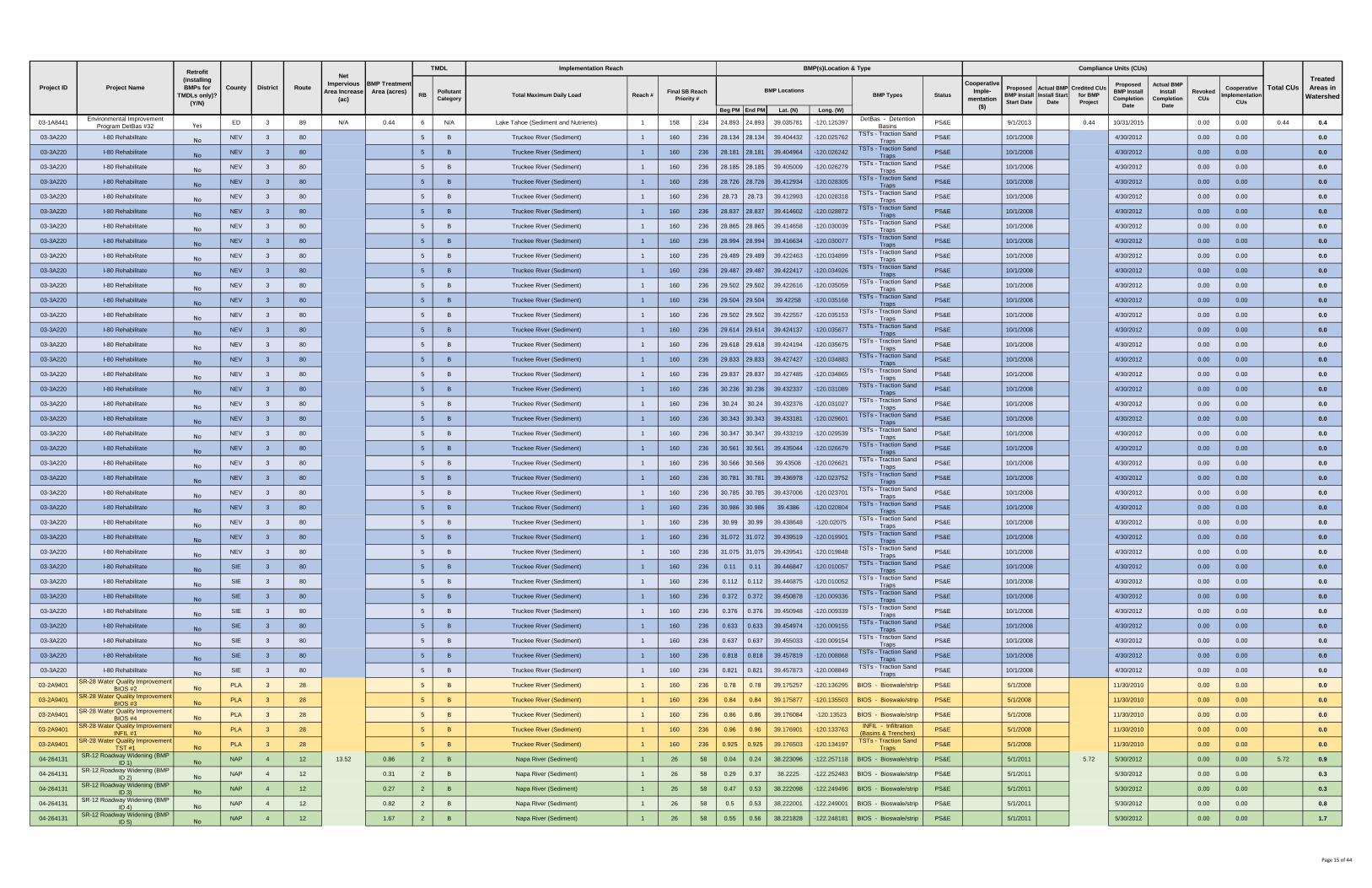
Beg PM End PM Lat. (N) Long. (W)
RouteProject ID Project Name
Retrofit (installing BMPs for
TMDLs only)? (Y/N)
County District Credited CUs for BMP Project
Proposed BMP Install Completion
Date
Actual BMP Install
Completion Date
Net Impervious
Area Increase (ac)
BMP Treatment Area (acres)
TMDL Implementation Reach BMP(s)Location & Type
BMP LocationsBMP Types Status
Revoked CUs
Total CUsTreated Areas in
WatershedRBPollutant Category
Total Maximum Daily Load Reach #Final SB Reach
Priority #
Compliance Units (CUs)
Cooperative Imple-
mentation ($)
Cooperative Implementation
CUs
Proposed BMP Install Start Date
Actual BMP Install Start
Date
03-1A8441Environmental Improvement
Program DetBas #32 Yes ED 3 89 N/A 0.44 6 N/A Lake Tahoe (Sediment and Nutrients) 1 158 234 24.893 24.893 39.035781 -120.125397DetBas - Detention
BasinsPS&E 9/1/2013 0.44 10/31/2015 0.00 0.00 0.44 0.4
03-3A220 I-80 Rehabilitate No NEV 3 80 5 B Truckee River (Sediment) 1 160 236 28.134 28.134 39.404432 -120.025762TSTs - Traction Sand
TrapsPS&E 10/1/2008 4/30/2012 0.00 0.00 0.0
03-3A220 I-80 Rehabilitate No NEV 3 80 5 B Truckee River (Sediment) 1 160 236 28.181 28.181 39.404964 -120.026242TSTs - Traction Sand
TrapsPS&E 10/1/2008 4/30/2012 0.00 0.00 0.0
03-3A220 I-80 Rehabilitate No NEV 3 80 5 B Truckee River (Sediment) 1 160 236 28.185 28.185 39.405009 -120.026279TSTs - Traction Sand
TrapsPS&E 10/1/2008 4/30/2012 0.00 0.00 0.0
03-3A220 I-80 Rehabilitate No NEV 3 80 5 B Truckee River (Sediment) 1 160 236 28.726 28.726 39.412934 -120.028305TSTs - Traction Sand
TrapsPS&E 10/1/2008 4/30/2012 0.00 0.00 0.0
03-3A220 I-80 Rehabilitate No NEV 3 80 5 B Truckee River (Sediment) 1 160 236 28.73 28.73 39.412993 -120.028318TSTs - Traction Sand
TrapsPS&E 10/1/2008 4/30/2012 0.00 0.00 0.0
03-3A220 I-80 Rehabilitate No NEV 3 80 5 B Truckee River (Sediment) 1 160 236 28.837 28.837 39.414602 -120.028872TSTs - Traction Sand
TrapsPS&E 10/1/2008 4/30/2012 0.00 0.00 0.0
03-3A220 I-80 Rehabilitate No NEV 3 80 5 B Truckee River (Sediment) 1 160 236 28.865 28.865 39.414658 -120.030039TSTs - Traction Sand
TrapsPS&E 10/1/2008 4/30/2012 0.00 0.00 0.0
03-3A220 I-80 Rehabilitate No NEV 3 80 5 B Truckee River (Sediment) 1 160 236 28.994 28.994 39.416634 -120.030077TSTs - Traction Sand
TrapsPS&E 10/1/2008 4/30/2012 0.00 0.00 0.0
03-3A220 I-80 Rehabilitate No NEV 3 80 5 B Truckee River (Sediment) 1 160 236 29.489 29.489 39.422463 -120.034899TSTs - Traction Sand
TrapsPS&E 10/1/2008 4/30/2012 0.00 0.00 0.0
03-3A220 I-80 Rehabilitate No NEV 3 80 5 B Truckee River (Sediment) 1 160 236 29.487 29.487 39.422417 -120.034926TSTs - Traction Sand
TrapsPS&E 10/1/2008 4/30/2012 0.00 0.00 0.0
03-3A220 I-80 Rehabilitate No NEV 3 80 5 B Truckee River (Sediment) 1 160 236 29.502 29.502 39.422616 -120.035059TSTs - Traction Sand
TrapsPS&E 10/1/2008 4/30/2012 0.00 0.00 0.0
03-3A220 I-80 Rehabilitate No NEV 3 80 5 B Truckee River (Sediment) 1 160 236 29.504 29.504 39.42258 -120.035168TSTs - Traction Sand
TrapsPS&E 10/1/2008 4/30/2012 0.00 0.00 0.0
03-3A220 I-80 Rehabilitate No NEV 3 80 5 B Truckee River (Sediment) 1 160 236 29.502 29.502 39.422557 -120.035153TSTs - Traction Sand
TrapsPS&E 10/1/2008 4/30/2012 0.00 0.00 0.0
03-3A220 I-80 Rehabilitate No NEV 3 80 5 B Truckee River (Sediment) 1 160 236 29.614 29.614 39.424137 -120.035677TSTs - Traction Sand
TrapsPS&E 10/1/2008 4/30/2012 0.00 0.00 0.0
03-3A220 I-80 Rehabilitate No NEV 3 80 5 B Truckee River (Sediment) 1 160 236 29.618 29.618 39.424194 -120.035675TSTs - Traction Sand
TrapsPS&E 10/1/2008 4/30/2012 0.00 0.00 0.0
03-3A220 I-80 Rehabilitate No NEV 3 80 5 B Truckee River (Sediment) 1 160 236 29.833 29.833 39.427427 -120.034883TSTs - Traction Sand
TrapsPS&E 10/1/2008 4/30/2012 0.00 0.00 0.0
03-3A220 I-80 Rehabilitate No NEV 3 80 5 B Truckee River (Sediment) 1 160 236 29.837 29.837 39.427485 -120.034865TSTs - Traction Sand
TrapsPS&E 10/1/2008 4/30/2012 0.00 0.00 0.0
03-3A220 I-80 Rehabilitate No NEV 3 80 5 B Truckee River (Sediment) 1 160 236 30.236 30.236 39.432337 -120.031089TSTs - Traction Sand
TrapsPS&E 10/1/2008 4/30/2012 0.00 0.00 0.0
03-3A220 I-80 Rehabilitate No NEV 3 80 5 B Truckee River (Sediment) 1 160 236 30.24 30.24 39.432376 -120.031027TSTs - Traction Sand
TrapsPS&E 10/1/2008 4/30/2012 0.00 0.00 0.0
03-3A220 I-80 Rehabilitate No NEV 3 80 5 B Truckee River (Sediment) 1 160 236 30.343 30.343 39.433181 -120.029601TSTs - Traction Sand
TrapsPS&E 10/1/2008 4/30/2012 0.00 0.00 0.0
03-3A220 I-80 Rehabilitate No NEV 3 80 5 B Truckee River (Sediment) 1 160 236 30.347 30.347 39.433219 -120.029539TSTs - Traction Sand
TrapsPS&E 10/1/2008 4/30/2012 0.00 0.00 0.0
03-3A220 I-80 Rehabilitate No NEV 3 80 5 B Truckee River (Sediment) 1 160 236 30.561 30.561 39.435044 -120.026679TSTs - Traction Sand
TrapsPS&E 10/1/2008 4/30/2012 0.00 0.00 0.0
03-3A220 I-80 Rehabilitate No NEV 3 80 5 B Truckee River (Sediment) 1 160 236 30.566 30.566 39.43508 -120.026621TSTs - Traction Sand
TrapsPS&E 10/1/2008 4/30/2012 0.00 0.00 0.0
03-3A220 I-80 Rehabilitate No NEV 3 80 5 B Truckee River (Sediment) 1 160 236 30.781 30.781 39.436978 -120.023752TSTs - Traction Sand
TrapsPS&E 10/1/2008 4/30/2012 0.00 0.00 0.0
03-3A220 I-80 Rehabilitate No NEV 3 80 5 B Truckee River (Sediment) 1 160 236 30.785 30.785 39.437006 -120.023701TSTs - Traction Sand
TrapsPS&E 10/1/2008 4/30/2012 0.00 0.00 0.0
03-3A220 I-80 Rehabilitate No NEV 3 80 5 B Truckee River (Sediment) 1 160 236 30.986 30.986 39.4386 -120.020804TSTs - Traction Sand
TrapsPS&E 10/1/2008 4/30/2012 0.00 0.00 0.0
03-3A220 I-80 Rehabilitate No NEV 3 80 5 B Truckee River (Sediment) 1 160 236 30.99 30.99 39.438648 -120.02075TSTs - Traction Sand
TrapsPS&E 10/1/2008 4/30/2012 0.00 0.00 0.0
03-3A220 I-80 Rehabilitate No NEV 3 80 5 B Truckee River (Sediment) 1 160 236 31.072 31.072 39.439519 -120.019901TSTs - Traction Sand
TrapsPS&E 10/1/2008 4/30/2012 0.00 0.00 0.0
03-3A220 I-80 Rehabilitate No NEV 3 80 5 B Truckee River (Sediment) 1 160 236 31.075 31.075 39.439541 -120.019848TSTs - Traction Sand
TrapsPS&E 10/1/2008 4/30/2012 0.00 0.00 0.0
03-3A220 I-80 Rehabilitate No SIE 3 80 5 B Truckee River (Sediment) 1 160 236 0.11 0.11 39.446847 -120.010057TSTs - Traction Sand
TrapsPS&E 10/1/2008 4/30/2012 0.00 0.00 0.0
03-3A220 I-80 Rehabilitate No SIE 3 80 5 B Truckee River (Sediment) 1 160 236 0.112 0.112 39.446875 -120.010052TSTs - Traction Sand
TrapsPS&E 10/1/2008 4/30/2012 0.00 0.00 0.0
03-3A220 I-80 Rehabilitate No SIE 3 80 5 B Truckee River (Sediment) 1 160 236 0.372 0.372 39.450878 -120.009336TSTs - Traction Sand
TrapsPS&E 10/1/2008 4/30/2012 0.00 0.00 0.0
03-3A220 I-80 Rehabilitate No SIE 3 80 5 B Truckee River (Sediment) 1 160 236 0.376 0.376 39.450948 -120.009339TSTs - Traction Sand
TrapsPS&E 10/1/2008 4/30/2012 0.00 0.00 0.0
03-3A220 I-80 Rehabilitate No SIE 3 80 5 B Truckee River (Sediment) 1 160 236 0.633 0.633 39.454974 -120.009155TSTs - Traction Sand
TrapsPS&E 10/1/2008 4/30/2012 0.00 0.00 0.0
03-3A220 I-80 Rehabilitate No SIE 3 80 5 B Truckee River (Sediment) 1 160 236 0.637 0.637 39.455033 -120.009154TSTs - Traction Sand
TrapsPS&E 10/1/2008 4/30/2012 0.00 0.00 0.0
03-3A220 I-80 Rehabilitate No SIE 3 80 5 B Truckee River (Sediment) 1 160 236 0.818 0.818 39.457819 -120.008868TSTs - Traction Sand
TrapsPS&E 10/1/2008 4/30/2012 0.00 0.00 0.0
03-3A220 I-80 Rehabilitate No SIE 3 80 5 B Truckee River (Sediment) 1 160 236 0.821 0.821 39.457873 -120.008849TSTs - Traction Sand
TrapsPS&E 10/1/2008 4/30/2012 0.00 0.00 0.0
03-2A9401SR-28 Water Quality Improvement
BIOS #2 No PLA 3 28 5 B Truckee River (Sediment) 1 160 236 0.78 0.78 39.175257 -120.136295 BIOS - Bioswale/strip PS&E 5/1/2008 11/30/2010 0.00 0.00 0.0
03-2A9401SR-28 Water Quality Improvement
BIOS #3 No PLA 3 28 5 B Truckee River (Sediment) 1 160 236 0.84 0.84 39.175877 -120.135503 BIOS - Bioswale/strip PS&E 5/1/2008 11/30/2010 0.00 0.00 0.0
03-2A9401SR-28 Water Quality Improvement
BIOS #4 No PLA 3 28 5 B Truckee River (Sediment) 1 160 236 0.86 0.86 39.176084 -120.13523 BIOS - Bioswale/strip PS&E 5/1/2008 11/30/2010 0.00 0.00 0.0
03-2A9401SR-28 Water Quality Improvement
INFIL #1 No PLA 3 28 5 B Truckee River (Sediment) 1 160 236 0.96 0.96 39.176901 -120.133763INFIL - Infiltration
(Basins & Trenches)PS&E 5/1/2008 11/30/2010 0.00 0.00 0.0
03-2A9401SR-28 Water Quality Improvement
TST #1 No PLA 3 28 5 B Truckee River (Sediment) 1 160 236 0.925 0.925 39.176503 -120.134197TSTs - Traction Sand
TrapsPS&E 5/1/2008 11/30/2010 0.00 0.00 0.0
04-264131SR-12 Roadway Widening (BMP
ID 1) No NAP 4 12 13.52 0.86 2 B Napa River (Sediment) 1 26 58 0.04 0.24 38.223096 -122.257118 BIOS - Bioswale/strip PS&E 5/1/2011 5.72 5/30/2012 0.00 0.00 5.72 0.9
04-264131SR-12 Roadway Widening (BMP
ID 2) No NAP 4 12 0.31 2 B Napa River (Sediment) 1 26 58 0.29 0.37 38.2225 -122.252483 BIOS - Bioswale/strip PS&E 5/1/2011 5/30/2012 0.00 0.00 0.3
04-264131SR-12 Roadway Widening (BMP
ID 3) No NAP 4 12 0.27 2 B Napa River (Sediment) 1 26 58 0.47 0.53 38.222098 -122.249496 BIOS - Bioswale/strip PS&E 5/1/2011 5/30/2012 0.00 0.00 0.3
04-264131SR-12 Roadway Widening (BMP
ID 4) No NAP 4 12 0.82 2 B Napa River (Sediment) 1 26 58 0.5 0.53 38.222001 -122.249001 BIOS - Bioswale/strip PS&E 5/1/2011 5/30/2012 0.00 0.00 0.8
04-264131SR-12 Roadway Widening (BMP
ID 5) No NAP 4 12 1.67 2 B Napa River (Sediment) 1 26 58 0.55 0.56 38.221828 -122.248181 BIOS - Bioswale/strip PS&E 5/1/2011 5/30/2012 0.00 0.00 1.7
Page 15 of 44

Beg PM End PM Lat. (N) Long. (W)
RouteProject ID Project Name
Retrofit (installing BMPs for
TMDLs only)? (Y/N)
County District Credited CUs for BMP Project
Proposed BMP Install Completion
Date
Actual BMP Install
Completion Date
Net Impervious
Area Increase (ac)
BMP Treatment Area (acres)
TMDL Implementation Reach BMP(s)Location & Type
BMP LocationsBMP Types Status
Revoked CUs
Total CUsTreated Areas in
WatershedRBPollutant Category
Total Maximum Daily Load Reach #Final SB Reach
Priority #
Compliance Units (CUs)
Cooperative Imple-
mentation ($)
Cooperative Implementation
CUs
Proposed BMP Install Start Date
Actual BMP Install Start
Date
04-264131SR-12 Roadway Widening (BMP
ID 6) No NAP 4 12 1.39 2 B Napa River (Sediment) 1 26 58 0.72 0.75 38.221283 -122.245391 BIOS - Bioswale/strip PS&E 5/1/2011 5/30/2012 0.00 0.00 1.4
04-264131SR-12 Roadway Widening (BMP
ID 7) No NAP 4 12 0.03 2 B Napa River (Sediment) 1 26 58 0.83 0.86 38.221256 -122.243553 BIOS - Bioswale/strip PS&E 5/1/2011 5/30/2012 0.00 0.00 0.0
04-264131SR-12 Roadway Widening (BMP
ID 7-1) No NAP 4 12 0.17 2 B Napa River (Sediment) 1 26 58 0.87 0.94 38.22128 -122.242888 BIOS - Bioswale/strip PS&E 5/1/2011 5/30/2012 0.00 0.00 0.2
04-264131SR-12 Roadway Widening (BMP
ID 8) No NAP 4 12 0.56 2 B Napa River (Sediment) 1 26 58 0.94 0.96 38.221324 -122.241723 BIOS - Bioswale/strip PS&E 5/1/2011 5/30/2012 0.00 0.00 0.6
04-264131SR-12 Roadway Widening (BMP
ID 9) No NAP 4 12 0.39 2 B Napa River (Sediment) 1 26 58 0.96 0.99 38.221336 -122.24139 BIOS - Bioswale/strip PS&E 5/1/2011 5/30/2012 0.00 0.00 0.4
04-264131SR-12 Roadway Widening (BMP
ID 10) No NAP 4 12 1.00 2 B Napa River (Sediment) 1 26 58 1.05 1.22 38.221409 -122.23988 BIOS - Bioswale/strip PS&E 5/1/2011 5/30/2012 0.00 0.00 1.0
04-264131SR-12 Roadway Widening (BMP
ID 11) No NAP 4 12 1.14 2 B Napa River (Sediment) 1 26 58 1.24 1.26 38.221043 -122.236756 BIOS - Bioswale/strip PS&E 5/1/2011 5/30/2012 0.00 0.00 1.1
04-264131SR-12 Roadway Widening (BMP
ID 12) No NAP 4 12 0.40 2 B Napa River (Sediment) 1 26 58 1.26 1.31 38.220934 -122.236439 BIOS - Bioswale/strip PS&E 5/1/2011 5/30/2012 0.00 0.00 0.4
04-264131SR-12 Roadway Widening (BMP
ID 13) No NAP 4 12 0.60 2 B Napa River (Sediment) 1 26 58 1.33 1.43 38.220553 -122.235329 BIOS - Bioswale/strip PS&E 5/1/2011 5/30/2012 0.00 0.00 0.6
04-264131SR-12 Roadway Widening (BMP
ID 14) No NAP 4 12 0.40 2 B Napa River (Sediment) 1 26 58 1.39 1.45 38.220212 -122.234385 BIOS - Bioswale/strip PS&E 5/1/2011 5/30/2012 0.00 0.00 0.4
04-264131SR-12 Roadway Widening (BMP
ID 15) No NAP 4 12 0.26 2 B Napa River (Sediment) 1 26 58 1.53 1.58 38.219418 -122.232179 BIOS - Bioswale/strip PS&E 5/1/2011 5/30/2012 0.00 0.00 0.3
04-264131SR-12 Roadway Widening (BMP
ID 16) No NAP 4 12 0.43 2 B Napa River (Sediment) 1 26 58 1.6 1.69 38.21903 -122.231074 BIOS - Bioswale/strip PS&E 5/1/2011 5/30/2012 0.00 0.00 0.4
04-264131SR-12 Roadway Widening (BMP
ID 17) No NAP 4 12 0.27 2 B Napa River (Sediment) 1 26 58 1.79 1.85 38.217969 -122.228086 BIOS - Bioswale/strip PS&E 5/1/2011 5/30/2012 0.00 0.00 0.3
04-264131SR-12 Roadway Widening (BMP
ID 18) No NAP 4 12 0.54 2 B Napa River (Sediment) 1 26 58 1.91 2.02 38.217295 -122.226195 BIOS - Bioswale/strip PS&E 5/1/2011 5/30/2012 0.00 0.00 0.5
04-264131SR-12 Roadway Widening (BMP
ID 19) No NAP 4 12 0.94 2 B Napa River (Sediment) 1 26 58 1.93 1.98 38.217182 -122.22588 BIOS - Bioswale/strip PS&E 5/1/2011 5/30/2012 0.00 0.00 0.9
04-264131SR-12 Roadway Widening (BMP
ID 20) No NAP 4 12 1.07 2 B Napa River (Sediment) 1 26 58 2.06 2.11 38.216452 -122.22383 BIOS - Bioswale/strip PS&E 5/1/2011 5/30/2012 0.00 0.00 1.1
04-264131SR-12 Roadway Widening (BMP
ID 21) No NAP 4 12 0.28 2 B Napa River (Sediment) 1 26 58 2.21 2.27 38.215612 -122.221461 BIOS - Bioswale/strip PS&E 5/1/2011 5/30/2012 0.00 0.00 0.3
04-264131SR-12 Roadway Widening (BMP
ID 22-1) No NAP 4 12 0.65 2 B Napa River (Sediment) 1 26 58 2.31 2.45 38.215054 -122.219895 BIOS - Bioswale/strip PS&E 5/1/2011 5/30/2012 0.00 0.00 0.7
04-264131SR-12 Roadway Widening (BMP
ID 22-2) No NAP 4 12 0.47 2 B Napa River (Sediment) 1 26 58 2.45 2.55 38.214374 -122.217646 BIOS - Bioswale/strip PS&E 5/1/2011 5/30/2012 0.00 0.00 0.5
04-264131SR-12 Roadway Widening (BMP
ID 22-3) No NAP 4 12 0.44 2 B Napa River (Sediment) 1 26 58 2.55 2.64 38.213912 -122.216039 BIOS - Bioswale/strip PS&E 5/1/2011 5/30/2012 0.00 0.00 0.4
04-264131SR-12 Roadway Widening (BMP
ID 23) No NAP 4 12 0.84 2 B Napa River (Sediment) 1 26 58 2.32 2.35 38.215005 -122.219735 BIOS - Bioswale/strip PS&E 5/1/2011 5/30/2012 0.00 0.00 0.8
04-264131SR-12 Roadway Widening (BMP
ID 24) No NAP 4 12 1.40 2 B Napa River (Sediment) 1 26 58 2.6 2.62 38.213678 -122.21524 BIOS - Bioswale/strip PS&E 5/1/2011 5/30/2012 0.00 0.00 1.4
04-264131SR-12 Roadway Widening (BMP
ID 25) No NAP 4 12 1.28 2 B Napa River (Sediment) 1 26 58 2.78 2.8 38.212793 -122.212362 BIOS - Bioswale/strip PS&E 5/1/2011 5/30/2012 0.00 0.00 1.3
04-264131SR-12 Roadway Widening (BMP
ID 26-1) No NAP 4 12 0.18 2 B Napa River (Sediment) 1 26 58 3.11 3.12 38.211106 -122.207127 BIOS - Bioswale/strip PS&E 5/1/2011 5/30/2012 0.00 0.00 0.2
04-264131SR-12 Roadway Widening (BMP
ID 26-2) No NAP 4 12 0.18 2 B Napa River (Sediment) 1 26 58 3.12 3.13 38.211032 -122.206978 BIOS - Bioswale/strip PS&E 5/1/2011 5/30/2012 0.00 0.00 0.2
04-26407I-101 Interchange Modifications and Frontage Roads (BMP ID 1) No MRN 4 101 11.12 0.63 2 B San Francisco Bay (Mercury) 10 99 170 23.66 23.26 38.13859 -122.564088 BIOS - Bioswale/strip PS&E 6/1/2012 4.59 6/30/2014 0.00 0.00 4.59 0.6
04-26407I-101 Interchange Modifications and Frontage Roads (BMP ID 2) No MRN 4 101 0.07 2 B San Francisco Bay (Mercury) 10 99 170 23.8 23.8 38.140632 -122.564233 BIOS - Bioswale/strip PS&E 6/1/2012 6/30/2014 0.00 0.00 0.1
04-26407I-101 Interchange Modifications and Frontage Roads (BMP ID 3) No MRN 4 101 0.78 2 B San Francisco Bay (Mercury) 10 99 170 23.81 23.81 38.140778 -122.564244 BIOS - Bioswale/strip PS&E 6/1/2012 6/30/2014 0.00 0.00 0.8
04-26407I-101 Interchange Modifications and Frontage Roads (BMP ID 4) No MRN 4 101 0.49 2 B San Francisco Bay (Mercury) 10 99 170 24.21 24.21 38.146529 -122.56519 BIOS - Bioswale/strip PS&E 6/1/2012 6/30/2014 0.00 0.00 0.5
04-26407I-101 Interchange Modifications and Frontage Roads (BMP ID 5) No MRN 4 101 0.03 2 B San Francisco Bay (Mercury) 10 99 170 24.46 24.46 38.149984 -122.566392 BIOS - Bioswale/strip PS&E 6/1/2012 6/30/2014 0.00 0.00 0.0
04-26407I-101 Interchange Modifications and Frontage Roads (BMP ID 6) No MRN 4 101 0.06 2 B San Francisco Bay (Mercury) 10 99 170 24.48 24.48 38.15026 -122.566488 BIOS - Bioswale/strip PS&E 6/1/2012 6/30/2014 0.00 0.00 0.1
04-26407I-101 Interchange Modifications and Frontage Roads (BMP ID 7) No MRN 4 101 0.26 2 B San Francisco Bay (Mercury) 10 99 170 24.47 24.47 38.150122 -122.56644 BIOS - Bioswale/strip PS&E 6/1/2012 6/30/2014 0.00 0.00 0.3
04-26407I-101 Interchange Modifications and Frontage Roads (BMP ID 8) No MRN 4 101 0.25 2 B San Francisco Bay (Mercury) 10 99 170 24.72 24.72 38.153582 -122.567637 BIOS - Bioswale/strip PS&E 6/1/2012 6/30/2014 0.00 0.00 0.3
04-26407I-101 Interchange Modifications and Frontage Roads (BMP ID 9) No MRN 4 101 0.47 2 B San Francisco Bay (Mercury) 10 99 170 24.83 24.83 38.155106 -122.568158 BIOS - Bioswale/strip PS&E 6/1/2012 6/30/2014 0.00 0.00 0.5
04-26407I-101 Interchange Modifications
and Frontage Roads (BMP ID 10) No MRN 4 101 0.94 2 B San Francisco Bay (Mercury) 10 99 170 24.94 24.94 38.156628 -122.568679 BIOS - Bioswale/strip PS&E 6/1/2012 6/30/2014 0.00 0.00 0.9
04-26407I-101 Interchange Modifications
and Frontage Roads (BMP ID 11) No MRN 4 101 0.34 2 B San Francisco Bay (Mercury) 10 99 170 25.29 25.29 38.160575 -122.571827 BIOS - Bioswale/strip PS&E 6/1/2012 6/30/2014 0.00 0.00 0.3
04-26407I-101 Interchange Modifications
and Frontage Roads (BMP ID 12) No MRN 4 101 0.02 2 B San Francisco Bay (Mercury) 10 99 170 25.37 25.37 38.161268 -122.572778 BIOS - Bioswale/strip PS&E 6/1/2012 6/30/2014 0.00 0.00 0.0
04-26407I-101 Interchange Modifications
and Frontage Roads (BMP ID 13) No MRN 4 101 0.60 2 B San Francisco Bay (Mercury) 10 99 170 25.35 25.35 38.161095 -122.57254 BIOS - Bioswale/strip PS&E 6/1/2012 6/30/2014 0.00 0.00 0.6
04-26407I-101 Interchange Modifications
and Frontage Roads (BMP ID 14) No MRN 4 101 0.10 2 B San Francisco Bay (Mercury) 10 99 170 25.58 25.58 38.163301 -122.575571 BIOS - Bioswale/strip PS&E 6/1/2012 6/30/2014 0.00 0.00 0.1
04-26407I-101 Interchange Modifications
and Frontage Roads (BMP ID 15) No MRN 4 101 0.19 2 B San Francisco Bay (Mercury) 10 99 170 26.87 26.87 38.17633 -122.593763 BIOS - Bioswale/strip PS&E 6/1/2012 6/30/2014 0.00 0.00 0.2
04-26407I-101 Interchange Modifications
and Frontage Roads (BMP ID 16) No MRN 4 101 1.01 2 B San Francisco Bay (Mercury) 10 99 170 25.25 25.25 38.160225 -122.571359 BIOS - Bioswale/strip PS&E 6/1/2012 6/30/2014 0.00 0.00 1.0
04-26407I-101 Interchange Modifications
and Frontage Roads (BMP ID 17) No MRN 4 101 0.34 2 B San Francisco Bay (Mercury) 10 99 170 25.51 25.51 38.162584 -122.574589 BIOS - Bioswale/strip PS&E 6/1/2012 6/30/2014 0.00 0.00 0.3
04-26407I-101 Interchange Modifications
and Frontage Roads (BMP ID 18) No MRN 4 101 0.03 2 B San Francisco Bay (Mercury) 10 99 170 25.5 25.5 38.162482 -122.574448 BIOS - Bioswale/strip PS&E 6/1/2012 6/30/2014 0.00 0.00 0.0
04-26407I-101 Interchange Modifications
and Frontage Roads (BMP ID 19) No MRN 4 101 0.16 2 B San Francisco Bay (Mercury) 10 99 170 25.52 25.52 38.162686 -122.574729 BIOS - Bioswale/strip PS&E 6/1/2012 6/30/2014 0.00 0.00 0.2
04-26407I-101 Interchange Modifications
and Frontage Roads (BMP ID 20) No MRN 4 101 0.73 2 B San Francisco Bay (Mercury) 10 99 170 25.56 25.56 38.163095 -122.575292 BIOS - Bioswale/strip PS&E 6/1/2012 6/30/2014 0.00 0.00 0.7
04-26407I-101 Interchange Modifications
and Frontage Roads (BMP ID 21) No MRN 4 101 0.17 2 B San Francisco Bay (Mercury) 10 99 170 25.88 25.88 38.166529 -122.57965 BIOS - Bioswale/strip PS&E 6/1/2012 6/30/2014 0.00 0.00 0.2
04-26407I-101 Interchange Modifications
and Frontage Roads (BMP ID 22) No MRN 4 101 0.65 2 B San Francisco Bay (Mercury) 10 99 170 25.95 25.95 38.167183 -122.580681 BIOS - Bioswale/strip PS&E 6/1/2012 6/30/2014 0.00 0.00 0.7
04-26407I-101 Interchange Modifications
and Frontage Roads (BMP ID 23) No MRN 4 101 0.38 2 B San Francisco Bay (Mercury) 10 99 170 26.08 26.08 38.168385 -122.582588 BIOS - Bioswale/strip PS&E 6/1/2012 6/30/2014 0.00 0.00 0.4
Page 16 of 44
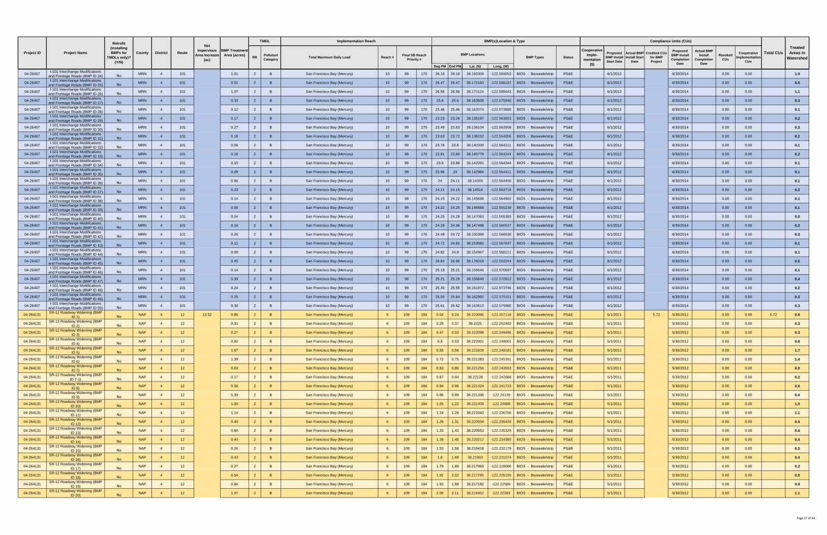
Beg PM End PM Lat. (N) Long. (W)
RouteProject ID Project Name
Retrofit (installing BMPs for
TMDLs only)? (Y/N)
County District Credited CUs for BMP Project
Proposed BMP Install Completion
Date
Actual BMP Install
Completion Date
Net Impervious
Area Increase (ac)
BMP Treatment Area (acres)
TMDL Implementation Reach BMP(s)Location & Type
BMP LocationsBMP Types Status
Revoked CUs
Total CUsTreated Areas in
WatershedRBPollutant Category
Total Maximum Daily Load Reach #Final SB Reach
Priority #
Compliance Units (CUs)
Cooperative Imple-
mentation ($)
Cooperative Implementation
CUs
Proposed BMP Install Start Date
Actual BMP Install Start
Date
04-26407I-101 Interchange Modifications
and Frontage Roads (BMP ID 24) No MRN 4 101 1.01 2 B San Francisco Bay (Mercury) 10 99 170 26.18 26.18 38.169309 -122.584053 BIOS - Bioswale/strip PS&E 6/1/2012 6/30/2014 0.00 0.00 1.0
04-26407I-101 Interchange Modifications
and Frontage Roads (BMP ID 25) No MRN 4 101 0.51 2 B San Francisco Bay (Mercury) 10 99 170 26.47 26.47 38.172193 -122.588187 BIOS - Bioswale/strip PS&E 6/1/2012 6/30/2014 0.00 0.00 0.5
04-26407I-101 Interchange Modifications
and Frontage Roads (BMP ID 26) No MRN 4 101 1.07 2 B San Francisco Bay (Mercury) 10 99 170 26.56 26.56 38.173124 -122.589443 BIOS - Bioswale/strip PS&E 6/1/2012 6/30/2014 0.00 0.00 1.1
04-26407I-101 Interchange Modifications
and Frontage Roads (BMP ID 27) No MRN 4 101 0.33 2 B San Francisco Bay (Mercury) 10 99 170 25.6 25.6 38.163508 -122.575848 BIOS - Bioswale/strip PS&E 6/1/2012 6/30/2014 0.00 0.00 0.3
04-26407I-101 Interchange Modifications
and Frontage Roads (BMP ID 28) No MRN 4 101 0.12 2 B San Francisco Bay (Mercury) 10 99 170 25.46 25.46 38.162074 -122.573886 BIOS - Bioswale/strip PS&E 6/1/2012 6/30/2014 0.00 0.00 0.1
04-26407I-101 Interchange Modifications
and Frontage Roads (BMP ID 29) No MRN 4 101 0.17 2 B San Francisco Bay (Mercury) 10 99 170 23.23 23.26 38.135197 -122.563853 BIOS - Bioswale/strip PS&E 6/1/2012 6/30/2014 0.00 0.00 0.2
04-26407I-101 Interchange Modifications
and Frontage Roads (BMP ID 30) No MRN 4 101 0.27 2 B San Francisco Bay (Mercury) 10 99 170 23.49 23.63 38.136104 -122.563908 BIOS - Bioswale/strip PS&E 6/1/2012 6/30/2014 0.00 0.00 0.3
04-26407I-101 Interchange Modifications
and Frontage Roads (BMP ID 31) No MRN 4 101 0.18 2 B San Francisco Bay (Mercury) 10 99 170 23.63 23.72 38.138152 -122.564056 BIOS - Bioswale/strip PS&E 6/1/2012 6/30/2014 0.00 0.00 0.2
04-26407I-101 Interchange Modifications
and Frontage Roads (BMP ID 32) No MRN 4 101 0.06 2 B San Francisco Bay (Mercury) 10 99 170 23.78 23.8 38.140339 -122.564211 BIOS - Bioswale/strip PS&E 6/1/2012 6/30/2014 0.00 0.00 0.1
04-26407I-101 Interchange Modifications
and Frontage Roads (BMP ID 33) No MRN 4 101 0.18 2 B San Francisco Bay (Mercury) 10 99 170 23.81 23.89 38.140778 -122.564244 BIOS - Bioswale/strip PS&E 6/1/2012 6/30/2014 0.00 0.00 0.2
04-26407I-101 Interchange Modifications
and Frontage Roads (BMP ID 34) No MRN 4 101 0.10 2 B San Francisco Bay (Mercury) 10 99 170 23.9 23.96 38.142091 -122.564344 BIOS - Bioswale/strip PS&E 6/1/2012 6/30/2014 0.00 0.00 0.1
04-26407I-101 Interchange Modifications
and Frontage Roads (BMP ID 35) No MRN 4 101 0.09 2 B San Francisco Bay (Mercury) 10 99 170 23.96 24 38.142966 -122.564411 BIOS - Bioswale/strip PS&E 6/1/2012 6/30/2014 0.00 0.00 0.1
04-26407I-101 Interchange Modifications
and Frontage Roads (BMP ID 36) No MRN 4 101 0.06 2 B San Francisco Bay (Mercury) 10 99 170 24 24.11 38.14355 -122.564456 BIOS - Bioswale/strip PS&E 6/1/2012 6/30/2014 0.00 0.00 0.1
04-26407I-101 Interchange Modifications
and Frontage Roads (BMP ID 37) No MRN 4 101 0.23 2 B San Francisco Bay (Mercury) 10 99 170 24.11 24.15 38.14514 -122.564718 BIOS - Bioswale/strip PS&E 6/1/2012 6/30/2014 0.00 0.00 0.2
04-26407I-101 Interchange Modifications
and Frontage Roads (BMP ID 38) No MRN 4 101 0.14 2 B San Francisco Bay (Mercury) 10 99 170 24.15 24.22 38.145698 -122.564902 BIOS - Bioswale/strip PS&E 6/1/2012 6/30/2014 0.00 0.00 0.1
04-26407I-101 Interchange Modifications
and Frontage Roads (BMP ID 39) No MRN 4 101 0.06 2 B San Francisco Bay (Mercury) 10 99 170 24.22 24.25 38.146668 -122.565238 BIOS - Bioswale/strip PS&E 6/1/2012 6/30/2014 0.00 0.00 0.1
04-26407I-101 Interchange Modifications
and Frontage Roads (BMP ID 40) No MRN 4 101 0.04 2 B San Francisco Bay (Mercury) 10 99 170 24.25 24.28 38.147083 -122.565383 BIOS - Bioswale/strip PS&E 6/1/2012 6/30/2014 0.00 0.00 0.0
04-26407I-101 Interchange Modifications
and Frontage Roads (BMP ID 41) No MRN 4 101 0.16 2 B San Francisco Bay (Mercury) 10 99 170 24.28 24.36 38.147498 -122.565527 BIOS - Bioswale/strip PS&E 6/1/2012 6/30/2014 0.00 0.00 0.2
04-26407I-101 Interchange Modifications
and Frontage Roads (BMP ID 42) No MRN 4 101 0.26 2 B San Francisco Bay (Mercury) 10 99 170 24.49 24.72 38.150398 -122.566536 BIOS - Bioswale/strip PS&E 6/1/2012 6/30/2014 0.00 0.00 0.3
04-26407I-101 Interchange Modifications
and Frontage Roads (BMP ID 43) No MRN 4 101 0.11 2 B San Francisco Bay (Mercury) 10 99 170 24.72 24.82 38.153582 -122.567637 BIOS - Bioswale/strip PS&E 6/1/2012 6/30/2014 0.00 0.00 0.1
04-26407I-101 Interchange Modifications
and Frontage Roads (BMP ID 44) No MRN 4 101 0.09 2 B San Francisco Bay (Mercury) 10 99 170 24.82 24.9 38.154967 -122.568111 BIOS - Bioswale/strip PS&E 6/1/2012 6/30/2014 0.00 0.00 0.1
04-26407I-101 Interchange Modifications
and Frontage Roads (BMP ID 45) No MRN 4 101 0.45 2 B San Francisco Bay (Mercury) 10 99 170 26.84 26.96 38.176019 -122.593344 BIOS - Bioswale/strip PS&E 6/1/2012 6/30/2014 0.00 0.00 0.5
04-26407I-101 Interchange Modifications
and Frontage Roads (BMP ID 46) No MRN 4 101 0.14 2 B San Francisco Bay (Mercury) 10 99 170 25.19 25.21 38.159648 -122.570697 BIOS - Bioswale/strip PS&E 6/1/2012 6/30/2014 0.00 0.00 0.1
04-26407I-101 Interchange Modifications
and Frontage Roads (BMP ID 47) No MRN 4 101 0.39 2 B San Francisco Bay (Mercury) 10 99 170 25.21 25.29 38.159848 -122.570912 BIOS - Bioswale/strip PS&E 6/1/2012 6/30/2014 0.00 0.00 0.4
04-26407I-101 Interchange Modifications
and Frontage Roads (BMP ID 48) No MRN 4 101 0.24 2 B San Francisco Bay (Mercury) 10 99 170 25.45 25.55 38.161972 -122.573746 BIOS - Bioswale/strip PS&E 6/1/2012 6/30/2014 0.00 0.00 0.2
04-26407I-101 Interchange Modifications
and Frontage Roads (BMP ID 49) No MRN 4 101 0.25 2 B San Francisco Bay (Mercury) 10 99 170 25.55 25.64 38.162992 -122.575151 BIOS - Bioswale/strip PS&E 6/1/2012 6/30/2014 0.00 0.00 0.3
04-26407I-101 Interchange Modifications
and Frontage Roads (BMP ID 50) No MRN 4 101 0.30 2 B San Francisco Bay (Mercury) 10 99 170 25.61 25.62 38.163613 -122.575986 BIOS - Bioswale/strip PS&E 6/1/2012 6/30/2014 0.00 0.00 0.3
04-264131SR-12 Roadway Widening (BMP
ID 1) No NAP 4 12 13.52 0.86 2 B San Francisco Bay (Mercury) 6 109 184 0.04 0.24 38.223096 -122.257118 BIOS - Bioswale/strip PS&E 5/1/2011 5.72 5/30/2012 0.00 0.00 5.72 0.9
04-264131SR-12 Roadway Widening (BMP
ID 2) No NAP 4 12 0.31 2 B San Francisco Bay (Mercury) 6 109 184 0.29 0.37 38.2225 -122.252483 BIOS - Bioswale/strip PS&E 5/1/2011 5/30/2012 0.00 0.00 0.3
04-264131SR-12 Roadway Widening (BMP
ID 3) No NAP 4 12 0.27 2 B San Francisco Bay (Mercury) 6 109 184 0.47 0.53 38.222098 -122.249496 BIOS - Bioswale/strip PS&E 5/1/2011 5/30/2012 0.00 0.00 0.3
04-264131SR-12 Roadway Widening (BMP
ID 4) No NAP 4 12 0.82 2 B San Francisco Bay (Mercury) 6 109 184 0.5 0.53 38.222001 -122.249001 BIOS - Bioswale/strip PS&E 5/1/2011 5/30/2012 0.00 0.00 0.8
04-264131SR-12 Roadway Widening (BMP
ID 5) No NAP 4 12 1.67 2 B San Francisco Bay (Mercury) 6 109 184 0.55 0.56 38.221828 -122.248181 BIOS - Bioswale/strip PS&E 5/1/2011 5/30/2012 0.00 0.00 1.7
04-264131SR-12 Roadway Widening (BMP
ID 6) No NAP 4 12 1.39 2 B San Francisco Bay (Mercury) 6 109 184 0.72 0.75 38.221283 -122.245391 BIOS - Bioswale/strip PS&E 5/1/2011 5/30/2012 0.00 0.00 1.4
04-264131SR-12 Roadway Widening (BMP
ID 7) No NAP 4 12 0.03 2 B San Francisco Bay (Mercury) 6 109 184 0.83 0.86 38.221256 -122.243553 BIOS - Bioswale/strip PS&E 5/1/2011 5/30/2012 0.00 0.00 0.0
04-264131SR-12 Roadway Widening (BMP
ID 7-1) No NAP 4 12 0.17 2 B San Francisco Bay (Mercury) 6 109 184 0.87 0.94 38.22128 -122.242888 BIOS - Bioswale/strip PS&E 5/1/2011 5/30/2012 0.00 0.00 0.2
04-264131SR-12 Roadway Widening (BMP
ID 8) No NAP 4 12 0.56 2 B San Francisco Bay (Mercury) 6 109 184 0.94 0.96 38.221324 -122.241723 BIOS - Bioswale/strip PS&E 5/1/2011 5/30/2012 0.00 0.00 0.6
04-264131SR-12 Roadway Widening (BMP
ID 9) No NAP 4 12 0.39 2 B San Francisco Bay (Mercury) 6 109 184 0.96 0.99 38.221336 -122.24139 BIOS - Bioswale/strip PS&E 5/1/2011 5/30/2012 0.00 0.00 0.4
04-264131SR-12 Roadway Widening (BMP
ID 10) No NAP 4 12 1.00 2 B San Francisco Bay (Mercury) 6 109 184 1.05 1.22 38.221409 -122.23988 BIOS - Bioswale/strip PS&E 5/1/2011 5/30/2012 0.00 0.00 1.0
04-264131SR-12 Roadway Widening (BMP
ID 11) No NAP 4 12 1.14 2 B San Francisco Bay (Mercury) 6 109 184 1.24 1.26 38.221043 -122.236756 BIOS - Bioswale/strip PS&E 5/1/2011 5/30/2012 0.00 0.00 1.1
04-264131SR-12 Roadway Widening (BMP
ID 12) No NAP 4 12 0.40 2 B San Francisco Bay (Mercury) 6 109 184 1.26 1.31 38.220934 -122.236439 BIOS - Bioswale/strip PS&E 5/1/2011 5/30/2012 0.00 0.00 0.4
04-264131SR-12 Roadway Widening (BMP
ID 13) No NAP 4 12 0.60 2 B San Francisco Bay (Mercury) 6 109 184 1.33 1.43 38.220553 -122.235329 BIOS - Bioswale/strip PS&E 5/1/2011 5/30/2012 0.00 0.00 0.6
04-264131SR-12 Roadway Widening (BMP
ID 14) No NAP 4 12 0.40 2 B San Francisco Bay (Mercury) 6 109 184 1.39 1.45 38.220212 -122.234385 BIOS - Bioswale/strip PS&E 5/1/2011 5/30/2012 0.00 0.00 0.4
04-264131SR-12 Roadway Widening (BMP
ID 15) No NAP 4 12 0.26 2 B San Francisco Bay (Mercury) 6 109 184 1.53 1.58 38.219418 -122.232179 BIOS - Bioswale/strip PS&E 5/1/2011 5/30/2012 0.00 0.00 0.3
04-264131SR-12 Roadway Widening (BMP
ID 16) No NAP 4 12 0.43 2 B San Francisco Bay (Mercury) 6 109 184 1.6 1.69 38.21903 -122.231074 BIOS - Bioswale/strip PS&E 5/1/2011 5/30/2012 0.00 0.00 0.4
04-264131SR-12 Roadway Widening (BMP
ID 17) No NAP 4 12 0.27 2 B San Francisco Bay (Mercury) 6 109 184 1.79 1.85 38.217969 -122.228086 BIOS - Bioswale/strip PS&E 5/1/2011 5/30/2012 0.00 0.00 0.3
04-264131SR-12 Roadway Widening (BMP
ID 18) No NAP 4 12 0.54 2 B San Francisco Bay (Mercury) 6 109 184 1.91 2.02 38.217295 -122.226195 BIOS - Bioswale/strip PS&E 5/1/2011 5/30/2012 0.00 0.00 0.5
04-264131SR-12 Roadway Widening (BMP
ID 19) No NAP 4 12 0.94 2 B San Francisco Bay (Mercury) 6 109 184 1.93 1.98 38.217182 -122.22588 BIOS - Bioswale/strip PS&E 5/1/2011 5/30/2012 0.00 0.00 0.9
04-264131SR-12 Roadway Widening (BMP
ID 20) No NAP 4 12 1.07 2 B San Francisco Bay (Mercury) 6 109 184 2.06 2.11 38.216452 -122.22383 BIOS - Bioswale/strip PS&E 5/1/2011 5/30/2012 0.00 0.00 1.1
Page 17 of 44
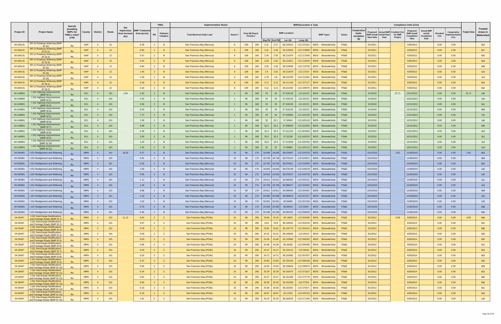
Beg PM End PM Lat. (N) Long. (W)
RouteProject ID Project Name
Retrofit (installing BMPs for
TMDLs only)? (Y/N)
County District Credited CUs for BMP Project
Proposed BMP Install Completion
Date
Actual BMP Install
Completion Date
Net Impervious
Area Increase (ac)
BMP Treatment Area (acres)
TMDL Implementation Reach BMP(s)Location & Type
BMP LocationsBMP Types Status
Revoked CUs
Total CUsTreated Areas in
WatershedRBPollutant Category
Total Maximum Daily Load Reach #Final SB Reach
Priority #
Compliance Units (CUs)
Cooperative Imple-
mentation ($)
Cooperative Implementation
CUs
Proposed BMP Install Start Date
Actual BMP Install Start
Date
04-264131SR-12 Roadway Widening (BMP
ID 21) No NAP 4 12 0.28 2 B San Francisco Bay (Mercury) 6 109 184 2.21 2.27 38.215612 -122.221461 BIOS - Bioswale/strip PS&E 5/1/2011 5/30/2012 0.00 0.00 0.3
04-264131SR-12 Roadway Widening (BMP
ID 22-1) No NAP 4 12 0.65 2 B San Francisco Bay (Mercury) 6 109 184 2.31 2.45 38.215054 -122.219895 BIOS - Bioswale/strip PS&E 5/1/2011 5/30/2012 0.00 0.00 0.7
04-264131SR-12 Roadway Widening (BMP
ID 22-2) No NAP 4 12 0.47 2 B San Francisco Bay (Mercury) 6 109 184 2.45 2.55 38.214374 -122.217646 BIOS - Bioswale/strip PS&E 5/1/2011 5/30/2012 0.00 0.00 0.5
04-264131SR-12 Roadway Widening (BMP
ID 22-3) No NAP 4 12 0.44 2 B San Francisco Bay (Mercury) 6 109 184 2.55 2.64 38.213912 -122.216039 BIOS - Bioswale/strip PS&E 5/1/2011 5/30/2012 0.00 0.00 0.4
04-264131SR-12 Roadway Widening (BMP
ID 23) No NAP 4 12 0.84 2 B San Francisco Bay (Mercury) 6 109 184 2.32 2.35 38.215005 -122.219735 BIOS - Bioswale/strip PS&E 5/1/2011 5/30/2012 0.00 0.00 0.8
04-264131SR-12 Roadway Widening (BMP
ID 24) No NAP 4 12 1.40 2 B San Francisco Bay (Mercury) 6 109 184 2.6 2.62 38.213678 -122.21524 BIOS - Bioswale/strip PS&E 5/1/2011 5/30/2012 0.00 0.00 1.4
04-264131SR-12 Roadway Widening (BMP
ID 25) No NAP 4 12 1.28 2 B San Francisco Bay (Mercury) 6 109 184 2.78 2.8 38.212793 -122.212362 BIOS - Bioswale/strip PS&E 5/1/2011 5/30/2012 0.00 0.00 1.3
04-264131SR-12 Roadway Widening (BMP
ID 26-1) No NAP 4 12 0.18 2 B San Francisco Bay (Mercury) 6 109 184 3.11 3.12 38.211106 -122.207127 BIOS - Bioswale/strip PS&E 5/1/2011 5/30/2012 0.00 0.00 0.2
04-264131SR-12 Roadway Widening (BMP
ID 26-2) No NAP 4 12 0.18 2 B San Francisco Bay (Mercury) 6 109 184 3.12 3.13 38.211032 -122.206978 BIOS - Bioswale/strip PS&E 5/1/2011 5/30/2012 0.00 0.00 0.2
04-1A9801I-101 Highway Improvements
(BMP ID 1) No SCL 4 101 1.50 1.92 2 B San Francisco Bay (Mercury) 1 96 168 33 33 37.318135 -121.83123 BIOS - Bioswale/strip PS&E 3/1/2010 22.71 12/21/2012 0.00 0.00 22.71 1.9
04-1A9801I-101 Highway Improvements
(BMP ID 2) No SCL 4 101 1.54 2 B San Francisco Bay (Mercury) 1 96 168 33 33 37.318135 -121.83123 BIOS - Bioswale/strip PS&E 3/1/2010 12/21/2012 0.00 0.00 1.5
04-1A9801I-101 Highway Improvements
(BMP ID 3) No SCL 4 101 3.06 2 B San Francisco Bay (Mercury) 1 96 168 33 33 37.318135 -121.83123 BIOS - Bioswale/strip PS&E 3/1/2010 12/21/2012 0.00 0.00 3.1
04-1A9801I-101 Highway Improvements
(BMP ID 4) No SCL 4 101 0.93 2 B San Francisco Bay (Mercury) 1 96 168 33 33 37.318135 -121.83123 BIOS - Bioswale/strip PS&E 3/1/2010 12/21/2012 0.00 0.00 0.9
04-1A9801I-101 Highway Improvements
(BMP ID 5) No SCL 4 101 7.17 2 B San Francisco Bay (Mercury) 1 96 168 34 34 37.329664 -121.842239 BIOS - Bioswale/strip PS&E 3/1/2010 12/21/2012 0.00 0.00 7.2
04-1A9801I-101 Highway Improvements
(BMP ID 6) No SCL 4 101 1.59 2 B San Francisco Bay (Mercury) 1 96 168 32 32.1 37.30664 -121.820119 BIOS - Bioswale/strip PS&E 3/1/2010 12/21/2012 0.00 0.00 1.6
04-1A9801I-101 Highway Improvements
(BMP ID 7) No SCL 4 101 0.88 2 B San Francisco Bay (Mercury) 1 96 168 32.2 32.2 37.308932 -121.822354 BIOS - Bioswale/strip PS&E 3/1/2010 12/21/2012 0.00 0.00 0.9
04-1A9801I-101 Highway Improvements
(BMP ID 8) No SCL 4 101 2.36 2 B San Francisco Bay (Mercury) 1 96 168 32.4 32.4 37.311242 -121.824563 BIOS - Bioswale/strip PS&E 3/1/2010 12/21/2012 0.00 0.00 2.4
04-1A9801I-101 Highway Improvements
(BMP ID 9) No SCL 4 101 2.09 2 B San Francisco Bay (Mercury) 1 96 168 32.5 32.5 37.31239 -121.825676 BIOS - Bioswale/strip PS&E 3/1/2010 12/21/2012 0.00 0.00 2.1
04-1A9801I-101 Highway Improvements
(BMP ID 10) No SCL 4 101 1.32 2 B San Francisco Bay (Mercury) 1 96 168 32.6 32.6 37.313539 -121.826784 BIOS - Bioswale/strip PS&E 3/1/2010 12/21/2012 0.00 0.00 1.3
04-1A9801I-101 Highway Improvements
(BMP ID 11) No SCL 4 101 1.35 2 B San Francisco Bay (Mercury) 1 96 168 32 32 37.30664 -121.820119 BIOS - Bioswale/strip PS&E 3/1/2010 12/21/2012 0.00 0.00 1.4
04-264061 I-101 Realignment and Widening No MRN 4 101 16.20 0.27 2 B San Francisco Bay (Mercury) 10 99 170 18.836 18.836 38.076457 -122.544233 BIOS - Bioswale/strip PS&E 10/1/2010 2.62 11/30/2015 0.00 0.00 2.62 0.3
04-264061 I-101 Realignment and Widening No MRN 4 101 0.91 2 B San Francisco Bay (Mercury) 10 99 170 18.739 18.739 38.076104 -122.542611 BIOS - Bioswale/strip PS&E 10/1/2010 11/30/2015 0.00 0.00 0.9
04-264061 I-101 Realignment and Widening No MRN 4 101 0.25 2 B San Francisco Bay (Mercury) 10 99 170 18.762 18.762 38.076321 -122.542905 BIOS - Bioswale/strip PS&E 10/1/2010 11/30/2015 0.00 0.00 0.3
04-264061 I-101 Realignment and Widening No MRN 4 101 1.00 2 B San Francisco Bay (Mercury) 10 99 170 18.925 18.925 38.078139 -122.544578 BIOS - Bioswale/strip PS&E 10/1/2010 11/30/2015 0.00 0.00 1.0
04-264061 I-101 Realignment and Widening No MRN 4 101 0.95 2 B San Francisco Bay (Mercury) 10 99 170 19.024 19.024 38.079107 -122.545758 BIOS - Bioswale/strip PS&E 10/1/2010 11/30/2015 0.00 0.00 1.0
04-264061 I-101 Realignment and Widening No MRN 4 101 1.12 2 B San Francisco Bay (Mercury) 10 99 170 19.611 19.611 38.086053 -122.552151 BIOS - Bioswale/strip PS&E 10/1/2010 11/30/2015 0.00 0.00 1.1
04-264061 I-101 Realignment and Widening No MRN 4 101 1.18 2 B San Francisco Bay (Mercury) 10 99 170 19.706 19.706 38.086677 -122.553692 BIOS - Bioswale/strip PS&E 10/1/2010 11/30/2015 0.00 0.00 1.2
04-264061 I-101 Realignment and Widening No MRN 4 101 0.88 2 B San Francisco Bay (Mercury) 10 99 170 19.811 19.811 38.088285 -122.554467 BIOS - Bioswale/strip PS&E 10/1/2010 11/30/2015 0.00 0.00 0.9
04-264061 I-101 Realignment and Widening No MRN 4 101 1.19 2 B San Francisco Bay (Mercury) 10 99 170 20.066 20.066 38.090676 -122.557917 BIOS - Bioswale/strip PS&E 10/1/2010 11/30/2015 0.00 0.00 1.2
04-264061 I-101 Realignment and Widening No MRN 4 101 1.52 2 B San Francisco Bay (Mercury) 10 99 170 20.051 20.051 38.09086 -122.557326 BIOS - Bioswale/strip PS&E 10/1/2010 11/30/2015 0.00 0.00 1.5
04-264061 I-101 Realignment and Widening No MRN 4 101 0.79 2 B San Francisco Bay (Mercury) 10 99 170 20.263 20.263 38.09319 -122.55967 BIOS - Bioswale/strip PS&E 10/1/2010 11/30/2015 0.00 0.00 0.8
04-264061 I-101 Realignment and Widening No MRN 4 101 0.45 2 B San Francisco Bay (Mercury) 10 99 170 20.238 20.238 38.093752 -122.558505 BIOS - Bioswale/strip PS&E 10/1/2010 11/30/2015 0.00 0.00 0.5
04-26407I-101 Interchange Modifications and Frontage Roads (BMP ID 1) No MRN 4 101 11.12 0.63 2 C San Francisco Bay (PCBs) 10 99 256 23.66 23.26 38.13859 -122.564088 BIOS - Bioswale/strip PS&E 6/1/2012 4.59 6/30/2014 0.00 0.00 4.59 0.6
04-26407I-101 Interchange Modifications and Frontage Roads (BMP ID 2) No MRN 4 101 0.07 2 C San Francisco Bay (PCBs) 10 99 256 23.8 23.8 38.140632 -122.564233 BIOS - Bioswale/strip PS&E 6/1/2012 6/30/2014 0.00 0.00 0.1
04-26407I-101 Interchange Modifications and Frontage Roads (BMP ID 3) No MRN 4 101 0.78 2 C San Francisco Bay (PCBs) 10 99 256 23.81 23.81 38.140778 -122.564244 BIOS - Bioswale/strip PS&E 6/1/2012 6/30/2014 0.00 0.00 0.8
04-26407I-101 Interchange Modifications and Frontage Roads (BMP ID 4) No MRN 4 101 0.49 2 C San Francisco Bay (PCBs) 10 99 256 24.21 24.21 38.146529 -122.56519 BIOS - Bioswale/strip PS&E 6/1/2012 6/30/2014 0.00 0.00 0.5
04-26407I-101 Interchange Modifications and Frontage Roads (BMP ID 5) No MRN 4 101 0.03 2 C San Francisco Bay (PCBs) 10 99 256 24.46 24.46 38.149984 -122.566392 BIOS - Bioswale/strip PS&E 6/1/2012 6/30/2014 0.00 0.00 0.0
04-26407I-101 Interchange Modifications and Frontage Roads (BMP ID 6) No MRN 4 101 0.06 2 C San Francisco Bay (PCBs) 10 99 256 24.48 24.48 38.15026 -122.566488 BIOS - Bioswale/strip PS&E 6/1/2012 6/30/2014 0.00 0.00 0.1
04-26407I-101 Interchange Modifications and Frontage Roads (BMP ID 7) No MRN 4 101 0.26 2 C San Francisco Bay (PCBs) 10 99 256 24.47 24.47 38.150122 -122.56644 BIOS - Bioswale/strip PS&E 6/1/2012 6/30/2014 0.00 0.00 0.3
04-26407I-101 Interchange Modifications and Frontage Roads (BMP ID 8) No MRN 4 101 0.25 2 C San Francisco Bay (PCBs) 10 99 256 24.72 24.72 38.153582 -122.567637 BIOS - Bioswale/strip PS&E 6/1/2012 6/30/2014 0.00 0.00 0.3
04-26407I-101 Interchange Modifications and Frontage Roads (BMP ID 9) No MRN 4 101 0.47 2 C San Francisco Bay (PCBs) 10 99 256 24.83 24.83 38.155106 -122.568158 BIOS - Bioswale/strip PS&E 6/1/2012 6/30/2014 0.00 0.00 0.5
04-26407I-101 Interchange Modifications
and Frontage Roads (BMP ID 10) No MRN 4 101 0.94 2 C San Francisco Bay (PCBs) 10 99 256 24.94 24.94 38.156628 -122.568679 BIOS - Bioswale/strip PS&E 6/1/2012 6/30/2014 0.00 0.00 0.9
04-26407I-101 Interchange Modifications
and Frontage Roads (BMP ID 11) No MRN 4 101 0.34 2 C San Francisco Bay (PCBs) 10 99 256 25.29 25.29 38.160575 -122.571827 BIOS - Bioswale/strip PS&E 6/1/2012 6/30/2014 0.00 0.00 0.3
04-26407I-101 Interchange Modifications
and Frontage Roads (BMP ID 12) No MRN 4 101 0.02 2 C San Francisco Bay (PCBs) 10 99 256 25.37 25.37 38.161268 -122.572778 BIOS - Bioswale/strip PS&E 6/1/2012 6/30/2014 0.00 0.00 0.0
04-26407I-101 Interchange Modifications
and Frontage Roads (BMP ID 13) No MRN 4 101 0.60 2 C San Francisco Bay (PCBs) 10 99 256 25.35 25.35 38.161095 -122.57254 BIOS - Bioswale/strip PS&E 6/1/2012 6/30/2014 0.00 0.00 0.6
04-26407I-101 Interchange Modifications
and Frontage Roads (BMP ID 14) No MRN 4 101 0.10 2 C San Francisco Bay (PCBs) 10 99 256 25.58 25.58 38.163301 -122.575571 BIOS - Bioswale/strip PS&E 6/1/2012 6/30/2014 0.00 0.00 0.1
04-26407I-101 Interchange Modifications
and Frontage Roads (BMP ID 15) No MRN 4 101 0.19 2 C San Francisco Bay (PCBs) 10 99 256 26.87 26.87 38.17633 -122.593763 BIOS - Bioswale/strip PS&E 6/1/2012 6/30/2014 0.00 0.00 0.2
04-26407I-101 Interchange Modifications
and Frontage Roads (BMP ID 16) No MRN 4 101 1.01 2 C San Francisco Bay (PCBs) 10 99 256 25.25 25.25 38.160225 -122.571359 BIOS - Bioswale/strip PS&E 6/1/2012 6/30/2014 0.00 0.00 1.0
Page 18 of 44
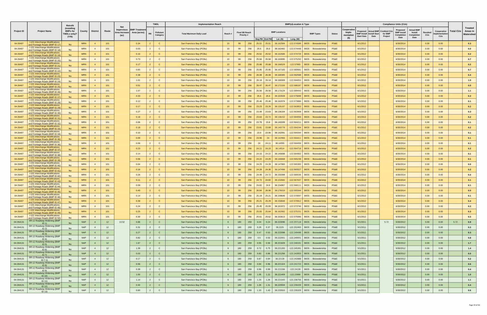
Beg PM End PM Lat. (N) Long. (W)
RouteProject ID Project Name
Retrofit (installing BMPs for
TMDLs only)? (Y/N)
County District Credited CUs for BMP Project
Proposed BMP Install Completion
Date
Actual BMP Install
Completion Date
Net Impervious
Area Increase (ac)
BMP Treatment Area (acres)
TMDL Implementation Reach BMP(s)Location & Type
BMP LocationsBMP Types Status
Revoked CUs
Total CUsTreated Areas in
WatershedRBPollutant Category
Total Maximum Daily Load Reach #Final SB Reach
Priority #
Compliance Units (CUs)
Cooperative Imple-
mentation ($)
Cooperative Implementation
CUs
Proposed BMP Install Start Date
Actual BMP Install Start
Date
04-26407I-101 Interchange Modifications
and Frontage Roads (BMP ID 17) No MRN 4 101 0.34 2 C San Francisco Bay (PCBs) 10 99 256 25.51 25.51 38.162584 -122.574589 BIOS - Bioswale/strip PS&E 6/1/2012 6/30/2014 0.00 0.00 0.3
04-26407I-101 Interchange Modifications
and Frontage Roads (BMP ID 18) No MRN 4 101 0.03 2 C San Francisco Bay (PCBs) 10 99 256 25.5 25.5 38.162482 -122.574448 BIOS - Bioswale/strip PS&E 6/1/2012 6/30/2014 0.00 0.00 0.0
04-26407I-101 Interchange Modifications
and Frontage Roads (BMP ID 19) No MRN 4 101 0.16 2 C San Francisco Bay (PCBs) 10 99 256 25.52 25.52 38.162686 -122.574729 BIOS - Bioswale/strip PS&E 6/1/2012 6/30/2014 0.00 0.00 0.2
04-26407I-101 Interchange Modifications
and Frontage Roads (BMP ID 20) No MRN 4 101 0.73 2 C San Francisco Bay (PCBs) 10 99 256 25.56 25.56 38.163095 -122.575292 BIOS - Bioswale/strip PS&E 6/1/2012 6/30/2014 0.00 0.00 0.7
04-26407I-101 Interchange Modifications
and Frontage Roads (BMP ID 21) No MRN 4 101 0.17 2 C San Francisco Bay (PCBs) 10 99 256 25.88 25.88 38.166529 -122.57965 BIOS - Bioswale/strip PS&E 6/1/2012 6/30/2014 0.00 0.00 0.2
04-26407I-101 Interchange Modifications
and Frontage Roads (BMP ID 22) No MRN 4 101 0.65 2 C San Francisco Bay (PCBs) 10 99 256 25.95 25.95 38.167183 -122.580681 BIOS - Bioswale/strip PS&E 6/1/2012 6/30/2014 0.00 0.00 0.7
04-26407I-101 Interchange Modifications
and Frontage Roads (BMP ID 23) No MRN 4 101 0.38 2 C San Francisco Bay (PCBs) 10 99 256 26.08 26.08 38.168385 -122.582588 BIOS - Bioswale/strip PS&E 6/1/2012 6/30/2014 0.00 0.00 0.4
04-26407I-101 Interchange Modifications
and Frontage Roads (BMP ID 24) No MRN 4 101 1.01 2 C San Francisco Bay (PCBs) 10 99 256 26.18 26.18 38.169309 -122.584053 BIOS - Bioswale/strip PS&E 6/1/2012 6/30/2014 0.00 0.00 1.0
04-26407I-101 Interchange Modifications
and Frontage Roads (BMP ID 25) No MRN 4 101 0.51 2 C San Francisco Bay (PCBs) 10 99 256 26.47 26.47 38.172193 -122.588187 BIOS - Bioswale/strip PS&E 6/1/2012 6/30/2014 0.00 0.00 0.5
04-26407I-101 Interchange Modifications
and Frontage Roads (BMP ID 26) No MRN 4 101 1.07 2 C San Francisco Bay (PCBs) 10 99 256 26.56 26.56 38.173124 -122.589443 BIOS - Bioswale/strip PS&E 6/1/2012 6/30/2014 0.00 0.00 1.1
04-26407I-101 Interchange Modifications
and Frontage Roads (BMP ID 27) No MRN 4 101 0.33 2 C San Francisco Bay (PCBs) 10 99 256 25.6 25.6 38.163508 -122.575848 BIOS - Bioswale/strip PS&E 6/1/2012 6/30/2014 0.00 0.00 0.3
04-26407I-101 Interchange Modifications
and Frontage Roads (BMP ID 28) No MRN 4 101 0.12 2 C San Francisco Bay (PCBs) 10 99 256 25.46 25.46 38.162074 -122.573886 BIOS - Bioswale/strip PS&E 6/1/2012 6/30/2014 0.00 0.00 0.1
04-26407I-101 Interchange Modifications
and Frontage Roads (BMP ID 29) No MRN 4 101 0.17 2 C San Francisco Bay (PCBs) 10 99 256 23.23 23.26 38.135197 -122.563853 BIOS - Bioswale/strip PS&E 6/1/2012 6/30/2014 0.00 0.00 0.2
04-26407I-101 Interchange Modifications
and Frontage Roads (BMP ID 30) No MRN 4 101 0.27 2 C San Francisco Bay (PCBs) 10 99 256 23.49 23.63 38.136104 -122.563908 BIOS - Bioswale/strip PS&E 6/1/2012 6/30/2014 0.00 0.00 0.3
04-26407I-101 Interchange Modifications
and Frontage Roads (BMP ID 31) No MRN 4 101 0.18 2 C San Francisco Bay (PCBs) 10 99 256 23.63 23.72 38.138152 -122.564056 BIOS - Bioswale/strip PS&E 6/1/2012 6/30/2014 0.00 0.00 0.2
04-26407I-101 Interchange Modifications
and Frontage Roads (BMP ID 32) No MRN 4 101 0.06 2 C San Francisco Bay (PCBs) 10 99 256 23.78 23.8 38.140339 -122.564211 BIOS - Bioswale/strip PS&E 6/1/2012 6/30/2014 0.00 0.00 0.1
04-26407I-101 Interchange Modifications
and Frontage Roads (BMP ID 33) No MRN 4 101 0.18 2 C San Francisco Bay (PCBs) 10 99 256 23.81 23.89 38.140778 -122.564244 BIOS - Bioswale/strip PS&E 6/1/2012 6/30/2014 0.00 0.00 0.2
04-26407I-101 Interchange Modifications
and Frontage Roads (BMP ID 34) No MRN 4 101 0.10 2 C San Francisco Bay (PCBs) 10 99 256 23.9 23.96 38.142091 -122.564344 BIOS - Bioswale/strip PS&E 6/1/2012 6/30/2014 0.00 0.00 0.1
04-26407I-101 Interchange Modifications
and Frontage Roads (BMP ID 35) No MRN 4 101 0.09 2 C San Francisco Bay (PCBs) 10 99 256 23.96 24 38.142966 -122.564411 BIOS - Bioswale/strip PS&E 6/1/2012 6/30/2014 0.00 0.00 0.1
04-26407I-101 Interchange Modifications
and Frontage Roads (BMP ID 36) No MRN 4 101 0.06 2 C San Francisco Bay (PCBs) 10 99 256 24 24.11 38.14355 -122.564456 BIOS - Bioswale/strip PS&E 6/1/2012 6/30/2014 0.00 0.00 0.1
04-26407I-101 Interchange Modifications
and Frontage Roads (BMP ID 37) No MRN 4 101 0.23 2 C San Francisco Bay (PCBs) 10 99 256 24.11 24.15 38.14514 -122.564718 BIOS - Bioswale/strip PS&E 6/1/2012 6/30/2014 0.00 0.00 0.2
04-26407I-101 Interchange Modifications
and Frontage Roads (BMP ID 38) No MRN 4 101 0.14 2 C San Francisco Bay (PCBs) 10 99 256 24.15 24.22 38.145698 -122.564902 BIOS - Bioswale/strip PS&E 6/1/2012 6/30/2014 0.00 0.00 0.1
04-26407I-101 Interchange Modifications
and Frontage Roads (BMP ID 39) No MRN 4 101 0.06 2 C San Francisco Bay (PCBs) 10 99 256 24.22 24.25 38.146668 -122.565238 BIOS - Bioswale/strip PS&E 6/1/2012 6/30/2014 0.00 0.00 0.1
04-26407I-101 Interchange Modifications
and Frontage Roads (BMP ID 40) No MRN 4 101 0.04 2 C San Francisco Bay (PCBs) 10 99 256 24.25 24.28 38.147083 -122.565383 BIOS - Bioswale/strip PS&E 6/1/2012 6/30/2014 0.00 0.00 0.0
04-26407I-101 Interchange Modifications
and Frontage Roads (BMP ID 41) No MRN 4 101 0.16 2 C San Francisco Bay (PCBs) 10 99 256 24.28 24.36 38.147498 -122.565527 BIOS - Bioswale/strip PS&E 6/1/2012 6/30/2014 0.00 0.00 0.2
04-26407I-101 Interchange Modifications
and Frontage Roads (BMP ID 42) No MRN 4 101 0.26 2 C San Francisco Bay (PCBs) 10 99 256 24.49 24.72 38.150398 -122.566536 BIOS - Bioswale/strip PS&E 6/1/2012 6/30/2014 0.00 0.00 0.3
04-26407I-101 Interchange Modifications
and Frontage Roads (BMP ID 43) No MRN 4 101 0.11 2 C San Francisco Bay (PCBs) 10 99 256 24.72 24.82 38.153582 -122.567637 BIOS - Bioswale/strip PS&E 6/1/2012 6/30/2014 0.00 0.00 0.1
04-26407I-101 Interchange Modifications
and Frontage Roads (BMP ID 44) No MRN 4 101 0.09 2 C San Francisco Bay (PCBs) 10 99 256 24.82 24.9 38.154967 -122.568111 BIOS - Bioswale/strip PS&E 6/1/2012 6/30/2014 0.00 0.00 0.1
04-26407I-101 Interchange Modifications
and Frontage Roads (BMP ID 45) No MRN 4 101 0.45 2 C San Francisco Bay (PCBs) 10 99 256 26.84 26.96 38.176019 -122.593344 BIOS - Bioswale/strip PS&E 6/1/2012 6/30/2014 0.00 0.00 0.5
04-26407I-101 Interchange Modifications
and Frontage Roads (BMP ID 46) No MRN 4 101 0.14 2 C San Francisco Bay (PCBs) 10 99 256 25.19 25.21 38.159648 -122.570697 BIOS - Bioswale/strip PS&E 6/1/2012 6/30/2014 0.00 0.00 0.1
04-26407I-101 Interchange Modifications
and Frontage Roads (BMP ID 47) No MRN 4 101 0.39 2 C San Francisco Bay (PCBs) 10 99 256 25.21 25.29 38.159848 -122.570912 BIOS - Bioswale/strip PS&E 6/1/2012 6/30/2014 0.00 0.00 0.4
04-26407I-101 Interchange Modifications
and Frontage Roads (BMP ID 48) No MRN 4 101 0.24 2 C San Francisco Bay (PCBs) 10 99 256 25.45 25.55 38.161972 -122.573746 BIOS - Bioswale/strip PS&E 6/1/2012 6/30/2014 0.00 0.00 0.2
04-26407I-101 Interchange Modifications
and Frontage Roads (BMP ID 49) No MRN 4 101 0.25 2 C San Francisco Bay (PCBs) 10 99 256 25.55 25.64 38.162992 -122.575151 BIOS - Bioswale/strip PS&E 6/1/2012 6/30/2014 0.00 0.00 0.3
04-26407I-101 Interchange Modifications
and Frontage Roads (BMP ID 50) No MRN 4 101 0.30 2 C San Francisco Bay (PCBs) 10 99 256 25.61 25.62 38.163613 -122.575986 BIOS - Bioswale/strip PS&E 6/1/2012 6/30/2014 0.00 0.00 0.3
04-264131SR-12 Roadway Widening (BMP
ID 1) No NAP 4 12 13.52 0.86 2 C San Francisco Bay (PCBs) 6 180 259 0.04 0.24 38.223096 -122.257118 BIOS - Bioswale/strip PS&E 5/1/2011 5.72 5/30/2012 0.00 0.00 5.72 0.9
04-264131SR-12 Roadway Widening (BMP
ID 2) No NAP 4 12 0.31 2 C San Francisco Bay (PCBs) 6 180 259 0.29 0.37 38.2225 -122.252483 BIOS - Bioswale/strip PS&E 5/1/2011 5/30/2012 0.00 0.00 0.3
04-264131SR-12 Roadway Widening (BMP
ID 3) No NAP 4 12 0.27 2 C San Francisco Bay (PCBs) 6 180 259 0.47 0.53 38.222098 -122.249496 BIOS - Bioswale/strip PS&E 5/1/2011 5/30/2012 0.00 0.00 0.3
04-264131SR-12 Roadway Widening (BMP
ID 4) No NAP 4 12 0.82 2 C San Francisco Bay (PCBs) 6 180 259 0.5 0.53 38.222001 -122.249001 BIOS - Bioswale/strip PS&E 5/1/2011 5/30/2012 0.00 0.00 0.8
04-264131SR-12 Roadway Widening (BMP
ID 5) No NAP 4 12 1.67 2 C San Francisco Bay (PCBs) 6 180 259 0.55 0.56 38.221828 -122.248181 BIOS - Bioswale/strip PS&E 5/1/2011 5/30/2012 0.00 0.00 1.7
04-264131SR-12 Roadway Widening (BMP
ID 6) No NAP 4 12 1.39 2 C San Francisco Bay (PCBs) 6 180 259 0.72 0.75 38.221283 -122.245391 BIOS - Bioswale/strip PS&E 5/1/2011 5/30/2012 0.00 0.00 1.4
04-264131SR-12 Roadway Widening (BMP
ID 7) No NAP 4 12 0.03 2 C San Francisco Bay (PCBs) 6 180 259 0.83 0.86 38.221256 -122.243553 BIOS - Bioswale/strip PS&E 5/1/2011 5/30/2012 0.00 0.00 0.0
04-264131SR-12 Roadway Widening (BMP
ID 7-1) No NAP 4 12 0.17 2 C San Francisco Bay (PCBs) 6 180 259 0.87 0.94 38.22128 -122.242888 BIOS - Bioswale/strip PS&E 5/1/2011 5/30/2012 0.00 0.00 0.2
04-264131SR-12 Roadway Widening (BMP
ID 8) No NAP 4 12 0.56 2 C San Francisco Bay (PCBs) 6 180 259 0.94 0.96 38.221324 -122.241723 BIOS - Bioswale/strip PS&E 5/1/2011 5/30/2012 0.00 0.00 0.6
04-264131SR-12 Roadway Widening (BMP
ID 9) No NAP 4 12 0.39 2 C San Francisco Bay (PCBs) 6 180 259 0.96 0.99 38.221336 -122.24139 BIOS - Bioswale/strip PS&E 5/1/2011 5/30/2012 0.00 0.00 0.4
04-264131SR-12 Roadway Widening (BMP
ID 10) No NAP 4 12 1.00 2 C San Francisco Bay (PCBs) 6 180 259 1.05 1.22 38.221409 -122.23988 BIOS - Bioswale/strip PS&E 5/1/2011 5/30/2012 0.00 0.00 1.0
04-264131SR-12 Roadway Widening (BMP
ID 11) No NAP 4 12 1.14 2 C San Francisco Bay (PCBs) 6 180 259 1.24 1.26 38.221043 -122.236756 BIOS - Bioswale/strip PS&E 5/1/2011 5/30/2012 0.00 0.00 1.1
04-264131SR-12 Roadway Widening (BMP
ID 12) No NAP 4 12 0.40 2 C San Francisco Bay (PCBs) 6 180 259 1.26 1.31 38.220934 -122.236439 BIOS - Bioswale/strip PS&E 5/1/2011 5/30/2012 0.00 0.00 0.4
04-264131SR-12 Roadway Widening (BMP
ID 13) No NAP 4 12 0.60 2 C San Francisco Bay (PCBs) 6 180 259 1.33 1.43 38.220553 -122.235329 BIOS - Bioswale/strip PS&E 5/1/2011 5/30/2012 0.00 0.00 0.6
Page 19 of 44
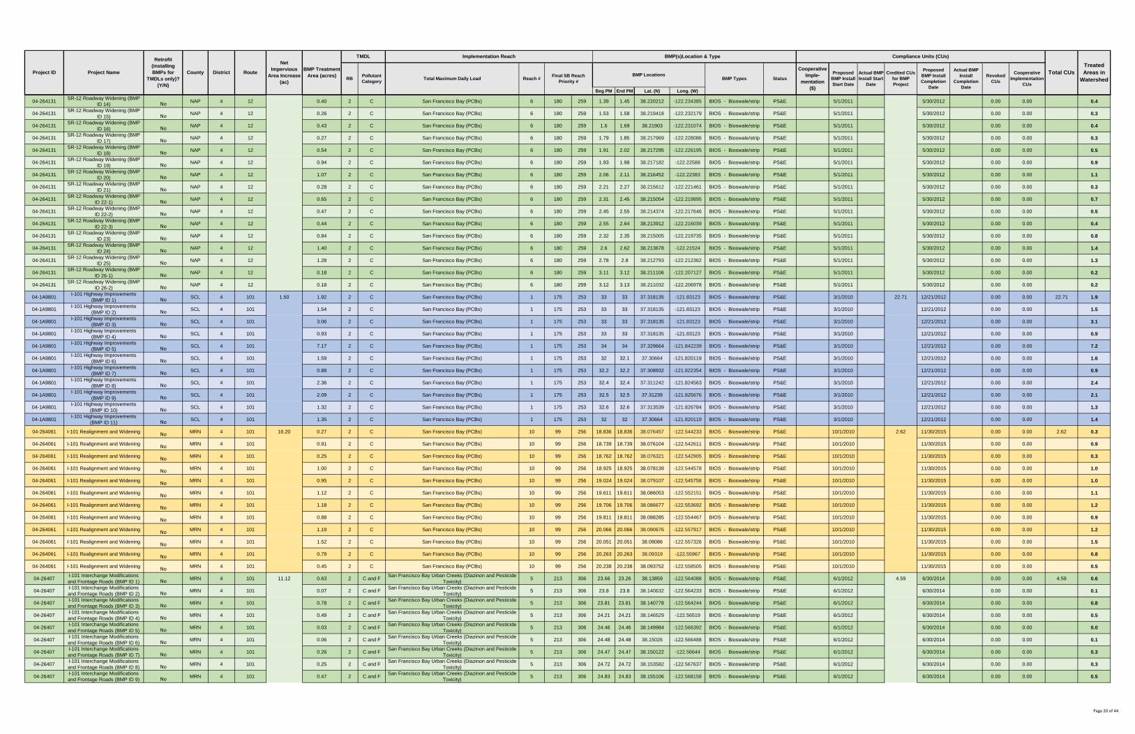
Beg PM End PM Lat. (N) Long. (W)
RouteProject ID Project Name
Retrofit (installing BMPs for
TMDLs only)? (Y/N)
County District Credited CUs for BMP Project
Proposed BMP Install Completion
Date
Actual BMP Install
Completion Date
Net Impervious
Area Increase (ac)
BMP Treatment Area (acres)
TMDL Implementation Reach BMP(s)Location & Type
BMP LocationsBMP Types Status
Revoked CUs
Total CUsTreated Areas in
WatershedRBPollutant Category
Total Maximum Daily Load Reach #Final SB Reach
Priority #
Compliance Units (CUs)
Cooperative Imple-
mentation ($)
Cooperative Implementation
CUs
Proposed BMP Install Start Date
Actual BMP Install Start
Date
04-264131SR-12 Roadway Widening (BMP
ID 14) No NAP 4 12 0.40 2 C San Francisco Bay (PCBs) 6 180 259 1.39 1.45 38.220212 -122.234385 BIOS - Bioswale/strip PS&E 5/1/2011 5/30/2012 0.00 0.00 0.4
04-264131SR-12 Roadway Widening (BMP
ID 15) No NAP 4 12 0.26 2 C San Francisco Bay (PCBs) 6 180 259 1.53 1.58 38.219418 -122.232179 BIOS - Bioswale/strip PS&E 5/1/2011 5/30/2012 0.00 0.00 0.3
04-264131SR-12 Roadway Widening (BMP
ID 16) No NAP 4 12 0.43 2 C San Francisco Bay (PCBs) 6 180 259 1.6 1.69 38.21903 -122.231074 BIOS - Bioswale/strip PS&E 5/1/2011 5/30/2012 0.00 0.00 0.4
04-264131SR-12 Roadway Widening (BMP
ID 17) No NAP 4 12 0.27 2 C San Francisco Bay (PCBs) 6 180 259 1.79 1.85 38.217969 -122.228086 BIOS - Bioswale/strip PS&E 5/1/2011 5/30/2012 0.00 0.00 0.3
04-264131SR-12 Roadway Widening (BMP
ID 18) No NAP 4 12 0.54 2 C San Francisco Bay (PCBs) 6 180 259 1.91 2.02 38.217295 -122.226195 BIOS - Bioswale/strip PS&E 5/1/2011 5/30/2012 0.00 0.00 0.5
04-264131SR-12 Roadway Widening (BMP
ID 19) No NAP 4 12 0.94 2 C San Francisco Bay (PCBs) 6 180 259 1.93 1.98 38.217182 -122.22588 BIOS - Bioswale/strip PS&E 5/1/2011 5/30/2012 0.00 0.00 0.9
04-264131SR-12 Roadway Widening (BMP
ID 20) No NAP 4 12 1.07 2 C San Francisco Bay (PCBs) 6 180 259 2.06 2.11 38.216452 -122.22383 BIOS - Bioswale/strip PS&E 5/1/2011 5/30/2012 0.00 0.00 1.1
04-264131SR-12 Roadway Widening (BMP
ID 21) No NAP 4 12 0.28 2 C San Francisco Bay (PCBs) 6 180 259 2.21 2.27 38.215612 -122.221461 BIOS - Bioswale/strip PS&E 5/1/2011 5/30/2012 0.00 0.00 0.3
04-264131SR-12 Roadway Widening (BMP
ID 22-1) No NAP 4 12 0.65 2 C San Francisco Bay (PCBs) 6 180 259 2.31 2.45 38.215054 -122.219895 BIOS - Bioswale/strip PS&E 5/1/2011 5/30/2012 0.00 0.00 0.7
04-264131SR-12 Roadway Widening (BMP
ID 22-2) No NAP 4 12 0.47 2 C San Francisco Bay (PCBs) 6 180 259 2.45 2.55 38.214374 -122.217646 BIOS - Bioswale/strip PS&E 5/1/2011 5/30/2012 0.00 0.00 0.5
04-264131SR-12 Roadway Widening (BMP
ID 22-3) No NAP 4 12 0.44 2 C San Francisco Bay (PCBs) 6 180 259 2.55 2.64 38.213912 -122.216039 BIOS - Bioswale/strip PS&E 5/1/2011 5/30/2012 0.00 0.00 0.4
04-264131SR-12 Roadway Widening (BMP
ID 23) No NAP 4 12 0.84 2 C San Francisco Bay (PCBs) 6 180 259 2.32 2.35 38.215005 -122.219735 BIOS - Bioswale/strip PS&E 5/1/2011 5/30/2012 0.00 0.00 0.8
04-264131SR-12 Roadway Widening (BMP
ID 24) No NAP 4 12 1.40 2 C San Francisco Bay (PCBs) 6 180 259 2.6 2.62 38.213678 -122.21524 BIOS - Bioswale/strip PS&E 5/1/2011 5/30/2012 0.00 0.00 1.4
04-264131SR-12 Roadway Widening (BMP
ID 25) No NAP 4 12 1.28 2 C San Francisco Bay (PCBs) 6 180 259 2.78 2.8 38.212793 -122.212362 BIOS - Bioswale/strip PS&E 5/1/2011 5/30/2012 0.00 0.00 1.3
04-264131SR-12 Roadway Widening (BMP
ID 26-1) No NAP 4 12 0.18 2 C San Francisco Bay (PCBs) 6 180 259 3.11 3.12 38.211106 -122.207127 BIOS - Bioswale/strip PS&E 5/1/2011 5/30/2012 0.00 0.00 0.2
04-264131SR-12 Roadway Widening (BMP
ID 26-2) No NAP 4 12 0.18 2 C San Francisco Bay (PCBs) 6 180 259 3.12 3.13 38.211032 -122.206978 BIOS - Bioswale/strip PS&E 5/1/2011 5/30/2012 0.00 0.00 0.2
04-1A9801I-101 Highway Improvements
(BMP ID 1) No SCL 4 101 1.50 1.92 2 C San Francisco Bay (PCBs) 1 175 253 33 33 37.318135 -121.83123 BIOS - Bioswale/strip PS&E 3/1/2010 22.71 12/21/2012 0.00 0.00 22.71 1.9
04-1A9801I-101 Highway Improvements
(BMP ID 2) No SCL 4 101 1.54 2 C San Francisco Bay (PCBs) 1 175 253 33 33 37.318135 -121.83123 BIOS - Bioswale/strip PS&E 3/1/2010 12/21/2012 0.00 0.00 1.5
04-1A9801I-101 Highway Improvements
(BMP ID 3) No SCL 4 101 3.06 2 C San Francisco Bay (PCBs) 1 175 253 33 33 37.318135 -121.83123 BIOS - Bioswale/strip PS&E 3/1/2010 12/21/2012 0.00 0.00 3.1
04-1A9801I-101 Highway Improvements
(BMP ID 4) No SCL 4 101 0.93 2 C San Francisco Bay (PCBs) 1 175 253 33 33 37.318135 -121.83123 BIOS - Bioswale/strip PS&E 3/1/2010 12/21/2012 0.00 0.00 0.9
04-1A9801I-101 Highway Improvements
(BMP ID 5) No SCL 4 101 7.17 2 C San Francisco Bay (PCBs) 1 175 253 34 34 37.329664 -121.842239 BIOS - Bioswale/strip PS&E 3/1/2010 12/21/2012 0.00 0.00 7.2
04-1A9801I-101 Highway Improvements
(BMP ID 6) No SCL 4 101 1.59 2 C San Francisco Bay (PCBs) 1 175 253 32 32.1 37.30664 -121.820119 BIOS - Bioswale/strip PS&E 3/1/2010 12/21/2012 0.00 0.00 1.6
04-1A9801I-101 Highway Improvements
(BMP ID 7) No SCL 4 101 0.88 2 C San Francisco Bay (PCBs) 1 175 253 32.2 32.2 37.308932 -121.822354 BIOS - Bioswale/strip PS&E 3/1/2010 12/21/2012 0.00 0.00 0.9
04-1A9801I-101 Highway Improvements
(BMP ID 8) No SCL 4 101 2.36 2 C San Francisco Bay (PCBs) 1 175 253 32.4 32.4 37.311242 -121.824563 BIOS - Bioswale/strip PS&E 3/1/2010 12/21/2012 0.00 0.00 2.4
04-1A9801I-101 Highway Improvements
(BMP ID 9) No SCL 4 101 2.09 2 C San Francisco Bay (PCBs) 1 175 253 32.5 32.5 37.31239 -121.825676 BIOS - Bioswale/strip PS&E 3/1/2010 12/21/2012 0.00 0.00 2.1
04-1A9801I-101 Highway Improvements
(BMP ID 10) No SCL 4 101 1.32 2 C San Francisco Bay (PCBs) 1 175 253 32.6 32.6 37.313539 -121.826784 BIOS - Bioswale/strip PS&E 3/1/2010 12/21/2012 0.00 0.00 1.3
04-1A9801I-101 Highway Improvements
(BMP ID 11) No SCL 4 101 1.35 2 C San Francisco Bay (PCBs) 1 175 253 32 32 37.30664 -121.820119 BIOS - Bioswale/strip PS&E 3/1/2010 12/21/2012 0.00 0.00 1.4
04-264061 I-101 Realignment and Widening No MRN 4 101 16.20 0.27 2 C San Francisco Bay (PCBs) 10 99 256 18.836 18.836 38.076457 -122.544233 BIOS - Bioswale/strip PS&E 10/1/2010 2.62 11/30/2015 0.00 0.00 2.62 0.3
04-264061 I-101 Realignment and Widening No MRN 4 101 0.91 2 C San Francisco Bay (PCBs) 10 99 256 18.739 18.739 38.076104 -122.542611 BIOS - Bioswale/strip PS&E 10/1/2010 11/30/2015 0.00 0.00 0.9
04-264061 I-101 Realignment and Widening No MRN 4 101 0.25 2 C San Francisco Bay (PCBs) 10 99 256 18.762 18.762 38.076321 -122.542905 BIOS - Bioswale/strip PS&E 10/1/2010 11/30/2015 0.00 0.00 0.3
04-264061 I-101 Realignment and Widening No MRN 4 101 1.00 2 C San Francisco Bay (PCBs) 10 99 256 18.925 18.925 38.078139 -122.544578 BIOS - Bioswale/strip PS&E 10/1/2010 11/30/2015 0.00 0.00 1.0
04-264061 I-101 Realignment and Widening No MRN 4 101 0.95 2 C San Francisco Bay (PCBs) 10 99 256 19.024 19.024 38.079107 -122.545758 BIOS - Bioswale/strip PS&E 10/1/2010 11/30/2015 0.00 0.00 1.0
04-264061 I-101 Realignment and Widening No MRN 4 101 1.12 2 C San Francisco Bay (PCBs) 10 99 256 19.611 19.611 38.086053 -122.552151 BIOS - Bioswale/strip PS&E 10/1/2010 11/30/2015 0.00 0.00 1.1
04-264061 I-101 Realignment and Widening No MRN 4 101 1.18 2 C San Francisco Bay (PCBs) 10 99 256 19.706 19.706 38.086677 -122.553692 BIOS - Bioswale/strip PS&E 10/1/2010 11/30/2015 0.00 0.00 1.2
04-264061 I-101 Realignment and Widening No MRN 4 101 0.88 2 C San Francisco Bay (PCBs) 10 99 256 19.811 19.811 38.088285 -122.554467 BIOS - Bioswale/strip PS&E 10/1/2010 11/30/2015 0.00 0.00 0.9
04-264061 I-101 Realignment and Widening No MRN 4 101 1.19 2 C San Francisco Bay (PCBs) 10 99 256 20.066 20.066 38.090676 -122.557917 BIOS - Bioswale/strip PS&E 10/1/2010 11/30/2015 0.00 0.00 1.2
04-264061 I-101 Realignment and Widening No MRN 4 101 1.52 2 C San Francisco Bay (PCBs) 10 99 256 20.051 20.051 38.09086 -122.557326 BIOS - Bioswale/strip PS&E 10/1/2010 11/30/2015 0.00 0.00 1.5
04-264061 I-101 Realignment and Widening No MRN 4 101 0.79 2 C San Francisco Bay (PCBs) 10 99 256 20.263 20.263 38.09319 -122.55967 BIOS - Bioswale/strip PS&E 10/1/2010 11/30/2015 0.00 0.00 0.8
04-264061 I-101 Realignment and Widening No MRN 4 101 0.45 2 C San Francisco Bay (PCBs) 10 99 256 20.238 20.238 38.093752 -122.558505 BIOS - Bioswale/strip PS&E 10/1/2010 11/30/2015 0.00 0.00 0.5
04-26407I-101 Interchange Modifications and Frontage Roads (BMP ID 1) No MRN 4 101 11.12 0.63 2 C and F
San Francisco Bay Urban Creeks (Diazinon and Pesticide Toxicity)
5 213 306 23.66 23.26 38.13859 -122.564088 BIOS - Bioswale/strip PS&E 6/1/2012 4.59 6/30/2014 0.00 0.00 4.59 0.6
04-26407I-101 Interchange Modifications and Frontage Roads (BMP ID 2) No MRN 4 101 0.07 2 C and F
San Francisco Bay Urban Creeks (Diazinon and Pesticide Toxicity)
5 213 306 23.8 23.8 38.140632 -122.564233 BIOS - Bioswale/strip PS&E 6/1/2012 6/30/2014 0.00 0.00 0.1
04-26407I-101 Interchange Modifications and Frontage Roads (BMP ID 3) No MRN 4 101 0.78 2 C and F
San Francisco Bay Urban Creeks (Diazinon and Pesticide Toxicity)
5 213 306 23.81 23.81 38.140778 -122.564244 BIOS - Bioswale/strip PS&E 6/1/2012 6/30/2014 0.00 0.00 0.8
04-26407I-101 Interchange Modifications and Frontage Roads (BMP ID 4) No MRN 4 101 0.49 2 C and F
San Francisco Bay Urban Creeks (Diazinon and Pesticide Toxicity)
5 213 306 24.21 24.21 38.146529 -122.56519 BIOS - Bioswale/strip PS&E 6/1/2012 6/30/2014 0.00 0.00 0.5
04-26407I-101 Interchange Modifications and Frontage Roads (BMP ID 5) No MRN 4 101 0.03 2 C and F
San Francisco Bay Urban Creeks (Diazinon and Pesticide Toxicity)
5 213 306 24.46 24.46 38.149984 -122.566392 BIOS - Bioswale/strip PS&E 6/1/2012 6/30/2014 0.00 0.00 0.0
04-26407I-101 Interchange Modifications and Frontage Roads (BMP ID 6) No MRN 4 101 0.06 2 C and F
San Francisco Bay Urban Creeks (Diazinon and Pesticide Toxicity)
5 213 306 24.48 24.48 38.15026 -122.566488 BIOS - Bioswale/strip PS&E 6/1/2012 6/30/2014 0.00 0.00 0.1
04-26407I-101 Interchange Modifications and Frontage Roads (BMP ID 7) No MRN 4 101 0.26 2 C and F
San Francisco Bay Urban Creeks (Diazinon and Pesticide Toxicity)
5 213 306 24.47 24.47 38.150122 -122.56644 BIOS - Bioswale/strip PS&E 6/1/2012 6/30/2014 0.00 0.00 0.3
04-26407I-101 Interchange Modifications and Frontage Roads (BMP ID 8) No MRN 4 101 0.25 2 C and F
San Francisco Bay Urban Creeks (Diazinon and Pesticide Toxicity)
5 213 306 24.72 24.72 38.153582 -122.567637 BIOS - Bioswale/strip PS&E 6/1/2012 6/30/2014 0.00 0.00 0.3
04-26407I-101 Interchange Modifications and Frontage Roads (BMP ID 9) No MRN 4 101 0.47 2 C and F
San Francisco Bay Urban Creeks (Diazinon and Pesticide Toxicity)
5 213 306 24.83 24.83 38.155106 -122.568158 BIOS - Bioswale/strip PS&E 6/1/2012 6/30/2014 0.00 0.00 0.5
Page 20 of 44
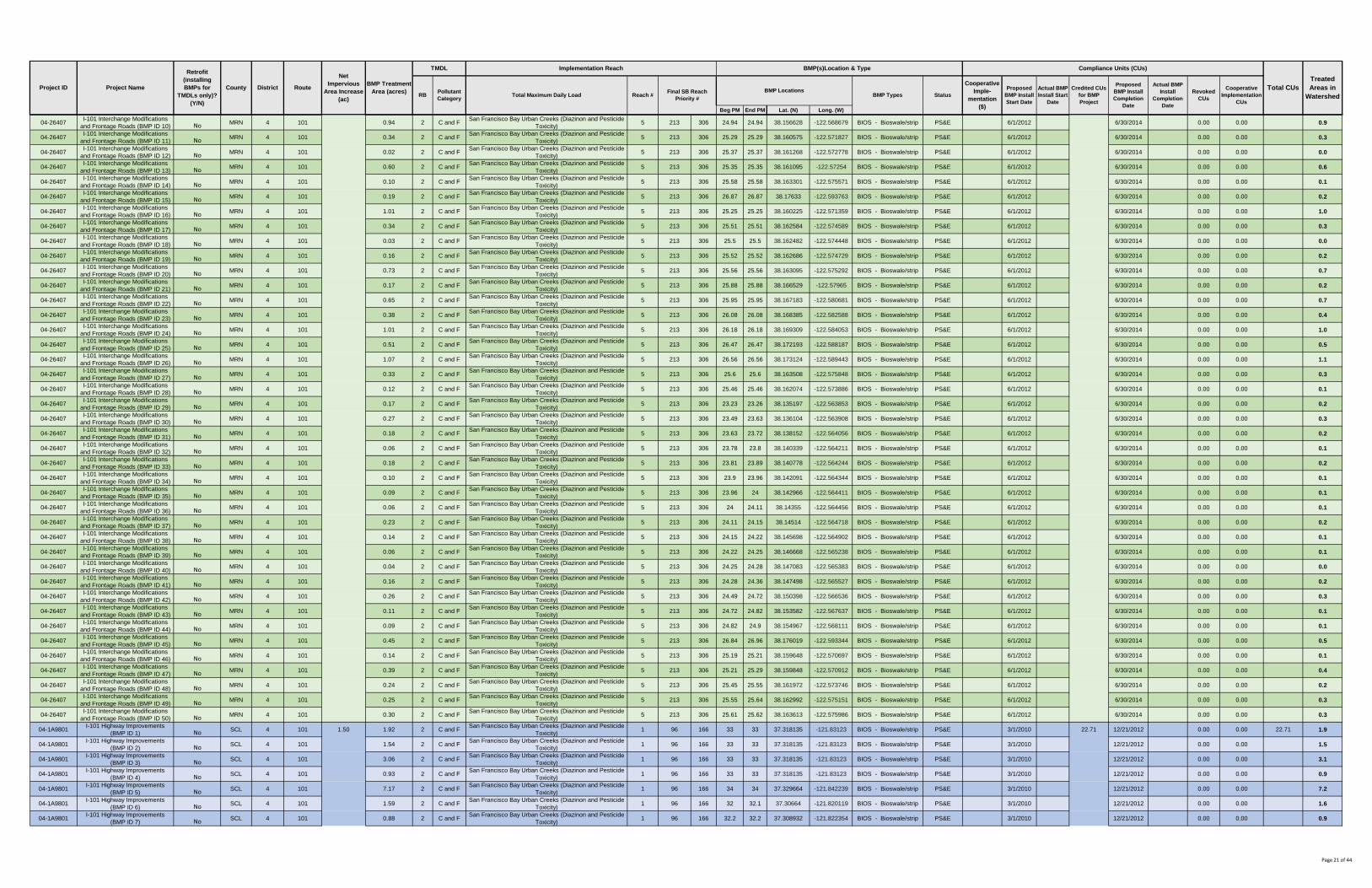
Beg PM End PM Lat. (N) Long. (W)
RouteProject ID Project Name
Retrofit (installing BMPs for
TMDLs only)? (Y/N)
County District Credited CUs for BMP Project
Proposed BMP Install Completion
Date
Actual BMP Install
Completion Date
Net Impervious
Area Increase (ac)
BMP Treatment Area (acres)
TMDL Implementation Reach BMP(s)Location & Type
BMP LocationsBMP Types Status
Revoked CUs
Total CUsTreated Areas in
WatershedRBPollutant Category
Total Maximum Daily Load Reach #Final SB Reach
Priority #
Compliance Units (CUs)
Cooperative Imple-
mentation ($)
Cooperative Implementation
CUs
Proposed BMP Install Start Date
Actual BMP Install Start
Date
04-26407I-101 Interchange Modifications
and Frontage Roads (BMP ID 10) No MRN 4 101 0.94 2 C and FSan Francisco Bay Urban Creeks (Diazinon and Pesticide
Toxicity)5 213 306 24.94 24.94 38.156628 -122.568679 BIOS - Bioswale/strip PS&E 6/1/2012 6/30/2014 0.00 0.00 0.9
04-26407I-101 Interchange Modifications
and Frontage Roads (BMP ID 11) No MRN 4 101 0.34 2 C and FSan Francisco Bay Urban Creeks (Diazinon and Pesticide
Toxicity)5 213 306 25.29 25.29 38.160575 -122.571827 BIOS - Bioswale/strip PS&E 6/1/2012 6/30/2014 0.00 0.00 0.3
04-26407I-101 Interchange Modifications
and Frontage Roads (BMP ID 12) No MRN 4 101 0.02 2 C and FSan Francisco Bay Urban Creeks (Diazinon and Pesticide
Toxicity)5 213 306 25.37 25.37 38.161268 -122.572778 BIOS - Bioswale/strip PS&E 6/1/2012 6/30/2014 0.00 0.00 0.0
04-26407I-101 Interchange Modifications
and Frontage Roads (BMP ID 13) No MRN 4 101 0.60 2 C and FSan Francisco Bay Urban Creeks (Diazinon and Pesticide
Toxicity)5 213 306 25.35 25.35 38.161095 -122.57254 BIOS - Bioswale/strip PS&E 6/1/2012 6/30/2014 0.00 0.00 0.6
04-26407I-101 Interchange Modifications
and Frontage Roads (BMP ID 14) No MRN 4 101 0.10 2 C and FSan Francisco Bay Urban Creeks (Diazinon and Pesticide
Toxicity)5 213 306 25.58 25.58 38.163301 -122.575571 BIOS - Bioswale/strip PS&E 6/1/2012 6/30/2014 0.00 0.00 0.1
04-26407I-101 Interchange Modifications
and Frontage Roads (BMP ID 15) No MRN 4 101 0.19 2 C and FSan Francisco Bay Urban Creeks (Diazinon and Pesticide
Toxicity)5 213 306 26.87 26.87 38.17633 -122.593763 BIOS - Bioswale/strip PS&E 6/1/2012 6/30/2014 0.00 0.00 0.2
04-26407I-101 Interchange Modifications
and Frontage Roads (BMP ID 16) No MRN 4 101 1.01 2 C and FSan Francisco Bay Urban Creeks (Diazinon and Pesticide
Toxicity)5 213 306 25.25 25.25 38.160225 -122.571359 BIOS - Bioswale/strip PS&E 6/1/2012 6/30/2014 0.00 0.00 1.0
04-26407I-101 Interchange Modifications
and Frontage Roads (BMP ID 17) No MRN 4 101 0.34 2 C and FSan Francisco Bay Urban Creeks (Diazinon and Pesticide
Toxicity)5 213 306 25.51 25.51 38.162584 -122.574589 BIOS - Bioswale/strip PS&E 6/1/2012 6/30/2014 0.00 0.00 0.3
04-26407I-101 Interchange Modifications
and Frontage Roads (BMP ID 18) No MRN 4 101 0.03 2 C and FSan Francisco Bay Urban Creeks (Diazinon and Pesticide
Toxicity)5 213 306 25.5 25.5 38.162482 -122.574448 BIOS - Bioswale/strip PS&E 6/1/2012 6/30/2014 0.00 0.00 0.0
04-26407I-101 Interchange Modifications
and Frontage Roads (BMP ID 19) No MRN 4 101 0.16 2 C and FSan Francisco Bay Urban Creeks (Diazinon and Pesticide
Toxicity)5 213 306 25.52 25.52 38.162686 -122.574729 BIOS - Bioswale/strip PS&E 6/1/2012 6/30/2014 0.00 0.00 0.2
04-26407I-101 Interchange Modifications
and Frontage Roads (BMP ID 20) No MRN 4 101 0.73 2 C and FSan Francisco Bay Urban Creeks (Diazinon and Pesticide
Toxicity)5 213 306 25.56 25.56 38.163095 -122.575292 BIOS - Bioswale/strip PS&E 6/1/2012 6/30/2014 0.00 0.00 0.7
04-26407I-101 Interchange Modifications
and Frontage Roads (BMP ID 21) No MRN 4 101 0.17 2 C and FSan Francisco Bay Urban Creeks (Diazinon and Pesticide
Toxicity)5 213 306 25.88 25.88 38.166529 -122.57965 BIOS - Bioswale/strip PS&E 6/1/2012 6/30/2014 0.00 0.00 0.2
04-26407I-101 Interchange Modifications
and Frontage Roads (BMP ID 22) No MRN 4 101 0.65 2 C and FSan Francisco Bay Urban Creeks (Diazinon and Pesticide
Toxicity)5 213 306 25.95 25.95 38.167183 -122.580681 BIOS - Bioswale/strip PS&E 6/1/2012 6/30/2014 0.00 0.00 0.7
04-26407I-101 Interchange Modifications
and Frontage Roads (BMP ID 23) No MRN 4 101 0.38 2 C and FSan Francisco Bay Urban Creeks (Diazinon and Pesticide
Toxicity)5 213 306 26.08 26.08 38.168385 -122.582588 BIOS - Bioswale/strip PS&E 6/1/2012 6/30/2014 0.00 0.00 0.4
04-26407I-101 Interchange Modifications
and Frontage Roads (BMP ID 24) No MRN 4 101 1.01 2 C and FSan Francisco Bay Urban Creeks (Diazinon and Pesticide
Toxicity)5 213 306 26.18 26.18 38.169309 -122.584053 BIOS - Bioswale/strip PS&E 6/1/2012 6/30/2014 0.00 0.00 1.0
04-26407I-101 Interchange Modifications
and Frontage Roads (BMP ID 25) No MRN 4 101 0.51 2 C and FSan Francisco Bay Urban Creeks (Diazinon and Pesticide
Toxicity)5 213 306 26.47 26.47 38.172193 -122.588187 BIOS - Bioswale/strip PS&E 6/1/2012 6/30/2014 0.00 0.00 0.5
04-26407I-101 Interchange Modifications
and Frontage Roads (BMP ID 26) No MRN 4 101 1.07 2 C and FSan Francisco Bay Urban Creeks (Diazinon and Pesticide
Toxicity)5 213 306 26.56 26.56 38.173124 -122.589443 BIOS - Bioswale/strip PS&E 6/1/2012 6/30/2014 0.00 0.00 1.1
04-26407I-101 Interchange Modifications
and Frontage Roads (BMP ID 27) No MRN 4 101 0.33 2 C and FSan Francisco Bay Urban Creeks (Diazinon and Pesticide
Toxicity)5 213 306 25.6 25.6 38.163508 -122.575848 BIOS - Bioswale/strip PS&E 6/1/2012 6/30/2014 0.00 0.00 0.3
04-26407I-101 Interchange Modifications
and Frontage Roads (BMP ID 28) No MRN 4 101 0.12 2 C and FSan Francisco Bay Urban Creeks (Diazinon and Pesticide
Toxicity)5 213 306 25.46 25.46 38.162074 -122.573886 BIOS - Bioswale/strip PS&E 6/1/2012 6/30/2014 0.00 0.00 0.1
04-26407I-101 Interchange Modifications
and Frontage Roads (BMP ID 29) No MRN 4 101 0.17 2 C and FSan Francisco Bay Urban Creeks (Diazinon and Pesticide
Toxicity)5 213 306 23.23 23.26 38.135197 -122.563853 BIOS - Bioswale/strip PS&E 6/1/2012 6/30/2014 0.00 0.00 0.2
04-26407I-101 Interchange Modifications
and Frontage Roads (BMP ID 30) No MRN 4 101 0.27 2 C and FSan Francisco Bay Urban Creeks (Diazinon and Pesticide
Toxicity)5 213 306 23.49 23.63 38.136104 -122.563908 BIOS - Bioswale/strip PS&E 6/1/2012 6/30/2014 0.00 0.00 0.3
04-26407I-101 Interchange Modifications
and Frontage Roads (BMP ID 31) No MRN 4 101 0.18 2 C and FSan Francisco Bay Urban Creeks (Diazinon and Pesticide
Toxicity)5 213 306 23.63 23.72 38.138152 -122.564056 BIOS - Bioswale/strip PS&E 6/1/2012 6/30/2014 0.00 0.00 0.2
04-26407I-101 Interchange Modifications
and Frontage Roads (BMP ID 32) No MRN 4 101 0.06 2 C and FSan Francisco Bay Urban Creeks (Diazinon and Pesticide
Toxicity)5 213 306 23.78 23.8 38.140339 -122.564211 BIOS - Bioswale/strip PS&E 6/1/2012 6/30/2014 0.00 0.00 0.1
04-26407I-101 Interchange Modifications
and Frontage Roads (BMP ID 33) No MRN 4 101 0.18 2 C and FSan Francisco Bay Urban Creeks (Diazinon and Pesticide
Toxicity)5 213 306 23.81 23.89 38.140778 -122.564244 BIOS - Bioswale/strip PS&E 6/1/2012 6/30/2014 0.00 0.00 0.2
04-26407I-101 Interchange Modifications
and Frontage Roads (BMP ID 34) No MRN 4 101 0.10 2 C and FSan Francisco Bay Urban Creeks (Diazinon and Pesticide
Toxicity)5 213 306 23.9 23.96 38.142091 -122.564344 BIOS - Bioswale/strip PS&E 6/1/2012 6/30/2014 0.00 0.00 0.1
04-26407I-101 Interchange Modifications
and Frontage Roads (BMP ID 35) No MRN 4 101 0.09 2 C and FSan Francisco Bay Urban Creeks (Diazinon and Pesticide
Toxicity)5 213 306 23.96 24 38.142966 -122.564411 BIOS - Bioswale/strip PS&E 6/1/2012 6/30/2014 0.00 0.00 0.1
04-26407I-101 Interchange Modifications
and Frontage Roads (BMP ID 36) No MRN 4 101 0.06 2 C and FSan Francisco Bay Urban Creeks (Diazinon and Pesticide
Toxicity)5 213 306 24 24.11 38.14355 -122.564456 BIOS - Bioswale/strip PS&E 6/1/2012 6/30/2014 0.00 0.00 0.1
04-26407I-101 Interchange Modifications
and Frontage Roads (BMP ID 37) No MRN 4 101 0.23 2 C and FSan Francisco Bay Urban Creeks (Diazinon and Pesticide
Toxicity)5 213 306 24.11 24.15 38.14514 -122.564718 BIOS - Bioswale/strip PS&E 6/1/2012 6/30/2014 0.00 0.00 0.2
04-26407I-101 Interchange Modifications
and Frontage Roads (BMP ID 38) No MRN 4 101 0.14 2 C and FSan Francisco Bay Urban Creeks (Diazinon and Pesticide
Toxicity)5 213 306 24.15 24.22 38.145698 -122.564902 BIOS - Bioswale/strip PS&E 6/1/2012 6/30/2014 0.00 0.00 0.1
04-26407I-101 Interchange Modifications
and Frontage Roads (BMP ID 39) No MRN 4 101 0.06 2 C and FSan Francisco Bay Urban Creeks (Diazinon and Pesticide
Toxicity)5 213 306 24.22 24.25 38.146668 -122.565238 BIOS - Bioswale/strip PS&E 6/1/2012 6/30/2014 0.00 0.00 0.1
04-26407I-101 Interchange Modifications
and Frontage Roads (BMP ID 40) No MRN 4 101 0.04 2 C and FSan Francisco Bay Urban Creeks (Diazinon and Pesticide
Toxicity)5 213 306 24.25 24.28 38.147083 -122.565383 BIOS - Bioswale/strip PS&E 6/1/2012 6/30/2014 0.00 0.00 0.0
04-26407I-101 Interchange Modifications
and Frontage Roads (BMP ID 41) No MRN 4 101 0.16 2 C and FSan Francisco Bay Urban Creeks (Diazinon and Pesticide
Toxicity)5 213 306 24.28 24.36 38.147498 -122.565527 BIOS - Bioswale/strip PS&E 6/1/2012 6/30/2014 0.00 0.00 0.2
04-26407I-101 Interchange Modifications
and Frontage Roads (BMP ID 42) No MRN 4 101 0.26 2 C and FSan Francisco Bay Urban Creeks (Diazinon and Pesticide
Toxicity)5 213 306 24.49 24.72 38.150398 -122.566536 BIOS - Bioswale/strip PS&E 6/1/2012 6/30/2014 0.00 0.00 0.3
04-26407I-101 Interchange Modifications
and Frontage Roads (BMP ID 43) No MRN 4 101 0.11 2 C and FSan Francisco Bay Urban Creeks (Diazinon and Pesticide
Toxicity)5 213 306 24.72 24.82 38.153582 -122.567637 BIOS - Bioswale/strip PS&E 6/1/2012 6/30/2014 0.00 0.00 0.1
04-26407I-101 Interchange Modifications
and Frontage Roads (BMP ID 44) No MRN 4 101 0.09 2 C and FSan Francisco Bay Urban Creeks (Diazinon and Pesticide
Toxicity)5 213 306 24.82 24.9 38.154967 -122.568111 BIOS - Bioswale/strip PS&E 6/1/2012 6/30/2014 0.00 0.00 0.1
04-26407I-101 Interchange Modifications
and Frontage Roads (BMP ID 45) No MRN 4 101 0.45 2 C and FSan Francisco Bay Urban Creeks (Diazinon and Pesticide
Toxicity)5 213 306 26.84 26.96 38.176019 -122.593344 BIOS - Bioswale/strip PS&E 6/1/2012 6/30/2014 0.00 0.00 0.5
04-26407I-101 Interchange Modifications
and Frontage Roads (BMP ID 46) No MRN 4 101 0.14 2 C and FSan Francisco Bay Urban Creeks (Diazinon and Pesticide
Toxicity)5 213 306 25.19 25.21 38.159648 -122.570697 BIOS - Bioswale/strip PS&E 6/1/2012 6/30/2014 0.00 0.00 0.1
04-26407I-101 Interchange Modifications
and Frontage Roads (BMP ID 47) No MRN 4 101 0.39 2 C and FSan Francisco Bay Urban Creeks (Diazinon and Pesticide
Toxicity)5 213 306 25.21 25.29 38.159848 -122.570912 BIOS - Bioswale/strip PS&E 6/1/2012 6/30/2014 0.00 0.00 0.4
04-26407I-101 Interchange Modifications
and Frontage Roads (BMP ID 48) No MRN 4 101 0.24 2 C and FSan Francisco Bay Urban Creeks (Diazinon and Pesticide
Toxicity)5 213 306 25.45 25.55 38.161972 -122.573746 BIOS - Bioswale/strip PS&E 6/1/2012 6/30/2014 0.00 0.00 0.2
04-26407I-101 Interchange Modifications
and Frontage Roads (BMP ID 49) No MRN 4 101 0.25 2 C and FSan Francisco Bay Urban Creeks (Diazinon and Pesticide
Toxicity)5 213 306 25.55 25.64 38.162992 -122.575151 BIOS - Bioswale/strip PS&E 6/1/2012 6/30/2014 0.00 0.00 0.3
04-26407I-101 Interchange Modifications
and Frontage Roads (BMP ID 50) No MRN 4 101 0.30 2 C and FSan Francisco Bay Urban Creeks (Diazinon and Pesticide
Toxicity)5 213 306 25.61 25.62 38.163613 -122.575986 BIOS - Bioswale/strip PS&E 6/1/2012 6/30/2014 0.00 0.00 0.3
04-1A9801I-101 Highway Improvements
(BMP ID 1) No SCL 4 101 1.50 1.92 2 C and FSan Francisco Bay Urban Creeks (Diazinon and Pesticide
Toxicity)1 96 166 33 33 37.318135 -121.83123 BIOS - Bioswale/strip PS&E 3/1/2010 22.71 12/21/2012 0.00 0.00 22.71 1.9
04-1A9801I-101 Highway Improvements
(BMP ID 2) No SCL 4 101 1.54 2 C and FSan Francisco Bay Urban Creeks (Diazinon and Pesticide
Toxicity)1 96 166 33 33 37.318135 -121.83123 BIOS - Bioswale/strip PS&E 3/1/2010 12/21/2012 0.00 0.00 1.5
04-1A9801I-101 Highway Improvements
(BMP ID 3) No SCL 4 101 3.06 2 C and FSan Francisco Bay Urban Creeks (Diazinon and Pesticide
Toxicity)1 96 166 33 33 37.318135 -121.83123 BIOS - Bioswale/strip PS&E 3/1/2010 12/21/2012 0.00 0.00 3.1
04-1A9801I-101 Highway Improvements
(BMP ID 4) No SCL 4 101 0.93 2 C and FSan Francisco Bay Urban Creeks (Diazinon and Pesticide
Toxicity)1 96 166 33 33 37.318135 -121.83123 BIOS - Bioswale/strip PS&E 3/1/2010 12/21/2012 0.00 0.00 0.9
04-1A9801I-101 Highway Improvements
(BMP ID 5) No SCL 4 101 7.17 2 C and FSan Francisco Bay Urban Creeks (Diazinon and Pesticide
Toxicity)1 96 166 34 34 37.329664 -121.842239 BIOS - Bioswale/strip PS&E 3/1/2010 12/21/2012 0.00 0.00 7.2
04-1A9801I-101 Highway Improvements
(BMP ID 6) No SCL 4 101 1.59 2 C and FSan Francisco Bay Urban Creeks (Diazinon and Pesticide
Toxicity)1 96 166 32 32.1 37.30664 -121.820119 BIOS - Bioswale/strip PS&E 3/1/2010 12/21/2012 0.00 0.00 1.6
04-1A9801I-101 Highway Improvements
(BMP ID 7) No SCL 4 101 0.88 2 C and FSan Francisco Bay Urban Creeks (Diazinon and Pesticide
Toxicity)1 96 166 32.2 32.2 37.308932 -121.822354 BIOS - Bioswale/strip PS&E 3/1/2010 12/21/2012 0.00 0.00 0.9
Page 21 of 44
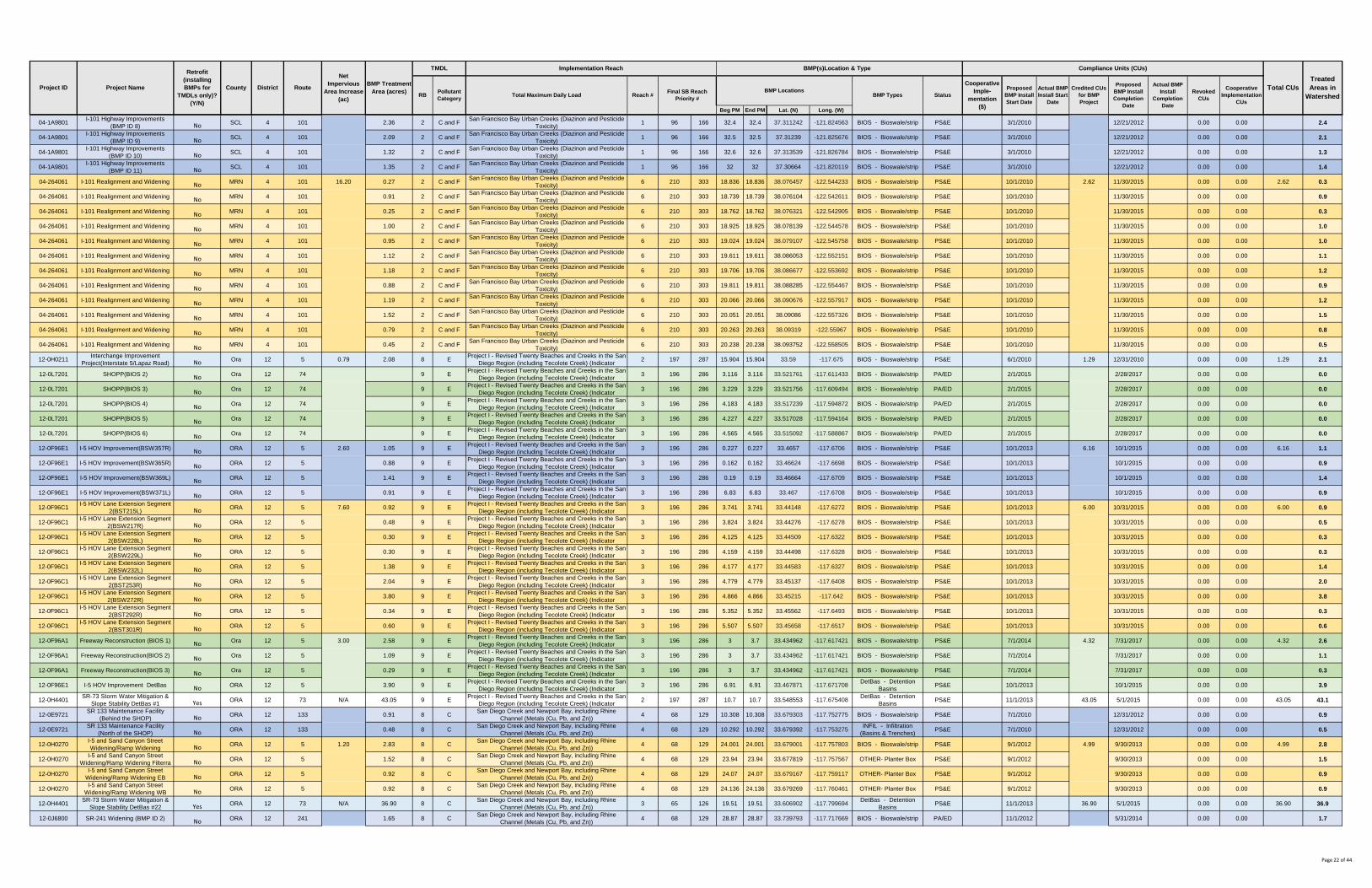
Beg PM End PM Lat. (N) Long. (W)
RouteProject ID Project Name
Retrofit (installing BMPs for
TMDLs only)? (Y/N)
County District Credited CUs for BMP Project
Proposed BMP Install Completion
Date
Actual BMP Install
Completion Date
Net Impervious
Area Increase (ac)
BMP Treatment Area (acres)
TMDL Implementation Reach BMP(s)Location & Type
BMP LocationsBMP Types Status
Revoked CUs
Total CUsTreated Areas in
WatershedRBPollutant Category
Total Maximum Daily Load Reach #Final SB Reach
Priority #
Compliance Units (CUs)
Cooperative Imple-
mentation ($)
Cooperative Implementation
CUs
Proposed BMP Install Start Date
Actual BMP Install Start
Date
04-1A9801I-101 Highway Improvements
(BMP ID 8) No SCL 4 101 2.36 2 C and FSan Francisco Bay Urban Creeks (Diazinon and Pesticide
Toxicity)1 96 166 32.4 32.4 37.311242 -121.824563 BIOS - Bioswale/strip PS&E 3/1/2010 12/21/2012 0.00 0.00 2.4
04-1A9801I-101 Highway Improvements
(BMP ID 9) No SCL 4 101 2.09 2 C and FSan Francisco Bay Urban Creeks (Diazinon and Pesticide
Toxicity)1 96 166 32.5 32.5 37.31239 -121.825676 BIOS - Bioswale/strip PS&E 3/1/2010 12/21/2012 0.00 0.00 2.1
04-1A9801I-101 Highway Improvements
(BMP ID 10) No SCL 4 101 1.32 2 C and FSan Francisco Bay Urban Creeks (Diazinon and Pesticide
Toxicity)1 96 166 32.6 32.6 37.313539 -121.826784 BIOS - Bioswale/strip PS&E 3/1/2010 12/21/2012 0.00 0.00 1.3
04-1A9801I-101 Highway Improvements
(BMP ID 11) No SCL 4 101 1.35 2 C and FSan Francisco Bay Urban Creeks (Diazinon and Pesticide
Toxicity)1 96 166 32 32 37.30664 -121.820119 BIOS - Bioswale/strip PS&E 3/1/2010 12/21/2012 0.00 0.00 1.4
04-264061 I-101 Realignment and Widening No MRN 4 101 16.20 0.27 2 C and FSan Francisco Bay Urban Creeks (Diazinon and Pesticide
Toxicity)6 210 303 18.836 18.836 38.076457 -122.544233 BIOS - Bioswale/strip PS&E 10/1/2010 2.62 11/30/2015 0.00 0.00 2.62 0.3
04-264061 I-101 Realignment and Widening No MRN 4 101 0.91 2 C and FSan Francisco Bay Urban Creeks (Diazinon and Pesticide
Toxicity)6 210 303 18.739 18.739 38.076104 -122.542611 BIOS - Bioswale/strip PS&E 10/1/2010 11/30/2015 0.00 0.00 0.9
04-264061 I-101 Realignment and Widening No MRN 4 101 0.25 2 C and FSan Francisco Bay Urban Creeks (Diazinon and Pesticide
Toxicity)6 210 303 18.762 18.762 38.076321 -122.542905 BIOS - Bioswale/strip PS&E 10/1/2010 11/30/2015 0.00 0.00 0.3
04-264061 I-101 Realignment and Widening No MRN 4 101 1.00 2 C and FSan Francisco Bay Urban Creeks (Diazinon and Pesticide
Toxicity)6 210 303 18.925 18.925 38.078139 -122.544578 BIOS - Bioswale/strip PS&E 10/1/2010 11/30/2015 0.00 0.00 1.0
04-264061 I-101 Realignment and Widening No MRN 4 101 0.95 2 C and FSan Francisco Bay Urban Creeks (Diazinon and Pesticide
Toxicity)6 210 303 19.024 19.024 38.079107 -122.545758 BIOS - Bioswale/strip PS&E 10/1/2010 11/30/2015 0.00 0.00 1.0
04-264061 I-101 Realignment and Widening No MRN 4 101 1.12 2 C and FSan Francisco Bay Urban Creeks (Diazinon and Pesticide
Toxicity)6 210 303 19.611 19.611 38.086053 -122.552151 BIOS - Bioswale/strip PS&E 10/1/2010 11/30/2015 0.00 0.00 1.1
04-264061 I-101 Realignment and Widening No MRN 4 101 1.18 2 C and FSan Francisco Bay Urban Creeks (Diazinon and Pesticide
Toxicity)6 210 303 19.706 19.706 38.086677 -122.553692 BIOS - Bioswale/strip PS&E 10/1/2010 11/30/2015 0.00 0.00 1.2
04-264061 I-101 Realignment and Widening No MRN 4 101 0.88 2 C and FSan Francisco Bay Urban Creeks (Diazinon and Pesticide
Toxicity)6 210 303 19.811 19.811 38.088285 -122.554467 BIOS - Bioswale/strip PS&E 10/1/2010 11/30/2015 0.00 0.00 0.9
04-264061 I-101 Realignment and Widening No MRN 4 101 1.19 2 C and FSan Francisco Bay Urban Creeks (Diazinon and Pesticide
Toxicity)6 210 303 20.066 20.066 38.090676 -122.557917 BIOS - Bioswale/strip PS&E 10/1/2010 11/30/2015 0.00 0.00 1.2
04-264061 I-101 Realignment and Widening No MRN 4 101 1.52 2 C and FSan Francisco Bay Urban Creeks (Diazinon and Pesticide
Toxicity)6 210 303 20.051 20.051 38.09086 -122.557326 BIOS - Bioswale/strip PS&E 10/1/2010 11/30/2015 0.00 0.00 1.5
04-264061 I-101 Realignment and Widening No MRN 4 101 0.79 2 C and FSan Francisco Bay Urban Creeks (Diazinon and Pesticide
Toxicity)6 210 303 20.263 20.263 38.09319 -122.55967 BIOS - Bioswale/strip PS&E 10/1/2010 11/30/2015 0.00 0.00 0.8
04-264061 I-101 Realignment and Widening No MRN 4 101 0.45 2 C and FSan Francisco Bay Urban Creeks (Diazinon and Pesticide
Toxicity)6 210 303 20.238 20.238 38.093752 -122.558505 BIOS - Bioswale/strip PS&E 10/1/2010 11/30/2015 0.00 0.00 0.5
12-0H0211Interchange Improvement
Project(Interstate 5/Lapaz Road) No Ora 12 5 0.79 2.08 8 EProject I - Revised Twenty Beaches and Creeks in the San
Diego Region (including Tecolote Creek) (Indicator 2 197 287 15.904 15.904 33.59 -117.675 BIOS - Bioswale/strip PS&E 6/1/2010 1.29 12/31/2010 0.00 0.00 1.29 2.1
12-0L7201 SHOPP(BIOS 2) No Ora 12 74 9 EProject I - Revised Twenty Beaches and Creeks in the San
Diego Region (including Tecolote Creek) (Indicator 3 196 286 3.116 3.116 33.521761 -117.611433 BIOS - Bioswale/strip PA/ED 2/1/2015 2/28/2017 0.00 0.00 0.0
12-0L7201 SHOPP(BIOS 3) No Ora 12 74 9 EProject I - Revised Twenty Beaches and Creeks in the San
Diego Region (including Tecolote Creek) (Indicator 3 196 286 3.229 3.229 33.521756 -117.609494 BIOS - Bioswale/strip PA/ED 2/1/2015 2/28/2017 0.00 0.00 0.0
12-0L7201 SHOPP(BIOS 4) No Ora 12 74 9 EProject I - Revised Twenty Beaches and Creeks in the San
Diego Region (including Tecolote Creek) (Indicator 3 196 286 4.183 4.183 33.517239 -117.594872 BIOS - Bioswale/strip PA/ED 2/1/2015 2/28/2017 0.00 0.00 0.0
12-0L7201 SHOPP(BIOS 5) No Ora 12 74 9 EProject I - Revised Twenty Beaches and Creeks in the San
Diego Region (including Tecolote Creek) (Indicator 3 196 286 4.227 4.227 33.517028 -117.594164 BIOS - Bioswale/strip PA/ED 2/1/2015 2/28/2017 0.00 0.00 0.0
12-0L7201 SHOPP(BIOS 6) No Ora 12 74 9 EProject I - Revised Twenty Beaches and Creeks in the San
Diego Region (including Tecolote Creek) (Indicator 3 196 286 4.565 4.565 33.515092 -117.588867 BIOS - Bioswale/strip PA/ED 2/1/2015 2/28/2017 0.00 0.00 0.0
12-0F96E1 I-5 HOV Improvement(BSW357R) No ORA 12 5 2.60 1.05 9 EProject I - Revised Twenty Beaches and Creeks in the San
Diego Region (including Tecolote Creek) (Indicator 3 196 286 0.227 0.227 33.4657 -117.6706 BIOS - Bioswale/strip PS&E 10/1/2013 6.16 10/1/2015 0.00 0.00 6.16 1.1
12-0F96E1 I-5 HOV Improvement(BSW365R) No ORA 12 5 0.88 9 EProject I - Revised Twenty Beaches and Creeks in the San
Diego Region (including Tecolote Creek) (Indicator 3 196 286 0.162 0.162 33.46624 -117.6698 BIOS - Bioswale/strip PS&E 10/1/2013 10/1/2015 0.00 0.00 0.9
12-0F96E1 I-5 HOV Improvement(BSW369L) No ORA 12 5 1.41 9 EProject I - Revised Twenty Beaches and Creeks in the San
Diego Region (including Tecolote Creek) (Indicator 3 196 286 0.19 0.19 33.46664 -117.6709 BIOS - Bioswale/strip PS&E 10/1/2013 10/1/2015 0.00 0.00 1.4
12-0F96E1 I-5 HOV Improvement(BSW371L) No ORA 12 5 0.91 9 EProject I - Revised Twenty Beaches and Creeks in the San
Diego Region (including Tecolote Creek) (Indicator 3 196 286 6.83 6.83 33.467 -117.6708 BIOS - Bioswale/strip PS&E 10/1/2013 10/1/2015 0.00 0.00 0.9
12-0F96C1I-5 HOV Lane Extension Segment
2(BST215L) No ORA 12 5 7.60 0.92 9 EProject I - Revised Twenty Beaches and Creeks in the San
Diego Region (including Tecolote Creek) (Indicator 3 196 286 3.741 3.741 33.44148 -117.6272 BIOS - Bioswale/strip PS&E 10/1/2013 6.00 10/31/2015 0.00 0.00 6.00 0.9
12-0F96C1I-5 HOV Lane Extension Segment
2(BSW217R) No ORA 12 5 0.48 9 EProject I - Revised Twenty Beaches and Creeks in the San
Diego Region (including Tecolote Creek) (Indicator 3 196 286 3.824 3.824 33.44276 -117.6278 BIOS - Bioswale/strip PS&E 10/1/2013 10/31/2015 0.00 0.00 0.5
12-0F96C1I-5 HOV Lane Extension Segment
2(BSW228L) No ORA 12 5 0.30 9 EProject I - Revised Twenty Beaches and Creeks in the San
Diego Region (including Tecolote Creek) (Indicator 3 196 286 4.125 4.125 33.44509 -117.6322 BIOS - Bioswale/strip PS&E 10/1/2013 10/31/2015 0.00 0.00 0.3
12-0F96C1I-5 HOV Lane Extension Segment
2(BSW229L) No ORA 12 5 0.30 9 EProject I - Revised Twenty Beaches and Creeks in the San
Diego Region (including Tecolote Creek) (Indicator 3 196 286 4.159 4.159 33.44498 -117.6328 BIOS - Bioswale/strip PS&E 10/1/2013 10/31/2015 0.00 0.00 0.3
12-0F96C1I-5 HOV Lane Extension Segment
2(BSW232L) No ORA 12 5 1.38 9 EProject I - Revised Twenty Beaches and Creeks in the San
Diego Region (including Tecolote Creek) (Indicator 3 196 286 4.177 4.177 33.44583 -117.6327 BIOS - Bioswale/strip PS&E 10/1/2013 10/31/2015 0.00 0.00 1.4
12-0F96C1I-5 HOV Lane Extension Segment
2(BST253R) No ORA 12 5 2.04 9 EProject I - Revised Twenty Beaches and Creeks in the San
Diego Region (including Tecolote Creek) (Indicator 3 196 286 4.779 4.779 33.45137 -117.6408 BIOS - Bioswale/strip PS&E 10/1/2013 10/31/2015 0.00 0.00 2.0
12-0F96C1I-5 HOV Lane Extension Segment
2(BSW272R) No ORA 12 5 3.80 9 EProject I - Revised Twenty Beaches and Creeks in the San
Diego Region (including Tecolote Creek) (Indicator 3 196 286 4.866 4.866 33.45215 -117.642 BIOS - Bioswale/strip PS&E 10/1/2013 10/31/2015 0.00 0.00 3.8
12-0F96C1I-5 HOV Lane Extension Segment
2(BST292R) No ORA 12 5 0.34 9 EProject I - Revised Twenty Beaches and Creeks in the San
Diego Region (including Tecolote Creek) (Indicator 3 196 286 5.352 5.352 33.45562 -117.6493 BIOS - Bioswale/strip PS&E 10/1/2013 10/31/2015 0.00 0.00 0.3
12-0F96C1I-5 HOV Lane Extension Segment
2(BST301R) No ORA 12 5 0.60 9 EProject I - Revised Twenty Beaches and Creeks in the San
Diego Region (including Tecolote Creek) (Indicator 3 196 286 5.507 5.507 33.45658 -117.6517 BIOS - Bioswale/strip PS&E 10/1/2013 10/31/2015 0.00 0.00 0.6
12-0F96A1 Freeway Reconstruction (BIOS 1) No Ora 12 5 3.00 2.58 9 EProject I - Revised Twenty Beaches and Creeks in the San
Diego Region (including Tecolote Creek) (Indicator 3 196 286 3 3.7 33.434962 -117.617421 BIOS - Bioswale/strip PS&E 7/1/2014 4.32 7/31/2017 0.00 0.00 4.32 2.6
12-0F96A1 Freeway Reconstruction(BIOS 2) No Ora 12 5 1.09 9 EProject I - Revised Twenty Beaches and Creeks in the San
Diego Region (including Tecolote Creek) (Indicator 3 196 286 3 3.7 33.434962 -117.617421 BIOS - Bioswale/strip PS&E 7/1/2014 7/31/2017 0.00 0.00 1.1
12-0F96A1 Freeway Reconstruction(BIOS 3) No Ora 12 5 0.29 9 EProject I - Revised Twenty Beaches and Creeks in the San
Diego Region (including Tecolote Creek) (Indicator 3 196 286 3 3.7 33.434962 -117.617421 BIOS - Bioswale/strip PS&E 7/1/2014 7/31/2017 0.00 0.00 0.3
12-0F96E1 I-5 HOV Improvement DetBas No ORA 12 5 3.90 9 EProject I - Revised Twenty Beaches and Creeks in the San
Diego Region (including Tecolote Creek) (Indicator 3 196 286 6.91 6.91 33.467871 -117.671708
DetBas - Detention Basins
PS&E 10/1/2013 10/1/2015 0.00 0.00 3.9
12-0H4401SR-73 Storm Water Mitigation &
Slope Stability DetBas #1 Yes ORA 12 73 N/A 43.05 9 EProject I - Revised Twenty Beaches and Creeks in the San
Diego Region (including Tecolote Creek) (Indicator 2 197 287 10.7 10.7 33.548553 -117.675408
DetBas - Detention Basins
PS&E 11/1/2013 43.05 5/1/2015 0.00 0.00 43.05 43.1
12-0E9721SR 133 Maintenance Facility
(Behind the SHOP) No ORA 12 133 0.91 8 CSan Diego Creek and Newport Bay, including Rhine
Channel (Metals (Cu, Pb, and Zn))4 68 129 10.308 10.308 33.679303 -117.752775 BIOS - Bioswale/strip PS&E 7/1/2010 12/31/2012 0.00 0.00 0.9
12-0E9721SR 133 Maintenance Facility
(North of the SHOP) No ORA 12 133 0.48 8 CSan Diego Creek and Newport Bay, including Rhine
Channel (Metals (Cu, Pb, and Zn))4 68 129 10.292 10.292 33.679392 -117.753275
INFIL - Infiltration (Basins & Trenches)
PS&E 7/1/2010 12/31/2012 0.00 0.00 0.5
12-0H0270I-5 and Sand Canyon Street Widening/Ramp Widening No ORA 12 5 1.20 2.83 8 C
San Diego Creek and Newport Bay, including Rhine Channel (Metals (Cu, Pb, and Zn))
4 68 129 24.001 24.001 33.679001 -117.757803 BIOS - Bioswale/strip PS&E 9/1/2012 4.99 9/30/2013 0.00 0.00 4.99 2.8
12-0H0270I-5 and Sand Canyon Street
Widening/Ramp Widening Filterra No ORA 12 5 1.52 8 CSan Diego Creek and Newport Bay, including Rhine
Channel (Metals (Cu, Pb, and Zn))4 68 129 23.94 23.94 33.677819 -117.757567 OTHER- Planter Box PS&E 9/1/2012 9/30/2013 0.00 0.00 1.5
12-0H0270I-5 and Sand Canyon Street
Widening/Ramp Widening EB No ORA 12 5 0.92 8 CSan Diego Creek and Newport Bay, including Rhine
Channel (Metals (Cu, Pb, and Zn))4 68 129 24.07 24.07 33.679167 -117.759117 OTHER- Planter Box PS&E 9/1/2012 9/30/2013 0.00 0.00 0.9
12-0H0270I-5 and Sand Canyon Street
Widening/Ramp Widening WB No ORA 12 5 0.92 8 CSan Diego Creek and Newport Bay, including Rhine
Channel (Metals (Cu, Pb, and Zn))4 68 129 24.136 24.136 33.679269 -117.760461 OTHER- Planter Box PS&E 9/1/2012 9/30/2013 0.00 0.00 0.9
12-0H4401SR-73 Storm Water Mitigation &
Slope Stability DetBas #22 Yes ORA 12 73 N/A 36.90 8 CSan Diego Creek and Newport Bay, including Rhine
Channel (Metals (Cu, Pb, and Zn))3 65 126 19.51 19.51 33.606902 -117.799694
DetBas - Detention Basins
PS&E 11/1/2013 36.90 5/1/2015 0.00 0.00 36.90 36.9
12-0J6800 SR-241 Widening (BMP ID 2) No ORA 12 241 1.65 8 CSan Diego Creek and Newport Bay, including Rhine
Channel (Metals (Cu, Pb, and Zn))4 68 129 28.87 28.87 33.739793 -117.717669 BIOS - Bioswale/strip PA/ED 11/1/2012 5/31/2014 0.00 0.00 1.7
Page 22 of 44

Beg PM End PM Lat. (N) Long. (W)
RouteProject ID Project Name
Retrofit (installing BMPs for
TMDLs only)? (Y/N)
County District Credited CUs for BMP Project
Proposed BMP Install Completion
Date
Actual BMP Install
Completion Date
Net Impervious
Area Increase (ac)
BMP Treatment Area (acres)
TMDL Implementation Reach BMP(s)Location & Type
BMP LocationsBMP Types Status
Revoked CUs
Total CUsTreated Areas in
WatershedRBPollutant Category
Total Maximum Daily Load Reach #Final SB Reach
Priority #
Compliance Units (CUs)
Cooperative Imple-
mentation ($)
Cooperative Implementation
CUs
Proposed BMP Install Start Date
Actual BMP Install Start
Date
12-0J6800 SR-241 Widening (BMP ID 3a) No ORA 12 241 0.91 8 CSan Diego Creek and Newport Bay, including Rhine
Channel (Metals (Cu, Pb, and Zn))4 68 129 29 29 33.741742 -117.718147 BIOS - Bioswale/strip PA/ED 11/1/2012 5/31/2014 0.00 0.00 0.9
12-0J6800 SR-241 Widening (BMP ID 3b) No ORA 12 241 1.45 8 CSan Diego Creek and Newport Bay, including Rhine
Channel (Metals (Cu, Pb, and Zn))4 68 129 29 29 33.741742 -117.718147 BIOS - Bioswale/strip PA/ED 11/1/2012 5/31/2014 0.00 0.00 1.5
12-0J6800 SR-241 Widening (BMP ID 3c) No ORA 12 241 5.30 8 CSan Diego Creek and Newport Bay, including Rhine
Channel (Metals (Cu, Pb, and Zn))4 68 129 29 29 33.741742 -117.718147 BIOS - Bioswale/strip PA/ED 11/1/2012 5/31/2014 0.00 0.00 5.3
12-0J6800 SR-241 Widening (BMP ID 4) No ORA 12 241 0.16 8 CSan Diego Creek and Newport Bay, including Rhine
Channel (Metals (Cu, Pb, and Zn))4 68 129 29.65 29.65 33.748768 -117.724991 BIOS - Bioswale/strip PA/ED 11/1/2012 5/31/2014 0.00 0.00 0.2
12-0J6800 SR-241 Widening (BMP ID 5) No ORA 12 241 2.02 8 CSan Diego Creek and Newport Bay, including Rhine
Channel (Metals (Cu, Pb, and Zn))4 68 129 29.75 29.75 33.749448 -117.726378 BIOS - Bioswale/strip PA/ED 11/1/2012 5/31/2014 0.00 0.00 2.0
12-0E9721SR 133 Maintenance Facility
(Behind the SHOP) No ORA 12 133 0.91 8 C San Diego Creek and Upper Newport Bay (Cadmium) 3 67 128 10.308 10.308 33.679303 -117.752775 BIOS - Bioswale/strip PS&E 7/1/2010 12/31/2012 0.00 0.00 0.9
12-0E9721SR 133 Maintenance Facility
(North of the SHOP) No ORA 12 133 0.48 8 C San Diego Creek and Upper Newport Bay (Cadmium) 3 67 128 10.292 10.292 33.679392 -117.753275INFIL - Infiltration
(Basins & Trenches)PS&E 7/1/2010 12/31/2012 0.00 0.00 0.5
12-0H0270I-5 and Sand Canyon Street Widening/Ramp Widening No ORA 12 5 1.20 2.83 8 C San Diego Creek and Upper Newport Bay (Cadmium) 3 67 128 24.001 24.001 33.679001 -117.757803 BIOS - Bioswale/strip PS&E 9/1/2012 4.99 9/30/2013 0.00 0.00 4.99 2.8
12-0H0270I-5 and Sand Canyon Street
Widening/Ramp Widening Filterra No ORA 12 5 1.52 8 C San Diego Creek and Upper Newport Bay (Cadmium) 3 67 128 23.94 23.94 33.677819 -117.757567 OTHER- Planter Box PS&E 9/1/2012 9/30/2013 0.00 0.00 1.5
12-0H0270I-5 and Sand Canyon Street
Widening/Ramp Widening EB No ORA 12 5 0.92 8 C San Diego Creek and Upper Newport Bay (Cadmium) 3 67 128 24.07 24.07 33.679167 -117.759117 OTHER- Planter Box PS&E 9/1/2012 9/30/2013 0.00 0.00 0.9
12-0H0270I-5 and Sand Canyon Street
Widening/Ramp Widening WB No ORA 12 5 0.92 8 C San Diego Creek and Upper Newport Bay (Cadmium) 3 67 128 24.136 24.136 33.679269 -117.760461 OTHER- Planter Box PS&E 9/1/2012 9/30/2013 0.00 0.00 0.9
12-0H4401SR-73 Storm Water Mitigation &
Slope Stability DetBas #22 Yes ORA 12 73 N/A 36.90 8 C San Diego Creek and Upper Newport Bay (Cadmium) 2 66 127 19.51 19.51 33.606902 -117.799694DetBas - Detention
BasinsPS&E 11/1/2013 36.90 5/1/2015 0.00 0.00 36.90 36.9
12-0J6800 SR-241 Widening (BMP ID 2) No ORA 12 241 1.65 8 C San Diego Creek and Upper Newport Bay (Cadmium) 3 67 128 28.87 28.87 33.739793 -117.717669 BIOS - Bioswale/strip PA/ED 11/1/2012 5/31/2014 0.00 0.00 1.7
12-0J6800 SR-241 Widening (BMP ID 3a) No ORA 12 241 0.91 8 C San Diego Creek and Upper Newport Bay (Cadmium) 3 67 128 29 29 33.741742 -117.718147 BIOS - Bioswale/strip PA/ED 11/1/2012 5/31/2014 0.00 0.00 0.9
12-0J6800 SR-241 Widening (BMP ID 3b) No ORA 12 241 1.45 8 C San Diego Creek and Upper Newport Bay (Cadmium) 3 67 128 29 29 33.741742 -117.718147 BIOS - Bioswale/strip PA/ED 11/1/2012 5/31/2014 0.00 0.00 1.5
12-0J6800 SR-241 Widening (BMP ID 3c) No ORA 12 241 5.30 8 C San Diego Creek and Upper Newport Bay (Cadmium) 3 67 128 29 29 33.741742 -117.718147 BIOS - Bioswale/strip PA/ED 11/1/2012 5/31/2014 0.00 0.00 5.3
12-0J6800 SR-241 Widening (BMP ID 4) No ORA 12 241 0.16 8 C San Diego Creek and Upper Newport Bay (Cadmium) 3 67 128 29.65 29.65 33.748768 -117.724991 BIOS - Bioswale/strip PA/ED 11/1/2012 5/31/2014 0.00 0.00 0.2
12-0J6800 SR-241 Widening (BMP ID 5) No ORA 12 241 2.02 8 C San Diego Creek and Upper Newport Bay (Cadmium) 3 67 128 29.75 29.75 33.749448 -117.726378 BIOS - Bioswale/strip PA/ED 11/1/2012 5/31/2014 0.00 0.00 2.0
12-0E9721SR 133 Maintenance Facility
(Behind the SHOP) No ORA 12 133 0.91 8 CSan Diego Creek Watershed (Organochlorine Compounds
(DDT, Chlordane, PCBs, and Toxaphene))2 168 244 10.308 10.308 33.679303 -117.752775 BIOS - Bioswale/strip PS&E 7/1/2010 12/31/2012 0.00 0.00 0.9
12-0E9721SR 133 Maintenance Facility
(North of the SHOP) No ORA 12 133 0.48 8 CSan Diego Creek Watershed (Organochlorine Compounds
(DDT, Chlordane, PCBs, and Toxaphene))2 168 244 10.292 10.292 33.679392 -117.753275
INFIL - Infiltration (Basins & Trenches)
PS&E 7/1/2010 12/31/2012 0.00 0.00 0.5
12-0H0270I-5 and Sand Canyon Street Widening/Ramp Widening No ORA 12 5 1.20 2.83 8 C
San Diego Creek Watershed (Organochlorine Compounds (DDT, Chlordane, PCBs, and Toxaphene))
2 168 244 24.001 24.001 33.679001 -117.757803 BIOS - Bioswale/strip PS&E 9/1/2012 4.99 9/30/2013 0.00 0.00 4.99 2.8
12-0H0270I-5 and Sand Canyon Street
Widening/Ramp Widening Filterra No ORA 12 5 1.52 8 CSan Diego Creek Watershed (Organochlorine Compounds
(DDT, Chlordane, PCBs, and Toxaphene))2 168 244 23.94 23.94 33.677819 -117.757567 OTHER- Planter Box PS&E 9/1/2012 9/30/2013 0.00 0.00 1.5
12-0H0270I-5 and Sand Canyon Street
Widening/Ramp Widening EB No ORA 12 5 0.92 8 CSan Diego Creek Watershed (Organochlorine Compounds
(DDT, Chlordane, PCBs, and Toxaphene))2 168 244 24.07 24.07 33.679167 -117.759117 OTHER- Planter Box PS&E 9/1/2012 9/30/2013 0.00 0.00 0.9
12-0H0270I-5 and Sand Canyon Street
Widening/Ramp Widening WB No ORA 12 5 0.92 8 CSan Diego Creek Watershed (Organochlorine Compounds
(DDT, Chlordane, PCBs, and Toxaphene))2 168 244 24.136 24.136 33.679269 -117.760461 OTHER- Planter Box PS&E 9/1/2012 9/30/2013 0.00 0.00 0.9
12-0H4401SR-73 Storm Water Mitigation &
Slope Stability DetBas #22 Yes ORA 12 73 N/A 36.90 8 CSan Diego Creek Watershed (Organochlorine Compounds
(DDT, Chlordane, PCBs, and Toxaphene))1 166 242 19.51 19.51 33.606902 -117.799694
DetBas - Detention Basins
PS&E 11/1/2013 36.90 5/1/2015 0.00 0.00 36.90 36.9
12-0J6800 SR-241 Widening (BMP ID 2) No ORA 12 241 1.65 8 CSan Diego Creek Watershed (Organochlorine Compounds
(DDT, Chlordane, PCBs, and Toxaphene))2 168 244 28.87 28.87 33.739793 -117.717669 BIOS - Bioswale/strip PA/ED 11/1/2012 5/31/2014 0.00 0.00 1.7
12-0J6800 SR-241 Widening (BMP ID 3a) No ORA 12 241 0.91 8 CSan Diego Creek Watershed (Organochlorine Compounds
(DDT, Chlordane, PCBs, and Toxaphene))2 168 244 29 29 33.741742 -117.718147 BIOS - Bioswale/strip PA/ED 11/1/2012 5/31/2014 0.00 0.00 0.9
12-0J6800 SR-241 Widening (BMP ID 3b) No ORA 12 241 1.45 8 CSan Diego Creek Watershed (Organochlorine Compounds
(DDT, Chlordane, PCBs, and Toxaphene))2 168 244 29 29 33.741742 -117.718147 BIOS - Bioswale/strip PA/ED 11/1/2012 5/31/2014 0.00 0.00 1.5
12-0J6800 SR-241 Widening (BMP ID 3c) No ORA 12 241 5.30 8 CSan Diego Creek Watershed (Organochlorine Compounds
(DDT, Chlordane, PCBs, and Toxaphene))2 168 244 29 29 33.741742 -117.718147 BIOS - Bioswale/strip PA/ED 11/1/2012 5/31/2014 0.00 0.00 5.3
12-0J6800 SR-241 Widening (BMP ID 4) No ORA 12 241 0.16 8 CSan Diego Creek Watershed (Organochlorine Compounds
(DDT, Chlordane, PCBs, and Toxaphene))2 168 244 29.65 29.65 33.748768 -117.724991 BIOS - Bioswale/strip PA/ED 11/1/2012 5/31/2014 0.00 0.00 0.2
12-0J6800 SR-241 Widening (BMP ID 5) No ORA 12 241 2.02 8 CSan Diego Creek Watershed (Organochlorine Compounds
(DDT, Chlordane, PCBs, and Toxaphene))2 168 244 29.75 29.75 33.749448 -117.726378 BIOS - Bioswale/strip PA/ED 11/1/2012 5/31/2014 0.00 0.00 2.0
12-71631Freeway Widening and HOV
Improvements(BIOS # 7) No Ora 12 22.405.605 19.00 1.49 4,8 C and G San Gabriel River (Metals (Cu, Pb, Zn) and Selenium) 1 83 147 22.3 22.3 33.77389 -118.0692 BIOS - Bioswale/strip PS&E 8/3/2010 18.79 12/21/2013 0.00 0.00 18.79 1.5
12-71631Freeway Widening and HOV Improvements(BIOS # 29) No Ora 12 22.405.605 1.34 4,8 C and G San Gabriel River (Metals (Cu, Pb, Zn) and Selenium) 1 83 147 22.559 22.559 33.77505 -118.0734 BIOS - Bioswale/strip PS&E 8/3/2010 12/21/2013 0.00 0.00 1.3
12-71631Freeway Widening and HOV
Improvements(BIOS #34) No Ora 12 22.405.605 1.51 4,8 C and G San Gabriel River (Metals (Cu, Pb, Zn) and Selenium) 1 83 147 22.543 22.543 33.77409 -118.0734 BIOS - Bioswale/strip PS&E 8/3/2010 12/21/2013 0.00 0.00 1.5
12-71631Freeway Widening and HOV
Improvements(BIOS #35) No Ora 12 22.405.605 3.16 4,8 C and G San Gabriel River (Metals (Cu, Pb, Zn) and Selenium) 1 83 147 22.548 22.548 33.77503 -118.0732 BIOS - Bioswale/strip PS&E 8/3/2010 12/21/2013 0.00 0.00 3.2
12-71631Freeway Widening and HOV
Improvements(BIOS 38) No Ora 12 22.405.605 1.36 4,8 C and G San Gabriel River (Metals (Cu, Pb, Zn) and Selenium) 1 83 147 22.804 22.804 33.77477 -118.0774 BIOS - Bioswale/strip PS&E 8/3/2010 12/21/2013 0.00 0.00 1.4
12-71631Freeway Widening and HOV
Improvements(BIOS #47) No Ora 12 22.405.605 9.26 4,8 C and G San Gabriel River (Metals (Cu, Pb, Zn) and Selenium) 1 83 147 22.625 22.625 33.77359 -118.0748 BIOS - Bioswale/strip PS&E 8/3/2010 12/21/2013 0.00 0.00 9.3
12-71631Freeway Widening and HOV
Improvements(BIOS #49) No Ora 12 22.405.605 0.31 4,8 C and G San Gabriel River (Metals (Cu, Pb, Zn) and Selenium) 1 83 147 3.258 3.258 33.78074 -118.0918 BIOS - Bioswale/strip PS&E 8/3/2010 12/21/2013 0.00 0.00 0.3
12-71631Freeway Widening and HOV
Improvements(BIOS #52) No Ora 7 22.405.605 2.63 4,8 C and G San Gabriel River (Metals (Cu, Pb, Zn) and Selenium) 1 83 147 0.313 0.313 33.78935 -118.0915 BIOS - Bioswale/strip PS&E 8/3/2010 12/21/2013 0.00 0.00 2.6
12-71631Freeway Widening and HOV Improvements(BIOS #53A) No Ora 7 22.405.605 3.51 4,8 C and G San Gabriel River (Metals (Cu, Pb, Zn) and Selenium) 6 108 183 0.113 0.113 33.80797 -118.0811 BIOS - Bioswale/strip PS&E 8/3/2010 12/21/2013 0.00 0.00 3.5
12-71631Freeway Widening and HOV Improvements(BIOS #53B) No Ora 7 22.405.605 2.26 4,8 C and G San Gabriel River (Metals (Cu, Pb, Zn) and Selenium) 1 83 147 0.347 0.347 33.78977 -118.0912 BIOS - Bioswale/strip PS&E 8/3/2010 12/21/2013 0.00 0.00 2.3
12-71631Freeway Widening and HOV
Improvements(BIOS #58) No Ora 7 22.405.605 0.83 4,8 C and G San Gabriel River (Metals (Cu, Pb, Zn) and Selenium) 1 83 147 1.02 1.02 33.79859 -118.0859 BIOS - Bioswale/strip PS&E 8/3/2010 12/21/2013 0.00 0.00 0.8
12-71631Freeway Widening and HOV
Improvements(BIOS #91) No Ora 12 22.405.605 3.65 4,8 C and G San Gabriel River (Metals (Cu, Pb, Zn) and Selenium) 1 83 147 22.607 22.607 33.77358 -118.0745 BIOS - Bioswale/strip PS&E 8/3/2010 12/21/2013 0.00 0.00 3.7
12-71631Freeway Widening and HOV
Improvements(BIOS #93) No Ora 12 22.405.605 2.43 4,8 C and G San Gabriel River (Metals (Cu, Pb, Zn) and Selenium) 1 83 147 0.08 0.08 33.7845 -118.0898 BIOS - Bioswale/strip PS&E 8/3/2010 12/21/2013 0.00 0.00 2.4
12-71631Freeway Widening and HOV
Improvements(BIOS #94) No Ora 12 22.405.605 1.41 4,8 C and G San Gabriel River (Metals (Cu, Pb, Zn) and Selenium) 1 83 147 0.197 0.197 33.78712 -118.0907 BIOS - Bioswale/strip PS&E 8/3/2010 12/21/2013 0.00 0.00 1.4
12-71631Freeway Widening and HOV
Improvements(BIOS #95) No Ora 12 22.405.605 1.66 4,8 C and G San Gabriel River (Metals (Cu, Pb, Zn) and Selenium) 1 83 147 0.465 0.465 33.79024 -118.0883 BIOS - Bioswale/strip PS&E 8/3/2010 12/21/2013 0.00 0.00 1.7
12-71631Freeway Widening and HOV
Improvements(BIOS #96) No Ora 12 22.405.605 0.98 4,8 C and G San Gabriel River (Metals (Cu, Pb, Zn) and Selenium) 1 83 147 0.738 0.738 33.79422 -118.0869 BIOS - Bioswale/strip PS&E 8/3/2010 12/21/2013 0.00 0.00 1.0
12-0F0311SR-57 Northbound Widening(BSW-
77R) No ORA 12 57 5.20 2.50 9 C and G San Gabriel River (Metals (Cu, Pb, Zn) and Selenium) 6 108 183 16.486 16.486 33.86258 -117.877 BIOS - Bioswale/strip PS&E 1/1/2010 7.86 1/31/2013 0.00 0.00 7.86 2.5
Page 23 of 44
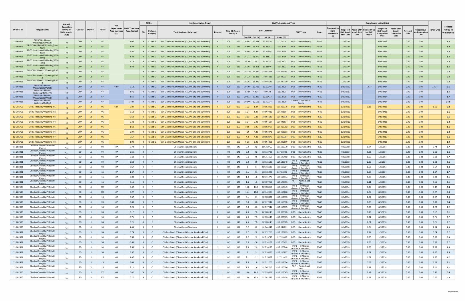
Beg PM End PM Lat. (N) Long. (W)
RouteProject ID Project Name
Retrofit (installing BMPs for
TMDLs only)? (Y/N)
County District Credited CUs for BMP Project
Proposed BMP Install Completion
Date
Actual BMP Install
Completion Date
Net Impervious
Area Increase (ac)
BMP Treatment Area (acres)
TMDL Implementation Reach BMP(s)Location & Type
BMP LocationsBMP Types Status
Revoked CUs
Total CUsTreated Areas in
WatershedRBPollutant Category
Total Maximum Daily Load Reach #Final SB Reach
Priority #
Compliance Units (CUs)
Cooperative Imple-
mentation ($)
Cooperative Implementation
CUs
Proposed BMP Install Start Date
Actual BMP Install Start
Date
12-0F0311SR-57 Northbound
Widening(BSW489R) No ORA 12 57 1.02 9 C and G San Gabriel River (Metals (Cu, Pb, Zn) and Selenium) 6 108 183 16.691 16.691 33.86539 -117.878 BIOS - Bioswale/strip PS&E 1/1/2010 1/31/2013 0.00 0.00 1.0
12-0F0311SR-57 Northbound Widening(bsw-
492R) No ORA 12 57 1.53 9 C and G San Gabriel River (Metals (Cu, Pb, Zn) and Selenium) 6 108 183 16.808 16.808 33.86702 -117.8785 BIOS - Bioswale/strip PS&E 1/1/2010 1/31/2013 0.00 0.00 1.5
12-0F0311SR-57 Northbound Widening(BSW-
498R) No ORA 12 57 2.82 9 C and G San Gabriel River (Metals (Cu, Pb, Zn) and Selenium) 6 108 183 16.884 16.884 33.86808 -117.8788 BIOS - Bioswale/strip PS&E 1/1/2010 1/31/2013 0.00 0.00 2.8
12-0F0311SR-57 Northbound Widening(BSW-
69R) No ORA 12 57 1.45 9 C and G San Gabriel River (Metals (Cu, Pb, Zn) and Selenium) 6 108 183 18.272 18.272 33.88822 -117.8716 BIOS - Bioswale/strip PS&E 1/1/2010 1/31/2013 0.00 0.00 1.5
12-0F0311SR-57 Northbound Widening(BSW-
72R) No ORA 12 57 2.18 9 C and G San Gabriel River (Metals (Cu, Pb, Zn) and Selenium) 6 108 183 18.43 18.43 33.89034 -117.8803 BIOS - Bioswale/strip PS&E 1/1/2010 1/31/2013 0.00 0.00 2.2
12-0F0311SR-57 Northbound Widening(BSW-
578R) No ORA 12 57 1.56 9 C and G San Gabriel River (Metals (Cu, Pb, Zn) and Selenium) 6 108 183 18.301 18.301 33.88846 -117.8802 BIOS - Bioswale/strip PS&E 1/1/2010 1/31/2013 0.00 0.00 1.6
12-0F0311SR-57 Northbound Widening(BST
1) No ORA 12 57 9 C and G San Gabriel River (Metals (Cu, Pb, Zn) and Selenium) 6 108 183 18.239 18.239 33.887558 -117.879364 BIOS - Bioswale/strip PS&E 1/1/2010 1/31/2013 0.00 0.00 0.0
12-0F0311SR-57 Northbound Widening(BST
2) No ORA 12 57 9 C and G San Gabriel River (Metals (Cu, Pb, Zn) and Selenium) 6 108 183 18.216 18.216 33.887222 -117.880217 BIOS - Bioswale/strip PS&E 1/1/2010 1/31/2013 0.00 0.00 0.0
12-0F0311SR-57 Northbound Widening(BST
3) No ORA 12 57 9 C and G San Gabriel River (Metals (Cu, Pb, Zn) and Selenium) 6 108 183 18.282 18.282 33.888181 -117.880019 BIOS - Bioswale/strip PS&E 1/1/2010 1/31/2013 0.00 0.00 0.0
12-0F0321SR-57 Northbound
Widening(BSW646R) No ORA 12 57 6.80 2.13 8 C and G San Gabriel River (Metals (Cu, Pb, Zn) and Selenium) 6 108 183 19.765 19.765 33.90948 -117.8829 BIOS - Bioswale/strip PS&E 6/30/2010 13.37 6/30/2014 0.00 0.00 13.37 2.1
12-0F0321SR-57 Northbound
Widening(BSW47R) No ORA 12 57 1.51 8 C and G San Gabriel River (Metals (Cu, Pb, Zn) and Selenium) 6 108 183 5.524 5.524 33.9104 -117.8823 BIOS - Bioswale/strip PS&E 6/30/2010 6/30/2014 0.00 0.00 1.5
12-0F0321SR-57 Northbound
Widening(BSW707R) No ORA 12 57 1.65 8 C and G San Gabriel River (Metals (Cu, Pb, Zn) and Selenium) 6 108 183 20.833 20.833 33.92433 -117.8798 BIOS - Bioswale/strip PS&E 6/30/2010 6/30/2014 0.00 0.00 1.7
12-0F0321SR-57 Northbound Widening(DetBas) No ORA 12 57 14.88 8 C and G San Gabriel River (Metals (Cu, Pb, Zn) and Selenium) 6 108 183 19.106 19.106 33.90023 -117.8809
DetBas - Detention Basins
PS&E 6/30/2010 6/30/2014 0.00 0.00 14.9
12-0C5701 SR-91 Freeway Widening (#1) No ORA 12 91 6.86 0.84 8 C and G San Gabriel River (Metals (Cu, Pb, Zn) and Selenium) 6 108 183 1.22 1.24 33.853913 -117.959375 BIOS - Bioswale/strip PS&E 12/1/2012 1.15 6/30/2015 0.00 0.00 1.15 0.8
12-0C5701 SR-91 Freeway Widening (#2) No ORA 12 91 2.12 8 C and G San Gabriel River (Metals (Cu, Pb, Zn) and Selenium) 6 108 183 1.27 1.29 33.853932 -117.958507 BIOS - Bioswale/strip PS&E 12/1/2012 6/30/2015 0.00 0.00 2.1
12-0C5701 SR-91 Freeway Widening (#3) No ORA 12 91 0.60 8 C and G San Gabriel River (Metals (Cu, Pb, Zn) and Selenium) 6 108 183 2.13 2.23 33.854148 -117.943575 BIOS - Bioswale/strip PS&E 12/1/2012 6/30/2015 0.00 0.00 0.6
12-0C5701 SR-91 Freeway Widening (#4) No ORA 12 91 0.42 8 C and G San Gabriel River (Metals (Cu, Pb, Zn) and Selenium) 6 108 183 2.27 2.31 33.854157 -117.941137 BIOS - Bioswale/strip PS&E 12/1/2012 6/30/2015 0.00 0.00 0.4
12-0C5701 SR-91 Freeway Widening (#5) No ORA 12 91 1.62 8 C and G San Gabriel River (Metals (Cu, Pb, Zn) and Selenium) 6 108 183 3.85 3.95 33.853797 -117.913752 BIOS - Bioswale/strip PS&E 12/1/2012 6/30/2015 0.00 0.00 1.6
12-0C5701 SR-91 Freeway Widening (#6) No ORA 12 91 0.84 8 C and G San Gabriel River (Metals (Cu, Pb, Zn) and Selenium) 6 108 183 4.25 4.26 33.853871 -117.906813 BIOS - Bioswale/strip PS&E 12/1/2012 6/30/2015 0.00 0.00 0.8
12-0C5701 SR-91 Freeway Widening (#7) No ORA 12 91 0.57 8 C and G San Gabriel River (Metals (Cu, Pb, Zn) and Selenium) 6 108 183 4.3 4.33 33.853873 -117.905957 BIOS - Bioswale/strip PS&E 12/1/2012 6/30/2015 0.00 0.00 0.6
12-0C5701 SR-91 Freeway Widening (#8) No ORA 12 91 1.00 8 C and G San Gabriel River (Metals (Cu, Pb, Zn) and Selenium) 6 108 183 5.23 5.25 33.854211 -117.890109 BIOS - Bioswale/strip PS&E 12/1/2012 6/30/2015 0.00 0.00 1.0
11-282401Chollas Creek BMP Retrofit
Project Yes SD 11 94 N/A 0.74 9 F Chollas Creek (Diazinon) 1 82 145 2.2 2.2 32.712755 -117.133279 BIOS - Bioswale/strip PS&E 9/1/2013 0.74 1/1/2014 0.00 0.00 0.74 0.7
11-282401Chollas Creek BMP Retrofit
Project Yes SD 11 94 N/A 0.55 9 F Chollas Creek (Diazinon) 1 82 145 2.2 2.2 32.713796 -117.13338 BIOS - Bioswale/strip PS&E 9/1/2013 0.55 1/1/2014 0.00 0.00 0.55 0.6
11-282401Chollas Creek BMP Retrofit
Project Yes SD 11 94 N/A 8.69 9 F Chollas Creek (Diazinon) 1 82 145 2.6 2.6 32.714157 -117.126412 BIOS - Bioswale/strip PS&E 9/1/2013 8.69 1/1/2014 0.00 0.00 8.69 8.7
11-282401Chollas Creek BMP Retrofit
Project Yes SD 11 94 N/A 2.53 9 F Chollas Creek (Diazinon) 1 82 145 2.9 2.9 32.716135 -117.120948INFIL - Infiltration
(Basins & Trenches)PS&E 9/1/2013 2.53 1/1/2014 0.00 0.00 2.53 2.5
11-282401Chollas Creek BMP Retrofit
Project Yes SD 11 94 N/A 2.57 9 F Chollas Creek (Diazinon) 1 82 145 3 3 32.716638 -117.118727INFIL - Infiltration
(Basins & Trenches)PS&E 9/1/2013 2.57 1/1/2014 0.00 0.00 2.57 2.6
11-282401Chollas Creek BMP Retrofit
Project Yes SD 11 15 N/A 1.67 9 F Chollas Creek (Diazinon) 1 82 145 2.1 2.1 32.715423 -117.11826INFIL - Infiltration
(Basins & Trenches)PS&E 9/1/2013 1.67 1/1/2014 0.00 0.00 1.67 1.7
11-282401Chollas Creek BMP Retrofit
Project Yes SD 11 15 N/A 3.09 9 F Chollas Creek (Diazinon) 1 82 145 1.8 1.8 32.711275 -117.119674INFIL - Infiltration
(Basins & Trenches)PS&E 9/1/2013 3.09 1/1/2014 0.00 0.00 3.09 3.1
11-282401Chollas Creek BMP Retrofit
Project Yes SD 11 15 N/A 2.11 9 F Chollas Creek (Diazinon) 1 82 145 1.6 1.6 32.707216 -117.120596ASF - Austin Sand
FilterPS&E 9/1/2013 2.11 1/1/2014 0.00 0.00 2.11 2.1
11-282500 Chollas Creek BMP Retrofit Yes SD 11 805 N/A 0.42 9 F Chollas Creek (Diazinon) 1 82 145 14.8 14.8 32.733857 -117.113045INFIL - Infiltration
(Basins & Trenches)PS&E 8/1/2014 0.42 8/1/2016 0.00 0.00 0.42 0.4
11-282500 Chollas Creek BMP Retrofit Yes SD 11 805 N/A 0.27 9 F Chollas Creek (Diazinon) 1 82 145 15.4 15.4 32.742085 -117.117128INFIL - Infiltration
(Basins & Trenches)PS&E 8/1/2014 0.27 8/1/2016 0.00 0.00 0.27 0.3
11-282500 Chollas Creek BMP Retrofit Yes SD 11 15 N/A 2.57 9 F Chollas Creek (Diazinon) 1 82 145 3.1 3.1 32.728432 -117.112073INFIL - Infiltration
(Basins & Trenches)PS&E 8/1/2014 2.57 8/1/2016 0.00 0.00 2.57 2.6
11-282500 Chollas Creek BMP Retrofit Yes SD 11 94 N/A 3.38 9 F Chollas Creek (Diazinon) 1 82 145 3.3 3.3 32.717044 -117.115915INFIL - Infiltration
(Basins & Trenches)PS&E 8/1/2014 3.38 8/1/2016 0.00 0.00 3.38 3.4
11-282500 Chollas Creek BMP Retrofit Yes SD 11 94 N/A 7.20 9 F Chollas Creek (Diazinon) 1 82 145 3.3 3.3 32.717044 -117.115915INFIL - Infiltration
(Basins & Trenches)PS&E 8/1/2014 7.20 8/1/2016 0.00 0.00 7.20 7.2
11-282500 Chollas Creek BMP Retrofit Yes SD 11 94 N/A 3.12 9 F Chollas Creek (Diazinon) 2 80 141 7.5 7.5 32.739145 -117.053805 BIOS - Bioswale/strip PS&E 8/1/2014 3.12 8/1/2016 0.00 0.00 3.12 3.1
11-282500 Chollas Creek BMP Retrofit Yes SD 11 94 N/A 0.71 9 F Chollas Creek (Diazinon) 2 80 141 7.5 7.5 32.739145 -117.053805 BIOS - Bioswale/strip PS&E 8/1/2014 0.71 8/1/2016 0.00 0.00 0.71 0.7
11-282500 Chollas Creek BMP Retrofit Yes SD 11 94 N/A 2.21 9 F Chollas Creek (Diazinon) 2 80 141 7.5 7.5 32.739145 -117.053805 BIOS - Bioswale/strip PS&E 8/1/2014 2.21 8/1/2016 0.00 0.00 2.21 2.2
11-282500 Chollas Creek BMP Retrofit Yes SD 11 94 N/A 1.04 9 F Chollas Creek (Diazinon) 2 80 141 8.2 8.2 32.744842 -117.044111 BIOS - Bioswale/strip PS&E 8/1/2014 1.04 8/1/2016 0.00 0.00 1.04 1.0
11-282401Chollas Creek BMP Retrofit
Project Yes SD 11 94 N/A 0.74 9 C Chollas Creek (Dissolved Copper, Lead and Zinc) 1 82 146 2.2 2.2 32.712755 -117.133279 BIOS - Bioswale/strip PS&E 9/1/2013 0.74 1/1/2014 0.00 0.00 0.74 0.7
11-282401Chollas Creek BMP Retrofit
Project Yes SD 11 94 N/A 0.55 9 C Chollas Creek (Dissolved Copper, Lead and Zinc) 1 82 146 2.2 2.2 32.713796 -117.13338 BIOS - Bioswale/strip PS&E 9/1/2013 0.55 1/1/2014 0.00 0.00 0.55 0.6
11-282401Chollas Creek BMP Retrofit
Project Yes SD 11 94 N/A 8.69 9 C Chollas Creek (Dissolved Copper, Lead and Zinc) 1 82 146 2.6 2.6 32.714157 -117.126412 BIOS - Bioswale/strip PS&E 9/1/2013 8.69 1/1/2014 0.00 0.00 8.69 8.7
11-282401Chollas Creek BMP Retrofit
Project Yes SD 11 94 N/A 2.53 9 C Chollas Creek (Dissolved Copper, Lead and Zinc) 1 82 146 2.9 2.9 32.716135 -117.120948INFIL - Infiltration
(Basins & Trenches)PS&E 9/1/2013 2.53 1/1/2014 0.00 0.00 2.53 2.5
11-282401Chollas Creek BMP Retrofit
Project Yes SD 11 94 N/A 2.57 9 C Chollas Creek (Dissolved Copper, Lead and Zinc) 1 82 146 3 3 32.716638 -117.118727INFIL - Infiltration
(Basins & Trenches)PS&E 9/1/2013 2.57 1/1/2014 0.00 0.00 2.57 2.6
11-282401Chollas Creek BMP Retrofit
Project Yes SD 11 15 N/A 1.67 9 C Chollas Creek (Dissolved Copper, Lead and Zinc) 1 82 146 2.1 2.1 32.715423 -117.11826INFIL - Infiltration
(Basins & Trenches)PS&E 9/1/2013 1.67 1/1/2014 0.00 0.00 1.67 1.7
11-282401Chollas Creek BMP Retrofit
Project Yes SD 11 15 N/A 3.09 9 C Chollas Creek (Dissolved Copper, Lead and Zinc) 1 82 146 1.8 1.8 32.711275 -117.119674INFIL - Infiltration
(Basins & Trenches)PS&E 9/1/2013 3.09 1/1/2014 0.00 0.00 3.09 3.1
11-282401Chollas Creek BMP Retrofit
Project Yes SD 11 15 N/A 2.11 9 C Chollas Creek (Dissolved Copper, Lead and Zinc) 1 82 146 1.6 1.6 32.707216 -117.120596ASF - Austin Sand
FilterPS&E 9/1/2013 2.11 1/1/2014 0.00 0.00 2.11 2.1
11-282500 Chollas Creek BMP Retrofit Yes SD 11 805 N/A 0.42 9 C Chollas Creek (Dissolved Copper, Lead and Zinc) 1 82 146 14.8 14.8 32.733857 -117.113045INFIL - Infiltration
(Basins & Trenches)PS&E 8/1/2014 0.42 8/1/2016 0.00 0.00 0.42 0.4
11-282500 Chollas Creek BMP Retrofit Yes SD 11 805 N/A 0.27 9 C Chollas Creek (Dissolved Copper, Lead and Zinc) 1 82 146 15.4 15.4 32.742085 -117.117128INFIL - Infiltration
(Basins & Trenches)PS&E 8/1/2014 0.27 8/1/2016 0.00 0.00 0.27 0.3
Page 24 of 44
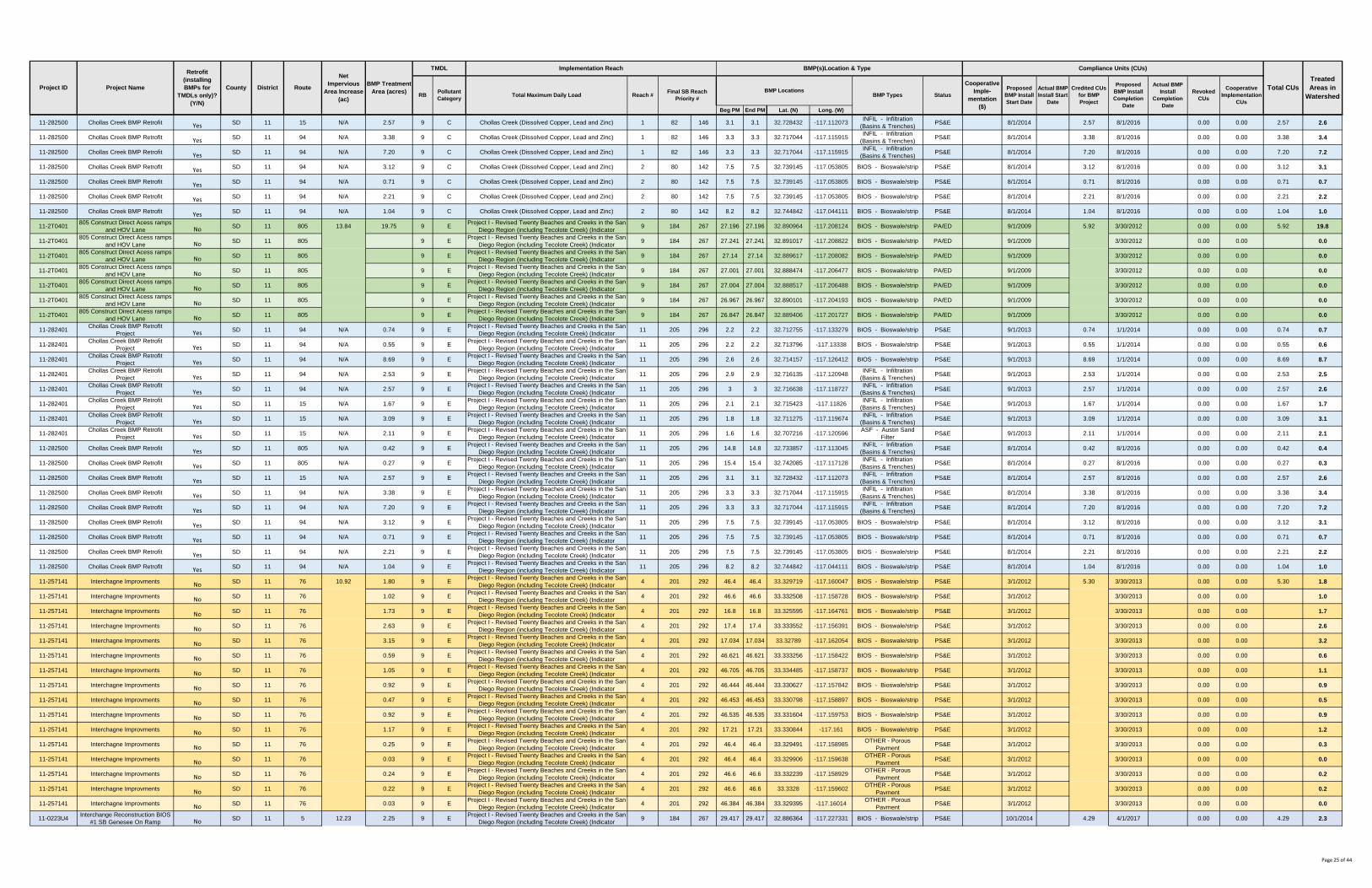
Beg PM End PM Lat. (N) Long. (W)
RouteProject ID Project Name
Retrofit (installing BMPs for
TMDLs only)? (Y/N)
County District Credited CUs for BMP Project
Proposed BMP Install Completion
Date
Actual BMP Install
Completion Date
Net Impervious
Area Increase (ac)
BMP Treatment Area (acres)
TMDL Implementation Reach BMP(s)Location & Type
BMP LocationsBMP Types Status
Revoked CUs
Total CUsTreated Areas in
WatershedRBPollutant Category
Total Maximum Daily Load Reach #Final SB Reach
Priority #
Compliance Units (CUs)
Cooperative Imple-
mentation ($)
Cooperative Implementation
CUs
Proposed BMP Install Start Date
Actual BMP Install Start
Date
11-282500 Chollas Creek BMP Retrofit Yes SD 11 15 N/A 2.57 9 C Chollas Creek (Dissolved Copper, Lead and Zinc) 1 82 146 3.1 3.1 32.728432 -117.112073INFIL - Infiltration
(Basins & Trenches)PS&E 8/1/2014 2.57 8/1/2016 0.00 0.00 2.57 2.6
11-282500 Chollas Creek BMP Retrofit Yes SD 11 94 N/A 3.38 9 C Chollas Creek (Dissolved Copper, Lead and Zinc) 1 82 146 3.3 3.3 32.717044 -117.115915INFIL - Infiltration
(Basins & Trenches)PS&E 8/1/2014 3.38 8/1/2016 0.00 0.00 3.38 3.4
11-282500 Chollas Creek BMP Retrofit Yes SD 11 94 N/A 7.20 9 C Chollas Creek (Dissolved Copper, Lead and Zinc) 1 82 146 3.3 3.3 32.717044 -117.115915INFIL - Infiltration
(Basins & Trenches)PS&E 8/1/2014 7.20 8/1/2016 0.00 0.00 7.20 7.2
11-282500 Chollas Creek BMP Retrofit Yes SD 11 94 N/A 3.12 9 C Chollas Creek (Dissolved Copper, Lead and Zinc) 2 80 142 7.5 7.5 32.739145 -117.053805 BIOS - Bioswale/strip PS&E 8/1/2014 3.12 8/1/2016 0.00 0.00 3.12 3.1
11-282500 Chollas Creek BMP Retrofit Yes SD 11 94 N/A 0.71 9 C Chollas Creek (Dissolved Copper, Lead and Zinc) 2 80 142 7.5 7.5 32.739145 -117.053805 BIOS - Bioswale/strip PS&E 8/1/2014 0.71 8/1/2016 0.00 0.00 0.71 0.7
11-282500 Chollas Creek BMP Retrofit Yes SD 11 94 N/A 2.21 9 C Chollas Creek (Dissolved Copper, Lead and Zinc) 2 80 142 7.5 7.5 32.739145 -117.053805 BIOS - Bioswale/strip PS&E 8/1/2014 2.21 8/1/2016 0.00 0.00 2.21 2.2
11-282500 Chollas Creek BMP Retrofit Yes SD 11 94 N/A 1.04 9 C Chollas Creek (Dissolved Copper, Lead and Zinc) 2 80 142 8.2 8.2 32.744842 -117.044111 BIOS - Bioswale/strip PS&E 8/1/2014 1.04 8/1/2016 0.00 0.00 1.04 1.0
11-2T0401805 Construct Direct Acess ramps
and HOV Lane No SD 11 805 13.84 19.75 9 EProject I - Revised Twenty Beaches and Creeks in the San
Diego Region (including Tecolote Creek) (Indicator 9 184 267 27.196 27.196 32.890964 -117.208124 BIOS - Bioswale/strip PA/ED 9/1/2009 5.92 3/30/2012 0.00 0.00 5.92 19.8
11-2T0401805 Construct Direct Acess ramps
and HOV Lane No SD 11 805 9 EProject I - Revised Twenty Beaches and Creeks in the San
Diego Region (including Tecolote Creek) (Indicator 9 184 267 27.241 27.241 32.891017 -117.208822 BIOS - Bioswale/strip PA/ED 9/1/2009 3/30/2012 0.00 0.00 0.0
11-2T0401805 Construct Direct Acess ramps
and HOV Lane No SD 11 805 9 EProject I - Revised Twenty Beaches and Creeks in the San
Diego Region (including Tecolote Creek) (Indicator 9 184 267 27.14 27.14 32.889617 -117.208082 BIOS - Bioswale/strip PA/ED 9/1/2009 3/30/2012 0.00 0.00 0.0
11-2T0401805 Construct Direct Acess ramps
and HOV Lane No SD 11 805 9 EProject I - Revised Twenty Beaches and Creeks in the San
Diego Region (including Tecolote Creek) (Indicator 9 184 267 27.001 27.001 32.888474 -117.206477 BIOS - Bioswale/strip PA/ED 9/1/2009 3/30/2012 0.00 0.00 0.0
11-2T0401805 Construct Direct Acess ramps
and HOV Lane No SD 11 805 9 EProject I - Revised Twenty Beaches and Creeks in the San
Diego Region (including Tecolote Creek) (Indicator 9 184 267 27.004 27.004 32.888517 -117.206488 BIOS - Bioswale/strip PA/ED 9/1/2009 3/30/2012 0.00 0.00 0.0
11-2T0401805 Construct Direct Acess ramps
and HOV Lane No SD 11 805 9 EProject I - Revised Twenty Beaches and Creeks in the San
Diego Region (including Tecolote Creek) (Indicator 9 184 267 26.967 26.967 32.890101 -117.204193 BIOS - Bioswale/strip PA/ED 9/1/2009 3/30/2012 0.00 0.00 0.0
11-2T0401805 Construct Direct Acess ramps
and HOV Lane No SD 11 805 9 EProject I - Revised Twenty Beaches and Creeks in the San
Diego Region (including Tecolote Creek) (Indicator 9 184 267 26.847 26.847 32.889406 -117.201727 BIOS - Bioswale/strip PA/ED 9/1/2009 3/30/2012 0.00 0.00 0.0
11-282401Chollas Creek BMP Retrofit
Project Yes SD 11 94 N/A 0.74 9 EProject I - Revised Twenty Beaches and Creeks in the San
Diego Region (including Tecolote Creek) (Indicator 11 205 296 2.2 2.2 32.712755 -117.133279 BIOS - Bioswale/strip PS&E 9/1/2013 0.74 1/1/2014 0.00 0.00 0.74 0.7
11-282401Chollas Creek BMP Retrofit
Project Yes SD 11 94 N/A 0.55 9 EProject I - Revised Twenty Beaches and Creeks in the San
Diego Region (including Tecolote Creek) (Indicator 11 205 296 2.2 2.2 32.713796 -117.13338 BIOS - Bioswale/strip PS&E 9/1/2013 0.55 1/1/2014 0.00 0.00 0.55 0.6
11-282401Chollas Creek BMP Retrofit
Project Yes SD 11 94 N/A 8.69 9 EProject I - Revised Twenty Beaches and Creeks in the San
Diego Region (including Tecolote Creek) (Indicator 11 205 296 2.6 2.6 32.714157 -117.126412 BIOS - Bioswale/strip PS&E 9/1/2013 8.69 1/1/2014 0.00 0.00 8.69 8.7
11-282401Chollas Creek BMP Retrofit
Project Yes SD 11 94 N/A 2.53 9 EProject I - Revised Twenty Beaches and Creeks in the San
Diego Region (including Tecolote Creek) (Indicator 11 205 296 2.9 2.9 32.716135 -117.120948
INFIL - Infiltration (Basins & Trenches)
PS&E 9/1/2013 2.53 1/1/2014 0.00 0.00 2.53 2.5
11-282401Chollas Creek BMP Retrofit
Project Yes SD 11 94 N/A 2.57 9 EProject I - Revised Twenty Beaches and Creeks in the San
Diego Region (including Tecolote Creek) (Indicator 11 205 296 3 3 32.716638 -117.118727
INFIL - Infiltration (Basins & Trenches)
PS&E 9/1/2013 2.57 1/1/2014 0.00 0.00 2.57 2.6
11-282401Chollas Creek BMP Retrofit
Project Yes SD 11 15 N/A 1.67 9 EProject I - Revised Twenty Beaches and Creeks in the San
Diego Region (including Tecolote Creek) (Indicator 11 205 296 2.1 2.1 32.715423 -117.11826
INFIL - Infiltration (Basins & Trenches)
PS&E 9/1/2013 1.67 1/1/2014 0.00 0.00 1.67 1.7
11-282401Chollas Creek BMP Retrofit
Project Yes SD 11 15 N/A 3.09 9 EProject I - Revised Twenty Beaches and Creeks in the San
Diego Region (including Tecolote Creek) (Indicator 11 205 296 1.8 1.8 32.711275 -117.119674
INFIL - Infiltration (Basins & Trenches)
PS&E 9/1/2013 3.09 1/1/2014 0.00 0.00 3.09 3.1
11-282401Chollas Creek BMP Retrofit
Project Yes SD 11 15 N/A 2.11 9 EProject I - Revised Twenty Beaches and Creeks in the San
Diego Region (including Tecolote Creek) (Indicator 11 205 296 1.6 1.6 32.707216 -117.120596
ASF - Austin Sand Filter
PS&E 9/1/2013 2.11 1/1/2014 0.00 0.00 2.11 2.1
11-282500 Chollas Creek BMP Retrofit Yes SD 11 805 N/A 0.42 9 EProject I - Revised Twenty Beaches and Creeks in the San
Diego Region (including Tecolote Creek) (Indicator 11 205 296 14.8 14.8 32.733857 -117.113045
INFIL - Infiltration (Basins & Trenches)
PS&E 8/1/2014 0.42 8/1/2016 0.00 0.00 0.42 0.4
11-282500 Chollas Creek BMP Retrofit Yes SD 11 805 N/A 0.27 9 EProject I - Revised Twenty Beaches and Creeks in the San
Diego Region (including Tecolote Creek) (Indicator 11 205 296 15.4 15.4 32.742085 -117.117128
INFIL - Infiltration (Basins & Trenches)
PS&E 8/1/2014 0.27 8/1/2016 0.00 0.00 0.27 0.3
11-282500 Chollas Creek BMP Retrofit Yes SD 11 15 N/A 2.57 9 EProject I - Revised Twenty Beaches and Creeks in the San
Diego Region (including Tecolote Creek) (Indicator 11 205 296 3.1 3.1 32.728432 -117.112073
INFIL - Infiltration (Basins & Trenches)
PS&E 8/1/2014 2.57 8/1/2016 0.00 0.00 2.57 2.6
11-282500 Chollas Creek BMP Retrofit Yes SD 11 94 N/A 3.38 9 EProject I - Revised Twenty Beaches and Creeks in the San
Diego Region (including Tecolote Creek) (Indicator 11 205 296 3.3 3.3 32.717044 -117.115915
INFIL - Infiltration (Basins & Trenches)
PS&E 8/1/2014 3.38 8/1/2016 0.00 0.00 3.38 3.4
11-282500 Chollas Creek BMP Retrofit Yes SD 11 94 N/A 7.20 9 EProject I - Revised Twenty Beaches and Creeks in the San
Diego Region (including Tecolote Creek) (Indicator 11 205 296 3.3 3.3 32.717044 -117.115915
INFIL - Infiltration (Basins & Trenches)
PS&E 8/1/2014 7.20 8/1/2016 0.00 0.00 7.20 7.2
11-282500 Chollas Creek BMP Retrofit Yes SD 11 94 N/A 3.12 9 EProject I - Revised Twenty Beaches and Creeks in the San
Diego Region (including Tecolote Creek) (Indicator 11 205 296 7.5 7.5 32.739145 -117.053805 BIOS - Bioswale/strip PS&E 8/1/2014 3.12 8/1/2016 0.00 0.00 3.12 3.1
11-282500 Chollas Creek BMP Retrofit Yes SD 11 94 N/A 0.71 9 EProject I - Revised Twenty Beaches and Creeks in the San
Diego Region (including Tecolote Creek) (Indicator 11 205 296 7.5 7.5 32.739145 -117.053805 BIOS - Bioswale/strip PS&E 8/1/2014 0.71 8/1/2016 0.00 0.00 0.71 0.7
11-282500 Chollas Creek BMP Retrofit Yes SD 11 94 N/A 2.21 9 EProject I - Revised Twenty Beaches and Creeks in the San
Diego Region (including Tecolote Creek) (Indicator 11 205 296 7.5 7.5 32.739145 -117.053805 BIOS - Bioswale/strip PS&E 8/1/2014 2.21 8/1/2016 0.00 0.00 2.21 2.2
11-282500 Chollas Creek BMP Retrofit Yes SD 11 94 N/A 1.04 9 EProject I - Revised Twenty Beaches and Creeks in the San
Diego Region (including Tecolote Creek) (Indicator 11 205 296 8.2 8.2 32.744842 -117.044111 BIOS - Bioswale/strip PS&E 8/1/2014 1.04 8/1/2016 0.00 0.00 1.04 1.0
11-257141 Interchagne Improvments No SD 11 76 10.92 1.80 9 EProject I - Revised Twenty Beaches and Creeks in the San
Diego Region (including Tecolote Creek) (Indicator 4 201 292 46.4 46.4 33.329719 -117.160047 BIOS - Bioswale/strip PS&E 3/1/2012 5.30 3/30/2013 0.00 0.00 5.30 1.8
11-257141 Interchagne Improvments No SD 11 76 1.02 9 EProject I - Revised Twenty Beaches and Creeks in the San
Diego Region (including Tecolote Creek) (Indicator 4 201 292 46.6 46.6 33.332508 -117.158728 BIOS - Bioswale/strip PS&E 3/1/2012 3/30/2013 0.00 0.00 1.0
11-257141 Interchagne Improvments No SD 11 76 1.73 9 EProject I - Revised Twenty Beaches and Creeks in the San
Diego Region (including Tecolote Creek) (Indicator 4 201 292 16.8 16.8 33.325595 -117.164761 BIOS - Bioswale/strip PS&E 3/1/2012 3/30/2013 0.00 0.00 1.7
11-257141 Interchagne Improvments No SD 11 76 2.63 9 EProject I - Revised Twenty Beaches and Creeks in the San
Diego Region (including Tecolote Creek) (Indicator 4 201 292 17.4 17.4 33.333552 -117.156391 BIOS - Bioswale/strip PS&E 3/1/2012 3/30/2013 0.00 0.00 2.6
11-257141 Interchagne Improvments No SD 11 76 3.15 9 EProject I - Revised Twenty Beaches and Creeks in the San
Diego Region (including Tecolote Creek) (Indicator 4 201 292 17.034 17.034 33.32789 -117.162054 BIOS - Bioswale/strip PS&E 3/1/2012 3/30/2013 0.00 0.00 3.2
11-257141 Interchagne Improvments No SD 11 76 0.59 9 EProject I - Revised Twenty Beaches and Creeks in the San
Diego Region (including Tecolote Creek) (Indicator 4 201 292 46.621 46.621 33.333256 -117.158422 BIOS - Bioswale/strip PS&E 3/1/2012 3/30/2013 0.00 0.00 0.6
11-257141 Interchagne Improvments No SD 11 76 1.05 9 EProject I - Revised Twenty Beaches and Creeks in the San
Diego Region (including Tecolote Creek) (Indicator 4 201 292 46.705 46.705 33.334485 -117.158737 BIOS - Bioswale/strip PS&E 3/1/2012 3/30/2013 0.00 0.00 1.1
11-257141 Interchagne Improvments No SD 11 76 0.92 9 EProject I - Revised Twenty Beaches and Creeks in the San
Diego Region (including Tecolote Creek) (Indicator 4 201 292 46.444 46.444 33.330627 -117.157842 BIOS - Bioswale/strip PS&E 3/1/2012 3/30/2013 0.00 0.00 0.9
11-257141 Interchagne Improvments No SD 11 76 0.47 9 EProject I - Revised Twenty Beaches and Creeks in the San
Diego Region (including Tecolote Creek) (Indicator 4 201 292 46.453 46.453 33.330798 -117.158897 BIOS - Bioswale/strip PS&E 3/1/2012 3/30/2013 0.00 0.00 0.5
11-257141 Interchagne Improvments No SD 11 76 0.92 9 EProject I - Revised Twenty Beaches and Creeks in the San
Diego Region (including Tecolote Creek) (Indicator 4 201 292 46.535 46.535 33.331604 -117.159753 BIOS - Bioswale/strip PS&E 3/1/2012 3/30/2013 0.00 0.00 0.9
11-257141 Interchagne Improvments No SD 11 76 1.17 9 EProject I - Revised Twenty Beaches and Creeks in the San
Diego Region (including Tecolote Creek) (Indicator 4 201 292 17.21 17.21 33.330844 -117.161 BIOS - Bioswale/strip PS&E 3/1/2012 3/30/2013 0.00 0.00 1.2
11-257141 Interchagne Improvments No SD 11 76 0.25 9 EProject I - Revised Twenty Beaches and Creeks in the San
Diego Region (including Tecolote Creek) (Indicator 4 201 292 46.4 46.4 33.329491 -117.158985
OTHER - Porous Pavment
PS&E 3/1/2012 3/30/2013 0.00 0.00 0.3
11-257141 Interchagne Improvments No SD 11 76 0.03 9 EProject I - Revised Twenty Beaches and Creeks in the San
Diego Region (including Tecolote Creek) (Indicator 4 201 292 46.4 46.4 33.329906 -117.159638
OTHER - Porous Pavment
PS&E 3/1/2012 3/30/2013 0.00 0.00 0.0
11-257141 Interchagne Improvments No SD 11 76 0.24 9 EProject I - Revised Twenty Beaches and Creeks in the San
Diego Region (including Tecolote Creek) (Indicator 4 201 292 46.6 46.6 33.332239 -117.158929
OTHER - Porous Pavment
PS&E 3/1/2012 3/30/2013 0.00 0.00 0.2
11-257141 Interchagne Improvments No SD 11 76 0.22 9 EProject I - Revised Twenty Beaches and Creeks in the San
Diego Region (including Tecolote Creek) (Indicator 4 201 292 46.6 46.6 33.3328 -117.159602
OTHER - Porous Pavment
PS&E 3/1/2012 3/30/2013 0.00 0.00 0.2
11-257141 Interchagne Improvments No SD 11 76 0.03 9 EProject I - Revised Twenty Beaches and Creeks in the San
Diego Region (including Tecolote Creek) (Indicator 4 201 292 46.384 46.384 33.329395 -117.16014
OTHER - Porous Pavment
PS&E 3/1/2012 3/30/2013 0.00 0.00 0.0
11-0223U4Interchange Reconstruction BIOS
#1 SB Genesee On Ramp No SD 11 5 12.23 2.25 9 EProject I - Revised Twenty Beaches and Creeks in the San
Diego Region (including Tecolote Creek) (Indicator 9 184 267 29.417 29.417 32.886364 -117.227331 BIOS - Bioswale/strip PS&E 10/1/2014 4.29 4/1/2017 0.00 0.00 4.29 2.3
Page 25 of 44
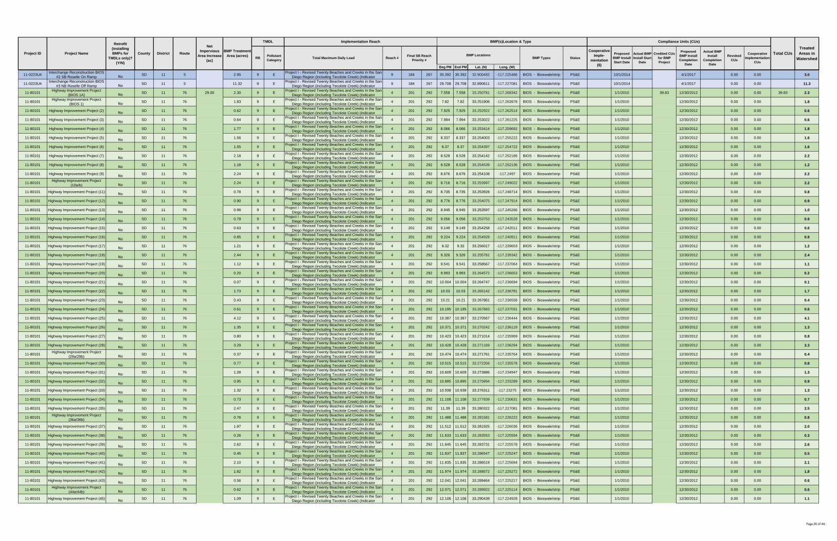
Beg PM End PM Lat. (N) Long. (W)
RouteProject ID Project Name
Retrofit (installing BMPs for
TMDLs only)? (Y/N)
County District Credited CUs for BMP Project
Proposed BMP Install Completion
Date
Actual BMP Install
Completion Date
Net Impervious
Area Increase (ac)
BMP Treatment Area (acres)
TMDL Implementation Reach BMP(s)Location & Type
BMP LocationsBMP Types Status
Revoked CUs
Total CUsTreated Areas in
WatershedRBPollutant Category
Total Maximum Daily Load Reach #Final SB Reach
Priority #
Compliance Units (CUs)
Cooperative Imple-
mentation ($)
Cooperative Implementation
CUs
Proposed BMP Install Start Date
Actual BMP Install Start
Date
11-0223U4Interchange Reconstruction BIOS
#2 SB Roselle On Ramp No SD 11 5 2.95 9 EProject I - Revised Twenty Beaches and Creeks in the San
Diego Region (including Tecolote Creek) (Indicator 9 184 267 30.392 30.392 32.900492 -117.225486 BIOS - Bioswale/strip PS&E 10/1/2014 4/1/2017 0.00 0.00 3.0
11-0223U4Interchange Reconstruction BIOS
#3 NB Roselle Off Ramp No SD 11 5 11.32 9 EProject I - Revised Twenty Beaches and Creeks in the San
Diego Region (including Tecolote Creek) (Indicator 9 184 267 29.708 29.708 32.890611 -117.227081 BIOS - Bioswale/strip PS&E 10/1/2014 4/1/2017 0.00 0.00 11.3
11-80101Highway Improvement Project
(BIOS 1A) No SD 11 76 29.00 2.30 9 EProject I - Revised Twenty Beaches and Creeks in the San
Diego Region (including Tecolote Creek) (Indicator 4 201 292 7.558 7.558 33.250781 -117.268342 BIOS - Bioswale/strip PS&E 1/1/2010 39.83 12/30/2012 0.00 0.00 39.83 2.3
11-80101Highway Improvement Project
(BIOS 1) No SD 11 76 1.83 9 EProject I - Revised Twenty Beaches and Creeks in the San
Diego Region (including Tecolote Creek) (Indicator 4 201 292 7.82 7.82 33.251906 -117.263978 BIOS - Bioswale/strip PS&E 1/1/2010 12/30/2012 0.00 0.00 1.8
11-80101 Highway Improvement Project (2) No SD 11 76 0.62 9 EProject I - Revised Twenty Beaches and Creeks in the San
Diego Region (including Tecolote Creek) (Indicator 4 201 292 7.925 7.925 33.252922 -117.262514 BIOS - Bioswale/strip PS&E 1/1/2010 12/30/2012 0.00 0.00 0.6
11-80101 Highway Improvement Project (3) No SD 11 76 0.64 9 EProject I - Revised Twenty Beaches and Creeks in the San
Diego Region (including Tecolote Creek) (Indicator 4 201 292 7.994 7.994 33.253022 -117.261225 BIOS - Bioswale/strip PS&E 1/1/2010 12/30/2012 0.00 0.00 0.6
11-80101 Highway Improvement Project (4) No SD 11 76 1.77 9 EProject I - Revised Twenty Beaches and Creeks in the San
Diego Region (including Tecolote Creek) (Indicator 4 201 292 8.066 8.066 33.253414 -117.259692 BIOS - Bioswale/strip PS&E 1/1/2010 12/30/2012 0.00 0.00 1.8
11-80101 Highway Improvement Project (5) No SD 11 76 1.56 9 EProject I - Revised Twenty Beaches and Creeks in the San
Diego Region (including Tecolote Creek) (Indicator 4 201 292 8.337 8.337 33.254003 -117.255222 BIOS - Bioswale/strip PS&E 1/1/2010 12/30/2012 0.00 0.00 1.6
11-80101 Highway Improvement Project (6) No SD 11 76 1.55 9 EProject I - Revised Twenty Beaches and Creeks in the San
Diego Region (including Tecolote Creek) (Indicator 4 201 292 8.37 8.37 33.254397 -117.254722 BIOS - Bioswale/strip PS&E 1/1/2010 12/30/2012 0.00 0.00 1.6
11-80101 Highway Improvement Project (7) No SD 11 76 2.18 9 EProject I - Revised Twenty Beaches and Creeks in the San
Diego Region (including Tecolote Creek) (Indicator 4 201 292 8.528 8.528 33.254142 -117.252186 BIOS - Bioswale/strip PS&E 1/1/2010 12/30/2012 0.00 0.00 2.2
11-80101 Highway Improvement Project (8) No SD 11 76 1.18 9 EProject I - Revised Twenty Beaches and Creeks in the San
Diego Region (including Tecolote Creek) (Indicator 4 201 292 8.528 8.528 33.254539 -117.252136 BIOS - Bioswale/strip PS&E 1/1/2010 12/30/2012 0.00 0.00 1.2
11-80101 Highway Improvement Project (9) No SD 11 76 2.24 9 EProject I - Revised Twenty Beaches and Creeks in the San
Diego Region (including Tecolote Creek) (Indicator 4 201 292 8.676 8.676 33.254108 -117.2497 BIOS - Bioswale/strip PS&E 1/1/2010 12/30/2012 0.00 0.00 2.2
11-80101Highway Improvement Project
(10a/b) No SD 11 76 2.24 9 EProject I - Revised Twenty Beaches and Creeks in the San
Diego Region (including Tecolote Creek) (Indicator 4 201 292 8.716 8.716 33.253997 -117.249022 BIOS - Bioswale/strip PS&E 1/1/2010 12/30/2012 0.00 0.00 2.2
11-80101 Highway Improvement Project (11) No SD 11 76 0.78 9 EProject I - Revised Twenty Beaches and Creeks in the San
Diego Region (including Tecolote Creek) (Indicator 4 201 292 8.735 8.735 33.253928 -117.248714 BIOS - Bioswale/strip PS&E 1/1/2010 12/30/2012 0.00 0.00 0.8
11-80101 Highway Improvement Project (12) No SD 11 76 0.90 9 EProject I - Revised Twenty Beaches and Creeks in the San
Diego Region (including Tecolote Creek) (Indicator 4 201 292 8.776 8.776 33.254075 -117.247914 BIOS - Bioswale/strip PS&E 1/1/2010 12/30/2012 0.00 0.00 0.9
11-80101 Highway Improvement Project (13) No SD 11 76 0.98 9 EProject I - Revised Twenty Beaches and Creeks in the San
Diego Region (including Tecolote Creek) (Indicator 4 201 292 8.945 8.945 33.253597 -117.245286 BIOS - Bioswale/strip PS&E 1/1/2010 12/30/2012 0.00 0.00 1.0
11-80101 Highway Improvement Project (14) No SD 11 76 0.78 9 EProject I - Revised Twenty Beaches and Creeks in the San
Diego Region (including Tecolote Creek) (Indicator 4 201 292 9.056 9.056 33.253753 -117.243528 BIOS - Bioswale/strip PS&E 1/1/2010 12/30/2012 0.00 0.00 0.8
11-80101 Highway Improvement Project (15) No SD 11 76 0.63 9 EProject I - Revised Twenty Beaches and Creeks in the San
Diego Region (including Tecolote Creek) (Indicator 4 201 292 9.149 9.149 33.254258 -117.242011 BIOS - Bioswale/strip PS&E 1/1/2010 12/30/2012 0.00 0.00 0.6
11-80101 Highway Improvement Project (16) No SD 11 76 0.85 9 EProject I - Revised Twenty Beaches and Creeks in the San
Diego Region (including Tecolote Creek) (Indicator 4 201 292 9.224 9.224 33.254928 -117.240911 BIOS - Bioswale/strip PS&E 1/1/2010 12/30/2012 0.00 0.00 0.8
11-80101 Highway Improvement Project (17) No SD 11 76 1.21 9 EProject I - Revised Twenty Beaches and Creeks in the San
Diego Region (including Tecolote Creek) (Indicator 4 201 292 9.32 9.32 33.256017 -117.239653 BIOS - Bioswale/strip PS&E 1/1/2010 12/30/2012 0.00 0.00 1.2
11-80101 Highway Improvement Project (18) No SD 11 76 2.44 9 EProject I - Revised Twenty Beaches and Creeks in the San
Diego Region (including Tecolote Creek) (Indicator 4 201 292 9.326 9.326 33.255781 -117.239342 BIOS - Bioswale/strip PS&E 1/1/2010 12/30/2012 0.00 0.00 2.4
11-80101 Highway Improvement Project (19) No SD 11 76 1.12 9 EProject I - Revised Twenty Beaches and Creeks in the San
Diego Region (including Tecolote Creek) (Indicator 4 201 292 9.541 9.541 33.258567 -117.237064 BIOS - Bioswale/strip PS&E 1/1/2010 12/30/2012 0.00 0.00 1.1
11-80101 Highway Improvement Project (20) No SD 11 76 0.20 9 EProject I - Revised Twenty Beaches and Creeks in the San
Diego Region (including Tecolote Creek) (Indicator 4 201 292 9.993 9.993 33.264572 -117.236653 BIOS - Bioswale/strip PS&E 1/1/2010 12/30/2012 0.00 0.00 0.2
11-80101 Highway Improvement Project (21) No SD 11 76 0.07 9 EProject I - Revised Twenty Beaches and Creeks in the San
Diego Region (including Tecolote Creek) (Indicator 4 201 292 10.004 10.004 33.264747 -117.236694 BIOS - Bioswale/strip PS&E 1/1/2010 12/30/2012 0.00 0.00 0.1
11-80101 Highway Improvement Project (22) No SD 11 76 1.73 9 EProject I - Revised Twenty Beaches and Creeks in the San
Diego Region (including Tecolote Creek) (Indicator 4 201 292 10.03 10.03 33.265142 -117.236781 BIOS - Bioswale/strip PS&E 1/1/2010 12/30/2012 0.00 0.00 1.7
11-80101 Highway Improvement Project (23) No SD 11 76 0.43 9 EProject I - Revised Twenty Beaches and Creeks in the San
Diego Region (including Tecolote Creek) (Indicator 4 201 292 10.21 10.21 33.267861 -117.236558 BIOS - Bioswale/strip PS&E 1/1/2010 12/30/2012 0.00 0.00 0.4
11-80101 Highway Improvement Project (24) No SD 11 76 0.61 9 EProject I - Revised Twenty Beaches and Creeks in the San
Diego Region (including Tecolote Creek) (Indicator 4 201 292 10.195 10.195 33.267683 -117.237031 BIOS - Bioswale/strip PS&E 1/1/2010 12/30/2012 0.00 0.00 0.6
11-80101 Highway Improvement Project (25) No SD 11 76 4.12 9 EProject I - Revised Twenty Beaches and Creeks in the San
Diego Region (including Tecolote Creek) (Indicator 4 201 292 10.387 10.387 33.270567 -117.236444 BIOS - Bioswale/strip PS&E 1/1/2010 12/30/2012 0.00 0.00 4.1
11-80101 Highway Improvement Project (26) No SD 11 76 1.35 9 EProject I - Revised Twenty Beaches and Creeks in the San
Diego Region (including Tecolote Creek) (Indicator 4 201 292 10.371 10.371 33.270242 -117.236119 BIOS - Bioswale/strip PS&E 1/1/2010 12/30/2012 0.00 0.00 1.3
11-80101 Highway Improvement Project (27) No SD 11 76 0.80 9 EProject I - Revised Twenty Beaches and Creeks in the San
Diego Region (including Tecolote Creek) (Indicator 4 201 292 10.423 10.423 33.271014 -117.235969 BIOS - Bioswale/strip PS&E 1/1/2010 12/30/2012 0.00 0.00 0.8
11-80101 Highway Improvement Project (28) No SD 11 76 3.29 9 EProject I - Revised Twenty Beaches and Creeks in the San
Diego Region (including Tecolote Creek) (Indicator 4 201 292 10.428 10.428 33.271169 -117.236294 BIOS - Bioswale/strip PS&E 1/1/2010 12/30/2012 0.00 0.00 3.3
11-80101Highway Improvement Project
(29a/29b) No SD 11 76 0.37 9 EProject I - Revised Twenty Beaches and Creeks in the San
Diego Region (including Tecolote Creek) (Indicator 4 201 292 10.474 10.474 33.271761 -117.235764 BIOS - Bioswale/strip PS&E 1/1/2010 12/30/2012 0.00 0.00 0.4
11-80101 Highway Improvement Project (30) No SD 11 76 0.77 9 EProject I - Revised Twenty Beaches and Creeks in the San
Diego Region (including Tecolote Creek) (Indicator 4 201 292 10.515 10.515 33.272356 -117.235578 BIOS - Bioswale/strip PS&E 1/1/2010 12/30/2012 0.00 0.00 0.8
11-80101 Highway Improvement Project (31) No SD 11 76 1.28 9 EProject I - Revised Twenty Beaches and Creeks in the San
Diego Region (including Tecolote Creek) (Indicator 4 201 292 10.609 10.609 33.273886 -117.234947 BIOS - Bioswale/strip PS&E 1/1/2010 12/30/2012 0.00 0.00 1.3
11-80101 Highway Improvement Project (32) No SD 11 76 0.95 9 EProject I - Revised Twenty Beaches and Creeks in the San
Diego Region (including Tecolote Creek) (Indicator 4 201 292 10.895 10.895 33.275894 -117.233289 BIOS - Bioswale/strip PS&E 1/1/2010 12/30/2012 0.00 0.00 0.9
11-80101 Highway Improvement Project (33) No SD 11 76 1.32 9 EProject I - Revised Twenty Beaches and Creeks in the San
Diego Region (including Tecolote Creek) (Indicator 4 201 292 10.938 10.938 33.276311 -117.23275 BIOS - Bioswale/strip PS&E 1/1/2010 12/30/2012 0.00 0.00 1.3
11-80101 Highway Improvement Project (34) No SD 11 76 0.73 9 EProject I - Revised Twenty Beaches and Creeks in the San
Diego Region (including Tecolote Creek) (Indicator 4 201 292 11.108 11.108 33.277839 -117.230631 BIOS - Bioswale/strip PS&E 1/1/2010 12/30/2012 0.00 0.00 0.7
11-80101 Highway Improvement Project (35) No SD 11 76 2.47 9 EProject I - Revised Twenty Beaches and Creeks in the San
Diego Region (including Tecolote Creek) (Indicator 4 201 292 11.39 11.39 33.280322 -117.227081 BIOS - Bioswale/strip PS&E 1/1/2010 12/30/2012 0.00 0.00 2.5
11-80101Highway Improvement Project
(36a/36b) No SD 11 76 0.76 9 EProject I - Revised Twenty Beaches and Creeks in the San
Diego Region (including Tecolote Creek) (Indicator 4 201 292 11.488 11.488 33.281581 -117.226222 BIOS - Bioswale/strip PS&E 1/1/2010 12/30/2012 0.00 0.00 0.8
11-80101 Highway Improvement Project (37) No SD 11 76 1.97 9 EProject I - Revised Twenty Beaches and Creeks in the San
Diego Region (including Tecolote Creek) (Indicator 4 201 292 11.512 11.512 33.281925 -117.226036 BIOS - Bioswale/strip PS&E 1/1/2010 12/30/2012 0.00 0.00 2.0
11-80101 Highway Improvement Project (38) No SD 11 76 0.26 9 EProject I - Revised Twenty Beaches and Creeks in the San
Diego Region (including Tecolote Creek) (Indicator 4 201 292 11.633 11.633 33.283553 -117.225594 BIOS - Bioswale/strip PS&E 1/1/2010 12/30/2012 0.00 0.00 0.3
11-80101 Highway Improvement Project (39) No SD 11 76 2.62 9 EProject I - Revised Twenty Beaches and Creeks in the San
Diego Region (including Tecolote Creek) (Indicator 4 201 292 11.645 11.645 33.283731 -117.225578 BIOS - Bioswale/strip PS&E 1/1/2010 12/30/2012 0.00 0.00 2.6
11-80101 Highway Improvement Project (40) No SD 11 76 0.45 9 EProject I - Revised Twenty Beaches and Creeks in the San
Diego Region (including Tecolote Creek) (Indicator 4 201 292 11.837 11.837 33.286547 -117.225247 BIOS - Bioswale/strip PS&E 1/1/2010 12/30/2012 0.00 0.00 0.5
11-80101 Highway Improvement Project (41) No SD 11 76 2.10 9 EProject I - Revised Twenty Beaches and Creeks in the San
Diego Region (including Tecolote Creek) (Indicator 4 201 292 11.835 11.835 33.286519 -117.225694 BIOS - Bioswale/strip PS&E 1/1/2010 12/30/2012 0.00 0.00 2.1
11-80101 Highway Improvement Project (42) No SD 11 76 1.82 9 EProject I - Revised Twenty Beaches and Creeks in the San
Diego Region (including Tecolote Creek) (Indicator 4 201 292 11.974 11.974 33.288572 -117.225272 BIOS - Bioswale/strip PS&E 1/1/2010 12/30/2012 0.00 0.00 1.8
11-80101 Highway Improvement Project (43) No SD 11 76 0.56 9 EProject I - Revised Twenty Beaches and Creeks in the San
Diego Region (including Tecolote Creek) (Indicator 4 201 292 12.041 12.041 33.289464 -117.225217 BIOS - Bioswale/strip PS&E 1/1/2010 12/30/2012 0.00 0.00 0.6
11-80101Highway Improvement Project
(44a/44b) No SD 11 76 0.62 9 EProject I - Revised Twenty Beaches and Creeks in the San
Diego Region (including Tecolote Creek) (Indicator 4 201 292 12.071 12.071 33.289922 -117.225114 BIOS - Bioswale/strip PS&E 1/1/2010 12/30/2012 0.00 0.00 0.6
11-80101 Highway Improvement Project (45) No SD 11 76 1.09 9 EProject I - Revised Twenty Beaches and Creeks in the San
Diego Region (including Tecolote Creek) (Indicator 4 201 292 12.106 12.106 33.290439 -117.224928 BIOS - Bioswale/strip PS&E 1/1/2010 12/30/2012 0.00 0.00 1.1
Page 26 of 44
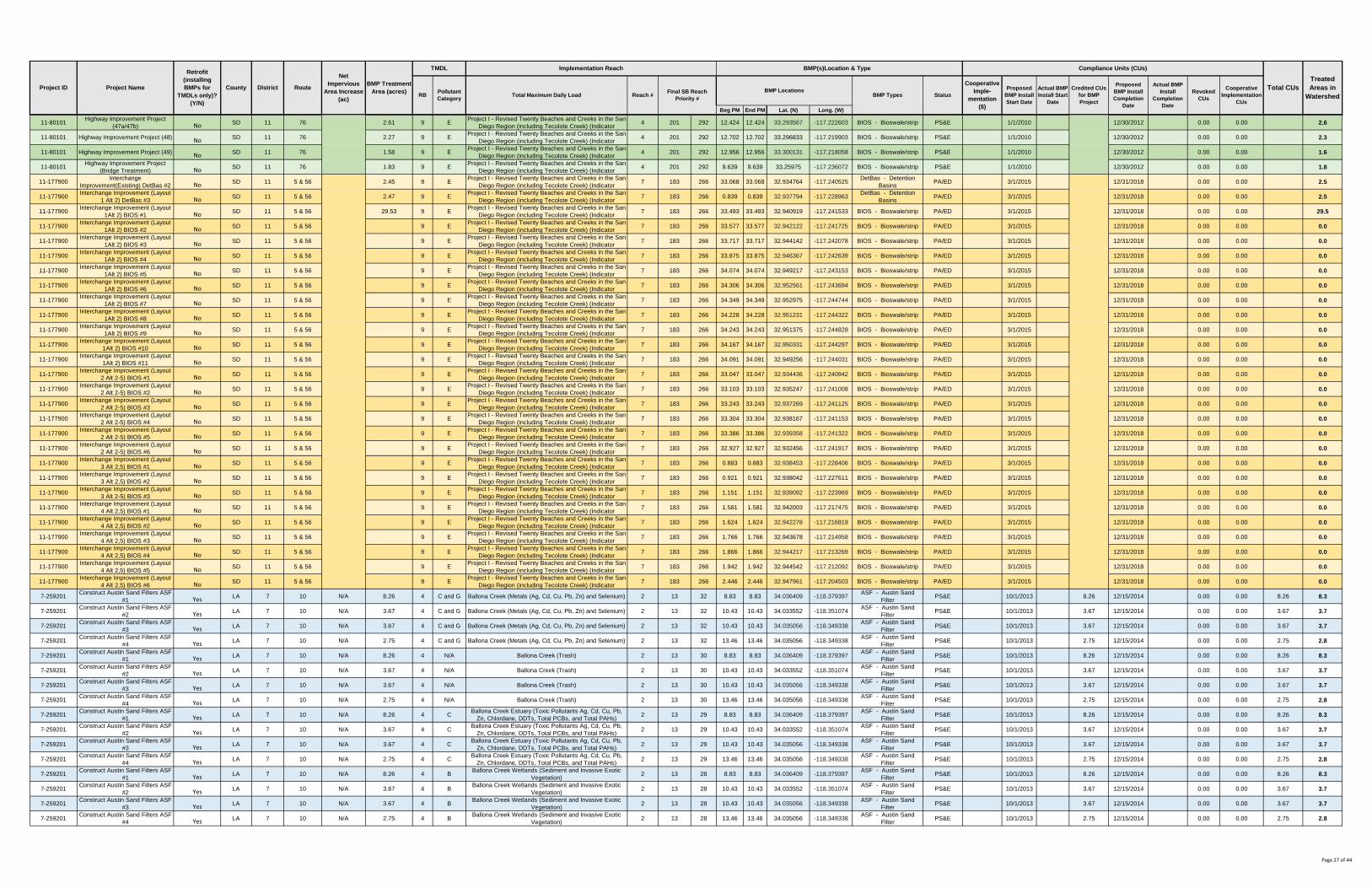
Beg PM End PM Lat. (N) Long. (W)
RouteProject ID Project Name
Retrofit (installing BMPs for
TMDLs only)? (Y/N)
County District Credited CUs for BMP Project
Proposed BMP Install Completion
Date
Actual BMP Install
Completion Date
Net Impervious
Area Increase (ac)
BMP Treatment Area (acres)
TMDL Implementation Reach BMP(s)Location & Type
BMP LocationsBMP Types Status
Revoked CUs
Total CUsTreated Areas in
WatershedRBPollutant Category
Total Maximum Daily Load Reach #Final SB Reach
Priority #
Compliance Units (CUs)
Cooperative Imple-
mentation ($)
Cooperative Implementation
CUs
Proposed BMP Install Start Date
Actual BMP Install Start
Date
11-80101Highway Improvement Project
(47a/47b) No SD 11 76 2.61 9 EProject I - Revised Twenty Beaches and Creeks in the San
Diego Region (including Tecolote Creek) (Indicator 4 201 292 12.424 12.424 33.293567 -117.222603 BIOS - Bioswale/strip PS&E 1/1/2010 12/30/2012 0.00 0.00 2.6
11-80101 Highway Improvement Project (48) No SD 11 76 2.27 9 EProject I - Revised Twenty Beaches and Creeks in the San
Diego Region (including Tecolote Creek) (Indicator 4 201 292 12.702 12.702 33.296833 -117.219903 BIOS - Bioswale/strip PS&E 1/1/2010 12/30/2012 0.00 0.00 2.3
11-80101 Highway Improvement Project (49) No SD 11 76 1.58 9 EProject I - Revised Twenty Beaches and Creeks in the San
Diego Region (including Tecolote Creek) (Indicator 4 201 292 12.956 12.956 33.300131 -117.218058 BIOS - Bioswale/strip PS&E 1/1/2010 12/30/2012 0.00 0.00 1.6
11-80101Highway Improvement Project
(Bridge Treatment) No SD 11 76 1.83 9 EProject I - Revised Twenty Beaches and Creeks in the San
Diego Region (including Tecolote Creek) (Indicator 4 201 292 9.639 9.639 33.25975 -117.236072 BIOS - Bioswale/strip PS&E 1/1/2010 12/30/2012 0.00 0.00 1.8
11-177900Interchange
Improvement(Existing) DetBas #2 No SD 11 5 & 56 2.45 9 EProject I - Revised Twenty Beaches and Creeks in the San
Diego Region (including Tecolote Creek) (Indicator 7 183 266 33.068 33.068 32.934764 -117.240525
DetBas - Detention Basins
PA/ED 3/1/2015 12/31/2018 0.00 0.00 2.5
11-177900Interchange Improvement (Layout
1 Alt 2) DetBas #3 No SD 11 5 & 56 2.47 9 EProject I - Revised Twenty Beaches and Creeks in the San
Diego Region (including Tecolote Creek) (Indicator 7 183 266 0.839 0.839 32.937794 -117.228963
DetBas - Detention Basins
PA/ED 3/1/2015 12/31/2018 0.00 0.00 2.5
11-177900Interchange Improvement (Layout
1Alt 2) BIOS #1 No SD 11 5 & 56 29.53 9 EProject I - Revised Twenty Beaches and Creeks in the San
Diego Region (including Tecolote Creek) (Indicator 7 183 266 33.493 33.493 32.940919 -117.241533 BIOS - Bioswale/strip PA/ED 3/1/2015 12/31/2018 0.00 0.00 29.5
11-177900Interchange Improvement (Layout
1Alt 2) BIOS #2 No SD 11 5 & 56 9 EProject I - Revised Twenty Beaches and Creeks in the San
Diego Region (including Tecolote Creek) (Indicator 7 183 266 33.577 33.577 32.942122 -117.241725 BIOS - Bioswale/strip PA/ED 3/1/2015 12/31/2018 0.00 0.00 0.0
11-177900Interchange Improvement (Layout
1Alt 2) BIOS #3 No SD 11 5 & 56 9 EProject I - Revised Twenty Beaches and Creeks in the San
Diego Region (including Tecolote Creek) (Indicator 7 183 266 33.717 33.717 32.944142 -117.242078 BIOS - Bioswale/strip PA/ED 3/1/2015 12/31/2018 0.00 0.00 0.0
11-177900Interchange Improvement (Layout
1Alt 2) BIOS #4 No SD 11 5 & 56 9 EProject I - Revised Twenty Beaches and Creeks in the San
Diego Region (including Tecolote Creek) (Indicator 7 183 266 33.875 33.875 32.946367 -117.242639 BIOS - Bioswale/strip PA/ED 3/1/2015 12/31/2018 0.00 0.00 0.0
11-177900Interchange Improvement (Layout
1Alt 2) BIOS #5 No SD 11 5 & 56 9 EProject I - Revised Twenty Beaches and Creeks in the San
Diego Region (including Tecolote Creek) (Indicator 7 183 266 34.074 34.074 32.949217 -117.243153 BIOS - Bioswale/strip PA/ED 3/1/2015 12/31/2018 0.00 0.00 0.0
11-177900Interchange Improvement (Layout
1Alt 2) BIOS #6 No SD 11 5 & 56 9 EProject I - Revised Twenty Beaches and Creeks in the San
Diego Region (including Tecolote Creek) (Indicator 7 183 266 34.306 34.306 32.952561 -117.243694 BIOS - Bioswale/strip PA/ED 3/1/2015 12/31/2018 0.00 0.00 0.0
11-177900Interchange Improvement (Layout
1Alt 2) BIOS #7 No SD 11 5 & 56 9 EProject I - Revised Twenty Beaches and Creeks in the San
Diego Region (including Tecolote Creek) (Indicator 7 183 266 34.349 34.349 32.952975 -117.244744 BIOS - Bioswale/strip PA/ED 3/1/2015 12/31/2018 0.00 0.00 0.0
11-177900Interchange Improvement (Layout
1Alt 2) BIOS #8 No SD 11 5 & 56 9 EProject I - Revised Twenty Beaches and Creeks in the San
Diego Region (including Tecolote Creek) (Indicator 7 183 266 34.228 34.228 32.951231 -117.244322 BIOS - Bioswale/strip PA/ED 3/1/2015 12/31/2018 0.00 0.00 0.0
11-177900Interchange Improvement (Layout
1Alt 2) BIOS #9 No SD 11 5 & 56 9 EProject I - Revised Twenty Beaches and Creeks in the San
Diego Region (including Tecolote Creek) (Indicator 7 183 266 34.243 34.243 32.951375 -117.244828 BIOS - Bioswale/strip PA/ED 3/1/2015 12/31/2018 0.00 0.00 0.0
11-177900Interchange Improvement (Layout
1Alt 2) BIOS #10 No SD 11 5 & 56 9 EProject I - Revised Twenty Beaches and Creeks in the San
Diego Region (including Tecolote Creek) (Indicator 7 183 266 34.167 34.167 32.950331 -117.244297 BIOS - Bioswale/strip PA/ED 3/1/2015 12/31/2018 0.00 0.00 0.0
11-177900Interchange Improvement (Layout
1Alt 2) BIOS #11 No SD 11 5 & 56 9 EProject I - Revised Twenty Beaches and Creeks in the San
Diego Region (including Tecolote Creek) (Indicator 7 183 266 34.091 34.091 32.949256 -117.244031 BIOS - Bioswale/strip PA/ED 3/1/2015 12/31/2018 0.00 0.00 0.0
11-177900Interchange Improvement (Layout
2 Alt 2-5) BIOS #1 No SD 11 5 & 56 9 EProject I - Revised Twenty Beaches and Creeks in the San
Diego Region (including Tecolote Creek) (Indicator 7 183 266 33.047 33.047 32.934436 -117.240942 BIOS - Bioswale/strip PA/ED 3/1/2015 12/31/2018 0.00 0.00 0.0
11-177900Interchange Improvement (Layout
2 Alt 2-5) BIOS #2 No SD 11 5 & 56 9 EProject I - Revised Twenty Beaches and Creeks in the San
Diego Region (including Tecolote Creek) (Indicator 7 183 266 33.103 33.103 32.935247 -117.241008 BIOS - Bioswale/strip PA/ED 3/1/2015 12/31/2018 0.00 0.00 0.0
11-177900Interchange Improvement (Layout
2 Alt 2-5) BIOS #3 No SD 11 5 & 56 9 EProject I - Revised Twenty Beaches and Creeks in the San
Diego Region (including Tecolote Creek) (Indicator 7 183 266 33.243 33.243 32.937269 -117.241125 BIOS - Bioswale/strip PA/ED 3/1/2015 12/31/2018 0.00 0.00 0.0
11-177900Interchange Improvement (Layout
2 Alt 2-5) BIOS #4 No SD 11 5 & 56 9 EProject I - Revised Twenty Beaches and Creeks in the San
Diego Region (including Tecolote Creek) (Indicator 7 183 266 33.304 33.304 32.938167 -117.241153 BIOS - Bioswale/strip PA/ED 3/1/2015 12/31/2018 0.00 0.00 0.0
11-177900Interchange Improvement (Layout
2 Alt 2-5) BIOS #5 No SD 11 5 & 56 9 EProject I - Revised Twenty Beaches and Creeks in the San
Diego Region (including Tecolote Creek) (Indicator 7 183 266 33.386 33.386 32.939358 -117.241322 BIOS - Bioswale/strip PA/ED 3/1/2015 12/31/2018 0.00 0.00 0.0
11-177900Interchange Improvement (Layout
2 Alt 2-5) BIOS #6 No SD 11 5 & 56 9 EProject I - Revised Twenty Beaches and Creeks in the San
Diego Region (including Tecolote Creek) (Indicator 7 183 266 32.927 32.927 32.932456 -117.241917 BIOS - Bioswale/strip PA/ED 3/1/2015 12/31/2018 0.00 0.00 0.0
11-177900Interchange Improvement (Layout
3 Alt 2,5) BIOS #1 No SD 11 5 & 56 9 EProject I - Revised Twenty Beaches and Creeks in the San
Diego Region (including Tecolote Creek) (Indicator 7 183 266 0.883 0.883 32.938453 -117.228406 BIOS - Bioswale/strip PA/ED 3/1/2015 12/31/2018 0.00 0.00 0.0
11-177900Interchange Improvement (Layout
3 Alt 2,5) BIOS #2 No SD 11 5 & 56 9 EProject I - Revised Twenty Beaches and Creeks in the San
Diego Region (including Tecolote Creek) (Indicator 7 183 266 0.921 0.921 32.938042 -117.227611 BIOS - Bioswale/strip PA/ED 3/1/2015 12/31/2018 0.00 0.00 0.0
11-177900Interchange Improvement (Layout
3 Alt 2-5) BIOS #3 No SD 11 5 & 56 9 EProject I - Revised Twenty Beaches and Creeks in the San
Diego Region (including Tecolote Creek) (Indicator 7 183 266 1.151 1.151 32.939092 -117.223969 BIOS - Bioswale/strip PA/ED 3/1/2015 12/31/2018 0.00 0.00 0.0
11-177900Interchange Improvement (Layout
4 Alt 2,5) BIOS #1 No SD 11 5 & 56 9 EProject I - Revised Twenty Beaches and Creeks in the San
Diego Region (including Tecolote Creek) (Indicator 7 183 266 1.581 1.581 32.942003 -117.217475 BIOS - Bioswale/strip PA/ED 3/1/2015 12/31/2018 0.00 0.00 0.0
11-177900Interchange Improvement (Layout
4 Alt 2,5) BIOS #2 No SD 11 5 & 56 9 EProject I - Revised Twenty Beaches and Creeks in the San
Diego Region (including Tecolote Creek) (Indicator 7 183 266 1.624 1.624 32.942278 -117.216819 BIOS - Bioswale/strip PA/ED 3/1/2015 12/31/2018 0.00 0.00 0.0
11-177900Interchange Improvement (Layout
4 Alt 2,5) BIOS #3 No SD 11 5 & 56 9 EProject I - Revised Twenty Beaches and Creeks in the San
Diego Region (including Tecolote Creek) (Indicator 7 183 266 1.766 1.766 32.943678 -117.214958 BIOS - Bioswale/strip PA/ED 3/1/2015 12/31/2018 0.00 0.00 0.0
11-177900Interchange Improvement (Layout
4 Alt 2,5) BIOS #4 No SD 11 5 & 56 9 EProject I - Revised Twenty Beaches and Creeks in the San
Diego Region (including Tecolote Creek) (Indicator 7 183 266 1.866 1.866 32.944217 -117.213269 BIOS - Bioswale/strip PA/ED 3/1/2015 12/31/2018 0.00 0.00 0.0
11-177900Interchange Improvement (Layout
4 Alt 2,5) BIOS #5 No SD 11 5 & 56 9 EProject I - Revised Twenty Beaches and Creeks in the San
Diego Region (including Tecolote Creek) (Indicator 7 183 266 1.942 1.942 32.944542 -117.212092 BIOS - Bioswale/strip PA/ED 3/1/2015 12/31/2018 0.00 0.00 0.0
11-177900Interchange Improvement (Layout
4 Alt 2,5) BIOS #6 No SD 11 5 & 56 9 EProject I - Revised Twenty Beaches and Creeks in the San
Diego Region (including Tecolote Creek) (Indicator 7 183 266 2.446 2.446 32.947961 -117.204503 BIOS - Bioswale/strip PA/ED 3/1/2015 12/31/2018 0.00 0.00 0.0
7-259201Construct Austin Sand Filters ASF
#1 Yes LA 7 10 N/A 8.26 4 C and G Ballona Creek (Metals (Ag, Cd, Cu, Pb, Zn) and Selenium) 2 13 32 8.83 8.83 34.036409 -118.379397ASF - Austin Sand
FilterPS&E 10/1/2013 8.26 12/15/2014 0.00 0.00 8.26 8.3
7-259201Construct Austin Sand Filters ASF
#2 Yes LA 7 10 N/A 3.67 4 C and G Ballona Creek (Metals (Ag, Cd, Cu, Pb, Zn) and Selenium) 2 13 32 10.43 10.43 34.033552 -118.351074ASF - Austin Sand
FilterPS&E 10/1/2013 3.67 12/15/2014 0.00 0.00 3.67 3.7
7-259201Construct Austin Sand Filters ASF
#3 Yes LA 7 10 N/A 3.67 4 C and G Ballona Creek (Metals (Ag, Cd, Cu, Pb, Zn) and Selenium) 2 13 32 10.43 10.43 34.035056 -118.349338ASF - Austin Sand
FilterPS&E 10/1/2013 3.67 12/15/2014 0.00 0.00 3.67 3.7
7-259201Construct Austin Sand Filters ASF
#4 Yes LA 7 10 N/A 2.75 4 C and G Ballona Creek (Metals (Ag, Cd, Cu, Pb, Zn) and Selenium) 2 13 32 13.46 13.46 34.035056 -118.349338ASF - Austin Sand
FilterPS&E 10/1/2013 2.75 12/15/2014 0.00 0.00 2.75 2.8
7-259201Construct Austin Sand Filters ASF
#1 Yes LA 7 10 N/A 8.26 4 N/A Ballona Creek (Trash) 2 13 30 8.83 8.83 34.036409 -118.379397ASF - Austin Sand
FilterPS&E 10/1/2013 8.26 12/15/2014 0.00 0.00 8.26 8.3
7-259201Construct Austin Sand Filters ASF
#2 Yes LA 7 10 N/A 3.67 4 N/A Ballona Creek (Trash) 2 13 30 10.43 10.43 34.033552 -118.351074ASF - Austin Sand
FilterPS&E 10/1/2013 3.67 12/15/2014 0.00 0.00 3.67 3.7
7-259201Construct Austin Sand Filters ASF
#3 Yes LA 7 10 N/A 3.67 4 N/A Ballona Creek (Trash) 2 13 30 10.43 10.43 34.035056 -118.349338ASF - Austin Sand
FilterPS&E 10/1/2013 3.67 12/15/2014 0.00 0.00 3.67 3.7
7-259201Construct Austin Sand Filters ASF
#4 Yes LA 7 10 N/A 2.75 4 N/A Ballona Creek (Trash) 2 13 30 13.46 13.46 34.035056 -118.349338ASF - Austin Sand
FilterPS&E 10/1/2013 2.75 12/15/2014 0.00 0.00 2.75 2.8
7-259201Construct Austin Sand Filters ASF
#1 Yes LA 7 10 N/A 8.26 4 CBallona Creek Estuary (Toxic Pollutants Ag, Cd, Cu, Pb,
Zn, Chlordane, DDTs, Total PCBs, and Total PAHs)2 13 29 8.83 8.83 34.036409 -118.379397
ASF - Austin Sand Filter
PS&E 10/1/2013 8.26 12/15/2014 0.00 0.00 8.26 8.3
7-259201Construct Austin Sand Filters ASF
#2 Yes LA 7 10 N/A 3.67 4 CBallona Creek Estuary (Toxic Pollutants Ag, Cd, Cu, Pb,
Zn, Chlordane, DDTs, Total PCBs, and Total PAHs)2 13 29 10.43 10.43 34.033552 -118.351074
ASF - Austin Sand Filter
PS&E 10/1/2013 3.67 12/15/2014 0.00 0.00 3.67 3.7
7-259201Construct Austin Sand Filters ASF
#3 Yes LA 7 10 N/A 3.67 4 CBallona Creek Estuary (Toxic Pollutants Ag, Cd, Cu, Pb,
Zn, Chlordane, DDTs, Total PCBs, and Total PAHs)2 13 29 10.43 10.43 34.035056 -118.349338
ASF - Austin Sand Filter
PS&E 10/1/2013 3.67 12/15/2014 0.00 0.00 3.67 3.7
7-259201Construct Austin Sand Filters ASF
#4 Yes LA 7 10 N/A 2.75 4 CBallona Creek Estuary (Toxic Pollutants Ag, Cd, Cu, Pb,
Zn, Chlordane, DDTs, Total PCBs, and Total PAHs)2 13 29 13.46 13.46 34.035056 -118.349338
ASF - Austin Sand Filter
PS&E 10/1/2013 2.75 12/15/2014 0.00 0.00 2.75 2.8
7-259201Construct Austin Sand Filters ASF
#1 Yes LA 7 10 N/A 8.26 4 BBallona Creek Wetlands (Sediment and Invasive Exotic
Vegetation)2 13 28 8.83 8.83 34.036409 -118.379397
ASF - Austin Sand Filter
PS&E 10/1/2013 8.26 12/15/2014 0.00 0.00 8.26 8.3
7-259201Construct Austin Sand Filters ASF
#2 Yes LA 7 10 N/A 3.67 4 BBallona Creek Wetlands (Sediment and Invasive Exotic
Vegetation)2 13 28 10.43 10.43 34.033552 -118.351074
ASF - Austin Sand Filter
PS&E 10/1/2013 3.67 12/15/2014 0.00 0.00 3.67 3.7
7-259201Construct Austin Sand Filters ASF
#3 Yes LA 7 10 N/A 3.67 4 BBallona Creek Wetlands (Sediment and Invasive Exotic
Vegetation)2 13 28 10.43 10.43 34.035056 -118.349338
ASF - Austin Sand Filter
PS&E 10/1/2013 3.67 12/15/2014 0.00 0.00 3.67 3.7
7-259201Construct Austin Sand Filters ASF
#4 Yes LA 7 10 N/A 2.75 4 BBallona Creek Wetlands (Sediment and Invasive Exotic
Vegetation)2 13 28 13.46 13.46 34.035056 -118.349338
ASF - Austin Sand Filter
PS&E 10/1/2013 2.75 12/15/2014 0.00 0.00 2.75 2.8
Page 27 of 44
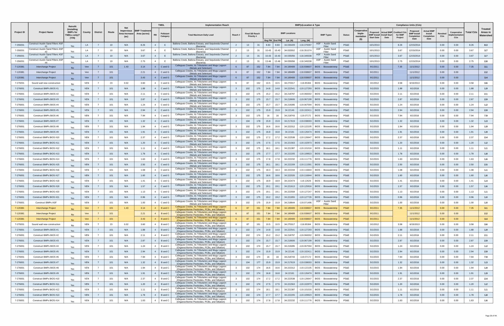
Beg PM End PM Lat. (N) Long. (W)
RouteProject ID Project Name
Retrofit (installing BMPs for
TMDLs only)? (Y/N)
County District Credited CUs for BMP Project
Proposed BMP Install Completion
Date
Actual BMP Install
Completion Date
Net Impervious
Area Increase (ac)
BMP Treatment Area (acres)
TMDL Implementation Reach BMP(s)Location & Type
BMP LocationsBMP Types Status
Revoked CUs
Total CUsTreated Areas in
WatershedRBPollutant Category
Total Maximum Daily Load Reach #Final SB Reach
Priority #
Compliance Units (CUs)
Cooperative Imple-
mentation ($)
Cooperative Implementation
CUs
Proposed BMP Install Start Date
Actual BMP Install Start
Date
7-259201Construct Austin Sand Filters ASF
#1 Yes LA 7 10 N/A 8.26 4 EBallona Creek, Ballona Estuary, and Sepulveda Channel
(Bacteria)2 13 31 8.83 8.83 34.036409 -118.379397
ASF - Austin Sand Filter
PS&E 10/1/2013 8.26 12/15/2014 0.00 0.00 8.26 8.3
7-259201Construct Austin Sand Filters ASF
#2 Yes LA 7 10 N/A 3.67 4 EBallona Creek, Ballona Estuary, and Sepulveda Channel
(Bacteria)2 13 31 10.43 10.43 34.033552 -118.351074
ASF - Austin Sand Filter
PS&E 10/1/2013 3.67 12/15/2014 0.00 0.00 3.67 3.7
7-259201Construct Austin Sand Filters ASF
#3 Yes LA 7 10 N/A 3.67 4 EBallona Creek, Ballona Estuary, and Sepulveda Channel
(Bacteria)2 13 31 10.43 10.43 34.035056 -118.349338
ASF - Austin Sand Filter
PS&E 10/1/2013 3.67 12/15/2014 0.00 0.00 3.67 3.7
7-259201Construct Austin Sand Filters ASF
#4 Yes LA 7 10 N/A 2.75 4 EBallona Creek, Ballona Estuary, and Sepulveda Channel
(Bacteria)2 13 31 13.46 13.46 34.035056 -118.349338
ASF - Austin Sand Filter
PS&E 10/1/2013 2.75 12/15/2014 0.00 0.00 2.75 2.8
7-120381 Interchange Project No Ven 7 101 1.43 3.14 4 C and GCalleguas Creeks, its Tributaries and Mugu Lagoon
(Metals and Selenium)6 87 152 7.84 7.84 34.189489 -118.938607 BIOS - Bioswale/strip PS&E 9/1/2011 7.35 11/1/2012 0.00 0.00 7.35 3.1
7-120381 Interchange Project No Ven 7 101 2.21 4 C and GCalleguas Creeks, its Tributaries and Mugu Lagoon
(Metals and Selenium)6 87 152 7.84 7.84 34.189489 -118.938607 BIOS - Bioswale/strip PS&E 9/1/2011 11/1/2012 0.00 0.00 2.2
7-120381 Interchange Project No Ven 7 101 3.43 4 C and GCalleguas Creeks, its Tributaries and Mugu Lagoon
(Metals and Selenium)6 87 152 7.84 7.84 34.189489 -118.938607 BIOS - Bioswale/strip PS&E 9/1/2011 11/1/2012 0.00 0.00 3.4
7-279201 Sound wall new construction No VEN 7 23 0.02 3.60 4 C and GCalleguas Creeks, its Tributaries and Mugu Lagoon
(Metals and Selenium)6 87 152 10.5 10.5 34.270317 -118.85384 BIOS - Bioswale/strip PS&E 3/1/2012 3.58 6/15/2013 0.00 0.00 3.58 3.6
7-276001 Construct BMPs BIOS #1 Yes VEN 7 101 N/A 1.88 4 C and GCalleguas Creeks, its Tributaries and Mugu Lagoon
(Metals and Selenium)3 102 175 14.8 14.8 34.222541 -119.127293 BIOS - Bioswale/strip PS&E 5/1/2015 1.88 6/1/2016 0.00 0.00 1.88 1.9
7-276001 Construct BMPs BIOS #2 Yes VEN 7 101 N/A 2.11 4 C and GCalleguas Creeks, its Tributaries and Mugu Lagoon
(Metals and Selenium)3 102 175 15.2 15.2 34.218797 -119.068302 BIOS - Bioswale/strip PS&E 5/1/2015 2.11 6/1/2016 0.00 0.00 2.11 2.1
7-276001 Construct BMPs BIOS #3 Yes VEN 7 101 N/A 2.87 4 C and GCalleguas Creeks, its Tributaries and Mugu Lagoon
(Metals and Selenium)3 102 175 15.7 15.7 34.218606 -119.067199 BIOS - Bioswale/strip PS&E 5/1/2015 2.87 6/1/2016 0.00 0.00 2.87 2.9
7-276001 Construct BMPs BIOS #4 Yes VEN 7 101 N/A 1.24 4 C and GCalleguas Creeks, its Tributaries and Mugu Lagoon
(Metals and Selenium)3 102 175 15.7 15.7 34.219285 -119.067594 BIOS - Bioswale/strip PS&E 5/1/2015 1.24 6/1/2016 0.00 0.00 1.24 1.2
7-276001 Construct BMPs BIOS #5 Yes VEN 7 101 N/A 2.94 4 C and GCalleguas Creeks, its Tributaries and Mugu Lagoon
(Metals and Selenium)3 102 175 15.9 15.9 34.22146 -119.102411 BIOS - Bioswale/strip PS&E 5/1/2015 2.94 6/1/2016 0.00 0.00 2.94 2.9
7-276001 Construct BMPs BIOS #6 Yes VEN 7 101 N/A 7.94 4 C and GCalleguas Creeks, its Tributaries and Mugu Lagoon
(Metals and Selenium)3 102 175 16 16 34.218743 -119.07172 BIOS - Bioswale/strip PS&E 5/1/2015 7.94 6/1/2016 0.00 0.00 7.94 7.9
7-276001 Construct BMPs BIOS #7 Yes VEN 7 101 N/A 1.32 4 C and GCalleguas Creeks, its Tributaries and Mugu Lagoon
(Metals and Selenium)2 104 178 15.9 15.9 34.217619 -119.038003 BIOS - Bioswale/strip PS&E 5/1/2015 1.32 6/1/2016 0.00 0.00 1.32 1.3
7-276001 Construct BMPs BIOS #8 Yes VEN 7 101 N/A 1.94 4 C and GCalleguas Creeks, its Tributaries and Mugu Lagoon
(Metals and Selenium)3 102 175 16.6 16.6 34.222312 -119.122105 BIOS - Bioswale/strip PS&E 5/1/2015 1.94 6/1/2016 0.00 0.00 1.94 1.9
7-276001 Construct BMPs BIOS #9 Yes VEN 7 101 N/A 1.91 4 C and GCalleguas Creeks, its Tributaries and Mugu Lagoon
(Metals and Selenium)3 102 175 16.8 16.8 34.22181 -119.126474 BIOS - Bioswale/strip PS&E 5/1/2015 1.91 6/1/2016 0.00 0.00 1.91 1.9
7-276001 Construct BMPs BIOS #10 Yes VEN 7 101 N/A 2.37 4 C and GCalleguas Creeks, its Tributaries and Mugu Lagoon
(Metals and Selenium)3 102 175 17.2 17.2 34.222538 -119.126647 BIOS - Bioswale/strip PS&E 5/1/2015 2.37 6/1/2016 0.00 0.00 2.37 2.4
7-276001 Construct BMPs BIOS #11 Yes VEN 7 101 N/A 1.20 4 C and GCalleguas Creeks, its Tributaries and Mugu Lagoon
(Metals and Selenium)3 102 175 17.5 17.5 34.221563 -119.102973 BIOS - Bioswale/strip PS&E 5/1/2015 1.20 6/1/2016 0.00 0.00 1.20 1.2
7-276001 Construct BMPs BIOS #12 Yes VEN 7 101 N/A 1.11 4 C and GCalleguas Creeks, its Tributaries and Mugu Lagoon
(Metals and Selenium)3 102 175 18.1 18.1 34.221387 -119.101016 BIOS - Bioswale/strip PS&E 5/1/2015 1.11 6/1/2016 0.00 0.00 1.11 1.1
7-276001 Construct BMPs BIOS #13 Yes VEN 7 101 N/A 1.78 4 C and GCalleguas Creeks, its Tributaries and Mugu Lagoon
(Metals and Selenium)3 102 175 17.7 17.7 34.222205 -119.109923 BIOS - Bioswale/strip PS&E 5/1/2015 1.78 6/1/2016 0.00 0.00 1.78 1.8
7-276001 Construct BMPs BIOS #14 Yes VEN 7 101 N/A 1.63 4 C and GCalleguas Creeks, its Tributaries and Mugu Lagoon
(Metals and Selenium)3 102 175 17.8 17.8 34.222232 -119.111776 BIOS - Bioswale/strip PS&E 5/1/2015 1.63 6/1/2016 0.00 0.00 1.63 1.6
7-276001 Construct BMPs BIOS #15 Yes VEN 7 101 N/A 2.50 4 C and GCalleguas Creeks, its Tributaries and Mugu Lagoon
(Metals and Selenium)3 102 175 18.1 18.1 34.222209 -119.111591 BIOS - Bioswale/strip PS&E 5/1/2015 2.50 6/1/2016 0.00 0.00 2.50 2.5
7-276001 Construct BMPs BIOS #16 Yes VEN 7 101 N/A 1.08 4 C and GCalleguas Creeks, its Tributaries and Mugu Lagoon
(Metals and Selenium)3 102 175 18.3 18.3 34.222244 -119.116844 BIOS - Bioswale/strip PS&E 5/1/2015 1.08 6/1/2016 0.00 0.00 1.08 1.1
7-276001 Construct BMPs BIOS #17 Yes VEN 7 101 N/A 1.60 4 C and GCalleguas Creeks, its Tributaries and Mugu Lagoon
(Metals and Selenium)3 102 175 18.6 18.6 34.222026 -119.116844 BIOS - Bioswale/strip PS&E 5/1/2015 1.60 6/1/2016 0.00 0.00 1.60 1.6
7-276001 Construct BMPs BIOS #18 Yes VEN 7 101 N/A 1.41 4 C and GCalleguas Creeks, its Tributaries and Mugu Lagoon
(Metals and Selenium)3 102 175 18.9 18.9 34.222474 -119.12629 BIOS - Bioswale/strip PS&E 5/1/2015 1.41 6/1/2016 0.00 0.00 1.41 1.4
7-276001 Construct BMPs BIOS #19 Yes VEN 7 101 N/A 1.57 4 C and GCalleguas Creeks, its Tributaries and Mugu Lagoon
(Metals and Selenium)3 102 175 19.1 19.1 34.221613 -119.125916 BIOS - Bioswale/strip PS&E 5/1/2015 1.57 6/1/2016 0.00 0.00 1.57 1.6
7-276001 Construct BMPs BIOS #20 Yes VEN 7 101 N/A 1.13 4 C and GCalleguas Creeks, its Tributaries and Mugu Lagoon
(Metals and Selenium)3 102 175 19.1 19.1 34.222559 -119.127247 BIOS - Bioswale/strip PS&E 5/1/2015 1.13 6/1/2016 0.00 0.00 1.13 1.1
7-276001 Construct BMPs BIOS #21 Yes VEN 7 101 N/A 0.96 4 C and GCalleguas Creeks, its Tributaries and Mugu Lagoon
(Metals and Selenium)3 102 175 19.2 19.2 34.221855 -119.127726 BIOS - Bioswale/strip PS&E 5/1/2015 0.96 6/1/2016 0.00 0.00 0.96 1.0
7-276001 Construct BMPs ASF Yes VEN 7 101 N/A 1.00 4 C and GCalleguas Creeks, its Tributaries and Mugu Lagoon
(Metals and Selenium)3 102 175 15.9 15.9 34.218644 -119.071496
ASF - Austin Sand Filter
PS&E 5/1/2015 1.00 6/1/2016 0.00 0.00 1.00 1.0
7-120381 Interchange Project No Ven 7 101 1.43 3.14 4 B and CCalleguas Creeks, its Tributaries and Mugu Lagoon
(Organochlorine Pesticides, PCBs, and Siltation)6 87 151 7.84 7.84 34.189489 -118.938607 BIOS - Bioswale/strip PS&E 9/1/2011 7.35 11/1/2012 0.00 0.00 7.35 3.1
7-120381 Interchange Project No Ven 7 101 2.21 4 B and CCalleguas Creeks, its Tributaries and Mugu Lagoon
(Organochlorine Pesticides, PCBs, and Siltation)6 87 151 7.84 7.84 34.189489 -118.938607 BIOS - Bioswale/strip PS&E 9/1/2011 11/1/2012 0.00 0.00 2.2
7-120381 Interchange Project No Ven 7 101 3.43 4 B and CCalleguas Creeks, its Tributaries and Mugu Lagoon
(Organochlorine Pesticides, PCBs, and Siltation)6 87 151 7.84 7.84 34.189489 -118.938607 BIOS - Bioswale/strip PS&E 9/1/2011 11/1/2012 0.00 0.00 3.4
7-279201 Sound wall new construction No VEN 7 23 0.02 3.60 4 B and CCalleguas Creeks, its Tributaries and Mugu Lagoon
(Organochlorine Pesticides, PCBs, and Siltation)6 87 151 10.5 10.5 34.270317 -118.85384 BIOS - Bioswale/strip PS&E 3/1/2012 3.58 6/15/2013 0.00 0.00 3.58 3.6
7-276001 Construct BMPs BIOS #1 Yes VEN 7 101 N/A 1.88 4 B and CCalleguas Creeks, its Tributaries and Mugu Lagoon
(Organochlorine Pesticides, PCBs, and Siltation)3 102 174 14.8 14.8 34.222541 -119.127293 BIOS - Bioswale/strip PS&E 5/1/2015 1.88 6/1/2016 0.00 0.00 1.88 1.9
7-276001 Construct BMPs BIOS #2 Yes VEN 7 101 N/A 2.11 4 B and CCalleguas Creeks, its Tributaries and Mugu Lagoon
(Organochlorine Pesticides, PCBs, and Siltation)3 102 174 15.2 15.2 34.218797 -119.068302 BIOS - Bioswale/strip PS&E 5/1/2015 2.11 6/1/2016 0.00 0.00 2.11 2.1
7-276001 Construct BMPs BIOS #3 Yes VEN 7 101 N/A 2.87 4 B and CCalleguas Creeks, its Tributaries and Mugu Lagoon
(Organochlorine Pesticides, PCBs, and Siltation)3 102 174 15.7 15.7 34.218606 -119.067199 BIOS - Bioswale/strip PS&E 5/1/2015 2.87 6/1/2016 0.00 0.00 2.87 2.9
7-276001 Construct BMPs BIOS #4 Yes VEN 7 101 N/A 1.24 4 B and CCalleguas Creeks, its Tributaries and Mugu Lagoon
(Organochlorine Pesticides, PCBs, and Siltation)3 102 174 15.7 15.7 34.219285 -119.067594 BIOS - Bioswale/strip PS&E 5/1/2015 1.24 6/1/2016 0.00 0.00 1.24 1.2
7-276001 Construct BMPs BIOS #5 Yes VEN 7 101 N/A 2.94 4 B and CCalleguas Creeks, its Tributaries and Mugu Lagoon
(Organochlorine Pesticides, PCBs, and Siltation)3 102 174 15.9 15.9 34.22146 -119.102411 BIOS - Bioswale/strip PS&E 5/1/2015 2.94 6/1/2016 0.00 0.00 2.94 2.9
7-276001 Construct BMPs BIOS #6 Yes VEN 7 101 N/A 7.94 4 B and CCalleguas Creeks, its Tributaries and Mugu Lagoon
(Organochlorine Pesticides, PCBs, and Siltation)3 102 174 16 16 34.218743 -119.07172 BIOS - Bioswale/strip PS&E 5/1/2015 7.94 6/1/2016 0.00 0.00 7.94 7.9
7-276001 Construct BMPs BIOS #7 Yes VEN 7 101 N/A 1.32 4 B and CCalleguas Creeks, its Tributaries and Mugu Lagoon
(Organochlorine Pesticides, PCBs, and Siltation)2 104 177 15.9 15.9 34.217619 -119.038003 BIOS - Bioswale/strip PS&E 5/1/2015 1.32 6/1/2016 0.00 0.00 1.32 1.3
7-276001 Construct BMPs BIOS #8 Yes VEN 7 101 N/A 1.94 4 B and CCalleguas Creeks, its Tributaries and Mugu Lagoon
(Organochlorine Pesticides, PCBs, and Siltation)3 102 174 16.6 16.6 34.222312 -119.122105 BIOS - Bioswale/strip PS&E 5/1/2015 1.94 6/1/2016 0.00 0.00 1.94 1.9
7-276001 Construct BMPs BIOS #9 Yes VEN 7 101 N/A 1.91 4 B and CCalleguas Creeks, its Tributaries and Mugu Lagoon
(Organochlorine Pesticides, PCBs, and Siltation)3 102 174 16.8 16.8 34.22181 -119.126474 BIOS - Bioswale/strip PS&E 5/1/2015 1.91 6/1/2016 0.00 0.00 1.91 1.9
7-276001 Construct BMPs BIOS #10 Yes VEN 7 101 N/A 2.37 4 B and CCalleguas Creeks, its Tributaries and Mugu Lagoon
(Organochlorine Pesticides, PCBs, and Siltation)3 102 174 17.2 17.2 34.222538 -119.126647 BIOS - Bioswale/strip PS&E 5/1/2015 2.37 6/1/2016 0.00 0.00 2.37 2.4
7-276001 Construct BMPs BIOS #11 Yes VEN 7 101 N/A 1.20 4 B and CCalleguas Creeks, its Tributaries and Mugu Lagoon
(Organochlorine Pesticides, PCBs, and Siltation)3 102 174 17.5 17.5 34.221563 -119.102973 BIOS - Bioswale/strip PS&E 5/1/2015 1.20 6/1/2016 0.00 0.00 1.20 1.2
7-276001 Construct BMPs BIOS #12 Yes VEN 7 101 N/A 1.11 4 B and CCalleguas Creeks, its Tributaries and Mugu Lagoon
(Organochlorine Pesticides, PCBs, and Siltation)3 102 174 18.1 18.1 34.221387 -119.101016 BIOS - Bioswale/strip PS&E 5/1/2015 1.11 6/1/2016 0.00 0.00 1.11 1.1
7-276001 Construct BMPs BIOS #13 Yes VEN 7 101 N/A 1.78 4 B and CCalleguas Creeks, its Tributaries and Mugu Lagoon
(Organochlorine Pesticides, PCBs, and Siltation)3 102 174 17.7 17.7 34.222205 -119.109923 BIOS - Bioswale/strip PS&E 5/1/2015 1.78 6/1/2016 0.00 0.00 1.78 1.8
7-276001 Construct BMPs BIOS #14 Yes VEN 7 101 N/A 1.63 4 B and CCalleguas Creeks, its Tributaries and Mugu Lagoon
(Organochlorine Pesticides, PCBs, and Siltation)3 102 174 17.8 17.8 34.222232 -119.111776 BIOS - Bioswale/strip PS&E 5/1/2015 1.63 6/1/2016 0.00 0.00 1.63 1.6
Page 28 of 44
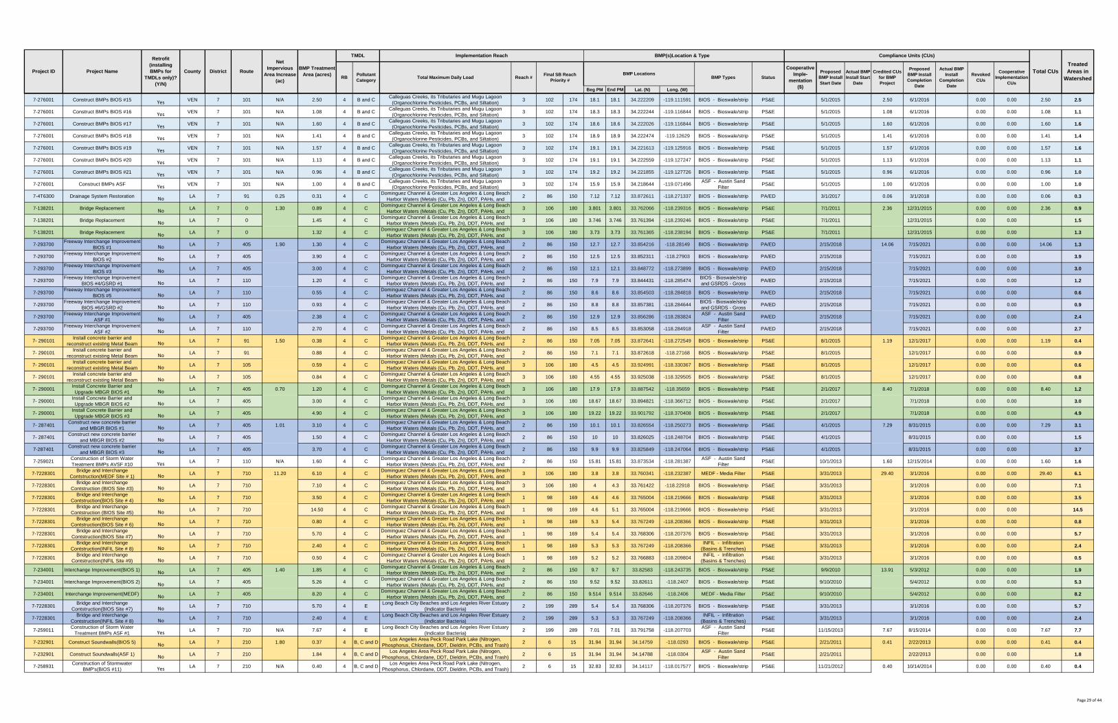
Beg PM End PM Lat. (N) Long. (W)
RouteProject ID Project Name
Retrofit (installing BMPs for
TMDLs only)? (Y/N)
County District Credited CUs for BMP Project
Proposed BMP Install Completion
Date
Actual BMP Install
Completion Date
Net Impervious
Area Increase (ac)
BMP Treatment Area (acres)
TMDL Implementation Reach BMP(s)Location & Type
BMP LocationsBMP Types Status
Revoked CUs
Total CUsTreated Areas in
WatershedRBPollutant Category
Total Maximum Daily Load Reach #Final SB Reach
Priority #
Compliance Units (CUs)
Cooperative Imple-
mentation ($)
Cooperative Implementation
CUs
Proposed BMP Install Start Date
Actual BMP Install Start
Date
7-276001 Construct BMPs BIOS #15 Yes VEN 7 101 N/A 2.50 4 B and CCalleguas Creeks, its Tributaries and Mugu Lagoon
(Organochlorine Pesticides, PCBs, and Siltation)3 102 174 18.1 18.1 34.222209 -119.111591 BIOS - Bioswale/strip PS&E 5/1/2015 2.50 6/1/2016 0.00 0.00 2.50 2.5
7-276001 Construct BMPs BIOS #16 Yes VEN 7 101 N/A 1.08 4 B and CCalleguas Creeks, its Tributaries and Mugu Lagoon
(Organochlorine Pesticides, PCBs, and Siltation)3 102 174 18.3 18.3 34.222244 -119.116844 BIOS - Bioswale/strip PS&E 5/1/2015 1.08 6/1/2016 0.00 0.00 1.08 1.1
7-276001 Construct BMPs BIOS #17 Yes VEN 7 101 N/A 1.60 4 B and CCalleguas Creeks, its Tributaries and Mugu Lagoon
(Organochlorine Pesticides, PCBs, and Siltation)3 102 174 18.6 18.6 34.222026 -119.116844 BIOS - Bioswale/strip PS&E 5/1/2015 1.60 6/1/2016 0.00 0.00 1.60 1.6
7-276001 Construct BMPs BIOS #18 Yes VEN 7 101 N/A 1.41 4 B and CCalleguas Creeks, its Tributaries and Mugu Lagoon
(Organochlorine Pesticides, PCBs, and Siltation)3 102 174 18.9 18.9 34.222474 -119.12629 BIOS - Bioswale/strip PS&E 5/1/2015 1.41 6/1/2016 0.00 0.00 1.41 1.4
7-276001 Construct BMPs BIOS #19 Yes VEN 7 101 N/A 1.57 4 B and CCalleguas Creeks, its Tributaries and Mugu Lagoon
(Organochlorine Pesticides, PCBs, and Siltation)3 102 174 19.1 19.1 34.221613 -119.125916 BIOS - Bioswale/strip PS&E 5/1/2015 1.57 6/1/2016 0.00 0.00 1.57 1.6
7-276001 Construct BMPs BIOS #20 Yes VEN 7 101 N/A 1.13 4 B and CCalleguas Creeks, its Tributaries and Mugu Lagoon
(Organochlorine Pesticides, PCBs, and Siltation)3 102 174 19.1 19.1 34.222559 -119.127247 BIOS - Bioswale/strip PS&E 5/1/2015 1.13 6/1/2016 0.00 0.00 1.13 1.1
7-276001 Construct BMPs BIOS #21 Yes VEN 7 101 N/A 0.96 4 B and CCalleguas Creeks, its Tributaries and Mugu Lagoon
(Organochlorine Pesticides, PCBs, and Siltation)3 102 174 19.2 19.2 34.221855 -119.127726 BIOS - Bioswale/strip PS&E 5/1/2015 0.96 6/1/2016 0.00 0.00 0.96 1.0
7-276001 Construct BMPs ASF Yes VEN 7 101 N/A 1.00 4 B and CCalleguas Creeks, its Tributaries and Mugu Lagoon
(Organochlorine Pesticides, PCBs, and Siltation)3 102 174 15.9 15.9 34.218644 -119.071496
ASF - Austin Sand Filter
PS&E 5/1/2015 1.00 6/1/2016 0.00 0.00 1.00 1.0
7-4T6300 Drainage System Restoration No LA 7 91 0.25 0.31 4 CDominguez Channel & Greater Los Angeles & Long Beach
Harbor Waters (Metals (Cu, Pb, Zn), DDT, PAHs, and 2 86 150 7.12 7.12 33.872611 -118.271337 BIOS - Bioswale/strip PA/ED 3/1/2017 0.06 3/1/2018 0.00 0.00 0.06 0.3
7-138201 Bridge Replacement No LA 7 0 1.30 0.89 4 CDominguez Channel & Greater Los Angeles & Long Beach
Harbor Waters (Metals (Cu, Pb, Zn), DDT, PAHs, and 3 106 180 3.801 3.801 33.762066 -118.239316 BIOS - Bioswale/strip PS&E 7/1/2011 2.36 12/31/2015 0.00 0.00 2.36 0.9
7-138201 Bridge Replacement No LA 7 0 1.45 4 CDominguez Channel & Greater Los Angeles & Long Beach
Harbor Waters (Metals (Cu, Pb, Zn), DDT, PAHs, and 3 106 180 3.746 3.746 33.761394 -118.239246 BIOS - Bioswale/strip PS&E 7/1/2011 12/31/2015 0.00 0.00 1.5
7-138201 Bridge Replacement No LA 7 0 1.32 4 CDominguez Channel & Greater Los Angeles & Long Beach
Harbor Waters (Metals (Cu, Pb, Zn), DDT, PAHs, and 3 106 180 3.73 3.73 33.761365 -118.238194 BIOS - Bioswale/strip PS&E 7/1/2011 12/31/2015 0.00 0.00 1.3
7-293700Freeway Interchange Improvement
BIOS #1 No LA 7 405 1.90 1.30 4 CDominguez Channel & Greater Los Angeles & Long Beach
Harbor Waters (Metals (Cu, Pb, Zn), DDT, PAHs, and 2 86 150 12.7 12.7 33.854216 -118.28149 BIOS - Bioswale/strip PA/ED 2/15/2018 14.06 7/15/2021 0.00 0.00 14.06 1.3
7-293700Freeway Interchange Improvement
BIOS #2 No LA 7 405 3.90 4 CDominguez Channel & Greater Los Angeles & Long Beach
Harbor Waters (Metals (Cu, Pb, Zn), DDT, PAHs, and 2 86 150 12.5 12.5 33.852311 -118.27903 BIOS - Bioswale/strip PA/ED 2/15/2018 7/15/2021 0.00 0.00 3.9
7-293700Freeway Interchange Improvement
BIOS #3 No LA 7 405 3.00 4 CDominguez Channel & Greater Los Angeles & Long Beach
Harbor Waters (Metals (Cu, Pb, Zn), DDT, PAHs, and 2 86 150 12.1 12.1 33.848772 -118.273899 BIOS - Bioswale/strip PA/ED 2/15/2018 7/15/2021 0.00 0.00 3.0
7-293700Freeway Interchange Improvement
BIOS #4/GSRD #1 No LA 7 110 1.20 4 CDominguez Channel & Greater Los Angeles & Long Beach
Harbor Waters (Metals (Cu, Pb, Zn), DDT, PAHs, and 2 86 150 7.9 7.9 33.844431 -118.285474
BIOS - Bioswale/strip and GSRDS - Gross
PA/ED 2/15/2018 7/15/2021 0.00 0.00 1.2
7-293700Freeway Interchange Improvement
BIOS #5 No LA 7 110 0.55 4 CDominguez Channel & Greater Los Angeles & Long Beach
Harbor Waters (Metals (Cu, Pb, Zn), DDT, PAHs, and 2 86 150 8.6 8.6 33.854503 -118.284818 BIOS - Bioswale/strip PA/ED 2/15/2018 7/15/2021 0.00 0.00 0.6
7-293700Freeway Interchange Improvement
BIOS #6/GSRD #2 No LA 7 110 0.93 4 CDominguez Channel & Greater Los Angeles & Long Beach
Harbor Waters (Metals (Cu, Pb, Zn), DDT, PAHs, and 2 86 150 8.8 8.8 33.857381 -118.284644
BIOS - Bioswale/strip and GSRDS - Gross
PA/ED 2/15/2018 7/15/2021 0.00 0.00 0.9
7-293700Freeway Interchange Improvement
ASF #1 No LA 7 405 2.38 4 CDominguez Channel & Greater Los Angeles & Long Beach
Harbor Waters (Metals (Cu, Pb, Zn), DDT, PAHs, and 2 86 150 12.9 12.9 33.856286 -118.283824
ASF - Austin Sand Filter
PA/ED 2/15/2018 7/15/2021 0.00 0.00 2.4
7-293700Freeway Interchange Improvement
ASF #2 No LA 7 110 2.70 4 CDominguez Channel & Greater Los Angeles & Long Beach
Harbor Waters (Metals (Cu, Pb, Zn), DDT, PAHs, and 2 86 150 8.5 8.5 33.853058 -118.284918
ASF - Austin Sand Filter
PA/ED 2/15/2018 7/15/2021 0.00 0.00 2.7
7- 290101Install concrete barrier and
reconstruct existing Metal Beam No LA 7 91 1.50 0.38 4 CDominguez Channel & Greater Los Angeles & Long Beach
Harbor Waters (Metals (Cu, Pb, Zn), DDT, PAHs, and 2 86 150 7.05 7.05 33.872641 -118.272549 BIOS - Bioswale/strip PS&E 8/1/2015 1.19 12/1/2017 0.00 0.00 1.19 0.4
7- 290101Install concrete barrier and
reconstruct existing Metal Beam No LA 7 91 0.88 4 CDominguez Channel & Greater Los Angeles & Long Beach
Harbor Waters (Metals (Cu, Pb, Zn), DDT, PAHs, and 2 86 150 7.1 7.1 33.872618 -118.27168 BIOS - Bioswale/strip PS&E 8/1/2015 12/1/2017 0.00 0.00 0.9
7- 290101Install concrete barrier and
reconstruct existing Metal Beam No LA 7 105 0.59 4 CDominguez Channel & Greater Los Angeles & Long Beach
Harbor Waters (Metals (Cu, Pb, Zn), DDT, PAHs, and 3 106 180 4.5 4.5 33.924991 -118.330367 BIOS - Bioswale/strip PS&E 8/1/2015 12/1/2017 0.00 0.00 0.6
7- 290101Install concrete barrier and
reconstruct existing Metal Beam No LA 7 105 0.84 4 CDominguez Channel & Greater Los Angeles & Long Beach
Harbor Waters (Metals (Cu, Pb, Zn), DDT, PAHs, and 3 106 180 4.55 4.55 33.925038 -118.329505 BIOS - Bioswale/strip PS&E 8/1/2015 12/1/2017 0.00 0.00 0.8
7- 290001Install Concrete Barrier and Upgrade MBGR BIOS #1 No LA 7 405 0.70 1.20 4 C
Dominguez Channel & Greater Los Angeles & Long Beach Harbor Waters (Metals (Cu, Pb, Zn), DDT, PAHs, and
3 106 180 17.9 17.9 33.887542 -118.35659 BIOS - Bioswale/strip PS&E 2/1/2017 8.40 7/1/2018 0.00 0.00 8.40 1.2
7- 290001Install Concrete Barrier and Upgrade MBGR BIOS #2 No LA 7 405 3.00 4 C
Dominguez Channel & Greater Los Angeles & Long Beach Harbor Waters (Metals (Cu, Pb, Zn), DDT, PAHs, and
3 106 180 18.67 18.67 33.894821 -118.366712 BIOS - Bioswale/strip PS&E 2/1/2017 7/1/2018 0.00 0.00 3.0
7- 290001Install Concrete Barrier and Upgrade MBGR BIOS #3 No LA 7 405 4.90 4 C
Dominguez Channel & Greater Los Angeles & Long Beach Harbor Waters (Metals (Cu, Pb, Zn), DDT, PAHs, and
3 106 180 19.22 19.22 33.901792 -118.370408 BIOS - Bioswale/strip PS&E 2/1/2017 7/1/2018 0.00 0.00 4.9
7- 287401Construct new concrete barrier
and MBGR BIOS #1 No LA 7 405 1.01 3.10 4 CDominguez Channel & Greater Los Angeles & Long Beach
Harbor Waters (Metals (Cu, Pb, Zn), DDT, PAHs, and 2 86 150 10.1 10.1 33.826554 -118.250273 BIOS - Bioswale/strip PS&E 4/1/2015 7.29 8/31/2015 0.00 0.00 7.29 3.1
7- 287401Construct new concrete barrier
and MBGR BIOS #2 No LA 7 405 1.50 4 CDominguez Channel & Greater Los Angeles & Long Beach
Harbor Waters (Metals (Cu, Pb, Zn), DDT, PAHs, and 2 86 150 10 10 33.826025 -118.248704 BIOS - Bioswale/strip PS&E 4/1/2015 8/31/2015 0.00 0.00 1.5
7-287401Construct new concrete barrier
and MBGR BIOS #3 No LA 7 405 3.70 4 CDominguez Channel & Greater Los Angeles & Long Beach
Harbor Waters (Metals (Cu, Pb, Zn), DDT, PAHs, and 2 86 150 9.9 9.9 33.825849 -118.247064 BIOS - Bioswale/strip PS&E 4/1/2015 8/31/2015 0.00 0.00 3.7
7-259021Construction of Storm Water Treatment BMPs AVSF #10 Yes LA 7 110 N/A 1.60 4 C
Dominguez Channel & Greater Los Angeles & Long Beach Harbor Waters (Metals (Cu, Pb, Zn), DDT, PAHs, and
2 86 150 15.81 15.81 33.873534 -118.281387ASF - Austin Sand
FilterPS&E 10/1/2013 1.60 12/15/2014 0.00 0.00 1.60 1.6
7-7228301Bridge and Interchange
Contstruction(MEDF Site # 1) No LA 7 710 11.20 6.10 4 CDominguez Channel & Greater Los Angeles & Long Beach
Harbor Waters (Metals (Cu, Pb, Zn), DDT, PAHs, and 3 106 180 3.8 3.8 33.760341 -118.232387 MEDF - Media Filter PS&E 3/31/2013 29.40 3/1/2016 0.00 0.00 29.40 6.1
7-7228301Bridge and Interchange
Contstruction (BIOS Site #3) No LA 7 710 7.10 4 CDominguez Channel & Greater Los Angeles & Long Beach
Harbor Waters (Metals (Cu, Pb, Zn), DDT, PAHs, and 3 106 180 4 4.3 33.761422 -118.22918 BIOS - Bioswale/strip PS&E 3/31/2013 3/1/2016 0.00 0.00 7.1
7-7228301Bridge and Interchange
Contstruction(BIOS Site # 4) No LA 7 710 3.50 4 CDominguez Channel & Greater Los Angeles & Long Beach
Harbor Waters (Metals (Cu, Pb, Zn), DDT, PAHs, and 1 98 169 4.6 4.6 33.765004 -118.219666 BIOS - Bioswale/strip PS&E 3/31/2013 3/1/2016 0.00 0.00 3.5
7-7228301Bridge and Interchange
Contstruction (BIOS Site #5) No LA 7 710 14.50 4 CDominguez Channel & Greater Los Angeles & Long Beach
Harbor Waters (Metals (Cu, Pb, Zn), DDT, PAHs, and 1 98 169 4.6 5.1 33.765004 -118.219666 BIOS - Bioswale/strip PS&E 3/31/2013 3/1/2016 0.00 0.00 14.5
7-7228301Bridge and Interchange
Contstruction(BIOS Site # 6) No LA 7 710 0.80 4 CDominguez Channel & Greater Los Angeles & Long Beach
Harbor Waters (Metals (Cu, Pb, Zn), DDT, PAHs, and 1 98 169 5.3 5.4 33.767249 -118.208366 BIOS - Bioswale/strip PS&E 3/31/2013 3/1/2016 0.00 0.00 0.8
7-7228301Bridge and Interchange
Contstruction(BIOS Site #7) No LA 7 710 5.70 4 CDominguez Channel & Greater Los Angeles & Long Beach
Harbor Waters (Metals (Cu, Pb, Zn), DDT, PAHs, and 1 98 169 5.4 5.4 33.768306 -118.207376 BIOS - Bioswale/strip PS&E 3/31/2013 3/1/2016 0.00 0.00 5.7
7-7228301Bridge and Interchange
Contstruction(INFIL Site # 8) No LA 7 710 2.40 4 CDominguez Channel & Greater Los Angeles & Long Beach
Harbor Waters (Metals (Cu, Pb, Zn), DDT, PAHs, and 1 98 169 5.3 5.3 33.767249 -118.208366
INFIL - Infiltration (Basins & Trenches)
PS&E 3/31/2013 3/1/2016 0.00 0.00 2.4
7-7228301Bridge and Interchange
Contstruction(INFIL Site #9) No LA 7 710 0.50 4 CDominguez Channel & Greater Los Angeles & Long Beach
Harbor Waters (Metals (Cu, Pb, Zn), DDT, PAHs, and 1 98 169 5.2 5.2 33.766883 -118.209804
INFIL - Infiltration (Basins & Trenches)
PS&E 3/31/2013 3/1/2016 0.00 0.00 0.5
7-234001 Interchange Improvement(BIOS 1) No LA 7 405 1.40 1.85 4 CDominguez Channel & Greater Los Angeles & Long Beach
Harbor Waters (Metals (Cu, Pb, Zn), DDT, PAHs, and 2 86 150 9.7 9.7 33.82583 -118.243735 BIOS - Bioswale/strip PS&E 9/9/2010 13.91 5/3/2012 0.00 0.00 1.9
7-234001 Interchange Improvement(BIOS 2) No LA 7 405 5.26 4 CDominguez Channel & Greater Los Angeles & Long Beach
Harbor Waters (Metals (Cu, Pb, Zn), DDT, PAHs, and 2 86 150 9.52 9.52 33.82611 -118.2407 BIOS - Bioswale/strip PS&E 9/10/2010 5/4/2012 0.00 0.00 5.3
7-234001 Interchange Improvement(MEDF) No LA 7 405 8.20 4 CDominguez Channel & Greater Los Angeles & Long Beach
Harbor Waters (Metals (Cu, Pb, Zn), DDT, PAHs, and 2 86 150 9.514 9.514 33.82646 -118.2406 MEDF - Media Filter PS&E 9/10/2010 5/4/2012 0.00 0.00 8.2
7-7228301Bridge and Interchange
Contstruction(BIOS Site #7) No LA 7 710 5.70 4 ELong Beach City Beaches and Los Angeles River Estuary
(Indicator Bacteria)2 199 289 5.4 5.4 33.768306 -118.207376 BIOS - Bioswale/strip PS&E 3/31/2013 3/1/2016 0.00 0.00 5.7
7-7228301Bridge and Interchange
Contstruction(INFIL Site # 8) No LA 7 710 2.40 4 ELong Beach City Beaches and Los Angeles River Estuary
(Indicator Bacteria)2 199 289 5.3 5.3 33.767249 -118.208366
INFIL - Infiltration (Basins & Trenches)
PS&E 3/31/2013 3/1/2016 0.00 0.00 2.4
7-259011Construction of Storm Water
Treatment BMPs ASF #1 Yes LA 7 710 N/A 7.67 4 ELong Beach City Beaches and Los Angeles River Estuary
(Indicator Bacteria)2 199 289 7.01 7.01 33.791758 -118.207703
ASF - Austin Sand Filter
PS&E 11/15/2013 7.67 8/15/2014 0.00 0.00 7.67 7.7
7-232901 Construct Soundwalls(BIOS 5) No LA 7 210 1.80 0.37 4 B, C and DLos Angeles Area Peck Road Park Lake (Nitrogen,
Phosphorus, Chlordane, DDT, Dieldrin, PCBs, and Trash)2 6 15 31.94 31.94 34.14759 -118.0293 BIOS - Bioswale/strip PS&E 2/21/2011 0.41 2/22/2013 0.00 0.00 0.41 0.4
7-232901 Construct Soundwalls(ASF 1) No LA 7 210 1.84 4 B, C and DLos Angeles Area Peck Road Park Lake (Nitrogen,
Phosphorus, Chlordane, DDT, Dieldrin, PCBs, and Trash)2 6 15 31.94 31.94 34.14788 -118.0304
ASF - Austin Sand Filter
PS&E 2/21/2011 2/22/2013 0.00 0.00 1.8
7-258931Construction of Stormwater
BMP's(BIOS #11) Yes LA 7 210 N/A 0.40 4 B, C and DLos Angeles Area Peck Road Park Lake (Nitrogen,
Phosphorus, Chlordane, DDT, Dieldrin, PCBs, and Trash)2 6 15 32.83 32.83 34.14117 -118.017577 BIOS - Bioswale/strip PS&E 11/21/2012 0.40 10/14/2014 0.00 0.00 0.40 0.4
Page 29 of 44

Beg PM End PM Lat. (N) Long. (W)
RouteProject ID Project Name
Retrofit (installing BMPs for
TMDLs only)? (Y/N)
County District Credited CUs for BMP Project
Proposed BMP Install Completion
Date
Actual BMP Install
Completion Date
Net Impervious
Area Increase (ac)
BMP Treatment Area (acres)
TMDL Implementation Reach BMP(s)Location & Type
BMP LocationsBMP Types Status
Revoked CUs
Total CUsTreated Areas in
WatershedRBPollutant Category
Total Maximum Daily Load Reach #Final SB Reach
Priority #
Compliance Units (CUs)
Cooperative Imple-
mentation ($)
Cooperative Implementation
CUs
Proposed BMP Install Start Date
Actual BMP Install Start
Date
7-258931Construction of Stormwater
BMP's(BIOS #21) Yes LA 7 210 N/A 2.07 4 B, C and DLos Angeles Area Peck Road Park Lake (Nitrogen,
Phosphorus, Chlordane, DDT, Dieldrin, PCBs, and Trash)2 6 15 33.01 33.01 34.139148 -118.015496 BIOS - Bioswale/strip PS&E 11/21/2012 2.07 10/14/2014 0.00 0.00 2.07 2.1
7-258931Construction of Stormwater
BMP's(BIOS #14) Yes LA 7 210 N/A 1.62 4 B, C and DLos Angeles Area Peck Road Park Lake (Nitrogen,
Phosphorus, Chlordane, DDT, Dieldrin, PCBs, and Trash)1 15 35 33.73 33.73 34.135474 -118.004137
ASF - Austin Sand Filter
PS&E 11/21/2012 1.62 10/14/2014 0.00 0.00 1.62 1.6
7-258931Construction of Stormwater
BMP's(AVSF #15) Yes LA 7 210 N/A 0.83 4 B, C and DLos Angeles Area Peck Road Park Lake (Nitrogen,
Phosphorus, Chlordane, DDT, Dieldrin, PCBs, and Trash)1 15 35 34.66 34.66 34.135456 -117.987911
ASF - Austin Sand Filter
PS&E 11/21/2012 0.83 10/14/2014 0.00 0.00 0.83 0.8
7-258931Construction of Stormwater
BMP's(INFIL # 16) Yes LA 7 210 N/A 0.93 4 B, C and DLos Angeles Area Peck Road Park Lake (Nitrogen,
Phosphorus, Chlordane, DDT, Dieldrin, PCBs, and Trash)1 15 35 35.05 35.05 34.135401 -117.981091
INFIL - Infiltration (Basins & Trenches)
PS&E 11/21/2012 0.93 10/14/2014 0.00 0.00 0.93 0.9
7-258931Construction of Stormwater
BMP's(AVSF #17) Yes LA 7 210 N/A 3.36 4 B, C and DLos Angeles Area Peck Road Park Lake (Nitrogen,
Phosphorus, Chlordane, DDT, Dieldrin, PCBs, and Trash)1 15 35 35.29 35.29 34.135331 -117.976922
ASF - Austin Sand Filter
PS&E 11/21/2012 3.36 10/14/2014 0.00 0.00 3.36 3.4
7-2X9201 Permanent Slope Restoration No LA 7 91 0.79 1.34 4 N/A Los Angeles River (Trash) 6 29 65 10.7 10.7 33.873601 -118.209135 MEDF - Media Filter PS&E 9/7/2012 17.28 6/10/2014 0.00 0.00 17.28 1.3
7-2X9201 Permanent Slope Restoration No LA 7 91 2.09 4 N/A Los Angeles River (Trash) 6 29 65 10.18 10.18 33.873534 -118.218219 MEDF - Media Filter PS&E 9/7/2012 6/10/2014 0.00 0.00 2.1
7-2X9201 Permanent Slope Restoration No LA 7 91 0.49 4 N/A Los Angeles River (Trash) 6 29 65 10.23 10.23 33.873486 -118.217347GSRDs - Gross Solid
Removal DevicesPS&E 9/7/2012 6/10/2014 0.00 0.00 0.5
7-2X9201 Permanent Slope Restoration No LA 7 91 0.60 4 N/A Los Angeles River (Trash) 6 29 65 10.33 10.33 33.873468 -118.215595 BIOS - Bioswale/strip PS&E 9/7/2012 6/10/2014 0.00 0.00 0.6
7-2X9201 Permanent Slope Restoration No LA 7 91 3.57 4 N/A Los Angeles River (Trash) 6 29 65 10.43 10.43 33.873495 -118.213849 MEDF - Media Filter PS&E 9/7/2012 6/10/2014 0.00 0.00 3.6
7-2X9201 Permanent Slope Restoration No LA 7 91 0.41 4 N/A Los Angeles River (Trash) 2 10 23 11.03 11.03 33.872733 -118.20351 BIOS - Bioswale/strip PS&E 9/7/2012 6/10/2014 0.00 0.00 0.4
7-2X9201 Permanent Slope Restoration No LA 7 91 3.62 4 N/A Los Angeles River (Trash) 2 10 23 11.07 11.07 33.872678 -118.202824 MEDF - Media Filter PS&E 9/7/2012 6/10/2014 0.00 0.00 3.6
7-2X9201 Permanent Slope Restoration No LA 7 91 0.44 4 N/A Los Angeles River (Trash) 2 10 23 11.16 11.16 33.872708 -118.201276 BIOS - Bioswale/strip PS&E 9/7/2012 6/10/2014 0.00 0.00 0.4
7-2X9201 Permanent Slope Restoration No LA 7 91 4.64 4 N/A Los Angeles River (Trash) 2 10 23 11.21 11.21 33.872805 -118.20042GSRDs - Gross Solid
Removal DevicesPS&E 9/7/2012 6/10/2014 0.00 0.00 4.6
7-2X9201 Permanent Slope Restoration No LA 7 91 0.87 4 N/A Los Angeles River (Trash) 2 10 23 11.63 11.63 33.87522 -118.193692 BIOS - Bioswale/strip PS&E 9/7/2012 6/10/2014 0.00 0.00 0.9
7-1218W1Modify Interchagne and Add HOV
Lanes No LA 7 5 4 N/A Los Angeles River (Trash) 10 30 68 31.59 31.59 34.203068 -118.340771ASF - Austin Sand
FilterPS&E 12/24/2012 12/7/2015 0.00 0.00 0.0
7-121901 HOV Land & Pavement Rehab No LA 7 5 24.22 2.80 4 N/A Los Angeles River (Trash) 11 28 62 38.54 38.54 34.257383 -118.434778 BIOS - Bioswale/strip PS&E 10/1/2009 5.27 9/10/2013 0.00 0.00 5.27 2.8
7-121901 HOV Land & Pavement Rehab No LA 7 5 2.80 4 N/A Los Angeles River (Trash) 11 28 62 38.54 38.54 34.256751 -118.436071 BIOS - Bioswale/strip PS&E 10/1/2009 9/10/2013 0.00 0.00 2.8
7-121901 HOV Land & Pavement Rehab No LA 7 5 0.30 4 N/A Los Angeles River (Trash) 11 28 62 38.46 38.46 34.255971 -118.434308 BIOS - Bioswale/strip PS&E 10/1/2009 9/10/2013 0.00 0.00 0.3
7-121901 HOV Land & Pavement Rehab No LA 7 5 2.30 4 N/A Los Angeles River (Trash) 11 28 62 37.4 37.4 34.244546 -118.422219 BIOS - Bioswale/strip PS&E 10/1/2009 9/10/2013 0.00 0.00 2.3
7-121901 HOV Land & Pavement Rehab No LA 7 5 2.80 4 N/A Los Angeles River (Trash) 11 28 62 38.54 38.54 34.256691 -118.436095INFIL - Infiltration
(Basins & Trenches)PS&E 10/1/2009 9/10/2013 0.00 0.00 2.8
7-121901 HOV Land & Pavement Rehab No LA 7 5 2.10 4 N/A Los Angeles River (Trash) 11 28 62 37.99 37.99 34.251458 -118.42849INFIL - Infiltration
(Basins & Trenches)PS&E 10/1/2009 9/10/2013 0.00 0.00 2.1
7-121901 HOV Land & Pavement Rehab No LA 7 5 2.80 4 N/A Los Angeles River (Trash) 11 28 62 38.54 38.54 34.257386 -118.435009ASF - Austin Sand
FilterPS&E 10/1/2009 9/10/2013 0.00 0.00 2.8
7-121901 HOV Land & Pavement Rehab No LA 7 5 3.80 4 N/A Los Angeles River (Trash) 11 28 62 37.5 37.5 34.245067 -118.423498ASF - Austin Sand
FilterPS&E 10/1/2009 9/10/2013 0.00 0.00 3.8
7-121901 HOV Land & Pavement Rehab No LA 7 5 2.30 4 N/A Los Angeles River (Trash) 11 28 62 36.36 36.36 34.245067 -118.423498ASF - Austin Sand
FilterPS&E 10/1/2009 9/10/2013 0.00 0.00 2.3
7-121901 HOV Land & Pavement Rehab No LA 7 5 1.30 4 N/A Los Angeles River (Trash) 4 21 47 36.16 36.16 34.231722 -118.406601ASF - Austin Sand
FilterPS&E 10/1/2009 9/10/2013 0.00 0.00 1.3
7-121901 HOV Land & Pavement Rehab No LA 7 5 5.40 4 N/A Los Angeles River (Trash) 11 28 62 39.21 39.21 34.264712 -118.442074ASF - Austin Sand
FilterPS&E 10/1/2009 9/10/2013 0.00 0.00 5.4
7-121901 HOV Land & Pavement Rehab No LA 7 5 0.79 4 N/A Los Angeles River (Trash) 4 21 47 36.23 36.23 34.231696 -118.406607GSRDs - Gross Solid
Removal DevicesPS&E 10/1/2009 9/10/2013 0.00 0.00 0.8
7-1786A1Modify interchange and realign
ramps No LA 7 5 0.80 2.85 4 N/A Los Angeles River (Trash) 4 21 47 27.4 28.1 34.159364 -118.292146DetBas - Detention
BasinsPS&E 2/4/2010 6.66 1/31/2012 0.00 0.00 6.66 2.9
7-1786A1Modify interchange and realign
ramps No LA 7 5 4.61 4 N/A Los Angeles River (Trash) 4 21 47 27.4 28.1 34.159364 -118.292146ASF - Austin Sand
FilterPS&E 2/4/2010 1/31/2012 0.00 0.00 4.6
7-2332E0 Construct Hot lanes No LA 7 5 1.83 4 N/A Los Angeles River (Trash) 5 24 52 45.66 45.66 34.334508 -118.509173GSRDs - Gross Solid
Removal DevicesPA/ED 2/1/2014 7/1/2018 0.00 0.00 1.8
7-2332E0 Construct Hot lanes No LA 7 5 1.07 4 N/A Los Angeles River (Trash) 5 24 52 45.99 45.99 34.337465 -118.513748GSRDs - Gross Solid
Removal DevicesPA/ED 2/1/2014 7/1/2018 0.00 0.00 1.1
7-2332E0 Construct Hot lanes No LA 7 5 0.61 4 N/A Los Angeles River (Trash) 5 24 52 45.89 45.89 34.33664 -118.512285 BIOS - Bioswale/strip PA/ED 2/1/2014 7/1/2018 0.00 0.00 0.6
7-2332E0 Construct Hot lanes No LA 7 5 0.66 4 N/A Los Angeles River (Trash) 5 24 52 46.08 46.08 34.338142 -118.515102 BIOS - Bioswale/strip PA/ED 2/1/2014 7/1/2018 0.00 0.00 0.7
7-2332E0 Construct Hot lanes No LA 7 5 0.49 4 N/A Los Angeles River (Trash) 5 24 52 46.12 46.12 34.338439 -118.515706 BIOS - Bioswale/strip PA/ED 2/1/2014 7/1/2018 0.00 0.00 0.5
7-2770U1 Source Control No LA 7 118 1.40 0.25 4 N/A Los Angeles River (Trash) 11 28 62 11.53 11.53 34.267217 -118.44203 BIOS - Bioswale/strip PS&E 2/26/2013 31.01 10/26/2013 0.00 0.00 31.01 0.3
7-2770U1 Source Control No LA 7 118 3.64 4 N/A Los Angeles River (Trash) 11 28 62 11.65 11.65 34.26749 -118.440151 BIOS - Bioswale/strip PS&E 2/26/2013 10/26/2013 0.00 0.00 3.6
7-2770U1 Source Control No LA 7 118 2.00 4 N/A Los Angeles River (Trash) 11 28 62 12.07 12.07 34.269282 -118.433277 BIOS - Bioswale/strip PS&E 2/26/2013 10/26/2013 0.00 0.00 2.0
7-2770U1 Source Control No LA 7 118 1.90 4 N/A Los Angeles River (Trash) 11 28 62 13.26 13.26 34.280949 -118.417884 BIOS - Bioswale/strip PS&E 2/26/2013 10/26/2013 0.00 0.00 1.9
7-2770U1 Source Control No LA 7 118 2.98 4 N/A Los Angeles River (Trash) 11 28 62 12.36 12.36 34.272056 -118.429407DetBas - Detention
BasinsPS&E 2/26/2013 10/26/2013 0.00 0.00 3.0
7-2770U1 Source Control No LA 7 118 0.91 4 N/A Los Angeles River (Trash) 11 28 62 12.16 12.16 34.270146 -118.43203GSRDs - Gross Solid
Removal DevicesPS&E 2/26/2013 10/26/2013 0.00 0.00 0.9
7-2770U1 Source Control No LA 7 118 5.08 4 N/A Los Angeles River (Trash) 11 28 62 12.44 12.44 34.27282 -118.428359GSRDs - Gross Solid
Removal DevicesPS&E 2/26/2013 10/26/2013 0.00 0.00 5.1
7-2770U1 Source Control No LA 7 118 3.18 4 N/A Los Angeles River (Trash) 11 28 62 12.69 12.69 34.275285 -118.425149GSRDs - Gross Solid
Removal DevicesPS&E 2/26/2013 10/26/2013 0.00 0.00 3.2
7-2770U1 Source Control No LA 7 118 1.82 4 N/A Los Angeles River (Trash) 11 28 62 12.98 12.98 34.278247 -118.421554GSRDs - Gross Solid
Removal DevicesPS&E 2/26/2013 10/26/2013 0.00 0.00 1.8
7-2770U1 Source Control No LA 7 118 1.81 4 N/A Los Angeles River (Trash) 11 28 62 13.53 13.53 34.283555 -118.414356GSRDs - Gross Solid
Removal DevicesPS&E 2/26/2013 10/26/2013 0.00 0.00 1.8
7-2770U1 Source Control No LA 7 118 1.73 4 N/A Los Angeles River (Trash) 11 28 62 12.27 12.27 34.271195 -118.430589ASF - Austin Sand
FilterPS&E 2/26/2013 10/26/2013 0.00 0.00 1.7
7-2770U1 Source Control No LA 7 118 2.75 4 N/A Los Angeles River (Trash) 11 28 62 13.52 13.52 34.28346 -118.414487ASF - Austin Sand
FilterPS&E 2/26/2013 10/26/2013 0.00 0.00 2.8
7-2770U1 Source Control No LA 7 118 1.67 4 N/A Los Angeles River (Trash) 11 28 62 13.13 13.13 34.279696 -118.41959ASF - Austin Sand
FilterPS&E 2/26/2013 10/26/2013 0.00 0.00 1.7
Page 30 of 44
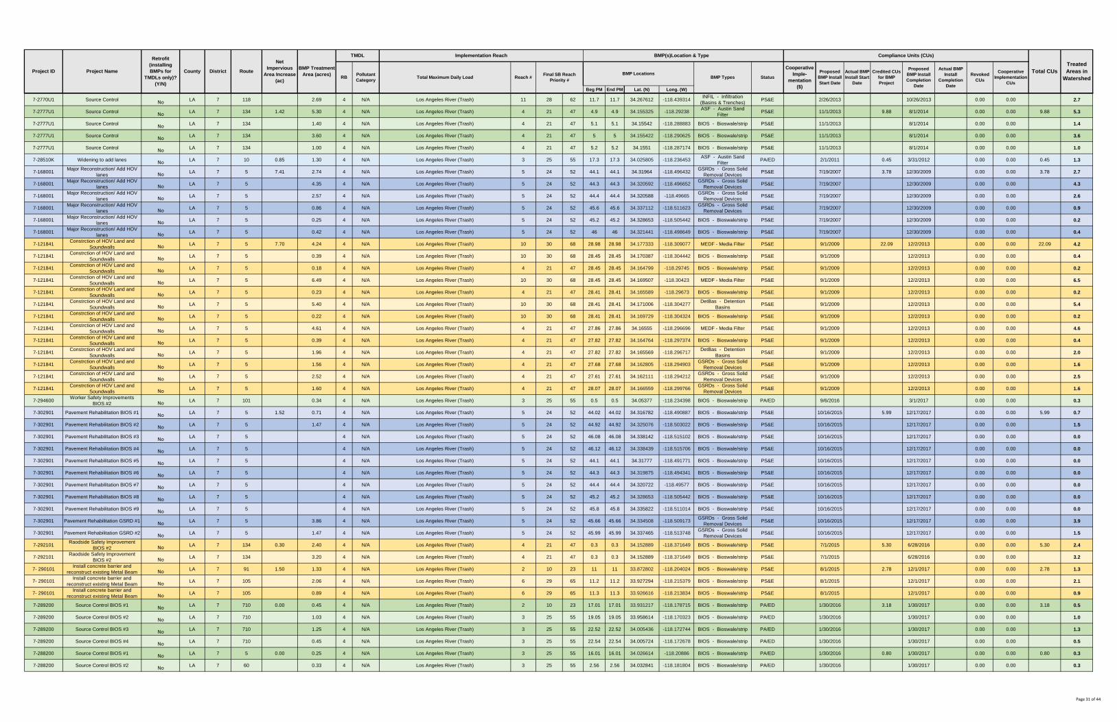
Beg PM End PM Lat. (N) Long. (W)
RouteProject ID Project Name
Retrofit (installing BMPs for
TMDLs only)? (Y/N)
County District Credited CUs for BMP Project
Proposed BMP Install Completion
Date
Actual BMP Install
Completion Date
Net Impervious
Area Increase (ac)
BMP Treatment Area (acres)
TMDL Implementation Reach BMP(s)Location & Type
BMP LocationsBMP Types Status
Revoked CUs
Total CUsTreated Areas in
WatershedRBPollutant Category
Total Maximum Daily Load Reach #Final SB Reach
Priority #
Compliance Units (CUs)
Cooperative Imple-
mentation ($)
Cooperative Implementation
CUs
Proposed BMP Install Start Date
Actual BMP Install Start
Date
7-2770U1 Source Control No LA 7 118 2.69 4 N/A Los Angeles River (Trash) 11 28 62 11.7 11.7 34.267612 -118.439314INFIL - Infiltration
(Basins & Trenches)PS&E 2/26/2013 10/26/2013 0.00 0.00 2.7
7-2777U1 Source Control No LA 7 134 1.42 5.30 4 N/A Los Angeles River (Trash) 4 21 47 4.9 4.9 34.155325 -118.29238ASF - Austin Sand
FilterPS&E 11/1/2013 9.88 8/1/2014 0.00 0.00 9.88 5.3
7-2777U1 Source Control No LA 7 134 1.40 4 N/A Los Angeles River (Trash) 4 21 47 5.1 5.1 34.15542 -118.288883 BIOS - Bioswale/strip PS&E 11/1/2013 8/1/2014 0.00 0.00 1.4
7-2777U1 Source Control No LA 7 134 3.60 4 N/A Los Angeles River (Trash) 4 21 47 5 5 34.155422 -118.290625 BIOS - Bioswale/strip PS&E 11/1/2013 8/1/2014 0.00 0.00 3.6
7-2777U1 Source Control No LA 7 134 1.00 4 N/A Los Angeles River (Trash) 4 21 47 5.2 5.2 34.1551 -118.287174 BIOS - Bioswale/strip PS&E 11/1/2013 8/1/2014 0.00 0.00 1.0
7-28510K Widening to add lanes No LA 7 10 0.85 1.30 4 N/A Los Angeles River (Trash) 3 25 55 17.3 17.3 34.025805 -118.236453ASF - Austin Sand
FilterPA/ED 2/1/2011 0.45 3/31/2012 0.00 0.00 0.45 1.3
7-168001Major Reconstruction/ Add HOV
lanes No LA 7 5 7.41 2.74 4 N/A Los Angeles River (Trash) 5 24 52 44.1 44.1 34.31964 -118.496432GSRDs - Gross Solid
Removal DevicesPS&E 7/19/2007 3.78 12/30/2009 0.00 0.00 3.78 2.7
7-168001Major Reconstruction/ Add HOV
lanes No LA 7 5 4.35 4 N/A Los Angeles River (Trash) 5 24 52 44.3 44.3 34.320592 -118.496652GSRDs - Gross Solid
Removal DevicesPS&E 7/19/2007 12/30/2009 0.00 0.00 4.3
7-168001Major Reconstruction/ Add HOV
lanes No LA 7 5 2.57 4 N/A Los Angeles River (Trash) 5 24 52 44.4 44.4 34.320588 -118.49665GSRDs - Gross Solid
Removal DevicesPS&E 7/19/2007 12/30/2009 0.00 0.00 2.6
7-168001Major Reconstruction/ Add HOV
lanes No LA 7 5 0.86 4 N/A Los Angeles River (Trash) 5 24 52 45.6 45.6 34.337112 -118.511623GSRDs - Gross Solid
Removal DevicesPS&E 7/19/2007 12/30/2009 0.00 0.00 0.9
7-168001Major Reconstruction/ Add HOV
lanes No LA 7 5 0.25 4 N/A Los Angeles River (Trash) 5 24 52 45.2 45.2 34.328653 -118.505442 BIOS - Bioswale/strip PS&E 7/19/2007 12/30/2009 0.00 0.00 0.2
7-168001Major Reconstruction/ Add HOV
lanes No LA 7 5 0.42 4 N/A Los Angeles River (Trash) 5 24 52 46 46 34.321441 -118.498649 BIOS - Bioswale/strip PS&E 7/19/2007 12/30/2009 0.00 0.00 0.4
7-121841Constrction of HOV Land and
Soundwalls No LA 7 5 7.70 4.24 4 N/A Los Angeles River (Trash) 10 30 68 28.98 28.98 34.177333 -118.309077 MEDF - Media Filter PS&E 9/1/2009 22.09 12/2/2013 0.00 0.00 22.09 4.2
7-121841Constrction of HOV Land and
Soundwalls No LA 7 5 0.39 4 N/A Los Angeles River (Trash) 10 30 68 28.45 28.45 34.170387 -118.304442 BIOS - Bioswale/strip PS&E 9/1/2009 12/2/2013 0.00 0.00 0.4
7-121841Constrction of HOV Land and
Soundwalls No LA 7 5 0.18 4 N/A Los Angeles River (Trash) 4 21 47 28.45 28.45 34.164799 -118.29745 BIOS - Bioswale/strip PS&E 9/1/2009 12/2/2013 0.00 0.00 0.2
7-121841Constrction of HOV Land and
Soundwalls No LA 7 5 6.49 4 N/A Los Angeles River (Trash) 10 30 68 28.45 28.45 34.169507 -118.30423 MEDF - Media Filter PS&E 9/1/2009 12/2/2013 0.00 0.00 6.5
7-121841Constrction of HOV Land and
Soundwalls No LA 7 5 0.23 4 N/A Los Angeles River (Trash) 4 21 47 28.41 28.41 34.165589 -118.29673 BIOS - Bioswale/strip PS&E 9/1/2009 12/2/2013 0.00 0.00 0.2
7-121841Constrction of HOV Land and
Soundwalls No LA 7 5 5.40 4 N/A Los Angeles River (Trash) 10 30 68 28.41 28.41 34.171006 -118.304277DetBas - Detention
BasinsPS&E 9/1/2009 12/2/2013 0.00 0.00 5.4
7-121841Constrction of HOV Land and
Soundwalls No LA 7 5 0.22 4 N/A Los Angeles River (Trash) 10 30 68 28.41 28.41 34.169729 -118.304324 BIOS - Bioswale/strip PS&E 9/1/2009 12/2/2013 0.00 0.00 0.2
7-121841Constrction of HOV Land and
Soundwalls No LA 7 5 4.61 4 N/A Los Angeles River (Trash) 4 21 47 27.86 27.86 34.16555 -118.296696 MEDF - Media Filter PS&E 9/1/2009 12/2/2013 0.00 0.00 4.6
7-121841Constrction of HOV Land and
Soundwalls No LA 7 5 0.39 4 N/A Los Angeles River (Trash) 4 21 47 27.82 27.82 34.164764 -118.297374 BIOS - Bioswale/strip PS&E 9/1/2009 12/2/2013 0.00 0.00 0.4
7-121841Constrction of HOV Land and
Soundwalls No LA 7 5 1.96 4 N/A Los Angeles River (Trash) 4 21 47 27.82 27.82 34.165569 -118.296717DetBas - Detention
BasinsPS&E 9/1/2009 12/2/2013 0.00 0.00 2.0
7-121841Constrction of HOV Land and
Soundwalls No LA 7 5 1.56 4 N/A Los Angeles River (Trash) 4 21 47 27.68 27.68 34.162805 -118.294903GSRDs - Gross Solid
Removal DevicesPS&E 9/1/2009 12/2/2013 0.00 0.00 1.6
7-121841Constrction of HOV Land and
Soundwalls No LA 7 5 2.52 4 N/A Los Angeles River (Trash) 4 21 47 27.61 27.61 34.162111 -118.294212GSRDs - Gross Solid
Removal DevicesPS&E 9/1/2009 12/2/2013 0.00 0.00 2.5
7-121841Constrction of HOV Land and
Soundwalls No LA 7 5 1.60 4 N/A Los Angeles River (Trash) 4 21 47 28.07 28.07 34.166559 -118.299766GSRDs - Gross Solid
Removal DevicesPS&E 9/1/2009 12/2/2013 0.00 0.00 1.6
7-294600Worker Safety Improvements
BIOS #2 No LA 7 101 0.34 4 N/A Los Angeles River (Trash) 3 25 55 0.5 0.5 34.05377 -118.234398 BIOS - Bioswale/strip PA/ED 9/6/2016 3/1/2017 0.00 0.00 0.3
7-302901 Pavement Rehabilitation BIOS #1 No LA 7 5 1.52 0.71 4 N/A Los Angeles River (Trash) 5 24 52 44.02 44.02 34.316782 -118.490887 BIOS - Bioswale/strip PS&E 10/16/2015 5.99 12/17/2017 0.00 0.00 5.99 0.7
7-302901 Pavement Rehabilitation BIOS #2 No LA 7 5 1.47 4 N/A Los Angeles River (Trash) 5 24 52 44.92 44.92 34.325076 -118.503022 BIOS - Bioswale/strip PS&E 10/16/2015 12/17/2017 0.00 0.00 1.5
7-302901 Pavement Rehabilitation BIOS #3 No LA 7 5 4 N/A Los Angeles River (Trash) 5 24 52 46.08 46.08 34.338142 -118.515102 BIOS - Bioswale/strip PS&E 10/16/2015 12/17/2017 0.00 0.00 0.0
7-302901 Pavement Rehabilitation BIOS #4 No LA 7 5 4 N/A Los Angeles River (Trash) 5 24 52 46.12 46.12 34.338439 -118.515706 BIOS - Bioswale/strip PS&E 10/16/2015 12/17/2017 0.00 0.00 0.0
7-302901 Pavement Rehabilitation BIOS #5 No LA 7 5 4 N/A Los Angeles River (Trash) 5 24 52 44.1 44.1 34.31777 -118.491771 BIOS - Bioswale/strip PS&E 10/16/2015 12/17/2017 0.00 0.00 0.0
7-302901 Pavement Rehabilitation BIOS #6 No LA 7 5 4 N/A Los Angeles River (Trash) 5 24 52 44.3 44.3 34.319875 -118.494341 BIOS - Bioswale/strip PS&E 10/16/2015 12/17/2017 0.00 0.00 0.0
7-302901 Pavement Rehabilitation BIOS #7 No LA 7 5 4 N/A Los Angeles River (Trash) 5 24 52 44.4 44.4 34.320722 -118.49577 BIOS - Bioswale/strip PS&E 10/16/2015 12/17/2017 0.00 0.00 0.0
7-302901 Pavement Rehabilitation BIOS #8 No LA 7 5 4 N/A Los Angeles River (Trash) 5 24 52 45.2 45.2 34.328653 -118.505442 BIOS - Bioswale/strip PS&E 10/16/2015 12/17/2017 0.00 0.00 0.0
7-302901 Pavement Rehabilitation BIOS #9 No LA 7 5 4 N/A Los Angeles River (Trash) 5 24 52 45.8 45.8 34.335822 -118.511014 BIOS - Bioswale/strip PS&E 10/16/2015 12/17/2017 0.00 0.00 0.0
7-302901 Pavement Rehabilitation GSRD #1 No LA 7 5 3.86 4 N/A Los Angeles River (Trash) 5 24 52 45.66 45.66 34.334508 -118.509173GSRDs - Gross Solid
Removal DevicesPS&E 10/16/2015 12/17/2017 0.00 0.00 3.9
7-302901 Pavement Rehabilitation GSRD #2 No LA 7 5 1.47 4 N/A Los Angeles River (Trash) 5 24 52 45.99 45.99 34.337465 -118.513748GSRDs - Gross Solid
Removal DevicesPS&E 10/16/2015 12/17/2017 0.00 0.00 1.5
7-292101Raodside Safety Improvement
BIOS #2 No LA 7 134 0.30 2.40 4 N/A Los Angeles River (Trash) 4 21 47 0.3 0.3 34.152889 -118.371649 BIOS - Bioswale/strip PS&E 7/1/2015 5.30 6/28/2016 0.00 0.00 5.30 2.4
7-292101Raodside Safety Improvement
BIOS #2 No LA 7 134 3.20 4 N/A Los Angeles River (Trash) 4 21 47 0.3 0.3 34.152889 -118.371649 BIOS - Bioswale/strip PS&E 7/1/2015 6/28/2016 0.00 0.00 3.2
7- 290101Install concrete barrier and
reconstruct existing Metal Beam No LA 7 91 1.50 1.33 4 N/A Los Angeles River (Trash) 2 10 23 11 11 33.872802 -118.204024 BIOS - Bioswale/strip PS&E 8/1/2015 2.78 12/1/2017 0.00 0.00 2.78 1.3
7- 290101Install concrete barrier and
reconstruct existing Metal Beam No LA 7 105 2.06 4 N/A Los Angeles River (Trash) 6 29 65 11.2 11.2 33.927294 -118.215379 BIOS - Bioswale/strip PS&E 8/1/2015 12/1/2017 0.00 0.00 2.1
7- 290101Install concrete barrier and
reconstruct existing Metal Beam No LA 7 105 0.89 4 N/A Los Angeles River (Trash) 6 29 65 11.3 11.3 33.926616 -118.213834 BIOS - Bioswale/strip PS&E 8/1/2015 12/1/2017 0.00 0.00 0.9
7-289200 Source Control BIOS #1 No LA 7 710 0.00 0.45 4 N/A Los Angeles River (Trash) 2 10 23 17.01 17.01 33.931217 -118.178715 BIOS - Bioswale/strip PA/ED 1/30/2016 3.18 1/30/2017 0.00 0.00 3.18 0.5
7-289200 Source Control BIOS #2 No LA 7 710 1.03 4 N/A Los Angeles River (Trash) 3 25 55 19.05 19.05 33.958614 -118.170323 BIOS - Bioswale/strip PA/ED 1/30/2016 1/30/2017 0.00 0.00 1.0
7-289200 Source Control BIOS #3 No LA 7 710 1.25 4 N/A Los Angeles River (Trash) 3 25 55 22.52 22.52 34.005436 -118.172744 BIOS - Bioswale/strip PA/ED 1/30/2016 1/30/2017 0.00 0.00 1.3
7-289200 Source Control BIOS #4 No LA 7 710 0.45 4 N/A Los Angeles River (Trash) 3 25 55 22.54 22.54 34.005724 -118.172678 BIOS - Bioswale/strip PA/ED 1/30/2016 1/30/2017 0.00 0.00 0.5
7-288200 Source Control BIOS #1 No LA 7 5 0.00 0.25 4 N/A Los Angeles River (Trash) 3 25 55 16.01 16.01 34.026614 -118.20886 BIOS - Bioswale/strip PA/ED 1/30/2016 0.80 1/30/2017 0.00 0.00 0.80 0.3
7-288200 Source Control BIOS #2 No LA 7 60 0.33 4 N/A Los Angeles River (Trash) 3 25 55 2.56 2.56 34.032841 -118.181804 BIOS - Bioswale/strip PA/ED 1/30/2016 1/30/2017 0.00 0.00 0.3
Page 31 of 44
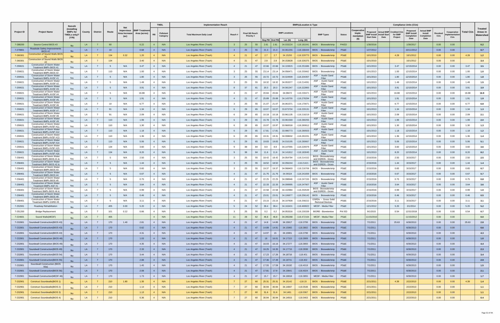
Beg PM End PM Lat. (N) Long. (W)
RouteProject ID Project Name
Retrofit (installing BMPs for
TMDLs only)? (Y/N)
County District Credited CUs for BMP Project
Proposed BMP Install Completion
Date
Actual BMP Install
Completion Date
Net Impervious
Area Increase (ac)
BMP Treatment Area (acres)
TMDL Implementation Reach BMP(s)Location & Type
BMP LocationsBMP Types Status
Revoked CUs
Total CUsTreated Areas in
WatershedRBPollutant Category
Total Maximum Daily Load Reach #Final SB Reach
Priority #
Compliance Units (CUs)
Cooperative Imple-
mentation ($)
Cooperative Implementation
CUs
Proposed BMP Install Start Date
Actual BMP Install Start
Date
7-288200 Source Control BIOS #3 No LA 7 60 0.22 4 N/A Los Angeles River (Trash) 3 25 55 2.61 2.61 34.033224 -118.181041 BIOS - Bioswale/strip PA/ED 1/30/2016 1/30/2017 0.00 0.00 0.2
7-279801Roadside Safety Improvements
BIOS #2 No LA 7 10 0.68 4 N/A Los Angeles River (Trash) 3 25 55 21.3 21.3 34.061255 -118.166444 BIOS - Bioswale/strip PS&E 1/27/2012 10/11/2012 0.00 0.00 0.7
7-260301Construction of Sound Walls BIOS
#1 No LA 7 134 0.32 1.20 4 N/A Los Angeles River (Trash) 4 21 47 2.7 2.7 34.15293 -118.329773 BIOS - Bioswale/strip PS&E 10/1/2010 4.28 10/1/2012 0.00 0.00 4.28 1.2
7-260301Construction of Sound Walls BIOS
#2 No LA 7 134 3.40 4 N/A Los Angeles River (Trash) 4 21 47 2.9 2.9 34.153628 -118.326375 BIOS - Bioswale/strip PS&E 10/1/2010 10/1/2012 0.00 0.00 3.4
7-259021Construction of Storm Water
Treatment BMPs BIOS #1 Yes LA 7 5 N/A 3.47 4 N/A Los Angeles River (Trash) 4 21 47 22.66 22.66 34.103815 -118.251686 BIOS - Bioswale/strip PS&E 10/1/2013 3.47 12/15/2014 0.00 0.00 3.47 3.5
7-259021Construction of Storm Water
Treatment BMPs BIOS #2 Yes LA 7 110 N/A 1.00 4 N/A Los Angeles River (Trash) 3 25 55 23.14 23.14 34.056471 -118.255662 BIOS - Bioswale/strip PS&E 10/1/2013 1.00 12/15/2014 0.00 0.00 1.00 1.0
7-259021Construction of Storm Water Treatment BMPs AVSF #1 Yes LA 7 5 N/A 1.80 4 N/A Los Angeles River (Trash) 3 25 55 15.72 15.72 34.024909 -118.204357
ASF - Austin Sand Filter
PS&E 10/1/2013 1.80 12/15/2014 0.00 0.00 1.80 1.8
7-259021Construction of Storm Water Treatment BMPs AVSF #2 Yes LA 7 5 N/A 1.49 4 N/A Los Angeles River (Trash) 3 25 55 18.32 18.32 34.053377 -118.214091
ASF - Austin Sand Filter
PS&E 10/1/2013 1.49 12/15/2014 0.00 0.00 1.49 1.5
7-259021Construction of Storm Water Treatment BMPs AVSF #3 Yes LA 7 5 N/A 3.91 4 N/A Los Angeles River (Trash) 8 37 81 20.3 20.3 34.081347 -118.222883
ASF - Austin Sand Filter
PS&E 10/1/2013 3.91 12/15/2014 0.00 0.00 3.91 3.9
7-259021Construction of Storm Water Treatment BMPs AVSF #4 Yes LA 7 5 N/A 16.88 4 N/A Los Angeles River (Trash) 4 21 47 20.84 20.84 34.08472 -118.230471
ASF - Austin Sand Filter
PS&E 10/1/2013 16.88 12/15/2014 0.00 0.00 16.88 16.9
7-259021Construction of Storm Water Treatment BMPs AVSF #5 Yes LA 7 5 N/A 1.91 4 N/A Los Angeles River (Trash) 4 21 47 25.89 25.89 34.143755 -118.278294
ASF - Austin Sand Filter
PS&E 10/1/2013 1.91 12/15/2014 0.00 0.00 1.91 1.9
7-259021Construction of Storm Water Treatment BMPs AVSF #6 Yes LA 7 10 N/A 6.77 4 N/A Los Angeles River (Trash) 3 25 55 21.07 21.07 34.061571 -118.170071
ASF - Austin Sand Filter
PS&E 10/1/2013 6.77 12/15/2014 0.00 0.00 6.77 6.8
7-259021Construction of Storm Water Treatment BMPs AVSF #7 Yes LA 7 91 N/A 1.34 4 N/A Los Angeles River (Trash) 6 29 65 10.07 10.07 33.873704 -118.220131
ASF - Austin Sand Filter
PS&E 10/1/2013 1.34 12/15/2014 0.00 0.00 1.34 1.3
7-259021Construction of Storm Water Treatment BMPs AVSF #8 Yes LA 7 91 N/A 2.09 4 N/A Los Angeles River (Trash) 6 29 65 10.18 10.18 33.961135 -118.218219
ASF - Austin Sand Filter
PS&E 10/1/2013 2.09 12/15/2014 0.00 0.00 2.09 2.1
7-259021Construction of Storm Water Treatment BMPs AVSF #9 Yes LA 7 110 N/A 1.99 4 N/A Los Angeles River (Trash) 6 29 65 15.78 15.78 33.961569 -118.280255
ASF - Austin Sand Filter
PS&E 10/1/2013 1.99 12/15/2014 0.00 0.00 1.99 2.0
7-259021Construction of Storm Water Treatment BMPs AVSF #11 Yes LA 7 110 N/A 1.30 4 N/A Los Angeles River (Trash) 6 29 65 15.97 15.97 33.960018 -118.280812
ASF - Austin Sand Filter
PS&E 10/1/2013 1.30 12/15/2014 0.00 0.00 1.30 1.3
7-259021Construction of Storm Water Treatment BMPs AVSF #12 Yes LA 7 110 N/A 1.18 4 N/A Los Angeles River (Trash) 6 29 65 17.81 17.81 33.986773 -118.280503
ASF - Austin Sand Filter
PS&E 10/1/2013 1.18 12/15/2014 0.00 0.00 1.18 1.2
7-259021Construction of Storm Water Treatment BMPs AVSF #13 Yes LA 7 110 N/A 1.36 4 N/A Los Angeles River (Trash) 6 29 65 19.31 19.31 34.008632 -118.281031
ASF - Austin Sand Filter
PS&E 10/1/2013 1.36 12/15/2014 0.00 0.00 1.36 1.4
7-259021Construction of Storm Water Treatment BMPs AVSF #14 Yes LA 7 110 N/A 5.06 4 N/A Los Angeles River (Trash) 6 29 65 19.83 19.83 34.016195 -118.280667
ASF - Austin Sand Filter
PS&E 10/1/2013 5.06 12/15/2014 0.00 0.00 5.06 5.1
7-259021Construction of Storm Water Treatment BMPs AVSF #15 Yes LA 7 134 N/A 3.60 4 N/A Los Angeles River (Trash) 9 38 84 8.9 8.9 34.147055 -118.226979
ASF - Austin Sand Filter
PS&E 10/1/2013 3.60 12/15/2014 0.00 0.00 3.60 3.6
7-259021Construction of Storm Water Treatment BMPs AVSF #16 Yes LA 7 134 N/A 8.20 4 N/A Los Angeles River (Trash) 9 38 84 11.6 11.6 34.141812 -118.183045
ASF - Austin Sand Filter
PS&E 10/1/2013 8.20 12/15/2014 0.00 0.00 8.20 8.2
7-258401Construction of Storm Water Treatment BMPs BIOS #1 & Yes LA 7 5 N/A 2.50 4 N/A Los Angeles River (Trash) 3 25 55 18.42 18.42 34.054794 -118.214152
BIOS - Bioswale/strip and GSRDS - Gross
PS&E 2/15/2016 2.50 3/15/2017 0.00 0.00 2.50 2.5
7-258401Construction of Storm Water Treatment BMPs BIOS #2 & Yes LA 7 5 N/A 1.44 4 N/A Los Angeles River (Trash) 3 25 55 18.52 18.52 34.056244 -118.21421
BIOS - Bioswale/strip and GSRDS - Gross
PS&E 2/15/2016 1.44 3/15/2017 0.00 0.00 1.44 1.4
7-258401Construction of Storm Water
Treatment BMPs BIOS #3 Yes LA 7 5 N/A 0.65 4 N/A Los Angeles River (Trash) 3 25 55 19.37 19.37 34.068403 -118.216706 BIOS - Bioswale/strip PS&E 2/15/2016 0.65 3/15/2017 0.00 0.00 0.65 0.7
7-258401Construction of Storm Water
Treatment BMPs BIOS #4 Yes LA 7 5 N/A 0.67 4 N/A Los Angeles River (Trash) 4 21 47 21.75 21.75 34.09324 -118.241659 BIOS - Bioswale/strip PS&E 2/15/2016 0.67 3/15/2017 0.00 0.00 0.67 0.7
7-258401Construction of Storm Water
Treatment BMPs BIOS #5 Yes LA 7 5 N/A 0.75 4 N/A Los Angeles River (Trash) 4 21 47 22.25 22.25 34.098946 -118.247155 BIOS - Bioswale/strip PS&E 2/15/2016 0.75 3/15/2017 0.00 0.00 0.75 0.8
7-258401Construction of Storm Water
Treatment BMPs ASF #1 Yes LA 7 5 N/A 3.64 4 N/A Los Angeles River (Trash) 4 21 47 22.33 22.33 34.099995 -118.247907ASF - Austin Sand
FilterPS&E 2/15/2016 3.64 3/15/2017 0.00 0.00 3.64 3.6
7-258401Construction of Storm Water Treatment BMPs BIOS #6 & Yes LA 7 5 N/A 0.99 4 N/A Los Angeles River (Trash) 4 21 47 22.58 22.58 34.102984 -118.250539
BIOS - Bioswale/strip and GSRDS - Gross
PS&E 2/15/2016 0.99 3/15/2017 0.00 0.00 0.99 1.0
7-258401Construction of Storm Water
Treatment BMPs BIOS #8 Yes LA 7 5 N/A 0.46 4 N/A Los Angeles River (Trash) 4 21 47 23.01 23.01 34.106877 -118.256142 BIOS - Bioswale/strip PS&E 2/15/2016 0.46 3/15/2017 0.00 0.00 0.46 0.5
7-258401Construction of Storm Water Treatment BMPs GSRD #5 Yes LA 7 5 N/A 3.11 4 N/A Los Angeles River (Trash) 4 21 47 23.15 23.15 34.107928 -118.258222
GSRDs - Gross Solid Removal Devices
PS&E 2/15/2016 3.11 3/15/2017 0.00 0.00 3.11 3.1
7-252001 Roadway Rehabilitation No LA 7 405 0.00 5.20 4 N/A Los Angeles River (Trash) 5 24 52 39.4 39.4 34.163431 -118.469922 MEDF - Media Filter PS&E 12/1/2012 5.20 3/1/2014 0.00 0.00 5.20 5.2
7-251200 Bridge Replacement No LA 7 101 0.12 0.66 4 N/A Los Angeles River (Trash) 3 25 55 0.2 0.2 34.053316 -118.230339 BIORE - Bioretention PA/ ED 9/1/2015 0.54 12/31/2018 0.00 0.00 0.54 0.7
7-224601 Sound Walls(MEDF) No LA 7 405 4 N/A Los Angeles River (Trash) 11 28 62 46.8 46.8 34.265268 -118.472164 MEDF - Media Filter PS&E 11/15/2010 11/15/2012 0.00 0.00 0.0
7-232801 Soundwall Construction(BIOS 43) No LA 7 170 1.40 2.81 4 N/A Los Angeles River (Trash) 4 21 47 14.8 14.85 34.15917 -118.3799 BIOS - Bioswale/strip PS&E 7/1/2011 25.63 6/30/2013 0.00 0.00 25.63 2.8
7-232801 Soundwall Construction(BIOS 43) No LA 7 170 0.62 4 N/A Los Angeles River (Trash) 4 21 47 14.89 14.91 34.15965 -118.3802 BIOS - Bioswale/strip PS&E 7/1/2011 6/30/2013 0.00 0.00 0.6
7-232801 Soundwall Construction(BIOS 43) No LA 7 170 4.31 4 N/A Los Angeles River (Trash) 4 21 47 14.97 15 34.15901 -118.3798 BIOS - Bioswale/strip PS&E 7/1/2011 6/30/2013 0.00 0.00 4.3
7-232801 Soundwall Construction (BIOS 48) No LA 7 170 1.03 4 N/A Los Angeles River (Trash) 4 21 47 16 16.01 34.17315 -118.3909 BIOS - Bioswale/strip PS&E 7/1/2011 6/30/2013 0.00 0.00 1.0
7-232801 Soundwall Construction (BIOS 49) No LA 7 170 4.35 4 N/A Los Angeles River (Trash) 4 21 47 16.03 16.16 34.17277 -118.3893 BIOS - Bioswale/strip PS&E 7/1/2011 6/30/2013 0.00 0.00 4.4
7-232801 Soundwall Construction(BIOS 49) No LA 7 170 2.33 4 N/A Los Angeles River (Trash) 4 21 47 16.25 16.35 34.17716 -118.3938 BIOS - Bioswale/strip PS&E 7/1/2011 6/30/2013 0.00 0.00 2.3
7-232801 Soundwall Construction(BIOS 54) No LA 7 170 3.44 4 N/A Los Angeles River (Trash) 4 21 47 17.23 17.26 34.18716 -118.401 BIOS - Bioswale/strip PS&E 7/1/2011 6/30/2013 0.00 0.00 3.4
7-232801 Soundwall Construction(BIOS 55) No LA 7 170 2.88 4 N/A Los Angeles River (Trash) 4 21 47 17.36 17.49 34.18741 -118.402 BIOS - Bioswale/strip PS&E 7/1/2011 6/30/2013 0.00 0.00 2.9
7-232801Soundwall Construction (BIOS
55a) No LA 7 170 1.45 4 N/A Los Angeles River (Trash) 4 21 47 17.55 17.59 34.19192 -118.4019 BIOS - Bioswale/strip PS&E 7/1/2011 6/30/2013 0.00 0.00 1.5
7-232801 Soundwall Construction(BIOS 56) No LA 7 170 2.08 4 N/A Los Angeles River (Trash) 4 21 47 17.81 17.9 34.19841 -118.4024 BIOS - Bioswale/strip PS&E 7/1/2011 6/30/2013 0.00 0.00 2.1
7-232801 Soundwall Construction(MEDF 46) No LA 7 170 1.73 4 N/A Los Angeles River (Trash) 4 21 47 15.7 15.7 34.16918 -118.3855 MEDF - Media Filter PS&E 7/1/2011 6/30/2013 0.00 0.00 1.7
7-232901 Construct Soundwalls(BIOS 1) No LA 7 210 1.80 1.35 4 N/A Los Angeles River (Trash) 7 27 60 25.31 25.31 34.15142 -118.15 BIOS - Bioswale/strip PS&E 2/21/2011 4.39 2/22/2013 0.00 0.00 4.39 1.4
7-232901 Construct Soundwalls(BIOS 2) No LA 7 210 1.14 4 N/A Los Angeles River (Trash) 7 27 60 30.94 30.94 34.14847 -118.0548 BIOS - Bioswale/strip PS&E 2/21/2011 2/22/2013 0.00 0.00 1.1
7-232901 Construct Soundwalls(BIOS 3) No LA 7 210 1.13 4 N/A Los Angeles River (Trash) 7 27 60 31.6 31.6 34.1481 -118.0367 BIOS - Bioswale/strip PS&E 2/21/2011 2/22/2013 0.00 0.00 1.1
7-232901 Construct Soundwalls(BIOS 4) No LA 7 210 0.36 4 N/A Los Angeles River (Trash) 7 27 60 30.94 30.94 34.14915 -118.0463 BIOS - Bioswale/strip PS&E 2/21/2011 2/22/2013 0.00 0.00 0.4
Page 32 of 44

Beg PM End PM Lat. (N) Long. (W)
RouteProject ID Project Name
Retrofit (installing BMPs for
TMDLs only)? (Y/N)
County District Credited CUs for BMP Project
Proposed BMP Install Completion
Date
Actual BMP Install
Completion Date
Net Impervious
Area Increase (ac)
BMP Treatment Area (acres)
TMDL Implementation Reach BMP(s)Location & Type
BMP LocationsBMP Types Status
Revoked CUs
Total CUsTreated Areas in
WatershedRBPollutant Category
Total Maximum Daily Load Reach #Final SB Reach
Priority #
Compliance Units (CUs)
Cooperative Imple-
mentation ($)
Cooperative Implementation
CUs
Proposed BMP Install Start Date
Actual BMP Install Start
Date
7-232901 Construct Soundwalls(BIOS 5) No LA 7 210 0.37 4 N/A Los Angeles River (Trash) 7 27 60 31.94 31.94 34.14759 -118.0293 BIOS - Bioswale/strip PS&E 2/21/2011 2/22/2013 0.00 0.00 0.4
7-232901 Construct Soundwalls(ASF 1) No LA 7 210 1.84 4 N/A Los Angeles River (Trash) 7 27 60 31.94 31.94 34.14788 -118.0304ASF - Austin Sand
FilterPS&E 2/21/2011 2/22/2013 0.00 0.00 1.8
7-258931Construction of Stormwater
BMP's(INFIL #1) Yes LA 7 210 N/A 1.44 4 N/A Los Angeles River (Trash) 9 38 84 15.9 15.9 34.230168 -118.261689INFIL - Infiltration
(Basins & Trenches)PS&E 11/21/2012 1.44 10/14/2014 0.00 0.00 1.44 1.4
7-258931Construction of Stormwater
BMP'S(BIOS #1 95a) Yes LA 7 210 N/A 0.64 4 N/A Los Angeles River (Trash) 8 37 81 19.75 19.75 34.206929 -118.202434 BIOS - Bioswale/strip PS&E 11/21/2012 0.64 10/14/2014 0.00 0.00 0.64 0.6
7-258931Construction of Stormwater
BMP's(BIOS #1 96a) Yes LA 7 210 N/A 0.64 4 N/A Los Angeles River (Trash) 8 37 81 19.75 19.75 34.206929 -118.202434 BIOS - Bioswale/strip PS&E 11/21/2012 0.64 10/14/2014 0.00 0.00 0.64 0.6
7-258931Construction of Stormwater
BMP's(BIOS #1 97a) Yes LA 7 210 N/A 0.21 4 N/A Los Angeles River (Trash) 8 37 81 19.75 19.75 34.206929 -118.202434 BIOS - Bioswale/strip PS&E 11/21/2012 0.21 10/14/2014 0.00 0.00 0.21 0.2
7-258931Construction of Stormwater
BMP's(AVSF #3) Yes LA 7 210 N/A 3.32 4 N/A Los Angeles River (Trash) 7 27 60 27 27 34.152309 -118.12065ASF - Austin Sand
FilterPS&E 11/21/2012 3.32 10/14/2014 0.00 0.00 3.32 3.3
7-258931Construction of Stormwater
BMP's(AVSF #4) Yes LA 7 210 N/A 3.62 4 N/A Los Angeles River (Trash) 7 27 60 27.49 27.49 34.152463 -118.112085ASF - Austin Sand
FilterPS&E 11/21/2012 3.62 10/14/2014 0.00 0.00 3.62 3.6
7-258931Construction of Stormwater
BMP's(AVSF #5) Yes LA 7 210 N/A 3.49 4 N/A Los Angeles River (Trash) 7 27 60 27.73 27.73 34.152512 -118.107896ASF - Austin Sand
FilterPS&E 11/21/2012 3.49 10/14/2014 0.00 0.00 3.49 3.5
7-258931Construction of Stormwater
BMP's(AVSF #6) Yes LA 7 210 N/A 5.37 4 N/A Los Angeles River (Trash) 7 27 60 27.94 27.94 34.152519 -118.104233ASF - Austin Sand
FilterPS&E 11/21/2012 5.37 10/14/2014 0.00 0.00 5.37 5.4
7-258931Construction of Stormwater
BMP's(AVSF #7) Yes LA 7 210 N/A 2.34 4 N/A Los Angeles River (Trash) 7 27 60 28.53 28.53 34.152466 -118.093942ASF - Austin Sand
FilterPS&E 11/21/2012 2.34 10/14/2014 0.00 0.00 2.34 2.3
7-258931Construction of Stormwater
BMP's(AVSF #8) Yes LA 7 210 N/A 2.57 4 N/A Los Angeles River (Trash) 7 27 60 28.79 28.79 34.151005 -118.089821ASF - Austin Sand
FilterPS&E 11/21/2012 2.57 10/14/2014 0.00 0.00 2.57 2.6
7-258931Construction of Stormwater
BMP's(AVSF #9) Yes LA 7 210 N/A 3.97 4 N/A Los Angeles River (Trash) 7 27 60 29.69 29.69 34.148106 -118.075404ASF - Austin Sand
FilterPS&E 11/21/2012 3.97 10/14/2014 0.00 0.00 3.97 4.0
7-258931Construction of Stormwater
BMP's(BIOS #18) Yes LA 7 210 N/A 0.32 4 N/A Los Angeles River (Trash) 7 27 60 29.83 29.83 34.148721 -118.067429 BIOS - Bioswale/strip PS&E 11/21/2012 0.32 10/14/2014 0.00 0.00 0.32 0.3
7-258931Construction of Stormwater
BMP's(BIOS #19) Yes LA 7 210 N/A 1.61 4 N/A Los Angeles River (Trash) 7 27 60 30.64 30.64 34.148813 -118.053459 BIOS - Bioswale/strip PS&E 11/21/2012 1.61 10/14/2014 0.00 0.00 1.61 1.6
7-258931Construction of Stormwater
BMP's(BIOS #11) Yes LA 7 210 N/A 0.40 4 N/A Los Angeles River (Trash) 7 27 60 32.83 32.83 34.14117 -118.017577 BIOS - Bioswale/strip PS&E 11/21/2012 0.40 10/14/2014 0.00 0.00 0.40 0.4
7-258931Construction of Stormwater
BMP's(BIOS #21) Yes LA 7 210 N/A 2.07 4 N/A Los Angeles River (Trash) 7 27 60 33.01 33.01 34.139148 -118.015496 BIOS - Bioswale/strip PS&E 11/21/2012 2.07 10/14/2014 0.00 0.00 2.07 2.1
7-258931Construction of Stormwater
BMP's(BIOS #14) Yes LA 7 210 N/A 1.62 4 N/A Los Angeles River (Trash) 7 27 60 33.73 33.73 34.135474 -118.004137ASF - Austin Sand
FilterPS&E 11/21/2012 1.62 10/14/2014 0.00 0.00 1.62 1.6
7-258931Construction of Stormwater
BMP's(AVSF #15) Yes LA 7 210 N/A 0.83 4 N/A Los Angeles River (Trash) 7 27 60 34.66 34.66 34.135456 -117.987911ASF - Austin Sand
FilterPS&E 11/21/2012 0.83 10/14/2014 0.00 0.00 0.83 0.8
7-258931Construction of Stormwater
BMP's(INFIL # 16) Yes LA 7 210 N/A 0.93 4 N/A Los Angeles River (Trash) 7 27 60 35.05 35.05 34.135401 -117.981091INFIL - Infiltration
(Basins & Trenches)PS&E 11/21/2012 0.93 10/14/2014 0.00 0.00 0.93 0.9
7-258931Construction of Stormwater
BMP's(AVSF #17) Yes LA 7 210 N/A 3.36 4 N/A Los Angeles River (Trash) 7 27 60 35.29 35.29 34.135331 -117.976922ASF - Austin Sand
FilterPS&E 11/21/2012 3.36 10/14/2014 0.00 0.00 3.36 3.4
7-259011Construction of Storm Water
Treatment BMPs ASF #1 Yes LA 7 710 N/A 7.67 4 N/A Los Angeles River (Trash) 1 19 43 7.01 7.01 33.791758 -118.207703ASF - Austin Sand
FilterPS&E 11/15/2013 7.67 8/15/2014 0.00 0.00 7.67 7.7
7-259011Construction of Storm Water
Treatment BMPs ASF #2 Yes LA 7 710 N/A 6.00 4 N/A Los Angeles River (Trash) 2 10 23 11.93 11.93 33.861579 -118.199964ASF - Austin Sand
FilterPS&E 11/15/2013 6.00 8/15/2014 0.00 0.00 6.00 6.0
7-259011Construction of Storm Water
Treatment BMPs BIOS #1 Yes LA 7 710 N/A 4.99 4 N/A Los Angeles River (Trash) 1 19 43 8.13 8.13 33.807886 -118.207007 BIOS - Bioswale/strip PS&E 11/15/2013 4.99 8/15/2014 0.00 0.00 4.99 5.0
7-259011Construction of Storm Water
Treatment BMPs BIOS #2 Yes LA 7 710 N/A 1.26 4 N/A Los Angeles River (Trash) 1 19 43 9.14 9.14 33.822595 -118.206955 BIOS - Bioswale/strip PS&E 11/15/2013 1.26 8/15/2014 0.00 0.00 1.26 1.3
7-259011Construction of Storm Water
Treatment BMPs BIOS #3 Yes LA 7 710 N/A 0.50 4 N/A Los Angeles River (Trash) 1 19 43 9.44 9.44 33.826889 -118.207595 BIOS - Bioswale/strip PS&E 11/15/2013 0.50 8/15/2014 0.00 0.00 0.50 0.5
7-259011Construction of Storm Water
Treatment BMPs BIOS #4 Yes LA 7 710 N/A 0.62 4 N/A Los Angeles River (Trash) 1 19 43 9.57 9.57 33.828712 -118.208125 BIOS - Bioswale/strip PS&E 11/15/2013 0.62 8/15/2014 0.00 0.00 0.62 0.6
7-259011Construction of Storm Water
Treatment BMPs BIOS #5 Yes LA 7 710 N/A 2.01 4 N/A Los Angeles River (Trash) 1 19 43 9.69 9.69 33.83041 -118.208589 BIOS - Bioswale/strip PS&E 11/15/2013 2.01 8/15/2014 0.00 0.00 2.01 2.0
7-259011Construction of Storm Water
Treatment BMPs BIOS #6 Yes LA 7 710 N/A 1.41 4 N/A Los Angeles River (Trash) 1 19 43 9.82 9.82 33.832282 -118.20887 BIOS - Bioswale/strip PS&E 11/15/2013 1.41 8/15/2014 0.00 0.00 1.41 1.4
7-259011Construction of Storm Water
Treatment BMPs BIOS #7 Yes LA 7 710 N/A 1.99 4 N/A Los Angeles River (Trash) 1 19 43 9.83 9.83 33.832427 -118.208869 BIOS - Bioswale/strip PS&E 11/15/2013 1.99 8/15/2014 0.00 0.00 1.99 2.0
7-259011Construction of Storm Water
Treatment BMPs BIOS #8 Yes LA 7 710 N/A 2.21 4 N/A Los Angeles River (Trash) 1 19 43 9.95 9.95 33.834181 -118.208735 BIOS - Bioswale/strip PS&E 11/15/2013 2.21 8/15/2014 0.00 0.00 2.21 2.2
7-259011Construction of Storm Water
Treatment BMPs BIOS #9 Yes LA 7 710 N/A 1.35 4 N/A Los Angeles River (Trash) 1 19 43 10.4 10.4 33.84054 -118.207057 BIOS - Bioswale/strip PS&E 11/15/2013 1.35 8/15/2014 0.00 0.00 1.35 1.4
7-259011Construction of Storm Water Treatment BMPs BIOS #10 Yes LA 7 710 N/A 1.24 4 N/A Los Angeles River (Trash) 2 10 23 13.05 13.05 33.876602 -118.192857 BIOS - Bioswale/strip PS&E 11/15/2013 1.24 8/15/2014 0.00 0.00 1.24 1.2
7-259011Construction of Storm Water Treatment BMPs BIOS #11 Yes LA 7 710 N/A 2.08 4 N/A Los Angeles River (Trash) 2 10 23 13.23 13.23 33.879165 -118.192254 BIOS - Bioswale/strip PS&E 11/15/2013 2.08 8/15/2014 0.00 0.00 2.08 2.1
7-259011Construction of Storm Water Treatment BMPs BIOS #12 Yes LA 7 710 N/A 1.07 4 N/A Los Angeles River (Trash) 2 10 23 15.76 15.76 33.91379 -118.179841 BIOS - Bioswale/strip PS&E 11/15/2013 1.07 8/15/2014 0.00 0.00 1.07 1.1
7-2X9201 Permanent Slope Restoration No LA 7 91 0.79 1.34 4 C Los Angeles River and Tributaries (Metals) 6 29 67 10.7 10.7 33.873601 -118.209135 MEDF - Media Filter PS&E 9/7/2012 12.15 6/10/2014 0.00 0.00 12.15 1.3
7-2X9201 Permanent Slope Restoration No LA 7 91 2.09 4 C Los Angeles River and Tributaries (Metals) 6 29 67 10.18 10.18 33.873534 -118.218219 MEDF - Media Filter PS&E 9/7/2012 6/10/2014 0.00 0.00 2.1
7-2X9201 Permanent Slope Restoration No LA 7 91 0.60 4 C Los Angeles River and Tributaries (Metals) 6 29 67 10.33 10.33 33.873468 -118.215595 BIOS - Bioswale/strip PS&E 9/7/2012 6/10/2014 0.00 0.00 0.6
7-2X9201 Permanent Slope Restoration No LA 7 91 3.57 4 C Los Angeles River and Tributaries (Metals) 6 29 67 10.43 10.43 33.873495 -118.213849 MEDF - Media Filter PS&E 9/7/2012 6/10/2014 0.00 0.00 3.6
7-2X9201 Permanent Slope Restoration No LA 7 91 0.41 4 C Los Angeles River and Tributaries (Metals) 2 10 25 11.03 11.03 33.872733 -118.20351 BIOS - Bioswale/strip PS&E 9/7/2012 6/10/2014 0.00 0.00 0.4
7-2X9201 Permanent Slope Restoration No LA 7 91 3.62 4 C Los Angeles River and Tributaries (Metals) 2 10 25 11.07 11.07 33.872678 -118.202824 MEDF - Media Filter PS&E 9/7/2012 6/10/2014 0.00 0.00 3.6
7-2X9201 Permanent Slope Restoration No LA 7 91 0.44 4 C Los Angeles River and Tributaries (Metals) 2 10 25 11.16 11.16 33.872708 -118.201276 BIOS - Bioswale/strip PS&E 9/7/2012 6/10/2014 0.00 0.00 0.4
7-2X9201 Permanent Slope Restoration No LA 7 91 0.87 4 C Los Angeles River and Tributaries (Metals) 2 10 25 11.63 11.63 33.87522 -118.193692 BIOS - Bioswale/strip PS&E 9/7/2012 6/10/2014 0.00 0.00 0.9
7-1218W1Modify Interchagne and Add HOV
Lanes No LA 7 5 4 C Los Angeles River and Tributaries (Metals) 10 30 70 31.59 31.59 34.203068 -118.340771ASF - Austin Sand
FilterPS&E 12/24/2012 12/7/2015 0.00 0.00 0.0
7-121901 HOV Land & Pavement Rehab No LA 7 5 24.22 2.80 4 C Los Angeles River and Tributaries (Metals) 11 28 64 38.54 38.54 34.257383 -118.434778 BIOS - Bioswale/strip PS&E 10/1/2009 4.48 9/10/2013 0.00 0.00 4.48 2.8
7-121901 HOV Land & Pavement Rehab No LA 7 5 2.80 4 C Los Angeles River and Tributaries (Metals) 11 28 64 38.54 38.54 34.256751 -118.436071 BIOS - Bioswale/strip PS&E 10/1/2009 9/10/2013 0.00 0.00 2.8
7-121901 HOV Land & Pavement Rehab No LA 7 5 0.30 4 C Los Angeles River and Tributaries (Metals) 11 28 64 38.46 38.46 34.255971 -118.434308 BIOS - Bioswale/strip PS&E 10/1/2009 9/10/2013 0.00 0.00 0.3
7-121901 HOV Land & Pavement Rehab No LA 7 5 2.30 4 C Los Angeles River and Tributaries (Metals) 11 28 64 37.4 37.4 34.244546 -118.422219 BIOS - Bioswale/strip PS&E 10/1/2009 9/10/2013 0.00 0.00 2.3
Page 33 of 44
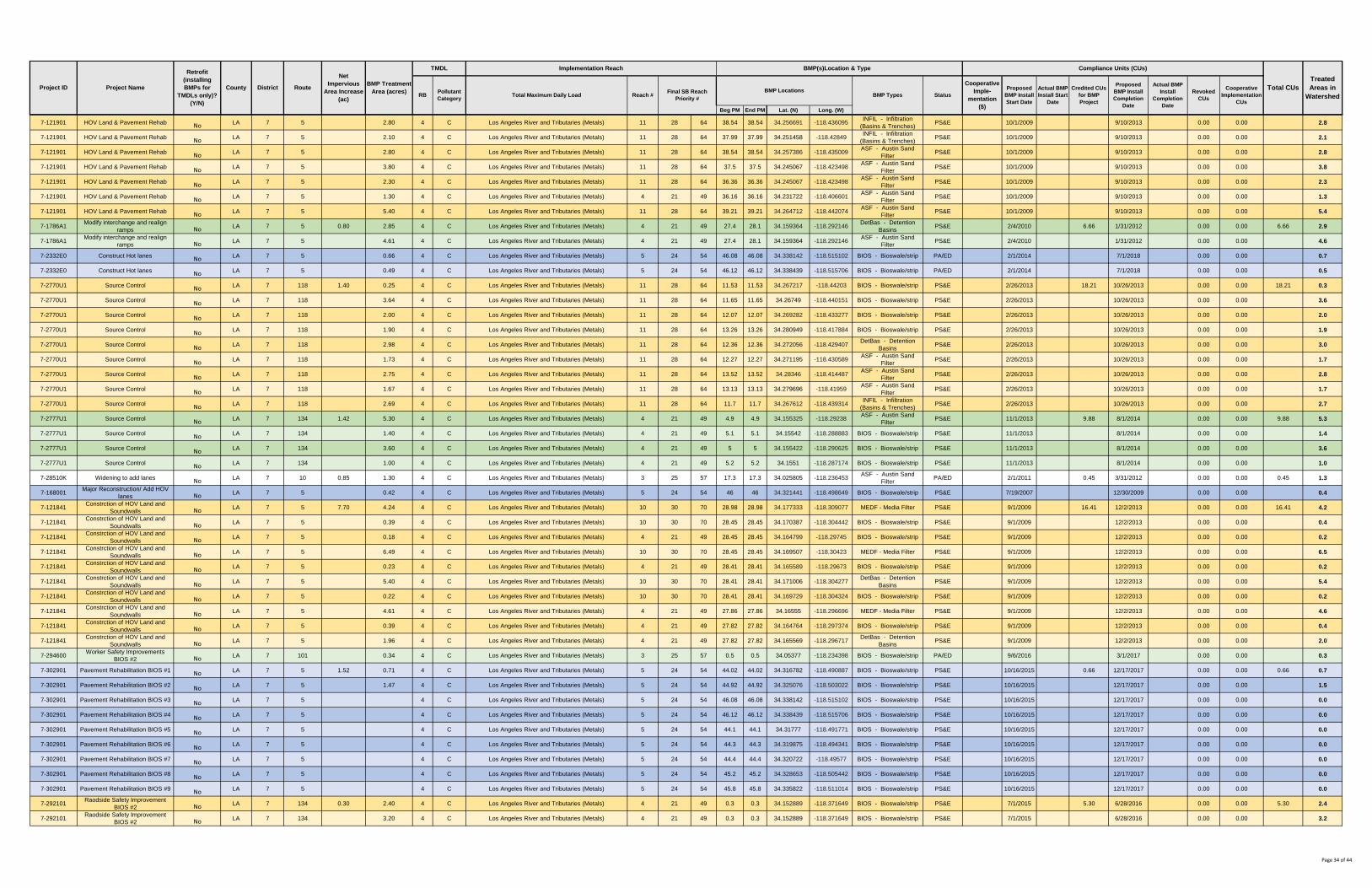
Beg PM End PM Lat. (N) Long. (W)
RouteProject ID Project Name
Retrofit (installing BMPs for
TMDLs only)? (Y/N)
County District Credited CUs for BMP Project
Proposed BMP Install Completion
Date
Actual BMP Install
Completion Date
Net Impervious
Area Increase (ac)
BMP Treatment Area (acres)
TMDL Implementation Reach BMP(s)Location & Type
BMP LocationsBMP Types Status
Revoked CUs
Total CUsTreated Areas in
WatershedRBPollutant Category
Total Maximum Daily Load Reach #Final SB Reach
Priority #
Compliance Units (CUs)
Cooperative Imple-
mentation ($)
Cooperative Implementation
CUs
Proposed BMP Install Start Date
Actual BMP Install Start
Date
7-121901 HOV Land & Pavement Rehab No LA 7 5 2.80 4 C Los Angeles River and Tributaries (Metals) 11 28 64 38.54 38.54 34.256691 -118.436095INFIL - Infiltration
(Basins & Trenches)PS&E 10/1/2009 9/10/2013 0.00 0.00 2.8
7-121901 HOV Land & Pavement Rehab No LA 7 5 2.10 4 C Los Angeles River and Tributaries (Metals) 11 28 64 37.99 37.99 34.251458 -118.42849INFIL - Infiltration
(Basins & Trenches)PS&E 10/1/2009 9/10/2013 0.00 0.00 2.1
7-121901 HOV Land & Pavement Rehab No LA 7 5 2.80 4 C Los Angeles River and Tributaries (Metals) 11 28 64 38.54 38.54 34.257386 -118.435009ASF - Austin Sand
FilterPS&E 10/1/2009 9/10/2013 0.00 0.00 2.8
7-121901 HOV Land & Pavement Rehab No LA 7 5 3.80 4 C Los Angeles River and Tributaries (Metals) 11 28 64 37.5 37.5 34.245067 -118.423498ASF - Austin Sand
FilterPS&E 10/1/2009 9/10/2013 0.00 0.00 3.8
7-121901 HOV Land & Pavement Rehab No LA 7 5 2.30 4 C Los Angeles River and Tributaries (Metals) 11 28 64 36.36 36.36 34.245067 -118.423498ASF - Austin Sand
FilterPS&E 10/1/2009 9/10/2013 0.00 0.00 2.3
7-121901 HOV Land & Pavement Rehab No LA 7 5 1.30 4 C Los Angeles River and Tributaries (Metals) 4 21 49 36.16 36.16 34.231722 -118.406601ASF - Austin Sand
FilterPS&E 10/1/2009 9/10/2013 0.00 0.00 1.3
7-121901 HOV Land & Pavement Rehab No LA 7 5 5.40 4 C Los Angeles River and Tributaries (Metals) 11 28 64 39.21 39.21 34.264712 -118.442074ASF - Austin Sand
FilterPS&E 10/1/2009 9/10/2013 0.00 0.00 5.4
7-1786A1Modify interchange and realign
ramps No LA 7 5 0.80 2.85 4 C Los Angeles River and Tributaries (Metals) 4 21 49 27.4 28.1 34.159364 -118.292146DetBas - Detention
BasinsPS&E 2/4/2010 6.66 1/31/2012 0.00 0.00 6.66 2.9
7-1786A1Modify interchange and realign
ramps No LA 7 5 4.61 4 C Los Angeles River and Tributaries (Metals) 4 21 49 27.4 28.1 34.159364 -118.292146ASF - Austin Sand
FilterPS&E 2/4/2010 1/31/2012 0.00 0.00 4.6
7-2332E0 Construct Hot lanes No LA 7 5 0.66 4 C Los Angeles River and Tributaries (Metals) 5 24 54 46.08 46.08 34.338142 -118.515102 BIOS - Bioswale/strip PA/ED 2/1/2014 7/1/2018 0.00 0.00 0.7
7-2332E0 Construct Hot lanes No LA 7 5 0.49 4 C Los Angeles River and Tributaries (Metals) 5 24 54 46.12 46.12 34.338439 -118.515706 BIOS - Bioswale/strip PA/ED 2/1/2014 7/1/2018 0.00 0.00 0.5
7-2770U1 Source Control No LA 7 118 1.40 0.25 4 C Los Angeles River and Tributaries (Metals) 11 28 64 11.53 11.53 34.267217 -118.44203 BIOS - Bioswale/strip PS&E 2/26/2013 18.21 10/26/2013 0.00 0.00 18.21 0.3
7-2770U1 Source Control No LA 7 118 3.64 4 C Los Angeles River and Tributaries (Metals) 11 28 64 11.65 11.65 34.26749 -118.440151 BIOS - Bioswale/strip PS&E 2/26/2013 10/26/2013 0.00 0.00 3.6
7-2770U1 Source Control No LA 7 118 2.00 4 C Los Angeles River and Tributaries (Metals) 11 28 64 12.07 12.07 34.269282 -118.433277 BIOS - Bioswale/strip PS&E 2/26/2013 10/26/2013 0.00 0.00 2.0
7-2770U1 Source Control No LA 7 118 1.90 4 C Los Angeles River and Tributaries (Metals) 11 28 64 13.26 13.26 34.280949 -118.417884 BIOS - Bioswale/strip PS&E 2/26/2013 10/26/2013 0.00 0.00 1.9
7-2770U1 Source Control No LA 7 118 2.98 4 C Los Angeles River and Tributaries (Metals) 11 28 64 12.36 12.36 34.272056 -118.429407DetBas - Detention
BasinsPS&E 2/26/2013 10/26/2013 0.00 0.00 3.0
7-2770U1 Source Control No LA 7 118 1.73 4 C Los Angeles River and Tributaries (Metals) 11 28 64 12.27 12.27 34.271195 -118.430589ASF - Austin Sand
FilterPS&E 2/26/2013 10/26/2013 0.00 0.00 1.7
7-2770U1 Source Control No LA 7 118 2.75 4 C Los Angeles River and Tributaries (Metals) 11 28 64 13.52 13.52 34.28346 -118.414487ASF - Austin Sand
FilterPS&E 2/26/2013 10/26/2013 0.00 0.00 2.8
7-2770U1 Source Control No LA 7 118 1.67 4 C Los Angeles River and Tributaries (Metals) 11 28 64 13.13 13.13 34.279696 -118.41959ASF - Austin Sand
FilterPS&E 2/26/2013 10/26/2013 0.00 0.00 1.7
7-2770U1 Source Control No LA 7 118 2.69 4 C Los Angeles River and Tributaries (Metals) 11 28 64 11.7 11.7 34.267612 -118.439314INFIL - Infiltration
(Basins & Trenches)PS&E 2/26/2013 10/26/2013 0.00 0.00 2.7
7-2777U1 Source Control No LA 7 134 1.42 5.30 4 C Los Angeles River and Tributaries (Metals) 4 21 49 4.9 4.9 34.155325 -118.29238ASF - Austin Sand
FilterPS&E 11/1/2013 9.88 8/1/2014 0.00 0.00 9.88 5.3
7-2777U1 Source Control No LA 7 134 1.40 4 C Los Angeles River and Tributaries (Metals) 4 21 49 5.1 5.1 34.15542 -118.288883 BIOS - Bioswale/strip PS&E 11/1/2013 8/1/2014 0.00 0.00 1.4
7-2777U1 Source Control No LA 7 134 3.60 4 C Los Angeles River and Tributaries (Metals) 4 21 49 5 5 34.155422 -118.290625 BIOS - Bioswale/strip PS&E 11/1/2013 8/1/2014 0.00 0.00 3.6
7-2777U1 Source Control No LA 7 134 1.00 4 C Los Angeles River and Tributaries (Metals) 4 21 49 5.2 5.2 34.1551 -118.287174 BIOS - Bioswale/strip PS&E 11/1/2013 8/1/2014 0.00 0.00 1.0
7-28510K Widening to add lanes No LA 7 10 0.85 1.30 4 C Los Angeles River and Tributaries (Metals) 3 25 57 17.3 17.3 34.025805 -118.236453ASF - Austin Sand
FilterPA/ED 2/1/2011 0.45 3/31/2012 0.00 0.00 0.45 1.3
7-168001Major Reconstruction/ Add HOV
lanes No LA 7 5 0.42 4 C Los Angeles River and Tributaries (Metals) 5 24 54 46 46 34.321441 -118.498649 BIOS - Bioswale/strip PS&E 7/19/2007 12/30/2009 0.00 0.00 0.4
7-121841Constrction of HOV Land and
Soundwalls No LA 7 5 7.70 4.24 4 C Los Angeles River and Tributaries (Metals) 10 30 70 28.98 28.98 34.177333 -118.309077 MEDF - Media Filter PS&E 9/1/2009 16.41 12/2/2013 0.00 0.00 16.41 4.2
7-121841Constrction of HOV Land and
Soundwalls No LA 7 5 0.39 4 C Los Angeles River and Tributaries (Metals) 10 30 70 28.45 28.45 34.170387 -118.304442 BIOS - Bioswale/strip PS&E 9/1/2009 12/2/2013 0.00 0.00 0.4
7-121841Constrction of HOV Land and
Soundwalls No LA 7 5 0.18 4 C Los Angeles River and Tributaries (Metals) 4 21 49 28.45 28.45 34.164799 -118.29745 BIOS - Bioswale/strip PS&E 9/1/2009 12/2/2013 0.00 0.00 0.2
7-121841Constrction of HOV Land and
Soundwalls No LA 7 5 6.49 4 C Los Angeles River and Tributaries (Metals) 10 30 70 28.45 28.45 34.169507 -118.30423 MEDF - Media Filter PS&E 9/1/2009 12/2/2013 0.00 0.00 6.5
7-121841Constrction of HOV Land and
Soundwalls No LA 7 5 0.23 4 C Los Angeles River and Tributaries (Metals) 4 21 49 28.41 28.41 34.165589 -118.29673 BIOS - Bioswale/strip PS&E 9/1/2009 12/2/2013 0.00 0.00 0.2
7-121841Constrction of HOV Land and
Soundwalls No LA 7 5 5.40 4 C Los Angeles River and Tributaries (Metals) 10 30 70 28.41 28.41 34.171006 -118.304277DetBas - Detention
BasinsPS&E 9/1/2009 12/2/2013 0.00 0.00 5.4
7-121841Constrction of HOV Land and
Soundwalls No LA 7 5 0.22 4 C Los Angeles River and Tributaries (Metals) 10 30 70 28.41 28.41 34.169729 -118.304324 BIOS - Bioswale/strip PS&E 9/1/2009 12/2/2013 0.00 0.00 0.2
7-121841Constrction of HOV Land and
Soundwalls No LA 7 5 4.61 4 C Los Angeles River and Tributaries (Metals) 4 21 49 27.86 27.86 34.16555 -118.296696 MEDF - Media Filter PS&E 9/1/2009 12/2/2013 0.00 0.00 4.6
7-121841Constrction of HOV Land and
Soundwalls No LA 7 5 0.39 4 C Los Angeles River and Tributaries (Metals) 4 21 49 27.82 27.82 34.164764 -118.297374 BIOS - Bioswale/strip PS&E 9/1/2009 12/2/2013 0.00 0.00 0.4
7-121841Constrction of HOV Land and
Soundwalls No LA 7 5 1.96 4 C Los Angeles River and Tributaries (Metals) 4 21 49 27.82 27.82 34.165569 -118.296717DetBas - Detention
BasinsPS&E 9/1/2009 12/2/2013 0.00 0.00 2.0
7-294600Worker Safety Improvements
BIOS #2 No LA 7 101 0.34 4 C Los Angeles River and Tributaries (Metals) 3 25 57 0.5 0.5 34.05377 -118.234398 BIOS - Bioswale/strip PA/ED 9/6/2016 3/1/2017 0.00 0.00 0.3
7-302901 Pavement Rehabilitation BIOS #1 No LA 7 5 1.52 0.71 4 C Los Angeles River and Tributaries (Metals) 5 24 54 44.02 44.02 34.316782 -118.490887 BIOS - Bioswale/strip PS&E 10/16/2015 0.66 12/17/2017 0.00 0.00 0.66 0.7
7-302901 Pavement Rehabilitation BIOS #2 No LA 7 5 1.47 4 C Los Angeles River and Tributaries (Metals) 5 24 54 44.92 44.92 34.325076 -118.503022 BIOS - Bioswale/strip PS&E 10/16/2015 12/17/2017 0.00 0.00 1.5
7-302901 Pavement Rehabilitation BIOS #3 No LA 7 5 4 C Los Angeles River and Tributaries (Metals) 5 24 54 46.08 46.08 34.338142 -118.515102 BIOS - Bioswale/strip PS&E 10/16/2015 12/17/2017 0.00 0.00 0.0
7-302901 Pavement Rehabilitation BIOS #4 No LA 7 5 4 C Los Angeles River and Tributaries (Metals) 5 24 54 46.12 46.12 34.338439 -118.515706 BIOS - Bioswale/strip PS&E 10/16/2015 12/17/2017 0.00 0.00 0.0
7-302901 Pavement Rehabilitation BIOS #5 No LA 7 5 4 C Los Angeles River and Tributaries (Metals) 5 24 54 44.1 44.1 34.31777 -118.491771 BIOS - Bioswale/strip PS&E 10/16/2015 12/17/2017 0.00 0.00 0.0
7-302901 Pavement Rehabilitation BIOS #6 No LA 7 5 4 C Los Angeles River and Tributaries (Metals) 5 24 54 44.3 44.3 34.319875 -118.494341 BIOS - Bioswale/strip PS&E 10/16/2015 12/17/2017 0.00 0.00 0.0
7-302901 Pavement Rehabilitation BIOS #7 No LA 7 5 4 C Los Angeles River and Tributaries (Metals) 5 24 54 44.4 44.4 34.320722 -118.49577 BIOS - Bioswale/strip PS&E 10/16/2015 12/17/2017 0.00 0.00 0.0
7-302901 Pavement Rehabilitation BIOS #8 No LA 7 5 4 C Los Angeles River and Tributaries (Metals) 5 24 54 45.2 45.2 34.328653 -118.505442 BIOS - Bioswale/strip PS&E 10/16/2015 12/17/2017 0.00 0.00 0.0
7-302901 Pavement Rehabilitation BIOS #9 No LA 7 5 4 C Los Angeles River and Tributaries (Metals) 5 24 54 45.8 45.8 34.335822 -118.511014 BIOS - Bioswale/strip PS&E 10/16/2015 12/17/2017 0.00 0.00 0.0
7-292101Raodside Safety Improvement
BIOS #2 No LA 7 134 0.30 2.40 4 C Los Angeles River and Tributaries (Metals) 4 21 49 0.3 0.3 34.152889 -118.371649 BIOS - Bioswale/strip PS&E 7/1/2015 5.30 6/28/2016 0.00 0.00 5.30 2.4
7-292101Raodside Safety Improvement
BIOS #2 No LA 7 134 3.20 4 C Los Angeles River and Tributaries (Metals) 4 21 49 0.3 0.3 34.152889 -118.371649 BIOS - Bioswale/strip PS&E 7/1/2015 6/28/2016 0.00 0.00 3.2
Page 34 of 44

Beg PM End PM Lat. (N) Long. (W)
RouteProject ID Project Name
Retrofit (installing BMPs for
TMDLs only)? (Y/N)
County District Credited CUs for BMP Project
Proposed BMP Install Completion
Date
Actual BMP Install
Completion Date
Net Impervious
Area Increase (ac)
BMP Treatment Area (acres)
TMDL Implementation Reach BMP(s)Location & Type
BMP LocationsBMP Types Status
Revoked CUs
Total CUsTreated Areas in
WatershedRBPollutant Category
Total Maximum Daily Load Reach #Final SB Reach
Priority #
Compliance Units (CUs)
Cooperative Imple-
mentation ($)
Cooperative Implementation
CUs
Proposed BMP Install Start Date
Actual BMP Install Start
Date
7- 290101Install concrete barrier and
reconstruct existing Metal Beam No LA 7 91 1.50 1.33 4 C Los Angeles River and Tributaries (Metals) 2 10 25 11 11 33.872802 -118.204024 BIOS - Bioswale/strip PS&E 8/1/2015 2.78 12/1/2017 0.00 0.00 2.78 1.3
7- 290101Install concrete barrier and
reconstruct existing Metal Beam No LA 7 105 2.06 4 C Los Angeles River and Tributaries (Metals) 6 29 67 11.2 11.2 33.927294 -118.215379 BIOS - Bioswale/strip PS&E 8/1/2015 12/1/2017 0.00 0.00 2.1
7- 290101Install concrete barrier and
reconstruct existing Metal Beam No LA 7 105 0.89 4 C Los Angeles River and Tributaries (Metals) 6 29 67 11.3 11.3 33.926616 -118.213834 BIOS - Bioswale/strip PS&E 8/1/2015 12/1/2017 0.00 0.00 0.9
7-289200 Source Control BIOS #1 No LA 7 710 0.00 0.45 4 C Los Angeles River and Tributaries (Metals) 2 10 25 17.01 17.01 33.931217 -118.178715 BIOS - Bioswale/strip PA/ED 1/30/2016 3.18 1/30/2017 0.00 0.00 3.18 0.5
7-289200 Source Control BIOS #2 No LA 7 710 1.03 4 C Los Angeles River and Tributaries (Metals) 3 25 57 19.05 19.05 33.958614 -118.170323 BIOS - Bioswale/strip PA/ED 1/30/2016 1/30/2017 0.00 0.00 1.0
7-289200 Source Control BIOS #3 No LA 7 710 1.25 4 C Los Angeles River and Tributaries (Metals) 3 25 57 22.52 22.52 34.005436 -118.172744 BIOS - Bioswale/strip PA/ED 1/30/2016 1/30/2017 0.00 0.00 1.3
7-289200 Source Control BIOS #4 No LA 7 710 0.45 4 C Los Angeles River and Tributaries (Metals) 3 25 57 22.54 22.54 34.005724 -118.172678 BIOS - Bioswale/strip PA/ED 1/30/2016 1/30/2017 0.00 0.00 0.5
7-288200 Source Control BIOS #1 No LA 7 5 0.00 0.25 4 C Los Angeles River and Tributaries (Metals) 3 25 57 16.01 16.01 34.026614 -118.20886 BIOS - Bioswale/strip PA/ED 1/30/2016 0.80 1/30/2017 0.00 0.00 0.80 0.3
7-288200 Source Control BIOS #2 No LA 7 60 0.33 4 C Los Angeles River and Tributaries (Metals) 3 25 57 2.56 2.56 34.032841 -118.181804 BIOS - Bioswale/strip PA/ED 1/30/2016 1/30/2017 0.00 0.00 0.3
7-288200 Source Control BIOS #3 No LA 7 60 0.22 4 C Los Angeles River and Tributaries (Metals) 3 25 57 2.61 2.61 34.033224 -118.181041 BIOS - Bioswale/strip PA/ED 1/30/2016 1/30/2017 0.00 0.00 0.2
7-279801Roadside Safety Improvements
BIOS #2 No LA 7 10 0.68 4 C Los Angeles River and Tributaries (Metals) 3 25 57 21.3 21.3 34.061255 -118.166444 BIOS - Bioswale/strip PS&E 1/27/2012 10/11/2012 0.00 0.00 0.7
7-260301Construction of Sound Walls BIOS
#1 No LA 7 134 0.32 1.20 4 C Los Angeles River and Tributaries (Metals) 4 21 49 2.7 2.7 34.15293 -118.329773 BIOS - Bioswale/strip PS&E 10/1/2010 4.28 10/1/2012 0.00 0.00 4.28 1.2
7-260301Construction of Sound Walls BIOS
#2 No LA 7 134 3.40 4 C Los Angeles River and Tributaries (Metals) 4 21 49 2.9 2.9 34.153628 -118.326375 BIOS - Bioswale/strip PS&E 10/1/2010 10/1/2012 0.00 0.00 3.4
7-259021Construction of Storm Water
Treatment BMPs BIOS #1 Yes LA 7 5 N/A 3.47 4 C Los Angeles River and Tributaries (Metals) 4 21 49 22.66 22.66 34.103815 -118.251686 BIOS - Bioswale/strip PS&E 10/1/2013 3.47 12/15/2014 0.00 0.00 3.47 3.5
7-259021Construction of Storm Water
Treatment BMPs BIOS #2 Yes LA 7 110 N/A 1.00 4 C Los Angeles River and Tributaries (Metals) 3 25 57 23.14 23.14 34.056471 -118.255662 BIOS - Bioswale/strip PS&E 10/1/2013 1.00 12/15/2014 0.00 0.00 1.00 1.0
7-259021Construction of Storm Water Treatment BMPs AVSF #1 Yes LA 7 5 N/A 1.80 4 C Los Angeles River and Tributaries (Metals) 3 25 57 15.72 15.72 34.024909 -118.204357
ASF - Austin Sand Filter
PS&E 10/1/2013 1.80 12/15/2014 0.00 0.00 1.80 1.8
7-259021Construction of Storm Water Treatment BMPs AVSF #2 Yes LA 7 5 N/A 1.49 4 C Los Angeles River and Tributaries (Metals) 3 25 57 18.32 18.32 34.053377 -118.214091
ASF - Austin Sand Filter
PS&E 10/1/2013 1.49 12/15/2014 0.00 0.00 1.49 1.5
7-259021Construction of Storm Water Treatment BMPs AVSF #3 Yes LA 7 5 N/A 3.91 4 C Los Angeles River and Tributaries (Metals) 8 37 83 20.3 20.3 34.081347 -118.222883
ASF - Austin Sand Filter
PS&E 10/1/2013 3.91 12/15/2014 0.00 0.00 3.91 3.9
7-259021Construction of Storm Water Treatment BMPs AVSF #4 Yes LA 7 5 N/A 16.88 4 C Los Angeles River and Tributaries (Metals) 4 21 49 20.84 20.84 34.08472 -118.230471
ASF - Austin Sand Filter
PS&E 10/1/2013 16.88 12/15/2014 0.00 0.00 16.88 16.9
7-259021Construction of Storm Water Treatment BMPs AVSF #5 Yes LA 7 5 N/A 1.91 4 C Los Angeles River and Tributaries (Metals) 4 21 49 25.89 25.89 34.143755 -118.278294
ASF - Austin Sand Filter
PS&E 10/1/2013 1.91 12/15/2014 0.00 0.00 1.91 1.9
7-259021Construction of Storm Water Treatment BMPs AVSF #6 Yes LA 7 10 N/A 6.77 4 C Los Angeles River and Tributaries (Metals) 3 25 57 21.07 21.07 34.061571 -118.170071
ASF - Austin Sand Filter
PS&E 10/1/2013 6.77 12/15/2014 0.00 0.00 6.77 6.8
7-259021Construction of Storm Water Treatment BMPs AVSF #7 Yes LA 7 91 N/A 1.34 4 C Los Angeles River and Tributaries (Metals) 6 29 67 10.07 10.07 33.873704 -118.220131
ASF - Austin Sand Filter
PS&E 10/1/2013 1.34 12/15/2014 0.00 0.00 1.34 1.3
7-259021Construction of Storm Water Treatment BMPs AVSF #8 Yes LA 7 91 N/A 2.09 4 C Los Angeles River and Tributaries (Metals) 6 29 67 10.18 10.18 33.961135 -118.218219
ASF - Austin Sand Filter
PS&E 10/1/2013 2.09 12/15/2014 0.00 0.00 2.09 2.1
7-259021Construction of Storm Water Treatment BMPs AVSF #9 Yes LA 7 110 N/A 1.99 4 C Los Angeles River and Tributaries (Metals) 6 29 67 15.78 15.78 33.961569 -118.280255
ASF - Austin Sand Filter
PS&E 10/1/2013 1.99 12/15/2014 0.00 0.00 1.99 2.0
7-259021Construction of Storm Water Treatment BMPs AVSF #11 Yes LA 7 110 N/A 1.30 4 C Los Angeles River and Tributaries (Metals) 6 29 67 15.97 15.97 33.960018 -118.280812
ASF - Austin Sand Filter
PS&E 10/1/2013 1.30 12/15/2014 0.00 0.00 1.30 1.3
7-259021Construction of Storm Water Treatment BMPs AVSF #12 Yes LA 7 110 N/A 1.18 4 C Los Angeles River and Tributaries (Metals) 6 29 67 17.81 17.81 33.986773 -118.280503
ASF - Austin Sand Filter
PS&E 10/1/2013 1.18 12/15/2014 0.00 0.00 1.18 1.2
7-259021Construction of Storm Water Treatment BMPs AVSF #13 Yes LA 7 110 N/A 1.36 4 C Los Angeles River and Tributaries (Metals) 6 29 67 19.31 19.31 34.008632 -118.281031
ASF - Austin Sand Filter
PS&E 10/1/2013 1.36 12/15/2014 0.00 0.00 1.36 1.4
7-259021Construction of Storm Water Treatment BMPs AVSF #14 Yes LA 7 110 N/A 5.06 4 C Los Angeles River and Tributaries (Metals) 6 29 67 19.83 19.83 34.016195 -118.280667
ASF - Austin Sand Filter
PS&E 10/1/2013 5.06 12/15/2014 0.00 0.00 5.06 5.1
7-259021Construction of Storm Water Treatment BMPs AVSF #15 Yes LA 7 134 N/A 3.60 4 C Los Angeles River and Tributaries (Metals) 9 38 86 8.9 8.9 34.147055 -118.226979
ASF - Austin Sand Filter
PS&E 10/1/2013 3.60 12/15/2014 0.00 0.00 3.60 3.6
7-259021Construction of Storm Water Treatment BMPs AVSF #16 Yes LA 7 134 N/A 8.20 4 C Los Angeles River and Tributaries (Metals) 9 38 86 11.6 11.6 34.141812 -118.183045
ASF - Austin Sand Filter
PS&E 10/1/2013 8.20 12/15/2014 0.00 0.00 8.20 8.2
7-258401Construction of Storm Water Treatment BMPs BIOS #1 & Yes LA 7 5 N/A 2.50 4 C Los Angeles River and Tributaries (Metals) 3 25 57 18.42 18.42 34.054794 -118.214152
BIOS - Bioswale/strip and GSRDS - Gross
PS&E 2/15/2016 2.50 3/15/2017 0.00 0.00 2.50 2.5
7-258401Construction of Storm Water Treatment BMPs BIOS #2 & Yes LA 7 5 N/A 1.44 4 C Los Angeles River and Tributaries (Metals) 3 25 57 18.52 18.52 34.056244 -118.21421
BIOS - Bioswale/strip and GSRDS - Gross
PS&E 2/15/2016 1.44 3/15/2017 0.00 0.00 1.44 1.4
7-258401Construction of Storm Water
Treatment BMPs BIOS #3 Yes LA 7 5 N/A 0.65 4 C Los Angeles River and Tributaries (Metals) 3 25 57 19.37 19.37 34.068403 -118.216706 BIOS - Bioswale/strip PS&E 2/15/2016 0.65 3/15/2017 0.00 0.00 0.65 0.7
7-258401Construction of Storm Water
Treatment BMPs BIOS #4 Yes LA 7 5 N/A 0.67 4 C Los Angeles River and Tributaries (Metals) 4 21 49 21.75 21.75 34.09324 -118.241659 BIOS - Bioswale/strip PS&E 2/15/2016 0.67 3/15/2017 0.00 0.00 0.67 0.7
7-258401Construction of Storm Water
Treatment BMPs BIOS #5 Yes LA 7 5 N/A 0.75 4 C Los Angeles River and Tributaries (Metals) 4 21 49 22.25 22.25 34.098946 -118.247155 BIOS - Bioswale/strip PS&E 2/15/2016 0.75 3/15/2017 0.00 0.00 0.75 0.8
7-258401Construction of Storm Water
Treatment BMPs ASF #1 Yes LA 7 5 N/A 3.64 4 C Los Angeles River and Tributaries (Metals) 4 21 49 22.33 22.33 34.099995 -118.247907ASF - Austin Sand
FilterPS&E 2/15/2016 3.64 3/15/2017 0.00 0.00 3.64 3.6
7-258401Construction of Storm Water Treatment BMPs BIOS #6 & Yes LA 7 5 N/A 0.99 4 C Los Angeles River and Tributaries (Metals) 4 21 49 22.58 22.58 34.102984 -118.250539
BIOS - Bioswale/strip and GSRDS - Gross
PS&E 2/15/2016 0.99 3/15/2017 0.00 0.00 0.99 1.0
7-258401Construction of Storm Water
Treatment BMPs BIOS #8 Yes LA 7 5 N/A 0.46 4 C Los Angeles River and Tributaries (Metals) 4 21 49 23.01 23.01 34.106877 -118.256142 BIOS - Bioswale/strip PS&E 2/15/2016 0.46 3/15/2017 0.00 0.00 0.46 0.5
7-251200 Bridge Replacement No LA 7 101 0.12 0.66 4 C Los Angeles River and Tributaries (Metals) 3 25 57 0.2 0.2 34.053316 -118.230339 BIORE - Bioretention PA/ ED 9/1/2015 0.54 12/31/2018 0.00 0.00 0.54 0.7
7-224601 Sound Walls(MEDF) No LA 7 405 4 C Los Angeles River and Tributaries (Metals) 11 28 64 46.8 46.8 34.265268 -118.472164 MEDF - Media Filter PS&E 11/15/2010 11/15/2012 0.00 0.00 0.0
7-232801 Soundwall Construction(BIOS 43) No LA 7 170 1.40 2.81 4 C Los Angeles River and Tributaries (Metals) 4 21 49 14.8 14.85 34.15917 -118.3799 BIOS - Bioswale/strip PS&E 7/1/2011 25.63 6/30/2013 0.00 0.00 25.63 2.8
7-232801 Soundwall Construction(BIOS 43) No LA 7 170 0.62 4 C Los Angeles River and Tributaries (Metals) 4 21 49 14.89 14.91 34.15965 -118.3802 BIOS - Bioswale/strip PS&E 7/1/2011 6/30/2013 0.00 0.00 0.6
7-232801 Soundwall Construction(BIOS 43) No LA 7 170 4.31 4 C Los Angeles River and Tributaries (Metals) 4 21 49 14.97 15 34.15901 -118.3798 BIOS - Bioswale/strip PS&E 7/1/2011 6/30/2013 0.00 0.00 4.3
7-232801 Soundwall Construction (BIOS 48) No LA 7 170 1.03 4 C Los Angeles River and Tributaries (Metals) 4 21 49 16 16.01 34.17315 -118.3909 BIOS - Bioswale/strip PS&E 7/1/2011 6/30/2013 0.00 0.00 1.0
7-232801 Soundwall Construction (BIOS 49) No LA 7 170 4.35 4 C Los Angeles River and Tributaries (Metals) 4 21 49 16.03 16.16 34.17277 -118.3893 BIOS - Bioswale/strip PS&E 7/1/2011 6/30/2013 0.00 0.00 4.4
7-232801 Soundwall Construction(BIOS 49) No LA 7 170 2.33 4 C Los Angeles River and Tributaries (Metals) 4 21 49 16.25 16.35 34.17716 -118.3938 BIOS - Bioswale/strip PS&E 7/1/2011 6/30/2013 0.00 0.00 2.3
7-232801 Soundwall Construction(BIOS 54) No LA 7 170 3.44 4 C Los Angeles River and Tributaries (Metals) 4 21 49 17.23 17.26 34.18716 -118.401 BIOS - Bioswale/strip PS&E 7/1/2011 6/30/2013 0.00 0.00 3.4
7-232801 Soundwall Construction(BIOS 55) No LA 7 170 2.88 4 C Los Angeles River and Tributaries (Metals) 4 21 49 17.36 17.49 34.18741 -118.402 BIOS - Bioswale/strip PS&E 7/1/2011 6/30/2013 0.00 0.00 2.9
Page 35 of 44
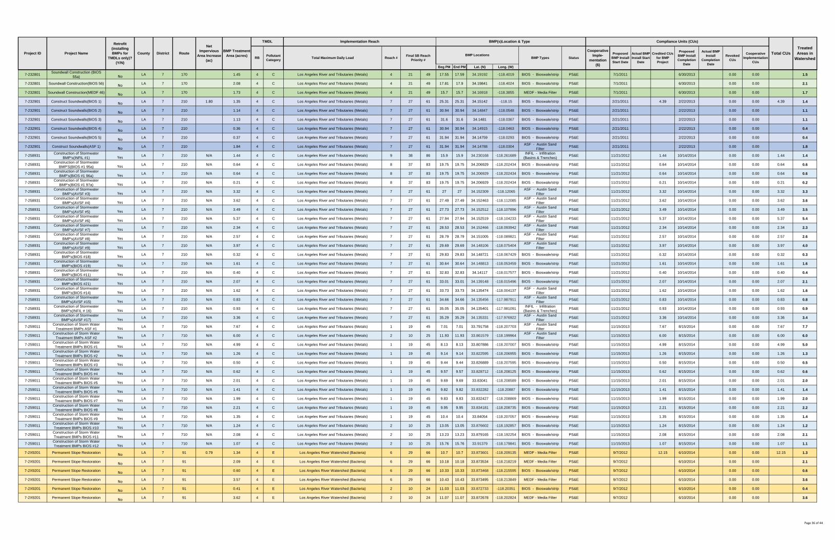
Beg PM End PM Lat. (N) Long. (W)
RouteProject ID Project Name
Retrofit (installing BMPs for
TMDLs only)? (Y/N)
County District Credited CUs for BMP Project
Proposed BMP Install Completion
Date
Actual BMP Install
Completion Date
Net Impervious
Area Increase (ac)
BMP Treatment Area (acres)
TMDL Implementation Reach BMP(s)Location & Type
BMP LocationsBMP Types Status
Revoked CUs
Total CUsTreated Areas in
WatershedRBPollutant Category
Total Maximum Daily Load Reach #Final SB Reach
Priority #
Compliance Units (CUs)
Cooperative Imple-
mentation ($)
Cooperative Implementation
CUs
Proposed BMP Install Start Date
Actual BMP Install Start
Date
7-232801Soundwall Construction (BIOS
55a) No LA 7 170 1.45 4 C Los Angeles River and Tributaries (Metals) 4 21 49 17.55 17.59 34.19192 -118.4019 BIOS - Bioswale/strip PS&E 7/1/2011 6/30/2013 0.00 0.00 1.5
7-232801 Soundwall Construction(BIOS 56) No LA 7 170 2.08 4 C Los Angeles River and Tributaries (Metals) 4 21 49 17.81 17.9 34.19841 -118.4024 BIOS - Bioswale/strip PS&E 7/1/2011 6/30/2013 0.00 0.00 2.1
7-232801 Soundwall Construction(MEDF 46) No LA 7 170 1.73 4 C Los Angeles River and Tributaries (Metals) 4 21 49 15.7 15.7 34.16918 -118.3855 MEDF - Media Filter PS&E 7/1/2011 6/30/2013 0.00 0.00 1.7
7-232901 Construct Soundwalls(BIOS 1) No LA 7 210 1.80 1.35 4 C Los Angeles River and Tributaries (Metals) 7 27 61 25.31 25.31 34.15142 -118.15 BIOS - Bioswale/strip PS&E 2/21/2011 4.39 2/22/2013 0.00 0.00 4.39 1.4
7-232901 Construct Soundwalls(BIOS 2) No LA 7 210 1.14 4 C Los Angeles River and Tributaries (Metals) 7 27 61 30.94 30.94 34.14847 -118.0548 BIOS - Bioswale/strip PS&E 2/21/2011 2/22/2013 0.00 0.00 1.1
7-232901 Construct Soundwalls(BIOS 3) No LA 7 210 1.13 4 C Los Angeles River and Tributaries (Metals) 7 27 61 31.6 31.6 34.1481 -118.0367 BIOS - Bioswale/strip PS&E 2/21/2011 2/22/2013 0.00 0.00 1.1
7-232901 Construct Soundwalls(BIOS 4) No LA 7 210 0.36 4 C Los Angeles River and Tributaries (Metals) 7 27 61 30.94 30.94 34.14915 -118.0463 BIOS - Bioswale/strip PS&E 2/21/2011 2/22/2013 0.00 0.00 0.4
7-232901 Construct Soundwalls(BIOS 5) No LA 7 210 0.37 4 C Los Angeles River and Tributaries (Metals) 7 27 61 31.94 31.94 34.14759 -118.0293 BIOS - Bioswale/strip PS&E 2/21/2011 2/22/2013 0.00 0.00 0.4
7-232901 Construct Soundwalls(ASF 1) No LA 7 210 1.84 4 C Los Angeles River and Tributaries (Metals) 7 27 61 31.94 31.94 34.14788 -118.0304ASF - Austin Sand
FilterPS&E 2/21/2011 2/22/2013 0.00 0.00 1.8
7-258931Construction of Stormwater
BMP's(INFIL #1) Yes LA 7 210 N/A 1.44 4 C Los Angeles River and Tributaries (Metals) 9 38 86 15.9 15.9 34.230168 -118.261689INFIL - Infiltration
(Basins & Trenches)PS&E 11/21/2012 1.44 10/14/2014 0.00 0.00 1.44 1.4
7-258931Construction of Stormwater
BMP'S(BIOS #1 95a) Yes LA 7 210 N/A 0.64 4 C Los Angeles River and Tributaries (Metals) 8 37 83 19.75 19.75 34.206929 -118.202434 BIOS - Bioswale/strip PS&E 11/21/2012 0.64 10/14/2014 0.00 0.00 0.64 0.6
7-258931Construction of Stormwater
BMP's(BIOS #1 96a) Yes LA 7 210 N/A 0.64 4 C Los Angeles River and Tributaries (Metals) 8 37 83 19.75 19.75 34.206929 -118.202434 BIOS - Bioswale/strip PS&E 11/21/2012 0.64 10/14/2014 0.00 0.00 0.64 0.6
7-258931Construction of Stormwater
BMP's(BIOS #1 97a) Yes LA 7 210 N/A 0.21 4 C Los Angeles River and Tributaries (Metals) 8 37 83 19.75 19.75 34.206929 -118.202434 BIOS - Bioswale/strip PS&E 11/21/2012 0.21 10/14/2014 0.00 0.00 0.21 0.2
7-258931Construction of Stormwater
BMP's(AVSF #3) Yes LA 7 210 N/A 3.32 4 C Los Angeles River and Tributaries (Metals) 7 27 61 27 27 34.152309 -118.12065ASF - Austin Sand
FilterPS&E 11/21/2012 3.32 10/14/2014 0.00 0.00 3.32 3.3
7-258931Construction of Stormwater
BMP's(AVSF #4) Yes LA 7 210 N/A 3.62 4 C Los Angeles River and Tributaries (Metals) 7 27 61 27.49 27.49 34.152463 -118.112085ASF - Austin Sand
FilterPS&E 11/21/2012 3.62 10/14/2014 0.00 0.00 3.62 3.6
7-258931Construction of Stormwater
BMP's(AVSF #5) Yes LA 7 210 N/A 3.49 4 C Los Angeles River and Tributaries (Metals) 7 27 61 27.73 27.73 34.152512 -118.107896ASF - Austin Sand
FilterPS&E 11/21/2012 3.49 10/14/2014 0.00 0.00 3.49 3.5
7-258931Construction of Stormwater
BMP's(AVSF #6) Yes LA 7 210 N/A 5.37 4 C Los Angeles River and Tributaries (Metals) 7 27 61 27.94 27.94 34.152519 -118.104233ASF - Austin Sand
FilterPS&E 11/21/2012 5.37 10/14/2014 0.00 0.00 5.37 5.4
7-258931Construction of Stormwater
BMP's(AVSF #7) Yes LA 7 210 N/A 2.34 4 C Los Angeles River and Tributaries (Metals) 7 27 61 28.53 28.53 34.152466 -118.093942ASF - Austin Sand
FilterPS&E 11/21/2012 2.34 10/14/2014 0.00 0.00 2.34 2.3
7-258931Construction of Stormwater
BMP's(AVSF #8) Yes LA 7 210 N/A 2.57 4 C Los Angeles River and Tributaries (Metals) 7 27 61 28.79 28.79 34.151005 -118.089821ASF - Austin Sand
FilterPS&E 11/21/2012 2.57 10/14/2014 0.00 0.00 2.57 2.6
7-258931Construction of Stormwater
BMP's(AVSF #9) Yes LA 7 210 N/A 3.97 4 C Los Angeles River and Tributaries (Metals) 7 27 61 29.69 29.69 34.148106 -118.075404ASF - Austin Sand
FilterPS&E 11/21/2012 3.97 10/14/2014 0.00 0.00 3.97 4.0
7-258931Construction of Stormwater
BMP's(BIOS #18) Yes LA 7 210 N/A 0.32 4 C Los Angeles River and Tributaries (Metals) 7 27 61 29.83 29.83 34.148721 -118.067429 BIOS - Bioswale/strip PS&E 11/21/2012 0.32 10/14/2014 0.00 0.00 0.32 0.3
7-258931Construction of Stormwater
BMP's(BIOS #19) Yes LA 7 210 N/A 1.61 4 C Los Angeles River and Tributaries (Metals) 7 27 61 30.64 30.64 34.148813 -118.053459 BIOS - Bioswale/strip PS&E 11/21/2012 1.61 10/14/2014 0.00 0.00 1.61 1.6
7-258931Construction of Stormwater
BMP's(BIOS #11) Yes LA 7 210 N/A 0.40 4 C Los Angeles River and Tributaries (Metals) 7 27 61 32.83 32.83 34.14117 -118.017577 BIOS - Bioswale/strip PS&E 11/21/2012 0.40 10/14/2014 0.00 0.00 0.40 0.4
7-258931Construction of Stormwater
BMP's(BIOS #21) Yes LA 7 210 N/A 2.07 4 C Los Angeles River and Tributaries (Metals) 7 27 61 33.01 33.01 34.139148 -118.015496 BIOS - Bioswale/strip PS&E 11/21/2012 2.07 10/14/2014 0.00 0.00 2.07 2.1
7-258931Construction of Stormwater
BMP's(BIOS #14) Yes LA 7 210 N/A 1.62 4 C Los Angeles River and Tributaries (Metals) 7 27 61 33.73 33.73 34.135474 -118.004137ASF - Austin Sand
FilterPS&E 11/21/2012 1.62 10/14/2014 0.00 0.00 1.62 1.6
7-258931Construction of Stormwater
BMP's(AVSF #15) Yes LA 7 210 N/A 0.83 4 C Los Angeles River and Tributaries (Metals) 7 27 61 34.66 34.66 34.135456 -117.987911ASF - Austin Sand
FilterPS&E 11/21/2012 0.83 10/14/2014 0.00 0.00 0.83 0.8
7-258931Construction of Stormwater
BMP's(INFIL # 16) Yes LA 7 210 N/A 0.93 4 C Los Angeles River and Tributaries (Metals) 7 27 61 35.05 35.05 34.135401 -117.981091INFIL - Infiltration
(Basins & Trenches)PS&E 11/21/2012 0.93 10/14/2014 0.00 0.00 0.93 0.9
7-258931Construction of Stormwater
BMP's(AVSF #17) Yes LA 7 210 N/A 3.36 4 C Los Angeles River and Tributaries (Metals) 7 27 61 35.29 35.29 34.135331 -117.976922ASF - Austin Sand
FilterPS&E 11/21/2012 3.36 10/14/2014 0.00 0.00 3.36 3.4
7-259011Construction of Storm Water
Treatment BMPs ASF #1 Yes LA 7 710 N/A 7.67 4 C Los Angeles River and Tributaries (Metals) 1 19 45 7.01 7.01 33.791758 -118.207703ASF - Austin Sand
FilterPS&E 11/15/2013 7.67 8/15/2014 0.00 0.00 7.67 7.7
7-259011Construction of Storm Water
Treatment BMPs ASF #2 Yes LA 7 710 N/A 6.00 4 C Los Angeles River and Tributaries (Metals) 2 10 25 11.93 11.93 33.861579 -118.199964ASF - Austin Sand
FilterPS&E 11/15/2013 6.00 8/15/2014 0.00 0.00 6.00 6.0
7-259011Construction of Storm Water
Treatment BMPs BIOS #1 Yes LA 7 710 N/A 4.99 4 C Los Angeles River and Tributaries (Metals) 1 19 45 8.13 8.13 33.807886 -118.207007 BIOS - Bioswale/strip PS&E 11/15/2013 4.99 8/15/2014 0.00 0.00 4.99 5.0
7-259011Construction of Storm Water
Treatment BMPs BIOS #2 Yes LA 7 710 N/A 1.26 4 C Los Angeles River and Tributaries (Metals) 1 19 45 9.14 9.14 33.822595 -118.206955 BIOS - Bioswale/strip PS&E 11/15/2013 1.26 8/15/2014 0.00 0.00 1.26 1.3
7-259011Construction of Storm Water
Treatment BMPs BIOS #3 Yes LA 7 710 N/A 0.50 4 C Los Angeles River and Tributaries (Metals) 1 19 45 9.44 9.44 33.826889 -118.207595 BIOS - Bioswale/strip PS&E 11/15/2013 0.50 8/15/2014 0.00 0.00 0.50 0.5
7-259011Construction of Storm Water
Treatment BMPs BIOS #4 Yes LA 7 710 N/A 0.62 4 C Los Angeles River and Tributaries (Metals) 1 19 45 9.57 9.57 33.828712 -118.208125 BIOS - Bioswale/strip PS&E 11/15/2013 0.62 8/15/2014 0.00 0.00 0.62 0.6
7-259011Construction of Storm Water
Treatment BMPs BIOS #5 Yes LA 7 710 N/A 2.01 4 C Los Angeles River and Tributaries (Metals) 1 19 45 9.69 9.69 33.83041 -118.208589 BIOS - Bioswale/strip PS&E 11/15/2013 2.01 8/15/2014 0.00 0.00 2.01 2.0
7-259011Construction of Storm Water
Treatment BMPs BIOS #6 Yes LA 7 710 N/A 1.41 4 C Los Angeles River and Tributaries (Metals) 1 19 45 9.82 9.82 33.832282 -118.20887 BIOS - Bioswale/strip PS&E 11/15/2013 1.41 8/15/2014 0.00 0.00 1.41 1.4
7-259011Construction of Storm Water
Treatment BMPs BIOS #7 Yes LA 7 710 N/A 1.99 4 C Los Angeles River and Tributaries (Metals) 1 19 45 9.83 9.83 33.832427 -118.208869 BIOS - Bioswale/strip PS&E 11/15/2013 1.99 8/15/2014 0.00 0.00 1.99 2.0
7-259011Construction of Storm Water
Treatment BMPs BIOS #8 Yes LA 7 710 N/A 2.21 4 C Los Angeles River and Tributaries (Metals) 1 19 45 9.95 9.95 33.834181 -118.208735 BIOS - Bioswale/strip PS&E 11/15/2013 2.21 8/15/2014 0.00 0.00 2.21 2.2
7-259011Construction of Storm Water
Treatment BMPs BIOS #9 Yes LA 7 710 N/A 1.35 4 C Los Angeles River and Tributaries (Metals) 1 19 45 10.4 10.4 33.84054 -118.207057 BIOS - Bioswale/strip PS&E 11/15/2013 1.35 8/15/2014 0.00 0.00 1.35 1.4
7-259011Construction of Storm Water Treatment BMPs BIOS #10 Yes LA 7 710 N/A 1.24 4 C Los Angeles River and Tributaries (Metals) 2 10 25 13.05 13.05 33.876602 -118.192857 BIOS - Bioswale/strip PS&E 11/15/2013 1.24 8/15/2014 0.00 0.00 1.24 1.2
7-259011Construction of Storm Water Treatment BMPs BIOS #11 Yes LA 7 710 N/A 2.08 4 C Los Angeles River and Tributaries (Metals) 2 10 25 13.23 13.23 33.879165 -118.192254 BIOS - Bioswale/strip PS&E 11/15/2013 2.08 8/15/2014 0.00 0.00 2.08 2.1
7-259011Construction of Storm Water Treatment BMPs BIOS #12 Yes LA 7 710 N/A 1.07 4 C Los Angeles River and Tributaries (Metals) 2 10 25 15.76 15.76 33.91379 -118.179841 BIOS - Bioswale/strip PS&E 11/15/2013 1.07 8/15/2014 0.00 0.00 1.07 1.1
7-2X9201 Permanent Slope Restoration No LA 7 91 0.79 1.34 4 E Los Angeles River Watershed (Bacteria) 6 29 66 10.7 10.7 33.873601 -118.209135 MEDF - Media Filter PS&E 9/7/2012 12.15 6/10/2014 0.00 0.00 12.15 1.3
7-2X9201 Permanent Slope Restoration No LA 7 91 2.09 4 E Los Angeles River Watershed (Bacteria) 6 29 66 10.18 10.18 33.873534 -118.218219 MEDF - Media Filter PS&E 9/7/2012 6/10/2014 0.00 0.00 2.1
7-2X9201 Permanent Slope Restoration No LA 7 91 0.60 4 E Los Angeles River Watershed (Bacteria) 6 29 66 10.33 10.33 33.873468 -118.215595 BIOS - Bioswale/strip PS&E 9/7/2012 6/10/2014 0.00 0.00 0.6
7-2X9201 Permanent Slope Restoration No LA 7 91 3.57 4 E Los Angeles River Watershed (Bacteria) 6 29 66 10.43 10.43 33.873495 -118.213849 MEDF - Media Filter PS&E 9/7/2012 6/10/2014 0.00 0.00 3.6
7-2X9201 Permanent Slope Restoration No LA 7 91 0.41 4 E Los Angeles River Watershed (Bacteria) 2 10 24 11.03 11.03 33.872733 -118.20351 BIOS - Bioswale/strip PS&E 9/7/2012 6/10/2014 0.00 0.00 0.4
7-2X9201 Permanent Slope Restoration No LA 7 91 3.62 4 E Los Angeles River Watershed (Bacteria) 2 10 24 11.07 11.07 33.872678 -118.202824 MEDF - Media Filter PS&E 9/7/2012 6/10/2014 0.00 0.00 3.6
Page 36 of 44
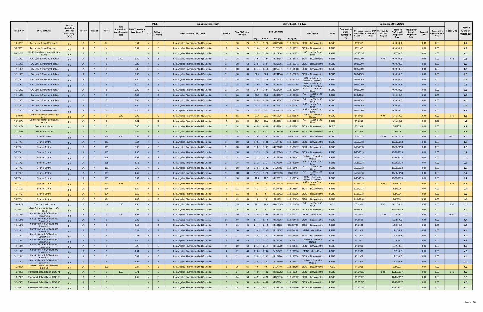
Beg PM End PM Lat. (N) Long. (W)
RouteProject ID Project Name
Retrofit (installing BMPs for
TMDLs only)? (Y/N)
County District Credited CUs for BMP Project
Proposed BMP Install Completion
Date
Actual BMP Install
Completion Date
Net Impervious
Area Increase (ac)
BMP Treatment Area (acres)
TMDL Implementation Reach BMP(s)Location & Type
BMP LocationsBMP Types Status
Revoked CUs
Total CUsTreated Areas in
WatershedRBPollutant Category
Total Maximum Daily Load Reach #Final SB Reach
Priority #
Compliance Units (CUs)
Cooperative Imple-
mentation ($)
Cooperative Implementation
CUs
Proposed BMP Install Start Date
Actual BMP Install Start
Date
7-2X9201 Permanent Slope Restoration No LA 7 91 0.44 4 E Los Angeles River Watershed (Bacteria) 2 10 24 11.16 11.16 33.872708 -118.201276 BIOS - Bioswale/strip PS&E 9/7/2012 6/10/2014 0.00 0.00 0.4
7-2X9201 Permanent Slope Restoration No LA 7 91 0.87 4 E Los Angeles River Watershed (Bacteria) 2 10 24 11.63 11.63 33.87522 -118.193692 BIOS - Bioswale/strip PS&E 9/7/2012 6/10/2014 0.00 0.00 0.9
7-1218W1Modify Interchagne and Add HOV
Lanes No LA 7 5 4 E Los Angeles River Watershed (Bacteria) 10 30 69 31.59 31.59 34.203068 -118.340771ASF - Austin Sand
FilterPS&E 12/24/2012 12/7/2015 0.00 0.00 0.0
7-121901 HOV Land & Pavement Rehab No LA 7 5 24.22 2.80 4 E Los Angeles River Watershed (Bacteria) 11 28 63 38.54 38.54 34.257383 -118.434778 BIOS - Bioswale/strip PS&E 10/1/2009 4.48 9/10/2013 0.00 0.00 4.48 2.8
7-121901 HOV Land & Pavement Rehab No LA 7 5 2.80 4 E Los Angeles River Watershed (Bacteria) 11 28 63 38.54 38.54 34.256751 -118.436071 BIOS - Bioswale/strip PS&E 10/1/2009 9/10/2013 0.00 0.00 2.8
7-121901 HOV Land & Pavement Rehab No LA 7 5 0.30 4 E Los Angeles River Watershed (Bacteria) 11 28 63 38.46 38.46 34.255971 -118.434308 BIOS - Bioswale/strip PS&E 10/1/2009 9/10/2013 0.00 0.00 0.3
7-121901 HOV Land & Pavement Rehab No LA 7 5 2.30 4 E Los Angeles River Watershed (Bacteria) 11 28 63 37.4 37.4 34.244546 -118.422219 BIOS - Bioswale/strip PS&E 10/1/2009 9/10/2013 0.00 0.00 2.3
7-121901 HOV Land & Pavement Rehab No LA 7 5 2.80 4 E Los Angeles River Watershed (Bacteria) 11 28 63 38.54 38.54 34.256691 -118.436095INFIL - Infiltration
(Basins & Trenches)PS&E 10/1/2009 9/10/2013 0.00 0.00 2.8
7-121901 HOV Land & Pavement Rehab No LA 7 5 2.10 4 E Los Angeles River Watershed (Bacteria) 11 28 63 37.99 37.99 34.251458 -118.42849INFIL - Infiltration
(Basins & Trenches)PS&E 10/1/2009 9/10/2013 0.00 0.00 2.1
7-121901 HOV Land & Pavement Rehab No LA 7 5 2.80 4 E Los Angeles River Watershed (Bacteria) 11 28 63 38.54 38.54 34.257386 -118.435009ASF - Austin Sand
FilterPS&E 10/1/2009 9/10/2013 0.00 0.00 2.8
7-121901 HOV Land & Pavement Rehab No LA 7 5 3.80 4 E Los Angeles River Watershed (Bacteria) 11 28 63 37.5 37.5 34.245067 -118.423498ASF - Austin Sand
FilterPS&E 10/1/2009 9/10/2013 0.00 0.00 3.8
7-121901 HOV Land & Pavement Rehab No LA 7 5 2.30 4 E Los Angeles River Watershed (Bacteria) 11 28 63 36.36 36.36 34.245067 -118.423498ASF - Austin Sand
FilterPS&E 10/1/2009 9/10/2013 0.00 0.00 2.3
7-121901 HOV Land & Pavement Rehab No LA 7 5 1.30 4 E Los Angeles River Watershed (Bacteria) 4 21 48 36.16 36.16 34.231722 -118.406601ASF - Austin Sand
FilterPS&E 10/1/2009 9/10/2013 0.00 0.00 1.3
7-121901 HOV Land & Pavement Rehab No LA 7 5 5.40 4 E Los Angeles River Watershed (Bacteria) 11 28 63 39.21 39.21 34.264712 -118.442074ASF - Austin Sand
FilterPS&E 10/1/2009 9/10/2013 0.00 0.00 5.4
7-1786A1Modify interchange and realign
ramps No LA 7 5 0.80 2.85 4 E Los Angeles River Watershed (Bacteria) 4 21 48 27.4 28.1 34.159364 -118.292146DetBas - Detention
BasinsPS&E 2/4/2010 6.66 1/31/2012 0.00 0.00 6.66 2.9
7-1786A1Modify interchange and realign
ramps No LA 7 5 4.61 4 E Los Angeles River Watershed (Bacteria) 4 21 48 27.4 28.1 34.159364 -118.292146ASF - Austin Sand
FilterPS&E 2/4/2010 1/31/2012 0.00 0.00 4.6
7-2332E0 Construct Hot lanes No LA 7 5 0.66 4 E Los Angeles River Watershed (Bacteria) 5 24 53 46.08 46.08 34.338142 -118.515102 BIOS - Bioswale/strip PA/ED 2/1/2014 7/1/2018 0.00 0.00 0.7
7-2332E0 Construct Hot lanes No LA 7 5 0.49 4 E Los Angeles River Watershed (Bacteria) 5 24 53 46.12 46.12 34.338439 -118.515706 BIOS - Bioswale/strip PA/ED 2/1/2014 7/1/2018 0.00 0.00 0.5
7-2770U1 Source Control No LA 7 118 1.40 0.25 4 E Los Angeles River Watershed (Bacteria) 11 28 63 11.53 11.53 34.267217 -118.44203 BIOS - Bioswale/strip PS&E 2/26/2013 18.21 10/26/2013 0.00 0.00 18.21 0.3
7-2770U1 Source Control No LA 7 118 3.64 4 E Los Angeles River Watershed (Bacteria) 11 28 63 11.65 11.65 34.26749 -118.440151 BIOS - Bioswale/strip PS&E 2/26/2013 10/26/2013 0.00 0.00 3.6
7-2770U1 Source Control No LA 7 118 2.00 4 E Los Angeles River Watershed (Bacteria) 11 28 63 12.07 12.07 34.269282 -118.433277 BIOS - Bioswale/strip PS&E 2/26/2013 10/26/2013 0.00 0.00 2.0
7-2770U1 Source Control No LA 7 118 1.90 4 E Los Angeles River Watershed (Bacteria) 11 28 63 13.26 13.26 34.280949 -118.417884 BIOS - Bioswale/strip PS&E 2/26/2013 10/26/2013 0.00 0.00 1.9
7-2770U1 Source Control No LA 7 118 2.98 4 E Los Angeles River Watershed (Bacteria) 11 28 63 12.36 12.36 34.272056 -118.429407DetBas - Detention
BasinsPS&E 2/26/2013 10/26/2013 0.00 0.00 3.0
7-2770U1 Source Control No LA 7 118 1.73 4 E Los Angeles River Watershed (Bacteria) 11 28 63 12.27 12.27 34.271195 -118.430589ASF - Austin Sand
FilterPS&E 2/26/2013 10/26/2013 0.00 0.00 1.7
7-2770U1 Source Control No LA 7 118 2.75 4 E Los Angeles River Watershed (Bacteria) 11 28 63 13.52 13.52 34.28346 -118.414487ASF - Austin Sand
FilterPS&E 2/26/2013 10/26/2013 0.00 0.00 2.8
7-2770U1 Source Control No LA 7 118 1.67 4 E Los Angeles River Watershed (Bacteria) 11 28 63 13.13 13.13 34.279696 -118.41959ASF - Austin Sand
FilterPS&E 2/26/2013 10/26/2013 0.00 0.00 1.7
7-2770U1 Source Control No LA 7 118 2.69 4 E Los Angeles River Watershed (Bacteria) 11 28 63 11.7 11.7 34.267612 -118.439314INFIL - Infiltration
(Basins & Trenches)PS&E 2/26/2013 10/26/2013 0.00 0.00 2.7
7-2777U1 Source Control No LA 7 134 1.42 5.30 4 E Los Angeles River Watershed (Bacteria) 4 21 48 4.9 4.9 34.155325 -118.29238ASF - Austin Sand
FilterPS&E 11/1/2013 9.88 8/1/2014 0.00 0.00 9.88 5.3
7-2777U1 Source Control No LA 7 134 1.40 4 E Los Angeles River Watershed (Bacteria) 4 21 48 5.1 5.1 34.15542 -118.288883 BIOS - Bioswale/strip PS&E 11/1/2013 8/1/2014 0.00 0.00 1.4
7-2777U1 Source Control No LA 7 134 3.60 4 E Los Angeles River Watershed (Bacteria) 4 21 48 5 5 34.155422 -118.290625 BIOS - Bioswale/strip PS&E 11/1/2013 8/1/2014 0.00 0.00 3.6
7-2777U1 Source Control No LA 7 134 1.00 4 E Los Angeles River Watershed (Bacteria) 4 21 48 5.2 5.2 34.1551 -118.287174 BIOS - Bioswale/strip PS&E 11/1/2013 8/1/2014 0.00 0.00 1.0
7-28510K Widening to add lanes No LA 7 10 0.85 1.30 4 E Los Angeles River Watershed (Bacteria) 3 25 56 17.3 17.3 34.025805 -118.236453ASF - Austin Sand
FilterPA/ED 2/1/2011 0.45 3/31/2012 0.00 0.00 0.45 1.3
7-168001Major Reconstruction/ Add HOV
lanes No LA 7 5 0.42 4 E Los Angeles River Watershed (Bacteria) 5 24 53 46 46 34.321441 -118.498649 BIOS - Bioswale/strip PS&E 7/19/2007 12/30/2009 0.00 0.00 0.4
7-121841Constrction of HOV Land and
Soundwalls No LA 7 5 7.70 4.24 4 E Los Angeles River Watershed (Bacteria) 10 30 69 28.98 28.98 34.177333 -118.309077 MEDF - Media Filter PS&E 9/1/2009 16.41 12/2/2013 0.00 0.00 16.41 4.2
7-121841Constrction of HOV Land and
Soundwalls No LA 7 5 0.39 4 E Los Angeles River Watershed (Bacteria) 10 30 69 28.45 28.45 34.170387 -118.304442 BIOS - Bioswale/strip PS&E 9/1/2009 12/2/2013 0.00 0.00 0.4
7-121841Constrction of HOV Land and
Soundwalls No LA 7 5 0.18 4 E Los Angeles River Watershed (Bacteria) 4 21 48 28.45 28.45 34.164799 -118.29745 BIOS - Bioswale/strip PS&E 9/1/2009 12/2/2013 0.00 0.00 0.2
7-121841Constrction of HOV Land and
Soundwalls No LA 7 5 6.49 4 E Los Angeles River Watershed (Bacteria) 10 30 69 28.45 28.45 34.169507 -118.30423 MEDF - Media Filter PS&E 9/1/2009 12/2/2013 0.00 0.00 6.5
7-121841Constrction of HOV Land and
Soundwalls No LA 7 5 0.23 4 E Los Angeles River Watershed (Bacteria) 4 21 48 28.41 28.41 34.165589 -118.29673 BIOS - Bioswale/strip PS&E 9/1/2009 12/2/2013 0.00 0.00 0.2
7-121841Constrction of HOV Land and
Soundwalls No LA 7 5 5.40 4 E Los Angeles River Watershed (Bacteria) 10 30 69 28.41 28.41 34.171006 -118.304277DetBas - Detention
BasinsPS&E 9/1/2009 12/2/2013 0.00 0.00 5.4
7-121841Constrction of HOV Land and
Soundwalls No LA 7 5 0.22 4 E Los Angeles River Watershed (Bacteria) 10 30 69 28.41 28.41 34.169729 -118.304324 BIOS - Bioswale/strip PS&E 9/1/2009 12/2/2013 0.00 0.00 0.2
7-121841Constrction of HOV Land and
Soundwalls No LA 7 5 4.61 4 E Los Angeles River Watershed (Bacteria) 4 21 48 27.86 27.86 34.16555 -118.296696 MEDF - Media Filter PS&E 9/1/2009 12/2/2013 0.00 0.00 4.6
7-121841Constrction of HOV Land and
Soundwalls No LA 7 5 0.39 4 E Los Angeles River Watershed (Bacteria) 4 21 48 27.82 27.82 34.164764 -118.297374 BIOS - Bioswale/strip PS&E 9/1/2009 12/2/2013 0.00 0.00 0.4
7-121841Constrction of HOV Land and
Soundwalls No LA 7 5 1.96 4 E Los Angeles River Watershed (Bacteria) 4 21 48 27.82 27.82 34.165569 -118.296717DetBas - Detention
BasinsPS&E 9/1/2009 12/2/2013 0.00 0.00 2.0
7-294600Worker Safety Improvements
BIOS #2 No LA 7 101 0.34 4 E Los Angeles River Watershed (Bacteria) 3 25 56 0.5 0.5 34.05377 -118.234398 BIOS - Bioswale/strip PA/ED 9/6/2016 3/1/2017 0.00 0.00 0.3
7-302901 Pavement Rehabilitation BIOS #1 No LA 7 5 1.52 0.71 4 E Los Angeles River Watershed (Bacteria) 5 24 53 44.02 44.02 34.316782 -118.490887 BIOS - Bioswale/strip PS&E 10/16/2015 0.66 12/17/2017 0.00 0.00 0.66 0.7
7-302901 Pavement Rehabilitation BIOS #2 No LA 7 5 1.47 4 E Los Angeles River Watershed (Bacteria) 5 24 53 44.92 44.92 34.325076 -118.503022 BIOS - Bioswale/strip PS&E 10/16/2015 12/17/2017 0.00 0.00 1.5
7-302901 Pavement Rehabilitation BIOS #3 No LA 7 5 4 E Los Angeles River Watershed (Bacteria) 5 24 53 46.08 46.08 34.338142 -118.515102 BIOS - Bioswale/strip PS&E 10/16/2015 12/17/2017 0.00 0.00 0.0
7-302901 Pavement Rehabilitation BIOS #4 No LA 7 5 4 E Los Angeles River Watershed (Bacteria) 5 24 53 46.12 46.12 34.338439 -118.515706 BIOS - Bioswale/strip PS&E 10/16/2015 12/17/2017 0.00 0.00 0.0
Page 37 of 44

Beg PM End PM Lat. (N) Long. (W)
RouteProject ID Project Name
Retrofit (installing BMPs for
TMDLs only)? (Y/N)
County District Credited CUs for BMP Project
Proposed BMP Install Completion
Date
Actual BMP Install
Completion Date
Net Impervious
Area Increase (ac)
BMP Treatment Area (acres)
TMDL Implementation Reach BMP(s)Location & Type
BMP LocationsBMP Types Status
Revoked CUs
Total CUsTreated Areas in
WatershedRBPollutant Category
Total Maximum Daily Load Reach #Final SB Reach
Priority #
Compliance Units (CUs)
Cooperative Imple-
mentation ($)
Cooperative Implementation
CUs
Proposed BMP Install Start Date
Actual BMP Install Start
Date
7-302901 Pavement Rehabilitation BIOS #5 No LA 7 5 4 E Los Angeles River Watershed (Bacteria) 5 24 53 44.1 44.1 34.31777 -118.491771 BIOS - Bioswale/strip PS&E 10/16/2015 12/17/2017 0.00 0.00 0.0
7-302901 Pavement Rehabilitation BIOS #6 No LA 7 5 4 E Los Angeles River Watershed (Bacteria) 5 24 53 44.3 44.3 34.319875 -118.494341 BIOS - Bioswale/strip PS&E 10/16/2015 12/17/2017 0.00 0.00 0.0
7-302901 Pavement Rehabilitation BIOS #7 No LA 7 5 4 E Los Angeles River Watershed (Bacteria) 5 24 53 44.4 44.4 34.320722 -118.49577 BIOS - Bioswale/strip PS&E 10/16/2015 12/17/2017 0.00 0.00 0.0
7-302901 Pavement Rehabilitation BIOS #8 No LA 7 5 4 E Los Angeles River Watershed (Bacteria) 5 24 53 45.2 45.2 34.328653 -118.505442 BIOS - Bioswale/strip PS&E 10/16/2015 12/17/2017 0.00 0.00 0.0
7-302901 Pavement Rehabilitation BIOS #9 No LA 7 5 4 E Los Angeles River Watershed (Bacteria) 5 24 53 45.8 45.8 34.335822 -118.511014 BIOS - Bioswale/strip PS&E 10/16/2015 12/17/2017 0.00 0.00 0.0
7-292101Raodside Safety Improvement
BIOS #2 No LA 7 134 0.30 2.40 4 E Los Angeles River Watershed (Bacteria) 4 21 48 0.3 0.3 34.152889 -118.371649 BIOS - Bioswale/strip PS&E 7/1/2015 5.30 6/28/2016 0.00 0.00 5.30 2.4
7-292101Raodside Safety Improvement
BIOS #2 No LA 7 134 3.20 4 E Los Angeles River Watershed (Bacteria) 4 21 48 0.3 0.3 34.152889 -118.371649 BIOS - Bioswale/strip PS&E 7/1/2015 6/28/2016 0.00 0.00 3.2
7- 290101Install concrete barrier and
reconstruct existing Metal Beam No LA 7 91 1.50 1.33 4 E Los Angeles River Watershed (Bacteria) 2 10 24 11 11 33.872802 -118.204024 BIOS - Bioswale/strip PS&E 8/1/2015 2.78 12/1/2017 0.00 0.00 2.78 1.3
7- 290101Install concrete barrier and
reconstruct existing Metal Beam No LA 7 105 2.06 4 E Los Angeles River Watershed (Bacteria) 6 29 66 11.2 11.2 33.927294 -118.215379 BIOS - Bioswale/strip PS&E 8/1/2015 12/1/2017 0.00 0.00 2.1
7- 290101Install concrete barrier and
reconstruct existing Metal Beam No LA 7 105 0.89 4 E Los Angeles River Watershed (Bacteria) 6 29 66 11.3 11.3 33.926616 -118.213834 BIOS - Bioswale/strip PS&E 8/1/2015 12/1/2017 0.00 0.00 0.9
7-289200 Source Control BIOS #1 No LA 7 710 0.00 0.45 4 E Los Angeles River Watershed (Bacteria) 2 10 24 17.01 17.01 33.931217 -118.178715 BIOS - Bioswale/strip PA/ED 1/30/2016 3.18 1/30/2017 0.00 0.00 3.18 0.5
7-289200 Source Control BIOS #2 No LA 7 710 1.03 4 E Los Angeles River Watershed (Bacteria) 3 25 56 19.05 19.05 33.958614 -118.170323 BIOS - Bioswale/strip PA/ED 1/30/2016 1/30/2017 0.00 0.00 1.0
7-289200 Source Control BIOS #3 No LA 7 710 1.25 4 E Los Angeles River Watershed (Bacteria) 3 25 56 22.52 22.52 34.005436 -118.172744 BIOS - Bioswale/strip PA/ED 1/30/2016 1/30/2017 0.00 0.00 1.3
7-289200 Source Control BIOS #4 No LA 7 710 0.45 4 E Los Angeles River Watershed (Bacteria) 3 25 56 22.54 22.54 34.005724 -118.172678 BIOS - Bioswale/strip PA/ED 1/30/2016 1/30/2017 0.00 0.00 0.5
7-288200 Source Control BIOS #1 No LA 7 5 0.00 0.25 4 E Los Angeles River Watershed (Bacteria) 3 25 56 16.01 16.01 34.026614 -118.20886 BIOS - Bioswale/strip PA/ED 1/30/2016 0.80 1/30/2017 0.00 0.00 0.80 0.3
7-288200 Source Control BIOS #2 No LA 7 60 0.33 4 E Los Angeles River Watershed (Bacteria) 3 25 56 2.56 2.56 34.032841 -118.181804 BIOS - Bioswale/strip PA/ED 1/30/2016 1/30/2017 0.00 0.00 0.3
7-288200 Source Control BIOS #3 No LA 7 60 0.22 4 E Los Angeles River Watershed (Bacteria) 3 25 56 2.61 2.61 34.033224 -118.181041 BIOS - Bioswale/strip PA/ED 1/30/2016 1/30/2017 0.00 0.00 0.2
7-279801Roadside Safety Improvements
BIOS #2 No LA 7 10 0.68 4 E Los Angeles River Watershed (Bacteria) 3 25 56 21.3 21.3 34.061255 -118.166444 BIOS - Bioswale/strip PS&E 1/27/2012 10/11/2012 0.00 0.00 0.7
7-260301Construction of Sound Walls BIOS
#1 No LA 7 134 0.32 1.20 4 E Los Angeles River Watershed (Bacteria) 4 21 48 2.7 2.7 34.15293 -118.329773 BIOS - Bioswale/strip PS&E 10/1/2010 4.28 10/1/2012 0.00 0.00 4.28 1.2
7-260301Construction of Sound Walls BIOS
#2 No LA 7 134 3.40 4 E Los Angeles River Watershed (Bacteria) 4 21 48 2.9 2.9 34.153628 -118.326375 BIOS - Bioswale/strip PS&E 10/1/2010 10/1/2012 0.00 0.00 3.4
7-259021Construction of Storm Water
Treatment BMPs BIOS #1 Yes LA 7 5 N/A 3.47 4 E Los Angeles River Watershed (Bacteria) 4 21 48 22.66 22.66 34.103815 -118.251686 BIOS - Bioswale/strip PS&E 10/1/2013 3.47 12/15/2014 0.00 0.00 3.47 3.5
7-259021Construction of Storm Water
Treatment BMPs BIOS #2 Yes LA 7 110 N/A 1.00 4 E Los Angeles River Watershed (Bacteria) 3 25 56 23.14 23.14 34.056471 -118.255662 BIOS - Bioswale/strip PS&E 10/1/2013 1.00 12/15/2014 0.00 0.00 1.00 1.0
7-259021Construction of Storm Water Treatment BMPs AVSF #1 Yes LA 7 5 N/A 1.80 4 E Los Angeles River Watershed (Bacteria) 3 25 56 15.72 15.72 34.024909 -118.204357
ASF - Austin Sand Filter
PS&E 10/1/2013 1.80 12/15/2014 0.00 0.00 1.80 1.8
7-259021Construction of Storm Water Treatment BMPs AVSF #2 Yes LA 7 5 N/A 1.49 4 E Los Angeles River Watershed (Bacteria) 3 25 56 18.32 18.32 34.053377 -118.214091
ASF - Austin Sand Filter
PS&E 10/1/2013 1.49 12/15/2014 0.00 0.00 1.49 1.5
7-259021Construction of Storm Water Treatment BMPs AVSF #3 Yes LA 7 5 N/A 3.91 4 E Los Angeles River Watershed (Bacteria) 8 37 82 20.3 20.3 34.081347 -118.222883
ASF - Austin Sand Filter
PS&E 10/1/2013 3.91 12/15/2014 0.00 0.00 3.91 3.9
7-259021Construction of Storm Water Treatment BMPs AVSF #4 Yes LA 7 5 N/A 16.88 4 E Los Angeles River Watershed (Bacteria) 4 21 48 20.84 20.84 34.08472 -118.230471
ASF - Austin Sand Filter
PS&E 10/1/2013 16.88 12/15/2014 0.00 0.00 16.88 16.9
7-259021Construction of Storm Water Treatment BMPs AVSF #5 Yes LA 7 5 N/A 1.91 4 E Los Angeles River Watershed (Bacteria) 4 21 48 25.89 25.89 34.143755 -118.278294
ASF - Austin Sand Filter
PS&E 10/1/2013 1.91 12/15/2014 0.00 0.00 1.91 1.9
7-259021Construction of Storm Water Treatment BMPs AVSF #6 Yes LA 7 10 N/A 6.77 4 E Los Angeles River Watershed (Bacteria) 3 25 56 21.07 21.07 34.061571 -118.170071
ASF - Austin Sand Filter
PS&E 10/1/2013 6.77 12/15/2014 0.00 0.00 6.77 6.8
7-259021Construction of Storm Water Treatment BMPs AVSF #7 Yes LA 7 91 N/A 1.34 4 E Los Angeles River Watershed (Bacteria) 6 29 66 10.07 10.07 33.873704 -118.220131
ASF - Austin Sand Filter
PS&E 10/1/2013 1.34 12/15/2014 0.00 0.00 1.34 1.3
7-259021Construction of Storm Water Treatment BMPs AVSF #8 Yes LA 7 91 N/A 2.09 4 E Los Angeles River Watershed (Bacteria) 6 29 66 10.18 10.18 33.961135 -118.218219
ASF - Austin Sand Filter
PS&E 10/1/2013 2.09 12/15/2014 0.00 0.00 2.09 2.1
7-259021Construction of Storm Water Treatment BMPs AVSF #9 Yes LA 7 110 N/A 1.99 4 E Los Angeles River Watershed (Bacteria) 6 29 66 15.78 15.78 33.961569 -118.280255
ASF - Austin Sand Filter
PS&E 10/1/2013 1.99 12/15/2014 0.00 0.00 1.99 2.0
7-259021Construction of Storm Water Treatment BMPs AVSF #11 Yes LA 7 110 N/A 1.30 4 E Los Angeles River Watershed (Bacteria) 6 29 66 15.97 15.97 33.960018 -118.280812
ASF - Austin Sand Filter
PS&E 10/1/2013 1.30 12/15/2014 0.00 0.00 1.30 1.3
7-259021Construction of Storm Water Treatment BMPs AVSF #12 Yes LA 7 110 N/A 1.18 4 E Los Angeles River Watershed (Bacteria) 6 29 66 17.81 17.81 33.986773 -118.280503
ASF - Austin Sand Filter
PS&E 10/1/2013 1.18 12/15/2014 0.00 0.00 1.18 1.2
7-259021Construction of Storm Water Treatment BMPs AVSF #13 Yes LA 7 110 N/A 1.36 4 E Los Angeles River Watershed (Bacteria) 6 29 66 19.31 19.31 34.008632 -118.281031
ASF - Austin Sand Filter
PS&E 10/1/2013 1.36 12/15/2014 0.00 0.00 1.36 1.4
7-259021Construction of Storm Water Treatment BMPs AVSF #14 Yes LA 7 110 N/A 5.06 4 E Los Angeles River Watershed (Bacteria) 6 29 66 19.83 19.83 34.016195 -118.280667
ASF - Austin Sand Filter
PS&E 10/1/2013 5.06 12/15/2014 0.00 0.00 5.06 5.1
7-259021Construction of Storm Water Treatment BMPs AVSF #15 Yes LA 7 134 N/A 3.60 4 E Los Angeles River Watershed (Bacteria) 9 38 85 8.9 8.9 34.147055 -118.226979
ASF - Austin Sand Filter
PS&E 10/1/2013 3.60 12/15/2014 0.00 0.00 3.60 3.6
7-259021Construction of Storm Water Treatment BMPs AVSF #16 Yes LA 7 134 N/A 8.20 4 E Los Angeles River Watershed (Bacteria) 9 38 85 11.6 11.6 34.141812 -118.183045
ASF - Austin Sand Filter
PS&E 10/1/2013 8.20 12/15/2014 0.00 0.00 8.20 8.2
7-258401Construction of Storm Water Treatment BMPs BIOS #1 & Yes LA 7 5 N/A 2.50 4 E Los Angeles River Watershed (Bacteria) 3 25 56 18.42 18.42 34.054794 -118.214152
BIOS - Bioswale/strip and GSRDS - Gross
PS&E 2/15/2016 2.50 3/15/2017 0.00 0.00 2.50 2.5
7-258401Construction of Storm Water Treatment BMPs BIOS #2 & Yes LA 7 5 N/A 1.44 4 E Los Angeles River Watershed (Bacteria) 3 25 56 18.52 18.52 34.056244 -118.21421
BIOS - Bioswale/strip and GSRDS - Gross
PS&E 2/15/2016 1.44 3/15/2017 0.00 0.00 1.44 1.4
7-258401Construction of Storm Water
Treatment BMPs BIOS #3 Yes LA 7 5 N/A 0.65 4 E Los Angeles River Watershed (Bacteria) 3 25 56 19.37 19.37 34.068403 -118.216706 BIOS - Bioswale/strip PS&E 2/15/2016 0.65 3/15/2017 0.00 0.00 0.65 0.7
7-258401Construction of Storm Water
Treatment BMPs BIOS #4 Yes LA 7 5 N/A 0.67 4 E Los Angeles River Watershed (Bacteria) 4 21 48 21.75 21.75 34.09324 -118.241659 BIOS - Bioswale/strip PS&E 2/15/2016 0.67 3/15/2017 0.00 0.00 0.67 0.7
7-258401Construction of Storm Water
Treatment BMPs BIOS #5 Yes LA 7 5 N/A 0.75 4 E Los Angeles River Watershed (Bacteria) 4 21 48 22.25 22.25 34.098946 -118.247155 BIOS - Bioswale/strip PS&E 2/15/2016 0.75 3/15/2017 0.00 0.00 0.75 0.8
7-258401Construction of Storm Water
Treatment BMPs ASF #1 Yes LA 7 5 N/A 3.64 4 E Los Angeles River Watershed (Bacteria) 4 21 48 22.33 22.33 34.099995 -118.247907ASF - Austin Sand
FilterPS&E 2/15/2016 3.64 3/15/2017 0.00 0.00 3.64 3.6
7-258401Construction of Storm Water Treatment BMPs BIOS #6 & Yes LA 7 5 N/A 0.99 4 E Los Angeles River Watershed (Bacteria) 4 21 48 22.58 22.58 34.102984 -118.250539
BIOS - Bioswale/strip and GSRDS - Gross
PS&E 2/15/2016 0.99 3/15/2017 0.00 0.00 0.99 1.0
7-258401Construction of Storm Water
Treatment BMPs BIOS #8 Yes LA 7 5 N/A 0.46 4 E Los Angeles River Watershed (Bacteria) 4 21 48 23.01 23.01 34.106877 -118.256142 BIOS - Bioswale/strip PS&E 2/15/2016 0.46 3/15/2017 0.00 0.00 0.46 0.5
7-252001 Roadway Rehabilitation No LA 7 405 0.00 5.20 4 E Los Angeles River Watershed (Bacteria) 5 24 53 39.4 39.4 34.163431 -118.469922 MEDF - Media Filter PS&E 12/1/2012 3/1/2014 0.00 0.00 5.2
7-251200 Bridge Replacement No LA 7 101 0.12 0.66 4 E Los Angeles River Watershed (Bacteria) 3 25 56 0.2 0.2 34.053316 -118.230339 BIORE - Bioretention PA/ ED 9/1/2015 0.54 12/31/2018 0.00 0.00 0.54 0.7
7-224601 Sound Walls(MEDF) No LA 7 405 4 E Los Angeles River Watershed (Bacteria) 11 28 63 46.8 46.8 34.265268 -118.472164 MEDF - Media Filter PS&E 11/15/2010 11/15/2012 0.00 0.00 0.0
Page 38 of 44
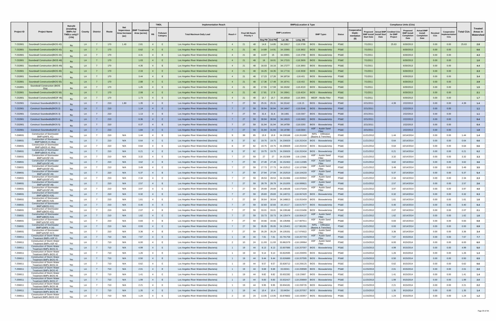
Beg PM End PM Lat. (N) Long. (W)
RouteProject ID Project Name
Retrofit (installing BMPs for
TMDLs only)? (Y/N)
County District Credited CUs for BMP Project
Proposed BMP Install Completion
Date
Actual BMP Install
Completion Date
Net Impervious
Area Increase (ac)
BMP Treatment Area (acres)
TMDL Implementation Reach BMP(s)Location & Type
BMP LocationsBMP Types Status
Revoked CUs
Total CUsTreated Areas in
WatershedRBPollutant Category
Total Maximum Daily Load Reach #Final SB Reach
Priority #
Compliance Units (CUs)
Cooperative Imple-
mentation ($)
Cooperative Implementation
CUs
Proposed BMP Install Start Date
Actual BMP Install Start
Date
7-232801 Soundwall Construction(BIOS 43) No LA 7 170 1.40 2.81 4 E Los Angeles River Watershed (Bacteria) 4 21 48 14.8 14.85 34.15917 -118.3799 BIOS - Bioswale/strip PS&E 7/1/2011 25.63 6/30/2013 0.00 0.00 25.63 2.8
7-232801 Soundwall Construction(BIOS 43) No LA 7 170 0.62 4 E Los Angeles River Watershed (Bacteria) 4 21 48 14.89 14.91 34.15965 -118.3802 BIOS - Bioswale/strip PS&E 7/1/2011 6/30/2013 0.00 0.00 0.6
7-232801 Soundwall Construction(BIOS 43) No LA 7 170 4.31 4 E Los Angeles River Watershed (Bacteria) 4 21 48 14.97 15 34.15901 -118.3798 BIOS - Bioswale/strip PS&E 7/1/2011 6/30/2013 0.00 0.00 4.3
7-232801 Soundwall Construction (BIOS 48) No LA 7 170 1.03 4 E Los Angeles River Watershed (Bacteria) 4 21 48 16 16.01 34.17315 -118.3909 BIOS - Bioswale/strip PS&E 7/1/2011 6/30/2013 0.00 0.00 1.0
7-232801 Soundwall Construction (BIOS 49) No LA 7 170 4.35 4 E Los Angeles River Watershed (Bacteria) 4 21 48 16.03 16.16 34.17277 -118.3893 BIOS - Bioswale/strip PS&E 7/1/2011 6/30/2013 0.00 0.00 4.4
7-232801 Soundwall Construction(BIOS 49) No LA 7 170 2.33 4 E Los Angeles River Watershed (Bacteria) 4 21 48 16.25 16.35 34.17716 -118.3938 BIOS - Bioswale/strip PS&E 7/1/2011 6/30/2013 0.00 0.00 2.3
7-232801 Soundwall Construction(BIOS 54) No LA 7 170 3.44 4 E Los Angeles River Watershed (Bacteria) 4 21 48 17.23 17.26 34.18716 -118.401 BIOS - Bioswale/strip PS&E 7/1/2011 6/30/2013 0.00 0.00 3.4
7-232801 Soundwall Construction(BIOS 55) No LA 7 170 2.88 4 E Los Angeles River Watershed (Bacteria) 4 21 48 17.36 17.49 34.18741 -118.402 BIOS - Bioswale/strip PS&E 7/1/2011 6/30/2013 0.00 0.00 2.9
7-232801Soundwall Construction (BIOS
55a) No LA 7 170 1.45 4 E Los Angeles River Watershed (Bacteria) 4 21 48 17.55 17.59 34.19192 -118.4019 BIOS - Bioswale/strip PS&E 7/1/2011 6/30/2013 0.00 0.00 1.5
7-232801 Soundwall Construction(BIOS 56) No LA 7 170 2.08 4 E Los Angeles River Watershed (Bacteria) 4 21 48 17.81 17.9 34.19841 -118.4024 BIOS - Bioswale/strip PS&E 7/1/2011 6/30/2013 0.00 0.00 2.1
7-232801 Soundwall Construction(MEDF 46) No LA 7 170 1.73 4 E Los Angeles River Watershed (Bacteria) 4 21 48 15.7 15.7 34.16918 -118.3855 MEDF - Media Filter PS&E 7/1/2011 6/30/2013 0.00 0.00 1.7
7-232901 Construct Soundwalls(BIOS 1) No LA 7 210 1.80 1.35 4 E Los Angeles River Watershed (Bacteria) 7 27 59 25.31 25.31 34.15142 -118.15 BIOS - Bioswale/strip PS&E 2/21/2011 4.39 2/22/2013 0.00 0.00 4.39 1.4
7-232901 Construct Soundwalls(BIOS 2) No LA 7 210 1.14 4 E Los Angeles River Watershed (Bacteria) 7 27 59 30.94 30.94 34.14847 -118.0548 BIOS - Bioswale/strip PS&E 2/21/2011 2/22/2013 0.00 0.00 1.1
7-232901 Construct Soundwalls(BIOS 3) No LA 7 210 1.13 4 E Los Angeles River Watershed (Bacteria) 7 27 59 31.6 31.6 34.1481 -118.0367 BIOS - Bioswale/strip PS&E 2/21/2011 2/22/2013 0.00 0.00 1.1
7-232901 Construct Soundwalls(BIOS 4) No LA 7 210 0.36 4 E Los Angeles River Watershed (Bacteria) 7 27 59 30.94 30.94 34.14915 -118.0463 BIOS - Bioswale/strip PS&E 2/21/2011 2/22/2013 0.00 0.00 0.4
7-232901 Construct Soundwalls(BIOS 5) No LA 7 210 0.37 4 E Los Angeles River Watershed (Bacteria) 7 27 59 31.94 31.94 34.14759 -118.0293 BIOS - Bioswale/strip PS&E 2/21/2011 2/22/2013 0.00 0.00 0.4
7-232901 Construct Soundwalls(ASF 1) No LA 7 210 1.84 4 E Los Angeles River Watershed (Bacteria) 7 27 59 31.94 31.94 34.14788 -118.0304ASF - Austin Sand
FilterPS&E 2/21/2011 2/22/2013 0.00 0.00 1.8
7-258931Construction of Stormwater
BMP's(INFIL #1) Yes LA 7 210 N/A 1.44 4 E Los Angeles River Watershed (Bacteria) 9 38 85 15.9 15.9 34.230168 -118.261689INFIL - Infiltration
(Basins & Trenches)PS&E 11/21/2012 1.44 10/14/2014 0.00 0.00 1.44 1.4
7-258931Construction of Stormwater
BMP'S(BIOS #1 95a) Yes LA 7 210 N/A 0.64 4 E Los Angeles River Watershed (Bacteria) 8 37 82 19.75 19.75 34.206929 -118.202434 BIOS - Bioswale/strip PS&E 11/21/2012 0.64 10/14/2014 0.00 0.00 0.64 0.6
7-258931Construction of Stormwater
BMP's(BIOS #1 96a) Yes LA 7 210 N/A 0.64 4 E Los Angeles River Watershed (Bacteria) 8 37 82 19.75 19.75 34.206929 -118.202434 BIOS - Bioswale/strip PS&E 11/21/2012 0.64 10/14/2014 0.00 0.00 0.64 0.6
7-258931Construction of Stormwater
BMP's(BIOS #1 97a) Yes LA 7 210 N/A 0.21 4 E Los Angeles River Watershed (Bacteria) 8 37 82 19.75 19.75 34.206929 -118.202434 BIOS - Bioswale/strip PS&E 11/21/2012 0.21 10/14/2014 0.00 0.00 0.21 0.2
7-258931Construction of Stormwater
BMP's(AVSF #3) Yes LA 7 210 N/A 3.32 4 E Los Angeles River Watershed (Bacteria) 7 27 59 27 27 34.152309 -118.12065ASF - Austin Sand
FilterPS&E 11/21/2012 3.32 10/14/2014 0.00 0.00 3.32 3.3
7-258931Construction of Stormwater
BMP's(AVSF #4) Yes LA 7 210 N/A 3.62 4 E Los Angeles River Watershed (Bacteria) 7 27 59 27.49 27.49 34.152463 -118.112085ASF - Austin Sand
FilterPS&E 11/21/2012 3.62 10/14/2014 0.00 0.00 3.62 3.6
7-258931Construction of Stormwater
BMP's(AVSF #5) Yes LA 7 210 N/A 3.49 4 E Los Angeles River Watershed (Bacteria) 7 27 59 27.73 27.73 34.152512 -118.107896ASF - Austin Sand
FilterPS&E 11/21/2012 3.49 10/14/2014 0.00 0.00 3.49 3.5
7-258931Construction of Stormwater
BMP's(AVSF #6) Yes LA 7 210 N/A 5.37 4 E Los Angeles River Watershed (Bacteria) 7 27 59 27.94 27.94 34.152519 -118.104233ASF - Austin Sand
FilterPS&E 11/21/2012 5.37 10/14/2014 0.00 0.00 5.37 5.4
7-258931Construction of Stormwater
BMP's(AVSF #7) Yes LA 7 210 N/A 2.34 4 E Los Angeles River Watershed (Bacteria) 7 27 59 28.53 28.53 34.152466 -118.093942ASF - Austin Sand
FilterPS&E 11/21/2012 2.34 10/14/2014 0.00 0.00 2.34 2.3
7-258931Construction of Stormwater
BMP's(AVSF #8) Yes LA 7 210 N/A 2.57 4 E Los Angeles River Watershed (Bacteria) 7 27 59 28.79 28.79 34.151005 -118.089821ASF - Austin Sand
FilterPS&E 11/21/2012 2.57 10/14/2014 0.00 0.00 2.57 2.6
7-258931Construction of Stormwater
BMP's(AVSF #9) Yes LA 7 210 N/A 3.97 4 E Los Angeles River Watershed (Bacteria) 7 27 59 29.69 29.69 34.148106 -118.075404ASF - Austin Sand
FilterPS&E 11/21/2012 3.97 10/14/2014 0.00 0.00 3.97 4.0
7-258931Construction of Stormwater
BMP's(BIOS #18) Yes LA 7 210 N/A 0.32 4 E Los Angeles River Watershed (Bacteria) 7 27 59 29.83 29.83 34.148721 -118.067429 BIOS - Bioswale/strip PS&E 11/21/2012 0.32 10/14/2014 0.00 0.00 0.32 0.3
7-258931Construction of Stormwater
BMP's(BIOS #19) Yes LA 7 210 N/A 1.61 4 E Los Angeles River Watershed (Bacteria) 7 27 59 30.64 30.64 34.148813 -118.053459 BIOS - Bioswale/strip PS&E 11/21/2012 1.61 10/14/2014 0.00 0.00 1.61 1.6
7-258931Construction of Stormwater
BMP's(BIOS #11) Yes LA 7 210 N/A 0.40 4 E Los Angeles River Watershed (Bacteria) 7 27 59 32.83 32.83 34.14117 -118.017577 BIOS - Bioswale/strip PS&E 11/21/2012 0.40 10/14/2014 0.00 0.00 0.40 0.4
7-258931Construction of Stormwater
BMP's(BIOS #21) Yes LA 7 210 N/A 2.07 4 E Los Angeles River Watershed (Bacteria) 7 27 59 33.01 33.01 34.139148 -118.015496 BIOS - Bioswale/strip PS&E 11/21/2012 2.07 10/14/2014 0.00 0.00 2.07 2.1
7-258931Construction of Stormwater
BMP's(BIOS #14) Yes LA 7 210 N/A 1.62 4 E Los Angeles River Watershed (Bacteria) 7 27 59 33.73 33.73 34.135474 -118.004137ASF - Austin Sand
FilterPS&E 11/21/2012 1.62 10/14/2014 0.00 0.00 1.62 1.6
7-258931Construction of Stormwater
BMP's(AVSF #15) Yes LA 7 210 N/A 0.83 4 E Los Angeles River Watershed (Bacteria) 7 27 59 34.66 34.66 34.135456 -117.987911ASF - Austin Sand
FilterPS&E 11/21/2012 0.83 10/14/2014 0.00 0.00 0.83 0.8
7-258931Construction of Stormwater
BMP's(INFIL # 16) Yes LA 7 210 N/A 0.93 4 E Los Angeles River Watershed (Bacteria) 7 27 59 35.05 35.05 34.135401 -117.981091INFIL - Infiltration
(Basins & Trenches)PS&E 11/21/2012 0.93 10/14/2014 0.00 0.00 0.93 0.9
7-258931Construction of Stormwater
BMP's(AVSF #17) Yes LA 7 210 N/A 3.36 4 E Los Angeles River Watershed (Bacteria) 7 27 59 35.29 35.29 34.135331 -117.976922ASF - Austin Sand
FilterPS&E 11/21/2012 3.36 10/14/2014 0.00 0.00 3.36 3.4
7-259011Construction of Storm Water
Treatment BMPs ASF #1 Yes LA 7 710 N/A 7.67 4 E Los Angeles River Watershed (Bacteria) 1 19 44 7.01 7.01 33.791758 -118.207703ASF - Austin Sand
FilterPS&E 11/15/2013 7.67 8/15/2014 0.00 0.00 7.67 7.7
7-259011Construction of Storm Water
Treatment BMPs ASF #2 Yes LA 7 710 N/A 6.00 4 E Los Angeles River Watershed (Bacteria) 2 10 24 11.93 11.93 33.861579 -118.199964ASF - Austin Sand
FilterPS&E 11/15/2013 6.00 8/15/2014 0.00 0.00 6.00 6.0
7-259011Construction of Storm Water
Treatment BMPs BIOS #1 Yes LA 7 710 N/A 4.99 4 E Los Angeles River Watershed (Bacteria) 1 19 44 8.13 8.13 33.807886 -118.207007 BIOS - Bioswale/strip PS&E 11/15/2013 4.99 8/15/2014 0.00 0.00 4.99 5.0
7-259011Construction of Storm Water
Treatment BMPs BIOS #2 Yes LA 7 710 N/A 1.26 4 E Los Angeles River Watershed (Bacteria) 1 19 44 9.14 9.14 33.822595 -118.206955 BIOS - Bioswale/strip PS&E 11/15/2013 1.26 8/15/2014 0.00 0.00 1.26 1.3
7-259011Construction of Storm Water
Treatment BMPs BIOS #3 Yes LA 7 710 N/A 0.50 4 E Los Angeles River Watershed (Bacteria) 1 19 44 9.44 9.44 33.826889 -118.207595 BIOS - Bioswale/strip PS&E 11/15/2013 0.50 8/15/2014 0.00 0.00 0.50 0.5
7-259011Construction of Storm Water
Treatment BMPs BIOS #4 Yes LA 7 710 N/A 0.62 4 E Los Angeles River Watershed (Bacteria) 1 19 44 9.57 9.57 33.828712 -118.208125 BIOS - Bioswale/strip PS&E 11/15/2013 0.62 8/15/2014 0.00 0.00 0.62 0.6
7-259011Construction of Storm Water
Treatment BMPs BIOS #5 Yes LA 7 710 N/A 2.01 4 E Los Angeles River Watershed (Bacteria) 1 19 44 9.69 9.69 33.83041 -118.208589 BIOS - Bioswale/strip PS&E 11/15/2013 2.01 8/15/2014 0.00 0.00 2.01 2.0
7-259011Construction of Storm Water
Treatment BMPs BIOS #6 Yes LA 7 710 N/A 1.41 4 E Los Angeles River Watershed (Bacteria) 1 19 44 9.82 9.82 33.832282 -118.20887 BIOS - Bioswale/strip PS&E 11/15/2013 1.41 8/15/2014 0.00 0.00 1.41 1.4
7-259011Construction of Storm Water
Treatment BMPs BIOS #7 Yes LA 7 710 N/A 1.99 4 E Los Angeles River Watershed (Bacteria) 1 19 44 9.83 9.83 33.832427 -118.208869 BIOS - Bioswale/strip PS&E 11/15/2013 1.99 8/15/2014 0.00 0.00 1.99 2.0
7-259011Construction of Storm Water
Treatment BMPs BIOS #8 Yes LA 7 710 N/A 2.21 4 E Los Angeles River Watershed (Bacteria) 1 19 44 9.95 9.95 33.834181 -118.208735 BIOS - Bioswale/strip PS&E 11/15/2013 2.21 8/15/2014 0.00 0.00 2.21 2.2
7-259011Construction of Storm Water
Treatment BMPs BIOS #9 Yes LA 7 710 N/A 1.35 4 E Los Angeles River Watershed (Bacteria) 1 19 44 10.4 10.4 33.84054 -118.207057 BIOS - Bioswale/strip PS&E 11/15/2013 1.35 8/15/2014 0.00 0.00 1.35 1.4
7-259011Construction of Storm Water Treatment BMPs BIOS #10 Yes LA 7 710 N/A 1.24 4 E Los Angeles River Watershed (Bacteria) 2 10 24 13.05 13.05 33.876602 -118.192857 BIOS - Bioswale/strip PS&E 11/15/2013 1.24 8/15/2014 0.00 0.00 1.24 1.2
Page 39 of 44
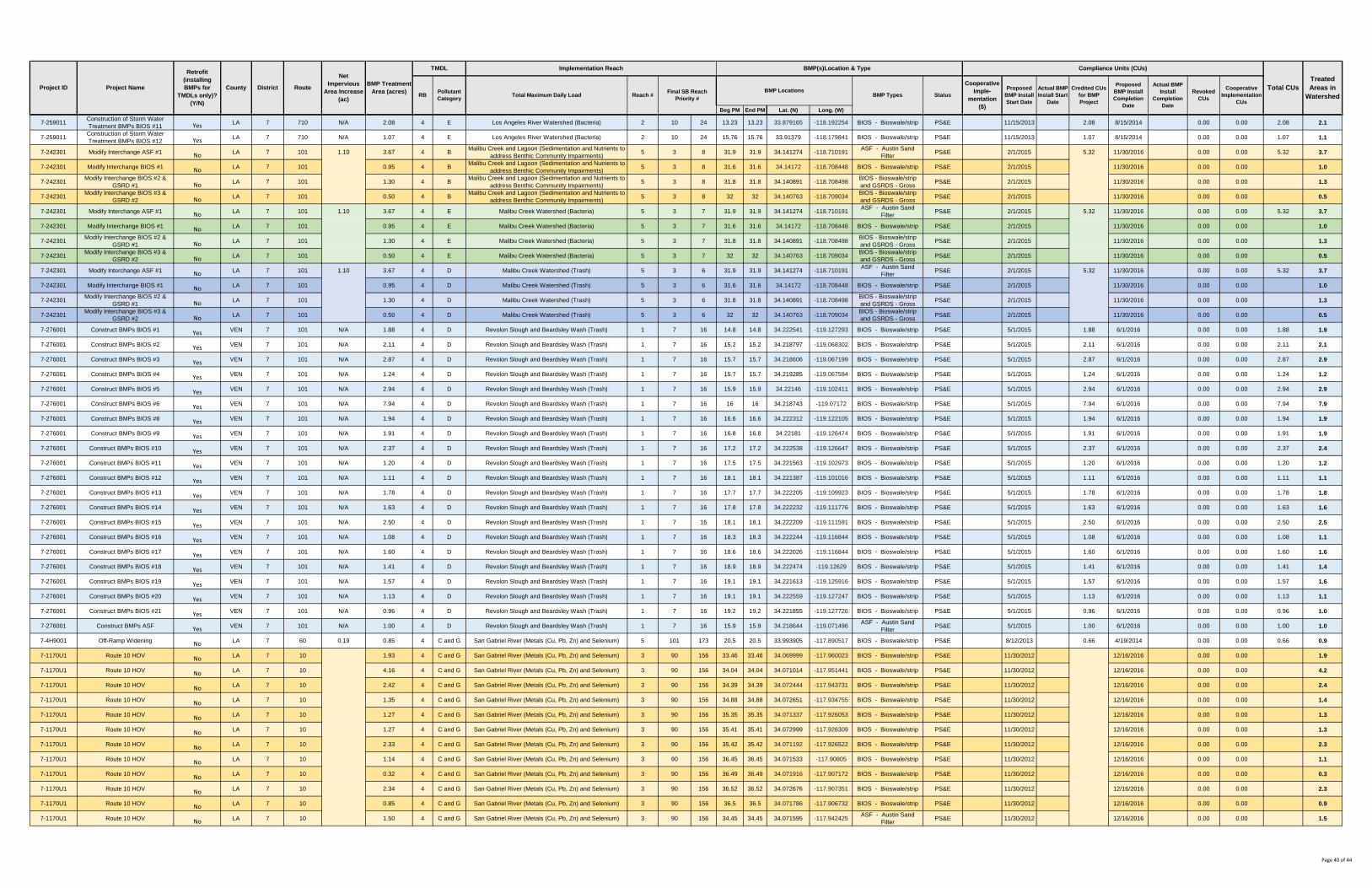
Beg PM End PM Lat. (N) Long. (W)
RouteProject ID Project Name
Retrofit (installing BMPs for
TMDLs only)? (Y/N)
County District Credited CUs for BMP Project
Proposed BMP Install Completion
Date
Actual BMP Install
Completion Date
Net Impervious
Area Increase (ac)
BMP Treatment Area (acres)
TMDL Implementation Reach BMP(s)Location & Type
BMP LocationsBMP Types Status
Revoked CUs
Total CUsTreated Areas in
WatershedRBPollutant Category
Total Maximum Daily Load Reach #Final SB Reach
Priority #
Compliance Units (CUs)
Cooperative Imple-
mentation ($)
Cooperative Implementation
CUs
Proposed BMP Install Start Date
Actual BMP Install Start
Date
7-259011Construction of Storm Water Treatment BMPs BIOS #11 Yes LA 7 710 N/A 2.08 4 E Los Angeles River Watershed (Bacteria) 2 10 24 13.23 13.23 33.879165 -118.192254 BIOS - Bioswale/strip PS&E 11/15/2013 2.08 8/15/2014 0.00 0.00 2.08 2.1
7-259011Construction of Storm Water Treatment BMPs BIOS #12 Yes LA 7 710 N/A 1.07 4 E Los Angeles River Watershed (Bacteria) 2 10 24 15.76 15.76 33.91379 -118.179841 BIOS - Bioswale/strip PS&E 11/15/2013 1.07 8/15/2014 0.00 0.00 1.07 1.1
7-242301 Modify Interchange ASF #1 No LA 7 101 1.10 3.67 4 BMalibu Creek and Lagoon (Sedimentation and Nutrients to
address Benthic Community Impairments)5 3 8 31.9 31.9 34.141274 -118.710191
ASF - Austin Sand Filter
PS&E 2/1/2015 5.32 11/30/2016 0.00 0.00 5.32 3.7
7-242301 Modify Interchange BIOS #1 No LA 7 101 0.95 4 BMalibu Creek and Lagoon (Sedimentation and Nutrients to
address Benthic Community Impairments)5 3 8 31.6 31.6 34.14172 -118.708448 BIOS - Bioswale/strip PS&E 2/1/2015 11/30/2016 0.00 0.00 1.0
7-242301Modify Interchange BIOS #2 &
GSRD #1 No LA 7 101 1.30 4 BMalibu Creek and Lagoon (Sedimentation and Nutrients to
address Benthic Community Impairments)5 3 8 31.8 31.8 34.140891 -118.708498
BIOS - Bioswale/strip and GSRDS - Gross
PS&E 2/1/2015 11/30/2016 0.00 0.00 1.3
7-242301Modify Interchange BIOS #3 &
GSRD #2 No LA 7 101 0.50 4 BMalibu Creek and Lagoon (Sedimentation and Nutrients to
address Benthic Community Impairments)5 3 8 32 32 34.140763 -118.709034
BIOS - Bioswale/strip and GSRDS - Gross
PS&E 2/1/2015 11/30/2016 0.00 0.00 0.5
7-242301 Modify Interchange ASF #1 No LA 7 101 1.10 3.67 4 E Malibu Creek Watershed (Bacteria) 5 3 7 31.9 31.9 34.141274 -118.710191ASF - Austin Sand
FilterPS&E 2/1/2015 5.32 11/30/2016 0.00 0.00 5.32 3.7
7-242301 Modify Interchange BIOS #1 No LA 7 101 0.95 4 E Malibu Creek Watershed (Bacteria) 5 3 7 31.6 31.6 34.14172 -118.708448 BIOS - Bioswale/strip PS&E 2/1/2015 11/30/2016 0.00 0.00 1.0
7-242301Modify Interchange BIOS #2 &
GSRD #1 No LA 7 101 1.30 4 E Malibu Creek Watershed (Bacteria) 5 3 7 31.8 31.8 34.140891 -118.708498BIOS - Bioswale/strip and GSRDS - Gross
PS&E 2/1/2015 11/30/2016 0.00 0.00 1.3
7-242301Modify Interchange BIOS #3 &
GSRD #2 No LA 7 101 0.50 4 E Malibu Creek Watershed (Bacteria) 5 3 7 32 32 34.140763 -118.709034BIOS - Bioswale/strip and GSRDS - Gross
PS&E 2/1/2015 11/30/2016 0.00 0.00 0.5
7-242301 Modify Interchange ASF #1 No LA 7 101 1.10 3.67 4 D Malibu Creek Watershed (Trash) 5 3 6 31.9 31.9 34.141274 -118.710191ASF - Austin Sand
FilterPS&E 2/1/2015 5.32 11/30/2016 0.00 0.00 5.32 3.7
7-242301 Modify Interchange BIOS #1 No LA 7 101 0.95 4 D Malibu Creek Watershed (Trash) 5 3 6 31.6 31.6 34.14172 -118.708448 BIOS - Bioswale/strip PS&E 2/1/2015 11/30/2016 0.00 0.00 1.0
7-242301Modify Interchange BIOS #2 &
GSRD #1 No LA 7 101 1.30 4 D Malibu Creek Watershed (Trash) 5 3 6 31.8 31.8 34.140891 -118.708498BIOS - Bioswale/strip and GSRDS - Gross
PS&E 2/1/2015 11/30/2016 0.00 0.00 1.3
7-242301Modify Interchange BIOS #3 &
GSRD #2 No LA 7 101 0.50 4 D Malibu Creek Watershed (Trash) 5 3 6 32 32 34.140763 -118.709034BIOS - Bioswale/strip and GSRDS - Gross
PS&E 2/1/2015 11/30/2016 0.00 0.00 0.5
7-276001 Construct BMPs BIOS #1 Yes VEN 7 101 N/A 1.88 4 D Revolon Slough and Beardsley Wash (Trash) 1 7 16 14.8 14.8 34.222541 -119.127293 BIOS - Bioswale/strip PS&E 5/1/2015 1.88 6/1/2016 0.00 0.00 1.88 1.9
7-276001 Construct BMPs BIOS #2 Yes VEN 7 101 N/A 2.11 4 D Revolon Slough and Beardsley Wash (Trash) 1 7 16 15.2 15.2 34.218797 -119.068302 BIOS - Bioswale/strip PS&E 5/1/2015 2.11 6/1/2016 0.00 0.00 2.11 2.1
7-276001 Construct BMPs BIOS #3 Yes VEN 7 101 N/A 2.87 4 D Revolon Slough and Beardsley Wash (Trash) 1 7 16 15.7 15.7 34.218606 -119.067199 BIOS - Bioswale/strip PS&E 5/1/2015 2.87 6/1/2016 0.00 0.00 2.87 2.9
7-276001 Construct BMPs BIOS #4 Yes VEN 7 101 N/A 1.24 4 D Revolon Slough and Beardsley Wash (Trash) 1 7 16 15.7 15.7 34.219285 -119.067594 BIOS - Bioswale/strip PS&E 5/1/2015 1.24 6/1/2016 0.00 0.00 1.24 1.2
7-276001 Construct BMPs BIOS #5 Yes VEN 7 101 N/A 2.94 4 D Revolon Slough and Beardsley Wash (Trash) 1 7 16 15.9 15.9 34.22146 -119.102411 BIOS - Bioswale/strip PS&E 5/1/2015 2.94 6/1/2016 0.00 0.00 2.94 2.9
7-276001 Construct BMPs BIOS #6 Yes VEN 7 101 N/A 7.94 4 D Revolon Slough and Beardsley Wash (Trash) 1 7 16 16 16 34.218743 -119.07172 BIOS - Bioswale/strip PS&E 5/1/2015 7.94 6/1/2016 0.00 0.00 7.94 7.9
7-276001 Construct BMPs BIOS #8 Yes VEN 7 101 N/A 1.94 4 D Revolon Slough and Beardsley Wash (Trash) 1 7 16 16.6 16.6 34.222312 -119.122105 BIOS - Bioswale/strip PS&E 5/1/2015 1.94 6/1/2016 0.00 0.00 1.94 1.9
7-276001 Construct BMPs BIOS #9 Yes VEN 7 101 N/A 1.91 4 D Revolon Slough and Beardsley Wash (Trash) 1 7 16 16.8 16.8 34.22181 -119.126474 BIOS - Bioswale/strip PS&E 5/1/2015 1.91 6/1/2016 0.00 0.00 1.91 1.9
7-276001 Construct BMPs BIOS #10 Yes VEN 7 101 N/A 2.37 4 D Revolon Slough and Beardsley Wash (Trash) 1 7 16 17.2 17.2 34.222538 -119.126647 BIOS - Bioswale/strip PS&E 5/1/2015 2.37 6/1/2016 0.00 0.00 2.37 2.4
7-276001 Construct BMPs BIOS #11 Yes VEN 7 101 N/A 1.20 4 D Revolon Slough and Beardsley Wash (Trash) 1 7 16 17.5 17.5 34.221563 -119.102973 BIOS - Bioswale/strip PS&E 5/1/2015 1.20 6/1/2016 0.00 0.00 1.20 1.2
7-276001 Construct BMPs BIOS #12 Yes VEN 7 101 N/A 1.11 4 D Revolon Slough and Beardsley Wash (Trash) 1 7 16 18.1 18.1 34.221387 -119.101016 BIOS - Bioswale/strip PS&E 5/1/2015 1.11 6/1/2016 0.00 0.00 1.11 1.1
7-276001 Construct BMPs BIOS #13 Yes VEN 7 101 N/A 1.78 4 D Revolon Slough and Beardsley Wash (Trash) 1 7 16 17.7 17.7 34.222205 -119.109923 BIOS - Bioswale/strip PS&E 5/1/2015 1.78 6/1/2016 0.00 0.00 1.78 1.8
7-276001 Construct BMPs BIOS #14 Yes VEN 7 101 N/A 1.63 4 D Revolon Slough and Beardsley Wash (Trash) 1 7 16 17.8 17.8 34.222232 -119.111776 BIOS - Bioswale/strip PS&E 5/1/2015 1.63 6/1/2016 0.00 0.00 1.63 1.6
7-276001 Construct BMPs BIOS #15 Yes VEN 7 101 N/A 2.50 4 D Revolon Slough and Beardsley Wash (Trash) 1 7 16 18.1 18.1 34.222209 -119.111591 BIOS - Bioswale/strip PS&E 5/1/2015 2.50 6/1/2016 0.00 0.00 2.50 2.5
7-276001 Construct BMPs BIOS #16 Yes VEN 7 101 N/A 1.08 4 D Revolon Slough and Beardsley Wash (Trash) 1 7 16 18.3 18.3 34.222244 -119.116844 BIOS - Bioswale/strip PS&E 5/1/2015 1.08 6/1/2016 0.00 0.00 1.08 1.1
7-276001 Construct BMPs BIOS #17 Yes VEN 7 101 N/A 1.60 4 D Revolon Slough and Beardsley Wash (Trash) 1 7 16 18.6 18.6 34.222026 -119.116844 BIOS - Bioswale/strip PS&E 5/1/2015 1.60 6/1/2016 0.00 0.00 1.60 1.6
7-276001 Construct BMPs BIOS #18 Yes VEN 7 101 N/A 1.41 4 D Revolon Slough and Beardsley Wash (Trash) 1 7 16 18.9 18.9 34.222474 -119.12629 BIOS - Bioswale/strip PS&E 5/1/2015 1.41 6/1/2016 0.00 0.00 1.41 1.4
7-276001 Construct BMPs BIOS #19 Yes VEN 7 101 N/A 1.57 4 D Revolon Slough and Beardsley Wash (Trash) 1 7 16 19.1 19.1 34.221613 -119.125916 BIOS - Bioswale/strip PS&E 5/1/2015 1.57 6/1/2016 0.00 0.00 1.57 1.6
7-276001 Construct BMPs BIOS #20 Yes VEN 7 101 N/A 1.13 4 D Revolon Slough and Beardsley Wash (Trash) 1 7 16 19.1 19.1 34.222559 -119.127247 BIOS - Bioswale/strip PS&E 5/1/2015 1.13 6/1/2016 0.00 0.00 1.13 1.1
7-276001 Construct BMPs BIOS #21 Yes VEN 7 101 N/A 0.96 4 D Revolon Slough and Beardsley Wash (Trash) 1 7 16 19.2 19.2 34.221855 -119.127726 BIOS - Bioswale/strip PS&E 5/1/2015 0.96 6/1/2016 0.00 0.00 0.96 1.0
7-276001 Construct BMPs ASF Yes VEN 7 101 N/A 1.00 4 D Revolon Slough and Beardsley Wash (Trash) 1 7 16 15.9 15.9 34.218644 -119.071496ASF - Austin Sand
FilterPS&E 5/1/2015 1.00 6/1/2016 0.00 0.00 1.00 1.0
7-4H9001 Off-Ramp Widening No LA 7 60 0.19 0.85 4 C and G San Gabriel River (Metals (Cu, Pb, Zn) and Selenium) 5 101 173 20.5 20.5 33.993905 -117.890517 BIOS - Bioswale/strip PS&E 8/12/2013 0.66 4/19/2014 0.00 0.00 0.66 0.9
7-1170U1 Route 10 HOV No LA 7 10 1.93 4 C and G San Gabriel River (Metals (Cu, Pb, Zn) and Selenium) 3 90 156 33.46 33.46 34.069999 -117.960023 BIOS - Bioswale/strip PS&E 11/30/2012 12/16/2016 0.00 0.00 1.9
7-1170U1 Route 10 HOV No LA 7 10 4.16 4 C and G San Gabriel River (Metals (Cu, Pb, Zn) and Selenium) 3 90 156 34.04 34.04 34.071014 -117.951441 BIOS - Bioswale/strip PS&E 11/30/2012 12/16/2016 0.00 0.00 4.2
7-1170U1 Route 10 HOV No LA 7 10 2.42 4 C and G San Gabriel River (Metals (Cu, Pb, Zn) and Selenium) 3 90 156 34.39 34.39 34.072444 -117.943731 BIOS - Bioswale/strip PS&E 11/30/2012 12/16/2016 0.00 0.00 2.4
7-1170U1 Route 10 HOV No LA 7 10 1.35 4 C and G San Gabriel River (Metals (Cu, Pb, Zn) and Selenium) 3 90 156 34.88 34.88 34.072651 -117.934755 BIOS - Bioswale/strip PS&E 11/30/2012 12/16/2016 0.00 0.00 1.4
7-1170U1 Route 10 HOV No LA 7 10 1.27 4 C and G San Gabriel River (Metals (Cu, Pb, Zn) and Selenium) 3 90 156 35.35 35.35 34.071337 -117.926053 BIOS - Bioswale/strip PS&E 11/30/2012 12/16/2016 0.00 0.00 1.3
7-1170U1 Route 10 HOV No LA 7 10 1.27 4 C and G San Gabriel River (Metals (Cu, Pb, Zn) and Selenium) 3 90 156 35.41 35.41 34.072999 -117.926309 BIOS - Bioswale/strip PS&E 11/30/2012 12/16/2016 0.00 0.00 1.3
7-1170U1 Route 10 HOV No LA 7 10 2.33 4 C and G San Gabriel River (Metals (Cu, Pb, Zn) and Selenium) 3 90 156 35.42 35.42 34.071192 -117.926522 BIOS - Bioswale/strip PS&E 11/30/2012 12/16/2016 0.00 0.00 2.3
7-1170U1 Route 10 HOV No LA 7 10 1.14 4 C and G San Gabriel River (Metals (Cu, Pb, Zn) and Selenium) 3 90 156 36.45 36.45 34.071533 -117.90805 BIOS - Bioswale/strip PS&E 11/30/2012 12/16/2016 0.00 0.00 1.1
7-1170U1 Route 10 HOV No LA 7 10 0.32 4 C and G San Gabriel River (Metals (Cu, Pb, Zn) and Selenium) 3 90 156 36.49 36.49 34.071916 -117.907172 BIOS - Bioswale/strip PS&E 11/30/2012 12/16/2016 0.00 0.00 0.3
7-1170U1 Route 10 HOV No LA 7 10 2.34 4 C and G San Gabriel River (Metals (Cu, Pb, Zn) and Selenium) 3 90 156 36.52 36.52 34.072676 -117.907351 BIOS - Bioswale/strip PS&E 11/30/2012 12/16/2016 0.00 0.00 2.3
7-1170U1 Route 10 HOV No LA 7 10 0.85 4 C and G San Gabriel River (Metals (Cu, Pb, Zn) and Selenium) 3 90 156 36.5 36.5 34.071786 -117.906732 BIOS - Bioswale/strip PS&E 11/30/2012 12/16/2016 0.00 0.00 0.9
7-1170U1 Route 10 HOV No LA 7 10 1.50 4 C and G San Gabriel River (Metals (Cu, Pb, Zn) and Selenium) 3 90 156 34.45 34.45 34.071595 -117.942425ASF - Austin Sand
FilterPS&E 11/30/2012 12/16/2016 0.00 0.00 1.5
Page 40 of 44

Beg PM End PM Lat. (N) Long. (W)
RouteProject ID Project Name
Retrofit (installing BMPs for
TMDLs only)? (Y/N)
County District Credited CUs for BMP Project
Proposed BMP Install Completion
Date
Actual BMP Install
Completion Date
Net Impervious
Area Increase (ac)
BMP Treatment Area (acres)
TMDL Implementation Reach BMP(s)Location & Type
BMP LocationsBMP Types Status
Revoked CUs
Total CUsTreated Areas in
WatershedRBPollutant Category
Total Maximum Daily Load Reach #Final SB Reach
Priority #
Compliance Units (CUs)
Cooperative Imple-
mentation ($)
Cooperative Implementation
CUs
Proposed BMP Install Start Date
Actual BMP Install Start
Date
7-2159C1 Freeway Widening No LA 7 5 4 C and G San Gabriel River (Metals (Cu, Pb, Zn) and Selenium) 6 108 183 2.46 2.46 33.894035 -118.047297 BIOS - Bioswale/strip PS&E 8/1/2009 12/1/2012 0.00 0.00 0.0
7-2159C1 Freeway Widening No LA 7 5 4 C and G San Gabriel River (Metals (Cu, Pb, Zn) and Selenium) 6 108 183 2.51 2.51 33.894429 -118.048026 BIOS - Bioswale/strip PS&E 8/1/2009 12/1/2012 0.00 0.00 0.0
7-117071 Freeway Widening HOV No LA 7 10 3.60 1.07 4 C and G San Gabriel River (Metals (Cu, Pb, Zn) and Selenium) 3 90 156 31.3 31.3 34.065384 -117.997575 BIOS - Bioswale/strip PS&E 8/18/2008 1.34 9/11/2008 0.00 0.00 1.34 1.1
7-117071 Freeway Widening HOV No LA 7 10 1.80 4 C and G San Gabriel River (Metals (Cu, Pb, Zn) and Selenium) 3 90 156 31.3 31.3 34.065384 -117.997575 BIOS - Bioswale/strip PS&E 8/18/2008 9/11/2008 0.00 0.00 1.8
7-117071 Freeway Widening HOV No LA 7 10 2.07 4 C and G San Gabriel River (Metals (Cu, Pb, Zn) and Selenium) 3 90 156 32.4 32.4 34.067938 -117.978646 BIOS - Bioswale/strip PS&E 8/18/2008 9/11/2008 0.00 0.00 2.1
7-279100 Interchange Improvement No LA 7 60 14.10 1.50 4 C and G San Gabriel River (Metals (Cu, Pb, Zn) and Selenium) 5 101 173 24.23 24.23 34.007575 -117.825969 BIOS - Bioswale/strip PA/ED 4/22/2014 0.50 10/24/2016 0.00 0.00 0.50 1.5
7-279100 Interchange Improvement No LA 7 60 7.20 4 C and G San Gabriel River (Metals (Cu, Pb, Zn) and Selenium) 5 101 173 24.34 24.34 34.008852 -117.824654INFIL - Infiltration
(Basins & Trenches)PA/ED 4/22/2014 10/24/2016 0.00 0.00 7.2
7-279100 Interchange Improvement No LA 7 60 3.40 4 C and G San Gabriel River (Metals (Cu, Pb, Zn) and Selenium) 5 101 173 24.56 24.56 34.011339 -117.82213ASF - Austin Sand
FilterPA/ED 4/22/2014 10/24/2016 0.00 0.00 3.4
7-279100 Interchange Improvement No LA 7 60 1.80 4 C and G San Gabriel River (Metals (Cu, Pb, Zn) and Selenium) 5 101 173 24.63 24.63 34.012097 -117.821363 BIOS - Bioswale/strip PA/ED 4/22/2014 10/24/2016 0.00 0.00 1.8
7-279100 Interchange Improvement No LA 7 60 0.70 4 C and G San Gabriel River (Metals (Cu, Pb, Zn) and Selenium) 5 101 173 24.64 24.64 34.012207 -117.821252 BIOS - Bioswale/strip PA/ED 4/22/2014 10/24/2016 0.00 0.00 0.7
7-287301 Source Control BIOS #2 No LA 7 210 0.41 4 C and G San Gabriel River (Metals (Cu, Pb, Zn) and Selenium) 3 90 156 41.8 41.8 34.119968 -117.872046 BIOS - Bioswale/strip PS&E 8/21/2014 0.41 2/11/2015 0.00 0.00 0.41 0.4
7-286901Roadway Rehabilitation and
Restoration DetBas #2 No LA 7 60 0.00 1.16 4 C and G San Gabriel River (Metals (Cu, Pb, Zn) and Selenium) 5 101 173 20.35 20.35 33.994574 -117.889052DetBas - Detention
BasinsPS&E 11/7/2011 2.50 12/30/2013 0.00 0.00 2.50 1.2
7-286901Roadway Rehabilitation and
Restoration DetBas #2 No LA 7 60 1.34 4 C and G San Gabriel River (Metals (Cu, Pb, Zn) and Selenium) 5 101 173 20.48 20.48 33.9938 -117.887874DetBas - Detention
BasinsPS&E 11/7/2011 12/30/2013 0.00 0.00 1.3
7-255101 Ramp Improvement No LA 7 60 1.30 3.50 4 C and G San Gabriel River (Metals (Cu, Pb, Zn) and Selenium) 5 101 173 24.23 24.23 34.007824 -117.826458 BIOS - Bioswale/strip PS&E 4/15/2014 2.20 12/12/2014 0.00 0.00 2.20 3.5
7-246501 Highway Planting Native Plants Yes LA 7 10 N/A 4.90 4 C and G San Gabriel River (Metals (Cu, Pb, Zn) and Selenium) 5 101 173 42.383 42.383 34.065841 -117.807844 BIOS - Bioswale/strip PS&E 12/30/2008 4.90 7/9/2009 0.00 0.00 4.90 4.9
7-246501 Highway Planting Native Plants Yes LA 7 10 N/A 1.62 4 C and G San Gabriel River (Metals (Cu, Pb, Zn) and Selenium) 5 101 173 42.366 42.366 34.063669 -117.807447 BIOS - Bioswale/strip PS&E 12/30/2008 1.62 7/9/2009 0.00 0.00 1.62 1.6
7-246501 Highway Planting Native Plants Yes LA 7 10 N/A 0.15 4 C and G San Gabriel River (Metals (Cu, Pb, Zn) and Selenium) 5 101 173 42.458 42.458 34.064839 -117.806598 BIOS - Bioswale/strip PS&E 12/30/2008 0.15 7/9/2009 0.00 0.00 0.15 0.2
7-210600Widening and Construct HOV
Lane(BIOS Site 18) No LA 7 71 24.10 1.18 4 C and G San Gabriel River (Metals (Cu, Pb, Zn) and Selenium) 5 101 173 1.497 1.497 34.05483 -117.78259 BIOS - Bioswale/strip PA/ED 12/5/2015 18.90 12/13/2017 0.00 0.00 18.90 1.2
7-210600Widening and Construct HOV
Lane(BIOS Site 23) No LA 7 71 0.26 4 C and G San Gabriel River (Metals (Cu, Pb, Zn) and Selenium) 5 101 173 1.497 1.497 34.05483 -117.78259 BIOS - Bioswale/strip PA/ED 12/5/2015 12/13/2017 0.00 0.00 0.3
7-210600Widening and Construct HOV
Lane(BIOS Site 25) No LA 7 71 0.41 4 C and G San Gabriel River (Metals (Cu, Pb, Zn) and Selenium) 5 101 173 1.547 1.547 34.05426 -117.78204 BIOS - Bioswale/strip PA/ED 12/5/2015 12/13/2017 0.00 0.00 0.4
7-210600Widening and Construct HOV
Lane(BIOS/GRSD Site 28) No LA 7 71 0.80 4 C and G San Gabriel River (Metals (Cu, Pb, Zn) and Selenium) 5 101 173 1.648 1.648 34.05312 -117.78093BIOS - Bioswale/strip and GSRDS - Gross
PA/ED 12/5/2015 12/13/2017 0.00 0.00 0.8
7-210600Widening and Construct HOV
Lane(BIOS Site 31) No LA 7 71 1.64 4 C and G San Gabriel River (Metals (Cu, Pb, Zn) and Selenium) 5 101 173 1.698 1.698 34.05258 -117.78035 BIOS - Bioswale/strip PA/ED 12/5/2015 12/13/2017 0.00 0.00 1.6
7-210600Widening and Construct HOV
Lane(BIOS/GRSD Site 32) No LA 7 71 0.71 4 C and G San Gabriel River (Metals (Cu, Pb, Zn) and Selenium) 5 101 173 1.748 1.748 34.05205 -117.77977BIOS - Bioswale/strip and GSRDS - Gross
PA/ED 12/5/2015 12/13/2017 0.00 0.00 0.7
7-210600Widening and Construct HOV
Lane(BIOS Site 36) No LA 7 71 0.40 4 C and G San Gabriel River (Metals (Cu, Pb, Zn) and Selenium) 5 101 173 1.899 1.899 34.05042 -117.77804 BIOS - Bioswale/strip PA/ED 12/5/2015 12/13/2017 0.00 0.00 0.4
7-210600Widening and Construct HOV
Lane(BIOS Site 12) No LA 7 71 1.81 4 C and G San Gabriel River (Metals (Cu, Pb, Zn) and Selenium) 5 101 173 1.093 1.093 34.0641 -117.79537 BIOS - Bioswale/strip PA/ED 12/5/2015 12/13/2017 0.00 0.00 1.8
7- 215911Freeway
Widening/Reconstruction(BIOS) No LA 7 5 7.00 1.73 4 C and G San Gabriel River (Metals (Cu, Pb, Zn) and Selenium) 6 108 183 1.75 1.75 33.888036 -118.037313 BIOS - Bioswale/strip PS&E 8/12/2011 10.64 11/1/2013 0.00 0.00 10.64 1.7
7- 215911Freeway
Widening/Reconstruction(MEDF) No LA 7 5 15.92 4 C and G San Gabriel River (Metals (Cu, Pb, Zn) and Selenium) 6 108 183 1.814 1.814 33.888971 -118.037782 MEDF - Media Filter PS&E 8/12/2011 11/1/2013 0.00 0.00 15.9
7-215921HOV Freeway Widening(BIOS
Exist) No LA 7 5 5.80 6.70 4 C and G San Gabriel River (Metals (Cu, Pb, Zn) and Selenium) 6 108 183 0.041 0.041 33.87514 -118.01202 BIOS - Bioswale/strip PS&E 8/26/2014 13.54 3/21/2014 0.00 0.00 13.54 6.7
7-215921HOV Freeway Widening(BIOS
New) No LA 7 5 2.26 4 C and G San Gabriel River (Metals (Cu, Pb, Zn) and Selenium) 6 108 183 0.219 0.219 33.87641 -118.01459 BIOS - Bioswale/strip PS&E 8/26/2014 3/21/2014 0.00 0.00 2.3
7-215921HOV Freeway Widening(BIOS Site
#2) No LA 7 5 3.60 4 C and G San Gabriel River (Metals (Cu, Pb, Zn) and Selenium) 6 108 183 0.829 0.829 33.88112 -118.0234 BIOS - Bioswale/strip PS&E 8/26/2014 3/21/2014 0.00 0.00 3.6
7-215921HOV Freeway Widening(BIOS Site
#4) No LA 7 5 3.60 4 C and G San Gabriel River (Metals (Cu, Pb, Zn) and Selenium) 6 108 183 1.152 1.152 33.88362 -118.02804 BIOS - Bioswale/strip PS&E 8/26/2014 3/21/2014 0.00 0.00 3.6
7-215921HOV Freeway Widening(Other-
Site #7) No LA 7 5 3.18 4 C and G San Gabriel River (Metals (Cu, Pb, Zn) and Selenium) 6 108 183 1.338 1.338 33.88515 -118.03086ASF - Austin Sand
FilterPS&E 8/26/2014 3/21/2014 0.00 0.00 3.2
7-215931Roadway Widening(MEDF Site #
22) No LA 7 5 4.10 4 C and G San Gabriel River (Metals (Cu, Pb, Zn) and Selenium) 6 108 183 3.469 3.469 33.9025 -118.06184 MEDF - Media Filter PS&E 9/14/2012 4/22/2016 0.00 0.00 4.1
7-215941Roadway Widening (Segment 4)
(DelSandF 28a) No LA 7 5 11.39 4 C and G San Gabriel River (Metals (Cu, Pb, Zn) and Selenium) 6 108 183 4.618 4.618 33.91375 -118.07635DelSandF - Delaware
Sand FilterPS&E 8/28/2012 10/13/2017 0.00 0.00 11.4
7-215951Roadway Widening (Segment 5)
(DetBas # 34a) No LA 7 5 5.60 22.00 4 C and G San Gabriel River (Metals (Cu, Pb, Zn) and Selenium) 3 90 156 6.729 6.729 33.93967 -118.09561DetBas - Detention
BasinsPS&E 7/1/2013 24.75 12/1/2016 0.00 0.00 24.75 22.0
7-215951Roadway Widening (Segment 5)
(BIOS Site # 36) No LA 7 5 0.68 4 C and G San Gabriel River (Metals (Cu, Pb, Zn) and Selenium) 3 90 156 6.492 6.492 33.93665 -118.09361 BIOS - Bioswale/strip PS&E 7/1/2013 12/1/2016 0.00 0.00 0.7
7-215951Roadway Widening (Segment 5)
(INFIL Site # 37) No LA 7 5 2.60 4 C and G San Gabriel River (Metals (Cu, Pb, Zn) and Selenium) 3 90 156 6.522 6.522 33.93703 -118.09386INFIL - Infiltration
(Basins & Trenches)PS&E 7/1/2013 12/1/2016 0.00 0.00 2.6
7-215951Roadway Widening (Segment 5)
(DetBas Site #43) No LA 7 5 1.10 4 C and G San Gabriel River (Metals (Cu, Pb, Zn) and Selenium) 3 90 156 6.888 6.888 33.94175 -118.09699DetBas - Detention
BasinsPS&E 7/1/2013 12/1/2016 0.00 0.00 1.1
7-215951Roadway Widening (Segment 5)
(ASF Site #44) No LA 7 5 2.80 4 C and G San Gabriel River (Metals (Cu, Pb, Zn) and Selenium) 3 90 156 6.888 6.888 33.94175 -118.09699ASF - Austin Sand
FilterPS&E 7/1/2013 12/1/2016 0.00 0.00 2.8
7-215951Roadway Widening (Segment 5)
(BIOS Site #36a) No LA 7 5 1.17 4 C and G San Gabriel River (Metals (Cu, Pb, Zn) and Selenium) 3 90 156 6.472 6.472 33.9364 -118.09344 BIOS - Bioswale/strip PS&E 7/1/2013 12/1/2016 0.00 0.00 1.2
7-224100Construct new interchance and
sound walls(DelSandF #1-WB On- No LA 7 60 2.02 0.94 4 C and G San Gabriel River (Metals (Cu, Pb, Zn) and Selenium) 5 101 173 22.942 22.942 34.000947 -117.845744DelSandF - Delaware
Sand FilterPA/ED 3/1/2011 0.17 11/15/2012 0.00 0.00 0.17 0.9
7-224100Construct new interchance and
sound walls(DelSandF #2-EB On- No LA 7 60 1.25 4 C and G San Gabriel River (Metals (Cu, Pb, Zn) and Selenium) 5 101 173 22.946 22.946 34.000483 -117.845458DelSandF - Delaware
Sand FilterPA/ED 3/1/2011 11/15/2012 0.00 0.00 1.3
7-223101Noise Abatement/Sound
Barriers(BIOS 20) No LA 7 605 2.00 0.28 4 C and G San Gabriel River (Metals (Cu, Pb, Zn) and Selenium) 3 90 156 12.11 12.11 33.97486 -118.0808 BIOS - Bioswale/strip PS&E 6/21/2010 2.85 2/19/2013 0.00 0.00 2.85 0.3
7-223101Noise Abatement/Sound
Barriers(BIOS 28) No LA 7 605 0.58 4 C and G San Gabriel River (Metals (Cu, Pb, Zn) and Selenium) 3 90 156 13.51 13.51 33.99238 -118.0691 BIOS - Bioswale/strip PS&E 6/21/2010 2/19/2013 0.00 0.00 0.6
7-223101Noise Abatement/Sound
Barriers(BIOS 28) No LA 7 605 0.48 4 C and G San Gabriel River (Metals (Cu, Pb, Zn) and Selenium) 3 90 156 13.51 13.51 33.99218 -118.0688 BIOS - Bioswale/strip PS&E 6/21/2010 2/19/2013 0.00 0.00 0.5
7-223101Noise Abatement/Sound
Barriers(BIOS 30) No LA 7 605 0.78 4 C and G San Gabriel River (Metals (Cu, Pb, Zn) and Selenium) 3 90 156 13.64 13.64 33.99434 -118.0696 BIOS - Bioswale/strip PS&E 6/21/2010 2/19/2013 0.00 0.00 0.8
7-223101Noise Abatement/Sound
Barriers(BIOS 15) No LA 7 605 1.97 4 C and G San Gabriel River (Metals (Cu, Pb, Zn) and Selenium) 3 90 156 11.68 11.68 33.96768 -118.0835 BIOS - Bioswale/strip PS&E 6/21/2010 2/19/2013 0.00 0.00 2.0
7-223101Noise Abatement/Sound
Barriers(BIOS 32) No LA 7 605 0.76 4 C and G San Gabriel River (Metals (Cu, Pb, Zn) and Selenium) 3 90 156 13.73 13.73 33.99388 -118.0715 BIOS - Bioswale/strip PS&E 6/21/2010 2/19/2013 0.00 0.00 0.8
Page 41 of 44

Beg PM End PM Lat. (N) Long. (W)
RouteProject ID Project Name
Retrofit (installing BMPs for
TMDLs only)? (Y/N)
County District Credited CUs for BMP Project
Proposed BMP Install Completion
Date
Actual BMP Install
Completion Date
Net Impervious
Area Increase (ac)
BMP Treatment Area (acres)
TMDL Implementation Reach BMP(s)Location & Type
BMP LocationsBMP Types Status
Revoked CUs
Total CUsTreated Areas in
WatershedRBPollutant Category
Total Maximum Daily Load Reach #Final SB Reach
Priority #
Compliance Units (CUs)
Cooperative Imple-
mentation ($)
Cooperative Implementation
CUs
Proposed BMP Install Start Date
Actual BMP Install Start
Date
7-4U4491Landscaping Planting, Irrigation &
Hardscape No LA 7 14 0.95 1.17 4 E Santa Clara River Estuary & Reaches 3,5,6,7 (Coliform) 5 236 271 33.54 33.54 34.426746 -118.419365 BIOS - Bioswale/strip PS&E 5/1/2013 0.22 11/1/2013 0.00 0.00 0.22 1.2
7-2332A1 Construct Truck lane No LA 7 5 3.65 4 E Santa Clara River Estuary & Reaches 3,5,6,7 (Coliform) 4 187 270 49.6 49.6 34.36942 -118.559576 BIOS - Bioswale/strip PS&E 1/2/2012 10/2/2013 0.00 0.00 3.7
7-2332E0 Construct Hot lanes No LA 7 5 71.38 1.60 4 E Santa Clara River Estuary & Reaches 3,5,6,7 (Coliform) 4 187 270 51.77 51.77 34.398805 -118.572382DelSandF - Delaware
Sand FilterPA/ED 2/1/2014 1.61 7/1/2018 0.00 0.00 1.61 1.6
7-2332E0 Construct Hot lanes No LA 7 5 1.20 4 E Santa Clara River Estuary & Reaches 3,5,6,7 (Coliform) 4 187 270 52.43 52.43 34.407797 -118.576079DelSandF - Delaware
Sand FilterPA/ED 2/1/2014 7/1/2018 0.00 0.00 1.2
7-2332E0 Construct Hot lanes No LA 7 5 3.20 4 E Santa Clara River Estuary & Reaches 3,5,6,7 (Coliform) 4 187 270 52.55 52.55 34.409437 -118.57681INFIL - Infiltration
(Basins & Trenches)PA/ED 2/1/2014 7/1/2018 0.00 0.00 3.2
7-2332E0 Construct Hot lanes No LA 7 5 2.37 4 E Santa Clara River Estuary & Reaches 3,5,6,7 (Coliform) 4 187 270 54.04 54.04 34.429557 -118.586715DelSandF - Delaware
Sand FilterPA/ED 2/1/2014 7/1/2018 0.00 0.00 2.4
7-2332E0 Construct Hot lanes No LA 7 5 1.97 4 E Santa Clara River Estuary & Reaches 3,5,6,7 (Coliform) 4 187 270 54.42 54.42 34.434112 -118.591656INFIL - Infiltration
(Basins & Trenches)PA/ED 2/1/2014 7/1/2018 0.00 0.00 2.0
7-2332E0 Construct Hot lanes No LA 7 5 1.73 4 E Santa Clara River Estuary & Reaches 3,5,6,7 (Coliform) 6 234 298 55.5 55.5 34.444433 -118.6078INFIL - Infiltration
(Basins & Trenches)PA/ED 2/1/2014 7/1/2018 0.00 0.00 1.7
7-2332E0 Construct Hot lanes No LA 7 5 10.02 4 E Santa Clara River Estuary & Reaches 3,5,6,7 (Coliform) 6 234 298 58.53 58.53 34.483863 -118.615296ASF - Austin Sand
FilterPA/ED 2/1/2014 7/1/2018 0.00 0.00 10.0
7-2332E0 Construct Hot lanes No LA 7 5 1.58 4 E Santa Clara River Estuary & Reaches 3,5,6,7 (Coliform) 4 187 270 53.53 53.53 34.422756 -118.583095 BIOS - Bioswale/strip PA/ED 2/1/2014 7/1/2018 0.00 0.00 1.6
7-2332E0 Construct Hot lanes No LA 7 5 1.29 4 E Santa Clara River Estuary & Reaches 3,5,6,7 (Coliform) 4 187 270 53.53 53.53 34.422756 -118.583095 BIOS - Bioswale/strip PA/ED 2/1/2014 7/1/2018 0.00 0.00 1.3
7-2332E0 Construct Hot lanes No LA 7 5 1.28 4 E Santa Clara River Estuary & Reaches 3,5,6,7 (Coliform) 4 187 270 53.59 53.59 34.423553 -118.583512 BIOS - Bioswale/strip PA/ED 2/1/2014 7/1/2018 0.00 0.00 1.3
7-2332E0 Construct Hot lanes No LA 7 5 1.27 4 E Santa Clara River Estuary & Reaches 3,5,6,7 (Coliform) 4 187 270 53.58 53.58 34.423423 -118.583445 BIOS - Bioswale/strip PA/ED 2/1/2014 7/1/2018 0.00 0.00 1.3
7-2332E0 Construct Hot lanes No LA 7 5 1.95 4 E Santa Clara River Estuary & Reaches 3,5,6,7 (Coliform) 4 187 270 53.87 53.87 34.427293 -118.585429BIOS - Bioswale/strip and GSRDS - Gross
PA/ED 2/1/2014 7/1/2018 0.00 0.00 2.0
7-2332E0 Construct Hot lanes No LA 7 5 4 E Santa Clara River Estuary & Reaches 3,5,6,7 (Coliform) 4 187 270 49.6 49.6 34.36942 -118.559576 BIOS - Bioswale/strip PA/ED 2/1/2014 7/1/2018 0.00 0.00 0.0
7-2332E0 Construct Hot lanes No LA 7 5 4 E Santa Clara River Estuary & Reaches 3,5,6,7 (Coliform) 4 187 270 49.6 49.6 34.36942 -118.559576 BIOS - Bioswale/strip PA/ED 2/1/2014 7/1/2018 0.00 0.00 0.0
7-2332E0 Construct Hot lanes No LA 7 5 0.42 4 E Santa Clara River Estuary & Reaches 3,5,6,7 (Coliform) 4 187 270 50.17 50.17 34.376729 -118.564272 BIOS - Bioswale/strip PA/ED 2/1/2014 7/1/2018 0.00 0.00 0.4
7-2332E0 Construct Hot lanes No LA 7 5 0.85 4 E Santa Clara River Estuary & Reaches 3,5,6,7 (Coliform) 4 187 270 50.23 50.23 34.377501 -118.564765 BIOS - Bioswale/strip PA/ED 2/1/2014 7/1/2018 0.00 0.00 0.9
7-2332E0 Construct Hot lanes No LA 7 5 0.55 4 E Santa Clara River Estuary & Reaches 3,5,6,7 (Coliform) 4 187 270 50.39 50.39 34.379555 -118.566059 BIOS - Bioswale/strip PA/ED 2/1/2014 7/1/2018 0.00 0.00 0.6
7-2332E0 Construct Hot lanes No LA 7 5 1.57 4 E Santa Clara River Estuary & Reaches 3,5,6,7 (Coliform) 4 187 270 50.48 50.48 34.38073 -118.566706 BIOS - Bioswale/strip PA/ED 2/1/2014 7/1/2018 0.00 0.00 1.6
7-2332E0 Construct Hot lanes No LA 7 5 0.54 4 E Santa Clara River Estuary & Reaches 3,5,6,7 (Coliform) 4 187 270 50.53 50.53 34.381413 -118.567003 BIOS - Bioswale/strip PA/ED 2/1/2014 7/1/2018 0.00 0.00 0.5
7-2332E0 Construct Hot lanes No LA 7 5 1.91 4 E Santa Clara River Estuary & Reaches 3,5,6,7 (Coliform) 4 187 270 51.01 51.01 34.388271 -118.56979 BIOS - Bioswale/strip PA/ED 2/1/2014 7/1/2018 0.00 0.00 1.9
7-2332E0 Construct Hot lanes No LA 7 5 3.20 4 E Santa Clara River Estuary & Reaches 3,5,6,7 (Coliform) 4 187 270 52.33 52.33 34.406447 -118.575485 BIOS - Bioswale/strip PA/ED 2/1/2014 7/1/2018 0.00 0.00 3.2
7-2332E0 Construct Hot lanes No LA 7 5 1.13 4 E Santa Clara River Estuary & Reaches 3,5,6,7 (Coliform) 4 187 270 52.39 52.39 34.407256 -118.575841 BIOS - Bioswale/strip PA/ED 2/1/2014 7/1/2018 0.00 0.00 1.1
7-2332E0 Construct Hot lanes No LA 7 5 2.30 4 E Santa Clara River Estuary & Reaches 3,5,6,7 (Coliform) 4 187 270 52.41 52.41 34.407526 -118.57596 BIOS - Bioswale/strip PA/ED 2/1/2014 7/1/2018 0.00 0.00 2.3
7-2332E0 Construct Hot lanes No LA 7 5 1.00 4 E Santa Clara River Estuary & Reaches 3,5,6,7 (Coliform) 4 187 270 52.41 52.41 34.407526 -118.57596 BIOS - Bioswale/strip PA/ED 2/1/2014 7/1/2018 0.00 0.00 1.0
7-2332E0 Construct Hot lanes No LA 7 5 0.64 4 E Santa Clara River Estuary & Reaches 3,5,6,7 (Coliform) 4 187 270 52.5 52.5 34.40875 -118.576502 BIOS - Bioswale/strip PA/ED 2/1/2014 7/1/2018 0.00 0.00 0.6
7-2332E0 Construct Hot lanes No LA 7 5 9.14 4 E Santa Clara River Estuary & Reaches 3,5,6,7 (Coliform) 4 187 270 53.17 53.17 34.41797 -118.58056 BIOS - Bioswale/strip PA/ED 2/1/2014 7/1/2018 0.00 0.00 9.1
7-2332E0 Construct Hot lanes No LA 7 5 1.23 4 E Santa Clara River Estuary & Reaches 3,5,6,7 (Coliform) 4 187 270 54.22 54.22 34.431637 -118.588726 BIOS - Bioswale/strip PA/ED 2/1/2014 7/1/2018 0.00 0.00 1.2
7-2332E0 Construct Hot lanes No LA 7 5 3.26 4 E Santa Clara River Estuary & Reaches 3,5,6,7 (Coliform) 4 187 270 54.42 54.42 34.434112 -118.591656 BIOS - Bioswale/strip PA/ED 2/1/2014 7/1/2018 0.00 0.00 3.3
7-2332E0 Construct Hot lanes No LA 7 5 0.41 4 E Santa Clara River Estuary & Reaches 3,5,6,7 (Coliform) 4 187 270 54.55 54.55 34.435727 -118.59356 BIOS - Bioswale/strip PA/ED 2/1/2014 7/1/2018 0.00 0.00 0.4
7-2332E0 Construct Hot lanes No LA 7 5 0.97 4 E Santa Clara River Estuary & Reaches 3,5,6,7 (Coliform) 4 187 270 54.55 54.55 34.435727 -118.59356 BIOS - Bioswale/strip PA/ED 2/1/2014 7/1/2018 0.00 0.00 1.0
7-2332E0 Construct Hot lanes No LA 7 5 0.67 4 E Santa Clara River Estuary & Reaches 3,5,6,7 (Coliform) 4 187 270 55.12 55.12 34.441749 -118.602629 BIOS - Bioswale/strip PA/ED 2/1/2014 7/1/2018 0.00 0.00 0.7
7-2332E0 Construct Hot lanes No LA 7 5 0.89 4 E Santa Clara River Estuary & Reaches 3,5,6,7 (Coliform) 4 187 270 55.33 55.33 34.443469 -118.60594 BIOS - Bioswale/strip PA/ED 2/1/2014 7/1/2018 0.00 0.00 0.9
7-2332E0 Construct Hot lanes No LA 7 5 0.74 4 E Santa Clara River Estuary & Reaches 3,5,6,7 (Coliform) 6 234 298 55.39 55.39 34.44381 -118.606597 BIOS - Bioswale/strip PA/ED 2/1/2014 7/1/2018 0.00 0.00 0.7
7-2332E0 Construct Hot lanes No LA 7 5 1.79 4 E Santa Clara River Estuary & Reaches 3,5,6,7 (Coliform) 6 234 298 55.39 55.39 34.44381 -118.606597 BIOS - Bioswale/strip PA/ED 2/1/2014 7/1/2018 0.00 0.00 1.8
7-2332E0 Construct Hot lanes No LA 7 5 0.99 4 E Santa Clara River Estuary & Reaches 3,5,6,7 (Coliform) 6 234 298 55.57 55.57 34.44483 -118.608566 BIOS - Bioswale/strip PA/ED 2/1/2014 7/1/2018 0.00 0.00 1.0
7-2332E0 Construct Hot lanes No LA 7 5 2.84 4 E Santa Clara River Estuary & Reaches 3,5,6,7 (Coliform) 6 234 298 55.57 55.57 34.44483 -118.608566 BIOS - Bioswale/strip PA/ED 2/1/2014 7/1/2018 0.00 0.00 2.8
7-2332E0 Construct Hot lanes No LA 7 5 0.72 4 E Santa Clara River Estuary & Reaches 3,5,6,7 (Coliform) 6 234 298 55.83 55.83 34.446791 -118.611082 BIOS - Bioswale/strip PA/ED 2/1/2014 7/1/2018 0.00 0.00 0.7
7-2332E0 Construct Hot lanes No LA 7 5 0.51 4 E Santa Clara River Estuary & Reaches 3,5,6,7 (Coliform) 6 234 298 56.55 56.55 34.455272 -118.61599 BIOS - Bioswale/strip PA/ED 2/1/2014 7/1/2018 0.00 0.00 0.5
7-2332E0 Construct Hot lanes No LA 7 5 0.83 4 E Santa Clara River Estuary & Reaches 3,5,6,7 (Coliform) 6 234 298 56.55 56.55 34.455272 -118.61599 BIOS - Bioswale/strip PA/ED 2/1/2014 7/1/2018 0.00 0.00 0.8
7-2332E0 Construct Hot lanes No LA 7 5 1.14 4 E Santa Clara River Estuary & Reaches 3,5,6,7 (Coliform) 6 234 298 56.64 56.64 34.456583 -118.615996 BIOS - Bioswale/strip PA/ED 2/1/2014 7/1/2018 0.00 0.00 1.1
7-2332E0 Construct Hot lanes No LA 7 5 0.98 4 E Santa Clara River Estuary & Reaches 3,5,6,7 (Coliform) 6 234 298 56.68 56.68 34.457166 -118.615933 BIOS - Bioswale/strip PA/ED 2/1/2014 7/1/2018 0.00 0.00 1.0
7-2332E0 Construct Hot lanes No LA 7 5 2.31 4 E Santa Clara River Estuary & Reaches 3,5,6,7 (Coliform) 4 187 270 53.73 53.73 34.425413 -118.584445 BIOS - Bioswale/strip PA/ED 2/1/2014 7/1/2018 0.00 0.00 2.3
7-240801Modification of Golden Valley
Road Interchange BIOS No LA 7 14 0.70 0.32 4 E Santa Clara River Estuary & Reaches 3,5,6,7 (Coliform) 5 236 271 29.62 29.62 34.393572 -118.470078 BIOS - Bioswale/strip PS&E 10/20/2014 2.31 12/16/2015 0.00 0.00 2.31 0.3
7-240801Modification of Golden Valley
Road Interchange MEDF No LA 7 14 2.69 4 E Santa Clara River Estuary & Reaches 3,5,6,7 (Coliform) 5 236 271 29.8 29.8 34.393412 -118.472157 MEDF - Media Filter PS&E 10/20/2014 12/16/2015 0.00 0.00 2.7
7-259201Construct Austin Sand Filters ASF
#1 Yes LA 7 10 N/A 8.26 4 C Santa Monica Bay (DDTs and PCBs) 6 46 103 8.83 8.83 34.036409 -118.379397ASF - Austin Sand
FilterPS&E 10/1/2013 8.26 12/15/2014 0.00 0.00 8.26 8.3
7-259201Construct Austin Sand Filters ASF
#2 Yes LA 7 10 N/A 3.67 4 C Santa Monica Bay (DDTs and PCBs) 6 46 103 10.43 10.43 34.033552 -118.351074ASF - Austin Sand
FilterPS&E 10/1/2013 3.67 12/15/2014 0.00 0.00 3.67 3.7
Page 42 of 44
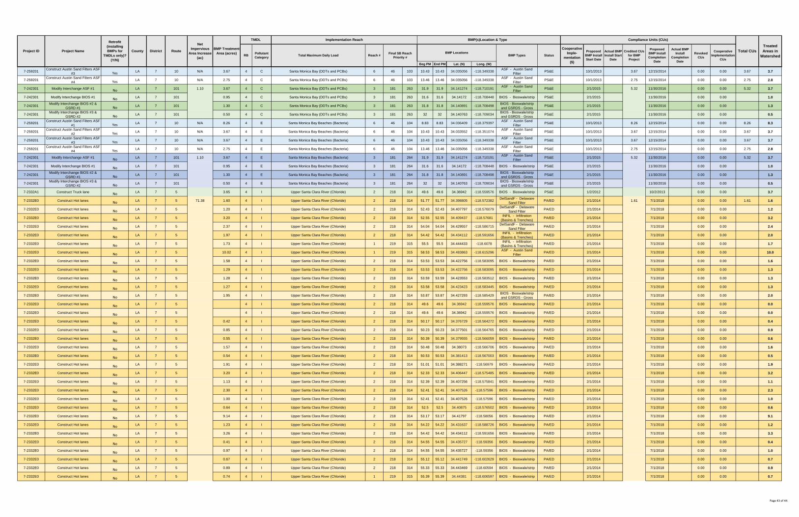
Beg PM End PM Lat. (N) Long. (W)
RouteProject ID Project Name
Retrofit (installing BMPs for
TMDLs only)? (Y/N)
County District Credited CUs for BMP Project
Proposed BMP Install Completion
Date
Actual BMP Install
Completion Date
Net Impervious
Area Increase (ac)
BMP Treatment Area (acres)
TMDL Implementation Reach BMP(s)Location & Type
BMP LocationsBMP Types Status
Revoked CUs
Total CUsTreated Areas in
WatershedRBPollutant Category
Total Maximum Daily Load Reach #Final SB Reach
Priority #
Compliance Units (CUs)
Cooperative Imple-
mentation ($)
Cooperative Implementation
CUs
Proposed BMP Install Start Date
Actual BMP Install Start
Date
7-259201Construct Austin Sand Filters ASF
#3 Yes LA 7 10 N/A 3.67 4 C Santa Monica Bay (DDTs and PCBs) 6 46 103 10.43 10.43 34.035056 -118.349338ASF - Austin Sand
FilterPS&E 10/1/2013 3.67 12/15/2014 0.00 0.00 3.67 3.7
7-259201Construct Austin Sand Filters ASF
#4 Yes LA 7 10 N/A 2.75 4 C Santa Monica Bay (DDTs and PCBs) 6 46 103 13.46 13.46 34.035056 -118.349338ASF - Austin Sand
FilterPS&E 10/1/2013 2.75 12/15/2014 0.00 0.00 2.75 2.8
7-242301 Modify Interchange ASF #1 No LA 7 101 1.10 3.67 4 C Santa Monica Bay (DDTs and PCBs) 3 181 263 31.9 31.9 34.141274 -118.710191ASF - Austin Sand
FilterPS&E 2/1/2015 5.32 11/30/2016 0.00 0.00 5.32 3.7
7-242301 Modify Interchange BIOS #1 No LA 7 101 0.95 4 C Santa Monica Bay (DDTs and PCBs) 3 181 263 31.6 31.6 34.14172 -118.708448 BIOS - Bioswale/strip PS&E 2/1/2015 11/30/2016 0.00 0.00 1.0
7-242301Modify Interchange BIOS #2 &
GSRD #1 No LA 7 101 1.30 4 C Santa Monica Bay (DDTs and PCBs) 3 181 263 31.8 31.8 34.140891 -118.708498BIOS - Bioswale/strip and GSRDS - Gross
PS&E 2/1/2015 11/30/2016 0.00 0.00 1.3
7-242301Modify Interchange BIOS #3 &
GSRD #2 No LA 7 101 0.50 4 C Santa Monica Bay (DDTs and PCBs) 3 181 263 32 32 34.140763 -118.709034BIOS - Bioswale/strip and GSRDS - Gross
PS&E 2/1/2015 11/30/2016 0.00 0.00 0.5
7-259201Construct Austin Sand Filters ASF
#1 Yes LA 7 10 N/A 8.26 4 E Santa Monica Bay Beaches (Bacteria) 6 46 104 8.83 8.83 34.036409 -118.379397ASF - Austin Sand
FilterPS&E 10/1/2013 8.26 12/15/2014 0.00 0.00 8.26 8.3
7-259201Construct Austin Sand Filters ASF
#2 Yes LA 7 10 N/A 3.67 4 E Santa Monica Bay Beaches (Bacteria) 6 46 104 10.43 10.43 34.033552 -118.351074ASF - Austin Sand
FilterPS&E 10/1/2013 3.67 12/15/2014 0.00 0.00 3.67 3.7
7-259201Construct Austin Sand Filters ASF
#3 Yes LA 7 10 N/A 3.67 4 E Santa Monica Bay Beaches (Bacteria) 6 46 104 10.43 10.43 34.035056 -118.349338ASF - Austin Sand
FilterPS&E 10/1/2013 3.67 12/15/2014 0.00 0.00 3.67 3.7
7-259201Construct Austin Sand Filters ASF
#4 Yes LA 7 10 N/A 2.75 4 E Santa Monica Bay Beaches (Bacteria) 6 46 104 13.46 13.46 34.035056 -118.349338ASF - Austin Sand
FilterPS&E 10/1/2013 2.75 12/15/2014 0.00 0.00 2.75 2.8
7-242301 Modify Interchange ASF #1 No LA 7 101 1.10 3.67 4 E Santa Monica Bay Beaches (Bacteria) 3 181 264 31.9 31.9 34.141274 -118.710191ASF - Austin Sand
FilterPS&E 2/1/2015 5.32 11/30/2016 0.00 0.00 5.32 3.7
7-242301 Modify Interchange BIOS #1 No LA 7 101 0.95 4 E Santa Monica Bay Beaches (Bacteria) 3 181 264 31.6 31.6 34.14172 -118.708448 BIOS - Bioswale/strip PS&E 2/1/2015 11/30/2016 0.00 0.00 1.0
7-242301Modify Interchange BIOS #2 &
GSRD #1 No LA 7 101 1.30 4 E Santa Monica Bay Beaches (Bacteria) 3 181 264 31.8 31.8 34.140891 -118.708498BIOS - Bioswale/strip and GSRDS - Gross
PS&E 2/1/2015 11/30/2016 0.00 0.00 1.3
7-242301Modify Interchange BIOS #3 &
GSRD #2 No LA 7 101 0.50 4 E Santa Monica Bay Beaches (Bacteria) 3 181 264 32 32 34.140763 -118.709034BIOS - Bioswale/strip and GSRDS - Gross
PS&E 2/1/2015 11/30/2016 0.00 0.00 0.5
7-2332A1 Construct Truck lane No LA 7 5 3.65 4 I Upper Santa Clara River (Chloride) 2 218 314 49.6 49.6 34.36942 -118.559576 BIOS - Bioswale/strip PS&E 1/2/2012 10/2/2013 0.00 0.00 3.7
7-2332E0 Construct Hot lanes No LA 7 5 71.38 1.60 4 I Upper Santa Clara River (Chloride) 2 218 314 51.77 51.77 34.398805 -118.572382DelSandF - Delaware
Sand FilterPA/ED 2/1/2014 1.61 7/1/2018 0.00 0.00 1.61 1.6
7-2332E0 Construct Hot lanes No LA 7 5 1.20 4 I Upper Santa Clara River (Chloride) 2 218 314 52.43 52.43 34.407797 -118.576079DelSandF - Delaware
Sand FilterPA/ED 2/1/2014 7/1/2018 0.00 0.00 1.2
7-2332E0 Construct Hot lanes No LA 7 5 3.20 4 I Upper Santa Clara River (Chloride) 2 218 314 52.55 52.55 34.409437 -118.57681INFIL - Infiltration
(Basins & Trenches)PA/ED 2/1/2014 7/1/2018 0.00 0.00 3.2
7-2332E0 Construct Hot lanes No LA 7 5 2.37 4 I Upper Santa Clara River (Chloride) 2 218 314 54.04 54.04 34.429557 -118.586715DelSandF - Delaware
Sand FilterPA/ED 2/1/2014 7/1/2018 0.00 0.00 2.4
7-2332E0 Construct Hot lanes No LA 7 5 1.97 4 I Upper Santa Clara River (Chloride) 2 218 314 54.42 54.42 34.434112 -118.591656INFIL - Infiltration
(Basins & Trenches)PA/ED 2/1/2014 7/1/2018 0.00 0.00 2.0
7-2332E0 Construct Hot lanes No LA 7 5 1.73 4 I Upper Santa Clara River (Chloride) 1 219 315 55.5 55.5 34.444433 -118.6078INFIL - Infiltration
(Basins & Trenches)PA/ED 2/1/2014 7/1/2018 0.00 0.00 1.7
7-2332E0 Construct Hot lanes No LA 7 5 10.02 4 I Upper Santa Clara River (Chloride) 1 219 315 58.53 58.53 34.483863 -118.615296ASF - Austin Sand
FilterPA/ED 2/1/2014 7/1/2018 0.00 0.00 10.0
7-2332E0 Construct Hot lanes No LA 7 5 1.58 4 I Upper Santa Clara River (Chloride) 2 218 314 53.53 53.53 34.422756 -118.583095 BIOS - Bioswale/strip PA/ED 2/1/2014 7/1/2018 0.00 0.00 1.6
7-2332E0 Construct Hot lanes No LA 7 5 1.29 4 I Upper Santa Clara River (Chloride) 2 218 314 53.53 53.53 34.422756 -118.583095 BIOS - Bioswale/strip PA/ED 2/1/2014 7/1/2018 0.00 0.00 1.3
7-2332E0 Construct Hot lanes No LA 7 5 1.28 4 I Upper Santa Clara River (Chloride) 2 218 314 53.59 53.59 34.423553 -118.583512 BIOS - Bioswale/strip PA/ED 2/1/2014 7/1/2018 0.00 0.00 1.3
7-2332E0 Construct Hot lanes No LA 7 5 1.27 4 I Upper Santa Clara River (Chloride) 2 218 314 53.58 53.58 34.423423 -118.583445 BIOS - Bioswale/strip PA/ED 2/1/2014 7/1/2018 0.00 0.00 1.3
7-2332E0 Construct Hot lanes No LA 7 5 1.95 4 I Upper Santa Clara River (Chloride) 2 218 314 53.87 53.87 34.427293 -118.585429BIOS - Bioswale/strip and GSRDS - Gross
PA/ED 2/1/2014 7/1/2018 0.00 0.00 2.0
7-2332E0 Construct Hot lanes No LA 7 5 4 I Upper Santa Clara River (Chloride) 2 218 314 49.6 49.6 34.36942 -118.559576 BIOS - Bioswale/strip PA/ED 2/1/2014 7/1/2018 0.00 0.00 0.0
7-2332E0 Construct Hot lanes No LA 7 5 4 I Upper Santa Clara River (Chloride) 2 218 314 49.6 49.6 34.36942 -118.559576 BIOS - Bioswale/strip PA/ED 2/1/2014 7/1/2018 0.00 0.00 0.0
7-2332E0 Construct Hot lanes No LA 7 5 0.42 4 I Upper Santa Clara River (Chloride) 2 218 314 50.17 50.17 34.376729 -118.564272 BIOS - Bioswale/strip PA/ED 2/1/2014 7/1/2018 0.00 0.00 0.4
7-2332E0 Construct Hot lanes No LA 7 5 0.85 4 I Upper Santa Clara River (Chloride) 2 218 314 50.23 50.23 34.377501 -118.564765 BIOS - Bioswale/strip PA/ED 2/1/2014 7/1/2018 0.00 0.00 0.9
7-2332E0 Construct Hot lanes No LA 7 5 0.55 4 I Upper Santa Clara River (Chloride) 2 218 314 50.39 50.39 34.379555 -118.566059 BIOS - Bioswale/strip PA/ED 2/1/2014 7/1/2018 0.00 0.00 0.6
7-2332E0 Construct Hot lanes No LA 7 5 1.57 4 I Upper Santa Clara River (Chloride) 2 218 314 50.48 50.48 34.38073 -118.566706 BIOS - Bioswale/strip PA/ED 2/1/2014 7/1/2018 0.00 0.00 1.6
7-2332E0 Construct Hot lanes No LA 7 5 0.54 4 I Upper Santa Clara River (Chloride) 2 218 314 50.53 50.53 34.381413 -118.567003 BIOS - Bioswale/strip PA/ED 2/1/2014 7/1/2018 0.00 0.00 0.5
7-2332E0 Construct Hot lanes No LA 7 5 1.91 4 I Upper Santa Clara River (Chloride) 2 218 314 51.01 51.01 34.388271 -118.56979 BIOS - Bioswale/strip PA/ED 2/1/2014 7/1/2018 0.00 0.00 1.9
7-2332E0 Construct Hot lanes No LA 7 5 3.20 4 I Upper Santa Clara River (Chloride) 2 218 314 52.33 52.33 34.406447 -118.575485 BIOS - Bioswale/strip PA/ED 2/1/2014 7/1/2018 0.00 0.00 3.2
7-2332E0 Construct Hot lanes No LA 7 5 1.13 4 I Upper Santa Clara River (Chloride) 2 218 314 52.39 52.39 34.407256 -118.575841 BIOS - Bioswale/strip PA/ED 2/1/2014 7/1/2018 0.00 0.00 1.1
7-2332E0 Construct Hot lanes No LA 7 5 2.30 4 I Upper Santa Clara River (Chloride) 2 218 314 52.41 52.41 34.407526 -118.57596 BIOS - Bioswale/strip PA/ED 2/1/2014 7/1/2018 0.00 0.00 2.3
7-2332E0 Construct Hot lanes No LA 7 5 1.00 4 I Upper Santa Clara River (Chloride) 2 218 314 52.41 52.41 34.407526 -118.57596 BIOS - Bioswale/strip PA/ED 2/1/2014 7/1/2018 0.00 0.00 1.0
7-2332E0 Construct Hot lanes No LA 7 5 0.64 4 I Upper Santa Clara River (Chloride) 2 218 314 52.5 52.5 34.40875 -118.576502 BIOS - Bioswale/strip PA/ED 2/1/2014 7/1/2018 0.00 0.00 0.6
7-2332E0 Construct Hot lanes No LA 7 5 9.14 4 I Upper Santa Clara River (Chloride) 2 218 314 53.17 53.17 34.41797 -118.58056 BIOS - Bioswale/strip PA/ED 2/1/2014 7/1/2018 0.00 0.00 9.1
7-2332E0 Construct Hot lanes No LA 7 5 1.23 4 I Upper Santa Clara River (Chloride) 2 218 314 54.22 54.22 34.431637 -118.588726 BIOS - Bioswale/strip PA/ED 2/1/2014 7/1/2018 0.00 0.00 1.2
7-2332E0 Construct Hot lanes No LA 7 5 3.26 4 I Upper Santa Clara River (Chloride) 2 218 314 54.42 54.42 34.434112 -118.591656 BIOS - Bioswale/strip PA/ED 2/1/2014 7/1/2018 0.00 0.00 3.3
7-2332E0 Construct Hot lanes No LA 7 5 0.41 4 I Upper Santa Clara River (Chloride) 2 218 314 54.55 54.55 34.435727 -118.59356 BIOS - Bioswale/strip PA/ED 2/1/2014 7/1/2018 0.00 0.00 0.4
7-2332E0 Construct Hot lanes No LA 7 5 0.97 4 I Upper Santa Clara River (Chloride) 2 218 314 54.55 54.55 34.435727 -118.59356 BIOS - Bioswale/strip PA/ED 2/1/2014 7/1/2018 0.00 0.00 1.0
7-2332E0 Construct Hot lanes No LA 7 5 0.67 4 I Upper Santa Clara River (Chloride) 2 218 314 55.12 55.12 34.441749 -118.602629 BIOS - Bioswale/strip PA/ED 2/1/2014 7/1/2018 0.00 0.00 0.7
7-2332E0 Construct Hot lanes No LA 7 5 0.89 4 I Upper Santa Clara River (Chloride) 2 218 314 55.33 55.33 34.443469 -118.60594 BIOS - Bioswale/strip PA/ED 2/1/2014 7/1/2018 0.00 0.00 0.9
7-2332E0 Construct Hot lanes No LA 7 5 0.74 4 I Upper Santa Clara River (Chloride) 1 219 315 55.39 55.39 34.44381 -118.606597 BIOS - Bioswale/strip PA/ED 2/1/2014 7/1/2018 0.00 0.00 0.7
Page 43 of 44
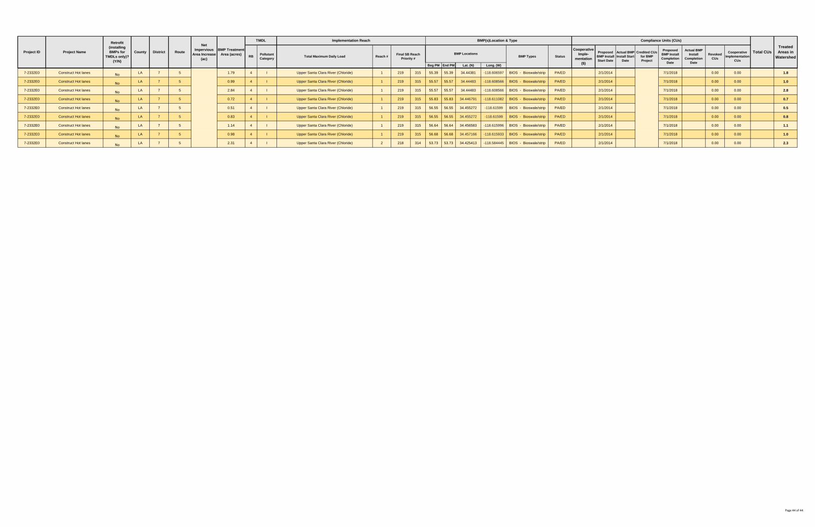
Beg PM End PM Lat. (N) Long. (W)
RouteProject ID Project Name
Retrofit (installing BMPs for
TMDLs only)? (Y/N)
County District Credited CUs for BMP Project
Proposed BMP Install Completion
Date
Actual BMP Install
Completion Date
Net Impervious
Area Increase (ac)
BMP Treatment Area (acres)
TMDL Implementation Reach BMP(s)Location & Type
BMP LocationsBMP Types Status
Revoked CUs
Total CUsTreated Areas in
WatershedRBPollutant Category
Total Maximum Daily Load Reach #Final SB Reach
Priority #
Compliance Units (CUs)
Cooperative Imple-
mentation ($)
Cooperative Implementation
CUs
Proposed BMP Install Start Date
Actual BMP Install Start
Date
7-2332E0 Construct Hot lanes No LA 7 5 1.79 4 I Upper Santa Clara River (Chloride) 1 219 315 55.39 55.39 34.44381 -118.606597 BIOS - Bioswale/strip PA/ED 2/1/2014 7/1/2018 0.00 0.00 1.8
7-2332E0 Construct Hot lanes No LA 7 5 0.99 4 I Upper Santa Clara River (Chloride) 1 219 315 55.57 55.57 34.44483 -118.608566 BIOS - Bioswale/strip PA/ED 2/1/2014 7/1/2018 0.00 0.00 1.0
7-2332E0 Construct Hot lanes No LA 7 5 2.84 4 I Upper Santa Clara River (Chloride) 1 219 315 55.57 55.57 34.44483 -118.608566 BIOS - Bioswale/strip PA/ED 2/1/2014 7/1/2018 0.00 0.00 2.8
7-2332E0 Construct Hot lanes No LA 7 5 0.72 4 I Upper Santa Clara River (Chloride) 1 219 315 55.83 55.83 34.446791 -118.611082 BIOS - Bioswale/strip PA/ED 2/1/2014 7/1/2018 0.00 0.00 0.7
7-2332E0 Construct Hot lanes No LA 7 5 0.51 4 I Upper Santa Clara River (Chloride) 1 219 315 56.55 56.55 34.455272 -118.61599 BIOS - Bioswale/strip PA/ED 2/1/2014 7/1/2018 0.00 0.00 0.5
7-2332E0 Construct Hot lanes No LA 7 5 0.83 4 I Upper Santa Clara River (Chloride) 1 219 315 56.55 56.55 34.455272 -118.61599 BIOS - Bioswale/strip PA/ED 2/1/2014 7/1/2018 0.00 0.00 0.8
7-2332E0 Construct Hot lanes No LA 7 5 1.14 4 I Upper Santa Clara River (Chloride) 1 219 315 56.64 56.64 34.456583 -118.615996 BIOS - Bioswale/strip PA/ED 2/1/2014 7/1/2018 0.00 0.00 1.1
7-2332E0 Construct Hot lanes No LA 7 5 0.98 4 I Upper Santa Clara River (Chloride) 1 219 315 56.68 56.68 34.457166 -118.615933 BIOS - Bioswale/strip PA/ED 2/1/2014 7/1/2018 0.00 0.00 1.0
7-2332E0 Construct Hot lanes No LA 7 5 2.31 4 I Upper Santa Clara River (Chloride) 2 218 314 53.73 53.73 34.425413 -118.584445 BIOS - Bioswale/strip PA/ED 2/1/2014 7/1/2018 0.00 0.00 2.3
Page 44 of 44
Caltrans TMDL Status Review Report | October 2015
Appendix B – Treatment BMPS for Completed and Proposed Projects within TMDL Watersheds
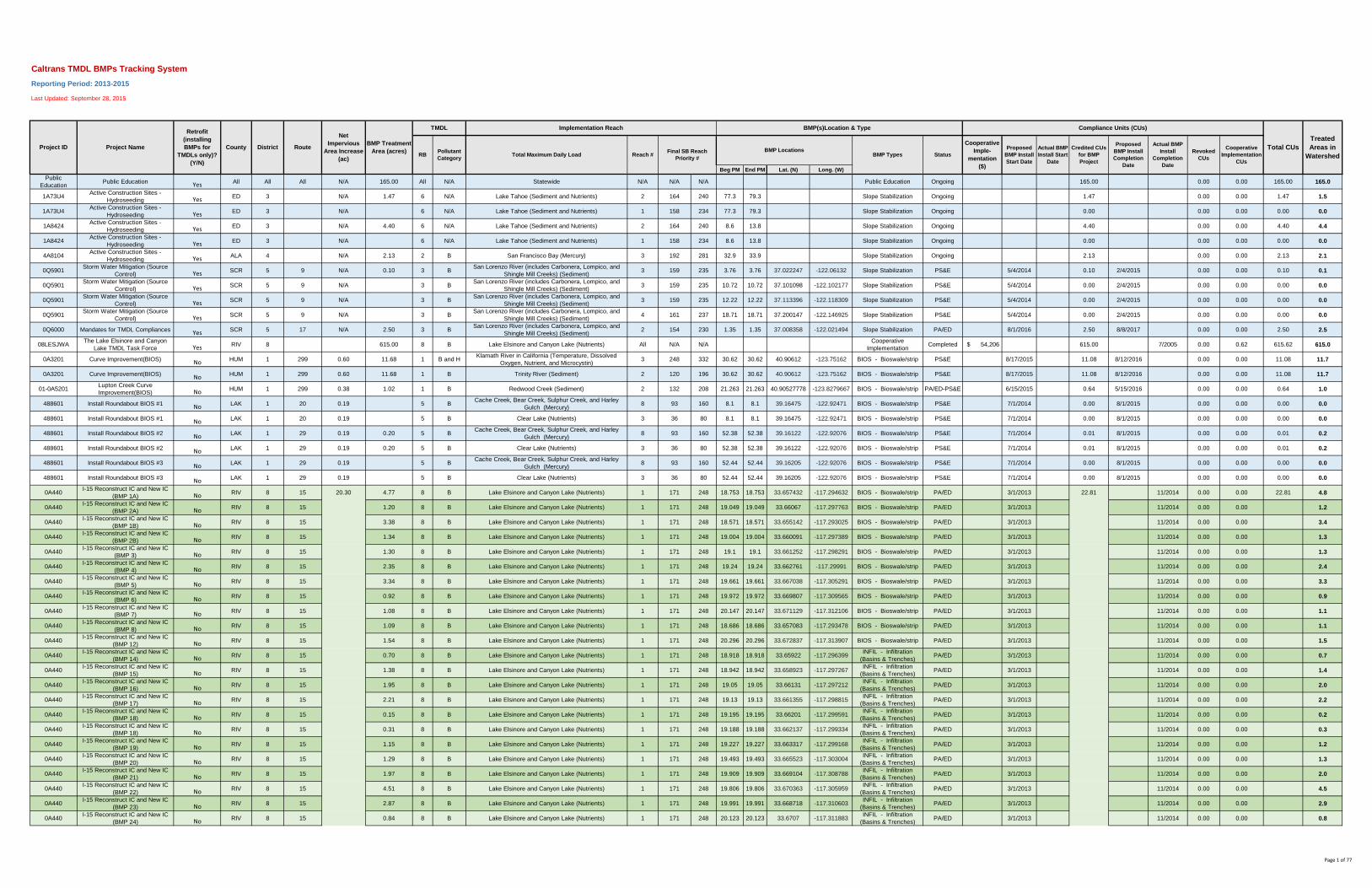
Caltrans TMDL BMPs Tracking System DO NOT SORT ONLY FILTERReporting Period: 2013-2015
Last Updated: September 28, 2015 No duplicates and verified
Beg PM End PM Lat. (N) Long. (W)
Public Education
Public Education Yes All All All N/A 165.00 All N/A Statewide N/A N/A N/A Public Education Ongoing 165.00 0.00 0.00 165.00 165.0
1A73U4Active Construction Sites -
Hydroseeding Yes ED 3 N/A 1.47 6 N/A Lake Tahoe (Sediment and Nutrients) 2 164 240 77.3 79.3 Slope Stabilization Ongoing 1.47 0.00 0.00 1.47 1.5
1A73U4Active Construction Sites -
Hydroseeding Yes ED 3 N/A 6 N/A Lake Tahoe (Sediment and Nutrients) 1 158 234 77.3 79.3 Slope Stabilization Ongoing 0.00 0.00 0.00 0.00 0.0
1A8424Active Construction Sites -
Hydroseeding Yes ED 3 N/A 4.40 6 N/A Lake Tahoe (Sediment and Nutrients) 2 164 240 8.6 13.8 Slope Stabilization Ongoing 4.40 0.00 0.00 4.40 4.4
1A8424Active Construction Sites -
Hydroseeding Yes ED 3 N/A 6 N/A Lake Tahoe (Sediment and Nutrients) 1 158 234 8.6 13.8 Slope Stabilization Ongoing 0.00 0.00 0.00 0.00 0.0
4A8104Active Construction Sites -
Hydroseeding Yes ALA 4 N/A 2.13 2 B San Francisco Bay (Mercury) 3 192 281 32.9 33.9 Slope Stabilization Ongoing 2.13 0.00 0.00 2.13 2.1
0Q5901Storm Water Mitigation (Source
Control) Yes SCR 5 9 N/A 0.10 3 BSan Lorenzo River (includes Carbonera, Lompico, and
Shingle Mill Creeks) (Sediment)3 159 235 3.76 3.76 37.022247 -122.06132 Slope Stabilization PS&E 5/4/2014 0.10 2/4/2015 0.00 0.00 0.10 0.1
0Q5901Storm Water Mitigation (Source
Control) Yes SCR 5 9 N/A 3 BSan Lorenzo River (includes Carbonera, Lompico, and
Shingle Mill Creeks) (Sediment)3 159 235 10.72 10.72 37.101098 -122.102177 Slope Stabilization PS&E 5/4/2014 0.00 2/4/2015 0.00 0.00 0.00 0.0
0Q5901Storm Water Mitigation (Source
Control) Yes SCR 5 9 N/A 3 BSan Lorenzo River (includes Carbonera, Lompico, and
Shingle Mill Creeks) (Sediment)3 159 235 12.22 12.22 37.113396 -122.118309 Slope Stabilization PS&E 5/4/2014 0.00 2/4/2015 0.00 0.00 0.00 0.0
0Q5901Storm Water Mitigation (Source
Control) Yes SCR 5 9 N/A 3 BSan Lorenzo River (includes Carbonera, Lompico, and
Shingle Mill Creeks) (Sediment)4 161 237 18.71 18.71 37.200147 -122.146925 Slope Stabilization PS&E 5/4/2014 0.00 2/4/2015 0.00 0.00 0.00 0.0
0Q6000 Mandates for TMDL Compliances Yes SCR 5 17 N/A 2.50 3 BSan Lorenzo River (includes Carbonera, Lompico, and
Shingle Mill Creeks) (Sediment)2 154 230 1.35 1.35 37.008358 -122.021494 Slope Stabilization PA/ED 8/1/2016 2.50 8/8/2017 0.00 0.00 2.50 2.5
08LESJWAThe Lake Elsinore and Canyon
Lake TMDL Task Force Yes RIV 8 615.00 8 B Lake Elsinore and Canyon Lake (Nutrients) All N/A N/ACooperative
ImplementationCompleted $ 54,206 615.00 7/2005 0.00 0.62 615.62 615.0
0A3201 Curve Improvement(BIOS) No HUM 1 299 0.60 11.68 1 B and HKlamath River in California (Temperature, Dissolved
Oxygen, Nutrient, and Microcystin)3 248 332 30.62 30.62 40.90612 -123.75162 BIOS - Bioswale/strip PS&E 8/17/2015 11.08 8/12/2016 0.00 0.00 11.08 11.7
0A3201 Curve Improvement(BIOS) No HUM 1 299 0.60 11.68 1 B Trinity River (Sediment) 2 120 196 30.62 30.62 40.90612 -123.75162 BIOS - Bioswale/strip PS&E 8/17/2015 11.08 8/12/2016 0.00 0.00 11.08 11.7
01-0A5201Lupton Creek Curve Improvement(BIOS) No HUM 1 299 0.38 1.02 1 B Redwood Creek (Sediment) 2 132 208 21.263 21.263 40.90527778 -123.8279667 BIOS - Bioswale/strip PA/ED-PS&E 6/15/2015 0.64 5/15/2016 0.00 0.00 0.64 1.0
488601 Install Roundabout BIOS #1 No LAK 1 20 0.19 5 BCache Creek, Bear Creek, Sulphur Creek, and Harley
Gulch (Mercury)8 93 160 8.1 8.1 39.16475 -122.92471 BIOS - Bioswale/strip PS&E 7/1/2014 0.00 8/1/2015 0.00 0.00 0.00 0.0
488601 Install Roundabout BIOS #1 No LAK 1 20 0.19 5 B Clear Lake (Nutrients) 3 36 80 8.1 8.1 39.16475 -122.92471 BIOS - Bioswale/strip PS&E 7/1/2014 0.00 8/1/2015 0.00 0.00 0.00 0.0
488601 Install Roundabout BIOS #2 No LAK 1 29 0.19 0.20 5 BCache Creek, Bear Creek, Sulphur Creek, and Harley
Gulch (Mercury)8 93 160 52.38 52.38 39.16122 -122.92076 BIOS - Bioswale/strip PS&E 7/1/2014 0.01 8/1/2015 0.00 0.00 0.01 0.2
488601 Install Roundabout BIOS #2 No LAK 1 29 0.19 0.20 5 B Clear Lake (Nutrients) 3 36 80 52.38 52.38 39.16122 -122.92076 BIOS - Bioswale/strip PS&E 7/1/2014 0.01 8/1/2015 0.00 0.00 0.01 0.2
488601 Install Roundabout BIOS #3 No LAK 1 29 0.19 5 BCache Creek, Bear Creek, Sulphur Creek, and Harley
Gulch (Mercury)8 93 160 52.44 52.44 39.16205 -122.92076 BIOS - Bioswale/strip PS&E 7/1/2014 0.00 8/1/2015 0.00 0.00 0.00 0.0
488601 Install Roundabout BIOS #3 No LAK 1 29 0.19 5 B Clear Lake (Nutrients) 3 36 80 52.44 52.44 39.16205 -122.92076 BIOS - Bioswale/strip PS&E 7/1/2014 0.00 8/1/2015 0.00 0.00 0.00 0.0
0A440I-15 Reconstruct IC and New IC
(BMP 1A) No RIV 8 15 20.30 4.77 8 B Lake Elsinore and Canyon Lake (Nutrients) 1 171 248 18.753 18.753 33.657432 -117.294632 BIOS - Bioswale/strip PA/ED 3/1/2013 22.81 11/2014 0.00 0.00 22.81 4.8
0A440I-15 Reconstruct IC and New IC
(BMP 2A) No RIV 8 15 1.20 8 B Lake Elsinore and Canyon Lake (Nutrients) 1 171 248 19.049 19.049 33.66067 -117.297763 BIOS - Bioswale/strip PA/ED 3/1/2013 11/2014 0.00 0.00 1.2
0A440I-15 Reconstruct IC and New IC
(BMP 1B) No RIV 8 15 3.38 8 B Lake Elsinore and Canyon Lake (Nutrients) 1 171 248 18.571 18.571 33.655142 -117.293025 BIOS - Bioswale/strip PA/ED 3/1/2013 11/2014 0.00 0.00 3.4
0A440I-15 Reconstruct IC and New IC
(BMP 2B) No RIV 8 15 1.34 8 B Lake Elsinore and Canyon Lake (Nutrients) 1 171 248 19.004 19.004 33.660091 -117.297389 BIOS - Bioswale/strip PA/ED 3/1/2013 11/2014 0.00 0.00 1.3
0A440I-15 Reconstruct IC and New IC
(BMP 3) No RIV 8 15 1.30 8 B Lake Elsinore and Canyon Lake (Nutrients) 1 171 248 19.1 19.1 33.661252 -117.298291 BIOS - Bioswale/strip PA/ED 3/1/2013 11/2014 0.00 0.00 1.3
0A440I-15 Reconstruct IC and New IC
(BMP 4) No RIV 8 15 2.35 8 B Lake Elsinore and Canyon Lake (Nutrients) 1 171 248 19.24 19.24 33.662761 -117.29991 BIOS - Bioswale/strip PA/ED 3/1/2013 11/2014 0.00 0.00 2.4
0A440I-15 Reconstruct IC and New IC
(BMP 5) No RIV 8 15 3.34 8 B Lake Elsinore and Canyon Lake (Nutrients) 1 171 248 19.661 19.661 33.667038 -117.305291 BIOS - Bioswale/strip PA/ED 3/1/2013 11/2014 0.00 0.00 3.3
0A440I-15 Reconstruct IC and New IC
(BMP 6) No RIV 8 15 0.92 8 B Lake Elsinore and Canyon Lake (Nutrients) 1 171 248 19.972 19.972 33.669807 -117.309565 BIOS - Bioswale/strip PA/ED 3/1/2013 11/2014 0.00 0.00 0.9
0A440I-15 Reconstruct IC and New IC
(BMP 7) No RIV 8 15 1.08 8 B Lake Elsinore and Canyon Lake (Nutrients) 1 171 248 20.147 20.147 33.671129 -117.312106 BIOS - Bioswale/strip PA/ED 3/1/2013 11/2014 0.00 0.00 1.1
0A440I-15 Reconstruct IC and New IC
(BMP 8) No RIV 8 15 1.09 8 B Lake Elsinore and Canyon Lake (Nutrients) 1 171 248 18.686 18.686 33.657083 -117.293478 BIOS - Bioswale/strip PA/ED 3/1/2013 11/2014 0.00 0.00 1.1
0A440I-15 Reconstruct IC and New IC
(BMP 12) No RIV 8 15 1.54 8 B Lake Elsinore and Canyon Lake (Nutrients) 1 171 248 20.296 20.296 33.672837 -117.313907 BIOS - Bioswale/strip PA/ED 3/1/2013 11/2014 0.00 0.00 1.5
0A440I-15 Reconstruct IC and New IC
(BMP 14) No RIV 8 15 0.70 8 B Lake Elsinore and Canyon Lake (Nutrients) 1 171 248 18.918 18.918 33.65922 -117.296399INFIL - Infiltration
(Basins & Trenches)PA/ED 3/1/2013 11/2014 0.00 0.00 0.7
0A440I-15 Reconstruct IC and New IC
(BMP 15) No RIV 8 15 1.38 8 B Lake Elsinore and Canyon Lake (Nutrients) 1 171 248 18.942 18.942 33.658923 -117.297267INFIL - Infiltration
(Basins & Trenches)PA/ED 3/1/2013 11/2014 0.00 0.00 1.4
0A440I-15 Reconstruct IC and New IC
(BMP 16) No RIV 8 15 1.95 8 B Lake Elsinore and Canyon Lake (Nutrients) 1 171 248 19.05 19.05 33.66131 -117.297212INFIL - Infiltration
(Basins & Trenches)PA/ED 3/1/2013 11/2014 0.00 0.00 2.0
0A440I-15 Reconstruct IC and New IC
(BMP 17) No RIV 8 15 2.21 8 B Lake Elsinore and Canyon Lake (Nutrients) 1 171 248 19.13 19.13 33.661355 -117.298815INFIL - Infiltration
(Basins & Trenches)PA/ED 3/1/2013 11/2014 0.00 0.00 2.2
0A440I-15 Reconstruct IC and New IC
(BMP 18) No RIV 8 15 0.15 8 B Lake Elsinore and Canyon Lake (Nutrients) 1 171 248 19.195 19.195 33.66201 -117.299591INFIL - Infiltration
(Basins & Trenches)PA/ED 3/1/2013 11/2014 0.00 0.00 0.2
0A440I-15 Reconstruct IC and New IC
(BMP 18) No RIV 8 15 0.31 8 B Lake Elsinore and Canyon Lake (Nutrients) 1 171 248 19.188 19.188 33.662137 -117.299334INFIL - Infiltration
(Basins & Trenches)PA/ED 3/1/2013 11/2014 0.00 0.00 0.3
0A440I-15 Reconstruct IC and New IC
(BMP 19) No RIV 8 15 1.15 8 B Lake Elsinore and Canyon Lake (Nutrients) 1 171 248 19.227 19.227 33.663317 -117.299168INFIL - Infiltration
(Basins & Trenches)PA/ED 3/1/2013 11/2014 0.00 0.00 1.2
0A440I-15 Reconstruct IC and New IC
(BMP 20) No RIV 8 15 1.29 8 B Lake Elsinore and Canyon Lake (Nutrients) 1 171 248 19.493 19.493 33.665523 -117.303004INFIL - Infiltration
(Basins & Trenches)PA/ED 3/1/2013 11/2014 0.00 0.00 1.3
0A440I-15 Reconstruct IC and New IC
(BMP 21) No RIV 8 15 1.97 8 B Lake Elsinore and Canyon Lake (Nutrients) 1 171 248 19.909 19.909 33.669104 -117.308788INFIL - Infiltration
(Basins & Trenches)PA/ED 3/1/2013 11/2014 0.00 0.00 2.0
0A440I-15 Reconstruct IC and New IC
(BMP 22) No RIV 8 15 4.51 8 B Lake Elsinore and Canyon Lake (Nutrients) 1 171 248 19.806 19.806 33.670363 -117.305959INFIL - Infiltration
(Basins & Trenches)PA/ED 3/1/2013 11/2014 0.00 0.00 4.5
0A440I-15 Reconstruct IC and New IC
(BMP 23) No RIV 8 15 2.87 8 B Lake Elsinore and Canyon Lake (Nutrients) 1 171 248 19.991 19.991 33.668718 -117.310603INFIL - Infiltration
(Basins & Trenches)PA/ED 3/1/2013 11/2014 0.00 0.00 2.9
0A440I-15 Reconstruct IC and New IC
(BMP 24) No RIV 8 15 0.84 8 B Lake Elsinore and Canyon Lake (Nutrients) 1 171 248 20.123 20.123 33.6707 -117.311883INFIL - Infiltration
(Basins & Trenches)PA/ED 3/1/2013 11/2014 0.00 0.00 0.8
Revoked CUs
Total CUsTreated Areas in
WatershedRBPollutant Category
Total Maximum Daily Load Reach #Final SB Reach
Priority #
Compliance Units (CUs)
Cooperative Imple-
mentation ($)
Cooperative Implementation
CUs
Proposed BMP Install Start Date
Actual BMP Install Start
Date
Credited CUs for BMP Project
Proposed BMP Install Completion
Date
Actual BMP Install
Completion Date
Net Impervious
Area Increase (ac)
BMP Treatment Area (acres)
TMDL Implementation Reach BMP(s)Location & Type
BMP LocationsBMP Types Status
RouteProject ID Project Name
Retrofit (installing BMPs for
TMDLs only)? (Y/N)
County District
Page 1 of 77
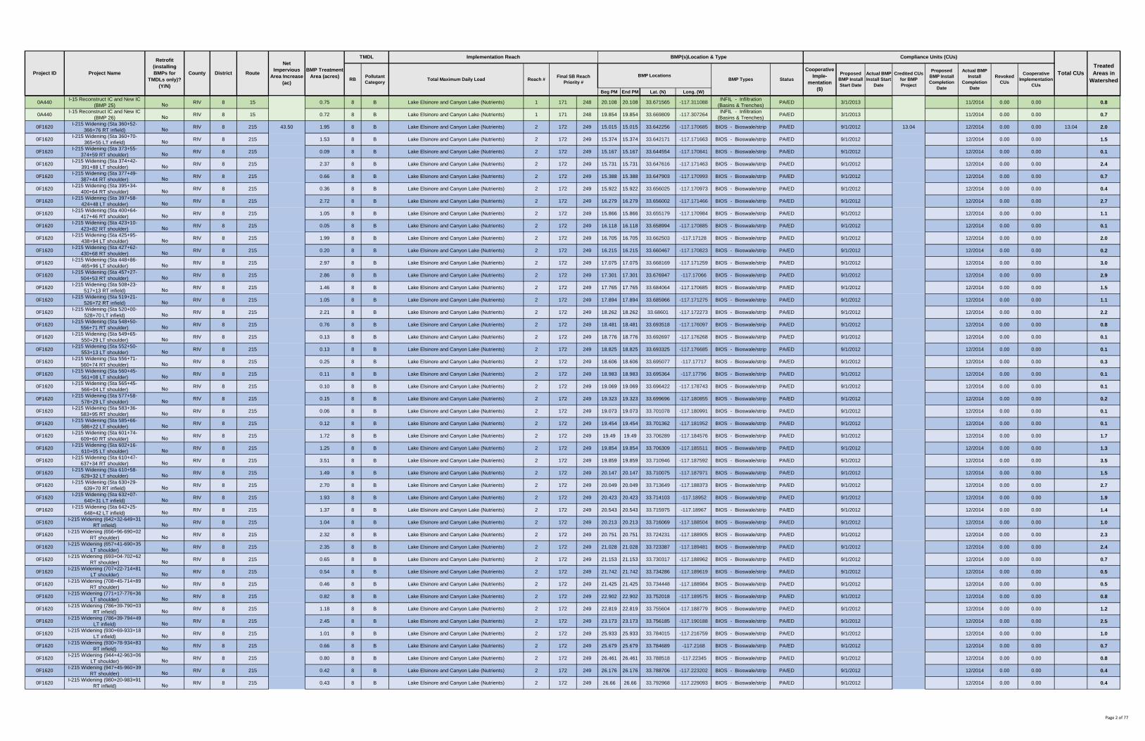
Beg PM End PM Lat. (N) Long. (W)
Revoked CUs
Total CUsTreated Areas in
WatershedRBPollutant Category
Total Maximum Daily Load Reach #Final SB Reach
Priority #
Compliance Units (CUs)
Cooperative Imple-
mentation ($)
Cooperative Implementation
CUs
Proposed BMP Install Start Date
Actual BMP Install Start
Date
Credited CUs for BMP Project
Proposed BMP Install Completion
Date
Actual BMP Install
Completion Date
Net Impervious
Area Increase (ac)
BMP Treatment Area (acres)
TMDL Implementation Reach BMP(s)Location & Type
BMP LocationsBMP Types Status
RouteProject ID Project Name
Retrofit (installing BMPs for
TMDLs only)? (Y/N)
County District
0A440I-15 Reconstruct IC and New IC
(BMP 25) No RIV 8 15 0.75 8 B Lake Elsinore and Canyon Lake (Nutrients) 1 171 248 20.108 20.108 33.671565 -117.311088INFIL - Infiltration
(Basins & Trenches)PA/ED 3/1/2013 11/2014 0.00 0.00 0.8
0A440I-15 Reconstruct IC and New IC
(BMP 26) No RIV 8 15 0.72 8 B Lake Elsinore and Canyon Lake (Nutrients) 1 171 248 19.854 19.854 33.669809 -117.307264INFIL - Infiltration
(Basins & Trenches)PA/ED 3/1/2013 11/2014 0.00 0.00 0.7
0F1620I-215 Widening (Sta 360+52-
366+76 RT infield) No RIV 8 215 43.50 1.95 8 B Lake Elsinore and Canyon Lake (Nutrients) 2 172 249 15.015 15.015 33.642256 -117.170685 BIOS - Bioswale/strip PA/ED 9/1/2012 13.04 12/2014 0.00 0.00 13.04 2.0
0F1620I-215 Widening (Sta 360+70-
365+55 LT infield) No RIV 8 215 1.53 8 B Lake Elsinore and Canyon Lake (Nutrients) 2 172 249 15.374 15.374 33.642171 -117.171663 BIOS - Bioswale/strip PA/ED 9/1/2012 12/2014 0.00 0.00 1.5
0F1620I-215 Widening (Sta 373+55-
374+59 RT shoulder) No RIV 8 215 0.09 8 B Lake Elsinore and Canyon Lake (Nutrients) 2 172 249 15.167 15.167 33.644554 -117.170841 BIOS - Bioswale/strip PA/ED 9/1/2012 12/2014 0.00 0.00 0.1
0F1620I-215 Widening (Sta 374+42-
391+88 LT shoulder) No RIV 8 215 2.37 8 B Lake Elsinore and Canyon Lake (Nutrients) 2 172 249 15.731 15.731 33.647616 -117.171463 BIOS - Bioswale/strip PA/ED 9/1/2012 12/2014 0.00 0.00 2.4
0F1620I-215 Widening (Sta 377+49-
387+44 RT shoulder) No RIV 8 215 0.66 8 B Lake Elsinore and Canyon Lake (Nutrients) 2 172 249 15.388 15.388 33.647903 -117.170993 BIOS - Bioswale/strip PA/ED 9/1/2012 12/2014 0.00 0.00 0.7
0F1620I-215 Widening (Sta 395+34-
400+64 RT shoulder) No RIV 8 215 0.36 8 B Lake Elsinore and Canyon Lake (Nutrients) 2 172 249 15.922 15.922 33.656025 -117.170973 BIOS - Bioswale/strip PA/ED 9/1/2012 12/2014 0.00 0.00 0.4
0F1620I-215 Widening (Sta 397+58-
424+48 LT shoulder) No RIV 8 215 2.72 8 B Lake Elsinore and Canyon Lake (Nutrients) 2 172 249 16.279 16.279 33.656002 -117.171466 BIOS - Bioswale/strip PA/ED 9/1/2012 12/2014 0.00 0.00 2.7
0F1620I-215 Widening (Sta 400+64-
417+46 RT shoulder) No RIV 8 215 1.05 8 B Lake Elsinore and Canyon Lake (Nutrients) 2 172 249 15.866 15.866 33.655179 -117.170984 BIOS - Bioswale/strip PA/ED 9/1/2012 12/2014 0.00 0.00 1.1
0F1620I-215 Widening (Sta 423+10-
423+82 RT shoulder) No RIV 8 215 0.05 8 B Lake Elsinore and Canyon Lake (Nutrients) 2 172 249 16.118 16.118 33.658994 -117.170885 BIOS - Bioswale/strip PA/ED 9/1/2012 12/2014 0.00 0.00 0.1
0F1620I-215 Widening (Sta 425+95-
438+94 LT shoulder) No RIV 8 215 1.99 8 B Lake Elsinore and Canyon Lake (Nutrients) 2 172 249 16.705 16.705 33.662503 -117.17128 BIOS - Bioswale/strip PA/ED 9/1/2012 12/2014 0.00 0.00 2.0
0F1620I-215 Widening (Sta 427+62-
430+68 RT shoulder) No RIV 8 215 0.20 8 B Lake Elsinore and Canyon Lake (Nutrients) 2 172 249 16.215 16.215 33.660467 -117.170823 BIOS - Bioswale/strip PA/ED 9/1/2012 12/2014 0.00 0.00 0.2
0F1620I-215 Widening (Sta 448+86-
465+96 LT shoulder) No RIV 8 215 2.97 8 B Lake Elsinore and Canyon Lake (Nutrients) 2 172 249 17.075 17.075 33.668169 -117.171259 BIOS - Bioswale/strip PA/ED 9/1/2012 12/2014 0.00 0.00 3.0
0F1620I-215 Widening (Sta 457+27-
504+53 RT shoulder) No RIV 8 215 2.86 8 B Lake Elsinore and Canyon Lake (Nutrients) 2 172 249 17.301 17.301 33.676947 -117.17066 BIOS - Bioswale/strip PA/ED 9/1/2012 12/2014 0.00 0.00 2.9
0F1620I-215 Widening (Sta 508+23-
517+13 RT infield) No RIV 8 215 1.46 8 B Lake Elsinore and Canyon Lake (Nutrients) 2 172 249 17.765 17.765 33.684064 -117.170685 BIOS - Bioswale/strip PA/ED 9/1/2012 12/2014 0.00 0.00 1.5
0F1620I-215 Widening (Sta 519+21-
526+72 RT infield) No RIV 8 215 1.05 8 B Lake Elsinore and Canyon Lake (Nutrients) 2 172 249 17.894 17.894 33.685966 -117.171275 BIOS - Bioswale/strip PA/ED 9/1/2012 12/2014 0.00 0.00 1.1
0F1620I-215 Widening (Sta 520+00-
528+70 LT infield) No RIV 8 215 2.21 8 B Lake Elsinore and Canyon Lake (Nutrients) 2 172 249 18.262 18.262 33.68601 -117.172273 BIOS - Bioswale/strip PA/ED 9/1/2012 12/2014 0.00 0.00 2.2
0F1620I-215 Widening (Sta 548+50-
556+71 RT shoulder) No RIV 8 215 0.76 8 B Lake Elsinore and Canyon Lake (Nutrients) 2 172 249 18.481 18.481 33.693518 -117.176097 BIOS - Bioswale/strip PA/ED 9/1/2012 12/2014 0.00 0.00 0.8
0F1620I-215 Widening (Sta 549+65-
550+29 LT shoulder) No RIV 8 215 0.13 8 B Lake Elsinore and Canyon Lake (Nutrients) 2 172 249 18.776 18.776 33.692697 -117.176268 BIOS - Bioswale/strip PA/ED 9/1/2012 12/2014 0.00 0.00 0.1
0F1620I-215 Widening (Sta 552+50-
553+13 LT shoulder) No RIV 8 215 0.13 8 B Lake Elsinore and Canyon Lake (Nutrients) 2 172 249 18.825 18.825 33.693325 -117.176685 BIOS - Bioswale/strip PA/ED 9/1/2012 12/2014 0.00 0.00 0.1
0F1620I-215 Widening (Sta 556+71-
560+74 RT shoulder) No RIV 8 215 0.25 8 B Lake Elsinore and Canyon Lake (Nutrients) 2 172 249 18.606 18.606 33.695077 -117.17717 BIOS - Bioswale/strip PA/ED 9/1/2012 12/2014 0.00 0.00 0.3
0F1620I-215 Widening (Sta 560+45-
561+08 LT shoulder) No RIV 8 215 0.11 8 B Lake Elsinore and Canyon Lake (Nutrients) 2 172 249 18.983 18.983 33.695364 -117.17796 BIOS - Bioswale/strip PA/ED 9/1/2012 12/2014 0.00 0.00 0.1
0F1620I-215 Widening (Sta 565+45-
566+04 LT shoulder) No RIV 8 215 0.10 8 B Lake Elsinore and Canyon Lake (Nutrients) 2 172 249 19.069 19.069 33.696422 -117.178743 BIOS - Bioswale/strip PA/ED 9/1/2012 12/2014 0.00 0.00 0.1
0F1620I-215 Widening (Sta 577+58-
578+29 LT shoulder) No RIV 8 215 0.15 8 B Lake Elsinore and Canyon Lake (Nutrients) 2 172 249 19.323 19.323 33.699696 -117.180855 BIOS - Bioswale/strip PA/ED 9/1/2012 12/2014 0.00 0.00 0.2
0F1620I-215 Widening (Sta 583+36-
583+95 RT shoulder) No RIV 8 215 0.06 8 B Lake Elsinore and Canyon Lake (Nutrients) 2 172 249 19.073 19.073 33.701078 -117.180991 BIOS - Bioswale/strip PA/ED 9/1/2012 12/2014 0.00 0.00 0.1
0F1620I-215 Widening (Sta 585+66-
586+22 LT shoulder) No RIV 8 215 0.12 8 B Lake Elsinore and Canyon Lake (Nutrients) 2 172 249 19.454 19.454 33.701362 -117.181952 BIOS - Bioswale/strip PA/ED 9/1/2012 12/2014 0.00 0.00 0.1
0F1620I-215 Widening (Sta 601+74-
609+60 RT shoulder) No RIV 8 215 1.72 8 B Lake Elsinore and Canyon Lake (Nutrients) 2 172 249 19.49 19.49 33.706289 -117.184576 BIOS - Bioswale/strip PA/ED 9/1/2012 12/2014 0.00 0.00 1.7
0F1620I-215 Widening (Sta 602+16-
610+05 LT shoulder) No RIV 8 215 1.25 8 B Lake Elsinore and Canyon Lake (Nutrients) 2 172 249 19.854 19.854 33.706309 -117.185511 BIOS - Bioswale/strip PA/ED 9/1/2012 12/2014 0.00 0.00 1.3
0F1620I-215 Widening (Sta 610+47-
637+34 RT shoulder) No RIV 8 215 3.51 8 B Lake Elsinore and Canyon Lake (Nutrients) 2 172 249 19.859 19.859 33.710946 -117.187592 BIOS - Bioswale/strip PA/ED 9/1/2012 12/2014 0.00 0.00 3.5
0F1620I-215 Widening (Sta 610+58-
629+32 LT shoulder) No RIV 8 215 1.49 8 B Lake Elsinore and Canyon Lake (Nutrients) 2 172 249 20.147 20.147 33.710075 -117.187971 BIOS - Bioswale/strip PA/ED 9/1/2012 12/2014 0.00 0.00 1.5
0F1620I-215 Widening (Sta 630+29-
639+70 RT infield) No RIV 8 215 2.70 8 B Lake Elsinore and Canyon Lake (Nutrients) 2 172 249 20.049 20.049 33.713649 -117.188373 BIOS - Bioswale/strip PA/ED 9/1/2012 12/2014 0.00 0.00 2.7
0F1620I-215 Widening (Sta 632+07-
640+31 LT infield) No RIV 8 215 1.93 8 B Lake Elsinore and Canyon Lake (Nutrients) 2 172 249 20.423 20.423 33.714103 -117.18952 BIOS - Bioswale/strip PA/ED 9/1/2012 12/2014 0.00 0.00 1.9
0F1620I-215 Widening (Sta 642+25-
648+42 LT infield) No RIV 8 215 1.37 8 B Lake Elsinore and Canyon Lake (Nutrients) 2 172 249 20.543 20.543 33.715975 -117.18967 BIOS - Bioswale/strip PA/ED 9/1/2012 12/2014 0.00 0.00 1.4
0F1620I-215 Widening (642+32-649+31
RT infield) No RIV 8 215 1.04 8 B Lake Elsinore and Canyon Lake (Nutrients) 2 172 249 20.213 20.213 33.716069 -117.188504 BIOS - Bioswale/strip PA/ED 9/1/2012 12/2014 0.00 0.00 1.0
0F1620I-215 Widening (656+96-690+02
RT shoulder) No RIV 8 215 2.32 8 B Lake Elsinore and Canyon Lake (Nutrients) 2 172 249 20.751 20.751 33.724231 -117.188905 BIOS - Bioswale/strip PA/ED 9/1/2012 12/2014 0.00 0.00 2.3
0F1620I-215 Widening (657+41-690+35
LT shoulder) No RIV 8 215 2.35 8 B Lake Elsinore and Canyon Lake (Nutrients) 2 172 249 21.028 21.028 33.723387 -117.189481 BIOS - Bioswale/strip PA/ED 9/1/2012 12/2014 0.00 0.00 2.4
0F1620I-215 Widening (693+04-702+62
RT shoulder) No RIV 8 215 0.65 8 B Lake Elsinore and Canyon Lake (Nutrients) 2 172 249 21.153 21.153 33.730317 -117.188962 BIOS - Bioswale/strip PA/ED 9/1/2012 12/2014 0.00 0.00 0.7
0F1620I-215 Widening (707+22-714+81
LT shoulder) No RIV 8 215 0.54 8 B Lake Elsinore and Canyon Lake (Nutrients) 2 172 249 21.742 21.742 33.734286 -117.189619 BIOS - Bioswale/strip PA/ED 9/1/2012 12/2014 0.00 0.00 0.5
0F1620I-215 Widening (708+45-714+89
RT shoulder) No RIV 8 215 0.46 8 B Lake Elsinore and Canyon Lake (Nutrients) 2 172 249 21.425 21.425 33.734448 -117.188984 BIOS - Bioswale/strip PA/ED 9/1/2012 12/2014 0.00 0.00 0.5
0F1620I-215 Widening (771+17-776+36
LT shoulder) No RIV 8 215 0.82 8 B Lake Elsinore and Canyon Lake (Nutrients) 2 172 249 22.902 22.902 33.752018 -117.189575 BIOS - Bioswale/strip PA/ED 9/1/2012 12/2014 0.00 0.00 0.8
0F1620I-215 Widening (786+39-790+03
RT infield) No RIV 8 215 1.18 8 B Lake Elsinore and Canyon Lake (Nutrients) 2 172 249 22.819 22.819 33.755604 -117.188779 BIOS - Bioswale/strip PA/ED 9/1/2012 12/2014 0.00 0.00 1.2
0F1620I-215 Widening (786+39-794+49
LT infield) No RIV 8 215 2.45 8 B Lake Elsinore and Canyon Lake (Nutrients) 2 172 249 23.173 23.173 33.756185 -117.190188 BIOS - Bioswale/strip PA/ED 9/1/2012 12/2014 0.00 0.00 2.5
0F1620I-215 Widening (930+69-933+18
LT infield) No RIV 8 215 1.01 8 B Lake Elsinore and Canyon Lake (Nutrients) 2 172 249 25.933 25.933 33.784015 -117.216759 BIOS - Bioswale/strip PA/ED 9/1/2012 12/2014 0.00 0.00 1.0
0F1620I-215 Widening (930+78-934+83
RT infield) No RIV 8 215 0.66 8 B Lake Elsinore and Canyon Lake (Nutrients) 2 172 249 25.679 25.679 33.784689 -117.2168 BIOS - Bioswale/strip PA/ED 9/1/2012 12/2014 0.00 0.00 0.7
0F1620I-215 Widening (944+42-963+06
LT shoulder) No RIV 8 215 0.80 8 B Lake Elsinore and Canyon Lake (Nutrients) 2 172 249 26.461 26.461 33.788518 -117.22345 BIOS - Bioswale/strip PA/ED 9/1/2012 12/2014 0.00 0.00 0.8
0F1620I-215 Widening (947+45-960+39
RT shoulder) No RIV 8 215 0.42 8 B Lake Elsinore and Canyon Lake (Nutrients) 2 172 249 26.176 26.176 33.788706 -117.223202 BIOS - Bioswale/strip PA/ED 9/1/2012 12/2014 0.00 0.00 0.4
0F1620I-215 Widening (980+20-983+91
RT infield) No RIV 8 215 0.43 8 B Lake Elsinore and Canyon Lake (Nutrients) 2 172 249 26.66 26.66 33.792968 -117.229093 BIOS - Bioswale/strip PA/ED 9/1/2012 12/2014 0.00 0.00 0.4
Page 2 of 77
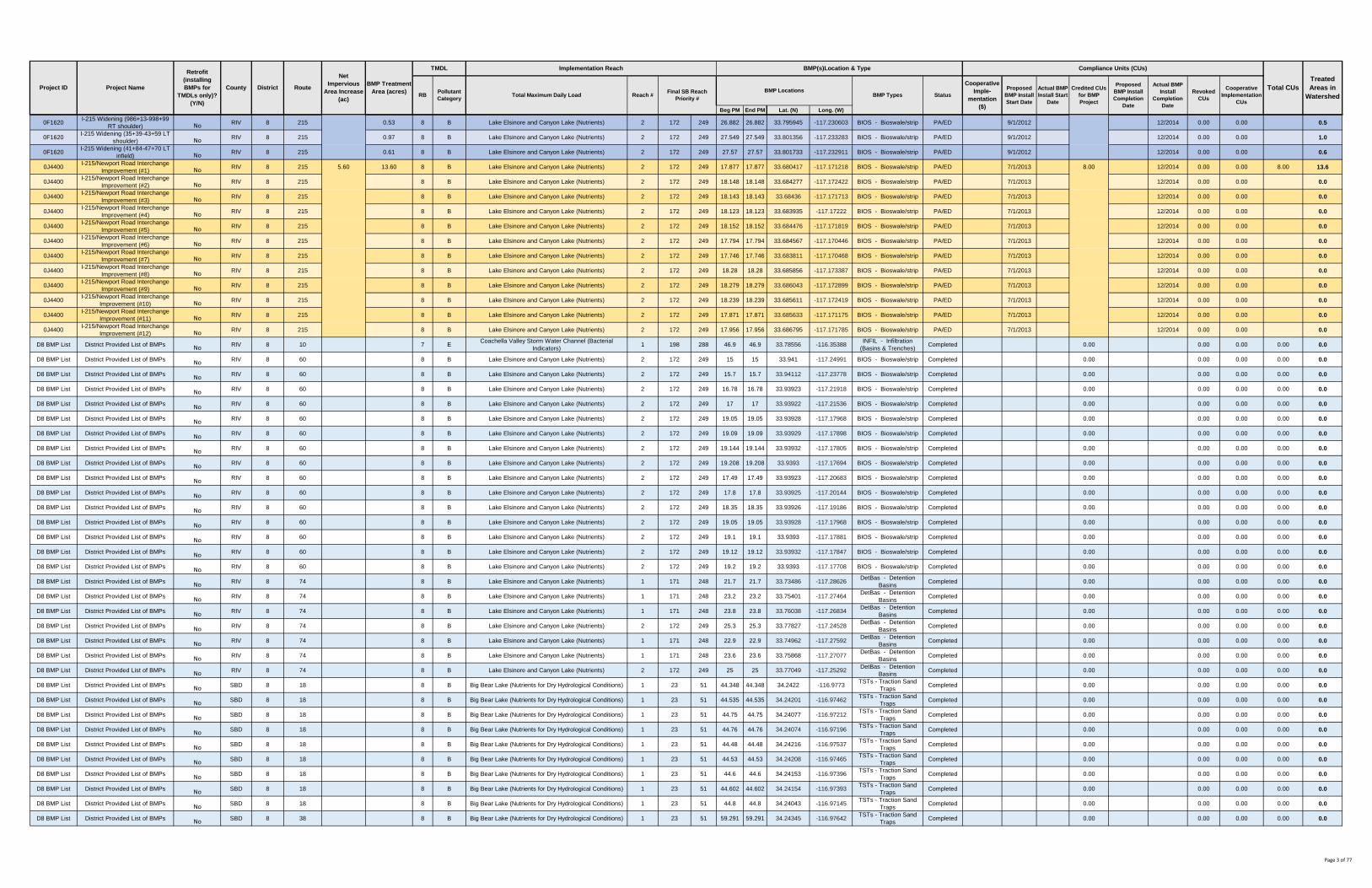
Beg PM End PM Lat. (N) Long. (W)
Revoked CUs
Total CUsTreated Areas in
WatershedRBPollutant Category
Total Maximum Daily Load Reach #Final SB Reach
Priority #
Compliance Units (CUs)
Cooperative Imple-
mentation ($)
Cooperative Implementation
CUs
Proposed BMP Install Start Date
Actual BMP Install Start
Date
Credited CUs for BMP Project
Proposed BMP Install Completion
Date
Actual BMP Install
Completion Date
Net Impervious
Area Increase (ac)
BMP Treatment Area (acres)
TMDL Implementation Reach BMP(s)Location & Type
BMP LocationsBMP Types Status
RouteProject ID Project Name
Retrofit (installing BMPs for
TMDLs only)? (Y/N)
County District
0F1620I-215 Widening (986+13-998+99
RT shoulder) No RIV 8 215 0.53 8 B Lake Elsinore and Canyon Lake (Nutrients) 2 172 249 26.882 26.882 33.795945 -117.230603 BIOS - Bioswale/strip PA/ED 9/1/2012 12/2014 0.00 0.00 0.5
0F1620I-215 Widening (35+39-43+59 LT
shoulder) No RIV 8 215 0.97 8 B Lake Elsinore and Canyon Lake (Nutrients) 2 172 249 27.549 27.549 33.801356 -117.233283 BIOS - Bioswale/strip PA/ED 9/1/2012 12/2014 0.00 0.00 1.0
0F1620I-215 Widening (41+84-47+70 LT
infield) No RIV 8 215 0.61 8 B Lake Elsinore and Canyon Lake (Nutrients) 2 172 249 27.57 27.57 33.801733 -117.232911 BIOS - Bioswale/strip PA/ED 9/1/2012 12/2014 0.00 0.00 0.6
0J4400I-215/Newport Road Interchange
Improvement (#1) No RIV 8 215 5.60 13.60 8 B Lake Elsinore and Canyon Lake (Nutrients) 2 172 249 17.877 17.877 33.680417 -117.171218 BIOS - Bioswale/strip PA/ED 7/1/2013 8.00 12/2014 0.00 0.00 8.00 13.6
0J4400I-215/Newport Road Interchange
Improvement (#2) No RIV 8 215 8 B Lake Elsinore and Canyon Lake (Nutrients) 2 172 249 18.148 18.148 33.684277 -117.172422 BIOS - Bioswale/strip PA/ED 7/1/2013 12/2014 0.00 0.00 0.0
0J4400I-215/Newport Road Interchange
Improvement (#3) No RIV 8 215 8 B Lake Elsinore and Canyon Lake (Nutrients) 2 172 249 18.143 18.143 33.68436 -117.171713 BIOS - Bioswale/strip PA/ED 7/1/2013 12/2014 0.00 0.00 0.0
0J4400I-215/Newport Road Interchange
Improvement (#4) No RIV 8 215 8 B Lake Elsinore and Canyon Lake (Nutrients) 2 172 249 18.123 18.123 33.683935 -117.17222 BIOS - Bioswale/strip PA/ED 7/1/2013 12/2014 0.00 0.00 0.0
0J4400I-215/Newport Road Interchange
Improvement (#5) No RIV 8 215 8 B Lake Elsinore and Canyon Lake (Nutrients) 2 172 249 18.152 18.152 33.684476 -117.171819 BIOS - Bioswale/strip PA/ED 7/1/2013 12/2014 0.00 0.00 0.0
0J4400I-215/Newport Road Interchange
Improvement (#6) No RIV 8 215 8 B Lake Elsinore and Canyon Lake (Nutrients) 2 172 249 17.794 17.794 33.684567 -117.170446 BIOS - Bioswale/strip PA/ED 7/1/2013 12/2014 0.00 0.00 0.0
0J4400I-215/Newport Road Interchange
Improvement (#7) No RIV 8 215 8 B Lake Elsinore and Canyon Lake (Nutrients) 2 172 249 17.746 17.746 33.683811 -117.170468 BIOS - Bioswale/strip PA/ED 7/1/2013 12/2014 0.00 0.00 0.0
0J4400I-215/Newport Road Interchange
Improvement (#8) No RIV 8 215 8 B Lake Elsinore and Canyon Lake (Nutrients) 2 172 249 18.28 18.28 33.685856 -117.173387 BIOS - Bioswale/strip PA/ED 7/1/2013 12/2014 0.00 0.00 0.0
0J4400I-215/Newport Road Interchange
Improvement (#9) No RIV 8 215 8 B Lake Elsinore and Canyon Lake (Nutrients) 2 172 249 18.279 18.279 33.686043 -117.172899 BIOS - Bioswale/strip PA/ED 7/1/2013 12/2014 0.00 0.00 0.0
0J4400I-215/Newport Road Interchange
Improvement (#10) No RIV 8 215 8 B Lake Elsinore and Canyon Lake (Nutrients) 2 172 249 18.239 18.239 33.685611 -117.172419 BIOS - Bioswale/strip PA/ED 7/1/2013 12/2014 0.00 0.00 0.0
0J4400I-215/Newport Road Interchange
Improvement (#11) No RIV 8 215 8 B Lake Elsinore and Canyon Lake (Nutrients) 2 172 249 17.871 17.871 33.685633 -117.171175 BIOS - Bioswale/strip PA/ED 7/1/2013 12/2014 0.00 0.00 0.0
0J4400I-215/Newport Road Interchange
Improvement (#12) No RIV 8 215 8 B Lake Elsinore and Canyon Lake (Nutrients) 2 172 249 17.956 17.956 33.686795 -117.171785 BIOS - Bioswale/strip PA/ED 7/1/2013 12/2014 0.00 0.00 0.0
D8 BMP List District Provided List of BMPs No RIV 8 10 7 ECoachella Valley Storm Water Channel (Bacterial
Indicators)1 198 288 46.9 46.9 33.78556 -116.35388
INFIL - Infiltration (Basins & Trenches)
Completed 0.00 0.00 0.00 0.00 0.0
D8 BMP List District Provided List of BMPs No RIV 8 60 8 B Lake Elsinore and Canyon Lake (Nutrients) 2 172 249 15 15 33.941 -117.24991 BIOS - Bioswale/strip Completed 0.00 0.00 0.00 0.00 0.0
D8 BMP List District Provided List of BMPs No RIV 8 60 8 B Lake Elsinore and Canyon Lake (Nutrients) 2 172 249 15.7 15.7 33.94112 -117.23778 BIOS - Bioswale/strip Completed 0.00 0.00 0.00 0.00 0.0
D8 BMP List District Provided List of BMPs No RIV 8 60 8 B Lake Elsinore and Canyon Lake (Nutrients) 2 172 249 16.78 16.78 33.93923 -117.21918 BIOS - Bioswale/strip Completed 0.00 0.00 0.00 0.00 0.0
D8 BMP List District Provided List of BMPs No RIV 8 60 8 B Lake Elsinore and Canyon Lake (Nutrients) 2 172 249 17 17 33.93922 -117.21536 BIOS - Bioswale/strip Completed 0.00 0.00 0.00 0.00 0.0
D8 BMP List District Provided List of BMPs No RIV 8 60 8 B Lake Elsinore and Canyon Lake (Nutrients) 2 172 249 19.05 19.05 33.93928 -117.17968 BIOS - Bioswale/strip Completed 0.00 0.00 0.00 0.00 0.0
D8 BMP List District Provided List of BMPs No RIV 8 60 8 B Lake Elsinore and Canyon Lake (Nutrients) 2 172 249 19.09 19.09 33.93929 -117.17898 BIOS - Bioswale/strip Completed 0.00 0.00 0.00 0.00 0.0
D8 BMP List District Provided List of BMPs No RIV 8 60 8 B Lake Elsinore and Canyon Lake (Nutrients) 2 172 249 19.144 19.144 33.93932 -117.17805 BIOS - Bioswale/strip Completed 0.00 0.00 0.00 0.00 0.0
D8 BMP List District Provided List of BMPs No RIV 8 60 8 B Lake Elsinore and Canyon Lake (Nutrients) 2 172 249 19.208 19.208 33.9393 -117.17694 BIOS - Bioswale/strip Completed 0.00 0.00 0.00 0.00 0.0
D8 BMP List District Provided List of BMPs No RIV 8 60 8 B Lake Elsinore and Canyon Lake (Nutrients) 2 172 249 17.49 17.49 33.93923 -117.20683 BIOS - Bioswale/strip Completed 0.00 0.00 0.00 0.00 0.0
D8 BMP List District Provided List of BMPs No RIV 8 60 8 B Lake Elsinore and Canyon Lake (Nutrients) 2 172 249 17.8 17.8 33.93925 -117.20144 BIOS - Bioswale/strip Completed 0.00 0.00 0.00 0.00 0.0
D8 BMP List District Provided List of BMPs No RIV 8 60 8 B Lake Elsinore and Canyon Lake (Nutrients) 2 172 249 18.35 18.35 33.93926 -117.19186 BIOS - Bioswale/strip Completed 0.00 0.00 0.00 0.00 0.0
D8 BMP List District Provided List of BMPs No RIV 8 60 8 B Lake Elsinore and Canyon Lake (Nutrients) 2 172 249 19.05 19.05 33.93928 -117.17968 BIOS - Bioswale/strip Completed 0.00 0.00 0.00 0.00 0.0
D8 BMP List District Provided List of BMPs No RIV 8 60 8 B Lake Elsinore and Canyon Lake (Nutrients) 2 172 249 19.1 19.1 33.9393 -117.17881 BIOS - Bioswale/strip Completed 0.00 0.00 0.00 0.00 0.0
D8 BMP List District Provided List of BMPs No RIV 8 60 8 B Lake Elsinore and Canyon Lake (Nutrients) 2 172 249 19.12 19.12 33.93932 -117.17847 BIOS - Bioswale/strip Completed 0.00 0.00 0.00 0.00 0.0
D8 BMP List District Provided List of BMPs No RIV 8 60 8 B Lake Elsinore and Canyon Lake (Nutrients) 2 172 249 19.2 19.2 33.9393 -117.17708 BIOS - Bioswale/strip Completed 0.00 0.00 0.00 0.00 0.0
D8 BMP List District Provided List of BMPs No RIV 8 74 8 B Lake Elsinore and Canyon Lake (Nutrients) 1 171 248 21.7 21.7 33.73486 -117.28626DetBas - Detention
BasinsCompleted 0.00 0.00 0.00 0.00 0.0
D8 BMP List District Provided List of BMPs No RIV 8 74 8 B Lake Elsinore and Canyon Lake (Nutrients) 1 171 248 23.2 23.2 33.75401 -117.27464DetBas - Detention
BasinsCompleted 0.00 0.00 0.00 0.00 0.0
D8 BMP List District Provided List of BMPs No RIV 8 74 8 B Lake Elsinore and Canyon Lake (Nutrients) 1 171 248 23.8 23.8 33.76038 -117.26834DetBas - Detention
BasinsCompleted 0.00 0.00 0.00 0.00 0.0
D8 BMP List District Provided List of BMPs No RIV 8 74 8 B Lake Elsinore and Canyon Lake (Nutrients) 2 172 249 25.3 25.3 33.77827 -117.24528DetBas - Detention
BasinsCompleted 0.00 0.00 0.00 0.00 0.0
D8 BMP List District Provided List of BMPs No RIV 8 74 8 B Lake Elsinore and Canyon Lake (Nutrients) 1 171 248 22.9 22.9 33.74962 -117.27592DetBas - Detention
BasinsCompleted 0.00 0.00 0.00 0.00 0.0
D8 BMP List District Provided List of BMPs No RIV 8 74 8 B Lake Elsinore and Canyon Lake (Nutrients) 1 171 248 23.6 23.6 33.75868 -117.27077DetBas - Detention
BasinsCompleted 0.00 0.00 0.00 0.00 0.0
D8 BMP List District Provided List of BMPs No RIV 8 74 8 B Lake Elsinore and Canyon Lake (Nutrients) 2 172 249 25 25 33.77049 -117.25292DetBas - Detention
BasinsCompleted 0.00 0.00 0.00 0.00 0.0
D8 BMP List District Provided List of BMPs No SBD 8 18 8 B Big Bear Lake (Nutrients for Dry Hydrological Conditions) 1 23 51 44.348 44.348 34.2422 -116.9773TSTs - Traction Sand
TrapsCompleted 0.00 0.00 0.00 0.00 0.0
D8 BMP List District Provided List of BMPs No SBD 8 18 8 B Big Bear Lake (Nutrients for Dry Hydrological Conditions) 1 23 51 44.535 44.535 34.24201 -116.97462TSTs - Traction Sand
TrapsCompleted 0.00 0.00 0.00 0.00 0.0
D8 BMP List District Provided List of BMPs No SBD 8 18 8 B Big Bear Lake (Nutrients for Dry Hydrological Conditions) 1 23 51 44.75 44.75 34.24077 -116.97212TSTs - Traction Sand
TrapsCompleted 0.00 0.00 0.00 0.00 0.0
D8 BMP List District Provided List of BMPs No SBD 8 18 8 B Big Bear Lake (Nutrients for Dry Hydrological Conditions) 1 23 51 44.76 44.76 34.24074 -116.97196TSTs - Traction Sand
TrapsCompleted 0.00 0.00 0.00 0.00 0.0
D8 BMP List District Provided List of BMPs No SBD 8 18 8 B Big Bear Lake (Nutrients for Dry Hydrological Conditions) 1 23 51 44.48 44.48 34.24216 -116.97537TSTs - Traction Sand
TrapsCompleted 0.00 0.00 0.00 0.00 0.0
D8 BMP List District Provided List of BMPs No SBD 8 18 8 B Big Bear Lake (Nutrients for Dry Hydrological Conditions) 1 23 51 44.53 44.53 34.24208 -116.97465TSTs - Traction Sand
TrapsCompleted 0.00 0.00 0.00 0.00 0.0
D8 BMP List District Provided List of BMPs No SBD 8 18 8 B Big Bear Lake (Nutrients for Dry Hydrological Conditions) 1 23 51 44.6 44.6 34.24153 -116.97396TSTs - Traction Sand
TrapsCompleted 0.00 0.00 0.00 0.00 0.0
D8 BMP List District Provided List of BMPs No SBD 8 18 8 B Big Bear Lake (Nutrients for Dry Hydrological Conditions) 1 23 51 44.602 44.602 34.24154 -116.97393TSTs - Traction Sand
TrapsCompleted 0.00 0.00 0.00 0.00 0.0
D8 BMP List District Provided List of BMPs No SBD 8 18 8 B Big Bear Lake (Nutrients for Dry Hydrological Conditions) 1 23 51 44.8 44.8 34.24043 -116.97145TSTs - Traction Sand
TrapsCompleted 0.00 0.00 0.00 0.00 0.0
D8 BMP List District Provided List of BMPs No SBD 8 38 8 B Big Bear Lake (Nutrients for Dry Hydrological Conditions) 1 23 51 59.291 59.291 34.24345 -116.97642TSTs - Traction Sand
TrapsCompleted 0.00 0.00 0.00 0.00 0.0
Page 3 of 77
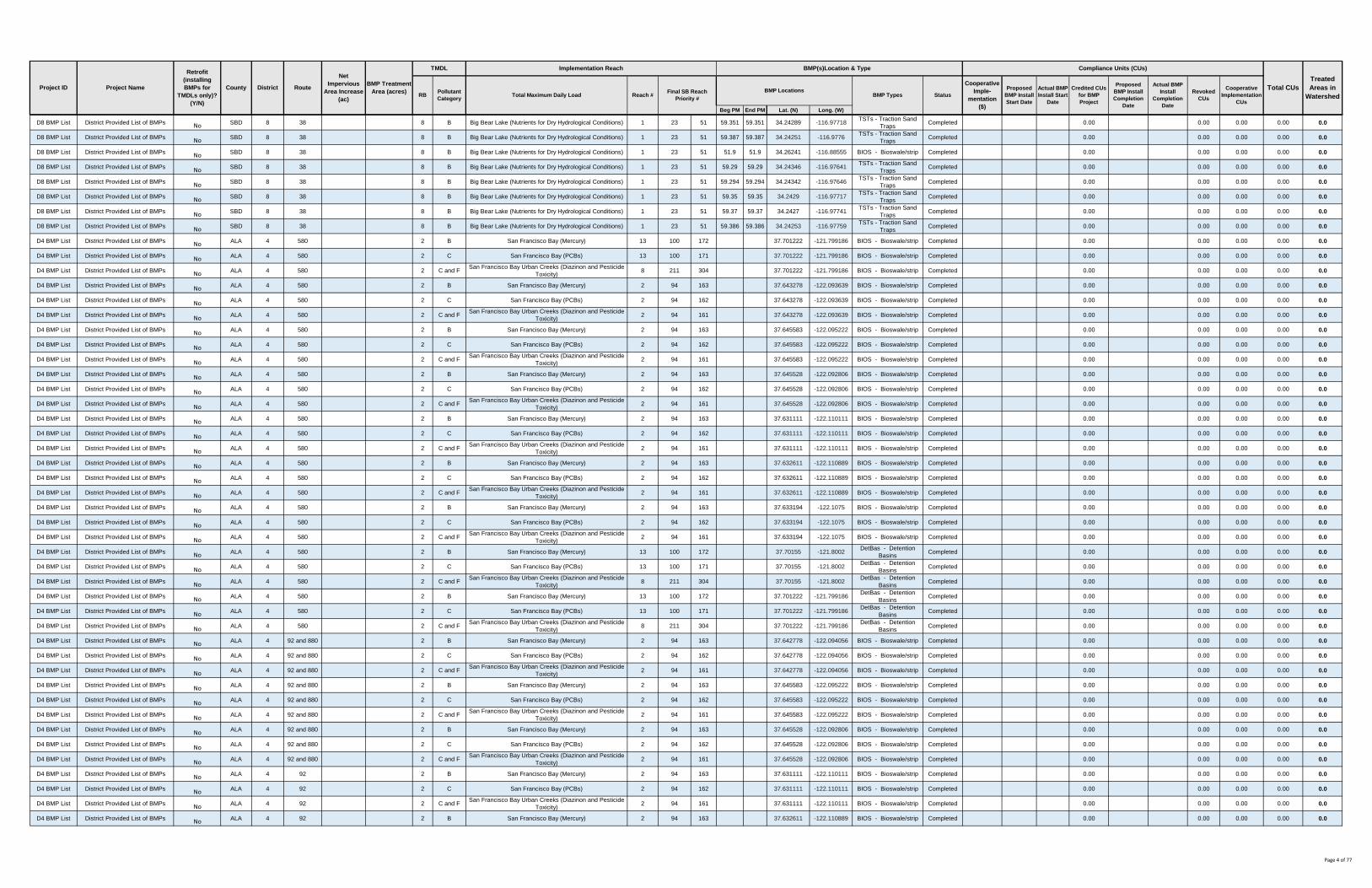
Beg PM End PM Lat. (N) Long. (W)
Revoked CUs
Total CUsTreated Areas in
WatershedRBPollutant Category
Total Maximum Daily Load Reach #Final SB Reach
Priority #
Compliance Units (CUs)
Cooperative Imple-
mentation ($)
Cooperative Implementation
CUs
Proposed BMP Install Start Date
Actual BMP Install Start
Date
Credited CUs for BMP Project
Proposed BMP Install Completion
Date
Actual BMP Install
Completion Date
Net Impervious
Area Increase (ac)
BMP Treatment Area (acres)
TMDL Implementation Reach BMP(s)Location & Type
BMP LocationsBMP Types Status
RouteProject ID Project Name
Retrofit (installing BMPs for
TMDLs only)? (Y/N)
County District
D8 BMP List District Provided List of BMPs No SBD 8 38 8 B Big Bear Lake (Nutrients for Dry Hydrological Conditions) 1 23 51 59.351 59.351 34.24289 -116.97718TSTs - Traction Sand
TrapsCompleted 0.00 0.00 0.00 0.00 0.0
D8 BMP List District Provided List of BMPs No SBD 8 38 8 B Big Bear Lake (Nutrients for Dry Hydrological Conditions) 1 23 51 59.387 59.387 34.24251 -116.9776TSTs - Traction Sand
TrapsCompleted 0.00 0.00 0.00 0.00 0.0
D8 BMP List District Provided List of BMPs No SBD 8 38 8 B Big Bear Lake (Nutrients for Dry Hydrological Conditions) 1 23 51 51.9 51.9 34.26241 -116.88555 BIOS - Bioswale/strip Completed 0.00 0.00 0.00 0.00 0.0
D8 BMP List District Provided List of BMPs No SBD 8 38 8 B Big Bear Lake (Nutrients for Dry Hydrological Conditions) 1 23 51 59.29 59.29 34.24346 -116.97641TSTs - Traction Sand
TrapsCompleted 0.00 0.00 0.00 0.00 0.0
D8 BMP List District Provided List of BMPs No SBD 8 38 8 B Big Bear Lake (Nutrients for Dry Hydrological Conditions) 1 23 51 59.294 59.294 34.24342 -116.97646TSTs - Traction Sand
TrapsCompleted 0.00 0.00 0.00 0.00 0.0
D8 BMP List District Provided List of BMPs No SBD 8 38 8 B Big Bear Lake (Nutrients for Dry Hydrological Conditions) 1 23 51 59.35 59.35 34.2429 -116.97717TSTs - Traction Sand
TrapsCompleted 0.00 0.00 0.00 0.00 0.0
D8 BMP List District Provided List of BMPs No SBD 8 38 8 B Big Bear Lake (Nutrients for Dry Hydrological Conditions) 1 23 51 59.37 59.37 34.2427 -116.97741TSTs - Traction Sand
TrapsCompleted 0.00 0.00 0.00 0.00 0.0
D8 BMP List District Provided List of BMPs No SBD 8 38 8 B Big Bear Lake (Nutrients for Dry Hydrological Conditions) 1 23 51 59.386 59.386 34.24253 -116.97759TSTs - Traction Sand
TrapsCompleted 0.00 0.00 0.00 0.00 0.0
D4 BMP List District Provided List of BMPs No ALA 4 580 2 B San Francisco Bay (Mercury) 13 100 172 37.701222 -121.799186 BIOS - Bioswale/strip Completed 0.00 0.00 0.00 0.00 0.0
D4 BMP List District Provided List of BMPs No ALA 4 580 2 C San Francisco Bay (PCBs) 13 100 171 37.701222 -121.799186 BIOS - Bioswale/strip Completed 0.00 0.00 0.00 0.00 0.0
D4 BMP List District Provided List of BMPs No ALA 4 580 2 C and FSan Francisco Bay Urban Creeks (Diazinon and Pesticide
Toxicity)8 211 304 37.701222 -121.799186 BIOS - Bioswale/strip Completed 0.00 0.00 0.00 0.00 0.0
D4 BMP List District Provided List of BMPs No ALA 4 580 2 B San Francisco Bay (Mercury) 2 94 163 37.643278 -122.093639 BIOS - Bioswale/strip Completed 0.00 0.00 0.00 0.00 0.0
D4 BMP List District Provided List of BMPs No ALA 4 580 2 C San Francisco Bay (PCBs) 2 94 162 37.643278 -122.093639 BIOS - Bioswale/strip Completed 0.00 0.00 0.00 0.00 0.0
D4 BMP List District Provided List of BMPs No ALA 4 580 2 C and FSan Francisco Bay Urban Creeks (Diazinon and Pesticide
Toxicity)2 94 161 37.643278 -122.093639 BIOS - Bioswale/strip Completed 0.00 0.00 0.00 0.00 0.0
D4 BMP List District Provided List of BMPs No ALA 4 580 2 B San Francisco Bay (Mercury) 2 94 163 37.645583 -122.095222 BIOS - Bioswale/strip Completed 0.00 0.00 0.00 0.00 0.0
D4 BMP List District Provided List of BMPs No ALA 4 580 2 C San Francisco Bay (PCBs) 2 94 162 37.645583 -122.095222 BIOS - Bioswale/strip Completed 0.00 0.00 0.00 0.00 0.0
D4 BMP List District Provided List of BMPs No ALA 4 580 2 C and FSan Francisco Bay Urban Creeks (Diazinon and Pesticide
Toxicity)2 94 161 37.645583 -122.095222 BIOS - Bioswale/strip Completed 0.00 0.00 0.00 0.00 0.0
D4 BMP List District Provided List of BMPs No ALA 4 580 2 B San Francisco Bay (Mercury) 2 94 163 37.645528 -122.092806 BIOS - Bioswale/strip Completed 0.00 0.00 0.00 0.00 0.0
D4 BMP List District Provided List of BMPs No ALA 4 580 2 C San Francisco Bay (PCBs) 2 94 162 37.645528 -122.092806 BIOS - Bioswale/strip Completed 0.00 0.00 0.00 0.00 0.0
D4 BMP List District Provided List of BMPs No ALA 4 580 2 C and FSan Francisco Bay Urban Creeks (Diazinon and Pesticide
Toxicity)2 94 161 37.645528 -122.092806 BIOS - Bioswale/strip Completed 0.00 0.00 0.00 0.00 0.0
D4 BMP List District Provided List of BMPs No ALA 4 580 2 B San Francisco Bay (Mercury) 2 94 163 37.631111 -122.110111 BIOS - Bioswale/strip Completed 0.00 0.00 0.00 0.00 0.0
D4 BMP List District Provided List of BMPs No ALA 4 580 2 C San Francisco Bay (PCBs) 2 94 162 37.631111 -122.110111 BIOS - Bioswale/strip Completed 0.00 0.00 0.00 0.00 0.0
D4 BMP List District Provided List of BMPs No ALA 4 580 2 C and FSan Francisco Bay Urban Creeks (Diazinon and Pesticide
Toxicity)2 94 161 37.631111 -122.110111 BIOS - Bioswale/strip Completed 0.00 0.00 0.00 0.00 0.0
D4 BMP List District Provided List of BMPs No ALA 4 580 2 B San Francisco Bay (Mercury) 2 94 163 37.632611 -122.110889 BIOS - Bioswale/strip Completed 0.00 0.00 0.00 0.00 0.0
D4 BMP List District Provided List of BMPs No ALA 4 580 2 C San Francisco Bay (PCBs) 2 94 162 37.632611 -122.110889 BIOS - Bioswale/strip Completed 0.00 0.00 0.00 0.00 0.0
D4 BMP List District Provided List of BMPs No ALA 4 580 2 C and FSan Francisco Bay Urban Creeks (Diazinon and Pesticide
Toxicity)2 94 161 37.632611 -122.110889 BIOS - Bioswale/strip Completed 0.00 0.00 0.00 0.00 0.0
D4 BMP List District Provided List of BMPs No ALA 4 580 2 B San Francisco Bay (Mercury) 2 94 163 37.633194 -122.1075 BIOS - Bioswale/strip Completed 0.00 0.00 0.00 0.00 0.0
D4 BMP List District Provided List of BMPs No ALA 4 580 2 C San Francisco Bay (PCBs) 2 94 162 37.633194 -122.1075 BIOS - Bioswale/strip Completed 0.00 0.00 0.00 0.00 0.0
D4 BMP List District Provided List of BMPs No ALA 4 580 2 C and FSan Francisco Bay Urban Creeks (Diazinon and Pesticide
Toxicity)2 94 161 37.633194 -122.1075 BIOS - Bioswale/strip Completed 0.00 0.00 0.00 0.00 0.0
D4 BMP List District Provided List of BMPs No ALA 4 580 2 B San Francisco Bay (Mercury) 13 100 172 37.70155 -121.8002DetBas - Detention
BasinsCompleted 0.00 0.00 0.00 0.00 0.0
D4 BMP List District Provided List of BMPs No ALA 4 580 2 C San Francisco Bay (PCBs) 13 100 171 37.70155 -121.8002DetBas - Detention
BasinsCompleted 0.00 0.00 0.00 0.00 0.0
D4 BMP List District Provided List of BMPs No ALA 4 580 2 C and FSan Francisco Bay Urban Creeks (Diazinon and Pesticide
Toxicity)8 211 304 37.70155 -121.8002
DetBas - Detention Basins
Completed 0.00 0.00 0.00 0.00 0.0
D4 BMP List District Provided List of BMPs No ALA 4 580 2 B San Francisco Bay (Mercury) 13 100 172 37.701222 -121.799186DetBas - Detention
BasinsCompleted 0.00 0.00 0.00 0.00 0.0
D4 BMP List District Provided List of BMPs No ALA 4 580 2 C San Francisco Bay (PCBs) 13 100 171 37.701222 -121.799186DetBas - Detention
BasinsCompleted 0.00 0.00 0.00 0.00 0.0
D4 BMP List District Provided List of BMPs No ALA 4 580 2 C and FSan Francisco Bay Urban Creeks (Diazinon and Pesticide
Toxicity)8 211 304 37.701222 -121.799186
DetBas - Detention Basins
Completed 0.00 0.00 0.00 0.00 0.0
D4 BMP List District Provided List of BMPs No ALA 4 92 and 880 2 B San Francisco Bay (Mercury) 2 94 163 37.642778 -122.094056 BIOS - Bioswale/strip Completed 0.00 0.00 0.00 0.00 0.0
D4 BMP List District Provided List of BMPs No ALA 4 92 and 880 2 C San Francisco Bay (PCBs) 2 94 162 37.642778 -122.094056 BIOS - Bioswale/strip Completed 0.00 0.00 0.00 0.00 0.0
D4 BMP List District Provided List of BMPs No ALA 4 92 and 880 2 C and FSan Francisco Bay Urban Creeks (Diazinon and Pesticide
Toxicity)2 94 161 37.642778 -122.094056 BIOS - Bioswale/strip Completed 0.00 0.00 0.00 0.00 0.0
D4 BMP List District Provided List of BMPs No ALA 4 92 and 880 2 B San Francisco Bay (Mercury) 2 94 163 37.645583 -122.095222 BIOS - Bioswale/strip Completed 0.00 0.00 0.00 0.00 0.0
D4 BMP List District Provided List of BMPs No ALA 4 92 and 880 2 C San Francisco Bay (PCBs) 2 94 162 37.645583 -122.095222 BIOS - Bioswale/strip Completed 0.00 0.00 0.00 0.00 0.0
D4 BMP List District Provided List of BMPs No ALA 4 92 and 880 2 C and FSan Francisco Bay Urban Creeks (Diazinon and Pesticide
Toxicity)2 94 161 37.645583 -122.095222 BIOS - Bioswale/strip Completed 0.00 0.00 0.00 0.00 0.0
D4 BMP List District Provided List of BMPs No ALA 4 92 and 880 2 B San Francisco Bay (Mercury) 2 94 163 37.645528 -122.092806 BIOS - Bioswale/strip Completed 0.00 0.00 0.00 0.00 0.0
D4 BMP List District Provided List of BMPs No ALA 4 92 and 880 2 C San Francisco Bay (PCBs) 2 94 162 37.645528 -122.092806 BIOS - Bioswale/strip Completed 0.00 0.00 0.00 0.00 0.0
D4 BMP List District Provided List of BMPs No ALA 4 92 and 880 2 C and FSan Francisco Bay Urban Creeks (Diazinon and Pesticide
Toxicity)2 94 161 37.645528 -122.092806 BIOS - Bioswale/strip Completed 0.00 0.00 0.00 0.00 0.0
D4 BMP List District Provided List of BMPs No ALA 4 92 2 B San Francisco Bay (Mercury) 2 94 163 37.631111 -122.110111 BIOS - Bioswale/strip Completed 0.00 0.00 0.00 0.00 0.0
D4 BMP List District Provided List of BMPs No ALA 4 92 2 C San Francisco Bay (PCBs) 2 94 162 37.631111 -122.110111 BIOS - Bioswale/strip Completed 0.00 0.00 0.00 0.00 0.0
D4 BMP List District Provided List of BMPs No ALA 4 92 2 C and FSan Francisco Bay Urban Creeks (Diazinon and Pesticide
Toxicity)2 94 161 37.631111 -122.110111 BIOS - Bioswale/strip Completed 0.00 0.00 0.00 0.00 0.0
D4 BMP List District Provided List of BMPs No ALA 4 92 2 B San Francisco Bay (Mercury) 2 94 163 37.632611 -122.110889 BIOS - Bioswale/strip Completed 0.00 0.00 0.00 0.00 0.0
Page 4 of 77
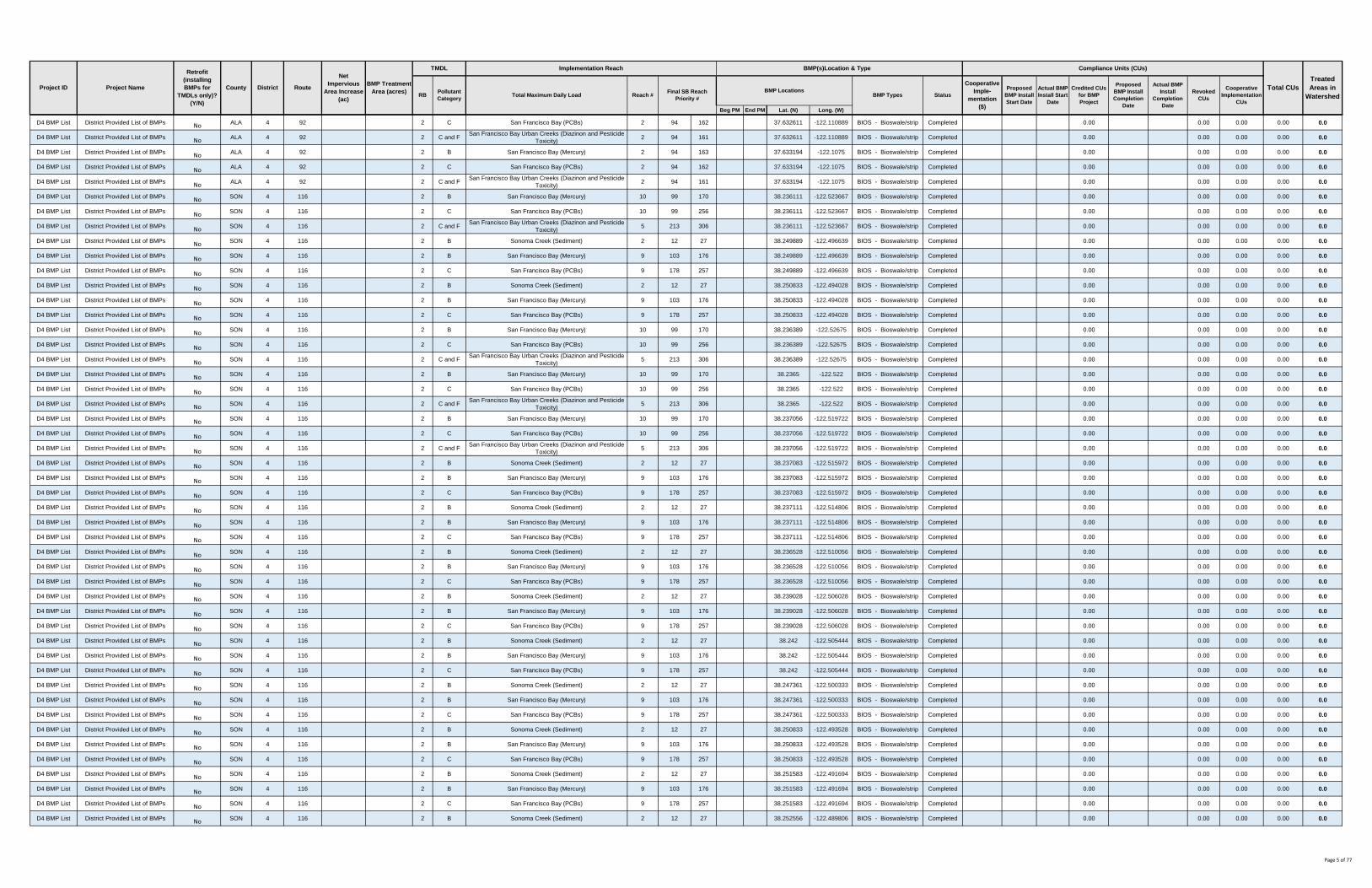
Beg PM End PM Lat. (N) Long. (W)
Revoked CUs
Total CUsTreated Areas in
WatershedRBPollutant Category
Total Maximum Daily Load Reach #Final SB Reach
Priority #
Compliance Units (CUs)
Cooperative Imple-
mentation ($)
Cooperative Implementation
CUs
Proposed BMP Install Start Date
Actual BMP Install Start
Date
Credited CUs for BMP Project
Proposed BMP Install Completion
Date
Actual BMP Install
Completion Date
Net Impervious
Area Increase (ac)
BMP Treatment Area (acres)
TMDL Implementation Reach BMP(s)Location & Type
BMP LocationsBMP Types Status
RouteProject ID Project Name
Retrofit (installing BMPs for
TMDLs only)? (Y/N)
County District
D4 BMP List District Provided List of BMPs No ALA 4 92 2 C San Francisco Bay (PCBs) 2 94 162 37.632611 -122.110889 BIOS - Bioswale/strip Completed 0.00 0.00 0.00 0.00 0.0
D4 BMP List District Provided List of BMPs No ALA 4 92 2 C and FSan Francisco Bay Urban Creeks (Diazinon and Pesticide
Toxicity)2 94 161 37.632611 -122.110889 BIOS - Bioswale/strip Completed 0.00 0.00 0.00 0.00 0.0
D4 BMP List District Provided List of BMPs No ALA 4 92 2 B San Francisco Bay (Mercury) 2 94 163 37.633194 -122.1075 BIOS - Bioswale/strip Completed 0.00 0.00 0.00 0.00 0.0
D4 BMP List District Provided List of BMPs No ALA 4 92 2 C San Francisco Bay (PCBs) 2 94 162 37.633194 -122.1075 BIOS - Bioswale/strip Completed 0.00 0.00 0.00 0.00 0.0
D4 BMP List District Provided List of BMPs No ALA 4 92 2 C and FSan Francisco Bay Urban Creeks (Diazinon and Pesticide
Toxicity)2 94 161 37.633194 -122.1075 BIOS - Bioswale/strip Completed 0.00 0.00 0.00 0.00 0.0
D4 BMP List District Provided List of BMPs No SON 4 116 2 B San Francisco Bay (Mercury) 10 99 170 38.236111 -122.523667 BIOS - Bioswale/strip Completed 0.00 0.00 0.00 0.00 0.0
D4 BMP List District Provided List of BMPs No SON 4 116 2 C San Francisco Bay (PCBs) 10 99 256 38.236111 -122.523667 BIOS - Bioswale/strip Completed 0.00 0.00 0.00 0.00 0.0
D4 BMP List District Provided List of BMPs No SON 4 116 2 C and FSan Francisco Bay Urban Creeks (Diazinon and Pesticide
Toxicity)5 213 306 38.236111 -122.523667 BIOS - Bioswale/strip Completed 0.00 0.00 0.00 0.00 0.0
D4 BMP List District Provided List of BMPs No SON 4 116 2 B Sonoma Creek (Sediment) 2 12 27 38.249889 -122.496639 BIOS - Bioswale/strip Completed 0.00 0.00 0.00 0.00 0.0
D4 BMP List District Provided List of BMPs No SON 4 116 2 B San Francisco Bay (Mercury) 9 103 176 38.249889 -122.496639 BIOS - Bioswale/strip Completed 0.00 0.00 0.00 0.00 0.0
D4 BMP List District Provided List of BMPs No SON 4 116 2 C San Francisco Bay (PCBs) 9 178 257 38.249889 -122.496639 BIOS - Bioswale/strip Completed 0.00 0.00 0.00 0.00 0.0
D4 BMP List District Provided List of BMPs No SON 4 116 2 B Sonoma Creek (Sediment) 2 12 27 38.250833 -122.494028 BIOS - Bioswale/strip Completed 0.00 0.00 0.00 0.00 0.0
D4 BMP List District Provided List of BMPs No SON 4 116 2 B San Francisco Bay (Mercury) 9 103 176 38.250833 -122.494028 BIOS - Bioswale/strip Completed 0.00 0.00 0.00 0.00 0.0
D4 BMP List District Provided List of BMPs No SON 4 116 2 C San Francisco Bay (PCBs) 9 178 257 38.250833 -122.494028 BIOS - Bioswale/strip Completed 0.00 0.00 0.00 0.00 0.0
D4 BMP List District Provided List of BMPs No SON 4 116 2 B San Francisco Bay (Mercury) 10 99 170 38.236389 -122.52675 BIOS - Bioswale/strip Completed 0.00 0.00 0.00 0.00 0.0
D4 BMP List District Provided List of BMPs No SON 4 116 2 C San Francisco Bay (PCBs) 10 99 256 38.236389 -122.52675 BIOS - Bioswale/strip Completed 0.00 0.00 0.00 0.00 0.0
D4 BMP List District Provided List of BMPs No SON 4 116 2 C and FSan Francisco Bay Urban Creeks (Diazinon and Pesticide
Toxicity)5 213 306 38.236389 -122.52675 BIOS - Bioswale/strip Completed 0.00 0.00 0.00 0.00 0.0
D4 BMP List District Provided List of BMPs No SON 4 116 2 B San Francisco Bay (Mercury) 10 99 170 38.2365 -122.522 BIOS - Bioswale/strip Completed 0.00 0.00 0.00 0.00 0.0
D4 BMP List District Provided List of BMPs No SON 4 116 2 C San Francisco Bay (PCBs) 10 99 256 38.2365 -122.522 BIOS - Bioswale/strip Completed 0.00 0.00 0.00 0.00 0.0
D4 BMP List District Provided List of BMPs No SON 4 116 2 C and FSan Francisco Bay Urban Creeks (Diazinon and Pesticide
Toxicity)5 213 306 38.2365 -122.522 BIOS - Bioswale/strip Completed 0.00 0.00 0.00 0.00 0.0
D4 BMP List District Provided List of BMPs No SON 4 116 2 B San Francisco Bay (Mercury) 10 99 170 38.237056 -122.519722 BIOS - Bioswale/strip Completed 0.00 0.00 0.00 0.00 0.0
D4 BMP List District Provided List of BMPs No SON 4 116 2 C San Francisco Bay (PCBs) 10 99 256 38.237056 -122.519722 BIOS - Bioswale/strip Completed 0.00 0.00 0.00 0.00 0.0
D4 BMP List District Provided List of BMPs No SON 4 116 2 C and FSan Francisco Bay Urban Creeks (Diazinon and Pesticide
Toxicity)5 213 306 38.237056 -122.519722 BIOS - Bioswale/strip Completed 0.00 0.00 0.00 0.00 0.0
D4 BMP List District Provided List of BMPs No SON 4 116 2 B Sonoma Creek (Sediment) 2 12 27 38.237083 -122.515972 BIOS - Bioswale/strip Completed 0.00 0.00 0.00 0.00 0.0
D4 BMP List District Provided List of BMPs No SON 4 116 2 B San Francisco Bay (Mercury) 9 103 176 38.237083 -122.515972 BIOS - Bioswale/strip Completed 0.00 0.00 0.00 0.00 0.0
D4 BMP List District Provided List of BMPs No SON 4 116 2 C San Francisco Bay (PCBs) 9 178 257 38.237083 -122.515972 BIOS - Bioswale/strip Completed 0.00 0.00 0.00 0.00 0.0
D4 BMP List District Provided List of BMPs No SON 4 116 2 B Sonoma Creek (Sediment) 2 12 27 38.237111 -122.514806 BIOS - Bioswale/strip Completed 0.00 0.00 0.00 0.00 0.0
D4 BMP List District Provided List of BMPs No SON 4 116 2 B San Francisco Bay (Mercury) 9 103 176 38.237111 -122.514806 BIOS - Bioswale/strip Completed 0.00 0.00 0.00 0.00 0.0
D4 BMP List District Provided List of BMPs No SON 4 116 2 C San Francisco Bay (PCBs) 9 178 257 38.237111 -122.514806 BIOS - Bioswale/strip Completed 0.00 0.00 0.00 0.00 0.0
D4 BMP List District Provided List of BMPs No SON 4 116 2 B Sonoma Creek (Sediment) 2 12 27 38.236528 -122.510056 BIOS - Bioswale/strip Completed 0.00 0.00 0.00 0.00 0.0
D4 BMP List District Provided List of BMPs No SON 4 116 2 B San Francisco Bay (Mercury) 9 103 176 38.236528 -122.510056 BIOS - Bioswale/strip Completed 0.00 0.00 0.00 0.00 0.0
D4 BMP List District Provided List of BMPs No SON 4 116 2 C San Francisco Bay (PCBs) 9 178 257 38.236528 -122.510056 BIOS - Bioswale/strip Completed 0.00 0.00 0.00 0.00 0.0
D4 BMP List District Provided List of BMPs No SON 4 116 2 B Sonoma Creek (Sediment) 2 12 27 38.239028 -122.506028 BIOS - Bioswale/strip Completed 0.00 0.00 0.00 0.00 0.0
D4 BMP List District Provided List of BMPs No SON 4 116 2 B San Francisco Bay (Mercury) 9 103 176 38.239028 -122.506028 BIOS - Bioswale/strip Completed 0.00 0.00 0.00 0.00 0.0
D4 BMP List District Provided List of BMPs No SON 4 116 2 C San Francisco Bay (PCBs) 9 178 257 38.239028 -122.506028 BIOS - Bioswale/strip Completed 0.00 0.00 0.00 0.00 0.0
D4 BMP List District Provided List of BMPs No SON 4 116 2 B Sonoma Creek (Sediment) 2 12 27 38.242 -122.505444 BIOS - Bioswale/strip Completed 0.00 0.00 0.00 0.00 0.0
D4 BMP List District Provided List of BMPs No SON 4 116 2 B San Francisco Bay (Mercury) 9 103 176 38.242 -122.505444 BIOS - Bioswale/strip Completed 0.00 0.00 0.00 0.00 0.0
D4 BMP List District Provided List of BMPs No SON 4 116 2 C San Francisco Bay (PCBs) 9 178 257 38.242 -122.505444 BIOS - Bioswale/strip Completed 0.00 0.00 0.00 0.00 0.0
D4 BMP List District Provided List of BMPs No SON 4 116 2 B Sonoma Creek (Sediment) 2 12 27 38.247361 -122.500333 BIOS - Bioswale/strip Completed 0.00 0.00 0.00 0.00 0.0
D4 BMP List District Provided List of BMPs No SON 4 116 2 B San Francisco Bay (Mercury) 9 103 176 38.247361 -122.500333 BIOS - Bioswale/strip Completed 0.00 0.00 0.00 0.00 0.0
D4 BMP List District Provided List of BMPs No SON 4 116 2 C San Francisco Bay (PCBs) 9 178 257 38.247361 -122.500333 BIOS - Bioswale/strip Completed 0.00 0.00 0.00 0.00 0.0
D4 BMP List District Provided List of BMPs No SON 4 116 2 B Sonoma Creek (Sediment) 2 12 27 38.250833 -122.493528 BIOS - Bioswale/strip Completed 0.00 0.00 0.00 0.00 0.0
D4 BMP List District Provided List of BMPs No SON 4 116 2 B San Francisco Bay (Mercury) 9 103 176 38.250833 -122.493528 BIOS - Bioswale/strip Completed 0.00 0.00 0.00 0.00 0.0
D4 BMP List District Provided List of BMPs No SON 4 116 2 C San Francisco Bay (PCBs) 9 178 257 38.250833 -122.493528 BIOS - Bioswale/strip Completed 0.00 0.00 0.00 0.00 0.0
D4 BMP List District Provided List of BMPs No SON 4 116 2 B Sonoma Creek (Sediment) 2 12 27 38.251583 -122.491694 BIOS - Bioswale/strip Completed 0.00 0.00 0.00 0.00 0.0
D4 BMP List District Provided List of BMPs No SON 4 116 2 B San Francisco Bay (Mercury) 9 103 176 38.251583 -122.491694 BIOS - Bioswale/strip Completed 0.00 0.00 0.00 0.00 0.0
D4 BMP List District Provided List of BMPs No SON 4 116 2 C San Francisco Bay (PCBs) 9 178 257 38.251583 -122.491694 BIOS - Bioswale/strip Completed 0.00 0.00 0.00 0.00 0.0
D4 BMP List District Provided List of BMPs No SON 4 116 2 B Sonoma Creek (Sediment) 2 12 27 38.252556 -122.489806 BIOS - Bioswale/strip Completed 0.00 0.00 0.00 0.00 0.0
Page 5 of 77
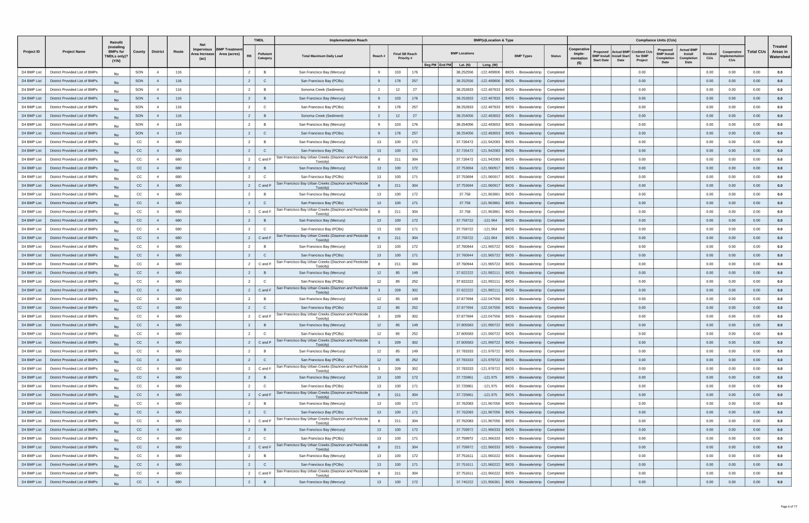
Beg PM End PM Lat. (N) Long. (W)
Revoked CUs
Total CUsTreated Areas in
WatershedRBPollutant Category
Total Maximum Daily Load Reach #Final SB Reach
Priority #
Compliance Units (CUs)
Cooperative Imple-
mentation ($)
Cooperative Implementation
CUs
Proposed BMP Install Start Date
Actual BMP Install Start
Date
Credited CUs for BMP Project
Proposed BMP Install Completion
Date
Actual BMP Install
Completion Date
Net Impervious
Area Increase (ac)
BMP Treatment Area (acres)
TMDL Implementation Reach BMP(s)Location & Type
BMP LocationsBMP Types Status
RouteProject ID Project Name
Retrofit (installing BMPs for
TMDLs only)? (Y/N)
County District
D4 BMP List District Provided List of BMPs No SON 4 116 2 B San Francisco Bay (Mercury) 9 103 176 38.252556 -122.489806 BIOS - Bioswale/strip Completed 0.00 0.00 0.00 0.00 0.0
D4 BMP List District Provided List of BMPs No SON 4 116 2 C San Francisco Bay (PCBs) 9 178 257 38.252556 -122.489806 BIOS - Bioswale/strip Completed 0.00 0.00 0.00 0.00 0.0
D4 BMP List District Provided List of BMPs No SON 4 116 2 B Sonoma Creek (Sediment) 2 12 27 38.252833 -122.487833 BIOS - Bioswale/strip Completed 0.00 0.00 0.00 0.00 0.0
D4 BMP List District Provided List of BMPs No SON 4 116 2 B San Francisco Bay (Mercury) 9 103 176 38.252833 -122.487833 BIOS - Bioswale/strip Completed 0.00 0.00 0.00 0.00 0.0
D4 BMP List District Provided List of BMPs No SON 4 116 2 C San Francisco Bay (PCBs) 9 178 257 38.252833 -122.487833 BIOS - Bioswale/strip Completed 0.00 0.00 0.00 0.00 0.0
D4 BMP List District Provided List of BMPs No SON 4 116 2 B Sonoma Creek (Sediment) 2 12 27 38.254056 -122.483653 BIOS - Bioswale/strip Completed 0.00 0.00 0.00 0.00 0.0
D4 BMP List District Provided List of BMPs No SON 4 116 2 B San Francisco Bay (Mercury) 9 103 176 38.254056 -122.483653 BIOS - Bioswale/strip Completed 0.00 0.00 0.00 0.00 0.0
D4 BMP List District Provided List of BMPs No SON 4 116 2 C San Francisco Bay (PCBs) 9 178 257 38.254056 -122.483653 BIOS - Bioswale/strip Completed 0.00 0.00 0.00 0.00 0.0
D4 BMP List District Provided List of BMPs No CC 4 680 2 B San Francisco Bay (Mercury) 13 100 172 37.726472 -121.942083 BIOS - Bioswale/strip Completed 0.00 0.00 0.00 0.00 0.0
D4 BMP List District Provided List of BMPs No CC 4 680 2 C San Francisco Bay (PCBs) 13 100 171 37.726472 -121.942083 BIOS - Bioswale/strip Completed 0.00 0.00 0.00 0.00 0.0
D4 BMP List District Provided List of BMPs No CC 4 680 2 C and FSan Francisco Bay Urban Creeks (Diazinon and Pesticide
Toxicity)8 211 304 37.726472 -121.942083 BIOS - Bioswale/strip Completed 0.00 0.00 0.00 0.00 0.0
D4 BMP List District Provided List of BMPs No CC 4 680 2 B San Francisco Bay (Mercury) 13 100 172 37.753694 -121.960917 BIOS - Bioswale/strip Completed 0.00 0.00 0.00 0.00 0.0
D4 BMP List District Provided List of BMPs No CC 4 680 2 C San Francisco Bay (PCBs) 13 100 171 37.753694 -121.960917 BIOS - Bioswale/strip Completed 0.00 0.00 0.00 0.00 0.0
D4 BMP List District Provided List of BMPs No CC 4 680 2 C and FSan Francisco Bay Urban Creeks (Diazinon and Pesticide
Toxicity)8 211 304 37.753694 -121.960917 BIOS - Bioswale/strip Completed 0.00 0.00 0.00 0.00 0.0
D4 BMP List District Provided List of BMPs No CC 4 680 2 B San Francisco Bay (Mercury) 13 100 172 37.758 -121.963861 BIOS - Bioswale/strip Completed 0.00 0.00 0.00 0.00 0.0
D4 BMP List District Provided List of BMPs No CC 4 680 2 C San Francisco Bay (PCBs) 13 100 171 37.758 -121.963861 BIOS - Bioswale/strip Completed 0.00 0.00 0.00 0.00 0.0
D4 BMP List District Provided List of BMPs No CC 4 680 2 C and FSan Francisco Bay Urban Creeks (Diazinon and Pesticide
Toxicity)8 211 304 37.758 -121.963861 BIOS - Bioswale/strip Completed 0.00 0.00 0.00 0.00 0.0
D4 BMP List District Provided List of BMPs No CC 4 680 2 B San Francisco Bay (Mercury) 13 100 172 37.759722 -121.964 BIOS - Bioswale/strip Completed 0.00 0.00 0.00 0.00 0.0
D4 BMP List District Provided List of BMPs No CC 4 680 2 C San Francisco Bay (PCBs) 13 100 171 37.759722 -121.964 BIOS - Bioswale/strip Completed 0.00 0.00 0.00 0.00 0.0
D4 BMP List District Provided List of BMPs No CC 4 680 2 C and FSan Francisco Bay Urban Creeks (Diazinon and Pesticide
Toxicity)8 211 304 37.759722 -121.964 BIOS - Bioswale/strip Completed 0.00 0.00 0.00 0.00 0.0
D4 BMP List District Provided List of BMPs No CC 4 680 2 B San Francisco Bay (Mercury) 13 100 172 37.760944 -121.965722 BIOS - Bioswale/strip Completed 0.00 0.00 0.00 0.00 0.0
D4 BMP List District Provided List of BMPs No CC 4 680 2 C San Francisco Bay (PCBs) 13 100 171 37.760944 -121.965722 BIOS - Bioswale/strip Completed 0.00 0.00 0.00 0.00 0.0
D4 BMP List District Provided List of BMPs No CC 4 680 2 C and FSan Francisco Bay Urban Creeks (Diazinon and Pesticide
Toxicity)8 211 304 37.760944 -121.965722 BIOS - Bioswale/strip Completed 0.00 0.00 0.00 0.00 0.0
D4 BMP List District Provided List of BMPs No CC 4 680 2 B San Francisco Bay (Mercury) 12 85 149 37.822222 -121.992111 BIOS - Bioswale/strip Completed 0.00 0.00 0.00 0.00 0.0
D4 BMP List District Provided List of BMPs No CC 4 680 2 C San Francisco Bay (PCBs) 12 85 252 37.822222 -121.992111 BIOS - Bioswale/strip Completed 0.00 0.00 0.00 0.00 0.0
D4 BMP List District Provided List of BMPs No CC 4 680 2 C and FSan Francisco Bay Urban Creeks (Diazinon and Pesticide
Toxicity)3 209 302 37.822222 -121.992111 BIOS - Bioswale/strip Completed 0.00 0.00 0.00 0.00 0.0
D4 BMP List District Provided List of BMPs No CC 4 680 2 B San Francisco Bay (Mercury) 12 85 149 37.877694 -122.047556 BIOS - Bioswale/strip Completed 0.00 0.00 0.00 0.00 0.0
D4 BMP List District Provided List of BMPs No CC 4 680 2 C San Francisco Bay (PCBs) 12 85 252 37.877694 -122.047556 BIOS - Bioswale/strip Completed 0.00 0.00 0.00 0.00 0.0
D4 BMP List District Provided List of BMPs No CC 4 680 2 C and FSan Francisco Bay Urban Creeks (Diazinon and Pesticide
Toxicity)3 209 302 37.877694 -122.047556 BIOS - Bioswale/strip Completed 0.00 0.00 0.00 0.00 0.0
D4 BMP List District Provided List of BMPs No CC 4 680 2 B San Francisco Bay (Mercury) 12 85 149 37.805583 -121.990722 BIOS - Bioswale/strip Completed 0.00 0.00 0.00 0.00 0.0
D4 BMP List District Provided List of BMPs No CC 4 680 2 C San Francisco Bay (PCBs) 12 85 252 37.805583 -121.990722 BIOS - Bioswale/strip Completed 0.00 0.00 0.00 0.00 0.0
D4 BMP List District Provided List of BMPs No CC 4 680 2 C and FSan Francisco Bay Urban Creeks (Diazinon and Pesticide
Toxicity)3 209 302 37.805583 -121.990722 BIOS - Bioswale/strip Completed 0.00 0.00 0.00 0.00 0.0
D4 BMP List District Provided List of BMPs No CC 4 680 2 B San Francisco Bay (Mercury) 12 85 149 37.783333 -121.978722 BIOS - Bioswale/strip Completed 0.00 0.00 0.00 0.00 0.0
D4 BMP List District Provided List of BMPs No CC 4 680 2 C San Francisco Bay (PCBs) 12 85 252 37.783333 -121.978722 BIOS - Bioswale/strip Completed 0.00 0.00 0.00 0.00 0.0
D4 BMP List District Provided List of BMPs No CC 4 680 2 C and FSan Francisco Bay Urban Creeks (Diazinon and Pesticide
Toxicity)3 209 302 37.783333 -121.978722 BIOS - Bioswale/strip Completed 0.00 0.00 0.00 0.00 0.0
D4 BMP List District Provided List of BMPs No CC 4 680 2 B San Francisco Bay (Mercury) 13 100 172 37.725861 -121.975 BIOS - Bioswale/strip Completed 0.00 0.00 0.00 0.00 0.0
D4 BMP List District Provided List of BMPs No CC 4 680 2 C San Francisco Bay (PCBs) 13 100 171 37.725861 -121.975 BIOS - Bioswale/strip Completed 0.00 0.00 0.00 0.00 0.0
D4 BMP List District Provided List of BMPs No CC 4 680 2 C and FSan Francisco Bay Urban Creeks (Diazinon and Pesticide
Toxicity)8 211 304 37.725861 -121.975 BIOS - Bioswale/strip Completed 0.00 0.00 0.00 0.00 0.0
D4 BMP List District Provided List of BMPs No CC 4 680 2 B San Francisco Bay (Mercury) 13 100 172 37.762083 -121.967056 BIOS - Bioswale/strip Completed 0.00 0.00 0.00 0.00 0.0
D4 BMP List District Provided List of BMPs No CC 4 680 2 C San Francisco Bay (PCBs) 13 100 171 37.762083 -121.967056 BIOS - Bioswale/strip Completed 0.00 0.00 0.00 0.00 0.0
D4 BMP List District Provided List of BMPs No CC 4 680 2 C and FSan Francisco Bay Urban Creeks (Diazinon and Pesticide
Toxicity)8 211 304 37.762083 -121.967056 BIOS - Bioswale/strip Completed 0.00 0.00 0.00 0.00 0.0
D4 BMP List District Provided List of BMPs No CC 4 680 2 B San Francisco Bay (Mercury) 13 100 172 37.759972 -121.966333 BIOS - Bioswale/strip Completed 0.00 0.00 0.00 0.00 0.0
D4 BMP List District Provided List of BMPs No CC 4 680 2 C San Francisco Bay (PCBs) 13 100 171 37.759972 -121.966333 BIOS - Bioswale/strip Completed 0.00 0.00 0.00 0.00 0.0
D4 BMP List District Provided List of BMPs No CC 4 680 2 C and FSan Francisco Bay Urban Creeks (Diazinon and Pesticide
Toxicity)8 211 304 37.759972 -121.966333 BIOS - Bioswale/strip Completed 0.00 0.00 0.00 0.00 0.0
D4 BMP List District Provided List of BMPs No CC 4 680 2 B San Francisco Bay (Mercury) 13 100 172 37.751611 -121.960222 BIOS - Bioswale/strip Completed 0.00 0.00 0.00 0.00 0.0
D4 BMP List District Provided List of BMPs No CC 4 680 2 C San Francisco Bay (PCBs) 13 100 171 37.751611 -121.960222 BIOS - Bioswale/strip Completed 0.00 0.00 0.00 0.00 0.0
D4 BMP List District Provided List of BMPs No CC 4 680 2 C and FSan Francisco Bay Urban Creeks (Diazinon and Pesticide
Toxicity)8 211 304 37.751611 -121.960222 BIOS - Bioswale/strip Completed 0.00 0.00 0.00 0.00 0.0
D4 BMP List District Provided List of BMPs No CC 4 680 2 B San Francisco Bay (Mercury) 13 100 172 37.745222 -121.956361 BIOS - Bioswale/strip Completed 0.00 0.00 0.00 0.00 0.0
Page 6 of 77
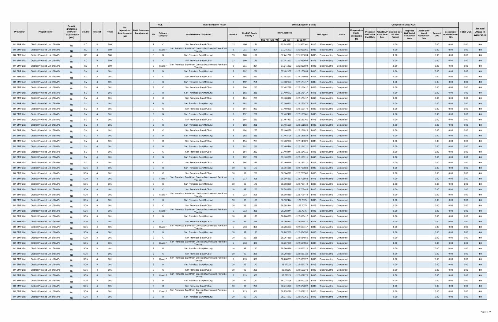
Beg PM End PM Lat. (N) Long. (W)
Revoked CUs
Total CUsTreated Areas in
WatershedRBPollutant Category
Total Maximum Daily Load Reach #Final SB Reach
Priority #
Compliance Units (CUs)
Cooperative Imple-
mentation ($)
Cooperative Implementation
CUs
Proposed BMP Install Start Date
Actual BMP Install Start
Date
Credited CUs for BMP Project
Proposed BMP Install Completion
Date
Actual BMP Install
Completion Date
Net Impervious
Area Increase (ac)
BMP Treatment Area (acres)
TMDL Implementation Reach BMP(s)Location & Type
BMP LocationsBMP Types Status
RouteProject ID Project Name
Retrofit (installing BMPs for
TMDLs only)? (Y/N)
County District
D4 BMP List District Provided List of BMPs No CC 4 680 2 C San Francisco Bay (PCBs) 13 100 171 37.745222 -121.956361 BIOS - Bioswale/strip Completed 0.00 0.00 0.00 0.00 0.0
D4 BMP List District Provided List of BMPs No CC 4 680 2 C and FSan Francisco Bay Urban Creeks (Diazinon and Pesticide
Toxicity)8 211 304 37.745222 -121.956361 BIOS - Bioswale/strip Completed 0.00 0.00 0.00 0.00 0.0
D4 BMP List District Provided List of BMPs No CC 4 680 2 B San Francisco Bay (Mercury) 13 100 172 37.741222 -121.953694 BIOS - Bioswale/strip Completed 0.00 0.00 0.00 0.00 0.0
D4 BMP List District Provided List of BMPs No CC 4 680 2 C San Francisco Bay (PCBs) 13 100 171 37.741222 -121.953694 BIOS - Bioswale/strip Completed 0.00 0.00 0.00 0.00 0.0
D4 BMP List District Provided List of BMPs No CC 4 680 2 C and FSan Francisco Bay Urban Creeks (Diazinon and Pesticide
Toxicity)8 211 304 37.741222 -121.953694 BIOS - Bioswale/strip Completed 0.00 0.00 0.00 0.00 0.0
D4 BMP List District Provided List of BMPs No SM 4 101 2 B San Francisco Bay (Mercury) 3 192 281 37.482167 -122.178694 BIOS - Bioswale/strip Completed 0.00 0.00 0.00 0.00 0.0
D4 BMP List District Provided List of BMPs No SM 4 101 2 C San Francisco Bay (PCBs) 3 194 283 37.482167 -122.178694 BIOS - Bioswale/strip Completed 0.00 0.00 0.00 0.00 0.0
D4 BMP List District Provided List of BMPs No SM 4 101 2 B San Francisco Bay (Mercury) 3 192 281 37.482028 -122.178417 BIOS - Bioswale/strip Completed 0.00 0.00 0.00 0.00 0.0
D4 BMP List District Provided List of BMPs No SM 4 101 2 C San Francisco Bay (PCBs) 3 194 283 37.482028 -122.178417 BIOS - Bioswale/strip Completed 0.00 0.00 0.00 0.00 0.0
D4 BMP List District Provided List of BMPs No SM 4 101 2 B San Francisco Bay (Mercury) 3 192 281 37.480972 -122.176417 BIOS - Bioswale/strip Completed 0.00 0.00 0.00 0.00 0.0
D4 BMP List District Provided List of BMPs No SM 4 101 2 C San Francisco Bay (PCBs) 3 194 283 37.480972 -122.176417 BIOS - Bioswale/strip Completed 0.00 0.00 0.00 0.00 0.0
D4 BMP List District Provided List of BMPs No SM 4 101 2 B San Francisco Bay (Mercury) 3 192 281 37.469361 -122.156472 BIOS - Bioswale/strip Completed 0.00 0.00 0.00 0.00 0.0
D4 BMP List District Provided List of BMPs No SM 4 101 2 C San Francisco Bay (PCBs) 3 194 283 37.469361 -122.156472 BIOS - Bioswale/strip Completed 0.00 0.00 0.00 0.00 0.0
D4 BMP List District Provided List of BMPs No SM 4 101 2 B San Francisco Bay (Mercury) 3 192 281 37.467417 -122.153361 BIOS - Bioswale/strip Completed 0.00 0.00 0.00 0.00 0.0
D4 BMP List District Provided List of BMPs No SM 4 101 2 C San Francisco Bay (PCBs) 3 194 283 37.467417 -122.153361 BIOS - Bioswale/strip Completed 0.00 0.00 0.00 0.00 0.0
D4 BMP List District Provided List of BMPs No SM 4 101 2 B San Francisco Bay (Mercury) 3 192 281 37.466139 -122.151028 BIOS - Bioswale/strip Completed 0.00 0.00 0.00 0.00 0.0
D4 BMP List District Provided List of BMPs No SM 4 101 2 C San Francisco Bay (PCBs) 3 194 283 37.466139 -122.151028 BIOS - Bioswale/strip Completed 0.00 0.00 0.00 0.00 0.0
D4 BMP List District Provided List of BMPs No SM 4 101 2 B San Francisco Bay (Mercury) 3 192 281 37.462028 -122.143028 BIOS - Bioswale/strip Completed 0.00 0.00 0.00 0.00 0.0
D4 BMP List District Provided List of BMPs No SM 4 101 2 C San Francisco Bay (PCBs) 3 194 283 37.462028 -122.143028 BIOS - Bioswale/strip Completed 0.00 0.00 0.00 0.00 0.0
D4 BMP List District Provided List of BMPs No SM 4 101 2 B San Francisco Bay (Mercury) 3 192 281 37.468444 -122.154111 BIOS - Bioswale/strip Completed 0.00 0.00 0.00 0.00 0.0
D4 BMP List District Provided List of BMPs No SM 4 101 2 C San Francisco Bay (PCBs) 3 194 283 37.468444 -122.154111 BIOS - Bioswale/strip Completed 0.00 0.00 0.00 0.00 0.0
D4 BMP List District Provided List of BMPs No SM 4 101 2 B San Francisco Bay (Mercury) 3 192 281 37.469639 -122.156111 BIOS - Bioswale/strip Completed 0.00 0.00 0.00 0.00 0.0
D4 BMP List District Provided List of BMPs No SM 4 101 2 C San Francisco Bay (PCBs) 3 194 283 37.469639 -122.156111 BIOS - Bioswale/strip Completed 0.00 0.00 0.00 0.00 0.0
D4 BMP List District Provided List of BMPs No SON 4 101 2 B San Francisco Bay (Mercury) 10 99 170 38.304611 -122.708583 BIOS - Bioswale/strip Completed 0.00 0.00 0.00 0.00 0.0
D4 BMP List District Provided List of BMPs No SON 4 101 2 C San Francisco Bay (PCBs) 10 99 256 38.304611 -122.708583 BIOS - Bioswale/strip Completed 0.00 0.00 0.00 0.00 0.0
D4 BMP List District Provided List of BMPs No SON 4 101 2 C and FSan Francisco Bay Urban Creeks (Diazinon and Pesticide
Toxicity)5 213 306 38.304611 -122.708583 BIOS - Bioswale/strip Completed 0.00 0.00 0.00 0.00 0.0
D4 BMP List District Provided List of BMPs No SON 4 101 2 B San Francisco Bay (Mercury) 10 99 170 38.303389 -122.708444 BIOS - Bioswale/strip Completed 0.00 0.00 0.00 0.00 0.0
D4 BMP List District Provided List of BMPs No SON 4 101 2 C San Francisco Bay (PCBs) 10 99 256 38.303389 -122.708444 BIOS - Bioswale/strip Completed 0.00 0.00 0.00 0.00 0.0
D4 BMP List District Provided List of BMPs No SON 4 101 2 C and FSan Francisco Bay Urban Creeks (Diazinon and Pesticide
Toxicity)5 213 306 38.303389 -122.708444 BIOS - Bioswale/strip Completed 0.00 0.00 0.00 0.00 0.0
D4 BMP List District Provided List of BMPs No SON 4 101 2 B San Francisco Bay (Mercury) 10 99 170 38.302444 -122.7075 BIOS - Bioswale/strip Completed 0.00 0.00 0.00 0.00 0.0
D4 BMP List District Provided List of BMPs No SON 4 101 2 C San Francisco Bay (PCBs) 10 99 256 38.302444 -122.7075 BIOS - Bioswale/strip Completed 0.00 0.00 0.00 0.00 0.0
D4 BMP List District Provided List of BMPs No SON 4 101 2 C and FSan Francisco Bay Urban Creeks (Diazinon and Pesticide
Toxicity)5 213 306 38.302444 -122.7075 BIOS - Bioswale/strip Completed 0.00 0.00 0.00 0.00 0.0
D4 BMP List District Provided List of BMPs No SON 4 101 2 B San Francisco Bay (Mercury) 10 99 170 38.266833 -122.663417 BIOS - Bioswale/strip Completed 0.00 0.00 0.00 0.00 0.0
D4 BMP List District Provided List of BMPs No SON 4 101 2 C San Francisco Bay (PCBs) 10 99 256 38.266833 -122.663417 BIOS - Bioswale/strip Completed 0.00 0.00 0.00 0.00 0.0
D4 BMP List District Provided List of BMPs No SON 4 101 2 C and FSan Francisco Bay Urban Creeks (Diazinon and Pesticide
Toxicity)5 213 306 38.266833 -122.663417 BIOS - Bioswale/strip Completed 0.00 0.00 0.00 0.00 0.0
D4 BMP List District Provided List of BMPs No SON 4 101 2 B San Francisco Bay (Mercury) 10 99 170 38.267889 -122.664556 BIOS - Bioswale/strip Completed 0.00 0.00 0.00 0.00 0.0
D4 BMP List District Provided List of BMPs No SON 4 101 2 C San Francisco Bay (PCBs) 10 99 256 38.267889 -122.664556 BIOS - Bioswale/strip Completed 0.00 0.00 0.00 0.00 0.0
D4 BMP List District Provided List of BMPs No SON 4 101 2 C and FSan Francisco Bay Urban Creeks (Diazinon and Pesticide
Toxicity)5 213 306 38.267889 -122.664556 BIOS - Bioswale/strip Completed 0.00 0.00 0.00 0.00 0.0
D4 BMP List District Provided List of BMPs No SON 4 101 2 B San Francisco Bay (Mercury) 10 99 170 38.268889 -122.665722 BIOS - Bioswale/strip Completed 0.00 0.00 0.00 0.00 0.0
D4 BMP List District Provided List of BMPs No SON 4 101 2 C San Francisco Bay (PCBs) 10 99 256 38.268889 -122.665722 BIOS - Bioswale/strip Completed 0.00 0.00 0.00 0.00 0.0
D4 BMP List District Provided List of BMPs No SON 4 101 2 C and FSan Francisco Bay Urban Creeks (Diazinon and Pesticide
Toxicity)5 213 306 38.268889 -122.665722 BIOS - Bioswale/strip Completed 0.00 0.00 0.00 0.00 0.0
D4 BMP List District Provided List of BMPs No SON 4 101 2 B San Francisco Bay (Mercury) 10 99 170 38.27025 -122.667278 BIOS - Bioswale/strip Completed 0.00 0.00 0.00 0.00 0.0
D4 BMP List District Provided List of BMPs No SON 4 101 2 C San Francisco Bay (PCBs) 10 99 256 38.27025 -122.667278 BIOS - Bioswale/strip Completed 0.00 0.00 0.00 0.00 0.0
D4 BMP List District Provided List of BMPs No SON 4 101 2 C and FSan Francisco Bay Urban Creeks (Diazinon and Pesticide
Toxicity)5 213 306 38.27025 -122.667278 BIOS - Bioswale/strip Completed 0.00 0.00 0.00 0.00 0.0
D4 BMP List District Provided List of BMPs No SON 4 101 2 B San Francisco Bay (Mercury) 10 99 170 38.274028 -122.672222 BIOS - Bioswale/strip Completed 0.00 0.00 0.00 0.00 0.0
D4 BMP List District Provided List of BMPs No SON 4 101 2 C San Francisco Bay (PCBs) 10 99 256 38.274028 -122.672222 BIOS - Bioswale/strip Completed 0.00 0.00 0.00 0.00 0.0
D4 BMP List District Provided List of BMPs No SON 4 101 2 C and FSan Francisco Bay Urban Creeks (Diazinon and Pesticide
Toxicity)5 213 306 38.274028 -122.672222 BIOS - Bioswale/strip Completed 0.00 0.00 0.00 0.00 0.0
D4 BMP List District Provided List of BMPs No SON 4 101 2 B San Francisco Bay (Mercury) 10 99 170 38.274972 -122.673361 BIOS - Bioswale/strip Completed 0.00 0.00 0.00 0.00 0.0
Page 7 of 77
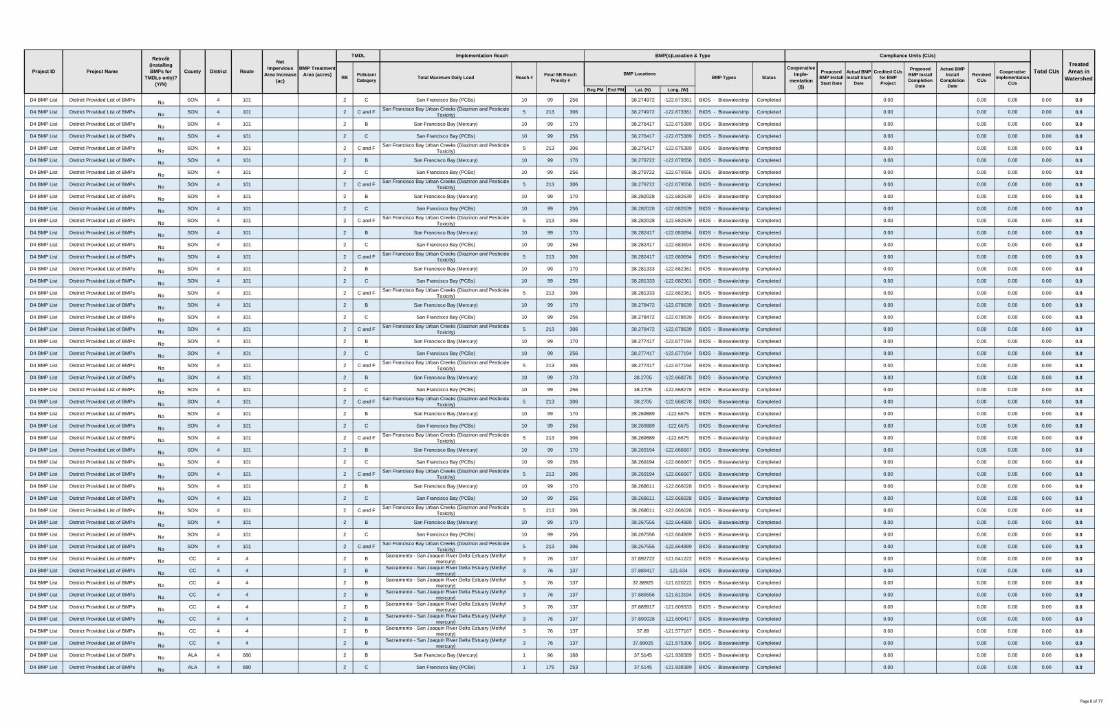
Beg PM End PM Lat. (N) Long. (W)
Revoked CUs
Total CUsTreated Areas in
WatershedRBPollutant Category
Total Maximum Daily Load Reach #Final SB Reach
Priority #
Compliance Units (CUs)
Cooperative Imple-
mentation ($)
Cooperative Implementation
CUs
Proposed BMP Install Start Date
Actual BMP Install Start
Date
Credited CUs for BMP Project
Proposed BMP Install Completion
Date
Actual BMP Install
Completion Date
Net Impervious
Area Increase (ac)
BMP Treatment Area (acres)
TMDL Implementation Reach BMP(s)Location & Type
BMP LocationsBMP Types Status
RouteProject ID Project Name
Retrofit (installing BMPs for
TMDLs only)? (Y/N)
County District
D4 BMP List District Provided List of BMPs No SON 4 101 2 C San Francisco Bay (PCBs) 10 99 256 38.274972 -122.673361 BIOS - Bioswale/strip Completed 0.00 0.00 0.00 0.00 0.0
D4 BMP List District Provided List of BMPs No SON 4 101 2 C and FSan Francisco Bay Urban Creeks (Diazinon and Pesticide
Toxicity)5 213 306 38.274972 -122.673361 BIOS - Bioswale/strip Completed 0.00 0.00 0.00 0.00 0.0
D4 BMP List District Provided List of BMPs No SON 4 101 2 B San Francisco Bay (Mercury) 10 99 170 38.276417 -122.675389 BIOS - Bioswale/strip Completed 0.00 0.00 0.00 0.00 0.0
D4 BMP List District Provided List of BMPs No SON 4 101 2 C San Francisco Bay (PCBs) 10 99 256 38.276417 -122.675389 BIOS - Bioswale/strip Completed 0.00 0.00 0.00 0.00 0.0
D4 BMP List District Provided List of BMPs No SON 4 101 2 C and FSan Francisco Bay Urban Creeks (Diazinon and Pesticide
Toxicity)5 213 306 38.276417 -122.675389 BIOS - Bioswale/strip Completed 0.00 0.00 0.00 0.00 0.0
D4 BMP List District Provided List of BMPs No SON 4 101 2 B San Francisco Bay (Mercury) 10 99 170 38.279722 -122.679556 BIOS - Bioswale/strip Completed 0.00 0.00 0.00 0.00 0.0
D4 BMP List District Provided List of BMPs No SON 4 101 2 C San Francisco Bay (PCBs) 10 99 256 38.279722 -122.679556 BIOS - Bioswale/strip Completed 0.00 0.00 0.00 0.00 0.0
D4 BMP List District Provided List of BMPs No SON 4 101 2 C and FSan Francisco Bay Urban Creeks (Diazinon and Pesticide
Toxicity)5 213 306 38.279722 -122.679556 BIOS - Bioswale/strip Completed 0.00 0.00 0.00 0.00 0.0
D4 BMP List District Provided List of BMPs No SON 4 101 2 B San Francisco Bay (Mercury) 10 99 170 38.282028 -122.682639 BIOS - Bioswale/strip Completed 0.00 0.00 0.00 0.00 0.0
D4 BMP List District Provided List of BMPs No SON 4 101 2 C San Francisco Bay (PCBs) 10 99 256 38.282028 -122.682639 BIOS - Bioswale/strip Completed 0.00 0.00 0.00 0.00 0.0
D4 BMP List District Provided List of BMPs No SON 4 101 2 C and FSan Francisco Bay Urban Creeks (Diazinon and Pesticide
Toxicity)5 213 306 38.282028 -122.682639 BIOS - Bioswale/strip Completed 0.00 0.00 0.00 0.00 0.0
D4 BMP List District Provided List of BMPs No SON 4 101 2 B San Francisco Bay (Mercury) 10 99 170 38.282417 -122.683694 BIOS - Bioswale/strip Completed 0.00 0.00 0.00 0.00 0.0
D4 BMP List District Provided List of BMPs No SON 4 101 2 C San Francisco Bay (PCBs) 10 99 256 38.282417 -122.683694 BIOS - Bioswale/strip Completed 0.00 0.00 0.00 0.00 0.0
D4 BMP List District Provided List of BMPs No SON 4 101 2 C and FSan Francisco Bay Urban Creeks (Diazinon and Pesticide
Toxicity)5 213 306 38.282417 -122.683694 BIOS - Bioswale/strip Completed 0.00 0.00 0.00 0.00 0.0
D4 BMP List District Provided List of BMPs No SON 4 101 2 B San Francisco Bay (Mercury) 10 99 170 38.281333 -122.682361 BIOS - Bioswale/strip Completed 0.00 0.00 0.00 0.00 0.0
D4 BMP List District Provided List of BMPs No SON 4 101 2 C San Francisco Bay (PCBs) 10 99 256 38.281333 -122.682361 BIOS - Bioswale/strip Completed 0.00 0.00 0.00 0.00 0.0
D4 BMP List District Provided List of BMPs No SON 4 101 2 C and FSan Francisco Bay Urban Creeks (Diazinon and Pesticide
Toxicity)5 213 306 38.281333 -122.682361 BIOS - Bioswale/strip Completed 0.00 0.00 0.00 0.00 0.0
D4 BMP List District Provided List of BMPs No SON 4 101 2 B San Francisco Bay (Mercury) 10 99 170 38.278472 -122.678639 BIOS - Bioswale/strip Completed 0.00 0.00 0.00 0.00 0.0
D4 BMP List District Provided List of BMPs No SON 4 101 2 C San Francisco Bay (PCBs) 10 99 256 38.278472 -122.678639 BIOS - Bioswale/strip Completed 0.00 0.00 0.00 0.00 0.0
D4 BMP List District Provided List of BMPs No SON 4 101 2 C and FSan Francisco Bay Urban Creeks (Diazinon and Pesticide
Toxicity)5 213 306 38.278472 -122.678639 BIOS - Bioswale/strip Completed 0.00 0.00 0.00 0.00 0.0
D4 BMP List District Provided List of BMPs No SON 4 101 2 B San Francisco Bay (Mercury) 10 99 170 38.277417 -122.677194 BIOS - Bioswale/strip Completed 0.00 0.00 0.00 0.00 0.0
D4 BMP List District Provided List of BMPs No SON 4 101 2 C San Francisco Bay (PCBs) 10 99 256 38.277417 -122.677194 BIOS - Bioswale/strip Completed 0.00 0.00 0.00 0.00 0.0
D4 BMP List District Provided List of BMPs No SON 4 101 2 C and FSan Francisco Bay Urban Creeks (Diazinon and Pesticide
Toxicity)5 213 306 38.277417 -122.677194 BIOS - Bioswale/strip Completed 0.00 0.00 0.00 0.00 0.0
D4 BMP List District Provided List of BMPs No SON 4 101 2 B San Francisco Bay (Mercury) 10 99 170 38.2705 -122.668278 BIOS - Bioswale/strip Completed 0.00 0.00 0.00 0.00 0.0
D4 BMP List District Provided List of BMPs No SON 4 101 2 C San Francisco Bay (PCBs) 10 99 256 38.2705 -122.668278 BIOS - Bioswale/strip Completed 0.00 0.00 0.00 0.00 0.0
D4 BMP List District Provided List of BMPs No SON 4 101 2 C and FSan Francisco Bay Urban Creeks (Diazinon and Pesticide
Toxicity)5 213 306 38.2705 -122.668278 BIOS - Bioswale/strip Completed 0.00 0.00 0.00 0.00 0.0
D4 BMP List District Provided List of BMPs No SON 4 101 2 B San Francisco Bay (Mercury) 10 99 170 38.269889 -122.6675 BIOS - Bioswale/strip Completed 0.00 0.00 0.00 0.00 0.0
D4 BMP List District Provided List of BMPs No SON 4 101 2 C San Francisco Bay (PCBs) 10 99 256 38.269889 -122.6675 BIOS - Bioswale/strip Completed 0.00 0.00 0.00 0.00 0.0
D4 BMP List District Provided List of BMPs No SON 4 101 2 C and FSan Francisco Bay Urban Creeks (Diazinon and Pesticide
Toxicity)5 213 306 38.269889 -122.6675 BIOS - Bioswale/strip Completed 0.00 0.00 0.00 0.00 0.0
D4 BMP List District Provided List of BMPs No SON 4 101 2 B San Francisco Bay (Mercury) 10 99 170 38.269194 -122.666667 BIOS - Bioswale/strip Completed 0.00 0.00 0.00 0.00 0.0
D4 BMP List District Provided List of BMPs No SON 4 101 2 C San Francisco Bay (PCBs) 10 99 256 38.269194 -122.666667 BIOS - Bioswale/strip Completed 0.00 0.00 0.00 0.00 0.0
D4 BMP List District Provided List of BMPs No SON 4 101 2 C and FSan Francisco Bay Urban Creeks (Diazinon and Pesticide
Toxicity)5 213 306 38.269194 -122.666667 BIOS - Bioswale/strip Completed 0.00 0.00 0.00 0.00 0.0
D4 BMP List District Provided List of BMPs No SON 4 101 2 B San Francisco Bay (Mercury) 10 99 170 38.268611 -122.666028 BIOS - Bioswale/strip Completed 0.00 0.00 0.00 0.00 0.0
D4 BMP List District Provided List of BMPs No SON 4 101 2 C San Francisco Bay (PCBs) 10 99 256 38.268611 -122.666028 BIOS - Bioswale/strip Completed 0.00 0.00 0.00 0.00 0.0
D4 BMP List District Provided List of BMPs No SON 4 101 2 C and FSan Francisco Bay Urban Creeks (Diazinon and Pesticide
Toxicity)5 213 306 38.268611 -122.666028 BIOS - Bioswale/strip Completed 0.00 0.00 0.00 0.00 0.0
D4 BMP List District Provided List of BMPs No SON 4 101 2 B San Francisco Bay (Mercury) 10 99 170 38.267556 -122.664889 BIOS - Bioswale/strip Completed 0.00 0.00 0.00 0.00 0.0
D4 BMP List District Provided List of BMPs No SON 4 101 2 C San Francisco Bay (PCBs) 10 99 256 38.267556 -122.664889 BIOS - Bioswale/strip Completed 0.00 0.00 0.00 0.00 0.0
D4 BMP List District Provided List of BMPs No SON 4 101 2 C and FSan Francisco Bay Urban Creeks (Diazinon and Pesticide
Toxicity)5 213 306 38.267556 -122.664889 BIOS - Bioswale/strip Completed 0.00 0.00 0.00 0.00 0.0
D4 BMP List District Provided List of BMPs No CC 4 4 2 BSacramento - San Joaquin River Delta Estuary (Methyl
mercury)3 76 137 37.892722 -121.641222 BIOS - Bioswale/strip Completed 0.00 0.00 0.00 0.00 0.0
D4 BMP List District Provided List of BMPs No CC 4 4 2 BSacramento - San Joaquin River Delta Estuary (Methyl
mercury)3 76 137 37.889417 -121.634 BIOS - Bioswale/strip Completed 0.00 0.00 0.00 0.00 0.0
D4 BMP List District Provided List of BMPs No CC 4 4 2 BSacramento - San Joaquin River Delta Estuary (Methyl
mercury)3 76 137 37.88925 -121.620222 BIOS - Bioswale/strip Completed 0.00 0.00 0.00 0.00 0.0
D4 BMP List District Provided List of BMPs No CC 4 4 2 BSacramento - San Joaquin River Delta Estuary (Methyl
mercury)3 76 137 37.889556 -121.613194 BIOS - Bioswale/strip Completed 0.00 0.00 0.00 0.00 0.0
D4 BMP List District Provided List of BMPs No CC 4 4 2 BSacramento - San Joaquin River Delta Estuary (Methyl
mercury)3 76 137 37.889917 -121.609333 BIOS - Bioswale/strip Completed 0.00 0.00 0.00 0.00 0.0
D4 BMP List District Provided List of BMPs No CC 4 4 2 BSacramento - San Joaquin River Delta Estuary (Methyl
mercury)3 76 137 37.890028 -121.600417 BIOS - Bioswale/strip Completed 0.00 0.00 0.00 0.00 0.0
D4 BMP List District Provided List of BMPs No CC 4 4 2 BSacramento - San Joaquin River Delta Estuary (Methyl
mercury)3 76 137 37.89 -121.577167 BIOS - Bioswale/strip Completed 0.00 0.00 0.00 0.00 0.0
D4 BMP List District Provided List of BMPs No CC 4 4 2 BSacramento - San Joaquin River Delta Estuary (Methyl
mercury)3 76 137 37.89025 -121.575306 BIOS - Bioswale/strip Completed 0.00 0.00 0.00 0.00 0.0
D4 BMP List District Provided List of BMPs No ALA 4 680 2 B San Francisco Bay (Mercury) 1 96 168 37.5145 -121.938389 BIOS - Bioswale/strip Completed 0.00 0.00 0.00 0.00 0.0
D4 BMP List District Provided List of BMPs No ALA 4 680 2 C San Francisco Bay (PCBs) 1 175 253 37.5145 -121.938389 BIOS - Bioswale/strip Completed 0.00 0.00 0.00 0.00 0.0
Page 8 of 77
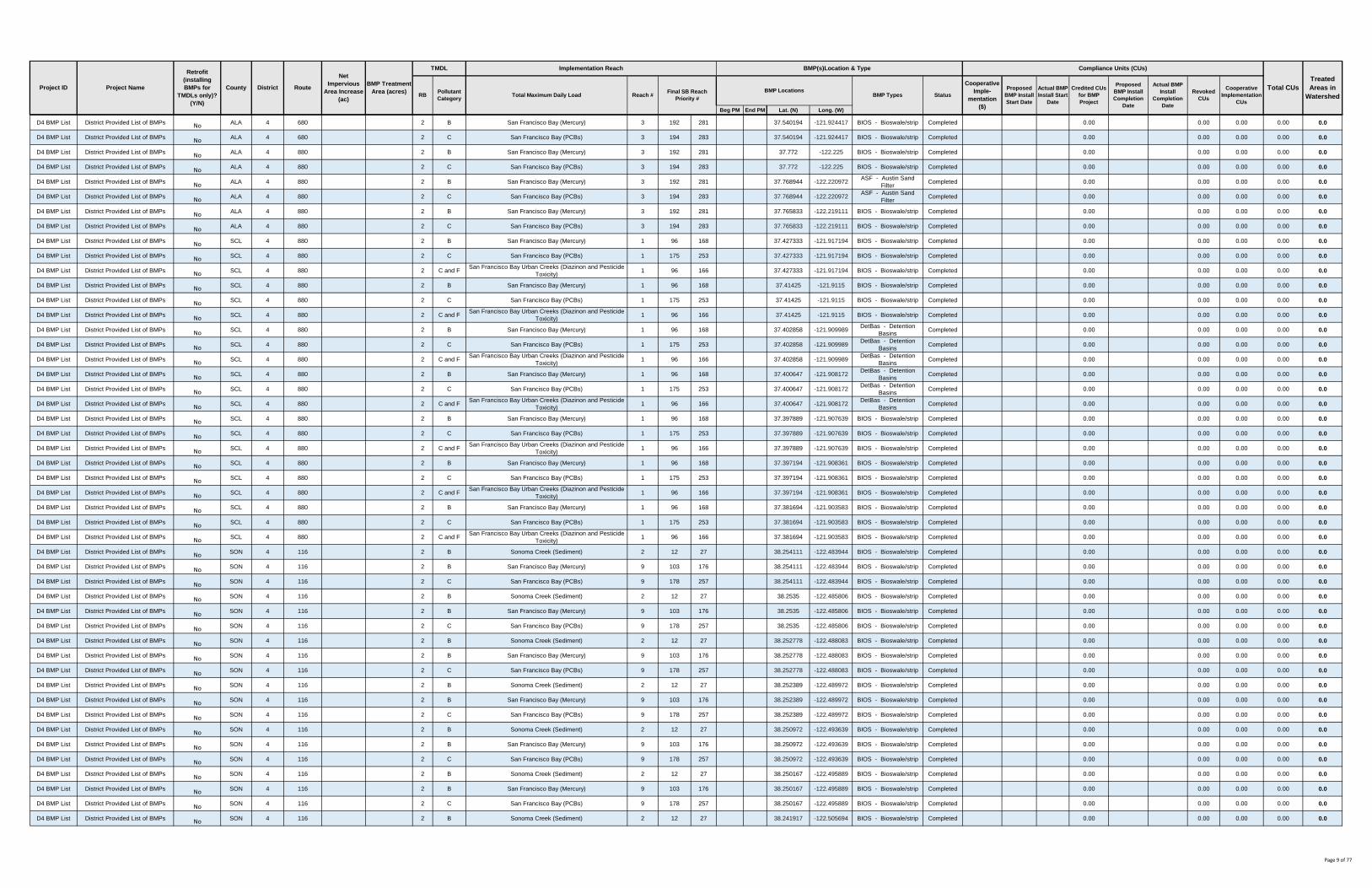
Beg PM End PM Lat. (N) Long. (W)
Revoked CUs
Total CUsTreated Areas in
WatershedRBPollutant Category
Total Maximum Daily Load Reach #Final SB Reach
Priority #
Compliance Units (CUs)
Cooperative Imple-
mentation ($)
Cooperative Implementation
CUs
Proposed BMP Install Start Date
Actual BMP Install Start
Date
Credited CUs for BMP Project
Proposed BMP Install Completion
Date
Actual BMP Install
Completion Date
Net Impervious
Area Increase (ac)
BMP Treatment Area (acres)
TMDL Implementation Reach BMP(s)Location & Type
BMP LocationsBMP Types Status
RouteProject ID Project Name
Retrofit (installing BMPs for
TMDLs only)? (Y/N)
County District
D4 BMP List District Provided List of BMPs No ALA 4 680 2 B San Francisco Bay (Mercury) 3 192 281 37.540194 -121.924417 BIOS - Bioswale/strip Completed 0.00 0.00 0.00 0.00 0.0
D4 BMP List District Provided List of BMPs No ALA 4 680 2 C San Francisco Bay (PCBs) 3 194 283 37.540194 -121.924417 BIOS - Bioswale/strip Completed 0.00 0.00 0.00 0.00 0.0
D4 BMP List District Provided List of BMPs No ALA 4 880 2 B San Francisco Bay (Mercury) 3 192 281 37.772 -122.225 BIOS - Bioswale/strip Completed 0.00 0.00 0.00 0.00 0.0
D4 BMP List District Provided List of BMPs No ALA 4 880 2 C San Francisco Bay (PCBs) 3 194 283 37.772 -122.225 BIOS - Bioswale/strip Completed 0.00 0.00 0.00 0.00 0.0
D4 BMP List District Provided List of BMPs No ALA 4 880 2 B San Francisco Bay (Mercury) 3 192 281 37.768944 -122.220972ASF - Austin Sand
FilterCompleted 0.00 0.00 0.00 0.00 0.0
D4 BMP List District Provided List of BMPs No ALA 4 880 2 C San Francisco Bay (PCBs) 3 194 283 37.768944 -122.220972ASF - Austin Sand
FilterCompleted 0.00 0.00 0.00 0.00 0.0
D4 BMP List District Provided List of BMPs No ALA 4 880 2 B San Francisco Bay (Mercury) 3 192 281 37.765833 -122.219111 BIOS - Bioswale/strip Completed 0.00 0.00 0.00 0.00 0.0
D4 BMP List District Provided List of BMPs No ALA 4 880 2 C San Francisco Bay (PCBs) 3 194 283 37.765833 -122.219111 BIOS - Bioswale/strip Completed 0.00 0.00 0.00 0.00 0.0
D4 BMP List District Provided List of BMPs No SCL 4 880 2 B San Francisco Bay (Mercury) 1 96 168 37.427333 -121.917194 BIOS - Bioswale/strip Completed 0.00 0.00 0.00 0.00 0.0
D4 BMP List District Provided List of BMPs No SCL 4 880 2 C San Francisco Bay (PCBs) 1 175 253 37.427333 -121.917194 BIOS - Bioswale/strip Completed 0.00 0.00 0.00 0.00 0.0
D4 BMP List District Provided List of BMPs No SCL 4 880 2 C and FSan Francisco Bay Urban Creeks (Diazinon and Pesticide
Toxicity)1 96 166 37.427333 -121.917194 BIOS - Bioswale/strip Completed 0.00 0.00 0.00 0.00 0.0
D4 BMP List District Provided List of BMPs No SCL 4 880 2 B San Francisco Bay (Mercury) 1 96 168 37.41425 -121.9115 BIOS - Bioswale/strip Completed 0.00 0.00 0.00 0.00 0.0
D4 BMP List District Provided List of BMPs No SCL 4 880 2 C San Francisco Bay (PCBs) 1 175 253 37.41425 -121.9115 BIOS - Bioswale/strip Completed 0.00 0.00 0.00 0.00 0.0
D4 BMP List District Provided List of BMPs No SCL 4 880 2 C and FSan Francisco Bay Urban Creeks (Diazinon and Pesticide
Toxicity)1 96 166 37.41425 -121.9115 BIOS - Bioswale/strip Completed 0.00 0.00 0.00 0.00 0.0
D4 BMP List District Provided List of BMPs No SCL 4 880 2 B San Francisco Bay (Mercury) 1 96 168 37.402858 -121.909989DetBas - Detention
BasinsCompleted 0.00 0.00 0.00 0.00 0.0
D4 BMP List District Provided List of BMPs No SCL 4 880 2 C San Francisco Bay (PCBs) 1 175 253 37.402858 -121.909989DetBas - Detention
BasinsCompleted 0.00 0.00 0.00 0.00 0.0
D4 BMP List District Provided List of BMPs No SCL 4 880 2 C and FSan Francisco Bay Urban Creeks (Diazinon and Pesticide
Toxicity)1 96 166 37.402858 -121.909989
DetBas - Detention Basins
Completed 0.00 0.00 0.00 0.00 0.0
D4 BMP List District Provided List of BMPs No SCL 4 880 2 B San Francisco Bay (Mercury) 1 96 168 37.400647 -121.908172DetBas - Detention
BasinsCompleted 0.00 0.00 0.00 0.00 0.0
D4 BMP List District Provided List of BMPs No SCL 4 880 2 C San Francisco Bay (PCBs) 1 175 253 37.400647 -121.908172DetBas - Detention
BasinsCompleted 0.00 0.00 0.00 0.00 0.0
D4 BMP List District Provided List of BMPs No SCL 4 880 2 C and FSan Francisco Bay Urban Creeks (Diazinon and Pesticide
Toxicity)1 96 166 37.400647 -121.908172
DetBas - Detention Basins
Completed 0.00 0.00 0.00 0.00 0.0
D4 BMP List District Provided List of BMPs No SCL 4 880 2 B San Francisco Bay (Mercury) 1 96 168 37.397889 -121.907639 BIOS - Bioswale/strip Completed 0.00 0.00 0.00 0.00 0.0
D4 BMP List District Provided List of BMPs No SCL 4 880 2 C San Francisco Bay (PCBs) 1 175 253 37.397889 -121.907639 BIOS - Bioswale/strip Completed 0.00 0.00 0.00 0.00 0.0
D4 BMP List District Provided List of BMPs No SCL 4 880 2 C and FSan Francisco Bay Urban Creeks (Diazinon and Pesticide
Toxicity)1 96 166 37.397889 -121.907639 BIOS - Bioswale/strip Completed 0.00 0.00 0.00 0.00 0.0
D4 BMP List District Provided List of BMPs No SCL 4 880 2 B San Francisco Bay (Mercury) 1 96 168 37.397194 -121.908361 BIOS - Bioswale/strip Completed 0.00 0.00 0.00 0.00 0.0
D4 BMP List District Provided List of BMPs No SCL 4 880 2 C San Francisco Bay (PCBs) 1 175 253 37.397194 -121.908361 BIOS - Bioswale/strip Completed 0.00 0.00 0.00 0.00 0.0
D4 BMP List District Provided List of BMPs No SCL 4 880 2 C and FSan Francisco Bay Urban Creeks (Diazinon and Pesticide
Toxicity)1 96 166 37.397194 -121.908361 BIOS - Bioswale/strip Completed 0.00 0.00 0.00 0.00 0.0
D4 BMP List District Provided List of BMPs No SCL 4 880 2 B San Francisco Bay (Mercury) 1 96 168 37.381694 -121.903583 BIOS - Bioswale/strip Completed 0.00 0.00 0.00 0.00 0.0
D4 BMP List District Provided List of BMPs No SCL 4 880 2 C San Francisco Bay (PCBs) 1 175 253 37.381694 -121.903583 BIOS - Bioswale/strip Completed 0.00 0.00 0.00 0.00 0.0
D4 BMP List District Provided List of BMPs No SCL 4 880 2 C and FSan Francisco Bay Urban Creeks (Diazinon and Pesticide
Toxicity)1 96 166 37.381694 -121.903583 BIOS - Bioswale/strip Completed 0.00 0.00 0.00 0.00 0.0
D4 BMP List District Provided List of BMPs No SON 4 116 2 B Sonoma Creek (Sediment) 2 12 27 38.254111 -122.483944 BIOS - Bioswale/strip Completed 0.00 0.00 0.00 0.00 0.0
D4 BMP List District Provided List of BMPs No SON 4 116 2 B San Francisco Bay (Mercury) 9 103 176 38.254111 -122.483944 BIOS - Bioswale/strip Completed 0.00 0.00 0.00 0.00 0.0
D4 BMP List District Provided List of BMPs No SON 4 116 2 C San Francisco Bay (PCBs) 9 178 257 38.254111 -122.483944 BIOS - Bioswale/strip Completed 0.00 0.00 0.00 0.00 0.0
D4 BMP List District Provided List of BMPs No SON 4 116 2 B Sonoma Creek (Sediment) 2 12 27 38.2535 -122.485806 BIOS - Bioswale/strip Completed 0.00 0.00 0.00 0.00 0.0
D4 BMP List District Provided List of BMPs No SON 4 116 2 B San Francisco Bay (Mercury) 9 103 176 38.2535 -122.485806 BIOS - Bioswale/strip Completed 0.00 0.00 0.00 0.00 0.0
D4 BMP List District Provided List of BMPs No SON 4 116 2 C San Francisco Bay (PCBs) 9 178 257 38.2535 -122.485806 BIOS - Bioswale/strip Completed 0.00 0.00 0.00 0.00 0.0
D4 BMP List District Provided List of BMPs No SON 4 116 2 B Sonoma Creek (Sediment) 2 12 27 38.252778 -122.488083 BIOS - Bioswale/strip Completed 0.00 0.00 0.00 0.00 0.0
D4 BMP List District Provided List of BMPs No SON 4 116 2 B San Francisco Bay (Mercury) 9 103 176 38.252778 -122.488083 BIOS - Bioswale/strip Completed 0.00 0.00 0.00 0.00 0.0
D4 BMP List District Provided List of BMPs No SON 4 116 2 C San Francisco Bay (PCBs) 9 178 257 38.252778 -122.488083 BIOS - Bioswale/strip Completed 0.00 0.00 0.00 0.00 0.0
D4 BMP List District Provided List of BMPs No SON 4 116 2 B Sonoma Creek (Sediment) 2 12 27 38.252389 -122.489972 BIOS - Bioswale/strip Completed 0.00 0.00 0.00 0.00 0.0
D4 BMP List District Provided List of BMPs No SON 4 116 2 B San Francisco Bay (Mercury) 9 103 176 38.252389 -122.489972 BIOS - Bioswale/strip Completed 0.00 0.00 0.00 0.00 0.0
D4 BMP List District Provided List of BMPs No SON 4 116 2 C San Francisco Bay (PCBs) 9 178 257 38.252389 -122.489972 BIOS - Bioswale/strip Completed 0.00 0.00 0.00 0.00 0.0
D4 BMP List District Provided List of BMPs No SON 4 116 2 B Sonoma Creek (Sediment) 2 12 27 38.250972 -122.493639 BIOS - Bioswale/strip Completed 0.00 0.00 0.00 0.00 0.0
D4 BMP List District Provided List of BMPs No SON 4 116 2 B San Francisco Bay (Mercury) 9 103 176 38.250972 -122.493639 BIOS - Bioswale/strip Completed 0.00 0.00 0.00 0.00 0.0
D4 BMP List District Provided List of BMPs No SON 4 116 2 C San Francisco Bay (PCBs) 9 178 257 38.250972 -122.493639 BIOS - Bioswale/strip Completed 0.00 0.00 0.00 0.00 0.0
D4 BMP List District Provided List of BMPs No SON 4 116 2 B Sonoma Creek (Sediment) 2 12 27 38.250167 -122.495889 BIOS - Bioswale/strip Completed 0.00 0.00 0.00 0.00 0.0
D4 BMP List District Provided List of BMPs No SON 4 116 2 B San Francisco Bay (Mercury) 9 103 176 38.250167 -122.495889 BIOS - Bioswale/strip Completed 0.00 0.00 0.00 0.00 0.0
D4 BMP List District Provided List of BMPs No SON 4 116 2 C San Francisco Bay (PCBs) 9 178 257 38.250167 -122.495889 BIOS - Bioswale/strip Completed 0.00 0.00 0.00 0.00 0.0
D4 BMP List District Provided List of BMPs No SON 4 116 2 B Sonoma Creek (Sediment) 2 12 27 38.241917 -122.505694 BIOS - Bioswale/strip Completed 0.00 0.00 0.00 0.00 0.0
Page 9 of 77
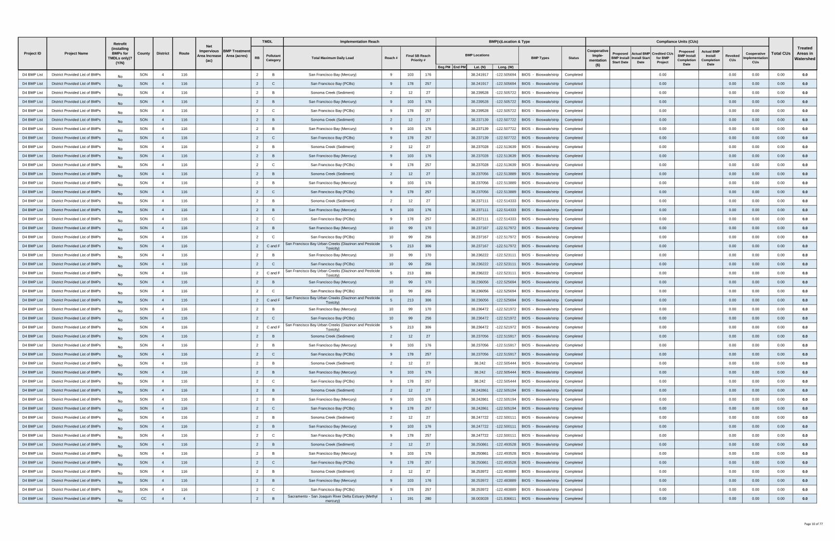
Beg PM End PM Lat. (N) Long. (W)
Revoked CUs
Total CUsTreated Areas in
WatershedRBPollutant Category
Total Maximum Daily Load Reach #Final SB Reach
Priority #
Compliance Units (CUs)
Cooperative Imple-
mentation ($)
Cooperative Implementation
CUs
Proposed BMP Install Start Date
Actual BMP Install Start
Date
Credited CUs for BMP Project
Proposed BMP Install Completion
Date
Actual BMP Install
Completion Date
Net Impervious
Area Increase (ac)
BMP Treatment Area (acres)
TMDL Implementation Reach BMP(s)Location & Type
BMP LocationsBMP Types Status
RouteProject ID Project Name
Retrofit (installing BMPs for
TMDLs only)? (Y/N)
County District
D4 BMP List District Provided List of BMPs No SON 4 116 2 B San Francisco Bay (Mercury) 9 103 176 38.241917 -122.505694 BIOS - Bioswale/strip Completed 0.00 0.00 0.00 0.00 0.0
D4 BMP List District Provided List of BMPs No SON 4 116 2 C San Francisco Bay (PCBs) 9 178 257 38.241917 -122.505694 BIOS - Bioswale/strip Completed 0.00 0.00 0.00 0.00 0.0
D4 BMP List District Provided List of BMPs No SON 4 116 2 B Sonoma Creek (Sediment) 2 12 27 38.239528 -122.505722 BIOS - Bioswale/strip Completed 0.00 0.00 0.00 0.00 0.0
D4 BMP List District Provided List of BMPs No SON 4 116 2 B San Francisco Bay (Mercury) 9 103 176 38.239528 -122.505722 BIOS - Bioswale/strip Completed 0.00 0.00 0.00 0.00 0.0
D4 BMP List District Provided List of BMPs No SON 4 116 2 C San Francisco Bay (PCBs) 9 178 257 38.239528 -122.505722 BIOS - Bioswale/strip Completed 0.00 0.00 0.00 0.00 0.0
D4 BMP List District Provided List of BMPs No SON 4 116 2 B Sonoma Creek (Sediment) 2 12 27 38.237139 -122.507722 BIOS - Bioswale/strip Completed 0.00 0.00 0.00 0.00 0.0
D4 BMP List District Provided List of BMPs No SON 4 116 2 B San Francisco Bay (Mercury) 9 103 176 38.237139 -122.507722 BIOS - Bioswale/strip Completed 0.00 0.00 0.00 0.00 0.0
D4 BMP List District Provided List of BMPs No SON 4 116 2 C San Francisco Bay (PCBs) 9 178 257 38.237139 -122.507722 BIOS - Bioswale/strip Completed 0.00 0.00 0.00 0.00 0.0
D4 BMP List District Provided List of BMPs No SON 4 116 2 B Sonoma Creek (Sediment) 2 12 27 38.237028 -122.513639 BIOS - Bioswale/strip Completed 0.00 0.00 0.00 0.00 0.0
D4 BMP List District Provided List of BMPs No SON 4 116 2 B San Francisco Bay (Mercury) 9 103 176 38.237028 -122.513639 BIOS - Bioswale/strip Completed 0.00 0.00 0.00 0.00 0.0
D4 BMP List District Provided List of BMPs No SON 4 116 2 C San Francisco Bay (PCBs) 9 178 257 38.237028 -122.513639 BIOS - Bioswale/strip Completed 0.00 0.00 0.00 0.00 0.0
D4 BMP List District Provided List of BMPs No SON 4 116 2 B Sonoma Creek (Sediment) 2 12 27 38.237056 -122.513889 BIOS - Bioswale/strip Completed 0.00 0.00 0.00 0.00 0.0
D4 BMP List District Provided List of BMPs No SON 4 116 2 B San Francisco Bay (Mercury) 9 103 176 38.237056 -122.513889 BIOS - Bioswale/strip Completed 0.00 0.00 0.00 0.00 0.0
D4 BMP List District Provided List of BMPs No SON 4 116 2 C San Francisco Bay (PCBs) 9 178 257 38.237056 -122.513889 BIOS - Bioswale/strip Completed 0.00 0.00 0.00 0.00 0.0
D4 BMP List District Provided List of BMPs No SON 4 116 2 B Sonoma Creek (Sediment) 2 12 27 38.237111 -122.514333 BIOS - Bioswale/strip Completed 0.00 0.00 0.00 0.00 0.0
D4 BMP List District Provided List of BMPs No SON 4 116 2 B San Francisco Bay (Mercury) 9 103 176 38.237111 -122.514333 BIOS - Bioswale/strip Completed 0.00 0.00 0.00 0.00 0.0
D4 BMP List District Provided List of BMPs No SON 4 116 2 C San Francisco Bay (PCBs) 9 178 257 38.237111 -122.514333 BIOS - Bioswale/strip Completed 0.00 0.00 0.00 0.00 0.0
D4 BMP List District Provided List of BMPs No SON 4 116 2 B San Francisco Bay (Mercury) 10 99 170 38.237167 -122.517972 BIOS - Bioswale/strip Completed 0.00 0.00 0.00 0.00 0.0
D4 BMP List District Provided List of BMPs No SON 4 116 2 C San Francisco Bay (PCBs) 10 99 256 38.237167 -122.517972 BIOS - Bioswale/strip Completed 0.00 0.00 0.00 0.00 0.0
D4 BMP List District Provided List of BMPs No SON 4 116 2 C and FSan Francisco Bay Urban Creeks (Diazinon and Pesticide
Toxicity)5 213 306 38.237167 -122.517972 BIOS - Bioswale/strip Completed 0.00 0.00 0.00 0.00 0.0
D4 BMP List District Provided List of BMPs No SON 4 116 2 B San Francisco Bay (Mercury) 10 99 170 38.236222 -122.523111 BIOS - Bioswale/strip Completed 0.00 0.00 0.00 0.00 0.0
D4 BMP List District Provided List of BMPs No SON 4 116 2 C San Francisco Bay (PCBs) 10 99 256 38.236222 -122.523111 BIOS - Bioswale/strip Completed 0.00 0.00 0.00 0.00 0.0
D4 BMP List District Provided List of BMPs No SON 4 116 2 C and FSan Francisco Bay Urban Creeks (Diazinon and Pesticide
Toxicity)5 213 306 38.236222 -122.523111 BIOS - Bioswale/strip Completed 0.00 0.00 0.00 0.00 0.0
D4 BMP List District Provided List of BMPs No SON 4 116 2 B San Francisco Bay (Mercury) 10 99 170 38.236056 -122.525694 BIOS - Bioswale/strip Completed 0.00 0.00 0.00 0.00 0.0
D4 BMP List District Provided List of BMPs No SON 4 116 2 C San Francisco Bay (PCBs) 10 99 256 38.236056 -122.525694 BIOS - Bioswale/strip Completed 0.00 0.00 0.00 0.00 0.0
D4 BMP List District Provided List of BMPs No SON 4 116 2 C and FSan Francisco Bay Urban Creeks (Diazinon and Pesticide
Toxicity)5 213 306 38.236056 -122.525694 BIOS - Bioswale/strip Completed 0.00 0.00 0.00 0.00 0.0
D4 BMP List District Provided List of BMPs No SON 4 116 2 B San Francisco Bay (Mercury) 10 99 170 38.236472 -122.521972 BIOS - Bioswale/strip Completed 0.00 0.00 0.00 0.00 0.0
D4 BMP List District Provided List of BMPs No SON 4 116 2 C San Francisco Bay (PCBs) 10 99 256 38.236472 -122.521972 BIOS - Bioswale/strip Completed 0.00 0.00 0.00 0.00 0.0
D4 BMP List District Provided List of BMPs No SON 4 116 2 C and FSan Francisco Bay Urban Creeks (Diazinon and Pesticide
Toxicity)5 213 306 38.236472 -122.521972 BIOS - Bioswale/strip Completed 0.00 0.00 0.00 0.00 0.0
D4 BMP List District Provided List of BMPs No SON 4 116 2 B Sonoma Creek (Sediment) 2 12 27 38.237056 -122.515917 BIOS - Bioswale/strip Completed 0.00 0.00 0.00 0.00 0.0
D4 BMP List District Provided List of BMPs No SON 4 116 2 B San Francisco Bay (Mercury) 9 103 176 38.237056 -122.515917 BIOS - Bioswale/strip Completed 0.00 0.00 0.00 0.00 0.0
D4 BMP List District Provided List of BMPs No SON 4 116 2 C San Francisco Bay (PCBs) 9 178 257 38.237056 -122.515917 BIOS - Bioswale/strip Completed 0.00 0.00 0.00 0.00 0.0
D4 BMP List District Provided List of BMPs No SON 4 116 2 B Sonoma Creek (Sediment) 2 12 27 38.242 -122.505444 BIOS - Bioswale/strip Completed 0.00 0.00 0.00 0.00 0.0
D4 BMP List District Provided List of BMPs No SON 4 116 2 B San Francisco Bay (Mercury) 9 103 176 38.242 -122.505444 BIOS - Bioswale/strip Completed 0.00 0.00 0.00 0.00 0.0
D4 BMP List District Provided List of BMPs No SON 4 116 2 C San Francisco Bay (PCBs) 9 178 257 38.242 -122.505444 BIOS - Bioswale/strip Completed 0.00 0.00 0.00 0.00 0.0
D4 BMP List District Provided List of BMPs No SON 4 116 2 B Sonoma Creek (Sediment) 2 12 27 38.242861 -122.505194 BIOS - Bioswale/strip Completed 0.00 0.00 0.00 0.00 0.0
D4 BMP List District Provided List of BMPs No SON 4 116 2 B San Francisco Bay (Mercury) 9 103 176 38.242861 -122.505194 BIOS - Bioswale/strip Completed 0.00 0.00 0.00 0.00 0.0
D4 BMP List District Provided List of BMPs No SON 4 116 2 C San Francisco Bay (PCBs) 9 178 257 38.242861 -122.505194 BIOS - Bioswale/strip Completed 0.00 0.00 0.00 0.00 0.0
D4 BMP List District Provided List of BMPs No SON 4 116 2 B Sonoma Creek (Sediment) 2 12 27 38.247722 -122.500111 BIOS - Bioswale/strip Completed 0.00 0.00 0.00 0.00 0.0
D4 BMP List District Provided List of BMPs No SON 4 116 2 B San Francisco Bay (Mercury) 9 103 176 38.247722 -122.500111 BIOS - Bioswale/strip Completed 0.00 0.00 0.00 0.00 0.0
D4 BMP List District Provided List of BMPs No SON 4 116 2 C San Francisco Bay (PCBs) 9 178 257 38.247722 -122.500111 BIOS - Bioswale/strip Completed 0.00 0.00 0.00 0.00 0.0
D4 BMP List District Provided List of BMPs No SON 4 116 2 B Sonoma Creek (Sediment) 2 12 27 38.250861 -122.493528 BIOS - Bioswale/strip Completed 0.00 0.00 0.00 0.00 0.0
D4 BMP List District Provided List of BMPs No SON 4 116 2 B San Francisco Bay (Mercury) 9 103 176 38.250861 -122.493528 BIOS - Bioswale/strip Completed 0.00 0.00 0.00 0.00 0.0
D4 BMP List District Provided List of BMPs No SON 4 116 2 C San Francisco Bay (PCBs) 9 178 257 38.250861 -122.493528 BIOS - Bioswale/strip Completed 0.00 0.00 0.00 0.00 0.0
D4 BMP List District Provided List of BMPs No SON 4 116 2 B Sonoma Creek (Sediment) 2 12 27 38.253972 -122.483889 BIOS - Bioswale/strip Completed 0.00 0.00 0.00 0.00 0.0
D4 BMP List District Provided List of BMPs No SON 4 116 2 B San Francisco Bay (Mercury) 9 103 176 38.253972 -122.483889 BIOS - Bioswale/strip Completed 0.00 0.00 0.00 0.00 0.0
D4 BMP List District Provided List of BMPs No SON 4 116 2 C San Francisco Bay (PCBs) 9 178 257 38.253972 -122.483889 BIOS - Bioswale/strip Completed 0.00 0.00 0.00 0.00 0.0
D4 BMP List District Provided List of BMPs No CC 4 4 2 BSacramento - San Joaquin River Delta Estuary (Methyl
mercury)1 191 280 38.003028 -121.836611 BIOS - Bioswale/strip Completed 0.00 0.00 0.00 0.00 0.0
Page 10 of 77
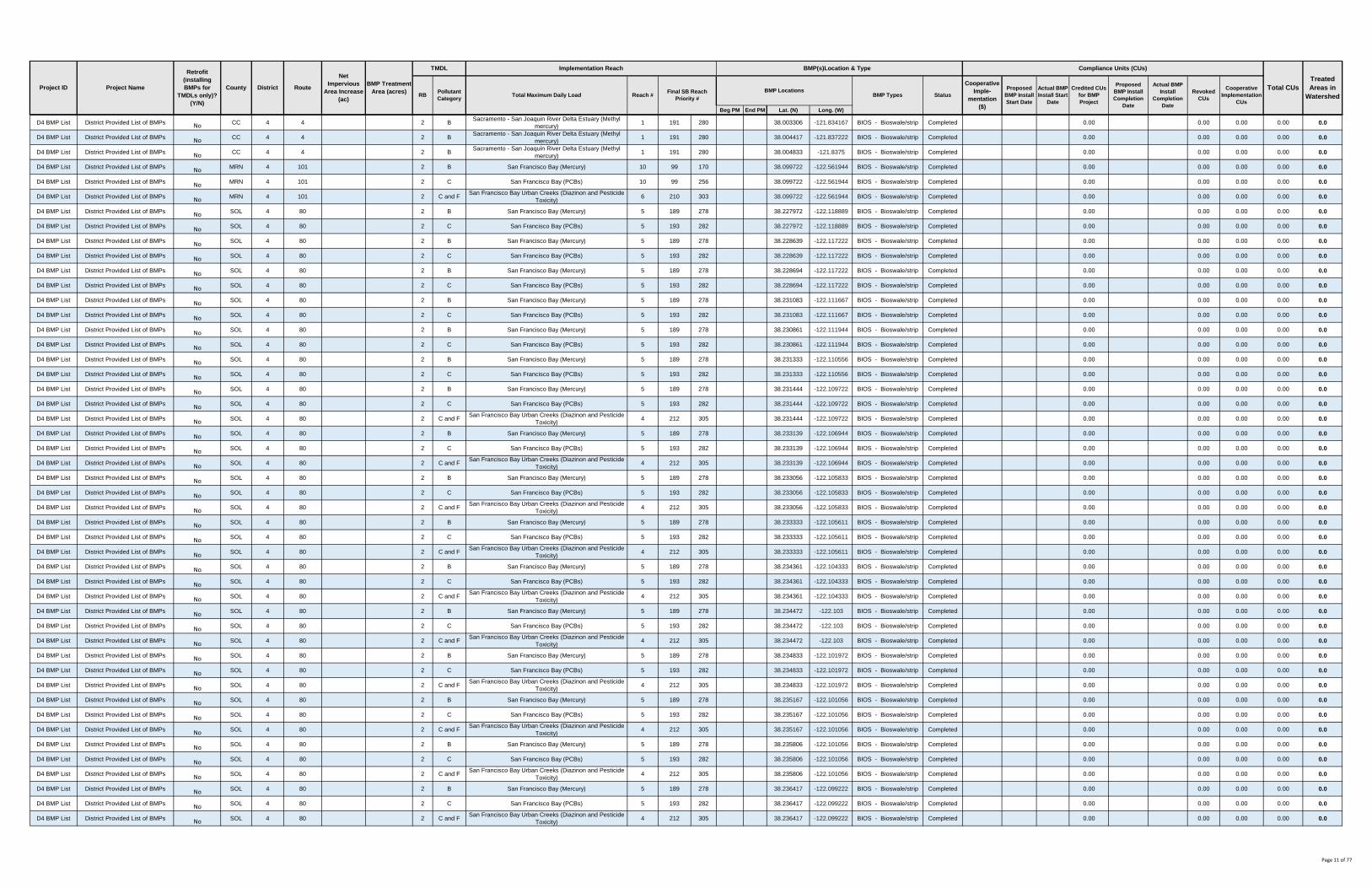
Beg PM End PM Lat. (N) Long. (W)
Revoked CUs
Total CUsTreated Areas in
WatershedRBPollutant Category
Total Maximum Daily Load Reach #Final SB Reach
Priority #
Compliance Units (CUs)
Cooperative Imple-
mentation ($)
Cooperative Implementation
CUs
Proposed BMP Install Start Date
Actual BMP Install Start
Date
Credited CUs for BMP Project
Proposed BMP Install Completion
Date
Actual BMP Install
Completion Date
Net Impervious
Area Increase (ac)
BMP Treatment Area (acres)
TMDL Implementation Reach BMP(s)Location & Type
BMP LocationsBMP Types Status
RouteProject ID Project Name
Retrofit (installing BMPs for
TMDLs only)? (Y/N)
County District
D4 BMP List District Provided List of BMPs No CC 4 4 2 BSacramento - San Joaquin River Delta Estuary (Methyl
mercury)1 191 280 38.003306 -121.834167 BIOS - Bioswale/strip Completed 0.00 0.00 0.00 0.00 0.0
D4 BMP List District Provided List of BMPs No CC 4 4 2 BSacramento - San Joaquin River Delta Estuary (Methyl
mercury)1 191 280 38.004417 -121.837222 BIOS - Bioswale/strip Completed 0.00 0.00 0.00 0.00 0.0
D4 BMP List District Provided List of BMPs No CC 4 4 2 BSacramento - San Joaquin River Delta Estuary (Methyl
mercury)1 191 280 38.004833 -121.8375 BIOS - Bioswale/strip Completed 0.00 0.00 0.00 0.00 0.0
D4 BMP List District Provided List of BMPs No MRN 4 101 2 B San Francisco Bay (Mercury) 10 99 170 38.099722 -122.561944 BIOS - Bioswale/strip Completed 0.00 0.00 0.00 0.00 0.0
D4 BMP List District Provided List of BMPs No MRN 4 101 2 C San Francisco Bay (PCBs) 10 99 256 38.099722 -122.561944 BIOS - Bioswale/strip Completed 0.00 0.00 0.00 0.00 0.0
D4 BMP List District Provided List of BMPs No MRN 4 101 2 C and FSan Francisco Bay Urban Creeks (Diazinon and Pesticide
Toxicity)6 210 303 38.099722 -122.561944 BIOS - Bioswale/strip Completed 0.00 0.00 0.00 0.00 0.0
D4 BMP List District Provided List of BMPs No SOL 4 80 2 B San Francisco Bay (Mercury) 5 189 278 38.227972 -122.118889 BIOS - Bioswale/strip Completed 0.00 0.00 0.00 0.00 0.0
D4 BMP List District Provided List of BMPs No SOL 4 80 2 C San Francisco Bay (PCBs) 5 193 282 38.227972 -122.118889 BIOS - Bioswale/strip Completed 0.00 0.00 0.00 0.00 0.0
D4 BMP List District Provided List of BMPs No SOL 4 80 2 B San Francisco Bay (Mercury) 5 189 278 38.228639 -122.117222 BIOS - Bioswale/strip Completed 0.00 0.00 0.00 0.00 0.0
D4 BMP List District Provided List of BMPs No SOL 4 80 2 C San Francisco Bay (PCBs) 5 193 282 38.228639 -122.117222 BIOS - Bioswale/strip Completed 0.00 0.00 0.00 0.00 0.0
D4 BMP List District Provided List of BMPs No SOL 4 80 2 B San Francisco Bay (Mercury) 5 189 278 38.228694 -122.117222 BIOS - Bioswale/strip Completed 0.00 0.00 0.00 0.00 0.0
D4 BMP List District Provided List of BMPs No SOL 4 80 2 C San Francisco Bay (PCBs) 5 193 282 38.228694 -122.117222 BIOS - Bioswale/strip Completed 0.00 0.00 0.00 0.00 0.0
D4 BMP List District Provided List of BMPs No SOL 4 80 2 B San Francisco Bay (Mercury) 5 189 278 38.231083 -122.111667 BIOS - Bioswale/strip Completed 0.00 0.00 0.00 0.00 0.0
D4 BMP List District Provided List of BMPs No SOL 4 80 2 C San Francisco Bay (PCBs) 5 193 282 38.231083 -122.111667 BIOS - Bioswale/strip Completed 0.00 0.00 0.00 0.00 0.0
D4 BMP List District Provided List of BMPs No SOL 4 80 2 B San Francisco Bay (Mercury) 5 189 278 38.230861 -122.111944 BIOS - Bioswale/strip Completed 0.00 0.00 0.00 0.00 0.0
D4 BMP List District Provided List of BMPs No SOL 4 80 2 C San Francisco Bay (PCBs) 5 193 282 38.230861 -122.111944 BIOS - Bioswale/strip Completed 0.00 0.00 0.00 0.00 0.0
D4 BMP List District Provided List of BMPs No SOL 4 80 2 B San Francisco Bay (Mercury) 5 189 278 38.231333 -122.110556 BIOS - Bioswale/strip Completed 0.00 0.00 0.00 0.00 0.0
D4 BMP List District Provided List of BMPs No SOL 4 80 2 C San Francisco Bay (PCBs) 5 193 282 38.231333 -122.110556 BIOS - Bioswale/strip Completed 0.00 0.00 0.00 0.00 0.0
D4 BMP List District Provided List of BMPs No SOL 4 80 2 B San Francisco Bay (Mercury) 5 189 278 38.231444 -122.109722 BIOS - Bioswale/strip Completed 0.00 0.00 0.00 0.00 0.0
D4 BMP List District Provided List of BMPs No SOL 4 80 2 C San Francisco Bay (PCBs) 5 193 282 38.231444 -122.109722 BIOS - Bioswale/strip Completed 0.00 0.00 0.00 0.00 0.0
D4 BMP List District Provided List of BMPs No SOL 4 80 2 C and FSan Francisco Bay Urban Creeks (Diazinon and Pesticide
Toxicity)4 212 305 38.231444 -122.109722 BIOS - Bioswale/strip Completed 0.00 0.00 0.00 0.00 0.0
D4 BMP List District Provided List of BMPs No SOL 4 80 2 B San Francisco Bay (Mercury) 5 189 278 38.233139 -122.106944 BIOS - Bioswale/strip Completed 0.00 0.00 0.00 0.00 0.0
D4 BMP List District Provided List of BMPs No SOL 4 80 2 C San Francisco Bay (PCBs) 5 193 282 38.233139 -122.106944 BIOS - Bioswale/strip Completed 0.00 0.00 0.00 0.00 0.0
D4 BMP List District Provided List of BMPs No SOL 4 80 2 C and FSan Francisco Bay Urban Creeks (Diazinon and Pesticide
Toxicity)4 212 305 38.233139 -122.106944 BIOS - Bioswale/strip Completed 0.00 0.00 0.00 0.00 0.0
D4 BMP List District Provided List of BMPs No SOL 4 80 2 B San Francisco Bay (Mercury) 5 189 278 38.233056 -122.105833 BIOS - Bioswale/strip Completed 0.00 0.00 0.00 0.00 0.0
D4 BMP List District Provided List of BMPs No SOL 4 80 2 C San Francisco Bay (PCBs) 5 193 282 38.233056 -122.105833 BIOS - Bioswale/strip Completed 0.00 0.00 0.00 0.00 0.0
D4 BMP List District Provided List of BMPs No SOL 4 80 2 C and FSan Francisco Bay Urban Creeks (Diazinon and Pesticide
Toxicity)4 212 305 38.233056 -122.105833 BIOS - Bioswale/strip Completed 0.00 0.00 0.00 0.00 0.0
D4 BMP List District Provided List of BMPs No SOL 4 80 2 B San Francisco Bay (Mercury) 5 189 278 38.233333 -122.105611 BIOS - Bioswale/strip Completed 0.00 0.00 0.00 0.00 0.0
D4 BMP List District Provided List of BMPs No SOL 4 80 2 C San Francisco Bay (PCBs) 5 193 282 38.233333 -122.105611 BIOS - Bioswale/strip Completed 0.00 0.00 0.00 0.00 0.0
D4 BMP List District Provided List of BMPs No SOL 4 80 2 C and FSan Francisco Bay Urban Creeks (Diazinon and Pesticide
Toxicity)4 212 305 38.233333 -122.105611 BIOS - Bioswale/strip Completed 0.00 0.00 0.00 0.00 0.0
D4 BMP List District Provided List of BMPs No SOL 4 80 2 B San Francisco Bay (Mercury) 5 189 278 38.234361 -122.104333 BIOS - Bioswale/strip Completed 0.00 0.00 0.00 0.00 0.0
D4 BMP List District Provided List of BMPs No SOL 4 80 2 C San Francisco Bay (PCBs) 5 193 282 38.234361 -122.104333 BIOS - Bioswale/strip Completed 0.00 0.00 0.00 0.00 0.0
D4 BMP List District Provided List of BMPs No SOL 4 80 2 C and FSan Francisco Bay Urban Creeks (Diazinon and Pesticide
Toxicity)4 212 305 38.234361 -122.104333 BIOS - Bioswale/strip Completed 0.00 0.00 0.00 0.00 0.0
D4 BMP List District Provided List of BMPs No SOL 4 80 2 B San Francisco Bay (Mercury) 5 189 278 38.234472 -122.103 BIOS - Bioswale/strip Completed 0.00 0.00 0.00 0.00 0.0
D4 BMP List District Provided List of BMPs No SOL 4 80 2 C San Francisco Bay (PCBs) 5 193 282 38.234472 -122.103 BIOS - Bioswale/strip Completed 0.00 0.00 0.00 0.00 0.0
D4 BMP List District Provided List of BMPs No SOL 4 80 2 C and FSan Francisco Bay Urban Creeks (Diazinon and Pesticide
Toxicity)4 212 305 38.234472 -122.103 BIOS - Bioswale/strip Completed 0.00 0.00 0.00 0.00 0.0
D4 BMP List District Provided List of BMPs No SOL 4 80 2 B San Francisco Bay (Mercury) 5 189 278 38.234833 -122.101972 BIOS - Bioswale/strip Completed 0.00 0.00 0.00 0.00 0.0
D4 BMP List District Provided List of BMPs No SOL 4 80 2 C San Francisco Bay (PCBs) 5 193 282 38.234833 -122.101972 BIOS - Bioswale/strip Completed 0.00 0.00 0.00 0.00 0.0
D4 BMP List District Provided List of BMPs No SOL 4 80 2 C and FSan Francisco Bay Urban Creeks (Diazinon and Pesticide
Toxicity)4 212 305 38.234833 -122.101972 BIOS - Bioswale/strip Completed 0.00 0.00 0.00 0.00 0.0
D4 BMP List District Provided List of BMPs No SOL 4 80 2 B San Francisco Bay (Mercury) 5 189 278 38.235167 -122.101056 BIOS - Bioswale/strip Completed 0.00 0.00 0.00 0.00 0.0
D4 BMP List District Provided List of BMPs No SOL 4 80 2 C San Francisco Bay (PCBs) 5 193 282 38.235167 -122.101056 BIOS - Bioswale/strip Completed 0.00 0.00 0.00 0.00 0.0
D4 BMP List District Provided List of BMPs No SOL 4 80 2 C and FSan Francisco Bay Urban Creeks (Diazinon and Pesticide
Toxicity)4 212 305 38.235167 -122.101056 BIOS - Bioswale/strip Completed 0.00 0.00 0.00 0.00 0.0
D4 BMP List District Provided List of BMPs No SOL 4 80 2 B San Francisco Bay (Mercury) 5 189 278 38.235806 -122.101056 BIOS - Bioswale/strip Completed 0.00 0.00 0.00 0.00 0.0
D4 BMP List District Provided List of BMPs No SOL 4 80 2 C San Francisco Bay (PCBs) 5 193 282 38.235806 -122.101056 BIOS - Bioswale/strip Completed 0.00 0.00 0.00 0.00 0.0
D4 BMP List District Provided List of BMPs No SOL 4 80 2 C and FSan Francisco Bay Urban Creeks (Diazinon and Pesticide
Toxicity)4 212 305 38.235806 -122.101056 BIOS - Bioswale/strip Completed 0.00 0.00 0.00 0.00 0.0
D4 BMP List District Provided List of BMPs No SOL 4 80 2 B San Francisco Bay (Mercury) 5 189 278 38.236417 -122.099222 BIOS - Bioswale/strip Completed 0.00 0.00 0.00 0.00 0.0
D4 BMP List District Provided List of BMPs No SOL 4 80 2 C San Francisco Bay (PCBs) 5 193 282 38.236417 -122.099222 BIOS - Bioswale/strip Completed 0.00 0.00 0.00 0.00 0.0
D4 BMP List District Provided List of BMPs No SOL 4 80 2 C and FSan Francisco Bay Urban Creeks (Diazinon and Pesticide
Toxicity)4 212 305 38.236417 -122.099222 BIOS - Bioswale/strip Completed 0.00 0.00 0.00 0.00 0.0
Page 11 of 77
Beg PM End PM Lat. (N) Long. (W)
Revoked CUs
Total CUsTreated Areas in
WatershedRBPollutant Category
Total Maximum Daily Load Reach #Final SB Reach
Priority #
Compliance Units (CUs)
Cooperative Imple-
mentation ($)
Cooperative Implementation
CUs
Proposed BMP Install Start Date
Actual BMP Install Start
Date
Credited CUs for BMP Project
Proposed BMP Install Completion
Date
Actual BMP Install
Completion Date
Net Impervious
Area Increase (ac)
BMP Treatment Area (acres)
TMDL Implementation Reach BMP(s)Location & Type
BMP LocationsBMP Types Status
RouteProject ID Project Name
Retrofit (installing BMPs for
TMDLs only)? (Y/N)
County District
D4 BMP List District Provided List of BMPs No SOL 4 80 2 B San Francisco Bay (Mercury) 5 189 278 38.23675 -122.097722 BIOS - Bioswale/strip Completed 0.00 0.00 0.00 0.00 0.0
D4 BMP List District Provided List of BMPs No SOL 4 80 2 C San Francisco Bay (PCBs) 5 193 282 38.23675 -122.097722 BIOS - Bioswale/strip Completed 0.00 0.00 0.00 0.00 0.0
D4 BMP List District Provided List of BMPs No SOL 4 80 2 C and FSan Francisco Bay Urban Creeks (Diazinon and Pesticide
Toxicity)4 212 305 38.23675 -122.097722 BIOS - Bioswale/strip Completed 0.00 0.00 0.00 0.00 0.0
D4 BMP List District Provided List of BMPs No CC 4 680 2 B San Francisco Bay (Mercury) 12 85 149 37.78325 -121.977985 BIOS - Bioswale/strip Completed 0.00 0.00 0.00 0.00 0.0
D4 BMP List District Provided List of BMPs No CC 4 680 2 C San Francisco Bay (PCBs) 12 85 252 37.78325 -121.977985 BIOS - Bioswale/strip Completed 0.00 0.00 0.00 0.00 0.0
D4 BMP List District Provided List of BMPs No CC 4 680 2 C and FSan Francisco Bay Urban Creeks (Diazinon and Pesticide
Toxicity)3 209 302 37.78325 -121.977985 BIOS - Bioswale/strip Completed 0.00 0.00 0.00 0.00 0.0
D4 BMP List District Provided List of BMPs No CC 4 680 2 B San Francisco Bay (Mercury) 12 85 149 37.785778 -121.979417 BIOS - Bioswale/strip Completed 0.00 0.00 0.00 0.00 0.0
D4 BMP List District Provided List of BMPs No CC 4 680 2 C San Francisco Bay (PCBs) 12 85 252 37.785778 -121.979417 BIOS - Bioswale/strip Completed 0.00 0.00 0.00 0.00 0.0
D4 BMP List District Provided List of BMPs No CC 4 680 2 C and FSan Francisco Bay Urban Creeks (Diazinon and Pesticide
Toxicity)3 209 302 37.785778 -121.979417 BIOS - Bioswale/strip Completed 0.00 0.00 0.00 0.00 0.0
D4 BMP List District Provided List of BMPs No CC 4 680 2 B San Francisco Bay (Mercury) 12 85 149 37.787139 -121.980194 BIOS - Bioswale/strip Completed 0.00 0.00 0.00 0.00 0.0
D4 BMP List District Provided List of BMPs No CC 4 680 2 C San Francisco Bay (PCBs) 12 85 252 37.787139 -121.980194 BIOS - Bioswale/strip Completed 0.00 0.00 0.00 0.00 0.0
D4 BMP List District Provided List of BMPs No CC 4 680 2 C and FSan Francisco Bay Urban Creeks (Diazinon and Pesticide
Toxicity)3 209 302 37.787139 -121.980194 BIOS - Bioswale/strip Completed 0.00 0.00 0.00 0.00 0.0
D4 BMP List District Provided List of BMPs No CC 4 680 2 B San Francisco Bay (Mercury) 12 85 149 37.790694 -121.982611 BIOS - Bioswale/strip Completed 0.00 0.00 0.00 0.00 0.0
D4 BMP List District Provided List of BMPs No CC 4 680 2 C San Francisco Bay (PCBs) 12 85 252 37.790694 -121.982611 BIOS - Bioswale/strip Completed 0.00 0.00 0.00 0.00 0.0
D4 BMP List District Provided List of BMPs No CC 4 680 2 C and FSan Francisco Bay Urban Creeks (Diazinon and Pesticide
Toxicity)3 209 302 37.790694 -121.982611 BIOS - Bioswale/strip Completed 0.00 0.00 0.00 0.00 0.0
D4 BMP List District Provided List of BMPs No CC 4 680 2 B San Francisco Bay (Mercury) 12 85 149 37.80525 -121.989917 BIOS - Bioswale/strip Completed 0.00 0.00 0.00 0.00 0.0
D4 BMP List District Provided List of BMPs No CC 4 680 2 C San Francisco Bay (PCBs) 12 85 252 37.80525 -121.989917 BIOS - Bioswale/strip Completed 0.00 0.00 0.00 0.00 0.0
D4 BMP List District Provided List of BMPs No CC 4 680 2 C and FSan Francisco Bay Urban Creeks (Diazinon and Pesticide
Toxicity)3 209 302 37.80525 -121.989917 BIOS - Bioswale/strip Completed 0.00 0.00 0.00 0.00 0.0
D4 BMP List District Provided List of BMPs No ALA 4 84 2 B San Francisco Bay (Mercury) 13 100 172 37.673139 -121.804806 MEDF - Media Filter Completed 0.00 0.00 0.00 0.00 0.0
D4 BMP List District Provided List of BMPs No ALA 4 84 2 C San Francisco Bay (PCBs) 13 100 171 37.673139 -121.804806 MEDF - Media Filter Completed 0.00 0.00 0.00 0.00 0.0
D4 BMP List District Provided List of BMPs No ALA 4 84 2 C and FSan Francisco Bay Urban Creeks (Diazinon and Pesticide
Toxicity)8 211 304 37.673139 -121.804806 MEDF - Media Filter Completed 0.00 0.00 0.00 0.00 0.0
D4 BMP List District Provided List of BMPs No SOL 4 12 2 B San Francisco Bay (Mercury) 5 189 278 38.209069 -122.198222 BIOS - Bioswale/strip Completed 0.00 0.00 0.00 0.00 0.0
D4 BMP List District Provided List of BMPs No SOL 4 12 2 C San Francisco Bay (PCBs) 5 193 282 38.209069 -122.198222 BIOS - Bioswale/strip Completed 0.00 0.00 0.00 0.00 0.0
D4 BMP List District Provided List of BMPs No SOL 4 12 2 B San Francisco Bay (Mercury) 5 189 278 38.208783 -122.194933 BIOS - Bioswale/strip Completed 0.00 0.00 0.00 0.00 0.0
D4 BMP List District Provided List of BMPs No SOL 4 12 2 C San Francisco Bay (PCBs) 5 193 282 38.208783 -122.194933 BIOS - Bioswale/strip Completed 0.00 0.00 0.00 0.00 0.0
D4 BMP List District Provided List of BMPs No SOL 4 12 2 B San Francisco Bay (Mercury) 5 189 278 38.208675 -122.193642 BIOS - Bioswale/strip Completed 0.00 0.00 0.00 0.00 0.0
D4 BMP List District Provided List of BMPs No SOL 4 12 2 C San Francisco Bay (PCBs) 5 193 282 38.208675 -122.193642 BIOS - Bioswale/strip Completed 0.00 0.00 0.00 0.00 0.0
D4 BMP List District Provided List of BMPs No SOL 4 12 2 B San Francisco Bay (Mercury) 5 189 278 38.208356 -122.188047 BIOS - Bioswale/strip Completed 0.00 0.00 0.00 0.00 0.0
D4 BMP List District Provided List of BMPs No SOL 4 12 2 C San Francisco Bay (PCBs) 5 193 282 38.208356 -122.188047 BIOS - Bioswale/strip Completed 0.00 0.00 0.00 0.00 0.0
D4 BMP List District Provided List of BMPs No SOL 4 12 2 B San Francisco Bay (Mercury) 5 189 278 38.208356 -122.187653 BIOS - Bioswale/strip Completed 0.00 0.00 0.00 0.00 0.0
D4 BMP List District Provided List of BMPs No SOL 4 12 2 C San Francisco Bay (PCBs) 5 193 282 38.208356 -122.187653 BIOS - Bioswale/strip Completed 0.00 0.00 0.00 0.00 0.0
D4 BMP List District Provided List of BMPs No SOL 4 12 2 B San Francisco Bay (Mercury) 5 189 278 38.208347 -122.186758 BIOS - Bioswale/strip Completed 0.00 0.00 0.00 0.00 0.0
D4 BMP List District Provided List of BMPs No SOL 4 12 2 C San Francisco Bay (PCBs) 5 193 282 38.208347 -122.186758 BIOS - Bioswale/strip Completed 0.00 0.00 0.00 0.00 0.0
D4 BMP List District Provided List of BMPs No SOL 4 12 2 B San Francisco Bay (Mercury) 5 189 278 38.208222 -122.185783 BIOS - Bioswale/strip Completed 0.00 0.00 0.00 0.00 0.0
D4 BMP List District Provided List of BMPs No SOL 4 12 2 C San Francisco Bay (PCBs) 5 193 282 38.208222 -122.185783 BIOS - Bioswale/strip Completed 0.00 0.00 0.00 0.00 0.0
D4 BMP List District Provided List of BMPs No SOL 4 12 2 B San Francisco Bay (Mercury) 5 189 278 38.208192 -122.185708 BIOS - Bioswale/strip Completed 0.00 0.00 0.00 0.00 0.0
D4 BMP List District Provided List of BMPs No SOL 4 12 2 C San Francisco Bay (PCBs) 5 193 282 38.208192 -122.185708 BIOS - Bioswale/strip Completed 0.00 0.00 0.00 0.00 0.0
D4 BMP List District Provided List of BMPs No SOL 4 12 2 B San Francisco Bay (Mercury) 5 189 278 38.208072 -122.184872 BIOS - Bioswale/strip Completed 0.00 0.00 0.00 0.00 0.0
D4 BMP List District Provided List of BMPs No SOL 4 12 2 C San Francisco Bay (PCBs) 5 193 282 38.208072 -122.184872 BIOS - Bioswale/strip Completed 0.00 0.00 0.00 0.00 0.0
D4 BMP List District Provided List of BMPs No SOL 4 12 2 B San Francisco Bay (Mercury) 5 189 278 38.207925 -122.184144 BIOS - Bioswale/strip Completed 0.00 0.00 0.00 0.00 0.0
D4 BMP List District Provided List of BMPs No SOL 4 12 2 C San Francisco Bay (PCBs) 5 193 282 38.207925 -122.184144 BIOS - Bioswale/strip Completed 0.00 0.00 0.00 0.00 0.0
D4 BMP List District Provided List of BMPs No SOL 4 12 2 B San Francisco Bay (Mercury) 5 189 278 38.207817 -122.183697 BIOS - Bioswale/strip Completed 0.00 0.00 0.00 0.00 0.0
D4 BMP List District Provided List of BMPs No SOL 4 12 2 C San Francisco Bay (PCBs) 5 193 282 38.207817 -122.183697 BIOS - Bioswale/strip Completed 0.00 0.00 0.00 0.00 0.0
D4 BMP List District Provided List of BMPs No SOL 4 12 2 B San Francisco Bay (Mercury) 5 189 278 38.207672 -122.183203 BIOS - Bioswale/strip Completed 0.00 0.00 0.00 0.00 0.0
D4 BMP List District Provided List of BMPs No SOL 4 12 2 C San Francisco Bay (PCBs) 5 193 282 38.207672 -122.183203 BIOS - Bioswale/strip Completed 0.00 0.00 0.00 0.00 0.0
D4 BMP List District Provided List of BMPs No SOL 4 12 2 B San Francisco Bay (Mercury) 5 189 278 38.207717 -122.182222 BIOS - Bioswale/strip Completed 0.00 0.00 0.00 0.00 0.0
D4 BMP List District Provided List of BMPs No SOL 4 12 2 C San Francisco Bay (PCBs) 5 193 282 38.207717 -122.182222 BIOS - Bioswale/strip Completed 0.00 0.00 0.00 0.00 0.0
D4 BMP List District Provided List of BMPs No SOL 4 12 2 B San Francisco Bay (Mercury) 5 189 278 38.207383 -122.182228 BIOS - Bioswale/strip Completed 0.00 0.00 0.00 0.00 0.0
Page 12 of 77
Beg PM End PM Lat. (N) Long. (W)
Revoked CUs
Total CUsTreated Areas in
WatershedRBPollutant Category
Total Maximum Daily Load Reach #Final SB Reach
Priority #
Compliance Units (CUs)
Cooperative Imple-
mentation ($)
Cooperative Implementation
CUs
Proposed BMP Install Start Date
Actual BMP Install Start
Date
Credited CUs for BMP Project
Proposed BMP Install Completion
Date
Actual BMP Install
Completion Date
Net Impervious
Area Increase (ac)
BMP Treatment Area (acres)
TMDL Implementation Reach BMP(s)Location & Type
BMP LocationsBMP Types Status
RouteProject ID Project Name
Retrofit (installing BMPs for
TMDLs only)? (Y/N)
County District
D4 BMP List District Provided List of BMPs No SOL 4 12 2 C San Francisco Bay (PCBs) 5 193 282 38.207383 -122.182228 BIOS - Bioswale/strip Completed 0.00 0.00 0.00 0.00 0.0
D4 BMP List District Provided List of BMPs No SOL 4 12 2 B San Francisco Bay (Mercury) 5 189 278 38.207278 -122.181742 BIOS - Bioswale/strip Completed 0.00 0.00 0.00 0.00 0.0
D4 BMP List District Provided List of BMPs No SOL 4 12 2 C San Francisco Bay (PCBs) 5 193 282 38.207278 -122.181742 BIOS - Bioswale/strip Completed 0.00 0.00 0.00 0.00 0.0
D4 BMP List District Provided List of BMPs No SOL 4 12 2 B San Francisco Bay (Mercury) 5 189 278 38.206822 -122.179986 BIOS - Bioswale/strip Completed 0.00 0.00 0.00 0.00 0.0
D4 BMP List District Provided List of BMPs No SOL 4 12 2 C San Francisco Bay (PCBs) 5 193 282 38.206822 -122.179986 BIOS - Bioswale/strip Completed 0.00 0.00 0.00 0.00 0.0
D4 BMP List District Provided List of BMPs No SOL 4 12 2 B San Francisco Bay (Mercury) 5 189 278 38.206261 -122.177 BIOS - Bioswale/strip Completed 0.00 0.00 0.00 0.00 0.0
D4 BMP List District Provided List of BMPs No SOL 4 12 2 C San Francisco Bay (PCBs) 5 193 282 38.206261 -122.177 BIOS - Bioswale/strip Completed 0.00 0.00 0.00 0.00 0.0
D4 BMP List District Provided List of BMPs No SOL 4 12 2 B San Francisco Bay (Mercury) 5 189 278 38.206422 -122.175314 BIOS - Bioswale/strip Completed 0.00 0.00 0.00 0.00 0.0
D4 BMP List District Provided List of BMPs No SOL 4 12 2 C San Francisco Bay (PCBs) 5 193 282 38.206422 -122.175314 BIOS - Bioswale/strip Completed 0.00 0.00 0.00 0.00 0.0
D4 BMP List District Provided List of BMPs No SOL 4 12 2 B San Francisco Bay (Mercury) 5 189 278 38.206553 -122.173764 BIOS - Bioswale/strip Completed 0.00 0.00 0.00 0.00 0.0
D4 BMP List District Provided List of BMPs No SOL 4 12 2 C San Francisco Bay (PCBs) 5 193 282 38.206553 -122.173764 BIOS - Bioswale/strip Completed 0.00 0.00 0.00 0.00 0.0
D4 BMP List District Provided List of BMPs No SOL 4 12 2 B San Francisco Bay (Mercury) 5 189 278 38.207328 -122.170428 BIOS - Bioswale/strip Completed 0.00 0.00 0.00 0.00 0.0
D4 BMP List District Provided List of BMPs No SOL 4 12 2 C San Francisco Bay (PCBs) 5 193 282 38.207328 -122.170428 BIOS - Bioswale/strip Completed 0.00 0.00 0.00 0.00 0.0
D4 BMP List District Provided List of BMPs No SOL 4 12 2 B San Francisco Bay (Mercury) 5 189 278 38.207431 -122.158764 BIOS - Bioswale/strip Completed 0.00 0.00 0.00 0.00 0.0
D4 BMP List District Provided List of BMPs No SOL 4 12 2 C San Francisco Bay (PCBs) 5 193 282 38.207431 -122.158764 BIOS - Bioswale/strip Completed 0.00 0.00 0.00 0.00 0.0
D4 BMP List District Provided List of BMPs No SON 4 101 2 B San Francisco Bay (Mercury) 10 99 170 38.248083 -122.629639 BIOS - Bioswale/strip Completed 0.00 0.00 0.00 0.00 0.0
D4 BMP List District Provided List of BMPs No SON 4 101 2 C San Francisco Bay (PCBs) 10 99 256 38.248083 -122.629639 BIOS - Bioswale/strip Completed 0.00 0.00 0.00 0.00 0.0
D4 BMP List District Provided List of BMPs No SON 4 101 2 C and FSan Francisco Bay Urban Creeks (Diazinon and Pesticide
Toxicity)5 213 306 38.248083 -122.629639 BIOS - Bioswale/strip Completed 0.00 0.00 0.00 0.00 0.0
D4 BMP List District Provided List of BMPs No SON 4 101 2 B San Francisco Bay (Mercury) 10 99 170 38.246833 -122.627167 BIOS - Bioswale/strip Completed 0.00 0.00 0.00 0.00 0.0
D4 BMP List District Provided List of BMPs No SON 4 101 2 C San Francisco Bay (PCBs) 10 99 256 38.246833 -122.627167 BIOS - Bioswale/strip Completed 0.00 0.00 0.00 0.00 0.0
D4 BMP List District Provided List of BMPs No SON 4 101 2 C and FSan Francisco Bay Urban Creeks (Diazinon and Pesticide
Toxicity)5 213 306 38.246833 -122.627167 BIOS - Bioswale/strip Completed 0.00 0.00 0.00 0.00 0.0
D4 BMP List District Provided List of BMPs No SON 4 101 2 B San Francisco Bay (Mercury) 10 99 170 38.246417 -122.6265 BIOS - Bioswale/strip Completed 0.00 0.00 0.00 0.00 0.0
D4 BMP List District Provided List of BMPs No SON 4 101 2 C San Francisco Bay (PCBs) 10 99 256 38.246417 -122.6265 BIOS - Bioswale/strip Completed 0.00 0.00 0.00 0.00 0.0
D4 BMP List District Provided List of BMPs No SON 4 101 2 C and FSan Francisco Bay Urban Creeks (Diazinon and Pesticide
Toxicity)5 213 306 38.246417 -122.6265 BIOS - Bioswale/strip Completed 0.00 0.00 0.00 0.00 0.0
D4 BMP List District Provided List of BMPs No SON 4 101 2 B San Francisco Bay (Mercury) 10 99 170 38.247778 -122.626361 BIOS - Bioswale/strip Completed 0.00 0.00 0.00 0.00 0.0
D4 BMP List District Provided List of BMPs No SON 4 101 2 C San Francisco Bay (PCBs) 10 99 256 38.247778 -122.626361 BIOS - Bioswale/strip Completed 0.00 0.00 0.00 0.00 0.0
D4 BMP List District Provided List of BMPs No SON 4 101 2 C and FSan Francisco Bay Urban Creeks (Diazinon and Pesticide
Toxicity)5 213 306 38.247778 -122.626361 BIOS - Bioswale/strip Completed 0.00 0.00 0.00 0.00 0.0
D4 BMP List District Provided List of BMPs No SON 4 101 2 B San Francisco Bay (Mercury) 10 99 170 38.245667 -122.626083 BIOS - Bioswale/strip Completed 0.00 0.00 0.00 0.00 0.0
D4 BMP List District Provided List of BMPs No SON 4 101 2 C San Francisco Bay (PCBs) 10 99 256 38.245667 -122.626083 BIOS - Bioswale/strip Completed 0.00 0.00 0.00 0.00 0.0
D4 BMP List District Provided List of BMPs No SON 4 101 2 C and FSan Francisco Bay Urban Creeks (Diazinon and Pesticide
Toxicity)5 213 306 38.245667 -122.626083 BIOS - Bioswale/strip Completed 0.00 0.00 0.00 0.00 0.0
D4 BMP List District Provided List of BMPs No SON 4 101 2 B San Francisco Bay (Mercury) 10 99 170 38.245528 -122.625778 BIOS - Bioswale/strip Completed 0.00 0.00 0.00 0.00 0.0
D4 BMP List District Provided List of BMPs No SON 4 101 2 C San Francisco Bay (PCBs) 10 99 256 38.245528 -122.625778 BIOS - Bioswale/strip Completed 0.00 0.00 0.00 0.00 0.0
D4 BMP List District Provided List of BMPs No SON 4 101 2 C and FSan Francisco Bay Urban Creeks (Diazinon and Pesticide
Toxicity)5 213 306 38.245528 -122.625778 BIOS - Bioswale/strip Completed 0.00 0.00 0.00 0.00 0.0
D4 BMP List District Provided List of BMPs No SON 4 101 2 B San Francisco Bay (Mercury) 10 99 170 38.2455 -122.628833 BIOS - Bioswale/strip Completed 0.00 0.00 0.00 0.00 0.0
D4 BMP List District Provided List of BMPs No SON 4 101 2 C San Francisco Bay (PCBs) 10 99 256 38.2455 -122.628833 BIOS - Bioswale/strip Completed 0.00 0.00 0.00 0.00 0.0
D4 BMP List District Provided List of BMPs No SON 4 101 2 C and FSan Francisco Bay Urban Creeks (Diazinon and Pesticide
Toxicity)5 213 306 38.2455 -122.628833 BIOS - Bioswale/strip Completed 0.00 0.00 0.00 0.00 0.0
D4 BMP List District Provided List of BMPs No CC 4 4 2 B San Francisco Bay (Mercury) 5 189 278 38.013028 -121.874417 BIOS - Bioswale/strip Completed 0.00 0.00 0.00 0.00 0.0
D4 BMP List District Provided List of BMPs No CC 4 4 2 C San Francisco Bay (PCBs) 5 193 282 38.013028 -121.874417 BIOS - Bioswale/strip Completed 0.00 0.00 0.00 0.00 0.0
D4 BMP List District Provided List of BMPs No CC 4 4 2 BSacramento - San Joaquin River Delta Estuary (Methyl
mercury)1 191 280 38.013028 -121.874417 BIOS - Bioswale/strip Completed 0.00 0.00 0.00 0.00 0.0
D4 BMP List District Provided List of BMPs No CC 4 4 2 B San Francisco Bay (Mercury) 5 189 278 38.010694 -121.863944 BIOS - Bioswale/strip Completed 0.00 0.00 0.00 0.00 0.0
D4 BMP List District Provided List of BMPs No CC 4 4 2 C San Francisco Bay (PCBs) 5 193 282 38.010694 -121.863944 BIOS - Bioswale/strip Completed 0.00 0.00 0.00 0.00 0.0
D4 BMP List District Provided List of BMPs No CC 4 4 2 BSacramento - San Joaquin River Delta Estuary (Methyl
mercury)1 191 280 38.010694 -121.863944 BIOS - Bioswale/strip Completed 0.00 0.00 0.00 0.00 0.0
D4 BMP List District Provided List of BMPs No CC 4 4 2 B San Francisco Bay (Mercury) 5 189 278 38.008167 -121.854389 BIOS - Bioswale/strip Completed 0.00 0.00 0.00 0.00 0.0
D4 BMP List District Provided List of BMPs No CC 4 4 2 C San Francisco Bay (PCBs) 5 193 282 38.008167 -121.854389 BIOS - Bioswale/strip Completed 0.00 0.00 0.00 0.00 0.0
D4 BMP List District Provided List of BMPs No CC 4 4 2 BSacramento - San Joaquin River Delta Estuary (Methyl
mercury)1 191 280 38.008167 -121.854389 BIOS - Bioswale/strip Completed 0.00 0.00 0.00 0.00 0.0
D4 BMP List District Provided List of BMPs No CC 4 4 2 B San Francisco Bay (Mercury) 5 189 278 38.012605 -121.867503 WETB - Wet Basin Completed 0.00 0.00 0.00 0.00 0.0
D4 BMP List District Provided List of BMPs No CC 4 4 2 C San Francisco Bay (PCBs) 5 193 282 38.012605 -121.867503 WETB - Wet Basin Completed 0.00 0.00 0.00 0.00 0.0
D4 BMP List District Provided List of BMPs No CC 4 4 2 BSacramento - San Joaquin River Delta Estuary (Methyl
mercury)1 191 280 38.012605 -121.867503 WETB - Wet Basin Completed 0.00 0.00 0.00 0.00 0.0
Page 13 of 77

Beg PM End PM Lat. (N) Long. (W)
Revoked CUs
Total CUsTreated Areas in
WatershedRBPollutant Category
Total Maximum Daily Load Reach #Final SB Reach
Priority #
Compliance Units (CUs)
Cooperative Imple-
mentation ($)
Cooperative Implementation
CUs
Proposed BMP Install Start Date
Actual BMP Install Start
Date
Credited CUs for BMP Project
Proposed BMP Install Completion
Date
Actual BMP Install
Completion Date
Net Impervious
Area Increase (ac)
BMP Treatment Area (acres)
TMDL Implementation Reach BMP(s)Location & Type
BMP LocationsBMP Types Status
RouteProject ID Project Name
Retrofit (installing BMPs for
TMDLs only)? (Y/N)
County District
D4 BMP List District Provided List of BMPs No ALA 4 880 2 B San Francisco Bay (Mercury) 3 192 281 37.789333 -122.2535 BIOS - Bioswale/strip Completed 0.00 0.00 0.00 0.00 0.0
D4 BMP List District Provided List of BMPs No ALA 4 880 2 C San Francisco Bay (PCBs) 3 194 283 37.789333 -122.2535 BIOS - Bioswale/strip Completed 0.00 0.00 0.00 0.00 0.0
D4 BMP List District Provided List of BMPs No MRN 4 101 2 B San Francisco Bay (Mercury) 10 99 170 38.12275 -122.565972 BIOS - Bioswale/strip Completed 0.00 0.00 0.00 0.00 0.0
D4 BMP List District Provided List of BMPs No MRN 4 101 2 C San Francisco Bay (PCBs) 10 99 256 38.12275 -122.565972 BIOS - Bioswale/strip Completed 0.00 0.00 0.00 0.00 0.0
D4 BMP List District Provided List of BMPs No MRN 4 101 2 C and FSan Francisco Bay Urban Creeks (Diazinon and Pesticide
Toxicity)5 213 306 38.12275 -122.565972 BIOS - Bioswale/strip Completed 0.00 0.00 0.00 0.00 0.0
D4 BMP List District Provided List of BMPs No MRN 4 101 2 B San Francisco Bay (Mercury) 10 99 170 38.128028 -122.564639 BIOS - Bioswale/strip Completed 0.00 0.00 0.00 0.00 0.0
D4 BMP List District Provided List of BMPs No MRN 4 101 2 C San Francisco Bay (PCBs) 10 99 256 38.128028 -122.564639 BIOS - Bioswale/strip Completed 0.00 0.00 0.00 0.00 0.0
D4 BMP List District Provided List of BMPs No MRN 4 101 2 C and FSan Francisco Bay Urban Creeks (Diazinon and Pesticide
Toxicity)5 213 306 38.128028 -122.564639 BIOS - Bioswale/strip Completed 0.00 0.00 0.00 0.00 0.0
D4 BMP List District Provided List of BMPs No MRN 4 101 2 B San Francisco Bay (Mercury) 10 99 170 38.128306 -122.565167 BIOS - Bioswale/strip Completed 0.00 0.00 0.00 0.00 0.0
D4 BMP List District Provided List of BMPs No MRN 4 101 2 C San Francisco Bay (PCBs) 10 99 256 38.128306 -122.565167 BIOS - Bioswale/strip Completed 0.00 0.00 0.00 0.00 0.0
D4 BMP List District Provided List of BMPs No MRN 4 101 2 C and FSan Francisco Bay Urban Creeks (Diazinon and Pesticide
Toxicity)5 213 306 38.128306 -122.565167 BIOS - Bioswale/strip Completed 0.00 0.00 0.00 0.00 0.0
D4 BMP List District Provided List of BMPs No MRN 4 101 2 B San Francisco Bay (Mercury) 10 99 170 38.134417 -122.564056 BIOS - Bioswale/strip Completed 0.00 0.00 0.00 0.00 0.0
D4 BMP List District Provided List of BMPs No MRN 4 101 2 C San Francisco Bay (PCBs) 10 99 256 38.134417 -122.564056 BIOS - Bioswale/strip Completed 0.00 0.00 0.00 0.00 0.0
D4 BMP List District Provided List of BMPs No MRN 4 101 2 C and FSan Francisco Bay Urban Creeks (Diazinon and Pesticide
Toxicity)5 213 306 38.134417 -122.564056 BIOS - Bioswale/strip Completed 0.00 0.00 0.00 0.00 0.0
D4 BMP List District Provided List of BMPs No MRN 4 101 2 B San Francisco Bay (Mercury) 10 99 170 38.147778 -122.565417 BIOS - Bioswale/strip Completed 0.00 0.00 0.00 0.00 0.0
D4 BMP List District Provided List of BMPs No MRN 4 101 2 C San Francisco Bay (PCBs) 10 99 256 38.147778 -122.565417 BIOS - Bioswale/strip Completed 0.00 0.00 0.00 0.00 0.0
D4 BMP List District Provided List of BMPs No MRN 4 101 2 C and FSan Francisco Bay Urban Creeks (Diazinon and Pesticide
Toxicity)5 213 306 38.147778 -122.565417 BIOS - Bioswale/strip Completed 0.00 0.00 0.00 0.00 0.0
D4 BMP List District Provided List of BMPs No SCL 4 101 2 B San Francisco Bay (Mercury) 3 192 281 37.446194 -122.119611 BIOS - Bioswale/strip Completed 0.00 0.00 0.00 0.00 0.0
D4 BMP List District Provided List of BMPs No SCL 4 101 2 C San Francisco Bay (PCBs) 3 194 283 37.446194 -122.119611 BIOS - Bioswale/strip Completed 0.00 0.00 0.00 0.00 0.0
D4 BMP List District Provided List of BMPs No SCL 4 101 2 C and FSan Francisco Bay Urban Creeks (Diazinon and Pesticide
Toxicity)1 96 166 37.446194 -122.119611 BIOS - Bioswale/strip Completed 0.00 0.00 0.00 0.00 0.0
D4 BMP List District Provided List of BMPs No SCL 4 101 2 B San Francisco Bay (Mercury) 3 192 281 37.428889 -122.101556 BIOS - Bioswale/strip Completed 0.00 0.00 0.00 0.00 0.0
D4 BMP List District Provided List of BMPs No SCL 4 101 2 C San Francisco Bay (PCBs) 3 194 283 37.428889 -122.101556 BIOS - Bioswale/strip Completed 0.00 0.00 0.00 0.00 0.0
D4 BMP List District Provided List of BMPs No SCL 4 101 2 C and FSan Francisco Bay Urban Creeks (Diazinon and Pesticide
Toxicity)1 96 166 37.428889 -122.101556 BIOS - Bioswale/strip Completed 0.00 0.00 0.00 0.00 0.0
D4 BMP List District Provided List of BMPs No SCL 4 101 2 B San Francisco Bay (Mercury) 3 192 281 37.421333 -122.09175 BIOS - Bioswale/strip Completed 0.00 0.00 0.00 0.00 0.0
D4 BMP List District Provided List of BMPs No SCL 4 101 2 C San Francisco Bay (PCBs) 3 194 283 37.421333 -122.09175 BIOS - Bioswale/strip Completed 0.00 0.00 0.00 0.00 0.0
D4 BMP List District Provided List of BMPs No SCL 4 101 2 C and FSan Francisco Bay Urban Creeks (Diazinon and Pesticide
Toxicity)1 96 166 37.421333 -122.09175 BIOS - Bioswale/strip Completed 0.00 0.00 0.00 0.00 0.0
D4 BMP List District Provided List of BMPs No SCL 4 101 2 B San Francisco Bay (Mercury) 3 192 281 37.420056 -122.09175 BIOS - Bioswale/strip Completed 0.00 0.00 0.00 0.00 0.0
D4 BMP List District Provided List of BMPs No SCL 4 101 2 C San Francisco Bay (PCBs) 3 194 283 37.420056 -122.09175 BIOS - Bioswale/strip Completed 0.00 0.00 0.00 0.00 0.0
D4 BMP List District Provided List of BMPs No SCL 4 101 2 C and FSan Francisco Bay Urban Creeks (Diazinon and Pesticide
Toxicity)1 96 166 37.420056 -122.09175 BIOS - Bioswale/strip Completed 0.00 0.00 0.00 0.00 0.0
D4 BMP List District Provided List of BMPs No SCL 4 101 2 B San Francisco Bay (Mercury) 3 192 281 37.414194 -122.083556 BIOS - Bioswale/strip Completed 0.00 0.00 0.00 0.00 0.0
D4 BMP List District Provided List of BMPs No SCL 4 101 2 C San Francisco Bay (PCBs) 3 194 283 37.414194 -122.083556 BIOS - Bioswale/strip Completed 0.00 0.00 0.00 0.00 0.0
D4 BMP List District Provided List of BMPs No SCL 4 101 2 C and FSan Francisco Bay Urban Creeks (Diazinon and Pesticide
Toxicity)1 96 166 37.414194 -122.083556 BIOS - Bioswale/strip Completed 0.00 0.00 0.00 0.00 0.0
D4 BMP List District Provided List of BMPs No CC 4 24 2 B San Francisco Bay (Mercury) 4 97 168 37.866886 -122.198942 BIOS - Bioswale/strip Completed 0.00 0.00 0.00 0.00 0.0
D4 BMP List District Provided List of BMPs No CC 4 24 2 C San Francisco Bay (PCBs) 4 177 255 37.866886 -122.198942 BIOS - Bioswale/strip Completed 0.00 0.00 0.00 0.00 0.0
D4 BMP List District Provided List of BMPs No CC 4 24 2 C and FSan Francisco Bay Urban Creeks (Diazinon and Pesticide
Toxicity)3 209 302 37.866886 -122.198942 BIOS - Bioswale/strip Completed 0.00 0.00 0.00 0.00 0.0
D4 BMP List District Provided List of BMPs No ALA 4 80 2 B San Francisco Bay (Mercury) 3 192 281 37.846408 -122.299494 BIOS - Bioswale/strip Completed 0.00 0.00 0.00 0.00 0.0
D4 BMP List District Provided List of BMPs No ALA 4 80 2 C San Francisco Bay (PCBs) 3 194 283 37.846408 -122.299494 BIOS - Bioswale/strip Completed 0.00 0.00 0.00 0.00 0.0
D4 BMP List District Provided List of BMPs No CC 4 24 2 B San Francisco Bay (Mercury) 4 97 168 37.866892 -122.198931 BIOS - Bioswale/strip Completed 0.00 0.00 0.00 0.00 0.0
D4 BMP List District Provided List of BMPs No CC 4 24 2 C San Francisco Bay (PCBs) 4 177 255 37.866892 -122.198931 BIOS - Bioswale/strip Completed 0.00 0.00 0.00 0.00 0.0
D4 BMP List District Provided List of BMPs No CC 4 24 2 C and FSan Francisco Bay Urban Creeks (Diazinon and Pesticide
Toxicity)3 209 302 37.866892 -122.198931 BIOS - Bioswale/strip Completed 0.00 0.00 0.00 0.00 0.0
115454 D7 District Provided List of BMPs No VEN 7 23 24.71 24.71 4 C and GCalleguas Creeks, its Tributaries and Mugu Lagoon
(Metals and Selenium)6 87 152 3.7 3.7 34.182077 -118.860539 BIOS - Bioswale/strip Completed 1/17/2006 0.00 4/17/2006 9/2009 0.00 0.00 0.00 24.7
115454 D7 District Provided List of BMPs No VEN 7 23 24.71 24.71 4 B and CCalleguas Creeks, its Tributaries and Mugu Lagoon
(Organochlorine Pesticides, PCBs, and Siltation)6 87 151 3.7 3.7 34.182077 -118.860539 BIOS - Bioswale/strip Completed 1/17/2006 0.00 4/17/2006 9/2009 0.00 0.00 0.00 24.7
116794 D7 District Provided List of BMPs No VEN 7 118 1.66 1.66 4 C and GCalleguas Creeks, its Tributaries and Mugu Lagoon
(Metals and Selenium)5 92 159 27.41 27.41 34.282644 -118.716144 BIOS - Bioswale/strip Completed 3/1/2007 0.00 3/15/2007 1/2010 0.00 0.00 0.00 1.7
116794 D7 District Provided List of BMPs No VEN 7 118 1.66 1.66 4 B and CCalleguas Creeks, its Tributaries and Mugu Lagoon
(Organochlorine Pesticides, PCBs, and Siltation)5 92 158 27.41 27.41 34.282644 -118.716144 BIOS - Bioswale/strip Completed 3/1/2007 0.00 3/15/2007 1/2010 0.00 0.00 0.00 1.7
116794 D7 District Provided List of BMPs No VEN 7 118 6.50 6.50 4 C and GCalleguas Creeks, its Tributaries and Mugu Lagoon
(Metals and Selenium)5 92 159 27.43 27.43 34.282141 -118.71444 BIOS - Bioswale/strip Completed 3/1/2007 0.00 3/15/2007 1/2010 0.00 0.00 0.00 6.5
116794 D7 District Provided List of BMPs No VEN 7 118 6.50 6.50 4 B and CCalleguas Creeks, its Tributaries and Mugu Lagoon
(Organochlorine Pesticides, PCBs, and Siltation)5 92 158 27.43 27.43 34.282141 -118.71444 BIOS - Bioswale/strip Completed 3/1/2007 0.00 3/15/2007 1/2010 0.00 0.00 0.00 6.5
116794 D7 District Provided List of BMPs No VEN 7 118 3.31 3.31 4 C and GCalleguas Creeks, its Tributaries and Mugu Lagoon
(Metals and Selenium)5 92 159 27.47 27.47 34.281179 -118.715022 BIOS - Bioswale/strip Completed 3/1/2007 0.00 3/15/2007 1/2010 0.00 0.00 0.00 3.3
116794 D7 District Provided List of BMPs No VEN 7 118 3.31 3.31 4 B and CCalleguas Creeks, its Tributaries and Mugu Lagoon
(Organochlorine Pesticides, PCBs, and Siltation)5 92 158 27.47 27.47 34.281179 -118.715022 BIOS - Bioswale/strip Completed 3/1/2007 0.00 3/15/2007 1/2010 0.00 0.00 0.00 3.3
Page 14 of 77
Beg PM End PM Lat. (N) Long. (W)
Revoked CUs
Total CUsTreated Areas in
WatershedRBPollutant Category
Total Maximum Daily Load Reach #Final SB Reach
Priority #
Compliance Units (CUs)
Cooperative Imple-
mentation ($)
Cooperative Implementation
CUs
Proposed BMP Install Start Date
Actual BMP Install Start
Date
Credited CUs for BMP Project
Proposed BMP Install Completion
Date
Actual BMP Install
Completion Date
Net Impervious
Area Increase (ac)
BMP Treatment Area (acres)
TMDL Implementation Reach BMP(s)Location & Type
BMP LocationsBMP Types Status
RouteProject ID Project Name
Retrofit (installing BMPs for
TMDLs only)? (Y/N)
County District
116794 D7 District Provided List of BMPs No VEN 7 118 6.60 6.60 4 C and GCalleguas Creeks, its Tributaries and Mugu Lagoon
(Metals and Selenium)5 92 159 27.83 27.83 34.282017 -118.707924 BIOS - Bioswale/strip Completed 3/1/2007 0.00 3/15/2007 1/2010 0.00 0.00 0.00 6.6
116794 D7 District Provided List of BMPs No VEN 7 118 6.60 6.60 4 B and CCalleguas Creeks, its Tributaries and Mugu Lagoon
(Organochlorine Pesticides, PCBs, and Siltation)5 92 158 27.83 27.83 34.282017 -118.707924 BIOS - Bioswale/strip Completed 3/1/2007 0.00 3/15/2007 1/2010 0.00 0.00 0.00 6.6
116794 D7 District Provided List of BMPs No VEN 7 118 1.55 1.55 4 C and GCalleguas Creeks, its Tributaries and Mugu Lagoon
(Metals and Selenium)5 92 159 28.1 28.1 34.28201 -118.702413 BIOS - Bioswale/strip Completed 3/1/2007 0.00 3/15/2007 1/2010 0.00 0.00 0.00 1.6
116794 D7 District Provided List of BMPs No VEN 7 118 1.55 1.55 4 B and CCalleguas Creeks, its Tributaries and Mugu Lagoon
(Organochlorine Pesticides, PCBs, and Siltation)5 92 158 28.1 28.1 34.28201 -118.702413 BIOS - Bioswale/strip Completed 3/1/2007 0.00 3/15/2007 1/2010 0.00 0.00 0.00 1.6
116794 D7 District Provided List of BMPs No VEN 7 118 1.55 1.55 4 C and GCalleguas Creeks, its Tributaries and Mugu Lagoon
(Metals and Selenium)5 92 159 28.1 28.1 34.281249 -118.70252 BIOS - Bioswale/strip Completed 3/1/2007 0.00 3/15/2007 1/2010 0.00 0.00 0.00 1.6
116794 D7 District Provided List of BMPs No VEN 7 118 1.55 1.55 4 B and CCalleguas Creeks, its Tributaries and Mugu Lagoon
(Organochlorine Pesticides, PCBs, and Siltation)5 92 158 28.1 28.1 34.281249 -118.70252 BIOS - Bioswale/strip Completed 3/1/2007 0.00 3/15/2007 1/2010 0.00 0.00 0.00 1.6
116794 D7 District Provided List of BMPs No VEN 7 118 4.25 4.25 4 C and GCalleguas Creeks, its Tributaries and Mugu Lagoon
(Metals and Selenium)5 92 159 28.3 28.3 34.282006 -118.698709 BIOS - Bioswale/strip Completed 3/1/2007 0.00 3/15/2007 1/2010 0.00 0.00 0.00 4.3
116794 D7 District Provided List of BMPs No VEN 7 118 4.25 4.25 4 B and CCalleguas Creeks, its Tributaries and Mugu Lagoon
(Organochlorine Pesticides, PCBs, and Siltation)5 92 158 28.3 28.3 34.282006 -118.698709 BIOS - Bioswale/strip Completed 3/1/2007 0.00 3/15/2007 1/2010 0.00 0.00 0.00 4.3
116794 D7 District Provided List of BMPs No VEN 7 118 3.76 3.76 4 C and GCalleguas Creeks, its Tributaries and Mugu Lagoon
(Metals and Selenium)5 92 159 28.8 28.8 34.280385 -118.692331 BIOS - Bioswale/strip Completed 3/1/2007 0.00 3/15/2007 1/2010 0.00 0.00 0.00 3.8
116794 D7 District Provided List of BMPs No VEN 7 118 3.76 3.76 4 B and CCalleguas Creeks, its Tributaries and Mugu Lagoon
(Organochlorine Pesticides, PCBs, and Siltation)5 92 158 28.8 28.8 34.280385 -118.692331 BIOS - Bioswale/strip Completed 3/1/2007 0.00 3/15/2007 1/2010 0.00 0.00 0.00 3.8
116794 D7 District Provided List of BMPs No VEN 7 118 2.32 2.32 4 C and GCalleguas Creeks, its Tributaries and Mugu Lagoon
(Metals and Selenium)5 92 159 28.9 28.9 34.28204 -118.689694 BIOS - Bioswale/strip Completed 3/1/2007 0.00 3/15/2007 1/2010 0.00 0.00 0.00 2.3
116794 D7 District Provided List of BMPs No VEN 7 118 2.32 2.32 4 B and CCalleguas Creeks, its Tributaries and Mugu Lagoon
(Organochlorine Pesticides, PCBs, and Siltation)5 92 158 28.9 28.9 34.28204 -118.689694 BIOS - Bioswale/strip Completed 3/1/2007 0.00 3/15/2007 1/2010 0.00 0.00 0.00 2.3
116794 D7 District Provided List of BMPs No VEN 7 118 3.19 3.19 4 C and GCalleguas Creeks, its Tributaries and Mugu Lagoon
(Metals and Selenium)5 92 159 29 29 34.281211 -118.687237 BIOS - Bioswale/strip Completed 3/1/2007 0.00 3/15/2007 1/2010 0.00 0.00 0.00 3.2
116794 D7 District Provided List of BMPs No VEN 7 118 3.19 3.19 4 B and CCalleguas Creeks, its Tributaries and Mugu Lagoon
(Organochlorine Pesticides, PCBs, and Siltation)5 92 158 29 29 34.281211 -118.687237 BIOS - Bioswale/strip Completed 3/1/2007 0.00 3/15/2007 1/2010 0.00 0.00 0.00 3.2
120164 D7 District Provided List of BMPs No LA 7 101 0.28 0.28 4 BMalibu Creek and Lagoon (Sedimentation and Nutrients to
address Benthic Community Impairments)2 16 38 37 37 34.149174 -118.803052 BIOS - Bioswale/strip Completed 4/15/2008 0.00 3/3/2009 3/2011 0.00 0.00 0.00 0.3
120164 D7 District Provided List of BMPs No LA 7 101 0.28 0.28 4 E Malibu Creek Watershed (Bacteria) 2 16 37 37 37 34.149174 -118.803052 BIOS - Bioswale/strip Completed 4/15/2008 0.00 3/3/2009 3/2011 0.00 0.00 0.00 0.3
120164 D7 District Provided List of BMPs No LA 7 101 0.28 0.28 4 D Malibu Creek Watershed (Trash) 2 16 36 37 37 34.149174 -118.803052 BIOS - Bioswale/strip Completed 4/15/2008 0.00 3/3/2009 3/2011 0.00 0.00 0.00 0.3
120164 D7 District Provided List of BMPs No LA 7 101 0.28 0.28 4 C Santa Monica Bay (DDTs and PCBs) 3 181 263 37 37 34.149174 -118.803052 BIOS - Bioswale/strip Completed 4/15/2008 0.00 3/3/2009 3/2011 0.00 0.00 0.00 0.3
120164 D7 District Provided List of BMPs No LA 7 101 0.28 0.28 4 E Santa Monica Bay Beaches (Bacteria) 3 181 264 37 37 34.149174 -118.803052 BIOS - Bioswale/strip Completed 4/15/2008 0.00 3/3/2009 3/2011 0.00 0.00 0.00 0.3
120164 D7 District Provided List of BMPs No LA 7 101 0.28 0.28 4 DSanta Monica Bay Nearshore & Offshore (Debris (trash &
plastic pellets))1 58 119 37 37 34.149174 -118.803052 BIOS - Bioswale/strip Completed 4/15/2008 0.00 3/3/2009 3/2011 0.00 0.00 0.00 0.3
120304 D7 District Provided List of BMPs No LA 7 405 7.24 7.24 4 EBallona Creek, Ballona Estuary, and Sepulveda Channel
(Bacteria)3 195 284 35.1 35.1 34.101087 -118.478259 BIOS - Bioswale/strip Completed 4/12/2010 0.00 4/23/2009 8/2014 0.00 0.00 0.00 7.2
120304 D7 District Provided List of BMPs No LA 7 405 7.24 7.24 4 C and G Ballona Creek (Metals (Ag, Cd, Cu, Pb, Zn) and Selenium) 3 195 285 35.1 35.1 34.101087 -118.478259 BIOS - Bioswale/strip Completed 4/12/2010 0.00 4/23/2009 8/2014 0.00 0.00 0.00 7.2
120304 D7 District Provided List of BMPs No LA 7 405 7.24 7.24 4 N/A Ballona Creek (Trash) 2 13 30 35.1 35.1 34.101087 -118.478259 BIOS - Bioswale/strip Completed 4/12/2010 0.00 4/23/2009 8/2014 0.00 0.00 0.00 7.2
120304 D7 District Provided List of BMPs No LA 7 405 7.24 7.24 4 CBallona Creek Estuary (Toxic Pollutants Ag, Cd, Cu, Pb,
Zn, Chlordane, DDTs, Total PCBs, and Total PAHs)2 13 29 35.1 35.1 34.101087 -118.478259 BIOS - Bioswale/strip Completed 4/12/2010 0.00 4/23/2009 8/2014 0.00 0.00 0.00 7.2
120304 D7 District Provided List of BMPs No LA 7 405 7.24 7.24 4 BBallona Creek Wetlands (Sediment and Invasive Exotic
Vegetation)2 13 28 35.1 35.1 34.101087 -118.478259 BIOS - Bioswale/strip Completed 4/12/2010 0.00 4/23/2009 8/2014 0.00 0.00 0.00 7.2
120304 D7 District Provided List of BMPs No LA 7 405 7.24 7.24 4 C Santa Monica Bay (DDTs and PCBs) 6 46 103 35.1 35.1 34.101087 -118.478259 BIOS - Bioswale/strip Completed 4/12/2010 0.00 4/23/2009 8/2014 0.00 0.00 0.00 7.2
120304 D7 District Provided List of BMPs No LA 7 405 7.24 7.24 4 E Santa Monica Bay Beaches (Bacteria) 6 46 104 35.1 35.1 34.101087 -118.478259 BIOS - Bioswale/strip Completed 4/12/2010 0.00 4/23/2009 8/2014 0.00 0.00 0.00 7.2
120304 D7 District Provided List of BMPs No LA 7 405 3.05 3.05 4 EBallona Creek, Ballona Estuary, and Sepulveda Channel
(Bacteria)3 195 284 34.9 34.9 34.098014 -118.478106 BIOS - Bioswale/strip Completed 4/12/2010 0.00 4/23/2009 8/2014 0.00 0.00 0.00 3.1
120304 D7 District Provided List of BMPs No LA 7 405 3.05 3.05 4 C and G Ballona Creek (Metals (Ag, Cd, Cu, Pb, Zn) and Selenium) 3 195 285 34.9 34.9 34.098014 -118.478106 BIOS - Bioswale/strip Completed 4/12/2010 0.00 4/23/2009 8/2014 0.00 0.00 0.00 3.1
120304 D7 District Provided List of BMPs No LA 7 405 3.05 3.05 4 N/A Ballona Creek (Trash) 2 13 30 34.9 34.9 34.098014 -118.478106 BIOS - Bioswale/strip Completed 4/12/2010 0.00 4/23/2009 8/2014 0.00 0.00 0.00 3.1
120304 D7 District Provided List of BMPs No LA 7 405 3.05 3.05 4 CBallona Creek Estuary (Toxic Pollutants Ag, Cd, Cu, Pb,
Zn, Chlordane, DDTs, Total PCBs, and Total PAHs)2 13 29 34.9 34.9 34.098014 -118.478106 BIOS - Bioswale/strip Completed 4/12/2010 0.00 4/23/2009 8/2014 0.00 0.00 0.00 3.1
120304 D7 District Provided List of BMPs No LA 7 405 3.05 3.05 4 BBallona Creek Wetlands (Sediment and Invasive Exotic
Vegetation)2 13 28 34.9 34.9 34.098014 -118.478106 BIOS - Bioswale/strip Completed 4/12/2010 0.00 4/23/2009 8/2014 0.00 0.00 0.00 3.1
120304 D7 District Provided List of BMPs No LA 7 405 3.05 3.05 4 C Santa Monica Bay (DDTs and PCBs) 6 46 103 34.9 34.9 34.098014 -118.478106 BIOS - Bioswale/strip Completed 4/12/2010 0.00 4/23/2009 8/2014 0.00 0.00 0.00 3.1
120304 D7 District Provided List of BMPs No LA 7 405 3.05 3.05 4 E Santa Monica Bay Beaches (Bacteria) 6 46 104 34.9 34.9 34.098014 -118.478106 BIOS - Bioswale/strip Completed 4/12/2010 0.00 4/23/2009 8/2014 0.00 0.00 0.00 3.1
120304 D7 District Provided List of BMPs No LA 7 405 6.46 6.46 4 EBallona Creek, Ballona Estuary, and Sepulveda Channel
(Bacteria)3 195 284 34.4 34.4 34.091039 -118.475644 BIOS - Bioswale/strip Completed 4/12/2010 0.00 4/23/2009 8/2014 0.00 0.00 0.00 6.5
120304 D7 District Provided List of BMPs No LA 7 405 6.46 6.46 4 C and G Ballona Creek (Metals (Ag, Cd, Cu, Pb, Zn) and Selenium) 3 195 285 34.4 34.4 34.091039 -118.475644 BIOS - Bioswale/strip Completed 4/12/2010 0.00 4/23/2009 8/2014 0.00 0.00 0.00 6.5
120304 D7 District Provided List of BMPs No LA 7 405 6.46 6.46 4 N/A Ballona Creek (Trash) 2 13 30 34.4 34.4 34.091039 -118.475644 BIOS - Bioswale/strip Completed 4/12/2010 0.00 4/23/2009 8/2014 0.00 0.00 0.00 6.5
120304 D7 District Provided List of BMPs No LA 7 405 6.46 6.46 4 CBallona Creek Estuary (Toxic Pollutants Ag, Cd, Cu, Pb,
Zn, Chlordane, DDTs, Total PCBs, and Total PAHs)2 13 29 34.4 34.4 34.091039 -118.475644 BIOS - Bioswale/strip Completed 4/12/2010 0.00 4/23/2009 8/2014 0.00 0.00 0.00 6.5
120304 D7 District Provided List of BMPs No LA 7 405 6.46 6.46 4 BBallona Creek Wetlands (Sediment and Invasive Exotic
Vegetation)2 13 28 34.4 34.4 34.091039 -118.475644 BIOS - Bioswale/strip Completed 4/12/2010 0.00 4/23/2009 8/2014 0.00 0.00 0.00 6.5
120304 D7 District Provided List of BMPs No LA 7 405 6.46 6.46 4 C Santa Monica Bay (DDTs and PCBs) 6 46 103 34.4 34.4 34.091039 -118.475644 BIOS - Bioswale/strip Completed 4/12/2010 0.00 4/23/2009 8/2014 0.00 0.00 0.00 6.5
120304 D7 District Provided List of BMPs No LA 7 405 6.46 6.46 4 E Santa Monica Bay Beaches (Bacteria) 6 46 104 34.4 34.4 34.091039 -118.475644 BIOS - Bioswale/strip Completed 4/12/2010 0.00 4/23/2009 8/2014 0.00 0.00 0.00 6.5
120304 D7 District Provided List of BMPs No LA 7 405 8.31 8.31 4 EBallona Creek, Ballona Estuary, and Sepulveda Channel
(Bacteria)3 195 284 32.9 32.9 34.071688 -118.465717 BIOS - Bioswale/strip Completed 4/12/2010 0.00 4/23/2009 8/2014 0.00 0.00 0.00 8.3
120304 D7 District Provided List of BMPs No LA 7 405 8.31 8.31 4 C and G Ballona Creek (Metals (Ag, Cd, Cu, Pb, Zn) and Selenium) 3 195 285 32.9 32.9 34.071688 -118.465717 BIOS - Bioswale/strip Completed 4/12/2010 0.00 4/23/2009 8/2014 0.00 0.00 0.00 8.3
120304 D7 District Provided List of BMPs No LA 7 405 8.31 8.31 4 N/A Ballona Creek (Trash) 2 13 30 32.9 32.9 34.071688 -118.465717 BIOS - Bioswale/strip Completed 4/12/2010 0.00 4/23/2009 8/2014 0.00 0.00 0.00 8.3
120304 D7 District Provided List of BMPs No LA 7 405 8.31 8.31 4 CBallona Creek Estuary (Toxic Pollutants Ag, Cd, Cu, Pb,
Zn, Chlordane, DDTs, Total PCBs, and Total PAHs)2 13 29 32.9 32.9 34.071688 -118.465717 BIOS - Bioswale/strip Completed 4/12/2010 0.00 4/23/2009 8/2014 0.00 0.00 0.00 8.3
120304 D7 District Provided List of BMPs No LA 7 405 8.31 8.31 4 BBallona Creek Wetlands (Sediment and Invasive Exotic
Vegetation)2 13 28 32.9 32.9 34.071688 -118.465717 BIOS - Bioswale/strip Completed 4/12/2010 0.00 4/23/2009 8/2014 0.00 0.00 0.00 8.3
120304 D7 District Provided List of BMPs No LA 7 405 8.31 8.31 4 C Santa Monica Bay (DDTs and PCBs) 6 46 103 32.9 32.9 34.071688 -118.465717 BIOS - Bioswale/strip Completed 4/12/2010 0.00 4/23/2009 8/2014 0.00 0.00 0.00 8.3
120304 D7 District Provided List of BMPs No LA 7 405 8.31 8.31 4 E Santa Monica Bay Beaches (Bacteria) 6 46 104 32.9 32.9 34.071688 -118.465717 BIOS - Bioswale/strip Completed 4/12/2010 0.00 4/23/2009 8/2014 0.00 0.00 0.00 8.3
Page 15 of 77

Beg PM End PM Lat. (N) Long. (W)
Revoked CUs
Total CUsTreated Areas in
WatershedRBPollutant Category
Total Maximum Daily Load Reach #Final SB Reach
Priority #
Compliance Units (CUs)
Cooperative Imple-
mentation ($)
Cooperative Implementation
CUs
Proposed BMP Install Start Date
Actual BMP Install Start
Date
Credited CUs for BMP Project
Proposed BMP Install Completion
Date
Actual BMP Install
Completion Date
Net Impervious
Area Increase (ac)
BMP Treatment Area (acres)
TMDL Implementation Reach BMP(s)Location & Type
BMP LocationsBMP Types Status
RouteProject ID Project Name
Retrofit (installing BMPs for
TMDLs only)? (Y/N)
County District
120304 D7 District Provided List of BMPs No LA 7 405 2.81 2.81 4 EBallona Creek, Ballona Estuary, and Sepulveda Channel
(Bacteria)3 195 284 32.6 32.6 34.068156 -118.462616 BIOS - Bioswale/strip Completed 4/12/2010 0.00 4/23/2009 8/2014 0.00 0.00 0.00 2.8
120304 D7 District Provided List of BMPs No LA 7 405 2.81 2.81 4 C and G Ballona Creek (Metals (Ag, Cd, Cu, Pb, Zn) and Selenium) 3 195 285 32.6 32.6 34.068156 -118.462616 BIOS - Bioswale/strip Completed 4/12/2010 0.00 4/23/2009 8/2014 0.00 0.00 0.00 2.8
120304 D7 District Provided List of BMPs No LA 7 405 2.81 2.81 4 N/A Ballona Creek (Trash) 2 13 30 32.6 32.6 34.068156 -118.462616 BIOS - Bioswale/strip Completed 4/12/2010 0.00 4/23/2009 8/2014 0.00 0.00 0.00 2.8
120304 D7 District Provided List of BMPs No LA 7 405 2.81 2.81 4 CBallona Creek Estuary (Toxic Pollutants Ag, Cd, Cu, Pb,
Zn, Chlordane, DDTs, Total PCBs, and Total PAHs)2 13 29 32.6 32.6 34.068156 -118.462616 BIOS - Bioswale/strip Completed 4/12/2010 0.00 4/23/2009 8/2014 0.00 0.00 0.00 2.8
120304 D7 District Provided List of BMPs No LA 7 405 2.81 2.81 4 BBallona Creek Wetlands (Sediment and Invasive Exotic
Vegetation)2 13 28 32.6 32.6 34.068156 -118.462616 BIOS - Bioswale/strip Completed 4/12/2010 0.00 4/23/2009 8/2014 0.00 0.00 0.00 2.8
120304 D7 District Provided List of BMPs No LA 7 405 2.81 2.81 4 C Santa Monica Bay (DDTs and PCBs) 6 46 103 32.6 32.6 34.068156 -118.462616 BIOS - Bioswale/strip Completed 4/12/2010 0.00 4/23/2009 8/2014 0.00 0.00 0.00 2.8
120304 D7 District Provided List of BMPs No LA 7 405 2.81 2.81 4 E Santa Monica Bay Beaches (Bacteria) 6 46 104 32.6 32.6 34.068156 -118.462616 BIOS - Bioswale/strip Completed 4/12/2010 0.00 4/23/2009 8/2014 0.00 0.00 0.00 2.8
120304 D7 District Provided List of BMPs No LA 7 405 3.61 3.61 4 EBallona Creek, Ballona Estuary, and Sepulveda Channel
(Bacteria)3 195 284 32.6 32.6 34.068156 -118.462616 BIOS - Bioswale/strip Completed 4/12/2010 0.00 4/23/2009 8/2014 0.00 0.00 0.00 3.6
120304 D7 District Provided List of BMPs No LA 7 405 3.61 3.61 4 C and G Ballona Creek (Metals (Ag, Cd, Cu, Pb, Zn) and Selenium) 3 195 285 32.6 32.6 34.068156 -118.462616 BIOS - Bioswale/strip Completed 4/12/2010 0.00 4/23/2009 8/2014 0.00 0.00 0.00 3.6
120304 D7 District Provided List of BMPs No LA 7 405 3.61 3.61 4 N/A Ballona Creek (Trash) 2 13 30 32.6 32.6 34.068156 -118.462616 BIOS - Bioswale/strip Completed 4/12/2010 0.00 4/23/2009 8/2014 0.00 0.00 0.00 3.6
120304 D7 District Provided List of BMPs No LA 7 405 3.61 3.61 4 CBallona Creek Estuary (Toxic Pollutants Ag, Cd, Cu, Pb,
Zn, Chlordane, DDTs, Total PCBs, and Total PAHs)2 13 29 32.6 32.6 34.068156 -118.462616 BIOS - Bioswale/strip Completed 4/12/2010 0.00 4/23/2009 8/2014 0.00 0.00 0.00 3.6
120304 D7 District Provided List of BMPs No LA 7 405 3.61 3.61 4 BBallona Creek Wetlands (Sediment and Invasive Exotic
Vegetation)2 13 28 32.6 32.6 34.068156 -118.462616 BIOS - Bioswale/strip Completed 4/12/2010 0.00 4/23/2009 8/2014 0.00 0.00 0.00 3.6
120304 D7 District Provided List of BMPs No LA 7 405 3.61 3.61 4 C Santa Monica Bay (DDTs and PCBs) 6 46 103 32.6 32.6 34.068156 -118.462616 BIOS - Bioswale/strip Completed 4/12/2010 0.00 4/23/2009 8/2014 0.00 0.00 0.00 3.6
120304 D7 District Provided List of BMPs No LA 7 405 3.61 3.61 4 E Santa Monica Bay Beaches (Bacteria) 6 46 104 32.6 32.6 34.068156 -118.462616 BIOS - Bioswale/strip Completed 4/12/2010 0.00 4/23/2009 8/2014 0.00 0.00 0.00 3.6
120304 D7 District Provided List of BMPs No LA 7 405 7.75 7.75 4 EBallona Creek, Ballona Estuary, and Sepulveda Channel
(Bacteria)3 195 284 31.7 31.7 34.057417 -118.453517 BIOS - Bioswale/strip Completed 4/12/2010 0.00 4/23/2009 8/2014 0.00 0.00 0.00 7.8
120304 D7 District Provided List of BMPs No LA 7 405 7.75 7.75 4 C and G Ballona Creek (Metals (Ag, Cd, Cu, Pb, Zn) and Selenium) 3 195 285 31.7 31.7 34.057417 -118.453517 BIOS - Bioswale/strip Completed 4/12/2010 0.00 4/23/2009 8/2014 0.00 0.00 0.00 7.8
120304 D7 District Provided List of BMPs No LA 7 405 7.75 7.75 4 N/A Ballona Creek (Trash) 2 13 30 31.7 31.7 34.057417 -118.453517 BIOS - Bioswale/strip Completed 4/12/2010 0.00 4/23/2009 8/2014 0.00 0.00 0.00 7.8
120304 D7 District Provided List of BMPs No LA 7 405 7.75 7.75 4 CBallona Creek Estuary (Toxic Pollutants Ag, Cd, Cu, Pb,
Zn, Chlordane, DDTs, Total PCBs, and Total PAHs)2 13 29 31.7 31.7 34.057417 -118.453517 BIOS - Bioswale/strip Completed 4/12/2010 0.00 4/23/2009 8/2014 0.00 0.00 0.00 7.8
120304 D7 District Provided List of BMPs No LA 7 405 7.75 7.75 4 BBallona Creek Wetlands (Sediment and Invasive Exotic
Vegetation)2 13 28 31.7 31.7 34.057417 -118.453517 BIOS - Bioswale/strip Completed 4/12/2010 0.00 4/23/2009 8/2014 0.00 0.00 0.00 7.8
120304 D7 District Provided List of BMPs No LA 7 405 7.75 7.75 4 C Santa Monica Bay (DDTs and PCBs) 6 46 103 31.7 31.7 34.057417 -118.453517 BIOS - Bioswale/strip Completed 4/12/2010 0.00 4/23/2009 8/2014 0.00 0.00 0.00 7.8
120304 D7 District Provided List of BMPs No LA 7 405 7.75 7.75 4 E Santa Monica Bay Beaches (Bacteria) 6 46 104 31.7 31.7 34.057417 -118.453517 BIOS - Bioswale/strip Completed 4/12/2010 0.00 4/23/2009 8/2014 0.00 0.00 0.00 7.8
120304 D7 District Provided List of BMPs No LA 7 405 6.37 6.37 4 EBallona Creek, Ballona Estuary, and Sepulveda Channel
(Bacteria)3 195 284 30.9 30.9 34.047379 -118.447025 BIOS - Bioswale/strip Completed 4/12/2010 0.00 4/23/2009 8/2014 0.00 0.00 0.00 6.4
120304 D7 District Provided List of BMPs No LA 7 405 6.37 6.37 4 C and G Ballona Creek (Metals (Ag, Cd, Cu, Pb, Zn) and Selenium) 3 195 285 30.9 30.9 34.047379 -118.447025 BIOS - Bioswale/strip Completed 4/12/2010 0.00 4/23/2009 8/2014 0.00 0.00 0.00 6.4
120304 D7 District Provided List of BMPs No LA 7 405 6.37 6.37 4 N/A Ballona Creek (Trash) 2 13 30 30.9 30.9 34.047379 -118.447025 BIOS - Bioswale/strip Completed 4/12/2010 0.00 4/23/2009 8/2014 0.00 0.00 0.00 6.4
120304 D7 District Provided List of BMPs No LA 7 405 6.37 6.37 4 CBallona Creek Estuary (Toxic Pollutants Ag, Cd, Cu, Pb,
Zn, Chlordane, DDTs, Total PCBs, and Total PAHs)2 13 29 30.9 30.9 34.047379 -118.447025 BIOS - Bioswale/strip Completed 4/12/2010 0.00 4/23/2009 8/2014 0.00 0.00 0.00 6.4
120304 D7 District Provided List of BMPs No LA 7 405 6.37 6.37 4 BBallona Creek Wetlands (Sediment and Invasive Exotic
Vegetation)2 13 28 30.9 30.9 34.047379 -118.447025 BIOS - Bioswale/strip Completed 4/12/2010 0.00 4/23/2009 8/2014 0.00 0.00 0.00 6.4
120304 D7 District Provided List of BMPs No LA 7 405 6.37 6.37 4 C Santa Monica Bay (DDTs and PCBs) 6 46 103 30.9 30.9 34.047379 -118.447025 BIOS - Bioswale/strip Completed 4/12/2010 0.00 4/23/2009 8/2014 0.00 0.00 0.00 6.4
120304 D7 District Provided List of BMPs No LA 7 405 6.37 6.37 4 E Santa Monica Bay Beaches (Bacteria) 6 46 104 30.9 30.9 34.047379 -118.447025 BIOS - Bioswale/strip Completed 4/12/2010 0.00 4/23/2009 8/2014 0.00 0.00 0.00 6.4
120304 D7 District Provided List of BMPs No LA 7 405 3.10 3.10 4 EBallona Creek, Ballona Estuary, and Sepulveda Channel
(Bacteria)3 195 284 30.2 30.2 34.039118 -118.439915 BIOS - Bioswale/strip Completed 4/12/2010 0.00 4/23/2009 8/2014 0.00 0.00 0.00 3.1
120304 D7 District Provided List of BMPs No LA 7 405 3.10 3.10 4 C and G Ballona Creek (Metals (Ag, Cd, Cu, Pb, Zn) and Selenium) 3 195 285 30.2 30.2 34.039118 -118.439915 BIOS - Bioswale/strip Completed 4/12/2010 0.00 4/23/2009 8/2014 0.00 0.00 0.00 3.1
120304 D7 District Provided List of BMPs No LA 7 405 3.10 3.10 4 N/A Ballona Creek (Trash) 2 13 30 30.2 30.2 34.039118 -118.439915 BIOS - Bioswale/strip Completed 4/12/2010 0.00 4/23/2009 8/2014 0.00 0.00 0.00 3.1
120304 D7 District Provided List of BMPs No LA 7 405 3.10 3.10 4 CBallona Creek Estuary (Toxic Pollutants Ag, Cd, Cu, Pb,
Zn, Chlordane, DDTs, Total PCBs, and Total PAHs)2 13 29 30.2 30.2 34.039118 -118.439915 BIOS - Bioswale/strip Completed 4/12/2010 0.00 4/23/2009 8/2014 0.00 0.00 0.00 3.1
120304 D7 District Provided List of BMPs No LA 7 405 3.10 3.10 4 BBallona Creek Wetlands (Sediment and Invasive Exotic
Vegetation)2 13 28 30.2 30.2 34.039118 -118.439915 BIOS - Bioswale/strip Completed 4/12/2010 0.00 4/23/2009 8/2014 0.00 0.00 0.00 3.1
120304 D7 District Provided List of BMPs No LA 7 405 3.10 3.10 4 C Santa Monica Bay (DDTs and PCBs) 6 46 103 30.2 30.2 34.039118 -118.439915 BIOS - Bioswale/strip Completed 4/12/2010 0.00 4/23/2009 8/2014 0.00 0.00 0.00 3.1
120304 D7 District Provided List of BMPs No LA 7 405 3.10 3.10 4 E Santa Monica Bay Beaches (Bacteria) 6 46 104 30.2 30.2 34.039118 -118.439915 BIOS - Bioswale/strip Completed 4/12/2010 0.00 4/23/2009 8/2014 0.00 0.00 0.00 3.1
120304 D7 District Provided List of BMPs No LA 7 405 5.60 5.60 4 EBallona Creek, Ballona Estuary, and Sepulveda Channel
(Bacteria)3 195 284 30.2 30.2 34.039118 -118.439915 BIOS - Bioswale/strip Completed 4/12/2010 0.00 4/23/2009 8/2014 0.00 0.00 0.00 5.6
120304 D7 District Provided List of BMPs No LA 7 405 5.60 5.60 4 C and G Ballona Creek (Metals (Ag, Cd, Cu, Pb, Zn) and Selenium) 3 195 285 30.2 30.2 34.039118 -118.439915 BIOS - Bioswale/strip Completed 4/12/2010 0.00 4/23/2009 8/2014 0.00 0.00 0.00 5.6
120304 D7 District Provided List of BMPs No LA 7 405 5.60 5.60 4 N/A Ballona Creek (Trash) 2 13 30 30.2 30.2 34.039118 -118.439915 BIOS - Bioswale/strip Completed 4/12/2010 0.00 4/23/2009 8/2014 0.00 0.00 0.00 5.6
120304 D7 District Provided List of BMPs No LA 7 405 5.60 5.60 4 CBallona Creek Estuary (Toxic Pollutants Ag, Cd, Cu, Pb,
Zn, Chlordane, DDTs, Total PCBs, and Total PAHs)2 13 29 30.2 30.2 34.039118 -118.439915 BIOS - Bioswale/strip Completed 4/12/2010 0.00 4/23/2009 8/2014 0.00 0.00 0.00 5.6
120304 D7 District Provided List of BMPs No LA 7 405 5.60 5.60 4 BBallona Creek Wetlands (Sediment and Invasive Exotic
Vegetation)2 13 28 30.2 30.2 34.039118 -118.439915 BIOS - Bioswale/strip Completed 4/12/2010 0.00 4/23/2009 8/2014 0.00 0.00 0.00 5.6
120304 D7 District Provided List of BMPs No LA 7 405 5.60 5.60 4 C Santa Monica Bay (DDTs and PCBs) 6 46 103 30.2 30.2 34.039118 -118.439915 BIOS - Bioswale/strip Completed 4/12/2010 0.00 4/23/2009 8/2014 0.00 0.00 0.00 5.6
120304 D7 District Provided List of BMPs No LA 7 405 5.60 5.60 4 E Santa Monica Bay Beaches (Bacteria) 6 46 104 30.2 30.2 34.039118 -118.439915 BIOS - Bioswale/strip Completed 4/12/2010 0.00 4/23/2009 8/2014 0.00 0.00 0.00 5.6
120304 D7 District Provided List of BMPs No LA 7 405 4.00 4.00 4 EBallona Creek, Ballona Estuary, and Sepulveda Channel
(Bacteria)3 195 284 29.9 29.9 34.035029 -118.437699 BIOS - Bioswale/strip Completed 4/12/2010 0.00 4/23/2009 8/2014 0.00 0.00 0.00 4.0
120304 D7 District Provided List of BMPs No LA 7 405 4.00 4.00 4 C and G Ballona Creek (Metals (Ag, Cd, Cu, Pb, Zn) and Selenium) 3 195 285 29.9 29.9 34.035029 -118.437699 BIOS - Bioswale/strip Completed 4/12/2010 0.00 4/23/2009 8/2014 0.00 0.00 0.00 4.0
120304 D7 District Provided List of BMPs No LA 7 405 4.00 4.00 4 N/A Ballona Creek (Trash) 2 13 30 29.9 29.9 34.035029 -118.437699 BIOS - Bioswale/strip Completed 4/12/2010 0.00 4/23/2009 8/2014 0.00 0.00 0.00 4.0
120304 D7 District Provided List of BMPs No LA 7 405 4.00 4.00 4 CBallona Creek Estuary (Toxic Pollutants Ag, Cd, Cu, Pb,
Zn, Chlordane, DDTs, Total PCBs, and Total PAHs)2 13 29 29.9 29.9 34.035029 -118.437699 BIOS - Bioswale/strip Completed 4/12/2010 0.00 4/23/2009 8/2014 0.00 0.00 0.00 4.0
120304 D7 District Provided List of BMPs No LA 7 405 4.00 4.00 4 BBallona Creek Wetlands (Sediment and Invasive Exotic
Vegetation)2 13 28 29.9 29.9 34.035029 -118.437699 BIOS - Bioswale/strip Completed 4/12/2010 0.00 4/23/2009 8/2014 0.00 0.00 0.00 4.0
120304 D7 District Provided List of BMPs No LA 7 405 4.00 4.00 4 C Santa Monica Bay (DDTs and PCBs) 6 46 103 29.9 29.9 34.035029 -118.437699 BIOS - Bioswale/strip Completed 4/12/2010 0.00 4/23/2009 8/2014 0.00 0.00 0.00 4.0
Page 16 of 77
Beg PM End PM Lat. (N) Long. (W)
Revoked CUs
Total CUsTreated Areas in
WatershedRBPollutant Category
Total Maximum Daily Load Reach #Final SB Reach
Priority #
Compliance Units (CUs)
Cooperative Imple-
mentation ($)
Cooperative Implementation
CUs
Proposed BMP Install Start Date
Actual BMP Install Start
Date
Credited CUs for BMP Project
Proposed BMP Install Completion
Date
Actual BMP Install
Completion Date
Net Impervious
Area Increase (ac)
BMP Treatment Area (acres)
TMDL Implementation Reach BMP(s)Location & Type
BMP LocationsBMP Types Status
RouteProject ID Project Name
Retrofit (installing BMPs for
TMDLs only)? (Y/N)
County District
120304 D7 District Provided List of BMPs No LA 7 405 4.00 4.00 4 E Santa Monica Bay Beaches (Bacteria) 6 46 104 29.9 29.9 34.035029 -118.437699 BIOS - Bioswale/strip Completed 4/12/2010 0.00 4/23/2009 8/2014 0.00 0.00 0.00 4.0
120304 D7 District Provided List of BMPs No LA 7 405 7.42 7.42 4 EBallona Creek, Ballona Estuary, and Sepulveda Channel
(Bacteria)3 195 284 29.5 29.5 34.030821 -118.433196 BIOS - Bioswale/strip Completed 4/12/2010 0.00 4/23/2009 8/2014 0.00 0.00 0.00 7.4
120304 D7 District Provided List of BMPs No LA 7 405 7.42 7.42 4 C and G Ballona Creek (Metals (Ag, Cd, Cu, Pb, Zn) and Selenium) 3 195 285 29.5 29.5 34.030821 -118.433196 BIOS - Bioswale/strip Completed 4/12/2010 0.00 4/23/2009 8/2014 0.00 0.00 0.00 7.4
120304 D7 District Provided List of BMPs No LA 7 405 7.42 7.42 4 N/A Ballona Creek (Trash) 2 13 30 29.5 29.5 34.030821 -118.433196 BIOS - Bioswale/strip Completed 4/12/2010 0.00 4/23/2009 8/2014 0.00 0.00 0.00 7.4
120304 D7 District Provided List of BMPs No LA 7 405 7.42 7.42 4 CBallona Creek Estuary (Toxic Pollutants Ag, Cd, Cu, Pb,
Zn, Chlordane, DDTs, Total PCBs, and Total PAHs)2 13 29 29.5 29.5 34.030821 -118.433196 BIOS - Bioswale/strip Completed 4/12/2010 0.00 4/23/2009 8/2014 0.00 0.00 0.00 7.4
120304 D7 District Provided List of BMPs No LA 7 405 7.42 7.42 4 BBallona Creek Wetlands (Sediment and Invasive Exotic
Vegetation)2 13 28 29.5 29.5 34.030821 -118.433196 BIOS - Bioswale/strip Completed 4/12/2010 0.00 4/23/2009 8/2014 0.00 0.00 0.00 7.4
120304 D7 District Provided List of BMPs No LA 7 405 7.42 7.42 4 C Santa Monica Bay (DDTs and PCBs) 6 46 103 29.5 29.5 34.030821 -118.433196 BIOS - Bioswale/strip Completed 4/12/2010 0.00 4/23/2009 8/2014 0.00 0.00 0.00 7.4
120304 D7 District Provided List of BMPs No LA 7 405 7.42 7.42 4 E Santa Monica Bay Beaches (Bacteria) 6 46 104 29.5 29.5 34.030821 -118.433196 BIOS - Bioswale/strip Completed 4/12/2010 0.00 4/23/2009 8/2014 0.00 0.00 0.00 7.4
120304 D7 District Provided List of BMPs No LA 7 405 8.52 8.52 4 EBallona Creek, Ballona Estuary, and Sepulveda Channel
(Bacteria)3 195 284 29.2 29.2 34.027173 -118.430301 BIOS - Bioswale/strip Completed 4/12/2010 0.00 4/23/2009 8/2014 0.00 0.00 0.00 8.5
120304 D7 District Provided List of BMPs No LA 7 405 8.52 8.52 4 C and G Ballona Creek (Metals (Ag, Cd, Cu, Pb, Zn) and Selenium) 3 195 285 29.2 29.2 34.027173 -118.430301 BIOS - Bioswale/strip Completed 4/12/2010 0.00 4/23/2009 8/2014 0.00 0.00 0.00 8.5
120304 D7 District Provided List of BMPs No LA 7 405 8.52 8.52 4 N/A Ballona Creek (Trash) 2 13 30 29.2 29.2 34.027173 -118.430301 BIOS - Bioswale/strip Completed 4/12/2010 0.00 4/23/2009 8/2014 0.00 0.00 0.00 8.5
120304 D7 District Provided List of BMPs No LA 7 405 8.52 8.52 4 CBallona Creek Estuary (Toxic Pollutants Ag, Cd, Cu, Pb,
Zn, Chlordane, DDTs, Total PCBs, and Total PAHs)2 13 29 29.2 29.2 34.027173 -118.430301 BIOS - Bioswale/strip Completed 4/12/2010 0.00 4/23/2009 8/2014 0.00 0.00 0.00 8.5
120304 D7 District Provided List of BMPs No LA 7 405 8.52 8.52 4 BBallona Creek Wetlands (Sediment and Invasive Exotic
Vegetation)2 13 28 29.2 29.2 34.027173 -118.430301 BIOS - Bioswale/strip Completed 4/12/2010 0.00 4/23/2009 8/2014 0.00 0.00 0.00 8.5
120304 D7 District Provided List of BMPs No LA 7 405 8.52 8.52 4 C Santa Monica Bay (DDTs and PCBs) 6 46 103 29.2 29.2 34.027173 -118.430301 BIOS - Bioswale/strip Completed 4/12/2010 0.00 4/23/2009 8/2014 0.00 0.00 0.00 8.5
120304 D7 District Provided List of BMPs No LA 7 405 8.52 8.52 4 E Santa Monica Bay Beaches (Bacteria) 6 46 104 29.2 29.2 34.027173 -118.430301 BIOS - Bioswale/strip Completed 4/12/2010 0.00 4/23/2009 8/2014 0.00 0.00 0.00 8.5
120304 D7 District Provided List of BMPs No LA 7 405 14.23 14.23 4 EBallona Creek, Ballona Estuary, and Sepulveda Channel
(Bacteria)3 195 284 31.1 31.1 34.04982 -118.448736
INFIL - Infiltration (Basins & Trenches)
Completed 4/12/2010 0.00 4/23/2009 8/2014 0.00 0.00 0.00 14.2
120304 D7 District Provided List of BMPs No LA 7 405 14.23 14.23 4 C and G Ballona Creek (Metals (Ag, Cd, Cu, Pb, Zn) and Selenium) 3 195 285 31.1 31.1 34.04982 -118.448736INFIL - Infiltration
(Basins & Trenches)Completed 4/12/2010 0.00 4/23/2009 8/2014 0.00 0.00 0.00 14.2
120304 D7 District Provided List of BMPs No LA 7 405 14.23 14.23 4 N/A Ballona Creek (Trash) 2 13 30 31.1 31.1 34.04982 -118.448736INFIL - Infiltration
(Basins & Trenches)Completed 4/12/2010 0.00 4/23/2009 8/2014 0.00 0.00 0.00 14.2
120304 D7 District Provided List of BMPs No LA 7 405 14.23 14.23 4 CBallona Creek Estuary (Toxic Pollutants Ag, Cd, Cu, Pb,
Zn, Chlordane, DDTs, Total PCBs, and Total PAHs)2 13 29 31.1 31.1 34.04982 -118.448736
INFIL - Infiltration (Basins & Trenches)
Completed 4/12/2010 0.00 4/23/2009 8/2014 0.00 0.00 0.00 14.2
120304 D7 District Provided List of BMPs No LA 7 405 14.23 14.23 4 BBallona Creek Wetlands (Sediment and Invasive Exotic
Vegetation)2 13 28 31.1 31.1 34.04982 -118.448736
INFIL - Infiltration (Basins & Trenches)
Completed 4/12/2010 0.00 4/23/2009 8/2014 0.00 0.00 0.00 14.2
120304 D7 District Provided List of BMPs No LA 7 405 14.23 14.23 4 C Santa Monica Bay (DDTs and PCBs) 6 46 103 31.1 31.1 34.04982 -118.448736INFIL - Infiltration
(Basins & Trenches)Completed 4/12/2010 0.00 4/23/2009 8/2014 0.00 0.00 0.00 14.2
120304 D7 District Provided List of BMPs No LA 7 405 14.23 14.23 4 E Santa Monica Bay Beaches (Bacteria) 6 46 104 31.1 31.1 34.04982 -118.448736INFIL - Infiltration
(Basins & Trenches)Completed 4/12/2010 0.00 4/23/2009 8/2014 0.00 0.00 0.00 14.2
120304 D7 District Provided List of BMPs No LA 7 405 4.40 4.40 4 EBallona Creek, Ballona Estuary, and Sepulveda Channel
(Bacteria)3 195 284 30.2 30.2 34.039118 -118.439915
INFIL - Infiltration (Basins & Trenches)
Completed 4/12/2010 0.00 4/23/2009 8/2014 0.00 0.00 0.00 4.4
120304 D7 District Provided List of BMPs No LA 7 405 4.40 4.40 4 C and G Ballona Creek (Metals (Ag, Cd, Cu, Pb, Zn) and Selenium) 3 195 285 30.2 30.2 34.039118 -118.439915INFIL - Infiltration
(Basins & Trenches)Completed 4/12/2010 0.00 4/23/2009 8/2014 0.00 0.00 0.00 4.4
120304 D7 District Provided List of BMPs No LA 7 405 4.40 4.40 4 N/A Ballona Creek (Trash) 2 13 30 30.2 30.2 34.039118 -118.439915INFIL - Infiltration
(Basins & Trenches)Completed 4/12/2010 0.00 4/23/2009 8/2014 0.00 0.00 0.00 4.4
120304 D7 District Provided List of BMPs No LA 7 405 4.40 4.40 4 CBallona Creek Estuary (Toxic Pollutants Ag, Cd, Cu, Pb,
Zn, Chlordane, DDTs, Total PCBs, and Total PAHs)2 13 29 30.2 30.2 34.039118 -118.439915
INFIL - Infiltration (Basins & Trenches)
Completed 4/12/2010 0.00 4/23/2009 8/2014 0.00 0.00 0.00 4.4
120304 D7 District Provided List of BMPs No LA 7 405 4.40 4.40 4 BBallona Creek Wetlands (Sediment and Invasive Exotic
Vegetation)2 13 28 30.2 30.2 34.039118 -118.439915
INFIL - Infiltration (Basins & Trenches)
Completed 4/12/2010 0.00 4/23/2009 8/2014 0.00 0.00 0.00 4.4
120304 D7 District Provided List of BMPs No LA 7 405 4.40 4.40 4 C Santa Monica Bay (DDTs and PCBs) 6 46 103 30.2 30.2 34.039118 -118.439915INFIL - Infiltration
(Basins & Trenches)Completed 4/12/2010 0.00 4/23/2009 8/2014 0.00 0.00 0.00 4.4
120304 D7 District Provided List of BMPs No LA 7 405 4.40 4.40 4 E Santa Monica Bay Beaches (Bacteria) 6 46 104 30.2 30.2 34.039118 -118.439915INFIL - Infiltration
(Basins & Trenches)Completed 4/12/2010 0.00 4/23/2009 8/2014 0.00 0.00 0.00 4.4
120304 D7 District Provided List of BMPs No LA 7 405 10.49 10.49 4 C Los Angeles River and Tributaries (Metals) 5 24 54 38.3 38.3 34.144179 -118.47125 BIOS - Bioswale/strip Completed 4/12/2010 0.00 4/23/2009 8/2014 0.00 0.00 0.00 10.5
120304 D7 District Provided List of BMPs No LA 7 405 10.49 10.49 4 E Los Angeles River Watershed (Bacteria) 5 24 53 38.3 38.3 34.144179 -118.47125 BIOS - Bioswale/strip Completed 4/12/2010 0.00 4/23/2009 8/2014 0.00 0.00 0.00 10.5
120304 D7 District Provided List of BMPs No LA 7 405 10.49 10.49 4 N/A Los Angeles River (Trash) 5 24 52 38.3 38.3 34.144179 -118.47125 BIOS - Bioswale/strip Completed 4/12/2010 0.00 4/23/2009 8/2014 0.00 0.00 0.00 10.5
120304 D7 District Provided List of BMPs No LA 7 405 21.30 21.30 4 C Los Angeles River and Tributaries (Metals) 5 24 54 37.8 37.8 34.136903 -118.471532 BIOS - Bioswale/strip Completed 4/12/2010 0.00 4/23/2009 8/2014 0.00 0.00 0.00 21.3
120304 D7 District Provided List of BMPs No LA 7 405 21.30 21.30 4 E Los Angeles River Watershed (Bacteria) 5 24 53 37.8 37.8 34.136903 -118.471532 BIOS - Bioswale/strip Completed 4/12/2010 0.00 4/23/2009 8/2014 0.00 0.00 0.00 21.3
120304 D7 District Provided List of BMPs No LA 7 405 21.30 21.30 4 N/A Los Angeles River (Trash) 5 24 52 37.8 37.8 34.136903 -118.471532 BIOS - Bioswale/strip Completed 4/12/2010 0.00 4/23/2009 8/2014 0.00 0.00 0.00 21.3
120304 D7 District Provided List of BMPs No LA 7 405 3.84 3.84 4 EBallona Creek, Ballona Estuary, and Sepulveda Channel
(Bacteria)3 195 284 36.2 36.2 34.116 -118.481895 BIOS - Bioswale/strip Completed 4/12/2010 0.00 4/23/2009 8/2014 0.00 0.00 0.00 3.8
120304 D7 District Provided List of BMPs No LA 7 405 3.84 3.84 4 C and G Ballona Creek (Metals (Ag, Cd, Cu, Pb, Zn) and Selenium) 3 195 285 36.2 36.2 34.116 -118.481895 BIOS - Bioswale/strip Completed 4/12/2010 0.00 4/23/2009 8/2014 0.00 0.00 0.00 3.8
120304 D7 District Provided List of BMPs No LA 7 405 3.84 3.84 4 N/A Ballona Creek (Trash) 2 13 30 36.2 36.2 34.116 -118.481895 BIOS - Bioswale/strip Completed 4/12/2010 0.00 4/23/2009 8/2014 0.00 0.00 0.00 3.8
120304 D7 District Provided List of BMPs No LA 7 405 3.84 3.84 4 CBallona Creek Estuary (Toxic Pollutants Ag, Cd, Cu, Pb,
Zn, Chlordane, DDTs, Total PCBs, and Total PAHs)2 13 29 36.2 36.2 34.116 -118.481895 BIOS - Bioswale/strip Completed 4/12/2010 0.00 4/23/2009 8/2014 0.00 0.00 0.00 3.8
120304 D7 District Provided List of BMPs No LA 7 405 3.84 3.84 4 BBallona Creek Wetlands (Sediment and Invasive Exotic
Vegetation)2 13 28 36.2 36.2 34.116 -118.481895 BIOS - Bioswale/strip Completed 4/12/2010 0.00 4/23/2009 8/2014 0.00 0.00 0.00 3.8
120304 D7 District Provided List of BMPs No LA 7 405 3.84 3.84 4 C Santa Monica Bay (DDTs and PCBs) 6 46 103 36.2 36.2 34.116 -118.481895 BIOS - Bioswale/strip Completed 4/12/2010 0.00 4/23/2009 8/2014 0.00 0.00 0.00 3.8
120304 D7 District Provided List of BMPs No LA 7 405 3.84 3.84 4 E Santa Monica Bay Beaches (Bacteria) 6 46 104 36.2 36.2 34.116 -118.481895 BIOS - Bioswale/strip Completed 4/12/2010 0.00 4/23/2009 8/2014 0.00 0.00 0.00 3.8
129934 D7 District Provided List of BMPs No LA 7 210 0.33 0.33 4 C and G San Gabriel River (Metals (Cu, Pb, Zn) and Selenium) 4 91 157 37.9 37.9 34.130575 -117.932046 BIOS - Bioswale/strip Completed 12/1/2006 0.00 7/31/2007 2/2010 0.00 0.00 0.00 0.3
166814 D7 District Provided List of BMPs No LA 7 10 0.10 0.10 4 C Los Angeles River and Tributaries (Metals) 3 25 57 20.8 20.8 34.059704 -118.174258 BIOS - Bioswale/strip Completed 12/1/2008 0.00 10/23/2008 3/2013 0.00 0.00 0.00 0.1
166814 D7 District Provided List of BMPs No LA 7 10 0.10 0.10 4 E Los Angeles River Watershed (Bacteria) 3 25 56 20.8 20.8 34.059704 -118.174258 BIOS - Bioswale/strip Completed 12/1/2008 0.00 10/23/2008 3/2013 0.00 0.00 0.00 0.1
166814 D7 District Provided List of BMPs No LA 7 10 0.10 0.10 4 N/A Los Angeles River (Trash) 3 25 55 20.8 20.8 34.059704 -118.174258 BIOS - Bioswale/strip Completed 12/1/2008 0.00 10/23/2008 3/2013 0.00 0.00 0.00 0.1
185504 D7 District Provided List of BMPs No VEN 7 101 0.41 0.41 4 BMalibu Creek and Lagoon (Sedimentation and Nutrients to
address Benthic Community Impairments)2 16 38 0.6 0.6 34.157743 -118.824517 BIOS - Bioswale/strip Completed 6/30/2007 0.00 12/3/2007 3/2009 0.00 0.00 0.00 0.4
185504 D7 District Provided List of BMPs No VEN 7 101 0.41 0.41 4 E Malibu Creek Watershed (Bacteria) 2 16 37 0.6 0.6 34.157743 -118.824517 BIOS - Bioswale/strip Completed 6/30/2007 0.00 12/3/2007 3/2009 0.00 0.00 0.00 0.4
Page 17 of 77
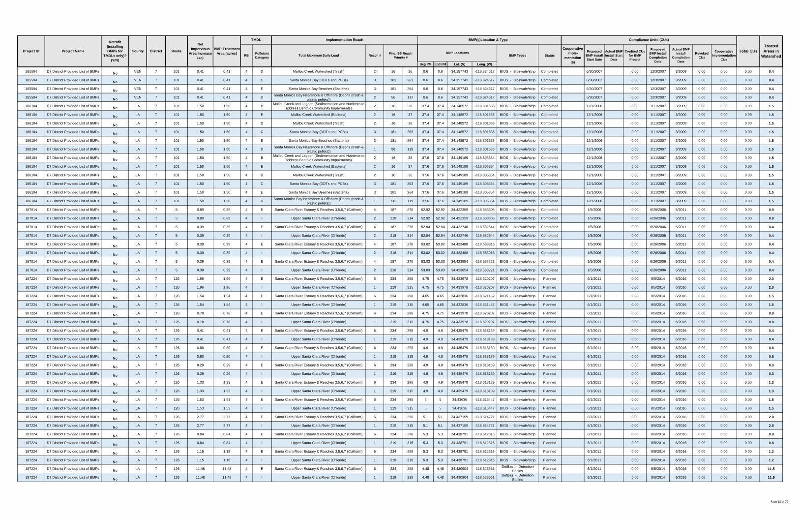
Beg PM End PM Lat. (N) Long. (W)
Revoked CUs
Total CUsTreated Areas in
WatershedRBPollutant Category
Total Maximum Daily Load Reach #Final SB Reach
Priority #
Compliance Units (CUs)
Cooperative Imple-
mentation ($)
Cooperative Implementation
CUs
Proposed BMP Install Start Date
Actual BMP Install Start
Date
Credited CUs for BMP Project
Proposed BMP Install Completion
Date
Actual BMP Install
Completion Date
Net Impervious
Area Increase (ac)
BMP Treatment Area (acres)
TMDL Implementation Reach BMP(s)Location & Type
BMP LocationsBMP Types Status
RouteProject ID Project Name
Retrofit (installing BMPs for
TMDLs only)? (Y/N)
County District
185504 D7 District Provided List of BMPs No VEN 7 101 0.41 0.41 4 D Malibu Creek Watershed (Trash) 2 16 36 0.6 0.6 34.157743 -118.824517 BIOS - Bioswale/strip Completed 6/30/2007 0.00 12/3/2007 3/2009 0.00 0.00 0.00 0.4
185504 D7 District Provided List of BMPs No VEN 7 101 0.41 0.41 4 C Santa Monica Bay (DDTs and PCBs) 3 181 263 0.6 0.6 34.157743 -118.824517 BIOS - Bioswale/strip Completed 6/30/2007 0.00 12/3/2007 3/2009 0.00 0.00 0.00 0.4
185504 D7 District Provided List of BMPs No VEN 7 101 0.41 0.41 4 E Santa Monica Bay Beaches (Bacteria) 3 181 264 0.6 0.6 34.157743 -118.824517 BIOS - Bioswale/strip Completed 6/30/2007 0.00 12/3/2007 3/2009 0.00 0.00 0.00 0.4
185504 D7 District Provided List of BMPs No VEN 7 101 0.41 0.41 4 DSanta Monica Bay Nearshore & Offshore (Debris (trash &
plastic pellets))2 56 117 0.6 0.6 34.157743 -118.824517 BIOS - Bioswale/strip Completed 6/30/2007 0.00 12/3/2007 3/2009 0.00 0.00 0.00 0.4
186104 D7 District Provided List of BMPs No LA 7 101 1.50 1.50 4 BMalibu Creek and Lagoon (Sedimentation and Nutrients to
address Benthic Community Impairments)2 16 38 37.4 37.4 34.148572 -118.801635 BIOS - Bioswale/strip Completed 12/1/2006 0.00 1/11/2007 3/2009 0.00 0.00 0.00 1.5
186104 D7 District Provided List of BMPs No LA 7 101 1.50 1.50 4 E Malibu Creek Watershed (Bacteria) 2 16 37 37.4 37.4 34.148572 -118.801635 BIOS - Bioswale/strip Completed 12/1/2006 0.00 1/11/2007 3/2009 0.00 0.00 0.00 1.5
186104 D7 District Provided List of BMPs No LA 7 101 1.50 1.50 4 D Malibu Creek Watershed (Trash) 2 16 36 37.4 37.4 34.148572 -118.801635 BIOS - Bioswale/strip Completed 12/1/2006 0.00 1/11/2007 3/2009 0.00 0.00 0.00 1.5
186104 D7 District Provided List of BMPs No LA 7 101 1.50 1.50 4 C Santa Monica Bay (DDTs and PCBs) 3 181 263 37.4 37.4 34.148572 -118.801635 BIOS - Bioswale/strip Completed 12/1/2006 0.00 1/11/2007 3/2009 0.00 0.00 0.00 1.5
186104 D7 District Provided List of BMPs No LA 7 101 1.50 1.50 4 E Santa Monica Bay Beaches (Bacteria) 3 181 264 37.4 37.4 34.148572 -118.801635 BIOS - Bioswale/strip Completed 12/1/2006 0.00 1/11/2007 3/2009 0.00 0.00 0.00 1.5
186104 D7 District Provided List of BMPs No LA 7 101 1.50 1.50 4 DSanta Monica Bay Nearshore & Offshore (Debris (trash &
plastic pellets))1 58 119 37.4 37.4 34.148572 -118.801635 BIOS - Bioswale/strip Completed 12/1/2006 0.00 1/11/2007 3/2009 0.00 0.00 0.00 1.5
186104 D7 District Provided List of BMPs No LA 7 101 1.50 1.50 4 BMalibu Creek and Lagoon (Sedimentation and Nutrients to
address Benthic Community Impairments)2 16 38 37.6 37.6 34.149189 -118.805354 BIOS - Bioswale/strip Completed 12/1/2006 0.00 1/11/2007 3/2009 0.00 0.00 0.00 1.5
186104 D7 District Provided List of BMPs No LA 7 101 1.50 1.50 4 E Malibu Creek Watershed (Bacteria) 2 16 37 37.6 37.6 34.149189 -118.805354 BIOS - Bioswale/strip Completed 12/1/2006 0.00 1/11/2007 3/2009 0.00 0.00 0.00 1.5
186104 D7 District Provided List of BMPs No LA 7 101 1.50 1.50 4 D Malibu Creek Watershed (Trash) 2 16 36 37.6 37.6 34.149189 -118.805354 BIOS - Bioswale/strip Completed 12/1/2006 0.00 1/11/2007 3/2009 0.00 0.00 0.00 1.5
186104 D7 District Provided List of BMPs No LA 7 101 1.50 1.50 4 C Santa Monica Bay (DDTs and PCBs) 3 181 263 37.6 37.6 34.149189 -118.805354 BIOS - Bioswale/strip Completed 12/1/2006 0.00 1/11/2007 3/2009 0.00 0.00 0.00 1.5
186104 D7 District Provided List of BMPs No LA 7 101 1.50 1.50 4 E Santa Monica Bay Beaches (Bacteria) 3 181 264 37.6 37.6 34.149189 -118.805354 BIOS - Bioswale/strip Completed 12/1/2006 0.00 1/11/2007 3/2009 0.00 0.00 0.00 1.5
186104 D7 District Provided List of BMPs No LA 7 101 1.50 1.50 4 DSanta Monica Bay Nearshore & Offshore (Debris (trash &
plastic pellets))1 58 119 37.6 37.6 34.149189 -118.805354 BIOS - Bioswale/strip Completed 12/1/2006 0.00 1/11/2007 3/2009 0.00 0.00 0.00 1.5
187014 D7 District Provided List of BMPs No LA 7 5 0.89 0.89 4 E Santa Clara River Estuary & Reaches 3,5,6,7 (Coliform) 4 187 270 52.92 52.92 34.422359 -118.583305 BIOS - Bioswale/strip Completed 1/5/2006 0.00 6/26/2006 5/2011 0.00 0.00 0.00 0.9
187014 D7 District Provided List of BMPs No LA 7 5 0.89 0.89 4 I Upper Santa Clara River (Chloride) 2 218 314 52.92 52.92 34.422359 -118.583305 BIOS - Bioswale/strip Completed 1/5/2006 0.00 6/26/2006 5/2011 0.00 0.00 0.00 0.9
187014 D7 District Provided List of BMPs No LA 7 5 0.39 0.39 4 E Santa Clara River Estuary & Reaches 3,5,6,7 (Coliform) 4 187 270 52.94 52.94 34.422746 -118.582644 BIOS - Bioswale/strip Completed 1/5/2006 0.00 6/26/2006 5/2011 0.00 0.00 0.00 0.4
187014 D7 District Provided List of BMPs No LA 7 5 0.39 0.39 4 I Upper Santa Clara River (Chloride) 2 218 314 52.94 52.94 34.422746 -118.582644 BIOS - Bioswale/strip Completed 1/5/2006 0.00 6/26/2006 5/2011 0.00 0.00 0.00 0.4
187014 D7 District Provided List of BMPs No LA 7 5 0.39 0.39 4 E Santa Clara River Estuary & Reaches 3,5,6,7 (Coliform) 4 187 270 53.02 53.02 34.423488 -118.583916 BIOS - Bioswale/strip Completed 1/5/2006 0.00 6/26/2006 5/2011 0.00 0.00 0.00 0.4
187014 D7 District Provided List of BMPs No LA 7 5 0.39 0.39 4 I Upper Santa Clara River (Chloride) 2 218 314 53.02 53.02 34.423488 -118.583916 BIOS - Bioswale/strip Completed 1/5/2006 0.00 6/26/2006 5/2011 0.00 0.00 0.00 0.4
187014 D7 District Provided List of BMPs No LA 7 5 0.39 0.39 4 E Santa Clara River Estuary & Reaches 3,5,6,7 (Coliform) 4 187 270 53.03 53.03 34.423854 -118.583221 BIOS - Bioswale/strip Completed 1/5/2006 0.00 6/26/2006 5/2011 0.00 0.00 0.00 0.4
187014 D7 District Provided List of BMPs No LA 7 5 0.39 0.39 4 I Upper Santa Clara River (Chloride) 2 218 314 53.03 53.03 34.423854 -118.583221 BIOS - Bioswale/strip Completed 1/5/2006 0.00 6/26/2006 5/2011 0.00 0.00 0.00 0.4
187224 D7 District Provided List of BMPs No LA 7 126 1.96 1.96 4 E Santa Clara River Estuary & Reaches 3,5,6,7 (Coliform) 6 234 298 4.75 4.75 34.433978 -118.620207 BIOS - Bioswale/strip Planned 6/1/2011 0.00 8/5/2014 6/2016 0.00 0.00 0.00 2.0
187224 D7 District Provided List of BMPs No LA 7 126 1.96 1.96 4 I Upper Santa Clara River (Chloride) 1 219 315 4.75 4.75 34.433978 -118.620207 BIOS - Bioswale/strip Planned 6/1/2011 0.00 8/5/2014 6/2016 0.00 0.00 0.00 2.0
187224 D7 District Provided List of BMPs No LA 7 126 1.54 1.54 4 E Santa Clara River Estuary & Reaches 3,5,6,7 (Coliform) 6 234 298 4.65 4.65 34.432836 -118.621452 BIOS - Bioswale/strip Planned 6/1/2011 0.00 8/5/2014 6/2016 0.00 0.00 0.00 1.5
187224 D7 District Provided List of BMPs No LA 7 126 1.54 1.54 4 I Upper Santa Clara River (Chloride) 1 219 315 4.65 4.65 34.432836 -118.621452 BIOS - Bioswale/strip Planned 6/1/2011 0.00 8/5/2014 6/2016 0.00 0.00 0.00 1.5
187224 D7 District Provided List of BMPs No LA 7 126 0.78 0.78 4 E Santa Clara River Estuary & Reaches 3,5,6,7 (Coliform) 6 234 298 4.75 4.75 34.433978 -118.620207 BIOS - Bioswale/strip Planned 6/1/2011 0.00 8/5/2014 6/2016 0.00 0.00 0.00 0.8
187224 D7 District Provided List of BMPs No LA 7 126 0.78 0.78 4 I Upper Santa Clara River (Chloride) 1 219 315 4.75 4.75 34.433978 -118.620207 BIOS - Bioswale/strip Planned 6/1/2011 0.00 8/5/2014 6/2016 0.00 0.00 0.00 0.8
187224 D7 District Provided List of BMPs No LA 7 126 0.41 0.41 4 E Santa Clara River Estuary & Reaches 3,5,6,7 (Coliform) 6 234 298 4.9 4.9 34.435479 -118.618139 BIOS - Bioswale/strip Planned 6/1/2011 0.00 8/5/2014 6/2016 0.00 0.00 0.00 0.4
187224 D7 District Provided List of BMPs No LA 7 126 0.41 0.41 4 I Upper Santa Clara River (Chloride) 1 219 315 4.9 4.9 34.435479 -118.618139 BIOS - Bioswale/strip Planned 6/1/2011 0.00 8/5/2014 6/2016 0.00 0.00 0.00 0.4
187224 D7 District Provided List of BMPs No LA 7 126 0.80 0.80 4 E Santa Clara River Estuary & Reaches 3,5,6,7 (Coliform) 6 234 298 4.9 4.9 34.435479 -118.618139 BIOS - Bioswale/strip Planned 6/1/2011 0.00 8/5/2014 6/2016 0.00 0.00 0.00 0.8
187224 D7 District Provided List of BMPs No LA 7 126 0.80 0.80 4 I Upper Santa Clara River (Chloride) 1 219 315 4.9 4.9 34.435479 -118.618139 BIOS - Bioswale/strip Planned 6/1/2011 0.00 8/5/2014 6/2016 0.00 0.00 0.00 0.8
187224 D7 District Provided List of BMPs No LA 7 126 0.29 0.29 4 E Santa Clara River Estuary & Reaches 3,5,6,7 (Coliform) 6 234 298 4.9 4.9 34.435479 -118.618139 BIOS - Bioswale/strip Planned 6/1/2011 0.00 8/5/2014 6/2016 0.00 0.00 0.00 0.3
187224 D7 District Provided List of BMPs No LA 7 126 0.29 0.29 4 I Upper Santa Clara River (Chloride) 1 219 315 4.9 4.9 34.435479 -118.618139 BIOS - Bioswale/strip Planned 6/1/2011 0.00 8/5/2014 6/2016 0.00 0.00 0.00 0.3
187224 D7 District Provided List of BMPs No LA 7 126 1.33 1.33 4 E Santa Clara River Estuary & Reaches 3,5,6,7 (Coliform) 6 234 298 4.9 4.9 34.435479 -118.618139 BIOS - Bioswale/strip Planned 6/1/2011 0.00 8/5/2014 6/2016 0.00 0.00 0.00 1.3
187224 D7 District Provided List of BMPs No LA 7 126 1.33 1.33 4 I Upper Santa Clara River (Chloride) 1 219 315 4.9 4.9 34.435479 -118.618139 BIOS - Bioswale/strip Planned 6/1/2011 0.00 8/5/2014 6/2016 0.00 0.00 0.00 1.3
187224 D7 District Provided List of BMPs No LA 7 126 1.53 1.53 4 E Santa Clara River Estuary & Reaches 3,5,6,7 (Coliform) 6 234 298 5 5 34.43636 -118.616447 BIOS - Bioswale/strip Planned 6/1/2011 0.00 8/5/2014 6/2016 0.00 0.00 0.00 1.5
187224 D7 District Provided List of BMPs No LA 7 126 1.53 1.53 4 I Upper Santa Clara River (Chloride) 1 219 315 5 5 34.43636 -118.616447 BIOS - Bioswale/strip Planned 6/1/2011 0.00 8/5/2014 6/2016 0.00 0.00 0.00 1.5
187224 D7 District Provided List of BMPs No LA 7 126 2.77 2.77 4 E Santa Clara River Estuary & Reaches 3,5,6,7 (Coliform) 6 234 298 5.1 5.1 34.437159 -118.614721 BIOS - Bioswale/strip Planned 6/1/2011 0.00 8/5/2014 6/2016 0.00 0.00 0.00 2.8
187224 D7 District Provided List of BMPs No LA 7 126 2.77 2.77 4 I Upper Santa Clara River (Chloride) 1 219 315 5.1 5.1 34.437159 -118.614721 BIOS - Bioswale/strip Planned 6/1/2011 0.00 8/5/2014 6/2016 0.00 0.00 0.00 2.8
187224 D7 District Provided List of BMPs No LA 7 126 0.84 0.84 4 E Santa Clara River Estuary & Reaches 3,5,6,7 (Coliform) 6 234 298 5.3 5.3 34.438791 -118.612316 BIOS - Bioswale/strip Planned 6/1/2011 0.00 8/5/2014 6/2016 0.00 0.00 0.00 0.8
187224 D7 District Provided List of BMPs No LA 7 126 0.84 0.84 4 I Upper Santa Clara River (Chloride) 1 219 315 5.3 5.3 34.438791 -118.612316 BIOS - Bioswale/strip Planned 6/1/2011 0.00 8/5/2014 6/2016 0.00 0.00 0.00 0.8
187224 D7 District Provided List of BMPs No LA 7 126 1.15 1.15 4 E Santa Clara River Estuary & Reaches 3,5,6,7 (Coliform) 6 234 298 5.3 5.3 34.438791 -118.612316 BIOS - Bioswale/strip Planned 6/1/2011 0.00 8/5/2014 6/2016 0.00 0.00 0.00 1.2
187224 D7 District Provided List of BMPs No LA 7 126 1.15 1.15 4 I Upper Santa Clara River (Chloride) 1 219 315 5.3 5.3 34.438791 -118.612316 BIOS - Bioswale/strip Planned 6/1/2011 0.00 8/5/2014 6/2016 0.00 0.00 0.00 1.2
187224 D7 District Provided List of BMPs No LA 7 126 11.48 11.48 4 E Santa Clara River Estuary & Reaches 3,5,6,7 (Coliform) 6 234 298 4.48 4.48 34.430904 -118.623561DetBas - Detention
BasinsPlanned 6/1/2011 0.00 8/5/2014 6/2016 0.00 0.00 0.00 11.5
187224 D7 District Provided List of BMPs No LA 7 126 11.48 11.48 4 I Upper Santa Clara River (Chloride) 1 219 315 4.48 4.48 34.430904 -118.623561DetBas - Detention
BasinsPlanned 6/1/2011 0.00 8/5/2014 6/2016 0.00 0.00 0.00 11.5
Page 18 of 77

Beg PM End PM Lat. (N) Long. (W)
Revoked CUs
Total CUsTreated Areas in
WatershedRBPollutant Category
Total Maximum Daily Load Reach #Final SB Reach
Priority #
Compliance Units (CUs)
Cooperative Imple-
mentation ($)
Cooperative Implementation
CUs
Proposed BMP Install Start Date
Actual BMP Install Start
Date
Credited CUs for BMP Project
Proposed BMP Install Completion
Date
Actual BMP Install
Completion Date
Net Impervious
Area Increase (ac)
BMP Treatment Area (acres)
TMDL Implementation Reach BMP(s)Location & Type
BMP LocationsBMP Types Status
RouteProject ID Project Name
Retrofit (installing BMPs for
TMDLs only)? (Y/N)
County District
187224 D7 District Provided List of BMPs No LA 7 126 6.29 6.29 4 E Santa Clara River Estuary & Reaches 3,5,6,7 (Coliform) 6 234 298 4.81 4.81 34.434597 -118.61942DetBas - Detention
BasinsPlanned 6/1/2011 0.00 8/5/2014 6/2016 0.00 0.00 0.00 6.3
187224 D7 District Provided List of BMPs No LA 7 126 6.29 6.29 4 I Upper Santa Clara River (Chloride) 1 219 315 4.81 4.81 34.434597 -118.61942DetBas - Detention
BasinsPlanned 6/1/2011 0.00 8/5/2014 6/2016 0.00 0.00 0.00 6.3
187224 D7 District Provided List of BMPs No LA 7 126 9.09 9.09 4 E Santa Clara River Estuary & Reaches 3,5,6,7 (Coliform) 6 234 298 4.86 4.86 34.435091 -118.618727DetBas - Detention
BasinsPlanned 6/1/2011 0.00 8/5/2014 6/2016 0.00 0.00 0.00 9.1
187224 D7 District Provided List of BMPs No LA 7 126 9.09 9.09 4 I Upper Santa Clara River (Chloride) 1 219 315 4.86 4.86 34.435091 -118.618727DetBas - Detention
BasinsPlanned 6/1/2011 0.00 8/5/2014 6/2016 0.00 0.00 0.00 9.1
189404 D7 District Provided List of BMPs No LA 7 71 0.41 0.41 4 C and G San Gabriel River (Metals (Cu, Pb, Zn) and Selenium) 5 101 173 0 0 34.057316 -117.785376 BIOS - Bioswale/strip Completed 9/29/2008 0.00 7/15/2008 11/2012 0.00 0.00 0.00 0.4
189404 D7 District Provided List of BMPs No LA 7 71 0.58 0.58 4 C and G San Gabriel River (Metals (Cu, Pb, Zn) and Selenium) 5 101 173 0 0 34.054664 -117.781854 BIOS - Bioswale/strip Completed 9/29/2008 0.00 7/15/2008 11/2012 0.00 0.00 0.00 0.6
189404 D7 District Provided List of BMPs No LA 7 71 0.84 0.84 4 C and G San Gabriel River (Metals (Cu, Pb, Zn) and Selenium) 5 101 173 0 0 34.053843 -117.781383 BIOS - Bioswale/strip Completed 9/29/2008 0.00 7/15/2008 11/2012 0.00 0.00 0.00 0.8
189404 D7 District Provided List of BMPs No LA 7 71 2.28 2.28 4 C and G San Gabriel River (Metals (Cu, Pb, Zn) and Selenium) 5 101 173 0 0 34.054273 -117.782342 BIOS - Bioswale/strip Completed 9/29/2008 0.00 7/15/2008 11/2012 0.00 0.00 0.00 2.3
189404 D7 District Provided List of BMPs No LA 7 71 1.39 1.39 4 C and G San Gabriel River (Metals (Cu, Pb, Zn) and Selenium) 5 101 173 0 0 34.053134 -117.781219 BIOS - Bioswale/strip Completed 9/29/2008 0.00 7/15/2008 11/2012 0.00 0.00 0.00 1.4
189404 D7 District Provided List of BMPs No LA 7 71 1.42 1.42 4 C and G San Gabriel River (Metals (Cu, Pb, Zn) and Selenium) 5 101 173 0 0 34.053795 -117.781327 BIOS - Bioswale/strip Completed 9/29/2008 0.00 7/15/2008 11/2012 0.00 0.00 0.00 1.4
189404 D7 District Provided List of BMPs No LA 7 71 0.65 0.65 4 C and G San Gabriel River (Metals (Cu, Pb, Zn) and Selenium) 5 101 173 0 0 34.052169 -117.779652 BIOS - Bioswale/strip Completed 9/29/2008 0.00 7/15/2008 11/2012 0.00 0.00 0.00 0.7
189404 D7 District Provided List of BMPs No LA 7 71 1.04 1.04 4 C and G San Gabriel River (Metals (Cu, Pb, Zn) and Selenium) 5 101 173 0 0 34.050891 -117.778291 BIOS - Bioswale/strip Completed 9/29/2008 0.00 7/15/2008 11/2012 0.00 0.00 0.00 1.0
189404 D7 District Provided List of BMPs No LA 7 71 1.01 1.01 4 C and G San Gabriel River (Metals (Cu, Pb, Zn) and Selenium) 5 101 173 0 0 34.051039 -117.778992 BIOS - Bioswale/strip Completed 9/29/2008 0.00 7/15/2008 11/2012 0.00 0.00 0.00 1.0
189404 D7 District Provided List of BMPs No LA 7 71 0.00 1.00 4 C and G San Gabriel River (Metals (Cu, Pb, Zn) and Selenium) 5 101 173 0 0 34.055103 -117.782051 BIOS - Bioswale/strip Completed 9/29/2008 1.00 7/15/2008 11/2012 0.00 0.00 1.00 1.0
191604 D7 District Provided List of BMPs No VEN 7 101 1.70 1.70 4 D Revolon Slough and Beardsley Wash (Trash) 1 7 16 16.63 16.63 34.220397 -119.089588 BIOS - Bioswale/strip Completed 7/15/2008 0.00 4/22/2010 6/2012 0.00 0.00 0.00 1.7
191604 D7 District Provided List of BMPs No VEN 7 101 1.70 1.70 4 C and GCalleguas Creeks, its Tributaries and Mugu Lagoon
(Metals and Selenium)3 102 175 16.63 16.63 34.220397 -119.089588 BIOS - Bioswale/strip Completed 7/15/2008 0.00 4/22/2010 6/2012 0.00 0.00 0.00 1.7
191604 D7 District Provided List of BMPs No VEN 7 101 1.70 1.70 4 B and CCalleguas Creeks, its Tributaries and Mugu Lagoon
(Organochlorine Pesticides, PCBs, and Siltation)3 102 174 16.63 16.63 34.220397 -119.089588 BIOS - Bioswale/strip Completed 7/15/2008 0.00 4/22/2010 6/2012 0.00 0.00 0.00 1.7
191604 D7 District Provided List of BMPs No VEN 7 101 0.00 1.00 4 D Revolon Slough and Beardsley Wash (Trash) 1 7 16 16.63 16.63 34.220635 -119.083059 BIOS - Bioswale/strip Completed 7/15/2008 1.00 4/22/2010 6/2012 0.00 0.00 1.00 1.0
191604 D7 District Provided List of BMPs No VEN 7 101 0.00 1.00 4 C and GCalleguas Creeks, its Tributaries and Mugu Lagoon
(Metals and Selenium)3 102 175 16.63 16.63 34.220635 -119.083059 BIOS - Bioswale/strip Completed 7/15/2008 1.00 4/22/2010 6/2012 0.00 0.00 1.00 1.0
191604 D7 District Provided List of BMPs No VEN 7 101 0.00 1.00 4 B and CCalleguas Creeks, its Tributaries and Mugu Lagoon
(Organochlorine Pesticides, PCBs, and Siltation)3 102 174 16.63 16.63 34.220635 -119.083059 BIOS - Bioswale/strip Completed 7/15/2008 1.00 4/22/2010 6/2012 0.00 0.00 1.00 1.0
191604 D7 District Provided List of BMPs No VEN 7 101 1.65 1.65 4 D Revolon Slough and Beardsley Wash (Trash) 1 7 16 16.6 16.6 34.219796 -119.082528 BIOS - Bioswale/strip Completed 7/15/2008 0.00 4/22/2010 6/2012 0.00 0.00 0.00 1.7
191604 D7 District Provided List of BMPs No VEN 7 101 1.65 1.65 4 C and GCalleguas Creeks, its Tributaries and Mugu Lagoon
(Metals and Selenium)3 102 175 16.6 16.6 34.219796 -119.082528 BIOS - Bioswale/strip Completed 7/15/2008 0.00 4/22/2010 6/2012 0.00 0.00 0.00 1.7
191604 D7 District Provided List of BMPs No VEN 7 101 1.65 1.65 4 B and CCalleguas Creeks, its Tributaries and Mugu Lagoon
(Organochlorine Pesticides, PCBs, and Siltation)3 102 174 16.6 16.6 34.219796 -119.082528 BIOS - Bioswale/strip Completed 7/15/2008 0.00 4/22/2010 6/2012 0.00 0.00 0.00 1.7
191604 D7 District Provided List of BMPs No VEN 7 101 0.00 1.00 4 D Revolon Slough and Beardsley Wash (Trash) 1 7 16 16.6 16.6 34.221015 -119.089752 BIOS - Bioswale/strip Completed 7/15/2008 1.00 4/22/2010 6/2012 0.00 0.00 1.00 1.0
191604 D7 District Provided List of BMPs No VEN 7 101 0.00 1.00 4 C and GCalleguas Creeks, its Tributaries and Mugu Lagoon
(Metals and Selenium)3 102 175 16.6 16.6 34.221015 -119.089752 BIOS - Bioswale/strip Completed 7/15/2008 1.00 4/22/2010 6/2012 0.00 0.00 1.00 1.0
191604 D7 District Provided List of BMPs No VEN 7 101 0.00 1.00 4 B and CCalleguas Creeks, its Tributaries and Mugu Lagoon
(Organochlorine Pesticides, PCBs, and Siltation)3 102 174 16.6 16.6 34.221015 -119.089752 BIOS - Bioswale/strip Completed 7/15/2008 1.00 4/22/2010 6/2012 0.00 0.00 1.00 1.0
195804 D7 District Provided List of BMPs No VEN 7 34 3.90 3.90 4 C and GCalleguas Creeks, its Tributaries and Mugu Lagoon
(Metals and Selenium)2 104 178 13.2 13.2 34.211533 -119.035744 BIOS - Bioswale/strip Completed 5/1/2008 0.00 1/6/2009 10/2011 0.00 0.00 0.00 3.9
195804 D7 District Provided List of BMPs No VEN 7 34 3.90 3.90 4 B and CCalleguas Creeks, its Tributaries and Mugu Lagoon
(Organochlorine Pesticides, PCBs, and Siltation)2 104 177 13.2 13.2 34.211533 -119.035744 BIOS - Bioswale/strip Completed 5/1/2008 0.00 1/6/2009 10/2011 0.00 0.00 0.00 3.9
195804 D7 District Provided List of BMPs No VEN 7 34 0.00 1.00 4 C and GCalleguas Creeks, its Tributaries and Mugu Lagoon
(Metals and Selenium)2 104 178 13.2 13.2 34.210322 -119.035479 BIOS - Bioswale/strip Completed 5/1/2008 1.00 1/6/2009 10/2011 0.00 0.00 1.00 1.0
195804 D7 District Provided List of BMPs No VEN 7 34 0.00 1.00 4 B and CCalleguas Creeks, its Tributaries and Mugu Lagoon
(Organochlorine Pesticides, PCBs, and Siltation)2 104 177 13.2 13.2 34.210322 -119.035479 BIOS - Bioswale/strip Completed 5/1/2008 1.00 1/6/2009 10/2011 0.00 0.00 1.00 1.0
195804 D7 District Provided List of BMPs No VEN 7 34 0.00 1.00 4 C and GCalleguas Creeks, its Tributaries and Mugu Lagoon
(Metals and Selenium)2 104 178 12.8 12.8 34.209321 -119.035153 BIOS - Bioswale/strip Completed 5/1/2008 1.00 1/6/2009 10/2011 0.00 0.00 1.00 1.0
195804 D7 District Provided List of BMPs No VEN 7 34 0.00 1.00 4 B and CCalleguas Creeks, its Tributaries and Mugu Lagoon
(Organochlorine Pesticides, PCBs, and Siltation)2 104 177 12.8 12.8 34.209321 -119.035153 BIOS - Bioswale/strip Completed 5/1/2008 1.00 1/6/2009 10/2011 0.00 0.00 1.00 1.0
195804 D7 District Provided List of BMPs No VEN 7 34 0.00 1.00 4 C and GCalleguas Creeks, its Tributaries and Mugu Lagoon
(Metals and Selenium)2 104 178 12.8 12.8 34.205889 -119.034441 BIOS - Bioswale/strip Completed 5/1/2008 1.00 1/6/2009 10/2011 0.00 0.00 1.00 1.0
195804 D7 District Provided List of BMPs No VEN 7 34 0.00 1.00 4 B and CCalleguas Creeks, its Tributaries and Mugu Lagoon
(Organochlorine Pesticides, PCBs, and Siltation)2 104 177 12.8 12.8 34.205889 -119.034441 BIOS - Bioswale/strip Completed 5/1/2008 1.00 1/6/2009 10/2011 0.00 0.00 1.00 1.0
195804 D7 District Provided List of BMPs No VEN 7 34 0.98 0.98 4 C and GCalleguas Creeks, its Tributaries and Mugu Lagoon
(Metals and Selenium)2 104 178 12.8 12.8 34.205689 -119.034955
INFIL - Infiltration (Basins & Trenches)
Completed 5/1/2008 0.00 1/6/2009 10/2011 0.00 0.00 0.00 1.0
195804 D7 District Provided List of BMPs No VEN 7 34 0.98 0.98 4 B and CCalleguas Creeks, its Tributaries and Mugu Lagoon
(Organochlorine Pesticides, PCBs, and Siltation)2 104 177 12.8 12.8 34.205689 -119.034955
INFIL - Infiltration (Basins & Trenches)
Completed 5/1/2008 0.00 1/6/2009 10/2011 0.00 0.00 0.00 1.0
199624 D7 District Provided List of BMPs No LA 7 405 19.00 19.00 4 N/A Los Angeles River (Trash) 5 24 52 42 42 34.169161 -118.468528GSRDs - Gross Solid
Removal DevicesCompleted 2/1/2005 0.00 7/8/2005 10/2007 0.00 0.00 0.00 19.0
202114 D7 District Provided List of BMPs No LA 7 710 0.00 1.00 4 N/A Los Angeles River (Trash) 3 25 55 17.97 17.97 33.942877 -118.170991GSRDs - Gross Solid
Removal DevicesPlanned 1/31/2012 1.00 4/27/2012 5/2016 0.00 0.00 1.00 1.0
202114 D7 District Provided List of BMPs No LA 7 710 0.00 1.00 4 N/A Los Angeles River (Trash) 3 25 55 17.99 17.99 33.943169 -118.170954GSRDs - Gross Solid
Removal DevicesPlanned 1/31/2012 1.00 4/27/2012 5/2016 0.00 0.00 1.00 1.0
202114 D7 District Provided List of BMPs No LA 7 710 0.00 1.00 4 N/A Los Angeles River (Trash) 3 25 55 17.99 17.99 33.943169 -118.170954GSRDs - Gross Solid
Removal DevicesPlanned 1/31/2012 1.00 4/27/2012 5/2016 0.00 0.00 1.00 1.0
202114 D7 District Provided List of BMPs No LA 7 710 0.00 1.00 4 N/A Los Angeles River (Trash) 3 25 55 25.61 25.61 34.049073 -118.166654GSRDs - Gross Solid
Removal DevicesPlanned 1/31/2012 1.00 4/27/2012 5/2016 0.00 0.00 1.00 1.0
202114 D7 District Provided List of BMPs No LA 7 710 0.69 0.69 4 C Los Angeles River and Tributaries (Metals) 3 25 57 18.49 18.49 33.950471 -118.170435 BIOS - Bioswale/strip Planned 1/31/2012 0.00 4/27/2012 5/2016 0.00 0.00 0.00 0.7
202114 D7 District Provided List of BMPs No LA 7 710 0.69 0.69 4 E Los Angeles River Watershed (Bacteria) 3 25 56 18.49 18.49 33.950471 -118.170435 BIOS - Bioswale/strip Planned 1/31/2012 0.00 4/27/2012 5/2016 0.00 0.00 0.00 0.7
202114 D7 District Provided List of BMPs No LA 7 710 0.69 0.69 4 N/A Los Angeles River (Trash) 3 25 55 18.49 18.49 33.950471 -118.170435 BIOS - Bioswale/strip Planned 1/31/2012 0.00 4/27/2012 5/2016 0.00 0.00 0.00 0.7
202114 D7 District Provided List of BMPs No LA 7 710 0.16 0.16 4 C Los Angeles River and Tributaries (Metals) 3 25 57 18.49 18.49 33.950471 -118.170435 BIOS - Bioswale/strip Planned 1/31/2012 0.00 4/27/2012 5/2016 0.00 0.00 0.00 0.2
202114 D7 District Provided List of BMPs No LA 7 710 0.16 0.16 4 E Los Angeles River Watershed (Bacteria) 3 25 56 18.49 18.49 33.950471 -118.170435 BIOS - Bioswale/strip Planned 1/31/2012 0.00 4/27/2012 5/2016 0.00 0.00 0.00 0.2
202114 D7 District Provided List of BMPs No LA 7 710 0.16 0.16 4 N/A Los Angeles River (Trash) 3 25 55 18.49 18.49 33.950471 -118.170435 BIOS - Bioswale/strip Planned 1/31/2012 0.00 4/27/2012 5/2016 0.00 0.00 0.00 0.2
202114 D7 District Provided List of BMPs No LA 7 710 1.31 1.31 4 C Los Angeles River and Tributaries (Metals) 3 25 57 18.51 18.51 33.950763 -118.170456 BIOS - Bioswale/strip Planned 1/31/2012 0.00 4/27/2012 5/2016 0.00 0.00 0.00 1.3
Page 19 of 77
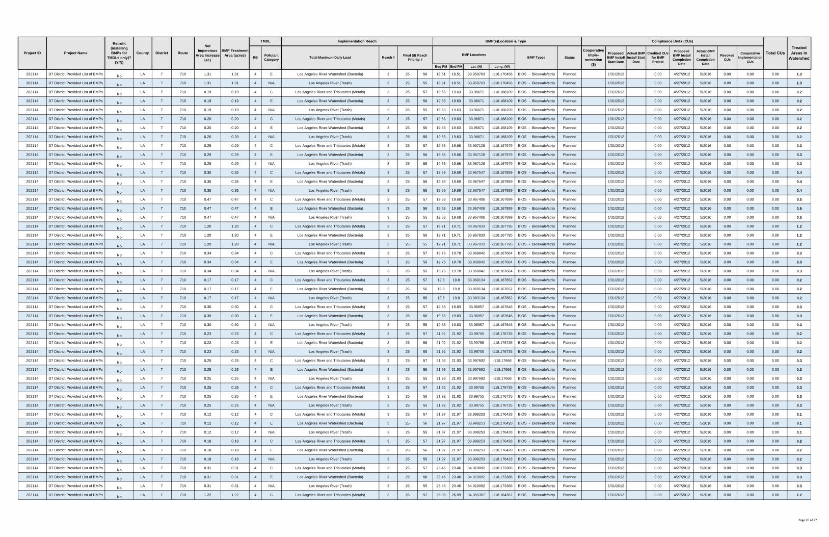
Beg PM End PM Lat. (N) Long. (W)
Revoked CUs
Total CUsTreated Areas in
WatershedRBPollutant Category
Total Maximum Daily Load Reach #Final SB Reach
Priority #
Compliance Units (CUs)
Cooperative Imple-
mentation ($)
Cooperative Implementation
CUs
Proposed BMP Install Start Date
Actual BMP Install Start
Date
Credited CUs for BMP Project
Proposed BMP Install Completion
Date
Actual BMP Install
Completion Date
Net Impervious
Area Increase (ac)
BMP Treatment Area (acres)
TMDL Implementation Reach BMP(s)Location & Type
BMP LocationsBMP Types Status
RouteProject ID Project Name
Retrofit (installing BMPs for
TMDLs only)? (Y/N)
County District
202114 D7 District Provided List of BMPs No LA 7 710 1.31 1.31 4 E Los Angeles River Watershed (Bacteria) 3 25 56 18.51 18.51 33.950763 -118.170456 BIOS - Bioswale/strip Planned 1/31/2012 0.00 4/27/2012 5/2016 0.00 0.00 0.00 1.3
202114 D7 District Provided List of BMPs No LA 7 710 1.31 1.31 4 N/A Los Angeles River (Trash) 3 25 55 18.51 18.51 33.950763 -118.170456 BIOS - Bioswale/strip Planned 1/31/2012 0.00 4/27/2012 5/2016 0.00 0.00 0.00 1.3
202114 D7 District Provided List of BMPs No LA 7 710 0.19 0.19 4 C Los Angeles River and Tributaries (Metals) 3 25 57 19.63 19.63 33.96671 -118.168109 BIOS - Bioswale/strip Planned 1/31/2012 0.00 4/27/2012 5/2016 0.00 0.00 0.00 0.2
202114 D7 District Provided List of BMPs No LA 7 710 0.19 0.19 4 E Los Angeles River Watershed (Bacteria) 3 25 56 19.63 19.63 33.96671 -118.168109 BIOS - Bioswale/strip Planned 1/31/2012 0.00 4/27/2012 5/2016 0.00 0.00 0.00 0.2
202114 D7 District Provided List of BMPs No LA 7 710 0.19 0.19 4 N/A Los Angeles River (Trash) 3 25 55 19.63 19.63 33.96671 -118.168109 BIOS - Bioswale/strip Planned 1/31/2012 0.00 4/27/2012 5/2016 0.00 0.00 0.00 0.2
202114 D7 District Provided List of BMPs No LA 7 710 0.20 0.20 4 C Los Angeles River and Tributaries (Metals) 3 25 57 19.63 19.63 33.96671 -118.168109 BIOS - Bioswale/strip Planned 1/31/2012 0.00 4/27/2012 5/2016 0.00 0.00 0.00 0.2
202114 D7 District Provided List of BMPs No LA 7 710 0.20 0.20 4 E Los Angeles River Watershed (Bacteria) 3 25 56 19.63 19.63 33.96671 -118.168109 BIOS - Bioswale/strip Planned 1/31/2012 0.00 4/27/2012 5/2016 0.00 0.00 0.00 0.2
202114 D7 District Provided List of BMPs No LA 7 710 0.20 0.20 4 N/A Los Angeles River (Trash) 3 25 55 19.63 19.63 33.96671 -118.168109 BIOS - Bioswale/strip Planned 1/31/2012 0.00 4/27/2012 5/2016 0.00 0.00 0.00 0.2
202114 D7 District Provided List of BMPs No LA 7 710 0.29 0.29 4 C Los Angeles River and Tributaries (Metals) 3 25 57 19.66 19.66 33.967128 -118.167979 BIOS - Bioswale/strip Planned 1/31/2012 0.00 4/27/2012 5/2016 0.00 0.00 0.00 0.3
202114 D7 District Provided List of BMPs No LA 7 710 0.29 0.29 4 E Los Angeles River Watershed (Bacteria) 3 25 56 19.66 19.66 33.967128 -118.167979 BIOS - Bioswale/strip Planned 1/31/2012 0.00 4/27/2012 5/2016 0.00 0.00 0.00 0.3
202114 D7 District Provided List of BMPs No LA 7 710 0.29 0.29 4 N/A Los Angeles River (Trash) 3 25 55 19.66 19.66 33.967128 -118.167979 BIOS - Bioswale/strip Planned 1/31/2012 0.00 4/27/2012 5/2016 0.00 0.00 0.00 0.3
202114 D7 District Provided List of BMPs No LA 7 710 0.35 0.35 4 C Los Angeles River and Tributaries (Metals) 3 25 57 19.69 19.69 33.967547 -118.167859 BIOS - Bioswale/strip Planned 1/31/2012 0.00 4/27/2012 5/2016 0.00 0.00 0.00 0.4
202114 D7 District Provided List of BMPs No LA 7 710 0.35 0.35 4 E Los Angeles River Watershed (Bacteria) 3 25 56 19.69 19.69 33.967547 -118.167859 BIOS - Bioswale/strip Planned 1/31/2012 0.00 4/27/2012 5/2016 0.00 0.00 0.00 0.4
202114 D7 District Provided List of BMPs No LA 7 710 0.35 0.35 4 N/A Los Angeles River (Trash) 3 25 55 19.69 19.69 33.967547 -118.167859 BIOS - Bioswale/strip Planned 1/31/2012 0.00 4/27/2012 5/2016 0.00 0.00 0.00 0.4
202114 D7 District Provided List of BMPs No LA 7 710 0.47 0.47 4 C Los Angeles River and Tributaries (Metals) 3 25 57 19.68 19.68 33.967406 -118.167899 BIOS - Bioswale/strip Planned 1/31/2012 0.00 4/27/2012 5/2016 0.00 0.00 0.00 0.5
202114 D7 District Provided List of BMPs No LA 7 710 0.47 0.47 4 E Los Angeles River Watershed (Bacteria) 3 25 56 19.68 19.68 33.967406 -118.167899 BIOS - Bioswale/strip Planned 1/31/2012 0.00 4/27/2012 5/2016 0.00 0.00 0.00 0.5
202114 D7 District Provided List of BMPs No LA 7 710 0.47 0.47 4 N/A Los Angeles River (Trash) 3 25 55 19.68 19.68 33.967406 -118.167899 BIOS - Bioswale/strip Planned 1/31/2012 0.00 4/27/2012 5/2016 0.00 0.00 0.00 0.5
202114 D7 District Provided List of BMPs No LA 7 710 1.20 1.20 4 C Los Angeles River and Tributaries (Metals) 3 25 57 19.71 19.71 33.967833 -118.167795 BIOS - Bioswale/strip Planned 1/31/2012 0.00 4/27/2012 5/2016 0.00 0.00 0.00 1.2
202114 D7 District Provided List of BMPs No LA 7 710 1.20 1.20 4 E Los Angeles River Watershed (Bacteria) 3 25 56 19.71 19.71 33.967833 -118.167795 BIOS - Bioswale/strip Planned 1/31/2012 0.00 4/27/2012 5/2016 0.00 0.00 0.00 1.2
202114 D7 District Provided List of BMPs No LA 7 710 1.20 1.20 4 N/A Los Angeles River (Trash) 3 25 55 19.71 19.71 33.967833 -118.167795 BIOS - Bioswale/strip Planned 1/31/2012 0.00 4/27/2012 5/2016 0.00 0.00 0.00 1.2
202114 D7 District Provided List of BMPs No LA 7 710 0.34 0.34 4 C Los Angeles River and Tributaries (Metals) 3 25 57 19.78 19.78 33.968842 -118.167664 BIOS - Bioswale/strip Planned 1/31/2012 0.00 4/27/2012 5/2016 0.00 0.00 0.00 0.3
202114 D7 District Provided List of BMPs No LA 7 710 0.34 0.34 4 E Los Angeles River Watershed (Bacteria) 3 25 56 19.78 19.78 33.968842 -118.167664 BIOS - Bioswale/strip Planned 1/31/2012 0.00 4/27/2012 5/2016 0.00 0.00 0.00 0.3
202114 D7 District Provided List of BMPs No LA 7 710 0.34 0.34 4 N/A Los Angeles River (Trash) 3 25 55 19.78 19.78 33.968842 -118.167664 BIOS - Bioswale/strip Planned 1/31/2012 0.00 4/27/2012 5/2016 0.00 0.00 0.00 0.3
202114 D7 District Provided List of BMPs No LA 7 710 0.17 0.17 4 C Los Angeles River and Tributaries (Metals) 3 25 57 19.8 19.8 33.969134 -118.167652 BIOS - Bioswale/strip Planned 1/31/2012 0.00 4/27/2012 5/2016 0.00 0.00 0.00 0.2
202114 D7 District Provided List of BMPs No LA 7 710 0.17 0.17 4 E Los Angeles River Watershed (Bacteria) 3 25 56 19.8 19.8 33.969134 -118.167652 BIOS - Bioswale/strip Planned 1/31/2012 0.00 4/27/2012 5/2016 0.00 0.00 0.00 0.2
202114 D7 District Provided List of BMPs No LA 7 710 0.17 0.17 4 N/A Los Angeles River (Trash) 3 25 55 19.8 19.8 33.969134 -118.167652 BIOS - Bioswale/strip Planned 1/31/2012 0.00 4/27/2012 5/2016 0.00 0.00 0.00 0.2
202114 D7 District Provided List of BMPs No LA 7 710 0.30 0.30 4 C Los Angeles River and Tributaries (Metals) 3 25 57 19.83 19.83 33.96957 -118.167646 BIOS - Bioswale/strip Planned 1/31/2012 0.00 4/27/2012 5/2016 0.00 0.00 0.00 0.3
202114 D7 District Provided List of BMPs No LA 7 710 0.30 0.30 4 E Los Angeles River Watershed (Bacteria) 3 25 56 19.83 19.83 33.96957 -118.167646 BIOS - Bioswale/strip Planned 1/31/2012 0.00 4/27/2012 5/2016 0.00 0.00 0.00 0.3
202114 D7 District Provided List of BMPs No LA 7 710 0.30 0.30 4 N/A Los Angeles River (Trash) 3 25 55 19.83 19.83 33.96957 -118.167646 BIOS - Bioswale/strip Planned 1/31/2012 0.00 4/27/2012 5/2016 0.00 0.00 0.00 0.3
202114 D7 District Provided List of BMPs No LA 7 710 0.23 0.23 4 C Los Angeles River and Tributaries (Metals) 3 25 57 21.92 21.92 33.99755 -118.176735 BIOS - Bioswale/strip Planned 1/31/2012 0.00 4/27/2012 5/2016 0.00 0.00 0.00 0.2
202114 D7 District Provided List of BMPs No LA 7 710 0.23 0.23 4 E Los Angeles River Watershed (Bacteria) 3 25 56 21.92 21.92 33.99755 -118.176735 BIOS - Bioswale/strip Planned 1/31/2012 0.00 4/27/2012 5/2016 0.00 0.00 0.00 0.2
202114 D7 District Provided List of BMPs No LA 7 710 0.23 0.23 4 N/A Los Angeles River (Trash) 3 25 55 21.92 21.92 33.99755 -118.176735 BIOS - Bioswale/strip Planned 1/31/2012 0.00 4/27/2012 5/2016 0.00 0.00 0.00 0.2
202114 D7 District Provided List of BMPs No LA 7 710 0.25 0.25 4 C Los Angeles River and Tributaries (Metals) 3 25 57 21.93 21.93 33.997692 -118.17668 BIOS - Bioswale/strip Planned 1/31/2012 0.00 4/27/2012 5/2016 0.00 0.00 0.00 0.3
202114 D7 District Provided List of BMPs No LA 7 710 0.25 0.25 4 E Los Angeles River Watershed (Bacteria) 3 25 56 21.93 21.93 33.997692 -118.17668 BIOS - Bioswale/strip Planned 1/31/2012 0.00 4/27/2012 5/2016 0.00 0.00 0.00 0.3
202114 D7 District Provided List of BMPs No LA 7 710 0.25 0.25 4 N/A Los Angeles River (Trash) 3 25 55 21.93 21.93 33.997692 -118.17668 BIOS - Bioswale/strip Planned 1/31/2012 0.00 4/27/2012 5/2016 0.00 0.00 0.00 0.3
202114 D7 District Provided List of BMPs No LA 7 710 0.25 0.25 4 C Los Angeles River and Tributaries (Metals) 3 25 57 21.92 21.92 33.99755 -118.176735 BIOS - Bioswale/strip Planned 1/31/2012 0.00 4/27/2012 5/2016 0.00 0.00 0.00 0.3
202114 D7 District Provided List of BMPs No LA 7 710 0.25 0.25 4 E Los Angeles River Watershed (Bacteria) 3 25 56 21.92 21.92 33.99755 -118.176735 BIOS - Bioswale/strip Planned 1/31/2012 0.00 4/27/2012 5/2016 0.00 0.00 0.00 0.3
202114 D7 District Provided List of BMPs No LA 7 710 0.25 0.25 4 N/A Los Angeles River (Trash) 3 25 55 21.92 21.92 33.99755 -118.176735 BIOS - Bioswale/strip Planned 1/31/2012 0.00 4/27/2012 5/2016 0.00 0.00 0.00 0.3
202114 D7 District Provided List of BMPs No LA 7 710 0.12 0.12 4 C Los Angeles River and Tributaries (Metals) 3 25 57 21.97 21.97 33.998253 -118.176428 BIOS - Bioswale/strip Planned 1/31/2012 0.00 4/27/2012 5/2016 0.00 0.00 0.00 0.1
202114 D7 District Provided List of BMPs No LA 7 710 0.12 0.12 4 E Los Angeles River Watershed (Bacteria) 3 25 56 21.97 21.97 33.998253 -118.176428 BIOS - Bioswale/strip Planned 1/31/2012 0.00 4/27/2012 5/2016 0.00 0.00 0.00 0.1
202114 D7 District Provided List of BMPs No LA 7 710 0.12 0.12 4 N/A Los Angeles River (Trash) 3 25 55 21.97 21.97 33.998253 -118.176428 BIOS - Bioswale/strip Planned 1/31/2012 0.00 4/27/2012 5/2016 0.00 0.00 0.00 0.1
202114 D7 District Provided List of BMPs No LA 7 710 0.18 0.18 4 C Los Angeles River and Tributaries (Metals) 3 25 57 21.97 21.97 33.998253 -118.176428 BIOS - Bioswale/strip Planned 1/31/2012 0.00 4/27/2012 5/2016 0.00 0.00 0.00 0.2
202114 D7 District Provided List of BMPs No LA 7 710 0.18 0.18 4 E Los Angeles River Watershed (Bacteria) 3 25 56 21.97 21.97 33.998253 -118.176428 BIOS - Bioswale/strip Planned 1/31/2012 0.00 4/27/2012 5/2016 0.00 0.00 0.00 0.2
202114 D7 District Provided List of BMPs No LA 7 710 0.18 0.18 4 N/A Los Angeles River (Trash) 3 25 55 21.97 21.97 33.998253 -118.176428 BIOS - Bioswale/strip Planned 1/31/2012 0.00 4/27/2012 5/2016 0.00 0.00 0.00 0.2
202114 D7 District Provided List of BMPs No LA 7 710 0.31 0.31 4 C Los Angeles River and Tributaries (Metals) 3 25 57 23.46 23.46 34.019092 -118.173386 BIOS - Bioswale/strip Planned 1/31/2012 0.00 4/27/2012 5/2016 0.00 0.00 0.00 0.3
202114 D7 District Provided List of BMPs No LA 7 710 0.31 0.31 4 E Los Angeles River Watershed (Bacteria) 3 25 56 23.46 23.46 34.019092 -118.173386 BIOS - Bioswale/strip Planned 1/31/2012 0.00 4/27/2012 5/2016 0.00 0.00 0.00 0.3
202114 D7 District Provided List of BMPs No LA 7 710 0.31 0.31 4 N/A Los Angeles River (Trash) 3 25 55 23.46 23.46 34.019092 -118.173386 BIOS - Bioswale/strip Planned 1/31/2012 0.00 4/27/2012 5/2016 0.00 0.00 0.00 0.3
202114 D7 District Provided List of BMPs No LA 7 710 1.22 1.22 4 C Los Angeles River and Tributaries (Metals) 3 25 57 26.09 26.09 34.055367 -118.164367 BIOS - Bioswale/strip Planned 1/31/2012 0.00 4/27/2012 5/2016 0.00 0.00 0.00 1.2
Page 20 of 77
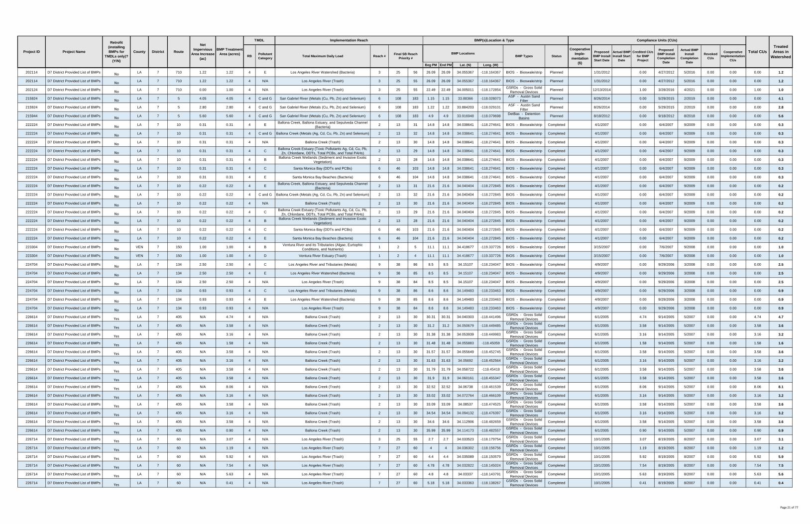
Beg PM End PM Lat. (N) Long. (W)
Revoked CUs
Total CUsTreated Areas in
WatershedRBPollutant Category
Total Maximum Daily Load Reach #Final SB Reach
Priority #
Compliance Units (CUs)
Cooperative Imple-
mentation ($)
Cooperative Implementation
CUs
Proposed BMP Install Start Date
Actual BMP Install Start
Date
Credited CUs for BMP Project
Proposed BMP Install Completion
Date
Actual BMP Install
Completion Date
Net Impervious
Area Increase (ac)
BMP Treatment Area (acres)
TMDL Implementation Reach BMP(s)Location & Type
BMP LocationsBMP Types Status
RouteProject ID Project Name
Retrofit (installing BMPs for
TMDLs only)? (Y/N)
County District
202114 D7 District Provided List of BMPs No LA 7 710 1.22 1.22 4 E Los Angeles River Watershed (Bacteria) 3 25 56 26.09 26.09 34.055367 -118.164367 BIOS - Bioswale/strip Planned 1/31/2012 0.00 4/27/2012 5/2016 0.00 0.00 0.00 1.2
202114 D7 District Provided List of BMPs No LA 7 710 1.22 1.22 4 N/A Los Angeles River (Trash) 3 25 55 26.09 26.09 34.055367 -118.164367 BIOS - Bioswale/strip Planned 1/31/2012 0.00 4/27/2012 5/2016 0.00 0.00 0.00 1.2
202124 D7 District Provided List of BMPs No LA 7 710 0.00 1.00 4 N/A Los Angeles River (Trash) 3 25 55 22.49 22.49 34.005011 -118.172854GSRDs - Gross Solid
Removal DevicesPlanned 12/13/2014 1.00 3/28/2016 4/2021 0.00 0.00 1.00 1.0
215924 D7 District Provided List of BMPs No LA 7 5 4.05 4.05 4 C and G San Gabriel River (Metals (Cu, Pb, Zn) and Selenium) 6 108 183 1.15 1.15 33.88366 -118.028073ASF - Austin Sand
FilterPlanned 8/26/2014 0.00 5/29/2015 2/2019 0.00 0.00 0.00 4.1
215924 D7 District Provided List of BMPs No LA 7 5 2.80 2.80 4 C and G San Gabriel River (Metals (Cu, Pb, Zn) and Selenium) 6 108 183 1.22 1.22 33.884203 -118.029101ASF - Austin Sand
FilterPlanned 8/26/2014 0.00 5/29/2015 2/2019 0.00 0.00 0.00 2.8
215944 D7 District Provided List of BMPs No LA 7 5 5.60 5.60 4 C and G San Gabriel River (Metals (Cu, Pb, Zn) and Selenium) 6 108 183 4.9 4.9 33.916948 -118.079698DetBas - Detention
BasinsPlanned 8/18/2012 0.00 9/18/2012 8/2018 0.00 0.00 0.00 5.6
222224 D7 District Provided List of BMPs No LA 7 10 0.31 0.31 4 EBallona Creek, Ballona Estuary, and Sepulveda Channel
(Bacteria)2 13 31 14.8 14.8 34.038641 -118.274641 BIOS - Bioswale/strip Completed 4/1/2007 0.00 6/4/2007 9/2009 0.00 0.00 0.00 0.3
222224 D7 District Provided List of BMPs No LA 7 10 0.31 0.31 4 C and G Ballona Creek (Metals (Ag, Cd, Cu, Pb, Zn) and Selenium) 2 13 32 14.8 14.8 34.038641 -118.274641 BIOS - Bioswale/strip Completed 4/1/2007 0.00 6/4/2007 9/2009 0.00 0.00 0.00 0.3
222224 D7 District Provided List of BMPs No LA 7 10 0.31 0.31 4 N/A Ballona Creek (Trash) 2 13 30 14.8 14.8 34.038641 -118.274641 BIOS - Bioswale/strip Completed 4/1/2007 0.00 6/4/2007 9/2009 0.00 0.00 0.00 0.3
222224 D7 District Provided List of BMPs No LA 7 10 0.31 0.31 4 CBallona Creek Estuary (Toxic Pollutants Ag, Cd, Cu, Pb,
Zn, Chlordane, DDTs, Total PCBs, and Total PAHs)2 13 29 14.8 14.8 34.038641 -118.274641 BIOS - Bioswale/strip Completed 4/1/2007 0.00 6/4/2007 9/2009 0.00 0.00 0.00 0.3
222224 D7 District Provided List of BMPs No LA 7 10 0.31 0.31 4 BBallona Creek Wetlands (Sediment and Invasive Exotic
Vegetation)2 13 28 14.8 14.8 34.038641 -118.274641 BIOS - Bioswale/strip Completed 4/1/2007 0.00 6/4/2007 9/2009 0.00 0.00 0.00 0.3
222224 D7 District Provided List of BMPs No LA 7 10 0.31 0.31 4 C Santa Monica Bay (DDTs and PCBs) 6 46 103 14.8 14.8 34.038641 -118.274641 BIOS - Bioswale/strip Completed 4/1/2007 0.00 6/4/2007 9/2009 0.00 0.00 0.00 0.3
222224 D7 District Provided List of BMPs No LA 7 10 0.31 0.31 4 E Santa Monica Bay Beaches (Bacteria) 6 46 104 14.8 14.8 34.038641 -118.274641 BIOS - Bioswale/strip Completed 4/1/2007 0.00 6/4/2007 9/2009 0.00 0.00 0.00 0.3
222224 D7 District Provided List of BMPs No LA 7 10 0.22 0.22 4 EBallona Creek, Ballona Estuary, and Sepulveda Channel
(Bacteria)2 13 31 21.6 21.6 34.040404 -118.272845 BIOS - Bioswale/strip Completed 4/1/2007 0.00 6/4/2007 9/2009 0.00 0.00 0.00 0.2
222224 D7 District Provided List of BMPs No LA 7 10 0.22 0.22 4 C and G Ballona Creek (Metals (Ag, Cd, Cu, Pb, Zn) and Selenium) 2 13 32 21.6 21.6 34.040404 -118.272845 BIOS - Bioswale/strip Completed 4/1/2007 0.00 6/4/2007 9/2009 0.00 0.00 0.00 0.2
222224 D7 District Provided List of BMPs No LA 7 10 0.22 0.22 4 N/A Ballona Creek (Trash) 2 13 30 21.6 21.6 34.040404 -118.272845 BIOS - Bioswale/strip Completed 4/1/2007 0.00 6/4/2007 9/2009 0.00 0.00 0.00 0.2
222224 D7 District Provided List of BMPs No LA 7 10 0.22 0.22 4 CBallona Creek Estuary (Toxic Pollutants Ag, Cd, Cu, Pb,
Zn, Chlordane, DDTs, Total PCBs, and Total PAHs)2 13 29 21.6 21.6 34.040404 -118.272845 BIOS - Bioswale/strip Completed 4/1/2007 0.00 6/4/2007 9/2009 0.00 0.00 0.00 0.2
222224 D7 District Provided List of BMPs No LA 7 10 0.22 0.22 4 BBallona Creek Wetlands (Sediment and Invasive Exotic
Vegetation)2 13 28 21.6 21.6 34.040404 -118.272845 BIOS - Bioswale/strip Completed 4/1/2007 0.00 6/4/2007 9/2009 0.00 0.00 0.00 0.2
222224 D7 District Provided List of BMPs No LA 7 10 0.22 0.22 4 C Santa Monica Bay (DDTs and PCBs) 6 46 103 21.6 21.6 34.040404 -118.272845 BIOS - Bioswale/strip Completed 4/1/2007 0.00 6/4/2007 9/2009 0.00 0.00 0.00 0.2
222224 D7 District Provided List of BMPs No LA 7 10 0.22 0.22 4 E Santa Monica Bay Beaches (Bacteria) 6 46 104 21.6 21.6 34.040404 -118.272845 BIOS - Bioswale/strip Completed 4/1/2007 0.00 6/4/2007 9/2009 0.00 0.00 0.00 0.2
223304 D7 District Provided List of BMPs No VEN 7 150 1.00 1.00 4 BVentura River and its Tributaries (Algae, Eurtophic
Conditions, and Nutrients)1 2 5 11.1 11.1 34.418677 -119.337726 BIOS - Bioswale/strip Completed 3/15/2007 0.00 7/6/2007 9/2008 0.00 0.00 0.00 1.0
223304 D7 District Provided List of BMPs No VEN 7 150 1.00 1.00 4 D Ventura River Estuary (Trash) 1 2 4 11.1 11.1 34.418677 -119.337726 BIOS - Bioswale/strip Completed 3/15/2007 0.00 7/6/2007 9/2008 0.00 0.00 0.00 1.0
224704 D7 District Provided List of BMPs No LA 7 134 2.50 2.50 4 C Los Angeles River and Tributaries (Metals) 9 38 86 8.5 8.5 34.15107 -118.234047 BIOS - Bioswale/strip Completed 4/9/2007 0.00 9/29/2006 3/2008 0.00 0.00 0.00 2.5
224704 D7 District Provided List of BMPs No LA 7 134 2.50 2.50 4 E Los Angeles River Watershed (Bacteria) 9 38 85 8.5 8.5 34.15107 -118.234047 BIOS - Bioswale/strip Completed 4/9/2007 0.00 9/29/2006 3/2008 0.00 0.00 0.00 2.5
224704 D7 District Provided List of BMPs No LA 7 134 2.50 2.50 4 N/A Los Angeles River (Trash) 9 38 84 8.5 8.5 34.15107 -118.234047 BIOS - Bioswale/strip Completed 4/9/2007 0.00 9/29/2006 3/2008 0.00 0.00 0.00 2.5
224704 D7 District Provided List of BMPs No LA 7 134 0.93 0.93 4 C Los Angeles River and Tributaries (Metals) 9 38 86 8.6 8.6 34.149483 -118.233463 BIOS - Bioswale/strip Completed 4/9/2007 0.00 9/29/2006 3/2008 0.00 0.00 0.00 0.9
224704 D7 District Provided List of BMPs No LA 7 134 0.93 0.93 4 E Los Angeles River Watershed (Bacteria) 9 38 85 8.6 8.6 34.149483 -118.233463 BIOS - Bioswale/strip Completed 4/9/2007 0.00 9/29/2006 3/2008 0.00 0.00 0.00 0.9
224704 D7 District Provided List of BMPs No LA 7 134 0.93 0.93 4 N/A Los Angeles River (Trash) 9 38 84 8.6 8.6 34.149483 -118.233463 BIOS - Bioswale/strip Completed 4/9/2007 0.00 9/29/2006 3/2008 0.00 0.00 0.00 0.9
226614 D7 District Provided List of BMPs Yes LA 7 405 N/A 4.74 4 N/A Ballona Creek (Trash) 2 13 30 30.31 30.31 34.040303 -118.441496GSRDs - Gross Solid
Removal DevicesCompleted 6/1/2005 4.74 9/14/2005 5/2007 0.00 0.00 4.74 4.7
226614 D7 District Provided List of BMPs Yes LA 7 405 N/A 3.58 4 N/A Ballona Creek (Trash) 2 13 30 31.2 31.2 34.050679 -118.449485GSRDs - Gross Solid
Removal DevicesCompleted 6/1/2005 3.58 9/14/2005 5/2007 0.00 0.00 3.58 3.6
226614 D7 District Provided List of BMPs Yes LA 7 405 N/A 3.16 4 N/A Ballona Creek (Trash) 2 13 30 31.38 31.38 34.053939 -118.449983GSRDs - Gross Solid
Removal DevicesCompleted 6/1/2005 3.16 9/14/2005 5/2007 0.00 0.00 3.16 3.2
226614 D7 District Provided List of BMPs Yes LA 7 405 N/A 1.58 4 N/A Ballona Creek (Trash) 2 13 30 31.48 31.48 34.055883 -118.45059GSRDs - Gross Solid
Removal DevicesCompleted 6/1/2005 1.58 9/14/2005 5/2007 0.00 0.00 1.58 1.6
226614 D7 District Provided List of BMPs Yes LA 7 405 N/A 3.58 4 N/A Ballona Creek (Trash) 2 13 30 31.57 31.57 34.055649 -118.452745GSRDs - Gross Solid
Removal DevicesCompleted 6/1/2005 3.58 9/14/2005 5/2007 0.00 0.00 3.58 3.6
226614 D7 District Provided List of BMPs Yes LA 7 405 N/A 3.16 4 N/A Ballona Creek (Trash) 2 13 30 31.63 31.63 34.05692 -118.452564GSRDs - Gross Solid
Removal DevicesCompleted 6/1/2005 3.16 9/14/2005 5/2007 0.00 0.00 3.16 3.2
226614 D7 District Provided List of BMPs Yes LA 7 405 N/A 3.58 4 N/A Ballona Creek (Trash) 2 13 30 31.79 31.79 34.058722 -118.45418GSRDs - Gross Solid
Removal DevicesCompleted 6/1/2005 3.58 9/14/2005 5/2007 0.00 0.00 3.58 3.6
226614 D7 District Provided List of BMPs Yes LA 7 405 N/A 3.58 4 N/A Ballona Creek (Trash) 2 13 30 31.9 31.9 34.060161 -118.455347GSRDs - Gross Solid
Removal DevicesCompleted 6/1/2005 3.58 9/14/2005 5/2007 0.00 0.00 3.58 3.6
226614 D7 District Provided List of BMPs Yes LA 7 405 N/A 8.06 4 N/A Ballona Creek (Trash) 2 13 30 32.52 32.52 34.06738 -118.461539GSRDs - Gross Solid
Removal DevicesCompleted 6/1/2005 8.06 9/14/2005 5/2007 0.00 0.00 8.06 8.1
226614 D7 District Provided List of BMPs Yes LA 7 405 N/A 3.16 4 N/A Ballona Creek (Trash) 2 13 30 33.02 33.02 34.072764 -118.466109GSRDs - Gross Solid
Removal DevicesCompleted 6/1/2005 3.16 9/14/2005 5/2007 0.00 0.00 3.16 3.2
226614 D7 District Provided List of BMPs Yes LA 7 405 N/A 3.58 4 N/A Ballona Creek (Trash) 2 13 30 33.09 33.09 34.08537 -118.474525GSRDs - Gross Solid
Removal DevicesCompleted 6/1/2005 3.58 9/14/2005 5/2007 0.00 0.00 3.58 3.6
226614 D7 District Provided List of BMPs Yes LA 7 405 N/A 3.16 4 N/A Ballona Creek (Trash) 2 13 30 34.54 34.54 34.094132 -118.476397GSRDs - Gross Solid
Removal DevicesCompleted 6/1/2005 3.16 9/14/2005 5/2007 0.00 0.00 3.16 3.2
226614 D7 District Provided List of BMPs Yes LA 7 405 N/A 3.58 4 N/A Ballona Creek (Trash) 2 13 30 34.6 34.6 34.112906 -118.482659GSRDs - Gross Solid
Removal DevicesCompleted 6/1/2005 3.58 9/14/2005 5/2007 0.00 0.00 3.58 3.6
226614 D7 District Provided List of BMPs Yes LA 7 405 N/A 0.90 4 N/A Ballona Creek (Trash) 2 13 30 35.99 35.99 34.114173 -118.482557GSRDs - Gross Solid
Removal DevicesCompleted 6/1/2005 0.90 9/14/2005 5/2007 0.00 0.00 0.90 0.9
226714 D7 District Provided List of BMPs Yes LA 7 60 N/A 3.07 4 N/A Los Angeles River (Trash) 3 25 55 2.7 2.7 34.033523 -118.179754GSRDs - Gross Solid
Removal DevicesCompleted 10/1/2005 3.07 8/19/2005 8/2007 0.00 0.00 3.07 3.1
226714 D7 District Provided List of BMPs Yes LA 7 60 N/A 1.19 4 N/A Los Angeles River (Trash) 7 27 60 4 4 34.036302 -118.156756GSRDs - Gross Solid
Removal DevicesCompleted 10/1/2005 1.19 8/19/2005 8/2007 0.00 0.00 1.19 1.2
226714 D7 District Provided List of BMPs Yes LA 7 60 N/A 5.92 4 N/A Los Angeles River (Trash) 7 27 60 4.4 4.4 34.035089 -118.150579GSRDs - Gross Solid
Removal DevicesCompleted 10/1/2005 5.92 8/19/2005 8/2007 0.00 0.00 5.92 5.9
226714 D7 District Provided List of BMPs Yes LA 7 60 N/A 7.54 4 N/A Los Angeles River (Trash) 7 27 60 4.78 4.78 34.032822 -118.145024GSRDs - Gross Solid
Removal DevicesCompleted 10/1/2005 7.54 8/19/2005 8/2007 0.00 0.00 7.54 7.5
226714 D7 District Provided List of BMPs Yes LA 7 60 N/A 5.63 4 N/A Los Angeles River (Trash) 7 27 60 4.8 4.8 34.03337 -118.143791GSRDs - Gross Solid
Removal DevicesCompleted 10/1/2005 5.63 8/19/2005 8/2007 0.00 0.00 5.63 5.6
226714 D7 District Provided List of BMPs Yes LA 7 60 N/A 0.41 4 N/A Los Angeles River (Trash) 7 27 60 5.18 5.18 34.033363 -118.138267GSRDs - Gross Solid
Removal DevicesCompleted 10/1/2005 0.41 8/19/2005 8/2007 0.00 0.00 0.41 0.4
Page 21 of 77
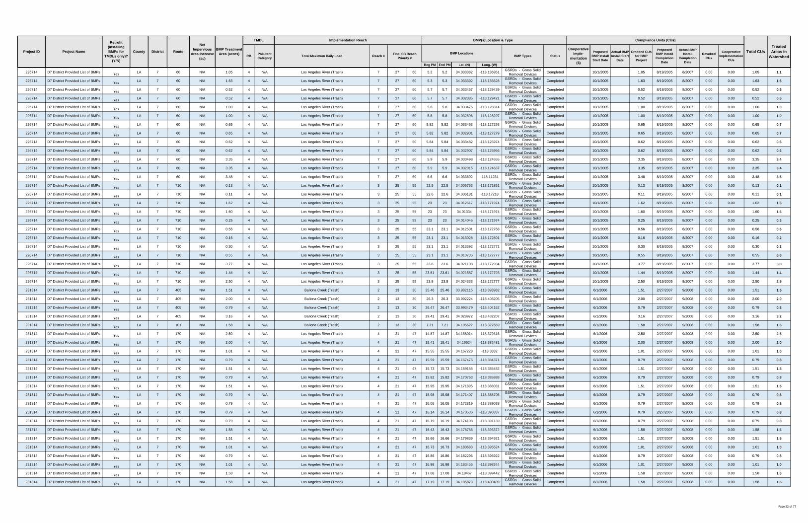
Beg PM End PM Lat. (N) Long. (W)
Revoked CUs
Total CUsTreated Areas in
WatershedRBPollutant Category
Total Maximum Daily Load Reach #Final SB Reach
Priority #
Compliance Units (CUs)
Cooperative Imple-
mentation ($)
Cooperative Implementation
CUs
Proposed BMP Install Start Date
Actual BMP Install Start
Date
Credited CUs for BMP Project
Proposed BMP Install Completion
Date
Actual BMP Install
Completion Date
Net Impervious
Area Increase (ac)
BMP Treatment Area (acres)
TMDL Implementation Reach BMP(s)Location & Type
BMP LocationsBMP Types Status
RouteProject ID Project Name
Retrofit (installing BMPs for
TMDLs only)? (Y/N)
County District
226714 D7 District Provided List of BMPs Yes LA 7 60 N/A 1.05 4 N/A Los Angeles River (Trash) 7 27 60 5.2 5.2 34.033382 -118.136951GSRDs - Gross Solid
Removal DevicesCompleted 10/1/2005 1.05 8/19/2005 8/2007 0.00 0.00 1.05 1.1
226714 D7 District Provided List of BMPs Yes LA 7 60 N/A 1.63 4 N/A Los Angeles River (Trash) 7 27 60 5.3 5.3 34.033392 -118.135628GSRDs - Gross Solid
Removal DevicesCompleted 10/1/2005 1.63 8/19/2005 8/2007 0.00 0.00 1.63 1.6
226714 D7 District Provided List of BMPs Yes LA 7 60 N/A 0.52 4 N/A Los Angeles River (Trash) 7 27 60 5.7 5.7 34.033457 -118.129439GSRDs - Gross Solid
Removal DevicesCompleted 10/1/2005 0.52 8/19/2005 8/2007 0.00 0.00 0.52 0.5
226714 D7 District Provided List of BMPs Yes LA 7 60 N/A 0.52 4 N/A Los Angeles River (Trash) 7 27 60 5.7 5.7 34.032885 -118.129421GSRDs - Gross Solid
Removal DevicesCompleted 10/1/2005 0.52 8/19/2005 8/2007 0.00 0.00 0.52 0.5
226714 D7 District Provided List of BMPs Yes LA 7 60 N/A 1.00 4 N/A Los Angeles River (Trash) 7 27 60 5.8 5.8 34.033476 -118.128314GSRDs - Gross Solid
Removal DevicesCompleted 10/1/2005 1.00 8/19/2005 8/2007 0.00 0.00 1.00 1.0
226714 D7 District Provided List of BMPs Yes LA 7 60 N/A 1.00 4 N/A Los Angeles River (Trash) 7 27 60 5.8 5.8 34.032896 -118.128297GSRDs - Gross Solid
Removal DevicesCompleted 10/1/2005 1.00 8/19/2005 8/2007 0.00 0.00 1.00 1.0
226714 D7 District Provided List of BMPs Yes LA 7 60 N/A 0.65 4 N/A Los Angeles River (Trash) 7 27 60 5.82 5.82 34.033463 -118.127293GSRDs - Gross Solid
Removal DevicesCompleted 10/1/2005 0.65 8/19/2005 8/2007 0.00 0.00 0.65 0.7
226714 D7 District Provided List of BMPs Yes LA 7 60 N/A 0.65 4 N/A Los Angeles River (Trash) 7 27 60 5.82 5.82 34.032901 -118.127279GSRDs - Gross Solid
Removal DevicesCompleted 10/1/2005 0.65 8/19/2005 8/2007 0.00 0.00 0.65 0.7
226714 D7 District Provided List of BMPs Yes LA 7 60 N/A 0.62 4 N/A Los Angeles River (Trash) 7 27 60 5.84 5.84 34.033482 -118.125974GSRDs - Gross Solid
Removal DevicesCompleted 10/1/2005 0.62 8/19/2005 8/2007 0.00 0.00 0.62 0.6
226714 D7 District Provided List of BMPs Yes LA 7 60 N/A 0.62 4 N/A Los Angeles River (Trash) 7 27 60 5.84 5.84 34.032907 -118.125956GSRDs - Gross Solid
Removal DevicesCompleted 10/1/2005 0.62 8/19/2005 8/2007 0.00 0.00 0.62 0.6
226714 D7 District Provided List of BMPs Yes LA 7 60 N/A 3.35 4 N/A Los Angeles River (Trash) 7 27 60 5.9 5.9 34.033498 -118.124655GSRDs - Gross Solid
Removal DevicesCompleted 10/1/2005 3.35 8/19/2005 8/2007 0.00 0.00 3.35 3.4
226714 D7 District Provided List of BMPs Yes LA 7 60 N/A 3.35 4 N/A Los Angeles River (Trash) 7 27 60 5.9 5.9 34.032915 -118.124637GSRDs - Gross Solid
Removal DevicesCompleted 10/1/2005 3.35 8/19/2005 8/2007 0.00 0.00 3.35 3.4
226714 D7 District Provided List of BMPs Yes LA 7 60 N/A 3.48 4 N/A Los Angeles River (Trash) 7 27 60 6.6 6.6 34.033692 -118.11231GSRDs - Gross Solid
Removal DevicesCompleted 10/1/2005 3.48 8/19/2005 8/2007 0.00 0.00 3.48 3.5
226714 D7 District Provided List of BMPs Yes LA 7 710 N/A 0.13 4 N/A Los Angeles River (Trash) 3 25 55 22.5 22.5 34.005763 -118.171851GSRDs - Gross Solid
Removal DevicesCompleted 10/1/2005 0.13 8/19/2005 8/2007 0.00 0.00 0.13 0.1
226714 D7 District Provided List of BMPs Yes LA 7 710 N/A 0.11 4 N/A Los Angeles River (Trash) 3 25 55 22.6 22.6 34.006181 -118.17218GSRDs - Gross Solid
Removal DevicesCompleted 10/1/2005 0.11 8/19/2005 8/2007 0.00 0.00 0.11 0.1
226714 D7 District Provided List of BMPs Yes LA 7 710 N/A 1.62 4 N/A Los Angeles River (Trash) 3 25 55 23 23 34.012617 -118.171974GSRDs - Gross Solid
Removal DevicesCompleted 10/1/2005 1.62 8/19/2005 8/2007 0.00 0.00 1.62 1.6
226714 D7 District Provided List of BMPs Yes LA 7 710 N/A 1.60 4 N/A Los Angeles River (Trash) 3 25 55 23 23 34.01334 -118.171974GSRDs - Gross Solid
Removal DevicesCompleted 10/1/2005 1.60 8/19/2005 8/2007 0.00 0.00 1.60 1.6
226714 D7 District Provided List of BMPs Yes LA 7 710 N/A 0.25 4 N/A Los Angeles River (Trash) 3 25 55 23 23 34.014045 -118.171974GSRDs - Gross Solid
Removal DevicesCompleted 10/1/2005 0.25 8/19/2005 8/2007 0.00 0.00 0.25 0.3
226714 D7 District Provided List of BMPs Yes LA 7 710 N/A 0.56 4 N/A Los Angeles River (Trash) 3 25 55 23.1 23.1 34.012501 -118.172768GSRDs - Gross Solid
Removal DevicesCompleted 10/1/2005 0.56 8/19/2005 8/2007 0.00 0.00 0.56 0.6
226714 D7 District Provided List of BMPs Yes LA 7 710 N/A 0.16 4 N/A Los Angeles River (Trash) 3 25 55 23.1 23.1 34.013028 -118.172801GSRDs - Gross Solid
Removal DevicesCompleted 10/1/2005 0.16 8/19/2005 8/2007 0.00 0.00 0.16 0.2
226714 D7 District Provided List of BMPs Yes LA 7 710 N/A 0.30 4 N/A Los Angeles River (Trash) 3 25 55 23.1 23.1 34.013392 -118.172771GSRDs - Gross Solid
Removal DevicesCompleted 10/1/2005 0.30 8/19/2005 8/2007 0.00 0.00 0.30 0.3
226714 D7 District Provided List of BMPs Yes LA 7 710 N/A 0.55 4 N/A Los Angeles River (Trash) 3 25 55 23.1 23.1 34.013736 -118.172777GSRDs - Gross Solid
Removal DevicesCompleted 10/1/2005 0.55 8/19/2005 8/2007 0.00 0.00 0.55 0.6
226714 D7 District Provided List of BMPs Yes LA 7 710 N/A 3.77 4 N/A Los Angeles River (Trash) 3 25 55 23.6 23.6 34.021108 -118.172934GSRDs - Gross Solid
Removal DevicesCompleted 10/1/2005 3.77 8/19/2005 8/2007 0.00 0.00 3.77 3.8
226714 D7 District Provided List of BMPs Yes LA 7 710 N/A 1.44 4 N/A Los Angeles River (Trash) 3 25 55 23.61 23.61 34.021587 -118.172793GSRDs - Gross Solid
Removal DevicesCompleted 10/1/2005 1.44 8/19/2005 8/2007 0.00 0.00 1.44 1.4
226714 D7 District Provided List of BMPs Yes LA 7 710 N/A 2.50 4 N/A Los Angeles River (Trash) 3 25 55 23.8 23.8 34.024333 -118.172777GSRDs - Gross Solid
Removal DevicesCompleted 10/1/2005 2.50 8/19/2005 8/2007 0.00 0.00 2.50 2.5
231314 D7 District Provided List of BMPs Yes LA 7 405 N/A 1.51 4 N/A Ballona Creek (Trash) 2 13 30 25.46 25.46 33.982115 -118.393982GSRDs - Gross Solid
Removal DevicesCompleted 6/1/2006 1.51 2/27/2007 9/2008 0.00 0.00 1.51 1.5
231314 D7 District Provided List of BMPs Yes LA 7 405 N/A 2.00 4 N/A Ballona Creek (Trash) 2 13 30 26.3 26.3 33.992224 -118.403205GSRDs - Gross Solid
Removal DevicesCompleted 6/1/2006 2.00 2/27/2007 9/2008 0.00 0.00 2.00 2.0
231314 D7 District Provided List of BMPs Yes LA 7 405 N/A 0.79 4 N/A Ballona Creek (Trash) 2 13 30 26.47 26.47 33.993479 -118.404162GSRDs - Gross Solid
Removal DevicesCompleted 6/1/2006 0.79 2/27/2007 9/2008 0.00 0.00 0.79 0.8
231314 D7 District Provided List of BMPs Yes LA 7 405 N/A 3.16 4 N/A Ballona Creek (Trash) 2 13 30 29.41 29.41 34.028972 -118.432207GSRDs - Gross Solid
Removal DevicesCompleted 6/1/2006 3.16 2/27/2007 9/2008 0.00 0.00 3.16 3.2
231314 D7 District Provided List of BMPs Yes LA 7 101 N/A 1.58 4 N/A Ballona Creek (Trash) 2 13 30 7.21 7.21 34.105622 -118.327659GSRDs - Gross Solid
Removal DevicesCompleted 6/1/2006 1.58 2/27/2007 9/2008 0.00 0.00 1.58 1.6
231314 D7 District Provided List of BMPs Yes LA 7 170 N/A 2.50 4 N/A Los Angeles River (Trash) 4 21 47 14.87 14.87 34.158014 -118.379316GSRDs - Gross Solid
Removal DevicesCompleted 6/1/2006 2.50 2/27/2007 9/2008 0.00 0.00 2.50 2.5
231314 D7 District Provided List of BMPs Yes LA 7 170 N/A 2.00 4 N/A Los Angeles River (Trash) 4 21 47 15.41 15.41 34.16524 -118.382481GSRDs - Gross Solid
Removal DevicesCompleted 6/1/2006 2.00 2/27/2007 9/2008 0.00 0.00 2.00 2.0
231314 D7 District Provided List of BMPs Yes LA 7 170 N/A 1.01 4 N/A Los Angeles River (Trash) 4 21 47 15.55 15.55 34.167228 -118.3832GSRDs - Gross Solid
Removal DevicesCompleted 6/1/2006 1.01 2/27/2007 9/2008 0.00 0.00 1.01 1.0
231314 D7 District Provided List of BMPs Yes LA 7 170 N/A 0.79 4 N/A Los Angeles River (Trash) 4 21 47 15.59 15.59 34.167476 -118.384371GSRDs - Gross Solid
Removal DevicesCompleted 6/1/2006 0.79 2/27/2007 9/2008 0.00 0.00 0.79 0.8
231314 D7 District Provided List of BMPs Yes LA 7 170 N/A 1.51 4 N/A Los Angeles River (Trash) 4 21 47 15.73 15.73 34.169155 -118.385482GSRDs - Gross Solid
Removal DevicesCompleted 6/1/2006 1.51 2/27/2007 9/2008 0.00 0.00 1.51 1.5
231314 D7 District Provided List of BMPs Yes LA 7 170 N/A 0.79 4 N/A Los Angeles River (Trash) 4 21 47 15.82 15.82 34.170763 -118.385888GSRDs - Gross Solid
Removal DevicesCompleted 6/1/2006 0.79 2/27/2007 9/2008 0.00 0.00 0.79 0.8
231314 D7 District Provided List of BMPs Yes LA 7 170 N/A 1.51 4 N/A Los Angeles River (Trash) 4 21 47 15.95 15.95 34.171895 -118.388031GSRDs - Gross Solid
Removal DevicesCompleted 6/1/2006 1.51 2/27/2007 9/2008 0.00 0.00 1.51 1.5
231314 D7 District Provided List of BMPs Yes LA 7 170 N/A 0.79 4 N/A Los Angeles River (Trash) 4 21 47 15.98 15.98 34.171407 -118.388705GSRDs - Gross Solid
Removal DevicesCompleted 6/1/2006 0.79 2/27/2007 9/2008 0.00 0.00 0.79 0.8
231314 D7 District Provided List of BMPs Yes LA 7 170 N/A 0.79 4 N/A Los Angeles River (Trash) 4 21 47 16.05 16.05 34.172819 -118.389038GSRDs - Gross Solid
Removal DevicesCompleted 6/1/2006 0.79 2/27/2007 9/2008 0.00 0.00 0.79 0.8
231314 D7 District Provided List of BMPs Yes LA 7 170 N/A 0.79 4 N/A Los Angeles River (Trash) 4 21 47 16.14 16.14 34.173536 -118.390337GSRDs - Gross Solid
Removal DevicesCompleted 6/1/2006 0.79 2/27/2007 9/2008 0.00 0.00 0.79 0.8
231314 D7 District Provided List of BMPs Yes LA 7 170 N/A 0.79 4 N/A Los Angeles River (Trash) 4 21 47 16.19 16.19 34.174108 -118.391139GSRDs - Gross Solid
Removal DevicesCompleted 6/1/2006 0.79 2/27/2007 9/2008 0.00 0.00 0.79 0.8
231314 D7 District Provided List of BMPs Yes LA 7 170 N/A 1.58 4 N/A Los Angeles River (Trash) 4 21 47 16.43 16.43 34.176768 -118.393372GSRDs - Gross Solid
Removal DevicesCompleted 6/1/2006 1.58 2/27/2007 9/2008 0.00 0.00 1.58 1.6
231314 D7 District Provided List of BMPs Yes LA 7 170 N/A 1.51 4 N/A Los Angeles River (Trash) 4 21 47 16.66 16.66 34.179839 -118.394921GSRDs - Gross Solid
Removal DevicesCompleted 6/1/2006 1.51 2/27/2007 9/2008 0.00 0.00 1.51 1.5
231314 D7 District Provided List of BMPs Yes LA 7 170 N/A 1.01 4 N/A Los Angeles River (Trash) 4 21 47 16.73 16.73 34.180683 -118.395524GSRDs - Gross Solid
Removal DevicesCompleted 6/1/2006 1.01 2/27/2007 9/2008 0.00 0.00 1.01 1.0
231314 D7 District Provided List of BMPs Yes LA 7 170 N/A 0.79 4 N/A Los Angeles River (Trash) 4 21 47 16.86 16.86 34.182296 -118.396922GSRDs - Gross Solid
Removal DevicesCompleted 6/1/2006 0.79 2/27/2007 9/2008 0.00 0.00 0.79 0.8
231314 D7 District Provided List of BMPs Yes LA 7 170 N/A 1.01 4 N/A Los Angeles River (Trash) 4 21 47 16.98 16.98 34.183456 -118.398344GSRDs - Gross Solid
Removal DevicesCompleted 6/1/2006 1.01 2/27/2007 9/2008 0.00 0.00 1.01 1.0
231314 D7 District Provided List of BMPs Yes LA 7 170 N/A 1.58 4 N/A Los Angeles River (Trash) 4 21 47 17.08 17.08 34.18467 -118.399442GSRDs - Gross Solid
Removal DevicesCompleted 6/1/2006 1.58 2/27/2007 9/2008 0.00 0.00 1.58 1.6
231314 D7 District Provided List of BMPs Yes LA 7 170 N/A 1.58 4 N/A Los Angeles River (Trash) 4 21 47 17.19 17.19 34.185873 -118.400409GSRDs - Gross Solid
Removal DevicesCompleted 6/1/2006 1.58 2/27/2007 9/2008 0.00 0.00 1.58 1.6
Page 22 of 77
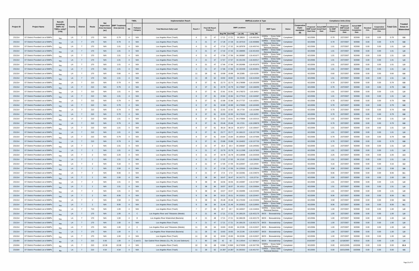
Beg PM End PM Lat. (N) Long. (W)
Revoked CUs
Total CUsTreated Areas in
WatershedRBPollutant Category
Total Maximum Daily Load Reach #Final SB Reach
Priority #
Compliance Units (CUs)
Cooperative Imple-
mentation ($)
Cooperative Implementation
CUs
Proposed BMP Install Start Date
Actual BMP Install Start
Date
Credited CUs for BMP Project
Proposed BMP Install Completion
Date
Actual BMP Install
Completion Date
Net Impervious
Area Increase (ac)
BMP Treatment Area (acres)
TMDL Implementation Reach BMP(s)Location & Type
BMP LocationsBMP Types Status
RouteProject ID Project Name
Retrofit (installing BMPs for
TMDLs only)? (Y/N)
County District
231314 D7 District Provided List of BMPs Yes LA 7 170 N/A 0.79 4 N/A Los Angeles River (Trash) 4 21 47 17.21 17.21 34.18624 -118.400196GSRDs - Gross Solid
Removal DevicesCompleted 6/1/2006 0.79 2/27/2007 9/2008 0.00 0.00 0.79 0.8
231314 D7 District Provided List of BMPs Yes LA 7 170 N/A 0.79 4 N/A Los Angeles River (Trash) 4 21 47 17.28 17.28 34.187019 -118.400896GSRDs - Gross Solid
Removal DevicesCompleted 6/1/2006 0.79 2/27/2007 9/2008 0.00 0.00 0.79 0.8
231314 D7 District Provided List of BMPs Yes LA 7 170 N/A 1.01 4 N/A Los Angeles River (Trash) 4 21 47 17.32 17.32 34.187678 -118.400743GSRDs - Gross Solid
Removal DevicesCompleted 6/1/2006 1.01 2/27/2007 9/2008 0.00 0.00 1.01 1.0
231314 D7 District Provided List of BMPs Yes LA 7 170 N/A 1.01 4 N/A Los Angeles River (Trash) 4 21 47 17.42 17.42 34.188995 -118.401403GSRDs - Gross Solid
Removal DevicesCompleted 6/1/2006 1.01 2/27/2007 9/2008 0.00 0.00 1.01 1.0
231314 D7 District Provided List of BMPs Yes LA 7 170 N/A 1.01 4 N/A Los Angeles River (Trash) 4 21 47 17.56 17.56 34.190987 -118.401677GSRDs - Gross Solid
Removal DevicesCompleted 6/1/2006 1.01 2/27/2007 9/2008 0.00 0.00 1.01 1.0
231314 D7 District Provided List of BMPs Yes LA 7 170 N/A 1.01 4 N/A Los Angeles River (Trash) 4 21 47 17.57 17.57 34.191246 -118.402517GSRDs - Gross Solid
Removal DevicesCompleted 6/1/2006 1.01 2/27/2007 9/2008 0.00 0.00 1.01 1.0
231314 D7 District Provided List of BMPs Yes LA 7 170 N/A 1.01 4 N/A Los Angeles River (Trash) 4 21 47 17.66 17.66 34.192486 -118.401878GSRDs - Gross Solid
Removal DevicesCompleted 6/1/2006 1.01 2/27/2007 9/2008 0.00 0.00 1.01 1.0
231314 D7 District Provided List of BMPs Yes LA 7 170 N/A 1.01 4 N/A Los Angeles River (Trash) 4 21 47 17.66 17.66 34.192409 -118.402601GSRDs - Gross Solid
Removal DevicesCompleted 6/1/2006 1.01 2/27/2007 9/2008 0.00 0.00 1.01 1.0
231314 D7 District Provided List of BMPs Yes LA 7 170 N/A 0.60 4 N/A Los Angeles River (Trash) 11 28 62 19.88 19.88 34.22385 -118.41039GSRDs - Gross Solid
Removal DevicesCompleted 6/1/2006 0.60 2/27/2007 9/2008 0.00 0.00 0.60 0.6
231314 D7 District Provided List of BMPs Yes LA 7 170 N/A 1.51 4 N/A Los Angeles River (Trash) 11 28 62 19.92 19.92 34.22439 -118.410549GSRDs - Gross Solid
Removal DevicesCompleted 6/1/2006 1.51 2/27/2007 9/2008 0.00 0.00 1.51 1.5
231314 D7 District Provided List of BMPs Yes LA 7 210 N/A 0.79 4 N/A Los Angeles River (Trash) 8 37 81 22.73 22.73 34.178099 -118.165309GSRDs - Gross Solid
Removal DevicesCompleted 6/1/2006 0.79 2/27/2007 9/2008 0.00 0.00 0.79 0.8
231314 D7 District Provided List of BMPs Yes LA 7 210 N/A 0.79 4 N/A Los Angeles River (Trash) 8 37 81 22.79 22.79 34.178687 -118.166059GSRDs - Gross Solid
Removal DevicesCompleted 6/1/2006 0.79 2/27/2007 9/2008 0.00 0.00 0.79 0.8
231314 D7 District Provided List of BMPs Yes LA 7 210 N/A 1.01 4 N/A Los Angeles River (Trash) 8 37 81 22.81 22.81 34.178373 -118.16453GSRDs - Gross Solid
Removal DevicesCompleted 6/1/2006 1.01 2/27/2007 9/2008 0.00 0.00 1.01 1.0
231314 D7 District Provided List of BMPs Yes LA 7 210 N/A 1.01 4 N/A Los Angeles River (Trash) 8 37 81 22.84 22.84 34.177619 -118.164587GSRDs - Gross Solid
Removal DevicesCompleted 6/1/2006 1.01 2/27/2007 9/2008 0.00 0.00 1.01 1.0
231314 D7 District Provided List of BMPs Yes LA 7 210 N/A 0.79 4 N/A Los Angeles River (Trash) 8 37 81 22.88 22.88 34.177737 -118.163541GSRDs - Gross Solid
Removal DevicesCompleted 6/1/2006 0.79 2/27/2007 9/2008 0.00 0.00 0.79 0.8
231314 D7 District Provided List of BMPs Yes LA 7 210 N/A 0.79 4 N/A Los Angeles River (Trash) 8 37 81 22.89 22.89 34.176686 -118.163465GSRDs - Gross Solid
Removal DevicesCompleted 6/1/2006 0.79 2/27/2007 9/2008 0.00 0.00 0.79 0.8
231314 D7 District Provided List of BMPs Yes LA 7 210 N/A 0.79 4 N/A Los Angeles River (Trash) 8 37 81 22.92 22.92 34.17734 -118.162986GSRDs - Gross Solid
Removal DevicesCompleted 6/1/2006 0.79 2/27/2007 9/2008 0.00 0.00 0.79 0.8
231314 D7 District Provided List of BMPs Yes LA 7 210 N/A 0.79 4 N/A Los Angeles River (Trash) 8 37 81 22.93 22.93 34.176242 -118.16293GSRDs - Gross Solid
Removal DevicesCompleted 6/1/2006 0.79 2/27/2007 9/2008 0.00 0.00 0.79 0.8
231314 D7 District Provided List of BMPs Yes LA 7 210 N/A 1.01 4 N/A Los Angeles River (Trash) 8 37 81 23.01 23.01 34.175904 -118.162515GSRDs - Gross Solid
Removal DevicesCompleted 6/1/2006 1.01 2/27/2007 9/2008 0.00 0.00 1.01 1.0
231314 D7 District Provided List of BMPs Yes LA 7 210 N/A 0.79 4 N/A Los Angeles River (Trash) 8 37 81 23.46 23.46 34.17231 -118.158878GSRDs - Gross Solid
Removal DevicesCompleted 6/1/2006 0.79 2/27/2007 9/2008 0.00 0.00 0.79 0.8
231314 D7 District Provided List of BMPs Yes LA 7 210 N/A 1.01 4 N/A Los Angeles River (Trash) 8 37 81 38.16 38.16 34.16717 -118.158447GSRDs - Gross Solid
Removal DevicesCompleted 6/1/2006 1.01 2/27/2007 9/2008 0.00 0.00 1.01 1.0
231314 D7 District Provided List of BMPs Yes LA 7 210 N/A 1.01 4 N/A Los Angeles River (Trash) 8 37 81 23.77 23.77 34.166122 -118.157709GSRDs - Gross Solid
Removal DevicesCompleted 6/1/2006 1.01 2/27/2007 9/2008 0.00 0.00 1.01 1.0
231314 D7 District Provided List of BMPs Yes LA 7 210 N/A 0.79 4 N/A Los Angeles River (Trash) 8 37 81 23.84 23.84 34.165424 -118.157698GSRDs - Gross Solid
Removal DevicesCompleted 6/1/2006 0.79 2/27/2007 9/2008 0.00 0.00 0.79 0.8
231314 D7 District Provided List of BMPs Yes LA 7 210 N/A 0.79 4 N/A Los Angeles River (Trash) 8 37 81 23.88 23.88 34.164802 -118.157726GSRDs - Gross Solid
Removal DevicesCompleted 6/1/2006 0.79 2/27/2007 9/2008 0.00 0.00 0.79 0.8
231314 D7 District Provided List of BMPs Yes LA 7 2 N/A 1.01 4 N/A Los Angeles River (Trash) 4 21 47 15.4 15.4 34.106367 -118.249392GSRDs - Gross Solid
Removal DevicesCompleted 6/1/2006 1.01 2/27/2007 9/2008 0.00 0.00 1.01 1.0
231314 D7 District Provided List of BMPs Yes LA 7 2 N/A 1.01 4 N/A Los Angeles River (Trash) 4 21 47 15.79 15.79 34.111598 -118.247605GSRDs - Gross Solid
Removal DevicesCompleted 6/1/2006 1.01 2/27/2007 9/2008 0.00 0.00 1.01 1.0
231314 D7 District Provided List of BMPs Yes LA 7 2 N/A 2.25 4 N/A Los Angeles River (Trash) 4 21 47 16.78 16.78 34.118598 -118.232559GSRDs - Gross Solid
Removal DevicesCompleted 6/1/2006 2.25 2/27/2007 9/2008 0.00 0.00 2.25 2.3
231314 D7 District Provided List of BMPs Yes LA 7 2 N/A 1.51 4 N/A Los Angeles River (Trash) 4 21 47 17.02 17.02 34.12182 -118.230026GSRDs - Gross Solid
Removal DevicesCompleted 6/1/2006 1.51 2/27/2007 9/2008 0.00 0.00 1.51 1.5
231314 D7 District Provided List of BMPs Yes LA 7 2 N/A 3.16 4 N/A Los Angeles River (Trash) 4 21 47 17.05 17.05 34.123047 -118.22934GSRDs - Gross Solid
Removal DevicesCompleted 6/1/2006 3.16 2/27/2007 9/2008 0.00 0.00 3.16 3.2
231314 D7 District Provided List of BMPs Yes LA 7 2 N/A 3.58 4 N/A Los Angeles River (Trash) 4 21 47 17.05 17.05 34.125503 -118.228644GSRDs - Gross Solid
Removal DevicesCompleted 6/1/2006 3.58 2/27/2007 9/2008 0.00 0.00 3.58 3.6
231314 D7 District Provided List of BMPs Yes LA 7 2 N/A 8.06 4 N/A Los Angeles River (Trash) 4 21 47 17.8 17.8 34.132391 -118.229075GSRDs - Gross Solid
Removal DevicesCompleted 6/1/2006 8.06 2/27/2007 9/2008 0.00 0.00 8.06 8.1
231314 D7 District Provided List of BMPs Yes LA 7 2 N/A 2.00 4 N/A Los Angeles River (Trash) 9 38 84 18.47 18.47 34.141771 -118.22718GSRDs - Gross Solid
Removal DevicesCompleted 6/1/2006 2.00 2/27/2007 9/2008 0.00 0.00 2.00 2.0
231314 D7 District Provided List of BMPs Yes LA 7 2 N/A 1.01 4 N/A Los Angeles River (Trash) 9 38 84 18.56 18.56 34.143097 -118.227887GSRDs - Gross Solid
Removal DevicesCompleted 6/1/2006 1.01 2/27/2007 9/2008 0.00 0.00 1.01 1.0
231314 D7 District Provided List of BMPs Yes LA 7 2 N/A 1.51 4 N/A Los Angeles River (Trash) 9 38 84 18.57 18.57 34.14312 -118.226564GSRDs - Gross Solid
Removal DevicesCompleted 6/1/2006 1.51 2/27/2007 9/2008 0.00 0.00 1.51 1.5
231314 D7 District Provided List of BMPs Yes LA 7 2 N/A 1.01 4 N/A Los Angeles River (Trash) 9 38 84 19.07 19.07 34.150095 -118.224355GSRDs - Gross Solid
Removal DevicesCompleted 6/1/2006 1.01 2/27/2007 9/2008 0.00 0.00 1.01 1.0
231314 D7 District Provided List of BMPs Yes LA 7 2 N/A 8.06 4 N/A Los Angeles River (Trash) 9 38 84 19.21 19.21 34.152621 -118.225407GSRDs - Gross Solid
Removal DevicesCompleted 6/1/2006 8.06 2/27/2007 9/2008 0.00 0.00 8.06 8.1
231314 D7 District Provided List of BMPs Yes LA 7 2 N/A 3.58 4 N/A Los Angeles River (Trash) 9 38 84 20.48 20.48 34.170193 -118.223456GSRDs - Gross Solid
Removal DevicesCompleted 6/1/2006 3.58 2/27/2007 9/2008 0.00 0.00 3.58 3.6
231314 D7 District Provided List of BMPs Yes LA 7 2 N/A 8.06 4 N/A Los Angeles River (Trash) 9 38 84 21.46 21.46 34.183832 -118.218955GSRDs - Gross Solid
Removal DevicesCompleted 6/1/2006 8.06 2/27/2007 9/2008 0.00 0.00 8.06 8.1
231314 D7 District Provided List of BMPs Yes LA 7 710 N/A 1.00 4 N/A Los Angeles River (Trash) 7 27 60 19.7 19.7 34.140027 -118.154834GSRDs - Gross Solid
Removal DevicesCompleted 6/1/2006 1.00 2/27/2007 9/2008 0.00 0.00 1.00 1.0
231314 D7 District Provided List of BMPs Yes LA 7 170 N/A 1.00 4 C Los Angeles River and Tributaries (Metals) 4 21 49 17.21 17.21 34.186135 -118.402179 BIOS - Bioswale/strip Completed 6/1/2006 1.00 2/27/2007 9/2008 0.00 0.00 1.00 1.0
231314 D7 District Provided List of BMPs Yes LA 7 170 N/A 1.00 4 E Los Angeles River Watershed (Bacteria) 4 21 48 17.21 17.21 34.186135 -118.402179 BIOS - Bioswale/strip Completed 6/1/2006 1.00 2/27/2007 9/2008 0.00 0.00 1.00 1.0
231314 D7 District Provided List of BMPs Yes LA 7 170 N/A 1.00 4 N/A Los Angeles River (Trash) 4 21 47 17.21 17.21 34.186135 -118.402179 BIOS - Bioswale/strip Completed 6/1/2006 1.00 2/27/2007 9/2008 0.00 0.00 1.00 1.0
231314 D7 District Provided List of BMPs Yes LA 7 170 N/A 1.00 4 C Los Angeles River and Tributaries (Metals) 11 28 64 19.83 19.83 34.22196 -118.410637 BIOS - Bioswale/strip Completed 6/1/2006 1.00 2/27/2007 9/2008 0.00 0.00 1.00 1.0
231314 D7 District Provided List of BMPs Yes LA 7 170 N/A 1.00 4 E Los Angeles River Watershed (Bacteria) 11 28 63 19.83 19.83 34.22196 -118.410637 BIOS - Bioswale/strip Completed 6/1/2006 1.00 2/27/2007 9/2008 0.00 0.00 1.00 1.0
231314 D7 District Provided List of BMPs Yes LA 7 170 N/A 1.00 4 N/A Los Angeles River (Trash) 11 28 62 19.83 19.83 34.22196 -118.410637 BIOS - Bioswale/strip Completed 6/1/2006 1.00 2/27/2007 9/2008 0.00 0.00 1.00 1.0
231404 D7 District Provided List of BMPs No LA 7 210 0.00 1.00 4 C and G San Gabriel River (Metals (Cu, Pb, Zn) and Selenium) 3 90 156 42 42 34.119544 -117.866414 BIOS - Bioswale/strip Completed 3/10/2007 1.00 12/18/2007 9/2010 0.00 0.00 1.00 1.0
231504 D7 District Provided List of BMPs No LA 7 210 10.38 10.38 4 N/A Los Angeles River (Trash) 10 30 68 8.569 8.569 34.274009 -118.367799GSRDs - Gross Solid
Removal DevicesCompleted 9/1/2005 0.00 10/21/2005 10/2006 0.00 0.00 0.00 10.4
231504 D7 District Provided List of BMPs No LA 7 210 4.54 4.54 4 N/A Los Angeles River (Trash) 11 28 62 14.367 14.367 34.283302 -118.401757GSRDs - Gross Solid
Removal DevicesCompleted 9/1/2005 0.00 10/21/2005 10/2006 0.00 0.00 0.00 4.5
Page 23 of 77
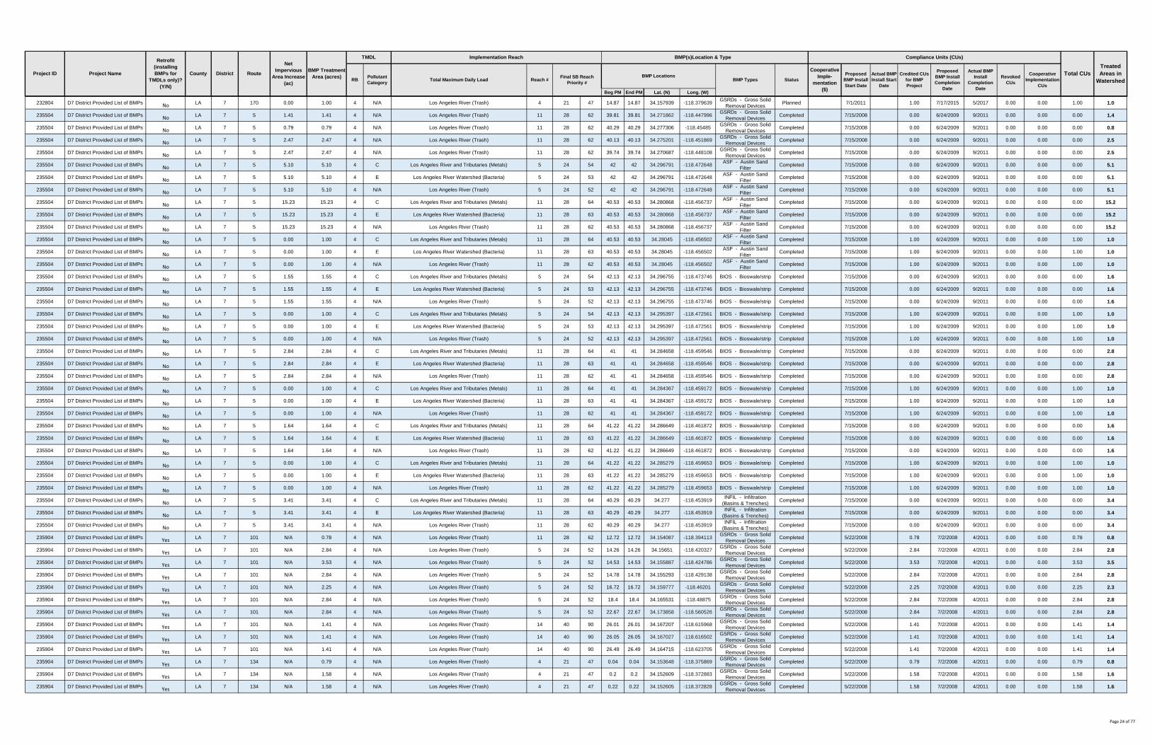
Beg PM End PM Lat. (N) Long. (W)
Revoked CUs
Total CUsTreated Areas in
WatershedRBPollutant Category
Total Maximum Daily Load Reach #Final SB Reach
Priority #
Compliance Units (CUs)
Cooperative Imple-
mentation ($)
Cooperative Implementation
CUs
Proposed BMP Install Start Date
Actual BMP Install Start
Date
Credited CUs for BMP Project
Proposed BMP Install Completion
Date
Actual BMP Install
Completion Date
Net Impervious
Area Increase (ac)
BMP Treatment Area (acres)
TMDL Implementation Reach BMP(s)Location & Type
BMP LocationsBMP Types Status
RouteProject ID Project Name
Retrofit (installing BMPs for
TMDLs only)? (Y/N)
County District
232804 D7 District Provided List of BMPs No LA 7 170 0.00 1.00 4 N/A Los Angeles River (Trash) 4 21 47 14.87 14.87 34.157939 -118.379639GSRDs - Gross Solid
Removal DevicesPlanned 7/1/2011 1.00 7/17/2015 5/2017 0.00 0.00 1.00 1.0
235504 D7 District Provided List of BMPs No LA 7 5 1.41 1.41 4 N/A Los Angeles River (Trash) 11 28 62 39.81 39.81 34.271862 -118.447996GSRDs - Gross Solid
Removal DevicesCompleted 7/15/2008 0.00 6/24/2009 9/2011 0.00 0.00 0.00 1.4
235504 D7 District Provided List of BMPs No LA 7 5 0.79 0.79 4 N/A Los Angeles River (Trash) 11 28 62 40.29 40.29 34.277306 -118.45485GSRDs - Gross Solid
Removal DevicesCompleted 7/15/2008 0.00 6/24/2009 9/2011 0.00 0.00 0.00 0.8
235504 D7 District Provided List of BMPs No LA 7 5 2.47 2.47 4 N/A Los Angeles River (Trash) 11 28 62 40.13 40.13 34.275201 -118.451869GSRDs - Gross Solid
Removal DevicesCompleted 7/15/2008 0.00 6/24/2009 9/2011 0.00 0.00 0.00 2.5
235504 D7 District Provided List of BMPs No LA 7 5 2.47 2.47 4 N/A Los Angeles River (Trash) 11 28 62 39.74 39.74 34.270687 -118.448108GSRDs - Gross Solid
Removal DevicesCompleted 7/15/2008 0.00 6/24/2009 9/2011 0.00 0.00 0.00 2.5
235504 D7 District Provided List of BMPs No LA 7 5 5.10 5.10 4 C Los Angeles River and Tributaries (Metals) 5 24 54 42 42 34.296791 -118.472648ASF - Austin Sand
FilterCompleted 7/15/2008 0.00 6/24/2009 9/2011 0.00 0.00 0.00 5.1
235504 D7 District Provided List of BMPs No LA 7 5 5.10 5.10 4 E Los Angeles River Watershed (Bacteria) 5 24 53 42 42 34.296791 -118.472648ASF - Austin Sand
FilterCompleted 7/15/2008 0.00 6/24/2009 9/2011 0.00 0.00 0.00 5.1
235504 D7 District Provided List of BMPs No LA 7 5 5.10 5.10 4 N/A Los Angeles River (Trash) 5 24 52 42 42 34.296791 -118.472648ASF - Austin Sand
FilterCompleted 7/15/2008 0.00 6/24/2009 9/2011 0.00 0.00 0.00 5.1
235504 D7 District Provided List of BMPs No LA 7 5 15.23 15.23 4 C Los Angeles River and Tributaries (Metals) 11 28 64 40.53 40.53 34.280868 -118.456737ASF - Austin Sand
FilterCompleted 7/15/2008 0.00 6/24/2009 9/2011 0.00 0.00 0.00 15.2
235504 D7 District Provided List of BMPs No LA 7 5 15.23 15.23 4 E Los Angeles River Watershed (Bacteria) 11 28 63 40.53 40.53 34.280868 -118.456737ASF - Austin Sand
FilterCompleted 7/15/2008 0.00 6/24/2009 9/2011 0.00 0.00 0.00 15.2
235504 D7 District Provided List of BMPs No LA 7 5 15.23 15.23 4 N/A Los Angeles River (Trash) 11 28 62 40.53 40.53 34.280868 -118.456737ASF - Austin Sand
FilterCompleted 7/15/2008 0.00 6/24/2009 9/2011 0.00 0.00 0.00 15.2
235504 D7 District Provided List of BMPs No LA 7 5 0.00 1.00 4 C Los Angeles River and Tributaries (Metals) 11 28 64 40.53 40.53 34.28045 -118.456502ASF - Austin Sand
FilterCompleted 7/15/2008 1.00 6/24/2009 9/2011 0.00 0.00 1.00 1.0
235504 D7 District Provided List of BMPs No LA 7 5 0.00 1.00 4 E Los Angeles River Watershed (Bacteria) 11 28 63 40.53 40.53 34.28045 -118.456502ASF - Austin Sand
FilterCompleted 7/15/2008 1.00 6/24/2009 9/2011 0.00 0.00 1.00 1.0
235504 D7 District Provided List of BMPs No LA 7 5 0.00 1.00 4 N/A Los Angeles River (Trash) 11 28 62 40.53 40.53 34.28045 -118.456502ASF - Austin Sand
FilterCompleted 7/15/2008 1.00 6/24/2009 9/2011 0.00 0.00 1.00 1.0
235504 D7 District Provided List of BMPs No LA 7 5 1.55 1.55 4 C Los Angeles River and Tributaries (Metals) 5 24 54 42.13 42.13 34.296755 -118.473746 BIOS - Bioswale/strip Completed 7/15/2008 0.00 6/24/2009 9/2011 0.00 0.00 0.00 1.6
235504 D7 District Provided List of BMPs No LA 7 5 1.55 1.55 4 E Los Angeles River Watershed (Bacteria) 5 24 53 42.13 42.13 34.296755 -118.473746 BIOS - Bioswale/strip Completed 7/15/2008 0.00 6/24/2009 9/2011 0.00 0.00 0.00 1.6
235504 D7 District Provided List of BMPs No LA 7 5 1.55 1.55 4 N/A Los Angeles River (Trash) 5 24 52 42.13 42.13 34.296755 -118.473746 BIOS - Bioswale/strip Completed 7/15/2008 0.00 6/24/2009 9/2011 0.00 0.00 0.00 1.6
235504 D7 District Provided List of BMPs No LA 7 5 0.00 1.00 4 C Los Angeles River and Tributaries (Metals) 5 24 54 42.13 42.13 34.295397 -118.472561 BIOS - Bioswale/strip Completed 7/15/2008 1.00 6/24/2009 9/2011 0.00 0.00 1.00 1.0
235504 D7 District Provided List of BMPs No LA 7 5 0.00 1.00 4 E Los Angeles River Watershed (Bacteria) 5 24 53 42.13 42.13 34.295397 -118.472561 BIOS - Bioswale/strip Completed 7/15/2008 1.00 6/24/2009 9/2011 0.00 0.00 1.00 1.0
235504 D7 District Provided List of BMPs No LA 7 5 0.00 1.00 4 N/A Los Angeles River (Trash) 5 24 52 42.13 42.13 34.295397 -118.472561 BIOS - Bioswale/strip Completed 7/15/2008 1.00 6/24/2009 9/2011 0.00 0.00 1.00 1.0
235504 D7 District Provided List of BMPs No LA 7 5 2.84 2.84 4 C Los Angeles River and Tributaries (Metals) 11 28 64 41 41 34.284658 -118.459546 BIOS - Bioswale/strip Completed 7/15/2008 0.00 6/24/2009 9/2011 0.00 0.00 0.00 2.8
235504 D7 District Provided List of BMPs No LA 7 5 2.84 2.84 4 E Los Angeles River Watershed (Bacteria) 11 28 63 41 41 34.284658 -118.459546 BIOS - Bioswale/strip Completed 7/15/2008 0.00 6/24/2009 9/2011 0.00 0.00 0.00 2.8
235504 D7 District Provided List of BMPs No LA 7 5 2.84 2.84 4 N/A Los Angeles River (Trash) 11 28 62 41 41 34.284658 -118.459546 BIOS - Bioswale/strip Completed 7/15/2008 0.00 6/24/2009 9/2011 0.00 0.00 0.00 2.8
235504 D7 District Provided List of BMPs No LA 7 5 0.00 1.00 4 C Los Angeles River and Tributaries (Metals) 11 28 64 41 41 34.284367 -118.459172 BIOS - Bioswale/strip Completed 7/15/2008 1.00 6/24/2009 9/2011 0.00 0.00 1.00 1.0
235504 D7 District Provided List of BMPs No LA 7 5 0.00 1.00 4 E Los Angeles River Watershed (Bacteria) 11 28 63 41 41 34.284367 -118.459172 BIOS - Bioswale/strip Completed 7/15/2008 1.00 6/24/2009 9/2011 0.00 0.00 1.00 1.0
235504 D7 District Provided List of BMPs No LA 7 5 0.00 1.00 4 N/A Los Angeles River (Trash) 11 28 62 41 41 34.284367 -118.459172 BIOS - Bioswale/strip Completed 7/15/2008 1.00 6/24/2009 9/2011 0.00 0.00 1.00 1.0
235504 D7 District Provided List of BMPs No LA 7 5 1.64 1.64 4 C Los Angeles River and Tributaries (Metals) 11 28 64 41.22 41.22 34.286649 -118.461872 BIOS - Bioswale/strip Completed 7/15/2008 0.00 6/24/2009 9/2011 0.00 0.00 0.00 1.6
235504 D7 District Provided List of BMPs No LA 7 5 1.64 1.64 4 E Los Angeles River Watershed (Bacteria) 11 28 63 41.22 41.22 34.286649 -118.461872 BIOS - Bioswale/strip Completed 7/15/2008 0.00 6/24/2009 9/2011 0.00 0.00 0.00 1.6
235504 D7 District Provided List of BMPs No LA 7 5 1.64 1.64 4 N/A Los Angeles River (Trash) 11 28 62 41.22 41.22 34.286649 -118.461872 BIOS - Bioswale/strip Completed 7/15/2008 0.00 6/24/2009 9/2011 0.00 0.00 0.00 1.6
235504 D7 District Provided List of BMPs No LA 7 5 0.00 1.00 4 C Los Angeles River and Tributaries (Metals) 11 28 64 41.22 41.22 34.285279 -118.459653 BIOS - Bioswale/strip Completed 7/15/2008 1.00 6/24/2009 9/2011 0.00 0.00 1.00 1.0
235504 D7 District Provided List of BMPs No LA 7 5 0.00 1.00 4 E Los Angeles River Watershed (Bacteria) 11 28 63 41.22 41.22 34.285279 -118.459653 BIOS - Bioswale/strip Completed 7/15/2008 1.00 6/24/2009 9/2011 0.00 0.00 1.00 1.0
235504 D7 District Provided List of BMPs No LA 7 5 0.00 1.00 4 N/A Los Angeles River (Trash) 11 28 62 41.22 41.22 34.285279 -118.459653 BIOS - Bioswale/strip Completed 7/15/2008 1.00 6/24/2009 9/2011 0.00 0.00 1.00 1.0
235504 D7 District Provided List of BMPs No LA 7 5 3.41 3.41 4 C Los Angeles River and Tributaries (Metals) 11 28 64 40.29 40.29 34.277 -118.453919INFIL - Infiltration
(Basins & Trenches)Completed 7/15/2008 0.00 6/24/2009 9/2011 0.00 0.00 0.00 3.4
235504 D7 District Provided List of BMPs No LA 7 5 3.41 3.41 4 E Los Angeles River Watershed (Bacteria) 11 28 63 40.29 40.29 34.277 -118.453919INFIL - Infiltration
(Basins & Trenches)Completed 7/15/2008 0.00 6/24/2009 9/2011 0.00 0.00 0.00 3.4
235504 D7 District Provided List of BMPs No LA 7 5 3.41 3.41 4 N/A Los Angeles River (Trash) 11 28 62 40.29 40.29 34.277 -118.453919INFIL - Infiltration
(Basins & Trenches)Completed 7/15/2008 0.00 6/24/2009 9/2011 0.00 0.00 0.00 3.4
235904 D7 District Provided List of BMPs Yes LA 7 101 N/A 0.78 4 N/A Los Angeles River (Trash) 11 28 62 12.72 12.72 34.154087 -118.394113GSRDs - Gross Solid
Removal DevicesCompleted 5/22/2008 0.78 7/2/2008 4/2011 0.00 0.00 0.78 0.8
235904 D7 District Provided List of BMPs Yes LA 7 101 N/A 2.84 4 N/A Los Angeles River (Trash) 5 24 52 14.26 14.26 34.15651 -118.420327GSRDs - Gross Solid
Removal DevicesCompleted 5/22/2008 2.84 7/2/2008 4/2011 0.00 0.00 2.84 2.8
235904 D7 District Provided List of BMPs Yes LA 7 101 N/A 3.53 4 N/A Los Angeles River (Trash) 5 24 52 14.53 14.53 34.155887 -118.424786GSRDs - Gross Solid
Removal DevicesCompleted 5/22/2008 3.53 7/2/2008 4/2011 0.00 0.00 3.53 3.5
235904 D7 District Provided List of BMPs Yes LA 7 101 N/A 2.84 4 N/A Los Angeles River (Trash) 5 24 52 14.78 14.78 34.155293 -118.429138GSRDs - Gross Solid
Removal DevicesCompleted 5/22/2008 2.84 7/2/2008 4/2011 0.00 0.00 2.84 2.8
235904 D7 District Provided List of BMPs Yes LA 7 101 N/A 2.25 4 N/A Los Angeles River (Trash) 5 24 52 16.72 16.72 34.159777 -118.46201GSRDs - Gross Solid
Removal DevicesCompleted 5/22/2008 2.25 7/2/2008 4/2011 0.00 0.00 2.25 2.3
235904 D7 District Provided List of BMPs Yes LA 7 101 N/A 2.84 4 N/A Los Angeles River (Trash) 5 24 52 18.4 18.4 34.165531 -118.48875GSRDs - Gross Solid
Removal DevicesCompleted 5/22/2008 2.84 7/2/2008 4/2011 0.00 0.00 2.84 2.8
235904 D7 District Provided List of BMPs Yes LA 7 101 N/A 2.84 4 N/A Los Angeles River (Trash) 5 24 52 22.67 22.67 34.173858 -118.560526GSRDs - Gross Solid
Removal DevicesCompleted 5/22/2008 2.84 7/2/2008 4/2011 0.00 0.00 2.84 2.8
235904 D7 District Provided List of BMPs Yes LA 7 101 N/A 1.41 4 N/A Los Angeles River (Trash) 14 40 90 26.01 26.01 34.167207 -118.615968GSRDs - Gross Solid
Removal DevicesCompleted 5/22/2008 1.41 7/2/2008 4/2011 0.00 0.00 1.41 1.4
235904 D7 District Provided List of BMPs Yes LA 7 101 N/A 1.41 4 N/A Los Angeles River (Trash) 14 40 90 26.05 26.05 34.167027 -118.616502GSRDs - Gross Solid
Removal DevicesCompleted 5/22/2008 1.41 7/2/2008 4/2011 0.00 0.00 1.41 1.4
235904 D7 District Provided List of BMPs Yes LA 7 101 N/A 1.41 4 N/A Los Angeles River (Trash) 14 40 90 26.49 26.49 34.164715 -118.623705GSRDs - Gross Solid
Removal DevicesCompleted 5/22/2008 1.41 7/2/2008 4/2011 0.00 0.00 1.41 1.4
235904 D7 District Provided List of BMPs Yes LA 7 134 N/A 0.79 4 N/A Los Angeles River (Trash) 4 21 47 0.04 0.04 34.153648 -118.375869GSRDs - Gross Solid
Removal DevicesCompleted 5/22/2008 0.79 7/2/2008 4/2011 0.00 0.00 0.79 0.8
235904 D7 District Provided List of BMPs Yes LA 7 134 N/A 1.58 4 N/A Los Angeles River (Trash) 4 21 47 0.2 0.2 34.152609 -118.372883GSRDs - Gross Solid
Removal DevicesCompleted 5/22/2008 1.58 7/2/2008 4/2011 0.00 0.00 1.58 1.6
235904 D7 District Provided List of BMPs Yes LA 7 134 N/A 1.58 4 N/A Los Angeles River (Trash) 4 21 47 0.22 0.22 34.152605 -118.372828GSRDs - Gross Solid
Removal DevicesCompleted 5/22/2008 1.58 7/2/2008 4/2011 0.00 0.00 1.58 1.6
Page 24 of 77

Beg PM End PM Lat. (N) Long. (W)
Revoked CUs
Total CUsTreated Areas in
WatershedRBPollutant Category
Total Maximum Daily Load Reach #Final SB Reach
Priority #
Compliance Units (CUs)
Cooperative Imple-
mentation ($)
Cooperative Implementation
CUs
Proposed BMP Install Start Date
Actual BMP Install Start
Date
Credited CUs for BMP Project
Proposed BMP Install Completion
Date
Actual BMP Install
Completion Date
Net Impervious
Area Increase (ac)
BMP Treatment Area (acres)
TMDL Implementation Reach BMP(s)Location & Type
BMP LocationsBMP Types Status
RouteProject ID Project Name
Retrofit (installing BMPs for
TMDLs only)? (Y/N)
County District
235904 D7 District Provided List of BMPs Yes LA 7 134 N/A 3.16 4 N/A Los Angeles River (Trash) 4 21 47 0.25 0.25 34.153388 -118.372331GSRDs - Gross Solid
Removal DevicesCompleted 5/22/2008 3.16 7/2/2008 4/2011 0.00 0.00 3.16 3.2
235904 D7 District Provided List of BMPs Yes LA 7 134 N/A 2.84 4 N/A Los Angeles River (Trash) 4 21 47 1.37 1.37 34.152839 -118.352884GSRDs - Gross Solid
Removal DevicesCompleted 5/22/2008 2.84 7/2/2008 4/2011 0.00 0.00 2.84 2.8
235904 D7 District Provided List of BMPs Yes LA 7 134 N/A 1.58 4 N/A Los Angeles River (Trash) 4 21 47 2.59 2.59 34.152828 -118.331842GSRDs - Gross Solid
Removal DevicesCompleted 5/22/2008 1.58 7/2/2008 4/2011 0.00 0.00 1.58 1.6
235904 D7 District Provided List of BMPs Yes LA 7 134 N/A 5.14 4 N/A Los Angeles River (Trash) 4 21 47 3.09 3.09 34.153847 -118.32353GSRDs - Gross Solid
Removal DevicesCompleted 5/22/2008 5.14 7/2/2008 4/2011 0.00 0.00 5.14 5.1
235904 D7 District Provided List of BMPs Yes LA 7 134 N/A 2.84 4 N/A Los Angeles River (Trash) 4 21 47 3.22 3.22 34.154375 -118.321364GSRDs - Gross Solid
Removal DevicesCompleted 5/22/2008 2.84 7/2/2008 4/2011 0.00 0.00 2.84 2.8
235904 D7 District Provided List of BMPs Yes LA 7 134 N/A 1.58 4 N/A Los Angeles River (Trash) 9 38 84 6.07 6.07 34.153802 -118.273235GSRDs - Gross Solid
Removal DevicesCompleted 5/22/2008 1.58 7/2/2008 4/2011 0.00 0.00 1.58 1.6
235904 D7 District Provided List of BMPs Yes LA 7 134 N/A 1.58 4 N/A Los Angeles River (Trash) 9 38 84 6.2 6.2 34.154532 -118.270973GSRDs - Gross Solid
Removal DevicesCompleted 5/22/2008 1.58 7/2/2008 4/2011 0.00 0.00 1.58 1.6
235904 D7 District Provided List of BMPs Yes LA 7 134 N/A 1.58 4 N/A Los Angeles River (Trash) 9 38 84 6.48 6.48 34.156285 -118.266531GSRDs - Gross Solid
Removal DevicesCompleted 5/22/2008 1.58 7/2/2008 4/2011 0.00 0.00 1.58 1.6
235904 D7 District Provided List of BMPs Yes LA 7 134 N/A 1.41 4 N/A Los Angeles River (Trash) 9 38 84 8.31 8.31 34.151714 -118.236333GSRDs - Gross Solid
Removal DevicesCompleted 5/22/2008 1.41 7/2/2008 4/2011 0.00 0.00 1.41 1.4
235904 D7 District Provided List of BMPs Yes LA 7 134 N/A 1.41 4 N/A Los Angeles River (Trash) 9 38 84 8.46 8.46 34.150894 -118.233804GSRDs - Gross Solid
Removal DevicesCompleted 5/22/2008 1.41 7/2/2008 4/2011 0.00 0.00 1.41 1.4
235904 D7 District Provided List of BMPs Yes LA 7 134 N/A 2.84 4 N/A Los Angeles River (Trash) 9 38 84 8.59 8.59 34.149329 -118.232631GSRDs - Gross Solid
Removal DevicesCompleted 5/22/2008 2.84 7/2/2008 4/2011 0.00 0.00 2.84 2.8
235904 D7 District Provided List of BMPs Yes LA 7 101 N/A 8.50 4 C Los Angeles River and Tributaries (Metals) 5 24 54 17.51 17.51 34.163718 -118.473529 BIOS - Bioswale/strip Completed 5/22/2008 8.50 7/2/2008 4/2011 0.00 0.00 8.50 8.5
235904 D7 District Provided List of BMPs Yes LA 7 101 N/A 8.50 4 E Los Angeles River Watershed (Bacteria) 5 24 53 17.51 17.51 34.163718 -118.473529 BIOS - Bioswale/strip Completed 5/22/2008 8.50 7/2/2008 4/2011 0.00 0.00 8.50 8.5
235904 D7 District Provided List of BMPs Yes LA 7 101 N/A 8.50 4 N/A Los Angeles River (Trash) 5 24 52 17.51 17.51 34.163718 -118.473529 BIOS - Bioswale/strip Completed 5/22/2008 8.50 7/2/2008 4/2011 0.00 0.00 8.50 8.5
240204 D7 District Provided List of BMPs No LA 7 101 0.95 0.95 4 BMalibu Creek and Lagoon (Sedimentation and Nutrients to
address Benthic Community Impairments)3 1 3 36.1 36.1 34.147374 -118.779272 BIOS - Bioswale/strip Completed 6/2/2008 0.00 9/1/2009 1/2012 0.00 0.00 0.00 1.0
240204 D7 District Provided List of BMPs No LA 7 101 0.95 0.95 4 E Malibu Creek Watershed (Bacteria) 3 1 2 36.1 36.1 34.147374 -118.779272 BIOS - Bioswale/strip Completed 6/2/2008 0.00 9/1/2009 1/2012 0.00 0.00 0.00 1.0
240204 D7 District Provided List of BMPs No LA 7 101 0.95 0.95 4 D Malibu Creek Watershed (Trash) 3 1 1 36.1 36.1 34.147374 -118.779272 BIOS - Bioswale/strip Completed 6/2/2008 0.00 9/1/2009 1/2012 0.00 0.00 0.00 1.0
240204 D7 District Provided List of BMPs No LA 7 101 0.95 0.95 4 C Santa Monica Bay (DDTs and PCBs) 3 181 263 36.1 36.1 34.147374 -118.779272 BIOS - Bioswale/strip Completed 6/2/2008 0.00 9/1/2009 1/2012 0.00 0.00 0.00 1.0
240204 D7 District Provided List of BMPs No LA 7 101 0.95 0.95 4 E Santa Monica Bay Beaches (Bacteria) 3 181 264 36.1 36.1 34.147374 -118.779272 BIOS - Bioswale/strip Completed 6/2/2008 0.00 9/1/2009 1/2012 0.00 0.00 0.00 1.0
242704 D7 District Provided List of BMPs No LA 7 210 4.27 4.27 4 B and CLos Angeles Area Puddingstone Reservoir (Nitrogen,
Phosphorus, Chlordane, DDT, PCBs, Mercury, Dieldrin)1 49 108 49 49 34.120307 -117.749821 BIOS - Bioswale/strip Completed 7/29/2008 0.00 3/12/2008 10/2009 0.00 0.00 0.00 4.3
242704 D7 District Provided List of BMPs No LA 7 210 4.27 4.27 4 C and G San Gabriel River (Metals (Cu, Pb, Zn) and Selenium) 3 90 156 49 49 34.120307 -117.749821 BIOS - Bioswale/strip Completed 7/29/2008 0.00 3/12/2008 10/2009 0.00 0.00 0.00 4.3
243604 D7 District Provided List of BMPs No LA 7 405 0.00 1.00 4 C Los Angeles River and Tributaries (Metals) 1 19 45 7.16 7.16 33.824796 -118.20048 BIOS - Bioswale/strip Completed 10/15/2007 1.00 3/12/2008 2/2010 0.00 0.00 1.00 1.0
243604 D7 District Provided List of BMPs No LA 7 405 0.00 1.00 4 E Los Angeles River Watershed (Bacteria) 1 19 44 7.16 7.16 33.824796 -118.20048 BIOS - Bioswale/strip Completed 10/15/2007 1.00 3/12/2008 2/2010 0.00 0.00 1.00 1.0
243604 D7 District Provided List of BMPs No LA 7 405 0.00 1.00 4 N/A Los Angeles River (Trash) 1 19 43 7.16 7.16 33.824796 -118.20048 BIOS - Bioswale/strip Completed 10/15/2007 1.00 3/12/2008 2/2010 0.00 0.00 1.00 1.0
246404 D7 District Provided List of BMPs No LA 7 5 1.95 1.95 4 C Los Angeles River and Tributaries (Metals) 3 25 57 18.4 18.4 34.054568 -118.21414 BIOS - Bioswale/strip Completed 11/1/2009 0.00 5/12/2011 12/2015 0.00 0.00 0.00 2.0
246404 D7 District Provided List of BMPs No LA 7 5 1.95 1.95 4 E Los Angeles River Watershed (Bacteria) 3 25 56 18.4 18.4 34.054568 -118.21414 BIOS - Bioswale/strip Completed 11/1/2009 0.00 5/12/2011 12/2015 0.00 0.00 0.00 2.0
246404 D7 District Provided List of BMPs No LA 7 5 1.95 1.95 4 N/A Los Angeles River (Trash) 3 25 55 18.4 18.4 34.054568 -118.21414 BIOS - Bioswale/strip Completed 11/1/2009 0.00 5/12/2011 12/2015 0.00 0.00 0.00 2.0
252104 D7 District Provided List of BMPs No LA 7 101 0.60 0.60 4 BMalibu Creek and Lagoon (Sedimentation and Nutrients to
address Benthic Community Impairments)2 16 38 37.2 37.2 34.147019 -118.798395 BIOS - Bioswale/strip Completed 4/11/2011 0.00 3/22/2011 4/2012 0.00 0.00 0.00 0.6
252104 D7 District Provided List of BMPs No LA 7 101 0.60 0.60 4 E Malibu Creek Watershed (Bacteria) 2 16 37 37.2 37.2 34.147019 -118.798395 BIOS - Bioswale/strip Completed 4/11/2011 0.00 3/22/2011 4/2012 0.00 0.00 0.00 0.6
252104 D7 District Provided List of BMPs No LA 7 101 0.60 0.60 4 D Malibu Creek Watershed (Trash) 2 16 36 37.2 37.2 34.147019 -118.798395 BIOS - Bioswale/strip Completed 4/11/2011 0.00 3/22/2011 4/2012 0.00 0.00 0.00 0.6
252104 D7 District Provided List of BMPs No LA 7 101 0.60 0.60 4 C Santa Monica Bay (DDTs and PCBs) 3 181 263 37.2 37.2 34.147019 -118.798395 BIOS - Bioswale/strip Completed 4/11/2011 0.00 3/22/2011 4/2012 0.00 0.00 0.00 0.6
252104 D7 District Provided List of BMPs No LA 7 101 0.60 0.60 4 E Santa Monica Bay Beaches (Bacteria) 3 181 264 37.2 37.2 34.147019 -118.798395 BIOS - Bioswale/strip Completed 4/11/2011 0.00 3/22/2011 4/2012 0.00 0.00 0.00 0.6
252104 D7 District Provided List of BMPs No LA 7 101 0.60 0.60 4 DSanta Monica Bay Nearshore & Offshore (Debris (trash &
plastic pellets))1 58 119 37.2 37.2 34.147019 -118.798395 BIOS - Bioswale/strip Completed 4/11/2011 0.00 3/22/2011 4/2012 0.00 0.00 0.00 0.6
252104 D7 District Provided List of BMPs No LA 7 101 0.40 0.40 4 BMalibu Creek and Lagoon (Sedimentation and Nutrients to
address Benthic Community Impairments)2 16 38 37.5 37.5 34.149174 -118.803052 BIOS - Bioswale/strip Completed 4/11/2011 0.00 3/22/2011 4/2012 0.00 0.00 0.00 0.4
252104 D7 District Provided List of BMPs No LA 7 101 0.40 0.40 4 E Malibu Creek Watershed (Bacteria) 2 16 37 37.5 37.5 34.149174 -118.803052 BIOS - Bioswale/strip Completed 4/11/2011 0.00 3/22/2011 4/2012 0.00 0.00 0.00 0.4
252104 D7 District Provided List of BMPs No LA 7 101 0.40 0.40 4 D Malibu Creek Watershed (Trash) 2 16 36 37.5 37.5 34.149174 -118.803052 BIOS - Bioswale/strip Completed 4/11/2011 0.00 3/22/2011 4/2012 0.00 0.00 0.00 0.4
252104 D7 District Provided List of BMPs No LA 7 101 0.40 0.40 4 C Santa Monica Bay (DDTs and PCBs) 3 181 263 37.5 37.5 34.149174 -118.803052 BIOS - Bioswale/strip Completed 4/11/2011 0.00 3/22/2011 4/2012 0.00 0.00 0.00 0.4
252104 D7 District Provided List of BMPs No LA 7 101 0.40 0.40 4 E Santa Monica Bay Beaches (Bacteria) 3 181 264 37.5 37.5 34.149174 -118.803052 BIOS - Bioswale/strip Completed 4/11/2011 0.00 3/22/2011 4/2012 0.00 0.00 0.00 0.4
252104 D7 District Provided List of BMPs No LA 7 101 0.40 0.40 4 DSanta Monica Bay Nearshore & Offshore (Debris (trash &
plastic pellets))1 58 119 37.5 37.5 34.149174 -118.803052 BIOS - Bioswale/strip Completed 4/11/2011 0.00 3/22/2011 4/2012 0.00 0.00 0.00 0.4
252104 D7 District Provided List of BMPs No LA 7 101 1.40 1.40 4 BMalibu Creek and Lagoon (Sedimentation and Nutrients to
address Benthic Community Impairments)2 16 38 37.8 37.8 34.149794 -118.807683 BIOS - Bioswale/strip Completed 4/11/2011 0.00 3/22/2011 4/2012 0.00 0.00 0.00 1.4
252104 D7 District Provided List of BMPs No LA 7 101 1.40 1.40 4 E Malibu Creek Watershed (Bacteria) 2 16 37 37.8 37.8 34.149794 -118.807683 BIOS - Bioswale/strip Completed 4/11/2011 0.00 3/22/2011 4/2012 0.00 0.00 0.00 1.4
252104 D7 District Provided List of BMPs No LA 7 101 1.40 1.40 4 D Malibu Creek Watershed (Trash) 2 16 36 37.8 37.8 34.149794 -118.807683 BIOS - Bioswale/strip Completed 4/11/2011 0.00 3/22/2011 4/2012 0.00 0.00 0.00 1.4
252104 D7 District Provided List of BMPs No LA 7 101 1.40 1.40 4 C Santa Monica Bay (DDTs and PCBs) 3 181 263 37.8 37.8 34.149794 -118.807683 BIOS - Bioswale/strip Completed 4/11/2011 0.00 3/22/2011 4/2012 0.00 0.00 0.00 1.4
252104 D7 District Provided List of BMPs No LA 7 101 1.40 1.40 4 E Santa Monica Bay Beaches (Bacteria) 3 181 264 37.8 37.8 34.149794 -118.807683 BIOS - Bioswale/strip Completed 4/11/2011 0.00 3/22/2011 4/2012 0.00 0.00 0.00 1.4
252104 D7 District Provided List of BMPs No LA 7 101 1.40 1.40 4 DSanta Monica Bay Nearshore & Offshore (Debris (trash &
plastic pellets))1 58 119 37.8 37.8 34.149794 -118.807683 BIOS - Bioswale/strip Completed 4/11/2011 0.00 3/22/2011 4/2012 0.00 0.00 0.00 1.4
252104 D7 District Provided List of BMPs No LA 7 101 1.90 1.90 4 BMalibu Creek and Lagoon (Sedimentation and Nutrients to
address Benthic Community Impairments)2 16 38 38 38 34.150781 -118.810625 BIOS - Bioswale/strip Completed 4/11/2011 0.00 3/22/2011 4/2012 0.00 0.00 0.00 1.9
252104 D7 District Provided List of BMPs No LA 7 101 1.90 1.90 4 E Malibu Creek Watershed (Bacteria) 2 16 37 38 38 34.150781 -118.810625 BIOS - Bioswale/strip Completed 4/11/2011 0.00 3/22/2011 4/2012 0.00 0.00 0.00 1.9
252104 D7 District Provided List of BMPs No LA 7 101 1.90 1.90 4 D Malibu Creek Watershed (Trash) 2 16 36 38 38 34.150781 -118.810625 BIOS - Bioswale/strip Completed 4/11/2011 0.00 3/22/2011 4/2012 0.00 0.00 0.00 1.9
Page 25 of 77

Beg PM End PM Lat. (N) Long. (W)
Revoked CUs
Total CUsTreated Areas in
WatershedRBPollutant Category
Total Maximum Daily Load Reach #Final SB Reach
Priority #
Compliance Units (CUs)
Cooperative Imple-
mentation ($)
Cooperative Implementation
CUs
Proposed BMP Install Start Date
Actual BMP Install Start
Date
Credited CUs for BMP Project
Proposed BMP Install Completion
Date
Actual BMP Install
Completion Date
Net Impervious
Area Increase (ac)
BMP Treatment Area (acres)
TMDL Implementation Reach BMP(s)Location & Type
BMP LocationsBMP Types Status
RouteProject ID Project Name
Retrofit (installing BMPs for
TMDLs only)? (Y/N)
County District
252104 D7 District Provided List of BMPs No LA 7 101 1.90 1.90 4 C Santa Monica Bay (DDTs and PCBs) 3 181 263 38 38 34.150781 -118.810625 BIOS - Bioswale/strip Completed 4/11/2011 0.00 3/22/2011 4/2012 0.00 0.00 0.00 1.9
252104 D7 District Provided List of BMPs No LA 7 101 1.90 1.90 4 E Santa Monica Bay Beaches (Bacteria) 3 181 264 38 38 34.150781 -118.810625 BIOS - Bioswale/strip Completed 4/11/2011 0.00 3/22/2011 4/2012 0.00 0.00 0.00 1.9
252104 D7 District Provided List of BMPs No LA 7 101 1.90 1.90 4 DSanta Monica Bay Nearshore & Offshore (Debris (trash &
plastic pellets))2 56 117 38 38 34.150781 -118.810625 BIOS - Bioswale/strip Completed 4/11/2011 0.00 3/22/2011 4/2012 0.00 0.00 0.00 1.9
253804 D7 District Provided List of BMPs No LA 7 210 4.59 4.59 4 C Los Angeles River and Tributaries (Metals) 7 27 61 32.83 32.83 34.140741 -118.017785INFIL - Infiltration
(Basins & Trenches)Completed 8/2/2010 0.00 12/23/2010 9/2012 0.00 0.00 0.00 4.6
253804 D7 District Provided List of BMPs No LA 7 210 4.59 4.59 4 E Los Angeles River Watershed (Bacteria) 7 27 59 32.83 32.83 34.140741 -118.017785INFIL - Infiltration
(Basins & Trenches)Completed 8/2/2010 0.00 12/23/2010 9/2012 0.00 0.00 0.00 4.6
253804 D7 District Provided List of BMPs No LA 7 210 4.59 4.59 4 N/A Los Angeles River (Trash) 7 27 60 32.83 32.83 34.140741 -118.017785INFIL - Infiltration
(Basins & Trenches)Completed 8/2/2010 0.00 12/23/2010 9/2012 0.00 0.00 0.00 4.6
253804 D7 District Provided List of BMPs No LA 7 210 4.59 4.59 4 B, C and DLos Angeles Area Peck Road Park Lake (Nitrogen,
Phosphorus, Chlordane, DDT, Dieldrin, PCBs, and Trash)2 6 15 32.83 32.83 34.140741 -118.017785
INFIL - Infiltration (Basins & Trenches)
Completed 8/2/2010 0.00 12/23/2010 9/2012 0.00 0.00 0.00 4.6
253804 D7 District Provided List of BMPs No LA 7 210 1.17 1.17 4 C and G San Gabriel River (Metals (Cu, Pb, Zn) and Selenium) 3 90 156 39.57 39.57 34.119676 -117.908007 BIOS - Bioswale/strip Completed 8/2/2010 0.00 12/23/2010 9/2012 0.00 0.00 0.00 1.2
253804 D7 District Provided List of BMPs No LA 7 210 1.35 1.35 4 C and G San Gabriel River (Metals (Cu, Pb, Zn) and Selenium) 3 90 156 39.58 39.58 34.121168 -117.908148 BIOS - Bioswale/strip Completed 8/2/2010 0.00 12/23/2010 9/2012 0.00 0.00 0.00 1.4
253804 D7 District Provided List of BMPs No LA 7 210 0.97 0.97 4 C and G San Gabriel River (Metals (Cu, Pb, Zn) and Selenium) 3 90 156 39.67 39.67 34.12099 -117.907172 BIOS - Bioswale/strip Completed 8/2/2010 0.00 12/23/2010 9/2012 0.00 0.00 0.00 1.0
253804 D7 District Provided List of BMPs No LA 7 210 0.69 0.69 4 C and G San Gabriel River (Metals (Cu, Pb, Zn) and Selenium) 3 90 156 39.7 39.7 34.121271 -117.905964 BIOS - Bioswale/strip Completed 8/2/2010 0.00 12/23/2010 9/2012 0.00 0.00 0.00 0.7
257404 D7 District Provided List of BMPs No LA 7 210 0.36 0.36 4 C and G San Gabriel River (Metals (Cu, Pb, Zn) and Selenium) 4 91 157 36.5 36.5 34.133486 -117.955331 BIOS - Bioswale/strip Completed 10/1/2006 0.00 2/23/2007 4/2008 0.00 0.00 0.00 0.4
257404 D7 District Provided List of BMPs No LA 7 210 0.36 0.36 4 C and G San Gabriel River (Metals (Cu, Pb, Zn) and Selenium) 4 91 157 36.3 36.3 34.133757 -117.958845 BIOS - Bioswale/strip Completed 10/1/2006 0.00 2/23/2007 4/2008 0.00 0.00 0.00 0.4
257404 D7 District Provided List of BMPs No LA 7 210 0.36 0.36 4 C and G San Gabriel River (Metals (Cu, Pb, Zn) and Selenium) 3 90 156 40.5 40.5 34.120397 -117.891101 BIOS - Bioswale/strip Completed 10/1/2006 0.00 2/23/2007 4/2008 0.00 0.00 0.00 0.4
258104 D7 District Provided List of BMPs No LA 7 101 1.37 1.37 4 BMalibu Creek and Lagoon (Sedimentation and Nutrients to
address Benthic Community Impairments)2 16 38 37.5 37.5 34.148848 -118.803384 BIOS - Bioswale/strip Completed 9/1/2013 0.00 8/6/2014 9/2015 0.00 0.00 0.00 1.4
258104 D7 District Provided List of BMPs No LA 7 101 1.37 1.37 4 E Malibu Creek Watershed (Bacteria) 2 16 37 37.5 37.5 34.148848 -118.803384 BIOS - Bioswale/strip Completed 9/1/2013 0.00 8/6/2014 9/2015 0.00 0.00 0.00 1.4
258104 D7 District Provided List of BMPs No LA 7 101 1.37 1.37 4 D Malibu Creek Watershed (Trash) 2 16 36 37.5 37.5 34.148848 -118.803384 BIOS - Bioswale/strip Completed 9/1/2013 0.00 8/6/2014 9/2015 0.00 0.00 0.00 1.4
258104 D7 District Provided List of BMPs No LA 7 101 1.37 1.37 4 C Santa Monica Bay (DDTs and PCBs) 3 181 263 37.5 37.5 34.148848 -118.803384 BIOS - Bioswale/strip Completed 9/1/2013 0.00 8/6/2014 9/2015 0.00 0.00 0.00 1.4
258104 D7 District Provided List of BMPs No LA 7 101 1.37 1.37 4 E Santa Monica Bay Beaches (Bacteria) 3 181 264 37.5 37.5 34.148848 -118.803384 BIOS - Bioswale/strip Completed 9/1/2013 0.00 8/6/2014 9/2015 0.00 0.00 0.00 1.4
258104 D7 District Provided List of BMPs No LA 7 101 1.37 1.37 4 DSanta Monica Bay Nearshore & Offshore (Debris (trash &
plastic pellets))1 58 119 37.5 37.5 34.148848 -118.803384 BIOS - Bioswale/strip Completed 9/1/2013 0.00 8/6/2014 9/2015 0.00 0.00 0.00 1.4
258104 D7 District Provided List of BMPs No LA 7 101 0.93 0.93 4 BMalibu Creek and Lagoon (Sedimentation and Nutrients to
address Benthic Community Impairments)2 16 38 37.6 37.6 34.14936 -118.805025 BIOS - Bioswale/strip Completed 9/1/2013 0.00 8/6/2014 9/2015 0.00 0.00 0.00 0.9
258104 D7 District Provided List of BMPs No LA 7 101 0.93 0.93 4 E Malibu Creek Watershed (Bacteria) 2 16 37 37.6 37.6 34.14936 -118.805025 BIOS - Bioswale/strip Completed 9/1/2013 0.00 8/6/2014 9/2015 0.00 0.00 0.00 0.9
258104 D7 District Provided List of BMPs No LA 7 101 0.93 0.93 4 D Malibu Creek Watershed (Trash) 2 16 36 37.6 37.6 34.14936 -118.805025 BIOS - Bioswale/strip Completed 9/1/2013 0.00 8/6/2014 9/2015 0.00 0.00 0.00 0.9
258104 D7 District Provided List of BMPs No LA 7 101 0.93 0.93 4 C Santa Monica Bay (DDTs and PCBs) 3 181 263 37.6 37.6 34.14936 -118.805025 BIOS - Bioswale/strip Completed 9/1/2013 0.00 8/6/2014 9/2015 0.00 0.00 0.00 0.9
258104 D7 District Provided List of BMPs No LA 7 101 0.93 0.93 4 E Santa Monica Bay Beaches (Bacteria) 3 181 264 37.6 37.6 34.14936 -118.805025 BIOS - Bioswale/strip Completed 9/1/2013 0.00 8/6/2014 9/2015 0.00 0.00 0.00 0.9
258104 D7 District Provided List of BMPs No LA 7 101 0.93 0.93 4 DSanta Monica Bay Nearshore & Offshore (Debris (trash &
plastic pellets))1 58 119 37.6 37.6 34.14936 -118.805025 BIOS - Bioswale/strip Completed 9/1/2013 0.00 8/6/2014 9/2015 0.00 0.00 0.00 0.9
258914 D7 District Provided List of BMPs Yes LA 7 5 N/A 2.37 4 C Los Angeles River and Tributaries (Metals) 7 27 61 9.88 9.88 33.976901 -118.125799ASF - Austin Sand
FilterCompleted 7/15/2009 2.37 10/8/2009 12/2011 0.00 0.00 2.37 2.4
258914 D7 District Provided List of BMPs Yes LA 7 5 N/A 2.37 4 E Los Angeles River Watershed (Bacteria) 7 27 59 9.88 9.88 33.976901 -118.125799ASF - Austin Sand
FilterCompleted 7/15/2009 2.37 10/8/2009 12/2011 0.00 0.00 2.37 2.4
258914 D7 District Provided List of BMPs Yes LA 7 5 N/A 2.37 4 N/A Los Angeles River (Trash) 7 27 60 9.88 9.88 33.976901 -118.125799ASF - Austin Sand
FilterCompleted 7/15/2009 2.37 10/8/2009 12/2011 0.00 0.00 2.37 2.4
258914 D7 District Provided List of BMPs Yes LA 7 710 N/A 3.20 4 C Los Angeles River and Tributaries (Metals) 2 10 25 16.8 16.8 33.931443 -118.177979ASF - Austin Sand
FilterCompleted 7/15/2009 3.20 10/8/2009 12/2011 0.00 0.00 3.20 3.2
258914 D7 District Provided List of BMPs Yes LA 7 710 N/A 3.20 4 E Los Angeles River Watershed (Bacteria) 2 10 24 16.8 16.8 33.931443 -118.177979ASF - Austin Sand
FilterCompleted 7/15/2009 3.20 10/8/2009 12/2011 0.00 0.00 3.20 3.2
258914 D7 District Provided List of BMPs Yes LA 7 710 N/A 3.20 4 N/A Los Angeles River (Trash) 2 10 23 16.8 16.8 33.931443 -118.177979ASF - Austin Sand
FilterCompleted 7/15/2009 3.20 10/8/2009 12/2011 0.00 0.00 3.20 3.2
258914 D7 District Provided List of BMPs Yes LA 7 710 N/A 1.35 4 C Los Angeles River and Tributaries (Metals) 3 25 57 22.54 22.54 34.005704 -118.172259ASF - Austin Sand
FilterCompleted 7/15/2009 1.35 10/8/2009 12/2011 0.00 0.00 1.35 1.4
258914 D7 District Provided List of BMPs Yes LA 7 710 N/A 1.35 4 E Los Angeles River Watershed (Bacteria) 3 25 56 22.54 22.54 34.005704 -118.172259ASF - Austin Sand
FilterCompleted 7/15/2009 1.35 10/8/2009 12/2011 0.00 0.00 1.35 1.4
258914 D7 District Provided List of BMPs Yes LA 7 710 N/A 1.35 4 N/A Los Angeles River (Trash) 3 25 55 22.54 22.54 34.005704 -118.172259ASF - Austin Sand
FilterCompleted 7/15/2009 1.35 10/8/2009 12/2011 0.00 0.00 1.35 1.4
258914 D7 District Provided List of BMPs Yes LA 7 710 N/A 3.54 4 C Los Angeles River and Tributaries (Metals) 2 10 25 16.8 16.8 33.931205 -118.178031DetBas - Detention
BasinsCompleted 7/15/2009 3.54 10/8/2009 12/2011 0.00 0.00 3.54 3.5
258914 D7 District Provided List of BMPs Yes LA 7 710 N/A 3.54 4 E Los Angeles River Watershed (Bacteria) 2 10 24 16.8 16.8 33.931205 -118.178031DetBas - Detention
BasinsCompleted 7/15/2009 3.54 10/8/2009 12/2011 0.00 0.00 3.54 3.5
258914 D7 District Provided List of BMPs Yes LA 7 710 N/A 3.54 4 N/A Los Angeles River (Trash) 2 10 23 16.8 16.8 33.931205 -118.178031DetBas - Detention
BasinsCompleted 7/15/2009 3.54 10/8/2009 12/2011 0.00 0.00 3.54 3.5
258914 D7 District Provided List of BMPs Yes LA 7 710 N/A 3.81 4 C Los Angeles River and Tributaries (Metals) 3 25 57 22.07 22.07 33.999108 -118.175173INFIL - Infiltration
(Basins & Trenches)Completed 7/15/2009 3.81 10/8/2009 12/2011 0.00 0.00 3.81 3.8
258914 D7 District Provided List of BMPs Yes LA 7 710 N/A 3.81 4 E Los Angeles River Watershed (Bacteria) 3 25 56 22.07 22.07 33.999108 -118.175173INFIL - Infiltration
(Basins & Trenches)Completed 7/15/2009 3.81 10/8/2009 12/2011 0.00 0.00 3.81 3.8
258914 D7 District Provided List of BMPs Yes LA 7 710 N/A 3.81 4 N/A Los Angeles River (Trash) 3 25 55 22.07 22.07 33.999108 -118.175173INFIL - Infiltration
(Basins & Trenches)Completed 7/15/2009 3.81 10/8/2009 12/2011 0.00 0.00 3.81 3.8
258924 D7 District Provided List of BMPs Yes LA 7 60 N/A 1.50 4 C Los Angeles River and Tributaries (Metals) 7 27 61 4.4 4.4 34.034763 -118.151165ASF - Austin Sand
FilterCompleted 7/15/2009 1.50 12/14/2009 11/2012 0.00 0.00 1.50 1.5
258924 D7 District Provided List of BMPs Yes LA 7 60 N/A 1.50 4 E Los Angeles River Watershed (Bacteria) 7 27 59 4.4 4.4 34.034763 -118.151165ASF - Austin Sand
FilterCompleted 7/15/2009 1.50 12/14/2009 11/2012 0.00 0.00 1.50 1.5
258924 D7 District Provided List of BMPs Yes LA 7 60 N/A 1.50 4 N/A Los Angeles River (Trash) 7 27 60 4.4 4.4 34.034763 -118.151165ASF - Austin Sand
FilterCompleted 7/15/2009 1.50 12/14/2009 11/2012 0.00 0.00 1.50 1.5
258924 D7 District Provided List of BMPs Yes LA 7 170 N/A 2.79 4 C Los Angeles River and Tributaries (Metals) 4 21 49 16.3 16.3 34.175045 -118.392245ASF - Austin Sand
FilterCompleted 7/15/2009 2.79 12/14/2009 11/2012 0.00 0.00 2.79 2.8
258924 D7 District Provided List of BMPs Yes LA 7 170 N/A 2.79 4 E Los Angeles River Watershed (Bacteria) 4 21 48 16.3 16.3 34.175045 -118.392245ASF - Austin Sand
FilterCompleted 7/15/2009 2.79 12/14/2009 11/2012 0.00 0.00 2.79 2.8
258924 D7 District Provided List of BMPs Yes LA 7 170 N/A 2.79 4 N/A Los Angeles River (Trash) 4 21 47 16.3 16.3 34.175045 -118.392245ASF - Austin Sand
FilterCompleted 7/15/2009 2.79 12/14/2009 11/2012 0.00 0.00 2.79 2.8
258924 D7 District Provided List of BMPs Yes LA 7 170 N/A 2.15 4 C Los Angeles River and Tributaries (Metals) 11 28 64 19.76 19.76 34.222316 -118.409692ASF - Austin Sand
FilterCompleted 7/15/2009 2.15 12/14/2009 11/2012 0.00 0.00 2.15 2.2
Page 26 of 77
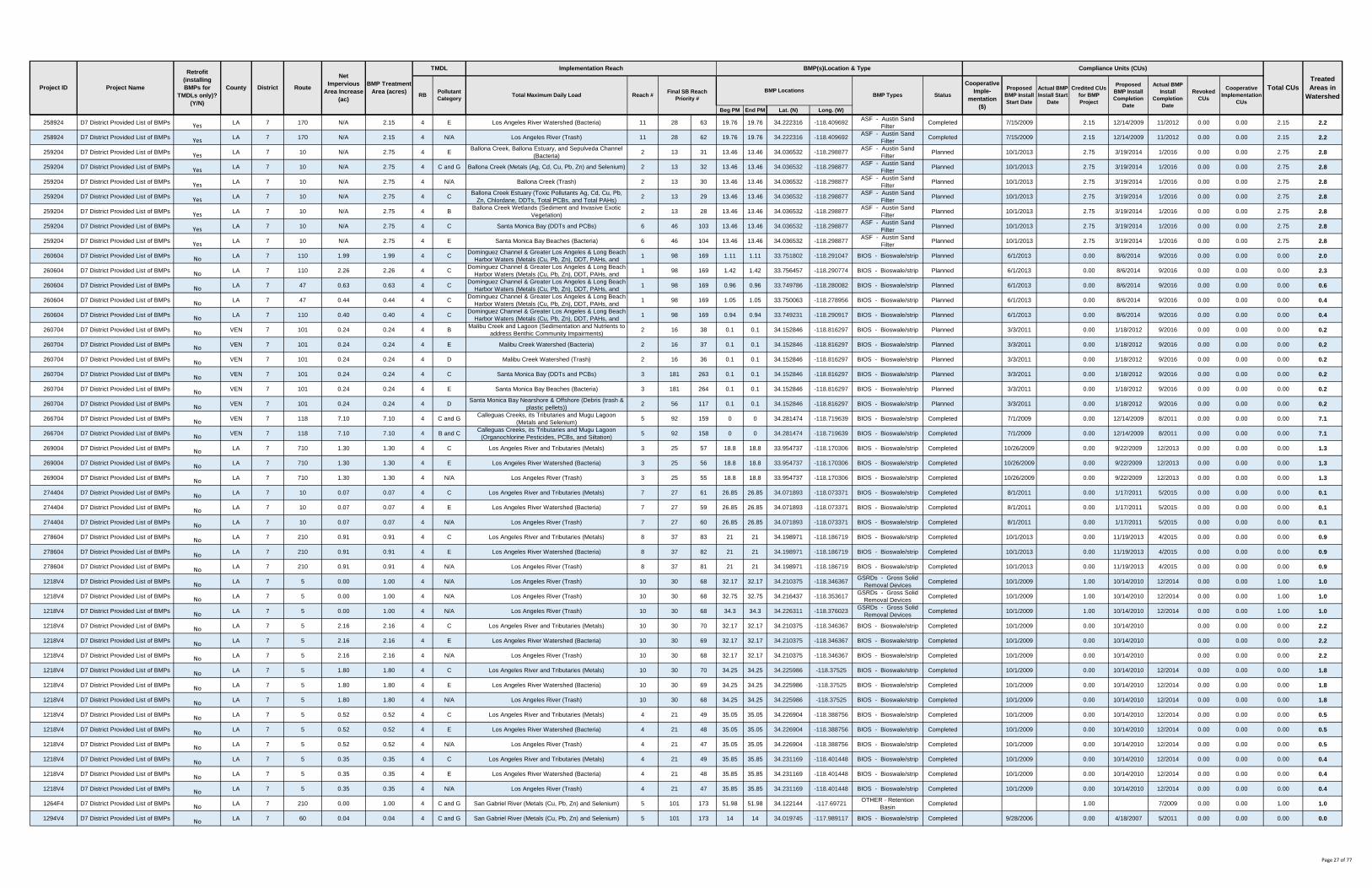
Beg PM End PM Lat. (N) Long. (W)
Revoked CUs
Total CUsTreated Areas in
WatershedRBPollutant Category
Total Maximum Daily Load Reach #Final SB Reach
Priority #
Compliance Units (CUs)
Cooperative Imple-
mentation ($)
Cooperative Implementation
CUs
Proposed BMP Install Start Date
Actual BMP Install Start
Date
Credited CUs for BMP Project
Proposed BMP Install Completion
Date
Actual BMP Install
Completion Date
Net Impervious
Area Increase (ac)
BMP Treatment Area (acres)
TMDL Implementation Reach BMP(s)Location & Type
BMP LocationsBMP Types Status
RouteProject ID Project Name
Retrofit (installing BMPs for
TMDLs only)? (Y/N)
County District
258924 D7 District Provided List of BMPs Yes LA 7 170 N/A 2.15 4 E Los Angeles River Watershed (Bacteria) 11 28 63 19.76 19.76 34.222316 -118.409692ASF - Austin Sand
FilterCompleted 7/15/2009 2.15 12/14/2009 11/2012 0.00 0.00 2.15 2.2
258924 D7 District Provided List of BMPs Yes LA 7 170 N/A 2.15 4 N/A Los Angeles River (Trash) 11 28 62 19.76 19.76 34.222316 -118.409692ASF - Austin Sand
FilterCompleted 7/15/2009 2.15 12/14/2009 11/2012 0.00 0.00 2.15 2.2
259204 D7 District Provided List of BMPs Yes LA 7 10 N/A 2.75 4 EBallona Creek, Ballona Estuary, and Sepulveda Channel
(Bacteria)2 13 31 13.46 13.46 34.036532 -118.298877
ASF - Austin Sand Filter
Planned 10/1/2013 2.75 3/19/2014 1/2016 0.00 0.00 2.75 2.8
259204 D7 District Provided List of BMPs Yes LA 7 10 N/A 2.75 4 C and G Ballona Creek (Metals (Ag, Cd, Cu, Pb, Zn) and Selenium) 2 13 32 13.46 13.46 34.036532 -118.298877ASF - Austin Sand
FilterPlanned 10/1/2013 2.75 3/19/2014 1/2016 0.00 0.00 2.75 2.8
259204 D7 District Provided List of BMPs Yes LA 7 10 N/A 2.75 4 N/A Ballona Creek (Trash) 2 13 30 13.46 13.46 34.036532 -118.298877ASF - Austin Sand
FilterPlanned 10/1/2013 2.75 3/19/2014 1/2016 0.00 0.00 2.75 2.8
259204 D7 District Provided List of BMPs Yes LA 7 10 N/A 2.75 4 CBallona Creek Estuary (Toxic Pollutants Ag, Cd, Cu, Pb,
Zn, Chlordane, DDTs, Total PCBs, and Total PAHs)2 13 29 13.46 13.46 34.036532 -118.298877
ASF - Austin Sand Filter
Planned 10/1/2013 2.75 3/19/2014 1/2016 0.00 0.00 2.75 2.8
259204 D7 District Provided List of BMPs Yes LA 7 10 N/A 2.75 4 BBallona Creek Wetlands (Sediment and Invasive Exotic
Vegetation)2 13 28 13.46 13.46 34.036532 -118.298877
ASF - Austin Sand Filter
Planned 10/1/2013 2.75 3/19/2014 1/2016 0.00 0.00 2.75 2.8
259204 D7 District Provided List of BMPs Yes LA 7 10 N/A 2.75 4 C Santa Monica Bay (DDTs and PCBs) 6 46 103 13.46 13.46 34.036532 -118.298877ASF - Austin Sand
FilterPlanned 10/1/2013 2.75 3/19/2014 1/2016 0.00 0.00 2.75 2.8
259204 D7 District Provided List of BMPs Yes LA 7 10 N/A 2.75 4 E Santa Monica Bay Beaches (Bacteria) 6 46 104 13.46 13.46 34.036532 -118.298877ASF - Austin Sand
FilterPlanned 10/1/2013 2.75 3/19/2014 1/2016 0.00 0.00 2.75 2.8
260604 D7 District Provided List of BMPs No LA 7 110 1.99 1.99 4 CDominguez Channel & Greater Los Angeles & Long Beach
Harbor Waters (Metals (Cu, Pb, Zn), DDT, PAHs, and 1 98 169 1.11 1.11 33.751802 -118.291047 BIOS - Bioswale/strip Planned 6/1/2013 0.00 8/6/2014 9/2016 0.00 0.00 0.00 2.0
260604 D7 District Provided List of BMPs No LA 7 110 2.26 2.26 4 CDominguez Channel & Greater Los Angeles & Long Beach
Harbor Waters (Metals (Cu, Pb, Zn), DDT, PAHs, and 1 98 169 1.42 1.42 33.756457 -118.290774 BIOS - Bioswale/strip Planned 6/1/2013 0.00 8/6/2014 9/2016 0.00 0.00 0.00 2.3
260604 D7 District Provided List of BMPs No LA 7 47 0.63 0.63 4 CDominguez Channel & Greater Los Angeles & Long Beach
Harbor Waters (Metals (Cu, Pb, Zn), DDT, PAHs, and 1 98 169 0.96 0.96 33.749786 -118.280082 BIOS - Bioswale/strip Planned 6/1/2013 0.00 8/6/2014 9/2016 0.00 0.00 0.00 0.6
260604 D7 District Provided List of BMPs No LA 7 47 0.44 0.44 4 CDominguez Channel & Greater Los Angeles & Long Beach
Harbor Waters (Metals (Cu, Pb, Zn), DDT, PAHs, and 1 98 169 1.05 1.05 33.750063 -118.278956 BIOS - Bioswale/strip Planned 6/1/2013 0.00 8/6/2014 9/2016 0.00 0.00 0.00 0.4
260604 D7 District Provided List of BMPs No LA 7 110 0.40 0.40 4 CDominguez Channel & Greater Los Angeles & Long Beach
Harbor Waters (Metals (Cu, Pb, Zn), DDT, PAHs, and 1 98 169 0.94 0.94 33.749231 -118.290917 BIOS - Bioswale/strip Planned 6/1/2013 0.00 8/6/2014 9/2016 0.00 0.00 0.00 0.4
260704 D7 District Provided List of BMPs No VEN 7 101 0.24 0.24 4 BMalibu Creek and Lagoon (Sedimentation and Nutrients to
address Benthic Community Impairments)2 16 38 0.1 0.1 34.152846 -118.816297 BIOS - Bioswale/strip Planned 3/3/2011 0.00 1/18/2012 9/2016 0.00 0.00 0.00 0.2
260704 D7 District Provided List of BMPs No VEN 7 101 0.24 0.24 4 E Malibu Creek Watershed (Bacteria) 2 16 37 0.1 0.1 34.152846 -118.816297 BIOS - Bioswale/strip Planned 3/3/2011 0.00 1/18/2012 9/2016 0.00 0.00 0.00 0.2
260704 D7 District Provided List of BMPs No VEN 7 101 0.24 0.24 4 D Malibu Creek Watershed (Trash) 2 16 36 0.1 0.1 34.152846 -118.816297 BIOS - Bioswale/strip Planned 3/3/2011 0.00 1/18/2012 9/2016 0.00 0.00 0.00 0.2
260704 D7 District Provided List of BMPs No VEN 7 101 0.24 0.24 4 C Santa Monica Bay (DDTs and PCBs) 3 181 263 0.1 0.1 34.152846 -118.816297 BIOS - Bioswale/strip Planned 3/3/2011 0.00 1/18/2012 9/2016 0.00 0.00 0.00 0.2
260704 D7 District Provided List of BMPs No VEN 7 101 0.24 0.24 4 E Santa Monica Bay Beaches (Bacteria) 3 181 264 0.1 0.1 34.152846 -118.816297 BIOS - Bioswale/strip Planned 3/3/2011 0.00 1/18/2012 9/2016 0.00 0.00 0.00 0.2
260704 D7 District Provided List of BMPs No VEN 7 101 0.24 0.24 4 DSanta Monica Bay Nearshore & Offshore (Debris (trash &
plastic pellets))2 56 117 0.1 0.1 34.152846 -118.816297 BIOS - Bioswale/strip Planned 3/3/2011 0.00 1/18/2012 9/2016 0.00 0.00 0.00 0.2
266704 D7 District Provided List of BMPs No VEN 7 118 7.10 7.10 4 C and GCalleguas Creeks, its Tributaries and Mugu Lagoon
(Metals and Selenium)5 92 159 0 0 34.281474 -118.719639 BIOS - Bioswale/strip Completed 7/1/2009 0.00 12/14/2009 8/2011 0.00 0.00 0.00 7.1
266704 D7 District Provided List of BMPs No VEN 7 118 7.10 7.10 4 B and CCalleguas Creeks, its Tributaries and Mugu Lagoon
(Organochlorine Pesticides, PCBs, and Siltation)5 92 158 0 0 34.281474 -118.719639 BIOS - Bioswale/strip Completed 7/1/2009 0.00 12/14/2009 8/2011 0.00 0.00 0.00 7.1
269004 D7 District Provided List of BMPs No LA 7 710 1.30 1.30 4 C Los Angeles River and Tributaries (Metals) 3 25 57 18.8 18.8 33.954737 -118.170306 BIOS - Bioswale/strip Completed 10/26/2009 0.00 9/22/2009 12/2013 0.00 0.00 0.00 1.3
269004 D7 District Provided List of BMPs No LA 7 710 1.30 1.30 4 E Los Angeles River Watershed (Bacteria) 3 25 56 18.8 18.8 33.954737 -118.170306 BIOS - Bioswale/strip Completed 10/26/2009 0.00 9/22/2009 12/2013 0.00 0.00 0.00 1.3
269004 D7 District Provided List of BMPs No LA 7 710 1.30 1.30 4 N/A Los Angeles River (Trash) 3 25 55 18.8 18.8 33.954737 -118.170306 BIOS - Bioswale/strip Completed 10/26/2009 0.00 9/22/2009 12/2013 0.00 0.00 0.00 1.3
274404 D7 District Provided List of BMPs No LA 7 10 0.07 0.07 4 C Los Angeles River and Tributaries (Metals) 7 27 61 26.85 26.85 34.071893 -118.073371 BIOS - Bioswale/strip Completed 8/1/2011 0.00 1/17/2011 5/2015 0.00 0.00 0.00 0.1
274404 D7 District Provided List of BMPs No LA 7 10 0.07 0.07 4 E Los Angeles River Watershed (Bacteria) 7 27 59 26.85 26.85 34.071893 -118.073371 BIOS - Bioswale/strip Completed 8/1/2011 0.00 1/17/2011 5/2015 0.00 0.00 0.00 0.1
274404 D7 District Provided List of BMPs No LA 7 10 0.07 0.07 4 N/A Los Angeles River (Trash) 7 27 60 26.85 26.85 34.071893 -118.073371 BIOS - Bioswale/strip Completed 8/1/2011 0.00 1/17/2011 5/2015 0.00 0.00 0.00 0.1
278604 D7 District Provided List of BMPs No LA 7 210 0.91 0.91 4 C Los Angeles River and Tributaries (Metals) 8 37 83 21 21 34.198971 -118.186719 BIOS - Bioswale/strip Completed 10/1/2013 0.00 11/19/2013 4/2015 0.00 0.00 0.00 0.9
278604 D7 District Provided List of BMPs No LA 7 210 0.91 0.91 4 E Los Angeles River Watershed (Bacteria) 8 37 82 21 21 34.198971 -118.186719 BIOS - Bioswale/strip Completed 10/1/2013 0.00 11/19/2013 4/2015 0.00 0.00 0.00 0.9
278604 D7 District Provided List of BMPs No LA 7 210 0.91 0.91 4 N/A Los Angeles River (Trash) 8 37 81 21 21 34.198971 -118.186719 BIOS - Bioswale/strip Completed 10/1/2013 0.00 11/19/2013 4/2015 0.00 0.00 0.00 0.9
1218V4 D7 District Provided List of BMPs No LA 7 5 0.00 1.00 4 N/A Los Angeles River (Trash) 10 30 68 32.17 32.17 34.210375 -118.346367GSRDs - Gross Solid
Removal DevicesCompleted 10/1/2009 1.00 10/14/2010 12/2014 0.00 0.00 1.00 1.0
1218V4 D7 District Provided List of BMPs No LA 7 5 0.00 1.00 4 N/A Los Angeles River (Trash) 10 30 68 32.75 32.75 34.216437 -118.353617GSRDs - Gross Solid
Removal DevicesCompleted 10/1/2009 1.00 10/14/2010 12/2014 0.00 0.00 1.00 1.0
1218V4 D7 District Provided List of BMPs No LA 7 5 0.00 1.00 4 N/A Los Angeles River (Trash) 10 30 68 34.3 34.3 34.226311 -118.376023GSRDs - Gross Solid
Removal DevicesCompleted 10/1/2009 1.00 10/14/2010 12/2014 0.00 0.00 1.00 1.0
1218V4 D7 District Provided List of BMPs No LA 7 5 2.16 2.16 4 C Los Angeles River and Tributaries (Metals) 10 30 70 32.17 32.17 34.210375 -118.346367 BIOS - Bioswale/strip Completed 10/1/2009 0.00 10/14/2010 0.00 0.00 0.00 2.2
1218V4 D7 District Provided List of BMPs No LA 7 5 2.16 2.16 4 E Los Angeles River Watershed (Bacteria) 10 30 69 32.17 32.17 34.210375 -118.346367 BIOS - Bioswale/strip Completed 10/1/2009 0.00 10/14/2010 0.00 0.00 0.00 2.2
1218V4 D7 District Provided List of BMPs No LA 7 5 2.16 2.16 4 N/A Los Angeles River (Trash) 10 30 68 32.17 32.17 34.210375 -118.346367 BIOS - Bioswale/strip Completed 10/1/2009 0.00 10/14/2010 0.00 0.00 0.00 2.2
1218V4 D7 District Provided List of BMPs No LA 7 5 1.80 1.80 4 C Los Angeles River and Tributaries (Metals) 10 30 70 34.25 34.25 34.225986 -118.37525 BIOS - Bioswale/strip Completed 10/1/2009 0.00 10/14/2010 12/2014 0.00 0.00 0.00 1.8
1218V4 D7 District Provided List of BMPs No LA 7 5 1.80 1.80 4 E Los Angeles River Watershed (Bacteria) 10 30 69 34.25 34.25 34.225986 -118.37525 BIOS - Bioswale/strip Completed 10/1/2009 0.00 10/14/2010 12/2014 0.00 0.00 0.00 1.8
1218V4 D7 District Provided List of BMPs No LA 7 5 1.80 1.80 4 N/A Los Angeles River (Trash) 10 30 68 34.25 34.25 34.225986 -118.37525 BIOS - Bioswale/strip Completed 10/1/2009 0.00 10/14/2010 12/2014 0.00 0.00 0.00 1.8
1218V4 D7 District Provided List of BMPs No LA 7 5 0.52 0.52 4 C Los Angeles River and Tributaries (Metals) 4 21 49 35.05 35.05 34.226904 -118.388756 BIOS - Bioswale/strip Completed 10/1/2009 0.00 10/14/2010 12/2014 0.00 0.00 0.00 0.5
1218V4 D7 District Provided List of BMPs No LA 7 5 0.52 0.52 4 E Los Angeles River Watershed (Bacteria) 4 21 48 35.05 35.05 34.226904 -118.388756 BIOS - Bioswale/strip Completed 10/1/2009 0.00 10/14/2010 12/2014 0.00 0.00 0.00 0.5
1218V4 D7 District Provided List of BMPs No LA 7 5 0.52 0.52 4 N/A Los Angeles River (Trash) 4 21 47 35.05 35.05 34.226904 -118.388756 BIOS - Bioswale/strip Completed 10/1/2009 0.00 10/14/2010 12/2014 0.00 0.00 0.00 0.5
1218V4 D7 District Provided List of BMPs No LA 7 5 0.35 0.35 4 C Los Angeles River and Tributaries (Metals) 4 21 49 35.85 35.85 34.231169 -118.401448 BIOS - Bioswale/strip Completed 10/1/2009 0.00 10/14/2010 12/2014 0.00 0.00 0.00 0.4
1218V4 D7 District Provided List of BMPs No LA 7 5 0.35 0.35 4 E Los Angeles River Watershed (Bacteria) 4 21 48 35.85 35.85 34.231169 -118.401448 BIOS - Bioswale/strip Completed 10/1/2009 0.00 10/14/2010 12/2014 0.00 0.00 0.00 0.4
1218V4 D7 District Provided List of BMPs No LA 7 5 0.35 0.35 4 N/A Los Angeles River (Trash) 4 21 47 35.85 35.85 34.231169 -118.401448 BIOS - Bioswale/strip Completed 10/1/2009 0.00 10/14/2010 12/2014 0.00 0.00 0.00 0.4
1264F4 D7 District Provided List of BMPs No LA 7 210 0.00 1.00 4 C and G San Gabriel River (Metals (Cu, Pb, Zn) and Selenium) 5 101 173 51.98 51.98 34.122144 -117.69721OTHER - Retention
BasinCompleted 1.00 7/2009 0.00 0.00 1.00 1.0
1294V4 D7 District Provided List of BMPs No LA 7 60 0.04 0.04 4 C and G San Gabriel River (Metals (Cu, Pb, Zn) and Selenium) 5 101 173 14 14 34.019745 -117.989117 BIOS - Bioswale/strip Completed 9/28/2006 0.00 4/18/2007 5/2011 0.00 0.00 0.00 0.0
Page 27 of 77
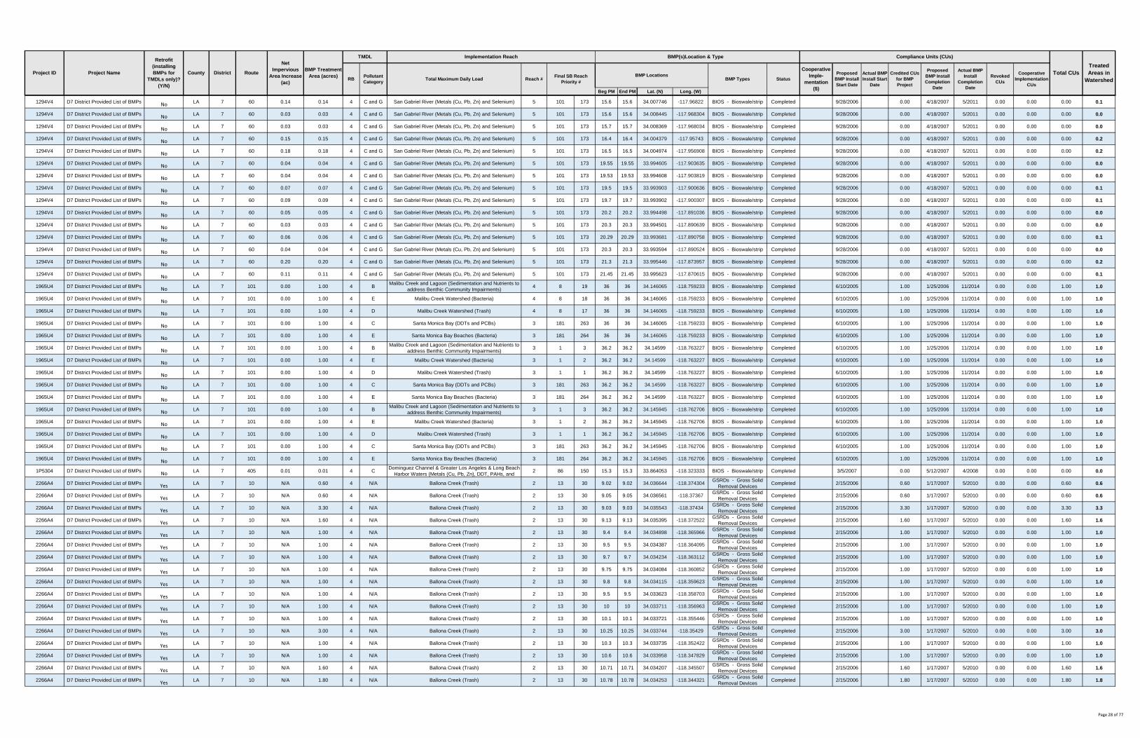
Beg PM End PM Lat. (N) Long. (W)
Revoked CUs
Total CUsTreated Areas in
WatershedRBPollutant Category
Total Maximum Daily Load Reach #Final SB Reach
Priority #
Compliance Units (CUs)
Cooperative Imple-
mentation ($)
Cooperative Implementation
CUs
Proposed BMP Install Start Date
Actual BMP Install Start
Date
Credited CUs for BMP Project
Proposed BMP Install Completion
Date
Actual BMP Install
Completion Date
Net Impervious
Area Increase (ac)
BMP Treatment Area (acres)
TMDL Implementation Reach BMP(s)Location & Type
BMP LocationsBMP Types Status
RouteProject ID Project Name
Retrofit (installing BMPs for
TMDLs only)? (Y/N)
County District
1294V4 D7 District Provided List of BMPs No LA 7 60 0.14 0.14 4 C and G San Gabriel River (Metals (Cu, Pb, Zn) and Selenium) 5 101 173 15.6 15.6 34.007746 -117.96822 BIOS - Bioswale/strip Completed 9/28/2006 0.00 4/18/2007 5/2011 0.00 0.00 0.00 0.1
1294V4 D7 District Provided List of BMPs No LA 7 60 0.03 0.03 4 C and G San Gabriel River (Metals (Cu, Pb, Zn) and Selenium) 5 101 173 15.6 15.6 34.008445 -117.968304 BIOS - Bioswale/strip Completed 9/28/2006 0.00 4/18/2007 5/2011 0.00 0.00 0.00 0.0
1294V4 D7 District Provided List of BMPs No LA 7 60 0.03 0.03 4 C and G San Gabriel River (Metals (Cu, Pb, Zn) and Selenium) 5 101 173 15.7 15.7 34.008369 -117.968034 BIOS - Bioswale/strip Completed 9/28/2006 0.00 4/18/2007 5/2011 0.00 0.00 0.00 0.0
1294V4 D7 District Provided List of BMPs No LA 7 60 0.15 0.15 4 C and G San Gabriel River (Metals (Cu, Pb, Zn) and Selenium) 5 101 173 16.4 16.4 34.004379 -117.95743 BIOS - Bioswale/strip Completed 9/28/2006 0.00 4/18/2007 5/2011 0.00 0.00 0.00 0.2
1294V4 D7 District Provided List of BMPs No LA 7 60 0.18 0.18 4 C and G San Gabriel River (Metals (Cu, Pb, Zn) and Selenium) 5 101 173 16.5 16.5 34.004974 -117.956908 BIOS - Bioswale/strip Completed 9/28/2006 0.00 4/18/2007 5/2011 0.00 0.00 0.00 0.2
1294V4 D7 District Provided List of BMPs No LA 7 60 0.04 0.04 4 C and G San Gabriel River (Metals (Cu, Pb, Zn) and Selenium) 5 101 173 19.55 19.55 33.994605 -117.903635 BIOS - Bioswale/strip Completed 9/28/2006 0.00 4/18/2007 5/2011 0.00 0.00 0.00 0.0
1294V4 D7 District Provided List of BMPs No LA 7 60 0.04 0.04 4 C and G San Gabriel River (Metals (Cu, Pb, Zn) and Selenium) 5 101 173 19.53 19.53 33.994608 -117.903819 BIOS - Bioswale/strip Completed 9/28/2006 0.00 4/18/2007 5/2011 0.00 0.00 0.00 0.0
1294V4 D7 District Provided List of BMPs No LA 7 60 0.07 0.07 4 C and G San Gabriel River (Metals (Cu, Pb, Zn) and Selenium) 5 101 173 19.5 19.5 33.993903 -117.900636 BIOS - Bioswale/strip Completed 9/28/2006 0.00 4/18/2007 5/2011 0.00 0.00 0.00 0.1
1294V4 D7 District Provided List of BMPs No LA 7 60 0.09 0.09 4 C and G San Gabriel River (Metals (Cu, Pb, Zn) and Selenium) 5 101 173 19.7 19.7 33.993902 -117.900307 BIOS - Bioswale/strip Completed 9/28/2006 0.00 4/18/2007 5/2011 0.00 0.00 0.00 0.1
1294V4 D7 District Provided List of BMPs No LA 7 60 0.05 0.05 4 C and G San Gabriel River (Metals (Cu, Pb, Zn) and Selenium) 5 101 173 20.2 20.2 33.994498 -117.891036 BIOS - Bioswale/strip Completed 9/28/2006 0.00 4/18/2007 5/2011 0.00 0.00 0.00 0.0
1294V4 D7 District Provided List of BMPs No LA 7 60 0.03 0.03 4 C and G San Gabriel River (Metals (Cu, Pb, Zn) and Selenium) 5 101 173 20.3 20.3 33.994501 -117.890639 BIOS - Bioswale/strip Completed 9/28/2006 0.00 4/18/2007 5/2011 0.00 0.00 0.00 0.0
1294V4 D7 District Provided List of BMPs No LA 7 60 0.06 0.06 4 C and G San Gabriel River (Metals (Cu, Pb, Zn) and Selenium) 5 101 173 20.29 20.29 33.993681 -117.890758 BIOS - Bioswale/strip Completed 9/28/2006 0.00 4/18/2007 5/2011 0.00 0.00 0.00 0.1
1294V4 D7 District Provided List of BMPs No LA 7 60 0.04 0.04 4 C and G San Gabriel River (Metals (Cu, Pb, Zn) and Selenium) 5 101 173 20.3 20.3 33.993594 -117.890524 BIOS - Bioswale/strip Completed 9/28/2006 0.00 4/18/2007 5/2011 0.00 0.00 0.00 0.0
1294V4 D7 District Provided List of BMPs No LA 7 60 0.20 0.20 4 C and G San Gabriel River (Metals (Cu, Pb, Zn) and Selenium) 5 101 173 21.3 21.3 33.995446 -117.873957 BIOS - Bioswale/strip Completed 9/28/2006 0.00 4/18/2007 5/2011 0.00 0.00 0.00 0.2
1294V4 D7 District Provided List of BMPs No LA 7 60 0.11 0.11 4 C and G San Gabriel River (Metals (Cu, Pb, Zn) and Selenium) 5 101 173 21.45 21.45 33.995623 -117.870615 BIOS - Bioswale/strip Completed 9/28/2006 0.00 4/18/2007 5/2011 0.00 0.00 0.00 0.1
1965U4 D7 District Provided List of BMPs No LA 7 101 0.00 1.00 4 BMalibu Creek and Lagoon (Sedimentation and Nutrients to
address Benthic Community Impairments)4 8 19 36 36 34.146065 -118.759233 BIOS - Bioswale/strip Completed 6/10/2005 1.00 1/25/2006 11/2014 0.00 0.00 1.00 1.0
1965U4 D7 District Provided List of BMPs No LA 7 101 0.00 1.00 4 E Malibu Creek Watershed (Bacteria) 4 8 18 36 36 34.146065 -118.759233 BIOS - Bioswale/strip Completed 6/10/2005 1.00 1/25/2006 11/2014 0.00 0.00 1.00 1.0
1965U4 D7 District Provided List of BMPs No LA 7 101 0.00 1.00 4 D Malibu Creek Watershed (Trash) 4 8 17 36 36 34.146065 -118.759233 BIOS - Bioswale/strip Completed 6/10/2005 1.00 1/25/2006 11/2014 0.00 0.00 1.00 1.0
1965U4 D7 District Provided List of BMPs No LA 7 101 0.00 1.00 4 C Santa Monica Bay (DDTs and PCBs) 3 181 263 36 36 34.146065 -118.759233 BIOS - Bioswale/strip Completed 6/10/2005 1.00 1/25/2006 11/2014 0.00 0.00 1.00 1.0
1965U4 D7 District Provided List of BMPs No LA 7 101 0.00 1.00 4 E Santa Monica Bay Beaches (Bacteria) 3 181 264 36 36 34.146065 -118.759233 BIOS - Bioswale/strip Completed 6/10/2005 1.00 1/25/2006 11/2014 0.00 0.00 1.00 1.0
1965U4 D7 District Provided List of BMPs No LA 7 101 0.00 1.00 4 BMalibu Creek and Lagoon (Sedimentation and Nutrients to
address Benthic Community Impairments)3 1 3 36.2 36.2 34.14599 -118.763227 BIOS - Bioswale/strip Completed 6/10/2005 1.00 1/25/2006 11/2014 0.00 0.00 1.00 1.0
1965U4 D7 District Provided List of BMPs No LA 7 101 0.00 1.00 4 E Malibu Creek Watershed (Bacteria) 3 1 2 36.2 36.2 34.14599 -118.763227 BIOS - Bioswale/strip Completed 6/10/2005 1.00 1/25/2006 11/2014 0.00 0.00 1.00 1.0
1965U4 D7 District Provided List of BMPs No LA 7 101 0.00 1.00 4 D Malibu Creek Watershed (Trash) 3 1 1 36.2 36.2 34.14599 -118.763227 BIOS - Bioswale/strip Completed 6/10/2005 1.00 1/25/2006 11/2014 0.00 0.00 1.00 1.0
1965U4 D7 District Provided List of BMPs No LA 7 101 0.00 1.00 4 C Santa Monica Bay (DDTs and PCBs) 3 181 263 36.2 36.2 34.14599 -118.763227 BIOS - Bioswale/strip Completed 6/10/2005 1.00 1/25/2006 11/2014 0.00 0.00 1.00 1.0
1965U4 D7 District Provided List of BMPs No LA 7 101 0.00 1.00 4 E Santa Monica Bay Beaches (Bacteria) 3 181 264 36.2 36.2 34.14599 -118.763227 BIOS - Bioswale/strip Completed 6/10/2005 1.00 1/25/2006 11/2014 0.00 0.00 1.00 1.0
1965U4 D7 District Provided List of BMPs No LA 7 101 0.00 1.00 4 BMalibu Creek and Lagoon (Sedimentation and Nutrients to
address Benthic Community Impairments)3 1 3 36.2 36.2 34.145945 -118.762706 BIOS - Bioswale/strip Completed 6/10/2005 1.00 1/25/2006 11/2014 0.00 0.00 1.00 1.0
1965U4 D7 District Provided List of BMPs No LA 7 101 0.00 1.00 4 E Malibu Creek Watershed (Bacteria) 3 1 2 36.2 36.2 34.145945 -118.762706 BIOS - Bioswale/strip Completed 6/10/2005 1.00 1/25/2006 11/2014 0.00 0.00 1.00 1.0
1965U4 D7 District Provided List of BMPs No LA 7 101 0.00 1.00 4 D Malibu Creek Watershed (Trash) 3 1 1 36.2 36.2 34.145945 -118.762706 BIOS - Bioswale/strip Completed 6/10/2005 1.00 1/25/2006 11/2014 0.00 0.00 1.00 1.0
1965U4 D7 District Provided List of BMPs No LA 7 101 0.00 1.00 4 C Santa Monica Bay (DDTs and PCBs) 3 181 263 36.2 36.2 34.145945 -118.762706 BIOS - Bioswale/strip Completed 6/10/2005 1.00 1/25/2006 11/2014 0.00 0.00 1.00 1.0
1965U4 D7 District Provided List of BMPs No LA 7 101 0.00 1.00 4 E Santa Monica Bay Beaches (Bacteria) 3 181 264 36.2 36.2 34.145945 -118.762706 BIOS - Bioswale/strip Completed 6/10/2005 1.00 1/25/2006 11/2014 0.00 0.00 1.00 1.0
1P5304 D7 District Provided List of BMPs No LA 7 405 0.01 0.01 4 CDominguez Channel & Greater Los Angeles & Long Beach
Harbor Waters (Metals (Cu, Pb, Zn), DDT, PAHs, and 2 86 150 15.3 15.3 33.864053 -118.323333 BIOS - Bioswale/strip Completed 3/5/2007 0.00 5/12/2007 4/2008 0.00 0.00 0.00 0.0
2266A4 D7 District Provided List of BMPs Yes LA 7 10 N/A 0.60 4 N/A Ballona Creek (Trash) 2 13 30 9.02 9.02 34.036644 -118.374304GSRDs - Gross Solid
Removal DevicesCompleted 2/15/2006 0.60 1/17/2007 5/2010 0.00 0.00 0.60 0.6
2266A4 D7 District Provided List of BMPs Yes LA 7 10 N/A 0.60 4 N/A Ballona Creek (Trash) 2 13 30 9.05 9.05 34.036561 -118.37367GSRDs - Gross Solid
Removal DevicesCompleted 2/15/2006 0.60 1/17/2007 5/2010 0.00 0.00 0.60 0.6
2266A4 D7 District Provided List of BMPs Yes LA 7 10 N/A 3.30 4 N/A Ballona Creek (Trash) 2 13 30 9.03 9.03 34.035543 -118.37434GSRDs - Gross Solid
Removal DevicesCompleted 2/15/2006 3.30 1/17/2007 5/2010 0.00 0.00 3.30 3.3
2266A4 D7 District Provided List of BMPs Yes LA 7 10 N/A 1.60 4 N/A Ballona Creek (Trash) 2 13 30 9.13 9.13 34.035395 -118.372522GSRDs - Gross Solid
Removal DevicesCompleted 2/15/2006 1.60 1/17/2007 5/2010 0.00 0.00 1.60 1.6
2266A4 D7 District Provided List of BMPs Yes LA 7 10 N/A 1.00 4 N/A Ballona Creek (Trash) 2 13 30 9.4 9.4 34.034898 -118.365966GSRDs - Gross Solid
Removal DevicesCompleted 2/15/2006 1.00 1/17/2007 5/2010 0.00 0.00 1.00 1.0
2266A4 D7 District Provided List of BMPs Yes LA 7 10 N/A 1.00 4 N/A Ballona Creek (Trash) 2 13 30 9.5 9.5 34.034387 -118.364095GSRDs - Gross Solid
Removal DevicesCompleted 2/15/2006 1.00 1/17/2007 5/2010 0.00 0.00 1.00 1.0
2266A4 D7 District Provided List of BMPs Yes LA 7 10 N/A 1.00 4 N/A Ballona Creek (Trash) 2 13 30 9.7 9.7 34.034234 -118.363112GSRDs - Gross Solid
Removal DevicesCompleted 2/15/2006 1.00 1/17/2007 5/2010 0.00 0.00 1.00 1.0
2266A4 D7 District Provided List of BMPs Yes LA 7 10 N/A 1.00 4 N/A Ballona Creek (Trash) 2 13 30 9.75 9.75 34.034084 -118.360852GSRDs - Gross Solid
Removal DevicesCompleted 2/15/2006 1.00 1/17/2007 5/2010 0.00 0.00 1.00 1.0
2266A4 D7 District Provided List of BMPs Yes LA 7 10 N/A 1.00 4 N/A Ballona Creek (Trash) 2 13 30 9.8 9.8 34.034115 -118.359623GSRDs - Gross Solid
Removal DevicesCompleted 2/15/2006 1.00 1/17/2007 5/2010 0.00 0.00 1.00 1.0
2266A4 D7 District Provided List of BMPs Yes LA 7 10 N/A 1.00 4 N/A Ballona Creek (Trash) 2 13 30 9.5 9.5 34.033623 -118.358703GSRDs - Gross Solid
Removal DevicesCompleted 2/15/2006 1.00 1/17/2007 5/2010 0.00 0.00 1.00 1.0
2266A4 D7 District Provided List of BMPs Yes LA 7 10 N/A 1.00 4 N/A Ballona Creek (Trash) 2 13 30 10 10 34.033711 -118.356963GSRDs - Gross Solid
Removal DevicesCompleted 2/15/2006 1.00 1/17/2007 5/2010 0.00 0.00 1.00 1.0
2266A4 D7 District Provided List of BMPs Yes LA 7 10 N/A 1.00 4 N/A Ballona Creek (Trash) 2 13 30 10.1 10.1 34.033721 -118.355446GSRDs - Gross Solid
Removal DevicesCompleted 2/15/2006 1.00 1/17/2007 5/2010 0.00 0.00 1.00 1.0
2266A4 D7 District Provided List of BMPs Yes LA 7 10 N/A 3.00 4 N/A Ballona Creek (Trash) 2 13 30 10.25 10.25 34.033744 -118.35429GSRDs - Gross Solid
Removal DevicesCompleted 2/15/2006 3.00 1/17/2007 5/2010 0.00 0.00 3.00 3.0
2266A4 D7 District Provided List of BMPs Yes LA 7 10 N/A 1.00 4 N/A Ballona Creek (Trash) 2 13 30 10.3 10.3 34.033735 -118.352422GSRDs - Gross Solid
Removal DevicesCompleted 2/15/2006 1.00 1/17/2007 5/2010 0.00 0.00 1.00 1.0
2266A4 D7 District Provided List of BMPs Yes LA 7 10 N/A 1.00 4 N/A Ballona Creek (Trash) 2 13 30 10.6 10.6 34.033958 -118.347829GSRDs - Gross Solid
Removal DevicesCompleted 2/15/2006 1.00 1/17/2007 5/2010 0.00 0.00 1.00 1.0
2266A4 D7 District Provided List of BMPs Yes LA 7 10 N/A 1.60 4 N/A Ballona Creek (Trash) 2 13 30 10.71 10.71 34.034207 -118.345507GSRDs - Gross Solid
Removal DevicesCompleted 2/15/2006 1.60 1/17/2007 5/2010 0.00 0.00 1.60 1.6
2266A4 D7 District Provided List of BMPs Yes LA 7 10 N/A 1.80 4 N/A Ballona Creek (Trash) 2 13 30 10.78 10.78 34.034253 -118.344321GSRDs - Gross Solid
Removal DevicesCompleted 2/15/2006 1.80 1/17/2007 5/2010 0.00 0.00 1.80 1.8
Page 28 of 77

Beg PM End PM Lat. (N) Long. (W)
Revoked CUs
Total CUsTreated Areas in
WatershedRBPollutant Category
Total Maximum Daily Load Reach #Final SB Reach
Priority #
Compliance Units (CUs)
Cooperative Imple-
mentation ($)
Cooperative Implementation
CUs
Proposed BMP Install Start Date
Actual BMP Install Start
Date
Credited CUs for BMP Project
Proposed BMP Install Completion
Date
Actual BMP Install
Completion Date
Net Impervious
Area Increase (ac)
BMP Treatment Area (acres)
TMDL Implementation Reach BMP(s)Location & Type
BMP LocationsBMP Types Status
RouteProject ID Project Name
Retrofit (installing BMPs for
TMDLs only)? (Y/N)
County District
2266A4 D7 District Provided List of BMPs Yes LA 7 10 N/A 7.70 4 N/A Ballona Creek (Trash) 2 13 30 13.19 13.19 34.036611 -118.303504GSRDs - Gross Solid
Removal DevicesCompleted 2/15/2006 7.70 1/17/2007 5/2010 0.00 0.00 7.70 7.7
2266A4 D7 District Provided List of BMPs Yes LA 7 10 N/A 1.00 4 N/A Ballona Creek (Trash) 2 13 30 13.3 13.3 34.037403 -118.300516GSRDs - Gross Solid
Removal DevicesCompleted 2/15/2006 1.00 1/17/2007 5/2010 0.00 0.00 1.00 1.0
2266A4 D7 District Provided List of BMPs Yes LA 7 10 N/A 1.00 4 N/A Ballona Creek (Trash) 2 13 30 13.3 13.3 34.036698 -118.300533GSRDs - Gross Solid
Removal DevicesCompleted 2/15/2006 1.00 1/17/2007 5/2010 0.00 0.00 1.00 1.0
2266A4 D7 District Provided List of BMPs Yes LA 7 10 N/A 1.00 4 N/A Ballona Creek (Trash) 2 13 30 13.34 13.34 34.036664 -118.30004GSRDs - Gross Solid
Removal DevicesCompleted 2/15/2006 1.00 1/17/2007 5/2010 0.00 0.00 1.00 1.0
2266A4 D7 District Provided List of BMPs Yes LA 7 10 N/A 5.90 4 N/A Ballona Creek (Trash) 2 13 30 13.4 13.4 34.036543 -118.298872GSRDs - Gross Solid
Removal DevicesCompleted 2/15/2006 5.90 1/17/2007 5/2010 0.00 0.00 5.90 5.9
2266A4 D7 District Provided List of BMPs Yes LA 7 10 N/A 3.50 4 N/A Ballona Creek (Trash) 2 13 30 13.55 13.55 34.036506 -118.2961GSRDs - Gross Solid
Removal DevicesCompleted 2/15/2006 3.50 1/17/2007 5/2010 0.00 0.00 3.50 3.5
2266A4 D7 District Provided List of BMPs Yes LA 7 10 N/A 0.60 4 N/A Ballona Creek (Trash) 2 13 30 13.59 13.59 34.036503 -118.295513GSRDs - Gross Solid
Removal DevicesCompleted 2/15/2006 0.60 1/17/2007 5/2010 0.00 0.00 0.60 0.6
2266A4 D7 District Provided List of BMPs Yes LA 7 10 N/A 4.20 4 N/A Ballona Creek (Trash) 2 13 30 13.67 13.67 34.036493 -118.294231GSRDs - Gross Solid
Removal DevicesCompleted 2/15/2006 4.20 1/17/2007 5/2010 0.00 0.00 4.20 4.2
2266A4 D7 District Provided List of BMPs Yes LA 7 10 N/A 5.10 4 N/A Ballona Creek (Trash) 2 13 30 13.82 13.82 34.036579 -118.291822GSRDs - Gross Solid
Removal DevicesCompleted 2/15/2006 5.10 1/17/2007 5/2010 0.00 0.00 5.10 5.1
2266A4 D7 District Provided List of BMPs Yes LA 7 90 N/A 1.00 4 N/A Ballona Creek (Trash) 1 4 13 1.1 1.1 33.980996 -118.42734GSRDs - Gross Solid
Removal DevicesCompleted 2/15/2006 1.00 1/17/2007 5/2010 0.00 0.00 1.00 1.0
2266A4 D7 District Provided List of BMPs Yes LA 7 90 N/A 1.00 4 N/A Ballona Creek (Trash) 2 13 30 1.5 1.5 33.98284 -118.416803GSRDs - Gross Solid
Removal DevicesCompleted 2/15/2006 1.00 1/17/2007 5/2010 0.00 0.00 1.00 1.0
2266A4 D7 District Provided List of BMPs Yes LA 7 90 N/A 1.00 4 N/A Ballona Creek (Trash) 2 13 30 1.78 1.78 33.985912 -118.414249GSRDs - Gross Solid
Removal DevicesCompleted 2/15/2006 1.00 1/17/2007 5/2010 0.00 0.00 1.00 1.0
2266A4 D7 District Provided List of BMPs Yes LA 7 90 N/A 1.00 4 N/A Ballona Creek (Trash) 2 13 30 1.8 1.8 33.985675 -118.412778GSRDs - Gross Solid
Removal DevicesCompleted 2/15/2006 1.00 1/17/2007 5/2010 0.00 0.00 1.00 1.0
2266A4 D7 District Provided List of BMPs Yes LA 7 90 N/A 1.00 4 N/A Ballona Creek (Trash) 2 13 30 1.84 1.84 33.986035 -118.412283GSRDs - Gross Solid
Removal DevicesCompleted 2/15/2006 1.00 1/17/2007 5/2010 0.00 0.00 1.00 1.0
2266A4 D7 District Provided List of BMPs Yes LA 7 90 N/A 1.00 4 N/A Ballona Creek (Trash) 2 13 30 1.9 1.9 33.986521 -118.411583GSRDs - Gross Solid
Removal DevicesCompleted 2/15/2006 1.00 1/17/2007 5/2010 0.00 0.00 1.00 1.0
2266A4 D7 District Provided List of BMPs Yes LA 7 90 N/A 1.00 4 N/A Ballona Creek (Trash) 2 13 30 2 2 33.987349 -118.409876GSRDs - Gross Solid
Removal DevicesCompleted 2/15/2006 1.00 1/17/2007 5/2010 0.00 0.00 1.00 1.0
2266A4 D7 District Provided List of BMPs Yes LA 7 90 N/A 4.10 4 N/A Ballona Creek (Trash) 2 13 30 2.7 2.7 33.989067 -118.399309GSRDs - Gross Solid
Removal DevicesCompleted 2/15/2006 4.10 1/17/2007 5/2010 0.00 0.00 4.10 4.1
2267A4 D7 District Provided List of BMPs Yes LA 7 10 N/A 1.70 4 N/A Ballona Creek (Trash) 2 13 30 5.59 5.59 34.031374 -118.430901GSRDs - Gross Solid
Removal DevicesCompleted 7/1/2006 1.70 10/25/2007 4/2010 0.00 0.00 1.70 1.7
2267A4 D7 District Provided List of BMPs Yes LA 7 10 N/A 1.00 4 N/A Ballona Creek (Trash) 2 13 30 5.6 5.6 34.031105 -118.429599GSRDs - Gross Solid
Removal DevicesCompleted 7/1/2006 1.00 10/25/2007 4/2010 0.00 0.00 1.00 1.0
2267A4 D7 District Provided List of BMPs Yes LA 7 10 N/A 3.40 4 N/A Ballona Creek (Trash) 2 13 30 5.68 5.68 34.031391 -118.427932GSRDs - Gross Solid
Removal DevicesCompleted 7/1/2006 3.40 10/25/2007 4/2010 0.00 0.00 3.40 3.4
2267A4 D7 District Provided List of BMPs Yes LA 7 10 N/A 3.30 4 N/A Ballona Creek (Trash) 2 13 30 5.85 5.85 34.031464 -118.426307GSRDs - Gross Solid
Removal DevicesCompleted 7/1/2006 3.30 10/25/2007 4/2010 0.00 0.00 3.30 3.3
2267A4 D7 District Provided List of BMPs Yes LA 7 10 N/A 2.90 4 N/A Ballona Creek (Trash) 2 13 30 5.98 5.98 34.031429 -118.42394GSRDs - Gross Solid
Removal DevicesCompleted 7/1/2006 2.90 10/25/2007 4/2010 0.00 0.00 2.90 2.9
2267A4 D7 District Provided List of BMPs Yes LA 7 10 N/A 0.70 4 N/A Ballona Creek (Trash) 2 13 30 6.17 6.17 34.031535 -118.420768GSRDs - Gross Solid
Removal DevicesCompleted 7/1/2006 0.70 10/25/2007 4/2010 0.00 0.00 0.70 0.7
2267A4 D7 District Provided List of BMPs Yes LA 7 10 N/A 0.80 4 N/A Ballona Creek (Trash) 2 13 30 6.18 6.18 34.032073 -118.420698GSRDs - Gross Solid
Removal DevicesCompleted 7/1/2006 0.80 10/25/2007 4/2010 0.00 0.00 0.80 0.8
2267A4 D7 District Provided List of BMPs Yes LA 7 10 N/A 6.70 4 N/A Ballona Creek (Trash) 2 13 30 8.06 8.06 34.031647 -118.389066GSRDs - Gross Solid
Removal DevicesCompleted 7/1/2006 6.70 10/25/2007 4/2010 0.00 0.00 6.70 6.7
2267A4 D7 District Provided List of BMPs Yes LA 7 10 N/A 1.70 4 N/A Ballona Creek (Trash) 2 13 30 8.5 8.5 34.035175 -118.382911GSRDs - Gross Solid
Removal DevicesCompleted 7/1/2006 1.70 10/25/2007 4/2010 0.00 0.00 1.70 1.7
2267A4 D7 District Provided List of BMPs Yes LA 7 10 N/A 4.30 4 N/A Ballona Creek (Trash) 2 13 30 8.66 8.66 34.036213 -118.380777GSRDs - Gross Solid
Removal DevicesCompleted 7/1/2006 4.30 10/25/2007 4/2010 0.00 0.00 4.30 4.3
2267A4 D7 District Provided List of BMPs Yes LA 7 10 N/A 9.60 4 N/A Ballona Creek (Trash) 2 13 30 8.8 8.8 34.036411 -118.379415GSRDs - Gross Solid
Removal DevicesCompleted 7/1/2006 9.60 10/25/2007 4/2010 0.00 0.00 9.60 9.6
2267A4 D7 District Provided List of BMPs Yes LA 7 91 N/A 2.45 4 N/A Los Angeles River (Trash) 6 29 65 10.25 10.25 33.872429 -118.217359GSRDs - Gross Solid
Removal DevicesCompleted 7/1/2006 2.45 10/25/2007 4/2010 0.00 0.00 2.45 2.5
2267A4 D7 District Provided List of BMPs Yes LA 7 91 N/A 4.10 4 N/A Los Angeles River (Trash) 6 29 65 10.84 10.84 33.873005 -118.206847GSRDs - Gross Solid
Removal DevicesCompleted 7/1/2006 4.10 10/25/2007 4/2010 0.00 0.00 4.10 4.1
2267A4 D7 District Provided List of BMPs Yes LA 7 91 N/A 5.28 4 N/A Los Angeles River (Trash) 2 10 23 11.22 11.22 33.873328 -118.2003GSRDs - Gross Solid
Removal DevicesCompleted 7/1/2006 5.28 10/25/2007 4/2010 0.00 0.00 5.28 5.3
2267A4 D7 District Provided List of BMPs Yes LA 7 91 N/A 0.95 4 N/A Los Angeles River (Trash) 2 10 23 12.26 12.26 33.876486 -118.183476GSRDs - Gross Solid
Removal DevicesCompleted 7/1/2006 0.95 10/25/2007 4/2010 0.00 0.00 0.95 1.0
2267A4 D7 District Provided List of BMPs Yes LA 7 91 N/A 3.10 4 N/A Los Angeles River (Trash) 2 10 23 12.27 12.27 33.876488 -118.183065GSRDs - Gross Solid
Removal DevicesCompleted 7/1/2006 3.10 10/25/2007 4/2010 0.00 0.00 3.10 3.1
2267A4 D7 District Provided List of BMPs Yes LA 7 91 N/A 1.67 4 N/A Los Angeles River (Trash) 2 10 23 12.35 12.35 33.876538 -118.181629GSRDs - Gross Solid
Removal DevicesCompleted 7/1/2006 1.67 10/25/2007 4/2010 0.00 0.00 1.67 1.7
2267A4 D7 District Provided List of BMPs Yes LA 7 91 N/A 1.34 4 N/A Los Angeles River (Trash) 2 10 23 12.54 12.54 33.877218 -118.178469GSRDs - Gross Solid
Removal DevicesCompleted 7/1/2006 1.34 10/25/2007 4/2010 0.00 0.00 1.34 1.3
2267A4 D7 District Provided List of BMPs Yes LA 7 91 N/A 1.34 4 N/A Los Angeles River (Trash) 2 10 23 12.56 12.56 33.877217 -118.178065GSRDs - Gross Solid
Removal DevicesCompleted 7/1/2006 1.34 10/25/2007 4/2010 0.00 0.00 1.34 1.3
2267A4 D7 District Provided List of BMPs Yes LA 7 91 N/A 1.18 4 N/A Los Angeles River (Trash) 2 10 23 12.62 12.62 33.877234 -118.177167GSRDs - Gross Solid
Removal DevicesCompleted 7/1/2006 1.18 10/25/2007 4/2010 0.00 0.00 1.18 1.2
2267A4 D7 District Provided List of BMPs Yes LA 7 91 N/A 1.18 4 N/A Los Angeles River (Trash) 2 10 23 12.61 12.61 33.876554 -118.177208GSRDs - Gross Solid
Removal DevicesCompleted 7/1/2006 1.18 10/25/2007 4/2010 0.00 0.00 1.18 1.2
2267A4 D7 District Provided List of BMPs Yes LA 7 91 N/A 2.76 4 N/A Los Angeles River (Trash) 2 10 23 12.85 12.85 33.876551 -118.173223GSRDs - Gross Solid
Removal DevicesCompleted 7/1/2006 2.76 10/25/2007 4/2010 0.00 0.00 2.76 2.8
2267A4 D7 District Provided List of BMPs Yes LA 7 91 N/A 1.80 4 N/A Los Angeles River (Trash) 2 10 23 12.92 12.92 33.876382 -118.171965GSRDs - Gross Solid
Removal DevicesCompleted 7/1/2006 1.80 10/25/2007 4/2010 0.00 0.00 1.80 1.8
2267A4 D7 District Provided List of BMPs Yes LA 7 91 N/A 1.25 4 N/A Los Angeles River (Trash) 2 10 23 13.46 13.46 33.87638 -118.162698GSRDs - Gross Solid
Removal DevicesCompleted 7/1/2006 1.25 10/25/2007 4/2010 0.00 0.00 1.25 1.3
2267A4 D7 District Provided List of BMPs Yes LA 7 105 N/A 7.14 4 N/A Los Angeles River (Trash) 6 29 65 8.25 8.25 33.927052 -118.26573GSRDs - Gross Solid
Removal DevicesCompleted 7/1/2006 7.14 10/25/2007 4/2010 0.00 0.00 7.14 7.1
2267A4 D7 District Provided List of BMPs Yes LA 7 105 N/A 4 N/A Los Angeles River (Trash) 6 29 65 8.31 8.31 33.927027 -118.264631GSRDs - Gross Solid
Removal DevicesCompleted 7/1/2006 0.00 10/25/2007 4/2010 0.00 0.00 0.00 0.0
2267A4 D7 District Provided List of BMPs Yes LA 7 105 N/A 6.35 4 N/A Los Angeles River (Trash) 6 29 65 8.43 8.43 33.927064 -118.262524GSRDs - Gross Solid
Removal DevicesCompleted 7/1/2006 6.35 10/25/2007 4/2010 0.00 0.00 6.35 6.4
2267A4 D7 District Provided List of BMPs Yes LA 7 105 N/A 2.31 4 N/A Los Angeles River (Trash) 6 29 65 8.46 8.46 33.927068 -118.261846GSRDs - Gross Solid
Removal DevicesCompleted 7/1/2006 2.31 10/25/2007 4/2010 0.00 0.00 2.31 2.3
2267A4 D7 District Provided List of BMPs Yes LA 7 105 N/A 4.94 4 N/A Los Angeles River (Trash) 6 29 65 8.67 8.67 33.927955 -118.258243GSRDs - Gross Solid
Removal DevicesCompleted 7/1/2006 4.94 10/25/2007 4/2010 0.00 0.00 4.94 4.9
2267A4 D7 District Provided List of BMPs Yes LA 7 105 N/A 0.73 4 N/A Los Angeles River (Trash) 6 29 65 8.74 8.74 33.928089 -118.257385GSRDs - Gross Solid
Removal DevicesCompleted 7/1/2006 0.73 10/25/2007 4/2010 0.00 0.00 0.73 0.7
2267A4 D7 District Provided List of BMPs Yes LA 7 105 N/A 1.74 4 N/A Los Angeles River (Trash) 6 29 65 8.75 8.75 33.928153 -118.257054GSRDs - Gross Solid
Removal DevicesCompleted 7/1/2006 1.74 10/25/2007 4/2010 0.00 0.00 1.74 1.7
Page 29 of 77
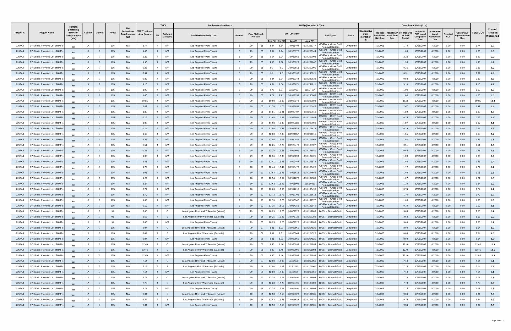
Beg PM End PM Lat. (N) Long. (W)
Revoked CUs
Total CUsTreated Areas in
WatershedRBPollutant Category
Total Maximum Daily Load Reach #Final SB Reach
Priority #
Compliance Units (CUs)
Cooperative Imple-
mentation ($)
Cooperative Implementation
CUs
Proposed BMP Install Start Date
Actual BMP Install Start
Date
Credited CUs for BMP Project
Proposed BMP Install Completion
Date
Actual BMP Install
Completion Date
Net Impervious
Area Increase (ac)
BMP Treatment Area (acres)
TMDL Implementation Reach BMP(s)Location & Type
BMP LocationsBMP Types Status
RouteProject ID Project Name
Retrofit (installing BMPs for
TMDLs only)? (Y/N)
County District
2267A4 D7 District Provided List of BMPs Yes LA 7 105 N/A 1.74 4 N/A Los Angeles River (Trash) 6 29 65 8.84 8.84 33.928494 -118.255377GSRDs - Gross Solid
Removal DevicesCompleted 7/1/2006 1.74 10/25/2007 4/2010 0.00 0.00 1.74 1.7
2267A4 D7 District Provided List of BMPs Yes LA 7 105 N/A 1.60 4 N/A Los Angeles River (Trash) 6 29 65 8.94 8.94 33.928775 -118.253144GSRDs - Gross Solid
Removal DevicesCompleted 7/1/2006 1.60 10/25/2007 4/2010 0.00 0.00 1.60 1.6
2267A4 D7 District Provided List of BMPs Yes LA 7 105 N/A 2.22 4 N/A Los Angeles River (Trash) 6 29 65 9.04 9.04 33.928856 -118.252003GSRDs - Gross Solid
Removal DevicesCompleted 7/1/2006 2.22 10/25/2007 4/2010 0.00 0.00 2.22 2.2
2267A4 D7 District Provided List of BMPs Yes LA 7 105 N/A 1.90 4 N/A Los Angeles River (Trash) 6 29 65 9.08 9.08 33.928923 -118.251267GSRDs - Gross Solid
Removal DevicesCompleted 7/1/2006 1.90 10/25/2007 4/2010 0.00 0.00 1.90 1.9
2267A4 D7 District Provided List of BMPs Yes LA 7 105 N/A 0.25 4 N/A Los Angeles River (Trash) 6 29 65 9.1 9.1 33.928918 -118.250905GSRDs - Gross Solid
Removal DevicesCompleted 7/1/2006 0.25 10/25/2007 4/2010 0.00 0.00 0.25 0.3
2267A4 D7 District Provided List of BMPs Yes LA 7 105 N/A 8.31 4 N/A Los Angeles River (Trash) 6 29 65 9.2 9.2 33.928338 -118.248921GSRDs - Gross Solid
Removal DevicesCompleted 7/1/2006 8.31 10/25/2007 4/2010 0.00 0.00 8.31 8.3
2267A4 D7 District Provided List of BMPs Yes LA 7 105 N/A 0.83 4 N/A Los Angeles River (Trash) 6 29 65 9.34 9.34 33.928344 -118.246633GSRDs - Gross Solid
Removal DevicesCompleted 7/1/2006 0.83 10/25/2007 4/2010 0.00 0.00 0.83 0.8
2267A4 D7 District Provided List of BMPs Yes LA 7 105 N/A 9.10 4 N/A Los Angeles River (Trash) 6 29 65 9.54 9.54 33.928871 -118.241811GSRDs - Gross Solid
Removal DevicesCompleted 7/1/2006 9.10 10/25/2007 4/2010 0.00 0.00 9.10 9.1
2267A4 D7 District Provided List of BMPs Yes LA 7 105 N/A 1.00 4 N/A Los Angeles River (Trash) 6 29 65 9.77 9.77 33.92783 -118.24124GSRDs - Gross Solid
Removal DevicesCompleted 7/1/2006 1.00 10/25/2007 4/2010 0.00 0.00 1.00 1.0
2267A4 D7 District Provided List of BMPs Yes LA 7 105 N/A 1.00 4 N/A Los Angeles River (Trash) 6 29 65 9.71 9.71 33.928799 -118.240808GSRDs - Gross Solid
Removal DevicesCompleted 7/1/2006 1.00 10/25/2007 4/2010 0.00 0.00 1.00 1.0
2267A4 D7 District Provided List of BMPs Yes LA 7 105 N/A 19.85 4 N/A Los Angeles River (Trash) 6 29 65 10.08 10.08 33.928372 -118.233504GSRDs - Gross Solid
Removal DevicesCompleted 7/1/2006 19.85 10/25/2007 4/2010 0.00 0.00 19.85 19.9
2267A4 D7 District Provided List of BMPs Yes LA 7 105 N/A 2.47 4 N/A Los Angeles River (Trash) 6 29 65 11.76 11.76 33.923859 -118.206445GSRDs - Gross Solid
Removal DevicesCompleted 7/1/2006 2.47 10/25/2007 4/2010 0.00 0.00 2.47 2.5
2267A4 D7 District Provided List of BMPs Yes LA 7 105 N/A 1.82 4 N/A Los Angeles River (Trash) 6 29 65 11.81 11.81 33.923407 -118.205619GSRDs - Gross Solid
Removal DevicesCompleted 7/1/2006 1.82 10/25/2007 4/2010 0.00 0.00 1.82 1.8
2267A4 D7 District Provided List of BMPs Yes LA 7 105 N/A 0.25 4 N/A Los Angeles River (Trash) 6 29 65 11.88 11.88 33.922996 -118.204684GSRDs - Gross Solid
Removal DevicesCompleted 7/1/2006 0.25 10/25/2007 4/2010 0.00 0.00 0.25 0.3
2267A4 D7 District Provided List of BMPs Yes LA 7 105 N/A 1.07 4 N/A Los Angeles River (Trash) 6 29 65 11.98 11.98 33.922331 -118.203198GSRDs - Gross Solid
Removal DevicesCompleted 7/1/2006 1.07 10/25/2007 4/2010 0.00 0.00 1.07 1.1
2267A4 D7 District Provided List of BMPs Yes LA 7 105 N/A 0.25 4 N/A Los Angeles River (Trash) 6 29 65 11.98 11.98 33.921623 -118.203618GSRDs - Gross Solid
Removal DevicesCompleted 7/1/2006 0.25 10/25/2007 4/2010 0.00 0.00 0.25 0.3
2267A4 D7 District Provided List of BMPs Yes LA 7 105 N/A 1.65 4 N/A Los Angeles River (Trash) 6 29 65 12.08 12.08 33.921657 -118.201611GSRDs - Gross Solid
Removal DevicesCompleted 7/1/2006 1.65 10/25/2007 4/2010 0.00 0.00 1.65 1.7
2267A4 D7 District Provided List of BMPs Yes LA 7 105 N/A 1.82 4 N/A Los Angeles River (Trash) 6 29 65 12.08 12.08 33.920936 -118.201963GSRDs - Gross Solid
Removal DevicesCompleted 7/1/2006 1.82 10/25/2007 4/2010 0.00 0.00 1.82 1.8
2267A4 D7 District Provided List of BMPs Yes LA 7 105 N/A 0.51 4 N/A Los Angeles River (Trash) 6 29 65 12.25 12.25 33.920478 -118.198927GSRDs - Gross Solid
Removal DevicesCompleted 7/1/2006 0.51 10/25/2007 4/2010 0.00 0.00 0.51 0.5
2267A4 D7 District Provided List of BMPs Yes LA 7 105 N/A 0.48 4 N/A Los Angeles River (Trash) 6 29 65 12.28 12.28 33.919601 -118.198881GSRDs - Gross Solid
Removal DevicesCompleted 7/1/2006 0.48 10/25/2007 4/2010 0.00 0.00 0.48 0.5
2267A4 D7 District Provided List of BMPs Yes LA 7 105 N/A 1.03 4 N/A Los Angeles River (Trash) 6 29 65 12.36 12.36 33.919099 -118.197721GSRDs - Gross Solid
Removal DevicesCompleted 7/1/2006 1.03 10/25/2007 4/2010 0.00 0.00 1.03 1.0
2267A4 D7 District Provided List of BMPs Yes LA 7 105 N/A 1.43 4 N/A Los Angeles River (Trash) 2 10 23 12.41 12.41 33.919464 -118.196575GSRDs - Gross Solid
Removal DevicesCompleted 7/1/2006 1.43 10/25/2007 4/2010 0.00 0.00 1.43 1.4
2267A4 D7 District Provided List of BMPs Yes LA 7 105 N/A 1.72 4 N/A Los Angeles River (Trash) 2 10 23 12.44 12.44 33.918478 -118.196426GSRDs - Gross Solid
Removal DevicesCompleted 7/1/2006 1.72 10/25/2007 4/2010 0.00 0.00 1.72 1.7
2267A4 D7 District Provided List of BMPs Yes LA 7 105 N/A 1.08 4 N/A Los Angeles River (Trash) 2 10 23 12.53 12.53 33.918615 -118.194656GSRDs - Gross Solid
Removal DevicesCompleted 7/1/2006 1.08 10/25/2007 4/2010 0.00 0.00 1.08 1.1
2267A4 D7 District Provided List of BMPs Yes LA 7 105 N/A 1.27 4 N/A Los Angeles River (Trash) 2 10 23 12.54 12.54 33.917876 -118.194989GSRDs - Gross Solid
Removal DevicesCompleted 7/1/2006 1.27 10/25/2007 4/2010 0.00 0.00 1.27 1.3
2267A4 D7 District Provided List of BMPs Yes LA 7 105 N/A 1.24 4 N/A Los Angeles River (Trash) 2 10 23 12.62 12.62 33.918003 -118.19323GSRDs - Gross Solid
Removal DevicesCompleted 7/1/2006 1.24 10/25/2007 4/2010 0.00 0.00 1.24 1.2
2267A4 D7 District Provided List of BMPs Yes LA 7 105 N/A 0.74 4 N/A Los Angeles River (Trash) 2 10 23 12.63 12.63 33.917215 -118.193496GSRDs - Gross Solid
Removal DevicesCompleted 7/1/2006 0.74 10/25/2007 4/2010 0.00 0.00 0.74 0.7
2267A4 D7 District Provided List of BMPs Yes LA 7 105 N/A 1.70 4 N/A Los Angeles River (Trash) 2 10 23 12.72 12.72 33.917302 -118.191618GSRDs - Gross Solid
Removal DevicesCompleted 7/1/2006 1.70 10/25/2007 4/2010 0.00 0.00 1.70 1.7
2267A4 D7 District Provided List of BMPs Yes LA 7 105 N/A 1.60 4 N/A Los Angeles River (Trash) 2 10 23 12.76 12.76 33.916347 -118.191577GSRDs - Gross Solid
Removal DevicesCompleted 7/1/2006 1.60 10/25/2007 4/2010 0.00 0.00 1.60 1.6
2267A4 D7 District Provided List of BMPs Yes LA 7 105 N/A 0.10 4 N/A Los Angeles River (Trash) 2 10 23 13.15 13.15 33.914156 -118.185049GSRDs - Gross Solid
Removal DevicesCompleted 7/1/2006 0.10 10/25/2007 4/2010 0.00 0.00 0.10 0.1
2267A4 D7 District Provided List of BMPs Yes LA 7 91 N/A 3.68 4 C Los Angeles River and Tributaries (Metals) 6 29 67 10.25 10.25 33.871728 -118.217283 BIOS - Bioswale/strip Completed 7/1/2006 3.68 10/25/2007 4/2010 0.00 0.00 3.68 3.7
2267A4 D7 District Provided List of BMPs Yes LA 7 91 N/A 3.68 4 E Los Angeles River Watershed (Bacteria) 6 29 66 10.25 10.25 33.871728 -118.217283 BIOS - Bioswale/strip Completed 7/1/2006 3.68 10/25/2007 4/2010 0.00 0.00 3.68 3.7
2267A4 D7 District Provided List of BMPs Yes LA 7 91 N/A 3.68 4 N/A Los Angeles River (Trash) 6 29 65 10.25 10.25 33.871728 -118.217283 BIOS - Bioswale/strip Completed 7/1/2006 3.68 10/25/2007 4/2010 0.00 0.00 3.68 3.7
2267A4 D7 District Provided List of BMPs Yes LA 7 105 N/A 8.04 4 C Los Angeles River and Tributaries (Metals) 6 29 67 8.31 8.31 33.926969 -118.264526 BIOS - Bioswale/strip Completed 7/1/2006 8.04 10/25/2007 4/2010 0.00 0.00 8.04 8.0
2267A4 D7 District Provided List of BMPs Yes LA 7 105 N/A 8.04 4 E Los Angeles River Watershed (Bacteria) 6 29 66 8.31 8.31 33.926969 -118.264526 BIOS - Bioswale/strip Completed 7/1/2006 8.04 10/25/2007 4/2010 0.00 0.00 8.04 8.0
2267A4 D7 District Provided List of BMPs Yes LA 7 105 N/A 8.04 4 N/A Los Angeles River (Trash) 6 29 65 8.31 8.31 33.926969 -118.264526 BIOS - Bioswale/strip Completed 7/1/2006 8.04 10/25/2007 4/2010 0.00 0.00 8.04 8.0
2267A4 D7 District Provided List of BMPs Yes LA 7 105 N/A 12.46 4 C Los Angeles River and Tributaries (Metals) 6 29 67 8.46 8.46 33.926999 -118.261894 BIOS - Bioswale/strip Completed 7/1/2006 12.46 10/25/2007 4/2010 0.00 0.00 12.46 12.5
2267A4 D7 District Provided List of BMPs Yes LA 7 105 N/A 12.46 4 E Los Angeles River Watershed (Bacteria) 6 29 66 8.46 8.46 33.926999 -118.261894 BIOS - Bioswale/strip Completed 7/1/2006 12.46 10/25/2007 4/2010 0.00 0.00 12.46 12.5
2267A4 D7 District Provided List of BMPs Yes LA 7 105 N/A 12.46 4 N/A Los Angeles River (Trash) 6 29 65 8.46 8.46 33.926999 -118.261894 BIOS - Bioswale/strip Completed 7/1/2006 12.46 10/25/2007 4/2010 0.00 0.00 12.46 12.5
2267A4 D7 District Provided List of BMPs Yes LA 7 105 N/A 7.14 4 C Los Angeles River and Tributaries (Metals) 6 29 67 12.08 12.08 33.92091 -118.202061 BIOS - Bioswale/strip Completed 7/1/2006 7.14 10/25/2007 4/2010 0.00 0.00 7.14 7.1
2267A4 D7 District Provided List of BMPs Yes LA 7 105 N/A 7.14 4 E Los Angeles River Watershed (Bacteria) 6 29 66 12.08 12.08 33.92091 -118.202061 BIOS - Bioswale/strip Completed 7/1/2006 7.14 10/25/2007 4/2010 0.00 0.00 7.14 7.1
2267A4 D7 District Provided List of BMPs Yes LA 7 105 N/A 7.14 4 N/A Los Angeles River (Trash) 6 29 65 12.08 12.08 33.92091 -118.202061 BIOS - Bioswale/strip Completed 7/1/2006 7.14 10/25/2007 4/2010 0.00 0.00 7.14 7.1
2267A4 D7 District Provided List of BMPs Yes LA 7 105 N/A 7.78 4 C Los Angeles River and Tributaries (Metals) 6 29 67 12.28 12.28 33.919491 -118.198803 BIOS - Bioswale/strip Completed 7/1/2006 7.78 10/25/2007 4/2010 0.00 0.00 7.78 7.8
2267A4 D7 District Provided List of BMPs Yes LA 7 105 N/A 7.78 4 E Los Angeles River Watershed (Bacteria) 6 29 66 12.28 12.28 33.919491 -118.198803 BIOS - Bioswale/strip Completed 7/1/2006 7.78 10/25/2007 4/2010 0.00 0.00 7.78 7.8
2267A4 D7 District Provided List of BMPs Yes LA 7 105 N/A 7.78 4 N/A Los Angeles River (Trash) 6 29 65 12.28 12.28 33.919491 -118.198803 BIOS - Bioswale/strip Completed 7/1/2006 7.78 10/25/2007 4/2010 0.00 0.00 7.78 7.8
2267A4 D7 District Provided List of BMPs Yes LA 7 105 N/A 9.34 4 C Los Angeles River and Tributaries (Metals) 2 10 25 12.53 12.53 33.918623 -118.194531 BIOS - Bioswale/strip Completed 7/1/2006 9.34 10/25/2007 4/2010 0.00 0.00 9.34 9.3
2267A4 D7 District Provided List of BMPs Yes LA 7 105 N/A 9.34 4 E Los Angeles River Watershed (Bacteria) 2 10 24 12.53 12.53 33.918623 -118.194531 BIOS - Bioswale/strip Completed 7/1/2006 9.34 10/25/2007 4/2010 0.00 0.00 9.34 9.3
2267A4 D7 District Provided List of BMPs Yes LA 7 105 N/A 9.34 4 N/A Los Angeles River (Trash) 2 10 23 12.53 12.53 33.918623 -118.194531 BIOS - Bioswale/strip Completed 7/1/2006 9.34 10/25/2007 4/2010 0.00 0.00 9.34 9.3
Page 30 of 77

Beg PM End PM Lat. (N) Long. (W)
Revoked CUs
Total CUsTreated Areas in
WatershedRBPollutant Category
Total Maximum Daily Load Reach #Final SB Reach
Priority #
Compliance Units (CUs)
Cooperative Imple-
mentation ($)
Cooperative Implementation
CUs
Proposed BMP Install Start Date
Actual BMP Install Start
Date
Credited CUs for BMP Project
Proposed BMP Install Completion
Date
Actual BMP Install
Completion Date
Net Impervious
Area Increase (ac)
BMP Treatment Area (acres)
TMDL Implementation Reach BMP(s)Location & Type
BMP LocationsBMP Types Status
RouteProject ID Project Name
Retrofit (installing BMPs for
TMDLs only)? (Y/N)
County District
2267A4 D7 District Provided List of BMPs Yes LA 7 105 N/A 7.26 4 C Los Angeles River and Tributaries (Metals) 2 10 25 12.54 12.54 33.917782 -118.194928 BIOS - Bioswale/strip Completed 7/1/2006 7.26 10/25/2007 4/2010 0.00 0.00 7.26 7.3
2267A4 D7 District Provided List of BMPs Yes LA 7 105 N/A 7.26 4 E Los Angeles River Watershed (Bacteria) 2 10 24 12.54 12.54 33.917782 -118.194928 BIOS - Bioswale/strip Completed 7/1/2006 7.26 10/25/2007 4/2010 0.00 0.00 7.26 7.3
2267A4 D7 District Provided List of BMPs Yes LA 7 105 N/A 7.26 4 N/A Los Angeles River (Trash) 2 10 23 12.54 12.54 33.917782 -118.194928 BIOS - Bioswale/strip Completed 7/1/2006 7.26 10/25/2007 4/2010 0.00 0.00 7.26 7.3
2411U4 D7 District Provided List of BMPs No LA 7 110 1.28 1.28 4 EBallona Creek, Ballona Estuary, and Sepulveda Channel
(Bacteria)2 13 31 21.2 21.2 34.040918 -118.274191 BIOS - Bioswale/strip Completed 2/19/2010 0.00 12/7/2009 5/2014 0.00 0.00 0.00 1.3
2411U4 D7 District Provided List of BMPs No LA 7 110 1.28 1.28 4 C and G Ballona Creek (Metals (Ag, Cd, Cu, Pb, Zn) and Selenium) 2 13 32 21.2 21.2 34.040918 -118.274191 BIOS - Bioswale/strip Completed 2/19/2010 0.00 12/7/2009 5/2014 0.00 0.00 0.00 1.3
2411U4 D7 District Provided List of BMPs No LA 7 110 1.28 1.28 4 N/A Ballona Creek (Trash) 2 13 30 21.2 21.2 34.040918 -118.274191 BIOS - Bioswale/strip Completed 2/19/2010 0.00 12/7/2009 5/2014 0.00 0.00 0.00 1.3
2411U4 D7 District Provided List of BMPs No LA 7 110 1.28 1.28 4 CBallona Creek Estuary (Toxic Pollutants Ag, Cd, Cu, Pb,
Zn, Chlordane, DDTs, Total PCBs, and Total PAHs)2 13 29 21.2 21.2 34.040918 -118.274191 BIOS - Bioswale/strip Completed 2/19/2010 0.00 12/7/2009 5/2014 0.00 0.00 0.00 1.3
2411U4 D7 District Provided List of BMPs No LA 7 110 1.28 1.28 4 BBallona Creek Wetlands (Sediment and Invasive Exotic
Vegetation)2 13 28 21.2 21.2 34.040918 -118.274191 BIOS - Bioswale/strip Completed 2/19/2010 0.00 12/7/2009 5/2014 0.00 0.00 0.00 1.3
2411U4 D7 District Provided List of BMPs No LA 7 110 1.28 1.28 4 C Santa Monica Bay (DDTs and PCBs) 6 46 103 21.2 21.2 34.040918 -118.274191 BIOS - Bioswale/strip Completed 2/19/2010 0.00 12/7/2009 5/2014 0.00 0.00 0.00 1.3
2411U4 D7 District Provided List of BMPs No LA 7 110 1.28 1.28 4 E Santa Monica Bay Beaches (Bacteria) 6 46 104 21.2 21.2 34.040918 -118.274191 BIOS - Bioswale/strip Completed 2/19/2010 0.00 12/7/2009 5/2014 0.00 0.00 0.00 1.3
2777U4 D7 District Provided List of BMPs No LA 7 5 0.62 0.62 4 C Los Angeles River and Tributaries (Metals) 4 21 49 26.51 26.51 34.152055 -118.282536 BIOS - Bioswale/strip Planned 11/1/2013 0.00 12/9/2013 11/2017 0.00 0.00 0.00 0.6
2777U4 D7 District Provided List of BMPs No LA 7 5 0.62 0.62 4 E Los Angeles River Watershed (Bacteria) 4 21 48 26.51 26.51 34.152055 -118.282536 BIOS - Bioswale/strip Planned 11/1/2013 0.00 12/9/2013 11/2017 0.00 0.00 0.00 0.6
2777U4 D7 District Provided List of BMPs No LA 7 5 0.62 0.62 4 N/A Los Angeles River (Trash) 4 21 47 26.51 26.51 34.152055 -118.282536 BIOS - Bioswale/strip Planned 11/1/2013 0.00 12/9/2013 11/2017 0.00 0.00 0.00 0.6
2881U4 D7 District Provided List of BMPs No LA 7 210 1.15 1.15 4 C Los Angeles River and Tributaries (Metals) 9 38 86 18.7 18.7 34.208659 -118.220277 BIOS - Bioswale/strip Planned 8/4/2014 0.00 10/28/2014 1/2018 0.00 0.00 0.00 1.2
2881U4 D7 District Provided List of BMPs No LA 7 210 1.15 1.15 4 E Los Angeles River Watershed (Bacteria) 9 38 85 18.7 18.7 34.208659 -118.220277 BIOS - Bioswale/strip Planned 8/4/2014 0.00 10/28/2014 1/2018 0.00 0.00 0.00 1.2
2881U4 D7 District Provided List of BMPs No LA 7 210 1.15 1.15 4 N/A Los Angeles River (Trash) 9 38 84 18.7 18.7 34.208659 -118.220277 BIOS - Bioswale/strip Planned 8/4/2014 0.00 10/28/2014 1/2018 0.00 0.00 0.00 1.2
4C0604 D7 District Provided List of BMPs No LA 7 103 0.72 0.72 4 CDominguez Channel & Greater Los Angeles & Long Beach
Harbor Waters (Metals (Cu, Pb, Zn), DDT, PAHs, and 2 86 150 1.1 1.1 33.783772 -118.227231 BIOS - Bioswale/strip Completed 7/8/2008 0.00 5/21/2008 10/2009 0.00 0.00 0.00 0.7
4S0104 D7 District Provided List of BMPs No LA 7 405 0.44 0.44 4 CDominguez Channel & Greater Los Angeles & Long Beach
Harbor Waters (Metals (Cu, Pb, Zn), DDT, PAHs, and 3 106 180 16.5 16.5 33.873219 -118.341832 BIOS - Bioswale/strip Completed 7/1/2007 0.00 5/22/2007 6/2008 0.00 0.00 0.00 0.4
BMP Pilot Study D7 District Provided List of BMPs No LA 7 210 1.30 1.30 4 C Los Angeles River and Tributaries (Metals) 11 28 64 6.048 6.048 34.286832 -118.407706ASF - Austin Sand
FilterCompleted 0.00 0.00 0.00 0.00 1.3
BMP Pilot Study D7 District Provided List of BMPs No LA 7 210 1.30 1.30 4 E Los Angeles River Watershed (Bacteria) 11 28 63 6.048 6.048 34.286832 -118.407706ASF - Austin Sand
FilterCompleted 0.00 0.00 0.00 0.00 1.3
BMP Pilot Study D7 District Provided List of BMPs No LA 7 210 1.30 1.30 4 N/A Los Angeles River (Trash) 11 28 62 6.048 6.048 34.286832 -118.407706ASF - Austin Sand
FilterCompleted 0.00 0.00 0.00 0.00 1.3
BMP Pilot Study D7 District Provided List of BMPs No LA 7 210 1.70 1.70 4 C Los Angeles River and Tributaries (Metals) 8 37 83 23.147 23.147 34.181251 -118.167885 BIOS - Bioswale/strip Completed 0.00 0.00 0.00 0.00 1.7
BMP Pilot Study D7 District Provided List of BMPs No LA 7 210 1.70 1.70 4 E Los Angeles River Watershed (Bacteria) 8 37 82 23.147 23.147 34.181251 -118.167885 BIOS - Bioswale/strip Completed 0.00 0.00 0.00 0.00 1.7
BMP Pilot Study D7 District Provided List of BMPs No LA 7 210 1.70 1.70 4 N/A Los Angeles River (Trash) 8 37 81 23.147 23.147 34.181251 -118.167885 BIOS - Bioswale/strip Completed 0.00 0.00 0.00 0.00 1.7
BMP Pilot Study D7 District Provided List of BMPs No LA 7 210 1.70 1.70 4 C Los Angeles River and Tributaries (Metals) 8 37 83 23.147 23.147 34.181155 -118.167768INFIL - Infiltration
(Basins & Trenches)Completed 0.00 0.00 0.00 0.00 1.7
BMP Pilot Study D7 District Provided List of BMPs No LA 7 210 1.70 1.70 4 E Los Angeles River Watershed (Bacteria) 8 37 82 23.147 23.147 34.181155 -118.167768INFIL - Infiltration
(Basins & Trenches)Completed 0.00 0.00 0.00 0.00 1.7
BMP Pilot Study D7 District Provided List of BMPs No LA 7 210 1.70 1.70 4 N/A Los Angeles River (Trash) 8 37 81 23.147 23.147 34.181155 -118.167768INFIL - Infiltration
(Basins & Trenches)Completed 0.00 0.00 0.00 0.00 1.7
BMP Pilot Study D7 District Provided List of BMPs No LA 7 105 1.90 1.90 4 C and G San Gabriel River (Metals (Cu, Pb, Zn) and Selenium) 2 89 155 15.695 15.695 33.911965 -118.14188MCTT - Multi-
Chambered Treatment Completed 0.00 0.00 0.00 0.00 1.9
BMP Pilot Study D7 District Provided List of BMPs No LA 7 5 4.60 4.60 4 C Los Angeles River and Tributaries (Metals) 4 21 49 22.429 22.429 34.101348 -118.24997MCTT - Multi-
Chambered Treatment Completed 0.00 0.00 0.00 0.00 4.6
BMP Pilot Study D7 District Provided List of BMPs No LA 7 5 4.60 4.60 4 E Los Angeles River Watershed (Bacteria) 4 21 48 22.429 22.429 34.101348 -118.24997MCTT - Multi-
Chambered Treatment Completed 0.00 0.00 0.00 0.00 4.6
BMP Pilot Study D7 District Provided List of BMPs No LA 7 5 4.60 4.60 4 N/A Los Angeles River (Trash) 4 21 47 22.429 22.429 34.101348 -118.24997MCTT - Multi-
Chambered Treatment Completed 0.00 0.00 0.00 0.00 4.6
BMP Pilot Study D7 District Provided List of BMPs No LA 7 10 0.80 0.80 4 C Los Angeles River and Tributaries (Metals) 3 25 57 17.024 17.024 34.023469 -118.241514OTHER - Oil/Water
SeparatorCompleted 0.00 0.00 0.00 0.00 0.8
BMP Pilot Study D7 District Provided List of BMPs No LA 7 10 0.80 0.80 4 E Los Angeles River Watershed (Bacteria) 3 25 56 17.024 17.024 34.023469 -118.241514OTHER - Oil/Water
SeparatorCompleted 0.00 0.00 0.00 0.00 0.8
BMP Pilot Study D7 District Provided List of BMPs No LA 7 10 0.80 0.80 4 N/A Los Angeles River (Trash) 3 25 55 17.024 17.024 34.023469 -118.241514OTHER - Oil/Water
SeparatorCompleted 0.00 0.00 0.00 0.00 0.8
BMP Pilot Study D7 District Provided List of BMPs No LA 7 60 1.50 1.50 4 C and G San Gabriel River (Metals (Cu, Pb, Zn) and Selenium) 3 90 156 12.151 12.151 34.031415 -118.019978ASF - Austin Sand
FilterCompleted 0.00 0.00 0.00 0.00 1.5
BMP Pilot Study D7 District Provided List of BMPs No LA 7 605 2.80 2.80 4 C and G San Gabriel River (Metals (Cu, Pb, Zn) and Selenium) 2 89 155 7.579 7.579 33.910146 -118.103032ASF - Austin Sand
FilterCompleted 0.00 0.00 0.00 0.00 2.8
BMP Pilot Study D7 District Provided List of BMPs No LA 7 605 0.20 0.20 4 C and G San Gabriel River (Metals (Cu, Pb, Zn) and Selenium) 2 89 155 5.019 5.019 33.878089 -118.10234 BIOS - Bioswale/strip Completed 0.00 0.00 0.00 0.00 0.2
BMP Pilot Study D7 District Provided List of BMPs No LA 7 91 0.40 0.40 4 C and G San Gabriel River (Metals (Cu, Pb, Zn) and Selenium) 2 89 155 17.071 17.071 33.876718 -118.100365 BIOS - Bioswale/strip Completed 0.00 0.00 0.00 0.00 0.4
BMP Pilot Study D7 District Provided List of BMPs No LA 7 5 0.70 0.70 4 C and G San Gabriel River (Metals (Cu, Pb, Zn) and Selenium) 3 90 156 6.794 6.794 33.94262 -118.098053 BIOS - Bioswale/strip Completed 0.00 0.00 0.00 0.00 0.7
BMP Pilot Study D7 District Provided List of BMPs No LA 7 605 0.70 0.70 4 C and G San Gabriel River (Metals (Cu, Pb, Zn) and Selenium) 6 108 183 2.885 2.885 33.839382 -118.088287 BIOS - Bioswale/strip Completed 0.00 0.00 0.00 0.00 0.7
BMP Pilot Study D7 District Provided List of BMPs No LA 7 5 6.80 6.80 4 C and G San Gabriel River (Metals (Cu, Pb, Zn) and Selenium) 3 90 156 6.875 6.875 33.941432 -118.097239OTHER - Extended
Detention BasinCompleted 0.00 0.00 0.00 0.00 6.8
BMP Pilot Study D7 District Provided List of BMPs No LA 7 605 0.80 0.80 4 C and G San Gabriel River (Metals (Cu, Pb, Zn) and Selenium) 2 89 155 5.004 5.004 33.873712 -118.101964OTHER - Extended
Detention BasinCompleted 0.00 0.00 0.00 0.00 0.8
BMP Pilot Study D7 District Provided List of BMPs No LA 7 605 4.20 4.20 4 C and G San Gabriel River (Metals (Cu, Pb, Zn) and Selenium) 2 89 155 5.079 5.079 33.877243 -118.101468INFIL - Infiltration
(Basins & Trenches)Completed 0.00 0.00 0.00 0.00 4.2
BMP Pilot Study D7 District Provided List of BMPs No LA 7 57 1.10 1.10 4 B and CLos Angeles Area Puddingstone Reservoir (Nitrogen,
Phosphorus, Chlordane, DDT, PCBs, Mercury, Dieldrin)1 49 108 8.74 8.74 34.077959 -117.814848
MCTT - Multi-Chambered Treatment
Completed 0.00 0.00 0.00 0.00 1.1
BMP Pilot Study D7 District Provided List of BMPs No LA 7 57 1.10 1.10 4 C and G San Gabriel River (Metals (Cu, Pb, Zn) and Selenium) 3 90 156 8.74 8.74 34.077959 -117.814848MCTT - Multi-
Chambered Treatment Completed 0.00 0.00 0.00 0.00 1.1
Missing EA D7 District Provided List of BMPs No LA 7 10 0.00 1.00 4 N/A Ballona Creek (Trash) 2 13 30 8.394 8.394 34.034346 -118.38445GSRDs - Gross Solid
Removal DevicesCompleted 1.00 0.00 0.00 1.00 1.0
Missing EA D7 District Provided List of BMPs No LA 7 10 0.00 1.00 4 N/A Los Angeles River (Trash) 8 37 81 26.622 26.622 34.181334 -118.169233GSRDs - Gross Solid
Removal DevicesCompleted 1.00 0.00 0.00 1.00 1.0
Missing EA D7 District Provided List of BMPs No LA 7 210 0.00 1.00 4 N/A Los Angeles River (Trash) 10 30 68 9.084 9.084 34.272612 -118.358763GSRDs - Gross Solid
Removal DevicesCompleted 1.00 0.00 0.00 1.00 1.0
Page 31 of 77
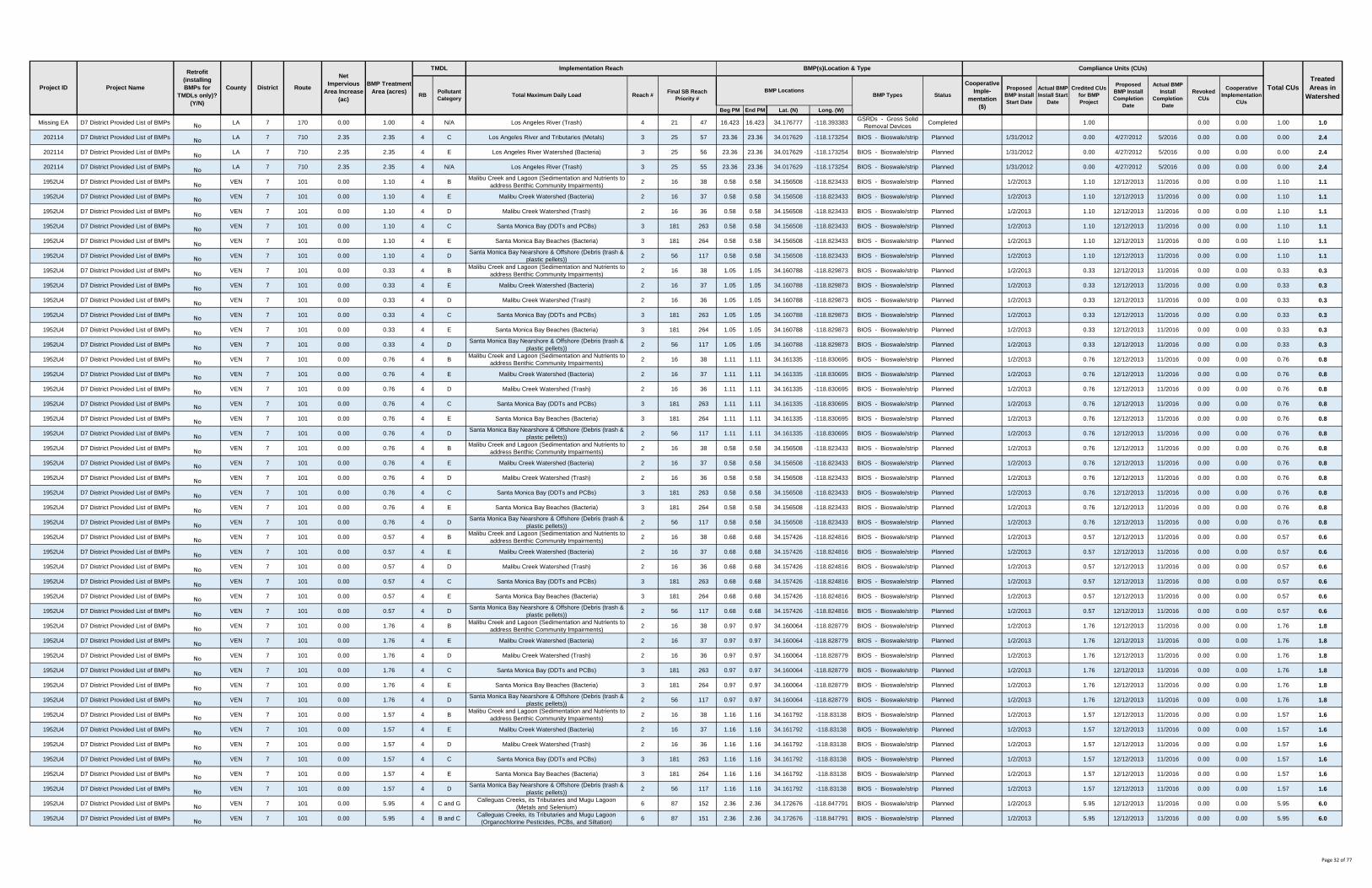
Beg PM End PM Lat. (N) Long. (W)
Revoked CUs
Total CUsTreated Areas in
WatershedRBPollutant Category
Total Maximum Daily Load Reach #Final SB Reach
Priority #
Compliance Units (CUs)
Cooperative Imple-
mentation ($)
Cooperative Implementation
CUs
Proposed BMP Install Start Date
Actual BMP Install Start
Date
Credited CUs for BMP Project
Proposed BMP Install Completion
Date
Actual BMP Install
Completion Date
Net Impervious
Area Increase (ac)
BMP Treatment Area (acres)
TMDL Implementation Reach BMP(s)Location & Type
BMP LocationsBMP Types Status
RouteProject ID Project Name
Retrofit (installing BMPs for
TMDLs only)? (Y/N)
County District
Missing EA D7 District Provided List of BMPs No LA 7 170 0.00 1.00 4 N/A Los Angeles River (Trash) 4 21 47 16.423 16.423 34.176777 -118.393383GSRDs - Gross Solid
Removal DevicesCompleted 1.00 0.00 0.00 1.00 1.0
202114 D7 District Provided List of BMPs No LA 7 710 2.35 2.35 4 C Los Angeles River and Tributaries (Metals) 3 25 57 23.36 23.36 34.017629 -118.173254 BIOS - Bioswale/strip Planned 1/31/2012 0.00 4/27/2012 5/2016 0.00 0.00 0.00 2.4
202114 D7 District Provided List of BMPs No LA 7 710 2.35 2.35 4 E Los Angeles River Watershed (Bacteria) 3 25 56 23.36 23.36 34.017629 -118.173254 BIOS - Bioswale/strip Planned 1/31/2012 0.00 4/27/2012 5/2016 0.00 0.00 0.00 2.4
202114 D7 District Provided List of BMPs No LA 7 710 2.35 2.35 4 N/A Los Angeles River (Trash) 3 25 55 23.36 23.36 34.017629 -118.173254 BIOS - Bioswale/strip Planned 1/31/2012 0.00 4/27/2012 5/2016 0.00 0.00 0.00 2.4
1952U4 D7 District Provided List of BMPs No VEN 7 101 0.00 1.10 4 BMalibu Creek and Lagoon (Sedimentation and Nutrients to
address Benthic Community Impairments)2 16 38 0.58 0.58 34.156508 -118.823433 BIOS - Bioswale/strip Planned 1/2/2013 1.10 12/12/2013 11/2016 0.00 0.00 1.10 1.1
1952U4 D7 District Provided List of BMPs No VEN 7 101 0.00 1.10 4 E Malibu Creek Watershed (Bacteria) 2 16 37 0.58 0.58 34.156508 -118.823433 BIOS - Bioswale/strip Planned 1/2/2013 1.10 12/12/2013 11/2016 0.00 0.00 1.10 1.1
1952U4 D7 District Provided List of BMPs No VEN 7 101 0.00 1.10 4 D Malibu Creek Watershed (Trash) 2 16 36 0.58 0.58 34.156508 -118.823433 BIOS - Bioswale/strip Planned 1/2/2013 1.10 12/12/2013 11/2016 0.00 0.00 1.10 1.1
1952U4 D7 District Provided List of BMPs No VEN 7 101 0.00 1.10 4 C Santa Monica Bay (DDTs and PCBs) 3 181 263 0.58 0.58 34.156508 -118.823433 BIOS - Bioswale/strip Planned 1/2/2013 1.10 12/12/2013 11/2016 0.00 0.00 1.10 1.1
1952U4 D7 District Provided List of BMPs No VEN 7 101 0.00 1.10 4 E Santa Monica Bay Beaches (Bacteria) 3 181 264 0.58 0.58 34.156508 -118.823433 BIOS - Bioswale/strip Planned 1/2/2013 1.10 12/12/2013 11/2016 0.00 0.00 1.10 1.1
1952U4 D7 District Provided List of BMPs No VEN 7 101 0.00 1.10 4 DSanta Monica Bay Nearshore & Offshore (Debris (trash &
plastic pellets))2 56 117 0.58 0.58 34.156508 -118.823433 BIOS - Bioswale/strip Planned 1/2/2013 1.10 12/12/2013 11/2016 0.00 0.00 1.10 1.1
1952U4 D7 District Provided List of BMPs No VEN 7 101 0.00 0.33 4 BMalibu Creek and Lagoon (Sedimentation and Nutrients to
address Benthic Community Impairments)2 16 38 1.05 1.05 34.160788 -118.829873 BIOS - Bioswale/strip Planned 1/2/2013 0.33 12/12/2013 11/2016 0.00 0.00 0.33 0.3
1952U4 D7 District Provided List of BMPs No VEN 7 101 0.00 0.33 4 E Malibu Creek Watershed (Bacteria) 2 16 37 1.05 1.05 34.160788 -118.829873 BIOS - Bioswale/strip Planned 1/2/2013 0.33 12/12/2013 11/2016 0.00 0.00 0.33 0.3
1952U4 D7 District Provided List of BMPs No VEN 7 101 0.00 0.33 4 D Malibu Creek Watershed (Trash) 2 16 36 1.05 1.05 34.160788 -118.829873 BIOS - Bioswale/strip Planned 1/2/2013 0.33 12/12/2013 11/2016 0.00 0.00 0.33 0.3
1952U4 D7 District Provided List of BMPs No VEN 7 101 0.00 0.33 4 C Santa Monica Bay (DDTs and PCBs) 3 181 263 1.05 1.05 34.160788 -118.829873 BIOS - Bioswale/strip Planned 1/2/2013 0.33 12/12/2013 11/2016 0.00 0.00 0.33 0.3
1952U4 D7 District Provided List of BMPs No VEN 7 101 0.00 0.33 4 E Santa Monica Bay Beaches (Bacteria) 3 181 264 1.05 1.05 34.160788 -118.829873 BIOS - Bioswale/strip Planned 1/2/2013 0.33 12/12/2013 11/2016 0.00 0.00 0.33 0.3
1952U4 D7 District Provided List of BMPs No VEN 7 101 0.00 0.33 4 DSanta Monica Bay Nearshore & Offshore (Debris (trash &
plastic pellets))2 56 117 1.05 1.05 34.160788 -118.829873 BIOS - Bioswale/strip Planned 1/2/2013 0.33 12/12/2013 11/2016 0.00 0.00 0.33 0.3
1952U4 D7 District Provided List of BMPs No VEN 7 101 0.00 0.76 4 BMalibu Creek and Lagoon (Sedimentation and Nutrients to
address Benthic Community Impairments)2 16 38 1.11 1.11 34.161335 -118.830695 BIOS - Bioswale/strip Planned 1/2/2013 0.76 12/12/2013 11/2016 0.00 0.00 0.76 0.8
1952U4 D7 District Provided List of BMPs No VEN 7 101 0.00 0.76 4 E Malibu Creek Watershed (Bacteria) 2 16 37 1.11 1.11 34.161335 -118.830695 BIOS - Bioswale/strip Planned 1/2/2013 0.76 12/12/2013 11/2016 0.00 0.00 0.76 0.8
1952U4 D7 District Provided List of BMPs No VEN 7 101 0.00 0.76 4 D Malibu Creek Watershed (Trash) 2 16 36 1.11 1.11 34.161335 -118.830695 BIOS - Bioswale/strip Planned 1/2/2013 0.76 12/12/2013 11/2016 0.00 0.00 0.76 0.8
1952U4 D7 District Provided List of BMPs No VEN 7 101 0.00 0.76 4 C Santa Monica Bay (DDTs and PCBs) 3 181 263 1.11 1.11 34.161335 -118.830695 BIOS - Bioswale/strip Planned 1/2/2013 0.76 12/12/2013 11/2016 0.00 0.00 0.76 0.8
1952U4 D7 District Provided List of BMPs No VEN 7 101 0.00 0.76 4 E Santa Monica Bay Beaches (Bacteria) 3 181 264 1.11 1.11 34.161335 -118.830695 BIOS - Bioswale/strip Planned 1/2/2013 0.76 12/12/2013 11/2016 0.00 0.00 0.76 0.8
1952U4 D7 District Provided List of BMPs No VEN 7 101 0.00 0.76 4 DSanta Monica Bay Nearshore & Offshore (Debris (trash &
plastic pellets))2 56 117 1.11 1.11 34.161335 -118.830695 BIOS - Bioswale/strip Planned 1/2/2013 0.76 12/12/2013 11/2016 0.00 0.00 0.76 0.8
1952U4 D7 District Provided List of BMPs No VEN 7 101 0.00 0.76 4 BMalibu Creek and Lagoon (Sedimentation and Nutrients to
address Benthic Community Impairments)2 16 38 0.58 0.58 34.156508 -118.823433 BIOS - Bioswale/strip Planned 1/2/2013 0.76 12/12/2013 11/2016 0.00 0.00 0.76 0.8
1952U4 D7 District Provided List of BMPs No VEN 7 101 0.00 0.76 4 E Malibu Creek Watershed (Bacteria) 2 16 37 0.58 0.58 34.156508 -118.823433 BIOS - Bioswale/strip Planned 1/2/2013 0.76 12/12/2013 11/2016 0.00 0.00 0.76 0.8
1952U4 D7 District Provided List of BMPs No VEN 7 101 0.00 0.76 4 D Malibu Creek Watershed (Trash) 2 16 36 0.58 0.58 34.156508 -118.823433 BIOS - Bioswale/strip Planned 1/2/2013 0.76 12/12/2013 11/2016 0.00 0.00 0.76 0.8
1952U4 D7 District Provided List of BMPs No VEN 7 101 0.00 0.76 4 C Santa Monica Bay (DDTs and PCBs) 3 181 263 0.58 0.58 34.156508 -118.823433 BIOS - Bioswale/strip Planned 1/2/2013 0.76 12/12/2013 11/2016 0.00 0.00 0.76 0.8
1952U4 D7 District Provided List of BMPs No VEN 7 101 0.00 0.76 4 E Santa Monica Bay Beaches (Bacteria) 3 181 264 0.58 0.58 34.156508 -118.823433 BIOS - Bioswale/strip Planned 1/2/2013 0.76 12/12/2013 11/2016 0.00 0.00 0.76 0.8
1952U4 D7 District Provided List of BMPs No VEN 7 101 0.00 0.76 4 DSanta Monica Bay Nearshore & Offshore (Debris (trash &
plastic pellets))2 56 117 0.58 0.58 34.156508 -118.823433 BIOS - Bioswale/strip Planned 1/2/2013 0.76 12/12/2013 11/2016 0.00 0.00 0.76 0.8
1952U4 D7 District Provided List of BMPs No VEN 7 101 0.00 0.57 4 BMalibu Creek and Lagoon (Sedimentation and Nutrients to
address Benthic Community Impairments)2 16 38 0.68 0.68 34.157426 -118.824816 BIOS - Bioswale/strip Planned 1/2/2013 0.57 12/12/2013 11/2016 0.00 0.00 0.57 0.6
1952U4 D7 District Provided List of BMPs No VEN 7 101 0.00 0.57 4 E Malibu Creek Watershed (Bacteria) 2 16 37 0.68 0.68 34.157426 -118.824816 BIOS - Bioswale/strip Planned 1/2/2013 0.57 12/12/2013 11/2016 0.00 0.00 0.57 0.6
1952U4 D7 District Provided List of BMPs No VEN 7 101 0.00 0.57 4 D Malibu Creek Watershed (Trash) 2 16 36 0.68 0.68 34.157426 -118.824816 BIOS - Bioswale/strip Planned 1/2/2013 0.57 12/12/2013 11/2016 0.00 0.00 0.57 0.6
1952U4 D7 District Provided List of BMPs No VEN 7 101 0.00 0.57 4 C Santa Monica Bay (DDTs and PCBs) 3 181 263 0.68 0.68 34.157426 -118.824816 BIOS - Bioswale/strip Planned 1/2/2013 0.57 12/12/2013 11/2016 0.00 0.00 0.57 0.6
1952U4 D7 District Provided List of BMPs No VEN 7 101 0.00 0.57 4 E Santa Monica Bay Beaches (Bacteria) 3 181 264 0.68 0.68 34.157426 -118.824816 BIOS - Bioswale/strip Planned 1/2/2013 0.57 12/12/2013 11/2016 0.00 0.00 0.57 0.6
1952U4 D7 District Provided List of BMPs No VEN 7 101 0.00 0.57 4 DSanta Monica Bay Nearshore & Offshore (Debris (trash &
plastic pellets))2 56 117 0.68 0.68 34.157426 -118.824816 BIOS - Bioswale/strip Planned 1/2/2013 0.57 12/12/2013 11/2016 0.00 0.00 0.57 0.6
1952U4 D7 District Provided List of BMPs No VEN 7 101 0.00 1.76 4 BMalibu Creek and Lagoon (Sedimentation and Nutrients to
address Benthic Community Impairments)2 16 38 0.97 0.97 34.160064 -118.828779 BIOS - Bioswale/strip Planned 1/2/2013 1.76 12/12/2013 11/2016 0.00 0.00 1.76 1.8
1952U4 D7 District Provided List of BMPs No VEN 7 101 0.00 1.76 4 E Malibu Creek Watershed (Bacteria) 2 16 37 0.97 0.97 34.160064 -118.828779 BIOS - Bioswale/strip Planned 1/2/2013 1.76 12/12/2013 11/2016 0.00 0.00 1.76 1.8
1952U4 D7 District Provided List of BMPs No VEN 7 101 0.00 1.76 4 D Malibu Creek Watershed (Trash) 2 16 36 0.97 0.97 34.160064 -118.828779 BIOS - Bioswale/strip Planned 1/2/2013 1.76 12/12/2013 11/2016 0.00 0.00 1.76 1.8
1952U4 D7 District Provided List of BMPs No VEN 7 101 0.00 1.76 4 C Santa Monica Bay (DDTs and PCBs) 3 181 263 0.97 0.97 34.160064 -118.828779 BIOS - Bioswale/strip Planned 1/2/2013 1.76 12/12/2013 11/2016 0.00 0.00 1.76 1.8
1952U4 D7 District Provided List of BMPs No VEN 7 101 0.00 1.76 4 E Santa Monica Bay Beaches (Bacteria) 3 181 264 0.97 0.97 34.160064 -118.828779 BIOS - Bioswale/strip Planned 1/2/2013 1.76 12/12/2013 11/2016 0.00 0.00 1.76 1.8
1952U4 D7 District Provided List of BMPs No VEN 7 101 0.00 1.76 4 DSanta Monica Bay Nearshore & Offshore (Debris (trash &
plastic pellets))2 56 117 0.97 0.97 34.160064 -118.828779 BIOS - Bioswale/strip Planned 1/2/2013 1.76 12/12/2013 11/2016 0.00 0.00 1.76 1.8
1952U4 D7 District Provided List of BMPs No VEN 7 101 0.00 1.57 4 BMalibu Creek and Lagoon (Sedimentation and Nutrients to
address Benthic Community Impairments)2 16 38 1.16 1.16 34.161792 -118.83138 BIOS - Bioswale/strip Planned 1/2/2013 1.57 12/12/2013 11/2016 0.00 0.00 1.57 1.6
1952U4 D7 District Provided List of BMPs No VEN 7 101 0.00 1.57 4 E Malibu Creek Watershed (Bacteria) 2 16 37 1.16 1.16 34.161792 -118.83138 BIOS - Bioswale/strip Planned 1/2/2013 1.57 12/12/2013 11/2016 0.00 0.00 1.57 1.6
1952U4 D7 District Provided List of BMPs No VEN 7 101 0.00 1.57 4 D Malibu Creek Watershed (Trash) 2 16 36 1.16 1.16 34.161792 -118.83138 BIOS - Bioswale/strip Planned 1/2/2013 1.57 12/12/2013 11/2016 0.00 0.00 1.57 1.6
1952U4 D7 District Provided List of BMPs No VEN 7 101 0.00 1.57 4 C Santa Monica Bay (DDTs and PCBs) 3 181 263 1.16 1.16 34.161792 -118.83138 BIOS - Bioswale/strip Planned 1/2/2013 1.57 12/12/2013 11/2016 0.00 0.00 1.57 1.6
1952U4 D7 District Provided List of BMPs No VEN 7 101 0.00 1.57 4 E Santa Monica Bay Beaches (Bacteria) 3 181 264 1.16 1.16 34.161792 -118.83138 BIOS - Bioswale/strip Planned 1/2/2013 1.57 12/12/2013 11/2016 0.00 0.00 1.57 1.6
1952U4 D7 District Provided List of BMPs No VEN 7 101 0.00 1.57 4 DSanta Monica Bay Nearshore & Offshore (Debris (trash &
plastic pellets))2 56 117 1.16 1.16 34.161792 -118.83138 BIOS - Bioswale/strip Planned 1/2/2013 1.57 12/12/2013 11/2016 0.00 0.00 1.57 1.6
1952U4 D7 District Provided List of BMPs No VEN 7 101 0.00 5.95 4 C and GCalleguas Creeks, its Tributaries and Mugu Lagoon
(Metals and Selenium)6 87 152 2.36 2.36 34.172676 -118.847791 BIOS - Bioswale/strip Planned 1/2/2013 5.95 12/12/2013 11/2016 0.00 0.00 5.95 6.0
1952U4 D7 District Provided List of BMPs No VEN 7 101 0.00 5.95 4 B and CCalleguas Creeks, its Tributaries and Mugu Lagoon
(Organochlorine Pesticides, PCBs, and Siltation)6 87 151 2.36 2.36 34.172676 -118.847791 BIOS - Bioswale/strip Planned 1/2/2013 5.95 12/12/2013 11/2016 0.00 0.00 5.95 6.0
Page 32 of 77
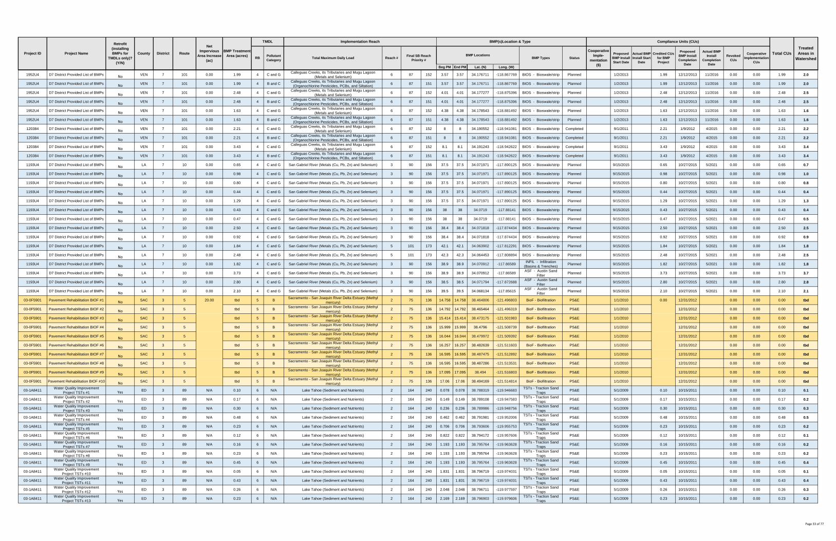
Beg PM End PM Lat. (N) Long. (W)
Revoked CUs
Total CUsTreated Areas in
WatershedRBPollutant Category
Total Maximum Daily Load Reach #Final SB Reach
Priority #
Compliance Units (CUs)
Cooperative Imple-
mentation ($)
Cooperative Implementation
CUs
Proposed BMP Install Start Date
Actual BMP Install Start
Date
Credited CUs for BMP Project
Proposed BMP Install Completion
Date
Actual BMP Install
Completion Date
Net Impervious
Area Increase (ac)
BMP Treatment Area (acres)
TMDL Implementation Reach BMP(s)Location & Type
BMP LocationsBMP Types Status
RouteProject ID Project Name
Retrofit (installing BMPs for
TMDLs only)? (Y/N)
County District
1952U4 D7 District Provided List of BMPs No VEN 7 101 0.00 1.99 4 C and GCalleguas Creeks, its Tributaries and Mugu Lagoon
(Metals and Selenium)6 87 152 3.57 3.57 34.176711 -118.867769 BIOS - Bioswale/strip Planned 1/2/2013 1.99 12/12/2013 11/2016 0.00 0.00 1.99 2.0
1952U4 D7 District Provided List of BMPs No VEN 7 101 0.00 1.99 4 B and CCalleguas Creeks, its Tributaries and Mugu Lagoon
(Organochlorine Pesticides, PCBs, and Siltation)6 87 151 3.57 3.57 34.176711 -118.867769 BIOS - Bioswale/strip Planned 1/2/2013 1.99 12/12/2013 11/2016 0.00 0.00 1.99 2.0
1952U4 D7 District Provided List of BMPs No VEN 7 101 0.00 2.48 4 C and GCalleguas Creeks, its Tributaries and Mugu Lagoon
(Metals and Selenium)6 87 152 4.01 4.01 34.177277 -118.875396 BIOS - Bioswale/strip Planned 1/2/2013 2.48 12/12/2013 11/2016 0.00 0.00 2.48 2.5
1952U4 D7 District Provided List of BMPs No VEN 7 101 0.00 2.48 4 B and CCalleguas Creeks, its Tributaries and Mugu Lagoon
(Organochlorine Pesticides, PCBs, and Siltation)6 87 151 4.01 4.01 34.177277 -118.875396 BIOS - Bioswale/strip Planned 1/2/2013 2.48 12/12/2013 11/2016 0.00 0.00 2.48 2.5
1952U4 D7 District Provided List of BMPs No VEN 7 101 0.00 1.63 4 C and GCalleguas Creeks, its Tributaries and Mugu Lagoon
(Metals and Selenium)6 87 152 4.38 4.38 34.178543 -118.881492 BIOS - Bioswale/strip Planned 1/2/2013 1.63 12/12/2013 11/2016 0.00 0.00 1.63 1.6
1952U4 D7 District Provided List of BMPs No VEN 7 101 0.00 1.63 4 B and CCalleguas Creeks, its Tributaries and Mugu Lagoon
(Organochlorine Pesticides, PCBs, and Siltation)6 87 151 4.38 4.38 34.178543 -118.881492 BIOS - Bioswale/strip Planned 1/2/2013 1.63 12/12/2013 11/2016 0.00 0.00 1.63 1.6
120384 D7 District Provided List of BMPs No VEN 7 101 0.00 2.21 4 C and GCalleguas Creeks, its Tributaries and Mugu Lagoon
(Metals and Selenium)6 87 152 8 8 34.190552 -118.941081 BIOS - Bioswale/strip Completed 9/1/2011 2.21 1/9/2012 4/2015 0.00 0.00 2.21 2.2
120384 D7 District Provided List of BMPs No VEN 7 101 0.00 2.21 4 B and CCalleguas Creeks, its Tributaries and Mugu Lagoon
(Organochlorine Pesticides, PCBs, and Siltation)6 87 151 8 8 34.190552 -118.941081 BIOS - Bioswale/strip Completed 9/1/2011 2.21 1/9/2012 4/2015 0.00 0.00 2.21 2.2
120384 D7 District Provided List of BMPs No VEN 7 101 0.00 3.43 4 C and GCalleguas Creeks, its Tributaries and Mugu Lagoon
(Metals and Selenium)6 87 152 8.1 8.1 34.191243 -118.942622 BIOS - Bioswale/strip Completed 9/1/2011 3.43 1/9/2012 4/2015 0.00 0.00 3.43 3.4
120384 D7 District Provided List of BMPs No VEN 7 101 0.00 3.43 4 B and CCalleguas Creeks, its Tributaries and Mugu Lagoon
(Organochlorine Pesticides, PCBs, and Siltation)6 87 151 8.1 8.1 34.191243 -118.942622 BIOS - Bioswale/strip Completed 9/1/2011 3.43 1/9/2012 4/2015 0.00 0.00 3.43 3.4
1193U4 D7 District Provided List of BMPs No LA 7 10 0.00 0.65 4 C and G San Gabriel River (Metals (Cu, Pb, Zn) and Selenium) 3 90 156 37.5 37.5 34.071971 -117.890125 BIOS - Bioswale/strip Planned 9/15/2015 0.65 10/27/2015 5/2021 0.00 0.00 0.65 0.7
1193U4 D7 District Provided List of BMPs No LA 7 10 0.00 0.98 4 C and G San Gabriel River (Metals (Cu, Pb, Zn) and Selenium) 3 90 156 37.5 37.5 34.071971 -117.890125 BIOS - Bioswale/strip Planned 9/15/2015 0.98 10/27/2015 5/2021 0.00 0.00 0.98 1.0
1193U4 D7 District Provided List of BMPs No LA 7 10 0.00 0.80 4 C and G San Gabriel River (Metals (Cu, Pb, Zn) and Selenium) 3 90 156 37.5 37.5 34.071971 -117.890125 BIOS - Bioswale/strip Planned 9/15/2015 0.80 10/27/2015 5/2021 0.00 0.00 0.80 0.8
1193U4 D7 District Provided List of BMPs No LA 7 10 0.00 0.44 4 C and G San Gabriel River (Metals (Cu, Pb, Zn) and Selenium) 3 90 156 37.5 37.5 34.071971 -117.890125 BIOS - Bioswale/strip Planned 9/15/2015 0.44 10/27/2015 5/2021 0.00 0.00 0.44 0.4
1193U4 D7 District Provided List of BMPs No LA 7 10 0.00 1.29 4 C and G San Gabriel River (Metals (Cu, Pb, Zn) and Selenium) 3 90 156 37.5 37.5 34.071971 -117.890125 BIOS - Bioswale/strip Planned 9/15/2015 1.29 10/27/2015 5/2021 0.00 0.00 1.29 1.3
1193U4 D7 District Provided List of BMPs No LA 7 10 0.00 0.43 4 C and G San Gabriel River (Metals (Cu, Pb, Zn) and Selenium) 3 90 156 38 38 34.0719 -117.88141 BIOS - Bioswale/strip Planned 9/15/2015 0.43 10/27/2015 5/2021 0.00 0.00 0.43 0.4
1193U4 D7 District Provided List of BMPs No LA 7 10 0.00 0.47 4 C and G San Gabriel River (Metals (Cu, Pb, Zn) and Selenium) 3 90 156 38 38 34.0719 -117.88141 BIOS - Bioswale/strip Planned 9/15/2015 0.47 10/27/2015 5/2021 0.00 0.00 0.47 0.5
1193U4 D7 District Provided List of BMPs No LA 7 10 0.00 2.50 4 C and G San Gabriel River (Metals (Cu, Pb, Zn) and Selenium) 3 90 156 38.4 38.4 34.071818 -117.874434 BIOS - Bioswale/strip Planned 9/15/2015 2.50 10/27/2015 5/2021 0.00 0.00 2.50 2.5
1193U4 D7 District Provided List of BMPs No LA 7 10 0.00 0.92 4 C and G San Gabriel River (Metals (Cu, Pb, Zn) and Selenium) 3 90 156 38.4 38.4 34.071818 -117.874434 BIOS - Bioswale/strip Planned 9/15/2015 0.92 10/27/2015 5/2021 0.00 0.00 0.92 0.9
1193U4 D7 District Provided List of BMPs No LA 7 10 0.00 1.84 4 C and G San Gabriel River (Metals (Cu, Pb, Zn) and Selenium) 5 101 173 42.1 42.1 34.063902 -117.812291 BIOS - Bioswale/strip Planned 9/15/2015 1.84 10/27/2015 5/2021 0.00 0.00 1.84 1.8
1193U4 D7 District Provided List of BMPs No LA 7 10 0.00 2.48 4 C and G San Gabriel River (Metals (Cu, Pb, Zn) and Selenium) 5 101 173 42.3 42.3 34.064453 -117.808894 BIOS - Bioswale/strip Planned 9/15/2015 2.48 10/27/2015 5/2021 0.00 0.00 2.48 2.5
1193U4 D7 District Provided List of BMPs No LA 7 10 0.00 1.82 4 C and G San Gabriel River (Metals (Cu, Pb, Zn) and Selenium) 3 90 156 38.9 38.9 34.070912 -117.86589INFIL - Infiltration
(Basins & Trenches)Planned 9/15/2015 1.82 10/27/2015 5/2021 0.00 0.00 1.82 1.8
1193U4 D7 District Provided List of BMPs No LA 7 10 0.00 3.73 4 C and G San Gabriel River (Metals (Cu, Pb, Zn) and Selenium) 3 90 156 38.9 38.9 34.070912 -117.86589ASF - Austin Sand
FilterPlanned 9/15/2015 3.73 10/27/2015 5/2021 0.00 0.00 3.73 3.7
1193U4 D7 District Provided List of BMPs No LA 7 10 0.00 2.80 4 C and G San Gabriel River (Metals (Cu, Pb, Zn) and Selenium) 3 90 156 38.5 38.5 34.071794 -117.872688ASF - Austin Sand
FilterPlanned 9/15/2015 2.80 10/27/2015 5/2021 0.00 0.00 2.80 2.8
1193U4 D7 District Provided List of BMPs No LA 7 10 0.00 2.10 4 C and G San Gabriel River (Metals (Cu, Pb, Zn) and Selenium) 3 90 156 39.5 39.5 34.068134 -117.85615ASF - Austin Sand
FilterPlanned 9/15/2015 2.10 10/27/2015 5/2021 0.00 0.00 2.10 2.1
03-0F5901 Pavement Rehabilitation BIOF #1 No SAC 3 5 20.00 tbd 5 BSacramento - San Joaquin River Delta Estuary (Methyl
mercury)2 75 136 14.758 14.758 38.464806 -121.496803 BioF - Biofiltration PS&E 1/1/2010 0.00 12/31/2012 0.00 0.00 0.00 tbd
03-0F5901 Pavement Rehabilitation BIOF #2 No SAC 3 5 tbd 5 BSacramento - San Joaquin River Delta Estuary (Methyl
mercury)2 75 136 14.792 14.792 38.465464 -121.496319 BioF - Biofiltration PS&E 1/1/2010 12/31/2012 0.00 0.00 0.00 tbd
03-0F5901 Pavement Rehabilitation BIOF #3 No SAC 3 5 tbd 5 BSacramento - San Joaquin River Delta Estuary (Methyl
mercury)2 75 136 15.414 15.414 38.473175 -121.501983 BioF - Biofiltration PS&E 1/1/2010 12/31/2012 0.00 0.00 0.00 tbd
03-0F5901 Pavement Rehabilitation BIOF #4 No SAC 3 5 tbd 5 BSacramento - San Joaquin River Delta Estuary (Methyl
mercury)2 75 136 15.999 15.999 38.4796 -121.508739 BioF - Biofiltration PS&E 1/1/2010 12/31/2012 0.00 0.00 0.00 tbd
03-0F5901 Pavement Rehabilitation BIOF #5 No SAC 3 5 tbd 5 BSacramento - San Joaquin River Delta Estuary (Methyl
mercury)2 75 136 16.044 16.044 38.479972 -121.509392 BioF - Biofiltration PS&E 1/1/2010 12/31/2012 0.00 0.00 0.00 tbd
03-0F5901 Pavement Rehabilitation BIOF #6 No SAC 3 5 tbd 5 BSacramento - San Joaquin River Delta Estuary (Methyl
mercury)2 75 136 16.257 16.257 38.482639 -121.511603 BioF - Biofiltration PS&E 1/1/2010 12/31/2012 0.00 0.00 0.00 tbd
03-0F5901 Pavement Rehabilitation BIOF #7 No SAC 3 5 tbd 5 BSacramento - San Joaquin River Delta Estuary (Methyl
mercury)2 75 136 16.595 16.595 38.487475 -121.512892 BioF - Biofiltration PS&E 1/1/2010 12/31/2012 0.00 0.00 0.00 tbd
03-0F5901 Pavement Rehabilitation BIOF #8 No SAC 3 5 tbd 5 BSacramento - San Joaquin River Delta Estuary (Methyl
mercury)2 75 136 16.595 16.595 38.487286 -121.513531 BioF - Biofiltration PS&E 1/1/2010 12/31/2012 0.00 0.00 0.00 tbd
03-0F5901 Pavement Rehabilitation BIOF #9 No SAC 3 5 tbd 5 BSacramento - San Joaquin River Delta Estuary (Methyl
mercury)2 75 136 17.095 17.095 38.494 -121.516803 BioF - Biofiltration PS&E 1/1/2010 12/31/2012 0.00 0.00 0.00 tbd
03-0F5901 Pavement Rehabilitation BIOF #10 No SAC 3 5 tbd 5 BSacramento - San Joaquin River Delta Estuary (Methyl
mercury)2 75 136 17.06 17.06 38.494169 -121.514814 BioF - Biofiltration PS&E 1/1/2010 12/31/2012 0.00 0.00 0.00 tbd
03-1A8411Water Quality Improvement
Project TSTs #1 Yes ED 3 89 N/A 0.10 6 N/A Lake Tahoe (Sediment and Nutrients) 2 164 240 0.078 0.078 38.788319 -119.946683TSTs - Traction Sand
TrapsPS&E 5/1/2009 0.10 10/15/2011 0.00 0.00 0.10 0.1
03-1A8411Water Quality Improvement
Project TSTs #2 Yes ED 3 89 N/A 0.17 6 N/A Lake Tahoe (Sediment and Nutrients) 2 164 240 0.149 0.149 38.789108 -119.947583TSTs - Traction Sand
TrapsPS&E 5/1/2009 0.17 10/15/2011 0.00 0.00 0.17 0.2
03-1A8411Water Quality Improvement
Project TSTs #3 Yes ED 3 89 N/A 0.30 6 N/A Lake Tahoe (Sediment and Nutrients) 2 164 240 0.236 0.236 38.789986 -119.948756TSTs - Traction Sand
TrapsPS&E 5/1/2009 0.30 10/15/2011 0.00 0.00 0.30 0.3
03-1A8411Water Quality Improvement
Project TSTs #4 Yes ED 3 89 N/A 0.48 6 N/A Lake Tahoe (Sediment and Nutrients) 2 164 240 0.462 0.462 38.791981 -119.952006TSTs - Traction Sand
TrapsPS&E 5/1/2009 0.48 10/15/2011 0.00 0.00 0.48 0.5
03-1A8411Water Quality Improvement
Project TSTs #5 Yes ED 3 89 N/A 0.23 6 N/A Lake Tahoe (Sediment and Nutrients) 2 164 240 0.706 0.706 38.793606 -119.955753TSTs - Traction Sand
TrapsPS&E 5/1/2009 0.23 10/15/2011 0.00 0.00 0.23 0.2
03-1A8411Water Quality Improvement
Project TSTs #6 Yes ED 3 89 N/A 0.12 6 N/A Lake Tahoe (Sediment and Nutrients) 2 164 240 0.822 0.822 38.794172 -119.957606TSTs - Traction Sand
TrapsPS&E 5/1/2009 0.12 10/15/2011 0.00 0.00 0.12 0.1
03-1A8411Water Quality Improvement
Project TSTs #7 Yes ED 3 89 N/A 0.16 6 N/A Lake Tahoe (Sediment and Nutrients) 2 164 240 1.193 1.193 38.795764 -119.963628TSTs - Traction Sand
TrapsPS&E 5/1/2009 0.16 10/15/2011 0.00 0.00 0.16 0.2
03-1A8411Water Quality Improvement
Project TSTs #8 Yes ED 3 89 N/A 0.23 6 N/A Lake Tahoe (Sediment and Nutrients) 2 164 240 1.193 1.193 38.795764 -119.963628TSTs - Traction Sand
TrapsPS&E 5/1/2009 0.23 10/15/2011 0.00 0.00 0.23 0.2
03-1A8411Water Quality Improvement
Project TSTs #9 Yes ED 3 89 N/A 0.45 6 N/A Lake Tahoe (Sediment and Nutrients) 2 164 240 1.193 1.193 38.795764 -119.963628TSTs - Traction Sand
TrapsPS&E 5/1/2009 0.45 10/15/2011 0.00 0.00 0.45 0.4
03-1A8411Water Quality Improvement
Project TSTs #10 Yes ED 3 89 N/A 0.05 6 N/A Lake Tahoe (Sediment and Nutrients) 2 164 240 1.831 1.831 38.796719 -119.974031TSTs - Traction Sand
TrapsPS&E 5/1/2009 0.05 10/15/2011 0.00 0.00 0.05 0.1
03-1A8411Water Quality Improvement
Project TSTs #11 Yes ED 3 89 N/A 0.43 6 N/A Lake Tahoe (Sediment and Nutrients) 2 164 240 1.831 1.831 38.796719 -119.974031TSTs - Traction Sand
TrapsPS&E 5/1/2009 0.43 10/15/2011 0.00 0.00 0.43 0.4
03-1A8411Water Quality Improvement
Project TSTs #12 Yes ED 3 89 N/A 0.26 6 N/A Lake Tahoe (Sediment and Nutrients) 2 164 240 2.048 2.048 38.796711 -119.977597TSTs - Traction Sand
TrapsPS&E 5/1/2009 0.26 10/15/2011 0.00 0.00 0.26 0.3
03-1A8411Water Quality Improvement
Project TSTs #13 Yes ED 3 89 N/A 0.23 6 N/A Lake Tahoe (Sediment and Nutrients) 2 164 240 2.169 2.169 38.796903 -119.979606TSTs - Traction Sand
TrapsPS&E 5/1/2009 0.23 10/15/2011 0.00 0.00 0.23 0.2
Page 33 of 77
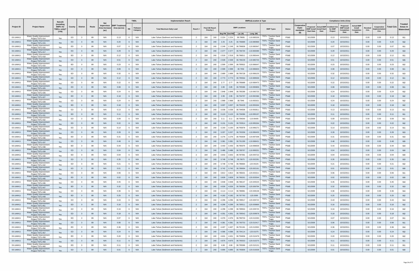
Beg PM End PM Lat. (N) Long. (W)
Revoked CUs
Total CUsTreated Areas in
WatershedRBPollutant Category
Total Maximum Daily Load Reach #Final SB Reach
Priority #
Compliance Units (CUs)
Cooperative Imple-
mentation ($)
Cooperative Implementation
CUs
Proposed BMP Install Start Date
Actual BMP Install Start
Date
Credited CUs for BMP Project
Proposed BMP Install Completion
Date
Actual BMP Install
Completion Date
Net Impervious
Area Increase (ac)
BMP Treatment Area (acres)
TMDL Implementation Reach BMP(s)Location & Type
BMP LocationsBMP Types Status
RouteProject ID Project Name
Retrofit (installing BMPs for
TMDLs only)? (Y/N)
County District
03-1A8411Water Quality Improvement
Project TSTs #14 Yes ED 3 89 N/A 0.13 6 N/A Lake Tahoe (Sediment and Nutrients) 2 164 240 2.224 2.224 38.79695 -119.980536TSTs - Traction Sand
TrapsPS&E 5/1/2009 0.13 10/15/2011 0.00 0.00 0.13 0.1
03-1A8411Water Quality Improvement
Project TSTs #15 Yes ED 3 89 N/A 0.20 6 N/A Lake Tahoe (Sediment and Nutrients) 2 164 240 2.25 2.25 38.796889 -119.980969TSTs - Traction Sand
TrapsPS&E 5/1/2009 0.20 10/15/2011 0.00 0.00 0.20 0.2
03-1A8411Water Quality Improvement
Project TSTs #16 Yes ED 3 89 N/A 0.07 6 N/A Lake Tahoe (Sediment and Nutrients) 2 164 240 2.249 2.249 38.796836 -119.980947TSTs - Traction Sand
TrapsPS&E 5/1/2009 0.07 10/15/2011 0.00 0.00 0.07 0.1
03-1A8411Water Quality Improvement
Project TSTs #17 Yes ED 3 89 N/A 0.29 6 N/A Lake Tahoe (Sediment and Nutrients) 2 164 240 2.377 2.377 38.796794 -119.983089TSTs - Traction Sand
TrapsPS&E 5/1/2009 0.29 10/15/2011 0.00 0.00 0.29 0.3
03-1A8411Water Quality Improvement
Project TSTs #18 Yes ED 3 89 N/A 0.12 6 N/A Lake Tahoe (Sediment and Nutrients) 2 164 240 2.518 2.518 38.796511 -119.985444TSTs - Traction Sand
TrapsPS&E 5/1/2009 0.12 10/15/2011 0.00 0.00 0.12 0.1
03-1A8411Water Quality Improvement
Project TSTs #19 Yes ED 3 89 N/A 0.51 6 N/A Lake Tahoe (Sediment and Nutrients) 2 164 240 2.539 2.539 38.796228 -119.985703TSTs - Traction Sand
TrapsPS&E 5/1/2009 0.51 10/15/2011 0.00 0.00 0.51 0.5
03-1A8411Water Quality Improvement
Project TSTs #20 Yes ED 3 89 N/A 0.23 6 N/A Lake Tahoe (Sediment and Nutrients) 2 164 240 2.599 2.599 38.795922 -119.986647TSTs - Traction Sand
TrapsPS&E 5/1/2009 0.23 10/15/2011 0.00 0.00 0.23 0.2
03-1A8411Water Quality Improvement
Project TSTs #21 Yes ED 3 89 N/A 0.08 6 N/A Lake Tahoe (Sediment and Nutrients) 2 164 240 2.599 2.599 38.7958 -119.986603TSTs - Traction Sand
TrapsPS&E 5/1/2009 0.08 10/15/2011 0.00 0.00 0.08 0.1
03-1A8411Water Quality Improvement
Project TSTs #22 Yes ED 3 89 N/A 0.32 6 N/A Lake Tahoe (Sediment and Nutrients) 2 164 240 2.689 2.689 38.795728 -119.988103TSTs - Traction Sand
TrapsPS&E 5/1/2009 0.32 10/15/2011 0.00 0.00 0.32 0.3
03-1A8411Water Quality Improvement
Project TSTs #23 Yes ED 3 89 N/A 0.12 6 N/A Lake Tahoe (Sediment and Nutrients) 2 164 240 2.773 2.773 38.795564 -119.989506TSTs - Traction Sand
TrapsPS&E 5/1/2009 0.12 10/15/2011 0.00 0.00 0.12 0.1
03-1A8411Water Quality Improvement
Project TSTs #24 Yes ED 3 89 N/A 0.22 6 N/A Lake Tahoe (Sediment and Nutrients) 2 164 240 2.77 2.77 38.795689 -119.989475TSTs - Traction Sand
TrapsPS&E 5/1/2009 0.22 10/15/2011 0.00 0.00 0.22 0.2
03-1A8411Water Quality Improvement
Project TSTs #25 Yes ED 3 89 N/A 0.08 6 N/A Lake Tahoe (Sediment and Nutrients) 2 164 240 2.85 2.85 38.795386 -119.990806TSTs - Traction Sand
TrapsPS&E 5/1/2009 0.08 10/15/2011 0.00 0.00 0.08 0.1
03-1A8411Water Quality Improvement
Project TSTs #26 Yes ED 3 89 N/A 0.24 6 N/A Lake Tahoe (Sediment and Nutrients) 2 164 240 2.848 2.848 38.795289 -119.990725TSTs - Traction Sand
TrapsPS&E 5/1/2009 0.24 10/15/2011 0.00 0.00 0.24 0.2
03-1A8411Water Quality Improvement
Project TSTs #27 Yes ED 3 89 N/A 0.18 6 N/A Lake Tahoe (Sediment and Nutrients) 2 164 240 2.95 2.95 38.794797 -119.992386TSTs - Traction Sand
TrapsPS&E 5/1/2009 0.18 10/15/2011 0.00 0.00 0.18 0.2
03-1A8411Water Quality Improvement
Project TSTs #28 Yes ED 3 89 N/A 0.24 6 N/A Lake Tahoe (Sediment and Nutrients) 2 164 240 2.968 2.968 38.7946 -119.992631TSTs - Traction Sand
TrapsPS&E 5/1/2009 0.24 10/15/2011 0.00 0.00 0.24 0.2
03-1A8411Water Quality Improvement
Project TSTs #29 Yes ED 3 89 N/A 0.18 6 N/A Lake Tahoe (Sediment and Nutrients) 2 164 240 3.007 3.007 38.794439 -119.993264TSTs - Traction Sand
TrapsPS&E 5/1/2009 0.18 10/15/2011 0.00 0.00 0.18 0.2
03-1A8411Water Quality Improvement
Project TSTs #30 Yes ED 3 89 N/A 0.13 6 N/A Lake Tahoe (Sediment and Nutrients) 2 164 240 3.038 3.038 38.794506 -119.993811TSTs - Traction Sand
TrapsPS&E 5/1/2009 0.13 10/15/2011 0.00 0.00 0.13 0.1
03-1A8411Water Quality Improvement
Project TSTs #31 Yes ED 3 89 N/A 0.11 6 N/A Lake Tahoe (Sediment and Nutrients) 2 164 240 3.123 3.123 38.794086 -119.995197TSTs - Traction Sand
TrapsPS&E 5/1/2009 0.11 10/15/2011 0.00 0.00 0.11 0.1
03-1A8411Water Quality Improvement
Project TSTs #32 Yes ED 3 89 N/A 0.09 6 N/A Lake Tahoe (Sediment and Nutrients) 2 164 240 3.11 3.11 38.794044 -119.99495TSTs - Traction Sand
TrapsPS&E 5/1/2009 0.09 10/15/2011 0.00 0.00 0.09 0.1
03-1A8411Water Quality Improvement
Project TSTs #33 Yes ED 3 89 N/A 0.22 6 N/A Lake Tahoe (Sediment and Nutrients) 2 164 240 3.131 3.131 38.793914 -119.995264TSTs - Traction Sand
TrapsPS&E 5/1/2009 0.22 10/15/2011 0.00 0.00 0.22 0.2
03-1A8411Water Quality Improvement
Project TSTs #34 Yes ED 3 89 N/A 0.14 6 N/A Lake Tahoe (Sediment and Nutrients) 2 164 240 3.193 3.193 38.793578 -119.996272TSTs - Traction Sand
TrapsPS&E 5/1/2009 0.14 10/15/2011 0.00 0.00 0.14 0.1
03-1A8411Water Quality Improvement
Project TSTs #35 Yes ED 3 89 N/A 0.28 6 N/A Lake Tahoe (Sediment and Nutrients) 2 164 240 3.207 3.207 38.793358 -119.996403TSTs - Traction Sand
TrapsPS&E 5/1/2009 0.28 10/15/2011 0.00 0.00 0.28 0.3
03-1A8411Water Quality Improvement
Project TSTs #36 Yes ED 3 89 N/A 0.31 6 N/A Lake Tahoe (Sediment and Nutrients) 2 164 240 3.276 3.276 38.792639 -119.997308TSTs - Traction Sand
TrapsPS&E 5/1/2009 0.31 10/15/2011 0.00 0.00 0.31 0.3
03-1A8411Water Quality Improvement
Project TSTs #37 Yes ED 3 89 N/A 0.48 6 N/A Lake Tahoe (Sediment and Nutrients) 2 164 240 3.381 3.381 38.791289 -119.998431TSTs - Traction Sand
TrapsPS&E 5/1/2009 0.48 10/15/2011 0.00 0.00 0.48 0.5
03-1A8411Water Quality Improvement
Project TSTs #38 Yes ED 3 89 N/A 0.44 6 N/A Lake Tahoe (Sediment and Nutrients) 2 164 240 3.443 3.443 38.790375 -119.998939TSTs - Traction Sand
TrapsPS&E 5/1/2009 0.44 10/15/2011 0.00 0.00 0.44 0.4
03-1A8411Water Quality Improvement
Project TSTs #39 Yes ED 3 89 N/A 0.04 6 N/A Lake Tahoe (Sediment and Nutrients) 2 164 240 3.486 3.486 38.789767 -119.999331TSTs - Traction Sand
TrapsPS&E 5/1/2009 0.04 10/15/2011 0.00 0.00 0.04 0.0
03-1A8411Water Quality Improvement
Project TSTs #40 Yes ED 3 89 N/A 0.04 6 N/A Lake Tahoe (Sediment and Nutrients) 2 164 240 3.642 3.642 38.787581 -120.000722TSTs - Traction Sand
TrapsPS&E 5/1/2009 0.04 10/15/2011 0.00 0.00 0.04 0.0
03-1A8411Water Quality Improvement
Project TSTs #41 Yes ED 3 89 N/A 0.35 6 N/A Lake Tahoe (Sediment and Nutrients) 2 164 240 3.748 3.748 38.78675 -120.002281TSTs - Traction Sand
TrapsPS&E 5/1/2009 0.35 10/15/2011 0.00 0.00 0.35 0.3
03-1A8411Water Quality Improvement
Project TSTs #42 Yes ED 3 89 N/A 0.21 6 N/A Lake Tahoe (Sediment and Nutrients) 2 164 240 3.748 3.748 38.786664 -120.00225TSTs - Traction Sand
TrapsPS&E 5/1/2009 0.21 10/15/2011 0.00 0.00 0.21 0.2
03-1A8411Water Quality Improvement
Project TSTs #43 Yes ED 3 89 N/A 0.01 6 N/A Lake Tahoe (Sediment and Nutrients) 2 164 240 3.742 3.742 38.786694 -120.002161TSTs - Traction Sand
TrapsPS&E 5/1/2009 0.01 10/15/2011 0.00 0.00 0.01 0.0
03-1A8411Water Quality Improvement
Project TSTs #44 Yes ED 3 89 N/A 0.06 6 N/A Lake Tahoe (Sediment and Nutrients) 2 164 240 3.812 3.812 38.786431 -120.003311TSTs - Traction Sand
TrapsPS&E 5/1/2009 0.06 10/15/2011 0.00 0.00 0.06 0.1
03-1A8411Water Quality Improvement
Project TSTs #45 Yes ED 3 89 N/A 0.02 6 N/A Lake Tahoe (Sediment and Nutrients) 2 164 240 3.828 3.828 38.786261 -120.003544TSTs - Traction Sand
TrapsPS&E 5/1/2009 0.02 10/15/2011 0.00 0.00 0.02 0.0
03-1A8411Water Quality Improvement
Project TSTs #46 Yes ED 3 89 N/A 0.45 6 N/A Lake Tahoe (Sediment and Nutrients) 2 164 240 3.948 3.948 38.786147 -120.005525TSTs - Traction Sand
TrapsPS&E 5/1/2009 0.45 10/15/2011 0.00 0.00 0.45 0.4
03-1A8411Water Quality Improvement
Project TSTs #47 Yes ED 3 89 N/A 0.32 6 N/A Lake Tahoe (Sediment and Nutrients) 2 164 240 4.026 4.026 38.786356 -120.006794TSTs - Traction Sand
TrapsPS&E 5/1/2009 0.32 10/15/2011 0.00 0.00 0.32 0.3
03-1A8411Water Quality Improvement
Project TSTs #48 Yes ED 3 89 N/A 0.36 6 N/A Lake Tahoe (Sediment and Nutrients) 2 164 240 4.114 4.114 38.786981 -120.008108TSTs - Traction Sand
TrapsPS&E 5/1/2009 0.36 10/15/2011 0.00 0.00 0.36 0.4
03-1A8411Water Quality Improvement
Project TSTs #49 Yes ED 3 89 N/A 0.25 6 N/A Lake Tahoe (Sediment and Nutrients) 2 164 240 4.182 4.182 38.787783 -120.0089TSTs - Traction Sand
TrapsPS&E 5/1/2009 0.25 10/15/2011 0.00 0.00 0.25 0.2
03-1A8411Water Quality Improvement
Project TSTs #50 Yes ED 3 89 N/A 0.43 6 N/A Lake Tahoe (Sediment and Nutrients) 2 164 240 4.296 4.296 38.789517 -120.009722TSTs - Traction Sand
TrapsPS&E 5/1/2009 0.43 10/15/2011 0.00 0.00 0.43 0.4
03-1A8411Water Quality Improvement
Project TSTs #51 Yes ED 3 89 N/A 0.16 6 N/A Lake Tahoe (Sediment and Nutrients) 2 164 240 4.299 4.299 38.789511 -120.009869TSTs - Traction Sand
TrapsPS&E 5/1/2009 0.16 10/15/2011 0.00 0.00 0.16 0.2
03-1A8411Water Quality Improvement
Project TSTs #52 Yes ED 3 89 N/A 0.16 6 N/A Lake Tahoe (Sediment and Nutrients) 2 164 240 4.298 4.298 38.789553 -120.009725TSTs - Traction Sand
TrapsPS&E 5/1/2009 0.16 10/15/2011 0.00 0.00 0.16 0.2
03-1A8411Water Quality Improvement
Project TSTs #53 Yes ED 3 89 N/A 0.18 6 N/A Lake Tahoe (Sediment and Nutrients) 2 164 240 4.301 4.301 38.789542 -120.009878TSTs - Traction Sand
TrapsPS&E 5/1/2009 0.18 10/15/2011 0.00 0.00 0.18 0.2
03-1A8411Water Quality Improvement
Project TSTs #54 Yes ED 3 89 N/A 0.07 6 N/A Lake Tahoe (Sediment and Nutrients) 2 164 240 4.376 4.376 38.790733 -120.010283TSTs - Traction Sand
TrapsPS&E 5/1/2009 0.07 10/15/2011 0.00 0.00 0.07 0.1
03-1A8411Water Quality Improvement
Project TSTs #55 Yes ED 3 89 N/A 0.06 6 N/A Lake Tahoe (Sediment and Nutrients) 2 164 240 4.381 4.381 38.790753 -120.010417TSTs - Traction Sand
TrapsPS&E 5/1/2009 0.06 10/15/2011 0.00 0.00 0.06 0.1
03-1A8411Water Quality Improvement
Project TSTs #56 Yes ED 3 89 N/A 0.36 6 N/A Lake Tahoe (Sediment and Nutrients) 2 164 240 4.407 4.407 38.791181 -120.010592TSTs - Traction Sand
TrapsPS&E 5/1/2009 0.36 10/15/2011 0.00 0.00 0.36 0.4
03-1A8411Water Quality Improvement
Project TSTs #57 Yes ED 3 89 N/A 0.24 6 N/A Lake Tahoe (Sediment and Nutrients) 2 164 240 4.586 4.586 38.794114 -120.01075TSTs - Traction Sand
TrapsPS&E 5/1/2009 0.24 10/15/2011 0.00 0.00 0.24 0.2
03-1A8411Water Quality Improvement
Project TSTs #58 Yes ED 3 89 N/A 0.20 6 N/A Lake Tahoe (Sediment and Nutrients) 2 164 240 4.631 4.631 38.794836 -120.010478TSTs - Traction Sand
TrapsPS&E 5/1/2009 0.20 10/15/2011 0.00 0.00 0.20 0.2
03-1A8411Water Quality Improvement
Project TSTs #59 Yes ED 3 89 N/A 0.11 6 N/A Lake Tahoe (Sediment and Nutrients) 2 164 240 4.675 4.675 38.795553 -120.010275TSTs - Traction Sand
TrapsPS&E 5/1/2009 0.11 10/15/2011 0.00 0.00 0.11 0.1
03-1A8411Water Quality Improvement
Project TSTs #60 Yes ED 3 89 N/A 0.11 6 N/A Lake Tahoe (Sediment and Nutrients) 2 164 240 4.68 4.68 38.795586 -120.010131TSTs - Traction Sand
TrapsPS&E 5/1/2009 0.11 10/15/2011 0.00 0.00 0.11 0.1
03-1A8411Water Quality Improvement
Project TSTs #61 Yes ED 3 89 N/A 0.01 6 N/A Lake Tahoe (Sediment and Nutrients) 2 164 240 4.695 4.695 38.795806 -120.010028TSTs - Traction Sand
TrapsPS&E 5/1/2009 0.01 10/15/2011 0.00 0.00 0.01 0.0
Page 34 of 77
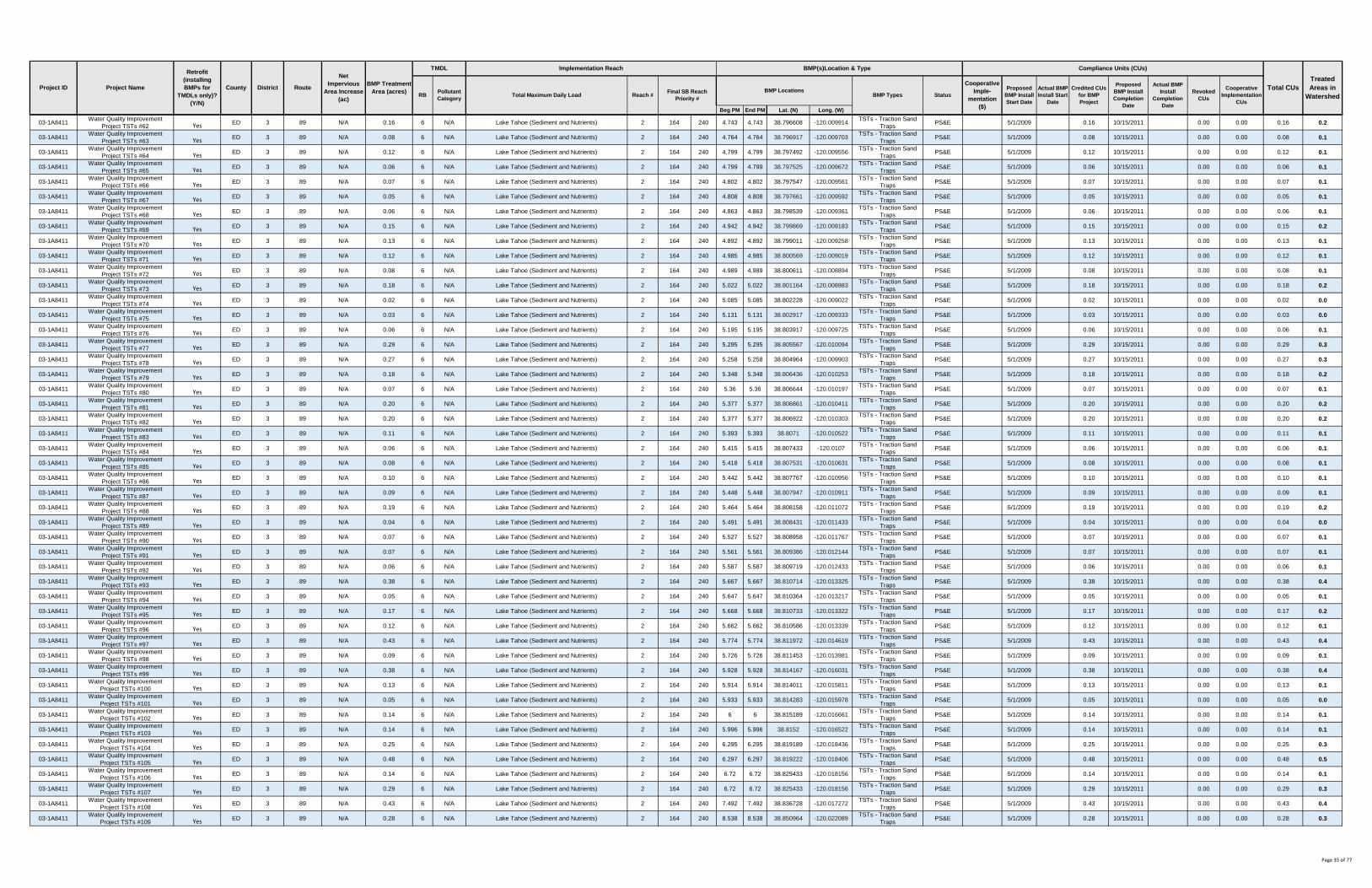
Beg PM End PM Lat. (N) Long. (W)
Revoked CUs
Total CUsTreated Areas in
WatershedRBPollutant Category
Total Maximum Daily Load Reach #Final SB Reach
Priority #
Compliance Units (CUs)
Cooperative Imple-
mentation ($)
Cooperative Implementation
CUs
Proposed BMP Install Start Date
Actual BMP Install Start
Date
Credited CUs for BMP Project
Proposed BMP Install Completion
Date
Actual BMP Install
Completion Date
Net Impervious
Area Increase (ac)
BMP Treatment Area (acres)
TMDL Implementation Reach BMP(s)Location & Type
BMP LocationsBMP Types Status
RouteProject ID Project Name
Retrofit (installing BMPs for
TMDLs only)? (Y/N)
County District
03-1A8411Water Quality Improvement
Project TSTs #62 Yes ED 3 89 N/A 0.16 6 N/A Lake Tahoe (Sediment and Nutrients) 2 164 240 4.743 4.743 38.796608 -120.009914TSTs - Traction Sand
TrapsPS&E 5/1/2009 0.16 10/15/2011 0.00 0.00 0.16 0.2
03-1A8411Water Quality Improvement
Project TSTs #63 Yes ED 3 89 N/A 0.08 6 N/A Lake Tahoe (Sediment and Nutrients) 2 164 240 4.764 4.764 38.796917 -120.009703TSTs - Traction Sand
TrapsPS&E 5/1/2009 0.08 10/15/2011 0.00 0.00 0.08 0.1
03-1A8411Water Quality Improvement
Project TSTs #64 Yes ED 3 89 N/A 0.12 6 N/A Lake Tahoe (Sediment and Nutrients) 2 164 240 4.799 4.799 38.797492 -120.009556TSTs - Traction Sand
TrapsPS&E 5/1/2009 0.12 10/15/2011 0.00 0.00 0.12 0.1
03-1A8411Water Quality Improvement
Project TSTs #65 Yes ED 3 89 N/A 0.06 6 N/A Lake Tahoe (Sediment and Nutrients) 2 164 240 4.799 4.799 38.797525 -120.009672TSTs - Traction Sand
TrapsPS&E 5/1/2009 0.06 10/15/2011 0.00 0.00 0.06 0.1
03-1A8411Water Quality Improvement
Project TSTs #66 Yes ED 3 89 N/A 0.07 6 N/A Lake Tahoe (Sediment and Nutrients) 2 164 240 4.802 4.802 38.797547 -120.009561TSTs - Traction Sand
TrapsPS&E 5/1/2009 0.07 10/15/2011 0.00 0.00 0.07 0.1
03-1A8411Water Quality Improvement
Project TSTs #67 Yes ED 3 89 N/A 0.05 6 N/A Lake Tahoe (Sediment and Nutrients) 2 164 240 4.808 4.808 38.797661 -120.009592TSTs - Traction Sand
TrapsPS&E 5/1/2009 0.05 10/15/2011 0.00 0.00 0.05 0.1
03-1A8411Water Quality Improvement
Project TSTs #68 Yes ED 3 89 N/A 0.06 6 N/A Lake Tahoe (Sediment and Nutrients) 2 164 240 4.863 4.863 38.798539 -120.009361TSTs - Traction Sand
TrapsPS&E 5/1/2009 0.06 10/15/2011 0.00 0.00 0.06 0.1
03-1A8411Water Quality Improvement
Project TSTs #69 Yes ED 3 89 N/A 0.15 6 N/A Lake Tahoe (Sediment and Nutrients) 2 164 240 4.942 4.942 38.799869 -120.009183TSTs - Traction Sand
TrapsPS&E 5/1/2009 0.15 10/15/2011 0.00 0.00 0.15 0.2
03-1A8411Water Quality Improvement
Project TSTs #70 Yes ED 3 89 N/A 0.13 6 N/A Lake Tahoe (Sediment and Nutrients) 2 164 240 4.892 4.892 38.799011 -120.009258TSTs - Traction Sand
TrapsPS&E 5/1/2009 0.13 10/15/2011 0.00 0.00 0.13 0.1
03-1A8411Water Quality Improvement
Project TSTs #71 Yes ED 3 89 N/A 0.12 6 N/A Lake Tahoe (Sediment and Nutrients) 2 164 240 4.985 4.985 38.800569 -120.009019TSTs - Traction Sand
TrapsPS&E 5/1/2009 0.12 10/15/2011 0.00 0.00 0.12 0.1
03-1A8411Water Quality Improvement
Project TSTs #72 Yes ED 3 89 N/A 0.08 6 N/A Lake Tahoe (Sediment and Nutrients) 2 164 240 4.989 4.989 38.800611 -120.008894TSTs - Traction Sand
TrapsPS&E 5/1/2009 0.08 10/15/2011 0.00 0.00 0.08 0.1
03-1A8411Water Quality Improvement
Project TSTs #73 Yes ED 3 89 N/A 0.18 6 N/A Lake Tahoe (Sediment and Nutrients) 2 164 240 5.022 5.022 38.801164 -120.008983TSTs - Traction Sand
TrapsPS&E 5/1/2009 0.18 10/15/2011 0.00 0.00 0.18 0.2
03-1A8411Water Quality Improvement
Project TSTs #74 Yes ED 3 89 N/A 0.02 6 N/A Lake Tahoe (Sediment and Nutrients) 2 164 240 5.085 5.085 38.802228 -120.009022TSTs - Traction Sand
TrapsPS&E 5/1/2009 0.02 10/15/2011 0.00 0.00 0.02 0.0
03-1A8411Water Quality Improvement
Project TSTs #75 Yes ED 3 89 N/A 0.03 6 N/A Lake Tahoe (Sediment and Nutrients) 2 164 240 5.131 5.131 38.802917 -120.009333TSTs - Traction Sand
TrapsPS&E 5/1/2009 0.03 10/15/2011 0.00 0.00 0.03 0.0
03-1A8411Water Quality Improvement
Project TSTs #76 Yes ED 3 89 N/A 0.06 6 N/A Lake Tahoe (Sediment and Nutrients) 2 164 240 5.195 5.195 38.803917 -120.009725TSTs - Traction Sand
TrapsPS&E 5/1/2009 0.06 10/15/2011 0.00 0.00 0.06 0.1
03-1A8411Water Quality Improvement
Project TSTs #77 Yes ED 3 89 N/A 0.29 6 N/A Lake Tahoe (Sediment and Nutrients) 2 164 240 5.295 5.295 38.805567 -120.010094TSTs - Traction Sand
TrapsPS&E 5/1/2009 0.29 10/15/2011 0.00 0.00 0.29 0.3
03-1A8411Water Quality Improvement
Project TSTs #78 Yes ED 3 89 N/A 0.27 6 N/A Lake Tahoe (Sediment and Nutrients) 2 164 240 5.258 5.258 38.804964 -120.009903TSTs - Traction Sand
TrapsPS&E 5/1/2009 0.27 10/15/2011 0.00 0.00 0.27 0.3
03-1A8411Water Quality Improvement
Project TSTs #79 Yes ED 3 89 N/A 0.18 6 N/A Lake Tahoe (Sediment and Nutrients) 2 164 240 5.348 5.348 38.806436 -120.010253TSTs - Traction Sand
TrapsPS&E 5/1/2009 0.18 10/15/2011 0.00 0.00 0.18 0.2
03-1A8411Water Quality Improvement
Project TSTs #80 Yes ED 3 89 N/A 0.07 6 N/A Lake Tahoe (Sediment and Nutrients) 2 164 240 5.36 5.36 38.806644 -120.010197TSTs - Traction Sand
TrapsPS&E 5/1/2009 0.07 10/15/2011 0.00 0.00 0.07 0.1
03-1A8411Water Quality Improvement
Project TSTs #81 Yes ED 3 89 N/A 0.20 6 N/A Lake Tahoe (Sediment and Nutrients) 2 164 240 5.377 5.377 38.806861 -120.010411TSTs - Traction Sand
TrapsPS&E 5/1/2009 0.20 10/15/2011 0.00 0.00 0.20 0.2
03-1A8411Water Quality Improvement
Project TSTs #82 Yes ED 3 89 N/A 0.20 6 N/A Lake Tahoe (Sediment and Nutrients) 2 164 240 5.377 5.377 38.806922 -120.010303TSTs - Traction Sand
TrapsPS&E 5/1/2009 0.20 10/15/2011 0.00 0.00 0.20 0.2
03-1A8411Water Quality Improvement
Project TSTs #83 Yes ED 3 89 N/A 0.11 6 N/A Lake Tahoe (Sediment and Nutrients) 2 164 240 5.393 5.393 38.8071 -120.010522TSTs - Traction Sand
TrapsPS&E 5/1/2009 0.11 10/15/2011 0.00 0.00 0.11 0.1
03-1A8411Water Quality Improvement
Project TSTs #84 Yes ED 3 89 N/A 0.06 6 N/A Lake Tahoe (Sediment and Nutrients) 2 164 240 5.415 5.415 38.807433 -120.0107TSTs - Traction Sand
TrapsPS&E 5/1/2009 0.06 10/15/2011 0.00 0.00 0.06 0.1
03-1A8411Water Quality Improvement
Project TSTs #85 Yes ED 3 89 N/A 0.08 6 N/A Lake Tahoe (Sediment and Nutrients) 2 164 240 5.418 5.418 38.807531 -120.010631TSTs - Traction Sand
TrapsPS&E 5/1/2009 0.08 10/15/2011 0.00 0.00 0.08 0.1
03-1A8411Water Quality Improvement
Project TSTs #86 Yes ED 3 89 N/A 0.10 6 N/A Lake Tahoe (Sediment and Nutrients) 2 164 240 5.442 5.442 38.807767 -120.010956TSTs - Traction Sand
TrapsPS&E 5/1/2009 0.10 10/15/2011 0.00 0.00 0.10 0.1
03-1A8411Water Quality Improvement
Project TSTs #87 Yes ED 3 89 N/A 0.09 6 N/A Lake Tahoe (Sediment and Nutrients) 2 164 240 5.448 5.448 38.807947 -120.010911TSTs - Traction Sand
TrapsPS&E 5/1/2009 0.09 10/15/2011 0.00 0.00 0.09 0.1
03-1A8411Water Quality Improvement
Project TSTs #88 Yes ED 3 89 N/A 0.19 6 N/A Lake Tahoe (Sediment and Nutrients) 2 164 240 5.464 5.464 38.808158 -120.011072TSTs - Traction Sand
TrapsPS&E 5/1/2009 0.19 10/15/2011 0.00 0.00 0.19 0.2
03-1A8411Water Quality Improvement
Project TSTs #89 Yes ED 3 89 N/A 0.04 6 N/A Lake Tahoe (Sediment and Nutrients) 2 164 240 5.491 5.491 38.808431 -120.011433TSTs - Traction Sand
TrapsPS&E 5/1/2009 0.04 10/15/2011 0.00 0.00 0.04 0.0
03-1A8411Water Quality Improvement
Project TSTs #90 Yes ED 3 89 N/A 0.07 6 N/A Lake Tahoe (Sediment and Nutrients) 2 164 240 5.527 5.527 38.808958 -120.011767TSTs - Traction Sand
TrapsPS&E 5/1/2009 0.07 10/15/2011 0.00 0.00 0.07 0.1
03-1A8411Water Quality Improvement
Project TSTs #91 Yes ED 3 89 N/A 0.07 6 N/A Lake Tahoe (Sediment and Nutrients) 2 164 240 5.561 5.561 38.809386 -120.012144TSTs - Traction Sand
TrapsPS&E 5/1/2009 0.07 10/15/2011 0.00 0.00 0.07 0.1
03-1A8411Water Quality Improvement
Project TSTs #92 Yes ED 3 89 N/A 0.06 6 N/A Lake Tahoe (Sediment and Nutrients) 2 164 240 5.587 5.587 38.809719 -120.012433TSTs - Traction Sand
TrapsPS&E 5/1/2009 0.06 10/15/2011 0.00 0.00 0.06 0.1
03-1A8411Water Quality Improvement
Project TSTs #93 Yes ED 3 89 N/A 0.38 6 N/A Lake Tahoe (Sediment and Nutrients) 2 164 240 5.667 5.667 38.810714 -120.013325TSTs - Traction Sand
TrapsPS&E 5/1/2009 0.38 10/15/2011 0.00 0.00 0.38 0.4
03-1A8411Water Quality Improvement
Project TSTs #94 Yes ED 3 89 N/A 0.05 6 N/A Lake Tahoe (Sediment and Nutrients) 2 164 240 5.647 5.647 38.810364 -120.013217TSTs - Traction Sand
TrapsPS&E 5/1/2009 0.05 10/15/2011 0.00 0.00 0.05 0.1
03-1A8411Water Quality Improvement
Project TSTs #95 Yes ED 3 89 N/A 0.17 6 N/A Lake Tahoe (Sediment and Nutrients) 2 164 240 5.668 5.668 38.810733 -120.013322TSTs - Traction Sand
TrapsPS&E 5/1/2009 0.17 10/15/2011 0.00 0.00 0.17 0.2
03-1A8411Water Quality Improvement
Project TSTs #96 Yes ED 3 89 N/A 0.12 6 N/A Lake Tahoe (Sediment and Nutrients) 2 164 240 5.662 5.662 38.810586 -120.013339TSTs - Traction Sand
TrapsPS&E 5/1/2009 0.12 10/15/2011 0.00 0.00 0.12 0.1
03-1A8411Water Quality Improvement
Project TSTs #97 Yes ED 3 89 N/A 0.43 6 N/A Lake Tahoe (Sediment and Nutrients) 2 164 240 5.774 5.774 38.811972 -120.014619TSTs - Traction Sand
TrapsPS&E 5/1/2009 0.43 10/15/2011 0.00 0.00 0.43 0.4
03-1A8411Water Quality Improvement
Project TSTs #98 Yes ED 3 89 N/A 0.09 6 N/A Lake Tahoe (Sediment and Nutrients) 2 164 240 5.726 5.726 38.811453 -120.013981TSTs - Traction Sand
TrapsPS&E 5/1/2009 0.09 10/15/2011 0.00 0.00 0.09 0.1
03-1A8411Water Quality Improvement
Project TSTs #99 Yes ED 3 89 N/A 0.38 6 N/A Lake Tahoe (Sediment and Nutrients) 2 164 240 5.928 5.928 38.814167 -120.016031TSTs - Traction Sand
TrapsPS&E 5/1/2009 0.38 10/15/2011 0.00 0.00 0.38 0.4
03-1A8411Water Quality Improvement
Project TSTs #100 Yes ED 3 89 N/A 0.13 6 N/A Lake Tahoe (Sediment and Nutrients) 2 164 240 5.914 5.914 38.814011 -120.015811TSTs - Traction Sand
TrapsPS&E 5/1/2009 0.13 10/15/2011 0.00 0.00 0.13 0.1
03-1A8411Water Quality Improvement
Project TSTs #101 Yes ED 3 89 N/A 0.05 6 N/A Lake Tahoe (Sediment and Nutrients) 2 164 240 5.933 5.933 38.814283 -120.015978TSTs - Traction Sand
TrapsPS&E 5/1/2009 0.05 10/15/2011 0.00 0.00 0.05 0.0
03-1A8411Water Quality Improvement
Project TSTs #102 Yes ED 3 89 N/A 0.14 6 N/A Lake Tahoe (Sediment and Nutrients) 2 164 240 6 6 38.815189 -120.016661TSTs - Traction Sand
TrapsPS&E 5/1/2009 0.14 10/15/2011 0.00 0.00 0.14 0.1
03-1A8411Water Quality Improvement
Project TSTs #103 Yes ED 3 89 N/A 0.14 6 N/A Lake Tahoe (Sediment and Nutrients) 2 164 240 5.996 5.996 38.8152 -120.016522TSTs - Traction Sand
TrapsPS&E 5/1/2009 0.14 10/15/2011 0.00 0.00 0.14 0.1
03-1A8411Water Quality Improvement
Project TSTs #104 Yes ED 3 89 N/A 0.25 6 N/A Lake Tahoe (Sediment and Nutrients) 2 164 240 6.295 6.295 38.819189 -120.018436TSTs - Traction Sand
TrapsPS&E 5/1/2009 0.25 10/15/2011 0.00 0.00 0.25 0.3
03-1A8411Water Quality Improvement
Project TSTs #105 Yes ED 3 89 N/A 0.48 6 N/A Lake Tahoe (Sediment and Nutrients) 2 164 240 6.297 6.297 38.819222 -120.018406TSTs - Traction Sand
TrapsPS&E 5/1/2009 0.48 10/15/2011 0.00 0.00 0.48 0.5
03-1A8411Water Quality Improvement
Project TSTs #106 Yes ED 3 89 N/A 0.14 6 N/A Lake Tahoe (Sediment and Nutrients) 2 164 240 6.72 6.72 38.825433 -120.018156TSTs - Traction Sand
TrapsPS&E 5/1/2009 0.14 10/15/2011 0.00 0.00 0.14 0.1
03-1A8411Water Quality Improvement
Project TSTs #107 Yes ED 3 89 N/A 0.29 6 N/A Lake Tahoe (Sediment and Nutrients) 2 164 240 6.72 6.72 38.825433 -120.018156TSTs - Traction Sand
TrapsPS&E 5/1/2009 0.29 10/15/2011 0.00 0.00 0.29 0.3
03-1A8411Water Quality Improvement
Project TSTs #108 Yes ED 3 89 N/A 0.43 6 N/A Lake Tahoe (Sediment and Nutrients) 2 164 240 7.492 7.492 38.836728 -120.017272TSTs - Traction Sand
TrapsPS&E 5/1/2009 0.43 10/15/2011 0.00 0.00 0.43 0.4
03-1A8411Water Quality Improvement
Project TSTs #109 Yes ED 3 89 N/A 0.28 6 N/A Lake Tahoe (Sediment and Nutrients) 2 164 240 8.538 8.538 38.850964 -120.022089TSTs - Traction Sand
TrapsPS&E 5/1/2009 0.28 10/15/2011 0.00 0.00 0.28 0.3
Page 35 of 77

Beg PM End PM Lat. (N) Long. (W)
Revoked CUs
Total CUsTreated Areas in
WatershedRBPollutant Category
Total Maximum Daily Load Reach #Final SB Reach
Priority #
Compliance Units (CUs)
Cooperative Imple-
mentation ($)
Cooperative Implementation
CUs
Proposed BMP Install Start Date
Actual BMP Install Start
Date
Credited CUs for BMP Project
Proposed BMP Install Completion
Date
Actual BMP Install
Completion Date
Net Impervious
Area Increase (ac)
BMP Treatment Area (acres)
TMDL Implementation Reach BMP(s)Location & Type
BMP LocationsBMP Types Status
RouteProject ID Project Name
Retrofit (installing BMPs for
TMDLs only)? (Y/N)
County District
03-1A8411Water Quality Improvement
Project TSTs #110 Yes ED 3 89 N/A 0.32 6 N/A Lake Tahoe (Sediment and Nutrients) 2 164 240 8.486 8.486 38.850208 -120.021819TSTs - Traction Sand
TrapsPS&E 5/1/2009 0.32 10/15/2011 0.00 0.00 0.32 0.3
03-1A8411Water Quality Improvement
Project VS #1 Yes ED 3 89 N/A 0.29 6 N/A Lake Tahoe (Sediment and Nutrients) 2 164 240 3.208 3.208 38.793453 -119.996489 BIOS - Bioswale/strip PS&E 5/1/2009 0.29 10/15/2011 0.00 0.00 0.29 0.3
03-1A8411Water Quality Improvement
Project VS #2 Yes ED 3 89 N/A 0.31 6 N/A Lake Tahoe (Sediment and Nutrients) 2 164 240 3.22 3.22 38.793356 -119.996669 BIOS - Bioswale/strip PS&E 5/1/2009 0.31 10/15/2011 0.00 0.00 0.31 0.3
03-1A8411Water Quality Improvement
Project VS #3 Yes ED 3 89 N/A 0.14 6 N/A Lake Tahoe (Sediment and Nutrients) 2 164 240 6.006 6.006 38.8154 -120.016497 BIOS - Bioswale/strip PS&E 5/1/2009 0.14 10/15/2011 0.00 0.00 0.14 0.1
03-1A8411Water Quality Improvement
Project VS #4 Yes ED 3 89 N/A 0.22 6 N/A Lake Tahoe (Sediment and Nutrients) 2 164 240 6.105 6.105 38.816528 -120.017589 BIOS - Bioswale/strip PS&E 5/1/2009 0.22 10/15/2011 0.00 0.00 0.22 0.2
03-1A8411Water Quality Improvement
Project VS #5 Yes ED 3 89 N/A 0.38 6 N/A Lake Tahoe (Sediment and Nutrients) 2 164 240 6.349 6.349 38.82 -120.018767 BIOS - Bioswale/strip PS&E 5/1/2009 0.38 10/15/2011 0.00 0.00 0.38 0.4
03-1A8411Water Quality Improvement
Project VS #6 Yes ED 3 89 N/A 0.36 6 N/A Lake Tahoe (Sediment and Nutrients) 2 164 240 6.715 6.715 38.825369 -120.0182 BIOS - Bioswale/strip PS&E 5/1/2009 0.36 10/15/2011 0.00 0.00 0.36 0.4
03-1A8411Water Quality Improvement
Project VS #7 Yes ED 3 89 N/A 0.18 6 N/A Lake Tahoe (Sediment and Nutrients) 2 164 240 7.994 7.994 38.843989 -120.018414 BIOS - Bioswale/strip PS&E 5/1/2009 0.18 10/15/2011 0.00 0.00 0.18 0.2
03-0E9901Water Quality Improvement
Project TST #1 No PLA 3 267 0.00 6 B Truckee River (Sediment) 3 156 232 5.015 5.015 39.271336 -120.095003TSTs - Traction Sand
TrapsPS&E 5/1/2011 0.00 12/31/2013 0.00 0.00 0.00 0.0
03-0E9901Water Quality Improvement
Project TST #2 No PLA 3 267 6 B Truckee River (Sediment) 3 156 232 5.016 5.016 39.271336 -120.094986TSTs - Traction Sand
TrapsPS&E 5/1/2011 0.00 12/31/2013 0.00 0.00 0.00 0.0
03-0E9901Water Quality Improvement
Project TST #3 No PLA 3 267 6 B Truckee River (Sediment) 3 156 232 5.414 5.414 39.270494 -120.088578TSTs - Traction Sand
TrapsPS&E 5/1/2011 0.00 12/31/2013 0.00 0.00 0.00 0.0
03-0E9901Water Quality Improvement
Project TST #4 No PLA 3 267 6 B Truckee River (Sediment) 3 156 232 5.415 5.415 39.270494 -120.088561TSTs - Traction Sand
TrapsPS&E 5/1/2011 0.00 12/31/2013 0.00 0.00 0.00 0.0
03-0E9901Water Quality Improvement
Project TST #5 No PLA 3 267 6 B Truckee River (Sediment) 3 156 232 5.416 5.416 39.270494 -120.088544TSTs - Traction Sand
TrapsPS&E 5/1/2011 0.00 12/31/2013 0.00 0.00 0.00 0.0
03-0E9901Water Quality Improvement
Project TST #6 No PLA 3 267 6 B Truckee River (Sediment) 3 156 232 5.708 5.708 39.269911 -120.083547TSTs - Traction Sand
TrapsPS&E 5/1/2011 0.00 12/31/2013 0.00 0.00 0.00 0.0
03-0E9901Water Quality Improvement
Project TST #7 No PLA 3 267 6 B Truckee River (Sediment) 3 156 232 5.709 5.709 39.269908 -120.083531TSTs - Traction Sand
TrapsPS&E 5/1/2011 0.00 12/31/2013 0.00 0.00 0.00 0.0
03-0E9901Water Quality Improvement
Project TST #8 No PLA 3 267 6 B Truckee River (Sediment) 3 156 232 5.71 5.71 39.269908 -120.083519TSTs - Traction Sand
TrapsPS&E 5/1/2011 0.00 12/31/2013 0.00 0.00 0.00 0.0
03-0E9901Water Quality Improvement
Project TST #9 No PLA 3 267 6 B Truckee River (Sediment) 3 156 232 5.711 5.711 39.269908 -120.083503TSTs - Traction Sand
TrapsPS&E 5/1/2011 0.00 12/31/2013 0.00 0.00 0.00 0.0
03-0E9901Water Quality Improvement
Project TST #10 No PLA 3 267 6 B Truckee River (Sediment) 3 156 232 5.712 5.712 39.269903 -120.083489TSTs - Traction Sand
TrapsPS&E 5/1/2011 0.00 12/31/2013 0.00 0.00 0.00 0.0
03-0E9901Water Quality Improvement
Project TST #11 No PLA 3 267 6 B Truckee River (Sediment) 3 156 232 6.164 6.164 39.267219 -120.075653TSTs - Traction Sand
TrapsPS&E 5/1/2011 0.00 12/31/2013 0.00 0.00 0.00 0.0
03-0E9901Water Quality Improvement
Project TST #12 No PLA 3 267 6 B Truckee River (Sediment) 3 156 232 6.165 6.165 39.267222 -120.075642TSTs - Traction Sand
TrapsPS&E 5/1/2011 0.00 12/31/2013 0.00 0.00 0.00 0.0
03-0E9901Water Quality Improvement
Project TST #13 No PLA 3 267 6 B Truckee River (Sediment) 3 156 232 6.166 6.166 39.267222 -120.075625TSTs - Traction Sand
TrapsPS&E 5/1/2011 0.00 12/31/2013 0.00 0.00 0.00 0.0
03-0E9901Water Quality Improvement
Project TST #14 No PLA 3 267 6 B Truckee River (Sediment) 3 156 232 6.167 6.167 39.267225 -120.075608TSTs - Traction Sand
TrapsPS&E 5/1/2011 0.00 12/31/2013 0.00 0.00 0.00 0.0
03-0E9901Water Quality Improvement
Project TST #15 No PLA 3 267 6 B Truckee River (Sediment) 3 156 232 6.167 6.167 39.267225 -120.075594TSTs - Traction Sand
TrapsPS&E 5/1/2011 0.00 12/31/2013 0.00 0.00 0.00 0.0
03-0E9901Water Quality Improvement
Project TST #16 No PLA 3 267 6 B Truckee River (Sediment) 3 156 232 6.233 6.233 39.267178 -120.074403TSTs - Traction Sand
TrapsPS&E 5/1/2011 0.00 12/31/2013 0.00 0.00 0.00 0.0
03-0E9901Water Quality Improvement
Project TST #17 No PLA 3 267 6 B Truckee River (Sediment) 3 156 232 6.233 6.233 39.267175 -120.074392TSTs - Traction Sand
TrapsPS&E 5/1/2011 0.00 12/31/2013 0.00 0.00 0.00 0.0
03-0E9901Water Quality Improvement
Project TST #18 No PLA 3 267 6 B Truckee River (Sediment) 3 156 232 6.234 6.234 39.267169 -120.074378TSTs - Traction Sand
TrapsPS&E 5/1/2011 0.00 12/31/2013 0.00 0.00 0.00 0.0
03-0E9901Water Quality Improvement
Project TST #19 No PLA 3 267 6 B Truckee River (Sediment) 3 156 232 6.235 6.235 39.267167 -120.074358TSTs - Traction Sand
TrapsPS&E 5/1/2011 0.00 12/31/2013 0.00 0.00 0.00 0.0
03-0E9901Water Quality Improvement
Project TST #20 No PLA 3 267 6 B Truckee River (Sediment) 3 156 232 6.236 6.236 39.267161 -120.074344TSTs - Traction Sand
TrapsPS&E 5/1/2011 0.00 12/31/2013 0.00 0.00 0.00 0.0
03-0E9901Water Quality Improvement
Project TST #21 No PLA 3 267 6 B Truckee River (Sediment) 3 156 232 6.324 6.324 39.2668 -120.072942TSTs - Traction Sand
TrapsPS&E 5/1/2011 0.00 12/31/2013 0.00 0.00 0.00 0.0
03-0E9901Water Quality Improvement
Project TST #22 No PLA 3 267 6 B Truckee River (Sediment) 3 156 232 6.324 6.324 39.266792 -120.072936TSTs - Traction Sand
TrapsPS&E 5/1/2011 0.00 12/31/2013 0.00 0.00 0.00 0.0
03-0E9901Water Quality Improvement
Project TST #23 No PLA 3 267 6 B Truckee River (Sediment) 3 156 232 6.325 6.325 39.266778 -120.072931TSTs - Traction Sand
TrapsPS&E 5/1/2011 0.00 12/31/2013 0.00 0.00 0.00 0.0
03-0E9901Water Quality Improvement
Project TST #24 No PLA 3 267 6 B Truckee River (Sediment) 3 156 232 6.326 6.326 39.266767 -120.072922TSTs - Traction Sand
TrapsPS&E 5/1/2011 0.00 12/31/2013 0.00 0.00 0.00 0.0
03-0E9901Water Quality Improvement
Project TST #25 No PLA 3 267 6 B Truckee River (Sediment) 3 156 232 6.326 6.326 39.266558 -120.073072TSTs - Traction Sand
TrapsPS&E 5/1/2011 0.00 12/31/2013 0.00 0.00 0.00 0.0
03-0E9901Water Quality Improvement
Project TST #26 No PLA 3 267 6 B Truckee River (Sediment) 3 156 232 6.327 6.327 39.266553 -120.073061TSTs - Traction Sand
TrapsPS&E 5/1/2011 0.00 12/31/2013 0.00 0.00 0.00 0.0
03-0E9901Water Quality Improvement
Project TST #27 No PLA 3 267 6 B Truckee River (Sediment) 3 156 232 6.328 6.328 39.266547 -120.07305TSTs - Traction Sand
TrapsPS&E 5/1/2011 0.00 12/31/2013 0.00 0.00 0.00 0.0
03-0E9901Water Quality Improvement
Project TST #28 No PLA 3 267 6 B Truckee River (Sediment) 3 156 232 6.329 6.329 39.266539 -120.073033TSTs - Traction Sand
TrapsPS&E 5/1/2011 0.00 12/31/2013 0.00 0.00 0.00 0.0
03-0E9901Water Quality Improvement
Project TST #29 No PLA 3 267 6 B Truckee River (Sediment) 3 156 232 6.329 6.329 39.266528 -120.073033TSTs - Traction Sand
TrapsPS&E 5/1/2011 0.00 12/31/2013 0.00 0.00 0.00 0.0
03-0E9901Water Quality Improvement
Project TST #30 No PLA 3 267 6 B Truckee River (Sediment) 3 156 232 6.33 6.33 39.266522 -120.073022TSTs - Traction Sand
TrapsPS&E 5/1/2011 0.00 12/31/2013 0.00 0.00 0.00 0.0
03-0E9901Water Quality Improvement
Project TST #31 No PLA 3 267 6 B Truckee River (Sediment) 3 156 232 6.331 6.331 39.266514 -120.073014TSTs - Traction Sand
TrapsPS&E 5/1/2011 0.00 12/31/2013 0.00 0.00 0.00 0.0
03-0E9901Water Quality Improvement
Project TST #32 No PLA 3 267 6 B Truckee River (Sediment) 3 156 232 6.332 6.332 39.266506 -120.073003TSTs - Traction Sand
TrapsPS&E 5/1/2011 0.00 12/31/2013 0.00 0.00 0.00 0.0
03-0E9901Water Quality Improvement
Project TST #33 No PLA 3 267 6 B Truckee River (Sediment) 3 156 232 6.332 6.332 39.2665 -120.072992TSTs - Traction Sand
TrapsPS&E 5/1/2011 0.00 12/31/2013 0.00 0.00 0.00 0.0
03-0E9901Water Quality Improvement
Project TST #34 No PLA 3 267 6 B Truckee River (Sediment) 3 156 232 6.334 6.334 39.266489 -120.072983TSTs - Traction Sand
TrapsPS&E 5/1/2011 0.00 12/31/2013 0.00 0.00 0.00 0.0
03-1A8421Storm Water Quality
Improvements INFIL #1 Yes ED 3 89 N/A 6 N/A Lake Tahoe (Sediment and Nutrients) 2 164 240 8.77 8.77 38.915762 -120.007233INFIL - Infiltration
(Basins & Trenches)PS&E 5/15/2014 0.00 12/1/2015 0.00 0.00 0.00 0.0
03-1A8421Storm Water Quality
Improvements INFIL #2 Yes ED 3 89 N/A 6 N/A Lake Tahoe (Sediment and Nutrients) 2 164 240 8.77 8.77 38.915762 -120.007233INFIL - Infiltration
(Basins & Trenches)PS&E 5/15/2014 0.00 12/1/2015 0.00 0.00 0.00 0.0
03-1A8421Storm Water Quality
Improvements INFIL #3 Yes ED 3 89 N/A 6 N/A Lake Tahoe (Sediment and Nutrients) 2 164 240 9.04 9.04 38.917939 -120.011177INFIL - Infiltration
(Basins & Trenches)PS&E 5/15/2014 0.00 12/1/2015 0.00 0.00 0.00 0.0
03-1A8421Storm Water Quality
Improvements INFIL #4 Yes ED 3 89 N/A 6 N/A Lake Tahoe (Sediment and Nutrients) 2 164 240 9.06 9.06 38.918116 -120.011461INFIL - Infiltration
(Basins & Trenches)PS&E 5/15/2014 0.00 12/1/2015 0.00 0.00 0.00 0.0
03-1A8421Storm Water Quality
Improvements INFIL #5 Yes ED 3 89 N/A 6 N/A Lake Tahoe (Sediment and Nutrients) 1 158 234 9.33 9.33 38.920409 -120.015271INFIL - Infiltration
(Basins & Trenches)PS&E 5/15/2014 0.00 12/1/2015 0.00 0.00 0.00 0.0
03-1A8421Storm Water Quality
Improvements INFIL #6 Yes ED 3 89 N/A 6 N/A Lake Tahoe (Sediment and Nutrients) 1 158 234 9.39 9.39 38.920606 -120.016251INFIL - Infiltration
(Basins & Trenches)PS&E 5/15/2014 0.00 12/1/2015 0.00 0.00 0.00 0.0
Page 36 of 77
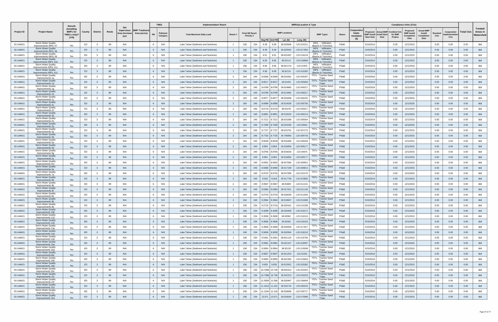
Beg PM End PM Lat. (N) Long. (W)
Revoked CUs
Total CUsTreated Areas in
WatershedRBPollutant Category
Total Maximum Daily Load Reach #Final SB Reach
Priority #
Compliance Units (CUs)
Cooperative Imple-
mentation ($)
Cooperative Implementation
CUs
Proposed BMP Install Start Date
Actual BMP Install Start
Date
Credited CUs for BMP Project
Proposed BMP Install Completion
Date
Actual BMP Install
Completion Date
Net Impervious
Area Increase (ac)
BMP Treatment Area (acres)
TMDL Implementation Reach BMP(s)Location & Type
BMP LocationsBMP Types Status
RouteProject ID Project Name
Retrofit (installing BMPs for
TMDLs only)? (Y/N)
County District
03-1A8421Storm Water Quality
Improvements INFIL #7 Yes ED 3 89 N/A 6 N/A Lake Tahoe (Sediment and Nutrients) 1 158 234 9.39 9.39 38.920606 -120.016251INFIL - Infiltration
(Basins & Trenches)PS&E 5/15/2014 0.00 12/1/2015 0.00 0.00 0.00 0.0
03-1A8421Storm Water Quality
Improvements INFIL #8 Yes ED 3 89 N/A 6 N/A Lake Tahoe (Sediment and Nutrients) 1 158 234 9.49 9.49 38.920942 -120.017893INFIL - Infiltration
(Basins & Trenches)PS&E 5/15/2014 0.00 12/1/2015 0.00 0.00 0.00 0.0
03-1A8421Storm Water Quality
Improvements INFIL #9 Yes ED 3 89 N/A 6 N/A Lake Tahoe (Sediment and Nutrients) 1 158 234 9.51 9.51 38.921007 -120.018218INFIL - Infiltration
(Basins & Trenches)PS&E 5/15/2014 0.00 12/1/2015 0.00 0.00 0.00 0.0
03-1A8421Storm Water Quality
Improvements INFIL #10 Yes ED 3 89 N/A 6 N/A Lake Tahoe (Sediment and Nutrients) 1 158 234 9.55 9.55 38.92114 -120.018868INFIL - Infiltration
(Basins & Trenches)PS&E 5/15/2014 0.00 12/1/2015 0.00 0.00 0.00 0.0
03-1A8421Storm Water Quality
Improvements INFIL #11 Yes ED 3 89 N/A 6 N/A Lake Tahoe (Sediment and Nutrients) 1 158 234 9.56 9.56 38.921173 -120.01903INFIL - Infiltration
(Basins & Trenches)PS&E 5/15/2014 0.00 12/1/2015 0.00 0.00 0.00 0.0
03-1A8421Storm Water Quality
Improvements INFIL #12 Yes ED 3 89 N/A 6 N/A Lake Tahoe (Sediment and Nutrients) 1 158 234 9.58 9.58 38.92124 -120.019355INFIL - Infiltration
(Basins & Trenches)PS&E 5/15/2014 0.00 12/1/2015 0.00 0.00 0.00 0.0
03-1A8421Storm Water Quality
Improvements 1a Yes ED 3 89 N/A 6 N/A Lake Tahoe (Sediment and Nutrients) 2 164 240 8.6266 8.6266 38.914281 -120.005357TSTs - Traction Sand
TrapsPS&E 5/15/2014 0.00 12/1/2015 0.00 0.00 0.00 0.0
03-1A8421Storm Water Quality
Improvements 1d Yes ED 3 89 N/A 6 N/A Lake Tahoe (Sediment and Nutrients) 2 164 240 8.6517 8.6517 38.91456 -120.005669TSTs - Traction Sand
TrapsPS&E 5/15/2014 0.00 12/1/2015 0.00 0.00 0.00 0.0
03-1A8421Storm Water Quality
Improvements 1g Yes ED 3 89 N/A 6 N/A Lake Tahoe (Sediment and Nutrients) 2 164 240 8.6799 8.6799 38.914865 -120.006017TSTs - Traction Sand
TrapsPS&E 5/15/2014 0.00 12/1/2015 0.00 0.00 0.00 0.0
03-1A8421Storm Water Quality
Improvements 1h Yes ED 3 89 N/A 6 N/A Lake Tahoe (Sediment and Nutrients) 2 164 240 8.6799 8.6799 38.914865 -120.006017TSTs - Traction Sand
TrapsPS&E 5/15/2014 0.00 12/1/2015 0.00 0.00 0.00 0.0
03-1A8421Storm Water Quality
Improvements 1j Yes ED 3 89 N/A 6 N/A Lake Tahoe (Sediment and Nutrients) 2 164 240 8.6977 8.6977 38.915058 -120.006255TSTs - Traction Sand
TrapsPS&E 5/15/2014 0.00 12/1/2015 0.00 0.00 0.00 0.0
03-1A8421Storm Water Quality
Improvements 2c Yes ED 3 89 N/A 6 N/A Lake Tahoe (Sediment and Nutrients) 2 164 240 8.6589 8.6589 38.914638 -120.005756TSTs - Traction Sand
TrapsPS&E 5/15/2014 0.00 12/1/2015 0.00 0.00 0.00 0.0
03-1A8421Storm Water Quality
Improvements 2f Yes ED 3 89 N/A 6 N/A Lake Tahoe (Sediment and Nutrients) 2 164 240 8.6716 8.6716 38.91478 -120.005917TSTs - Traction Sand
TrapsPS&E 5/15/2014 0.00 12/1/2015 0.00 0.00 0.00 0.0
03-1A8421Storm Water Quality
Improvements 2k Yes ED 3 89 N/A 6 N/A Lake Tahoe (Sediment and Nutrients) 2 164 240 8.6951 8.6951 38.915026 -120.006214TSTs - Traction Sand
TrapsPS&E 5/15/2014 0.00 12/1/2015 0.00 0.00 0.00 0.0
03-1A8421Storm Water Quality
Improvements 2n Yes ED 3 89 N/A 6 N/A Lake Tahoe (Sediment and Nutrients) 2 164 240 8.7212 8.7212 38.915288 -120.006564TSTs - Traction Sand
TrapsPS&E 5/15/2014 0.00 12/1/2015 0.00 0.00 0.00 0.0
03-1A8421Storm Water Quality
Improvements 2q Yes ED 3 89 N/A 6 N/A Lake Tahoe (Sediment and Nutrients) 2 164 240 8.7259 8.7259 38.915336 -120.00663TSTs - Traction Sand
TrapsPS&E 5/15/2014 0.00 12/1/2015 0.00 0.00 0.00 0.0
03-1A8421Storm Water Quality
Improvements 3a Yes ED 3 89 N/A 6 N/A Lake Tahoe (Sediment and Nutrients) 2 164 240 8.7727 8.7727 38.915791 -120.007275TSTs - Traction Sand
TrapsPS&E 5/15/2014 0.00 12/1/2015 0.00 0.00 0.00 0.0
03-1A8421Storm Water Quality
Improvements 4b Yes ED 3 89 N/A 6 N/A Lake Tahoe (Sediment and Nutrients) 2 164 240 8.7725 8.7725 38.796856 -120.009743TSTs - Traction Sand
TrapsPS&E 5/15/2014 0.00 12/1/2015 0.00 0.00 0.00 0.0
03-1A8421Storm Water Quality
Improvements 5a Yes ED 3 89 N/A 6 N/A Lake Tahoe (Sediment and Nutrients) 2 164 240 8.8548 8.8548 38.916469 -120.008458TSTs - Traction Sand
TrapsPS&E 5/15/2014 0.00 12/1/2015 0.00 0.00 0.00 0.0
03-1A8421Storm Water Quality
Improvements 5d Yes ED 3 89 N/A 6 N/A Lake Tahoe (Sediment and Nutrients) 2 164 240 8.904 8.904 38.916856 -120.009177TSTs - Traction Sand
TrapsPS&E 5/15/2014 0.00 12/1/2015 0.00 0.00 0.00 0.0
03-1A8421Storm Water Quality
Improvements 5g Yes ED 3 89 N/A 6 N/A Lake Tahoe (Sediment and Nutrients) 2 164 240 8.8756 8.8756 38.916634 -120.00876TSTs - Traction Sand
TrapsPS&E 5/15/2014 0.00 12/1/2015 0.00 0.00 0.00 0.0
03-1A8421Storm Water Quality
Improvements 5j Yes ED 3 89 N/A 6 N/A Lake Tahoe (Sediment and Nutrients) 2 164 240 8.904 8.904 38.916856 -120.009177TSTs - Traction Sand
TrapsPS&E 5/15/2014 0.00 12/1/2015 0.00 0.00 0.00 0.0
03-1A8421Storm Water Quality Improvements 5m Yes ED 3 89 N/A 6 N/A Lake Tahoe (Sediment and Nutrients) 2 164 240 8.9302 8.9302 38.917064 -120.009561
TSTs - Traction Sand Traps
PS&E 5/15/2014 0.00 12/1/2015 0.00 0.00 0.00 0.0
03-1A8421Storm Water Quality
Improvements 6a Yes ED 3 89 N/A 6 N/A Lake Tahoe (Sediment and Nutrients) 2 164 240 8.9469 8.9469 38.917199 -120.009812TSTs - Traction Sand
TrapsPS&E 5/15/2014 0.00 12/1/2015 0.00 0.00 0.00 0.0
03-1A8421Storm Water Quality
Improvements 7a Yes ED 3 89 N/A 6 N/A Lake Tahoe (Sediment and Nutrients) 2 164 240 8.9715 8.9715 38.917395 -120.010175TSTs - Traction Sand
TrapsPS&E 5/15/2014 0.00 12/1/2015 0.00 0.00 0.00 0.0
03-1A8421Storm Water Quality
Improvements 8b Yes ED 3 89 N/A 6 N/A Lake Tahoe (Sediment and Nutrients) 2 164 240 9.018 9.018 38.917758 -120.010855TSTs - Traction Sand
TrapsPS&E 5/15/2014 0.00 12/1/2015 0.00 0.00 0.00 0.0
03-1A8421Storm Water Quality
Improvements 8k Yes ED 3 89 N/A 6 N/A Lake Tahoe (Sediment and Nutrients) 2 164 240 9.0567 9.0567 38.91809 -120.011421TSTs - Traction Sand
TrapsPS&E 5/15/2014 0.00 12/1/2015 0.00 0.00 0.00 0.0
03-1A8421Storm Water Quality
Improvements 8f Yes ED 3 89 N/A 6 N/A Lake Tahoe (Sediment and Nutrients) 2 164 240 9.0384 9.0384 38.917921 -120.011146TSTs - Traction Sand
TrapsPS&E 5/15/2014 0.00 12/1/2015 0.00 0.00 0.00 0.0
03-1A8421Storm Water Quality
Improvements 8n Yes ED 3 89 N/A 6 N/A Lake Tahoe (Sediment and Nutrients) 2 164 240 9.0743 9.0743 38.918249 -120.011656TSTs - Traction Sand
TrapsPS&E 5/15/2014 0.00 12/1/2015 0.00 0.00 0.00 0.0
03-1A8421Storm Water Quality
Improvements 9b Yes ED 3 89 N/A 6 N/A Lake Tahoe (Sediment and Nutrients) 2 164 240 9.2064 9.2064 38.919607 -120.013389TSTs - Traction Sand
TrapsPS&E 5/15/2014 0.00 12/1/2015 0.00 0.00 0.00 0.0
03-1A8421Storm Water Quality
Improvements 9k Yes ED 3 89 N/A 6 N/A Lake Tahoe (Sediment and Nutrients) 1 158 234 9.2716 9.2716 38.920161 -120.014338TSTs - Traction Sand
TrapsPS&E 5/15/2014 0.00 12/1/2015 0.00 0.00 0.00 0.0
03-1A8421Storm Water Quality Improvements 10b Yes ED 3 89 N/A 6 N/A Lake Tahoe (Sediment and Nutrients) 1 158 234 9.3299 9.3299 38.920409 -120.015271
TSTs - Traction Sand Traps
PS&E 5/15/2014 0.00 12/1/2015 0.00 0.00 0.00 0.0
03-1A8421Storm Water Quality Improvements 11b Yes ED 3 89 N/A 6 N/A Lake Tahoe (Sediment and Nutrients) 1 158 234 9.3936 9.3936 38.92062 -120.016316
TSTs - Traction Sand Traps
PS&E 5/15/2014 0.00 12/1/2015 0.00 0.00 0.00 0.0
03-1A8421Storm Water Quality Improvements 12b Yes ED 3 89 N/A 6 N/A Lake Tahoe (Sediment and Nutrients) 1 158 234 9.3936 9.3936 38.92062 -120.016316
TSTs - Traction Sand Traps
PS&E 5/15/2014 0.00 12/1/2015 0.00 0.00 0.00 0.0
03-1A8421Storm Water Quality Improvements 13a Yes ED 3 89 N/A 6 N/A Lake Tahoe (Sediment and Nutrients) 1 158 234 9.4858 9.4858 38.920928 -120.017827
TSTs - Traction Sand Traps
PS&E 5/15/2014 0.00 12/1/2015 0.00 0.00 0.00 0.0
03-1A8421Storm Water Quality Improvements 14a Yes ED 3 89 N/A 6 N/A Lake Tahoe (Sediment and Nutrients) 1 158 234 9.5059 9.5059 38.920994 -120.018153
TSTs - Traction Sand Traps
PS&E 5/15/2014 0.00 12/1/2015 0.00 0.00 0.00 0.0
03-1A8421Storm Water Quality Improvements 13e Yes ED 3 89 N/A 6 N/A Lake Tahoe (Sediment and Nutrients) 1 158 234 9.5451 9.5451 38.921123 -120.018786
TSTs - Traction Sand Traps
PS&E 5/15/2014 0.00 12/1/2015 0.00 0.00 0.00 0.0
03-1A8421Storm Water Quality Improvements 15a Yes ED 3 89 N/A 6 N/A Lake Tahoe (Sediment and Nutrients) 1 158 234 9.5581 9.5581 38.921167 -120.018997
TSTs - Traction Sand Traps
PS&E 5/15/2014 0.00 12/1/2015 0.00 0.00 0.00 0.0
03-1A8421Storm Water Quality Improvements 16a Yes ED 3 89 N/A 6 N/A Lake Tahoe (Sediment and Nutrients) 1 158 234 9.5954 9.5954 38.92129 -120.019598
TSTs - Traction Sand Traps
PS&E 5/15/2014 0.00 12/1/2015 0.00 0.00 0.00 0.0
03-1A8421Storm Water Quality Improvements16e Yes ED 3 89 N/A 6 N/A Lake Tahoe (Sediment and Nutrients) 1 158 234 9.5837 9.5837 38.921253 -120.01942
TSTs - Traction Sand Traps
PS&E 5/15/2014 0.00 12/1/2015 0.00 0.00 0.00 0.0
03-1A8421Storm Water Quality Improvements 16h Yes ED 3 89 N/A 6 N/A Lake Tahoe (Sediment and Nutrients) 1 158 234 9.5993 9.5993 38.921303 -120.019663
TSTs - Traction Sand Traps
PS&E 5/15/2014 0.00 12/1/2015 0.00 0.00 0.00 0.0
03-1A8421Storm Water Quality Improvements 18a Yes ED 3 89 N/A 6 N/A Lake Tahoe (Sediment and Nutrients) 1 158 234 9.933 9.933 38.922652 -120.025082
TSTs - Traction Sand Traps
PS&E 5/15/2014 0.00 12/1/2015 0.00 0.00 0.00 0.0
03-1A8421Storm Water Quality Improvements 20c Yes ED 3 89 N/A 6 N/A Lake Tahoe (Sediment and Nutrients) 1 158 234 10.7388 10.739 38.932313 -120.033253
TSTs - Traction Sand Traps
PS&E 5/15/2014 0.00 12/1/2015 0.00 0.00 0.00 0.0
03-1A8421Storm Water Quality Improvements 22i Yes ED 3 89 N/A 6 N/A Lake Tahoe (Sediment and Nutrients) 1 158 234 10.7388 10.739 38.932313 -120.033253
TSTs - Traction Sand Traps
PS&E 5/15/2014 0.00 12/1/2015 0.00 0.00 0.00 0.0
03-1A8421Storm Water Quality Improvements 22l Yes ED 3 89 N/A 6 N/A Lake Tahoe (Sediment and Nutrients) 1 158 234 11.0559 11.056 38.933467 -120.038669
TSTs - Traction Sand Traps
PS&E 5/15/2014 0.00 12/1/2015 0.00 0.00 0.00 0.0
03-1A8421Storm Water Quality Improvements 22o Yes ED 3 89 N/A 6 N/A Lake Tahoe (Sediment and Nutrients) 1 158 234 11.1013 11.101 38.933719 -120.039432
TSTs - Traction Sand Traps
PS&E 5/15/2014 0.00 12/1/2015 0.00 0.00 0.00 0.0
03-1A8421Storm Water Quality Improvements 22r Yes ED 3 89 N/A 6 N/A Lake Tahoe (Sediment and Nutrients) 1 158 234 11.1184 11.118 38.933836 -120.039717
TSTs - Traction Sand Traps
PS&E 5/15/2014 0.00 12/1/2015 0.00 0.00 0.00 0.0
03-1A8421Storm Water Quality Improvements 31d Yes ED 3 89 N/A 6 N/A Lake Tahoe (Sediment and Nutrients) 1 158 234 13.071 13.071 38.933646 -120.073088
TSTs - Traction Sand Traps
PS&E 5/15/2014 0.00 12/1/2015 0.00 0.00 0.00 0.0
Page 37 of 77
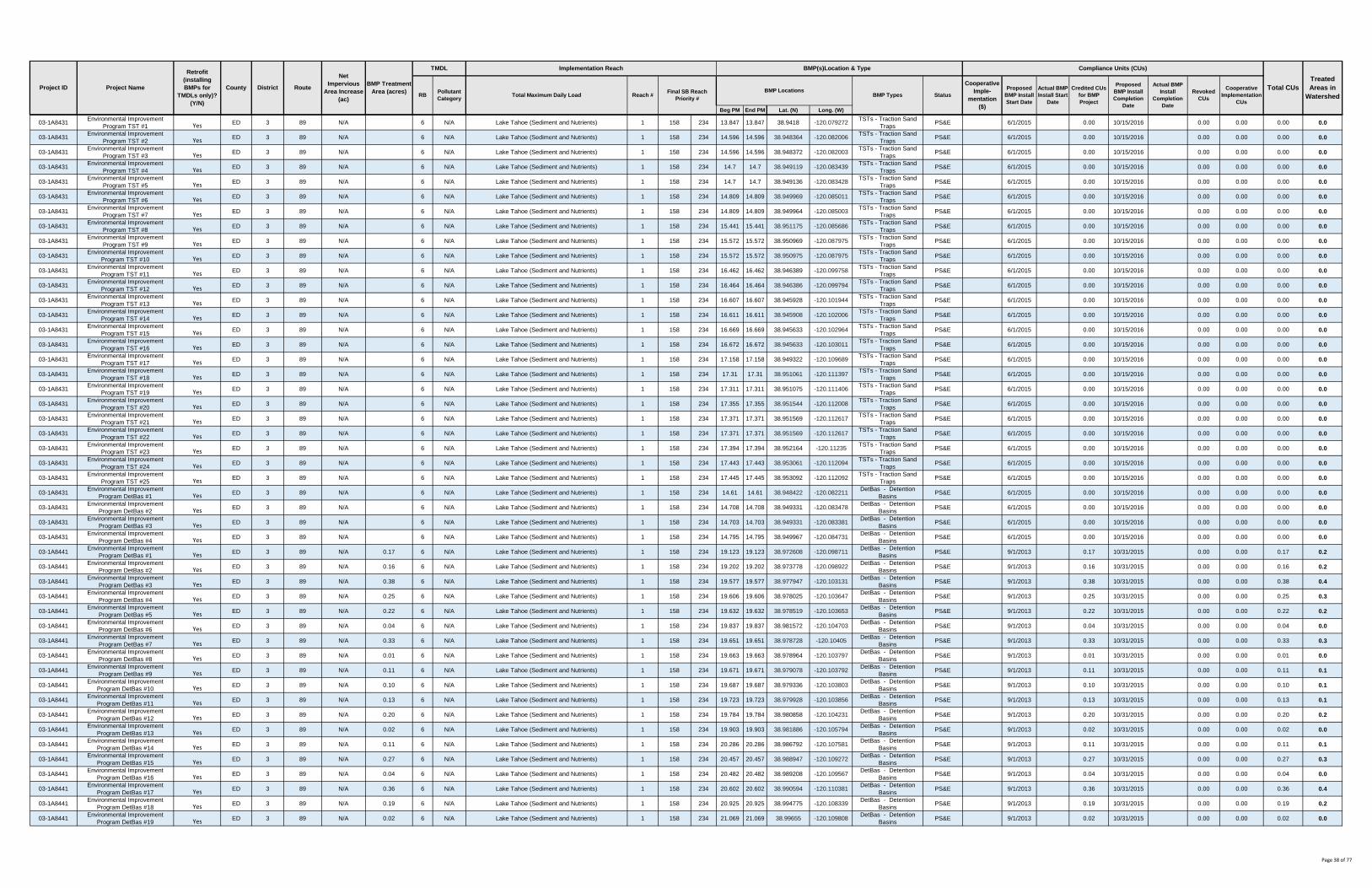
Beg PM End PM Lat. (N) Long. (W)
Revoked CUs
Total CUsTreated Areas in
WatershedRBPollutant Category
Total Maximum Daily Load Reach #Final SB Reach
Priority #
Compliance Units (CUs)
Cooperative Imple-
mentation ($)
Cooperative Implementation
CUs
Proposed BMP Install Start Date
Actual BMP Install Start
Date
Credited CUs for BMP Project
Proposed BMP Install Completion
Date
Actual BMP Install
Completion Date
Net Impervious
Area Increase (ac)
BMP Treatment Area (acres)
TMDL Implementation Reach BMP(s)Location & Type
BMP LocationsBMP Types Status
RouteProject ID Project Name
Retrofit (installing BMPs for
TMDLs only)? (Y/N)
County District
03-1A8431Environmental Improvement
Program TST #1 Yes ED 3 89 N/A 6 N/A Lake Tahoe (Sediment and Nutrients) 1 158 234 13.847 13.847 38.9418 -120.079272TSTs - Traction Sand
TrapsPS&E 6/1/2015 0.00 10/15/2016 0.00 0.00 0.00 0.0
03-1A8431Environmental Improvement
Program TST #2 Yes ED 3 89 N/A 6 N/A Lake Tahoe (Sediment and Nutrients) 1 158 234 14.596 14.596 38.948364 -120.082006TSTs - Traction Sand
TrapsPS&E 6/1/2015 0.00 10/15/2016 0.00 0.00 0.00 0.0
03-1A8431Environmental Improvement
Program TST #3 Yes ED 3 89 N/A 6 N/A Lake Tahoe (Sediment and Nutrients) 1 158 234 14.596 14.596 38.948372 -120.082003TSTs - Traction Sand
TrapsPS&E 6/1/2015 0.00 10/15/2016 0.00 0.00 0.00 0.0
03-1A8431Environmental Improvement
Program TST #4 Yes ED 3 89 N/A 6 N/A Lake Tahoe (Sediment and Nutrients) 1 158 234 14.7 14.7 38.949119 -120.083439TSTs - Traction Sand
TrapsPS&E 6/1/2015 0.00 10/15/2016 0.00 0.00 0.00 0.0
03-1A8431Environmental Improvement
Program TST #5 Yes ED 3 89 N/A 6 N/A Lake Tahoe (Sediment and Nutrients) 1 158 234 14.7 14.7 38.949136 -120.083428TSTs - Traction Sand
TrapsPS&E 6/1/2015 0.00 10/15/2016 0.00 0.00 0.00 0.0
03-1A8431Environmental Improvement
Program TST #6 Yes ED 3 89 N/A 6 N/A Lake Tahoe (Sediment and Nutrients) 1 158 234 14.809 14.809 38.949969 -120.085011TSTs - Traction Sand
TrapsPS&E 6/1/2015 0.00 10/15/2016 0.00 0.00 0.00 0.0
03-1A8431Environmental Improvement
Program TST #7 Yes ED 3 89 N/A 6 N/A Lake Tahoe (Sediment and Nutrients) 1 158 234 14.809 14.809 38.949964 -120.085003TSTs - Traction Sand
TrapsPS&E 6/1/2015 0.00 10/15/2016 0.00 0.00 0.00 0.0
03-1A8431Environmental Improvement
Program TST #8 Yes ED 3 89 N/A 6 N/A Lake Tahoe (Sediment and Nutrients) 1 158 234 15.441 15.441 38.951175 -120.085686TSTs - Traction Sand
TrapsPS&E 6/1/2015 0.00 10/15/2016 0.00 0.00 0.00 0.0
03-1A8431Environmental Improvement
Program TST #9 Yes ED 3 89 N/A 6 N/A Lake Tahoe (Sediment and Nutrients) 1 158 234 15.572 15.572 38.950969 -120.087975TSTs - Traction Sand
TrapsPS&E 6/1/2015 0.00 10/15/2016 0.00 0.00 0.00 0.0
03-1A8431Environmental Improvement
Program TST #10 Yes ED 3 89 N/A 6 N/A Lake Tahoe (Sediment and Nutrients) 1 158 234 15.572 15.572 38.950975 -120.087975TSTs - Traction Sand
TrapsPS&E 6/1/2015 0.00 10/15/2016 0.00 0.00 0.00 0.0
03-1A8431Environmental Improvement
Program TST #11 Yes ED 3 89 N/A 6 N/A Lake Tahoe (Sediment and Nutrients) 1 158 234 16.462 16.462 38.946389 -120.099758TSTs - Traction Sand
TrapsPS&E 6/1/2015 0.00 10/15/2016 0.00 0.00 0.00 0.0
03-1A8431Environmental Improvement
Program TST #12 Yes ED 3 89 N/A 6 N/A Lake Tahoe (Sediment and Nutrients) 1 158 234 16.464 16.464 38.946386 -120.099794TSTs - Traction Sand
TrapsPS&E 6/1/2015 0.00 10/15/2016 0.00 0.00 0.00 0.0
03-1A8431Environmental Improvement
Program TST #13 Yes ED 3 89 N/A 6 N/A Lake Tahoe (Sediment and Nutrients) 1 158 234 16.607 16.607 38.945928 -120.101944TSTs - Traction Sand
TrapsPS&E 6/1/2015 0.00 10/15/2016 0.00 0.00 0.00 0.0
03-1A8431Environmental Improvement
Program TST #14 Yes ED 3 89 N/A 6 N/A Lake Tahoe (Sediment and Nutrients) 1 158 234 16.611 16.611 38.945908 -120.102006TSTs - Traction Sand
TrapsPS&E 6/1/2015 0.00 10/15/2016 0.00 0.00 0.00 0.0
03-1A8431Environmental Improvement
Program TST #15 Yes ED 3 89 N/A 6 N/A Lake Tahoe (Sediment and Nutrients) 1 158 234 16.669 16.669 38.945633 -120.102964TSTs - Traction Sand
TrapsPS&E 6/1/2015 0.00 10/15/2016 0.00 0.00 0.00 0.0
03-1A8431Environmental Improvement
Program TST #16 Yes ED 3 89 N/A 6 N/A Lake Tahoe (Sediment and Nutrients) 1 158 234 16.672 16.672 38.945633 -120.103011TSTs - Traction Sand
TrapsPS&E 6/1/2015 0.00 10/15/2016 0.00 0.00 0.00 0.0
03-1A8431Environmental Improvement
Program TST #17 Yes ED 3 89 N/A 6 N/A Lake Tahoe (Sediment and Nutrients) 1 158 234 17.158 17.158 38.949322 -120.109689TSTs - Traction Sand
TrapsPS&E 6/1/2015 0.00 10/15/2016 0.00 0.00 0.00 0.0
03-1A8431Environmental Improvement
Program TST #18 Yes ED 3 89 N/A 6 N/A Lake Tahoe (Sediment and Nutrients) 1 158 234 17.31 17.31 38.951061 -120.111397TSTs - Traction Sand
TrapsPS&E 6/1/2015 0.00 10/15/2016 0.00 0.00 0.00 0.0
03-1A8431Environmental Improvement
Program TST #19 Yes ED 3 89 N/A 6 N/A Lake Tahoe (Sediment and Nutrients) 1 158 234 17.311 17.311 38.951075 -120.111406TSTs - Traction Sand
TrapsPS&E 6/1/2015 0.00 10/15/2016 0.00 0.00 0.00 0.0
03-1A8431Environmental Improvement
Program TST #20 Yes ED 3 89 N/A 6 N/A Lake Tahoe (Sediment and Nutrients) 1 158 234 17.355 17.355 38.951544 -120.112008TSTs - Traction Sand
TrapsPS&E 6/1/2015 0.00 10/15/2016 0.00 0.00 0.00 0.0
03-1A8431Environmental Improvement
Program TST #21 Yes ED 3 89 N/A 6 N/A Lake Tahoe (Sediment and Nutrients) 1 158 234 17.371 17.371 38.951569 -120.112617TSTs - Traction Sand
TrapsPS&E 6/1/2015 0.00 10/15/2016 0.00 0.00 0.00 0.0
03-1A8431Environmental Improvement
Program TST #22 Yes ED 3 89 N/A 6 N/A Lake Tahoe (Sediment and Nutrients) 1 158 234 17.371 17.371 38.951569 -120.112617TSTs - Traction Sand
TrapsPS&E 6/1/2015 0.00 10/15/2016 0.00 0.00 0.00 0.0
03-1A8431Environmental Improvement
Program TST #23 Yes ED 3 89 N/A 6 N/A Lake Tahoe (Sediment and Nutrients) 1 158 234 17.394 17.394 38.952164 -120.11235TSTs - Traction Sand
TrapsPS&E 6/1/2015 0.00 10/15/2016 0.00 0.00 0.00 0.0
03-1A8431Environmental Improvement
Program TST #24 Yes ED 3 89 N/A 6 N/A Lake Tahoe (Sediment and Nutrients) 1 158 234 17.443 17.443 38.953061 -120.112094TSTs - Traction Sand
TrapsPS&E 6/1/2015 0.00 10/15/2016 0.00 0.00 0.00 0.0
03-1A8431Environmental Improvement
Program TST #25 Yes ED 3 89 N/A 6 N/A Lake Tahoe (Sediment and Nutrients) 1 158 234 17.445 17.445 38.953092 -120.112092TSTs - Traction Sand
TrapsPS&E 6/1/2015 0.00 10/15/2016 0.00 0.00 0.00 0.0
03-1A8431Environmental Improvement
Program DetBas #1 Yes ED 3 89 N/A 6 N/A Lake Tahoe (Sediment and Nutrients) 1 158 234 14.61 14.61 38.948422 -120.082211DetBas - Detention
BasinsPS&E 6/1/2015 0.00 10/15/2016 0.00 0.00 0.00 0.0
03-1A8431Environmental Improvement
Program DetBas #2 Yes ED 3 89 N/A 6 N/A Lake Tahoe (Sediment and Nutrients) 1 158 234 14.708 14.708 38.949331 -120.083478DetBas - Detention
BasinsPS&E 6/1/2015 0.00 10/15/2016 0.00 0.00 0.00 0.0
03-1A8431Environmental Improvement
Program DetBas #3 Yes ED 3 89 N/A 6 N/A Lake Tahoe (Sediment and Nutrients) 1 158 234 14.703 14.703 38.949331 -120.083381DetBas - Detention
BasinsPS&E 6/1/2015 0.00 10/15/2016 0.00 0.00 0.00 0.0
03-1A8431Environmental Improvement
Program DetBas #4 Yes ED 3 89 N/A 6 N/A Lake Tahoe (Sediment and Nutrients) 1 158 234 14.795 14.795 38.949967 -120.084731DetBas - Detention
BasinsPS&E 6/1/2015 0.00 10/15/2016 0.00 0.00 0.00 0.0
03-1A8441Environmental Improvement
Program DetBas #1 Yes ED 3 89 N/A 0.17 6 N/A Lake Tahoe (Sediment and Nutrients) 1 158 234 19.123 19.123 38.972608 -120.098711DetBas - Detention
BasinsPS&E 9/1/2013 0.17 10/31/2015 0.00 0.00 0.17 0.2
03-1A8441Environmental Improvement
Program DetBas #2 Yes ED 3 89 N/A 0.16 6 N/A Lake Tahoe (Sediment and Nutrients) 1 158 234 19.202 19.202 38.973778 -120.098922DetBas - Detention
BasinsPS&E 9/1/2013 0.16 10/31/2015 0.00 0.00 0.16 0.2
03-1A8441Environmental Improvement
Program DetBas #3 Yes ED 3 89 N/A 0.38 6 N/A Lake Tahoe (Sediment and Nutrients) 1 158 234 19.577 19.577 38.977947 -120.103131DetBas - Detention
BasinsPS&E 9/1/2013 0.38 10/31/2015 0.00 0.00 0.38 0.4
03-1A8441Environmental Improvement
Program DetBas #4 Yes ED 3 89 N/A 0.25 6 N/A Lake Tahoe (Sediment and Nutrients) 1 158 234 19.606 19.606 38.978025 -120.103647DetBas - Detention
BasinsPS&E 9/1/2013 0.25 10/31/2015 0.00 0.00 0.25 0.3
03-1A8441Environmental Improvement
Program DetBas #5 Yes ED 3 89 N/A 0.22 6 N/A Lake Tahoe (Sediment and Nutrients) 1 158 234 19.632 19.632 38.978519 -120.103653DetBas - Detention
BasinsPS&E 9/1/2013 0.22 10/31/2015 0.00 0.00 0.22 0.2
03-1A8441Environmental Improvement
Program DetBas #6 Yes ED 3 89 N/A 0.04 6 N/A Lake Tahoe (Sediment and Nutrients) 1 158 234 19.837 19.837 38.981572 -120.104703DetBas - Detention
BasinsPS&E 9/1/2013 0.04 10/31/2015 0.00 0.00 0.04 0.0
03-1A8441Environmental Improvement
Program DetBas #7 Yes ED 3 89 N/A 0.33 6 N/A Lake Tahoe (Sediment and Nutrients) 1 158 234 19.651 19.651 38.978728 -120.10405DetBas - Detention
BasinsPS&E 9/1/2013 0.33 10/31/2015 0.00 0.00 0.33 0.3
03-1A8441Environmental Improvement
Program DetBas #8 Yes ED 3 89 N/A 0.01 6 N/A Lake Tahoe (Sediment and Nutrients) 1 158 234 19.663 19.663 38.978964 -120.103797DetBas - Detention
BasinsPS&E 9/1/2013 0.01 10/31/2015 0.00 0.00 0.01 0.0
03-1A8441Environmental Improvement
Program DetBas #9 Yes ED 3 89 N/A 0.11 6 N/A Lake Tahoe (Sediment and Nutrients) 1 158 234 19.671 19.671 38.979078 -120.103792DetBas - Detention
BasinsPS&E 9/1/2013 0.11 10/31/2015 0.00 0.00 0.11 0.1
03-1A8441Environmental Improvement
Program DetBas #10 Yes ED 3 89 N/A 0.10 6 N/A Lake Tahoe (Sediment and Nutrients) 1 158 234 19.687 19.687 38.979336 -120.103803DetBas - Detention
BasinsPS&E 9/1/2013 0.10 10/31/2015 0.00 0.00 0.10 0.1
03-1A8441Environmental Improvement
Program DetBas #11 Yes ED 3 89 N/A 0.13 6 N/A Lake Tahoe (Sediment and Nutrients) 1 158 234 19.723 19.723 38.979928 -120.103856DetBas - Detention
BasinsPS&E 9/1/2013 0.13 10/31/2015 0.00 0.00 0.13 0.1
03-1A8441Environmental Improvement
Program DetBas #12 Yes ED 3 89 N/A 0.20 6 N/A Lake Tahoe (Sediment and Nutrients) 1 158 234 19.784 19.784 38.980858 -120.104231DetBas - Detention
BasinsPS&E 9/1/2013 0.20 10/31/2015 0.00 0.00 0.20 0.2
03-1A8441Environmental Improvement
Program DetBas #13 Yes ED 3 89 N/A 0.02 6 N/A Lake Tahoe (Sediment and Nutrients) 1 158 234 19.903 19.903 38.981886 -120.105794DetBas - Detention
BasinsPS&E 9/1/2013 0.02 10/31/2015 0.00 0.00 0.02 0.0
03-1A8441Environmental Improvement
Program DetBas #14 Yes ED 3 89 N/A 0.11 6 N/A Lake Tahoe (Sediment and Nutrients) 1 158 234 20.286 20.286 38.986792 -120.107581DetBas - Detention
BasinsPS&E 9/1/2013 0.11 10/31/2015 0.00 0.00 0.11 0.1
03-1A8441Environmental Improvement
Program DetBas #15 Yes ED 3 89 N/A 0.27 6 N/A Lake Tahoe (Sediment and Nutrients) 1 158 234 20.457 20.457 38.988947 -120.109272DetBas - Detention
BasinsPS&E 9/1/2013 0.27 10/31/2015 0.00 0.00 0.27 0.3
03-1A8441Environmental Improvement
Program DetBas #16 Yes ED 3 89 N/A 0.04 6 N/A Lake Tahoe (Sediment and Nutrients) 1 158 234 20.482 20.482 38.989208 -120.109567DetBas - Detention
BasinsPS&E 9/1/2013 0.04 10/31/2015 0.00 0.00 0.04 0.0
03-1A8441Environmental Improvement
Program DetBas #17 Yes ED 3 89 N/A 0.36 6 N/A Lake Tahoe (Sediment and Nutrients) 1 158 234 20.602 20.602 38.990594 -120.110381DetBas - Detention
BasinsPS&E 9/1/2013 0.36 10/31/2015 0.00 0.00 0.36 0.4
03-1A8441Environmental Improvement
Program DetBas #18 Yes ED 3 89 N/A 0.19 6 N/A Lake Tahoe (Sediment and Nutrients) 1 158 234 20.925 20.925 38.994775 -120.108339DetBas - Detention
BasinsPS&E 9/1/2013 0.19 10/31/2015 0.00 0.00 0.19 0.2
03-1A8441Environmental Improvement
Program DetBas #19 Yes ED 3 89 N/A 0.02 6 N/A Lake Tahoe (Sediment and Nutrients) 1 158 234 21.069 21.069 38.99655 -120.109808DetBas - Detention
BasinsPS&E 9/1/2013 0.02 10/31/2015 0.00 0.00 0.02 0.0
Page 38 of 77
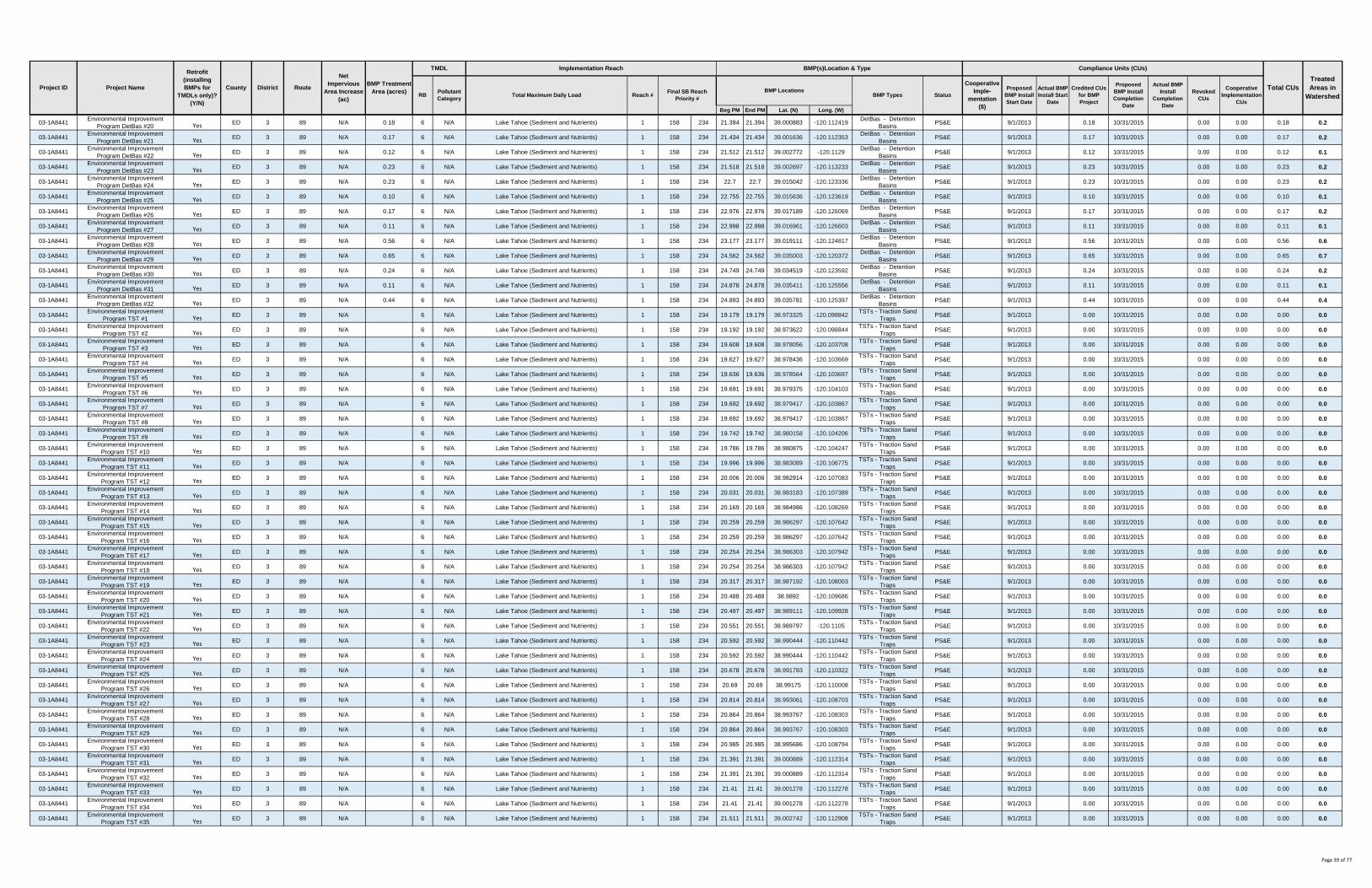
Beg PM End PM Lat. (N) Long. (W)
Revoked CUs
Total CUsTreated Areas in
WatershedRBPollutant Category
Total Maximum Daily Load Reach #Final SB Reach
Priority #
Compliance Units (CUs)
Cooperative Imple-
mentation ($)
Cooperative Implementation
CUs
Proposed BMP Install Start Date
Actual BMP Install Start
Date
Credited CUs for BMP Project
Proposed BMP Install Completion
Date
Actual BMP Install
Completion Date
Net Impervious
Area Increase (ac)
BMP Treatment Area (acres)
TMDL Implementation Reach BMP(s)Location & Type
BMP LocationsBMP Types Status
RouteProject ID Project Name
Retrofit (installing BMPs for
TMDLs only)? (Y/N)
County District
03-1A8441Environmental Improvement
Program DetBas #20 Yes ED 3 89 N/A 0.18 6 N/A Lake Tahoe (Sediment and Nutrients) 1 158 234 21.394 21.394 39.000883 -120.112419DetBas - Detention
BasinsPS&E 9/1/2013 0.18 10/31/2015 0.00 0.00 0.18 0.2
03-1A8441Environmental Improvement
Program DetBas #21 Yes ED 3 89 N/A 0.17 6 N/A Lake Tahoe (Sediment and Nutrients) 1 158 234 21.434 21.434 39.001636 -120.112353DetBas - Detention
BasinsPS&E 9/1/2013 0.17 10/31/2015 0.00 0.00 0.17 0.2
03-1A8441Environmental Improvement
Program DetBas #22 Yes ED 3 89 N/A 0.12 6 N/A Lake Tahoe (Sediment and Nutrients) 1 158 234 21.512 21.512 39.002772 -120.1129DetBas - Detention
BasinsPS&E 9/1/2013 0.12 10/31/2015 0.00 0.00 0.12 0.1
03-1A8441Environmental Improvement
Program DetBas #23 Yes ED 3 89 N/A 0.23 6 N/A Lake Tahoe (Sediment and Nutrients) 1 158 234 21.518 21.518 39.002697 -120.113233DetBas - Detention
BasinsPS&E 9/1/2013 0.23 10/31/2015 0.00 0.00 0.23 0.2
03-1A8441Environmental Improvement
Program DetBas #24 Yes ED 3 89 N/A 0.23 6 N/A Lake Tahoe (Sediment and Nutrients) 1 158 234 22.7 22.7 39.015042 -120.123336DetBas - Detention
BasinsPS&E 9/1/2013 0.23 10/31/2015 0.00 0.00 0.23 0.2
03-1A8441Environmental Improvement
Program DetBas #25 Yes ED 3 89 N/A 0.10 6 N/A Lake Tahoe (Sediment and Nutrients) 1 158 234 22.755 22.755 39.015636 -120.123619DetBas - Detention
BasinsPS&E 9/1/2013 0.10 10/31/2015 0.00 0.00 0.10 0.1
03-1A8441Environmental Improvement
Program DetBas #26 Yes ED 3 89 N/A 0.17 6 N/A Lake Tahoe (Sediment and Nutrients) 1 158 234 22.976 22.976 39.017189 -120.126069DetBas - Detention
BasinsPS&E 9/1/2013 0.17 10/31/2015 0.00 0.00 0.17 0.2
03-1A8441Environmental Improvement
Program DetBas #27 Yes ED 3 89 N/A 0.11 6 N/A Lake Tahoe (Sediment and Nutrients) 1 158 234 22.998 22.998 39.016961 -120.126603DetBas - Detention
BasinsPS&E 9/1/2013 0.11 10/31/2015 0.00 0.00 0.11 0.1
03-1A8441Environmental Improvement
Program DetBas #28 Yes ED 3 89 N/A 0.56 6 N/A Lake Tahoe (Sediment and Nutrients) 1 158 234 23.177 23.177 39.019111 -120.124817DetBas - Detention
BasinsPS&E 9/1/2013 0.56 10/31/2015 0.00 0.00 0.56 0.6
03-1A8441Environmental Improvement
Program DetBas #29 Yes ED 3 89 N/A 0.65 6 N/A Lake Tahoe (Sediment and Nutrients) 1 158 234 24.562 24.562 39.035003 -120.120372DetBas - Detention
BasinsPS&E 9/1/2013 0.65 10/31/2015 0.00 0.00 0.65 0.7
03-1A8441Environmental Improvement
Program DetBas #30 Yes ED 3 89 N/A 0.24 6 N/A Lake Tahoe (Sediment and Nutrients) 1 158 234 24.749 24.749 39.034519 -120.123592DetBas - Detention
BasinsPS&E 9/1/2013 0.24 10/31/2015 0.00 0.00 0.24 0.2
03-1A8441Environmental Improvement
Program DetBas #31 Yes ED 3 89 N/A 0.11 6 N/A Lake Tahoe (Sediment and Nutrients) 1 158 234 24.878 24.878 39.035411 -120.125556DetBas - Detention
BasinsPS&E 9/1/2013 0.11 10/31/2015 0.00 0.00 0.11 0.1
03-1A8441Environmental Improvement
Program DetBas #32 Yes ED 3 89 N/A 0.44 6 N/A Lake Tahoe (Sediment and Nutrients) 1 158 234 24.893 24.893 39.035781 -120.125397DetBas - Detention
BasinsPS&E 9/1/2013 0.44 10/31/2015 0.00 0.00 0.44 0.4
03-1A8441Environmental Improvement
Program TST #1 Yes ED 3 89 N/A 6 N/A Lake Tahoe (Sediment and Nutrients) 1 158 234 19.179 19.179 38.973325 -120.098842TSTs - Traction Sand
TrapsPS&E 9/1/2013 0.00 10/31/2015 0.00 0.00 0.00 0.0
03-1A8441Environmental Improvement
Program TST #2 Yes ED 3 89 N/A 6 N/A Lake Tahoe (Sediment and Nutrients) 1 158 234 19.192 19.192 38.973622 -120.098844TSTs - Traction Sand
TrapsPS&E 9/1/2013 0.00 10/31/2015 0.00 0.00 0.00 0.0
03-1A8441Environmental Improvement
Program TST #3 Yes ED 3 89 N/A 6 N/A Lake Tahoe (Sediment and Nutrients) 1 158 234 19.608 19.608 38.978056 -120.103708TSTs - Traction Sand
TrapsPS&E 9/1/2013 0.00 10/31/2015 0.00 0.00 0.00 0.0
03-1A8441Environmental Improvement
Program TST #4 Yes ED 3 89 N/A 6 N/A Lake Tahoe (Sediment and Nutrients) 1 158 234 19.627 19.627 38.978436 -120.103669TSTs - Traction Sand
TrapsPS&E 9/1/2013 0.00 10/31/2015 0.00 0.00 0.00 0.0
03-1A8441Environmental Improvement
Program TST #5 Yes ED 3 89 N/A 6 N/A Lake Tahoe (Sediment and Nutrients) 1 158 234 19.636 19.636 38.978564 -120.103697TSTs - Traction Sand
TrapsPS&E 9/1/2013 0.00 10/31/2015 0.00 0.00 0.00 0.0
03-1A8441Environmental Improvement
Program TST #6 Yes ED 3 89 N/A 6 N/A Lake Tahoe (Sediment and Nutrients) 1 158 234 19.691 19.691 38.979375 -120.104103TSTs - Traction Sand
TrapsPS&E 9/1/2013 0.00 10/31/2015 0.00 0.00 0.00 0.0
03-1A8441Environmental Improvement
Program TST #7 Yes ED 3 89 N/A 6 N/A Lake Tahoe (Sediment and Nutrients) 1 158 234 19.692 19.692 38.979417 -120.103867TSTs - Traction Sand
TrapsPS&E 9/1/2013 0.00 10/31/2015 0.00 0.00 0.00 0.0
03-1A8441Environmental Improvement
Program TST #8 Yes ED 3 89 N/A 6 N/A Lake Tahoe (Sediment and Nutrients) 1 158 234 19.692 19.692 38.979417 -120.103867TSTs - Traction Sand
TrapsPS&E 9/1/2013 0.00 10/31/2015 0.00 0.00 0.00 0.0
03-1A8441Environmental Improvement
Program TST #9 Yes ED 3 89 N/A 6 N/A Lake Tahoe (Sediment and Nutrients) 1 158 234 19.742 19.742 38.980158 -120.104206TSTs - Traction Sand
TrapsPS&E 9/1/2013 0.00 10/31/2015 0.00 0.00 0.00 0.0
03-1A8441Environmental Improvement
Program TST #10 Yes ED 3 89 N/A 6 N/A Lake Tahoe (Sediment and Nutrients) 1 158 234 19.786 19.786 38.980875 -120.104247TSTs - Traction Sand
TrapsPS&E 9/1/2013 0.00 10/31/2015 0.00 0.00 0.00 0.0
03-1A8441Environmental Improvement
Program TST #11 Yes ED 3 89 N/A 6 N/A Lake Tahoe (Sediment and Nutrients) 1 158 234 19.996 19.996 38.983089 -120.106775TSTs - Traction Sand
TrapsPS&E 9/1/2013 0.00 10/31/2015 0.00 0.00 0.00 0.0
03-1A8441Environmental Improvement
Program TST #12 Yes ED 3 89 N/A 6 N/A Lake Tahoe (Sediment and Nutrients) 1 158 234 20.006 20.006 38.982914 -120.107083TSTs - Traction Sand
TrapsPS&E 9/1/2013 0.00 10/31/2015 0.00 0.00 0.00 0.0
03-1A8441Environmental Improvement
Program TST #13 Yes ED 3 89 N/A 6 N/A Lake Tahoe (Sediment and Nutrients) 1 158 234 20.031 20.031 38.983183 -120.107389TSTs - Traction Sand
TrapsPS&E 9/1/2013 0.00 10/31/2015 0.00 0.00 0.00 0.0
03-1A8441Environmental Improvement
Program TST #14 Yes ED 3 89 N/A 6 N/A Lake Tahoe (Sediment and Nutrients) 1 158 234 20.169 20.169 38.984986 -120.108269TSTs - Traction Sand
TrapsPS&E 9/1/2013 0.00 10/31/2015 0.00 0.00 0.00 0.0
03-1A8441Environmental Improvement
Program TST #15 Yes ED 3 89 N/A 6 N/A Lake Tahoe (Sediment and Nutrients) 1 158 234 20.259 20.259 38.986297 -120.107642TSTs - Traction Sand
TrapsPS&E 9/1/2013 0.00 10/31/2015 0.00 0.00 0.00 0.0
03-1A8441Environmental Improvement
Program TST #16 Yes ED 3 89 N/A 6 N/A Lake Tahoe (Sediment and Nutrients) 1 158 234 20.259 20.259 38.986297 -120.107642TSTs - Traction Sand
TrapsPS&E 9/1/2013 0.00 10/31/2015 0.00 0.00 0.00 0.0
03-1A8441Environmental Improvement
Program TST #17 Yes ED 3 89 N/A 6 N/A Lake Tahoe (Sediment and Nutrients) 1 158 234 20.254 20.254 38.986303 -120.107942TSTs - Traction Sand
TrapsPS&E 9/1/2013 0.00 10/31/2015 0.00 0.00 0.00 0.0
03-1A8441Environmental Improvement
Program TST #18 Yes ED 3 89 N/A 6 N/A Lake Tahoe (Sediment and Nutrients) 1 158 234 20.254 20.254 38.986303 -120.107942TSTs - Traction Sand
TrapsPS&E 9/1/2013 0.00 10/31/2015 0.00 0.00 0.00 0.0
03-1A8441Environmental Improvement
Program TST #19 Yes ED 3 89 N/A 6 N/A Lake Tahoe (Sediment and Nutrients) 1 158 234 20.317 20.317 38.987192 -120.108003TSTs - Traction Sand
TrapsPS&E 9/1/2013 0.00 10/31/2015 0.00 0.00 0.00 0.0
03-1A8441Environmental Improvement
Program TST #20 Yes ED 3 89 N/A 6 N/A Lake Tahoe (Sediment and Nutrients) 1 158 234 20.488 20.488 38.9892 -120.109686TSTs - Traction Sand
TrapsPS&E 9/1/2013 0.00 10/31/2015 0.00 0.00 0.00 0.0
03-1A8441Environmental Improvement
Program TST #21 Yes ED 3 89 N/A 6 N/A Lake Tahoe (Sediment and Nutrients) 1 158 234 20.497 20.497 38.989111 -120.109928TSTs - Traction Sand
TrapsPS&E 9/1/2013 0.00 10/31/2015 0.00 0.00 0.00 0.0
03-1A8441Environmental Improvement
Program TST #22 Yes ED 3 89 N/A 6 N/A Lake Tahoe (Sediment and Nutrients) 1 158 234 20.551 20.551 38.989797 -120.1105TSTs - Traction Sand
TrapsPS&E 9/1/2013 0.00 10/31/2015 0.00 0.00 0.00 0.0
03-1A8441Environmental Improvement
Program TST #23 Yes ED 3 89 N/A 6 N/A Lake Tahoe (Sediment and Nutrients) 1 158 234 20.592 20.592 38.990444 -120.110442TSTs - Traction Sand
TrapsPS&E 9/1/2013 0.00 10/31/2015 0.00 0.00 0.00 0.0
03-1A8441Environmental Improvement
Program TST #24 Yes ED 3 89 N/A 6 N/A Lake Tahoe (Sediment and Nutrients) 1 158 234 20.592 20.592 38.990444 -120.110442TSTs - Traction Sand
TrapsPS&E 9/1/2013 0.00 10/31/2015 0.00 0.00 0.00 0.0
03-1A8441Environmental Improvement
Program TST #25 Yes ED 3 89 N/A 6 N/A Lake Tahoe (Sediment and Nutrients) 1 158 234 20.678 20.678 38.991783 -120.110322TSTs - Traction Sand
TrapsPS&E 9/1/2013 0.00 10/31/2015 0.00 0.00 0.00 0.0
03-1A8441Environmental Improvement
Program TST #26 Yes ED 3 89 N/A 6 N/A Lake Tahoe (Sediment and Nutrients) 1 158 234 20.69 20.69 38.99175 -120.110008TSTs - Traction Sand
TrapsPS&E 9/1/2013 0.00 10/31/2015 0.00 0.00 0.00 0.0
03-1A8441Environmental Improvement
Program TST #27 Yes ED 3 89 N/A 6 N/A Lake Tahoe (Sediment and Nutrients) 1 158 234 20.814 20.814 38.993061 -120.108703TSTs - Traction Sand
TrapsPS&E 9/1/2013 0.00 10/31/2015 0.00 0.00 0.00 0.0
03-1A8441Environmental Improvement
Program TST #28 Yes ED 3 89 N/A 6 N/A Lake Tahoe (Sediment and Nutrients) 1 158 234 20.864 20.864 38.993767 -120.108303TSTs - Traction Sand
TrapsPS&E 9/1/2013 0.00 10/31/2015 0.00 0.00 0.00 0.0
03-1A8441Environmental Improvement
Program TST #29 Yes ED 3 89 N/A 6 N/A Lake Tahoe (Sediment and Nutrients) 1 158 234 20.864 20.864 38.993767 -120.108303TSTs - Traction Sand
TrapsPS&E 9/1/2013 0.00 10/31/2015 0.00 0.00 0.00 0.0
03-1A8441Environmental Improvement
Program TST #30 Yes ED 3 89 N/A 6 N/A Lake Tahoe (Sediment and Nutrients) 1 158 234 20.985 20.985 38.995686 -120.108794TSTs - Traction Sand
TrapsPS&E 9/1/2013 0.00 10/31/2015 0.00 0.00 0.00 0.0
03-1A8441Environmental Improvement
Program TST #31 Yes ED 3 89 N/A 6 N/A Lake Tahoe (Sediment and Nutrients) 1 158 234 21.391 21.391 39.000889 -120.112314TSTs - Traction Sand
TrapsPS&E 9/1/2013 0.00 10/31/2015 0.00 0.00 0.00 0.0
03-1A8441Environmental Improvement
Program TST #32 Yes ED 3 89 N/A 6 N/A Lake Tahoe (Sediment and Nutrients) 1 158 234 21.391 21.391 39.000889 -120.112314TSTs - Traction Sand
TrapsPS&E 9/1/2013 0.00 10/31/2015 0.00 0.00 0.00 0.0
03-1A8441Environmental Improvement
Program TST #33 Yes ED 3 89 N/A 6 N/A Lake Tahoe (Sediment and Nutrients) 1 158 234 21.41 21.41 39.001278 -120.112278TSTs - Traction Sand
TrapsPS&E 9/1/2013 0.00 10/31/2015 0.00 0.00 0.00 0.0
03-1A8441Environmental Improvement
Program TST #34 Yes ED 3 89 N/A 6 N/A Lake Tahoe (Sediment and Nutrients) 1 158 234 21.41 21.41 39.001278 -120.112278TSTs - Traction Sand
TrapsPS&E 9/1/2013 0.00 10/31/2015 0.00 0.00 0.00 0.0
03-1A8441Environmental Improvement
Program TST #35 Yes ED 3 89 N/A 6 N/A Lake Tahoe (Sediment and Nutrients) 1 158 234 21.511 21.511 39.002742 -120.112908TSTs - Traction Sand
TrapsPS&E 9/1/2013 0.00 10/31/2015 0.00 0.00 0.00 0.0
Page 39 of 77
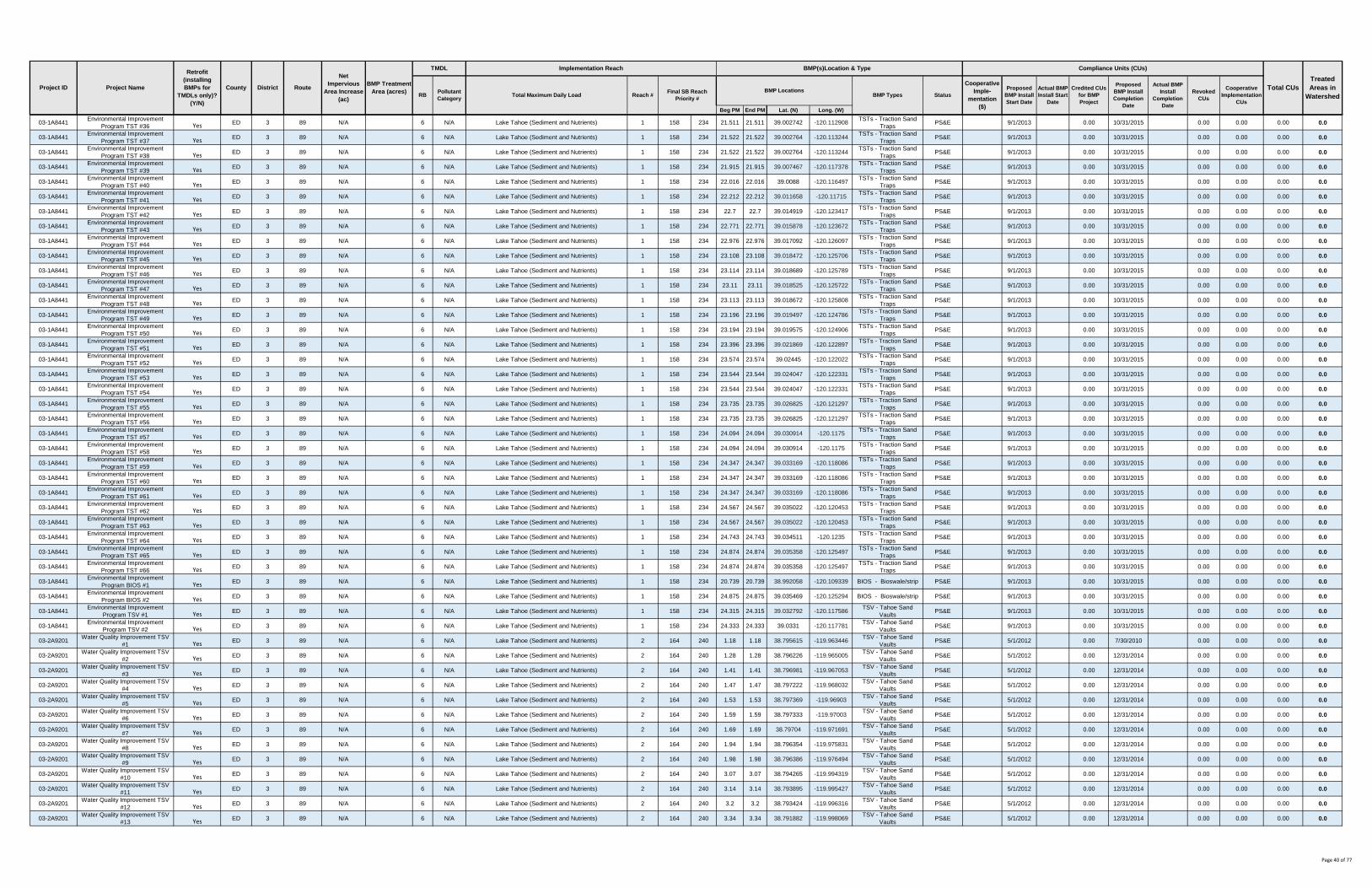
Beg PM End PM Lat. (N) Long. (W)
Revoked CUs
Total CUsTreated Areas in
WatershedRBPollutant Category
Total Maximum Daily Load Reach #Final SB Reach
Priority #
Compliance Units (CUs)
Cooperative Imple-
mentation ($)
Cooperative Implementation
CUs
Proposed BMP Install Start Date
Actual BMP Install Start
Date
Credited CUs for BMP Project
Proposed BMP Install Completion
Date
Actual BMP Install
Completion Date
Net Impervious
Area Increase (ac)
BMP Treatment Area (acres)
TMDL Implementation Reach BMP(s)Location & Type
BMP LocationsBMP Types Status
RouteProject ID Project Name
Retrofit (installing BMPs for
TMDLs only)? (Y/N)
County District
03-1A8441Environmental Improvement
Program TST #36 Yes ED 3 89 N/A 6 N/A Lake Tahoe (Sediment and Nutrients) 1 158 234 21.511 21.511 39.002742 -120.112908TSTs - Traction Sand
TrapsPS&E 9/1/2013 0.00 10/31/2015 0.00 0.00 0.00 0.0
03-1A8441Environmental Improvement
Program TST #37 Yes ED 3 89 N/A 6 N/A Lake Tahoe (Sediment and Nutrients) 1 158 234 21.522 21.522 39.002764 -120.113244TSTs - Traction Sand
TrapsPS&E 9/1/2013 0.00 10/31/2015 0.00 0.00 0.00 0.0
03-1A8441Environmental Improvement
Program TST #38 Yes ED 3 89 N/A 6 N/A Lake Tahoe (Sediment and Nutrients) 1 158 234 21.522 21.522 39.002764 -120.113244TSTs - Traction Sand
TrapsPS&E 9/1/2013 0.00 10/31/2015 0.00 0.00 0.00 0.0
03-1A8441Environmental Improvement
Program TST #39 Yes ED 3 89 N/A 6 N/A Lake Tahoe (Sediment and Nutrients) 1 158 234 21.915 21.915 39.007467 -120.117378TSTs - Traction Sand
TrapsPS&E 9/1/2013 0.00 10/31/2015 0.00 0.00 0.00 0.0
03-1A8441Environmental Improvement
Program TST #40 Yes ED 3 89 N/A 6 N/A Lake Tahoe (Sediment and Nutrients) 1 158 234 22.016 22.016 39.0088 -120.116497TSTs - Traction Sand
TrapsPS&E 9/1/2013 0.00 10/31/2015 0.00 0.00 0.00 0.0
03-1A8441Environmental Improvement
Program TST #41 Yes ED 3 89 N/A 6 N/A Lake Tahoe (Sediment and Nutrients) 1 158 234 22.212 22.212 39.011658 -120.11715TSTs - Traction Sand
TrapsPS&E 9/1/2013 0.00 10/31/2015 0.00 0.00 0.00 0.0
03-1A8441Environmental Improvement
Program TST #42 Yes ED 3 89 N/A 6 N/A Lake Tahoe (Sediment and Nutrients) 1 158 234 22.7 22.7 39.014919 -120.123417TSTs - Traction Sand
TrapsPS&E 9/1/2013 0.00 10/31/2015 0.00 0.00 0.00 0.0
03-1A8441Environmental Improvement
Program TST #43 Yes ED 3 89 N/A 6 N/A Lake Tahoe (Sediment and Nutrients) 1 158 234 22.771 22.771 39.015878 -120.123672TSTs - Traction Sand
TrapsPS&E 9/1/2013 0.00 10/31/2015 0.00 0.00 0.00 0.0
03-1A8441Environmental Improvement
Program TST #44 Yes ED 3 89 N/A 6 N/A Lake Tahoe (Sediment and Nutrients) 1 158 234 22.976 22.976 39.017092 -120.126097TSTs - Traction Sand
TrapsPS&E 9/1/2013 0.00 10/31/2015 0.00 0.00 0.00 0.0
03-1A8441Environmental Improvement
Program TST #45 Yes ED 3 89 N/A 6 N/A Lake Tahoe (Sediment and Nutrients) 1 158 234 23.108 23.108 39.018472 -120.125706TSTs - Traction Sand
TrapsPS&E 9/1/2013 0.00 10/31/2015 0.00 0.00 0.00 0.0
03-1A8441Environmental Improvement
Program TST #46 Yes ED 3 89 N/A 6 N/A Lake Tahoe (Sediment and Nutrients) 1 158 234 23.114 23.114 39.018689 -120.125789TSTs - Traction Sand
TrapsPS&E 9/1/2013 0.00 10/31/2015 0.00 0.00 0.00 0.0
03-1A8441Environmental Improvement
Program TST #47 Yes ED 3 89 N/A 6 N/A Lake Tahoe (Sediment and Nutrients) 1 158 234 23.11 23.11 39.018525 -120.125722TSTs - Traction Sand
TrapsPS&E 9/1/2013 0.00 10/31/2015 0.00 0.00 0.00 0.0
03-1A8441Environmental Improvement
Program TST #48 Yes ED 3 89 N/A 6 N/A Lake Tahoe (Sediment and Nutrients) 1 158 234 23.113 23.113 39.018672 -120.125808TSTs - Traction Sand
TrapsPS&E 9/1/2013 0.00 10/31/2015 0.00 0.00 0.00 0.0
03-1A8441Environmental Improvement
Program TST #49 Yes ED 3 89 N/A 6 N/A Lake Tahoe (Sediment and Nutrients) 1 158 234 23.196 23.196 39.019497 -120.124786TSTs - Traction Sand
TrapsPS&E 9/1/2013 0.00 10/31/2015 0.00 0.00 0.00 0.0
03-1A8441Environmental Improvement
Program TST #50 Yes ED 3 89 N/A 6 N/A Lake Tahoe (Sediment and Nutrients) 1 158 234 23.194 23.194 39.019575 -120.124906TSTs - Traction Sand
TrapsPS&E 9/1/2013 0.00 10/31/2015 0.00 0.00 0.00 0.0
03-1A8441Environmental Improvement
Program TST #51 Yes ED 3 89 N/A 6 N/A Lake Tahoe (Sediment and Nutrients) 1 158 234 23.396 23.396 39.021869 -120.122897TSTs - Traction Sand
TrapsPS&E 9/1/2013 0.00 10/31/2015 0.00 0.00 0.00 0.0
03-1A8441Environmental Improvement
Program TST #52 Yes ED 3 89 N/A 6 N/A Lake Tahoe (Sediment and Nutrients) 1 158 234 23.574 23.574 39.02445 -120.122022TSTs - Traction Sand
TrapsPS&E 9/1/2013 0.00 10/31/2015 0.00 0.00 0.00 0.0
03-1A8441Environmental Improvement
Program TST #53 Yes ED 3 89 N/A 6 N/A Lake Tahoe (Sediment and Nutrients) 1 158 234 23.544 23.544 39.024047 -120.122331TSTs - Traction Sand
TrapsPS&E 9/1/2013 0.00 10/31/2015 0.00 0.00 0.00 0.0
03-1A8441Environmental Improvement
Program TST #54 Yes ED 3 89 N/A 6 N/A Lake Tahoe (Sediment and Nutrients) 1 158 234 23.544 23.544 39.024047 -120.122331TSTs - Traction Sand
TrapsPS&E 9/1/2013 0.00 10/31/2015 0.00 0.00 0.00 0.0
03-1A8441Environmental Improvement
Program TST #55 Yes ED 3 89 N/A 6 N/A Lake Tahoe (Sediment and Nutrients) 1 158 234 23.735 23.735 39.026825 -120.121297TSTs - Traction Sand
TrapsPS&E 9/1/2013 0.00 10/31/2015 0.00 0.00 0.00 0.0
03-1A8441Environmental Improvement
Program TST #56 Yes ED 3 89 N/A 6 N/A Lake Tahoe (Sediment and Nutrients) 1 158 234 23.735 23.735 39.026825 -120.121297TSTs - Traction Sand
TrapsPS&E 9/1/2013 0.00 10/31/2015 0.00 0.00 0.00 0.0
03-1A8441Environmental Improvement
Program TST #57 Yes ED 3 89 N/A 6 N/A Lake Tahoe (Sediment and Nutrients) 1 158 234 24.094 24.094 39.030914 -120.1175TSTs - Traction Sand
TrapsPS&E 9/1/2013 0.00 10/31/2015 0.00 0.00 0.00 0.0
03-1A8441Environmental Improvement
Program TST #58 Yes ED 3 89 N/A 6 N/A Lake Tahoe (Sediment and Nutrients) 1 158 234 24.094 24.094 39.030914 -120.1175TSTs - Traction Sand
TrapsPS&E 9/1/2013 0.00 10/31/2015 0.00 0.00 0.00 0.0
03-1A8441Environmental Improvement
Program TST #59 Yes ED 3 89 N/A 6 N/A Lake Tahoe (Sediment and Nutrients) 1 158 234 24.347 24.347 39.033169 -120.118086TSTs - Traction Sand
TrapsPS&E 9/1/2013 0.00 10/31/2015 0.00 0.00 0.00 0.0
03-1A8441Environmental Improvement
Program TST #60 Yes ED 3 89 N/A 6 N/A Lake Tahoe (Sediment and Nutrients) 1 158 234 24.347 24.347 39.033169 -120.118086TSTs - Traction Sand
TrapsPS&E 9/1/2013 0.00 10/31/2015 0.00 0.00 0.00 0.0
03-1A8441Environmental Improvement
Program TST #61 Yes ED 3 89 N/A 6 N/A Lake Tahoe (Sediment and Nutrients) 1 158 234 24.347 24.347 39.033169 -120.118086TSTs - Traction Sand
TrapsPS&E 9/1/2013 0.00 10/31/2015 0.00 0.00 0.00 0.0
03-1A8441Environmental Improvement
Program TST #62 Yes ED 3 89 N/A 6 N/A Lake Tahoe (Sediment and Nutrients) 1 158 234 24.567 24.567 39.035022 -120.120453TSTs - Traction Sand
TrapsPS&E 9/1/2013 0.00 10/31/2015 0.00 0.00 0.00 0.0
03-1A8441Environmental Improvement
Program TST #63 Yes ED 3 89 N/A 6 N/A Lake Tahoe (Sediment and Nutrients) 1 158 234 24.567 24.567 39.035022 -120.120453TSTs - Traction Sand
TrapsPS&E 9/1/2013 0.00 10/31/2015 0.00 0.00 0.00 0.0
03-1A8441Environmental Improvement
Program TST #64 Yes ED 3 89 N/A 6 N/A Lake Tahoe (Sediment and Nutrients) 1 158 234 24.743 24.743 39.034511 -120.1235TSTs - Traction Sand
TrapsPS&E 9/1/2013 0.00 10/31/2015 0.00 0.00 0.00 0.0
03-1A8441Environmental Improvement
Program TST #65 Yes ED 3 89 N/A 6 N/A Lake Tahoe (Sediment and Nutrients) 1 158 234 24.874 24.874 39.035358 -120.125497TSTs - Traction Sand
TrapsPS&E 9/1/2013 0.00 10/31/2015 0.00 0.00 0.00 0.0
03-1A8441Environmental Improvement
Program TST #66 Yes ED 3 89 N/A 6 N/A Lake Tahoe (Sediment and Nutrients) 1 158 234 24.874 24.874 39.035358 -120.125497TSTs - Traction Sand
TrapsPS&E 9/1/2013 0.00 10/31/2015 0.00 0.00 0.00 0.0
03-1A8441Environmental Improvement
Program BIOS #1 Yes ED 3 89 N/A 6 N/A Lake Tahoe (Sediment and Nutrients) 1 158 234 20.739 20.739 38.992058 -120.109339 BIOS - Bioswale/strip PS&E 9/1/2013 0.00 10/31/2015 0.00 0.00 0.00 0.0
03-1A8441Environmental Improvement
Program BIOS #2 Yes ED 3 89 N/A 6 N/A Lake Tahoe (Sediment and Nutrients) 1 158 234 24.875 24.875 39.035469 -120.125294 BIOS - Bioswale/strip PS&E 9/1/2013 0.00 10/31/2015 0.00 0.00 0.00 0.0
03-1A8441Environmental Improvement
Program TSV #1 Yes ED 3 89 N/A 6 N/A Lake Tahoe (Sediment and Nutrients) 1 158 234 24.315 24.315 39.032792 -120.117586TSV - Tahoe Sand
VaultsPS&E 9/1/2013 0.00 10/31/2015 0.00 0.00 0.00 0.0
03-1A8441Environmental Improvement
Program TSV #2 Yes ED 3 89 N/A 6 N/A Lake Tahoe (Sediment and Nutrients) 1 158 234 24.333 24.333 39.0331 -120.117781TSV - Tahoe Sand
VaultsPS&E 9/1/2013 0.00 10/31/2015 0.00 0.00 0.00 0.0
03-2A9201Water Quality Improvement TSV
#1 Yes ED 3 89 N/A 6 N/A Lake Tahoe (Sediment and Nutrients) 2 164 240 1.18 1.18 38.795615 -119.963446TSV - Tahoe Sand
VaultsPS&E 5/1/2012 0.00 7/30/2010 0.00 0.00 0.00 0.0
03-2A9201Water Quality Improvement TSV
#2 Yes ED 3 89 N/A 6 N/A Lake Tahoe (Sediment and Nutrients) 2 164 240 1.28 1.28 38.796226 -119.965005TSV - Tahoe Sand
VaultsPS&E 5/1/2012 0.00 12/31/2014 0.00 0.00 0.00 0.0
03-2A9201Water Quality Improvement TSV
#3 Yes ED 3 89 N/A 6 N/A Lake Tahoe (Sediment and Nutrients) 2 164 240 1.41 1.41 38.796981 -119.967053TSV - Tahoe Sand
VaultsPS&E 5/1/2012 0.00 12/31/2014 0.00 0.00 0.00 0.0
03-2A9201Water Quality Improvement TSV
#4 Yes ED 3 89 N/A 6 N/A Lake Tahoe (Sediment and Nutrients) 2 164 240 1.47 1.47 38.797222 -119.968032TSV - Tahoe Sand
VaultsPS&E 5/1/2012 0.00 12/31/2014 0.00 0.00 0.00 0.0
03-2A9201Water Quality Improvement TSV
#5 Yes ED 3 89 N/A 6 N/A Lake Tahoe (Sediment and Nutrients) 2 164 240 1.53 1.53 38.797369 -119.96903TSV - Tahoe Sand
VaultsPS&E 5/1/2012 0.00 12/31/2014 0.00 0.00 0.00 0.0
03-2A9201Water Quality Improvement TSV
#6 Yes ED 3 89 N/A 6 N/A Lake Tahoe (Sediment and Nutrients) 2 164 240 1.59 1.59 38.797333 -119.97003TSV - Tahoe Sand
VaultsPS&E 5/1/2012 0.00 12/31/2014 0.00 0.00 0.00 0.0
03-2A9201Water Quality Improvement TSV
#7 Yes ED 3 89 N/A 6 N/A Lake Tahoe (Sediment and Nutrients) 2 164 240 1.69 1.69 38.79704 -119.971691TSV - Tahoe Sand
VaultsPS&E 5/1/2012 0.00 12/31/2014 0.00 0.00 0.00 0.0
03-2A9201Water Quality Improvement TSV
#8 Yes ED 3 89 N/A 6 N/A Lake Tahoe (Sediment and Nutrients) 2 164 240 1.94 1.94 38.796354 -119.975831TSV - Tahoe Sand
VaultsPS&E 5/1/2012 0.00 12/31/2014 0.00 0.00 0.00 0.0
03-2A9201Water Quality Improvement TSV
#9 Yes ED 3 89 N/A 6 N/A Lake Tahoe (Sediment and Nutrients) 2 164 240 1.98 1.98 38.796386 -119.976494TSV - Tahoe Sand
VaultsPS&E 5/1/2012 0.00 12/31/2014 0.00 0.00 0.00 0.0
03-2A9201Water Quality Improvement TSV
#10 Yes ED 3 89 N/A 6 N/A Lake Tahoe (Sediment and Nutrients) 2 164 240 3.07 3.07 38.794265 -119.994319TSV - Tahoe Sand
VaultsPS&E 5/1/2012 0.00 12/31/2014 0.00 0.00 0.00 0.0
03-2A9201Water Quality Improvement TSV
#11 Yes ED 3 89 N/A 6 N/A Lake Tahoe (Sediment and Nutrients) 2 164 240 3.14 3.14 38.793895 -119.995427TSV - Tahoe Sand
VaultsPS&E 5/1/2012 0.00 12/31/2014 0.00 0.00 0.00 0.0
03-2A9201Water Quality Improvement TSV
#12 Yes ED 3 89 N/A 6 N/A Lake Tahoe (Sediment and Nutrients) 2 164 240 3.2 3.2 38.793424 -119.996316TSV - Tahoe Sand
VaultsPS&E 5/1/2012 0.00 12/31/2014 0.00 0.00 0.00 0.0
03-2A9201Water Quality Improvement TSV
#13 Yes ED 3 89 N/A 6 N/A Lake Tahoe (Sediment and Nutrients) 2 164 240 3.34 3.34 38.791882 -119.998069TSV - Tahoe Sand
VaultsPS&E 5/1/2012 0.00 12/31/2014 0.00 0.00 0.00 0.0
Page 40 of 77
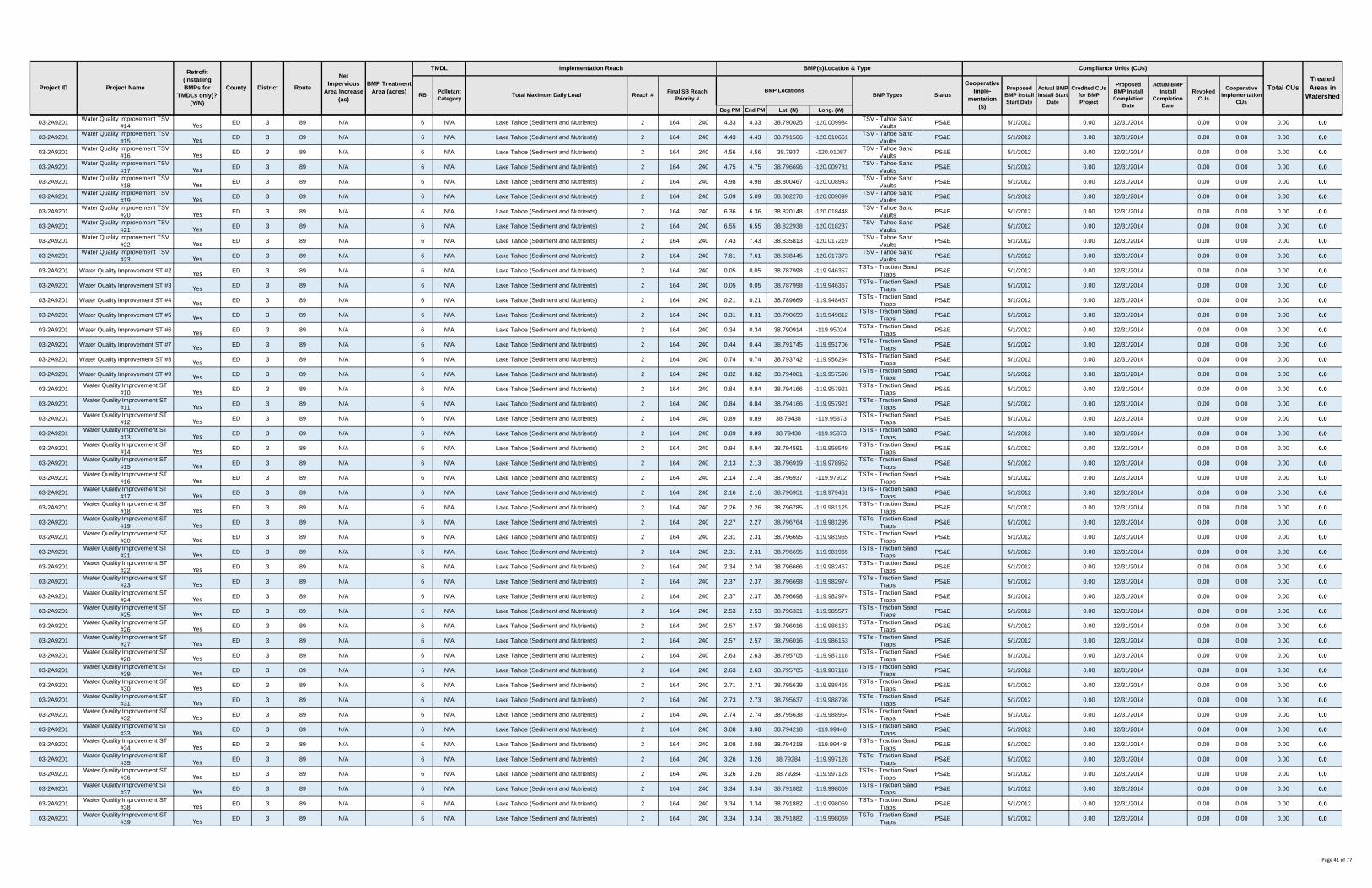
Beg PM End PM Lat. (N) Long. (W)
Revoked CUs
Total CUsTreated Areas in
WatershedRBPollutant Category
Total Maximum Daily Load Reach #Final SB Reach
Priority #
Compliance Units (CUs)
Cooperative Imple-
mentation ($)
Cooperative Implementation
CUs
Proposed BMP Install Start Date
Actual BMP Install Start
Date
Credited CUs for BMP Project
Proposed BMP Install Completion
Date
Actual BMP Install
Completion Date
Net Impervious
Area Increase (ac)
BMP Treatment Area (acres)
TMDL Implementation Reach BMP(s)Location & Type
BMP LocationsBMP Types Status
RouteProject ID Project Name
Retrofit (installing BMPs for
TMDLs only)? (Y/N)
County District
03-2A9201Water Quality Improvement TSV
#14 Yes ED 3 89 N/A 6 N/A Lake Tahoe (Sediment and Nutrients) 2 164 240 4.33 4.33 38.790025 -120.009984TSV - Tahoe Sand
VaultsPS&E 5/1/2012 0.00 12/31/2014 0.00 0.00 0.00 0.0
03-2A9201Water Quality Improvement TSV
#15 Yes ED 3 89 N/A 6 N/A Lake Tahoe (Sediment and Nutrients) 2 164 240 4.43 4.43 38.791566 -120.010661TSV - Tahoe Sand
VaultsPS&E 5/1/2012 0.00 12/31/2014 0.00 0.00 0.00 0.0
03-2A9201Water Quality Improvement TSV
#16 Yes ED 3 89 N/A 6 N/A Lake Tahoe (Sediment and Nutrients) 2 164 240 4.56 4.56 38.7937 -120.01087TSV - Tahoe Sand
VaultsPS&E 5/1/2012 0.00 12/31/2014 0.00 0.00 0.00 0.0
03-2A9201Water Quality Improvement TSV
#17 Yes ED 3 89 N/A 6 N/A Lake Tahoe (Sediment and Nutrients) 2 164 240 4.75 4.75 38.796696 -120.009781TSV - Tahoe Sand
VaultsPS&E 5/1/2012 0.00 12/31/2014 0.00 0.00 0.00 0.0
03-2A9201Water Quality Improvement TSV
#18 Yes ED 3 89 N/A 6 N/A Lake Tahoe (Sediment and Nutrients) 2 164 240 4.98 4.98 38.800467 -120.008943TSV - Tahoe Sand
VaultsPS&E 5/1/2012 0.00 12/31/2014 0.00 0.00 0.00 0.0
03-2A9201Water Quality Improvement TSV
#19 Yes ED 3 89 N/A 6 N/A Lake Tahoe (Sediment and Nutrients) 2 164 240 5.09 5.09 38.802278 -120.009099TSV - Tahoe Sand
VaultsPS&E 5/1/2012 0.00 12/31/2014 0.00 0.00 0.00 0.0
03-2A9201Water Quality Improvement TSV
#20 Yes ED 3 89 N/A 6 N/A Lake Tahoe (Sediment and Nutrients) 2 164 240 6.36 6.36 38.820148 -120.018448TSV - Tahoe Sand
VaultsPS&E 5/1/2012 0.00 12/31/2014 0.00 0.00 0.00 0.0
03-2A9201Water Quality Improvement TSV
#21 Yes ED 3 89 N/A 6 N/A Lake Tahoe (Sediment and Nutrients) 2 164 240 6.55 6.55 38.822938 -120.018237TSV - Tahoe Sand
VaultsPS&E 5/1/2012 0.00 12/31/2014 0.00 0.00 0.00 0.0
03-2A9201Water Quality Improvement TSV
#22 Yes ED 3 89 N/A 6 N/A Lake Tahoe (Sediment and Nutrients) 2 164 240 7.43 7.43 38.835813 -120.017219TSV - Tahoe Sand
VaultsPS&E 5/1/2012 0.00 12/31/2014 0.00 0.00 0.00 0.0
03-2A9201Water Quality Improvement TSV
#23 Yes ED 3 89 N/A 6 N/A Lake Tahoe (Sediment and Nutrients) 2 164 240 7.61 7.61 38.838445 -120.017373TSV - Tahoe Sand
VaultsPS&E 5/1/2012 0.00 12/31/2014 0.00 0.00 0.00 0.0
03-2A9201 Water Quality Improvement ST #2 Yes ED 3 89 N/A 6 N/A Lake Tahoe (Sediment and Nutrients) 2 164 240 0.05 0.05 38.787998 -119.946357TSTs - Traction Sand
TrapsPS&E 5/1/2012 0.00 12/31/2014 0.00 0.00 0.00 0.0
03-2A9201 Water Quality Improvement ST #3 Yes ED 3 89 N/A 6 N/A Lake Tahoe (Sediment and Nutrients) 2 164 240 0.05 0.05 38.787998 -119.946357TSTs - Traction Sand
TrapsPS&E 5/1/2012 0.00 12/31/2014 0.00 0.00 0.00 0.0
03-2A9201 Water Quality Improvement ST #4 Yes ED 3 89 N/A 6 N/A Lake Tahoe (Sediment and Nutrients) 2 164 240 0.21 0.21 38.789669 -119.948457TSTs - Traction Sand
TrapsPS&E 5/1/2012 0.00 12/31/2014 0.00 0.00 0.00 0.0
03-2A9201 Water Quality Improvement ST #5 Yes ED 3 89 N/A 6 N/A Lake Tahoe (Sediment and Nutrients) 2 164 240 0.31 0.31 38.790659 -119.949812TSTs - Traction Sand
TrapsPS&E 5/1/2012 0.00 12/31/2014 0.00 0.00 0.00 0.0
03-2A9201 Water Quality Improvement ST #6 Yes ED 3 89 N/A 6 N/A Lake Tahoe (Sediment and Nutrients) 2 164 240 0.34 0.34 38.790914 -119.95024TSTs - Traction Sand
TrapsPS&E 5/1/2012 0.00 12/31/2014 0.00 0.00 0.00 0.0
03-2A9201 Water Quality Improvement ST #7 Yes ED 3 89 N/A 6 N/A Lake Tahoe (Sediment and Nutrients) 2 164 240 0.44 0.44 38.791745 -119.951706TSTs - Traction Sand
TrapsPS&E 5/1/2012 0.00 12/31/2014 0.00 0.00 0.00 0.0
03-2A9201 Water Quality Improvement ST #8 Yes ED 3 89 N/A 6 N/A Lake Tahoe (Sediment and Nutrients) 2 164 240 0.74 0.74 38.793742 -119.956294TSTs - Traction Sand
TrapsPS&E 5/1/2012 0.00 12/31/2014 0.00 0.00 0.00 0.0
03-2A9201 Water Quality Improvement ST #9 Yes ED 3 89 N/A 6 N/A Lake Tahoe (Sediment and Nutrients) 2 164 240 0.82 0.82 38.794081 -119.957598TSTs - Traction Sand
TrapsPS&E 5/1/2012 0.00 12/31/2014 0.00 0.00 0.00 0.0
03-2A9201Water Quality Improvement ST
#10 Yes ED 3 89 N/A 6 N/A Lake Tahoe (Sediment and Nutrients) 2 164 240 0.84 0.84 38.794166 -119.957921TSTs - Traction Sand
TrapsPS&E 5/1/2012 0.00 12/31/2014 0.00 0.00 0.00 0.0
03-2A9201Water Quality Improvement ST
#11 Yes ED 3 89 N/A 6 N/A Lake Tahoe (Sediment and Nutrients) 2 164 240 0.84 0.84 38.794166 -119.957921TSTs - Traction Sand
TrapsPS&E 5/1/2012 0.00 12/31/2014 0.00 0.00 0.00 0.0
03-2A9201Water Quality Improvement ST
#12 Yes ED 3 89 N/A 6 N/A Lake Tahoe (Sediment and Nutrients) 2 164 240 0.89 0.89 38.79438 -119.95873TSTs - Traction Sand
TrapsPS&E 5/1/2012 0.00 12/31/2014 0.00 0.00 0.00 0.0
03-2A9201Water Quality Improvement ST
#13 Yes ED 3 89 N/A 6 N/A Lake Tahoe (Sediment and Nutrients) 2 164 240 0.89 0.89 38.79438 -119.95873TSTs - Traction Sand
TrapsPS&E 5/1/2012 0.00 12/31/2014 0.00 0.00 0.00 0.0
03-2A9201Water Quality Improvement ST
#14 Yes ED 3 89 N/A 6 N/A Lake Tahoe (Sediment and Nutrients) 2 164 240 0.94 0.94 38.794591 -119.959549TSTs - Traction Sand
TrapsPS&E 5/1/2012 0.00 12/31/2014 0.00 0.00 0.00 0.0
03-2A9201Water Quality Improvement ST
#15 Yes ED 3 89 N/A 6 N/A Lake Tahoe (Sediment and Nutrients) 2 164 240 2.13 2.13 38.796919 -119.978952TSTs - Traction Sand
TrapsPS&E 5/1/2012 0.00 12/31/2014 0.00 0.00 0.00 0.0
03-2A9201Water Quality Improvement ST
#16 Yes ED 3 89 N/A 6 N/A Lake Tahoe (Sediment and Nutrients) 2 164 240 2.14 2.14 38.796937 -119.97912TSTs - Traction Sand
TrapsPS&E 5/1/2012 0.00 12/31/2014 0.00 0.00 0.00 0.0
03-2A9201Water Quality Improvement ST
#17 Yes ED 3 89 N/A 6 N/A Lake Tahoe (Sediment and Nutrients) 2 164 240 2.16 2.16 38.796951 -119.979461TSTs - Traction Sand
TrapsPS&E 5/1/2012 0.00 12/31/2014 0.00 0.00 0.00 0.0
03-2A9201Water Quality Improvement ST
#18 Yes ED 3 89 N/A 6 N/A Lake Tahoe (Sediment and Nutrients) 2 164 240 2.26 2.26 38.796785 -119.981125TSTs - Traction Sand
TrapsPS&E 5/1/2012 0.00 12/31/2014 0.00 0.00 0.00 0.0
03-2A9201Water Quality Improvement ST
#19 Yes ED 3 89 N/A 6 N/A Lake Tahoe (Sediment and Nutrients) 2 164 240 2.27 2.27 38.796764 -119.981295TSTs - Traction Sand
TrapsPS&E 5/1/2012 0.00 12/31/2014 0.00 0.00 0.00 0.0
03-2A9201Water Quality Improvement ST
#20 Yes ED 3 89 N/A 6 N/A Lake Tahoe (Sediment and Nutrients) 2 164 240 2.31 2.31 38.796695 -119.981965TSTs - Traction Sand
TrapsPS&E 5/1/2012 0.00 12/31/2014 0.00 0.00 0.00 0.0
03-2A9201Water Quality Improvement ST
#21 Yes ED 3 89 N/A 6 N/A Lake Tahoe (Sediment and Nutrients) 2 164 240 2.31 2.31 38.796695 -119.981965TSTs - Traction Sand
TrapsPS&E 5/1/2012 0.00 12/31/2014 0.00 0.00 0.00 0.0
03-2A9201Water Quality Improvement ST
#22 Yes ED 3 89 N/A 6 N/A Lake Tahoe (Sediment and Nutrients) 2 164 240 2.34 2.34 38.796666 -119.982467TSTs - Traction Sand
TrapsPS&E 5/1/2012 0.00 12/31/2014 0.00 0.00 0.00 0.0
03-2A9201Water Quality Improvement ST
#23 Yes ED 3 89 N/A 6 N/A Lake Tahoe (Sediment and Nutrients) 2 164 240 2.37 2.37 38.796698 -119.982974TSTs - Traction Sand
TrapsPS&E 5/1/2012 0.00 12/31/2014 0.00 0.00 0.00 0.0
03-2A9201Water Quality Improvement ST
#24 Yes ED 3 89 N/A 6 N/A Lake Tahoe (Sediment and Nutrients) 2 164 240 2.37 2.37 38.796698 -119.982974TSTs - Traction Sand
TrapsPS&E 5/1/2012 0.00 12/31/2014 0.00 0.00 0.00 0.0
03-2A9201Water Quality Improvement ST
#25 Yes ED 3 89 N/A 6 N/A Lake Tahoe (Sediment and Nutrients) 2 164 240 2.53 2.53 38.796331 -119.985577TSTs - Traction Sand
TrapsPS&E 5/1/2012 0.00 12/31/2014 0.00 0.00 0.00 0.0
03-2A9201Water Quality Improvement ST
#26 Yes ED 3 89 N/A 6 N/A Lake Tahoe (Sediment and Nutrients) 2 164 240 2.57 2.57 38.796016 -119.986163TSTs - Traction Sand
TrapsPS&E 5/1/2012 0.00 12/31/2014 0.00 0.00 0.00 0.0
03-2A9201Water Quality Improvement ST
#27 Yes ED 3 89 N/A 6 N/A Lake Tahoe (Sediment and Nutrients) 2 164 240 2.57 2.57 38.796016 -119.986163TSTs - Traction Sand
TrapsPS&E 5/1/2012 0.00 12/31/2014 0.00 0.00 0.00 0.0
03-2A9201Water Quality Improvement ST
#28 Yes ED 3 89 N/A 6 N/A Lake Tahoe (Sediment and Nutrients) 2 164 240 2.63 2.63 38.795705 -119.987118TSTs - Traction Sand
TrapsPS&E 5/1/2012 0.00 12/31/2014 0.00 0.00 0.00 0.0
03-2A9201Water Quality Improvement ST
#29 Yes ED 3 89 N/A 6 N/A Lake Tahoe (Sediment and Nutrients) 2 164 240 2.63 2.63 38.795705 -119.987118TSTs - Traction Sand
TrapsPS&E 5/1/2012 0.00 12/31/2014 0.00 0.00 0.00 0.0
03-2A9201Water Quality Improvement ST
#30 Yes ED 3 89 N/A 6 N/A Lake Tahoe (Sediment and Nutrients) 2 164 240 2.71 2.71 38.795639 -119.988465TSTs - Traction Sand
TrapsPS&E 5/1/2012 0.00 12/31/2014 0.00 0.00 0.00 0.0
03-2A9201Water Quality Improvement ST
#31 Yes ED 3 89 N/A 6 N/A Lake Tahoe (Sediment and Nutrients) 2 164 240 2.73 2.73 38.795637 -119.988798TSTs - Traction Sand
TrapsPS&E 5/1/2012 0.00 12/31/2014 0.00 0.00 0.00 0.0
03-2A9201Water Quality Improvement ST
#32 Yes ED 3 89 N/A 6 N/A Lake Tahoe (Sediment and Nutrients) 2 164 240 2.74 2.74 38.795638 -119.988964TSTs - Traction Sand
TrapsPS&E 5/1/2012 0.00 12/31/2014 0.00 0.00 0.00 0.0
03-2A9201Water Quality Improvement ST
#33 Yes ED 3 89 N/A 6 N/A Lake Tahoe (Sediment and Nutrients) 2 164 240 3.08 3.08 38.794218 -119.99448TSTs - Traction Sand
TrapsPS&E 5/1/2012 0.00 12/31/2014 0.00 0.00 0.00 0.0
03-2A9201Water Quality Improvement ST
#34 Yes ED 3 89 N/A 6 N/A Lake Tahoe (Sediment and Nutrients) 2 164 240 3.08 3.08 38.794218 -119.99448TSTs - Traction Sand
TrapsPS&E 5/1/2012 0.00 12/31/2014 0.00 0.00 0.00 0.0
03-2A9201Water Quality Improvement ST
#35 Yes ED 3 89 N/A 6 N/A Lake Tahoe (Sediment and Nutrients) 2 164 240 3.26 3.26 38.79284 -119.997128TSTs - Traction Sand
TrapsPS&E 5/1/2012 0.00 12/31/2014 0.00 0.00 0.00 0.0
03-2A9201Water Quality Improvement ST
#36 Yes ED 3 89 N/A 6 N/A Lake Tahoe (Sediment and Nutrients) 2 164 240 3.26 3.26 38.79284 -119.997128TSTs - Traction Sand
TrapsPS&E 5/1/2012 0.00 12/31/2014 0.00 0.00 0.00 0.0
03-2A9201Water Quality Improvement ST
#37 Yes ED 3 89 N/A 6 N/A Lake Tahoe (Sediment and Nutrients) 2 164 240 3.34 3.34 38.791882 -119.998069TSTs - Traction Sand
TrapsPS&E 5/1/2012 0.00 12/31/2014 0.00 0.00 0.00 0.0
03-2A9201Water Quality Improvement ST
#38 Yes ED 3 89 N/A 6 N/A Lake Tahoe (Sediment and Nutrients) 2 164 240 3.34 3.34 38.791882 -119.998069TSTs - Traction Sand
TrapsPS&E 5/1/2012 0.00 12/31/2014 0.00 0.00 0.00 0.0
03-2A9201Water Quality Improvement ST
#39 Yes ED 3 89 N/A 6 N/A Lake Tahoe (Sediment and Nutrients) 2 164 240 3.34 3.34 38.791882 -119.998069TSTs - Traction Sand
TrapsPS&E 5/1/2012 0.00 12/31/2014 0.00 0.00 0.00 0.0
Page 41 of 77
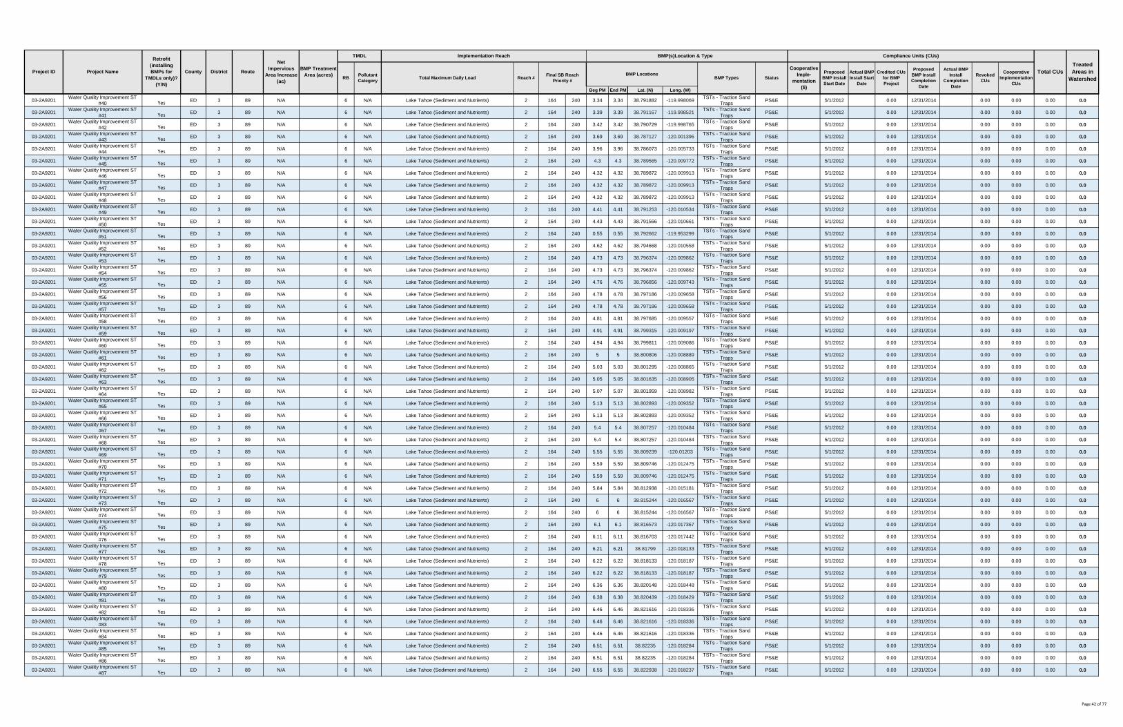
Beg PM End PM Lat. (N) Long. (W)
Revoked CUs
Total CUsTreated Areas in
WatershedRBPollutant Category
Total Maximum Daily Load Reach #Final SB Reach
Priority #
Compliance Units (CUs)
Cooperative Imple-
mentation ($)
Cooperative Implementation
CUs
Proposed BMP Install Start Date
Actual BMP Install Start
Date
Credited CUs for BMP Project
Proposed BMP Install Completion
Date
Actual BMP Install
Completion Date
Net Impervious
Area Increase (ac)
BMP Treatment Area (acres)
TMDL Implementation Reach BMP(s)Location & Type
BMP LocationsBMP Types Status
RouteProject ID Project Name
Retrofit (installing BMPs for
TMDLs only)? (Y/N)
County District
03-2A9201Water Quality Improvement ST
#40 Yes ED 3 89 N/A 6 N/A Lake Tahoe (Sediment and Nutrients) 2 164 240 3.34 3.34 38.791882 -119.998069TSTs - Traction Sand
TrapsPS&E 5/1/2012 0.00 12/31/2014 0.00 0.00 0.00 0.0
03-2A9201Water Quality Improvement ST
#41 Yes ED 3 89 N/A 6 N/A Lake Tahoe (Sediment and Nutrients) 2 164 240 3.39 3.39 38.791167 -119.998521TSTs - Traction Sand
TrapsPS&E 5/1/2012 0.00 12/31/2014 0.00 0.00 0.00 0.0
03-2A9201Water Quality Improvement ST
#42 Yes ED 3 89 N/A 6 N/A Lake Tahoe (Sediment and Nutrients) 2 164 240 3.42 3.42 38.790729 -119.998765TSTs - Traction Sand
TrapsPS&E 5/1/2012 0.00 12/31/2014 0.00 0.00 0.00 0.0
03-2A9201Water Quality Improvement ST
#43 Yes ED 3 89 N/A 6 N/A Lake Tahoe (Sediment and Nutrients) 2 164 240 3.69 3.69 38.787127 -120.001396TSTs - Traction Sand
TrapsPS&E 5/1/2012 0.00 12/31/2014 0.00 0.00 0.00 0.0
03-2A9201Water Quality Improvement ST
#44 Yes ED 3 89 N/A 6 N/A Lake Tahoe (Sediment and Nutrients) 2 164 240 3.96 3.96 38.786073 -120.005733TSTs - Traction Sand
TrapsPS&E 5/1/2012 0.00 12/31/2014 0.00 0.00 0.00 0.0
03-2A9201Water Quality Improvement ST
#45 Yes ED 3 89 N/A 6 N/A Lake Tahoe (Sediment and Nutrients) 2 164 240 4.3 4.3 38.789565 -120.009772TSTs - Traction Sand
TrapsPS&E 5/1/2012 0.00 12/31/2014 0.00 0.00 0.00 0.0
03-2A9201Water Quality Improvement ST
#46 Yes ED 3 89 N/A 6 N/A Lake Tahoe (Sediment and Nutrients) 2 164 240 4.32 4.32 38.789872 -120.009913TSTs - Traction Sand
TrapsPS&E 5/1/2012 0.00 12/31/2014 0.00 0.00 0.00 0.0
03-2A9201Water Quality Improvement ST
#47 Yes ED 3 89 N/A 6 N/A Lake Tahoe (Sediment and Nutrients) 2 164 240 4.32 4.32 38.789872 -120.009913TSTs - Traction Sand
TrapsPS&E 5/1/2012 0.00 12/31/2014 0.00 0.00 0.00 0.0
03-2A9201Water Quality Improvement ST
#48 Yes ED 3 89 N/A 6 N/A Lake Tahoe (Sediment and Nutrients) 2 164 240 4.32 4.32 38.789872 -120.009913TSTs - Traction Sand
TrapsPS&E 5/1/2012 0.00 12/31/2014 0.00 0.00 0.00 0.0
03-2A9201Water Quality Improvement ST
#49 Yes ED 3 89 N/A 6 N/A Lake Tahoe (Sediment and Nutrients) 2 164 240 4.41 4.41 38.791253 -120.010534TSTs - Traction Sand
TrapsPS&E 5/1/2012 0.00 12/31/2014 0.00 0.00 0.00 0.0
03-2A9201Water Quality Improvement ST
#50 Yes ED 3 89 N/A 6 N/A Lake Tahoe (Sediment and Nutrients) 2 164 240 4.43 4.43 38.791566 -120.010661TSTs - Traction Sand
TrapsPS&E 5/1/2012 0.00 12/31/2014 0.00 0.00 0.00 0.0
03-2A9201Water Quality Improvement ST
#51 Yes ED 3 89 N/A 6 N/A Lake Tahoe (Sediment and Nutrients) 2 164 240 0.55 0.55 38.792662 -119.953299TSTs - Traction Sand
TrapsPS&E 5/1/2012 0.00 12/31/2014 0.00 0.00 0.00 0.0
03-2A9201Water Quality Improvement ST
#52 Yes ED 3 89 N/A 6 N/A Lake Tahoe (Sediment and Nutrients) 2 164 240 4.62 4.62 38.794668 -120.010558TSTs - Traction Sand
TrapsPS&E 5/1/2012 0.00 12/31/2014 0.00 0.00 0.00 0.0
03-2A9201Water Quality Improvement ST
#53 Yes ED 3 89 N/A 6 N/A Lake Tahoe (Sediment and Nutrients) 2 164 240 4.73 4.73 38.796374 -120.009862TSTs - Traction Sand
TrapsPS&E 5/1/2012 0.00 12/31/2014 0.00 0.00 0.00 0.0
03-2A9201Water Quality Improvement ST
#54 Yes ED 3 89 N/A 6 N/A Lake Tahoe (Sediment and Nutrients) 2 164 240 4.73 4.73 38.796374 -120.009862TSTs - Traction Sand
TrapsPS&E 5/1/2012 0.00 12/31/2014 0.00 0.00 0.00 0.0
03-2A9201Water Quality Improvement ST
#55 Yes ED 3 89 N/A 6 N/A Lake Tahoe (Sediment and Nutrients) 2 164 240 4.76 4.76 38.796856 -120.009743TSTs - Traction Sand
TrapsPS&E 5/1/2012 0.00 12/31/2014 0.00 0.00 0.00 0.0
03-2A9201Water Quality Improvement ST
#56 Yes ED 3 89 N/A 6 N/A Lake Tahoe (Sediment and Nutrients) 2 164 240 4.78 4.78 38.797186 -120.009658TSTs - Traction Sand
TrapsPS&E 5/1/2012 0.00 12/31/2014 0.00 0.00 0.00 0.0
03-2A9201Water Quality Improvement ST
#57 Yes ED 3 89 N/A 6 N/A Lake Tahoe (Sediment and Nutrients) 2 164 240 4.78 4.78 38.797186 -120.009658TSTs - Traction Sand
TrapsPS&E 5/1/2012 0.00 12/31/2014 0.00 0.00 0.00 0.0
03-2A9201Water Quality Improvement ST
#58 Yes ED 3 89 N/A 6 N/A Lake Tahoe (Sediment and Nutrients) 2 164 240 4.81 4.81 38.797685 -120.009557TSTs - Traction Sand
TrapsPS&E 5/1/2012 0.00 12/31/2014 0.00 0.00 0.00 0.0
03-2A9201Water Quality Improvement ST
#59 Yes ED 3 89 N/A 6 N/A Lake Tahoe (Sediment and Nutrients) 2 164 240 4.91 4.91 38.799315 -120.009197TSTs - Traction Sand
TrapsPS&E 5/1/2012 0.00 12/31/2014 0.00 0.00 0.00 0.0
03-2A9201Water Quality Improvement ST
#60 Yes ED 3 89 N/A 6 N/A Lake Tahoe (Sediment and Nutrients) 2 164 240 4.94 4.94 38.799811 -120.009086TSTs - Traction Sand
TrapsPS&E 5/1/2012 0.00 12/31/2014 0.00 0.00 0.00 0.0
03-2A9201Water Quality Improvement ST
#61 Yes ED 3 89 N/A 6 N/A Lake Tahoe (Sediment and Nutrients) 2 164 240 5 5 38.800806 -120.008889TSTs - Traction Sand
TrapsPS&E 5/1/2012 0.00 12/31/2014 0.00 0.00 0.00 0.0
03-2A9201Water Quality Improvement ST
#62 Yes ED 3 89 N/A 6 N/A Lake Tahoe (Sediment and Nutrients) 2 164 240 5.03 5.03 38.801295 -120.008865TSTs - Traction Sand
TrapsPS&E 5/1/2012 0.00 12/31/2014 0.00 0.00 0.00 0.0
03-2A9201Water Quality Improvement ST
#63 Yes ED 3 89 N/A 6 N/A Lake Tahoe (Sediment and Nutrients) 2 164 240 5.05 5.05 38.801635 -120.008905TSTs - Traction Sand
TrapsPS&E 5/1/2012 0.00 12/31/2014 0.00 0.00 0.00 0.0
03-2A9201Water Quality Improvement ST
#64 Yes ED 3 89 N/A 6 N/A Lake Tahoe (Sediment and Nutrients) 2 164 240 5.07 5.07 38.801959 -120.008982TSTs - Traction Sand
TrapsPS&E 5/1/2012 0.00 12/31/2014 0.00 0.00 0.00 0.0
03-2A9201Water Quality Improvement ST
#65 Yes ED 3 89 N/A 6 N/A Lake Tahoe (Sediment and Nutrients) 2 164 240 5.13 5.13 38.802893 -120.009352TSTs - Traction Sand
TrapsPS&E 5/1/2012 0.00 12/31/2014 0.00 0.00 0.00 0.0
03-2A9201Water Quality Improvement ST
#66 Yes ED 3 89 N/A 6 N/A Lake Tahoe (Sediment and Nutrients) 2 164 240 5.13 5.13 38.802893 -120.009352TSTs - Traction Sand
TrapsPS&E 5/1/2012 0.00 12/31/2014 0.00 0.00 0.00 0.0
03-2A9201Water Quality Improvement ST
#67 Yes ED 3 89 N/A 6 N/A Lake Tahoe (Sediment and Nutrients) 2 164 240 5.4 5.4 38.807257 -120.010484TSTs - Traction Sand
TrapsPS&E 5/1/2012 0.00 12/31/2014 0.00 0.00 0.00 0.0
03-2A9201Water Quality Improvement ST
#68 Yes ED 3 89 N/A 6 N/A Lake Tahoe (Sediment and Nutrients) 2 164 240 5.4 5.4 38.807257 -120.010484TSTs - Traction Sand
TrapsPS&E 5/1/2012 0.00 12/31/2014 0.00 0.00 0.00 0.0
03-2A9201Water Quality Improvement ST
#69 Yes ED 3 89 N/A 6 N/A Lake Tahoe (Sediment and Nutrients) 2 164 240 5.55 5.55 38.809239 -120.01203TSTs - Traction Sand
TrapsPS&E 5/1/2012 0.00 12/31/2014 0.00 0.00 0.00 0.0
03-2A9201Water Quality Improvement ST
#70 Yes ED 3 89 N/A 6 N/A Lake Tahoe (Sediment and Nutrients) 2 164 240 5.59 5.59 38.809746 -120.012475TSTs - Traction Sand
TrapsPS&E 5/1/2012 0.00 12/31/2014 0.00 0.00 0.00 0.0
03-2A9201Water Quality Improvement ST
#71 Yes ED 3 89 N/A 6 N/A Lake Tahoe (Sediment and Nutrients) 2 164 240 5.59 5.59 38.809746 -120.012475TSTs - Traction Sand
TrapsPS&E 5/1/2012 0.00 12/31/2014 0.00 0.00 0.00 0.0
03-2A9201Water Quality Improvement ST
#72 Yes ED 3 89 N/A 6 N/A Lake Tahoe (Sediment and Nutrients) 2 164 240 5.84 5.84 38.812938 -120.015181TSTs - Traction Sand
TrapsPS&E 5/1/2012 0.00 12/31/2014 0.00 0.00 0.00 0.0
03-2A9201Water Quality Improvement ST
#73 Yes ED 3 89 N/A 6 N/A Lake Tahoe (Sediment and Nutrients) 2 164 240 6 6 38.815244 -120.016567TSTs - Traction Sand
TrapsPS&E 5/1/2012 0.00 12/31/2014 0.00 0.00 0.00 0.0
03-2A9201Water Quality Improvement ST
#74 Yes ED 3 89 N/A 6 N/A Lake Tahoe (Sediment and Nutrients) 2 164 240 6 6 38.815244 -120.016567TSTs - Traction Sand
TrapsPS&E 5/1/2012 0.00 12/31/2014 0.00 0.00 0.00 0.0
03-2A9201Water Quality Improvement ST
#75 Yes ED 3 89 N/A 6 N/A Lake Tahoe (Sediment and Nutrients) 2 164 240 6.1 6.1 38.816573 -120.017367TSTs - Traction Sand
TrapsPS&E 5/1/2012 0.00 12/31/2014 0.00 0.00 0.00 0.0
03-2A9201Water Quality Improvement ST
#76 Yes ED 3 89 N/A 6 N/A Lake Tahoe (Sediment and Nutrients) 2 164 240 6.11 6.11 38.816703 -120.017442TSTs - Traction Sand
TrapsPS&E 5/1/2012 0.00 12/31/2014 0.00 0.00 0.00 0.0
03-2A9201Water Quality Improvement ST
#77 Yes ED 3 89 N/A 6 N/A Lake Tahoe (Sediment and Nutrients) 2 164 240 6.21 6.21 38.81799 -120.018133TSTs - Traction Sand
TrapsPS&E 5/1/2012 0.00 12/31/2014 0.00 0.00 0.00 0.0
03-2A9201Water Quality Improvement ST
#78 Yes ED 3 89 N/A 6 N/A Lake Tahoe (Sediment and Nutrients) 2 164 240 6.22 6.22 38.818133 -120.018187TSTs - Traction Sand
TrapsPS&E 5/1/2012 0.00 12/31/2014 0.00 0.00 0.00 0.0
03-2A9201Water Quality Improvement ST
#79 Yes ED 3 89 N/A 6 N/A Lake Tahoe (Sediment and Nutrients) 2 164 240 6.22 6.22 38.818133 -120.018187TSTs - Traction Sand
TrapsPS&E 5/1/2012 0.00 12/31/2014 0.00 0.00 0.00 0.0
03-2A9201Water Quality Improvement ST
#80 Yes ED 3 89 N/A 6 N/A Lake Tahoe (Sediment and Nutrients) 2 164 240 6.36 6.36 38.820148 -120.018448TSTs - Traction Sand
TrapsPS&E 5/1/2012 0.00 12/31/2014 0.00 0.00 0.00 0.0
03-2A9201Water Quality Improvement ST
#81 Yes ED 3 89 N/A 6 N/A Lake Tahoe (Sediment and Nutrients) 2 164 240 6.38 6.38 38.820439 -120.018429TSTs - Traction Sand
TrapsPS&E 5/1/2012 0.00 12/31/2014 0.00 0.00 0.00 0.0
03-2A9201Water Quality Improvement ST
#82 Yes ED 3 89 N/A 6 N/A Lake Tahoe (Sediment and Nutrients) 2 164 240 6.46 6.46 38.821616 -120.018336TSTs - Traction Sand
TrapsPS&E 5/1/2012 0.00 12/31/2014 0.00 0.00 0.00 0.0
03-2A9201Water Quality Improvement ST
#83 Yes ED 3 89 N/A 6 N/A Lake Tahoe (Sediment and Nutrients) 2 164 240 6.46 6.46 38.821616 -120.018336TSTs - Traction Sand
TrapsPS&E 5/1/2012 0.00 12/31/2014 0.00 0.00 0.00 0.0
03-2A9201Water Quality Improvement ST
#84 Yes ED 3 89 N/A 6 N/A Lake Tahoe (Sediment and Nutrients) 2 164 240 6.46 6.46 38.821616 -120.018336TSTs - Traction Sand
TrapsPS&E 5/1/2012 0.00 12/31/2014 0.00 0.00 0.00 0.0
03-2A9201Water Quality Improvement ST
#85 Yes ED 3 89 N/A 6 N/A Lake Tahoe (Sediment and Nutrients) 2 164 240 6.51 6.51 38.82235 -120.018284TSTs - Traction Sand
TrapsPS&E 5/1/2012 0.00 12/31/2014 0.00 0.00 0.00 0.0
03-2A9201Water Quality Improvement ST
#86 Yes ED 3 89 N/A 6 N/A Lake Tahoe (Sediment and Nutrients) 2 164 240 6.51 6.51 38.82235 -120.018284TSTs - Traction Sand
TrapsPS&E 5/1/2012 0.00 12/31/2014 0.00 0.00 0.00 0.0
03-2A9201Water Quality Improvement ST
#87 Yes ED 3 89 N/A 6 N/A Lake Tahoe (Sediment and Nutrients) 2 164 240 6.55 6.55 38.822938 -120.018237TSTs - Traction Sand
TrapsPS&E 5/1/2012 0.00 12/31/2014 0.00 0.00 0.00 0.0
Page 42 of 77
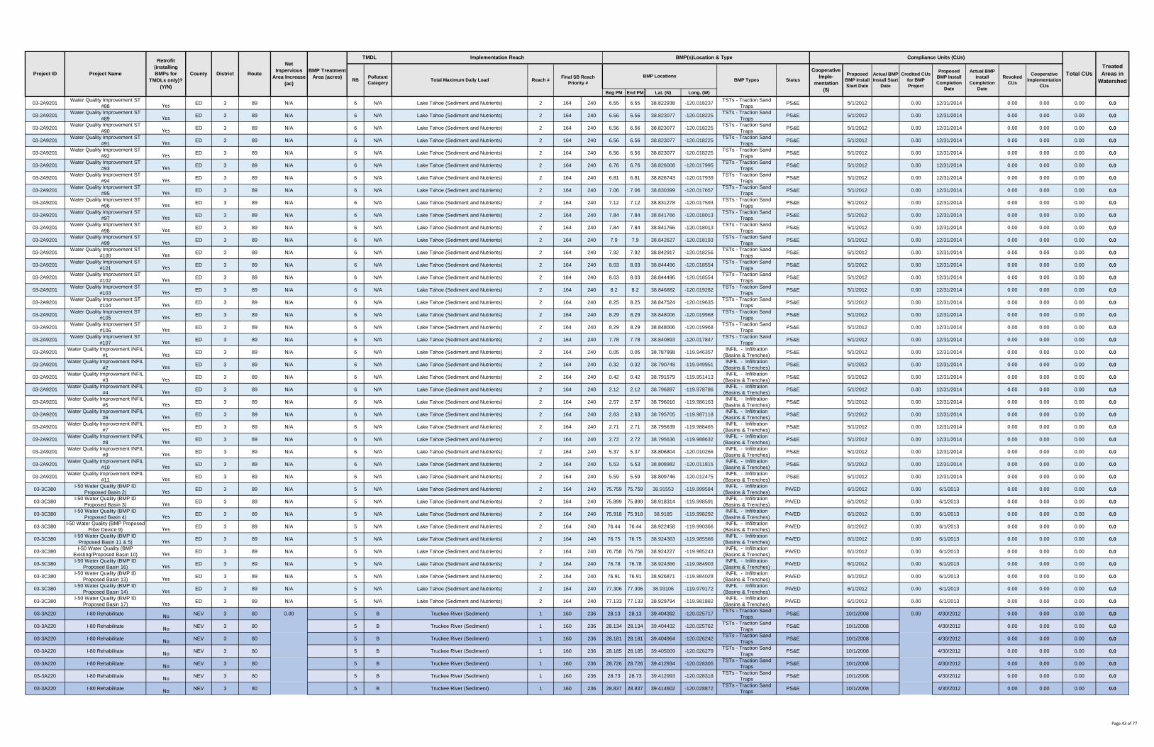
Beg PM End PM Lat. (N) Long. (W)
Revoked CUs
Total CUsTreated Areas in
WatershedRBPollutant Category
Total Maximum Daily Load Reach #Final SB Reach
Priority #
Compliance Units (CUs)
Cooperative Imple-
mentation ($)
Cooperative Implementation
CUs
Proposed BMP Install Start Date
Actual BMP Install Start
Date
Credited CUs for BMP Project
Proposed BMP Install Completion
Date
Actual BMP Install
Completion Date
Net Impervious
Area Increase (ac)
BMP Treatment Area (acres)
TMDL Implementation Reach BMP(s)Location & Type
BMP LocationsBMP Types Status
RouteProject ID Project Name
Retrofit (installing BMPs for
TMDLs only)? (Y/N)
County District
03-2A9201Water Quality Improvement ST
#88 Yes ED 3 89 N/A 6 N/A Lake Tahoe (Sediment and Nutrients) 2 164 240 6.55 6.55 38.822938 -120.018237TSTs - Traction Sand
TrapsPS&E 5/1/2012 0.00 12/31/2014 0.00 0.00 0.00 0.0
03-2A9201Water Quality Improvement ST
#89 Yes ED 3 89 N/A 6 N/A Lake Tahoe (Sediment and Nutrients) 2 164 240 6.56 6.56 38.823077 -120.018225TSTs - Traction Sand
TrapsPS&E 5/1/2012 0.00 12/31/2014 0.00 0.00 0.00 0.0
03-2A9201Water Quality Improvement ST
#90 Yes ED 3 89 N/A 6 N/A Lake Tahoe (Sediment and Nutrients) 2 164 240 6.56 6.56 38.823077 -120.018225TSTs - Traction Sand
TrapsPS&E 5/1/2012 0.00 12/31/2014 0.00 0.00 0.00 0.0
03-2A9201Water Quality Improvement ST
#91 Yes ED 3 89 N/A 6 N/A Lake Tahoe (Sediment and Nutrients) 2 164 240 6.56 6.56 38.823077 -120.018225TSTs - Traction Sand
TrapsPS&E 5/1/2012 0.00 12/31/2014 0.00 0.00 0.00 0.0
03-2A9201Water Quality Improvement ST
#92 Yes ED 3 89 N/A 6 N/A Lake Tahoe (Sediment and Nutrients) 2 164 240 6.56 6.56 38.823077 -120.018225TSTs - Traction Sand
TrapsPS&E 5/1/2012 0.00 12/31/2014 0.00 0.00 0.00 0.0
03-2A9201Water Quality Improvement ST
#93 Yes ED 3 89 N/A 6 N/A Lake Tahoe (Sediment and Nutrients) 2 164 240 6.76 6.76 38.826008 -120.017995TSTs - Traction Sand
TrapsPS&E 5/1/2012 0.00 12/31/2014 0.00 0.00 0.00 0.0
03-2A9201Water Quality Improvement ST
#94 Yes ED 3 89 N/A 6 N/A Lake Tahoe (Sediment and Nutrients) 2 164 240 6.81 6.81 38.826743 -120.017939TSTs - Traction Sand
TrapsPS&E 5/1/2012 0.00 12/31/2014 0.00 0.00 0.00 0.0
03-2A9201Water Quality Improvement ST
#95 Yes ED 3 89 N/A 6 N/A Lake Tahoe (Sediment and Nutrients) 2 164 240 7.06 7.06 38.830399 -120.017657TSTs - Traction Sand
TrapsPS&E 5/1/2012 0.00 12/31/2014 0.00 0.00 0.00 0.0
03-2A9201Water Quality Improvement ST
#96 Yes ED 3 89 N/A 6 N/A Lake Tahoe (Sediment and Nutrients) 2 164 240 7.12 7.12 38.831278 -120.017593TSTs - Traction Sand
TrapsPS&E 5/1/2012 0.00 12/31/2014 0.00 0.00 0.00 0.0
03-2A9201Water Quality Improvement ST
#97 Yes ED 3 89 N/A 6 N/A Lake Tahoe (Sediment and Nutrients) 2 164 240 7.84 7.84 38.841766 -120.018013TSTs - Traction Sand
TrapsPS&E 5/1/2012 0.00 12/31/2014 0.00 0.00 0.00 0.0
03-2A9201Water Quality Improvement ST
#98 Yes ED 3 89 N/A 6 N/A Lake Tahoe (Sediment and Nutrients) 2 164 240 7.84 7.84 38.841766 -120.018013TSTs - Traction Sand
TrapsPS&E 5/1/2012 0.00 12/31/2014 0.00 0.00 0.00 0.0
03-2A9201Water Quality Improvement ST
#99 Yes ED 3 89 N/A 6 N/A Lake Tahoe (Sediment and Nutrients) 2 164 240 7.9 7.9 38.842627 -120.018193TSTs - Traction Sand
TrapsPS&E 5/1/2012 0.00 12/31/2014 0.00 0.00 0.00 0.0
03-2A9201Water Quality Improvement ST
#100 Yes ED 3 89 N/A 6 N/A Lake Tahoe (Sediment and Nutrients) 2 164 240 7.92 7.92 38.842917 -120.018256TSTs - Traction Sand
TrapsPS&E 5/1/2012 0.00 12/31/2014 0.00 0.00 0.00 0.0
03-2A9201Water Quality Improvement ST
#101 Yes ED 3 89 N/A 6 N/A Lake Tahoe (Sediment and Nutrients) 2 164 240 8.03 8.03 38.844496 -120.018554TSTs - Traction Sand
TrapsPS&E 5/1/2012 0.00 12/31/2014 0.00 0.00 0.00 0.0
03-2A9201Water Quality Improvement ST
#102 Yes ED 3 89 N/A 6 N/A Lake Tahoe (Sediment and Nutrients) 2 164 240 8.03 8.03 38.844496 -120.018554TSTs - Traction Sand
TrapsPS&E 5/1/2012 0.00 12/31/2014 0.00 0.00 0.00 0.0
03-2A9201Water Quality Improvement ST
#103 Yes ED 3 89 N/A 6 N/A Lake Tahoe (Sediment and Nutrients) 2 164 240 8.2 8.2 38.846882 -120.019282TSTs - Traction Sand
TrapsPS&E 5/1/2012 0.00 12/31/2014 0.00 0.00 0.00 0.0
03-2A9201Water Quality Improvement ST
#104 Yes ED 3 89 N/A 6 N/A Lake Tahoe (Sediment and Nutrients) 2 164 240 8.25 8.25 38.847524 -120.019635TSTs - Traction Sand
TrapsPS&E 5/1/2012 0.00 12/31/2014 0.00 0.00 0.00 0.0
03-2A9201Water Quality Improvement ST
#105 Yes ED 3 89 N/A 6 N/A Lake Tahoe (Sediment and Nutrients) 2 164 240 8.29 8.29 38.848006 -120.019968TSTs - Traction Sand
TrapsPS&E 5/1/2012 0.00 12/31/2014 0.00 0.00 0.00 0.0
03-2A9201Water Quality Improvement ST
#106 Yes ED 3 89 N/A 6 N/A Lake Tahoe (Sediment and Nutrients) 2 164 240 8.29 8.29 38.848006 -120.019968TSTs - Traction Sand
TrapsPS&E 5/1/2012 0.00 12/31/2014 0.00 0.00 0.00 0.0
03-2A9201Water Quality Improvement ST
#107 Yes ED 3 89 N/A 6 N/A Lake Tahoe (Sediment and Nutrients) 2 164 240 7.78 7.78 38.840893 -120.017847TSTs - Traction Sand
TrapsPS&E 5/1/2012 0.00 12/31/2014 0.00 0.00 0.00 0.0
03-2A9201Water Quality Improvement INFIL
#1 Yes ED 3 89 N/A 6 N/A Lake Tahoe (Sediment and Nutrients) 2 164 240 0.05 0.05 38.787998 -119.946357INFIL - Infiltration
(Basins & Trenches)PS&E 5/1/2012 0.00 12/31/2014 0.00 0.00 0.00 0.0
03-2A9201Water Quality Improvement INFIL
#2 Yes ED 3 89 N/A 6 N/A Lake Tahoe (Sediment and Nutrients) 2 164 240 0.32 0.32 38.790748 -119.949951INFIL - Infiltration
(Basins & Trenches)PS&E 5/1/2012 0.00 12/31/2014 0.00 0.00 0.00 0.0
03-2A9201Water Quality Improvement INFIL
#3 Yes ED 3 89 N/A 6 N/A Lake Tahoe (Sediment and Nutrients) 2 164 240 0.42 0.42 38.791579 -119.951413INFIL - Infiltration
(Basins & Trenches)PS&E 5/1/2012 0.00 12/31/2014 0.00 0.00 0.00 0.0
03-2A9201Water Quality Improvement INFIL
#4 Yes ED 3 89 N/A 6 N/A Lake Tahoe (Sediment and Nutrients) 2 164 240 2.12 2.12 38.796897 -119.978786INFIL - Infiltration
(Basins & Trenches)PS&E 5/1/2012 0.00 12/31/2014 0.00 0.00 0.00 0.0
03-2A9201Water Quality Improvement INFIL
#5 Yes ED 3 89 N/A 6 N/A Lake Tahoe (Sediment and Nutrients) 2 164 240 2.57 2.57 38.796016 -119.986163INFIL - Infiltration
(Basins & Trenches)PS&E 5/1/2012 0.00 12/31/2014 0.00 0.00 0.00 0.0
03-2A9201Water Quality Improvement INFIL
#6 Yes ED 3 89 N/A 6 N/A Lake Tahoe (Sediment and Nutrients) 2 164 240 2.63 2.63 38.795705 -119.987118INFIL - Infiltration
(Basins & Trenches)PS&E 5/1/2012 0.00 12/31/2014 0.00 0.00 0.00 0.0
03-2A9201Water Quality Improvement INFIL
#7 Yes ED 3 89 N/A 6 N/A Lake Tahoe (Sediment and Nutrients) 2 164 240 2.71 2.71 38.795639 -119.988465INFIL - Infiltration
(Basins & Trenches)PS&E 5/1/2012 0.00 12/31/2014 0.00 0.00 0.00 0.0
03-2A9201Water Quality Improvement INFIL
#8 Yes ED 3 89 N/A 6 N/A Lake Tahoe (Sediment and Nutrients) 2 164 240 2.72 2.72 38.795636 -119.988632INFIL - Infiltration
(Basins & Trenches)PS&E 5/1/2012 0.00 12/31/2014 0.00 0.00 0.00 0.0
03-2A9201Water Quality Improvement INFIL
#9 Yes ED 3 89 N/A 6 N/A Lake Tahoe (Sediment and Nutrients) 2 164 240 5.37 5.37 38.806804 -120.010266INFIL - Infiltration
(Basins & Trenches)PS&E 5/1/2012 0.00 12/31/2014 0.00 0.00 0.00 0.0
03-2A9201Water Quality Improvement INFIL
#10 Yes ED 3 89 N/A 6 N/A Lake Tahoe (Sediment and Nutrients) 2 164 240 5.53 5.53 38.808982 -120.011815INFIL - Infiltration
(Basins & Trenches)PS&E 5/1/2012 0.00 12/31/2014 0.00 0.00 0.00 0.0
03-2A9201Water Quality Improvement INFIL
#11 Yes ED 3 89 N/A 6 N/A Lake Tahoe (Sediment and Nutrients) 2 164 240 5.59 5.59 38.809746 -120.012475INFIL - Infiltration
(Basins & Trenches)PS&E 5/1/2012 0.00 12/31/2014 0.00 0.00 0.00 0.0
03-3C380I-50 Water Quality (BMP ID
Proposed Basin 2) Yes ED 3 89 N/A 5 N/A Lake Tahoe (Sediment and Nutrients) 2 164 240 75.759 75.759 38.91553 -119.999584INFIL - Infiltration
(Basins & Trenches)PA/ED 6/1/2012 0.00 6/1/2013 0.00 0.00 0.00 0.0
03-3C380I-50 Water Quality (BMP ID
Proposed Basin 3) Yes ED 3 89 N/A 5 N/A Lake Tahoe (Sediment and Nutrients) 2 164 240 75.899 75.899 38.918314 -119.998591INFIL - Infiltration
(Basins & Trenches)PA/ED 6/1/2012 0.00 6/1/2013 0.00 0.00 0.00 0.0
03-3C380I-50 Water Quality (BMP ID
Proposed Basin 4) Yes ED 3 89 N/A 5 N/A Lake Tahoe (Sediment and Nutrients) 2 164 240 75.918 75.918 38.9185 -119.998292INFIL - Infiltration
(Basins & Trenches)PA/ED 6/1/2012 0.00 6/1/2013 0.00 0.00 0.00 0.0
03-3C380I-50 Water Quality (BMP Proposed
Filter Device 9) Yes ED 3 89 N/A 5 N/A Lake Tahoe (Sediment and Nutrients) 2 164 240 76.44 76.44 38.922458 -119.990366INFIL - Infiltration
(Basins & Trenches)PA/ED 6/1/2012 0.00 6/1/2013 0.00 0.00 0.00 0.0
03-3C380I-50 Water Quality (BMP ID
Proposed Basin 11 & 5) Yes ED 3 89 N/A 5 N/A Lake Tahoe (Sediment and Nutrients) 2 164 240 76.75 76.75 38.924363 -119.985566INFIL - Infiltration
(Basins & Trenches)PA/ED 6/1/2012 0.00 6/1/2013 0.00 0.00 0.00 0.0
03-3C380I-50 Water Quality (BMP
Existing/Proposed Basin 10) Yes ED 3 89 N/A 5 N/A Lake Tahoe (Sediment and Nutrients) 2 164 240 76.758 76.758 38.924227 -119.985243INFIL - Infiltration
(Basins & Trenches)PA/ED 6/1/2012 0.00 6/1/2013 0.00 0.00 0.00 0.0
03-3C380I-50 Water Quality (BMP ID
Proposed Basin 16) Yes ED 3 89 N/A 5 N/A Lake Tahoe (Sediment and Nutrients) 2 164 240 76.78 76.78 38.924366 -119.984903INFIL - Infiltration
(Basins & Trenches)PA/ED 6/1/2012 0.00 6/1/2013 0.00 0.00 0.00 0.0
03-3C380I-50 Water Quality (BMP ID
Proposed Basin 13) Yes ED 3 89 N/A 5 N/A Lake Tahoe (Sediment and Nutrients) 2 164 240 76.91 76.91 38.926871 -119.984028INFIL - Infiltration
(Basins & Trenches)PA/ED 6/1/2012 0.00 6/1/2013 0.00 0.00 0.00 0.0
03-3C380I-50 Water Quality (BMP ID
Proposed Basin 14) Yes ED 3 89 N/A 5 N/A Lake Tahoe (Sediment and Nutrients) 2 164 240 77.306 77.306 38.93106 -119.979172INFIL - Infiltration
(Basins & Trenches)PA/ED 6/1/2012 0.00 6/1/2013 0.00 0.00 0.00 0.0
03-3C380I-50 Water Quality (BMP ID
Proposed Basin 17) Yes ED 3 89 N/A 5 N/A Lake Tahoe (Sediment and Nutrients) 2 164 240 77.133 77.133 38.929794 -119.981882INFIL - Infiltration
(Basins & Trenches)PA/ED 6/1/2012 0.00 6/1/2013 0.00 0.00 0.00 0.0
03-3A220 I-80 Rehabilitate No NEV 3 80 0.00 5 B Truckee River (Sediment) 1 160 236 28.13 28.13 39.404392 -120.025717TSTs - Traction Sand
TrapsPS&E 10/1/2008 0.00 4/30/2012 0.00 0.00 0.00 0.0
03-3A220 I-80 Rehabilitate No NEV 3 80 5 B Truckee River (Sediment) 1 160 236 28.134 28.134 39.404432 -120.025762TSTs - Traction Sand
TrapsPS&E 10/1/2008 4/30/2012 0.00 0.00 0.00 0.0
03-3A220 I-80 Rehabilitate No NEV 3 80 5 B Truckee River (Sediment) 1 160 236 28.181 28.181 39.404964 -120.026242TSTs - Traction Sand
TrapsPS&E 10/1/2008 4/30/2012 0.00 0.00 0.00 0.0
03-3A220 I-80 Rehabilitate No NEV 3 80 5 B Truckee River (Sediment) 1 160 236 28.185 28.185 39.405009 -120.026279TSTs - Traction Sand
TrapsPS&E 10/1/2008 4/30/2012 0.00 0.00 0.00 0.0
03-3A220 I-80 Rehabilitate No NEV 3 80 5 B Truckee River (Sediment) 1 160 236 28.726 28.726 39.412934 -120.028305TSTs - Traction Sand
TrapsPS&E 10/1/2008 4/30/2012 0.00 0.00 0.00 0.0
03-3A220 I-80 Rehabilitate No NEV 3 80 5 B Truckee River (Sediment) 1 160 236 28.73 28.73 39.412993 -120.028318TSTs - Traction Sand
TrapsPS&E 10/1/2008 4/30/2012 0.00 0.00 0.00 0.0
03-3A220 I-80 Rehabilitate No NEV 3 80 5 B Truckee River (Sediment) 1 160 236 28.837 28.837 39.414602 -120.028872TSTs - Traction Sand
TrapsPS&E 10/1/2008 4/30/2012 0.00 0.00 0.00 0.0
Page 43 of 77
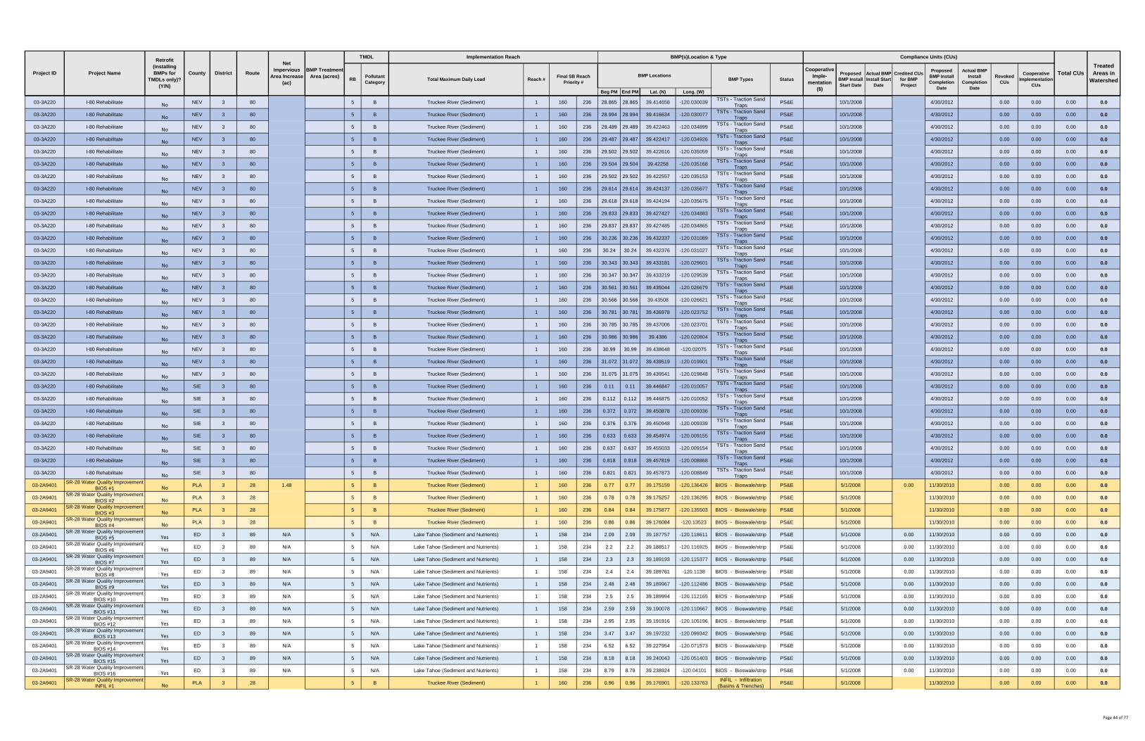
Beg PM End PM Lat. (N) Long. (W)
Revoked CUs
Total CUsTreated Areas in
WatershedRBPollutant Category
Total Maximum Daily Load Reach #Final SB Reach
Priority #
Compliance Units (CUs)
Cooperative Imple-
mentation ($)
Cooperative Implementation
CUs
Proposed BMP Install Start Date
Actual BMP Install Start
Date
Credited CUs for BMP Project
Proposed BMP Install Completion
Date
Actual BMP Install
Completion Date
Net Impervious
Area Increase (ac)
BMP Treatment Area (acres)
TMDL Implementation Reach BMP(s)Location & Type
BMP LocationsBMP Types Status
RouteProject ID Project Name
Retrofit (installing BMPs for
TMDLs only)? (Y/N)
County District
03-3A220 I-80 Rehabilitate No NEV 3 80 5 B Truckee River (Sediment) 1 160 236 28.865 28.865 39.414658 -120.030039TSTs - Traction Sand
TrapsPS&E 10/1/2008 4/30/2012 0.00 0.00 0.00 0.0
03-3A220 I-80 Rehabilitate No NEV 3 80 5 B Truckee River (Sediment) 1 160 236 28.994 28.994 39.416634 -120.030077TSTs - Traction Sand
TrapsPS&E 10/1/2008 4/30/2012 0.00 0.00 0.00 0.0
03-3A220 I-80 Rehabilitate No NEV 3 80 5 B Truckee River (Sediment) 1 160 236 29.489 29.489 39.422463 -120.034899TSTs - Traction Sand
TrapsPS&E 10/1/2008 4/30/2012 0.00 0.00 0.00 0.0
03-3A220 I-80 Rehabilitate No NEV 3 80 5 B Truckee River (Sediment) 1 160 236 29.487 29.487 39.422417 -120.034926TSTs - Traction Sand
TrapsPS&E 10/1/2008 4/30/2012 0.00 0.00 0.00 0.0
03-3A220 I-80 Rehabilitate No NEV 3 80 5 B Truckee River (Sediment) 1 160 236 29.502 29.502 39.422616 -120.035059TSTs - Traction Sand
TrapsPS&E 10/1/2008 4/30/2012 0.00 0.00 0.00 0.0
03-3A220 I-80 Rehabilitate No NEV 3 80 5 B Truckee River (Sediment) 1 160 236 29.504 29.504 39.42258 -120.035168TSTs - Traction Sand
TrapsPS&E 10/1/2008 4/30/2012 0.00 0.00 0.00 0.0
03-3A220 I-80 Rehabilitate No NEV 3 80 5 B Truckee River (Sediment) 1 160 236 29.502 29.502 39.422557 -120.035153TSTs - Traction Sand
TrapsPS&E 10/1/2008 4/30/2012 0.00 0.00 0.00 0.0
03-3A220 I-80 Rehabilitate No NEV 3 80 5 B Truckee River (Sediment) 1 160 236 29.614 29.614 39.424137 -120.035677TSTs - Traction Sand
TrapsPS&E 10/1/2008 4/30/2012 0.00 0.00 0.00 0.0
03-3A220 I-80 Rehabilitate No NEV 3 80 5 B Truckee River (Sediment) 1 160 236 29.618 29.618 39.424194 -120.035675TSTs - Traction Sand
TrapsPS&E 10/1/2008 4/30/2012 0.00 0.00 0.00 0.0
03-3A220 I-80 Rehabilitate No NEV 3 80 5 B Truckee River (Sediment) 1 160 236 29.833 29.833 39.427427 -120.034883TSTs - Traction Sand
TrapsPS&E 10/1/2008 4/30/2012 0.00 0.00 0.00 0.0
03-3A220 I-80 Rehabilitate No NEV 3 80 5 B Truckee River (Sediment) 1 160 236 29.837 29.837 39.427485 -120.034865TSTs - Traction Sand
TrapsPS&E 10/1/2008 4/30/2012 0.00 0.00 0.00 0.0
03-3A220 I-80 Rehabilitate No NEV 3 80 5 B Truckee River (Sediment) 1 160 236 30.236 30.236 39.432337 -120.031089TSTs - Traction Sand
TrapsPS&E 10/1/2008 4/30/2012 0.00 0.00 0.00 0.0
03-3A220 I-80 Rehabilitate No NEV 3 80 5 B Truckee River (Sediment) 1 160 236 30.24 30.24 39.432376 -120.031027TSTs - Traction Sand
TrapsPS&E 10/1/2008 4/30/2012 0.00 0.00 0.00 0.0
03-3A220 I-80 Rehabilitate No NEV 3 80 5 B Truckee River (Sediment) 1 160 236 30.343 30.343 39.433181 -120.029601TSTs - Traction Sand
TrapsPS&E 10/1/2008 4/30/2012 0.00 0.00 0.00 0.0
03-3A220 I-80 Rehabilitate No NEV 3 80 5 B Truckee River (Sediment) 1 160 236 30.347 30.347 39.433219 -120.029539TSTs - Traction Sand
TrapsPS&E 10/1/2008 4/30/2012 0.00 0.00 0.00 0.0
03-3A220 I-80 Rehabilitate No NEV 3 80 5 B Truckee River (Sediment) 1 160 236 30.561 30.561 39.435044 -120.026679TSTs - Traction Sand
TrapsPS&E 10/1/2008 4/30/2012 0.00 0.00 0.00 0.0
03-3A220 I-80 Rehabilitate No NEV 3 80 5 B Truckee River (Sediment) 1 160 236 30.566 30.566 39.43508 -120.026621TSTs - Traction Sand
TrapsPS&E 10/1/2008 4/30/2012 0.00 0.00 0.00 0.0
03-3A220 I-80 Rehabilitate No NEV 3 80 5 B Truckee River (Sediment) 1 160 236 30.781 30.781 39.436978 -120.023752TSTs - Traction Sand
TrapsPS&E 10/1/2008 4/30/2012 0.00 0.00 0.00 0.0
03-3A220 I-80 Rehabilitate No NEV 3 80 5 B Truckee River (Sediment) 1 160 236 30.785 30.785 39.437006 -120.023701TSTs - Traction Sand
TrapsPS&E 10/1/2008 4/30/2012 0.00 0.00 0.00 0.0
03-3A220 I-80 Rehabilitate No NEV 3 80 5 B Truckee River (Sediment) 1 160 236 30.986 30.986 39.4386 -120.020804TSTs - Traction Sand
TrapsPS&E 10/1/2008 4/30/2012 0.00 0.00 0.00 0.0
03-3A220 I-80 Rehabilitate No NEV 3 80 5 B Truckee River (Sediment) 1 160 236 30.99 30.99 39.438648 -120.02075TSTs - Traction Sand
TrapsPS&E 10/1/2008 4/30/2012 0.00 0.00 0.00 0.0
03-3A220 I-80 Rehabilitate No NEV 3 80 5 B Truckee River (Sediment) 1 160 236 31.072 31.072 39.439519 -120.019901TSTs - Traction Sand
TrapsPS&E 10/1/2008 4/30/2012 0.00 0.00 0.00 0.0
03-3A220 I-80 Rehabilitate No NEV 3 80 5 B Truckee River (Sediment) 1 160 236 31.075 31.075 39.439541 -120.019848TSTs - Traction Sand
TrapsPS&E 10/1/2008 4/30/2012 0.00 0.00 0.00 0.0
03-3A220 I-80 Rehabilitate No SIE 3 80 5 B Truckee River (Sediment) 1 160 236 0.11 0.11 39.446847 -120.010057TSTs - Traction Sand
TrapsPS&E 10/1/2008 4/30/2012 0.00 0.00 0.00 0.0
03-3A220 I-80 Rehabilitate No SIE 3 80 5 B Truckee River (Sediment) 1 160 236 0.112 0.112 39.446875 -120.010052TSTs - Traction Sand
TrapsPS&E 10/1/2008 4/30/2012 0.00 0.00 0.00 0.0
03-3A220 I-80 Rehabilitate No SIE 3 80 5 B Truckee River (Sediment) 1 160 236 0.372 0.372 39.450878 -120.009336TSTs - Traction Sand
TrapsPS&E 10/1/2008 4/30/2012 0.00 0.00 0.00 0.0
03-3A220 I-80 Rehabilitate No SIE 3 80 5 B Truckee River (Sediment) 1 160 236 0.376 0.376 39.450948 -120.009339TSTs - Traction Sand
TrapsPS&E 10/1/2008 4/30/2012 0.00 0.00 0.00 0.0
03-3A220 I-80 Rehabilitate No SIE 3 80 5 B Truckee River (Sediment) 1 160 236 0.633 0.633 39.454974 -120.009155TSTs - Traction Sand
TrapsPS&E 10/1/2008 4/30/2012 0.00 0.00 0.00 0.0
03-3A220 I-80 Rehabilitate No SIE 3 80 5 B Truckee River (Sediment) 1 160 236 0.637 0.637 39.455033 -120.009154TSTs - Traction Sand
TrapsPS&E 10/1/2008 4/30/2012 0.00 0.00 0.00 0.0
03-3A220 I-80 Rehabilitate No SIE 3 80 5 B Truckee River (Sediment) 1 160 236 0.818 0.818 39.457819 -120.008868TSTs - Traction Sand
TrapsPS&E 10/1/2008 4/30/2012 0.00 0.00 0.00 0.0
03-3A220 I-80 Rehabilitate No SIE 3 80 5 B Truckee River (Sediment) 1 160 236 0.821 0.821 39.457873 -120.008849TSTs - Traction Sand
TrapsPS&E 10/1/2008 4/30/2012 0.00 0.00 0.00 0.0
03-2A9401SR-28 Water Quality Improvement
BIOS #1 No PLA 3 28 1.48 5 B Truckee River (Sediment) 1 160 236 0.77 0.77 39.175159 -120.136426 BIOS - Bioswale/strip PS&E 5/1/2008 0.00 11/30/2010 0.00 0.00 0.00 0.0
03-2A9401SR-28 Water Quality Improvement
BIOS #2 No PLA 3 28 5 B Truckee River (Sediment) 1 160 236 0.78 0.78 39.175257 -120.136295 BIOS - Bioswale/strip PS&E 5/1/2008 11/30/2010 0.00 0.00 0.00 0.0
03-2A9401SR-28 Water Quality Improvement
BIOS #3 No PLA 3 28 5 B Truckee River (Sediment) 1 160 236 0.84 0.84 39.175877 -120.135503 BIOS - Bioswale/strip PS&E 5/1/2008 11/30/2010 0.00 0.00 0.00 0.0
03-2A9401SR-28 Water Quality Improvement
BIOS #4 No PLA 3 28 5 B Truckee River (Sediment) 1 160 236 0.86 0.86 39.176084 -120.13523 BIOS - Bioswale/strip PS&E 5/1/2008 11/30/2010 0.00 0.00 0.00 0.0
03-2A9401SR-28 Water Quality Improvement
BIOS #5 Yes ED 3 89 N/A 5 N/A Lake Tahoe (Sediment and Nutrients) 1 158 234 2.09 2.09 39.187757 -120.118611 BIOS - Bioswale/strip PS&E 5/1/2008 0.00 11/30/2010 0.00 0.00 0.00 0.0
03-2A9401SR-28 Water Quality Improvement
BIOS #6 Yes ED 3 89 N/A 5 N/A Lake Tahoe (Sediment and Nutrients) 1 158 234 2.2 2.2 39.188517 -120.116925 BIOS - Bioswale/strip PS&E 5/1/2008 0.00 11/30/2010 0.00 0.00 0.00 0.0
03-2A9401SR-28 Water Quality Improvement
BIOS #7 Yes ED 3 89 N/A 5 N/A Lake Tahoe (Sediment and Nutrients) 1 158 234 2.3 2.3 39.189193 -120.115377 BIOS - Bioswale/strip PS&E 5/1/2008 0.00 11/30/2010 0.00 0.00 0.00 0.0
03-2A9401SR-28 Water Quality Improvement
BIOS #8 Yes ED 3 89 N/A 5 N/A Lake Tahoe (Sediment and Nutrients) 1 158 234 2.4 2.4 39.189761 -120.1138 BIOS - Bioswale/strip PS&E 5/1/2008 0.00 11/30/2010 0.00 0.00 0.00 0.0
03-2A9401SR-28 Water Quality Improvement
BIOS #9 Yes ED 3 89 N/A 5 N/A Lake Tahoe (Sediment and Nutrients) 1 158 234 2.48 2.48 39.189967 -120.112486 BIOS - Bioswale/strip PS&E 5/1/2008 0.00 11/30/2010 0.00 0.00 0.00 0.0
03-2A9401SR-28 Water Quality Improvement
BIOS #10 Yes ED 3 89 N/A 5 N/A Lake Tahoe (Sediment and Nutrients) 1 158 234 2.5 2.5 39.189994 -120.112165 BIOS - Bioswale/strip PS&E 5/1/2008 0.00 11/30/2010 0.00 0.00 0.00 0.0
03-2A9401SR-28 Water Quality Improvement
BIOS #11 Yes ED 3 89 N/A 5 N/A Lake Tahoe (Sediment and Nutrients) 1 158 234 2.59 2.59 39.190078 -120.110667 BIOS - Bioswale/strip PS&E 5/1/2008 0.00 11/30/2010 0.00 0.00 0.00 0.0
03-2A9401SR-28 Water Quality Improvement
BIOS #12 Yes ED 3 89 N/A 5 N/A Lake Tahoe (Sediment and Nutrients) 1 158 234 2.95 2.95 39.191916 -120.105196 BIOS - Bioswale/strip PS&E 5/1/2008 0.00 11/30/2010 0.00 0.00 0.00 0.0
03-2A9401SR-28 Water Quality Improvement
BIOS #13 Yes ED 3 89 N/A 5 N/A Lake Tahoe (Sediment and Nutrients) 1 158 234 3.47 3.47 39.197232 -120.099342 BIOS - Bioswale/strip PS&E 5/1/2008 0.00 11/30/2010 0.00 0.00 0.00 0.0
03-2A9401SR-28 Water Quality Improvement
BIOS #14 Yes ED 3 89 N/A 5 N/A Lake Tahoe (Sediment and Nutrients) 1 158 234 6.52 6.52 39.227954 -120.071573 BIOS - Bioswale/strip PS&E 5/1/2008 0.00 11/30/2010 0.00 0.00 0.00 0.0
03-2A9401SR-28 Water Quality Improvement
BIOS #15 Yes ED 3 89 N/A 5 N/A Lake Tahoe (Sediment and Nutrients) 1 158 234 8.18 8.18 39.240043 -120.051403 BIOS - Bioswale/strip PS&E 5/1/2008 0.00 11/30/2010 0.00 0.00 0.00 0.0
03-2A9401SR-28 Water Quality Improvement
BIOS #16 Yes ED 3 89 N/A 5 N/A Lake Tahoe (Sediment and Nutrients) 1 158 234 8.79 8.79 39.238924 -120.04101 BIOS - Bioswale/strip PS&E 5/1/2008 0.00 11/30/2010 0.00 0.00 0.00 0.0
03-2A9401SR-28 Water Quality Improvement
INFIL #1 No PLA 3 28 5 B Truckee River (Sediment) 1 160 236 0.96 0.96 39.176901 -120.133763INFIL - Infiltration
(Basins & Trenches)PS&E 5/1/2008 11/30/2010 0.00 0.00 0.00 0.0
Page 44 of 77
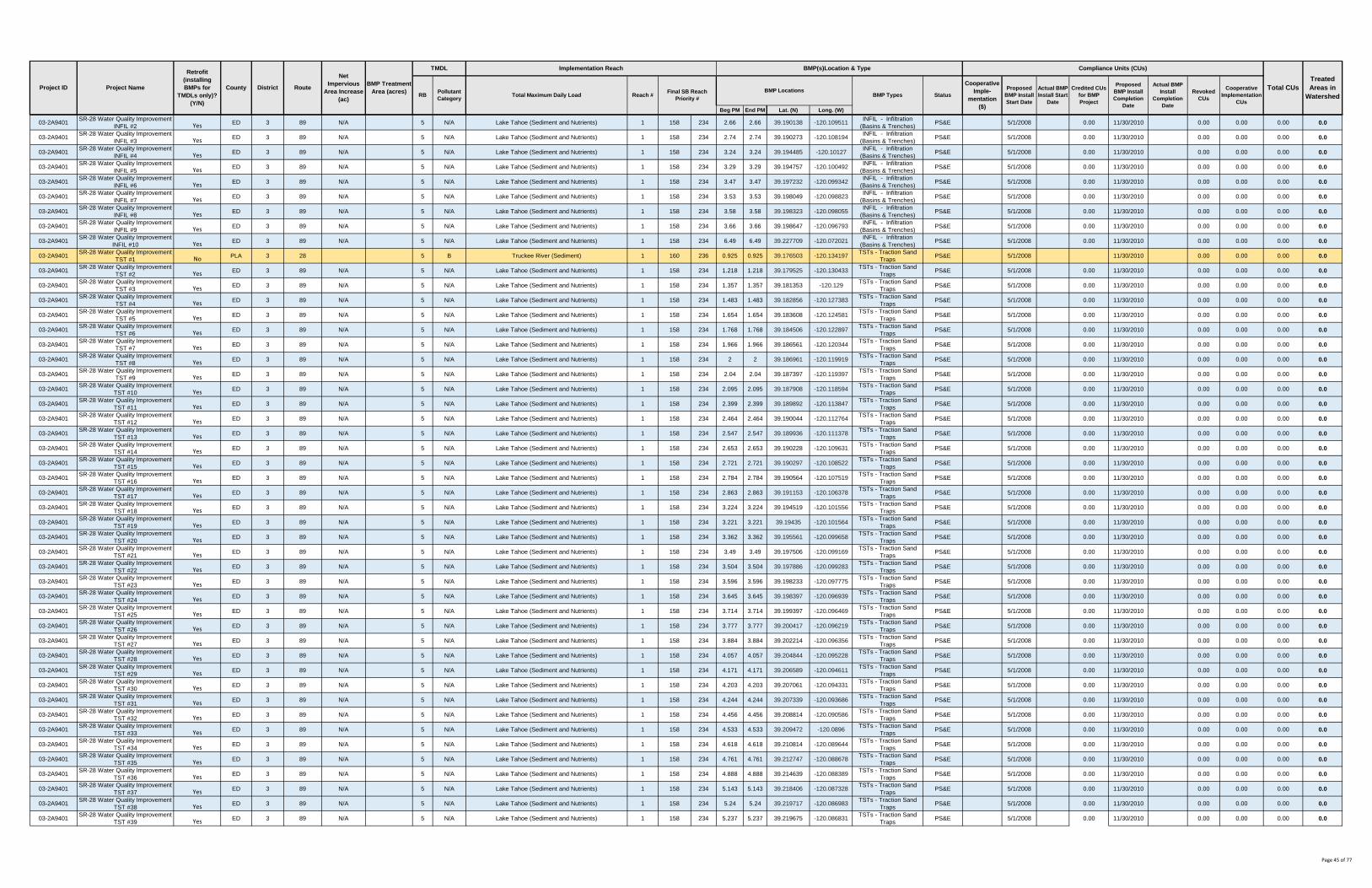
Beg PM End PM Lat. (N) Long. (W)
Revoked CUs
Total CUsTreated Areas in
WatershedRBPollutant Category
Total Maximum Daily Load Reach #Final SB Reach
Priority #
Compliance Units (CUs)
Cooperative Imple-
mentation ($)
Cooperative Implementation
CUs
Proposed BMP Install Start Date
Actual BMP Install Start
Date
Credited CUs for BMP Project
Proposed BMP Install Completion
Date
Actual BMP Install
Completion Date
Net Impervious
Area Increase (ac)
BMP Treatment Area (acres)
TMDL Implementation Reach BMP(s)Location & Type
BMP LocationsBMP Types Status
RouteProject ID Project Name
Retrofit (installing BMPs for
TMDLs only)? (Y/N)
County District
03-2A9401SR-28 Water Quality Improvement
INFIL #2 Yes ED 3 89 N/A 5 N/A Lake Tahoe (Sediment and Nutrients) 1 158 234 2.66 2.66 39.190138 -120.109511INFIL - Infiltration
(Basins & Trenches)PS&E 5/1/2008 0.00 11/30/2010 0.00 0.00 0.00 0.0
03-2A9401SR-28 Water Quality Improvement
INFIL #3 Yes ED 3 89 N/A 5 N/A Lake Tahoe (Sediment and Nutrients) 1 158 234 2.74 2.74 39.190273 -120.108194INFIL - Infiltration
(Basins & Trenches)PS&E 5/1/2008 0.00 11/30/2010 0.00 0.00 0.00 0.0
03-2A9401SR-28 Water Quality Improvement
INFIL #4 Yes ED 3 89 N/A 5 N/A Lake Tahoe (Sediment and Nutrients) 1 158 234 3.24 3.24 39.194485 -120.10127INFIL - Infiltration
(Basins & Trenches)PS&E 5/1/2008 0.00 11/30/2010 0.00 0.00 0.00 0.0
03-2A9401SR-28 Water Quality Improvement
INFIL #5 Yes ED 3 89 N/A 5 N/A Lake Tahoe (Sediment and Nutrients) 1 158 234 3.29 3.29 39.194757 -120.100492INFIL - Infiltration
(Basins & Trenches)PS&E 5/1/2008 0.00 11/30/2010 0.00 0.00 0.00 0.0
03-2A9401SR-28 Water Quality Improvement
INFIL #6 Yes ED 3 89 N/A 5 N/A Lake Tahoe (Sediment and Nutrients) 1 158 234 3.47 3.47 39.197232 -120.099342INFIL - Infiltration
(Basins & Trenches)PS&E 5/1/2008 0.00 11/30/2010 0.00 0.00 0.00 0.0
03-2A9401SR-28 Water Quality Improvement
INFIL #7 Yes ED 3 89 N/A 5 N/A Lake Tahoe (Sediment and Nutrients) 1 158 234 3.53 3.53 39.198049 -120.098823INFIL - Infiltration
(Basins & Trenches)PS&E 5/1/2008 0.00 11/30/2010 0.00 0.00 0.00 0.0
03-2A9401SR-28 Water Quality Improvement
INFIL #8 Yes ED 3 89 N/A 5 N/A Lake Tahoe (Sediment and Nutrients) 1 158 234 3.58 3.58 39.198323 -120.098055INFIL - Infiltration
(Basins & Trenches)PS&E 5/1/2008 0.00 11/30/2010 0.00 0.00 0.00 0.0
03-2A9401SR-28 Water Quality Improvement
INFIL #9 Yes ED 3 89 N/A 5 N/A Lake Tahoe (Sediment and Nutrients) 1 158 234 3.66 3.66 39.198647 -120.096793INFIL - Infiltration
(Basins & Trenches)PS&E 5/1/2008 0.00 11/30/2010 0.00 0.00 0.00 0.0
03-2A9401SR-28 Water Quality Improvement
INFIL #10 Yes ED 3 89 N/A 5 N/A Lake Tahoe (Sediment and Nutrients) 1 158 234 6.49 6.49 39.227709 -120.072021INFIL - Infiltration
(Basins & Trenches)PS&E 5/1/2008 0.00 11/30/2010 0.00 0.00 0.00 0.0
03-2A9401SR-28 Water Quality Improvement
TST #1 No PLA 3 28 5 B Truckee River (Sediment) 1 160 236 0.925 0.925 39.176503 -120.134197TSTs - Traction Sand
TrapsPS&E 5/1/2008 11/30/2010 0.00 0.00 0.00 0.0
03-2A9401SR-28 Water Quality Improvement
TST #2 Yes ED 3 89 N/A 5 N/A Lake Tahoe (Sediment and Nutrients) 1 158 234 1.218 1.218 39.179525 -120.130433TSTs - Traction Sand
TrapsPS&E 5/1/2008 0.00 11/30/2010 0.00 0.00 0.00 0.0
03-2A9401SR-28 Water Quality Improvement
TST #3 Yes ED 3 89 N/A 5 N/A Lake Tahoe (Sediment and Nutrients) 1 158 234 1.357 1.357 39.181353 -120.129TSTs - Traction Sand
TrapsPS&E 5/1/2008 0.00 11/30/2010 0.00 0.00 0.00 0.0
03-2A9401SR-28 Water Quality Improvement
TST #4 Yes ED 3 89 N/A 5 N/A Lake Tahoe (Sediment and Nutrients) 1 158 234 1.483 1.483 39.182856 -120.127383TSTs - Traction Sand
TrapsPS&E 5/1/2008 0.00 11/30/2010 0.00 0.00 0.00 0.0
03-2A9401SR-28 Water Quality Improvement
TST #5 Yes ED 3 89 N/A 5 N/A Lake Tahoe (Sediment and Nutrients) 1 158 234 1.654 1.654 39.183608 -120.124581TSTs - Traction Sand
TrapsPS&E 5/1/2008 0.00 11/30/2010 0.00 0.00 0.00 0.0
03-2A9401SR-28 Water Quality Improvement
TST #6 Yes ED 3 89 N/A 5 N/A Lake Tahoe (Sediment and Nutrients) 1 158 234 1.768 1.768 39.184506 -120.122897TSTs - Traction Sand
TrapsPS&E 5/1/2008 0.00 11/30/2010 0.00 0.00 0.00 0.0
03-2A9401SR-28 Water Quality Improvement
TST #7 Yes ED 3 89 N/A 5 N/A Lake Tahoe (Sediment and Nutrients) 1 158 234 1.966 1.966 39.186561 -120.120344TSTs - Traction Sand
TrapsPS&E 5/1/2008 0.00 11/30/2010 0.00 0.00 0.00 0.0
03-2A9401SR-28 Water Quality Improvement
TST #8 Yes ED 3 89 N/A 5 N/A Lake Tahoe (Sediment and Nutrients) 1 158 234 2 2 39.186961 -120.119919TSTs - Traction Sand
TrapsPS&E 5/1/2008 0.00 11/30/2010 0.00 0.00 0.00 0.0
03-2A9401SR-28 Water Quality Improvement
TST #9 Yes ED 3 89 N/A 5 N/A Lake Tahoe (Sediment and Nutrients) 1 158 234 2.04 2.04 39.187397 -120.119397TSTs - Traction Sand
TrapsPS&E 5/1/2008 0.00 11/30/2010 0.00 0.00 0.00 0.0
03-2A9401SR-28 Water Quality Improvement
TST #10 Yes ED 3 89 N/A 5 N/A Lake Tahoe (Sediment and Nutrients) 1 158 234 2.095 2.095 39.187908 -120.118594TSTs - Traction Sand
TrapsPS&E 5/1/2008 0.00 11/30/2010 0.00 0.00 0.00 0.0
03-2A9401SR-28 Water Quality Improvement
TST #11 Yes ED 3 89 N/A 5 N/A Lake Tahoe (Sediment and Nutrients) 1 158 234 2.399 2.399 39.189892 -120.113847TSTs - Traction Sand
TrapsPS&E 5/1/2008 0.00 11/30/2010 0.00 0.00 0.00 0.0
03-2A9401SR-28 Water Quality Improvement
TST #12 Yes ED 3 89 N/A 5 N/A Lake Tahoe (Sediment and Nutrients) 1 158 234 2.464 2.464 39.190044 -120.112764TSTs - Traction Sand
TrapsPS&E 5/1/2008 0.00 11/30/2010 0.00 0.00 0.00 0.0
03-2A9401SR-28 Water Quality Improvement
TST #13 Yes ED 3 89 N/A 5 N/A Lake Tahoe (Sediment and Nutrients) 1 158 234 2.547 2.547 39.189936 -120.111378TSTs - Traction Sand
TrapsPS&E 5/1/2008 0.00 11/30/2010 0.00 0.00 0.00 0.0
03-2A9401SR-28 Water Quality Improvement
TST #14 Yes ED 3 89 N/A 5 N/A Lake Tahoe (Sediment and Nutrients) 1 158 234 2.653 2.653 39.190228 -120.109631TSTs - Traction Sand
TrapsPS&E 5/1/2008 0.00 11/30/2010 0.00 0.00 0.00 0.0
03-2A9401SR-28 Water Quality Improvement
TST #15 Yes ED 3 89 N/A 5 N/A Lake Tahoe (Sediment and Nutrients) 1 158 234 2.721 2.721 39.190297 -120.108522TSTs - Traction Sand
TrapsPS&E 5/1/2008 0.00 11/30/2010 0.00 0.00 0.00 0.0
03-2A9401SR-28 Water Quality Improvement
TST #16 Yes ED 3 89 N/A 5 N/A Lake Tahoe (Sediment and Nutrients) 1 158 234 2.784 2.784 39.190564 -120.107519TSTs - Traction Sand
TrapsPS&E 5/1/2008 0.00 11/30/2010 0.00 0.00 0.00 0.0
03-2A9401SR-28 Water Quality Improvement
TST #17 Yes ED 3 89 N/A 5 N/A Lake Tahoe (Sediment and Nutrients) 1 158 234 2.863 2.863 39.191153 -120.106378TSTs - Traction Sand
TrapsPS&E 5/1/2008 0.00 11/30/2010 0.00 0.00 0.00 0.0
03-2A9401SR-28 Water Quality Improvement
TST #18 Yes ED 3 89 N/A 5 N/A Lake Tahoe (Sediment and Nutrients) 1 158 234 3.224 3.224 39.194519 -120.101556TSTs - Traction Sand
TrapsPS&E 5/1/2008 0.00 11/30/2010 0.00 0.00 0.00 0.0
03-2A9401SR-28 Water Quality Improvement
TST #19 Yes ED 3 89 N/A 5 N/A Lake Tahoe (Sediment and Nutrients) 1 158 234 3.221 3.221 39.19435 -120.101564TSTs - Traction Sand
TrapsPS&E 5/1/2008 0.00 11/30/2010 0.00 0.00 0.00 0.0
03-2A9401SR-28 Water Quality Improvement
TST #20 Yes ED 3 89 N/A 5 N/A Lake Tahoe (Sediment and Nutrients) 1 158 234 3.362 3.362 39.195561 -120.099658TSTs - Traction Sand
TrapsPS&E 5/1/2008 0.00 11/30/2010 0.00 0.00 0.00 0.0
03-2A9401SR-28 Water Quality Improvement
TST #21 Yes ED 3 89 N/A 5 N/A Lake Tahoe (Sediment and Nutrients) 1 158 234 3.49 3.49 39.197506 -120.099169TSTs - Traction Sand
TrapsPS&E 5/1/2008 0.00 11/30/2010 0.00 0.00 0.00 0.0
03-2A9401SR-28 Water Quality Improvement
TST #22 Yes ED 3 89 N/A 5 N/A Lake Tahoe (Sediment and Nutrients) 1 158 234 3.504 3.504 39.197886 -120.099283TSTs - Traction Sand
TrapsPS&E 5/1/2008 0.00 11/30/2010 0.00 0.00 0.00 0.0
03-2A9401SR-28 Water Quality Improvement
TST #23 Yes ED 3 89 N/A 5 N/A Lake Tahoe (Sediment and Nutrients) 1 158 234 3.596 3.596 39.198233 -120.097775TSTs - Traction Sand
TrapsPS&E 5/1/2008 0.00 11/30/2010 0.00 0.00 0.00 0.0
03-2A9401SR-28 Water Quality Improvement
TST #24 Yes ED 3 89 N/A 5 N/A Lake Tahoe (Sediment and Nutrients) 1 158 234 3.645 3.645 39.198397 -120.096939TSTs - Traction Sand
TrapsPS&E 5/1/2008 0.00 11/30/2010 0.00 0.00 0.00 0.0
03-2A9401SR-28 Water Quality Improvement
TST #25 Yes ED 3 89 N/A 5 N/A Lake Tahoe (Sediment and Nutrients) 1 158 234 3.714 3.714 39.199397 -120.096469TSTs - Traction Sand
TrapsPS&E 5/1/2008 0.00 11/30/2010 0.00 0.00 0.00 0.0
03-2A9401SR-28 Water Quality Improvement
TST #26 Yes ED 3 89 N/A 5 N/A Lake Tahoe (Sediment and Nutrients) 1 158 234 3.777 3.777 39.200417 -120.096219TSTs - Traction Sand
TrapsPS&E 5/1/2008 0.00 11/30/2010 0.00 0.00 0.00 0.0
03-2A9401SR-28 Water Quality Improvement
TST #27 Yes ED 3 89 N/A 5 N/A Lake Tahoe (Sediment and Nutrients) 1 158 234 3.884 3.884 39.202214 -120.096356TSTs - Traction Sand
TrapsPS&E 5/1/2008 0.00 11/30/2010 0.00 0.00 0.00 0.0
03-2A9401SR-28 Water Quality Improvement
TST #28 Yes ED 3 89 N/A 5 N/A Lake Tahoe (Sediment and Nutrients) 1 158 234 4.057 4.057 39.204844 -120.095228TSTs - Traction Sand
TrapsPS&E 5/1/2008 0.00 11/30/2010 0.00 0.00 0.00 0.0
03-2A9401SR-28 Water Quality Improvement
TST #29 Yes ED 3 89 N/A 5 N/A Lake Tahoe (Sediment and Nutrients) 1 158 234 4.171 4.171 39.206589 -120.094611TSTs - Traction Sand
TrapsPS&E 5/1/2008 0.00 11/30/2010 0.00 0.00 0.00 0.0
03-2A9401SR-28 Water Quality Improvement
TST #30 Yes ED 3 89 N/A 5 N/A Lake Tahoe (Sediment and Nutrients) 1 158 234 4.203 4.203 39.207061 -120.094331TSTs - Traction Sand
TrapsPS&E 5/1/2008 0.00 11/30/2010 0.00 0.00 0.00 0.0
03-2A9401SR-28 Water Quality Improvement
TST #31 Yes ED 3 89 N/A 5 N/A Lake Tahoe (Sediment and Nutrients) 1 158 234 4.244 4.244 39.207339 -120.093686TSTs - Traction Sand
TrapsPS&E 5/1/2008 0.00 11/30/2010 0.00 0.00 0.00 0.0
03-2A9401SR-28 Water Quality Improvement
TST #32 Yes ED 3 89 N/A 5 N/A Lake Tahoe (Sediment and Nutrients) 1 158 234 4.456 4.456 39.208814 -120.090586TSTs - Traction Sand
TrapsPS&E 5/1/2008 0.00 11/30/2010 0.00 0.00 0.00 0.0
03-2A9401SR-28 Water Quality Improvement
TST #33 Yes ED 3 89 N/A 5 N/A Lake Tahoe (Sediment and Nutrients) 1 158 234 4.533 4.533 39.209472 -120.0896TSTs - Traction Sand
TrapsPS&E 5/1/2008 0.00 11/30/2010 0.00 0.00 0.00 0.0
03-2A9401SR-28 Water Quality Improvement
TST #34 Yes ED 3 89 N/A 5 N/A Lake Tahoe (Sediment and Nutrients) 1 158 234 4.618 4.618 39.210814 -120.089644TSTs - Traction Sand
TrapsPS&E 5/1/2008 0.00 11/30/2010 0.00 0.00 0.00 0.0
03-2A9401SR-28 Water Quality Improvement
TST #35 Yes ED 3 89 N/A 5 N/A Lake Tahoe (Sediment and Nutrients) 1 158 234 4.761 4.761 39.212747 -120.088678TSTs - Traction Sand
TrapsPS&E 5/1/2008 0.00 11/30/2010 0.00 0.00 0.00 0.0
03-2A9401SR-28 Water Quality Improvement
TST #36 Yes ED 3 89 N/A 5 N/A Lake Tahoe (Sediment and Nutrients) 1 158 234 4.888 4.888 39.214639 -120.088389TSTs - Traction Sand
TrapsPS&E 5/1/2008 0.00 11/30/2010 0.00 0.00 0.00 0.0
03-2A9401SR-28 Water Quality Improvement
TST #37 Yes ED 3 89 N/A 5 N/A Lake Tahoe (Sediment and Nutrients) 1 158 234 5.143 5.143 39.218406 -120.087328TSTs - Traction Sand
TrapsPS&E 5/1/2008 0.00 11/30/2010 0.00 0.00 0.00 0.0
03-2A9401SR-28 Water Quality Improvement
TST #38 Yes ED 3 89 N/A 5 N/A Lake Tahoe (Sediment and Nutrients) 1 158 234 5.24 5.24 39.219717 -120.086983TSTs - Traction Sand
TrapsPS&E 5/1/2008 0.00 11/30/2010 0.00 0.00 0.00 0.0
03-2A9401SR-28 Water Quality Improvement
TST #39 Yes ED 3 89 N/A 5 N/A Lake Tahoe (Sediment and Nutrients) 1 158 234 5.237 5.237 39.219675 -120.086831TSTs - Traction Sand
TrapsPS&E 5/1/2008 0.00 11/30/2010 0.00 0.00 0.00 0.0
Page 45 of 77
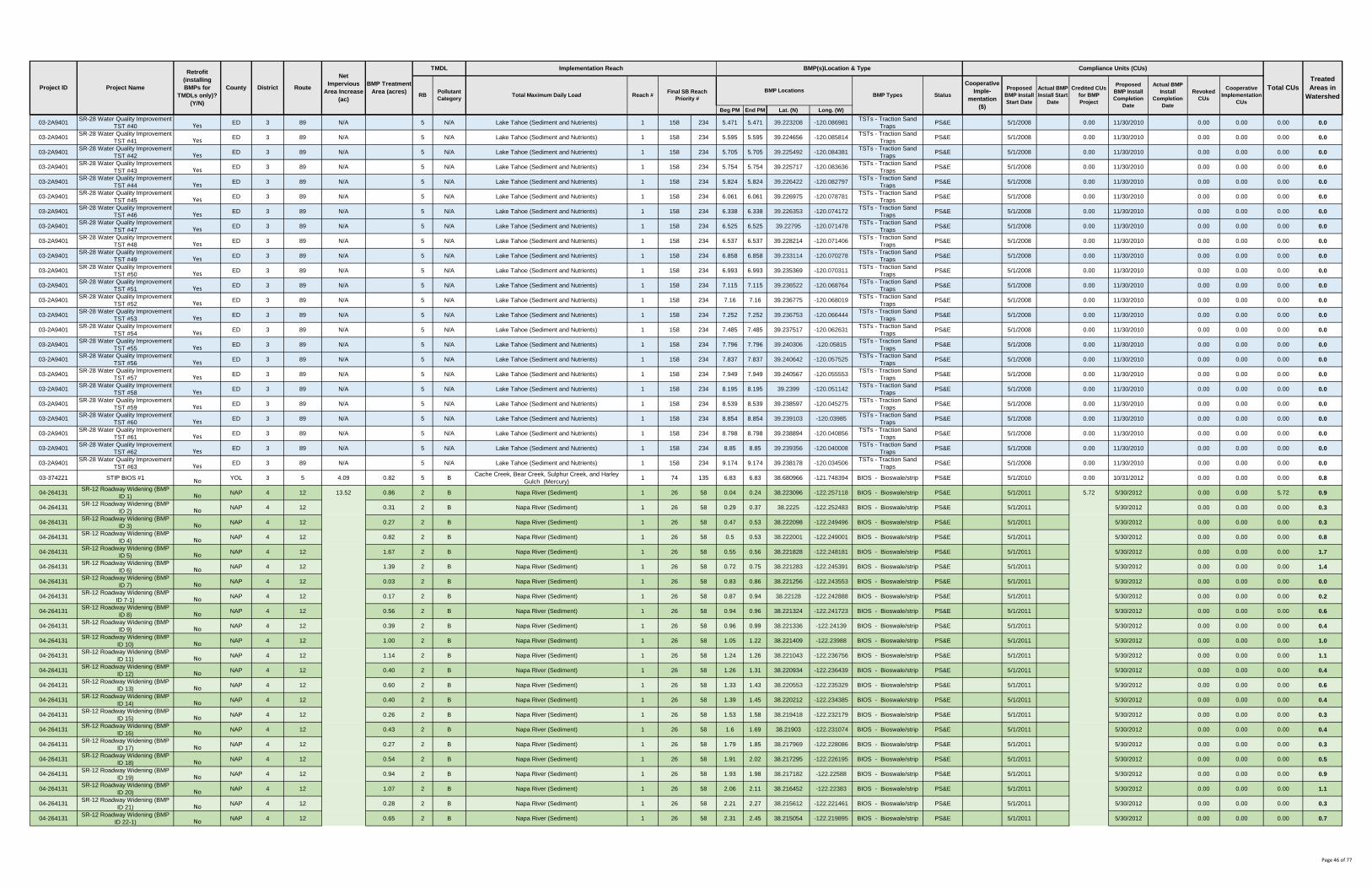
Beg PM End PM Lat. (N) Long. (W)
Revoked CUs
Total CUsTreated Areas in
WatershedRBPollutant Category
Total Maximum Daily Load Reach #Final SB Reach
Priority #
Compliance Units (CUs)
Cooperative Imple-
mentation ($)
Cooperative Implementation
CUs
Proposed BMP Install Start Date
Actual BMP Install Start
Date
Credited CUs for BMP Project
Proposed BMP Install Completion
Date
Actual BMP Install
Completion Date
Net Impervious
Area Increase (ac)
BMP Treatment Area (acres)
TMDL Implementation Reach BMP(s)Location & Type
BMP LocationsBMP Types Status
RouteProject ID Project Name
Retrofit (installing BMPs for
TMDLs only)? (Y/N)
County District
03-2A9401SR-28 Water Quality Improvement
TST #40 Yes ED 3 89 N/A 5 N/A Lake Tahoe (Sediment and Nutrients) 1 158 234 5.471 5.471 39.223208 -120.086981TSTs - Traction Sand
TrapsPS&E 5/1/2008 0.00 11/30/2010 0.00 0.00 0.00 0.0
03-2A9401SR-28 Water Quality Improvement
TST #41 Yes ED 3 89 N/A 5 N/A Lake Tahoe (Sediment and Nutrients) 1 158 234 5.595 5.595 39.224656 -120.085814TSTs - Traction Sand
TrapsPS&E 5/1/2008 0.00 11/30/2010 0.00 0.00 0.00 0.0
03-2A9401SR-28 Water Quality Improvement
TST #42 Yes ED 3 89 N/A 5 N/A Lake Tahoe (Sediment and Nutrients) 1 158 234 5.705 5.705 39.225492 -120.084381TSTs - Traction Sand
TrapsPS&E 5/1/2008 0.00 11/30/2010 0.00 0.00 0.00 0.0
03-2A9401SR-28 Water Quality Improvement
TST #43 Yes ED 3 89 N/A 5 N/A Lake Tahoe (Sediment and Nutrients) 1 158 234 5.754 5.754 39.225717 -120.083636TSTs - Traction Sand
TrapsPS&E 5/1/2008 0.00 11/30/2010 0.00 0.00 0.00 0.0
03-2A9401SR-28 Water Quality Improvement
TST #44 Yes ED 3 89 N/A 5 N/A Lake Tahoe (Sediment and Nutrients) 1 158 234 5.824 5.824 39.226422 -120.082797TSTs - Traction Sand
TrapsPS&E 5/1/2008 0.00 11/30/2010 0.00 0.00 0.00 0.0
03-2A9401SR-28 Water Quality Improvement
TST #45 Yes ED 3 89 N/A 5 N/A Lake Tahoe (Sediment and Nutrients) 1 158 234 6.061 6.061 39.226975 -120.078781TSTs - Traction Sand
TrapsPS&E 5/1/2008 0.00 11/30/2010 0.00 0.00 0.00 0.0
03-2A9401SR-28 Water Quality Improvement
TST #46 Yes ED 3 89 N/A 5 N/A Lake Tahoe (Sediment and Nutrients) 1 158 234 6.338 6.338 39.226353 -120.074172TSTs - Traction Sand
TrapsPS&E 5/1/2008 0.00 11/30/2010 0.00 0.00 0.00 0.0
03-2A9401SR-28 Water Quality Improvement
TST #47 Yes ED 3 89 N/A 5 N/A Lake Tahoe (Sediment and Nutrients) 1 158 234 6.525 6.525 39.22795 -120.071478TSTs - Traction Sand
TrapsPS&E 5/1/2008 0.00 11/30/2010 0.00 0.00 0.00 0.0
03-2A9401SR-28 Water Quality Improvement
TST #48 Yes ED 3 89 N/A 5 N/A Lake Tahoe (Sediment and Nutrients) 1 158 234 6.537 6.537 39.228214 -120.071406TSTs - Traction Sand
TrapsPS&E 5/1/2008 0.00 11/30/2010 0.00 0.00 0.00 0.0
03-2A9401SR-28 Water Quality Improvement
TST #49 Yes ED 3 89 N/A 5 N/A Lake Tahoe (Sediment and Nutrients) 1 158 234 6.858 6.858 39.233114 -120.070278TSTs - Traction Sand
TrapsPS&E 5/1/2008 0.00 11/30/2010 0.00 0.00 0.00 0.0
03-2A9401SR-28 Water Quality Improvement
TST #50 Yes ED 3 89 N/A 5 N/A Lake Tahoe (Sediment and Nutrients) 1 158 234 6.993 6.993 39.235369 -120.070311TSTs - Traction Sand
TrapsPS&E 5/1/2008 0.00 11/30/2010 0.00 0.00 0.00 0.0
03-2A9401SR-28 Water Quality Improvement
TST #51 Yes ED 3 89 N/A 5 N/A Lake Tahoe (Sediment and Nutrients) 1 158 234 7.115 7.115 39.236522 -120.068764TSTs - Traction Sand
TrapsPS&E 5/1/2008 0.00 11/30/2010 0.00 0.00 0.00 0.0
03-2A9401SR-28 Water Quality Improvement
TST #52 Yes ED 3 89 N/A 5 N/A Lake Tahoe (Sediment and Nutrients) 1 158 234 7.16 7.16 39.236775 -120.068019TSTs - Traction Sand
TrapsPS&E 5/1/2008 0.00 11/30/2010 0.00 0.00 0.00 0.0
03-2A9401SR-28 Water Quality Improvement
TST #53 Yes ED 3 89 N/A 5 N/A Lake Tahoe (Sediment and Nutrients) 1 158 234 7.252 7.252 39.236753 -120.066444TSTs - Traction Sand
TrapsPS&E 5/1/2008 0.00 11/30/2010 0.00 0.00 0.00 0.0
03-2A9401SR-28 Water Quality Improvement
TST #54 Yes ED 3 89 N/A 5 N/A Lake Tahoe (Sediment and Nutrients) 1 158 234 7.485 7.485 39.237517 -120.062631TSTs - Traction Sand
TrapsPS&E 5/1/2008 0.00 11/30/2010 0.00 0.00 0.00 0.0
03-2A9401SR-28 Water Quality Improvement
TST #55 Yes ED 3 89 N/A 5 N/A Lake Tahoe (Sediment and Nutrients) 1 158 234 7.796 7.796 39.240306 -120.05815TSTs - Traction Sand
TrapsPS&E 5/1/2008 0.00 11/30/2010 0.00 0.00 0.00 0.0
03-2A9401SR-28 Water Quality Improvement
TST #56 Yes ED 3 89 N/A 5 N/A Lake Tahoe (Sediment and Nutrients) 1 158 234 7.837 7.837 39.240642 -120.057525TSTs - Traction Sand
TrapsPS&E 5/1/2008 0.00 11/30/2010 0.00 0.00 0.00 0.0
03-2A9401SR-28 Water Quality Improvement
TST #57 Yes ED 3 89 N/A 5 N/A Lake Tahoe (Sediment and Nutrients) 1 158 234 7.949 7.949 39.240567 -120.055553TSTs - Traction Sand
TrapsPS&E 5/1/2008 0.00 11/30/2010 0.00 0.00 0.00 0.0
03-2A9401SR-28 Water Quality Improvement
TST #58 Yes ED 3 89 N/A 5 N/A Lake Tahoe (Sediment and Nutrients) 1 158 234 8.195 8.195 39.2399 -120.051142TSTs - Traction Sand
TrapsPS&E 5/1/2008 0.00 11/30/2010 0.00 0.00 0.00 0.0
03-2A9401SR-28 Water Quality Improvement
TST #59 Yes ED 3 89 N/A 5 N/A Lake Tahoe (Sediment and Nutrients) 1 158 234 8.539 8.539 39.238597 -120.045275TSTs - Traction Sand
TrapsPS&E 5/1/2008 0.00 11/30/2010 0.00 0.00 0.00 0.0
03-2A9401SR-28 Water Quality Improvement
TST #60 Yes ED 3 89 N/A 5 N/A Lake Tahoe (Sediment and Nutrients) 1 158 234 8.854 8.854 39.239103 -120.03985TSTs - Traction Sand
TrapsPS&E 5/1/2008 0.00 11/30/2010 0.00 0.00 0.00 0.0
03-2A9401SR-28 Water Quality Improvement
TST #61 Yes ED 3 89 N/A 5 N/A Lake Tahoe (Sediment and Nutrients) 1 158 234 8.798 8.798 39.238894 -120.040856TSTs - Traction Sand
TrapsPS&E 5/1/2008 0.00 11/30/2010 0.00 0.00 0.00 0.0
03-2A9401SR-28 Water Quality Improvement
TST #62 Yes ED 3 89 N/A 5 N/A Lake Tahoe (Sediment and Nutrients) 1 158 234 8.85 8.85 39.239356 -120.040008TSTs - Traction Sand
TrapsPS&E 5/1/2008 0.00 11/30/2010 0.00 0.00 0.00 0.0
03-2A9401SR-28 Water Quality Improvement
TST #63 Yes ED 3 89 N/A 5 N/A Lake Tahoe (Sediment and Nutrients) 1 158 234 9.174 9.174 39.238178 -120.034506TSTs - Traction Sand
TrapsPS&E 5/1/2008 0.00 11/30/2010 0.00 0.00 0.00 0.0
03-374221 STIP BIOS #1 No YOL 3 5 4.09 0.82 5 BCache Creek, Bear Creek, Sulphur Creek, and Harley
Gulch (Mercury)1 74 135 6.83 6.83 38.680966 -121.748394 BIOS - Bioswale/strip PS&E 5/1/2010 0.00 10/31/2012 0.00 0.00 0.00 0.8
04-264131SR-12 Roadway Widening (BMP
ID 1) No NAP 4 12 13.52 0.86 2 B Napa River (Sediment) 1 26 58 0.04 0.24 38.223096 -122.257118 BIOS - Bioswale/strip PS&E 5/1/2011 5.72 5/30/2012 0.00 0.00 5.72 0.9
04-264131SR-12 Roadway Widening (BMP
ID 2) No NAP 4 12 0.31 2 B Napa River (Sediment) 1 26 58 0.29 0.37 38.2225 -122.252483 BIOS - Bioswale/strip PS&E 5/1/2011 5/30/2012 0.00 0.00 0.00 0.3
04-264131SR-12 Roadway Widening (BMP
ID 3) No NAP 4 12 0.27 2 B Napa River (Sediment) 1 26 58 0.47 0.53 38.222098 -122.249496 BIOS - Bioswale/strip PS&E 5/1/2011 5/30/2012 0.00 0.00 0.00 0.3
04-264131SR-12 Roadway Widening (BMP
ID 4) No NAP 4 12 0.82 2 B Napa River (Sediment) 1 26 58 0.5 0.53 38.222001 -122.249001 BIOS - Bioswale/strip PS&E 5/1/2011 5/30/2012 0.00 0.00 0.00 0.8
04-264131SR-12 Roadway Widening (BMP
ID 5) No NAP 4 12 1.67 2 B Napa River (Sediment) 1 26 58 0.55 0.56 38.221828 -122.248181 BIOS - Bioswale/strip PS&E 5/1/2011 5/30/2012 0.00 0.00 0.00 1.7
04-264131SR-12 Roadway Widening (BMP
ID 6) No NAP 4 12 1.39 2 B Napa River (Sediment) 1 26 58 0.72 0.75 38.221283 -122.245391 BIOS - Bioswale/strip PS&E 5/1/2011 5/30/2012 0.00 0.00 0.00 1.4
04-264131SR-12 Roadway Widening (BMP
ID 7) No NAP 4 12 0.03 2 B Napa River (Sediment) 1 26 58 0.83 0.86 38.221256 -122.243553 BIOS - Bioswale/strip PS&E 5/1/2011 5/30/2012 0.00 0.00 0.00 0.0
04-264131SR-12 Roadway Widening (BMP
ID 7-1) No NAP 4 12 0.17 2 B Napa River (Sediment) 1 26 58 0.87 0.94 38.22128 -122.242888 BIOS - Bioswale/strip PS&E 5/1/2011 5/30/2012 0.00 0.00 0.00 0.2
04-264131SR-12 Roadway Widening (BMP
ID 8) No NAP 4 12 0.56 2 B Napa River (Sediment) 1 26 58 0.94 0.96 38.221324 -122.241723 BIOS - Bioswale/strip PS&E 5/1/2011 5/30/2012 0.00 0.00 0.00 0.6
04-264131SR-12 Roadway Widening (BMP
ID 9) No NAP 4 12 0.39 2 B Napa River (Sediment) 1 26 58 0.96 0.99 38.221336 -122.24139 BIOS - Bioswale/strip PS&E 5/1/2011 5/30/2012 0.00 0.00 0.00 0.4
04-264131SR-12 Roadway Widening (BMP
ID 10) No NAP 4 12 1.00 2 B Napa River (Sediment) 1 26 58 1.05 1.22 38.221409 -122.23988 BIOS - Bioswale/strip PS&E 5/1/2011 5/30/2012 0.00 0.00 0.00 1.0
04-264131SR-12 Roadway Widening (BMP
ID 11) No NAP 4 12 1.14 2 B Napa River (Sediment) 1 26 58 1.24 1.26 38.221043 -122.236756 BIOS - Bioswale/strip PS&E 5/1/2011 5/30/2012 0.00 0.00 0.00 1.1
04-264131SR-12 Roadway Widening (BMP
ID 12) No NAP 4 12 0.40 2 B Napa River (Sediment) 1 26 58 1.26 1.31 38.220934 -122.236439 BIOS - Bioswale/strip PS&E 5/1/2011 5/30/2012 0.00 0.00 0.00 0.4
04-264131SR-12 Roadway Widening (BMP
ID 13) No NAP 4 12 0.60 2 B Napa River (Sediment) 1 26 58 1.33 1.43 38.220553 -122.235329 BIOS - Bioswale/strip PS&E 5/1/2011 5/30/2012 0.00 0.00 0.00 0.6
04-264131SR-12 Roadway Widening (BMP
ID 14) No NAP 4 12 0.40 2 B Napa River (Sediment) 1 26 58 1.39 1.45 38.220212 -122.234385 BIOS - Bioswale/strip PS&E 5/1/2011 5/30/2012 0.00 0.00 0.00 0.4
04-264131SR-12 Roadway Widening (BMP
ID 15) No NAP 4 12 0.26 2 B Napa River (Sediment) 1 26 58 1.53 1.58 38.219418 -122.232179 BIOS - Bioswale/strip PS&E 5/1/2011 5/30/2012 0.00 0.00 0.00 0.3
04-264131SR-12 Roadway Widening (BMP
ID 16) No NAP 4 12 0.43 2 B Napa River (Sediment) 1 26 58 1.6 1.69 38.21903 -122.231074 BIOS - Bioswale/strip PS&E 5/1/2011 5/30/2012 0.00 0.00 0.00 0.4
04-264131SR-12 Roadway Widening (BMP
ID 17) No NAP 4 12 0.27 2 B Napa River (Sediment) 1 26 58 1.79 1.85 38.217969 -122.228086 BIOS - Bioswale/strip PS&E 5/1/2011 5/30/2012 0.00 0.00 0.00 0.3
04-264131SR-12 Roadway Widening (BMP
ID 18) No NAP 4 12 0.54 2 B Napa River (Sediment) 1 26 58 1.91 2.02 38.217295 -122.226195 BIOS - Bioswale/strip PS&E 5/1/2011 5/30/2012 0.00 0.00 0.00 0.5
04-264131SR-12 Roadway Widening (BMP
ID 19) No NAP 4 12 0.94 2 B Napa River (Sediment) 1 26 58 1.93 1.98 38.217182 -122.22588 BIOS - Bioswale/strip PS&E 5/1/2011 5/30/2012 0.00 0.00 0.00 0.9
04-264131SR-12 Roadway Widening (BMP
ID 20) No NAP 4 12 1.07 2 B Napa River (Sediment) 1 26 58 2.06 2.11 38.216452 -122.22383 BIOS - Bioswale/strip PS&E 5/1/2011 5/30/2012 0.00 0.00 0.00 1.1
04-264131SR-12 Roadway Widening (BMP
ID 21) No NAP 4 12 0.28 2 B Napa River (Sediment) 1 26 58 2.21 2.27 38.215612 -122.221461 BIOS - Bioswale/strip PS&E 5/1/2011 5/30/2012 0.00 0.00 0.00 0.3
04-264131SR-12 Roadway Widening (BMP
ID 22-1) No NAP 4 12 0.65 2 B Napa River (Sediment) 1 26 58 2.31 2.45 38.215054 -122.219895 BIOS - Bioswale/strip PS&E 5/1/2011 5/30/2012 0.00 0.00 0.00 0.7
Page 46 of 77
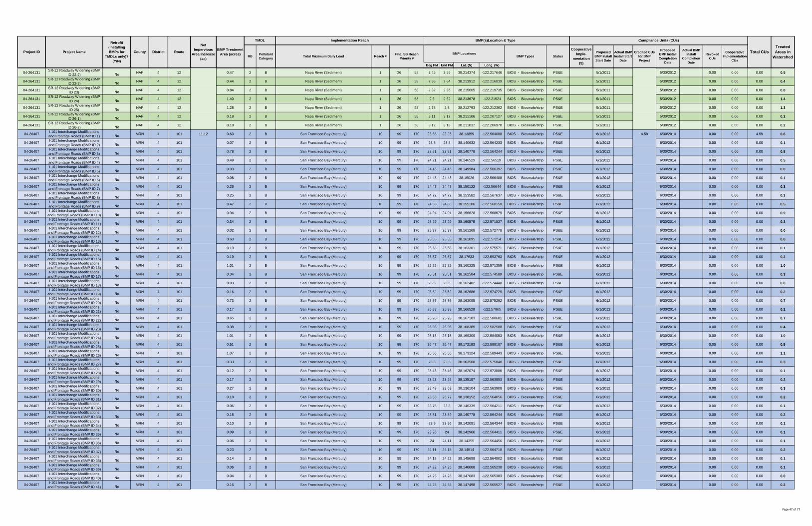
Beg PM End PM Lat. (N) Long. (W)
Revoked CUs
Total CUsTreated Areas in
WatershedRBPollutant Category
Total Maximum Daily Load Reach #Final SB Reach
Priority #
Compliance Units (CUs)
Cooperative Imple-
mentation ($)
Cooperative Implementation
CUs
Proposed BMP Install Start Date
Actual BMP Install Start
Date
Credited CUs for BMP Project
Proposed BMP Install Completion
Date
Actual BMP Install
Completion Date
Net Impervious
Area Increase (ac)
BMP Treatment Area (acres)
TMDL Implementation Reach BMP(s)Location & Type
BMP LocationsBMP Types Status
RouteProject ID Project Name
Retrofit (installing BMPs for
TMDLs only)? (Y/N)
County District
04-264131SR-12 Roadway Widening (BMP
ID 22-2) No NAP 4 12 0.47 2 B Napa River (Sediment) 1 26 58 2.45 2.55 38.214374 -122.217646 BIOS - Bioswale/strip PS&E 5/1/2011 5/30/2012 0.00 0.00 0.00 0.5
04-264131SR-12 Roadway Widening (BMP
ID 22-3) No NAP 4 12 0.44 2 B Napa River (Sediment) 1 26 58 2.55 2.64 38.213912 -122.216039 BIOS - Bioswale/strip PS&E 5/1/2011 5/30/2012 0.00 0.00 0.00 0.4
04-264131SR-12 Roadway Widening (BMP
ID 23) No NAP 4 12 0.84 2 B Napa River (Sediment) 1 26 58 2.32 2.35 38.215005 -122.219735 BIOS - Bioswale/strip PS&E 5/1/2011 5/30/2012 0.00 0.00 0.00 0.8
04-264131SR-12 Roadway Widening (BMP
ID 24) No NAP 4 12 1.40 2 B Napa River (Sediment) 1 26 58 2.6 2.62 38.213678 -122.21524 BIOS - Bioswale/strip PS&E 5/1/2011 5/30/2012 0.00 0.00 0.00 1.4
04-264131SR-12 Roadway Widening (BMP
ID 25) No NAP 4 12 1.28 2 B Napa River (Sediment) 1 26 58 2.78 2.8 38.212793 -122.212362 BIOS - Bioswale/strip PS&E 5/1/2011 5/30/2012 0.00 0.00 0.00 1.3
04-264131SR-12 Roadway Widening (BMP
ID 26-1) No NAP 4 12 0.18 2 B Napa River (Sediment) 1 26 58 3.11 3.12 38.211106 -122.207127 BIOS - Bioswale/strip PS&E 5/1/2011 5/30/2012 0.00 0.00 0.00 0.2
04-264131SR-12 Roadway Widening (BMP
ID 26-2) No NAP 4 12 0.18 2 B Napa River (Sediment) 1 26 58 3.12 3.13 38.211032 -122.206978 BIOS - Bioswale/strip PS&E 5/1/2011 5/30/2012 0.00 0.00 0.00 0.2
04-26407I-101 Interchange Modifications and Frontage Roads (BMP ID 1) No MRN 4 101 11.12 0.63 2 B San Francisco Bay (Mercury) 10 99 170 23.66 23.26 38.13859 -122.564088 BIOS - Bioswale/strip PS&E 6/1/2012 4.59 6/30/2014 0.00 0.00 4.59 0.6
04-26407I-101 Interchange Modifications and Frontage Roads (BMP ID 2) No MRN 4 101 0.07 2 B San Francisco Bay (Mercury) 10 99 170 23.8 23.8 38.140632 -122.564233 BIOS - Bioswale/strip PS&E 6/1/2012 6/30/2014 0.00 0.00 0.00 0.1
04-26407I-101 Interchange Modifications and Frontage Roads (BMP ID 3) No MRN 4 101 0.78 2 B San Francisco Bay (Mercury) 10 99 170 23.81 23.81 38.140778 -122.564244 BIOS - Bioswale/strip PS&E 6/1/2012 6/30/2014 0.00 0.00 0.00 0.8
04-26407I-101 Interchange Modifications and Frontage Roads (BMP ID 4) No MRN 4 101 0.49 2 B San Francisco Bay (Mercury) 10 99 170 24.21 24.21 38.146529 -122.56519 BIOS - Bioswale/strip PS&E 6/1/2012 6/30/2014 0.00 0.00 0.00 0.5
04-26407I-101 Interchange Modifications and Frontage Roads (BMP ID 5) No MRN 4 101 0.03 2 B San Francisco Bay (Mercury) 10 99 170 24.46 24.46 38.149984 -122.566392 BIOS - Bioswale/strip PS&E 6/1/2012 6/30/2014 0.00 0.00 0.00 0.0
04-26407I-101 Interchange Modifications and Frontage Roads (BMP ID 6) No MRN 4 101 0.06 2 B San Francisco Bay (Mercury) 10 99 170 24.48 24.48 38.15026 -122.566488 BIOS - Bioswale/strip PS&E 6/1/2012 6/30/2014 0.00 0.00 0.00 0.1
04-26407I-101 Interchange Modifications and Frontage Roads (BMP ID 7) No MRN 4 101 0.26 2 B San Francisco Bay (Mercury) 10 99 170 24.47 24.47 38.150122 -122.56644 BIOS - Bioswale/strip PS&E 6/1/2012 6/30/2014 0.00 0.00 0.00 0.3
04-26407I-101 Interchange Modifications and Frontage Roads (BMP ID 8) No MRN 4 101 0.25 2 B San Francisco Bay (Mercury) 10 99 170 24.72 24.72 38.153582 -122.567637 BIOS - Bioswale/strip PS&E 6/1/2012 6/30/2014 0.00 0.00 0.00 0.3
04-26407I-101 Interchange Modifications and Frontage Roads (BMP ID 9) No MRN 4 101 0.47 2 B San Francisco Bay (Mercury) 10 99 170 24.83 24.83 38.155106 -122.568158 BIOS - Bioswale/strip PS&E 6/1/2012 6/30/2014 0.00 0.00 0.00 0.5
04-26407I-101 Interchange Modifications
and Frontage Roads (BMP ID 10) No MRN 4 101 0.94 2 B San Francisco Bay (Mercury) 10 99 170 24.94 24.94 38.156628 -122.568679 BIOS - Bioswale/strip PS&E 6/1/2012 6/30/2014 0.00 0.00 0.00 0.9
04-26407I-101 Interchange Modifications
and Frontage Roads (BMP ID 11) No MRN 4 101 0.34 2 B San Francisco Bay (Mercury) 10 99 170 25.29 25.29 38.160575 -122.571827 BIOS - Bioswale/strip PS&E 6/1/2012 6/30/2014 0.00 0.00 0.00 0.3
04-26407I-101 Interchange Modifications
and Frontage Roads (BMP ID 12) No MRN 4 101 0.02 2 B San Francisco Bay (Mercury) 10 99 170 25.37 25.37 38.161268 -122.572778 BIOS - Bioswale/strip PS&E 6/1/2012 6/30/2014 0.00 0.00 0.00 0.0
04-26407I-101 Interchange Modifications
and Frontage Roads (BMP ID 13) No MRN 4 101 0.60 2 B San Francisco Bay (Mercury) 10 99 170 25.35 25.35 38.161095 -122.57254 BIOS - Bioswale/strip PS&E 6/1/2012 6/30/2014 0.00 0.00 0.00 0.6
04-26407I-101 Interchange Modifications
and Frontage Roads (BMP ID 14) No MRN 4 101 0.10 2 B San Francisco Bay (Mercury) 10 99 170 25.58 25.58 38.163301 -122.575571 BIOS - Bioswale/strip PS&E 6/1/2012 6/30/2014 0.00 0.00 0.00 0.1
04-26407I-101 Interchange Modifications
and Frontage Roads (BMP ID 15) No MRN 4 101 0.19 2 B San Francisco Bay (Mercury) 10 99 170 26.87 26.87 38.17633 -122.593763 BIOS - Bioswale/strip PS&E 6/1/2012 6/30/2014 0.00 0.00 0.00 0.2
04-26407I-101 Interchange Modifications
and Frontage Roads (BMP ID 16) No MRN 4 101 1.01 2 B San Francisco Bay (Mercury) 10 99 170 25.25 25.25 38.160225 -122.571359 BIOS - Bioswale/strip PS&E 6/1/2012 6/30/2014 0.00 0.00 0.00 1.0
04-26407I-101 Interchange Modifications
and Frontage Roads (BMP ID 17) No MRN 4 101 0.34 2 B San Francisco Bay (Mercury) 10 99 170 25.51 25.51 38.162584 -122.574589 BIOS - Bioswale/strip PS&E 6/1/2012 6/30/2014 0.00 0.00 0.00 0.3
04-26407I-101 Interchange Modifications
and Frontage Roads (BMP ID 18) No MRN 4 101 0.03 2 B San Francisco Bay (Mercury) 10 99 170 25.5 25.5 38.162482 -122.574448 BIOS - Bioswale/strip PS&E 6/1/2012 6/30/2014 0.00 0.00 0.00 0.0
04-26407I-101 Interchange Modifications
and Frontage Roads (BMP ID 19) No MRN 4 101 0.16 2 B San Francisco Bay (Mercury) 10 99 170 25.52 25.52 38.162686 -122.574729 BIOS - Bioswale/strip PS&E 6/1/2012 6/30/2014 0.00 0.00 0.00 0.2
04-26407I-101 Interchange Modifications
and Frontage Roads (BMP ID 20) No MRN 4 101 0.73 2 B San Francisco Bay (Mercury) 10 99 170 25.56 25.56 38.163095 -122.575292 BIOS - Bioswale/strip PS&E 6/1/2012 6/30/2014 0.00 0.00 0.00 0.7
04-26407I-101 Interchange Modifications
and Frontage Roads (BMP ID 21) No MRN 4 101 0.17 2 B San Francisco Bay (Mercury) 10 99 170 25.88 25.88 38.166529 -122.57965 BIOS - Bioswale/strip PS&E 6/1/2012 6/30/2014 0.00 0.00 0.00 0.2
04-26407I-101 Interchange Modifications
and Frontage Roads (BMP ID 22) No MRN 4 101 0.65 2 B San Francisco Bay (Mercury) 10 99 170 25.95 25.95 38.167183 -122.580681 BIOS - Bioswale/strip PS&E 6/1/2012 6/30/2014 0.00 0.00 0.00 0.7
04-26407I-101 Interchange Modifications
and Frontage Roads (BMP ID 23) No MRN 4 101 0.38 2 B San Francisco Bay (Mercury) 10 99 170 26.08 26.08 38.168385 -122.582588 BIOS - Bioswale/strip PS&E 6/1/2012 6/30/2014 0.00 0.00 0.00 0.4
04-26407I-101 Interchange Modifications
and Frontage Roads (BMP ID 24) No MRN 4 101 1.01 2 B San Francisco Bay (Mercury) 10 99 170 26.18 26.18 38.169309 -122.584053 BIOS - Bioswale/strip PS&E 6/1/2012 6/30/2014 0.00 0.00 0.00 1.0
04-26407I-101 Interchange Modifications
and Frontage Roads (BMP ID 25) No MRN 4 101 0.51 2 B San Francisco Bay (Mercury) 10 99 170 26.47 26.47 38.172193 -122.588187 BIOS - Bioswale/strip PS&E 6/1/2012 6/30/2014 0.00 0.00 0.00 0.5
04-26407I-101 Interchange Modifications
and Frontage Roads (BMP ID 26) No MRN 4 101 1.07 2 B San Francisco Bay (Mercury) 10 99 170 26.56 26.56 38.173124 -122.589443 BIOS - Bioswale/strip PS&E 6/1/2012 6/30/2014 0.00 0.00 0.00 1.1
04-26407I-101 Interchange Modifications
and Frontage Roads (BMP ID 27) No MRN 4 101 0.33 2 B San Francisco Bay (Mercury) 10 99 170 25.6 25.6 38.163508 -122.575848 BIOS - Bioswale/strip PS&E 6/1/2012 6/30/2014 0.00 0.00 0.00 0.3
04-26407I-101 Interchange Modifications
and Frontage Roads (BMP ID 28) No MRN 4 101 0.12 2 B San Francisco Bay (Mercury) 10 99 170 25.46 25.46 38.162074 -122.573886 BIOS - Bioswale/strip PS&E 6/1/2012 6/30/2014 0.00 0.00 0.00 0.1
04-26407I-101 Interchange Modifications
and Frontage Roads (BMP ID 29) No MRN 4 101 0.17 2 B San Francisco Bay (Mercury) 10 99 170 23.23 23.26 38.135197 -122.563853 BIOS - Bioswale/strip PS&E 6/1/2012 6/30/2014 0.00 0.00 0.00 0.2
04-26407I-101 Interchange Modifications
and Frontage Roads (BMP ID 30) No MRN 4 101 0.27 2 B San Francisco Bay (Mercury) 10 99 170 23.49 23.63 38.136104 -122.563908 BIOS - Bioswale/strip PS&E 6/1/2012 6/30/2014 0.00 0.00 0.00 0.3
04-26407I-101 Interchange Modifications
and Frontage Roads (BMP ID 31) No MRN 4 101 0.18 2 B San Francisco Bay (Mercury) 10 99 170 23.63 23.72 38.138152 -122.564056 BIOS - Bioswale/strip PS&E 6/1/2012 6/30/2014 0.00 0.00 0.00 0.2
04-26407I-101 Interchange Modifications
and Frontage Roads (BMP ID 32) No MRN 4 101 0.06 2 B San Francisco Bay (Mercury) 10 99 170 23.78 23.8 38.140339 -122.564211 BIOS - Bioswale/strip PS&E 6/1/2012 6/30/2014 0.00 0.00 0.00 0.1
04-26407I-101 Interchange Modifications
and Frontage Roads (BMP ID 33) No MRN 4 101 0.18 2 B San Francisco Bay (Mercury) 10 99 170 23.81 23.89 38.140778 -122.564244 BIOS - Bioswale/strip PS&E 6/1/2012 6/30/2014 0.00 0.00 0.00 0.2
04-26407I-101 Interchange Modifications
and Frontage Roads (BMP ID 34) No MRN 4 101 0.10 2 B San Francisco Bay (Mercury) 10 99 170 23.9 23.96 38.142091 -122.564344 BIOS - Bioswale/strip PS&E 6/1/2012 6/30/2014 0.00 0.00 0.00 0.1
04-26407I-101 Interchange Modifications
and Frontage Roads (BMP ID 35) No MRN 4 101 0.09 2 B San Francisco Bay (Mercury) 10 99 170 23.96 24 38.142966 -122.564411 BIOS - Bioswale/strip PS&E 6/1/2012 6/30/2014 0.00 0.00 0.00 0.1
04-26407I-101 Interchange Modifications
and Frontage Roads (BMP ID 36) No MRN 4 101 0.06 2 B San Francisco Bay (Mercury) 10 99 170 24 24.11 38.14355 -122.564456 BIOS - Bioswale/strip PS&E 6/1/2012 6/30/2014 0.00 0.00 0.00 0.1
04-26407I-101 Interchange Modifications
and Frontage Roads (BMP ID 37) No MRN 4 101 0.23 2 B San Francisco Bay (Mercury) 10 99 170 24.11 24.15 38.14514 -122.564718 BIOS - Bioswale/strip PS&E 6/1/2012 6/30/2014 0.00 0.00 0.00 0.2
04-26407I-101 Interchange Modifications
and Frontage Roads (BMP ID 38) No MRN 4 101 0.14 2 B San Francisco Bay (Mercury) 10 99 170 24.15 24.22 38.145698 -122.564902 BIOS - Bioswale/strip PS&E 6/1/2012 6/30/2014 0.00 0.00 0.00 0.1
04-26407I-101 Interchange Modifications
and Frontage Roads (BMP ID 39) No MRN 4 101 0.06 2 B San Francisco Bay (Mercury) 10 99 170 24.22 24.25 38.146668 -122.565238 BIOS - Bioswale/strip PS&E 6/1/2012 6/30/2014 0.00 0.00 0.00 0.1
04-26407I-101 Interchange Modifications
and Frontage Roads (BMP ID 40) No MRN 4 101 0.04 2 B San Francisco Bay (Mercury) 10 99 170 24.25 24.28 38.147083 -122.565383 BIOS - Bioswale/strip PS&E 6/1/2012 6/30/2014 0.00 0.00 0.00 0.0
04-26407I-101 Interchange Modifications
and Frontage Roads (BMP ID 41) No MRN 4 101 0.16 2 B San Francisco Bay (Mercury) 10 99 170 24.28 24.36 38.147498 -122.565527 BIOS - Bioswale/strip PS&E 6/1/2012 6/30/2014 0.00 0.00 0.00 0.2
Page 47 of 77

Beg PM End PM Lat. (N) Long. (W)
Revoked CUs
Total CUsTreated Areas in
WatershedRBPollutant Category
Total Maximum Daily Load Reach #Final SB Reach
Priority #
Compliance Units (CUs)
Cooperative Imple-
mentation ($)
Cooperative Implementation
CUs
Proposed BMP Install Start Date
Actual BMP Install Start
Date
Credited CUs for BMP Project
Proposed BMP Install Completion
Date
Actual BMP Install
Completion Date
Net Impervious
Area Increase (ac)
BMP Treatment Area (acres)
TMDL Implementation Reach BMP(s)Location & Type
BMP LocationsBMP Types Status
RouteProject ID Project Name
Retrofit (installing BMPs for
TMDLs only)? (Y/N)
County District
04-26407I-101 Interchange Modifications
and Frontage Roads (BMP ID 42) No MRN 4 101 0.26 2 B San Francisco Bay (Mercury) 10 99 170 24.49 24.72 38.150398 -122.566536 BIOS - Bioswale/strip PS&E 6/1/2012 6/30/2014 0.00 0.00 0.00 0.3
04-26407I-101 Interchange Modifications
and Frontage Roads (BMP ID 43) No MRN 4 101 0.11 2 B San Francisco Bay (Mercury) 10 99 170 24.72 24.82 38.153582 -122.567637 BIOS - Bioswale/strip PS&E 6/1/2012 6/30/2014 0.00 0.00 0.00 0.1
04-26407I-101 Interchange Modifications
and Frontage Roads (BMP ID 44) No MRN 4 101 0.09 2 B San Francisco Bay (Mercury) 10 99 170 24.82 24.9 38.154967 -122.568111 BIOS - Bioswale/strip PS&E 6/1/2012 6/30/2014 0.00 0.00 0.00 0.1
04-26407I-101 Interchange Modifications
and Frontage Roads (BMP ID 45) No MRN 4 101 0.45 2 B San Francisco Bay (Mercury) 10 99 170 26.84 26.96 38.176019 -122.593344 BIOS - Bioswale/strip PS&E 6/1/2012 6/30/2014 0.00 0.00 0.00 0.5
04-26407I-101 Interchange Modifications
and Frontage Roads (BMP ID 46) No MRN 4 101 0.14 2 B San Francisco Bay (Mercury) 10 99 170 25.19 25.21 38.159648 -122.570697 BIOS - Bioswale/strip PS&E 6/1/2012 6/30/2014 0.00 0.00 0.00 0.1
04-26407I-101 Interchange Modifications
and Frontage Roads (BMP ID 47) No MRN 4 101 0.39 2 B San Francisco Bay (Mercury) 10 99 170 25.21 25.29 38.159848 -122.570912 BIOS - Bioswale/strip PS&E 6/1/2012 6/30/2014 0.00 0.00 0.00 0.4
04-26407I-101 Interchange Modifications
and Frontage Roads (BMP ID 48) No MRN 4 101 0.24 2 B San Francisco Bay (Mercury) 10 99 170 25.45 25.55 38.161972 -122.573746 BIOS - Bioswale/strip PS&E 6/1/2012 6/30/2014 0.00 0.00 0.00 0.2
04-26407I-101 Interchange Modifications
and Frontage Roads (BMP ID 49) No MRN 4 101 0.25 2 B San Francisco Bay (Mercury) 10 99 170 25.55 25.64 38.162992 -122.575151 BIOS - Bioswale/strip PS&E 6/1/2012 6/30/2014 0.00 0.00 0.00 0.3
04-26407I-101 Interchange Modifications
and Frontage Roads (BMP ID 50) No MRN 4 101 0.30 2 B San Francisco Bay (Mercury) 10 99 170 25.61 25.62 38.163613 -122.575986 BIOS - Bioswale/strip PS&E 6/1/2012 6/30/2014 0.00 0.00 0.00 0.3
04-264131SR-12 Roadway Widening (BMP
ID 1) No NAP 4 12 13.52 0.86 2 B San Francisco Bay (Mercury) 6 109 184 0.04 0.24 38.223096 -122.257118 BIOS - Bioswale/strip PS&E 5/1/2011 5.72 5/30/2012 0.00 0.00 5.72 0.9
04-264131SR-12 Roadway Widening (BMP
ID 2) No NAP 4 12 0.31 2 B San Francisco Bay (Mercury) 6 109 184 0.29 0.37 38.2225 -122.252483 BIOS - Bioswale/strip PS&E 5/1/2011 5/30/2012 0.00 0.00 0.00 0.3
04-264131SR-12 Roadway Widening (BMP
ID 3) No NAP 4 12 0.27 2 B San Francisco Bay (Mercury) 6 109 184 0.47 0.53 38.222098 -122.249496 BIOS - Bioswale/strip PS&E 5/1/2011 5/30/2012 0.00 0.00 0.00 0.3
04-264131SR-12 Roadway Widening (BMP
ID 4) No NAP 4 12 0.82 2 B San Francisco Bay (Mercury) 6 109 184 0.5 0.53 38.222001 -122.249001 BIOS - Bioswale/strip PS&E 5/1/2011 5/30/2012 0.00 0.00 0.00 0.8
04-264131SR-12 Roadway Widening (BMP
ID 5) No NAP 4 12 1.67 2 B San Francisco Bay (Mercury) 6 109 184 0.55 0.56 38.221828 -122.248181 BIOS - Bioswale/strip PS&E 5/1/2011 5/30/2012 0.00 0.00 0.00 1.7
04-264131SR-12 Roadway Widening (BMP
ID 6) No NAP 4 12 1.39 2 B San Francisco Bay (Mercury) 6 109 184 0.72 0.75 38.221283 -122.245391 BIOS - Bioswale/strip PS&E 5/1/2011 5/30/2012 0.00 0.00 0.00 1.4
04-264131SR-12 Roadway Widening (BMP
ID 7) No NAP 4 12 0.03 2 B San Francisco Bay (Mercury) 6 109 184 0.83 0.86 38.221256 -122.243553 BIOS - Bioswale/strip PS&E 5/1/2011 5/30/2012 0.00 0.00 0.00 0.0
04-264131SR-12 Roadway Widening (BMP
ID 7-1) No NAP 4 12 0.17 2 B San Francisco Bay (Mercury) 6 109 184 0.87 0.94 38.22128 -122.242888 BIOS - Bioswale/strip PS&E 5/1/2011 5/30/2012 0.00 0.00 0.00 0.2
04-264131SR-12 Roadway Widening (BMP
ID 8) No NAP 4 12 0.56 2 B San Francisco Bay (Mercury) 6 109 184 0.94 0.96 38.221324 -122.241723 BIOS - Bioswale/strip PS&E 5/1/2011 5/30/2012 0.00 0.00 0.00 0.6
04-264131SR-12 Roadway Widening (BMP
ID 9) No NAP 4 12 0.39 2 B San Francisco Bay (Mercury) 6 109 184 0.96 0.99 38.221336 -122.24139 BIOS - Bioswale/strip PS&E 5/1/2011 5/30/2012 0.00 0.00 0.00 0.4
04-264131SR-12 Roadway Widening (BMP
ID 10) No NAP 4 12 1.00 2 B San Francisco Bay (Mercury) 6 109 184 1.05 1.22 38.221409 -122.23988 BIOS - Bioswale/strip PS&E 5/1/2011 5/30/2012 0.00 0.00 0.00 1.0
04-264131SR-12 Roadway Widening (BMP
ID 11) No NAP 4 12 1.14 2 B San Francisco Bay (Mercury) 6 109 184 1.24 1.26 38.221043 -122.236756 BIOS - Bioswale/strip PS&E 5/1/2011 5/30/2012 0.00 0.00 0.00 1.1
04-264131SR-12 Roadway Widening (BMP
ID 12) No NAP 4 12 0.40 2 B San Francisco Bay (Mercury) 6 109 184 1.26 1.31 38.220934 -122.236439 BIOS - Bioswale/strip PS&E 5/1/2011 5/30/2012 0.00 0.00 0.00 0.4
04-264131SR-12 Roadway Widening (BMP
ID 13) No NAP 4 12 0.60 2 B San Francisco Bay (Mercury) 6 109 184 1.33 1.43 38.220553 -122.235329 BIOS - Bioswale/strip PS&E 5/1/2011 5/30/2012 0.00 0.00 0.00 0.6
04-264131SR-12 Roadway Widening (BMP
ID 14) No NAP 4 12 0.40 2 B San Francisco Bay (Mercury) 6 109 184 1.39 1.45 38.220212 -122.234385 BIOS - Bioswale/strip PS&E 5/1/2011 5/30/2012 0.00 0.00 0.00 0.4
04-264131SR-12 Roadway Widening (BMP
ID 15) No NAP 4 12 0.26 2 B San Francisco Bay (Mercury) 6 109 184 1.53 1.58 38.219418 -122.232179 BIOS - Bioswale/strip PS&E 5/1/2011 5/30/2012 0.00 0.00 0.00 0.3
04-264131SR-12 Roadway Widening (BMP
ID 16) No NAP 4 12 0.43 2 B San Francisco Bay (Mercury) 6 109 184 1.6 1.69 38.21903 -122.231074 BIOS - Bioswale/strip PS&E 5/1/2011 5/30/2012 0.00 0.00 0.00 0.4
04-264131SR-12 Roadway Widening (BMP
ID 17) No NAP 4 12 0.27 2 B San Francisco Bay (Mercury) 6 109 184 1.79 1.85 38.217969 -122.228086 BIOS - Bioswale/strip PS&E 5/1/2011 5/30/2012 0.00 0.00 0.00 0.3
04-264131SR-12 Roadway Widening (BMP
ID 18) No NAP 4 12 0.54 2 B San Francisco Bay (Mercury) 6 109 184 1.91 2.02 38.217295 -122.226195 BIOS - Bioswale/strip PS&E 5/1/2011 5/30/2012 0.00 0.00 0.00 0.5
04-264131SR-12 Roadway Widening (BMP
ID 19) No NAP 4 12 0.94 2 B San Francisco Bay (Mercury) 6 109 184 1.93 1.98 38.217182 -122.22588 BIOS - Bioswale/strip PS&E 5/1/2011 5/30/2012 0.00 0.00 0.00 0.9
04-264131SR-12 Roadway Widening (BMP
ID 20) No NAP 4 12 1.07 2 B San Francisco Bay (Mercury) 6 109 184 2.06 2.11 38.216452 -122.22383 BIOS - Bioswale/strip PS&E 5/1/2011 5/30/2012 0.00 0.00 0.00 1.1
04-264131SR-12 Roadway Widening (BMP
ID 21) No NAP 4 12 0.28 2 B San Francisco Bay (Mercury) 6 109 184 2.21 2.27 38.215612 -122.221461 BIOS - Bioswale/strip PS&E 5/1/2011 5/30/2012 0.00 0.00 0.00 0.3
04-264131SR-12 Roadway Widening (BMP
ID 22-1) No NAP 4 12 0.65 2 B San Francisco Bay (Mercury) 6 109 184 2.31 2.45 38.215054 -122.219895 BIOS - Bioswale/strip PS&E 5/1/2011 5/30/2012 0.00 0.00 0.00 0.7
04-264131SR-12 Roadway Widening (BMP
ID 22-2) No NAP 4 12 0.47 2 B San Francisco Bay (Mercury) 6 109 184 2.45 2.55 38.214374 -122.217646 BIOS - Bioswale/strip PS&E 5/1/2011 5/30/2012 0.00 0.00 0.00 0.5
04-264131SR-12 Roadway Widening (BMP
ID 22-3) No NAP 4 12 0.44 2 B San Francisco Bay (Mercury) 6 109 184 2.55 2.64 38.213912 -122.216039 BIOS - Bioswale/strip PS&E 5/1/2011 5/30/2012 0.00 0.00 0.00 0.4
04-264131SR-12 Roadway Widening (BMP
ID 23) No NAP 4 12 0.84 2 B San Francisco Bay (Mercury) 6 109 184 2.32 2.35 38.215005 -122.219735 BIOS - Bioswale/strip PS&E 5/1/2011 5/30/2012 0.00 0.00 0.00 0.8
04-264131SR-12 Roadway Widening (BMP
ID 24) No NAP 4 12 1.40 2 B San Francisco Bay (Mercury) 6 109 184 2.6 2.62 38.213678 -122.21524 BIOS - Bioswale/strip PS&E 5/1/2011 5/30/2012 0.00 0.00 0.00 1.4
04-264131SR-12 Roadway Widening (BMP
ID 25) No NAP 4 12 1.28 2 B San Francisco Bay (Mercury) 6 109 184 2.78 2.8 38.212793 -122.212362 BIOS - Bioswale/strip PS&E 5/1/2011 5/30/2012 0.00 0.00 0.00 1.3
04-264131SR-12 Roadway Widening (BMP
ID 26-1) No NAP 4 12 0.18 2 B San Francisco Bay (Mercury) 6 109 184 3.11 3.12 38.211106 -122.207127 BIOS - Bioswale/strip PS&E 5/1/2011 5/30/2012 0.00 0.00 0.00 0.2
04-264131SR-12 Roadway Widening (BMP
ID 26-2) No NAP 4 12 0.18 2 B San Francisco Bay (Mercury) 6 109 184 3.12 3.13 38.211032 -122.206978 BIOS - Bioswale/strip PS&E 5/1/2011 5/30/2012 0.00 0.00 0.00 0.2
04-1A9801I-101 Highway Improvements
(BMP ID 1) No SCL 4 101 1.50 1.92 2 B San Francisco Bay (Mercury) 1 96 168 33 33 37.318135 -121.83123 BIOS - Bioswale/strip PS&E 3/1/2010 22.71 12/21/2012 0.00 0.00 22.71 1.9
04-1A9801I-101 Highway Improvements
(BMP ID 2) No SCL 4 101 1.54 2 B San Francisco Bay (Mercury) 1 96 168 33 33 37.318135 -121.83123 BIOS - Bioswale/strip PS&E 3/1/2010 12/21/2012 0.00 0.00 0.00 1.5
04-1A9801I-101 Highway Improvements
(BMP ID 3) No SCL 4 101 3.06 2 B San Francisco Bay (Mercury) 1 96 168 33 33 37.318135 -121.83123 BIOS - Bioswale/strip PS&E 3/1/2010 12/21/2012 0.00 0.00 0.00 3.1
04-1A9801I-101 Highway Improvements
(BMP ID 4) No SCL 4 101 0.93 2 B San Francisco Bay (Mercury) 1 96 168 33 33 37.318135 -121.83123 BIOS - Bioswale/strip PS&E 3/1/2010 12/21/2012 0.00 0.00 0.00 0.9
04-1A9801I-101 Highway Improvements
(BMP ID 5) No SCL 4 101 7.17 2 B San Francisco Bay (Mercury) 1 96 168 34 34 37.329664 -121.842239 BIOS - Bioswale/strip PS&E 3/1/2010 12/21/2012 0.00 0.00 0.00 7.2
04-1A9801I-101 Highway Improvements
(BMP ID 6) No SCL 4 101 1.59 2 B San Francisco Bay (Mercury) 1 96 168 32 32.1 37.30664 -121.820119 BIOS - Bioswale/strip PS&E 3/1/2010 12/21/2012 0.00 0.00 0.00 1.6
04-1A9801I-101 Highway Improvements
(BMP ID 7) No SCL 4 101 0.88 2 B San Francisco Bay (Mercury) 1 96 168 32.2 32.2 37.308932 -121.822354 BIOS - Bioswale/strip PS&E 3/1/2010 12/21/2012 0.00 0.00 0.00 0.9
04-1A9801I-101 Highway Improvements
(BMP ID 8) No SCL 4 101 2.36 2 B San Francisco Bay (Mercury) 1 96 168 32.4 32.4 37.311242 -121.824563 BIOS - Bioswale/strip PS&E 3/1/2010 12/21/2012 0.00 0.00 0.00 2.4
04-1A9801I-101 Highway Improvements
(BMP ID 9) No SCL 4 101 2.09 2 B San Francisco Bay (Mercury) 1 96 168 32.5 32.5 37.31239 -121.825676 BIOS - Bioswale/strip PS&E 3/1/2010 12/21/2012 0.00 0.00 0.00 2.1
Page 48 of 77
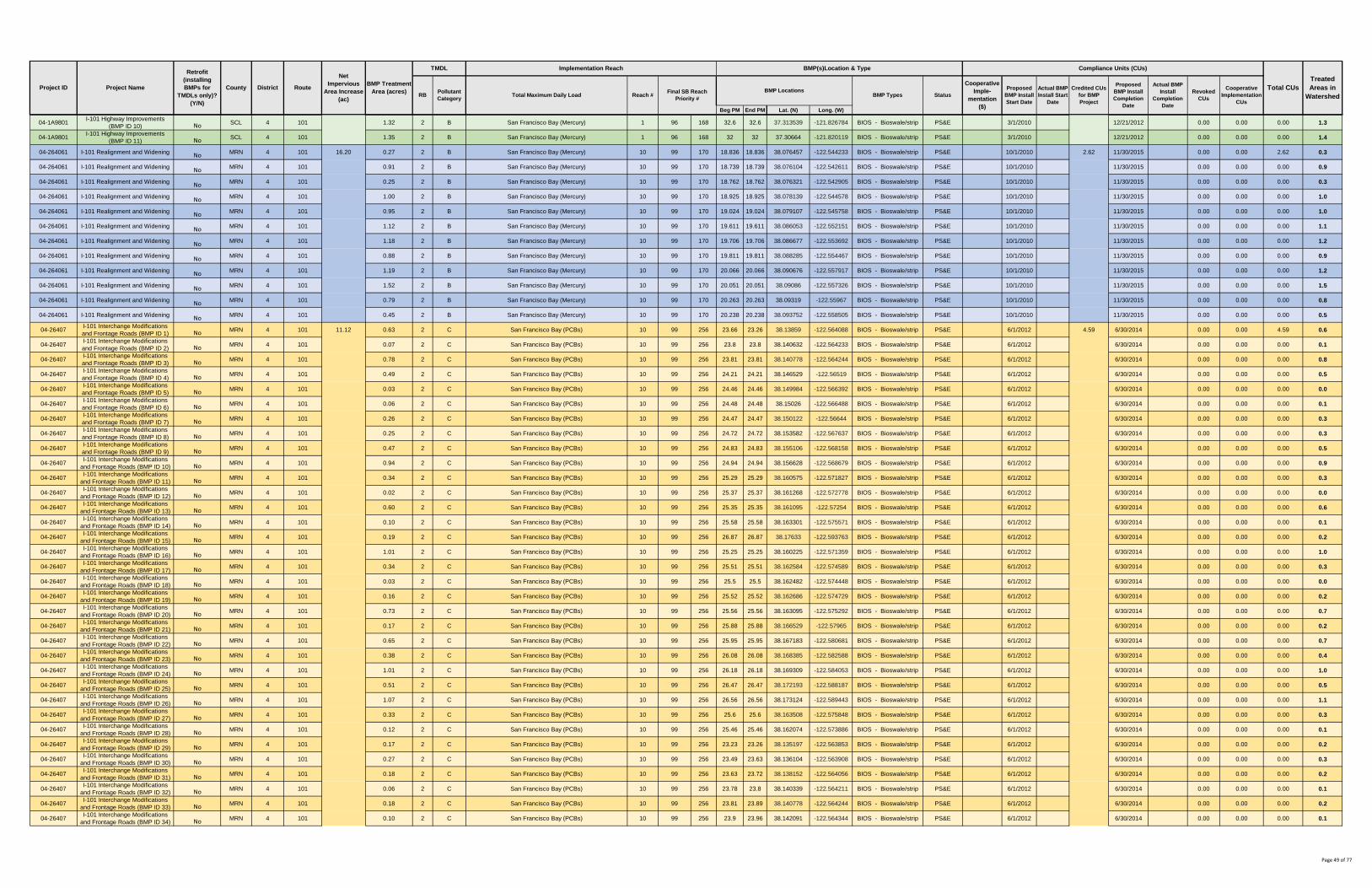
Beg PM End PM Lat. (N) Long. (W)
Revoked CUs
Total CUsTreated Areas in
WatershedRBPollutant Category
Total Maximum Daily Load Reach #Final SB Reach
Priority #
Compliance Units (CUs)
Cooperative Imple-
mentation ($)
Cooperative Implementation
CUs
Proposed BMP Install Start Date
Actual BMP Install Start
Date
Credited CUs for BMP Project
Proposed BMP Install Completion
Date
Actual BMP Install
Completion Date
Net Impervious
Area Increase (ac)
BMP Treatment Area (acres)
TMDL Implementation Reach BMP(s)Location & Type
BMP LocationsBMP Types Status
RouteProject ID Project Name
Retrofit (installing BMPs for
TMDLs only)? (Y/N)
County District
04-1A9801I-101 Highway Improvements
(BMP ID 10) No SCL 4 101 1.32 2 B San Francisco Bay (Mercury) 1 96 168 32.6 32.6 37.313539 -121.826784 BIOS - Bioswale/strip PS&E 3/1/2010 12/21/2012 0.00 0.00 0.00 1.3
04-1A9801I-101 Highway Improvements
(BMP ID 11) No SCL 4 101 1.35 2 B San Francisco Bay (Mercury) 1 96 168 32 32 37.30664 -121.820119 BIOS - Bioswale/strip PS&E 3/1/2010 12/21/2012 0.00 0.00 0.00 1.4
04-264061 I-101 Realignment and Widening No MRN 4 101 16.20 0.27 2 B San Francisco Bay (Mercury) 10 99 170 18.836 18.836 38.076457 -122.544233 BIOS - Bioswale/strip PS&E 10/1/2010 2.62 11/30/2015 0.00 0.00 2.62 0.3
04-264061 I-101 Realignment and Widening No MRN 4 101 0.91 2 B San Francisco Bay (Mercury) 10 99 170 18.739 18.739 38.076104 -122.542611 BIOS - Bioswale/strip PS&E 10/1/2010 11/30/2015 0.00 0.00 0.00 0.9
04-264061 I-101 Realignment and Widening No MRN 4 101 0.25 2 B San Francisco Bay (Mercury) 10 99 170 18.762 18.762 38.076321 -122.542905 BIOS - Bioswale/strip PS&E 10/1/2010 11/30/2015 0.00 0.00 0.00 0.3
04-264061 I-101 Realignment and Widening No MRN 4 101 1.00 2 B San Francisco Bay (Mercury) 10 99 170 18.925 18.925 38.078139 -122.544578 BIOS - Bioswale/strip PS&E 10/1/2010 11/30/2015 0.00 0.00 0.00 1.0
04-264061 I-101 Realignment and Widening No MRN 4 101 0.95 2 B San Francisco Bay (Mercury) 10 99 170 19.024 19.024 38.079107 -122.545758 BIOS - Bioswale/strip PS&E 10/1/2010 11/30/2015 0.00 0.00 0.00 1.0
04-264061 I-101 Realignment and Widening No MRN 4 101 1.12 2 B San Francisco Bay (Mercury) 10 99 170 19.611 19.611 38.086053 -122.552151 BIOS - Bioswale/strip PS&E 10/1/2010 11/30/2015 0.00 0.00 0.00 1.1
04-264061 I-101 Realignment and Widening No MRN 4 101 1.18 2 B San Francisco Bay (Mercury) 10 99 170 19.706 19.706 38.086677 -122.553692 BIOS - Bioswale/strip PS&E 10/1/2010 11/30/2015 0.00 0.00 0.00 1.2
04-264061 I-101 Realignment and Widening No MRN 4 101 0.88 2 B San Francisco Bay (Mercury) 10 99 170 19.811 19.811 38.088285 -122.554467 BIOS - Bioswale/strip PS&E 10/1/2010 11/30/2015 0.00 0.00 0.00 0.9
04-264061 I-101 Realignment and Widening No MRN 4 101 1.19 2 B San Francisco Bay (Mercury) 10 99 170 20.066 20.066 38.090676 -122.557917 BIOS - Bioswale/strip PS&E 10/1/2010 11/30/2015 0.00 0.00 0.00 1.2
04-264061 I-101 Realignment and Widening No MRN 4 101 1.52 2 B San Francisco Bay (Mercury) 10 99 170 20.051 20.051 38.09086 -122.557326 BIOS - Bioswale/strip PS&E 10/1/2010 11/30/2015 0.00 0.00 0.00 1.5
04-264061 I-101 Realignment and Widening No MRN 4 101 0.79 2 B San Francisco Bay (Mercury) 10 99 170 20.263 20.263 38.09319 -122.55967 BIOS - Bioswale/strip PS&E 10/1/2010 11/30/2015 0.00 0.00 0.00 0.8
04-264061 I-101 Realignment and Widening No MRN 4 101 0.45 2 B San Francisco Bay (Mercury) 10 99 170 20.238 20.238 38.093752 -122.558505 BIOS - Bioswale/strip PS&E 10/1/2010 11/30/2015 0.00 0.00 0.00 0.5
04-26407I-101 Interchange Modifications and Frontage Roads (BMP ID 1) No MRN 4 101 11.12 0.63 2 C San Francisco Bay (PCBs) 10 99 256 23.66 23.26 38.13859 -122.564088 BIOS - Bioswale/strip PS&E 6/1/2012 4.59 6/30/2014 0.00 0.00 4.59 0.6
04-26407I-101 Interchange Modifications and Frontage Roads (BMP ID 2) No MRN 4 101 0.07 2 C San Francisco Bay (PCBs) 10 99 256 23.8 23.8 38.140632 -122.564233 BIOS - Bioswale/strip PS&E 6/1/2012 6/30/2014 0.00 0.00 0.00 0.1
04-26407I-101 Interchange Modifications and Frontage Roads (BMP ID 3) No MRN 4 101 0.78 2 C San Francisco Bay (PCBs) 10 99 256 23.81 23.81 38.140778 -122.564244 BIOS - Bioswale/strip PS&E 6/1/2012 6/30/2014 0.00 0.00 0.00 0.8
04-26407I-101 Interchange Modifications and Frontage Roads (BMP ID 4) No MRN 4 101 0.49 2 C San Francisco Bay (PCBs) 10 99 256 24.21 24.21 38.146529 -122.56519 BIOS - Bioswale/strip PS&E 6/1/2012 6/30/2014 0.00 0.00 0.00 0.5
04-26407I-101 Interchange Modifications and Frontage Roads (BMP ID 5) No MRN 4 101 0.03 2 C San Francisco Bay (PCBs) 10 99 256 24.46 24.46 38.149984 -122.566392 BIOS - Bioswale/strip PS&E 6/1/2012 6/30/2014 0.00 0.00 0.00 0.0
04-26407I-101 Interchange Modifications and Frontage Roads (BMP ID 6) No MRN 4 101 0.06 2 C San Francisco Bay (PCBs) 10 99 256 24.48 24.48 38.15026 -122.566488 BIOS - Bioswale/strip PS&E 6/1/2012 6/30/2014 0.00 0.00 0.00 0.1
04-26407I-101 Interchange Modifications and Frontage Roads (BMP ID 7) No MRN 4 101 0.26 2 C San Francisco Bay (PCBs) 10 99 256 24.47 24.47 38.150122 -122.56644 BIOS - Bioswale/strip PS&E 6/1/2012 6/30/2014 0.00 0.00 0.00 0.3
04-26407I-101 Interchange Modifications and Frontage Roads (BMP ID 8) No MRN 4 101 0.25 2 C San Francisco Bay (PCBs) 10 99 256 24.72 24.72 38.153582 -122.567637 BIOS - Bioswale/strip PS&E 6/1/2012 6/30/2014 0.00 0.00 0.00 0.3
04-26407I-101 Interchange Modifications and Frontage Roads (BMP ID 9) No MRN 4 101 0.47 2 C San Francisco Bay (PCBs) 10 99 256 24.83 24.83 38.155106 -122.568158 BIOS - Bioswale/strip PS&E 6/1/2012 6/30/2014 0.00 0.00 0.00 0.5
04-26407I-101 Interchange Modifications
and Frontage Roads (BMP ID 10) No MRN 4 101 0.94 2 C San Francisco Bay (PCBs) 10 99 256 24.94 24.94 38.156628 -122.568679 BIOS - Bioswale/strip PS&E 6/1/2012 6/30/2014 0.00 0.00 0.00 0.9
04-26407I-101 Interchange Modifications
and Frontage Roads (BMP ID 11) No MRN 4 101 0.34 2 C San Francisco Bay (PCBs) 10 99 256 25.29 25.29 38.160575 -122.571827 BIOS - Bioswale/strip PS&E 6/1/2012 6/30/2014 0.00 0.00 0.00 0.3
04-26407I-101 Interchange Modifications
and Frontage Roads (BMP ID 12) No MRN 4 101 0.02 2 C San Francisco Bay (PCBs) 10 99 256 25.37 25.37 38.161268 -122.572778 BIOS - Bioswale/strip PS&E 6/1/2012 6/30/2014 0.00 0.00 0.00 0.0
04-26407I-101 Interchange Modifications
and Frontage Roads (BMP ID 13) No MRN 4 101 0.60 2 C San Francisco Bay (PCBs) 10 99 256 25.35 25.35 38.161095 -122.57254 BIOS - Bioswale/strip PS&E 6/1/2012 6/30/2014 0.00 0.00 0.00 0.6
04-26407I-101 Interchange Modifications
and Frontage Roads (BMP ID 14) No MRN 4 101 0.10 2 C San Francisco Bay (PCBs) 10 99 256 25.58 25.58 38.163301 -122.575571 BIOS - Bioswale/strip PS&E 6/1/2012 6/30/2014 0.00 0.00 0.00 0.1
04-26407I-101 Interchange Modifications
and Frontage Roads (BMP ID 15) No MRN 4 101 0.19 2 C San Francisco Bay (PCBs) 10 99 256 26.87 26.87 38.17633 -122.593763 BIOS - Bioswale/strip PS&E 6/1/2012 6/30/2014 0.00 0.00 0.00 0.2
04-26407I-101 Interchange Modifications
and Frontage Roads (BMP ID 16) No MRN 4 101 1.01 2 C San Francisco Bay (PCBs) 10 99 256 25.25 25.25 38.160225 -122.571359 BIOS - Bioswale/strip PS&E 6/1/2012 6/30/2014 0.00 0.00 0.00 1.0
04-26407I-101 Interchange Modifications
and Frontage Roads (BMP ID 17) No MRN 4 101 0.34 2 C San Francisco Bay (PCBs) 10 99 256 25.51 25.51 38.162584 -122.574589 BIOS - Bioswale/strip PS&E 6/1/2012 6/30/2014 0.00 0.00 0.00 0.3
04-26407I-101 Interchange Modifications
and Frontage Roads (BMP ID 18) No MRN 4 101 0.03 2 C San Francisco Bay (PCBs) 10 99 256 25.5 25.5 38.162482 -122.574448 BIOS - Bioswale/strip PS&E 6/1/2012 6/30/2014 0.00 0.00 0.00 0.0
04-26407I-101 Interchange Modifications
and Frontage Roads (BMP ID 19) No MRN 4 101 0.16 2 C San Francisco Bay (PCBs) 10 99 256 25.52 25.52 38.162686 -122.574729 BIOS - Bioswale/strip PS&E 6/1/2012 6/30/2014 0.00 0.00 0.00 0.2
04-26407I-101 Interchange Modifications
and Frontage Roads (BMP ID 20) No MRN 4 101 0.73 2 C San Francisco Bay (PCBs) 10 99 256 25.56 25.56 38.163095 -122.575292 BIOS - Bioswale/strip PS&E 6/1/2012 6/30/2014 0.00 0.00 0.00 0.7
04-26407I-101 Interchange Modifications
and Frontage Roads (BMP ID 21) No MRN 4 101 0.17 2 C San Francisco Bay (PCBs) 10 99 256 25.88 25.88 38.166529 -122.57965 BIOS - Bioswale/strip PS&E 6/1/2012 6/30/2014 0.00 0.00 0.00 0.2
04-26407I-101 Interchange Modifications
and Frontage Roads (BMP ID 22) No MRN 4 101 0.65 2 C San Francisco Bay (PCBs) 10 99 256 25.95 25.95 38.167183 -122.580681 BIOS - Bioswale/strip PS&E 6/1/2012 6/30/2014 0.00 0.00 0.00 0.7
04-26407I-101 Interchange Modifications
and Frontage Roads (BMP ID 23) No MRN 4 101 0.38 2 C San Francisco Bay (PCBs) 10 99 256 26.08 26.08 38.168385 -122.582588 BIOS - Bioswale/strip PS&E 6/1/2012 6/30/2014 0.00 0.00 0.00 0.4
04-26407I-101 Interchange Modifications
and Frontage Roads (BMP ID 24) No MRN 4 101 1.01 2 C San Francisco Bay (PCBs) 10 99 256 26.18 26.18 38.169309 -122.584053 BIOS - Bioswale/strip PS&E 6/1/2012 6/30/2014 0.00 0.00 0.00 1.0
04-26407I-101 Interchange Modifications
and Frontage Roads (BMP ID 25) No MRN 4 101 0.51 2 C San Francisco Bay (PCBs) 10 99 256 26.47 26.47 38.172193 -122.588187 BIOS - Bioswale/strip PS&E 6/1/2012 6/30/2014 0.00 0.00 0.00 0.5
04-26407I-101 Interchange Modifications
and Frontage Roads (BMP ID 26) No MRN 4 101 1.07 2 C San Francisco Bay (PCBs) 10 99 256 26.56 26.56 38.173124 -122.589443 BIOS - Bioswale/strip PS&E 6/1/2012 6/30/2014 0.00 0.00 0.00 1.1
04-26407I-101 Interchange Modifications
and Frontage Roads (BMP ID 27) No MRN 4 101 0.33 2 C San Francisco Bay (PCBs) 10 99 256 25.6 25.6 38.163508 -122.575848 BIOS - Bioswale/strip PS&E 6/1/2012 6/30/2014 0.00 0.00 0.00 0.3
04-26407I-101 Interchange Modifications
and Frontage Roads (BMP ID 28) No MRN 4 101 0.12 2 C San Francisco Bay (PCBs) 10 99 256 25.46 25.46 38.162074 -122.573886 BIOS - Bioswale/strip PS&E 6/1/2012 6/30/2014 0.00 0.00 0.00 0.1
04-26407I-101 Interchange Modifications
and Frontage Roads (BMP ID 29) No MRN 4 101 0.17 2 C San Francisco Bay (PCBs) 10 99 256 23.23 23.26 38.135197 -122.563853 BIOS - Bioswale/strip PS&E 6/1/2012 6/30/2014 0.00 0.00 0.00 0.2
04-26407I-101 Interchange Modifications
and Frontage Roads (BMP ID 30) No MRN 4 101 0.27 2 C San Francisco Bay (PCBs) 10 99 256 23.49 23.63 38.136104 -122.563908 BIOS - Bioswale/strip PS&E 6/1/2012 6/30/2014 0.00 0.00 0.00 0.3
04-26407I-101 Interchange Modifications
and Frontage Roads (BMP ID 31) No MRN 4 101 0.18 2 C San Francisco Bay (PCBs) 10 99 256 23.63 23.72 38.138152 -122.564056 BIOS - Bioswale/strip PS&E 6/1/2012 6/30/2014 0.00 0.00 0.00 0.2
04-26407I-101 Interchange Modifications
and Frontage Roads (BMP ID 32) No MRN 4 101 0.06 2 C San Francisco Bay (PCBs) 10 99 256 23.78 23.8 38.140339 -122.564211 BIOS - Bioswale/strip PS&E 6/1/2012 6/30/2014 0.00 0.00 0.00 0.1
04-26407I-101 Interchange Modifications
and Frontage Roads (BMP ID 33) No MRN 4 101 0.18 2 C San Francisco Bay (PCBs) 10 99 256 23.81 23.89 38.140778 -122.564244 BIOS - Bioswale/strip PS&E 6/1/2012 6/30/2014 0.00 0.00 0.00 0.2
04-26407I-101 Interchange Modifications
and Frontage Roads (BMP ID 34) No MRN 4 101 0.10 2 C San Francisco Bay (PCBs) 10 99 256 23.9 23.96 38.142091 -122.564344 BIOS - Bioswale/strip PS&E 6/1/2012 6/30/2014 0.00 0.00 0.00 0.1
Page 49 of 77
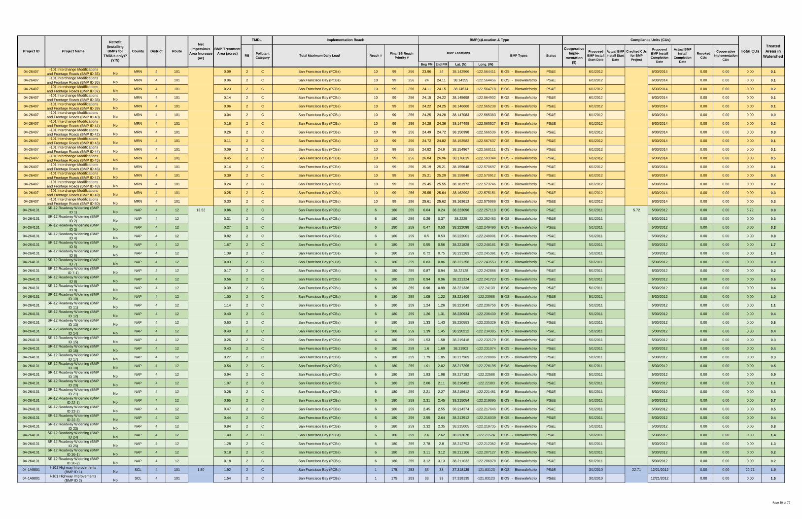
Beg PM End PM Lat. (N) Long. (W)
Revoked CUs
Total CUsTreated Areas in
WatershedRBPollutant Category
Total Maximum Daily Load Reach #Final SB Reach
Priority #
Compliance Units (CUs)
Cooperative Imple-
mentation ($)
Cooperative Implementation
CUs
Proposed BMP Install Start Date
Actual BMP Install Start
Date
Credited CUs for BMP Project
Proposed BMP Install Completion
Date
Actual BMP Install
Completion Date
Net Impervious
Area Increase (ac)
BMP Treatment Area (acres)
TMDL Implementation Reach BMP(s)Location & Type
BMP LocationsBMP Types Status
RouteProject ID Project Name
Retrofit (installing BMPs for
TMDLs only)? (Y/N)
County District
04-26407I-101 Interchange Modifications
and Frontage Roads (BMP ID 35) No MRN 4 101 0.09 2 C San Francisco Bay (PCBs) 10 99 256 23.96 24 38.142966 -122.564411 BIOS - Bioswale/strip PS&E 6/1/2012 6/30/2014 0.00 0.00 0.00 0.1
04-26407I-101 Interchange Modifications
and Frontage Roads (BMP ID 36) No MRN 4 101 0.06 2 C San Francisco Bay (PCBs) 10 99 256 24 24.11 38.14355 -122.564456 BIOS - Bioswale/strip PS&E 6/1/2012 6/30/2014 0.00 0.00 0.00 0.1
04-26407I-101 Interchange Modifications
and Frontage Roads (BMP ID 37) No MRN 4 101 0.23 2 C San Francisco Bay (PCBs) 10 99 256 24.11 24.15 38.14514 -122.564718 BIOS - Bioswale/strip PS&E 6/1/2012 6/30/2014 0.00 0.00 0.00 0.2
04-26407I-101 Interchange Modifications
and Frontage Roads (BMP ID 38) No MRN 4 101 0.14 2 C San Francisco Bay (PCBs) 10 99 256 24.15 24.22 38.145698 -122.564902 BIOS - Bioswale/strip PS&E 6/1/2012 6/30/2014 0.00 0.00 0.00 0.1
04-26407I-101 Interchange Modifications
and Frontage Roads (BMP ID 39) No MRN 4 101 0.06 2 C San Francisco Bay (PCBs) 10 99 256 24.22 24.25 38.146668 -122.565238 BIOS - Bioswale/strip PS&E 6/1/2012 6/30/2014 0.00 0.00 0.00 0.1
04-26407I-101 Interchange Modifications
and Frontage Roads (BMP ID 40) No MRN 4 101 0.04 2 C San Francisco Bay (PCBs) 10 99 256 24.25 24.28 38.147083 -122.565383 BIOS - Bioswale/strip PS&E 6/1/2012 6/30/2014 0.00 0.00 0.00 0.0
04-26407I-101 Interchange Modifications
and Frontage Roads (BMP ID 41) No MRN 4 101 0.16 2 C San Francisco Bay (PCBs) 10 99 256 24.28 24.36 38.147498 -122.565527 BIOS - Bioswale/strip PS&E 6/1/2012 6/30/2014 0.00 0.00 0.00 0.2
04-26407I-101 Interchange Modifications
and Frontage Roads (BMP ID 42) No MRN 4 101 0.26 2 C San Francisco Bay (PCBs) 10 99 256 24.49 24.72 38.150398 -122.566536 BIOS - Bioswale/strip PS&E 6/1/2012 6/30/2014 0.00 0.00 0.00 0.3
04-26407I-101 Interchange Modifications
and Frontage Roads (BMP ID 43) No MRN 4 101 0.11 2 C San Francisco Bay (PCBs) 10 99 256 24.72 24.82 38.153582 -122.567637 BIOS - Bioswale/strip PS&E 6/1/2012 6/30/2014 0.00 0.00 0.00 0.1
04-26407I-101 Interchange Modifications
and Frontage Roads (BMP ID 44) No MRN 4 101 0.09 2 C San Francisco Bay (PCBs) 10 99 256 24.82 24.9 38.154967 -122.568111 BIOS - Bioswale/strip PS&E 6/1/2012 6/30/2014 0.00 0.00 0.00 0.1
04-26407I-101 Interchange Modifications
and Frontage Roads (BMP ID 45) No MRN 4 101 0.45 2 C San Francisco Bay (PCBs) 10 99 256 26.84 26.96 38.176019 -122.593344 BIOS - Bioswale/strip PS&E 6/1/2012 6/30/2014 0.00 0.00 0.00 0.5
04-26407I-101 Interchange Modifications
and Frontage Roads (BMP ID 46) No MRN 4 101 0.14 2 C San Francisco Bay (PCBs) 10 99 256 25.19 25.21 38.159648 -122.570697 BIOS - Bioswale/strip PS&E 6/1/2012 6/30/2014 0.00 0.00 0.00 0.1
04-26407I-101 Interchange Modifications
and Frontage Roads (BMP ID 47) No MRN 4 101 0.39 2 C San Francisco Bay (PCBs) 10 99 256 25.21 25.29 38.159848 -122.570912 BIOS - Bioswale/strip PS&E 6/1/2012 6/30/2014 0.00 0.00 0.00 0.4
04-26407I-101 Interchange Modifications
and Frontage Roads (BMP ID 48) No MRN 4 101 0.24 2 C San Francisco Bay (PCBs) 10 99 256 25.45 25.55 38.161972 -122.573746 BIOS - Bioswale/strip PS&E 6/1/2012 6/30/2014 0.00 0.00 0.00 0.2
04-26407I-101 Interchange Modifications
and Frontage Roads (BMP ID 49) No MRN 4 101 0.25 2 C San Francisco Bay (PCBs) 10 99 256 25.55 25.64 38.162992 -122.575151 BIOS - Bioswale/strip PS&E 6/1/2012 6/30/2014 0.00 0.00 0.00 0.3
04-26407I-101 Interchange Modifications
and Frontage Roads (BMP ID 50) No MRN 4 101 0.30 2 C San Francisco Bay (PCBs) 10 99 256 25.61 25.62 38.163613 -122.575986 BIOS - Bioswale/strip PS&E 6/1/2012 6/30/2014 0.00 0.00 0.00 0.3
04-264131SR-12 Roadway Widening (BMP
ID 1) No NAP 4 12 13.52 0.86 2 C San Francisco Bay (PCBs) 6 180 259 0.04 0.24 38.223096 -122.257118 BIOS - Bioswale/strip PS&E 5/1/2011 5.72 5/30/2012 0.00 0.00 5.72 0.9
04-264131SR-12 Roadway Widening (BMP
ID 2) No NAP 4 12 0.31 2 C San Francisco Bay (PCBs) 6 180 259 0.29 0.37 38.2225 -122.252483 BIOS - Bioswale/strip PS&E 5/1/2011 5/30/2012 0.00 0.00 0.00 0.3
04-264131SR-12 Roadway Widening (BMP
ID 3) No NAP 4 12 0.27 2 C San Francisco Bay (PCBs) 6 180 259 0.47 0.53 38.222098 -122.249496 BIOS - Bioswale/strip PS&E 5/1/2011 5/30/2012 0.00 0.00 0.00 0.3
04-264131SR-12 Roadway Widening (BMP
ID 4) No NAP 4 12 0.82 2 C San Francisco Bay (PCBs) 6 180 259 0.5 0.53 38.222001 -122.249001 BIOS - Bioswale/strip PS&E 5/1/2011 5/30/2012 0.00 0.00 0.00 0.8
04-264131SR-12 Roadway Widening (BMP
ID 5) No NAP 4 12 1.67 2 C San Francisco Bay (PCBs) 6 180 259 0.55 0.56 38.221828 -122.248181 BIOS - Bioswale/strip PS&E 5/1/2011 5/30/2012 0.00 0.00 0.00 1.7
04-264131SR-12 Roadway Widening (BMP
ID 6) No NAP 4 12 1.39 2 C San Francisco Bay (PCBs) 6 180 259 0.72 0.75 38.221283 -122.245391 BIOS - Bioswale/strip PS&E 5/1/2011 5/30/2012 0.00 0.00 0.00 1.4
04-264131SR-12 Roadway Widening (BMP
ID 7) No NAP 4 12 0.03 2 C San Francisco Bay (PCBs) 6 180 259 0.83 0.86 38.221256 -122.243553 BIOS - Bioswale/strip PS&E 5/1/2011 5/30/2012 0.00 0.00 0.00 0.0
04-264131SR-12 Roadway Widening (BMP
ID 7-1) No NAP 4 12 0.17 2 C San Francisco Bay (PCBs) 6 180 259 0.87 0.94 38.22128 -122.242888 BIOS - Bioswale/strip PS&E 5/1/2011 5/30/2012 0.00 0.00 0.00 0.2
04-264131SR-12 Roadway Widening (BMP
ID 8) No NAP 4 12 0.56 2 C San Francisco Bay (PCBs) 6 180 259 0.94 0.96 38.221324 -122.241723 BIOS - Bioswale/strip PS&E 5/1/2011 5/30/2012 0.00 0.00 0.00 0.6
04-264131SR-12 Roadway Widening (BMP
ID 9) No NAP 4 12 0.39 2 C San Francisco Bay (PCBs) 6 180 259 0.96 0.99 38.221336 -122.24139 BIOS - Bioswale/strip PS&E 5/1/2011 5/30/2012 0.00 0.00 0.00 0.4
04-264131SR-12 Roadway Widening (BMP
ID 10) No NAP 4 12 1.00 2 C San Francisco Bay (PCBs) 6 180 259 1.05 1.22 38.221409 -122.23988 BIOS - Bioswale/strip PS&E 5/1/2011 5/30/2012 0.00 0.00 0.00 1.0
04-264131SR-12 Roadway Widening (BMP
ID 11) No NAP 4 12 1.14 2 C San Francisco Bay (PCBs) 6 180 259 1.24 1.26 38.221043 -122.236756 BIOS - Bioswale/strip PS&E 5/1/2011 5/30/2012 0.00 0.00 0.00 1.1
04-264131SR-12 Roadway Widening (BMP
ID 12) No NAP 4 12 0.40 2 C San Francisco Bay (PCBs) 6 180 259 1.26 1.31 38.220934 -122.236439 BIOS - Bioswale/strip PS&E 5/1/2011 5/30/2012 0.00 0.00 0.00 0.4
04-264131SR-12 Roadway Widening (BMP
ID 13) No NAP 4 12 0.60 2 C San Francisco Bay (PCBs) 6 180 259 1.33 1.43 38.220553 -122.235329 BIOS - Bioswale/strip PS&E 5/1/2011 5/30/2012 0.00 0.00 0.00 0.6
04-264131SR-12 Roadway Widening (BMP
ID 14) No NAP 4 12 0.40 2 C San Francisco Bay (PCBs) 6 180 259 1.39 1.45 38.220212 -122.234385 BIOS - Bioswale/strip PS&E 5/1/2011 5/30/2012 0.00 0.00 0.00 0.4
04-264131SR-12 Roadway Widening (BMP
ID 15) No NAP 4 12 0.26 2 C San Francisco Bay (PCBs) 6 180 259 1.53 1.58 38.219418 -122.232179 BIOS - Bioswale/strip PS&E 5/1/2011 5/30/2012 0.00 0.00 0.00 0.3
04-264131SR-12 Roadway Widening (BMP
ID 16) No NAP 4 12 0.43 2 C San Francisco Bay (PCBs) 6 180 259 1.6 1.69 38.21903 -122.231074 BIOS - Bioswale/strip PS&E 5/1/2011 5/30/2012 0.00 0.00 0.00 0.4
04-264131SR-12 Roadway Widening (BMP
ID 17) No NAP 4 12 0.27 2 C San Francisco Bay (PCBs) 6 180 259 1.79 1.85 38.217969 -122.228086 BIOS - Bioswale/strip PS&E 5/1/2011 5/30/2012 0.00 0.00 0.00 0.3
04-264131SR-12 Roadway Widening (BMP
ID 18) No NAP 4 12 0.54 2 C San Francisco Bay (PCBs) 6 180 259 1.91 2.02 38.217295 -122.226195 BIOS - Bioswale/strip PS&E 5/1/2011 5/30/2012 0.00 0.00 0.00 0.5
04-264131SR-12 Roadway Widening (BMP
ID 19) No NAP 4 12 0.94 2 C San Francisco Bay (PCBs) 6 180 259 1.93 1.98 38.217182 -122.22588 BIOS - Bioswale/strip PS&E 5/1/2011 5/30/2012 0.00 0.00 0.00 0.9
04-264131SR-12 Roadway Widening (BMP
ID 20) No NAP 4 12 1.07 2 C San Francisco Bay (PCBs) 6 180 259 2.06 2.11 38.216452 -122.22383 BIOS - Bioswale/strip PS&E 5/1/2011 5/30/2012 0.00 0.00 0.00 1.1
04-264131SR-12 Roadway Widening (BMP
ID 21) No NAP 4 12 0.28 2 C San Francisco Bay (PCBs) 6 180 259 2.21 2.27 38.215612 -122.221461 BIOS - Bioswale/strip PS&E 5/1/2011 5/30/2012 0.00 0.00 0.00 0.3
04-264131SR-12 Roadway Widening (BMP
ID 22-1) No NAP 4 12 0.65 2 C San Francisco Bay (PCBs) 6 180 259 2.31 2.45 38.215054 -122.219895 BIOS - Bioswale/strip PS&E 5/1/2011 5/30/2012 0.00 0.00 0.00 0.7
04-264131SR-12 Roadway Widening (BMP
ID 22-2) No NAP 4 12 0.47 2 C San Francisco Bay (PCBs) 6 180 259 2.45 2.55 38.214374 -122.217646 BIOS - Bioswale/strip PS&E 5/1/2011 5/30/2012 0.00 0.00 0.00 0.5
04-264131SR-12 Roadway Widening (BMP
ID 22-3) No NAP 4 12 0.44 2 C San Francisco Bay (PCBs) 6 180 259 2.55 2.64 38.213912 -122.216039 BIOS - Bioswale/strip PS&E 5/1/2011 5/30/2012 0.00 0.00 0.00 0.4
04-264131SR-12 Roadway Widening (BMP
ID 23) No NAP 4 12 0.84 2 C San Francisco Bay (PCBs) 6 180 259 2.32 2.35 38.215005 -122.219735 BIOS - Bioswale/strip PS&E 5/1/2011 5/30/2012 0.00 0.00 0.00 0.8
04-264131SR-12 Roadway Widening (BMP
ID 24) No NAP 4 12 1.40 2 C San Francisco Bay (PCBs) 6 180 259 2.6 2.62 38.213678 -122.21524 BIOS - Bioswale/strip PS&E 5/1/2011 5/30/2012 0.00 0.00 0.00 1.4
04-264131SR-12 Roadway Widening (BMP
ID 25) No NAP 4 12 1.28 2 C San Francisco Bay (PCBs) 6 180 259 2.78 2.8 38.212793 -122.212362 BIOS - Bioswale/strip PS&E 5/1/2011 5/30/2012 0.00 0.00 0.00 1.3
04-264131SR-12 Roadway Widening (BMP
ID 26-1) No NAP 4 12 0.18 2 C San Francisco Bay (PCBs) 6 180 259 3.11 3.12 38.211106 -122.207127 BIOS - Bioswale/strip PS&E 5/1/2011 5/30/2012 0.00 0.00 0.00 0.2
04-264131SR-12 Roadway Widening (BMP
ID 26-2) No NAP 4 12 0.18 2 C San Francisco Bay (PCBs) 6 180 259 3.12 3.13 38.211032 -122.206978 BIOS - Bioswale/strip PS&E 5/1/2011 5/30/2012 0.00 0.00 0.00 0.2
04-1A9801I-101 Highway Improvements
(BMP ID 1) No SCL 4 101 1.50 1.92 2 C San Francisco Bay (PCBs) 1 175 253 33 33 37.318135 -121.83123 BIOS - Bioswale/strip PS&E 3/1/2010 22.71 12/21/2012 0.00 0.00 22.71 1.9
04-1A9801I-101 Highway Improvements
(BMP ID 2) No SCL 4 101 1.54 2 C San Francisco Bay (PCBs) 1 175 253 33 33 37.318135 -121.83123 BIOS - Bioswale/strip PS&E 3/1/2010 12/21/2012 0.00 0.00 0.00 1.5
Page 50 of 77
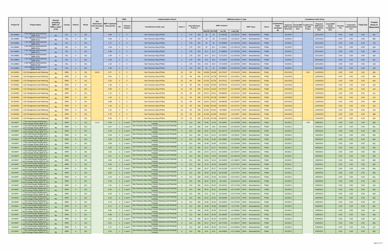
Beg PM End PM Lat. (N) Long. (W)
Revoked CUs
Total CUsTreated Areas in
WatershedRBPollutant Category
Total Maximum Daily Load Reach #Final SB Reach
Priority #
Compliance Units (CUs)
Cooperative Imple-
mentation ($)
Cooperative Implementation
CUs
Proposed BMP Install Start Date
Actual BMP Install Start
Date
Credited CUs for BMP Project
Proposed BMP Install Completion
Date
Actual BMP Install
Completion Date
Net Impervious
Area Increase (ac)
BMP Treatment Area (acres)
TMDL Implementation Reach BMP(s)Location & Type
BMP LocationsBMP Types Status
RouteProject ID Project Name
Retrofit (installing BMPs for
TMDLs only)? (Y/N)
County District
04-1A9801I-101 Highway Improvements
(BMP ID 3) No SCL 4 101 3.06 2 C San Francisco Bay (PCBs) 1 175 253 33 33 37.318135 -121.83123 BIOS - Bioswale/strip PS&E 3/1/2010 12/21/2012 0.00 0.00 0.00 3.1
04-1A9801I-101 Highway Improvements
(BMP ID 4) No SCL 4 101 0.93 2 C San Francisco Bay (PCBs) 1 175 253 33 33 37.318135 -121.83123 BIOS - Bioswale/strip PS&E 3/1/2010 12/21/2012 0.00 0.00 0.00 0.9
04-1A9801I-101 Highway Improvements
(BMP ID 5) No SCL 4 101 7.17 2 C San Francisco Bay (PCBs) 1 175 253 34 34 37.329664 -121.842239 BIOS - Bioswale/strip PS&E 3/1/2010 12/21/2012 0.00 0.00 0.00 7.2
04-1A9801I-101 Highway Improvements
(BMP ID 6) No SCL 4 101 1.59 2 C San Francisco Bay (PCBs) 1 175 253 32 32.1 37.30664 -121.820119 BIOS - Bioswale/strip PS&E 3/1/2010 12/21/2012 0.00 0.00 0.00 1.6
04-1A9801I-101 Highway Improvements
(BMP ID 7) No SCL 4 101 0.88 2 C San Francisco Bay (PCBs) 1 175 253 32.2 32.2 37.308932 -121.822354 BIOS - Bioswale/strip PS&E 3/1/2010 12/21/2012 0.00 0.00 0.00 0.9
04-1A9801I-101 Highway Improvements
(BMP ID 8) No SCL 4 101 2.36 2 C San Francisco Bay (PCBs) 1 175 253 32.4 32.4 37.311242 -121.824563 BIOS - Bioswale/strip PS&E 3/1/2010 12/21/2012 0.00 0.00 0.00 2.4
04-1A9801I-101 Highway Improvements
(BMP ID 9) No SCL 4 101 2.09 2 C San Francisco Bay (PCBs) 1 175 253 32.5 32.5 37.31239 -121.825676 BIOS - Bioswale/strip PS&E 3/1/2010 12/21/2012 0.00 0.00 0.00 2.1
04-1A9801I-101 Highway Improvements
(BMP ID 10) No SCL 4 101 1.32 2 C San Francisco Bay (PCBs) 1 175 253 32.6 32.6 37.313539 -121.826784 BIOS - Bioswale/strip PS&E 3/1/2010 12/21/2012 0.00 0.00 0.00 1.3
04-1A9801I-101 Highway Improvements
(BMP ID 11) No SCL 4 101 1.35 2 C San Francisco Bay (PCBs) 1 175 253 32 32 37.30664 -121.820119 BIOS - Bioswale/strip PS&E 3/1/2010 12/21/2012 0.00 0.00 0.00 1.4
04-264061 I-101 Realignment and Widening No MRN 4 101 16.20 0.27 2 C San Francisco Bay (PCBs) 10 99 256 18.836 18.836 38.076457 -122.544233 BIOS - Bioswale/strip PS&E 10/1/2010 2.62 11/30/2015 0.00 0.00 2.62 0.3
04-264061 I-101 Realignment and Widening No MRN 4 101 0.91 2 C San Francisco Bay (PCBs) 10 99 256 18.739 18.739 38.076104 -122.542611 BIOS - Bioswale/strip PS&E 10/1/2010 11/30/2015 0.00 0.00 0.00 0.9
04-264061 I-101 Realignment and Widening No MRN 4 101 0.25 2 C San Francisco Bay (PCBs) 10 99 256 18.762 18.762 38.076321 -122.542905 BIOS - Bioswale/strip PS&E 10/1/2010 11/30/2015 0.00 0.00 0.00 0.3
04-264061 I-101 Realignment and Widening No MRN 4 101 1.00 2 C San Francisco Bay (PCBs) 10 99 256 18.925 18.925 38.078139 -122.544578 BIOS - Bioswale/strip PS&E 10/1/2010 11/30/2015 0.00 0.00 0.00 1.0
04-264061 I-101 Realignment and Widening No MRN 4 101 0.95 2 C San Francisco Bay (PCBs) 10 99 256 19.024 19.024 38.079107 -122.545758 BIOS - Bioswale/strip PS&E 10/1/2010 11/30/2015 0.00 0.00 0.00 1.0
04-264061 I-101 Realignment and Widening No MRN 4 101 1.12 2 C San Francisco Bay (PCBs) 10 99 256 19.611 19.611 38.086053 -122.552151 BIOS - Bioswale/strip PS&E 10/1/2010 11/30/2015 0.00 0.00 0.00 1.1
04-264061 I-101 Realignment and Widening No MRN 4 101 1.18 2 C San Francisco Bay (PCBs) 10 99 256 19.706 19.706 38.086677 -122.553692 BIOS - Bioswale/strip PS&E 10/1/2010 11/30/2015 0.00 0.00 0.00 1.2
04-264061 I-101 Realignment and Widening No MRN 4 101 0.88 2 C San Francisco Bay (PCBs) 10 99 256 19.811 19.811 38.088285 -122.554467 BIOS - Bioswale/strip PS&E 10/1/2010 11/30/2015 0.00 0.00 0.00 0.9
04-264061 I-101 Realignment and Widening No MRN 4 101 1.19 2 C San Francisco Bay (PCBs) 10 99 256 20.066 20.066 38.090676 -122.557917 BIOS - Bioswale/strip PS&E 10/1/2010 11/30/2015 0.00 0.00 0.00 1.2
04-264061 I-101 Realignment and Widening No MRN 4 101 1.52 2 C San Francisco Bay (PCBs) 10 99 256 20.051 20.051 38.09086 -122.557326 BIOS - Bioswale/strip PS&E 10/1/2010 11/30/2015 0.00 0.00 0.00 1.5
04-264061 I-101 Realignment and Widening No MRN 4 101 0.79 2 C San Francisco Bay (PCBs) 10 99 256 20.263 20.263 38.09319 -122.55967 BIOS - Bioswale/strip PS&E 10/1/2010 11/30/2015 0.00 0.00 0.00 0.8
04-264061 I-101 Realignment and Widening No MRN 4 101 0.45 2 C San Francisco Bay (PCBs) 10 99 256 20.238 20.238 38.093752 -122.558505 BIOS - Bioswale/strip PS&E 10/1/2010 11/30/2015 0.00 0.00 0.00 0.5
04-26407I-101 Interchange Modifications and Frontage Roads (BMP ID 1) No MRN 4 101 11.12 0.63 2 C and F
San Francisco Bay Urban Creeks (Diazinon and Pesticide Toxicity)
5 213 306 23.66 23.26 38.13859 -122.564088 BIOS - Bioswale/strip PS&E 6/1/2012 4.59 6/30/2014 0.00 0.00 4.59 0.6
04-26407I-101 Interchange Modifications and Frontage Roads (BMP ID 2) No MRN 4 101 0.07 2 C and F
San Francisco Bay Urban Creeks (Diazinon and Pesticide Toxicity)
5 213 306 23.8 23.8 38.140632 -122.564233 BIOS - Bioswale/strip PS&E 6/1/2012 6/30/2014 0.00 0.00 0.00 0.1
04-26407I-101 Interchange Modifications and Frontage Roads (BMP ID 3) No MRN 4 101 0.78 2 C and F
San Francisco Bay Urban Creeks (Diazinon and Pesticide Toxicity)
5 213 306 23.81 23.81 38.140778 -122.564244 BIOS - Bioswale/strip PS&E 6/1/2012 6/30/2014 0.00 0.00 0.00 0.8
04-26407I-101 Interchange Modifications and Frontage Roads (BMP ID 4) No MRN 4 101 0.49 2 C and F
San Francisco Bay Urban Creeks (Diazinon and Pesticide Toxicity)
5 213 306 24.21 24.21 38.146529 -122.56519 BIOS - Bioswale/strip PS&E 6/1/2012 6/30/2014 0.00 0.00 0.00 0.5
04-26407I-101 Interchange Modifications and Frontage Roads (BMP ID 5) No MRN 4 101 0.03 2 C and F
San Francisco Bay Urban Creeks (Diazinon and Pesticide Toxicity)
5 213 306 24.46 24.46 38.149984 -122.566392 BIOS - Bioswale/strip PS&E 6/1/2012 6/30/2014 0.00 0.00 0.00 0.0
04-26407I-101 Interchange Modifications and Frontage Roads (BMP ID 6) No MRN 4 101 0.06 2 C and F
San Francisco Bay Urban Creeks (Diazinon and Pesticide Toxicity)
5 213 306 24.48 24.48 38.15026 -122.566488 BIOS - Bioswale/strip PS&E 6/1/2012 6/30/2014 0.00 0.00 0.00 0.1
04-26407I-101 Interchange Modifications and Frontage Roads (BMP ID 7) No MRN 4 101 0.26 2 C and F
San Francisco Bay Urban Creeks (Diazinon and Pesticide Toxicity)
5 213 306 24.47 24.47 38.150122 -122.56644 BIOS - Bioswale/strip PS&E 6/1/2012 6/30/2014 0.00 0.00 0.00 0.3
04-26407I-101 Interchange Modifications and Frontage Roads (BMP ID 8) No MRN 4 101 0.25 2 C and F
San Francisco Bay Urban Creeks (Diazinon and Pesticide Toxicity)
5 213 306 24.72 24.72 38.153582 -122.567637 BIOS - Bioswale/strip PS&E 6/1/2012 6/30/2014 0.00 0.00 0.00 0.3
04-26407I-101 Interchange Modifications and Frontage Roads (BMP ID 9) No MRN 4 101 0.47 2 C and F
San Francisco Bay Urban Creeks (Diazinon and Pesticide Toxicity)
5 213 306 24.83 24.83 38.155106 -122.568158 BIOS - Bioswale/strip PS&E 6/1/2012 6/30/2014 0.00 0.00 0.00 0.5
04-26407I-101 Interchange Modifications
and Frontage Roads (BMP ID 10) No MRN 4 101 0.94 2 C and FSan Francisco Bay Urban Creeks (Diazinon and Pesticide
Toxicity)5 213 306 24.94 24.94 38.156628 -122.568679 BIOS - Bioswale/strip PS&E 6/1/2012 6/30/2014 0.00 0.00 0.00 0.9
04-26407I-101 Interchange Modifications
and Frontage Roads (BMP ID 11) No MRN 4 101 0.34 2 C and FSan Francisco Bay Urban Creeks (Diazinon and Pesticide
Toxicity)5 213 306 25.29 25.29 38.160575 -122.571827 BIOS - Bioswale/strip PS&E 6/1/2012 6/30/2014 0.00 0.00 0.00 0.3
04-26407I-101 Interchange Modifications
and Frontage Roads (BMP ID 12) No MRN 4 101 0.02 2 C and FSan Francisco Bay Urban Creeks (Diazinon and Pesticide
Toxicity)5 213 306 25.37 25.37 38.161268 -122.572778 BIOS - Bioswale/strip PS&E 6/1/2012 6/30/2014 0.00 0.00 0.00 0.0
04-26407I-101 Interchange Modifications
and Frontage Roads (BMP ID 13) No MRN 4 101 0.60 2 C and FSan Francisco Bay Urban Creeks (Diazinon and Pesticide
Toxicity)5 213 306 25.35 25.35 38.161095 -122.57254 BIOS - Bioswale/strip PS&E 6/1/2012 6/30/2014 0.00 0.00 0.00 0.6
04-26407I-101 Interchange Modifications
and Frontage Roads (BMP ID 14) No MRN 4 101 0.10 2 C and FSan Francisco Bay Urban Creeks (Diazinon and Pesticide
Toxicity)5 213 306 25.58 25.58 38.163301 -122.575571 BIOS - Bioswale/strip PS&E 6/1/2012 6/30/2014 0.00 0.00 0.00 0.1
04-26407I-101 Interchange Modifications
and Frontage Roads (BMP ID 15) No MRN 4 101 0.19 2 C and FSan Francisco Bay Urban Creeks (Diazinon and Pesticide
Toxicity)5 213 306 26.87 26.87 38.17633 -122.593763 BIOS - Bioswale/strip PS&E 6/1/2012 6/30/2014 0.00 0.00 0.00 0.2
04-26407I-101 Interchange Modifications
and Frontage Roads (BMP ID 16) No MRN 4 101 1.01 2 C and FSan Francisco Bay Urban Creeks (Diazinon and Pesticide
Toxicity)5 213 306 25.25 25.25 38.160225 -122.571359 BIOS - Bioswale/strip PS&E 6/1/2012 6/30/2014 0.00 0.00 0.00 1.0
04-26407I-101 Interchange Modifications
and Frontage Roads (BMP ID 17) No MRN 4 101 0.34 2 C and FSan Francisco Bay Urban Creeks (Diazinon and Pesticide
Toxicity)5 213 306 25.51 25.51 38.162584 -122.574589 BIOS - Bioswale/strip PS&E 6/1/2012 6/30/2014 0.00 0.00 0.00 0.3
04-26407I-101 Interchange Modifications
and Frontage Roads (BMP ID 18) No MRN 4 101 0.03 2 C and FSan Francisco Bay Urban Creeks (Diazinon and Pesticide
Toxicity)5 213 306 25.5 25.5 38.162482 -122.574448 BIOS - Bioswale/strip PS&E 6/1/2012 6/30/2014 0.00 0.00 0.00 0.0
04-26407I-101 Interchange Modifications
and Frontage Roads (BMP ID 19) No MRN 4 101 0.16 2 C and FSan Francisco Bay Urban Creeks (Diazinon and Pesticide
Toxicity)5 213 306 25.52 25.52 38.162686 -122.574729 BIOS - Bioswale/strip PS&E 6/1/2012 6/30/2014 0.00 0.00 0.00 0.2
04-26407I-101 Interchange Modifications
and Frontage Roads (BMP ID 20) No MRN 4 101 0.73 2 C and FSan Francisco Bay Urban Creeks (Diazinon and Pesticide
Toxicity)5 213 306 25.56 25.56 38.163095 -122.575292 BIOS - Bioswale/strip PS&E 6/1/2012 6/30/2014 0.00 0.00 0.00 0.7
04-26407I-101 Interchange Modifications
and Frontage Roads (BMP ID 21) No MRN 4 101 0.17 2 C and FSan Francisco Bay Urban Creeks (Diazinon and Pesticide
Toxicity)5 213 306 25.88 25.88 38.166529 -122.57965 BIOS - Bioswale/strip PS&E 6/1/2012 6/30/2014 0.00 0.00 0.00 0.2
04-26407I-101 Interchange Modifications
and Frontage Roads (BMP ID 22) No MRN 4 101 0.65 2 C and FSan Francisco Bay Urban Creeks (Diazinon and Pesticide
Toxicity)5 213 306 25.95 25.95 38.167183 -122.580681 BIOS - Bioswale/strip PS&E 6/1/2012 6/30/2014 0.00 0.00 0.00 0.7
04-26407I-101 Interchange Modifications
and Frontage Roads (BMP ID 23) No MRN 4 101 0.38 2 C and FSan Francisco Bay Urban Creeks (Diazinon and Pesticide
Toxicity)5 213 306 26.08 26.08 38.168385 -122.582588 BIOS - Bioswale/strip PS&E 6/1/2012 6/30/2014 0.00 0.00 0.00 0.4
04-26407I-101 Interchange Modifications
and Frontage Roads (BMP ID 24) No MRN 4 101 1.01 2 C and FSan Francisco Bay Urban Creeks (Diazinon and Pesticide
Toxicity)5 213 306 26.18 26.18 38.169309 -122.584053 BIOS - Bioswale/strip PS&E 6/1/2012 6/30/2014 0.00 0.00 0.00 1.0
04-26407I-101 Interchange Modifications
and Frontage Roads (BMP ID 25) No MRN 4 101 0.51 2 C and FSan Francisco Bay Urban Creeks (Diazinon and Pesticide
Toxicity)5 213 306 26.47 26.47 38.172193 -122.588187 BIOS - Bioswale/strip PS&E 6/1/2012 6/30/2014 0.00 0.00 0.00 0.5
04-26407I-101 Interchange Modifications
and Frontage Roads (BMP ID 26) No MRN 4 101 1.07 2 C and FSan Francisco Bay Urban Creeks (Diazinon and Pesticide
Toxicity)5 213 306 26.56 26.56 38.173124 -122.589443 BIOS - Bioswale/strip PS&E 6/1/2012 6/30/2014 0.00 0.00 0.00 1.1
04-26407I-101 Interchange Modifications
and Frontage Roads (BMP ID 27) No MRN 4 101 0.33 2 C and FSan Francisco Bay Urban Creeks (Diazinon and Pesticide
Toxicity)5 213 306 25.6 25.6 38.163508 -122.575848 BIOS - Bioswale/strip PS&E 6/1/2012 6/30/2014 0.00 0.00 0.00 0.3
Page 51 of 77

Beg PM End PM Lat. (N) Long. (W)
Revoked CUs
Total CUsTreated Areas in
WatershedRBPollutant Category
Total Maximum Daily Load Reach #Final SB Reach
Priority #
Compliance Units (CUs)
Cooperative Imple-
mentation ($)
Cooperative Implementation
CUs
Proposed BMP Install Start Date
Actual BMP Install Start
Date
Credited CUs for BMP Project
Proposed BMP Install Completion
Date
Actual BMP Install
Completion Date
Net Impervious
Area Increase (ac)
BMP Treatment Area (acres)
TMDL Implementation Reach BMP(s)Location & Type
BMP LocationsBMP Types Status
RouteProject ID Project Name
Retrofit (installing BMPs for
TMDLs only)? (Y/N)
County District
04-26407I-101 Interchange Modifications
and Frontage Roads (BMP ID 28) No MRN 4 101 0.12 2 C and FSan Francisco Bay Urban Creeks (Diazinon and Pesticide
Toxicity)5 213 306 25.46 25.46 38.162074 -122.573886 BIOS - Bioswale/strip PS&E 6/1/2012 6/30/2014 0.00 0.00 0.00 0.1
04-26407I-101 Interchange Modifications
and Frontage Roads (BMP ID 29) No MRN 4 101 0.17 2 C and FSan Francisco Bay Urban Creeks (Diazinon and Pesticide
Toxicity)5 213 306 23.23 23.26 38.135197 -122.563853 BIOS - Bioswale/strip PS&E 6/1/2012 6/30/2014 0.00 0.00 0.00 0.2
04-26407I-101 Interchange Modifications
and Frontage Roads (BMP ID 30) No MRN 4 101 0.27 2 C and FSan Francisco Bay Urban Creeks (Diazinon and Pesticide
Toxicity)5 213 306 23.49 23.63 38.136104 -122.563908 BIOS - Bioswale/strip PS&E 6/1/2012 6/30/2014 0.00 0.00 0.00 0.3
04-26407I-101 Interchange Modifications
and Frontage Roads (BMP ID 31) No MRN 4 101 0.18 2 C and FSan Francisco Bay Urban Creeks (Diazinon and Pesticide
Toxicity)5 213 306 23.63 23.72 38.138152 -122.564056 BIOS - Bioswale/strip PS&E 6/1/2012 6/30/2014 0.00 0.00 0.00 0.2
04-26407I-101 Interchange Modifications
and Frontage Roads (BMP ID 32) No MRN 4 101 0.06 2 C and FSan Francisco Bay Urban Creeks (Diazinon and Pesticide
Toxicity)5 213 306 23.78 23.8 38.140339 -122.564211 BIOS - Bioswale/strip PS&E 6/1/2012 6/30/2014 0.00 0.00 0.00 0.1
04-26407I-101 Interchange Modifications
and Frontage Roads (BMP ID 33) No MRN 4 101 0.18 2 C and FSan Francisco Bay Urban Creeks (Diazinon and Pesticide
Toxicity)5 213 306 23.81 23.89 38.140778 -122.564244 BIOS - Bioswale/strip PS&E 6/1/2012 6/30/2014 0.00 0.00 0.00 0.2
04-26407I-101 Interchange Modifications
and Frontage Roads (BMP ID 34) No MRN 4 101 0.10 2 C and FSan Francisco Bay Urban Creeks (Diazinon and Pesticide
Toxicity)5 213 306 23.9 23.96 38.142091 -122.564344 BIOS - Bioswale/strip PS&E 6/1/2012 6/30/2014 0.00 0.00 0.00 0.1
04-26407I-101 Interchange Modifications
and Frontage Roads (BMP ID 35) No MRN 4 101 0.09 2 C and FSan Francisco Bay Urban Creeks (Diazinon and Pesticide
Toxicity)5 213 306 23.96 24 38.142966 -122.564411 BIOS - Bioswale/strip PS&E 6/1/2012 6/30/2014 0.00 0.00 0.00 0.1
04-26407I-101 Interchange Modifications
and Frontage Roads (BMP ID 36) No MRN 4 101 0.06 2 C and FSan Francisco Bay Urban Creeks (Diazinon and Pesticide
Toxicity)5 213 306 24 24.11 38.14355 -122.564456 BIOS - Bioswale/strip PS&E 6/1/2012 6/30/2014 0.00 0.00 0.00 0.1
04-26407I-101 Interchange Modifications
and Frontage Roads (BMP ID 37) No MRN 4 101 0.23 2 C and FSan Francisco Bay Urban Creeks (Diazinon and Pesticide
Toxicity)5 213 306 24.11 24.15 38.14514 -122.564718 BIOS - Bioswale/strip PS&E 6/1/2012 6/30/2014 0.00 0.00 0.00 0.2
04-26407I-101 Interchange Modifications
and Frontage Roads (BMP ID 38) No MRN 4 101 0.14 2 C and FSan Francisco Bay Urban Creeks (Diazinon and Pesticide
Toxicity)5 213 306 24.15 24.22 38.145698 -122.564902 BIOS - Bioswale/strip PS&E 6/1/2012 6/30/2014 0.00 0.00 0.00 0.1
04-26407I-101 Interchange Modifications
and Frontage Roads (BMP ID 39) No MRN 4 101 0.06 2 C and FSan Francisco Bay Urban Creeks (Diazinon and Pesticide
Toxicity)5 213 306 24.22 24.25 38.146668 -122.565238 BIOS - Bioswale/strip PS&E 6/1/2012 6/30/2014 0.00 0.00 0.00 0.1
04-26407I-101 Interchange Modifications
and Frontage Roads (BMP ID 40) No MRN 4 101 0.04 2 C and FSan Francisco Bay Urban Creeks (Diazinon and Pesticide
Toxicity)5 213 306 24.25 24.28 38.147083 -122.565383 BIOS - Bioswale/strip PS&E 6/1/2012 6/30/2014 0.00 0.00 0.00 0.0
04-26407I-101 Interchange Modifications
and Frontage Roads (BMP ID 41) No MRN 4 101 0.16 2 C and FSan Francisco Bay Urban Creeks (Diazinon and Pesticide
Toxicity)5 213 306 24.28 24.36 38.147498 -122.565527 BIOS - Bioswale/strip PS&E 6/1/2012 6/30/2014 0.00 0.00 0.00 0.2
04-26407I-101 Interchange Modifications
and Frontage Roads (BMP ID 42) No MRN 4 101 0.26 2 C and FSan Francisco Bay Urban Creeks (Diazinon and Pesticide
Toxicity)5 213 306 24.49 24.72 38.150398 -122.566536 BIOS - Bioswale/strip PS&E 6/1/2012 6/30/2014 0.00 0.00 0.00 0.3
04-26407I-101 Interchange Modifications
and Frontage Roads (BMP ID 43) No MRN 4 101 0.11 2 C and FSan Francisco Bay Urban Creeks (Diazinon and Pesticide
Toxicity)5 213 306 24.72 24.82 38.153582 -122.567637 BIOS - Bioswale/strip PS&E 6/1/2012 6/30/2014 0.00 0.00 0.00 0.1
04-26407I-101 Interchange Modifications
and Frontage Roads (BMP ID 44) No MRN 4 101 0.09 2 C and FSan Francisco Bay Urban Creeks (Diazinon and Pesticide
Toxicity)5 213 306 24.82 24.9 38.154967 -122.568111 BIOS - Bioswale/strip PS&E 6/1/2012 6/30/2014 0.00 0.00 0.00 0.1
04-26407I-101 Interchange Modifications
and Frontage Roads (BMP ID 45) No MRN 4 101 0.45 2 C and FSan Francisco Bay Urban Creeks (Diazinon and Pesticide
Toxicity)5 213 306 26.84 26.96 38.176019 -122.593344 BIOS - Bioswale/strip PS&E 6/1/2012 6/30/2014 0.00 0.00 0.00 0.5
04-26407I-101 Interchange Modifications
and Frontage Roads (BMP ID 46) No MRN 4 101 0.14 2 C and FSan Francisco Bay Urban Creeks (Diazinon and Pesticide
Toxicity)5 213 306 25.19 25.21 38.159648 -122.570697 BIOS - Bioswale/strip PS&E 6/1/2012 6/30/2014 0.00 0.00 0.00 0.1
04-26407I-101 Interchange Modifications
and Frontage Roads (BMP ID 47) No MRN 4 101 0.39 2 C and FSan Francisco Bay Urban Creeks (Diazinon and Pesticide
Toxicity)5 213 306 25.21 25.29 38.159848 -122.570912 BIOS - Bioswale/strip PS&E 6/1/2012 6/30/2014 0.00 0.00 0.00 0.4
04-26407I-101 Interchange Modifications
and Frontage Roads (BMP ID 48) No MRN 4 101 0.24 2 C and FSan Francisco Bay Urban Creeks (Diazinon and Pesticide
Toxicity)5 213 306 25.45 25.55 38.161972 -122.573746 BIOS - Bioswale/strip PS&E 6/1/2012 6/30/2014 0.00 0.00 0.00 0.2
04-26407I-101 Interchange Modifications
and Frontage Roads (BMP ID 49) No MRN 4 101 0.25 2 C and FSan Francisco Bay Urban Creeks (Diazinon and Pesticide
Toxicity)5 213 306 25.55 25.64 38.162992 -122.575151 BIOS - Bioswale/strip PS&E 6/1/2012 6/30/2014 0.00 0.00 0.00 0.3
04-26407I-101 Interchange Modifications
and Frontage Roads (BMP ID 50) No MRN 4 101 0.30 2 C and FSan Francisco Bay Urban Creeks (Diazinon and Pesticide
Toxicity)5 213 306 25.61 25.62 38.163613 -122.575986 BIOS - Bioswale/strip PS&E 6/1/2012 6/30/2014 0.00 0.00 0.00 0.3
04-1A9801I-101 Highway Improvements
(BMP ID 1) No SCL 4 101 1.50 1.92 2 C and FSan Francisco Bay Urban Creeks (Diazinon and Pesticide
Toxicity)1 96 166 33 33 37.318135 -121.83123 BIOS - Bioswale/strip PS&E 3/1/2010 22.71 12/21/2012 0.00 0.00 22.71 1.9
04-1A9801I-101 Highway Improvements
(BMP ID 2) No SCL 4 101 1.54 2 C and FSan Francisco Bay Urban Creeks (Diazinon and Pesticide
Toxicity)1 96 166 33 33 37.318135 -121.83123 BIOS - Bioswale/strip PS&E 3/1/2010 12/21/2012 0.00 0.00 0.00 1.5
04-1A9801I-101 Highway Improvements
(BMP ID 3) No SCL 4 101 3.06 2 C and FSan Francisco Bay Urban Creeks (Diazinon and Pesticide
Toxicity)1 96 166 33 33 37.318135 -121.83123 BIOS - Bioswale/strip PS&E 3/1/2010 12/21/2012 0.00 0.00 0.00 3.1
04-1A9801I-101 Highway Improvements
(BMP ID 4) No SCL 4 101 0.93 2 C and FSan Francisco Bay Urban Creeks (Diazinon and Pesticide
Toxicity)1 96 166 33 33 37.318135 -121.83123 BIOS - Bioswale/strip PS&E 3/1/2010 12/21/2012 0.00 0.00 0.00 0.9
04-1A9801I-101 Highway Improvements
(BMP ID 5) No SCL 4 101 7.17 2 C and FSan Francisco Bay Urban Creeks (Diazinon and Pesticide
Toxicity)1 96 166 34 34 37.329664 -121.842239 BIOS - Bioswale/strip PS&E 3/1/2010 12/21/2012 0.00 0.00 0.00 7.2
04-1A9801I-101 Highway Improvements
(BMP ID 6) No SCL 4 101 1.59 2 C and FSan Francisco Bay Urban Creeks (Diazinon and Pesticide
Toxicity)1 96 166 32 32.1 37.30664 -121.820119 BIOS - Bioswale/strip PS&E 3/1/2010 12/21/2012 0.00 0.00 0.00 1.6
04-1A9801I-101 Highway Improvements
(BMP ID 7) No SCL 4 101 0.88 2 C and FSan Francisco Bay Urban Creeks (Diazinon and Pesticide
Toxicity)1 96 166 32.2 32.2 37.308932 -121.822354 BIOS - Bioswale/strip PS&E 3/1/2010 12/21/2012 0.00 0.00 0.00 0.9
04-1A9801I-101 Highway Improvements
(BMP ID 8) No SCL 4 101 2.36 2 C and FSan Francisco Bay Urban Creeks (Diazinon and Pesticide
Toxicity)1 96 166 32.4 32.4 37.311242 -121.824563 BIOS - Bioswale/strip PS&E 3/1/2010 12/21/2012 0.00 0.00 0.00 2.4
04-1A9801I-101 Highway Improvements
(BMP ID 9) No SCL 4 101 2.09 2 C and FSan Francisco Bay Urban Creeks (Diazinon and Pesticide
Toxicity)1 96 166 32.5 32.5 37.31239 -121.825676 BIOS - Bioswale/strip PS&E 3/1/2010 12/21/2012 0.00 0.00 0.00 2.1
04-1A9801I-101 Highway Improvements
(BMP ID 10) No SCL 4 101 1.32 2 C and FSan Francisco Bay Urban Creeks (Diazinon and Pesticide
Toxicity)1 96 166 32.6 32.6 37.313539 -121.826784 BIOS - Bioswale/strip PS&E 3/1/2010 12/21/2012 0.00 0.00 0.00 1.3
04-1A9801I-101 Highway Improvements
(BMP ID 11) No SCL 4 101 1.35 2 C and FSan Francisco Bay Urban Creeks (Diazinon and Pesticide
Toxicity)1 96 166 32 32 37.30664 -121.820119 BIOS - Bioswale/strip PS&E 3/1/2010 12/21/2012 0.00 0.00 0.00 1.4
04-264061 I-101 Realignment and Widening No MRN 4 101 16.20 0.27 2 C and FSan Francisco Bay Urban Creeks (Diazinon and Pesticide
Toxicity)6 210 303 18.836 18.836 38.076457 -122.544233 BIOS - Bioswale/strip PS&E 10/1/2010 2.62 11/30/2015 0.00 0.00 2.62 0.3
04-264061 I-101 Realignment and Widening No MRN 4 101 0.91 2 C and FSan Francisco Bay Urban Creeks (Diazinon and Pesticide
Toxicity)6 210 303 18.739 18.739 38.076104 -122.542611 BIOS - Bioswale/strip PS&E 10/1/2010 11/30/2015 0.00 0.00 0.00 0.9
04-264061 I-101 Realignment and Widening No MRN 4 101 0.25 2 C and FSan Francisco Bay Urban Creeks (Diazinon and Pesticide
Toxicity)6 210 303 18.762 18.762 38.076321 -122.542905 BIOS - Bioswale/strip PS&E 10/1/2010 11/30/2015 0.00 0.00 0.00 0.3
04-264061 I-101 Realignment and Widening No MRN 4 101 1.00 2 C and FSan Francisco Bay Urban Creeks (Diazinon and Pesticide
Toxicity)6 210 303 18.925 18.925 38.078139 -122.544578 BIOS - Bioswale/strip PS&E 10/1/2010 11/30/2015 0.00 0.00 0.00 1.0
04-264061 I-101 Realignment and Widening No MRN 4 101 0.95 2 C and FSan Francisco Bay Urban Creeks (Diazinon and Pesticide
Toxicity)6 210 303 19.024 19.024 38.079107 -122.545758 BIOS - Bioswale/strip PS&E 10/1/2010 11/30/2015 0.00 0.00 0.00 1.0
04-264061 I-101 Realignment and Widening No MRN 4 101 1.12 2 C and FSan Francisco Bay Urban Creeks (Diazinon and Pesticide
Toxicity)6 210 303 19.611 19.611 38.086053 -122.552151 BIOS - Bioswale/strip PS&E 10/1/2010 11/30/2015 0.00 0.00 0.00 1.1
04-264061 I-101 Realignment and Widening No MRN 4 101 1.18 2 C and FSan Francisco Bay Urban Creeks (Diazinon and Pesticide
Toxicity)6 210 303 19.706 19.706 38.086677 -122.553692 BIOS - Bioswale/strip PS&E 10/1/2010 11/30/2015 0.00 0.00 0.00 1.2
04-264061 I-101 Realignment and Widening No MRN 4 101 0.88 2 C and FSan Francisco Bay Urban Creeks (Diazinon and Pesticide
Toxicity)6 210 303 19.811 19.811 38.088285 -122.554467 BIOS - Bioswale/strip PS&E 10/1/2010 11/30/2015 0.00 0.00 0.00 0.9
04-264061 I-101 Realignment and Widening No MRN 4 101 1.19 2 C and FSan Francisco Bay Urban Creeks (Diazinon and Pesticide
Toxicity)6 210 303 20.066 20.066 38.090676 -122.557917 BIOS - Bioswale/strip PS&E 10/1/2010 11/30/2015 0.00 0.00 0.00 1.2
04-264061 I-101 Realignment and Widening No MRN 4 101 1.52 2 C and FSan Francisco Bay Urban Creeks (Diazinon and Pesticide
Toxicity)6 210 303 20.051 20.051 38.09086 -122.557326 BIOS - Bioswale/strip PS&E 10/1/2010 11/30/2015 0.00 0.00 0.00 1.5
04-264061 I-101 Realignment and Widening No MRN 4 101 0.79 2 C and FSan Francisco Bay Urban Creeks (Diazinon and Pesticide
Toxicity)6 210 303 20.263 20.263 38.09319 -122.55967 BIOS - Bioswale/strip PS&E 10/1/2010 11/30/2015 0.00 0.00 0.00 0.8
04-264061 I-101 Realignment and Widening No MRN 4 101 0.45 2 C and FSan Francisco Bay Urban Creeks (Diazinon and Pesticide
Toxicity)6 210 303 20.238 20.238 38.093752 -122.558505 BIOS - Bioswale/strip PS&E 10/1/2010 11/30/2015 0.00 0.00 0.00 0.5
12-71631Freeway Widening and HOV
Improvements(BIOS #74) No Ora 7 22, 405, 605 19.00 3.54 4,8 C Los Cerritos (Metals) 1 41 93 0.125 0.125 33.7875 -118.0944 BIOS - Bioswale/strip PS&E 8/3/2010 0.00 12/21/2013 0.00 0.00 0.00 3.5
12-0H0211Interchange Improvement
Project(Interstate 5/Lapaz Road) No Ora 12 5 0.79 2.08 8 EProject I - Revised Twenty Beaches and Creeks in the San
Diego Region (including Tecolote Creek) (Indicator 2 197 287 15.904 15.904 33.59 -117.675 BIOS - Bioswale/strip PS&E 6/1/2010 1.29 12/31/2010 0.00 0.00 1.29 2.1
Page 52 of 77
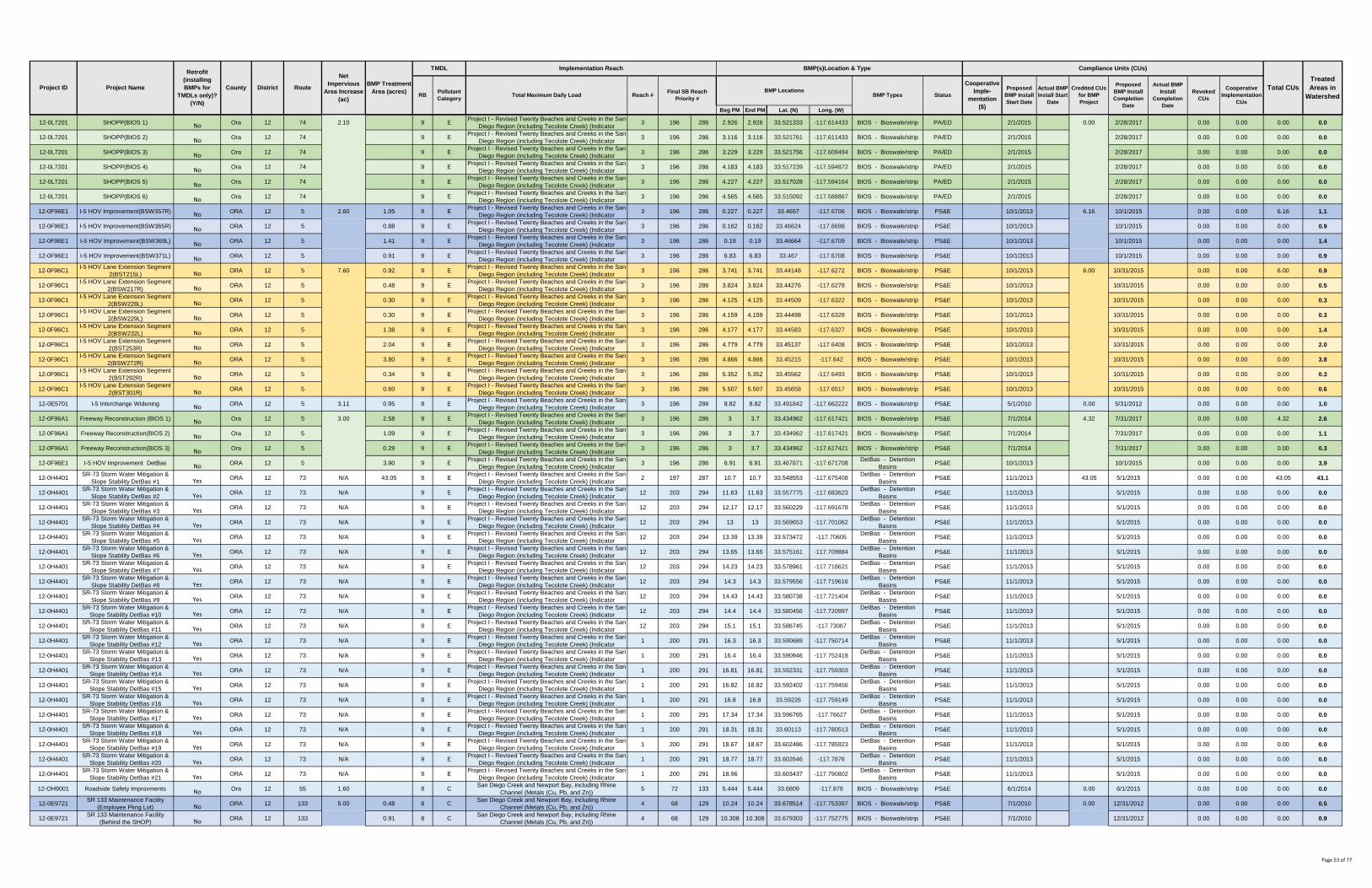
Beg PM End PM Lat. (N) Long. (W)
Revoked CUs
Total CUsTreated Areas in
WatershedRBPollutant Category
Total Maximum Daily Load Reach #Final SB Reach
Priority #
Compliance Units (CUs)
Cooperative Imple-
mentation ($)
Cooperative Implementation
CUs
Proposed BMP Install Start Date
Actual BMP Install Start
Date
Credited CUs for BMP Project
Proposed BMP Install Completion
Date
Actual BMP Install
Completion Date
Net Impervious
Area Increase (ac)
BMP Treatment Area (acres)
TMDL Implementation Reach BMP(s)Location & Type
BMP LocationsBMP Types Status
RouteProject ID Project Name
Retrofit (installing BMPs for
TMDLs only)? (Y/N)
County District
12-0L7201 SHOPP(BIOS 1) No Ora 12 74 2.10 9 EProject I - Revised Twenty Beaches and Creeks in the San
Diego Region (including Tecolote Creek) (Indicator 3 196 286 2.926 2.926 33.521333 -117.614433 BIOS - Bioswale/strip PA/ED 2/1/2015 0.00 2/28/2017 0.00 0.00 0.00 0.0
12-0L7201 SHOPP(BIOS 2) No Ora 12 74 9 EProject I - Revised Twenty Beaches and Creeks in the San
Diego Region (including Tecolote Creek) (Indicator 3 196 286 3.116 3.116 33.521761 -117.611433 BIOS - Bioswale/strip PA/ED 2/1/2015 2/28/2017 0.00 0.00 0.00 0.0
12-0L7201 SHOPP(BIOS 3) No Ora 12 74 9 EProject I - Revised Twenty Beaches and Creeks in the San
Diego Region (including Tecolote Creek) (Indicator 3 196 286 3.229 3.229 33.521756 -117.609494 BIOS - Bioswale/strip PA/ED 2/1/2015 2/28/2017 0.00 0.00 0.00 0.0
12-0L7201 SHOPP(BIOS 4) No Ora 12 74 9 EProject I - Revised Twenty Beaches and Creeks in the San
Diego Region (including Tecolote Creek) (Indicator 3 196 286 4.183 4.183 33.517239 -117.594872 BIOS - Bioswale/strip PA/ED 2/1/2015 2/28/2017 0.00 0.00 0.00 0.0
12-0L7201 SHOPP(BIOS 5) No Ora 12 74 9 EProject I - Revised Twenty Beaches and Creeks in the San
Diego Region (including Tecolote Creek) (Indicator 3 196 286 4.227 4.227 33.517028 -117.594164 BIOS - Bioswale/strip PA/ED 2/1/2015 2/28/2017 0.00 0.00 0.00 0.0
12-0L7201 SHOPP(BIOS 6) No Ora 12 74 9 EProject I - Revised Twenty Beaches and Creeks in the San
Diego Region (including Tecolote Creek) (Indicator 3 196 286 4.565 4.565 33.515092 -117.588867 BIOS - Bioswale/strip PA/ED 2/1/2015 2/28/2017 0.00 0.00 0.00 0.0
12-0F96E1 I-5 HOV Improvement(BSW357R) No ORA 12 5 2.60 1.05 9 EProject I - Revised Twenty Beaches and Creeks in the San
Diego Region (including Tecolote Creek) (Indicator 3 196 286 0.227 0.227 33.4657 -117.6706 BIOS - Bioswale/strip PS&E 10/1/2013 6.16 10/1/2015 0.00 0.00 6.16 1.1
12-0F96E1 I-5 HOV Improvement(BSW365R) No ORA 12 5 0.88 9 EProject I - Revised Twenty Beaches and Creeks in the San
Diego Region (including Tecolote Creek) (Indicator 3 196 286 0.162 0.162 33.46624 -117.6698 BIOS - Bioswale/strip PS&E 10/1/2013 10/1/2015 0.00 0.00 0.00 0.9
12-0F96E1 I-5 HOV Improvement(BSW369L) No ORA 12 5 1.41 9 EProject I - Revised Twenty Beaches and Creeks in the San
Diego Region (including Tecolote Creek) (Indicator 3 196 286 0.19 0.19 33.46664 -117.6709 BIOS - Bioswale/strip PS&E 10/1/2013 10/1/2015 0.00 0.00 0.00 1.4
12-0F96E1 I-5 HOV Improvement(BSW371L) No ORA 12 5 0.91 9 EProject I - Revised Twenty Beaches and Creeks in the San
Diego Region (including Tecolote Creek) (Indicator 3 196 286 6.83 6.83 33.467 -117.6708 BIOS - Bioswale/strip PS&E 10/1/2013 10/1/2015 0.00 0.00 0.00 0.9
12-0F96C1I-5 HOV Lane Extension Segment
2(BST215L) No ORA 12 5 7.60 0.92 9 EProject I - Revised Twenty Beaches and Creeks in the San
Diego Region (including Tecolote Creek) (Indicator 3 196 286 3.741 3.741 33.44148 -117.6272 BIOS - Bioswale/strip PS&E 10/1/2013 6.00 10/31/2015 0.00 0.00 6.00 0.9
12-0F96C1I-5 HOV Lane Extension Segment
2(BSW217R) No ORA 12 5 0.48 9 EProject I - Revised Twenty Beaches and Creeks in the San
Diego Region (including Tecolote Creek) (Indicator 3 196 286 3.824 3.824 33.44276 -117.6278 BIOS - Bioswale/strip PS&E 10/1/2013 10/31/2015 0.00 0.00 0.00 0.5
12-0F96C1I-5 HOV Lane Extension Segment
2(BSW228L) No ORA 12 5 0.30 9 EProject I - Revised Twenty Beaches and Creeks in the San
Diego Region (including Tecolote Creek) (Indicator 3 196 286 4.125 4.125 33.44509 -117.6322 BIOS - Bioswale/strip PS&E 10/1/2013 10/31/2015 0.00 0.00 0.00 0.3
12-0F96C1I-5 HOV Lane Extension Segment
2(BSW229L) No ORA 12 5 0.30 9 EProject I - Revised Twenty Beaches and Creeks in the San
Diego Region (including Tecolote Creek) (Indicator 3 196 286 4.159 4.159 33.44498 -117.6328 BIOS - Bioswale/strip PS&E 10/1/2013 10/31/2015 0.00 0.00 0.00 0.3
12-0F96C1I-5 HOV Lane Extension Segment
2(BSW232L) No ORA 12 5 1.38 9 EProject I - Revised Twenty Beaches and Creeks in the San
Diego Region (including Tecolote Creek) (Indicator 3 196 286 4.177 4.177 33.44583 -117.6327 BIOS - Bioswale/strip PS&E 10/1/2013 10/31/2015 0.00 0.00 0.00 1.4
12-0F96C1I-5 HOV Lane Extension Segment
2(BST253R) No ORA 12 5 2.04 9 EProject I - Revised Twenty Beaches and Creeks in the San
Diego Region (including Tecolote Creek) (Indicator 3 196 286 4.779 4.779 33.45137 -117.6408 BIOS - Bioswale/strip PS&E 10/1/2013 10/31/2015 0.00 0.00 0.00 2.0
12-0F96C1I-5 HOV Lane Extension Segment
2(BSW272R) No ORA 12 5 3.80 9 EProject I - Revised Twenty Beaches and Creeks in the San
Diego Region (including Tecolote Creek) (Indicator 3 196 286 4.866 4.866 33.45215 -117.642 BIOS - Bioswale/strip PS&E 10/1/2013 10/31/2015 0.00 0.00 0.00 3.8
12-0F96C1I-5 HOV Lane Extension Segment
2(BST292R) No ORA 12 5 0.34 9 EProject I - Revised Twenty Beaches and Creeks in the San
Diego Region (including Tecolote Creek) (Indicator 3 196 286 5.352 5.352 33.45562 -117.6493 BIOS - Bioswale/strip PS&E 10/1/2013 10/31/2015 0.00 0.00 0.00 0.3
12-0F96C1I-5 HOV Lane Extension Segment
2(BST301R) No ORA 12 5 0.60 9 EProject I - Revised Twenty Beaches and Creeks in the San
Diego Region (including Tecolote Creek) (Indicator 3 196 286 5.507 5.507 33.45658 -117.6517 BIOS - Bioswale/strip PS&E 10/1/2013 10/31/2015 0.00 0.00 0.00 0.6
12-0E5701 I-5 Interchange Widening No ORA 12 5 3.11 0.95 8 EProject I - Revised Twenty Beaches and Creeks in the San
Diego Region (including Tecolote Creek) (Indicator 3 196 286 8.82 8.82 33.491842 -117.662222 BIOS - Bioswale/strip PS&E 5/1/2010 0.00 5/31/2012 0.00 0.00 0.00 1.0
12-0F96A1 Freeway Reconstruction (BIOS 1) No Ora 12 5 3.00 2.58 9 EProject I - Revised Twenty Beaches and Creeks in the San
Diego Region (including Tecolote Creek) (Indicator 3 196 286 3 3.7 33.434962 -117.617421 BIOS - Bioswale/strip PS&E 7/1/2014 4.32 7/31/2017 0.00 0.00 4.32 2.6
12-0F96A1 Freeway Reconstruction(BIOS 2) No Ora 12 5 1.09 9 EProject I - Revised Twenty Beaches and Creeks in the San
Diego Region (including Tecolote Creek) (Indicator 3 196 286 3 3.7 33.434962 -117.617421 BIOS - Bioswale/strip PS&E 7/1/2014 7/31/2017 0.00 0.00 0.00 1.1
12-0F96A1 Freeway Reconstruction(BIOS 3) No Ora 12 5 0.29 9 EProject I - Revised Twenty Beaches and Creeks in the San
Diego Region (including Tecolote Creek) (Indicator 3 196 286 3 3.7 33.434962 -117.617421 BIOS - Bioswale/strip PS&E 7/1/2014 7/31/2017 0.00 0.00 0.00 0.3
12-0F96E1 I-5 HOV Improvement DetBas No ORA 12 5 3.90 9 EProject I - Revised Twenty Beaches and Creeks in the San
Diego Region (including Tecolote Creek) (Indicator 3 196 286 6.91 6.91 33.467871 -117.671708
DetBas - Detention Basins
PS&E 10/1/2013 10/1/2015 0.00 0.00 0.00 3.9
12-0H4401SR-73 Storm Water Mitigation &
Slope Stability DetBas #1 Yes ORA 12 73 N/A 43.05 9 EProject I - Revised Twenty Beaches and Creeks in the San
Diego Region (including Tecolote Creek) (Indicator 2 197 287 10.7 10.7 33.548553 -117.675408
DetBas - Detention Basins
PS&E 11/1/2013 43.05 5/1/2015 0.00 0.00 43.05 43.1
12-0H4401SR-73 Storm Water Mitigation &
Slope Stability DetBas #2 Yes ORA 12 73 N/A 9 EProject I - Revised Twenty Beaches and Creeks in the San
Diego Region (including Tecolote Creek) (Indicator 12 203 294 11.63 11.63 33.557775 -117.683623
DetBas - Detention Basins
PS&E 11/1/2013 5/1/2015 0.00 0.00 0.00 0.0
12-0H4401SR-73 Storm Water Mitigation &
Slope Stability DetBas #3 Yes ORA 12 73 N/A 9 EProject I - Revised Twenty Beaches and Creeks in the San
Diego Region (including Tecolote Creek) (Indicator 12 203 294 12.17 12.17 33.560229 -117.691678
DetBas - Detention Basins
PS&E 11/1/2013 5/1/2015 0.00 0.00 0.00 0.0
12-0H4401SR-73 Storm Water Mitigation &
Slope Stability DetBas #4 Yes ORA 12 73 N/A 9 EProject I - Revised Twenty Beaches and Creeks in the San
Diego Region (including Tecolote Creek) (Indicator 12 203 294 13 13 33.569653 -117.701062
DetBas - Detention Basins
PS&E 11/1/2013 5/1/2015 0.00 0.00 0.00 0.0
12-0H4401SR-73 Storm Water Mitigation &
Slope Stability DetBas #5 Yes ORA 12 73 N/A 9 EProject I - Revised Twenty Beaches and Creeks in the San
Diego Region (including Tecolote Creek) (Indicator 12 203 294 13.39 13.39 33.573472 -117.70605
DetBas - Detention Basins
PS&E 11/1/2013 5/1/2015 0.00 0.00 0.00 0.0
12-0H4401SR-73 Storm Water Mitigation &
Slope Stability DetBas #6 Yes ORA 12 73 N/A 9 EProject I - Revised Twenty Beaches and Creeks in the San
Diego Region (including Tecolote Creek) (Indicator 12 203 294 13.65 13.65 33.575161 -117.709884
DetBas - Detention Basins
PS&E 11/1/2013 5/1/2015 0.00 0.00 0.00 0.0
12-0H4401SR-73 Storm Water Mitigation &
Slope Stability DetBas #7 Yes ORA 12 73 N/A 9 EProject I - Revised Twenty Beaches and Creeks in the San
Diego Region (including Tecolote Creek) (Indicator 12 203 294 14.23 14.23 33.578961 -117.718621
DetBas - Detention Basins
PS&E 11/1/2013 5/1/2015 0.00 0.00 0.00 0.0
12-0H4401SR-73 Storm Water Mitigation &
Slope Stability DetBas #8 Yes ORA 12 73 N/A 9 EProject I - Revised Twenty Beaches and Creeks in the San
Diego Region (including Tecolote Creek) (Indicator 12 203 294 14.3 14.3 33.579556 -117.719616
DetBas - Detention Basins
PS&E 11/1/2013 5/1/2015 0.00 0.00 0.00 0.0
12-0H4401SR-73 Storm Water Mitigation &
Slope Stability DetBas #9 Yes ORA 12 73 N/A 9 EProject I - Revised Twenty Beaches and Creeks in the San
Diego Region (including Tecolote Creek) (Indicator 12 203 294 14.43 14.43 33.580738 -117.721404
DetBas - Detention Basins
PS&E 11/1/2013 5/1/2015 0.00 0.00 0.00 0.0
12-0H4401SR-73 Storm Water Mitigation &
Slope Stability DetBas #10 Yes ORA 12 73 N/A 9 EProject I - Revised Twenty Beaches and Creeks in the San
Diego Region (including Tecolote Creek) (Indicator 12 203 294 14.4 14.4 33.580456 -117.720997
DetBas - Detention Basins
PS&E 11/1/2013 5/1/2015 0.00 0.00 0.00 0.0
12-0H4401SR-73 Storm Water Mitigation &
Slope Stability DetBas #11 Yes ORA 12 73 N/A 9 EProject I - Revised Twenty Beaches and Creeks in the San
Diego Region (including Tecolote Creek) (Indicator 12 203 294 15.1 15.1 33.586745 -117.73067
DetBas - Detention Basins
PS&E 11/1/2013 5/1/2015 0.00 0.00 0.00 0.0
12-0H4401SR-73 Storm Water Mitigation &
Slope Stability DetBas #12 Yes ORA 12 73 N/A 9 EProject I - Revised Twenty Beaches and Creeks in the San
Diego Region (including Tecolote Creek) (Indicator 1 200 291 16.3 16.3 33.590689 -117.750714
DetBas - Detention Basins
PS&E 11/1/2013 5/1/2015 0.00 0.00 0.00 0.0
12-0H4401SR-73 Storm Water Mitigation &
Slope Stability DetBas #13 Yes ORA 12 73 N/A 9 EProject I - Revised Twenty Beaches and Creeks in the San
Diego Region (including Tecolote Creek) (Indicator 1 200 291 16.4 16.4 33.590946 -117.752418
DetBas - Detention Basins
PS&E 11/1/2013 5/1/2015 0.00 0.00 0.00 0.0
12-0H4401SR-73 Storm Water Mitigation &
Slope Stability DetBas #14 Yes ORA 12 73 N/A 9 EProject I - Revised Twenty Beaches and Creeks in the San
Diego Region (including Tecolote Creek) (Indicator 1 200 291 16.81 16.81 33.592331 -117.759303
DetBas - Detention Basins
PS&E 11/1/2013 5/1/2015 0.00 0.00 0.00 0.0
12-0H4401SR-73 Storm Water Mitigation &
Slope Stability DetBas #15 Yes ORA 12 73 N/A 9 EProject I - Revised Twenty Beaches and Creeks in the San
Diego Region (including Tecolote Creek) (Indicator 1 200 291 16.82 16.82 33.592402 -117.759456
DetBas - Detention Basins
PS&E 11/1/2013 5/1/2015 0.00 0.00 0.00 0.0
12-0H4401SR-73 Storm Water Mitigation &
Slope Stability DetBas #16 Yes ORA 12 73 N/A 9 EProject I - Revised Twenty Beaches and Creeks in the San
Diego Region (including Tecolote Creek) (Indicator 1 200 291 16.8 16.8 33.59226 -117.759149
DetBas - Detention Basins
PS&E 11/1/2013 5/1/2015 0.00 0.00 0.00 0.0
12-0H4401SR-73 Storm Water Mitigation &
Slope Stability DetBas #17 Yes ORA 12 73 N/A 9 EProject I - Revised Twenty Beaches and Creeks in the San
Diego Region (including Tecolote Creek) (Indicator 1 200 291 17.34 17.34 33.596765 -117.76627
DetBas - Detention Basins
PS&E 11/1/2013 5/1/2015 0.00 0.00 0.00 0.0
12-0H4401SR-73 Storm Water Mitigation &
Slope Stability DetBas #18 Yes ORA 12 73 N/A 9 EProject I - Revised Twenty Beaches and Creeks in the San
Diego Region (including Tecolote Creek) (Indicator 1 200 291 18.31 18.31 33.60113 -117.780513
DetBas - Detention Basins
PS&E 11/1/2013 5/1/2015 0.00 0.00 0.00 0.0
12-0H4401SR-73 Storm Water Mitigation &
Slope Stability DetBas #19 Yes ORA 12 73 N/A 9 EProject I - Revised Twenty Beaches and Creeks in the San
Diego Region (including Tecolote Creek) (Indicator 1 200 291 18.67 18.67 33.602486 -117.785923
DetBas - Detention Basins
PS&E 11/1/2013 5/1/2015 0.00 0.00 0.00 0.0
12-0H4401SR-73 Storm Water Mitigation &
Slope Stability DetBas #20 Yes ORA 12 73 N/A 9 EProject I - Revised Twenty Beaches and Creeks in the San
Diego Region (including Tecolote Creek) (Indicator 1 200 291 18.77 18.77 33.602646 -117.7876
DetBas - Detention Basins
PS&E 11/1/2013 5/1/2015 0.00 0.00 0.00 0.0
12-0H4401SR-73 Storm Water Mitigation &
Slope Stability DetBas #21 Yes ORA 12 73 N/A 9 EProject I - Revised Twenty Beaches and Creeks in the San
Diego Region (including Tecolote Creek) (Indicator 1 200 291 18.96 33.603437 -117.790802
DetBas - Detention Basins
PS&E 11/1/2013 5/1/2015 0.00 0.00 0.00 0.0
12-OH9001 Roadside Safety Improvments No Ora 12 55 1.60 8 CSan Diego Creek and Newport Bay, including Rhine
Channel (Metals (Cu, Pb, and Zn))5 72 133 5.444 5.444 33.6809 -117.878 BIOS - Bioswale/strip PS&E 6/1/2014 0.00 6/1/2015 0.00 0.00 0.00 0.0
12-0E9721SR 133 Maintenance Facility
(Employee Pkng Lot) No ORA 12 133 5.00 0.48 8 CSan Diego Creek and Newport Bay, including Rhine
Channel (Metals (Cu, Pb, and Zn))4 68 129 10.24 10.24 33.678514 -117.753397 BIOS - Bioswale/strip PS&E 7/1/2010 0.00 12/31/2012 0.00 0.00 0.00 0.5
12-0E9721SR 133 Maintenance Facility
(Behind the SHOP) No ORA 12 133 0.91 8 CSan Diego Creek and Newport Bay, including Rhine
Channel (Metals (Cu, Pb, and Zn))4 68 129 10.308 10.308 33.679303 -117.752775 BIOS - Bioswale/strip PS&E 7/1/2010 12/31/2012 0.00 0.00 0.00 0.9
Page 53 of 77
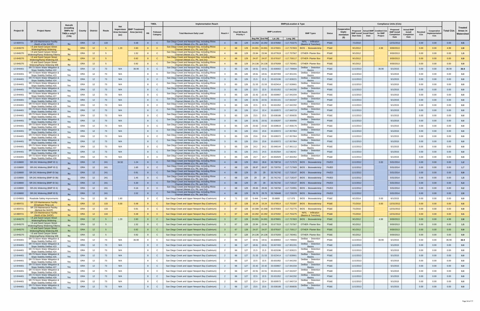
Beg PM End PM Lat. (N) Long. (W)
Revoked CUs
Total CUsTreated Areas in
WatershedRBPollutant Category
Total Maximum Daily Load Reach #Final SB Reach
Priority #
Compliance Units (CUs)
Cooperative Imple-
mentation ($)
Cooperative Implementation
CUs
Proposed BMP Install Start Date
Actual BMP Install Start
Date
Credited CUs for BMP Project
Proposed BMP Install Completion
Date
Actual BMP Install
Completion Date
Net Impervious
Area Increase (ac)
BMP Treatment Area (acres)
TMDL Implementation Reach BMP(s)Location & Type
BMP LocationsBMP Types Status
RouteProject ID Project Name
Retrofit (installing BMPs for
TMDLs only)? (Y/N)
County District
12-0E9721SR 133 Maintenance Facility
(North of the SHOP) No ORA 12 133 0.48 8 CSan Diego Creek and Newport Bay, including Rhine
Channel (Metals (Cu, Pb, and Zn))4 68 129 10.292 10.292 33.679392 -117.753275
INFIL - Infiltration (Basins & Trenches)
PS&E 7/1/2010 12/31/2012 0.00 0.00 0.00 0.5
12-0H0270I-5 and Sand Canyon Street Widening/Ramp Widening No ORA 12 5 1.20 2.83 8 C
San Diego Creek and Newport Bay, including Rhine Channel (Metals (Cu, Pb, and Zn))
4 68 129 24.001 24.001 33.679001 -117.757803 BIOS - Bioswale/strip PS&E 9/1/2012 4.99 9/30/2013 0.00 0.00 4.99 2.8
12-0H0270I-5 and Sand Canyon Street
Widening/Ramp Widening Filterra No ORA 12 5 1.52 8 CSan Diego Creek and Newport Bay, including Rhine
Channel (Metals (Cu, Pb, and Zn))4 68 129 23.94 23.94 33.677819 -117.757567 OTHER- Planter Box PS&E 9/1/2012 9/30/2013 0.00 0.00 0.00 1.5
12-0H0270I-5 and Sand Canyon Street
Widening/Ramp Widening EB No ORA 12 5 0.92 8 CSan Diego Creek and Newport Bay, including Rhine
Channel (Metals (Cu, Pb, and Zn))4 68 129 24.07 24.07 33.679167 -117.759117 OTHER- Planter Box PS&E 9/1/2012 9/30/2013 0.00 0.00 0.00 0.9
12-0H0270I-5 and Sand Canyon Street
Widening/Ramp Widening WB No ORA 12 5 0.92 8 CSan Diego Creek and Newport Bay, including Rhine
Channel (Metals (Cu, Pb, and Zn))4 68 129 24.136 24.136 33.679269 -117.760461 OTHER- Planter Box PS&E 9/1/2012 9/30/2013 0.00 0.00 0.00 0.9
12-0H4401SR-73 Storm Water Mitigation &
Slope Stability DetBas #22 Yes ORA 12 73 N/A 36.90 8 CSan Diego Creek and Newport Bay, including Rhine
Channel (Metals (Cu, Pb, and Zn))3 65 126 19.51 19.51 33.606902 -117.799694
DetBas - Detention Basins
PS&E 11/1/2013 36.90 5/1/2015 0.00 0.00 36.90 36.9
12-0H4401SR-73 Storm Water Mitigation &
Slope Stability DetBas #23 Yes ORA 12 73 N/A 8 CSan Diego Creek and Newport Bay, including Rhine
Channel (Metals (Cu, Pb, and Zn))3 65 126 19.61 19.61 33.607493 -117.801331
DetBas - Detention Basins
PS&E 11/1/2013 5/1/2015 0.00 0.00 0.00 0.0
12-0H4401SR-73 Storm Water Mitigation &
Slope Stability DetBas #24 Yes ORA 12 73 N/A 8 CSan Diego Creek and Newport Bay, including Rhine
Channel (Metals (Cu, Pb, and Zn))3 65 126 21.5 21.5 33.623196 -117.828221
DetBas - Detention Basins
PS&E 11/1/2013 5/1/2015 0.00 0.00 0.00 0.0
12-0H4401SR-73 Storm Water Mitigation &
Slope Stability DetBas #25 Yes ORA 12 73 N/A 8 CSan Diego Creek and Newport Bay, including Rhine
Channel (Metals (Cu, Pb, and Zn))3 65 126 21.53 21.53 33.623414 -117.828661
DetBas - Detention Basins
PS&E 11/1/2013 5/1/2015 0.00 0.00 0.00 0.0
12-0H4401SR-73 Storm Water Mitigation &
Slope Stability DetBas #26 Yes ORA 12 73 N/A 8 CSan Diego Creek and Newport Bay, including Rhine
Channel (Metals (Cu, Pb, and Zn))3 65 126 22.5 22.5 33.631052 -117.842292
DetBas - Detention Basins
PS&E 11/1/2013 5/1/2015 0.00 0.00 0.00 0.0
12-0H4401SR-73 Storm Water Mitigation &
Slope Stability DetBas #27 Yes ORA 12 73 N/A 8 CSan Diego Creek and Newport Bay, including Rhine
Channel (Metals (Cu, Pb, and Zn))3 65 126 22.42 22.42 33.630667 -117.841034
DetBas - Detention Basins
PS&E 11/1/2013 5/1/2015 0.00 0.00 0.00 0.0
12-0H4401SR-73 Storm Water Mitigation &
Slope Stability DetBas #28 Yes ORA 12 73 N/A 8 CSan Diego Creek and Newport Bay, including Rhine
Channel (Metals (Cu, Pb, and Zn))3 65 126 22.51 22.51 33.631101 -117.842447
DetBas - Detention Basins
PS&E 11/1/2013 5/1/2015 0.00 0.00 0.00 0.0
12-0H4401SR-73 Storm Water Mitigation &
Slope Stability DetBas #29 Yes ORA 12 73 N/A 8 CSan Diego Creek and Newport Bay, including Rhine
Channel (Metals (Cu, Pb, and Zn))3 65 126 22.5 22.5 33.631052 -117.842292
DetBas - Detention Basins
PS&E 11/1/2013 5/1/2015 0.00 0.00 0.00 0.0
12-0H4401SR-73 Storm Water Mitigation &
Slope Stability DetBas #30 Yes ORA 12 73 N/A 8 CSan Diego Creek and Newport Bay, including Rhine
Channel (Metals (Cu, Pb, and Zn))3 65 126 22.4 22.4 33.630572 -117.840719
DetBas - Detention Basins
PS&E 11/1/2013 5/1/2015 0.00 0.00 0.00 0.0
12-0H4401SR-73 Storm Water Mitigation &
Slope Stability DetBas #31 Yes ORA 12 73 N/A 8 CSan Diego Creek and Newport Bay, including Rhine
Channel (Metals (Cu, Pb, and Zn))3 65 126 23.5 23.5 33.638188 -117.856835
DetBas - Detention Basins
PS&E 11/1/2013 5/1/2015 0.00 0.00 0.00 0.0
12-0H4401SR-73 Storm Water Mitigation &
Slope Stability DetBas #32 Yes ORA 12 73 N/A 8 CSan Diego Creek and Newport Bay, including Rhine
Channel (Metals (Cu, Pb, and Zn))3 65 126 23.51 23.51 33.638297 -117.856956
DetBas - Detention Basins
PS&E 11/1/2013 5/1/2015 0.00 0.00 0.00 0.0
12-0H4401SR-73 Storm Water Mitigation &
Slope Stability DetBas #33 Yes ORA 12 73 N/A 8 CSan Diego Creek and Newport Bay, including Rhine
Channel (Metals (Cu, Pb, and Zn))3 65 126 23.62 23.62 33.639619 -117.858176
DetBas - Detention Basins
PS&E 11/1/2013 5/1/2015 0.00 0.00 0.00 0.0
12-0H4401SR-73 Storm Water Mitigation &
Slope Stability DetBas #34 Yes ORA 12 73 N/A 8 CSan Diego Creek and Newport Bay, including Rhine
Channel (Metals (Cu, Pb, and Zn))3 65 126 23.6 23.6 33.639372 -117.857964
DetBas - Detention Basins
PS&E 11/1/2013 5/1/2015 0.00 0.00 0.00 0.0
12-0H4401SR-73 Storm Water Mitigation &
Slope Stability DetBas #35 Yes ORA 12 73 N/A 8 CSan Diego Creek and Newport Bay, including Rhine
Channel (Metals (Cu, Pb, and Zn))3 65 126 23.6 23.6 33.639372 -117.857964
DetBas - Detention Basins
PS&E 11/1/2013 5/1/2015 0.00 0.00 0.00 0.0
12-0H4401SR-73 Storm Water Mitigation &
Slope Stability DetBas #36 Yes ORA 12 73 N/A 8 CSan Diego Creek and Newport Bay, including Rhine
Channel (Metals (Cu, Pb, and Zn))3 65 126 23.6 23.6 33.639372 -117.857964
DetBas - Detention Basins
PS&E 11/1/2013 5/1/2015 0.00 0.00 0.00 0.0
12-0H4401SR-73 Storm Water Mitigation &
Slope Stability DetBas #37 Yes ORA 12 73 N/A 8 CSan Diego Creek and Newport Bay, including Rhine
Channel (Metals (Cu, Pb, and Zn))3 65 126 24.2 24.2 33.648144 -117.861112
DetBas - Detention Basins
PS&E 11/1/2013 5/1/2015 0.00 0.00 0.00 0.0
12-0H4401SR-73 Storm Water Mitigation &
Slope Stability DetBas #38 Yes ORA 12 73 N/A 8 CSan Diego Creek and Newport Bay, including Rhine
Channel (Metals (Cu, Pb, and Zn))3 65 126 24.5 24.5 33.652564 -117.86242
DetBas - Detention Basins
PS&E 11/1/2013 5/1/2015 0.00 0.00 0.00 0.0
12-0H4401SR-73 Storm Water Mitigation &
Slope Stability DetBas #39 Yes ORA 12 73 N/A 8 CSan Diego Creek and Newport Bay, including Rhine
Channel (Metals (Cu, Pb, and Zn))3 65 126 24.7 24.7 33.654929 -117.864352
DetBas - Detention Basins
PS&E 11/1/2013 5/1/2015 0.00 0.00 0.00 0.0
12-0J6800 SR-241 Widening (BMP ID 1) No ORA 12 241 34.50 1.24 8 CSan Diego Creek and Newport Bay, including Rhine
Channel (Metals (Cu, Pb, and Zn))4 68 129 28.8 28.8 33.738716 -117.717573 BIOS - Bioswale/strip PA/ED 11/1/2012 0.00 5/31/2014 0.00 0.00 0.00 1.2
12-0J6800 SR-241 Widening (BMP ID 2) No ORA 12 241 1.65 8 CSan Diego Creek and Newport Bay, including Rhine
Channel (Metals (Cu, Pb, and Zn))4 68 129 28.87 28.87 33.739793 -117.717669 BIOS - Bioswale/strip PA/ED 11/1/2012 5/31/2014 0.00 0.00 0.00 1.7
12-0J6800 SR-241 Widening (BMP ID 3a) No ORA 12 241 0.91 8 CSan Diego Creek and Newport Bay, including Rhine
Channel (Metals (Cu, Pb, and Zn))4 68 129 29 29 33.741742 -117.718147 BIOS - Bioswale/strip PA/ED 11/1/2012 5/31/2014 0.00 0.00 0.00 0.9
12-0J6800 SR-241 Widening (BMP ID 3b) No ORA 12 241 1.45 8 CSan Diego Creek and Newport Bay, including Rhine
Channel (Metals (Cu, Pb, and Zn))4 68 129 29 29 33.741742 -117.718147 BIOS - Bioswale/strip PA/ED 11/1/2012 5/31/2014 0.00 0.00 0.00 1.5
12-0J6800 SR-241 Widening (BMP ID 3c) No ORA 12 241 5.30 8 CSan Diego Creek and Newport Bay, including Rhine
Channel (Metals (Cu, Pb, and Zn))4 68 129 29 29 33.741742 -117.718147 BIOS - Bioswale/strip PA/ED 11/1/2012 5/31/2014 0.00 0.00 0.00 5.3
12-0J6800 SR-241 Widening (BMP ID 4) No ORA 12 241 0.16 8 CSan Diego Creek and Newport Bay, including Rhine
Channel (Metals (Cu, Pb, and Zn))4 68 129 29.65 29.65 33.748768 -117.724991 BIOS - Bioswale/strip PA/ED 11/1/2012 5/31/2014 0.00 0.00 0.00 0.2
12-0J6800 SR-241 Widening (BMP ID 5) No ORA 12 241 2.02 8 CSan Diego Creek and Newport Bay, including Rhine
Channel (Metals (Cu, Pb, and Zn))4 68 129 29.75 29.75 33.749448 -117.726378 BIOS - Bioswale/strip PA/ED 11/1/2012 5/31/2014 0.00 0.00 0.00 2.0
12-OH9001 Roadside Safety Improvments No Ora 12 55 1.60 8 C San Diego Creek and Upper Newport Bay (Cadmium) 4 71 132 5.444 5.444 33.6809 -117.878 BIOS - Bioswale/strip PS&E 6/1/2014 0.00 6/1/2015 0.00 0.00 0.00 0.0
12-0E9721SR 133 Maintenance Facility
(Employee Pkng Lot) No ORA 12 133 5.00 0.48 8 C San Diego Creek and Upper Newport Bay (Cadmium) 3 67 128 10.24 10.24 33.678514 -117.753397 BIOS - Bioswale/strip PS&E 7/1/2010 0.00 12/31/2012 0.00 0.00 0.00 0.5
12-0E9721SR 133 Maintenance Facility
(Behind the SHOP) No ORA 12 133 0.91 8 C San Diego Creek and Upper Newport Bay (Cadmium) 3 67 128 10.308 10.308 33.679303 -117.752775 BIOS - Bioswale/strip PS&E 7/1/2010 12/31/2012 0.00 0.00 0.00 0.9
12-0E9721SR 133 Maintenance Facility
(North of the SHOP) No ORA 12 133 0.48 8 C San Diego Creek and Upper Newport Bay (Cadmium) 3 67 128 10.292 10.292 33.679392 -117.753275INFIL - Infiltration
(Basins & Trenches)PS&E 7/1/2010 12/31/2012 0.00 0.00 0.00 0.5
12-0H0270I-5 and Sand Canyon Street Widening/Ramp Widening No ORA 12 5 1.20 2.83 8 C San Diego Creek and Upper Newport Bay (Cadmium) 3 67 128 24.001 24.001 33.679001 -117.757803 BIOS - Bioswale/strip PS&E 9/1/2012 4.99 9/30/2013 0.00 0.00 4.99 2.8
12-0H0270I-5 and Sand Canyon Street
Widening/Ramp Widening Filterra No ORA 12 5 1.52 8 C San Diego Creek and Upper Newport Bay (Cadmium) 3 67 128 23.94 23.94 33.677819 -117.757567 OTHER- Planter Box PS&E 9/1/2012 9/30/2013 0.00 0.00 0.00 1.5
12-0H0270I-5 and Sand Canyon Street
Widening/Ramp Widening EB No ORA 12 5 0.92 8 C San Diego Creek and Upper Newport Bay (Cadmium) 3 67 128 24.07 24.07 33.679167 -117.759117 OTHER- Planter Box PS&E 9/1/2012 9/30/2013 0.00 0.00 0.00 0.9
12-0H0270I-5 and Sand Canyon Street
Widening/Ramp Widening WB No ORA 12 5 0.92 8 C San Diego Creek and Upper Newport Bay (Cadmium) 3 67 128 24.136 24.136 33.679269 -117.760461 OTHER- Planter Box PS&E 9/1/2012 9/30/2013 0.00 0.00 0.00 0.9
12-0H4401SR-73 Storm Water Mitigation &
Slope Stability DetBas #22 Yes ORA 12 73 N/A 36.90 8 C San Diego Creek and Upper Newport Bay (Cadmium) 2 66 127 19.51 19.51 33.606902 -117.799694DetBas - Detention
BasinsPS&E 11/1/2013 36.90 5/1/2015 0.00 0.00 36.90 36.9
12-0H4401SR-73 Storm Water Mitigation &
Slope Stability DetBas #23 Yes ORA 12 73 N/A 8 C San Diego Creek and Upper Newport Bay (Cadmium) 2 66 127 19.61 19.61 33.607493 -117.801331DetBas - Detention
BasinsPS&E 11/1/2013 5/1/2015 0.00 0.00 0.00 0.0
12-0H4401SR-73 Storm Water Mitigation &
Slope Stability DetBas #24 Yes ORA 12 73 N/A 8 C San Diego Creek and Upper Newport Bay (Cadmium) 2 66 127 21.5 21.5 33.623196 -117.828221DetBas - Detention
BasinsPS&E 11/1/2013 5/1/2015 0.00 0.00 0.00 0.0
12-0H4401SR-73 Storm Water Mitigation &
Slope Stability DetBas #25 Yes ORA 12 73 N/A 8 C San Diego Creek and Upper Newport Bay (Cadmium) 2 66 127 21.53 21.53 33.623414 -117.828661DetBas - Detention
BasinsPS&E 11/1/2013 5/1/2015 0.00 0.00 0.00 0.0
12-0H4401SR-73 Storm Water Mitigation &
Slope Stability DetBas #26 Yes ORA 12 73 N/A 8 C San Diego Creek and Upper Newport Bay (Cadmium) 2 66 127 22.5 22.5 33.631052 -117.842292DetBas - Detention
BasinsPS&E 11/1/2013 5/1/2015 0.00 0.00 0.00 0.0
12-0H4401SR-73 Storm Water Mitigation &
Slope Stability DetBas #27 Yes ORA 12 73 N/A 8 C San Diego Creek and Upper Newport Bay (Cadmium) 2 66 127 22.42 22.42 33.630667 -117.841034DetBas - Detention
BasinsPS&E 11/1/2013 5/1/2015 0.00 0.00 0.00 0.0
12-0H4401SR-73 Storm Water Mitigation &
Slope Stability DetBas #28 Yes ORA 12 73 N/A 8 C San Diego Creek and Upper Newport Bay (Cadmium) 2 66 127 22.51 22.51 33.631101 -117.842447DetBas - Detention
BasinsPS&E 11/1/2013 5/1/2015 0.00 0.00 0.00 0.0
12-0H4401SR-73 Storm Water Mitigation &
Slope Stability DetBas #29 Yes ORA 12 73 N/A 8 C San Diego Creek and Upper Newport Bay (Cadmium) 2 66 127 22.5 22.5 33.631052 -117.842292DetBas - Detention
BasinsPS&E 11/1/2013 5/1/2015 0.00 0.00 0.00 0.0
12-0H4401SR-73 Storm Water Mitigation &
Slope Stability DetBas #30 Yes ORA 12 73 N/A 8 C San Diego Creek and Upper Newport Bay (Cadmium) 2 66 127 22.4 22.4 33.630572 -117.840719DetBas - Detention
BasinsPS&E 11/1/2013 5/1/2015 0.00 0.00 0.00 0.0
12-0H4401SR-73 Storm Water Mitigation &
Slope Stability DetBas #31 Yes ORA 12 73 N/A 8 C San Diego Creek and Upper Newport Bay (Cadmium) 2 66 127 23.5 23.5 33.638188 -117.856835DetBas - Detention
BasinsPS&E 11/1/2013 5/1/2015 0.00 0.00 0.00 0.0
Page 54 of 77
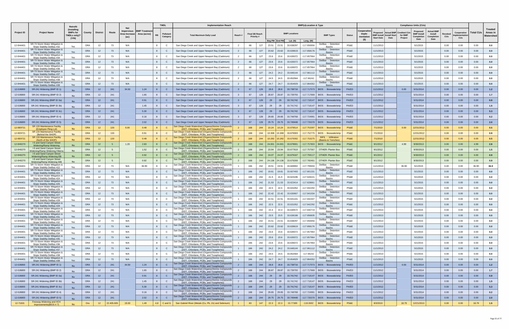
Beg PM End PM Lat. (N) Long. (W)
Revoked CUs
Total CUsTreated Areas in
WatershedRBPollutant Category
Total Maximum Daily Load Reach #Final SB Reach
Priority #
Compliance Units (CUs)
Cooperative Imple-
mentation ($)
Cooperative Implementation
CUs
Proposed BMP Install Start Date
Actual BMP Install Start
Date
Credited CUs for BMP Project
Proposed BMP Install Completion
Date
Actual BMP Install
Completion Date
Net Impervious
Area Increase (ac)
BMP Treatment Area (acres)
TMDL Implementation Reach BMP(s)Location & Type
BMP LocationsBMP Types Status
RouteProject ID Project Name
Retrofit (installing BMPs for
TMDLs only)? (Y/N)
County District
12-0H4401SR-73 Storm Water Mitigation &
Slope Stability DetBas #32 Yes ORA 12 73 N/A 8 C San Diego Creek and Upper Newport Bay (Cadmium) 2 66 127 23.51 23.51 33.638297 -117.856956DetBas - Detention
BasinsPS&E 11/1/2013 5/1/2015 0.00 0.00 0.00 0.0
12-0H4401SR-73 Storm Water Mitigation &
Slope Stability DetBas #33 Yes ORA 12 73 N/A 8 C San Diego Creek and Upper Newport Bay (Cadmium) 2 66 127 23.62 23.62 33.639619 -117.858176DetBas - Detention
BasinsPS&E 11/1/2013 5/1/2015 0.00 0.00 0.00 0.0
12-0H4401SR-73 Storm Water Mitigation &
Slope Stability DetBas #34 Yes ORA 12 73 N/A 8 C San Diego Creek and Upper Newport Bay (Cadmium) 2 66 127 23.6 23.6 33.639372 -117.857964DetBas - Detention
BasinsPS&E 11/1/2013 5/1/2015 0.00 0.00 0.00 0.0
12-0H4401SR-73 Storm Water Mitigation &
Slope Stability DetBas #35 Yes ORA 12 73 N/A 8 C San Diego Creek and Upper Newport Bay (Cadmium) 2 66 127 23.6 23.6 33.639372 -117.857964DetBas - Detention
BasinsPS&E 11/1/2013 5/1/2015 0.00 0.00 0.00 0.0
12-0H4401SR-73 Storm Water Mitigation &
Slope Stability DetBas #36 Yes ORA 12 73 N/A 8 C San Diego Creek and Upper Newport Bay (Cadmium) 2 66 127 23.6 23.6 33.639372 -117.857964DetBas - Detention
BasinsPS&E 11/1/2013 5/1/2015 0.00 0.00 0.00 0.0
12-0H4401SR-73 Storm Water Mitigation &
Slope Stability DetBas #37 Yes ORA 12 73 N/A 8 C San Diego Creek and Upper Newport Bay (Cadmium) 2 66 127 24.2 24.2 33.648144 -117.861112DetBas - Detention
BasinsPS&E 11/1/2013 5/1/2015 0.00 0.00 0.00 0.0
12-0H4401SR-73 Storm Water Mitigation &
Slope Stability DetBas #38 Yes ORA 12 73 N/A 8 C San Diego Creek and Upper Newport Bay (Cadmium) 2 66 127 24.5 24.5 33.652564 -117.86242DetBas - Detention
BasinsPS&E 11/1/2013 5/1/2015 0.00 0.00 0.00 0.0
12-0H4401SR-73 Storm Water Mitigation &
Slope Stability DetBas #39 Yes ORA 12 73 N/A 8 C San Diego Creek and Upper Newport Bay (Cadmium) 2 66 127 24.7 24.7 33.654929 -117.864352DetBas - Detention
BasinsPS&E 11/1/2013 5/1/2015 0.00 0.00 0.00 0.0
12-0J6800 SR-241 Widening (BMP ID 1) No ORA 12 241 34.50 1.24 8 C San Diego Creek and Upper Newport Bay (Cadmium) 3 67 128 28.8 28.8 33.738716 -117.717573 BIOS - Bioswale/strip PA/ED 11/1/2012 0.00 5/31/2014 0.00 0.00 0.00 1.2
12-0J6800 SR-241 Widening (BMP ID 2) No ORA 12 241 1.65 8 C San Diego Creek and Upper Newport Bay (Cadmium) 3 67 128 28.87 28.87 33.739793 -117.717669 BIOS - Bioswale/strip PA/ED 11/1/2012 5/31/2014 0.00 0.00 0.00 1.7
12-0J6800 SR-241 Widening (BMP ID 3a) No ORA 12 241 0.91 8 C San Diego Creek and Upper Newport Bay (Cadmium) 3 67 128 29 29 33.741742 -117.718147 BIOS - Bioswale/strip PA/ED 11/1/2012 5/31/2014 0.00 0.00 0.00 0.9
12-0J6800 SR-241 Widening (BMP ID 3b) No ORA 12 241 1.45 8 C San Diego Creek and Upper Newport Bay (Cadmium) 3 67 128 29 29 33.741742 -117.718147 BIOS - Bioswale/strip PA/ED 11/1/2012 5/31/2014 0.00 0.00 0.00 1.5
12-0J6800 SR-241 Widening (BMP ID 3c) No ORA 12 241 5.30 8 C San Diego Creek and Upper Newport Bay (Cadmium) 3 67 128 29 29 33.741742 -117.718147 BIOS - Bioswale/strip PA/ED 11/1/2012 5/31/2014 0.00 0.00 0.00 5.3
12-0J6800 SR-241 Widening (BMP ID 4) No ORA 12 241 0.16 8 C San Diego Creek and Upper Newport Bay (Cadmium) 3 67 128 29.65 29.65 33.748768 -117.724991 BIOS - Bioswale/strip PA/ED 11/1/2012 5/31/2014 0.00 0.00 0.00 0.2
12-0J6800 SR-241 Widening (BMP ID 5) No ORA 12 241 2.02 8 C San Diego Creek and Upper Newport Bay (Cadmium) 3 67 128 29.75 29.75 33.749448 -117.726378 BIOS - Bioswale/strip PA/ED 11/1/2012 5/31/2014 0.00 0.00 0.00 2.0
12-0E9721SR 133 Maintenance Facility
(Employee Pkng Lot) No ORA 12 133 5.00 0.48 8 CSan Diego Creek Watershed (Organochlorine Compounds
(DDT, Chlordane, PCBs, and Toxaphene))2 168 244 10.24 10.24 33.678514 -117.753397 BIOS - Bioswale/strip PS&E 7/1/2010 0.00 12/31/2012 0.00 0.00 0.00 0.5
12-0E9721SR 133 Maintenance Facility
(Behind the SHOP) No ORA 12 133 0.91 8 CSan Diego Creek Watershed (Organochlorine Compounds
(DDT, Chlordane, PCBs, and Toxaphene))2 168 244 10.308 10.308 33.679303 -117.752775 BIOS - Bioswale/strip PS&E 7/1/2010 12/31/2012 0.00 0.00 0.00 0.9
12-0E9721SR 133 Maintenance Facility
(North of the SHOP) No ORA 12 133 0.48 8 CSan Diego Creek Watershed (Organochlorine Compounds
(DDT, Chlordane, PCBs, and Toxaphene))2 168 244 10.292 10.292 33.679392 -117.753275
INFIL - Infiltration (Basins & Trenches)
PS&E 7/1/2010 12/31/2012 0.00 0.00 0.00 0.5
12-0H0270I-5 and Sand Canyon Street Widening/Ramp Widening No ORA 12 5 1.20 2.83 8 C
San Diego Creek Watershed (Organochlorine Compounds (DDT, Chlordane, PCBs, and Toxaphene))
2 168 244 24.001 24.001 33.679001 -117.757803 BIOS - Bioswale/strip PS&E 9/1/2012 4.99 9/30/2013 0.00 0.00 4.99 2.8
12-0H0270I-5 and Sand Canyon Street
Widening/Ramp Widening Filterra No ORA 12 5 1.52 8 CSan Diego Creek Watershed (Organochlorine Compounds
(DDT, Chlordane, PCBs, and Toxaphene))2 168 244 23.94 23.94 33.677819 -117.757567 OTHER- Planter Box PS&E 9/1/2012 9/30/2013 0.00 0.00 0.00 1.5
12-0H0270I-5 and Sand Canyon Street
Widening/Ramp Widening EB No ORA 12 5 0.92 8 CSan Diego Creek Watershed (Organochlorine Compounds
(DDT, Chlordane, PCBs, and Toxaphene))2 168 244 24.07 24.07 33.679167 -117.759117 OTHER- Planter Box PS&E 9/1/2012 9/30/2013 0.00 0.00 0.00 0.9
12-0H0270I-5 and Sand Canyon Street
Widening/Ramp Widening WB No ORA 12 5 0.92 8 CSan Diego Creek Watershed (Organochlorine Compounds
(DDT, Chlordane, PCBs, and Toxaphene))2 168 244 24.136 24.136 33.679269 -117.760461 OTHER- Planter Box PS&E 9/1/2012 9/30/2013 0.00 0.00 0.00 0.9
12-0H4401SR-73 Storm Water Mitigation &
Slope Stability DetBas #22 Yes ORA 12 73 N/A 36.90 8 CSan Diego Creek Watershed (Organochlorine Compounds
(DDT, Chlordane, PCBs, and Toxaphene))1 166 242 19.51 19.51 33.606902 -117.799694
DetBas - Detention Basins
PS&E 11/1/2013 36.90 5/1/2015 0.00 0.00 36.90 36.9
12-0H4401SR-73 Storm Water Mitigation &
Slope Stability DetBas #23 Yes ORA 12 73 N/A 8 CSan Diego Creek Watershed (Organochlorine Compounds
(DDT, Chlordane, PCBs, and Toxaphene))1 166 242 19.61 19.61 33.607493 -117.801331
DetBas - Detention Basins
PS&E 11/1/2013 5/1/2015 0.00 0.00 0.00 0.0
12-0H4401SR-73 Storm Water Mitigation &
Slope Stability DetBas #24 Yes ORA 12 73 N/A 8 CSan Diego Creek Watershed (Organochlorine Compounds
(DDT, Chlordane, PCBs, and Toxaphene))1 166 242 21.5 21.5 33.623196 -117.828221
DetBas - Detention Basins
PS&E 11/1/2013 5/1/2015 0.00 0.00 0.00 0.0
12-0H4401SR-73 Storm Water Mitigation &
Slope Stability DetBas #25 Yes ORA 12 73 N/A 8 CSan Diego Creek Watershed (Organochlorine Compounds
(DDT, Chlordane, PCBs, and Toxaphene))1 166 242 21.53 21.53 33.623414 -117.828661
DetBas - Detention Basins
PS&E 11/1/2013 5/1/2015 0.00 0.00 0.00 0.0
12-0H4401SR-73 Storm Water Mitigation &
Slope Stability DetBas #26 Yes ORA 12 73 N/A 8 CSan Diego Creek Watershed (Organochlorine Compounds
(DDT, Chlordane, PCBs, and Toxaphene))1 166 242 22.5 22.5 33.631052 -117.842292
DetBas - Detention Basins
PS&E 11/1/2013 5/1/2015 0.00 0.00 0.00 0.0
12-0H4401SR-73 Storm Water Mitigation &
Slope Stability DetBas #27 Yes ORA 12 73 N/A 8 CSan Diego Creek Watershed (Organochlorine Compounds
(DDT, Chlordane, PCBs, and Toxaphene))1 166 242 22.42 22.42 33.630667 -117.841034
DetBas - Detention Basins
PS&E 11/1/2013 5/1/2015 0.00 0.00 0.00 0.0
12-0H4401SR-73 Storm Water Mitigation &
Slope Stability DetBas #28 Yes ORA 12 73 N/A 8 CSan Diego Creek Watershed (Organochlorine Compounds
(DDT, Chlordane, PCBs, and Toxaphene))1 166 242 22.51 22.51 33.631101 -117.842447
DetBas - Detention Basins
PS&E 11/1/2013 5/1/2015 0.00 0.00 0.00 0.0
12-0H4401SR-73 Storm Water Mitigation &
Slope Stability DetBas #29 Yes ORA 12 73 N/A 8 CSan Diego Creek Watershed (Organochlorine Compounds
(DDT, Chlordane, PCBs, and Toxaphene))1 166 242 22.5 22.5 33.631052 -117.842292
DetBas - Detention Basins
PS&E 11/1/2013 5/1/2015 0.00 0.00 0.00 0.0
12-0H4401SR-73 Storm Water Mitigation &
Slope Stability DetBas #30 Yes ORA 12 73 N/A 8 CSan Diego Creek Watershed (Organochlorine Compounds
(DDT, Chlordane, PCBs, and Toxaphene))1 166 242 22.4 22.4 33.630572 -117.840719
DetBas - Detention Basins
PS&E 11/1/2013 5/1/2015 0.00 0.00 0.00 0.0
12-0H4401SR-73 Storm Water Mitigation &
Slope Stability DetBas #31 Yes ORA 12 73 N/A 8 CSan Diego Creek Watershed (Organochlorine Compounds
(DDT, Chlordane, PCBs, and Toxaphene))1 166 242 23.5 23.5 33.638188 -117.856835
DetBas - Detention Basins
PS&E 11/1/2013 5/1/2015 0.00 0.00 0.00 0.0
12-0H4401SR-73 Storm Water Mitigation &
Slope Stability DetBas #32 Yes ORA 12 73 N/A 8 CSan Diego Creek Watershed (Organochlorine Compounds
(DDT, Chlordane, PCBs, and Toxaphene))1 166 242 23.51 23.51 33.638297 -117.856956
DetBas - Detention Basins
PS&E 11/1/2013 5/1/2015 0.00 0.00 0.00 0.0
12-0H4401SR-73 Storm Water Mitigation &
Slope Stability DetBas #33 Yes ORA 12 73 N/A 8 CSan Diego Creek Watershed (Organochlorine Compounds
(DDT, Chlordane, PCBs, and Toxaphene))1 166 242 23.62 23.62 33.639619 -117.858176
DetBas - Detention Basins
PS&E 11/1/2013 5/1/2015 0.00 0.00 0.00 0.0
12-0H4401SR-73 Storm Water Mitigation &
Slope Stability DetBas #34 Yes ORA 12 73 N/A 8 CSan Diego Creek Watershed (Organochlorine Compounds
(DDT, Chlordane, PCBs, and Toxaphene))1 166 242 23.6 23.6 33.639372 -117.857964
DetBas - Detention Basins
PS&E 11/1/2013 5/1/2015 0.00 0.00 0.00 0.0
12-0H4401SR-73 Storm Water Mitigation &
Slope Stability DetBas #35 Yes ORA 12 73 N/A 8 CSan Diego Creek Watershed (Organochlorine Compounds
(DDT, Chlordane, PCBs, and Toxaphene))1 166 242 23.6 23.6 33.639372 -117.857964
DetBas - Detention Basins
PS&E 11/1/2013 5/1/2015 0.00 0.00 0.00 0.0
12-0H4401SR-73 Storm Water Mitigation &
Slope Stability DetBas #36 Yes ORA 12 73 N/A 8 CSan Diego Creek Watershed (Organochlorine Compounds
(DDT, Chlordane, PCBs, and Toxaphene))1 166 242 23.6 23.6 33.639372 -117.857964
DetBas - Detention Basins
PS&E 11/1/2013 5/1/2015 0.00 0.00 0.00 0.0
12-0H4401SR-73 Storm Water Mitigation &
Slope Stability DetBas #37 Yes ORA 12 73 N/A 8 CSan Diego Creek Watershed (Organochlorine Compounds
(DDT, Chlordane, PCBs, and Toxaphene))1 166 242 24.2 24.2 33.648144 -117.861112
DetBas - Detention Basins
PS&E 11/1/2013 5/1/2015 0.00 0.00 0.00 0.0
12-0H4401SR-73 Storm Water Mitigation &
Slope Stability DetBas #38 Yes ORA 12 73 N/A 8 CSan Diego Creek Watershed (Organochlorine Compounds
(DDT, Chlordane, PCBs, and Toxaphene))1 166 242 24.5 24.5 33.652564 -117.86242
DetBas - Detention Basins
PS&E 11/1/2013 5/1/2015 0.00 0.00 0.00 0.0
12-0H4401SR-73 Storm Water Mitigation &
Slope Stability DetBas #39 Yes ORA 12 73 N/A 8 CSan Diego Creek Watershed (Organochlorine Compounds
(DDT, Chlordane, PCBs, and Toxaphene))1 166 242 24.7 24.7 33.654929 -117.864352
DetBas - Detention Basins
PS&E 11/1/2013 5/1/2015 0.00 0.00 0.00 0.0
12-0J6800 SR-241 Widening (BMP ID 1) No ORA 12 241 34.50 1.24 8 CSan Diego Creek Watershed (Organochlorine Compounds
(DDT, Chlordane, PCBs, and Toxaphene))2 168 244 28.8 28.8 33.738716 -117.717573 BIOS - Bioswale/strip PA/ED 11/1/2012 0.00 5/31/2014 0.00 0.00 0.00 1.2
12-0J6800 SR-241 Widening (BMP ID 2) No ORA 12 241 1.65 8 CSan Diego Creek Watershed (Organochlorine Compounds
(DDT, Chlordane, PCBs, and Toxaphene))2 168 244 28.87 28.87 33.739793 -117.717669 BIOS - Bioswale/strip PA/ED 11/1/2012 5/31/2014 0.00 0.00 0.00 1.7
12-0J6800 SR-241 Widening (BMP ID 3a) No ORA 12 241 0.91 8 CSan Diego Creek Watershed (Organochlorine Compounds
(DDT, Chlordane, PCBs, and Toxaphene))2 168 244 29 29 33.741742 -117.718147 BIOS - Bioswale/strip PA/ED 11/1/2012 5/31/2014 0.00 0.00 0.00 0.9
12-0J6800 SR-241 Widening (BMP ID 3b) No ORA 12 241 1.45 8 CSan Diego Creek Watershed (Organochlorine Compounds
(DDT, Chlordane, PCBs, and Toxaphene))2 168 244 29 29 33.741742 -117.718147 BIOS - Bioswale/strip PA/ED 11/1/2012 5/31/2014 0.00 0.00 0.00 1.5
12-0J6800 SR-241 Widening (BMP ID 3c) No ORA 12 241 5.30 8 CSan Diego Creek Watershed (Organochlorine Compounds
(DDT, Chlordane, PCBs, and Toxaphene))2 168 244 29 29 33.741742 -117.718147 BIOS - Bioswale/strip PA/ED 11/1/2012 5/31/2014 0.00 0.00 0.00 5.3
12-0J6800 SR-241 Widening (BMP ID 4) No ORA 12 241 0.16 8 CSan Diego Creek Watershed (Organochlorine Compounds
(DDT, Chlordane, PCBs, and Toxaphene))2 168 244 29.65 29.65 33.748768 -117.724991 BIOS - Bioswale/strip PA/ED 11/1/2012 5/31/2014 0.00 0.00 0.00 0.2
12-0J6800 SR-241 Widening (BMP ID 5) No ORA 12 241 2.02 8 CSan Diego Creek Watershed (Organochlorine Compounds
(DDT, Chlordane, PCBs, and Toxaphene))2 168 244 29.75 29.75 33.749448 -117.726378 BIOS - Bioswale/strip PA/ED 11/1/2012 5/31/2014 0.00 0.00 0.00 2.0
12-71631Freeway Widening and HOV
Improvements(BIOS # 7) No Ora 12 22.405.605 19.00 1.49 4,8 C and G San Gabriel River (Metals (Cu, Pb, Zn) and Selenium) 1 83 147 22.3 22.3 33.77389 -118.0692 BIOS - Bioswale/strip PS&E 8/3/2010 18.79 12/21/2013 0.00 0.00 18.79 1.5
Page 55 of 77
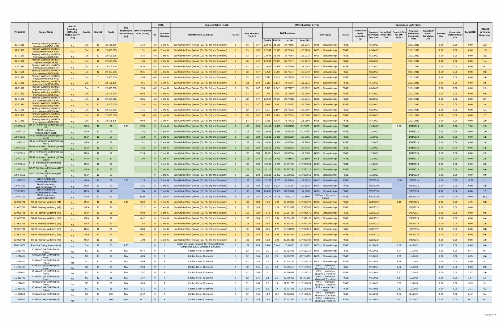
Beg PM End PM Lat. (N) Long. (W)
Revoked CUs
Total CUsTreated Areas in
WatershedRBPollutant Category
Total Maximum Daily Load Reach #Final SB Reach
Priority #
Compliance Units (CUs)
Cooperative Imple-
mentation ($)
Cooperative Implementation
CUs
Proposed BMP Install Start Date
Actual BMP Install Start
Date
Credited CUs for BMP Project
Proposed BMP Install Completion
Date
Actual BMP Install
Completion Date
Net Impervious
Area Increase (ac)
BMP Treatment Area (acres)
TMDL Implementation Reach BMP(s)Location & Type
BMP LocationsBMP Types Status
RouteProject ID Project Name
Retrofit (installing BMPs for
TMDLs only)? (Y/N)
County District
12-71631Freeway Widening and HOV Improvements(BIOS # 29) No Ora 12 22.405.605 1.34 4,8 C and G San Gabriel River (Metals (Cu, Pb, Zn) and Selenium) 1 83 147 22.559 22.559 33.77505 -118.0734 BIOS - Bioswale/strip PS&E 8/3/2010 12/21/2013 0.00 0.00 0.00 1.3
12-71631Freeway Widening and HOV
Improvements(BIOS #34) No Ora 12 22.405.605 1.51 4,8 C and G San Gabriel River (Metals (Cu, Pb, Zn) and Selenium) 1 83 147 22.543 22.543 33.77409 -118.0734 BIOS - Bioswale/strip PS&E 8/3/2010 12/21/2013 0.00 0.00 0.00 1.5
12-71631Freeway Widening and HOV
Improvements(BIOS #35) No Ora 12 22.405.605 3.16 4,8 C and G San Gabriel River (Metals (Cu, Pb, Zn) and Selenium) 1 83 147 22.548 22.548 33.77503 -118.0732 BIOS - Bioswale/strip PS&E 8/3/2010 12/21/2013 0.00 0.00 0.00 3.2
12-71631Freeway Widening and HOV
Improvements(BIOS 38) No Ora 12 22.405.605 1.36 4,8 C and G San Gabriel River (Metals (Cu, Pb, Zn) and Selenium) 1 83 147 22.804 22.804 33.77477 -118.0774 BIOS - Bioswale/strip PS&E 8/3/2010 12/21/2013 0.00 0.00 0.00 1.4
12-71631Freeway Widening and HOV
Improvements(BIOS #47) No Ora 12 22.405.605 9.26 4,8 C and G San Gabriel River (Metals (Cu, Pb, Zn) and Selenium) 1 83 147 22.625 22.625 33.77359 -118.0748 BIOS - Bioswale/strip PS&E 8/3/2010 12/21/2013 0.00 0.00 0.00 9.3
12-71631Freeway Widening and HOV
Improvements(BIOS #49) No Ora 12 22.405.605 0.31 4,8 C and G San Gabriel River (Metals (Cu, Pb, Zn) and Selenium) 1 83 147 3.258 3.258 33.78074 -118.0918 BIOS - Bioswale/strip PS&E 8/3/2010 12/21/2013 0.00 0.00 0.00 0.3
12-71631Freeway Widening and HOV
Improvements(BIOS #52) No Ora 7 22.405.605 2.63 4,8 C and G San Gabriel River (Metals (Cu, Pb, Zn) and Selenium) 1 83 147 0.313 0.313 33.78935 -118.0915 BIOS - Bioswale/strip PS&E 8/3/2010 12/21/2013 0.00 0.00 0.00 2.6
12-71631Freeway Widening and HOV Improvements(BIOS #53A) No Ora 7 22.405.605 3.51 4,8 C and G San Gabriel River (Metals (Cu, Pb, Zn) and Selenium) 6 108 183 0.113 0.113 33.80797 -118.0811 BIOS - Bioswale/strip PS&E 8/3/2010 12/21/2013 0.00 0.00 0.00 3.5
12-71631Freeway Widening and HOV Improvements(BIOS #53B) No Ora 7 22.405.605 2.26 4,8 C and G San Gabriel River (Metals (Cu, Pb, Zn) and Selenium) 1 83 147 0.347 0.347 33.78977 -118.0912 BIOS - Bioswale/strip PS&E 8/3/2010 12/21/2013 0.00 0.00 0.00 2.3
12-71631Freeway Widening and HOV
Improvements(BIOS #58) No Ora 7 22.405.605 0.83 4,8 C and G San Gabriel River (Metals (Cu, Pb, Zn) and Selenium) 1 83 147 1.02 1.02 33.79859 -118.0859 BIOS - Bioswale/strip PS&E 8/3/2010 12/21/2013 0.00 0.00 0.00 0.8
12-71631Freeway Widening and HOV
Improvements(BIOS #91) No Ora 12 22.405.605 3.65 4,8 C and G San Gabriel River (Metals (Cu, Pb, Zn) and Selenium) 1 83 147 22.607 22.607 33.77358 -118.0745 BIOS - Bioswale/strip PS&E 8/3/2010 12/21/2013 0.00 0.00 0.00 3.7
12-71631Freeway Widening and HOV
Improvements(BIOS #93) No Ora 12 22.405.605 2.43 4,8 C and G San Gabriel River (Metals (Cu, Pb, Zn) and Selenium) 1 83 147 0.08 0.08 33.7845 -118.0898 BIOS - Bioswale/strip PS&E 8/3/2010 12/21/2013 0.00 0.00 0.00 2.4
12-71631Freeway Widening and HOV
Improvements(BIOS #94) No Ora 12 22.405.605 1.41 4,8 C and G San Gabriel River (Metals (Cu, Pb, Zn) and Selenium) 1 83 147 0.197 0.197 33.78712 -118.0907 BIOS - Bioswale/strip PS&E 8/3/2010 12/21/2013 0.00 0.00 0.00 1.4
12-71631Freeway Widening and HOV
Improvements(BIOS #95) No Ora 12 22.405.605 1.66 4,8 C and G San Gabriel River (Metals (Cu, Pb, Zn) and Selenium) 1 83 147 0.465 0.465 33.79024 -118.0883 BIOS - Bioswale/strip PS&E 8/3/2010 12/21/2013 0.00 0.00 0.00 1.7
12-71631Freeway Widening and HOV
Improvements(BIOS #96) No Ora 12 22.405.605 0.98 4,8 C and G San Gabriel River (Metals (Cu, Pb, Zn) and Selenium) 1 83 147 0.738 0.738 33.79422 -118.0869 BIOS - Bioswale/strip PS&E 8/3/2010 12/21/2013 0.00 0.00 0.00 1.0
12-0F0311SR-57 Northbound Widening(BSW-
77R) No ORA 12 57 5.20 2.50 9 C and G San Gabriel River (Metals (Cu, Pb, Zn) and Selenium) 6 108 183 16.486 16.486 33.86258 -117.877 BIOS - Bioswale/strip PS&E 1/1/2010 7.86 1/31/2013 0.00 0.00 7.86 2.5
12-0F0311SR-57 Northbound
Widening(BSW489R) No ORA 12 57 1.02 9 C and G San Gabriel River (Metals (Cu, Pb, Zn) and Selenium) 6 108 183 16.691 16.691 33.86539 -117.878 BIOS - Bioswale/strip PS&E 1/1/2010 1/31/2013 0.00 0.00 0.00 1.0
12-0F0311SR-57 Northbound Widening(bsw-
492R) No ORA 12 57 1.53 9 C and G San Gabriel River (Metals (Cu, Pb, Zn) and Selenium) 6 108 183 16.808 16.808 33.86702 -117.8785 BIOS - Bioswale/strip PS&E 1/1/2010 1/31/2013 0.00 0.00 0.00 1.5
12-0F0311SR-57 Northbound Widening(BSW-
498R) No ORA 12 57 2.82 9 C and G San Gabriel River (Metals (Cu, Pb, Zn) and Selenium) 6 108 183 16.884 16.884 33.86808 -117.8788 BIOS - Bioswale/strip PS&E 1/1/2010 1/31/2013 0.00 0.00 0.00 2.8
12-0F0311SR-57 Northbound Widening(BSW-
69R) No ORA 12 57 1.45 9 C and G San Gabriel River (Metals (Cu, Pb, Zn) and Selenium) 6 108 183 18.272 18.272 33.88822 -117.8716 BIOS - Bioswale/strip PS&E 1/1/2010 1/31/2013 0.00 0.00 0.00 1.5
12-0F0311SR-57 Northbound Widening(BSW-
72R) No ORA 12 57 2.18 9 C and G San Gabriel River (Metals (Cu, Pb, Zn) and Selenium) 6 108 183 18.43 18.43 33.89034 -117.8803 BIOS - Bioswale/strip PS&E 1/1/2010 1/31/2013 0.00 0.00 0.00 2.2
12-0F0311SR-57 Northbound Widening(BSW-
578R) No ORA 12 57 1.56 9 C and G San Gabriel River (Metals (Cu, Pb, Zn) and Selenium) 6 108 183 18.301 18.301 33.88846 -117.8802 BIOS - Bioswale/strip PS&E 1/1/2010 1/31/2013 0.00 0.00 0.00 1.6
12-0F0311SR-57 Northbound Widening(BST
1) No ORA 12 57 9 C and G San Gabriel River (Metals (Cu, Pb, Zn) and Selenium) 6 108 183 18.239 18.239 33.887558 -117.879364 BIOS - Bioswale/strip PS&E 1/1/2010 1/31/2013 0.00 0.00 0.00 0.0
12-0F0311SR-57 Northbound Widening(BST
2) No ORA 12 57 9 C and G San Gabriel River (Metals (Cu, Pb, Zn) and Selenium) 6 108 183 18.216 18.216 33.887222 -117.880217 BIOS - Bioswale/strip PS&E 1/1/2010 1/31/2013 0.00 0.00 0.00 0.0
12-0F0311SR-57 Northbound Widening(BST
3) No ORA 12 57 9 C and G San Gabriel River (Metals (Cu, Pb, Zn) and Selenium) 6 108 183 18.282 18.282 33.888181 -117.880019 BIOS - Bioswale/strip PS&E 1/1/2010 1/31/2013 0.00 0.00 0.00 0.0
12-0F0321SR-57 Northbound
Widening(BSW646R) No ORA 12 57 6.80 2.13 8 C and G San Gabriel River (Metals (Cu, Pb, Zn) and Selenium) 6 108 183 19.765 19.765 33.90948 -117.8829 BIOS - Bioswale/strip PS&E 6/30/2010 13.37 6/30/2014 0.00 0.00 13.37 2.1
12-0F0321SR-57 Northbound
Widening(BSW47R) No ORA 12 57 1.51 8 C and G San Gabriel River (Metals (Cu, Pb, Zn) and Selenium) 6 108 183 5.524 5.524 33.9104 -117.8823 BIOS - Bioswale/strip PS&E 6/30/2010 6/30/2014 0.00 0.00 0.00 1.5
12-0F0321SR-57 Northbound
Widening(BSW707R) No ORA 12 57 1.65 8 C and G San Gabriel River (Metals (Cu, Pb, Zn) and Selenium) 6 108 183 20.833 20.833 33.92433 -117.8798 BIOS - Bioswale/strip PS&E 6/30/2010 6/30/2014 0.00 0.00 0.00 1.7
12-0F0321SR-57 Northbound Widening(DetBas) No ORA 12 57 14.88 8 C and G San Gabriel River (Metals (Cu, Pb, Zn) and Selenium) 6 108 183 19.106 19.106 33.90023 -117.8809
DetBas - Detention Basins
PS&E 6/30/2010 6/30/2014 0.00 0.00 0.00 14.9
12-0C5701 SR-91 Freeway Widening (#1) No ORA 12 91 6.86 0.84 8 C and G San Gabriel River (Metals (Cu, Pb, Zn) and Selenium) 6 108 183 1.22 1.24 33.853913 -117.959375 BIOS - Bioswale/strip PS&E 12/1/2012 1.15 6/30/2015 0.00 0.00 1.15 0.8
12-0C5701 SR-91 Freeway Widening (#2) No ORA 12 91 2.12 8 C and G San Gabriel River (Metals (Cu, Pb, Zn) and Selenium) 6 108 183 1.27 1.29 33.853932 -117.958507 BIOS - Bioswale/strip PS&E 12/1/2012 6/30/2015 0.00 0.00 0.00 2.1
12-0C5701 SR-91 Freeway Widening (#3) No ORA 12 91 0.60 8 C and G San Gabriel River (Metals (Cu, Pb, Zn) and Selenium) 6 108 183 2.13 2.23 33.854148 -117.943575 BIOS - Bioswale/strip PS&E 12/1/2012 6/30/2015 0.00 0.00 0.00 0.6
12-0C5701 SR-91 Freeway Widening (#4) No ORA 12 91 0.42 8 C and G San Gabriel River (Metals (Cu, Pb, Zn) and Selenium) 6 108 183 2.27 2.31 33.854157 -117.941137 BIOS - Bioswale/strip PS&E 12/1/2012 6/30/2015 0.00 0.00 0.00 0.4
12-0C5701 SR-91 Freeway Widening (#5) No ORA 12 91 1.62 8 C and G San Gabriel River (Metals (Cu, Pb, Zn) and Selenium) 6 108 183 3.85 3.95 33.853797 -117.913752 BIOS - Bioswale/strip PS&E 12/1/2012 6/30/2015 0.00 0.00 0.00 1.6
12-0C5701 SR-91 Freeway Widening (#6) No ORA 12 91 0.84 8 C and G San Gabriel River (Metals (Cu, Pb, Zn) and Selenium) 6 108 183 4.25 4.26 33.853871 -117.906813 BIOS - Bioswale/strip PS&E 12/1/2012 6/30/2015 0.00 0.00 0.00 0.8
12-0C5701 SR-91 Freeway Widening (#7) No ORA 12 91 0.57 8 C and G San Gabriel River (Metals (Cu, Pb, Zn) and Selenium) 6 108 183 4.3 4.33 33.853873 -117.905957 BIOS - Bioswale/strip PS&E 12/1/2012 6/30/2015 0.00 0.00 0.00 0.6
12-0C5701 SR-91 Freeway Widening (#8) No ORA 12 91 1.00 8 C and G San Gabriel River (Metals (Cu, Pb, Zn) and Selenium) 6 108 183 5.23 5.25 33.854211 -117.890109 BIOS - Bioswale/strip PS&E 12/1/2012 6/30/2015 0.00 0.00 0.00 1.0
12-OH9001 Roadside Safety Improvments No Ora 12 55 1.60 8 CUpper and Lower Newport Bay (Organochlorine
Compounds (DDT, Chlordane, & PCBs))3 167 243 5.444 5.444 33.6809 -117.878 BIOS - Bioswale/strip PS&E 6/1/2014 0.00 6/1/2015 0.00 0.00 0.00 0.0
11-282401Chollas Creek BMP Retrofit
Project Yes SD 11 94 N/A 0.74 9 F Chollas Creek (Diazinon) 1 82 145 2.2 2.2 32.712755 -117.133279 BIOS - Bioswale/strip PS&E 9/1/2013 0.74 1/1/2014 0.00 0.00 0.74 0.7
11-282401Chollas Creek BMP Retrofit
Project Yes SD 11 94 N/A 0.55 9 F Chollas Creek (Diazinon) 1 82 145 2.2 2.2 32.713796 -117.13338 BIOS - Bioswale/strip PS&E 9/1/2013 0.55 1/1/2014 0.00 0.00 0.55 0.6
11-282401Chollas Creek BMP Retrofit
Project Yes SD 11 94 N/A 8.69 9 F Chollas Creek (Diazinon) 1 82 145 2.6 2.6 32.714157 -117.126412 BIOS - Bioswale/strip PS&E 9/1/2013 8.69 1/1/2014 0.00 0.00 8.69 8.7
11-282401Chollas Creek BMP Retrofit
Project Yes SD 11 94 N/A 2.53 9 F Chollas Creek (Diazinon) 1 82 145 2.9 2.9 32.716135 -117.120948INFIL - Infiltration
(Basins & Trenches)PS&E 9/1/2013 2.53 1/1/2014 0.00 0.00 2.53 2.5
11-282401Chollas Creek BMP Retrofit
Project Yes SD 11 94 N/A 2.57 9 F Chollas Creek (Diazinon) 1 82 145 3 3 32.716638 -117.118727INFIL - Infiltration
(Basins & Trenches)PS&E 9/1/2013 2.57 1/1/2014 0.00 0.00 2.57 2.6
11-282401Chollas Creek BMP Retrofit
Project Yes SD 11 15 N/A 1.67 9 F Chollas Creek (Diazinon) 1 82 145 2.1 2.1 32.715423 -117.11826INFIL - Infiltration
(Basins & Trenches)PS&E 9/1/2013 1.67 1/1/2014 0.00 0.00 1.67 1.7
11-282401Chollas Creek BMP Retrofit
Project Yes SD 11 15 N/A 3.09 9 F Chollas Creek (Diazinon) 1 82 145 1.8 1.8 32.711275 -117.119674INFIL - Infiltration
(Basins & Trenches)PS&E 9/1/2013 3.09 1/1/2014 0.00 0.00 3.09 3.1
11-282401Chollas Creek BMP Retrofit
Project Yes SD 11 15 N/A 2.11 9 F Chollas Creek (Diazinon) 1 82 145 1.6 1.6 32.707216 -117.120596ASF - Austin Sand
FilterPS&E 9/1/2013 2.11 1/1/2014 0.00 0.00 2.11 2.1
11-282500 Chollas Creek BMP Retrofit Yes SD 11 805 N/A 0.42 9 F Chollas Creek (Diazinon) 1 82 145 14.8 14.8 32.733857 -117.113045INFIL - Infiltration
(Basins & Trenches)PS&E 8/1/2014 0.42 8/1/2016 0.00 0.00 0.42 0.4
11-282500 Chollas Creek BMP Retrofit Yes SD 11 805 N/A 0.27 9 F Chollas Creek (Diazinon) 1 82 145 15.4 15.4 32.742085 -117.117128INFIL - Infiltration
(Basins & Trenches)PS&E 8/1/2014 0.27 8/1/2016 0.00 0.00 0.27 0.3
Page 56 of 77
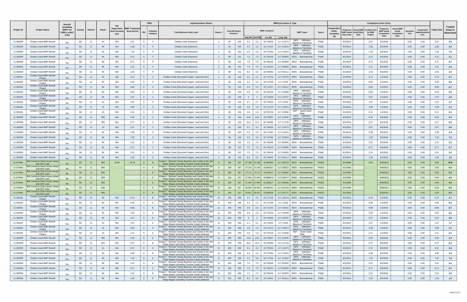
Beg PM End PM Lat. (N) Long. (W)
Revoked CUs
Total CUsTreated Areas in
WatershedRBPollutant Category
Total Maximum Daily Load Reach #Final SB Reach
Priority #
Compliance Units (CUs)
Cooperative Imple-
mentation ($)
Cooperative Implementation
CUs
Proposed BMP Install Start Date
Actual BMP Install Start
Date
Credited CUs for BMP Project
Proposed BMP Install Completion
Date
Actual BMP Install
Completion Date
Net Impervious
Area Increase (ac)
BMP Treatment Area (acres)
TMDL Implementation Reach BMP(s)Location & Type
BMP LocationsBMP Types Status
RouteProject ID Project Name
Retrofit (installing BMPs for
TMDLs only)? (Y/N)
County District
11-282500 Chollas Creek BMP Retrofit Yes SD 11 15 N/A 2.57 9 F Chollas Creek (Diazinon) 1 82 145 3.1 3.1 32.728432 -117.112073INFIL - Infiltration
(Basins & Trenches)PS&E 8/1/2014 2.57 8/1/2016 0.00 0.00 2.57 2.6
11-282500 Chollas Creek BMP Retrofit Yes SD 11 94 N/A 3.38 9 F Chollas Creek (Diazinon) 1 82 145 3.3 3.3 32.717044 -117.115915INFIL - Infiltration
(Basins & Trenches)PS&E 8/1/2014 3.38 8/1/2016 0.00 0.00 3.38 3.4
11-282500 Chollas Creek BMP Retrofit Yes SD 11 94 N/A 7.20 9 F Chollas Creek (Diazinon) 1 82 145 3.3 3.3 32.717044 -117.115915INFIL - Infiltration
(Basins & Trenches)PS&E 8/1/2014 7.20 8/1/2016 0.00 0.00 7.20 7.2
11-282500 Chollas Creek BMP Retrofit Yes SD 11 94 N/A 3.12 9 F Chollas Creek (Diazinon) 2 80 141 7.5 7.5 32.739145 -117.053805 BIOS - Bioswale/strip PS&E 8/1/2014 3.12 8/1/2016 0.00 0.00 3.12 3.1
11-282500 Chollas Creek BMP Retrofit Yes SD 11 94 N/A 0.71 9 F Chollas Creek (Diazinon) 2 80 141 7.5 7.5 32.739145 -117.053805 BIOS - Bioswale/strip PS&E 8/1/2014 0.71 8/1/2016 0.00 0.00 0.71 0.7
11-282500 Chollas Creek BMP Retrofit Yes SD 11 94 N/A 2.21 9 F Chollas Creek (Diazinon) 2 80 141 7.5 7.5 32.739145 -117.053805 BIOS - Bioswale/strip PS&E 8/1/2014 2.21 8/1/2016 0.00 0.00 2.21 2.2
11-282500 Chollas Creek BMP Retrofit Yes SD 11 94 N/A 1.04 9 F Chollas Creek (Diazinon) 2 80 141 8.2 8.2 32.744842 -117.044111 BIOS - Bioswale/strip PS&E 8/1/2014 1.04 8/1/2016 0.00 0.00 1.04 1.0
11-282401Chollas Creek BMP Retrofit
Project Yes SD 11 94 N/A 0.74 9 C Chollas Creek (Dissolved Copper, Lead and Zinc) 1 82 146 2.2 2.2 32.712755 -117.133279 BIOS - Bioswale/strip PS&E 9/1/2013 0.74 1/1/2014 0.00 0.00 0.74 0.7
11-282401Chollas Creek BMP Retrofit
Project Yes SD 11 94 N/A 0.55 9 C Chollas Creek (Dissolved Copper, Lead and Zinc) 1 82 146 2.2 2.2 32.713796 -117.13338 BIOS - Bioswale/strip PS&E 9/1/2013 0.55 1/1/2014 0.00 0.00 0.55 0.6
11-282401Chollas Creek BMP Retrofit
Project Yes SD 11 94 N/A 8.69 9 C Chollas Creek (Dissolved Copper, Lead and Zinc) 1 82 146 2.6 2.6 32.714157 -117.126412 BIOS - Bioswale/strip PS&E 9/1/2013 8.69 1/1/2014 0.00 0.00 8.69 8.7
11-282401Chollas Creek BMP Retrofit
Project Yes SD 11 94 N/A 2.53 9 C Chollas Creek (Dissolved Copper, Lead and Zinc) 1 82 146 2.9 2.9 32.716135 -117.120948INFIL - Infiltration
(Basins & Trenches)PS&E 9/1/2013 2.53 1/1/2014 0.00 0.00 2.53 2.5
11-282401Chollas Creek BMP Retrofit
Project Yes SD 11 94 N/A 2.57 9 C Chollas Creek (Dissolved Copper, Lead and Zinc) 1 82 146 3 3 32.716638 -117.118727INFIL - Infiltration
(Basins & Trenches)PS&E 9/1/2013 2.57 1/1/2014 0.00 0.00 2.57 2.6
11-282401Chollas Creek BMP Retrofit
Project Yes SD 11 15 N/A 1.67 9 C Chollas Creek (Dissolved Copper, Lead and Zinc) 1 82 146 2.1 2.1 32.715423 -117.11826INFIL - Infiltration
(Basins & Trenches)PS&E 9/1/2013 1.67 1/1/2014 0.00 0.00 1.67 1.7
11-282401Chollas Creek BMP Retrofit
Project Yes SD 11 15 N/A 3.09 9 C Chollas Creek (Dissolved Copper, Lead and Zinc) 1 82 146 1.8 1.8 32.711275 -117.119674INFIL - Infiltration
(Basins & Trenches)PS&E 9/1/2013 3.09 1/1/2014 0.00 0.00 3.09 3.1
11-282401Chollas Creek BMP Retrofit
Project Yes SD 11 15 N/A 2.11 9 C Chollas Creek (Dissolved Copper, Lead and Zinc) 1 82 146 1.6 1.6 32.707216 -117.120596ASF - Austin Sand
FilterPS&E 9/1/2013 2.11 1/1/2014 0.00 0.00 2.11 2.1
11-282500 Chollas Creek BMP Retrofit Yes SD 11 805 N/A 0.42 9 C Chollas Creek (Dissolved Copper, Lead and Zinc) 1 82 146 14.8 14.8 32.733857 -117.113045INFIL - Infiltration
(Basins & Trenches)PS&E 8/1/2014 0.42 8/1/2016 0.00 0.00 0.42 0.4
11-282500 Chollas Creek BMP Retrofit Yes SD 11 805 N/A 0.27 9 C Chollas Creek (Dissolved Copper, Lead and Zinc) 1 82 146 15.4 15.4 32.742085 -117.117128INFIL - Infiltration
(Basins & Trenches)PS&E 8/1/2014 0.27 8/1/2016 0.00 0.00 0.27 0.3
11-282500 Chollas Creek BMP Retrofit Yes SD 11 15 N/A 2.57 9 C Chollas Creek (Dissolved Copper, Lead and Zinc) 1 82 146 3.1 3.1 32.728432 -117.112073INFIL - Infiltration
(Basins & Trenches)PS&E 8/1/2014 2.57 8/1/2016 0.00 0.00 2.57 2.6
11-282500 Chollas Creek BMP Retrofit Yes SD 11 94 N/A 3.38 9 C Chollas Creek (Dissolved Copper, Lead and Zinc) 1 82 146 3.3 3.3 32.717044 -117.115915INFIL - Infiltration
(Basins & Trenches)PS&E 8/1/2014 3.38 8/1/2016 0.00 0.00 3.38 3.4
11-282500 Chollas Creek BMP Retrofit Yes SD 11 94 N/A 7.20 9 C Chollas Creek (Dissolved Copper, Lead and Zinc) 1 82 146 3.3 3.3 32.717044 -117.115915INFIL - Infiltration
(Basins & Trenches)PS&E 8/1/2014 7.20 8/1/2016 0.00 0.00 7.20 7.2
11-282500 Chollas Creek BMP Retrofit Yes SD 11 94 N/A 3.12 9 C Chollas Creek (Dissolved Copper, Lead and Zinc) 2 80 142 7.5 7.5 32.739145 -117.053805 BIOS - Bioswale/strip PS&E 8/1/2014 3.12 8/1/2016 0.00 0.00 3.12 3.1
11-282500 Chollas Creek BMP Retrofit Yes SD 11 94 N/A 0.71 9 C Chollas Creek (Dissolved Copper, Lead and Zinc) 2 80 142 7.5 7.5 32.739145 -117.053805 BIOS - Bioswale/strip PS&E 8/1/2014 0.71 8/1/2016 0.00 0.00 0.71 0.7
11-282500 Chollas Creek BMP Retrofit Yes SD 11 94 N/A 2.21 9 C Chollas Creek (Dissolved Copper, Lead and Zinc) 2 80 142 7.5 7.5 32.739145 -117.053805 BIOS - Bioswale/strip PS&E 8/1/2014 2.21 8/1/2016 0.00 0.00 2.21 2.2
11-282500 Chollas Creek BMP Retrofit Yes SD 11 94 N/A 1.04 9 C Chollas Creek (Dissolved Copper, Lead and Zinc) 2 80 142 8.2 8.2 32.744842 -117.044111 BIOS - Bioswale/strip PS&E 8/1/2014 1.04 8/1/2016 0.00 0.00 1.04 1.0
11-2T0401805 Construct Direct Acess ramps
and HOV Lane No SD 11 805 13.84 19.75 9 EProject I - Revised Twenty Beaches and Creeks in the San
Diego Region (including Tecolote Creek) (Indicator 9 184 267 27.196 27.196 32.890964 -117.208124 BIOS - Bioswale/strip PA/ED 9/1/2009 5.92 3/30/2012 0.00 0.00 5.92 19.8
11-2T0401805 Construct Direct Acess ramps
and HOV Lane No SD 11 805 9 EProject I - Revised Twenty Beaches and Creeks in the San
Diego Region (including Tecolote Creek) (Indicator 9 184 267 27.241 27.241 32.891017 -117.208822 BIOS - Bioswale/strip PA/ED 9/1/2009 3/30/2012 0.00 0.00 0.00 0.0
11-2T0401805 Construct Direct Acess ramps
and HOV Lane No SD 11 805 9 EProject I - Revised Twenty Beaches and Creeks in the San
Diego Region (including Tecolote Creek) (Indicator 9 184 267 27.14 27.14 32.889617 -117.208082 BIOS - Bioswale/strip PA/ED 9/1/2009 3/30/2012 0.00 0.00 0.00 0.0
11-2T0401805 Construct Direct Acess ramps
and HOV Lane No SD 11 805 9 EProject I - Revised Twenty Beaches and Creeks in the San
Diego Region (including Tecolote Creek) (Indicator 9 184 267 27.001 27.001 32.888474 -117.206477 BIOS - Bioswale/strip PA/ED 9/1/2009 3/30/2012 0.00 0.00 0.00 0.0
11-2T0401805 Construct Direct Acess ramps
and HOV Lane No SD 11 805 9 EProject I - Revised Twenty Beaches and Creeks in the San
Diego Region (including Tecolote Creek) (Indicator 9 184 267 27.004 27.004 32.888517 -117.206488 BIOS - Bioswale/strip PA/ED 9/1/2009 3/30/2012 0.00 0.00 0.00 0.0
11-2T0401805 Construct Direct Acess ramps
and HOV Lane No SD 11 805 9 EProject I - Revised Twenty Beaches and Creeks in the San
Diego Region (including Tecolote Creek) (Indicator 9 184 267 26.967 26.967 32.890101 -117.204193 BIOS - Bioswale/strip PA/ED 9/1/2009 3/30/2012 0.00 0.00 0.00 0.0
11-2T0401805 Construct Direct Acess ramps
and HOV Lane No SD 11 805 9 EProject I - Revised Twenty Beaches and Creeks in the San
Diego Region (including Tecolote Creek) (Indicator 9 184 267 26.847 26.847 32.889406 -117.201727 BIOS - Bioswale/strip PA/ED 9/1/2009 3/30/2012 0.00 0.00 0.00 0.0
11-282401Chollas Creek BMP Retrofit
Project Yes SD 11 94 N/A 0.74 9 EProject I - Revised Twenty Beaches and Creeks in the San
Diego Region (including Tecolote Creek) (Indicator 11 205 296 2.2 2.2 32.712755 -117.133279 BIOS - Bioswale/strip PS&E 9/1/2013 0.74 1/1/2014 0.00 0.00 0.74 0.7
11-282401Chollas Creek BMP Retrofit
Project Yes SD 11 94 N/A 0.55 9 EProject I - Revised Twenty Beaches and Creeks in the San
Diego Region (including Tecolote Creek) (Indicator 11 205 296 2.2 2.2 32.713796 -117.13338 BIOS - Bioswale/strip PS&E 9/1/2013 0.55 1/1/2014 0.00 0.00 0.55 0.6
11-282401Chollas Creek BMP Retrofit
Project Yes SD 11 94 N/A 8.69 9 EProject I - Revised Twenty Beaches and Creeks in the San
Diego Region (including Tecolote Creek) (Indicator 11 205 296 2.6 2.6 32.714157 -117.126412 BIOS - Bioswale/strip PS&E 9/1/2013 8.69 1/1/2014 0.00 0.00 8.69 8.7
11-282401Chollas Creek BMP Retrofit
Project Yes SD 11 94 N/A 2.53 9 EProject I - Revised Twenty Beaches and Creeks in the San
Diego Region (including Tecolote Creek) (Indicator 11 205 296 2.9 2.9 32.716135 -117.120948
INFIL - Infiltration (Basins & Trenches)
PS&E 9/1/2013 2.53 1/1/2014 0.00 0.00 2.53 2.5
11-282401Chollas Creek BMP Retrofit
Project Yes SD 11 94 N/A 2.57 9 EProject I - Revised Twenty Beaches and Creeks in the San
Diego Region (including Tecolote Creek) (Indicator 11 205 296 3 3 32.716638 -117.118727
INFIL - Infiltration (Basins & Trenches)
PS&E 9/1/2013 2.57 1/1/2014 0.00 0.00 2.57 2.6
11-282401Chollas Creek BMP Retrofit
Project Yes SD 11 15 N/A 1.67 9 EProject I - Revised Twenty Beaches and Creeks in the San
Diego Region (including Tecolote Creek) (Indicator 11 205 296 2.1 2.1 32.715423 -117.11826
INFIL - Infiltration (Basins & Trenches)
PS&E 9/1/2013 1.67 1/1/2014 0.00 0.00 1.67 1.7
11-282401Chollas Creek BMP Retrofit
Project Yes SD 11 15 N/A 3.09 9 EProject I - Revised Twenty Beaches and Creeks in the San
Diego Region (including Tecolote Creek) (Indicator 11 205 296 1.8 1.8 32.711275 -117.119674
INFIL - Infiltration (Basins & Trenches)
PS&E 9/1/2013 3.09 1/1/2014 0.00 0.00 3.09 3.1
11-282401Chollas Creek BMP Retrofit
Project Yes SD 11 15 N/A 2.11 9 EProject I - Revised Twenty Beaches and Creeks in the San
Diego Region (including Tecolote Creek) (Indicator 11 205 296 1.6 1.6 32.707216 -117.120596
ASF - Austin Sand Filter
PS&E 9/1/2013 2.11 1/1/2014 0.00 0.00 2.11 2.1
11-282500 Chollas Creek BMP Retrofit Yes SD 11 805 N/A 0.42 9 EProject I - Revised Twenty Beaches and Creeks in the San
Diego Region (including Tecolote Creek) (Indicator 11 205 296 14.8 14.8 32.733857 -117.113045
INFIL - Infiltration (Basins & Trenches)
PS&E 8/1/2014 0.42 8/1/2016 0.00 0.00 0.42 0.4
11-282500 Chollas Creek BMP Retrofit Yes SD 11 805 N/A 0.27 9 EProject I - Revised Twenty Beaches and Creeks in the San
Diego Region (including Tecolote Creek) (Indicator 11 205 296 15.4 15.4 32.742085 -117.117128
INFIL - Infiltration (Basins & Trenches)
PS&E 8/1/2014 0.27 8/1/2016 0.00 0.00 0.27 0.3
11-282500 Chollas Creek BMP Retrofit Yes SD 11 15 N/A 2.57 9 EProject I - Revised Twenty Beaches and Creeks in the San
Diego Region (including Tecolote Creek) (Indicator 11 205 296 3.1 3.1 32.728432 -117.112073
INFIL - Infiltration (Basins & Trenches)
PS&E 8/1/2014 2.57 8/1/2016 0.00 0.00 2.57 2.6
11-282500 Chollas Creek BMP Retrofit Yes SD 11 94 N/A 3.38 9 EProject I - Revised Twenty Beaches and Creeks in the San
Diego Region (including Tecolote Creek) (Indicator 11 205 296 3.3 3.3 32.717044 -117.115915
INFIL - Infiltration (Basins & Trenches)
PS&E 8/1/2014 3.38 8/1/2016 0.00 0.00 3.38 3.4
11-282500 Chollas Creek BMP Retrofit Yes SD 11 94 N/A 7.20 9 EProject I - Revised Twenty Beaches and Creeks in the San
Diego Region (including Tecolote Creek) (Indicator 11 205 296 3.3 3.3 32.717044 -117.115915
INFIL - Infiltration (Basins & Trenches)
PS&E 8/1/2014 7.20 8/1/2016 0.00 0.00 7.20 7.2
11-282500 Chollas Creek BMP Retrofit Yes SD 11 94 N/A 3.12 9 EProject I - Revised Twenty Beaches and Creeks in the San
Diego Region (including Tecolote Creek) (Indicator 11 205 296 7.5 7.5 32.739145 -117.053805 BIOS - Bioswale/strip PS&E 8/1/2014 3.12 8/1/2016 0.00 0.00 3.12 3.1
11-282500 Chollas Creek BMP Retrofit Yes SD 11 94 N/A 0.71 9 EProject I - Revised Twenty Beaches and Creeks in the San
Diego Region (including Tecolote Creek) (Indicator 11 205 296 7.5 7.5 32.739145 -117.053805 BIOS - Bioswale/strip PS&E 8/1/2014 0.71 8/1/2016 0.00 0.00 0.71 0.7
11-282500 Chollas Creek BMP Retrofit Yes SD 11 94 N/A 2.21 9 EProject I - Revised Twenty Beaches and Creeks in the San
Diego Region (including Tecolote Creek) (Indicator 11 205 296 7.5 7.5 32.739145 -117.053805 BIOS - Bioswale/strip PS&E 8/1/2014 2.21 8/1/2016 0.00 0.00 2.21 2.2
11-282500 Chollas Creek BMP Retrofit Yes SD 11 94 N/A 1.04 9 EProject I - Revised Twenty Beaches and Creeks in the San
Diego Region (including Tecolote Creek) (Indicator 11 205 296 8.2 8.2 32.744842 -117.044111 BIOS - Bioswale/strip PS&E 8/1/2014 1.04 8/1/2016 0.00 0.00 1.04 1.0
Page 57 of 77
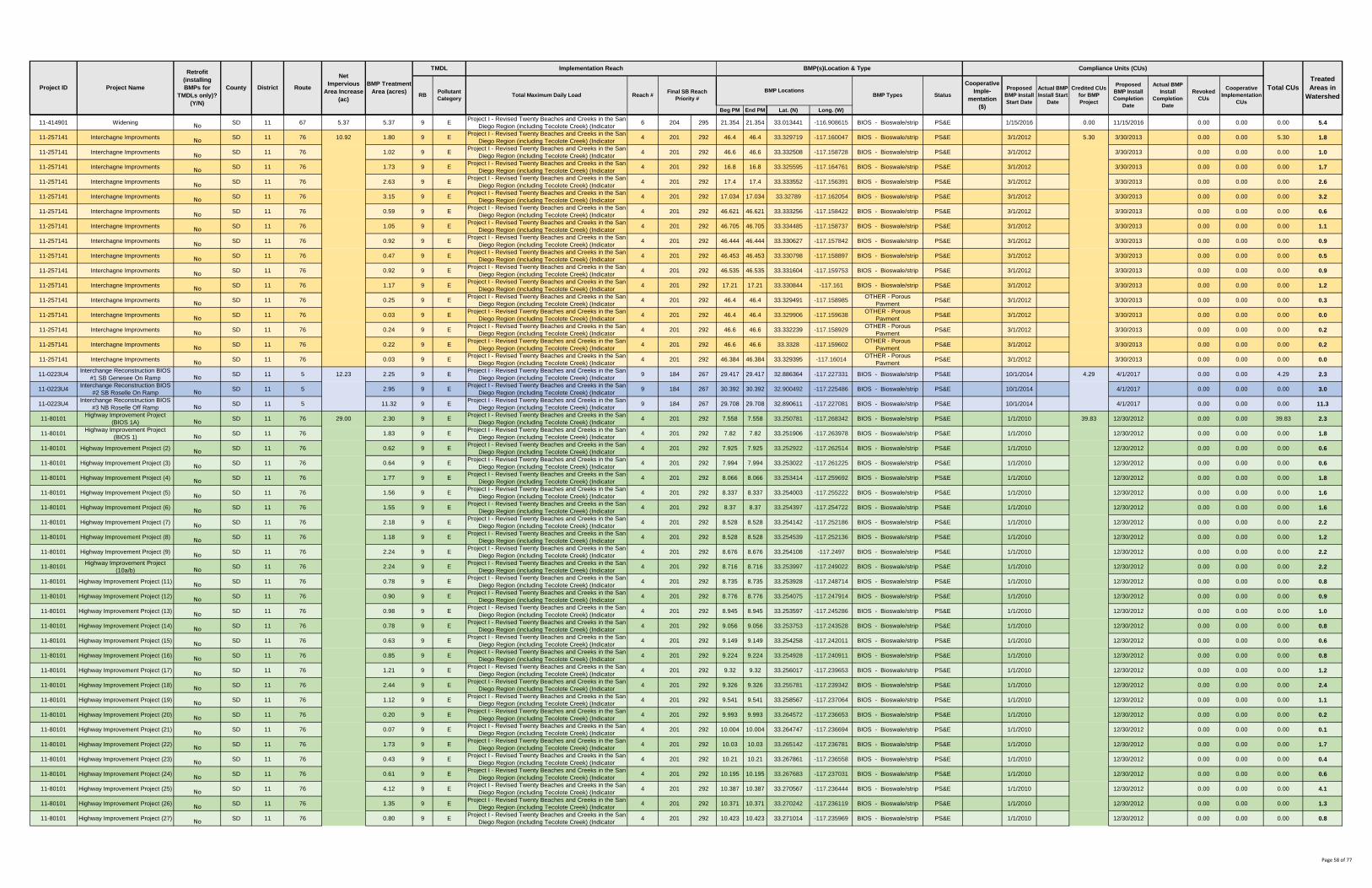
Beg PM End PM Lat. (N) Long. (W)
Revoked CUs
Total CUsTreated Areas in
WatershedRBPollutant Category
Total Maximum Daily Load Reach #Final SB Reach
Priority #
Compliance Units (CUs)
Cooperative Imple-
mentation ($)
Cooperative Implementation
CUs
Proposed BMP Install Start Date
Actual BMP Install Start
Date
Credited CUs for BMP Project
Proposed BMP Install Completion
Date
Actual BMP Install
Completion Date
Net Impervious
Area Increase (ac)
BMP Treatment Area (acres)
TMDL Implementation Reach BMP(s)Location & Type
BMP LocationsBMP Types Status
RouteProject ID Project Name
Retrofit (installing BMPs for
TMDLs only)? (Y/N)
County District
11-414901 Widening No SD 11 67 5.37 5.37 9 EProject I - Revised Twenty Beaches and Creeks in the San
Diego Region (including Tecolote Creek) (Indicator 6 204 295 21.354 21.354 33.013441 -116.908615 BIOS - Bioswale/strip PS&E 1/15/2016 0.00 11/15/2016 0.00 0.00 0.00 5.4
11-257141 Interchagne Improvments No SD 11 76 10.92 1.80 9 EProject I - Revised Twenty Beaches and Creeks in the San
Diego Region (including Tecolote Creek) (Indicator 4 201 292 46.4 46.4 33.329719 -117.160047 BIOS - Bioswale/strip PS&E 3/1/2012 5.30 3/30/2013 0.00 0.00 5.30 1.8
11-257141 Interchagne Improvments No SD 11 76 1.02 9 EProject I - Revised Twenty Beaches and Creeks in the San
Diego Region (including Tecolote Creek) (Indicator 4 201 292 46.6 46.6 33.332508 -117.158728 BIOS - Bioswale/strip PS&E 3/1/2012 3/30/2013 0.00 0.00 0.00 1.0
11-257141 Interchagne Improvments No SD 11 76 1.73 9 EProject I - Revised Twenty Beaches and Creeks in the San
Diego Region (including Tecolote Creek) (Indicator 4 201 292 16.8 16.8 33.325595 -117.164761 BIOS - Bioswale/strip PS&E 3/1/2012 3/30/2013 0.00 0.00 0.00 1.7
11-257141 Interchagne Improvments No SD 11 76 2.63 9 EProject I - Revised Twenty Beaches and Creeks in the San
Diego Region (including Tecolote Creek) (Indicator 4 201 292 17.4 17.4 33.333552 -117.156391 BIOS - Bioswale/strip PS&E 3/1/2012 3/30/2013 0.00 0.00 0.00 2.6
11-257141 Interchagne Improvments No SD 11 76 3.15 9 EProject I - Revised Twenty Beaches and Creeks in the San
Diego Region (including Tecolote Creek) (Indicator 4 201 292 17.034 17.034 33.32789 -117.162054 BIOS - Bioswale/strip PS&E 3/1/2012 3/30/2013 0.00 0.00 0.00 3.2
11-257141 Interchagne Improvments No SD 11 76 0.59 9 EProject I - Revised Twenty Beaches and Creeks in the San
Diego Region (including Tecolote Creek) (Indicator 4 201 292 46.621 46.621 33.333256 -117.158422 BIOS - Bioswale/strip PS&E 3/1/2012 3/30/2013 0.00 0.00 0.00 0.6
11-257141 Interchagne Improvments No SD 11 76 1.05 9 EProject I - Revised Twenty Beaches and Creeks in the San
Diego Region (including Tecolote Creek) (Indicator 4 201 292 46.705 46.705 33.334485 -117.158737 BIOS - Bioswale/strip PS&E 3/1/2012 3/30/2013 0.00 0.00 0.00 1.1
11-257141 Interchagne Improvments No SD 11 76 0.92 9 EProject I - Revised Twenty Beaches and Creeks in the San
Diego Region (including Tecolote Creek) (Indicator 4 201 292 46.444 46.444 33.330627 -117.157842 BIOS - Bioswale/strip PS&E 3/1/2012 3/30/2013 0.00 0.00 0.00 0.9
11-257141 Interchagne Improvments No SD 11 76 0.47 9 EProject I - Revised Twenty Beaches and Creeks in the San
Diego Region (including Tecolote Creek) (Indicator 4 201 292 46.453 46.453 33.330798 -117.158897 BIOS - Bioswale/strip PS&E 3/1/2012 3/30/2013 0.00 0.00 0.00 0.5
11-257141 Interchagne Improvments No SD 11 76 0.92 9 EProject I - Revised Twenty Beaches and Creeks in the San
Diego Region (including Tecolote Creek) (Indicator 4 201 292 46.535 46.535 33.331604 -117.159753 BIOS - Bioswale/strip PS&E 3/1/2012 3/30/2013 0.00 0.00 0.00 0.9
11-257141 Interchagne Improvments No SD 11 76 1.17 9 EProject I - Revised Twenty Beaches and Creeks in the San
Diego Region (including Tecolote Creek) (Indicator 4 201 292 17.21 17.21 33.330844 -117.161 BIOS - Bioswale/strip PS&E 3/1/2012 3/30/2013 0.00 0.00 0.00 1.2
11-257141 Interchagne Improvments No SD 11 76 0.25 9 EProject I - Revised Twenty Beaches and Creeks in the San
Diego Region (including Tecolote Creek) (Indicator 4 201 292 46.4 46.4 33.329491 -117.158985
OTHER - Porous Pavment
PS&E 3/1/2012 3/30/2013 0.00 0.00 0.00 0.3
11-257141 Interchagne Improvments No SD 11 76 0.03 9 EProject I - Revised Twenty Beaches and Creeks in the San
Diego Region (including Tecolote Creek) (Indicator 4 201 292 46.4 46.4 33.329906 -117.159638
OTHER - Porous Pavment
PS&E 3/1/2012 3/30/2013 0.00 0.00 0.00 0.0
11-257141 Interchagne Improvments No SD 11 76 0.24 9 EProject I - Revised Twenty Beaches and Creeks in the San
Diego Region (including Tecolote Creek) (Indicator 4 201 292 46.6 46.6 33.332239 -117.158929
OTHER - Porous Pavment
PS&E 3/1/2012 3/30/2013 0.00 0.00 0.00 0.2
11-257141 Interchagne Improvments No SD 11 76 0.22 9 EProject I - Revised Twenty Beaches and Creeks in the San
Diego Region (including Tecolote Creek) (Indicator 4 201 292 46.6 46.6 33.3328 -117.159602
OTHER - Porous Pavment
PS&E 3/1/2012 3/30/2013 0.00 0.00 0.00 0.2
11-257141 Interchagne Improvments No SD 11 76 0.03 9 EProject I - Revised Twenty Beaches and Creeks in the San
Diego Region (including Tecolote Creek) (Indicator 4 201 292 46.384 46.384 33.329395 -117.16014
OTHER - Porous Pavment
PS&E 3/1/2012 3/30/2013 0.00 0.00 0.00 0.0
11-0223U4Interchange Reconstruction BIOS
#1 SB Genesee On Ramp No SD 11 5 12.23 2.25 9 EProject I - Revised Twenty Beaches and Creeks in the San
Diego Region (including Tecolote Creek) (Indicator 9 184 267 29.417 29.417 32.886364 -117.227331 BIOS - Bioswale/strip PS&E 10/1/2014 4.29 4/1/2017 0.00 0.00 4.29 2.3
11-0223U4Interchange Reconstruction BIOS
#2 SB Roselle On Ramp No SD 11 5 2.95 9 EProject I - Revised Twenty Beaches and Creeks in the San
Diego Region (including Tecolote Creek) (Indicator 9 184 267 30.392 30.392 32.900492 -117.225486 BIOS - Bioswale/strip PS&E 10/1/2014 4/1/2017 0.00 0.00 0.00 3.0
11-0223U4Interchange Reconstruction BIOS
#3 NB Roselle Off Ramp No SD 11 5 11.32 9 EProject I - Revised Twenty Beaches and Creeks in the San
Diego Region (including Tecolote Creek) (Indicator 9 184 267 29.708 29.708 32.890611 -117.227081 BIOS - Bioswale/strip PS&E 10/1/2014 4/1/2017 0.00 0.00 0.00 11.3
11-80101Highway Improvement Project
(BIOS 1A) No SD 11 76 29.00 2.30 9 EProject I - Revised Twenty Beaches and Creeks in the San
Diego Region (including Tecolote Creek) (Indicator 4 201 292 7.558 7.558 33.250781 -117.268342 BIOS - Bioswale/strip PS&E 1/1/2010 39.83 12/30/2012 0.00 0.00 39.83 2.3
11-80101Highway Improvement Project
(BIOS 1) No SD 11 76 1.83 9 EProject I - Revised Twenty Beaches and Creeks in the San
Diego Region (including Tecolote Creek) (Indicator 4 201 292 7.82 7.82 33.251906 -117.263978 BIOS - Bioswale/strip PS&E 1/1/2010 12/30/2012 0.00 0.00 0.00 1.8
11-80101 Highway Improvement Project (2) No SD 11 76 0.62 9 EProject I - Revised Twenty Beaches and Creeks in the San
Diego Region (including Tecolote Creek) (Indicator 4 201 292 7.925 7.925 33.252922 -117.262514 BIOS - Bioswale/strip PS&E 1/1/2010 12/30/2012 0.00 0.00 0.00 0.6
11-80101 Highway Improvement Project (3) No SD 11 76 0.64 9 EProject I - Revised Twenty Beaches and Creeks in the San
Diego Region (including Tecolote Creek) (Indicator 4 201 292 7.994 7.994 33.253022 -117.261225 BIOS - Bioswale/strip PS&E 1/1/2010 12/30/2012 0.00 0.00 0.00 0.6
11-80101 Highway Improvement Project (4) No SD 11 76 1.77 9 EProject I - Revised Twenty Beaches and Creeks in the San
Diego Region (including Tecolote Creek) (Indicator 4 201 292 8.066 8.066 33.253414 -117.259692 BIOS - Bioswale/strip PS&E 1/1/2010 12/30/2012 0.00 0.00 0.00 1.8
11-80101 Highway Improvement Project (5) No SD 11 76 1.56 9 EProject I - Revised Twenty Beaches and Creeks in the San
Diego Region (including Tecolote Creek) (Indicator 4 201 292 8.337 8.337 33.254003 -117.255222 BIOS - Bioswale/strip PS&E 1/1/2010 12/30/2012 0.00 0.00 0.00 1.6
11-80101 Highway Improvement Project (6) No SD 11 76 1.55 9 EProject I - Revised Twenty Beaches and Creeks in the San
Diego Region (including Tecolote Creek) (Indicator 4 201 292 8.37 8.37 33.254397 -117.254722 BIOS - Bioswale/strip PS&E 1/1/2010 12/30/2012 0.00 0.00 0.00 1.6
11-80101 Highway Improvement Project (7) No SD 11 76 2.18 9 EProject I - Revised Twenty Beaches and Creeks in the San
Diego Region (including Tecolote Creek) (Indicator 4 201 292 8.528 8.528 33.254142 -117.252186 BIOS - Bioswale/strip PS&E 1/1/2010 12/30/2012 0.00 0.00 0.00 2.2
11-80101 Highway Improvement Project (8) No SD 11 76 1.18 9 EProject I - Revised Twenty Beaches and Creeks in the San
Diego Region (including Tecolote Creek) (Indicator 4 201 292 8.528 8.528 33.254539 -117.252136 BIOS - Bioswale/strip PS&E 1/1/2010 12/30/2012 0.00 0.00 0.00 1.2
11-80101 Highway Improvement Project (9) No SD 11 76 2.24 9 EProject I - Revised Twenty Beaches and Creeks in the San
Diego Region (including Tecolote Creek) (Indicator 4 201 292 8.676 8.676 33.254108 -117.2497 BIOS - Bioswale/strip PS&E 1/1/2010 12/30/2012 0.00 0.00 0.00 2.2
11-80101Highway Improvement Project
(10a/b) No SD 11 76 2.24 9 EProject I - Revised Twenty Beaches and Creeks in the San
Diego Region (including Tecolote Creek) (Indicator 4 201 292 8.716 8.716 33.253997 -117.249022 BIOS - Bioswale/strip PS&E 1/1/2010 12/30/2012 0.00 0.00 0.00 2.2
11-80101 Highway Improvement Project (11) No SD 11 76 0.78 9 EProject I - Revised Twenty Beaches and Creeks in the San
Diego Region (including Tecolote Creek) (Indicator 4 201 292 8.735 8.735 33.253928 -117.248714 BIOS - Bioswale/strip PS&E 1/1/2010 12/30/2012 0.00 0.00 0.00 0.8
11-80101 Highway Improvement Project (12) No SD 11 76 0.90 9 EProject I - Revised Twenty Beaches and Creeks in the San
Diego Region (including Tecolote Creek) (Indicator 4 201 292 8.776 8.776 33.254075 -117.247914 BIOS - Bioswale/strip PS&E 1/1/2010 12/30/2012 0.00 0.00 0.00 0.9
11-80101 Highway Improvement Project (13) No SD 11 76 0.98 9 EProject I - Revised Twenty Beaches and Creeks in the San
Diego Region (including Tecolote Creek) (Indicator 4 201 292 8.945 8.945 33.253597 -117.245286 BIOS - Bioswale/strip PS&E 1/1/2010 12/30/2012 0.00 0.00 0.00 1.0
11-80101 Highway Improvement Project (14) No SD 11 76 0.78 9 EProject I - Revised Twenty Beaches and Creeks in the San
Diego Region (including Tecolote Creek) (Indicator 4 201 292 9.056 9.056 33.253753 -117.243528 BIOS - Bioswale/strip PS&E 1/1/2010 12/30/2012 0.00 0.00 0.00 0.8
11-80101 Highway Improvement Project (15) No SD 11 76 0.63 9 EProject I - Revised Twenty Beaches and Creeks in the San
Diego Region (including Tecolote Creek) (Indicator 4 201 292 9.149 9.149 33.254258 -117.242011 BIOS - Bioswale/strip PS&E 1/1/2010 12/30/2012 0.00 0.00 0.00 0.6
11-80101 Highway Improvement Project (16) No SD 11 76 0.85 9 EProject I - Revised Twenty Beaches and Creeks in the San
Diego Region (including Tecolote Creek) (Indicator 4 201 292 9.224 9.224 33.254928 -117.240911 BIOS - Bioswale/strip PS&E 1/1/2010 12/30/2012 0.00 0.00 0.00 0.8
11-80101 Highway Improvement Project (17) No SD 11 76 1.21 9 EProject I - Revised Twenty Beaches and Creeks in the San
Diego Region (including Tecolote Creek) (Indicator 4 201 292 9.32 9.32 33.256017 -117.239653 BIOS - Bioswale/strip PS&E 1/1/2010 12/30/2012 0.00 0.00 0.00 1.2
11-80101 Highway Improvement Project (18) No SD 11 76 2.44 9 EProject I - Revised Twenty Beaches and Creeks in the San
Diego Region (including Tecolote Creek) (Indicator 4 201 292 9.326 9.326 33.255781 -117.239342 BIOS - Bioswale/strip PS&E 1/1/2010 12/30/2012 0.00 0.00 0.00 2.4
11-80101 Highway Improvement Project (19) No SD 11 76 1.12 9 EProject I - Revised Twenty Beaches and Creeks in the San
Diego Region (including Tecolote Creek) (Indicator 4 201 292 9.541 9.541 33.258567 -117.237064 BIOS - Bioswale/strip PS&E 1/1/2010 12/30/2012 0.00 0.00 0.00 1.1
11-80101 Highway Improvement Project (20) No SD 11 76 0.20 9 EProject I - Revised Twenty Beaches and Creeks in the San
Diego Region (including Tecolote Creek) (Indicator 4 201 292 9.993 9.993 33.264572 -117.236653 BIOS - Bioswale/strip PS&E 1/1/2010 12/30/2012 0.00 0.00 0.00 0.2
11-80101 Highway Improvement Project (21) No SD 11 76 0.07 9 EProject I - Revised Twenty Beaches and Creeks in the San
Diego Region (including Tecolote Creek) (Indicator 4 201 292 10.004 10.004 33.264747 -117.236694 BIOS - Bioswale/strip PS&E 1/1/2010 12/30/2012 0.00 0.00 0.00 0.1
11-80101 Highway Improvement Project (22) No SD 11 76 1.73 9 EProject I - Revised Twenty Beaches and Creeks in the San
Diego Region (including Tecolote Creek) (Indicator 4 201 292 10.03 10.03 33.265142 -117.236781 BIOS - Bioswale/strip PS&E 1/1/2010 12/30/2012 0.00 0.00 0.00 1.7
11-80101 Highway Improvement Project (23) No SD 11 76 0.43 9 EProject I - Revised Twenty Beaches and Creeks in the San
Diego Region (including Tecolote Creek) (Indicator 4 201 292 10.21 10.21 33.267861 -117.236558 BIOS - Bioswale/strip PS&E 1/1/2010 12/30/2012 0.00 0.00 0.00 0.4
11-80101 Highway Improvement Project (24) No SD 11 76 0.61 9 EProject I - Revised Twenty Beaches and Creeks in the San
Diego Region (including Tecolote Creek) (Indicator 4 201 292 10.195 10.195 33.267683 -117.237031 BIOS - Bioswale/strip PS&E 1/1/2010 12/30/2012 0.00 0.00 0.00 0.6
11-80101 Highway Improvement Project (25) No SD 11 76 4.12 9 EProject I - Revised Twenty Beaches and Creeks in the San
Diego Region (including Tecolote Creek) (Indicator 4 201 292 10.387 10.387 33.270567 -117.236444 BIOS - Bioswale/strip PS&E 1/1/2010 12/30/2012 0.00 0.00 0.00 4.1
11-80101 Highway Improvement Project (26) No SD 11 76 1.35 9 EProject I - Revised Twenty Beaches and Creeks in the San
Diego Region (including Tecolote Creek) (Indicator 4 201 292 10.371 10.371 33.270242 -117.236119 BIOS - Bioswale/strip PS&E 1/1/2010 12/30/2012 0.00 0.00 0.00 1.3
11-80101 Highway Improvement Project (27) No SD 11 76 0.80 9 EProject I - Revised Twenty Beaches and Creeks in the San
Diego Region (including Tecolote Creek) (Indicator 4 201 292 10.423 10.423 33.271014 -117.235969 BIOS - Bioswale/strip PS&E 1/1/2010 12/30/2012 0.00 0.00 0.00 0.8
Page 58 of 77
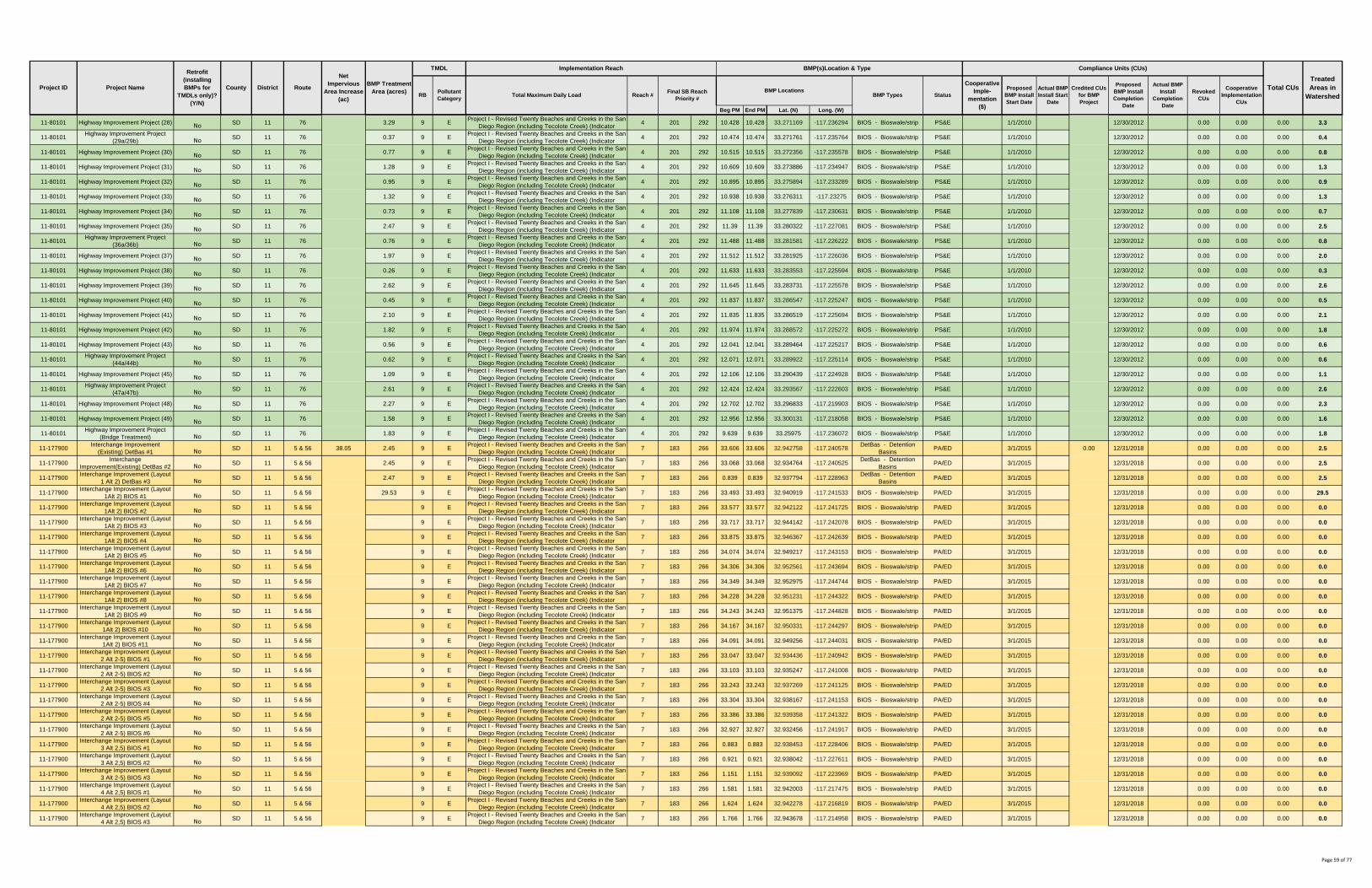
Beg PM End PM Lat. (N) Long. (W)
Revoked CUs
Total CUsTreated Areas in
WatershedRBPollutant Category
Total Maximum Daily Load Reach #Final SB Reach
Priority #
Compliance Units (CUs)
Cooperative Imple-
mentation ($)
Cooperative Implementation
CUs
Proposed BMP Install Start Date
Actual BMP Install Start
Date
Credited CUs for BMP Project
Proposed BMP Install Completion
Date
Actual BMP Install
Completion Date
Net Impervious
Area Increase (ac)
BMP Treatment Area (acres)
TMDL Implementation Reach BMP(s)Location & Type
BMP LocationsBMP Types Status
RouteProject ID Project Name
Retrofit (installing BMPs for
TMDLs only)? (Y/N)
County District
11-80101 Highway Improvement Project (28) No SD 11 76 3.29 9 EProject I - Revised Twenty Beaches and Creeks in the San
Diego Region (including Tecolote Creek) (Indicator 4 201 292 10.428 10.428 33.271169 -117.236294 BIOS - Bioswale/strip PS&E 1/1/2010 12/30/2012 0.00 0.00 0.00 3.3
11-80101Highway Improvement Project
(29a/29b) No SD 11 76 0.37 9 EProject I - Revised Twenty Beaches and Creeks in the San
Diego Region (including Tecolote Creek) (Indicator 4 201 292 10.474 10.474 33.271761 -117.235764 BIOS - Bioswale/strip PS&E 1/1/2010 12/30/2012 0.00 0.00 0.00 0.4
11-80101 Highway Improvement Project (30) No SD 11 76 0.77 9 EProject I - Revised Twenty Beaches and Creeks in the San
Diego Region (including Tecolote Creek) (Indicator 4 201 292 10.515 10.515 33.272356 -117.235578 BIOS - Bioswale/strip PS&E 1/1/2010 12/30/2012 0.00 0.00 0.00 0.8
11-80101 Highway Improvement Project (31) No SD 11 76 1.28 9 EProject I - Revised Twenty Beaches and Creeks in the San
Diego Region (including Tecolote Creek) (Indicator 4 201 292 10.609 10.609 33.273886 -117.234947 BIOS - Bioswale/strip PS&E 1/1/2010 12/30/2012 0.00 0.00 0.00 1.3
11-80101 Highway Improvement Project (32) No SD 11 76 0.95 9 EProject I - Revised Twenty Beaches and Creeks in the San
Diego Region (including Tecolote Creek) (Indicator 4 201 292 10.895 10.895 33.275894 -117.233289 BIOS - Bioswale/strip PS&E 1/1/2010 12/30/2012 0.00 0.00 0.00 0.9
11-80101 Highway Improvement Project (33) No SD 11 76 1.32 9 EProject I - Revised Twenty Beaches and Creeks in the San
Diego Region (including Tecolote Creek) (Indicator 4 201 292 10.938 10.938 33.276311 -117.23275 BIOS - Bioswale/strip PS&E 1/1/2010 12/30/2012 0.00 0.00 0.00 1.3
11-80101 Highway Improvement Project (34) No SD 11 76 0.73 9 EProject I - Revised Twenty Beaches and Creeks in the San
Diego Region (including Tecolote Creek) (Indicator 4 201 292 11.108 11.108 33.277839 -117.230631 BIOS - Bioswale/strip PS&E 1/1/2010 12/30/2012 0.00 0.00 0.00 0.7
11-80101 Highway Improvement Project (35) No SD 11 76 2.47 9 EProject I - Revised Twenty Beaches and Creeks in the San
Diego Region (including Tecolote Creek) (Indicator 4 201 292 11.39 11.39 33.280322 -117.227081 BIOS - Bioswale/strip PS&E 1/1/2010 12/30/2012 0.00 0.00 0.00 2.5
11-80101Highway Improvement Project
(36a/36b) No SD 11 76 0.76 9 EProject I - Revised Twenty Beaches and Creeks in the San
Diego Region (including Tecolote Creek) (Indicator 4 201 292 11.488 11.488 33.281581 -117.226222 BIOS - Bioswale/strip PS&E 1/1/2010 12/30/2012 0.00 0.00 0.00 0.8
11-80101 Highway Improvement Project (37) No SD 11 76 1.97 9 EProject I - Revised Twenty Beaches and Creeks in the San
Diego Region (including Tecolote Creek) (Indicator 4 201 292 11.512 11.512 33.281925 -117.226036 BIOS - Bioswale/strip PS&E 1/1/2010 12/30/2012 0.00 0.00 0.00 2.0
11-80101 Highway Improvement Project (38) No SD 11 76 0.26 9 EProject I - Revised Twenty Beaches and Creeks in the San
Diego Region (including Tecolote Creek) (Indicator 4 201 292 11.633 11.633 33.283553 -117.225594 BIOS - Bioswale/strip PS&E 1/1/2010 12/30/2012 0.00 0.00 0.00 0.3
11-80101 Highway Improvement Project (39) No SD 11 76 2.62 9 EProject I - Revised Twenty Beaches and Creeks in the San
Diego Region (including Tecolote Creek) (Indicator 4 201 292 11.645 11.645 33.283731 -117.225578 BIOS - Bioswale/strip PS&E 1/1/2010 12/30/2012 0.00 0.00 0.00 2.6
11-80101 Highway Improvement Project (40) No SD 11 76 0.45 9 EProject I - Revised Twenty Beaches and Creeks in the San
Diego Region (including Tecolote Creek) (Indicator 4 201 292 11.837 11.837 33.286547 -117.225247 BIOS - Bioswale/strip PS&E 1/1/2010 12/30/2012 0.00 0.00 0.00 0.5
11-80101 Highway Improvement Project (41) No SD 11 76 2.10 9 EProject I - Revised Twenty Beaches and Creeks in the San
Diego Region (including Tecolote Creek) (Indicator 4 201 292 11.835 11.835 33.286519 -117.225694 BIOS - Bioswale/strip PS&E 1/1/2010 12/30/2012 0.00 0.00 0.00 2.1
11-80101 Highway Improvement Project (42) No SD 11 76 1.82 9 EProject I - Revised Twenty Beaches and Creeks in the San
Diego Region (including Tecolote Creek) (Indicator 4 201 292 11.974 11.974 33.288572 -117.225272 BIOS - Bioswale/strip PS&E 1/1/2010 12/30/2012 0.00 0.00 0.00 1.8
11-80101 Highway Improvement Project (43) No SD 11 76 0.56 9 EProject I - Revised Twenty Beaches and Creeks in the San
Diego Region (including Tecolote Creek) (Indicator 4 201 292 12.041 12.041 33.289464 -117.225217 BIOS - Bioswale/strip PS&E 1/1/2010 12/30/2012 0.00 0.00 0.00 0.6
11-80101Highway Improvement Project
(44a/44b) No SD 11 76 0.62 9 EProject I - Revised Twenty Beaches and Creeks in the San
Diego Region (including Tecolote Creek) (Indicator 4 201 292 12.071 12.071 33.289922 -117.225114 BIOS - Bioswale/strip PS&E 1/1/2010 12/30/2012 0.00 0.00 0.00 0.6
11-80101 Highway Improvement Project (45) No SD 11 76 1.09 9 EProject I - Revised Twenty Beaches and Creeks in the San
Diego Region (including Tecolote Creek) (Indicator 4 201 292 12.106 12.106 33.290439 -117.224928 BIOS - Bioswale/strip PS&E 1/1/2010 12/30/2012 0.00 0.00 0.00 1.1
11-80101Highway Improvement Project
(47a/47b) No SD 11 76 2.61 9 EProject I - Revised Twenty Beaches and Creeks in the San
Diego Region (including Tecolote Creek) (Indicator 4 201 292 12.424 12.424 33.293567 -117.222603 BIOS - Bioswale/strip PS&E 1/1/2010 12/30/2012 0.00 0.00 0.00 2.6
11-80101 Highway Improvement Project (48) No SD 11 76 2.27 9 EProject I - Revised Twenty Beaches and Creeks in the San
Diego Region (including Tecolote Creek) (Indicator 4 201 292 12.702 12.702 33.296833 -117.219903 BIOS - Bioswale/strip PS&E 1/1/2010 12/30/2012 0.00 0.00 0.00 2.3
11-80101 Highway Improvement Project (49) No SD 11 76 1.58 9 EProject I - Revised Twenty Beaches and Creeks in the San
Diego Region (including Tecolote Creek) (Indicator 4 201 292 12.956 12.956 33.300131 -117.218058 BIOS - Bioswale/strip PS&E 1/1/2010 12/30/2012 0.00 0.00 0.00 1.6
11-80101Highway Improvement Project
(Bridge Treatment) No SD 11 76 1.83 9 EProject I - Revised Twenty Beaches and Creeks in the San
Diego Region (including Tecolote Creek) (Indicator 4 201 292 9.639 9.639 33.25975 -117.236072 BIOS - Bioswale/strip PS&E 1/1/2010 12/30/2012 0.00 0.00 0.00 1.8
11-177900Interchange Improvement
(Existing) DetBas #1 No SD 11 5 & 56 38.05 2.45 9 EProject I - Revised Twenty Beaches and Creeks in the San
Diego Region (including Tecolote Creek) (Indicator 7 183 266 33.606 33.606 32.942758 -117.240578
DetBas - Detention Basins
PA/ED 3/1/2015 0.00 12/31/2018 0.00 0.00 0.00 2.5
11-177900Interchange
Improvement(Existing) DetBas #2 No SD 11 5 & 56 2.45 9 EProject I - Revised Twenty Beaches and Creeks in the San
Diego Region (including Tecolote Creek) (Indicator 7 183 266 33.068 33.068 32.934764 -117.240525
DetBas - Detention Basins
PA/ED 3/1/2015 12/31/2018 0.00 0.00 0.00 2.5
11-177900Interchange Improvement (Layout
1 Alt 2) DetBas #3 No SD 11 5 & 56 2.47 9 EProject I - Revised Twenty Beaches and Creeks in the San
Diego Region (including Tecolote Creek) (Indicator 7 183 266 0.839 0.839 32.937794 -117.228963
DetBas - Detention Basins
PA/ED 3/1/2015 12/31/2018 0.00 0.00 0.00 2.5
11-177900Interchange Improvement (Layout
1Alt 2) BIOS #1 No SD 11 5 & 56 29.53 9 EProject I - Revised Twenty Beaches and Creeks in the San
Diego Region (including Tecolote Creek) (Indicator 7 183 266 33.493 33.493 32.940919 -117.241533 BIOS - Bioswale/strip PA/ED 3/1/2015 12/31/2018 0.00 0.00 0.00 29.5
11-177900Interchange Improvement (Layout
1Alt 2) BIOS #2 No SD 11 5 & 56 9 EProject I - Revised Twenty Beaches and Creeks in the San
Diego Region (including Tecolote Creek) (Indicator 7 183 266 33.577 33.577 32.942122 -117.241725 BIOS - Bioswale/strip PA/ED 3/1/2015 12/31/2018 0.00 0.00 0.00 0.0
11-177900Interchange Improvement (Layout
1Alt 2) BIOS #3 No SD 11 5 & 56 9 EProject I - Revised Twenty Beaches and Creeks in the San
Diego Region (including Tecolote Creek) (Indicator 7 183 266 33.717 33.717 32.944142 -117.242078 BIOS - Bioswale/strip PA/ED 3/1/2015 12/31/2018 0.00 0.00 0.00 0.0
11-177900Interchange Improvement (Layout
1Alt 2) BIOS #4 No SD 11 5 & 56 9 EProject I - Revised Twenty Beaches and Creeks in the San
Diego Region (including Tecolote Creek) (Indicator 7 183 266 33.875 33.875 32.946367 -117.242639 BIOS - Bioswale/strip PA/ED 3/1/2015 12/31/2018 0.00 0.00 0.00 0.0
11-177900Interchange Improvement (Layout
1Alt 2) BIOS #5 No SD 11 5 & 56 9 EProject I - Revised Twenty Beaches and Creeks in the San
Diego Region (including Tecolote Creek) (Indicator 7 183 266 34.074 34.074 32.949217 -117.243153 BIOS - Bioswale/strip PA/ED 3/1/2015 12/31/2018 0.00 0.00 0.00 0.0
11-177900Interchange Improvement (Layout
1Alt 2) BIOS #6 No SD 11 5 & 56 9 EProject I - Revised Twenty Beaches and Creeks in the San
Diego Region (including Tecolote Creek) (Indicator 7 183 266 34.306 34.306 32.952561 -117.243694 BIOS - Bioswale/strip PA/ED 3/1/2015 12/31/2018 0.00 0.00 0.00 0.0
11-177900Interchange Improvement (Layout
1Alt 2) BIOS #7 No SD 11 5 & 56 9 EProject I - Revised Twenty Beaches and Creeks in the San
Diego Region (including Tecolote Creek) (Indicator 7 183 266 34.349 34.349 32.952975 -117.244744 BIOS - Bioswale/strip PA/ED 3/1/2015 12/31/2018 0.00 0.00 0.00 0.0
11-177900Interchange Improvement (Layout
1Alt 2) BIOS #8 No SD 11 5 & 56 9 EProject I - Revised Twenty Beaches and Creeks in the San
Diego Region (including Tecolote Creek) (Indicator 7 183 266 34.228 34.228 32.951231 -117.244322 BIOS - Bioswale/strip PA/ED 3/1/2015 12/31/2018 0.00 0.00 0.00 0.0
11-177900Interchange Improvement (Layout
1Alt 2) BIOS #9 No SD 11 5 & 56 9 EProject I - Revised Twenty Beaches and Creeks in the San
Diego Region (including Tecolote Creek) (Indicator 7 183 266 34.243 34.243 32.951375 -117.244828 BIOS - Bioswale/strip PA/ED 3/1/2015 12/31/2018 0.00 0.00 0.00 0.0
11-177900Interchange Improvement (Layout
1Alt 2) BIOS #10 No SD 11 5 & 56 9 EProject I - Revised Twenty Beaches and Creeks in the San
Diego Region (including Tecolote Creek) (Indicator 7 183 266 34.167 34.167 32.950331 -117.244297 BIOS - Bioswale/strip PA/ED 3/1/2015 12/31/2018 0.00 0.00 0.00 0.0
11-177900Interchange Improvement (Layout
1Alt 2) BIOS #11 No SD 11 5 & 56 9 EProject I - Revised Twenty Beaches and Creeks in the San
Diego Region (including Tecolote Creek) (Indicator 7 183 266 34.091 34.091 32.949256 -117.244031 BIOS - Bioswale/strip PA/ED 3/1/2015 12/31/2018 0.00 0.00 0.00 0.0
11-177900Interchange Improvement (Layout
2 Alt 2-5) BIOS #1 No SD 11 5 & 56 9 EProject I - Revised Twenty Beaches and Creeks in the San
Diego Region (including Tecolote Creek) (Indicator 7 183 266 33.047 33.047 32.934436 -117.240942 BIOS - Bioswale/strip PA/ED 3/1/2015 12/31/2018 0.00 0.00 0.00 0.0
11-177900Interchange Improvement (Layout
2 Alt 2-5) BIOS #2 No SD 11 5 & 56 9 EProject I - Revised Twenty Beaches and Creeks in the San
Diego Region (including Tecolote Creek) (Indicator 7 183 266 33.103 33.103 32.935247 -117.241008 BIOS - Bioswale/strip PA/ED 3/1/2015 12/31/2018 0.00 0.00 0.00 0.0
11-177900Interchange Improvement (Layout
2 Alt 2-5) BIOS #3 No SD 11 5 & 56 9 EProject I - Revised Twenty Beaches and Creeks in the San
Diego Region (including Tecolote Creek) (Indicator 7 183 266 33.243 33.243 32.937269 -117.241125 BIOS - Bioswale/strip PA/ED 3/1/2015 12/31/2018 0.00 0.00 0.00 0.0
11-177900Interchange Improvement (Layout
2 Alt 2-5) BIOS #4 No SD 11 5 & 56 9 EProject I - Revised Twenty Beaches and Creeks in the San
Diego Region (including Tecolote Creek) (Indicator 7 183 266 33.304 33.304 32.938167 -117.241153 BIOS - Bioswale/strip PA/ED 3/1/2015 12/31/2018 0.00 0.00 0.00 0.0
11-177900Interchange Improvement (Layout
2 Alt 2-5) BIOS #5 No SD 11 5 & 56 9 EProject I - Revised Twenty Beaches and Creeks in the San
Diego Region (including Tecolote Creek) (Indicator 7 183 266 33.386 33.386 32.939358 -117.241322 BIOS - Bioswale/strip PA/ED 3/1/2015 12/31/2018 0.00 0.00 0.00 0.0
11-177900Interchange Improvement (Layout
2 Alt 2-5) BIOS #6 No SD 11 5 & 56 9 EProject I - Revised Twenty Beaches and Creeks in the San
Diego Region (including Tecolote Creek) (Indicator 7 183 266 32.927 32.927 32.932456 -117.241917 BIOS - Bioswale/strip PA/ED 3/1/2015 12/31/2018 0.00 0.00 0.00 0.0
11-177900Interchange Improvement (Layout
3 Alt 2,5) BIOS #1 No SD 11 5 & 56 9 EProject I - Revised Twenty Beaches and Creeks in the San
Diego Region (including Tecolote Creek) (Indicator 7 183 266 0.883 0.883 32.938453 -117.228406 BIOS - Bioswale/strip PA/ED 3/1/2015 12/31/2018 0.00 0.00 0.00 0.0
11-177900Interchange Improvement (Layout
3 Alt 2,5) BIOS #2 No SD 11 5 & 56 9 EProject I - Revised Twenty Beaches and Creeks in the San
Diego Region (including Tecolote Creek) (Indicator 7 183 266 0.921 0.921 32.938042 -117.227611 BIOS - Bioswale/strip PA/ED 3/1/2015 12/31/2018 0.00 0.00 0.00 0.0
11-177900Interchange Improvement (Layout
3 Alt 2-5) BIOS #3 No SD 11 5 & 56 9 EProject I - Revised Twenty Beaches and Creeks in the San
Diego Region (including Tecolote Creek) (Indicator 7 183 266 1.151 1.151 32.939092 -117.223969 BIOS - Bioswale/strip PA/ED 3/1/2015 12/31/2018 0.00 0.00 0.00 0.0
11-177900Interchange Improvement (Layout
4 Alt 2,5) BIOS #1 No SD 11 5 & 56 9 EProject I - Revised Twenty Beaches and Creeks in the San
Diego Region (including Tecolote Creek) (Indicator 7 183 266 1.581 1.581 32.942003 -117.217475 BIOS - Bioswale/strip PA/ED 3/1/2015 12/31/2018 0.00 0.00 0.00 0.0
11-177900Interchange Improvement (Layout
4 Alt 2,5) BIOS #2 No SD 11 5 & 56 9 EProject I - Revised Twenty Beaches and Creeks in the San
Diego Region (including Tecolote Creek) (Indicator 7 183 266 1.624 1.624 32.942278 -117.216819 BIOS - Bioswale/strip PA/ED 3/1/2015 12/31/2018 0.00 0.00 0.00 0.0
11-177900Interchange Improvement (Layout
4 Alt 2,5) BIOS #3 No SD 11 5 & 56 9 EProject I - Revised Twenty Beaches and Creeks in the San
Diego Region (including Tecolote Creek) (Indicator 7 183 266 1.766 1.766 32.943678 -117.214958 BIOS - Bioswale/strip PA/ED 3/1/2015 12/31/2018 0.00 0.00 0.00 0.0
Page 59 of 77
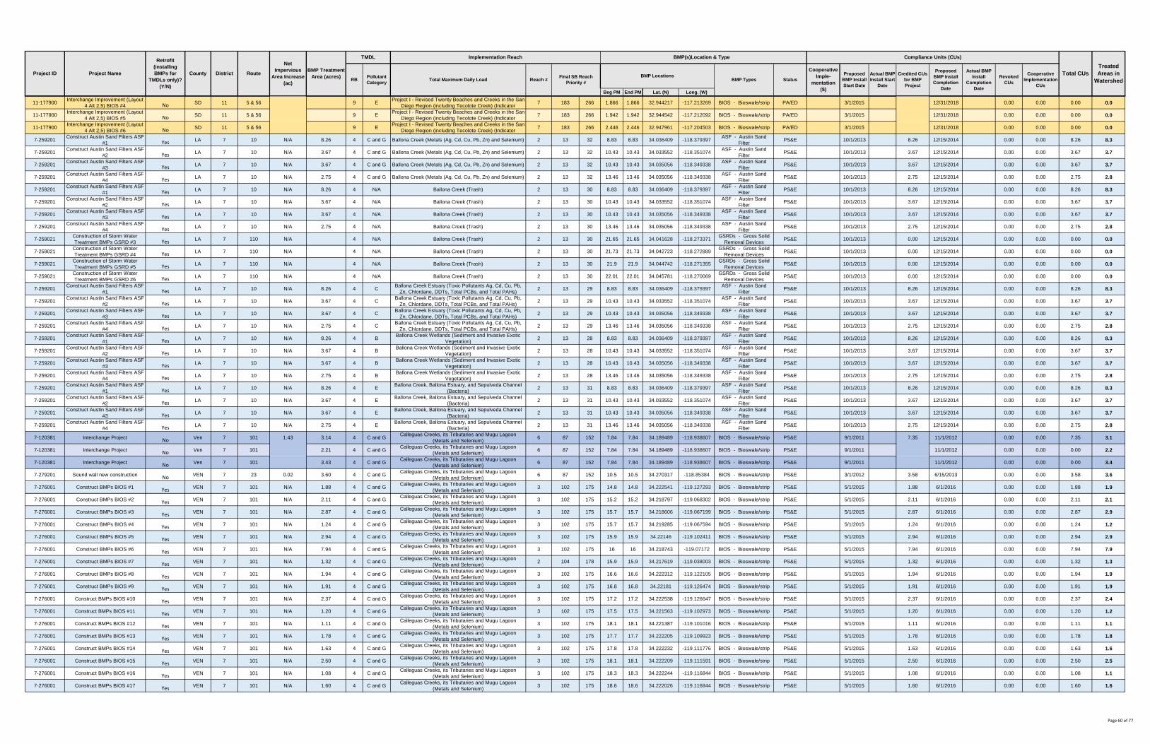
Beg PM End PM Lat. (N) Long. (W)
Revoked CUs
Total CUsTreated Areas in
WatershedRBPollutant Category
Total Maximum Daily Load Reach #Final SB Reach
Priority #
Compliance Units (CUs)
Cooperative Imple-
mentation ($)
Cooperative Implementation
CUs
Proposed BMP Install Start Date
Actual BMP Install Start
Date
Credited CUs for BMP Project
Proposed BMP Install Completion
Date
Actual BMP Install
Completion Date
Net Impervious
Area Increase (ac)
BMP Treatment Area (acres)
TMDL Implementation Reach BMP(s)Location & Type
BMP LocationsBMP Types Status
RouteProject ID Project Name
Retrofit (installing BMPs for
TMDLs only)? (Y/N)
County District
11-177900Interchange Improvement (Layout
4 Alt 2,5) BIOS #4 No SD 11 5 & 56 9 EProject I - Revised Twenty Beaches and Creeks in the San
Diego Region (including Tecolote Creek) (Indicator 7 183 266 1.866 1.866 32.944217 -117.213269 BIOS - Bioswale/strip PA/ED 3/1/2015 12/31/2018 0.00 0.00 0.00 0.0
11-177900Interchange Improvement (Layout
4 Alt 2,5) BIOS #5 No SD 11 5 & 56 9 EProject I - Revised Twenty Beaches and Creeks in the San
Diego Region (including Tecolote Creek) (Indicator 7 183 266 1.942 1.942 32.944542 -117.212092 BIOS - Bioswale/strip PA/ED 3/1/2015 12/31/2018 0.00 0.00 0.00 0.0
11-177900Interchange Improvement (Layout
4 Alt 2,5) BIOS #6 No SD 11 5 & 56 9 EProject I - Revised Twenty Beaches and Creeks in the San
Diego Region (including Tecolote Creek) (Indicator 7 183 266 2.446 2.446 32.947961 -117.204503 BIOS - Bioswale/strip PA/ED 3/1/2015 12/31/2018 0.00 0.00 0.00 0.0
7-259201Construct Austin Sand Filters ASF
#1 Yes LA 7 10 N/A 8.26 4 C and G Ballona Creek (Metals (Ag, Cd, Cu, Pb, Zn) and Selenium) 2 13 32 8.83 8.83 34.036409 -118.379397ASF - Austin Sand
FilterPS&E 10/1/2013 8.26 12/15/2014 0.00 0.00 8.26 8.3
7-259201Construct Austin Sand Filters ASF
#2 Yes LA 7 10 N/A 3.67 4 C and G Ballona Creek (Metals (Ag, Cd, Cu, Pb, Zn) and Selenium) 2 13 32 10.43 10.43 34.033552 -118.351074ASF - Austin Sand
FilterPS&E 10/1/2013 3.67 12/15/2014 0.00 0.00 3.67 3.7
7-259201Construct Austin Sand Filters ASF
#3 Yes LA 7 10 N/A 3.67 4 C and G Ballona Creek (Metals (Ag, Cd, Cu, Pb, Zn) and Selenium) 2 13 32 10.43 10.43 34.035056 -118.349338ASF - Austin Sand
FilterPS&E 10/1/2013 3.67 12/15/2014 0.00 0.00 3.67 3.7
7-259201Construct Austin Sand Filters ASF
#4 Yes LA 7 10 N/A 2.75 4 C and G Ballona Creek (Metals (Ag, Cd, Cu, Pb, Zn) and Selenium) 2 13 32 13.46 13.46 34.035056 -118.349338ASF - Austin Sand
FilterPS&E 10/1/2013 2.75 12/15/2014 0.00 0.00 2.75 2.8
7-259201Construct Austin Sand Filters ASF
#1 Yes LA 7 10 N/A 8.26 4 N/A Ballona Creek (Trash) 2 13 30 8.83 8.83 34.036409 -118.379397ASF - Austin Sand
FilterPS&E 10/1/2013 8.26 12/15/2014 0.00 0.00 8.26 8.3
7-259201Construct Austin Sand Filters ASF
#2 Yes LA 7 10 N/A 3.67 4 N/A Ballona Creek (Trash) 2 13 30 10.43 10.43 34.033552 -118.351074ASF - Austin Sand
FilterPS&E 10/1/2013 3.67 12/15/2014 0.00 0.00 3.67 3.7
7-259201Construct Austin Sand Filters ASF
#3 Yes LA 7 10 N/A 3.67 4 N/A Ballona Creek (Trash) 2 13 30 10.43 10.43 34.035056 -118.349338ASF - Austin Sand
FilterPS&E 10/1/2013 3.67 12/15/2014 0.00 0.00 3.67 3.7
7-259201Construct Austin Sand Filters ASF
#4 Yes LA 7 10 N/A 2.75 4 N/A Ballona Creek (Trash) 2 13 30 13.46 13.46 34.035056 -118.349338ASF - Austin Sand
FilterPS&E 10/1/2013 2.75 12/15/2014 0.00 0.00 2.75 2.8
7-259021Construction of Storm Water Treatment BMPs GSRD #3 Yes LA 7 110 N/A 4 N/A Ballona Creek (Trash) 2 13 30 21.65 21.65 34.041628 -118.273371
GSRDs - Gross Solid Removal Devices
PS&E 10/1/2013 0.00 12/15/2014 0.00 0.00 0.00 0.0
7-259021Construction of Storm Water Treatment BMPs GSRD #4 Yes LA 7 110 N/A 4 N/A Ballona Creek (Trash) 2 13 30 21.73 21.73 34.042723 -118.272889
GSRDs - Gross Solid Removal Devices
PS&E 10/1/2013 0.00 12/15/2014 0.00 0.00 0.00 0.0
7-259021Construction of Storm Water Treatment BMPs GSRD #5 Yes LA 7 110 N/A 4 N/A Ballona Creek (Trash) 2 13 30 21.9 21.9 34.044742 -118.271355
GSRDs - Gross Solid Removal Devices
PS&E 10/1/2013 0.00 12/15/2014 0.00 0.00 0.00 0.0
7-259021Construction of Storm Water Treatment BMPs GSRD #6 Yes LA 7 110 N/A 4 N/A Ballona Creek (Trash) 2 13 30 22.01 22.01 34.045781 -118.270069
GSRDs - Gross Solid Removal Devices
PS&E 10/1/2013 0.00 12/15/2014 0.00 0.00 0.00 0.0
7-259201Construct Austin Sand Filters ASF
#1 Yes LA 7 10 N/A 8.26 4 CBallona Creek Estuary (Toxic Pollutants Ag, Cd, Cu, Pb,
Zn, Chlordane, DDTs, Total PCBs, and Total PAHs)2 13 29 8.83 8.83 34.036409 -118.379397
ASF - Austin Sand Filter
PS&E 10/1/2013 8.26 12/15/2014 0.00 0.00 8.26 8.3
7-259201Construct Austin Sand Filters ASF
#2 Yes LA 7 10 N/A 3.67 4 CBallona Creek Estuary (Toxic Pollutants Ag, Cd, Cu, Pb,
Zn, Chlordane, DDTs, Total PCBs, and Total PAHs)2 13 29 10.43 10.43 34.033552 -118.351074
ASF - Austin Sand Filter
PS&E 10/1/2013 3.67 12/15/2014 0.00 0.00 3.67 3.7
7-259201Construct Austin Sand Filters ASF
#3 Yes LA 7 10 N/A 3.67 4 CBallona Creek Estuary (Toxic Pollutants Ag, Cd, Cu, Pb,
Zn, Chlordane, DDTs, Total PCBs, and Total PAHs)2 13 29 10.43 10.43 34.035056 -118.349338
ASF - Austin Sand Filter
PS&E 10/1/2013 3.67 12/15/2014 0.00 0.00 3.67 3.7
7-259201Construct Austin Sand Filters ASF
#4 Yes LA 7 10 N/A 2.75 4 CBallona Creek Estuary (Toxic Pollutants Ag, Cd, Cu, Pb,
Zn, Chlordane, DDTs, Total PCBs, and Total PAHs)2 13 29 13.46 13.46 34.035056 -118.349338
ASF - Austin Sand Filter
PS&E 10/1/2013 2.75 12/15/2014 0.00 0.00 2.75 2.8
7-259201Construct Austin Sand Filters ASF
#1 Yes LA 7 10 N/A 8.26 4 BBallona Creek Wetlands (Sediment and Invasive Exotic
Vegetation)2 13 28 8.83 8.83 34.036409 -118.379397
ASF - Austin Sand Filter
PS&E 10/1/2013 8.26 12/15/2014 0.00 0.00 8.26 8.3
7-259201Construct Austin Sand Filters ASF
#2 Yes LA 7 10 N/A 3.67 4 BBallona Creek Wetlands (Sediment and Invasive Exotic
Vegetation)2 13 28 10.43 10.43 34.033552 -118.351074
ASF - Austin Sand Filter
PS&E 10/1/2013 3.67 12/15/2014 0.00 0.00 3.67 3.7
7-259201Construct Austin Sand Filters ASF
#3 Yes LA 7 10 N/A 3.67 4 BBallona Creek Wetlands (Sediment and Invasive Exotic
Vegetation)2 13 28 10.43 10.43 34.035056 -118.349338
ASF - Austin Sand Filter
PS&E 10/1/2013 3.67 12/15/2014 0.00 0.00 3.67 3.7
7-259201Construct Austin Sand Filters ASF
#4 Yes LA 7 10 N/A 2.75 4 BBallona Creek Wetlands (Sediment and Invasive Exotic
Vegetation)2 13 28 13.46 13.46 34.035056 -118.349338
ASF - Austin Sand Filter
PS&E 10/1/2013 2.75 12/15/2014 0.00 0.00 2.75 2.8
7-259201Construct Austin Sand Filters ASF
#1 Yes LA 7 10 N/A 8.26 4 EBallona Creek, Ballona Estuary, and Sepulveda Channel
(Bacteria)2 13 31 8.83 8.83 34.036409 -118.379397
ASF - Austin Sand Filter
PS&E 10/1/2013 8.26 12/15/2014 0.00 0.00 8.26 8.3
7-259201Construct Austin Sand Filters ASF
#2 Yes LA 7 10 N/A 3.67 4 EBallona Creek, Ballona Estuary, and Sepulveda Channel
(Bacteria)2 13 31 10.43 10.43 34.033552 -118.351074
ASF - Austin Sand Filter
PS&E 10/1/2013 3.67 12/15/2014 0.00 0.00 3.67 3.7
7-259201Construct Austin Sand Filters ASF
#3 Yes LA 7 10 N/A 3.67 4 EBallona Creek, Ballona Estuary, and Sepulveda Channel
(Bacteria)2 13 31 10.43 10.43 34.035056 -118.349338
ASF - Austin Sand Filter
PS&E 10/1/2013 3.67 12/15/2014 0.00 0.00 3.67 3.7
7-259201Construct Austin Sand Filters ASF
#4 Yes LA 7 10 N/A 2.75 4 EBallona Creek, Ballona Estuary, and Sepulveda Channel
(Bacteria)2 13 31 13.46 13.46 34.035056 -118.349338
ASF - Austin Sand Filter
PS&E 10/1/2013 2.75 12/15/2014 0.00 0.00 2.75 2.8
7-120381 Interchange Project No Ven 7 101 1.43 3.14 4 C and GCalleguas Creeks, its Tributaries and Mugu Lagoon
(Metals and Selenium)6 87 152 7.84 7.84 34.189489 -118.938607 BIOS - Bioswale/strip PS&E 9/1/2011 7.35 11/1/2012 0.00 0.00 7.35 3.1
7-120381 Interchange Project No Ven 7 101 2.21 4 C and GCalleguas Creeks, its Tributaries and Mugu Lagoon
(Metals and Selenium)6 87 152 7.84 7.84 34.189489 -118.938607 BIOS - Bioswale/strip PS&E 9/1/2011 11/1/2012 0.00 0.00 0.00 2.2
7-120381 Interchange Project No Ven 7 101 3.43 4 C and GCalleguas Creeks, its Tributaries and Mugu Lagoon
(Metals and Selenium)6 87 152 7.84 7.84 34.189489 -118.938607 BIOS - Bioswale/strip PS&E 9/1/2011 11/1/2012 0.00 0.00 0.00 3.4
7-279201 Sound wall new construction No VEN 7 23 0.02 3.60 4 C and GCalleguas Creeks, its Tributaries and Mugu Lagoon
(Metals and Selenium)6 87 152 10.5 10.5 34.270317 -118.85384 BIOS - Bioswale/strip PS&E 3/1/2012 3.58 6/15/2013 0.00 0.00 3.58 3.6
7-276001 Construct BMPs BIOS #1 Yes VEN 7 101 N/A 1.88 4 C and GCalleguas Creeks, its Tributaries and Mugu Lagoon
(Metals and Selenium)3 102 175 14.8 14.8 34.222541 -119.127293 BIOS - Bioswale/strip PS&E 5/1/2015 1.88 6/1/2016 0.00 0.00 1.88 1.9
7-276001 Construct BMPs BIOS #2 Yes VEN 7 101 N/A 2.11 4 C and GCalleguas Creeks, its Tributaries and Mugu Lagoon
(Metals and Selenium)3 102 175 15.2 15.2 34.218797 -119.068302 BIOS - Bioswale/strip PS&E 5/1/2015 2.11 6/1/2016 0.00 0.00 2.11 2.1
7-276001 Construct BMPs BIOS #3 Yes VEN 7 101 N/A 2.87 4 C and GCalleguas Creeks, its Tributaries and Mugu Lagoon
(Metals and Selenium)3 102 175 15.7 15.7 34.218606 -119.067199 BIOS - Bioswale/strip PS&E 5/1/2015 2.87 6/1/2016 0.00 0.00 2.87 2.9
7-276001 Construct BMPs BIOS #4 Yes VEN 7 101 N/A 1.24 4 C and GCalleguas Creeks, its Tributaries and Mugu Lagoon
(Metals and Selenium)3 102 175 15.7 15.7 34.219285 -119.067594 BIOS - Bioswale/strip PS&E 5/1/2015 1.24 6/1/2016 0.00 0.00 1.24 1.2
7-276001 Construct BMPs BIOS #5 Yes VEN 7 101 N/A 2.94 4 C and GCalleguas Creeks, its Tributaries and Mugu Lagoon
(Metals and Selenium)3 102 175 15.9 15.9 34.22146 -119.102411 BIOS - Bioswale/strip PS&E 5/1/2015 2.94 6/1/2016 0.00 0.00 2.94 2.9
7-276001 Construct BMPs BIOS #6 Yes VEN 7 101 N/A 7.94 4 C and GCalleguas Creeks, its Tributaries and Mugu Lagoon
(Metals and Selenium)3 102 175 16 16 34.218743 -119.07172 BIOS - Bioswale/strip PS&E 5/1/2015 7.94 6/1/2016 0.00 0.00 7.94 7.9
7-276001 Construct BMPs BIOS #7 Yes VEN 7 101 N/A 1.32 4 C and GCalleguas Creeks, its Tributaries and Mugu Lagoon
(Metals and Selenium)2 104 178 15.9 15.9 34.217619 -119.038003 BIOS - Bioswale/strip PS&E 5/1/2015 1.32 6/1/2016 0.00 0.00 1.32 1.3
7-276001 Construct BMPs BIOS #8 Yes VEN 7 101 N/A 1.94 4 C and GCalleguas Creeks, its Tributaries and Mugu Lagoon
(Metals and Selenium)3 102 175 16.6 16.6 34.222312 -119.122105 BIOS - Bioswale/strip PS&E 5/1/2015 1.94 6/1/2016 0.00 0.00 1.94 1.9
7-276001 Construct BMPs BIOS #9 Yes VEN 7 101 N/A 1.91 4 C and GCalleguas Creeks, its Tributaries and Mugu Lagoon
(Metals and Selenium)3 102 175 16.8 16.8 34.22181 -119.126474 BIOS - Bioswale/strip PS&E 5/1/2015 1.91 6/1/2016 0.00 0.00 1.91 1.9
7-276001 Construct BMPs BIOS #10 Yes VEN 7 101 N/A 2.37 4 C and GCalleguas Creeks, its Tributaries and Mugu Lagoon
(Metals and Selenium)3 102 175 17.2 17.2 34.222538 -119.126647 BIOS - Bioswale/strip PS&E 5/1/2015 2.37 6/1/2016 0.00 0.00 2.37 2.4
7-276001 Construct BMPs BIOS #11 Yes VEN 7 101 N/A 1.20 4 C and GCalleguas Creeks, its Tributaries and Mugu Lagoon
(Metals and Selenium)3 102 175 17.5 17.5 34.221563 -119.102973 BIOS - Bioswale/strip PS&E 5/1/2015 1.20 6/1/2016 0.00 0.00 1.20 1.2
7-276001 Construct BMPs BIOS #12 Yes VEN 7 101 N/A 1.11 4 C and GCalleguas Creeks, its Tributaries and Mugu Lagoon
(Metals and Selenium)3 102 175 18.1 18.1 34.221387 -119.101016 BIOS - Bioswale/strip PS&E 5/1/2015 1.11 6/1/2016 0.00 0.00 1.11 1.1
7-276001 Construct BMPs BIOS #13 Yes VEN 7 101 N/A 1.78 4 C and GCalleguas Creeks, its Tributaries and Mugu Lagoon
(Metals and Selenium)3 102 175 17.7 17.7 34.222205 -119.109923 BIOS - Bioswale/strip PS&E 5/1/2015 1.78 6/1/2016 0.00 0.00 1.78 1.8
7-276001 Construct BMPs BIOS #14 Yes VEN 7 101 N/A 1.63 4 C and GCalleguas Creeks, its Tributaries and Mugu Lagoon
(Metals and Selenium)3 102 175 17.8 17.8 34.222232 -119.111776 BIOS - Bioswale/strip PS&E 5/1/2015 1.63 6/1/2016 0.00 0.00 1.63 1.6
7-276001 Construct BMPs BIOS #15 Yes VEN 7 101 N/A 2.50 4 C and GCalleguas Creeks, its Tributaries and Mugu Lagoon
(Metals and Selenium)3 102 175 18.1 18.1 34.222209 -119.111591 BIOS - Bioswale/strip PS&E 5/1/2015 2.50 6/1/2016 0.00 0.00 2.50 2.5
7-276001 Construct BMPs BIOS #16 Yes VEN 7 101 N/A 1.08 4 C and GCalleguas Creeks, its Tributaries and Mugu Lagoon
(Metals and Selenium)3 102 175 18.3 18.3 34.222244 -119.116844 BIOS - Bioswale/strip PS&E 5/1/2015 1.08 6/1/2016 0.00 0.00 1.08 1.1
7-276001 Construct BMPs BIOS #17 Yes VEN 7 101 N/A 1.60 4 C and GCalleguas Creeks, its Tributaries and Mugu Lagoon
(Metals and Selenium)3 102 175 18.6 18.6 34.222026 -119.116844 BIOS - Bioswale/strip PS&E 5/1/2015 1.60 6/1/2016 0.00 0.00 1.60 1.6
Page 60 of 77
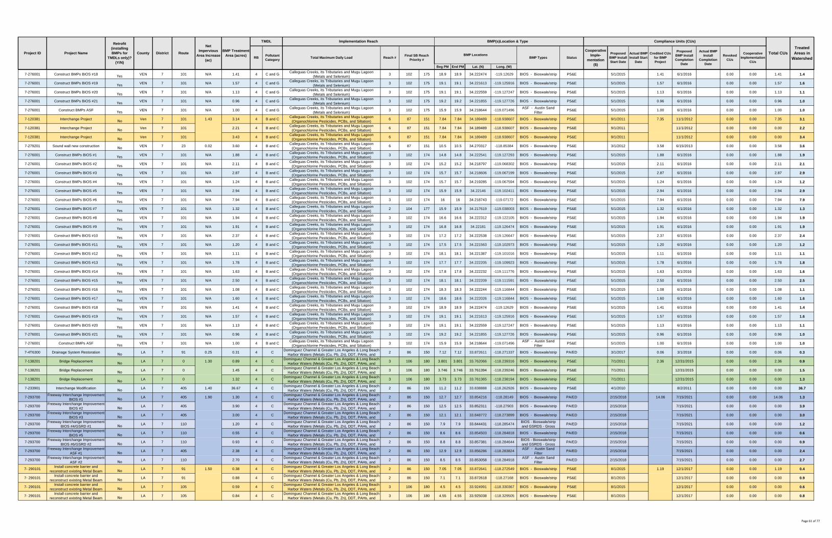
Beg PM End PM Lat. (N) Long. (W)
Revoked CUs
Total CUsTreated Areas in
WatershedRBPollutant Category
Total Maximum Daily Load Reach #Final SB Reach
Priority #
Compliance Units (CUs)
Cooperative Imple-
mentation ($)
Cooperative Implementation
CUs
Proposed BMP Install Start Date
Actual BMP Install Start
Date
Credited CUs for BMP Project
Proposed BMP Install Completion
Date
Actual BMP Install
Completion Date
Net Impervious
Area Increase (ac)
BMP Treatment Area (acres)
TMDL Implementation Reach BMP(s)Location & Type
BMP LocationsBMP Types Status
RouteProject ID Project Name
Retrofit (installing BMPs for
TMDLs only)? (Y/N)
County District
7-276001 Construct BMPs BIOS #18 Yes VEN 7 101 N/A 1.41 4 C and GCalleguas Creeks, its Tributaries and Mugu Lagoon
(Metals and Selenium)3 102 175 18.9 18.9 34.222474 -119.12629 BIOS - Bioswale/strip PS&E 5/1/2015 1.41 6/1/2016 0.00 0.00 1.41 1.4
7-276001 Construct BMPs BIOS #19 Yes VEN 7 101 N/A 1.57 4 C and GCalleguas Creeks, its Tributaries and Mugu Lagoon
(Metals and Selenium)3 102 175 19.1 19.1 34.221613 -119.125916 BIOS - Bioswale/strip PS&E 5/1/2015 1.57 6/1/2016 0.00 0.00 1.57 1.6
7-276001 Construct BMPs BIOS #20 Yes VEN 7 101 N/A 1.13 4 C and GCalleguas Creeks, its Tributaries and Mugu Lagoon
(Metals and Selenium)3 102 175 19.1 19.1 34.222559 -119.127247 BIOS - Bioswale/strip PS&E 5/1/2015 1.13 6/1/2016 0.00 0.00 1.13 1.1
7-276001 Construct BMPs BIOS #21 Yes VEN 7 101 N/A 0.96 4 C and GCalleguas Creeks, its Tributaries and Mugu Lagoon
(Metals and Selenium)3 102 175 19.2 19.2 34.221855 -119.127726 BIOS - Bioswale/strip PS&E 5/1/2015 0.96 6/1/2016 0.00 0.00 0.96 1.0
7-276001 Construct BMPs ASF Yes VEN 7 101 N/A 1.00 4 C and GCalleguas Creeks, its Tributaries and Mugu Lagoon
(Metals and Selenium)3 102 175 15.9 15.9 34.218644 -119.071496
ASF - Austin Sand Filter
PS&E 5/1/2015 1.00 6/1/2016 0.00 0.00 1.00 1.0
7-120381 Interchange Project No Ven 7 101 1.43 3.14 4 B and CCalleguas Creeks, its Tributaries and Mugu Lagoon
(Organochlorine Pesticides, PCBs, and Siltation)6 87 151 7.84 7.84 34.189489 -118.938607 BIOS - Bioswale/strip PS&E 9/1/2011 7.35 11/1/2012 0.00 0.00 7.35 3.1
7-120381 Interchange Project No Ven 7 101 2.21 4 B and CCalleguas Creeks, its Tributaries and Mugu Lagoon
(Organochlorine Pesticides, PCBs, and Siltation)6 87 151 7.84 7.84 34.189489 -118.938607 BIOS - Bioswale/strip PS&E 9/1/2011 11/1/2012 0.00 0.00 0.00 2.2
7-120381 Interchange Project No Ven 7 101 3.43 4 B and CCalleguas Creeks, its Tributaries and Mugu Lagoon
(Organochlorine Pesticides, PCBs, and Siltation)6 87 151 7.84 7.84 34.189489 -118.938607 BIOS - Bioswale/strip PS&E 9/1/2011 11/1/2012 0.00 0.00 0.00 3.4
7-279201 Sound wall new construction No VEN 7 23 0.02 3.60 4 B and CCalleguas Creeks, its Tributaries and Mugu Lagoon
(Organochlorine Pesticides, PCBs, and Siltation)6 87 151 10.5 10.5 34.270317 -118.85384 BIOS - Bioswale/strip PS&E 3/1/2012 3.58 6/15/2013 0.00 0.00 3.58 3.6
7-276001 Construct BMPs BIOS #1 Yes VEN 7 101 N/A 1.88 4 B and CCalleguas Creeks, its Tributaries and Mugu Lagoon
(Organochlorine Pesticides, PCBs, and Siltation)3 102 174 14.8 14.8 34.222541 -119.127293 BIOS - Bioswale/strip PS&E 5/1/2015 1.88 6/1/2016 0.00 0.00 1.88 1.9
7-276001 Construct BMPs BIOS #2 Yes VEN 7 101 N/A 2.11 4 B and CCalleguas Creeks, its Tributaries and Mugu Lagoon
(Organochlorine Pesticides, PCBs, and Siltation)3 102 174 15.2 15.2 34.218797 -119.068302 BIOS - Bioswale/strip PS&E 5/1/2015 2.11 6/1/2016 0.00 0.00 2.11 2.1
7-276001 Construct BMPs BIOS #3 Yes VEN 7 101 N/A 2.87 4 B and CCalleguas Creeks, its Tributaries and Mugu Lagoon
(Organochlorine Pesticides, PCBs, and Siltation)3 102 174 15.7 15.7 34.218606 -119.067199 BIOS - Bioswale/strip PS&E 5/1/2015 2.87 6/1/2016 0.00 0.00 2.87 2.9
7-276001 Construct BMPs BIOS #4 Yes VEN 7 101 N/A 1.24 4 B and CCalleguas Creeks, its Tributaries and Mugu Lagoon
(Organochlorine Pesticides, PCBs, and Siltation)3 102 174 15.7 15.7 34.219285 -119.067594 BIOS - Bioswale/strip PS&E 5/1/2015 1.24 6/1/2016 0.00 0.00 1.24 1.2
7-276001 Construct BMPs BIOS #5 Yes VEN 7 101 N/A 2.94 4 B and CCalleguas Creeks, its Tributaries and Mugu Lagoon
(Organochlorine Pesticides, PCBs, and Siltation)3 102 174 15.9 15.9 34.22146 -119.102411 BIOS - Bioswale/strip PS&E 5/1/2015 2.94 6/1/2016 0.00 0.00 2.94 2.9
7-276001 Construct BMPs BIOS #6 Yes VEN 7 101 N/A 7.94 4 B and CCalleguas Creeks, its Tributaries and Mugu Lagoon
(Organochlorine Pesticides, PCBs, and Siltation)3 102 174 16 16 34.218743 -119.07172 BIOS - Bioswale/strip PS&E 5/1/2015 7.94 6/1/2016 0.00 0.00 7.94 7.9
7-276001 Construct BMPs BIOS #7 Yes VEN 7 101 N/A 1.32 4 B and CCalleguas Creeks, its Tributaries and Mugu Lagoon
(Organochlorine Pesticides, PCBs, and Siltation)2 104 177 15.9 15.9 34.217619 -119.038003 BIOS - Bioswale/strip PS&E 5/1/2015 1.32 6/1/2016 0.00 0.00 1.32 1.3
7-276001 Construct BMPs BIOS #8 Yes VEN 7 101 N/A 1.94 4 B and CCalleguas Creeks, its Tributaries and Mugu Lagoon
(Organochlorine Pesticides, PCBs, and Siltation)3 102 174 16.6 16.6 34.222312 -119.122105 BIOS - Bioswale/strip PS&E 5/1/2015 1.94 6/1/2016 0.00 0.00 1.94 1.9
7-276001 Construct BMPs BIOS #9 Yes VEN 7 101 N/A 1.91 4 B and CCalleguas Creeks, its Tributaries and Mugu Lagoon
(Organochlorine Pesticides, PCBs, and Siltation)3 102 174 16.8 16.8 34.22181 -119.126474 BIOS - Bioswale/strip PS&E 5/1/2015 1.91 6/1/2016 0.00 0.00 1.91 1.9
7-276001 Construct BMPs BIOS #10 Yes VEN 7 101 N/A 2.37 4 B and CCalleguas Creeks, its Tributaries and Mugu Lagoon
(Organochlorine Pesticides, PCBs, and Siltation)3 102 174 17.2 17.2 34.222538 -119.126647 BIOS - Bioswale/strip PS&E 5/1/2015 2.37 6/1/2016 0.00 0.00 2.37 2.4
7-276001 Construct BMPs BIOS #11 Yes VEN 7 101 N/A 1.20 4 B and CCalleguas Creeks, its Tributaries and Mugu Lagoon
(Organochlorine Pesticides, PCBs, and Siltation)3 102 174 17.5 17.5 34.221563 -119.102973 BIOS - Bioswale/strip PS&E 5/1/2015 1.20 6/1/2016 0.00 0.00 1.20 1.2
7-276001 Construct BMPs BIOS #12 Yes VEN 7 101 N/A 1.11 4 B and CCalleguas Creeks, its Tributaries and Mugu Lagoon
(Organochlorine Pesticides, PCBs, and Siltation)3 102 174 18.1 18.1 34.221387 -119.101016 BIOS - Bioswale/strip PS&E 5/1/2015 1.11 6/1/2016 0.00 0.00 1.11 1.1
7-276001 Construct BMPs BIOS #13 Yes VEN 7 101 N/A 1.78 4 B and CCalleguas Creeks, its Tributaries and Mugu Lagoon
(Organochlorine Pesticides, PCBs, and Siltation)3 102 174 17.7 17.7 34.222205 -119.109923 BIOS - Bioswale/strip PS&E 5/1/2015 1.78 6/1/2016 0.00 0.00 1.78 1.8
7-276001 Construct BMPs BIOS #14 Yes VEN 7 101 N/A 1.63 4 B and CCalleguas Creeks, its Tributaries and Mugu Lagoon
(Organochlorine Pesticides, PCBs, and Siltation)3 102 174 17.8 17.8 34.222232 -119.111776 BIOS - Bioswale/strip PS&E 5/1/2015 1.63 6/1/2016 0.00 0.00 1.63 1.6
7-276001 Construct BMPs BIOS #15 Yes VEN 7 101 N/A 2.50 4 B and CCalleguas Creeks, its Tributaries and Mugu Lagoon
(Organochlorine Pesticides, PCBs, and Siltation)3 102 174 18.1 18.1 34.222209 -119.111591 BIOS - Bioswale/strip PS&E 5/1/2015 2.50 6/1/2016 0.00 0.00 2.50 2.5
7-276001 Construct BMPs BIOS #16 Yes VEN 7 101 N/A 1.08 4 B and CCalleguas Creeks, its Tributaries and Mugu Lagoon
(Organochlorine Pesticides, PCBs, and Siltation)3 102 174 18.3 18.3 34.222244 -119.116844 BIOS - Bioswale/strip PS&E 5/1/2015 1.08 6/1/2016 0.00 0.00 1.08 1.1
7-276001 Construct BMPs BIOS #17 Yes VEN 7 101 N/A 1.60 4 B and CCalleguas Creeks, its Tributaries and Mugu Lagoon
(Organochlorine Pesticides, PCBs, and Siltation)3 102 174 18.6 18.6 34.222026 -119.116844 BIOS - Bioswale/strip PS&E 5/1/2015 1.60 6/1/2016 0.00 0.00 1.60 1.6
7-276001 Construct BMPs BIOS #18 Yes VEN 7 101 N/A 1.41 4 B and CCalleguas Creeks, its Tributaries and Mugu Lagoon
(Organochlorine Pesticides, PCBs, and Siltation)3 102 174 18.9 18.9 34.222474 -119.12629 BIOS - Bioswale/strip PS&E 5/1/2015 1.41 6/1/2016 0.00 0.00 1.41 1.4
7-276001 Construct BMPs BIOS #19 Yes VEN 7 101 N/A 1.57 4 B and CCalleguas Creeks, its Tributaries and Mugu Lagoon
(Organochlorine Pesticides, PCBs, and Siltation)3 102 174 19.1 19.1 34.221613 -119.125916 BIOS - Bioswale/strip PS&E 5/1/2015 1.57 6/1/2016 0.00 0.00 1.57 1.6
7-276001 Construct BMPs BIOS #20 Yes VEN 7 101 N/A 1.13 4 B and CCalleguas Creeks, its Tributaries and Mugu Lagoon
(Organochlorine Pesticides, PCBs, and Siltation)3 102 174 19.1 19.1 34.222559 -119.127247 BIOS - Bioswale/strip PS&E 5/1/2015 1.13 6/1/2016 0.00 0.00 1.13 1.1
7-276001 Construct BMPs BIOS #21 Yes VEN 7 101 N/A 0.96 4 B and CCalleguas Creeks, its Tributaries and Mugu Lagoon
(Organochlorine Pesticides, PCBs, and Siltation)3 102 174 19.2 19.2 34.221855 -119.127726 BIOS - Bioswale/strip PS&E 5/1/2015 0.96 6/1/2016 0.00 0.00 0.96 1.0
7-276001 Construct BMPs ASF Yes VEN 7 101 N/A 1.00 4 B and CCalleguas Creeks, its Tributaries and Mugu Lagoon
(Organochlorine Pesticides, PCBs, and Siltation)3 102 174 15.9 15.9 34.218644 -119.071496
ASF - Austin Sand Filter
PS&E 5/1/2015 1.00 6/1/2016 0.00 0.00 1.00 1.0
7-4T6300 Drainage System Restoration No LA 7 91 0.25 0.31 4 CDominguez Channel & Greater Los Angeles & Long Beach
Harbor Waters (Metals (Cu, Pb, Zn), DDT, PAHs, and 2 86 150 7.12 7.12 33.872611 -118.271337 BIOS - Bioswale/strip PA/ED 3/1/2017 0.06 3/1/2018 0.00 0.00 0.06 0.3
7-138201 Bridge Replacement No LA 7 0 1.30 0.89 4 CDominguez Channel & Greater Los Angeles & Long Beach
Harbor Waters (Metals (Cu, Pb, Zn), DDT, PAHs, and 3 106 180 3.801 3.801 33.762066 -118.239316 BIOS - Bioswale/strip PS&E 7/1/2011 2.36 12/31/2015 0.00 0.00 2.36 0.9
7-138201 Bridge Replacement No LA 7 0 1.45 4 CDominguez Channel & Greater Los Angeles & Long Beach
Harbor Waters (Metals (Cu, Pb, Zn), DDT, PAHs, and 3 106 180 3.746 3.746 33.761394 -118.239246 BIOS - Bioswale/strip PS&E 7/1/2011 12/31/2015 0.00 0.00 0.00 1.5
7-138201 Bridge Replacement No LA 7 0 1.32 4 CDominguez Channel & Greater Los Angeles & Long Beach
Harbor Waters (Metals (Cu, Pb, Zn), DDT, PAHs, and 3 106 180 3.73 3.73 33.761365 -118.238194 BIOS - Bioswale/strip PS&E 7/1/2011 12/31/2015 0.00 0.00 0.00 1.3
7-233901 Interchange Modification No LA 7 405 1.40 36.67 4 CDominguez Channel & Greater Los Angeles & Long Beach
Harbor Waters (Metals (Cu, Pb, Zn), DDT, PAHs, and 2 86 150 11.2 11.2 33.838888 -118.262926 BIOS - Bioswale/strip PS&E 4/1/2010 8/2/2011 0.00 0.00 0.00 36.7
7-293700Freeway Interchange Improvement
BIOS #1 No LA 7 405 1.90 1.30 4 CDominguez Channel & Greater Los Angeles & Long Beach
Harbor Waters (Metals (Cu, Pb, Zn), DDT, PAHs, and 2 86 150 12.7 12.7 33.854216 -118.28149 BIOS - Bioswale/strip PA/ED 2/15/2018 14.06 7/15/2021 0.00 0.00 14.06 1.3
7-293700Freeway Interchange Improvement
BIOS #2 No LA 7 405 3.90 4 CDominguez Channel & Greater Los Angeles & Long Beach
Harbor Waters (Metals (Cu, Pb, Zn), DDT, PAHs, and 2 86 150 12.5 12.5 33.852311 -118.27903 BIOS - Bioswale/strip PA/ED 2/15/2018 7/15/2021 0.00 0.00 0.00 3.9
7-293700Freeway Interchange Improvement
BIOS #3 No LA 7 405 3.00 4 CDominguez Channel & Greater Los Angeles & Long Beach
Harbor Waters (Metals (Cu, Pb, Zn), DDT, PAHs, and 2 86 150 12.1 12.1 33.848772 -118.273899 BIOS - Bioswale/strip PA/ED 2/15/2018 7/15/2021 0.00 0.00 0.00 3.0
7-293700Freeway Interchange Improvement
BIOS #4/GSRD #1 No LA 7 110 1.20 4 CDominguez Channel & Greater Los Angeles & Long Beach
Harbor Waters (Metals (Cu, Pb, Zn), DDT, PAHs, and 2 86 150 7.9 7.9 33.844431 -118.285474
BIOS - Bioswale/strip and GSRDS - Gross
PA/ED 2/15/2018 7/15/2021 0.00 0.00 0.00 1.2
7-293700Freeway Interchange Improvement
BIOS #5 No LA 7 110 0.55 4 CDominguez Channel & Greater Los Angeles & Long Beach
Harbor Waters (Metals (Cu, Pb, Zn), DDT, PAHs, and 2 86 150 8.6 8.6 33.854503 -118.284818 BIOS - Bioswale/strip PA/ED 2/15/2018 7/15/2021 0.00 0.00 0.00 0.6
7-293700Freeway Interchange Improvement
BIOS #6/GSRD #2 No LA 7 110 0.93 4 CDominguez Channel & Greater Los Angeles & Long Beach
Harbor Waters (Metals (Cu, Pb, Zn), DDT, PAHs, and 2 86 150 8.8 8.8 33.857381 -118.284644
BIOS - Bioswale/strip and GSRDS - Gross
PA/ED 2/15/2018 7/15/2021 0.00 0.00 0.00 0.9
7-293700Freeway Interchange Improvement
ASF #1 No LA 7 405 2.38 4 CDominguez Channel & Greater Los Angeles & Long Beach
Harbor Waters (Metals (Cu, Pb, Zn), DDT, PAHs, and 2 86 150 12.9 12.9 33.856286 -118.283824
ASF - Austin Sand Filter
PA/ED 2/15/2018 7/15/2021 0.00 0.00 0.00 2.4
7-293700Freeway Interchange Improvement
ASF #2 No LA 7 110 2.70 4 CDominguez Channel & Greater Los Angeles & Long Beach
Harbor Waters (Metals (Cu, Pb, Zn), DDT, PAHs, and 2 86 150 8.5 8.5 33.853058 -118.284918
ASF - Austin Sand Filter
PA/ED 2/15/2018 7/15/2021 0.00 0.00 0.00 2.7
7- 290101Install concrete barrier and
reconstruct existing Metal Beam No LA 7 91 1.50 0.38 4 CDominguez Channel & Greater Los Angeles & Long Beach
Harbor Waters (Metals (Cu, Pb, Zn), DDT, PAHs, and 2 86 150 7.05 7.05 33.872641 -118.272549 BIOS - Bioswale/strip PS&E 8/1/2015 1.19 12/1/2017 0.00 0.00 1.19 0.4
7- 290101Install concrete barrier and
reconstruct existing Metal Beam No LA 7 91 0.88 4 CDominguez Channel & Greater Los Angeles & Long Beach
Harbor Waters (Metals (Cu, Pb, Zn), DDT, PAHs, and 2 86 150 7.1 7.1 33.872618 -118.27168 BIOS - Bioswale/strip PS&E 8/1/2015 12/1/2017 0.00 0.00 0.00 0.9
7- 290101Install concrete barrier and
reconstruct existing Metal Beam No LA 7 105 0.59 4 CDominguez Channel & Greater Los Angeles & Long Beach
Harbor Waters (Metals (Cu, Pb, Zn), DDT, PAHs, and 3 106 180 4.5 4.5 33.924991 -118.330367 BIOS - Bioswale/strip PS&E 8/1/2015 12/1/2017 0.00 0.00 0.00 0.6
7- 290101Install concrete barrier and
reconstruct existing Metal Beam No LA 7 105 0.84 4 CDominguez Channel & Greater Los Angeles & Long Beach
Harbor Waters (Metals (Cu, Pb, Zn), DDT, PAHs, and 3 106 180 4.55 4.55 33.925038 -118.329505 BIOS - Bioswale/strip PS&E 8/1/2015 12/1/2017 0.00 0.00 0.00 0.8
Page 61 of 77
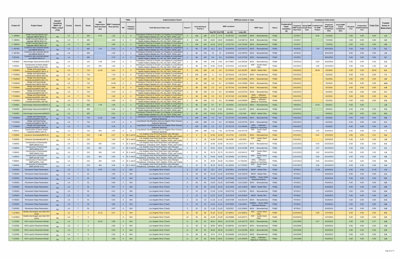
Beg PM End PM Lat. (N) Long. (W)
Revoked CUs
Total CUsTreated Areas in
WatershedRBPollutant Category
Total Maximum Daily Load Reach #Final SB Reach
Priority #
Compliance Units (CUs)
Cooperative Imple-
mentation ($)
Cooperative Implementation
CUs
Proposed BMP Install Start Date
Actual BMP Install Start
Date
Credited CUs for BMP Project
Proposed BMP Install Completion
Date
Actual BMP Install
Completion Date
Net Impervious
Area Increase (ac)
BMP Treatment Area (acres)
TMDL Implementation Reach BMP(s)Location & Type
BMP LocationsBMP Types Status
RouteProject ID Project Name
Retrofit (installing BMPs for
TMDLs only)? (Y/N)
County District
7- 290001Install Concrete Barrier and Upgrade MBGR BIOS #1 No LA 7 405 0.70 1.20 4 C
Dominguez Channel & Greater Los Angeles & Long Beach Harbor Waters (Metals (Cu, Pb, Zn), DDT, PAHs, and
3 106 180 17.9 17.9 33.887542 -118.35659 BIOS - Bioswale/strip PS&E 2/1/2017 8.40 7/1/2018 0.00 0.00 8.40 1.2
7- 290001Install Concrete Barrier and Upgrade MBGR BIOS #2 No LA 7 405 3.00 4 C
Dominguez Channel & Greater Los Angeles & Long Beach Harbor Waters (Metals (Cu, Pb, Zn), DDT, PAHs, and
3 106 180 18.67 18.67 33.894821 -118.366712 BIOS - Bioswale/strip PS&E 2/1/2017 7/1/2018 0.00 0.00 0.00 3.0
7- 290001Install Concrete Barrier and Upgrade MBGR BIOS #3 No LA 7 405 4.90 4 C
Dominguez Channel & Greater Los Angeles & Long Beach Harbor Waters (Metals (Cu, Pb, Zn), DDT, PAHs, and
3 106 180 19.22 19.22 33.901792 -118.370408 BIOS - Bioswale/strip PS&E 2/1/2017 7/1/2018 0.00 0.00 0.00 4.9
7- 287401Construct new concrete barrier
and MBGR BIOS #1 No LA 7 405 1.01 3.10 4 CDominguez Channel & Greater Los Angeles & Long Beach
Harbor Waters (Metals (Cu, Pb, Zn), DDT, PAHs, and 2 86 150 10.1 10.1 33.826554 -118.250273 BIOS - Bioswale/strip PS&E 4/1/2015 7.29 8/31/2015 0.00 0.00 7.29 3.1
7- 287401Construct new concrete barrier
and MBGR BIOS #2 No LA 7 405 1.50 4 CDominguez Channel & Greater Los Angeles & Long Beach
Harbor Waters (Metals (Cu, Pb, Zn), DDT, PAHs, and 2 86 150 10 10 33.826025 -118.248704 BIOS - Bioswale/strip PS&E 4/1/2015 8/31/2015 0.00 0.00 0.00 1.5
7-287401Construct new concrete barrier
and MBGR BIOS #3 No LA 7 405 3.70 4 CDominguez Channel & Greater Los Angeles & Long Beach
Harbor Waters (Metals (Cu, Pb, Zn), DDT, PAHs, and 2 86 150 9.9 9.9 33.825849 -118.247064 BIOS - Bioswale/strip PS&E 4/1/2015 8/31/2015 0.00 0.00 0.00 3.7
7-264802 Interchange Improvements BIOS No LA 7 110 1.54 0.30 4 CDominguez Channel & Greater Los Angeles & Long Beach
Harbor Waters (Metals (Cu, Pb, Zn), DDT, PAHs, and 1 98 169 2.65 2.65 33.770667 -118.280292 BIOS - Bioswale/strip PS&E 7/22/2013 0.00 6/22/2015 0.00 0.00 0.00 0.3
7-259021Construction of Storm Water Treatment BMPs AVSF #10 Yes LA 7 110 N/A 1.60 4 C
Dominguez Channel & Greater Los Angeles & Long Beach Harbor Waters (Metals (Cu, Pb, Zn), DDT, PAHs, and
2 86 150 15.81 15.81 33.873534 -118.281387ASF - Austin Sand
FilterPS&E 10/1/2013 1.60 12/15/2014 0.00 0.00 1.60 1.6
7-7228301Bridge and Interchange
Contstruction(MEDF Site # 1) No LA 7 710 11.20 6.10 4 CDominguez Channel & Greater Los Angeles & Long Beach
Harbor Waters (Metals (Cu, Pb, Zn), DDT, PAHs, and 3 106 180 3.8 3.8 33.760341 -118.232387 MEDF - Media Filter PS&E 3/31/2013 29.40 3/1/2016 0.00 0.00 29.40 6.1
7-7228301Bridge and Interchange
Contstruction (BIOS Site #3) No LA 7 710 7.10 4 CDominguez Channel & Greater Los Angeles & Long Beach
Harbor Waters (Metals (Cu, Pb, Zn), DDT, PAHs, and 3 106 180 4 4.3 33.761422 -118.22918 BIOS - Bioswale/strip PS&E 3/31/2013 3/1/2016 0.00 0.00 0.00 7.1
7-7228301Bridge and Interchange
Contstruction(BIOS Site # 4) No LA 7 710 3.50 4 CDominguez Channel & Greater Los Angeles & Long Beach
Harbor Waters (Metals (Cu, Pb, Zn), DDT, PAHs, and 1 98 169 4.6 4.6 33.765004 -118.219666 BIOS - Bioswale/strip PS&E 3/31/2013 3/1/2016 0.00 0.00 0.00 3.5
7-7228301Bridge and Interchange
Contstruction (BIOS Site #5) No LA 7 710 14.50 4 CDominguez Channel & Greater Los Angeles & Long Beach
Harbor Waters (Metals (Cu, Pb, Zn), DDT, PAHs, and 1 98 169 4.6 5.1 33.765004 -118.219666 BIOS - Bioswale/strip PS&E 3/31/2013 3/1/2016 0.00 0.00 0.00 14.5
7-7228301Bridge and Interchange
Contstruction(BIOS Site # 6) No LA 7 710 0.80 4 CDominguez Channel & Greater Los Angeles & Long Beach
Harbor Waters (Metals (Cu, Pb, Zn), DDT, PAHs, and 1 98 169 5.3 5.4 33.767249 -118.208366 BIOS - Bioswale/strip PS&E 3/31/2013 3/1/2016 0.00 0.00 0.00 0.8
7-7228301Bridge and Interchange
Contstruction(BIOS Site #7) No LA 7 710 5.70 4 CDominguez Channel & Greater Los Angeles & Long Beach
Harbor Waters (Metals (Cu, Pb, Zn), DDT, PAHs, and 1 98 169 5.4 5.4 33.768306 -118.207376 BIOS - Bioswale/strip PS&E 3/31/2013 3/1/2016 0.00 0.00 0.00 5.7
7-7228301Bridge and Interchange
Contstruction(INFIL Site # 8) No LA 7 710 2.40 4 CDominguez Channel & Greater Los Angeles & Long Beach
Harbor Waters (Metals (Cu, Pb, Zn), DDT, PAHs, and 1 98 169 5.3 5.3 33.767249 -118.208366
INFIL - Infiltration (Basins & Trenches)
PS&E 3/31/2013 3/1/2016 0.00 0.00 0.00 2.4
7-7228301Bridge and Interchange
Contstruction(INFIL Site #9) No LA 7 710 0.50 4 CDominguez Channel & Greater Los Angeles & Long Beach
Harbor Waters (Metals (Cu, Pb, Zn), DDT, PAHs, and 1 98 169 5.2 5.2 33.766883 -118.209804
INFIL - Infiltration (Basins & Trenches)
PS&E 3/31/2013 3/1/2016 0.00 0.00 0.00 0.5
7-234001 Interchange Improvement(BIOS 1) No LA 7 405 1.40 1.85 4 CDominguez Channel & Greater Los Angeles & Long Beach
Harbor Waters (Metals (Cu, Pb, Zn), DDT, PAHs, and 2 86 150 9.7 9.7 33.82583 -118.243735 BIOS - Bioswale/strip PS&E 9/9/2010 13.91 5/3/2012 0.00 0.00 1.9
7-234001 Interchange Improvement(BIOS 2) No LA 7 405 5.26 4 CDominguez Channel & Greater Los Angeles & Long Beach
Harbor Waters (Metals (Cu, Pb, Zn), DDT, PAHs, and 2 86 150 9.52 9.52 33.82611 -118.2407 BIOS - Bioswale/strip PS&E 9/10/2010 5/4/2012 0.00 0.00 0.00 5.3
7-234001 Interchange Improvement(MEDF) No LA 7 405 8.20 4 CDominguez Channel & Greater Los Angeles & Long Beach
Harbor Waters (Metals (Cu, Pb, Zn), DDT, PAHs, and 2 86 150 9.514 9.514 33.82646 -118.2406 MEDF - Media Filter PS&E 9/10/2010 5/4/2012 0.00 0.00 0.00 8.2
7-7228301Bridge and Interchange
Contstruction(BIOS Site # 6) No LA 7 710 11.20 0.80 4 ELong Beach City Beaches and Los Angeles River Estuary
(Indicator Bacteria)2 199 289 5.3 5.4 33.767249 -118.208366 BIOS - Bioswale/strip PS&E 3/31/2013 0.00 3/1/2016 0.00 0.00 0.00 0.8
7-7228301Bridge and Interchange
Contstruction(BIOS Site #7) No LA 7 710 5.70 4 ELong Beach City Beaches and Los Angeles River Estuary
(Indicator Bacteria)2 199 289 5.4 5.4 33.768306 -118.207376 BIOS - Bioswale/strip PS&E 3/31/2013 3/1/2016 0.00 0.00 0.00 5.7
7-7228301Bridge and Interchange
Contstruction(INFIL Site # 8) No LA 7 710 2.40 4 ELong Beach City Beaches and Los Angeles River Estuary
(Indicator Bacteria)2 199 289 5.3 5.3 33.767249 -118.208366
INFIL - Infiltration (Basins & Trenches)
PS&E 3/31/2013 3/1/2016 0.00 0.00 0.00 2.4
7-259011Construction of Storm Water
Treatment BMPs ASF #1 Yes LA 7 710 N/A 7.67 4 ELong Beach City Beaches and Los Angeles River Estuary
(Indicator Bacteria)2 199 289 7.01 7.01 33.791758 -118.207703
ASF - Austin Sand Filter
PS&E 11/15/2013 7.67 8/15/2014 0.00 0.00 7.67 7.7
7-232901 Construct Soundwalls(BIOS 5) No LA 7 210 1.80 0.37 4 B, C and DLos Angeles Area Peck Road Park Lake (Nitrogen,
Phosphorus, Chlordane, DDT, Dieldrin, PCBs, and Trash)2 6 15 31.94 31.94 34.14759 -118.0293 BIOS - Bioswale/strip PS&E 2/21/2011 0.41 2/22/2013 0.00 0.00 0.41 0.4
7-232901 Construct Soundwalls(ASF 1) No LA 7 210 1.84 4 B, C and DLos Angeles Area Peck Road Park Lake (Nitrogen,
Phosphorus, Chlordane, DDT, Dieldrin, PCBs, and Trash)2 6 15 31.94 31.94 34.14788 -118.0304
ASF - Austin Sand Filter
PS&E 2/21/2011 2/22/2013 0.00 0.00 0.00 1.8
7-258931Construction of Stormwater
BMP's(BIOS #11) Yes LA 7 210 N/A 0.40 4 B, C and DLos Angeles Area Peck Road Park Lake (Nitrogen,
Phosphorus, Chlordane, DDT, Dieldrin, PCBs, and Trash)2 6 15 32.83 32.83 34.14117 -118.017577 BIOS - Bioswale/strip PS&E 11/21/2012 0.40 10/14/2014 0.00 0.00 0.40 0.4
7-258931Construction of Stormwater
BMP's(BIOS #21) Yes LA 7 210 N/A 2.07 4 B, C and DLos Angeles Area Peck Road Park Lake (Nitrogen,
Phosphorus, Chlordane, DDT, Dieldrin, PCBs, and Trash)2 6 15 33.01 33.01 34.139148 -118.015496 BIOS - Bioswale/strip PS&E 11/21/2012 2.07 10/14/2014 0.00 0.00 2.07 2.1
7-258931Construction of Stormwater
BMP's(BIOS #14) Yes LA 7 210 N/A 1.62 4 B, C and DLos Angeles Area Peck Road Park Lake (Nitrogen,
Phosphorus, Chlordane, DDT, Dieldrin, PCBs, and Trash)1 15 35 33.73 33.73 34.135474 -118.004137
ASF - Austin Sand Filter
PS&E 11/21/2012 1.62 10/14/2014 0.00 0.00 1.62 1.6
7-258931Construction of Stormwater
BMP's(AVSF #15) Yes LA 7 210 N/A 0.83 4 B, C and DLos Angeles Area Peck Road Park Lake (Nitrogen,
Phosphorus, Chlordane, DDT, Dieldrin, PCBs, and Trash)1 15 35 34.66 34.66 34.135456 -117.987911
ASF - Austin Sand Filter
PS&E 11/21/2012 0.83 10/14/2014 0.00 0.00 0.83 0.8
7-258931Construction of Stormwater
BMP's(INFIL # 16) Yes LA 7 210 N/A 0.93 4 B, C and DLos Angeles Area Peck Road Park Lake (Nitrogen,
Phosphorus, Chlordane, DDT, Dieldrin, PCBs, and Trash)1 15 35 35.05 35.05 34.135401 -117.981091
INFIL - Infiltration (Basins & Trenches)
PS&E 11/21/2012 0.93 10/14/2014 0.00 0.00 0.93 0.9
7-258931Construction of Stormwater
BMP's(AVSF #17) Yes LA 7 210 N/A 3.36 4 B, C and DLos Angeles Area Peck Road Park Lake (Nitrogen,
Phosphorus, Chlordane, DDT, Dieldrin, PCBs, and Trash)1 15 35 35.29 35.29 34.135331 -117.976922
ASF - Austin Sand Filter
PS&E 11/21/2012 3.36 10/14/2014 0.00 0.00 3.36 3.4
7-2X9201 Permanent Slope Restoration No LA 7 91 0.79 1.34 4 N/A Los Angeles River (Trash) 6 29 65 10.7 10.7 33.873601 -118.209135 MEDF - Media Filter PS&E 9/7/2012 17.28 6/10/2014 0.00 0.00 17.28 1.3
7-2X9201 Permanent Slope Restoration No LA 7 91 2.09 4 N/A Los Angeles River (Trash) 6 29 65 10.18 10.18 33.873534 -118.218219 MEDF - Media Filter PS&E 9/7/2012 6/10/2014 0.00 0.00 0.00 2.1
7-2X9201 Permanent Slope Restoration No LA 7 91 0.49 4 N/A Los Angeles River (Trash) 6 29 65 10.23 10.23 33.873486 -118.217347GSRDs - Gross Solid
Removal DevicesPS&E 9/7/2012 6/10/2014 0.00 0.00 0.00 0.5
7-2X9201 Permanent Slope Restoration No LA 7 91 0.60 4 N/A Los Angeles River (Trash) 6 29 65 10.33 10.33 33.873468 -118.215595 BIOS - Bioswale/strip PS&E 9/7/2012 6/10/2014 0.00 0.00 0.00 0.6
7-2X9201 Permanent Slope Restoration No LA 7 91 3.57 4 N/A Los Angeles River (Trash) 6 29 65 10.43 10.43 33.873495 -118.213849 MEDF - Media Filter PS&E 9/7/2012 6/10/2014 0.00 0.00 0.00 3.6
7-2X9201 Permanent Slope Restoration No LA 7 91 0.41 4 N/A Los Angeles River (Trash) 2 10 23 11.03 11.03 33.872733 -118.20351 BIOS - Bioswale/strip PS&E 9/7/2012 6/10/2014 0.00 0.00 0.00 0.4
7-2X9201 Permanent Slope Restoration No LA 7 91 3.62 4 N/A Los Angeles River (Trash) 2 10 23 11.07 11.07 33.872678 -118.202824 MEDF - Media Filter PS&E 9/7/2012 6/10/2014 0.00 0.00 0.00 3.6
7-2X9201 Permanent Slope Restoration No LA 7 91 0.44 4 N/A Los Angeles River (Trash) 2 10 23 11.16 11.16 33.872708 -118.201276 BIOS - Bioswale/strip PS&E 9/7/2012 6/10/2014 0.00 0.00 0.00 0.4
7-2X9201 Permanent Slope Restoration No LA 7 91 4.64 4 N/A Los Angeles River (Trash) 2 10 23 11.21 11.21 33.872805 -118.20042GSRDs - Gross Solid
Removal DevicesPS&E 9/7/2012 6/10/2014 0.00 0.00 0.00 4.6
7-2X9201 Permanent Slope Restoration No LA 7 91 0.87 4 N/A Los Angeles River (Trash) 2 10 23 11.63 11.63 33.87522 -118.193692 BIOS - Bioswale/strip PS&E 9/7/2012 6/10/2014 0.00 0.00 0.00 0.9
7-1218W1Modify Interchagne and Add HOV
Lanes No LA 7 5 12.10 8.27 4 N/A Los Angeles River (Trash) 10 30 68 31.34 31.34 34.199912 -118.338615ASF - Austin Sand
FilterPS&E 12/24/2012 0.00 12/7/2015 0.00 0.00 0.00 8.3
7-1218W1Modify Interchagne and Add HOV
Lanes No LA 7 5 4 N/A Los Angeles River (Trash) 10 30 68 31.59 31.59 34.203068 -118.340771ASF - Austin Sand
FilterPS&E 12/24/2012 12/7/2015 0.00 0.00 0.00 0.0
7-121901 HOV Land & Pavement Rehab No LA 7 5 24.22 2.80 4 N/A Los Angeles River (Trash) 11 28 62 38.54 38.54 34.257383 -118.434778 BIOS - Bioswale/strip PS&E 10/1/2009 5.27 9/10/2013 0.00 0.00 5.27 2.8
7-121901 HOV Land & Pavement Rehab No LA 7 5 2.80 4 N/A Los Angeles River (Trash) 11 28 62 38.54 38.54 34.256751 -118.436071 BIOS - Bioswale/strip PS&E 10/1/2009 9/10/2013 0.00 0.00 0.00 2.8
7-121901 HOV Land & Pavement Rehab No LA 7 5 0.30 4 N/A Los Angeles River (Trash) 11 28 62 38.46 38.46 34.255971 -118.434308 BIOS - Bioswale/strip PS&E 10/1/2009 9/10/2013 0.00 0.00 0.00 0.3
7-121901 HOV Land & Pavement Rehab No LA 7 5 2.30 4 N/A Los Angeles River (Trash) 11 28 62 37.4 37.4 34.244546 -118.422219 BIOS - Bioswale/strip PS&E 10/1/2009 9/10/2013 0.00 0.00 0.00 2.3
7-121901 HOV Land & Pavement Rehab No LA 7 5 2.80 4 N/A Los Angeles River (Trash) 11 28 62 38.54 38.54 34.256691 -118.436095INFIL - Infiltration
(Basins & Trenches)PS&E 10/1/2009 9/10/2013 0.00 0.00 0.00 2.8
Page 62 of 77
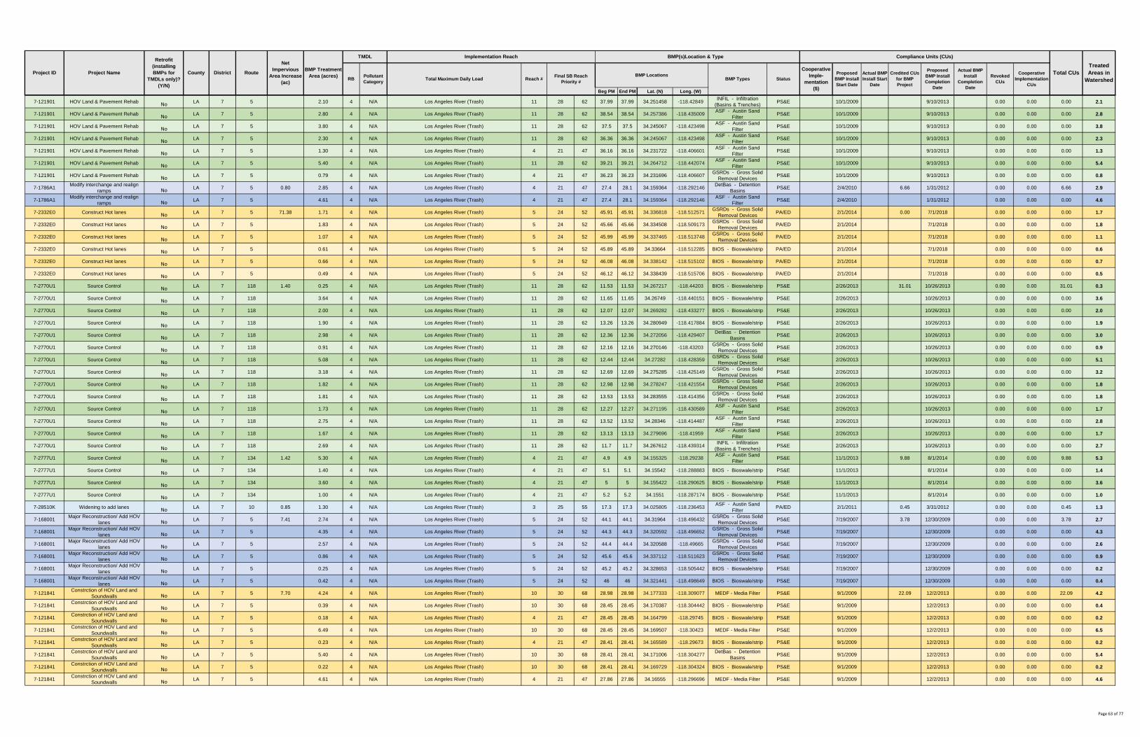
Beg PM End PM Lat. (N) Long. (W)
Revoked CUs
Total CUsTreated Areas in
WatershedRBPollutant Category
Total Maximum Daily Load Reach #Final SB Reach
Priority #
Compliance Units (CUs)
Cooperative Imple-
mentation ($)
Cooperative Implementation
CUs
Proposed BMP Install Start Date
Actual BMP Install Start
Date
Credited CUs for BMP Project
Proposed BMP Install Completion
Date
Actual BMP Install
Completion Date
Net Impervious
Area Increase (ac)
BMP Treatment Area (acres)
TMDL Implementation Reach BMP(s)Location & Type
BMP LocationsBMP Types Status
RouteProject ID Project Name
Retrofit (installing BMPs for
TMDLs only)? (Y/N)
County District
7-121901 HOV Land & Pavement Rehab No LA 7 5 2.10 4 N/A Los Angeles River (Trash) 11 28 62 37.99 37.99 34.251458 -118.42849INFIL - Infiltration
(Basins & Trenches)PS&E 10/1/2009 9/10/2013 0.00 0.00 0.00 2.1
7-121901 HOV Land & Pavement Rehab No LA 7 5 2.80 4 N/A Los Angeles River (Trash) 11 28 62 38.54 38.54 34.257386 -118.435009ASF - Austin Sand
FilterPS&E 10/1/2009 9/10/2013 0.00 0.00 0.00 2.8
7-121901 HOV Land & Pavement Rehab No LA 7 5 3.80 4 N/A Los Angeles River (Trash) 11 28 62 37.5 37.5 34.245067 -118.423498ASF - Austin Sand
FilterPS&E 10/1/2009 9/10/2013 0.00 0.00 0.00 3.8
7-121901 HOV Land & Pavement Rehab No LA 7 5 2.30 4 N/A Los Angeles River (Trash) 11 28 62 36.36 36.36 34.245067 -118.423498ASF - Austin Sand
FilterPS&E 10/1/2009 9/10/2013 0.00 0.00 0.00 2.3
7-121901 HOV Land & Pavement Rehab No LA 7 5 1.30 4 N/A Los Angeles River (Trash) 4 21 47 36.16 36.16 34.231722 -118.406601ASF - Austin Sand
FilterPS&E 10/1/2009 9/10/2013 0.00 0.00 0.00 1.3
7-121901 HOV Land & Pavement Rehab No LA 7 5 5.40 4 N/A Los Angeles River (Trash) 11 28 62 39.21 39.21 34.264712 -118.442074ASF - Austin Sand
FilterPS&E 10/1/2009 9/10/2013 0.00 0.00 0.00 5.4
7-121901 HOV Land & Pavement Rehab No LA 7 5 0.79 4 N/A Los Angeles River (Trash) 4 21 47 36.23 36.23 34.231696 -118.406607GSRDs - Gross Solid
Removal DevicesPS&E 10/1/2009 9/10/2013 0.00 0.00 0.00 0.8
7-1786A1Modify interchange and realign
ramps No LA 7 5 0.80 2.85 4 N/A Los Angeles River (Trash) 4 21 47 27.4 28.1 34.159364 -118.292146DetBas - Detention
BasinsPS&E 2/4/2010 6.66 1/31/2012 0.00 0.00 6.66 2.9
7-1786A1Modify interchange and realign
ramps No LA 7 5 4.61 4 N/A Los Angeles River (Trash) 4 21 47 27.4 28.1 34.159364 -118.292146ASF - Austin Sand
FilterPS&E 2/4/2010 1/31/2012 0.00 0.00 0.00 4.6
7-2332E0 Construct Hot lanes No LA 7 5 71.38 1.71 4 N/A Los Angeles River (Trash) 5 24 52 45.91 45.91 34.336818 -118.512571GSRDs - Gross Solid
Removal DevicesPA/ED 2/1/2014 0.00 7/1/2018 0.00 0.00 0.00 1.7
7-2332E0 Construct Hot lanes No LA 7 5 1.83 4 N/A Los Angeles River (Trash) 5 24 52 45.66 45.66 34.334508 -118.509173GSRDs - Gross Solid
Removal DevicesPA/ED 2/1/2014 7/1/2018 0.00 0.00 0.00 1.8
7-2332E0 Construct Hot lanes No LA 7 5 1.07 4 N/A Los Angeles River (Trash) 5 24 52 45.99 45.99 34.337465 -118.513748GSRDs - Gross Solid
Removal DevicesPA/ED 2/1/2014 7/1/2018 0.00 0.00 0.00 1.1
7-2332E0 Construct Hot lanes No LA 7 5 0.61 4 N/A Los Angeles River (Trash) 5 24 52 45.89 45.89 34.33664 -118.512285 BIOS - Bioswale/strip PA/ED 2/1/2014 7/1/2018 0.00 0.00 0.00 0.6
7-2332E0 Construct Hot lanes No LA 7 5 0.66 4 N/A Los Angeles River (Trash) 5 24 52 46.08 46.08 34.338142 -118.515102 BIOS - Bioswale/strip PA/ED 2/1/2014 7/1/2018 0.00 0.00 0.00 0.7
7-2332E0 Construct Hot lanes No LA 7 5 0.49 4 N/A Los Angeles River (Trash) 5 24 52 46.12 46.12 34.338439 -118.515706 BIOS - Bioswale/strip PA/ED 2/1/2014 7/1/2018 0.00 0.00 0.00 0.5
7-2770U1 Source Control No LA 7 118 1.40 0.25 4 N/A Los Angeles River (Trash) 11 28 62 11.53 11.53 34.267217 -118.44203 BIOS - Bioswale/strip PS&E 2/26/2013 31.01 10/26/2013 0.00 0.00 31.01 0.3
7-2770U1 Source Control No LA 7 118 3.64 4 N/A Los Angeles River (Trash) 11 28 62 11.65 11.65 34.26749 -118.440151 BIOS - Bioswale/strip PS&E 2/26/2013 10/26/2013 0.00 0.00 0.00 3.6
7-2770U1 Source Control No LA 7 118 2.00 4 N/A Los Angeles River (Trash) 11 28 62 12.07 12.07 34.269282 -118.433277 BIOS - Bioswale/strip PS&E 2/26/2013 10/26/2013 0.00 0.00 0.00 2.0
7-2770U1 Source Control No LA 7 118 1.90 4 N/A Los Angeles River (Trash) 11 28 62 13.26 13.26 34.280949 -118.417884 BIOS - Bioswale/strip PS&E 2/26/2013 10/26/2013 0.00 0.00 0.00 1.9
7-2770U1 Source Control No LA 7 118 2.98 4 N/A Los Angeles River (Trash) 11 28 62 12.36 12.36 34.272056 -118.429407DetBas - Detention
BasinsPS&E 2/26/2013 10/26/2013 0.00 0.00 0.00 3.0
7-2770U1 Source Control No LA 7 118 0.91 4 N/A Los Angeles River (Trash) 11 28 62 12.16 12.16 34.270146 -118.43203GSRDs - Gross Solid
Removal DevicesPS&E 2/26/2013 10/26/2013 0.00 0.00 0.00 0.9
7-2770U1 Source Control No LA 7 118 5.08 4 N/A Los Angeles River (Trash) 11 28 62 12.44 12.44 34.27282 -118.428359GSRDs - Gross Solid
Removal DevicesPS&E 2/26/2013 10/26/2013 0.00 0.00 0.00 5.1
7-2770U1 Source Control No LA 7 118 3.18 4 N/A Los Angeles River (Trash) 11 28 62 12.69 12.69 34.275285 -118.425149GSRDs - Gross Solid
Removal DevicesPS&E 2/26/2013 10/26/2013 0.00 0.00 0.00 3.2
7-2770U1 Source Control No LA 7 118 1.82 4 N/A Los Angeles River (Trash) 11 28 62 12.98 12.98 34.278247 -118.421554GSRDs - Gross Solid
Removal DevicesPS&E 2/26/2013 10/26/2013 0.00 0.00 0.00 1.8
7-2770U1 Source Control No LA 7 118 1.81 4 N/A Los Angeles River (Trash) 11 28 62 13.53 13.53 34.283555 -118.414356GSRDs - Gross Solid
Removal DevicesPS&E 2/26/2013 10/26/2013 0.00 0.00 0.00 1.8
7-2770U1 Source Control No LA 7 118 1.73 4 N/A Los Angeles River (Trash) 11 28 62 12.27 12.27 34.271195 -118.430589ASF - Austin Sand
FilterPS&E 2/26/2013 10/26/2013 0.00 0.00 0.00 1.7
7-2770U1 Source Control No LA 7 118 2.75 4 N/A Los Angeles River (Trash) 11 28 62 13.52 13.52 34.28346 -118.414487ASF - Austin Sand
FilterPS&E 2/26/2013 10/26/2013 0.00 0.00 0.00 2.8
7-2770U1 Source Control No LA 7 118 1.67 4 N/A Los Angeles River (Trash) 11 28 62 13.13 13.13 34.279696 -118.41959ASF - Austin Sand
FilterPS&E 2/26/2013 10/26/2013 0.00 0.00 0.00 1.7
7-2770U1 Source Control No LA 7 118 2.69 4 N/A Los Angeles River (Trash) 11 28 62 11.7 11.7 34.267612 -118.439314INFIL - Infiltration
(Basins & Trenches)PS&E 2/26/2013 10/26/2013 0.00 0.00 0.00 2.7
7-2777U1 Source Control No LA 7 134 1.42 5.30 4 N/A Los Angeles River (Trash) 4 21 47 4.9 4.9 34.155325 -118.29238ASF - Austin Sand
FilterPS&E 11/1/2013 9.88 8/1/2014 0.00 0.00 9.88 5.3
7-2777U1 Source Control No LA 7 134 1.40 4 N/A Los Angeles River (Trash) 4 21 47 5.1 5.1 34.15542 -118.288883 BIOS - Bioswale/strip PS&E 11/1/2013 8/1/2014 0.00 0.00 0.00 1.4
7-2777U1 Source Control No LA 7 134 3.60 4 N/A Los Angeles River (Trash) 4 21 47 5 5 34.155422 -118.290625 BIOS - Bioswale/strip PS&E 11/1/2013 8/1/2014 0.00 0.00 0.00 3.6
7-2777U1 Source Control No LA 7 134 1.00 4 N/A Los Angeles River (Trash) 4 21 47 5.2 5.2 34.1551 -118.287174 BIOS - Bioswale/strip PS&E 11/1/2013 8/1/2014 0.00 0.00 0.00 1.0
7-28510K Widening to add lanes No LA 7 10 0.85 1.30 4 N/A Los Angeles River (Trash) 3 25 55 17.3 17.3 34.025805 -118.236453ASF - Austin Sand
FilterPA/ED 2/1/2011 0.45 3/31/2012 0.00 0.00 0.45 1.3
7-168001Major Reconstruction/ Add HOV
lanes No LA 7 5 7.41 2.74 4 N/A Los Angeles River (Trash) 5 24 52 44.1 44.1 34.31964 -118.496432GSRDs - Gross Solid
Removal DevicesPS&E 7/19/2007 3.78 12/30/2009 0.00 0.00 3.78 2.7
7-168001Major Reconstruction/ Add HOV
lanes No LA 7 5 4.35 4 N/A Los Angeles River (Trash) 5 24 52 44.3 44.3 34.320592 -118.496652GSRDs - Gross Solid
Removal DevicesPS&E 7/19/2007 12/30/2009 0.00 0.00 0.00 4.3
7-168001Major Reconstruction/ Add HOV
lanes No LA 7 5 2.57 4 N/A Los Angeles River (Trash) 5 24 52 44.4 44.4 34.320588 -118.49665GSRDs - Gross Solid
Removal DevicesPS&E 7/19/2007 12/30/2009 0.00 0.00 0.00 2.6
7-168001Major Reconstruction/ Add HOV
lanes No LA 7 5 0.86 4 N/A Los Angeles River (Trash) 5 24 52 45.6 45.6 34.337112 -118.511623GSRDs - Gross Solid
Removal DevicesPS&E 7/19/2007 12/30/2009 0.00 0.00 0.00 0.9
7-168001Major Reconstruction/ Add HOV
lanes No LA 7 5 0.25 4 N/A Los Angeles River (Trash) 5 24 52 45.2 45.2 34.328653 -118.505442 BIOS - Bioswale/strip PS&E 7/19/2007 12/30/2009 0.00 0.00 0.00 0.2
7-168001Major Reconstruction/ Add HOV
lanes No LA 7 5 0.42 4 N/A Los Angeles River (Trash) 5 24 52 46 46 34.321441 -118.498649 BIOS - Bioswale/strip PS&E 7/19/2007 12/30/2009 0.00 0.00 0.00 0.4
7-121841Constrction of HOV Land and
Soundwalls No LA 7 5 7.70 4.24 4 N/A Los Angeles River (Trash) 10 30 68 28.98 28.98 34.177333 -118.309077 MEDF - Media Filter PS&E 9/1/2009 22.09 12/2/2013 0.00 0.00 22.09 4.2
7-121841Constrction of HOV Land and
Soundwalls No LA 7 5 0.39 4 N/A Los Angeles River (Trash) 10 30 68 28.45 28.45 34.170387 -118.304442 BIOS - Bioswale/strip PS&E 9/1/2009 12/2/2013 0.00 0.00 0.00 0.4
7-121841Constrction of HOV Land and
Soundwalls No LA 7 5 0.18 4 N/A Los Angeles River (Trash) 4 21 47 28.45 28.45 34.164799 -118.29745 BIOS - Bioswale/strip PS&E 9/1/2009 12/2/2013 0.00 0.00 0.00 0.2
7-121841Constrction of HOV Land and
Soundwalls No LA 7 5 6.49 4 N/A Los Angeles River (Trash) 10 30 68 28.45 28.45 34.169507 -118.30423 MEDF - Media Filter PS&E 9/1/2009 12/2/2013 0.00 0.00 0.00 6.5
7-121841Constrction of HOV Land and
Soundwalls No LA 7 5 0.23 4 N/A Los Angeles River (Trash) 4 21 47 28.41 28.41 34.165589 -118.29673 BIOS - Bioswale/strip PS&E 9/1/2009 12/2/2013 0.00 0.00 0.00 0.2
7-121841Constrction of HOV Land and
Soundwalls No LA 7 5 5.40 4 N/A Los Angeles River (Trash) 10 30 68 28.41 28.41 34.171006 -118.304277DetBas - Detention
BasinsPS&E 9/1/2009 12/2/2013 0.00 0.00 0.00 5.4
7-121841Constrction of HOV Land and
Soundwalls No LA 7 5 0.22 4 N/A Los Angeles River (Trash) 10 30 68 28.41 28.41 34.169729 -118.304324 BIOS - Bioswale/strip PS&E 9/1/2009 12/2/2013 0.00 0.00 0.00 0.2
7-121841Constrction of HOV Land and
Soundwalls No LA 7 5 4.61 4 N/A Los Angeles River (Trash) 4 21 47 27.86 27.86 34.16555 -118.296696 MEDF - Media Filter PS&E 9/1/2009 12/2/2013 0.00 0.00 0.00 4.6
Page 63 of 77
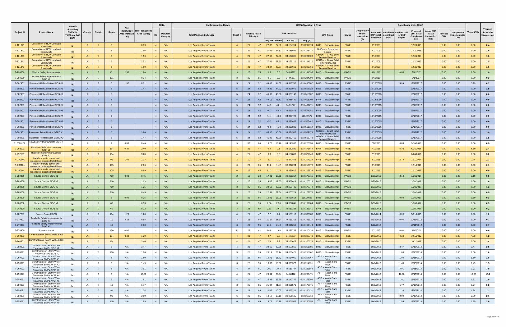
Beg PM End PM Lat. (N) Long. (W)
Revoked CUs
Total CUsTreated Areas in
WatershedRBPollutant Category
Total Maximum Daily Load Reach #Final SB Reach
Priority #
Compliance Units (CUs)
Cooperative Imple-
mentation ($)
Cooperative Implementation
CUs
Proposed BMP Install Start Date
Actual BMP Install Start
Date
Credited CUs for BMP Project
Proposed BMP Install Completion
Date
Actual BMP Install
Completion Date
Net Impervious
Area Increase (ac)
BMP Treatment Area (acres)
TMDL Implementation Reach BMP(s)Location & Type
BMP LocationsBMP Types Status
RouteProject ID Project Name
Retrofit (installing BMPs for
TMDLs only)? (Y/N)
County District
7-121841Constrction of HOV Land and
Soundwalls No LA 7 5 0.39 4 N/A Los Angeles River (Trash) 4 21 47 27.82 27.82 34.164764 -118.297374 BIOS - Bioswale/strip PS&E 9/1/2009 12/2/2013 0.00 0.00 0.00 0.4
7-121841Constrction of HOV Land and
Soundwalls No LA 7 5 1.96 4 N/A Los Angeles River (Trash) 4 21 47 27.82 27.82 34.165569 -118.296717DetBas - Detention
BasinsPS&E 9/1/2009 12/2/2013 0.00 0.00 0.00 2.0
7-121841Constrction of HOV Land and
Soundwalls No LA 7 5 1.56 4 N/A Los Angeles River (Trash) 4 21 47 27.68 27.68 34.162805 -118.294903GSRDs - Gross Solid
Removal DevicesPS&E 9/1/2009 12/2/2013 0.00 0.00 0.00 1.6
7-121841Constrction of HOV Land and
Soundwalls No LA 7 5 2.52 4 N/A Los Angeles River (Trash) 4 21 47 27.61 27.61 34.162111 -118.294212GSRDs - Gross Solid
Removal DevicesPS&E 9/1/2009 12/2/2013 0.00 0.00 0.00 2.5
7-121841Constrction of HOV Land and
Soundwalls No LA 7 5 1.60 4 N/A Los Angeles River (Trash) 4 21 47 28.07 28.07 34.166559 -118.299766GSRDs - Gross Solid
Removal DevicesPS&E 9/1/2009 12/2/2013 0.00 0.00 0.00 1.6
7-294600 Worker Safety Improvments No LA 7 101 2.50 1.90 4 N/A Los Angeles River (Trash) 3 25 55 0.5 0.5 34.05377 -118.234398 BIOS - Bioswale/strip PA/ED 9/6/2016 0.00 3/1/2017 0.00 0.00 0.00 1.9
7-294600Worker Safety Improvements
BIOS #2 No LA 7 101 0.34 4 N/A Los Angeles River (Trash) 3 25 55 0.5 0.5 34.05377 -118.234398 BIOS - Bioswale/strip PA/ED 9/6/2016 3/1/2017 0.00 0.00 0.00 0.3
7-302901 Pavement Rehabilitation BIOS #1 No LA 7 5 1.52 0.71 4 N/A Los Angeles River (Trash) 5 24 52 44.02 44.02 34.316782 -118.490887 BIOS - Bioswale/strip PS&E 10/16/2015 5.99 12/17/2017 0.00 0.00 5.99 0.7
7-302901 Pavement Rehabilitation BIOS #2 No LA 7 5 1.47 4 N/A Los Angeles River (Trash) 5 24 52 44.92 44.92 34.325076 -118.503022 BIOS - Bioswale/strip PS&E 10/16/2015 12/17/2017 0.00 0.00 0.00 1.5
7-302901 Pavement Rehabilitation BIOS #3 No LA 7 5 4 N/A Los Angeles River (Trash) 5 24 52 46.08 46.08 34.338142 -118.515102 BIOS - Bioswale/strip PS&E 10/16/2015 12/17/2017 0.00 0.00 0.00 0.0
7-302901 Pavement Rehabilitation BIOS #4 No LA 7 5 4 N/A Los Angeles River (Trash) 5 24 52 46.12 46.12 34.338439 -118.515706 BIOS - Bioswale/strip PS&E 10/16/2015 12/17/2017 0.00 0.00 0.00 0.0
7-302901 Pavement Rehabilitation BIOS #5 No LA 7 5 4 N/A Los Angeles River (Trash) 5 24 52 44.1 44.1 34.31777 -118.491771 BIOS - Bioswale/strip PS&E 10/16/2015 12/17/2017 0.00 0.00 0.00 0.0
7-302901 Pavement Rehabilitation BIOS #6 No LA 7 5 4 N/A Los Angeles River (Trash) 5 24 52 44.3 44.3 34.319875 -118.494341 BIOS - Bioswale/strip PS&E 10/16/2015 12/17/2017 0.00 0.00 0.00 0.0
7-302901 Pavement Rehabilitation BIOS #7 No LA 7 5 4 N/A Los Angeles River (Trash) 5 24 52 44.4 44.4 34.320722 -118.49577 BIOS - Bioswale/strip PS&E 10/16/2015 12/17/2017 0.00 0.00 0.00 0.0
7-302901 Pavement Rehabilitation BIOS #8 No LA 7 5 4 N/A Los Angeles River (Trash) 5 24 52 45.2 45.2 34.328653 -118.505442 BIOS - Bioswale/strip PS&E 10/16/2015 12/17/2017 0.00 0.00 0.00 0.0
7-302901 Pavement Rehabilitation BIOS #9 No LA 7 5 4 N/A Los Angeles River (Trash) 5 24 52 45.8 45.8 34.335822 -118.511014 BIOS - Bioswale/strip PS&E 10/16/2015 12/17/2017 0.00 0.00 0.00 0.0
7-302901 Pavement Rehabilitation GSRD #1 No LA 7 5 3.86 4 N/A Los Angeles River (Trash) 5 24 52 45.66 45.66 34.334508 -118.509173GSRDs - Gross Solid
Removal DevicesPS&E 10/16/2015 12/17/2017 0.00 0.00 0.00 3.9
7-302901 Pavement Rehabilitation GSRD #2 No LA 7 5 1.47 4 N/A Los Angeles River (Trash) 5 24 52 45.99 45.99 34.337465 -118.513748GSRDs - Gross Solid
Removal DevicesPS&E 10/16/2015 12/17/2017 0.00 0.00 0.00 1.5
712000108Road safety Improvments BIOS #
1 No LA 7 2 0.80 0.46 4 N/A Los Angeles River (Trash) 9 38 84 18.76 18.76 34.146396 -118.226359 BIOS - Bioswale/strip PS&E 7/6/2015 0.00 3/16/2016 0.00 0.00 0.00 0.5
7-292101Raodside Safety Improvement
BIOS #2 No LA 7 134 0.30 2.40 4 N/A Los Angeles River (Trash) 4 21 47 0.3 0.3 34.152889 -118.371649 BIOS - Bioswale/strip PS&E 7/1/2015 5.30 6/28/2016 0.00 0.00 5.30 2.4
7-292101Raodside Safety Improvement
BIOS #2 No LA 7 134 3.20 4 N/A Los Angeles River (Trash) 4 21 47 0.3 0.3 34.152889 -118.371649 BIOS - Bioswale/strip PS&E 7/1/2015 6/28/2016 0.00 0.00 0.00 3.2
7- 290101Install concrete barrier and
reconstruct existing Metal Beam No LA 7 91 1.50 1.33 4 N/A Los Angeles River (Trash) 2 10 23 11 11 33.872802 -118.204024 BIOS - Bioswale/strip PS&E 8/1/2015 2.78 12/1/2017 0.00 0.00 2.78 1.3
7- 290101Install concrete barrier and
reconstruct existing Metal Beam No LA 7 105 2.06 4 N/A Los Angeles River (Trash) 6 29 65 11.2 11.2 33.927294 -118.215379 BIOS - Bioswale/strip PS&E 8/1/2015 12/1/2017 0.00 0.00 0.00 2.1
7- 290101Install concrete barrier and
reconstruct existing Metal Beam No LA 7 105 0.89 4 N/A Los Angeles River (Trash) 6 29 65 11.3 11.3 33.926616 -118.213834 BIOS - Bioswale/strip PS&E 8/1/2015 12/1/2017 0.00 0.00 0.00 0.9
7-289200 Source Control BIOS #1 No LA 7 710 0.00 0.45 4 N/A Los Angeles River (Trash) 2 10 23 17.01 17.01 33.931217 -118.178715 BIOS - Bioswale/strip PA/ED 1/30/2016 3.18 1/30/2017 0.00 0.00 3.18 0.5
7-289200 Source Control BIOS #2 No LA 7 710 1.03 4 N/A Los Angeles River (Trash) 3 25 55 19.05 19.05 33.958614 -118.170323 BIOS - Bioswale/strip PA/ED 1/30/2016 1/30/2017 0.00 0.00 0.00 1.0
7-289200 Source Control BIOS #3 No LA 7 710 1.25 4 N/A Los Angeles River (Trash) 3 25 55 22.52 22.52 34.005436 -118.172744 BIOS - Bioswale/strip PA/ED 1/30/2016 1/30/2017 0.00 0.00 0.00 1.3
7-289200 Source Control BIOS #4 No LA 7 710 0.45 4 N/A Los Angeles River (Trash) 3 25 55 22.54 22.54 34.005724 -118.172678 BIOS - Bioswale/strip PA/ED 1/30/2016 1/30/2017 0.00 0.00 0.00 0.5
7-288200 Source Control BIOS #1 No LA 7 5 0.00 0.25 4 N/A Los Angeles River (Trash) 3 25 55 16.01 16.01 34.026614 -118.20886 BIOS - Bioswale/strip PA/ED 1/30/2016 0.80 1/30/2017 0.00 0.00 0.80 0.3
7-288200 Source Control BIOS #2 No LA 7 60 0.33 4 N/A Los Angeles River (Trash) 3 25 55 2.56 2.56 34.032841 -118.181804 BIOS - Bioswale/strip PA/ED 1/30/2016 1/30/2017 0.00 0.00 0.00 0.3
7-288200 Source Control BIOS #3 No LA 7 60 0.22 4 N/A Los Angeles River (Trash) 3 25 55 2.61 2.61 34.033224 -118.181041 BIOS - Bioswale/strip PA/ED 1/30/2016 1/30/2017 0.00 0.00 0.00 0.2
7-287201 Source Control BIOS No LA 7 134 1.20 1.20 4 N/A Los Angeles River (Trash) 4 21 47 2.7 2.7 34.153119 -118.330688 BIOS - Bioswale/strip PS&E 10/1/2014 0.00 5/31/2015 0.00 0.00 0.00 1.2
7-279801Roadside Safety Improvements
BIOS #1 No LA 7 10 3.25 0.68 4 N/A Los Angeles River (Trash) 3 25 55 21.27 21.27 34.061312 -118.166917 BIOS - Bioswale/strip PS&E 1/27/2012 0.00 10/11/2012 0.00 0.00 0.00 0.7
7-279801Roadside Safety Improvements
BIOS #2 No LA 7 10 0.68 4 N/A Los Angeles River (Trash) 3 25 55 21.3 21.3 34.061255 -118.166444 BIOS - Bioswale/strip PS&E 1/27/2012 10/11/2012 0.00 0.00 0.00 0.7
7-276900 Source Contrrol No LA 7 170 0.00 4 N/A Los Angeles River (Trash) 11 28 62 19.8 19.8 34.222739 -118.410439 BIOS - Bioswale/strip PA/ED 2/1/2013 0.00 1/1/2015 0.00 0.00 0.00 0.0
7-260301Construction of Sound Walls BIOS
#1 No LA 7 134 0.32 1.20 4 N/A Los Angeles River (Trash) 4 21 47 2.7 2.7 34.15293 -118.329773 BIOS - Bioswale/strip PS&E 10/1/2010 4.28 10/1/2012 0.00 0.00 4.28 1.2
7-260301Construction of Sound Walls BIOS
#2 No LA 7 134 3.40 4 N/A Los Angeles River (Trash) 4 21 47 2.9 2.9 34.153628 -118.326375 BIOS - Bioswale/strip PS&E 10/1/2010 10/1/2012 0.00 0.00 0.00 3.4
7-259021Construction of Storm Water
Treatment BMPs BIOS #1 Yes LA 7 5 N/A 3.47 4 N/A Los Angeles River (Trash) 4 21 47 22.66 22.66 34.103815 -118.251686 BIOS - Bioswale/strip PS&E 10/1/2013 3.47 12/15/2014 0.00 0.00 3.47 3.5
7-259021Construction of Storm Water
Treatment BMPs BIOS #2 Yes LA 7 110 N/A 1.00 4 N/A Los Angeles River (Trash) 3 25 55 23.14 23.14 34.056471 -118.255662 BIOS - Bioswale/strip PS&E 10/1/2013 1.00 12/15/2014 0.00 0.00 1.00 1.0
7-259021Construction of Storm Water Treatment BMPs AVSF #1 Yes LA 7 5 N/A 1.80 4 N/A Los Angeles River (Trash) 3 25 55 15.72 15.72 34.024909 -118.204357
ASF - Austin Sand Filter
PS&E 10/1/2013 1.80 12/15/2014 0.00 0.00 1.80 1.8
7-259021Construction of Storm Water Treatment BMPs AVSF #2 Yes LA 7 5 N/A 1.49 4 N/A Los Angeles River (Trash) 3 25 55 18.32 18.32 34.053377 -118.214091
ASF - Austin Sand Filter
PS&E 10/1/2013 1.49 12/15/2014 0.00 0.00 1.49 1.5
7-259021Construction of Storm Water Treatment BMPs AVSF #3 Yes LA 7 5 N/A 3.91 4 N/A Los Angeles River (Trash) 8 37 81 20.3 20.3 34.081347 -118.222883
ASF - Austin Sand Filter
PS&E 10/1/2013 3.91 12/15/2014 0.00 0.00 3.91 3.9
7-259021Construction of Storm Water Treatment BMPs AVSF #4 Yes LA 7 5 N/A 16.88 4 N/A Los Angeles River (Trash) 4 21 47 20.84 20.84 34.08472 -118.230471
ASF - Austin Sand Filter
PS&E 10/1/2013 16.88 12/15/2014 0.00 0.00 16.88 16.9
7-259021Construction of Storm Water Treatment BMPs AVSF #5 Yes LA 7 5 N/A 1.91 4 N/A Los Angeles River (Trash) 4 21 47 25.89 25.89 34.143755 -118.278294
ASF - Austin Sand Filter
PS&E 10/1/2013 1.91 12/15/2014 0.00 0.00 1.91 1.9
7-259021Construction of Storm Water Treatment BMPs AVSF #6 Yes LA 7 10 N/A 6.77 4 N/A Los Angeles River (Trash) 3 25 55 21.07 21.07 34.061571 -118.170071
ASF - Austin Sand Filter
PS&E 10/1/2013 6.77 12/15/2014 0.00 0.00 6.77 6.8
7-259021Construction of Storm Water Treatment BMPs AVSF #7 Yes LA 7 91 N/A 1.34 4 N/A Los Angeles River (Trash) 6 29 65 10.07 10.07 33.873704 -118.220131
ASF - Austin Sand Filter
PS&E 10/1/2013 1.34 12/15/2014 0.00 0.00 1.34 1.3
7-259021Construction of Storm Water Treatment BMPs AVSF #8 Yes LA 7 91 N/A 2.09 4 N/A Los Angeles River (Trash) 6 29 65 10.18 10.18 33.961135 -118.218219
ASF - Austin Sand Filter
PS&E 10/1/2013 2.09 12/15/2014 0.00 0.00 2.09 2.1
7-259021Construction of Storm Water Treatment BMPs AVSF #9 Yes LA 7 110 N/A 1.99 4 N/A Los Angeles River (Trash) 6 29 65 15.78 15.78 33.961569 -118.280255
ASF - Austin Sand Filter
PS&E 10/1/2013 1.99 12/15/2014 0.00 0.00 1.99 2.0
Page 64 of 77
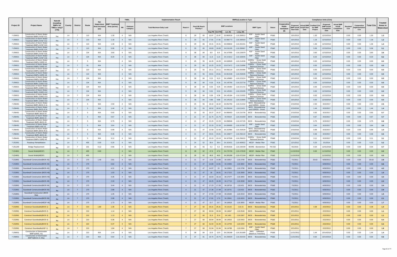
Beg PM End PM Lat. (N) Long. (W)
Revoked CUs
Total CUsTreated Areas in
WatershedRBPollutant Category
Total Maximum Daily Load Reach #Final SB Reach
Priority #
Compliance Units (CUs)
Cooperative Imple-
mentation ($)
Cooperative Implementation
CUs
Proposed BMP Install Start Date
Actual BMP Install Start
Date
Credited CUs for BMP Project
Proposed BMP Install Completion
Date
Actual BMP Install
Completion Date
Net Impervious
Area Increase (ac)
BMP Treatment Area (acres)
TMDL Implementation Reach BMP(s)Location & Type
BMP LocationsBMP Types Status
RouteProject ID Project Name
Retrofit (installing BMPs for
TMDLs only)? (Y/N)
County District
7-259021Construction of Storm Water Treatment BMPs AVSF #11 Yes LA 7 110 N/A 1.30 4 N/A Los Angeles River (Trash) 6 29 65 15.97 15.97 33.960018 -118.280812
ASF - Austin Sand Filter
PS&E 10/1/2013 1.30 12/15/2014 0.00 0.00 1.30 1.3
7-259021Construction of Storm Water Treatment BMPs AVSF #12 Yes LA 7 110 N/A 1.18 4 N/A Los Angeles River (Trash) 6 29 65 17.81 17.81 33.986773 -118.280503
ASF - Austin Sand Filter
PS&E 10/1/2013 1.18 12/15/2014 0.00 0.00 1.18 1.2
7-259021Construction of Storm Water Treatment BMPs AVSF #13 Yes LA 7 110 N/A 1.36 4 N/A Los Angeles River (Trash) 6 29 65 19.31 19.31 34.008632 -118.281031
ASF - Austin Sand Filter
PS&E 10/1/2013 1.36 12/15/2014 0.00 0.00 1.36 1.4
7-259021Construction of Storm Water Treatment BMPs AVSF #14 Yes LA 7 110 N/A 5.06 4 N/A Los Angeles River (Trash) 6 29 65 19.83 19.83 34.016195 -118.280667
ASF - Austin Sand Filter
PS&E 10/1/2013 5.06 12/15/2014 0.00 0.00 5.06 5.1
7-259021Construction of Storm Water Treatment BMPs AVSF #15 Yes LA 7 134 N/A 3.60 4 N/A Los Angeles River (Trash) 9 38 84 8.9 8.9 34.147055 -118.226979
ASF - Austin Sand Filter
PS&E 10/1/2013 3.60 12/15/2014 0.00 0.00 3.60 3.6
7-259021Construction of Storm Water Treatment BMPs AVSF #16 Yes LA 7 134 N/A 8.20 4 N/A Los Angeles River (Trash) 9 38 84 11.6 11.6 34.141812 -118.183045
ASF - Austin Sand Filter
PS&E 10/1/2013 8.20 12/15/2014 0.00 0.00 8.20 8.2
7-259021Construction of Storm Water Treatment BMPs GSRD #1 Yes LA 7 5 N/A 4 N/A Los Angeles River (Trash) 3 25 55 16.35 16.35 34.028929 -118.214038
GSRDs - Gross Solid Removal Devices
PS&E 10/1/2013 0.00 12/15/2014 0.00 0.00 0.00 0.0
7-259021Construction of Storm Water Treatment BMPs GSRD #2 Yes LA 7 91 N/A 4 N/A Los Angeles River (Trash) 6 29 65 10.25 10.25 33.873472 -118.216996
GSRDs - Gross Solid Removal Devices
PS&E 10/1/2013 0.00 12/15/2014 0.00 0.00 0.00 0.0
7-259021Construction of Storm Water Treatment BMPs GSRD #7 Yes LA 7 110 N/A 4 N/A Los Angeles River (Trash) 3 25 55 23.11 23.11 34.056119 -118.255986
GSRDs - Gross Solid Removal Devices
PS&E 10/1/2013 0.00 12/15/2014 0.00 0.00 0.00 0.0
7-259021Construction of Storm Water Treatment BMPs GSRD #8 Yes LA 7 110 N/A 4 N/A Los Angeles River (Trash) 3 25 55 23.61 23.61 34.061538 -118.250035
GSRDs - Gross Solid Removal Devices
PS&E 10/1/2013 0.00 12/15/2014 0.00 0.00 0.00 0.0
7-259021Construction of Storm Water Treatment BMPs GSRD #9 Yes LA 7 134 N/A 4 N/A Los Angeles River (Trash) 9 38 84 9.13 9.13 34.145883 -118.223224
GSRDs - Gross Solid Removal Devices
PS&E 10/1/2013 0.00 12/15/2014 0.00 0.00 0.00 0.0
7-259021Construction of Storm Water Treatment BMPs GSRD #10 Yes LA 7 134 N/A 4 N/A Los Angeles River (Trash) 9 38 84 9.16 9.16 34.145766 -118.222718
GSRDs - Gross Solid Removal Devices
PS&E 10/1/2013 0.00 12/15/2014 0.00 0.00 0.00 0.0
7-259021Construction of Storm Water Treatment BMPs GSRD #11 Yes LA 7 134 N/A 4 N/A Los Angeles River (Trash) 9 38 84 9.25 9.25 34.145464 -118.221215
GSRDs - Gross Solid Removal Devices
PS&E 10/1/2013 0.00 12/15/2014 0.00 0.00 0.00 0.0
7-259021Construction of Storm Water Treatment BMPs GSRD #12 Yes LA 7 134 N/A 4 N/A Los Angeles River (Trash) 9 38 84 9.31 9.31 34.145301 -118.220205
GSRDs - Gross Solid Removal Devices
PS&E 10/1/2013 0.00 12/15/2014 0.00 0.00 0.00 0.0
7-259021Construction of Storm Water Treatment BMPs GSRD #13 Yes LA 7 134 N/A 4 N/A Los Angeles River (Trash) 9 38 84 9.36 9.36 34.145184 -118.219355
GSRDs - Gross Solid Removal Devices
PS&E 10/1/2013 0.00 12/15/2014 0.00 0.00 0.00 0.0
7-259021Construction of Storm Water Treatment BMPs GSRD #14 Yes LA 7 134 N/A 4 N/A Los Angeles River (Trash) 9 38 84 9.86 9.86 34.145102 -118.210805
GSRDs - Gross Solid Removal Devices
PS&E 10/1/2013 0.00 12/15/2014 0.00 0.00 0.00 0.0
7-258401Construction of Storm Water Treatment BMPs BIOS #1 & Yes LA 7 5 N/A 2.50 4 N/A Los Angeles River (Trash) 3 25 55 18.42 18.42 34.054794 -118.214152
BIOS - Bioswale/strip and GSRDS - Gross
PS&E 2/15/2016 2.50 3/15/2017 0.00 0.00 2.50 2.5
7-258401Construction of Storm Water Treatment BMPs BIOS #2 & Yes LA 7 5 N/A 1.44 4 N/A Los Angeles River (Trash) 3 25 55 18.52 18.52 34.056244 -118.21421
BIOS - Bioswale/strip and GSRDS - Gross
PS&E 2/15/2016 1.44 3/15/2017 0.00 0.00 1.44 1.4
7-258401Construction of Storm Water
Treatment BMPs BIOS #3 Yes LA 7 5 N/A 0.65 4 N/A Los Angeles River (Trash) 3 25 55 19.37 19.37 34.068403 -118.216706 BIOS - Bioswale/strip PS&E 2/15/2016 0.65 3/15/2017 0.00 0.00 0.65 0.7
7-258401Construction of Storm Water
Treatment BMPs BIOS #4 Yes LA 7 5 N/A 0.67 4 N/A Los Angeles River (Trash) 4 21 47 21.75 21.75 34.09324 -118.241659 BIOS - Bioswale/strip PS&E 2/15/2016 0.67 3/15/2017 0.00 0.00 0.67 0.7
7-258401Construction of Storm Water
Treatment BMPs BIOS #5 Yes LA 7 5 N/A 0.75 4 N/A Los Angeles River (Trash) 4 21 47 22.25 22.25 34.098946 -118.247155 BIOS - Bioswale/strip PS&E 2/15/2016 0.75 3/15/2017 0.00 0.00 0.75 0.8
7-258401Construction of Storm Water
Treatment BMPs ASF #1 Yes LA 7 5 N/A 3.64 4 N/A Los Angeles River (Trash) 4 21 47 22.33 22.33 34.099995 -118.247907ASF - Austin Sand
FilterPS&E 2/15/2016 3.64 3/15/2017 0.00 0.00 3.64 3.6
7-258401Construction of Storm Water Treatment BMPs BIOS #6 & Yes LA 7 5 N/A 0.99 4 N/A Los Angeles River (Trash) 4 21 47 22.58 22.58 34.102984 -118.250539
BIOS - Bioswale/strip and GSRDS - Gross
PS&E 2/15/2016 0.99 3/15/2017 0.00 0.00 0.99 1.0
7-258401Construction of Storm Water
Treatment BMPs BIOS #8 Yes LA 7 5 N/A 0.46 4 N/A Los Angeles River (Trash) 4 21 47 23.01 23.01 34.106877 -118.256142 BIOS - Bioswale/strip PS&E 2/15/2016 0.46 3/15/2017 0.00 0.00 0.46 0.5
7-258401Construction of Storm Water Treatment BMPs GSRD #5 Yes LA 7 5 N/A 3.11 4 N/A Los Angeles River (Trash) 4 21 47 23.15 23.15 34.107928 -118.258222
GSRDs - Gross Solid Removal Devices
PS&E 2/15/2016 3.11 3/15/2017 0.00 0.00 3.11 3.1
7-252001 Roadway Rehabilitation No LA 7 405 0.00 5.20 4 N/A Los Angeles River (Trash) 5 24 52 39.4 39.4 34.163431 -118.469922 MEDF - Media Filter PS&E 12/1/2012 5.20 3/1/2014 0.00 0.00 5.20 5.2
7-251200 Bridge Replacement No LA 7 101 0.12 0.66 4 N/A Los Angeles River (Trash) 3 25 55 0.2 0.2 34.053316 -118.230339 BIORE - Bioretention PA/ ED 9/1/2015 0.54 12/31/2018 0.00 0.00 0.54 0.7
7-224601 Sound Walls(MEDF) No LA 7 405 0.60 4 N/A Los Angeles River (Trash) 11 28 62 47.6 47.6 34.276706 -118.470539 MEDF - Media Filter PS&E 11/15/2010 0.00 11/15/2012 0.00 0.00 0.00 0.0
7-224601 Sound Walls(MEDF) No LA 7 405 4 N/A Los Angeles River (Trash) 11 28 62 46.8 46.8 34.265268 -118.472164 MEDF - Media Filter PS&E 11/15/2010 11/15/2012 0.00 0.00 0.00 0.0
7-232801 Soundwall Construction(BIOS 43) No LA 7 170 1.40 2.81 4 N/A Los Angeles River (Trash) 4 21 47 14.8 14.85 34.15917 -118.3799 BIOS - Bioswale/strip PS&E 7/1/2011 25.63 6/30/2013 0.00 0.00 25.63 2.8
7-232801 Soundwall Construction(BIOS 43) No LA 7 170 0.62 4 N/A Los Angeles River (Trash) 4 21 47 14.89 14.91 34.15965 -118.3802 BIOS - Bioswale/strip PS&E 7/1/2011 6/30/2013 0.00 0.00 0.00 0.6
7-232801 Soundwall Construction(BIOS 43) No LA 7 170 4.31 4 N/A Los Angeles River (Trash) 4 21 47 14.97 15 34.15901 -118.3798 BIOS - Bioswale/strip PS&E 7/1/2011 6/30/2013 0.00 0.00 0.00 4.3
7-232801 Soundwall Construction (BIOS 48) No LA 7 170 1.03 4 N/A Los Angeles River (Trash) 4 21 47 16 16.01 34.17315 -118.3909 BIOS - Bioswale/strip PS&E 7/1/2011 6/30/2013 0.00 0.00 0.00 1.0
7-232801 Soundwall Construction (BIOS 49) No LA 7 170 4.35 4 N/A Los Angeles River (Trash) 4 21 47 16.03 16.16 34.17277 -118.3893 BIOS - Bioswale/strip PS&E 7/1/2011 6/30/2013 0.00 0.00 0.00 4.4
7-232801 Soundwall Construction(BIOS 49) No LA 7 170 2.33 4 N/A Los Angeles River (Trash) 4 21 47 16.25 16.35 34.17716 -118.3938 BIOS - Bioswale/strip PS&E 7/1/2011 6/30/2013 0.00 0.00 0.00 2.3
7-232801 Soundwall Construction(BIOS 54) No LA 7 170 3.44 4 N/A Los Angeles River (Trash) 4 21 47 17.23 17.26 34.18716 -118.401 BIOS - Bioswale/strip PS&E 7/1/2011 6/30/2013 0.00 0.00 0.00 3.4
7-232801 Soundwall Construction(BIOS 55) No LA 7 170 2.88 4 N/A Los Angeles River (Trash) 4 21 47 17.36 17.49 34.18741 -118.402 BIOS - Bioswale/strip PS&E 7/1/2011 6/30/2013 0.00 0.00 0.00 2.9
7-232801Soundwall Construction (BIOS
55a) No LA 7 170 1.45 4 N/A Los Angeles River (Trash) 4 21 47 17.55 17.59 34.19192 -118.4019 BIOS - Bioswale/strip PS&E 7/1/2011 6/30/2013 0.00 0.00 0.00 1.5
7-232801 Soundwall Construction(BIOS 56) No LA 7 170 2.08 4 N/A Los Angeles River (Trash) 4 21 47 17.81 17.9 34.19841 -118.4024 BIOS - Bioswale/strip PS&E 7/1/2011 6/30/2013 0.00 0.00 0.00 2.1
7-232801 Soundwall Construction(MEDF 46) No LA 7 170 1.73 4 N/A Los Angeles River (Trash) 4 21 47 15.7 15.7 34.16918 -118.3855 MEDF - Media Filter PS&E 7/1/2011 6/30/2013 0.00 0.00 0.00 1.7
7-232901 Construct Soundwalls(BIOS 1) No LA 7 210 1.80 1.35 4 N/A Los Angeles River (Trash) 7 27 60 25.31 25.31 34.15142 -118.15 BIOS - Bioswale/strip PS&E 2/21/2011 4.39 2/22/2013 0.00 0.00 4.39 1.4
7-232901 Construct Soundwalls(BIOS 2) No LA 7 210 1.14 4 N/A Los Angeles River (Trash) 7 27 60 30.94 30.94 34.14847 -118.0548 BIOS - Bioswale/strip PS&E 2/21/2011 2/22/2013 0.00 0.00 0.00 1.1
7-232901 Construct Soundwalls(BIOS 3) No LA 7 210 1.13 4 N/A Los Angeles River (Trash) 7 27 60 31.6 31.6 34.1481 -118.0367 BIOS - Bioswale/strip PS&E 2/21/2011 2/22/2013 0.00 0.00 0.00 1.1
7-232901 Construct Soundwalls(BIOS 4) No LA 7 210 0.36 4 N/A Los Angeles River (Trash) 7 27 60 30.94 30.94 34.14915 -118.0463 BIOS - Bioswale/strip PS&E 2/21/2011 2/22/2013 0.00 0.00 0.00 0.4
7-232901 Construct Soundwalls(BIOS 5) No LA 7 210 0.37 4 N/A Los Angeles River (Trash) 7 27 60 31.94 31.94 34.14759 -118.0293 BIOS - Bioswale/strip PS&E 2/21/2011 2/22/2013 0.00 0.00 0.00 0.4
7-232901 Construct Soundwalls(ASF 1) No LA 7 210 1.84 4 N/A Los Angeles River (Trash) 7 27 60 31.94 31.94 34.14788 -118.0304ASF - Austin Sand
FilterPS&E 2/21/2011 2/22/2013 0.00 0.00 0.00 1.8
7-258931Construction of Stormwater
BMP's(INFIL #1) Yes LA 7 210 N/A 1.44 4 N/A Los Angeles River (Trash) 9 38 84 15.9 15.9 34.230168 -118.261689INFIL - Infiltration
(Basins & Trenches)PS&E 11/21/2012 1.44 10/14/2014 0.00 0.00 1.44 1.4
7-258931Construction of Stormwater
BMP'S(BIOS #1 95a) Yes LA 7 210 N/A 0.64 4 N/A Los Angeles River (Trash) 8 37 81 19.75 19.75 34.206929 -118.202434 BIOS - Bioswale/strip PS&E 11/21/2012 0.64 10/14/2014 0.00 0.00 0.64 0.6
Page 65 of 77
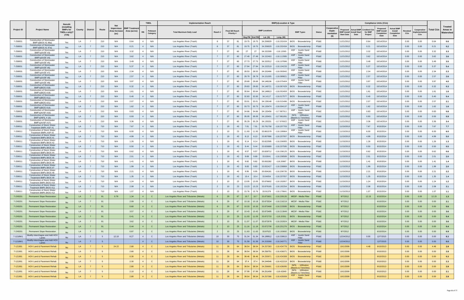
Beg PM End PM Lat. (N) Long. (W)
Revoked CUs
Total CUsTreated Areas in
WatershedRBPollutant Category
Total Maximum Daily Load Reach #Final SB Reach
Priority #
Compliance Units (CUs)
Cooperative Imple-
mentation ($)
Cooperative Implementation
CUs
Proposed BMP Install Start Date
Actual BMP Install Start
Date
Credited CUs for BMP Project
Proposed BMP Install Completion
Date
Actual BMP Install
Completion Date
Net Impervious
Area Increase (ac)
BMP Treatment Area (acres)
TMDL Implementation Reach BMP(s)Location & Type
BMP LocationsBMP Types Status
RouteProject ID Project Name
Retrofit (installing BMPs for
TMDLs only)? (Y/N)
County District
7-258931Construction of Stormwater
BMP's(BIOS #1 96a) Yes LA 7 210 N/A 0.64 4 N/A Los Angeles River (Trash) 8 37 81 19.75 19.75 34.206929 -118.202434 BIOS - Bioswale/strip PS&E 11/21/2012 0.64 10/14/2014 0.00 0.00 0.64 0.6
7-258931Construction of Stormwater
BMP's(BIOS #1 97a) Yes LA 7 210 N/A 0.21 4 N/A Los Angeles River (Trash) 8 37 81 19.75 19.75 34.206929 -118.202434 BIOS - Bioswale/strip PS&E 11/21/2012 0.21 10/14/2014 0.00 0.00 0.21 0.2
7-258931Construction of Stormwater
BMP's(AVSF #3) Yes LA 7 210 N/A 3.32 4 N/A Los Angeles River (Trash) 7 27 60 27 27 34.152309 -118.12065ASF - Austin Sand
FilterPS&E 11/21/2012 3.32 10/14/2014 0.00 0.00 3.32 3.3
7-258931Construction of Stormwater
BMP's(AVSF #4) Yes LA 7 210 N/A 3.62 4 N/A Los Angeles River (Trash) 7 27 60 27.49 27.49 34.152463 -118.112085ASF - Austin Sand
FilterPS&E 11/21/2012 3.62 10/14/2014 0.00 0.00 3.62 3.6
7-258931Construction of Stormwater
BMP's(AVSF #5) Yes LA 7 210 N/A 3.49 4 N/A Los Angeles River (Trash) 7 27 60 27.73 27.73 34.152512 -118.107896ASF - Austin Sand
FilterPS&E 11/21/2012 3.49 10/14/2014 0.00 0.00 3.49 3.5
7-258931Construction of Stormwater
BMP's(AVSF #6) Yes LA 7 210 N/A 5.37 4 N/A Los Angeles River (Trash) 7 27 60 27.94 27.94 34.152519 -118.104233ASF - Austin Sand
FilterPS&E 11/21/2012 5.37 10/14/2014 0.00 0.00 5.37 5.4
7-258931Construction of Stormwater
BMP's(AVSF #7) Yes LA 7 210 N/A 2.34 4 N/A Los Angeles River (Trash) 7 27 60 28.53 28.53 34.152466 -118.093942ASF - Austin Sand
FilterPS&E 11/21/2012 2.34 10/14/2014 0.00 0.00 2.34 2.3
7-258931Construction of Stormwater
BMP's(AVSF #8) Yes LA 7 210 N/A 2.57 4 N/A Los Angeles River (Trash) 7 27 60 28.79 28.79 34.151005 -118.089821ASF - Austin Sand
FilterPS&E 11/21/2012 2.57 10/14/2014 0.00 0.00 2.57 2.6
7-258931Construction of Stormwater
BMP's(AVSF #9) Yes LA 7 210 N/A 3.97 4 N/A Los Angeles River (Trash) 7 27 60 29.69 29.69 34.148106 -118.075404ASF - Austin Sand
FilterPS&E 11/21/2012 3.97 10/14/2014 0.00 0.00 3.97 4.0
7-258931Construction of Stormwater
BMP's(BIOS #18) Yes LA 7 210 N/A 0.32 4 N/A Los Angeles River (Trash) 7 27 60 29.83 29.83 34.148721 -118.067429 BIOS - Bioswale/strip PS&E 11/21/2012 0.32 10/14/2014 0.00 0.00 0.32 0.3
7-258931Construction of Stormwater
BMP's(BIOS #19) Yes LA 7 210 N/A 1.61 4 N/A Los Angeles River (Trash) 7 27 60 30.64 30.64 34.148813 -118.053459 BIOS - Bioswale/strip PS&E 11/21/2012 1.61 10/14/2014 0.00 0.00 1.61 1.6
7-258931Construction of Stormwater
BMP's(BIOS #11) Yes LA 7 210 N/A 0.40 4 N/A Los Angeles River (Trash) 7 27 60 32.83 32.83 34.14117 -118.017577 BIOS - Bioswale/strip PS&E 11/21/2012 0.40 10/14/2014 0.00 0.00 0.40 0.4
7-258931Construction of Stormwater
BMP's(BIOS #21) Yes LA 7 210 N/A 2.07 4 N/A Los Angeles River (Trash) 7 27 60 33.01 33.01 34.139148 -118.015496 BIOS - Bioswale/strip PS&E 11/21/2012 2.07 10/14/2014 0.00 0.00 2.07 2.1
7-258931Construction of Stormwater
BMP's(BIOS #14) Yes LA 7 210 N/A 1.62 4 N/A Los Angeles River (Trash) 7 27 60 33.73 33.73 34.135474 -118.004137ASF - Austin Sand
FilterPS&E 11/21/2012 1.62 10/14/2014 0.00 0.00 1.62 1.6
7-258931Construction of Stormwater
BMP's(AVSF #15) Yes LA 7 210 N/A 0.83 4 N/A Los Angeles River (Trash) 7 27 60 34.66 34.66 34.135456 -117.987911ASF - Austin Sand
FilterPS&E 11/21/2012 0.83 10/14/2014 0.00 0.00 0.83 0.8
7-258931Construction of Stormwater
BMP's(INFIL # 16) Yes LA 7 210 N/A 0.93 4 N/A Los Angeles River (Trash) 7 27 60 35.05 35.05 34.135401 -117.981091INFIL - Infiltration
(Basins & Trenches)PS&E 11/21/2012 0.93 10/14/2014 0.00 0.00 0.93 0.9
7-258931Construction of Stormwater
BMP's(AVSF #17) Yes LA 7 210 N/A 3.36 4 N/A Los Angeles River (Trash) 7 27 60 35.29 35.29 34.135331 -117.976922ASF - Austin Sand
FilterPS&E 11/21/2012 3.36 10/14/2014 0.00 0.00 3.36 3.4
7-259011Construction of Storm Water
Treatment BMPs ASF #1 Yes LA 7 710 N/A 7.67 4 N/A Los Angeles River (Trash) 1 19 43 7.01 7.01 33.791758 -118.207703ASF - Austin Sand
FilterPS&E 11/15/2013 7.67 8/15/2014 0.00 0.00 7.67 7.7
7-259011Construction of Storm Water
Treatment BMPs ASF #2 Yes LA 7 710 N/A 6.00 4 N/A Los Angeles River (Trash) 2 10 23 11.93 11.93 33.861579 -118.199964ASF - Austin Sand
FilterPS&E 11/15/2013 6.00 8/15/2014 0.00 0.00 6.00 6.0
7-259011Construction of Storm Water
Treatment BMPs BIOS #1 Yes LA 7 710 N/A 4.99 4 N/A Los Angeles River (Trash) 1 19 43 8.13 8.13 33.807886 -118.207007 BIOS - Bioswale/strip PS&E 11/15/2013 4.99 8/15/2014 0.00 0.00 4.99 5.0
7-259011Construction of Storm Water
Treatment BMPs BIOS #2 Yes LA 7 710 N/A 1.26 4 N/A Los Angeles River (Trash) 1 19 43 9.14 9.14 33.822595 -118.206955 BIOS - Bioswale/strip PS&E 11/15/2013 1.26 8/15/2014 0.00 0.00 1.26 1.3
7-259011Construction of Storm Water
Treatment BMPs BIOS #3 Yes LA 7 710 N/A 0.50 4 N/A Los Angeles River (Trash) 1 19 43 9.44 9.44 33.826889 -118.207595 BIOS - Bioswale/strip PS&E 11/15/2013 0.50 8/15/2014 0.00 0.00 0.50 0.5
7-259011Construction of Storm Water
Treatment BMPs BIOS #4 Yes LA 7 710 N/A 0.62 4 N/A Los Angeles River (Trash) 1 19 43 9.57 9.57 33.828712 -118.208125 BIOS - Bioswale/strip PS&E 11/15/2013 0.62 8/15/2014 0.00 0.00 0.62 0.6
7-259011Construction of Storm Water
Treatment BMPs BIOS #5 Yes LA 7 710 N/A 2.01 4 N/A Los Angeles River (Trash) 1 19 43 9.69 9.69 33.83041 -118.208589 BIOS - Bioswale/strip PS&E 11/15/2013 2.01 8/15/2014 0.00 0.00 2.01 2.0
7-259011Construction of Storm Water
Treatment BMPs BIOS #6 Yes LA 7 710 N/A 1.41 4 N/A Los Angeles River (Trash) 1 19 43 9.82 9.82 33.832282 -118.20887 BIOS - Bioswale/strip PS&E 11/15/2013 1.41 8/15/2014 0.00 0.00 1.41 1.4
7-259011Construction of Storm Water
Treatment BMPs BIOS #7 Yes LA 7 710 N/A 1.99 4 N/A Los Angeles River (Trash) 1 19 43 9.83 9.83 33.832427 -118.208869 BIOS - Bioswale/strip PS&E 11/15/2013 1.99 8/15/2014 0.00 0.00 1.99 2.0
7-259011Construction of Storm Water
Treatment BMPs BIOS #8 Yes LA 7 710 N/A 2.21 4 N/A Los Angeles River (Trash) 1 19 43 9.95 9.95 33.834181 -118.208735 BIOS - Bioswale/strip PS&E 11/15/2013 2.21 8/15/2014 0.00 0.00 2.21 2.2
7-259011Construction of Storm Water
Treatment BMPs BIOS #9 Yes LA 7 710 N/A 1.35 4 N/A Los Angeles River (Trash) 1 19 43 10.4 10.4 33.84054 -118.207057 BIOS - Bioswale/strip PS&E 11/15/2013 1.35 8/15/2014 0.00 0.00 1.35 1.4
7-259011Construction of Storm Water Treatment BMPs BIOS #10 Yes LA 7 710 N/A 1.24 4 N/A Los Angeles River (Trash) 2 10 23 13.05 13.05 33.876602 -118.192857 BIOS - Bioswale/strip PS&E 11/15/2013 1.24 8/15/2014 0.00 0.00 1.24 1.2
7-259011Construction of Storm Water Treatment BMPs BIOS #11 Yes LA 7 710 N/A 2.08 4 N/A Los Angeles River (Trash) 2 10 23 13.23 13.23 33.879165 -118.192254 BIOS - Bioswale/strip PS&E 11/15/2013 2.08 8/15/2014 0.00 0.00 2.08 2.1
7-259011Construction of Storm Water Treatment BMPs BIOS #12 Yes LA 7 710 N/A 1.07 4 N/A Los Angeles River (Trash) 2 10 23 15.76 15.76 33.91379 -118.179841 BIOS - Bioswale/strip PS&E 11/15/2013 1.07 8/15/2014 0.00 0.00 1.07 1.1
7-2X9201 Permanent Slope Restoration No LA 7 91 0.79 1.34 4 C Los Angeles River and Tributaries (Metals) 6 29 67 10.7 10.7 33.873601 -118.209135 MEDF - Media Filter PS&E 9/7/2012 12.15 6/10/2014 0.00 0.00 12.15 1.3
7-2X9201 Permanent Slope Restoration No LA 7 91 2.09 4 C Los Angeles River and Tributaries (Metals) 6 29 67 10.18 10.18 33.873534 -118.218219 MEDF - Media Filter PS&E 9/7/2012 6/10/2014 0.00 0.00 0.00 2.1
7-2X9201 Permanent Slope Restoration No LA 7 91 0.60 4 C Los Angeles River and Tributaries (Metals) 6 29 67 10.33 10.33 33.873468 -118.215595 BIOS - Bioswale/strip PS&E 9/7/2012 6/10/2014 0.00 0.00 0.00 0.6
7-2X9201 Permanent Slope Restoration No LA 7 91 3.57 4 C Los Angeles River and Tributaries (Metals) 6 29 67 10.43 10.43 33.873495 -118.213849 MEDF - Media Filter PS&E 9/7/2012 6/10/2014 0.00 0.00 0.00 3.6
7-2X9201 Permanent Slope Restoration No LA 7 91 0.41 4 C Los Angeles River and Tributaries (Metals) 2 10 25 11.03 11.03 33.872733 -118.20351 BIOS - Bioswale/strip PS&E 9/7/2012 6/10/2014 0.00 0.00 0.00 0.4
7-2X9201 Permanent Slope Restoration No LA 7 91 3.62 4 C Los Angeles River and Tributaries (Metals) 2 10 25 11.07 11.07 33.872678 -118.202824 MEDF - Media Filter PS&E 9/7/2012 6/10/2014 0.00 0.00 0.00 3.6
7-2X9201 Permanent Slope Restoration No LA 7 91 0.44 4 C Los Angeles River and Tributaries (Metals) 2 10 25 11.16 11.16 33.872708 -118.201276 BIOS - Bioswale/strip PS&E 9/7/2012 6/10/2014 0.00 0.00 0.00 0.4
7-2X9201 Permanent Slope Restoration No LA 7 91 0.87 4 C Los Angeles River and Tributaries (Metals) 2 10 25 11.63 11.63 33.87522 -118.193692 BIOS - Bioswale/strip PS&E 9/7/2012 6/10/2014 0.00 0.00 0.00 0.9
7-1218W1Modify Interchagne and Add HOV
Lanes No LA 7 5 12.10 8.27 4 C Los Angeles River and Tributaries (Metals) 10 30 70 31.34 31.34 34.199912 -118.338615ASF - Austin Sand
FilterPS&E 12/24/2012 0.00 12/7/2015 0.00 0.00 0.00 8.3
7-1218W1Modify Interchagne and Add HOV
Lanes No LA 7 5 4 C Los Angeles River and Tributaries (Metals) 10 30 70 31.59 31.59 34.203068 -118.340771ASF - Austin Sand
FilterPS&E 12/24/2012 12/7/2015 0.00 0.00 0.00 0.0
7-121901 HOV Land & Pavement Rehab No LA 7 5 24.22 2.80 4 C Los Angeles River and Tributaries (Metals) 11 28 64 38.54 38.54 34.257383 -118.434778 BIOS - Bioswale/strip PS&E 10/1/2009 4.48 9/10/2013 0.00 0.00 4.48 2.8
7-121901 HOV Land & Pavement Rehab No LA 7 5 2.80 4 C Los Angeles River and Tributaries (Metals) 11 28 64 38.54 38.54 34.256751 -118.436071 BIOS - Bioswale/strip PS&E 10/1/2009 9/10/2013 0.00 0.00 0.00 2.8
7-121901 HOV Land & Pavement Rehab No LA 7 5 0.30 4 C Los Angeles River and Tributaries (Metals) 11 28 64 38.46 38.46 34.255971 -118.434308 BIOS - Bioswale/strip PS&E 10/1/2009 9/10/2013 0.00 0.00 0.00 0.3
7-121901 HOV Land & Pavement Rehab No LA 7 5 2.30 4 C Los Angeles River and Tributaries (Metals) 11 28 64 37.4 37.4 34.244546 -118.422219 BIOS - Bioswale/strip PS&E 10/1/2009 9/10/2013 0.00 0.00 0.00 2.3
7-121901 HOV Land & Pavement Rehab No LA 7 5 2.80 4 C Los Angeles River and Tributaries (Metals) 11 28 64 38.54 38.54 34.256691 -118.436095INFIL - Infiltration
(Basins & Trenches)PS&E 10/1/2009 9/10/2013 0.00 0.00 0.00 2.8
7-121901 HOV Land & Pavement Rehab No LA 7 5 2.10 4 C Los Angeles River and Tributaries (Metals) 11 28 64 37.99 37.99 34.251458 -118.42849INFIL - Infiltration
(Basins & Trenches)PS&E 10/1/2009 9/10/2013 0.00 0.00 0.00 2.1
7-121901 HOV Land & Pavement Rehab No LA 7 5 2.80 4 C Los Angeles River and Tributaries (Metals) 11 28 64 38.54 38.54 34.257386 -118.435009ASF - Austin Sand
FilterPS&E 10/1/2009 9/10/2013 0.00 0.00 0.00 2.8
Page 66 of 77
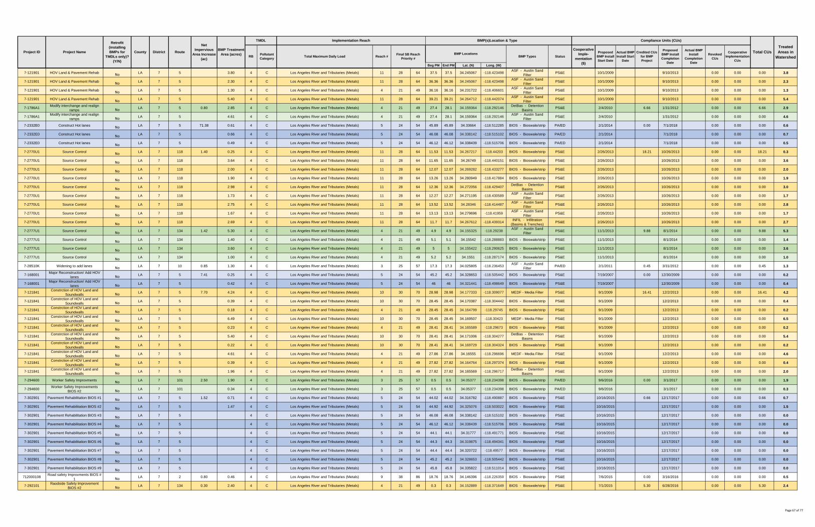
Beg PM End PM Lat. (N) Long. (W)
Revoked CUs
Total CUsTreated Areas in
WatershedRBPollutant Category
Total Maximum Daily Load Reach #Final SB Reach
Priority #
Compliance Units (CUs)
Cooperative Imple-
mentation ($)
Cooperative Implementation
CUs
Proposed BMP Install Start Date
Actual BMP Install Start
Date
Credited CUs for BMP Project
Proposed BMP Install Completion
Date
Actual BMP Install
Completion Date
Net Impervious
Area Increase (ac)
BMP Treatment Area (acres)
TMDL Implementation Reach BMP(s)Location & Type
BMP LocationsBMP Types Status
RouteProject ID Project Name
Retrofit (installing BMPs for
TMDLs only)? (Y/N)
County District
7-121901 HOV Land & Pavement Rehab No LA 7 5 3.80 4 C Los Angeles River and Tributaries (Metals) 11 28 64 37.5 37.5 34.245067 -118.423498ASF - Austin Sand
FilterPS&E 10/1/2009 9/10/2013 0.00 0.00 0.00 3.8
7-121901 HOV Land & Pavement Rehab No LA 7 5 2.30 4 C Los Angeles River and Tributaries (Metals) 11 28 64 36.36 36.36 34.245067 -118.423498ASF - Austin Sand
FilterPS&E 10/1/2009 9/10/2013 0.00 0.00 0.00 2.3
7-121901 HOV Land & Pavement Rehab No LA 7 5 1.30 4 C Los Angeles River and Tributaries (Metals) 4 21 49 36.16 36.16 34.231722 -118.406601ASF - Austin Sand
FilterPS&E 10/1/2009 9/10/2013 0.00 0.00 0.00 1.3
7-121901 HOV Land & Pavement Rehab No LA 7 5 5.40 4 C Los Angeles River and Tributaries (Metals) 11 28 64 39.21 39.21 34.264712 -118.442074ASF - Austin Sand
FilterPS&E 10/1/2009 9/10/2013 0.00 0.00 0.00 5.4
7-1786A1Modify interchange and realign
ramps No LA 7 5 0.80 2.85 4 C Los Angeles River and Tributaries (Metals) 4 21 49 27.4 28.1 34.159364 -118.292146DetBas - Detention
BasinsPS&E 2/4/2010 6.66 1/31/2012 0.00 0.00 6.66 2.9
7-1786A1Modify interchange and realign
ramps No LA 7 5 4.61 4 C Los Angeles River and Tributaries (Metals) 4 21 49 27.4 28.1 34.159364 -118.292146ASF - Austin Sand
FilterPS&E 2/4/2010 1/31/2012 0.00 0.00 0.00 4.6
7-2332E0 Construct Hot lanes No LA 7 5 71.38 0.61 4 C Los Angeles River and Tributaries (Metals) 5 24 54 45.89 45.89 34.33664 -118.512285 BIOS - Bioswale/strip PA/ED 2/1/2014 0.00 7/1/2018 0.00 0.00 0.00 0.6
7-2332E0 Construct Hot lanes No LA 7 5 0.66 4 C Los Angeles River and Tributaries (Metals) 5 24 54 46.08 46.08 34.338142 -118.515102 BIOS - Bioswale/strip PA/ED 2/1/2014 7/1/2018 0.00 0.00 0.00 0.7
7-2332E0 Construct Hot lanes No LA 7 5 0.49 4 C Los Angeles River and Tributaries (Metals) 5 24 54 46.12 46.12 34.338439 -118.515706 BIOS - Bioswale/strip PA/ED 2/1/2014 7/1/2018 0.00 0.00 0.00 0.5
7-2770U1 Source Control No LA 7 118 1.40 0.25 4 C Los Angeles River and Tributaries (Metals) 11 28 64 11.53 11.53 34.267217 -118.44203 BIOS - Bioswale/strip PS&E 2/26/2013 18.21 10/26/2013 0.00 0.00 18.21 0.3
7-2770U1 Source Control No LA 7 118 3.64 4 C Los Angeles River and Tributaries (Metals) 11 28 64 11.65 11.65 34.26749 -118.440151 BIOS - Bioswale/strip PS&E 2/26/2013 10/26/2013 0.00 0.00 0.00 3.6
7-2770U1 Source Control No LA 7 118 2.00 4 C Los Angeles River and Tributaries (Metals) 11 28 64 12.07 12.07 34.269282 -118.433277 BIOS - Bioswale/strip PS&E 2/26/2013 10/26/2013 0.00 0.00 0.00 2.0
7-2770U1 Source Control No LA 7 118 1.90 4 C Los Angeles River and Tributaries (Metals) 11 28 64 13.26 13.26 34.280949 -118.417884 BIOS - Bioswale/strip PS&E 2/26/2013 10/26/2013 0.00 0.00 0.00 1.9
7-2770U1 Source Control No LA 7 118 2.98 4 C Los Angeles River and Tributaries (Metals) 11 28 64 12.36 12.36 34.272056 -118.429407DetBas - Detention
BasinsPS&E 2/26/2013 10/26/2013 0.00 0.00 0.00 3.0
7-2770U1 Source Control No LA 7 118 1.73 4 C Los Angeles River and Tributaries (Metals) 11 28 64 12.27 12.27 34.271195 -118.430589ASF - Austin Sand
FilterPS&E 2/26/2013 10/26/2013 0.00 0.00 0.00 1.7
7-2770U1 Source Control No LA 7 118 2.75 4 C Los Angeles River and Tributaries (Metals) 11 28 64 13.52 13.52 34.28346 -118.414487ASF - Austin Sand
FilterPS&E 2/26/2013 10/26/2013 0.00 0.00 0.00 2.8
7-2770U1 Source Control No LA 7 118 1.67 4 C Los Angeles River and Tributaries (Metals) 11 28 64 13.13 13.13 34.279696 -118.41959ASF - Austin Sand
FilterPS&E 2/26/2013 10/26/2013 0.00 0.00 0.00 1.7
7-2770U1 Source Control No LA 7 118 2.69 4 C Los Angeles River and Tributaries (Metals) 11 28 64 11.7 11.7 34.267612 -118.439314INFIL - Infiltration
(Basins & Trenches)PS&E 2/26/2013 10/26/2013 0.00 0.00 0.00 2.7
7-2777U1 Source Control No LA 7 134 1.42 5.30 4 C Los Angeles River and Tributaries (Metals) 4 21 49 4.9 4.9 34.155325 -118.29238ASF - Austin Sand
FilterPS&E 11/1/2013 9.88 8/1/2014 0.00 0.00 9.88 5.3
7-2777U1 Source Control No LA 7 134 1.40 4 C Los Angeles River and Tributaries (Metals) 4 21 49 5.1 5.1 34.15542 -118.288883 BIOS - Bioswale/strip PS&E 11/1/2013 8/1/2014 0.00 0.00 0.00 1.4
7-2777U1 Source Control No LA 7 134 3.60 4 C Los Angeles River and Tributaries (Metals) 4 21 49 5 5 34.155422 -118.290625 BIOS - Bioswale/strip PS&E 11/1/2013 8/1/2014 0.00 0.00 0.00 3.6
7-2777U1 Source Control No LA 7 134 1.00 4 C Los Angeles River and Tributaries (Metals) 4 21 49 5.2 5.2 34.1551 -118.287174 BIOS - Bioswale/strip PS&E 11/1/2013 8/1/2014 0.00 0.00 0.00 1.0
7-28510K Widening to add lanes No LA 7 10 0.85 1.30 4 C Los Angeles River and Tributaries (Metals) 3 25 57 17.3 17.3 34.025805 -118.236453ASF - Austin Sand
FilterPA/ED 2/1/2011 0.45 3/31/2012 0.00 0.00 0.45 1.3
7-168001Major Reconstruction/ Add HOV
lanes No LA 7 5 7.41 0.25 4 C Los Angeles River and Tributaries (Metals) 5 24 54 45.2 45.2 34.328653 -118.505442 BIOS - Bioswale/strip PS&E 7/19/2007 0.00 12/30/2009 0.00 0.00 0.00 0.2
7-168001Major Reconstruction/ Add HOV
lanes No LA 7 5 0.42 4 C Los Angeles River and Tributaries (Metals) 5 24 54 46 46 34.321441 -118.498649 BIOS - Bioswale/strip PS&E 7/19/2007 12/30/2009 0.00 0.00 0.00 0.4
7-121841Constrction of HOV Land and
Soundwalls No LA 7 5 7.70 4.24 4 C Los Angeles River and Tributaries (Metals) 10 30 70 28.98 28.98 34.177333 -118.309077 MEDF - Media Filter PS&E 9/1/2009 16.41 12/2/2013 0.00 0.00 16.41 4.2
7-121841Constrction of HOV Land and
Soundwalls No LA 7 5 0.39 4 C Los Angeles River and Tributaries (Metals) 10 30 70 28.45 28.45 34.170387 -118.304442 BIOS - Bioswale/strip PS&E 9/1/2009 12/2/2013 0.00 0.00 0.00 0.4
7-121841Constrction of HOV Land and
Soundwalls No LA 7 5 0.18 4 C Los Angeles River and Tributaries (Metals) 4 21 49 28.45 28.45 34.164799 -118.29745 BIOS - Bioswale/strip PS&E 9/1/2009 12/2/2013 0.00 0.00 0.00 0.2
7-121841Constrction of HOV Land and
Soundwalls No LA 7 5 6.49 4 C Los Angeles River and Tributaries (Metals) 10 30 70 28.45 28.45 34.169507 -118.30423 MEDF - Media Filter PS&E 9/1/2009 12/2/2013 0.00 0.00 0.00 6.5
7-121841Constrction of HOV Land and
Soundwalls No LA 7 5 0.23 4 C Los Angeles River and Tributaries (Metals) 4 21 49 28.41 28.41 34.165589 -118.29673 BIOS - Bioswale/strip PS&E 9/1/2009 12/2/2013 0.00 0.00 0.00 0.2
7-121841Constrction of HOV Land and
Soundwalls No LA 7 5 5.40 4 C Los Angeles River and Tributaries (Metals) 10 30 70 28.41 28.41 34.171006 -118.304277DetBas - Detention
BasinsPS&E 9/1/2009 12/2/2013 0.00 0.00 0.00 5.4
7-121841Constrction of HOV Land and
Soundwalls No LA 7 5 0.22 4 C Los Angeles River and Tributaries (Metals) 10 30 70 28.41 28.41 34.169729 -118.304324 BIOS - Bioswale/strip PS&E 9/1/2009 12/2/2013 0.00 0.00 0.00 0.2
7-121841Constrction of HOV Land and
Soundwalls No LA 7 5 4.61 4 C Los Angeles River and Tributaries (Metals) 4 21 49 27.86 27.86 34.16555 -118.296696 MEDF - Media Filter PS&E 9/1/2009 12/2/2013 0.00 0.00 0.00 4.6
7-121841Constrction of HOV Land and
Soundwalls No LA 7 5 0.39 4 C Los Angeles River and Tributaries (Metals) 4 21 49 27.82 27.82 34.164764 -118.297374 BIOS - Bioswale/strip PS&E 9/1/2009 12/2/2013 0.00 0.00 0.00 0.4
7-121841Constrction of HOV Land and
Soundwalls No LA 7 5 1.96 4 C Los Angeles River and Tributaries (Metals) 4 21 49 27.82 27.82 34.165569 -118.296717DetBas - Detention
BasinsPS&E 9/1/2009 12/2/2013 0.00 0.00 0.00 2.0
7-294600 Worker Safety Improvments No LA 7 101 2.50 1.90 4 C Los Angeles River and Tributaries (Metals) 3 25 57 0.5 0.5 34.05377 -118.234398 BIOS - Bioswale/strip PA/ED 9/6/2016 0.00 3/1/2017 0.00 0.00 0.00 1.9
7-294600Worker Safety Improvements
BIOS #2 No LA 7 101 0.34 4 C Los Angeles River and Tributaries (Metals) 3 25 57 0.5 0.5 34.05377 -118.234398 BIOS - Bioswale/strip PA/ED 9/6/2016 3/1/2017 0.00 0.00 0.00 0.3
7-302901 Pavement Rehabilitation BIOS #1 No LA 7 5 1.52 0.71 4 C Los Angeles River and Tributaries (Metals) 5 24 54 44.02 44.02 34.316782 -118.490887 BIOS - Bioswale/strip PS&E 10/16/2015 0.66 12/17/2017 0.00 0.00 0.66 0.7
7-302901 Pavement Rehabilitation BIOS #2 No LA 7 5 1.47 4 C Los Angeles River and Tributaries (Metals) 5 24 54 44.92 44.92 34.325076 -118.503022 BIOS - Bioswale/strip PS&E 10/16/2015 12/17/2017 0.00 0.00 0.00 1.5
7-302901 Pavement Rehabilitation BIOS #3 No LA 7 5 4 C Los Angeles River and Tributaries (Metals) 5 24 54 46.08 46.08 34.338142 -118.515102 BIOS - Bioswale/strip PS&E 10/16/2015 12/17/2017 0.00 0.00 0.00 0.0
7-302901 Pavement Rehabilitation BIOS #4 No LA 7 5 4 C Los Angeles River and Tributaries (Metals) 5 24 54 46.12 46.12 34.338439 -118.515706 BIOS - Bioswale/strip PS&E 10/16/2015 12/17/2017 0.00 0.00 0.00 0.0
7-302901 Pavement Rehabilitation BIOS #5 No LA 7 5 4 C Los Angeles River and Tributaries (Metals) 5 24 54 44.1 44.1 34.31777 -118.491771 BIOS - Bioswale/strip PS&E 10/16/2015 12/17/2017 0.00 0.00 0.00 0.0
7-302901 Pavement Rehabilitation BIOS #6 No LA 7 5 4 C Los Angeles River and Tributaries (Metals) 5 24 54 44.3 44.3 34.319875 -118.494341 BIOS - Bioswale/strip PS&E 10/16/2015 12/17/2017 0.00 0.00 0.00 0.0
7-302901 Pavement Rehabilitation BIOS #7 No LA 7 5 4 C Los Angeles River and Tributaries (Metals) 5 24 54 44.4 44.4 34.320722 -118.49577 BIOS - Bioswale/strip PS&E 10/16/2015 12/17/2017 0.00 0.00 0.00 0.0
7-302901 Pavement Rehabilitation BIOS #8 No LA 7 5 4 C Los Angeles River and Tributaries (Metals) 5 24 54 45.2 45.2 34.328653 -118.505442 BIOS - Bioswale/strip PS&E 10/16/2015 12/17/2017 0.00 0.00 0.00 0.0
7-302901 Pavement Rehabilitation BIOS #9 No LA 7 5 4 C Los Angeles River and Tributaries (Metals) 5 24 54 45.8 45.8 34.335822 -118.511014 BIOS - Bioswale/strip PS&E 10/16/2015 12/17/2017 0.00 0.00 0.00 0.0
712000108Road safety Improvments BIOS #
1 No LA 7 2 0.80 0.46 4 C Los Angeles River and Tributaries (Metals) 9 38 86 18.76 18.76 34.146396 -118.226359 BIOS - Bioswale/strip PS&E 7/6/2015 0.00 3/16/2016 0.00 0.00 0.00 0.5
7-292101Raodside Safety Improvement
BIOS #2 No LA 7 134 0.30 2.40 4 C Los Angeles River and Tributaries (Metals) 4 21 49 0.3 0.3 34.152889 -118.371649 BIOS - Bioswale/strip PS&E 7/1/2015 5.30 6/28/2016 0.00 0.00 5.30 2.4
Page 67 of 77
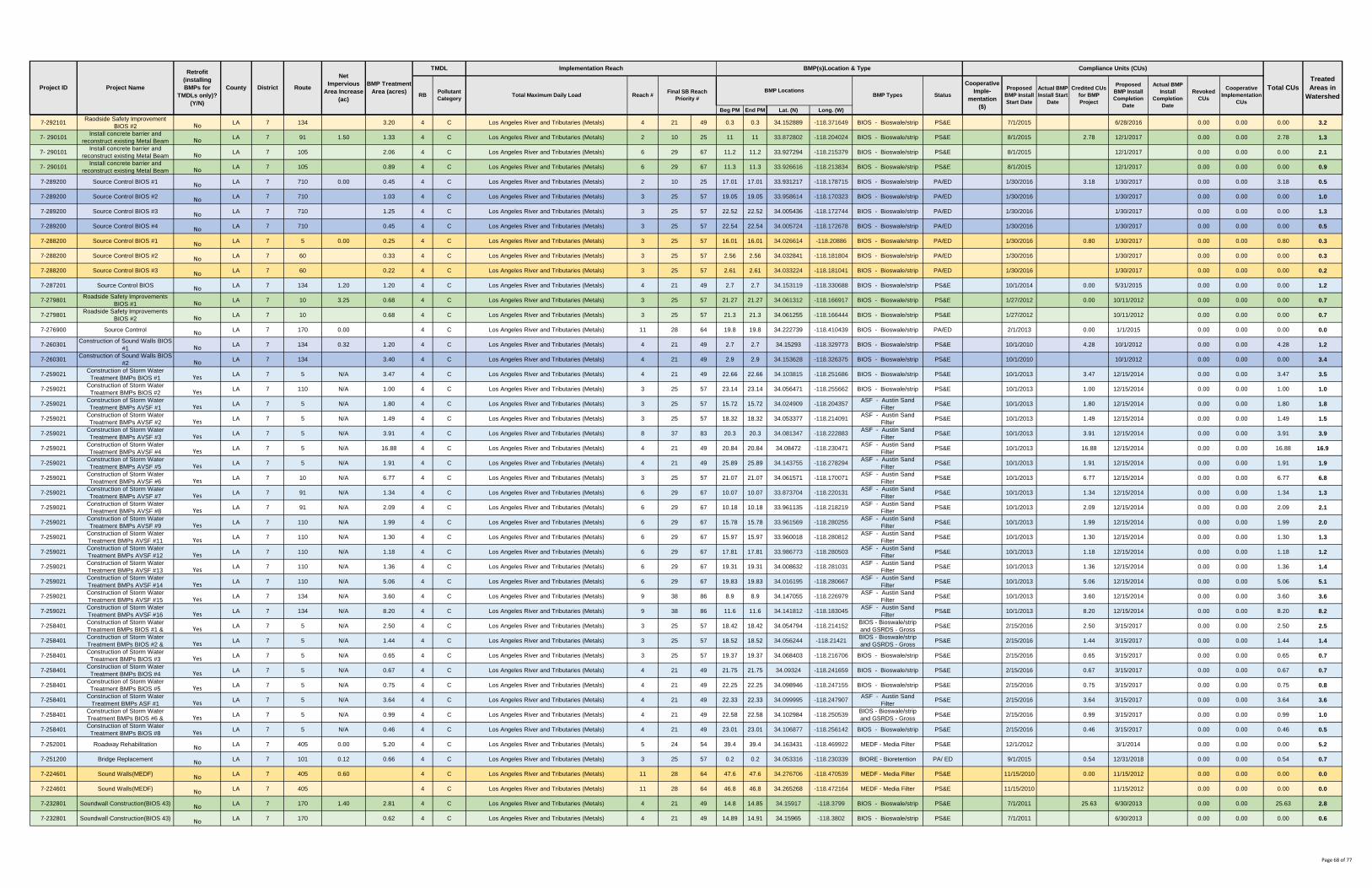
Beg PM End PM Lat. (N) Long. (W)
Revoked CUs
Total CUsTreated Areas in
WatershedRBPollutant Category
Total Maximum Daily Load Reach #Final SB Reach
Priority #
Compliance Units (CUs)
Cooperative Imple-
mentation ($)
Cooperative Implementation
CUs
Proposed BMP Install Start Date
Actual BMP Install Start
Date
Credited CUs for BMP Project
Proposed BMP Install Completion
Date
Actual BMP Install
Completion Date
Net Impervious
Area Increase (ac)
BMP Treatment Area (acres)
TMDL Implementation Reach BMP(s)Location & Type
BMP LocationsBMP Types Status
RouteProject ID Project Name
Retrofit (installing BMPs for
TMDLs only)? (Y/N)
County District
7-292101Raodside Safety Improvement
BIOS #2 No LA 7 134 3.20 4 C Los Angeles River and Tributaries (Metals) 4 21 49 0.3 0.3 34.152889 -118.371649 BIOS - Bioswale/strip PS&E 7/1/2015 6/28/2016 0.00 0.00 0.00 3.2
7- 290101Install concrete barrier and
reconstruct existing Metal Beam No LA 7 91 1.50 1.33 4 C Los Angeles River and Tributaries (Metals) 2 10 25 11 11 33.872802 -118.204024 BIOS - Bioswale/strip PS&E 8/1/2015 2.78 12/1/2017 0.00 0.00 2.78 1.3
7- 290101Install concrete barrier and
reconstruct existing Metal Beam No LA 7 105 2.06 4 C Los Angeles River and Tributaries (Metals) 6 29 67 11.2 11.2 33.927294 -118.215379 BIOS - Bioswale/strip PS&E 8/1/2015 12/1/2017 0.00 0.00 0.00 2.1
7- 290101Install concrete barrier and
reconstruct existing Metal Beam No LA 7 105 0.89 4 C Los Angeles River and Tributaries (Metals) 6 29 67 11.3 11.3 33.926616 -118.213834 BIOS - Bioswale/strip PS&E 8/1/2015 12/1/2017 0.00 0.00 0.00 0.9
7-289200 Source Control BIOS #1 No LA 7 710 0.00 0.45 4 C Los Angeles River and Tributaries (Metals) 2 10 25 17.01 17.01 33.931217 -118.178715 BIOS - Bioswale/strip PA/ED 1/30/2016 3.18 1/30/2017 0.00 0.00 3.18 0.5
7-289200 Source Control BIOS #2 No LA 7 710 1.03 4 C Los Angeles River and Tributaries (Metals) 3 25 57 19.05 19.05 33.958614 -118.170323 BIOS - Bioswale/strip PA/ED 1/30/2016 1/30/2017 0.00 0.00 0.00 1.0
7-289200 Source Control BIOS #3 No LA 7 710 1.25 4 C Los Angeles River and Tributaries (Metals) 3 25 57 22.52 22.52 34.005436 -118.172744 BIOS - Bioswale/strip PA/ED 1/30/2016 1/30/2017 0.00 0.00 0.00 1.3
7-289200 Source Control BIOS #4 No LA 7 710 0.45 4 C Los Angeles River and Tributaries (Metals) 3 25 57 22.54 22.54 34.005724 -118.172678 BIOS - Bioswale/strip PA/ED 1/30/2016 1/30/2017 0.00 0.00 0.00 0.5
7-288200 Source Control BIOS #1 No LA 7 5 0.00 0.25 4 C Los Angeles River and Tributaries (Metals) 3 25 57 16.01 16.01 34.026614 -118.20886 BIOS - Bioswale/strip PA/ED 1/30/2016 0.80 1/30/2017 0.00 0.00 0.80 0.3
7-288200 Source Control BIOS #2 No LA 7 60 0.33 4 C Los Angeles River and Tributaries (Metals) 3 25 57 2.56 2.56 34.032841 -118.181804 BIOS - Bioswale/strip PA/ED 1/30/2016 1/30/2017 0.00 0.00 0.00 0.3
7-288200 Source Control BIOS #3 No LA 7 60 0.22 4 C Los Angeles River and Tributaries (Metals) 3 25 57 2.61 2.61 34.033224 -118.181041 BIOS - Bioswale/strip PA/ED 1/30/2016 1/30/2017 0.00 0.00 0.00 0.2
7-287201 Source Control BIOS No LA 7 134 1.20 1.20 4 C Los Angeles River and Tributaries (Metals) 4 21 49 2.7 2.7 34.153119 -118.330688 BIOS - Bioswale/strip PS&E 10/1/2014 0.00 5/31/2015 0.00 0.00 0.00 1.2
7-279801Roadside Safety Improvements
BIOS #1 No LA 7 10 3.25 0.68 4 C Los Angeles River and Tributaries (Metals) 3 25 57 21.27 21.27 34.061312 -118.166917 BIOS - Bioswale/strip PS&E 1/27/2012 0.00 10/11/2012 0.00 0.00 0.00 0.7
7-279801Roadside Safety Improvements
BIOS #2 No LA 7 10 0.68 4 C Los Angeles River and Tributaries (Metals) 3 25 57 21.3 21.3 34.061255 -118.166444 BIOS - Bioswale/strip PS&E 1/27/2012 10/11/2012 0.00 0.00 0.00 0.7
7-276900 Source Contrrol No LA 7 170 0.00 4 C Los Angeles River and Tributaries (Metals) 11 28 64 19.8 19.8 34.222739 -118.410439 BIOS - Bioswale/strip PA/ED 2/1/2013 0.00 1/1/2015 0.00 0.00 0.00 0.0
7-260301Construction of Sound Walls BIOS
#1 No LA 7 134 0.32 1.20 4 C Los Angeles River and Tributaries (Metals) 4 21 49 2.7 2.7 34.15293 -118.329773 BIOS - Bioswale/strip PS&E 10/1/2010 4.28 10/1/2012 0.00 0.00 4.28 1.2
7-260301Construction of Sound Walls BIOS
#2 No LA 7 134 3.40 4 C Los Angeles River and Tributaries (Metals) 4 21 49 2.9 2.9 34.153628 -118.326375 BIOS - Bioswale/strip PS&E 10/1/2010 10/1/2012 0.00 0.00 0.00 3.4
7-259021Construction of Storm Water
Treatment BMPs BIOS #1 Yes LA 7 5 N/A 3.47 4 C Los Angeles River and Tributaries (Metals) 4 21 49 22.66 22.66 34.103815 -118.251686 BIOS - Bioswale/strip PS&E 10/1/2013 3.47 12/15/2014 0.00 0.00 3.47 3.5
7-259021Construction of Storm Water
Treatment BMPs BIOS #2 Yes LA 7 110 N/A 1.00 4 C Los Angeles River and Tributaries (Metals) 3 25 57 23.14 23.14 34.056471 -118.255662 BIOS - Bioswale/strip PS&E 10/1/2013 1.00 12/15/2014 0.00 0.00 1.00 1.0
7-259021Construction of Storm Water Treatment BMPs AVSF #1 Yes LA 7 5 N/A 1.80 4 C Los Angeles River and Tributaries (Metals) 3 25 57 15.72 15.72 34.024909 -118.204357
ASF - Austin Sand Filter
PS&E 10/1/2013 1.80 12/15/2014 0.00 0.00 1.80 1.8
7-259021Construction of Storm Water Treatment BMPs AVSF #2 Yes LA 7 5 N/A 1.49 4 C Los Angeles River and Tributaries (Metals) 3 25 57 18.32 18.32 34.053377 -118.214091
ASF - Austin Sand Filter
PS&E 10/1/2013 1.49 12/15/2014 0.00 0.00 1.49 1.5
7-259021Construction of Storm Water Treatment BMPs AVSF #3 Yes LA 7 5 N/A 3.91 4 C Los Angeles River and Tributaries (Metals) 8 37 83 20.3 20.3 34.081347 -118.222883
ASF - Austin Sand Filter
PS&E 10/1/2013 3.91 12/15/2014 0.00 0.00 3.91 3.9
7-259021Construction of Storm Water Treatment BMPs AVSF #4 Yes LA 7 5 N/A 16.88 4 C Los Angeles River and Tributaries (Metals) 4 21 49 20.84 20.84 34.08472 -118.230471
ASF - Austin Sand Filter
PS&E 10/1/2013 16.88 12/15/2014 0.00 0.00 16.88 16.9
7-259021Construction of Storm Water Treatment BMPs AVSF #5 Yes LA 7 5 N/A 1.91 4 C Los Angeles River and Tributaries (Metals) 4 21 49 25.89 25.89 34.143755 -118.278294
ASF - Austin Sand Filter
PS&E 10/1/2013 1.91 12/15/2014 0.00 0.00 1.91 1.9
7-259021Construction of Storm Water Treatment BMPs AVSF #6 Yes LA 7 10 N/A 6.77 4 C Los Angeles River and Tributaries (Metals) 3 25 57 21.07 21.07 34.061571 -118.170071
ASF - Austin Sand Filter
PS&E 10/1/2013 6.77 12/15/2014 0.00 0.00 6.77 6.8
7-259021Construction of Storm Water Treatment BMPs AVSF #7 Yes LA 7 91 N/A 1.34 4 C Los Angeles River and Tributaries (Metals) 6 29 67 10.07 10.07 33.873704 -118.220131
ASF - Austin Sand Filter
PS&E 10/1/2013 1.34 12/15/2014 0.00 0.00 1.34 1.3
7-259021Construction of Storm Water Treatment BMPs AVSF #8 Yes LA 7 91 N/A 2.09 4 C Los Angeles River and Tributaries (Metals) 6 29 67 10.18 10.18 33.961135 -118.218219
ASF - Austin Sand Filter
PS&E 10/1/2013 2.09 12/15/2014 0.00 0.00 2.09 2.1
7-259021Construction of Storm Water Treatment BMPs AVSF #9 Yes LA 7 110 N/A 1.99 4 C Los Angeles River and Tributaries (Metals) 6 29 67 15.78 15.78 33.961569 -118.280255
ASF - Austin Sand Filter
PS&E 10/1/2013 1.99 12/15/2014 0.00 0.00 1.99 2.0
7-259021Construction of Storm Water Treatment BMPs AVSF #11 Yes LA 7 110 N/A 1.30 4 C Los Angeles River and Tributaries (Metals) 6 29 67 15.97 15.97 33.960018 -118.280812
ASF - Austin Sand Filter
PS&E 10/1/2013 1.30 12/15/2014 0.00 0.00 1.30 1.3
7-259021Construction of Storm Water Treatment BMPs AVSF #12 Yes LA 7 110 N/A 1.18 4 C Los Angeles River and Tributaries (Metals) 6 29 67 17.81 17.81 33.986773 -118.280503
ASF - Austin Sand Filter
PS&E 10/1/2013 1.18 12/15/2014 0.00 0.00 1.18 1.2
7-259021Construction of Storm Water Treatment BMPs AVSF #13 Yes LA 7 110 N/A 1.36 4 C Los Angeles River and Tributaries (Metals) 6 29 67 19.31 19.31 34.008632 -118.281031
ASF - Austin Sand Filter
PS&E 10/1/2013 1.36 12/15/2014 0.00 0.00 1.36 1.4
7-259021Construction of Storm Water Treatment BMPs AVSF #14 Yes LA 7 110 N/A 5.06 4 C Los Angeles River and Tributaries (Metals) 6 29 67 19.83 19.83 34.016195 -118.280667
ASF - Austin Sand Filter
PS&E 10/1/2013 5.06 12/15/2014 0.00 0.00 5.06 5.1
7-259021Construction of Storm Water Treatment BMPs AVSF #15 Yes LA 7 134 N/A 3.60 4 C Los Angeles River and Tributaries (Metals) 9 38 86 8.9 8.9 34.147055 -118.226979
ASF - Austin Sand Filter
PS&E 10/1/2013 3.60 12/15/2014 0.00 0.00 3.60 3.6
7-259021Construction of Storm Water Treatment BMPs AVSF #16 Yes LA 7 134 N/A 8.20 4 C Los Angeles River and Tributaries (Metals) 9 38 86 11.6 11.6 34.141812 -118.183045
ASF - Austin Sand Filter
PS&E 10/1/2013 8.20 12/15/2014 0.00 0.00 8.20 8.2
7-258401Construction of Storm Water Treatment BMPs BIOS #1 & Yes LA 7 5 N/A 2.50 4 C Los Angeles River and Tributaries (Metals) 3 25 57 18.42 18.42 34.054794 -118.214152
BIOS - Bioswale/strip and GSRDS - Gross
PS&E 2/15/2016 2.50 3/15/2017 0.00 0.00 2.50 2.5
7-258401Construction of Storm Water Treatment BMPs BIOS #2 & Yes LA 7 5 N/A 1.44 4 C Los Angeles River and Tributaries (Metals) 3 25 57 18.52 18.52 34.056244 -118.21421
BIOS - Bioswale/strip and GSRDS - Gross
PS&E 2/15/2016 1.44 3/15/2017 0.00 0.00 1.44 1.4
7-258401Construction of Storm Water
Treatment BMPs BIOS #3 Yes LA 7 5 N/A 0.65 4 C Los Angeles River and Tributaries (Metals) 3 25 57 19.37 19.37 34.068403 -118.216706 BIOS - Bioswale/strip PS&E 2/15/2016 0.65 3/15/2017 0.00 0.00 0.65 0.7
7-258401Construction of Storm Water
Treatment BMPs BIOS #4 Yes LA 7 5 N/A 0.67 4 C Los Angeles River and Tributaries (Metals) 4 21 49 21.75 21.75 34.09324 -118.241659 BIOS - Bioswale/strip PS&E 2/15/2016 0.67 3/15/2017 0.00 0.00 0.67 0.7
7-258401Construction of Storm Water
Treatment BMPs BIOS #5 Yes LA 7 5 N/A 0.75 4 C Los Angeles River and Tributaries (Metals) 4 21 49 22.25 22.25 34.098946 -118.247155 BIOS - Bioswale/strip PS&E 2/15/2016 0.75 3/15/2017 0.00 0.00 0.75 0.8
7-258401Construction of Storm Water
Treatment BMPs ASF #1 Yes LA 7 5 N/A 3.64 4 C Los Angeles River and Tributaries (Metals) 4 21 49 22.33 22.33 34.099995 -118.247907ASF - Austin Sand
FilterPS&E 2/15/2016 3.64 3/15/2017 0.00 0.00 3.64 3.6
7-258401Construction of Storm Water Treatment BMPs BIOS #6 & Yes LA 7 5 N/A 0.99 4 C Los Angeles River and Tributaries (Metals) 4 21 49 22.58 22.58 34.102984 -118.250539
BIOS - Bioswale/strip and GSRDS - Gross
PS&E 2/15/2016 0.99 3/15/2017 0.00 0.00 0.99 1.0
7-258401Construction of Storm Water
Treatment BMPs BIOS #8 Yes LA 7 5 N/A 0.46 4 C Los Angeles River and Tributaries (Metals) 4 21 49 23.01 23.01 34.106877 -118.256142 BIOS - Bioswale/strip PS&E 2/15/2016 0.46 3/15/2017 0.00 0.00 0.46 0.5
7-252001 Roadway Rehabilitation No LA 7 405 0.00 5.20 4 C Los Angeles River and Tributaries (Metals) 5 24 54 39.4 39.4 34.163431 -118.469922 MEDF - Media Filter PS&E 12/1/2012 3/1/2014 0.00 0.00 0.00 5.2
7-251200 Bridge Replacement No LA 7 101 0.12 0.66 4 C Los Angeles River and Tributaries (Metals) 3 25 57 0.2 0.2 34.053316 -118.230339 BIORE - Bioretention PA/ ED 9/1/2015 0.54 12/31/2018 0.00 0.00 0.54 0.7
7-224601 Sound Walls(MEDF) No LA 7 405 0.60 4 C Los Angeles River and Tributaries (Metals) 11 28 64 47.6 47.6 34.276706 -118.470539 MEDF - Media Filter PS&E 11/15/2010 0.00 11/15/2012 0.00 0.00 0.00 0.0
7-224601 Sound Walls(MEDF) No LA 7 405 4 C Los Angeles River and Tributaries (Metals) 11 28 64 46.8 46.8 34.265268 -118.472164 MEDF - Media Filter PS&E 11/15/2010 11/15/2012 0.00 0.00 0.00 0.0
7-232801 Soundwall Construction(BIOS 43) No LA 7 170 1.40 2.81 4 C Los Angeles River and Tributaries (Metals) 4 21 49 14.8 14.85 34.15917 -118.3799 BIOS - Bioswale/strip PS&E 7/1/2011 25.63 6/30/2013 0.00 0.00 25.63 2.8
7-232801 Soundwall Construction(BIOS 43) No LA 7 170 0.62 4 C Los Angeles River and Tributaries (Metals) 4 21 49 14.89 14.91 34.15965 -118.3802 BIOS - Bioswale/strip PS&E 7/1/2011 6/30/2013 0.00 0.00 0.00 0.6
Page 68 of 77
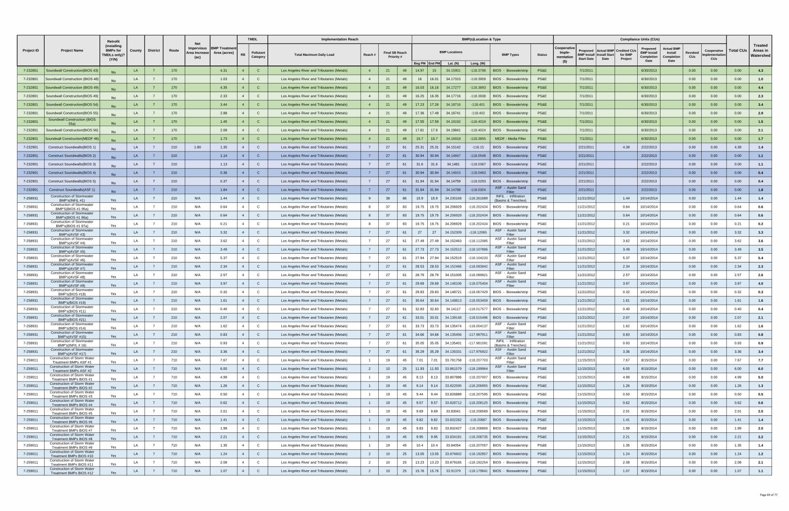
Beg PM End PM Lat. (N) Long. (W)
Revoked CUs
Total CUsTreated Areas in
WatershedRBPollutant Category
Total Maximum Daily Load Reach #Final SB Reach
Priority #
Compliance Units (CUs)
Cooperative Imple-
mentation ($)
Cooperative Implementation
CUs
Proposed BMP Install Start Date
Actual BMP Install Start
Date
Credited CUs for BMP Project
Proposed BMP Install Completion
Date
Actual BMP Install
Completion Date
Net Impervious
Area Increase (ac)
BMP Treatment Area (acres)
TMDL Implementation Reach BMP(s)Location & Type
BMP LocationsBMP Types Status
RouteProject ID Project Name
Retrofit (installing BMPs for
TMDLs only)? (Y/N)
County District
7-232801 Soundwall Construction(BIOS 43) No LA 7 170 4.31 4 C Los Angeles River and Tributaries (Metals) 4 21 49 14.97 15 34.15901 -118.3798 BIOS - Bioswale/strip PS&E 7/1/2011 6/30/2013 0.00 0.00 0.00 4.3
7-232801 Soundwall Construction (BIOS 48) No LA 7 170 1.03 4 C Los Angeles River and Tributaries (Metals) 4 21 49 16 16.01 34.17315 -118.3909 BIOS - Bioswale/strip PS&E 7/1/2011 6/30/2013 0.00 0.00 0.00 1.0
7-232801 Soundwall Construction (BIOS 49) No LA 7 170 4.35 4 C Los Angeles River and Tributaries (Metals) 4 21 49 16.03 16.16 34.17277 -118.3893 BIOS - Bioswale/strip PS&E 7/1/2011 6/30/2013 0.00 0.00 0.00 4.4
7-232801 Soundwall Construction(BIOS 49) No LA 7 170 2.33 4 C Los Angeles River and Tributaries (Metals) 4 21 49 16.25 16.35 34.17716 -118.3938 BIOS - Bioswale/strip PS&E 7/1/2011 6/30/2013 0.00 0.00 0.00 2.3
7-232801 Soundwall Construction(BIOS 54) No LA 7 170 3.44 4 C Los Angeles River and Tributaries (Metals) 4 21 49 17.23 17.26 34.18716 -118.401 BIOS - Bioswale/strip PS&E 7/1/2011 6/30/2013 0.00 0.00 0.00 3.4
7-232801 Soundwall Construction(BIOS 55) No LA 7 170 2.88 4 C Los Angeles River and Tributaries (Metals) 4 21 49 17.36 17.49 34.18741 -118.402 BIOS - Bioswale/strip PS&E 7/1/2011 6/30/2013 0.00 0.00 0.00 2.9
7-232801Soundwall Construction (BIOS
55a) No LA 7 170 1.45 4 C Los Angeles River and Tributaries (Metals) 4 21 49 17.55 17.59 34.19192 -118.4019 BIOS - Bioswale/strip PS&E 7/1/2011 6/30/2013 0.00 0.00 0.00 1.5
7-232801 Soundwall Construction(BIOS 56) No LA 7 170 2.08 4 C Los Angeles River and Tributaries (Metals) 4 21 49 17.81 17.9 34.19841 -118.4024 BIOS - Bioswale/strip PS&E 7/1/2011 6/30/2013 0.00 0.00 0.00 2.1
7-232801 Soundwall Construction(MEDF 46) No LA 7 170 1.73 4 C Los Angeles River and Tributaries (Metals) 4 21 49 15.7 15.7 34.16918 -118.3855 MEDF - Media Filter PS&E 7/1/2011 6/30/2013 0.00 0.00 0.00 1.7
7-232901 Construct Soundwalls(BIOS 1) No LA 7 210 1.80 1.35 4 C Los Angeles River and Tributaries (Metals) 7 27 61 25.31 25.31 34.15142 -118.15 BIOS - Bioswale/strip PS&E 2/21/2011 4.39 2/22/2013 0.00 0.00 4.39 1.4
7-232901 Construct Soundwalls(BIOS 2) No LA 7 210 1.14 4 C Los Angeles River and Tributaries (Metals) 7 27 61 30.94 30.94 34.14847 -118.0548 BIOS - Bioswale/strip PS&E 2/21/2011 2/22/2013 0.00 0.00 0.00 1.1
7-232901 Construct Soundwalls(BIOS 3) No LA 7 210 1.13 4 C Los Angeles River and Tributaries (Metals) 7 27 61 31.6 31.6 34.1481 -118.0367 BIOS - Bioswale/strip PS&E 2/21/2011 2/22/2013 0.00 0.00 0.00 1.1
7-232901 Construct Soundwalls(BIOS 4) No LA 7 210 0.36 4 C Los Angeles River and Tributaries (Metals) 7 27 61 30.94 30.94 34.14915 -118.0463 BIOS - Bioswale/strip PS&E 2/21/2011 2/22/2013 0.00 0.00 0.00 0.4
7-232901 Construct Soundwalls(BIOS 5) No LA 7 210 0.37 4 C Los Angeles River and Tributaries (Metals) 7 27 61 31.94 31.94 34.14759 -118.0293 BIOS - Bioswale/strip PS&E 2/21/2011 2/22/2013 0.00 0.00 0.00 0.4
7-232901 Construct Soundwalls(ASF 1) No LA 7 210 1.84 4 C Los Angeles River and Tributaries (Metals) 7 27 61 31.94 31.94 34.14788 -118.0304ASF - Austin Sand
FilterPS&E 2/21/2011 2/22/2013 0.00 0.00 0.00 1.8
7-258931Construction of Stormwater
BMP's(INFIL #1) Yes LA 7 210 N/A 1.44 4 C Los Angeles River and Tributaries (Metals) 9 38 86 15.9 15.9 34.230168 -118.261689INFIL - Infiltration
(Basins & Trenches)PS&E 11/21/2012 1.44 10/14/2014 0.00 0.00 1.44 1.4
7-258931Construction of Stormwater
BMP'S(BIOS #1 95a) Yes LA 7 210 N/A 0.64 4 C Los Angeles River and Tributaries (Metals) 8 37 83 19.75 19.75 34.206929 -118.202434 BIOS - Bioswale/strip PS&E 11/21/2012 0.64 10/14/2014 0.00 0.00 0.64 0.6
7-258931Construction of Stormwater
BMP's(BIOS #1 96a) Yes LA 7 210 N/A 0.64 4 C Los Angeles River and Tributaries (Metals) 8 37 83 19.75 19.75 34.206929 -118.202434 BIOS - Bioswale/strip PS&E 11/21/2012 0.64 10/14/2014 0.00 0.00 0.64 0.6
7-258931Construction of Stormwater
BMP's(BIOS #1 97a) Yes LA 7 210 N/A 0.21 4 C Los Angeles River and Tributaries (Metals) 8 37 83 19.75 19.75 34.206929 -118.202434 BIOS - Bioswale/strip PS&E 11/21/2012 0.21 10/14/2014 0.00 0.00 0.21 0.2
7-258931Construction of Stormwater
BMP's(AVSF #3) Yes LA 7 210 N/A 3.32 4 C Los Angeles River and Tributaries (Metals) 7 27 61 27 27 34.152309 -118.12065ASF - Austin Sand
FilterPS&E 11/21/2012 3.32 10/14/2014 0.00 0.00 3.32 3.3
7-258931Construction of Stormwater
BMP's(AVSF #4) Yes LA 7 210 N/A 3.62 4 C Los Angeles River and Tributaries (Metals) 7 27 61 27.49 27.49 34.152463 -118.112085ASF - Austin Sand
FilterPS&E 11/21/2012 3.62 10/14/2014 0.00 0.00 3.62 3.6
7-258931Construction of Stormwater
BMP's(AVSF #5) Yes LA 7 210 N/A 3.49 4 C Los Angeles River and Tributaries (Metals) 7 27 61 27.73 27.73 34.152512 -118.107896ASF - Austin Sand
FilterPS&E 11/21/2012 3.49 10/14/2014 0.00 0.00 3.49 3.5
7-258931Construction of Stormwater
BMP's(AVSF #6) Yes LA 7 210 N/A 5.37 4 C Los Angeles River and Tributaries (Metals) 7 27 61 27.94 27.94 34.152519 -118.104233ASF - Austin Sand
FilterPS&E 11/21/2012 5.37 10/14/2014 0.00 0.00 5.37 5.4
7-258931Construction of Stormwater
BMP's(AVSF #7) Yes LA 7 210 N/A 2.34 4 C Los Angeles River and Tributaries (Metals) 7 27 61 28.53 28.53 34.152466 -118.093942ASF - Austin Sand
FilterPS&E 11/21/2012 2.34 10/14/2014 0.00 0.00 2.34 2.3
7-258931Construction of Stormwater
BMP's(AVSF #8) Yes LA 7 210 N/A 2.57 4 C Los Angeles River and Tributaries (Metals) 7 27 61 28.79 28.79 34.151005 -118.089821ASF - Austin Sand
FilterPS&E 11/21/2012 2.57 10/14/2014 0.00 0.00 2.57 2.6
7-258931Construction of Stormwater
BMP's(AVSF #9) Yes LA 7 210 N/A 3.97 4 C Los Angeles River and Tributaries (Metals) 7 27 61 29.69 29.69 34.148106 -118.075404ASF - Austin Sand
FilterPS&E 11/21/2012 3.97 10/14/2014 0.00 0.00 3.97 4.0
7-258931Construction of Stormwater
BMP's(BIOS #18) Yes LA 7 210 N/A 0.32 4 C Los Angeles River and Tributaries (Metals) 7 27 61 29.83 29.83 34.148721 -118.067429 BIOS - Bioswale/strip PS&E 11/21/2012 0.32 10/14/2014 0.00 0.00 0.32 0.3
7-258931Construction of Stormwater
BMP's(BIOS #19) Yes LA 7 210 N/A 1.61 4 C Los Angeles River and Tributaries (Metals) 7 27 61 30.64 30.64 34.148813 -118.053459 BIOS - Bioswale/strip PS&E 11/21/2012 1.61 10/14/2014 0.00 0.00 1.61 1.6
7-258931Construction of Stormwater
BMP's(BIOS #11) Yes LA 7 210 N/A 0.40 4 C Los Angeles River and Tributaries (Metals) 7 27 61 32.83 32.83 34.14117 -118.017577 BIOS - Bioswale/strip PS&E 11/21/2012 0.40 10/14/2014 0.00 0.00 0.40 0.4
7-258931Construction of Stormwater
BMP's(BIOS #21) Yes LA 7 210 N/A 2.07 4 C Los Angeles River and Tributaries (Metals) 7 27 61 33.01 33.01 34.139148 -118.015496 BIOS - Bioswale/strip PS&E 11/21/2012 2.07 10/14/2014 0.00 0.00 2.07 2.1
7-258931Construction of Stormwater
BMP's(BIOS #14) Yes LA 7 210 N/A 1.62 4 C Los Angeles River and Tributaries (Metals) 7 27 61 33.73 33.73 34.135474 -118.004137ASF - Austin Sand
FilterPS&E 11/21/2012 1.62 10/14/2014 0.00 0.00 1.62 1.6
7-258931Construction of Stormwater
BMP's(AVSF #15) Yes LA 7 210 N/A 0.83 4 C Los Angeles River and Tributaries (Metals) 7 27 61 34.66 34.66 34.135456 -117.987911ASF - Austin Sand
FilterPS&E 11/21/2012 0.83 10/14/2014 0.00 0.00 0.83 0.8
7-258931Construction of Stormwater
BMP's(INFIL # 16) Yes LA 7 210 N/A 0.93 4 C Los Angeles River and Tributaries (Metals) 7 27 61 35.05 35.05 34.135401 -117.981091INFIL - Infiltration
(Basins & Trenches)PS&E 11/21/2012 0.93 10/14/2014 0.00 0.00 0.93 0.9
7-258931Construction of Stormwater
BMP's(AVSF #17) Yes LA 7 210 N/A 3.36 4 C Los Angeles River and Tributaries (Metals) 7 27 61 35.29 35.29 34.135331 -117.976922ASF - Austin Sand
FilterPS&E 11/21/2012 3.36 10/14/2014 0.00 0.00 3.36 3.4
7-259011Construction of Storm Water
Treatment BMPs ASF #1 Yes LA 7 710 N/A 7.67 4 C Los Angeles River and Tributaries (Metals) 1 19 45 7.01 7.01 33.791758 -118.207703ASF - Austin Sand
FilterPS&E 11/15/2013 7.67 8/15/2014 0.00 0.00 7.67 7.7
7-259011Construction of Storm Water
Treatment BMPs ASF #2 Yes LA 7 710 N/A 6.00 4 C Los Angeles River and Tributaries (Metals) 2 10 25 11.93 11.93 33.861579 -118.199964ASF - Austin Sand
FilterPS&E 11/15/2013 6.00 8/15/2014 0.00 0.00 6.00 6.0
7-259011Construction of Storm Water
Treatment BMPs BIOS #1 Yes LA 7 710 N/A 4.99 4 C Los Angeles River and Tributaries (Metals) 1 19 45 8.13 8.13 33.807886 -118.207007 BIOS - Bioswale/strip PS&E 11/15/2013 4.99 8/15/2014 0.00 0.00 4.99 5.0
7-259011Construction of Storm Water
Treatment BMPs BIOS #2 Yes LA 7 710 N/A 1.26 4 C Los Angeles River and Tributaries (Metals) 1 19 45 9.14 9.14 33.822595 -118.206955 BIOS - Bioswale/strip PS&E 11/15/2013 1.26 8/15/2014 0.00 0.00 1.26 1.3
7-259011Construction of Storm Water
Treatment BMPs BIOS #3 Yes LA 7 710 N/A 0.50 4 C Los Angeles River and Tributaries (Metals) 1 19 45 9.44 9.44 33.826889 -118.207595 BIOS - Bioswale/strip PS&E 11/15/2013 0.50 8/15/2014 0.00 0.00 0.50 0.5
7-259011Construction of Storm Water
Treatment BMPs BIOS #4 Yes LA 7 710 N/A 0.62 4 C Los Angeles River and Tributaries (Metals) 1 19 45 9.57 9.57 33.828712 -118.208125 BIOS - Bioswale/strip PS&E 11/15/2013 0.62 8/15/2014 0.00 0.00 0.62 0.6
7-259011Construction of Storm Water
Treatment BMPs BIOS #5 Yes LA 7 710 N/A 2.01 4 C Los Angeles River and Tributaries (Metals) 1 19 45 9.69 9.69 33.83041 -118.208589 BIOS - Bioswale/strip PS&E 11/15/2013 2.01 8/15/2014 0.00 0.00 2.01 2.0
7-259011Construction of Storm Water
Treatment BMPs BIOS #6 Yes LA 7 710 N/A 1.41 4 C Los Angeles River and Tributaries (Metals) 1 19 45 9.82 9.82 33.832282 -118.20887 BIOS - Bioswale/strip PS&E 11/15/2013 1.41 8/15/2014 0.00 0.00 1.41 1.4
7-259011Construction of Storm Water
Treatment BMPs BIOS #7 Yes LA 7 710 N/A 1.99 4 C Los Angeles River and Tributaries (Metals) 1 19 45 9.83 9.83 33.832427 -118.208869 BIOS - Bioswale/strip PS&E 11/15/2013 1.99 8/15/2014 0.00 0.00 1.99 2.0
7-259011Construction of Storm Water
Treatment BMPs BIOS #8 Yes LA 7 710 N/A 2.21 4 C Los Angeles River and Tributaries (Metals) 1 19 45 9.95 9.95 33.834181 -118.208735 BIOS - Bioswale/strip PS&E 11/15/2013 2.21 8/15/2014 0.00 0.00 2.21 2.2
7-259011Construction of Storm Water
Treatment BMPs BIOS #9 Yes LA 7 710 N/A 1.35 4 C Los Angeles River and Tributaries (Metals) 1 19 45 10.4 10.4 33.84054 -118.207057 BIOS - Bioswale/strip PS&E 11/15/2013 1.35 8/15/2014 0.00 0.00 1.35 1.4
7-259011Construction of Storm Water Treatment BMPs BIOS #10 Yes LA 7 710 N/A 1.24 4 C Los Angeles River and Tributaries (Metals) 2 10 25 13.05 13.05 33.876602 -118.192857 BIOS - Bioswale/strip PS&E 11/15/2013 1.24 8/15/2014 0.00 0.00 1.24 1.2
7-259011Construction of Storm Water Treatment BMPs BIOS #11 Yes LA 7 710 N/A 2.08 4 C Los Angeles River and Tributaries (Metals) 2 10 25 13.23 13.23 33.879165 -118.192254 BIOS - Bioswale/strip PS&E 11/15/2013 2.08 8/15/2014 0.00 0.00 2.08 2.1
7-259011Construction of Storm Water Treatment BMPs BIOS #12 Yes LA 7 710 N/A 1.07 4 C Los Angeles River and Tributaries (Metals) 2 10 25 15.76 15.76 33.91379 -118.179841 BIOS - Bioswale/strip PS&E 11/15/2013 1.07 8/15/2014 0.00 0.00 1.07 1.1
Page 69 of 77

Beg PM End PM Lat. (N) Long. (W)
Revoked CUs
Total CUsTreated Areas in
WatershedRBPollutant Category
Total Maximum Daily Load Reach #Final SB Reach
Priority #
Compliance Units (CUs)
Cooperative Imple-
mentation ($)
Cooperative Implementation
CUs
Proposed BMP Install Start Date
Actual BMP Install Start
Date
Credited CUs for BMP Project
Proposed BMP Install Completion
Date
Actual BMP Install
Completion Date
Net Impervious
Area Increase (ac)
BMP Treatment Area (acres)
TMDL Implementation Reach BMP(s)Location & Type
BMP LocationsBMP Types Status
RouteProject ID Project Name
Retrofit (installing BMPs for
TMDLs only)? (Y/N)
County District
7-2X9201 Permanent Slope Restoration No LA 7 91 0.79 1.34 4 E Los Angeles River Watershed (Bacteria) 6 29 66 10.7 10.7 33.873601 -118.209135 MEDF - Media Filter PS&E 9/7/2012 12.15 6/10/2014 0.00 0.00 12.15 1.3
7-2X9201 Permanent Slope Restoration No LA 7 91 2.09 4 E Los Angeles River Watershed (Bacteria) 6 29 66 10.18 10.18 33.873534 -118.218219 MEDF - Media Filter PS&E 9/7/2012 6/10/2014 0.00 0.00 0.00 2.1
7-2X9201 Permanent Slope Restoration No LA 7 91 0.60 4 E Los Angeles River Watershed (Bacteria) 6 29 66 10.33 10.33 33.873468 -118.215595 BIOS - Bioswale/strip PS&E 9/7/2012 6/10/2014 0.00 0.00 0.00 0.6
7-2X9201 Permanent Slope Restoration No LA 7 91 3.57 4 E Los Angeles River Watershed (Bacteria) 6 29 66 10.43 10.43 33.873495 -118.213849 MEDF - Media Filter PS&E 9/7/2012 6/10/2014 0.00 0.00 0.00 3.6
7-2X9201 Permanent Slope Restoration No LA 7 91 0.41 4 E Los Angeles River Watershed (Bacteria) 2 10 24 11.03 11.03 33.872733 -118.20351 BIOS - Bioswale/strip PS&E 9/7/2012 6/10/2014 0.00 0.00 0.00 0.4
7-2X9201 Permanent Slope Restoration No LA 7 91 3.62 4 E Los Angeles River Watershed (Bacteria) 2 10 24 11.07 11.07 33.872678 -118.202824 MEDF - Media Filter PS&E 9/7/2012 6/10/2014 0.00 0.00 0.00 3.6
7-2X9201 Permanent Slope Restoration No LA 7 91 0.44 4 E Los Angeles River Watershed (Bacteria) 2 10 24 11.16 11.16 33.872708 -118.201276 BIOS - Bioswale/strip PS&E 9/7/2012 6/10/2014 0.00 0.00 0.00 0.4
7-2X9201 Permanent Slope Restoration No LA 7 91 0.87 4 E Los Angeles River Watershed (Bacteria) 2 10 24 11.63 11.63 33.87522 -118.193692 BIOS - Bioswale/strip PS&E 9/7/2012 6/10/2014 0.00 0.00 0.00 0.9
7-1218W1Modify Interchagne and Add HOV
Lanes No LA 7 5 12.10 8.27 4 E Los Angeles River Watershed (Bacteria) 10 30 69 31.34 31.34 34.199912 -118.338615ASF - Austin Sand
FilterPS&E 12/24/2012 0.00 12/7/2015 0.00 0.00 0.00 8.3
7-1218W1Modify Interchagne and Add HOV
Lanes No LA 7 5 4 E Los Angeles River Watershed (Bacteria) 10 30 69 31.59 31.59 34.203068 -118.340771ASF - Austin Sand
FilterPS&E 12/24/2012 12/7/2015 0.00 0.00 0.00 0.0
7-121901 HOV Land & Pavement Rehab No LA 7 5 24.22 2.80 4 E Los Angeles River Watershed (Bacteria) 11 28 63 38.54 38.54 34.257383 -118.434778 BIOS - Bioswale/strip PS&E 10/1/2009 4.48 9/10/2013 0.00 0.00 4.48 2.8
7-121901 HOV Land & Pavement Rehab No LA 7 5 2.80 4 E Los Angeles River Watershed (Bacteria) 11 28 63 38.54 38.54 34.256751 -118.436071 BIOS - Bioswale/strip PS&E 10/1/2009 9/10/2013 0.00 0.00 0.00 2.8
7-121901 HOV Land & Pavement Rehab No LA 7 5 0.30 4 E Los Angeles River Watershed (Bacteria) 11 28 63 38.46 38.46 34.255971 -118.434308 BIOS - Bioswale/strip PS&E 10/1/2009 9/10/2013 0.00 0.00 0.00 0.3
7-121901 HOV Land & Pavement Rehab No LA 7 5 2.30 4 E Los Angeles River Watershed (Bacteria) 11 28 63 37.4 37.4 34.244546 -118.422219 BIOS - Bioswale/strip PS&E 10/1/2009 9/10/2013 0.00 0.00 0.00 2.3
7-121901 HOV Land & Pavement Rehab No LA 7 5 2.80 4 E Los Angeles River Watershed (Bacteria) 11 28 63 38.54 38.54 34.256691 -118.436095INFIL - Infiltration
(Basins & Trenches)PS&E 10/1/2009 9/10/2013 0.00 0.00 0.00 2.8
7-121901 HOV Land & Pavement Rehab No LA 7 5 2.10 4 E Los Angeles River Watershed (Bacteria) 11 28 63 37.99 37.99 34.251458 -118.42849INFIL - Infiltration
(Basins & Trenches)PS&E 10/1/2009 9/10/2013 0.00 0.00 0.00 2.1
7-121901 HOV Land & Pavement Rehab No LA 7 5 2.80 4 E Los Angeles River Watershed (Bacteria) 11 28 63 38.54 38.54 34.257386 -118.435009ASF - Austin Sand
FilterPS&E 10/1/2009 9/10/2013 0.00 0.00 0.00 2.8
7-121901 HOV Land & Pavement Rehab No LA 7 5 3.80 4 E Los Angeles River Watershed (Bacteria) 11 28 63 37.5 37.5 34.245067 -118.423498ASF - Austin Sand
FilterPS&E 10/1/2009 9/10/2013 0.00 0.00 0.00 3.8
7-121901 HOV Land & Pavement Rehab No LA 7 5 2.30 4 E Los Angeles River Watershed (Bacteria) 11 28 63 36.36 36.36 34.245067 -118.423498ASF - Austin Sand
FilterPS&E 10/1/2009 9/10/2013 0.00 0.00 0.00 2.3
7-121901 HOV Land & Pavement Rehab No LA 7 5 1.30 4 E Los Angeles River Watershed (Bacteria) 4 21 48 36.16 36.16 34.231722 -118.406601ASF - Austin Sand
FilterPS&E 10/1/2009 9/10/2013 0.00 0.00 0.00 1.3
7-121901 HOV Land & Pavement Rehab No LA 7 5 5.40 4 E Los Angeles River Watershed (Bacteria) 11 28 63 39.21 39.21 34.264712 -118.442074ASF - Austin Sand
FilterPS&E 10/1/2009 9/10/2013 0.00 0.00 0.00 5.4
7-1786A1Modify interchange and realign
ramps No LA 7 5 0.80 2.85 4 E Los Angeles River Watershed (Bacteria) 4 21 48 27.4 28.1 34.159364 -118.292146DetBas - Detention
BasinsPS&E 2/4/2010 6.66 1/31/2012 0.00 0.00 6.66 2.9
7-1786A1Modify interchange and realign
ramps No LA 7 5 4.61 4 E Los Angeles River Watershed (Bacteria) 4 21 48 27.4 28.1 34.159364 -118.292146ASF - Austin Sand
FilterPS&E 2/4/2010 1/31/2012 0.00 0.00 0.00 4.6
7-2332E0 Construct Hot lanes No LA 7 5 71.38 0.61 4 E Los Angeles River Watershed (Bacteria) 5 24 53 45.89 45.89 34.33664 -118.512285 BIOS - Bioswale/strip PA/ED 2/1/2014 0.00 7/1/2018 0.00 0.00 0.00 0.6
7-2332E0 Construct Hot lanes No LA 7 5 0.66 4 E Los Angeles River Watershed (Bacteria) 5 24 53 46.08 46.08 34.338142 -118.515102 BIOS - Bioswale/strip PA/ED 2/1/2014 7/1/2018 0.00 0.00 0.00 0.7
7-2332E0 Construct Hot lanes No LA 7 5 0.49 4 E Los Angeles River Watershed (Bacteria) 5 24 53 46.12 46.12 34.338439 -118.515706 BIOS - Bioswale/strip PA/ED 2/1/2014 7/1/2018 0.00 0.00 0.00 0.5
7-2770U1 Source Control No LA 7 118 1.40 0.25 4 E Los Angeles River Watershed (Bacteria) 11 28 63 11.53 11.53 34.267217 -118.44203 BIOS - Bioswale/strip PS&E 2/26/2013 18.21 10/26/2013 0.00 0.00 18.21 0.3
7-2770U1 Source Control No LA 7 118 3.64 4 E Los Angeles River Watershed (Bacteria) 11 28 63 11.65 11.65 34.26749 -118.440151 BIOS - Bioswale/strip PS&E 2/26/2013 10/26/2013 0.00 0.00 0.00 3.6
7-2770U1 Source Control No LA 7 118 2.00 4 E Los Angeles River Watershed (Bacteria) 11 28 63 12.07 12.07 34.269282 -118.433277 BIOS - Bioswale/strip PS&E 2/26/2013 10/26/2013 0.00 0.00 0.00 2.0
7-2770U1 Source Control No LA 7 118 1.90 4 E Los Angeles River Watershed (Bacteria) 11 28 63 13.26 13.26 34.280949 -118.417884 BIOS - Bioswale/strip PS&E 2/26/2013 10/26/2013 0.00 0.00 0.00 1.9
7-2770U1 Source Control No LA 7 118 2.98 4 E Los Angeles River Watershed (Bacteria) 11 28 63 12.36 12.36 34.272056 -118.429407DetBas - Detention
BasinsPS&E 2/26/2013 10/26/2013 0.00 0.00 0.00 3.0
7-2770U1 Source Control No LA 7 118 1.73 4 E Los Angeles River Watershed (Bacteria) 11 28 63 12.27 12.27 34.271195 -118.430589ASF - Austin Sand
FilterPS&E 2/26/2013 10/26/2013 0.00 0.00 0.00 1.7
7-2770U1 Source Control No LA 7 118 2.75 4 E Los Angeles River Watershed (Bacteria) 11 28 63 13.52 13.52 34.28346 -118.414487ASF - Austin Sand
FilterPS&E 2/26/2013 10/26/2013 0.00 0.00 0.00 2.8
7-2770U1 Source Control No LA 7 118 1.67 4 E Los Angeles River Watershed (Bacteria) 11 28 63 13.13 13.13 34.279696 -118.41959ASF - Austin Sand
FilterPS&E 2/26/2013 10/26/2013 0.00 0.00 0.00 1.7
7-2770U1 Source Control No LA 7 118 2.69 4 E Los Angeles River Watershed (Bacteria) 11 28 63 11.7 11.7 34.267612 -118.439314INFIL - Infiltration
(Basins & Trenches)PS&E 2/26/2013 10/26/2013 0.00 0.00 0.00 2.7
7-2777U1 Source Control No LA 7 134 1.42 5.30 4 E Los Angeles River Watershed (Bacteria) 4 21 48 4.9 4.9 34.155325 -118.29238ASF - Austin Sand
FilterPS&E 11/1/2013 9.88 8/1/2014 0.00 0.00 9.88 5.3
7-2777U1 Source Control No LA 7 134 1.40 4 E Los Angeles River Watershed (Bacteria) 4 21 48 5.1 5.1 34.15542 -118.288883 BIOS - Bioswale/strip PS&E 11/1/2013 8/1/2014 0.00 0.00 0.00 1.4
7-2777U1 Source Control No LA 7 134 3.60 4 E Los Angeles River Watershed (Bacteria) 4 21 48 5 5 34.155422 -118.290625 BIOS - Bioswale/strip PS&E 11/1/2013 8/1/2014 0.00 0.00 0.00 3.6
7-2777U1 Source Control No LA 7 134 1.00 4 E Los Angeles River Watershed (Bacteria) 4 21 48 5.2 5.2 34.1551 -118.287174 BIOS - Bioswale/strip PS&E 11/1/2013 8/1/2014 0.00 0.00 0.00 1.0
7-28510K Widening to add lanes No LA 7 10 0.85 1.30 4 E Los Angeles River Watershed (Bacteria) 3 25 56 17.3 17.3 34.025805 -118.236453ASF - Austin Sand
FilterPA/ED 2/1/2011 0.45 3/31/2012 0.00 0.00 0.45 1.3
7-168001Major Reconstruction/ Add HOV
lanes No LA 7 5 7.41 0.25 4 E Los Angeles River Watershed (Bacteria) 5 24 53 45.2 45.2 34.328653 -118.505442 BIOS - Bioswale/strip PS&E 7/19/2007 0.00 12/30/2009 0.00 0.00 0.00 0.2
7-168001Major Reconstruction/ Add HOV
lanes No LA 7 5 0.42 4 E Los Angeles River Watershed (Bacteria) 5 24 53 46 46 34.321441 -118.498649 BIOS - Bioswale/strip PS&E 7/19/2007 12/30/2009 0.00 0.00 0.00 0.4
7-121841Constrction of HOV Land and
Soundwalls No LA 7 5 7.70 4.24 4 E Los Angeles River Watershed (Bacteria) 10 30 69 28.98 28.98 34.177333 -118.309077 MEDF - Media Filter PS&E 9/1/2009 16.41 12/2/2013 0.00 0.00 16.41 4.2
7-121841Constrction of HOV Land and
Soundwalls No LA 7 5 0.39 4 E Los Angeles River Watershed (Bacteria) 10 30 69 28.45 28.45 34.170387 -118.304442 BIOS - Bioswale/strip PS&E 9/1/2009 12/2/2013 0.00 0.00 0.00 0.4
7-121841Constrction of HOV Land and
Soundwalls No LA 7 5 0.18 4 E Los Angeles River Watershed (Bacteria) 4 21 48 28.45 28.45 34.164799 -118.29745 BIOS - Bioswale/strip PS&E 9/1/2009 12/2/2013 0.00 0.00 0.00 0.2
7-121841Constrction of HOV Land and
Soundwalls No LA 7 5 6.49 4 E Los Angeles River Watershed (Bacteria) 10 30 69 28.45 28.45 34.169507 -118.30423 MEDF - Media Filter PS&E 9/1/2009 12/2/2013 0.00 0.00 0.00 6.5
7-121841Constrction of HOV Land and
Soundwalls No LA 7 5 0.23 4 E Los Angeles River Watershed (Bacteria) 4 21 48 28.41 28.41 34.165589 -118.29673 BIOS - Bioswale/strip PS&E 9/1/2009 12/2/2013 0.00 0.00 0.00 0.2
7-121841Constrction of HOV Land and
Soundwalls No LA 7 5 5.40 4 E Los Angeles River Watershed (Bacteria) 10 30 69 28.41 28.41 34.171006 -118.304277DetBas - Detention
BasinsPS&E 9/1/2009 12/2/2013 0.00 0.00 0.00 5.4
Page 70 of 77
Beg PM End PM Lat. (N) Long. (W)
Revoked CUs
Total CUsTreated Areas in
WatershedRBPollutant Category
Total Maximum Daily Load Reach #Final SB Reach
Priority #
Compliance Units (CUs)
Cooperative Imple-
mentation ($)
Cooperative Implementation
CUs
Proposed BMP Install Start Date
Actual BMP Install Start
Date
Credited CUs for BMP Project
Proposed BMP Install Completion
Date
Actual BMP Install
Completion Date
Net Impervious
Area Increase (ac)
BMP Treatment Area (acres)
TMDL Implementation Reach BMP(s)Location & Type
BMP LocationsBMP Types Status
RouteProject ID Project Name
Retrofit (installing BMPs for
TMDLs only)? (Y/N)
County District
7-121841Constrction of HOV Land and
Soundwalls No LA 7 5 0.22 4 E Los Angeles River Watershed (Bacteria) 10 30 69 28.41 28.41 34.169729 -118.304324 BIOS - Bioswale/strip PS&E 9/1/2009 12/2/2013 0.00 0.00 0.00 0.2
7-121841Constrction of HOV Land and
Soundwalls No LA 7 5 4.61 4 E Los Angeles River Watershed (Bacteria) 4 21 48 27.86 27.86 34.16555 -118.296696 MEDF - Media Filter PS&E 9/1/2009 12/2/2013 0.00 0.00 0.00 4.6
7-121841Constrction of HOV Land and
Soundwalls No LA 7 5 0.39 4 E Los Angeles River Watershed (Bacteria) 4 21 48 27.82 27.82 34.164764 -118.297374 BIOS - Bioswale/strip PS&E 9/1/2009 12/2/2013 0.00 0.00 0.00 0.4
7-121841Constrction of HOV Land and
Soundwalls No LA 7 5 1.96 4 E Los Angeles River Watershed (Bacteria) 4 21 48 27.82 27.82 34.165569 -118.296717DetBas - Detention
BasinsPS&E 9/1/2009 12/2/2013 0.00 0.00 0.00 2.0
7-294600 Worker Safety Improvments No LA 7 101 2.50 1.90 4 E Los Angeles River Watershed (Bacteria) 3 25 56 0.5 0.5 34.05377 -118.234398 BIOS - Bioswale/strip PA/ED 9/6/2016 0.00 3/1/2017 0.00 0.00 0.00 1.9
7-294600Worker Safety Improvements
BIOS #2 No LA 7 101 0.34 4 E Los Angeles River Watershed (Bacteria) 3 25 56 0.5 0.5 34.05377 -118.234398 BIOS - Bioswale/strip PA/ED 9/6/2016 3/1/2017 0.00 0.00 0.00 0.3
7-302901 Pavement Rehabilitation BIOS #1 No LA 7 5 1.52 0.71 4 E Los Angeles River Watershed (Bacteria) 5 24 53 44.02 44.02 34.316782 -118.490887 BIOS - Bioswale/strip PS&E 10/16/2015 0.66 12/17/2017 0.00 0.00 0.66 0.7
7-302901 Pavement Rehabilitation BIOS #2 No LA 7 5 1.47 4 E Los Angeles River Watershed (Bacteria) 5 24 53 44.92 44.92 34.325076 -118.503022 BIOS - Bioswale/strip PS&E 10/16/2015 12/17/2017 0.00 0.00 0.00 1.5
7-302901 Pavement Rehabilitation BIOS #3 No LA 7 5 4 E Los Angeles River Watershed (Bacteria) 5 24 53 46.08 46.08 34.338142 -118.515102 BIOS - Bioswale/strip PS&E 10/16/2015 12/17/2017 0.00 0.00 0.00 0.0
7-302901 Pavement Rehabilitation BIOS #4 No LA 7 5 4 E Los Angeles River Watershed (Bacteria) 5 24 53 46.12 46.12 34.338439 -118.515706 BIOS - Bioswale/strip PS&E 10/16/2015 12/17/2017 0.00 0.00 0.00 0.0
7-302901 Pavement Rehabilitation BIOS #5 No LA 7 5 4 E Los Angeles River Watershed (Bacteria) 5 24 53 44.1 44.1 34.31777 -118.491771 BIOS - Bioswale/strip PS&E 10/16/2015 12/17/2017 0.00 0.00 0.00 0.0
7-302901 Pavement Rehabilitation BIOS #6 No LA 7 5 4 E Los Angeles River Watershed (Bacteria) 5 24 53 44.3 44.3 34.319875 -118.494341 BIOS - Bioswale/strip PS&E 10/16/2015 12/17/2017 0.00 0.00 0.00 0.0
7-302901 Pavement Rehabilitation BIOS #7 No LA 7 5 4 E Los Angeles River Watershed (Bacteria) 5 24 53 44.4 44.4 34.320722 -118.49577 BIOS - Bioswale/strip PS&E 10/16/2015 12/17/2017 0.00 0.00 0.00 0.0
7-302901 Pavement Rehabilitation BIOS #8 No LA 7 5 4 E Los Angeles River Watershed (Bacteria) 5 24 53 45.2 45.2 34.328653 -118.505442 BIOS - Bioswale/strip PS&E 10/16/2015 12/17/2017 0.00 0.00 0.00 0.0
7-302901 Pavement Rehabilitation BIOS #9 No LA 7 5 4 E Los Angeles River Watershed (Bacteria) 5 24 53 45.8 45.8 34.335822 -118.511014 BIOS - Bioswale/strip PS&E 10/16/2015 12/17/2017 0.00 0.00 0.00 0.0
712000108Road safety Improvments BIOS #
1 No LA 7 2 0.80 0.46 4 E Los Angeles River Watershed (Bacteria) 9 38 85 18.76 18.76 34.146396 -118.226359 BIOS - Bioswale/strip PS&E 7/6/2015 0.00 3/16/2016 0.00 0.00 0.00 0.5
7-292101Raodside Safety Improvement
BIOS #2 No LA 7 134 0.30 2.40 4 E Los Angeles River Watershed (Bacteria) 4 21 48 0.3 0.3 34.152889 -118.371649 BIOS - Bioswale/strip PS&E 7/1/2015 5.30 6/28/2016 0.00 0.00 5.30 2.4
7-292101Raodside Safety Improvement
BIOS #2 No LA 7 134 3.20 4 E Los Angeles River Watershed (Bacteria) 4 21 48 0.3 0.3 34.152889 -118.371649 BIOS - Bioswale/strip PS&E 7/1/2015 6/28/2016 0.00 0.00 0.00 3.2
7- 290101Install concrete barrier and
reconstruct existing Metal Beam No LA 7 91 1.50 1.33 4 E Los Angeles River Watershed (Bacteria) 2 10 24 11 11 33.872802 -118.204024 BIOS - Bioswale/strip PS&E 8/1/2015 2.78 12/1/2017 0.00 0.00 2.78 1.3
7- 290101Install concrete barrier and
reconstruct existing Metal Beam No LA 7 105 2.06 4 E Los Angeles River Watershed (Bacteria) 6 29 66 11.2 11.2 33.927294 -118.215379 BIOS - Bioswale/strip PS&E 8/1/2015 12/1/2017 0.00 0.00 0.00 2.1
7- 290101Install concrete barrier and
reconstruct existing Metal Beam No LA 7 105 0.89 4 E Los Angeles River Watershed (Bacteria) 6 29 66 11.3 11.3 33.926616 -118.213834 BIOS - Bioswale/strip PS&E 8/1/2015 12/1/2017 0.00 0.00 0.00 0.9
7-289200 Source Control BIOS #1 No LA 7 710 0.00 0.45 4 E Los Angeles River Watershed (Bacteria) 2 10 24 17.01 17.01 33.931217 -118.178715 BIOS - Bioswale/strip PA/ED 1/30/2016 3.18 1/30/2017 0.00 0.00 3.18 0.5
7-289200 Source Control BIOS #2 No LA 7 710 1.03 4 E Los Angeles River Watershed (Bacteria) 3 25 56 19.05 19.05 33.958614 -118.170323 BIOS - Bioswale/strip PA/ED 1/30/2016 1/30/2017 0.00 0.00 0.00 1.0
7-289200 Source Control BIOS #3 No LA 7 710 1.25 4 E Los Angeles River Watershed (Bacteria) 3 25 56 22.52 22.52 34.005436 -118.172744 BIOS - Bioswale/strip PA/ED 1/30/2016 1/30/2017 0.00 0.00 0.00 1.3
7-289200 Source Control BIOS #4 No LA 7 710 0.45 4 E Los Angeles River Watershed (Bacteria) 3 25 56 22.54 22.54 34.005724 -118.172678 BIOS - Bioswale/strip PA/ED 1/30/2016 1/30/2017 0.00 0.00 0.00 0.5
7-288200 Source Control BIOS #1 No LA 7 5 0.00 0.25 4 E Los Angeles River Watershed (Bacteria) 3 25 56 16.01 16.01 34.026614 -118.20886 BIOS - Bioswale/strip PA/ED 1/30/2016 0.80 1/30/2017 0.00 0.00 0.80 0.3
7-288200 Source Control BIOS #2 No LA 7 60 0.33 4 E Los Angeles River Watershed (Bacteria) 3 25 56 2.56 2.56 34.032841 -118.181804 BIOS - Bioswale/strip PA/ED 1/30/2016 1/30/2017 0.00 0.00 0.00 0.3
7-288200 Source Control BIOS #3 No LA 7 60 0.22 4 E Los Angeles River Watershed (Bacteria) 3 25 56 2.61 2.61 34.033224 -118.181041 BIOS - Bioswale/strip PA/ED 1/30/2016 1/30/2017 0.00 0.00 0.00 0.2
7-287201 Source Control BIOS No LA 7 134 1.20 1.20 4 E Los Angeles River Watershed (Bacteria) 4 21 48 2.7 2.7 34.153119 -118.330688 BIOS - Bioswale/strip PS&E 10/1/2014 0.00 5/31/2015 0.00 0.00 0.00 1.2
7-279801Roadside Safety Improvements
BIOS #1 No LA 7 10 3.25 0.68 4 E Los Angeles River Watershed (Bacteria) 3 25 56 21.27 21.27 34.061312 -118.166917 BIOS - Bioswale/strip PS&E 1/27/2012 0.00 10/11/2012 0.00 0.00 0.00 0.7
7-279801Roadside Safety Improvements
BIOS #2 No LA 7 10 0.68 4 E Los Angeles River Watershed (Bacteria) 3 25 56 21.3 21.3 34.061255 -118.166444 BIOS - Bioswale/strip PS&E 1/27/2012 10/11/2012 0.00 0.00 0.00 0.7
7-276900 Source Contrrol No LA 7 170 0.00 4 E Los Angeles River Watershed (Bacteria) 11 28 63 19.8 19.8 34.222739 -118.410439 BIOS - Bioswale/strip PA/ED 2/1/2013 0.00 1/1/2015 0.00 0.00 0.00 0.0
7-260301Construction of Sound Walls BIOS
#1 No LA 7 134 0.32 1.20 4 E Los Angeles River Watershed (Bacteria) 4 21 48 2.7 2.7 34.15293 -118.329773 BIOS - Bioswale/strip PS&E 10/1/2010 4.28 10/1/2012 0.00 0.00 4.28 1.2
7-260301Construction of Sound Walls BIOS
#2 No LA 7 134 3.40 4 E Los Angeles River Watershed (Bacteria) 4 21 48 2.9 2.9 34.153628 -118.326375 BIOS - Bioswale/strip PS&E 10/1/2010 10/1/2012 0.00 0.00 0.00 3.4
7-259021Construction of Storm Water
Treatment BMPs BIOS #1 Yes LA 7 5 N/A 3.47 4 E Los Angeles River Watershed (Bacteria) 4 21 48 22.66 22.66 34.103815 -118.251686 BIOS - Bioswale/strip PS&E 10/1/2013 3.47 12/15/2014 0.00 0.00 3.47 3.5
7-259021Construction of Storm Water
Treatment BMPs BIOS #2 Yes LA 7 110 N/A 1.00 4 E Los Angeles River Watershed (Bacteria) 3 25 56 23.14 23.14 34.056471 -118.255662 BIOS - Bioswale/strip PS&E 10/1/2013 1.00 12/15/2014 0.00 0.00 1.00 1.0
7-259021Construction of Storm Water Treatment BMPs AVSF #1 Yes LA 7 5 N/A 1.80 4 E Los Angeles River Watershed (Bacteria) 3 25 56 15.72 15.72 34.024909 -118.204357
ASF - Austin Sand Filter
PS&E 10/1/2013 1.80 12/15/2014 0.00 0.00 1.80 1.8
7-259021Construction of Storm Water Treatment BMPs AVSF #2 Yes LA 7 5 N/A 1.49 4 E Los Angeles River Watershed (Bacteria) 3 25 56 18.32 18.32 34.053377 -118.214091
ASF - Austin Sand Filter
PS&E 10/1/2013 1.49 12/15/2014 0.00 0.00 1.49 1.5
7-259021Construction of Storm Water Treatment BMPs AVSF #3 Yes LA 7 5 N/A 3.91 4 E Los Angeles River Watershed (Bacteria) 8 37 82 20.3 20.3 34.081347 -118.222883
ASF - Austin Sand Filter
PS&E 10/1/2013 3.91 12/15/2014 0.00 0.00 3.91 3.9
7-259021Construction of Storm Water Treatment BMPs AVSF #4 Yes LA 7 5 N/A 16.88 4 E Los Angeles River Watershed (Bacteria) 4 21 48 20.84 20.84 34.08472 -118.230471
ASF - Austin Sand Filter
PS&E 10/1/2013 16.88 12/15/2014 0.00 0.00 16.88 16.9
7-259021Construction of Storm Water Treatment BMPs AVSF #5 Yes LA 7 5 N/A 1.91 4 E Los Angeles River Watershed (Bacteria) 4 21 48 25.89 25.89 34.143755 -118.278294
ASF - Austin Sand Filter
PS&E 10/1/2013 1.91 12/15/2014 0.00 0.00 1.91 1.9
7-259021Construction of Storm Water Treatment BMPs AVSF #6 Yes LA 7 10 N/A 6.77 4 E Los Angeles River Watershed (Bacteria) 3 25 56 21.07 21.07 34.061571 -118.170071
ASF - Austin Sand Filter
PS&E 10/1/2013 6.77 12/15/2014 0.00 0.00 6.77 6.8
7-259021Construction of Storm Water Treatment BMPs AVSF #7 Yes LA 7 91 N/A 1.34 4 E Los Angeles River Watershed (Bacteria) 6 29 66 10.07 10.07 33.873704 -118.220131
ASF - Austin Sand Filter
PS&E 10/1/2013 1.34 12/15/2014 0.00 0.00 1.34 1.3
7-259021Construction of Storm Water Treatment BMPs AVSF #8 Yes LA 7 91 N/A 2.09 4 E Los Angeles River Watershed (Bacteria) 6 29 66 10.18 10.18 33.961135 -118.218219
ASF - Austin Sand Filter
PS&E 10/1/2013 2.09 12/15/2014 0.00 0.00 2.09 2.1
7-259021Construction of Storm Water Treatment BMPs AVSF #9 Yes LA 7 110 N/A 1.99 4 E Los Angeles River Watershed (Bacteria) 6 29 66 15.78 15.78 33.961569 -118.280255
ASF - Austin Sand Filter
PS&E 10/1/2013 1.99 12/15/2014 0.00 0.00 1.99 2.0
7-259021Construction of Storm Water Treatment BMPs AVSF #11 Yes LA 7 110 N/A 1.30 4 E Los Angeles River Watershed (Bacteria) 6 29 66 15.97 15.97 33.960018 -118.280812
ASF - Austin Sand Filter
PS&E 10/1/2013 1.30 12/15/2014 0.00 0.00 1.30 1.3
7-259021Construction of Storm Water Treatment BMPs AVSF #12 Yes LA 7 110 N/A 1.18 4 E Los Angeles River Watershed (Bacteria) 6 29 66 17.81 17.81 33.986773 -118.280503
ASF - Austin Sand Filter
PS&E 10/1/2013 1.18 12/15/2014 0.00 0.00 1.18 1.2
7-259021Construction of Storm Water Treatment BMPs AVSF #13 Yes LA 7 110 N/A 1.36 4 E Los Angeles River Watershed (Bacteria) 6 29 66 19.31 19.31 34.008632 -118.281031
ASF - Austin Sand Filter
PS&E 10/1/2013 1.36 12/15/2014 0.00 0.00 1.36 1.4
Page 71 of 77
Beg PM End PM Lat. (N) Long. (W)
Revoked CUs
Total CUsTreated Areas in
WatershedRBPollutant Category
Total Maximum Daily Load Reach #Final SB Reach
Priority #
Compliance Units (CUs)
Cooperative Imple-
mentation ($)
Cooperative Implementation
CUs
Proposed BMP Install Start Date
Actual BMP Install Start
Date
Credited CUs for BMP Project
Proposed BMP Install Completion
Date
Actual BMP Install
Completion Date
Net Impervious
Area Increase (ac)
BMP Treatment Area (acres)
TMDL Implementation Reach BMP(s)Location & Type
BMP LocationsBMP Types Status
RouteProject ID Project Name
Retrofit (installing BMPs for
TMDLs only)? (Y/N)
County District
7-259021Construction of Storm Water Treatment BMPs AVSF #14 Yes LA 7 110 N/A 5.06 4 E Los Angeles River Watershed (Bacteria) 6 29 66 19.83 19.83 34.016195 -118.280667
ASF - Austin Sand Filter
PS&E 10/1/2013 5.06 12/15/2014 0.00 0.00 5.06 5.1
7-259021Construction of Storm Water Treatment BMPs AVSF #15 Yes LA 7 134 N/A 3.60 4 E Los Angeles River Watershed (Bacteria) 9 38 85 8.9 8.9 34.147055 -118.226979
ASF - Austin Sand Filter
PS&E 10/1/2013 3.60 12/15/2014 0.00 0.00 3.60 3.6
7-259021Construction of Storm Water Treatment BMPs AVSF #16 Yes LA 7 134 N/A 8.20 4 E Los Angeles River Watershed (Bacteria) 9 38 85 11.6 11.6 34.141812 -118.183045
ASF - Austin Sand Filter
PS&E 10/1/2013 8.20 12/15/2014 0.00 0.00 8.20 8.2
7-258401Construction of Storm Water Treatment BMPs BIOS #1 & Yes LA 7 5 N/A 2.50 4 E Los Angeles River Watershed (Bacteria) 3 25 56 18.42 18.42 34.054794 -118.214152
BIOS - Bioswale/strip and GSRDS - Gross
PS&E 2/15/2016 2.50 3/15/2017 0.00 0.00 2.50 2.5
7-258401Construction of Storm Water Treatment BMPs BIOS #2 & Yes LA 7 5 N/A 1.44 4 E Los Angeles River Watershed (Bacteria) 3 25 56 18.52 18.52 34.056244 -118.21421
BIOS - Bioswale/strip and GSRDS - Gross
PS&E 2/15/2016 1.44 3/15/2017 0.00 0.00 1.44 1.4
7-258401Construction of Storm Water
Treatment BMPs BIOS #3 Yes LA 7 5 N/A 0.65 4 E Los Angeles River Watershed (Bacteria) 3 25 56 19.37 19.37 34.068403 -118.216706 BIOS - Bioswale/strip PS&E 2/15/2016 0.65 3/15/2017 0.00 0.00 0.65 0.7
7-258401Construction of Storm Water
Treatment BMPs BIOS #4 Yes LA 7 5 N/A 0.67 4 E Los Angeles River Watershed (Bacteria) 4 21 48 21.75 21.75 34.09324 -118.241659 BIOS - Bioswale/strip PS&E 2/15/2016 0.67 3/15/2017 0.00 0.00 0.67 0.7
7-258401Construction of Storm Water
Treatment BMPs BIOS #5 Yes LA 7 5 N/A 0.75 4 E Los Angeles River Watershed (Bacteria) 4 21 48 22.25 22.25 34.098946 -118.247155 BIOS - Bioswale/strip PS&E 2/15/2016 0.75 3/15/2017 0.00 0.00 0.75 0.8
7-258401Construction of Storm Water
Treatment BMPs ASF #1 Yes LA 7 5 N/A 3.64 4 E Los Angeles River Watershed (Bacteria) 4 21 48 22.33 22.33 34.099995 -118.247907ASF - Austin Sand
FilterPS&E 2/15/2016 3.64 3/15/2017 0.00 0.00 3.64 3.6
7-258401Construction of Storm Water Treatment BMPs BIOS #6 & Yes LA 7 5 N/A 0.99 4 E Los Angeles River Watershed (Bacteria) 4 21 48 22.58 22.58 34.102984 -118.250539
BIOS - Bioswale/strip and GSRDS - Gross
PS&E 2/15/2016 0.99 3/15/2017 0.00 0.00 0.99 1.0
7-258401Construction of Storm Water
Treatment BMPs BIOS #8 Yes LA 7 5 N/A 0.46 4 E Los Angeles River Watershed (Bacteria) 4 21 48 23.01 23.01 34.106877 -118.256142 BIOS - Bioswale/strip PS&E 2/15/2016 0.46 3/15/2017 0.00 0.00 0.46 0.5
7-252001 Roadway Rehabilitation No LA 7 405 0.00 5.20 4 E Los Angeles River Watershed (Bacteria) 5 24 53 39.4 39.4 34.163431 -118.469922 MEDF - Media Filter PS&E 12/1/2012 3/1/2014 0.00 0.00 0.00 5.2
7-251200 Bridge Replacement No LA 7 101 0.12 0.66 4 E Los Angeles River Watershed (Bacteria) 3 25 56 0.2 0.2 34.053316 -118.230339 BIORE - Bioretention PA/ ED 9/1/2015 0.54 12/31/2018 0.00 0.00 0.54 0.7
7-224601 Sound Walls(MEDF) No LA 7 405 0.60 4 E Los Angeles River Watershed (Bacteria) 11 28 63 47.6 47.6 34.276706 -118.470539 MEDF - Media Filter PS&E 11/15/2010 0.00 11/15/2012 0.00 0.00 0.00 0.0
7-224601 Sound Walls(MEDF) No LA 7 405 4 E Los Angeles River Watershed (Bacteria) 11 28 63 46.8 46.8 34.265268 -118.472164 MEDF - Media Filter PS&E 11/15/2010 11/15/2012 0.00 0.00 0.00 0.0
7-232801 Soundwall Construction(BIOS 43) No LA 7 170 1.40 2.81 4 E Los Angeles River Watershed (Bacteria) 4 21 48 14.8 14.85 34.15917 -118.3799 BIOS - Bioswale/strip PS&E 7/1/2011 25.63 6/30/2013 0.00 0.00 25.63 2.8
7-232801 Soundwall Construction(BIOS 43) No LA 7 170 0.62 4 E Los Angeles River Watershed (Bacteria) 4 21 48 14.89 14.91 34.15965 -118.3802 BIOS - Bioswale/strip PS&E 7/1/2011 6/30/2013 0.00 0.00 0.00 0.6
7-232801 Soundwall Construction(BIOS 43) No LA 7 170 4.31 4 E Los Angeles River Watershed (Bacteria) 4 21 48 14.97 15 34.15901 -118.3798 BIOS - Bioswale/strip PS&E 7/1/2011 6/30/2013 0.00 0.00 0.00 4.3
7-232801 Soundwall Construction (BIOS 48) No LA 7 170 1.03 4 E Los Angeles River Watershed (Bacteria) 4 21 48 16 16.01 34.17315 -118.3909 BIOS - Bioswale/strip PS&E 7/1/2011 6/30/2013 0.00 0.00 0.00 1.0
7-232801 Soundwall Construction (BIOS 49) No LA 7 170 4.35 4 E Los Angeles River Watershed (Bacteria) 4 21 48 16.03 16.16 34.17277 -118.3893 BIOS - Bioswale/strip PS&E 7/1/2011 6/30/2013 0.00 0.00 0.00 4.4
7-232801 Soundwall Construction(BIOS 49) No LA 7 170 2.33 4 E Los Angeles River Watershed (Bacteria) 4 21 48 16.25 16.35 34.17716 -118.3938 BIOS - Bioswale/strip PS&E 7/1/2011 6/30/2013 0.00 0.00 0.00 2.3
7-232801 Soundwall Construction(BIOS 54) No LA 7 170 3.44 4 E Los Angeles River Watershed (Bacteria) 4 21 48 17.23 17.26 34.18716 -118.401 BIOS - Bioswale/strip PS&E 7/1/2011 6/30/2013 0.00 0.00 0.00 3.4
7-232801 Soundwall Construction(BIOS 55) No LA 7 170 2.88 4 E Los Angeles River Watershed (Bacteria) 4 21 48 17.36 17.49 34.18741 -118.402 BIOS - Bioswale/strip PS&E 7/1/2011 6/30/2013 0.00 0.00 0.00 2.9
7-232801Soundwall Construction (BIOS
55a) No LA 7 170 1.45 4 E Los Angeles River Watershed (Bacteria) 4 21 48 17.55 17.59 34.19192 -118.4019 BIOS - Bioswale/strip PS&E 7/1/2011 6/30/2013 0.00 0.00 0.00 1.5
7-232801 Soundwall Construction(BIOS 56) No LA 7 170 2.08 4 E Los Angeles River Watershed (Bacteria) 4 21 48 17.81 17.9 34.19841 -118.4024 BIOS - Bioswale/strip PS&E 7/1/2011 6/30/2013 0.00 0.00 0.00 2.1
7-232801 Soundwall Construction(MEDF 46) No LA 7 170 1.73 4 E Los Angeles River Watershed (Bacteria) 4 21 48 15.7 15.7 34.16918 -118.3855 MEDF - Media Filter PS&E 7/1/2011 6/30/2013 0.00 0.00 0.00 1.7
7-232901 Construct Soundwalls(BIOS 1) No LA 7 210 1.80 1.35 4 E Los Angeles River Watershed (Bacteria) 7 27 59 25.31 25.31 34.15142 -118.15 BIOS - Bioswale/strip PS&E 2/21/2011 4.39 2/22/2013 0.00 0.00 4.39 1.4
7-232901 Construct Soundwalls(BIOS 2) No LA 7 210 1.14 4 E Los Angeles River Watershed (Bacteria) 7 27 59 30.94 30.94 34.14847 -118.0548 BIOS - Bioswale/strip PS&E 2/21/2011 2/22/2013 0.00 0.00 0.00 1.1
7-232901 Construct Soundwalls(BIOS 3) No LA 7 210 1.13 4 E Los Angeles River Watershed (Bacteria) 7 27 59 31.6 31.6 34.1481 -118.0367 BIOS - Bioswale/strip PS&E 2/21/2011 2/22/2013 0.00 0.00 0.00 1.1
7-232901 Construct Soundwalls(BIOS 4) No LA 7 210 0.36 4 E Los Angeles River Watershed (Bacteria) 7 27 59 30.94 30.94 34.14915 -118.0463 BIOS - Bioswale/strip PS&E 2/21/2011 2/22/2013 0.00 0.00 0.00 0.4
7-232901 Construct Soundwalls(BIOS 5) No LA 7 210 0.37 4 E Los Angeles River Watershed (Bacteria) 7 27 59 31.94 31.94 34.14759 -118.0293 BIOS - Bioswale/strip PS&E 2/21/2011 2/22/2013 0.00 0.00 0.00 0.4
7-232901 Construct Soundwalls(ASF 1) No LA 7 210 1.84 4 E Los Angeles River Watershed (Bacteria) 7 27 59 31.94 31.94 34.14788 -118.0304ASF - Austin Sand
FilterPS&E 2/21/2011 2/22/2013 0.00 0.00 0.00 1.8
7-258931Construction of Stormwater
BMP's(INFIL #1) Yes LA 7 210 N/A 1.44 4 E Los Angeles River Watershed (Bacteria) 9 38 85 15.9 15.9 34.230168 -118.261689INFIL - Infiltration
(Basins & Trenches)PS&E 11/21/2012 1.44 10/14/2014 0.00 0.00 1.44 1.4
7-258931Construction of Stormwater
BMP'S(BIOS #1 95a) Yes LA 7 210 N/A 0.64 4 E Los Angeles River Watershed (Bacteria) 8 37 82 19.75 19.75 34.206929 -118.202434 BIOS - Bioswale/strip PS&E 11/21/2012 0.64 10/14/2014 0.00 0.00 0.64 0.6
7-258931Construction of Stormwater
BMP's(BIOS #1 96a) Yes LA 7 210 N/A 0.64 4 E Los Angeles River Watershed (Bacteria) 8 37 82 19.75 19.75 34.206929 -118.202434 BIOS - Bioswale/strip PS&E 11/21/2012 0.64 10/14/2014 0.00 0.00 0.64 0.6
7-258931Construction of Stormwater
BMP's(BIOS #1 97a) Yes LA 7 210 N/A 0.21 4 E Los Angeles River Watershed (Bacteria) 8 37 82 19.75 19.75 34.206929 -118.202434 BIOS - Bioswale/strip PS&E 11/21/2012 0.21 10/14/2014 0.00 0.00 0.21 0.2
7-258931Construction of Stormwater
BMP's(AVSF #3) Yes LA 7 210 N/A 3.32 4 E Los Angeles River Watershed (Bacteria) 7 27 59 27 27 34.152309 -118.12065ASF - Austin Sand
FilterPS&E 11/21/2012 3.32 10/14/2014 0.00 0.00 3.32 3.3
7-258931Construction of Stormwater
BMP's(AVSF #4) Yes LA 7 210 N/A 3.62 4 E Los Angeles River Watershed (Bacteria) 7 27 59 27.49 27.49 34.152463 -118.112085ASF - Austin Sand
FilterPS&E 11/21/2012 3.62 10/14/2014 0.00 0.00 3.62 3.6
7-258931Construction of Stormwater
BMP's(AVSF #5) Yes LA 7 210 N/A 3.49 4 E Los Angeles River Watershed (Bacteria) 7 27 59 27.73 27.73 34.152512 -118.107896ASF - Austin Sand
FilterPS&E 11/21/2012 3.49 10/14/2014 0.00 0.00 3.49 3.5
7-258931Construction of Stormwater
BMP's(AVSF #6) Yes LA 7 210 N/A 5.37 4 E Los Angeles River Watershed (Bacteria) 7 27 59 27.94 27.94 34.152519 -118.104233ASF - Austin Sand
FilterPS&E 11/21/2012 5.37 10/14/2014 0.00 0.00 5.37 5.4
7-258931Construction of Stormwater
BMP's(AVSF #7) Yes LA 7 210 N/A 2.34 4 E Los Angeles River Watershed (Bacteria) 7 27 59 28.53 28.53 34.152466 -118.093942ASF - Austin Sand
FilterPS&E 11/21/2012 2.34 10/14/2014 0.00 0.00 2.34 2.3
7-258931Construction of Stormwater
BMP's(AVSF #8) Yes LA 7 210 N/A 2.57 4 E Los Angeles River Watershed (Bacteria) 7 27 59 28.79 28.79 34.151005 -118.089821ASF - Austin Sand
FilterPS&E 11/21/2012 2.57 10/14/2014 0.00 0.00 2.57 2.6
7-258931Construction of Stormwater
BMP's(AVSF #9) Yes LA 7 210 N/A 3.97 4 E Los Angeles River Watershed (Bacteria) 7 27 59 29.69 29.69 34.148106 -118.075404ASF - Austin Sand
FilterPS&E 11/21/2012 3.97 10/14/2014 0.00 0.00 3.97 4.0
7-258931Construction of Stormwater
BMP's(BIOS #18) Yes LA 7 210 N/A 0.32 4 E Los Angeles River Watershed (Bacteria) 7 27 59 29.83 29.83 34.148721 -118.067429 BIOS - Bioswale/strip PS&E 11/21/2012 0.32 10/14/2014 0.00 0.00 0.32 0.3
7-258931Construction of Stormwater
BMP's(BIOS #19) Yes LA 7 210 N/A 1.61 4 E Los Angeles River Watershed (Bacteria) 7 27 59 30.64 30.64 34.148813 -118.053459 BIOS - Bioswale/strip PS&E 11/21/2012 1.61 10/14/2014 0.00 0.00 1.61 1.6
7-258931Construction of Stormwater
BMP's(BIOS #11) Yes LA 7 210 N/A 0.40 4 E Los Angeles River Watershed (Bacteria) 7 27 59 32.83 32.83 34.14117 -118.017577 BIOS - Bioswale/strip PS&E 11/21/2012 0.40 10/14/2014 0.00 0.00 0.40 0.4
7-258931Construction of Stormwater
BMP's(BIOS #21) Yes LA 7 210 N/A 2.07 4 E Los Angeles River Watershed (Bacteria) 7 27 59 33.01 33.01 34.139148 -118.015496 BIOS - Bioswale/strip PS&E 11/21/2012 2.07 10/14/2014 0.00 0.00 2.07 2.1
7-258931Construction of Stormwater
BMP's(BIOS #14) Yes LA 7 210 N/A 1.62 4 E Los Angeles River Watershed (Bacteria) 7 27 59 33.73 33.73 34.135474 -118.004137ASF - Austin Sand
FilterPS&E 11/21/2012 1.62 10/14/2014 0.00 0.00 1.62 1.6
Page 72 of 77
Beg PM End PM Lat. (N) Long. (W)
Revoked CUs
Total CUsTreated Areas in
WatershedRBPollutant Category
Total Maximum Daily Load Reach #Final SB Reach
Priority #
Compliance Units (CUs)
Cooperative Imple-
mentation ($)
Cooperative Implementation
CUs
Proposed BMP Install Start Date
Actual BMP Install Start
Date
Credited CUs for BMP Project
Proposed BMP Install Completion
Date
Actual BMP Install
Completion Date
Net Impervious
Area Increase (ac)
BMP Treatment Area (acres)
TMDL Implementation Reach BMP(s)Location & Type
BMP LocationsBMP Types Status
RouteProject ID Project Name
Retrofit (installing BMPs for
TMDLs only)? (Y/N)
County District
7-258931Construction of Stormwater
BMP's(AVSF #15) Yes LA 7 210 N/A 0.83 4 E Los Angeles River Watershed (Bacteria) 7 27 59 34.66 34.66 34.135456 -117.987911ASF - Austin Sand
FilterPS&E 11/21/2012 0.83 10/14/2014 0.00 0.00 0.83 0.8
7-258931Construction of Stormwater
BMP's(INFIL # 16) Yes LA 7 210 N/A 0.93 4 E Los Angeles River Watershed (Bacteria) 7 27 59 35.05 35.05 34.135401 -117.981091INFIL - Infiltration
(Basins & Trenches)PS&E 11/21/2012 0.93 10/14/2014 0.00 0.00 0.93 0.9
7-258931Construction of Stormwater
BMP's(AVSF #17) Yes LA 7 210 N/A 3.36 4 E Los Angeles River Watershed (Bacteria) 7 27 59 35.29 35.29 34.135331 -117.976922ASF - Austin Sand
FilterPS&E 11/21/2012 3.36 10/14/2014 0.00 0.00 3.36 3.4
7-259011Construction of Storm Water
Treatment BMPs ASF #1 Yes LA 7 710 N/A 7.67 4 E Los Angeles River Watershed (Bacteria) 1 19 44 7.01 7.01 33.791758 -118.207703ASF - Austin Sand
FilterPS&E 11/15/2013 7.67 8/15/2014 0.00 0.00 7.67 7.7
7-259011Construction of Storm Water
Treatment BMPs ASF #2 Yes LA 7 710 N/A 6.00 4 E Los Angeles River Watershed (Bacteria) 2 10 24 11.93 11.93 33.861579 -118.199964ASF - Austin Sand
FilterPS&E 11/15/2013 6.00 8/15/2014 0.00 0.00 6.00 6.0
7-259011Construction of Storm Water
Treatment BMPs BIOS #1 Yes LA 7 710 N/A 4.99 4 E Los Angeles River Watershed (Bacteria) 1 19 44 8.13 8.13 33.807886 -118.207007 BIOS - Bioswale/strip PS&E 11/15/2013 4.99 8/15/2014 0.00 0.00 4.99 5.0
7-259011Construction of Storm Water
Treatment BMPs BIOS #2 Yes LA 7 710 N/A 1.26 4 E Los Angeles River Watershed (Bacteria) 1 19 44 9.14 9.14 33.822595 -118.206955 BIOS - Bioswale/strip PS&E 11/15/2013 1.26 8/15/2014 0.00 0.00 1.26 1.3
7-259011Construction of Storm Water
Treatment BMPs BIOS #3 Yes LA 7 710 N/A 0.50 4 E Los Angeles River Watershed (Bacteria) 1 19 44 9.44 9.44 33.826889 -118.207595 BIOS - Bioswale/strip PS&E 11/15/2013 0.50 8/15/2014 0.00 0.00 0.50 0.5
7-259011Construction of Storm Water
Treatment BMPs BIOS #4 Yes LA 7 710 N/A 0.62 4 E Los Angeles River Watershed (Bacteria) 1 19 44 9.57 9.57 33.828712 -118.208125 BIOS - Bioswale/strip PS&E 11/15/2013 0.62 8/15/2014 0.00 0.00 0.62 0.6
7-259011Construction of Storm Water
Treatment BMPs BIOS #5 Yes LA 7 710 N/A 2.01 4 E Los Angeles River Watershed (Bacteria) 1 19 44 9.69 9.69 33.83041 -118.208589 BIOS - Bioswale/strip PS&E 11/15/2013 2.01 8/15/2014 0.00 0.00 2.01 2.0
7-259011Construction of Storm Water
Treatment BMPs BIOS #6 Yes LA 7 710 N/A 1.41 4 E Los Angeles River Watershed (Bacteria) 1 19 44 9.82 9.82 33.832282 -118.20887 BIOS - Bioswale/strip PS&E 11/15/2013 1.41 8/15/2014 0.00 0.00 1.41 1.4
7-259011Construction of Storm Water
Treatment BMPs BIOS #7 Yes LA 7 710 N/A 1.99 4 E Los Angeles River Watershed (Bacteria) 1 19 44 9.83 9.83 33.832427 -118.208869 BIOS - Bioswale/strip PS&E 11/15/2013 1.99 8/15/2014 0.00 0.00 1.99 2.0
7-259011Construction of Storm Water
Treatment BMPs BIOS #8 Yes LA 7 710 N/A 2.21 4 E Los Angeles River Watershed (Bacteria) 1 19 44 9.95 9.95 33.834181 -118.208735 BIOS - Bioswale/strip PS&E 11/15/2013 2.21 8/15/2014 0.00 0.00 2.21 2.2
7-259011Construction of Storm Water
Treatment BMPs BIOS #9 Yes LA 7 710 N/A 1.35 4 E Los Angeles River Watershed (Bacteria) 1 19 44 10.4 10.4 33.84054 -118.207057 BIOS - Bioswale/strip PS&E 11/15/2013 1.35 8/15/2014 0.00 0.00 1.35 1.4
7-259011Construction of Storm Water Treatment BMPs BIOS #10 Yes LA 7 710 N/A 1.24 4 E Los Angeles River Watershed (Bacteria) 2 10 24 13.05 13.05 33.876602 -118.192857 BIOS - Bioswale/strip PS&E 11/15/2013 1.24 8/15/2014 0.00 0.00 1.24 1.2
7-259011Construction of Storm Water Treatment BMPs BIOS #11 Yes LA 7 710 N/A 2.08 4 E Los Angeles River Watershed (Bacteria) 2 10 24 13.23 13.23 33.879165 -118.192254 BIOS - Bioswale/strip PS&E 11/15/2013 2.08 8/15/2014 0.00 0.00 2.08 2.1
7-259011Construction of Storm Water Treatment BMPs BIOS #12 Yes LA 7 710 N/A 1.07 4 E Los Angeles River Watershed (Bacteria) 2 10 24 15.76 15.76 33.91379 -118.179841 BIOS - Bioswale/strip PS&E 11/15/2013 1.07 8/15/2014 0.00 0.00 1.07 1.1
7-242301 Modify Interchange ASF #1 No LA 7 101 1.10 3.67 4 BMalibu Creek and Lagoon (Sedimentation and Nutrients to
address Benthic Community Impairments)5 3 8 31.9 31.9 34.141274 -118.710191
ASF - Austin Sand Filter
PS&E 2/1/2015 5.32 11/30/2016 0.00 0.00 5.32 3.7
7-242301 Modify Interchange BIOS #1 No LA 7 101 0.95 4 BMalibu Creek and Lagoon (Sedimentation and Nutrients to
address Benthic Community Impairments)5 3 8 31.6 31.6 34.14172 -118.708448 BIOS - Bioswale/strip PS&E 2/1/2015 11/30/2016 0.00 0.00 0.00 1.0
7-242301Modify Interchange BIOS #2 &
GSRD #1 No LA 7 101 1.30 4 BMalibu Creek and Lagoon (Sedimentation and Nutrients to
address Benthic Community Impairments)5 3 8 31.8 31.8 34.140891 -118.708498
BIOS - Bioswale/strip and GSRDS - Gross
PS&E 2/1/2015 11/30/2016 0.00 0.00 0.00 1.3
7-242301Modify Interchange BIOS #3 &
GSRD #2 No LA 7 101 0.50 4 BMalibu Creek and Lagoon (Sedimentation and Nutrients to
address Benthic Community Impairments)5 3 8 32 32 34.140763 -118.709034
BIOS - Bioswale/strip and GSRDS - Gross
PS&E 2/1/2015 11/30/2016 0.00 0.00 0.00 0.5
7-242301 Modify Interchange ASF #1 No LA 7 101 1.10 3.67 4 E Malibu Creek Watershed (Bacteria) 5 3 7 31.9 31.9 34.141274 -118.710191ASF - Austin Sand
FilterPS&E 2/1/2015 5.32 11/30/2016 0.00 0.00 5.32 3.7
7-242301 Modify Interchange BIOS #1 No LA 7 101 0.95 4 E Malibu Creek Watershed (Bacteria) 5 3 7 31.6 31.6 34.14172 -118.708448 BIOS - Bioswale/strip PS&E 2/1/2015 11/30/2016 0.00 0.00 0.00 1.0
7-242301Modify Interchange BIOS #2 &
GSRD #1 No LA 7 101 1.30 4 E Malibu Creek Watershed (Bacteria) 5 3 7 31.8 31.8 34.140891 -118.708498BIOS - Bioswale/strip and GSRDS - Gross
PS&E 2/1/2015 11/30/2016 0.00 0.00 0.00 1.3
7-242301Modify Interchange BIOS #3 &
GSRD #2 No LA 7 101 0.50 4 E Malibu Creek Watershed (Bacteria) 5 3 7 32 32 34.140763 -118.709034BIOS - Bioswale/strip and GSRDS - Gross
PS&E 2/1/2015 11/30/2016 0.00 0.00 0.00 0.5
7-242301 Modify Interchange ASF #1 No LA 7 101 1.10 3.67 4 D Malibu Creek Watershed (Trash) 5 3 6 31.9 31.9 34.141274 -118.710191ASF - Austin Sand
FilterPS&E 2/1/2015 5.32 11/30/2016 0.00 0.00 5.32 3.7
7-242301 Modify Interchange BIOS #1 No LA 7 101 0.95 4 D Malibu Creek Watershed (Trash) 5 3 6 31.6 31.6 34.14172 -118.708448 BIOS - Bioswale/strip PS&E 2/1/2015 11/30/2016 0.00 0.00 0.00 1.0
7-242301Modify Interchange BIOS #2 &
GSRD #1 No LA 7 101 1.30 4 D Malibu Creek Watershed (Trash) 5 3 6 31.8 31.8 34.140891 -118.708498BIOS - Bioswale/strip and GSRDS - Gross
PS&E 2/1/2015 11/30/2016 0.00 0.00 0.00 1.3
7-242301Modify Interchange BIOS #3 &
GSRD #2 No LA 7 101 0.50 4 D Malibu Creek Watershed (Trash) 5 3 6 32 32 34.140763 -118.709034BIOS - Bioswale/strip and GSRDS - Gross
PS&E 2/1/2015 11/30/2016 0.00 0.00 0.00 0.5
7-276001 Construct BMPs BIOS #1 Yes VEN 7 101 N/A 1.88 4 D Revolon Slough and Beardsley Wash (Trash) 1 7 16 14.8 14.8 34.222541 -119.127293 BIOS - Bioswale/strip PS&E 5/1/2015 1.88 6/1/2016 0.00 0.00 1.88 1.9
7-276001 Construct BMPs BIOS #2 Yes VEN 7 101 N/A 2.11 4 D Revolon Slough and Beardsley Wash (Trash) 1 7 16 15.2 15.2 34.218797 -119.068302 BIOS - Bioswale/strip PS&E 5/1/2015 2.11 6/1/2016 0.00 0.00 2.11 2.1
7-276001 Construct BMPs BIOS #3 Yes VEN 7 101 N/A 2.87 4 D Revolon Slough and Beardsley Wash (Trash) 1 7 16 15.7 15.7 34.218606 -119.067199 BIOS - Bioswale/strip PS&E 5/1/2015 2.87 6/1/2016 0.00 0.00 2.87 2.9
7-276001 Construct BMPs BIOS #4 Yes VEN 7 101 N/A 1.24 4 D Revolon Slough and Beardsley Wash (Trash) 1 7 16 15.7 15.7 34.219285 -119.067594 BIOS - Bioswale/strip PS&E 5/1/2015 1.24 6/1/2016 0.00 0.00 1.24 1.2
7-276001 Construct BMPs BIOS #5 Yes VEN 7 101 N/A 2.94 4 D Revolon Slough and Beardsley Wash (Trash) 1 7 16 15.9 15.9 34.22146 -119.102411 BIOS - Bioswale/strip PS&E 5/1/2015 2.94 6/1/2016 0.00 0.00 2.94 2.9
7-276001 Construct BMPs BIOS #6 Yes VEN 7 101 N/A 7.94 4 D Revolon Slough and Beardsley Wash (Trash) 1 7 16 16 16 34.218743 -119.07172 BIOS - Bioswale/strip PS&E 5/1/2015 7.94 6/1/2016 0.00 0.00 7.94 7.9
7-276001 Construct BMPs BIOS #8 Yes VEN 7 101 N/A 1.94 4 D Revolon Slough and Beardsley Wash (Trash) 1 7 16 16.6 16.6 34.222312 -119.122105 BIOS - Bioswale/strip PS&E 5/1/2015 1.94 6/1/2016 0.00 0.00 1.94 1.9
7-276001 Construct BMPs BIOS #9 Yes VEN 7 101 N/A 1.91 4 D Revolon Slough and Beardsley Wash (Trash) 1 7 16 16.8 16.8 34.22181 -119.126474 BIOS - Bioswale/strip PS&E 5/1/2015 1.91 6/1/2016 0.00 0.00 1.91 1.9
7-276001 Construct BMPs BIOS #10 Yes VEN 7 101 N/A 2.37 4 D Revolon Slough and Beardsley Wash (Trash) 1 7 16 17.2 17.2 34.222538 -119.126647 BIOS - Bioswale/strip PS&E 5/1/2015 2.37 6/1/2016 0.00 0.00 2.37 2.4
7-276001 Construct BMPs BIOS #11 Yes VEN 7 101 N/A 1.20 4 D Revolon Slough and Beardsley Wash (Trash) 1 7 16 17.5 17.5 34.221563 -119.102973 BIOS - Bioswale/strip PS&E 5/1/2015 1.20 6/1/2016 0.00 0.00 1.20 1.2
7-276001 Construct BMPs BIOS #12 Yes VEN 7 101 N/A 1.11 4 D Revolon Slough and Beardsley Wash (Trash) 1 7 16 18.1 18.1 34.221387 -119.101016 BIOS - Bioswale/strip PS&E 5/1/2015 1.11 6/1/2016 0.00 0.00 1.11 1.1
7-276001 Construct BMPs BIOS #13 Yes VEN 7 101 N/A 1.78 4 D Revolon Slough and Beardsley Wash (Trash) 1 7 16 17.7 17.7 34.222205 -119.109923 BIOS - Bioswale/strip PS&E 5/1/2015 1.78 6/1/2016 0.00 0.00 1.78 1.8
7-276001 Construct BMPs BIOS #14 Yes VEN 7 101 N/A 1.63 4 D Revolon Slough and Beardsley Wash (Trash) 1 7 16 17.8 17.8 34.222232 -119.111776 BIOS - Bioswale/strip PS&E 5/1/2015 1.63 6/1/2016 0.00 0.00 1.63 1.6
7-276001 Construct BMPs BIOS #15 Yes VEN 7 101 N/A 2.50 4 D Revolon Slough and Beardsley Wash (Trash) 1 7 16 18.1 18.1 34.222209 -119.111591 BIOS - Bioswale/strip PS&E 5/1/2015 2.50 6/1/2016 0.00 0.00 2.50 2.5
7-276001 Construct BMPs BIOS #16 Yes VEN 7 101 N/A 1.08 4 D Revolon Slough and Beardsley Wash (Trash) 1 7 16 18.3 18.3 34.222244 -119.116844 BIOS - Bioswale/strip PS&E 5/1/2015 1.08 6/1/2016 0.00 0.00 1.08 1.1
7-276001 Construct BMPs BIOS #17 Yes VEN 7 101 N/A 1.60 4 D Revolon Slough and Beardsley Wash (Trash) 1 7 16 18.6 18.6 34.222026 -119.116844 BIOS - Bioswale/strip PS&E 5/1/2015 1.60 6/1/2016 0.00 0.00 1.60 1.6
7-276001 Construct BMPs BIOS #18 Yes VEN 7 101 N/A 1.41 4 D Revolon Slough and Beardsley Wash (Trash) 1 7 16 18.9 18.9 34.222474 -119.12629 BIOS - Bioswale/strip PS&E 5/1/2015 1.41 6/1/2016 0.00 0.00 1.41 1.4
7-276001 Construct BMPs BIOS #19 Yes VEN 7 101 N/A 1.57 4 D Revolon Slough and Beardsley Wash (Trash) 1 7 16 19.1 19.1 34.221613 -119.125916 BIOS - Bioswale/strip PS&E 5/1/2015 1.57 6/1/2016 0.00 0.00 1.57 1.6
7-276001 Construct BMPs BIOS #20 Yes VEN 7 101 N/A 1.13 4 D Revolon Slough and Beardsley Wash (Trash) 1 7 16 19.1 19.1 34.222559 -119.127247 BIOS - Bioswale/strip PS&E 5/1/2015 1.13 6/1/2016 0.00 0.00 1.13 1.1
Page 73 of 77
Beg PM End PM Lat. (N) Long. (W)
Revoked CUs
Total CUsTreated Areas in
WatershedRBPollutant Category
Total Maximum Daily Load Reach #Final SB Reach
Priority #
Compliance Units (CUs)
Cooperative Imple-
mentation ($)
Cooperative Implementation
CUs
Proposed BMP Install Start Date
Actual BMP Install Start
Date
Credited CUs for BMP Project
Proposed BMP Install Completion
Date
Actual BMP Install
Completion Date
Net Impervious
Area Increase (ac)
BMP Treatment Area (acres)
TMDL Implementation Reach BMP(s)Location & Type
BMP LocationsBMP Types Status
RouteProject ID Project Name
Retrofit (installing BMPs for
TMDLs only)? (Y/N)
County District
7-276001 Construct BMPs BIOS #21 Yes VEN 7 101 N/A 0.96 4 D Revolon Slough and Beardsley Wash (Trash) 1 7 16 19.2 19.2 34.221855 -119.127726 BIOS - Bioswale/strip PS&E 5/1/2015 0.96 6/1/2016 0.00 0.00 0.96 1.0
7-276001 Construct BMPs ASF Yes VEN 7 101 N/A 1.00 4 D Revolon Slough and Beardsley Wash (Trash) 1 7 16 15.9 15.9 34.218644 -119.071496ASF - Austin Sand
FilterPS&E 5/1/2015 1.00 6/1/2016 0.00 0.00 1.00 1.0
7-4H9001 Off-Ramp Widening No LA 7 60 0.19 0.85 4 C and G San Gabriel River (Metals (Cu, Pb, Zn) and Selenium) 5 101 173 20.5 20.5 33.993905 -117.890517 BIOS - Bioswale/strip PS&E 8/12/2013 0.66 4/19/2014 0.00 0.00 0.66 0.9
7-1170U1 Route 10 HOV No LA 7 10 26.80 1.46 4 C and G San Gabriel River (Metals (Cu, Pb, Zn) and Selenium) 3 90 156 33.38 33.38 34.069861 -117.96057 BIOS - Bioswale/strip PS&E 11/30/2012 0.00 12/16/2016 0.00 0.00 0.00 1.5
7-1170U1 Route 10 HOV No LA 7 10 1.93 4 C and G San Gabriel River (Metals (Cu, Pb, Zn) and Selenium) 3 90 156 33.46 33.46 34.069999 -117.960023 BIOS - Bioswale/strip PS&E 11/30/2012 12/16/2016 0.00 0.00 0.00 1.9
7-1170U1 Route 10 HOV No LA 7 10 4.16 4 C and G San Gabriel River (Metals (Cu, Pb, Zn) and Selenium) 3 90 156 34.04 34.04 34.071014 -117.951441 BIOS - Bioswale/strip PS&E 11/30/2012 12/16/2016 0.00 0.00 0.00 4.2
7-1170U1 Route 10 HOV No LA 7 10 2.42 4 C and G San Gabriel River (Metals (Cu, Pb, Zn) and Selenium) 3 90 156 34.39 34.39 34.072444 -117.943731 BIOS - Bioswale/strip PS&E 11/30/2012 12/16/2016 0.00 0.00 0.00 2.4
7-1170U1 Route 10 HOV No LA 7 10 1.35 4 C and G San Gabriel River (Metals (Cu, Pb, Zn) and Selenium) 3 90 156 34.88 34.88 34.072651 -117.934755 BIOS - Bioswale/strip PS&E 11/30/2012 12/16/2016 0.00 0.00 0.00 1.4
7-1170U1 Route 10 HOV No LA 7 10 1.27 4 C and G San Gabriel River (Metals (Cu, Pb, Zn) and Selenium) 3 90 156 35.35 35.35 34.071337 -117.926053 BIOS - Bioswale/strip PS&E 11/30/2012 12/16/2016 0.00 0.00 0.00 1.3
7-1170U1 Route 10 HOV No LA 7 10 1.27 4 C and G San Gabriel River (Metals (Cu, Pb, Zn) and Selenium) 3 90 156 35.41 35.41 34.072999 -117.926309 BIOS - Bioswale/strip PS&E 11/30/2012 12/16/2016 0.00 0.00 0.00 1.3
7-1170U1 Route 10 HOV No LA 7 10 2.33 4 C and G San Gabriel River (Metals (Cu, Pb, Zn) and Selenium) 3 90 156 35.42 35.42 34.071192 -117.926522 BIOS - Bioswale/strip PS&E 11/30/2012 12/16/2016 0.00 0.00 0.00 2.3
7-1170U1 Route 10 HOV No LA 7 10 1.14 4 C and G San Gabriel River (Metals (Cu, Pb, Zn) and Selenium) 3 90 156 36.45 36.45 34.071533 -117.90805 BIOS - Bioswale/strip PS&E 11/30/2012 12/16/2016 0.00 0.00 0.00 1.1
7-1170U1 Route 10 HOV No LA 7 10 0.32 4 C and G San Gabriel River (Metals (Cu, Pb, Zn) and Selenium) 3 90 156 36.49 36.49 34.071916 -117.907172 BIOS - Bioswale/strip PS&E 11/30/2012 12/16/2016 0.00 0.00 0.00 0.3
7-1170U1 Route 10 HOV No LA 7 10 2.34 4 C and G San Gabriel River (Metals (Cu, Pb, Zn) and Selenium) 3 90 156 36.52 36.52 34.072676 -117.907351 BIOS - Bioswale/strip PS&E 11/30/2012 12/16/2016 0.00 0.00 0.00 2.3
7-1170U1 Route 10 HOV No LA 7 10 0.85 4 C and G San Gabriel River (Metals (Cu, Pb, Zn) and Selenium) 3 90 156 36.5 36.5 34.071786 -117.906732 BIOS - Bioswale/strip PS&E 11/30/2012 12/16/2016 0.00 0.00 0.00 0.9
7-1170U1 Route 10 HOV No LA 7 10 1.50 4 C and G San Gabriel River (Metals (Cu, Pb, Zn) and Selenium) 3 90 156 34.45 34.45 34.071595 -117.942425ASF - Austin Sand
FilterPS&E 11/30/2012 12/16/2016 0.00 0.00 0.00 1.5
7-2159C1 Freeway Widening No LA 7 5 0.13 4 C and G San Gabriel River (Metals (Cu, Pb, Zn) and Selenium) 6 108 183 2.36 2.36 33.893247 -118.045838 BIOS - Bioswale/strip PS&E 8/1/2009 0.00 12/1/2012 0.00 0.00 0.00 0.0
7-2159C1 Freeway Widening No LA 7 5 4 C and G San Gabriel River (Metals (Cu, Pb, Zn) and Selenium) 6 108 183 2.46 2.46 33.894035 -118.047297 BIOS - Bioswale/strip PS&E 8/1/2009 12/1/2012 0.00 0.00 0.00 0.0
7-2159C1 Freeway Widening No LA 7 5 4 C and G San Gabriel River (Metals (Cu, Pb, Zn) and Selenium) 6 108 183 2.51 2.51 33.894429 -118.048026 BIOS - Bioswale/strip PS&E 8/1/2009 12/1/2012 0.00 0.00 0.00 0.0
7-117071 Freeway Widening HOV No LA 7 10 3.60 1.07 4 C and G San Gabriel River (Metals (Cu, Pb, Zn) and Selenium) 3 90 156 31.3 31.3 34.065384 -117.997575 BIOS - Bioswale/strip PS&E 8/18/2008 1.34 9/11/2008 0.00 0.00 1.34 1.1
7-117071 Freeway Widening HOV No LA 7 10 1.80 4 C and G San Gabriel River (Metals (Cu, Pb, Zn) and Selenium) 3 90 156 31.3 31.3 34.065384 -117.997575 BIOS - Bioswale/strip PS&E 8/18/2008 9/11/2008 0.00 0.00 0.00 1.8
7-117071 Freeway Widening HOV No LA 7 10 2.07 4 C and G San Gabriel River (Metals (Cu, Pb, Zn) and Selenium) 3 90 156 32.4 32.4 34.067938 -117.978646 BIOS - Bioswale/strip PS&E 8/18/2008 9/11/2008 0.00 0.00 0.00 2.1
7-279100 Interchange Improvement No LA 7 60 14.10 1.50 4 C and G San Gabriel River (Metals (Cu, Pb, Zn) and Selenium) 5 101 173 24.23 24.23 34.007575 -117.825969 BIOS - Bioswale/strip PA/ED 4/22/2014 0.50 10/24/2016 0.00 0.00 0.50 1.5
7-279100 Interchange Improvement No LA 7 60 7.20 4 C and G San Gabriel River (Metals (Cu, Pb, Zn) and Selenium) 5 101 173 24.34 24.34 34.008852 -117.824654INFIL - Infiltration
(Basins & Trenches)PA/ED 4/22/2014 10/24/2016 0.00 0.00 0.00 7.2
7-279100 Interchange Improvement No LA 7 60 3.40 4 C and G San Gabriel River (Metals (Cu, Pb, Zn) and Selenium) 5 101 173 24.56 24.56 34.011339 -117.82213ASF - Austin Sand
FilterPA/ED 4/22/2014 10/24/2016 0.00 0.00 0.00 3.4
7-279100 Interchange Improvement No LA 7 60 1.80 4 C and G San Gabriel River (Metals (Cu, Pb, Zn) and Selenium) 5 101 173 24.63 24.63 34.012097 -117.821363 BIOS - Bioswale/strip PA/ED 4/22/2014 10/24/2016 0.00 0.00 0.00 1.8
7-279100 Interchange Improvement No LA 7 60 0.70 4 C and G San Gabriel River (Metals (Cu, Pb, Zn) and Selenium) 5 101 173 24.64 24.64 34.012207 -117.821252 BIOS - Bioswale/strip PA/ED 4/22/2014 10/24/2016 0.00 0.00 0.00 0.7
7-287301 Source Control BIOS #1 No LA 7 210 1.50 0.25 4 C and G San Gabriel River (Metals (Cu, Pb, Zn) and Selenium) 3 90 156 41.69 41.69 34.120166 -117.870781 BIOS - Bioswale/strip PS&E 8/21/2014 0.00 2/11/2015 0.00 0.00 0.00 0.3
7-287301 Source Control BIOS #2 No LA 7 210 0.41 4 C and G San Gabriel River (Metals (Cu, Pb, Zn) and Selenium) 3 90 156 41.8 41.8 34.119968 -117.872046 BIOS - Bioswale/strip PS&E 8/21/2014 0.41 2/11/2015 0.00 0.00 0.41 0.4
7-286901Roadway Rehabilitation and
Restoration DetBas #2 No LA 7 60 0.00 1.16 4 C and G San Gabriel River (Metals (Cu, Pb, Zn) and Selenium) 5 101 173 20.35 20.35 33.994574 -117.889052DetBas - Detention
BasinsPS&E 11/7/2011 2.50 12/30/2013 0.00 0.00 2.50 1.2
7-286901Roadway Rehabilitation and
Restoration DetBas #2 No LA 7 60 1.34 4 C and G San Gabriel River (Metals (Cu, Pb, Zn) and Selenium) 5 101 173 20.48 20.48 33.9938 -117.887874DetBas - Detention
BasinsPS&E 11/7/2011 12/30/2013 0.00 0.00 0.00 1.3
7-255101 Ramp Improvement No LA 7 60 1.30 3.50 4 C and G San Gabriel River (Metals (Cu, Pb, Zn) and Selenium) 5 101 173 24.23 24.23 34.007824 -117.826458 BIOS - Bioswale/strip PS&E 4/15/2014 2.20 12/12/2014 0.00 0.00 2.20 3.5
7-246501 Highway Planting Native Plants Yes LA 7 10 N/A 4.90 4 C and G San Gabriel River (Metals (Cu, Pb, Zn) and Selenium) 5 101 173 42.383 42.383 34.065841 -117.807844 BIOS - Bioswale/strip PS&E 12/30/2008 4.90 7/9/2009 0.00 0.00 4.90 4.9
7-246501 Highway Planting Native Plants Yes LA 7 10 N/A 1.62 4 C and G San Gabriel River (Metals (Cu, Pb, Zn) and Selenium) 5 101 173 42.366 42.366 34.063669 -117.807447 BIOS - Bioswale/strip PS&E 12/30/2008 1.62 7/9/2009 0.00 0.00 1.62 1.6
7-246501 Highway Planting Native Plants Yes LA 7 10 N/A 0.15 4 C and G San Gabriel River (Metals (Cu, Pb, Zn) and Selenium) 5 101 173 42.458 42.458 34.064839 -117.806598 BIOS - Bioswale/strip PS&E 12/30/2008 0.15 7/9/2009 0.00 0.00 0.15 0.2
7-210600Widening and Construct HOV
Lane(BIOS Site 18) No LA 7 71 24.10 1.18 4 C and G San Gabriel River (Metals (Cu, Pb, Zn) and Selenium) 5 101 173 1.497 1.497 34.05483 -117.78259 BIOS - Bioswale/strip PA/ED 12/5/2015 18.90 12/13/2017 0.00 0.00 18.90 1.2
7-210600Widening and Construct HOV
Lane(BIOS Site 23) No LA 7 71 0.26 4 C and G San Gabriel River (Metals (Cu, Pb, Zn) and Selenium) 5 101 173 1.497 1.497 34.05483 -117.78259 BIOS - Bioswale/strip PA/ED 12/5/2015 12/13/2017 0.00 0.00 0.00 0.3
7-210600Widening and Construct HOV
Lane(BIOS Site 25) No LA 7 71 0.41 4 C and G San Gabriel River (Metals (Cu, Pb, Zn) and Selenium) 5 101 173 1.547 1.547 34.05426 -117.78204 BIOS - Bioswale/strip PA/ED 12/5/2015 12/13/2017 0.00 0.00 0.00 0.4
7-210600Widening and Construct HOV
Lane(BIOS/GRSD Site 28) No LA 7 71 0.80 4 C and G San Gabriel River (Metals (Cu, Pb, Zn) and Selenium) 5 101 173 1.648 1.648 34.05312 -117.78093BIOS - Bioswale/strip and GSRDS - Gross
PA/ED 12/5/2015 12/13/2017 0.00 0.00 0.00 0.8
7-210600Widening and Construct HOV
Lane(BIOS Site 31) No LA 7 71 1.64 4 C and G San Gabriel River (Metals (Cu, Pb, Zn) and Selenium) 5 101 173 1.698 1.698 34.05258 -117.78035 BIOS - Bioswale/strip PA/ED 12/5/2015 12/13/2017 0.00 0.00 0.00 1.6
7-210600Widening and Construct HOV
Lane(BIOS/GRSD Site 32) No LA 7 71 0.71 4 C and G San Gabriel River (Metals (Cu, Pb, Zn) and Selenium) 5 101 173 1.748 1.748 34.05205 -117.77977BIOS - Bioswale/strip and GSRDS - Gross
PA/ED 12/5/2015 12/13/2017 0.00 0.00 0.00 0.7
7-210600Widening and Construct HOV
Lane(BIOS Site 36) No LA 7 71 0.40 4 C and G San Gabriel River (Metals (Cu, Pb, Zn) and Selenium) 5 101 173 1.899 1.899 34.05042 -117.77804 BIOS - Bioswale/strip PA/ED 12/5/2015 12/13/2017 0.00 0.00 0.00 0.4
7-210600Widening and Construct HOV
Lane(BIOS Site 12) No LA 7 71 1.81 4 C and G San Gabriel River (Metals (Cu, Pb, Zn) and Selenium) 5 101 173 1.093 1.093 34.0641 -117.79537 BIOS - Bioswale/strip PA/ED 12/5/2015 12/13/2017 0.00 0.00 0.00 1.8
7- 215911Freeway
Widening/Reconstruction(BIOS) No LA 7 5 7.00 1.73 4 C and G San Gabriel River (Metals (Cu, Pb, Zn) and Selenium) 6 108 183 1.75 1.75 33.888036 -118.037313 BIOS - Bioswale/strip PS&E 8/12/2011 10.64 11/1/2013 0.00 0.00 10.64 1.7
7- 215911Freeway
Widening/Reconstruction(MEDF) No LA 7 5 15.92 4 C and G San Gabriel River (Metals (Cu, Pb, Zn) and Selenium) 6 108 183 1.814 1.814 33.888971 -118.037782 MEDF - Media Filter PS&E 8/12/2011 11/1/2013 0.00 0.00 0.00 15.9
7-215921HOV Freeway Widening(BIOS
Exist) No LA 7 5 5.80 6.70 4 C and G San Gabriel River (Metals (Cu, Pb, Zn) and Selenium) 6 108 183 0.041 0.041 33.87514 -118.01202 BIOS - Bioswale/strip PS&E 8/26/2014 13.54 3/21/2014 0.00 0.00 13.54 6.7
7-215921HOV Freeway Widening(BIOS
New) No LA 7 5 2.26 4 C and G San Gabriel River (Metals (Cu, Pb, Zn) and Selenium) 6 108 183 0.219 0.219 33.87641 -118.01459 BIOS - Bioswale/strip PS&E 8/26/2014 3/21/2014 0.00 0.00 0.00 2.3
7-215921HOV Freeway Widening(BIOS Site
#2) No LA 7 5 3.60 4 C and G San Gabriel River (Metals (Cu, Pb, Zn) and Selenium) 6 108 183 0.829 0.829 33.88112 -118.0234 BIOS - Bioswale/strip PS&E 8/26/2014 3/21/2014 0.00 0.00 0.00 3.6
Page 74 of 77
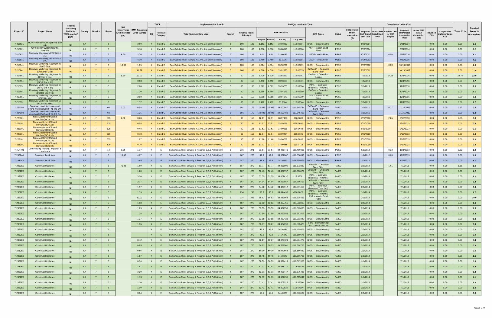
Beg PM End PM Lat. (N) Long. (W)
Revoked CUs
Total CUsTreated Areas in
WatershedRBPollutant Category
Total Maximum Daily Load Reach #Final SB Reach
Priority #
Compliance Units (CUs)
Cooperative Imple-
mentation ($)
Cooperative Implementation
CUs
Proposed BMP Install Start Date
Actual BMP Install Start
Date
Credited CUs for BMP Project
Proposed BMP Install Completion
Date
Actual BMP Install
Completion Date
Net Impervious
Area Increase (ac)
BMP Treatment Area (acres)
TMDL Implementation Reach BMP(s)Location & Type
BMP LocationsBMP Types Status
RouteProject ID Project Name
Retrofit (installing BMPs for
TMDLs only)? (Y/N)
County District
7-215921HOV Freeway Widening(BIOS Site
#4) No LA 7 5 3.60 4 C and G San Gabriel River (Metals (Cu, Pb, Zn) and Selenium) 6 108 183 1.152 1.152 33.88362 -118.02804 BIOS - Bioswale/strip PS&E 8/26/2014 3/21/2014 0.00 0.00 0.00 3.6
7-215921HOV Freeway Widening(Other-
Site #7) No LA 7 5 3.18 4 C and G San Gabriel River (Metals (Cu, Pb, Zn) and Selenium) 6 108 183 1.338 1.338 33.88515 -118.03086ASF - Austin Sand
FilterPS&E 8/26/2014 3/21/2014 0.00 0.00 0.00 3.2
7-215931Roadway Widening(MEDF Site #
21) No LA 7 5 9.60 3.70 4 C and G San Gabriel River (Metals (Cu, Pb, Zn) and Selenium) 6 108 183 3.41 3.41 33.90192 -118.06104 MEDF - Media Filter PS&E 9/14/2012 0.00 4/22/2016 0.00 0.00 0.00 3.7
7-215931Roadway Widening(MEDF Site #
22) No LA 7 5 4.10 4 C and G San Gabriel River (Metals (Cu, Pb, Zn) and Selenium) 6 108 183 3.469 3.469 33.9025 -118.06184 MEDF - Media Filter PS&E 9/14/2012 4/22/2016 0.00 0.00 0.00 4.1
7-215941Roadway Widening (Segment 4)
(BIOS 26a) No LA 7 5 18.90 1.85 4 C and G San Gabriel River (Metals (Cu, Pb, Zn) and Selenium) 6 108 183 4.614 4.614 33.90261 -118.08231 BIOS - Bioswale/strip PS&E 8/28/2012 0.00 10/13/2017 0.00 0.00 0.00 1.9
7-215941Roadway Widening (Segment 4)
(DelSandF 28a) No LA 7 5 11.39 4 C and G San Gabriel River (Metals (Cu, Pb, Zn) and Selenium) 6 108 183 4.618 4.618 33.91375 -118.07635DelSandF - Delaware
Sand FilterPS&E 8/28/2012 10/13/2017 0.00 0.00 0.00 11.4
7-215951Roadway Widening (Segment 5)
(DetBas # 34a) No LA 7 5 5.60 22.00 4 C and G San Gabriel River (Metals (Cu, Pb, Zn) and Selenium) 3 90 156 6.729 6.729 33.93967 -118.09561DetBas - Detention
BasinsPS&E 7/1/2013 24.75 12/1/2016 0.00 0.00 24.75 22.0
7-215951Roadway Widening (Segment 5)
(BIOS Site # 36) No LA 7 5 0.68 4 C and G San Gabriel River (Metals (Cu, Pb, Zn) and Selenium) 3 90 156 6.492 6.492 33.93665 -118.09361 BIOS - Bioswale/strip PS&E 7/1/2013 12/1/2016 0.00 0.00 0.00 0.7
7-215951Roadway Widening (Segment 5)
(INFIL Site # 37) No LA 7 5 2.60 4 C and G San Gabriel River (Metals (Cu, Pb, Zn) and Selenium) 3 90 156 6.522 6.522 33.93703 -118.09386INFIL - Infiltration
(Basins & Trenches)PS&E 7/1/2013 12/1/2016 0.00 0.00 0.00 2.6
7-215951Roadway Widening (Segment 5)
(DetBas Site #43) No LA 7 5 1.10 4 C and G San Gabriel River (Metals (Cu, Pb, Zn) and Selenium) 3 90 156 6.888 6.888 33.94175 -118.09699DetBas - Detention
BasinsPS&E 7/1/2013 12/1/2016 0.00 0.00 0.00 1.1
7-215951Roadway Widening (Segment 5)
(ASF Site #44) No LA 7 5 2.80 4 C and G San Gabriel River (Metals (Cu, Pb, Zn) and Selenium) 3 90 156 6.888 6.888 33.94175 -118.09699ASF - Austin Sand
FilterPS&E 7/1/2013 12/1/2016 0.00 0.00 0.00 2.8
7-215951Roadway Widening (Segment 5)
(BIOS Site #36a) No LA 7 5 1.17 4 C and G San Gabriel River (Metals (Cu, Pb, Zn) and Selenium) 3 90 156 6.472 6.472 33.9364 -118.09344 BIOS - Bioswale/strip PS&E 7/1/2013 12/1/2016 0.00 0.00 0.00 1.2
7-224100Construct new interchance and
sound walls(DelSandF #1-WB On- No LA 7 60 2.02 0.94 4 C and G San Gabriel River (Metals (Cu, Pb, Zn) and Selenium) 5 101 173 22.942 22.942 34.000947 -117.845744DelSandF - Delaware
Sand FilterPA/ED 3/1/2011 0.17 11/15/2012 0.00 0.00 0.17 0.9
7-224100Construct new interchance and
sound walls(DelSandF #2-EB On- No LA 7 60 1.25 4 C and G San Gabriel River (Metals (Cu, Pb, Zn) and Selenium) 5 101 173 22.946 22.946 34.000483 -117.845458DelSandF - Delaware
Sand FilterPA/ED 3/1/2011 11/15/2012 0.00 0.00 0.00 1.3
7-223101Noise Abatement/Sound
Barriers(BIOS 20) No LA 7 605 2.00 0.28 4 C and G San Gabriel River (Metals (Cu, Pb, Zn) and Selenium) 3 90 156 12.11 12.11 33.97486 -118.0808 BIOS - Bioswale/strip PS&E 6/21/2010 2.85 2/19/2013 0.00 0.00 2.85 0.3
7-223101Noise Abatement/Sound
Barriers(BIOS 28) No LA 7 605 0.58 4 C and G San Gabriel River (Metals (Cu, Pb, Zn) and Selenium) 3 90 156 13.51 13.51 33.99238 -118.0691 BIOS - Bioswale/strip PS&E 6/21/2010 2/19/2013 0.00 0.00 0.00 0.6
7-223101Noise Abatement/Sound
Barriers(BIOS 28) No LA 7 605 0.48 4 C and G San Gabriel River (Metals (Cu, Pb, Zn) and Selenium) 3 90 156 13.51 13.51 33.99218 -118.0688 BIOS - Bioswale/strip PS&E 6/21/2010 2/19/2013 0.00 0.00 0.00 0.5
7-223101Noise Abatement/Sound
Barriers(BIOS 30) No LA 7 605 0.78 4 C and G San Gabriel River (Metals (Cu, Pb, Zn) and Selenium) 3 90 156 13.64 13.64 33.99434 -118.0696 BIOS - Bioswale/strip PS&E 6/21/2010 2/19/2013 0.00 0.00 0.00 0.8
7-223101Noise Abatement/Sound
Barriers(BIOS 15) No LA 7 605 1.97 4 C and G San Gabriel River (Metals (Cu, Pb, Zn) and Selenium) 3 90 156 11.68 11.68 33.96768 -118.0835 BIOS - Bioswale/strip PS&E 6/21/2010 2/19/2013 0.00 0.00 0.00 2.0
7-223101Noise Abatement/Sound
Barriers(BIOS 32) No LA 7 605 0.76 4 C and G San Gabriel River (Metals (Cu, Pb, Zn) and Selenium) 3 90 156 13.73 13.73 33.99388 -118.0715 BIOS - Bioswale/strip PS&E 6/21/2010 2/19/2013 0.00 0.00 0.00 0.8
7-4U4491Landscaping Planting, Irrigation &
Hardscape No LA 7 14 0.95 1.17 4 E Santa Clara River Estuary & Reaches 3,5,6,7 (Coliform) 5 236 271 33.54 33.54 34.426746 -118.419365 BIOS - Bioswale/strip PS&E 5/1/2013 0.22 11/1/2013 0.00 0.00 0.22 1.2
7-2332A1 Construct Truck lane No LA 7 5 15.62 4.27 4 E Santa Clara River Estuary & Reaches 3,5,6,7 (Coliform) 4 187 270 49.6 49.6 34.367967 -118.558043 BIOS - Bioswale/strip PS&E 1/2/2012 0.00 10/2/2013 0.00 0.00 0.00 4.3
7-2332A1 Construct Truck lane No LA 7 5 3.65 4 E Santa Clara River Estuary & Reaches 3,5,6,7 (Coliform) 4 187 270 49.6 49.6 34.36942 -118.559576 BIOS - Bioswale/strip PS&E 1/2/2012 10/2/2013 0.00 0.00 0.00 3.7
7-2332E0 Construct Hot lanes No LA 7 5 71.38 1.60 4 E Santa Clara River Estuary & Reaches 3,5,6,7 (Coliform) 4 187 270 51.77 51.77 34.398805 -118.572382DelSandF - Delaware
Sand FilterPA/ED 2/1/2014 1.61 7/1/2018 0.00 0.00 1.61 1.6
7-2332E0 Construct Hot lanes No LA 7 5 1.20 4 E Santa Clara River Estuary & Reaches 3,5,6,7 (Coliform) 4 187 270 52.43 52.43 34.407797 -118.576079DelSandF - Delaware
Sand FilterPA/ED 2/1/2014 7/1/2018 0.00 0.00 0.00 1.2
7-2332E0 Construct Hot lanes No LA 7 5 3.20 4 E Santa Clara River Estuary & Reaches 3,5,6,7 (Coliform) 4 187 270 52.55 52.55 34.409437 -118.57681INFIL - Infiltration
(Basins & Trenches)PA/ED 2/1/2014 7/1/2018 0.00 0.00 0.00 3.2
7-2332E0 Construct Hot lanes No LA 7 5 2.37 4 E Santa Clara River Estuary & Reaches 3,5,6,7 (Coliform) 4 187 270 54.04 54.04 34.429557 -118.586715DelSandF - Delaware
Sand FilterPA/ED 2/1/2014 7/1/2018 0.00 0.00 0.00 2.4
7-2332E0 Construct Hot lanes No LA 7 5 1.97 4 E Santa Clara River Estuary & Reaches 3,5,6,7 (Coliform) 4 187 270 54.42 54.42 34.434112 -118.591656INFIL - Infiltration
(Basins & Trenches)PA/ED 2/1/2014 7/1/2018 0.00 0.00 0.00 2.0
7-2332E0 Construct Hot lanes No LA 7 5 1.73 4 E Santa Clara River Estuary & Reaches 3,5,6,7 (Coliform) 6 234 298 55.5 55.5 34.444433 -118.6078INFIL - Infiltration
(Basins & Trenches)PA/ED 2/1/2014 7/1/2018 0.00 0.00 0.00 1.7
7-2332E0 Construct Hot lanes No LA 7 5 10.02 4 E Santa Clara River Estuary & Reaches 3,5,6,7 (Coliform) 6 234 298 58.53 58.53 34.483863 -118.615296ASF - Austin Sand
FilterPA/ED 2/1/2014 7/1/2018 0.00 0.00 0.00 10.0
7-2332E0 Construct Hot lanes No LA 7 5 1.58 4 E Santa Clara River Estuary & Reaches 3,5,6,7 (Coliform) 4 187 270 53.53 53.53 34.422756 -118.583095 BIOS - Bioswale/strip PA/ED 2/1/2014 7/1/2018 0.00 0.00 0.00 1.6
7-2332E0 Construct Hot lanes No LA 7 5 1.29 4 E Santa Clara River Estuary & Reaches 3,5,6,7 (Coliform) 4 187 270 53.53 53.53 34.422756 -118.583095 BIOS - Bioswale/strip PA/ED 2/1/2014 7/1/2018 0.00 0.00 0.00 1.3
7-2332E0 Construct Hot lanes No LA 7 5 1.28 4 E Santa Clara River Estuary & Reaches 3,5,6,7 (Coliform) 4 187 270 53.59 53.59 34.423553 -118.583512 BIOS - Bioswale/strip PA/ED 2/1/2014 7/1/2018 0.00 0.00 0.00 1.3
7-2332E0 Construct Hot lanes No LA 7 5 1.27 4 E Santa Clara River Estuary & Reaches 3,5,6,7 (Coliform) 4 187 270 53.58 53.58 34.423423 -118.583445 BIOS - Bioswale/strip PA/ED 2/1/2014 7/1/2018 0.00 0.00 0.00 1.3
7-2332E0 Construct Hot lanes No LA 7 5 1.95 4 E Santa Clara River Estuary & Reaches 3,5,6,7 (Coliform) 4 187 270 53.87 53.87 34.427293 -118.585429BIOS - Bioswale/strip and GSRDS - Gross
PA/ED 2/1/2014 7/1/2018 0.00 0.00 0.00 2.0
7-2332E0 Construct Hot lanes No LA 7 5 4 E Santa Clara River Estuary & Reaches 3,5,6,7 (Coliform) 4 187 270 49.6 49.6 34.36942 -118.559576 BIOS - Bioswale/strip PA/ED 2/1/2014 7/1/2018 0.00 0.00 0.00 0.0
7-2332E0 Construct Hot lanes No LA 7 5 4 E Santa Clara River Estuary & Reaches 3,5,6,7 (Coliform) 4 187 270 49.6 49.6 34.36942 -118.559576 BIOS - Bioswale/strip PA/ED 2/1/2014 7/1/2018 0.00 0.00 0.00 0.0
7-2332E0 Construct Hot lanes No LA 7 5 0.42 4 E Santa Clara River Estuary & Reaches 3,5,6,7 (Coliform) 4 187 270 50.17 50.17 34.376729 -118.564272 BIOS - Bioswale/strip PA/ED 2/1/2014 7/1/2018 0.00 0.00 0.00 0.4
7-2332E0 Construct Hot lanes No LA 7 5 0.85 4 E Santa Clara River Estuary & Reaches 3,5,6,7 (Coliform) 4 187 270 50.23 50.23 34.377501 -118.564765 BIOS - Bioswale/strip PA/ED 2/1/2014 7/1/2018 0.00 0.00 0.00 0.9
7-2332E0 Construct Hot lanes No LA 7 5 0.55 4 E Santa Clara River Estuary & Reaches 3,5,6,7 (Coliform) 4 187 270 50.39 50.39 34.379555 -118.566059 BIOS - Bioswale/strip PA/ED 2/1/2014 7/1/2018 0.00 0.00 0.00 0.6
7-2332E0 Construct Hot lanes No LA 7 5 1.57 4 E Santa Clara River Estuary & Reaches 3,5,6,7 (Coliform) 4 187 270 50.48 50.48 34.38073 -118.566706 BIOS - Bioswale/strip PA/ED 2/1/2014 7/1/2018 0.00 0.00 0.00 1.6
7-2332E0 Construct Hot lanes No LA 7 5 0.54 4 E Santa Clara River Estuary & Reaches 3,5,6,7 (Coliform) 4 187 270 50.53 50.53 34.381413 -118.567003 BIOS - Bioswale/strip PA/ED 2/1/2014 7/1/2018 0.00 0.00 0.00 0.5
7-2332E0 Construct Hot lanes No LA 7 5 1.91 4 E Santa Clara River Estuary & Reaches 3,5,6,7 (Coliform) 4 187 270 51.01 51.01 34.388271 -118.56979 BIOS - Bioswale/strip PA/ED 2/1/2014 7/1/2018 0.00 0.00 0.00 1.9
7-2332E0 Construct Hot lanes No LA 7 5 3.20 4 E Santa Clara River Estuary & Reaches 3,5,6,7 (Coliform) 4 187 270 52.33 52.33 34.406447 -118.575485 BIOS - Bioswale/strip PA/ED 2/1/2014 7/1/2018 0.00 0.00 0.00 3.2
7-2332E0 Construct Hot lanes No LA 7 5 1.13 4 E Santa Clara River Estuary & Reaches 3,5,6,7 (Coliform) 4 187 270 52.39 52.39 34.407256 -118.575841 BIOS - Bioswale/strip PA/ED 2/1/2014 7/1/2018 0.00 0.00 0.00 1.1
7-2332E0 Construct Hot lanes No LA 7 5 2.30 4 E Santa Clara River Estuary & Reaches 3,5,6,7 (Coliform) 4 187 270 52.41 52.41 34.407526 -118.57596 BIOS - Bioswale/strip PA/ED 2/1/2014 7/1/2018 0.00 0.00 0.00 2.3
7-2332E0 Construct Hot lanes No LA 7 5 1.00 4 E Santa Clara River Estuary & Reaches 3,5,6,7 (Coliform) 4 187 270 52.41 52.41 34.407526 -118.57596 BIOS - Bioswale/strip PA/ED 2/1/2014 7/1/2018 0.00 0.00 0.00 1.0
7-2332E0 Construct Hot lanes No LA 7 5 0.64 4 E Santa Clara River Estuary & Reaches 3,5,6,7 (Coliform) 4 187 270 52.5 52.5 34.40875 -118.576502 BIOS - Bioswale/strip PA/ED 2/1/2014 7/1/2018 0.00 0.00 0.00 0.6
Page 75 of 77

Beg PM End PM Lat. (N) Long. (W)
Revoked CUs
Total CUsTreated Areas in
WatershedRBPollutant Category
Total Maximum Daily Load Reach #Final SB Reach
Priority #
Compliance Units (CUs)
Cooperative Imple-
mentation ($)
Cooperative Implementation
CUs
Proposed BMP Install Start Date
Actual BMP Install Start
Date
Credited CUs for BMP Project
Proposed BMP Install Completion
Date
Actual BMP Install
Completion Date
Net Impervious
Area Increase (ac)
BMP Treatment Area (acres)
TMDL Implementation Reach BMP(s)Location & Type
BMP LocationsBMP Types Status
RouteProject ID Project Name
Retrofit (installing BMPs for
TMDLs only)? (Y/N)
County District
7-2332E0 Construct Hot lanes No LA 7 5 9.14 4 E Santa Clara River Estuary & Reaches 3,5,6,7 (Coliform) 4 187 270 53.17 53.17 34.41797 -118.58056 BIOS - Bioswale/strip PA/ED 2/1/2014 7/1/2018 0.00 0.00 0.00 9.1
7-2332E0 Construct Hot lanes No LA 7 5 1.23 4 E Santa Clara River Estuary & Reaches 3,5,6,7 (Coliform) 4 187 270 54.22 54.22 34.431637 -118.588726 BIOS - Bioswale/strip PA/ED 2/1/2014 7/1/2018 0.00 0.00 0.00 1.2
7-2332E0 Construct Hot lanes No LA 7 5 3.26 4 E Santa Clara River Estuary & Reaches 3,5,6,7 (Coliform) 4 187 270 54.42 54.42 34.434112 -118.591656 BIOS - Bioswale/strip PA/ED 2/1/2014 7/1/2018 0.00 0.00 0.00 3.3
7-2332E0 Construct Hot lanes No LA 7 5 0.41 4 E Santa Clara River Estuary & Reaches 3,5,6,7 (Coliform) 4 187 270 54.55 54.55 34.435727 -118.59356 BIOS - Bioswale/strip PA/ED 2/1/2014 7/1/2018 0.00 0.00 0.00 0.4
7-2332E0 Construct Hot lanes No LA 7 5 0.97 4 E Santa Clara River Estuary & Reaches 3,5,6,7 (Coliform) 4 187 270 54.55 54.55 34.435727 -118.59356 BIOS - Bioswale/strip PA/ED 2/1/2014 7/1/2018 0.00 0.00 0.00 1.0
7-2332E0 Construct Hot lanes No LA 7 5 0.67 4 E Santa Clara River Estuary & Reaches 3,5,6,7 (Coliform) 4 187 270 55.12 55.12 34.441749 -118.602629 BIOS - Bioswale/strip PA/ED 2/1/2014 7/1/2018 0.00 0.00 0.00 0.7
7-2332E0 Construct Hot lanes No LA 7 5 0.89 4 E Santa Clara River Estuary & Reaches 3,5,6,7 (Coliform) 4 187 270 55.33 55.33 34.443469 -118.60594 BIOS - Bioswale/strip PA/ED 2/1/2014 7/1/2018 0.00 0.00 0.00 0.9
7-2332E0 Construct Hot lanes No LA 7 5 0.74 4 E Santa Clara River Estuary & Reaches 3,5,6,7 (Coliform) 6 234 298 55.39 55.39 34.44381 -118.606597 BIOS - Bioswale/strip PA/ED 2/1/2014 7/1/2018 0.00 0.00 0.00 0.7
7-2332E0 Construct Hot lanes No LA 7 5 1.79 4 E Santa Clara River Estuary & Reaches 3,5,6,7 (Coliform) 6 234 298 55.39 55.39 34.44381 -118.606597 BIOS - Bioswale/strip PA/ED 2/1/2014 7/1/2018 0.00 0.00 0.00 1.8
7-2332E0 Construct Hot lanes No LA 7 5 0.99 4 E Santa Clara River Estuary & Reaches 3,5,6,7 (Coliform) 6 234 298 55.57 55.57 34.44483 -118.608566 BIOS - Bioswale/strip PA/ED 2/1/2014 7/1/2018 0.00 0.00 0.00 1.0
7-2332E0 Construct Hot lanes No LA 7 5 2.84 4 E Santa Clara River Estuary & Reaches 3,5,6,7 (Coliform) 6 234 298 55.57 55.57 34.44483 -118.608566 BIOS - Bioswale/strip PA/ED 2/1/2014 7/1/2018 0.00 0.00 0.00 2.8
7-2332E0 Construct Hot lanes No LA 7 5 0.72 4 E Santa Clara River Estuary & Reaches 3,5,6,7 (Coliform) 6 234 298 55.83 55.83 34.446791 -118.611082 BIOS - Bioswale/strip PA/ED 2/1/2014 7/1/2018 0.00 0.00 0.00 0.7
7-2332E0 Construct Hot lanes No LA 7 5 0.51 4 E Santa Clara River Estuary & Reaches 3,5,6,7 (Coliform) 6 234 298 56.55 56.55 34.455272 -118.61599 BIOS - Bioswale/strip PA/ED 2/1/2014 7/1/2018 0.00 0.00 0.00 0.5
7-2332E0 Construct Hot lanes No LA 7 5 0.83 4 E Santa Clara River Estuary & Reaches 3,5,6,7 (Coliform) 6 234 298 56.55 56.55 34.455272 -118.61599 BIOS - Bioswale/strip PA/ED 2/1/2014 7/1/2018 0.00 0.00 0.00 0.8
7-2332E0 Construct Hot lanes No LA 7 5 1.14 4 E Santa Clara River Estuary & Reaches 3,5,6,7 (Coliform) 6 234 298 56.64 56.64 34.456583 -118.615996 BIOS - Bioswale/strip PA/ED 2/1/2014 7/1/2018 0.00 0.00 0.00 1.1
7-2332E0 Construct Hot lanes No LA 7 5 0.98 4 E Santa Clara River Estuary & Reaches 3,5,6,7 (Coliform) 6 234 298 56.68 56.68 34.457166 -118.615933 BIOS - Bioswale/strip PA/ED 2/1/2014 7/1/2018 0.00 0.00 0.00 1.0
7-2332E0 Construct Hot lanes No LA 7 5 2.31 4 E Santa Clara River Estuary & Reaches 3,5,6,7 (Coliform) 4 187 270 53.73 53.73 34.425413 -118.584445 BIOS - Bioswale/strip PA/ED 2/1/2014 7/1/2018 0.00 0.00 0.00 2.3
7-240801Modification of Golden Valley
Road Interchange BIOS No LA 7 14 0.70 0.32 4 E Santa Clara River Estuary & Reaches 3,5,6,7 (Coliform) 5 236 271 29.62 29.62 34.393572 -118.470078 BIOS - Bioswale/strip PS&E 10/20/2014 2.31 12/16/2015 0.00 0.00 2.31 0.3
7-240801Modification of Golden Valley
Road Interchange MEDF No LA 7 14 2.69 4 E Santa Clara River Estuary & Reaches 3,5,6,7 (Coliform) 5 236 271 29.8 29.8 34.393412 -118.472157 MEDF - Media Filter PS&E 10/20/2014 12/16/2015 0.00 0.00 0.00 2.7
7-259201Construct Austin Sand Filters ASF
#1 Yes LA 7 10 N/A 8.26 4 C Santa Monica Bay (DDTs and PCBs) 6 46 103 8.83 8.83 34.036409 -118.379397ASF - Austin Sand
FilterPS&E 10/1/2013 8.26 12/15/2014 0.00 0.00 8.26 8.3
7-259201Construct Austin Sand Filters ASF
#2 Yes LA 7 10 N/A 3.67 4 C Santa Monica Bay (DDTs and PCBs) 6 46 103 10.43 10.43 34.033552 -118.351074ASF - Austin Sand
FilterPS&E 10/1/2013 3.67 12/15/2014 0.00 0.00 3.67 3.7
7-259201Construct Austin Sand Filters ASF
#3 Yes LA 7 10 N/A 3.67 4 C Santa Monica Bay (DDTs and PCBs) 6 46 103 10.43 10.43 34.035056 -118.349338ASF - Austin Sand
FilterPS&E 10/1/2013 3.67 12/15/2014 0.00 0.00 3.67 3.7
7-259201Construct Austin Sand Filters ASF
#4 Yes LA 7 10 N/A 2.75 4 C Santa Monica Bay (DDTs and PCBs) 6 46 103 13.46 13.46 34.035056 -118.349338ASF - Austin Sand
FilterPS&E 10/1/2013 2.75 12/15/2014 0.00 0.00 2.75 2.8
7-242301 Modify Interchange ASF #1 No LA 7 101 1.10 3.67 4 C Santa Monica Bay (DDTs and PCBs) 3 181 263 31.9 31.9 34.141274 -118.710191ASF - Austin Sand
FilterPS&E 2/1/2015 5.32 11/30/2016 0.00 0.00 5.32 3.7
7-242301 Modify Interchange BIOS #1 No LA 7 101 0.95 4 C Santa Monica Bay (DDTs and PCBs) 3 181 263 31.6 31.6 34.14172 -118.708448 BIOS - Bioswale/strip PS&E 2/1/2015 11/30/2016 0.00 0.00 0.00 1.0
7-242301Modify Interchange BIOS #2 &
GSRD #1 No LA 7 101 1.30 4 C Santa Monica Bay (DDTs and PCBs) 3 181 263 31.8 31.8 34.140891 -118.708498BIOS - Bioswale/strip and GSRDS - Gross
PS&E 2/1/2015 11/30/2016 0.00 0.00 0.00 1.3
7-242301Modify Interchange BIOS #3 &
GSRD #2 No LA 7 101 0.50 4 C Santa Monica Bay (DDTs and PCBs) 3 181 263 32 32 34.140763 -118.709034BIOS - Bioswale/strip and GSRDS - Gross
PS&E 2/1/2015 11/30/2016 0.00 0.00 0.00 0.5
7-259201Construct Austin Sand Filters ASF
#1 Yes LA 7 10 N/A 8.26 4 E Santa Monica Bay Beaches (Bacteria) 6 46 104 8.83 8.83 34.036409 -118.379397ASF - Austin Sand
FilterPS&E 10/1/2013 8.26 12/15/2014 0.00 0.00 8.26 8.3
7-259201Construct Austin Sand Filters ASF
#2 Yes LA 7 10 N/A 3.67 4 E Santa Monica Bay Beaches (Bacteria) 6 46 104 10.43 10.43 34.033552 -118.351074ASF - Austin Sand
FilterPS&E 10/1/2013 3.67 12/15/2014 0.00 0.00 3.67 3.7
7-259201Construct Austin Sand Filters ASF
#3 Yes LA 7 10 N/A 3.67 4 E Santa Monica Bay Beaches (Bacteria) 6 46 104 10.43 10.43 34.035056 -118.349338ASF - Austin Sand
FilterPS&E 10/1/2013 3.67 12/15/2014 0.00 0.00 3.67 3.7
7-259201Construct Austin Sand Filters ASF
#4 Yes LA 7 10 N/A 2.75 4 E Santa Monica Bay Beaches (Bacteria) 6 46 104 13.46 13.46 34.035056 -118.349338ASF - Austin Sand
FilterPS&E 10/1/2013 2.75 12/15/2014 0.00 0.00 2.75 2.8
7-242301 Modify Interchange ASF #1 No LA 7 101 1.10 3.67 4 E Santa Monica Bay Beaches (Bacteria) 3 181 264 31.9 31.9 34.141274 -118.710191ASF - Austin Sand
FilterPS&E 2/1/2015 5.32 11/30/2016 0.00 0.00 5.32 3.7
7-242301 Modify Interchange BIOS #1 No LA 7 101 0.95 4 E Santa Monica Bay Beaches (Bacteria) 3 181 264 31.6 31.6 34.14172 -118.708448 BIOS - Bioswale/strip PS&E 2/1/2015 11/30/2016 0.00 0.00 0.00 1.0
7-242301Modify Interchange BIOS #2 &
GSRD #1 No LA 7 101 1.30 4 E Santa Monica Bay Beaches (Bacteria) 3 181 264 31.8 31.8 34.140891 -118.708498BIOS - Bioswale/strip and GSRDS - Gross
PS&E 2/1/2015 11/30/2016 0.00 0.00 0.00 1.3
7-242301Modify Interchange BIOS #3 &
GSRD #2 No LA 7 101 0.50 4 E Santa Monica Bay Beaches (Bacteria) 3 181 264 32 32 34.140763 -118.709034BIOS - Bioswale/strip and GSRDS - Gross
PS&E 2/1/2015 11/30/2016 0.00 0.00 0.00 0.5
7-2332A1 Construct Truck lane No LA 7 5 15.62 4.27 4 I Upper Santa Clara River (Chloride) 2 218 314 49.6 49.6 34.367967 -118.558043 BIOS - Bioswale/strip PS&E 1/2/2012 0.00 10/2/2013 0.00 0.00 0.00 4.3
7-2332A1 Construct Truck lane No LA 7 5 3.65 4 I Upper Santa Clara River (Chloride) 2 218 314 49.6 49.6 34.36942 -118.559576 BIOS - Bioswale/strip PS&E 1/2/2012 10/2/2013 0.00 0.00 0.00 3.7
7-2332E0 Construct Hot lanes No LA 7 5 71.38 1.60 4 I Upper Santa Clara River (Chloride) 2 218 314 51.77 51.77 34.398805 -118.572382DelSandF - Delaware
Sand FilterPA/ED 2/1/2014 1.61 7/1/2018 0.00 0.00 1.61 1.6
7-2332E0 Construct Hot lanes No LA 7 5 1.20 4 I Upper Santa Clara River (Chloride) 2 218 314 52.43 52.43 34.407797 -118.576079DelSandF - Delaware
Sand FilterPA/ED 2/1/2014 7/1/2018 0.00 0.00 0.00 1.2
7-2332E0 Construct Hot lanes No LA 7 5 3.20 4 I Upper Santa Clara River (Chloride) 2 218 314 52.55 52.55 34.409437 -118.57681INFIL - Infiltration
(Basins & Trenches)PA/ED 2/1/2014 7/1/2018 0.00 0.00 0.00 3.2
7-2332E0 Construct Hot lanes No LA 7 5 2.37 4 I Upper Santa Clara River (Chloride) 2 218 314 54.04 54.04 34.429557 -118.586715DelSandF - Delaware
Sand FilterPA/ED 2/1/2014 7/1/2018 0.00 0.00 0.00 2.4
7-2332E0 Construct Hot lanes No LA 7 5 1.97 4 I Upper Santa Clara River (Chloride) 2 218 314 54.42 54.42 34.434112 -118.591656INFIL - Infiltration
(Basins & Trenches)PA/ED 2/1/2014 7/1/2018 0.00 0.00 0.00 2.0
7-2332E0 Construct Hot lanes No LA 7 5 1.73 4 I Upper Santa Clara River (Chloride) 1 219 315 55.5 55.5 34.444433 -118.6078INFIL - Infiltration
(Basins & Trenches)PA/ED 2/1/2014 7/1/2018 0.00 0.00 0.00 1.7
7-2332E0 Construct Hot lanes No LA 7 5 10.02 4 I Upper Santa Clara River (Chloride) 1 219 315 58.53 58.53 34.483863 -118.615296ASF - Austin Sand
FilterPA/ED 2/1/2014 7/1/2018 0.00 0.00 0.00 10.0
7-2332E0 Construct Hot lanes No LA 7 5 1.58 4 I Upper Santa Clara River (Chloride) 2 218 314 53.53 53.53 34.422756 -118.583095 BIOS - Bioswale/strip PA/ED 2/1/2014 7/1/2018 0.00 0.00 0.00 1.6
7-2332E0 Construct Hot lanes No LA 7 5 1.29 4 I Upper Santa Clara River (Chloride) 2 218 314 53.53 53.53 34.422756 -118.583095 BIOS - Bioswale/strip PA/ED 2/1/2014 7/1/2018 0.00 0.00 0.00 1.3
7-2332E0 Construct Hot lanes No LA 7 5 1.28 4 I Upper Santa Clara River (Chloride) 2 218 314 53.59 53.59 34.423553 -118.583512 BIOS - Bioswale/strip PA/ED 2/1/2014 7/1/2018 0.00 0.00 0.00 1.3
7-2332E0 Construct Hot lanes No LA 7 5 1.27 4 I Upper Santa Clara River (Chloride) 2 218 314 53.58 53.58 34.423423 -118.583445 BIOS - Bioswale/strip PA/ED 2/1/2014 7/1/2018 0.00 0.00 0.00 1.3
Page 76 of 77
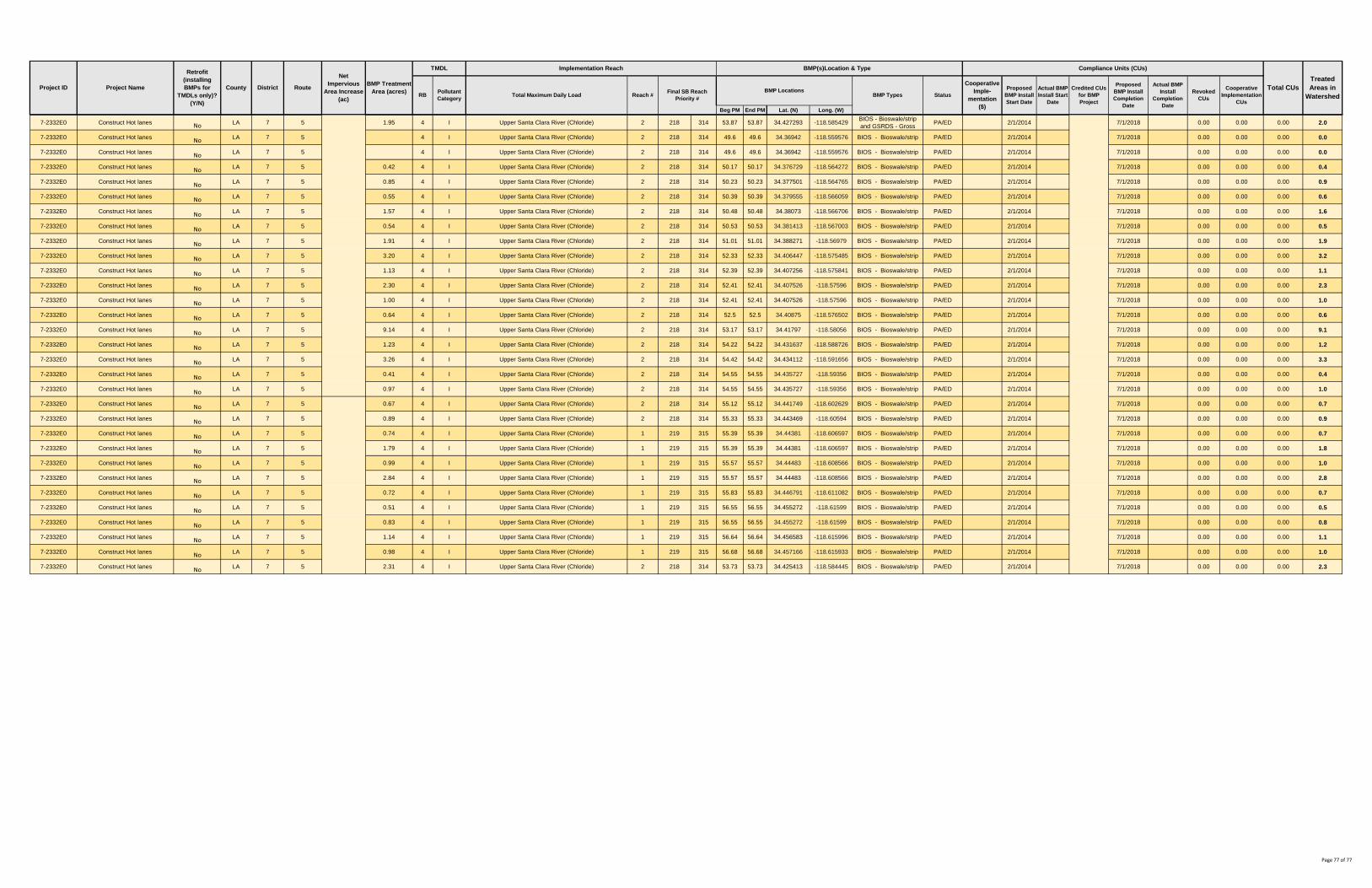
Beg PM End PM Lat. (N) Long. (W)
Revoked CUs
Total CUsTreated Areas in
WatershedRBPollutant Category
Total Maximum Daily Load Reach #Final SB Reach
Priority #
Compliance Units (CUs)
Cooperative Imple-
mentation ($)
Cooperative Implementation
CUs
Proposed BMP Install Start Date
Actual BMP Install Start
Date
Credited CUs for BMP Project
Proposed BMP Install Completion
Date
Actual BMP Install
Completion Date
Net Impervious
Area Increase (ac)
BMP Treatment Area (acres)
TMDL Implementation Reach BMP(s)Location & Type
BMP LocationsBMP Types Status
RouteProject ID Project Name
Retrofit (installing BMPs for
TMDLs only)? (Y/N)
County District
7-2332E0 Construct Hot lanes No LA 7 5 1.95 4 I Upper Santa Clara River (Chloride) 2 218 314 53.87 53.87 34.427293 -118.585429BIOS - Bioswale/strip and GSRDS - Gross
PA/ED 2/1/2014 7/1/2018 0.00 0.00 0.00 2.0
7-2332E0 Construct Hot lanes No LA 7 5 4 I Upper Santa Clara River (Chloride) 2 218 314 49.6 49.6 34.36942 -118.559576 BIOS - Bioswale/strip PA/ED 2/1/2014 7/1/2018 0.00 0.00 0.00 0.0
7-2332E0 Construct Hot lanes No LA 7 5 4 I Upper Santa Clara River (Chloride) 2 218 314 49.6 49.6 34.36942 -118.559576 BIOS - Bioswale/strip PA/ED 2/1/2014 7/1/2018 0.00 0.00 0.00 0.0
7-2332E0 Construct Hot lanes No LA 7 5 0.42 4 I Upper Santa Clara River (Chloride) 2 218 314 50.17 50.17 34.376729 -118.564272 BIOS - Bioswale/strip PA/ED 2/1/2014 7/1/2018 0.00 0.00 0.00 0.4
7-2332E0 Construct Hot lanes No LA 7 5 0.85 4 I Upper Santa Clara River (Chloride) 2 218 314 50.23 50.23 34.377501 -118.564765 BIOS - Bioswale/strip PA/ED 2/1/2014 7/1/2018 0.00 0.00 0.00 0.9
7-2332E0 Construct Hot lanes No LA 7 5 0.55 4 I Upper Santa Clara River (Chloride) 2 218 314 50.39 50.39 34.379555 -118.566059 BIOS - Bioswale/strip PA/ED 2/1/2014 7/1/2018 0.00 0.00 0.00 0.6
7-2332E0 Construct Hot lanes No LA 7 5 1.57 4 I Upper Santa Clara River (Chloride) 2 218 314 50.48 50.48 34.38073 -118.566706 BIOS - Bioswale/strip PA/ED 2/1/2014 7/1/2018 0.00 0.00 0.00 1.6
7-2332E0 Construct Hot lanes No LA 7 5 0.54 4 I Upper Santa Clara River (Chloride) 2 218 314 50.53 50.53 34.381413 -118.567003 BIOS - Bioswale/strip PA/ED 2/1/2014 7/1/2018 0.00 0.00 0.00 0.5
7-2332E0 Construct Hot lanes No LA 7 5 1.91 4 I Upper Santa Clara River (Chloride) 2 218 314 51.01 51.01 34.388271 -118.56979 BIOS - Bioswale/strip PA/ED 2/1/2014 7/1/2018 0.00 0.00 0.00 1.9
7-2332E0 Construct Hot lanes No LA 7 5 3.20 4 I Upper Santa Clara River (Chloride) 2 218 314 52.33 52.33 34.406447 -118.575485 BIOS - Bioswale/strip PA/ED 2/1/2014 7/1/2018 0.00 0.00 0.00 3.2
7-2332E0 Construct Hot lanes No LA 7 5 1.13 4 I Upper Santa Clara River (Chloride) 2 218 314 52.39 52.39 34.407256 -118.575841 BIOS - Bioswale/strip PA/ED 2/1/2014 7/1/2018 0.00 0.00 0.00 1.1
7-2332E0 Construct Hot lanes No LA 7 5 2.30 4 I Upper Santa Clara River (Chloride) 2 218 314 52.41 52.41 34.407526 -118.57596 BIOS - Bioswale/strip PA/ED 2/1/2014 7/1/2018 0.00 0.00 0.00 2.3
7-2332E0 Construct Hot lanes No LA 7 5 1.00 4 I Upper Santa Clara River (Chloride) 2 218 314 52.41 52.41 34.407526 -118.57596 BIOS - Bioswale/strip PA/ED 2/1/2014 7/1/2018 0.00 0.00 0.00 1.0
7-2332E0 Construct Hot lanes No LA 7 5 0.64 4 I Upper Santa Clara River (Chloride) 2 218 314 52.5 52.5 34.40875 -118.576502 BIOS - Bioswale/strip PA/ED 2/1/2014 7/1/2018 0.00 0.00 0.00 0.6
7-2332E0 Construct Hot lanes No LA 7 5 9.14 4 I Upper Santa Clara River (Chloride) 2 218 314 53.17 53.17 34.41797 -118.58056 BIOS - Bioswale/strip PA/ED 2/1/2014 7/1/2018 0.00 0.00 0.00 9.1
7-2332E0 Construct Hot lanes No LA 7 5 1.23 4 I Upper Santa Clara River (Chloride) 2 218 314 54.22 54.22 34.431637 -118.588726 BIOS - Bioswale/strip PA/ED 2/1/2014 7/1/2018 0.00 0.00 0.00 1.2
7-2332E0 Construct Hot lanes No LA 7 5 3.26 4 I Upper Santa Clara River (Chloride) 2 218 314 54.42 54.42 34.434112 -118.591656 BIOS - Bioswale/strip PA/ED 2/1/2014 7/1/2018 0.00 0.00 0.00 3.3
7-2332E0 Construct Hot lanes No LA 7 5 0.41 4 I Upper Santa Clara River (Chloride) 2 218 314 54.55 54.55 34.435727 -118.59356 BIOS - Bioswale/strip PA/ED 2/1/2014 7/1/2018 0.00 0.00 0.00 0.4
7-2332E0 Construct Hot lanes No LA 7 5 0.97 4 I Upper Santa Clara River (Chloride) 2 218 314 54.55 54.55 34.435727 -118.59356 BIOS - Bioswale/strip PA/ED 2/1/2014 7/1/2018 0.00 0.00 0.00 1.0
7-2332E0 Construct Hot lanes No LA 7 5 0.67 4 I Upper Santa Clara River (Chloride) 2 218 314 55.12 55.12 34.441749 -118.602629 BIOS - Bioswale/strip PA/ED 2/1/2014 7/1/2018 0.00 0.00 0.00 0.7
7-2332E0 Construct Hot lanes No LA 7 5 0.89 4 I Upper Santa Clara River (Chloride) 2 218 314 55.33 55.33 34.443469 -118.60594 BIOS - Bioswale/strip PA/ED 2/1/2014 7/1/2018 0.00 0.00 0.00 0.9
7-2332E0 Construct Hot lanes No LA 7 5 0.74 4 I Upper Santa Clara River (Chloride) 1 219 315 55.39 55.39 34.44381 -118.606597 BIOS - Bioswale/strip PA/ED 2/1/2014 7/1/2018 0.00 0.00 0.00 0.7
7-2332E0 Construct Hot lanes No LA 7 5 1.79 4 I Upper Santa Clara River (Chloride) 1 219 315 55.39 55.39 34.44381 -118.606597 BIOS - Bioswale/strip PA/ED 2/1/2014 7/1/2018 0.00 0.00 0.00 1.8
7-2332E0 Construct Hot lanes No LA 7 5 0.99 4 I Upper Santa Clara River (Chloride) 1 219 315 55.57 55.57 34.44483 -118.608566 BIOS - Bioswale/strip PA/ED 2/1/2014 7/1/2018 0.00 0.00 0.00 1.0
7-2332E0 Construct Hot lanes No LA 7 5 2.84 4 I Upper Santa Clara River (Chloride) 1 219 315 55.57 55.57 34.44483 -118.608566 BIOS - Bioswale/strip PA/ED 2/1/2014 7/1/2018 0.00 0.00 0.00 2.8
7-2332E0 Construct Hot lanes No LA 7 5 0.72 4 I Upper Santa Clara River (Chloride) 1 219 315 55.83 55.83 34.446791 -118.611082 BIOS - Bioswale/strip PA/ED 2/1/2014 7/1/2018 0.00 0.00 0.00 0.7
7-2332E0 Construct Hot lanes No LA 7 5 0.51 4 I Upper Santa Clara River (Chloride) 1 219 315 56.55 56.55 34.455272 -118.61599 BIOS - Bioswale/strip PA/ED 2/1/2014 7/1/2018 0.00 0.00 0.00 0.5
7-2332E0 Construct Hot lanes No LA 7 5 0.83 4 I Upper Santa Clara River (Chloride) 1 219 315 56.55 56.55 34.455272 -118.61599 BIOS - Bioswale/strip PA/ED 2/1/2014 7/1/2018 0.00 0.00 0.00 0.8
7-2332E0 Construct Hot lanes No LA 7 5 1.14 4 I Upper Santa Clara River (Chloride) 1 219 315 56.64 56.64 34.456583 -118.615996 BIOS - Bioswale/strip PA/ED 2/1/2014 7/1/2018 0.00 0.00 0.00 1.1
7-2332E0 Construct Hot lanes No LA 7 5 0.98 4 I Upper Santa Clara River (Chloride) 1 219 315 56.68 56.68 34.457166 -118.615933 BIOS - Bioswale/strip PA/ED 2/1/2014 7/1/2018 0.00 0.00 0.00 1.0
7-2332E0 Construct Hot lanes No LA 7 5 2.31 4 I Upper Santa Clara River (Chloride) 2 218 314 53.73 53.73 34.425413 -118.584445 BIOS - Bioswale/strip PA/ED 2/1/2014 7/1/2018 0.00 0.00 0.00 2.3
Page 77 of 77
Caltrans TMDL Status Review Report | October 2015
Appendix C – Caltrans Stream Crossing Survey Workplan for Napa River and Sonoma Creek

Caltrans TMDL Status Review Report | October 2015
Appendix C - Caltrans Stream Crossing Survey Workplan for Napa River and Sonoma Creek
Table of Contents 1 Purpose of the Work Plan ................................................................................................. 2 1.1 Background ....................................................................................................................... 2 1.2 Caltrans Stream Crossings ................................................................................................ 2
2 Survey Methodology......................................................................................................... 3 2.1 Desktop Survey ................................................................................................................. 3 2.2 Survey Ratings .................................................................................................................. 4 2.3 Survey Information ........................................................................................................... 4 2.4 Information Compilation .................................................................................................. 6
3 Crossing Prioritization ....................................................................................................... 6 3.1 Critical Ratings .................................................................................................................. 6 3.2 Stream Conditions ............................................................................................................ 6 3.3 Structure Conditions ......................................................................................................... 7 3.4 Surrounding Conditions .................................................................................................... 7
4 Survey and Prioritization Schedule ................................................................................... 8
5 Improvement Schedule ..................................................................................................... 8
Attachments Attachment A – Caltrans Stream Crossing Database
Attachment B – Stream Crossing Survey Form
Appendix C. Stream Crossing Survey Workplan for Napa River and Sonoma Creek | Page C-2
Caltrans TMDL Status Review Report | October 2015
1 PurposeoftheWorkPlanThe purpose of this work plan is to outline the actions the California Department of Transportation
(Caltrans) will take to comply with Attachment IV, Section 2 of the National Pollutant Discharge
Elimination System (NPDES) Statewide Storm Water Permit for State of California Department of
Transportation (Order WQ 2014‐0077‐DWQ) (Caltrans NPDES Permit) (published September 19, 2012,
effective July 1, 2013, and revised on May 20, 2014) for the Napa River and Sonoma Creek Sediment
TMDLs.
Attachment IV, Section 2 indicates that compliance shall be achieved by:
a. Submitting a plan and schedule for conducting stream crossing surveys; and
b. Submitting an implementation plan and schedule for repair and/or replacement of high priority
crossings/culverts.
The objectives of this work plan are to:
Discuss Caltrans’ approach to conducting stream crossing surveys located along the Napa River
and Sonoma Creek;
Present the methodology used to prioritize crossings for possible improvements in regard to
their impact on the Sediment TMDLs; and
Identify a schedule in which all surveys will be performed and crossings prioritized.
This work plan will consider the results and findings of surveys from other Caltrans efforts to streamline
this overall process.
1.1 BackgroundThe goals of the Napa River and Sonoma Creek Sediment TMDLs are focused on the conservation of
native aquatic species and the enhancement of the aesthetic and recreational values of the waterbodies
and their tributaries. The TMDLs identify the following three sources of waterway degradation and the
decreasing fish population:
1. High concentrations of fine sediment deposited in the streambeds cause poor incubation
conditions for fish eggs.
2. Channel incision, the progressive lowering of a streambed as a result of erosion, has increased,
causing a reduction in the amount of riffles, gravel bars, side channels, and other natural areas
that provide essential spawning habitats for native fish.
3. Low flows and stressful water temperatures due to the development of manmade structures
have negatively impacted the migration rates of native fish.
The TMDLs further state the overall contributing factor causing detrimental impacts to local fish
populations is increased sediment delivery rates and loads. An overall reduction in sediment delivery has
been enacted for each waterbody.
1.2 CaltransStreamCrossingsCaltrans estimates that there are 18 stream crossings along Sonoma Creek and 55 stream crossings
along the Napa River. Caltrans roadways that cross waterbodies in the Sonoma Creek Watershed include
State Routes 12, 37, 116, and 121. Caltrans roadways that cross waterbodies in the Napa River

Appendix C. Stream Crossing Survey Workplan for Napa River and Sonoma Creek | Page C-3
Caltrans TMDL Status Review Report | October 2015
Watershed include State Routes 12, 29, 37, 80, 121, 128, and 221. These crossings range from multilane
bridges over the main reaches to small culverts along surrounding tributaries. Caltrans is not identified
as a significant source for the contribution of increased sediment loads in these watersheds. The impact
of Caltrans' crossings is likely minor when compared to the overall watershed affecting these TMDLs.
However, per the Caltrans Permit requirements, all crossings must be inspected to determine if the
stream crossings may be contributing to the sediment TMDL. Crossings that are undersized or not
maintained may contribute to the loss of salmonid and aquatic habitat.
Stream crossings may pose a threat of increased erosion and deposition by constricting natural flow
patterns of the waterway. As flow area is reduced, approach velocities can decrease, resulting in
additional deposition on the upstream side of a crossing. The discharge may then pose a threat on the
downstream side of the crossing. Due to the upstream deposition, the discharge may be sediment
starved and may result in erosion or degradation of the downstream portion of the stream.
Furthermore, as flow through these structures become impeded by natural debris and vegetation, the
designed capacity decreases, thus increasing the rate of downstream erosion and amount of upstream
sediment deposition. The goal of this survey is to determine if Caltrans stream crossings are allowing for
the natural hydrologic and hydraulic function of the waterbodies.
2 SurveyMethodologyField surveys will be conducted to gather information about and around each crossing to prioritize
improvements for crossings deemed high priority. The conditions that will be evaluated are discussed in
Section 2.3 and the way in which the condition ratings will be interpreted will determine which crossings
are deemed high priority. Caltrans is developing a GIS map and a database with each stream crossing
location. The locations in the GIS database are currently approximated and will be field verified when
conducting surveys. Attachment A contains the database and mapped locations of all Caltrans crossings.
Each survey will focus on the physical characteristics of the stream, both upstream and downstream of
the crossing. The stability of stream banks and evidence of scour or aggradation along the streambed
will be examined. The condition of the crossing itself will also be reviewed to help determine if it is
contributing to any observed stream deficiency. Caltrans has developed a survey form, contained in
Attachment B, which will aid in the surveys.
2.1 DesktopSurveyThe most significant findings in the overall survey may come from reviewing historical records of the
Caltrans crossings. Prior to performing field surveys, a comprehensive desktop survey will be conducted
to gather existing information about the history of the crossings. Analysis of aerial imagery of each
crossing will be examined to identify any major changes to the streams and surrounding areas. Caltrans
will review the Passage Assessment Database to determine if any of these crossings have previously
been evaluated during fish passage investigation. Additionally, Caltrans will review available roadway
maintenance and bridge inspection forms for the area. This will include use of the Maintenance Culvert
Inspection GIS tool. The knowledge gained from the desktop survey will be verified while conducting the
field surveys to note any significant changes.
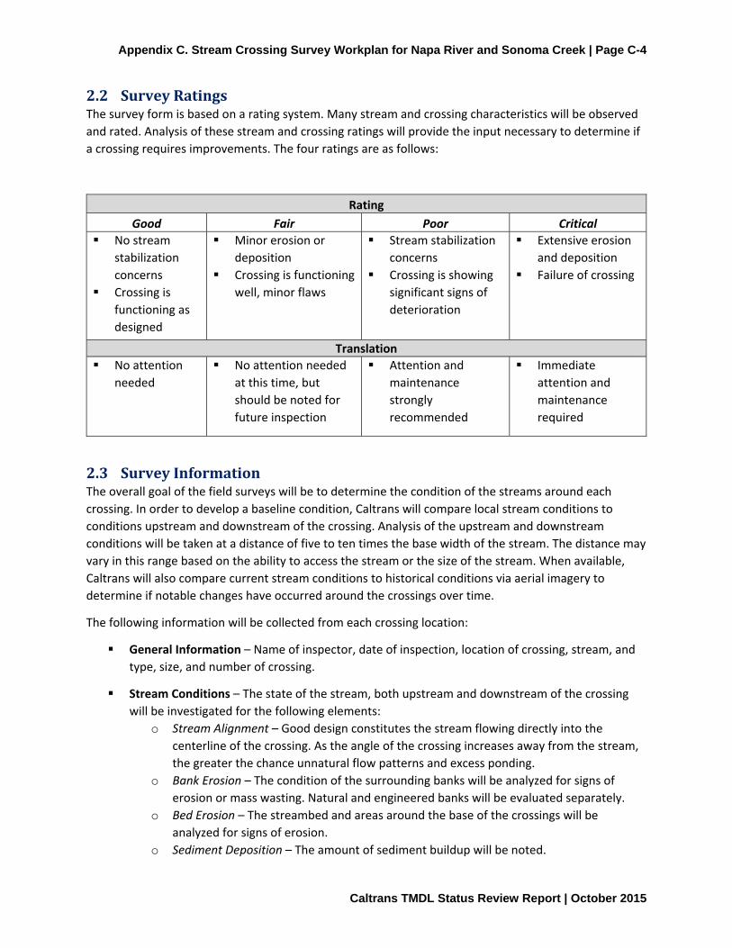
Appendix C. Stream Crossing Survey Workplan for Napa River and Sonoma Creek | Page C-4
Caltrans TMDL Status Review Report | October 2015
2.2 SurveyRatingsThe survey form is based on a rating system. Many stream and crossing characteristics will be observed
and rated. Analysis of these stream and crossing ratings will provide the input necessary to determine if
a crossing requires improvements. The four ratings are as follows:
Rating
Good Fair Poor Critical
No stream
stabilization
concerns
Crossing is
functioning as
designed
Minor erosion or
deposition
Crossing is functioning
well, minor flaws
Stream stabilization
concerns
Crossing is showing
significant signs of
deterioration
Extensive erosion
and deposition
Failure of crossing
Translation
No attention
needed
No attention needed
at this time, but
should be noted for
future inspection
Attention and
maintenance
strongly
recommended
Immediate
attention and
maintenance
required
2.3 SurveyInformationThe overall goal of the field surveys will be to determine the condition of the streams around each
crossing. In order to develop a baseline condition, Caltrans will compare local stream conditions to
conditions upstream and downstream of the crossing. Analysis of the upstream and downstream
conditions will be taken at a distance of five to ten times the base width of the stream. The distance may
vary in this range based on the ability to access the stream or the size of the stream. When available,
Caltrans will also compare current stream conditions to historical conditions via aerial imagery to
determine if notable changes have occurred around the crossings over time.
The following information will be collected from each crossing location:
General Information – Name of inspector, date of inspection, location of crossing, stream, and
type, size, and number of crossing.
Stream Conditions – The state of the stream, both upstream and downstream of the crossing
will be investigated for the following elements:
o Stream Alignment – Good design constitutes the stream flowing directly into the
centerline of the crossing. As the angle of the crossing increases away from the stream,
the greater the chance unnatural flow patterns and excess ponding.
o Bank Erosion – The condition of the surrounding banks will be analyzed for signs of
erosion or mass wasting. Natural and engineered banks will be evaluated separately.
o Bed Erosion – The streambed and areas around the base of the crossings will be
analyzed for signs of erosion.
o Sediment Deposition – The amount of sediment buildup will be noted.
Appendix C. Stream Crossing Survey Workplan for Napa River and Sonoma Creek | Page C-5
Caltrans TMDL Status Review Report | October 2015
Structure Conditions – Each stream crossing will be investigated for the following elements:
o Sediment Blockage
o Cracking
o Invert Conditions
o Piping Damage
o Headwall/Wingwall Damage
o Miscellaneous Debris
General Crossing Location Information – Caltrans cannot control the characteristics of the
watershed upstream of their crossings or outside of their right‐of‐way. However, unnatural
stream conditions may amplify the effect that Caltrans crossings have on the stream. A general
analysis of the surrounding area at each crossing location will be considered to gain background
information on the natural characteristics. The surrounding area is defined as five to ten times
the base width upstream and downstream of the crossing.
o Flow Characteristics – Flow characteristics will be observed by denoting whether the
flow is perennial or ephemeral, approximating the volume of water present at the
crossing, and approximating the velocity of the water traveling in the waterway, and
identifying whether or not ponding is present.
o Sediment Particle Size – A broad analysis will be made in the comparison of sediment
particle sizes upstream and downstream of the crossing. If there is a visually observable
difference in particle size between upstream and downstream, it will be noted.
o Watershed Characteristics – The characteristics of the surrounding watershed, such as
land use and soil types, will be identified to determine whether upstream sources are a
contributing factor to any stream degradation.
Site Photographs – Photographs of each crossing survey will supplement the inspection form.
Photographs will be taken at strategic locations, as described below, to ensure consistency
among surveys, as well as provide Caltrans with a detailed understanding of the crossing.
o A: Stream crossing location/number
o B: Roadway cross‐section (decreasing Post Mile)
o C: Roadway cross‐section (increasing Post Mile)
o D: Stream, banks, crossing looking downstream (upstream)
o E: Left bank (upstream)
o F: Right bank (upstream)
o G: Crossing inlet (upstream)
o H: Crossing inlet interior (upstream)
o I: Looking upstream from crossing
o J: Looking downstream from crossing
o K: Crossing outlet (downstream)
o L: Crossing outlet interior (downstream)
o M: Left bank (downstream)
o N: Right bank (downstream)
o O: Stream, banks, crossing looking upstream (downstream)
o P‐Z: Miscellaneous photos of the crossing
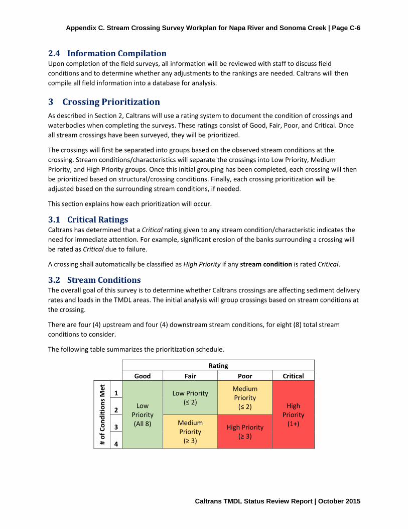
Appendix C. Stream Crossing Survey Workplan for Napa River and Sonoma Creek | Page C-6
Caltrans TMDL Status Review Report | October 2015
2.4 InformationCompilationUpon completion of the field surveys, all information will be reviewed with staff to discuss field
conditions and to determine whether any adjustments to the rankings are needed. Caltrans will then
compile all field information into a database for analysis.
3 CrossingPrioritizationAs described in Section 2, Caltrans will use a rating system to document the condition of crossings and
waterbodies when completing the surveys. These ratings consist of Good, Fair, Poor, and Critical. Once
all stream crossings have been surveyed, they will be prioritized.
The crossings will first be separated into groups based on the observed stream conditions at the
crossing. Stream conditions/characteristics will separate the crossings into Low Priority, Medium
Priority, and High Priority groups. Once this initial grouping has been completed, each crossing will then
be prioritized based on structural/crossing conditions. Finally, each crossing prioritization will be
adjusted based on the surrounding stream conditions, if needed.
This section explains how each prioritization will occur.
3.1 CriticalRatingsCaltrans has determined that a Critical rating given to any stream condition/characteristic indicates the
need for immediate attention. For example, significant erosion of the banks surrounding a crossing will
be rated as Critical due to failure.
A crossing shall automatically be classified as High Priority if any stream condition is rated Critical.
3.2 StreamConditionsThe overall goal of this survey is to determine whether Caltrans crossings are affecting sediment delivery
rates and loads in the TMDL areas. The initial analysis will group crossings based on stream conditions at
the crossing.
There are four (4) upstream and four (4) downstream stream conditions, for eight (8) total stream
conditions to consider.
The following table summarizes the prioritization schedule.
Rating
Good Fair Poor Critical
# of Conditions Met
1
Low Priority (All 8)
Low Priority (≤ 2)
Medium Priority (≤ 2) High
Priority (1+)
2
3 Medium Priority (≥ 3)
High Priority (≥ 3)
4
Appendix C. Stream Crossing Survey Workplan for Napa River and Sonoma Creek | Page C-7
Caltrans TMDL Status Review Report | October 2015
In the case that multiple conditions of various ratings exist, the worst‐case priority will govern. For
example, if the crossing meets the Low Priority threshold for Fair Ratings (≤ 2 conditions met), but also
meets the Medium Priority threshold for Poor Ratings (≤ 2 conditions met), the crossing will be
considered Medium Priority. Additionally, the worst‐case priority between the upstream and
downstream conditions will be considered as the overall crossing grouping.
3.3 StructureConditionsThere are six (6) upstream and six (6) downstream structure conditions, for 12 total structure conditions.
After the crossings are grouped based on stream conditions, they will be prioritized based on the 12
structure conditions. The more severely damaged a crossing, the higher it will be prioritized for future
maintenance.
To determine the ranking, the rating scores from all 12 structure crossings will be totaled. The higher the total score, the higher the ranking.
3.4 SurroundingConditionsFinal adjustments will be made based on surrounding stream and watershed conditions. Crossings
where the following characteristics are present may have their prioritization adjusted to account for
these global factors.
Flow Characteristics – Areas that consist of perennial flows and large volumes of water.
Sediment Particle Size – Areas with notable change in sediment particle size between the
upstream and downstream locations.
Watershed Characteristics – Areas with known potential contaminants; disturbed land; slopes
with high erosion potential.
Caltrans will compile a final Report summarizing the prioritized list of stream crossings based on the
findings of these surveys.

Appendix C. Stream Crossing Survey Workplan for Napa River and Sonoma Creek | Page C-8
Caltrans TMDL Status Review Report | October 2015
4 SurveyandPrioritizationScheduleCaltrans will begin implementation of this work plan immediately upon submittal to the State Board. The proposed schedule for implementation of the surveys and improvement prioritization is included in the table below.
Action Task Schedule
Desktop Review
Verify all crossing locations and create maps and tables for use during field surveys.
Review watershed characteristics. Create field survey schedule.
November 2‐13, 2015
Field Surveys Complete surveys of all Caltrans crossings in the Napa
River and Sonoma Creek watersheds. November 16‐December 4, 2015
Survey Review Review all survey information gathered in the field. Include photos from the field surveys in the forms. Finalize all survey forms.
December 7 – 30, 2015
Crossing Improvement Prioritization
Enter the ratings from all surveys to a database. Assign the appropriate stream risk rating to each
crossing. Order each of the crossings in each stream risk rating
group based on the crossing risk rating and the watershed characteristics.
Produce Survey and Improvement Prioritization Report
January 4 – 29, 2016
5 ImprovementScheduleBased on the results of the crossing surveys and prioritization, Caltrans will develop an Improvement
Schedule to focus on the repair and/or replacement of High Priority crossings. The actual number and
location of these crossings will not be known until the Crossing Prioritization is complete in December
2015. Caltrans will assume that at least 5% of the crossings in the Sonoma Creek and Napa River
watersheds will be High Priority crossings that require attention. Based off this assumption, Caltrans will
begin including this workload in future maintenance budgets and schedules.
Appendix C. Stream Crossing Survey Workplan for Napa River and Sonoma Creek | Page C-9
Caltrans TMDL Status Review Report | October 2015
Attachment A – Caltrans Stream Crossing Database
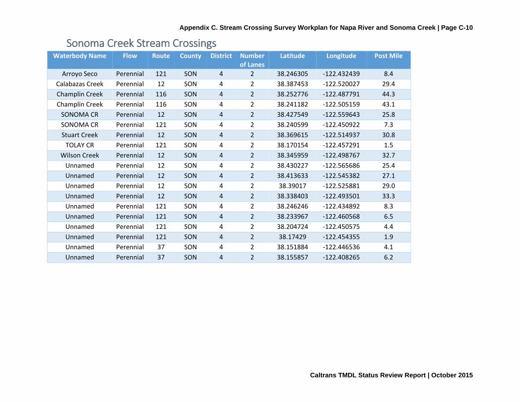
Appendix C. Stream Crossing Survey Workplan for Napa River and Sonoma Creek | Page C-10
Caltrans TMDL Status Review Report | October 2015
Sonoma Creek Stream Crossings
Waterbody Name Flow Route County District Number of Lanes
Latitude Longitude Post Mile
Arroyo Seco Perennial 121 SON 4 2 38.246305 ‐122.432439 8.4
Calabazas Creek Perennial 12 SON 4 2 38.387453 ‐122.520027 29.4
Champlin Creek Perennial 116 SON 4 2 38.252776 ‐122.487791 44.3
Champlin Creek Perennial 116 SON 4 2 38.241182 ‐122.505159 43.1
SONOMA CR Perennial 12 SON 4 2 38.427549 ‐122.559643 25.8
SONOMA CR Perennial 121 SON 4 2 38.240599 ‐122.450922 7.3
Stuart Creek Perennial 12 SON 4 2 38.369615 ‐122.514937 30.8
TOLAY CR Perennial 121 SON 4 2 38.170154 ‐122.457291 1.5
Wilson Creek Perennial 12 SON 4 2 38.345959 ‐122.498767 32.7
Unnamed Perennial 12 SON 4 2 38.430227 ‐122.565686 25.4
Unnamed Perennial 12 SON 4 2 38.413633 ‐122.545382 27.1
Unnamed Perennial 12 SON 4 2 38.39017 ‐122.525881 29.0
Unnamed Perennial 12 SON 4 2 38.338403 ‐122.493501 33.3
Unnamed Perennial 121 SON 4 2 38.246246 ‐122.434892 8.3
Unnamed Perennial 121 SON 4 2 38.233967 ‐122.460568 6.5
Unnamed Perennial 121 SON 4 2 38.204724 ‐122.450575 4.4
Unnamed Perennial 121 SON 4 2 38.17429 ‐122.454355 1.9
Unnamed Perennial 37 SON 4 2 38.151884 ‐122.446536 4.1
Unnamed Perennial 37 SON 4 2 38.155857 ‐122.408265 6.2
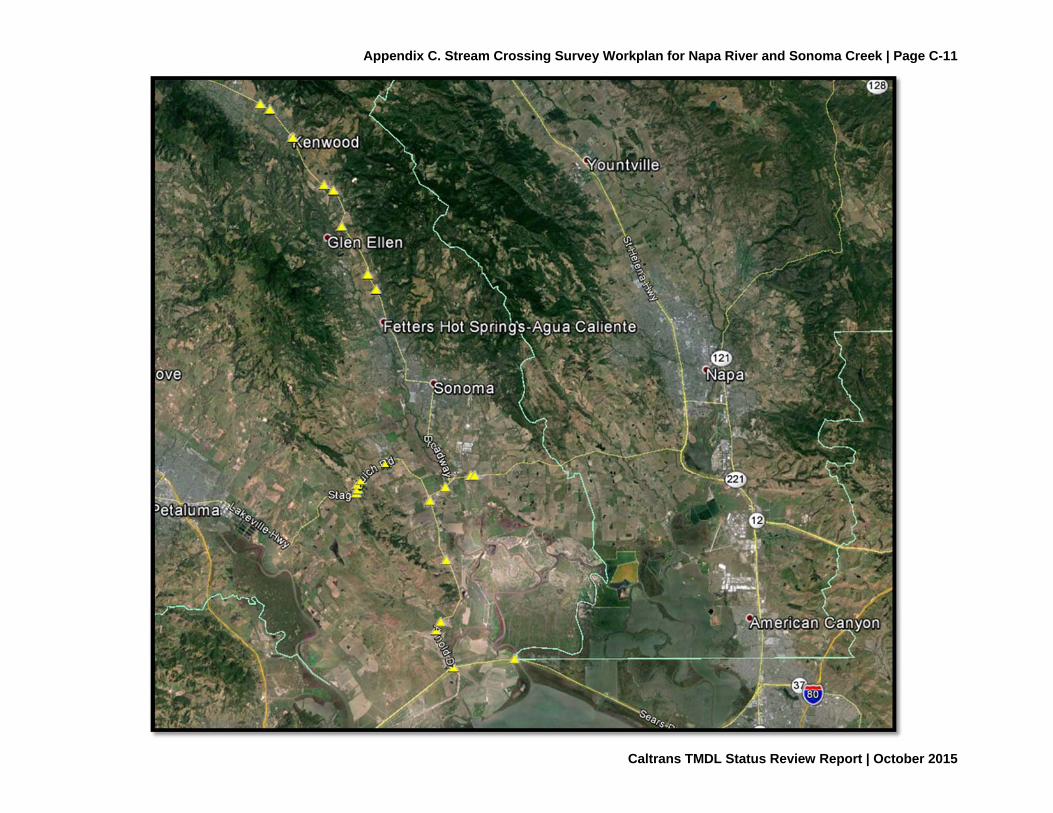
Appendix C. Stream Crossing Survey Workplan for Napa River and Sonoma Creek | Page C-11
Caltrans TMDL Status Review Report | October 2015
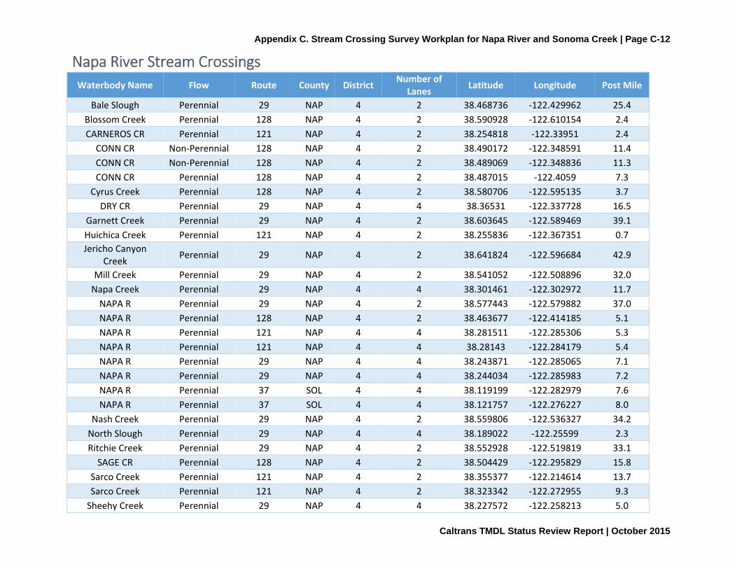
Appendix C. Stream Crossing Survey Workplan for Napa River and Sonoma Creek | Page C-12
Caltrans TMDL Status Review Report | October 2015
Napa River Stream Crossings
Waterbody Name Flow Route County District Number of
Lanes Latitude Longitude Post Mile
Bale Slough Perennial 29 NAP 4 2 38.468736 ‐122.429962 25.4
Blossom Creek Perennial 128 NAP 4 2 38.590928 ‐122.610154 2.4
CARNEROS CR Perennial 121 NAP 4 2 38.254818 ‐122.33951 2.4
CONN CR Non‐Perennial 128 NAP 4 2 38.490172 ‐122.348591 11.4
CONN CR Non‐Perennial 128 NAP 4 2 38.489069 ‐122.348836 11.3
CONN CR Perennial 128 NAP 4 2 38.487015 ‐122.4059 7.3
Cyrus Creek Perennial 128 NAP 4 2 38.580706 ‐122.595135 3.7
DRY CR Perennial 29 NAP 4 4 38.36531 ‐122.337728 16.5
Garnett Creek Perennial 29 NAP 4 2 38.603645 ‐122.589469 39.1
Huichica Creek Perennial 121 NAP 4 2 38.255836 ‐122.367351 0.7
Jericho Canyon Creek
Perennial 29 NAP 4 2 38.641824 ‐122.596684 42.9
Mill Creek Perennial 29 NAP 4 2 38.541052 ‐122.508896 32.0
Napa Creek Perennial 29 NAP 4 4 38.301461 ‐122.302972 11.7
NAPA R Perennial 29 NAP 4 2 38.577443 ‐122.579882 37.0
NAPA R Perennial 128 NAP 4 2 38.463677 ‐122.414185 5.1
NAPA R Perennial 121 NAP 4 4 38.281511 ‐122.285306 5.3
NAPA R Perennial 121 NAP 4 4 38.28143 ‐122.284179 5.4
NAPA R Perennial 29 NAP 4 4 38.243871 ‐122.285065 7.1
NAPA R Perennial 29 NAP 4 4 38.244034 ‐122.285983 7.2
NAPA R Perennial 37 SOL 4 4 38.119199 ‐122.282979 7.6
NAPA R Perennial 37 SOL 4 4 38.121757 ‐122.276227 8.0
Nash Creek Perennial 29 NAP 4 2 38.559806 ‐122.536327 34.2
North Slough Perennial 29 NAP 4 4 38.189022 ‐122.25599 2.3
Ritchie Creek Perennial 29 NAP 4 2 38.552928 ‐122.519819 33.1
SAGE CR Perennial 128 NAP 4 2 38.504429 ‐122.295829 15.8
Sarco Creek Perennial 121 NAP 4 2 38.355377 ‐122.214614 13.7
Sarco Creek Perennial 121 NAP 4 2 38.323342 ‐122.272955 9.3
Sheehy Creek Perennial 29 NAP 4 4 38.227572 ‐122.258213 5.0
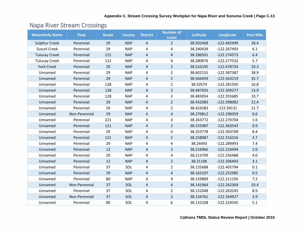
Appendix C. Stream Crossing Survey Workplan for Napa River and Sonoma Creek | Page C-13
Caltrans TMDL Status Review Report | October 2015
Napa River Stream Crossings
Waterbody Name Flow Route County District Number of
Lanes Latitude Longitude Post Mile
Sulphur Creek Perennial 29 NAP 4 2 38.502468 ‐122.465949 28.4
Suscol Creek Perennial 29 NAP 4 4 38.240439 ‐122.267493 6.1
Tulucay Creek Perennial 121 NAP 4 4 38.286501 ‐122.274573 6.4
Tulucay Creek Perennial 121 NAP 4 4 38.280876 ‐122.277532 5.7
York Creek Perennial 29 NAP 4 2 38.510195 ‐122.478734 29.3
Unnamed Perennial 29 NAP 4 2 38.602155 ‐122.587387 38.9
Unnamed Perennial 29 NAP 4 2 38.566459 ‐122.563219 35.7
Unnamed Perennial 128 NAP 4 2 38.50574 ‐122.281505 16.8
Unnamed Perennial 128 NAP 4 2 38.487935 ‐122.309277 13.9
Unnamed Perennial 128 NAP 4 2 38.483054 ‐122.355685 10.7
Unnamed Perennial 29 NAP 4 2 38.432083 ‐122.398082 22.4
Unnamed Perennial 29 NAP 4 2 38.424283 ‐122.39131 21.7
Unnamed Non‐Perennial 29 NAP 4 4 38.270812 ‐122.298359 9.6
Unnamed Perennial 221 NAP 4 4 38.263772 ‐122.270704 1.6
Unnamed Perennial 121 NAP 4 2 38.255987 ‐122.363543 0.9
Unnamed Perennial 29 NAP 4 4 38.253778 ‐122.303709 8.4
Unnamed Perennial 121 NAP 4 2 38.258087 ‐122.316316 3.7
Unnamed Perennial 29 NAP 4 4 38.24493 ‐122.289993 7.4
Unnamed Perennial 12 NAP 4 2 38.216966 ‐122.224494 2.0
Unnamed Perennial 29 NAP 4 4 38.213709 ‐122.256488 4.0
Unnamed Perennial 12 NAP 4 2 38.21106 ‐122.206493 3.1
Unnamed Perennial 37 SOL 4 2 38.155688 ‐122.405794 0.1
Unnamed Perennial 29 NAP 4 4 38.163197 ‐122.252985 0.5
Unnamed Perennial 80 NAP 4 9 38.159889 ‐122.211195 7.2
Unnamed Non‐Perennial 37 SOL 4 4 38.141964 ‐122.242304 10.4
Unnamed Perennial 37 SOL 4 2 38.131048 ‐122.263245 8.9
Unnamed Non‐Perennial 37 SOL 4 2 38.134761 ‐122.344927 3.9
Unnamed Perennial 80 SOL 4 6 38.132108 ‐122.224545 5.1
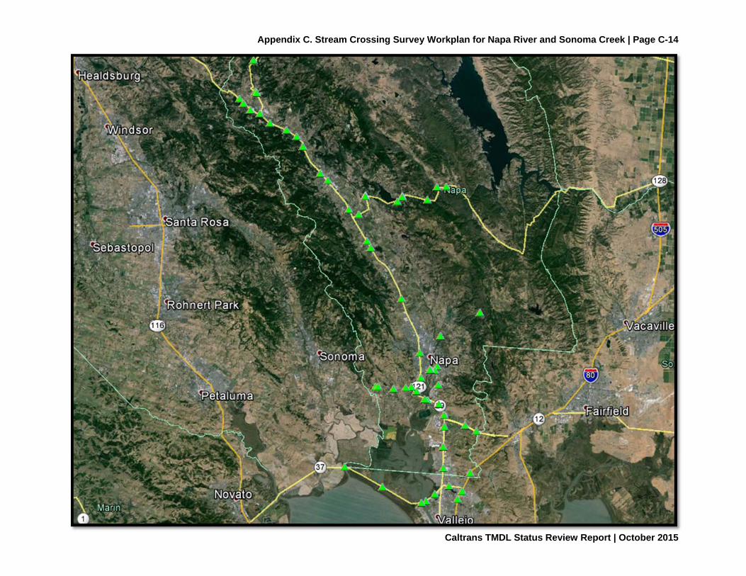
Appendix C. Stream Crossing Survey Workplan for Napa River and Sonoma Creek | Page C-14
Caltrans TMDL Status Review Report | October 2015
Appendix C. Stream Crossing Survey Workplan for Napa River and Sonoma Creek | Page C-15
Caltrans TMDL Status Review Report | October 2015
Attachment B – Stream Crossing Survey Form
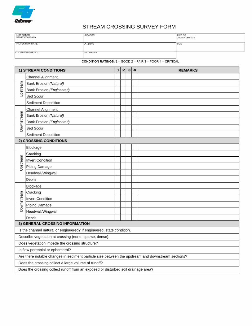
STREAM CROSSING SURVEY FORM
INSPECTOR NAME/ COMPANY
LOCATION TYPE OF CULVERT/BRIDGE
INSPECTION DATE LAT/LONG SIZE
CULVERT/BRIDGE NO.
WATERWAY
CONDITION RATINGS: 1 = GOOD 2 = FAIR 3 = POOR 4 = CRITICAL
1) STREAM CONDITIONS 1 2 3 4 REMARKS
Ups
trea
m
Channel Alignment
Bank Erosion (Natural)
Bank Erosion (Engineered)
Bed Scour
Sediment Deposition
Dow
nstr
eam
Channel Alignment
Bank Erosion (Natural)
Bank Erosion (Engineered)
Bed Scour
Sediment Deposition
2) CROSSING CONDITIONS
Ups
trea
m
Blockage
Cracking
Invert Condition
Piping Damage
Headwall/Wingwall
Debris
Dow
nstr
eam
Blockage
Cracking
Invert Condition
Piping Damage
Headwall/Wingwall
Debris
3) GENERAL CROSSING INFORMATION
Is the channel natural or engineered? If engineered, state condition.
Describe vegetation at crossing (none, sparse, dense).
Does vegetation impede the crossing structure?
Is flow perennial or ephemeral?
Are there notable changes in sediment particle size between the upstream and downstream sections?
Does the crossing collect a large volume of runoff?
Does the crossing collect runoff from an exposed or disturbed soil drainage area?
SITE NOTES AND OBSERVATIONS
Use this section to provide any additional information for the conditions listed on Page 1.
Also, are there upstream: Flow diversions or
unnatural inflows? Flow obstructions? Weirs/drop structures? Ditches (Agricultural)? Excessive sediment
debris?
Excessive runoff?
CROSS SECTION SKETCH
ATTACH PHOTOS AT THE END OF THIS REPORT
SIGNED REVIEWED NOTED
INSPECTOR NAME NAME
.
PHOTO A: STREAM CROSSING LOCATION/NUMBER
PHOTO B: ROADWAY CROSS-SECTION (DECREASING PM)
PHOTO C: ROADWAY CROSS-SECTION (INCREASING PM)
PHOTO D: STREAM, BANKS, CROSSING LOOKING DOWNSTREAM (UPSTREAM)
PHOTO E: LEFT BANK (UPSTREAM)
PHOTO F: RIGHT BANK (UPSTREAM)

PHOTO G: CROSSING INLET (UPSTREAM)
PHOTO H: CROSSING INLET INTERIOR (UPSTREAM)

PHOTO I: LOOKING UPSTREAM FROM CROSSING
PHOTO J: LOOKING DOWNSTREAM FROM CROSSING

PHOTO K: CROSSING OUTLET (DOWNSTREAM)
PHOTO L: CROSSING OUTLET INTERIOR (DOWNSTREAM)
PHOTO M: LEFT BANK (DOWNSTREAM)
PHOTO N: RIGHT BANK (DOWNSTREAM)
PHOTO O: STREAM, BANKS, CROSSING LOOKING UPSTREAM (DOWNSTREAM)