Embed Size (px)
Citation preview

Hydrography - coast and sea (SS57) English version – SOSI standard 4.0
Hydrography - coast and sea (S57)
Norwegian Mapping Authority [email protected]
Norwegian Mapping Authority June 2009 Page 1 of 99

Hydrography - coast and sea (SS57) English version – SOSI standard 4.0
Norwegian Mapping Authority June 2009 Page 2 of 99

Hydrography - coast and sea (SS57) English version – SOSI standard 4.0
Table of contents
1.1 Application schema...................................................................................................................... 7Main …………...................................................................................................................................... 7Habours ............................................................................................................................................... 8Maritime information............................................................................................................................. 9Anchorage area and seafloor situation.................................................................................................9Maritime information........................................................................................................................... 10Cables and pipeline............................................................................................................................ 10Maritime information........................................................................................................................... 11Caution- and restriction area..............................................................................................................11Maritime information........................................................................................................................... 12Dumping area..................................................................................................................................... 12Maritime information........................................................................................................................... 12Radio report point............................................................................................................................... 12Maritime information........................................................................................................................... 13Various maritime information..............................................................................................................13Maritime information........................................................................................................................... 14Wreck and obstructions......................................................................................................................14Military information............................................................................................................................. 15Navigation installation........................................................................................................................16Fixed navigation marks...................................................................................................................... 16Navigation installation........................................................................................................................17Floating navigation marks................................................................................................................... 17Navigation installation........................................................................................................................18Latern foundation............................................................................................................................... 18Navigation installation........................................................................................................................19Leading ............................................................................................................................................. 19Navigation installation........................................................................................................................19Signal equipment................................................................................................................................ 19Navigation installation........................................................................................................................20CodeLists........................................................................................................................................... 20Topography........................................................................................................................................ 21Delimination land/sea......................................................................................................................... 21Topography........................................................................................................................................ 22Depth area.......................................................................................................................................... 22Topography........................................................................................................................................ 23Dredged area..................................................................................................................................... 23Topography........................................................................................................................................ 24Foreshore........................................................................................................................................... 24Topography........................................................................................................................................ 25Uncharted ocean serceyed area........................................................................................................25Traffic separation information.............................................................................................................26CodeLists........................................................................................................................................... 27
1.2 Description................................................................................................................................. 28Habours ............................................................................................................................................. 28
1.2.1.1 ??HarbourArea/HarbourSegment................................................................................281.2.1.2 HarbourTerminal..........................................................................................................281.2.1.3 HarbourAreaBoundary.................................................................................................291.2.1.4 HarbourTerminalBoundary...........................................................................................301.2.1.5 Association ??HarbourArea/HarbourSegment-HarbourTerminal.................................301.2.1.6 Association <<Topo>> ??HarbourArea/HarbourSegment-HarbourAreaBoundary.......301.2.1.7 Association <<Topo>> HarbourTerminal-HarbourTerminalBoundary..........................311.2.1.8 Association <<Topo>> HarbourDistrict-HabourDisrictBoundary..................................311.2.1.9 Association HarbourDistrict-??HarbourArea/HarbourSegment....................................31
Norwegian Mapping Authority June 2009 Page 3 of 99

Hydrography - coast and sea (SS57) English version – SOSI standard 4.0
1.2.1.10 Association HarbourDistrict-MunicipalityBoundary.......................................................31Maritime information........................................................................................................................... 32
1.2.1.11 CautionAreaBoundary..................................................................................................321.2.1.12 AnchorageArea............................................................................................................321.2.1.13 SeafloorSituation..........................................................................................................331.2.1.14 DumpingGround...........................................................................................................331.2.1.15 Fartsmil........................................................................................................................341.2.1.16 RadioReportPoint.........................................................................................................341.2.1.17 RestrictionArea.............................................................................................................341.2.1.18 SeaplaneHarbour.........................................................................................................351.2.1.19 UnderwaterCableArea..................................................................................................351.2.1.20 AnchorageAreaBoundary.............................................................................................351.2.1.21 DumpingGroundBoundary............................................................................................361.2.1.22 RestrictionAreaBoundary.............................................................................................361.2.1.23 SeaplaneHarbourBoundary..........................................................................................361.2.1.24 UnderwaterCableAreaBoundary..................................................................................371.2.1.25 CautionArea................................................................................................................. 371.2.1.26 ??SmallBoatHarbour/SmallBoatMarina........................................................................371.2.1.27 SmallBoatHarbourBoundary.........................................................................................381.2.1.28 SeafloorSituationBoundary...........................................................................................381.2.1.29 RadioReportPointBoundary..........................................................................................381.2.1.30 PipelineArea................................................................................................................. 381.2.1.31 PipelineAreaBoundary..................................................................................................391.2.1.32 HazardArea..................................................................................................................391.2.1.33 HazardAreaBoundary...................................................................................................391.2.1.34 ObstructionFoulSeafloor...............................................................................................401.2.1.35 HarbourTerminalBoundary...........................................................................................401.2.1.36 Wreck........................................................................................................................... 401.2.1.37 MooringBuoy................................................................................................................411.2.1.38 WreckBoundary............................................................................................................411.2.1.39 Association <<Topo>> AnchorageArea-AnchorageAreaBoundary..............................411.2.1.40 Association <<Topo>> DumpingGround-DumpingGroundBoundary...........................411.2.1.41 Association <<Topo>> RestrictionArea-RestrictionAreaBoundary...............................421.2.1.42 Association <<Topo>> HazardArea-HazardAreaBoundary..........................................421.2.1.43 Association <<Topo>> FisheryProtectionZone-FisheryProtectionZoneBoundary........421.2.1.44 Association <<Topo>> UnderwaterCableArea-UnderwaterCableAreaBoundary.........431.2.1.45 Association <<Topo>> SeaplaneHarbour-SeaplaneHarbourBoundary........................431.2.1.46 Association <<Topo>> ObstructionFoulSeafloor -HarbourTerminalBoundary..............431.2.1.47 Association <<Topo>> CautionArea-CautionAreaBoundary........................................441.2.1.48 Association <<Topo>> ??SmallBoatHarbour/SmallBoatMarina-SmallBoatHarbourBoundary..........................................................................................................441.2.1.49 Association <<Topo>> MilitaryPracticeArea-MilitaryPracticeAreaBoundary................441.2.1.50 Association <<Topo>> SeafloorSituation-SeafloorSituationBoundary.........................451.2.1.51 Association <<Topo>> PipelineArea-PipelineAreaBoundary.......................................451.2.1.52 Association <<Topo>> Wreck-WreckBoundary............................................................451.2.1.53 CodeLists.....................................................................................................................46
1.2.1.53.1 <<CodeList>> SeafloorType..................................................................................461.2.1.53.2 <<CodeList>> CategoryOfDumpingGround...........................................................471.2.1.53.3 <<CodeList>> TrafficFlow......................................................................................471.2.1.53.4 <<CodeList>> AnchorageUsage............................................................................471.2.1.53.5 <<CodeList>> CategoryOfSmallCraftFacility..........................................................471.2.1.53.6 <<CodeList>> CategoryOfDumpingArea...............................................................491.2.1.53.7 <<CodeList>> Restriction.......................................................................................491.2.1.53.8 <<CodeList>> CategoryOfAnchorage....................................................................501.2.1.53.9 <<CodeList>> CategoryOfCable............................................................................501.2.1.53.10 <<CodeList>> CategoryOfRestrictedArea............................................................50
Norwegian Mapping Authority June 2009 Page 4 of 99

Hydrography - coast and sea (SS57) English version – SOSI standard 4.0
1.2.1.53.11 <<CodeList>> CategoryOfPipe............................................................................511.2.1.53.12 <<CodeList>> CategoryOfWreck.........................................................................511.2.1.53.13 <<CodeList>> StatusSea.....................................................................................51
Military information............................................................................................................................. 531.2.1.54 MilitaryPracticeAreaBoundary......................................................................................531.2.1.55 MilitaryPracticeArea.....................................................................................................53
1.2.1.55.1 CodeLists...............................................................................................................551.2.1.55.2 <<CodeList>> CategoryOfMilitaryPracticeArea......................................................55
Navigation installation........................................................................................................................561.2.1.56 NavigationInstallation...................................................................................................561.2.1.57 NavigationMark............................................................................................................571.2.1.58 BuildingPoint................................................................................................................581.2.1.59 Pillar............................................................................................................................. 581.2.1.60 Landmark.....................................................................................................................581.2.1.61 IsolatedDangerBuoy.....................................................................................................581.2.1.62 ??SafeWaterBuoy........................................................................................................591.2.1.63 LateralBuoy..................................................................................................................591.2.1.64 RadarStation................................................................................................................591.2.1.65 LateralMark.................................................................................................................. 601.2.1.66 IsolatedDangerMark.....................................................................................................601.2.1.67 CardinalBuoy................................................................................................................601.2.1.68 SpecialMark................................................................................................................. 601.2.1.69 SignalEquipment..........................................................................................................601.2.1.70 Racon........................................................................................................................... 611.2.1.71 Illumination................................................................................................................... 621.2.1.72 Radio............................................................................................................................ 631.2.1.73 FloatingNavigationMark................................................................................................641.2.1.74 FixedNavigationMark....................................................................................................641.2.1.75 LightSector...................................................................................................................651.2.1.76 OtherFixedMarks..........................................................................................................651.2.1.77 LanternFoundation.......................................................................................................651.2.1.78 Installasjonsbøye.........................................................................................................661.2.1.79 Leading??.................................................................................................................... 661.2.1.80 Association SignalEquipment-NavigationInstallation....................................................661.2.1.81 Association LightSector-Illumination............................................................................661.2.1.82 Association NavigationInstallation-LanternFoundation.................................................671.2.1.83 Association NavigationInstallation-Leading??..............................................................67
1.2.1.83.1 CodeLists...............................................................................................................681.2.1.83.2 <<CodeList>> BeaconShape.................................................................................681.2.1.83.3 <<CodeList>> ColourPattern..................................................................................681.2.1.83.4 <<CodeList>> BuoyShape.....................................................................................681.2.1.83.5 <<CodeList>> SystemOfNavigationalMarks..........................................................691.2.1.83.6 <<CodeList>> CLOwner........................................................................................691.2.1.83.7 <<CodeList>> CategoryOfLateralMark..................................................................691.2.1.83.8 <<CodeList>> CheckedByNHS..............................................................................701.2.1.83.9 <<CodeList>> RaconType.....................................................................................701.2.1.83.10 <<CodeList>> CoastalAdministrationDistrict........................................................701.2.1.83.11 <<CodeList>> CategoryOfLight............................................................................711.2.1.83.12 <<CodeList>> CategoryOfRadarTransponderBeacon.........................................711.2.1.83.13 <<CodeList>> Colour...........................................................................................721.2.1.83.14 <<CodeList>> CategoryOfCardinalMark..............................................................721.2.1.83.15 <<CodeList>> LightCharacteristic........................................................................731.2.1.83.16 <<CodeList>> CategoryOfInstallationBuoy..........................................................731.2.1.83.17 <<CodeList>> CategoryOfRadioStation...............................................................741.2.1.83.18 <<CodeList>> CategoryOfSpecialPurposeMark..................................................741.2.1.83.19 <<CodeList>> TechniqueOfSoundingMeasurement............................................76
Norwegian Mapping Authority June 2009 Page 5 of 99

Hydrography - coast and sea (SS57) English version – SOSI standard 4.0
1.2.1.83.20 <<CodeList>> TopmarkDaymarkShape...............................................................771.2.1.83.21 <<CodeList>> NationalTopMarkType..................................................................781.2.1.83.22 <<CodeList>> CategoryOfLandmark...................................................................781.2.1.83.23 <<CodeList>> CategoryOfPile.............................................................................791.2.1.83.24 <<CodeList>> RaconFrequencyBand..................................................................791.2.1.83.25 <<CodeList>> RaconMorseCodeCharacter.........................................................791.2.1.83.26 <<CodeList>> RaconResponseInterval...............................................................791.2.1.83.27 <<CodeList>> RadioBeaconModulation...............................................................801.2.1.83.28 <<CodeList>> Function........................................................................................801.2.1.83.29 <<CodeList>> ConspicuousVisually.....................................................................811.2.1.83.30 <<CodeList>> CategoryOfRadarStation..............................................................82
Topography........................................................................................................................................ 831.2.1.84 DepthArea.................................................................................................................... 831.2.1.85 Shallows....................................................................................................................... 831.2.1.86 SeaSurface..................................................................................................................831.2.1.87 Depth contour...............................................................................................................841.2.1.88 Coastline...................................................................................................................... 841.2.1.89 SeaRiverDelineation....................................................................................................851.2.1.90 LandArea......................................................................................................................861.2.1.91 DredgedArea................................................................................................................861.2.1.92 Foreshore.....................................................................................................................861.2.1.93 ForeshoreBoundary.....................................................................................................871.2.1.94 DredgedAreaBoundary.................................................................................................881.2.1.95 PhotogrDelimitationShallowArea..................................................................................881.2.1.96 CoastlineTechnicalFacility............................................................................................881.2.1.97 UnchartedOceanSurveyedBoundary............................................................................891.2.1.98 UnchartedOceanSurveyedArea...................................................................................891.2.1.99 DelimitationLandSea....................................................................................................891.2.1.100 Skerry........................................................................................................................... 901.2.1.101 Association <<Topo>> DepthArea-Depth contour........................................................901.2.1.102 Association <<Topo>> Foreshore -ForeshoreBoundary..............................................911.2.1.103 Association <<Topo>> SeaSurface-DelimitationLandSea............................................911.2.1.104 Association <<Topo>> DredgedArea-DredgedAreaBoundary.....................................911.2.1.105 Association <<Topo>> LandArea -DelimitationLandSea..............................................911.2.1.106 Association <<Topo>> DepthArea-ForeshoreBoundary...............................................921.2.1.107 Association <<Topo>> DepthArea-DredgedAreaBoundary..........................................921.2.1.108 Association <<Topo>> LandArea -DataDelimitation....................................................921.2.1.109 Association <<Topo>> SeaSurface-DataDelimitation..................................................931.2.1.110 Association <<Topo>> DredgedArea-ForeshoreBoundary..........................................931.2.1.111 Association SeaSurface-Foreshore..............................................................................931.2.1.112 Association SeaSurface-DepthArea.............................................................................931.2.1.113 Association SeaSurface-DredgedArea.........................................................................941.2.1.114 Association <<Topo>> DepthArea-DelimitationLandSea.............................................941.2.1.115 Association <<Topo>> UnchartedOceanSurveyedArea-UnchartedOceanSurveyedBoundary..............................................................................................941.2.1.116 Association <<Topo>> Foreshore -DelimitationLandSea.............................................941.2.1.117 Association <<Topo>> UnchartedOceanSurveyedArea-DelimitationLandSea.............951.2.1.118 Association <<Topo>> DredgedArea-DelimitationLandSea.........................................951.2.1.119 CodeLists.....................................................................................................................96
1.2.1.119.1 <<CodeList>> CategoryOfCoastline....................................................................961.2.1.119.2 <<CodeList>> CoastalReferenceLevel................................................................961.2.1.119.3 <<CodeList>> DepthType....................................................................................961.2.1.119.4 <<CodeList>> CategoryOfShorelineConstruction................................................97
Traffic sepertaion information.............................................................................................................981.2.1.120 TrafficSeparationLanePart...........................................................................................981.2.1.121 TrafficSeparationLine...................................................................................................98
Norwegian Mapping Authority June 2009 Page 6 of 99

Hydrography - coast and sea (SS57) English version – SOSI standard 4.0
1.2.1.122 RecommendedTrafficDirection.....................................................................................981.2.1.123 TrafficSeparationLanePartBoundary............................................................................991.2.1.124 Association TrafficSeparationLanePart-TrafficSeparationLine.....................................991.2.1.125 Association <<Topo>> TrafficSeparationLanePart-TrafficSeparationLanePartBoundary
99
Norwegian Mapping Authority June 2009 Page 7 of 99

Hydrography - coast and sea (SS57) English version – SOSI standard 4.0
1.1 Application schema
Main
Harbours
Maritime information
Military information
Topography
Navigation ins tallation
Traffic seperation information
Norwegian Mapping Authority June 2009 Page 8 of 99

Hydrography - coast and sea (SS57) English version – SOSI standard 4.0
Habours
PortDistrictAdministration
+ ??Interkommunal port management = 1+ Technical Recruitment Agency = 2+ Own port authority = 3
(from Other i nformation)
<<CodeList>>
HarbourTerminalBoundary+ border : CurveWithQuality
HarbourAreaBoundary+ border : CurveWithQuality
HarbourTerminal+ extent [0..1] : SurfaceWithQuality+ position [0..1] : PointWithQuality+ harbourTerminalNumber [0..1] : Integer+ harbourTerminalType [0..1] : CharacterString+ harbourTerminalStatus [0..1] : CharacterString+ harbourTerminalISPSnumber [0..1] : Integer
0..*
1 +boundaryHabourTerminal
0..*
1
<<Topo>>
??HarbourArea/HarbourSegment+ extent [0..1] : SurfaceWithQuality+ position [0..1] : PointWithQuality+ harbourAreaNumber [0..1] : Integer+ harbourAreaType [0..1] : CharacterString+ harbourAreaStatus [0..1] : CharacterString
0..*
1 +HarbourAreaBoundary
0..*
1
<<Topo>>
1..*1..*
+HarbourTerminalBoundary
HabourDisrictBoundary
+ border : CurveWithQuality(from Other i nformation)
HarbourDistrict
+ extent [0..1] : SurfaceWithQuality+ position [0..1] : PointWithQuality+ englishName [0..1] : Name+ portIdentification [0..1] : PortIdentification+ habourDistrictInformation [0..1] : HabourDistrictInformation+ habourStatus : Status
(from Other i nformation)
1..*1..*
+boundaryHabourDistrict
0..*
1 +boundaryHabourDistrict
0..*
1
<<Topo>>
Norwegian Mapping Authority June 2009 Page 9 of 99

Hydrography - coast and sea (SS57) English version – SOSI standard 4.0
Maritime informationAnchorage area and seafloor situation
AnchorageUsage+ Important anchorage areas for vessels = 1+ Areas for laying up vessels = 2+ Anchorage/Lay-up areas for petroleum installations = 3
<<CodeList>>
AnchorageArea+ extent [0..1] : SurfaceWithQuality+ position [0..1] : PointWithQuality+ categoryOfAnchorage [0..*] : CategoryOfAnchorage+ restriction [0..*] : Restriction+ anchorageUsage [0..1] : AnchorageUsage+ status [0..1] : StatusSea+ seafloorType [0..1] : SeafloorType
AnchorageAreaBoundary+ border : CurveWithQuality
1 0..*1
+AnchorageAreaBoundary
0..*<<Topo>>
SeafloorType+ Mussels (Note : quotation marks) = Ms+ Pebbles and sand (Note : quotation marks) = "P S"...+ Sand and clay (Note : quotation marks) = "S Cy"...+ Shells and sand (Note : quotation marks) = "Sh S"...+ Coarse = c+ Medium large stones 64.0 - 256.0 mm = Cb+ Chalk = Ck+ Coral = Co+ Coarse sand 0.5 - 2.0 mm = cS+ Clay < 0.002 mm = Cy+ Fine = f+ Fine sand 0.0625 - 0.125 mm = fS+ Gravel 2.0 - 4.0 mm = G+ Hard = h+ Mud = M+ Medium-fine sand 0.25 - 0.5 mm+ Oysters = Oy+ Pebbles 4.0 - 64.0 mm = P+ Rock > 256 mm = R+ Sand = S+ Shells = Sh+ Silt 0.002 - 0.0625 mm = Si+ Small = sm+ Soft = so+ Stones = St+ Kelp, Seaweed = Wd
<<CodeList>>
Restriction+ Anchoring forbidden = 1+ Restriksjoner for ankring = 2+ Fishing is forbidden = 3+ Fishing restricted = 4+ Trawling is forbidden = 5+ Restrictions on trawling = 6+ Area to which access is forbidden = 7...+ Restrictions on access = 8+ Dredging/seafloor scraping forbidden = 9...+ Dredging restricted+ Diving prohibited = 11+ Restrictions on diving = 12+ No wake = 13+ Area which should be avoided = 14+ Construction prohibited = 15+ Reduced speed
<<CodeList>>
CategoryOfAnchorage+ Anchorage allowed/recommended/required = 1+ Deep water anchorage = 2+ Tanker anchorage = 3+ Explosives anchorage = 4+ Quarantine anchorage = 5+ Sea plane anchorage = 6+ Small craft mooring area = 7+ Small craft anchorage = 8+ Short-term anchorage ??berth/space = 9
<<CodeList>>StatusSea
+ Permanent = 1+ Spesial needs = 2+ Recommended = 3+ Not in use 4+ Periodic/intermittent = 5+ Reserved = 6+ Temporary = 7+ Private = 8+ Mandatory = 9+ Havarert = 10+ Extinguished = 11+ Illuminated = 12+ Historic = 13+ Public = 14+ Synchronized = 15+ Watched = 16+ Un-watched = 17+ Existence Doubtful = 18+ Operational = 30+ Discontinued/Omitted = 31+ Planned = 32
<<CodeList>>
SeafloorSituation+ position [0..1] : PointWithQuality+ extent [0..1] : SurfaceWithQuality+ seafloorType : SeafloorType
SeafloorSituationBoundary+ border : CurveWithQuality
1 0..*1
+SeafloorSituationBoundary
0..*
<<Topo>>
Norwegian Mapping Authority June 2009 Page 10 of 99

Hydrography - coast and sea (SS57) English version – SOSI standard 4.0
Maritime informationCables and pipeline
UnderwaterCableArea+ extent [0..1] : SurfaceWithQuality+ position [0..1] : PointWithQuality+ categoryOfCable : CategoryOfCable
UnderwaterCableAreaBoundary+ border : CurveWithQuality
1
0..*
1
+UnderwaterCableAreaBoundary
0..*
<<Topo>>
CategoryOfCable+ Power line+ High-voltage power line+ Telephone line+ Telegraph line+ Mooring cable / chain
<<CodeList>>
PipelineAreaBoundary+ border : CurveWithQuality
PipelineArea+ extent [0..1] : SurfaceWithQuality+ position [0..1] : PointWithQuality+ categoryOfPipe [0..1] : CategoryOfPipe
0..*
1
+PipelineAreaBoundary
0..*
1
<<Topo>>
CategoryOfPipe+ Outlet = 1+ Inlet = 2+ Sewer = 3+ Supply pipe = 6
<<CodeList>>
Norwegian Mapping Authority June 2009 Page 11 of 99

Hydrography - coast and sea (SS57) English version – SOSI standard 4.0
Maritime informationCaution- and restriction area
CautionAreaBoundary+ border : CurveWithQuality
CautionArea+ extent [0..1] : SurfaceWithQuality+ position [0..1] : PointW ithQuality
0..*
1
+CautionAreaBoundary0..*
1 <<Topo>>
RestrictionArea+ extent [0..1] : SurfaceWithQuality+ position [0..1] : PointWithQuality+ restriction [0..*] : Restriction+ categoryOfRestrictedArea : CategoryOfRestrictedArea
RestrictionAreaBoundary+ border : CurveWithQuality
1 0..*1 +RestrictionAreaBoundary 0..*
<<Topo>>
CategoryOfRestrictedArea+ Offshore safety zone = 1+ Nature reserve = 4+ Bird sanctuary = 5+ Game reserve = 6+ Seal sanctuary = 7+ Degaussing area = 8+ Military area = 9+ Historic wreck area = 10+ Navigsational aid safety zone = 12+ Minefield = 14+ Dredging area = 21
<<CodeList>>Restriction
+ Anchoring forbidden = 1+ Restriksjoner for ankring = 2+ Fishing is forbidden = 3+ Fishing restricted = 4+ Trawling is forbidden = 5+ Restrictions on trawling = 6+ Area to which access is forbidden = 7+ Restrictions on access = 8+ Dredging/seafloor scraping forbidden = 9+ Dredging restricted+ Diving prohibited = 11+ Restrictions on diving = 12+ No wake = 13+ Area which should be avoided = 14+ Construction prohibited = 15+ Reduced speed
<<CodeList>>
Norwegian Mapping Authority June 2009 Page 12 of 99

Hydrography - coast and sea (SS57) English version – SOSI standard 4.0
Maritime informationDumping area
CategoryOfDumpingGround+ General dumping ground = 1+ Chemical waste dumping ground = 2+ Nuclear waste dumping ground = 3+ Explosives dumping ground = 4+ Spoil ground = 5+ Shipwreck Vessel dumping ground = 6+ Oil installations = 7+ Ballast water = 9
<<CodeList>>
DumpingGroundBoundary+ border : CurveWithQuality
DumpingGround+ extent [0..1] : SurfaceWithQuality+ position [0..1] : PointWithQuality+ categoryOfDumpingGround [1..*] : CategoryOfDumpingGround+ restriction [0..*] : Restriction+ categoryOfDumpingArea [0..1] : CategoryOfDumpingArea
0..*
1
+DumpingGroundBoundary
0..*
1
<<Topo>>
CategoryOfDumpingArea+ Dredged masses, soil and rock = 1+ Ships with metal hulls = 2+ Other ships = 3+ Fish waste from onshore processing = 4+ Other waste/materia = 5+ Ammunition = 6
<<CodeList>>
Restriction+ Anchoring forbidden = 1+ Restriksjoner for ankring = 2+ Fishing is forbidden = 3+ Fishing restricted = 4+ Trawling is forbidden = 5+ Restrictions on trawling = 6+ Area to which access is forbidden = 7+ Restrictions on access = 8+ Dredging/seafloor scraping forbidden = 9+ Dredging restricted+ Diving prohibited = 11+ Restrictions on diving = 12+ No wake = 13+ Area which should be avoided = 14+ Construction prohibited = 15+ Reduced speed
<<CodeList>>
Maritime information Radio report point
RadioReportPoint+ position [0..1] : PointWithQuality+ directionalVector : DirectionVector+ communicationChannel [0..1] : Integer+ trafficFlow : TrafficFlow
TrafficFlow+ Inbound = 1+ Outbound = 2+ One-way = 3+ Two-way = 4
<<CodeList>>
Norwegian Mapping Authority June 2009 Page 13 of 99

Hydrography - coast and sea (SS57) English version – SOSI standard 4.0
Maritime informationVarious maritime information
SeaplaneHarbourBoundary+ border : CurveWithQuality
SeaplaneHarbour+ extent [0..1] : SurfaceWithQuality+ position [0..1] : PointWithQuality
0..*
1
+SeaplaneHarbourBoundary
0..*
1
<<Topo>>
CategoryOfSmallCraftFacility+ Visitor’s berth = 1+ Nautical club = 2+ Boat hoist = 3+ Sail maker = 4+ Boatyard = 5+ Public inn = 6+ Restaurant = 7+ Chandler = 8+ Provisions = 9+ Doctor = 10+ Pharmacy = 11+ Water tap = 12+ Fuel station = 13+ Electricity = 14+ Bottle gas = 15+ Showers = 1+ Launderette = 17+ Public toilet = 18+ Post box = 19+ Public telephone = 20+ Refuse bin = 21+ Car park = 22+ Parking for boats and trailers = 23+ Caravan site = 24+ Camping site = 25+ Emptying of septic tank Sewerage pump-out station = 26...+ Emergency telephone = 27+ Landing/launching place for boats = 28+ Visitors mooring = 29+ Scrubbing berth = 30+ Picnic area = 31+ Mechanics workshop = 32+ Guard and/or security service = 33
<<CodeList>>
SmallBoatHarbourBoundary+ border : CurveWithQuality
??SmallBoatHarbour/SmallBoatMarina+ extent [0..1] : SurfaceWithQuality+ position [0..1] : PointWithQuality+ categoryOfSmallCraftFacility [0..*] : CategoryOfSmallCraftFacility
0..*
1
+SmallBoatHarbourBoundary0..*
1
<<Topo>>
MooringBuoy+ position : PointWithQuality
Norwegian Mapping Authority June 2009 Page 14 of 99

Hydrography - coast and sea (SS57) English version – SOSI standard 4.0
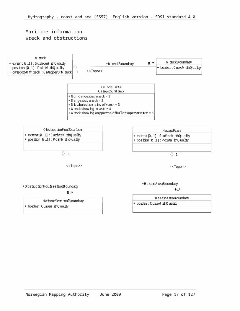
Maritime informationWreck and obstructions
CategoryOfWreck+ Non-dangerous wreck = 1+ Dangerous wreck = 2+ Dis tributed remains of wreck = 3+ Wreck showing masts = 4+ Wreck showing any portion of hull or superstructure = 5
<<CodeLis t>>
ObstructionFoulSeafloor + extent [0..1] : SurfaceWithQuality+ position [0..1] : PointWithQuality
HarbourTerminalBoundary+ border : CurveWithQuality
1
0..*
1
+ObstructionFoulSeafloorBoundary
0..*
<<Topo>>
HazardArea+ extent [0..1] : SurfaceWithQuality+ position [0..1] : PointWithQuality
HazardAreaBoundary+ border : CurveWithQuality
1
0..*
1
+HazardAreaBoundary
0..*
<<Topo>>
WreckBoundary+ border : CurveWithQuality
Wreck+ extent [0..1] : SurfaceWithQuality+ position [0..1] : PointWithQuality+ categoryOfWreck : CategoryOfWreck
0..*
1
+WreckBoundary 0..*
1 <<Topo>>
Norwegian Mapping Authority June 2009 Page 15 of 99

Hydrography - coast and sea (SS57) English version – SOSI standard 4.0
Military information
Restriction
+ Anchoring forbidden = 1+ Restriksjoner for ankring = 2+ Fishing is forbidden = 3+ Fishing restricted = 4+ Trawling is forbidden = 5+ Restrictions on trawling = 6+ Area to which access is forbidden = 7+ Restrictions on access = 8+ Dredging/seafloor scraping forbidden = 9+ Dredging restricted+ Diving prohibited = 11+ Restrictions on diving = 12+ No wake = 13+ Area which should be avoided = 14+ Construction prohibited = 15+ Reduced speed
(from M aritime information)
<<CodeList>>MilitaryPracticeArea+ extent [0..1] : SurfaceWithQuality+ position [0..1] : PointWithQuality+ categoryOfMilitaryPracticeArea [0..1] : CategoryOfMilitaryPracticeArea+ restriction [0..1] : Restriction+ status [0..1] : StatusSea
MilitaryPracticeAreaBoundary+ border : CurveWithQuality
1
0..*
1
+MilitaryPracticeAreaBoundary
0..*
<<Topo>>
CategoryOfMilitaryPracticeArea+ Torpedo exercise area = 2+ Submarine exercise area = 3+ General practice range = 4+ Mine-laying practice area = 5+ Small arms firing range = 6
<<CodeList>>
StatusSea
+ Permanent = 1+ Spesial needs = 2+ Recommended = 3+ Not in use 4+ Periodic/intermittent = 5+ Reserved = 6+ Temporary = 7+ Private = 8+ Mandatory = 9+ Havarert = 10+ Extinguished = 11+ Illuminated = 12+ Historic = 13+ Public = 14+ Synchronized = 15+ Watched = 16+ Un-watched = 17+ Existence Doubtful = 18+ Operational = 30+ Discontinued/Omitted = 31+ Planned = 32
(from M aritime information)
<<CodeList>>
Norwegian Mapping Authority June 2009 Page 16 of 99
Hydrography - coast and sea (SS57) English version – SOSI standard 4.0
Navigation installationFixed navigation marks
LateralMark+ categoryOfLateralMark : CategoryOfLateralMark
FixedNavigationMark+ beaconShape : BeaconShape
NavigationMark+ retroReflector [0..1] : Boolean+ topmarkDaymarkShape [0..1] : TopmarkDaymarkShape+ nationalTopMarkType [0..1] : NasjonalToppmerketype+ navigationalMarkListNumber [0..1] : integer+ depth [0..1] : Real+ techniqueOfSoundingMeasurement [0..1] : TechniqueOfSoundingMeasurement+ colour1 : Colour+ colour2 : Colour+ colour3 : Colour+ colourPattern [0..1] : ColourPattern
IsolatedDangerMark
OtherFixedMarks
SpecialMark+ categoryOfSpecialPurposeMark : CategoryOfSpecialPurposeMark...
NavigationInstallation+ position : PointWithQuality+ surveyedPosisjon [0..1] : PointWithQuality+ descriptionOfLocation [0..1] : CharacterString+ objectNameInNationalLanguage [0..1] : CharacterString+ nameOfArea [0..1] : CharacterString+ height [0..1] : Real+ navigationalInstallationOwner [0..1] : CharacterString+ listOfLightsNumber [0..1] : CharacterString+ status [0..1] : StatusSea+ periodicDateStart [0..1] : Date+ periodicDateEnd [0..1] : Date+ coastalAdministrationDistrict [0..1] : CoastalAdministrationDistrict+ systemOfNavigationalMarks [0..1] : SystemOfNavigationalMarks
Norwegian Mapping Authority June 2009 Page 17 of 99

Hydrography - coast and sea (SS57) English version – SOSI standard 4.0
Navigation installationFloating navigation marks
FloatingNavigationMark+ buoyShape : BuoyShape
IsolatedDangerBuoy
CardinalBuoy+ categoryOfCardinalMark : categoryOfCardinalMark
??SafeWaterBuoy
NavigationMark+ retroReflector [0..1] : Boolean+ topmarkDaymarkShape [0..1] : TopmarkDaymarkShape+ nationalTopMarkType [0..1] : NasjonalToppmerketype+ navigationalMarkListNumber [0..1] : integer+ depth [0..1] : Real+ techniqueOfSoundingMeasurement [0..1] : TechniqueOfSoundingMeasurement+ colour1 : Colour+ colour2 : Colour+ colour3 : Colour+ colourPattern [0..1] : ColourPattern
LateralBuoy+ systemOfNavigationalMarks : SystemOfNavigationalMarks
NavigationInstallation+ position : PointWithQuality+ surveyedPosisjon [0..1] : PointWithQuality+ descriptionOfLocation [0..1] : CharacterString+ objectNameInNationalLanguage [0..1] : CharacterString+ nameOfArea [0..1] : CharacterString+ height [0..1] : Real+ navigationalInstallationOwner [0..1] : CharacterString+ listOfLightsNumber [0..1] : CharacterString+ status [0..1] : StatusSea+ periodicDateStart [0..1] : Date+ periodicDateEnd [0..1] : Date+ coastalAdministrationDistrict [0..1] : CoastalAdministrationDistrict+ systemOfNavigationalMarks [0..1] : SystemOfNavigationalMarks
Norwegian Mapping Authority June 2009 Page 18 of 99

Hydrography - coast and sea (SS57) English version – SOSI standard 4.0
Navigation installation Latern foundation
Landmark+ function [0..1] : Function+ categoryOfLandmark : CategoryOfLandmark+ conspicuousVisually : ConspicuousVisually
Pillar+ categoryOfPile [0..1] : CharacterString
NavigationInstallation+ position : PointWithQuality+ surveyedPosisjon [0..1] : PointWithQuality+ descriptionOfLocation [0..1] : CharacterString+ objectNameInNationalLanguage [0..1] : CharacterString+ nameOfArea [0..1] : CharacterString+ height [0..1] : Real+ navigationalInstallationOwner [0..1] : CharacterString+ listOfLightsNumber [0..1] : CharacterString+ status [0..1] : StatusSea+ periodicDateStart [0..1] : Date+ periodicDateEnd [0..1] : Date+ coastalAdministrationDistrict [0..1] : CoastalAdministrationDistrict+ systemOfNavigationalMarks [0..1] : SystemOfNavigationalMarks
LanternFoundation
0..1 0..10..1
+foundation
0..1
Norwegian Mapping Authority June 2009 Page 19 of 99

Hydrography - coast and sea (SS57) English version – SOSI standard 4.0
Navigation installation Leading
NavigationInstallation+ position : PointWithQuality+ surveyedPosisjon [0..1] : PointWithQuality+ descriptionOfLocation [0..1] : CharacterString+ objectNameInNationalLanguage [0..1] : CharacterString+ nameOfArea [0..1] : CharacterString+ height [0..1] : Real+ navigationalInstallationOwner [0..1] : CharacterString+ listOfLightsNumber [0..1] : CharacterString+ status [0..1] : StatusSea+ periodicDateStart [0..1] : Date+ periodicDateEnd [0..1] : Date+ coastalAdministrationDistrict [0..1] : CoastalAdministrationDistrict+ systemOfNavigationalMarks [0..1] : SystemOfNavigationalMarks
Leading??+ ??directionValue / bearingValue : Real+ navigationCurve : CurveWithQuality+ directionVectorCurve : CurveWithQuality
2 0..1
+position
2 0..1
Navigation installationSignal equipment
Racon+ type [0..1] : RaconType+ frequencyBand [0..1] : RaconFrequencyBand+ morseCodeCharacter [0..1] : RaconMorseCodeCharacter+ responseInterval [0..1] : RaconResponseInterval+ raconElevation [0..1] : Real+ valueOfMaximumRange [0..1] : Real+ raconCharacter [0..1] : CharacterString+ categoryOfRadarTransponderBeacon : CategoryOfRadarTransponderBeacon = 2+ directionalVector1 : DirectionVector+ directionalVector2 : DirectionVector
RadarStation+ categoryOfRadioStation [0..1] : CategoryOfRadioStation+ communicationChannel [0..1] : CharacterString+ height [0..1] : Real+ valueOfNominalRange [0..1] : Real
Radio+ categoryOfRadioStation [0..1] : CategoryOfRadioStation+ callSign [0..1] : CharacterString+ communicationChannel [0..1] : CharacterString+ valueOfNominalRange [0..1] : Real+ directionalVector [0..1] : DirectionVector+ signalFrequency [0..1] : Integer+ modulation [0..1] : RadioBeaconModulation
LightSector+ lightColour [0..1] : Colour+ SectorText [0..1] : CharacterString+ directionSectorLine1 : Real+ lengthSectorLine1 : Real+ directionSectorLine2 : Real+ lengthSectorLine2 : Real
Illumination+ categoryOfLight [1..2] : CategoryOfLight+ listOfLightsCharacteristic [0..1] : CharacterString+ lightCharacteristic [0..1] : LightCharacteristic+ directionalVector [0..1] : Real+ signalGroup [0..1] : CharacterString+ signalPeriod [0..1] : CharacterString+ signalSequence [0..1] : CharacterString+ height [0..1] : Real+ multiplicityOfLights [0..1] : Integer+ valueOfNominalRangeWhite [0..1] : Real+ valueOfNominalRangeRed [0..1] : Real+ valueOfNominalRangeGreen [0..1] : Real+ valueOfNominalRangeYellow [0..1] : Real
1..*
1
+lightSector
1..*
1
SignalEquipment
NavigationInstallation+ position : PointWithQuality+ surveyedPosisjon [0..1] : PointWithQuality+ descriptionOfLocation [0..1] : CharacterString+ objectNameInNationalLanguage [0..1] : CharacterString+ nameOfArea [0..1] : CharacterString+ height [0..1] : Real+ navigationalInstallationOwner [0..1] : CharacterString+ listOfLightsNumber [0..1] : CharacterString+ status [0..1] : StatusSea+ periodicDateStart [0..1] : Date+ periodicDateEnd [0..1] : Date+ coastalAdministrationDistrict [0..1] : CoastalAdministrationDistrict+ systemOfNavigationalMarks [0..1] : SystemOfNavigationalMarks
0..*1
+equipment
0..*1
Norwegian Mapping Authority June 2009 Page 20 of 99

Hydrography - coast and sea (SS57) English version – SOSI standard 4.0
Navigation installationCodeLists
Function+ Unknown function = 0+ Harbour master's office = 2+ Custom office = 3+ Health Office, Quarantine building = 4+ Hospital = 5+ Post office = 6+ Hotel = 7+ Railway station = 8+ Police station = 9+ Harbour police station = 10+ Boarding place, position of a Pilot-Cruising Vessel, with note = 11+ Boarding place, position of a Pilot-Cruising Vessel, with name = 12+ Bankkontor = 13+ Headquarters for district control = 14+ Transit shed, warehouse = 15+ Factory = 16+ Power station = 17+ Administrativ bygning = 18+ Educational facility = 19+ Church = 20+ Chapel = 21+ Temple = 22+ Pagode = 23+ Shinto-shrine = 24+ Buddhist temple = 25+ Mosque, minaret = 26+ Marabout mosque = 27+ Observation tower, lookout post = 28+ Communication = 29+ Television = 30+ Radio = 31+ Radar = 32+ Light support = 33+ Microwave = 34+ Cooling = 35+ Observation = 36+ Timeball = 37+ Clock = 38+ Control = 39+ Airship mooring = 40+ Stadium = 41+ Bus station = 42
<<CodeList>>
BuoyShape+ Conical buoy = 1+ Can/Cylindrical buoy = 2+ Pillar buoy = 4+ Spherical buoy = 5+ Barrel/tun buoy = 6+ Super-buoy = 7+ Ice buoy = 8+ Pillar buoy, right-leaning = 21+ Spar, right-leaning = 22+ Pillar buoy, left-leaning = 26+ Spar, left-leaning = 27
<<CodeList>>
CLOwner+ The Norwegian Coastal Administration (Kystverket) = KV+ Municipal port authority or similar = HV+ The Armed Forces = FV+ Private = PR
<<CodeList>> TechniqueOfSoundingMeasurement+ Found by echo sounder = 1+ Found by side-scan sonar = 2+ Found by multi-beam echo sounder = 3+ Found by diver = 4+ Found by lead-line = 5+ Swept = 6+ Found by laser = 7+ Swept by vertical acoustic system = 8+ Found by electromagnetic sensor = 9+ Photogrammetry = 10+ Satellite imagery = 11+ Found by levelling = 12+ Swept by side-scan sonar = 13+ Computer generated = 14
<<CodeList>>
TopmarkDaymarkShape+ Cone, point up = 1+ Cone, point down = 2+ Sphere = 3+ 2 Spheres = 4+ Cylinder (can) = 5+ Board = 6+ X-shape (St. Andrews cross) = 7+ Upright cross (St Georges cross) = 8+ Cube, point up = 9+ 2 cones, point to point = 10+ 2 cones, base to base = 11+ Rhombus (diamond) = 12+ 2 cones (points upward) = 13+ 2 cones (points downward) = 14+ Besom, point up (broom or perch) = 15+ Besom, point down (broom or perch) = 16+ Flag = 17+ Sphere over rhombus = 18+ Square = 19+ Rectangle, horizontal = 20+ Rectangle, vertical = 21+ Trapezium, up = 22+ Trapezium, down = 23+ Triangle, point up = 24+ Triangle, point down = 25+ Circle = 26+ Two upright crosses (one over the other) = 27+ T-shape = 28+ Triangle pointing up over a circle = 29+ Upright cross over a circle = 30+ Rrhombus over a circle = 31+ Circle over a triangle pointing up = 32+ Other shape (see INFORM attribute) = 33
<<CodeList>>
CategoryOfInstallationBuoy+ Catenary anchor leg mooring = 1+ Single buoy mooring = 2
<<CodeList>>
CategoryOfCardinalMark+ North cardinal mark = 1+ East cardinal mark = 2+ South cardinal mark = 3+ West cardinal mark = 4
<<CodeList>>
CoastalAdministrationDistrict+ Unspecified = 0+ The Norwegian Coastal Administration (Kystverket) Southeast = 1+ Kystverket Vest = 2+ The Norwegian Coastal Administration (Kystverket) Middle Norway = 3+ The Norwegian Coastal Administration (Kystverket) Nordland = 4+ The Norwegian Coastal Administration (Kystverket) Troms and Finnmark = 5+ The Norwegian Coastal Administration (Kystverket) Svalbard = 6+ The North Sea = 7
<<CodeList>>
CategoryOfLandmark+ Cairn = 1+ Chimney = 3+ Dish aerial = 4+ Flare stack = 6+ Mast = 7+ Windsock = 8+ Monument = 9+ Column (pillar) = 10+ Obelisk = 12+ Cross = 14+ Radar dome = 15+ Radar scanner = 16+ Tower = 17+ Windmill = 18+ Wind motor = 19+ Church spire = 20
<<CodeList>>
CategoryOfLateralMark+ Port-hand lateral mark+ Starboard-hand lateral mark+ Preferred channel to starboard lateral mark = 3+ Preferred channel to port lateral mark = 4
<<CodeList>>
BeaconShape+ Other = 0+ Stake, pole , perch, post = 1+ Lattice Beacon = 4+ Cairn = 6
<<CodeList>>
ColourPattern+ Horizontal stripes = 1+ Vertical stripes = 2+ Diagonal stripes = 3+ Squared = 4+ Stripes (direction unknown)+ Border stripe = 6
<<CodeList>>NationalTopMarkType
+ Unknown Norwegian top mark type = 0+ Top mark with pointer+ Iron rod with pointer+ Pointer of black/carbon steel = 3+ Lantern with top mark = 4
<<CodeList>>
LightCharacteristic+ U = 0+ F = 1+ Fl = 2+ LFl = 3+ Q = 4+ VQ = 5+ UQ = 6+ Iso = 7+ Oc = 8+ IQ = 9+ IVQ = 10+ IUQ = 11+ Mo(K) = 12+ FFl = 13+ Al Oc = 17+ Al LFl = 18+ Al Fl = 19+ Q LFl = 25+ VQ LFl = 26+ UQ LFl = 27+ Al = 28+ Al F = 29
<<CodeList>>
CategoryOfLight+ Undefined type of navigation light+ Directional function+ Lantern = 2+ Leading light = 4+ Aero light = 5+ Aero obstruction light = 6+ Fog detector light+ Flood light = 8+ Strip light+ Bifyr = 10+ Spotlight = 11+ Front+ Rear = 13+ Lower = 14+ Upper = 15+ Moiré effect+ Emergency = 17+ Illumination with automatic ??direction/bearing finding = 18+ Horizontally disposed+ Vertically disposed = 20+ Navigation lights, in general = 99
<<CodeList>>
CategoryOfPile+ Unknown = 0+ Stake = 1+ Post+ Rack?? = 4
<<CodeList>>
RaconFrequencyBand+ Racon in the 3 and 10-cm bands = X+S+ Racon in the 3 cm band = X+ Racon in the 10 cm band = S
<<CodeList>>
RaconMorseCodeCharacter+ Morse code sign B = B+ Morse code sign G = G+ Morse code sign K = K+ Morse code sign M = M+ Morse code sign N = N+ Morse code sign O = O+ Morse code sign T = T
<<CodeList>>RaconResponseInterval
+ Active 18 seconds each 30 seconds+ Active 6 seconds each 12 seconds+ Active 15 seconds each 30 seconds+ Active 6 seconds each 30 seconds
<<CodeList>>
RaconType+ Unknown type of racon+ (FA) Frequency Agile racon = 1+ (ITOFAR) Interrogated Time Offset Frequency Agile racon = 2+ (SF) Swept Frequency racon = 3
<<CodeList>>
CategoryOfRadarTransponderBeacon+ Unknown radar beacon type = 0+ Ramark, radar beacon transmitting contonuously = 1+ Racon, radar transponder beacon+ Leading racon/radar transponder beacon = 3
<<CodeList>>
CategoryOfRadarStation+ Radar surveillance station+ Coast radar station
<<CodeList>>
RadioBeaconModulation+ Bærebølgen er G1D modulert = G1D+ Carrier signal is A1A-modulated with call s ign and direction finding signal
<<CodeList>>
CategoryOfRadioStation+ Unknown radio beacon type = 0+ Circular radio beacon = 1+ Directional radio beacon+ Rotating-pattern radio beacon = 3+ Console beacon+ Radio direction finding station+ Coastal radio station providing QTG service = 6+ Aeronautical radio beacon = 7+ Decca = 8+ Loran C = 9+ Differential GPS = 10+ Toran = 11+ Omega = 12+ Syledis = 13+ Chaika (Chayka) = 14
<<CodeList>>
CheckedByNHS+ Not controlled = 1+ Controlled = 2
<<CodeList>>
Colour+ White = 1+ Black = 2+ Red = 3+ Green = 4+ Blue = 5+ Yellow = 6+ Grey = 7+ Brown = 8+ Amber = 9+ Violet+ Orange = 11+ Magenta = 12+ Pink = 13
<<CodeList>>
SystemOfNavigationalMarks+ IALA A = 1+ IALA B = 2+ No system = 9+ Other systems = 10
<<CodeList>>
CategoryOfSpecialPurposeMark+ Firing danger area mark = 1+ Target mark = 2+ Marker ship mark+ Degaussing range mark+ Barge mark+ Cable mark+ Spoil ground mark = 7+ Outfall mark = 8+ ODAS(OceanData Acquisition System) = 9+ Recording mark+ Seaplane anchorage mark = 11+ Recreation zone mark+ Private mark = 13+ Mooring mark = 14+ LANBY - Large Automatic Navigational Buoy = 15+ Leading mark = 16+ Measured distance mark+ Notice mark+ TSS mark (Traffic Separation Scheme) = 19+ Clearing mark = 41+ Control mark+ Refuge beacon+ Yachting mark = 46+ Heliport mark = 47+ GPS mark+ Mark with unknown purpose = 52+ Anchoring prohibited mark = 20+ Berthing prohibited mark = 21+ Overtaking prohibited mark = 22+ Two-way traffic prohibited mark = 23+ Reduced wake mark = 24+ Speed limit mark = 25+ Stop mark = 26+ General warning mark = 27+ Sound ship´s siren mark = 28+ Restricted vertical clearance mark = 29+ Maximum vessel´s draught mark = 30+ Restricted horizontal clearance mark = 31+ Strong current warning mark = 32+ Berthing permitted mark = 33+ Overhead power cable mark = 34+ Channel edge gradient mark = 35+ Telephone mark = 36+ Ferry crossing mark = 37+ Marine traffic lights (discontinued from S-57) = 38+ Pipeline mark = 39+ Anchorage mark = 40+ Diving mark = 43+ Foul ground mark (yachting) = 45+ Seaplane landing mark = 49+ Entry prohibited mark = 50+ Work in progress mark = 51
<<CodeList>>
ConspicuousVisually+ Visually conspicuous = 1+ Not visually conspicuous = 2
<<CodeList>>
Norwegian Mapping Authority June 2009 Page 21 of 99

Hydrography - coast and sea (SS57) English version – SOSI standard 4.0
TopographyDelimination land/sea
Coastline+ border : CurveWithQuality+ categoryOfCoastline [0..1] : CategoryOfCoastline+ coastalReferenceLevel [0..1] : CoastalReferenceLevel+ elevation [0..1] : Real
SeaRiverDelineation+ border : CurveWithQuality+ coastlineReferenceLevel [0..1] : CoastalReferenceLevel+ elevation [0..1] : Real
LandArea + extent [0..1] : SurfaceWithQuality+ position [0..1] : PointWithQuality
SeaSurface+ extent [0..1] : SurfaceWithQuality+ position [0..1] : PointWithQuality
DelimitationLandSea
1
...
1
+boundaryDelimitationLandSea
...
<<Topo>>
1
0..*
1
+SeaRiverDelineation
0..*
<<Topo>>
CoastalReferenceLevel+ Photogrammetric water level = FOTOV+ Mean sea level = K0+ Mean high water = MHV+ Contour, not verified = USIKR
<<CodeList>>CategoryOfCoastline
+ Steep coast = 1+ Flat coast = 2+ Sandy shore = 3+ Stony/Shingly shore = 4+ Glacier = 6
<<CodeList>>
CoastlineTechnicalFacility + border [0..1] : CurveWithQuality+ centerline [0.1] : CurveWithQuality+ categoryOfShorelineConstruction [0..1] : CategoryOfShorelineConstruction+ coastalReferenceLevel [0..1] : CoastalReferenceLevel+ height [0..1] : Real
CategoryOfShorelineConstruction+ Breakwater = 1+ Groyne = 2+ Mole = 3+ Pier = 4+ Promenade pier = 5+ Quay/Wharf/ = 6+ Seawall = 7+ Dyke = 8+ Steps = 11+ Ramp = 12+ Slipway = 13+ Building = 50
<<CodeList>>
Skerry+ position : PointWithQuality+ coastalReferenceLevel [0..1] : CoastalReferenceLevel+ elevation [0..1] : Real+ categoryOfShorelineConstruction [0..1] : CoastalReferenceLevel
Norwegian Mapping Authority June 2009 Page 22 of 99

Hydrography - coast and sea (SS57) English version – SOSI standard 4.0
TopographyDepth area
DepthType+ Unspecified = 1+ Saddle point = 2+ Snag point = 3+ Reversed snag-point = 4+ Deep point = 5+ Quay depths = 6
<<CodeList>>
Depth contour+ border : CurveWithQuality+ depth : Depth
ForeshoreBoundary+ border : CurveWithQuality+ depth : Depth = 0,5
DredgedAreaBoundary+ border : CurveWithQuality
DelimitationLandSea
DepthArea+ extent [0..1] : SurfaceWithQuality+ position [0..1] : PointWithQuality+ minimumDepth : Depth+ maximumDepth : Depth
2
0..*
2
+DepthContour
0..*
<<Topo>>
0..*
0..1
+boundaryForeshore0..*
0..1<<Topo>>
0..*
0..1
+boundaryDredgedArea
0..*
0..1
<<Topo>>
0..*0..*+boundaryDelimitationLandSea
0..*0..*<<Topo>>
DepthPoint
+ position : PointWithQuality+ points [0..1] : Sverm+ depth : Depth+ depthType [0..1] : DepthType
(from T erra in)
Shallows
Norwegian Mapping Authority June 2009 Page 23 of 99

Hydrography - coast and sea (SS57) English version – SOSI standard 4.0
TopographyDredged area
DredgedAreaBoundary+ border : CurveWithQuality
ForeshoreBoundary+ border : CurveWithQuality+ depth : Depth = 0,5
Delim itationLandSea
DredgedArea+ extent [0..1] : SurfaceWithQuality+ pos ition [0..1] : PointWithQuality+ m inimumDepth : Depth+ maxim umDepth : Depth 1
0..*
1 +Delim itationLandSea
0..*<<Topo>>
0..*
0..1
+boundaryForeshore
0..*
0..1
<<Topo>>
0..*
1
+boundaryDelimitationLandSea
0..*
1
<<Topo>>
Norwegian Mapping Authority June 2009 Page 24 of 99

Hydrography - coast and sea (SS57) English version – SOSI standard 4.0
TopographyForeshore
ForeshoreBoundary+ border : CurveWithQuality+ depth : Depth = 0,5
DelimitationLandSea
Foreshore + extent [0..1] : SurfaceWithQuality+ position [0..1] : PointWithQuality
1
0..*
1
+boundaryForeshore 0..*
<<Topo>>
0..*
1
+DelimitationLandSea
0..*
1
<<Topo>>
Norwegian Mapping Authority June 2009 Page 25 of 99

Hydrography - coast and sea (SS57) English version – SOSI standard 4.0
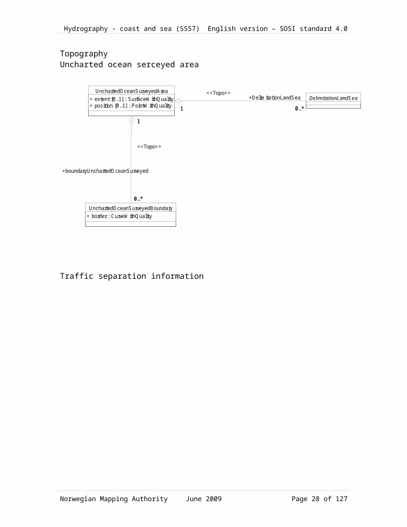
TopographyUncharted ocean serceyed area
UnchartedOceanSurveyedBoundary+ border : CurveWithQuality
UnchartedOceanSurveyedArea+ extent [0..1] : SurfaceWithQuality+ position [0..1] : PointWithQuality
0..*
1
+boundaryUnchartedOceanSurveyed
0..*
1
<<Topo>>
DelimitationLandSea
1 0..*1
+DelimitationLandSea
0..*
<<Topo>>
Traffic separation information
Norwegian Mapping Authority June 2009 Page 26 of 99

Hydrography - coast and sea (SS57) English version – SOSI standard 4.0
RecommendedTrafficDirection+ position : PointWithQuality+ directionVector : DirectionVector
Restriction
+ Anchoring forbidden = 1+ Restriksjoner for ankring = 2+ Fishing is forbidden = 3+ Fishing restricted = 4+ Trawling is forbidden = 5+ Restrictions on trawling = 6+ Area to which access is forbidden = 7+ Restrictions on access = 8+ Dredging/seafloor scraping forbidden = 9+ Dredging restricted+ Diving prohibited = 11+ Restrictions on diving = 12+ No wake = 13+ Area which should be avoided = 14+ Construction prohibited = 15+ Reduced speed
(from M aritime information)
<<CodeList>>
DirectionUnits
+ Grad (angular unit of measurement, 1/400 of a full circle) = 2...+ Degree (angular unit of measurement, 1/360 of a full circle) = 1...+ Radians = 3
(from Di rectionVector)
<<CodeList>>DirectionReference
+ Local = 3+ Magnetic north = 2+ True north = 1
(from Di rectionVector)
<<CodeList>>
DirectionVector
+ ??directionValue / bearingValue : Real+ directionUnits : DirectionUnits+ directionReference : DirectionReference
(from Di rectionVector)
<<DataType>>
TrafficSeparationLine+ centerline : CurveWithQuality
TrafficSeparationLanePartBoundary+ border : CurveWithQuality
TrafficSeparationLanePart+ extent : SurfaceWithQuality+ position : PointWithQuality+ directionalVector [0..1] : DirectionVector+ restriction [0..1] : Restriction
1
1
+trafficSeparationLine
1
1
0..*1
+boundaryTrafficSeparationLanePart
0..*1 <<Topo>>
Norwegian Mapping Authority June 2009 Page 27 of 99
Hydrography - coast and sea (SS57) English version – SOSI standard 4.0
CodeLists
Function
+ Unknown function = 0+ Harbour master's office = 2+ Custom office = 3+ Health Office, Quarantine building = 4+ Hospital = 5+ Post office = 6+ Hotel = 7+ Railway station = 8+ Police station = 9+ Harbour police station = 10+ Boarding place, position of a Pilot-Cruising Vessel, with note = 11+ Boarding place, position of a Pilot-Cruising Vessel, with name = 12+ Bankkontor = 13+ Headquarters for district control = 14+ Transit shed, warehouse = 15+ Factory = 16+ Power station = 17+ Administrativ bygning = 18+ Educational facility = 19+ Church = 20+ Chapel = 21+ Temple = 22+ Pagode = 23+ Shinto-shrine = 24+ Buddhist temple = 25+ Mosque, minaret = 26+ Marabout mosque = 27+ Observation tower, lookout post = 28+ Communication = 29+ Television = 30+ Radio = 31+ Radar = 32+ Light support = 33+ Microwave = 34+ Cooling = 35+ Observation = 36+ Timeball = 37+ Clock = 38+ Control = 39+ Airship mooring = 40+ Stadium = 41+ Bus station = 42
(from Navigation insta lla tion )
<<CodeList>>
BuoyShape
+ Conical buoy = 1+ Can/Cylindrical buoy = 2+ Pillar buoy = 4+ Spherical buoy = 5+ Barrel/tun buoy = 6+ Super-buoy = 7+ Ice buoy = 8+ Pillar buoy, right-leaning = 21+ Spar, right-leaning = 22+ Pillar buoy, left-leaning = 26+ Spar, left-leaning = 27
(from Navigation instal la tion )
<<CodeList>>CLOwner
+ The Norwegian Coastal Administration (Kystverket) = KV+ Municipal port authority or similar = HV+ The Armed Forces = FV+ Private = PR
(from Navigation instal la tion)
<<CodeList>>
TechniqueOfSoundingMeasurement
+ Found by echo sounder = 1+ Found by side-scan sonar = 2+ Found by multi-beam echo sounder = 3+ Found by diver = 4+ Found by lead-line = 5+ Swept = 6+ Found by laser = 7+ Swept by vertical acoustic system = 8+ Found by electromagnetic sensor = 9+ Photogrammetry = 10+ Satellite imagery = 11+ Found by levelling = 12+ Swept by side-scan sonar = 13+ Computer generated = 14
(from Navigation insta l lation)
<<CodeList>>
TopmarkDaymarkShape
+ Cone, point up = 1+ Cone, point down = 2+ Sphere = 3+ 2 Spheres = 4+ Cylinder (can) = 5+ Board = 6+ X-shape (St. Andrews cross) = 7+ Upright cross (St Georges cross) = 8+ Cube, point up = 9+ 2 cones, point to point = 10+ 2 cones, base to base = 11+ Rhombus (diamond) = 12+ 2 cones (points upward) = 13+ 2 cones (points downward) = 14+ Besom, point up (broom or perch) = 15+ Besom, point down (broom or perch) = 16+ Flag = 17+ Sphere over rhombus = 18+ Square = 19+ Rectangle, horizontal = 20+ Rectangle, vertical = 21+ Trapezium, up = 22+ Trapezium, down = 23+ Triangle, point up = 24+ Triangle, point down = 25+ Circle = 26+ Two upright crosses (one over the other) = 27+ T-shape = 28+ Triangle pointing up over a circle = 29+ Upright cross over a circle = 30+ Rrhombus over a circle = 31+ Circle over a triangle pointing up = 32+ Other shape (see INFORM attribute) = 33
(from Navigation insta l la tion )
<<CodeList>>
CategoryOfInstallationBuoy
+ Catenary anchor leg mooring = 1+ Single buoy mooring = 2
(from Navigation insta l la tion )
<<CodeList>>
CategoryOfCardinalMark
+ North cardinal mark = 1+ East cardinal mark = 2+ South cardinal mark = 3+ West cardinal mark = 4
(from Navigation insta l lation )
<<CodeList>>
CoastalAdministrationDistrict
+ Unspecified = 0+ The Norwegian Coastal Administration (Kystverket) Southeast = 1+ Kystverket Vest = 2+ The Norwegian Coastal Administration (Kystverket) Middle Norway = 3+ The Norwegian Coastal Administration (Kystverket) Nordland = 4+ The Norwegian Coastal Administration (Kystverket) Troms and Finnmark = 5+ The Norwegian Coastal Administration (Kystverket) Svalbard = 6+ The North Sea = 7
(from Navigation instal la tion)
<<CodeList>>
CategoryOfLandmark
+ Cairn = 1+ Chimney = 3+ Dish aerial = 4+ Flare stack = 6+ Mast = 7+ Windsock = 8+ Monument = 9+ Column (pillar) = 10+ Obelisk = 12+ Cross = 14+ Radar dome = 15+ Radar scanner = 16+ Tower = 17+ Windmill = 18+ Wind motor = 19+ Church spire = 20
(from Navigation instal la tion )
<<CodeList>>
CategoryOfLateralMark
+ Port-hand lateral mark+ Starboard-hand lateral mark+ Preferred channel to starboard lateral mark = 3+ Preferred channel to port lateral mark = 4
(from Navigation insta l lation)
<<CodeList>>BeaconShape
+ Other = 0+ Stake, pole , perch, post = 1+ Lattice Beacon = 4+ Cairn = 6
(from Navigation insta lla tion )
<<CodeList>>
ColourPattern
+ Horizontal stripes = 1+ Vertical stripes = 2+ Diagonal stripes = 3+ Squared = 4+ Stripes (direction unknown)+ Border stripe = 6
(from Navigation insta l la tion )
<<CodeList>> NationalTopMarkType
+ Unknown Norwegian top mark type = 0+ Top mark with pointer+ Iron rod with pointer+ Pointer of black/carbon steel = 3+ Lantern with top mark = 4
(from Navigation insta l lation)
<<CodeList>>
LightCharacteristic
+ U = 0+ F = 1+ Fl = 2+ LFl = 3+ Q = 4+ VQ = 5+ UQ = 6+ Iso = 7+ Oc = 8+ IQ = 9+ IVQ = 10+ IUQ = 11+ Mo(K) = 12+ FFl = 13+ Al Oc = 17+ Al LFl = 18+ Al Fl = 19+ Q LFl = 25+ VQ LFl = 26+ UQ LFl = 27+ Al = 28+ Al F = 29
(from Navigation insta l lation)
<<CodeList>>
CategoryOfLight
+ Undefined type of navigation light+ Directional function+ Lantern = 2+ Leading light = 4+ Aero light = 5+ Aero obstruction light = 6+ Fog detector light+ Flood light = 8+ Strip light+ Bifyr = 10+ Spotlight = 11+ Front+ Rear = 13+ Lower = 14+ Upper = 15+ Moiré effect+ Emergency = 17+ Illumination with automatic ??direction/bearing finding = 18+ Horizontally disposed+ Vertically disposed = 20+ Navigation lights, in general = 99
(from Navigation instal la tion )
<<CodeList>>
CategoryOfPile
+ Unknown = 0+ Stake = 1+ Post+ Rack?? = 4
(from Navigation instal la tion )
<<CodeList>>
RaconFrequencyBand
+ Racon in the 3 and 10-cm bands = X+S+ Racon in the 3 cm band = X+ Racon in the 10 cm band = S
(from Navigation insta l la tion )
<<CodeList>>
RaconMorseCodeCharacter
+ Morse code s ign B = B+ Morse code s ign G = G+ Morse code s ign K = K+ Morse code s ign M = M+ Morse code s ign N = N+ Morse code s ign O = O+ Morse code s ign T = T
(from Navigation insta lla tion )
<<CodeList>>
RaconResponseInterval
+ Active 18 seconds each 30 seconds+ Active 6 seconds each 12 seconds+ Active 15 seconds each 30 seconds+ Active 6 seconds each 30 seconds
(from Navigation insta l lation )
<<CodeList>>
RaconType
+ Unknown type of racon+ (FA) Frequency Agile racon = 1+ (ITOFAR) Interrogated Time Offset Frequency Agile racon = 2+ (SF) Swept Frequency racon = 3
(from Navigation insta l la tion )
<<CodeList>>CategoryOfRadarTransponderBeacon
+ Unknown radar beacon type = 0+ Ramark, radar beacon transmitting contonuously = 1+ Racon, radar transponder beacon+ Leading racon/radar transponder beacon = 3
(from Navigation insta lla tion )
<<CodeList>>
CategoryOfRadarStation
+ Radar surveillance station+ Coast radar station
(from Navigation instal la tion)
<<CodeList>>
RadioBeaconModulation
+ Bærebølgen er G1D modulert = G1D+ Carrier signal is A1A-modulated with call sign and direction finding signal
(from Navigation instal la tion)
<<CodeList>>
CategoryOfRadioStation
+ Unknown radio beacon type = 0+ Circular radio beacon = 1+ Directional radio beacon+ Rotating-pattern radio beacon = 3+ Console beacon+ Radio direction finding station+ Coastal radio station providing QTG service = 6+ Aeronautical radio beacon = 7+ Decca = 8+ Loran C = 9+ Differential GPS = 10+ Toran = 11+ Omega = 12+ Syledis = 13+ Chaika (Chayka) = 14
(from Navigation insta lla tion )
<<CodeList>>
CheckedByNHS
+ Not controlled = 1+ Controlled = 2
(from Navigation instal la tion)
<<CodeList>>
Colour
+ White = 1+ Black = 2+ Red = 3+ Green = 4+ Blue = 5+ Yellow = 6+ Grey = 7+ Brown = 8+ Amber = 9+ Violet+ Orange = 11+ Magenta = 12+ Pink = 13
(from Navigation instal la tion)
<<CodeList>>
SystemOfNavigationalMarks
+ IALA A = 1+ IALA B = 2+ No system = 9+ Other systems = 10
(from Navigation insta l lation )
<<CodeList>>
CategoryOfSpecialPurposeMark
+ Firing danger area mark = 1+ Target mark = 2+ Marker ship mark+ Degaussing range mark+ Barge mark+ Cable mark+ Spoil ground mark = 7+ Outfall mark = 8+ ODAS(OceanData Acquisition System) = 9+ Recording mark+ Seaplane anchorage mark = 11+ Recreation zone mark+ Private mark = 13+ Mooring mark = 14+ LANBY - Large Automatic Navigational Buoy = 15+ Leading mark = 16+ Measured distance mark+ Notice mark+ TSS mark (Traffic Separation Scheme) = 19+ Clearing mark = 41+ Control mark+ Refuge beacon+ Yachting mark = 46+ Heliport mark = 47+ GPS mark+ Mark with unknown purpose = 52+ Anchoring prohibited mark = 20+ Berthing prohibited mark = 21+ Overtaking prohibited mark = 22+ Two-way traffic prohibited mark = 23+ Reduced wake mark = 24+ Speed limit mark = 25+ Stop mark = 26+ General warning mark = 27+ Sound ship´s siren mark = 28+ Restricted vertical clearance mark = 29+ Maximum vessel´s draught mark = 30+ Restricted horizontal c learance mark = 31+ Strong current warning mark = 32+ Berthing permitted mark = 33+ Overhead power cable mark = 34+ Channel edge gradient mark = 35+ Telephone mark = 36+ Ferry crossing mark = 37+ Marine traffic lights (discontinued from S-57) = 38+ Pipeline mark = 39+ Anchorage mark = 40+ Diving mark = 43+ Foul ground mark (yachting) = 45+ Seaplane landing mark = 49+ Entry prohibited mark = 50+ Work in progress mark = 51
(from Navigation insta l la tion )
<<CodeList>>
ConspicuousVisually
+ Visually conspicuous = 1+ Not visually conspicuous = 2
(from Navigation insta l lation )
<<CodeList>>
Norwegian Mapping Authority June 2009 Page 28 of 99

Hydrography - coast and sea (SS57) English version – SOSI standard 4.0
1.2 DescriptionHabours1.2.1.1 ??HarbourArea/HarbourSegmentNo Name/
Role nameDescription Obligation/
ConditionMaximumOccurrence
Type Constraint
1 Class ??HarbourArea/HarbourSegment
a greater area dominated by harbour activity Note: Comprising sea area and land area, manoeuvring area at sea, staging area for goods and passengers on land, harbour terminals, shipyards, guest harbours, ??layover harbours, etc.
1.1 extent area over which an object extends
0 1 SurfaceWithQuality
1.2 position location where the object exists
0 1 PointWithQuality
1.3 harbourAreaNumber
consecutive numbering of habour districts/areas. Note: not S-57
0 1 Integer
1.4 harbourAreaType information about what type of ship traffic dominates in this harbour district/area Note: not S-57
0 1 CharacterString
1.5 harbourAreaStatus
information about the importance of this harbour district/area Note: not S-57 STATUS
0 1 CharacterString
1.6 Role (unnamed) HarbourTerminal
1 N HarbourTerminal
1.7 Role HarbourAreaBoundary
delimitation 0 N HarbourAreaBoundary
Aggregration
1.8 Role boundaryHabourDistrict
1 1 HarbourDistrict
1.2.1.2 HarbourTerminalNo Name/
Role nameDescription Obligation/
ConditionMaximumOccurrence
Type Constraint
2 Class HarbourTerminal
area for loading and unloading goods and/or passengers Note: This includes terminals for passengers and goods, harbour terminals for industrial centres, harbour terminals for fishing boats, etc. One harbour terminal is a self-contained unit
Norwegian Mapping Authority June 2009 Page 29 of 99

Hydrography - coast and sea (SS57) English version – SOSI standard 4.0
which functions independently of other adjacent terminals. Multiple adjacent quays which are used for similar purposes and which are under joint administration will be included in one harbour terminal.
2.1 extent area over which an object extends
0 1 SurfaceWithQuality
2.2 position location where the object exists
0 1 PointWithQuality
2.3 harbourTerminalNumber
consecutive numbering of harbour terminals. Note: not S-57
0 1 Integer
2.4 harbourTerminalType
a statement of which type of shipping is predominant at the harbour terminal. For example: Goods, passengers, fishing, etc. Note: not S-57 CATHAF for HRBFAC
0 1 CharacterString
2.5 harbourTerminalStatus
the importance of the harbour terminal. Note: not S-57 STATUS
0 1 CharacterString
2.6 harbourTerminalISPSnumber
the harbour terminalXzXs ISPS (The International Ship and Port Facility Security Code) code number. Note: not S-57
0 1 Integer
2.7 Role HarbourTerminalBoundary
delimitation 1 1 ??HarbourArea/HarbourSegment
2.8 Role boundaryHabourTerminal
0 N HarbourTerminalBoundary
Aggregration
1.2.1.3 HarbourAreaBoundaryNo Name/
Role nameDescription Obligation/
ConditionMaximumOccurrence
Type Constraint
3 Class HarbourAreaBoundary
delimitation of a greater area dominated by harbour activity
3.1 border course following the transition between different real world phenomena
1 1 CurveWithQuality
3.2 Role (unnamed) ??HarbourArea/HarbourSegment
1 1 ??HarbourArea/HarbourSegment
1.2.1.4 HarbourTerminalBoundaryNo Name/ Description Obligation/ Maximum Type Constraint
Norwegian Mapping Authority June 2009 Page 30 of 99

Hydrography - coast and sea (SS57) English version – SOSI standard 4.0
Role name Condition Occurrence
4 Class HarbourTerminalBoundary
delimitation of an area for loading and unloading goods and/or passengers
4.1 border course following the transition between different real world phenomena
1 1 CurveWithQuality
4.2 Role (unnamed) HarbourTerminal
1 1 HarbourTerminal
1.2.1.5 Association ??HarbourArea/HarbourSegment-HarbourTerminalNo Name/
Role nameDescription Obligation/
ConditionMaximumOccurrence
Type Constraint
5 Association ??HarbourArea/HarbourSegment-HarbourTerminal
5.1 Role (unnamed) HarbourTerminal
1 N HarbourTerminal
5.2 Role HarbourTerminalBoundary
delimitation 1 1 ??HarbourArea/HarbourSegment
1.2.1.6 Association <<Topo>> ??HarbourArea/HarbourSegment-HarbourAreaBoundary
No Name/Role name
Description Obligation/Condition
MaximumOccurrence
Type Constraint
6 Association ??HarbourArea/HarbourSegment-HarbourAreaBoundary
6.1 Role HarbourAreaBoundary
delimitation 0 N HarbourAreaBoundary
Aggregation
6.2 Role (unnamed) ??HarbourArea/HarbourSegment
1 1 ??HarbourArea/HarbourSegment
1.2.1.7 Association <<Topo>> HarbourTerminal-HarbourTerminalBoundaryNo Name/
Role nameDescription Obligation/
ConditionMaximumOccurrence
Type Constraint
7 Association HarbourTerminal-HarbourTerminalBoundary
Norwegian Mapping Authority June 2009 Page 31 of 99

Hydrography - coast and sea (SS57) English version – SOSI standard 4.0
7.1 Role boundaryHabourTerminal
0 N HarbourTerminalBoundary
Aggregation
7.2 Role (unnamed) HarbourTerminal
1 1 HarbourTerminal
1.2.1.8 Association <<Topo>> HarbourDistrict-HabourDisrictBoundaryNo Name/
Role nameDescription Obligation/
ConditionMaximumOccurrence
Type Constraint
8 Association HarbourDistrict-HabourDisrictBoundary
8.1 Role boundaryHabourDistrict
0 N HabourDisrictBoundary
Aggregation
8.2 Role (unnamed) HarbourDistrict
1 1 HarbourDistrict
1.2.1.9 Association HarbourDistrict-??HarbourArea/HarbourSegmentNo Name/
Role nameDescription Obligation/
ConditionMaximumOccurrence
Type Constraint
9 Association HarbourDistrict-??HarbourArea/HarbourSegment
9.1 Role (unnamed) ??HarbourArea/HarbourSegment
1 N ??HarbourArea/HarbourSegment
9.2 Role boundaryHabourDistrict
1 1 HarbourDistrict
1.2.1.10 Association HarbourDistrict-MunicipalityBoundaryNo Name/
Role nameDescription Obligation/
ConditionMaximumOccurrence
Type Constraint
10 Association HarbourDistrict-MunicipalityBoundary
10.1
Role (unnamed) MunicipalityBoundary
1 1 MunicipalityBoundary
Aggregation
10.2
Role (unnamed) HarbourDistrict
1 1 HarbourDistrict
Maritime information1.2.1.11 CautionAreaBoundaryNo Name/
Role nameDescription Obligation/
ConditionMaximumOccurrenc
Type Constraint
Norwegian Mapping Authority June 2009 Page 32 of 99

Hydrography - coast and sea (SS57) English version – SOSI standard 4.0
e1 Class
CautionAreaBoundary
defined boundary of an area where mariners must exercise particular caution and where traffic flow direction may be recommended Note: Source DNL 1997
1.1 border course following the transition between different real world phenomena
1 1 CurveWithQuality
1.2 Role (unnamed) CautionArea
1 1 CautionArea
1.2.1.12 AnchorageAreaNo Name/
Role nameDescription Obligation/
ConditionMaximumOccurrence
Type Constraint
2 Class AnchorageArea
site for anchorage and/or laying up of ships
Subtype of <<< Tom klasse, klassen det arves fra er sannsynligvis ikke lastet inn!! >>>
2.1 extent area over which an object extends
0 1 SurfaceWithQuality
2.2 position location where the object exists
0 1 PointWithQuality
2.3 categoryOfAnchorage
the category of the anchorage. Note: S-57 CATACH
0 N CategoryOfAnchorage
2.4 restriction limitations on traffic or use of maritime areas. Note: S-57 RESTRN
0 N Restriction
2.5 anchorageUsage the category for the anchorage use as defined by the Norwegian Coastal Administration
0 1 AnchorageUsage
2.6 status the status of the object used for maritime objects. Note: S-57 STATUS
0 1 StatusSea
2.7 seafloorType the category for the materials on the seafloor used by the Norwegian Hydrographic Service. Note: Not S-57 NATSUR
0 1 SeafloorType
2.8 Role AnchorageAreaBoundary
delimitation 0 N AnchorageAreaBoundary
Aggregration
1.2.1.13 SeafloorSituationNo Name/ Description Obligation/ Maximum Type Constraint
Norwegian Mapping Authority June 2009 Page 33 of 99

Hydrography - coast and sea (SS57) English version – SOSI standard 4.0
Role name Condition Occurrence
3 Class SeafloorSituation
description of seafloor conditions
3.1 position location where the object exists
0 1 PointWithQuality
3.2 extent area over which an object extends
0 1 SurfaceWithQuality
3.3 seafloorType the category for the materials on the seafloor used by the Norwegian Hydrographic Service. Note: Not S-57 NATSUR
1 1 SeafloorType
3.4 Role SeafloorSituationBoundary
delimitation 0 N SeafloorSituationBoundary
Aggregration
1.2.1.14 DumpingGroundNo Name/
Role nameDescription Obligation/
ConditionMaximumOccurrence
Type Constraint
4 Class DumpingGround
site for scuttling/dumping at sea
4.1 extent area over which an object extends
0 1 SurfaceWithQuality
4.2 position location where the object exists
0 1 PointWithQuality
4.3 categoryOfDumpingGround
the category of the dumping ground. Note: S-57 CATDPG
1 N CategoryOfDumpingGround
4.4 restriction limitations on traffic or use of maritime areas. Note: S-57 RESTRN
0 N Restriction
4.5 categoryOfDumpingArea
information about what can be dumped in this dumping area (the categories used by the Norwegian Coastal Administration). Note: not S-57 CATDPG
0 1 CategoryOfDumpingArea
4.6 Role DumpingGroundBoundary
delimitation 0 N DumpingGroundBoundary
Aggregration
1.2.1.15 FartsmilNo Name/
Role nameDescription Obligation/
ConditionMaximumOccurrence
Type Constraint
5 Class Fartsmil
angitt strekning mellom to overettlinjer med kjent lengde som brukes til å bestemme fartøyets fart
5.1 centerline course followed by the central part of the object
1 1 CurveWithQuality
1.2.1.16 RadioReportPointNo Name/
Role nameDescription Obligation/
ConditionMaximumOccurrenc
Type Constraint
Norwegian Mapping Authority June 2009 Page 34 of 99

Hydrography - coast and sea (SS57) English version – SOSI standard 4.0
e6 Class
RadioReportPoint
position where vessels must hail coastal traffic centre Note: Corresponds to RDOCAL in S-57
6.1 position location where the object exists
0 1 PointWithQuality
6.2 directionalVector line segment with length and orientation. Note: from SOSI 4.0 chapter about General Types, slightly related to S-57 ORIENT: Orientation
1 1 DirectionVector
6.3 communicationChannel
a channel number assigned to a specific radio frequency, frequencies or frequency band Note: S-57 COMCHA
0 1 Integer
6.4 trafficFlow the direction of the traffic flow used for maritime objects. Note: S-57 TRAFIC (used by FAIRWY, RDOCAL and RECTRC)
1 1 TrafficFlow
1.2.1.17 RestrictionAreaNo Name/
Role nameDescription Obligation/
ConditionMaximumOccurrence
Type Constraint
7 Class RestrictionArea
area where special restrictions apply Note: Corresponds to RESARE in S-57
7.1 extent area over which an object extends
0 1 SurfaceWithQuality
7.2 position location where the object exists
0 1 PointWithQuality
7.3 restriction limitations on traffic or use of maritime areas. Note: S-57 RESTRN
0 N Restriction
7.4 categoryOfRestrictedArea
the category of the restricted area. Note: S-57 CATREA
1 1 CategoryOfRestrictedArea
7.5 Role RestrictionAreaBoundary
delimitation 0 N RestrictionAreaBoundary
Aggregration
1.2.1.18 SeaplaneHarbourNo Name/
Role nameDescription Obligation/
ConditionMaximumOccurrence
Type Constraint
8 Class SeaplaneHarbour
landing area for seaplanes
8.1 extent area over which an object 0 1 SurfaceWithQu
Norwegian Mapping Authority June 2009 Page 35 of 99

Hydrography - coast and sea (SS57) English version – SOSI standard 4.0
extends ality8.2 position location where the object
exists0 1 PointWithQuali
ty8.3 Role
SeaplaneHarbourBoundary
delimitation 0 N SeaplaneHarbourBoundary
Aggregration
1.2.1.19 UnderwaterCableAreaNo Name/
Role nameDescription Obligation/
ConditionMaximumOccurrence
Type Constraint
9 Class UnderwaterCableArea
area with underwater cables Note: Corresponds to CBLARE in S-57
9.1 extent area over which an object extends
0 1 SurfaceWithQuality
9.2 position location where the object exists
0 1 PointWithQuality
9.3 categoryOfCable the category of the cable. Note: S-57 CATCBL
1 1 CategoryOfCable
9.4 Role UnderwaterCableAreaBoundary
delimitation 0 N UnderwaterCableAreaBoundary
Aggregration
1.2.1.20 AnchorageAreaBoundaryNo Name/
Role nameDescription Obligation/
ConditionMaximumOccurrence
Type Constraint
10 Class AnchorageAreaBoundary
boundary for area/site for anchorage and/or laying up of ships
10.1
border course following the transition between different real world phenomena
1 1 CurveWithQuality
10.2
Role (unnamed) AnchorageArea
1 1 AnchorageArea
1.2.1.21 DumpingGroundBoundaryNo Name/
Role nameDescription Obligation/
ConditionMaximumOccurrence
Type Constraint
11 Class DumpingGroundBoundary
boundary for area/site for scuttling/dumping at sea
11.1
border course following the transition between different real world phenomena
1 1 CurveWithQuality
11.2
Role (unnamed) DumpingGround
1 1 DumpingGround
1.2.1.22 RestrictionAreaBoundaryNo Name/
Role nameDescription Obligation/
ConditionMaximumOccurrence
Type Constraint
12 Class RestrictionAreaB
boundary of area in which special restrictions on
Norwegian Mapping Authority June 2009 Page 36 of 99

Hydrography - coast and sea (SS57) English version – SOSI standard 4.0
oundary navigation apply12.1
border course following the transition between different real world phenomena
1 1 CurveWithQuality
12.2
Role (unnamed) RestrictionArea
1 1 RestrictionArea
1.2.1.23 SeaplaneHarbourBoundaryNo Name/
Role nameDescription Obligation/
ConditionMaximumOccurrence
Type Constraint
13 Class SeaplaneHarbourBoundary
boundary of landing area for seaplanes
13.1
border course following the transition between different real world phenomena
1 1 CurveWithQuality
13.2
Role (unnamed) SeaplaneHarbour
1 1 SeaplaneHarbour
1.2.1.24 UnderwaterCableAreaBoundaryNo Name/
Role nameDescription Obligation/
ConditionMaximumOccurrence
Type Constraint
14 Class UnderwaterCableAreaBoundary
boundary of area with underwater cables
14.1
border course following the transition between different real world phenomena
1 1 CurveWithQuality
14.2
Role (unnamed) UnderwaterCableArea
1 1 UnderwaterCableArea
1.2.1.25 CautionAreaNo Name/
Role nameDescription Obligation/
ConditionMaximumOccurrence
Type Constraint
15 Class CautionArea
defined area where mariners must exercise particular caution and where traffic flow direction may be recommended Note: Corresponds to CTNARE in S-57
15.1
extent area over which an object extends
0 1 SurfaceWithQuality
15.2
position location where the object exists
0 1 PointWithQuality
15.3
Role CautionAreaBoundary
delimitation 0 N CautionAreaBoundary
Aggregration
1.2.1.26 ??SmallBoatHarbour/SmallBoatMarina
Norwegian Mapping Authority June 2009 Page 37 of 99

Hydrography - coast and sea (SS57) English version – SOSI standard 4.0
No Name/Role name
Description Obligation/Condition
MaximumOccurrence
Type Constraint
16 Class ??SmallBoatHarbour/SmallBoatMarina
place with services of general interest for small boats Note: Corresponds to SMCFAC in S-57
16.1
extent area over which an object extends
0 1 SurfaceWithQuality
16.2
position location where the object exists
0 1 PointWithQuality
16.3
categoryOfSmallCraftFacility
the category of the small craft facility. Note: S-57 CATSCF
0 N CategoryOfSmallCraftFacility
16.4
Role SmallBoatHarbourBoundary
delimitation 0 N SmallBoatHarbourBoundary
Aggregration
1.2.1.27 SmallBoatHarbourBoundaryNo Name/
Role nameDescription Obligation/
ConditionMaximumOccurrence
Type Constraint
17 Class SmallBoatHarbourBoundary
delimitation of a place with services of general interest for small boats
17.1
border course following the transition between different real world phenomena
1 1 CurveWithQuality
17.2
Role (unnamed) ??SmallBoatHarbour/SmallBoatMarina
1 1 ??SmallBoatHarbour/SmallBoatMarina
1.2.1.28 SeafloorSituationBoundaryNo Name/
Role nameDescription Obligation/
ConditionMaximumOccurrence
Type Constraint
18 Class SeafloorSituationBoundary
statement of boundary for seafloor conditions
18.1
border course following the transition between different real world phenomena
1 1 CurveWithQuality
18.2
Role (unnamed) SeafloorSituation
1 1 SeafloorSituation
1.2.1.29 RadioReportPointBoundaryNo Name/
Role nameDescription Obligation/
ConditionMaximumOccurrence
Type Constraint
19 Class RadioReportPointBoundary
1.2.1.30 PipelineArea
Norwegian Mapping Authority June 2009 Page 38 of 99

Hydrography - coast and sea (SS57) English version – SOSI standard 4.0
No Name/Role name
Description Obligation/Condition
MaximumOccurrence
Type Constraint
20 Class PipelineArea
??representation/indication of area for pipelines Note: Corresponds to PIRARE in S-57
20.1
extent area over which an object extends
0 1 SurfaceWithQuality
20.2
position location where the object exists
0 1 PointWithQuality
20.3
categoryOfPipe the category of the pipeline or pipe. Note: S-57 CATPIP
0 1 CategoryOfPipe
20.4
Role PipelineAreaBoundary
areaBoundary 0 N PipelineAreaBoundary
Aggregration
1.2.1.31 PipelineAreaBoundaryNo Name/
Role nameDescription Obligation/
ConditionMaximumOccurrence
Type Constraint
21 Class PipelineAreaBoundary
description of border for a pipeline area
21.1
border course following the transition between different real world phenomena
1 1 CurveWithQuality
21.2
Role (unnamed) PipelineArea
1 1 PipelineArea
1.2.1.32 HazardAreaNo Name/
Role nameDescription Obligation/
ConditionMaximumOccurrence
Type Constraint
22 Class HazardArea
general hazard, wave breaking slope (old term for area near land where the waves break, i.e. where the force of the sea may strike against the seafloor). Note: Corresponds to OBSTRN in S-57
22.1
extent area over which an object extends
0 1 SurfaceWithQuality
22.2
position location where the object exists
0 1 PointWithQuality
22.3
Role HazardAreaBoundary
delimitation 0 N HazardAreaBoundary
Aggregration
1.2.1.33 HazardAreaBoundaryNo Name/
Role nameDescription Obligation/
ConditionMaximumOccurrence
Type Constraint
Norwegian Mapping Authority June 2009 Page 39 of 99

Hydrography - coast and sea (SS57) English version – SOSI standard 4.0
23 Class HazardAreaBoundary
boundary for general hazard or wave breaking slope (old term for area near land where the waves break, i.e. where the force of the sea may strike against the seafloor)
23.1
border course following the transition between different real world phenomena
1 1 CurveWithQuality
23.2
Role (unnamed) HazardArea
1 1 HazardArea
1.2.1.34 ObstructionFoulSeafloor No Name/
Role nameDescription Obligation/
ConditionMaximumOccurrence
Type Constraint
24 Class ObstructionFoulSeafloor
area with foul seafloor Note: Not dangerous for the voyage. (Cf. INT 1 IK 31) Corresponds to OBSTRN in S-57
24.1
extent area over which an object extends
0 1 SurfaceWithQuality
24.2
position location where the object exists
0 1 PointWithQuality
24.3
Role ObstructionFoulSeafloorBoundary
delimitation 0 N HarbourTerminalBoundary
Aggregration
1.2.1.35 HarbourTerminalBoundaryNo Name/
Role nameDescription Obligation/
ConditionMaximumOccurrence
Type Constraint
25 Class HarbourTerminalBoundary
delimitation of an area for loading and unloading goods and/or passengers
25.1
border course following the transition between different real world phenomena
1 1 CurveWithQuality
25.2
Role (unnamed) ObstructionFoulSeafloor
1 1 ObstructionFoulSeafloor
1.2.1.36 WreckNo Name/
Role nameDescription Obligation/
ConditionMaximumOccurrence
Type Constraint
26 Class Wreck
remains of vessel which has run aground or sunk and has been abandoned in useless condition Note: Corresponds to WRECKS in S-57
26. extent area over which an object 0 1 SurfaceWithQu
Norwegian Mapping Authority June 2009 Page 40 of 99

Hydrography - coast and sea (SS57) English version – SOSI standard 4.0
1 extends ality26.2
position location where the object exists
0 1 PointWithQuality
26.3
categoryOfWreck the category of the wreck. Note: S-57 CATWRK
1 1 CategoryOfWreck
26.4
Role WreckBoundary
delimitation 0 N WreckBoundary
Aggregration
1.2.1.37 MooringBuoyNo Name/
Role nameDescription Obligation/
ConditionMaximumOccurrence
Type Constraint
27 Class MooringBuoy
buoy for mooring vessels
27.1
position location where the object exists
1 1 PointWithQuality
1.2.1.38 WreckBoundaryNo Name/
Role nameDescription Obligation/
ConditionMaximumOccurrence
Type Constraint
28 Class WreckBoundary
delimitation of remains of vessel which has run aground or sunk and has been abandoned in useless condition
28.1
border course following the transition between different real world phenomena
1 1 CurveWithQuality
28.2
Role (unnamed) Wreck
1 1 Wreck
1.2.1.39 Association <<Topo>> AnchorageArea-AnchorageAreaBoundaryNo Name/
Role nameDescription Obligation/
ConditionMaximumOccurrence
Type Constraint
29 Association AnchorageArea-AnchorageAreaBoundary
29.1
Role AnchorageAreaBoundary
delimitation 0 N AnchorageAreaBoundary
Aggregation
29.2
Role (unnamed) AnchorageArea
1 1 AnchorageArea
1.2.1.40 Association <<Topo>> DumpingGround-DumpingGroundBoundaryNo Name/
Role nameDescription Obligation/
ConditionMaximumOccurrence
Type Constraint
30 Association DumpingGround-DumpingGroundBoundary
30.1
Role DumpingGround
delimitation 0 N DumpingGroundBoundary
Aggregation
Norwegian Mapping Authority June 2009 Page 41 of 99

Hydrography - coast and sea (SS57) English version – SOSI standard 4.0
Boundary30.2
Role (unnamed) DumpingGround
1 1 DumpingGround
1.2.1.41 Association <<Topo>> RestrictionArea-RestrictionAreaBoundaryNo Name/
Role nameDescription Obligation/
ConditionMaximumOccurrence
Type Constraint
31 Association RestrictionArea-RestrictionAreaBoundary
31.1
Role RestrictionAreaBoundary
delimitation 0 N RestrictionAreaBoundary
Aggregation
31.2
Role (unnamed) RestrictionArea
1 1 RestrictionArea
1.2.1.42 Association <<Topo>> HazardArea-HazardAreaBoundaryNo Name/
Role nameDescription Obligation/
ConditionMaximumOccurrence
Type Constraint
32 Association HazardArea-HazardAreaBoundary
32.1
Role HazardAreaBoundary
delimitation 0 N HazardAreaBoundary
Aggregation
32.2
Role (unnamed) HazardArea
1 1 HazardArea
1.2.1.43 Association <<Topo>> FisheryProtectionZone-FisheryProtectionZoneBoundary
No Name/Role name
Description Obligation/Condition
MaximumOccurrence
Type Constraint
33 Association FisheryProtectionZone-FisheryProtectionZoneBoundary
33.1
Role avgrensning
0 N FisheryProtectionZoneBoundary
Aggregation
33.2
Role (unnamed) FisheryProtectionZone
1 2 FisheryProtectionZone
1.2.1.44 Association <<Topo>> UnderwaterCableArea-UnderwaterCableAreaBoundary
No Name/Role name
Description Obligation/Condition
MaximumOccurrence
Type Constraint
Norwegian Mapping Authority June 2009 Page 42 of 99

Hydrography - coast and sea (SS57) English version – SOSI standard 4.0
34 Association UnderwaterCableArea-UnderwaterCableAreaBoundary
34.1
Role UnderwaterCableAreaBoundary
delimitation 0 N UnderwaterCableAreaBoundary
Aggregation
34.2
Role (unnamed) UnderwaterCableArea
1 1 UnderwaterCableArea
1.2.1.45 Association <<Topo>> SeaplaneHarbour-SeaplaneHarbourBoundaryNo Name/
Role nameDescription Obligation/
ConditionMaximumOccurrence
Type Constraint
35 Association SeaplaneHarbour-SeaplaneHarbourBoundary
35.1
Role SeaplaneHarbourBoundary
delimitation 0 N SeaplaneHarbourBoundary
Aggregation
35.2
Role (unnamed) SeaplaneHarbour
1 1 SeaplaneHarbour
1.2.1.46 Association <<Topo>> ObstructionFoulSeafloor -HarbourTerminalBoundary
No Name/Role name
Description Obligation/Condition
MaximumOccurrence
Type Constraint
36 Association ObstructionFoulSeafloor -HarbourTerminalBoundary
36.1
Role ObstructionFoulSeafloorBoundary
delimitation 0 N HarbourTerminalBoundary
Aggregation
36.2
Role (unnamed) ObstructionFoulSeafloor
1 1 ObstructionFoulSeafloor
1.2.1.47 Association <<Topo>> CautionArea-CautionAreaBoundaryNo Name/
Role nameDescription Obligation/
ConditionMaximumOccurrence
Type Constraint
37 Association CautionArea-CautionAreaBoundary
37. Role delimitation 0 N CautionAreaBo Aggregatio
Norwegian Mapping Authority June 2009 Page 43 of 99
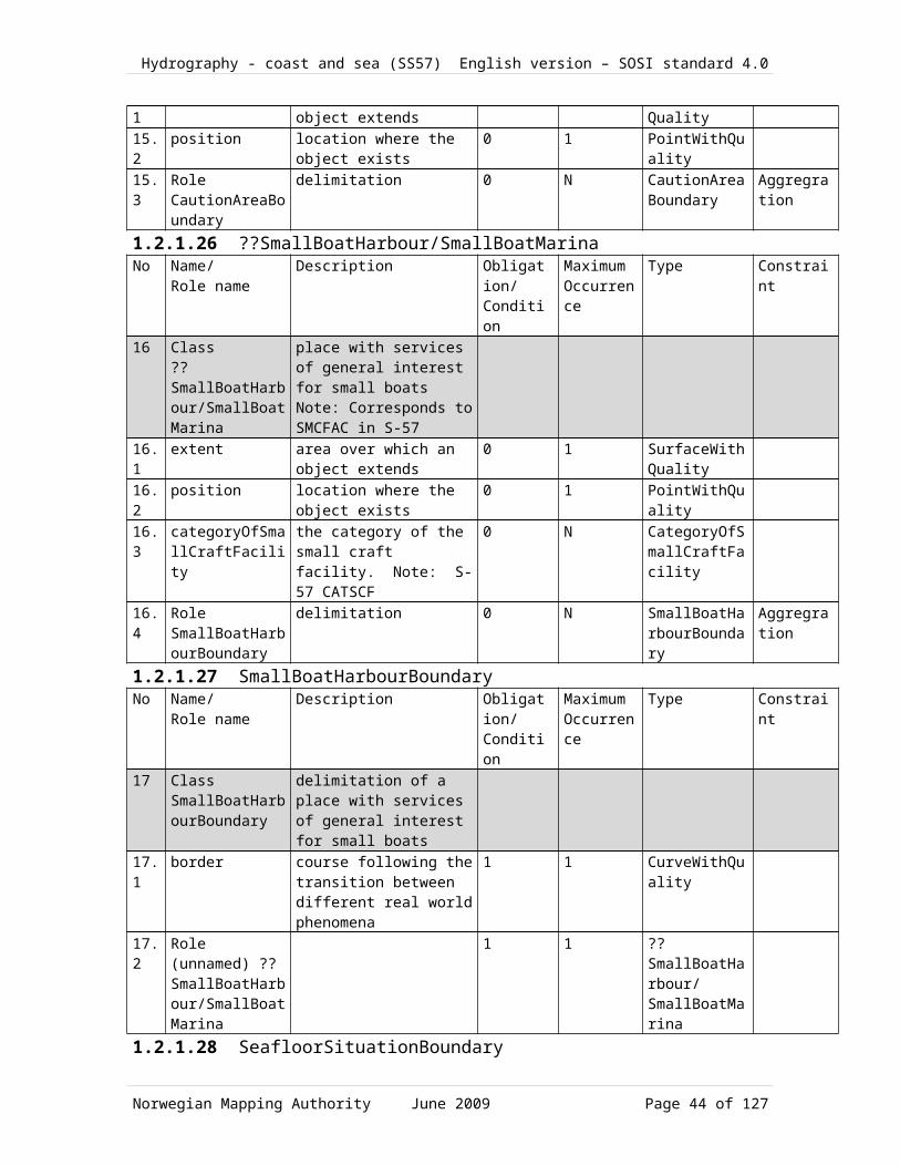
Hydrography - coast and sea (SS57) English version – SOSI standard 4.0
1 CautionAreaBoundary
undary n
37.2
Role (unnamed) CautionArea
1 1 CautionArea
1.2.1.48 Association <<Topo>> ??SmallBoatHarbour/SmallBoatMarina-SmallBoatHarbourBoundary
No Name/Role name
Description Obligation/Condition
MaximumOccurrence
Type Constraint
38 Association ??SmallBoatHarbour/SmallBoatMarina-SmallBoatHarbourBoundary
38.1
Role SmallBoatHarbourBoundary
delimitation 0 N SmallBoatHarbourBoundary
Aggregation
38.2
Role (unnamed) ??SmallBoatHarbour/SmallBoatMarina
1 1 ??SmallBoatHarbour/SmallBoatMarina
1.2.1.49 Association <<Topo>> MilitaryPracticeArea-MilitaryPracticeAreaBoundary
No Name/Role name
Description Obligation/Condition
MaximumOccurrence
Type Constraint
39 Association MilitaryPracticeArea-MilitaryPracticeAreaBoundary
39.1
Role MilitaryPracticeAreaBoundary
delimitation 0 N MilitaryPracticeAreaBoundary
Aggregation
39.2
Role (unnamed) MilitaryPracticeArea
1 1 MilitaryPracticeArea
1.2.1.50 Association <<Topo>> SeafloorSituation-SeafloorSituationBoundaryNo Name/
Role nameDescription Obligation/
ConditionMaximumOccurrence
Type Constraint
40 Association SeafloorSituation-SeafloorSituationBoundary
40.1
Role SeafloorSituationBoundary
delimitation 0 N SeafloorSituationBoundary
Aggregation
Norwegian Mapping Authority June 2009 Page 44 of 99

Hydrography - coast and sea (SS57) English version – SOSI standard 4.0
40.2
Role (unnamed) SeafloorSituation
1 1 SeafloorSituation
1.2.1.51 Association <<Topo>> PipelineArea-PipelineAreaBoundaryNo Name/
Role nameDescription Obligation/
ConditionMaximumOccurrence
Type Constraint
41 Association PipelineArea-PipelineAreaBoundary
41.1
Role PipelineAreaBoundary
areaBoundary 0 N PipelineAreaBoundary
Aggregation
41.2
Role (unnamed) PipelineArea
1 1 PipelineArea
1.2.1.52 Association <<Topo>> Wreck-WreckBoundaryNo Name/
Role nameDescription Obligation/
ConditionMaximumOccurrence
Type Constraint
42 Association Wreck-WreckBoundary
42.1
Role WreckBoundary
delimitation 0 N WreckBoundary
Aggregation
42.2
Role (unnamed) Wreck
1 1 Wreck
Norwegian Mapping Authority June 2009 Page 45 of 99

Hydrography - coast and sea (SS57) English version – SOSI standard 4.0
1.2.1.53 CodeLists1.2.1.53.1 <<CodeList>> SeafloorTypeNr Code name Definition/Description Code1 CodeList
SeafloorTypethe category for the materials on the seafloor used by the Norwegian Hydrographic Service. Note: Not S-57 NATSUR
1.1 Mussels (Note Ms1.2 Pebbles and sand (Note "P S"1.3 Sand and clay (Note "S Cy"1.4 Shells and sand (Note "Sh S"1.5 Coarse c1.6 Medium large stones 64.0 - 256.0
mmCb
1.7 Chalk Ck1.8 Coral Co1.9 Coarse sand 0.5 - 2.0 mm cS1.10 Clay < 0.002 mm Cy1.11 Fine f1.12 Fine sand 0.0625 - 0.125 mm fS1.13 Gravel 2.0 - 4.0 mm G1.14 Hard h1.15 Mud M1.16 Medium-fine sand 0.25 - 0.5 mm1.17 Oysters Oy1.18 Pebbles 4.0 - 64.0 mm P1.19 Rock > 256 mm R1.20 Sand S1.21 Shells Sh1.22 Silt 0.002 - 0.0625 mm Si1.23 Small sm1.24 Soft so1.25 Stones St1.26 Kelp, Seaweed Wd1.2.1.53.2 <<CodeList>> CategoryOfDumpingGroundNr Code name Definition/Description Code
Norwegian Mapping Authority June 2009 Page 46 of 99

Hydrography - coast and sea (SS57) English version – SOSI standard 4.0
2 CodeList CategoryOfDumpingGround
the category of the dumping ground. Note: S-57 CATDPG
2.1 General dumping ground generell 12.2 Chemical waste dumping ground (IN 24; 442.1-3; ) 22.3 Nuclear waste dumping ground 32.4 Explosives dumping ground (IN 23.1-2; 442.1-3;) 42.5 Spoil ground (IN 62.1-2; 446.1-2;) 52.6 Shipwreck Vessel dumping ground 62.7 Oil installations 72.8 Ballast water 91.2.1.53.3 <<CodeList>> TrafficFlowNr Code name Definition/Description Code3 CodeList
TrafficFlowthe direction of the traffic flow used for maritime objects. Note: S-57 TRAFIC (used by FAIRWY, RDOCAL and RECTRC)
3.1 Inbound 13.2 Outbound 23.3 One-way 33.4 Two-way 41.2.1.53.4 <<CodeList>> AnchorageUsageNr Code name Definition/Description Code4 CodeList
AnchorageUsageclassification of anchorage used by the Norwegian Coastal Administration (Kystverket)
4.1 Important anchorage areas for vessels
1
4.2 Areas for laying up vessels 24.3 Anchorage/Lay-up areas for
petroleum installations3
1.2.1.53.5 <<CodeList>> CategoryOfSmallCraftFacilityNr Code name Definition/Description Code5 CodeList
CategoryOfSmallCraftFacilitythe category of the small craft facility. Note: S-57 CATSCF
5.1 Visitor’s berth 15.2 Nautical club 25.3 Boat hoist 35.4 Sail maker 4
Norwegian Mapping Authority June 2009 Page 47 of 99
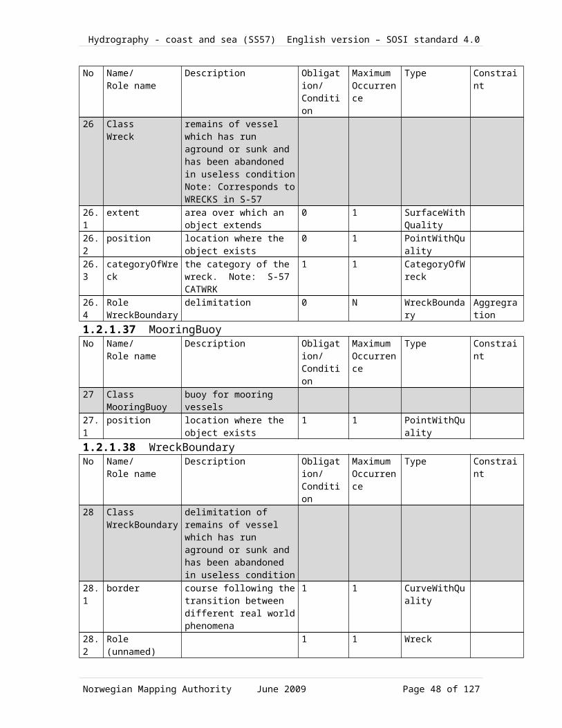
Hydrography - coast and sea (SS57) English version – SOSI standard 4.0
5.5 Boatyard 55.6 Public inn 65.7 Restaurant 75.8 Chandler 85.9 Provisions 95.10 Doctor 105.11 Pharmacy 115.12 Water tap 125.13 Fuel station 135.14 Electricity 145.15 Bottle gas 155.16 Showers 15.17 Launderette 175.18 Public toilet 185.19 Post box 195.20 Public telephone 205.21 Refuse bin 215.22 Car park 225.23 Parking for boats and trailers 235.24 Caravan site 245.25 Camping site 255.26 Emptying of septic tank Sewerage
pump-out station26
5.27 Emergency telephone 275.28 Landing/launching place for boats 285.29 Visitors mooring 295.30 Scrubbing berth 305.31 Picnic area 315.32 Mechanics workshop 325.33 Guard and/or security service 331.2.1.53.6 <<CodeList>> CategoryOfDumpingAreaNr Code name Definition/Description Code6 CodeList
CategoryOfDumpingAreainformation about what can be dumped in this dumping area (the categories used by the Norwegian Coastal Administration). Note: not S-57 CATDPG
6.1 Dredged masses, soil and rock 1
Norwegian Mapping Authority June 2009 Page 48 of 99
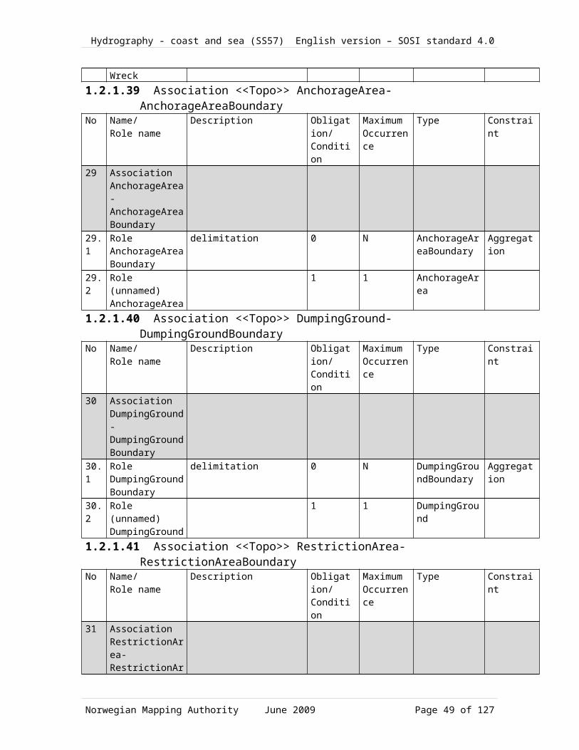
Hydrography - coast and sea (SS57) English version – SOSI standard 4.0
6.2 Ships with metal hulls 26.3 Other ships 36.4 Fish waste from onshore processing 46.5 Other waste/materia 56.6 Ammunition 61.2.1.53.7 <<CodeList>> RestrictionNr Code name Definition/Description Code7 CodeList
Restrictionlimitations on traffic or use of maritime areas. Note: S-57 RESTRN
7.1 Anchoring forbidden 17.2 Restriksjoner for ankring 27.3 Fishing is forbidden 37.4 Fishing restricted 47.5 Trawling is forbidden 57.6 Restrictions on trawling 67.7 Area to which access is forbidden 77.8 Restrictions on access 87.9 Dredging/seafloor scraping forbidden 97.10 Dredging restricted7.11 Diving prohibited 117.12 Restrictions on diving 127.13 No wake 137.14 Area which should be avoided 147.15 Construction prohibited 157.16 Reduced speed1.2.1.53.8 <<CodeList>> CategoryOfAnchorageNr Code name Definition/Description Code8 CodeList
CategoryOfAnchoragethe category of the anchorage. Note: S-57 CATACH
8.1 Anchorage allowed/recommended/required
1
8.2 Deep water anchorage 28.3 Tanker anchorage 38.4 Explosives anchorage 48.5 Quarantine anchorage 5
Norwegian Mapping Authority June 2009 Page 49 of 99

Hydrography - coast and sea (SS57) English version – SOSI standard 4.0
8.6 Sea plane anchorage 68.7 Small craft mooring area 78.8 Small craft anchorage 88.9 Short-term anchorage ??berth/space 91.2.1.53.9 <<CodeList>> CategoryOfCableNr Code name Definition/Description Code9 CodeList
CategoryOfCablethe category of the cable. Note: S-57 CATCBL
9.1 Power line9.2 High-voltage power line9.3 Telephone line9.4 Telegraph line9.5 Mooring cable / chain1.2.1.53.10 <<CodeList>> CategoryOfRestrictedAreaNr Code name Definition/Description Code10 CodeList
CategoryOfRestrictedAreathe category of the restricted area. Note: S-57 CATREA
10.1 Offshore safety zone 110.2 Nature reserve 410.3 Bird sanctuary 510.4 Game reserve 610.5 Seal sanctuary 710.6 Degaussing area 810.7 Military area 910.8 Historic wreck area 1010.9 Navigsational aid safety zone 1210.10 Minefield 1410.11 Dredging area 211.2.1.53.11 <<CodeList>> CategoryOfPipeNr Code name Definition/Description Code11 CodeList
CategoryOfPipethe category of the pipeline or pipe. Note: S-57 CATPIP
11.1 Outlet 111.2 Inlet 2
Norwegian Mapping Authority June 2009 Page 50 of 99

Hydrography - coast and sea (SS57) English version – SOSI standard 4.0
11.3 Sewer 311.4 Supply pipe 61.2.1.53.12 <<CodeList>> CategoryOfWreckNr Code name Definition/Description Code12 CodeList
CategoryOfWreckthe category of the wreck. Note: S-57 CATWRK
12.1 Non-dangerous wreck 112.2 Dangerous wreck 212.3 Distributed remains of wreck 312.4 Wreck showing masts 412.5 Wreck showing any portion of hull or
superstructure5
1.2.1.53.13 <<CodeList>> StatusSeaNr Code name Definition/Description Code13 CodeList
StatusSeathe status of the object used for maritime objects. Note: S-57 STATUS
13.1 Permanent 113.2 Spesial needs 213.3 Recommended 313.4 Not in use 413.5 Periodic/intermittent 513.6 Reserved 613.7 Temporary 713.8 Private 813.9 Mandatory 913.10 Havarert 1013.11 Extinguished 1113.12 Illuminated 1213.13 Historic 1313.14 Public 1413.15 Synchronized 1513.16 Watched 1613.17 Un-watched 1713.18 Existence Doubtful 1813.19 Operational 30
Norwegian Mapping Authority June 2009 Page 51 of 99

Hydrography - coast and sea (SS57) English version – SOSI standard 4.0
13.20 Discontinued/Omitted 3113.21 Planned 32
Norwegian Mapping Authority June 2009 Page 52 of 99

Hydrography - coast and sea (SS57) English version – SOSI standard 4.0
Military information1.2.1.54 MilitaryPracticeAreaBoundaryNo Name/
Role nameDescription Obligation/
ConditionMaximumOccurrence
Type Constraint
1 Class MilitaryPracticeAreaBoundary
boundary for area used by the armed forces for exercises
1.1 border course following the transition between different real world phenomena
1 1 CurveWithQuality
1.2 Role (unnamed) MilitaryPracticeArea
1 1 MilitaryPracticeArea
1.2.1.55 MilitaryPracticeAreaNo Name/
Role nameDescription Obligation/
ConditionMaximumOccurrence
Type Constraint
2 Class MilitaryPracticeArea
area used by the armed forces for exercises Note: Corresponds to MIPARE in S-57
2.1 extent area over which an object extends
0 1 SurfaceWithQuality
2.2 position location where the object exists
0 1 PointWithQuality
2.3 categoryOfMilitaryPracticeArea
the category of the military practice area. Note: S-57 CATMPA
0 1 CategoryOfMilitaryPracticeArea
2.4 restriction limitations on traffic or use of maritime areas. Note: S-57 RESTRN
0 1 Restriction
2.5 status the status of the object used for maritime objects. Note: S-57 STATUS
0 1 StatusSea
Norwegian Mapping Authority June 2009 Page 53 of 99

Hydrography - coast and sea (SS57) English version – SOSI standard 4.0
2.6 Role MilitaryPracticeAreaBoundary
delimitation 0 N MilitaryPracticeAreaBoundary
Aggregration
Norwegian Mapping Authority June 2009 Page 54 of 99

Hydrography - coast and sea (SS57) English version – SOSI standard 4.0
1.2.1.55.1 CodeLists1.2.1.55.2 <<CodeList>> CategoryOfMilitaryPracticeAreaNr Code name Definition/Description Code1 CodeList
CategoryOfMilitaryPracticeAreathe category of the military practice area. Note: S-57 CATMPA
1.1 Torpedo exercise area 21.2 Submarine exercise area 31.3 General practice range 41.4 Mine-laying practice area 5
Small arms firing range 6
Norwegian Mapping Authority June 2009 Page 55 of 99

Hydrography - coast and sea (SS57) English version – SOSI standard 4.0
Navigation installation1.2.1.56 NavigationInstallationNo Name/
Role nameDescription Obligation/
ConditionMaximumOccurrence
Type Constraint
1 Class NavigationInstallation
object which helps mariners to navigate at sea
1.1 position location where the object exists
1 1 PointWithQuality
1.2 surveyedPosisjon
0 1 PointWithQuality
1.3 descriptionOfLocation
the detailed description of the location as used in the Norwegian List of Lights publication. Note: not BELIGG from SOSI 4.0 LEDN chapter about Ledningsnett
0 1 CharacterString
1.4 objectNameInNationalLanguage
the name of the object in the national language. Note: S-57 NOBJNM and also NAVN from the SOSI 4.0 chapter about General Types, and not S-57 OBJNAM which is the objectXzXs name in English
0 1 CharacterString
1.5 nameOfArea the name of the general area in which the object is located, as used in the Norwegian List of Lights publication. Note: not S-57
0 1 CharacterString
1.6 height the value of the vertical distance to the highest point of the object. Note: S-57 HEIGHT
0 1 Real
1.7 navigationalInstallationOwner
specification of who owns the installation. Note: not S-57
0 1 CharacterString
1.8 listOfLightsNumber
the identification number of the installation used in the Norwegian List of Lights publication
0 1 CharacterString
1.9 status the status of the object used for maritime objects. Note: S-57 STATUS
0 1 StatusSea
1.10
periodicDateStart the start of the active period for a seasonal object (e.g. a buoy). Note: S-57 PERSTA
0 1 Date
1.11
periodicDateEnd the end of the active period for a seasonal
0 1 Date
Norwegian Mapping Authority June 2009 Page 56 of 99

Hydrography - coast and sea (SS57) English version – SOSI standard 4.0
object (e.g. a buoy). Note: S-57 PEREND
1.12
coastalAdministrationDistrict
the Norwegian Coastal AdministrationXzXs district or region. Note: not S-57
0 1 CoastalAdministrationDistrict
1.13
systemOfNavigationalMarks
the system of the maritime buoyage and beaconage used for the object. Note: S-57 MARSYS
0 1 SystemOfNavigationalMarks
1.14
Role equipment
0 N SignalEquipment
Aggregration
1.15
Role foundation
0 1 LanternFoundation
1.16
Role (unnamed) Leading??
0 1 Leading??
1.2.1.57 NavigationMarkNo Name/
Role nameDescription Obligation/
ConditionMaximumOccurrence
Type Constraint
2 Class NavigationMark
??beacon/mark which serves as a guide for navigation
Abstract
Subtype of NavigationInstallation
2.1 retroReflector an indication of whether there is a means of distinguishing unlighted marks at night. Note: not an S-57 attribute, but generates the S-57 object RETRFL, retro-reflector.
0 1 Boolean
2.2 topmarkDaymarkShape
the category of the IMO topmark / daymark shape. Note: S-57 TOPSHP
0 1 TopmarkDaymarkShape
2.3 nationalTopMarkType
the category of the Norwegian topmarks. Note: not S-57's TOPSHP
0 1 NasjonalToppmerketype
2.4 navigationalMarkListNumber
the Norwegian Coastal Administration's identification number for the mark
0 1 integer
2.5 depth the depth of an object. Note: S-57 uses a 3-D encoding of the depth on the geometry. Compatible with DYBDE from the SOSI 4.0 chapter about General Types?
0 1 Real
2.6 techniqueOfSoundingMeasurement
the technique used for the sounding measurement. Note: S-57 TECSOU
0 1 TechniqueOfSoundingMeasurement
2.7 colour1 generell fargeangivelse, tilsvarer S-57 COLOUR
1 1 Colour
2.8 colour2 generell fargeangivelse, 1 1 Colour
Norwegian Mapping Authority June 2009 Page 57 of 99

Hydrography - coast and sea (SS57) English version – SOSI standard 4.0
tilsvarer S-57 COLOUR2.9 colour3 generell fargeangivelse,
tilsvarer S-57 COLOUR1 1 Colour
2.10
colourPattern the category of the colour pattern. Note: S-57 COLPAT
0 1 ColourPattern
1.2.1.58 BuildingPointNo Name/
Role nameDescription Obligation/
ConditionMaximumOccurrence
Type Constraint
3 Class BuildingPoint
(S57 BUISGL) Subtype of LanternFoundation
3.1 status angivelse av bygningspunktets status (fra S57)
0 1 StatusSea
3.2 bygningsfunksjon 0 1 Function1.2.1.59 PillarNo Name/
Role nameDescription Obligation/
ConditionMaximumOccurrence
Type Constraint
4 Class Pillar
Note: S-57 PILPNT Subtype of LanternFoundation
4.1 categoryOfPile the category of the pile. Note: S-57 CATPLE
0 1 CharacterString
1.2.1.60 LandmarkNo Name/
Role nameDescription Obligation/
ConditionMaximumOccurrence
Type Constraint
5 Class Landmark
Note: S-57 LNDMRK Subtype of LanternFoundation
5.1 function the category of the objectXzXs function. Note: S-57 FUNCTN
0 1 Function
5.2 categoryOfLandmark
the category of the landmark. Note: S-57 CATLMK
1 1 CategoryOfLandmark
5.3 conspicuousVisually
the category of the visual conspicuousness. Note: S-57 CONVIS
1 1 ConspicuousVisually
1.2.1.61 IsolatedDangerBuoyNo Name/
Role nameDescription Obligation/
ConditionMaximumOccurrence
Type Constraint
6 Class IsolatedDangerBuoy
buoyant navigation mark anchored to a dangerous shoal of modest scope, passable outside of the ??obstruction/hindrance Note: S-57 BOYISD
Subtype of FloatingNavigationMark
1.2.1.62 ??SafeWaterBuoyNo Name/ Description Obligation/ Maximum Type Constraint
Norwegian Mapping Authority June 2009 Page 58 of 99

Hydrography - coast and sea (SS57) English version – SOSI standard 4.0
Role name Condition Occurrence
7 Class ??SafeWaterBuoy
Subtype of FloatingNavigationMark
1.2.1.63 LateralBuoyNo Name/
Role nameDescription Obligation/
ConditionMaximumOccurrence
Type Constraint
8 Class LateralBuoy
Subtype of FloatingNavigationMark
8.1 systemOfNavigationalMarks
the system of the maritime buoyage and beaconage used for the object. Note: S-57 MARSYS
1 1 SystemOfNavigationalMarks
1.2.1.64 RadarStationNo Name/
Role nameDescription Obligation/
ConditionMaximumOccurrence
Type Constraint
9 Class RadarStation
Note: S-57 RADSTA Subtype of SignalEquipment
9.1 categoryOfRadioStation
the category of the radio station. Note: S-57 CATROS
0 1 CategoryOfRadioStation
9.2 communicationChannel
a channel number assigned to a specific radio frequency, frequencies or frequency band Note: S-57 COMCHA
0 1 CharacterString
9.3 height the value of the vertical distance to the highest point of the object. Note: S-57 HEIGHT
0 1 Real
9.4 valueOfNominalRange
the nominal range at which an object can be seen or a signal detected, in units of 0.1 nautical miles. Note: S-57 VALNMR
0 1 Real
1.2.1.65 LateralMarkNo Name/
Role nameDescription Obligation/
ConditionMaximumOccurrence
Type Constraint
10 Class LateralMark
Subtype of FixedNavigationMark
10.1
categoryOfLateralMark
the category of the lateral mark. Note: S-57 CATLAM
1 1 CategoryOfLateralMark
1.2.1.66 IsolatedDangerMark
Norwegian Mapping Authority June 2009 Page 59 of 99
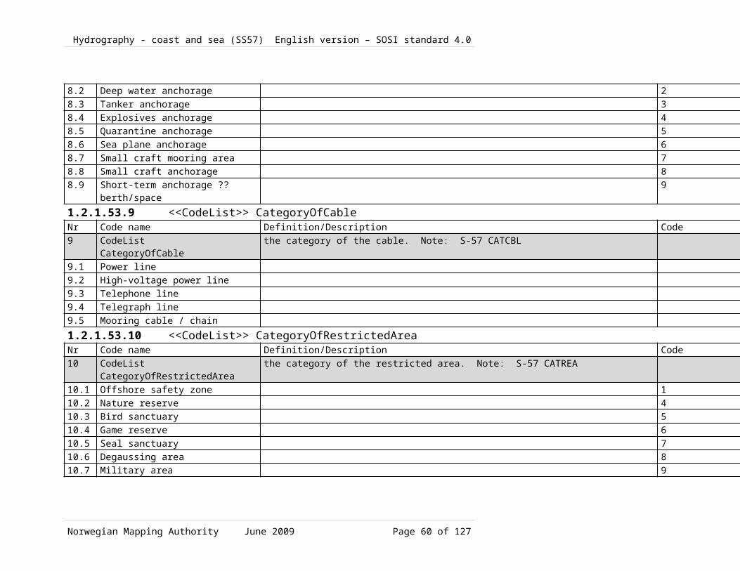
Hydrography - coast and sea (SS57) English version – SOSI standard 4.0
No Name/Role name
Description Obligation/Condition
MaximumOccurrence
Type Constraint
11 Class IsolatedDangerMark
Note: S-57 BCNISD Subtype of FixedNavigationMark
1.2.1.67 CardinalBuoyNo Name/
Role nameDescription Obligation/
ConditionMaximumOccurrence
Type Constraint
12 Class CardinalBuoy
Note: S57 BOYCAR Subtype of FloatingNavigationMark
12.1
categoryOfCardinalMark
the category of the cardinal mark. Note: S-57 CATCAM
1 1 categoryOfCardinalMark
1.2.1.68 SpecialMarkNo Name/
Role nameDescription Obligation/
ConditionMaximumOccurrence
Type Constraint
13 Class SpecialMark
Subtype of FixedNavigationMark
13.1
categoryOfSpecialPurposeMark
the category of the special purpose mark. Note: S-57 CATSPM
1 1 CategoryOfSpecialPurposeMark
1.2.1.69 SignalEquipmentNo Name/
Role nameDescription Obligation/
ConditionMaximumOccurrence
Type Constraint
14 Class SignalEquipment
Abstract
14.1
Role (unnamed) NavigationInstallation
1 1 NavigationInstallation
1.2.1.70 RaconNo Name/
Role nameDescription Obligation/
ConditionMaximumOccurrence
Type Constraint
15 Class Racon
Note: S-57 RTPBCN Subtype of SignalEquipment
15.1
type the racon types as described in the Norwegian List of Lights publication. Note: not S-57
0 1 RaconType
15.2
frequencyBand a categorization of a racon based on the distance between two successive peaks (or other points of identical phase) on an
0 1 RaconFrequencyBand
Norwegian Mapping Authority June 2009 Page 60 of 99

Hydrography - coast and sea (SS57) English version – SOSI standard 4.0
electromagnetic wave in the radar band of the electromagnetic spectrum. Note: related to S-57 RADWAL. Used by in the Norwegian List of Lights publication.
15.3
morseCodeCharacter
the number of signals, the combination of signals or the morse character(s) within one period of full sequence. Implemented as one Morse code letter, but without brackets, so it is not equivalent to S-57XzXs SIGGRP for racons.
0 1 RaconMorseCodeCharacter
15.4
responseInterval the Norwegian Coastal AdministrationXzXs signal response interval as described in its
0 1 RaconResponseInterval
15.5
raconElevation the altitude of the ground level of an object, measured from a specified vertical datum. Note: S-57 ELEVAT
0 1 Real
15.6
valueOfMaximumRange
the extreme distance at which an object can be seen or a signal detected, in units of 0.1 nautical miles. Note: S-57 VALMXR
0 1 Real
15.7
raconCharacter the text used to describe the signature of a radar transponder beacon (racon) on Norwegian nautical charts, i.e., Racon (x) where x is the Morse code letter. Note: not S-57
0 1 CharacterString
15.8
categoryOfRadarTransponderBeacon
the category of the radar transponder beacon. Note: S-57 CATRTB
1 1 CategoryOfRadarTransponderBeacon
Init Value =2
15.9
directionalVector1
line segment with length and orientation. Note: from SOSI 4.0 chapter about General Types, slightly related to S-57 ORIENT: Orientation
1 1 DirectionVector
15.10
directionalVector2
line segment with length and orientation. Note: from SOSI 4.0 chapter about General Types, slightly related to S-57 ORIENT: Orientation
1 1 DirectionVector
Norwegian Mapping Authority June 2009 Page 61 of 99
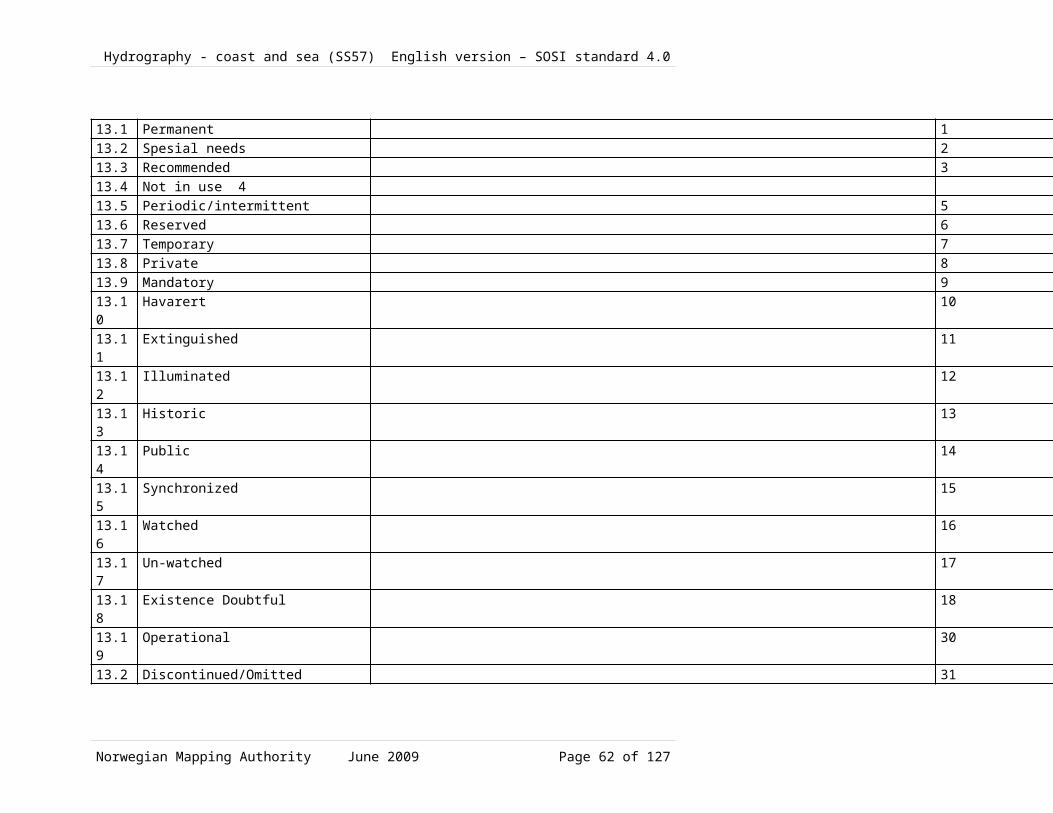
Hydrography - coast and sea (SS57) English version – SOSI standard 4.0
1.2.1.71 IlluminationNo Name/
Role nameDescription Obligation/
ConditionMaximumOccurrence
Type Constraint
16 Class Illumination
Note: S-57 LIGHTS Subtype of SignalEquipment
16.1
categoryOfLight the category of the light. Note: S-57 CATLIT
1 2 CategoryOfLight
16.2
listOfLightsCharacteristic
the light characteristic as used in the Norwegian List of Lights publication. Note: not S-57 LITCHR
0 1 CharacterString
16.3
lightCharacteristic
the category of the navigational light characteristic. Note: S-57 LITCHR
0 1 LightCharacteristic
16.4
directionalVector line segment with length and orientation. Note: from SOSI 4.0 chapter about General Types, slightly related to S-57 ORIENT: Orientation
0 1 Real
16.5
signalGroup the number of signals, the combination of signals or the morse character(s) within one period of full sequence. The signal group of a light is encoded using brackets to separate the individual groups. Note: S-57 SIGGRP
0 1 CharacterString
16.6
signalPeriod the time occupied by an entire cycle of intervals of light and eclipse in units of 0.01 seconds. Note: S-57 SIGPER
0 1 CharacterString
16.7
signalSequence the sequence of times occupied by intervals of light and eclipse for all "light characteristics" except for occulting where the sequence of times is occupied by intervals of eclipse and light. Note: S-57 SIGSEQ
0 1 CharacterString
16.8
height the value of the vertical distance to the highest point of the object, from sea level, in this case. Note: S-57 HEIGHT
0 1 Real
16.9
multiplicityOfLights
the number of lights of identical character that exist as a co-located group. Note: S-57
0 1 Integer
Norwegian Mapping Authority June 2009 Page 62 of 99

Hydrography - coast and sea (SS57) English version – SOSI standard 4.0
MLTYLT16.10
valueOfNominalRangeWhite
the nominal range at which an object can be seen or a signal detected, in units of 0.1 nautical miles. Note: S-57 VALNMR: Value of nominal range
0 1 Real
16.11
valueOfNominalRangeRed
the nominal range at which an object can be seen or a signal detected, in units of 0.1 nautical miles. Note: S-57 VALNMR: Value of nominal range
0 1 Real
16.12
valueOfNominalRangeGreen
the nominal range at which an object can be seen or a signal detected, in units of 0.1 nautical miles. Note: S-57 VALNMR: Value of nominal range
0 1 Real
16.13
valueOfNominalRangeYellow
the nominal range at which an object can be seen or a signal detected, in units of 0.1 nautical miles. Note: S-57 VALNMR: Value of nominal range
0 1 Real
16.14
Role lightSector
sector 1 N LightSector Aggregration
1.2.1.72 RadioNo Name/
Role nameDescription Obligation/
ConditionMaximumOccurrence
Type Constraint
17 Class Radio
Note: S-57 RDOSTA Subtype of SignalEquipment
17.1
categoryOfRadioStation
the category of the radio station. Note: S-57 CATROS
0 1 CategoryOfRadioStation
17.2
callSign the designated call-sign of a radio station. Note: S-57 CALSGN
0 1 CharacterString
17.3
communicationChannel
a channel number assigned to a specific radio frequency, frequencies or frequency band Note: S-57 COMCHA
0 1 CharacterString
17.4
valueOfNominalRange
the nominal range at which an object can be seen or a signal detected, in units of 0.1 nautical miles. Note: S-57 VALNMR
0 1 Real
17.5
directionalVector line segment with length and orientation. Note: from SOSI 4.0 chapter about General Types,
0 1 DirectionVector
Norwegian Mapping Authority June 2009 Page 63 of 99

Hydrography - coast and sea (SS57) English version – SOSI standard 4.0
slightly related to S-57 ORIENT: Orientation
17.6
signalFrequency the frequency of a signal for use by maritime transportation. Note: S-57 SIGFRQ
0 1 Integer
17.7
modulation the Norwegian Coastal AdministrationXzXs categories for modulation of the radio signal as described in its Norwegian List of Lights publication 2002 and 2004. Note: not S-57
0 1 RadioBeaconModulation
1.2.1.73 FloatingNavigationMarkNo Name/
Role nameDescription Obligation/
ConditionMaximumOccurrence
Type Constraint
18 Class FloatingNavigationMark
Abstract
Subtype of NavigationMark
18.1
buoyShape the category of a buoyXzXs shape. The principal shapes are those recommended in the
1 1 BuoyShape
1.2.1.74 FixedNavigationMarkNo Name/
Role nameDescription Obligation/
ConditionMaximumOccurrence
Type Constraint
19 Class FixedNavigationMark
fixed (not floating) navigation marks (cairns, beacons, iron rods, etc.)
Abstract
Subtype of NavigationMark
19.1
beaconShape the category of the characteristic geometric form of the beacon. Note: S57 BCNSHP
1 1 BeaconShape
1.2.1.75 LightSectorNo Name/
Role nameDescription Obligation/
ConditionMaximumOccurrence
Type Constraint
20 Class LightSector
Note: S-57 LIGHTS
20.1
lightColour generell fargeangivelse, tilsvarer S-57 COLOUR
0 1 Colour
20.2
SectorText 0 1 CharacterString
20.3
directionSectorLine1
S57 SECTR1SOSI:Retninger gitt i grader, 0-360, med 0 mot sant nord. Angitt fra sjø
1 1 Real
Norwegian Mapping Authority June 2009 Page 64 of 99
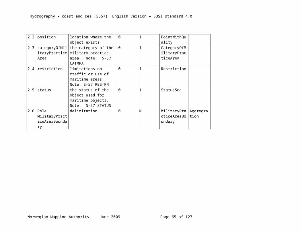
Hydrography - coast and sea (SS57) English version – SOSI standard 4.0
mot fyr20.4
lengthSectorLine1
Length, sector line 1 1 1 Real
20.5
directionSectorLine2
S57 SECTR2SOSI: Retninger gitt i grader, 0-360, med 0 mot sant nord. Angitt fra sjø mot fyr
1 1 Real
20.6
lengthSectorLine2
Length, sector line 2 1 1 Real
20.7
Role (unnamed) Illumination
1 1 Illumination
1.2.1.76 OtherFixedMarksNo Name/
Role nameDescription Obligation/
ConditionMaximumOccurrence
Type Constraint
21 Class OtherFixedMarks
Note: S-57 BCNISD Subtype of FixedNavigationMark
1.2.1.77 LanternFoundationNo Name/
Role nameDescription Obligation/
ConditionMaximumOccurrence
Type Constraint
22 Class LanternFoundation
Note: Non-navigation marks
Abstract
22.1
Role (unnamed) NavigationInstallation
0 1 NavigationInstallation
1.2.1.78 InstallasjonsbøyeNo Name/
Role nameDescription Obligation/
ConditionMaximumOccurrence
Type Constraint
23 Class Installasjonsbøye
Subtype of FloatingNavigationMark
23.1
installasjonsbøyekategori
0 1 Installasjonsbøyekategori
1.2.1.79 Leading??No Name/
Role nameDescription Obligation/
ConditionMaximumOccurrence
Type Constraint
24 Class Leading??
aggregate object containing 2 navigation devices, a solid leading line and a navigation line (solid and dotted leading line) Note: Corresponds to C_AGGR in S-57
24.1
??directionValue/
a general element stating ??direction/bearing
1 1 Real
Norwegian Mapping Authority June 2009 Page 65 of 99

Hydrography - coast and sea (SS57) English version – SOSI standard 4.0
bearingValue24.2
navigationCurve 1 1 CurveWithQuality
24.3
directionVectorCurve
1 1 CurveWithQuality
24.4
Role position
2 2 NavigationInstallation
Aggregration
1.2.1.80 Association SignalEquipment-NavigationInstallationNo Name/
Role nameDescription Obligation/
ConditionMaximumOccurrence
Type Constraint
25 Association SignalEquipment-NavigationInstallation
25.1
Role (unnamed) NavigationInstallation
1 1 NavigationInstallation
25.2
Role equipment
0 N SignalEquipment
Aggregation
1.2.1.81 Association LightSector-IlluminationNo Name/
Role nameDescription Obligation/
ConditionMaximumOccurrence
Type Constraint
26 Association LightSector-Illumination
26.1
Role (unnamed) Illumination
1 1 Illumination
26.2
Role lightSector
sector 1 N LightSector Aggregation
1.2.1.82 Association NavigationInstallation-LanternFoundationNo Name/
Role nameDescription Obligation/
ConditionMaximumOccurrence
Type Constraint
27 Association NavigationInstallation-LanternFoundation
27.1
Role foundation
0 1 LanternFoundation
27.2
Role (unnamed) NavigationInstallation
0 1 NavigationInstallation
1.2.1.83 Association NavigationInstallation-Leading??No Name/
Role nameDescription Obligation/
ConditionMaximumOccurrence
Type Constraint
28 Association
Norwegian Mapping Authority June 2009 Page 66 of 99
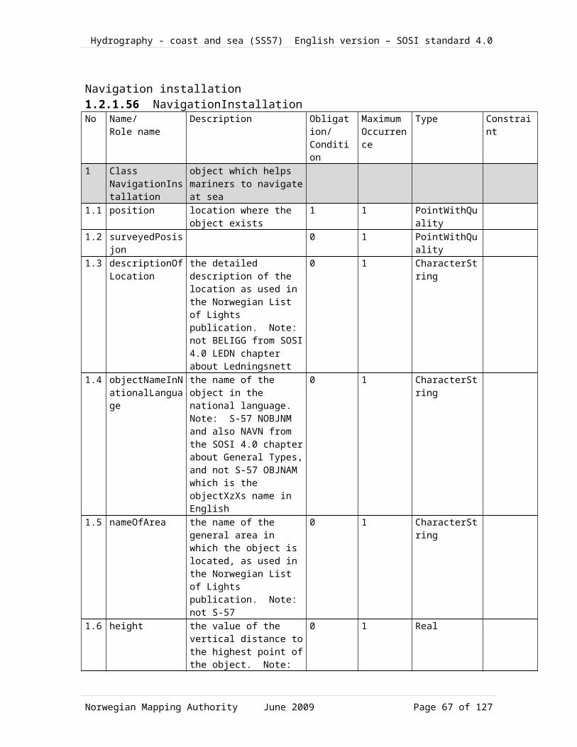
Hydrography - coast and sea (SS57) English version – SOSI standard 4.0
NavigationInstallation-Leading??
28.1
Role (unnamed) Leading??
0 1 Leading??
28.2
Role position
2 2 NavigationInstallation
Aggregation
Norwegian Mapping Authority June 2009 Page 67 of 99

Hydrography - coast and sea (SS57) English version – SOSI standard 4.0
1.2.1.83.1 CodeLists1.2.1.83.2 <<CodeList>> BeaconShapeNr Code name Definition/Description Code1 CodeList
BeaconShapehe category of the characteristic geometric form of the beacon. Note: S57 BCNSHP
1.1 Other 01.2 Stake, pole , perch, post 11.3 Lattice Beacon 41.4 Cairn 61.2.1.83.3 <<CodeList>> ColourPatternNr Code name Definition/Description Code2 CodeList
ColourPatternthe category of the pattern of the colors. Note: S57 COLPAT
2.1 Horizontal stripes 12.2 Vertical stripes 22.3 Diagonal stripes 32.4 Squared 42.5 Stripes (direction unknown)2.6 Border stripe 61.2.1.83.4 <<CodeList>> BuoyShapeNr Code name Definition/Description Code3 CodeList
BuoyShapethe category of a buoy's shape. The principal shapes are those recommended in the International Association of Lighthouse Authorities - IALA System. Note: S-57 BOYSHP
3.1 Conical buoy 13.2 Can/Cylindrical buoy 23.3 Pillar buoy 43.4 Spherical buoy 53.5 Barrel/tun buoy 63.6 Super-buoy 73.7 Ice buoy 83.8 Pillar buoy, right-leaning 213.9 Spar, right-leaning 223.10 Pillar buoy, left-leaning 263.11 Spar, left-leaning 27
Norwegian Mapping Authority June 2009 Page 68 of 99
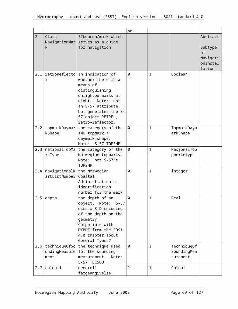
Hydrography - coast and sea (SS57) English version – SOSI standard 4.0
1.2.1.83.5 <<CodeList>> SystemOfNavigationalMarksNr Code name Definition/Description Code4 CodeList
SystemOfNavigationalMarkshe system of the maritime buoyage and beaconage used for the object. Note: S-57 MARSYS
4.1 IALA A (Int. Association of Lighthouse Authorities A) 14.2 IALA B (Int. Association of Lighthouse Authorities B) 24.3 No system 94.4 Other systems 101.2.1.83.6 <<CodeList>> CLOwnerNr Code name Definition/Description Code5 CodeList
CLOwner(not S-57) Not a codelist in PDB or in S57
5.1 The Norwegian Coastal Administration (Kystverket)
KV
5.2 Municipal port authority or similar HV5.3 The Armed Forces FV5.4 Private PR1.2.1.83.7 <<CodeList>> CategoryOfLateralMarkNr Code name Definition/Description Code6 CodeList
CategoryOfLateralMarkthe category of the lateral mark. Note: S-57 CATLAM
6.1 Port-hand lateral mark6.2 Starboard-hand lateral mark6.3 Preferred channel to starboard lateral
markMerknad:Ingen i Norge(INT1 s.72)
3
6.4 Preferred channel to port lateral mark Merknad:Ingen i Norge(INT1 s.72)
4
1.2.1.83.8 <<CodeList>> CheckedByNHSNr Code name Definition/Description Code7 CodeList
CheckedByNHSNote: not S-57
7.1 Not controlled 17.2 Controlled 2
Norwegian Mapping Authority June 2009 Page 69 of 99

Hydrography - coast and sea (SS57) English version – SOSI standard 4.0
1.2.1.83.9 <<CodeList>> RaconTypeNr Code name Definition/Description Code8 CodeList
RaconTypethe racon types as described in the Norwegian List of Lights publication. Note: not S-57
8.1 Unknown type of racon8.2 (FA) Frequency Agile racon 18.3 (ITOFAR) Interrogated Time Offset
Frequency Agile racon2
8.4 (SF) Swept Frequency racon 31.2.1.83.10 <<CodeList>> CoastalAdministrationDistrictNr Code name Definition/Description Code9 CodeList
CoastalAdministrationDistrictthe Norwegian Coastal Administration's district or region. Note: not S-57
9.1 Unspecified 09.2 The Norwegian Coastal
Administration (Kystverket) Southeast1
9.3 Kystverket Vest 29.4 The Norwegian Coastal
Administration (Kystverket) Middle Norway
3
9.5 The Norwegian Coastal Administration (Kystverket) Nordland
4
9.6 The Norwegian Coastal Administration (Kystverket) Troms and Finnmark
5
9.7 The Norwegian Coastal Administration (Kystverket) Svalbard
6
9.8 The North Sea 71.2.1.83.11 <<CodeList>> CategoryOfLightNr Code name Definition/Description Code10 CodeList
CategoryOfLightthe category of the light. Note: S-57 CATLIT
10.1 Undefined type of navigation light (ikke en S57 CATLIT verdi)10.2 Directional function10.3 Lantern (kun 1 sektor, oftest rundtlysende -- ikke S57 CATLIT) 2
Norwegian Mapping Authority June 2009 Page 70 of 99

Hydrography - coast and sea (SS57) English version – SOSI standard 4.0
10.4 Leading light 410.5 Aero light 510.6 Aero obstruction light 610.7 Fog detector light10.8 Flood light 810.9 Strip light10.10 Bifyr 1010.11 Spotlight meget liten flate 1110.12 Front10.13 Rear 1310.14 Lower 1410.15 Upper 1510.16 Moiré effect10.17 Emergency reservelys 1710.18 Illumination with automatic ??
direction/bearing finding18
10.19 Horizontally disposed10.20 Vertically disposed 2010.21 Navigation lights, in general med sektorer; ikke S57 CATLIT 991.2.1.83.12 <<CodeList>> CategoryOfRadarTransponderBeaconNr Code name Definition/Description Code11 CodeList
CategoryOfRadarTransponderBeacon
the category of the radar transponder beacon. Note: S-57 CATRTB
11.1 Unknown radar beacon type ikke en S57 CATRTB verdi 011.2 Ramark, radar beacon transmitting
contonuouslyramark) (INT1, IS 2 1
11.3 Racon, radar transponder beacon (racon) (INT1, IS 3.1-6)11.4 Leading racon/radar transponder
beacon(INT1, IS 3.5) 3
1.2.1.83.13 <<CodeList>> ColourNr Code name Definition/Description Code12 CodeList
Colourthe category of the colour used on lights/marks which are used for navigation. Note: S-57 COLOUR
12.1 White 1
Norwegian Mapping Authority June 2009 Page 71 of 99

Hydrography - coast and sea (SS57) English version – SOSI standard 4.0
12.2 Black 212.3 Red 312.4 Green 412.5 Blue 512.6 Yellow 612.7 Grey 712.8 Brown 812.9 Amber 912.10 Violet12.11 Orange 1112.12 Magenta 1212.13 Pink 131.2.1.83.14 <<CodeList>> CategoryOfCardinalMarkNr Code name Definition/Description Code13 CodeList
CategoryOfCardinalMarkthe category of the cardinal mark. Note: S-57 CATCAM
13.1 North cardinal mark 113.2 East cardinal mark 213.3 South cardinal mark 313.4 West cardinal mark 41.2.1.83.15 <<CodeList>> LightCharacteristicNr Code name Definition/Description Code14 CodeList
LightCharacteristicthe category of the navigational light characteristic. Note: S-57 LITCHR
14.1 U Udefinert 014.2 F Fast lys 114.3 Fl Blinkende lys 214.4 LFl Langt blink
(>2 sek)3
14.5 Q Hurtigblink(50-79/minutt)
4
14.6 VQ Kontinuerlig rask hurtigblink(80-160/min)
5
14.7 UQ Kontinuerlig ultra hurtigblink(>160/min.) 614.8 Iso Isofase 7
Norwegian Mapping Authority June 2009 Page 72 of 99

Hydrography - coast and sea (SS57) English version – SOSI standard 4.0
14.9 Oc Okkulterende 814.10 IQ Avbrutt hurtigblink 914.11 IVQ Avbrutt rask hurtigblink 1014.12 IUQ Avbrutt ultra hurtigblink 1114.13 Mo(K) Morsekode 1214.14 FFl Fast med blinkende 1314.15 Al Oc Vekslende og okkulterende 1714.16 Al LFl Vekslende og langt blink 1814.17 Al Fl Vekslende og blinkende 1914.18 Q LFl Hurtigblink og Langt blink 2514.19 VQ LFl Rask hurtigblink og Langt blink 2614.20 UQ LFl Ultra hurtigblink og Langt blink 2714.21 Al Vekslende 2814.22 Al F Fast og Vekslende blinker 291.2.1.83.16 <<CodeList>> CategoryOfInstallationBuoyNr Code name Definition/Description Code15 CodeList
CategoryOfInstallationBuoythe category of the installation buoy. Note: S57 CATINB
15.1 Catenary anchor leg mooring (CALM) 115.2 Single buoy mooring (SBM or SPM) 21.2.1.83.17 <<CodeList>> CategoryOfRadioStationNr Code name Definition/Description Code16 CodeList
CategoryOfRadioStationthe category of the radio station. Note: S-57 CATROS
16.1 Unknown radio beacon type (ikke en S57 CATROS verdi) 016.2 Circular radio beacon (RC) 116.3 Directional radio beacon (RD)16.4 Rotating-pattern radio beacon (RW) 316.5 Console beacon (Consol)16.6 Radio direction finding station (RG)16.7 Coastal radio station providing QTG
service(R) 6
16.8 Aeronautical radio beacon (Aero RC) 716.9 Decca (utgått?) 816.10 Loran C (utgått?) 9
Norwegian Mapping Authority June 2009 Page 73 of 99

Hydrography - coast and sea (SS57) English version – SOSI standard 4.0
16.11 Differential GPS (DGPS) 1016.12 Toran (utgått?) 1116.13 Omega (utgått) 1216.14 Syledis (utgått?) 1316.15 Chaika (Chayka) (utgått?) 141.2.1.83.18 <<CodeList>> CategoryOfSpecialPurposeMarkNr Code name Definition/Description Code17 CodeList
CategoryOfSpecialPurposeMarkthe category of the special purpose mark. Note: S-57 CATSPM
17.1 Firing danger area mark 117.2 Target mark 217.3 Marker ship mark17.4 Degaussing range mark17.5 Barge mark17.6 Cable mark17.7 Spoil ground mark 717.8 Outfall mark 817.9 ODAS(OceanData Acquisition
System)9
17.10 Recording mark17.11 Seaplane anchorage mark 1117.12 Recreation zone mark17.13 Private mark 1317.14 Mooring mark 1417.15 LANBY - Large Automatic
Navigational Buoy15
17.16 Leading mark 1617.17 Measured distance mark17.18 Notice mark17.19 TSS mark (Traffic Separation
Scheme)19
17.20 Clearing mark 4117.21 Control mark17.22 Refuge beacon17.23 Yachting mark 46
Norwegian Mapping Authority June 2009 Page 74 of 99

Hydrography - coast and sea (SS57) English version – SOSI standard 4.0
17.24 Heliport mark 4717.25 GPS mark17.26 Mark with unknown purpose 5217.27 Anchoring prohibited mark 2017.28 Berthing prohibited mark 2117.29 Overtaking prohibited mark 2217.30 Two-way traffic prohibited mark 2317.31 Reduced wake mark 2417.32 Speed limit mark 2517.33 Stop mark 2617.34 General warning mark 2717.35 Sound ship´s siren mark 2817.36 Restricted vertical clearance mark 2917.37 Maximum vessel´s draught mark 3017.38 Restricted horizontal clearance mark 3117.39 Strong current warning mark 3217.40 Berthing permitted mark 3317.41 Overhead power cable mark 3417.42 Channel edge gradient mark 3517.43 Telephone mark 3617.44 Ferry crossing mark 3717.45 Marine traffic lights (discontinued
from S-57)38
17.46 Pipeline mark 3917.47 Anchorage mark 4017.48 Diving mark 4317.49 Foul ground mark (yachting) 4517.50 Seaplane landing mark 4917.51 Entry prohibited mark 5017.52 Work in progress mark 511.2.1.83.19 <<CodeList>> TechniqueOfSoundingMeasurementNr Code name Definition/Description Code18 CodeList
TechniqueOfSoundingMeasurementthe technique used for the sounding measurement. Note: S-57 TECSOU
18.1 Found by echo sounder 1
Norwegian Mapping Authority June 2009 Page 75 of 99

Hydrography - coast and sea (SS57) English version – SOSI standard 4.0
18.2 Found by side-scan sonar 218.3 Found by multi-beam echo sounder 318.4 Found by diver 418.5 Found by lead-line 518.6 Swept 618.7 Found by laser 718.8 Swept by vertical acoustic system 818.9 Found by electromagnetic sensor 918.10 Photogrammetry 1018.11 Satellite imagery 1118.12 Found by levelling 1218.13 Swept by side-scan sonar 1318.14 Computer generated 141.2.1.83.20 <<CodeList>> TopmarkDaymarkShapeNr Code name Definition/Description Code19 CodeList
TopmarkDaymarkShapethe category of the IMO topmark / daymark shape. Note: S-57 TOPSHP
19.1 Cone, point up 119.2 Cone, point down 219.3 Sphere 319.4 2 Spheres 419.5 Cylinder (can) 519.6 Board 619.7 X-shape (St. Andrews cross) 719.8 Upright cross (St Georges cross) 819.9 Cube, point up 919.10 2 cones, point to point 1019.11 2 cones, base to base 1119.12 Rhombus (diamond) 1219.13 2 cones (points upward) 1319.14 2 cones (points downward) 1419.15 Besom, point up (broom or perch) 1519.16 Besom, point down (broom or perch) 1619.17 Flag 1719.18 Sphere over rhombus 18
Norwegian Mapping Authority June 2009 Page 76 of 99

Hydrography - coast and sea (SS57) English version – SOSI standard 4.0
19.19 Square 1919.20 Rectangle, horizontal 2019.21 Rectangle, vertical 2119.22 Trapezium, up 2219.23 Trapezium, down 2319.24 Triangle, point up 2419.25 Triangle, point down 2519.26 Circle 2619.27 Two upright crosses (one over the
other)27
19.28 T-shape 2819.29 Triangle pointing up over a circle 2919.30 Upright cross over a circle 3019.31 Rrhombus over a circle 3119.32 Circle over a triangle pointing up 3219.33 Other shape (see INFORM attribute) 331.2.1.83.21 <<CodeList>> NationalTopMarkTypeNr Code name Definition/Description Code20 CodeList
NationalTopMarkTypethe category of the Norwegian topmarks. Note: not S-57XzXs TOPSHP
20.1 Unknown Norwegian top mark type 020.2 Top mark with pointer20.3 Iron rod with pointer20.4 Pointer of black/carbon steel 320.5 Lantern with top mark 41.2.1.83.22 <<CodeList>> CategoryOfLandmarkNr Code name Definition/Description Code21 CodeList
CategoryOfLandmarkthe category of the landmark. Note: S-57 CATLMK
21.1 Cairn 121.2 Chimney 321.3 Dish aerial 421.4 Flare stack 621.5 Mast 721.6 Windsock 8
Norwegian Mapping Authority June 2009 Page 77 of 99

Hydrography - coast and sea (SS57) English version – SOSI standard 4.0
21.7 Monument 921.8 Column (pillar) 1021.9 Obelisk 1221.10 Cross 1421.11 Radar dome 1521.12 Radar scanner 1621.13 Tower 1721.14 Windmill 1821.15 Wind motor 1921.16 Church spire 201.2.1.83.23 <<CodeList>> CategoryOfPileNr Code name Definition/Description Code22 CodeList
CategoryOfPilethe category of the pile. Note: S-57 CATPLE
22.1 Unknown (ikke en S57 CATPLE verdi) : VARCHAR2(2) 022.2 Stake (ikke brukt av L&M) : VARCHAR2(2) 122.3 Post (INT1--IF22) : VARCHAR2(2)22.4 Rack?? VARCHAR2(2) 41.2.1.83.24 <<CodeList>> RaconFrequencyBandNr Code name Definition/Description Code23 CodeList
RaconFrequencyBanda categorization of a racon based on the distance between two successive peaks (or other points of identical phase) on an electromagnetic wave in the radar band of the electromagnetic spectrum. Note: related to S-57 RADWAL. Used by in the Norwegian List of Lights publication.
23.1 Racon in the 3 and 10-cm bands X+S23.2 Racon in the 3 cm band mellom 9320 og 9500 MHz X23.3 Racon in the 10 cm band mellom 2900 og 3100 MHz S1.2.1.83.25 <<CodeList>> RaconMorseCodeCharacterNr Code name Definition/Description Code24 CodeList
RaconMorseCodeCharacterthe number of signals, the combination of signals or the morse character(s) within one period of full sequence. Implemented as one Morse code letter, but without brackets, so it is not equivalent to S-57XzXs SIGGRP for racons.
24.1 Morse code sign B B24.2 Morse code sign G G24.3 Morse code sign K K
Norwegian Mapping Authority June 2009 Page 78 of 99
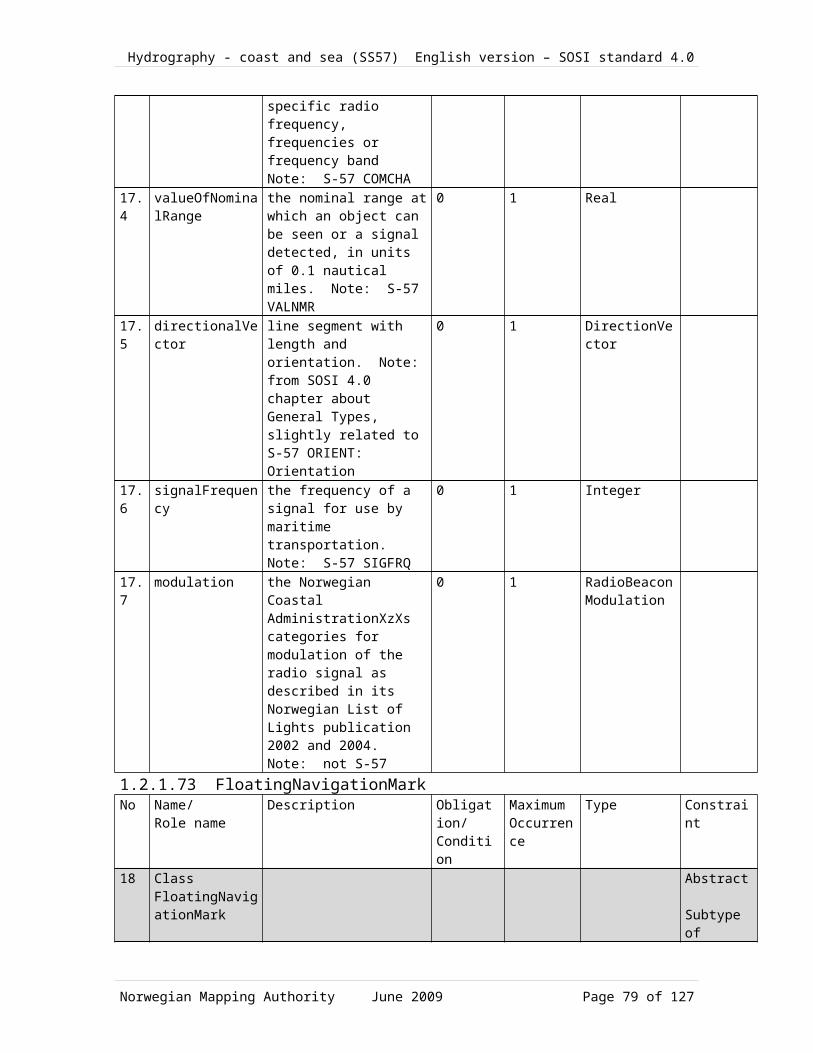
Hydrography - coast and sea (SS57) English version – SOSI standard 4.0
24.4 Morse code sign M M24.5 Morse code sign N N24.6 Morse code sign O O24.7 Morse code sign T T1.2.1.83.26 <<CodeList>> RaconResponseIntervalNr Code name Definition/Description Code25 CodeList
RaconResponseIntervalthe Norwegian Coastal AdministrationXzXs signal response interval as described in its Norwegian List of Lights publication. Note: not S-57
25.1 Active 18 seconds each 30 seconds25.2 Active 6 seconds each 12 seconds25.3 Active 15 seconds each 30 seconds25.4 Active 6 seconds each 30 seconds1.2.1.83.27 <<CodeList>> RadioBeaconModulationNr Code name Definition/Description Code26 CodeList
RadioBeaconModulationthe Norwegian Coastal AdministrationXzXs categories for modulation of the radio signal as described in its Norwegian List of Lights publication 2002 and 2004. Note: not S-57
26.1 Bærebølgen er G1D modulert (sendekanal er for utsendelse av DGPS korreksjoner) G1D26.2 Carrier signal is A1A-modulated with
call sign and direction finding signal1.2.1.83.28 <<CodeList>> FunctionNr Code name Definition/Description Code27 CodeList
Functionthe category of the object's function. Note: S-57 FUNCTN
27.1 Unknown function (ikke en S57 FUNCTN verdi) 027.2 Harbour master's office (INT1, IF.60) 227.3 Custom office (INT, IF.61) 327.4 Health Office, Quarantine building (INT1, IF.62.1) 427.5 Hospital (INT1, IF.62.2) 527.6 Post office (INT1, IF.63) 627.7 Hotel 727.8 Railway station (INT1, ID.13) 827.9 Police station 927.10 Harbour police station 1027.11 Boarding place, position of a Pilot- (INT1, IT.3) 11
Norwegian Mapping Authority June 2009 Page 79 of 99

Hydrography - coast and sea (SS57) English version – SOSI standard 4.0
Cruising Vessel, with note27.12 Boarding place, position of a Pilot-
Cruising Vessel, with name(INT1, IT.2) 12
27.13 Bankkontor 1327.14 Headquarters for district control 1427.15 Transit shed, warehouse (INT1, IF.51) 1527.16 Factory 1627.17 Power station 1727.18 Administrativ bygning 1827.19 Educational facility 1927.20 Church (INT1, IE.10.1) 2027.21 Chapel (INT1, IE.11) 2127.22 Temple (INT1, IE.13) 2227.23 Pagode (INT1, IE.14) 2327.24 Shinto-shrine (INT1, IE.15) 2427.25 Buddhist temple (INT1, IE.16) 2527.26 Mosque, minaret (INT1, IE.17) 2627.27 Marabout mosque (INT1, IE.18) 2727.28 Observation tower, lookout post (INT1, IG.77) 2827.29 Communication 2927.30 Television 3027.31 Radio 3127.32 Radar 3227.33 Light support 3327.34 Microwave 3427.35 Cooling 3527.36 Observation 3627.37 Timeball 3727.38 Clock 3827.39 Control 3927.40 Airship mooring 4027.41 Stadium 4127.42 Bus station 421.2.1.83.29 <<CodeList>> ConspicuousVisuallyNr Code name Definition/Description Code
Norwegian Mapping Authority June 2009 Page 80 of 99
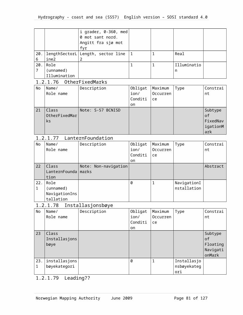
Hydrography - coast and sea (SS57) English version – SOSI standard 4.0
28 CodeList ConspicuousVisually
the category of the visual conspicuousness. Note: S-57 CONVIS
28.1 Visually conspicuous 128.2 Not visually conspicuous 21.2.1.83.30 <<CodeList>> CategoryOfRadarStationNr Code name Definition/Description Code29 CodeList
CategoryOfRadarStationthe category of the radar station. Note: S-57 CATRAS
29.1 Radar surveillance station29.2 Coast radar station
Norwegian Mapping Authority June 2009 Page 81 of 99

Hydrography - coast and sea (SS57) English version – SOSI standard 4.0
Topography1.2.1.84 DepthAreaNo Name/
Role nameDescription Obligation/
ConditionMaximumOccurrence
Type Constraint
1 Class DepthArea
sea area where all of the depths are within a designated depth interval Note: Corresponds to DEPARE in S-57
1.1 extent area over which an object extends
0 1 SurfaceWithQuality
1.2 position location where the object exists
0 1 PointWithQuality
1.3 minimumDepth 1 1 Depth1.4 maximumDepth 1 1 Depth1.5 Role
DepthContourdelimitation 0 N Depth contour Aggregrati
on1.6 Role
boundaryForeshore
0 N ForeshoreBoundary
Aggregration
1.7 Role boundaryDredgedArea
0 N DredgedAreaBoundary
Aggregration
1.8 Role (unnamed) SeaSurface
1 1 SeaSurface
1.9 Role boundaryDelimitationLandSea
0 N DelimitationLandSea
Aggregration
1.2.1.85 ShallowsNo Name/
Role nameDescription Obligation/
ConditionMaximumOccurrence
Type Constraint
2 Class Shallows
??(a rise/an elevation) on the seafloor which differs significantly from the depth of the surroundings (NHS dictionary). Comprising the former object classes UnderwaterRock, SkerryIntermittentlyDry, RockAwash and SoundingShot with (depth type) DYBDTYP=2.
Subtype of DepthPoint
1.2.1.86 SeaSurfaceNo Name/
Role nameDescription Obligation/
ConditionMaximumOccurrence
Type Constraint
3 Class SeaSurface
sea area which is delimited by ??Coastline/CoastalContour, CoastDelineation, SeaRiverDelineation and
Norwegian Mapping Authority June 2009 Page 82 of 99

Hydrography - coast and sea (SS57) English version – SOSI standard 4.0
CoastalTechnicalFacility3.1 extent area over which an object
extends0 1 SurfaceWithQu
ality3.2 position location where the object
exists0 1 PointWithQuali
ty3.3 Role
SeaRiverDelineation
seaSurfaceLandDelimitation
0 N DelimitationLandSea
Aggregration
3.4 Role havflateDataavgrensning
0 N DataDelimitation
Aggregration
3.5 Role (unnamed) Foreshore
1 1 Foreshore Aggregration
3.6 Role (unnamed) DepthArea
1 1 DepthArea Aggregration
3.7 Role MudretOmråde
0 N DredgedArea Aggregration
1.2.1.87 Depth contourNo Name/
Role nameDescription Obligation/
ConditionMaximumOccurrence
Type Constraint
4 Class Depth contour
line between points with the same depth in relation to designated reference level Note: Corresponds to DEPCNT in S-57
4.1 border course following the transition between different real world phenomena
1 1 CurveWithQuality
4.2 depth 1 1 Depth4.3 Role
(unnamed) DepthArea
2 2 DepthArea
1.2.1.88 CoastlineNo Name/
Role nameDescription Obligation/
ConditionMaximumOccurrence
Type Constraint
5 Class Coastline
boundary between land and sea, defined as the mean high ??tide/water line Note: Corresponds to COALNE in S-57
Subtype of DelimitationLandSea
5.1 border course following the transition between different real world phenomena
1 1 CurveWithQuality
5.2 categoryOfCoastline
the category of the coastline. Note: S-57 CATCOA
0 1 CategoryOfCoastline
5.3 coastalReferenceLevel
the coastline's reference level. Note: not S-57's VERDAT but distantly related
0 1 CoastalReferenceLevel
Norwegian Mapping Authority June 2009 Page 83 of 99
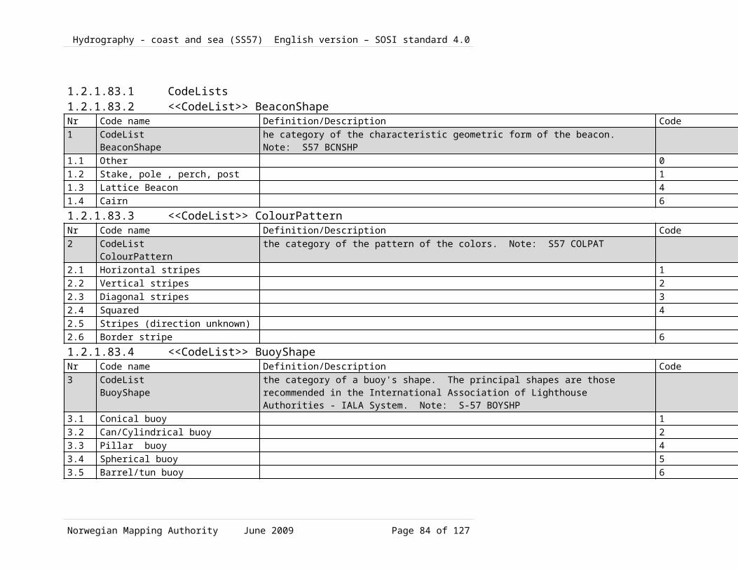
Hydrography - coast and sea (SS57) English version – SOSI standard 4.0
5.4 elevation The altitude of the ground level of an object, measured from a specified vertical datum. Note: S-57 ELEVAT
0 1 Real
5.5 Role (unnamed) HypsometricLayer
0 1 HypsometricLayer
1.2.1.89 SeaRiverDelineationNo Name/
Role nameDescription Obligation/
ConditionMaximumOccurrence
Type Constraint
6 Class SeaRiverDelineation
a fictitious line which defines the border between sea and river at the same level as ??coastline/CoastalContour (mean high ??tide/water) Note: This is identical to the same line referred to in the chapter on Lakes and watercourses).
Subtype of DelimitationLandSea
6.1 border course following the transition between different real world phenomena
1 1 CurveWithQuality
6.2 coastlineReferenceLevel
the coastline reference level. Note: not S-57 VERDAT but distantly related
0 1 CoastalReferenceLevel
6.3 elevation the altitude of the ground level of an object, measured from a specified vertical datum. Note: S-57 ELEVAT
0 1 Real
6.4 Role (unnamed) RiverBrook
1 1 RiverBrook
6.5 Role (unnamed) CanalDitch
1 1 CanalDitch
6.6 Role (unnamed) HypsometricLayer
0 1 HypsometricLayer
1.2.1.90 LandArea No Name/
Role nameDescription Obligation/
ConditionMaximumOccurrence
Type Constraint
7 Class LandArea
the area on the "land" side of the ??(coastline/coastal contour), quay and data delineation lines Note: Corresponds to LNDARE in S-57
Norwegian Mapping Authority June 2009 Page 84 of 99

Hydrography - coast and sea (SS57) English version – SOSI standard 4.0
7.1 extent area over which an object extends
0 1 SurfaceWithQuality
7.2 position location where the object exists
0 1 PointWithQuality
7.3 Role boundaryDelimitationLandSea
0 N DelimitationLandSea
Aggregration
7.4 Role landarealDataavgrensning
0 N DataDelimitation
Aggregration
1.2.1.91 DredgedAreaNo Name/
Role nameDescription Obligation/
ConditionMaximumOccurrence
Type Constraint
8 Class DredgedArea
dredged facility or area with a continuously maintained depth Note: Corresponds to DRGARE in S-57
8.1 extent area over which an object extends
0 1 SurfaceWithQuality
8.2 position location where the object exists
0 1 PointWithQuality
8.3 minimumDepth 1 1 Depth8.4 maximumDepth 1 1 Depth8.5 Role
DelimitationLandSea
delimitation 0 N DredgedAreaBoundary
Aggregration
8.6 Role boundaryForeshore
0 N ForeshoreBoundary
Aggregration
8.7 Role (unnamed) SeaSurface
1 1 SeaSurface
8.8 Role boundaryDelimitationLandSea
0 N DelimitationLandSea
Aggregration
1.2.1.92 Foreshore No Name/
Role nameDescription Obligation/
ConditionMaximumOccurrence
Type Constraint
9 Class Foreshore
that part of the seafloor which extends from 0.5 metres below ??hydrographic/nautical chart zero up to the ??coastline/coastal contour Note: The foreshore area is delimited by the ??coastline/coastal contour and the foreshore line, which is the line at the 0.5 m level below ??hydrographic/nautical chart
Subtype of SeaSurface
Norwegian Mapping Authority June 2009 Page 85 of 99
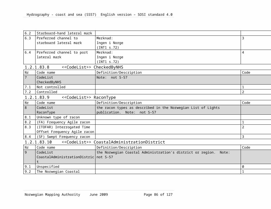
Hydrography - coast and sea (SS57) English version – SOSI standard 4.0
zero. Corresponds to DEPARE in S-57
9.1 extent area over which an object extends
0 1 SurfaceWithQuality
9.2 position location where the object exists
0 1 PointWithQuality
9.3 Role boundaryForeshore
0 N ForeshoreBoundary
Aggregration
9.4 Role (unnamed) SeaSurface
1 1 SeaSurface
9.5 Role DelimitationLandSea
delimitation 0 N DelimitationLandSea
Aggregration
1.2.1.93 ForeshoreBoundaryNo Name/
Role nameDescription Obligation/
ConditionMaximumOccurrence
Type Constraint
10 Class ForeshoreBoundary
boundary for foreshore area, curve with depth value of 0.5 m below K0, the zero level of the ??hydrographic/nautical chart Note: Corresponds to DEPCNT in S-57 -57 with standard depth value of 0.5 (m)
Subtype of Depth contour
10.1
border course following the transition between different real world phenomena
1 1 CurveWithQuality
10.2
depth 1 1 Depth Init Value =0,5
10.3
Role (unnamed) Foreshore
1 1 Foreshore
10.4
Role (unnamed) DepthArea
0 1 DepthArea
10.5
Role (unnamed) DredgedArea
0 1 DredgedArea
1.2.1.94 DredgedAreaBoundaryNo Name/
Role nameDescription Obligation/
ConditionMaximumOccurrence
Type Constraint
11 Class DredgedAreaBoundary
boundary for dredged facility or area with a continuously maintained depth
11.1
border course following the transition between different real world phenomena
1 1 CurveWithQuality
11. Role 1 1 DredgedArea
Norwegian Mapping Authority June 2009 Page 86 of 99

Hydrography - coast and sea (SS57) English version – SOSI standard 4.0
2 (unnamed) DredgedArea
11.3
Role (unnamed) DepthArea
0 1 DepthArea
1.2.1.95 PhotogrDelimitationShallowAreaNo Name/
Role nameDescription Obligation/
ConditionMaximumOccurrence
Type Constraint
12 Class PhotogrDelimitationShallowArea
photogrammetric line delimiting a shallow area. An approximate photogrammetric line separating deep and shallow water
12.1
centerline course followed by the central part of the object
1 1 CurveWithQuality
1.2.1.96 CoastlineTechnicalFacility No Name/
Role nameDescription Obligation/
ConditionMaximumOccurrence
Type Constraint
13 Class CoastlineTechnicalFacility
indication of coastline where this consists of technical facilities, defined as mean high ??tide/water Note: Corresponds to SLCONS in S-57
Subtype of DelimitationLandSea
13.1
border course following the transition between different real world phenomena
0 1 CurveWithQuality
13.2
centerline course followed by the central part of the Object
0 1 CurveWithQuality
13.3
categoryOfShorelineConstruction
the category of the usage of the shoreline construction. Note: S-57 CATSLC
0 1 CategoryOfShorelineConstruction
13.4
coastalReferenceLevel
the coastline reference level. Note: not S-57 VERDAT but distantly related
0 1 CoastalReferenceLevel
13.5
height the value of the vertical distance to the highest point of the object. Note: S-57 HEIGHT
0 1 Real
1.2.1.97 UnchartedOceanSurveyedBoundaryNo Name/
Role nameDescription Obligation/
ConditionMaximumOccurrence
Type Constraint
14 Class UnchartedOceanSurveyedBoundary
boundary against an uncharted/non-surveyed area
14.1
border course following the transition between different
1 1 CurveWithQuality
Norwegian Mapping Authority June 2009 Page 87 of 99

Hydrography - coast and sea (SS57) English version – SOSI standard 4.0
real world phenomena14.2
Role (unnamed) UnchartedOceanSurveyedArea
1 1 UnchartedOceanSurveyedArea
1.2.1.98 UnchartedOceanSurveyedAreaNo Name/
Role nameDescription Obligation/
ConditionMaximumOccurrence
Type Constraint
15 Class UnchartedOceanSurveyedArea
area which is uncharted or which has not been surveyed
Subtype of DelimitationLandSea
15.1
extent objektets utstrekning 0 1 SurfaceWithQuality
15.2
position location where the object exists
0 1 PointWithQuality
15.3
Role boundaryUnchartedOceanSurveyed
0 N UnchartedOceanSurveyedBoundary
Aggregration
15.4
Role DelimitationLandSea
delimitation 0 N DelimitationLandSea
Aggregration
1.2.1.99 DelimitationLandSeaNo Name/
Role nameDescription Obligation/
ConditionMaximumOccurrence
Type Constraint
16 Class DelimitationLandSea
abstract class which expresses that the boundary between land and sea consists of Coastline, Coastal delimitation and CoastlineTechnicalFacility
Abstract
16.1
Role (unnamed) SeaSurface
1 1 SeaSurface
16.2
Role (unnamed) LandArea
1 1 LandArea
16.3
Role (unnamed) DepthArea
0 N DepthArea
16.4
Role (unnamed) Foreshore
1 1 Foreshore
16.5
Role (unnamed) UnchartedOceanSurveyedArea
1 1 UnchartedOceanSurveyedArea
16.6
Role (unnamed) DredgedArea
1 1 DredgedArea
1.2.1.100 Skerry
Norwegian Mapping Authority June 2009 Page 88 of 99

Hydrography - coast and sea (SS57) English version – SOSI standard 4.0
No Name/Role name
Description Obligation/Condition
MaximumOccurrence
Type Constraint
17 Class Skerry
generalised point object for small islands or land area
Subtype of LandArea
17.1
position location where the object exists
1 1 PointWithQuality
17.2
coastalReferenceLevel
the coastline's reference level. Note: not S-57's VERDAT but distantly related
0 1 CoastalReferenceLevel
17.3
elevation The altitude of the ground level of an object, measured from a specified vertical datum. Note: S-57 ELEVAT
0 1 Real
17.4
categoryOfShorelineConstruction
the category of the usage of the shoreline construction. Note: S-57 CATSLC
0 1 CoastalReferenceLevel
1.2.1.101 Association <<Topo>> DepthArea-Depth contourNo Name/
Role nameDescription Obligation/
ConditionMaximumOccurrence
Type Constraint
18 Association DepthArea-Depth contour
18.1
Role DepthContour
delimitation 0 N Depth contour Aggregation
18.2
Role (unnamed) DepthArea
2 2 DepthArea
1.2.1.102 Association <<Topo>> Foreshore -ForeshoreBoundaryNo Name/
Role nameDescription Obligation/
ConditionMaximumOccurrence
Type Constraint
19 Association Foreshore -ForeshoreBoundary
19.1
Role boundaryForeshore
0 N ForeshoreBoundary
Aggregation
19.2
Role (unnamed) Foreshore
1 1 Foreshore
1.2.1.103 Association <<Topo>> SeaSurface-DelimitationLandSeaNo Name/
Role nameDescription Obligation/
ConditionMaximumOccurrence
Type Constraint
20 Association SeaSurface-DelimitationLandSea
Norwegian Mapping Authority June 2009 Page 89 of 99

Hydrography - coast and sea (SS57) English version – SOSI standard 4.0
20.1
Role SeaRiverDelineation
seaSurfaceLandDelimitation
0 N DelimitationLandSea
Aggregation
20.2
Role (unnamed) SeaSurface
1 1 SeaSurface
1.2.1.104 Association <<Topo>> DredgedArea-DredgedAreaBoundaryNo Name/
Role nameDescription Obligation/
ConditionMaximumOccurrence
Type Constraint
21 Association DredgedArea-DredgedAreaBoundary
21.1
Role DelimitationLandSea
delimitation 0 N DredgedAreaBoundary
Aggregation
21.2
Role (unnamed) DredgedArea
1 1 DredgedArea
1.2.1.105 Association <<Topo>> LandArea -DelimitationLandSeaNo Name/
Role nameDescription Obligation/
ConditionMaximumOccurrence
Type Constraint
22 Association LandArea -DelimitationLandSea
22.1
Role boundaryDelimitationLandSea
0 N DelimitationLandSea
Aggregation
22.2
Role (unnamed) LandArea
1 1 LandArea
1.2.1.106 Association <<Topo>> DepthArea-ForeshoreBoundaryNo Name/
Role nameDescription Obligation/
ConditionMaximumOccurrence
Type Constraint
23 Association DepthArea-ForeshoreBoundary
23.1
Role boundaryForeshore
0 N ForeshoreBoundary
Aggregation
23.2
Role (unnamed) DepthArea
0 1 DepthArea
1.2.1.107 Association <<Topo>> DepthArea-DredgedAreaBoundaryNo Name/
Role nameDescription Obligation/
ConditionMaximumOccurrence
Type Constraint
24 Association DepthArea-
Norwegian Mapping Authority June 2009 Page 90 of 99

Hydrography - coast and sea (SS57) English version – SOSI standard 4.0
DredgedAreaBoundary
24.1
Role boundaryDredgedArea
0 N DredgedAreaBoundary
Aggregation
24.2
Role (unnamed) DepthArea
0 1 DepthArea
1.2.1.108 Association <<Topo>> LandArea -DataDelimitationNo Name/
Role nameDescription Obligation/
ConditionMaximumOccurrence
Type Constraint
25 Association LandArea -DataDelimitation
25.1
Role landarealDataavgrensning
0 N DataDelimitation
Aggregation
25.2
Role (unnamed) LandArea
0 1 LandArea
1.2.1.109 Association <<Topo>> SeaSurface-DataDelimitationNo Name/
Role nameDescription Obligation/
ConditionMaximumOccurrence
Type Constraint
26 Association SeaSurface-DataDelimitation
26.1
Role havflateDataavgrensning
0 N DataDelimitation
Aggregation
26.2
Role (unnamed) SeaSurface
0 2 SeaSurface
1.2.1.110 Association <<Topo>> DredgedArea-ForeshoreBoundaryNo Name/
Role nameDescription Obligation/
ConditionMaximumOccurrence
Type Constraint
27 Association DredgedArea-ForeshoreBoundary
27.1
Role boundaryForeshore
0 N ForeshoreBoundary
Aggregation
27.2
Role (unnamed) DredgedArea
0 1 DredgedArea
1.2.1.111 Association SeaSurface-Foreshore No Name/
Role nameDescription Obligation/
ConditionMaximumOccurrence
Type Constraint
28 Association SeaSurface-
Norwegian Mapping Authority June 2009 Page 91 of 99

Hydrography - coast and sea (SS57) English version – SOSI standard 4.0
Foreshore28.1
Role (unnamed) Foreshore
1 1 Foreshore Aggregation
28.2
Role (unnamed) SeaSurface
1 1 SeaSurface
1.2.1.112 Association SeaSurface-DepthAreaNo Name/
Role nameDescription Obligation/
ConditionMaximumOccurrence
Type Constraint
29 Association SeaSurface-DepthArea
29.1
Role (unnamed) DepthArea
1 1 DepthArea Aggregation
29.2
Role (unnamed) SeaSurface
1 1 SeaSurface
1.2.1.113 Association SeaSurface-DredgedAreaNo Name/
Role nameDescription Obligation/
ConditionMaximumOccurrence
Type Constraint
30 Association SeaSurface-DredgedArea
30.1
Role MudretOmråde
0 N DredgedArea Aggregation
30.2
Role (unnamed) SeaSurface
1 1 SeaSurface
1.2.1.114 Association <<Topo>> DepthArea-DelimitationLandSeaNo Name/
Role nameDescription Obligation/
ConditionMaximumOccurrence
Type Constraint
31 Association DepthArea-DelimitationLandSea
31.1
Role boundaryDelimitationLandSea
0 N DelimitationLandSea
Aggregation
31.2
Role (unnamed) DepthArea
0 N DepthArea
1.2.1.115 Association <<Topo>> UnchartedOceanSurveyedArea-UnchartedOceanSurveyedBoundary
No Name/Role name
Description Obligation/Condition
MaximumOccurrence
Type Constraint
32 Association UnchartedOceanSurveyedArea-
Norwegian Mapping Authority June 2009 Page 92 of 99

Hydrography - coast and sea (SS57) English version – SOSI standard 4.0
UnchartedOceanSurveyedBoundary
32.1
Role boundaryUnchartedOceanSurveyed
0 N UnchartedOceanSurveyedBoundary
Aggregation
32.2
Role (unnamed) UnchartedOceanSurveyedArea
1 1 UnchartedOceanSurveyedArea
1.2.1.116 Association <<Topo>> Foreshore -DelimitationLandSeaNo Name/
Role nameDescription Obligation/
ConditionMaximumOccurrence
Type Constraint
33 Association Foreshore -DelimitationLandSea
33.1
Role DelimitationLandSea
delimitation 0 N DelimitationLandSea
Aggregation
33.2
Role (unnamed) Foreshore
1 1 Foreshore
1.2.1.117 Association <<Topo>> UnchartedOceanSurveyedArea-DelimitationLandSea
No Name/Role name
Description Obligation/Condition
MaximumOccurrence
Type Constraint
34 Association UnchartedOceanSurveyedArea-DelimitationLandSea
34.1
Role DelimitationLandSea
delimitation 0 N DelimitationLandSea
Aggregation
34.2
Role (unnamed) UnchartedOceanSurveyedArea
1 1 UnchartedOceanSurveyedArea
1.2.1.118 Association <<Topo>> DredgedArea-DelimitationLandSeaNo Name/
Role nameDescription Obligation/
ConditionMaximumOccurrence
Type Constraint
35 Association DredgedArea-DelimitationLandSea
35.1
Role boundaryDelimitationLandSea
0 N DelimitationLandSea
Aggregation
35. Role 1 1 DredgedArea
Norwegian Mapping Authority June 2009 Page 93 of 99

Hydrography - coast and sea (SS57) English version – SOSI standard 4.0
2 (unnamed) DredgedArea
Norwegian Mapping Authority June 2009 Page 94 of 99

Hydrography - coast and sea (SS57) English version – SOSI standard 4.0
1.2.1.119 CodeLists1.2.1.119.1 <<CodeList>> CategoryOfCoastlineNr Code name Definition/Description Code1 CodeList
CategoryOfCoastlinethe category of the coastline. Note: S-57 CATCOA
1.1 Steep coast 11.2 Flat coast 21.3 Sandy shore 31.4 Stony/Shingly shore 41.5 Glacier 61.2.1.119.2 <<CodeList>> CoastalReferenceLevelNr Code name Definition/Description Code2 CodeList
CoastalReferenceLevelthe coastline's reference level. Note: not S-57's VERDAT but distantly related
2.1 Photogrammetric water level FOTOV2.2 Mean sea level K02.3 Mean high water MHV2.4 Contour, not verified USIKR1.2.1.119.3 <<CodeList>> DepthTypeNr Code name Definition/Description Code3 CodeList
DepthTypeclassification of DepthPoint (not S-57)
3.1 Unspecified dybdepunkt som ikke tilhører en av de andre kategoriene 13.2 Saddle point dybdepunkt hvor det er grunnere i to retninger og dypere i to retninger 23.3 Snag point dybdepunkt som representerer en knekk i terrenget, hvor bunnen begynner å helle bratt
nedover3
3.4 Reversed snag-point dybdepunkt som representerer en knekk i terrenget, hvor bunnen går over fra å helle bratt til å helle slakt. F eks innerste punktet i en dalbunn
4
3.5 Deep point dybdepunkt som er dypeste punkt i et område 53.6 Quay depths dybdemålinger utenfor en kai 61.2.1.119.4 <<CodeList>> CategoryOfShorelineConstructionNr Code name Definition/Description Code4 CodeList
CategoryOfShorelineConstructionthe category of the usage of the shoreline construction. Note: S-57 CATSLC
Norwegian Mapping Authority June 2009 Page 95 of 99

Hydrography - coast and sea (SS57) English version – SOSI standard 4.0
4.1 Breakwater konstruksjon som beskytter et kystområde-,havn/havnebasseng eller ankringsområde mot bølgerMerknad: Til forskjell fra molo: ikke brukbar til fortøyning av båter.
1
4.2 Groyne 24.3 Mole kunstig eller naturlig oppbygning som demper eller tilintetgjør bølgebevegelser i sjøen 34.4 Pier 44.5 Promenade pier 54.6 Quay/Wharf/ 64.7 Seawall 74.8 Dyke 84.9 Steps 114.10 Ramp 124.11 Slipway 134.12 Building 50
Norwegian Mapping Authority June 2009 Page 96 of 99
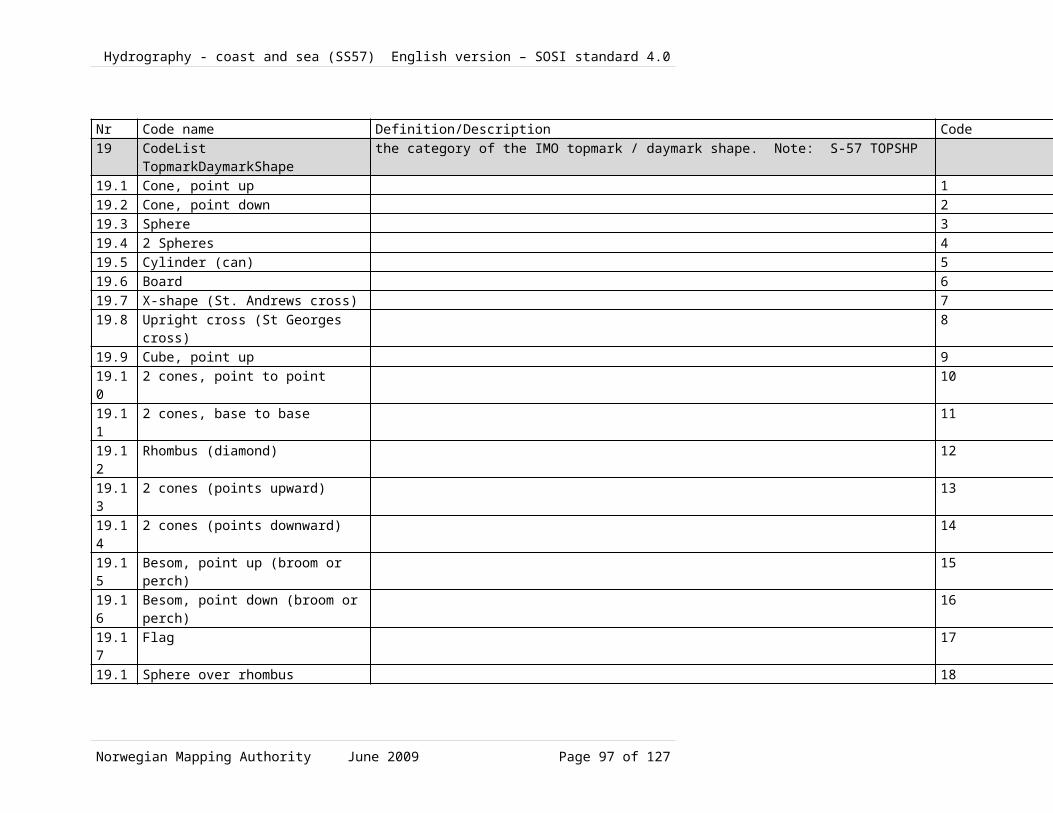
Hydrography - coast and sea (SS57) English version – SOSI standard 4.0
Traffic sepertaion information1.2.1.120 TrafficSeparationLanePartNo Name/
Role nameDescription Obligation/
ConditionMaximumOccurrence
Type Constraint
1 Class TrafficSeparationLanePart
part of traffic separation system, wherein the direction of traffic is the same
1.1 extent area over which an object extends
1 1 SurfaceWithQuality
1.2 position location where the object exists
1 1 PointWithQuality
1.3 directionalVector line segment with length and orientation. Note: from SOSI 4.0 chapter about General Types, slightly related to S-57 ORIENT: Orientation
0 1 DirectionVector
1.4 restriction limitations on traffic or use of maritime areas. Note: S-57 RESTRN
0 1 Restriction
1.5 Role trafficSeparationLine
1 1 TrafficSeparationLine
Aggregration
1.6 Role boundaryTrafficSeparationLanePart
0 N TrafficSeparationLanePartBoundary
Aggregration
1.2.1.121 TrafficSeparationLineNo Name/
Role nameDescription Obligation/
ConditionMaximumOccurrence
Type Constraint
2 Class TrafficSeparationLine
line which separates traffic (Cf. INT 1 IM 12)
2.1 centerline course followed by the central part of the object
1 1 CurveWithQuality
2.2 Role (unnamed) TrafficSeparationLanePart
1 1 TrafficSeparationLanePart
1.2.1.122 RecommendedTrafficDirectionNo Name/
Role nameDescription Obligation/
ConditionMaximumOccurrence
Type Constraint
3 Class RecommendedTrafficDirection
recommended direction of traffic between traffic separation systems (Cf. INT 1, IM26.1)
3.1 position location where the object exists
1 1 PointWithQuality
3.2 directionVector line segment with length 1 1 DirectionVecto
Norwegian Mapping Authority June 2009 Page 97 of 99

Hydrography - coast and sea (SS57) English version – SOSI standard 4.0
and orientation r1.2.1.123 TrafficSeparationLanePartBoundaryNo Name/
Role nameDescription Obligation/
ConditionMaximumOccurrence
Type Constraint
4 Class TrafficSeparationLanePartBoundary
delimitation of that part of the traffic separation system, wherein the direction of traffic is the same
4.1 border course following the transition between different real world phenomena
1 1 CurveWithQuality
4.2 Role (unnamed) TrafficSeparationLanePart
1 1 TrafficSeparationLanePart
1.2.1.124 Association TrafficSeparationLanePart-TrafficSeparationLineNo Name/
Role nameDescription Obligation/
ConditionMaximumOccurrence
Type Constraint
5 Association TrafficSeparationLanePart-TrafficSeparationLine
5.1 Role trafficSeparationLine
1 1 TrafficSeparationLine
Aggregation
5.2 Role (unnamed) TrafficSeparationLanePart
1 1 TrafficSeparationLanePart
1.2.1.125 Association <<Topo>> TrafficSeparationLanePart-TrafficSeparationLanePartBoundary
No Name/Role name
Description Obligation/Condition
MaximumOccurrence
Type Constraint
6 Association TrafficSeparationLanePart-TrafficSeparationLanePartBoundary
6.1 Role boundaryTrafficSeparationLanePart
0 N TrafficSeparationLanePartBoundary
Aggregation
6.2 Role (unnamed) TrafficSeparationLanePart
1 1 TrafficSeparationLanePart
Norwegian Mapping Authority June 2009 Page 98 of 99

Hydrography - coast and sea (SS57) English version – SOSI standard 4.0
Norwegian Mapping Authority June 2009 Page 99 of 99


![Thirteen recursion. Recursion ► [define horizontal-array [object spacing count → [if [= count 1] object [group object [translate [point spacing 0] [horizontal-array](https://img.dokumen.tips/doc/110x75/56649d375503460f94a10460/thirteen-recursion-recursion-define-horizontal-array-object-spacing.jpg)