Embed Size (px)
Citation preview

1
Rajesh Gajjar & Shailendra Mohan
TITLE: DESIGN OF MULTI-LEVEL INTERCHANGE AT SEWRI, MUMBAI, INDIA
Description Details
Word Count 2832 (including abstract), No of Figures – 13, No of tables -1,
Equivalent Count of word - 6334
Submission Date 13th
December-2014
Author-1
Name Rajesh Gajjar
Affiliations Indian Road Congress (IRC), Institution of Traffic Engineers,
USA, Institution of Engineers, India
Address 2, Park View, Park Avenue, Sector-17, Nerul (East) Navi
Mumbai, India -400706
Phone No. +91 022-27700991, +919920519933
E-Mail [email protected]
Author-2 (Corresponding)
Name Shailendra Mohan
Affiliations Indian Road Congress (IRC), Indian Concrete Institute,
Institution of Engineers, India
Address 2, Park View, Park Avenue, Sector-17, Nerul (East) Navi
Mumbai, India -400706
Phone No. +91 022-27700991, +919967014586
E-Mail [email protected]

2
Rajesh Gajjar & Shailendra Mohan
ABSTRACT
Sewri Junction is proposed to serve as dispersal hub for following major arterials and freeways
Mumbai Trans Harbor Link (MTHL) - 6 Lane Proposed Express Connectivity between
Mumbai (Island City) & Navi Mumbai (Main Land)
Eastern Freeway (EF) – Commissioned four lane access control elevated fast corridor connecting
Chembur (eastern suburbs) to CBD at South Mumbai.
Worli – Sewri Link (WSL) – Under Construction elevated four lane access control corridor to
serve as major east – west connectivity in south Mumbai to connect existing Bandra Worli Sea
Link to MTHL.
Major local Collector road running north – south – Rafi Ahmed Kidwai Marg
Above all roads carry considerable traffic volume. In construction of such major junctions the real
challenge lies in ground condition and constraints. Heritage building, major local railway station (mass
transit), railway line of Mumbai Port Trust, constructed EF (elevated freeway), large oil storage tanks,
congested local streets are within limits of interchange and pose of constraints for development.
A well designed single level elevated loop was conceived as innovative solution for interchange against
conventional segregated ramp option. One way clockwise circulation in elevated loop avoided all cross
conflict despite being at grade. Proper merging and weaving lengths were provided at all joints of ramps.
Alignment of this loop was fitted in median of underneath road to achieve minimum relocation of existing
utilities. Number of Railway crossings was also reduced to 2 from 5 as compared with individual ramp
option. Reducing height of structure resulted in substantially savings on lengths of ramps and eventually
cost.
One way circulation of loop required additional travel distance for some traffic but its benefits in terms of
forgivingness for taking wrong ramp, increased efficiency and flexibility to locate connecting ramps
outweighed its demerits.
3
Rajesh Gajjar & Shailendra Mohan
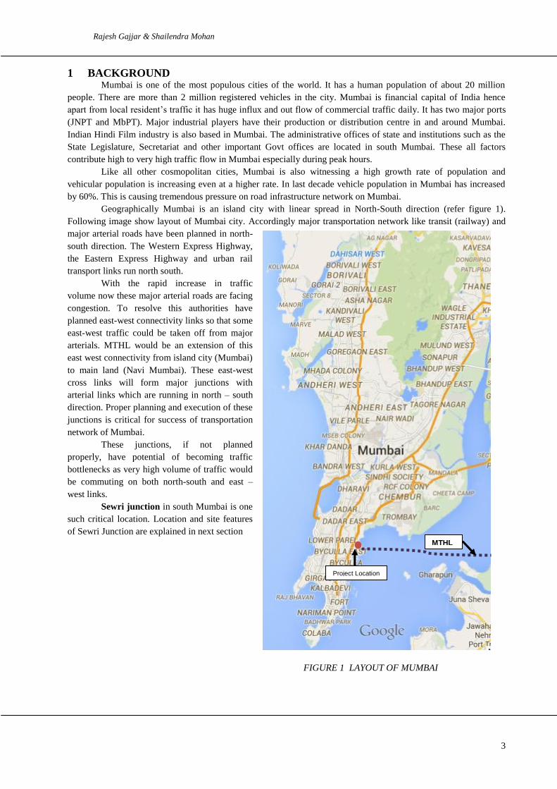
1 BACKGROUND Mumbai is one of the most populous cities of the world. It has a human population of about 20 million
people. There are more than 2 million registered vehicles in the city. Mumbai is financial capital of India hence
apart from local resident’s traffic it has huge influx and out flow of commercial traffic daily. It has two major ports
(JNPT and MbPT). Major industrial players have their production or distribution centre in and around Mumbai.
Indian Hindi Film industry is also based in Mumbai. The administrative offices of state and institutions such as the
State Legislature, Secretariat and other important Govt offices are located in south Mumbai. These all factors
contribute high to very high traffic flow in Mumbai especially during peak hours.
Like all other cosmopolitan cities, Mumbai is also witnessing a high growth rate of population and
vehicular population is increasing even at a higher rate. In last decade vehicle population in Mumbai has increased
by 60%. This is causing tremendous pressure on road infrastructure network on Mumbai.
Geographically Mumbai is an island city with linear spread in North-South direction (refer figure 1).
Following image show layout of Mumbai city. Accordingly major transportation network like transit (railway) and
major arterial roads have been planned in north-
south direction. The Western Express Highway,
the Eastern Express Highway and urban rail
transport links run north south.
With the rapid increase in traffic
volume now these major arterial roads are facing
congestion. To resolve this authorities have
planned east-west connectivity links so that some
east-west traffic could be taken off from major
arterials. MTHL would be an extension of this
east west connectivity from island city (Mumbai)
to main land (Navi Mumbai). These east-west
cross links will form major junctions with
arterial links which are running in north – south
direction. Proper planning and execution of these
junctions is critical for success of transportation
network of Mumbai.
These junctions, if not planned
properly, have potential of becoming traffic
bottlenecks as very high volume of traffic would
be commuting on both north-south and east –
west links.
Sewri junction in south Mumbai is one
such critical location. Location and site features
of Sewri Junction are explained in next section
FIGURE 1 LAYOUT OF MUMBAI
Project Location
MTHL

4
Rajesh Gajjar & Shailendra Mohan
2 LOCATION AND SITE FEATURES
Location of Sewri Junction and connecting arterials is illustrated in figure 2 below.
Proposed junction at Sewri junction
would handle traffic from following
major arterials:
MTHL (Mumbai Trans Harbor
Link) - 6 Lane Proposed Express
Connectivity between Island City &
Main Land developments
EF (Eastern Freeway) –
Commissioned four lane access
control, mostly elevated fast corridor
connecting eastern suburbs to South
Mumbai.
WSL (Worli – Sewri Link) – Under
Construction elevated four lane
access control fast corridor to serve
as major east – west connectivity in
Mumbai’s normally north –south
oriented transportation links
RAK Marg - Major local collector
road running north – south
All four major links would bring in
about 11000 PCU traffic in peak
hour at junction. This calls for grade
separation at junction for major
traffic movement.
FIGURE 2 SEWRI JUNCTION LAOUT

5
Rajesh Gajjar & Shailendra Mohan
3 SITE CHALLENGES
Site location of Sewri junction is quite challenging. It is an urban congested area with Mumbai Port in vicinity.
Major challenges are as under:
a) Limited space on ground
b) Rail lines (Suburban Passenger Transit and Mumbai Port rail line)
c) Existing structures including heritage structure
d) Non availability of land for an conventional interchange
e) Location of suburban transit rail station adjacent to site
These challenges are briefly discussed as under
3.1 Limited space on ground
One of the ramp or arm of proposed interchange would have to pass on road like Sewri station road. Total width of
road is about 8-10 m with structures on both sides. In such case fitting a elevated transportation link with keeping
road traffic live would be a challenge.
FIGURE 3 SEWRI STATION ROAD
Similar is the condition at location where existing the EF is running parallel to railway line. On west side of EF there
are Oil Tanks and high structures. Thus any connectivity with the existing EF will have to be carved out between
Railway line and existing EF alignment. Following photograph depict this location

6
Rajesh Gajjar & Shailendra Mohan
FIGURE 4 RAILWAY LINE AND EXISTING EASTERN FREEWAY
3.2 Railway Lines
There are two parallel rail lines operational at the location, first one called as main Harbour Line (suburban Rail
Transit) second being Mumbai Port Trust (MbPT) rail line for hauling of port goods and material. Thus any grade
separated scheme at Sewri junction would involve crossing these lines which with a span of about 60-70m.
Structural arrangement and geometric design of such crossing would be a challenge.
3.3 Heritage Buildings
There exist some very old structures between RAK marg and railway lines. These are called BDD chawls (local
name for old community dwelling units). These structures come under heritage list of Mumbai Municipal
Corporation. Any scheme of Sewri interchange design would have to take safety of these heritage structures in to
account.
3.4 Project Affected Structures
There exists some additional structures very close to roads and railway alignment and would be affected by scheme
of Sewri Interchange. Minimizing this impact would be one of the major challenges for design as this impact has
socio-political ramification to the extent of dumping the scheme. Following photograph shows one such location.

7
Rajesh Gajjar & Shailendra Mohan
FIGURE 5 IMPLEMENT-ABILITY OF ANY SCHEME OF SEWRI JUNCTION IMPROVEMENT
As explained Sewri junction would be integrating and facilitating 8 major movements. A grade separated junction
with 8 movement would be quite complex. In such a scenario efficient geometrics, simplicity of movement,
constructability and forgiveness of circulation design would be at stake.
The forgivingness character of a rotary structure assumes significance as it is also going to cater to long distance
traffic coming from main land via MTHL link. This out station traffic may not be very familiar with directions and it
would be very helpful in such cases to have this add-on facility till the travellers become familiar and get used to.
4 HISTORICAL DESIGN APPROACH & CONCEPT
Planning for Sewri junction improvement is major part of Mumbai Transport improvement scheme. Mumbai Trans
Harbour Link (MTHL) is a dream transportation infrastructure which would bring mainland closer to island city of
Mumbai and thus would release urban population pressure. An efficient scheme of Sewri junction is critical to
success of MTHL. This is simply because Sewri junction is the main dispersal point for MTHL on island side.
Importance of Sewri junction with respect to MTHL can be understood from following figure which shows MTHL
alignment connecting island city of Mumbai with main land of Navi Mumbai

8
Rajesh Gajjar & Shailendra Mohan
FIGURE 6 MTHL ALIGNMENT CONNECTING ISLAND CITY OF MUMBAI WITH MAIN LAND OF
NAVI MUMBAI
Authorities have been studying and planning MTHL for last 40 years. Consequently some designs were developed
for improvement of the Sewri Interchange as well. Latest and most comprehensive design development was done by
Mumbai Metropolitan Region Development Authority (MMRDA) recently in year 2010. This was based on
individual ramp approach for each movement. Following sketch depict concept alignments of various arms at Sewri
interchange.
FIGURE 7 CONCEPT ALIGNMENTS OF VARIOUS ARMS AT SEWRI JUNCTION
MTHL
SOUTH MUMBAI
WORLI

9
Rajesh Gajjar & Shailendra Mohan
This design was based taking South Mumbai and MTHL as a priority connectivity. All movements of traffic
circulation are separated by dedicated ramps thus creating a scheme of 3 levels of ramps one over other. Following
can be observed with respect to above scheme of traffic circulation for Sewri junction
A complex system of ramps is provided for access to South Mumbai, Freeway and Worli- Sewri Link
All movements segregated but there are 3 Level grade separation at most crossings which would add to
complexity in construction.
Circulation of traffic through various ramps required proper prior selection of correct ramp to reach
desired destination. If a wrong ramp is selected than there would be a punishing detour to correct
erroneous decision. Thus design is UNFORGIVING.
With commissioning of EF and delay in MTHL connectivity priorities have changed. In existing
concept of Sewri Interchange there is no provision of connectivity between Eastern Freeway and Worli-
Sewri Link. Also there is no connectivity with RAK Marg as well from any link.
Thus the current design is not flexible to accommodate changes and amenable for future changes and
priorities.
Authorities were also of the view that current design is complex and especially with such tight site constructability
will also be a challenge. It was felt that an out of box approach should be explored for new solution of improvement
of Sewri junction.
With this background and requirement concept, options of Sewri junction improvement were developed. These
options are discussed in subsequent sections of this paper.
5 DESIGN STANDARD AND OBJECTIVES
Sewri Interchange is part of traffic dispersal system of MTHL which would provide fast connectivity between Island
city (specially South Mumbai) and main land towards Navi Mumbai. This would attract and generate large volume
of traffic which would require an efficient traffic dispersal system at Sewri. It would require a high capacity
interchange on one hand and simple circulation on other. Thus the following design targets were set for developing
preliminary concept options for Sewri Interchange
• Minimum traffic conflicts
• Sufficient weaving, merging and demerging distances
• Simplified and forgiving traffic circulation (easy decision making)
• Gentle gradients (max 3.3% to 5%)
• Maximum turning radius (design speed 40--50kmph)
• Minimum number of grade separation levels
• Accommodating site constraints (BDD Chawl, Railway, IOCL, Freeway, Existing Structures)
• Compliance to local IRC (Indian Roads Congress) standards
6 DESIGN OPTIONS
Taking all site concerns, design standards and connectivity requirement for traffic circulation two options were
developed for improvement of Sewri junction. These are discussed and explained as under.
6.1 Concept Option-I
It has been explained earlier that with commissioning of Eastern Freeway and connectivity requirement of Sewri
junction has new dimensions. Not only connectivity with MTHL and Worli – Sewri link is important but also
interconnectivity between Worli – Sewri Link and Eastern Freeway has become critical for success of traffic
circulation scheme at Sewri.

10
Rajesh Gajjar & Shailendra Mohan
Concept option is based on concept of segregated movement for different direction of traffic. In this option separate
arms have been provided for different direction of traffic movement. Due to site constraints at few locations both up
and down ramps have been structurally paired. Wherever possible, median of existing road is used for placement of
foundations of ramps so that carriageways of existing road are not curtailed.
Following sketch shows plan of Concept Option-I. All alignments were prepared in Civil-3D
FIGURE 8 CONCEPT OPTION-I
Salient features of Concept Option-I are as under
• Connectivity for Worli-Sewri link to Eastern Freeway thru dual ramps which run parallel up to railway
track.
• Utilise median of RAK Marg and Sewri station street to locate supporting piers
• One way Connectivity to Rafi Ahmad Kidwai Marg at both ends
• Free Left out left in ramp for EF to MTHL Traffic. MTHL to Worli and EF (North Side) through
common ramp up to some distance and then arms are separated at level 2
• MTHL to South Mumbai (Freeway) through freeway left out left in arm
• Worli Sewri Link to MTHL arm at level 3
• Connecting arms for South Mumbai Worli traffic thru ramp over rail tracks and RAK Marg. No direct
connectivity from Worli to South Mumbai
• 3 Levels Grade Separation (2Levels above Eastern Freeway)
• Total 11 different Arms
• Crossing Railway Tracks at 5 Locations
• Accommodating site constraints (BDD Chawl, Railway, IOCL, Freeway, Existing Structures)
• Design Speed 40 kmph-50kmph

11
Rajesh Gajjar & Shailendra Mohan
• Design of Horizontal Curve (Radius and Transitions Length) as Per IRC:38: 1998 using Autodesk
Civil3D Road Design Tool.
• Maximum Vertical Grade of 3.3%.
• Lane Configuration: 2 Lane (One way) Undivided Carriageway for all ramps except 4 Lane Divided
Carriageway for Worli-Freeway Connecting Ramp up to railway crossing
• Sufficient merging distances
• For better appreciate of concept option 3-D model was developed in Civil Infrastructure Suite.
•
• FIGURE 9 CONCEPT OPTION 1
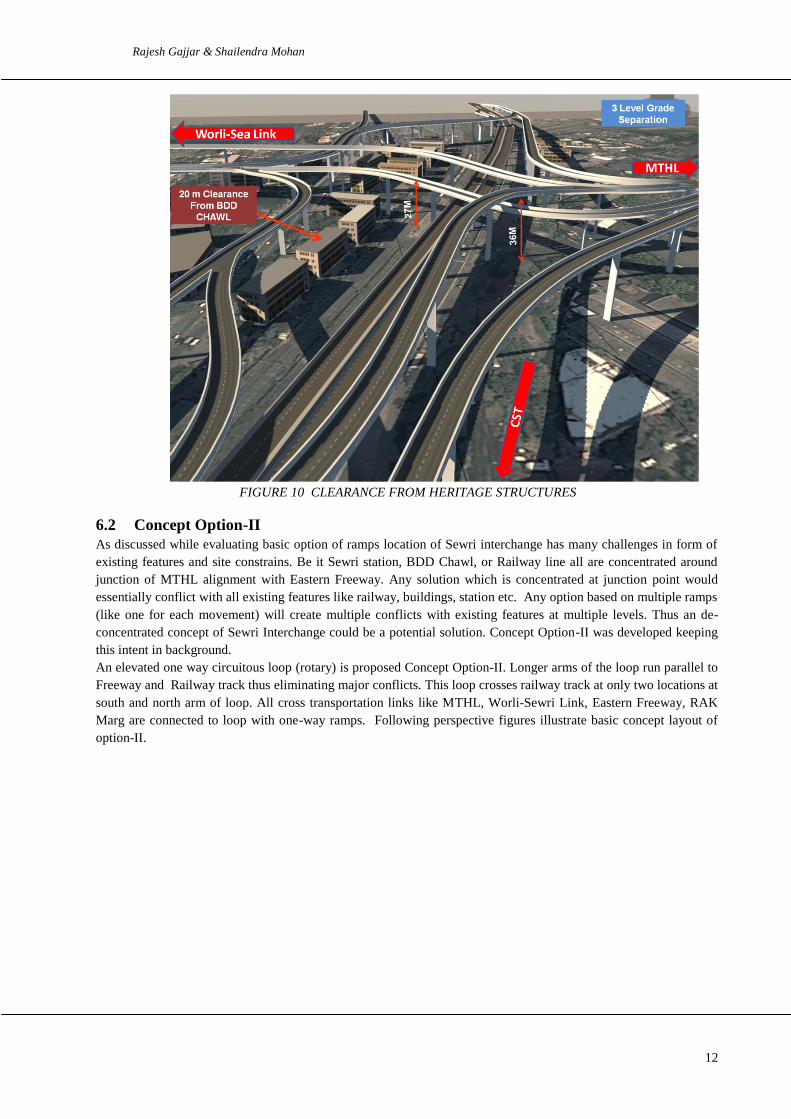
As can be observed from above, ramps cross railway line at 5 locations. One more view of concept option-I is
given under which shows that heritage structures are cleared off.
12
Rajesh Gajjar & Shailendra Mohan
FIGURE 10 CLEARANCE FROM HERITAGE STRUCTURES
6.2 Concept Option-II
As discussed while evaluating basic option of ramps location of Sewri interchange has many challenges in form of
existing features and site constrains. Be it Sewri station, BDD Chawl, or Railway line all are concentrated around
junction of MTHL alignment with Eastern Freeway. Any solution which is concentrated at junction point would
essentially conflict with all existing features like railway, buildings, station etc. Any option based on multiple ramps
(like one for each movement) will create multiple conflicts with existing features at multiple levels. Thus an de-
concentrated concept of Sewri Interchange could be a potential solution. Concept Option-II was developed keeping
this intent in background.
An elevated one way circuitous loop (rotary) is proposed Concept Option-II. Longer arms of the loop run parallel to
Freeway and Railway track thus eliminating major conflicts. This loop crosses railway track at only two locations at
south and north arm of loop. All cross transportation links like MTHL, Worli-Sewri Link, Eastern Freeway, RAK
Marg are connected to loop with one-way ramps. Following perspective figures illustrate basic concept layout of
option-II.

13
Rajesh Gajjar & Shailendra Mohan
FIGURE 11 BASIC CONCEPT LAYOUT
Salient features of Concept Option-II are as under
Concept of elevated rotary - all traffic will move in one direction and will join or leave rotary at
destination ramp
Arms provided for each cross link like Worli – Sewri, Eastern Freeway, MTHL, Rafi Ahmed
Kidwai Marg for in and out movement
Single level Circuitous Four Lane Elevated Loop of length 1550 m approx
2 Level Grade Separation only (One Level above Eastern Freeway)
Elevated Loop crossing Railway Tracks at 2 Locations
Accommodating site constraints (BDD Chawl, Railway, IOCL, Freeway, Existing Structures)
Connectivity to all major links like MTHL, Freeway and Worli – Sewri link
One way connectivity with RAK Marg
Following 3-D image would help in appreciating this option

14
Rajesh Gajjar & Shailendra Mohan
FIGURE 12 ANOTHER VIEW FROM WORLI SIDE SHOWING CLEARANCE OF VARIOUS
STRUCTURES AND SITE FEATURES

15
Rajesh Gajjar & Shailendra Mohan
FIGURE 13 ANOTHER VIEW FROM WORLI SIDE SHOWING CLEARANCE OF VARIOUS
STRUCTURES AND SITE FEATURES
It can be appreciated here that most of the critical aspects like number of railway crossings, level of structure, and
forgiveness of circulation have been worked out favourably in this option. Both options have been evaluated on the
basis of critical aspects. Following table gives a summary of comparison of both options
TABLE 1: SUMMARY OF COMPARISON OF BOTH OPTIONS
Option Main Feature Connectivity Traffic Flow No of Levels USP
Option-I Ramps (3-
Lane)
RAK Marg
(one way),
Eastern
Freeway (Both
way), MTHL
(Both way
Merging &
demerging
friction at all
joints. No wrong
turn correction
Ramps crossing
each other at
multiple locations
at 3 levels
Ramps for
MTHL
connectivity
modular. Can
be added later
Option-II
Circuitous
Loop (4-
Lane) &
Ramp (2-
Lane)
RAK Marg
(one way),
Eastern
Freeway (Both
way), MTHL
(Both way
Smooth merging
of traffic in
circuitous 4 lane
loop and merging
2-lane ramps
Grade separation
required for
crossing Eastern
Freeway Only
Hence 2 level
grade separation
Single level
Circuitous loop
rotary.
Forgiving
design for
wrong turn.
Simple traffic
circulation

16
Rajesh Gajjar & Shailendra Mohan
Concept Option-II of elevated loop was selected as Preferred option for following reasons
Simplicity of circulation
Decongestion of conflict area
Reduced level of structure
Forgiveness of circulation
Minimum number of railway crossings
Constructability
6.3 Traffic Analysis
Following roads would be contributing traffic on proposed
elevated loop:
Proposed Mumbai Trans Harbour Link (MTHL)
Proposed Worli Sewri Link
Eastern Freeway
From South Mumbai (Eastern Freeway)
In order to project traffic on proposed elevated
loop available traffic data and projection estimates were
analysed. Elevated loop alignment was divided in to 4
links and shown in figure 14 below
Traffic from various roads was then assigned and loaded to
these links. Following Table 2 gives peak hour traffic
volume on each link in year 2021, 2031 and 2041
TABLE 2: PEAK HOUR TRAFFIC VOLUME OF LINKS OF PROPOSED ELEVATED LOOP
Link No Year 2021 Year 2031 Year 2041
Link1 2339 3676 4831
Link2 2346 3687 4846
Link3 2512 3947 5188
Link4 2115 3323 4368

17
Rajesh Gajjar & Shailendra Mohan
Assuming a capacity of 1000 PCU per hour per lane, it was observed that the proposed configuration would serve
well till 2041 and would require to be augmented to six lanes beyond.
7 CONCLUSION
It can be concluded that most preferred solution to any situation depends on site context and relative criticality of
site constraints. Design solution should be responsive and oriented to criticality of site requirement. In present case
since railway line crossings and various unavoidable sensitive structures were concentrated at junction point, hence
a solution which moves impact of construction away from area of conflict would be a viable and preferred solution.
An elevated circuitous loop worked on this very principle helped in providing a solution with simple traffic
circulation scheme which avoided concentrated area of conflict. Solutions to complex junction like Sewri junction in
Mumbai required moving away from conventional line of thinking and bringing in new ideas.
************