Embed Size (px)
Citation preview

Icarus 212 (2011) 790–806
Contents lists available at ScienceDirect
Icarus
journal homepage: www.elsevier .com/ locate/ icarus
Titan: An exogenic world?
Jeffrey M. Moore a,⇑, Robert T. Pappalardo b
a NASA Ames Research Center, Space Science Division, M/S 245-3, Moffett Field, CA 94035, United Statesb Jet Propulsion Laboratory, California Institute of Technology, M/S 321-560, Pasadena, CA 91109, United States
a r t i c l e i n f o
Article history:Received 4 March 2010Revised 13 January 2011Accepted 19 January 2011Available online 1 February 2011
Keywords:Saturn, satellitesTitanTitan, atmosphereTitan, hydrologyTitan, surface
0019-1035/$ - see front matter Published by Elsevierdoi:10.1016/j.icarus.2011.01.019
⇑ Corresponding author. Fax: +1 650 604 6779.E-mail addresses: [email protected] (J.M. Mo
nasa.gov (R.T. Pappalardo).
a b s t r a c t
All landforms on Titan that are unambiguously identifiable can be explained by exogenic processes (aeo-lian, fluvial, impact cratering, and mass wasting). Previous suggestions of endogenically produced cryo-volcanic constructs and flows have, without exception, lacked conclusive diagnostic evidence. Themodification of sparse recognizable impact craters (themselves exogenic) can be explained by aeolianand fluvial erosion. Tectonic activity could be driven by global thermal evolution or external forcing,rather than by active interior processes. A lack of cryovolcanism would be consistent with geophysicalinferences of a relatively quiescent interior: incomplete differentiation, only minor tidal heating, and pos-sibly a lack of internal convection today. Titan might be most akin to Callisto with weather: an endogen-ically relatively inactive world with a cool interior. We do not aim to disprove the existence of any and allendogenic activity at Titan, nor to provide definitive alternative hypotheses for all landforms, but insteadto inject a necessary level of caution into the discussion. The hypothesis of Titan as a predominantly exo-genic world can be tested through additional Cassini observations and analyses of putative cryovolcanicfeatures, geophysical and thermal modeling of Titan’s interior evolution, modeling of icy satellite land-scape evolution that is shaped by exogenic processes alone, and consideration of possible means for sup-plying Titan’s atmospheric constituents that do not rely on cryovolcanism.
Published by Elsevier Inc.
1. Introduction
Following the first flyby of Titan by the Cassini spacecraft inOctober 2004, there were several published studies reporting onevidence and analysis of icy volcanism, or ‘‘cryovolcanism,’’ on Ti-tan, based on data from the Cassini radar and the Visual and Infra-red Mapping Spectrometer (VIMS) instruments (Elachi et al., 2005,2006; Barnes et al., 2006; Stofan et al., 2006; Lopes et al., 2007,2010; Nelson et al., 2009a,b; Wall et al., 2009; Le Corre et al.,2009; Soderblom et al., 2009; Jaumann et al., 2009a). Cryovolcan-ism can be defined as ‘‘eruptions... that consist of liquid or vaporphases of materials that freeze at temperatures of icy satellite sur-faces’’ (Prockter, 2004). The term ‘‘cryovolcanism’’ can also includethe possibility of solid-state (diapiric) emplacement of materials.Cryovolcanism is canonically associated with an icy body thathas a warm and active interior (e.g., Schenk and Moore, 1998).
The level of reported certainty of interpretation for cryovolcanicfeatures on Titan ranges from ‘‘putative’’ cryovolcanic domes andflows (Lopes et al., 2007) to assertions of ‘‘strong evidence’’ foractive cryovolcanic venting (Nelson et al., 2009a). The cumulativeweight of these reports has generally conveyed a sense thatevidence for cryovolcanic activity, based on remote sensing
Inc.
ore), robert.pappalardo@jpl.
observations, is conclusive or nearly so (e.g., Jaumann et al.,2009a; Lopes et al., 2010). The present contribution urges a cau-tious approach to this issue, given many incidences of equivocalidentification of planetary volcanism (see Section 4), combinedwith the inherent resolution limitations of Titan remote sensingdata and the uniqueness of Titan’s surface as an icy satellite af-fected by exogenic processes (i.e., energy for modification is sup-plied externally to the planetary surface), specifically fluvial(Fig. 1) and aeolian activity (Fig. 2) as well as impact cratering(Fig. 3). Here we do not aim to disprove the existence of any andall endogenic activity on Titan, nor to provide definitive alternativehypotheses for all landforms, but instead to inject a necessary levelof caution into the discussion.
In this paper, we will: (Section 2) summarize the challenges ofCassini image interpretation through Titan’s atmosphere; (Sec-tion 3) briefly review the evidence of various exogenic geologicalprocesses that have shaped Titan’s surface; (Section 4) considerlessons from the history of the initial phases of planetary geologi-cal exploration (of the Moon, Mars, Mercury, and the icy satellites)for certain processes operating on planetary surfaces, and thecautions that can be drawn from those experiences; (Section 5)consider case examples of Titan’s features previously argued tobe cryovolcanic, which can instead be interpreted as related toother processes, and touch on the issue of tectonism; (Section 6)note that the interpretation of a relatively quiescent Titan interioris consistent with a broad range of geophysical constraints; and

Fig. 1. A landscape of Titan unambiguously dominated by fluvial and lacustrineerosion, transportation and deposition. The scene is centered at 75�N, 260�W(excerpted from Cassini SAR swath T28).
Fig. 3. Examples of unambiguously recognizable impact craters on Titan. Giventheir size, shape, arrangement, and textures of component landforms (e.g., thecentral peak and radial external ejecta) and the relative lack of modification byerosion make their interpretation uncontroversial. The crater on the right is Sinlap(diameter 79 km) located 11�N, 16�W (excerpted from Cassini SAR swath T03). Theunnamed 112 km-diameter crater on the left is located at 26�N, 200�W (excerptedfrom Cassini SAR swath T43).
J.M. Moore, R.T. Pappalardo / Icarus 212 (2011) 790–806 791
(Section 7) consider the implications for the geological and atmo-spheric evolution of Titan.
2. Challenges of landform identification on Titan
Geological interpretation of spacecraft images is based on thefundamental recognition of image tone, textures, pattern, shape,size, and relation of associated features (e.g. Ray, 1960). Even underideal conditions, �2–3 pixels are required across a high-contrastfeature in order to be said to ‘‘resolve’’ that feature (Drury, 2001).The exception to this are lineaments (straight or otherwise), whichmerely need to return enough energy within their pixels to pro-duce distinctive contrasts along a string of pixels, even if the linea-ments themselves are more narrow than a pixel.
Experience with unambiguous volcanic landforms providesdiagnostic criteria for their recognition. Volcanic effusion is pri-marily an accretionary constructive (landform building) process,generally with a negligible erosive role. The criteria for volcanicdeposits include recognition of flow fronts, flow textures, identifi-cation of source vents, embayment and superposition relationshipsof the flows over pre-existing surfaces (including earlier flows).
Geological interpretability of planetary landscapes is substan-tially improved with the addition of topographic information. Inall cases, better spatial resolution (both horizontal and vertical) in-creases interpretability, as long as coverage is appropriate to thescale of features under study. Through an atmosphere as aerosol-laden as Titan’s, scattering is a severe limitation to visible andnear-infrared imaging, reducing the contrast and effective resolu-tion of optical images. Synthetic Aperture Radar (SAR) images donot have this limitation, but present their own challenges to thegeologist, as discussed below.
Fig. 2. Unambiguously identifiable Aeolian sand dunes on Titan, surroundingtopographic obstacles. The scene is located at 8�N, 44�W (excerpted from CassiniSAR swath T17).
2.1. ISS images
Imaging of Titan’s surface is possible with the Cassini ImagingScience Subsystem (ISS) through an atmospheric window near0.94 lm. Porco et al. (2005) estimate that �60–90% of photons atthis wavelength are scattered by atmospheric haze at the mostideal geometry of normal incidence and emission, reducing theeffective resolution about fivefold. Thus, although pixel scales ofa few hundred meters can be attained with ISS, effectively it is dif-ficult to interpret features smaller than �2 km. Shape from shadingis usually not possible because of the effects of scatter. ISS imagesare consequently limited in their contribution to understanding Ti-tan’s geological processes. The significance of resolution limitationis illustrated by the Huygens Probe imaging, which exposed a land-scape densely dissected by fluvial erosion, although lower resolu-tion Cassini imaging and radar have not revealed fluvial featuresat this location (Rodriguez et al., 2006; Soderblom et al., 2007a;Keller et al., 2008).
2.2. VIMS images
The Visual and Infrared Mapping Spectrometer (VIMS) aboardCassini, which observes across the 0.35–5.2 lm wavelength range(with 352 channels), has been used to search for and evaluate geo-logical processes on Titan, including putative cryovolcanic features(e.g., Sotin et al., 2005; Nelson et al., 2009a,b; Soderblom et al.,2009). To its advantage, VIMS can observe the surface throughany of eight atmospheric windows, including those at wavelengthsnear 2.0 and 5.0 lm, which, in principle, permits viewing the sur-face without significant spatial-resolution-degrading atmosphericscatter. Soderblom et al. (2009) estimate that in the most ideal caseof normal incidence and emission, �44% of the light is scattered at2.0 lm, while just 10% is scattered at 5.0 lm.
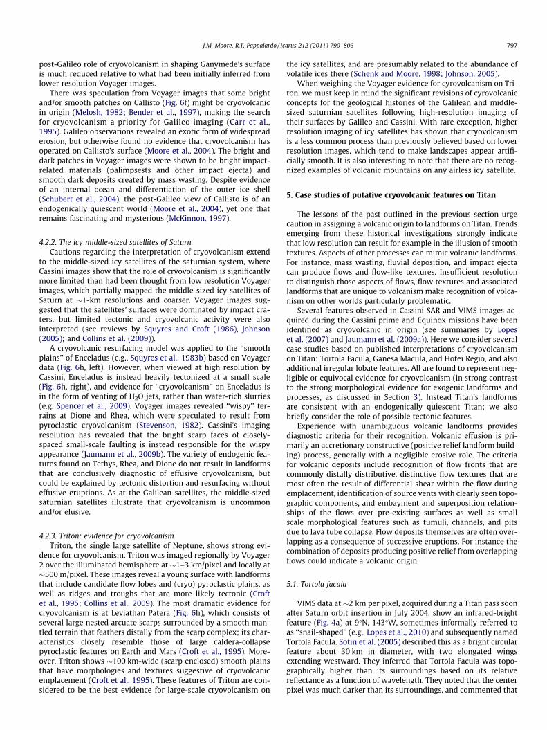
Titan’s thick atmosphere restricts Cassini to a closest approachdistance of no less than about 900 km from the surface. VIMSimaging of surface features is limited by the instrument’s relativelycoarse spatial resolution of (at best) 0.25 � 0.5 mrad on a 64 � 64pixel detector. This translates into VIMS resolutions of �1 km/pixelat closest approach to Titan. For example, the image of Tortola Fac-ula (see Fig. 4 left) with a resolution of �1.8 km/pixel is near thelimit of the instrument’s spatial resolution capability.
2.3. SAR images
There is an extensive literature on interpreting radar data ofplanetary surfaces, and the difficulties and benefits involved (e.g.,

792 J.M. Moore, R.T. Pappalardo / Icarus 212 (2011) 790–806
Ford et al., 1989, 1993 and references with in). Synthetic ApertureRadar (SAR) images, relative to images taken from reflected (oremitted) light, typically exhibit a narrower dynamic range of usefulgray scales (and therefore limited contrast), as well as artifacts(e.g., topographic layover, volume scattering, and speckle noise)and ambiguity as to whether return signal strength is due to thescattering properties of the surface or the angle of the slope rela-tive to viewing geometry of the antenna (Elachi, 1988; Fordet al., 1989; Farr, 1993). These are the restrictions that affect themorphological interpretability of Cassini SAR images of Titan’ssurface.
Cassini’s Titan Radar Mapper generates SAR images of Titan withpixel sizes as small as 350 m, but more typically nearer to 1 km/pixel(Elachi et al., 2004). The combination of low resolution and limitedgrayscale dynamic range means that most landforms on Titan (withthe exception of linear features) would need to be�1 km, and moretypically several kilometers across to be identifiable.
Cassini SAR images are acquired at a relatively small incidenceangle (usually less than 30�), because of the limited closest ap-proach distance of Cassini from Titan’s surface. The effect of smallincidence angles is to preferentially accentuate subtle relief, butwith the unfortunate effect of enhancing distortion of high-relieffeatures (e.g., Farr, 1993). Where stereo SAR coverage exists, ithas been possible to resolve most topographic ambiguities (Kirket al., 2009). While total Cassini SAR image coverage at nominalmission end is 20%, the stereo coverage at the end of the nominalmission is less than 1% of Titan’s surface. The Cassini SAR can beused to generate topographic profiles along two-dimensional tran-sects, which have proven useful in specific instances (Stiles et al.,2009).
Given the limitations in morphological interpretability and cov-erage of the Cassini SAR images, and the potential influence of ero-sive exogenic processes on Titan (see Section 3), it is easy tounderstand why unambiguous identification of Titan’s landformmorphology—and thus the relative significance of its geologicalprocesses—has been challenging.
3. Exogenic processes on Titan
The Cassini Orbiter and the Huygens Probe reveal an Earth-likelandscape of fluvial valleys, channels, and lakes interspersed with
Fig. 4. Tortola Facula (9�N, 143�W), was interpreted as a cryovolcano (Sotin et al., 2005),October 2004). The nominal resolution is 2 km/pixel. Subsequent SAR imaging (right, exmountain, such as are commonly found in this region of Titan (see Fig. 2). SAR image n
impact craters and extensive dune fields (e.g. Elachi et al., 2005;Keller et al., 2008). Fluvial and lacustrine processes, aeolian pro-cesses, and impact cratering are all exogenic processes, wherethe energy for surface modification is supplied external to the sur-face. While simulations of exogenic processes relevant to Titan’ssurface environment are beyond the preview of this report, suchstudies are being performed (e.g., Burr et al., 2008; Sklar et al.,2008; Moore et al., 2010). As briefly summarized below, evidencefor their action at Titan is very strong. This is in contrast to theexisting morphological evidence for cryovolcanism, as we will dis-cuss in Section 5.
3.1. Fluvial and lacustrine processes
Strong argument for fluvial and lacustrine erosion and deposi-tion on Titan has primarily involved landform identification andinterpretation in Cassini SAR (Fig. 1) and VIMS images (Stofanet al., 2006; Barnes et al., 2007; Soderblom et al., 2007a; Jaumannet al., 2008; Lorenz et al., 2008); images from the Huygens probe(Soderblom et al., 2007b; Keller et al., 2008); and theoretical scal-ing of fluvial processes to account for the different gravity, temper-ature, fluid and material properties of Titan relative to Earth (Oriet al., 1998; Collins, 2005; Parker, 2005; Burr et al., 2006; Perronet al., 2006). Evidence for fluvial processes includes integrated den-dritic systems, always originating with diminutive presentation inregions of high topography and becoming more prominent asbranches converge down-gradient, where topographic informationcan be derived or inferred. Where resolution permits, the dendriticsystems are seen to be composed of valleys, which in some casesexhibit central channels.
The occurrence of fluvial valley networks is consistent with Ti-tan’s methane-rich atmosphere being capable of producing high-intensity convective liquid precipitation events (Lorenz, 2005;Lorenz et al., 2005; Hueso and Sanchez-Lavega, 2006; Perronet al., 2006; Lunine and Atreya, 2008; Turtle et al., 2009; Schalleret al., 2009). The narrow, elongated fluvial depressions on Titanare commonly termed ‘‘channels’’ (e.g., Barnes et al., 2007; Lorenzet al., 2008); however, most are probably more precisely termedvalleys (a category that includes surrounding slopes) or floodplains(which are typically not fully occupied by flood flows, i.e. the flu-vial discharges produced during a flood). It has been proposed thathigh-volume discharge floods may have affected broader regions of
based on VIMS data (left) collected near the beginning of the Cassini orbital tour (26cerpted from Cassini radar swath T43) indicates that this feature is a non-descript
ominal resolution is 300 m/pixel.

J.M. Moore, R.T. Pappalardo / Icarus 212 (2011) 790–806 793
the satellite (Soderblom et al., 2007b) and potentially could be animportant erosional process on Titan, as they have been on Mars(e.g., Robinson and Tanaka, 1990; Craddock and Howard, 2002).
Imaging of Titan’s polar regions has revealed landform suiteswith collective components that are strongly consistent withlacustrine origin (Stofan et al., 2007; Brown et al., 2008; Hayeset al., 2008a; Turtle et al., 2009). Inferred changes in the outlinesof some polar Titan lakes suggest ongoing lacustrine activity (e.g.,Turtle et al., 2009; Hayes et al., 2009; Wall et al., 2010). Many ofthese lakes appear to occupy steep-walled depressions that appar-ently reflect lacustrine shore processes (Mitri et al., 2007; Stofanet al., 2007; Brown et al., 2008; Hayes et al., 2008a), while otherlakes appear to have resulted from relatively recent deep immer-sion of fluvially eroded topography with no obvious shorelinemodification by lacustrine processes. These characteristics arediagnostic of lacustrine morphologies and processes. Moreover,convincing evidence that some contain fluids at present comesfrom IR spectra (Brown et al., 2008) and the definitive observationof glint off of one northern lake (Stefan et al., 2010).
3.2. Aeolian processes
Cassini radar imaging reveals sub-parallel dark striations(Fig. 2) that commonly deflect around topographic obstacles, withmorphologies and characteristics that are diagnostic of longitudi-nal (seif) dunes (Lorenz et al., 2006). These radar-dark featuresare observed to cross huge tracts of the equatorial surface. Theytypically overlie brighter materials, which are sometimes revealedin interdune materials. Their deflection directions, Y-junctions, andasymmetric streamline pattern all suggest generally eastwardtransport direction for aeolian-saltated grains (Lorenz et al.,2006; Radebaugh et al., 2007a,b; Lorenz and Radebaugh, 2009).The nature of the aeolian sediment is uncertain, but may consistof organic solids (Soderblom et al., 2007a), which are potentiallycohesive (Rubin and Hesp, 2009). No definitive evidence for aeolianerosion of obstacles has been detected, perhaps because of the lim-itations in available image resolution and spatial coverage.
3.3. Impact cratering
Wood et al. (2010) describe the nature of Titan’s impact craters(Fig. 3) and possible modification processes. In the 22% of Titanthat has been thus far imaged with radar as of this writing, Titanis reported to possess 7 certain impact craters. Their morphologicalcharacteristics such as raised rims, central peaks, ejecta deposits,and inward-facing scarps argue convincingly that these cratersare of impact origin. An additional 44 features are more tentativelyidentified as impact craters that are more degraded, but their isnecessarily uncertain because they do not show multiple diagnos-tic morphologies distinctive of impact craters (Wood et al., 2010).
The certain impact craters include the central peak craters Ksa,Selk, and Afekan (diameters of 30 km, 80 km, and 115 km, respec-tively); an unnamed 139 km crater with a probable central peak;and Menrva, a 445 km peak-ring basin. The impact crater Sinlap(79 km diameter) appears to be flat-floored in radar images. Themajority of craters have dark floors, and all are modified to variousdegrees. Eastern Xanadu shows by far the greatest density of puta-tive craters, most apparently eroded (Radebaugh et al., 2010).Many craters here and elsewhere are encroached upon by dunesand valleys, indicating that aeolian and fluvial processes have mod-ified the cratered landscape. The nature of the smooth dark mate-rial within craters may be wind-carried dust, saltated ‘‘sand,’’ orprecipitated hydrocarbons. Wood et al. (2010) also considerederuption of icy lava in crater floors as a possible mechanism forthese deposits. Titan shows no evidence for palimpsests or centraldome craters, in contrast to similarly sized impact features on
Ganymede and Callisto, two bodies of similar size, surface gravity,and crustal composition to Titan (see Section 6.1).
The small number of certain identified impact craters combineswith the uncertainty in impactor flux to permit an uncertainty inthe surface age from as little as 100–500 Myr to as great as 1–3.5Gyr, as inferred by modeled cratering rates (Artemieva and Lunine,2005; Korycansky and Zahnle, 2005; Jaumann and Neukum, 2009).Jaumann and Neukum (2009) note that when putative impacts areincluded, the shape of the size–frequency distribution for large(>80 km) craters is similar to that of Iapetus but depleted by an or-der of magnitude. They argue that smaller craters are much moredepleted, and the size–frequency curve for Titan is shallower thanexpected for atmospheric shielding alone, such that other pro-cesses (exogenic and/or endogenic) have played a major role inburying or destroying small craters.
4. Cautions from other worlds
The experience from past exploration of the solid planetarybodies provides a critical framework in which to consider explora-tion of a previously unscrutinized world such as Titan. Here we dis-cuss selected lessons from the initial explorations of other worldsregarding the limitations of image spatial coverage and resolution,especially as pertinent to the search for volcanic and cryovolcaniclandforms and deposits. These lessons warrant prudence in inter-pretation of (cryo)volcanism from modest resolution images.
4.1. The terrestrial planets
Analysis and landform interpretation during exploration of theMoon, Mars, and Mercury encountered many of the limitationsnow presented to Titan investigations. There are the obvious con-ceptual limitations when grappling with unfamiliar landscapes, be-cause of processes, geological materials, and process dominanceand rates that are very different than those previously considered.Early explorations were further exacerbated by limitations in reso-lution and coverage.
4.1.1. Mariner 6 and 7 at MarsWith its mix of exogenic processes (impact cratering, and fluvial
and aeolian processes), and endogenic processes (volcanism andtectonism), Mars makes an interesting comparison to Titan. A goodexample of the effects of limitations in both resolution and cover-age can be gleaned from the 1969 duo flybys of Mars by Mariner 6and 7 (Fig. 5). Mariners 6 and 7 collectively imaged about 20% ofthe martian surface at resolutions of �2 km/pixel or better (witha few narrow angle images with ostensible resolutions of�100 m/pixel covering less than 1% of the planet), analogous toCassini radar coverage of Titan. The fine detail discrimination capa-bility (i.e., modulation transfer function and dynamic range) of thecamera imaging systems of 1969 were substantially inferior to vis-ible light cameras of today, but are similar to the SAR images of Ti-tan from Cassini. Our knowledge of Mars geology in 1969, was insome respects, comparable to our knowledge of Titan geology priorto Cassini’s arrival; therefore, the lessons of early Mars explorationare pertinent.
Much of the Mariner 6 and 7 geological analysis was performedunder the careful eye of R.P. Sharp (Leighton et al., 1969a–c; Sharpet al., 1971a,b; Murray et al., 1971; Cutts et al., 1971), a geomor-phologist renowned for his meticulous terrestrial work beforebecoming involved in planetary studies. Among the landforms seenin some of these images were sinuous troughs, which Murray et al.(1971) noted in passing but declined to speculate as to their origin.In fact, the image analysis team did not spend notable time infor-mally speculating even among themselves as to sinuous trough

Fig. 5. Mercator map of Mariner 6 and 7 coverage of Mars. Both spacecraft flew past Mars in 1969 producing image coverage of �20% of the planet at �2 km/pixel. Much ofthe rest of Mars was seen at substantially lower resolution. The 1969 Mariner coverage is roughly comparable in areal coverage and resolution to surface imaging of Titanfrom both the RADAR SAR and the ISS at the end of the Cassini nominal mission. The insets show a single Mariner 6 image (6N21, full frame on right, full resolutionenlargement on left). In the upper left inset, the ‘‘sinuous trough’’ subsequently named Evros Vallis is clearly seen. Given the limitations of the data and knowledge of Mars,the Mariner 1969 image team prudently described the feature without attributing it to a geological process. (Mariner 6 and 7 map courtesy L.A. Soderblom, USGS.)
794 J.M. Moore, R.T. Pappalardo / Icarus 212 (2011) 790–806
origin (L.A. Soderblom and J.A. Cutts, personal communications).Today we can identify the largest and most conspicuous sinuoustrough in the Mariner 6 images as Evros Vallis, which is widelyinterpreted to have formed by running water (e.g., Howard et al.,2005). In retrospect, it is understandable why the Mariner camerageologic group did not venture past merely describing these fea-tures: The best Mariner 6 image of Evros Valles shows very littletributary branching or any other unambiguous features specificallyassociated with fluvial activity. Moreover, the contemporaneouspost-Apollo-landing analysis of much higher quality images ofthe Moon concluded that the sinuous troughs seen there were vol-canic (e.g., Greeley, 1971). It is especially interesting that planetarygeologists did not speculate about water-formed features on Marsat that moment, given political stress on the Mars program as itsought continued public funding for the ‘‘Mariner 1971’’ and‘‘Viking 1973’’ projects (e.g., Ezell and Ezell, 1984, pp. 175–192;Chaikin, 2008, pp. 55–57).
The Mariner 6 and 7 camera team noted that their images didnot show low-lying lava-filled basins (as known on the Moon), orany other features which they might have taken as definitive evi-dence of volcanism. (The 1969 Mariners did not image the martiannorthern hemisphere sufficiently to see the global dichotomy thatis there.) On the other hand, they did observe that cratered terrainhad been degraded by some process or processes, and an intercra-ter plains unit was present that was unlike the landscape of the lu-nar highlands (Murray et al., 1971). These deviations from thelunar landscape were attributed to some unidentified process(es)involving erosion and lateral transport of material. A notable mis-call by the team was identification of the �500 km-diameter brightannulus with a bright central dot in the Nix Olympica region as animpact crater (Leighton et al., 1969a). Today we know this featureas the enormous shield volcano Olympus Mons. Given what the
1969 Mariner camera team could discern and conceptualize ofMars to that date, this was a reasonable and conservativeassumption.
In light of subsequent missions, shortcomings of Mariner 6 and7 images were that their resolutions were insufficient to recognizelandforms that are unambiguously diagnostic of high science inter-est processes (fluvial and volcanic). Moreover, limited non-contiguous coverage did not permit enough examples of defini-tively interpretable features. Finally, the 1969 state-of-knowledgeof Mars may have played a role in the perceptions of the imageanalysts. These lessons should be borne in mind as the Cassini Titandata are analyzed.
4.1.2. The lunar Cayley PlainsAround the same time as the Mariner 1969 flybys, the lunar
mapping effort, much of it initially based on Earth-based telescopicobservations [see Wilhelms (1993) for historical commentary], wasbeing synthesized into a map of the Moon’s near side. Wilhelms(1970) summarized the stratigraphic argument that the smoothlight-toned plains unit known as the Cayley Formation, which lo-cally covers the floors and seemingly embays the walls of craterssuch as Ptolemaeus (Fig. 6a), was of volcanic origin. Although ear-lier maps suggested that this material might be part of the FraMauro Formation, which is interpreted as ejecta from the Imbriumimpact, consensus was reached that the Cayley Formation wascomposed of volcanogenic lavas or tuffs; the relatively high albedoand lack of volcanic landforms were considered to be the result ofdifferent composition or greater age than the basaltic mare mate-rials (Wilhelms, 1970, 1976). The outcrops of Cayley material inwidely separated ‘‘pools’’ were attributed to discrete volcanicsources. The lack of flow fronts and wrinkle ridges on these unitswas thought to indicate the materials consisted of tephra.

Fig. 6. The search for (cryo)volcanism on the terrestrial planets and icy satellites provides lessons and cautions for the search for cryovolcanism on Titan. Each scale bar is50 km in length. (a) Light plains materials of the lunar Cayley Formation fill Ptolemaeus crater and other neighboring low-lying highlands regions on the Moon (Apollo ImageAS16-M-0990, NASA/JSC/Arizona State University). The smooth materials were at the forefront of the search for highlands volcanism, but instead Apollo 16 samples showedthat the Cayley Formation consists of impact breccias associated with basin-forming impacts. (b) MESSENGER images of Mercury support the hypothesis that smooth plainsare volcanic in origin (MESSENGER MDIS NAC image EN0108827047M, and PIA10384), based on superposition relationships (here because the smooth material in the largecrater embays the ejecta of superposed craters) and an abundance of distinctive volcanic landforms (Head et al., 2008). (c) Like other low-relief palimpsests on Ganymede, thebright circular patch that defines Buto Facula was suggested to be possibly cryovolcanic, based on Voyager images (background Voyager 2 image is �1.2 km/pixel). Galileoimages superimposed within the tick marks (190 m/pixel, Galileo observation G8GSBUTOFC01, and PIA01659) demonstrate that the bright material is impact ejecta, whichhas excavated brighter subsurface material (Jones et al., 2003). (d) Ganymede’s dark terrain exhibits bright patches associated with tectonic furrows, which had been inferredas possibly cryovolcanic in origin (Murchie et al., 1990), as seen in Voyager 1 images at �1.2 km/pixel. (e) Galileo images at 180 m/pixel (Galileo observation G7GSNICHOL01,showing the area within the tick marks of [d]) illustrate that brightening is the due to a combination of tectonism, impacts, and mass wasting (Prockter et al., 2000), with noindication of associated cryovolcanism. (f) Scalloped depressions (arrows) in Ganymede’s bright terrain (43 m/pixel Galileo observation 28GSCALDRA01 superimposed on150 m/pixel observation 28GSCALDRA02), which may be analogous to volcanic calderas, based on their scalloped morphologies and associations with bright smooth material(e.g. Schenk et al., 2001). The boundaries of Ganymede’s scalloped depressions are typically concave-inward, with inward-pointed cusps (e.g. at arrow tips), consistent withinward collapse along listric faults, like those at terrestrial calderas. Comparison to nearby impact craters shows distinctive differences in planform morphology. (g)Variegated albedo materials of Callisto’s cratered plains as imaged by Voyager 1 at �1.7 km/pixel. Some bright and smooth patches were previously considered possiblycryovolcanic in origin (Bender et al., 1997), but high-resolution Galileo imaging indicated that these are related to impact ejecta and mass wasting instead (Moore et al., 2004).(h) Voyager 2 imaging of Samarkand Sulci in the north polar region of Enceladus (left) at 1 km/pixel shows partial craters that were cited as evidence for cryovolcanism (e.g.Squyres et al., 1983b). Cassini images of the same region (right) at 176 m/pixel (PIA08409) instead indicate that tectonism has resurfaced this region, without evidence forassociated cryovolcanism. (i) The Leviathan Patera region on Triton presents some of the best evidence for cryovolcanism on an icy satellite: smooth deposits and associatedirregular pits radiate from a complex scalloped depression. However, the �1 km/pixel resolution of the Voyager 2 images warrants caution in this interpretation.
J.M. Moore, R.T. Pappalardo / Icarus 212 (2011) 790–806 795

796 J.M. Moore, R.T. Pappalardo / Icarus 212 (2011) 790–806
Sampling the Cayley Plains was a critical objective that drovethe landing site selection process for the Apollo 16 mission. An-other driver was the desire to sample materials from the nearbyhills of the Descartes Formation, a unit also interpreted to be vol-canic. Samples collected by the astronauts from sites of typicaloccurrence showed Cayley and Descartes materials to be brecciat-ed materials little different than other highlands materials. TheCayley Formation was then deduced to be composed of impact ba-sin ejecta (Wilhelms, 1976; Muehlberger and Ulnch, 1981), likelydeposited from the ancient Nectaris impact and later reworkedby Imbrium secondary impact events (Spudis, 1984). The lessonof the Cayley Plains experience is that volcanism, in some cases,may be very difficult to remotely distinguish from other processesusing geomorphology alone.
4.1.3. The mercurian smooth plainsThe Mariner 10 spacecraft had three flyby encounters with the
planet Mercury in 1974 and 1975. It contiguously imaged theavailable illuminated surface (�40% of globe) at �1 km/pixel andobserved a few locations at resolutions as fine as �100 m/pixel.The Mariner 10 imaging team reported a Moon-like geology,including high-albedo smooth plains that were interpreted as vol-canic (Murray et al., 1974, 1975; Strom et al., 1975; Trask andGuest, 1975). With the recent lesson of the Cayley Formation inmind, interpretations of a volcanic origin for smooth plains werequestioned, and an origin as impact ejecta was proposed(Wilhelms, 1976; Malin, 1978). The Mariner 10 camera teamacknowledged that the smooth plains unit (termed the IntercraterPlains) exhibited no definitive evidence for volcanism, such as flowfronts, vents, or central constructs. Wilhelms (1976) recognizedthat the arguments of the Mariner 10 camera team were verysimilar to those advanced for the volcanic origin of the CayleyFormation, so alternative hypotheses needed to be considered.Plains volcanism would have important implications for theevolution of Mercury (and for the other terrestrial planets), andWilhelms (1976) emphasized the importance of keeping the ques-tion of volcanism open.
Subsequently, recalibration and analysis of Mariner 10 cameracolor data was pursued, indicating compositional differences be-tween the plains materials and the cratered terrains, supportinga volcanic origin for the plains (Robinson and Lucey, 1997). Openquestions of mercurian volcanism were part of the justificationfor the MESSENGER mission (Solomon et al., 2001). Results fromthe three MESSENGER flybys show confirmatory evidence for vol-canic vents and geological associations (Fig. 6b), augmenting theevidence for plains volcanism (Head et al., 2008; Robinson et al.,2008), though not yet settling this question for all ‘‘smooth plains’’across the planet. For the mercurian plains, high resolution andcompositional data acquired by a later mission permitted remoteidentification of characteristics diagnostic of volcanism.
4.2. The icy satellites
4.2.1. The Galilean satellitesLessons from exploration of the Galilean satellites can better in-
form our understanding of Titan. The concept of icy volcanism, or‘‘cryovolcanism,’’ emerged from examinations of icy satellites sur-faces as first acquired by the twin Voyager spacecraft in the 1970sand 1980s. The Galileo mission then provided the opportunity totest cryovolcanic hypothesis by means of much higher resolutionimaging, commonly �10s m/pixel (Carr et al., 1995). In most in-stances, landforms inferred as cryovolcanic in relatively low reso-lution Voyager images were found to have other explanationswhen examined with higher resolution Galileo images. This sug-gests a cautious approach to interpretation of landforms as possi-bly cryovolcanic on Titan and other icy satellites.
Europa was imaged by the Voyagers at resolutions too coarse(never finer than �2 km/pixel) to draw definitive conclusionsregarding cryovolcanism, but observations of smooth, bright plainswere generally inferred to have been produced by cryovolcanicresurfacing (e.g., Squyres et al., 1983a). On the other hand, Lucchitaand Soderblom (1982) suggested that vertical replacement of thelithosphere might have played a more important role. Subsequentpost-Galileo analysis found that the bright plains are dominated byvertical tectonic and ridging processes (Greeley et al., 2004), withonly occasional (�1–10 km-wide) patches of level smooth terrainthat embays surrounding terrain and might have formed as a resultof the freezing of a watery extrusion (Fagents, 2003). Galileoimages did reveal that chaotic terrains have resurfaced significantportions of Europa, potentially by means of ice diapirism(Pappalardo et al., 1998); however, these chaotic regions compriseEuropa’s dark ‘‘mottled terrain,’’ rather than the bright plains thathad been commonly inferred as emplaced by cryovolcanic flows.Lessons from Europa urge caution in interpreting a terrain as cryo-volcanic based on uniform and smooth appearance at coarseresolution.
The Voyagers imaged Ganymede both more extensively and atsignificantly higher resolution (portions up to �500 m/pixel) thanEuropa. Bright subcircular patches within dark terrain termed‘‘palimpsests’’ (Fig. 6c) were suggested to be ejecta deposits (e.g.Passey and Shoemaker, 1982) or sites of impact-triggered cryovol-canism (e.g. Thomas and Squyres, 1990). Analyses of higher resolu-tion Galileo images indicate that the bright palimpsest material isbrighter impact ejecta excavated from below (Jones et al., 2003;Schenk et al., 2004), rather than cryovolcanic material.
From Voyager images, Ganymede’s dark terrain was interpretedas an old, heavily cratered surface buried by overlapping blanketsof cryovolcanic material (Fig. 6d), an interpretation supported byinferences of depleted small crater densities, embayment of largecraters, and smooth areas associated with furrows (e.g. Murchieet al., 1990). Schenk and Moore (1995) proposed that volcanicactivity on Ganymede included extrusion of icy materials into cra-ter floors to form lobate domes and into furrow floors to createsmooth dark deposits. But higher resolution Galileo images revealno unequivocal identification of dark terrain volcanism, such as lo-bate materials with an identifiable source vent. However, somecandidate cryovolcanic units identified at low resolution on the ba-sis of embayment and texture instead seem to have formed as flu-idized impact ejecta or from fine-scale tectonism (Fig. 6e).Moreover, smooth dark materials in topographic lows probablyaccumulated by downslope movement of loose material (Prockteret al., 2000; Pappalardo et al., 2004). While it is possible that evi-dence for cryovolcanism could potentially exist below the currentlimits of image resolution or in dark terrain areas not yet imaged,the hypothesis of dark terrain cryovolcanism is not supported bythe Galileo imaging data.
The interpretive view of Ganymede’s bright grooved terrain thatdeveloped from Voyager images held that light-toned cells ofproto-grooved terrain were broad graben, cryovolcanically infilledby the extrusion of relatively clean (silicate-poor) liquid water,warm ice, or icy slush which was subsequently stretched and frac-tured (Shoemaker et al., 1982). Analyses of Galileo data led tosubstantially revised ideas: direct evidence for bright terraincryovolcanism is rare, with scalloped depressions associated withsome smooth terrains (Fig. 6f) being the best evidence, inferredto be caldera-like features from which smooth cryovolcanic mate-rial may have extruded (Schenk et al., 2001; Pappalardo et al.,2004). The dominant post-Galileo conception of Ganymede’s brightterrain formation argues that ‘‘resurfacing’’ (i.e., erasure of craters)can be accomplished through pervasive extensional tectonism,while most evidence of associated cryovolcanism, if present, isdestroyed by subsequent tectonism (Pappalardo et al., 2004). The
J.M. Moore, R.T. Pappalardo / Icarus 212 (2011) 790–806 797
post-Galileo role of cryovolcanism in shaping Ganymede’s surfaceis much reduced relative to what had been initially inferred fromlower resolution Voyager images.
There was speculation from Voyager images that some brightand/or smooth patches on Callisto (Fig. 6f) might be cryovolcanicin origin (Melosh, 1982; Bender et al., 1997), making the searchfor cryovolcanism a priority for Galileo imaging (Carr et al.,1995). Galileo observations revealed an exotic form of widespreaderosion, but otherwise found no evidence that cryovolcanism hasoperated on Callisto’s surface (Moore et al., 2004). The bright anddark patches in Voyager images were shown to be bright impact-related materials (palimpsests and other impact ejecta) andsmooth dark deposits created by mass wasting. Despite evidenceof an internal ocean and differentiation of the outer ice shell(Schubert et al., 2004), the post-Galileo view of Callisto is of anendogenically quiescent world (Moore et al., 2004), yet one thatremains fascinating and mysterious (McKinnon, 1997).
4.2.2. The icy middle-sized satellites of SaturnCautions regarding the interpretation of cryovolcanism extend
to the middle-sized icy satellites of the saturnian system, whereCassini images show that the role of cryovolcanism is significantlymore limited than had been thought from low resolution Voyagerimages, which partially mapped the middle-sized icy satellites ofSaturn at �1-km resolutions and coarser. Voyager images sug-gested that the satellites’ surfaces were dominated by impact cra-ters, but limited tectonic and cryovolcanic activity were alsointerpreted (see reviews by Squyres and Croft (1986), Johnson(2005); and Collins et al. (2009)).
A cryovolcanic resurfacing model was applied to the ‘‘smoothplains’’ of Enceladus (e.g., Squyres et al., 1983b) based on Voyagerdata (Fig. 6h, left). However, when viewed at high resolution byCassini, Enceladus is instead heavily tectonized at a small scale(Fig. 6h, right), and evidence for ‘‘cryovolcanism’’ on Enceladus isin the form of venting of H2O jets, rather than water-rich slurries(e.g. Spencer et al., 2009). Voyager images revealed ‘‘wispy’’ ter-rains at Dione and Rhea, which were speculated to result frompyroclastic cryovolcanism (Stevenson, 1982). Cassini’s imagingresolution has revealed that the bright scarp faces of closely-spaced small-scale faulting is instead responsible for the wispyappearance (Jaumann et al., 2009b). The variety of endogenic fea-tures found on Tethys, Rhea, and Dione do not result in landformsthat are conclusively diagnostic of effusive cryovolcanism, butcould be explained by tectonic distortion and resurfacing withouteffusive eruptions. As at the Galilean satellites, the middle-sizedsaturnian satellites illustrate that cryovolcanism is uncommonand/or elusive.
4.2.3. Triton: evidence for cryovolcanismTriton, the single large satellite of Neptune, shows strong evi-
dence for cryovolcanism. Triton was imaged regionally by Voyager2 over the illuminated hemisphere at �1–3 km/pixel and locally at�500 m/pixel. These images reveal a young surface with landformsthat include candidate flow lobes and (cryo) pyroclastic plains, aswell as ridges and troughs that are more likely tectonic (Croftet al., 1995; Collins et al., 2009). The most dramatic evidence forcryovolcanism is at Leviathan Patera (Fig. 6h), which consists ofseveral large nested arcuate scarps surrounded by a smooth man-tled terrain that feathers distally from the scarp complex; its char-acteristics closely resemble those of large caldera-collapsepyroclastic features on Earth and Mars (Croft et al., 1995). More-over, Triton shows �100 km-wide (scarp enclosed) smooth plainsthat have morphologies and textures suggestive of cryovolcanicemplacement (Croft et al., 1995). These features of Triton are con-sidered to be the best evidence for large-scale cryovolcanism on
the icy satellites, and are presumably related to the abundance ofvolatile ices there (Schenk and Moore, 1998; Johnson, 2005).
When weighing the Voyager evidence for cyrovolcanism on Tri-ton, we must keep in mind the significant revisions of cyrovolcanicconcepts for the geological histories of the Galilean and middle-sized saturnian satellites following high-resolution imaging oftheir surfaces by Galileo and Cassini. With rare exception, higherresolution imaging of icy satellites has shown that cryovolcanismis a less common process than previously believed based on lowerresolution images, which tend to make landscapes appear artifi-cially smooth. It is also interesting to note that there are no recog-nized examples of volcanic mountains on any airless icy satellite.
5. Case studies of putative cryovolcanic features on Titan
The lessons of the past outlined in the previous section urgecaution in assigning a volcanic origin to landforms on Titan. Trendsemerging from these historical investigations strongly indicatethat low resolution can result for example in the illusion of smoothtextures. Aspects of other processes can mimic volcanic landforms.For instance, mass wasting, fluvial deposition, and impact ejectacan produce flows and flow-like textures. Insufficient resolutionto distinguish those aspects of flows, flow textures and associatedlandforms that are unique to volcanism make recognition of volca-nism on other worlds particularly problematic.
Several features observed in Cassini SAR and VIMS images ac-quired during the Cassini prime and Equinox missions have beenidentified as cryovolcanic in origin (see summaries by Lopeset al. (2007) and Jaumann et al. (2009a)). Here we consider severalcase studies based on published interpretations of cryovolcanismon Titan: Tortola Facula, Ganesa Macula, and Hotei Regio, and alsoadditional irregular lobate features. All are found to represent neg-ligible or equivocal evidence for cryovolcanism (in strong contrastto the strong morphological evidence for exogenic landforms andprocesses, as discussed in Section 3). Instead Titan’s landformsare consistent with an endogenically quiescent Titan; we alsobriefly consider the role of possible tectonic features.
Experience with unambiguous volcanic landforms providesdiagnostic criteria for their recognition. Volcanic effusion is pri-marily an accretionary constructive (positive relief landform build-ing) process, generally with a negligible erosive role. The criteriafor volcanic deposits include recognition of flow fronts that arecommonly distally distributive, distinctive flow textures that aremost often the result of differential shear within the flow duringemplacement, identification of source vents with clearly seen topo-graphic components, and embayment and superposition relation-ships of the flows over pre-existing surfaces as well as smallscale morphological features such as tumuli, channels, and pitsdue to lava tube collapse. Flow deposits themselves are often over-lapping as a consequence of successive eruptions. For instance thecombination of deposits producing positive relief from overlappingflows could indicate a volcanic origin.
5.1. Tortola facula
VIMS data at �2 km per pixel, acquired during a Titan pass soonafter Saturn orbit insertion in July 2004, show an infrared-brightfeature (Fig. 4a) at 9�N, 143�W, sometimes informally referred toas ‘‘snail-shaped’’ (e.g., Lopes et al., 2010) and subsequently namedTortola Facula. Sotin et al. (2005) described this as a bright circularfeature about 30 km in diameter, with two elongated wingsextending westward. They inferred that Tortola Facula was topo-graphically higher than its surroundings based on its relativereflectance as a function of wavelength. They noted that the centerpixel was much darker than its surroundings, and commented that

798 J.M. Moore, R.T. Pappalardo / Icarus 212 (2011) 790–806
‘‘it is quite tempting to imagine a caldera-like feature in the cen-tre.’’ Sotin et al. (2005) argued that the feature resembles volcanicedifices with lobate flows, such as those observed on Earth orVenus. Sotin et al. (2005) concluded by interpreting Tortola Faculaas a cryovolcanic dome in an area dominated by tectonic extension,and that eruptions from it may release large amounts of methaneinto Titan’s atmosphere.
A 300 m/pixel SAR image of Tortola Facula acquired on the T43flyby in May 2008 (Hayes et al., 2008b) shows the feature to be apatch of mottled non-descript radar-bright terrain, surroundedby radar-dark dunes that divert around the feature (Fig. 4b). Earlierimpressions of concentric ridges and a central caldera are insteadfound to be the low-resolution effect of a complex interplay ofsmall-scale reflectance and topographic variations. Blocks andpatches of radar-bright (commonly hummocky) terrain amidstdune ergs are now known to be common in this region, designatedShangri-la (see Fig. 2). Such patches are generally inferred to be ra-dar-bright mountainous terrain (cf. Radebaugh et al., 2007b). Lopeset al. (2010) explicitly note that Tortola Facula is now amongpatches of material they classified as the hummocky and mountain-ous terrain, rather than cryovolcanic.
5.2. Ganesa macula
Ganesa Macula (50�N, 85�W; 180 km-diameter) was identifiedin the first SAR observation of Titan (orbit Ta) in October 2004(Fig. 7). It was described as a radar-bright border apparently sur-rounding radar-dark material, with a central bright spot fromwhich at least four sinuous lineaments radiate out to the perimeter(Elachi et al., 2005). Ganesa Macula was interpreted as a volcanicedifice, either a dome or a shield volcano, and radar-bright lobatematerials to the east named Leilah Fluctus were considered flowsof material that emanated from Ganesa (Elachi et al., 2005; Stofanet al., 2006; Lopes et al., 2007). Lopes et al. (2007) noted the simi-larity of the radar presentation of Ganesa Macula to Magellan SARimages of ‘‘pancake’’ domes on Venus, which SAR images imply aresteep sided and flat topped. Encouraged by this interpretation,follow-on studies reported on modeling of the eruption and rheo-logical characteristics that the formation of such features wouldindicate (Neish et al., 2006; Fortes et al., 2007; Mitri et al., 2008;Zhong et al., 2009). Ganesa was commonly cited as the archetypalexample of cyrovolcanism on Titan.
Fig. 7. The circular �180-km-diameter feature in the center of this image wasobserved in the first SAR image swath (Ta) acquired by Cassini in 2004 andsubsequently named Ganesa Macula (50�N, 85�W). Ganesa Macula was interpretedin a number of studies as a possible cryovolcano. In monoscopic images it resemblesin some respects the so-called pancake dome volcanoes on Venus, though theVenusian examples are a factor of several smaller in diameter. Subsequent stereo-derived topographic analysis indicates that Ganesa Macula is not a coherenttopographic dome but instead a collection of high and lowlands.
Subsequently in January 2007, an additional SAR pass (T23) wasobtained over Ganesa with an opposite-looking viewing geometry.This permitted ‘‘radargrammetric’’ (stereo) analysis of the twooverlapping SAR swaths, providing topographic information forGanesa Macula and its surroundings. Topographic results indicatethat for Ganesa Macula itself there is little or no topographicexpression of a dome or shield (Kirk et al., 2009). Kirk et al.(2009) note that Ganesa Macula appears to be part of a largertrough system exhibiting modification by erosion or other pro-cesses. Rather than being cryovolcanic flows, fans of Leilah Fluctusto the east of Ganesa are likely depositional fans instead, as sug-gested by Paganelli et al. (2005). With this hindsight, Furfaroet al. (2010), in developing a technique for automated detectionof suspected cryovolcanic features in SAR data of Titan, indicate po-sitive test detection of cryovolcanism at Ganesa and to its east withthe Ta SAR data alone, and negative detection when including theSAR-derived stereo topographic information. The misidentificationof Ganesa Macula as a cryovolcano was due to a lack of topographicinformation plus low resolution.
5.3. Hotei regio
Another widely reported example of possible volcanic featureson Titan is the case of bright and dark features with lobate marginswithin Hotei Regio (Fig. 8), near the 650-km long semi-circular fea-ture Hotei Arcus. Nelson et al. (2009a,b) report IR-bright featureswith lobate margins within Hotei Regio, and infer temporalchanges in brightness in this vicinity, which they attribute tochanges in amounts of ammonia frosts.
Wall et al. (2009) report from two different SAR swaths thatthere are many light gray features within Hotei Regio, apparentlyoverlaid on a darker substrate, approximately corresponding tothe IR-bright region observed by Nelson et al. (2009a,b). TheSAR-brighter units show well-defined lobate boundaries, they ex-hibit generally uniform radar backscatter, and some larger patchesappear to consist of overlapping units. Wall et al. (2009) interpretthe bright features with lobate margins as multiple, coalescingcryovolcanic lava flows, where the SAR-brighter unit has flowedover the darker substrate. They note that radar images of lava flowson Earth and Venus show similar lobate shape, texture, and bright-ness. Moreover, high radar backscatter is generally associated withrelatively high roughness and hence potentially relative youth onterrestrial flows, given a lack of erosion and infilling.
Kirk et al. (2009) used SAR stereo-derived topographic data toinfer that the lobate radar-bright features of Wall et al. (2009)are instead mostly flat and co-level (notably in the mushroom-shaped ‘‘lobe’’ generally used as an example; see Fig. 2, arrow Ain Soderblom et al., 2009), representing usually the lowest reliefin the region of stereo overlap. Rising above these radar brightplains are low undulating hills with darker and mottled radarbrightness (Kirk et al., 2009). Soderblom et al. (2009) note thatthese low undulating hills with dark and mottled radar brightnessare anomalously bright in VIMS images. Soderblom et al. (2009) re-fer to the cryovolcanic interpretation of the materials with lobateboundaries by Wall et al. (2009) to build on the notion of volca-nism in this region, further suggesting that two large roughly cir-cular areas seen only in VIMS data might be calderas. Soderblomet al. (2009) also note that south-debouching valleys (discussednext) as well as the materials with lobate boundaries all lie withina regional basin, which they speculate may have originated as avery large impact feature. Finally, these authors argue that cryovol-canism has occurred in the past rather than at present, illustratingthat the inferred temporal changes in Hotei Regio of Nelson et al.(2009a,b) are instead probably a combination of resolution andemission angle effects related to atmospheric scattering.

Fig. 8. A region along the northern flank of Hotei Arcus (centered �30�S, 76�W). The bright surfaces with sinuous (or ‘‘lobate’’) borders along the northern third of the figurehave been interpreted in several studies as possible cryolava flows. Subsequent stereo-derived topographic analysis indicates that these bright surfaces are nearly level andthe lowest topography in this scene. An alternate explanation is that the bright surfaces are fluvial or lacustrine deposits related to the drainage networks observed along thesouthern two-thirds of this figure (excerpted from Cassini radar swath T41, north is to the top).
J.M. Moore, R.T. Pappalardo / Icarus 212 (2011) 790–806 799
The presence of many radar-bright valleys (probably fluvial),which we interpret as running out onto the radar-bright lobatematerials from the highlands to the southeast (Fig. 8), invites analternate explanation for the bright lobate traces. Soderblomet al. (2009) suggest that the fluvial textures associated with thesevalleys are limited to small basal ‘‘VIMS dark blue units’’; however,our examination of the SAR imaging leads us to conclude other-wise. We infer that the bright materials result from fluvial erosionand downcutting of channels, as is commonly observed insediment-filled valleys on the Earth. Here the radar brightness ofthe plains unit could be attributed to coarse alluvium, or a desicca-tion texture, both of which are common on terrestrial playas, andobserved in SAR images (for example, of Death Valley, California).The radar-bright alluvium occurs among radar-dark hills we inter-pret as remnants of older high-standing topography diminished byerosional lowering, rounding, and scarp retreat. Consistent withthis, Moore and Howard (2010) suggest that Hotei Regio may bethe site of an ancient sea bed (or paleolake clusters), analogousto smaller polar dry lake beds that have been previously inferred(Hayes et al., 2008a). Compared to the cryovolcanic hypothesis,Occam’s razor suggests that this fluvial-lacustrine explanation isboth simpler and consistent with existing observations, given thestrong evidence of widespread fluvial and lacustrine process onTitan.
5.4. Other flow-like features
Many other features on Titan previously have been speculatedto be cryovolcanic in origin, based on lobate or irregular morphol-ogy (Fig. 9). A ‘‘bright lobate unit’’ in SAR images has been identi-fied and mapped as potentially cryovolcanic, with boundariesthat range from distinct to gradational and showing variablebrightness across the unit (Elachi et al., 2005, 2006; Stofan et al.,2006; Lopes et al., 2007). In first characterizing such a unit, Elachiet al. (2006) explicitly cite previous identification of Ganesa andTortola as rationale to infer that cryovolcanism occurs on Titanto form irregular radar-bright features. Current indications thatneither Ganesa nor Tortola shows evidence for cryovolcanismweakens the case that other more poorly characterized lobateradar-bright patches are cryovolcanic in origin.
Lopes et al. (2007, 2010) identify several circular depressions inSAR images as ‘‘calderas’’ each associated with an apparent ‘‘flow’’
(Fig. 9). Possible cryovolcanic implications of one such feature(Fig. 9g) are considered by Le Corre et al. (2009), and a similar fea-ture (Fig. 9d) is identified in VIMS and ISS data by Barnes et al.(2006). The limitations of Titan images (Section 2) necessarilymake the identification and description of these features some-what equivocal. A possible explanation for the origin of a circulardepression associated with lobate material is the coincidence ofan impact crater with fluvially or aeolian eroded and/or depositedradar-bright material. Better understanding of the nature and ori-gin of Titan’s putative ‘‘caldera-like’’ features will certainly comefrom further imaging and mapping of Titan’s surface units, model-ing of fluvial and aeolian erosion, and modeling of depositionprocesses.
Taken as a whole, the examples of candidate cryovolcanism onTitan reported so far are necessarily equivocal. Indeed, two of themost widely cited examples of cryovolcanism, Tortola Facula andGanesa Macula, are now known to be unremarkable, with noapparent evidence of cryovolcanism when viewed at higher resolu-tion (Tortola) or when seen with associated stereo-derived topog-raphy (Ganesa). The cryovolcanic interpretation of a third wellknown example, at Hotei Regio, has been inverted to correspondto updated topographic information, and evidence for temporalchange is probably spurious. Instead, fluvial processes can alter-nately explain the characteristics of Hotei Regio features. Otherirregular and lobate features on Titan may similarly have alterna-tive, and simpler, exogenic explanations. The possibility that thesefeatures or others on Titan may be cryovolcanic cannot yet be ruledout, but evidence for cryovolcanism is not compelling.
5.5. Tectonism
Identification of tectonic features on Titan is generally lessproblematic than are the cryovolcanic candidates. Early notionsof extensional-tectonic ‘‘grooved terrain’’ inferred from VIMS andSAR images of Titan (Sotin et al., 2005; Elachi et al., 2005) havenot proved true, and are probably related to aeolian processes in-stead. Nonetheless, there is little doubt that SAR images show lin-ear ridges and other structural features (Radebaugh et al., 2007b;Paganelli et al., 2010). Paganelli et al. (2010) note that Titan SARimages show subtle but distinctive structural geological features,including lineaments, ridges, and linear terrain boundaries, andpotentially structurally controlled valleys and lakes.

Fig. 9. Examples of features that have been interpreted previously as cryovolcanic in origin may have alternative interpretations, but confident interpretation is hampered bypoor resolution and incomplete understanding of the geological processes that might shape Titan. Each scale bar is 100 km in length. (a) An oblong crater and bright arcuateregion, previously interpreted as a caldera and associated flow (from Ta SAR). This could be the coincidental occurrence of an impact crater and irregularly mottled materials.(b) A bright amoeboid shaped feature, which may have a small crater at its center, has been previously interpreted as a cryovolcanic caldera and flow (from Ta SAR). Mobilizedimpact ejecta seems a viable alternative hypothesis. (c) A semi-circular feature amidst radar-bright and radar-dark materials, previously interpreted as a cryovolcanic calderaand flow (from T8 SAR). This could possibly be an impact crater with a rim that has been partially eroded. (d) A combination of images of western Tui Regio (from VIMS Ta at40 km/pixel and VIMS Tb at 20 km/pixel), bright at 2.0 and 5.0 lm, has been previously interpreted as showing a series of cryovolcanic flows (from Barnes et al. (2006)). ISSimaging suggests a crater at the juncture of the bright features. It seems plausible that the lobes might represent crater ejecta, or some other unknown bright materials. (e) Atleft are radar-bright materials named Winia Fluctus, previously interpreted as cryovolcanic flow lobes (from Ta SAR); however, dunes cross portions of Winia Fluctus (Lopeset al., 2010), calling into question the interpretation as high topography. It seems plausible that mass wasting and/or fluvial processes have shaped this surface. At right is acrater and nearby mottled materials, previously interpreted as a cryovolcanic caldera and associated flows. Alternatively, this could be a coincidence of an impact crater andan irregular surface. (f) A depression and materials near Sotra Facula (from T25 SAR) has been suggested as a cryovolcano and associated flows (Kirk et al., 2010).Interpretation of these materials should also consider other mechanisms to create depressions and (the currently unexplained origin of) other scalloped and rounded featuresin the region, which plausibly could involve exogenic processes. (g) Across the center of this scene (from T3 SAR) are features previously interpreted as a cryovolcanic sourceregion and associated flow; its composition has been analyzed in a cryovolcanic context by Le Corre et al. (2009) using VIMS data. Sufficient context is provided here to showthat other nearby radar-bright materials are associated with fluvial valleys (Elivagar Flumina, at left), and that the boundaries of the putative flow are aligned similarly tonearby aeolian features (at right and at top). These associations suggest that the central materials may have been deposited and/or subsequently shaped by fluvial and/oraeolian processes.
800 J.M. Moore, R.T. Pappalardo / Icarus 212 (2011) 790–806
Radebaugh et al. (2007b) note that large-scale ridges apparentlyhave bedrock central cores, and commonly exhibit downslope flut-ing surrounded by radar-diffuse peripheries, interpreted as mate-rial eroded off the mountain-like ridges by fluvial and other masswasting processes. In fact, it is plausible Titan’s radar-bright moun-tains may be the result of global contraction, which may buildmountains as folded or thrusted blocks (Mitri et al., 2010a).Radebaugh et al. (2007b) examine several possible formationmechanisms for mountains, including crustal contraction andupthrusting of blocks, extensional tectonism with formation ofhorst-and-graben, deposition as impact ejecta blocks, or dissectionand erosion of pre-existing material. They conclude that all theabove processes may be at work, given the diversity of geologyevident across Titan’s surface. Tracts of rugged highlands in Titan’sXanadu province exhibit arcuate and parallel structural lineation
that is potential evidence for extensional and contractional tecto-nism (Radebaugh et al., 2010). Arcuate and parallel structural tex-tures on Titan, as well as well-separated parallel ridges observedelsewhere in the Xanadu region have also been interpreted asexpressions of tectonism (Mitri et al., 2010a).
On the terrestrial planets or outer planet satellites, tectonic fea-tures can arise as the result of internal heat transport processes,such as solid-state convection. However, outer planet satellite tec-tonic features do not necessarily indicate a geologically active inte-rior. Instead, changes in a satellite’s figure due to internal cooling,orbital evolution, or rotational state can give rise to tectonics-inducing stress. Cooling and freezing of an internal ammonia–water ocean is modeled as giving rise to global contraction of Titan,which may create mountains (Mitri et al., 2010a). Global tectonismmight also be induced by tidal flexing due to orbital eccentricity,

Fig. 10. A montage of impact features on Titan (upper left panels) compared withthose of Ganymede and Callisto (right-hand panels) and Evandor basin on Dione(lower left panel), all shown to a common scale. Note that the largest impact craterson Titan do not resemble similar-sized impact features on Ganymede or Callisto.The largest known Titan impact feature (Menrva, middle left) instead showsmorphological similarity to similar-sized impact features on other saturniansatellites, such as Evandor on Dione. (All non-Titan images are courtesy PaulSchenk.)
J.M. Moore, R.T. Pappalardo / Icarus 212 (2011) 790–806 801
orbital recession or progression, or nonsynchronous rotation(Paganelli et al., 2010). On Callisto, which shows little evidenceof endogenic activity, parallel straight to arcuate ridges and scarps,typically similar in scale to those on Titan, owe their origin tomulti-ring basin-forming impacts (notably Valhalla and Asgard).Global and regional scale mapping of tectonic elements along withgeophysical modeling is necessary to understand the driving pro-cesses of Titan’s tectonic structures, and whether they provide evi-dence for endogenic geological activity at Titan.
6. Geophysical consistency with a quiescent interior
The chemistry of Titan’s atmosphere is commonly cited as a rea-son to suspect endogenic activity at Titan, as discussed in Section 7.But first, here we examine several geophysical arguments that areconsistent with a cool and quiescent interior at Titan, which wouldbe consistent with a lack of cryovolcanic features on the satellite.
6.1. Impact craters
The morphologies of large craters of Titan diverge significantlyfrom similar-sized impact features on the Galilean satellites (seeSection 3.3), despite the similar bulk compositions and gravita-tional accelerations of these satellites (Fig. 10). Although we donot attempt a thorough and quantitative analysis here, we pointto first-order issues that should be further investigated.
Impact craters on Ganymede and Callisto in the range �35–60 km diameter exhibit central pits, while and craters �60–175 km diameter exhibit central domes (Schenk et al., 2004). Thesehave been related to the presence of warm, mobile material in theshallow subsurface at the time of impact (Schenk et al., 2004; Senftand Stewart, in preparation). With the caveat that many of Titan’scraters are highly eroded, those recognizable craters in this size
range do not show such morphologies. This suggests that its icylithosphere may not have been warm when its similarly sized im-pact craters formed, or any such morphological indicators on Titanhave been subsequently erased as through erosion.
Impact features larger than �200 km in diameter on Ganymedeand Callisto are typically palimpsests with little vertical relief (typ-ically <1 km overall), and can have central regions that are higherthan the surrounding terrain, and thus in the strict geometricsense, are not ‘‘craters.’’ In contrast, the largest impact feature thusfar observed on Titan (445 km-diameter Menrva), though eroded,resembles the peak-ring basins seen elsewhere in the Saturn sys-tem, such as Evander on Dione (Fig. 10) or Odysseus on Tethys.In addition to the striking difference in appearance betweenMenrva and similar-sized impact features on Ganymede andCallisto, regionally the outer floor (the portion between the rimand the peak rim) of Menrva lies �500 m below the rim, as shownin Fig. 10 of Stiles et al. (2009) (Wood et al., 2010), which is muchmore relief than is typical of Galilean impact features of similarsize (e.g., Schenk et al., 2004). The regional relief within Menrvais all the more remarkable because the outer floor of Menrvaexhibits strong evidence of substantial fluvial sediment fill (Woodet al., 2010), and because its original topography has been some-what eroded. The fact that Titan retains a large deep impact basinwith morphologies analogous to similar sized basins on the othersaturnian satellites, but very different from the palimpsest-likefeatures of Ganymede and Callisto, suggests that the strength ofthe icy lithosphere at the time of, and following, Menrva’s forma-tion was significantly greater than at Ganymede and Callisto atthe time that their palimpsest impacts formed, and closer to thatof Dione or Tethys. The apparently stiff icy lithosphere at Titan isconsistent with a relatively low heat flux during the presumablybroad period of geological time that its impact craters represent.
6.2. Incomplete differentiation
Titan’s axial moment of inertia has been derived from CassiniDoppler tracking of the Cassini spacecraft, indicating an interiorstate intermediate between partially differentiated Callisto andfully differentiated Ganymede (Iess et al., 2010). Interior modelsconsistent with these data suggest that Titan is partially differenti-ated with an internal mixed ice–rock layer, and/or it contains a hy-drated rock core (Iess et al., 2010; Mitri et al., 2010b).
Formation models suggest that Titan must have accreted slowlyin order to remain cool and incompletely differentiated (Mitriet al., 2009, 2010b; Mosqueira and Estrada, 2009; Sotin et al.,2009; Barr et al., 2010; Iess et al., 2010). Barr et al. (2010) suggestthat Titan could have avoided subsequent full differentiation bylarge impacts during the late heavy bombardment, instead remain-ing partially differentiated, with a clean outer ice shell and a cen-tral rocky core.
The likelihood that Titan is partially differentiated changes theparadigm in our thinking about the satellite’s heat budget and his-tory. It seems unlikely that Titan is or has ever been a very warmand active satellite in the vein of Europa or Ganymede, or that tidalheating is significant within. This tempers expectations regardingcryovolcanism, given that any cryovolcanism is expected to be tiedto interior heat loss and evolution. Titan may be more akin toCallisto, with a heat budget dominated by radiogenic heating andloss, as discussed next.
6.3. Convection, tidal heating, and shape
Because convection and any cryovolcanism would be plausiblylinked (e.g. Tobie et al., 2006), it is valuable to consider whetherTitan’s outer ice shell might be convecting. It has been argued thatTitan may have experienced convection in the past, and potentially

802 J.M. Moore, R.T. Pappalardo / Icarus 212 (2011) 790–806
through the present day (Grasset et al., 2000; Sohl et al., 2003; To-bie et al., 2005, 2006; McKinnon, 2006; Grindrod et al., 2008; Mitriet al., 2008, 2010a; Sotin et al., 2009). In fact, Titan is required toconvect during its thermal evolution in order to lose its radiogenicheat while remaining incompletely differentiated (e.g. Barr et al.,2010). Tobie et al. (2006) devise a scenario where Titan enters aconvective regime relatively late in its history, potentially trigger-ing cryovolcanism in methane clathrate ice. Mitri et al. (2010a)consider a scenario in which Titan’s outer ice shell has cooled tothe point where convection halted in recent geological time.Whether Titan’s thick ice shell convects today depends on the heatflux from below and the ice shell rheology. The possible presenceof clathrate within Titan’s ice shell complicates the issue, but therheology probably principally depends on the temperature of Ti-tan’s probable internal ocean, which is in turn controlled by theammonia concentration (Sohl et al., 2003; Nimmo and Bills,2010). If significant tidal heating occurs, convection, tidal heating,and interior evolution are inherently linked, as the amount of tidalheating in turn depends upon whether convection warms the iceshell, increasing its dissipation (Sohl et al., 1995; Sotin et al., 2009).
Zebker et al. (2009) infer from radar altimetry data that Titan’sglobal shape is lower at its poles than would be expected from tidaland rotational distortions, given Titan’s present rotation rate anddistance from Saturn. They hypothesize that Titan’s shape was fro-zen in place when Titan was closer to Saturn than it is today. Incontrast, Iess et al. (2010) conclude that Titan’s gravity field isinconsistent with this interpretation, finding instead that Titan isconsistent with hydrostatic equilibrium with its present rotationaland tidal distortions. Instead, the gravity field implies that Titan’sicy shell is warm enough today to permit compensation of its sur-face topography.
Nimmo and Bills (2010) find that Titan’s long-wavelength shape(as defined by Zebker et al. (2009)) is consistent with a relativelycool and conductive ice shell, which experiences minor tidal heat-ing and nearly chondritic heat flux, generating topography as a re-sult of lateral variations in ice shell thickness. They find that Titan’spresent shape is inconsistent with a relatively warm and convectiveice shell that experiences significant tidal heating, where topogra-phy would vary in response to lateral differences in heatproduction.
Together the results of Iess et al. (2010) and those of Nimmoand Bills (2010) suggest that Titan’s global shape and gravity indi-cate an outer ice shell that is warm enough to be hydrostatic anddissipate a small amount of tidal heat, but potentially too cool toconvect today. Such is consistent with conduction and sluggishflow of ice, resulting from radiogenic heating and only minor tidaldissipation.
6.4. Orbital evolution
Today Titan possesses a finite orbital eccentricity of 0.029,which is difficult to reconcile with a highly dissipative Titan, asits primordial eccentricity is expected to circularize over the ageof the Solar System (e.g., Sohl et al., 1995). Previous argumentshave focused chiefly on whether Titan’s present eccentricity is con-sistent with the dissipation induced by a surface hydrocarbonocean or disconnected seas (Sagan and Dermott, 1982; Dermottand Sagan, 1995; Sohl et al., 1995), a problem that itself has dissi-pated, given that a global surface hydrocarbon ocean is not presentat Titan today. An internal ocean will also increase the tidal dissi-pation, by permitting greater flexing of the overlying ice shell (Sohlet al., 1995). Moreover, a warm and convecting ice shell would fur-ther amplify tidal dissipation (e.g. Sohl et al., 2003).
A cool Titan interior significantly diminishes the problem bylimiting the interior dissipation within the ice shell (Tobie et al.,2005). Such could be consistent with an ice shell that is cool and
conductive (Nimmo and Bills, 2010) or which is convecting slug-gishly (Tobie et al., 2005). It is instead possible that Titan’s eccen-tricity was excited in relatively recent geological time (Sohl et al.,1995; Bills and Nimmo, 2004). Models by Tobie et al. (2005) sug-gest that a relatively cool Titan, with a global ammonia–waterocean within, can have sufficiently low dissipation as to be consis-tent with Titan’s present eccentricity having decayed from primor-dial, without need for recent excitation.
7. Implications for titan’s geological and atmospheric evolution
7.1. Titan: Callisto with weather?
We propose that the satellite most akin to Titan is Callisto, withweather. In this scenario, Titan has been an endogenically rela-tively inactive world with a quiescent interior through much ofits history. It is plausible that early in Solar System history Titan’sradiogenic heat flux may have been great enough to trigger endo-genic activity and perhaps somewhat amplified tidal dissipation;moreover, some amount of convection is expected during Titan’sthermal evolution in order to lose its radiogenic heat while remain-ing incompletely differentiated. Analogous to Callisto’s probableinternal ocean (Spohn and Schubert, 2003), Titan’s can be main-tained by radiogenic heating given the pressure melting of icealong with available freezing point depressants, most notablyammonia (e.g. Sotin et al., 2009).
The preservation of large craters on Titan, at least some ofwhich may be ancient, argues for a quiescent endogenic geologicalhistory. It is intriguing to compare portions of the Xanadu regionon Titan (such as around 90�W, Fig. 11) to typical cratered terrainon Callisto. Might Titan have been a cratered landscape originallylike Callisto that has been subsequently eroded principally by flu-vial activity? There are many quasi-circular features in this region,which have some morphological characteristics of impact craters(e.g., central peaks, inward-facing scarps). If these features are im-pact craters, then eastern Xanadu represents an old surface subse-quently eroded probably by fluvial activity. If eastern Xanadu is aregion of degraded ancient cratered terrain, then this would havesignificant implications for Titan’s history. Martian fluvially de-graded cratered terrain still retains craters because fluvial activitylargely ceased at the end of the heavy bombardment. For Titan tohave such terrain and ongoing fluvial activity could imply one ormore of at least three possible explanations: (1) alkane fluvial ero-sion on Titan is extremely inefficient relative to that by water onthe Earth and Mars; (2) fluvial erosion very rarely occurs on someregions on Titan; and/or (3) it has started raining on Titan only ingeologically recent times.
7.2. Titan’s atmosphere
The chemical makeup of Titan’s atmosphere is commonly citedas a chief reason to suspect endogenic activity at Titan, for twochief reasons. First, the lifetime of Titan’s atmospheric methaneagainst destruction by ultraviolet photolysis and high-energycharged particles in the upper atmosphere is only �107–108 years,arguing for a replenishment source (e.g., Lunine and Atreya, 2008).Second, the Huygens Gas Chromatograph Mass Spectrometer(GCMS) measured radiogenically produced 40Ar, the decay productof 40K, which argues for some degree of communication between arocky deep interior and the atmosphere, perhaps by ongoing out-gassing via cryovolcanism (Niemann et al., 2005; Owen, 2005).
Hypotheses have been suggested for supplying Titan’s meth-ane-rich atmosphere that did not rely on cryovolcanic replenish-ment. McKay et al. (1993) considered that the warming sun mayhave been key to generating Titan’s atmosphere over time. They

Fig. 11. A portion of the Xanadu region at Titan (left) compared to cratered terrain on Callisto (right), both shown to a common scale. Note the many quasi-circular features inXanadu, which have some morphological characteristics of impact craters (e.g., central peaks and inward-facing scarps). If these features are impact craters, then Xanadurepresents an old surface that has been subsequently eroded, probably by fluvial and aeolian activity. For comparison, the surface of Callisto is a substantially eroded crateredlandscape, although the erosion mechanism is thought to be due to sublimation degradation (Moore et al., 2004). (Titan image is excerpted from Cassini radar swath T13,centered at �10�S, 85�W; Callisto image is Galileo observation C9CSCRATER01 centered at �6�S, 7�W.)
J.M. Moore, R.T. Pappalardo / Icarus 212 (2011) 790–806 803
found that Titan might have experienced a Triton-like phase 3 Gyrago, where Titan’s surface may have been covered by methane andpossibly nitrogen ice. The surface would have gradually warmed,releasing methane into the atmosphere, as the solar luminosity in-creased to the present day. Lorenz et al. (1997) concur that nitro-gen may have been collapsed out of Titan’s atmosphere in thepast due to the faint young sun, and/or because ancient methanewas photochemically destroyed at a rate faster than it could besupplied to the atmosphere. Gradual increase in solar luminosityand irradiation-induced lowering of the surface albedo may havereleased the frozen volatiles to the atmosphere over time.
Zahnle et al. (1992) and Griffith and Zahnle (1995) argued thatTitan’s atmosphere could be impact-generated, where low velocityimpactors can deliver a volatile-rich atmosphere to early Titanwhile avoiding excess impact stripping. Supply of nitrogen isthrough the break-down of complex organic molecules and directcontribution of cometary nitrogen. (In this model, the only sub-stantial difference between Titan and Callisto is that impact veloc-ities are lower for impacts on Titan.) A corollary is that relativelyrecent large impacts into Titan (notably Menrva) can also contrib-ute volatiles and/or liberate them from the interior. Kress andMcKay (2004) note that large cometary impacts into Titan may in-deed produce methane through catalysis by refractory dust. Zahnle(2010) suggests that the modest-sized impacts might saturate Ti-tan’s atmosphere with methane. In this way, it is plausible that im-pacts may have resupplied methane to Titan’s atmosphere throughtime without cryovolcanism.
Titan’s radiogenically produced 40Ar does imply some degree ofdegassing from Titan’s rocky interior. McKinnon (2010) finds that�6% of Titan’s total inventory of radiogenically produced 40Ar hasbeen degassed, and possibly �10% if atmospheric loses are takeninto account (Niemann et al., 2005). Either value is much morecomparable to the degassing of Mars rather than the �50% degas-sing of Earth. It might be possible that most 40Ar degassing oc-curred very early in Titan’s history, rather than through time viacryovolcanism, for example if Titan partially differentiated duringa late heavy bombardment or through outgassing activity soonafter. This permits the possibility that Titan experienced negligible
outgassing throughout most of Solar System history, and today.However, very early degassing of Titan would imply a muchgreater fraction of the satellite must have been degassed to accountfor the present 40Ar abundance, given that little of the 40Ar produc-tion would have yet occurred through 40K decay if degassingoccurred very early. Another relevant issue is the possibleincorporation of argon into clathrated ice, if water was presentwithin Titan prior to 40Ar release. It will be important to modelthe production and release of 40Ar as coupled to impact bombard-ment and thermal evolution of Titan. This would allow a betterunderstanding of whether significant cryovolcanism is necessaryto explain Titan’s 40Ar budget, or whether early production andrelease is viable. It is worthwhile to revisit Titan’s inferred atmo-spheric evolution within the premise that cryovolcanism may beminor or nonexistent on the satellite, and that exogenic processeshave instead dominated the satellite’s evolution.
8. Summary
Titan may be an exogenic world, with a landscape dominated byexogenic processes. Strong evidence exists for fluvial, lacustrine,aeolian, and impact processes on the surface. In contrast, evidencefor endogenic cryovolcanism is equivocal at best. Moreover, Titan’stectonic structures may originate from external forcing and/orslow cooling and freezing of an interior ocean. The history of plan-etary exploration is rife with cautionary examples of planetary vol-canism as misidentified in low resolution data, and shown insteadto result from impact (e.g., the lunar Cayley Plains and icy satellitepalimpsests) or tectonic processes (e.g., several of the icy satel-lites). Cryovolcanic interpretations of Tortola Facula and GanesaMacula—which have been commonly cited as outstanding exam-ples of cryovolcanism—do not remain credible upon examinationof improved data. Moreover, features hypothesized to be formedby cryovolcanism at Hotei Regio may represent fluvial and lacus-trine landforms instead. Overall the evidence for cryovolcanismis substantially short of compelling, and exogenic processes pro-vide viable explanations for all features thus far suggested to bycryovolcanic.

804 J.M. Moore, R.T. Pappalardo / Icarus 212 (2011) 790–806
Geophysical evidence supports a quiescent history for Titan’sinterior: impact crater morphologies suggest a low heat flux, it isprobable that the interior is incompletely differentiated, gravityand global shape suggests that it is not currently convecting or sig-nificantly tidally heated, and a cool interior is most consistent withits orbital eccentricity and evolution. Titan’s atmospheric chemis-try is commonly cited as implying cryovolcanic replenishment ofmethane and venting of 40Ar, but alternative scenarios for Titan’satmospheric evolution appear to be viable and warrant furtherinvestigation.
Titan may be most akin to Callisto with weather. Xanadu mayrepresent an old surface that has been subsequently eroded, by flu-vial and other processes. The hypothesis of Titan as a predomi-nantly exogenic world can be tested through additional Cassiniobservations and analyses of putative cryovolcanic features, geo-physical and thermal modeling of Titan’s interior evolution, model-ing of icy satellite landscape evolution that is shaped by exogenicprocesses alone, and consideration of possible means for supplyingTitan’s atmospheric constituents that do not rely on cryovolcan-ism. Interpreting Titan’s landscape and the implications for Titan’shistory is both exciting and challenging, for its complexity and forthe means we have to evaluate this landscape. Titan continues tobe a complex and fascinating world.
Acknowledgments
We thank Amy Barr, Bruce Bills, Geoff Collins, Ken Edgett, AlanHoward, Krishan Khurana, Randy Kirk, Bill McKinnon, GiuseppeMitri, Francis Nimmo, Conor Nixon, Flora Paganelli, Paul Schenk,Larry Soderblom, Christophe Sotin, Don Wilhelms, and Kevin Zah-nle for valuable reviews and discussions on various aspects of thisresearch. We are especially grateful for the formal reviews of JaniRadebaugh, Ellen Stofan, and an anonymous reviewer collectivelywhose comments substantially improved this report. We acknowl-edge Snowpacalypse 2010 for making the long-awaited completionof this paper possible. Funding for this work was provided by anOuter Planets Research Program grant (JMM) and the Cassini Pro-ject (RTP). The portion of this work performed by RTP was carriedout at the Jet Propulsion Laboratory, California Institute of Technol-ogy, under a contract with the National Aeronautics and SpaceAdministration.
References
Artemieva, N., Lunine, J.I., 2005. Impact cratering on Titan. II: Global melt, escapingejecta, and aqueous alteration of surface organics. Icarus 175, 522–533.
Barnes, J.W. et al., 2006. Cassini observations of flow-like features in western TuiRegio, Titan. Geophys. Res. Lett. 33, L16204. doi:10.1029/2006GL026843.
Barnes, J.W. et al., 2007. Near infrared spectral mapping of Titan’s mountains andchannels. J. Geophys. Res. 112, E11006. doi:10.1029/2007JE002932.
Barr, A.C., Citron, R.I., Canup, R.M., 2010. Origin of a partially differentiated Titan.Icarus 209, 858–862. doi:10.1016/j.icarus.2010.05.028.
Bender, K.C., Rice, J.W., Wilhelms, D.E., Greeley, R., 1997. Geological map of Callisto.USGS Misc. Investigations Series, I-2581.
Bills, B.G., Nimmo, F., 2004. How does Titan retain a finite orbital eccentricity? LunarPlanet. Sci. XXXV. Abstract #1341.
Brown, R.H. et al., 2008. The identification of liquid ethane in Titan’s Ontario Lacus.Nature 454, 607–610.
Burr, D.M., Emery, J.P., Lorenz, R.D., Collins, G.C., Carling, P.A., 2006. Sedimenttransport by liquid surficial flow: Application to Titan. Icarus 181, 235–242.
Burr, D.M. et al., 2008. The Titan wind tunnel: A new resource in the PlanetaryAeolian Laboratory. Lunar Planet. Sci. 39. Abstract #2196.
Carr, M.H. et al., 1995. The Galileo Imaging Team plan for observing the satellites ofJupiter. J. Geophys. Res. 100, 18935–18955.
Chaikin, A., 2008. A Passion for Mars: Intrepid Explorers of the Red Planet. AbramsInc., New York. pp. 55–57. 272pp.
Collins, G.C., 2005. Relative rates of fluvial bedrock incision on Titan and Earth.Geophys. Res. Lett. 32, L22202. doi:10.1029/2005GL024551.
Collins, G.C. et al., 2009. Tectonics of the outer planet satellites. In: Watters, T.,Schultz, R. (Eds.), Planetary Tectonics. Cambridge Univ. Press, pp. 264–350.
Craddock, R.A., Howard, A.D., 2002. The case for rainfall on a warm, wet early Mars.J. Geophys. Res. 107, 5111, 21–36.
Croft, S.K., Kargel, J.S., Kirk, R.L., Moore, J.M., Schenk, P.M., Strom, R.G., 1995. Geologyof Triton. In: Cruikshank, D.P., Matthews, M.S. (Eds.), Neptune and Triton. Univ.of Ariz. Press, Tucson, pp. 879–948.
Cutts, J.A., Soderblom, L.A., Sharp, R.P., Smith, B.A., Murray, B.C., 1971. The surface ofMars: 3. Light and dark markings. J. Geophys. Res. 76, 343–356.
Dermott, S.F., Sagan, C., 1995. Tidal effects of disconnected hydrocarbon seas onTitan. Nature 374, 238–240.
Drury, S., 2001. Image interpretation. Geology, third ed. Blackwell, Cheltenham, UK.Elachi, C., 1988. Spaceborne Radar Remote Sensing: Applications and Techniques.
IEEE Press, New York. 254pp.Elachi, C. et al., 2004. RADAR: The Cassini Titan Radar Mapper. Space Sci. Rev. 115,
71–110.Elachi, C. et al., 2005. Cassini radar views the surface of Titan. Science 308, 970–974.Elachi, C. et al., 2006. Titan Radar Mapper observations from Cassini’s T3 fly-by.
Nature 441, 709–713.Ezell, E.C., Ezell, L.N., 1984. On Mars: Exploration of the Red Planet 1958–1978.
NASA SP-4212, pp. 175–192. 576pp.Fagents, S.A., 2003. Considerations for effusive cryovolcanism on Europa: The post-
Galileo perspective. J. Geophys. Res. 108, 5139. doi:10.1029/2003JE002128.Farr, T.G., 1993. Radar interactions with geologic surfaces. In: Fulton, D. (Ed.), Guide
to Magellan Image Interpretation. JPL Publication 93-24, pp. 45–56. <http://www.history.nasa.gov/JPL-93-24/jpl_93-24.htm>.
Ford, J.P. et al., 1989. In: Fulton, D. (Ed.), Spaceborne Radar Observations, a Guide forMagellan Radar-Image Analysis. JPL Publication 89-41.
Ford, J.P. et al., 1993. In: Fulton, D. (Ed.), Guide to Magellan Image Interpretation. JPLPublication 93-24.
Fortes, A.D., Grindrod, P.M., Trickett, S.K., Vocadlo, L., 2007. Ammonium sulfate onTitan: Possible origin and role in cryovolcanism. Icarus 188, 139–153.
Furfaro, R., Kargel, J.S., Lunine, J.I., Fink, W., Bishop, M.P., 2010. Identification ofcryovolcanism on Titan using Fuzzy Cognitive Maps. Planet. Space Sci. 58 (5),761–779. doi:10.1016/j.pss.2009.12.003.
Grasset, O., Sotin, C., Deschamps, F., 2000. On the internal structure and dynamics ofTitan. Planet. Space Sci. 48, 617–636.
Greeley, R., 1971. Lunar Hadley Rille: Considerations of its origin. Science 172, 722–725.
Greeley, R., Chyba, C., Head, J.W., McCord, T., McKinnon, W.B., Pappalardo, R.T.,2004. Geology of Europa. In: Bagenal, F. et al. (Eds.), Jupiter: The Planet,Satellites & Magnetosphere. Cambridge Univ. Press, pp. 329–362.
Griffith, C.A., Zahnle, K., 1995. Influx of cometary volatiles to planetary Moons:The atmospheres of 1000 possible Titans. J. Geophys. Res. 100 (16), 907–916. 922.
Grindrod, P.M., Fortes, A.D., Nimmo, F., Feltham, D.L., Brodholt, J.P., Vocadlo, L., 2008.The long-term stability of a possible aqueous ammonium sulfate ocean insideTitan. Icarus 197, 137–151.
Hayes, A. et al., 2008a. Hydrocarbon lakes on Titan: Distribution and interactionwith an isotropic porous regolith. Geophys. Res. Lett. 35, L09204. doi:10.1029/2008GRL033409.
Hayes, A.G. et al., 2008b. Joint analysis of Titan’s surface using the Cassini VIMS andRadar instruments. Division for Planetary Sciences Annual Meeting, Ithaca.Abstract #34.06.
Hayes, A.G. et al., 2009. Observations and modeling of transient lacustrine featuresin Titan’s South Polar Region. AGU Fall Meeting 2009. Abstract #P54C-02.
Head, J.W. et al., 2008. Volcanism on Mercury: Evidence from the first MESSENGERflyby. Science 321, 69–72.
Howard, A.D., Moore, J.M., Irwin, R.P., 2005. An intense terminal epoch ofwidespread fluvial activity on early Mars: 1. Valley network incision andassociated deposits. J. Geophys. Res. 110, E12S14. doi:10.1029/2005JE002459.
Hueso, R., Sanchez-Lavega, A., 2006. Methane storms on Saturn’s Moon Titan.Nature 442, 428–431.
Iess, L. et al., 2010. Gravity field, shape and moment of inertia of Titan. Science 327(5971), 1367–1369. doi:10.1126/science.1182583.
Jaumann, R., Neukum, G., 2009. The surface age of Titan. Lunar Planet. Sci. 40.Abstract #1641.
Jaumann, R. et al., 2008. Fluvial erosion and post-erosional processes on Titan.Icarus 197, 526–538.
Jaumann, R. et al., 2009a. Geology and surface processes on Titan. In: Brown, R.H.et al. (Eds.), Titan from Cassini–Huygens. Springer, New York, pp. 75–140.
Jaumann, R. et al., 2009b. Icy satellites: Geological evolution and surface processes.In: Saturn after Cassini–Huygens. In: Dougherty, M. et al. (Eds.), Saturn fromCassini–Huygens. Springer, New York, pp. 637–682.
Johnson, T.V., 2005. Geology of the icy satellites. Space Sci. Rev. 116, 401–420.Jones, K.B., Head, J.W., Pappalardo, R.T., Moore, J.M., 2003. Morphology and origin of
palimpsests on Ganymede from Galileo observations. Icarus 164, 197–212.Keller, H.U., Grieger, B., Küppers, M., Schröder, S.E., Skorov, Y.V., Tomasko, M.G.,
2008. The properties of Titan’s surface at the Huygens landing site from DISRobservations. Planet. Space Sci. 56, 728–752.
Kirk, R.L. et al., 2009. Three-dimensional views of Titan’s diverse surface featuresfrom Cassini radar stereogrammetry. Lunar Planet. Sci. 40, #1413.
Kirk, R.L. et al., 2010. La Sotra y las otras: Topographic evidence for (and against)cryovolcanism on Titan. AGU Fall Meeting 2010. Abstract # P22A-03.
Korycansky, D.G., Zahnle, K.J., 2005. Modeling crater populations on Venus andTitan. Planet. Space Sci. 52, 695–710.
Kress, M.E., McKay, C.P., 2004. Formation of methane in comet impacts:Implications for Earth, Mars, and Titan. Icarus 168, 475–483.
Le Corre, L. et al., 2009. Analysis of a cryolava flow-like feature on Titan. Planet.Space Sci. 57, 870–879.

J.M. Moore, R.T. Pappalardo / Icarus 212 (2011) 790–806 805
Leighton, R.B. et al., 1969a. Mariner 6 television pictures: First report. Science 165,684–690.
Leighton, R.B. et al., 1969b. Mariner 7 television pictures: First report. Science 165,787–795.
Leighton, R.B. et al., 1969c. Mariner 6 and 7 television pictures: Preliminaryanalysis. Science 166, 49–67.
Lopes, R.M.C. et al., 2007. Cryovolcanic features on Titan’s surface as revealed by theCassini Titan Radar Mapper. Icarus 186, 395–412.
Lopes, R.M.C. et al., 2010. Distribution and interplay of geologic processes on Titanfrom Cassini radar data. Icarus 205, 540–558.
Lorenz, R.D., 2005. Titan’s methane monsoon: Evidence of catastrophic hydrologyfrom Cassini RADAR. Bull. Am. Astron. Soc. DPS 37 (3). Abstract #53.07.
Lorenz, R.D., Radebaugh, J., 2009. Global pattern of Titan’s dunes: Radar survey fromthe Cassini prime mission. Geophys. Res. Lett. 36, L03202. doi:10.1029/2008GL036850.
Lorenz, R.D., McKay, C.P., Lunine, J.I., 1997. Photochemically driven collapse ofTitan’s atmosphere. Science 275, 642–644.
Lorenz, R.D., Griffith, C.A., Lunine, J.I., McKay, C.P., Rennò, N.O., 2005. Convectiveplumes and the scarcity of Titan’s clouds. Geophys. Res. Lett. 32, L01201.doi:10.1029/2004GL021415.
Lorenz, R.D. et al., 2006. The sand seas of Titan: Cassini RADAR observations oflongitudinal dunes. Science 312, 724–727.
Lorenz, R.D. et al., 2008. Fluvial channels on Titan: Initial Cassini RADARobservations. Planet. Space Sci. 56, 1132–1144.
Lucchita, B.K., Soderblom, L.A., 1982. The geology of Europa. In: Morrison, D. (Ed.),Satellites of Jupiter. Univ. of Ariz. Press, Tucson, pp. 521–555.
Lunine, J.I., Atreya, S.K., 2008. The methane cycle on Titan. Nat. Geosci. 1, 159–164.Malin, M.C., 1978. Surfaces of Mercury and the Moon: Effects of resolution and
lighting conditions on the discrimination of volcanic features. Proc. Lunar Sci.Conf. 9, 3395–3409.
McKay, C.P., Pollack, J.B., Lunine, J.I., Courtin, R., 1993. Coupled atmosphere–oceanmodels of Titan’s past. Icarus 102, 88–98.
McKinnon, W.B., 1997. NOTE: Mystery of Callisto: Is it undifferentiated? Icarus 130,540–543. doi:10.1006/icar.1997.5826.
McKinnon, W.B., 2006. On convection in ice I shells of outer Solar System bodies,with detailed application to Callisto. Icarus 183, 435–450.
McKinnon, W.B., 2010. Argon-40 degassing from Titan and Enceladus: A tale of twosatellites. Lunar Planet. Sci. 41. Abstract #2718.
Melosh, H.J., 1982. A simple mechanical model of Valhalla basin, Callisto. J. Geophys.Res. 87 (B3), 1880–1890. doi:10.1029/JB087iB03p01880.
Mitri, G., Showman, A.P., Lunine, J.I., Lorenz, R.D., 2007. Hydrocarbon lakes on Titan.Icarus 186, 385–394.
Mitri, G., Showman, A.P., Lunine, J.I., Lopes, R.M.C., 2008. Resurfacing of Titan byammonia–water cryomagma. Icarus 196, 216–224.
Mitri, G., Pappalardo, R.T., Stevenson, D.J., 2009. Is Titan partially differentiated? EosTrans. AGU 90 (52) (Fall Suppl.). Abstract P43F-07.
Mitri, G. et al., 2010a. Mountains on Titan: Modeling and observations. J. Geophys.Res. 115, E10002. doi:10.1029/2010JE003592.
Mitri, G., Pappalardo, R.T., Stevenson, D.J., 2010b. Evolution and interior structure ofTitan. Lunar Planet. Sci. 41. Abstract #2229.
Moore, J.M., Howard, A.D., 2010. Are the basins of Titan’s Tui Regio and Hotei Regiosites of former low latitude seas? Geophys. Res. Lett. 37, L22205. doi:10.1029/2010GL045234.
Moore, J.M. et al., 2004. Callisto. In: Bagenal, F. et al. (Eds.), Jupiter: The Planet,Satellites, and Magnetosphere. Cambridge Univ. Press, New York, pp. 397–426.
Moore, J.M., Howard, A.D., Schenk, P.M., Pappalardo, R.T., 2010. Titan: Can fluvialerosion patterns tell us anything about initial landforms and regionallandscapes? Lunar Planet. Sci. 41. Abstract #1167.
Mosqueira, I., Estrada, P.R., 2009. The Ganymede, Titan, Callisto, Iapetus trend:Interpretation of Titan’s moment of inertia. Eos Trans. AGU 90 (52) (Fall Suppl.).Abstract P43F-08.
Muehlberger, W.R., Ulnch, G.E., 1981. Summary of geologic results from Apollo 16.In: Ulrich, G.E. (Ed.), Geology of the Apollo 16 Area, Central Lunar Highlands. USGeol. Surv. Prof. Pap. 1048, pp. 1–5.
Murchie, S.L., Head, J.W., Plescia, J.B., 1990. Tectonic and volcanic evolution of darkterrain and its implications for the internal structure of Ganymede. J. Geophys.Res. 95, 10743–10768.
Murray, B.C., Soderblom, L.A., Sharp, R.P., Cutts, J.A., 1971. The surface of Mars 1.Cratered terrains. J. Geophys. Res. 76 (2), 313–330.
Murray, B.C. et al., 1974. Mercury’s surface: Preliminary description andinterpretation from Mariner 10 pictures. Science 185, 169–179.
Murray, B.C., Strom, R.G., Trask, N.J., Gault, D.E., 1975. Surface history of Mercury –Implications for terrestrial planets. J. Geophys. Res. 80, 2508–2514.
Neish, C.D. et al., 2006. The potential for prebiotic chemistry in the possiblecryovolcanic dome Ganesa Macula on Titan. Int. J. Astrobiol. 5 (1), 57–65.doi:10.1017/S1473550406002898.
Nelson, R.M. et al., 2009a. Photometric changes on Saturn’s Titan: Evidence for activecryovolcanism. Geophys. Res. Lett. 36, L04202. doi:10.1029/2008GL036206.
Nelson, R.M. et al., 2009b. Saturn’s Titan: Surface change, ammonia, andimplications for atmospheric and tectonic activity. Icarus 199, 429–441.
Niemann, H.B. et al., 2005. The abundances of constituents of Titan’s atmospherefrom the GCMS instrument on the Huygens probe. Nature 438, 779–784.
Nimmo, F., Bills, B.G., 2010. Shell thickness variations and the long wavelengthtopography of Titan. Icarus 208, 896–904.
Ori, G.G., Marinangeli, L., Baliva, A., Bressan, M., Strom, R.G., 1998. Fluid dynamics ofliquids on Titan’s surface. Planet. Space Sci. 46, 1417–1421.
Owen, T., 2005. Huygens rediscovers Titan. Nature 438, 756–757.Paganelli, F. et al., 2005. Channels and fan-like features on Titan’s surface imaged by
the Cassini RADAR. Proc. Lunar Sci. Conf. 36. Abstract #2150.Paganelli, F. et al., 2010. Preliminary analysis of structural elements of Titan and
implications for stress. Lunar Planet. Sci. 41. Abstract #2664.Pappalardo, R.T. et al., 1998. Geological evidence for solid-state convection in
Europa’s ice shell. Nature 391, 365–368.Pappalardo, R.T. et al., 2004. Geology of Ganymede. In: Bagenal, F. et al. (Eds.),
Jupiter: The Planet, Satellites & Magnetosphere. Cambridge Univ. Press, NewYork, pp. 363–396.
Parker, G., 2005. Comparative application of dimensionless bankfull hydraulicrelations for Earth and Titan. American Geophysical Union Fall Meeting 2005.Abstract #H31G-06.
Passey, Q.R., Shoemaker, E.M., 1982. Craters and basins on Ganymede and Callisto:Morphological indicators of crustal evolution. In: Morrison, D. (Ed.), Satellites ofJupiter. Univ. of Arizona Press, Tucson, AZ, pp. 379–434.
Perron, J.T., Lamb, M.P., Coven, C.D., Fung, I.Y., Yager, E., Ádámkovicks, M., 2006.Valley formation and methane precipitation rates on Titan. J. Geophys. Res. 111,E11001. doi:10.1029/2005JE02602.
Porco, C.C. et al., 2005. Imaging of Titan from the Cassini spacecraft. Nature 434,159–168.
Prockter, L.M., 2004. Ice volcanism on Jupiter’s Moons and beyond. In: Lopes, R.M.C.,Gregg, T.K.P. (Eds.), Volcanic Worlds: Exploring the Solar System’s Volcanoes.Springer-Verlag, Berlin, pp. 145–177.
Prockter, L.M., Figueredo, P., Pappalardo, R.T., Head III, J.W., Collins, G.C., 2000.Geology and mapping of dark terrain on Ganymede and implications forgrooved terrain formation. J. Geophys. Res. 105, 22519–22540.
Radebaugh, J. et al., 2007a. Dunes on Titan observed by Cassini Radar. Icarus 194,690–703.
Radebaugh, J. et al., 2007b. Mountains on Titan observed by Cassini Radar. Icarus192, 77–91.
Radebaugh, J. et al., 2010. Regional geomorphology and history of Titan’s Xanaduprovince. Icarus 211, 1, 672–685.
Ray, R.G., 1960. Aerial Photographs in Geologic Interpretation and Mapping.Geological Survey Professional Paper 373. US Gov. Printing Office, Washington.
Robinson, M.S., Lucey, P.G., 1997. Recalibrated Mariner 10 color mosaics:Implications for mercurian volcanism. Science 275, 197–200.
Robinson, M.S., Tanaka, K.L., 1990. Magnitude of a catastrophic flood event at KaseiValles, Mars. Geology 18, 902–905.
Robinson, M.S. et al., 2008. Reflectance and color variations on Mercury: Regolithprocesses and compositional heterogeneity. Science 321, 66–69.
Rodriguez, S. et al., 2006. Cassini/VIMS hyperspectral observations of the Huygenslanding site on Titan. Planet. Space Sci. 54, 1510–1523.
Rubin, D.M., Hesp, P.A., 2009. Multiple origins of linear dunes on Earth and Titan.Nat. Geosci. 2, 653–658.
Sagan, C., Dermott, S.F., 1982. The tide in the seas of Titan. Nature 300, 731–733.Schaller, E.L., Roe, H.G., Schneider, T., Brown, M.E., 2009. Storms in the tropics of
Titan. Nature 460, 873–875.Schenk, P.M., Moore, J.M., 1995. Volcanic constructs on Ganymede and Enceladus:
Topographic evidence from stereo images and photoclinometry. J. Geophys. Res.100, 19009–19022.
Schenk, P.M., Moore, J.M., 1998. Geologic landforms and processes on icy satellites.In: Schmitt, B. et al. (Eds.), Solar System Ices. Kluwer, Boston, pp. 551–578.
Schenk, P.M., McKinnon, W.B., Gwynn, D., Moore, J.M., 2001. Flooding of Ganymede’sbright terrains by low-viscosity water–ice lavas. Nature 410, 57–60.
Schenk, P., Chapman, C., Zahnle, K., Moore, J., 2004. Ages and interiors: The crateringrecord of the Galilean satellites. In: Bagenal, F. et al. (Eds.), Jupiter: The Planet,Satellites & Magnetosphere. Cambridge Univ. Press, pp. 427–456.
Schubert, G., Anderson, J.D., Spohn, T., McKinnon, W.B., 2004. Interior composition,structure, and dynamics of the Galilean satellites. In: Bagenal, F. et al. (Eds.),Jupiter: The Planet, Satellites & Magnetosphere. Cambridge Univ. Press, pp.281–306.
Sharp, R.P., Murray, B.C., Leighton, R.B., Soderblom, L.A., Cutts, J.A., 1971a. Thesurface of Mars: 4. South polar cap. J. Geophys. Res. 76, 357–368.
Sharp, R.P., Soderblom, L.A., Murray, B.C., Cutts, J.A., 1971b. The surface of Mars: 2.Uncratered terrains. J. Geophys. Res. 76, 331–342.
Shoemaker, E.M., Lucchitta, B.K., Plescia, J.B., Squyres, S.W., Wilhelms, D.E., 1982.The geology of Ganymede. In: Morrison, D. (Ed.), Satellites of Jupiter. Univ. ofAriz. Press, Tucson, pp. 435–520.
Sklar, L.S., Polito, P., Zygielbaum, B., Collins, G.C., 2008. Abrasion susceptibility ofultra-cold water ice: Preliminary measurements of abrasion rate, tensilestrength and elastic modulus. Lunar Planet. Sci. 39. Abstract #9076.
Soderblom, L.A. et al., 2007a. Correlations between Cassini VIMS spectra and RADARSAR images: Implications for Titan’s surface composition and the character ofthe Huygens probe landing site. Planet. Space Sci. 55, 2025–2036.
Soderblom, L.A. et al., 2007b. Topography and geomorphology of the Huygenslanding site on Titan. Planet. Space Sci. 55, 2015–2024.
Soderblom, L.A. et al., 2009. The geology of Hotei Regio, Titan: Correlation of CassiniVIMS and RADAR. Icarus 204, 610–618.
Sohl, F., Sears, W.D., Lorenz, R.D., 1995. Tidal dissipation on Titan. Icarus 115, 278–294.
Sohl, F., Hussmann, H., Schwentker, B., Spohn, T., Lorenz, R.D., 2003. Interiorstructure models and tidal Love numbers of Titan. J. Geophys. Res. 108, 5130.doi:10.1029/2003JE002044.
Solomon, S.C. et al., 2001. The MESSENGER mission to Mercury: Scientific objectivesand implementation. Planet. Space Sci. 49, 1445–1465.

806 J.M. Moore, R.T. Pappalardo / Icarus 212 (2011) 790–806
Sotin, C. et al., 2005. Release of volatiles from a possible cryovolcano from near-infrared imaging of Titan. Nature 435, 786–789.
Sotin, C., Mitri, G., Rappaport, N., Schubert, G., Stevenson, D., 2009. Titan’s interiorstructure. In: Brown, R.H. et al. (Eds.), Titan from Cassini–Huygens. Springer,New York, pp. 61–73.
Spencer, J. et al., 2009. Enceladus: An active cryovolcanic satellite. In: Dougherty, M.et al. (Eds.), Saturn from Cassini–Huygens. Springer, New York, pp. 683–724.
Spohn, T., Schubert, G., 2003. Oceans in the icy Galilean satellites of Jupiter? Icarus161, 456–467.
Spudis, P., 1984. Apollo 16 site geology ad impact melts: Implications for thegeologic history of the lunar highlands. Proc. Lunar. Sci. Conf., Part 1, J. Geophys.Res. 89 (Suppl.), C95–C107.
Squyres, S.W., Croft, S.K., 1986. The tectonics of icy satellites. In: Burns, J.A.,Matthews, M.S. (Eds.), Satellites. Univ. of Arizona Press, Tucson, pp. 293–341.
Squyres, S.W., Reynolds, R.T., Cassen, P.M., Peale, S.J., 1983a. Liquid water and activeresurfacing on Europa. Nature 301, 225–226.
Squyres, S.W., Reynolds, R.T., Cassen, P.M., Peale, S.J., 1983b. The evolution ofEnceladus. Icarus 53, 319–331.
Stefan, K. et al., 2010. Specular reflection on Titan: Liquids in Kraken Mare. Geophys.Res. Lett.. doi:10.1029/2009GL042312.
Stevenson, D., 1982. Volcanism and igneous processes in small icy satellites. Nature298, 142–144.
Stiles, B.W. et al., 2009. Determining Titan surface topography from Cassini SARdata. Icarus 202, 584–598.
Stofan, E.R. et al., 2006. Mapping of Titan: Results from the first Titan radar passes.Icarus 185, 443–456.
Stofan, E.R. et al., 2007. The lakes of Titan. Nature 445, 61–64.Strom, R.G., Trask, N.J., Guest, J.E., 1975. Tectonism and volcanism on Mercury. J.
Geophys. Res. 80, 2478–2507.Thomas, P.J., Squyres, S.W., 1990. Formation of crater palimpsests on Ganymede. J.
Geophys. Res. 95, 19161–19174.Tobie, G., Grasset, O., Lunine, J.I., Mocquet, A., Sotin, C., 2005. Titan’s internal
structure inferred from a coupled thermal–orbital model. Icarus 175, 496–502.
Tobie, G., Lunine, J.I., Sotin, C., 2006. Episodic outgassing as the origin ofatmospheric methane on Titan. Nature 440, 61–64.
Trask, N.J., Guest, J.E., 1975. Preliminary geologic terrain map of Mercury. J.Geophys. Res. 80, 2461–2477.
Turtle, E.P., Perry, J.E., McEwen, A.S., Del Genio, A.D., Barbara, J., West, R.A., Dawson,D.D., Porco, C.C., 2009. Cassini imaging of Titan’s high-latitude lakes, clouds, andsouthpolar surface changes. Geophys. Res. Lett. 36, L02204. doi:10.1029/2008GL036186.
Wall, S.D. et al., 2009. Cassini RADAR images at Hotei Arcus and Western Xanadu,Titan: Evidence for geologically recent cryovolcanic activity. Geophys. Res. Lett.36, L04203. doi:10.1029/2008GL036415.
Wall, S. et al., 2010. Active shoreline of Ontario Lacus, Titan: A morphological studyof the lake and its surroundings. Geophys. Res. Lett. 37, L05202. doi:10.1029/2009GL041821.
Wilhelms, D.E., 1970. Summary of lunar stratigraphy—Telescopic observations. USGeol. Survey Prof. Paper 599-F.
Wilhelms, D.E., 1976. Mercurian volcanism questioned. Icarus 28, 551–558.Wilhelms, D.E., 1993. To a Rocky Moon: A Geologist’s History of Lunar Exploration.
University of Arizona Press, Tucson, AZ, 477pp.Wood, C.A., Lorenz, R., Kirk, R., Lopes, R., Mitchell, K., Stofan, E., 2010. Impact craters
on Titan. Icarus 206, 334–344.Zahnle, K., 2010. Titan’s impact history. Titan through Time. Abstract for Titan
through Time Workshop, NASA Goddard Space Flight Center, Green Belt, MD.Zahnle, K., Pollack, J.B., Grinspoon, D., Dones, L., 1992. Impact-generated
atmospheres over Titan, Ganymede, and Callisto. Icarus 95, 1–23.Zebker, H.A., Stiles, B., Hensley, S., Lorenz, R., Kirk, R.L., Lunine, J., 2009. Size and
shape of Saturn’s Moon Titan. Science 324, 921–923.Zhong, F., Mitchell, K.L., Hays, C.C., Choukroun, M., Barmatz, M., Kargel, J.S., 2009.
The rheology of cryovolcanic slurries: Motivation and phenomenology ofmethanol–water slurries with implications for Titan. Icarus 202, 607–619.