Embed Size (px)
Citation preview

DhlA PRECISE: TIME AND TIME INTERVAL REQUIREMEN'I3
R. H. Carnahan Defense Mapping Agency
ABSTRACT
The Defense Mapping Agency, a s well a s i ts predecessors, has been a user of time for a number of years a s part of the geodetic astronomy a d satellite geodesy programs.
John Harrison's clock opened the door to the field use of time required 'n the determination of astronomic longitude. While current astronomic observing m e t h d s employ the same &sic principles that were utilized 200 years ago, in- strumentation u s d in the determination of astronomic positions has been greatly improved and epoch times a r e printed out rather than read from,a clock face o r interpolated from recorded clock ticks. The accuracy ,md p?rticularly the stability of portable timing equipment us& in the field for astrononlic position- ing has been greatly improved during the last 10 years.
Positioning by satellites using portable Geoceiver equipment has facilitated the rapid determination of geodetic positions on a uniform world system and has re- placed positioning by astronomic methods in remote areas of the world. The high velocity of satellites being used for precise positioning has led to the re- quirement for more accurate time. Clock epochs to about 50 microseconds a re now routine a t satellite tracking stations with the goal being a t least 10 micro- seconds. Although these accuracies a r e still less precise than the state of the art, they must be met with operational equipment and frequently under unusual field conditions. Crystal oscillators in the Geoccivers a r e stable in frequency to 8 parts in 10" (short term) and 5 parts in 10"' (long term), and a r e among the better crystal standards.
Another geodetic system, the Very Long Base-Line Interferometer (VLBI) re- quires the synchronization of clocks at two o r more observing stations to ex- tremely high accuracy. The accuracy of the system depends largely on the ac- curacy of the synchronization. The use of Rubidium sLqndards to replace the crystal standards will be tested in the near future a t fixed satellite tracking sta- tions for the purpose of improving satellite orbits. New satellite systems, such a s those proposed in the Defense Positioning Program (DPP) will be able to use more precise timing for providing observational data required for the accom- plishment of geodetic missions, Defense Mapping Agency timing requirements m g e from milliseconds to tenths of nanoseconds. These requirements will be discussed in detail.
https://ntrs.nasa.gov/search.jsp?R=19750003204 2020-03-25T17:11:10+00:00Z

INTRODUCTION
The Defense Mapping Agency was eetablished in July 1972 by the Secretary of Defense. We are charged with providing the Unified and Specified Commands and Services with maps, charts, precise positions, gravity field data and other geodetic products. While DMA i s a new agency, it i s made up of e!ements of the former Army Topographic Command, the Naval Oceanographic Office and the A i r Force Aeronautical Chart and Information Center, which have existed for some time. These a re now known as our Topographic, Hydrographic and Aero- space Centers. Our small Headquarters is located on the Naval Observatory g r d s .
One of man's earliest requirements for precise time was for navigation and posi- tioning. The addition of the astronomical section of the Depot of Charts and In- strummts in 1837 was a step in the direction of more precise time for greater accuracy for nagivation and charting. Although the U.S. Naval Observatory and the U. S. Hydrographic Office became separate entities in 1866, when the Depot of Charts and Instruments was reorganized, the need for time has made us more and more dependent upon the Naval Observatory throughout the years. This de- pedence shows up mainly in two areas of our work; time required for geodetic astronomy, and time required for satellite tracking.
GEODETIC ASTRONOMY
Since there is a direct relationship between longitude and time, determination of the local time at a specific point with respect to the time at the meridian of Greenwich will establish the longitude of the point. Present day time signals which are broadcast by several major observatories throughout the world have been synchronized and provide an excellent means of obtaining time with r e f e r ence to the meridian of Greenwich. Time a t the measurement point i s determined by observing the meridian transit of stars using optical instrumen& and precise- timing equipment.
The UTC (Universal Time Coordinated) time signal used to compute longitude must be corrected to UT1 (Universal Time Corrected For Polar Motion); in other words, the UT1-UTC corrections must be applied. This means that the local sidereal time of the observatory monitoring the radio signal which is received at the field station has been referenced to the identical pole or axis of rotation as the field station.
UTO (Uncorrected Universal Time) as determined by stellar observations includes errors in the apparent positions of the stars observed, unknown refraction effects, observational errors, and a systematic error causrd by the conventional longiMe
of the observatory not being exact, relative to the prime meridian. One milli- second of time represents approximately one half meter on the ground at the equator. Through the Bureau of International de LIIIeure (BIH), the conventional longitudes of the time service stations are revised to minimize the errors intro- duced by inconsistent longitudes.
As a result of the longitude adjustments and the previous synchronization of the time services with the atomic frequency standards, conventional (high frequency) time signals and corrections thereof are based on the coordinated and synchro- nized system UTC (UT Coordinated). Published corrections a re now available 30-60 days after the fact. It would, of course, be desirable to have these cor- rections available sooner, say, about 15 days. (Since the presentation we h a v ~ been advised that the corrections are available in the desired time).
Until comparatively recent times, time for field astronomy was maintaind with a mechanical chronometer which was compared about once an hour with a radio time signal. These comparisons were recorded in increments of two seconds on a chronograph along with the star transits over the observer's meridian and subsequently manually scaled (interpolated) and meaned. As the mechanical chronometers were replaced with crystal clocks, the times between radio clock comparisons were allowed to become less frequent. Finally, the increased ac- curacy, due to use of temperature controlled ovens, permitted longer periods between time comparisons.
Paper or magnetic tape recorders allowing direct input of star transit. times into a computer have been considered for some time. This would eliminate the most time consuming (and I might add, the most monotonous) job in the determination of longitude; that is, the scaling of the time ticks from strip or oscillograph chrrrts. As you know, field astronomic equipment must be portable. Very few sites, probabIy less than fifty percent, are " d r i ~ e to" stations. Most stations are lccated on hill tops or in remote areas not accessible by road. The "back- pa.cklngl' of generators or heavy batteries except for short distances i s an extremely difficult task. We are still looking for a lightweight digital recorder system whic3 can be used for direct entry into a computer.
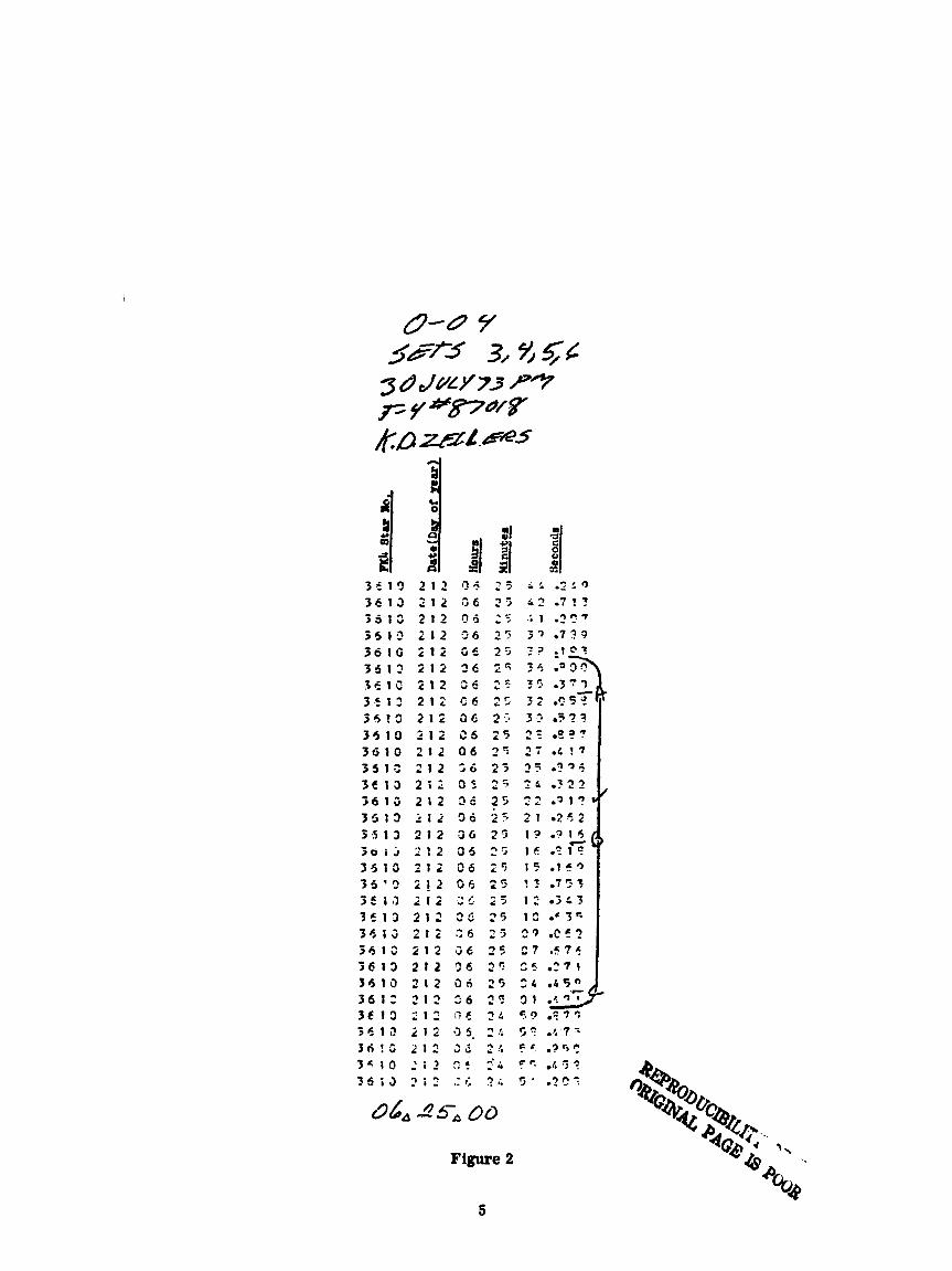
Recently, DMA acquired several time position printer systems, Model SP-300, manufactured by Datametrics, a subsidiary of ITE Imperial Corporation of Wilmington, Massachusetts. One of these is shown with a Wild T-4 optical the0 - dolite (Fig. 1). This system can be powered by disposable dry cell batteries. A sample of the "grocery tapew output of the system shows FK-4 star number, day of year, hours, minutes and seconds of observation (Fig. 2). About 60 astronomic stations have been observed to date with excellent results using this equipment.

1 2 c 5 ; F': . 4 5 ? C I 3 6 3 3 .:< .;* .?c'
06~ 25-& 00
Figure 2
3 5 1 3 2 1 2 !>+ 2 5 i r .::a 3 6 1 3 2 1 2 3 6 2 5 4?.7!? 3 5 1 3 2 1 2 0 6 2 5 .;I .??7
3 4 1 3 2 1 2 3 6 19 3 7 . 7 ? 9
3 . 6 1 6 2 1 2 j E 2 3 3 3 - 1 3 1
35 13 2 1 2 3 6 2 4 3 4 .%3? f e l C 2 1 2 36 2'. 3 5 03'1 2 3 . 5 1 2 2 1 2 C b 2 5 5 2 . ?5$ 3 5 I S 2 1 2 36 2.7 3 3 a % ? ?
3 5 1 0 2 1 2 3 5 2 5 2 1 a ? ? ? 3 6 1 0 2 1 2 06 34 2 7 . & ? 7
3 5 1 3 2 1 2 ; 6 2 3 9 5 0296 3 C t 3 2 ; : 9 5 2 s 2 6 .321 j c r ; 2 1 2 36 ? 5 t: . 2 1 ? r '
3 5 1 3 2 1 2 3 6 2-21 0252 5 5 1 3 2 1 2 36 25 I? . ? 1 5 c - 3 0 i j 2 ! 2 O j 2'i l ( r .?I? 3 5 1 9 2 1 2 0 6 2 5 1 5 .I", 3 5 . 2 2 1 2 Or; 25 ! ? . ? 3 3 3 5 1 3 2 1 2 2 C 2 5 1 2 - 5 5 3 351.3 2 1 2 2 5 2 5 IS - ' 3 " 3 4 3 3 2 1 2 S 6 2 3 2 9 . C C ? 361: 1 1 2 G 6 25 C ? , 5 7 6 3 6 1 3 2 1 2 3 6 2'7 2 5 - 2 7 1 3 4 1 3 2 1 2 O A 2 5 3 4 d 5 "
P
3 6 1 2 2 1 2 3 6 29 3 1 3 t 1 3 2 1 2 i 7 f 2s 5.9 . $ 7 5
5 6 1 , ? 2 1 2 3 5 . 1? 5 S . 4 7 : 36:s 2 1 2 2 ; 2!. s c . .PC,?

A major advantage of combining the DoD mapping, charting d geodesy firactiom under me single organization is that a larger base fs available for the ju8tifica- tion and development of new instnunentation. In an effort to reduce '& possibi- lity of error and to reduce the coet of astranomic poeitianing, an automated ur- trowmic positioning system is being dweloped for DMA by the Coatrol Data Corporrtioa.
Electromagnetic distance meunving equipment used for trilatemtioa o r h v e r - sing measurer, the time required for a signal to make the rorrnd trip over the distance being measured, While the accuracy of ~ ~ m e n t s are limited by our knowledge of the speed of light, it is not the dominant error in these measurements.
SATELLITE GEODESY
DMA requires more precise time measurements for its satellite tracking pro- grams. Satellites a re tracked to determine 2n ephemeris which is used for posi- ti- and in s t d i e s to i m p m e our model of the earth's gravity field. Among other p u m e s , the model of tbe gravity field can be used to provide improved ephemerides. This bootstrap operation has been used primarily by the U. S. Navy, from whom the program was inherited, since 1960 and has resulted in the present gravity field model which includes harmonic terms thm** the twen- tieth order and degree, about 400 terms in all.
In addition to the Navy navigation satellites, other satellites, such a s those launched by NASA, are used for gravity field improvements. The Timation III satellite, due to be launched next spring, will also be used. The CEOS-C satel- lite, scheduled to be launched next summer, will have an altimeter aboard which promises to provide deflections of the vertical over ocean areas and also an in- dication of the variation of the geoid. Other techniques, such a s satellite-to- satellite tracking, are being examined to determine the least expensive system for improving the gravity field model and thus the shape of the geoid.
The DMA TRANET tracking network is managed by our Topographic Center and consists of 15 semi-permanent stations deployed worldwide and six stations available for mobile deployment. l'hese ground stations track doppler satellites by recording the time of day when a preset number of doppler cycles have been received since the last data point. The measurements are dependent on a local clock synchronized with UTC from t ie Naval Observatory. The master tracking and control station at the AT-lied Physics Laboratory of The Johns Hopkins University is equipped with a cesium clock, which i s tied to the Observatory by VLF, Loran, TV and portable clock transfers. When tracking the Navy naviga- tion satellites, containing clocks maintainc close to UTC, the time to receipt

of the satellite's timing marks provides a means of =librating the satellite clock against the Observatory's clock, The time signals from the same satellite, when received a t the other stations, pmvide a meaes a# calibrating the clocks a t tboee statloem, Redudaacp is pnwided by trackiw VLF time signals. At the present time, epoch is maintained a t the tracking statiaas to an a m c y of a- 50 mic-. At tbe altitude of the NAVSATS, satellites move a t the rate of seven meters per millisecood. The 50 microseeoads. therefore, equates to 35 centimeters of satellite motSon. Al- this is well witbin the current observatiaml accuracy, impmements are desired which will require timing accumcies af about 10 microerecoads. Rubidium osciLlators have k e n ordered for six of tbe semi-permanent stations, as a first step in achieving increased timing accuracy. O&er changes are being considered at the same time to im- pnwe the cnrerall abser'zatioaal accuracy, Tbese inclPde modification of a digitizatiaa technique, s M y d the third order ionospheric correction, and im- praviag Me phase lock loop. Quartz cqwtai uscillators are currently be* used at the statioas to drive the clocks a s well as to measure the doppler shift. These oscillators have r stability of about are part in 10'' per day and sligatly better ihan that wer the period of a satellite pass.
As with astronomic observations, satellite observations must be corrected for the latitude sB'i dt.e to the motion of the pole. A satellite making a do- or 80
revolutions about the earth each day becomes a powerful tool for determing the position of the pole. The Naval Weapons Laboratory, Dthlgrea, Virginia, re- duces the data collected at tbo TRAhET stations every dher day to generate an ephemeris. These epkmerides can only be accurate if the polar motion is taken into accourt. bowing the positiocs of the tracking h t i o n s , the position of the pole becomes a bias in the adjustment of the data, and must be applied a s a cor- rectioa. Comparison of the NWL polar motion values with the BIH and the IPMS (Intematiaoal Polar Motioa Service) values shows as good agreement as between the B M and the IPMS values themselves.
Although we a r e supplyiag the polar motion coordinates derived from doppler data to the Naval Obsematory. the c o r r a a r s applied to astronomic positions are derived by the BIH. Most astronomers a r e not ready to replace the traditional star observations with corrections derived from satellite data.
Positioaing satellite is also accomplished by wing a geoceiver (Fig. 3) with the antenna unit located wer the mark to be positioned. The geoceiver (Reodetic receiver) is a miniaturized dqrpler tracking station weighing only about 45 kilo- grams. Designed hy the Applied Physics Laboratory and Magnavox, geoceivera a r e operated by DMA Centers, a s well a s NAVOCEANO and others. The geo- ceiver clock is driven by a quartz crystal oscillator similar to the ones used a t larger tracking stations, The clock i s started from aud synchronized with the NAVSAT time signals. The frequency of the oscillator and the clock drift can be


defermined om site by hrmd calcplriaas or ur a part ofthedata reduction pro- gram. Tbc stability af these -ilhtors is five parts in loi0 per rhy iad eight prts in lo'? per minute. Tbe time a t the end at oae doppler anmtiag period . n d t b e ~ d t b e a e x t i s & o r t r i t h a r e s d 9 t i m a t f a u m i c ~ , Positiaaiqg by geomiver, wben using the precise orbits coqmted by the Naval Weapms Wmratory is ktkr than two meters in each coordimte uds, Approx- imately 35 usable passes are required to achieve this accuracy,
Tbe knowledge d time epoch a d the measurement of time interval have tradi- tionally played an importpat role in the fiekl of mappipg, charting and gmxby. Curmat nretbods of astrawmic positioaing and satellite hacking will be rephced by nev systems coming wer the horizom. The present navigation ~~tellites will be reqhcal with a aerp system of satellites, possiMy tfroare proposed &r tbe NAVSTAR program (also referred to as the Defense Navigation Satellite System). werillbererdytomrke~dthptsgstemvbenitfsaPiilible. Epochaccuracy will need to be about tbe same a s the present accuracy. b Lhe meantime, an order of magpiMe iqrmrement in the epoch accuracy of our tracking stations is anticipated which sbauld app10~ch the accuracy of the new system in tbe along track directiar,
Much af tk DMA survey work, particularly point positioning, depends upon time for its accomplishment. Eiamwecoad accuracy is not yet required, but the equip ment for providing time a d meamring time intend which is required, must operate mder diffkult field cditioas. Cost, reliability and portability are of atmost importance, D m is a p e o n organization and must depend an the develapers to provide the hardware needed to do the job with the a-cy and low cost demanded in these days of tight operating bpdgets.
In closing, I umuld like to acknowledge the fine assistance of Mr. Philip D. Kddell of our TopagrPgbic Center in preparing this paper. I would also like to asswe you as DMA's needs for increased precisian aml accuracy of time deve- lop, we will appraise yan of them.

QUESTION AND ANSWER P E m D
DR. KLEPCZYNSKI:
Are there aay quest'ins from the autience? Yes.
am. LIEBERbUN:
The new system that will replace the NAVSAT. will that be able to use geooeivers ?
MR. UilLLIAads:
Yes.
That i s andher name, yes. It i s very had Q l i e 2 up with the bureaucratic aame changes. I must admit.
DR. KLEPCZYNSI:
I believe "GPS* stands for "Glob1 Positioairrg System. "
MR. WILLIAMS:
Right.
(Editor's Comment: Later during the week of the meetillg. the System mas renamed "NA V STAR". )
DR. KLEPCZYNWI:
A r e there any other questions ?
(No response. )
DR. KLEPCZYSKI:
U'ell, thank you very much. Maybe we can get a discussion going here for a few minutes with some audience participation.
Before the meeting started -we were talking about wrttiag requirements for PTTI system. This seems to be a very difficult thing to do. People require, o r they say they need accurate time. Some people talk about accuracies of ten nanoseconds . Apparently it bemmt-s very hard to justify requirements in terms, which upper management finds easy to accept.
Now, I am wondering if anybody in the audience might be able to contribute some type of discussion a s to some hard and proven techniques for justifying extreme accuracies in certain time systems ?
Everybody knows all systems work better with more exact time, but it is difficult to formulate that in words which a r e easily understood, o r can be proven. It sometimes gets to be a very difficult thing, and I don't know if any- body here has had experience with this.
Yes, Dr. Winkler.
DR. WINKLER:
Well, my experience is rather broad and general; there seems to be a sub- theorem of the more general one that the more expensive a system is, thc easier it would be approved. The subtheorem offered is: The fancier the clock, the better will be the system.
But I think, to be more on the serious side, in specifying requirements, and in justibing requirements, you have really two problems.
The first one is the acceptance of a common terminology; how do you specify a frequency, how do you spec~fy time. o r frequency and phase variations. In most specifications which you see there i s a tremendous confusion. People like to talk in parts to the 10 to the something, when in fact they mean phase noise, and vice versa. We will later on have occasion to refer to some papers, some fundamental literature which exists regarding terminology, most notably, the IEEE Subcommittee work on Frequency Stability and its publication on charac- terization of frequency stability by Barns et al. I think this paper is one which may lead the way to a uniform specification of frequency stability.
Uniform specification language in time should be simpler. You simply state what your phase noise expressed in time is going to be.
But turning now to the second part of my concern, the credibility aspect, and to the justification which ~ o u l d be given in a language easily understood by the many levels of review and approval, I think you have again basically two aspects. Om nanosecond propagation time of light corresponds to one foot; i t i s an extremely short interval of time. I will caution systems designers and systems proponents, to be very, very careful not to overstate the actual requirements, becausc it will be very expensive to implement timing systems with nanosecond time requirements.
In the discussion of a system, anyone, who talks about nanosaconds and so on, should better f irs t study the various disturbances in the atmosphere, the various disturbances in signal propagation, through the electronic systems, etc., before specifications of requirements for clocks a r e firmed up.
3nce you follow that common engineering syndrome of overspecifying, and of doing things more complicated than may actually be necessary, then you have already embarked on a path which leads to disaster, and you will end up with the typical problems of production, maintenance and cost. I remind you what an elephant is; an elephant i s a "military specification" designed mouse.
And one should not use cesium clocks o r hydrogen masers in a backpack unless absolutely required (if one can't get a time signal in time!).
(Applause, )
DR. KLEPCZYNSKI:
Do you have a comment over here?
MR. LIEBERMAN:
I think to tcirn the question around, rather than requirements, a s Captain Fowler pointed out, perhaps we should look a t what i s available in precise time on existing systems, and try to make maximum use of what i s available a t comparatively reasonable costs.
We now have 1 microsecond around the world a t the SATCOM stations. VLF, i t was pointed out, could be used down to 10 microseconds and approximately 1 microsecond is available on some Loran C systems.

Try to build systems based upon this availability.
DR. KLEPCZYNSKI:
Very good. These are very interesting comments.
Are there any more ?