Embed Size (px)
Citation preview

In ';e:Anorphology and engineering. 1976.p. 19.9-221.-Donald R. Coates, ed. Dowden,Hutchinson & Ross, Inc. Stroudsburg, Pa. 10
TIMBER HARVESTING,MASS EROSION, AND
STEEPLAND FOREST GEOMORPHOLOGYIN THE PACIFIC NORTHWEST
Douglas N. Swanston and Frederick J. Swanson
INTRODUCTION
Forest operations in mountainous regions of the Pacific Northwest have a majorimpact on soil-erosion processes. The mountains of the region are youthful, the area hasundergone recent tectonic activity, and west of the crest of the Cascades annual precipita-tion may exceed 375 cm. Consequently, natural erosion rates are high. Heavy forestvegetation and the high infiltration capacity of many of the forest soils protect slopesfrom surface erosion. The combination of these factors results in mass erosion processesgenerally being the dominant mechanisms of sediment transport from hillslopes to streamchannels. The principal mass erosion processes are slow, downslope movement involvingsubtle deformation of the soil mantle (creep) and discrete failures, including slow-moving,deep-seated slump—earthflows; rapid, shallow soil and organic debris movement fromhillslopes (debris avalanches); and rapid debris movement along downstream channels(debris torrents) (Fig. 1A, B). In many areas, forest vegetation plays an important role instabilizing slopes and reducing the movement rate and occurrence of these mass erosionprocesses. When timber is removed from marginally stable slopes, whether by naturalprocesses such as wildfire and wind or by the activities of man, a temporary accelerationof erosion activity is likely.
Accelerated erosion due to forest land management activities may result in reducedproductivity of forest soils over sizable portions of affected watersheds, damage to roads,bridges, and other structures, and adverse impacts on the stream environment down-stream.
FACTORS CONTROLINGMASS EROSION PROCESSES
Geologic, hydrologic, and vegetative factors control the occurrence and relativeimportance of mass erosion processes. In the Pacific Northwest, areas of clay-rich bedrockand deep, cohesive soils are characterized by dominance of the slow mass movementprocesses of creep and slump—earthflow; notably in the extensive areas of soft sedimen-tary rocks of the Klamath Mountains, Oregon, and northern California Coast Range andthe volcaniclastic rocks in the Cascade Range. Debris avalanches dominate mass erosionprocesses in terrain typified by steep slopes, cohesionless soils, and relatively competentbedrock, such as large areas of the coast ranges of Oregon, Washington, British Columbia,and Alaska.
199

A
FIGURE 1 Examples of principal mass erosion processes operating onsteep forested slopes in the Pacific Northwest. (A) creep and slump-earthflow terrain on Franciscan sediments in the upper headwaters of theNorth Fork, Eel River, northern California. The entire slope is under-going creep deformation but note the discrete failure (slump—earthflow)marked by the steep headwall scarp at top center and the many smallslumps and debris avalanches triggered by surface springs and roadconstruction. (B) debris avalanches developed in shallow soils overlyingcompact till in southeast Alaska. Debris torrent developed below debrisavalanche at center of photo due to channeling of debris, undercutting ofsideslopes, and addition of material by secondary avalanching into chan-nel.
200

Douglas N. Swanston and Frederick J. Swanson 201
Periods of high-intensity precipitation, storm events, and condensation snowmeltcommonl y trigger or accelerate mass wasting events on steep forest slopes (Bishop andStevens, 1964; Fredriksen, 1965; Dyrness, 1967; Swanston, 1969). These factors directlyinfluence the moisture content of the soil and determine the presence or absence of activepiezometric levels in the subsurface. Moisture content and piezometric level affect theweight of the soil mass and control the development of positive pore pressures. Thesefactors act to reduce the resistance of the soil mass to sliding by either mobilization ofclay structures, primarily through adsorption of water into the clay mineral structure, orby reducing the frictional resistance of the soil mass along the failure surface.
Vegetation cover in general helps control the amount of water reaching the soil andthe amount held as stored water, largely through a combination of interception andevapotranspiration. In high-rainfall areas of the Pacific Northwest, interception is negli-gible during large storm events important to mass soil movement (Rothacher, 1963).Evapotranspiration (ET) has its principal effect on soil strength by reducing the length oftime that soils remain saturated. ET reduces soil moisture during dry months, reduces thedegree of saturation that can result from the first storms of the fall recharge period, andaccelerates the rate of soil moisture removal at the end of the wet season. Once the soil isrecharged as the wet season begins, the effect of ET loss becomes negligible. Also ofimportance is the depth of withdrawals by ET. Deep withdrawals may require substantialrecharge to satisfy the soil-water deficit, delaying the attainment of saturated soilconditions several months or through a number of major slide-producing events. Shallowsoils, on the other hand, will recharge rapidly, possibly attaining saturated conditions andmaximum instability during the first major storm. ET has also been linked with at least atemporary increase of shear strength and stability during dry summer months through soilmoisture depletion and buildup of soil moisture stress (Gray and Brenner, 1970; Man-beian, 1973; Gray, 1973).
Forests may also moderate the rate at which moisture enters the soil. This isparticularly important in the case of warm-rain-on-snow events in which forest vegetationmay influence the amount of snow collected on the land surface and the rate of melting,where advection and condensation melting are important (Anderson, 1969).
A crucial factor in the stability of active slopes is the role of plant roots inmaintaining the shear strength of soil mantles. Roots add strength to the soil by verticalanchoring through the soil mass into fractures in the bedrock, and by laterally tying theslope together across zones of weakness or instability. In shallow soils, both effects maybe important. In deep soils the vertical rooting factor will become negligible, but lateralanchoring may remain important. In some steep areas in the western United States,rooting strength may be the dominant factor in maintaining the slope equilibrium of anotherwise unstable area (Bishop and Stevens, 1964; Croft and Adams, 1950). Zaruba andMencl (1969) have reported the stabilizing effect of tree roots in landslide areas inCzechoslovakia, and Nakano (1971) reports similar effects from unstable areas in Japan.
IMPACTS OF FOREST-MANAGEMENT ACTIVITIESON MASS EROSION PROCESSES
Timber-harvesting activities, including clearcutting and road construction, modifyfactors influencing mass erosion in a variety of ways. Some of the most importantimpacts of these activities are summarized in Table 1.

TABLE 1 Impacts of Engineering Activities on Factors That Influence Slope Stability in Steep Forest Landsof the Pacific Northwest
Engineering activitiesa
Factors Deforestation Roading References
I. Hydrologic influencesWater movementby vegetation
Reduce evapotranspiration (—) Eliminate evapotranspiration (—) Gray (1970)Brown and Sheu
(1975)Surface and sub- Alter snowmelt hydrology Alter snowmelt hydrology (— or +) Anderson (1969)surface water (— or +) Alter surface drainage network (—) Harr et al. (1975)movement Intercept subsurface water at roadcuts (—) Megahan (1972)
Alter concentrations of un- Alter concentrations of unstable debris Rothacher (1959)stable debris in channels (—) in channels (—) Froehlich (1973)
Reduce infiltration by groundsurface disturbance (—)
Reduce infiltration by roadbed (—)
II. Physical influencesA. Vegetation Swanston (1970)
Roots Reduce rooting strength (—) Eliminate rooting strength (—) Nakano (1971)Bole and crown Reduce medium for transfer of
wind stress to soil mantle (+)Eliminate medium for transfer of wind
stress to soil mantle (+)Swanston (1969)
B. SlopeSlope angle Increase slope angle at cut and
fill slopes (—)Parizek (1971),
O'Loughlin (1972)Mass on slope Reduce mass of vegetation on
slope (+)Eliminate mass of vegetation on slope (+) Bishop and Stevens
(1964)Cut and fill construction redistributes
mass of soil and rock on slope (— or +)O'Loughlin (1972)
C. Soil properties Reduce compaction and apparent cohesionof soil used as road fill (—)
a lnfluence that usually increases slope stability denoted by (+); influence that usually decreases stability denoted by (—).

Douglas N. Swanston and Frederick J. Swanson 203
The principal impacts of forest removal by clearcutting are to reduce rooting strengthand to alter the hydrologic regime at the site. In Japan, Kitamura and Namba (1966,1968) have described a period of greatly reduced soil strength attributable to rootingbeginning about 3 yr following cutting, when there has been significant decay of rootsystems. and attaining a minimum strength 15 yr after cutting. Similar loss of notingstrength on unstable sites has been reported from coastal Alaska' and British Columbia(O'Loughlin. 1974), with minimum rooting strength attained 3 to 5 yr after cutting.
The hydrologic impacts of clearcutting include modification of annual soil-waterstatus and changes in peaks of soil water held in detention storage during periods of stormrunoff. Increased peak flows can generate active pore-water pressures, triggering shallowdebris avalanches and debris torrents. Reduced ET due to clearcutting results in thesoil-water status remaining at higher levels for several months longer than it would underforested conditions (Gray, 1970: Rothacher, 1971). This modification in the soil-waterregime may result in prolonged periods of active creep and slump—earthflow movementduring a single season or reactivation of dormant terrain. Water-yield studies in experi-mental watersheds in Oregon (Rothacher, 1971; Harr, 1975) suggest that this effect maycontinue for more than a decade after cutting.
Timber removal may also increase peaks of soil water by accelerated snowmelt duringwarm-rain-on-snow conditions (Anderson, 1969). This phenomenon may also increasetotal surface runoff if rain and snowmelt are synchronized (Rothacher and Glazebrook,1968).
The principal impacts of road construction are to interrupt the natural balancebetween the resistance of the soil to failure and the downslope stress of gravity bydisturbance of marginally stable slopes and alteration of subsurface and surface-watermovement. Disturbance results from careless or improper cutting of marginally stableslopes, poor construction and placement of fills on steep slopes, and improper drainagedesign. Roads alter the routing of water by interception of surface water at cut slopes andsurface drainage from roads and by carrying this excess water through ditches (Megahan.1972; Harr et al., 1975). Mass erosion commonly occurs where natural and artificialdrainage systems are inadequate to handle this excess water.
CREEP
CharacteristicsCreep is the slow, downslope movement of the soil mantle in response to gravitational
stress. The mechanics of creep have been investigated experimentally and theoretically bya number of workers (Terzaghi, 1953; Goldstein and Ter-Stepanian, 1957; Saito andUezawa, 1961; Culling, 1963; Haefeli, 1965; Bjerrum, 1967; Carson and Kirkby, 1972;and others). Movement is by quasi-viscous flow, occurring under shear stresses sufficientto produce permanent deformation, but too small to result in discrete failure. Mobiliza-tion of the soil mass is primarily by deformation at grain boundaries and within claymineral structures. Both interstitial and absorbed water appear to contribute to creepmovement by opening the structure within and between mineral grains, thereby reducing
' Douglas N. Swanston and W. J. Walkotten, tree rooting and soil stability in coastal forests of
southeastern Alaska. Study No. FS-NOR-1604:26 on file at PNW Forestry Sciences Laboratory,
Juneau, Alaska.
204 TIMBER HARVESTING AND FOREST GEOMORPHOLOGY
friction within the soil mass. This permits a "remolding" of the clay fraction, transform-ing it into a slurry, which then lubricates the remaining soil mass. In local areas whereshear stresses are great enough, discrete failure may occur, resulting in development ofslump—earthflow due to progressive failure of the mantle materials.
Movement Rate and OccurrenceCreep movement generally occurs at rates of a few millimeters to a few centimeters
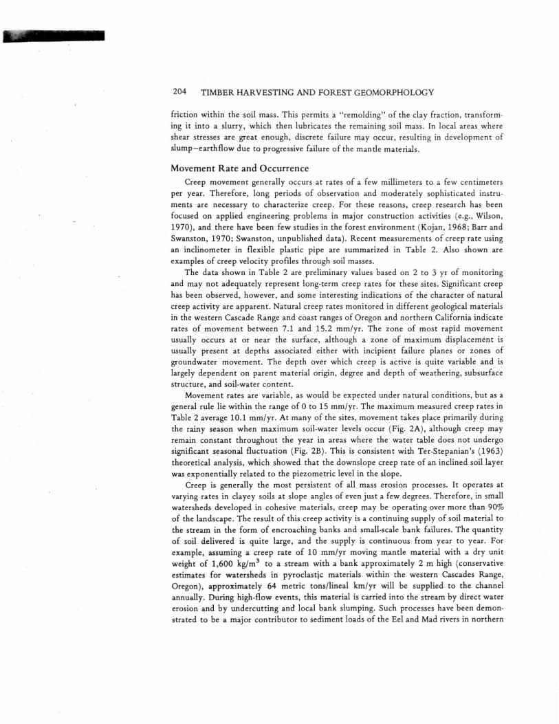
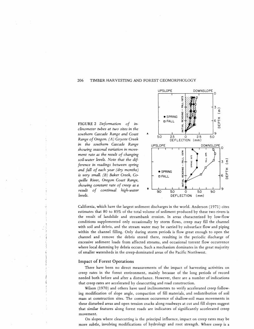
per year. Therefore, long periods of observation and moderately sophisticated instru-ments are necessary to characterize creep. For these reasons, creep research has beenfocused on applied engineering problems in major construction activities (e.g., Wilson,1970), and there have been few studies in the forest environment (Kojan, 1968; Barr andSwanston, 1970; Swanston, unpublished data). Recent measurements of creep rate usingan inclinometer in flexible plastic pipe are summarized in Table 2. Also shown areexamples of creep velocity profiles through soil masses.
The data shown in Table 2 are preliminary values based on 2 to 3 yr of monitoringand may not adequately represent long-term creep rates for these sites. Significant creephas been observed, however, and some interesting indications of the character of naturalcreep activity are apparent. Natural creep rates monitored in different geological materialsin the western Cascade Range and coast ranges of Oregon and northern California indicaterates of movement between 7.1 and 15.2 mm/yr. The zone of most rapid movementusually occurs at or near the surface, although a zone of maximum displacement isusually present at depths associated either with incipient failure planes or zones ofgroundwater movement. The depth over which creep is active is quite variable and islargely dependent on parent material origin, degree and depth of weathering, subsurfacestructure, and soil-water content.
Movement rates are variable, as would be expected under natural conditions, but as ageneral rule lie within the range of 0 to 15 mm/yr. The maximum measured creep rates inTable 2 average 10.1 mm/yr. At many of the sites, movement takes place primarily duringthe rainy season when maximum soil-water levels occur (Fig. 2A), although creep mayremain constant throughout the year in areas where the water table does not undergosignificant seasonal fluctuation (Fig. 2B). This is consistent with Ter-Stepanian's (1963)theoretical analysis, which showed that the downslope creep rate of an inclined soil layerwas exponentially related to the piezometric level in the slope.
Creep is generally the most persistent of all mass erosion processes. It operates atvarying rates in clayey soils at slope angles of even just a few degrees. Therefore, in smallwatersheds developed in cohesive materials, creep may be operating over more than 90%of the landscape. The result of this creep activity is a continuing supply of soil material tothe stream in the form of encroaching banks and small-scale bank failures. The quantityof soil delivered is quite large, and the supply is continuous from year to year. Forexample, assuming a creep rate of 10 mm/yr moving mantle material with a dry unitweight of 1,600 kg/m 3 to a stream with a bank approximately 2 m high (conservativeestimates for watersheds in pyroclastic materials within the western Cascades Range,Oregon), approximately 64 metric tons/lineal km/yr will be supplied to the channelannually. During high-flow events, this material is carried into the stream by direct watererosion and by undercutting and local bank slumping. Such processes have been demon-strated to be a major contributor to sediment loads of the Eel and Mad rivers in northern

-100 0 100DEFLECTION (fron)
Depth of Zone ofsignificant accelerated
Data movement Surface movementLocation source P-.rent material (m) (mm/yr) (mm/yr)
Coyote Creek Swanstona Little ButteVolcanic Series:
South Umpqua deeply weathered 7.3 13.97 10.9
River drainage, clay-rich andesiticCascade Range dacitic volcani-of Oregon, clastic rockssite C-1
Blue River Swanston aLittle Butte Series:drainage—(same as above) 5.6 7.9 7.1
Lookout CreekH. J. Andrews Exp.Forest, CentralCascades of Oregon,site A-1
Blue River McCorison bLittle Butte
drainage IBP and Glenn Volcanic Series 0.5 9.0
ExperimentalWatershed 10,site No. 4
Baker Creek, Swanston aOtter PointCoquille River, Formation:
Coast Range, highly sheared 7.3 10.4 10.7
Ore., and altered clay-Site B-3 rich argillite and
mudstoneBear Creek, SwanstonaNestucca
Nestucca River, Formation:Coast Range, deeply weatheredOre., pyroclastic rocks
site N-1 and interbedded,shaly siltstonesand claystones
15.2 14.9 11.7
Redwood Creek, Swanston aKerr RanchCoast Range, Schist:northern Calif., sheared, deeply
site 3-B weathered clayeyschist
2.6 15.2 10.4
OOWNSLOPE 0
(//1 15
40 0 0 10.0DEFLECTION (mm)
UPSLOPE
DOWNSLOPE 0
5 ,&
1 -10.0 0 10.0
DEFLECTION (mm)
UPSLOPE OOWNSLOPE
-10.0 0 10.0DEFLECTION(mm)
UPSLOPE
Representativecreep profile
UPSLOPE DOWNSLOPE o
-IS
110
0OWNSLOPE 0
EUPSLOPE
so-100 0 100
DEFLECT I ON 1,..1
Douglas N. Swanston and Frederick J. Swanson 205
TABLE 2 Examples of Measured Rates of Natural Creep on Forested Slopes in thePacific Northwest
Maximum downslopecreep rate
aDouglas N. Swanston, unpublished data on file at Forestry Sciences Laboratory, U.S. Department ofAgriculture, Forest Service, Pacific Northwest Forest and Range Experiment Station, Corvallis, Ore.
b F. Michael McCorison and J. F. Glenn, data on file at Forestry Sciences Laboratory, U.S. Departmentof Agriculture, Forest Service, Pacific Northwest Forest and Range Experiment Station, Corvallis,Ore.
DOWNSLOPE oI I
CT-— 6
• SPRINGO FALL
DOWNSLOPE0
UPSLOPE
E
5.0 2.5 0 2.5DEFLECTION (mm)
A
C
—3
cr,
9.
1 i I i .1Q. I 1 I I 9.0 5.0 0 5.0 9.0
DEFLECTION (mm)
UPSLOPE
206 TIMBER HARVESTING AND FOREST GEOMORPHOLOGY
FIGURE 2 Deformation of in-clinometer tubes at two sites in thesouthern Cascade Range and CoastRange of Oregon. (A) Coyote Creekin the southern Cascade Rangeshowing seasonal variation in move-ment rate as the result of changingsoil-water levels. Note that the dif-ference in readings between springand fall of each year (dry months)is very small. (B) Baker Creek, Co-quille River, Oregon Coast Range,showing constant rate of creep as aresult of continual high-waterlevels.
California, which have the largest sediment discharges in the world. Anderson (1971) citesestimates that 80 to 85% of the total volume of sediment produced by these two rivers isthe result of landslide and streambank erosion. In areas characterized by low-flowconditions supplemented only occasionally by storm flows, creep may fill the channelwith soil and debris, and the stream water may be carried by subsurface flow and pipingwithin the channel filling. Only during storm periods is flow great enough to open thechannel and remove the debris stored there, resulting in the periodic discharge ofexcessive sediment loads from affected streams, and occasional torrent flow occurrencewhere local damming by debris occurs. Such a mechanism dominates in the great majorityof smaller watersheds in the creep-dominated areas of the Pacific Northwest.
Impact of Forest OperationsThere have been no direct measurements of the impact of harvesting activities on
creep rates in the forest environment, mainly because of the long periods of recordneeded both before and after a disturbance. However, there are a number of indicationsthat creep rates are accelerated by clearcutting and road construction.
Wilson (1970) and others have used inclinometers to verify accelerated creep follow-ing modification of slope angle, compaction of fill materials, and redistribution of soilmass at construction sites. The common occurrence of shallow-soil mass movements inthese disturbed areas and open tension cracks along roadways at cut and fill slopes suggestthat similar features along forest roads are indicators of significantly accelerated creepmovement.
On slopes where clearcutting is the principal influence, impact on creep rates may bemore subtle, involving modifications of hydrology and root strength. Where creep is a
Douglas N. Swanston and Frederick J. Swanson 207
shallow phenomenon (less than 2 to 3 m), the loss of root strength due to clearcutting islikely to be significant. Reduced evapotranspiration following clearcutting (Gray, 1970;Rothacher, 1971) may result in greater duration of the annual period of creep activityand, thereby, increase the annual creep rate.
Brown and Sheu (1975) have developed a mathematical model of creep that accountsfor root strength, wind stress on the soil mantle, weight of vegetation, and soil moisture.The model predicts a brief period of increased slope stability following clearcutting dueto removal of the weight of vegetation and elimination of wind stress. Thereafter, creeprates are accelerated as soil strength is attenuated by progressive root decay. The netresult of the short-term increase and longer-term decrease in slope stability is expected tobe an overall increase in creep activity.
SLUMP—EARTHFLOW
CharacteristicsIn local areas where shear stresses are great enough, discrete failure occurs and
slump—earthflow features (Varnes, 1958) are formed. Simple slumping takes place as arotational movement of a block of earth over a broadly concave slip surface and involvesvery little breakup of the moving material. Where the moving material slips downslopeand is broken up and transported either by a flowage mechanism or by gliding displace-ment of a series of blocks, the movement is termed slow earthflow (Varnes, 1958). Thecombined term slump—earthflow is used because many deep-seated mass movements inthe Pacific Northwest have slump characteristics in the headwall area and developearthflow features downslope.
Slump—earthflows have been described by Varnes (1958), Wilson (1970), Colman(1973), Swanson and James (1975), and others. In the Pacific Northwest, these featuresmay range in area from less than 1 hectare to more than several square kilometers. Thezone of failure occurs at depths of a few meters up to several tens of meters below thesurface. Commonly, there is a slump basin with a headwall scarp at the top of the failurearea. Lower ends of earthflows typically run into stream channels. Transfer of earthflowdebris to stream channels may take place by shallow, small-scale debris avalanching or bygullying and surface erosion, depending on soil and vegetation conditions. Therefore, thegeneral instability set up by an active slump—earthflow initiates erosion activity by avariety of other processes.
Geologic, vegetative, and hydrologic factors have primary control over slump-earthflow occurrence. Deep, cohesive soils and clay-rich bedrock are especially prone toslump—earth flow failure, particularly where these materials are overlain by hard, compe-tent rock (Wilson, 1970; Swanson and James, 1975). Earthflow movement also appears tobe most sensitive to long-term fluctuations in the amount of available soil water (weeks,months, annually) (Wilson, 1970; and others).
Because earthflows are slow moving, deep-seated, poorly drained features, individualstorm events probably have much less influence on their movement than on the occur-rence of debris avalanches and torrents. Where planes of slump—earth flow failure are morethan several meters deep, weight of vegetation and vertical root-anchoring effects arenegligible (O'Loughlin, 1974).

208 TIMBER HARVESTING AND FOREST GEOMORPHOLOGY
Movement Rate and OccurrenceMovement rates of earthflows vary from imperceptibly slow to more than 1 m/day in
extreme cases. In parts of the Pacific Northwest, many slump—earth flow areas appear tobe presently inactive (Colman, 1973; Swanson and James, 1975). Areas of active move-ment may be recognized by fresh ground breaks at shear and tension cracks and by tippedand bowed trees. Rates of movement may be monitored directly by repeated surveying ofmarked points, by inclinometers, and by measuring deflection of roadways and otherreference systems. These methods have been used to estimate the rates of earthflowmovement shown in Table 3. However, these average rates, stated so simply, are some-what misleading, because of the great variability of movement rate over both time andspace, even for a single slump—earthflow (Colman, 1973; Swanson and James, 1975).Open tension cracks and degree of disturbance of vegetation on slump—earthflowsindicate that some part of an earthflow terrane may move rather rapidly, while otherareas appear to be temporarily stabilized.
The history of individual slump—earthflows may extend over thousands of years. Thisis indicated by age estimates based on radiometric dating of included wood, calculation ofvolume of eroded material, estimated long-term rate of earthflow erosion from site,presence of 7,000-yr-old Mazama ash on preexisting earthflow terrain, and characteristicsof drainage development over earthflow surfaces. During this long history, periods ofrelatively high precipitation or forest removal may increase water content of an earthflowand accelerate movement rate. This downslope movement will decrease the relief at thesite until the stability of the mass is increased to a point where the velocity decreasesmarkedly. A period of temporary inactivity will take place until there is reactiviationduring a period of high moisture availability, or when the area had been destabilized bystream erosion at the toe of the earthflow.
The areal occurrence of slump—earthflows is mainly determined by bedrock geology.In the Redwood Creek Basin, northern California, Colman (1973) observed that, of the27.4% of the drainage which is in slumps, earthflows, and older or questionable land-slides, a very high percentage of the unstable areas are located in the clay-rich and
TABLE 3 Observations of Movement Rates of Four ActiveEarthflows in the Western Cascade Range,Oregon
Location
Periodof record
(yr)
Movementrate
(cm/yr)
12
25
2.5
7
Method ofobservation
Landes Creek(Sec. 21 T22S R4E)
Boone Creek(Sec. 17 T17S R5E)
S.W. Cougar Reservoir(Sec. 29 T17S R5E)
Lookout Creek(Sec. 30 T15S R6E)
15
2
2
1
Deflectionof road
Deflectionof road
Deflectionof road
Strain rhombusmeasurementsacross activeground breaks
Douglas N. Swanston and Frederick J. Swanson 209
pervasively sheared portions of the Franciscan assemblage of rocks. Areas underlain byschists and other more highly metamorphosed rock arc much less prone to deep-seatedmass erosion. The areal occurrence of slump—earthflows in volcanic terranes of the PacificNorthwest is also closely linked to bedrock type. In the H. J. Andrews ExperimentalForest, western Cascade Range, Oregon, for example, approximately 25.6% of areasunderlain by volcaniclastic rocks are included in active and presently inactive slump-earthflows. Less than 1% of areas of basalt and andesite flow rock have undergoneslump—earthflow failure.
Impact of Forest OperationsEngineering activities that involve excavation and fills frequently have dramatic
impact on slump—earth flow activity (Wilson, 1970). In the forest environment, there arenumerous unpublished examples of accelerated or reactivated slump—earthflow move-ment after forest road construction. Undercutting of toe slopes of earthflows and pilingof rock and soil debris on slump blocks are common practices that increase slump-earthflow movement. Stability of such areas is also affected by modification of drainagesystems, particularly where road drainage systems route additional water into the slump-earthflow areas. These disturbances may increase movement rates from a few millimetersper year to several tens of centimeters per year or more. Once such areas have beendestabilized, they may continue to move at accelerated rates for several years.
Although the impact of clearcutting alone on slump—earthflow movement has notbeen demonstrated quantitatively, several pieces of evidence suggest that it may besignificant. In massive, deep-seated failures, lateral and vertical anchoring of tree-rootsystems is negligible. However, hydrologic impacts appear to be important. Increasedmoisture availability due to reduced evapotranspiration will increase the volume of waternot utilized by the vegetation. This water is therefore free to pass through the rootingzone to deeper levels of the earthflow. Although the hydrology of slump—earthflows hasnot yet been investigated, hydrology research on small watersheds suggests that this effectmay be substantial. For example, even 9 yr after clearcutting of a small watershed in theH. J. Andrews Experimental Forest, runoff may still exceed by 50 cm the estimated yieldfor the watershed in a forested condition (Rothacher, 1971; Harr, 1975, pers. comm.). Inwatersheds with steep slopes and relatively permeable soils, this increased water yieldcomes as higher base flow during dry months and higher peak and base flow during earlyand late stages of the wet season (Rothacher, 1971). On poorly drained earthflows, theincreased available moisture is likely to be stored in the subsoil for longer periods of time,possibly contributing to increased rate and duration of the wet season earthflow move-ment. It is not known whether possible clearcutting-related increases in peak discharge ofsurface and subsurface water influences earthflow movement.
DEBRIS AVALANCHES
CharacteristicsDebris avalanches are rapid, shallow-soil mass movements from hillslope areas. Here
we use the term "debris avalanche" in a general sense encompassing debris slides,avalanches, and flows, which have been distinguished by Varnes (1958) and others on thebasis of increasing water content. From a land-management standpoint, there is little
210 TIMBER HARVESTING AND FOREST GEOMORPHOLOGY
purpose in differentiating failures among these types of shallow hillslope, since themechanics and controlling and contributing factors are the same, and one frequently leadsto another.
Debris avalanches have rather consistent characteristics in the variety of geologic andgeomorphic settings extending from northern California to southeast Alaska (Colman,1973; Morrison, 1975; Dyrness, 1967; Gonsior and Gardner, 1971; Fiksdal, 1974;O'Loughlin, 1972; Bishop and Stevens, 1964; Swanston, 1970). In all these areas, debrisavalanches are usually triggered by infrequent, intense storms. For example, in the H. J.Andrews Experimental Forest, Oregon, it has taken storms of a 7-yr return period orgreater to initiate debris avalanching in forested areas. Swanston (1969) has correlatedstorms with a 5-yr return interval with accelerated debris avalanching in coastal Alaska.
Debris avalanches leave scars in the form of spoon-shaped depressions from which lessthan 10 to more than 10,000 m 3 of soil and organic debris have moved downslope.Average volumes of individual debris avalanches in forested areas in the Pacific Northwestrange from about 1,540 to 4,600 m3.
Several of the factors discussed previously control the occurrence of debris ava-lanches. Debris-avalanche-prone areas are typified by shallow, noncohesive soils on steepslopes where subsurface water may be concentrated by subtle topography on bedrock orglacial till surfaces. Because debris avalanches are shallow failures, factors such as rootstrength, anchoring effects, and the transfer of wind stress to the soil mantle, arepotentially important influences. Factors that influence antecedent soil moisture condi-tions and the rate of water supply to the soil by snowmelt and rainfall also havesignificant control over when and where debris avalanches occur.
Movement Rate and OccurrenceMovement rates of debris avalanches have seldom been measured because of the
extreme storm conditions under which they occur. However, based on the few availableaccounts and the steep slope conditions where debris avalanches occur, their rates ofmovement probably range as high as 20 m/s.
The rate of occurrence of debris avalanches is controlled by the stability of thelandscape and the frequency of storm events severe enough to trigger them. Therefore,the rates of erosion by debris avalanching will vary from one geomorphic—climatic settingto another. Table 4 shows that annual rates of debris-avalanche erosion from forestedareas of study sites in Oregon, Washington, and British Columbia range from 11 to 72m 3 /km2 /yr. These estimates are based on surveys and measurements of erosion by eachdebris avalanche occurring in a particular time period (25 yr or longer) over a large area
4
(12 km 2 or larger).
Impact of Forest OperationsThe net impact of engineering activities can be estimated by determining the rate of
debris-avalanche erosion in clearcut areas and road rights-of-way and comparing theselevels of erosion with the erosion rate for forested areas during the same time period.Such an analysis (Table 4) reveals that clearcutting commonly results in acceleration by afactor of 2 to 4 of debris-avalanche erosion. Roads appear to have a much more profoundimpact on erosion activity. In the four study areas listed in Table 4, road-relateddebris-avalanche erosion was increased by factors ranging from 25 to 340 times the rateof debris-avalanche erosion in forested areas.
Douglas N. Swanston and Frederick J. Swanson 211
TABLE 4 Debris-Avalanche Erosion in Forest, Clearcut, and Roaded Areas
Period of Area Debris-aval. Rate of debris-aval-record Number erosion anche erosion relative
Site (yr) (%) (km 2 ) slides (m3 /km' /yr) to forested areas
Stequaleho Creek, Olympic Peninsula .(Fiksdal, 1974)Forest 84 79 19.3 25 71.8Clearcut 6 18 4.4 0 0Road R/W 6 3 0.7 83 • 11,825
24.4 108
X 1.00
X 165
Alder Creek, western Cascade Range, Oregon (Morrison, 1975)Forest 25 70.5 12.3 7 45.3 X 1.0Clearcut 15 26.0 4.5 18 117.1 X 2.6Road R/W 15 3.5 0.6 75 15,565 X344
17.4 100
Selected Drainages, Coast Mountains, S.W. British Columbia (O'Loughlin,1972, and pers. comm.)
Forest 32 88.9 246.1 29 11.2 X 1.0Clearcut 32 9.5 26.4 18 24.5 X 2.2Road R/W 32 1.5 4.2 11 282.5a X 25.2
276.7 58
H. J. Andrews Experimental Forest, western Cascade Range, Oregon (Swansonand Dyrness, 1975)
Forest 25 77.5 49.8 31 35.9 X 1.0Clearcut 25 19.3 12.4 30 132.2 X 3.7Road R/W 25 3.2 2.0 69 1,772 X 49
64.2 130
'Calculated from O'Loughlin (1972, and pers. comm.), assuming that area involving roadconstruction in and outside clearcuts is 16% of area clearcut.
The great variability of the impact of roads reflects not only differences in the naturalstability of the landscapes, but also differences in road-location design and construction.For example, the Alder Creek and H. J. Andrews Experimental Forest study sites are insimilar climatic, geologic, and geomorphic settings, both areas are managed by a singleNational Forest, and the level of debris-avalanche erosion in forested areas of the twodrainage is similar. However, the level of road-related debris-avalanche erosion in theAlder Creek drainage has been nearly eight times greater than in the Andrews Forest. Thiscontrast in road impact appears to result from higher proportions of midslope roadmileage and large, unstable hillslopes in the Alder Creek area, which was managed in a lessstringent fashion than the experimental forest (Morrison, 1975).
The duration of impacts of clearcutting and road construction on debris-avalancheerosion is not well documented. Ideally, it would be useful to know how the variousfactors influencing slope stability, such as rooting strength and soil-moisture storage, eachvary as a function of time since disturbance. However, such information is known only ina qualitative sense.
fi
212 TIMBER HARVESTING AND FOREST GEOMORPHOLOGY
The duration of the net effects of harvesting activities can be deduced from historicalrecords such as those for the H. J. Andrews Experimental Forest, where the history ofdebris avalanches and associated clearcutting and road construction since 1950 has beendocumented (Swanson, unpublished data). Based on these observations, clearcut slopesappear to undergo a period of increased susceptibility to debris avalanching for about 12yr after cutting. However, the strength of the conclusions that can be drawn from arecord of only 25 yr is limited by the irregular, episodic nature of both storms andharvesting activities. The history of road-related debris avalanches with respect to roadage is further complicated by the disproportionately high levels of natural instability inareas where road access has not yet been developed and by the changing standards of roadconstruction and maintenance. These factors contribute to the very irregular patterns ofroad age at the time of failure shown in Table 5. It is important to note that roads in thetwo study areas (Table 5) continued to be very active sites of debris-avalanche erosion formore than 16 yr after initial construction of the road. Therefore, the duration of impactof road construction on erosion by debris avalanches may persist more than twice as longas clearcutting impacts.
The relative impacts of clearcutting and road construction on the total level ofaccelerated erosion are not clearly reflected in the data in Table 4. For example, in the H.J. Andrews Experimental Forest, roads accelerate debris-avalanche erosion to a muchgreater extent than clearcutting, but road rights-of-way cover much less area of the forestthan do clearcut units. When road and clearcutting impacts arc weighted by the areainfluenced by each activity, the two types of forest engineering activities contributeabout equally to the total level of accelerated debris-avalanche erosion (Swanson andDyrness, 1975).
DEBRIS TORRENTS
CharacteristicsDebris torrents involve the rapid movement of water-charged soil, rock, and organic
material down steep stream channels. Debris torrents are distinguished from debris
TABLE 5 History of Debris Avalanches with Respect toRoad Age
Percent of debris avalanches
Road age(yr) H. J. Andrews Exp. Forest aClearwater Natl. Forestb
0-5 57 56-10 11 50
11-15 20 3416+ 12 11
aSwanson, unpublished data, based on a complete 25-yr history ofroad construction and 73 debris avalanches.
bDay and Megahan, 1975, based on debris avalanches occurring in asingle large storm during Jan. 1974.

Douglas N. Swanston and Frederick J. Swanson 213
avalanches because the two types of mass movement events occur over different parts ofthe landscape; consequently, they have differing implications for the land manager.
Debris torrents typically occur in steep intermittent first- and second-order channels.These events are triggered during extreme discharge events by slides from adjacenthillslopes, which enter a channel and move directly downstream, or by the breakup andmobilization of debris accumulations in the channel. The initial slurry of water andassociated debris commonly entrains large quantities of additional inorganic and livingand dead organic material from the stream bed and banks. Some torrents are triggered bydebris avalanches of less than 100 m 3 , but ultimately involve 10,000 m 3 of debrisentrained along the track of the torrent. As the torrent moves downstream, hundreds ofmeters of channel may be scoured to bedrock. When a torrent loses momentum, there isdeposition of a tangled mass of large organic debris in a matrix of sediment and fineorganic material covering areas up to several hectares.
The main factors controlling the occurrence of debris torrents are the quantity andstability of debris in channels, steepness of channel, stability of adjacent hillslopes, andpeak discharge characteristics of the channel. The concentration and stability of debris inchannels reflects the history of stream flushing and the health and stage of developmentof the surrounding timber stand (Froehlich, 1973). The stability of adjacent slopes isdependent on a number of factors described in previous sections on other mass erosionprocesses. The history of storm flows has a controlling influence over the stability of bothsoils on hillslopes and debris in stream channels.
Movement Rate and OccurrenceAlthough debris torrents pose very significant environmental hazards in mountainous
areas of the Pacific Northwest, they have received little study (Fredriksen, 1963, 1965;Morrison, 1975; Swanson and Lienkaemper, 1975). Velocities of debris torrents, esti-mated to be up to several tens of meters per second are known only from verbal and afew written accounts. The occurrence of torrents has been systematically documented inonly two small areas of the Pacific Northwest, both in the western Cascade Range ofOregon (Morrison, 1975; Swanson, unpublished data). In these studies, rates of occur-rence of debris torrents were observed to be 0.005 and 0.008 events/km 2 /yr for forestedareas (Table 6). Torrent tracks initiated in forest areas ranged in length from 100 to 2,280m and averaged 610 m of channel length. Debris avalanches have played a dominant rolein triggering 83% of all inventoried torrents. Mobilization of stream debris not immedi-ately related to debris avalanches has been a rather minor factor in initiating debristorrents in these Cascade Range streams. Therefore, the susceptibility of an area to debrisavalanching is a direct indicator of the potential for debris torrents.
Impact of Forest OperationsTimber-harvesting activities appear to dramatically accelerate the occurrence of debris
torrents by increasing the frequency of debris avalanches. Although it has not beendemonstrated, it is also possible that increased concentrations of unstable debris inchannels during harvesting (Rothacher, 1959; Froehlich, 1973; Swanson and Lien-kaemper, 1975) and possible increased peak discharges (Rothacher, 1973; Harr et al.,1975) may accelerate the frequency of debris torrents.
The relative impacts of these factors and of clearcutting and roads may be assessed byusing the frequency of occurrence of debris torrents (events/km 2 /yr) in forest areas as an

214 TIMBER HARVESTING AND FOREST GEOMORPHOLOGY
estimate of the natural, background level of debris-torrent activity against which tocompare the rates of occurrence attributed to roads and clearcutting (Table 6). In the H.J. Andrews Experimental Forest and the Alder Creek study sites, clearcutting appeared toincrease the occurrence of debris torrents by 4.5 and 8.8 times; roads were responsible forincreases of 42.5 and 133 times.
Although the quantitative reliability of these estimates of harvesting impacts islimited by the small number of events analyzed, there is clear evidence of marked increasein the frequency of debris torrents as a result of clearcutting and road building. Thehistory of debris avalanches in the two study areas clearly indicates that increased debristorrents are primarily a result of two conditions: debris avalanches trigger most debristorrents (Table 6), and the occurrence of debris avalanches is greatly increased byclearcutting and road construction (Table 4).
The data in Table 6 suggest that clearcutting in the H. J. Andrews ExperimentalForest may have had a significant impact on frequency of debris torrents. In several cases,increased concentrations of debris in streams appeared to have contributed to debris-torrent occurrence. The extent of management impact on stream debris concentrations isdirectly related to how carefully engineering activities are designed and carried out. Underdifferent geomorphic conditions and management practices, logging-related increases ofdebris in streams may have a more dramatic impact on debris-torrent occurrence.
The close relationship between occurrence of debris avalanches and debris torrentsalso indicates that the duration and the relative impacts of roads and clearcutting ondebris torrents and debris avalanches (discussed previously) will be very similar in timingand magnitude.
RELATIONSHIPS AMONG PROCESSES
Creep, slump—earthflows, debris avalanches, and debris torrents function as primarylinks in the natural transport of soil material to streams in the Pacific Northwest. Theimportance of the linkage among these processes and the apparent impact of timberharvesting on rate of movement and sediment yield to streams is illustrated by resultsfrom ongoing investigations at Coyote Creek in the South Umpqua Experimental Forestand in the H. J. Andrews Experimental Forest, both in Oregon.
Coyote Creek Erosion ResearchThe Coyote Creek research area is located approximately 65 km southeast of
Roseburg, Oregon, in the western Cascade Range. Four research watersheds have beenestablished on deeply weathered volcaniclastic materials of the Little Butte Formation.Since 1966, both streamflow and sediment discharge have been monitored in thesewatersheds to determine water yield and nutrient outflow under forested and clearcutconditions.' Two access roads were constructed across the upper half of watershed 3 in1971, and the watershed was logged by clearcutting in 1972.
From 1966 to 1970, total bedload export, estimated from volumes of sedimentremoved from a weir at the mouth of the watershed, was much less than 0.01 m 3 /m of
' Study 1602-10, A Study of the Effects of Timber Harvestihg on Small Watersheds in the Sugarpine,Douglas-Fir Area of Southwestern Oregon, U.S. Department of Agriculture Forest Service, ForestrySciences Laboratory, Corvallis, Ore.
_se
OziCO
V
C
U
V
in
"0V
ca/2,
O
O.) bsCI)
'171••• J ••••■■
0
"Z4 ....°)E 4.'
E
•cyr00 0
O
CO 00 en .tr
M
o to o 0 co Tr
N •—■ CO en
X X X X X X
1-1 e-I
N c.'" cc) Lc-) .O -1-t%.° C•1 .7 0 S
■D .0 ....,G
,—I
43-se
cli7t
.8 6-'1' t.,U 73'
E-' --' Lt ''8C.) E2',C
215
216 TIMBER HARVESTING AND FOREST GEOMORPHOLOGY
TABLE 7 Estimated Annual Bedload Export from Clearcut CoyoteCreek Watersheds 3 and 4
YearPrecipitation
(cm)
Total bedloadvolume
(m)3Volume/unit stream length
(m3 /m)Basin
condition
1966 120.5 3.9 0.0091 Forested1967 118.5 0.5 0.0012 Forested1968 87.6 0.6 0.0014 Forested1969 110.9 0.2 0.0005 Forested1970 116.3 1.3 0.0030 Forested1971 155.7 21.9 0.051 Roads1972 153.3 69.9a 0.163 Clearcut1973 89.5 3.2 0.0074 Clearcut1974 156.5 46.4 0.108 Clearcut1975 122.6 7.7 0.018 Clearcut
aMinimum estimate; basin overflowed.
active stream channel/yr (m 3 /m/yr) (Table 7: R. L. Fredriksen, pers. comm.). In 1971,sediment yield dramatically increased to approximately 0.05 m 3 /m/yr as the result ofunusually heavy winter precipitation and increased runoff from the construction oflogging access roads. The bedload materials were derived primarily from debris avalanch-ing and rotational slumping along the banks of the stream draining the watershed. In1972, the first year after the entire watershed was clearcut and also a year of exception-ally heavy rainfall, bedload movement tripled over prelogging and road-building levels toan estimated volume of 0.16 m 3 /m/yr. During this period, two new debris avalanchesreached the channel from midslope, possibly triggered by reduction of rooting strength ofvegetation following the logging process. Part of this overall bedload increase is due tosurface erosion of severely scarified soil resulting from piling of slash after logging.However, the greater part can be directly linked to mass movements along the channel.
The major increases in bedload deposition in the weir basins have occurred duringstorm periods. Reconnaissance of the area and dissection of the weir deposits immedi-ately after a major storm during the winter of 1972 exposed layering of heterogeneoussedimentary materials separated by zones of organic accumulations, which defined shortperiods or pulses of heavy sediment deposition. Such pulses result from repeated episodesof slumping and debris avalanching into the channel above the weir. A survey of thechannel above the weir showed that nine new bank slumps and debris avalanches hadoccurred as a result of the storm, two of which were large enough to provide the volumesof material necessary to fill the weir basin (approximately 5.4 m 3 each). After 1972,bedload yields have been much lower, but still substantially above prelogging levels. Thisreflects accelerated bank erosion and removal of stream-stored sediment due to increasedpeak flows. A detailed survey of the watershed has since revealed over 50 sites of activebank slumping and debris avalanching along the active stream channel, with volumesranging from 5.6 to 350 m 3 . Much of this material moved into the channel, diverting it orcausing water to flow beneath the surface. At least 12 debris dams have blocked thechannel, leading to temporary storage of from 45 to 1,340 m 3 of alluvium, soil, andorganic debris behind each dam. In 1974, the total volume of material available for

Douglas N. Swanston and Frederick J. Swanson 217
stream transport was estimated to be 3,100 m 3 . Of this, 1,090 m 3 was stored as slumpblocks and 2,010 m 3 was stored behind debris dams.
In addition, quantitative creep measurements in the soil and deeply weatheredvolcaniclastic rocks in the lower half of the watershed indicate creep of the soil in thezone of maximum movement of approximately 10.9 mm/yr, with much of the movementtaking place along a narrow zone of weakness at a depth of approximately 8.2 m (Table2). Since the banks in the watershed average at least 1 m in height, soil material issupplied to the stream channel in the lower part of the watershed at annual rates of 0.02m 3 /m of active channel. There are approximately 430 m of active stream channel inwatershed 3. Thus, approximately 8.6 m 3 of soil are made available for stream transportannually by creep movement. The average annual yield since 1972 has been 31.8 m3/yr.This suggests that about 27% of the annual yield is being supplied by creep processes. Theremainder is supplied by active slump—earthflows, surface erosion, and debris avalanching,or derived from stored channel deposits.
H. J. Andrews Experimental ForestThe H. J. Andrews Experimental Forest is located in the western Cascade Range of
Oregon in an area characterized by lava flow and volcaniclastic bedrock (Swanson andJames, 1975), average annual precipitation of 230 cm, and Douglas fir—western hemlockforest vegetation (Franklin and Dyrness. 1973). Erosion research in the forest has beenfocussed on two scales: (1) studies in small watersheds (less than 110 hectares) involvingcontinuous monitoring of bedload and suspended sediment outflow since 1956 (Fred-riksen, 1963, 1965, 1970), and (2) mapping and historical analysis of slump—earthflows,debris avalanches, and debris torrents throughout the forest (Dyrness, 1967; Swanson andJames, 1975).
The history of mass erosion in the small watersheds and the entire experimental forestreveals the close interactions among the various mass erosion processes. As showndiagramatically in Figure 3, areas of creep and slump—earthflow activity may overlap, andthese two processes contribute to the instability of areas that ultimately fail by debrisavalanching. Debris avalanches, in turn, are dominant initiators of debris torrents.
Creep and slump—earthflow processes are interrelated in at least two senses. Creepdeformation is thought to be a common precursor of slump—earthflows, occurring wherestrain in the form of creep has exceeded the shear strength of soil and rock material. Evenwhere discrete failure has occurred and slump—earthflow movement has begun, super-imposed creep deformation is likely to occur in the earthflow material. In one slump-earthflow terrain that is moving at the rate of about 5 cm/yr (Lookout Creek earthflow,Table 3), creep deformation within a single slump block of earthflow material has beenmeasured at 7 mm/yr using an inclinometer tube.
Active slump—earthflow movement, which extends over only 3.3% of the entireforest, appears to have contributed to the instability leading to nearly 40% of the totalvolume of debris-avalanche erosion from forested areas in the past 25 yr. Slightly morethan half of this earthflow generated erosion by debris avalanches occurred in streamsideareas where earthflow movement constricted channels, and subsequent streambank cut-ting has led to rapid, shallow-soil mass movements. Much of the remaining debris-avalanche erosion in undisturbed areas has occurred in steep midslope areas where creepactivity is an important destabilizing factor.
These close relationships among mass and fluvial erosion processes suggest that, if one

218 TIMBER HARVESTING AND FOREST GEOMORPHOLOGY
FIGURE 3 Relationships among mass ero-sion processes. Arrows point from a processthat sets up instability leading to failure bythe process at head of the arrow. Width ofarrows is a rough indication of degree ofinfluence based on studies in the H. J. An-drews Experimental Forest.
_
process is accelerated, the others may also be. Available data are insufficient to demon-strate the extent of impact of timber-harvesting activities on creep and slump—earthflowerosion in the H. J. Andrews Experimental Forest. However, in areas that have beenclearcut and where roads have been built, debris-avalanche erosion has been increased byabout five times (Swanson and Dyrness, 1975). This might be viewed as a reflection ofaccelerated creep and slump—earthflow activity in disturbed areas. Increased frequency ofoccurrence of debris avalanches also has resulted in a dramatic increase in debris torrents(Table 6).
CONCLUSIONS
Creep, slump—earthflows, debris avalanches, and debris torrents function as primarylinks in the natural transport of soil material to streams in the Pacific Northwest.
In areas characterized by deeply weathered, clay-rich mantle materials, creep move-ment may range as high as 15 mm/yr. Locally, where strain buildup causes discrete failureand the development of progressive slump—earthflows, transport rates of material to thestream may increase by several orders of magnitude. In areas characterized by steepslopes, shallow, coarse-grained mantle materials and steep, incised drainages, discretefailures producing debris avalanches and debris torrents transport large volumes ofmaterial to the stream at rates as high as 20 m/s.
Timber-harvesting operations, particularly clearcutting and road construction. acceler-ate these processes, the former by destroying the stabilizing influence of vegetation coverand altering the hydrologic regime of the site, the latter by interrupting the balancedstrength—stress relationships existing under natural conditions by cut and fill activities,poor construction of fills, and alteration of surface and subsurface water movement.
ACKNOWLEDGMENTS
The work reported in this paper was supported in part by National Science Founda--• • KT- D11AC'7 A '1 r1 .7 A A C - A

Douglas N. Swanston and Frederick J. Swanson 219
Studies. U.S./International Biological Program. This is contribution no. 216 from theConiferous Forest Biome.
REFERENCES
Anderson, H. W. 1969. Snowpack management: in Snow, seminar of Oregon StateUniversity, Oregon Water Resources Research Institute, Corvallis, Ore., p. 27-40.
1971. Relative contributions of sediment from source areas, and transport pro-cesses: in J. T. Krygier and J. D. Hall, eds., Forest Land Uses and the StreamEnvironment, Oregon State University, Corvallis, Ore., p. 55-63.
Barr, D. J., and Swanston, D. N. 1970. Measurement of creep in a shallow, slide-prone tillsoil: Amer. Jour. Sci., v. 269, p. 467-480.
Bishop, D. M., and Stevens, M. E. 1964. Landslides on logged areas in southeast Alaska:U.S. Dept. Agr. Forest Serv. Res. Paper NOR-I, 18 p.
Bjerrum, L. 1967. Progressive failure in slopes of overconsolidated plastic clay and clayshales: Jour. Soil Mech. Found. Div., Amer. Soc. Civil Engr., v. 93, p. 1-49.
Brown, C. B., and Sheu, M. S. 1975. Effects of deforestation on slopes: Jour. Geotech.Eng. Div., Amer. Soc. Civil Engr., v. 101, p. 147-165.
Carson, M. A., and Kirkby, M. J. 1972. Hillslope Form and Process: Cambridge UniversityPress, London, 475 p.
Colman, S. M. 1973. The history of mass movement processes in the Redwood Creekbasin, Humboldt County, Calif.: M.S. thesis, Pennsylvania State University, UniversityPark, Pa., 151 p.
Croft, A. R., and Adams, J. A. 1950. Landslides and sedimentation in the North Fork ofOgden River, May 1949: U.S. Dept. Agr. Forest Serv. Res. Paper INT-21, 4 p.
Culling, W. E. H. 1963. Soil creep and the development of hillside slopes: Jour. Geol., v.71, p. 127-161.
Day, N. F., and Megahan. W. F. 1975. Landslide occurrence on the Clearwater NationalForest, 1974: Geol. Soc. America Abstr. with Programs, v. 7, p. 602-603.
Dyrness, C. T. 1967. Mass soil movements in the H. J. Andrews Experimental Forest:U.S. Dept. Agr. Forest Serv. Res. Paper PNW-42, 12 p.
Fiksdal, A. J. 1974. A landslide survey of the Stequaleho Creek watershed: Supplementto Final Report FRI-UW-7404, Fisheries Research Institute, University of Washing-ton, Seattle, Wash., 8 p.
Franklin, J. F., and Dyrness, C. T. 1973. Natural vegetation of Oregon and Washington:U.S. Dept. Agr. Forest Serv. General Tech. Rept. PNW-8, 417 p.
Fredriksen, R. L. 1963. A case history of a mud and rock slide on an experimentalwatershed: U.S. Dept. Agr. Forest Serv. Res. Note PNW-1, 4 p. . 1965. Christmas storm damage on the H. J. Andrews Experimental Forest: U.S.
Dept. Agr. Forest Serv. Res. Note PNW-29, 11 p. . 1970. Erosion and sedimentation following road construction and timber harvest
on unstable soils in three small western Oregon watersheds: U.S. Dept. Agr. ForestServ. Res. Paper PNW-104, 15 p.
Froehlich, H. A. 1973. Natural and man-caused slash in headwater streams: LoggersHandbook, v. 33,8 p.
Goldstein, M., and Ter-Stepanian, G. 1957. The long-term strength of clays and deepcreep of slopes: Proceedings 4th International Conference on Soil Mechanics andFoundation Engineering, v. 2, p. 311-314.
220 TIMBER HARVESTING AND FOREST GEOMORPHOLOGY
Gonsior, M. J., and Gardner, R. B. 1971. Investigation of slope failures in the IdahoBatholith: U.S. Dept. Agr. Forest Serv. Res. Paper INT-97, 34 p.
Gray, D. H. 1970. Effects of forest clearcutting on the stability of natural slopes: Assoc.Eng. Geologists Bull., v. 7. p. 45-67. . 1973. Effects of forest clearcutting on the stability of natural slopes: results of
field studies: Interim report to National Science Foundation for Grant no. GK-24747,119 p. , and Brenner, R. P. 1970. The hydrology and stability of cut-over slopes: Proceed-
ings Symposium on Interdisciplinary Aspects of Watershed Management, AmericanSociety of Civil Engineers, Bozeman, Mont., p. 295-326.
Haefeli, R. 1965. Creep and progressive failure in snow, soil, rock, and ice: 6th Interna-tional Conference on Soil Mechanics and Foundation Engineering, v. 3, p. 134 148.
Harr, R. D. 1975. Forest practices and streamflow in western Oregon: Unpublished paperpresented at Symposium on Watershed Management, American Society of CivilEngineers, Logan, Utah, 27 p. , Harper, W. C., Krygier, J. T., and Hsiel, F. S. 1975. Changes in storm hydrographs
after roadbuilding and clearcutting in the Oregon Coast Range: Water Resources Res.,v. 11, p. 436-444.
Kitamura, Y., and Senshi Namba. 1966. A field experiment on the uprooting resistance oftree roots (1): Proceedings of the 77th Meeting of the Japanese Forestry Society, pp.568-570. , and Senshi Namba. 1968. A field experiment on the uprooting resistance of tree
roots (II): Proceedings of the 79th Meeting of the Japanese Forestry Society, p.360-361
Kojan, E. 1968. Mechanics and rates of natural soil creep: Proceedings of 1st Session ofInternational Association of Engineering Geologists, Prague, p. 122-154.
Manbeian, T. 1973. The influence of soil moisture suction, cyclic wetting and drying, andplant roots on the shear strength of a cohesive soil: Ph.D. thesis, University ofCalifornia, Berkeley, Calif., 207 p.
Megahan, W. F. 1972. Subsurface flow interception by a logging road in mountains ofcentral Idaho: in National Symposium on Watersheds in Transition, Colorado StateUniversity, Fort Collins, Colo., p. 350-356.
Morrison, P. H. 1975. Ecological and geomorphological consequences of mass movementsin the Alder Creek watershed and implications for forest land management: B.A.thesis, University of Oregon, Eugene, Ore., 102 p.
Nakano, H. 1971. Soil and water conservation functions of forest on mountainous land:Rept. Forest Influences Devel. Govt. (Japan) Forest Expt. Sta., 66 p.
O'Loughlin, C. L. 1972. An investigation of the stability of the steepland forest soils inthe Coast Mountains, southwest British Columbia: Ph.D. thesis, University of BritishColumbia, Vancouver, B.C., 147 p.
. 1974. The effects of timber removal on the stability of forest soils: Jour.Hydrology (NZ), v. 13, p. 121-134.
Parizek, R. R. 1971. Impact of highways on the hydrogeologic environment: in D. R.Coates, ed., Environmental Geomorphology, State University of New York, Bingham-ton, N.Y., p. 151-199.
Rothacher, J. 1959. How much debris down the drainage: Timberman, v. 60, p. 75-76. . 1963. Net precipitation under a Douglas-fir forest: Forest Sci., v. 9, p. 423-429.
1r‘.1
•
1

Douglas N. Swanston and Frederick J. Swanson 221
1971. Regimes of streamflow and their modification by logging: in J. T. Krygierand J. D. Hall, eds., Forest Land Uses and the Stream Environment, Oregon StateUniversity, Corvallis, Ore., p. 40-54. . 1973. Does harvest in west slope Douglas-fir increase peak flow in small forest
streams: U.S. Dept. Agr. Forest Serv. Res. Paper PNW-163, 13 p. , and Glazebrook, T. B. 1968. Flood damage in the national forests of Region 6:
U.S. Dept. Agr. Forest Serv., Pacific Northwest Forest and Range Expt. Sta., 20 p.Saito, M., and Uezawa, H. 1961. Failure of soil due to creep: Proceedings 5th Inter-
national Conference on Soil Mechanics and Foundation Engineering, v. 1, p. 315—318
Swanson, F. J., and Dyrness, C. T. 1975. Impact of clearcutting and road construction onsoil erosion by landslides in the western Cascade Range, Oregon: Geology, v. 3, p.393-396. , and James, M. E. 1975. Geology and geomorphology of the H. J. Andrews
Experimental Forest, western Cascades, Oregon: U.S. Dept. Agr. Forest Serv. Res.Paper PNW-188, 14 p. , and Lienkaemper, G. W. 1975. The history and physical effects of large organic
debris in western Oregon streams: in Logging debris in streams, Oregon State Univer-sity, Corvallis, Ore., 13 p.
Swanston, D. N. 1969. Mass wasting in coastal Alaska: U.S. Dept. Agr. Forest Serv. Res.Paper PNW-83, 15 p. . 1970. Mechanics of debris avalanching in shallow till soils of southeast Alaska: U.S.
Dept. Agr. Forest Serv. Res. Paper PNW-103, 17 p.Ter-Stepanian, G. 1963. On the long-term stability of slopes: Norg. Geotek. Inst. Pub., v.
52, p. 1-14.Terzaghi, K. 1953. Some miscellaneous notes on creep: Proceedings 3rd International
Conference on Soil Mechanics and Foundation Engineering, v. 3, p. 205-206.Varnes, D. J. 1958. Landslide types and processes: in E. B. Eckel, ed., Landslides and
Engineering Practice, Highway Research Board Spec. Publ. 29, Washington, D.C., p.20-47.
Wilson, S. D. 1970. Observational data on ground movements related to slope instability:Jour. Soil Mech. Found. Div. Amer. Soc. Civil Engr., v. 96, p. 1521-1544.
Zarbu, Q., and Menel, V. 1969. Landslides and Their Control: Elsevier, New York,205 p.
Reproduced by the FOREST SERVICEU. S. Department of Agriculture
For Official Use
GPO 997-172