Embed Size (px)
Citation preview

This paper not t0l! be cited without prior referenee to the author
International Couneil for
Exploration.of the Sea
C. M. 1972/C; 6
Hydrography Committee
•
Intermediate Polar Water in the Denmark -Strait
- "Overflow" August -1971 -
by
Svend-Aage Malmberg
Marine Research Institute
Reykjavlk
Introduetion
In August 1971 a joint Ieelandie-German oeeanographie survey was
made in the Denmark Strait from the r/v "Bjarni Scemundsson".
The purpose of the survey was to investigate the so-ealled "overflow" of
bottom water aeros s the Iceland-Greenland ~idge. This was in. a way a
preliminary investigation for the planned ICES "Overflow" program in 1973,
a program suggested and headed by Prof. Günther Dietrich, Institut für
Meereskunde. University of Kiel.
The work eonsisted of standard hydrographie stations and direet
eurrent measurements from an anehored buoy as weH as from pydrographie
stations. The eurrent measurements were made by the "Institut für
Meereskunde" (M. Stein Land the hydrographie work by the Marine' Research
Institute (Hafrannsoknastofnun) in Reykjavlk.
This paper deals with some preliminary results obtained. from the
hydrographie datCl..
Material
The hydrographie material eonsists of 22 hydrographie stations
(temperature and salinity) whieh are somewhat ineomplete as regards

. ,- -2 . - .-
standard depths and ~pacing and 45 vertical continous recordings from the
sea surface to the bottom (max. depth of about 890 m) by means of XBT 's.
The location of the stations {s shown in Figures 1 and 2. The sec
tions are numbered I. II. II 1. IV and V. Section I was worked twice and
sections IV and V are not dealt within this paper.
Results
a. Water masses
The observations .. made-in·August;.l97L,show, )the known water ... ~
masses in the Denmark Strait as reported by Dietrich { 1957 L Stefansson
(1962. 1968) and Gade et al. (1965). These are
• Atlantic Water t :> 6°C S'> 35.00%0 ; bt = 27.58
Polar Water t< oOe S< 34. OUo/00 ; ()t < 27.32
Atlantic Intermediate Water tN l.oC . S tV 34.95 0/00 ; 6't N 28.03.'
Arctic Bottom Water t< oOe S = 34.92%0 ; Gt = 28.08
•
Irminger Water (t.:: 3.50-4. OOoC ; S = 34.92% 0) was not observed. pro
bably due to the norther1y location of the sections.
A distinct temperature and salinity minimum .layer was found in
section I. especially traced by means of ~he XBT recordings (Figs. 3. 4.
7 and 8). Farther north in sections II and III (Figs. 5.6; 9 and 10).
it is not as distinct as in section I. but is though indicated as I. '.-
shown in the; figures~. '. This minimum layer has previously been observed
in the area (Stefansson ,!962. 1967.__ Malmberg 1:963 • .9ade et al. 1965). but
as far as the author knows never illustrated in. such a detail as by the
c~ntinous.XBT recordings here presented.
This intermedia~~ Polar Water with temperatures below 00 and
salinit~es of about 3.4.50-34.55%0 (G'f rv 27 . 76,) ~cCl:lmot develop by" '"
the mixing of the water masses existing in the study area. but must be
formed farther north - probably in an area as far north' as the Greenland
Sea - by the mixing of Polar Water and· Atlantic Intermediat~ Water.
It then nows southwards between these two water masses to the Iceland
Greenland Ridge. where it has been observed off Kägur (100 m. Stefansson.1962. p. 90).
The oxygen content of about 7 ml/l found in this intermediate water
in September 1963 (Gade et al. 1965. Stefansson 1968) also points to the
fact that a relative1y long time has passed since it was at the sea, surface.
whereas the Polar Water in the .surface layer had values above 8 mI/I.

•
•
- 3 -
When -the intermediate Polar Water crosses the Iceland-Greenland
Ridge it rnoves toward greater depths because of its density. as observed in
the present investigations where it was found down to a depth of 500-:"600"m.
It appears in a thin layer - asound reason why it so seldorn has been
observed by standard depth casts - .which in connection with possibly great
velocities rnay contribute to a rapid mixing 'with the surrounding water
rnasses in the area. This is supported by the fact that it has never as far
as the author knows been found farther south in the Irrninger Sea than: at the
location of seetion I (Gade et a1. 1965. Stefansson 1968).
b. Overflow of Arctic Bottom Water
The results of the investigations made in· August 1971 in the Denmark
-Strait show no overflow of Arctic Bottorn Water across the -Iceland-Greenland
Ridge during the investigational periods (August" 20-23 and 29-30).
The Arctic Bottom Water was only found in the two northernrnost sections
in the Denmark Strait (Seetions II and III. Figs. 5.6.9 and 10)..Le.
off Latrabjarg on August 21-22 and off Kopanes on August 22-23. From
there on it seerned to flow north and eastwards along the Icelandic slope.
These findings are in accordance with former observations. such as
Dietrich' s (1957). who draws attention tb interrnittent overflow of Arctic
Bottorn Wat~r across the Iceland-Greenland Ridge.
The cold "bottorn water l1 along the East-Greenland Slope observed
by means of XBT recordings in seetion Ia. (station 5. Fig. 3) rnay at first
be interpreted as Arctic Bottorn Water. whereas closer analysis' indicate.
that this water is the above-mentioned intermediate Polar Water.
It should be noted that the anchored buoy rnentioned above. anchored
at 400 m depth.; on the East-Greenland Slope (section I. station 4. Fig. 3)
was located in an area where Atlantic Intermediate Water and Polar Water
predorninate but not Arctic Bottom Water. '',i ...::,. ll, : •• ,,'
,.'1';;: :",1'
c. Variability
11 '. ) , . .. '
The distribution of the different water rnasses in the. Denmark Strait
is known to be very irregular. This is clearly shown in the present' •.
investigations. The great changes observed in seetion I (Figs. 3. 4. 7
and 8) during aperiod of only 8- 9 days present an interesting feature of
the August 1971 survey. These ·take place in the Atlantic Water as weH
as in the other water rnasses. Thus. Polar Water has spread -eastwards in

•
•
- 4 -
the' surface layer fromAugust 20-21 to· August 29, and in the bottom
layers the Atlantic Water has been replaced by Atlantic Intermediate Water
and intermediate Polar Water. This last water mass has during the same
period .moved from the East-Greenland Slope farther out into the Strait.
No attempt has beenmade to correlate these findings with· meteorological
factors.
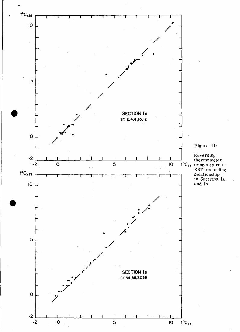
d. Comparison between reversing thermometer temperature observa
tions and XBT recordings
The accuracy of the XBT recordings (The SIPPICAN CORPORATION·
MARION. l\~ass. U~S.A.) is given as+ O.l oC. Experience shows that it
is necessary to take great care when shooting the XBT for absoulute
accuracy. Diagrams of reversing thermometer observationsver.sus XBT
recordings from seetions I (Fig. 11) seem to be quite acceptable, having
in mind the irregular patterns of the hydrographie conditions' in the study
area and the factors of depth and time of the different measurements as
weH as the measuring units. The correlation in section la is better than
in lb. where the XBT recordin'gs are in general higher than those of the
thermometers. It must be noted that the line drawn in the respective
diagrams is the ideal one. or tOCth = tOCXBT .
Conclusions
The conc1usions.; of this paper can be summarized as follows:
1: During the investigational period (August 20-30. 1971) no overflow
of Arctic Bottom Water was observed across the Iceland-Greenland· Ridge.
2. Direct current measurements of the overflow from an anchored buoy
on the East-Greenland Slope were made in an area dominated by Polar
Water and Atlantic Intermediate Water (section la. station 4. Fig. 3).
3. Great changes in the distribution of the different water masses in
the study area were observed during an interval of only 8- 9 days
(section I, Figs. 3. 4. 7 and 8).
4. Closely spaced XBT recordings can be useful for oceanographic
studies in an area like the Denmark Strait and for studies on overflow of
bottom water gene rally when depths ;do not exceed 800 m.
5. The' main result stated in this paper is the distinct water observed.
at intermediate depths in the Denmark Strait. with temperatures below
OOC and salinities as low as 34.50% 0. This intermediate Polar Water

- 5 -
seems to be part of the general hydrographie eonditionsdn the area and has
only rarely been reported beeause water boHles at standard depths have
failed to diselose it. The intermediate Polar Water· must be formed by
mixing between Polar Water and Atlantie Intermediate Water farther north.
probably in the Greenland .Sea, from where it flows southwards aeross the
Ieeland-Greenland Ridge in thin patterns. It seems to mix rapidly with
the surrounding water masses sinee it has never been observed farther
south than the loeation of seetion I of this paper (Figs. 1 and 2).

· .References
Dietrich, G. 1957
Gade, H. G., S. A. Malmberg,
U. Stefansson 1965
Malmberg, . S. A. 1963
Stefansson, U. 1962
Stefansson J U. 1968
Schichtung und Zircll1ation der Irminger
See im Juni 1955.
Ber. Dtsch. Wiss. Komm. Meeresforsch.
14 J 4.
Report on the 'joint Icelandic Norwegian
Expedition to the Area between Iceland
and Greenland 1963. Preliminary
Results. •
Nato, Subcomm. on Ocgr. Res. Techn.
Rep. 22.
ICNAF - Norwestlant II National Report. ,
Sero No. 1319 Oceanographic Observa
tions.
North Icelandic Waters.
Rit Fiskideildar, 3.
Dissolved nutrients J oxygen and water
masses in the Northern Irminger Sea.
Deep-Sea Research, 15.

o
•
SURVEY I20-23/8 1971
2•
Figures 1-2
•
Location of Stations
SURVEY2o XBT ST._60 29-30/8 1971
39
•0 •
00
46m: .. Ib
0 0 ••0 0
0
1l: •Jd 0
310
300 250

r----------------- --
"OVERFLOW" DENMARK STRAfT
t·C- XBT20-2118,1971
0ST.2 3 4 5 12
m '0-g- '>=8-
100 7--,-
200
300
700
600
1500
400
800
•
•BOn.m. 50 o
Figure 3 Temperature distribution in Section Ia - XBT.

100
200
300
400
~oo
600 -
100-
800
70n.m.
"OVERFLOW" DENMARK STRAIT
tOC-XBT
29/8,1971
o
Figure 4 Temperature distribution in Section Ib - XBT

-~-9°
"___--8°---
"OVERFLOW" DEN MARK STRAIT
tOC-XBT
,21-22/8, 1971
o,--",;:,,;~r-,-~~r----=-r----T:""';~--r~r-----;r--__-=-1;:..3--....,
m
100
200
(!)
1°u.a::u.«0..,
m300
u.«..Ja::Wt-:1:-«(f)..J
1°
400
600
500
e'
o700'----L.------l..------J-----..L-----l-- --l__--.J
50n.m.
Figure 5: Temperature distribution in Section I I - XBT

fOC-XBT
22-23/8, 1971
"OVERFLOW" DEN MARK STRAIT
_____- 8" -------
I"
>I"
----I"~
- 0"
<-I·
;~-I.----------0"
mOr-s;;..T.;;"·120~~~/~.;22;1~~/~.~g2~2§===~~~~~=~;::lJtF~~:::::::::::=o""'--T=---=--...;2=r9;"'-'-----:--------=71~_-9.·---__
100
200
500
300
600
400
100n.m..
Figure 6: Temperature distribution in Section I I I - XBT
50 o

500 .
600
500
600
sr. 2 4 6 sr 2 300 4 60 0m ___I. 2" m -31.
"--32.0
~7~~33.0 --
100 J457~100 34.7 •
6°
'" 5·-".
~:34.7 34.8 34.9
) .200 200 -
2"-
-........,..300 300 >35.0
e400 400
700 700"OVERFLOW" DEN MARK SlRAIT "OVERFLOW" DENMARK STRAITe loe 5°/00
20/6,1971 20/6,1971
800 800
20n.m. 10 o 20n.m. o
Figure 7 Temperature and salinity distribution in Section Ia

•
...........::::::=:::::::34.9
J4.8
\. ~50
~~34.7~,:
34.8
" , .. ,. ' .. .. .. .. ..>34.95 ' .. ..,
Or---=.::.:....=.:::..-------:;e:...-:::::;;;oo---:;<.::--::::>'.;.~-...,
m
800"OVERFLOW" DENMARK STRAIT
5 0/0.
29/8,1971
500 -
600
700
100
300
400 -
200
•
•
•
/........-/.
t·c29/8,1971
~OO
700
·OVERFLOW· DENMARK STRAIT800
600
0Sr. 39
m -2·
<2·•
100
>J.)•
200
/.
300
e400
o 30n.m. o
Figure 8 Temperature and salinity distribution in Section Ib

Figure 9 :
...u.1l:......0'"111........Ja:WI" ....fI)...J
8° •-
,oe21-22/8, 1971
"OVERFLOW" DENMARK STRAIT
/~:../
O..-....:s~T.!:... .!.;19~ .--__!.:17~_o:::::::-;;;;~~=--,,.y..::.......;::-_,_~13:..-_....,
m~<) ~ ,.
600
100
500
200
300
400
400
500
600
' ..o ..,,• .34.95 \
\\\\
o
13
Cl... a:... ...0-'
Ul... .....Ja:WIr· ...U) ...J
"OVERFLOW" DENMARK STRAIT
21-2218, 1971
Temperatureand salinitydistributionin Section II
o700'I----I ..l- --..l. ..l- --l .l..-_--l
50n.m.

200
____/0_---- ""
300
400
500
600
"OVERFLOW" DEN MARK STRAIT
,·e22-23/8, 1971
IOOnm. 50 o
o
S%o
22-23/8, 1971
"OVERFLOW· DENMARK STRAIT
-------
" ... ,"
"",34.95\\
\\
\\
--34.0'-------
3~)34.5
500
300 . ;;.----
400
100
e200
Figure 10 Temperature and silinity distribution in Section I I I
5o-2 '--........._-.L._-L-_...I-_.&..---IL....----I._--'-_........_-'--_"-----I'---~
-2


