Embed Size (px)
Citation preview


Cover image and design by Samantha de Ruiter 2012

1
Mapping History An analysis of site locations in the northwestern Dominican Republic
RMA thesis Samantha de Ruiter
S0647640 Supervisor: Prof. Dr. Corinne L. Hofman
Religion and Society University of Leiden, Faculty of Archaeology
Leiden, June 2012

2
3
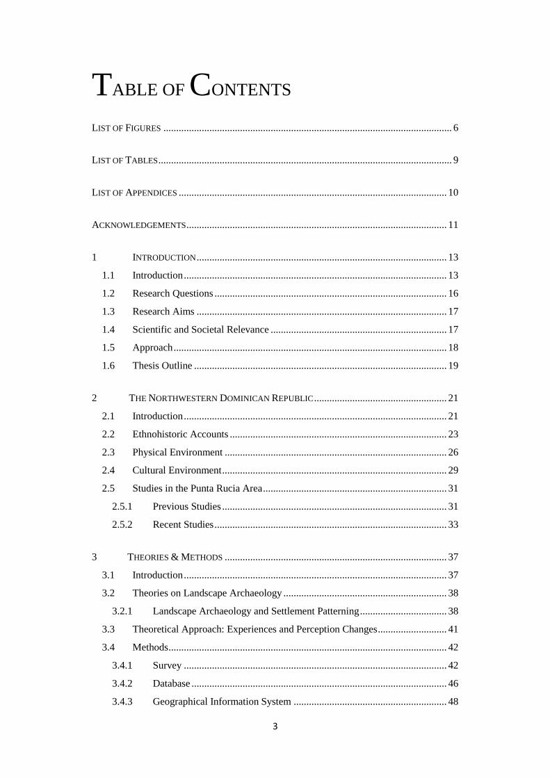
TABLE OF CONTENTS
LIST OF FIGURES ................................................................................................................. 6
LIST OF TABLES ................................................................................................................... 9
LIST OF APPENDICES ......................................................................................................... 10
ACKNOWLEDGEMENTS ...................................................................................................... 11
1 INTRODUCTION .................................................................................................. 13
1.1 Introduction ....................................................................................................... 13
1.2 Research Questions ........................................................................................... 16
1.3 Research Aims .................................................................................................. 17
1.4 Scientific and Societal Relevance ..................................................................... 17
1.5 Approach ........................................................................................................... 18
1.6 Thesis Outline ................................................................................................... 19
2 THE NORTHWESTERN DOMINICAN REPUBLIC .................................................... 21
2.1 Introduction ....................................................................................................... 21
2.2 Ethnohistoric Accounts ..................................................................................... 23
2.3 Physical Environment ....................................................................................... 26
2.4 Cultural Environment ........................................................................................ 29
2.5 Studies in the Punta Rucia Area ........................................................................ 31
2.5.1 Previous Studies ........................................................................................ 31
2.5.2 Recent Studies ........................................................................................... 33
3 THEORIES & METHODS ....................................................................................... 37
3.1 Introduction ....................................................................................................... 37
3.2 Theories on Landscape Archaeology ................................................................ 38
3.2.1 Landscape Archaeology and Settlement Patterning .................................. 38
3.3 Theoretical Approach: Experiences and Perception Changes ........................... 41
3.4 Methods ............................................................................................................. 42
3.4.1 Survey ....................................................................................................... 42
3.4.2 Database .................................................................................................... 46
3.4.3 Geographical Information System ............................................................ 48

4
3.5 The Social Landscape ....................................................................................... 51
4 SITES & THE SURVEYS ....................................................................................... 53
4.1 Introduction ....................................................................................................... 53
4.2 Map Data ........................................................................................................... 54
4.2.1 Military Maps ............................................................................................ 54
4.2.2 Soil Maps, Geomorphological Maps, and Vegetation Maps..................... 55
4.2.3 Aerial Photographs .................................................................................... 56
4.3 Fieldwork Data .................................................................................................. 57
4.3.1 Archaic Age Sites ...................................................................................... 59
4.3.2 Ceramic Age Sites ..................................................................................... 59
4.3.2.1 Sites with Predominantly Meillacoid Ceramics .................................... 60
4.3.2.2 Sites With Predominantly Chicoid Ceramics ........................................ 67
4.3.2.3 Undetermined Sites ............................................................................... 75
5 ANALYSIS & RESULTS ........................................................................................ 79
5.1 Introduction ....................................................................................................... 79
5.2 Sites & the Landscape ....................................................................................... 80
5.2.1 Site types ................................................................................................... 80
5.2.2 Geomorphology and Soil .......................................................................... 80
5.2.3 Proximity to the ocean and fresh water ..................................................... 82
5.2.4 Occurrence of mounds .............................................................................. 84
5.3 Sites in Relation to Other Sites ......................................................................... 86
5.3.1 Proximity to Other Sites ............................................................................ 86
5.3.2 Visibility .................................................................................................... 87
5.4 Site Plans ........................................................................................................... 91
5.4.1 Chicoid Sites ............................................................................................. 92
5.4.2 Meillacoid Sites ......................................................................................... 93
5.5 Patterning and the Social Landscape ................................................................. 95
5.6 Predictive Modelling ......................................................................................... 95
6 DISCUSSION ........................................................................................................ 97
6.1 Introduction ....................................................................................................... 97
6.2 Results ............................................................................................................... 97
6.2.1 The Location of Sites in the Landscape .................................................... 97
6.2.2 Sites and their Relations to Other Sites ..................................................... 98
5
6.2.3 Site Plans ................................................................................................. 100
6.2.4 Patterning ................................................................................................ 101
6.3 Comparability and Compatibility with Related Research ............................... 102
7 CONCLUSIONS .................................................................................................... 105
7.1 Introduction: An Overview ............................................................................. 105
7.2 Conclusions: the Social Landscape of the Punta Rucia Area .......................... 106
7.3 Suggestions for Further Research ................................................................... 107
ABSTRACTS ..................................................................................................................... 108
BIBLIOGRAPHY ................................................................................................................ 111
APPENDICES .................................................................................................................... 119

6
LIST OF FIGURES
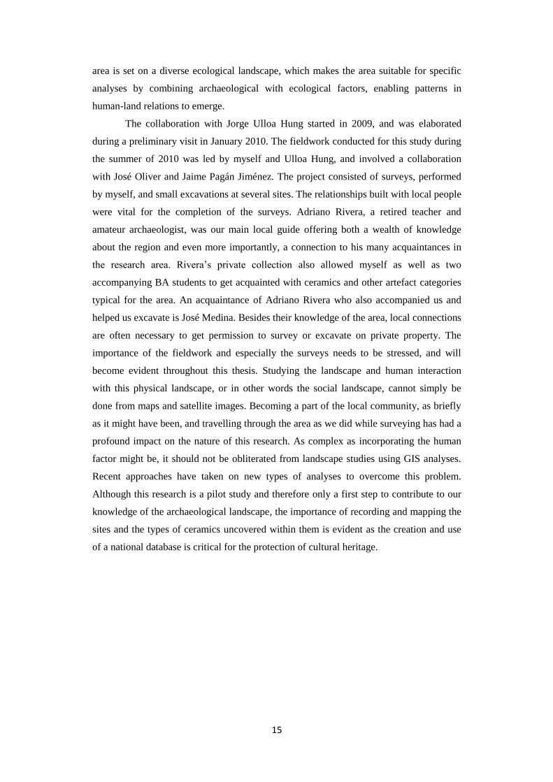
Figure 1. P13: Above a map of Hispaniola with the research area highlighted, and an
enlargement of the highlighted area with the location of villages below.
Figure 2. P22: A southeast facing view of the valley, from the site Los Mangos.
Figure 3. P23: Adapted Landsat7 Imagery with the location of La Isabela and the
research area highlighted.
Figure 4. P26: Northeastern view from Los Muertos.
Figure 5. P27: Map of geomorpohological profiles in the area.
Figure 6. P29: Ostionoid ceramics on the left and Meillacoid ceramics on the right.
Adapted and enhanced image, photographs taken by Jorge Ulloa Hung.
Figure 7. P31: Meillacoid ceramics (A) and typical Chicoid ceramics (B).
Adapted and enhanced image, photographs taken by Jorge Ulloa Hung.
Figure 8. P32: Part of the map on which Ortega marked the route by Columbus (after
Ortega 1988).
Figure 9. P34: The merge of Ostionoid and Meillacoid traits. Adapted and enhanced
image, photographss taken by Jorge Ulloa Hung.
Figure 10. P43: A typical huacero pit located on the slope of the Humilde Lopez site.
Figure 11. P45: Standardized form used in the field.
Figure 12. P47: Overview of the pull-down menu’s used in the analysis-database.
Figure 13. P49: Moore and Tremmel’s map of archaeological sites in Haiti (after Moore
1997).

7
Figure 14. P50: 3D model of the research area created in Surfer, viewed from the
northwest.
Figure 15. P54: Snippet of the military map in the area of Punta Rucia.
Figure 16. P55: Geomorphological map on the left, and vegetation map on the right.
Figure 17. P56: Aerial photograph of Punta Rucia in the top image, and a 100% zoom
level in the bottom picture (adapted image from Instituto Nacional de
Recursos Hidráulicos; 2000)
Figure 18. P57: Overview map of all sites, numbered.
Figure 19. P59: Aerial photograph of the site area of El Burén, with the limestone cliffs
indicated.
Figure 20. P60: Overview map with Meillacoid sites highlighted.
Figure 21. P61: Stone slabs on the slope of mound 7, Los Perez.
Figure 22. P64: Contour map of Popi (Ulloa Hung, in press).
Figure 23. P67: Overview map with Chicoid sites highlighted.
Figure 24. P69: Aerial photograph of Persio Polanco, where the bulldozed area is clearly
visible on the western side (INDHRI 2000).
Figure 25. P73: Western view from La Muchacha.
Figure 26. P82: Map with locations of Meillacoid (red) and Chicoid sites (blue).
Figure 27. P84: Presence of mounds on the sites highlighted in red.
Figure 28. P86: Example of a 2.5 km radius.

8
Figure 29. P89: Visualizations of the links between sites, created with Visone 2.6.5.
Chicoid sites and links in blue, Meillacoid sites and links in red, Chicoid-
Meillacoid links in purple, and unknown sites and links in pink.
Figure 30. P91: Overview of the locations of the site-plan images indicated in red on cut
outs of the military map.
Figure 31. P92: Site plans of Chicoid sites Rafo, El Rastrillo and Elida.
Figure 32. P93: Site plan of Chicoid site Persio Polanco.
Figure 33. P94: Site plan of Los Perez.
Figure 34. P94: Site plan of Popi.

9
LIST OF TABLES
Table 1. P58: Overview of sites, site numbers, altitudes and coordinates.
Table 2. P81: Number of sites present in different geomorphological profiles.
Table 3. P83: Distance to ocean and fresh water for Meillacoid sites.
Table 4. P83: Distance to ocean and fresh water of Chicoid sites.
Table 5. P85: Overview of all sites, with radiocarbon dates, percentages of ceramics from
a different style than the predominant one at the site (after Ulloa Hung, in
press), and locational factors. C=Chicoid, M=Meillacoid, A=Archaic,
O=Ostionoid U=Unknown.
Table 6. P87: Average amount of sites within 2,5 and 1,5 km radii.
Table 7. P88: Overview of visibility ranges and sites visible, with a summary of the
results below.

10
LIST OF APPENDICES
Appendix 1 P 119: Composed image of military maps.
Appendix 2 P 120: Microsoft Access 2003 database entry form
Appendix 3 P 121: Overview table of sites
Appendix 4 P 122: Fold-out overview map with site numbers

11
ACKNOWLEDGEMENTS
I owe thanks to many people for helping me in writing this thesis, as well as for their
participation in the fieldwork, and general support. I especially thank my supervisor Prof.
Dr. Corinne Hofman, without whose guidance this thesis could not have been written, for
giving me the opportunity to conduct my own research and fieldwork. Also I would like
to express gratitude to all of the members of the Caribbean Research Group for their
feedback on my presentations and writings. One of the most important people in this
study has been Jorge Ulloa Hung, with whom I collaborated on several articles and
presentations, and conducted the fieldwork with in 2010. I thank him for his guidance,
assistance, and discussions on all the interesting aspects ‘our’ region has given us.
Adriano Rivera and José Medina have also played a very important role during the
fieldwork, by sharing their knowledge of the region and getting us acquainted with local
landowners. Furthermore I want to thank Marlieke Ernst and especially Danielle
Meuleman, who were also members of the fieldwork team. I would also like to express
my gratitude to Marlies van Vuuren for accompanying us, Marthia Fuller - one of the
greatest people I have ever met as well as Micheal Gunther and Tazbah Chavez who
always lightened up my evening after returning from hours of exhausting surveys. You
made the rough conditions of our fieldwork quite bearable! I would like to express my
gratitude to Alice Samson for her guidance. Furthermore, her work in El Cabo inspired
me to continue to pursue research. I thank Amanda Guzman for correcting my English,
and Maria-Eugenia Sesmilo for helping me with my resumen.
My parents, Francisca and Ron, have always supported me in whatever decision I
made in any way they could, and for that I am very grateful. They have always
encouraged me, my brother and my sister, and have always tried to help us along the way.
Above all I want to say thank you to my partner Liliane de Veth, for her everlasting
support in every way, for her patience, and for all her help in finishing this thesis.

12
13
1 INTRODUCTION
1.1 INTRODUCTION
The Dominican Republic has been the focus of a great amount of research in the Greater
Antilles and the Caribbean area in general. In this study, ambitiously titled Mapping
History, past social landscapes on the border of the northwestern provinces of the
Dominican Republic (Figure 1) - Monte Christi and Puerto Plata - are mapped by using
archaeological data, present-day maps combined with GPS data, and ethnohistoric
accounts of the sites in the region. This pilot study provides a Geographical Information
System (GIS) database containing the known sites in the region, which will be a first set-
up for a more widely used database. Such a national database promotes the
implementation of Cultural Heritage Management programmes, which is essential for the
protection of cultural heritage.
Figure 1. Above a map of Hispaniola with the research area highlighted, and an enlargement of
the highlighted area with the location of villages below.

14
In recent decades, computer applications have increasingly become an essential
element in the field of archaeology. Archaeologists have gained access to a whole new
range of data analysis with the aid of different types of spatial analyses, viewshed
analyses and other forms of geoinformatics. This line of data analysis is arguably suitable
for a study of the social landscape though the pitfalls will be addressed and elaborated on
in the following chapters. ‘Social landscape’ is a very broad term, which encompasses the
physical as well as the social spaces that people inhabit. The people residing in this social
landscape do not necessarily form a homogenous community; in fact, the various social
relations existing within a given society allow for differences within and between its
members (Torres 2010). Through such an analysis of the studied area a better conception
of the past social landscape will emerge. Equally importantly, information will be
permanently recorded in a database. This is of major importance in the region, as well as
on most of the Caribbean islands.
A study of the past social landscape is fundamental to understanding how sites
and in turn the people might have been interrelated. Mapping the social landscape and
creating a GIS of the region will clarify the interesting mix of different ceramic styles all
over the region and within sites. Archaeological research in the northwest of the
Dominican Republic is rather scarce in comparison to the eastern part of the island, but
there are several publications on sites in the region. Among others, Marcio Veloz
Maggiolo and Elpidio Ortega provide a clear overview of the sites in the region around
Puerto Plata, and show the great diversity of types of pottery styles within and between
them (Ortega 2005; Veloz Maggiolo et al. 1981).
One of the best known sites in the region is La Isabela, commonly considered as
the first town in the New World. This site is described in historical sources, and has been
the subject of archaeological research (Chiarelli and Luna Calderón 1987; Deagan and
Cruxent 2002b). In the past years archaeological research has taken place at several sites
in the area, conducted mainly by Jorge Ulloa Hung (Museo del Hombre Dominicano),
José Oliver (University College London) and Alfredo Coppa (Università la Sapienza
Roma). Coppa’s study focused on the site Don Julio located in the northwestern part of
the research area, while José Oliver excavated at Edilio Cruz, located in the centre of the
research area. Ulloa has excavated at several sites in the area prior to this research (Ulloa
Hung 2007), and his preliminary findings have founded the basis of this thesis. The fact
that different types of ceramic styles are found on one site point to a much more dynamic
body of societies, their economies and material culture, which has been argued before by
Veloz Maggiolo (Veloz Maggiolo 1977). An image of a diverse and complex
archaeological area emerged, which called for the combination of Ulloa Hung’s study on
ceramic styles with a study on the archaeological landscape. The social landscape in this
15
area is set on a diverse ecological landscape, which makes the area suitable for specific
analyses by combining archaeological with ecological factors, enabling patterns in
human-land relations to emerge.
The collaboration with Jorge Ulloa Hung started in 2009, and was elaborated
during a preliminary visit in January 2010. The fieldwork conducted for this study during
the summer of 2010 was led by myself and Ulloa Hung, and involved a collaboration
with José Oliver and Jaime Pagán Jiménez. The project consisted of surveys, performed
by myself, and small excavations at several sites. The relationships built with local people
were vital for the completion of the surveys. Adriano Rivera, a retired teacher and
amateur archaeologist, was our main local guide offering both a wealth of knowledge
about the region and even more importantly, a connection to his many acquaintances in
the research area. Rivera’s private collection also allowed myself as well as two
accompanying BA students to get acquainted with ceramics and other artefact categories
typical for the area. An acquaintance of Adriano Rivera who also accompanied us and
helped us excavate is José Medina. Besides their knowledge of the area, local connections
are often necessary to get permission to survey or excavate on private property. The
importance of the fieldwork and especially the surveys needs to be stressed, and will
become evident throughout this thesis. Studying the landscape and human interaction
with this physical landscape, or in other words the social landscape, cannot simply be
done from maps and satellite images. Becoming a part of the local community, as briefly
as it might have been, and travelling through the area as we did while surveying has had a
profound impact on the nature of this research. As complex as incorporating the human
factor might be, it should not be obliterated from landscape studies using GIS analyses.
Recent approaches have taken on new types of analyses to overcome this problem.
Although this research is a pilot study and therefore only a first step to contribute to our
knowledge of the archaeological landscape, the importance of recording and mapping the
sites and the types of ceramics uncovered within them is evident as the creation and use
of a national database is critical for the protection of cultural heritage.
16
1.2 RESEARCH QUESTIONS
The following research questions have been formed or reshaped after some initial data
collection and an exploratory visit to the area.
The main research question to be addressed is:
“What can site characteristics and certain patterns in site locations reveal about the
social landscape in the past?”
The sub questions are:
1) In what kind of environments are the sites located?
-What is the geomorphological setting?
-What is the ecological setting?
-Is there a specific kind of site (ceremonial, settlement etcetera) linked to a
specific setting?
2) Is there a pattern visible in the location of (or the combination of) sites with either
predominantly Meillacoid or Chicoid ceramics?
-What are the specific site characteristics?
3) Is there an indication that visibility played a role in site location?
What role could this visibility play?
As part of the main research question it is essential to define the term social landscape;
this will be discussed in the section on theories. Throughout this thesis the research
questions are tackled or in some cases be deemed less relevant. An evaluation of the
questions and the results is discussed in Chapter 6, while the main research question is
addressed in the concluding chapter.

17
1.3 RESEARCH AIMS
Most research conducted in the Dominican Republic has been in the southern and
southwestern provinces of the island. A thorough overview and characterization of sites
in the northwestern part of the country was lacking. The aim of both Ulloa Hung and
myself has been to fill this gap and to produce a coherent and inclusive regional vision.
With the aid of extensive surveys and a widely used database it is possible to address the
research questions and to come to such an inclusive regional vision. This results in the
unveiling of the social landscape. In all, the source of interest is twofold: a scientific
analysis of the archaeological landscape which sheds light on matters of interaction and
patterning, and the creation and use of a general database. The archaeological landscape
has been the main focus of this research, leaving questions concerning different computer
applications in the periphery.
1.4 SCIENTIFIC AND SOCIETAL RELEVANCE
There are important objectives besides the scientific and archaeological value of this
research. The creation of a database in collaboration with the Museo del Hombre
Dominicano in January 2010 was set up in such a manner that this database can be used
nationally, by professional archaeologists as well as by local amateur archaeologists.
Information on excavations, specific finds, or literature can be entered into this database.
An important aspect of creating a database and map of the sites in the region is the
recording and storage of information that might be lost in the near future. Not only
hurricanes, erosion, agriculture or urban growth are endangering the maintenance of the
archaeological resources in the Caribbean area, but also developments in the tourist
industry are a major threat to the archaeological heritage. These threats are some of the
reasons why databases are built; the realization that archaeological resources are finite is
a catalyst for the creation of these types of recording methods. Once a site is destroyed, it
becomes impossible to retrieve contextual information, and it will be a loss for the
archaeological record and our knowledge of the human past.
Although many steps must be taken in between, such a widely used database is
the first step towards Cultural Resource Management programmes, which are important
in order to counter the destruction of the archaeological record in these vulnerable
regions. This has been done in the Caribbean with some measure of success (Reid and
Lewis 2007). On many Caribbean islands there are certain CRM programmes, laws or

18
NGO’s which may be consulted for advice, but often it is the case that these laws are not
enforced (Farmer 2011). Esteban Prieto Vicioso recently published a chapter on the
current state of the protection of heritage in the Dominican Republic. Although the
chapter consists of an overview of laws and institutions dealing with this subject, Prieto
Vicioso concludes that Dominican legislation is as of yet deficient, primarily because of
the lack of enforcement of the legislation (Prieto Vicioso 2011). Ulloa Hung has also
recently published on the status and the protection of Dominican heritage, but more from
a social point of view instead of a legislative one (Ulloa Hung 2010). It is clear that
creating a CRM programme based on GIS and predictive modelling is a first step towards
the better treatment of the archaeological record.
This research will not only add to our knowledge about the past inhabitants of the
region, but will also help to preserve the archaeological record. Eventually, CRM
programmes can be developed, but this calls for a rise in local awareness of the
importance of the heritage. Education plays a role in this awareness, and is a key factor in
developing a sustainable heritage management policy. Although local interest in
archaeology is divided between huaceros who loot for money and collectors or amateur
archaeologists, the efforts of certain local people like Adriano Rivera, who has turned his
house and garden into a small archaeological museum as did several other people in the
area, enable next generations to continue a local interest in archaeology and in their
heritage.
1.5 APPROACH
The approach taken in this study relies on the use of computer applications to address
questions about the relationship between the landscape and site patterning. A short
introduction on the use and usefulness of these applications, both now and in the past,
follows in Chapter 3 with an elaborate discussion on the methods used and the theories
behind them. Such methods, including GIS, are widely utilized by archaeologists working
in various disciplines, but the application is distinct for each study. The situation in the
Americas differs from for example that of ancient Rome, where one might analyse
movement through the streets, temples and theatres, as the sites of horticulturalists
located on island settings can only be analysed by focusing on the landscape and on site
locations. Not only the environmental factors – in the broadest sense of the word – can
vary greatly, but the worldview of these past people can as well. While this worldview
can hardly be incorporated in any computer model, it is a major aspect that needs to be

19
taken into account. Both GIS applications and fieldwork observations are utilized to
address the research questions. Although this does not address the worldview of past
people, with this approach the human perception is partially incorporated in the analyses.
1.6 THESIS OUTLINE
The introductory chapter includes the general aims and questions of this study as well as
the scientific and societal relevance. The outline and objectives are discussed and will
function as a guideline while reading this thesis. The following chapter will focus on the
North-western Dominican Republic, discussing the reasons for the selection as well as for
the delimitation of the study area. There are several ethnohistoric sources available from
the area which mention the landscape or other relevant aspects. Furthermore, previous
studies in the area will be discussed in the second chapter. These include not only studies
performed directly in the area, but also refer to the area such as Daniel Koski-Karrell’s
research in northern Haiti. Lastly, a sketch of the physical and the cultural landscape will
be drawn. The physical landscape needs to be described with both facts about for example
the different types of vegetation in the area, and with the possible experiences of being
there. To find a balance between these two aspects has proven to be difficult. The cultural
landscape will be described by the presence of different ceramic styles recently studied by
Jorge Ulloa Hung, as well as by the results of previous studies about these styles in the
area.
The methods and theories used will be discussed in Chapter 3. The methods of
surveying and excavation during our fieldwork are explained, and the resulting database
and GIS are thoroughly discussed. The focus in the section on theories of the landscape is
mainly on archaeology and settlement patterning. However, during the fieldwork the
importance of experiencing the landscape became clear, which led to perception changes
of myself. This process is also discussed in Chapter 3. The available and used dataset is
covered in Chapter 4. This dataset consists of the different maps used for the creation of
the GIS, and of the fieldwork data. Each known and visited site in the area will be
described in terms of their setting in the landscape, their size, the distribution of ceramics
and other artefacts, and any other specific characteristics.
Chapter 5 deals with the analysis of the data, and the generated results. Sites are
analysed in relation to the landscape and in relation to other sites. A brief overview of
different types of site plans is given, though not analysed due to the small amount of data
on this topic. Chapter 5 concludes with a short elaboration on site patterning and
20
predictive modelling, followed by a discussion on all analyses and results in Chapter 6. In
the final part of Chapter 6 the research questions are reviewed and addressed and the aims
are discussed. Lastly, Chapter 7 consists of a short summary of the thesis, followed by the
conclusions, and concluding with suggestions for further research.

21
2 THE NORTHWESTERN
DOMINICAN REPUBLIC
2.1 INTRODUCTION
Hispaniola is the second largest island of Caribbean, covering an area of approximately
75 000 km2, with Haiti on the western part and the Dominican Republic on the eastern
part of the island. Consequently, together with Cuba it also has the most complex
topography and the greatest habitat diversity, and therefore has the greatest number of
taxa among many classes of fresh water fish and mammals (Newsom and Wing 2004).
The central and western parts of the island are rather mountainous, while the eastern part
of Hispaniola is rather flat. The highest mountain range is the Cordillera Central or the
Central Mountain range , with the Pico Duarte at 3,087 m above main sea level, and
consisting of formations dating back to the Late Cretaceous era. Parallel to the Cordillera
Central are the larger ranges Sierra de Neiba and the Sierra de Barouco in the southwest,
and the Cordillera Septentrional in the north. The Valle del Cibao and the Valle del
Yaque are located in between the latter and the Cordillera Central. Names of the
geological features are the names used in the Dominican Republic, which differ from
those used in Haiti. The geology of Hispaniola is diverse due to the age of formation of
the island, although the details of the formation of the Greater Antilles are controversial
(Hedges 2001). The most geomorphologically homogenous area is the southern part of
the southeastern region, with a low-lying limestone area consisting of coastal reefs. One
of the most diverse areas is located in the northwest of the Dominican Republic, enclosed
by the sloping hills of the Cordillera Septentrional.
22
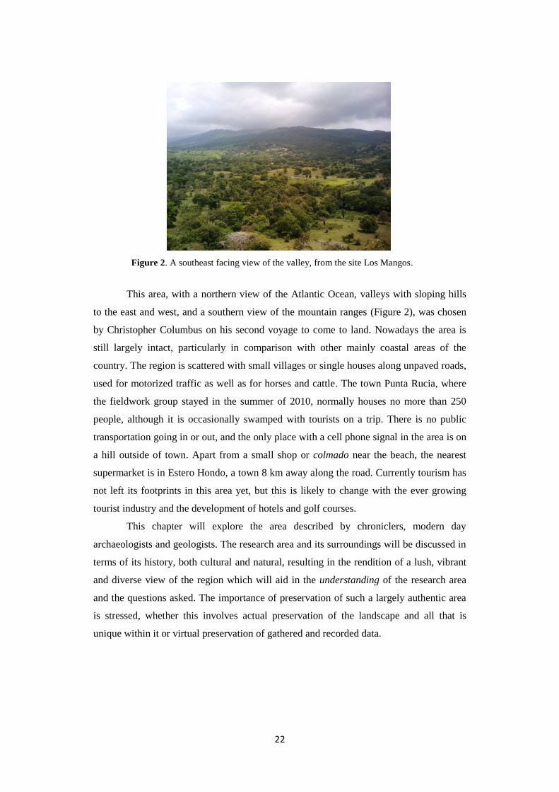
Figure 2. A southeast facing view of the valley, from the site Los Mangos.
This area, with a northern view of the Atlantic Ocean, valleys with sloping hills
to the east and west, and a southern view of the mountain ranges (Figure 2), was chosen
by Christopher Columbus on his second voyage to come to land. Nowadays the area is
still largely intact, particularly in comparison with other mainly coastal areas of the
country. The region is scattered with small villages or single houses along unpaved roads,
used for motorized traffic as well as for horses and cattle. The town Punta Rucia, where
the fieldwork group stayed in the summer of 2010, normally houses no more than 250
people, although it is occasionally swamped with tourists on a trip. There is no public
transportation going in or out, and the only place with a cell phone signal in the area is on
a hill outside of town. Apart from a small shop or colmado near the beach, the nearest
supermarket is in Estero Hondo, a town 8 km away along the road. Currently tourism has
not left its footprints in this area yet, but this is likely to change with the ever growing
tourist industry and the development of hotels and golf courses.
This chapter will explore the area described by chroniclers, modern day
archaeologists and geologists. The research area and its surroundings will be discussed in
terms of its history, both cultural and natural, resulting in the rendition of a lush, vibrant
and diverse view of the region which will aid in the understanding of the research area
and the questions asked. The importance of preservation of such a largely authentic area
is stressed, whether this involves actual preservation of the landscape and all that is
unique within it or virtual preservation of gathered and recorded data.

23
2.2 ETHNOHISTORIC ACCOUNTS
The northern coast of Hispaniola is well known for the encounters during the arrival of
Europeans in the area. After nearly three months at sea Christopher Columbus and his
approximately 1500 men went ashore at the bay of what he named La Isabela, after the
Queen of Spain, in December 1493 (Deagan and Cruxent 2002a). It is now known as the
first town of the New World, and is located in the vicinity of the research area (Figure 3).
Columbus stated that this site was the “best suited spot and better than any other in the
land; and this must be believed”. However, it is most likely that the bay was chosen rather
hastily because the crew was weary and there was illness among the people and animals
on the ships (Deagan and Cruxent 2002b, 47).
Figure 3. Adapted Landsat7 Imagery with the location of La Isabela and the research area
highlighted.
The main ethnohistoric sources on the landscape of the area are those of Pietro
Martire d’Anghiera, friar Bartholomé de las Casas, and Gonzales Fernando de Oviedo,
which will be discussed below. Pietro Martire, an Italian historian born in the fifteenth
century, wrote in his Decades of the New World about the first accounts of explorations in
the Americas. Using documents and letters he interviewed the European explorers
himself. Martire describes a lush landscape with healthy rivers filled with flavorful fish,
as well as ‘rumors about the master of the house of gold’ (Martir 1964, 124). It is also

24
described how the indigenous people procure things from the forest in a sustainable way,
to exchange these with inhabitants of the neighboring islands (Martir 1964,124). On the
geopolitical division of northern Hispaniola Martire has written the following (author’s
translation):
“In the province of Huhabo are the regions of Xamaná, Canabacoa,
Cuhabo and many others whose names I do not know until today. Those of
Cayabo include Maguá and Cocacubana. The inhabitants of this region speak a
language very different from the others on Hispaniola, and call it “macoryxes”.
Other regions are Cubana, the language also being different from the other,
Baioháigua, in which occurs the same, Dahaboon and Cybaho and Manabaho.
Cotoy is in the middle of the island and across the river Nizao, its hills are called
Mahaítin, Hazúa and Neibamáo ..“ (Martir 1964, 356).
“There is in Hispaniola, in the territory of the old chief, a tree called
“macorix”, which still retains the name of the region, and it has a thick top. At
the ends of its branches there is cotton no less useful than the seed, planted each
year” (Martir 1964, 638).
This excerpt reveals a diverse depiction of the region, describing the existence of
different languages and regional identity. The accounts of Gonzalo Fernando de Oviedo,
a Spanish chronicler born in the fifteenth century, are even more verbose on these topics
in his La Historia general de las Indias (Oviedo 1988). Oviedo describes where the
indigenous people were located (author’s translation):
“The Indians on the island of Haiti or Hispaniola live on the coast or
along rivers, or near the sea,[…] , and in high places and in the plains, valleys or
forests, […]. And along their places they had their crops and conucos ..., of corn
and cassava, and fruit trees” (Oviedo 1988, 183).
Similar to Martir, Oviedo also describes the rivers of the island. About the Yaque river,
located west to southwest of the research area, he has written the following (author’s
translation):
‘..of another named Yaque…, which enters and finishes in the sea, in the
part of the island that faces the north, …There is a good salina near…This river
is powerful, and […] of great and beautiful grass meadows and farms” (Oviedo
1988, 199).

25
Friar Bartolomé de las Casas, now known for his opposition to the treatment of
the Indians at the time, was born in the late fifteenth century in Spain and came to live on
Hispaniola before he was 20 years old. After years of exploiting the Indians, Las Casas’
perception of the indigenous people altered and he started arguing on behalf of the
Indians. Among other chronicles, he has written Apologética Historia de Las Indias, in
which he describes the provinces located in the north of Hispaniola. These descriptions
are full of beautiful landscapes, fertile fields, gracious rivers, and landscape features such
as salt plains. In his writing on the area of the Yaque river, located west of the research
area, Las Casas recounts a salina in the vicinity, as did Oviedo.
In his Historia de Las indias, Las Casas describes a valley in the north, which is similar
to other of his descriptions of valleys (author’s translation):
“[…] This port is the ridge mentioned above, fertile, which makes the
plains by the north, which was all settled, but for the part where they were, there
ought to be a deserted road; however it was all within walking distance, because
it could not be more than eight or ten leagues to descend in the valley down
below, which was so admirably populated” (Las Casas 1988b, 361).
He further recounts the difficulties encountered while traveling in the northern region and
further inland, where the reception of the indigenous people was not always hospitable.
Las Casas also mentions the Macorix ethnic group, living in the Vega Real, as well as
‘three or four or a few more’ languages (Las Casas 1988b, 408). This is described in
Apologética Historia de Las Indias (author’s translation):
“There were three different languages on the island, which were not
understood by the others: one was from the Macorix de Abajo, another from the
Macorix de Arriba… The other was the universal language of all land, and this
was more elegant with better words and a sweet sound […].” (Las Casas 1988a,
620).
The described chronicles and translated excerpts depict a diverse population and a
beautiful and fertile landscape, populated in different places; on the hills, in the valleys,
near the coast and along the rivers. The chronicles are much more elaborated, also on
topics such as exchange, but for this study the small translated fragments are sufficient to
portray the contents of the accounts relating to the landscape.
26
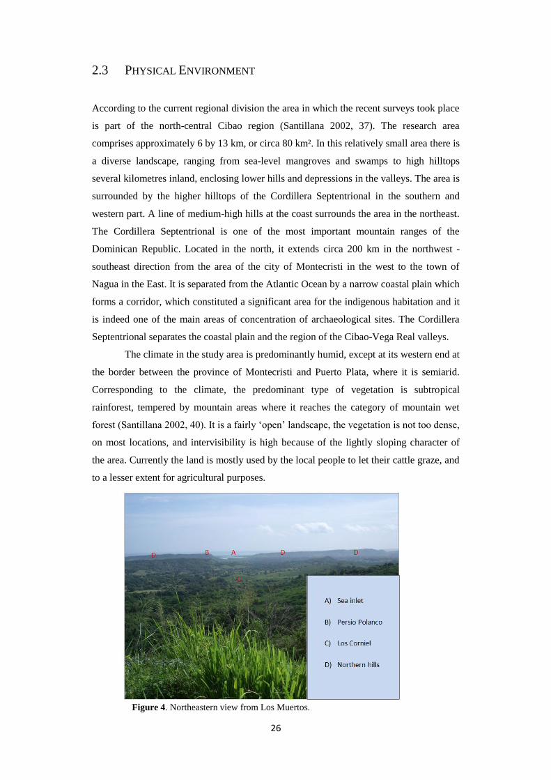
2.3 PHYSICAL ENVIRONMENT
According to the current regional division the area in which the recent surveys took place
is part of the north-central Cibao region (Santillana 2002, 37). The research area
comprises approximately 6 by 13 km, or circa 80 km². In this relatively small area there is
a diverse landscape, ranging from sea-level mangroves and swamps to high hilltops
several kilometres inland, enclosing lower hills and depressions in the valleys. The area is
surrounded by the higher hilltops of the Cordillera Septentrional in the southern and
western part. A line of medium-high hills at the coast surrounds the area in the northeast.
The Cordillera Septentrional is one of the most important mountain ranges of the
Dominican Republic. Located in the north, it extends circa 200 km in the northwest -
southeast direction from the area of the city of Montecristi in the west to the town of
Nagua in the East. It is separated from the Atlantic Ocean by a narrow coastal plain which
forms a corridor, which constituted a significant area for the indigenous habitation and it
is indeed one of the main areas of concentration of archaeological sites. The Cordillera
Septentrional separates the coastal plain and the region of the Cibao-Vega Real valleys.
The climate in the study area is predominantly humid, except at its western end at
the border between the province of Montecristi and Puerto Plata, where it is semiarid.
Corresponding to the climate, the predominant type of vegetation is subtropical
rainforest, tempered by mountain areas where it reaches the category of mountain wet
forest (Santillana 2002, 40). It is a fairly ‘open’ landscape, the vegetation is not too dense,
on most locations, and intervisibility is high because of the lightly sloping character of
the area. Currently the land is mostly used by the local people to let their cattle graze, and
to a lesser extent for agricultural purposes.
Figure 4. Northeastern view from Los Muertos.

27
The geology of the research area dates from the Tertiary and Quaternary period, and
consists predominantly of limestone, lacustrine and marine deposits. The study area
comprises three major regions, the plains of Puerto Plata, the Bajabonico Plain and the
Cordillera Septentrional. The first two coastal plains are irrigated by two key streams and
their tributaries, the Bajabonico river and the Camú river, which flow into the Atlantic
Ocean.
The soil on the narrow strip that runs along the northern slope of the Cordillera
Septentrional consists of different types. In figure 5 the four different geomorphological
profiles in the research area are indicated by the numbers and different colours. Dating
further back, area three (9% of the area) is formed in the Quaternary period and consists
of swamps. These coastal marshes extend from the town El Cacao to Punta Rucia. The
soils are associated with permanently flooded areas subject to tidal influence. Its texture
is clay loam with predominantly halophytic vegetation (Tirado 2003). Area 2 (24% of the
area) consisting of lacustrine and marine deposits also dates to the Quaternary period.
Figure 5. Map of geomorpohological profiles in the area.
Legend

28
These consist mainly of clay with sand and gravel. Area number 4 (3% of the area)
represents a Miocene deposit of limestone, and area one (64% of the area) represents an
Oligocene mix of limestone, calcareous clay and sandstone; both dating from the Tertiary
period. The yellow residual soils occur both deep and shallow in the area, and are formed
by the deposition of calcareous materials. These clay soils have a brown or reddish colour
and are of certain importance to agriculture (Tirado 2003). In areas closer to the shoreline
soils are usually red and consist of hard limestone, while in the inland areas they are grey
and formed by non-hardened calcareous material. The soils in the area are fit for
agriculture, although the possibilities are limited. However, the presence of mangroves
and swamp areas make the area perfectly fit for the collections of shells for dietary or
utilitarian purposes.
As depicted in figure 4 from the top of Los Muertos, the above list of facts about
vegetation, geomorphology and soil is not sufficient for a thorough description of the
landscape. The physical landscape can both be measured and experienced. Due to the
fairly ‘open’ landscape there is a high level of visibility on a large amount of sites, which
was observed during the extensive surveys. Surveying two to five sites a day, it became
facile to navigate through the area as the days passed. Within one week it was possible to
recognize numerous other sites while standing on one of the 44 sites in the area. The view
in figure 4 is rather restricted because it is looking to the northeast from Los Muertos, a
site located in the eastern part of the southern hills. On the right side of the image, partly
covered, the slope of the adjoining hill restricts the view. This image, together with figure
3 from Los Mangos, demonstrates how open as well as secluded the landscape in this area
is. Concerning altitudes the landscape is averagely divided into four sections: the coast,
the lower northern hills, the valley, and the higher southern hills. Broadly, these four
sections come with their own specific views, although there is some variation within the
sections as well as similarities between them. The four sections are also characterised by
the accessibility of the sites. Sites located on the sloping hills in the valley covered in
only grass and some trees and bushes are a walk up the hill. Sites in the southern hills are
very different; the higher altitude and the steeper slopes of the hills combined with dense
vegetation demands an intensive hike up the hill. The landscape of the area, visible in its
entirety from most of the sites located on the southern hills, is diverse in several ways.

29
2.4 CULTURAL ENVIRONMENT
The existence of stylistic diversity at the intra-regional level was perceived early on by
Rouse and Rainey during their studies at Fort-Liberté. The stone and shell artefacts and
ceramics were different from those compared to the southeast (Ulloa and De Ruiter
2011). Discussions about this diversity are part of current research. A brief overview of
the cultural landscape follows.
Focusing on the ceramic period, the cultural landscape will for the larger part be
described using ceramic styles. Ostionoid ceramics appear in eastern Hispaniola at around
600 CE. These ceramics are characterized by polished or smoothed surfaces, surfaces
painted with reddish slip, handles in the shape of looped straps, modelled or applied
zoomorphic heads and limbs, and simple stylized decoration. Ostionoid ceramics are
diagnostic of Ostionan culture (Koski-Karrell 2002), dating roughly from 600 to 1200 CE
(Rouse 1992).The settlement sites are characterized by the presence of redware pottery
and griddles. As noted by Veloz Maggiolo, Ortega and Caba Fuentes in Modos de Vida
Meillacoides, the Ostionan components in northern Hispaniola are ephemeral and
contemporaneous with or succeeded by Meillacoid components (Veloz Maggiolo, et al.
1981).
Figure 6. Ostionoid ceramics on the left and Meillacoid ceramics on the right. Adapted
and enhanced image, photographs taken by Jorge Ulloa Hung.

30
The aforementioned authors also suggest that the Meillacoid cultural expressions
seem to originate in northern Hispaniola. This will be discussed further in the paragraph
below. Meillacoid style ceramics are usually hard, have thin walls, are not polished but
smoothed, with a greyish-brown paste. One of the most distinct features of Meillacoid
pottery is the cross-hatch pattern, either incised or applied (Figure 6). Zoomorphic
features are also common in Meillacoid pottery, and consists of heads, limbs, and other
body features. Although many things are unclear about the Meillacoid series, there are
indications that the socio-political organization resembles an egalitarian village-based
system where the subsistence in based on agriculture. Settlement sites are characterized
by the presence of marine shells, suggesting that the collection of shellfish was an
important subsistence practice. Calibrated radiocarbon dates on sites with predominantly
Meillacoid style ceramics in the research area were between 1019 and 1394 CE.
Chicoid style ceramics, named after the Boca Chica site in southeastern
Hispaniola where the style was first reported, emerge at around 900 CE, although the
spread to the northwest occurs later. It was argued by Rouse that the Chicoid culture
occupied a vast territory spanning from eastern Cuba up to the Virgin Islands, and
covering nearly all of Hispaniola (Rouse 1992). Archaeological studies indicated that
Meillacoid and Chicoid series were contemporaneously in certain places, among which
the research area (Moore 1997). As discussed in paragraph 2, the chroniclers also recount
what could be called a melting pot. The idea that Chicoid groups simply replaced
Meillacoid groups is clearly oversimplified.
The earliest date of a site with predominantly Chicoid style ceramics in the
research area is 1160 CE, while the latest dates to 1632 CE. The Classic Taíno or Chicoid
culture is well known for its hierarchical chiefdom system (Rouse 1992, 9). However, the
subsistence patterns are similar to those of the Meillacoid. Although there is a wealth of
finely crafted and unique Chicoid style artefacts coming from the southern regions of the
island, it is rather scarce in the northern part. Chicoid style ceramics are often reddish-
brown, and have typical wide incisions and punctuations, both of which are visible on the
right side of figure 7. The pottery also appears as more refined than Meillacoid pottery.
As Classic Taíno culture, our knowledge of the Chicoid series is larger than of most other
cultures in the area. In the discussion of Ulloa Hung’s research below, the extent of the
complexity and the ‘melting pot’ will become clear.
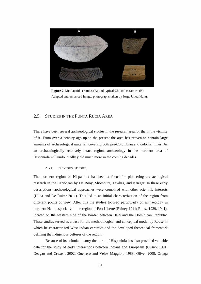
31
Figure 7. Meillacoid ceramics (A) and typical Chicoid ceramics (B).
Adapted and enhanced image, photographs taken by Jorge Ulloa Hung.
2.5 STUDIES IN THE PUNTA RUCIA AREA
There have been several archaeological studies in the research area, or the in the vicinity
of it. From over a century ago up to the present the area has proven to contain large
amounts of archaeological material, covering both pre-Columbian and colonial times. As
an archaeologically relatively intact region, archaeology in the northern area of
Hispaniola will undoubtedly yield much more in the coming decades.
2.5.1 PREVIOUS STUDIES
The northern region of Hispaniola has been a focus for pioneering archaeological
research in the Caribbean by De Booy, Shomburg, Fewkes, and Krieger. In these early
descriptions, archaeological approaches were combined with other scientific interests
(Ulloa and De Ruiter 2011). This led to an initial characterization of the region from
different points of view. After this the studies focused particularly on archaeology in
northern Haiti, especially in the region of Fort Liberté (Rainey 1941; Rouse 1939, 1941),
located on the western side of the border between Haiti and the Dominican Republic.
These studies served as a base for the methodological and conceptual model by Rouse in
which he characterized West Indian ceramics and the developed theoretical framework
defining the indigenous cultures of the region.
Because of its colonial history the north of Hispaniola has also provided valuable
data for the study of early interactions between Indians and Europeans (Cusick 1991;
Deagan and Cruxent 2002; Guerrero and Veloz Maggiolo 1988; Oliver 2008; Ortega

32
1988; Rothschild, Luna Calderon, Coppa and Rothschild, 2000; VanderVeen 2006; Vega
1990; Veloz Maggiolo 2002; Wilson 1992). The main focus of these studies is on the first
European colonial enclaves in the West Indies, in particular La Isabela, En Bas Saline,
and Puerto Real, with general archaeological references to its surroundings in an attempt
to contextualize the social and cultural space in which the first Spanish villas were
located (Cusick 1991; Deagan 1995; Deagan and Cruxent, 2002).
Another approach often taken in the region is to try to link archaeological data
with ethnohistoric accounts, which was conducted by for example Elpidio Ortega.
Ortega´s study is an archaeological exploration along the route of Christopher Columbus
(Figure 8), this trail runs from La Isabela to the Cibao Valley (Ortega 1988).
Figure 8. Part of the map on which Ortega marked the route by
Columbus, with the location of the research area highlighted
(after Ortega 1988).
33
Guerrero and Veloz Maggiolo have attempted to attribute the Meillacoid ceramic
style to the aforementioned Macorix group described in the Chronicles (Guerrero and
Veloz Maggiolo 1988). In Wilson’s 1992 publication Hispaniola: Caribbean Chiefdoms
in the Age of Columbus the complexity and integration of chiefdoms are studied using
historical sources from the early colonial times. More recently archaeometric methods
were applied for studies on the diet, in order to reveal interactions between indigenous
people and Europeans (VanderVeen 2006). Most archaeological studies in the north of
Hispaniola have been primarily focused on isolated sites (De Grossi et al. 2008; Luna
Calderón 1973; Olsen 2000; Ortega 1981, 1988; Ortega and Veloz Maggiolo 1972;
Ortega et al. 1990; Veloz Maggiolo 1972a, 2002; Veloz et al. 1981), which has created
the absence of a coherent and inclusive regional vision.
2.5.2 RECENT STUDIES
Already performed and perceived by Veloz Maggiolo in the 1970’s, the study of
identities as dynamic and diverse phenomena focused on material culture differences is
one of the latest archaeological approaches in the region (Oliver 2009; Veloz Maggiolo
1971). These differences have been interpreted as a sign of diversity within so-called
Taíno cultural expressions. The area studied in this research elucidates the complexity
and depth of this diversity. Recently, other researchers have mapped the northern coast of
Hispaniola as well; Clark Moore mapped all archaeological sites in Haiti (Moore 1991b,
1997; Rouse and Moore 1983), while Daniel Koski-Karell focused on settlement patterns
in northern Haiti (Koski-Karrell 2002). Koski-Karell distinguished different types of
settlement based on their size, starting with the household as the smallest and the large
villages as the largest. The landscape was categorized into different terrain relief zones:
waterland, shoreline, coastal plain, river valley, piedmont, highland and montane zones.
Koski-Karell analysed the combinations of these variables for Ostionoid, Chicoid, and
Meillacoid sites. Although the categorizations are somewhat different, the research is
comparable to this study. This will be further discussed in Chapter 6.
As previously discussed, this study is conducted in collaboration with Jorge Ulloa
Hung’s study. Ulloa Hung has studied the ceramics of the area, focussing on the
processes behind stylistic diversity. The chronological analysis of Hispaniolan ceramic
styles reveal significant levels of stylistic coexistence in various parts of the island. This
coexistence marks the presence of a particular cultural landscape in which different types
of interaction can be perceived through ceramics, at different scales in the region under
study (Ulloa Hung and De Ruiter 2011). In these combined studies placed in the northern
region a combination of ceramic attributes have been observed. These two different
ceramic expressions are found both separately and combined in the same archaeological

34
context. The differences are observed not only at the decorative attribute level but also in
other technological and formal aspects (Figure 9).
This gradual combination of the two ceramic styles in the area is retraceable
through a consistent combination of attributes through time, and was thus a graded
continuum. The fully combined expressions are what most consider Hispaniolan
Meillacoid, which presents differences as well as similarities to the Meillacoid style
ceramics in for example Jamaica or Cuba (Ulloa Hung, in press). Hispaniolan Meillacoid
is marked by the presence of the Ostionoid technological expressions of appliqués, which
can be very characteristic. This reflects the different historical processes for each island
or island region. The gradual process of the merging of the two ceramic traditions is
expressed in different phases at various sites in the northeast of Hispaniola (Ulloa Hung,
in press). However, in the study area we only see the result of the final process, at the
Meillacoid sites Don Julio, Puerto Juanita, Los Perez, Popi and Humilde Lopez.
Figure 9. The merge of Ostionoid and Meillacoid traits.
Adapted and enhanced image, photographs taken by Jorge Ulloa Hung.
Another process of interaction is visible in the Meillacoid and Chicoid style ceramics.
There is no harmonious integration between the two expressions, rather these remain
separate within the same site or specific elements are adopted on the vessels. This kind of
interaction is present in sites such as Don Julio, Humilde Lopez, Puerto Juanita, El
Coronel, Los Muertos and Edilio Cruz. In Ulloa Hung’s opinion this interaction was not
35
part of a legitimizing or homogenizing discourse or a ritual grammar, but that the
evidence suggests constant negotiation and renegotiation at the intra-regional level.

36
37
3 THEORIES & METHODS
3.1 INTRODUCTION
Two factors play a central role in this research: the fieldwork data and experiences, and
the computer-analyses. In this chapter applicable theories are described, followed by the
choices of the used methods. This extensive explanation is important because the focus of
this research, and therefore the methods as well as the theoretical approach, has changed
during the process of writing this thesis.
Theories on landscape archaeology have always varied widely: from one end of
the spectrum, analysis of the hard data on the landscape comprising particularly
ecological variables, to the other, analysis of ‘experiencing the landscape’ or a more
phenomenological approach. There are many approaches to the landscape, the main
difference lies in the focus of these approaches (Anschuetz et al. 2001; Cooper 2007; De
Waal 2006; Fitzjohn 2007, Ingold 1993; Johnston1998; Reid 2008; Witcher 1999). A
broad approach, encompassing the entire aforementioned spectrum, is necessary for a
study of the social landscape. The intention was to adopt a hard-data analysis approach,
which is evident from the initial plan to rely on computer applications in order to address
the research questions. However, after several days in the field it became clear that this
would not be sufficient to come to conclusions. The focus of research has somewhat
shifted in order to combine these two different approaches. This process, and this shift,
will be explained in the Theories section below.
After a brief introduction on preparatory work the methods of survey will be
discussed. The fieldwork in the summer of 2010 is the main source of information and
has provided the data necessary to address the research questions. All data recorded in the
field was completed according to a standardized form, in order to be able to record it into
a Microsoft Access-database designed for this project. The contents of the form were
defined in collaboration with the Museo del Hombre Dominicano, during a preparatory
visit. The form and the database set-up have been sent digitally. This enables other
archaeologists active in the Dominican Republic to record their data to this standardized
form. The contents and use of the database will be explained in paragraph 3.4.3. A GIS

38
was created with the fieldwork data and the collected maps. Different GIS-programs were
used for different purposes. The methods section concludes with the description of the
computer applications used.
3.2 THEORIES ON LANDSCAPE ARCHAEOLOGY
A short overview of the developments and the current state of affairs in landscape
archaeology and settlement patterning is discussed, focusing on specific studies and
methods used. The following section will focus on the current state of affairs of these
topics in the research area.
3.2.1 LANDSCAPE ARCHAEOLOGY AND SETTLEMENT PATTERNING
Starting with New Archaeology in the 1960s, the landscape was viewed as one of the
factors in a system, with a focus on ecology. Movement, settlement and other human
activity was explained with empirical evidence on different scales, from the artefact, to
the site, to the landscape. Instead of the mere descriptive documentation of a site or a
region, interpretation of multivariate dynamics underlying certain observed patterns
became the way to conduct archaeological research. According to Clarke (Clarke 1968)
and Johnson (Johnson 1977) among others, the interaction of different factors on different
scales would allow for a more comprehensive understanding of patterns of change. A
well-known proponent of New Archaeology, Lewis Binford stated that the landscape, not
the site, is the arena for all human activities. He argues for a multiscalar approach, within
and between sites, to come to a systemization of settlement pattern studies (Binford
1982). Binford’s views on the importance of context have had profound effect on
landscape archaeology and archaeology in general. However, these systems approaches
could only the how, and not the why.
These views changed gradually through the 1970s and 1980s. The socio-symbolic
aspect now came into focus, and more interpretive methods were used. By the time of the
1990s the re-creation of the socio-cultural landscape had become the main focus in
landscape archaeology. Ian Hodder’s work is one of the most well-known of this
approach, as are Timothy Ingold’s taskscapes and the dwelling perspective. The
temporality of the landscape (Ingold 1993) is one of the key publications in landscape
archaeology. In this article Ingold describes how much the landscape can change within a
years’ time, how human action changes within that, and how every person perceives this
differently – in the present as well as in the past. According to the dwelling perspective
39
the landscape is constituted as an enduring record of the lives and actions that have taken
place of the past people who have dwelt within it. Through their lives and their actions,
these people have left something of themselves there. The landscape does not just tell a
story, it is a story (Ingold 1993). This recent approach towards the human experience in
the past has made landscape archaeology all the more complex. The historical and
economic component of the landscape have been replaced by a human socio-symbolic
component. More recent research by Joshua Torres on the landscape surrounding Tibes,
Puerto Rico (Torres 2010) attempts to approach the social landscape methodologically,
focussing on the relations between sites and areas. Although the socio-symbolic factors
are mentioned, the study results in a categorization of sites in the landscape.
Although landscape archaeology and settlement patterning studies are not as
widely applied in the New World as they are in the Old World, there have been some
major studies since the 1940’s. Gordon R. Willey’s 1953 publication on prehistoric
settlement patterns in the Virú valley in Peru was one of these which was conducted on a
regional scale and focussed on the description of a set of specific site characteristics
(Willey 1953), in line with the archaeological theory in that period. Studies on a regional
scale in the 1950’s and 1960’s generally adopted the cultural-historical descriptive
approach. An important and exemplary study from the next theoretical era, known as
processualism or New Archaeology, is Kent Flannery’s 1976 The Early Mesoamerican
Village. Flannery’s goal was not only to create a model of Early Formative society based
on substantive data, but also to produce “analytic procedures for sampling and studying
Formative cultures” on different levels (Flannery 2009). Processualist studies focus on
systematically acquiring hard data which led to the postprocessualist critique of the
obliteration of the human factor in developing our understandings of the past. However,
this more interpretive approach does not necessarily exclude the ecological factor.
Current studies on landscape and settlement patterning often apply computer applications
for analysis, which is why they tend to focus more on ecological factors.
One of the most prolific studies in the circum-Caribbean has been conducted by
Irving Rouse. Throughout his career Rouse’s descriptive studies have produced an all-
encompassing overview of the area. However, due to this large scale detail is lacking, and
notions of landscape and settlements are rather broad-stroked. A more explanatory
approach has been taken on by Marcio Veloz Maggiolo from the 1970’s onward, with his
modos de vida (Veloz Maggiolo et al. 1981). Veloz Maggiolo has been the most
influential Dominican archaeologist and opted for a new approach - a specifically
Antillean vision, as a reaction against North American hegemony. He focused on the
social relationships between people as part of a production system, the hybridity and
diversity of aboriginal cultures, and on the importance of ecology (Samson 2010). His

40
approach resulted in a more dynamic and diverse view of the Caribbean, in contrast to
that of Rouse. One of the more recent large scale study on landscape and settlement
patterning, albeit across the border, was conducted by Daniel Koski-Karrell, in which
sites were mapped along the northern coast of Haiti. Koski-Karrell used similar
categorizations as were used in this study, which make them quite comparable. Koski-
Karrell’s work will be further addressed throughout this thesis. Maaike de Waal’s study
on social interaction and settlement patterns on La Désirade and on Guadeloupe (De Waal
2006) and Alistair Bright’s dissertation on inter- and intra- insular relationships in the
Windward islands (Bright 2011) are some of the most recent studies (at least partly) on
settlement patterning in the Caribbean.
Current research on landscape archaeology and settlement patterning shows a
diversity of approaches, both processual and postprocessual, often using GIS for analyses.
Jago Coopers’ review of pre-Columbian Cuban archaeology included an analysis of
settlement patterning with the aid of a GIS. Although the overview was very thorough,
interpretations were feeble due to the biased information incorporated in the GIS (Cooper
2010). Difficulties concerning the limitations of these analyses can be overcome with
creative new approaches such as Fitzjohn’s study on the perception of space in the
mountains of Sicily (Fitzjohn 2007). In this study he explores the use and value of
methods of analysis widely used by archaeologists by incorporating perception and
experience of local farmers into his research. Approaches such as these will bring
landscape archaeology, settlement patterning and the use of GIS to the next level.
A long introduction on the development of theories in computer applications is
not needed, as these are methods which have only been in use in the past decades.
However, as with general archaeological theory, there has been a shift in the attitudes
towards the use of these models. The naiveté about the possibilities of these applications
that existed at the rise of it was soon met with more pessimistic and critical views; the
above mentioned study by Fitzjohn is an example of this. The incorporation of the human
factor demanded new types of analysis, such as space syntax analysis; a graph-based
theory normally used by architects to examine how the spatial layout of buildings and
cities influences the economic, social, and environmental outcomes of human movement
and social interaction. Furthermore, it can be argued that the sustainability or permanence
of the digital information is not guaranteed. With new software and upgraded versions
developing faster than the average time it takes to excavate a small site it is very well
possible that data stored in a specific format cannot be accessed in a few years’ time, or at
least not without expertise. Besides this factor there is also the possibility of losing digital
data in many other ways, from a simple virus to a crashing server.

41
3.3 THEORETICAL APPROACH: EXPERIENCES AND PERCEPTION
CHANGES
In the process of writing this thesis it was striking to realize that the four-decade spanning
journey from processualism toward post-processualism was unintentionally also
undertaken in my own approach. Commencing with the notion that hard data and
computer-models will unveil the social landscape of this small area, this was revealed to
be insufficient. There are many variables which cannot be included in a computer model,
and the most relevant one is experiencing the landscape. Certain patterns might emerge
from the data collected, all based on these measurable variables. These variables play a
certain role, but it has to be made clear that many other factors such as animism, which is
believed to have been a key factor of life in the pre-Columbian Caribbean, have played an
important part in for example site location.
While computer models are useful for the characterization of a region or area, the
use for analyses must be questioned. When computer models are used for analysis it has
to be made clear why these analyses are performed. What would it actually mean that
route X is the shortest or fastest route from point A to point B? It is merely a computer
model which does not necessarily reflect routes taken by people in the past. In fact, what
is available in archaeological data is point A and point B. How these are connected or
what the relation is between these two cannot be concluded from computer models based
on location, distances and slopes. At the very least other variables must be included, such
as indications of mobility and/or exchange between the two. It has become increasingly
clear that mobility and exchange have played an important role in the life of Amerindians,
whether this was on a day-to-day basis or as part of a larger network (e.g. Hofman et al.
2007; Hofman and Hoogland 2011).
In this thesis only the points are analysed, not the relation or connectedness
between them. These points are analysed in terms of location in the landscape and each
other. The argument for the inclusion of visibility in the analysis comes from experiences
during the fieldwork. During the surveys it appeared that the visibility might have played
a role in site location. While navigating through the area it was striking how many
landscape features and other sites could be seen from one point. While some sites were
located in on such a slope in a specific location that there was a 360° view even from a
relatively low altitude, like Los Mangos (Figure 3), other sites located in for example the
high southern hills have a rather restricted view (Figure 6). In both cases there are other
possibilities for site location within a 500 m range, which would have similar
characteristics (altitude, slope, surface). Examples such as these indicated the possibility
of visibility as a factor in site location. Because current vegetation often restricted (part
42
of) the views, a 3D computer model was necessary to reconstruct what is visible from
which site. This is further explored and explained in chapters 5 and 6.
The experience of navigating through the landscape has changed my views on
many aspects of this thesis. The focus is shifted from GIS analyses towards experiencing
the landscape. However, this can only be described and cannot be analysed. Answering
the research questions is possible by analysing the characterizations made while taking
the site descriptions into account. To retrieve the experiences of the past people
archaeologically is impossible. However, some variables and patterns emerging from
analyses can generate possible priorities and preferences of specific peoples.
3.4 METHODS
As preparatory work a study of the available literature on archaeological sites in the area
is essential in the first phase of this research. With the aid of the Museo del Hombre
Dominicano a list of known sites was compiled from archaeological as well as from
ethnohistoric sources. This provides the information that is necessary to determine the
possibilities for fieldwork in the area, and has helped to estimate possibilities of the
extent of the research area. Several different maps had to be retrieved, many of them only
available in the Dominican Republic, and some of them on the internet or at the Leiden
University Library. A preparatory visit was made by myself in January 2010. The aim of
this visit was to retrieve maps, get acquainted with the research area, and to meet local
archaeologists who would work on this combined project. The next step in the
preparatory work was to digitize the collected maps, in order have a properly working
GIS of the area when the fieldwork commenced. Due to difficulties with the digitizing
tablets and with importing the map from AutoCAD into MapInfo, this was partially
completed in advance.
3.4.1 SURVEY
The surveys that took place were based on the knowledge of local people. The research
area comprises such a small scale that local people have reliable knowledge on where
certain archaeological material was and still could be found. The collaboration with
Adriano Rivera was very valuable during the course of the fieldwork. His knowledge of
the area, his connections to landowners, and above all his interest in archaeology have
made this project possible. Most of the land surveyed is currently used as a grazing area
for cattle, although not on a large scale, and some of the land is used for small scale

43
agriculture. People in the area generally live off their own land with a few animals, crops
and fruit trees to sustain them. Local inhabitants know their lands well, and
archaeological material hardly goes unnoticed: this has proven to be a lucrative way of
earning money. Huaceros or looters are very active in the area. Every single one of the
sites visited had been visited by looters as well (Figure 10), with distinctively dug pits at
strategic points on a site left behind as evidence for these activities. Local knowledge of
the presence of archaeological material is reliable; during our great many hikes to a site
we have never encountered archaeological material of which the local people had no
knowledge.
Figure 10. A typical huacero pit located on the slope of the Humilde Lopez site.
The surveys of the sites were usually conducted by a team of two local men,
Adriano Rivera and José Medina, two BA-students from Leiden University, Daniëlle
Meuleman and Marlieke Ernst, archaeologist Jorge Ulloa Hung, and myself. The tasks
varied from site to site; depending on whether or not shovel-tests or test-pits would be
made. All sites were surveyed on the surface, and as many useful points as possible were
mapped with a handheld GPS by me. Where possible the general area of the site was
mapped, as well as mounds and specific finds. The location of pits, dug by archaeologists
as well as by looters, were also mapped by recording the coordinates of at least one

44
corner. The surface surveys took place in a random manner due the irregular vegetation,
fences, and slope of the landscape which made a systematic survey impossible.
The standardized A4 form (Figure 11) has been used in the field and during
literature studies. It is made in such a general manner that it is suitable to record the
observed information on the paper form into the digital database.
In the field the following information was noted when possible:
These variables were not only noted to be used for this study, but also to record information to
incorporate in the general database. Variables used for this research are mainly the UTM
coordinates, the accessibility, geomorphology, altitude, vegetation, current land-use, complex
type, period, and site type. The latter is often a rough estimate based on presumed function and
general archaeological character, such as resource extraction sites, settlements, workshops,
individual finds, and ritual sites. Observations on the field as well as the material assemblage of
the site aid in assigning site types (De Waal 2006). In this section observations on the visibility
and specific views were noted. The aforementioned variables are all either environmental
factors or influence the human experience of the landscape. For instance, the accessibility,
vegetation and visibility might make a site location either beneficial or disadvantageous. Other
variables noted, such as depth of finds and number of finds, are in order to preserve information
for future research, easily accessible with the database and recorded in a standardized manner.
-Site name -Minimum depth of finds
-UTM Coordinates -Maximum depth of finds
-Place -Find/research area
-Landowner -Maximum depth of research
-Accessibility -Complex type
-Soil -Site type
-Geomorphology -Number of finds
-Altitude AMSL -Material
-Vegetation/Surrounding -Date/Period
-Current land-use -Remarks (about the view or experiences)

45
Figure 11. Standardized form used in the field.

46
It was rarely ever possible to record information on all these variables due to
different circumstances on each site. When one of the variables could not be observed and
recorded the cause was explained on the form. Both Ulloa Hung and I used a handheld
GPS in the field. The recorded coordinates were compared and reliability was checked on
the maps. Due to the type of GPS device which displays the UTM coordinates without the
ability to name or record them, the displayed coordinates were copied in a field notebook
and on the standardized A4 form, accompanied by a short description.
Shovel-tests and test-pits were dug at several sites. The shovel-tests consist of a
shallow, irregular dig, usually with a pick-axe. These tests were not only made to collect
material, but also to assess the general area of the site and the best option to dig a 1x1
meter test-pit. Test-pits were 1x1 or 1x2 meters, set out with a measuring tape, and were
not aligned to a specific grid; however the coordinates of at least one corner were
recorded. The test-pits were divided in layers of 10 cm and finds were bagged
accordingly, categorized by material. The contents of the test-pits were sieved in order to
retrieve smaller pieces of archaeological material. Excavation ended when the pit-depth
had come to the sterile layer. Ulloa Hung made profile drawings and recorded
photographs of the profiles. Lastly, soil colour was noted according to the Munsell color
chart, and the characterization of the soil texture was recorded. All finds were washed in
the Punta Rucia field laboratory with tap water, different sized brushes, and sticks.
3.4.2 DATABASE
Relational databases are the main choice in storing data, especially in archaeology. It is a
relational database when relations are assigned between different attributes of several
tables. However, these relations and tables are not in a particular order. Geographic
Information Systems are map-based databases, systems designed to store, manipulate and
analyze all types of geographically referenced data. It is a combination of cartography,
statistical analysis and database technology. Computer applications have become an
indispensable aspect of archaeological research. Even in for example literature and
historical studies a digital database is created and used, thus resulting in mainly digital
data storage. Fieldwork carried out with a mere measuring tape and a shovel will
eventually be digitized in a text document and a data spreadsheet, before it could ever be
published.
Creating a (relational) database requires clarity on what it will be used for, and
which questions it might need to help answer. A detailed plan must be written down or
preferably sketched to ensure that the structure is solid and that all variables are covered.
Efficiency is one of the key aspects in the use of a database; therefore the database has to
be easy to use, clear, and should take the least amount of bytes possible. Data entry is less

47
complicated, time-consuming, and more reliable through the use of forms and within
them so-called drop-down menu’s to ensure that all entries in that box will be
comparable. For example, for the analysis database the relative approximate altitudes
have been categorized into plain, low hill, medium high hill, and high hill. Broad analyses
can be made through the use of created queries, of which simple graphs can be made.
The database created for this project was not only built to be used for this
research, but also had to be capable to contain research information from other parts of
the Dominican Republic, conducted by other researchers. The variables included in the
main database are therefore quite general. Although the titles and data-fields are in
English, the descriptions of the fields are also in Spanish to enable Spanish-speakers to
use the database. An additional database with data fields more specific for the analyses
planned for this research was created as well, related to the general database. All
recordings on the form were entered into a Microsoft Access 2003 database. It should be
noted that this database is mainly used as a recording device, not as a tool to enable
comparisons and analyses. The variables are too complex and most of them cannot be
converted into a simple drop-down menu, which would enable analyses. However, factors
such as geomorphology, relative altitude, slope, the presence of mounds, percentage of
visibility, view (direction), and distance to the sea are categorized and can therefore be
analysed using the database.
Figure 12. Overview of the pull-down menu’s used in the analysis-database.
48
As is visible in the database image in figure 12, which is simplified and enhanced, the
analytical database contains information on the aforementioned variables, categorized
into comparable units of measurement or terms. In the reference table for view on the
upper right the E stands for east, the W stands for West, the V for valley, and the O for
ocean. The lower right depicts the ranges in the distance to sea, in kilometres. The lower
left represents the different categories of geomorphology, in which the number
corresponds to the numbers and a specific colour on the maps used in following chapters.
The presence of anthropogenic mounds on sites is answered with a simple yes/no.
3.4.3 GEOGRAPHICAL INFORMATION SYSTEM
Geographical Information Systems have become a key aspect in archaeological research.
Programmes such as ArcGIS, MapInfo/Pitney Bowes, Surfer, and Idrisi are constantly
being developed and updated. Each GIS computer programme has its own specialty; 3D
models are best made with Surfer and Idrisi, while Autodesk also allows for digitizing
maps through AutoCAD. Currently there are several open source GIS programmes
available on the internet, these are for example GRASS, Quantum GIS and MapWindow
GIS. The well-known Google Earth is also a GIS programme. Over the last years the
interface of these open source programmes has become more user-friendly, which enables
utility by a larger group of people. Geographical Information Systems are also used for
predictive modelling, a method of which the usability and value is much debated
(Verhagen and Whitley 2011; Kamermans 2007; Kvamme 1997).
Predictive modelling and the use of GIS have played a central role in several
studies in the Caribbean as well, for example on St. Eustatius and Trinidad among other
islands (Reid 2008). Recently Cooper and Boothroyd have published on their extensive
computer analysis on the sea-level changes in the pan-Caribbean (Cooper and Boothroyd
2011). In this study the combination of digital elevation models and data on sea level
changes from the last 8000 years is used in order to provide models of changing
islandscapes through time. Another recent study was conducted by Rodriguez Ramos and
Torres, in which the intervisibility of the islands was explored. They argue for an island
interconnectivity based on visibility, and suggest it might have provided a sense of
continuity and continentality. The study gives an indication of possible interaction
spheres (Torres and Rodriguez Ramos 2008).

49
Figure 13 . Moore and Tremmel’s map of archaeological sites in Haiti (after Moore 1997).
On Hispaniola Clark Moore’s online available archaeological database of sites in
Haiti is a fine example of an easily accessible and clear national database (Figure 13).
Specific characteristics of all sites are recorded, such as the type, culture and area, so
there is a short overview of each site in the database. Harold Olsen Bogaert is one of the
archaeologists working in the Dominican Republic who has done walkover surveys in
several areas ahead of builder development and has recorded the site locations with a
GPS, starting a database with site locations used by the Museo del Hombre (pers.
comm.). While in Olsen’s and this research several sites located in an area are mapped,
Erlend Johnson has mapped specific features in the surrounding area of one site; El Cabo.
The site is located on the east coast of the Dominican Republic and has been extensively
researched in the past decade by a team from Leiden University under the direction of Dr.
Menno Hoogland, producing a complex image of house trajectories (Samson and
Hoogland 2007, Samson 2010). Johnson’s study placed the site in the context of its
surroundings by surveying with a GPS (Johnson 2009).
Overall it can be stated that GIS and relational databases have become a large
part of archaeological research. Although the use of these computer applications is very
efficient, the aforementioned caveats should be taken into account.

50
For this research the collected military and soil maps were digitized with
AutoCAD 2007 to create a basic map to import into GIS programmes. The data was
imported into MapInfo to make a clear and understandable map to use as a basis for
images. Aerial photographs were available for only a part of the area and did not provide
any significant information, which is why these were not incorporated. 3D Grid data,
obtained from the United Stated Geological Survey, was imported into Golden Software
Surfer 9.0 (Figure 14) and Global Mapper 10. The interpolation method kriging was used
to create the most useful grid-file from which the 3D image below was produced. Such a
3D model enables the execution of viewshed analyses.
Figure 14. 3D model of the research area created in Surfer, viewed from the northwest.
3D Models as depicted in figure 14 can also be used for for example least-cost path
analysis. Given that this research area is very small and that basing such an analysis on
only a few variables would be insufficient, these kinds of analyses were not undertaken.
To address the research questions concerning patterning and visibility, the location in
combination with information of specific features is sufficient.
51
3.5 THE SOCIAL LANDSCAPE
After this thorough discussion of the theories and methods used, the social landscape
needs to be addressed. The term social landscape is as broad as it is vague, with different
definitions used by different researchers, and often the term is simply used without
discussing the definition first. This leaves their readers to guess what the social landscape
actually encompasses – even though it is the focus of their study (Adler 1996; Varian
1999). My definition is a rather practical and all-encompassing one: the social landscape
is the combination of the physical landscape and the human presence and actions which
take place in it. It is viewed truly as a merger of the cultural and the physical aspect. This
entails that both empirical data and humanistic or more phenomenological data have to be
used and combined where possible. The data used in this research allows merely for a
broad-stroked image of the social landscape of a small area in the northwest of the
Dominican Republic. On this ‘middle scale’, with small comprising one site and large the
whole region, it is hard to place the area as well as specific sites into interaction spheres.
Detailed information is lacking on a large majority of the sites, which makes it impossible
to look at site-to-site relations. The amount of located sites in the surroundings of the
research area is low in comparison with the site density of the area, which makes placing
the study area in a larger settlement-patterning context difficult. However, the study area
itself is a rather secluded one, encompassed by lines of hills and the ocean. Detailed
studies and dense surveys of the surrounding area could shed more light on the actual
level of seclusion of the research area.
By mapping the sites within a small area, recording their specific characteristics,
and combining this information with ecological data as well as with fieldwork notes on
the experience of certain factors such as strong winds or visibility, this study attempts to
discern patterns and perceive the social landscape in such a small area. The social
landscape that emerges from this study is what in this study is called a patchwork of
diversity, with many sites located close together, exhibiting many different combinations
of specific features, and a merge of ceramic styles. In this thesis I argue for the vision of a
dynamic and diverse social landscape of the area, in which the combination of similarities
and differences are the common denominator.

52

53
4 SITES & THE SURVEYS
4.1 INTRODUCTION
Three fieldwork campaigns with different purposes were carried out in the northwest of
the Dominican Republic, around the border of the provinces Monte Christi and Puerto
Plata. A total of 49 archaeological sites were visited of which 44 are new recordings for
this area of the island. Archaeological material was also studied in two existing local
collections, the ceramic material was restudied and site reports from the Museo del
Hombre from the 1970s and 1980s from the Cibao valley and the province of Montecristi
were reviewed.
Eleven sites were surveyed with excavation units of different sizes and seven
sites with different cultural components were dated. In the remainder of the sites
archaeological material from the surface was collected and all information was recorded
on the standardized form in order to be able to analyse the interaction of human groups
with the landscape. Thirty sources of clay in the north of the Dominican Republic were
located contributing to research on ceramic interactions and mobility (Ulloa Hung, in
press). These, along with samples of potsherds from several settlements are under
analysis in the Ceramic Laboratory in the Faculty of Archaeology, Leiden University.
All sites visited or used in the analysis are discussed below, after a brief
introduction on the map data used for this research. The sites are divided into Archaic
Age sites, sites with predominantly Meillacoid style ceramics, sites with predominantly
Chicoid style ceramics, and other sites. The latter includes one Ostionoid site which could
not be visited, sites in an adjacent area to the east, and sites where no diagnostic pieces of
ceramics could be found. The order in which they are discussed within the subdivisions is
random.

54
4.2 MAP DATA
A very brief overview of the used maps and aerial photographs is described
below. The maps used for this research are military maps and geomorphological
maps. These maps were retrieved in the library of the Museo del Hombre in
January 2010, or via digital source.
4.2.1 MILITARY MAPS
The maps used for the GIS were military maps in Universal Transverse Mercator (UTM)
coordinates with a scale of 1:50 000. These military maps, created in 1984 and 1988 are
very detailed and reveal a large amount of basic information. Roads, contour lines with
20 meter intervals, buildings, vegetation and other features are indicated on these maps.
Although lines on the map, as pictured in figure 15, are at least 2.5 m wide, these maps
still form a solid basis to create a GIS. The maps were digitized into AutoCAD 2007, and
later imported into other GIS software. The simplified coloured maps, such as figure 18,
are all created from the CAD drawing based in these military maps. A composed image
of the area is placed in Appendix 1.
Figure 15. Snippet of the military map in the area of Punta Rucia.

55
4.2.2 SOIL MAPS, GEOMORPHOLOGICAL MAPS, AND VEGETATION MAPS
The geomorphological maps incorporated in the GIS are on a scale of 1:250 000, which is
rather large and causes a lack of detail. However, for this research and the study area it is
acceptable. Sites near the border of two profiles are characterized as profile X+Y in the
analyses in Chapter 5. Information on the soils is given in the map legend. This, in
combination with Tirado’s publication Los suelos de la Republica Dominicana (Tirado
2003), gives an indication of the soil types in the area.
Vegetation maps could not be obtained on a scale smaller than 1:500 000. This is
one of the reasons vegetation is not taken into account in detail. The best vegetation map
that could be obtained is shown in figure 16, which is impossible to incorporate into the
created GIS. However, the most relevant argument not to take vegetation into account
during analyses is because the vegetation can change within a year in the area. Both
myself and Ulloa Hung have mistaken their location on different accounts based on
vegetation. This was simply because where once was a densely overgrown area with large
trees, there was now a completely cut field with young fruit trees planted on it, or in my
case, where an easily accessible agricultural field was encountered in January and a
completely overgrown, impossible to survey area was encountered in July.
Figure 16. Examples of a geomorphological map on the left, and vegetation map on the right.
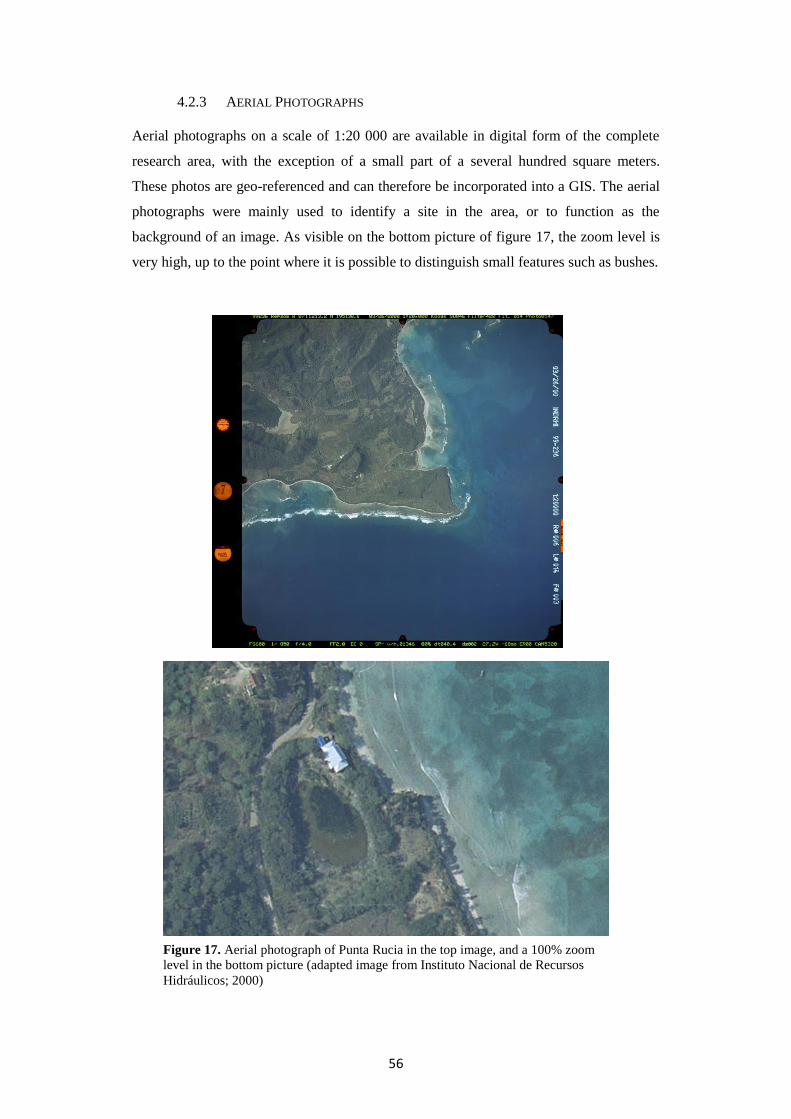
56
4.2.3 AERIAL PHOTOGRAPHS
Aerial photographs on a scale of 1:20 000 are available in digital form of the complete
research area, with the exception of a small part of a several hundred square meters.
These photos are geo-referenced and can therefore be incorporated into a GIS. The aerial
photographs were mainly used to identify a site in the area, or to function as the
background of an image. As visible on the bottom picture of figure 17, the zoom level is
very high, up to the point where it is possible to distinguish small features such as bushes.
Figure 17. Aerial photograph of Punta Rucia in the top image, and a 100% zoom
level in the bottom picture (adapted image from Instituto Nacional de Recursos
Hidráulicos; 2000)

57
4.3 FIELDWORK DATA
Prior to the fieldwork which took place in the summer of 2010, the area has been visited
in order to estimate research possibilities in terms of surveying and the extent of the area
which would be covered. Maps, site reports and articles on the area were also collected in
the library of the Museo del Hombre Dominicano.
After an initial week of preparatory studies, the surveys in the research area were
carried out. The first 17 days of surveying took place in the vicinity of Punta Rucia, while
the last four days these were in a larger area around Imbert located further east. Although
data have been collected on the sites in the vicinity of Imbert, they are not included in the
analyses. Sites located in a different area would not be comparable in factors such as
viewshed analyses, distance to the sea, vegetation etcetera. Sites included in the analyses
are located in the area of Punta Rucia, 36 of them recorded by myself, while five were
recorded by Jorge Ulloa Hung. The latter have not been visited by myself due to both
time restraints and in some cases the inability to find the sites again. Visited sites will be
discussed below, divided into Archaic Age sites and Ceramic Age sites. The latter are
subdivided into sites with predominantly Chicoid style ceramics or with predominantly
Meillacoid style ceramics. Accessibility and steepness of the slopes are described as
experienced while on foot. All variables described per site contain information on either
the ecological setting of the sites, or on the human experience of travelling and residing
there. Although archaeological material from each site is briefly discussed, more detailed
information about the results from the test pits and ceramics is recounted in Ulloa Hung’s
Figure 18. Overview map of all sites, numbered.
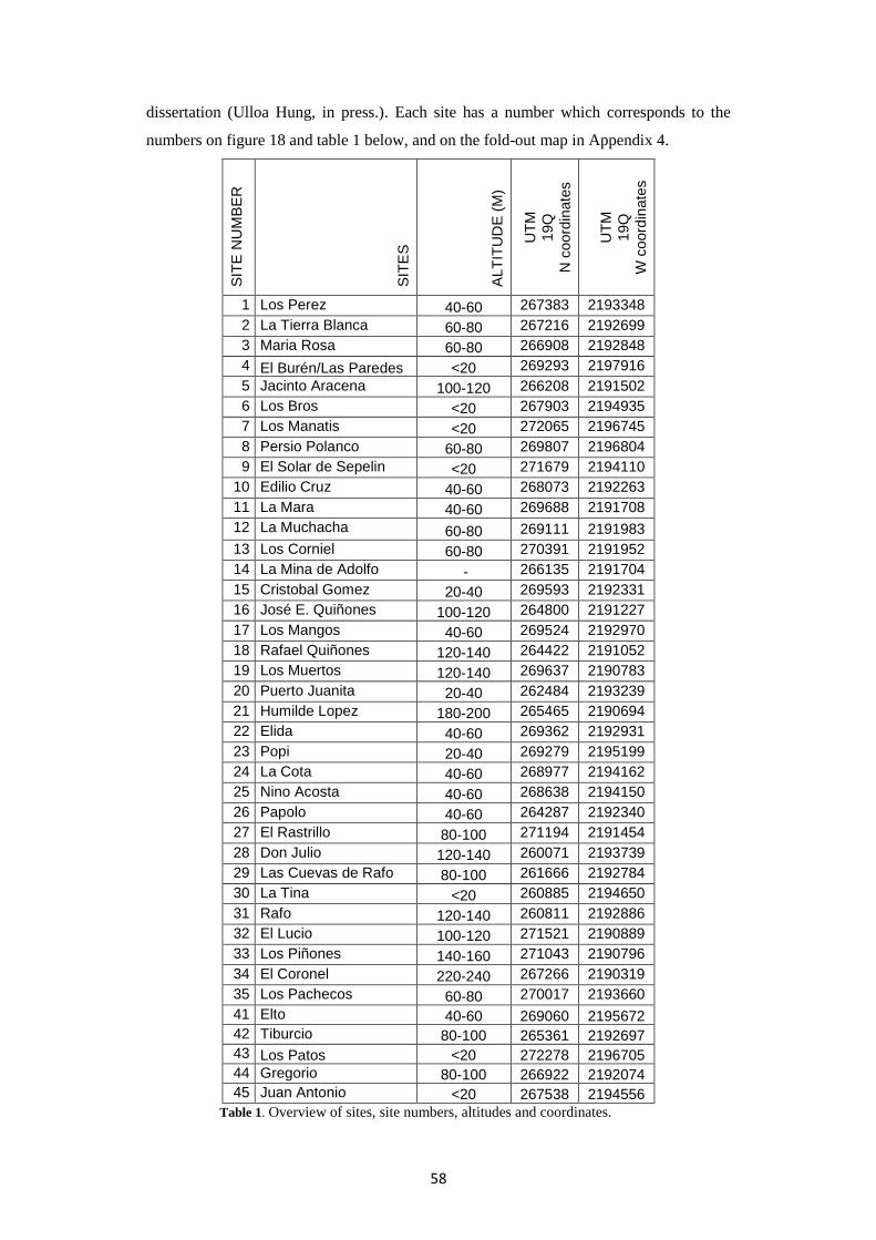
58
dissertation (Ulloa Hung, in press.). Each site has a number which corresponds to the
numbers on figure 18 and table 1 below, and on the fold-out map in Appendix 4.
SIT
E N
UM
BE
R
SIT
ES
ALT
ITU
DE
(M
)
UT
M
19Q
N c
oord
inate
s
UT
M
19Q
W c
oord
inate
s
1 Los Perez 40-60 267383 2193348
2 La Tierra Blanca 60-80 267216 2192699
3 Maria Rosa 60-80 266908 2192848
4 El Burén/Las Paredes <20 269293 2197916
5 Jacinto Aracena 100-120 266208 2191502
6 Los Bros <20 267903 2194935
7 Los Manatis <20 272065 2196745
8 Persio Polanco 60-80 269807 2196804
9 El Solar de Sepelin <20 271679 2194110
10 Edilio Cruz 40-60 268073 2192263
11 La Mara 40-60 269688 2191708
12 La Muchacha 60-80 269111 2191983
13 Los Corniel 60-80 270391 2191952
14 La Mina de Adolfo - 266135 2191704
15 Cristobal Gomez 20-40 269593 2192331
16 José E. Quiñones 100-120 264800 2191227
17 Los Mangos 40-60 269524 2192970
18 Rafael Quiñones 120-140 264422 2191052
19 Los Muertos 120-140 269637 2190783
20 Puerto Juanita 20-40 262484 2193239
21 Humilde Lopez 180-200 265465 2190694
22 Elida 40-60 269362 2192931
23 Popi 20-40 269279 2195199
24 La Cota 40-60 268977 2194162
25 Nino Acosta 40-60 268638 2194150
26 Papolo 40-60 264287 2192340
27 El Rastrillo 80-100 271194 2191454
28 Don Julio 120-140 260071 2193739
29 Las Cuevas de Rafo 80-100 261666 2192784
30 La Tina <20 260885 2194650
31 Rafo 120-140 260811 2192886
32 El Lucio 100-120 271521 2190889
33 Los Piñones 140-160 271043 2190796
34 El Coronel 220-240 267266 2190319
35 Los Pachecos 60-80 270017 2193660
41 Elto 40-60 269060 2195672
42 Tiburcio 80-100 265361 2192697
43 Los Patos <20 272278 2196705
44 Gregorio 80-100 266922 2192074
45 Juan Antonio <20 267538 2194556
Table 1. Overview of sites, site numbers, altitudes and coordinates.

59
4.3.1 ARCHAIC AGE SITES
The site El Burén ( Number 4 on the map, UTM 19Q 269293 2197916) is also known
as Los Farallones, Estero Hondo or Las Paredes. The site consists of a habitation area
near several caves and rock shelters located near the coast (Figure 19). According to
Ulloa Hung the plain in front of the caves was a habitation area. Archaeological evidence
has been found in front of the caves as well as inside. A large amount of subsistence
remains was found, among this different kinds of shells and hearths. There were also
human burials at the site (Ulloa Hung, in press). El Burén is the only site in the study
area which is known as an Archaic site, and its coastal setting is unique because of the
location near a (albeit small) limestone cliff; other coastal sites in the area are located in
the mangroves or on flat plains. Current vegetation consists of small trees. The view is
basically limited to the ocean and the sea inlet on the eastern side because of the setting in
front of a cliff on the southern side.
4.3.2 CERAMIC AGE SITES
With the exception of El Burén, all the sites in the research area date from the Ceramic
period. Below the fieldwork at the sites is discussed, categorized into either sites with
predominantly Meillacoid style ceramics or Chicoid style ceramics, and undetermined
Figure 19. Aerial photograph of the site area of El Burén, with the limestone cliffs
indicated.
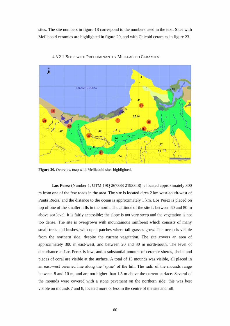
60
sites. The site numbers in figure 18 correspond to the numbers used in the text. Sites with
Meillacoid ceramics are highlighted in figure 20, and with Chicoid ceramics in figure 23.
4.3.2.1 SITES WITH PREDOMINANTLY MEILLACOID CERAMICS
Figure 20. Overview map with Meillacoid sites highlighted.
Los Perez (Number 1, UTM 19Q 267383 2193348) is located approximately 300
m from one of the few roads in the area. The site is located circa 2 km west-south-west of
Punta Rucia, and the distance to the ocean is approximately 1 km. Los Perez is placed on
top of one of the smaller hills in the north. The altitude of the site is between 60 and 80 m
above sea level. It is fairly accessible; the slope is not very steep and the vegetation is not
too dense. The site is overgrown with mountainous rainforest which consists of many
small trees and bushes, with open patches where tall grasses grow. The ocean is visible
from the northern side, despite the current vegetation. The site covers an area of
approximately 300 m east-west, and between 20 and 30 m north-south. The level of
disturbance at Los Perez is low, and a substantial amount of ceramic sherds, shells and
pieces of coral are visible at the surface. A total of 13 mounds was visible, all placed in
an east-west oriented line along the ‘spine’ of the hill. The radii of the mounds range
between 8 and 10 m, and are not higher than 1.5 m above the current surface. Several of
the mounds were covered with a stone pavement on the northern side; this was best
visible on mounds 7 and 8, located more or less in the centre of the site and hill.

61
The exact function of this pavement is still unknown and several different theories exist
on this topic. In the area this practice of paving the (mounted) soil on which the house is
placed is common among contemporary local inhabitants. It serves as a firm basis for the
house which will be less prone to erosion and slope wash. This might have been the
function in the past as well. Another possibility is that it was used to cover the side of the
hill to keep that from washing away. The occurrence of limestone slabs is also found at
the Meillacoid site Puerto Juanita (Ulloa Hung, in press). This phenomenon does not only
occur in the study area, but is also reported in other areas of Hispaniola (Véloz Maggiolo
et al. 1981) and on Meillacoid sites in Jamaica (De Booy 1913). However, in these cases
this occurrence was believed to be related to agricultural purposes, for which there is no
indication in this research area.
The fieldwork on this site has taken place in 2009 and 2010. Two test-pits were
dug in the summer of 2009 by a team from Leiden University, with the aim of
establishing a site stratigraphy and collecting material for radiocarbon dating. The test-
pits were dug in areas in which traces of ash and food waste were present. In the 1x1 m
test-pit there was little archaeological material; only very fragmented shell and some
pieces of ceramics. The other test-pit was 0.50x0.50 m and was placed next to a looters
pit. Many pieces of Codakia sp. were found in a layer of grey ash (Ulloa Hung, in press).
The site had been visited by the myself in January 2010. As noted, during these
previous visits several mounds were spotted, some of which were covered with a stone
pavement. This was confirmed during the summer 2010 excavation that has taken place.
Material was collected from the surface and all visible mounds were recorded with the
GPS device. The site boundaries were also recorded. Three test pits were excavated and,
Figure 21. Stone slabs on the slope of mound 7, Los Perez.

62
with the aid of Dr. José Oliver (University College London), a contour map of the hill
was created with his GPS device. The 2010 fieldwork was primarily focused on the
partially paved mounds, and started with the cleaning of the surfaces of these paved
slopes. This enabled an overview of the surfaces, all on the northern side, and accurate
measuring of these. The northern side of mound 7 is nearly completely paved with flat
stones which appeared to have been worked to fit together; examined stones showed clear
traces of flaking. The location of several large trees made it impossible to excavate the
total extent of the pavement. The northern slope of mound 8 was also paved, although
this was only partially or possibly not preserved as well as the pavement on mound 7.
The excavations first focused on mound number 7, located in the centre of the
site, where a 1x2 m test pit was dug in arbitrary layers of 10 cm on the eastern slope,
oriented east-west. Ceramics, shells, coral and stone were retrieved only in the first ten of
the excavated 30 cm. The ceramics found were mostly Meillacoid, but there was also one
Chicoid sherd. Overall there was very little archaeological material in this test pit. The
soil of the mound is yellowish white which is different from what is usually found in the
area. There is no presence of stone slabs in the pit. The stratigraphy was recorded by
Ulloa Hung. Mound 7 is approximately 7x7.50 m with a maximum height of 95 cm from
the surface. The pavement, as seen in figure 21, was 1.20 m in height by 4.60 m in length.
The northern side of this mound is the steepest; the incline of the paved area is 35%.
A second test pit of 1x1 m was opened on mound 3, but after 15 cm of clean soil
this was closed again. Another 1x1 m test pit was excavated on the northern side of
mound 2. In the layer 0-10 cm there was a large amount of shell, some ceramics among
which a piece of a griddle, and pieces of stone. It contained mainly ashy soil. In the layer
10-20 cm deep there was a lot of charcoal, fish bones, shell, and ash. A charcoal sample
was taken from this layer for radiocarbon dating. This is similar in the 20-30 cm layer,
which in addition also contained some ceramics, one of which was decorated in
Meillacoid style. A charcoal sample was also taken from this layer. The next layer
consisted of clean soil from 32 cm to 38 cm deep. The stratigraphy of the test pit was
drawn by Ulloa Hung. His study of the ceramics from Los Perez revealed that 22,2% of
the ceramics contain Chicoid elements. Radiocarbon dates of samples from Los Perez
revealed dates (2σ range) from1056 to 1255 CE and from 1296 to 1394 CE.
Popi (Number 23, UTM 19Q 269279 2195199) is a rather large site located on a low
hilltop and is covered in grass and several trees. Maize is cultivated on the far
southwestern area of the hill which runs in a southwest-northeast direction, although it
winds a bit. The ocean is visible in the north, part of the valley is visible in the southeast,
and the site Persio Polanco is visible in the northwest. Southeast of the site is a stream

63
which runs in the rain season. Popi is easily accessible because of its rather flat slopes
(Figure 22) and low altitude. The latter also causes the experience and views on the site to
be locked ‘in the valley’. Medium high hills in the surrounding constrict the views from
the site.
There are 17 mounds on the site, on the eastern part these are aligned in a linear
fashion, while on the western part the mounds seem to be aligned in a horseshoe-pattern,
then again flowing into a linear pattern further west. There are a lot of stones on the
surface of the slopes of the eastern part of the hill. The mounds have a diameter between
5 and 10 meters and they are usually located within 15 meters from each other, although
there are a few larger gaps between the mounds. A human burial was found at the foot of
one of the mounds which is part of the horseshoe-shape. At the first visit shovel-tests
were made, which produced Meillacoid style ceramics, shell, and bone. Ulloa Hung,
Oliver and Pagán Jiménez later returned to make a 1x2 m test pit in a north-south
orientation on the mound where the human remains were found earlier. The first 10 cm
contained a lot of archaeological material, bivalves, ceramics and a polishing stone. A
small fish bone and some charcoal were found as well. Most of the archaeological
material was retrieved on the north side of the trench (Ulloa Hung, in press). In the 10 to
20 cm layer there was charcoal, bird bones, bivalves, fish bones, pottery with Meillacoid
decorations, coral, hutía bones (a small mammal), and mangrove shell species. A large
cluster of mangrove shells was present, associated with the charcoal. Furthermore a piece
of pottery with Chicoid characteristics was unearthed, executed with Meillacoid
technique. Mangroves shells and bivalves are the most prevalent in this layer. The 20 to
30 cm layer was again full of bivalves, mangrove shells, charcoal, fish, turtle, hutía and
bird bones, and ceramics. A large piece of pottery was excavated, with typically
Meillacoid decoration on it. In the southeastern part of the trench some flat stones and a
concentration of archaeological material were encountered. The deepest layer which
contained archaeological material is from 30 to 40 cm, mainly concentrated in the
southern part of the trench. Pottery with classic Meillacoid decoration was excavated
from this layer, in what is called the Transitional style in Dominican archaeology. Ulloa
Hung’s study of the ceramics form Popi reveal that 4,8% of the ceramics contain Chicoid
elements (Ulloa Hung, in press). Radiocarbon dating of the site indicated calibrated (2σ
range) dates between 1019 and 1150 CE.

64
Papolo (Number 26, UTM 19Q 264287 2192340) is located on a hilltop approximately 2
km from the coast. Sites in the vicinity are Puerto Juanita and Tiburcio, the former is well
visible from Papolo. There is a small stream southeast and northwest of Papolo. The site
was covered in tall grass during the summer visit. It is easily accessible and located near a
possible clay source. Despite the tall grass it was possible to collect shell and ceramics
during a surface survey. The ceramics were decorated with typically Meillacoid motifs.
As is the case for practically all sites, this hill is used for cattle to graze.
Los Mangos (Number 17, UTM 19Q 269524 2192970) is one of the most unique sites in
the area, particularly because of its location on a medium high hilltop with extremely
steep slopes. The Rio Encantamiento flows along the southwestern slope of the site. Los
Mangos is located near one of the main roads in the area, at the fringes of the northern
line of hills. The top is only about 50 square meters, and due to strong winds it was
impossible to thoroughly survey this area. There was one tree at the top and the hill was
covered in grass. The view from Los Mangos was 360°, over the valley to the east and
west, and to the ocean in the northwest. Shell fragments were visible on the surface. Due
to an upcoming storm, visible in figure 3, the site was left without conducting an
extensive survey. However, four mounds were identified during a previous survey, and
seashells, Meillacoid ceramics, fish bones, mangrove species, a burin and hammer stones
were retrieved (Ulloa Hung, in press).
Puerto Juanita (Number 20, UTM 19Q 262484 2193239) is located on a medium high
hilltop, in an east-west orientation. The site is located near the ocean and overlooks the
mangroves and lagoons on the northeastern side, and part of the valley on the
southeastern side. The Puerto Juanita lagoon with brackish water lies less than 500 m
from the site. This lagoon with its mangroves provide rich source for the extraction of
Figure 1
Figure 22. Contour map of Popi (Ulloa Hung, in press).

65
dietary and utilitarian resources. The site is approximately 260 meter in from east to west,
and 70 meter in width, which forms a rather linear shape.
With a cover of several trees the site is easily accessible and surveying was very
well possible because of the large amount of ceramics, pieces of coral, and shells are
visible at the surface. Local people have reported burials in the northwestern part of the
site, which were also unearthed by them. These burials would have been an adult and a
child. During previous excavations colonial material has been found; this did not only
consist of colonial ceramics but also of parts of glass bottles and flat bricks. Whether
these bricks are in situ is unknown. A large amount of ash, charcoal, Meillacoid style
pottery and food remains were excavated from a 1x1 meter pit on the southern slope of
the hill. A 2x2 meter pit in the vicinity yielded very little archaeological material, after
which it was decided to open a 1x2m pit on the northern side which contained slightly
more material, mainly marine molluscs. Several other pits contained more material,
among which small mammal bones, a celt, a human molar, a human skull, shells and
pieces of pottery. Most of the pits contain primarily dietary remains, although evidence of
fishing is scarce. Ulloa Hung’s study of the ceramics from Puerto Juanita shows that 12%
of the ceramics contain Chicoid elements (Ulloa Hung, in press). Radiocarbon dates
range from 1010 ± 15 BP to 1075 ± 15 BP.
La Tina (Number 30, UTM 19Q 260885 2194650) is a resource extraction site at the
coast of approximately 5000 m2. The site is flat and covered in small trees. The area is
associated with an area of mangrove swamp nearby, in the vicinity of Puerto Juanita. La
Tina is located at the northeastern base of the hill on which the site Don Julio is placed. A
large amount of shell material was encountered during the surface survey. Small pieces of
ceramics, some of them with Meillacoid decoration, were found as well. The view is
limited to the ocean to the north and to Puerto Juanita to the west. Because of the wide
dispersal of surface material it is assumed that this was an area where for example
shellfish were collected. At the time of the visit the area was swamped with land crabs.
During the survey a large amount of material, such as pieces of Strombus shells, a lot of
coral files, and pieces of pottery with typical Meillacoid decoration were collected.
Because this area was most likely used to extract marine resources, there is a possibility
that it has served the people inhabiting several different sites in the area.
Only a brief visit was paid to Los Pachecos (Number 35, UTM 19Q 270017 2193660)
due to time constraints. This site is set on a medium high hilltop in the eastern valley in
the vicinity of Los Mangos and Elida. The slopes are rather steep which makes the site
less accessible. The ocean is visible in the northwest, and parts of the valley are visible to

66
the south and east. Los Pachecos is approximately100 m in length and 20 m in width,
oriented east-west. The vegetation was very dense; large trees and bushes covered the
site. A small scatter of shells was visible on an open patch of soil. During previous
research seven mounds with diameters of circa 20 m could be distinguished. Shell, turtle
and crab remains were found, as well as Meillacoid style ceramics.
Located on a high southern hilltop quite like Los Muertos, Humilde Lopez (Number 21,
UTM 19Q 265465 2190694) is not easily accessible. Although the entrance is on the
roadside, from that point on it becomes a steep and often slippery climb up the hill. The
site is completely overgrown with trees, without these the view would encompass the
valleys all the way to the ocean. The site is placed on different ‘plateaus’ around and on
the hilltop, which is rather unique in the area. The orientation of the site is roughly east-
west, containing several lines of mounds. Although there is a total of 13 mounds on two
different plateaus, distinguished during previous visits, only four mounds could be
discerned in 2010, and two of them were measured. One of the largest mounds had a 23to
29 meter diameter. A 1x1 meter test pit was dug on the western slope of the hill near a pit
created by looters, while the surface of the site was surveyed. Shell, ceramics, coral,
stone, fishbones, charcoal and ash were retrieved from the 70 cm deep test pit. Distinctive
Meillacoid style ceramics were found in the test-pit as well as during the survey. In the
first 10 cm there were mainly bivalves, mostly Codakia orbicularis and Arca Zebra. A
charcoal sample was taken from this layer for radiocarbon dating. The next layer, from 10
to 20 cm revealed a lot of shell and ash, as well as charcoal. At the top of the 20 to 30 cm
later there was a large amount of Cittarium pica shells as well as a substantial amount of
bivalves and pottery fragments. Similar to the previous layer, a lot of ash and charcoal
was encountered. The next layer revealed more diverse archaeological material, and
contained several large pieces of pottery, some with typically Meillacoid decoration.
Furthermore there were fish bones, small mammal bones, bivalves, land snails, crab
shells, mangrove species, and other shells. A large amount of ash and charcoal were also
present in this layer. The 40 to 50 cm layer contained a concentration of charcoal and ash,
which indicates the possible presence of a fire. The archaeological material in this layer is
very similar to the previous one, although there were more fish and small mammal bones
in this layer. The next layer, 50 to 60 cm contained similar finds, though with less ash and
charcoal. The last layer, up to 70 cm deep also contained typically Meillacoid style
ceramics, as well as turtle bones, marine shells, and land snails. A loop handle common
in Ostionoid style ceramics was excavated from this layer. At approximately 70 cm
natural soil was reached. The wall profile was drawn and photographed by Ulloa Hung,
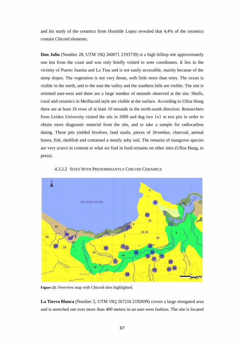
67
and his study of the ceramics from Humilde Lopez revealed that 4,4% of the ceramics
contain Chicoid elements.
Don Julio (Number 28, UTM 19Q 260071 2193739) is a high hilltop site approximately
one km from the coast and was only briefly visited to note coordinates. It lies in the
vicinity of Puerto Juanita and La Tina and is not easily accessible, mainly because of the
steep slopes. The vegetation is not very dense, with little more than trees. The ocean is
visible in the north, and to the east the valley and the southern hills are visible. The site is
oriented east-west and there are a large number of mounds observed at the site. Shells,
coral and ceramics in Meillacoid style are visible at the surface. According to Ulloa Hung
there are at least 16 rows of at least 10 mounds in the north-south direction. Researchers
from Leiden University visited the site in 2009 and dug two 1x1 m test pits in order to
obtain more diagnostic material from the site, and to take a sample for radiocarbon
dating. These pits yielded bivalves, land snails, pieces of Strombus, charcoal, animal
bones, fish, shellfish and contained a mostly ashy soil. The remains of mangrove species
are very scarce in contrast to what we find in food remains on other sites (Ulloa Hung, in
press).
4.3.2.2 SITES WITH PREDOMINANTLY CHICOID CERAMICS
La Tierra Blanca (Number 2, UTM 19Q 267216 2192699) covers a large elongated area
and is stretched out over more than 400 meters in an east-west fashion. The site is located
Figure 23. Overview map with Chicoid sites highlighted.

68
on a medium-high hill covered in grass and several trees, surrounded by other medium
high hills and by a depression on the southern side. It is exemplary of one of the sites
embedded in the valley, surrounded by many low hilltops in the vicinity. The ocean is
visible from the site, as well as large parts of the valley. La Tierra Blanca is easily
accessible as it is right next to a main road. The site is cross-cut by a small unpaved road.
During previous research a total of nine mounds were recorded.
Starting on the eastern side of the hill, nine shovel tests were made in the western
direction on the southern side of this small road, three of which contained shell, ceramics
and coral while the remainder was marked as ‘negative’. Another 18 shovel tests were
dug on the northern side of the road, eight of which contained shell, ceramics and stone.
One sherd was in typically Chicoid style. The seven most western pits were all negative.
These shovel tests functioned as a means to establish the general area of the site, and to
observe if La Tierra Blanca and Maria Rosa were part of one and the same site. It was
concluded that these were in fact two different sites because of the absence of
archaeological remains for in a large area between the sites. A 1x1 m test pit was dug at
shovel test 4. In the first layer, 0-10 cm, shell, Chicoid ceramics, bone, and stone was
found. A piece of pottery with an anthropomorphic decoration on it was also excavated.
The bivalves in this layer are rather large. In the 10-20 cm layer there were similar finds,
although less than the in the first layer, eventually ending in the natural soil. The profile
of the pit was recorded with a photograph.
Maria Rosa (Number 3, UTM 19Q 266908 2192848) is located 200 m from La Tierra
Blanca, also easily accessible from the main road. It is placed somewhat higher than La
Tierra Blanca on a hilltop, covered in trees and tall grass. Possible mounds are hard to
discern because of the high degree of surface and soil disturbance. There 9 or 10 small
elevations on the site, but these are not necessarily anthropogenic mounds. The ocean is
visible from the northern side, and although Maria Rosa and La Tierra Blanca are located
very near to each other, both sites seem to have a very different character in terms of the
setting of the sites. While the latter has a very elongated and sloping character, Maria
Rosa is a bit higher up, on a steeper hill, and a bit more circular and flat in shape.
However, it was impossible to map the site area accurately because of tall grass, the
restriction of a fence, and the high degree of looter pits. These factors also made it
difficult to select the location for a test-pit. Shovel tests were made to explore the
possibilities for a test pit. Three of six shovel tests were positive. Surface material
consisted of bivalves and some Chicoid style ceramics. A 1x1 m test pit was opened at
the location of shovel test 2. Shell and ceramics were found in both the 0-10 cm and the

69
10-20 cm layer, although there was less in the lower layer. No clearly decorated ceramics
were encountered in the pit.
Jacinto Aracena (Number 5, UTM 19Q 266208 2191502) is located on a steep, high
hilltop in the southern part of the valley, and is not too easily accessible because of its
steep slopes overgrown with tall grass and bushes. The ocean and part of the valley are
visible from the site. Low-growing vegetation is dense on the larger part of the slope,
which is now used for cattle to graze. This, and the fence on top of the hill, made it
impossible to map the site exact area accurately. The length is approximately 160 m and
the width is circa 70 m, in an east-west orientation. Shovel tests were dug from west to
east in order to approximate the site area. Ten out of 15 shovel tests were negative, only
two contained ceramics out of a total of five pits which also contained shell. There were
decorated ceramics in Chicoid style as well as undecorated ceramics.
Persio Polanco (Number 8, UTM 19Q 269807 2196804), also known as Don Persio, is
located on a high hilltop with steep slopes in the north of the area, encompassed by the
ocean on three sides. Approximately half the site has been bulldozed about two meters
deep (Figure 24), the intact half is densely vegetated with small trees and bushes. Not
only the ocean, but also the sea inlet to the west is visible from Persio Polanco, as well as
the valley to the south. The site Los Manatís lies at the banks of the sea inlet, and is
named after the presence of manatees in the national park in which it is located. During
the summer 2010 visit 10 mounds could be distinguished and their coordinates were
recorded. During previous surveys ceramic material was collected, and the site is
designated as a Chicoid site, although some Meillacoid ceramics have been retrieved.
Figure 24. Aerial photograph of Persio Polanco, where the
bulldozed area is clearly visible on the western side (INDHRI 2000).

70
La Mara (Number 11, UTM 19Q 269688 2191708) is one of the two non-hilltop sites
which is not located at the coast. La Mara consists of a flat area located near the Rio
Encantamiento, at the foothill of the site Los Muertos. There is a small artificial lake
created to provide water for livestock; unfortunately this construction destroyed most of
the site. Now the site is very sparsely scattered with shells and ceramics, which made it
impossible to map it accurately. Currently it is used as a grazing area for cattle. Earlier
surface collections have recovered shells, ceramics, mortars and hammerstones. The site
was labeled as a Chicoid site.
Cristobal Gomez (Number 15, UTM 19Q 269593 2192331) is the other site located on a
large, flat plain. The location near a road makes it easily accessible. The site has a very
limited view of only the surrounding hills. Cristobal Gomez is covered in low grass and
several trees, and is used as land for cattle to graze. There are stone slabs visible on the
surface, and the landowner explained that when he tried to use this land to grow some
crops it failed because of the difficulty to plough with such a large amount of stones in
the soil. A small stream runs by the site, and there are natural bodies of water in the
vicinity. The general area of the site was identified and recorded, but no archaeological
material was collected. The site is approximately 140 m east to west by 150 m north to
south. Ceramics collected during earlier surveys are in Chicoid style. Other finds include
shells (mainly bivalves), pestles, and fragments of ochre. A shovel test produced a large
number of marine shells and mangrove species. According to the landowner there were
human burials present at the site. Cristobal Gomez is different from the surrounding
Chicoid sites in the sense that is located on a low, flat plain.
Elida (Number 22, UTM 19Q 269362 2192931) is located on the slope of a low hill in
the vicinity of Los Mangos, at the northern side of the main road. It is an easily
accessible, medium high site with three small mounds scattered in a circular fashion
between several trees. Eilda is different from other sites in the area because it is located
on the slope of a hill, not on a flat plain or a hilltop. Only a small portion of the western
valley and a larger area of the eastern valley to the south are visible from this site.
Besides shell, coral and stone, Chicoid style ceramics were also collected during the
surface survey.
El Rastrillo (Number 27, UTM 19Q 271194 2191454) is a medium high-hilltop site
surrounded by higher hills and is difficult to access. The site lies in the vicinity of Los
Muertos, Los Corniel, Los Pinones and El Lucio. The hilltop is a circular flat plain and is

71
covered in some trees and bushes. Nine mounds were recorded aligned in a more or less
circular pattern, covering approximately 2000 m², and with a depression in the centre.
The surface survey produced Chicoid ceramics as well as shell material. A natural body
of water which collects water from the surrounding hills is located at the base of the hill
on the southwestern side.
El Lucio (Number 32, UTM 19Q 271521 2190889) was the most difficult site to access,
and was completely overgrown with trees, bushes, and plants. Ravines with large, loose
rocks and slippery, muddy walls are part of the slopes on several sides of the hill. After
following the guide climbing these with the help of lianas we were under the impression
that there was finally a site in the area which was truly hard to get to. However, we were
both unpleasantly surprised and relieved when the route back, via the northern slope, was
an easy walk down a smooth, grass covered slope. El Rastrillo is located down this slope.
Although the site is at a relatively high altitude, the view is limited to the eastern valley.
Two small test-pits were excavated in order to retrieve some archaeological material from
the site. Bivalves, mangrove oysters, a retouched flake, a fragment of the lip of a
Strombus shell and ceramics were collected from the shovel tests with a maximum depth
of 35 cm, but a surface survey was impossible because of the extremely dense vegetation.
Some of the ceramics had typical Chicoid style decorations.
Los Corniel (Number 13, UTM 19Q 270391 2191952) is located near La Muchacha, and
the two sites have a clear view of each other. Los Corniel is a medium-high hilltop site,
oriented northwest-southeast, near the Rio Encantamiento, which runs between the two
sites. The site is accessed from the road after crossing a few fields and the river. The view
is mainly restricted to medium high hilltops in the vicinity, the southern hills, and small
part of the ocean to the northeast. At the time of the visit the site was densely overgrown
with thorned bushes which made any kind of survey impossible. However, this site was
also visited in January 2010 at which time Los Corniel was only covered low grass and
recently planted crops. It was clear that the whole hilltop, at rather flat area of least 150 m
in length, was covered in shell and ceramics. During previous research by Ulloa Hung 18
mounds were observed. A 1x2 m trench was excavated on a mound located on the
southern side of the site. The amount of archaeological material increases as the depth
increases first 20 cm, with mainly dietary remains. In the 20 to 40 cm layer the
archaeological material is more abundant. Mangrove shells and bivalves are the most
prevalent. A sample of charcoal was taken for radiocarbon dating. Archaeological
material was very scarce below 40 cm. Ulloa Hung’s study of the ceramics from Los
Corniel revealed that 11,1% of the ceramics contains Meillacoid elements.
72
There is abundant evidence of looters activities on the site, with huacero-pits
particularly at the base of the mounds. Remains of at least two human burials on the
western slope, one of which was a juvenile were reported by local people. According to
local accounts the burials excavated at the foot of a mound were associated with
archaeological material, suggesting the existence of burial offerings consisting of pottery.
Further excavations on Los Corniel might reveal more information on the burial practices
in the area.
Edilio Cruz (Number 10, UTM 19Q 268073 2192263) has been partially excavated by
José Oliver (UCL) and his team of Puerto Rican and US archaeologists. Located on a
medium high-hill in the valley, the site is sparsely covered in large trees and is
approximately 500 m in length. The view is limited to the southern part of the valley. The
top of the hill is flattened, this is possibly artificial. There are at least 10 mounds on the
site. Circular depressions might indicate the location of houses, where waste was swept
outside. According to looters, there were human burials near or under the possible
housing. There is a high level of site preservation which is one of the reasons why it was
selected to excavate. Furthermore it is located next to one of the main roads in the area,
which makes it easily accessible. The Rio Encantamiento runs 200 m from the site and is
a seasonal river which runs dry outside of the rain season. Excavations revealed similar
finds as elsewhere in the area, with a lot of dietary remains and ceramics. The ceramics
found are in a simple Chicoid style, although 16% of the ceramics contained Meillacoid
elements (Ulloa Hung, in press).
From El Coronel (Number 34, UTM 19Q 267266 2190319), on the northern slope of the
southern hills, and at an altitude of approximately 250 m, the entire research area is
visible. In the west the view is restricted by the southern hills, where the far northwestern
end of the Cordillera Septentrional flows into the ocean. El Coronel lies south of the road
from Punta Rucia to Rancho Manuel. The surface of the hilltop is irregular, which makes
it difficult to distinguish mounds, and is oriented north-south. The surface appears as one
with a depression in the middle. The looters pit was located on the fringe of this
depression. As suggested at Edilio Cruz, this circular depression might indicate a
sweeping area. The site was covered in trees and tall grass. A looters pit revealed that
archaeological material is present until a depth of 75 cm. Mostly shell and some Chicoid
style ceramics were collected from the surface; 28% of the ceramics contained Meillacoid
elements (Ulloa Hung, in press).

73
La Muchacha (Number 12, UTM 19Q 269111 2191983) is a high hilltop-site, with quite
steep slopes. Since it lies next to the main road it is easily accessible. It is partially
covered in trees, but the larger part is covered in low grass. The eastern side of the hill
views over the valley and the two ranges of hills in the north and the south (Figure 25)
and over the ocean in the northeast. The orientation is roughly north-south, but the extent
of the site could not be mapped in all directions due to a fence in the western part and
dense vegetation at another part. There are numerous traces of looter activity on the site.
Surface material was collected, and a 1x1 m test pit was dug on top of the hill on the
eastern side. This pit contained a wealth of archaeological material up until 90 cm deep,
consisting of ceramics, shell, fish bones, crab, manatee bone, stones, charcoal, and coral.
Specific finds from La Muchacha include very typically Chicoid ceramics, a possible
hearth, and a specimen of Strombus which showed traces of being in the middle of the
process of getting cut. Many shells were mangrove species. The archaeological material
retrieved from the pit consists wholly of dietary material, except for one piece of flint
which was found. At several points samples were taken for radiocarbon dating, which
resulted in calibrated dates (2σ) ranging from 1300 to 1445, and from 1439 to 1632. In
the 70-80 cm layer a cluster of stones and charcoal was encountered, which was possibly
a fireplace. The ceramics, among which some adornos, were mainly in Chicoid style. The
wall profile was drawn, and soil samples were taken from each layer by Ulloa Hung. His
study of the ceramics from La Muchacha revealed that 28% of the ceramics contained
Meillacoid elements.
Figure 25. Western view from La Muchacha.

74
Los Muertos (Number 19, UTM 19Q 269637 2190783) has earned its name from the
amount of burials which were present on this high hilltop, none of which have been
preserved. Los Muertos is quite hard to access, a one hour hike starting at La Mara, then
following a creek to the foothill, on through dense vegetation and patches of burned trees
is necessary to get to the top of this hill. The dimensions of the site are approximately 190
m north-south and 90 m east-west. This site has a view to the north over the western as
well as the eastern valley, up to the ocean. Currently it is overgrown with tall grass, and
cattle grazes at the top despite the steepness and the high altitude. In the recent past this
area has been used as a tobacco plantation, and the site has been looted almost
completely. According to locals’ accounts human burials, associated with well-crafted
Chicoid ceramics, often in zoomorphic or anthropomorphic shapes, were present at the
site. Some of these objects have made their way to the collection of local amateur
archaeologists, like complete ceramic vessels and a skull with what appear to be
pathological lesions. The pottery collected from Los Muertos in these local collections is
sometimes produced in a very crude manner which suggests the presence of possible
Meillacoid elements. Furthermore stone tools, beads, celts, hematite and ochre were
found at the site. Shell material yielded dietary remains as well as scrapers and burins.
Survey was impossible because of the dense vegetation, the tremendous amount of cow
dung, and due to the fact that most of the site was already looted. A survey was
conducted in search for petroglyphs at the Rio Encantamiento running around the foothill,
but none were found. The water level in the rivers changes a lot over the year and was
low at the time of the survey, exposing large rocks on the banks.
Rafo (Number 31, UTM 19Q 260811 2192886) is located on Mr. Rafael Sánchez’s
property on a rather flat plain on high hilltop near the ocean, at the far northwestern end
of the Cordillera Septentrional. The view from Rafo encompasses the ocean as well as the
valleys to the east. Within 500 m of the site is an area with caves, which the I have named
Las Cuevas de Rafo because these are also located on Rafael Sánchez’s land. The site is
relatively easily accessible. A surface survey produced several large coral slabs, as well
as Chicoid style ceramics and shells. The mounds present on this site are aligned in a
circular fashion and have a flat surface or depression in the centre, similar to what has
been observed at the Edilio Cruz site. Due to time restraints only one coordinate was
noted, although other coordinates were used in the field to calculate the width of one of
the mounds.
Similar to Humilde Lopez, Los Piñones (Number 33, UTM 19Q 271043 2190796) is
placed on three plateaus surrounding a high hilltop, although this is more in step-by-step

75
way rather than in a circular way. The site is located in the vicinity of Los Corniel, Los
Muertos, El Lucio and El Rastrillo. One of the looters pits indicates the presence of
archaeological material up to a depth of 70 cm. There are five mounds spread over these
plateaus on different altitudes, with a total altitude difference of about 20 m. Set on the
northeastern slope of the southern hills, the view of Los Piñones is limited to the eastern
valley. Surface survey produced a large amount of shell, undecorated and Chicoid
ceramics, and a stone axe.
4.3.2.3 UNDETERMINED SITES
Los Bros (Number 6, UTM 19Q 267903 2194935) is one of the few coastal sites in the
area, located at the beach of Punta Rucia. The site is located approximately 200 m from a
possible resource extraction area. Los Bros was briefly visited and could not be mapped
accurately, only a general GPS location for the site could be recorded. The site was
completely overgrown with very dense thorny bushes which made any kind of survey or
an approximation of the site dimensions difficult. Maize, papaya and sweet potatoes are
currently cultivated at the site, and surface material is very scarce. Food remains and
some pieces of pottery were found, but there were no diagnostic sherds. There were also
hammer stones and pieces of coral found at the site, and it is suggested that Los Bros was
a settlement site associated to the resource extraction area mentioned above (Ulloa Hung,
in press).
Los Manatis (Number 7, UTM 19Q 272065 2196745) is another coastal or rather a
riverbank site; and it is easily accessible. The site is located in a national park, which is
designated due to the presence of manatees in the nearby sea inlet and mangroves. Los
Manatis consists of a large area of scattered shell material on the western bank of Estero
Hondo (the Hondo Estuary). There are no recordings of ceramic material at this site,
which has never been excavated or thoroughly surveyed. However, Ostionoid ceramics
have been found at the site of Los Patos located on the eastern bank of the estuary. Los
Manatis appears to have functioned mainly as a resource extraction area.
El Solar de Sepelin (Number 9, UTM 19Q 271679 2194110) is located right next to a
road, and would be easily accessible if not for a house and garden which are lay on top of
the site. The location and altitude of the site restricts the view to surrounding hills. During
a previous visit it was estimated that at least five mounds were present in an east to west
orientation. Archaeological material is very scarce, and there was no diagnostic pottery
obtained from the site.

76
The situation at La Mina de Adolfo (Number 14, UTM 19Q 266135 2191704) is similar.
As the name of the site states, the area where this site was located is used for mining, or
more specifically the extraction of limestone for the construction of the road to Punta
Rucia. Only very small fragments of ceramics could be found – not just at the location of
the site but also along many parts of the aforementioned road. Only the location could be
recorded.
Local landowners pointed us to the location of José Enrique Quiñones (Number 16,
UTM 19Q 264800 2191227) where several years ago a stone in the shape of an iguana
was found. This location was on a low hill near a flat plain, causing a limited visibility.
There was no archaeological material visible on the surface at this location, which is why
only one coordinate was taken to indicate the general location.
Located on a medium high hilltop near José Enrique Quiñones, Rafael Quiñones
(Number 18, UTM 19Q 264422 2191052) has a broad view over the valley to the
northwest, in the direction of Puerto Juanita. With the exception of a few trees the site
was only covered in grass. The site is easily accessible from a nearby road. There were
five low mounds on the site of Rafael Quiñones. Some pieces of shell and ceramics could
be collected. Unfortunately none of the ceramics were clearly decorated.
La Cota (Number 24, UTM 19Q 268977 2194162) is located on top of a relatively high
hill with a broad view over the ocean and a partial view of the valley to the south. The
site is easily accessible and is covered in grass. The general area of the site was recorded
with the GPS, while a 1x1 meter test pit was dug on the northern side of the site after an
earlier attempt on the eastern side which revealed no finds. Test pit number 2 contained
shell, ceramics, stone, bone and coral. Sterile soil was reached at 30 cm depth. No
diagnostic ceramics were found. During a visit in 2008 14 mounds were identified.
However, these could not be distinguished during the last visit in 2010.
Nino Acosta (Number 25, UTM 19Q 268638 2194150) is located on a very steep and
relatively high hill only 200 m away from La Cota, and is oriented east-west. The site is
less than 2 km away from the ocean. Due to very dense vegetation Nino Acosta was only
briefly visited. The ocean is very well visible from the site, but only part from the valley
in the south is visible. The hilltop is covered in pieces of shell and some ceramics, but no
diagnostic sherds could be found. There are 6 mounds on the site, but possible damage
due to bulldozing made it impossible to observe them during the 2010 visit.

77
The caves of Rafo (Number 29, UTM 19Q 261666 2192784) are located at the foothills
near Rafo and Don Julio. These caves have unfortunately collapsed. However, the
landowner stated that he had found archaeological material in these caves in the past. One
coordinate was recorded for the general location of these interconnecting caves, to
indicate the area where these were placed.
Guzmancito (36), Los Judios (37), Paradero (38), and Arturo Payero (39) were all
visited during the summer of 2010. However, the sites lie outside of the research area in a
different landscape setting and are geographically segregated from the Punta Rucia area.
The aforementioned sites are therefore not included in analyses in this thesis. The sites of
Elto (Number 41, UTM 19Q 269060 2195672), Tiburcio (Number 42, UTM 19Q
265361 2192697), Los Patos (Number 43, UTM 19 Q 272278 2196705), Gregorio
(Number 44, UTM 19Q 266922 2192074), and Juan Antonio (Number 45, UTM 19Q
267538 2194556) are included although they were not visited because these are located in
the research area. Only coordinates are known from these sites.

78

79
5 ANALYSIS & RESULTS
5.1 INTRODUCTION
The extensive dataset discussed in Chapter 3 allows for many different analyses, covering
a broad spectrum. ‘Social landscape’ is in itself a broad term, encompassing and being the
sum of numerous factors concerning both people and the environment. The former is a
complex aspect when dealing with any type of analysis; only measurable variables can be
analysed. This is one of the causes of the obliteration of people from computer models.
Analyses such as least-cost-paths attempt to approach human (inter)action, but are in fact
an image of different paths which would have been the most efficient to travel between
for example several sites. This only becomes relevant when these are combined with
variables concerning human choice, for example with the placement of settlements or
ceremonial sites. However, there are still countless variables concerning human agency
which cannot be reconstructed and therefore not be incorporated into a computer model.
For example, interaction with specific other people while on route to the coast might
make one take an ‘inefficient’ route. Assuming that interaction with other people has
played was rather substantial in the area in pre-Columbian times, this might have
happened more often than not. This could be on a regular as well as on an irregular basis.
However if it is on a regular basis one might argue that it actually comprises two paths,
from point A to B, and from B to point C. Furthermore, in this area most sites are located
on low hilltops, which would make the least-cost-path analysis becomes useless to
approach human action.
The 40 sites located in the research area all have their own characteristics and set
of ceramics. In which way or how frequent people actually interacted is not traceable. In
other words, there are dots on the map but these cannot be connected with any substantial
arguments. The data produced by the analyses performed, in which the sites are always
placed in a larger context; either site-to-site or site-to landscape, culminates in a broad-
stroked image of the social landscape in the discussion. This chapter commences with the
analysis of the placement of sites in the landscape by analysing the locations of types of
sites, occurrence of mounds, geomorphology, altitude, and the proximity to the sea. On a

80
site-to-site basis analysis has been performed on the proximity of other sites and on
viewsheds and intervisibility. Detailed site plans are only characterized because few are
available which are not fit for analysis. Results are briefly discussed in terms of site
patterning, and the possibility of making a predictive model for the area.
5.2 SITES & THE LANDSCAPE
The landscape is the main focus in this research, and in the following paragraph the
possible roles of specific settings of the sites are explored. Site types in combination with
geomorphology and soil and the proximity to the ocean and fresh water are analysed in
order to conclude whether patterns can be discerned. An overview of analysed variables
is presented in table 5. A column containing information on the presence of different
ceramic styles, as discussed at specific site descriptions in the previous chapter, is also
included in the table due to the indication of subsistence strategies carried out in the study
area. This will be further examined in Chapter 6.
5.2.1 SITE TYPES
As site patterning is part of the main research question, the occurrence of different types
of sites is a relevant variable. However, during the fieldwork it has become clear that the
only distinction which could be made was that between a resource extraction site and a
settlement site. There are no evident ceremonial sites in the area. Although two of the
sites are located in or near a set of caves, El Búren on the northeast coast and Las Cuevas
de Rafo located inland in the southwest of the area, only the former has been thoroughly
researched. Moreover, El Búren is a settlement site located on the small strip of land
between the caves or rock shelters and the ocean. Due to the lack of different types in this
sense, conclusions about site pattering concerning such site types are not possible in the
study area. However, it is noted by Moore (1991a) that Archaic Age sites in several areas
of Haiti also tend to be located close to the coast, while ceramic sites in that same area are
located further inland on higher hilltops. Settlement size, as used by Koski-Karrell
(Koski-Karrell 2002), is also a variable which cannot be included due to the lack of detail
and data on this.
5.2.2 GEOMORPHOLOGY AND SOIL
The placement of sites in the landscape is the key factor in this study. As visible in figure
26, the sites are rather equally dispersed over the landscape. The red squares represent

81
sites indicated as sites with predominantly Meillacoid style ceramics and the blue
triangles represent sites indicated as Chicoid, based on the ceramics analysis performed
by Jorge Ulloa Hung (Ulloa Hung, in press). The diamonds represent sites where only
undecorated pottery was found.
The nine Meillacoid sites are generally aligned in a curve following the coastline,
with three sites forming a second line located slightly further inland. There is great
diversity in altitude, ranging from a sea level site like La Tina to a high hilltop site such
as Humilde Lopez with an altitude of between 180 and 200 meters. The altitude
indications are divided in ranges of twenty meters because of the general differences in
altitude within a site, as well as the level of detail of the DEM and contour maps used.
The majority of the Meillacoid style sites are located on the lower hills. The larger part of
these sites occurs in the limestone, clay and sandstone area, and several sites are located
on the border between two types of soils.
Chicoid style sites are located on higher hilltops further inland, and most of them
are rather clustered in the southeastern part of the research area. The sites are aligned
following the Cordillera Septentrional instead of the coastline, which causes these sites to
be more frequently located at higher altitudes. The Chicoid style sites demonstrate the
same patterns as the Meillacoid in terms of geomorphology (Table 2), with the majority
in the limestone and sandstone area, and several on the borders of two different types of
soils. However, there are no sites in the marshy areas.
Table 2. Number of sites present in different geomorphological profiles.

82
Figure 26. Map with locations of Meillacoid (red) and Chicoid sites (blue).
5.2.3 PROXIMITY TO THE OCEAN AND FRESH WATER
The amount of rivers and other bodies of water is rather high in the area due to the
location at the foothills of the Cordillera Septentrional, combined with the sloping
character of the hills. Without exception, all sites are located within 1.5 km from a river
or another body of water besides the ocean. On average, this would take approximately
20 minutes to walk. The majority of the sites, 19, are within 500 m or approximately a
six-minute walk from a fresh water source. When the distinction between Meillacoid and
Chicoid sites is made, the following tables (Table 3 and 4) demonstrate the differences.
The number indicates in what radius, in steps of 500 m, a body of water is located.
Legend
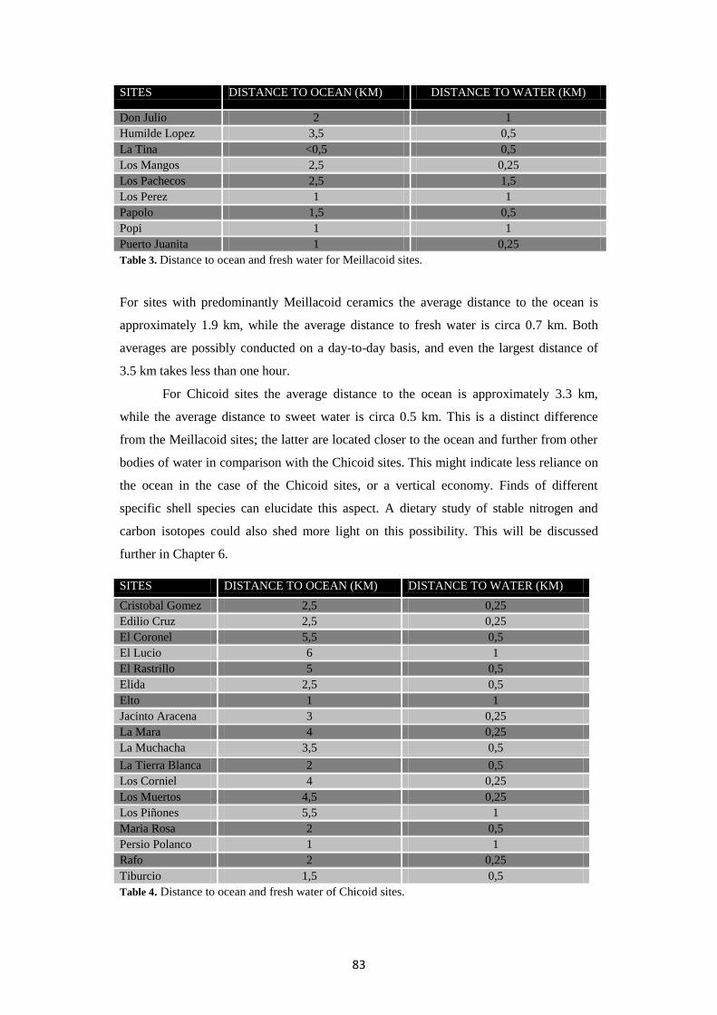
83
SITES DISTANCE TO OCEAN (KM) DISTANCE TO WATER (KM)
Don Julio 2 1
Humilde Lopez 3,5 0,5
La Tina <0,5 0,5
Los Mangos 2,5 0,25
Los Pachecos 2,5 1,5
Los Perez 1 1
Papolo 1,5 0,5
Popi 1 1
Puerto Juanita 1 0,25
Table 3. Distance to ocean and fresh water for Meillacoid sites.
For sites with predominantly Meillacoid ceramics the average distance to the ocean is
approximately 1.9 km, while the average distance to fresh water is circa 0.7 km. Both
averages are possibly conducted on a day-to-day basis, and even the largest distance of
3.5 km takes less than one hour.
For Chicoid sites the average distance to the ocean is approximately 3.3 km,
while the average distance to sweet water is circa 0.5 km. This is a distinct difference
from the Meillacoid sites; the latter are located closer to the ocean and further from other
bodies of water in comparison with the Chicoid sites. This might indicate less reliance on
the ocean in the case of the Chicoid sites, or a vertical economy. Finds of different
specific shell species can elucidate this aspect. A dietary study of stable nitrogen and
carbon isotopes could also shed more light on this possibility. This will be discussed
further in Chapter 6.
Table 4. Distance to ocean and fresh water of Chicoid sites.
SITES DISTANCE TO OCEAN (KM) DISTANCE TO WATER (KM)
Cristobal Gomez 2,5 0,25
Edilio Cruz 2,5 0,25
El Coronel 5,5 0,5
El Lucio 6 1
El Rastrillo 5 0,5
Elida 2,5 0,5
Elto 1 1
Jacinto Aracena 3 0,25
La Mara 4 0,25
La Muchacha 3,5 0,5
La Tierra Blanca 2 0,5
Los Corniel 4 0,25
Los Muertos 4,5 0,25
Los Piñones 5,5 1
Maria Rosa 2 0,5
Persio Polanco 1 1
Rafo 2 0,25
Tiburcio 1,5 0,5

84
5.2.4 OCCURRENCE OF MOUNDS
Although the exact function and shaping of the mounds are as of yet unknown or at least
much debated, the occurrence of these mounds on many sites in the area is a variable
which needs to be taken into account for site patterning. As highlighted in figure 27, the
mounds occur in the limestone, calcareous clay and sandstone area as well as in the
lacustrine and marine deposits area. Covering all four geomorphological areas, with
locations close to the sea as well as on high hilltops in the south, these ecological factors
are unlikely to have been a reason for the presence of mounds on a site. Mounds are
present on six out of nine Meillacoid sites, and on nine out of 18 Chicoid sites, as well as
on three sites with undecorated pottery. Furthermore, mounds are present on both sites
with a flat, circular plan and an elongated, linear plan.
Figure 27. Presence of mounds on the sites highlighted in red.

85
SITES
CE
RA
MIC
S
RA
DIO
CA
RB
ON
DA
TE
S (
2σ
ra
ng
e)
PE
RC
EN
TA
GE
OF
DIF
FE
RE
NT
ST
YL
E
OF
CE
RA
MIC
S
GE
OM
OR
PH
OL
OG
Y
AL
TIT
UD
E (
M)
DIS
TA
NC
E T
O S
EA
(KM
)
DIS
TA
NC
E T
O
WA
TE
R (
KM
)
Cristobal Gomez C - - 1 20-40 2,5 0,25
Edilio Cruz C 1160-1420 CE 16% 2 40-60 2,5 0,25
El Coronel C - 28,6% 1 220-240 5,5 0,5
El Lucio C - - 1 100-120 6 1
El Rastrillo C - - 1 80-100 5 0,5
Elida C - - 2+1 40-60 2,5 0,5
Elto C - - 1 40-60 1 1
Jacinto Aracena C - - 1 100-120 3 0,25
La Mara C - - 1 40-60 4 0,25
La Muchacha C 1300-1445 CE 28,8% 2+1 60-80 3,5 0,5
La Tierra Blanca C - - 1 60-80 2 0,5
Los Corniel C - 11,1% 2+1 60-80 4 0,25
Los Muertos C - 22,3% 1 120-140 4,5 0,25
Los Piñones C - - 1 140-160 5,5 1
Maria Rosa C - - 1 60-80 2 0,5
Persio Polanco C - - 4 60-80 1 1
Rafo C - - 1 120-140 2 0,25
Tiburcio C - - 1 80-100 1,5 0,5
Don Julio M 1227-1278 CE 4% 1 120-140 2 1
Humilde Lopez M 1031-1206 CE 4,4% 2+1 180-200 3,5 0,5
La Tina M - - 3 <20 <0,5 0,5
Los Mangos M - - 1 40-60 2,5 0,25
Los Pachecos M - - 1 60-80 2,5 1,5
Los Perez M 1296-1428 CE 22,2% 1 40-60 1 1
Papolo M - - 1 40-60 1,5 0,5
Popi M 1019-1150 CE 4,8% 1 20-40 1 1
Puerto Juanita M 1267-1402 CE 12% 2+3 20-40 1 0,25
El Burén/Las Paredes A - - 1 <20 <0,5 1
Los Patos O - - 3 <20 <0,5 1
El Solar de Sepelin U - - 2 <20 2,5 0,5
Gregorio U - - 2 80-100 2,5 0,25
José Enrique Quiñones U - - 2+1 100-120 3 0,5
Juan Antonio U - - 3 <20 0,5 0,25
La Cota U - - 1 40-60 1,5 1,5
La Mina de Adolfo U - - 1 - 2,5 0,25
Las Cuevas de Rafo U - - 1 80-100 2 1
Los Bros U - - 1 <20 <0,5 0,25
Los Manatis U - - 2 <20 <0,5 1
Nino Acosta U - - 1 40-60 1,5 1,5
Rafael Quiñones U - - 2 120-140 3 0,5
Table 5. Overview of all sites, with radiocarbon dates, percentages of ceramics from a different style than the predominant one at
the site (after Ulloa Hung, in press), and locational factors. C=Chicoid, M=Meillacoid, A=Archaic, O=Ostionoid U=Unknown.

86
5.3 SITES IN RELATION TO OTHER SITES
The location as well as the view of other sites might play a role in the choice of site
location. During the fieldwork it has increasingly become clear how different these views
are while two sites might be located quite near each other. The importance of these
factors is explored below.
5.3.1 PROXIMITY TO OTHER SITES
The proximity to other sites places the site into an archaeological context. As with all
other factors it needs to be taken into account that many of these sites might not be
contemporaneous. However, as extensive and detailed dating is lacking at the moment, it
is useful to examine this particular context: it reveals whether certain sites are located
near each other either synchronically or diachronically. It is known from radiocarbon
dates of several sites that both Meillacoid and Chicoid sites occur contemporaneously. In
figure 28 an example of a Chicoid site, La Muchacha, is indicated as a triangle at the
centre of a 2.5 km radius. Within this area 11 other Chicoid sites are located. This at least
indicates a preference for the location, either through time or simultaneously.
Figure 28. Example of a 2.5 km radius.

87
What becomes clear after analysis is that Chicoid sites are located in the vicinity of on
average six other Chicoid sites (33% of all Chicoid sites) in a 2.5 km radius, and of only
two Meillacoid sites (22% of all Meillacoid sites) in that same radius. However,
Meillacoid sites are located in the vicinity of four Chicoid sites (22%) and two Meillacoid
sites (22%) in the 2.5 km radius; in this case the percentages are the same (Table 6). In
absolute as well as in relative numbers there is a stronger relation between the location of
Chicoid sites than there is between Meillacoid sites.
5.3.2 VISIBILITY
Another possibly relevant factor is the visibility and intervisibility of the sites. Because
the landscape is fairly ‘open’ there is a high level of visibility on most sites, as noted
during the fieldwork. Concerning altitudes the landscape is roughly divided into four
sections: the coast, the lower northern hills, the valley, and the higher southern hills.
Broadly, these four sections come with their own specific views, although there is some
variation within the sections as well as similarities between them. A Digital Elevation
Model or DEM is necessary in order to render a viewshed analysis. For each site several
coordinates across the site, all at an eye altitude of 150 cm, were used. Many sites are
located on and around hilltops which would give each point a different view. The
analyses show that on average about forty per cent (Table 7) of the area is visible from a
site.
Whether there is a difference in this average between Meillacoid and Chicoid
sites, and what is visible from which sites is examined below. In the following
comparisons percentages are used because the number of Chicoid sites and Meillacoid
sites is different. With the higher altitudes of most Chicoid sites it would be expected that
these will also have wider views, and therefore more sites would be visible from these
Chicoid sites. However, looking at the overall percentages Chicoid sites have an average
visibility of 37% while the Meillacoid sites have an average visibility of 48% of the area.
This corresponds roughly with the number of sites that can be seen; Chicoid sites cover
on average 43 per cent of all sites, while for Meillacoid sites the average is 53 per cent.
Table 6. Average amount of sites within 2,5 and 1,5 km radii.

88
Per
cio P
ola
nco
Cri
stobal
Gom
ez
El
Coro
nel
El
Luci
o
El
Ras
tril
lo
Elt
o
Jaci
nto
Ara
cena
La
Mar
a
La
Tie
rra
Bla
nca
Los
Muer
tos
Los
Piñ
ones
Mar
ia R
osa
Raf
o
Tib
urc
io
Edil
io C
ruz
Eli
da
La
Much
acha
Los
Corn
iel
Don J
uli
o
Los
Man
gos
Los
Pac
hec
os
Los
Per
ez
Pap
olo
Popi
La
Tin
a
Hum
ilde
Lopez
Puer
to J
uan
ita
El
Búre
n
Los
Man
atis
Los
Bro
s
Juan
Anto
nio
Nin
o A
cost
a
La
Cota
El
Sola
r de
Sep
elin
Gre
gori
o
La
Min
a de
Adolf
o
Jose
E Q
uin
ones
Raf
ael
Quin
ones
Las
Cuev
as d
e R
afo
PE
RC
EN
TA
GE
N/C
N/M
N/U
(in
c E
B)
N/T
Percio Polanco x x v v v v v x v v v v v v x x v x v x v v x v v v v x v x x x v v x v x x v 73 12 7 5 24
Cristobal Gomez x x v x v x x v x v v x x x x v v v x v v x x x x x x x x x x x v x x x x x x 7 8 2 1 11
El Coronel v v x x v v v x v v x v v v v v v x v v v v x v v v v v x v v v v x v v x v v 72 13 8 9 30
El Lucio v x x x v v v x x x v x x x x v x x x v v v x v x x x x x x x x v v x x x x x 41 5 4 2 11
El Rastrillo v v v v x x x x v x v v v x x v v x v v v v x v x x x x x x x x v v x x x x x 32 10 5 2 17
Elto v x v v x x v x x v v x v x x x v x v x v x x v x v x x x x x x v x x x x x x 36 8 4 1 13
Jacinto Aracena v x v x x v x x v x x v x v v v v x v v v x x v v v v x x x x x v x v x v v x 51 9 7 4 20
La Mara x v x x x x x x x v x x x x x v x v x v v x x x x x x x x x x x v x x x x x x 4 4 2 1 7
La Tierra Blanca v x v x v x v x x x v x x x v v v v x v v x x v x v x x x v x v v x v v x x x 28 9 4 5 18
Los Muertos v v v x x v x v x x x x v v x v x v v v v x x v v x x v x x x x v v x x x x v 58 9 5 4 18
Los Piñones v v x v v v x x v x x x x x x v v v x v v v x v x x x v x x x x v v x x x x x 46 9 4 3 16
Maria Rosa v x v x v x v x x x x x v v x v v v v v v v x v x v x x x v v v v x x x x x v 54 9 6 5 20
Rafo v x v x v v x x x v x v x v v v v x v v v v v v v v x x x v v v v x v v v v v 61 10 8 9 27
Tiburcio v x v x x x v x x x x v v x x x v x v x v v v v x v v x x v x v v x x v x x v 24 6 7 5 18
Edilio Cruz x x v x x x v x v x x x v x x v v x x v v x x x x v x x x x x x x x x v x x x 7 6 3 1 10
Elida x v v v v x v v v v v v v x v x v v v v x x x x x v x x x x x x x x x v x x x 12 14 3 1 18
La Muchacha v v v x v v v x v x x v v v v v x v v v v v v v x v x x x x x x v x v v v v v 45 13 7 6 26
Los Corniel x v x x x x x v v v v v x x x v v x x v v x x x x x x x x x x x x x x x x x x 9 8 2 0 10
Don Julio v x v x v v v x x v x v v v x v v x x v v v v v v v v x x v v v v x v v v v v 66 11 8 9 28
Los Mangos x v v v v x v v v v v v v x v v v v v x v x x x x v x x x x x x v x x v x x x 14 15 3 2 20
Los Pachecos v v v v v v v v v v v v v v v x v v v v x x x v v v x x x x x x x v v v v x v 52 17 5 5 27
Los Perez v x v v v x x x x x v v v v x x v x v x x x x v v v x x x x v v v x x x x x x 48 9 4 4 17
Papolo x x x x x x x x x x x x v v x x v x v x x x x x v v v x x x x x x x x x x v v 40 3 4 2 9
Popi v x v v v v v x v v v v v v x x v x v x v v x x v v v x x v v v v x x v x x v 54 13 6 6 25
La Tina v x v x x x v x x v x x v x x x x x v x v v v v x v v x x v v v v x x v x v v 47 5 7 7 19
Humilde Lopez v x v x x v v x v x x v v v v v v x v v v v v v v x v x x v v v v x v v v x v 61 11 8 8 27
Puerto Juanita v x v x x x v x x x x x x v x x x x v x x x v v v v x x x v v v v x x x x v v 46 4 5 6 15
El Búren x x v x x x x x x v v x x x x x x x x x x x x x x x x x v x x x x x x x x x x 28 3 0 1 4
Los Manatis v x x x x x x x x x x x x x x x x x x x x x x x x x x v x x x x x x x x x x x 25 1 0 0 2
Los Bros x x v x x x x x v x x v v v x x x x v x x x x v v v v x x x x v v x x x x x v 39 5 5 3 13
Juan Antonio x x v x x x x x x x x v v x x x x x v x x v x v v v v x x x x v v x x x x x v 44 3 6 3 12
Nino Acosta x x v x x x x x v x x v v v x x x x v x x v x v v v v x x v v x v x x x x x v 43 5 6 4 15
La Cota v v v v v v v v v v v v v v x x v x v v x v x v v v v x x v v v x x x v x x v 54 15 7 5 27
El Solar de Sepelin v x x v v x x x x v v x x x x x x x x x v x x x x x x x x x x x x x x x x x x 13 5 1 0 6
Gregorio x x v x x x v x v x x x v v x x v x v x v x x x x v x x x x x x x x x v x x x 6 6 3 1 10
La Mina de Adolfo v x v x x x x x v x x x v v v v v x v v v x x v v v x x x x x x v x v x v x x 43 8 6 3 17
Jose E Quinones x x x x x x v x x x x x v x x x v x v x v x x x x v x x x x x x x x x v x x x 4 3 3 1 7
Rafael Quinones x x v x x v v x v x x v v v v v v x v v v v v v v v v x x v v v v x v v v x v 70 10 9 8 27
Las Cuevas de Rafo v x v x x x x x x v x v v v x x v x v x v x v v v v v x x v v v v x x x x v x 57 7 8 5 20
Table 7. Overview of visibility ranges and sites visible, with a summary of the results below.
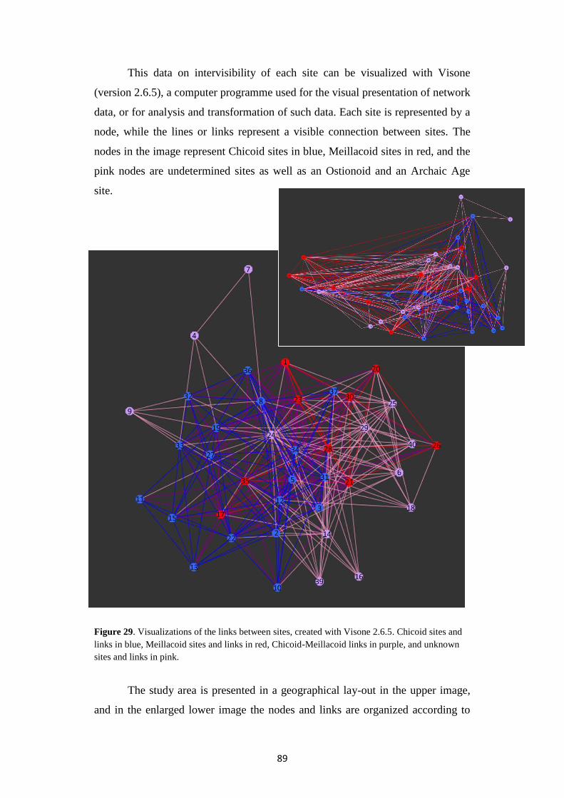
89
This data on intervisibility of each site can be visualized with Visone
(version 2.6.5), a computer programme used for the visual presentation of network
data, or for analysis and transformation of such data. Each site is represented by a
node, while the lines or links represent a visible connection between sites. The
nodes in the image represent Chicoid sites in blue, Meillacoid sites in red, and the
pink nodes are undetermined sites as well as an Ostionoid and an Archaic Age
site.
Figure 29. Visualizations of the links between sites, created with Visone 2.6.5. Chicoid sites and
links in blue, Meillacoid sites and links in red, Chicoid-Meillacoid links in purple, and unknown
sites and links in pink.
The study area is presented in a geographical lay-out in the upper image,
and in the enlarged lower image the nodes and links are organized according to

90
their ‘degree’, or the numbers of links attached. In other words, the most visually
connected site is placed near the centre of the image, while the least connected
sites are placed on the fringes. With the different colour indications it becomes
clear in the lower image that although several Chicoid sites are well-connected, or
located near the centre, most Meillacoid sites are in general located rather near the
centre.

91
5.4 SITE PLANS
Sites where mounds have been recorded were thoroughly mapped with the handheld
GPS, although this was not always possible due to vegetation or other restrictions. In
some cases the visibility of the mounds has changed over time, which is the reason why
several sites have more mounds listed than were eventually recorded in 2010. The result
is a detailed site plan of six sites, one of them incomplete due to destruction of a large
part of the site. The site plans will only be described and characterized because only six
could be mapped in some detail. The mounds are indicated with same-sized half-circular
symbols, and the dark grey areas are rough indications of the general site-area, identified
by the scatter of archaeological material such as shells and ceramics. These images are all
a top view of the site, generating a 2D overview of the general area and mound locations.
All images are depicted on the same scale and are oriented according to figure 30, the top
being the north quarter of the compass. The figures were created by adapting the rather
Figure 30. Overview of the locations of the site-plan images indicated in red on cut outs of the military map.

92
basic AutoCad 2007 map and the Global Mapper map with Adobe Photoshop CS5
Extended. These maps were incorporated as different layers on which the simplified
figures were drawn.
5.4.1 CHICOID SITES
The sites Rafo, El Rastrillo and Elida were mapped thoroughly with the GPS. Persio
Polanco was mapped, but the resulting image is incomplete because there is a clear cut-
off of the site where it has been bulldozed (Figure 24 and 32). Another site, Los Piñones,
was also mapped, but the exact location or presence of mounds was difficult to identify
because of the location on the slope of a hill. The sites covered three different ´levels´,
each 2 to 4 m higher than the other. The exact altitude differences and contours of the hill
have not been mapped with a handheld GPS. A detailed 3D-model, which is necessary to
map the site and exact mound locations accurately, could therefore not be created.
Without such an accurate 3D model the image would not accurately represent the site
plan on a 2D image.
Rafo, Elida and El Rastrillo have several characteristics in common. All three are
located on a rather flat area, whether on the top of a hill at the foothill. The surface
scatter, usually consisting of shell material and small pieces of ceramics, is in a rather
circular shape. However, Persio Polanco reveals different characteristics. It is located
along a hilltop and both the mounds and the surface scatter follow the ‘spine’ of the hill.
It is noted to have 22 mounds, but only 9 could be mapped. The straight cut-off in the
darkened area on the image in figures 31 and 32 depicts the line from which the site has
been completely destroyed. According to the local guide Adriano Rivera, the site used to
continue westward for at least 30 metres.
Figure 31. Site plans of Chicoid sites Rafo, El Rastrillo and Elida.
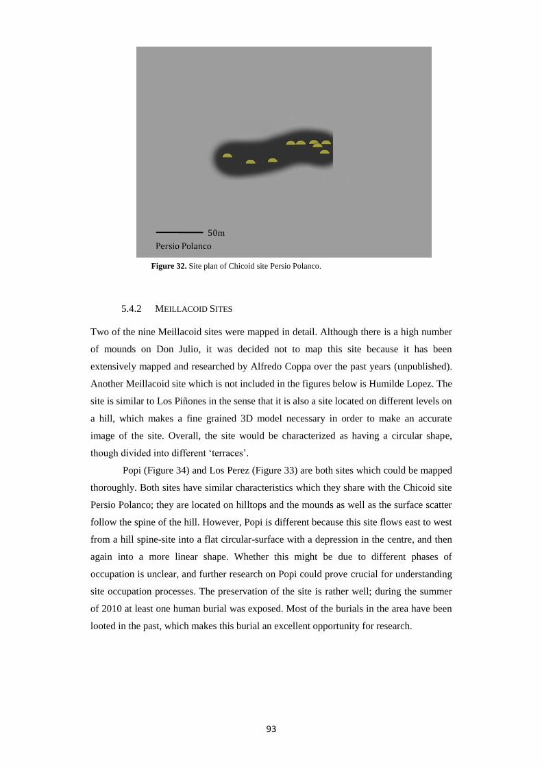
93
5.4.2 MEILLACOID SITES
Two of the nine Meillacoid sites were mapped in detail. Although there is a high number
of mounds on Don Julio, it was decided not to map this site because it has been
extensively mapped and researched by Alfredo Coppa over the past years (unpublished).
Another Meillacoid site which is not included in the figures below is Humilde Lopez. The
site is similar to Los Piñones in the sense that it is also a site located on different levels on
a hill, which makes a fine grained 3D model necessary in order to make an accurate
image of the site. Overall, the site would be characterized as having a circular shape,
though divided into different ‘terraces’.
Popi (Figure 34) and Los Perez (Figure 33) are both sites which could be mapped
thoroughly. Both sites have similar characteristics which they share with the Chicoid site
Persio Polanco; they are located on hilltops and the mounds as well as the surface scatter
follow the spine of the hill. However, Popi is different because this site flows east to west
from a hill spine-site into a flat circular-surface with a depression in the centre, and then
again into a more linear shape. Whether this might be due to different phases of
occupation is unclear, and further research on Popi could prove crucial for understanding
site occupation processes. The preservation of the site is rather well; during the summer
of 2010 at least one human burial was exposed. Most of the burials in the area have been
looted in the past, which makes this burial an excellent opportunity for research.
Figure 32. Site plan of Chicoid site Persio Polanco.

94
Figure 33. Site plan of Los Perez.
Figure 34. Site plan of Popi.

95
5.5 PATTERNING AND THE SOCIAL LANDSCAPE
Most of the factors discussed reveal a difference in Meillacoid and Chicoid preferences,
these are mainly evident in site location and in visibility. Overall, it can be stated that in
this particular area Meillacoid sites are usually located within 2.5 km (with one
exception) from the ocean and within 1 km (one exception) from a water source.
However, Chicoid sites are usually located within 5.5 km (one exception) from the ocean,
and not more than 1 km from a water source. Chicoid sites are for the larger part located
on the higher hilltops, either in the same area through time or in the vicinity of on average
six other Chicoid sites. Despite the high altitude and the proximity of other sites, Chicoid
sites have a smaller visibility range than Meillacoid sites. Many Chicoid sites are located
on rather flat hilltops, while the location along the ‘spine’ of a hill is more typically
Meillacoid. However, there is a great variety among site plans of both.
Despite these differences in specific characteristics, it needs to be made clear that
there are many similarities between the Meillacoid and Chicoid sites as well. Not unlike
the island of Hispaniola itself or even the pan-Caribbean, the whole area is simply a
patchwork of different sites, pottery styles and people where diversity and interaction
have most likely been the common denominators.
5.6 PREDICTIVE MODELLING
Besides setting up a database one of the aims of this thesis was to explore the possibilities
of predictive modelling. This has become a less important research question while doing
analyses and while writing this thesis. First of all, the geographical study area is very
small. Due to the lack of detail in soil and precipitation maps it would only be possible to
create a very coarse grained predictive model. Secondly, sites are scattered all across the
area, both on hilltops and in the valley, as well as at the coast and deep inland, which
would make the whole area one of high archaeological interest. Without a higher degree
of detail in both the aforementioned maps as well as in information and cover of surveys
it would not be useful to create an accurate predictive model for this area. Such pitfalls
and difficulties using predictive modelling are not unknown in other larger projects
(Kamermans 2007). However, there are definitely possibilities when looking at a larger
scale; for example (large parts of) Hispaniola. Predictive modelling might prove a useful
exercise either through expanding the scale or acquiring more detailed information on a
smaller area. Suggestions for further research are discussed in the concluding chapter.

96

97
6 DISCUSSION
6.1 INTRODUCTION
Results presented in the previous chapter will be put into context in the discussion below.
The different results will be examined in terms of what these entail, and what their
significance is. How these compare to previous research, and whether they produced
different or similar patterns to this research will be explored in this paragraph. An
evaluation of the research questions follows, concluding with an evaluation of how these
have been addressed.
6.2 RESULTS
In the introductory chapter it was explained that there were two main goals for this thesis:
a scientific analysis of the social landscape which sheds light on matters of interaction
and patterning, and the creation and use of a general database. Combined with Ulloa
Hung’s study on the ceramic styles this would produce a coherent and inclusive regional
vision. The design and utilization of the database has proven to be of great advantage,
which in turn was one of the other aims. The analyses performed enable us to address
most of the research questions, while fieldwork has also played a key role.
6.2.1 THE LOCATION OF SITES IN THE LANDSCAPE
The main distinction that could be made was between sites with predominantly
Meillacoid or with predominantly Chicoid ceramics. The analysis of these two types in
combination with the geomorphology resulted in a rather homogenous image, without
significant differences in the choice of for example the clay grounds of the river deposits
or the older areas with limestone. However, the most significant difference between
Meillacoid and Chicoid sites is the location in the landscape. While Meillacoid sites are
located more or less aligned with the coastline, the Chicoid sites are located mostly on the
hills of the Cordillera Septentrional, roughly in a line from the west-northwest to the east-

98
southeast. This automatically caused the difference in the distance to the ocean, with a 1.4
km higher average for Chicoid sites. As suggested in Chapter 5 there could be different
reasons for this. All sites located in the high southern hills contained large amounts of
marine shells, and often also mangrove oysters. This indicates that the ocean played an
important part in the subsistence strategy of the inhabitants of Chicoid sites as well. The
largest distance to the ocean is from the Chicoid site Los Piñones at 5.5 km. This means a
walk of a little over an hour, or a total of 3 hours counting the collection of shells and the
way back, which is easily performed on a day to day basis, and therefore does not
indicate a vertical economy; however it does not refute the idea of a vertical economy
either.
If one would argue that all sites in the area are coastal sites because all but one
are within a mere 5 km from the coast, the main difference is that of the altitude. Even the
Chicoid sites closer to the coast tend to be placed at higher altitudes. This will be put
further into context below, in the section of comparability with related research. The
difference in the proximity to fresh water is a mere 200 m, with averages of 700 m for
Meillacoid sites and 500 m for Chicoid sites. The area nowadays has at least 80 mm of
rainfall in the dry months, and 230 mm in the wet season. This in combination with the
sloping character of the hills produces natural water basins. Furthermore, the area is full
of rivers of different sizes. It needs to be stressed that these are mere ecological and
environmental factors, and that there could be numerous other factors playing a role in
preference of site location which cannot be obtained archaeologically.
6.2.2 SITES AND THEIR RELATIONS TO OTHER SITES
The relation of sites to other sites was studied through both intervisibility and the
proximity to other sites. Chicoid sites tend to be located more in the vicinity of other
Chicoid sites than Meillacoid sites. This is most evident in the southeastern part of the
research area. Since only one site in this area has been dated, it cannot be concluded
whether these sites were located in each other’s vicinity contemporaneously or if this area
was the location of choice over a longer period of time. This factor makes the results in
general hard to interpret. The possibility of the importance of visibility became more and
more evident during the surveys. These observations were recorded during the fieldwork,
and when this was impossible due to dense vegetation the DEM was used to create a
viewshed analysis. Observations and the reliability of the DEM were cross-checked with
each other. The use and significance of these analyses is debated. One of the problems is
the spurious correlation between visibility and height. Sites might be located on a higher
altitude for a different reason such as simply catching a bit more wind. However, higher
locations tend to have a greater visibility, and are therefore statistically more likely to

99
have a larger amount of sites visible (Wheatly and Gillings 2002). As discussed in the
previous chapter, the Chicoid sites are generally located at a higher altitude, but have less
visibility. Even more so, Chicoid sites and Meillacoid sites within a few hundred metres
from each other even have visibility range differences of 20 per cent. This was also
experienced in the field: one hilltop has a restricted view caused by surrounding hills
which are only a bit higher, and the other has a very wide view because of its exact
location between lower surrounding hills. The differences between Meillacoid and
Chicoid sites in visibility ranges and the amount of sites visible are an indication that
visibility did play a role in site location, and that it was not a ‘side effect’ of ecological
factors. Another issue is the purpose of the high visibility rate. In the last decades studies
have increasingly focused on this aspect. For instance, in a study on the relationship
between cognition, perception and visibility on rock art sites in southwestern Scotland,
cumulative viewsheds were used to identify areas of ‘increased monument awareness’,
with the level of this viewed as a direct correlate of socio-symbolic importance (Gaffney
et al. 1995). This is a gross oversimplification of the complex man-land relationship;
computer analyses are in this case even used to generate the human variable. Experiences
during the fieldwork have been the most important influence in incorporating the human
variable in this research. They revealed that there were three beneficial aspects for sites
with a high visibility range. First of all, the sites catch more wind; this is desirable
because it can get very hot and damp in the area. Secondly, it is possible to predict the
weather hours in advance from specific points in the landscape, and thirdly it is very
important to keep track of everything happening around the site and possibly interact with
people. Communication is possible from a large distance as long as the individuals can
see each other. The relevance of visibility will be examined further below.
It has become increasingly clear through Ulloa Hung’s study of the ceramics that
specifically Meillacoid sites near the coast and Chicoid sites further inland show a higher
percentage of each other’s ceramic traits in their ceramic assemblage. This does indicate
connections between ocean-based Meillacoid sites and Chicoid inland sites. Overall, the
Meillacoid sites in the area date further back than Chicoid sites in the area. This is similar
to the rest of the Dominican Republic; although the calibrated radiocarbon dates of
Meillacoid and Chicoid sites do overlap based on 150 calibrated radiocarbon dates, the
latter are generally more recent (Ulloa Hung, in press). It could be suggested that the
coastal Meillacoid sites were already ‘in use’ when groups using Chicoid style ceramics
came into the region, where they settled on higher hilltops in the south. These higher
hilltops often have a view over the most important resource extraction sites: de Laguna la
Playa mangroves, where Los Manatis and Los Patos are located, and the Puerto Juanita
lagoon where Puerto Juanita and La Tina are located. The Meillacoid site Los Perez is

100
located in the vicinity of a smaller mangrove area. Both Los Muertos and El Coronel, the
Chicoid sites with the highest degrees of ‘mixed ceramics’ (Chicoid ceramics with
Meillacoid traits or elements or vice versa), have a clear view of at least two of the
mangrove areas. In turn, the aforementioned Los Perez and Puerto Juanita are the
Meillacoid sites with the highest degree of mixed ceramics. Two lines of evidence - the
presence of marine shells and the presence of the mixed ceramics - point to specific
connections between hilltop sites and marine resource extraction sites. This northern line
of Meillacoid sites might have had control of the coastal sites, but their visibility is
generally poor. However, the southern line of Meillacoid sites, located only slightly
further inland, has great visibility. Both lines are quite strategically placed, with sites
scattered throughout the valley.
6.2.3 SITE PLANS
Two main categories of site plans could be distinguished: sites in circular patterns
and sites in linear patterns. These mostly follow the contours of the hill, although not
necessarily, but they are naturally bounded by them. Hills come in all shapes, altitudes
and sizes in the area, and it is possible that the ‘right hill’ was chosen to fit the preferred
site lay-out as well as the other way around. However, both categories occur in
Meillacoid sites as well as in Chicoid sites. The one exception of Popi, on which both
types of site plan occurs, possibly consists of different phases as it is also quite large in
comparison to other sites. Further research would be necessary to confirm or refute this
claim. Although the function or production of the mounds is still debated, they were also
counted as a variable in site characterization. Mounds are present on Meillacoid as well as
on Chicoid sites, in different patterns, elevations, shapes and dimensions. The presence of
mounds was also analyzed in combination with the present soil. There was no significant
difference in the occurrence of these factors. Due to the lack of knowledge of the mounds
and their debated function it would not be expedient to come to further interpretations of
the site plans. Furthermore, the amount of research from the Dominican Republic on
house plans, household patterns and village site plans is insufficient to aid interpretation,
especially in the northern area of the island. One of the studies which does include
mounds is Veloz Maggiolo’s research on Atajadizo, located in the far southeastern
province of the Dominican Republic, where two phases were distinguished: an early
phase dating from 540 CE (Ostionoid) in which there were large, seasonally occupied
extended family houses, and a later Chicoid phase dating from the tenth century until
colonial times with small nuclear family houses on top of anthropogenic mounds,
arranged concentrically around a plaza (Veloz Maggiolo et al. 1976). In this later phase
the houses were located near their ‘agricultural mounds’ and people were buried in

101
cemeteries. Such changes or differences in site lay-out are often assumed to coincide with
a difference or change in social complexity or even in culture. Social complexity, site
plans and site hierarchy are a common topic in Caribbean archaeology. For instance, in
their article on the Anguilla Bank Crock and Petersen (2004) argue that Anguilla’s
settlement hierarchy reflected an independent chiefdom polity covering multiple islands.
This idea was based on the presence of high-status objects at certain places and the
important role of Anguillan settlements in exchange networks. The settlements in
Anguilla are assumed to be at the highest level on the inter-island settlement hierarchy
based on their dimensions, which were far greater than those of other Lesser Antillean
settlements. However, Maggiolo’s descriptions do not match what was observed at the
Chicoid sites in the area, and much more extensive research is elementary to distinguish
possible site hierarchies. For now, the available data consists of descriptions of the site
plans. These are linear as well as circular, and according to accounts of local people there
were human burials below or near mounds which are interpreted as having a domestic
function.
6.2.4 PATTERNING
The combination of all aforementioned analyzed factors culminates into
patterning of the sites. As stated above, there are differences in the preference of site
location for Meillacoid sites and for Chicoid sites. Meillacoid sites are usually located
within 2,5 km from the ocean with five sites (55% of all Meillacoid sites) within the first
1.5 km, while Chicoid sites are located within 6 km from the ocean, with only four sites
in the first 1,5 km (22% of all Chicoid sites). Lastly, predictive modelling was discussed
in Chapter 5. The use and reliability of these models is highly debatable. Predictive
models tend to rely too much on ecological or environmental factors, and assume that
these would have been the same in the past. Furthermore, data on the research area is too
crude to make a useful predictive model. Even with more detailed data, a thorough
consideration of methods and theories applied must precede the creation of a predictive
model in order for it to be feasible (Verhagen and Whitley 2011).
Surveys truly played a key role in this thesis, and the information and experiences
obtained by it proved to be the most valuable. A study on landscape and the human
presence within it cannot be done by analyzing dots on a map, soil information, and aerial
photographs. The landscape needs to be navigated by the researcher, because nothing will
reveal more about possible variables in site location preference than walking through the
valley and over the hills yourself. Ethnographic data might also be a fruitful source, but is
lacking for this area. There are ethnohistoric accounts, as described in Chapter 2, but
these mainly tell of the experiences of the past Europeans. Although the experience of the

102
researcher might not even resemble that of the past inhabitants, it does hint at which
variables to analyze in order to conclude if a specific aspect did in fact seem to play a
role.
6.3 COMPARABILITY AND COMPATIBILITY WITH RELATED RESEARCH
Jorge Ulloa Hung’s research on ceramics and processes of fusion and assimilation is
complementary to this research and vice versa. These two studies are completely
compatible as they were written rather simultaneously and in collaboration. Different
presentations (at the International Association for Caribbean Archaeology conference at
Martinique in 2011, and at Leiden in the Caribbean V at Leiden University) as well as
articles written by both (Ulloa Hung and De Ruiter 2011) have also produced a composed
and corresponding view of the area.
As noted before Koski-Karell’s research is similar to this study. Situated on the
northern coast of Haiti, the landscape resembles the landscape in the research area,
located on the other side of the border between Haiti and the Dominican Republic. The
approach Koski-Karell developed identifies and compares habitation types and
distribution on a regional-scale area and is called settlement-type distribution analysis
method. Different types of settlement were categorized based on their size, starting with
the household as the smallest and the large villages as the largest. Koski-Karell also
categorized the landscape into different terrain relief zones: waterland, shoreline, coastal
plain, river valley, piedmont, highland and montane. The combinations of these variables
were analysed for Ostionoid, Chicoid, and Meillacoid sites. The main difference is that
Koski-Karell applies an ecological approach, while this study also includes other
variables. Furthermore, he also includes data obtained from underwater site surveys,
which has not been done in this study. Although his categorizations are somewhat
different, his research is comparable to this study. The distribution of sites is rather
similar to the research area, although there is a higher percentage (37.7 %) of Meillacoid
sites located on the piedmonts and in the highlands than is the case in the area of Punta
Rucia, and there are more Chicoid sites located in the coastal areas (55.1 %). A major
difference between the two studies is that Koski-Karell concludes, among other things,
that the Chicoid expansion westward into northern Haiti may relate to apparent hostility
between Chicoid and Meillacoid groups. The picture emerging from the research area
around Punta Rucia is very different: there were Meillacoid and Chicoid groups
inhabiting the same area, and even adopting traits of the other’s ceramics. The processes
103
of ‘ceramic interaction’ are discussed in Ulloa Hung’s study. Because of the lack of
cultural factors in Koski-Karell’s study this factor is not explored in northern Haiti.
However, several researchers have noted the occurrence of different ceramic styles in
present in one site in Haiti (Moore 1999a). Site locations on the whole island of
Hispaniola show similar patterns as to what is observed in the research area. For instance,
Chicoid sites tend to cluster and are more often located further inland on higher altitudes,
while Archaic and Meillacoid sites are locates closer to the coast (Koski-Karell 2002;
Moore 1991a; 1991b; 1997; Rouse and Moore 1983). However, these are general
similarities in which local detail is lost. These studies mainly presented overviews of site
locations and survey results. Based on the data from Haiti it is suggested that there was
not only a lot of diversity within the area, but also between areas.

104

105
7 CONCLUSIONS
7.1 INTRODUCTION: AN OVERVIEW
Throughout this thesis the landscape has played the lead role. After an introduction into
the aims and central questions in this thesis and an explanation of the approach taken, the
reader is introduced to the northwestern Dominican Republic. This is done through
ethnohistoric accounts, descriptions of the physical as well as the cultural landscape, and
previous studies. The ethnohistoric accounts often speak of a lush and fertile area, which
is exactly how it would be experienced nowadays: the hills covered in grass, bushes and
trees, cultivated areas with fruit trees, maize and other crops, interspersed with small
seasonal streams and larger rivers, all surrounded by high, densely vegetated hills in the
south and limited by the ocean in the north. Buildings are sparsely scattered throughout
the landscape and are often easy to overlook; they are usually located on lower grounds
near the roads.
Following the description of the methods and theories used, and a discussion on
perception changes, the available dataset was discussed. As a study using a map related-
database it is important to discuss which maps are used. Unfortunately there were very
few and often crude maps available. Military maps at a scale of 1:50 000 were used as the
basis for the GIS, on which all data recorded during the fieldwork could be placed. Aerial
photographs sometimes aided in locating a site, or in characterizing it.
The fieldwork took place in the summer of 2010 and mainly consisted of surveys
and digging test pits on several sites. Sites were discussed in detail in terms of their
setting and the results form surface surveys and excavations. The sites are subdivided into
ceramic style categories, such as sites with predominantly Meillacoid ceramics. The data
acquired during the fieldwork was analyzed by combining map data and information on
the sites in order to establish preferences and patterns in the location of sites. Not only
ecological factors were counted, but intervisibility was also one the major factors in
analysis and the results. The possibility of the importance of this factor was noted during
the surveys in the area, and the results indicate that this was a correct assumption. All
results of the analyses were then discussed and put into context. The research questions

106
were briefly addressed with referrals to the chapters dealing with these questions for more
in depth information. Lastly, the success of the research aims was reviewed.
7.2 CONCLUSIONS: THE SOCIAL LANDSCAPE OF THE PUNTA RUCIA AREA
The main research question on what patterns in site location can tell us about the social
landscape has been gradually addressed throughout the last chapters. The social landscape
was defined as the combination of the physical landscape and the human presence and
actions which take place on it. Although conclusions on direct human actions were not
drawn, the presence of people in the landscape has been characterized and analyzed. This
was done by analyzing many aspects of sites, both in relation to the landscape and in
relation to each other. The focus in analyses lies on Meillacoid and Chicoid sites, to
determine if there are patterns in their site locations. This focus is mainly because there is
only one Archaic and one Ostionoid site in the area. The 9 Meillacoid and 18 Chicoid
sites in the area were all surveyed in a similar way, in order to enable comparison. What
emerged was a diverse image, with as many similarities as differences among and
between Meillacoid and Chicoid sites. Although patterns can be discerned, the
characteristics they comprise are not exclusive for one or the other. While Chicoid sites
are generally located at higher altitudes it does not mean that Meillacoid sites are not, and
vice versa. The location on hill-spines as well as on more circular areas area also present
on both Meillacoid and Chicoid sites, although one tends to be more prevalent at the
Meillacoid sites and the other at the Chicoid sites. This overlap of characteristics makes it
impossible to simply make a list of aspects typical for either site type. Sites without
diagnostic ceramics can therefore not be identified using typical characteristics, although
it can be suggested that there is a higher probability to be either a Meillacoid or a Chicoid
site. Still, the image of a diverse area makes for a complex picture. Of course there is
always the question what ceramic styles actually mean in terms of culture, which is the
reason why the sites were described as containing Meillacoid and Chicoid ceramics. Such
is a topic itself worthy of a doctoral dissertation. Furthermore, as discussed in the thesis,
there are other differences in between the site types as well. Specific traits of coastal and
inland sites have been interpreted as the rendition of connections between coastal
Meillacoid en inland Chicoid sites. It is postulated that earlier Meillacoid groups might
have had control over marine resource extraction sites, which ensued the interaction
between Meillacoid and Chicoid groups.

107
Overall it can be concluded that the social landscape that comes forward from this
study is what I call a patchwork of diversity, with many sites located close together,
exhibiting many different combinations of specific features, and with even a merge of
ceramic styles. The diversity of landscape features in a small area might play a factor in
this, because it allows for different preferences and strategic choices in site location. In
this thesis the image of a dynamic and diverse social landscape of the area comes forth, in
which the combination of similarities and differences are the common denominator.
7.3 SUGGESTIONS FOR FURTHER RESEARCH
As has become clear over the course of writing this thesis, further research in the area will
highly likely prove to be very fruitful. On a smaller scale the area is rather intact and still
has a lot to reveal about processes change in ceramic styles. Furthermore, extensive
research on the function or genesis of the mounds might add to the ongoing debate on this
topic. However, the function of the mounds need not be uniform, but may comprise a set
of functions. It is also needed in the Punta Rucia Area to enable better interpretations of
settlement types.
On a larger scale the topic of diversity in the landscape combined with diversity
in cultural groups can be explored on an island-scale. It is my view, based on some years
of studying Caribbean archaeology, that in the past this entire area would have been a
very diverse and dynamic whole, in which mobility and exchange played an important
role. A thorough overview and review of current knowledge of settlement patterning on
Hispaniola will be a promising start of such an endeavor. Research tends to stay on either
side of the border, which is a loss for especially landscape archaeology and settlement
patterning. The database created by me will be advantageous for such an extensive study,
and vice versa. Furthermore, it can be argued that in regions such as the Punta Rucia area,
where local knowledge is great and the area is not too affected by modern construction,
the use of an accessible database would be of great significance for the management of
cultural heritage. However, there has to be a well-established heritage management
programme in place in order for it to have any effect in the preservation of sites.

108
ABSTRACTS
SUMMARY
In this thesis titled Mapping History archaeological sites within a small region in the
northwestern Dominican Republic are mapped, in order to distinguish patterns in site
locations and to explore the social landscape in the past. The landscape in the research
area consists of beaches, swamps, mangroves, valleys, and hills up to 300 metres in
height. It is known from research by Jorge Ulloa Hung, an archaeologist currently writing
his dissertation on ceramics in the area, that there were different ceramic styles present
contemporaneously in the north of the Dominican Republic. While Ulloa Hung focuses
on the ceramics from the sites in the area, in this research the surrounding area (circa 80
km²) is mapped to provide a context for Ulloa Hung’s research. In this thesis the study on
the social landscape is the central focus. Observations and results of the fieldwork
conducted in the area were used for this study, and recorded into a map-related database
or Geographical Information System (GIS). The relation between site locations and
surroundings were analysed with the use of the created GIS. The focus of the analyses is
mainly on differences between sites with Meillacoid style ceramics and sites with Chicoid
style ceramics. The goal was to bring forth different patterns in the site locations of
Meillacoid and Chicoid sites. The diverse landscape in the area combined with the
diverse cultural landscape makes this area very suitable for such analyses. Although
there are similarities between several aspects of the sites, the area also differences.
Meillacoid sites tend to be located closer to the coast, while Chicoid sites are located
further inland. Furthermore, Meillacoid sites have a better visibility range, and are
therefore better visible themselves. There are evidently different patterns of site locations
of both kinds of sites in the area, but there is one common denominator: diversity.
SAMENVATTING
In het onderzoek Mapping History worden archeologische sites in een kleine
regio in het noordwesten van de Dominicaanse Republiek in kaart gebracht, om zo
patronen te achterhalen in site locaties en meer te weten te komen over het sociale
landschap van het verleden. Het landschap in het onderzoeksgebied bestaat uit stranden,

109
moerassen, mangroven, valleien, en heuvels tot 300 meter hoogte. Het is onder andere uit
lopend onderzoek van Jorge Ulloa Hung, een archeoloog die zijn dissertatie schrijft over
aardewerk in het gebied, bekend dat er in het noorden van de Dominicaanse Republiek
meerdere aardewerkstijlen tegelijkertijd voorkwamen. Waar Ulloa Hung gedetailleerder
onderzoek doet naar het aardewerk van de vindplaatsen in de regio, is in deze studie het
omliggende gebied (circa 80 km²) in kaart gebracht om het eerder genoemde onderzoek
meer context te geven. In deze scriptie staat onderzoek naar het sociale landschap
centraal. Voor dit onderzoek zijn de observaties en resultaten van veldwerk in de regio
gebruikt, en verwerkt in een kaartgerelateerde database of een Geografisch Informatie
Systeem (GIS) . De relatie tussen de site locaties en de omgeving van de vindplaatsen en
het landschap zijn geanalyseerd met behulp van de gecreëerde GIS. De focus van de
analyses ligt voornamelijk op het verschillen tussen sites met Meillacoid-stijl aardewerk,
en sites met Chicoid-stijl aardewerk. Er is gezocht naar verschillende patronen in de
locaties van de Meillacoid en Chicoid vindplaatsen. Het diverse fysieke landschap in de
regio in combinatie met het diverse culturele landschap maakt het gebied uiterst geschikt
voor zulke analyses. Hoewel er veel overeenkomsten zijn tussen meerdere aspecten van
de vindplaatsen, zijn er ook verschillen. Meillacoid sites bevinden zich meer langs de
kust, terwijl Chicoid sites zich meer op de hogere heuvels bevinden. Ook zijn de
Meillacoid vindplaatsen beter zichtbaar, en hebben dus ook een groter gezichtsveld. Er
zijn duidelijk verschillende patronen in vindplaats locaties van beide soorten sites in het
gebied, maar er is één gemene deler voor alle sites: diversiteit.
RESUMEN
En la investigación Maping History, se realizan mapas de los sitios arqueológicos que se
encuentran en una región pequeña del noroeste de la República Dominicanacon el fin de
descubrir patrones en sitios y a su vez para comprender el paisaje social del pasado.
El paisaje en el área de estudio esta compuesto por playas, pantanos, manglares,
valles y cerros que van hasta los 300 metros de altura. Se conoce por la investigación
proveniente de Jorge Ulloa Hung, un arqueólogo que escribió su disertación sobre la
cerámica de la zona, que en el norte de la Republica Dominicanallegaron diferentes
estilos de cerámica al mismo tiempo. En esta investigación se ha mapeado la zona
adyacente (aproximadamente 80 km²) a la región donde Ulloa Hung ha realizado la
investigación, con el fin de otorgarle más contexto a dicha investigación. En esta tesis se
encuentra la investigación sobre el paisaje social central. Para este estudio se han
utilizado y procesado las observaciones y resultados del estudio de campo en una base de

110
datos o en unSistema de Información Geográfica (SIG). La relación entre los sitios y el
entorno de los yacimientos en el paisaje han sido analizados con la ayuda del SIG creado.
El foco del análisis se centra principalmente en las diferencias entre los sitios con
cerámica del estilo Meillacoid y sitios con cerámica del estilo Chicoid. Se han buscado
diferentes patrones en los lugares de los yacimientos Meillacoid y Chicoid.
La diversidad del paisaje físico en la región en combinación con la diversidad del
paisaje cultural hacen que la zona sea ideal para este tipo de análisis. Aunque hay muchas
similitudes entre los múltiples aspectos de los yacimientos, también hay diferencias. Los
sitios Meillaicoid se encuentran a lo largo de la costa, mientras que los sitios Chicoid
estan en los cerros altos. Además, los yacimientos Meillaciod se los encuentra mejor
visibles y poseen a su vez un panorama más amplio. Existen claramente patrones
diferentes en los yacimientos lugares de los dos tipos de sitios en la zona, pero hay un
denominardor común para todos los sitios: la diversidad.

111
BIBLIOGRAPHY
-Adler, M.A., 1996. Land Tenure, Archaeology, and the Ancestral Pueblo Social
Landscape. Journal of Anthropological Archaeology 15, 337-371.
-Anschuetz, K.F., R.H. Wilshusen, and C.L. SCheick, 2001. An Archaeology of
Landscapes: Perspectives and Directions. Journal of Archaeological Research, Vol. 9,
No.2.
- Binford, L. R., 1982. The archaeology of place. Journal of Anthropological
Archaeology, 1, 5-31.
-Bright, A.J., 2011. Blood is thicker than water: Amerindian intra- and inter-insular
relationships and social organization in the pre-Colonial Windward Islands. Sidestone
Press, Leiden.
- Chiarelli, B., and F. Luna Calderón, 1987. The excavations of La Isabela, the first
European city of the New World. International journal of anthropology, 2(3), 199-210.
- Clarke, D. L., 1968. Analytical Archaeology. London: Methuen.
-Cooper, J, 2010. Pre-Columbian Archaeology of Cuba: A Study of Site Distribution
Patterns and Radiocarbon Chronologies. In: S.M. Fitzpatrick and A.H. Moss (eds), Island
Shores, Distant Pasts. Florida University Press.
- Cooper J., and R. Boothroyd, 2011. Living islands of the Caribbean: a view of the
relative sea level change from the water’s edge. In: C.L. Hofman and A. Duijvenbode,
van (eds), Communities in contact. Essays in archaeology, ethnohistory & ethnography of
the Amerindian circum-Caribbean. Leiden: Sidestone Press.
-Crock, J. and J. Petersen, 2004. Inter-Island Exchange, Settlement Hierarchy, and a
Taíno-Related Chiefdom on the Anguilla Bank, Northern Lesser Antilles. In: A.
Delpuech and C.L. Hofman (eds), Late Ceramic Age Societies in the Eastern Caribbean,
BAR International Series 1273. British Archaeological Reports, Oxford, 139-158.
112
- Cusick, J. G., 1991. Culture change and pottery change in Taino village. Paper
presented at the Proceeding of the Thirteenth International Congress for Caribbean
Archaeology. Curacao, Netherlands Antilles.
- De Booy, T., 1915. Pottery from Certain Caves in Eastern Santo Domingo, West
Indies. American Anthropologist, New series, Vol. 17(1), 69-97.
- De Grossi Mazzorin, J., C. Tavarez, and A. Coppa, 2008. Reporte Preliminar de los
Restos Arqueozoológicas de Loma Perenal: Puerto Plata, República Dominicana, XII-
XIII siglo AD. Boletín del Museo del Hombre Dominicano, 42, 317-320.
-De Waal, M. S., 2006. Pre-Columbian social organisation and interaction interpreted
through the study of settlement patterns. Doctoral thesis, Leiden University.
- Deagan, K., 1995. Puerto Real. The Archaeology of a Sixteenth-Century Sapnish Town
in Hispaniola. Gainesville: University Press of Florida.
- Deagan, K., and J.M. Cruxent, 2002a. Columbus's outpost among the Taínos Spain and
America at La Isabela, 1493-1498. New Haven: Yale University Press.
- Deagan, K., and J. M. Cruxent, 2002b. Archaeology at La Isabela America´s First
European Town. New Haven: Yale University Press.
- Farmer, K., 2011. Barbados. In: P. E. Siegel, and E. Righter (eds), Protecting heritage
in the Caribbean. Tuscaloosa: University of Alabama Press.
- Fitzjohn, M., 2007. Viewing spaces: GIS applications for examining the perception of
space in the mountains of Sicily. World archaeology, 39(1), 36-50.
- Flannery, K. V., and J. A. Sabloff, 2009. The early Mesoamerican village. Walnut
Creek, California: Left Coast Press.
- Gaffney, V., Z. Stanic, and H. Watson, 1995. The impact of GIS on archaeology: a
personal perspective. In: G.R. Lock and Z. Stanic (eds), Archaeological and geographical
information systems: a European perspective. Taylor & Francis, London.

113
- Guerrero, J.G., and M. Veloz Maggiolo, 1988. Los inicios de la colonización en
América. San Pedro de Macorís, Dominican. Republic: UCE.
-Hedges, S.B., 2001. Biogeography of the West Indies: An Overview. In: C.A. Woods
and F.E. Sergile (eds), Biogeography of the west Indies: Patterns and Perspectives.CRC
Press, Boca Raton, 15-33.
-Hofman, C.L., A. J. Bright, A. Boomert, S. Knippenberg, 2007. Island Rhythms: The
Web of Social Relationships and Interaction Networks in the Lesser Antillean
Archipelago between 400 B.C. and A.D. 1492. Latin American Antiquity 18(3): 243-268.
-Hofman, C.L. and M.L.P. Hoogland, 2011. The multi‐scales of mobility and exchange
in the pre‐colonial circum‐Caribbean. In: Hofman, C.L and A. van Duijvenbode
(eds.), Communities in contact. Essays in archaeology, Ethnohistory and Ethnography of
the Amerindian circum‐Caribbean., pp. 15-43. Leiden: Sidestone Press
- Ingold, T., 1993. The temporality of the landscape. World archaeology, 25(2), 152-174.
- Johnson, G. A., 1977. Aspects of regional analysis in archaeology. Annual Review of
Anthropology, 6, 479–508.
- Johnson, E., 2009. Life between the cracks: Uses and meanings of a past Hispaniolan
landscape at El Cabo. MPhil thesis, Leiden University.
- Johnston, R., 1998. Approaches to the Perception of Landscape. Archaeological
Dialogues 1.
-Kamermans, H., 2007. Smashing the Crystal Ball. A Critical Evaluation of the Dutch
National Archaeological Predictive Model (IKAW). International Journal of Humanities
and Arts Computing 1, 71-84.
- Koski Karell, D., 2002. Prehistoric Northern Haití: Settlement in Diachronic
Ecological Context. Ph.D. dissertation, Catholic University of America.
- Kvamme, K. L., 1997, Ranters corner: bringing the camps together: GIS and ED.
Archaeological computing newsletter, 47, 1-5.

114
- Las Casas, F. B., 1988a. Historia de Las Indias. In: Corripio (ed), Oviedo-Las Casas,
Crónicas Escogidas. Vol IV, Biblioteca de Clasicos Dominicanos: Santo Domingo.
- Las Casas, F.B., 1988b. Apologética Historia de Las Indias. In: Corripio (ed), Oviedo-
Las Casas, Crónicas Escogidas. Vol IV, Biblioteca de Clasicos Dominicanos: Santo
Domingo.
- Luna Calderón, F., 1973. El cementerio de La Unión. Provincia Puerto Plata. Boletín del
Museo del Hombre Dominicano, 2, 130-146.
- Martir Angleria, P., 1964. Décadas del Nuevo Mundo 1. José Porrua e Hijos, SUCS,
México DF.
-Moore, C., 1991a. Cabaret: Lithic Workshop Sites in Haiti. In: E.N. Ayubi and J.B.
Haviser (eds), Proceedings of the Thirteenth International Congress for Caribbean
Archaeology. Curaçao, the Netherlands Antilles, 92-104.
- Moore, C., 1991b. Report of site survey made along the coast of Haiti in the
Departments of the Nort and Northeast form December 1990-March 1991. Port au
Prince: Bureau National d'Etnologie.
- Moore, C., 1997. Settlement patterns in pre Columbian Haiti: an inventory of
archaeological sites. Port au Prince: Bureau National d'Etnologie.
- Newsom, L. A., and E. S. Wing, 2004. On land and sea: Native American uses of
biological resources in the West Indies. Tuscaloosa: University of Alabama Press.
- Oliver, J., 2008. El universo material y espiritual de los tainos. In: J.R. Oliver, C.
McEwan, and A. Casas Giberga (eds), El Caribe precolombino. Fray Ramón Pané y el
universo taino. Barcelona: Museu Barbier-Mueller and Fundacion Caixa Galicia.
- Oliver, J., 2009. Caciques and cemí idols. The web spun by Taino rulers between
Hispaniola and Puerto Rico. Tuscaloosa: The University of Alabama Press.
- Olsen Bogaert , H., 2000. Estudio de Impacto Ambiental. Selección de rutas y
topografía de líneas de trasmisión y sub-estaciones. Aspectos arqueológicos. Unpublished
work, Santo Domingo.

115
- Ortega, E., 1988. La Isabela y la Arqueología en la ruta de Cristobal Colón. San Pedro
de Macorís: UCE.
- Ortega, E. J., 2005. Compendio General Arqueológico de Santo Domingo. Vol. 1. Santo
Domingo: Academia de Ciencias de la República Dominicana.
- Ortega, E., P. Denis, and H. Olsen Bogaert, 1990. Nuevos yacimientos arqueológicos en
Arroyo Caña. Boletín del Museo del Hombre Dominicano 23, 29-40.
- Ortega, E., and M. Veloz Maggiolo, 1972. Excavación Arqueológica en el vasto
residuario indígena de de Hatillo Palma. In: Revista Dominicana de Arqueología y
Antropología. Santo Domingo: Universidad Autónoma, Facultad de Humanidades.
- Prieto Vicioso, E., 2011. Dominican Republic. In: P. E. Siegel, and E. Righter (eds),
Protecting heritage in the Caribbean. Tuscaloosa: University of Alabama Press.
- De Oviedo, G. F., 1988. Historia General y Natural de Las Indias. In: Corripio (ed),
Oviedo-Las Casas, Crónicas Escogidas. Vol IV, Biblioteca de Clasicos Dominicanos:
Santo Domingo.
- Rainey, F. G., 1941. Excavations in the Ft Liberte Region, Haiti. New Haven: Yale
University Press.
- Reid, B.A., 2008. Introduction. Archaeology and Geoinformatics: Case Studies from the
Caribbean. In: B.A. Reid (ed), Archaeology and Geoinformatics. Case Studies from the
Caribbean. Tuscaloosa, 1-9.
- Reid, B.A., and V. Lewis, 2011. A history of Archaeological Heritage Management
(AHM) In: P. E. Siegel, and E. Righter (eds), Protecting Heritage in the Caribbean.
Tuscaloosa: University of Alabama Press.
- Rothschild, B. M., F. Luna Calderon, A. Coppa, and C. Rothschild, 2000. First
European Exposure to Syphilis: The Dominican Republic at the Time of Columbian
Contact. Clinical Infectious Diseases 31, 936–41.

116
- Rouse, I. B., 1939. Prehistory in Haiti. A study in method. New Haven: Yale
University.
- Rouse, I. B., 1992. The Tainos. Rise and Decline of the people Who Greeted Columbus.
New Haven and London: Yale University.
-Rouse, I.B. and C. Moore, 1983.Cultural Sequence in Southwestern Haiti. In: L. Allaire
and F.M. Mayer (eds), Proceedings of the Tenth International Congress for the Study of
Pre-Columbian Cultures of the Lesser Antilles. Fort-de-France, 3-27.
- Santillana, S. A., 2002. Atlas de la República Dominicana y del Mundo. Santo
Domingo: Santillana.
- Samson, A.V.M., Hoogland, M.L.P, 2007. Residencia Taína: Huellas de asentamiento
en El Cabo, República Dominicana. El Caribe Arqueológico 10, 93-103.
- Samson, A. V. M., 2010. Renewing the house: trajectories of social life in the
yucayeque (community) of El Cabo, Higüey, Dominican Republic, AD 800 to 1504.
Leiden: Sidestone Press.
- Tirado, G., 2003. Los suelos de la República Dominicana. Organización Mundial para
la Agricultura y la Alimentación FAO. Santo Domingo.
- Torres, J.M., 2010. Tibes and the Social Landscape. Integration, Interaction and the
Community. In: L. A. Curet, and L.M. Stringer (eds), Tibes: People, Power, and Ritual at
the Center of the Cosmos. Tuscaloosa, 231-260.
- Torres, J.M., and R. Rodriguez Ramos, 2008. The Caribbean. A continent divided by
water. In: B.A. Reid (ed), Archaeology and Geoinformatics. Case Studies from the
Caribbean. Tuscaloosa, 13-29.
- Ulloa Hung, J., 2007. Informe del survey realizado en el norte de la República
Dominicana. Leiden: Leiden University Press.
-Ulloa Hung, J., 2010. Patrimonio Arquéologico e Identidades en la República
Dominicana. Ciencia y Sociedad, vol. XXXV, No. 4, 681-699.

117
-Ulloa Hung, J., in press. Title Forthcoming. Leiden (Unpublished Ph.D. thesis
University of Leiden).
- Ulloa Hung, J., and S. de Ruiter, 2011. Arqueología en la línea Noroeste de la República
Dominicana. Un esbozo del paisaje arqueológico y las interacciones. El Caribe
Arqueológico, 60-75.
- Vander Veen, J. M., 2006. Subsistence Patterns as Markers of Cultural Exchange
European and Taino Interactions in the Dominican Republic. Ph.D. dissertation, Indiana
University.
-Varien, M.D., 1999. Sedentism and Mobility in a Social Landscape: Mesa Verde &
Beyond. University of Arizona Press.
- Vega, B., 1990. Los Cacicazgos de La Española. Santo Domingo: Fundación Cultural
Dominicana.
- Veloz Maggiolo, M., 1971. Creación de la Asociación Dominicana de Arqueología y
Antropología. In: In: Revista Dominicana de Arqueología y Antropología. Santo
Domingo: Universidad Autónoma, Facultad de Humanidades.
- Veloz Maggiolo, M., 1972a. Resumen tipológico de los complejos relacionables con
Santo Domingo. Boletín del Museo del hombre Dominicano 1, 21-60.
- Veloz Maggiolo, M., E. Ortega, M. Sanoja, and I. Vargas, 1976. Preliminary report on
archaeological investigations at El Atajadizo, Dominican Republic. Proceedings of the
6th International Congress for the Study of Pre-Columbian Cultures of the Lesser
Antilles, Pointe a Pitre, Guadeloupe, 1976, pp. 283-294.
- Veloz Maggiolo, M., 1977. Medioambiente y Adaptacion Humana en la Prehistoria de
Santo Domingo: La formación agricultora, 2nd edition, Vol. 1. Santo Domingo:
Ediciones de Taller.
- Veloz Maggiolo, M., 2002. La Isabela: núcleo de la sociedad criolla. El Caribe
Arqueológico, 2-8.

118
- Veloz Maggiolo, M., E. Ortega, and A. Caba Fuentes (eds), 1981. Los modos de vida
Mellacoides y sus posibles origenes: Un estudio interpretativo. Santo Domingo: Editora
Taller.
-Verhagen, P. and T.G. Whitley, 2011. Integrating Archaeological Theory and Predictive
Modeling: a Live Report from the Scene. Journal of Archaeological Method and Theory,
Vol. 19, No. 1, 49-100.
- Wheatly, D., and M. Gillings, 2002. Spatial technology and archaeology: the
archaeological applications of GIS. Taylor & Francis, New York.
-Willey, G.R., 1953. Prehistoric settlement patterns in the Virú Valley, Perú.
Washington, DC: Smithsonian institution, bureau of American Ethnology bulletin 155.
- Wilson, S., 1990. Hispaniola. Caribbean Chiefdoms in the Age of Columbus. Tucaloosa
and London: The University of Alabama Press.
-Witcher, R. E.,1999. GIS and landscapes of perception. In: M. Gillings, D.J. Mattingly
and J. van Dalen (eds), Geographical Information Systems and Landscape Archaeology.
The Archaeology of Mediterranean Landscapes 3. Oxford: Oxbow, pp.13-22.

119
APPENDICES APPENDIX 1 Composed image of military maps
APPENDIX 2 Access database entry form

120
APPENDIX 2 Microsoft Access 2003 database entry form
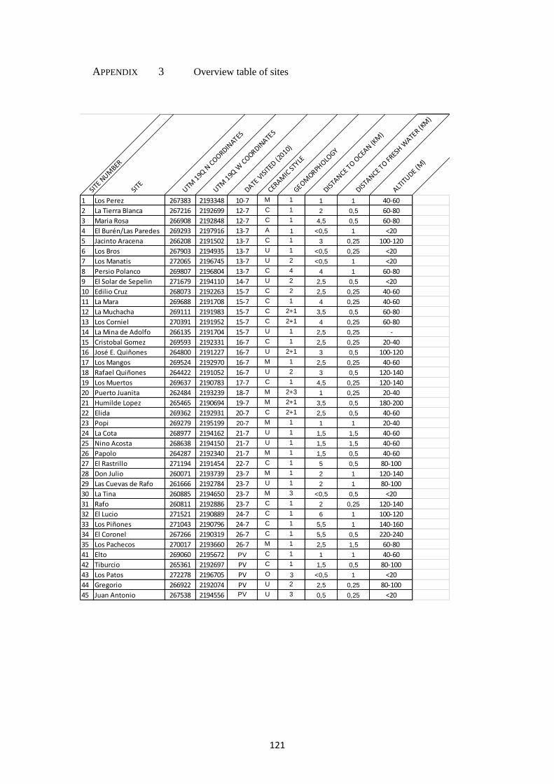
121
APPENDIX 3 Overview table of sites
SITE
NUM
BER
SITE
UTM 1
9Q N
COORDIN
ATES
UTM 1
9Q W
COORDIN
ATES
DATE V
ISIT
ED (2
010)
CERAM
IC ST
YLE
GEOMORPH
OLOGY
DISTA
NCE TO O
CEAN (K
M)
DISTA
NCE TO FR
ESH W
ATER (K
M)
ALTIT
UDE (M)
1 Los Perez 267383 2193348 10-7 M 1 1 1 40-60
2 La Tierra Blanca 267216 2192699 12-7 C 1 2 0,5 60-80
3 Maria Rosa 266908 2192848 12-7 C 1 4,5 0,5 60-80
4 El Burén/Las Paredes 269293 2197916 13-7 A 1 <0,5 1 <20
5 Jacinto Aracena 266208 2191502 13-7 C 1 3 0,25 100-120
6 Los Bros 267903 2194935 13-7 U 1 <0,5 0,25 <20
7 Los Manatis 272065 2196745 13-7 U 2 <0,5 1 <20
8 Persio Polanco 269807 2196804 13-7 C 4 4 1 60-80
9 El Solar de Sepelin 271679 2194110 14-7 U 2 2,5 0,5 <20
10 Edilio Cruz 268073 2192263 15-7 C 2 2,5 0,25 40-60
11 La Mara 269688 2191708 15-7 C 1 4 0,25 40-60
12 La Muchacha 269111 2191983 15-7 C 2+1 3,5 0,5 60-80
13 Los Corniel 270391 2191952 15-7 C 2+1 4 0,25 60-80
14 La Mina de Adolfo 266135 2191704 15-7 U 1 2,5 0,25 -
15 Cristobal Gomez 269593 2192331 16-7 C 1 2,5 0,25 20-40
16 José E. Quiñones 264800 2191227 16-7 U 2+1 3 0,5 100-120
17 Los Mangos 269524 2192970 16-7 M 1 2,5 0,25 40-60
18 Rafael Quiñones 264422 2191052 16-7 U 2 3 0,5 120-140
19 Los Muertos 269637 2190783 17-7 C 1 4,5 0,25 120-140
20 Puerto Juanita 262484 2193239 18-7 M 2+3 1 0,25 20-40
21 Humilde Lopez 265465 2190694 19-7 M 2+1 3,5 0,5 180-200
22 Elida 269362 2192931 20-7 C 2+1 2,5 0,5 40-60
23 Popi 269279 2195199 20-7 M 1 1 1 20-40
24 La Cota 268977 2194162 21-7 U 1 1,5 1,5 40-60
25 Nino Acosta 268638 2194150 21-7 U 1 1,5 1,5 40-60
26 Papolo 264287 2192340 21-7 M 1 1,5 0,5 40-60
27 El Rastrillo 271194 2191454 22-7 C 1 5 0,5 80-100
28 Don Julio 260071 2193739 23-7 M 1 2 1 120-140
29 Las Cuevas de Rafo 261666 2192784 23-7 U 1 2 1 80-100
30 La Tina 260885 2194650 23-7 M 3 <0,5 0,5 <20
31 Rafo 260811 2192886 23-7 C 1 2 0,25 120-140
32 El Lucio 271521 2190889 24-7 C 1 6 1 100-120
33 Los Piñones 271043 2190796 24-7 C 1 5,5 1 140-160
34 El Coronel 267266 2190319 26-7 C 1 5,5 0,5 220-240
35 Los Pachecos 270017 2193660 26-7 M 1 2,5 1,5 60-80
41 Elto 269060 2195672 PV C 1 1 1 40-60
42 Tiburcio 265361 2192697 PV C 1 1,5 0,5 80-100
43 Los Patos 272278 2196705 PV O 3 <0,5 1 <20
44 Gregorio 266922 2192074 PV U 2 2,5 0,25 80-100
45 Juan Antonio 267538 2194556 PV U 3 0,5 0,25 <20

122
APPENDIX 4 Fold-out overview map with site numbers
SIT
E N
UM
BE
R
SIT
ES
UT
M
19Q
N c
oord
inate
s
UT
M
19Q
W c
oord
inate
s
15 Cristobal Gomez 269593 2192331
10 Edilio Cruz 268073 2192263
34 El Coronel 267266 2190319
32 El Lucio 271521 2190889
27 El Rastrillo 271194 2191454
22 Elida 269362 2192931
41 Elto 269060 2195672
5 Jacinto Aracena 266208 2191502
11 La Mara 269688 2191708
12 La Muchacha 269111 2191983
2 La Tierra Blanca 267216 2192699
13 Los Corniel 270391 2191952
19 Los Muertos 269637 2190783
33 Los Piñones 271043 2190796
3 Maria Rosa 266908 2192848
8 Persio Polanco 269807 2196804
31 Rafo 260811 2192886
42 Tiburcio 265361 2192697
28 Don Julio 260071 2193739
21 Humilde Lopez 265465 2190694
30 La Tina 260885 2194650
17 Los Mangos 269524 2192970
35 Los Pachecos 270017 2193660
1 Los Perez 267383 2193348
26 Papolo 264287 2192340
23 Popi 269279 2195199
20 Puerto Juanita 262484 2193239
4 El Burén/Las Paredes 269293 2197916
43 Los Patos 272278 2196705
9 El Solar de Sepelin 271679 2194110
44 Gregorio 266922 2192074
16 José E. Quiñones 264800 2191227
45 Juan Antonio 267538 2194556
24 La Cota 268977 2194162
14 La Mina de Adolfo 266135 2191704
29 Las Cuevas de Rafo 261666 2192784
6 Los Bros 267903 2194935
7 Los Manatis 272065 2196745
25 Nino Acosta 268638 2194150
18 Rafael Quiñones 264422 2191052
122

123