Embed Size (px)
Citation preview

The International DORIS Service (IDS): RecentDevelopments in Preparation for ITRF2013
Pascal Willis, Frank G. Lemoine, Guilhem Moreaux, Laurent Soudarin,Pascale Ferrage, John Ries, Michiel Otten, Jerome Saunier, Carey Noll,Richard Biancale, and Brian Luzum
Abstract
The International DORIS Service (IDS) was created in 2003 under the umbrella of theInternational Association of Geodesy (IAG) to foster scientific research related to theFrench DORIS tracking system and to deliver scientific products, mostly related to theInternational Earth rotation and Reference systems Service (IERS). We first present somegeneral background related to the DORIS system (current and planned satellites, currenttracking network and expected evolution) and to the general IDS organization (from DataCenters, Analysis Centers and Combination Center). Then, we discuss some of the stepsrecently taken to prepare the IDS submission to ITRF2013 (combined weekly time seriesbased on individual solutions from several Analysis Centers). In particular, recent resultsobtained from the Analysis Centers and the Combination Center show that improvementscan still be made when updating physical models of some DORIS satellites, such as Envisat,Cryosat-2 or Jason-2. The DORIS contribution to ITRF2013 should also benefit from thelarger number of ground observations collected by the last generation of DGXX receivers(first instrument being onboard Jason-2 satellite). In particular for polar motion, sub-milliarcsecond accuracy seems now to be achievable. Weekly station positioning internalconsistency also seems to be improved with a larger DORIS constellation.
Keywords
DORIS • International DORIS Service • Jason-2 • Polar Motion • Terrestrial ReferenceFrame
P. Willis (�)IGN, Direction de la Recherche et de l’Enseignement, Saint-Mandé,France
IPGP, UMR 7154, Gravimétrie et géodésie, Université Paris Diderot,Sorbonne Paris Cité, Paris, Francee-mail: [email protected]; [email protected]
F.G. LemoineGSFC, Greenbelt, MD, USAe-mail: [email protected]
G. Moreaux • L. SoudarinCLS, Toulouse, Francee-mail: [email protected]; [email protected]
P. FerrageCNES, Toulouse, Francee-mail: [email protected]
J. RiesU. Texas, Center for Space Research, Austin, TX, USAe-mail: [email protected]
M. OttenESA, Darmstaadt, Germanye-mail: [email protected]
J. SaunierIGN, Service de Geodesie et de Nivellement, Saint-Mande, Francee-mail: [email protected]
C. NollGSFC, CDDIS, Greenbelt, MD, USAe-mail: [email protected]
R. BiancaleCNES, Toulouse, Francee-mail: [email protected]
B. LuzumUSNO, Washington, DC, USAe-mail: [email protected]
631C. Rizos, P. Willis (eds.), IAG 150 Years, International Association of Geodesy Symposia 143,DOI 10.1007/1345_2015_164
© Springer International Publishing Switzerland 2015

632 P. Willis et al.
Fig. 1 Current DORIS satellite constellation (September 2013)
1 Introduction
Following a preliminary Pilot Project (Tavernier et al.2002), an International DORIS Service (IDS) was createdin 2003 to foster international scientific cooperation forgeodesy and geophysics (Willis et al. 2010). DORIS is anacronym for Doppler Orbitography and RadiopositioningIntegrated by Satellite. The goal of this paper is to presentthe first steps taken by the IDS groups in preparationfor the next ITRF2013, to discuss new DORIS results,future improvements and possible limitations. We willpresent recent improvements related to the DORIStechnique (evolution of the satellite constellation and groundinfrastructure). Then, after a brief description of the currentIDS organization, we will detail the current IDS plans inpreparation for ITRF2013. Finally, we will provide a fewexamples showing areas where further improvements arestill required.
2 DORIS Ground and SatelliteInfrastructure
Unlike Global Navigation Satellite Systems (GNSS), thenumber of DORIS satellites changes with time as the mainapplication of this system is Precise Orbit Determination(POD) for real-time (Jayles et al. 2010) or post-processingapplications (Cerri et al. 2010; Lemoine et al. 2010) and nottime and positioning on the Earth. As of September 2013,data from five DORIS satellites can be used for geodesyand geophysics through the IDS Data Centers, including therecent Chinese HY-2A satellite and the Indian Saral satellite,both launched for altimetry.
Figure 1 shows that more DORIS satellites should alsobe launched in the next few years. According to CNES, theDORIS system could maintain operations at least until 2026(Ferrage, personal communication), if not 2030. It must alsobe noted that the most recent DORIS satellites now include

The International DORIS Service (IDS): Recent Developments in Preparation for ITRF2013 633
Fig. 2 Current DORIS tracking network and co-location with other geodetic space techniques (November 2013)
Table 1 Past and current IDS analysis centers
Analysis Center Acronym Country Software package Current status
ESA/ESOC ESA Germany NAPEOS Active
Geosciences Australia GAU Australia GEODYN Past
GeoForschungsZentrum GFZ Germany EPOS Proposed
NASA/GSFC GSC USA GEODYN Active
Geodetic Observatory of Pecny GOP Czech Rep. Bernese Active
IGN IGN France GIPSY-OASIS Active
INASAN INA Russia GIPSY-OASIS Active
CNES/CLS LCA France GINS/DYNAMO Active
onboard DGXX receivers, allowing a more robust trackingof the ground stations, thanks to their new multi-channeltechnology (Auriol and Tourain 2010). Up to seven DORISground tracking stations can be tracked simultaneously byeach of the new satellites (instead of previously only one forSPOT-2,-3, -4 and TOPEX/Poseidon and later two for SPOT-5, Jason-1, and Envisat).
Since 1993, the DORIS ground tracking network hasremained rather stable with time (Fagard 2006) with 50to 60 operating stations. As displayed in Fig. 2, this net-work is geographically well distributed and also includes alarge number of sites co-located with other space techniquessuch as Very Long Baseline Interferometry (VLBI), SatelliteLaser Ranging (SLR) and GNSS, contributing and enhancingthe development of the ITRF and its applications (Altamimiet al. 2005; Altamimi and Collilieux (2010)). For the groundequipment, only two types of DORIS antennae have been
used. The Alcatel antennae, used initially, have now been allreplaced with the Starec generation.
More information regarding these stations, such as thedescription of co-located instruments, for instance geodetictechnique instruments but also absolute gravity and tidegauges, can be found in the electronic supplement of Williset al. (2010) and also online through a GoogleEarth applica-tion developed by the IDS Central Bureau at http://ids-doris.org/network/googleearth.html).
3 International DORIS Service: CurrentStructure and Products
Like the other IAG Services, the IDS is organized as fol-lows: several Analysis Centers (see Table 1) generatingdifferent scientific products, a Combination Center (at CLS)

634 P. Willis et al.
Table 2 List of current IDS products (September 2013)
Product Format Frequency delivery From Analysis Center From Combination Center
Station coordinates SINEX Weeklyp p
Earth Orientation Parameters IDS Weeklyp p
Geocenter motion IDS Weeklyp p
Orbits sp3 Dailyp
Reference frame SINEX Yearlyp
combining these results, two Data Centers (at NASA/CDDISand at IGN) archiving the different DORIS data and products(Noll 2010), a Central Bureau (CNES/CLS/IGN) providingday-to-day operations and in particular maintaining the IDSWeb site (http://ids-doris.org), and a Governing Board givinglong-term directions and ensuring regular contact with otherentities such as the IAG, Global Geodetic Observing System(GGOS) and the IERS.
As of September 2013, six Analysis Centers (using 5 dif-ferent software packages) plan to participate in the IDS com-bination, providing weekly time series of station positionswith full covariance information in SINEX format with eithernormal equations or as loosely constrained solutions with fullcovariance information. These six individual contributionswill be merged by the IDS Combination Center (Valette et al.(2010)), providing a unique DORIS time series, which wouldthen be used by the ITRF Combination Centers (Altamimiet al. (2011); Seitz et al. 2012) to realize the future ITRF2013solution, in conjunction with similar combinations providedby VLBI, SLR and GNSS.
Table 2 displays the different products generated for theIDS by the Analysis Centers (ACs) and/or by the Combina-tion Center.
DORIS can also provide other types of scientific resultssuch as precise orbit determination, as discussed before, aswell as tropospheric Zenith Total Delays (ZTDs), as recentlyshown by Bock et al. (2010) and Stepanek et al. (2010).
4 Plans Towards ITRF2013
Almost all Analysis Centers plan to use the most recentEIGEN-6S2 gravity field (Förste et al. (2012); Rudenko et al.submitted), which augments a new static field with annualfits to time variable gravity coefficients derived from theGRACE mission (Tapley et al. (2004)) or from SLR dataoutside this period of time (Cerri et al. (2013)). As proposedfor ITRF2008, solar radiation reflectivity scaling factors orimproved macromodels will be used for all DORIS satelliteswhen modeling the radiation pressure accelerations (Gobind-dass et al. (2009); Le Bail et al. (2010)) and an atmosphericdrag parameter will be estimated more frequently (every30 min to 8 h, depending on the satellite altitude and onthe daily values of the geomagnetic indices) (Gobinddass
et al. (2010); Stepanek et al. (2010)). The implementationof the satellite attitude laws in POD software has been re-verified by some analysis centers. The periodic changesin the solar array pitch of the SPOT-5 satellite after 22January 2008, as previously detected in Gobinddass et al.(2009) are also now explicitly accounted for, followingnew information available from CNES (ftp://ftp.ids-doris.org/pub/ids/satellites/DORISSatelliteModels.pdf). Problemsrelated to some DORIS data sets were also recently cor-rected: timetagging for Envisat, South Atlantic Anomaly(SAA) effects on SPOT-5 oscillator (Stepanek et al. (2013)).
Some problems that were not previously detected andwhich affected the ITRF2008 solutions are now solved. Asan example, Fig. 3 shows that some DORIS Analysis Cen-ters did not handle properly the frequency offsets betweenthe actual frequency of the transmitted signal at 2GHz bythe beacons and its nominal value (2.03625 GHZ). Theerror, which resulted from using standard station frequencyvalue, was corrected by modifying the partial derivativesfor bias estimation. This error mostly affected the estimatedstation height, introducing discontinuities in some of theAC solutions, which were consequently propagated into thecombined solution as well as in the ITRF2008.
As shown in Fig. 3, the new solutions do not displayany discontinuity related to a change in ground oscillatorfrequency, while the previous solutions used in preparationof ITRF2008 were affected by a large discontinuity. Thisproblem is now solved and consequently should not affectthe IDS combination, nor the future ITRF2013 solution.
5 Early Results Towards ITRF2013
In preparation for ITRF2013, intensive comparisons weremade by all Analysis Groups under the direction of theAnalysis Coordinator (Frank Lemoine). Some of the orbitcomparisons for all satellites were made and some of themdemonstrated deficiencies for some of the Analysis Cen-ters. In preparation for ITRF2013, more detailed tests werealso performed for some of the DORIS orbit parameters,especially the once-per-revolution (OPR) empirical accel-erations, usually estimated once per day for each satellite.The magnitude of the empirical accelerations reflects thequality of the non-conservative force modeling and can be
The International DORIS Service (IDS): Recent Developments in Preparation for ITRF2013 635
Fig. 3 Time series of weekly station height determination for Yarra-gadee station: two solutions used for ITRF2008 and their currentpreliminary solutions for ITRF2013 (using Plottool). Previous esawd08
(in green) and gscwd06 (in black) show a clear discontinuity, comingfrom a data processing artifact
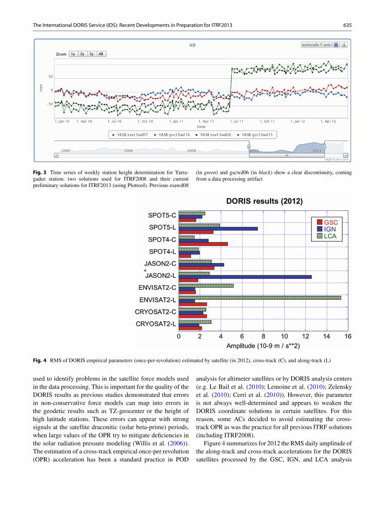
Fig. 4 RMS of DORIS empirical parameters (once-per-revolution) estimated by satellite (in 2012), cross-track (C), and along-track (L)
used to identify problems in the satellite force models usedin the data processing. This is important for the quality of theDORIS results as previous studies demonstrated that errorsin non-conservative force models can map into errors inthe geodetic results such as TZ-geocenter or the height ofhigh latitude stations. These errors can appear with strongsignals at the satellite draconitic (solar beta-prime) periods,when large values of the OPR try to mitigate deficiencies inthe solar radiation pressure modeling (Willis et al. (2006)).The estimation of a cross-track empirical once-per revolution(OPR) acceleration has been a standard practice in POD
analysis for altimeter satellites or by DORIS analysis centers(e.g. Le Bail et al. (2010); Lemoine et al. (2010); Zelenskyet al. (2010); Cerri et al. (2010)). However, this parameteris not always well-determined and appears to weaken theDORIS coordinate solutions in certain satellites. For thisreason, some ACs decided to avoid estimating the cross-track OPR as was the practice for all previous ITRF solutions(including ITRF2008).
Figure 4 summarizes for 2012 the RMS daily amplitude ofthe along-track and cross-track accelerations for the DORISsatellites processed by the GSC, IGN, and LCA analysis

636 P. Willis et al.
Fig. 5 TZ-geocenter weekly comparisons between the preliminary IDS combined weekly solution and the ITRF2008. Vertical line in bluecorresponds to a change in the DORIS constellation
centers. Some modeling problems are still evident in thesestatistics: e.g., Envisat for LCA, Jason-2 and SPOT-5 forIGN. It can also be seen that the groups that performbetter for these satellites may not perform as well for othersatellites. Systematic inter-comparisons of results betweengroups and open discussions should help to resolve suchdisparities in performance, allowing all groups to provide thebest possible results by the end of this verification phase.Early discussions already allowed some groups to identifyand to resolve modeling issues for some satellites.
However, other problems are also common to all groupsand may be more difficult to solve. For example, Fig. 5 showsthat a significant jump can be seen in the DORIS resultsfor Tz translation (from the combined solution) when thenew Jason-2 data are introduced. A more detailed analysisshowed that all groups observe this feature. This apparentdiscontinuity in Tz has two origins: (1) From the end of theavailability of DORIS on TOPEX/Poseidon (in November2004), as Jason-1 was not included in the weekly solutionsdue to the sensitivity of its Ultra Stable Oscillator (USO) toradiation in the SAA region, Jason-2 was the first satellitewith a different orbit plane (66ı of inclination compared to98ı for the rest of the DORIS constellation at that time); (2)Jason-2 is the first satellite with the so-called DORIS receiveron board that can track up to seven beacons simultaneously(compared to one for SPOT-2-4 and two for SPOT-5 andEnvisat). We interpret this change – a better centering of theTz parameter of the combination solution – as beneficial, andthus it motivated the DORIS ACs to consider the inclusionof Jason-1 from November 2004 to July 2008. The Jason-1DORIS data will be processed with the SAA data correctionprovided by Lemoine and Capdeville (2006), where the
Jason-1 station data most affected by the SAA will be down-weighted or excluded from the combination.
We also observe impacts on the Earth orientationparameters such as polar motion, when data from the newDORIS satellites (Jason-2, Cryosat-2, HY-2A) are added tothe weekly solutions. We compare in Fig. 6 the differencesin the computed EOP values with the IERS C04 series(Bizouard and Gambis 2009). The series was provided by theESA analysis center and represents a step in the developmentof that analysis center’s contribution to the IDS combinationfor ITRF2013. The largest EOP discrepancies occur prior to2002 – before SPOT-5 and Envisat started providing data. Anoticeable improvement occurs especially for the Xpole afterthe addition of Jason-2. The mean and standard deviation ofthe differences are given in Table 3 for the different timeperiods.
This improvement is due after 2008 to the large increasein the amount of data available with the new DGXX receiveronboard Jason-2 (typically 8,000 data points per day forSPOT-5 or Envisat but 17,000 for Jason-2). We note animprovement in the standard deviation of the differences withIERS C04 after the addition of each new satellite with aDGXX receiver.
The improvement in precision due the increase of DORISdata can also be seen when looking at geodetic stationpositioning. As shown in Fig. 7, DORIS station positionconsistency regularly improves with time, when consideringthe gscwd23 weekly soution, which is an improved GSFCweekly solution compared to the solution submitted beforeby this group in view of ITRF2008 (Le Bail et al. (2010)). InFig. 7, vertical bars indicate epochs of changes in the DORISconstellation.

The International DORIS Service (IDS): Recent Developments in Preparation for ITRF2013 637
5
4
3
2
1
0
X p
ole
(mas
)
–1
–2
–3
–4
–51994 1995 1998 2000 2002 2004 2005 2008 2010 2012
5
4
3
2
1
0
Y p
ole
(mas
)
–1
–2
–3
–4
–51994 1995 1998 2000 2002 2004 2005 2008 2010 2012
Fig. 6 Polar motion daily difference between the gscwd23 combined weekly solution and IERS C04 series. Vertical lines in blue correspond tochanges in the DORIS constellation
Table 3 Time evolution of polar motion differences between the esawd08 weekly solution and IERS C04 series
Period Number of DORIS satellites X pole mean/std (in mas) Y pole mean/std (in mas)
2000-001 to 2002-160 3 0.292/2.609 0.207/1.449
2002-167 to 2004-312 5 (CEnvisat C SPOT-5) 0.270/2.111 �0.177/1.009
2004-319 to 2008-195 4 (-TOPEX/Poseidon) 0.197/1.958 0.106/0.902
2008-202 to 2010-150 5 (CJason-2) 0.273/0.882 0.237/0.521
2010-157 to 2011-275 6 (CCryosat-2) 0.283/0.545 0.202/0.374
2011-282 to 2012-152 7 (CHY-2A) 0.384/0.398 0.292/0.343
Some statistics are also provided for these results inTable 4, where the increasing number of available DORISsatellites continuously improves the geodetic results, asdiscussed before in Willis (2007). Major differences aredue to the availability of the new Envisat and SPOT-5 data in mid-2002, the end of TOPEX data in 2004(which surprisingly seems to improve results at thattime) and the availability of the new Jason-2 data in late2008.
Other improvements are also under consideration inpreparation of ITRF2013, such as the use of antennaphase laws corrections for the Alcatel and Starec antennae,equivalent to the GPS phase center corrections, but onlyshowing an elevation dependency due to the nature of theDORIS transmitting antennae. Possible use of the mostrecent DORIS data provided by the HY-2A and Saralsatellites is also under consideration by different DORISACs.

638 P. Willis et al.
Fig. 7 Internal consistency of the gscwd10 (previous solution in red) and gscwd23 solution (new solution in black). 3D WRMS when comparingstation positions in 3D with the previous week. Vertical lines in blue correspond to changes in the DORIS constellation
Table 4 Time evolution of DORIS geodetic precision (WRMS) as indicated by the internal consistency of the gscwd10 weekly solution (previoussolution) and gscwd23 weekly solution (new solution). Comparison with similar results from previous week
Period Number of DORIS satellites WRMS of gscwd10 (in mm) WRMS of gscwd23 series (in mm)
1993-001 to 2002-173 3 19.71 19.54
2002-174 to 2004-318 5 15.63 15.71
2004-319 to 2008-201 4 14.15 13.79
2008-202 to 2012-365 5 11.77
6 Conclusions
In conclusion, the DORIS system should remain operationaluntil 2026, if not 2030. The IDS has started several validationstudies in preparation for ITRF2013, involving the currentsix Analysis Centers and the Combination Center. Satellite-specific and DORIS-data related problems were identifiedand most of them are now resolved. Improvements inthe accuracy of the DORIS-derived geodetic products areexpected for the future combined solution, for both thepolar motion determination and the station positioning. Suchimprovements are due to the large increase in DORIS dataper station, thanks to the new DGXX receivers on-board thesatellites, as well as improved data processing strategies:a new gravity field including time variable coefficients,satellite physical models or phase center corrections. At thetime of writing, all IDS groups are working to refine theirdata processing scheme in order to be ready in time for theIDS submission to ITRF2013.
Acknowledgements Part of this work was supported by the Cen-tre National d’Etudes Spatiales (CNES). It is based on observationswith DORIS deployed on SPOTs, TOPEX/Poseidon, Envisat, Jason-2, Cryosat-2 and HY-2A satellites. This paper is IPGP contributionnumber 3477.
References
Altamimi Z, Collilieux X (2010) Quality assessment of the IDS con-tribution to ITRF2008. Adv Space Res 45(12):1500–1509. doi:10.1016/j.asr.2010.03.010
Altamimi Z, Boucher C, Willis P (2005) Terrestrial reference framerequirements within GGOS perspective. J Geodyn 40(4-5):363–374.doi:10.1016/j.jog.2005.06.002
Altamimi Z, Collilieux X, Metivier L (2011) ITRF2008, an improvedsolution of the International Terrestrial Reference Frame. J Geod85(8):457–473. doi:10.1007/s00190-011-0444-4
Auriol A, Tourain C (2010) DORIS system, the new age. Adv SpaceRes 46(12):1484–1496. doi:10.1016/j.asr.2010.05.015
Bizouard C, Gambis D (2009) The combined solution C04 for EarthOrientation Parameters consistent with International Terrestrial Ref-erence Frame 2005. IAG Symp 134:265–270. doi:10.1007/978-3-642-00860-3_41
Bock O, Willis P, Lacarra M, Bosser P (2010) An intercomparison ofzenith tropospheric delays derived from DORIS and GPS data. AdvSpace Res 46(12):1648–1660. doi:10.1016/j.asr.2010.05.018
Cerri L, Berthias JP, Bertiger WI, Haines BJ, Lemoine FG, Mercier F,Ries JC, Willis P, Zelensky NP, Ziebart M (2010) Precision orbitdetermination standards for the Jason series of altimeter missions.Marine Geod 33(S1):379–418. doi:10.1080/01490419.2010.488966
Cerri L, Lemoine JM, Mercier F, Zelensky NP, Lemoine FG (2013)DORIS-based point mascons for the long term stability of preciseorbit solutions. Adv Space Res 52(3):466–476. doi:10.1016/j.asr.2013.03.023
Fagard H (2006) Twenty years of evolution of the DORIS permanentnetwork, From its initial deployment to its renovation. J Geod 80(8-11):429–456

The International DORIS Service (IDS): Recent Developments in Preparation for ITRF2013 639
Förste C, Bruinsma SL, Shako R, Abrikosov O, Flechtner F, MartyJC, Lemoine JM, Dahle C, Neumeyer H, Barthelmes F, BiancaleR, Balmino G, König R (2012) A new release of EIGEN-6, thelatest combined gravity field model including LAGEOS, GRACEand GOCE data from the collaboration of GFZ Potsdam and GRGSToulouse, EGU General Assembly, Geophys Res Abstracts 14,EGU2012-2821-2.
Gobinddass ML, Willis P, de Viron O, Sibthorpe A, Zelensly NP,Ries JC, Ferland R, Bar-Sever Y, Diament M, Lemoine FG (2009)Improving geocenter time series using an empirical rescaling ofsolar radiation pressure models. Adv Space Res 44(11):1279–1287.doi:10.1016/j.asr.2009.08.004
Gobinddass ML, Willis P, Menvielle M, Diament M (2010) RefiningDORIS atmospheric drag estimation in preparation of ITRF2008.45(12):1566 –1577. doi:10.1016/j.asr.2010.04.004
Jayles C, Chauveau JF, Rozo F (2010) DORIS/Jason2, Better than10 cm on-board orbits available for near-real-time altimetry. AdvSpace Res 46(12):1497–1512. doi: 10.1016/j.asr.2010.04.030
Le Bail K, Lemoine F, Chinn D (2010) GSFC DORIS contributionto ITRF2008. Adv Space Res 46(12):1471–1499. doi:10.1016/j.asr.2010.01.030
Lemoine JM, Capdeville H (2006) A corrective model for Jason-1DORIS Doppler data in relation to the South Atlantic Anomaly. AdvSpace Res 80(8-11):507–523. doi:10.1007/s00190-006-0068-2
Lemoine FG, Zelensky N, Chinn D, Pavlis D, Beckley B, Luthcke SB,Willis P, Ziebart M, Sibthorpe A, Boy JP, Luceri V (2010) Towardsdevelopment of a consistent orbit determination, TOPEX/Poseidon,Jason-1 and Jason-2. Adv Space Res 46(12):1513–1540. doi:10.1016/j.asr.2010.05.007
Noll CE (2010) The Crustal Dynamics Data Information System, Aresource to support scientific analysis using space geodesy. AdvSpace Res 45(12):1421–1440. doi:10.1016/j.asr.2010.01.018
Rudenko S, Dettmering D, Eselborn S, Schöne T, Förste C, LemoineJM, Ablain M, Alexandre D, Neumayer KH (2014) Influence of timevariable geopotential models o precise orbits of altimetry satellites,global and regional mean sea level trends. Adv Space Res 54(1):92–118. doi:10.1016/j.asr.2014.03.010
Seitz M, Angermann D, Blossfeld M, Drewes M, Gerstl M (2012)The 2008 DGFI realization of the ITRS, DTRF2008. J Geod86(12):1097–1123. doi:10.1007/s00190-012-0567-2
Stepanek P, Dousa J, Filler V, Hugentobler U (2010) DORIS dataanalysis at Geodetic Observatory Pecny using single-satellite andmulti-satellite solutions. Adv Space Res 46(12):1578–1592. doi:10.1016/j.asr.2010.04.015
Stepanek P, Dousa J, Filler V (2013) SPOT-5 oscillator instability due toSouth Atlantic Anomaly, mapping the effect and application of datacorrective model. Adv Space Res 52(7):1355–1365. doi:10.1016/j.asr.2013.07.010
Tapley BD, Bettadpur S, Ries JC, Thompson PF, Watkins MM (2004)GRACE measurements of mass variability in the Earth system.Science 305(5683):503–505. doi: 10.1126/science.1099192
Tavernier G, Soudarin L, Larson K, Noll C, Ries JC, Willis P (2002)Current status of the DORIS Pilot Experiment and the future interna-tional DORIS Service. Adv Space Res 30(2):151–155. doi:10.1016/S0273-1177(02)00279-X
Valette JJ, Lemoine FG, Ferrage P, Yaya P, Altamimi Z, Willis P,Soudarin L (2010) IDS contribution to ITRF2008. Adv Space Res46(12):1614–1632. doi:10.1016/j.asr.2010.05.029
Willis P (2007) Analysis of a possible future degradation in the DORISgeodetic results related to changes in the satellite constellation. AdvSpace Res 39(10):1582–1588. doi:10.1016/j.asr.2006.11.018
Willis P, Berthias JP, Bar-Sever YE (2006) Systematic errors in the Z-geocenter derived using satellite tracking data, a case study fromSPOT-4 DORIS data in 1998. J Geod 79(10-11):567–572. doi:10.1007/s00190-005-0013-9
Willis P, Fagard H, Ferrage P, Lemoine FG, Noll CE, Noomen R, OttenM, Ries JC, Rothacher M, Soudarin L, Tavernier G, Valette JJ (2010)The International DORIS Service (IDS), toward maturity. Adv SpaceRes 45(12):1408–1420. doi:10.1016/j.asr.2009.11.018
Zelensky N, Lemoine FG, Chinn D, Rowlands D, Luthcke S, BeckleyB, Pavlis D, Klosko S, Ziebart M, Sibthorpe AJ, Willis P, Luceri V(2010) DORIS/SLR POD modeling improvements for Jason-1 andJason-2. Adv Space Res 46(12):1541–1558. doi:10.1016/j.asr.2010.05.008