Embed Size (px)
Citation preview
Td
CI
a
ARRAA
KPLSB
1
Pi(apmsG
gstmoacb
0h
Journal of Geodynamics 64 (2013) 62– 70
Contents lists available at SciVerse ScienceDirect
Journal of Geodynamics
jo u r n al hom epage : ht tp : / /www.e lsev ier .com/ locate / jog
he Zafarraya Polje (Betic Cordillera, Granada, Spain), a basin open by lateralisplacement and bending
arlos Sanz de Galdeano ∗
nstituto Andaluz de Ciencias de la Tierra (CSIC-Univ. Granada), Facultad de Ciencias, Univ. Granada, 18071 Granada, Spain
r t i c l e i n f o
rticle history:eceived 23 April 2012eceived in revised form 5 October 2012ccepted 27 October 2012vailable online 16 November 2012
eywords:oljeateral bending basinubbetic
a b s t r a c t
The Zafarraya Polje is situated in the Subbetic (Betic External Zone), near the contact with the BeticInternal Zone. This is a small tectonic basin delimited by faults of which the main component is normal,but located among folds and reverse and dextral-reverse faults formed in a compressive context. One N–Sfault marks the western border of the basin and shows major dextral displacements in its southern part(at the SW of the basin but directly outside the basin) and major normal movements in the northern part(on the west side of the basin). This fault took on great importance in the formation of the basin, and itsmovements are not compatible with the stress ellipsoids existing during the Neotectonic period. The basinappeared just at the end of the formation process of the compressive structures, probably at the beginningof the late Tortonian, as the result of the westward push of the Internal Zone in the southernmost part of
etic Cordillera the Subbetic in this area. This resulted in an intense local compression on the present southern borderof the basin, causing a southward bending of this border and the dextral displacements of the N–S fault.Simultaneously, this movement created tension in the interior of the basin, forming different normalfaults within the basin. The whole structure constitutes a basin formed by lateral displacement andbending. Nevertheless, the sinking process of the basin has continued until the present owing to the laterradial extension in the region.
. Introduction
The Zafarraya Polje, perhaps the largest polje of the Iberianeninsula, is situated to the south of the Sierra Gorda de Loja (Spain)n the western-central part of the Betic Cordillera, in the SubbeticExternal Zone), very near the contact between the Betic Internalnd External Zones (Figs. 1 and 2). In many ways, this is a typicalolje: it is an endorheic depression, a plain with several ponors, theain one situated to the NW, where the waters disappear under the
urface to spring up many kilometres away, in the NE of the Sierraorda.
Nevertheless, some particular features bear highlighting: (1) areat part of the plain is not formed by the dissolution of the lime-tones but by the erosion of Cretaceous marls and marlstones; (2)he existing hums do not correspond to the process of karst for-
ation but rather to small tectonic horsts; (3) the NE and SE partsf the polje are filled by upper Miocene to Quaternary sediments,pparently occupying a subsident area inserted within a complex
ompressional tectonic framework. It corresponds to a peculiarasin, the origin of which is discussed here.∗ Corresponding author. Tel.: +34 644 191389.E-mail address: [email protected]
264-3707/$ – see front matter © 2012 Elsevier Ltd. All rights reserved.ttp://dx.doi.org/10.1016/j.jog.2012.10.004
© 2012 Elsevier Ltd. All rights reserved.
The basins most similar to that of the Zafarraya Polje are pull-apart basins (Aydin and Nur, 1982; Hempton and Neher, 1986), inwhich, within a transcurrent context and owing to irregularitiesin the strike of the fault, tensional rhomb-like basins are formed.Examples of such fault types can be found in many parts of theworld, as in the North Anatolian Fault, in the Dead Sea, in somefaults of California (San Andreas Fault, Garlock Fault), etc. Never-theless, the similarity with the basin of the Polje of Zafarraya isonly partial, because the main fault controlling the subsidence ofthis basin does not continue beyond the basin itself. Perhaps in thissense the present basin could be called a “semi-pull-apart basin”,although, finally, the term chosen is that of a “lateral displacementand bending basin”, which may be more descriptive.
It is also common for old transcurrent faults, when the positionand orientation of the stress ellipsoid change, to move differently,as is the case of the Cadiz-Alicante Fault in the Betic. This fault wasformerly a dextral strike-slip fault and later moved as a normalfault in some of its different segments (Sanz de Galdeano, 2008),within an ellipsoid of stress coinciding with radial tension (Sanz deGaldeano et al., 2010) that occurred at the same time during thelate Miocene to the Quaternary. This is also a factor to be taken into
account in the evolution of the basin of the Zafarraya Polje.This work examines both previous aspects concerning theformer lateral bending which created the basin and the posteriorcontinuity of the movements, then within a tensional context.
C. Sanz de Galdeano / Journal of Geodynamics 64 (2013) 62– 70 63
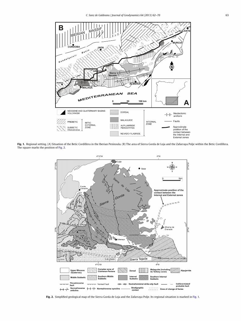
Fig. 1. Regional setting. (A) Situation of the Betic Cordillera in the Iberian Peninsula. (B) The area of Sierra Gorda de Loja and the Zafarraya Polje within the Betic Cordillera.The square marks the position of Fig. 2.
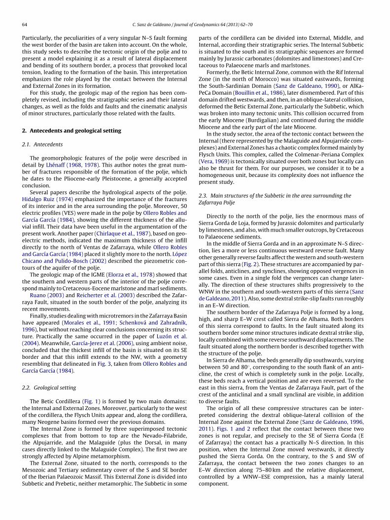
Fig. 2. Simplified geological map of the Sierra Gorda de Loja and the Zafarraya Polje. Its regional situation is marked in Fig. 1.
6 l of Ge
Pttpatea
pco
2
2
dbhc
HoeGvpedaCt
ts
rr
h1t(cbrG
2
tom
ctcs
MoS
4 C. Sanz de Galdeano / Journa
articularly, the peculiarities of a very singular N–S fault forminghe west border of the basin are taken into account. On the whole,his study seeks to describe the tectonic origin of the polje and toresent a model explaining it as a result of lateral displacementnd bending of its southern border, a process that provoked localension, leading to the formation of the basin. This interpretationmphasizes the role played by the contact between the Internalnd External Zones in its formation.
For this study, the geologic map of the region has been com-letely revised, including the stratigraphic series and their lateralhanges, as well as the folds and faults and the cinematic analysisf minor structures, particularly those related with the faults.
. Antecedents and geological setting
.1. Antecedents
The geomorphologic features of the polje were described inetail by Lhénaff (1968, 1978). This author notes the great num-er of fractures responsible of the formation of the polje, whiche dates to the Pliocene-early Pleistocene, a generally acceptedonclusion.
Several papers describe the hydrological aspects of the polje.idalgo Ruiz (1974) emphasized the importance of the fracturesf its interior and in the area surrounding the polje. Moreover, 50lectric profiles (VES) were made in the polje by Ollero Robles andarcía García (1984), showing the different thickness of the allu-ial infill. Their data have been useful in the argumentation of theresent work. Another paper (Chirlaque et al., 1987), based on geo-lectric methods, indicated the maximum thickness of the infillirectly to the north of Ventas de Zafarraya, while Ollero Roblesnd García García (1984) placed it slightly more to the north. Lópezhicano and Pulido-Bosch (2002) described the piezometric con-ours of the aquifer of the polje.
The geologic map of the IGME (Elorza et al., 1978) showed thathe southern and western parts of the interior of the polje corre-pond mainly to Cretaceous-Eocene marlstone and marl sediments.
Ruano (2003) and Reicherter et al. (2003) described the Zafar-aya Fault, situated in the south border of the polje, analyzing itsecent movements.
Finally, studies dealing with microtremors in the Zafarraya Basinave appeared (Morales et al., 1991; Schenková and Zahradník,996), but without reaching clear conclusions concerning its struc-ure. Practically the same occurred in the paper of Luzón et al.2004). Meanwhile, García-Jerez et al. (2006), using ambient noise,oncluded that the thickest infill of the basin is situated on its SEorder and that this infill extends to the NW, with a geometryesembling that delineated in Fig. 3, taken from Ollero Robles andarcía García (1984).
.2. Geological setting
The Betic Cordillera (Fig. 1) is formed by two main domains:he Internal and External Zones. Moreover, particularly to the westf the cordillera, the Flysch Units appear and, along the cordillera,any Neogene basins formed over the previous domains.The Internal Zone is formed by three superimposed tectonic
omplexes that from bottom to top are the Nevado-Filabride,he Alpujarride, and the Malaguide (plus the Dorsal, in manyases directly linked to the Malaguide Complex). The first two aretrongly affected by Alpine metamorphism.
The External Zone, situated to the north, corresponds to theesozoic and Tertiary sedimentary cover of the S and SE border
f the Iberian Palaeozoic Massif. This External Zone is divided intoubbetic and Prebetic, neither metamorphic. The Subbetic in some
odynamics 64 (2013) 62– 70
parts of the cordillera can be divided into External, Middle, andInternal, according their stratigraphic series. The Internal Subbeticis situated to the south and its stratigraphic sequences are formedmainly by Jurassic carbonates (dolomites and limestones) and Cre-taceous to Palaeocene marls and marlstones.
Formerly, the Betic Internal Zone, common with the Rif InternalZone (in the north of Morocco) was situated eastwards, formingthe South-Sardinian Domain (Sanz de Galdeano, 1990), or AlKa-PeCa Domain (Bouillin et al., 1986), later dismembered. Part of thisdomain drifted westwards, and then, in an oblique-lateral collision,deformed the Betic External Zone, particularly the Subbetic, whichwas broken into many tectonic units. This collision occurred fromthe early Miocene (Burdigalian) and continued during the middleMiocene and the early part of the late Miocene.
In the study sector, the area of the tectonic contact between theInternal (there represented by the Malaguide and Alpujarride com-plexes) and External Zones has a chaotic complex formed mainly byFlysch Units. This complex, called the Colmenar-Periana Complex(Vera, 1969) is tectonically situated over both zones but locally canalso be thrust for them. For our purposes, we consider it to be ahomogeneous unit, because its complexity does not influence thepresent study.
2.3. Main structures of the Subbetic in the area surrounding theZafarraya Polje
Directly to the north of the polje, lies the enormous mass ofSierra Gorda de Loja, formed by Jurassic dolomites and particularlyby limestones, and also, with much smaller outcrops, by Cretaceousto Palaeocene sediments.
In the middle of Sierra Gorda and in an approximate N–S direc-tion, lies a more or less continuous westward reverse fault. Manyother generally reverse faults affect the western and south-westernpart of this sierra (Fig. 2). These structures are accompanied by par-allel folds, anticlines, and synclines, showing opposed vergences insome cases. Even in a single fold the vergences can change later-ally. The direction of these structures shifts progressively to theWNW in the southern and south-western parts of this sierra (Sanzde Galdeano, 2011). Also, some dextral strike-slip faults run roughlyin an E–W direction.
The southern border of the Zafarraya Polje is formed by a long,high, and sharp E–W crest called Sierra de Alhama. Both bordersof this sierra correspond to faults. In the fault situated along itssouthern border some minor structures indicate dextral strike slip,locally combined with some reverse southward displacements. Thefault situated along the northern border is described together withthe structure of the polje.
In Sierra de Alhama, the beds generally dip southwards, varyingbetween 50 and 80◦, corresponding to the south flank of an anti-cline, the crest of which is completely sunk in the polje. Locally,these beds reach a vertical position and are even reversed. To theeast in this sierra, from the Ventas de Zafarraya Fault, part of thecrest of the anticlinal and a small synclinal are visible, in additionto diverse faults.
The origin of all these compressive structures can be inter-preted considering the dextral oblique-lateral collision of theInternal Zone against the External Zone (Sanz de Galdeano, 1996,2011). Figs. 1 and 2 reflect that the contact between these twozones is not regular, and precisely to the SE of Sierra Gorda (Eof Zafarraya) the contact has a practically N–S direction. In thisposition, when the Internal Zone moved westwards, it directlypushed the Sierra Gorda. On the contrary, to the S and SW of
Zafarraya, the contact between the two zones changes to anE–W direction along 75–80 km and the relative displacement,controlled by a WNW–ESE compression, has a mainly lateralcomponent.
C. Sanz de Galdeano / Journal of Geodynamics 64 (2013) 62– 70 65
F lts suf ig. 6 is
3
tt
bvtiFfeta(f
rdcsmitad
f
ig. 3. Geological semi-detailed map of the Zafarraya Polje. The isopachs and the faurom Ollero Robles and García García (1984). The position of the cross-sections of F
. Structure of the Zafarraya Polje
Unlike the above-described compressive structures existing inhe sector where the polje is situated, its present limits correspondo faults for which the principal component is normal.
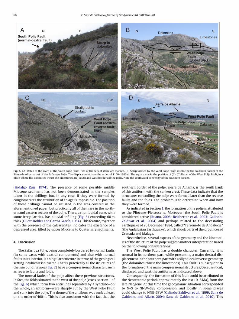
Along the southern border of the polje (i.e. along the northernorder of Sierra de Alhama) an E–W normal fault (Fig. 3) limits thealley. Ruano (2003) and Reicherter et al. (2003) called this faulthe Zafarraya Fault, but it would be better to avoid using this namen different contexts; therefore, here it is called the South Poljeault. This fault separates lower Liassic dolomites, to the south,rom Cretaceous marls and marlstones in the polje. Its scarp is wellxposed locally, where several sets of striae are visible. Some ofhese indicate pure normal movements while others have a rake ofpproximately 40◦ to the E, showing dextral-normal displacementsFig. 4A); some other intermediate striae also appear. The dip of theault is approximately 70◦ to the north.
The South Polje Fault is cut by another one near Ventas de Zafar-aya (Fig. 3). This latter fault of Ventas de Zafarraya, of NNW–SSEirection, presents a wide friction zone, with minor structures indi-ating a complex history of movements. There, the rocks weretrongly fractured and later were easily eroded, facilitating the for-ation of the so-called Boquete (breach), a major discontinuity
n the relief of Sierra de Alhama where the road passes. Despitehe pronounced friction and throw (uplifting the west side) from
geometrical standpoint, the South Polje Fault is practically notisplaced laterally in this area of the Ventas de Zafarraya.
To the west, the South Polje Fault is limited by one major faultorming the western border of the polje, a N–S fault (West Polje
rrounding them in the central and northern part of the polje are taken and deduced indicated.
Fault) which northern end coincides with the NW limit of the basin.This fault has a dip varying from 60◦ to 85◦ east and in its northernpart the visible striae have a rake of 90–80◦N—that is, there the faultshows practically pure normal movements with a throw on theorder of several 100 m. Here, in the northern part, several other sub-parallel faults also have a normal character. To the south, the faultcuts through the Sierra de Alhama (Fig. 3). There, the main striaeobserved have a rake of 25◦N, corresponding to dextral strike-slipmovements with a reverse component. The dextral displacementis on the order of 1100–1200 m, giving rise to a prominent reliefthat transversally cuts the south border of the Sierra de Alhama(Figs. 4B, C and 5).
On the northern and eastern borders of the polje, Jurassic car-bonates crop out, and only near the Almendral can Cretaceous marlsbe seen. On the surface no fault is visible, but geophysical data(Ollero Robles and García García, 1984), together with the strati-graphic columns of several survey wells, indicate the presence of amarked change of the height of the basement, implying the exist-ence of faults along this border.
The interior of the polje is practically a plain covered by soilsand Quaternary sediments with the exception of the western andsouthern parts (Fig. 3). In the western part, there are several out-crops of Jurassic limestones bordered, where the contact is visible,by normal faults. These outcrops correspond to the hums of thepolje and around some of them appear Cretaceous sediments, these
latter occupying particularly the SW part of the polje.Calcarenites and marls of the upper Miocene in the polje areknown only from borehole samples, some at a depth exceeding130 m, which in several cases do not reach the Jurassic limestones
66 C. Sanz de Galdeano / Journal of Geodynamics 64 (2013) 62– 70
F markeS 00–1p polje
(Mtcoaestwd
4
(fsta
Ittao
ig. 4. (A) Detail of the scarp of the South Polje Fault. Two of the sets of striae are
ierra de Alhama, out of the Zafarraya Polje. The displacement is on the order of 11lace where the dolomites thrust the limestones. (D) South and west borders of the
Hidalgo Ruiz, 1974). The presence of some possible middleiocene sediment has not been demonstrated in the samples
aken in the drillings but, in any case, if they were formed byonglomerates the attribution of an age is impossible. The positionf these drillings cannot be situated in the area covered in theforementioned paper, but practically all of them are in the north-rn and eastern sectors of the polje. There, a rhomboidal zone, withome irregularities, has alluvial infilling (Fig. 3) exceeding 60 mhick (Ollero Robles and García García, 1984). This feature, togetherith the presence of the calcarenites, indicates the existence of aepressed area, filled by upper Miocene to Quaternary sediments.
. Discussion
The Zafarraya Polje, being completely bordered by normal faultsin some cases with dextral components) and also with normalaults in its interior, is a singular structure in terms of the geologicaletting in which it is situated. That is, practically all the structures ofhe surrounding area (Fig. 2) have a compressional character, suchs reverse faults and folds.
The normal faults of the polje affect these previous structures.n fact, the folds situated to the west of the polje (cross-section 1 of
he Fig. 6) which form two anticlines separated by a syncline—onhe whole, an antiform—were sharply cut by the West Polje Faultnd sunk into the polje. The dome of the antiform was sunk at leastn the order of 400 m. This is also consistent with the fact that thed. (B) Scarp formed by the West Polje Fault, displacing the southern border of the200 m. The square marks the position of (C). (C) Detail of the West Polje Fault, in a. Note the southward convexity of the southern border.
southern border of the polje, Sierra de Alhama, is the south flankof this antiform with the sunken crest. These data indicate that thestructures controlling the polje were formed later than the reversefaults and the folds. The problem is to determine when and howthey were formed.
As indicated in Section 1, the formation of the polje is attributedto the Pliocene–Pleistocene. Moreover, the South Polje Fault isconsidered active (Ruano, 2003; Reicherter et al., 2003; Galindo-Zaldívar et al., 2004) and perhaps related to the devastatingearthquake of 25 December 1884, called “Terremoto de Andalucía”(the Andalusian Earthquake), which shook parts of the provinces ofGranada and Malaga.
Nevertheless, several aspects of the geometry and the kinemat-ics of the structure of the polje suggest another interpretation basedon the following considerations:
The West Polje Fault has a double character. Currently, it isnormal in its northern part, while presenting a major dextral dis-placement in the southern part with a slight local reverse geometry(the dolomites thrust the limestones). This fault is subsequent tothe formation of the main compressional structures, because it cut,displaced, and sank the antiform, as indicated above.
Consequently, the formation of this fault could be attributed tothe Neotectonic period (approximately the last 10–8 Ma), from the
late Neogene. At this time the geodynamic situation correspondedto N–S to NNW–SSE compression, and locally in some placescould change to NNE–SSW (Galindo-Zaldívar et al., 1999; Sanz deGaldeano and Alfaro, 2004; Sanz de Galdeano et al., 2010). This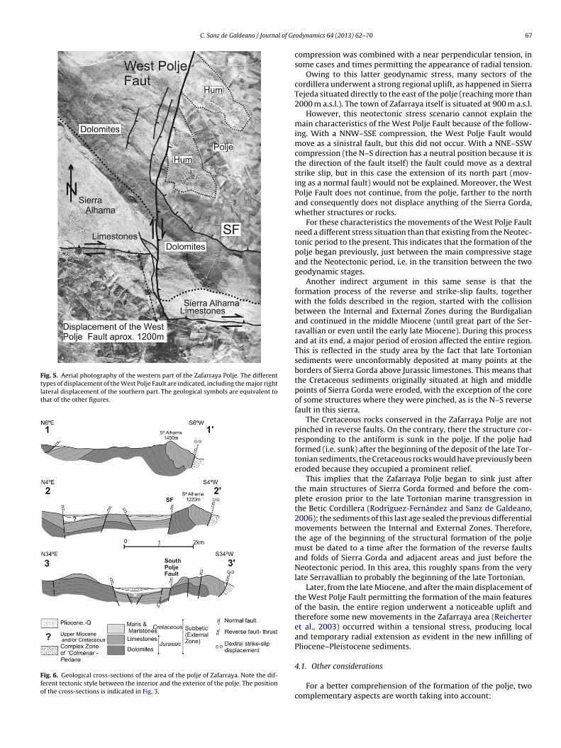
C. Sanz de Galdeano / Journal of Ge
Fig. 5. Aerial photography of the western part of the Zafarraya Polje. The differenttypes of displacement of the West Polje Fault are indicated, including the major rightlateral displacement of the southern part. The geological symbols are equivalent tothat of the other figures.
Fig. 6. Geological cross-sections of the area of the polje of Zafarraya. Note the dif-ferent tectonic style between the interior and the exterior of the polje. The positionof the cross-sections is indicated in Fig. 3.
odynamics 64 (2013) 62– 70 67
compression was combined with a near perpendicular tension, insome cases and times permitting the appearance of radial tension.
Owing to this latter geodynamic stress, many sectors of thecordillera underwent a strong regional uplift, as happened in SierraTejeda situated directly to the east of the polje (reaching more than2000 m a.s.l.). The town of Zafarraya itself is situated at 900 m a.s.l.
However, this neotectonic stress scenario cannot explain themain characteristics of the West Polje Fault because of the follow-ing. With a NNW–SSE compression, the West Polje Fault wouldmove as a sinistral fault, but this did not occur. With a NNE–SSWcompression (the N–S direction has a neutral position because it isthe direction of the fault itself) the fault could move as a dextralstrike slip, but in this case the extension of its north part (mov-ing as a normal fault) would not be explained. Moreover, the WestPolje Fault does not continue, from the polje, farther to the northand consequently does not displace anything of the Sierra Gorda,whether structures or rocks.
For these characteristics the movements of the West Polje Faultneed a different stress situation than that existing from the Neotec-tonic period to the present. This indicates that the formation of thepolje began previously, just between the main compressive stageand the Neotectonic period, i.e. in the transition between the twogeodynamic stages.
Another indirect argument in this same sense is that theformation process of the reverse and strike-slip faults, togetherwith the folds described in the region, started with the collisionbetween the Internal and External Zones during the Burdigalianand continued in the middle Miocene (until great part of the Ser-ravallian or even until the early late Miocene). During this processand at its end, a major period of erosion affected the entire region.This is reflected in the study area by the fact that late Tortoniansediments were unconformably deposited at many points at theborders of Sierra Gorda above Jurassic limestones. This means thatthe Cretaceous sediments originally situated at high and middlepoints of Sierra Gorda were eroded, with the exception of the coreof some structures where they were pinched, as is the N–S reversefault in this sierra.
The Cretaceous rocks conserved in the Zafarraya Polje are notpinched in reverse faults. On the contrary, there the structure cor-responding to the antiform is sunk in the polje. If the polje hadformed (i.e. sunk) after the beginning of the deposit of the late Tor-tonian sediments, the Cretaceous rocks would have previously beeneroded because they occupied a prominent relief.
This implies that the Zafarraya Polje began to sink just afterthe main structures of Sierra Gorda formed and before the com-plete erosion prior to the late Tortonian marine transgression inthe Betic Cordillera (Rodríguez-Fernández and Sanz de Galdeano,2006); the sediments of this last age sealed the previous differentialmovements between the Internal and External Zones. Therefore,the age of the beginning of the structural formation of the poljemust be dated to a time after the formation of the reverse faultsand folds of Sierra Gorda and adjacent areas and just before theNeotectonic period. In this area, this roughly spans from the verylate Serravallian to probably the beginning of the late Tortonian.
Later, from the late Miocene, and after the main displacement ofthe West Polje Fault permitting the formation of the main featuresof the basin, the entire region underwent a noticeable uplift andtherefore some new movements in the Zafarraya area (Reicherteret al., 2003) occurred within a tensional stress, producing localand temporary radial extension as evident in the new infilling ofPliocene–Pleistocene sediments.
4.1. Other considerations
For a better comprehension of the formation of the polje, twocomplementary aspects are worth taking into account:

68 C. Sanz de Galdeano / Journal of Geodynamics 64 (2013) 62– 70
Fig. 7. Scheme of the differential movements of the contact between the Internaland External Zones. (1) Formation of the main compressive structures in the SierraGorda- Zafarraya Polje. (2) Differential movement of the contact to the south ofAlhama de Granada village. (3) The last differential movement in this case occurreddirectly to the east of the Zafarraya Polje and specifically affected its southern border,tG
(
(
bicG
w
Fig. 8. Schemes showing the progressive development of the lateral displacementand bending basin of Zafarraya. (A) Formation of the main compressive structures of
after with the time when the main faults and folds of the area of
he Sierra de Alhama (note that this name does not refer to the village of Alhama deranada).
1) The shape of the polje is approximately a parallelogram withan oblique north-eastern limit; the northern and eastern partsof the polje have a rhomboidal form as is usual in pull-apartbasins. This rhomboidal form corresponds to the most subsi-dent part of the polje according to data of Ollero Robles andGarcía García (1984). As indicated in the Introduction, the maindifference with the pull-apart basins is that in these basins thefault controlling their formation continues beyond their limits,and its movements provoke the tension necessary to create thebasin. In the case of the polje, the fault does not continue (theWest Polje Fault does not continue to the north, and the southPolje Fault does not continue to the west), as occurs with theother faults of the basin.
2) The contact between the Internal and External Zones has alength of the order of 75–80 km south-west of Zafarraya and anE–W direction, but immediately to the east it presents majorshifts. There the contact has three echelons, with a NNE–SSWto N–S direction (Figs. 2, 3 and 7). Regionally, more to the NE,the general direction of the contact between the two zones isapproximately N70E (Fig. 1), although farther away lie otherechelons that do not affect the present area.
The existence of these three echelons in which the contactetween the two zones has an approximately N–S direction is
mportant, because when the Internal Zone moved westwards theyompressed, provoking the formation of the structures of Sierra
orda (Sanz de Galdeano, 2011).Each of these echelons corresponds to differential movementsithin the Internal Zone (Sanz de Galdeano, 1996) and the
the area. (B) Initial stage of the formation of the tensional structures of the ZafarrayaPolje. (C) Total development of the tensional structures. (A) corresponds to the stages1 and 2 of Fig. 7, and (B and C) of the stage 3.
movements of the southernmost of them played an important rolein the formation of the structure of the polje (Fig. 7).
4.2. Interpretation of the formation of the structure of theZafarraya Polje
The role played by these latter cited differential movements(Fig. 7) is fundamental. The beginning of the formation process ofthe structures of the Zafarraya Polje occurred later but immediately
Sierra Gorda formed (A in Fig. 8). Scheme B of this same figure showsthe formation of a new and narrow echelon in the contact betweenthe Internal and External Zones. This new echelon affected only
l of Ge
tdit
cfd
tbpaattetTow
tfmtiddttib
ptbmc
pswti
Ztadt(
5
siO
totit
C. Sanz de Galdeano / Journa
he southernmost part of the Subbetic (the present area of Sierrae Alhama), pushing it. Then the South Polje Fault appeared and,
mmediately afterwards, the West Polje Fault as a direct responseo the compression; initially this fault had a reverse character.
In this process the area of Sierra de Alhama underwent a con-omitant bending in the direction of lesser resistance, the south (inact, on the whole, the southern border of the polje is bent in thisirection) and partially also being uplifted.
With the progressive development of these structures, includinghe southward (and partially vertical) bending, the West Polje Faultegan to move as a dextral fault, facilitating the southward dis-lacement of the southern border of the polje and, simultaneouslynd necessarily, the north-western part of the polje began to beffected by tension (given that the West Polje Fault does not con-inue farther to the north). The extension that was provoked inhe polje intensified in proportion with the increasing right lat-ral displacement. Several parallel normal faults were formed inhe northern part in response to the increasing tension of the area.hen, the antiform sank in the area of the polje. Contemporane-us with this process, the South Polje Fault underwent drag in itsestern part, caused by the West Polje Fault.
An alternative interpretation of the role played by this fault iso consider it as a transfer fault, displacing the antiform and otherolds and faults even during their formation (during the early to
iddle Miocene). In fact, the axis of the antiform is cut, displacedo the south and sunk in the eastern block of the fault. However,t is necessary to remember that no one part of the southern bor-er of Sierra Gorda, beyond the NW border of the Zafarraya Polje isisplaced by this fault. The near 1100–1200 m of displacement ofhe West Polje Fault in its southern part are integrally absorbed inhe Zafarraya Polje. For this reason this fault has no the character-stics of a transfer fault, in which laterally the displacement woulde progressively absorbed.
In this process, the newly forming basin—the future polje—rogressively widened in the N–S direction, in coincidence withhe dextral displacement of the West Polje Fault and the southwardending of the southern border of the polje (Fig. 4D). This was theechanism underlying the formation of the depressed area now
orresponding to the Zafarraya Polje.The role played by the Ventas de Zafarraya Fault can be inter-
reted as a partial buffer of the approximate E–W compressionuffered by the Sierra de Alhama. There, part of this compressionas absorbed, forming the wide zone of friction and at the same
ime facilitating the uplift and bending of part the Sierra de Alhama,n the sector comprised between this fault and the West Polje Fault.
Moreover, for an understanding of this formation process of theafarraya Polje basin, it is necessary to take into account that fromhe late Tortonian, the entire region underwent an important upliftnd radial tension. This permitted the continuation of the subsi-ence in the interior of the basin, as indicated by the distribution ofhe Pliocene–Pleistocene sediments and the paleoseismicity dataReicherter et al., 2003).
. Conclusions
The Zafarraya Polje, although situated in a sector where thetructures, faults, and folds were formed in a compressive context,s a tectonic basin limited by faults with mainly a normal character.ther normal faults affect the interior of the basin.
The formation of this basin has been attributed to the Neotec-onic period, but the characteristics of the fault of the western edge
f the polje (West Polje Fault), with reverse and especially dex-ral strike-slip displacements in its southern part, together withts normal character in the northern part, are not compatible withhe geodynamic context existing in the Betics during this period.odynamics 64 (2013) 62– 70 69
Moreover, the presence of abundant Cretaceous rocks in the poljeindicates the early sinking of the structure of the polje because,otherwise, they would be eroded before the Neotectonic period.
The interpretation proposed in the present work is that the basinwas formed just after, and as a direct continuation of, the compres-sive structures, due to the formation of a new echelon in the contactbetween the Internal and External Zones, which pushed and bentthe southernmost part of the Subbetic in this area. This promptedthe propagation of the fault on the southern border of the polje(South Polje Fault) and, simultaneously, the formation of the WestPolje Fault, the dextral displacement of which absorbed part of thebend, while the tension, beginning in the NE of the basin, progres-sively occupied its entire area. The Ventas de Zafarraya Fault alsoabsorbed part of the deformation, facilitating simultaneously theuplift of the sector between it and the West Polje Fault.
This type of extensional basin, formed by lateral compressionand causing local tension and bending, is called here a “lateraldisplacement and bending basin”.
The age of the beginning of the formation of this basin mustbe compressed between the very late Serravallian to probably thebeginnings of the late Tortonian. Immediately after the basin wasformed, the later radial tension affecting the region contributed toits progressive sinking, a process that continued to the present.
Acknowledgements
The suggestions and corrections of two anonymous review-ers improved the analysis of the data and consequently the finalredaction. A. Caballero drew the figures. This study has receivedfinancial support from the projects (Ministerio de Ciencia e Inno-vación): TOPO-IBERIA CONSOLIDER-INGENIO (CSD2006-00041),RNM-5388 (Junta Andalucía) and from the Research Group RNM-370 (Junta de Andalucía).
References
Aydin, A., Nur, A., 1982. Evolution of pull-apart basins and their scale independence.Tectonics 1 (1), 91–105.
Bouillin, J., Durand Delga, M., Olivier, P., 1986. Betic-Rif and Tyrrhenian distinctivefeatures, genesis and development stages. In: Wezel, F.C. (Ed.), The Origin ofArcs. Developments in tectonics, vol. 21. Elsevier, Amsterdam, pp. 281–304.
Chirlaque, M., Díaz, M., García, A.J., García, E., Guillén, F., Jiménez, J.C., 1987. Estudiogeoeléctrico del polje de Zafarraya. Informe del Departamento de Geodinámica,Universidad de Granada, p. 129.
Elorza, J.J., García-Duenas, V., González-Donoso, J.M., Martín, L., Matas, J., 1978. MapaGeológico de Espana, no. 1040 (Zafarraya). 1:50.000 (2a serie). I.G.M.E., 64 p.
Galindo-Zaldívar, J., Jabaloy, A., Serrano, I., Morales, J., González-Lodeiro, F., Torcal, F.,1999. Recent and present-day stresses in the Granada Basin (Betic Cordilleras):example of a late Miocene-present-day extensional basin in a convergent plateboundary. Tectonics 18, 686–702.
Galindo-Zaldívar, J., Gil, A.J., Borque, M.J., González-Lodeiro, F., Jabaloy, A., Marín-Lechado, C., Ruano, P., Sanz de Galdeano, C., 2004. Desarrollo simultáneo recientede pliegues y fallas en las Cordilleras Béticas: la Falla de Zafarraya y el Plieguede Sierra Tejeda. Geo-Temas 6, 147–150.
García-Jerez, L., Navarro, M., Pérez-Ruiz, J.A., 2006. Characterization of the sedi-mentary cover of the Zafarraya Basin, southern Spain, by means of ambientnoise. Bulletin of the Seismological Society of America 96 (3), 957–967,http://dx.doi.org/10.1785/0120050061.
Hempton, M., Neher, K., 1986. Experimental fracture, strain and subsidence patternsover en echelon strike-slip faults: implications for the structural evolution ofpull-apart basins. Journal of Structural Geology 8, 597–605.
Hidalgo Ruiz, J., 1974. Fluctuaciones del nivel piezométrico en el polje de Zafar-raya (provincia de Granada). V Coloquio de Investigaciones sobre el agua, SanSebastián, October 1973. Documentos de Investigación Hidrológica 16, 96–112.
Lhénaff, R., 1968. Le poljé de Zafarraya (province de Grenade), vol. 4, Mélanges de laCasa de Velázquez, Paris, pp. 5–25.
Lhénaff, R., 1978. Poljés et structures charriées. Quelques exemples dans les Cordil-lères Bétiques centro-occidentales (Espagne). Revue de Géographie Alpine 66(3), 299–307.
López Chicano, M., Pulido-Bosch, A., 2002. Síntesis hidrogeológica de los acuíferos de
Sierra Gorda, Polje de Zafarraya y Hacho de Loja. Libro Homenaje a Manuel delValle Cardenete. Aportaciones al conocimiento de los acuíferos andaluces. IGME,CHG, IAA (COPTJA), Diputación Provincial de Granada, Madrid, pp. 311–340.Luzón, F., Gil-Zepeda, S.A., Sánchez-Sesma, F.J., Ortiz-Alemán, C., 2004. Three-dimensional simulation of ground motion in the Zafarraya Basin (Southern
7 l of Ge
M
O
R
R
R
S
0 C. Sanz de Galdeano / Journa
Spain) up to 1.335 Hz under incident plane waves. Geophysical Journal of Inter-national 156, 584–594, http://dx.doi.org/10.1111/j.1365-246X.2004.02142.x.
orales, J., Vidal, F., Pena, J., Alguacil, G., Ibánez, J.M., 1991. Microtremor study inthe sediment-filled basin of Zafarraya, Granada (Southern Spain). Bulletin of theSeismological Society of America 81 (2), 687–693.
llero Robles, E., García García, J.L., 1984. Morfología del sustrato y geometría delacuífero aluvial del polje de Zafarraya (Granada), vol. 4. In: I Congreso Espanolde Geología, Segovia, pp. 307–315.
eicherter, K.R., Jabaloy, A., Galindo-Zaldívar, J., Ruano, P., Becker-Heimann, P.,Morales, J., Reiss, S., González-Lodeiro, F., 2003. Repeated palaeoseismicactivity of the Ventas de Zafarraya Fault (S Spain) and its relation withthe 1884 Andalusian earthquake. International Journal of Earth Sciences 92,912–922.
odríguez-Fernández, J., Sanz de Galdeano, C., 2006. Late orogenic intramontanebasin development: the Granada basin, Betics (southern Spain). Basin Research
18, 85–102, http://dx.doi.org/10.1111/j.1365-2117.2006.00284.x.uano, P., 2003. Estructuras tectónicas recientes en la transversal central de lasCordillera Béticas. Thesis Univ. Granada, 446 p.
anz de Galdeano, C., 1990. Geologic evolution of the Betic Cordilleras in the WesternMediterranean, Miocene to the Present. Tectonophysics 172, 107–119.
odynamics 64 (2013) 62– 70
Sanz de Galdeano, C., 1996. The E–W segments of the contact between the Externaland Internal Zones of the Betic and Rif Cordilleras and the E–W corridors of theInternal Zone (A combined explanation). Estudios Geológicos 52, 123–136.
Sanz de Galdeano, C., 2008. The Cádiz-Alicante Fault: an important discontinuity inthe Betic Cordillera. Revista de la Sociedad Geológica de Espana 20, 49–58.
Sanz de Galdeano, C., 2011. Génesis de la estructura arqueada de la Sierra de lascabras al Gibalto (Subbético, provincias de Málaga y Granada, Espana). EstudiosGeológicos, http://dx.doi.org/10.3989/egeol.40487.150.
Sanz de Galdeano, C., Alfaro, P., 2004. Tectonic significance of the present relief ofthe Betic Cordillera. Geomorphology 63, 178–190.
Sanz de Galdeano, C., Shanov, S., Galindo-Zaldívar, J., Radulov, A., Nikolov, G., 2010.A new tectonic discontinuity in the Betic Cordillera deduced from active tec-tonics and seismicity in the Tabernas Basin. Journal of Geodynamics 50, 57–66,http://dx.doi.org/10.1016/j.jog.2010.02.005.
Schenková, Z., Zahradník, J., 1996. Interpretation of microtremor spectra at the
Zafarraya basin, southern Spain. Soil Dynamics and Earthquake Engineering 15,69–73.Vera, J.A., 1969. Estudio geológico de la zona Subbética en la transversal de Lojay sectores adyacentes. Memorias del Instituto Geológico y Minero de Espana,Madrid 72, 187.