Embed Size (px)
Citation preview

The Wetlands of Lakes Pontchartrain andMaurepas: Past, Present and Future
P.A. Keddy, D. Campbell, T. McFalls, G.P. Shaffer, R. Moreau, C. Dranguet, andR. Heleniak
Abstract: One of the largest wetlands along the Gulf Coast of North America (ca. 150 000 ha) occurs around the shore-lines of Lake Pontchartrain and Lake Maurepas in southeastern Louisiana, just north and west of New Orleans. We providean introduction to the environmental history of the marshes and swamps in the upper Lake Pontchartrain basin, a reviewof the existing vegetation patterns and their possible causes, and a discussion of restoration targets and priorities. The Mis-sissippi River produced the St. Bernard Delta 3000–4000 years ago, trapping fresh water to produce both Lake Maurepasand Lake Pontchartrain (Frazier 1967). The natural vegetation of much of the region remains fresh or brackish marshes,mixed with swamps dominated by bald cypress (Taxodium distichum) and tupelo (Nyssa aquatica). Yearly flooding by theMississippi River was once a major factor controlling vegetation patterns, but these processes have been greatly impairedby the construction of artificial levees for flood control. Humans also removed most of the cypress swamps in a pulse oflogging between 1876 and 1956. Continued subsidence of the land, slowly rising sea levels, salinity pulses from hurri-canes, and canals from the Gulf of Mexico, add further stress to these wetlands. Over the past century there has been asteady loss of wetland area, and a gradual conversion of fresh water to salt water vegetation types. Biotic processes arealso important. An exotic species of mammal, nutria (Myocastor coypus), consumes both aboveground and belowgroundparts of wetland plants. Reforestation is strictly limited by the combination of salt pulses, competition, and nutria. Alliga-tors are the top predator in this system, but their potential for reducing the impacts of nutria has received minimal atten-tion from biologists. There are many potential future states for this ecosystem. In the extreme case of rising sea level andwarmer climate, the area may become a salt and brackish embayment fringed with mangroves. The state closest to histori-cal conditions would be large areas of bald cypress swamp. Two important priorities are to increase flow of freshwaterinto the system from multiple pulsed fresh water diversions, and to decrease saltwater intrusions by closing canals such asthe Mississippi River Gulf Outlet.
Key words: Louisiana, Maurepas, Mississippi River, Pontchartrain, wetlands, restoration.
Resume : Une des plus grandes surfaces de terres humides le long du golfe du Mexique en Amerique (ca. 150 000 ha) seretrouve sur les rives des lacs Pontchartrain et Maurepas, dans le sud-ouest de la Louisiane, au nord et a l’ouest de la Nou-velle-Orleans. Les auteurs presentent une introduction a l’histoire environnementale des marais et des marecages a la tetedu bassin du lac Pontchartrain, une revue des patrons de vegetation actuelle et de leurs causes, et une discussion sur les ci-bles et les priorites de restauration. Le fleuve Mississippi a engendre le delta St-Bernard, il y a 3000–4000 ans, en retenantde l’eau douce, pour produire les deux lacs, Maurepas et Pontchartrain (Frazier 1967). La vegetation naturelle d’une bonnepartie de la region demeure constituee d’eau douce ou saumatre, avec des savanes dominees par le cypres chauve (Taxo-dium distichum) et le tupelo (Nyssa aquatica). Chaque annee, la crue des eaux du Mississippi etait autrefois un facteur ma-jeur qui determinait les patrons de vegetation, mais ces processus ont ete largement affectes par la construction de diguesartificielles pour maıtriser les inondations. On a egalement supprime la majeure partie des cypres chauves, au cours d’unepisode de coupe, entre 1876 et 1956. Affaissement continu des terres, augmentation lente des niveaux de la mer, intru-sions salines lors des ouragans, ainsi que les canaux provenant du golfe du Mexique, ajoutent aux stress recus par ces ter-res humides. Au cours du dernier siecle, on a observe une perte continue de la surface de terres humides, et uneconversion graduelle a des types de vegetation d’eau douce vers des types d’eau salee. Les processus biotiques sont egale-ment importants. Une espece exotique de mammifere, le ragondin (Mycocastor coypus), consomme les parties souterraineset aeriennes des plantes des terres humides. La reforestation est strictement limitee par une combinaison d’intrusions sali-nes et de competition, incluant les ragondins. Les alligators sont les predateurs a la tete de ce ecosysteme, mais leur poten-tiel pour reduire les impacts des ragondins n’a recu que peu d’attention de la part des biologistes. Plusieurs possibilitesexistent pour le future de cet ecosysteme. Dans une situation extreme d’augmentation du niveau de la mer et du rechauffe-ment climatique, cette surface pourrait se transformer en baie entouree de mangroves. La situation la plus proche des
Received 7 November 2005. Accepted 18 December 2006. Published on the NRC Research Press Web site at er.nrc.ca on 26 May 2007.
P.A. Keddy,1 D. Campbell, T. McFalls, and G.P. Shaffer. Department of Biological Sciences, Southeastern Louisiana University,Hammond Louisiana, USA 70402.R. Moreau. Turtle Cove Environmental Research Station, Southeastern Louisiana University, Hammond Louisiana, USA 70402.C. Dranguet and R. Heleniak. Department of History and Political Science, Southeastern Louisiana University, Hammond, Louisiana,USA 70402.
1Corresponding author (e-mail: [email protected]).
43
Environ. Rev. 15: 43–77 (2007) doi:10.1139/A06-008 # 2007 NRC Canada
conditions historiques serait une grande surface marecageuse couverte de cypres chauves. On doit accorder deux grandespriorites, soit l’augmentation de l’apport en eau douce dans le systeme a partir de multiples diversions periodiques d’eaudouce, et la diminution des intrusions d’eau salee, en fermant les canaux comme le Mississipi River Gulf Outlet.
Mots-cles : Louisiane, Maurepas, fleuve Mississippi, Pontchartrain, terres humides, restauration.
[Traduit par la Redaction]
______________________________________________________________________________________
IntroductionOne of the largest freshwater wetlands along the Gulf
Coast of North America occupies the shorelines of LakePontchartrain and Lake Maurepas in Southeastern Louisiana(Moore 1992), just northwest of New Orleans. This area in-cludes some 147 000 ha of wetland, largely bald cypress andwater tupelo swamp, with increasing areas of marsh andopen water (Penland et al. 2001). This area is the southeast-ern extension of one of the world’s ten largest wetlands(Fraser and Keddy 2005), the Mississippi River alluvialplain (Shaffer et al. 2005). The socio-economic well-beingof southern coastal states is tied to the ecological health oftheir wetlands, and consequently, there is considerable inter-est in conserving and maintaining such areas. Despite thisinterest and concern, coastal wetland loss in Louisiana aver-aged 34.9 mi.2/year (1 mi2 & 2.59 km2) from 1978 through1990 (Barras et al. 1994).
Although there have been many studies of selected aspectsof the Lake Pontchartrain and Lake Maurepas wetlands, noone has synthesized the available literature, particularly thatwhich is available largely (or only) as unpublished reportsand student theses. The primary focus of this review is plantcommunities and their ecological drivers, since these provideboth the physical structure of the system and supply the en-ergetic basis for wildlife production.
To put the Lake Pontchartrain and Maurepas marshes incontext, the largest wetland along the Gulf Coast is theAtchafalalya Swamp. Depending upon how one draws theboundary around this ecological region, there are at least400 000 ha still somewhat wet and wild, and possibly nearerto 800 000 ha if we include ‘‘the entire Atchafalaya back-water complex lying west of the Mississippi River betweenBaton Rouge and the Gulf of Mexico’’ (Reuss 1998; U.S.Army Corps of Engineers 1982). The largest interior marshalong the Gulf Coast is the Everglades (4.45 million ha),although expanses of freshwater marsh, wet prairie, or wetmeadows occur elsewhere (Penfound and Hathaway 1938;Moore 1992; DeSelm and Murdock 1993). In Louisiana,Chabreck (1972) estimated there are over 1 million hectaresof natural marsh in the coastal region alone, an area 1/4 thesize of the Everglades. A number of nationally and region-ally significant protected areas occur in the Lake Pontchar-train and Maurepas wetlands, including, from east to west,Bayou Sauvage National Wildlife Refuge (9315 ha), BigBranch National Wildlife Refuge (6917 ha), FontainebleauState Park (1133 ha), the Joyce Wildlife Management Area(6511 ha), the Manchac Wildlife Management Area (3369 ha),and the new Maurepas Swamp Wildlife Management Area(25 293 ha), for a total in excess of 52 000 hectares or justover 1/3 of the total wetland area.
Acquiring and protecting land is a crucial first step inconservation, but equally important is the design and imple-
mentation of management practices based on a thoroughunderstanding of ecosystem processes. The freshwater wet-lands draining into the northern Gulf of Mexico have beenthe subject of active research, and entire books (Messinaand Conner 1998; Turner and Streever 2002) have summar-ized their ecological processes and conservation status. Sim-ilarly, the Mississippi River drainage basin has beensubjected to multiple studies (Shaffer et al. 2005). However,a comprehensive review specifically dealing with LakeMaurepas and Lake Pontchartrain is lacking. Many of thesewetlands around Lake Pontchartrain are threatened by saltwater intrusion and subsidence (Barras et al. 1994; Gosse-link et al. 1998; Shaffer et al. 2005), a problem attributed inpart to the many levees that prevent the Mississippi Riverfrom delivering fresh water, nutrients, and sediment to theregion (Turner 1997; Davis 2000; Lopez 2003; Shaffer etal. 2003, 2005). Although southern wetlands have a pool inexcess of a thousand wetland plant species (e.g. Godfrey andWooten 1981), most coastal marshes in Louisiana, and inthe Pontchartrain–Maurepas area have a small subset of thewetland flora. For example the entire Manchac WildlifeManagement Area (3369 ha) has only 87 species of vascularplants (Platt 1988). This low diversity suggests that environ-mental factors such as salinity and flooding are stronglyconstraining the biological diversity of the marsh (Flynn etal. 1995; Grace and Pugesek 1997; Howard and Mendels-sohn 1999).
It is imperative that an understanding of the ecologicalprocesses that maintain these wetlands be gained to ensuretheir conservation and restoration. Our goal is to provide areference for researchers in this area, and a guide for admin-istrators and policy makers involved in making conservationand restoration decisions. We, therefore, provide an intro-duction to the environmental history of the marshes andswamps at the west end of Lake Pontchartrain, a review ofthe existing vegetation patterns and their possible causes,and a discussion of potential restoration targets. There are anumber of related topics that we do not cover, but whichreaders may wish to explore later — these include theunique habitats associated with longleaf pine savannas inuplands adjacent to these wetlands (Smith 1991; White etal. 1998; Keddy et al. 2006), the naval stores industry in thelongleaf pine forests (Gamble 1920; Williams 1989), aquaticorganisms of Lakes Pontchartrain and Maurepas such as ran-gia clams, paddlefish, and sturgeon (e.g. Smith 1985; Ruth-erford 2002; Lopez 2003), the effects of the historic plumeindustry on birds of Louisiana wetlands in the late 1800s(Rolfe 1900; Hornaday 1913), the effects of clam shell min-ing on adjacent aquatic ecosystems in Lake Pontchartrain(Lopez 2003), changes in water quality of Lakes Pontchar-train and Maurepas (Penland et al. 2001; LPBF 2005), thetravels of Audubon in the region (Chancellor 1978; Dormon
44 Environ. Rev. Vol. 15, 2007
# 2007 NRC Canada

1990), and the great Mississippi River flood of 1927 (Barry1997). The combined effects of Hurricanes Katrina and Ritain 2005 had catastrophic effects upon humans in southernLouisiana, but the ecological effects are only slowly emerg-ing. We include some short-term observations on the effectsof these hurricanes on the wetlands of Lakes Pontchartrainand Maurepas where data are available.
Regional context: The Mississippi Delta
Louisiana is located on the Gulf of Mexico on the Gulfcoastal plain. The sediments that form contemporary Louisi-ana eroded from uplands far to the northwest (Rocky Moun-tains) and northeast (Appalachian Mountains), being carriedhere primarily by the Mississippi River (Fig. 1). The centralfeature of southern Louisiana is the 3 million hectare deltaicplain of the Mississippi River; overviews of this region in-clude Bernard and Leblanc (1965), Boyd and Penland(1988), Coleman et al. (1998), Boesch et al. (1994), andGosselink et al. (1998). The origins of this plain can betraced to events at the end of the last ice age, as these con-trolled sea level and rates of discharge down the MississippiRiver, and consequently the location and volume of sedi-ments deposited in coastal Louisiana (Table 1). Each of thehigh water periods of the four interglacial periods left flatterraces with distinctive types of sediment deposited allalong the coast of modern Louisiana (Holland 1944). Dur-ing the last ice age, the Mississippi drained much of themelt waters from continental glaciers. A complex series ofevents involving ice margins and glacial Lake Agassiz, ahuge glacial lake in midwestern United States and centralCanada also produced five surges of melt water (from 30to 200 years in duration) down the Mississippi River be-tween 11 700 and 9270 years before present (Teller andThorleifson 1983; Teller 1988, 2003). There is also marineevidence of megafloods approximately every thousand yearssince 5300 years before present (Brown and Kennett 1999).With deglaciation, changes in climate simultaneously pro-duced changes in plant composition in southern Louisiana(Table 1).
Today the Mississippi River may be considered a sceniclandscape, but the region left a forbidding impression onsome early visitors. In 1837 one traveler from Europe wrote:
It is not like most rivers, beautiful to the sight . . . not onethat the eye loves to dwell upon as it sweeps along . . .. Itis a furious, rapid, desolating torrent, loaded with allu-vial soil . . .. [I]t sweeps down whole forests in its course,which disappear in tumultuous confusion, whirled awayby the stream now loaded with the masses of soil whichnourished their roots, often blocking up and changingthe channel of the river, which, as if in anger at its beingopposed, inundates and devastates the whole countryround. . . (Barry 1997 p. 96)
The youngest parts of Louisiana have been newly builtout into the Gulf of Mexico over the past 5000 years. Asthe Mississippi River enters the delta, the sediments (an an-nual load of some 6.2 x 10¹¹ kg, Coleman et al. 1998) beginto settle and accumulate below the surface of the water.When not in flood, river sediments reach the sea. Coarsesediments accumulate closest to where the river enters thesea, whereas fine particles are carried further. An engineer
named Eads once lowered himself to the bottom of this riverin a self-made diving bell and later described his experience:
The sand was drifting like a dense snowstorm at the bot-tom . . .. At sixty-five feet below the surface I found thebed of the river, for at least three feet [0.91 m] in depth,a moving mass and so unstable that, in endeavoring tofind a footing on it beneath my bell, my feet penetratedthrough it until I could feel, although standing erect, thesand rushing past my hands, driven by a current appar-ently as rapid as that on the surface. (Barry 1997 p. 26)
During flood periods, the river flows up and over olderdeposits, depositing new layers of sediment. Coarse sedi-ments deposit first and form natural levees while finer sedi-ments deposit in back marsh and swamp wetlands. Thus, thedeltaic sediments build up above the level of the ocean
Figure 1. The lower Mississippi River basin, showing those regionsthat remain forested (from Llewellyn et al. 1996). The box indi-cates the general area covered by this review.
Keddy et al. 45
# 2007 NRC Canada

(Fig. 2a–2c). The natural vegetation of much of southernLouisiana would therefore be fresh or saltwater marshes,with higher elevations dominated by bald cypress (Taxo-dium distichum) and tupelo (Nyssa aquatica) swamps(taxonomy follows ITIS 2005). During periods of fallingsea level, such as occurred during the ice ages, land forma-tion would accelerate. During periods of rising sea levels,deposition by the river may fail to keep pace, and salinewater may move inland, converting the fresh water swampsand marshes back into brackish marsh, salt marsh, or openwater (Fig. 2d–2e). Since the 1930s, the Louisiana coastalplain has lost some 395 000 ha of wetlands, and there isan ongoing debate as to how much this rate of loss is nat-ural and how much it has been accelerated by human inter-vention in the natural deltaic cycles (Turner 1997; Day etal. 2000, 2001; Houck 2006). Even without human inter-vention, it would be part of the natural deltaic cycle for adelta to subside until only a small chain of islands or evenjust a shoal remains (Boyd and Penland 1988). Hurricaneswould occasionally accelerate this tug-of-war by erodingbarrier islands and destroying outlying marshes (Boyd andPenland 1988; Cahoon et al 1995) as well as redistributingsediment (Turner et al. 2006).
If it were possible to view the last 10 000 years from asatellite with a time-lapse camera, the Mississippi Riverwould be seen to snake back and forth from east to westacross the northern Gulf of Mexico, switching deltas every1000 to 2000 years. At least five major deltas can be distin-
guished (Fig. 3), each with an average thickness of 35 m(Coleman et al. 1998) corresponding to a period of activesedimentation by the Mississippi River. The oldest sedi-ments are now those furthest to the west. About 3000–4000years ago, the Mississippi swung back to the east, layingdown the St. Bernard Delta and trapping fresh water to pro-duce both Lake Maurepas and Lake Pontchartrain.
Since it was produced by flowing water, southern Louisi-ana is very flat. As the Mississippi River approaches theocean, it flows down a negligible slope. For the last 724 kmthe bed of the river is actually below sea level- 4.6 m belowsea level at Vicksburg and over 52 m below sea level atNew Orleans! In the words of Barry (1997) ‘‘for 450 miles[724 km] or more, the water on the bottom of the river hasno reason to flow at all’’ (p. 39).
Even a difference of a few centimetres in elevation canmake a huge difference in the duration of flooding, andhence the plant communities (Penfound and Hathaway1938; Reuss 1998; Reyes et al. 2000). Sediment depositedby deltaic processes, and the associated increase in elevationand nutrients, has been shown to enhance productivity in de-teriorating marshes (e.g. Pezeshki et al. 1992; Mendelssohnand Kuhn 2003). Where trees cannot tolerate flooding,marshes form, dominated by herbaceous species such asCladium mariscoides, Spartina spp., Phragmites australis,Schoenoplectus spp., Peltandra virginica, and Sagittariaspp. The areas that are less inundated can become forested,with the tree species determined by flood duration.
Table 1. A summary of important events in the lower Mississippi River valley during the last major ice age. Much of theevidence comes from fossil pollen and plant debris, some of which was found along Nonconnah Creek (along the Tennessee–Mississippi border) associated with the skeletal remains of American mastodon (after Delcourt et al. 1980). Times preceding22 000 BP were taken from the USGS LITE (Last Interglacial: Timing and Environment) site, esp.cr.usgs.gov/info/lite,accessed 12 July 2006.
Time before pre-sent Climate Other events Floodplains Bluffs
125 000 – 115 000 warm and dry few glaciers warm temperate forests oak–pine forest andprairie
115 000 – 22 000 Cooling increased depth ofponds
prairies invaded byforest
22 000 – 17 000 coldest era glacialmaximum
American mastodondies and is coveredby sediment winderodes silt anddeposits it to the east(loess)
northern conifer forestswith white spruce, firand larch river formsbraided streams
mesic forest with beech,oak, tulip tree,hickory, black walnutwind-carried silt(loess) accumulateson blufflands
17 000 – 11 000 warmer climate glaciers generatepulses of meltwaterinto the MississippiRiver
intense periods of flooding gum, chestnut andbayberry migratenorth to Memphis
12 500 continued warming spruce disappears fromlower Mississippi Valley
9200 last pulse of meltwaterfrom Lake Agassiz
severe flooding
8700 – 5000 warmer and drier falling water tables river begins meanderingand cuts terracesswamps become openmarsh
increased frequency offire and possibleexpansion of prairie
5000 – present cooler and wetter rising water tables marsh reverts to swampwith willows, riverbirch, gums and baldcypress
mixed mesic forest withsouthern trees
46 Environ. Rev. Vol. 15, 2007
# 2007 NRC Canada

Occasional floods can breach natural levees and depositlarge fans of sediment. The land-building power of a singlebreach in a levee was demonstrated in 1890 on the NitaPlantation, some 80 km upstream from New Orleans (Sau-cier 1963). This breach began on 13 March 1890, and sooneroded to more than 0.8 km in width with a discharge ofnearly 1/3 of the normal flow rate of the entire MississippiRiver. The land to the north was quickly inundated: 9 dayslater the floodwaters reached Lake Maurepas and Pass Man-chac, and by the end of the month, the flooding halted theIllinois Central railway that runs north from New Orleans toChicago along the Manchac land bridge. The water rose to
within 2.4 km of Ponchatoula Station, and continued toblock trains for more than 2 months. Seen from the shortterm, this flood was probably a catastrophe yet the floodbuilt land: it left a fan-shaped deposit of sand and silt cover-ing some 2849 ha (Saucier 1963). Further east, the marshessouth of Ponchatoula were covered with a fine ‘‘yellowish orbluish-brown clay’’. Another example occurred even closerto New Orleans, just 40 km upstream, where levees nearBonnet Carre were repeatedly breached by floods: 1849,1857, 1867, 1871, 1874, and 1882. In 1849, the breach wasnearly 1.61 km wide. The result of these events was verticalaccretion over 9065 ha; the southwest shores of Lake
Figure 2. Progressive stages in the development of the Mississippi River levees and marshes (from Bernard and Leblanc 1965).
Keddy et al. 47
# 2007 NRC Canada

Pontchartrain alone received more than 1.83 m of sediment.The total volume was calculated at 141 584 234 m3 (Saucier1963).
Left alone, the Mississippi would now swing back west-wards and drain directly down the Atchafalaya basin (Fig.3). The new delta at the mouth of the Atchafalaya is beingbuilt at a rate of some 121 to 202 ha/year (Coleman et al.1998). If not for the massive Old River Control Structurebuilt by the Army Corps of Engineers, it is likely that theMississippi River would cease flowing through New Or-leans. Started in 1955 and completed in 1963, the Old RiverControl Structure has 11 gates, each 13 m across that divertsome 2/3 of the Mississippi away from the Atchafalya andtoward New Orleans (Reuss 1998).
A brief environmental history for humanimpacts
Native Americans and early European exploration:Superimposed upon the above geological processes are
those driven by human beings. In southeastern North Amer-ica, Native American populations achieved their greatestdensity. The Caddo, Atakapa, Tunica, Natchez, and Chitima-cha were the five dominant cultures in Louisiana (Kniffenand Hilliard 1988). Most relied heavily on farming, with thewomen planting and harvesting corn, beans, squash, andsweet potatoes. Not only did these produce a high yield ofquality food, but all could easily be dried and stored for lateruse. Sunflowers and tobacco were also cultivated. Fertilesoils along rivers were favored for settlement. One of themost important American Indian settlements in North Amer-ica occurs upstream from New Orleans at Poverty Point; herenatives constructed an enormous bird-shaped mound of earth
about 23 m high, along with six concentric ridges markingout a circle more than 0.8 km in diameter (Gibson 1996).
The American Indian way of life ended with the arrival ofthe Europeans. By far the most devastating effect was thespread of European diseases, such as smallpox, againstwhich the American Indians had no immunity. Even one ofthe earliest European explorers, De Soto, in 1540, reportedfinding Indian villages virtually devoid of people. In one de-serted village De Soto encountered houses ‘‘filled with thebodies of people who had died of the pestilence’’ — perhapsthe consequence of an epidemic started by an earlier Span-ish expedition in 1526 (Silver 1990).
The area known as Manchac Swamp was visited by theFrench explorer Pierre LeMoyne, Sieur d’Iberville, on 26March 1699. According to Iberville’s diaries (McWilliams1981), while exploring the Mississippi River for a high-ground site to establish a fort to secure the basin near themouth of the river, Iberville encountered two American In-dian tribes (Bayogoula and Mogoulacha), who described analternate route to the Gulf of Mexico. This alternate routebegan with a turn off of the Mississippi onto a small dis-tributary named by Iberville’s crew as Riviere d’Iberville,which was later re-named Bayou Manchac (Manchac is aChoctaw word meaning ‘‘rear entrance’’. From there thebayou joins with the larger Amite River that flows intoLake Maurepas (after Jerome de Phelypeaux, Comte deMaurepas) and then on to Lake Pontchartrain (after Maure-pas’ father, Louis Phelypeaux, Comte de Pontchartrain, Min-ister of Marine for France at the time) through theconnecting Pass Manchac. From Lake Pontchartrain Iber-ville was able to make his way out to the Gulf of Mexicothrough Lake Borgne, where he finally reached his fleet ofships moored off the Mississippi coast at Ship Island.
Figure 3. The active delta of the Mississippi River has shifted positions repeatedly over the last 7,000 years. The St. Bernard Delta (esti-mated age 3000–4000 years BP) formed the embayment that contains Lakes Maurepas and Pontchartrain (from Boesch et al. 1994).
48 Environ. Rev. Vol. 15, 2007
# 2007 NRC Canada

Sieur de Bienville established New Orleans between theMississippi River and Lake Pontchartrain in 1718, and theimpacts of Europeans have continued to increase with popu-lation growth and industrialization. Edward King, lookingback from 1875, painted this colorful picture of New Or-leans in the early 1700s:
Imagine a low-lying swamp, overgrown with a denseragged forest, cut up into a thousand miniature islandsby ruts and pools filled with stagnant water. Fancy asmall cleared space along the superb river channel, aspace often inundated, but partially reclaimed from thecircumambient swamp, and divided into a host of smallcorrect squares, each exactly like its neighbor, and soditched within and without as to render wandering afternightfall perilous. The ditch which ran along the foursides of every square in the city was filled with a compo-site of black mud and refuse, which, under a burning sun,sent forth a deadly odor. Around the city was a palisadeand a gigantic moat; tall grasses grew up to the doors ofthe houses, and the hoarse chant of myriads of frogsmingled with the vesper songs of the colonists. (p. 22)
The great American naturalist, William Bartram visitedLouisiana in autumn 1777, towards the end of his journey,which included 9656 km on horseback, across the southeast(Earnest 1940). He describes traveling from east to westthrough Lakes Pontchartrain and Maurepas. Near the PearlRiver, just east of Lake Pontchartrain he made the followingobservations:
I made frequent, indeed I may say daily excursions in andabout this island, strolling through its awful shades, ve-nerable groves and sublime forests, consisting of theLive Oaks and Magnolia grandiflora, Laurus Borbonia,Olea Americana, Fagus sylvatica, Laur. Sassafras, Quer-cus hemispherica, Telea, Liquid-amber styraciflua,Morus, Gleditsia, Callicarpa, Halesia, &c. (p. 421)
Although the names of the plants have changed somewhatin two centuries, the live oaks, magnolias, red bay, ash,beech, and sassafras still occur. Many of these forests have,however, vanished under subdivisions spreading in the samedirection Bartram traveled, eastwards along the north shoreof Lake Pontchartrain. He next set off for:
Manchac on the Mississipi (sic), in a handsome largeboat with three Negroes to navigate her; leaving thefriendly Mr. Rumsey’s seat on Pearl Island, we descenda creek from the landing near his house; this creek ledus about a mile, winding through salt sedgy marshes,into Lake Pontchartrain, along whose North shores, wecoasted about twenty miles, having low, reedy marshes,on our starboard: these marshes were very extensive be-tween us and the far distant high forests. . .. We came toin a little bay, kindled a fire, and after supper betookourselves to repose . . . on clean sand banks; we restedquietly, though sometimes roused by alarms from the cro-codile, which are here in great numbers, and of an enor-mous bulk and strength.
He, of course, was referring to the dense population of al-ligators in the Manchac area. He next arrives at the Tangipa-hoa River (Taensapaoa in his notes):
we still coasted Westward, three or four miles [4.83–6.44km], to the straits that communicate to the lake Mauri-pas(sic); entering which and continuing six or eight miles[9.66–12.87 km], having low swampy land on each side,
the channel divides, forming an island in the middle ofthe pass, we took the right hand channel, which continu-ing three or four miles [4.83–6.44 km], when the chan-nels reunite in full view of the charming lake [LakeMaurepas]. (p. 425)
He next sails up the Amite River, seeing
the land on each side a level swamp, about two feet[0.61 m] above the surface of the water, supporting athick forest of trees, consisting chiefly of Fraxinus,Nyssa aquatica, Nyssa multiflora, Cupressus disticha,Quercus phillos, Acer rubrum, Ac. negundo, Acer glau-cum, Sambuces(sic), Laurus Borbonia, Carpinus, Ulmusand others. (p. 425)
Many of the species of trees grow along the Amite today,including, following the order in Bartram’s notes, ash, tu-pelo, bald cypress, willow oak, and red maple, respectively.Eventually Bartram reaches the Mississippi River by travel-ing overland:
THE depth of the river here, even in this season, at its low-est ebb is astonishing, not less than forty fathoms [73 m],and the width about a mile [1.61 km] or some whatless. . ..The banks of the river . . . though frequentlyoverflowed by the vernal inundations, are fifty feet[15.2m] perpendicular height above the surface of thewater (by which the channel at those times must beabout two hundred and ninety feet deep [88 m]) andthese precipices being an accumulation of the sedimentof muddy waters, annually brought down with thefloods, of a light loamy consistence(sic), are continuallycracking and parting, present to view deep yawningchasms, in time split off, as the active perpetual cur-rent undermines, and the mighty masses of earth tumbe(sic) headlong into the river, whose impetuous currentsweeps away and lodges them elsewhere. (p. 427–428).
Early colonization, levees, the railway and logging:Bartram arrived before humans had their greatest impacts
on the landscape. Lopez (2003) divides human impacts inthe basin into five periods of activity (supported by his ap-pendix A with a 30 page chronological list of environmentalevents from 1711–2002).(1) 1718–1844 Natural levee and ridge utilization.(2) 1812–1895 Mississippi River severed from Pontchartrain
basin(3) 1890–1938 Commercial deforestation(4) 1932–1990 Dredging and armoring of estuary(5) 1950–1989 Water pollution
The two of these with the greatest continuing impact onwetlands are likely those that occurred largely between1812 and 1938 — the construction of artificial levees andthe destruction of upland and swamp forests (Davis 2000;Lopez 2003). The former has minimized the flow of freshwater, nutrients, and sediment into Lakes Maurepas andPontchartrain. The latter removed natural forest cover andleft the land permanently scarred. Both of these events willbe a recurring theme in the remainder of this review. Onespecific, more recent, event — the construction of the Mis-sissippi River Gulf Outlet in 1963–1965 — has amplifiedthe effects of levee construction by providing direct accessof salt water to the Lake Pontchartrain Basin (Lopez 2003).The original dredge width of the canal removed 527 ha ofwetland, but the canal has expanded from bank erosion.
Keddy et al. 49
# 2007 NRC Canada
Moreover, the direct impacts are minor compared to the ex-tensive damage from salt-water intrusion. Locally known asMr. Go, the shipping channel continues to be one of the mostimportant causes of salinization in both Lakes Pontchartrainand Maurepas (Lopez 2003; The Nature Conservancy 2004).
Levees were built steadily during the late 1800s and early1900s, although even then there were vigorous debatesamong engineers about how to best control floods along theriver (Barry 1997). But levee construction continued.
By 1851 most of the levees between New Orleans and theRed River had risen to at least four and a half feet – thelargest was eight feet, with a base of thirty-five feet. Withtime these embankments extended from New Orleans tothe mouth of the Arkansas River, a distance of about 600miles (Barry, J.M. 1997)
Almost as soon as the levees were built, they werebreached. Davis (2000) describes how over time the fre-quency of crevasses grew from under ten crevasses a yearbefore 1850, to 16–45 between 1858 and 1874, to morethan 200 per year over the three years from 1882 to 1884.Crevasses increased in frequency as the levees grew in stat-ure. Even so, as the levees grew in length and height, vitalwater, nutrients, and sediment were diverted away from wet-lands along the river.
The Manchac land bridge is a prominent feature that sep-arates Lakes Pontchartrain and Maurepas (Fig. 4), and itshistory mirrors that of the region as a whole. This peninsulawas produced by the Mississippi River during the St. Ber-nard stage of delta construction (ca. 5000 years BP), whendeltaic deposits created present day Lake Pontchartrain. Si-multaneously, a branch of the Mississippi flowed, carryingsediment and building a narrow land bridge that severedmodern Lake Maurepas from Lake Pontchartrain (Saucier1963). In 1852, railroad construction began to link New Or-leans to Jackson, Mississippi (Woolfolk 1979). Two bridgeswere built across Pass Manchac, a 213 m span at North Passand a 549 m trestle span at South Pass, each with a steamdrawbridge. Cypress crib work and pilings supported therails. The New Orleans, Jackson, and Great Northern Rail-way opened the 142 km of track from New Orleans to theMississippi border just 2 years later in 1854. A turntable atPass Manchac allowed engines to be turned around on thesingle-track line, and a wooden loading platform constructedon pilings on the north side of Pass Manchac allowed boatsto transfer freight to the train. This railway played a notablerole in the Civil War, until it was burned with ‘‘nothing re-maining at Pass Manchac more combustible than railroadiron and water-soaked piles’’ (Perrin 2000).
When the Civil War ended in 1865, the railway was re-built. The towns of Frenier and Ruddock grew up along thetracks, based upon truck farming and services for the log-ging industry. The black soil was apparently well-suited togrowing cabbage and lettuce. The residents built a systemof levees to control flooding of each farm, while the housesand sidewalks were built on pilings at least eight feet abovethe ground. The towns became well-known for shipping pro-duce north to Chicago. By 1910, Ruddock had over 700 res-idents and Frenier had close to 200 (Heleniak and Dranguet1987). Both towns were obliterated by the unnamed hurri-cane, which struck on 29 September 1915. The history ofthis era is recounted at four scales: for the south as a whole
by Conner and Buford (1998), for Louisiana by Norgress(1947), for pull boat technology by Mancil (1980), and forthe Manchac area local accounts such as Woolfolk (1979),Dranguet and Heleniak (1992), Heleniak and Dranguet(1987), and Perrin (2000).
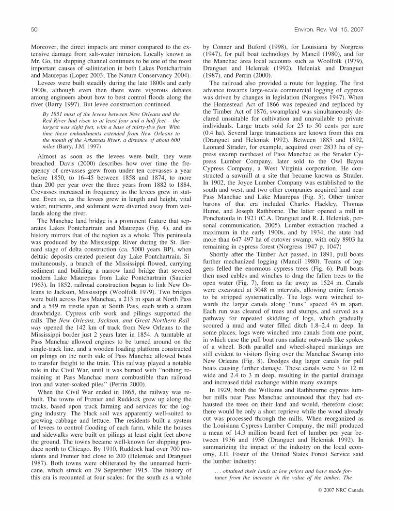
The railroad also provided a route for logging. The firstadvance towards large-scale commercial logging of cypresswas driven by changes in legislation (Norgress 1947). Whenthe Homestead Act of 1866 was repealed and replaced bythe Timber Act of 1876, swampland was simultaneously de-clared unsuitable for cultivation and unavailable to privateindividuals. Large tracts sold for 25 to 50 cents per acre(0.4 ha). Several large transactions are known from this era(Dranguet and Heleniak 1992). Between 1885 and 1892,Leonard Strader, for example, acquired over 2833 ha of cy-press swamp northeast of Pass Manchac as the Strader Cy-press Lumber Company, later sold to the Owl BayouCypress Company, a West Virginia corporation. He con-structed a sawmill at a site that became known as Strader.In 1902, the Joyce Lumber Company was established to thesouth and west, and two other companies acquired land nearPass Manchac and Lake Maurepas (Fig. 5). Other timberbarons of that era included Charles Hackley, ThomasHume, and Joseph Rathborne. The latter opened a mill inPonchatoula in 1921 (C.A. Dranguet and R. J. Heleniak, per-sonal communication, 2005). Lumber extraction reached amaximum in the early 1900s, and by 1934, the state hadmore than 647 497 ha of cutover swamp, with only 8903 haremaining in cypress forest (Norgress 1947 p. 1047)
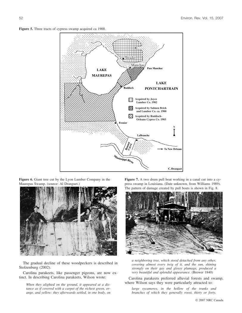
Shortly after the Timber Act passed, in 1891, pull boatsfurther mechanized logging (Mancil 1980). Teams of log-gers felled the enormous cypress trees (Fig. 6). Pull boatsthen used cables and winches to drag the fallen trees to theopen water (Fig. 7), from as far away as 1524 m. Canalswere excavated at 3048 m intervals, allowing entire foreststo be stripped systematically. The logs were winched to-wards the larger canals along ‘‘runs’’ spaced 45 m apart.Each run was cleared of trees and stumps, and served as apathway for repeated skidding of logs, which graduallyscoured a mud and water filled ditch 1.8–2.4 m deep. Insome places, logs were winched into canals from one point,in which case the pull boat runs radiate outwards like spokesof a wheel. Both parallel and wheel-shaped markings arestill evident to visitors flying over the Manchac Swamp intoNew Orleans (Fig. 8). Dredges dug larger canals for pullboats causing further damage. These canals were 3 to 12 mwide and 2.4 to 3 m deep, resulting in the partial drainageand increased tidal exchange within many swamps.
In 1929, both the Williams and Rathbourne cypress lum-ber mills near Pass Manchac announced that they had ex-hausted the trees on their land and would, therefore close;there would be only a short reprieve while the wood alreadycut was processed through the mills. When reorganized asthe Louisiana Cypress Lumber Company, the mill produceda mean of 14.3 million board feet of lumber per year be-tween 1936 and 1956 (Dranguet and Heleniak 1992). Insummarizing the impact of the industry on the local econ-omy, J.H. Foster of the United States Forest Service saidthe lumber industry:
. . . obtained their lands at low prices and have made for-tunes from the increase in the value of the timber. The
50 Environ. Rev. Vol. 15, 2007
# 2007 NRC Canada

industry does not develop the country permanently andthe earnings are seldom invested where they are of anybenefit to the community. (Norgress, R.E. 1947).
With the loss of the swamp forests, the biota too certainlydeclined, but no wildlife census data from this era in theManchac are available. One can either rely on the testimonyof persons who lived in the area to describe losses of water-fowl, furbearers, and deer, or extrapolate from general trendsin wildlife documented in that era. We can certainly inferthe loss of three birds, one now on the edge of extinction(ivory-billed woodpecker), and two extinct (Carolina para-keet, passenger pigeon), as likely former inhabitants of theseswamps.
The ivory-billed woodpecker was described admiringly byAlexander Wilson, a naturalist who pre-dated Audubon by
about one generation, and who prepared an early volumeguide to the birds of North America, called American Orni-thology (Brewer 1840). Wilson says:
This majestic and formidable species, in strength andmagnitude, stands at the head of the whole class ofWoodpeckers hitherto discovered. He may be called theking or chief of his tribe; and Nature seems to havedesigned him a distinguished characteristic in the su-perb carmine crest and bill of polished ivory withwhich she has ornamented him. . .. the royal hunternow before us . . . seeks the most towering trees of theforests; seeming particularly attached to those prodi-gious cypress swamps. . .. his trumpet-like note andloud strokes resound through the solitary, savage wilds,of which he seems the sole lord and inhabitant.(Brewer 1840)
A
B
///
///
Figure 4 (a) The study area (after Conner et al. 1980) (b), public lands and protected areas. Dark gray: state lands; medium gray: federallands (from The Nature Conservancy 2004). Ongoing land acquisition indicated by ///.
Keddy et al. 51
# 2007 NRC Canada
The gradual decline of these woodpeckers is described inStolzenburg (2002).
Carolina parakeets, like passenger pigeons, are now ex-tinct. In describing Carolina parakeets, Wilson wrote:
When they alighted on the ground, it appeared at a dis-tance as if covered with a carpet of the richest green, or-ange, and yellow: they afterwards settled, in one body, on
a neighboring tree, which stood detached from any other,covering almost every twig of it, and the sun, shiningstrongly on their gay and glossy plumage, produced avery beautiful and splendid appearance. (Brewer 1840)
Carolina parakeets preferred alluvial forests and swamp,where Wilson says they were particularly attracted to:
large sycamores, in the hollow of the trunks andbranches of which they generally roost, thirty or forty,
Acquired by JoyceLumber Co. 1902
Acquired by Salmen Brickand Lumber Co. ca. 1900
Acquired by Ruddock-Orleans Cypres Co. 1903
Strader
Manchac
Figure 5. Three tracts of cypress swamp acquired ca 1900.
Figure 6. Giant tree cut by the Lyon Lumber Company in theMaurepas Swamp. (source: Al Dranguet.)
Figure 7. A two drum pull boat working in a canal cut into a cy-press swamp in Louisiana. (Date unknown, from Williams 1989).The pattern of damage created by pull boats is shown in Fig. 8.
52 Environ. Rev. Vol. 15, 2007
# 2007 NRC Canada

and sometimes more, entering at the same hole. Herethey cling close to the sides of the tree, holding fast bythe claws and also by the bills. They . . . often retire totheir holes during the day, probably to take their regularsiesta. They are extremely sociable, and fond of eachother, often scratching each other’s heads and necks,and always, at night, nestling as close as possible toeach other, preferring, at that time, a perpendicular posi-tion, supported by their bill and claws. (Brewer 1840)
Audubon’s specimen of the Carolina parakeet is said tohave been collected about 1821 at Bayou Sara near St.Francisville (Oberholser 1938), not far from the presentday Cat Island National Wildlife Refuge. The last knownCarolina parakeet died in the Cincinnati Zoo in 1918.
With the end of the cypress industry, two other industriesended (Heleniak and Dranguet 1987). One was the gatheringof Spanish moss, which brought moss gatherers up to sixcents per pound (0.45 kg). The moss was then pressed intobales and shipped for use in the furniture industry and forthe expanding business of automobile upholstery. Boatbuilding also was affected, particularly the larger boats thatmight require cypress planks over 7 inches thick. Although
Manchac skiffs are still built locally, fiberglass has takenthe place of cypress. A few other residents still harvestsunken logs, known as sinker cypress, for lumber.
One other noteworthy event occurred with the end of log-ging. The millionaire brewer and businessman from NewOrleans, Edward Schlieder, acquired a 2226 ha tract of cut-over cypress land on the south side of Pass Manchac fromthe Salmen Brick and Lumber Company. Here Schliederbuilt a 2 1/2-story building, a boathouse, and a caretaker’sresidence. The camp was an island of luxury with electriclights and a walk-in refrigerator powered by a gas generator(Heleniak and Dranguet 1987). This building later becamethe Turtle Cove Environmental Research Station, the landbecame the Manchac Wildlife Management Area, and theSchlieder Foundation eventually funded the creation of theSchlieder Endowed Chair for Environmental Studies atSoutheastern Louisiana University (Hastings 2004).
The story of the Manchac Swamp, therefore, illustratesthe pattern of events that occurred across much of Louisiana— land built by the Mississippi River, early exploration bythe Spanish and French, settlement, the Civil War, levee
Figure 8: Aerial view of the Manchac wetlands between Lake Maurepas and Lake Pontchartrain. Parallel and wheel-shaped markings aremud and water-filled ditches made by pull boats dragging trees through the swamp during logging operations in the early twentieth century(Thomson 2000).
Keddy et al. 53
# 2007 NRC Canada

construction, cypress logging, decline in animal speciesfrom woodpeckers to sturgeon, and then mills closing asthe cypress was exhausted. The state of the Pontchartrainand Maurepas wetlands today is largely a result of theseevents.
The Manchac area retains a distinctive culture — ‘‘the au-tomobile is of little use to the people who live and work inthe marsh between (the towns of) LaPlace (to the south) andPonchatoula (to the north)’’ (Dranguet and Heleniak 1985),and after 3000 years of human habitation of the Manchacland bridge, the only surviving and permanent communityis that of the Village of Manchac.
Flooding and salinityIn coastal wetlands, flood duration and salinity are the
two main gradients that control species composition,although other factors including nutrients, herbivory, andrates of sediment deposition also are important (e.g., Moore1992; Gough and Grace 1998; Keddy 2000; Mitsch andGosselink 2000). These factors have been well-studied inwetlands along the Louisiana coast (e.g., Penfound andHathaway 1938; Baldwin et al. 1996; Boesch et al. 1994;Gosselink et al. 1998) and manipulated in greenhouse ex-periments (e.g. Pezeshki et al. 1987c; Flynn et al. 1995;Baldwin and Mendelssohn 1998b; Hester et al. 1998, 2001;La Peyre et al. 2001). They are considered key factors forcoastal wetlands in general (Keddy 2000; Mitsch and Gosse-link 2000). Flood duration and salinity combine to producethe gradient of vegetation from herbaceous vegetation in themost flooded areas to forests in the least flooded areas. Ta-ble 2 summarizes the changes in production associated withthis gradient. Within the herbaceous vegetation, salinity alsoproduces changes in species composition and diversity(Table 3).
To explore patterns of flooding and salinity within theManchac area, Thomson (2000) analyzed historical datafrom a stage and salinity gage (#85420) maintained by theUnited States Army Corps of Engineers (USACE), New Or-leans District, attached to a piling on the southern end of theInterstate 55 bridge across Pass Manchac. The datum for themonitor currently is set to NGVD sea level (1983 adjust-ment), and the Louisiana Department of Transportation hasstated that Interstate 55 does not subside with the surround-ing wetlands, so this datum is assumed stable. These datawere used to calculate the rate of eustatic sea level rise forthe waters surrounding the study area, flood duration, andinter-annual variability.
For any single year, the stage is bimodal (Fig. 9) — itgenerally rises in the spring, then falls to its lowest level dur-ing summer, rises to its highest level in the fall, and againfalls to low levels in the winter. The high stages recorded inthe fall are attributed to tropical storms such as HurricaneKatrina in late August of 2005. During the period from1956 to 1999, flood duration increased significantly, produc-ing flood durations of 30% near Schlieder’s Ditch and 60%near First Canal (Fig. 10). Salinity increased dramaticallyduring the drought in 1999–2000, exceeding 8 ppt early inthe growing season, and staying in the vicinity of 5 ppt untilthe heavy rains in July that ended that drought (Fig. 11). Byearly 2003, levels had returned to below 2 ppt.
Increased flood duration can be attributed to two causes.First, data from the gage (#85420) shows that from 1957 to2000, there has been a rise in mean sea level of 1.6 mm perannum for a total rise in mean sea level of 0.07 m in thisperiod (Thomson 2000). Second, local subsidence has beenestimated to be 2.0 mm per annum at the southern Manchacland bridge (Penland and Ramsey 1990). As a consequence,the marshes in the Manchac area are flooded twice as muchas they were 50 years ago. Increased submergence results insulfide accumulation, a phytotoxin, which also reduces plantuptake of nitrogen (Koch et al. 1990), an important limitingprimary nutrient in wetland plant productivity (Valiela andTeal 1974; Keddy 2000). This combination of increasedflood duration and increased salinity are likely to convertfresh water swamps and marshes to salt marshes and openwater, a process already well documented in historical pho-tographs (Barras et al. 1994).
Zedler and Beare (1986) have argued that southernmarshes in general are subjected to cycles of fresh and sal-ine conditions driven by drought cycles, with regenerationfrom buried seed controlled by pulses of fresh water that al-low germination and establishment. In the same way, pulsesof saline water driven inland by tropical storms, and exacer-bated by altered hydrology (Lopez 2003), are thought to sig-nificantly reduce plant diversity in fresh marshes (O’Neil1949; Brewer and Grace 1990) and prevent the regenerationof swamps (Penfound 1952; Shaffer et al. 2003). One suchpulse appeared when Hurricane Katrina passed over Louisi-ana in August 2005 (Fig. 12). The long-term effects of thispulse upon these wetlands remains unknown.
Major vegetation types
Because the large-scale picture of these gradients incoastal wetlands is well-documented, our focus here will beupon those studies that illustrate how these forces apply tothe Pontchartrain–Maurepas area. Overall, the vegetation ofthe area can be approximately divided into two types, marshand swamp. In many cases the distinction is arbitrary asmany areas represent transitions between the two.
Several ecological factors acting in combination can cre-ate marsh. Further north, fluctuating water levels seem to bethe single major cause of marsh formation, with high waterperiods killing colonizing woody plants, and intervening lowwater periods allowing regeneration of herbaceous species(Toner and Keddy 1997; Keddy 2000). In contrast, southernmarshes have more complex and diverse origins. Fluctuatingwater levels are likely important in some cases, particularlyin the Everglades (White 1994), at the mouths of large rivers(Brewer and Grace 1990), and certainly in adjoining pinesavannas (Christensen 1988; Peet and Allard 1993). Firealso is known to be significant in maintaining and regenerat-ing marshes in both coastal Louisiana (O’Neil 1949) and theEverglades (Loveless 1959; Brewer and Grace 1990; Hern-don et al. 1991; White 1994), as well as marshes near Man-deville, Louisiana. Newly deposited deltaic sediments createconditions for the formation of new areas of marsh (Shafferet al. 1992; White 1993; Boesch et al. 1994). Pulses of saltwater associated with hurricanes and other tropical stormscan cause significant changes in the species composition ofmarshes, and may kill trees or inhibit regeneration (Brewer
54 Environ. Rev. Vol. 15, 2007
# 2007 NRC Canada

and Grace 1990; Gosselink et al. 1998). Herbivores maymaintain, or possibly expand, marshes by feeding upon treeseedlings (Wilsey et al. 1991; Brantley and Platt 1992;Myers et al. 1995).
A major cause of open marsh is humans. Given the inten-sive and extensive history of logging (e.g. Norgress 1947;Conner and Buford 1998; Lopez 2003), it is often reason-able to suspect anthropogenic rather than natural origins.Large stumps emerging from mud, or troughs cut into themarsh by draglines, confirm that such areas were once for-est. Further, these anthropogenic marshes are now at riskfrom another anthropogenic factor: salt water intrusioncaused by a combination of rising sea levels, levees alongrivers, altered hydrology that provides direct links to moresaline waters, and subsidence of sediment (Boesch et al.1994; Gosselink et al. 1998) along with increased exposureto salt water from storm surges (Michener et al. 1997;Thomson 2000). At the same time, proposals to divert freshwater from the Mississippi River (Shaffer et al. 2003) or topump partially treated sewage into the Joyce Wildlife Man-agement area could result in expanded areas of swamp andmore eutrophic conditions.
In 2003, species composition was measured in 40 10 m �10 m quadrats stratified among four a priori vegetation typesin the Manchac wetlands to better describe the different veg-etation types (Kandalepas 2004). The sample sites extendedfrom the Tchefuncte River in the east to the Blind andAmite Rivers in the west. After removing infrequent speciesand floating aquatics, the resultant database consisted of 79species out of the 107 species originally detected.
Marshes tended to have fewer plant species and less var-iation in species composition than swamps. TWINSPANshowed ten natural groupings (Fig. 13). There was no clearseparation between anthropogenic and natural marshes, butrather the differences appear to be attributable to the salinitygradient, with the added occurrence of shrub-scrub commun-ity type that may reflect past logging activities. Morella cer-ifera is a common component of this community type. Theswamps divided into two major groups: one, with the occur-rence of Sphagnum moss, the other with saplings of Taxo-dium distichum. This suggests a fertility difference, withSphagnum documenting sites of low fertility. The most spe-ciose plots were those dominated by Acer rubrum and Taxo-dium distichum; the mechanism seems to be that manymarsh plants can grow in small gaps in the forest, in whichcase forests contain not only woody plants, but a moderatenumber of marsh species in addition.
The status of the swamps
The original swamps were heavily logged, as describedabove. Apart from faded photographs, our other informationon old growth cypress come from remnant stands, many out-side the study area (e.g., Conner and Buford 1998; Devall1998), although Hall and Penfound (1939a, 1939b) providedreliable descriptions of swamps nearby along the PearlRiver. According to Devall, Taxodium distichum trees canreach 3.6 m in diameter (measured above the swollen baseof the tree) and live up to 1000 years old. Dead snags anddowned logs occurred at densities of ‘‘several’’ per 1.2 ha.Nyssa aquatica and Nyssa biflora were common associates.
The second growth swamps south of Lake Maurepas havereceived intensive study documenting variation among yearsand hydrologic regimes (Shaffer et al. 2003). Twenty studysites with two 625 m2 replicates each were selected to cap-ture four different hydrological regimes within the swamp:lake, intermediate, interior, and throughput. Interior siteswere located away from any direct water exchange withLake Maurepas and were only accessible by airboat. Inter-mediate sites were located closer to the lake in the vicinityof larger bayous or canals that made direct water exchangewith the lake probable. Lake sites were close enough toLake Maurepas to render tidal exchange common. Through-put sites were located near canals or natural waterways thatwere likely to provide regular inundation and sheet flow.
An intensive monitoring program measured factors in-cluding rates of subsidence, accretion, flooding, surface-water salinity, and soil variables such as soil water salinity,pH, bulk density, redox potential (Eh), sulfide concentra-tions, and concentrations of nitrate, ammonia, and phospho-rus. Forest structure, production, and tree mortality weremeasured within each of forty 625 m2 plots where all Taxo-dium distichum and Nyssa aquatica were tagged, as well astrees and large shrubs of other species, such as Fraxinuspennsylvanica, Acer rubrum var. drummondii, Nyssa biflora,Quercus laurifolia, Salix nigra, Morella cerifera, Cephalan-thus occidentalis, and Triadica sebifera.
The results varied in both time (across years) and space(across the four habitat types). The drought during 1999–2000 had pronounced effects on the vegetation throughoutthe area, with effects including the invasion of herbaceouswetlands by shrubs and the increase in abundance of annualssuch as Amaranthus australis. During the drought, the salin-ity of wells was highest in the lake plots (> 4 ppt), and low-est (< 2 ppt) in the interior and throughput plots. Although
Table 2. Biomass and primary productivity for the major wetland types, and the effects of salinity upon the productivity in each(adapted from the literature review and analysis in Visser et al. 2004). Area from Coast 2050 (The Louisiana Coastal WetlandsConservation and Restoration Task Force and the Wetlands Conservation and Restoration Authority. 1998).
Wetland type Salinity (ppt)Above groundbiomass (g-2)
Total production(g-2 year-1)
Percent decreasein productivityper 1 ppt
Area in LakePontchartrain/Maurepaswetlands (ha)
Bottomland hardwood < 2 16 100 1374 44 515Swamp forest < 4 37 500 400–1780 8.4 86 392Fresh marsh < 2 635 7430 11.1 13 233Intermediate marsh 2-6 291–1499 1414–7285 6.8 11 210Brackish Marsh 6-15 441–1781 2143–8656 2.6 16 997Saline wetlands > 15 447–1750 1614–6318 2.1
Keddy et al. 55
# 2007 NRC Canada

the trend remained the same 2 years later, values had fallento below 2 and 1 ppt, respectively.
Overall, Taxodium distichum was the most productivespecies followed by Nyssa aquatica. These two species arethe canopy dominants, make up the majority of the basalarea found at each site, and are the most flood-tolerant tree
species in this system. There was an increase in productionthe first year after the drought, and then production declined(Shaffer et al. 2003). Production was lowest at the lake sitesand highest in the throughput sites. Tagged trees revealedmortality rates of about 2% in throughput, interior, and in-termediate sites, but 10% in lake sites, with one, at Jones Is-land near Pass Manchac, showing rates as high as 25%.
Throughput sites had the highest productivity (Fig. 14),but comprised less that 15% of the area. Even the most pro-ductive throughput sites in the Maurepas, however, do notcompare well with natural, periodically flooded cypress-tupelo swamps elsewhere in the southeastern United States(Carter et al. 1973; Conner and Day 1976; Conner et al.1981; Megonigal et al. 1997). The vast majority of theMaurepas swamp, including interior, intermediate, and lakesites, was typical of swamps identified as either nutrient-poor and stagnant (Schlesinger 1978), stagnant (Taylor1985; Mitsch et al. 1991), or near-continuously flooded(Megonigal et al. 1997).
All of these observations suggest that the majority of theMaurepas swamp consists of relic forests. The high rates ofmortality are consistent with losses of swamp forest docu-mented in Barras et al. (1994). Existing swamps are contin-uously flooded and largely impounded, which prevents seedgermination and recruitment of Taxodium distichum andNyssa aquatica (e.g., Conner and Day 1976; Harms et al.1980; Conner and Day 1988; Myers et al. 1995; Southerand Shaffer 2000). Moreover, on average, flood durations inthe Maurepas Swamps have doubled over the past half-cen-tury (Thomson et al. 2002). Continuous flooding, althoughnot immediately detrimental to cypress-tupelo swamps, willlead to their gradual death over time (e.g., Harms et al.1980; Pezeshki et al. 1987a; Conner and Day 1988; Connerand Day 1992). The four different habitat types identifiedwithin the Maurepas swamp appear to be in various stagesalong this trajectory of swamp decline. Moreover, if thehigh mortality rates continue, some areas along the southern
Table 3. Common plant species, total number of plant species observed, and area for coastal marsh types in Louisiana (after Chabreck1972). Salinity levels are from Visser et al. 2004.
Marsh type
Saline Brackish Intermediate Fresh
Salinity (ppt)>15 6-15 2-6 <2
SpeciesSpartina alterniflora 1 4Distichlis spicata 2 2Juncus roemerianus 3 5Spartina patens 4 1 1 5Batis maritima 5Scirpus olneyi (Schoenoplectus americanus) 3Phragmites communis (Phragmites australis) 2Sagittaria falcata (Sagittaria lancifolia ssp. media) 3 2Bacopa monnieri 4Eleocharis sp. 5 3Panicum hemitomon 1Alternanthera philoxeroides 4Total no. species 17 40 54 93Area (ha) 323 344 479 957 263 855 494 526
MONTH OF A YEAR
JAN.
FEB.
MAR.
APR.
MAY
JUNE
JULY
AUG.
SEPT.
OCT.
NOV.
DEC.
ME
AN
STA
GE
(m)
0.1
0.2
0.3
0.4
0.5
0.6
0.7
1955–1981
1998–2000
Figure 9. Intra-annual variability of monthly mean stage comparingthe periods 1955–1981 (historical) and 1998–2000 (drought period)(± standard error of the mean). The duration of flooding (percen-tage of the year that the marshes by Schleider’s Ditch flood) morethan doubled over the period of record for the USACE tide gage (Yi= 11.527 + 0.450Xi, R2 = 0.253) from 11.5% in the mid-1950s to30.5% in 2000 (from Thomson 2000, Thomson et al. 2002).
56 Environ. Rev. Vol. 15, 2007
# 2007 NRC Canada

shore of Lake Maurepas may be completely deforestedwithin the next 2–5 years.
Forests at slightly higher elevation are at risk from humandevelopment, as well as altered hydrology. White and Sko-jac (2002) have documented a few remnant forests in the re-gion, several of which have already been destroyed bydevelopment. As a consequence, cypress swamps, alongwith bottomland hardwood forests, and relict ridge wood-lands, are targets for conservation planning according to thecriteria of The Nature Conservancy (2004).
In summary, Shaffer et al. (2003) have shown that mostof the swamps in the Maurepas region appear to be convert-ing to marsh and open water primarily due to the lack ofriverine input. At lake sites, salt stress is the primary causeof mortality, whereas in interior sites, stagnant standingwater and nutrient deprivation appear to be the largest stres-
sors. Irrespective of their relative importance among site andyears, both stressors would be simultaneously reduced by in-creased flows of water from the Mississippi River. Thesesites are, however, all potentially at risk from unsustainablelogging (Shaffer et al. in review), while those at slightlyhigher elevations are at risk from urban sprawl.
Composition of marshes
To put the marshes in context, Table 3 summarizes thecomposition of wetlands along the coast of Louisiana alonga salinity gradient of saline, brackish, intermediate, and
PE
RC
EN
TO
FT
HE
YE
AR
FLO
OD
ED
0
10
20
30
40
50
60
70
80
90
100
y =11.527+0.4502x, r2
= 0.2534
30%
YEAR
1950 1960 1970 1980 1990 2000 2010
PE
RC
EN
T
0
10
20
30
40
50
60
70
80
90
100
y=34.16+0.58x, r2=0.215
60%
Figure 10. Percentage of the year that the marshes adjacent toSchleider’s Ditch (top) and First Canal (bottom) flooded for theperiod 1956–1999 (Thomson 2000).
MONTH OF A YEAR
JAN.
FEB.
MAR.
APR.
MAY
JUNE
JULY
AUG.
SEPT.
OCT.
NOV.
DEC.
ME
AN
SA
LIN
ITY
(pp
t)
0
1
2
3
4
5
6
7
1955–1981
1998–2000
YEAR
1940 1950 1960 1970 1980 1990 2000 2010M
EA
NS
AL
INIT
Y(p
pt)
0
1
2
3
4
5
6
7
Figure 11. Yearly mean salinity for Pass Manchac 1951–2000showing the impact of the 2000 drought on patterns among years(top) and within years (bottom) (Thomson 2000).
Keddy et al. 57
# 2007 NRC Canada

fresh. In general, this large-scale variation is repeated at asmaller scale in Lakes Pontchartrain and Maurepas, with themost saline marshes occurring further to the southeast. Table4 shows the species commonly found in the marshes andswamps of Lakes Pontchartrain and Maurepas.
One of the best-described natural marshes occurs at themouth of the Tchefuncte River (Conner et al 1980; Brewerand Grace 1990; Baldwin and Mendelssohn 1998a). Alonga gradient extending between a bald cypress swamp and thelake, there are three major marsh types, Cladium mariscusssp. jamaicense, Sagittaria lancifolia, and Spartina patens.The plant distributions are attributed largely to flood regimeand soil organic matter, along with the occasional impacts ofsalinity pulses associated with storms (Brewer and Grace1990). Although Cladium mariscus ssp. jamaicense (saw-grass) is common elsewhere along the Louisiana coast, thisappears to be the largest stand in the Lake Pontchartrain–Maurepas area. Cladium mariscus ssp. jamaicense is consid-ered to be particularly tolerant of low soil nutrient levels(Newman et al.1996; Lorenzen et al. 2001). In the Tche-
functe River marshes, more than 37 species of vascularplants were found in a total sample area of only 78 m2
(Brewer and Grace 1990). Further to the east, at LittleLagoon, Conner et al. (1980) sampled a total of 2.5 m2
(25–0.1 m2 plots), and reported only seven species includ-ing Spartina patens, Fimbristylis castanea, Symphyotrichumsubulatum, and Sabatia dodecandra.
To better quantify characteristics of anthropogenicmarshes for comparison with natural marshes, we estab-lished seven nested plots in sites representing the anthropo-genic marshes in the wetlands south of pass Manchac nearthe Turtle Cove Environmental Research Station (Hastings2004). Each plot consisted of 11 nested circular quadrats(from 0.25 to 200.0 m2). Dr. G. Montz confirmed all identi-fications, and voucher specimens were deposited in theSoutheastern Louisiana University herbarium. In 2000, weidentified only 19 species of vascular plants representing 17genera in this area of 1400 m2. The dominant species wereAmaranthus australis, Cuscuta indecora, Symphyotrichumsubulatum, Echinochloa walteri, and Sagittaria lancifolia.
Figure 12. Changes in water level and salinity with the arrival of Hurricane Katrina (measured by USGS 301748090200900 Pass Manchacat Turtle Cove near Ponchatoula, LA; provisional data from USGS).
58 Environ. Rev. Vol. 15, 2007
# 2007 NRC Canada

In later years, with less drought effects, dominance shiftedto Polygonum punctatum, Schoenoplectus americanus, andEleocharis cellulosa. Table 5 shows species compositionoverall, and as subdivided into four types by correspondenceanalysis.
Frequently, Louisiana wetlands are treated in isolationfrom the rest of the Gulf Coast. We wish to emphasize, asdid Penfound (1952), that similar vegetation types are wide-
spread along the Gulf Coast. Thus, scientists can share basicunderstanding and apply restoration techniques across amuch wider geographic range than is normally done. For ex-ample, central Florida, on the margins of Blue CypressLake, Lowe (1986) describes wet prairie (37% of the marsharea) with the dominant being Panicum hemitomon alongwith Sagittaria lancifolia and Cephalanthus occidentalis.Other species included Peltandra virginica, Crinum ameri-canum, and Pontederia cordata. He notes (p. 225) that thiscommunity is ‘‘quite similar to the wet prairies dominatedby maidencane (Panicum hemitomon) which occupy largeareas of the northern Everglades’’. A further 23% of themarsh is dominated by Cladium mariscus ssp. jamaicense.Although this species does not occur in the anthropogenicmarshes at Turtle Cove, it is common in other coastalmarshes of Louisiana. Much like Cephalanthus occidentalis,it only occurs in fresh marshes, and likely only in those withadequate sheet flow (Chabreck 1972; Brewer and Grace1990). The most extensive community type in the Ever-glades, which ‘‘covers vast areas throughout the entiremarsh’’, is Cladium mariscus ssp. jamaicense, stands ‘‘in as-sociation with’’ Sagittaria lancifolia, Panicum hemitomon,Pontederia cordata, Typha domingensis, and Typha angusti-folia (Loveless 1959). Other species include Peltandra vir-ginica and Crinum americanum (Loveless 1959). Lovelesseven describes the effects of drought in allowing speciessuch as Acnida cuspidata (Amaranthus australis) and Rhyn-chospora corniculata to become abundant. Louisianamarshes, then, need not be studied in geographic isolationfrom those along the entire Gulf Coast; equally, results forstudies carried out in Louisiana can be extrapolated to areaswell beyond the mouth of the Mississippi River.
Figure 13. A TWINSPAN classification of vegetation types in the northwestern portion of the Lake Pontchartrain Basin (Kandalepas 2004).Numbers directly above vegetation types indicate the number of locations out of 40 assigned to each group. The numbers in parentheses aremean number of plant species found within each group.
Figure 14. Annual production of swamps was lowest at the lakesites exposed to salt water intrusion and highest in the sites withthroughput. The wood: litter ratio is about 1:1 (after Shaffer et al.2003).
Keddy et al. 59
# 2007 NRC Canada

Possible mechanisms for patterns inmarshes
To understand the current patterns in this wetland com-plex, and to predict changes in response to salt water intru-sion or fresh water diversions, it is necessary to understandsome of the mechanisms producing the above patterns. Thefirst class of explanations assumes that environmental fac-tors provide strong filters that exclude most of the nativespecies pool (van der Valk 1981; Keddy 1992). There isbroad consensus that deltaic wetlands in general, and theLake Pontchartrain wetlands in particular, are likely con-trolled by a few over-riding ecological factors: salinity (Pen-found and Hathaway 1938; Chabreck 1972; Taylor andGrace 1995), hydrology (Boesch et al. 1994; Myers et al.1995), sedimentation rates (Milliman and Meade 1983;Keddy 2000), herbivory (O’Neil 1949; Brantley and Platt1992; Myers et al.1995; Taylor et al. 1997; Evers et al.1998), and fire (O’Neil 1949; Smith and Kadlec 1985a,1985b; Nyman and Chabreck 1995).
Further, the biomass of these communities also could besetting a limit on the number of species. It may be thatthe physical factors control the amount of biomass form-ing a canopy, thereby excluding species intolerant of shad-ing (Grace 1999; Keddy 2000; Keddy and Fraser 2002).The first two factors in the preceding paragraph (salinityand sedimentation) tend to control the rates at which bio-mass is produced, while the latter factors (herbivores andfire) tend to control the rates at which biomass is re-moved.
All of the above explanations, however, tend to assumethat immediate physiological processes (or surrogates suchas shading or competition) are sufficient to explain lowplant diversity. Disturbance treatments that ameliorate ef-fects of shading and competition should increase species
richness, although experiments by Thomson (2000) andMcFalls (2004) did not find corresponding increases in rich-ness with disturbance.
The second class of explanations invokes dispersal. Be-cause these marshes are anthropogenic in origin, they likelyoriginated rapidly (over a few decades, probably fromnearby seeds or as seeds dispersed by logging activities).Thus, the few founders of these plant communities mayhave given rise to the existing marshes. From this perspec-tive, the low diversity of these marshes may be simply afounder effect, maintained by limited dispersal. Further, thefew founder species may have rapidly filled the clearingsand provided a closed canopy within a few years. A closedcanopy would further reduce opportunities for successful es-tablishment by newly arrived propagules. In most naturalmarshes, large deltaic networks provide vast areas of openmud flats where colonists may establish (Shaffer et al.1992; White 1993). There is evidence from other vegetationtypes, that the size of the pool of colonists has an importanteffect on plant species diversity at local scales (Eriksson1993; Grace and Pugesek 1997). Dispersal limitations in theManchac area have been hypothesized (Gough et al. 1994).
The experimental introduction of plant species can testdispersal as a limiting factor, and allow the exploration ofthe relative importance of specified factors as controls onplant distribution. A large transplant experiment (Geho etal. 2007) was conducted to measure the relative importanceof competition, herbivory (mammalian herbivores, primarilynutria), and sedimentation in controlling the number of spe-cies in the marsh. Sixteen species were introduced to thesemarshes (12 herbaceous species: Acorus calamus, Cladiummariscoides, Eleocharis sp., Juncus effusus, Panicum hemi-tomon, Peltandra virginica, Pontederia cordata, Rhyncho-spora corniculata, Rhynshospora inundata, Saururuscernuus, Schoenoplectus americanus, Typha domingensis;
Table 4. Species commonly found in the marshes and swamps of the western Lake Pontchartrain and Maurepas area (adapted from Kan-dalepas 2004).
Marsh species % Total cover Swamp species % Total cover
Sagittaria lancifolia 15.8 Nyssa aquatica 31.7Eleocharis sp. 8.4 Taxodium distichum 12.7Ipomoea sagittata 6.4 Acer rubrum 8.6Polygonum punctatum 6.3 Peltandra virginica 7.8Spartina patens 5.9 Alternanthera philoxeroides 5.2Lythrum lineare 5.8 Zizaniopsis miliaceae 4.4Eleocharis cellulosa 5.8 Eleocharis vivipara 3.6Symphyotrichum subulatum 4.5 Acer rubrum seedling 3.5Cuscuta indecora 4.0 Cephalanthus occidentalis 2.2Leersia hexandra 3.3 Morella cerifera 2.2Paspalum vaginatum 3.0 Sacciolepis striata 2.2Panicum spp. 2.5 Sparganium eurycarpum 1.5Cladium mariscus ssp. Jamaicense 2.5 Echinochloa walteri 1.3Vigna luteola 2.3 Hibiscus moscheutos ssp. lasiocarpos seedling 1.1Myrica cerifera (Morella cerifera) 1.9 Pontederia cordata 0.9Eleocharis quadrangulata 1.7 Leersia hexandra 0.8Echinochloa walteri 1.4 Eleocharis spp. 0.7Baccharis halimifolia 1.4Peltandra virginica 1.2Alternanthera philoxeroides 1.2
60 Environ. Rev. Vol. 15, 2007
# 2007 NRC Canada

and 4 woody species: Acer rubrum, Cephalanthus occiden-talis, Nyssa aquatica, and Taxodium distichum). Adult plantswere transplanted into 3 m � 3 m plots either inside or out-side of herbivore exclosures, with or without competition(removed by RodeoTM) from established vegetation, andwith or without added sediment (1 cm thick). Each of thesefour treatments contained one representative of each species,and the four treatments were replicated three times. At theend of one growing season (7 months), above- and below-ground dry biomass was measured.
The treatments had significant effects on seven species(Table 6). The exclusion of herbivores resulted in significantbiomass increases (2 to 26 times) for Typha domingensisand Taxodium distichum (Table 6). Removal of competitionfrom neighbors resulted in significant biomass increases (2to 10 times) for five species: Acorus calamus, Cephalanthusoccidentalis, Panicum hemitomon, Pontederia cordata, andRhynchospora corniculata (Table 6). In summary, the ef-fects of competition from established plants may be prevent-ing establishment after dispersal. Further, competition isapparently more important than herbivory, and, at least inthe short term, added sediment, like that from a freshwaterdiversion, is unlikely to influence the number of speciesfound. Despite studies supporting the prevalence of floodingand (or) salinity at reducing germination, recruitment andsurvival (McKee and Mendelssohn 1989; Baldwin et al.1996), the increase in elevation created by the sediment ad-dition, which would ameliorate flooding pressures, did notincrease plant diversity over the short term (McFalls 2004).Longer-term experiments are needed to properly assess thishypothesis.
Effects of disturbance and fertility onmarshes
The interactions of grazing, flooding, and salinity — threeof the key ecological factors in this ecosystem — were ex-perimentally explored in the Manchac marshes by Grace andFord (1996). Sods of Sagittaria lancifolia were exposed tofactorial combinations of salinity, flooding, and simulatedherbivory. None of these factors alone significantly affectedthe test plants (Fig. 15), but all three factors combinedcaused negative effects on the plants. However, other studieshave shown that increased flooding and salinity can nega-tively affect plants such as Sagittaria lancifolia (Pezeshki etal. 1987b). Low levels of salinity (£ 6 ppt) combined withpermanent flooding allow the expansion of Sagittaria lanci-folia (Martin and Shaffer 2005) and Peltandra virginica(Watkins 2005) at the expense of less stress-tolerant species.
To better document the effects of natural disturbances inmarshes, Baldwin and Mendelssohn (1998a) created threelevels of disturbance in plots in the Tchefuncte Rivermarshes: (1) no disturbance, (2) non-lethal clipping aboveground vegetation, and (3) killing above and below groundvegetation with herbicide. They repeated the experiment intwo vegetation types, a community dominated by Sagittarialancifolia and another dominated by Spartina patens.Although treatment effects were significant in both com-munities (P < 0.001), the Spartina community was less resil-ient to disturbance. In the Sagittaria community (Fig. 16a),non-lethal disturbance had minimal effects, while lethal dis-turbance slightly decreased the number of species observed.In contrast, in the Spartina patens community (Fig. 16b),
Table 5. List of dominant plant species in the Manchac marshes near the Turtle Cove Environmental Research Stationand the mean percent cover in four vegetation types identified by correspondence analysis. Only species that havegreater than 10% mean cover in a vegetation type are included here. The areas being invaded by shrubs and havingabundant Amaranthus australis became more noticeable during the drought, but later declined.
Vegetation type
PolygonumShrubs (Baccharis,Iva, etc.) Eleocharis Schoeno-plectus
AnnualsAmaranthus australis 1 34 1 1Symphyotrichum subulatum 33 32 12 3Echinochloa crus-galli 3 21 9 1Polygonum punctatum 31 0 15 23PerennialsAlternanthera philoxeroides 1 16 0 0Eleocharis cellulosa 1 1 28 1Lythrum lineare 3 2 9 3Sagittaria lancifolia 13 19 0 1Schoenoplectus americanus 0 0 0 58Schoenoplectus robustus 5 5 7 0VinesIpomoea sagittata 8 7 6 6Vigna luteola 13 5 4 6ParasitesCuscuta indecora 1 38 1 1ShrubsBaccharis halimifolia 1 11 0 0Iva frutescens 4 16 0 1
Keddy et al. 61
# 2007 NRC Canada

non-lethal disturbance increased plant richness, and lethaldistance tripled the number of species observed. Overall,Baldwin and Mendelssohn (1998a) concluded that vegeta-tion quickly recovered from non-lethal disturbance, sincethe plants quickly resprouted. In contrast, lethal disturbancecreated longer-term effects, in part because of delays in re-covery, and in part because of increased establishment ofspecies from buried seeds (Table 7). The Spartina commun-ity had nearly ten times the seed density (>32 000 as op-posed to > 2500 seeds/m2).
Inspired by this study, a much larger and more realisticexperiment was conducted to measure how biomass andrichness of entire plant communities respond to these and re-lated factors. This larger experiment was conducted at TurtleCove Experimental Marsh located on the Manchac landbridge (Fig. 17). The vegetation here was dominated bythree species: Schoenoplectus americanus (39.0%), Polygo-num punctatum (18.9%), and Sagittaria lancifolia (7.4%).The research treatments were designed to provide both mul-tiple disturbance and fertility treatments ranked by intensityand combined in a factorial design (McFalls 2004). Disturb-ance, defined as any event that destroys plant biomass(Grime 1977, 1979), strongly influences species diversityand biomass patterns by creating heterogeneity in ecologicalcommunities (e.g., Connell 1979; Grime 1979). Disturbanceintensity, measured as the proportion of biomass killed(Grime 1979; Sousa 1984), dictates how much the system isperturbed, while resource availability determines the rate ofrecovery. In 2002, five disturbance treatments, ranked by or-der of probable intensity, were applied: no disturbance (con-trol), prescribed fire, herbivory (manipulated with exclosurecages), a single vegetation removal treatment, and a doublevegetation removal treatment. The fertility treatments weredesigned to include factors that might affect production inLouisiana’s rapidly submerging coastal areas, and also wereranked by probable intensity: no fertility enhancement (con-trol), sediment addition, fertilizer addition, and a sediment +fertilizer addition (McFalls 2004).
In early 2002, three 40 m � 60 m herbivore exclosureswere constructed and paired with 3 areas of equal size thatwere open to herbivory. Exclosures were designed to preventnutria (Myocastor coypus), the principal vertebrate herbi-vores of the marsh, from entering the plots, but the exclo-sures also excluded other less common herbivores such asferal hogs (Sus scrofa), marsh rabbits (Sylvilagus aquaticus),and muskrats (Ondatra zibethicus). The main plots were con-structed parallel to one another with a large boardwalk sepa-rating them. Access inside of the main plots was provided by670 m of catwalk (Fig. 17). Subplots (3 m � 3 m) for thefactorial combinations of the disturbance and fertility treat-ments were randomly allocated within the main plots. Aboveground biomass was measured in July 2003 using destructivesampling techniques near the perimeter of each plot (McFalls2004). The data were analyzed as 2�4�4 randomized blockdesign split plot factorial analyses of covariance.
The main effects of disturbance and fertility treatmentsroughly followed our intensity rankings (Fig. 18). Linearcontrasts showed that the sediment + fertilizer treatment,which simulated Mississippi River flooding events, resultedin increased biomass compared to plots with no fertility en-hancement and plots with the sediment only treatment. TheT
able
6.E
ffec
tsof
herb
ivor
y,co
mpe
titio
n,an
dse
dim
ent
addi
tion
upon
eigh
tsp
ecie
str
ansp
lant
edin
toth
ean
thro
poge
nic
mar
sh.
Sign
ific
ant
P-v
alue
s(A
NO
VA
,p
<0.
005,
Bon
ferr
oni
adju
stm
ent
of�
=0.
05to
adju
stfo
rm
ultip
leco
mpa
riso
ns)
are
bold
and
mar
ked
with
anas
teri
sk(*
).E
mpt
yce
llsin
dica
teth
ein
tera
ctio
nte
rmw
aspo
oled
into
the
erro
rte
rm(F
<1.
70)
(Ban
crof
tan
dH
an19
83).
Spec
ies
that
wer
eun
affe
cted
byan
ytr
eatm
ent
are
not
show
n.(A
dapt
edfr
omG
eho
etal
.20
07)
Spec
ies
Her
bivo
res
(Exc
losu
re)
Com
petit
ion
(Her
bici
de)
Sedi
men
tH
erbi
vore
s+
Com
petit
ion
Her
bivo
res
+Se
dim
ent
Com
peti
tion
+Se
dim
ent
Her
bivo
res
+C
ompe
titio
n+
Sedi
men
t
Aco
rus
cala
mus
0.15
890.
0003
*0.
0377
0.14
940.
0593
0.18
11C
epha
lant
hus
occi
dent
alis
0.02
830.
0000
*0.
1179
0.00
44*
0.18
240.
1978
Pan
icum
hem
itom
on0.
8656
0.00
00*
0.00
530.
1041
0.02
83P
onte
deri
aco
rdat
a0.
2044
0.00
00*
0.07
50.
0472
Rhy
ncho
spor
aco
rnic
ulat
a0.
2848
0.00
02*
0.81
810.
0086
Tax
odiu
mdi
stic
hum
0.00
24*
0.09
310.
2819
0.00
22*
0.06
94T
ypha
dom
inge
nsis
0.00
00*
0.01
110.
1722
0.01
260.
1383
0.03
750.
1158
62 Environ. Rev. Vol. 15, 2007
# 2007 NRC Canada

sediment treatment was statistically similar to the fertilizertreatment. Linear contrasts demonstrated that fire and the sin-gle vegetation removal reduced the amount of biomass rela-tive to the control. Herbivory significantly reduced biomass(p< 0.0001). On average, areas protected from nutria herbi-vory had 1.4 times the biomass of areas open to herbivory.
There were complicated two- and three-way interactions(McFalls 2004) that are not shown here, but will be brieflysummarized. Without grazing, biomass increased as fertilityincreased, whereas outside the exclosures, biomass did notchange with fertility. This suggests that nutria consumed agreat deal of the increased vegetation that results from en-hanced fertility. Further, biomass decreased monotonicallywith disturbance outside the exclosures while this was muchless noticeable inside the exclosures. Apparently, nutria onlyhad an impact upon biomass if another disturbance waspresent, and they tended to amplify effects of disturbance.The likely mechanism is a preference for newly-growingvegetation, a common phenomenon in herbivores (White1993). Overall, the results show that freshwater diversionsthat carry sediment and nutrients into the marsh are likelyto increase production. These responses are likely to be re-duced in the presence of nutria. Although fire occurs in Lou-isiana marshes, and is a management tool applied to selectedmarshes (O’Neil 1949; Nyman and Chabreck 1995), theshort-term results of this experiment indicate that plants re-generating after fire are particularly attractive to nutria andincrease impacts of herbivores upon the vegetation. Further,in dry periods fires can consume organic matter in the soil,leading to reduced elevation and increased flooding. Thiscould initiate a positive feedback cycle for further reductionin plant cover and marsh elevation.
Nutria, alligators, trophic networks, and topdown control
Thus far, we have described these wetlands using the tra-ditional paradigm in coastal management — a view that isentirely bottom up — that is, rivers deposit sediments, sedi-ments raise elevation and allow plants to grow, and then theplants are converted into useful products that are harvested.There is undoubtedly a geological component to the creationof wetlands (e.g., Boyd and Penland 1988; Reyes et al2000), and a certain bottom up logic is unavoidable: withoutsediments, there can be no plants. However, once sedimenthas been deposited, and a food web established, a new alter-native emerges: top down control or trophic cascades inwhich a top predator like the American alligator could re-duce herbivore populations, and thereby increase growthand biomass accumulation of plants (Keddy et al. In press).
The term trophic cascade refers to top down control,where a predator controls the abundance of herbivores,thereby controlling the biomass and species composition of
Figure 15. The response of one common marsh plant, Sagittarialancifolia, to simulated herbivory (herb), increased salinity (salt),prolonged flooding (flood) and all possible combinations of these(e.g., hs is simulated herbivory + increased salinity). Although eacheffect is insignificant, when these effects are combined (hsf is her-bivory + salinity + flood; hsff is herbivory + salinity + flood + fer-tilizer), plants were strongly negatively affected (from Grace andFord 1996).
Figure 16. Effect of three levels of disturbance on the number ofplant species (species richness) in two oligohaline marsh commu-nities near the mouth of the Tchefuncte River over a 2 year period.Richness was measured in 0.5 m x 0.5 m quadrats and error barsare ± SE (from Baldwin and Mendelssohn 1998a).
Keddy et al. 63
# 2007 NRC Canada

plant communities. When predators decline, the herbivoresmay increase in population size, become limited by foodavailability rather than predation, and cause significant dam-age to vegetation. One well-known (but still imperfectlyunderstood) example in terrestrial habitats has been the ma-jor increase in populations of deer (Odocoileus virginianus)in North America, which in turn, affect forest compositionand tree regeneration (Alverson et al. 1988; Tilghman 1989;Botkin 1990; Russell et al. 2001). There are multiple possi-ble causes including human-induced changes in forest com-position, increased edge habitat, and changing agriculturalpractices, but the loss of natural predators such as wolvesand cougar also is implicated as a causal agent. There aremore examples from aquatic habitats. Lobsters, for example,may control sea urchins on the east coast of North America,thereby influencing both the area and biomass of kelp beds(Mann and Breen 1972, but see Elner and Vadas 1990).Freshwater fish can reduce the abundance of herbivorouszooplankton in lakes, and may thereby increase phytoplank-ton (Carpenter and Kitchell 1988). In southern salt marshes,blue crabs (Callinectes sapidus) may help protect saltmarshes from overgrazing by consuming periwinkles (Sil-liman and Bertness 2002). In northern marshes, explodinggoose populations have damaged nearly two thirds of the ap-proximately 55 000 ha of salt marsh along the coast of Hud-son and James Bays (Jefferies and Rockwell 2002;Abrahamand Keddy 2005). Overall, Sinclair et al. (2000) postulatethat the effects of removing predators attenuate less inaquatic than in terrestrial systems. Hence, we need to con-sider the possibility that some of the patterns and processesseen in the study area reflect these sorts of trophic relation-ships.
Some evidence strongly suggests that trophic relationshipsare important in controlling the composition of the Pontchar-train–Maurepas wetlands. The first body of evidence is theimpact of nutria on these wetlands. (Muskrats also are a part
of the story, but seem to have usually been less commonthan nutria (Keddy et al. In press)). To put this problem inthe Louisiana context, nutria were introduced to Louisianain the late 1930s (Lowery 1974; Bernard 2002) and quicklybecame a common herbivore. Nutria and other herbivoreshave significant effects on wetland vegetation loss and com-position (Bazely and Jefferies 1986; Myers et al. 1995;Lodge et al. 1998; Carter et al. 1999). Annual aerial surveysbeginning in 1998 indicated that 321 km2 to 415 km2 ofLouisiana’s 14 164 km2 coastal wetlands were severely dam-aged by nutria (LDWF 2006). These estimates are conserva-tive because only the most obvious damage can be detectedduring aerial surveys (LDWF 2006). This damage occurredalmost exclusively in the Mississippi River Deltaic Plain(unpublished map, Louisiana Department of Wildlife andFisheries). Marshes in the Mississippi River Deltaic Plainprobably are more sensitive to nutria damage because sub-mergence (i.e., the combination of local subsidence andglobal sea-level rise) exceeds 1 cm/year in the MississippiRiver Deltaic Plain, but averages only 0.57 cm/year in theChenier Plain (Penland and Ramsey 1990), and because asnoted, nutria increase the sensitivity of vegetation to flood-ing and (or) salinity stress (Gough and Grace 1998; Graceand Ford 1996). In 2002, the Coastal Wetlands Planning,Protection and Restoration Act (CWPPRA) Task Force ini-tiated a US$68 million statewide nutria-control programdesigned to reduce damage to coastal wetlands resultingfrom nutria activity (CWPPRA 2003).
We already have provided evidence that simulated herbi-vory can increase the sensitivity of plants to flooding (Graceand Ford 1996) and that nutria reduce biomass in wetlands(McFalls 2004). Nutria even have a significant effect upontree regeneration, which is particularly important for restora-tion, given the declining area of swamp and the possibilityof reforesting areas of anthropogenic wetlands (Myers et al.1995). In the transplant experiment conducted by Geho et al.
Table 7. Species occurring in the seed banks of two oligohaline marshes near the mouth of the Tchefuncte River. Values aremean ± SE of density (number m-2). Each sample consisted of five shallow cores 5 cm deep by 4.8 cm in diameter in June 1994.Species names in brackets indicate current nomenclature. (Baldwin and Mendelssohn 1998a)
Species Sagittaria community Spartina community
Amaranthus australis 22 + 22 177 + 79Ammannia latifolia 0 6587 + 2973Aster subulatus (Symphyotrichum subulatum) 111 + 49 44 + 29Cyperus haspan 376 +155 22 + 22Cyperus odoratus 0 5305 + 1263C. polystachyos var. filicinus (Cyperus filicinus) 22 + 22 0Diodia virginiana 44 + 29 0Echinochloa crus-galli 22 + 22 1304 + 455Eleocharis fallax 774 + 256 0E. parvula 0 17 352 + 5869Lythrum lineare 597 + 437 420 + 217Phyla nodiflora 22 + 22 0Polygonum punctatum 243 + 61 221 + 93Sagittaria lancifolia 309 + 124 140 + 244Scirpus tabernaemontani (Schoenoplectus tabernaemontani) 0 486 + 279Sesbania exaltata (Sesbania herbacea) 0 66 + 47Vigna luteola 22 + 22 0Total 2564 + 570 32 826 + 8638
64 Environ. Rev. Vol. 15, 2007
# 2007 NRC Canada

(2007), all cypress seedlings outside of exclosures werekilled, often being cut off near the ground level by nutria.Larger trees may have their bark stripped.
Myers et al. (1995) explored possible restoration techni-ques for bald cypress, planting 400 trees in the ManchacWildlife Management Area in a three-way factorial arrange-ment that included nutrient augmentation, control of entan-gling vegetation, and three types of protection fromherbivores. All three of these factors strongly affected diam-eter growth of the seedlings. Unprotected trees suffered
100% mortality. Given the impacts of nutria on herbaceousand woody plants, it is reasonable to ask if a natural factormight control their abundance. Alligators are well knowngeneralist predators in wetlands. Determining their dietfrom stomach content is always difficult, since the input ofprey will vary with habitat, season and predator size, whilevolume and digestibility differs among prey species (com-pare fish and turtles). Turning first to a classic source, Dun-dee and Rossman (1989) say that alligators more than 1 mlong ‘‘will eat anything they can catch and swallow . . . espe-
Figure 17. Turtle Cove Experimental Marsh. Left, aerial view with boardwalks and catwalks highlighted. The three 40 m � 60 m herbivoreexclosures were randomly assigned to left or right of the main boardwalk. Schlieder’s ditch runs to the east of the experiment, and the fieldstation (not shown) is just beyond the bottom of the photograph. Note the parallel ditches left by logging nearly a century earlier. Right,entrance showing anthropogenic marshes in foreground and a cypress swamp along First Canal in the distance.
Bio
mas
s(g
/m2
)
Control Sediment Fertilizer Sediment + Control Fire Herbivory Single DoubleFertilizer
Fertility Type Disturbance Type
Figure 18. The short-term effects upon biomass of increasing fertility (left, including all herbivory and disturbance treatments, mean ± 1SE, n = 96, F3,70 = 10.004, p = 0.000) and increasing disturbance (right, including all herbivory and fertility treatments, mean ± 1 SE, n =96, F3,70 = 30.297, p = 0.000). Herbivory is included in the latter figure for visual comparison, but was not tested against the other types ofdisturbance (from McFalls 2004).
Keddy et al. 65
# 2007 NRC Canada

cially muskrats. . . and nutria.’’ In a recent review, Gabrey(2005) summarized the literature reporting alligator stomachcontents. Nutria were not detected in alligator stomachs until1961 (Valentine et al. 1972). In subsequent studies nutriacomprised a significant portion of adult alligator dietthroughout coastal Louisiana, while muskrat declined in im-portance (Wolfe et al. 1987).
Juvenile alligators (less than 1.2 m long) feed primarilyon fish, insects, and crustaceans (reviewed in Gabrey 2005).Blue crabs can account for 70% of prey biomass in brackishmarsh (Elsey et al. 1992), but crawfish can dominate prey infresher areas (Platt et al. 1990). In coastal Louisiana, mam-malian prey of adult alligators (>1.2 m) are dominated bynutria and muskrat (Wolfe et al. 1987). Quantitative simula-tions of such food webs show that alligators can have majorimpacts through indirect linkages to lower trophic levels(Bondavalli and Ulanowicz 1999). But the stomach contentdata from Louisiana show that the food webs may in factbe dominated by a few strong interactions –— invertebratesbeing favored by smaller alligators, and nutria by larger alli-gators (Gabrey 2005). The diet also is controlled by salinity,with increasing salinity shifting the diet from nutria to bluecrabs (Fig. 19).
There are no systematically collected data, but descrip-tions indicate that alligator populations in Louisiana de-clined precipitously between 1850 and 1960. The naturalistBartram (1791), a frequently accurate but sometimes overze-alous observer wrote:
Should I say, that the river (in this place) from shore toshore, and perhaps near half a mile [0.8 km] above andbelow me, appeared to be one solid bank of fish, of var-ious kinds, pushing through this narrow pass of St. Juansinto the little lake, on their return down the river, andthat the alligators were in such incredible numbers, andso close together from shore to shore, that it would havebeen easy to have walked across on their heads, had theanimals been harmless. (p. 123)
Audubon (1827) was also impressed by their abundance:
On the Red River . . . they were so extremely abundant,that, to see hundreds at a sight along the shores, or onthe immense rafts of floating or stranded timber, wasquite a common occurrence, the smaller on the backs ofthe larger. . .. The shores are yet trampled by them insuch a matter that their large tracks are seen as plentifulas those of sheep in a fold. It was on that river particu-larly that thousands of the largest size were killed, whenthe mania of having either shoes, boots or saddle-seats,made of their hides, lasted. (p. 271)
McIlhenny (1935), who was a keen naturalist and can beconsidered a particularly reliable witness, reported that alli-gators ‘‘fairly swarmed’’ prior to harvest that began in the1880s; they remained common until 1900, but were extermi-nated from many areas of Louisiana by 1935. All trappingwas suspended in 1962 (Joanen and McNease 1987), and al-ligators were declared a federally endangered species in1967. Poaching was virtually eliminated in parts of south-west Louisiana by the early 1960s (Tarver et al. 1987). Alli-gator populations then recovered enough that by 1972 therewas an experimental harvest of 1337 animals in southwestLouisiana (Tarver et al. 1987). Alligator numbers continuedto increase and by 1981 the harvest was state-wide and
15 534 hides were taken (Joanen et al. 1984). Larger alli-gators still are preferentially harvested (Taylor and Neal1984), making it highly probable that mean size is well be-low that of the 1850s.
In summary, it is plausible, but by no means proven, thatalligators could have several largely-overlooked direct andindirect impacts upon marsh vegetation through their im-pacts upon nutria (and to a lesser degree, muskrats):(1) Increased biomass of plants in marshes(2) Shifts in species composition towards species more fa-
vored by grazers(3) Increased land accretion from increased organic matter
accumulation(4) Increased rates of regeneration of trees, particularly bald
cypressIn view of the significant skepticism about such possibil-
ities, and the continued practice of single species manage-ment, we draw again upon a terrestrial example. In northernforests, grazing by white tailed deer is changing the compo-sition of both the forest canopy and the understory flora,with some species of herbaceous plants at risk of extirpationfrom high deer densities (Tilghman 1989; Russell et al.2001; Latham et al. 2005). Regeneration of some tree spe-cies, particularly the conifer Tsuga canadensis, is all buteliminated by high deer populations. The absence of largepredators like timber wolves and cougars is one of severalexplanations for these high deer population densities (Rus-sell et al. 2001; Latham et al. 2005). Just as wolves may ex-ert top down control upon the regeneration of northernforests, alligators may exert top down control on the regen-eration of trees in southern swamps. So long as this possibil-ity is ignored, we will lack the evidence to fairly evaluate it.Possible avenues for future work to test this proposition arediscussed in Keddy et al. (In press). All require comparisonof multiple treatment and control areas. The Manchac Wild-life Management Area may provide an example of an areawhere alligators are hunted; while nearby Jean Lafitte Na-tional Park may provide an example of an area where alliga-tor populations are approaching historical density and sizeclass distribution.
Conservation and restoration possibilities
Three conservation plansTo summarize processes in these wetlands, Fig. 20 shows
the relationships between wetland area and key natural con-straints. It is immediately apparent that these wetlands facemultiple natural constraints (salinity, flooding, nutrient limi-tation, grazing) acting simultaneously. Further, when humanimpacts are super-imposed, it is apparent that humans haveincreased the severity of these natural constraints. The lossof wetland area, and conversion of swamp to marsh or openwater, is a logical consequence of these natural and humanimpacts. Were we to add the projected effects of global cli-mate change to Fig. 20, we could anticipate increased salin-ity, flooding, and storm pulses from rising sea levels. Othereffects such as increased salinity from droughts or increasedstorm frequency and intensity would have additional nega-tive effects. Consequently, at least three attempts have beenmade to develop comprehensive plans for the future of thesewetlands.
66 Environ. Rev. Vol. 15, 2007
# 2007 NRC Canada

The Louisiana Coastal Wetlands Conservation and Resto-ration Task Force and the Wetlands Conservation and Resto-ration Authority (1998) published a report entitled Coast2050: Toward a Sustainable Coastal Louisiana. In it, theyreview coastal processes, and review causes for the loss ofcoastal wetlands including rising sea levels, subsidence, al-tered hydrology, storms, and herbivory. Their Region 1 en-compasses the Pontchartrain–Maurepas wetlands andextends to the Gulf. In the Lake Maurepas area, they recog-nized 44 500 ha of bottomland hardwoods, 77 500 ha ofswamps, 5200 ha of fresh and intermediate marshes. Sur-rounding Lake Pontchartrain they recognized 8800 ha ofswamps, 8000 ha of fresh marshes, 11 000 ha of intermedi-ate marshes, and 17 000 ha acres of brackish marshes. Theirrestoration strategies included freshwater diversions into theMaurepas swamps, maintaining ‘‘shoreline integrity’’ of thenorth shore of the lake, and phasing out of the MississippiRiver Gulf Outlet. In view of the recent impacts of Hurri-cane Katrina, let us also record their concerns about NewOrleans, ‘‘virtually an island already’’, in which ‘‘45% ofthe metropolitan core is at or below sea level’’ (p. 63).They add that ‘‘None of the current or planned protectionmeasures would be effective’’ (p. 64) if an intense hurricanewere to strike the city.
The Nature Conservancy completed a conservation areaplan for the Lake Pontchartrain estuary in 2004 (The NatureConservancy 2004). Their wetland target groups were freshand intermediate marshes, brackish and salt marshes, cy-press swamp, bottomland hardwood forest, and alligatorsnapping turtles. For the adjoining aquatic systems, thesetargets were gulf sturgeon, paddlefish, the open water eco-system, submersed aquatic vegetation, and rangia clams.The primary stressors are largely a consequence of alteredhydrology, with its consequent reduction in sediment and
nutrients. More locally, urban sprawl has affected turbidityand nutrient loading. The highest priorities for action, ac-cording to their report are (1) fresh water diversions fromthe Mississippi River, (2) land use planning and growth man-agement, (3) conservation land acquisition, and (4) a stricterwetland permitting process. High ranking priorities include(1) an invasive species action plan, (2) sustainable manage-ment of cypress forests, (3) watershed planning, (4) reduc-tion of non-point source pollution, (5) protecting criticalhabitat for Gulf sturgeon, and (6) hunter and fisher educationfor target species.
The Lake Pontchartrain Basin Foundation (LPBF 2005)completed a new conservation management plan in 2005 to
Figure 19. Alligators may have a positive indirect effect upon marsh vegetation by their negative direct effect upon nutria and muskrats.The symbol —* indicates a negative effect. There is also a possible link to the blue crab – periwinkle vegetation food web at higher levelsof salinity.
Ditches Levees Eutrophication
MotorboatsMean salinity Flooding Fertility
Waves
Salinitypulses
Wetlandarea
Herbivores
Alligatorhunting
Nutriatrapping
Plant dispersal
Figure 20. A summary of the natural forces acting upon the area ofwetlands in the Pontchartrain–Maurepas basin. The symbol ? indi-cates a positive effect while the symbol —* indicates a negativeeffect. Superimposed, and marked with stippling, are the effects ofhumans; these largely amplify the natural forces that reduce wet-land area.
Keddy et al. 67
# 2007 NRC Canada
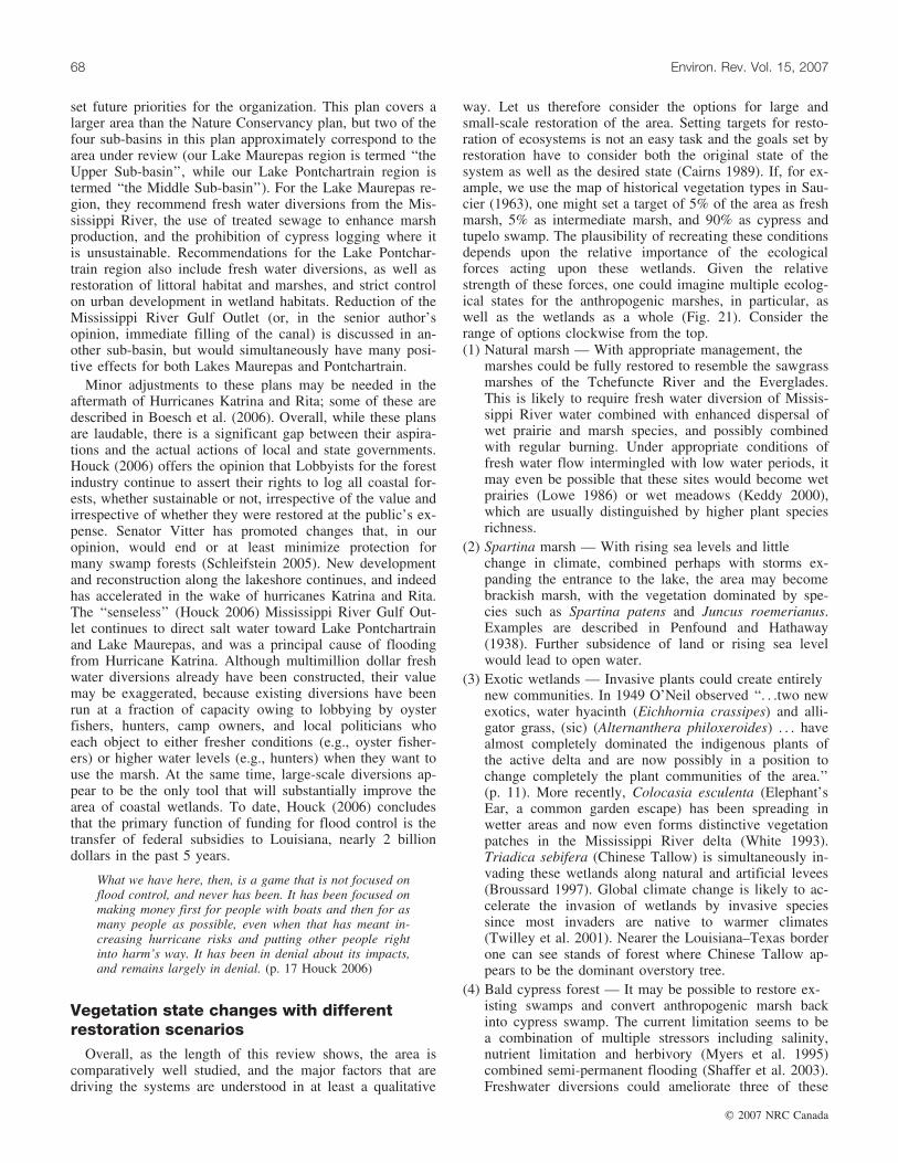
set future priorities for the organization. This plan covers alarger area than the Nature Conservancy plan, but two of thefour sub-basins in this plan approximately correspond to thearea under review (our Lake Maurepas region is termed ‘‘theUpper Sub-basin’’, while our Lake Pontchartrain region istermed ‘‘the Middle Sub-basin’’). For the Lake Maurepas re-gion, they recommend fresh water diversions from the Mis-sissippi River, the use of treated sewage to enhance marshproduction, and the prohibition of cypress logging where itis unsustainable. Recommendations for the Lake Pontchar-train region also include fresh water diversions, as well asrestoration of littoral habitat and marshes, and strict controlon urban development in wetland habitats. Reduction of theMississippi River Gulf Outlet (or, in the senior author’sopinion, immediate filling of the canal) is discussed in an-other sub-basin, but would simultaneously have many posi-tive effects for both Lakes Maurepas and Pontchartrain.
Minor adjustments to these plans may be needed in theaftermath of Hurricanes Katrina and Rita; some of these aredescribed in Boesch et al. (2006). Overall, while these plansare laudable, there is a significant gap between their aspira-tions and the actual actions of local and state governments.Houck (2006) offers the opinion that Lobbyists for the forestindustry continue to assert their rights to log all coastal for-ests, whether sustainable or not, irrespective of the value andirrespective of whether they were restored at the public’s ex-pense. Senator Vitter has promoted changes that, in ouropinion, would end or at least minimize protection formany swamp forests (Schleifstein 2005). New developmentand reconstruction along the lakeshore continues, and indeedhas accelerated in the wake of hurricanes Katrina and Rita.The ‘‘senseless’’ (Houck 2006) Mississippi River Gulf Out-let continues to direct salt water toward Lake Pontchartrainand Lake Maurepas, and was a principal cause of floodingfrom Hurricane Katrina. Although multimillion dollar freshwater diversions already have been constructed, their valuemay be exaggerated, because existing diversions have beenrun at a fraction of capacity owing to lobbying by oysterfishers, hunters, camp owners, and local politicians whoeach object to either fresher conditions (e.g., oyster fisher-ers) or higher water levels (e.g., hunters) when they want touse the marsh. At the same time, large-scale diversions ap-pear to be the only tool that will substantially improve thearea of coastal wetlands. To date, Houck (2006) concludesthat the primary function of funding for flood control is thetransfer of federal subsidies to Louisiana, nearly 2 billiondollars in the past 5 years.
What we have here, then, is a game that is not focused onflood control, and never has been. It has been focused onmaking money first for people with boats and then for asmany people as possible, even when that has meant in-creasing hurricane risks and putting other people rightinto harm’s way. It has been in denial about its impacts,and remains largely in denial. (p. 17 Houck 2006)
Vegetation state changes with differentrestoration scenarios
Overall, as the length of this review shows, the area iscomparatively well studied, and the major factors that aredriving the systems are understood in at least a qualitative
way. Let us therefore consider the options for large andsmall-scale restoration of the area. Setting targets for resto-ration of ecosystems is not an easy task and the goals set byrestoration have to consider both the original state of thesystem as well as the desired state (Cairns 1989). If, for ex-ample, we use the map of historical vegetation types in Sau-cier (1963), one might set a target of 5% of the area as freshmarsh, 5% as intermediate marsh, and 90% as cypress andtupelo swamp. The plausibility of recreating these conditionsdepends upon the relative importance of the ecologicalforces acting upon these wetlands. Given the relativestrength of these forces, one could imagine multiple ecolog-ical states for the anthropogenic marshes, in particular, aswell as the wetlands as a whole (Fig. 21). Consider therange of options clockwise from the top.(1) Natural marsh — With appropriate management, the
marshes could be fully restored to resemble the sawgrassmarshes of the Tchefuncte River and the Everglades.This is likely to require fresh water diversion of Missis-sippi River water combined with enhanced dispersal ofwet prairie and marsh species, and possibly combinedwith regular burning. Under appropriate conditions offresh water flow intermingled with low water periods, itmay even be possible that these sites would become wetprairies (Lowe 1986) or wet meadows (Keddy 2000),which are usually distinguished by higher plant speciesrichness.
(2) Spartina marsh — With rising sea levels and littlechange in climate, combined perhaps with storms ex-panding the entrance to the lake, the area may becomebrackish marsh, with the vegetation dominated by spe-cies such as Spartina patens and Juncus roemerianus.Examples are described in Penfound and Hathaway(1938). Further subsidence of land or rising sea levelwould lead to open water.
(3) Exotic wetlands — Invasive plants could create entirelynew communities. In 1949 O’Neil observed ‘‘. . .two newexotics, water hyacinth (Eichhornia crassipes) and alli-gator grass, (sic) (Alternanthera philoxeroides) . . . havealmost completely dominated the indigenous plants ofthe active delta and are now possibly in a position tochange completely the plant communities of the area.’’(p. 11). More recently, Colocasia esculenta (Elephant’sEar, a common garden escape) has been spreading inwetter areas and now even forms distinctive vegetationpatches in the Mississippi River delta (White 1993).Triadica sebifera (Chinese Tallow) is simultaneously in-vading these wetlands along natural and artificial levees(Broussard 1997). Global climate change is likely to ac-celerate the invasion of wetlands by invasive speciessince most invaders are native to warmer climates(Twilley et al. 2001). Nearer the Louisiana–Texas borderone can see stands of forest where Chinese Tallow ap-pears to be the dominant overstory tree.
(4) Bald cypress forest — It may be possible to restore ex-isting swamps and convert anthropogenic marsh backinto cypress swamp. The current limitation seems to bea combination of multiple stressors including salinity,nutrient limitation and herbivory (Myers et al. 1995)combined semi-permanent flooding (Shaffer et al. 2003).Freshwater diversions could ameliorate three of these
68 Environ. Rev. Vol. 15, 2007
# 2007 NRC Canada

four stressors (Shaffer et al. 2003; Visser et al. 2004).Both inorganic sediments from the river, and the result-ing increase in production would lead to increased eleva-tion, while the fresh water would reduce impacts of saltwater intrusion and sulfide accumulation. Currently, theHope Canal near the southern edge of the MaurepasSwamp is a candidate for such a fresh water diversion(Lane et al. 2003; Shaffer et al. 2003). Hall and Pen-found (1939a) describe a virgin example of such asswamp that could serve as a reference point for restora-tion
(5) Water tupelo swamp — With sufficient fresh water sheetflow and increased rates of sedimentation, it also is pos-sible that Nyssa aquatica and N. biflora forest, and per-haps associated bottomland hardwood species, would re-establish. Fresh water diversions (Lane et al. 2003; Shaf-fer et al 2003; Visser et al. 2004) are again a significanttool in establishing such forests. Hall and Penfound(1939b) describe a virgin example of such as swampthat could serve as a reference point for restoration.
(6) Shrub scrub — With frequent drought, it may becomeBaccharis halimifolia, Iva frutescens, and Morella ceri-fera dominated shrub scrub. Shrub cover rapidly in-creased during the 1999–2000 drought, but decreasedthereafter. Another drought is in progress, suggestingthat the area of this wetland type may be tied to projec-tions for climate change along the Gulf Coast (e.g.,Twilley et al. 2001).
(7) Mangrove swamp — Rising sea levels and a warmer cli-mate in coastal Louisiana might lead to a gradual con-version to mangrove swamp. Avicennia germinansoccurs only a short distance to the south on the margin
of the deltaic plain (Penfound and Hathaway 1938;Chabreck and Condrey 1979). Presently, occasional win-ter frosts appear to set the northern limit of this speciesand the associated mangrove ecosystem (Chabreck andCondrey 1979; Twilley et al. 2001).
Setting precise targets for ecosystem restoration requiresinformation including (1) the constraints that are currentlyoperating, (2) the degree to which humans can amelioratethese constraints (which includes both cost and ecologicalfeasibility), (3) the probable trajectories of future stressessuch as rising sea levels and changing climate, and (4) theecological value and services likely to be produced by eachof these future states. We suggest that it is not unreasonableto use the historical vegetation types in Saucier (1963) as atarget — that is, a compositional goal of 5% of the wetlandsas fresh marsh, 5% as intermediate marsh, and 90% as baldcypress – tupelo swamp. A total area somewhat greater thanpresent — ca. 162 000 ha — appears practical given scienceknowledge and managerial capability. While we have notdocumented the economic value of all the goods and serv-ices produced by these wetlands, the historical data showthat these areas of wetland were capable of supporting awide array of activities and that most of these could prob-ably continue, if practiced in a sustainable manner within arestored wetland landscape. Newer activities such as eco-tourism could also be accommodated and expanded.
Priority actions for restoration
The wetlands we have described are driven by two pri-mary processes. Both processes occur as pulses — shortterm, high impact events. The land building activities thatmaintain and restore freshwater wetlands are caused byflooding, primarily, but not exclusively, from the MississippiRiver. The overall importance of such pulse events in riversis well understood (Keddy 2000; Middleton 2002; Shaffer etal. 2005), although the impacts of pulses from hurricanes isless well understood (Michener et al. 1997, Boesch et al.2006; Turner et al. 2006). As Fig. 2 illustrated, these floodpulses from rivers build freshwater wetlands in deltas, butthese freshwater wetlands deteriorate over time as sea waterreturns (Boyd and Penland 1988; Coleman et al. 1998). Thissalt water often arrives in pulses associated with storms(Fig. 12), although the slower processes of subsidence anderosion also are responsible for loss of wetland area. Undernatural conditions, the balance between these two sets offorces determines the relative amount of open salt water asopposed to fresh water wetlands. The future state of this sys-tem will therefore depend upon the dynamic equilibrium at-tained between these two opposing sets of pulses. There willnot be a single stable state in future, but rather a dynamicequilibrium around a mean, with the deviations from thatmean depending upon the magnitude and direction of themost recent pulses.
Humans have shifted this dynamic equilibrium by ampli-fying the pulses that enable salt-water intrusion events (e.g.,construction of the Mississippi River Gulf Outlet), and allbut terminating the pulses carrying sediment and fresh waterinto this system (e.g., construction of levees along the Mis-sissippi River). The science of this situation is well under-stood, even down to the precise salinity levels that interfere
Open water
Figure 21. The constraints acting upon the wetlands of the LakesPontchartrain and Maurepas, along with possible future states forthe ecosystem depending upon different combinations of climatechange, rising sea levels, fresh water diversions, fire, and invasionby exotic plants. Areas in grey represent forest.
Keddy et al. 69
# 2007 NRC Canada

with tree photosynthesis (Pezeshki 1990). Although the sal-inity levels that cause transitions from one vegetation typeto another are less exactly determined (Visser et al. 2004),the direction of the change is equally clear. Priority actionsmust focus upon redressing this imbalance. That is, we needto increase the frequency and magnitude of fresh waterpulses, and reduce the frequency and magnitude of salt-water pulses. We simultaneously need to avoid activitiesthat will interfere with our ability to carry out these tasks— allowing new construction in wetlands, for example, willcreate more opposition to flood pulses. We propose sevenactions. The first is the overriding factor, while the remain-ing six are refinements.(1) More and larger fresh water pulses. The levees along the
Mississippi River are incompatible with the long-termsurvival of deltaic wetlands. These levees interfere withwater flow from as far upstream as the Bayou Manchacarea (due south of Baton Rouge and not to be confusedwith the Pass Manchac within our mapped area). Thesepulses must be restored. In the short run, there are plansfor a small diversion at the Hope Canal area whichwould add water and nutrients to the southern Maurepasarea (Shaffer et al. 2003, 2005). The Bonne Carre spill-way just west of New Orleans also provides a possibleroute for fresh water pulses. It leaks some 8000 cfs (1ft3/s & 0.0283 m3/s) during flood stage of the Missis-sippi, and could be routed up the I-55 Canal to spreadacross the Maurepas Swamp (Day et al. 2006). Its loca-tion near New Orleans makes it less than desirable, sinceit also is possible that the fresh water and sedimentwould directly enter Lake Pontchartrain rather than thewetlands to the west. In the immediate term, only theBonne Carre is a viable option for adding fresh water.In the short term, the Hope Canal may provide someamelioration for southern regions of the swamp. In thelong run, we must divert more fresh water into theswamps in sufficient volume to carry sediment and nutri-ents at least as far as the Manchac land bridge. Furtherdiversions upstream as far as Bayou Manchac will be re-quired. These events occurred historically (Thomson2000), and they are urgently needed now. We stronglyrecommend at least two more large freshwater diversionsinto this area, with volumes capable of replicating theoriginal flood levels that built these wetlands (candidatesites, and possible flows, are discussed in LPBF 2005).
(2) Re-establishment of sheet flow. Once water enters thesystem carrying sediment and nutrients, it must be ableto flow through the entire system. Shallow flow over thesurface of the soil, called sheet flow, was almost cer-tainly a principle way in which water and nutrientsmoved through this system. Now, however, even iffloods occur, canals and road and rail beds interferewith water movement. Canals decrease overbank flood-ing accelerate the flow of water and nutrients out of thearea, while spoil banks and road and rail beds blocksheet flow. Existing canals therefore need to be pluggedand their levees need to be gapped every 500 m, whileexisting road and rail beds need to be removed, or atleast breached with many large openings. It is importantto re-establish such sheet flow across the entire Manchacland bridge — floods that simply flow out Pass Manchac
into Lake Pontchartrain will continue to starve most ofthe Manchac land bridge of sediment and nutrients, andcontinue the ongoing conversion of swamp to marsh andopen water. In contrast, the elevated Interstate 55 (con-tiguous to the land bridge from LaPlace to Ponchatoula)illustrates a more compatible transportation corridor. Theold construction canal and spoil banks from I-55 likelyalso interfere with sheet flow; although there are largeculverts. Newer methods of end-on construction are lessdamaging. In contrast, the road bed of old Highway 51and the parallel rail line illustrate the scale of the obsta-cles that have been created; although these have culverts,many are now plugged and need maintenance.
(3) Limit salt-water intrusion. Salt-water intrusion fromstorms (e.g., Figs. 10, 12) remains a significant negativefactor. The damaging effects of the Mississippi RiverGulf Outlet continue to be documented, most recentlywith the flooding of New Orleans (Houck 2006). TheMississippi River Gulf Outlet needs to be closed, or atleast reduced greatly in size with engineering additionsto reduce salt water flow inland.
(4) Terminate land development within wetlands. The con-struction of camps, homes, and commercial enterprisesin these wetlands is largely incompatible with the for-going processes. First, flood pulses for restoration mayplace these structures at risk. Second, even if the struc-tures are built on pilings capable of withstanding theflood pulses, previous experience has shown that landowners are frequently unwilling to tolerate flooding. Asdescribed above, through much of its history, the mas-sive Caernarvon project has been run at a fraction of itsflow capacity, and without large spring pulses, becauseof objections from landowners. Given strong landownerrights, there seems to be little prospect of convincinglandowners to allow their land to be flooded in the pub-lic good. Therefore, if the Pontchartrain and Maurepaswetlands are to be managed appropriately, no furthercreation of obstacles to management can be tolerated.Every new subdivision, and every new camp, is an impe-diment to management and conservation.
(5) Acquire land for the public trust. In view of the fore-going problems, land acquisition is essential. Easementsmay provide a partial solution, but even when they aresigned, management is constrained by elements not an-ticipated in the easements. Landowners may assert otherrights, and each new right must be purchased. Even inthe best case, easements can create long lag times in re-sponse to management problems, since each landownermust be contacted, negotiations must proceed, and singlelandowners can refuse the needed management. Hence, itis imperative that most of these lands be eventuallyplaced in the public trust. Figure 4b and Table 8 sum-marize the public areas that now exist. At the sametime, each of these is surrounded by privately ownedland, which constrains the management of the publicland. Large tracts remain from former logging leasesmay provide an opportunity for rapidly expanding landadditions.
(6) Terminate logging in coastal swamps. In spite of the en-ormous pressure upon these swamp forests, including cu-mulative impacts of past logging, salt-water intrusion,
70 Environ. Rev. Vol. 15, 2007
# 2007 NRC Canada

and nutrient starvation, private land in this area is stillbeing logged, particularly for cypress. Given the historyof degradation caused by logging, the sensitivity ofmany of these areas to disturbance by logging, and theevidence that significant areas of these forests are al-ready converting to shrub scrub, marsh and open waterwe believe that no further logging should be permissiblewithin the wetlands of this area. This restriction could berevisited once restoration measures are established to en-sure sustainability. In theory, the U.S. Army Corps ofEngineers can restrict logging near waterways, but in2005, when a U.S. Senate committee drafted the WaterResources Development Act of 2005 to give Louisianafunding for coastal restoration, a provision, without pub-lic notice or discussion, was added by Senator DavidVitter to remove these powers from the Corps. This ac-tion was strongly supported by the Louisiana ForestryAssociation because it would allow more logging inswamps (Schleifstein 2005). The Louisiana House voted92-6 in support of this provision; on 25 May 2005 theLouisiana Senate approved the provision unanimously(Capitol News Bureau 2005). A recent 121 page reportto the governor with 12 authors and 4 special contribu-tors (Chambers et al. 2005) has concluded that there arethree regeneration classes for cypress: class I (sites withpotential for natural regeneration), class II (sites with po-tential for artificial regeneration only), and class III (nopotential for either natural or artificial regeneration).After several years of activity, the report recommends(p. ix) ‘‘Place an interim moratorium on harvesting onstate-owned Condition Class III lands. Develop mechan-isms to delay timber harvesting on privately owned Con-dition Class III lands’’. We urge the Louisiana legislatureto implement these recommendations. Still, given a hun-dred years of experience with the negative effects of log-ging, and decades of scientific study of wetland loss,these recommendations are surely insufficient.
(7) Create a special planning zone. The lack of regionalplanning exacerbates pressures upon these wetlands.Subdivisions continue to be developed in flood proneareas, logging upstream alters fresh water flow down riv-ers draining into the swamp, and overall, there is littleconsideration of the degree to which activities on adjoin-ing uplands might impact the wetlands. We therefore re-commend that a special planning zone be designated,extending, perhaps ten miles from the wetland boundary.Within this zone, added restrictions would be placedupon land use to prevent incompatible developmentfrom further interfering with conservation of the LakePontchartrain and Maurepas wetlands.
In conclusion, we have shown that the science of this areais comparatively well-understood. There is now a need foraction; we have recommended management strategies. Lack-ing such action, the conversion of swamp to open water canbe expected to continue or even accelerate, and the LakePontchartrain – Maurepas area will likely become an embay-ment open to the Gulf of Mexico. The potential loss of freshwater fisheries and recreation opportunities, and the conse-quent flood threats to New Orleans, would argue stronglyagainst allowing this scenario to unfold. To restore this wet-land to its original composition and productivity, and to sup-
port the local economy and offer new opportunities forecotourism, the preceding seven steps need to be imple-mented without delay.
AcknowledgmentsWe thank the Louisiana Department of Fisheries and
Wildlife for permission to work in the Manchac WildlifeManagement Area. We thank Bob Hastings for his effortsto develop a strong research program at Turtle Cove Envi-ronmental Research Station, and the many scholars whosework we appropriated in this review. We also thank themany students and volunteers who, over the years, have con-tributed to the research we cite, many of whom will go un-recognized. Maria Brown and Cathy Keddy providedvaluable assistance preparing the final manuscript, while IanKeddy prepared Figs. 14 and 21. Financial support for thiswork was provided by the Louisiana Board of Regents(LEQSF (2001-03)-RD-A-25) and the US EnvironmentalProtection Agency.
ReferencesAbraham, K.F., and Keddy, C.J. 2005. The Hudson Bay Lowland.
In The World’s Largest Wetlands: Ecology and Conservation.Edited by L.H. Fraser and P.A. Keddy. Cambridge UniversityPress, Cambridge, UK. pp. 118-148.
Alverson, W.S., Waller, D.M., and Solheim, S.L. 1988. Forests toodeer: edge effects in northern Wisconsin. Conserv. Biol. 2: 348–358.
Audubon, J.J. 1827. Observations on the natural history of the alli-gator. The Edinburgh new philosophical journal, exhibiting aview of the progressive discoveries and improvements in thesciences and the arts (January-March). pp. 270-280.
Baldwin, A.H., McKee, K.L., and Mendelssohn, I.A. 1996. The in-fluence of vegetation, salinity, and inundation on seed banks ofoligohaline coastal marshes. Am. J. Bot. 83: 470–479.
Baldwin, A.H., and Mendelssohn, I.A. 1998a. Response of two oli-gohaline marsh communities to lethal and nonlethal disturbance.Oecologia, 116: 543–555.
Baldwin, A.H., and Mendelssohn, I.A. 1998b. Effects of salinityand water level on coastal marshes: an experimental test of dis-turbance as a catalyst for vegetation change. Aquat. Bot. 61:255–268.
Bancroft, T.A., and Han, C. 1983. A note on pooling variances. J.Am. Stat. Assoc. 78: 981–983.
Barras, J.A., Bourgeois, P.E., and Handley, L.R. 1994. Land loss incoastal Louisiana, 1956-1990, Open File Report 94-01. NationalBiological Survey, National Wetlands Research Center.
Barry, J.M. 1997. Rising Tide. The Great Mississippi Flood of1927 and How it Changed America. Simon and Schuster, NewYork, NY, USA.
Table 8. Protected wetlands within the Pontchartrain–Maurepasarea.
Protected wetland Area (ha)
Maurepas Swamp Wildlife Management Area 25 293Bayou Sauvage National Wildlife Refuge 9308Big Branch National Wildlife Refuge 6917Joyce Wildlife Management Area 6511Manchac Wildlife Management Area 3369Fontainebleau State Park 1133Total 52 531
Keddy et al. 71
# 2007 NRC Canada

Bartram, W. 1791. Travels Through North & South Carolina, Geor-gia, East & West Florida, the Cherokee Country, the ExtensiveTerritories of the Muscogulges, or Creek Confederacy, and theCountry of the Chactaws; Containing An Account of the Soiland Natural Productions of Those Regions, Together with Ob-servations on the Manners of the Indians. James and Johnson,Philadelphia. (Electronic version, 2001, Documenting the Amer-ican South, University of North Carolina at Chapel Hill.)
Bazely, D.R., and Jefferies, R.L. 1986. Changes in the compositionand standing crop of salt-marsh communities in response to theremoval of a grazer. J. Ecol. 74: 693–706.
Bernard, S.K. 2002. M’sieu Ned’s rat? Reconsidering the origin ofnutria in Louisiana: The E.A. McIlhenny Collection, Avery Is-land, LA, USA. La. Hist. 43: 281–293.
Bernard, H.A., and Leblanc, R.J. 1965. Resume of the QuaternaryGeology of the Northwestern Gulf of Mexico Province. In TheQuaternary of the United States. Edited by H.E. Wright, andD.G. Frey. Princeton University Press, Princeton, N J, USA, pp.137-185.
Boesch, D.F., Josselyn, M.N., Mehta, A.J., Morris, J.T., Nuttle,W.K., Simenstad, C.A., and Swift, D.P.J. 1994. Scientific As-sessment of Coastal wetland loss, restoration and managementin Louisiana. J.Coast. Res., Special Issue No. 20.
Boesch, D.F., Shabman, L., Antle, G.L., Day, J.W., Jr., Dean, R.G.,Galloway, G.E., Groat, C.G., Laska, S.B., Luettich, R.A., Jr.,Mitsch, W.J., Rabalais, N.N., Reed, D.J., Simenstad, C.A., Stre-ever, B.J., Taylor, B.R., Twilley, R.R., Watson, C.C., Wells,J.T., and Whigham, D.F. 2006. A New Framework for Planningthe Future of Coastal Louisiana after the Hurricanes of 2005.Working Group for Post-Hurricane Planning for the LouisianaCoast, University of Maryland Center for EnvironmentalScience, Cambridge, Maryland.
Bondavalli, C., and Ulanowicz, R.E. 1999. Unexpected effects ofpredators upon their prey: the case of the American Alligator.Ecosystems (N.Y., Print), 2: 49–63.
Botkin, D.B. 1990. Discordant Harmonies: A New Ecology for theTwenty-first Century. Oxford University Press, New York, NY,USA.
Boyd, R., and Penland, S. 1988. A geomorphologic model for Mis-sissippi River Delta Evolution. Transactions. Gulf Coast Assoc.Geol. Soc. Trans. 38: 443–452.
Brantley, C.G., and Platt, S.G. 1992. Experimental evaluation ofnutria herbivory on bald cypress. Proc. La. Acad. Sci. 55: 21–25.
Brewer, T.M. 1840. Wilson’s American Ornithology, with notes byJardine. Otis, Broaders, and Company. Boston, MA, USA.
Brewer, J.S., and Grace, J.B. 1990. Plant community structure in anoligohaline tidal marsh. Vegetatio, 90: 93–107.
Broussard, M.M. 1997. Decomposition and environmental con-straints of the introduced Chinese tallow tree. M.Sc. thesis,Southeastern Louisiana University, Hammond, LA, USA.
Brown, P., Kennett, J.P., and Ingram B.L. 1999. Marine evidencefor episodic Holocene megafloods in North America and north-ern Gulf of Mexico. Paleoceanography, 14: 498–510.
Cahoon, D.R., Reed, D.J., Day, J.W., Jr., Steyer, G.D., Boumans,R.M., Lynch, J.C., McNally, D., and Latif, N. 1995. The influ-ence of Hurricane Andrew on sediment distribution in Louisianacoastal marshes. J. Coastal Res. 81: 280–294.
Cairns, J. 1989. Restoring damaged ecosystems: is predisturbancecondition a viable option? Environ. Prof. 11: 152–159.
Capitol News Bureau. 2005. House votes to back wetlands cypresslogging. Undated. The Advocate/WBRZ-TV, Baton Rouge.Downloaded 18 October 2005. Available: http://www.2theadvocate.com/stories/061805/pol_logging001.shtml.
Carpenter, S.R., and Kitchell, J.F. 1988. Consumer control of lakeproductivity. Bioscience, 38: 764–769.
Carter, J., Foote, A.L., and Johnson-Randall, L.A. 1999. Modelingthe effects of nutria (Myocastor coypus) on wetland loss. Wet-lands, 19: 209–219.
Carter, M.R., Burns, L.A., Cavinder, T.R., Dugger, K.R., and Fore,P.L. Hicks, D.B., Revells, H.L., and Schmidt, T.W. 1973. Eco-systems analysis of the Big Cypress Swamp and estuaries.USEPA, Region IV, South Florida Ecological Study.
Chabreck, R.H. 1972. Vegetation, Water and Soil Characteristics ofthe Louisiana Coastal Region. Louisiana State University, Agri-cultural Experiment Station Bulletin No. 664, Baton Rouge, LA,USA.
Chabreck, R.H., and Condrey, R.E. 1979. Common Vascular Plantsof the Louisiana Marsh. Louisiana State University Center forWetland Resources, Baton Rouge, LA.
Chambers, J.L., Conner, W.H., Day, J.W., Faulkner, S.P., Gardiner,E.S., Hughes, M.S., Keim, R.F., King, S.L., McLeod, K.W.,Miller, C.A., Nyman, J.A., and Shaffer, G.P. 2005. Conserva-tion, protection and utilization of Louisiana’s Coastal WetlandForests. Final Report to the Governor of Louisiana from theCoastal Wetland Forest Conservation and Use Science WorkingGroup. (Special contributions from W.M. Aust, Goyer, R.A.,Lenhard, G.J., Souther-Effler, R.F., Rutherford, D.A., and Kelso,W.E.). Available from: Louisiana Governor’s Office of CoastalActivities, 1051 N. Third St. Capitol Annex Bldg, Suite 138 Ba-ton Rouge, LA 70802.
Chancellor, J. 1978. Audubon. Weidenfeld and Nicolson, London,UK.
Christensen, N.L. 1988. Vegetation of the Southeastern CoastalPlain. In North American Terrestrial Vegetation. Edited byM.G. Barbour and W.D. Billings. Cambridge University Press,Cambridge, UK. pp. 317–363.
Coleman, J.M., Roberts, H.H., and Stone, G.W. 1998. MississippiRiver Delta: an overview. J. Coastal Res. 14: 698–716.
Connell, J.H. 1979. Intermediate-disturbance hypothesis. Science(Wash.). 204: 1344–1345.
Conner, W.H., Cramer, G.W., and Day, J.W. 1980. Vegetation ofthe north shore marshes and west shore swamps of Lake Pontch-artrain Louisiana. Proc. La. Acad. Sci. 43: 139–145.
Conner, W.H., and Buford, M.A. 1998. Southern deepwaterswamps. In Southern Forested Wetlands. Ecology and Manage-ment. Edited by M.G. Messina and W.H. Conner. Lewis Pub-lishers, Boca Raton, FL. pp. 261-287
Conner, W.H., and Day, J.W., Jr. 1976. Productivity and composi-tion of a bald cypress-water tupelo site and a bottomland hard-wood site in a Louisiana swamp. Am. J. Bot. 63: 1354–1364.
Conner, W.H., and Day, J.W., Jr. 1988. Rising water levels incoastal Louisiana: implications for two coastal forested wetlandareas in Louisiana. J. Coastal Res. 4: 589–596.
Conner, W.H., and Day, J.W., Jr. 1992. Water level variability andlitterfall productivity of forested freshwater wetlands in Louisi-ana. Am. Midl. Nat. 128: 237–245.
Conner, W.H., Gosselink, J.G., and Parrondo, R.T. 1981. Compari-son of the vegetation of three Louisiana swamp sites with differ-ent flooding regimes. Am. J. Bot. 68: 320–331.
CWPPRA. 2003. Coastwide nutria control program (LA-03b) factsheet. Coastal Wetland Planning, Protection, and RestorationAct Task Force. Downloaded 20 November 2003. Available:http://www.lacoast.gov/projects/list.asp.
Davis, D.W. 2000. Historical perspective on crevasses, levees, andthe Mississippi River. In Transforming New Orleans and Its En-virons, Centuries of Change. Edited by C.E. Colten. Universityof Pittsburgh Press, Pittsburgh, PA. pp. 84-108.
72 Environ. Rev. Vol. 15, 2007
# 2007 NRC Canada

Day, J.W., Jr., Shaffer, G.P., Britsch, D., Reed, D., Hawes, S., andCahoon, D. 2000. Pattern and process of land loss in the Louisi-ana coastal zone: an analysis of spatial and temporal patterns ofwetlands habitat change. Estuaries, 23: 425–438.
Day, J.W., Jr., Shaffer, G.P., Britsch, D., Reed, D., Hawes, S., andCahoon, D. 2001. Patterns and processes of land loss in coastalLouisiana are complex: a reply to Turner 2001. Estimating theindirect effects of hydrologic change on wetland loss: if theEarth is curved, then how would we know it? Estuaries, 24:647–651.
Day, J.W., Conner, W.H., and Shaffer, G.P. 2006. The importanceof pulsed physical events for sustainability of Louisana coastalforested wetlands. Hydrology and Management of Forested Wet-lands Proceedings of the international Conference. American So-ciety of Agricultural and Biological Engineers, St. Joseph, MI.pp. 158–166.
Delcourt, P.A., Delcourt, H.R., Brister, R.C., and Lackey, L.E.1980. Quaternary vegetation history of the Mississippi embay-ment. Quat. Res. 13: 111–132.
DeSelm, H.R. and Murdock, N. 1993. Grassland-dominated com-munities. In Biodiversity of the Southeastern United States. Edi-ted by W.H. Martin, S.G. Boyce, and A.C. Echternacht. JohnWiley, New York, NY, USA. pp. 87–141.
Devall, M.S. 1998. An Interim Old-Growth Definition for Cy-press-Tupelo Communities in the Southeast. United States De-partment of Agriculture, Forest Service, Southern ResearchStation, Stoneville, Mississippi. General Technical Report SRS-19.
Dormon, J.H. 1990. Audubon. A Retrospective. The Center forLouisiana Studies, University of Southwestern Louisiana, Lafay-ette, LA, USA.
Dranguet, C.A., Jr., and Heleniak, R.J. 1992. Man in the Basin: Ha-bitation and Forest Exploitation in the Pontchartrain Basin. Pa-per presented at the "Basics of the Basin" Research Symposiumaddressing the condition of the Lake Pontchartrain Basin. Uni-versity of New Orleans, May 14, 1992.
Dranguet, C.A., Jr., and Heleniak, R.J. 1985. Back Door to theGulf: The Pass Manchac Region, 1699-1863. Center for Regio-nal Studies, Southeastern Louisiana University, Hammond, LA,USA, reprinted from Regional Dimensions 3.
Dundee, H.A., and Rossman, D.A. 1989. The Amphibians and Rep-tiles of Louisiana. Louisiana State University Press, BatonRouge, LA, USA.
Earnest, E.P. 1940. John and William Bartram, Botanists and Ex-plorers, 1699-1777, 1739-1823. University of PennsylvaniaPress, Philadelphia.
Elner, R.W., and Vadas, R.L., Sr. 1990. Inference in ecology: thesea urchin phenomenon in the northwestern Atlantic. Am. Nat.136: 108–125.
Elsey, R.M., McNease, L., Joanen, T., and Kinler, N. 1992. Foodhabits of native and farm-released juvenile Alligators. Proc.Annu. Conf. SEAFWA, 46: 57–66.
Eriksson, O. 1993. The species-pool hypothesis and plant commu-nity diversity. Oikos, 68: 371–374.
Evers, D.E., Sasser, C.E., Gosselink, J.G., Fuller, D.A., and Visser,J.M. 1998. The impact of vertebrate herbivores on wetland ve-getation in Atchfalaya Bay, Louisiana. Estuaries, 21: 1–13.
Flynn, K.M., McKee, K.L., and Mendelssohn, I.A. 1995. Recoveryof freshwater marsh vegetation after a saltwater intrusion event.Oecologia, 103: 63–72.
Fraser, L.H., and Keddy, P.A. (editors). 2005. The World’s LargestWetlands: Ecology and Conservation. Cambridge UniversityPress, Cambridge, UK.
Frazier, D.E. 1967. Recent deltaic deposits of the Mississippi
River: their development and chronology. Gulf Coast Assoc.Geol. Soc. Trans. 27: 287–315.
Fox, J.F., and Connell, J.H. 1979. Intermediate-disturbance hypoth-esis. Science, 204: 1344–1345.
Gabrey, S.W. 2005. Impacts of the nutria removal program on thediet of American alligators (Alligator mississippiensis) in southLouisiana. Report to Louisiana Department of Wildlife and Fish-eries, Baton Rouge, LA, USA.
Gamble, T. 1920. Naval Stores. History, Production, Distributionand Consumption. Review Publishing and Printing Company,Savannah, GA, USA.
Geho, E.M., Campbell, D., Keddy, P.A. 2007. Quantifying ecologi-cal filters: the relative impact of herbivory, neighbours, and se-diment on an oligohaline marsh. Oikos. In press.
Gibson, J.L. 1996. Poverty Point. A Terminal Archaic Culture ofthe Lower Mississippi Valley. 2nd ed. The AnthropologicalStudy Series No. 7, Louisiana Archaeological Survey and Anti-quities Commission, Department of Culture, Recreation andTourism. Downloaded 10 January 2004. Available: www.crt.state.la.us/crt/ocd/arch/poverpoi/mapopo.htm.
Godfrey, R.K., and Wooten, J.W. 1981. Aquatic and WetlandPlants of the Southeastern United States. University of GeorgiaPress, Athens, GA, USA.
Gosselink, J.G., Coleman, J.M., and Stewart, R.E., Jr. 1998.Coastal Louisiana. In Status and Trends of the Nation’s Biologi-cal Resources, 2 Vols. Edited by M.J. Mac, P.A. Opler, C.E.Puckett Haecker, and P.D. Doran. U.S. Department of the Inter-ior, U.S. Geological Survey, Reston, VA, USA. pp. 385-436.
Gough, L., and Grace, J.B. 1998. Effects of flooding, salinity, andherbivory on coastal plant communities, Louisiana, USA. Oeco-logia, 117: 527–535.
Gough, L., Grace, J.B., and Taylor, K.L. 1994. The relationship be-tween species richness and community biomass: the importanceof environmental variables. Oikos, 70: 271–279.
Grace, J.B. 1999. The factors controlling species density in herbac-eous plant communities: an assessment. Perspect. Plant Ecol.Evol. Syst. 2: 1–28.
Grace, J.B., and Ford, M.A. 1996. The potential impact of herbi-vores on the susceptibility of the marsh plant Sagittaria lancifo-lia to saltwater intrusion in coastal wetlands. Estuaries, 19: 13–20.
Grace, J.B., and Pugesek, B.H. 1997. A structural equation modelof plant species richness and its application to a coastal wetland.Am. Nat. 149: 436–460.
Grime, J.P. 1977. Evidence for the existence of three primary stra-tegies in plants and its relevance to ecological and evolutionarytheory. Am. Nat. 111: 1169–1194.
Grime, J.P. 1979. Plant Strategies and Vegetation Processes. Wiley,London, UK.
Hall, T.F., and Penfound, W.T. 1939a. A phytosociological studyof a cypress-gum swamp in southeastern Louisiana. Am. Midl.Nat. 21: 378–395.
Hall, T.F., and Penfound, W.T. 1939b. A Phytosociological studyof a Nyssa biflora consocies in southeastern Louisiana. Am.Midl. Nat. 22: 369–375.
Harms, W.R., Schreuder, H.T., Hook, D.D., Brown, C.L., andShropshire, F.W. 1980. The effects of flooding on the swampforest in Lake Ochlawaha, Florida. Ecology (USA), 61: 1412–1421.
Hastings, R. 2004. History of the Turtle Cove Environmental Re-search Station: The first two decades. Proc. L. Academy Sci.65: 30–47.
Heleniak, R.J., and Dranguet, C.A. 1987. Changing patterns of hu-man activity in the western basin of Lake Pontchartrain. In Pro-
Keddy et al. 73
# 2007 NRC Canada

ceedings of the Tenth National Conference of the Coastal So-ciety, October 12–15, 1986. New Orleans, LA.
Herndon, A., Gunderson, L., and Stenberg, J. 1991. Sawgrass (Cla-dium jamaicense) survival in a regime of fire and flooding. Wet-lands, 11: 17–28.
Hester, M.W., Mendelssohn, I.A., and McKee, K.L. 1998. Intraspe-cific variation in salt tolerance and morphology in Panicumhemitomon and Spartina alterniflora (Poaceae). Int. J. Plant Sci.159: 127–138.
Hester, M.W., Mendelssohn, I.A., and McKee, K.L. 2001. Speciesand population variation to salinity stress in Panicum hemito-mon, Spartina patens, and Spartina alterniflora: morphologicaland physiological constraints. Environ. Exp. Bot. 46: 277–297.
Holland, W.C. 1944. Physiographic divisions of the Quaternarylowlands of Louisiana. La. Acad. Sci. 8: 11–24.
Hornaday, W.T. 1913. Our Vanishing Wild Life. Its Exterminationand Preservation. New York Zoological Society, New York,NY, USA.
Houck, O. 2006. Can we save New Orleans? Tulane Environ. LawJ. 19: 1–68.
Howard, R.J., and Mendelssohn, I.A. 1999. Salinity as a constrainton growth of oligohaline marsh macrophytes. Species variationin stress tolerance. Am. J. Bot. 86: 785–794.
ITIS. 2005. Integrated Taxonomic Information System. UnitedStates Department of Agriculture online database. Available:http://www.itis.usda.gov (October 2005).
Jefferies, R.L., and Rockwell, R.F. 2002. Foraging geese, vegeta-tion loss and soil degradation in an Arctic salt marsh. Appl.Veg. Sci. 5: 7–16.
Joanen, T., and McNease, L. 1987. The management of Alligatorsin Louisiana, USA. In Wildlife Management: Crocodiles and Al-ligators. Edited by G.J.W. Webb, S.C. Manolis, and P.J. White-head. Surrey Teatty and Sons Pty Limited, Chipping Norton,Australia, pp. 33–42.
Joanen, T., McNease, L., Perry, G., Richard, D., and Taylor, D.1984. Louisiana’s alligator management program. Proc. Annu.Conf. SEAFWA, 38: 210–211.
Kandalepas, D. 2004. Classification of wetland vegetation types inthe northwestern portion of the Lake Pontchartrain Basin, LA.USA. M.Sc. thesis, Southeastern Louisiana University, Ham-mond, LA, USA.
Keddy, P.A. 1992. Assembly and response rules: two goals for pre-dictive community ecology. J. Veg. Sci. 3: 157–164.
Keddy, P.A. 2000. Wetland Ecology: Principles and Conservation.Cambridge University Press, Cambridge, UK.
Keddy, P.A., and Fraser, L.H. 2002. The management of wetlandsfor biological diversity: four principles. In Modern Trends inApplied Aquatic Ecology. Edited by R.S. Ambasht and N.K.Ambasht. Kluwer, New York, NY, USA. pp. 21-42.
Keddy, P.A., Smith, L., Campbell, D.R., Clark, M., and Montz, G.2006. Patterns of herbaceous plant diversity in a Louisiana pinesavanna. Appl. Veg. Sci. 9: 16–26.
Keddy, P.A., Gough, L., Nyman, J.A., McFalls, T., Carter, J., andSiegrist, J. In press. Alligator hunters, pelt traders, and runawayconsumption of Gulf Coast marshes: A trophic cascade perspec-tive on coastal wetland losses. In Anthropogenic Modification ofNorth American Salt Marshes. Edited by B. Silliman, M. Bertness,and D. Strong. University of California Press, CA, USA. In press.
Kniffen, F.B., and Hilliard, S.B. 1988. Louisiana: Its Land andPeople. Louisiana State University Press, Baton Rouge, LA,USA.
Koch, M.S., Mendelssohn, I.A., and McKee, K.L. 1990. Mechan-ism for the hydrogen sulfide-induced growth limitation in wet-land macrophytes. Limnol. Oceanogr. 35: 399–408.
Lane, R.R., Mashriqui, H.S., Kemp, G.P., Day, J.W., Day, J.N., andHamilton, A. 2003. Potential nitrate removal from a river diver-sion into a Mississippi delta forested wetland. Ecol. Eng. 20:237–249.
La Peyre, M.K.G., Grace, J.B., Hahn, E., and Mendelssohn, I.A.2001. The importance of competition in regulating plant speciesabundance along a salinity gradient. Ecology (USA), 82: 62–69.
Latham, R.E., Beyea, J., Benner, M., Dunn, C.A., Fajvan, M.A.,Freed, R.R., Grund, M., Horsley, S.B., Rhoads, A.F., and Shiss-ler, B.P. 2005. Managing White-tailed Deer in Forest HabitatFrom an Ecosystem Perspective: Pennsylvania Case Study. Re-port by the Deer Management Forum for Audubon Pennsylvaniaand Pennsylvania Habitat Alliance, Harrisburg, PA.
LDWF. 2006. Nutria: Wetland Damage. Louisiana Department ofWildlife and Fisheries. Downloaded 9 September 2006. Avail-able: http://www.nutria.com/site5.php.
Llewellyn, D.W., Shaffer, G.P., Craig, N.J., Creasman, L., Pashley,D., Swan, M., and Brown, C. 1996. A decision-support systemfor prioritizing restoration sites on the Mississippi River alluvialplain. Conserv. Biol. 10: 1446–1455.
Lodge, D.M., Cronin, G., van Donk, E., and Froelich, A.J. 1998.Impact of herbivory on plant standing crop: Comparisons amongbiomes, between vascular and nonvascular plants, and amongfreshwater herbivore taxa. In The structuring role of submergedmacrophytes in lakes. Edited by E. Jeppesen, M. Sondergard, M.Sondergard, and K. Christoffersen. Springer-Verlag, New York,NY, USA, Vol. 131. pp. 149–174.
Lopez, J.A. 2003.Chronology and analysis of environmental im-pacts within the Pontchartrain basin of the Mississippi DeltaPlain: 1718-2002. Ph.D. Dissertation, Engineering and AppliedSciences Program, University of New Orleans, New Orleans,LA, USA.
Lorenzen, B., Brix, H., Mendelssohn, I.A., McKee, K.L., and Miao,S.L. 2001. Growth, biomass allocation and nutrient use efficiencyin Cladium jamaicense and Typha domingensis as affected byphosphorus and oxygen availability. Aquat. Bot. 70: 117–133.
Loveless, C.M. 1959. A study of the vegetation in the Florida ever-glades. Ecology (USA), 40: 1–9.
Lowe, E.F. 1986. The relationship between hydrology and vegeta-tional pattern within the floodplain marsh of a subtropical Flor-ida lake. Fla. Sci. 49: 213–233.
Lowery, G.H. 1974. The Mammals of Louisiana and its AdjacentWaters. Louisiana State University Press, Baton Rouge, LA, USA.
LPBF. 2005. Comprehensive Management Plan for Habitats in theLake Pontchartrain Basin. Lake Pontchartrain Basin Foundation,New Orleans, LA, USA.
Mancil, E. 1980. Pullboat logging. J. For. Hist. 24: 135–141.Mann, K.H., and Breen, P.A. 1972. The relation between lobster
abundance, sea urchins, and kelp beds. J. Fish. Res. Board Can.29: 603–605.
Martin, S.B., and Shaffer, G.P. 2005. Sagittaria biomass partition-ing relative to salinity, hydrological regime, and substrate type:implications for plant distribution patterns in coastal Louisiana,USA. J. Coastal Res. 21: 164–171.
McFalls, T. 2004. Effects of disturbance and fertility upon the ve-getation of a Louisiana coastal marsh. M.Sc. thesis, SoutheasternLouisiana University, Hammond, LA, USA.
McIlhenny, E.A. 1935. The alligator’s life history. ChristopherPublishing House, Boston. Republished (1976) by the Societyfor the Study of Amphibians and Reptiles, Miscellaneous publi-cations, facsimile reprints in Herpetology.
McKee, K.L., and Mendelssohn, I.A. 1989. Response of a fresh-water marsh plant community to increased salinity and increasedwater level. Aquat. Bot. 34: 301–316.
74 Environ. Rev. Vol. 15, 2007
# 2007 NRC Canada

Megonigal, J.P., Conner, W.H., Kroeger, S., and Sharitz, R.R.1997. Aboveground production in southeastern floodplain for-ests: a test of the subsidy-stress hypothesis. Ecology (USA), 78:370–384.
McWilliams, R.G. (Editor). 1981. Iberville’s Gulf Journals. Univer-sity of Alabama Press, Tuscaloosa, AL, USA.
Mendelssohn, I.A., and Kuhn, I.A. 2003. Sediment subsidy: effectson soil-plant responses in a rapidly submerging coastal saltmarsh. Ecol. Eng. 21: 115–128.
Messina, M.G., and Conner, W.H. 1998. (Editors) SouthernForested Wetlands. Ecology and Management. Lewis Publishers,Boca Raton, FL, USA.
Michener, W.K., Blood, E.R., Bildstein, K.L., Brinson, M.M., andGardner, L.R. 1997. Climate change, hurricanes and tropicalstorm, and rising sea level in coastal wetlands. Ecol. Appl. 7:770–801.
Middleton, B.A. (Editor). 2002. Flood pulsing in wetlands: Restor-ing the natural hydrological balance. John Wiley, New York,N.Y, USA.
Milliman, J.D., and Meade, R.H. 1983. World-wide delivery ofriver sediment to the oceans. J. Geol. 91: 1–21.
Mitsch, W.J., and Gosselink, J.G. 2000. Wetlands (3rd edition).John Wiley, New York, NY, USA.
Mitsch, W.J., Taylor, J.R., and Benson, K.B. 1991. Estimating pri-mary productivity of forested wetland communities in differenthydrologic landscapes. Landscape Ecol. 5: 75–92.
Moore, R.H. 1992. Low-salinity back bays and lagoons. In Biodi-versity of the Southeastern United States. Edited by C.T. Hack-ney, S.M. Adams, and W.H. Martin. Wiley, New York, NY,USA. pp. 541-614.
Myers, R.S., Shaffer, G.P., and Llewellyn, D.W. 1995. Baldcypress(Taxodium distichum.) restoration in southeastern Louisiana: therelative effects of herbivory, flooding, competition and macro-nutrients. Wetlands, 15: 141–148.
Newman, S., Grace, J.B., and Koebel, J.W. 1996. Effects of nutri-ents and hydroperiod on Typha, Cladium and Eleocharis: impli-cations of Everglades restoration. Ecol. Appl. 6: 774–783.
Norgress, R.E. 1947. The history of the cypress lumber industry inLouisiana. The Louisiana Historical Quarterly, 30: 979–1059.
Nyman, J.A., and Chabreck, R.H. 1995. Fire in coastal marshes:history and recent concerns. In Proceedings 19th Tall TimbersFire Ecology Conference - Fire in Wetlands: a Management Per-spective. Edited by S.I. Cerulean and R.T. Engstrom. Tall Tim-bers Research, Inc., Tallahassee, FL, USA, pp. 135-141.
Oberholser, H.C. 1938. The Bird Life of Louisiana. Bulletin No.28, Department of Conservation, New Orleans, LA, USA.
O’Neil, T. 1949. The Muskrat in the Louisiana Coastal Marshes.Louisiana Department of Wildlife and Fisheries, New Orleans(now Baton Rouge), LA, USA.
Peet, R.K., and Allard, D.J. 1993. Longleaf pine vegetation of thesouthern Atlantic and eastern Gulf Coast regions: A preliminaryclassification. In Proceedings of the Tall Timbers Fire EcologyConference, No. 18, The Longleaf Pine Ecosystem: Ecology,Restoration, Management. Edited by S.M. Hermann. Tall Tim-bers Research Inc., Tallahassee, FL, USA. pp. 45-81.
Penfound, W.T. 1952. Southern swamps and marshes. Bot. Rev.18: 413–446.
Penfound, W.T., and Hathaway, E.S. 1938. Plant communities in themarshlands of southeastern Louisiana. Ecol. Monogr. 8: 1–56.
Penland, S., and Ramsey, K.E. 1990. Relative sea-level rise in Louisi-ana and the Gulf of Mexico: 1908-1988. J. Coast. Res. 6: 323–342.
Penland, S., Beall, A., and Waters, J. (Editors). 2001. Environmen-tal Atlas of the Lake Pontchartrain Basin. Lake PontchartrainBasin Foundation, New Orleans, LA, USA.
Perrin, J.M. 2000. Home Town Ponchatoula. A Community Historyof Ponchatoula, Louisiana. Self published, Ponchatoula, LA,USA.
Pezeshki, S.R. 1990. A comparative study of the response of Taxo-dium distichum and Nyssa aquatica seedlings to soil anaerobio-sis and salinity. For. Ecol. Manage. 33/34: 531–541.
Pezeshki, S.R., DeLaune, R.D., and Pardue, J.H. 1992. Sedimentaddition enhances transpiration and growth of Spartina alterni-flora in deteriorating Louisiana Gulf Coast salt marshes. Wet-lands Ecol. Manage. 1: 185–189.
Pezeshki, S.R., DeLaune, R.D., and Patrick, W.H., Jr. 1987a. Re-sponse of bald cypress (Taxodium distichum L. var. distichum)to increases in flooding and salinity in Louisiana’s MississippiRiver Deltaic Plain. Wetlands, 7: 1–10.
Pezeshki, S.R., DeLaune, R.D., and Patrick, W.H., Jr. 1987b. Ef-fects of flooding and salinity on photosynthesis of Sagittarialancifolia. Mar. Ecol. Prog. Ser. 41: 87–91.
Pezeshki, S.R., DeLaune, R.D., and Patrick, W.H., Jr. 1987c. Re-sponse of the freshwater marsh species, Panicum hemitomonSchult., to increased salinity. Freshwater Biol. 17: 195–200.
Platt, S.G. 1988. A checklist of the flora of the Manchac WildlifeManagement Area, St. John the Baptist Parish, Louisiana. Pro-ceedings of the Louisiana Academy of Sciences, 51: 15–20.
Platt, S.G., Brantley, C.G., and Hastings, R.W. 1990. Food habitsof juvenile Amercian alligators in the upper Lake PonchartrainEstuary. NE Gulf Sci. 11: 123–130.
Reyes, E., White, M.L., Martin, J.F., Kemp, G.P., Day, J.W., andAravamuthan, V. 2000. Landscape modeling of coastal habitatchange in the Mississippi Delta. Ecology (USA), 81: 2331–2349.
Reuss, M. 1998. Designing the Bayous. The Control of Water inthe Atchafalaya Basin 1800-1995. Office of History U.S. ArmyCorps of Engineers, Alexandria, VA, USA.
Rolfe, E.S. 1900. The Passing of the Birds. New England Maga-zine, 22: 413–419. [New Series.]
Russell, F.L., Zippin, D.B., and Fowler, N.L. 2001. Effects ofwhite-tailed deer (Odocoileus virginianus) on plants, plant popu-lations and communities: A review. Am. Midl. Nat. 146: 1–26.
Rutherford, D.A. 2002. Pallid Sturgeon: A Louisiana living fossil.L. Agric. 45: 29–30.
Saucier, R.T. 1963. Recent Geomorphic History of the Pontchar-train Basin. Louisiana State University Press, Baton Rouge, LA,USA.
Schleifstein, M. 2005. Vitter backs off logging proposal. It wouldopen harvest of cypress in wetlands. The Times Picayune, NewOrleans. Downloaded 18 October 2005. Available: http://www.nola.com/printer/printer.ssf?/base/news-0/111561653810230.xml.
Schlesinger, W.H. 1978. Community structure, dyes, and nutrientecology in the Okenfenokee cypress swamp-forest. Ecol.Monogr. 48: 43–65.
Shaffer, G.P., Wood, W.B., Hoeppner, S.S., Perkins, T.E., Zoeller,J.A., and Kandalepas, D. In review. Degradation of Baldcypress– Water Tupelo Swamp to Marsh and Open Water in Southeast-ern Louisiana, USA: An Irreversible Trajectory? J. Coastal Res.
Shaffer, G.P., Gosselink, J.G., and Hoeppner, S.S. 2005. The Mis-sissippi River alluvial plain. In The World’s Largest Wetlands:Ecology and Conservation. Edited by L.H. Fraser and P.A.Keddy. Cambridge University Press, Cambridge, UK. pp. 272-315.
Shaffer, G.P., Perkins, T.E., Hoeppner, S., Howell, S., Benard, H.,and Parsons, A.C. 2003. Ecosystem Health of the MaurepasSwamp: Feasibility and Projected Benefits of a Freshwater Di-version. U.S. Environmental Protection Agency, Region 6, Dal-las, TX, USA.
Keddy et al. 75
# 2007 NRC Canada

Shaffer, G.P., Sasser, C.E., Gosselink, J.G., and Rejmanek, M.1992. Vegetation dynamics in the emerging Atchafalaya Delta,Louisiana, USA. J. Ecol. 80: 677–687.
Silliman, B.R., and Bertness, M.D. 2002. A trophic cascade regu-lates salt marsh primary production. Proc. Natl. Acad. Sci.U.S.A. 99: 10500–10505.
Silver, T. 1990. A New Face on the Countryside. Indians, Colonistsand Slaves in the South Atlantic Forests, 1500-1800. CambridgeUniversity Press, Cambridge, UK.
Sinclair, A.R.E., Krebs, C.J., Fryxell, J.M., Turkington, R., Boutin,S., Boonstra, R., Seccombe-Hett, P., Lundberg, P., and Oksanen,L. 2000. Testing hypotheses of trophic level interactions: a bor-eal forest ecosystem. Oikos, 89: 313–328.
Smith, T.I.J. 1985. The fishery, biology and management of Atlan-tic sturgeon, Acipenser oxyrhynchus, in North America. Environ.Biol. Fishes, 14: 61–72.
Smith, L.M., and Kadlec, J.A. 1985a. Fire and herbivory in a GreatSalt Lake marsh. Ecology (USA), 66: 259–265.
Smith, L.M., and Kadlec, J.A. 1985b. Comparisons of prescribedburning and cutting of Utah marsh plants. Great Basin Nat. 45:463–466.
Smith, L. 1991. Louisiana longleaf: an endangered legacy. Louisi-ana Conservationist, 3: 24–27.
Sousa, W.P. 1984. The role of disturbance in natural communities.Annu. Rev. Ecol. Syst. 15: 353–391.
Souther, R.F., and Shaffer, G.P. 2000. The effects of submergenceand light on two age classes of baldcypress (Taxodium disti-chum) seedlings. Wetlands, 20: 697–706.
Stolzenburg, W. 2002. Swan song of the ivory-bill. Nature Conser-vancy, 52: 38–47.
Tarver, J., Linscombe, G., and Kinler, N. 1987. Fur animals, alliga-tor, and the fur industry in Louisiana. Miscellaneous publica-tions of the Fur and Refuge Division, Louisiana Department ofWildife and Fisheries, Baton Rouge, LA, USA.
Taylor, I.R. 1985. Community structure and primary productivityof forested wetlands in western Kentucky. Ph.D. Dissertation,University of Louisville, Louisville, KY, USA.
Taylor, D., and Neal, W. 1984. Management implications of size-class frequency distributions in Louisiana alligator populations.Wildlife Soc. Bul. 12: 312–319.
Taylor, K.L., and Grace, J.B. 1995. The effects of vertebrate her-bivory on plant community structure in the coastal marshes ofthe Pearl River, Louisiana, USA. Wetlands, 15: 68–73.
Taylor, K.L., Grace, J.B., and Marx, B.D. 1997. The effects of her-bivory on neighbor interactions along a coastal marsh gradient.Am. J. Bot. 84: 708–715.
Teller, J.T. 1988. Lake Agassiz and its contribution to flow throughthe Ottawa- St. Lawrence system. In The Late Quaternary Devel-opment of the Champlain Sea Basin. Edited by N.R. Gadd. Geo-logical Association of Canada Special Paper 35. pp. 281-289.
Teller, J.T. 2003. Controls, history, outbursts and impact of largelate-Quaternary proglacial lakes in North America. In The Qua-ternary Period in the United States. Edited by A. Gilespie, S.Porter and B. Awater. INQUA Anniversary Volume. Elsevier,Amsterdam, The Netherlands, pp. 45-61.
Teller, J.T., and Thorleifson, L.H. 1983. The Lake Agassiz – LakeSuperior connection. In Glacial Lake Agassiz. Edited by J.T.Teller and L. Clayton. Geological Association of Canada SpecialPaper 26. pp. 261-290.
The Louisiana Coastal Wetlands Conservation and RestorationTask Force and the Wetlands Conservation and RestorationAuthority. 1998. Coast 2050: Toward a Sustainable CoastalLouisiana. Louisiana Department of Natural Resources, BatonRouge, LA, USA.
The Nature Conservancy. 2004. Conservation Area Plan for theLake Pontchartrain Estuary. North Shore Field Office, Coving-ton, LA, USA.
Thomson, D.A. 2000. The influence of hydrological alterationsupon wetland hydrodynamics and plant growth on the ManchacLandbridge. M.Sc. thesis, Southeastern Louisiana University,Hammond, LA, USA.
Thomson, D.A., Shaffer, G.P., and McCorquodale, J.A. 2002. Apotential interaction between sea-level rise and global warming:implications for coastal stability on the Mississippi River DeltaicPlain. Global Planet. Change, 32: 49–59.
Tilghman, N.G. 1989. Impacts of white-tailed deer on forest regen-eration in northwestern Pennsylvania. J. Wildl. Manage. 53:524–532.
Toner, M., and Keddy, P. 1997. River hydrology and riparian wet-lands: a predictive model for ecological assembly. Ecol. Appl. 7:236–246.
Turner, R.E. 1997. Wetland loss in the Northern Gulf of Mexico:multiple working hypotheses. Estuaries, 20: 1–13.
Turner, R.E., and Streever, B. 2002. Approaches to Coastal Wet-land Restoration: Northern Gulf of Mexico. SPB Academic Pub-lishing, The Hague, Netherlands.
Turner, R.E., Baustian, J.J., Swenson, E.M., and Spicer, J.S. 2006.Wetland sedimentation from hurricanes Katrina and Rita.Science, 314: 449–452.
Twilley, R.R., Barron, E.J., Gholz, H.L., Harwell, M.A., Miller,R.L., Reed, D.J., Rose, J.B., Siemann, E.H., Wetzel, R.G., andZimmerman, R.J. 2001. Confronting Climate Change in theGulf Coast Region. Prospects for Sustaining Our EcologicalHeritage. The Union of Concerned Scientists and The Ecologi-cal Society of America, UCS Publications, Cambridge, MA,USA.
U.S. Army Corps of Engineers. 1982. Atchafalaya Basin FloodwaySystem, Louisiana. Feasibility Study. Volume 3, Technical Ap-pendices E,F,G. Hand, I: EIS-78.
Valentine, J.M., Walther, J.R., McCartney, K.M., and Ivey, L.M.1972. Alligator diets on the Sabine National Wildlife Refuge. J.Wildl. Manage. 36: 809–815.
Valiela, I., and Teal, J.M. 1974. Nutrient limitation in salt marshvegetation. In Ecology of halophytes. Edited by R.J. Reimoldand W.H. McQueen. Academic Press, New York, NY, USA,pp. 547–563.
van der Valk, A.G. 1981. Succession in wetlands: a Gleasonian ap-proach. Ecology (USA), 62: 688–696.
Visser, J.M., Steyer, G.D., Shaffer, G.P., Hoppner, S.S., Hester,M.W., Reyes, E., Keddy, P., Mendelssohn, I.A., Sasser, C.E.,and Swarzenski, C. 2004. Louisiana Coastal Area (LCA) Eco-system Restoration Study - November 2004. Volume 4. Appen-dix C - Hydrodynamic and Ecological Modeling. Chapter 9.Habitat Switching Module. pp. c143-c159.
Watkins, L. 2005. The effects of hydrology, nutrients, and salinityon ten common wetland plants in Louisiana: a mesocosm study.Masters Thesis, Southeastern Louisiana University.
White, D.A. 1993. Vascular plant community development onmudflats in the Mississippi River delta, Louisiana, USA. Aquat.Bot. 45: 171–194.
White, D.A., and Skojac, S.S. 2002. Remnant bottomland forestsnear the terminus of the Mississippi River in southeasternLouisiana. Castanea, 67: 134–145.
White, P.S. 1994. Synthesis: Vegetation Pattern and Process in theEverglades Ecosystem. In Everglades: The Ecosystem and ItsRestoration. Edited by S. Davis and J. Ogden. St. Lucia Press,Del Ray Beach, FL, USA. pp. 445-46.
White, P.S., Wilds, S.P., and Thunhorst, G.A. Southeast. 1998. In
76 Environ. Rev. Vol. 15, 2007
# 2007 NRC Canada

Status and Trends of the Nation’s Biological Resources, 2 Vols.Edited by M.J. Mac, P.A. Opler, C.E. Puckett Haecker, and P.D.Doran. U.S. Department of the Interior, U.S. Geological Survey,Reston, VA, USA. pp. 255-314.
White, T.C.R. 1993. The Inadequate Environment: Nitrogen andthe Abundance of Animals. Springer-Verlag, Berlin, Germany.
Williams, M. 1989. The lumberman’s assault on the southern for-est, 1880 - 1920. In Americans and Their Forests: A HistoricalGeography. Edited by M. Williams. Cambridge University Press,Cambridge, UK. pp. 238-288.
Wilsey, B.J., Chabreck, R.H., and Linscombe, R.G. 1991. Variation
in nutria diets in selected freshwater forested wetlands of Louisi-ana. Wetlands, 11: 263–278.
Wolfe, J.L., Bradshaw, D.K., and Chabreck, R.H. 1987. Alligatorfeeding habits: new data and a review. NE Gulf Sci. 9: 1–8.
Woolfolk, D. (Editor). 1979. Tangipahoa Crossings. Excursionsinto Tangipahoa History. Citizens National Bank, Moran Pub-lishing, Baton Rouge, LA.
Zedler, J.B., and Beare, P.A. 1986. Temporal Variability of saltMarsh Vegetation: the role of low-salinity gaps and environmen-tal stress. In Estuarine Variability. Edited by D.A. Wolfe. SanDiego: Academic Press. pp. 295–306.
Keddy et al. 77
# 2007 NRC Canada