Embed Size (px)
Citation preview

ARTICLE IN PRESS
0278-4343/$ - see
doi:10.1016/j.csr
�Correspondifax: +33144278
E-mail addre
(G. Arnaud-Fas
Continental Shelf Research 26 (2006) 363–384
www.elsevier.com/locate/csr
The western lagoon marshes of the Ria Formosa(Southern Portugal): Sediment-vegetation dynamics,long-term to short-term changes and perspective
Gilles Arnaud-Fassettaa,�, Frederic Bertrandb, Stephane Costac, Robert Davidsonc
aUniversite Denis-Diderot (Paris 7), UFR de Geographie, Histoire et Sciences de la Societe (CC 7001), UMR 8586 CNRS-PRODIG,
2 place Jussieu, 75251 Paris Cedex 05, FrancebUniversite Pantheon-Sorbonne (Paris 1), UFR de Geographie, UMR 8586 CNRS-PRODIG, 191 rue Saint-Jacques, 75005 Paris, France
cUniversite de Caen Basse-Normandie, UFR de Geographie, UMR 6554 CNRS-LETG, France
Received 1 October 2004; received in revised form 18 July 2005; accepted 1 December 2005
Available online 14 February 2006
Abstract
The study concerns the lagoon marshes of the ‘‘cul-de-sac’’ of Ancao (CDSA), situated in the western part of the Ria
Formosa. The aim of this article is to propose a quantification of the sedimentary volume in lagoon marshes on the long-,
medium- and short-term, to precise the respective part of the natural and human factors driving the sedimentary changes,
and to put in perspective the results with the predictions on the rise of sea level. The environmental analysis is based on a
set of botanical, morpho-sedimentary and chronological ( 14C, 137Cs, 210Pb, 226Ra) indicators, on the use of surface
marks to measure the vertical growth of saltmarshes, and on the photo-interpretation. Results show that the present
available volume of fine-grained sediments represents �1,549,215m3. The muddy deposits are concentrated both in the
upstream (30%) and downstream (63%) part of the CDSA. The pluri-secular accretion rates (0.4mm/a between 1681 BC
and AD 2001) obtained in the Holocene Ludo ria are relatively low, compared with the pluri-10-year accretion rates
(8–9mm/a between AD 1941 and AD 2000) calculated from the excess 210Pb and 137Cs activity concentrations. On the
short-term (AD 2000–2002), the measures of accretion rates confirm field observations, namely a critical situation where
saltmarshes are in dominant erosion. Changes in sedimentary secular trend, spatial heterogeneity of present accretionary
deficit and preservation potential of the CDSA marshes are discussed.
r 2006 Elsevier Ltd. All rights reserved.
Keywords: Ria Formosa; Lagoon marsh; Vegetation map; Marsh levels; Radiometric dating; Sedimentation rate; Marsh erosion;
Sedimentary volume
front matter r 2006 Elsevier Ltd. All rights reserved
.2005.12.008
ng author. Tel.: +33144277669;
135.
sses: [email protected]
setta), [email protected] (F. Bertrand).
1. Introduction
Lagoon marshes, as transitional coastal environ-ments located at the land–sea interface, constitutean original category of tidal marshes. On the marineside, they are bounded both by mobile barrier-islandsand peninsular spits whereas on the terrestrial side
.

ARTICLE IN PRESSG. Arnaud-Fassetta et al. / Continental Shelf Research 26 (2006) 363–384364
their intertidal surfaces are limited by severalinherited relief features. This double physical con-straint is particularly strong in the lagoon marshesof the Ria Formosa (Fig. 1), in the context of highmesotidal regime and absence of coastal plain(Pilkey et al., 1989).
Since lagoon marshes occupy the transitionalzone between terrestrial and marine environments,they are strongly vulnerable to erosion and sub-mergence by rising sea level and negative accre-tionary balance (e.g., accretion rate minus relativesea-level rise—RSLR). Sustainability of lagoonmarshes threatened by rising sea level and negativeaccretionary balance will depend on landwardmigration and accretion rates (French and Spencer,1993). In the Ria Formosa, the terrestrial-sideboundaries of lagoon marshes strictly depend oninherited landforms and human actions, that con-siderably limit the adjustments of the landwardmarshes. Furthermore, accretion rates depend onsedimentation processes and accumulation of or-ganic matter derived from net primary production
Fig. 1. Location of study area in the lagoon mars
of marsh vegetation (Reed et al., 1999). In theRia Formosa, the sedimentary balance of lagoonmarshes was altered by human activities and manymarshes do not receive sufficient sedimentary inputsto support their growth. In the mean time, themarsh vegetation was affected by water pollution(Newton et al., 2003).
In the year 2000, the program APN-Ria Formosasupported by the French Centre for ScientificResearch (CNRS) was developed with the aim ofdefining the medium- to short-term evolution andconditions of conservation of lagoon marshes whichwas recently (1987) given National Park status. Thepresent study focuses on the lagoon marshes of the‘‘cul-de-sac’’ of Ancao (abbreviated CDSA in thetext). In this western part of the Ria Formosalagoon, the interference of human activities withnatural processes are particularly marked andthreatening for conservation of marshes. Theenvironmental analysis is based on a set of botanicaland morpho-sedimentary indicators, and on the useof the photo-interpretation. The goal of this paper is
hes of the Ria Formosa, Southern Portugal.

ARTICLE IN PRESS
Table 1
Classification of vegetation communities in the ‘‘cul-de-sac’’ of Ancao, Ria Formosa, Southern Portugal (see also Fig. 1)
Mapping unit Classification of European habitats (code)
Low marsh
1. Continuous saltgrass meadows Annual glasswort swards (15.1111)
2. Discontinuous saltgrass meadows Flat-leaved [Spartina] swards (15.21)
Lower middle marsh
3. Creeping glasswort mats Creeping glasswort mats (15.611)
4. Creeping glasswort and salt-grass mosaic Flat-leaved [Spartina] swards (15.21)
Upper middle marsh
5. Continuous sea-purslane thicket Mediterranean sea-purslane thicket (15.616)
6. Discontinuous sea-purslane thicket
7. Woody glasswort shrub Woody glasswort scrubs (15.612)
8. Sea-purslane and red glasswort mosaic Upper-shore glasswort swards (15.1133)
High marsh
9. Mediterranean thermo-Atlantic scrubs Mediterranean saltmarsh driftlines (15.56)
Glaucous glasswort thickets (15.613)
Shrubby seablite thickets (15.614)
Mediterranean Limoniastrum scrubs (15.63)
Brackish water vegetation
10. Previous reclaimed marshes (salgados) Halophile scirpus beds (53.11)
Mediterranean fine-leaved rush beds (15.58)
Seablite-samphire communities (15.1112)
Dune vegetation
11. Shifting coastal dunes occupied by open grasslands Halo-nitrophilous pioneer communities (15.12)
Embryonic shifting dunes (16.211)
Shifting dunes along the shoreline with [Ammophila arenaria] white dunes
(16.212)
12. Fixed (grey) dunes occupied by perennial
grasslands
Mediterranean–Atlantic grey-dune (16.233)
Malcolmietalia dune grasslands (16.228)
Other vegetation
13. Plantations Acacia plantations (83.3)
G. Arnaud-Fassetta et al. / Continental Shelf Research 26 (2006) 363–384 365
(1) to propose a quantification of sedimentaryvolume in the lagoon marshes, on the long-term(1700 BC–AD 2000), the medium-term (20thcentury) and the short-term (AD 2000–2002), (2)to discuss the respective part of the natural andhuman factors leading this evolution, and (3) to putin perspective the results with the predictions onfuture RSLR (Table 1, Fig. 2).
1.1. Physical and human context of lagoon marshes
Situated in the northwest part of the Bay ofCadiz, the Ria Formosa is a large (111 km2) coastallagoon extending along the eastern part of the southcoast of Algarve, between Olhos de Agua and themouth of the Guadiana River (Fig. 1). The Algarveregion is characterised by a Mediterranean climate
(Csb or Csa according to Koppen’s classification),with hot, dry summers and warm, wet winters.
According to the geomorphological concept ofbarrier-system (Oertel and Woo, 1994) and thestratigraphical model of the Ria Formosa proposedby Bettencourt (1994), the CDSA corresponds to anenvironmental system characterised by several fittedmorpho-sedimentary units due to the contraction ofthe lagoonal basin. The backdrop of the marshlandscapes is represented by the metasediments ofthe Serra massif and by the late-Pleistocenefluviatile unconsolidated sands [‘‘formation ofQuarteira’’ (Chester and James, 1995)] of thepiedmont slope. The geological basement of thelagoon marshes is constituted by sands of barrierplatform, reshaped in a prism that degraded duringthe slowing down of the RSLR from 6000BP

ARTICLE IN PRESS
Fig. 2. (A). Ecological map of the Ancao lagoon marsh, Ria Formosa, Southern Portugal. 1–13: see Table 1; 14: ocean beach and related
significant lines (a: backshore line; b: high water line; c: swash line); 15: bare mudflat; 16: mudflat with erosional spurs and grooves; 17:
sandflat; 18: mudflat exploited for clam gathering; 19: tidal channel at mean low water; 20: former reclaimed marsh (fish pond); 21: salt
pond; 22: artificial lake; 23: palaeochannel; 24: former drain; 25: flood (a) and ebb (b) rills; 26: washover fan; 27: plateau (glacis); 28:
embanked small valley; 29: footbridge; 30: road bridge; 31: constructions; 32: transversal transect and measuring site. (B) Morpho-
sedimentary subdivision of the CDSA, Ria Formosa, Southern Portugal.
G. Arnaud-Fassetta et al. / Continental Shelf Research 26 (2006) 363–384366
(Bettencourt, 1994). Stratigraphical studies (O’Con-nor et al., 1998) show that tidal channel, ebb-deltaand saltmarsh constitute the main depositional sub-environments of the barrier platform. The salt-marshes are separated from the sea by peninsularsand spits and barrier islands. In particular, theAncao spit was connected to the continent duringthe tsunami of 1 November 1755. Then, themigration of the spit towards the continent waslinked to rollover mechanism. The recent overwashevents were responsible for the partial burial ofmarshes connected to the spit. This latter evolveslongitudinally under the control of (1) a powerfullittoral drift oriented W–E (130,000m3/a), fed fromthe erosion of the cliffs of Barlavanto coast (Granja
et al., 1984; Andrade, 1990; Bettencourt, 1994), and(2) the cyclic migration of the tidal inlet of Ancao(Balouin, 2001; Andrade et al., 2004).
With a tidal range varying from 1.1m (neap tide)to 3.8m (spring tide), the tide is the dominantenergy input. The CDSA is included in the westernhydrodynamic cell of the Ria Formosa (Salles,2000) in which the inlets of Ancao, Faro andArmona represent, respectively, 9%, 60% and 31%of the exchanges of water (97 hm3) between theocean and the lagoon (Andrade, 1990). However,the main part of sediments transferred to the lagoonby the ebb is confined to the immediate neighbour-hood of the inlets. So the CDSA is away from thedomain of redistribution of marine sediments by

ARTICLE IN PRESSG. Arnaud-Fassetta et al. / Continental Shelf Research 26 (2006) 363–384 367
tide. The sedimentary exchanges between the CDSAand the ocean by overwash processes seem muchmore significant. The whole peninsula can besubmerged during a 5-year storm, with a positivestorm-surge of �0.5m (Andrade, 1990). Thisphenomenon puts the problem of the maintenanceof the lagoon marshes in the CDSA, in the contextof RSLR estimated for the period AD 1910–1990 atLagos to 1.570.2mm/a, including the probablecrustal uplift (0.370.2mm/a) proper to the Lagosstation (Dias and Taborda, 1992). Furthermore, thewind is an important dynamic agent that it isnecessary to consider in the sedimentary balance ofthe CDSA. A quantification of both longitudinaland transversal aeolian fluxes shows that dunes ofthe CDSA supply annually 90,850m3 of sandstowards the continent (Andrade, 1990). This volumeis almost the same that the resulting from thetidal accumulation (76,500m3/a) observed on theinternal side of the Barra Nova inlet (Vila-Concejoet al., 2002). It exceeds even the sediment dis-charge yielded by the main rivers of the CDSA, theSao Lourenc-o (18,700m3/a) and the Gondra(2400m3/a), which supply practically no moresediment in the lagoon, since their alluvial plainwas impounded at the end of the 19th century.
Although they widely declined today, the agricul-tural activities developed from the end of the 19thcentury both in Gondra and Sao Lourenc-o riasaltered durably the configuration and the hydrosedi-mentary functioning of the CDSA (Arnaud-Fassettaet al., 2002; Goeldner-Giannella et al., 2003). Theimpoudments of these two estuaries reduced thesurface of the intertidal basin of �5.6km2. Theseengineering works were responsible for the eastwardmigration and for the chronic instability of the tidalmouth of the CDSA (Bettencourt, 1994; Balouin,2001). These anthropogenic alterations also modifiedthe geometry both of the tidal channels and marshes.During the 20th century (1923–1976), the AncaoChannel recorded a considerable widening (up toseveral hundreds of metres), as a consequence of thedistance of the mouth and erosion of the marshes.From the end of 1970s, the intensification of theirrigated agriculture, tourism and urbanisation of thecontinental margins of CDSA profoundly modifiedthe functioning of lagoon marsh. The punctualdischarges of urban effluents as well as the diffusepollution of the subterranean waters lead to theeutrophication of marshes (Newton et al., 2003).Today, the lagoon marsh is a complex network oftidal channels, some of which are navigable to join the
main ports like Faro, via natural or artificial inlets.The new inlet (Barra Nova) of Ancao, openedartificially more on the west in June 1997 during theINDIA project (Williams et al., 2003; Andrade et al.,2004), constituted a pole of important sandy suppliesderived from the erosion of the external platform(Bertrand et al., 2003). Since the end of the 18thcentury its position varied between the present roadbridge, situated at 5.5 km from the spit root, and alimit point reached in 1997, 5.5 km farther in the east(Vila-Concejo et al., 2004). In addition, the navigablechannels have been extensively dredged since the lastyears. The average depth of the navigable channels is�6m, but most sections are less than 2m deep.
2. Analytical methods of vegetation and sediment
dynamics
2.1. Sampling areas and delimitation of plant
communities
The CDSA was surveyed using vegetationalprofiles running in a grid of shore-normal transects.Line transects (height in all) focused on selectedareas where the plant communities were representa-tive of phytosociological associations that hadalready been recognised using the classic hierarchicalphytosociology approach (Costa et al., 1996).Sampling was led in order to obtain an equivalentnumber of samples for each type of vegetation.Transects were defined so as to cross the variousvegetation communities while taking into accounttopographical and substrate modifications. Relationsbetween the distribution of the vegetation andtopography could be specified thanks to planimetricand altimetric surveys obtained using a system ofDifferential Global Positioning System (D-GPS) thatdelivers measurements with centimetric precision.
Saltmarsh communities were defined according tothe methods of integrated synusial phytosociologyapproach (Gillet, 1998) as followed. In a first stage,the work concerned the recording plant compositionand dominance in quadrats, considering the dom-inance of an adaptive strategy (Raunkiaerian lifeform, morphological type). In a second stage, thetransects served to identify particular spatial sequenceswhich were also used for grouping units communities(synusiae) organised spatially and functionally withinthe same bionomic level (low/middle/high marsh). Thereference work for this study is the hierarchicalclassification of habitats produced through thePalaearctic Habitat programme built on the former

ARTICLE IN PRESSG. Arnaud-Fassetta et al. / Continental Shelf Research 26 (2006) 363–384368
CORINE classification (Devillers and Devillers-Terschuren, 1996).
At a higher level, the comparison of varioussequences ensured that plant distribution was notonly a reflection of altitude but could also be relatedto physiographic features such as environmentalsettings and sediment type or anthropogenic factors(impoundments), modifying the occurrence of dis-tinctive communities (zonation).
2.2. Mapping and description of saltmarsh vegetation
Land cover map of CDSA was generated byremote sensed images acquired from aircraft plat-form. The information was extracted by an imageinterpretation supported by surface level signatureverification and species identification. Mapping ofhabitats was performed from several overlappingvertical photographs registered with ER Mapperr
software to the same geographic datum and to thesame map projection before being displayed into aRGB unbalanced image mosaic to create a contin-uous representation of the area. The image ofJanuary 1999 (mission Uaga-F, no. 13160) waschosen since its true colour emulsion gives moreinformation than black and white or infrared films.Furthermore, its 1:16,000 scale seemed to be a goodcompromise among resolution of signatures, cover-age of coastal habitats and inclusion of land featuresfor control. In addition, tide around 10:00 AM at theacquisition date approaches mean low tide aspredicted in Portos de Sotavento tide tables (Agendados Portos de Sotavento do Algarve, 1999), allowingan optimal visualisation of both emergent commu-nities (saltmarsh) and submerged communities (sea-grass communities) located above water line. Thespatial resolution (1.35-m pixel size) of the 300dpiscanned paper prints and the spatial extent of thearea (6.21 km2) were the two key issues in thedefinition of a 1:20,000 scale mapping. Althoughsome land cover categories such as Spartina grass-lands may have a very low minimum measurementunit due to the distinctiveness of their signature, theminimum mapping unit of 400m2 imposed adetermined polygon size for all land cover categories.
2.3. Strategy of sampling to estimate the thickness of
sediment and accretion rates
The measure of thickness of sediments andchronological data allowed us to obtain accretionrates in the marshes at three scales of time.
Long-term (1000–100 years) accretion rates: acampaign of boring with a manual auger (+ 50mm)was realised in March 2001 in the sector of Ludo, atonce near the CDSA. Two boreholes (LU6 andLU10), among the 10 realised, revealed sedimentaryunits containing enough organic debris to be datedby 14C. Two AMS 14C dates [Lyon-1811 (GrA-20833) and Lyon-1812 (GrA-20834)] were obtainedby dating the organic matter (ligneous macrore-mains) accumulated syndepositionally in fine-grained sediments. The analyses were supervised bythe Centre de Datation par le Radiocarbone,universite Claude-Bernard (Lyon 1). The 14C ageswere converted to calendar years using the curve ofStuiver et al. (1998).
Medium-term (100–10 years) accretion rates: anatural (e.g., erosional scarp) stratigraphic section(CDSA1) was exploited on the marsh shoreline ofthe CDSA with the aim of characterising/dating thesedimentary units of the marsh. Sampling of themarsh sediments was obtained in November 2000by collecting 5-cm intervals from a stratigraphicsection 0.8m in height. The site was selected tobe representative of marsh storage in the CDSAand thus to provide information on variationsof accretion rates. Sixteen sub-samples were ana-lysed by gamma spectrometry for 210Pb, 226Raand 137Cs at the Laboratoire de la CRII-RAD/Valence, using an EGG Ortec N-type germaniumhyperpur detector (Chareyron, 2001). Countingerrors were generally about 10%. Besides, on everysample subjected to the radiometric measurementwas realised a grain size analysis. Grain sizedistributions were measured with a Coulter LS230laser diffraction granulometre. In addition, 133short boreholes (length: 0.1–3.5m) were made witha small auger (+ 12mm) in November 2000 along7 transects perpendicular to the Ancao tidalchannel, to determine the thickness of fine-grainedsediments (marsh deposits) in the whole CDSA. Oneach transect, the topography was surveyed using aD-GPS, with a precision of 75mm. Finally, weexploited these thickness measurements to completethe data obtained on the stratigraphic section of theCDSA. A correlation between stratigraphic unitsand the use of the chronology obtained by radio-nucleids analysis allowed us to date the beginning ofthe edification of the marshes that constitute thepresent landscape of the CDSA.
Short-term (10–1 years) accretion rates: they werestudied over a 2-year period (July 2000–March2002) by measuring (45 values) the thickness of the

ARTICLE IN PRESSG. Arnaud-Fassetta et al. / Continental Shelf Research 26 (2006) 363–384 369
top sediment layer relative to a 0.3� 0.3m plasticpatch buried at 0.1–0.2m under the marsh surface inJuly 2000. Five plots (with 9 measurements by plot)were situated in transect 2b perpendicular to theAncao tidal channel. The measurements were madeon four dates (October 2000, March 2001, October2001, March 2002), with a periodicity from 3 to 7months. In addition, altimetric measurements (63values) were led in July 2000 and March 2002 on themarsh surface situated under the bridge of Quintado Lago (upstream of the CDSA). The distancebetween the bridge and the marsh surface wasmeasured every 5m with a decametre (precision of75mm).
3. Results
3.1. Hierarchical framework of habitats dynamics
3.1.1. General features of vegetational pattern
Regarding the saltmarsh as part of the intertidalprofile, visible distinctive vegetational units mayquite easily be defined on both sides of altitudinalboundaries and sometimes on erosional features.These boundaries design a hierarchical frameworkpermitting comparisons between sites. On the basisof the integrating value of the vegetation, four levelsof intertidal platforms are distinguished (Table 2):
�
Ta
Lo
var
Ma
Lo
Lo
Up
Hig
The lower level, between 1.80 and 2.30m, risegently from the adjacent tidal flats. Higher pointsare colonised by pioneer communities of glasswort(Sarcocornia perennis) and cord grass (Spartina
maritima) showing clonal extension. Small hum-mocks found around isolated patches of Spartina
suggest that vascular plants assist the depositionof material by reducing current energy in that so-called pioneer zone or low marsh (Units 1–2).
ble 2
wer and higher limits (in metres above hydrographic datum) of ma
ious authors
rsh levels Vegetation units cul-de-sac Bert
et al. (2004)
w marsh 1–2 1.69–2.31
wer-middle marsh 3–4 2.12–2.56
per-middle marsh 5–8 2.43–2.74
h marsh 9–10 2.75–3.84
�
rsh
ran
As the surface rises gradually above 2.10m orsuddenly upward a saltmarsh cliff, the surfacebecomes fully vegetated defining the saltmarshflat proper. The lowest third of it, between 2.10and 2.55m, support either flat-leaved Spartina
swards or creeping glasswort (Sarcocornia per-
ennis) thickets often in a closed mosaic appear-ance. This lower middle marsh (Units 3–4), whichis not distinguished in former marsh typesclassifications, is recognised on the basis of itsremarkably flat appearance rather than onfloristic homogeneity.
� In the middle levels of the well-established marsh,between 2.45 and 2.75m, the surface is coveredby extensive pure stands of the shrub sea-purslane (Halimione portulcaoides) and woodyglasswort (Sarcocornia fruticosa) which formcommunities of generally high vegetation cover.The ramifying hydrographic network sometimesmodified into channel-pans colonised by upper-shore glasswort swards, is the most distinctivefeature of this mature upper-middle marsh(Units 5–8).
� The high marsh starts above 2.75 up to 3.40mand is dominated by typically Mediterraneansaltmarsh scrubs (Unit 9). This zone is charac-terised by a strong environmental gradient andconsiderable ecological heterogeneity, due to theelevation gradient as well as the influence of driftlitter and human impacts (impoundments, paths)on vegetation communities (Unit 10).
In conclusion, detailed elevation data showconsiderable variations between sites in the presentpattern of communities’ distribution across themarsh. Only the middle marsh and the high marshexhibit a well-established boundary around 2.75m.Zones boundaries in the more seaward part of the
levels of the Ria Formosa (Southern Portugal) according to
d Ria Formosa
Costa et al.
(1996)
Bettencourt
(1994)
Andrade
(1990)
— — o2.00
2.50–3.00 2.50–3.00 2.00–4.00
3.00–3.30 3.00–3.50
3.30–3.40 43.50 E4.00

ARTICLE IN PRESSG. Arnaud-Fassetta et al. / Continental Shelf Research 26 (2006) 363–384370
marsh show an approximate contiguity due tobroader ecological tolerance of many species, forinstance Halimione portulacoides, reaching domi-nance at low or middle elevations.
This altitudinal pattern can be compared withthe whole Ria Formosa lagoon. Our measurement(2 March 2002) of the high tide mark elevation(3.61m) along the inner side of the lagoon indicatesthat the maximal tidal amplitude throughout thelagoon is quite similar to high tide heights predictednearby Ancao and Faro inlets (3.65 and 3.71m).The elevation range of the Ancao saltmarsh surfaceis 0.7m higher than that suggested by previousworks (Table 2). These differences are all the moreremarkable as the average elevations of differentmarsh levels are 0.30m (lower-middle marsh),0.45m (upper-middle marsh) and 0.80m (highmarsh) lower to those retained by Bettencourt(1994) and Costa et al. (1996) as well as thosemeasured in the marshes of Mar Santo (Bertrand,2003). Only Andrade (1990) considered that thelower limit of the marsh (sapal) corresponds to themean sea level (2.00m), which our measurementsseem to confirm if one takes account of an averagedifference of +0.11m between the levels observedinside and those predicted outside the lagoon (Sebrade Melo, 1989).
These various observations tend to show that themarshes in the downstream part of the CDSA aresubjected to duration of submergence longer than inother parts of the lagoon, in relation with loweraltitude. Thus, the elevation of marsh zonesboundaries do not agree as a whole with ‘‘criticaltidal levels’’ recognised elsewhere. Indeed, theaverage elevation of the upper-middle marsh(2.58m) corresponds to the tide height of the meanhigh water neap tide (2.61m) where in shelteredshore, the transition between the low and middlemarsh is usually found (Beefink, 1977). The lowmarsh starts between 1.70 and 1.80m, slightlybelow the mid-tide level (1.93m) and this appearsin better conformity with common observations andsuggests that lower zones are defined better bytidal levels than the upper ones. Thus, the presentzonation pattern seems to be adjusted to substantialhydrological changes involving changing in waterlevels.
3.1.2. Hydrological factors of vegetational variation
between sites
Marsh level average elevation shows little varia-tion for the height of transversal transects (Fig. 3).
The mean surface elevation of the high marshranges from 0.1m higher on transect t4—probablyin relationship with an elevated water table—to0.2m lower on transect t2 since the impoundmentsof Sao Lourenc-o marshes.
The vertical variation of the lower limit of themarsh (0.75m) is ultimately much more remarkablebeing understood that this limit corresponds eitherto the edge of pioneer or secondary low marsh(transect t3), or to the edge of a well-consolidatedmarsh (transect t6) in erosion. Variation of lowmarsh elevation between the studied sites dependson variation in tidal energy that can be related toposition along the estuarine gradient and acrossthe marsh surface. The height of the lower limit ofthe marsh decreases according to the distance to theAncao Channel, involving more determining varia-tions in energy gradient across the intertidal(mudflat and saltmarsh) profile than along the mainchannel. This assumption is suggested by thedistinct physiographic features on the north sideof Ancao Channel as shown by the transect t6. Theouter part of the bank is characterised by a highlydissected mudflat consisting of a series of rills cutdeeply into the intertidal profile. Further inland, asecond morphological zone consists of two parallel-sided creeks surrounding an elongate upper marshisland. These creeks are fringed by pioneer marshesdominated by Spartina that may start 0.4m lowerthan the height of the dissected front zone. Agreater magnitude of the flood velocity pulse nearthe seaward end of the mudflat–saltmarsh systemand decreasing hydrodynamics towards the land-ward margins probably explain these transversalcontrasts.
In conclusion, for equal supply of suspendedsediment, the degree of protection and the topo-graphy that determine the extent and the rate ofsaltmarsh growth cannot be simply correlated inCDSA with position along the estuarine (long-itudinal) gradient.
3.1.3. Geomorphological factors of vegetational
variation between sites
Reclamation of peripheral wetlands, especiallyalong the mainland side of the lagoon, created atidally segmented lagoon in relation to the morpho-logical partitioning of the CDSA. Since numerousdikes were constructed across the valleys thatdrained into the barrier lagoon (Goeldner-Giannellaet al., 2003), the shape of the fringe saltmarshesalong the mainland is no more controlled by the

ARTICLE IN PRESS
Fig. 3. Longitudinal variations of the average altitude [in metres above chart datum (�2m MSL)] of marsh levels of, Ria Formosa,
Southern Portugal. 1: continuous cordgrass swards; 2: discontinuous cordgrass swards; 3: creeping glasswort mats; 4: creeping glasswort
and sea-purslane mosaic; 5: continuous sea-purslane thicket; 6: discontinuous sea-purslane thicket; 7: woody glasswort shrub; 8: sea-
purslane and red glasswort mosaic, 9: Mediterranean thermo-Atlantic scrub; 10: previous reclaimed marsh (salgados); 11: open grasslands
over shifting coastal dunes; 12: maximal cross-section area at highest astronomical tide (HAT); 13: minimal cross-section area at mean
high water neap (MHWN); 14: idem under human control; 15: mudflat; 16: barrier platform and barrier spit; 17: dike; 18: footpath.
G. Arnaud-Fassetta et al. / Continental Shelf Research 26 (2006) 363–384 371

ARTICLE IN PRESSG. Arnaud-Fassetta et al. / Continental Shelf Research 26 (2006) 363–384372
configurations of the previous mainland shoreline.Instead, marshes form a contiguous and rathercontinuous border—except where the lagoon hasbeen infilled for golf course—along the mainlandfringe. However, the zonation of saltmarsh vegeta-tion is less marked than on the lagoon side of thepeninsular spit, in relation to recurrent microscaleenvironmental patterns, such as the change fromchannel-bank to inter-creek basins across themouths of watersheds (transect t7) or the transitionfrom saline to non-saline habitats in front of moreor less watertight banks (transect t6). The mosaicappearance is in deep contrast with the arrangementof species and communities in belts parallel to theshore that occurs in various sites along the lagoonside of the barrier spit (transects t3 and t4),although in some upper parts of fully mature marshcovered by aeolian and water-borne sediments theshrubby vegetation may be fairly open (transect t5).
To conclude, the two major factors (hydrologyand geomorphology) of vegetational variation canbe combined to produce a tripartite division ofCDSA in which diversity of saltmarsh biota variesfrom the mouth to the head of the enclosed estuary.Three sectors can be distinguished as follows:
�
The seaward sector (I) consists of a wideasymmetric mudflat-system decreasing in widthfrom the road bridge to the eastern bank of thecentral fishpond. The marshes are primarily areflection of an antecedent extensive system ofhammock marshes that has formed across themouths of the former Sao Lourenc-o estuary.Elongate basins between relict beach ridges are atsome good distance from the main channel andare, therefore, excellent sites for marsh colonisa-tion. �Table 3
Quantification of the present intertidal fine-grained sediments in
the Ancao lagoon marsh, Ria Formosa, Southern Portugal (the
impounded marshes are excluded)
Sector Subsector Depth (m) Area (m2) Volume (m3)
I 1 0.75 327,400 245,500
2 0.95 484,150 459,950
3 0.76 332,535 252,730
Total I 1,144,100 958,220
II 4 1.30 364,230 473,500
In the central sector (II), reclamation for fishproduction created strong funnelling so that thetidal prism cannot discharge over the headlandmarshes formerly drained by the sheet flow. Sincetidal energy cannot dissipate within the adjacentnarrow fringe marshes, the creek system heredevelops a series of straight channels. Tidalcurrents reactivate the antecedent channels byproviding energy for tidal-scour and fill processwhich lead to the formation of natural levee atthe margin of the channels. These are suitablehabitats for tidal channel fringe-marshes.
III 5 0.67 175,425 117,535
�Total I+II+III 1,683,740 1,549,215
The landward sector (III) exhibits the resonantcharacteristics of a closed estuarine channel withhigh flow velocities. The hydrographic network
adapts to these high-energy conditions develop-ing a typical spur and groove topography.Further inland, the tidal energy forces furtherinto the low/mid marshes, developing a smallnumber of highly sinuous creeks and wideningthe tributary creeks at their landward end intonear-circular pans. The consequence is (1) theappearance of tidal flat facies within the low/middle tidal-channel marshes fringing both sidesof the Ancao Channel and (2) the occurrence of adistinctive upward edge as the creek systemends abruptly against sandy facies of hammock(on the mainland side) and storm-surge platform(on the back-barrier side) upper marshes.
This broadest-scale pattern in saltmarsh vegeta-tion reflects the currently acting effects of geo-morphic process as well as the legacy of long-rangedirectional trend and—disrupting natural or hu-man—events. In the following discussion, thephysiographic state of the CDSA will be evaluatedconsidering the thickness and the geometry ofmarsh facies.
3.2. Quantification of sedimentary volume in lagoon
marshes
The sub-superficial sandy units (Fig. 3) reachedby coring within 4m of depth can be attributed tothe tidal channel and tidal delta deposits (Betten-court, 1994; O’Connor et al., 1998; Barnhardt et al.,2002). The muddy deposits which cover themcorrespond to a regressive vertical sequence depos-ited in a lagoonal-estuarine environment, indicatingan abrupt transition between high-energy subtidalenvironment and low-energy intertidal (semi-enclosed) environment (Faugeres et al., 1986). The

ARTICLE IN PRESSG. Arnaud-Fassetta et al. / Continental Shelf Research 26 (2006) 363–384 373
most evident features of the fine-grained sedimentinfilling of CDSA are, on the one hand, little thickdeposits (mean thickness: 0.49–1.07m; Table 3) and,on the other hand, the relative complexity of thestratigraphy (Fig. 3), with frequent, discontinuoussedimentary units. Variations of thickness and thegeometry of sedimentary infilling constitute the baseof the subdivision in three well-differentiatedmorpho-sedimentary sectors.
The seaward sector (sector I; transects t1–t3; Fig. 2)singularises by little thick deposits (mean thickness:0.52–0.90m, with variations from 0 to 2m), but thevalues are higher than those of sector II and lowerthan those of sector III. Here the abundant sedimentsupply yielded by the Sao Lourenc-o River until theend of the 19th century allowed the edification of avast platform marsh arising from the coalescence ofmarshes, either, around the distal parts of flood deltas(flood-delta marshes), or, in border of the tidalchannels (tidal-channel fringe marshes). The distinc-tive shield or beach ridge morphology that canobserved in the middle of the discontinuous platformmarsh indicates that (1) the lagoonal infilling isunfinished and/or (2) the present lagoon marshes arein situation of sedimentary deficit, linked to thereduction of the detritic supply due to human actionson the environment.
In the narrowed middle part of CDSA (sector II;transects t5 and especially t4; Fig. 2), the lagoonaldeposits (muds and underlying sands) were re-worked by tidal channels. In this sector, the littlethick (mean thickness: 0.49–0.63m, with variationsfrom 0 to 1.45m) fine sediments of the marshescover sandy accumulations, deposited as washoverfans or storm-surge platforms. These two types ofaccumulations determine the general shape of themarshes, which is scalloped in the case of washover-fan marshes, and massive for storm-surge platformmarshes.
The landward sector (sector III; transects t6 andt7; Fig. 2), the most distal from the Ancao inlet,presents continuous and thick deposits (meanthickness: 1.00–1.07m, with variations from 0 to3.50m) typical of a low-energy lagoonal infilling(sheltered situation). These conditions were favour-able to the development of fringe marshes, butthe soil-surface elevation in the axis of CDSA(transect t6), at a level compatible with theinstallation of the colonising plant species, did notlead to the development of a mid-lagoon marsh, asit is the case in the other parts of the lagoon(Bertrand et al., 2002).
In conclusion, the quantification of the presentsedimentary volume in the lagoon marshes allowedus to estimate the available volume of fine-grainedsediments as being equal to 1,549,215m3. This sedi-mentary volume, distributed by sector in Table 3,puts in evidence a concentration of the muddystock both in the downstream (seaward sector I;958,220m3
�63%) and upstream (landward sectorIII; 473,500m3
�30%) parts of the CDSA. Exceptin the fish-breeding basin, the muddy stock is littleimportant (117,535m3
�7%) in the central sector II,which corresponds to an interruption of the down-stream morpho-sedimentary continuum of theCDSA. The decrease of the fined-grained sedimentvolume in sector II is explained by the importantspecific stream power of the Ancao tidal channel,which increased as a result of (1) the extension ofthe washover fans (right bank) and (2) the artificialchannel narrowing (eastern bank) in the year 1970that restricted the amount of fine-grained sedimentavailable to the suspended load. These high-energyhydraulic conditions favour a strong channel trans-port capacity of the channel, which, in return, limitsthe deposition of fine-grained sediments in theadjacent fringe marshes.
3.3. Pluri-secular to pluri-annual accretion rates
3.3.1. Pluri-secular accretion rates
The stratigraphic log deduced from the boreholeLU6 (Fig. 4) shows the succession of five sedimen-tary units, interpreted here in terms of distinctdepositional environments and described from thebottom to the top:
�
Unit 1 (between 4.00 and 2.00m in depth):interstratified sandy silt/clayed-sandy silt andsandy silt/clayed sand with abundant lagoonal-marine fauna correspond to a middle estuarineenvironment; � Unit 2 (between 2.00 and 1.65m): medium sandwith lagoonal-marine shell debris corresponds toa tidal channel bar (Sao Lourenc-o River);
� Unit 3 (between 1.65 and 0.95m): an upwardfining sequence of clayed-sandy silt and sandy siltwith occasional ligneous debris shows the pre-sence of a lagoon marsh;
� Unit 4 (between 0.95 and 0.20m): azoicclayed sand and silty sand with scattered gravelsare interpreted as being a part of an adventivecone which progrades towards the axis ofthe ria;

ARTICLE IN PRESS
Fig. 4. Sedimentological analysis, depositional environments, radiometric dating and long-term accretion rates derived from borehole
LU6, Ria Formosa, Southern Portugal.
G. Arnaud-Fassetta et al. / Continental Shelf Research 26 (2006) 363–384374
�
Unit 5 (between 0.20 and 0m): sandy silt withabundant organic debris correspond to a fresh-water/brackish marsh set up since the construc-tion of the Ludo dike in AD 1822.In sum, this palaeoenvironmental succession canserve as a model to illustrate a high-level progradingprism, where the marine influence gives up graduallythe place to an environment dominated by essentiallycontinental conditions. At the top of the sequence, a14C dating placed at 1.5m under the present surfaceindicates a calibrated age of 1744–1521 BC, with amaximum of probabilities between 1681 BC and1639 BC. If we retain this last chronological interval,the accretion rates, from 1681–1639 BC to AD 1822and from 1681–1639 BC to AD 2001, are equal to0.4mm/a. The accretion rates would be globallyhigher (1.1mm/a) in the Unit 5 corresponding to thefreshwater/brackish marsh.
To conclude, the pluri-secular accretion ratesobtained in the lagoonal zone are very close to thoseobtained by Andrade et al. (2004) in Ancao’s sector.Indeed, the authors put in evidence, from thesedimentological study of two boreholes (SB3 andSC4) a lagoon marsh dated 3635–400 BC (Unit B)and 4595–780 BC (Unit B), in which accretion ratesare equal in 1.1370.04 and 0.6670.02mm/a,respectively. However, one should admit that theyare relatively low compared (1) to long-termaccretion rates observed in other parts of the RiaFormosa (Fig. 5), and (2) to medium-term evolutionin the CDSA (see below). That can be explained by(1) a smoothing of the information, due to the factthat the studied sedimentary sequence was able tointegrate phases of erosion and sedimentation, and/or (2) a possible auto-compaction of the organic,fine-grained sediments, and/or (3) the probabledifference between the apparent age of the sediment

ARTICLE IN PRESS
Fig. 5. Long-term accretion rates in lagoon marshes derived
from several boreholes, Ria Formosa, Southern Portugal.
(A) Radiocarbon dates (cal. BC/AD) vs. depth below surface.
(B) Accretion rates vs. depth below surface. 1: data from Arnaud-
Fassetta (unpublished); 2; data from Bettencourt (1994); 3: data
from Andrade et al. (2004).
G. Arnaud-Fassetta et al. / Continental Shelf Research 26 (2006) 363–384 375
deposit, determined by the radiocarbon, and thetrue age of this one the radiocarbon dates wereobtained on macro-ligneous fragments. Therefore,one cannot exclude that these fragments are olderthan the sediment deposit in which they are. In thatcase, it would explain why the sedimentation rateobtained on the studied site is lower than thosegenerally observed on the long term in the RiaFormosa (Bettencourt, 1994; Andrade et al., 2004).Finally, terrestrial, sandy sediment supplies effi-ciently participate to the accretion process on themargin of the lagoon marsh. The stratigraphic logdeduced from the borehole LU68 shows thatalluvial sand (adventive cone) represents 41% ofthe marsh infilling.
3.3.2. Pluri-10-year accretion rates
The stratigraphic section CDSA1 (Fig. 6) repre-sents the sedimentary sequence of a washover-fanmarsh. It shows the succession of two sedimentary
units divided in four sub-units, from the baseupward:
�
Unit 1 (between 0.95 and 0.80m in depth):medium to coarse well-sorted sand correspondsto a tidal channel bar. This unit constitutesthe basement of the recent marshes in theCDSA. � Unit 2 (between 0.80m and 0): it can besubdivided into three sub-units, namely a coarse-grained sediment unit arranged in sandwichbetween two fine-grained sediment units; sub-unit2a (between 0.80 and 0.55–0.50m): very fine sandcorresponds to a first lagoon marsh; sub-unit 2b(between 0.55–0.50 and 0.45–0.40m): mediumsand represents a washover fan covering thelagoon marsh; sub-unit 2c (between 0.45–0.40mand 0): silty sand and fine sand correspond to asecond lagoon marsh. The high values of mediangrain size (D50), even in marsh sediments never-theless usually characterised by lower values(Baraut, 2003), certainly indicate the mixing ofmuds with sandy aeolian or marine supplies.Furthermore, sand peaks (A15, A12, A6, A2) insub-units 2a and 2c are interpreted as minorwashover fans or aeolian deposits. Consideringthe median grain-size (0:3mmoD50o0:5mm) ofmarine-beach sand of Praia de Faro (Andrade,1990), a large part of the sand fraction observed inUnit 2 is likely to be blown up into dunes alongthe margin of the washover zones. Therefore thissand should be considered as relatively coarse,most likely deflation sands, representing washoversands more or less reworked by aeolian actions.Nevertheless, most of sand packages such as sub-unit 2b must have been delivered by overwashesrelated to particular storms. Several of them arewell known. Thus, a major storm occurred inthe region in January 1941 (Weinholtz, 1964;Esaguy, 1985; Andrade, 1990) and determinedlarge washover fans on the adjacent island ofCulatra (Garcia et al., 2002). Then, during theFebruary 20/21, 1966 storm event, the Ancaodune line was overwashed forming elevenbreaches (Guillemot, 1979; Pilkey et al., 1989).Besides, three other marine storms occurred inMarch 1961 (Weinholtz, 1964; Esaguy, 1986),January 1973 (Pita and Carvalho, 1987) and 1997(Andrade et al., 2004).
Concerning unit 2, the activity of total 210Pb,strongly correlated in that of 226Ra, indicates an

ARTICLE IN PRESS
Fig. 6. Sedimentological analysis, depositional environments, radiometric dating and medium-term accretion rates derived from
stratigraphic section CDSA1, Ria Formosa, Southern Portugal. (A) Frontal view of the washover fan (photograph: F. Bertrand).
(B) Stratigraphic section CDSA1 (photograph: G. Arnaud-Fassetta). (C) Aerial photograph of the washover fan.
G. Arnaud-Fassetta et al. / Continental Shelf Research 26 (2006) 363–384376

ARTICLE IN PRESSG. Arnaud-Fassetta et al. / Continental Shelf Research 26 (2006) 363–384 377
accretion rate of 9mm/a. Furthermore, concern-ing more specifically sub-unit 2c, the activity ofthe 137Cs shows two peaks, the first one between A8and A7 and the second in A4. These two peakscorrespond, respectively, to the atmospheric nucleartests (AD 1963) and to the accident of Tchernobyl’snuclear power station (AD 1986). We deduct fromthis chronology that (1) the accretion rate from 1963to 2000 is equal to 9.5mm/a, with lower values from1963 to 1986 (8mm/a) than from 1986 to 2000(12mm/a). By considering the historical record ofstorm events (Vila-Concejo et al., 2002), we wouldbe incited of associate sub-unit 2b (washover fan) tothe major storm event of January 1941. It isinteresting to note that the dating of sub-unit 2cby radionucleids, by considering an accretion rate of8–9.5mm/a, gives a chronological amplitude (AD1939–1945) which includes the year 1941 deducedfrom the historical source.
To conclude, sedimentation rates calculated fromthe excess 210Pb and 226Ra activity concentrationsare in good agreement with sedimentation ratescalculated from the 137Cs data. This correspondencebetween the results obtained by two independentmethods gives credit to the suitability of bothtechniques. The pluri-10-year accretion rates observedin a washover-fan marsh of the CDSA are relativelyhigh, compared to pluri-secular accretion rates. Thesudden sand supplies (washover fans or aeoliandeposits) represent 37.5% of the marsh infilling.
3.3.3. Pluri-annual accretion/erosion rates
The pluri-annual accretion/erosion rates werederived from measures realised between July 2000and March 2002 on two sites, the first one beingsituated upstream and the second downstream tothe CDSA. Fig. 7 and 8 suggest that the sedimen-tary balance is negative both in low marsh andlower-middle marsh, with average erosion ratesvarying from �9mm/a (upstream) to �3.7mm/a(downstream).
In the upstream part of CDSA (Fig. 7C), the mostimportant sectors in erosion are situated in theAncao tidal channel (average erosion rate:�71.8mm/a). Low marsh, high marsh and lower-middle marsh are sectors of lesser erosion, withaverage erosion rates of, respectively, �14.9, �2.1and �1.2mm/a. Only the watt and upper-middlemarsh show a positive sedimentary balance, withaverage accretion rates of, respectively, 196.4 and1.6mm/a. These results are confirmed by theevolution of the occupation coefficient of each
depositional sub-environment. From July 2000 toMarch 2002, the extension of watt and high marshincreased to +67% and +31%, respectively. In themean time, low marsh, lower-middle marsh andupper-middle marsh surfaces, respectively, de-creased to �63%, �33% and �33%. Strongreduction of low-marsh surface is confirmed bynumbers of denuded sites, which is maximum, andseveral forms of erosion (Figs. 9B, C and E–G). Inthe downstream part of CDSA (Fig. 8), measureswere made only in lower-middle marsh and lowmarsh. These two sectors present a contrastedsedimentary balance, with average values varyingrespectively from �10.2 to �1.8mm/a.
To conclude, the measures of the accretion/erosion rates on the short-term confirm our fieldobservations in CDSA, namely a critical situationwhere marshes are in dominant erosion (Fig. 9).This accretionary deficit can be shown by theerosion of the marsh edge, forming either a steepcliff (Fig. 9B) or a series of rills cut deeply into theintertidal profile ramp (Figs. 9A and D). It can alsobe observed within the middle marsh through theenlargement of pans despite protective biologicalactivity near the bottom (Fig. 9F). In a general way,vegetal denudation of sites gives an appreciation oferosion intensity. In the upstream part of CDSA,near Quinta do Lago footbridge, the denuded sitesrepresented 52% of the total studied sites in July2000, 63% in March 2002, indicating an annualincrease of denudation of 13%.
In conclusion, the estimations concerning theevolution of accretion/erosion rates both on the long(the last 3500 years) and medium (20th century) termssuggest that accretion processes are predominant inthe lagoon marshes of the CDSA. These results areopposed to those obtained on the 2000–2002 period,which indicate predominant erosion.
4. Discussion and conclusions
4.1. Changes in sedimentary secular trend
In the lagoon marshes of the CDSA, changes indirectional trends appear enough pronounced to leadto substantial changes in dominating geomorphicprocess and habitats dynamics. Significant accretion/erosion rates were measured and these latter havebeen compared to estimates concerning RSLR:
�
On the long term, average accretion rate was0.4mm/a between 1681–1639 BC and AD 2001,
ARTICLE IN PRESS
Fig. 7. Short-term evolution of the lagoon marshes of the CDSA near Quinta do Lago footbridge, Ria Formosa, Southern Portugal. (A)
Photograph looking upwards at low tide (November 2000). (B) Change in lagoon marsh elevation from July 2000 to March 2002. (C)
Description of the sub-environments based on July 2000 observations (photograph: G. Arnaud-Fassetta).
G. Arnaud-Fassetta et al. / Continental Shelf Research 26 (2006) 363–384378
ARTICLE IN PRESS
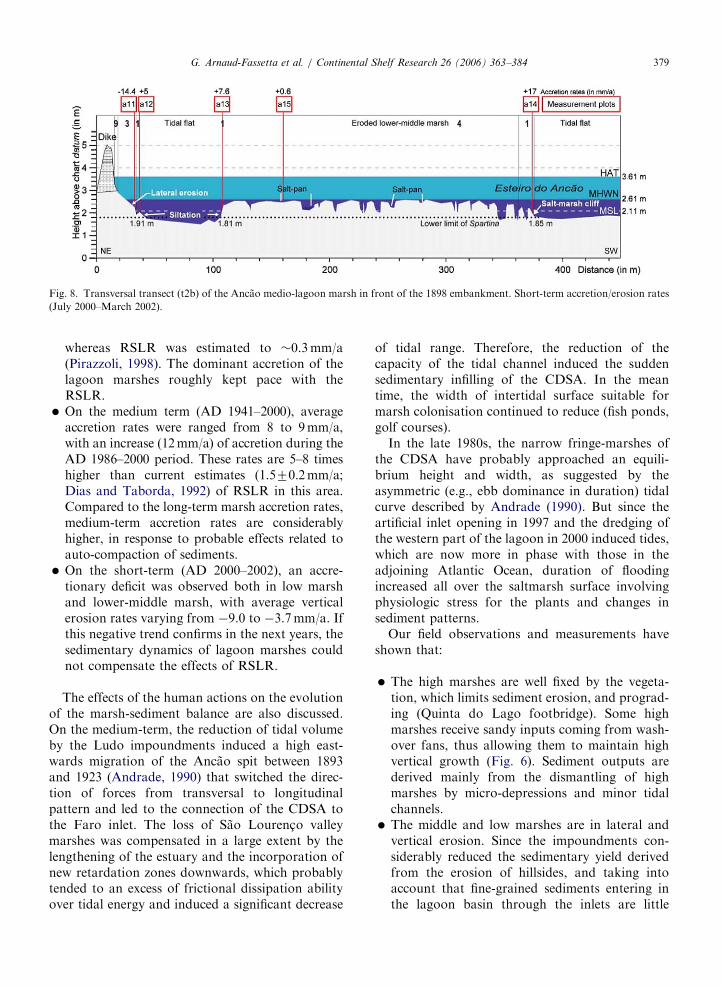
Fig. 8. Transversal transect (t2b) of the Ancao medio-lagoon marsh in front of the 1898 embankment. Short-term accretion/erosion rates
(July 2000–March 2002).
G. Arnaud-Fassetta et al. / Continental Shelf Research 26 (2006) 363–384 379
whereas RSLR was estimated to �0.3mm/a(Pirazzoli, 1998). The dominant accretion of thelagoon marshes roughly kept pace with theRSLR.
� On the medium term (AD 1941–2000), averageaccretion rates were ranged from 8 to 9mm/a,with an increase (12mm/a) of accretion during theAD 1986–2000 period. These rates are 5–8 timeshigher than current estimates (1.570.2mm/a;Dias and Taborda, 1992) of RSLR in this area.Compared to the long-term marsh accretion rates,medium-term accretion rates are considerablyhigher, in response to probable effects related toauto-compaction of sediments.
� On the short-term (AD 2000–2002), an accre-tionary deficit was observed both in low marshand lower-middle marsh, with average verticalerosion rates varying from �9.0 to �3.7mm/a. Ifthis negative trend confirms in the next years, thesedimentary dynamics of lagoon marshes couldnot compensate the effects of RSLR.
The effects of the human actions on the evolutionof the marsh-sediment balance are also discussed.On the medium-term, the reduction of tidal volumeby the Ludo impoundments induced a high east-wards migration of the Ancao spit between 1893and 1923 (Andrade, 1990) that switched the direc-tion of forces from transversal to longitudinalpattern and led to the connection of the CDSA tothe Faro inlet. The loss of Sao Lourenc-o valleymarshes was compensated in a large extent by thelengthening of the estuary and the incorporation ofnew retardation zones downwards, which probablytended to an excess of frictional dissipation abilityover tidal energy and induced a significant decrease
of tidal range. Therefore, the reduction of thecapacity of the tidal channel induced the suddensedimentary infilling of the CDSA. In the meantime, the width of intertidal surface suitable formarsh colonisation continued to reduce (fish ponds,golf courses).
In the late 1980s, the narrow fringe-marshes ofthe CDSA have probably approached an equili-brium height and width, as suggested by theasymmetric (e.g., ebb dominance in duration) tidalcurve described by Andrade (1990). But since theartificial inlet opening in 1997 and the dredging ofthe western part of the lagoon in 2000 induced tides,which are now more in phase with those in theadjoining Atlantic Ocean, duration of floodingincreased all over the saltmarsh surface involvingphysiologic stress for the plants and changes insediment patterns.
Our field observations and measurements haveshown that:
�
The high marshes are well fixed by the vegeta-tion, which limits sediment erosion, and prograd-ing (Quinta do Lago footbridge). Some highmarshes receive sandy inputs coming from wash-over fans, thus allowing them to maintain highvertical growth (Fig. 6). Sediment outputs arederived mainly from the dismantling of highmarshes by micro-depressions and minor tidalchannels. � The middle and low marshes are in lateral andvertical erosion. Since the impoundments con-siderably reduced the sedimentary yield derivedfrom the erosion of hillsides, and taking intoaccount that fine-grained sediments entering inthe lagoon basin through the inlets are little

ARTICLE IN PRESS
Fig. 9. Field evidence of changes in habitats (photographs: G. Arnaud-Fassetta and F. Bertrand). (A) Upper section of the CDSA towards
the mainland shoreline (1). Pioneer Salicornia fragilis (2) Spartina maritima (3) and communities are growing on the backbarrier marsh
edge whereas vegetation is absent on the mid-lagoon mudflats despite the stabilisation of the sediment surface by the chlorophyte
Entermorpha clathrata (4). (B) Photograph looking upwards along the Ancao steep-sided channel and illustrating the tidal-scour and fill
process. Current-eroded microcliff formed by erosion of the middle salt marsh (1). The slumped blocks are eroded (2), so converting the
marsh to bare mudflat (3) and allowing accretion on the tops (4). (C) Lower intertidal flats of the landward side of CDSA behind the
footbridge. Note the absence of seagrass (Zostera noltii) possibly due to the gathering of mollusks taken by hand (1) and to the
eutrophication of the lagoon marked by the green—Entermorpha clathrata (2) and red—Graciliaria sp., (3) macro-algal mats. (D)
Erosional spur and grooves topography which surface is no more contiguous with the backbarrier fringe marsh (1). The cutting face of the
marsh cliff (2) and the surface of the mudmounds (3) are devoid of vegetation. (E) Central section of the CDSA showing extensive tidal-
channel marshes. Along the main channel margin, current action has undercut the marsh surface creating a cliff of variable elevation (1).
Along more sheltered sites, Spartina may either extend down to the fronting mudflat (2) or colonise the eroded lower level surface (3). (F)
Secondary annual glasswort swards (1) overlapping both the inter-creek basin perennial glasswort (2) communities and the fringing
Halimione stands (3). Note the sandy layer (4) which underlies a cynaobacterial mat developed under anaerobic conditions (5) since this
channel pan was left without outlet (arrows). (G) Backbarrier middle marshes developed on a storm-surge platform. Typical
Mediterranean dwarf shrubs (1) contrast with the lower growths of the chamaephytic Halimione portulacoides (2) and the hemicryptophitic
Spartina which is spreading on the floor of a shallow and elongate pan under conditions of accretion (3).
G. Arnaud-Fassetta et al. / Continental Shelf Research 26 (2006) 363–384380

ARTICLE IN PRESSG. Arnaud-Fassetta et al. / Continental Shelf Research 26 (2006) 363–384 381
important, products of erosion of this lower partof the marsh constitute the main sedimentarysource for the watts.
� The watts are both in strong extension andaccretion, but they are the most unstable deposi-tional sub-environment because the closest to thehigh-energy tidal channel.
� The tidal channels widen and deepen partially foranthropogenic causes (e.g., dredging). Sedimentseroding from the marshes could temporallycompensate the sedimentary deficit of tidalchannels.
4.2. Spatial heterogeneity of present accretionary
deficit
The present negative sedimentary balance oflagoon marshes is more marked upstream thandownstream of the CDSA. Three causes can beevoked to explain this situation: firstly, the durationand the frequency of flooding are weaker upstreamof the CDSA, so the fine-grained sediment suppliesare less important; secondly, there are no fine-grained sediments yielding from the upstream partof the CDSA because of impoundments anddisconnection with the catchment basin, that isnot the case downstream where fine-grained sedi-ment supplies are derived from the product of theerosion of marshes situated upstream of the CDSA;thirdly, the surfaces not covered by salt-marshvegetation are in net progression in the upstreampart of the CDSA. Therefore, the erosion and theremobilisation of fine-grained sediments are easier.
Furthermore, the present accretionary deficit orthe negligible amount of accretion observed both indownstream and upstream parts of the CDSAsuggest there is a negative relationship betweenaccretion and elevation. Assuming that RSLRoccurs at a rate of 1.570.2mm/a, the overallconsequence is a strong increase of frequency andduration of the marsh surface flooding that con-tribute to marsh deterioration through osmoregula-tion problems and submergence effects on plantvigour. The present accretionnary deficit must beevaluated with respect to the dissipation ability andtherefore the elevation of the antecedent saltmarshsurface. Considering the numerous marks of erosionboth in the downstream (transect t2) and upstream(Quinta do Lago footbridge transect) parts of theCDSA, the negligible amount of accretion in thesaltmarshes is certainly due to an excess of tidal
energy over frictional dissipation ability of theirsurface which exhibits a very low elevation.
However, the present accretionnary deficit is noteverywhere and some sites record a trend toward theaccretion Field evidences, as middle marsh salt panscolonised by Spartina (Fig. 9G) indicate that higherelevations of marshes are more favourable todepositional process, because the presence of well-developed vegetation above the present mid-tidelevel stills current actions and encourages theretention of the flood-tide sediment influx. Theseareas are likely to get progressively shallowerthrough upbuilding by uneven siltation, which isalready suggested by the mosaic appearance of plantdistribution associated with reccurrent microtopo-graphic variations.
In the downstream part of the CDSA the erodedlower level surface is locally colonised by pioneerspecies, suggesting that new low-level secondarymarsh may extent in the following years (transectt7). Conversely in the upstream part of it, thechannel-bank is eroded back without producing anystep-like bench and suitable habitat for pioneergrowth of Spartina. Instead, the site of Quinta doLago footbridge suggests a preferential sedimentredeposition close to the main channel, leading tothe formation of levees (Fig. 9B). Continuedaccretion on such sites means that spaced marshstems, while acting as an effective baffle to currentflow, may enhance accretion rate in the near-futurein such a way to keep face locally with sea-level rise.
To conclude, we have compared the accretion/erosion rates of the CDSA with those acquired inthe other parts of the Ria Formosa (Bertrand et al.,in preparation). The results show that the trendtoward a sedimentary deficit is confirmed on thestudied sites as Barra Nova, Mar Santo andGemidos, with average erosion rates varying from�2.6 to�1.5mm/a (min.�13.8mm/a; max. 16mm/a)between July 2000 and March 2002. Finally, thesedimentary deficit observed in the CDSA is notspecific to this zone but corresponds to a globalcontext of dominant salt-marsh erosion in the wholeRia Formosa.
4.3. Preservation potential of the CDSA marshes
The eroding margins of the marsh are not asufficient source of accreting matter, and accretion atlower marsh elevations not sufficient as well tomaintain an overall equilibrium position in theintertidal zone. A response of the intertidal profile

ARTICLE IN PRESSG. Arnaud-Fassetta et al. / Continental Shelf Research 26 (2006) 363–384382
to current and presumably future high-energy inputswould be to increase into length so as to extend thetidal wave-sediment interface. These adjustments areno more possible along the mainland where theimpoundment of the former valley marshes limitsmarsh expansion landwards and where the mostexposed reaches of the headland marshes are alreadyreworked into tidal flats (Fig. 9C).
The preservation potential of mid-lagoonmarshes seems to vary according to the changingcharacter of the antecedent surface. Short-termaccretion rates indicate that hammock marshes thatsurround relict beach ridges exhibit the highest—although little—vertical accretion (plot a15; Fig. 8)and may well evolve into marsh islands as the marshspreads over the sandy substrate and its distal edgeschange into tidal flats. Field observations show thatthe maintenance of tidal-channel marshes is morehypothetical although accretion rates (levees) areable to maintain an elevation suitable for vegetationgrowth (Quinta do Lago footbridge transect).Locally, the tidal-marsh fringe becomes completelysurrounded by water producing therefore typicallySpartina dominated marsh islands (Fig. 9E). Butpresently, most of the dissected edge of the mid-lagoon marsh is bare of vascular plants as if thereadvance of vegetation over the residual mud-mounds was durably inhibited (Fig. 9A). Consider-ing the numerous sources of untreated domesticeffluent as well as non-point runoff (agriculture, golfcourse) leading to episodic eutrophic condition(Newton et al., 2003) and dense algal growth(Fig. 9C), it is suggested that there may be arelationship between the general deterioration in waterquality and the failure of Spartina to (re-)establish onpresent accretional surfaces.
Finally, the lagoon side of the peninsular spit isthe only part of the CDSA where the rate ofupbuilding could exceed the rate of RSLR andtherefore assure the maintenance of the marsh.Upward growth of the marsh is permitted both bythe intermittent cross-island sediment and theincreased duration of flooding on the backbarrierregion which allow high marshes to spread rapidlyover a newly inundated surface, particularly asreworked sediment from the low-lying marshes istransported backwards (Fig. 9G). This transferringsediment process is no more possible in places suchas Praia de Faro where the dune ridge has beendestroyed by human occupation (Martins et al.,1996) and where infrastructures prevent water andsediment from spreading and flowing down the
backbarrier into the lagoon. In such a case, thepreservation potential of fringe marsh is annihilatedmoreover since the overtop sandy material is used asfiller for backbarrier shoreline nourishment andfurthermore creation of land (Cremona, 1998).
Beyond this attempt to estimate the preservationpotential of various categories of marshes within thespecified western part of the Ria Formosa lagoon,one can ask about the significance of the presentnegative sedimentary balance of CDSA lagoonmarshes in term of overall sediment budget of thearea. Changes in sedimentary trend and spatialheterogeneity of accretionnary deficit permitted toidentify the marshes of the CDSA as both animportant source and important sink for sediment.Fig. 1 shows that cross-shore aeolian sand transport(90,850m3) is by far the first sediment source in thebackbarrier lagoon whereas fluviatile supplies(82m3 including sediment discharge of the RioSeco) are insignificant. The cross-barrier marinetransport cannot be considered as a major source ofmaterial, but this study has shown that the part ofsediment deposited in lagoon marshes by over-washing is not neglictible. However, the totalsedimentary budget of the CDSA appears verydifficult to quantify because boundaries between the‘‘barrier-island’’ and ‘‘lagoon-marsh’’ hydrosedi-mentary cells are hard to define precisely.
Acknowledgements
We wish to thank the staff of the National Parkof the Ria Formosa (PNRF), for have assumed abig part of the logistics during fieldwork. Radio-carbon dates of Ludo site and calibration ofBettencourt (1994) radiometric data were obtainedby C. Oberlin (Centre de Datation par le Radio-carbone, Universite Claude Bernard-Lyon 1), whomwe warmly thank. The paper benefited greatly fromconstructive comments by two anonymous re-viewers. Thanks are extended to Marjon Jekel forher work in the editorial committee of Continental
Shelf Research.
References
Agenda dos Portos de Sotavento do Algarve, 1999. Ministerio do
Equipamento planeamento e administrac- ao do Territorio,
90pp.
Andrade, C., 1990. O Ambiente de barreira da Ria Formosa,
Algarve, Portugal. Unpublished Ph.D. Dissertation, University
of Lisbon, 645pp.

ARTICLE IN PRESSG. Arnaud-Fassetta et al. / Continental Shelf Research 26 (2006) 363–384 383
Andrade, C., Freitas, M.C., Moreno, J., Craveiro, S.C.,
2004. Stratigraphical evidence of Late Holocene barrier
breaching and extreme storms in lagoonal sediments
of Ria Formosa, Algarve, Portugal. Marine Geology 210,
339–362.
Arnaud-Fassetta, G., Goeldner-Gianella, L., Baron-Yelles, N.,
2002. Geomorphologie, activites humaines et changements
environnementaux dans les marais lagunaires de la Ria
Formosa. L’exemple des rias du Ludo et de Gondra (Algarve,
Portugal). In: Proceedings of the Colloquium ‘‘Hydrosys-
temes, Paysages, Territoires’’, 6–8 September 2001, Lille,
Commission des Hydrosystemes Continentaux of the Comite
National Franc-ais de Geographie, CD-rom (http://www.univ-
lille1.fr/geographie/labo/gma.htm).
Balouin, Y., 2001. Les embouchures mesotidales (tidal inlets)
et leur relation avec les littoraux adjacents: l’exemple de la
Barra nova—Algarve, Sud Portugal. Unpublished Ph.D.
Dissertation, University of Bordeaux 1, 299pp.
Baraut, G., 2003. Dynamique sedimentaire d’un marais lagu-
naire: la Ria Formosa (Algarve, Portugal). Unpublished
Master’s Essay, University Denis Diderot, Paris 7, 146pp.
Barnhardt, W., Gonzalez, R., Kelley, J.T., Neal, W.J., Pilkey Jr.,
O., Jose, H., Dias, J.A., 2002. Geologic evidence for the
incorporation of flood tidal deltas at Tavira Island, southern
Portugal. Journal of Coastal Research SI 36, 28–36.
Beefink, W.G., 1977. The coastal salt marshes of western and
northern Europe: an ecological and phytosociological ap-
proach. In: Chapman, V.J. (Ed.), Wet Coastal Ecosystems.
Elsevier, Amsterdam, pp. 109–156.
Bertrand, F., 2003. Dynamique des marais sales et changements
environnementaux. Photo-Interpretation 3–4, 12–17.
Bertrand, F., Costa, S., Beltrando, G., 2002. Complexite et
vulnerabilite de l’hydrosysteme lagunaire de la Ria Formosa.
In: Proceedings of the Colloquium ‘‘Hydrosystemes, Pay-
sages, Territoires’’, 6–8 September 2001, Lille, Commission
des Hydrosystemes Continentaux of the Comite National
Franc-ais de Geographie, CD-rom (http://www.univ-lille1.fr/
geographie/labo/gma.htm).
Bertrand, F., Costa, S., Arnaud-Fassetta, G., Davidson, R.,
2003. Dynamique des marais d’arriere-barriere associee a la
nouvelle passe d’Ancao (Ria Formosa, Portugal meridional).
Geomorphologie: Relief, Processus, Environnement 3,
151–163.
Bertrand, F., Arnaud-Fassetta, G., Costa, S., Davidson, R., in
preparation. Sediment dynamics of Gemidos and Mar Santo
saltmarshes (Ria Formosa, southern Portugal).
Bettencourt, P., 1994. Les environnements sedimentaires de la
cote sotavento (Algarve, Sud Portugal) et leur evolution
holocene et actuelle. Unpublished Ph.D. Dissertation, 2 vol,
University of Bordeaux 1.
Chareyron, B., 2001. Estimation des vitesses de sedimentation
au moyen d’analyses radiochimiques. Unpublished Report,
01-07, CRII-RAD, Valence.
Chester, D.K., James, P.A., 1995. The Pleistocene Faro/
Quarteira formation of the Algarve region, southern Portu-
gal. Geomorphology 12, 133–149.
Cremona, C., 1998. La dynamique recente du systeme lagunaire
de la Ria Formosa. Unpublished Master’s Essay, University
Paris 1- Pantheon-Sorbonne, 110pp.
Costa, J.C., Lousa, M., Espırito-Santo, M.D., 1996. A vegetac- ao
do Parque Natural da Ria Formosa (Algarve, Portugal).
Studia Botanica 15, 69–157.
Devillers, P., Devillers-Terschuren, J., 1996. A classification of
Palearctic habitats. Council of Europe, Strasbourg. Nature
and Environment 78, 133–165.
Dias, J.A., Taborda, R., 1992. Tidal gauge data in deducing
secular trends of relative sea level and crustal movements in
Portugal. Journal of Coastal Research 8, 655–659.
Esaguy, A.S., 1985. Ria de Faro, Barra da Fuseta. Evoluc- ao
1944–1984. Direcc- ao Geral de Portos, Unpublished Report,
11pp.
Esaguy, A.S., 1986. Ria de Faro, Ilha de Tavira. Evoluc- ao
1950–1985. Direcc- ao Geral de Portos, Unpublished Report,
8pp.
Faugeres, J.-C., Cuigon, R., Renies, H., Gayet, J., 1986.
Caracteres et facteurs d’un comblement littoral a l’Holocene
superieur: passage d’un domaine estuarien a un domaine
lagunaire (bassin d’Arcachon, France). Bulletin de l’Institut
de Geologie du Bassin d’Aquitaine 39, 95–116.
French, J.R., Spencer, T., 1993. Dynamics of sedimentation in a
tide-dominated backbarrier salt marsh, Norfolk, UK. Marine
Geology 110, 315–331.
Garcia, T., Ferreira, O., Matias, A., Dias, J.A., 2002. Recent
Evolution of Culatra Island. Littoral 2002, The Changing
Coast. EUROCOAST/EUCC, Porto, pp. 289–294.
Gillet, F., 1998. La phytosociologie synusiale integree. Guide
methodologique. Documents du Laboratoire d’Ecologie
vegetale, Institut de Botanique, Universite de Neuchatel.
Goeldner-Giannella, L., Arnaud-Fassetta, G., Bertrand, F.,
Baron-Yelles, N., Costa, S., Beltrando, G., Davidson, R.,
2003. Les marais endigues de la Ria Formosa (Algarve) face a
un siecle de developpement economique. Le cas de la reserve
naturelle du Ludo. Annales de Geographie 629, 3–22.
Granja, H., Froidefond, J.-M., Pera, T., 1984. Processus
d’evolution morpho-sedimentaire de la Ria Formosa (Portu-
gal). Bulletin de l’Institut de Geologie du Bassin d’Aquitaine
36, 37–50.
Guillemot, E., 1979. Le littoral de la region de Faro. Etude de
geomorphologie littorale. Unpublished Report, DES, Uni-
versity of Paris-Sorbonne, Paris 4, 131pp.
Martins, J.T., Ferreira, O., Ciavola, P., Dias, J.A., 1996.
Monitoring of profile changes at Praia de Faro, Algarve: a
tool to predict and solve problems. In: Taussik, M. (Ed.),
Partnership in Coastal Zone Management. Samara Publishing
Limited, Cardigan, pp. 615–622.
Newton, A., Icely, J.D., Falacao, M., Nobre, A., Nunes, J.P.,
Ferreira, J.G., Vale, C., 2003. Evaluation of eutrophication in
the Ria Formosa coastal lagoon, Portugal. Continental Shelf
Research 23, 1945–1961.
O’Connor, B.A., Pan, S., Pires, H.O., Dias, J.M.A., Silva, A.J.,
Hale, I., Rose, C., Williams, J.J., 1998. Environmental Data,
Peninsula do Ancao, Algarve. Report CE/02, University of
Liverpool, Department of Civil Engineering, 64pp.
Oertel, G.F., Woo, H.J., 1994. Landscape classification and
terminology for marsh in deficit coastal lagoons. Journal of
Coastal Research 10, 919–932.
Pilkey Jr., O.K., Neal, W.J., Monteiro, J.H., Dias, J.M.A., 1989.
Algarve barrier islands: a noncoastal-plain system in Portu-
gal. Journal of Coastal Research 5, 239–261.
Pirazzoli, P.A., 1998. Sea-level Changes. The Last 20000 Years.
Wiley, Chichester 211pp.
Pita, C.A.R.M., Carvalho, M.M., 1987. Agitac- ao marıtima na
cosata Portuguesa. Dados de Base.Temporais. Direcc- ao-
Geral de Portos, LNEC, Unpublished Report, 17pp.

ARTICLE IN PRESSG. Arnaud-Fassetta et al. / Continental Shelf Research 26 (2006) 363–384384
Reed, D.J., Spencer, T., Murray, A.L., French, J.R., Leonard, L.,
1999. Marsh surface sediment deposition and the role of tidal
creeks: implications for created and managed coastal marshes.
Journal of Coastal Conservation 5, 81–90.
Salles, 2000. Hydrodynamic controls on multiple tidal inlet
persistence. Unpublished Ph.D. Dissertation, Massachussets
Institute of Technology and Woods Hole Oceanographic
Institution, 266pp.
Sebra de Melo, J.L.B., 1989. Caracterizac- ao hidro-oceanografica
da Ria Formosa. Anais do Instituto Hidrografico 10, 7–23.
Stuiver, M., Reimer, P.J., Bard, E., Beck, J.W., Burr, G.S.,
Hughen, K.A., Kromer, B., McCormac, G., Van Der Plicht,
J., Spurk, M., 1998. Intcal98 radiocarbon age calibration,
24000–0 cal BP. Radiocarbon 40, 1041–1083.
Vila-Concejo, A., Matias, A., Ferreira, O., Duarte, C., Dias,
J.M.A., 2002. Recent evolution of the natural inlets of a
barrier island system in Portugal. Journal of Coastal Research
SI 36, 741–752.
Vila-Concejo, A., Ferreira, O., Morris, B.D., Matias, A., Dias,
J.M.A., 2004. Lessons from inlet relocation: examples from
Southern Portugal. Coastal Engineering 51, 967–990.
Williams, J.J., O’Connor, B.A., Arens, S.M., Abadie, S., Bell, P.,
Balouin, Y., Van Boxel, J.H., Do Carmo, A.J., Davidson, M.,
Ferreira, O., Heron, M., Howa, H., Hugues, Z., Kaczmarek,
L.M., Kim, H., Morris, B., Nicholson, J., Pan, S., Silva, A.,
Smith, J., Soares, C., Vila-Concejo, A., 2003. Tidal inlet
function: field evidence an numerical simulation in the INDIA
Project. Journal of Coastal Research 19, 189–211.