Embed Size (px)
Citation preview

The Water Wheel January/February 2019 1


3
CONTENTS
THE WATER WHEEL is a two-monthly
magazine on water and water research
published by the South African Water
Research Commission (WRC), a statutory
organisation established in 1971 by
Act of Parliament. Subscription is
free. Material in this publication does
not necessarily reflect the considered
opinions of the members of the WRC,
and may be copied with acknow-
ledgement of source.
Editorial offices:
Water Research Commission, Private
Bag X03, Gezina, 0031, Republic of
South Africa.
Tel (012) 761 9300. Fax (012) 331-2565.
WRC Internet address:
http://www.wrc.org.za
Follow us on Twitter:
@WaterWheelmag
Editor: Lani van Vuuren,
E-mail: [email protected];
Editorial Secretary: Dikeledi Molutsi,
E-mail: [email protected];
Layout: Anja van der Merwe, E-mail: [email protected] Printing: Oshiang PrintersEmail: [email protected]
We follow the journey of
RJ Gordon and revisit the water
landmarks he came across.
Article on page 10.
UPFRONT
WATER HISTORYWater history – In the footsteps of RJ Gordon Part 2
RESEARCH PARTNERSHIPSFlourishing research partnership pays off for Western Cape
tourist attraction
DROUGHT MANAGEMENTOptimising risk-based drought restriction analysis
ALIEN INVASIVE PLANTSBiological control agents help tackle water weeds in SA
WETLANDSPressures on the wetland hotspot regions of the Northern Cape
GROUNDWATERGroundwater issues in digital news reports – A descriptive
analysis
WATER-ENERGY-FOODAssessing the state of the water-energy-food nexus in South
Africa
LAST WORDNovel earth observation technology wins national prize
041014
1822
32
36
The Water Wheel January/February 2019
38
27

The Water Wheel January/February 20194
FLUID THOUGHTS
Water-energy futures
South Africa is once again walking on the knife edge of an energy
security crisis.
We, again, appear to be two steps short of continuous
rolling blackouts in the most extreme scenarios of demand
management. Diversification of the solution box is key to a more
comfortable energy future. And in doing so thinking out of the
transformer box is key.
One of the earlier energy enterprises in human history was of
course water. Firstly, using the kinetic energy in running water
to turn water wheels, then moving on to more sophisticated
engineering in the form of traditional hydropower from large
dams and reservoirs.
“Research and innovation have
expanded the possibilities in the
water-energy portfolio
exponentially over time.”
Research and innovation have expanded the possibilities in the
water-energy portfolio exponentially over time. Some of the
possibilities are refining the older techniques for the modern
age. This includes the upgrade of traditional hydropower with
miniaturisation to develop a suite of appropriate energy solutions
on or close to site. Better turbine technology and the increasing
of our understanding of water flow dynamics now makes it
possible to harvest vast amounts of energy from our existing
water infrastructure. Installing laminar flow turbines to capture
the energy in our large pipelines is the modern-day equivalent of
the old water wheels.
The Water Research Commission and BloemWater have
collaborated on this technology. The net result is an international
award-winning solution run on conduit hydropower that now has
the Bloemwater headquarters getting all of its electricity needs
from the micro-hydro unit, making it the first off-grid water utility
headquarters in the country and continent.
The second option is an extension of this concept to stored
energy in the form of the vast amounts of potential energy that
‘sits’ in every water tower and reservoir in every city and town
in the country. As has been demonstrated in WRC-University of
Pretoria projects – the installation of a nano-hyropower unit to
capture the energy from the water exiting the towers every day.
This gives us the possibility of new energy in the Gigawatt-hour
range if we refit and exploit the many thousands of existing
suitable reservoirs and water towers around the country. This
combination could organise for not only the marked decrease
of electricity demand from an already strained electricity grid. In
addition, the water sector has the real possibility to become a
significantly energy supplier to the system from these new non-
traditional sources.
This is very promising, and this is only the tip of the iceberg. Even
more revolutionary are the latest developments in wastewater
treatment technologies. This comes in the form of optimising
the generation and capture of biogas, primarily in the form of
methane as a principal energy source. This channel is extending
rapidly with increased innovation in the direction of hydrogen
production and the optimisation of microbiological fuel cells or
MFCs.
We are on a global trajectory that says that wastewater treatment
plants of the future will be a significant part of the energy
generation fleet. In a country where we clearly need a wastewater
treatment plant renewal we would be amiss if we did not grasp
the opportunity to retrofit our existing plants to optimise the
energy generation potential while increasing their capacity to
better manage the wastewater treatment load. This will be a
significant win-win situation.
Combining our efforts in addressing the national challenges
on water and energy in a joint strategy is key. The water energy
nexus will determine our future national security, our ability to
improve the quality of life of all our peoples, meet our sustainable
development goals, as well as our international competitiveness.
Upfront
WRC CEO, Dhesigen Naidoo

The Water Wheel January/February 2019 5
Faecal sludge management
17-22 February
The 5th International Faecal Sludge
Management Conference (FSM5) will be
held in Cape Town. The conference will
advocate and share good practice and
innovation to improve how faecal sludge
is managed and contributes to meeting
the sanitation needs of 4.5 billion people
lacking access to sustainable sanitation
services. The event will be co-hosted with
AfricaSan.
For more information,
visit: https://fsm5.susana.org/en/
Consulting engineering
6-7 March 2019
Consulting Engineers South Africa is
hosting their annual Infrastructure Indaba
at the Durban International Convention
Centre. The theme for the event is
‘Engineering the future now’.
For more information,
visit: www.cesa.co.za.
Science education
6-12 March 2019
South Africa’s National Science Festival,
Scifest Africa, will be celebrating its 23rd
anniversary event in Grahamstown,
Eastern Cape.
For more information, visit:
www.scifest.org.za
Intermittent water supply
7-9 April
The first IWA Intermittent Water Supply
Conference will be held in Kampala,
Uganda. The conference aims to advance
the knowledge and share experiences
on intermittent water supply (IWS) and
to frame the problem of IWS within its
technical, institutional, financial and social
contexts.
For more information, visit:
www.iws2019.org
Young Water Professionals
23-27 June
The International Young Water
Professional (YWP) Conference will take
place in Toronto, Canada. This conference
is one of the vehicles in which the IWA
supports YWPs to develop themselves to
be at the forefront of decision-making.
For more information, visit:
iwa-youngwaterprofessionals.org
World Water
25-30 August
Hosted by the Stockholm International
Water Institute, World Water Week will
be held in Stockholm, Sweden, with the
theme ‘Water for society – including all’.
For more information, visit:
www.worldwaterweek.org
WATER DIARY
Upfront
Figure 1. Water has always been a central pillar electricity production before being overtaken by the fossil fuel revolution. The aspiration toward a lower
carbon future and the massive advances in science and engineering has made possible a new ‘hydropower’. Water has several energy generating possibilities
from traditional hydropower and wave power generation to the harvesting of ‘raindrop energy’ through capturing the energy generated by raindrop
vibrations.

The Water Wheel January/February 20196
NEWS
Upfront
New freshwater crab species discovered in Eastern Cape
Foundational Biodiversity Information
Programme. Mbotyi is a picturesque
forested region northeast of Port St Johns
and adjacent to the East Coast of South
Africa.
The crab, which shimmers in the
presence of light, was collected from
under stones found in small streams
which flow towards the cost. In a case of
what phylogeographers call ‘sympatry’
the pearly white crab lives alongside a
known rust brown species belonging
to the African freshwater crab genus
Potamonautes.
Like a divorced couple who still share
the same house, the two related (but
genetically distinct) populations are
sympatric because they exist in the same
geographic area and thus frequently
encounter one another without breeding.
Daniels found no morphological
characteristics with which to distinguish
the P. sidneyi crabs from the new Mbotyi
species except for the striking colour
difference. The latter was inspiration for
the naming of the new species, namely
mhlophe meaning ‘white’ in isiXhosa.
Source: www.fbip.co.za
A new ‘pearl white’ freshwater crab species
has been discovered in the Eastern Cape
forests.
Prof Savel Daniels, a molecular taxonomist
at Stellenbosch University, says crabs are
relatively well studied in South Africa,
but for some reason forests have been
neglected in sampling efforts.
“Nobody has ever intensively sampled
the forests in the Eastern Cape where we
(incidentally) found the species at Mbotyi.”
The study formed part of the Eastern
Cape Forestry project, one of the Large
Integrated Projects funded by the
Water minister calls on SA innovators
Sanitation, Gugile Nkwinti, lamented the
fact that despite so many innovators in
the sector, South Africa still faced myriad
water challenges.
“We need to look at new ways of
providing the services that we are
responsible for, thus the need for this
interactive session with this group of
innovators [so we can] be informed of
and find out what new technologies and
thinking are on the market to assist this
beautiful country to resolve its delivery
challenges.”
Nkwinti addressed some 450 delegates
who had gathered during the Ministerial
Interactive Session in Boksburg. The
session was Nkwinti’s response to a
number of sector stakeholders and
innovators who have inundated his office
with offers of solutions to challenges in
the sector.
The event offered a platform for
historically disadvantaged innovators to
showcase their work.
Source: www.sanews.gov.za
Water and sanitation industry players
have been urged to tap into new local
technologies and solutions that will
address the service delivery challenges
that plague the sector.
Speaking at a ministerial event on 10
November last year, Minister of Water and
The Water Wheel January/February 2019 7
Upfront
Civil society organisations celebrate court victory over Wakkerstroom
mine decision
The North Gauteng High Court set aside
the 2016 decisions of former Mineral
Resources Minister, Mosebenzi Zwane,
and the late Environmental Affairs
minister, Edna Molewa, to permit a
new coal mine to be developed in the
Mabola Protected Environment near
Wakkerstroom, Mpumalanga.
The case was brought by the coalition
of eight civil society organisations
challenging a range of authorisations
that have permitted an underground coal
mine in a strategic water source area and
a protected area.
The Mabola Protected Environment was
declared under the Protected Areas Act
in 2014 by the Mpumalanga provincial
government as part of the declaration
of more than 70 000 ha of protected
area in the Mpumalanga grasslands. This
followed years of extensive research and
planning by a number of government
agencies, including the Department of
Environmental Affairs, the South Africa
National Biodiversity Institute and the
Mpumalanga Tourism and Parks Agency.
In 2016, without public consultation
and without notice to the coalition, the
two ministers gave their permission for
a large, 15-year coal mine to be built
inside the protected area. The court set
aside the permission and referred the
decision back to the two ministers for
reconsideration on the basis that they did
not take their decisions in the open and
transparent manner or in a manner that
promoted public participation, and that
the decisions were therefore procedurally
unfair.
“South Africa has long recognised that
the grasslands of Mpumalanga, KwaZulu-
Natal and Free State are incredibly
important to the country’s natural
heritage. The grasslands are important
water sources, and home to a range
of production sectors that underpin
economic development,” notes Yolan
Friedmann, CEO of the Endangered
Wildlife Trust. “In the case of Mabola,
the protected environment falls inside a
strategic water source area which feeds
some of South Africa’s biggest rivers.”
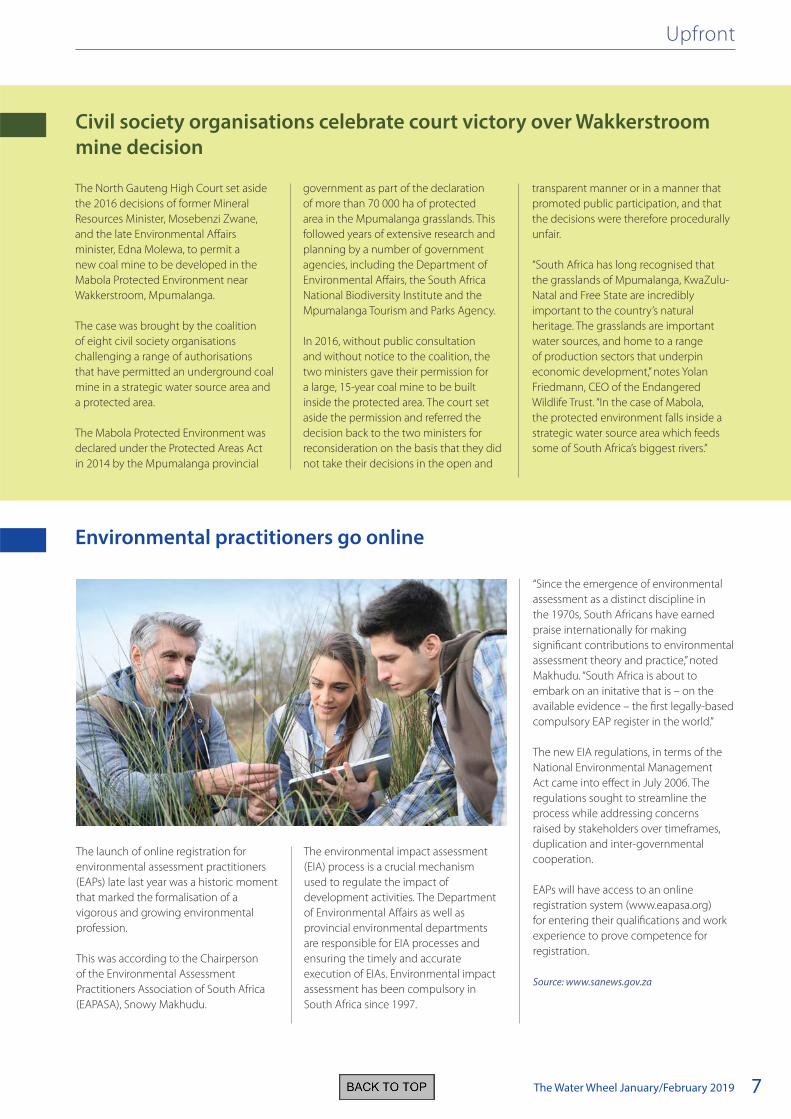
The launch of online registration for
environmental assessment practitioners
(EAPs) late last year was a historic moment
that marked the formalisation of a
vigorous and growing environmental
profession.
This was according to the Chairperson
of the Environmental Assessment
Practitioners Association of South Africa
(EAPASA), Snowy Makhudu.
The environmental impact assessment
(EIA) process is a crucial mechanism
used to regulate the impact of
development activities. The Department
of Environmental Affairs as well as
provincial environmental departments
are responsible for EIA processes and
ensuring the timely and accurate
execution of EIAs. Environmental impact
assessment has been compulsory in
South Africa since 1997.
“Since the emergence of environmental
assessment as a distinct discipline in
the 1970s, South Africans have earned
praise internationally for making
significant contributions to environmental
assessment theory and practice,” noted
Makhudu. “South Africa is about to
embark on an initative that is – on the
available evidence – the first legally-based
compulsory EAP register in the world.”
The new EIA regulations, in terms of the
National Environmental Management
Act came into effect in July 2006. The
regulations sought to streamline the
process while addressing concerns
raised by stakeholders over timeframes,
duplication and inter-governmental
cooperation.
EAPs will have access to an online
registration system (www.eapasa.org)
for entering their qualifications and work
experience to prove competence for
registration.
Source: www.sanews.gov.za
Environmental practitioners go online

The Water Wheel January/February 20198
miles, larger than the entire country
of Colombia.
• People could destroy more than
70 000 square miles of natural habitat
by 2030.
• Natural habitats likely to be lost to
urban growth store an estimated
4.3 billion tons or carbon dioxide.
This would be the equivalent of the
annual carbon dioxide emissions
from 931 million cars on the road.
• Urban expansion could especially
affect coastal areas and by 2030
researchers predict urban areas will
more than double, increasing the
number of those urban dwellers who
depend on protection from natural
ecosystems to more than 330 million
people.
• Countries expected to lose the most
natural habitat due to urban growth
include the United States, Brazil,
Nigeria and China.
Solutions to the problems could
include more effective integration of
local governments in national planning
efforts; encouraging and empowering
cities to incorporate protection of
biodiversity and ecosystem services in
their planning efforts; leveraging the
work of international institutions such as
the Green Climate Fund and the Global
Environmental Facility; and coordinating
the work of the United Nations
Convention of Biological Diversity to find
ways to combat these future problems.
“Cities have been called one of mankind’s
greatest inventions,” Güneralp says. “But
we should not be blindsided by the
potentially detrimental impacts of the
ongoing rapid urban expansion, not
even in the US or in Texas. In fact, this
unprecedented urban growth presents
us with a fleeting opportunity to act so
that it takes place in a way that safeguards
biodiversity and ecosystem services that
are so critical for human wellbeing.”
To view the original report, Visit:
https://bit.ly/2QPJqC9
Massive urban expansion threatens natural habitats
Upfront
City expansion has accelerated in recent
decades, so much so that, by 2050, we
could be creating a city the size of London
every seven weeks if current trends
continue, a new study warns.
Urban growth presents extreme
challenges to biodiversity and ecosystem
services due to the ongoing loss and
fragmentation of habitats, says Burak
Güneralp, assistant professor of geography
at Texas A&M University.
“The message is clear: We have to take
action and we must do it quickly. The
challenges presented by urban expansion
for conservation of biodiversity and
ecosystem services we all depend on are
only going to get more intense as the
world continues to urbanise.”
The findings, which appear in a Nature
Conservancy report, show that by 2050,
there will be 2.4 billion more people in
cities. This means:
• Humanity will urbanise an area of
more than 460 000 additional square
GLOBAL

The Water Wheel January/February 2019 9
Upfront
CO2 emissions on the rise for first time in four years – UNEP warns
A report by the United Nations
Environment Programme (UNEP) shows
that global carbon dioxide (CO2) emissions
rose again during 2017 after a three-
year hiatus, highlighting the imperative
for countries to deliver on the Paris
Agreement to keep global warming to
below 2oC above pre-industrial levels.
The report was released in November, just
days before the key UN climate change
conference known as COP24, which took
place in Katowice, Poland. The UNEP
report follows the Intergovernmental
Panel on Climate Change (IPCC) report
on global warming, released last October,
which cautioned that emissions had
to stop rising now, in order to keep
temperature increases below 1.5oC, and
reduce the risks for the well-being of the
planet and its people.
“If the IPCC report represented a global
fire alarm, this report is the arson
investigation,” said UNEP’s Deputy
Executive Director, Joyce, Msuya. “The
science is clear, for all the ambitious
climate action we’ve seen – governments
need to move faster and with greater
urgency. We’re feeding this fire while the
means to extinguish it are within reach.”
To read the report,
Visit: https://bit.ly/2KsiXrW
“Soil acts as a filter for contaminants. But
when its buffering capacity is exceeded,
contaminants can enter the environment
and the food chain. This undermines food
security by making crops risky and unsafe
for consumption.
“Human activities are the main source of
soil pollution. It is in our hands to adopt
sustainable soil management practices,”
she added.
Semedo called for greater political
support and significantly increased
investment towards healthy soils.
Maintaining healthy soils helps ensure safe
and nutritious foods and is essential for
achieving the Sustainable Development
Goals and Zero Hunger.
The theme for this year’s World Soil Day
was ‘Be the solution to soil pollution’.
Increased soil contamination puts food security at risk
Urgent action is needed to address soil
pollution and contain the multiple threats
it poses to global food safety and security.
This is according to the Food and
Agriculture Organisation of the United
Nations (FAO), who marked World Soil Day
on 5 December.
Thousands of chemicals, which are
commercially produced on a large scale,
plastic and electronic waste, non-treated
wastewater can all become a source
of soil pollution, paving the way for
pollutants to enter the food chain with
serious consequences for the health and
wellbeing of people and planet.
“About 33% of all soils are degraded –
and soils continue to deteriorate at an
alarming rate,” said Deputy DG Maria
Helena Semedo at the World Soil Day
Ceremony at FAO’s Rome headquarters.
The Water Wheel January/February 201910
Water history – In the footsteps of RJ Gordon Part 2
Resuming their journey, the explorers arrived at the Gamtoos
River on 24 January 1778, but could not cross it for two days
because it was flowing fast and full. Having waited for the level
to drop, they managed to pull the wagon’s lead oxen across
with a leather strap, but Gordon noted: “At times this river rises
very high as one can see from what has been washed up, and
sometimes remains impassable for a month.”
By the mid-1800s, river-crossings were easier because a pontoon
was operated at the site where the Ferry Hotel stands today, but
high water levels continued to cause periodic travel delays of
several days. The problem was only overcome when a bridge
across the river was opened in December 1895. This single-lane
structure is still in use today, but most traffic uses the newer
bridge on the N2 national road, 1.5 km downstream.
A day after fording the Gamtoos River – having outspanned at a
local stock-farm – Gordon rode out to inspect the mouth, which
he recorded as running south-east into the sea, with heavy
surf in the channel. The estuary is considered a permanently
open one, but it has closed on a few occasions during drought
conditions, most recently in early July 2018.
Such was the severity of the 2018 drought that by the end of
August the level of the Kouga Dam – the largest of three dams
in the Gamtoos catchment and an important water supply both
for farmers downstream and for city-dwellers in Port Elizabeth
– stood at only 6.8%. Heavy rains in early September began
filling the dam, but – due to the closed mouth – also caused
back-flooding of a holiday resort on the banks of the lagoon and
of agricultural fields on the floodplain. The local municipality
therefore artificially breached the mouth on 11 September last
year as an emergency measure, after obtaining permission from
the environmental authorities.
Back in 1778, our intrepid travellers left their host’s farm near the
Gamtoos River and moved to another at the Seekoei River, which
Gordon noted had flowed into the sea during the past rainy year,
but was otherwise blocked up. The Seekoei estuary featured
in national television news in spring 2017, after high seas had
overtopped the beach berm and inundated the causeway
joining the resort towns of Paradise Beach and Aston Bay, forcing
residents to use a gravel road round the head of the estuary
instead. The causeway, as well as other infrastructure built at the
mouth and numerous farm dams and irrigation offtakes in the
catchment, have all severely impacted estuarine functioning,
and are believed to have caused an increase in flood risk and fish
kills.
In the past, the mouth was frequently dug open by residents
or municipal officials, but with the promulgation of the NEMA:
EIA Regulations in 2010 such artificial breaching became illegal
unless it is done in accordance with a management plan agreed
to by the relevant environmental authority.
In Part 1 of this article in the previous issue, we left Robert Jacob Gordon and his travelling companions in the area that was later to become Port Elizabeth. Here, we join them again as they
make their way back to Cape Town. Article by Sue Matthews.
WATER HISTORY
Cover story
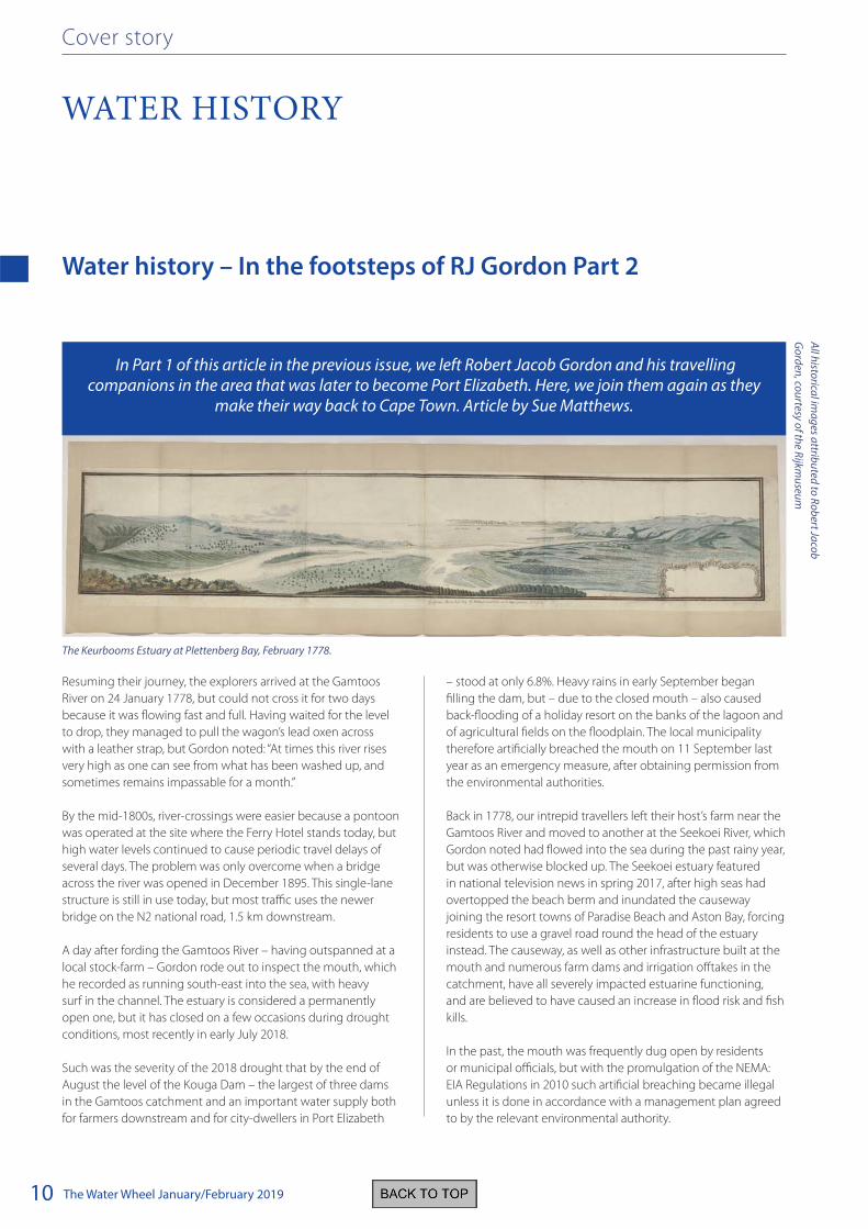
The Keurbooms Estuary at Plettenberg Bay, February 1778.
All h
istorica
l ima
ges a
ttribu
ted to
Ro
bert Ja
cob
Go
rden
, cou
rtesy of th
e Rijkm
useu
m

The Water Wheel January/February 2019 11
On 30 September 2017 the Kouga Municipality breached the
estuary after environmental authorisation was obtained on the
basis of it being an emergency, and a Mouth Management Plan
has subsequently been developed by estuarine scientists at
Nelson Mandela University.
Exploring the area, Gordon rode west along the beach for an
hour-and-a-half to the Kromme River, which borders the current-
day village of St Francis Bay. It was here that the country’s first
estuarine marina was later developed, starting in 1959. Today,
sedimentation of the canal system – aggravated by reduced
flushing by periodic floods due to two major dams upstream –
severely limits boat navigation, particularly at low tide.
The following day, Gordon went fishing at the mouth of the
Kabeljous River, where he “caught a good type of mullet and
springer”. Named after the abundant kabeljou, or kob, that were
historically caught here, the river forms a shallow lagoon just to
the east of Jeffreys Bay, and only opens to the sea during floods.
Departing the area on 4 February 1778, Gordon followed the
coast and crossed the Tsitsikamma River, until he came to a river
with steep cliffs that prevented him from going any further. He
named this the Steile Krants River, but he was clearly referring
to the Groot River, just beyond the present-day settlement of
holiday homes known as Eersterivierstrand.
Turning inland, he bore north-east across the coastal plain
and traversed the mountains via the Kareedouw pass into the
Langkloof to meet up with the wagon, which he had sent on an
inland route. After a few days travelling through and resting in
the Langkloof, where he noted that the peaches were beginning
to ripen, he set out from Avontuur to cross back over the
mountains to the coast.
“This was on a difficult road, and Mattys Sondag had given
me wrong directions and I had got onto one of the stoniest
and steepest of roads so that Schumacher, the artist, who was
the only person with me, quite gave up and I was at a loss to
know what to do with him. However at the top of the range I
discovered a road with my spy-glass, and wandered around for a
long time.”
Fortunately, upon crossing the upper reaches of the Keurbooms
River he encountered a herdsman, who guided him over the
mountains. At 10 o’clock that evening they finally arrived at the
farm Wittedrift on the Bitou River, several kilometres upstream of
where it flows into the Keurbooms River estuary. It was towards
the end of this year that the Governor of the Cape, Baron
Joachim van Plettenberg, visited the area and erected a Dutch
East India Company beacon on a hill overlooking the sea, giving
rise to the name Plettenberg Bay.
The following morning, 14 February, Gordon rode down the
Bietou Valley, which he noted “is bordered with forests, giving
it a beautiful prospect. Going through along the beach, I found
that the Keurbooms River had accumulated much quicksand so
that I was unable to cross it.” Instead he went westward across
the Piesang River to beyond Robberg, before heading back to
Wittedrift. The next day, he again tried but failed to cross the
Keurbooms River mouth “on account of the quicksand”, so he
continued exploring the area, noting that he “saw two herds of
buffalo grazing on a plain, each of two to three hundred head”.
Water history
The harder or southern mullet (Liza richardsonii) is the most likely species of mullet that Gordon caught in the Kabeljous Estuary, although striped
mullet (Liza tricuspidens) and flathead mullet (Mugil cephalus) also occur there.

The Water Wheel January/February 201912
Water history
Gordon’s depiction of the Keurbooms River estuary – a
panorama almost two-and-a-half metres wide – shows the
mouth in the middle of the low barrier dune separating the
permanently open estuary from the sea. Its position is slightly
south-west of this today, but it has shifted dramatically during
the intervening 240 years, sometimes with catastrophic
consequences. In the late 1800s the mouth was close to the
south-western end of the barrier, where a rocky outcrop known
as Lookout Rocks prevents its further advance, but in 1915 a
flood broke open a new mouth at the north-eastern end, directly
opposite the river inflow. Research conducted by the late
Dr Koos Reddering revealed that the mouth had then migrated
southward at a rate of about 30 m per year between 1915 and
1980, and would keep going until it again reached the south-
western end, despite this side of the barrier – site of the popular
Lookout Beach – having by then been stabilised with alien
acacias.
The prediction came true rather sooner than expected, however,
when four days of heavy rain and stormy seas broke open a
second mouth at Lookout Rocks on 23 November 2007, taking
with it the intervening barrier, the acacia forest, parts of a carpark
and the swimming pool of a guesthouse. A sand-spit soon
reformed where the original mouth and barrier had been, but
the mouth at Lookout Rocks remained open.
Almost five years later, in July 2012, a smaller flood broke
through the barrier just under a kilometre to the north-east, and
within six months the Lookout Rocks mouth had closed in favour
of this new mouth. Retired oceanographer Dr Eckart Schumann
described and analysed the geomorphological changes that
occurred during the 2006—2012 period in a paper published
in the November/December 2015 issue of the South African
Journal of Science. The mouth has subsequently moved a little to
the north-east, but it changes constantly under the competing
influences of river flow, tides and waves.
Gordon’s small party continued their journey, and after riding for
five-and-a-half hours reached the farm Melkhoutkraal, allocated
to Stephanus Terblans at the Knysna River estuary. After visiting
what is now known as The Heads and observing waves breaking
in the mouth, despite the calm weather and only a light westerly
wind, Gordon noted that “It would be impossible for even a
hooker to enter here”.
On this count he was proved wrong, because the estuary
later became a busy shipping port. It was George Rex (the
longstanding legend that he was the illegitimate son of King
George III of England has been debunked) who lobbied for this
after purchasing Melkhoutkraal in 1804. He recognised that the
commercial potential of the surrounding forests could not be
realised if the harvested timber had to be transported to Cape
Town by ox-wagon. The Royal Navy transport brig Emu became
the first ship to attempt entry on 11 February 1817, but she ran
aground in the mouth.
Two months later, the Podargus succeeded where the Emu had
failed, and the following year a harbour pilot was appointed
Gordon’s depiction of the Knysna Estuary in 1778 is a stark contrast to the picture today.
Gordon’s encounter with the Cape dune mole-rat while visiting Groenvlei
could have had disastrous consequences. He wrote: “On the beach here
I experienced once again the discomfort and danger caused by dune
moles, for my horse crashed head over heels, falling on my leg, though
only injuring it lightly.”

The Water Wheel January/February 2019 13
Water history
Duivelskop track is now a popular 4x4 and mountain-bike route
starting at the Louvain Guestfarm and descending into the
Bergplaas forestry plantation. He continued eastward as far as
“the long and deep Groenvlei… this spring has fresh water”,
where his horse fell head over heels – slightly injuring Gordon’s
leg – after stepping into a dune mole-rat burrow. Groenvlei
today forms part of the Goukamma Nature Reserve, managed by
the provincial conservation agency, Cape Nature.
Gordon’s group left the area on 19 February, crossing the
Kaaimans River drift that the N2 national road skirts today, and
overnighting at farms at Great Brak, Mossel Bay and Gourits River,
the mouth of which he observed as being “a long musket shot
wide and full of breakers”. They took a more inland route to cross
the Duiwenhoks River near present-day Heidelberg, and from
Swellendam veered behind the Riversonderend mountains to
return to Cape Town via Franschhoek, arriving home on 8 March
1778.
Five months later, Gordon departed Cape Town for another
five-month exploration. This and his other two journeys will be
covered in future issues of The Water Wheel.
to guide ships through the Heads and deep-water channels.
Nevertheless, numerous ships went to a watery grave before the
harbour was eventually decommissioned by the Government in
1954, because road and rail transport options meant it was no
longer cost-effective. Today the estuary is used only as a small
boat harbour, although the South African Navy traditionally
brings a ship through The Heads to berth at Thesens Jetty for the
duration of the Knysna Oyster Festival each July.
After spending a night at Melkhoutkraal, Gordon crossed the
Knysna estuary in its uppermost reaches, passed to the north of
Ruigtevlei, and rode along the coastal plateau above Swartvlei,
which he described as “a large lake that mostly flows out into
the sea but is sometimes blocked by sand in June or July”. After
a wretched night under the leaking roof of the Kleinhoogkraal
hut, he “rode south-east onward to the shore and after a distance
of an hour reached Drievleien, the farm of a certain Seele a
few musket shots distance from the shore. This is where the
people from the Langkloof come fishing, using a dangerous
wagonroad north of here which comes over the mountains
called Duivelskop, or Nanni Douw, which means ‘Finger Road’. It
starts at a certain Widow Beulen’s in the Langkloof. A high ridge
of dunes separates these vleis from the beach. They are salty.”
He is undoubtedly referring to the Wilderness National Park’s
Rondevlei, Langvlei and Eilandsvlei (or Island Lake), and the
Gordon noted on his illustration of vervet monkeys in Outeniqualand that they occur only in the
forests and in trees along rivers.

The Water Wheel January/February 201914
Feature
RESEARCH PARTNERSHIPS
What is thought to be the largest private alien-clearing project
in South Africa has – after 23 years – achieved its goal of
removing 2 200 hectares of invasive vegetation from the slopes
of the Hottentots Holland mountain range, which towers over
Somerset West in the Cape. In the process, long-dormant
streams have begun flowing again, verdant wetlands have re-
established, and fynbos plants and animals have flourished – so
much so that the land has been approved for declaration as a
private nature reserve.
The site of this inspiring initiative is Vergelegen, the historic
estate founded by Willem Adriaan van Der Stel in 1700, shortly
after he had succeeded his father as Governor of the Cape
Colony. Today the estate is owned by Anglo American and is a
popular tourist attraction, offering top-notch restaurants, wine-
tasting, heritage exhibits and beautiful gardens.
Alien-clearing work began on a small scale in 1995, and was
initially funded from the estate’s trading profits, but in 2004
Anglo American decided to bankroll the project from Head
Office so that progress could be accelerated. The 3 000 hectare
estate was demarcated into 26 management units, each with
different alien species, densities and challenges. While the steep
slopes higher up were covered in pine trees, the lowland areas
were infested with eucalypts and acacias, reaching densities as
high as 10 000 stems per hectare in places.
Removing these invaders was a massive undertaking, at times
requiring a workforce of up to 300 people. Now that the
initial clearing has been completed and only follow-up work
Flourishing research partnership pays off for Western Cape
tourist attraction
Vergelegen has not only helped protect water resources by clearing vast tracts of invasive alien vegetation, but also by hosting early research on pesticide pollution that has since been
expanded upon in Water Research Commission funded projects. Article by Sue Matthews.

The Water Wheel January/February 2019 15
is required to remove regrowth from the soil seedbank, there
are just 75 contractors on site, but the project has provided
an average of 137 employment opportunities per year over
its 23 year lifespan. The on-the-job training provided to these
contractors, including business skills such as budgeting and tax
administration, has allowed them to find work elsewhere, and
their rigorous operational and safety standards mean that they
are held in high regard on other alien-clearing projects.
Insights from the Vergelegen experience have been
documented for the benefit of others, because this was the
subject of an MSc thesis by Jacques van Rensburg, who was
also the environmental manager of the alien-clearing project for
more than seven years. His thesis – submitted to the University
of Stellenbosch in March 2017 – covers the period up to 2016,
and two chapters from it have been published as papers with
his supervisors, well-known invasive alien plant scientists Dr
Brian van Wilgen and Dr David Richardson. Their paper in the
South African Geographical Journal (Vol. 100, No. 2: 180-195)
reconstructs the spread of invasive vegetation at Vergelegen and
examines the factors contributing to the problem. The findings
show a clear link between human activities, changes in land use
– primarily due to agricultural development – and the spread
and proliferation of invasive vegetation.
The second paper, published in the Transactions of the Royal
Society of South Africa (Vol. 72, No. 3: 207-216) focuses on the
challenges of managing the invasion. Most notably, the alien-
clearing operations between 2004 and 2015 cost a staggering
R43.6 million, which was 3.6 times more than originally
estimated! The escalation was partly due to a wildfire that swept
through Vergelegen in 2009, triggering a mass germination
of soil-stored seeds in areas that had already been cleared.
Undoubtedly, though, the vast majority of private landowners
would not be able to afford the initial and follow-up work
required to remove large stands of invasive alien plants.
This research was just a small component of the scientific effort
at Vergelegen, because the estate has allowed students and staff
from both local and foreign universities to conduct fieldwork
on their land. An Environmental Trust established in 1995 to
guide the first phase of the alien-clearing project promoted the
concept of Vergelegen as a ‘Centre of Learning Excellence’, and
more than 20 qualifications have so far been obtained on the
basis of research performed there.
Interestingly, one of the first of these research projects gave rise
to a suite of projects funded by the Water Research Commission
(WRC). Dr James Dabrowski, currently leading a WRC-funded
project (K5/2707) entitled ‘An integrated approach to managing
and mitigating the risk of agricultural non-point source pesticide
pollution to the aquatic environment’, began working in the
Lourens River flowing through Vergelegen as a University of
Stellenbosch honours student in 1999, and the following year
continued with more in-depth research for his MSc degree. His
co-supervisor for both projects was Dr Ralf Schulz, an aquatic
ecotoxicologist who now heads the Institute of Environmental
Science at the University of Koblenz-Landau in Germany, but was
then visiting Stellenbosch regularly as a post-doctoral researcher.
“He was very keen to get a student involved, and since there
wasn’t much prior work of this nature that had been done
in South Africa, it seemed like a new and interesting thing to
do,” says Dr Dabrowski. “Our idea at the beginning was to try
and get a basic understanding of pesticide contamination
in the Lourens River, so our initial work focussed on simple
runoff monitoring, and also sampling when Vergelegen and its
neighbour Lourensford were doing spray applications. Once we
had established that pesticides do often occur in the river there,
the next logical step was to move on to ways of mitigating and
managing pesticide contamination.”
Research partnerships
Going, going gone! A Vergelegen alien-clearing contractor fells one of the last remaining eucalypts.

The Water Wheel January/February 201916
Research partnerships
With the removal of water-guzzling alien plants, streams are flowing
again and riparian vegetation is flourishing.
“We did some basic ecotoxicological studies, where we set
up stream microcosms and exposed whole communities of
macroinvertebrates to field-relevant concentrations of pesticides
– quite low concentrations similar to what we found in the river
– for a certain period of time. The concentrations we measured
did seem to be having an effect at a community level, so we
then used a GIS-based modelling approach to try and predict
hotspot areas in the catchment, with the idea of implementing
management initiatives to minimise pesticide transport into the
river.”
“That’s how we got into our research on constructed wetlands,
which was really very interesting,” continues Dr Dabrowski. “We
were able to show that those wetlands trap pesticides coming
from the small tributaries flowing through the orchards – both
water-dissolved and sediment-bound pesticides – and not
only were the concentrations coming out of the wetlands
significantly reduced, but so was the toxicity to aquatic
invertebrates. Once the constructed wetland at Vergelegen was
shown to be so effective, Lourensford built one in a tributary on
their side of the river too.”
Dr Dabrowski moved to the Freshwater Research Unit at
the University of Cape Town for his PhD, but still used the
Lourens River as his study site, and Dr Schulz again served as
co-supervisor. His thesis, submitted in June 2004, was entitled
‘A comparison of runoff- and spray-drift-related pesticide
contamination in agricultural surface waters: exposure, effects
and mitigation’. For this research, GIS-based modelling, validated
by field-based sampling, was used to predict loading of
azmphos-methyl (AZP) – the most commonly applied insecticide
in the catchment – in the river from runoff and spray-drift events.
Runoff was found to be the more important contributor to
non-point source pesticide pollution in the catchment, but
experiments with mayfly nymphs showed that these insects
had a greater behavioural response to spray-drift exposure. This
can be attributed to pesticide from spray-drift being directly
dissolved in the water, rather than associated with suspended
sediment in runoff events, when flow volume and velocity is also
typically higher.
For the mitigation aspect of the research, Dr Dabrowski
compared the effectiveness of aquatic macrophytes in
reducing pesticide input from runoff- and spray-drift. The
results showed that a vegetated stream is more effective than a
non-vegetated one in reducing pesticide concentrations from
both pathways, but those derived from spray-drift are better
mitigated than those from runoff. This is because emergent
aquatic macrophytes intercept spray-drift before it lands on the
water surface, significantly reducing water-dissolved pesticide
concentrations. Predictions showed that 50% macrophyte
coverage in combination with a 5 m buffer strip resulted in as
large a reduction in drift deposition as the combination of a 10
m buffer strip with 0% macrophyte coverage.
A few years later, while employed as a Principal Researcher at
the CSIR, Dr Dabrowski successfully applied for WRC funding to
develop a risk indicator methodology to estimate the relative
exposure and risk of pesticides in surface waters (K5/1854).
Essentially, the methodology was designed to predict the
impacts of pesticides on water quality by integrating pesticide
use, toxicity and physicochemical data of pesticides with site-
specific geographic and climatic characteristics. The Lourens
catchment was again used for the field study, which set out
to validate the predictions of the risk indicator methodology
through sampling of pesticide levels in water and sediment.
“We wanted to see if we could predict which of a variety of
pesticides applied are most likely to enter water resources, and
which of those are likely to have the highest risk to aquatic biota,”
explains Dr Dabrowski. “That was quite a successful project,
because we were able to show a clear link between what we
modelled and what we monitored. So the pesticide risk indicator
was potentially very useful in terms of being able to identify
the pesticides in a particular catchment requiring more careful
management.”
The next WRC project (K5/1956) – featured in the January/
February 2016 issue of The Water Wheel – took a broader view,
by investigating the risks posed by pesticides in water resources
to environmental and human health at a national level.
“We did monitoring in three different catchments throughout
the country to get more baseline information on pesticide
contamination, created a series of pesticide use maps, and also
developed a way of prioritising which pesticides to monitor,
given that each crop has a variety of different pesticides – in

The Water Wheel January/February 2019 17
the form of herbicides, fungicides and insecticides – that
could potentially be applied. Monitoring all them would be
problematic, because the laboratory analyses is very expensive,
so there was a need to identify which were most important.”
“The current project has built upon this work, and it’s
more about developing tools to try and manage pesticide
contamination. It aims to develop a framework allowing us to
identify high-risk areas throughout the country. The pesticide
use maps from the previous project just show where different
pesticides are applied. However, risk implies not only use, but
how toxic the pesticides used in an area are, what geographical
conditions exist that might make pesticides more mobile – so
it incorporates use, toxicology, environmental chemistry and
geographical parameters all in one. We’ve actually developed
three different maps that portray risk towards fish, aquatic
invertebrates, and aquatic macrophytes and algae.”
The project has provided an
average of 137 employment
opportunities per year over its
23 year lifespan.
“There is also more focus on catchment-scale modelling
approaches. Given the limitations associated with monitoring,
modelling can be very useful in identifying areas at a much
larger scale, and also in postulating certain management
options and seeing what effect they are likely to have on
pesticide concentrations in the river in the long term. We’re also
developing a risk indicator tool that will be able to tell a farmer
or catchment manager which are the highest, medium and
lowest risk pesticides registered for use on a particular pest of a
particular crop, since the active ingredients can be quite different
in terms of their toxicity to aquatic biota and their mobility in
the environment. It’s just a way of informing people of the most
environmentally friendly choice of pesticide.”
The project is due to be completed in 2022, so progress and/
or the final outcomes will be covered in a future issue of The
Water Wheel. In the meantime, however, it is worth noting that
Vergelegen management report that the alien-clearing project
has resulted in such a proliferation of insect life that natural
predators have allowed insecticide sprays on the estate to be
reduced by 75%!
Research partnerships
The Lourens River that flows through Vergelegen was used as a study site for initial research on pesticide pollution that has since spawned a number
of WRC-funded projects.
Helen
On
line /W
ikiped
ia
The Water Wheel January/February 201918
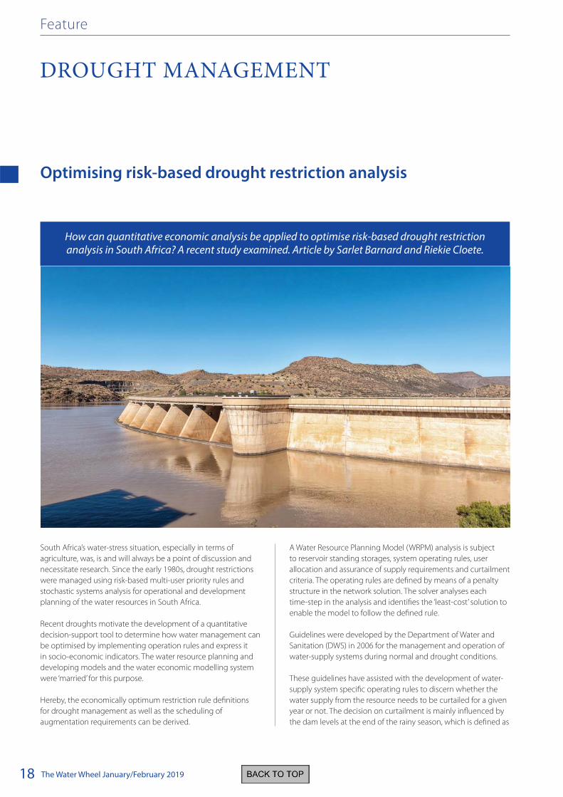
Optimising risk-based drought restriction analysis
South Africa’s water-stress situation, especially in terms of
agriculture, was, is and will always be a point of discussion and
necessitate research. Since the early 1980s, drought restrictions
were managed using risk-based multi-user priority rules and
stochastic systems analysis for operational and development
planning of the water resources in South Africa.
Recent droughts motivate the development of a quantitative
decision-support tool to determine how water management can
be optimised by implementing operation rules and express it
in socio-economic indicators. The water resource planning and
developing models and the water economic modelling system
were ‘married’ for this purpose.
Hereby, the economically optimum restriction rule definitions
for drought management as well as the scheduling of
augmentation requirements can be derived.
A Water Resource Planning Model (WRPM) analysis is subject
to reservoir standing storages, system operating rules, user
allocation and assurance of supply requirements and curtailment
criteria. The operating rules are defined by means of a penalty
structure in the network solution. The solver analyses each
time-step in the analysis and identifies the ‘least-cost’ solution to
enable the model to follow the defined rule.
Guidelines were developed by the Department of Water and
Sanitation (DWS) in 2006 for the management and operation of
water-supply systems during normal and drought conditions.
These guidelines have assisted with the development of water-
supply system specific operating rules to discern whether the
water supply from the resource needs to be curtailed for a given
year or not. The decision on curtailment is mainly influenced by
the dam levels at the end of the rainy season, which is defined as
How can quantitative economic analysis be applied to optimise risk-based drought restriction analysis in South Africa? A recent study examined. Article by Sarlet Barnard and Riekie Cloete.
DROUGHT MANAGEMENT
Feature

The Water Wheel January/February 2019 19
May in the summer rainfall regions and September in the winter
rainfall regions. It is important to establish the severity of the
level of curtailment, when it is needed, the timing thereof and
possible relaxation after the drought subsides.
The driver behind stochastic risk analysis is the priority
classification of the different water user sectors as configured in
the WRPM. The definition of the priority classification or criteria
for risk of curtailments has largely been based on expert opinion
and qualitative economic criteria.
A proportion of the water demand of each user sector is
classified at different priorities in terms of assurance of water
supply.
A higher assurance of supply will mean a lower risk of
curtailment. In the given table for example, 30% of the domestic
use is regarded as gardening water and will be classified at the
lowest assurance of supply which in this case has a 5% risk of
being curtailed. Furthermore, 20% of the domestic user sector
is classified at a medium assurance of supply and 50% at a high
assurance of supply. For strategic industries the total demand is
often classified at a high assurance of supply.
For the irrigation sector a measure of classification can be the
type of crops produced within the water-supply system. These
can either be annual crops such as cabbage, irrigated sugarcane
and maize, which start production mostly in the first year, or
permanent crops such as orange- and mango trees. Permanent
crops are usually classified at a higher assurance of supply than
the annual crops, as their production cycles take longer than a
year and thus return on investment takes longer to realise.
Drought curtailments are simulated for water users with
different assurance of supply requirements regarding their
allocation from a specific water resource. Short-term operation
analyses are carried out for a five- to ten-year operation
period. Results in terms of system storage and curtailments are
generally presented in a box-and-whisker format, illustrating
the exceedance probability of a certain value over the analysis
period.
Decisions concerning assurance of supply levels to the different
water user sectors in water resource systems have not been
scientifically established and don’t always reflect the optimum
outcome. This poses a problem, especially during times of
drought.
The box-and-whisker plot.
The impact different water users have in a river catchment on
the economic indicators such as gross domestic product (GDP),
low household income and employment, can be established by
undertaking a quantitative economic analysis.
The macro-economic indicators are calculated by making se
of the Water Impact Model (WIM). The WIM model is water
sector specific and has, until this study, been applied in various
Department of Agriculture, Forestry and Fisheries (DAFF) and
multinational studies. These include ‘Determining the economic
viability of different planning options and options for the
joint Maputo River Basin Water Resources Study (2006-2007)’,
‘Development of an ecological water requirement policy and
water management plan to implement the ecological water
requirement policy for the Komati River Basin (2008-2009)’,
‘Vaalharts/Taung irrigation area (2011)’ and ‘Implementation of
the water resources classification system and determination of
the resource quality objectives for significant water resources in
the Letaba (2012-2013)’.
The WIM model is a dynamic, computerised water entitlement
model, customised for the irrigation sector, whereby economic
benefits, possible water reduction and capitalised impact
can be classified and computed. It provides a tool to create
an appropriate economic baseline against which to measure
the possible impact of changes in water availability by means
of scenarios. The macro-economic impact of possible water
reduction on the individual producers, the community and the
economy in the selected catchments can then be determined.
The economic baseline is used to estimate the impacts of the
water restrictions and is explained as follows: Current production,
deducting curtailed production, estimates the loss in production
due to water restrictions.
GDP and employment are presented in terms of direct, indirect
and induced indicators or impacts:
• Direct impacts refer to impacts occurring directly in the
irrigation or water dependent activity.
• Indirect impacts refer to those effects occurring in the
different economic sectors that link backward to a specific
sector due to the supply of intermediate inputs used in the
production process.
• Induced impacts refer to the chain reaction triggered by
the salaries and profits (less retained earnings) that are
Drought management

The Water Wheel January/February 201920
Drought management
ploughed back into the economy in the form of private
consumption expenditure.
The impact on household income, and especially low household
income, is a good indicator of the impact on poverty levels in an
area.
By cementing the WRPM and WIM as a unit, an economically
optimum user priority classification can be derived to improve
equitable water resource allocation and drought management.
Such a linkage was tested by post-processing of the WRPM
output using Excel Visual Basic open script.
The user priority and risk criteria definition or table is the primary
input dataset to be varied in the scenario analyses. The objective
is to evaluate the economic implications of alternative settings of
the user priority table with the aim to find the optimum or most
suitable set of parameters.
The Present Value (PV) of the economic indicators will be used
to have one single comparable value for the economic output of
the WIM, for all the simulated sequences, for each scenario per
selected study area.
To account for the time value of a time series of monetary
indicators, the Present Value of each of the 1 000 sequences have
to be calculated to provide a probability distribution of the PV.
The procedure on which the Assurance of Supply Model (ASM) is based. The steps include: A. The user priority and risk criteria definition, B. Water Resource Planning Model (WRPM), C. Risk analysis (results from WRPM), D. Water Impact Model (WIM), E. Gross Domestic Product
(GDP) vs. restriction relationship, F. Economic Indicators, G. Present Value of Economic Indicator and H. The Expected value (mean) of
Economic Indicator.

The Water Wheel January/February 2019 21
Drought management
results. For general economic impact analysis, a weighted
average enterprise budget per annum was sufficient. To indicate
the feasible reduction in water supply per each crop production
stage, a more detailed research and model developing is
recommended to strengthen and extend the modelling system.
It was found that during the actual drought in 2016, restrictions
might not have been required had alternative assurance of
supply criteria been applied. Fortunately, during the 2018/2019
Annual Operating Analysis of the Orange River System, DWS
considered alternative user priority definitions to be investigated
and analysed as a scenario.
Decisions concerning assurance of supply
levels to the different water user sectors
in water resource systems have not been
scientifically established
It is recommended that farmers diversify and incorporate
mix-crop farming as much as possible for farming to remain
economically viable when water use is restricted. The writers go
so far to emphasise this as a pilot study of which only a sub-
section of the primary economic sector – irrigation agriculture
– was assessed. This creates the opportunity to expand the
model to the other water-dependant users in the secondary and
tertiary economic sectors.
It can be extended for the same study areas, or other study areas
in need of re-evaluating operating rules. Such improvements
have however commenced in other studies i.e. the Thukela-
Vaal Transfer scenario analyses as part of the development of
operating rules for the Integrated Vaal River System as well as the
development of operating rules for the Lesotho Highlands Water
Project Phase II.
Similar studies and application of the ASM in another drought
stricken WSS’s, such as the Western Cape, are encouraged.
The economic indicators ensure the proposed method can be
used to evaluate time dependent decisions such as, whether
moderate drought restrictions should be implemented
immediately, or can be delayed until later when more severe
restrictions are implemented at a certain risk.
The three study areas that were selected to test the
methodology include the Orange River Project, the Groot Letaba
and the Mhlathuze Water Supply Systems (WSS’s). The major
water resources within these WSS’s, from which the water supply
is subjected to be restricted in times of drought, are: The Gariep
and Vanderkloof dams, Tzaneen Dam and the Goedertrouw
Dam respectively. The irrigation agriculture sector uses 63%,
69% and 36% correspondingly of the water supplied from these
resources. Quite a diverse selection of crops is cultivated within
these WSS’s and it is important that the viability of farming
and the direct and indirect impact of water restrictions on the
regional economy are not jeopardised.
Furthermore, the total contribution of the irrigation agriculture
sector to the GDP, household income and employment within
these WSS’s can be summarised as follows:
Water Supply
System
GDP Household
Income
Employment
(R million) (Numbers)
Orange River 14 166 11 004 148 442
Groot Letaba 2 463 2 247 20 370
Mhlathuze 613 618 5 851
It was expected that with a reduction in water supply, the
scenarios rendering the lowest present values of loss for the
economic indicators, would be the more favourable. It is,
however, important to determine if the farmer will be able to
continue farming on a sustainable level despite the reduction in
the water supply.
The expected risk weighted present value of loss in GDP as a
result of reduction in water supply from the combined Gariep and
Vanderkloof dams for three different scenarios.
Regional relationship curves were derived from the results
showing the loss in the specific economic indicator resulting
from a volumetric reduction in water supply. In the curve below,
it can be seen that a reduction in water supply of 500 million m³
will result in a GDP loss in the order of R4 000 million.
The development of the new decision support tool and the
link between the Water Resource Models and Water Impact
Model, was successful. The current WIM’s output indicates a
linear relationship between volume curtailed and the economic

The Water Wheel January/February 201922
Feature
ALIEN INVASIVE PLANTS
Scientists linked to Rhodes University’s Centre for Biological
Control (CBC) in Grahamstown are playing a pivotal role in efforts
to halt the spread of alien invasive plants in South Africa by
employing biological control agents.
The centre is involved in the research and ‘deployment’ of
natural enemies of weeds in local conditions. Earlier this year
the CBC received a three-year contract of R68-million from
the Department of Environmental Affairs to focus on 54 weed
species spreading across the country.
These biological agents are mass-reared under strict conditions,
including in portable pools and plastic tunnels at CBC’s
approved insect rearing facilities.
The research is driven by a consortium of universities, and CBC’s
team works closely with the Agricultural Research Council on
this. The consortium is led by Rhodes University and includes
scientists from the University of Cape Town, the University of
KwaZulu-Natal and Wits University.
Scientists working at the centre are focusing their efforts on
the sustainable control of alien invasive plants using insects or
pathogens. They are interested in understanding the ecological
dynamics of invasive pests, as well as aquatic and terrestrial
weeds, among others.
Weeds of concern
Alien invasive plants are of both global and local concern,
according to Prof Martin Hill, CBC’s Director and Head of the
Biological control agents help tackle water weeds in SA
They are tiny, reliable and their contribution to society often goes by mostly unnoticed. Yet many of the biological control agents being studied and mass-reared by scientists in the Eastern Cape are playing a huge role in the ongoing fight against alien invasive plant species. Article by
Jorisna Bonthuys.
Priority catchment areas targeted
for invasive alien plant control.
The Water Wheel January/February 2019 23
Department of Entomology at Rhodes University. These plants,
including water hyacinths and some Acacia species, have now
spread over more than a tenth of South Africa’s land area.
Prof Hill was recently appointed as a SARChI research chair (in
terms of the South African Research Chairs Initiative). His work
includes finding sustainable ways of controlling invasive plant
species – a challenge he considers of “national importance”. “The
challenge to arrest or even reverse the trend of weed invasions
remains huge. We are looking at ways to harness biological
control measures for the future.”
The challenge remains huge. Of the 2 034 alien species known to
have established populations outside of cultivation or captivity,
775 have become invasive. Of these, 107 have caused severe
negative impacts on the environment, affecting 80 000 km²
(1.4%) of the country’s land area.
Current mechanical and chemical control measures reach
less than 3-4% of this invaded area per year, according to
research by Prof Brian van Wilgen and Prof John Wilson, both
from the Department of Science and Technology-National
Research Foundation Centre of Excellence for Invasion Biology
at Stellenbosch University (SU). Given spread rates between 5
and 10% per year, current control measures are not enough to
contain or reduce the problem, according to a recent SU press
release.
Profs Van Wilgen and Wilson are the lead authors of South Africa’s
first national report on the status of invasive species published
by the South African National Biodiversity Institute (SANBI) in
November. The report, titled The Status of Biological Invasions
and their Management in South Africa 2017, paints a worrying
picture about the effects of weeds in the country. The most
troubling indicator it highlights is the one measuring the level
of success in managing invasions. It stands at only 5.5%. This is
despite the fact that at least R12 billion has been spent over the
past 20 years as the researchers point out.
Invasions by alien plants are rapidly extending across the
globe, leading to large-scale ecosystem damage. This damage
is aggravated by climate change, pollution, habitat loss and
human-induced disturbance, according to the Convention on
Biological Diversity. Invasive species spreading outside their
natural habitats is now considered one of the greatest threats
to biodiversity worldwide. Since the seventeenth century, alien
invasive species have contributed to nearly 40% of all animal
extinctions for which the cause is known.
At least R6.5 billion worth of ecosystem services are lost every
year as a result of alien invasive plants, according to published
estimates.
In South Africa, the total area infested by alien invasive plants
doubled from 10 million to 20 million hectares between the
mid-1990s and 2007. Some alien species have a strong foothold
in many important catchments and water source areas. “Most of
the invader plant species spread exponentially when there are
no biological control interventions in place,” Prof Hill explains.
These water-thirsty plants are literally sucking catchments dry
at the expense of humans and nature. Weeds also affect water
quality negatively, adding to South Africa’s water woes. Given
the country’s water risks, stopping the spread of these plants in
crucial catchment areas should be a priority, WWF-SA states in a
recent fact sheet titled Farming for a drier future.
It is, for instance, estimated that these plants are reducing the
water supply to the Theewaterskloof Dam in the Western Cape
by 30 million m3 per annum. This dam is one of the six main
dams providing water to the City of Cape Town’s metropole area
and many exporting agricultural producers. This volume of water
lost to alien invasive plants is equivalent to the full capacity of
the Upper Steenbras Dam.
Eco-friendly, cost-effective option
Despite the challenges posed by invasive plant species, there
have been successes dealing with them on a local scale. One
such example is the use of biological control methods: of the
60 invasive plant species targeted for biological control thus far
in South Africa, 15 species are now under complete biological
control and another 19 species under a substantial degree of
biological control.
“Biological control measures, or the development of host-specific
natural enemies, offer a cost-effective alternative and long-term
solution for dealing with this problem,” says Hill. Scientists focus
their efforts on priority catchments to optimise the resources
available.
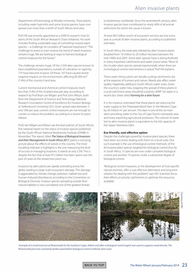
Alien invasive plants
Example of a small reservoir at Rheenendal (in the Southern Cape), before and after a biological control agent was used to suppress weed density. The
Rheenendal pool was covered by kariba weed before biological control methods were used.
Co
urtesy o
f CB
C

The Water Wheel January/February 201924
Alien invasive plants
agrochemicals, especially certain pesticides, have many negative
impacts on the environment.
Biological control is a particularly appealing solution because
it is not: toxic, pathogenic or dangerous to humans. They are
also particularly useful when employed alongside integrated
pest management. “In some cases, mechanical and chemical
methods still have to be used, given dense stands of these alien
plants in certain areas,” Hill explains.
These “weed-warrior” insects also have the advantage of being
self-perpetuating once established and are specific to their host
plants, adds Philip Ivey, a project manager at the CBC. “The adult
mirids and planthoppers CBC uses as biological agents will, for
instance, only feed, survive and reproduce on water hyacinths.”
Strict quarantine measures and permit conditions are in place,
and extensive research is done before biocontrol agents are
released, Hill explains. “Biological control agents are only released
when there is scientific proof that these agents can safely be
released,” he emphasises. This happens once they have been
cleared for release by the regulatory bodies; the Department
of Agriculture, Forestry and Fisheries and the Department of
Environmental Affairs; and if they conform to current legislation.
So far, only 120 of the potential 270 biocontrol agents (species)
identified for possible local use have been approved by South
African authorities. This is according to Ivey indicative of just how
strict and rigorous this process is.
In numbers
20 million Number of hectares overgrown by alien
plants in SA
379 Number of alien invasive plants listed in
SA’s national legislation
93 Number of biological control agents used
in SA
90 litres Amount of water used daily by one (alien
invasive) pine tree
59 Number of weed species targeted using
biocontrol agents
1913 Date first biocontrol agent was released
in SA
The estimated cost-to-benefit ratios highlighted by the SANBI
report indicate that, for every R1 invested into biological control
measures, economic losses caused by alien invasive plant
invasions of between R8 and over R3000 have been avoided.
In 1963, in her influential book Silent Spring, Rachel Carson
warned the world of the environmental and human health
dangers of pesticide use. Carson, a scientist and ecologist,
promoted the use of biological control as an alternative method
for suppressing insect outbreaks and weed infestations. Despite
this warning, the global expenditure on pesticides has increased
annually, reaching some $65.3 billion for 2017. The use of
Rosali Smith, a PhD student at CBC, releasing the fly larvae targeting Brazilian water weed into the Nahoon River with the help of Ahmed Khan,
Director of Operational Support and Planning in the Department of Environmental Affairs. This weed, native to South America, was first recorded in
South Africa in 1963. It reproduces through vegetative means. Any plant fragment, even as small as 1 cm, can develop into a new plant.
Mich
ael P
inya
na
The Water Wheel January/February 2019 25
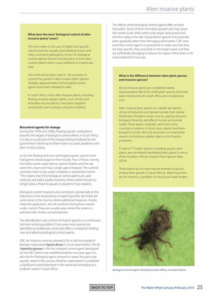
Biocontrol agents for change
During the 1970s and 1980s, floating aquatic weed plants
became the targets of biological control efforts in South Africa.
It is also a crucial part of the strategy being employed by the
government’s Working for Water teams to tackle problems with
alien invasive plants.
So far, five floating and one submerged aquatic species have
had agents released against them locally. Four of these, namely
the kariba weed, water lettuce, parrot’s feather and the red
water fern, have each had a single agent released. The scientist
considers them to be under complete or substantial control.
“This means that if the biological control agents are used
correctly and water quality improves, these weeds should no
longer pose a threat to aquatic ecosystems,” Ivey explains.
Biological control measures also contribute substantially to the
reduction in the invasiveness of water hyacinths. But there are
some areas in the country where additional measures, mostly
herbicide application, are still needed to bring these weeds
under control. These are usually areas where the system is
polluted with nitrates and phosphates.
The identification and control of invasive species is a continuous
and ever-evolving problem. Every year, more species are
identified as problematic and more effort is invested in finding
new and effective biological control agents.
CBC, for instance, recently released a fly to halt the spread of
Brazilian waterweed (Egeria densa) in local water bodies. This fly
(Hydrellia egeriae) is the first released control agent developed
by the CBC (which was established almost one year ago). It is
also the first biological agent released to target this particular
aquatic weed in the country. Brazilian waterweed is considered
a significant weed elsewhere in the world and emerging as a
problem weed in South Africa.
The effects of the biological control agents differ on their
host plant. Some of them limit plant growth and may cause
the weeds to die while others only target seed production
and thus reduce the rate of population growth of a particular
plant gradually rather than damaging adult plants. “CBC tests
potential control agents in quarantine to make sure that they
are host-specific, they only feed on the target weed, and they
are sufficiently damaging to reduce the vigour of the plant or its
seed production,” Ivey says.
Alien invasive plants
What does the term ‘biological control of alien
invasive plants’ mean?
This term refers to the use of highly host-specific
natural enemies (usually plant-feeding insects and
mites, and plant pathogens), known as ‘biological
control agents’, that are introduced to control alien
invasive plants which cause problems in a particular
area.
This method has been used in 130 countries to
control the spread of alien invasive plant species.
Globally, approximately 550 biological control
agents have been released to date.
In South Africa, many alien invasive plants, including
floating invasive aquatic plants, cacti, shrubs and
Australian Acacia species, have been targeted
successfully over a century using this method.
What is the difference between alien plant species
and invasive species?
Not all invasive plants are considered weeds.
Approximately 380 of the 9 000 plant species that have
been introduced into South Africa are considered as
such.
Alien invasive plant species (or weeds) are species
whose introduction and spread outside their natural
distribution threatens water sources, grazing resource,
biological diversity, and affects human and animal
health. These plants originally came from other
countries or regions. In most cases, plants have been
brought to South Africa for economic or ornamental
reasons (including as garden plants or for forestry
purposes).
A total of 773 plant species, including aquatic alien
plants, are considered ‘neutralised alien plants’ in terms
of the Southern African Invasive Plant Species Atlas
(2016).
These plants do not have natural enemies or factors
limiting their growth in South African. Water hyacinths
are, for instance, a problem in many local water bodies.
Biological control agent, Neohydronomus affinis, on water lettuce.

The Water Wheel January/February 201926
Alien invasive plants
Of the 2 034 alien species known
to have established populations outside
of cultivation or captivity, 775 have
become invasive.
The larvae of the fly recently ‘deployed’ by CBC near
Grahamstown to halt the spread of Brazilian waterweed feeds on
the plant’s leaves, which reduces its photosynthetic capacity and
induces secondary infection. This damage reduces the plant’s
biomass and its invasive impact. About 10 000 fly larvae were
released in October in the Nahoon River.
CBC’s scientists cultivate alien invasive plants in controlled
greenhouse environments at its Waainek and Uitenhage
mass-rearing facilities. The bugs are then mass-reared on their
host plants which are kept in portable pools in temperature-
maintained plastic tunnels. “On average, three to four years are
needed to do this testing,” says Ivey. “If there are problems with
maintaining the population in quarantine, this obviously takes
longer.”
Biological control measures have been used successfully for
more than a century in South Africa. For several decades, South
Africa has been recognised as one of the top countries globally
with regard to research on the biological control of weeds.
Hill says biocontrol methods have already enabled efforts to
reduce the area infested with alien cactus plants from 900 000
hectares to less than 100 000 hectares in South Africa.
“Where conventional (chemical and mechanical) methods of
getting rid of alien weeds prove ineffective to deal with the
problem, biological control agents often provide the only
sustainable solution,” says Hill. “Investing in biological control
offers huge long-term benefits and attractive returns of
investment. These methods can arrest or even reverse the spread
of invasive plants and the impact thereof when used as part of
an integrated management strategy,” he concludes.”
For more information, visit www.ru.ac.za/
centreforbiologicalcontrol
Inside the Waainek facility.

The Water Wheel January/February 2019 27
Pressures on the wetland hotspot regions of the Northern Cape
Historically, pressures on arid depressions in the Northern Cape
have been poorly reflected in national products which modelled
the ecological condition of inland wetlands using land cover
datasets. Researchers in the province sought to address these
shortcomings by amalgamating their expertise into a preliminary
synthesis which they presented during a Northern Cape Wetland
Forum meeting on 14 November 2017. The forum was attended
by 17 people, representing a variety of organisations ranging
from six government departments to universities, municipalities,
private consultants and South African National Parks.
The presentation centred mainly around two topics, namely:
• The identification of a number of key inland wetland
hotspot regions in the Northern Cape. Hotspot regions
were considered areas where a larger density of wetlands
may be present compared to other areas in the Northern
Cape. Hotspot regions were not related to bioclimatic
information but merely a visual demarcation of areas where
the extent of wetlands appear more than other areas.
• Listing the state of key pressures found within each of the
hotspot regions.
The intention was to inform conservation and rehabilitation
planning.
Dr Betsie Milne and Heidi Nieuwoudt identified the extent of six
hotspot regions in the Northern Cape Province where a higher
density of depressions or ‘pans’ occur (Figure 1). Pressures on arid
depressions in the Kalahari, Bushmanland, Ghaap Plateau and
Upper Karoo hotspots (Figure 1, regions 3 – 6) were identified
by Dr Milne following direct observations in combination with
general assumptions towards impacts that might affect the
functioning of these systems.
Pressures on depressions in the arid Northern Cape Province are often poorly
reflected in models used to determine the ecological
condition of inland wetlands. Research currently
being undertaken in the province has revealed a
number of hotspot regions along with associated pressures. Article by Dr
Donovan Kotze, Dr Betsie Milne, Heidi Nieuwoudt and
Halcyone Muller.
WETLANDS
Feature
Co
urtesy H
eidi N
ieuw
ou
dt

The Water Wheel January/February 201928
Unlike typical wetlands, the arid depressions in these four
regions are characterised by the availability and successful
development of a sustained crustacean egg bank. These
crustaceans are tiny little invertebrates that specialise in
temporary waters. They survive desiccation by producing
millions of dormant eggs during inundation, which then get
deposited in the sediment where it dries up to form an egg
bank. Eggs can only be seen under a microscope at 50 times
magnification (Figure 2). Any pressures potentially affecting the
soil characteristics and hydrology were therefore considered.
In addition to these four regions, the Kamiesberg massif (Figure
1, region 1) has also been identified in the Working for Wetlands
strategic plan for the Northern Cape (2013) as an important
centre of endemism. It is a distinctive and unique bioregion that
is located around the high lying region of the uplands – an area
just north of the town Garies, and constituting a key priority
for conservation by virtue of the remarkable biodiversity and
high levels of endemism. Quaternary catchments F50E, F50A
and F30A (inclusive of the Swartleentjies, Groen, Buffels and
Spoeg systems) have been identified as supporting the priority
wetlands of the region. These catchments are critical high
water-yield areas and the wetlands fall within two important
vegetation types, Kamiesberg Granite Fynbos and Namaqualand
Granite Renosterveld.
Figure 1. Depression hotspot regions of the Northern Cape, identified
through the work of Betsie Milne (SAEON) and Heidi Nieuwoudt
(DEA). Regions include: 1. Kamiesberg Uplands; 2 Nieuwoudtville; 3.
Bushmanland; 4. Ghaap Plateau; 5. Upper Karoo; 6. Kalahari.
The Kamiesberg uplands dominate groundwater recharge in
the catchments of the area, therefore playing an important
role in sustaining groundwater as a resource (SRK, 2010).
Kamiesberg Granite Fynbos is restricted to the Kamiesberg
Uplands, a factor making it a key element of any conservation
strategy for the area. This vegetation type supports a very high
number of endemic plant species, with at least 29 endemics (or
near endemics) wholly restricted to or found primarily in this
vegetation type. Namaqualand Granite Renosterveld is almost
entirely endemic to the Kamiesberg (all but 30 hectares of its
global distribution is found here). The Renosterveld also supports
a rich diversity of plant species, especially geophytes.
Wetlands within Namaqualand Granite Renosterveld have been
identified as special habitats in need of particular conservation
attention in view of their high levels of transformation,
importance in terms of biodiversity conservation, and as water
sources.
The Nieuwoudtville Plateau (Figure 1, region 2) is a distinctive
and unique bioregion and a key priority area for conservation
by virtue of the remarkable biodiversity and high levels of
endemism. The Namaqualand Biodiversity Sector Plan highlights
the importance of this area in terms of biodiversity. The area is
regarded as a centre of bulb endemism, and is home to a great
diversity of plants and vegetation types. It is also a hotspot for
invertebrates, and the area surrounding Nieuwoudtville is known
to have a variety of insects – notably certain endemic monkey
beetles that are key pollinators for many of the regions unique
plant life.
The area surrounding the town of Nieuwoudtville is also a centre
of endemism for bees, and the only place in the world where
plant and bee endemism overlap. Quaternary catchments E32E,
E40C and E24K have been identified as supporting the priority
wetlands of the region. These catchments are critical high water-
yield areas and also important support systems for rivers and
aquatic species of the area.
Pressures
Subsequently, the type of pressures, their extent and intensity
were presented by Dr Donovan Kotze. Table 1 summarises how
the intensity and extent of impacts varies greatly across the
different wetland hotpots of the Northern Cape.
In the Kamiesberg Uplands and Niewoudville, cultivation is
having the greatest magnitude of impact owing to its relatively
high intensity of impact and high extent. While livestock grazing
also has a high extent of impact in these two hotspots, its
intensity of impact is less than cultivation. Additional important
impacts are from invasive alien plants and dams.
In Bushmanland, Upper Karoo and Ghaap Plateau hotspots,
the extent of wetland cultivation is lower than in the wetlands
of the Kamiesberg Uplands and Niewoudville hotspot regions,
but livestock grazing greater. In addition, several depression
wetlands are impacted by mining, especially by diamond and
gypsum mining in the Upper Karoo and salt mining in the
Kalahari and Bushmanland; albeit with a very limited extent.
In the Kalahari, cultivation of wetlands is absent and impacts
from grazing more limited in extent than in the other hotspots.
Cultivation pressures of wetlands in Bushmanland are mainly
restricted to seasons of flooding, i.e. once every 13 – 16 years
and only for a period during which the wetland is inundated or
saturated. This presents a possible severe and direct pressure on
the crustaceans, coinciding with their time of reproduction.
Wetlands

The Water Wheel January/February 2019 29
Table 1. Intensity and extent of different impacts on wetlands in key
wetland hotspots in the Northern Cape Province
Grazing pressures
The Ghaap Plateau wetlands are confined to karstic dolomitic
limestone geology with very shallow, calcareous soil. The soils
are generally less clayey and more organic compared to other
pan regions and therefore vegetated with palatable grasses and
herbs which heightens grazing and trampling pressures.
In the Bushmanland region many farmers plough the pan
surfaces to increase drainage and to capture moisture in the
pan. This enables adjacent matrix vegetation to grow within
the pan, providing more feed for livestock. These disturbances
to the crust may destroy the egg bank of special fauna
indicators. Dr Milne is assessing how these activities might
impact crustacean egg banks under several research grants (see
Acknowledgements). Grazing pressure in the Bushmanland
is mainly restricted to the vegetated vloere and along the
floodplains, where vegetation occurs.
Overgrazing in the Kamiesberg and Niewuwoudtville regions is a
key driver for loss in ecosystem function. The valleys which occur
between rocky outcrops is prime grazing areas for sheep and
goat farmers. Although the Kamiesberg is known for herding
sheep and goats between winter and summer grazing fields;
the intensity and number of livestock often result in poor to no
vegetation cover. The occurrence of erosion on grazed lands and
wetlands also leads to soil erosion (Namaqua District Biodiversity
Sector Plan, 2008).
Commercial farming practices are more common in the
Nieuwoudtville area with the main activity being sheep farming.
The impact on the landscape is similar to that of the Kamiesberg
region.
Cultivation
Cultivation in the depressions of the Bushmanland hotspot is
mainly opportunistic after major flood events and subsequent
prolonged water availability. Some depressions in the Upper
Karoo hotspot region have also been cultivated in the past,
especially after the great floods in the 1980’s. Currently, only
footprints of these activities remain.
The Kamiesberg Uplands is characterised by extensive
granite outcrops with intervening sandy footslope and valley
bottom areas, where most of the wetlands and the potentially
cultivatable land are concentrated. In addition, annual rainfall is
300-400 mm in contrast to the much more arid lower-lying areas.
These factors have contributed to much of the wetland area
being historically cultivated.
The wetlands are often channelled to allow for the expansion
of lands for wheat and fodder. Lands are also ploughed to the
very edge of a wetlands’ channel – leaving no buffer. In the
private commercial farmland, which covers the largest portion
of the Kamiesberg Uplands, most of the cultivated wetland areas
continue to be maintained as such. In the communal areas most
of the wetland cultivation has been abandoned, and although
semi-natural wetland vegetation has become established, much
of this is in a degraded state, although some promising signs of
recovery have been observed where wetland rehabilitation has
been undertaken by Working for Wetlands.
Nieuwoudtville is also a relatively high rainfall area in an
otherwise arid landscape, and wetlands in the area have also
been subject to relatively high levels of transformation by
cultivation, although probably to a lesser extent than in the
Kamiesberg Uplands.
Water abstraction
Surface- groundwater interactions vary across the different
depression hotspot regions, but most of the depression
wetlands appear to be perched with little to no interactions with
groundwater. However, the Kalahari and Bushmanland regions
Wetlands
Examples of crustaceans found in the arid pans of the Northern Cape Province, including Triops granaries, left, and fairy shrimps.
Joh
Hen
schel)
Bria
n C
ulve

The Water Wheel January/February 201930
do show groundwater interaction, especially at hypersaline pans
with permanently saturated soils. These areas are also generally
associated with salt-mining activities. The Dwyka geology of
this region produces high-quality underground brine that is
exploited for salt mining. Apart from the physical disturbances
that salt mining operations cause to the wetland surface, further
modifications occur when large volumes of groundwater is
extracted and pumped onto the surface to allow crystallisation
of salt through evaporation.
Groundwater in the Kamiesberg region is greatly affected by
boreholes. Local towns are directly dependant on the aquifers for
water provision. In the communal and farming areas fountains
are utilised for basic needs. Abstraction for irrigation is not very
common.
Dams/diversions
Dams and diversions are most profound in the Bushmanland
region, where drainage areas have been cut off. The Sakrivier
floodplain and its main tributaries, for example, have been
cut off by numerous dam walls to retain water for longer,
eventually limiting hydrological connectivity. Additionally, many
depressions in the Upper Karoo, Kalahari and Bushmanland
have been excavated to create a damming effect within the
depression and ensure prolonged water availability to livestock,
as well as to create evaporation ponds for salt mining.
These geomorphic changes to the inland wetlands alter
microhabitat conditions. This said, it has recently been proven
that freshwater dams built by farmers also provide additional
habitat types to increase aquatic biodiversity in the region.
Damming within depressions also allowed for research in ‘live
pools’ and in such a way distribution of unknown species could
be discovered. These added advantages are complimentary
to the agriculture-biodiversity relationship. A paper, which
elaborates more on this topic, is being drafted by Dr Betsie Milne.
No major dams for water provision to towns exist in the
Kamiesberg. Farm dams have been constructed on commercial
farms for irrigation of grazing fields for cattle – mostly occurring
in degraded valley bottom wetlands.
The extent of water diversions and artificial drainage channels
associated with cultivation has not been quantified and remains
uncertain. However, interpretation of satellite imagery provides
some indication of the extent of these impacts.
Invasive plant species
Prosopis spp., including both Prosopis glandulosa (Honey
mesquite) and Prosopis velutina (Velvet mesquite), are prolific
woody invasive plant species from arid regions of America.
The pods produced by the trees are highly palatable. The
seeds are, however, indigestible and livestock, especially cattle,
spread them in rangelands. The result: multiple trees growing
and replacing natural species in the landscape. Prosopis spp.
has a low sensitivity to water quality and has a very deep root
system that easily taps into groundwater. As a result, it poses a
significant threat to biodiversity and ecosystem services where
it outcompetes with indigenous plant species, particularly in the
riparian zones.
According to the National Environmental Management:
Biodiversty Act (NEM:BA), Prosopis spp. are listed as category 3
invasive plant species in the Northern Cape Province. However,
should it occur on river banks; it should be regarded as category
1b invasive plant species which allows for no exemptions
in having the species present. Dr Elna van den Berg of the
Agricultural Research Council (ARC) has modelled the extent
of Prosopis spp. in the Northern Cape Province (Van den Berg,
2010) using remote sensing and Geographical Information
System (GIS) methods. The results showed a high density of the
invader primarily around river courses as well as other inland
wetlands. The overall accuracy of the prediction was 72% and
therefore allows targeted intervention in these areas.
Wetlands
Salsola sp. established in old plough lines on a pan near Brandvlei.
Betsie M
ilne
Salt crusts (left) and permanently saturated soil (right) of the Loch Maree salt pan.
Betsie M
ilne

The Water Wheel January/February 2019 31
Climate change
In 2012, Conservation South Africa (CSA) generated a
comprehensive Climate Change Vulnerability Assessment for the
Namakwa District Municipality (NDM). The key wetland hotspots
identified in the workshop, Kamiesberg Uplands, Nieuwoudtville
and Bushmanland, are all located within the NDM. The report
summarises the likely impacts for the District as a result of
expected climate change. It highlighted the more sensitive
and more resilient areas ecologically, and identified those areas
that contain the most vulnerable populations and/or the most
important natural resources for ecosystem-based adaptation.
Dr Holness and Prof Midgley (Bourne et al, 2012) developed
three climate scenarios for the Namakwa District. Under all
scenarios the greatest warming is projected for the south-central
interior (Bushmanland wetland hotspot area) and along the
Orange River in the north, and the coastline particularly to the
south. The most stable areas in terms of projected temperature
change are around Sutherland in the south east and in the
Kamiesberg uplands and Nieuwoudtville, where higher altitudes
limit temperature increases. Rainfall maps demonstrate greater
uncertainty where best case scenario predicts an increase in
rainfall around the Kamiesberg and into south central and south
east NDM, but the intermediate and worst case scenarios predict
a reduction in the rainfall across NDM.
Another process mapped the areas important for supporting
climate change resilient ecosystems and the socio-economic
vulnerability of the NDM and ultimately the priority areas for
Ecosystem-based Adaptation (EbA) was developed. EbA is
the use of biodiversity and ecosystem services as part of an
overall adaptation strategy to help people to adapt to the
adverse effects of climate change. Strategies within EbA need to
consider ways to manage ecosystems so that they can provide
the services that reduce vulnerability and increase resilience
of socioecological systems to both climatic and non-climatic
risks, while at the same time providing multiple benefits to the
society.
EbA is well suited to rural landscapes, and implementation
efforts can be easily aligned with job creation and other
projects with significant social benefits. The Kamiesberg and
Nieuwoudtville wetland hotspot areas had a high value for EbA
to climate change impacts while a medium value was calculated
for the Bushmanland wetland hotspot area based on values for
ecological infrastructure, biodiversity priorities, climate resilience
and social priorities.
In light of climate change as a threat to these areas, or rather the
resilience offered by these priority areas, especially that of the
Kamiesberg Upland system and Nieuwoudtville, maintenance,
conservation and restoration of these systems are crucial to
continue to provide socioecological resilience and absorb
impacts of climate change related disasters.
Conclusion
In conclusion, across the hotspots generally, it appears that
wetlands with open drainage (typically in valley bottoms) are
subject to greater pressure from direct cultivation and alien
plant invasion than wetlands with closed drainage (typically
in depressions/flats). Wetlands with closed drainage tend to
accumulate salts to a greater extent than those with open
drainage, and under the low rainfall conditions of the Northern
Cape this accumulation is a major constraint in terms of
cultivation and invasive alien plant infestation.
Highly saline wetlands and those with an impenetrable clay
surface lacking any vegetation are also not subject to grazing
pressure. Wetlands with open drainage have much greater
potential for the flushing of salts potentially accumulating in
the soil. These wetlands also generally have larger catchments,
leading to a greater supply of water, which may potentially
be impacted by upstream dams, diversions and abstractions.
Impacts from groundwater abstraction are probably confined
to some wetlands in the Kalahari and Bushmanland regions,
which appear to have aquifer connections, while the majority of
the remaining wetlands are likely to be perched well above the
regional aquifer.
Wetlands
Acknowledgements:
Dr Betsie Milne is a Postdoctoral
Fellow of a Professional Development
Programme funded by the South
African Department of Science and
Technology and the National Research
Foundation. Project funding was
provided through an NRF FBIP grant and additional
support was received from NRF RIRP funds held by Joh
Henschel.
Brian Culver (pictured) is a citizen scientist, incredible and
passionate photographer, avid birder and local wetland
activist! He is retired and has volunteered his time on
many occasions to help out with SAEON activities,
including accompanying Betsie on field trips. Being in
work mode in the mud all the time it is difficult to take
good photos, so it is always a great pleasure to have
someone like Brian along.
Betsie M
ilne
References:
Bourne, A, P. deAbreu, C. Donatti, S. Scorgie, and S. Holness. 2015. A
Climate Change Vulnerability Assessment for the Namakwa District,
South Africa: The 2015 revision. Conservation South Africa, Cape Town.
Conservation International Foundation – South Africa (2010).
Hydrogeological Report on the Role of Wetlands in the Sustainability
of Groundwater Resources: Kamiesberg, Northern Cape, South Africa.
Report No 419914/Draft V1. Rondebosch: SRK Consulting.Van den Berg,
E.C. 2010. Detection, quantification and monitoring Prosopis spp. in the
Northern Cape Province of South Africa using remote sensing and GIS.
M.Sc dissertation from the North-West University. North West Province,
South Africa.

The Water Wheel January/February 201932
Feature
GROUNDWATER
Groundwater is a valuable, highly respected and complex
commodity worldwide. Thousands of peer-reviewed research
articles on groundwater are published in academic journals
annually. The Journal of Hydrology serves as a good example.
Valuable information is also available in other types of
publications, e.g. textbooks, these, magazines and media articles.
Journalists also report on groundwater issues in digital media.
Groundwater can be defined as subsurface water that moves
due to the effects of gravitation, or as water that has not yet
come into contact with surface water (Schmidt and Hahn, 2012).
Groundwater can also be described as water that fills the pores,
cracks, fractures and other cavities in geological structures under
the earth’s surface (Bradbury, 2018).
Ascot (undated) pointed out that groundwater has been used
for millennia during the existence of the human species. Only
the ways in which the source was used and managed changed
over time, including the degree of exploitation, attitude towards
and the utilisation of groundwater.
The strategic importance of groundwater is highlighted in arid
areas where groundwater extracted from aquifers is used as
an additional water source during periods of intense drought
and water stress. Should groundwater abstraction surpass the
natural groundwater recharge, overexploitation or groundwater
depletion occurs (Wada et al, 2010).
Groundwater issues in digital news reports – A descriptive
analysis
How often is groundwater mentioned in the digital press? Handré Brand did a quick study to find out.

The Water Wheel January/February 2019 33
Aims of this study
Water is a liquid of the water molecule H2O, consisting of two
hydrogen atoms and one oxygen atom (Helmenstine, 2017). It
should then be expected that the major worldwide research
interest in groundwater and the water cycle would come from
the basic natural sciences. But the humanitarian-oriented
information, research findings, and publications should also play
an important commentary role within this knowledge area of
the contemporary groundwater research domain.
From this premise, the primary research question of this study
follows: What is the incidence and core focus on humanitarian-
oriented reports on groundwater published by international
online digital news media?
Method
In this study, a cross-sectional analysis was made of international
digital news items published on groundwater during a specific
and relatively short time period. Cross-sectional analysis is a
quick method (Bhat, 2018) which is suitable for descriptive
analysis. This study can accordingly be viewed as a selective
summary of digital reports on groundwater obtained at a given
point in time.
The online function Google Alerts Daily Updates was used as
an instrument to capture all information that was published
on Google under the keyword ‘groundwater’ for the period 18
August to 18 September 2018.
Specific selection criteria were applicable when a decision was
made to include or not to include the detail of a specific digital
report for the purposes of this study:
• Whether an article was immediately accessible or not
• Whether the content was applicable to the research
question (letters to editors and notices of meetings or
conferences were excluded)
• General knowledge and incomplete contributions were not
included
• Information about extraction of groundwater by hotels and
buildings as well as information on pipelines did not meet
the criteria for inclusion
• The marketing process of companies, services or
organisations were also excluded
The obtained content which met the selection criteria was
summarised by a table under the following criteria:
Groundwater
Reference Date published on
Google Alerts
Author(s)/Nature of
the study
Area/country Core focus of the
article/Keywords
Direct quotations
from the text1
1. Information in this column was utilised primarily as a tool to identify the core focuses (in column 5) of the individual publications and was later excluded
in the final version of the table.
Reference Date published on
Google Alerts
Author(s)/Type of study Area/ Country Core focus of article/Key
words
1. https://academic.oup.com/femsec/
advance-article-abstract/doi/10.1093/femsec/
fiy164/5076029?redirectedFrom=fulltext
Aug 18, 2018 Geesink, P (et.al.)
Friedrich Schiller University,
Jena, Germany.
Research study
Germany Microbiology, Ecology ,
Microbes
Growth promotion of
groundwater bacteria.
2. https://onlinelibrary.wiley.com/doi/
abs/10.1002/jctb.5801?af=R&
Aug 18, 2018 Perez-Mora, B.E.
Journal of Chemical
Technology and
Biotechnology.
Research article
Argentina Toxication
Arsenic absorption in
contaminated groundwater.
3. https://www.ajol.info/index.php/ijbcs/article/
view/176290
Aug 18, 2018 Djaouda, M (et.al.)
International Journal of
Biological and Chemical
Sciences.
Research article
Maroua
(Far North
Cameroon)
Quality assessment of
groundwater.
Assessment of
bacteriological quality
of groundwater from
boreholes
4. http://www.thehansindia.com/posts/index/
Andhra-Pradesh/2018-08-19/Groundwater-
levels-seen-rising-in-State/406459
Aug 19, 2018 Pradesh, A.
News report on The Hans
India Website
State of
Vijayawada,
India
Groundwater Management
and conservation
Table 1 - Viewpoints on groundwater (an example of the articles found)
The Water Wheel January/February 201934
Findings
In total, 29 Daily Updates were received during the period of 30
days showing 314 entries under ‘groundwater’ as the keyword.
From the total number of entries, the content of 78 articles
(24.8%) was in line with the selection criteria, and was included
in the table. The number of publications which appeared in the
popular digital press before selection over a period of 29 days,
was on average more than 10 reports per day. This emphasises
that the digital media (as expected) had a definite impact on the
promotion of awareness, as well as the relevance and nature of
groundwater, including the hydrological cycle.
The 78 selected publications could be classified into four main
areas in terms of the type of publication. The areas were: news
reports, research articles, seminars (including lectures and
workshops) and professional opinions.
The number of countries to which the selected publications
related was rather limited (19). The list included only two
countries from Africa (Cameroon and Egypt) and two from South
America (Argentina and Colombia). The USA (50%) and India
(24%) had the most references.
The core themes of the selected publications can broadly be
classified as natural sciences (59% of entries) and humanities
(41% of entries).
The reports listed in the natural sciences category mainly
focused on the following core scientific issues: growth of
groundwater bacteria, contamination and pollution, aquifer
inflow decline, application of isotope techniques, recharge,
radioactivity removal, groundwater flow origins and subsidence.
Several academic disciplines, including geology, hydrology,
chemistry, physics, microbiology and space science and
engineering were represented in this sample of digital media
reports.
Humanitarian issues related to groundwater were the primary
focus of 32 entries. Most of these entries originated in the USA
(16) and India (10) while the rest were published in Mexico,
Groundwater
Reference Date published on
Google Alerts
Author(s)/Type of study Area/ Country Core focus of article/Key
words
5. http://www.hastingstribune.com/
news/lbnrd-board-signs-off-on-revised-
rules/article_5f969704-a21e-11e8-b948-
4b9172d0e12e.html
Aug 19, 2018 Raun, A.
Journalist
Report on The Hastings
Tribune Website
Davenport,
Nabraska, VSA
Groundwater management.
6. https://www.hindustantimes.com/delhi-
news/following-ngt-order-22-units-shut-in-
ghaziabad-for-polluting-hindon-river/story-
svWzCvhhvrKqL0YGBKrSVL.html
Aug 19, 2018 Correspondent
Hindustan Times,
Ghaziabad
News Report
Ghaziabad,
India
Pollution
7. http://www.foxla.com/news/local-news/simi-
valley-residents-protest-city-proposal-to-use-
groundwater-over-contamination-concerns
Aug 20, 2018 Melugin, B.
Journalist
News report on Fox11 News
Website
Simi Valley,
Los Angeles,
California, USA
Contamination
8. https://www.stuff.co.nz/science/106280426/
what-lives-beneath-microbes-in-nz-
groundwater-have-vital-role-in-processing-
contaminants
Aug 20, 2018 Cvitanovic, H.
Science news report on
Stuff Website
Golden Bay,
New Zeeland
Contamination
9. https://www.thehindubusinessline.com/news/
science/ganga-drying-up-in-summers-due-to-
groundwater-depletion-study/article24736218.
ece
Aug 20, 2018 Mukherjee, A.
News report on The Hindu
Business Line
India Decreasing flow and levels.
Satellite images.
Decline of Ganga
groundwater inflow
impacts on health of river.
10. https://qz.com/1353839/theres-a-time-
bomb-for-us-mexico-relations-ticking-
underground/
Aug 20, 2018 Schlanger, Z.
Journalist
Quartz (Online Magazine)
Report
Mexico Bilateral agreements and
borders.
USA, Mexico relations and
cross border aquifers.
• To access the full table, contact the author at Email: [email protected]

The Water Wheel January/February 2019 35
Iran, Israel, Pakistan, Australia and France. The focus of these
reports was mainly around groundwater management and
conservation, bilateral agreements, and cross-border aquifers,
groundwater permits, levies and taxes, over-concretisation
in cities, groundwater acts, allocation of groundwater,
preventative steps, sustainable groundwater plans, illegal
boreholes, awareness lectures, monitoring, costing, biodiversity
management and guidance programmes. The following
academic disciplines, namely law, management, ecology,
conservation, education, and accountancy were prominent
in their association with the humanitarian and social science
domain.
Conclusions
Based on the cross-sectional approach in this study, it appears
that a wide range of reports containing humanitarian and
social scientific content is being published on digital media.
The incidence of the publications is satisfactory, and the core
issues in these articles refer to management, policy formulation,
legislation, and awareness promotion of the complexity of
groundwater. This finding answers the basic research question of
the study.
Concepts such as ‘bringing humanity back’ and ‘re-humanisation’
are becoming increasingly popular across a wide range of
contemporary society. Interest groups and activists could
gradually exert greater pressure on groundwater management,
legislation and policies in the light of human rights. An
important point of departure could be to approach groundwater
as a cutting-edge brand in order to “connect emotionally with
people to build and maintain a community of loyal customers.”
(Heinemann, 2018).
Water is an indispensable nutrient. Developing, researching
and publishing innovative, valid, reliable and well-founded
groundwater management programmes, targeting adults as well
as schools seem to be a key future priority. In agreement with
this viewpoint, White (2018) stated: “We must ensure that our
groundwater management is effective and robust.”
No studies on the attitude towards groundwater by the
public, property owners or land owners were identified in
this study, which may be a basic shortcoming in the literature
reviewed. Brand (2018) in his study on the attitudes of property
owners towards groundwater concepts and the extraction
of groundwater by means of boreholes, found no consensus
between the respondents a) whether groundwater abstraction
by boreholes has an influence on the water table, b) whether
they supported the common good principle, and c) whether
they will share borehole water between neighbours even if an
official regulation prohibits the sharing of groundwater. This is
a finding which be explored in more detail by duplicating the
study of Brand and using larger and stratified sampling methods.
Critical evaluation of the study
The basic shortcomings of this study are the following:
• It is a survey of a specific type of literature (digital press
reports), published over a relatively short period (30 days).
• From an academic perspective this analysis focused
primarily on secondary reports, which were not peer-
reviewed, and were mostly popular literature written by
journalists.
• The study could be duplicated using scientific literature
published on Google Scholar, Ebsco Host or other academic
databases.
Groundwater
References
• Ascot, M. Undated. A brief history of UK
groundwater use. http://www.bgs.ac.uk/
research/groundwater/waterResources/
GroundwaterInUK/past.html
• Bhat, A. 2018. What is cross-sectional study?
https://www.questionpro.com/blog/cross-
sectional-study/
• Bradbury, K. 2018. Groundwater, whetlands
and geology. https://wpt4.org/wpt-video/
university-place/groundwater-wetlands-and-
geology-vxdcct/
• Brand, HJ. 2018. Groundwater, boreholes and
ethical issues. The Water Wheel, Sept/October:
34-38.
• Heinemann, E. 2018. How to bring humaity
back to branding. https://www.bizjournals.
com/bizjournals/how-to/marketing/2018/05/
how-to-bring-humanity-back-to-branding.
html
• Helmenstine, AM. 2017. Why isn’t water in the
periodic table? https://www.thoughtco.com/
water-and-the-periodic-table-609434
• Schmidt, SI and HJ Hahn. 2012. What is
groundwater and what does this mean to
fauna? An opinion. Limnologica. Ecology and
Management of Inland Waters, 42(1): 1-6.
• Wada, Y, LPH van Beek, CM van Kempen,
JWTM Reckman, S Vasak and MFP Bierkens.
2010. Global depletion of groundwater
sources. Geophysical Research Letters, 37,
L20402. https://agupubs.onlinelibrary.wiley.
com/doi/abs/10.1029/2010GL044571
• White, E.K. 2018. Hidden depths: why
groundwater is our most important water
source. The borehole Journal, March 20.
http://bwa.co.za/the-borehole-water-
journal/2018/3/12/hidden-depths-why-
groundwater-is-our-most-important-water-
source?rq=groundwater
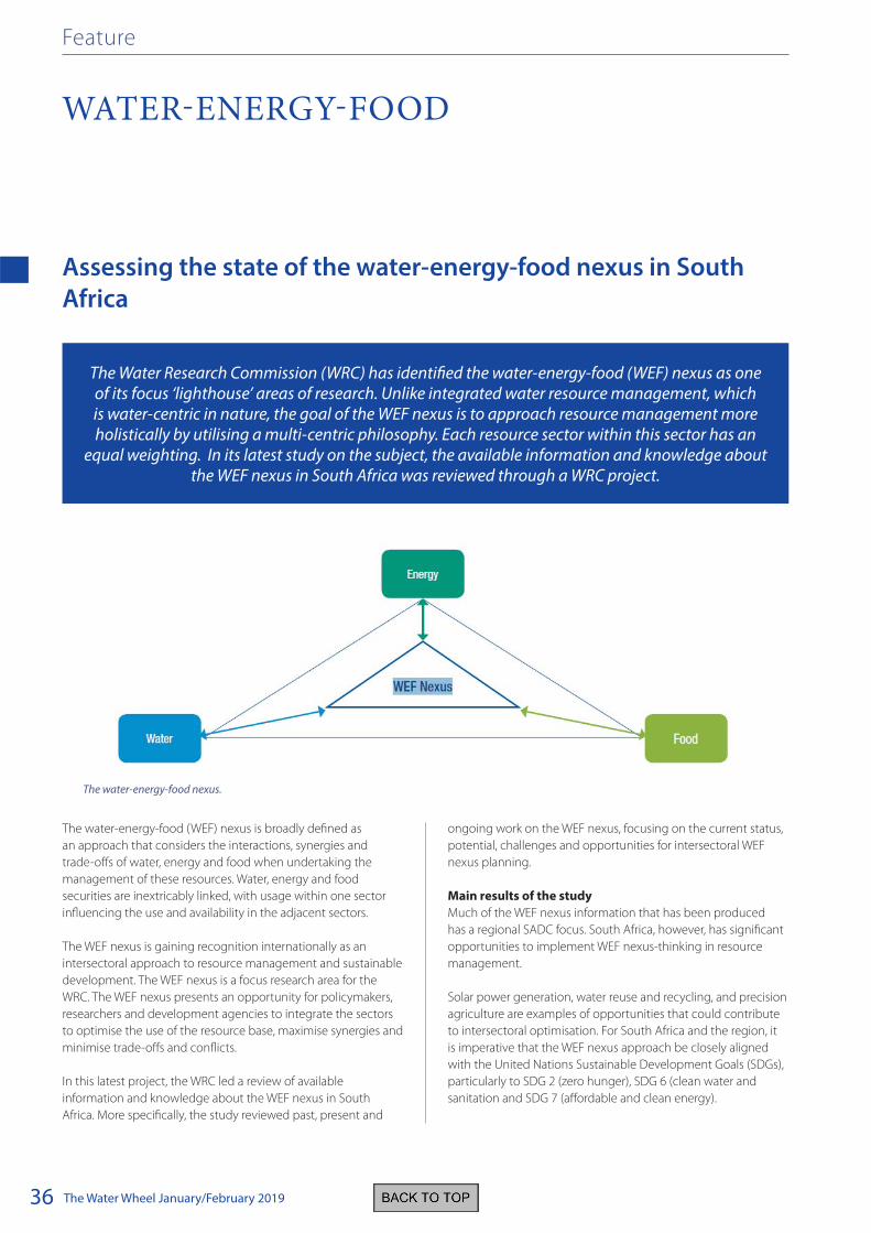
The Water Wheel January/February 201936
Assessing the state of the water-energy-food nexus in South
Africa
The water-energy-food (WEF) nexus is broadly defined as
an approach that considers the interactions, synergies and
trade-offs of water, energy and food when undertaking the
management of these resources. Water, energy and food
securities are inextricably linked, with usage within one sector
influencing the use and availability in the adjacent sectors.
The WEF nexus is gaining recognition internationally as an
intersectoral approach to resource management and sustainable
development. The WEF nexus is a focus research area for the
WRC. The WEF nexus presents an opportunity for policymakers,
researchers and development agencies to integrate the sectors
to optimise the use of the resource base, maximise synergies and
minimise trade-offs and conflicts.
In this latest project, the WRC led a review of available
information and knowledge about the WEF nexus in South
Africa. More specifically, the study reviewed past, present and
ongoing work on the WEF nexus, focusing on the current status,
potential, challenges and opportunities for intersectoral WEF
nexus planning.
Main results of the study
Much of the WEF nexus information that has been produced
has a regional SADC focus. South Africa, however, has significant
opportunities to implement WEF nexus-thinking in resource
management.
Solar power generation, water reuse and recycling, and precision
agriculture are examples of opportunities that could contribute
to intersectoral optimisation. For South Africa and the region, it
is imperative that the WEF nexus approach be closely aligned
with the United Nations Sustainable Development Goals (SDGs),
particularly to SDG 2 (zero hunger), SDG 6 (clean water and
sanitation and SDG 7 (affordable and clean energy).
The Water Research Commission (WRC) has identified the water-energy-food (WEF) nexus as one of its focus ‘lighthouse’ areas of research. Unlike integrated water resource management, which is water-centric in nature, the goal of the WEF nexus is to approach resource management more holistically by utilising a multi-centric philosophy. Each resource sector within this sector has an
equal weighting. In its latest study on the subject, the available information and knowledge about the WEF nexus in South Africa was reviewed through a WRC project.
WATER-ENERGY-FOOD
Feature
The water-energy-food nexus.

The Water Wheel January/February 2019 37
A diverse set of challenges hinder the effective implementation
of the WEF nexus in South Africa. As a developing country, South
Africa’s primary focus is on alleviating poverty, inequality and
corruption while attempting to increase economic growth.
Secondly, resource management and policy development
are generally sector-specific, with little acknowledgement
of adjacent sectors. Thirdly, data related to the three sectors,
and especially their interactions, are frequently unavailable,
inaccessible or unusable due to scale, unit or temporal
differences. Furthermore, WEF nexus implementation will
be subject to its inclusion in national policies and standards,
implying the integration of the water, energy and agricultural
departments at planning level.
Recommendations from the study
A systematic analysis of existing WEF nexus framework in
academic and grey literature resulted in the development of
a South African framework that considers the three sectors as
well as technological innovations, human-wellbeing, SDGs and
different drivers of the WEF nexus.
It is proposed that this framework be utilised as a point of
departure for future research related to the WEF nexus in South
Africa. To this end a research agenda for the WEF nexus in South
Africa is proposed in the final report of the study.
It is recommended that future research on the WEF nexus focus
on the following:
• Developing an integrated model, indicators, metrics and
indices to monitor and evaluate the WEF nexus in South
Africa and creating a WEF nexus database.
• Translation of existing knowledge to inform policies for
integrated sustainable resource management among the
WEF sectors
• Participatory research aimed at demonstrating the
applicability of the WEF nexus at the local level, especially
among the poor, and generating cases that demonstrate
how the WEF nexus could assist in achieving the SDGs.
South Africa is well positioned to achieve these goals as there
are large datasets already in existence. The development of a
WEF nexus model, indicators, metrics and indices would help
to unlock the value of such existing data and also guide the
generation of new datasets.
To order the report, Assessing the state of the water-energy-food
nexus in South Africa (WRC Report No. KV 365/18) contact
Publications at Tel: (012) 761-9300, Email: [email protected] or
Visit: www.wrc.org.za to download a free copy.
Water-energy-food
The proposed water-energy-food nexus framework for South Africa.

The Water Wheel January/February 201938
Last word
NOVEL EARTH OBSERVATION TECHNOLOGY WINS NATIONAL PRIZE
The South African developed earth observation technology to
map and monitor water use of irrigated agriculture has won a
significant prize. The prize, led by international firm DigitalGlobe,
followed the 2018 Open Innovation Challenge for Novel
Applications of Earth Observations. The competition was co-
sponsored by various organisations, including the South African
National Space Agency (SANSA) and the Technology Innovation
Agency. The winners were to receive access to the DigitalGlobe’s
GBSX Platform and the Licensed content. This includes
DigitalGlobe’s 18-year, 1 000 Petabyte library of high-resolution,
multispectral imagery, as well as pre-built machine learning and
remote sensing algorithms. In addition, the winners can access
the latest imagery from NASA’s Landsat and ESA’s Sentinel data.
Led by the Centre for Geographical Analysis at the University of
Stellenbosch, and co-funded by the Water Research Commission
and the Department of Agriculture, Forestry and Fisheries, the
winning technology makes use of machine learning and freely
available satellite imagery (Sentinel-2 and MODIS) to identify
actively growing crops, determine whether the crops are being
irrigated (or not) and to quantify the water used by the crops.
The technology was used to map all irrigated crops in South
Africa and to quantify the water used by such crops in 2014/15.
Near real-time monitoring of water use was combined with
earth observation and machine learning to drive economic
growth.
The developers expressed the hope that the exposure
following the award would lead to the operationalisation of the
technology.
The prize judging criteria.

The Water Wheel May/June 201640
Upfront