Embed Size (px)
Citation preview

Journal of Petroleum Geology, vo1.23(2), April 2000, pp 133-164 133
THE VENEZUELAN HYDROCARBON HABITAT, PART 2: HYDROCARBON OCCURRENCES AND
GENERATED-ACCUMULATED VOLUMES
K. H. James*
Venezuela 's most important hydrocarbon reserves occur in the intermontane Maracaibo Basin and in the Eastern Venezuela foreland basin. Seeps are abundant in these areas. Lesser volumes occur in the Barinas-Apure foreland basin. Most of the oil in these basins was derived from the Upper Cretaceous La Luna Formation in the west and its equivalent, the Querecual Formation, in the east. Minor volumes of oil derived from Tertiary source rocks occur in the Maracaibo and Eastern Venezuela Basins and in the Falcdn area.
Offshore, several TCF of methane with some associated condensate are present in the Cadpano Basin, and gas is also present in the Columbus Basin. Oil reserves are present in La Vela Bay and in the Gugof Paria, and oil has been encountered in the Cariaco Basin. The Gulf of Venezuela remains undrilled. The basins between the Netherlands and Venezuelan Antillian Islands seem to lack reservoirs.
Tertiary sandstones provide the most important reservoirs, but production comes also from fractured basement (igneous and metamorphic rocks), from basal Cretaceous sandstones and from fractured Cretaceous limestones. Seals are provided by encasing shales, unconformities, faults and tarplugs. There is a wide variety of structural and stratigraphic traps. The Orinoco Heavy Oil Belt of the Eastern Venezuela Basin, one of the world's largest accumulations (1.2 x 1 0l2 brl) involves stratigraphic trapping provided by onlap and by tar plugging. Stratigraphic trapping involving unconformities and tar plugging also plays a major role also in the Bolivar Coastal complex offields along the NE margin of Lake Maracaibo. Many of the traps elsewhere in the Maracaibo Basin were influenced by faulting. The faults played an extensional role during Jurassic rifing and subsequently suffered inversion and strike-slip reactivation. This created anticlines as well as fracture porosity and permeability, and influenced the distribution of sandstone reservoirs, unconformities and related truncation traps. The faults probably also provided migration paths as well as lateral seals. This is very likely the case also in the large, thrust-related traps of the Furrial Trend in Eastern Venezuela. Normal faults, many antithetic
*Consultant Geologist; I6 Maeshenllan, Llandre, Near Aberystwyth, Ceredigion SY 24 5DD, Wales, UK.
email: [email protected].
Note: in this papel; MM denotes million; the terms billion and trillion follow American usage (one thousand million and one million million, respectively}.

134 The Venezuelan hydrocarbon habitat, Part 2
to basement dip, provide important traps in the Las Mercedes, Oficina and Emblador complexes on the southern flanks of the Eastern Venezuela Basin. Similar faults seem to control the Sinco- Silvestre complex of the Barinas-Apure Basin.
Much of Venezuela S crude (around 1.5 trillion brls original STOIIP) has been degraded and is heavy, Perhaps two to three trillion brls of precursol; lighter oil existed. While the known Upper Cretaceous La Luna and Querecual Formations are known to include prolific source rocks, a reasonable generationlaccumulation efficiency of 10% implies volumes too large to have come from the reported kitchens. The country S vast reserves are perhaps better explained by recognizing that the present-day basins are remnants of much broader sedimentary areas. The source rocks originally had a much more regional distribution. They suffered widespread, earlierphases of generation that probably charged early-formed traps on a regional scale. These, together with more recent kitchens, provided oil to the present-day accumulations. This history involved long-distance migration and remigration.
INTRODUCTION
This paper attempts to provide an overview of the main plays in Venezuela (Figs 1 and 2). Some of these are illustrated in summary fashion. However, much of the information comes from rather old literature. Since many of the classic fields are being reworked, future publications will hopefully provide updated descriptions of them, illustrated with modern seismic/well data and cross-sections.
The paper also suggests that current explanations of the country’s enormous reserves are not wholly satisfactory. Earlier phases of generation and entrapment on a regional scale, followed by younger, more local kitchens and entrapment, with remigration from earlier accumulations, may offer a more elegant explanation. If true, this may point towards deeper, untested plays.
Note that this paper is a continuation of Part 1 (James, 2000), which covered the tectonic setting, structure, palaeographic evolution and source rocks of Venezuela. Part 1 provided details of the stratigraphy, geography and geology necessary to understand Part 2, in which I consider the distribution and volumes of hydrocarbons present.
HYDROCARBON OCCURRENCES
THE MARACAIBO BASIN
Geological Occurrence of oil- and gasfields
The Maracaibo Basin (Fig. 1) is defined by the transpressional uplifts of the Venezuelan (MCrida) Andes in the SW, the Serrm’a de Los Motilones (or Santander Uplift) in the SE, the Serrm’a de Perijfi in the NW, and the Serrania de Trujillo in the east (Fig. 3a). Physiographically it opens northwards to the Gulf of Venezuela from which it is separated by the major Oca Fault and associated subsurface highs (Fig. 1). The basin deepens SE to the North Andean Foredeep, adjacent to the MCrida Andes.
The basin is structured internally by a southward-opening fan of NE- to north-south to NW-trending faults (James, 2000, Fig. 7). Until recently these were thought to be sinistral strike-slip features. However, the latest interpretations favour their origin as Mesozoic normal faults inverted by Andean compression, and highlight the accommodation of disharmony between deep and shallow structures by the Upper Cretaceous CoMn shales (e.g.. Roberto et al, 1990; Audemard, 1991). The faults probably have a net oblique slip with significant lateral
K . H. James

136 The Venezuelan hydrocarbon habitat, Part 2
displacement. Important fracture porosity is developed along shear zones at fault bends and in associated tight folds.
The Maracaibo Basin has numerous and prolific oil seeps on all flanks, and as in the rest of Venezuela, these focussed early exploratory drilling. Most of the country’s production to date has come from this basin, which remains the main producing area in Venezuela. Total oil in place is estimated to be 318 B brls, and production approaches 40 B brl of oil and 36 TCF of gas. Recoverable reserves are estimated by Petroleos de Venezuela to be 29 x lo9 brls of oil and 16 TCF gas (Graf, 1998).
In general, the basin contains lighter oil and gas at deep levels and heavy oil at shallow levels, reflecting the loss of light fractions by evaporation, flushing and biodegradation.
Talukdar and Marcano (1994) described two total petroleum systems in the basin. The first contributes 98% of reserves, which have migrated from the Upper Cretaceous La Luna source rock to reservoirs in the Eocene Misoa Formation (50%), the Miocene Lagunillas Formation (44%), the Cretaceous (<5%), and the Miocene La Rosa Formation (<1%), as well as to the igneous and metamorphic basement ( ~ 1 % ) reservoirs. The most efficient system is from the La Luna to the Misoa Formation. This leaks to reservoirs in the Lagunillas Formation. The second system links source rocks in the Maastrichtian-Palaeocene OrocuC Group to reservoirs of the same age (47%) and to reservoirs in the Mirador Formation (37%), the Carbonera Formation (1 1%) and to other Cretaceous (5%) reservoirs. Unlike the former system, a definite source-oil correlation is lacking.
Stratigraphic traps formed by sand pinch-out and truncation are important in the shallow fields in the NE ( e g the Bolivar Coastal fields from Cabimus (discovered in 1917) in the north to Mene Grande (1914) in the south: Figs. 2, 3a and 4). Here, crudes reservoired at depths shallower, than around 1,500 m are strongly biodegraded and shallow asphalt forms additional traps (Bockmeulen et al., 1983).
Elsewhere in the basin, the main traps are associated with a family of roughly north-south trending, sinistral strike-slip and reverse faults (Figs. 4 and 5) for example Tarra, (discovered in 1916); La Paz (1924); Bosccin (1946); Urdaneta (1955); Centro (1957); Lama (1957) and Ceuta (1957). The traps involve structural closure, fault sealing and unconfomities. Fault- generated fracture porosity and permeability allow production from otherwise tight Cretaceous limestones and basement rocks.
Eocene and Miocene sandstone reservoirs contain 50% and 40%, respectively, of the Maracaibo Basin’s oil (Talukdar and Marcano, 1994). Both possess mainly intergranular porosity. In the Eocene Misoa Formation porosity ranges from 12-28% and the mean permeability is 240 mD. The Miocene Lagunillas and La Rosa Formations have porosities from 1 0 4 0 % and the mean permeability is 610 mD. Fracturing also enhances the producibility of the Misoa sandstones in the Barua-Motatcin field.
It is interesting to note that the importance of both porosity-enhancing fractures and of basement potential received some of their earliest recognition in this basin. Fractured igneous and metamorphic basement rocks in the NW produced up to 17,000 b/d in the La Puz-Muru fields. Field data show more fracturing in the basement than in the overlying limestones.
Salvador and Hotz (1963) summarized hydrocarbon occurrences in Cretaceous reservoir rocks in Venezuela. Sandstones in the basal Cretaceous Rio Negro Formation have porosities of around 13% in the Urdaneta field (FigSb). Cretaceous limestone reservoirs have some local matrix porosity and permeability, comprising mollusc packstones and grainstones in the Maraca and Apon Formations. These are poorly predictable, and fracturing provides the main reservoirs at these levels. Fracture density is best in areas of maximum faulting, fault intersections and where rocks have passed through folds (e.g. Bueno and Avila, 1987; Bueno and Pinto, 1994; Apotria and Wilkerson, 1997). Bartok et al. (1981) noted that the Albian Cogollo Group has generally poor porosity and permeability (<12%, 3.2 mD) which improves where fracturing has developed in the clean and brittle limestones and sandstones.

I I
I I
I I
I I
I I
I I
t I
I 11
3
NET
HER
LAN
DS
AN
TILL
ES
0 C
AR
IBB
EA
N S
EA
Fig.
2. T
he m
ain
oil-
and
gasf
ield
s of V
enez
uela
. 3
W
4
138 The Venezuelan hydrocarbon habitat, Part 2
Horizontal drilling has made fractured source rock in the La Luna Formation a recent exploration target. Seismic anisotropy and 3D seismic data are being used as fracture detection methods. Early-formed fractures are cemented and late-formed fractures are more likely to have preserved porosity. Outcrops in the Sierra de Perijii show two sets of fractures striking around N10-15”E and N50-55”E (Miller, 1962).
The Campanian Col6n Shales seal Cretaceous and deeper reservoirs, while overlying/ interbedded shales seal younger units. Asphalt forms shallow seals in the Bolivar Coastal fields.
The northern half of the Maracaibo Basin is at a rather mature stage of exploration. In the south, however, the North Andean Foredeep (or Bobures Trough), the Andean front and the Catatumbo area remain poorly explored. While attention in the past focussed upon structural highs, recent exploration successes have tested normal fault traps on the monoclinal rises occurring between these highs (Roberto et al., 1990) where Ghmez et al. (1997) reported 3 B brls oil in place. Deeper drilling in the Bachaquero field has located new pools of lighter (3 1’API) crude oils (Oil & Gas Journal, Feb. 1996). Increasing understanding of the interplay between sedimentation and structure during reservoir deposition, and of the structural complexity of the basin flanks, will lead to major additions to the reserves of this basin.
Dibujo Syncline
This NE-plunging syncline, also known as the Manuelote Syncline, lies at the northern end of the Sierra PerijA range, to the NW of the Maracaibo Basin (Fig. l), from which it is separated by the Tigre-Perijii fault and an associated (Palmar) basement uplift. Oil occurs at outcrop at the contact between Tertiary rocks and the underlying granite of the uplift, in faults and fractures in igneous rocks, and in the outcrops of the La Luna Formation, the Cogollo Group and Eocene sandstones. Despite this abundance of surface indications, only one field, Amana (discovered in 1928), has produced oil (terrestrially sourced) from the northern end of this syncline.
FalcBn Basin
The Falc6n “Basin” in the NJ3 is often grouped with the Maracaibo Basin in terms of production. It is, however, a separate geological entity with only a minor, Tertiary-sourced production. Andean tectonics inverted a middle Eocene-middle Miocene pull-apart basin during the late Miocene, producing an ENE-trending anticlinorium. No seeps occur on this structure. It is bounded to the north by an ENE-trending fault system involving locally preserved, viable Tertiary rocks that source a line of fields (El Mene - Tiguaje, Figs. 2 and 5c) and seeps. Further north lie the Dabajuro (Fig. 1) and Coro “platforms”, in the west and east, respectively, separated by the north-plunging Urumaco Trough. These carry immature Miocene-Recent cover on overmature and eroded Eocene and older rocks. A marine, Oligocene-lower Miocene source rock, mature in the Urumaco Trough, fed the updip, abandoned Mamdn field.
Discoveries in the Falc6n area include El Mene de Mauroa (discovered in 1921), Media (1929) and Hombre Pintado (1927) fields, all drilled close to seeps (Halse, 1947). At the Mene field, the trap is largely stratigraphic (Fig. 5c). Oil occurs in sand lenses of the Mio- Pliocene La Puerta Formation and in truncated sands of the Oligocene Agua Clara Formation, above and below an unconfonnity. Production at Media came from sandstones in the Agua Clara Formation, sealed by faults. Hombre Pintado also produced from the same interval; but here the trap is anticlinal. These fields produced a cumulative 107 MM brls of waxy, marine- terrestrial oil. The source rock is Eocene in age according to Boesi and Goddard (1991), though earlier studies recognized the Oligocene Agua Clara Formation as the most likely source. Biomarker studies indicate a relationship between seeps at Mene de Mauroa in the
K . H. James 139
W
PERIJA MOUNTAINS
MARACAIBO BASIN E l
TRUJILLO MOUNTAINS I
WEST COAST flELDS CENTRAL LAKE FIELDS BOLIVAR COAST FIELDS (LA P U , MARA) (LAMA. LAMAR) (LAGUNILLAS, YENE GRANDE)
MATURIN SUB-BASIN
INTERIOR RANGE GUAYANA SHIELD
sw BARINAS-APURE BASIN NE HAT0 EL BAUL HIGH (POI-)
BRUJAS HIGH
n C B - l X KK SOCOPO-1 SJNCO
CAPITANEJO-1 LECmYOrr-, CONS004 15-Gu201 PEDRILO-I
AI~W F.O -. t en; PC+UI~ uld RUM, imi.
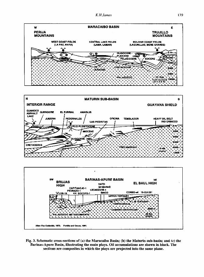
Fig. 3. Schematic cross-sections of (a) the Maracaibo Basin; (b) the Maturin sub-basin; and (c) the Barinas-Apure Basin, illustrating the main plays. Oil accumulations are shown in black. The
sections are composites in which the plays are projected into the same plane.


BOSCAN FIELD sw
Fig. 4e. Boscan field (after Richmond Exploration, in Smith 1962). Trap: Homocline, dipping SW, cut and sealed by Boscln Fault, truncation of sandstones at the Eocene unconformity. Reservoir/seab Concepcion, Icotea and La Rosa Fm sandstones; Eocene fluvio- deltaic sandstones. Sourcekitchen:La Luna Fm, early mature in the vicinity of the field. Hydrocarbons:Low maturity, sulphur rich, mild bacterial alteration, 11-12" API, produced 800 brl; 2,470 MM brl reserves.
TARRA FIELD Iw
Fig. 4f. Tarra field. Trap: Thrust-generated anticline of Tarra-Los Manueles complex. Tertiary structure disharmonic to Cretaceous (accommodation in Col6n shales). Reservoidseal: Aptian-Albian Aguardiente and Apon Fm limestones (6 %, 3000mD fracture permeability) and Palaeocene Catatumbo sandstone (18.5%) sealed by Col6n shales, Mirador shales and faults. Sourcekitchen: Cretaceous La Luna and Tertiary Orocue Fins, mature in the North Andean foredeep from Miocene time. Hydrocarbons: 38-51' API, 137 MM brl UR, solution gas drive.
W LAMA RELD
La RM.
Quaurn
Fig. 4g. Centro field (after R.B.Scott, in Smith, 1952): Trap: NE-trending anticline, fault seal and facies changes. Reservoidseal Miocene La Rosa Fm sandstones. Sourcekitchen: La Luna Fm, matured in the Eocene to the NE. In the Miocene - Recent to the south. Hydrocarbons: 35" API, 2000 MM brl reserves.
Fig. 4h Lama field. Trap: NNE- trending anticline cut by faults; unconformity truncation. Reservoir/seal: Lower Eocene "C" and "B" sandstones, porosity 24% perm. 300 mD, minor contributions from fractured Cretaceous Cogollo limestones, Palaeocene Gausare Fm limestones and Miocene Santa Barbara Fm sandstones. Sourcekitchen: La Luna Fm, matured during the Eocene in the NE, in the Miocene-Recent in the south. Hydrocarbons: 32-40' API, undersaturated, EUR 3,500 MM brl proven, - 9,700 MM brl STOIIP. ah
- Fig. 4. Field summaries, Maracaibo Basin.
142 The Venezuelan hydrocarbon habitat, Part 2
west and Mene Cosme in the east, and the Oligo-Miocene Guacharaca Formation and the Miocene Agua Salada Group (0110 et al., 1994). The Cumarebo field (193 1) produced gas and condensate from Miocene sandstones in a north-vergent, thrust-related anticline on the southern shoreline of La Vela Bay. This field probably is related to discoveries on a basement high that trends across the adjacent Bay. These contain hydrocarbons in fractured basement and in Miocene carbonates and sandstones. To date, they remain undeveloped. The source rock in this area is thought to be the same, marine Oligo-Miocene section as in the Urumaco Trough.
Suter (1947) described the structure at the abandonedMene de Acustu field as an asymmetric NE-trending anticline on which only the south flank had been productive. The field was discovered in 1925 by surface mapping and seeps. Pitch and 18'API oil had been observed in a river cut at Mene and Menecito, and gas was visible in the wet season.
THE EASTERN VENEZUELA BASIN
Geological occurrence of oil-and gasfields
The asymmetric, Eastern Venezuela Basin runs ENE along the north flank of the Proterozoic Guayana Shield (Fig. 1). It deepens northwards from the Shield towards its northern margin (Fig. 3b), which comprises uplifts formed by the Cretaceous - Palaeogene sedimentary rocks of the Interior Range and the Jurassic - Cretaceous metasediments of the Coastal Ranges. The basin is tilted to the east. Uplift and erosion occur in the west, while subsidence continues in the east. Sedimentary thicknesses are thought to exceed 12 km in the northern foredeep, but the exact depth to the basement in the northern part of the basin has not yet been verified. The degree to which the Interior Range overrides the foredeep also is unknown and the thickest part of the Tertiary section, below the Amacuro Delta, is poorly explored.
This basin had an important early production history from fields such as Quiriquire (discovered in 1925), Pedernales (1933), Jusepi'n (1938) and Orocual (1933), together with the fields of the Greater Mercedes (1941), Anaco (1937) and Oficina (1937) areas (Figs. 2 and 6). Deep drilling in the fold-and-thrust belt revitalized enthusiasm in the early 1980s, with the discovery of the Furrial trend (1983). At the same time, delineation of the Heavy Oil Belt resulted in the realization that this is possibly the world's largest oil accumulation. The basin has produced some 13 B brl of oil, considerably less than the Maracaibo Basin. However, the area is assuming increasing importance as the Furrial trend accumulations are developed and as various projects to exploit the Heavy Oil Belt move ahead.
The El Batil Uplift or Arch in the west separates the Eastern Venezuela Basin from the Barinas-Apure Basin (Fig. 1). The arch is not completely covered by Cretaceous sediments and the Eocene is absent. It was completely covered by Oligocene sediments, but towards the end of the Miocene the Oligocene-Miocene section was partly eroded. Palaeozoic igneous- metamorphic rocks and Triassic-Jurassic volcanics are exposed locally today. The area north of the Arch has been referred to as the Guarumen Basin.
The Eastern Venezuela Basin is sub-divided into the western (Guhico) and eastern (Maturin) sub-basins by the Anaco-Altamira Fault. This had considerable synsedimentary activity and now supplants the Urica Fault, which was originally taken as the boundary between the sub- basins. The area south of the Cariaco embayment is sometimes referred to as North Anzohtegui, and the zone of fields along the Anaco Fault is known as the Greater Anaco Area.
Lilliu (1990) defined the Frontal Deformation Alignment, south of which no compressional deformation is seen, which runs approximately 50 km south of the town of Maturin. The Maturin Foreland, north of the alignment, is a sedimentary basin that continues northwards as far as the Interior Range foothills. Like the Interior Range, this basin is characterized by thrust anticlines separated by transcurrent faults. The Maturin Foredeep, characterized by normal faulting, lies between the deformation front and the Guyana Shield.

W CEUTA FIELD E
Fig. 5a.Ceuta field. Trap: Pueblo Viejo anticlinal structure, Pueblo Viejo, Ceuta and West Boundary Faults. Reservoidseal: Eocene Misoa Fm lower “B” sandstones (10-17%), and Oligo-Miocene La Rosa and Lagunillas Fm sandstones (20-30%). Sourcekitchen: La Luna Fm, matured in Eocene in NE. Miocene - Recent in the south. Hydrocarbons: 8-38’ API, EUR 1,402 MM brl.
- N EL MENE DE MAUROA FIELD
-=E-=s.L.
I SSW UP18 URDANETAFIELO UP14 NNE
Fig. 5b. Urdaneta field. Trap: NE-SW trending high cut by parallel and orthogonal faults, oil is associated with the Eocene unconformity. Reservoir/seal: Eocene Icotea and Misoa Fm sandstones above and below the Eocene unconformity, porosities up to 32%, 5-2750 mD. Sourcekitchen: La Luna Fm, matured in the Eocene in NE, Miocene-Recent in the south. Hydrocarbons: 12’API, very heavy, viscous, sulphur-rich, 1615 MM brl reserves. 3
2
JO0AL VUCAL PLACER ZURON
Fig. 5c. El Mene de Mauroa field (after Fichter and Renz, in Mencher et al. 1953): Trap: Unconformity cut-off and sand lenses in faulted anticline with seeps. Reservoidseal: Mio-Pliocene La Puerta and Oligocene Agua Clara Fm sandstones. Sourcekitchen: Tertiary humic OM in Agua Clara Fm, Late Miocene - Pliocene generation? Hydrocarbons: 32’ API oil.
Fig. 5d. Yucal-Placer field. Trap: Pinch-out of turbiditic sandstones, drape over low-relief structures associated with thrust fault. Reservoir/seal:Oligocene La Pascua and Roblecito Fm sandstones (porosity 5- 18%). Sourcekitchen: Marine amorphous kerogen in the Cretaceous La Cruz, Infante and Guaninita Formations in the northern part of the Guarico sub-basin. Hydrocarbons: 8 TCF gas, C,-C,, CO,, H,S. - tl

SAN JOAOUIN FIELD (Gealer Anaco ares) SSE NNW CIL.4
llrnrn -
I 1 Krn
I \-
Fig. 6a. Sun Joaquin field (after Mencher et al., 1963). Trap: Elongate dome, one of a series of en Jchelon and strike-slip offset surface features associated with the SE-verging NE-striking Anaco Thrust. Steep SE flank, gentle NW flank. No seeps. High temperatures. Reservoir/seal: Oligocene, lenticular Oficina Fm sst (18-26%, 50mD) and Merecure Fm sst (15-20%, 100-300 mD); interbedded and overlying shale seals; thin sands overpressured. Sourcekitchen: Mixed, Cretaceous Querecual Fm and Tertiary Merecure and Oficina Fm. Mio-Pliocene generation in Espino Graben. Hydrocarbons: Waxy, 33-47' API, up to 60°, 358 MM brl reserves, gas caps.
N PEDERNALES FIELD s
Fig. 6c. Pedernales field. Trap: Stratigraphic traps on flank of clay diapir (Oligo-Miocene Carapita Fm) generated by Andean compression. Reservoirheal: Miocene La Pica Fm turbidites to deltaic channel sandstones (27%, 300 mD), maximum thickness 250m, sealed by interbedded and overlying shales. Sourcekitchen: La Luna and San Antonio Fm, matured in Late Miocene to Recent kitchen in the north of the Maturin Basin. Hydrocarbons: 18-22' and 26-31' API oil, 58 MM brl produced, 547 MM hrl QTnTIP. Patension STOIIP 600 MM brl, 300 MM brl reserves.
SSE I OUlRlaUlRE FIELD
I NNW
I I
Fig. 6b. Quiriquire field. Trap: SE-dipping monocline with lateral pinch-out and deeper faulted anticline. Reservoidseal: Pliocene Quiriquire Fm. alluvial fan sandstonelconglomerates, poorly sorted, 18% porosity, 100-11,000 mD, sealed by lateral shale-out and gilsonite, also Oligocene, main deeper reservoir (11 % porosity, fractured), Eocene Los Jabillos, Caratas and Vidono and Cretaceous San Antonio Fm sandstones. Sourcekitchen: Cretaceous Querecual-San Antonio Fm, upper, matured Late Miocene-Holocene beneath the main thrusts. Hydrocarbons: 750 MM brl produced 12-28' API oil, gas and condensate (55- 56') at deeper levels (none produced, Los Jabillos is best known). 812 MM brl and 545BCF reserves: 4-5 MM brl STOIIP.
TUCUPlTA FIELD (Gm81er Temblador ma) // N
I' I
Fig. 6d Tucupita field (ajler Mencher et al., 1963). Trap: Down-to-south normal fault on regional foreland ramp. Reservoir/seal: Oligocene Oficina Fm sandstone, sealed by overlying Oficina shales. Source/kitchen: Querecual Formation, matured to north during Miocene. Hydrocarbons: 95 MM brl reserves.
c
K. H. James 145
I .I
To the east of the Maturin area (Fig. l), the Eastern Venezuela Basin deepens into the Gulf of Paria towards Trinidad and the Atlantic Shelf. The Gulf of Paria (see below) is a downfaulted area that links eastern Venezuelan and Trinidadian geology below Mio-Pliocene sediments. The Gulf opens to the Atlantic to the SE of Trinidad via the Serpent's Mouth channel. More than 14 km of mainly Miocene to Recent sediments are present SE of Trinidad (Erlich and Barrett, 1990).
The southern flank of the Eastern Venezuela Basin is structured by a conjugate system of NW- and NE-trending normal faults that downthrow preferentially to the south (Fig. 3b) (James, 2000, Fig. 7). These are thought to be a response to fold-and-thrust loading in the north, generated by transpression between the Caribbean and South American Plates. Compressive stresses affect the basin at least as far as the diapiric trend that runs from Maturin to Trinidad and have produced the inverted structures of the Piedritas trend. In the eastern part of the Maturin sub-basin, north-trending, eastward-dipping listric faults affect the thick Miocene- Pleistocene section.
The Guarumen Basin
This little-explored and apparently barren area, strongly overthrust by nappes, lies at the northern end of the El Baul Arch where it forms a link between the GuArico sub-basin and the Barinas-Apure Basin (Fig. 1) The Basin is separated from the GuArico sub-basin by the north- trending subsurface El Pao High.

146 The Venezuelan hydrocarbon habitat, Part 2
There are no seeps and no fields in this area. A stratigraphic well, Guarumen-Is, tested a seismic interpretation that showed a sedimentary, autochthonous foreland basin beneath the nappes (Chigne, 1989). The well penetrated Palaeocene-Eocene flysch containing large Cretaceous olistostromes in the allochthon, a Barinas-type middle Eocene-Oligocene section in the autochthon and bottomed in Palaeozoic basement. The well recorded only minor shows of formation gas. A Cretaceous source section was absent as a result of non-deposition, erosion or fault cut-out.
The Guhrico sub-basin
One oil seep and three gas seeps have been reported from the Guiuico sub-basin (Renz et al., 1958). There are no surface indications of the field complexes occurring further south, which include part of the Orinoco Heavy Oil Belt and fields of the huge Greater Mercedes Area. Cretaceous source rocks in the north of the area are thought to have entered the oil window in the Oligocene and are now gas prone.
In the northern Guiuico sub-basin, the Yucal-Placer field (Fig. 5d, discovered in 1948) which has reserves of 8TCF of thermal gas (mainly methane) has an element of stratigraphic trapping provided by southward shale-out of Oligocene barrier-island and turbidite sandstones assigned to the Roblecito and La Pascua Formations (Aymard et al., 1985). These are the Guiuico sub-basin equivalents of the Maturin sub-basin Los Jabillos and Caratas Formations, respectively (James, 2000, Fig. 8b). Porosities are 5-18% and 8-18%, respectively. Shales in the Roblecito Formation and the upper part of the La Pascua Formation provide seals. Daal and Lander (1993) noted temperature gradients here of up to 4.2"C/100m here, among the highest in the Eastern Venezuela Basin.
In the Greater Las Mercedes Area (1 94 l), La Luna-sourced, moderately mature oil and gas are trapped by antithetic normal faults. Oligocene La Pascua and Roblecito Formation sandstones (1 2-22% porosity) and the lower Miocene Chaguaramas Sandstones (20-25% porosity) form the main reservoirs. There is also minor production from fractured carbonates of the Cretaceous La Cruz Member of the Tigre Formation. Las Mercedes field oils (25- 35"API) show no significant vertical or lateral gravity distributions (Talukdar, 1992).
Northern Anzoategui
This area lies in the eastern part of the Guiuico Sub-basin (Fig. 1). Here, the greater part of the Coastal and Interior Ranges collapsed during pull-apart that created the Cariaco Basin in the Late Miocene. Only the southernmost folds and thrusts remain to crop out onshore. The area just to the south of these is the deepest part of the Guiuico sub-basin and is probably an active kitchen today. One seep occurs near the coast just east of Puerto La Cruz, in the NE of the area.
In the northern part of the area, fields such as Quiamare (discovered in 1942,30-50°API), La Eeja (1950,12-37OAPI), Cerro Pelado (195 l,34-4O0API) and La Ceiba (1946,30-4OoAPI) produce from Miocene Oficina and Merecure Formation. sandstones (7-1 1 % porosity) in anticlinal traps. Most production comes from the Oficina Formation, using gas and water drive (Galeazzi et al., 1996). According to Flores and Barbato (1990) fracture porosity in the dense glauconitic, San Antonio limestone (1.5% porosity), allows condensate to be produced.
Deeper prospectivity related to the fold and thrust belt should exist in the north, and further prospectivity may be present in compressional structures within or adjacent to the Urica and Anaco fault systems. This play was tested recently by the TAG-I well which produced oil from thrusted lower Miocene sandstones at rates of up to 16,000 b/d.

K. H. James 147
The Anaco Area
Fields in the Anaco area - Sun Joaquin (Fig. 6a), El Roble, Guario, Santa Rosa (discovered in 1937) - are located in a narrow zone of asymmetric anticlines, expressed at the surface, above the N5O"E-trending, NW-dipping Anaco Fault. The trend is cross-cut by NW trending strike-slip faults. The Anaco Fault is interpreted to have been active as a reverse fault in the Late Miocene-Pliocene, but the Oligo-Miocene section thickens across the fault from east to west, indicating downthrowing to the west at that time (Banks and Driver, 1957). The fault is thought to be related to older, deeper faults (Jurassic normal faults at the eastern margin of the Espino Graben). These may explain why the area is characterized by abnormally high temperature gradients (3.6 - 4.5"C/100m: Funkhouser et al., 1948).
There are no seeps in the Greater Anaco Area (Fig. 2). Reservoirs are provided by up to 70 separate sandstone intervals in the Merecure and Oficina Formations, which contain oils of 33-47"API gravity and are gas-rich. In several fields along the trend, Tertiary terrestrially- sourced oil is present in the San Juan, Caratas, Carapita and Oficina Formations. Tertiary sources are thought to be mature in areas west of Anaco. According to Talukdar (1992), Type I11 source rocks have probably generated the terrestrial oils found in the area. The presence of Tertiary source rocks in the area was noted by James (2000), but it is also interesting to speculate on a change of organic facies in the Querecual Formation, similar to that seen in the proximal facies of the La Luna Formation. in the Barinas-Apure Basin.
The Maturin Sub-basin
Abundant oil and gas seeps occur along the eastern part of the mountain front that forms the northern limit to this area (Fig. 3b). The world's largest asphalt lake occurs at Guanoco and covers 1,100 acres (Halse, 1932, quoting Carver, 1887; Gonzalez de Juana et al., 1980) (Fig. 2), and there are further asphalt lakes in the same area at La Bred and Lug0 Saldado. Oil and gas seeps also occur near the crest of a large, linear clay diapir, part of a system that extends to Trinidad, at Pedemales (see below), where asphalt was extracted in the late 1800s. No seeps occur in the south in the area of the Orinoco Heavy Oil Belt.
At the Guanoco field (discovered in 1913) oil was produced from fractures in the San Antonio Formation. The Quiriquire (1928) and Jusepin (1938) fields were shallow discoveries in Pliocene (plus some Oligocene) and Miocene sandstones in stratigraphic and anticlinal traps which are more structured at deeper levels (Figs. 2 and 6b). The Pedemales field (1933) is located near mud volcanoes, oil and gas seeps and an asphalt lake. Oil is stratigraphically trapped in Mio-Pliocene sandstones of the La Pica Formation, adjacent to a large Pliocene diapir of Miocene Carapita Formation shales (Fig.6~).
Drilling much further to the south discovered the stratigraphically-trapped Heavy Oil Belt in 1935 (see below). North of this, the Temblador field (discovered in 1935; illustrated by the Tucupita field (1945) (Figs. 2 and 6d) produces from Miocene Oficina Formation sandstones (35% porosity) sealed by southward-hading normal faults.
The Ofcina field (discovered in 1937), originally defined by gravity measurements as an anticlinal structure, was the first Venezuelan field to be discovered using seismic methods. Trapping here involves a conjugate system of normal faults that throw basin- and cratonwards. Around thirty other accumulations were subsequently found in the Greater Oficina Area. Multiple sandstones in the Oficina Formation were deposited as fluviadeltaic channel sand bodies. Porosities are 10-30% and permeabilities 50-1,000mD. The sandstones are 1-30m thick, and up to 70 are present. Most of the oil accumulations have gas caps. Ofcina oils generally are heavier in the deeper and sandier parts of the formation and there is a general southwards decrease of gravity (Talukdar, 1992). Strong mixing of Cretaceous and Tertiary sourced oils is indicated by the presence of waxy crudes and high GORs. Rabasso-Vidal
148 The Venezuelan hydrocarbon habitat, Part 2
(1985) noted that most of the sand bodies are channel deposits, elongated north-south. Coastal or littoral bodies would be oriented E-W and should offer stratigraphic trapping opportunities. Similarly, Funes and Itriago (1 994) studied fields in the Oficina and Anaco areas, and estimated that 13% of reserves are stratigraphically trapped, suggesting that significant reserves remain to be discovered in similar traps in the area.
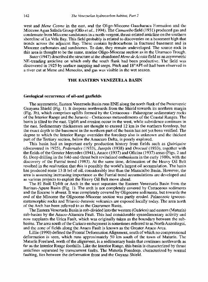
The deeper, Furrial (or Greater Furrial) trend (discovered in 1986) is a series of large, en khelon anticlines associated with blind thrusts (Figs. 2, 3b and 6e). Long oil columns occur in Oligocene (Naricual Formation), and Cretaceous (San Juan Formation) sandstones (Carnevalli, 1988; Aymard et al., 1990; Prieto and Valdes, 1992). Most production comes from the Naricual Formation. Rodriquez (1995) reported volumes of 16.4 B brl of oil and 50.5 TCF gas in place. No oil-water contact has been found and the down-dip limit of oil appears to be tar. Tear faults (lateral ramps to the thrust sheets) provide lateral seals and subdivide the 100-km long Furrial trend. Different oil gravities are present in the separate structures, so that Tejero oil is lighter than Carito oil. Yet lighter fractions are predicted for structures such as Casupal-Mata Grande and Tonoro, located further west (Garcia, 1992). The structures, fault propagation anticlines, are known to extend below the Pirital Fault, especially in the west (Lander, et al., 1993). Fields on this trend are Carito (discovered in 1988), Tejero (1988), beneath the Santa Barbara gasfield, and Boquerh (1989).
In 1990, the well Amarilis-Z tested a deeper structural play basinward of the Furrial trend (Figs. 2, 3b and 6). It found hydrocarbons in turbidite sandstones (Barrios and Sams, 1992) within the Miocene Carapita Formation (the regional seal to the Oligocene and Cretaceous accumulations). Sams et al. (1992) discussed two possible settings for this accumulation: its seismic structure could be interpreted as either as a thrust-related anticline or as a fan within the syncline.
In early-1994, the discovery of a new province in the east of the Maturin sub-basin was announced. A 300-km long, E-W trend of gently inverted structures, known as Las Piedritasl Acema Casma, shows that Andean contraction has penetrated deeply into the foreland (Fig. 3b). The structures occur in association with shallow gravity faulting that trends N-S to E-W, downfaulting to the east (Daza and Prieto, 1990). Oil occurs in lower Miocene, transgressive sands sealed by middle Miocene, deep marine shales (Barrios and Iusco, 1997). The sands, at around 4,500 m depth, have 61 m mean thickness, and porosities and permeabilities ranging from 12 - 15% and from 50- 1,000 mD, respectively.
Recent, deeper drilling in the Quiriquire area (Tropical-I) has realized significant production from reservoirs in the Cretaceous San Antonio and San Juan Formations.
The Orinoco Heavy Oil Belt
Reservoirs in the Orinoco Heavy Oil Belt (discovered in 1935) are dominated by stratigraphic trapping provided by the onlap of sands, onto basement on a north-dipping monocline, and by heavy oil plugs (Fig. 3b). The belt, 460-km long and up to 40-km wide, includes six main producing areas (Machete, Zuata, Sun Diego, Pao, Hamaca and Cerro Negro: Martinez, 1987); however, convention currently refers to the four areas shown in Fig. 2. Most of the oil is trapped in fine to very coarse, unconsolidated Miocene Oficina sands in the Zuata, Hamaca and Cerro Negro areas of the Maturin Sub-basin and in the Oligocene-lower Miocene La Pascua, Roblecito and Chaguaramas sands (equivalents to the Oficina Formation) in the Machete area of the Guhrico sub-basin. In the latter area, oil also occurs in the massive, unconsolidated sands of the Albian-Coniacian Canoa Formation (Kiser, 1987).
Although the oil occurs at shallow levels (less than 610 m to more than 1,220 m (Isea, 1987), there are no surface indications. Zamora et al. (1988) suggested that the belt may extend below the poorly-explored, swampy, southern part of the Orinoco delta, where a further 25 to 226 x lo9 brl of oil-in-place may be trapped.
K. H. James 149
The oil was derived from the Upper Cretaceous Querecual Formation (Cassani et al., 1988). According to Chigne et al., (1993, 1995) earliest generation occurred in the northern part of the area during the Late Eocene and Early Oligocene. Most of the oil migrated 150 km up the then-undeformed southern flank to the Heavy Oil Belt; oil formed in younger, Early Miocene to Recent, southward-migrating kitchens became trapped against faults north of the Belt. Early, long-distance migration occurred along regional carrier beds and unconformities. This occurred within the Upper Cretaceous San Juan Sandstones, along and across unconformities to the Eocene Los Jabillos Formation, stepping up to the basal, Oligo-Miocene Merecure-Oficina sandstones above Oligocene and Miocene unconformities and finally to the Oficina Formation pinchout (Talukdar et al., 1987). George and Socas (1994), however, alternatively suggested that the Heavy Oil Belt kitchen area lay in the vicinity of Parinrinidad.
The oil contains 4% sulphur and significant amounts of vanadium and nickel. Bitumen (4’API) is also present. Despite high densities, the oils are highly mobile in the reservoir where temperatures range from 50°C at 800m to 60°C at 1,100m. Natural gas also occurs in the belt, in the western, (Gorrin, Machete and San Diego) areas. This is thought to have accumulated independently from the oil (Martinez, 1987).
An excellent history of the Belt was provided by Martinez (op cit.). The first well drilled in the belt was La Canoa No. I, in 1935. It was abandoned at 1,176m after testing 40 b/d oil (7’API) in tar sands in a thin conglomeratic zone on top of basement. In the next 30 years, 58 wells were drilled. Fifty of these encountered heavy, viscous and unmarketable oil in the lowermost sands of the Miocene Oficina Formation. Most were abandoned without testing. At this time the area was called the “Tar Belt”. In 1978, areas of the belt were assigned to four PDVSA (Petroleos de Venezuela) filial Venezuelan companies and in the five-year period 1979-1983,669 wells were drilled and 15,OOOkm of vibroseis lines were recorded, along with a 54,000 sq. km airborne magnetometer survey. The effort included recording 5.5 km of logs and 4,500m of coring.
Following re-entry of international companies into Venezuela, this reserve base has attracted a great deal of attention. Several multi-billion dollar schemes are in place to transport and upgrade the heavy crude, in partnership with Venezuelan affiliates.
Gulf of Paria
This marine area is confined by the Orinoco Delta to the west and by Trinidad to the east (Fig. 7). To the NW and NE lie the metamorphic rocks of the Paria Peninsula of eastern Venezuela and the Northern Range of Trinidad. The Isla de Patos (Venezuela) and the Chatachapos, Huevos and Monos Islands (Trinidad) show the continuity of these elements across the Dragon’s Mouth channel, which is the Gulf’s northern outlet to the Caribbean Sea. Trinidad’s Central Range correlates structurally with the front of the Interior Range of eastern Venezuela and indicates a similar, but offset, link across the Gulf. Likewise, Trinidad’s Southern Range is a continuation of a shale diapir zone that extends from Tonoro-El Lirial SW of the town of Maturin, via Joyo, Guanipa and Pedernales and thence via southern Trinidad to the edge of the continental platform east of Trinidad. Oil and gas seeps and asphalt lakes characterize this zone. To the SE the Gulf opens to the Columbus Basin, via the Serpent’s Mouth channel.
Perez de Mejia and Tarache (1985) noted that neither gravity nor magnetic data allow basement depth below the Gulf to be determined. Extrapolation of onshore trends indicates deepening to around 12,000 m. According to Erlich and Barrett (1990) Bouguer gravity suggests a crustal depth of 10-14 km below the Amacuro/Gulf of Paria boundary to the south.
Significant seeps and fields surround the Gulf. Two of the world’s largest asphalt lakes occur at Guanoco (1,100 acres) in Venezuela, and at Pitch Lake in Trinidad (150 acres). Oil with a shallow carbonate/evaporite signature has been identified in Pedernales and offshore eastern Trinidad (Poui field). It may be related to Lower Cretaceous evaporites penetrated in the Gulf of Paria (Couva evaporites: Bray and Eva, 1983).

150 The Venezuelan hydrocarbon habitat, Part 2
1 m
Columbus Basin
Fig. 7. Structural elements of the Gulf of Paria pull-apart basin (see location in Fig. 1). Metamorphic rocks in the Paria Peninsula continue in the Northern Range of Trindad. Cretaceous rocks of the Interior Range of Venezuela (Fig. 1) continue beneath thin cover in the north, but lie
deeply buried beneath in the south. The thrust front of the Interior Range in Venezuela corresponds to the Central Range of Wnidad. The Southern Range of M d a d is the eastward continuation of a
diapairic trend that begins in the Maturin Basin.
Structurally, the Gulf of Paria is poorly known. It could be interpreted as a pull-apart basin formed where east-west trending dextral faults associated with the Caribbean-South America plate boundary step south to the Galeota Fault, south of Trinidad. It is an eastward continuation of Eastern Venezuela, with significant normal faulting superimposed since the Miocene. The Casanay-El Pilar Fault system and the diapiric zone limit the area to the north and south, respectively. The intervening area is crossed by SE-trending dextral faults such as the Bohordal, Los Bajos, Warm Springs and Piparo faults. These are synthetic to the regional east-west faults and also have significant normal displacements. The buried thrust front of the Interior Range is offset along these faults below the Gulf and then resurfaces in Trinidad's Central Range. This front separates the northern Guiria area from the southern Posa sub-basin. The Cretaceous section of the Interior Range occurs below upper Miocene or younger rocks in the north, while a more complete and very thick Cretaceous - Neogene section occurs in the south. The deepest wells have reached the Oligocene in the south (ca. 4,000 m) and the Cretaceous in the north (ca. 3,600 m).
The Guiria sub-basin comprises a central high flanked by the Yaguaraparo Depression to the west and the Caroni Basin to the east (Fig. 7). The Yaguaraparo Depression continues onshore south of the Paria Peninsula. There are no well data here. Geophysical data indicate
K. H. James 151
3,600m of Tertiary sediments in a syncline in the vicinity of TuruCpano Island. A zone of "Cretaceous Highs" crosses the Gulf from the Campana area in the SW, through the Plata High, the Posa-40 High, to the Domoil High. The highs were covered by Tertiary sediments in the south, but remained positive in the north. Drilling on them has been unsuccessful. In the Guiria sub-basin Upper Miocene or younger sediments lie above the Cretaceous rocks. The latter include significant, Lower Cretaceous anhydrite deposits, mentioned above, that may correlate with the Cariaquito Formation of the Paria Peninsula and the Laventille Formation of Trinidad's Northern Range.
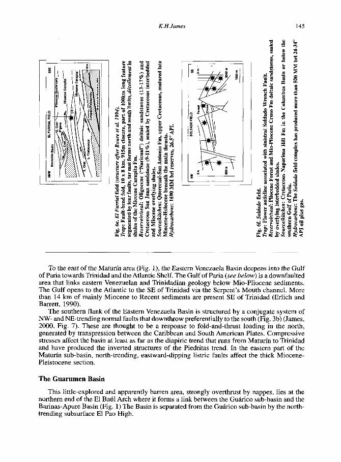
The Posa sub-basin is located between the Los Bajos fault, the zone of Cretaceous highs and the Diapiric Zone. Numerous intraformational unconformities, thrusts and growth faults result in poor seismic continuity and difficulty in correlation, especially from north to south and where no well data exist. In addition, lateral displacement has juxtaposed blocks of disparate origins. Thus, the Posa sub-basin has a composite sedimentary column comprising the Upper Cretaceous Guayuta Group, the Upper Cretaceous-Eocene Vidoiio and Caratas Formations, the Miocene Carapita, Tamana-Lengua and La Pica Formations, and the Plio-Pleistocene Las Piedras and Paria Formations. Two fields have been discovered in this area and a further discovery in this area was made in 1998 by the well Corocoro-1, north of the Pedemales. The Soldado field (Fig. 6 0 is an anticlinal feature associated with the Los Bajos Fault, while the Posa is situated on the northern flank of the regional Guanipa Syncline. Source/oil geochemical correlation suggests a Cretaceous source for these oils. A low thermal gradient (1.8-2.7'C/lOO m) is reflected by low VR values measured in Soldado wells (Ro 0.8 at 4,300m). The onset of oil generation occurred in the late Oligocene to Pliocene and peaked from the late Miocene onwards.
The shallow-marine to deltaic, lower Pliocene Manzanilla Formation provides the most important reservoirs of the Soldado North field. This unit extends into the gulf as far as the international border, where it interfingers with the La Pica Formation. Source areas for these deltaic sands were units such as the Northern and Central Ranges of Trinidad. The Soldado Main field produces from the Miocene Cruse Members, part of the same northerly-derived deltaic system. These late Miocene deltaic deposits (the Cruse, Forest and Morne L'Enfer Formations) form important reservoirs in southern Trinidad. Stainforth (1978) suggested that these sands were delivered by the proto Essequibo River in the Guayana area (palaeocurrent analysis indicates a SE source). Mio-Pliocene sands are notoriously unclean in this region and permeabilities are low. In the Posa field, for example, porosities are around 33%, but permeabilities range from 50 to 250 mD.
Deeper tests in this area have recovered 27-34' oil from thin sandstones in the Naparima Hill Formation (10-25% porosity) and heavy 12" oil from the overlying Nariva Sandstone.
BARINAS-APURE BASIN
This is the least explored and least prolific of Venezuela's main hydrocarbon provinces (632 MM brls produced)(Fig. 1). A few seeps occur within the MCrida Andes (Fig. 3c). Jordan (1984) noted that the flank of the basin has abundant surface hydrocarbon indications in Cretaceous strata and that important seeps and asphalt impregnations occur at the Cretaceous- Upper Tertiary unconfonnity outcrop in the Rio Quiu de Barinas and at Mina de Cope in Tichira State.
Geological occurrence of oil- and gasfields
The basin is asymmetric and deepens to the NW from the Guayana Shield towards the foredeeps (up to 9,000 m in the SW) along the SE flank of the Venezuelan Andes (Fig. 3c). It is limited to the north by the NW-trending El Batil Uplift or Arch. In the NW, this high trends
152 The Venezuelan hydrocarbon habitat, Part 2
westwards and is known as the Alto de Guanarito. In the south, the Arauca Arch (Santa Barbara High of Young, 1988) separates the basin from the Colombian Llanos Basin (also referred to in Venezuela as the Apure Basin: Loaiza et al., 1990). The MCrida Arch divides the basin into a northern area, known as the Northeast Monocline, and the southern, Capitanejo Basin, also known as the Barinas Deep. Thinning of the Upper Cretaceous section, with increased terrestrial content in the source intervals, and the absence of the Palaeocene show that the arches were positive at these times. The Jurassic San Fernando Graben in the SE subsurface (James, 2000, Fig. 9) trends NE towards, and possibly links with, the Espino Graben of the Eastern Venezuela Basin. The Nutria Graben splays NNE from the San Fernando Graben.
Structural analysis based upon aeromagnetic data, calibrated by seismic and well data (Young, 1988) has defined numerous structural elements parallel to the adjacent MCrida Andes (e.g. the Caiio Limon - Guafita Fault system), to which they are probably related. Chigne and Hernandez (1990) likewise noted that NE-SW faults (parallel to the Andes) are common, extending for 40-80 km and involving reverse displacement (probably dextral transpression). In addition, there are important east-west trending structures in the north and centre of the area, which, according to this paper, can be related to the plate boundary further north. Portilla (1993) observed that the structures are either pre-Oligocene or Mio-Pleistocene. Only the former constitute important traps for oil. According to Talukdar (1992), the structures in the Barinas fields (faults and folds) formed in the Late Cretaceous-Palaeocene and were reactivated in the late Eocene.
Structures adjacent to the Andes in the SW of the basin include basement-involved thrusts that die out in the Oligocene section and are commonly associated with gentle, small-scale anticlines. The thrusts are west-vergent and contrast with the general Andean outward vergence (Audemard, 1991). Further north, thrusts verge to the SE (Urbina and Cornelio, 1993). The NW Barinas-Apure Basin became separated from the Maracaibo Basin during Late Neogene uplift of the Andes. Earlier sections in the two basins are correlative.
The Barinas fields (Figs. 2,3c and 8), such as Silvan (discovered in 1949), Silvestre (1948), Sinco (1953), Maporal (1957), Palmita (1957), Hato (1961), Paez-Mingo (1963, and Caipe (1967) lie on the northern flank of the M6rida Arch and are traditionally ascribed to anticlinal and fault trapping, the latter being more important. The structures have low relief. Their location above the hinge line of the basin suggests that normal faults may play the same trapping role as they do in the Las Mercedes and Oficina fields of the Eastern Venezuela Basin. Basal Tertiary (Eocene Gobernador Formation) and highly porous and permeable sandstone belonging to the Upper Cretaceous Escandalosa Formation provide the reservoirs. These fields are all small except Silvestre and Sinco (155 and 320 MM brl, respectively). Oil gravity is 22-25' API. The Barinas field oils occur in the Cretaceous Escandalosa Formation sandstone and in the Eocene Gobernador Formation sandstone. Porosities range from 20-28%, and permeabilities are in the order of 200-2000 mD. The Eocene Pagiiey Shale provides an excellent seal. Oligocene upper Carbonera shales seal the Caiio Limon field (Cleveland and Molina, 1990). Lopez et al., (1998) reported that La Victoria and Guafita oils are paraffinic-naphthenic, derived from a siliciclastic source, while the Caipe, Silvestre, Sinco, Silvan and Palmita oils are aromatic- naphthenic, from a calcareous source. Both are Cretaceous-sourced, from different facies of the Navay Formation. Biomarker studies indicate less mature oil in La Victoria, more mature in Caiio Limon and Arauca, suggesting two phases of migration: first at 25-20 Ma (La Victoria), then around 15 -10 Ma to Caiio Limon and Arauca (120 km of migration: Chigne et al., 1997).
The Guafita (26-30"API) and La Victoria (30-36") fields were discovered in 1984 (Figs. 2 and 8). La Victoria contains 400 MM brl in place. The structure is either not filled to spill or spills along the fault to the east. Guafita had 1 B brl oil originally in place. Like the Caiio Limon field with which it associated, it is anomalously large compared to other fields in the basin. The structure is associated with a Jurassic graben. Other wells drilled along the Caiio Limon - Guafta trend (Guasdualito-lx, Amparo-lx and Caiio Muiioz) were dry.

Fig. 8a. La Victoria field (from Chigne and Hernandez, 1990). Trap: Two anticlines bounded by reverse, strike-slip faults to the east, Reservoir/seal: Palaeogene (17%) and Cretaceous (13-27%) sandstones, sealed
2 by overlying shales. a Sourcekitchen: Cretaceous Quevedo, Escandalosa and La Morita Fm (La Luna
Fm equivalents), in South Andean Foredeep. 3 Hydrocarbons: 400 MM brl STOIIP, 33’ API oil, not full to spill. 3 (Y
NNW
W I 8’
OUAFITA FIELD SSE
uppw T*rtl.Iy
SILVESTRE FIELD
Fig. 8b. Silvestre field (after Christensen, in Smith, 1962). Trap: Fault blocks on NW-plunging arch. Reservoir/seal: Mostly Cretaceous Fortuna sandstones and limestones, 25 % porosity. Sourcekitchen: La Luna equivalent in foredeep adjacent to M6rida Andes, several models in literature. Hydrocarbons: 24-28’ API, 200 MM brl reserves.
3
I’ -’ I Fig. 8c. Guafta field (after Chigne and Hernandez, 1990, 1993). Trap: Anticline associated with dextral Cano Limon Fault. Reservoir/seal: Oligocene (“Guafita”) basal, deltaic sandstones (26%) and upper Cretaceous Navay Group Quevedo Member. Sourcekitchen: Upper Cretaceous Qnevedo, La Morita and Escadalosa Fms. (La Luna Fm equivalents), mature in the Capitanejo ’lkough adjacent to the M6rida Andes. Hydrocarbons: 1 billion brl in place, 250 MM brl recoverable (possibly 40%), 29’ API oil.

154 The Venezuelan hydrocarbon habitat, Part 2
Chigne and Hernandez (1990) described reservoirs in basal Tertiary and Upper Cretaceous sandstones. In the Guufitu field oil occurs in lower basal Oligocene sands (in the north block) and in all basal Oligocene sands plus Cretaceous upper Navay Group (in the south block). The basal Guafita sands are lower delta-plain deposits, coarse-grained, poorly sorted and poorly consolidated, with 26% primary porosity, and 1,000-9,OOO mD permeability. La Victoria oil occurs in basal Tertiary sandstones (17% porosity, 700-3,100 mD) and in the Upper Cretaceous (the main reservoir consists of calcareous and glauconitic sandstones with thin interbedded limestone).
From the foregoing discussion, it is clear that migration has occurred laterally, sometimes over long distances, to structural and stratigraphic traps on the foreland ramp, and vertically to fold and thrust-related, structural and stratigraphic traps in the sub-Andean zones.
OFFSHORE
Offshore activity has been significantly lower than that onshore, partly because of the early and highly successful developments which have taken place onshore, and partly because the offshore seemingly offers only locally developed, generally poor quality Tertiary source rocks and reservoirs. The most significant discoveries to date involve several TCF methane accumulations in the Carupano Basin, in the NE.
The Netherlands and Venezuelan Antilles
Three wells have been drilled to test a half graben adjacent to Aruba (Fig. 1), penetrating mainly shales of ?late Eocene, Oligocene to Recent age which rest upon a mixture of metamorphic and igneous rocks and red claystones (Curet, 1992). The sedimentary section records rapid subsidence to abyssal depths, followed by shallowing to present-day depths. This area seems to lack both source and reservoir rocks. No other drilling in the vicinity of these islands has been reported.
Gulf of Venezuela
The Gulf is a pull-apart basin bounded by the Guajira and Paraguanh peninsulas to the west and east and by the Falc6n/Maracaibo Basin area to the south (Fig. 1). It opens northwards to the Caribbean Sea.
Although seismic surveys have been performed here, the area remains untested by the drill. Magnetic data indicate shallow basement in the west (see Bonini, 1984, Fig. 1). Viable La Luna Formation source rocks occur in the southern part of the adjacent Guajira Peninsula (Renz, 1960, 1982). In the east, the Oligo-Miocene Urumaco Trough on the western side of the Paraguanh Peninsula is closely similar to La Vela Bay on the east, although it lacks a basement high. The presence of a working hydrocarbon system is evidenced by the onshore, updip El Mum6n field. The lower Miocene Agua Clara Formation source rock may be thick in this area. According to Macellari (1999, Eocene subsidence occurred in the western part of the Gulf of Venezuela and Oligo-Miocene subsidence occurred in the Urumaco Trough and La Vela Bay.
La Vela Bay
La Vela Bay lies to the east of the Paraguanh Peninsula (Fig. 1). It is a pull-apart basin with local Eocene or Oligocene red beds and a mainly Miocene-Recent fill. The basin dips to the SW in the west, and to the SE in the east; up to 4,500 m of sediments are present. The E-W trending Adicora Fault limits the area to the north. The Los MCdanos Fault forms the western

K. H. James 155
limit of the basin (the eastern margin of the Paraguana Peninsula) and the La Vela Fault forms the southern limit. The basin is crossed by a system of NW-SE faults that define a basement high known as the Pilar Tectonico. The fractured basement of this high (phyllites and gneisses- metamorphosed during the Cretaceous) and overlying carbonates and sandstones provide reservoirs for the light oil and gas in the area. Source rocks are considered to be present within the Oligocene Guarabal and Agua Clara Formations. Thirteen wells have been drilled in this area, resulting in five discoveries. However, there has not yet been commercial production from this area.
Cariaco Basin (Thy-Cariaco Basin, Gulf of Barcelona, Unare Bay)
The Cariaco Basin (Fig. 1) is a pull-apart formed where the dextral Mor6n - El Pilar fault system sidesteps to the right (Schubert, 1982). It comprises two sub-basins with water depths up to 1,400m (Schubert, 1985). The basin contains anoxic waters below a 300 m sill and cores have recovered 5 - 11 m of dark greenish-grey organic-rich lutite with preserved foraminifera and pteropods dating from 10,900 years (Heezen et al., 1959).
In the surrounding area, an oil seep on Cubagua Island (a small island between Margarita and the mainland, Fig. 1) was mined in 1912. Small seeps occur in the west of the Margarita Island. Another seep at the extreme western end of the Paria Peninsula was tested by well Aruya-1 in 1912, but the results have been lost.
Blanco and Giraldo (1992) noted that the platform that carries Margarita and La Tortuga Islands and the Cariaco Basin are floored by nappes. In the Cariaco Basin, Upper Cretaceous metamorphic and igneous basement is overlain by local Middle-Upper Eocene, marine conglomerates, limestones and shales (cropping out on Margarita as the Grupo Punta Carnero wildflysch), Oligocene-Lower Miocene fluvial sands and Upper Miocene-Quaternary shales and sands. Eocene and Oligocene marine shales include fair source rocks north of the Tortuga- Margarita high; Eocene and Miocene marines shales include good source rocks to the south.
A twelve-well campaign in the early 1980s resulted in three oil, five thermogenic gas and two condensate discoveries (Talukdar and de Bolivar, 1982), leading to estimates that this basin contains recoverable reserves in the order of 50- 157 MM brl. The oils are derived mainly from marine organic matter, with some terrestrial contribution. There has been no commercial production from this area.
Canipano Basin
Castro and Mederos (1985) gave a stratigraphic analysis of the Cadpano Basin and Ysaccis (1997) presented a comprehensive study of the NE offshore part of Venezuela. The basement includes Jurassic-Lower Cretaceous metabasalts and the shales, limestones, cherts, radiolarites, volcaniclastics and basalts of the Lower-Upper Cretaceous Mejillones Complex. Extension in the NE occurred in the Eocene - Oligocene. It was followed by inversion in the Oligocene and by further transtension in the Mio-Pliocene. Neritic to bathyal environments accommodated mainly muds until the Pliocene, when a regression allowed progradation of shallow marine sands. These sands contain biogenic methane at the Mejillones and Patuo fields, and condensate at Rio Curibe (for which there is no published explanation). Reserves amount to some 6-7 TCF gas. The fields are located on a horst system that continues north of Trinidad, where only biogenic gas is reported.
GENERATED-ACCUMULATED VOLUMES
It is interesting to consider the efficiency of hydrocarbon generation and entrapment in this oil-rich country. Talukdar and Marcano (1994), for example, calculated a Generation-

156 The Venezuelan hydrocarbon habitat, Part 2
Accumulation Efficiency (GAE) of 14% for the Maracaibo Basin, putting it at the top (except for one small basin) of 16 basins discussed by Magoon and Valin (1994) (c.f. GAE of 4.95 for the La Luna in Colombia: P&ez-TCllez, 1995).
According to McDowell(1975), data from many basin studies suggest that one-quarter to one-third of oil generated is a practical maximum for the oil trapped, with a more likely average figure of 10% and a range of 1-25%. Magoon and Valin (1994) and Hunt (1995) reported values up to 15% for reservoired oil as a function of generated oil. McDowell (op cit.) calculated a 10% efficiency for the IraniadArabian Basin.
The known original STOIIP of Venezuela was, conservatively, in the order of 1.5 trillion barrels of oil equivalent. This must be increased significantly to account for the volume reduction involved in biodegradation, volatile loss and oxidation that resulted in the formation of heavy crudes in the Orinoco Heavy Oil Belt and the Bolivar Coast Complex. Using a conservative factor of two to account for this shrinkage (i.e. 2 x STOIIP = 3 trillion BOE), a globally reasonable generatiodaccumulation efficiency of 10% implies the generation of at least 30 trillion barrels in Venezuela. An immature Luna source with parameters quoted by Talukdar and Marcano (1994, mean TOC 5.56 wt.%, mean density 2.65 g/cm3, mean net thickness 65m, HI 650 mg/gm) would have to have matured over an area of 800,000kmz to generate such volumes. The reported oil kitchens (Fig. 9) do not have this capacity. For example, the Talukdar and Marcano (op. cit.) estimate of hydrocarbons formed in the Maracaibo Eocene and Miocene- Recent kitchens amounts to some 1.8 trillion barrels.
Possible explanations for these larger reserves include the presence of additional source rocks, thicker net source rock values, wider source areasflarger kitchens, additional phases of generation, additional reservoirs/traps and remigration of oil from older to younger traps.
To account for the 2.7 trillion barrels of heavy oil in the Western Canada sedimentary basin, Garven (1989) considered highly efficient, long-distance transport of miscible and immiscible oil within a gravity-driven, Devonian carbonate aquifer. Whereas Cretaceous source rocks were formerly thought to have sourced the oil, Devonian, Mississippian and Jurassic sources were probably involved as well. The Canadian accumulation occurs updip to the east of the basin in sandstones flanking the Precambrian Shield, to the west lies the Rocky Mountain Fold and Thrust belt. The setting provokes comparison with the Eastern Venezuela Basin.
Cassani et d ’ s (1988) biomarker investigation of crudes from Venezuelan basins indicates that most originated from marine Cretaceous source rocks. However, they also stated that large amounts were biodegraded after accumulation in the reservoir.
The presence of additional source rocks is indicated locally, for example, by the Aptian Machiques Member in the western Maracaibo Basin. Some areas of Jurassic rifting, like the Machiques Trough (James 2000, Fig. 9), continued to undergo rapid subsidence in the Cretaceous and accommodated local source rocks. Llerena and Marcano (1997) considered that both this member and the overlying La Luna Formation entered the oil window as early as the CampaniadMaastrichtian in the northern part of the Col6n district (SW Maracaibo Basin). Oils migrated east and SE towards developing structures.
Bockmeulen et al. (1983) proposed that Eocene generation occurred in the area NE of the present-day Maracaibo Basin. They speculated that deep marine, Eocene shales in the Falc6n and Lara areas were source rocks. Oil from this deep would have been trapped in (Misoa) sandstones in the southkentral part of the Maracaibo area. The oil would have remigrated, during Guarao subsidence, along an Oligocene unconformity to traps such as the Bolivar Coastal field. These authors estimated that the complex could contain up to 200 B brl of oil and noted that while the La Luna was widely believed to be the source, it would have needed to be mature over “an extremely large area” to generate these volumes. They gave no estimate of this, but instead illustrated areas involving a 1,000-m thick shale source, presumably their postulated deep marine Eocene source
It is known today that Tertiary-sourced oils in the Maracaibo Basin are restricted to the SW of the basin (Talukdar and Marcano, 1994). Blaser and White (1984) reported that the Eocene

K. H. James 157
I I I I I I I I I I I I 1 I 1 -78 -72 -71 -70 +S d(l 67 -66 -66 -64 63 -62 -61 -60 I c . 3
Fig. 9. Compilation of kitchen areas reported in the literature for Upper Cretaceous source rocks (La Luna and Querecual Fms). These limited areas, the earliest of which developed in the Eocene, are not sufficient to have supplied Venezuela’s huge petroleum resources, which amount to around
1.5 trillion brl oil.
section in the known Maracaibo Basin does not contain oil-prone source material. Marine facies of the lower Eocene contains multiple and locally very thick intervals of organic-rich rocks. The total volume of organic matter is probably larger than that of the La Luna, but it consists of hydrogen-poor land-plant debris and is gas prone. They presented geochemical correlations supporting earlier works (Aldershoff, 1953; Gransch and Eisma, 1966) which concluded that oil came from La Luna Formation source rocks. These generated oil and reached gas maturity by the end of the Eocene in the NE area of subsidence. However, while their illustrations show thick Eocene sedimentation extending into western Falcbn, the area where maturity occurred appears only as a narrow zone along the NE coast of Lake Maracaibo (their Figures 12 and 18).
In eastern Venezuela, George and Socas (1994) discussed the possibility that the thick, Late Oligocene-Middle Miocene pro-delta Carapita shales may contain source horizons that are mature over large areas. Tocco et al. (1994) provided data to support this idea, reporting organic matter in two zones within the Carapita Formation. Oil recovered from well Amarilis- I x is derived from a land plant source and correlates with the Carapita source material, thought to have matured in the Late Miocene. However, there is little indication of Tertiary sourcing east of western Oficina.
Krause and James (1990), James (1990) and James and Rigby (1993) emphasized that the present-day basins of Venezuela are mere remnants of a much larger hydrocarbon province in terms of the original regional and diachronous distribution of Cretaceous source rocks. Generation before the Guarao Orogeny (which commenced in the Early Oligocene) would

158 The Venezuelan hydrocarbon habitat, Part 2
have involved much larger kitchen areas than most models consider. This differs from the belief of Talukdar et al. (1985) that the Maracaibo Basin is an example of a basin in which all the hydrocarbons present were derived from source rocks within the area of the basin. It contrasts with the statement of Cassani et al. (1988) that maturation of Cretaceous source rocks occurred mainly during Miocene-Recent subsidence, with the one exception being the NE area of the Maracaibo Basin.
According to Talukdar and Marcano (op. cit.), La Luna source rocks matured over an Eocene (“phase I”) generation area of 15,000km2 and a late Miocene-Holocene (“phase 11”) area of 32,500 km2, a total of 47,500 km2. These authors noted that “the areal extent of themlly mature La Luna source rock for phase I at the end of Eocene time was restricted to an elongate area southwest of the Tnrjillo Range”. However, the Maracaibo Basin did not exist in the Eocene, and areas such as the Trujillo Range, the Mkrida Andes and the Sierra de PerijB, which today carry mature La Luna at outcrop, were unshortened and remained buried. The Trujillo Range was probably uplifted in the Miocene. It is the type locality for the Eocene Trujillo Formation that is part of a regionally distributed system of Palaeocene-Eocene flysch/ wildflysch deposits (James, 1997; James 2000, Fig. 10).
Findlay (1988) suggested that before uplift occurred, the Mkrida Andes was a Miocene kitchen area. Hydrocarbons would have migrated to pre-middle Miocene structural traps in the Barinas area. In Colombia’s Llanos Basin, Palmer and Russel (1988) found overmature Lower Cretaceous gas- and oil-prone source rocks and mature to overmature Upper Cretaceous oil-prone source rocks cropping out in the foothills and in the Eastern Cordillera. They concluded that such rocks could have matured as early as the Late Cretaceous and Early Tertiary.
Several studies recognize early Guarao phases of oil generation from source rocks now uplifted in the Interior Range of Eastern Venezuela (Talukdar et al., 1987- middle Miocene; Chigne et al., 1993 - late Eocene and early Oligocene; Gallango and Parnaud, 1993 - early Tertiary; George and Socas, 1994 - pre middle Miocene).
Additional reservoirs are indicated by Rodriguez et al. (1997) who identified the potential to find some 2.5 B brl of oil in deeper, Eocene reservoirs below the traditional fields of the Bolivar Coast Complex. Structural and stratigraphic traps involving fault-controlled sediments and possible deepwater fan sands could have received an Eocene and later hydrocarbon charge, preserving the reservoirs’ poroperm characteristics. Martinez (1996) also lent support to the possible presence of deeper, older reservoirs. A sedimentary wedge, of suggested Oligocene age, is apparent on seismic profiles in the north of the Maturin sub-basin. It is overlain by Carapita shales in the north and by the transgressive shales of the Oficina Formation further south. This wedge could involve important stratigraphic traps.
The possibility of earlier traps supplying oil for remigration was indicated by Daal and Lander (1993), who noted that the Oligocene sand reservoirs of the Yucal Placer gasfield thicken to the north where black, residual oil occurs in tight reservoirs. Oil protected updip sands from cementation before being displaced by gas. Gallango and Parnaud (1 993) suggested that early oil migrated to the El Cantil and Barranquin Formations.
In Eastern Venezuela, site of the world’s largest oilfield, the Late Cretaceous - Middle Eocene Caribbean-Guajiro phase of generation was followed by the Oligocene-Miocene- Recent Guarao Orogeny. In both phases, the existing basin would have received charge from a southward-rolling systems of foredeep kitchens related to advancing fold-and-thrust belts. It is feasible that the older phase charged large trap systems, analogous to the Oficina Complex and the Heavy Oil Belt and involving Eocene sandstones, north of the present-day basin. Such traps may have yielded very large quantities of oil for remigration during later deformation. Some accumulations may remain deeply buried, transformed to gas, condensate and pyrobitumens in the manner discussed by Blanc and Connan (1994). Such hydrocarbons occur in the Oligocene-Miocene Los Jabillos and Naricual sandstones of the Fumal complex (pers.
K. H. James 159
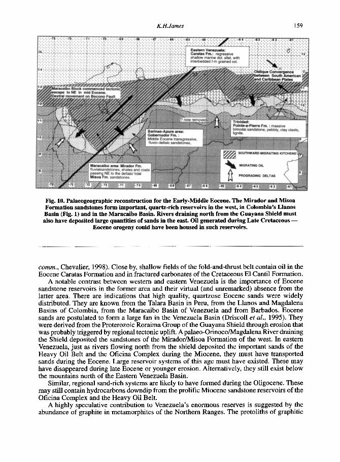
Fig. 10. Palaeogeographic reconstruction for the Early-Middle Eocene. The Mirador and Misoa Formation sandstones form important, quartz-rich reservoirs in the west, in Colombia’s Llanos Basin (Fig. 1) and in the Maracaibo Basin. Rivers draining north from the Guayana Shield must also have deposited large quantities of sands in the east. Oil generated during Late Cretaceous -
Eocene orogeny could have been housed in such reservoirs.
comm., Chevalier, 1998). Close by, shallow fields of the fold-and-thrust belt contain oil in the Eocene Caratas Formation and in fractured carbonates of the Cretaceous El Cantil Formation.
A notable contrast between western and eastern Venezuela is the importance of Eocene sandstone reservoirs in the former area and their virtual (and unremarked) absence from the latter area. There are indications that high quality, quartzose Eocene sands were widely distributed. They are known from the Talara Basin in Peru, from the Llanos and Magdalena Basins of Colombia, from the Maracaibo Basin of Venezuela and from Barbados. Eocene sands are postulated to form a large fan in the Venezuela Basin (Driscoll et al., 1995). They were derived from the Proterozoic Roraima Group of the Guayana Shield through erosion that was probably triggered by regional tectonic uplift. A palaeo-Orinoco/Magdalena River draining the Shield deposited the sandstones of the MiradodMisoa Formation of the west. In eastern Venezuela, just as rivers flowing north from the shield deposited the important sands of the Heavy Oil Belt and the Oficina Complex during the Miocene, they must have transported sands during the Eocene. Large reservoir systems of this age must have existed. These may have disappeared during late Eocene or younger erosion. Alternatively, they still exist below the mountains north of the Eastern Venezuela Basin.
Similar, regional sand-rich systems are likely to have formed during the Oligocene. These may still contain hydrocarbons downdip from the prolific Miocene sandstone reservoirs of the Oficina Complex and the Heavy Oil Belt.
A highly speculative contribution to Venezuela’s enormous reserves is suggested by the abundance of graphite in metamorphites of the Northern Ranges. The protoliths of graphitic

160 The Venezuelan hydrocarbon habitat, Part 2
marbles and schists probably were bituminous limestones and shales, while graphitic quartzites may have been oil-bearing sandstone reservoirs. The assemblage seems to be a metamorphosed petroleum system, involving Jurassic-Lower Cretaceous source rocks, which generated hydrocarbons during Late Cretaceous - Middle Eocene contraction. It is (remotely?) possible that the system may have supplied some of the country’s reserves via intermediate traps.
To summarize, source rocks along the northern margin of South America originally had a very large areal extent and were deposited in both Early and Late Cretaceous times and possibly also during the Jurassic. The Eocene sandstones which form important reservoirs in the west probably existed also in the east. At least two major phases of hydrocarbon generation occurred - in the Late Cretaceous-middle Eocene and from the Oligocene to the Recent. The first phase was of regional extent and was accompanied by crustal shortening involving “rolling” kitchens within migrating foredeeps. It could have charged widely-developed structural and stratigraphic complexes. This was repeated in Eastern Venezuela during the Guarao Orogeny. At this time, earlier traps may have released hydrocarbons for remigration. In the Maracaibo Basin area, the latter phase involved the subsidence of early accumulations, the remigration of their hydrocarbons, and the addition of new hydrocarbons formed in the Andean foredeep. The Barinas-Apure Basin may have been isolated from remigrating early-phase oil by the rising MCrida Andes, becoming charged only by local foredeeps formed during the Guarao phase. This basin contains significantly fewer reserves than the Maracaibo and Eastern Venezuela basins. These considerations are addressed by Fig. 10 which depicts a wide areal extent for kitchens involving Cretaceous source rocks and suggests the important development of early-middle Eocene sands in Eastern Venezuela. The latter may survive in the north of the area or they may have been largely eroded.
THE FUTURE: CONCLUDING REMARKS
The return of international companies to Venezuela has brought additional scientists and technology to investigate the country’s geology and to find and develop further hydrocarbon resources. Since many producing fields were discovered some decades ago, revision of their geological characteristics using modern tools will result in improved understanding and enhanced production. Additional reserves will be found within, below and adjacent to the known fields. Directional drilling and enhanced production techniques will allow more oil to be recovered.
Most spectacular is the rapid growth of plans to produce the supergiant Orinoco Heavy Oil Belt that lay dormant for many years. The measured Venezuelan campaign to delineate these deposits during the early 1980s has now begun to bear fruit, with the first oil flowing in 1998.
Besides these large heavy-oil deposits, the country also possesses large gas reserves that remain largely unexploited. These appear to be the subject of an upcoming round of licencing.
One of the most promising remaining plays lies in the poorly-explored deeper part of the Maturin Basin Tertiary section, where deep-water reservoirs may provide mainly stratigraphic traps within enveloping shales. In addition, the extent and the stratigraphy of this basin below the mountains to the north remain unknown and offer the possibility that accumulations exist there. Imaging and drilling these will be major challenges. Deeper structures involving Cretaceous and Tertiary objectives probably remain to be tested within the frontal fold-and- thrust belt.
Of the country’s three main producing provinces, the Barinas-Apure Basin is the least prolific. For this reason, exploration, while active, is less mature than in the Maracaibo and Maturin Basins. The Andean flank of this basin is a continuation of the Llanos Basin fold-and- thrust belt where major reserves lie in the Cusiana - Cupiagua - Volcanera/Pauto/Florena complex. However, great variations of stratigraphy and structural style occur along the Andean front, and the Barinas area so far has not yielded any major reserves other than the inverted Guafta structure.

K. H. James 161
Exploration on the Maracaibo Basin side of the M6rida Andes has located hydrocarbons, though not in great quantities. The North Andean front appears to be composed of basement- cored thrusts. Nevertheless, as long ago as 1956, gravity data were interpreted to indicate that this complex overrides the north Andean foredeep which may have some deep, sub-thrust potential. The deeper, southern part of the basin and its western flank remain poorly tested. The former probably is gas-prone; the latter may structurally be very complex.
The core of the inverted Falc6n Basin remains poorly explored and structurally poorly understood. Its potential seems poor.
In the offshore areas, the Gulf of Venezuela remains virtually untouched by the drill. Seismic data provide some encouragement in the west, while in the east the plunging Urumaco Trough lies downdip from the onshore El Mumdn field. Undeveloped oil lies in La Vela Bay and shows have been seen in the Cariaco Basin. The Carupano Basin contains several trillion cubic feet of gas, so far undeveloped. Apart from studies focussed on production of the latter for LNG, offshore activity has remained low and the province remains poorly explored except for the southern part of the Columbus Basin where gasfields are known, but have not been reported in the public domain. The Cariaco Basin especially merits further exploration, since only structural leads have been tested.
An interesting observation is that the kitchen areas for hydrocarbons in the Barinas-Apure and Eastern Venezuela Basins are still poorly understood. The literature describes several plausible models, but this plurality reinforces the foregoing statement. There is general agreement that the vast majority of reserves derive from Upper Cretaceous source rocks; yet, in the Eastern Venezuela Basin, these rocks are not known from the autochthonous subsurface and at outcrop they are overmature. This further indicates that the timing of generation and the paths of migration are speculative. These facts are often not acknowledged in literature that describes models with unwarranted confidence and fails to consider multiple models. This allows the possibility that further prospectivity is enshrouded in the general lack of understanding. By way of illustration, there is the growing recognition that significant source material may exist in Tertiary deposits, and that different types of organic material in the Cretaceous section may be capable of generation at differing stages of thermal evolution.
The adage states that where oil is known, more remains to be discovered. Venezuela has a lot of known oil.
ACKNOWLEDGEMENTS
I thank the many friends and colleagues who have shared their thoughts and knowledge of Venezuela with me. Bob Erlich , Bob Stoneley and Tomas Villamil reviewed the paper and contributed many improvements, for which I am grateful.
REFERENCES
ALDERSHOFF, W. G., 1953. Crude oil studies in Western Venezuela; the establishment of a genetical relation between oil source beds and crude oil by means of tracers (vanadium, nickel, porphyrins). Internal Shell report.
APOTRIA, T. G. and M. S. WILKERSON, 1997. Use of 3D Visualization Tools to Interpret Stucture and Fracture Potential: Rosario Field, Maracaibo Basin, Venezuela. AAPG Annual Convention, Program, A 5.
ARATA, J., J. LLERENA, E. ARZOLA, M. LOPEZ, J. SALAZAR and M. VIVAS, 1985. Geologia del post-Eoceno en el Campo Cabimas, Costa Oriental del Lago de Maracaibo, Venezuela. VI Cong. Geol. Venez., Memorias, 2748-2777.
AUDEMARD, F. M., 1991. Tectonics of Western Venezuela. Ph.D. Thesis, Rice University, Houston, Texas, 245p. AYMARD, R., L. PIMENTAL, P. LOPEZ, A.CHAOUCH, J. NAVARRO, J. MIJARES and J. G. PEREIRA, 1990.
Geological integration and evaluation of Northern Monagas, Eastern Venezuela Basin. In: Brooks, J., (Ed.), Classic Petroleum Provinces, Geol. Soc. Lond. Spec. Publ., 50, 37-53.
BANKS , L. M. and E. S. DRIVER, 1957. Geologic history of Santa Ana structure, Anaco structural trend, Anzoategui, Venezuela. AAPG Bull., 41, 2, 308-325.
BARRIOS, F. A. and R. H. SAMS, 1992. Anllisis sismoestratigrlfico en a1 &a de Amadis, norte de Monagas. VI Congreso Veriezolano de Geofisica, Memorias, 62-69.

162 The Venezuelan hydrocarbon habitat, Part 2
BARRIOS, F. and G. IUSCO, 1997. Potencial Hidrocarbifero en el Camp0 Las Piedritas, Cuenca Oriental de Venezuela. VI Simposio Bolivariano, Memorias, II, 220-223.
BARTOK, P., T. J. A. RELTERS and J. JUHASZ, 1981. Lower Cretaceous Cogollo Group, Maracaibo Basin, Venezuela: sedimentology, diagenesis, and petrophysics. AAPG Bull., 65, 6,1110-1133.
BLANC, P. and J. CONNAN, 1994. Preservation, Degradation, and Destruction of Trapped Oil. In: Magoon, L. B. and W. G. Dow (Eds.), The Petroleum System--from Source to Trap. AAPG Memoir 60, 237-247.
BLANCO, B. and C. GIRALDO, 1992. Sintesis tectono-estratigr#ica de la Cuenca Tuy-Cariaco y plataforma externa. VI Congreso Venezolano de Geofisica, Memorias, 47-54.
BLASER, R. and C. WHITE, 1984. Source rock and carbonization study, Maracaibo Basin, Venezuela. In: G. Demaison and R. J. Mums (Eds.), Petroleum Geochemistry and Basin Evaluation. AAPG Memoir 35,426 p.
BOCKMEULEN, H., C. BARKER and P. A. DICKEY, 1983. Geology and geochemistry of Crude Oils, Bolivar Coastal Fields, Venezuela. AAPG Bull., 67, 2, 242-270.
BOESI, T., and D. GODDARD, 1991. A new geologic model related to the distribution of hydrocarbon source rocks in the Falc6n Basin, Northwestern Venezuela. In: Biddle, K., (Ed.), Active Margin Basins. AAPG Memoir 52, 303-319.
BONINI, W. E., 1984. Magnetic provinces in western Venezuela. In: Bonini et al. (Eds.). The Caribbean-South American Plate Boundary and Regional Tectonics. GSA Mem. 162, 161-173.
BORGER, H. D., 1952. Case history of the Quiriquire Field, Venezuela. AAPG Bull, 36, 12, 2291-2330. BRAY and EVA, 1983. Age, depositional environment, ahd tectonic significance of the Couva Marine evaporite, offshore
BUENO, E. and J. G. PINTO, 1994. Interpretaci6n estructural y caracterizaci6n mediante atributos sismicos en el Creticico
BUENO, E. and J. AVILA, 1987. An integrated study of a naturally fractured reservoir, La Paz Field, Western Venezuela.
CARNEVALLI, J., 1988. Venezuela Nor-Oriental: exploracion en frente de montafia. 111 Simposio Bolivariano, 69-89. CASSANI, F., C. VALLEJOS, 0. GALLANGO, B. DE TONI, and S. TALUKDAR, 1988. Geoquimica organica de 10s
crudos Venezolanos. III Simposio Bolivariano, Exploracion Petrolera de Las Cuencas Subandinas, Caracas, Memoria,
CASTRO, M., and A. MEDEROS, 1985. Litoestratigrafa de la Cuencade Carupano. VI Congreso Geologic0 Venezolano, Caracas, Memoria, I, 201-225.
CHIGNE, N. C, 1989. Guarumen-Carora, perspectivas para la exploracion ene regimenes tectonicos complejos. VII Congreso Geol6gico Venezolano, 1393-1417.
CHIGNE, N. and L. HERNANDEZ, 1990. Main aspects of petroleum exploration in the Apure area of southwestern Venezuela, 1985-1987. In: Brooks, J. (Ed.), Classic Petroleum Provinces, Geol. SOC. Lond. Spec. Publ. 50, 55-75.
CHIGNE, N., F. RUSSOMANNO, H. SANCHEZ, A. CELLEJON, A. FINN0 and N. ESCALONA, 1993. Hydrocarbon Generation and Migration Modelling, Eastern Venezuela Basin. AAPG/SVG International Congress and Exhibition, Caracas, Abstracts, 41.
CHIGNE, N., F. RUSSOMANO, H. SANCHEZ, A. CELLEJON, A. FINN0 and N. ESCALONA, 1995. Hydrocarbon Generation and Migration Modelling, Eastern Venezuela Basin. AAPG International Conference, Nice, AAPG Bull. 79, 8, Abstracts, 1203.
CLEVELAND, M. N. and MOLINA, J., 1990. Deltaic reservoirs of the Can0 Limon Field, Colombia, South America. In: Banvis et al. (Eds.), Sandstone Petroleum Reservoirs, Springer-Verlag, 281-315.
CURET, E. A,, 1992. Stratigraphy and evolution of the Tertiary Amba Basin. Journ Petrol. Geol., 15, 283-304. DAAL, J. Q. and R. LANDER, 1993. Yucal-Placer Field-Venezuela, Eastern Venezuela Basin, Gu&rico Subbasin. In:
E. A. Beaumont and N. H. Foster (compilers) AAPG Treatise of Petroleum Geology, Atlas of Oil and Gas Fields of the World, Structural Traps VIII, 307-328.
DAZA, J. and R. PRIETO, 1990. Fallas de crecimiento en el area de Mapirito, Monagas Central. V Congreso Venezolano de Geofisica, Caracas, Memoria, 142.149.
DRISCOLL, N. W., J. B. DIEBOLD and E. P. LAINE, 1995. New Seismic Evidence for Late Cretaceous to Eocene Turbidite Deposition in the Venezuela Basin. Eos, Transactions, American Geophysical Union, 76, 46, suppl., F615.
ElUICH, R. N. and S. F. BARRETT, 1990. Cenozoic plate tectonic history of the northern Venezuela-Trinidad area. Tectonics, 9, 161-184.
FEO CODECIDO, G., 1972. Contribucion de la Estratigrafia de la Cuenca Barinas-Apure. IV Geol. Cong. Venez., Caracas, Memoria, Bol. Geol., Publ. Esp. 5, II, 773-792
FINDLAY, A. L., 1988. Cortes geologicos regionales en 10s Andes Venezolanos y sus implicaciones petroleras y estructurales. I11 Simposio Bolivariano, Exploracion en las Cuencas Subandinas, Caracas, 401-413.
FLORES, D. and R. BARBATO, 1990. Deteccion de fracturas utilizando registros de pozos en la cuenca oriental de Venezuela. V Congreso Venezolano de Geofisica, Caracas, 58- 165.
FUNES, D. and J. ITRIAGO, 1994. Resoluci6n de la sismica en la exploracidn de acumulaciones estratigrificas en la Cuenca Oriental de Venezuela. VII Congreso Venezolano de Geofisica, Memorias, 119-126.
FUNKHOUSER, H. J., L. C. SASS A and H. D. HEDBERG, 1948. Santa Ana, San Joaquin. Guario, and Santa Rosa oil fields (Anaco fields), Central Anzoategui, Venezuela. AAPG Bull., 32,10, 1851-1908.
GALLANGO, 0. and F. PARNAUD, 1993. 2-D Computer Modelling of Oil Generation and Migration in a Transect of the Eastern Venezuela Basin. AAPGlSVG International Congress and Exhibition, Caracas, Abstracts, 48.
Trinidad. Tenth Caribbean Geological Conference, Proceedings, Abstract, 372.
del Bloque M. VII Congreso Venezolano de Geofisica, Memorias, 362-368.
AAPG Research Conference, Snowbird, Utah.
612-637.
K. H. James 163
GALEAZZI, S, S. PAREDES, D. DELLAPE and G. MORODER, 1996. Revitalizing Mature Miocene Reservoirs in NE Anzoategui: A Sequence-stratigraphic Perspective in the Quiamare and La Ceiba Oil Fields. AAPG/SVG International Congress and Exhibition,Caracas, Abstracts, A16.
GAMEZ, L. G. TORRES and M. RAMPAZZO, 1977. Ceuta. Desarrollo de gigante complejo. VI Simposio Bolivariano, Memorias, 11, 232-239.
GARCiA, E. S., 1992. Us0 de registros geofisicos de pozo en la determinacibn de modelos de segregacibn de hidrocarburos en el norte de Monagas. VI Congreso Venezolano de Geofisica, Memorias, 300-307.
GARVEN, 1989. Hydrologic model for the formation of the giant oil sand deposits of the western Canada sedimentary basins. American Journal of Science, 289, 105-166.
GEORGE, R. P., Jr. and M. B. SOCAS, 1994. Pros and cons of five hypotheses of migration of oil to the eastern part of the Orinoco Oil Belt, Eastern Venezuela foreland basin. AAPG Annual Convention, Official Program, 3,154.
GONZALEZ DE JUANA, C., J.M. ITURRALDE DE AROZENA and X. P. CADILLAT, 1980. Geologia de Venezuela y de sus Suencas Petroliferas. Ediciones Foninves, Caracas, 1980.
GRAF, C., 1998. Venezuelan Petroleum Potential Outlook. AAPG Bull., 82, 10, 1919 (Abstract). GRANSCH, J. A. and E. EISMA, 1966. Geochemical aspects of occurrence of porphyrins in West-Venezuelan mineral
oil and rocks. In: Hobson, G. D. and G. C. Speers (Eds.), Advances in Organic Geochemistry. HALSE, G. W., 1932. The history of Venezuelan Oil Developments. Petroleum Emes, October 1932, 361-362. HALSE, G. W., 1947. Oil fields of west Buchivacoa, Venezuela. AAPG Bull., 31, 12, 2170-2192. HEEZEN, B. C., R. J. MENZIES, W. S. BROECKER and M. EWING, 1959. Date of stagnation of the Cariaco Trench,
HUNT, J. M., 1995. Petroleum Geochemistry and Geology. W. H. Freeman, New York, 742p. ISEA, A,, 1987. Geological synthesis of the Orinoco Oil Belt, Eastern Venezuela. Journ. Petrol. Geol. 10 (2), 135 -147. JAMES, K. H., 1990. The Venezuelan Hydrocarbon Habitat. In: Brooks. J. (Ed.), Classic Petroleum Provinces, Geol.
SOC. Lond. Spec. Publ., 50,9-35. JAMES, K. H., 1997. Distribution and tectonic significance of Cretaceous - Eocene flysch/wildflysch deposits of Venezuela
and Trinidad. Sociedad Venezolana de Ge6logos, VIII Venezuelan Geological Congress, Margarita, 415-421. JAMES, K. H., 2000. The Venezuelan Hydrocarbon Habitat, Part 1. Tectonics, Structure, Palaeogeography, Source
Rocks. Journ. Petrol. Geol., 23, 1, 5-53. JAMES, K. H. and S. M. RIGBY, 1993. Mesozoic-Early Paleogene Palaeogeography of Venezuelflrinidad and
Implications for CaribbeadSouth America Plate Interaction. AAPGlSVG International Congress and Exhibition, Caracas, Abstracts, 52.
J O R D h , N., 1984. Petrografia organica de la secuencia Cretacica en dos pozos del suroeste de la Cuenca de Barinas- Apure. Revista Tdcnica Intevep 4 (2), 153-161.
KISER, G.D., 1981. Resultados preliminares de la exploracion costafuera. Petroleo International, 39, 2, 78-84. KISER, G. D., 1987. Exploration results, Machete area, Orinoco Oil Belt, Venezuela. J. Petrol. Geol., 10 (2), 149 -162. KRAUSE, H.H. and K.H. JAMES, 1990. Hydrocarbon resources of Venezuela, their source rocks and structural habitat.
In: Erickson, G. et al., (Eds.), Geology of the Andes and its Relation to Hydrocarbon and Mineral Resources, (Symposium, Santiago, Chile, 1985). Circum-Pacific Council for Energy and Mineral Resources Earth Science Series, 11, 405-414.
LANDER, R., A. GONZALEZ, J. FLJENTES and J. DAAL, 1993. Exploration of the Late Cretaceous and the Oligocene Sequences Underneath the Pirital Allochthonous Block, Northern Monagas Area, Eastern Venezuela Basin. AAPG/ SVG International Congress and Exhibition, Caracas, Abstracts, p. 54.
LILLIU, A. G., 1990. Geophysical Interpretation of Maturin Foreland NE Venezuela. MS Thesis, Univ. Houston, 124 p. LLERENA, J and F. MARCANO, 1997. El Sistema Petrolifero en la Subcuenca de Catatumbo, Cuenca de Maracaibo,
Venezuela. VI Simposio Bolivariano, Memorias, I, 540- 55 1. LOAIZA, P., L. HERNANDEZ, C. URBINA and R. CORIAT, 1990. Reactivacion de la exploracion en Barinas. V
Congreso Venezolano de Geofisica, Caracas, Memorias, 236-243. LOPEZ, L. 1998. Use of molecular parameters and trace elements in oil-oil correlation studies, Barinas sub-basin,
Venezuela. Advances in OrganicGeochemistry, 29, 1-3, 613-629. LOPEZ, L., S. LO MONACO, E. LABASTIDAand LIRA, A,, 1998. Correlacibn de Crudos de la Subcuenca de Barinas,
Venezuela. 6th. Latin American Congress on Organic Geochemistry, abstract. MACELLARI, C., 199.5. Late Cenozoic Sedimentation and Tectonics of the Southwestern Caribbean Pull-Apart Basin,
Venezuela and Colombia. In: Tankard et al., (Eds.), Petroleum Basins of South America. AAPG Memoir 62, 757-780. MAGOON. L. B. and 2. C. VALIN, 1994. Overview of petroleum system case studies. In: Magoon, L. B. and W. G. Dow
(Eds.), The Petroleum System-From source to trap. AAPG Memoir 60, 329-338. MARTINEZ, A. R., 1987. The Orinoco Oil Belt, Venezuela. Journ. Petrol. Geol., 10 (2), 125 -134. MARTINEZ, R. E., 1996. Seismic data in the Southern Maturin Suh-basin in E Venezuela reveals the structure and
stratal patterns of the Lower Miocene sediments. AAPG/SVG Int. Congress and Exhibition,Caracas, Abstracts, A 30. McDOWELL, A.N., 1975. What are the problems in estimating the oil potential of a basin? OGJ, June 9, 85-90. MENCHER, F.; H. J. FICHTER, H. H. RENZ, W. E. WALLIS, H.H. RENZ, J. M. PATTERSON and R. H. ROBE, 1953.
MILLER, J., 1962. Tectonic trends in Sierra de Perijjl and adjacent parts of Venezuela and Colombia. AAPG Bull., 46,9,
Southeast Caribbean. Boletin Infonnativo, Asociacibn Venezolana de Geologia, Mineria y Petroleo, 2, 2, 32.
Geology of Venezuela and its oil fields. AAPG Bull., 37, 4, 690-777.
1565- 1595.

164 The Venezuelan hydrocarbon habitat, Par t 2
OLLO, D. DeEL., M. ESCANDON and F. GATARRAGA, 1994. Origen del petroleo en la Cuenca de FalcCon. V Simposio Bolivariano, Memoria, 408-410.
PALMER, S . E., and J. A. RUSSEL, 1988. The five oil families of the Llanos Basin. III Simposio Bolivariano, Exploracion Petrolera de Las Cuencas Subandinas, Caracas, Memoria, 723-753.
PEREZ DE MEdA, D. and C. TARACHE, 1985. Sintesis geologica del Golf0 de Paria. VI Congreso Geol6gico Venezolano, Memoria, V, 3243-3277.
PEREZ-TELLEZ, G., 1995. La Luna Formation of Colombia: lithofacies, organic facies and generation capacity. VI Congreso Colombiano del Petroleo, Memorias 1, 135-144.
PORTILLA, A., 1993. Tectonic Events and Structural Configuration of the Barinas-Apure Basin. AAPGlSVG International Congress and Exhibition, Caracas, Abstracts, 62.
PORTILLA, A. and S. OSUNA, 1991. Cuenca Barinas-Apure, consideraciones estratigraficas y estructurales. IV Simposio Bolivariano, Bogotii, Memorias, II, Trabajo 37.
PRIETO, R. and G. VALDES, 1992. El Fumal Oil Field; a new giant in an old basin. In: Halbouty, M. T. (Ed.), Giant Oil and Gas Fields of the Decade. AAPG Memoir 54, 155-161.
RABASSO-VIDAL, J., 1985. Sugerenciaslanalogias: Exploracion de trampas estratigrafkas en una cuenca petrolera madura, region de Anaco-Oficina:. VI Congreso Geologico Venezolano, Caracas, Memoria, V, 335 1-3364.
RENZ, O., 1960. Geologia de la parte sureste de la Peninsula de Goajira (Republica de Colombia). Congress0 Geologico Venezolano, 111, Caracas, Noviembre 1959, Memoria, Boletin Geologico, Caracas, Publicacion Especial 3, I, 3 17- 347.
RENZ, O., 1982. The Cretaceous ammonites of Venezuela. Limited edition book, edited by Maraven, a subsidiary of Petroleos de Venezuela, S. A. Caracas, 132p, 40 plates.
RENZ, H. H., ALBERDING, H., DALLMUS, K. F., PATTERSON, J. M., ROBIE, R. H., WEISBORD, N. E. and MASVALL, J., 1958. The Eastern Venezuela Basin. In: Weeks, L. G., Habitat of Oil, a Symposium, AAPG.
ROBERTO, M., L. MOMPART, E. PUCHE and F. SCHERER, 1990. New oil discoveries in the Ceuta area, SE Lake Maracaibo, Venezuela. In: Brooks, J., (Ed.), Classic Petroleum Provinces, Geol. SOC. London. Spec. Pub. 50,. 77-88.
RODRIGUEZ, F. M., 1995. Explotaci6n de 10s Yacimientos Profundos del Norte de Monagas - Venezuela. VI Congreso Colqmbiano del Petroleo, Memorias., I, 127-133.
RODRIGUEZ, I., A. NAVARRO and S. GHOSH, 1997. Nueva Frontera Exploratoria en la Cuenca Petrolifera del Lago de Maracaibo: Zulia Oriental, Venezuela Occidental. VI Simposio Bolivariano, Memorias, 11, 565-58 1.
SALVADOR, A. and E. HOTZ, 1963. Petroleum occurrences in the Cretaceous of Venezuela. Sixth World Petroleum Congress, Proceedings, Section I, Paper 48, 115-138.
SAMS, R. H., R. P. GEORGE, F. J. NUNEZ, F. BARRIOS and M. ROQUETT, 1992. New considerations of basin history from sequence stratigraphy in northern Monagas, Eastern Venezuela Basin. VI Congreso Venezolano de Geofisica, Memorias, 98-105.
SCHUBERT, C., 1982. Origin of the Cariaco Basin, southern Caribbean Sea. Marine Geology, 47, 345-360. SCHUBERT, C., 1985. Neotectonic aspects of the Southern Caribbean Plate boundary. First Geological Conference of
SMITH, F. D., 1962. Geological Resume, First Venezuelan Geological Congress. SPEED, R., 1992. Hinterland of the Caribbean Mountains of Venezuela and Trinidad and implications for Cenozoic
STAINFORTH, R. M., 1978. Was it the Orinoco? AAPG Bull, 62,303-306. SUTER, H. H., 1947. El Mene de Acosta Field, Falcbn, Venezuela. AAPG Bull., 31, 12, 2193-2206. TALUKDAR, J. C., 1992. Hydrocarbon Habitats of the Venezuelan Basins. DGSI Report, Houston. TALUKDAR, S. and E.H. DE BOLIVAR, 1982. Petroleum Geology of the Tuy-Cariaco Basin, Eastern Venezuelan
continental shelf a preliminary appraisal. Infonnes Tecnicos, Intevep, S.A., 78 p. TALUKDAR, S., 0. GALLANGO, and M. CHIN-A-LIEN, 1985. Generation and migration of hydrocarbons in the
Maracaibo Basin, Venezuela: an integrated basin study. Advances in Organic Geochemistry 1985, Organic Geochemistry, 10, 261-279.
TALUKDAR, S., 0. GALLANGO and A. RUGGIERO, 1987. Generation and migration of oil in the Maturin Subbasin, Eastern Venezuela basin. Advances in Organic Geochemistry, Organic Geochemistry, 13, 1-1 3, 537-547.
TALUKDAR, S. C., B. DE TONI, F. MARCANO, J. SWEENEY and A. RANGEL, 1993. Upper Cretaceous Source Rocks of Northern South America. AAPG/SVG International Congress and Exhibition, Caracas, Abstracts, 69.
TALUKDAR, S. and F. MARCANO, 1994. Petroleum systems of the Maracaibo Basin, Venezuela. In: Magoon and Dow (Eds.), The Petroleum System - from source to trap: AAPG Memoir 60,463-482.
TOCCO, R., M. ALBERDI, A. RUGGIERO and N. JORDAN, 1994. Organic geochemistry of the Carapita Formation and terrestrial crude oils in the Maturin Subbasin, E Venezuela Basin. Organic Geochemistry, 21, lOl11, 1107-1119.
URBINA, C. and A. CORNELIO, 1993. Structural Style on Southern Flank of Merida Andes, Venezuela:. AAPGlSVG International Congress and Exhibition, Caracas, Abstracts, 70.
YOUNG, G. A., 1988. La tectonica de la Cuenca Barinas-Apure, Venezuela, interpretation magnetica detallada. I11 Simposio Bolivariano, Exploracion Petrolera en Las Cuencas Subandinas, Caracas, Memoria, 962-984.
YSACCIS, R., 1997. Tertiary Evolution of the Venezuelan NE Offshore. Ph.D thesis, Rice University, Houston, 285p. ZAMORA, L. G., GONZALEZ, L. S., and LINARES, L. M., 1988. The Orinoco Delta, a future exploratory province for
the G. S. T. T., 265-269.
oblique collision. GSA Annual Meeting, Abstracts, A149.
heavy and extra heavy oils. Fourth UnitalLTndip Conference on Heavy Crude and Tar Sands, Paper No.169.