Embed Size (px)
Citation preview

U.S. Department of the InteriorU.S. Geological Survey
Fact Sheet 2014–3026 May 2014
The USGS National Streamflow Information Program and the Importance of Preserving Long-Term Streamgages
Long-term streamflow information is critical for use in several water-related areas that are important to humans and wildlife, including water management, computation of flood and drought flows for water infrastructure, and analysis of climate-related trends. Specific uses are many and diverse and range from informing water rights across state and international boundaries to designing dams and bridges.
USGS Streamgaging NetworkThe U.S. Geological Survey (USGS) operates and
maintains a national streamgage network of more than 8,000 streamgages (2013) to provide long-term, accurate, and unbiased streamflow information to meet the multiple needs of many diverse users. Streamflow information is fundamental to national and local economic well-being, protection of life and property, and efficient and effective management of water resources.
The USGS operates the streamgaging network in partner-ship with more than 850 Federal, state, tribal, regional, and local agencies. The streamflow information from this network, both historic and real-time, is used for many purposes that ben-efit everyone in our society, although many are unaware of its existence, uses, or value. Uses of USGS streamgage informa-tion include water-availability assessments; water compacts and decrees; engineering design of reservoirs, bridges, roads, culverts, and water-treatment plants; operation of reservoirs for power production and other uses; analysis of changes in streamflow due to climatic, land-use, and water-use changes; forecasting of streamflows, including flood forecasting; sup-port of water-quality programs; providing adequate flows for fish and other organisms; and ensuring recreation safety and enjoyment. Most USGS streamgages provide streamflow infor-mation for more than one use. As an example of its widespread use, more than 50 different organizations in Maryland actively use USGS streamflow information, including the Federal Emergency Management Agency, U.S. Fish and Wildlife Service, Maryland State Highway Administration, Maryland Department of the Environment, county and city departments of public works, and private engineering companies (Hester and others, 2006a).
USGS National Streamflow Information ProgramThe National Streamflow Information Program (NSIP)
was started in 2002 in response to Congressional and stakeholder concerns about the ongoing decrease in the num-ber of active USGS streamgages (particularly streamgages with long periods of record), the inability of the USGS to fund high-priority streamgages when faced with reduced partner funds, and the increased demand for streamflow information
via the Internet beginning in the late 1980s. The NSIP has five major goals:
1. Develop, maintain, and fully fund an enhanced, stable baseline streamgaging network that meets Federal needs for streamflow information, including the need for long-term data-sets. This baseline network is supplemented by streamgages funded by partnerships to meet state, regional, and local needs.
2. Improve the timeliness, reliability, and convenience of streamflow information delivery to users. This includes robust and redundant data delivery systems that ensure continued availability of data during catastrophic events and provide improved storage, retrieval, and data analysis abilities.
3. Make regional assessments of existing streamflow information on an ongoing basis to identify trends and to estimate streamflow at locations without streamgages. These trend analyses can help to identify the effects of land-use, water-use, and climatic changes.
4. Improve the understanding of floods and droughts through additional measurements and analyses.
5. Perform and fund research and development activities to advance equipment technologies and measurement and analysis techniques for greater accuracy and lower cost.
Figure 1. Lake Powell and Glen Canyon Dam on the Colorado River, July 21, 2004, 119 feet below full level.
Photograph credit: Bradley H. Udall

Importance of Long-Term StreamgagesLong-term streamflow information is critical for several
types of studies that benefit people and wildlife. These uses are described in more detail in the following “Water Management,” “Design Flood Flows,” and “Climate-Related Trends” sections.
Water Management
Consistent, long-term streamflow data are important for allocating water according to agreements among water rights holders, including interstate and international agreements (Hester and others, 2006a). As an example, 30 million people in the arid southwestern United States depend on Colorado River water for home use, agriculture, industry, and recreation (Jacobs, 2011). The history of streamflow and water rights on the Colorado River shows how long-term data are needed to understand long-term streamflow variability. It is now known that the 1922 Colorado River Compact, which governs water allocations between the upper and lower Colorado watersheds, was based on a short period of relatively high streamflows (National Research Council, 2007). Figure 1 shows the low water level in Lake Powell on the Colorado River in 2004 that was caused by five consecutive years of below average inflows (Fulp, 2005).
Protection of environmental resources has become a major objective for water managers, including providing ade-quate flows for fish and other aquatic organisms (Hester and others, 2006a). Long-term streamflow information is needed to understand the variability of streamflows, particularly low streamflows, and how managed flows may differ from natural flows.
Design Flood Flows
Designers of bridges, culverts, dams, floodplain struc-tures, and other important infrastructure need to compute the size of flood flows (such as the 1-percent annual exceedance probability flood, which is also known as the 100-year flood) that will affect those structures. Long-term streamflow records using consistent measurement techniques provide a high degree of confidence in the calculation of these design flood flows (Hester and others, 2006a), minimizing the safety risks of under design and the costs of over design.
Reservoirs across the United States are important for water supply, flood protection, hydropower, and other uses (Hester and others, 2006a). Streamflow data are needed to properly size reservoirs; long-term data are needed to deter-mine the size and variability of flood flows into the reservoir, as well as the amount of water during very dry or wet periods.
1950 1970 1990 2010Year
0
20,000
40,000
60,000
80,000
100,000
120,000
Annu
al p
eak
flow
, in
cubi
c fe
et p
er s
econ
d
100-year peak flow, based on 1947 to 2012 data
100-year peak flow, based on 1947 to 1971 data
Figure 2. Annual peak flows for St. John River at Dickey, Maine, and 100-year peak flows based on data from selected periods.
A reservoir design that must rely on short-term data may be over or under designed. For example, the Folsom Dam and Reservoir was constructed in the 1950s on the American River east of Sacramento, California. Its size was based on stream-flow data from about 1905 to 1940. Recent flood studies using more years of data indicate that the reservoir is undersized for the desired level of flood protection; costs to retrofit the dam are about $1 billion (Hester and others, 2006b).
Design flood flows in the United States are usually calcu-lated with statistical methods that use annual peak streamflows (Interagency Advisory Committee on Water Data, 1982). If the design flood flows are based on relatively short periods of
annual peak flows, they may not be representative of condi-tions experienced over longer periods. Multi-decadal ocean temperature variability (as represented by the Pacific Decadal Oscillation and the Atlantic Multidecadal Oscillation) has influenced streamflows in parts of the United States (Tootle and others, 2005). An example of the potential difference between design flood flows (calculated using Interagency Advisory Committee on Water Data (1982) guidelines) for a shorter period and for a longer period is shown in figure 2. The 100-year peak flow based on 66 years of data (1947–2012) is 14 percent higher than the 100-year peak flow based on the first 25 years of data (1947 to 1971).
60°90°120°150°
60°
45°
30°
0 500 1,000 MILES
0 500 1,000 KILOMETERSEXPLANATION
U.S. Geological Survey 2009 Hydro-Climatic Data Network (HCDN-2009) streamgages
U.S. Geological Survey HCDN-2009 streamgages supported by the National Streamflow Information Program (NSIP)
Environment Canada Reference Hydrometric Basin Network streamgages
Basemap source: Esri, DigitalGlobe North American Datum 1983, Contiguous USA Albers
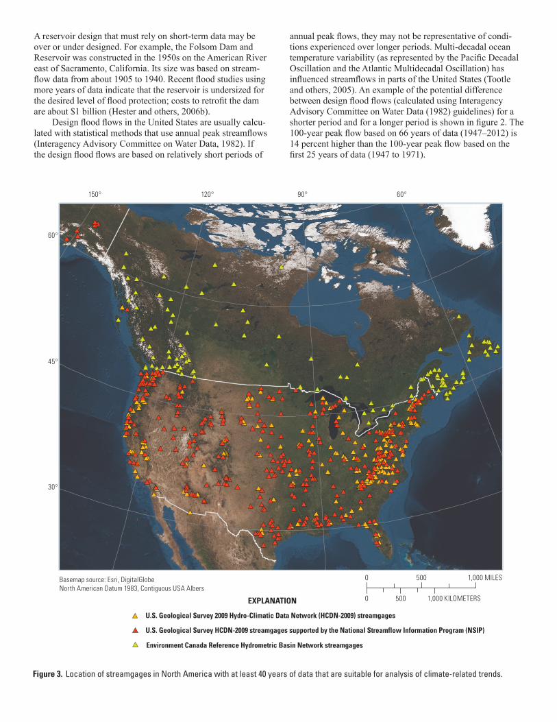
Figure 3. Location of streamgages in North America with at least 40 years of data that are suitable for analysis of climate-related trends.

Climate-Related Trends
Streamflow changes over long periods of time can be important to many water users. With trends based on stream-flow records of a few decades or less, it can be very difficult to tell whether streamflows will continue to change in the same direction or revert to earlier flow amounts. Climate-related streamflow changes over time also can be conflated with changes resulting from reservoir regulation or watershed land-use change (such as urbanization). The effects of precipitation and temperature changes on streamflows are better studied by using data from long-record streamgages that are least disturbed by land-use change, regulation, or other direct human watershed changes; streamgages in various countries have been designated for this purpose (Whitfield and oth-ers, 2012; Burn and others, 2012). In the United States, the most recent evaluation of least-disturbed streamgages was completed in 2011 (Lins, 2012). More than 300 of these least-disturbed long-record streamgages in the continental United States are supported by the NSIP to promote stable long-term funding for these gages (fig. 3).
Many studies have used least-disturbed streamgages in the United States to analyze climate-related trends in streamflows. For example, low streamflows have generally increased in the north-central and northeastern United States in the past 70 years; low flows have decreased in parts of the western and southeastern United States (U.S. Environmental Protection Agency, 2012). Changes over time in annual high streamflows have not been as regionally cohesive; increases occurred in some relatively small regions and decreases in others (U.S. Environmental Protection Agency, 2012). Annual winter-spring runoff in areas with substantial winter snow-pack—which can be important for water supply and flood risk—occurred earlier in the second half of the 20th century for many watersheds in the western and eastern United States (McCabe and Clark, 2005; Hodgkins and Dudley, 2006).
AcknowledgmentsPaul Whitfield, University of Saskatchewan, and Donald
Burn, University of Waterloo, Ontario, Canada, provided the information on Environment Canada Reference Hydrometric Basin Network streamgages. David Stewart, U.S. Geologi-cal Survey (USGS), provided information on USGS National Streamflow Information Program streamgages. Luke Sturte-vant, USGS, provided geographic information system support.
References CitedBurn, D.H., Hannaford, J., Hodgkins, G.A., Whitfield, P.H.,
Thorne, R., and Marsh, T., 2012, Reference hydrologic networks II. Using reference hydrologic networks to assess climate-driven changes in streamflow: Hydrologic Sciences Journal, v. 57, 14 p.
Fulp, T., 2005, How low can it go?: Southwest Hydrology, March/April 2005, 3 p.
Hester, G., Carsell, K., and Ford, D., 2006a, Benefits of USGS streamgaging program: National Hydrologic Warning Council, March 7, 2006, 17 p.
Hester, G., Ford, D., Carsell, K., Vertucci, C., and Stallings, E.A., 2006b, Flood management benefits of USGS streamgaging program: National Hydrologic Warning Council, October 19, 2006, 48 p.
Hodgkins, G.A., and Dudley, R.W., 2006, Changes in the timing of winter–spring streamflows in eastern North America, 1913–2002: Geophysical Research Letters, v. 33, L06402, doi:10.1029/2005GL025593.
Interagency Advisory Committee on Water Data, 1982, Guide-lines for determining flood flow frequency–Bulletin 17B of the Hydrology Subcommittee: U.S. Geological Survey, Office of Water-Data Coordination, 183 p.
Jacobs, J., 2011, The sustainability of water resources in the Colorado River Basin: The Bridge—Linking Engineering and Society, National Academy of Engineering, v. 41, p. 6–12.
Lins, H.F., 2012, USGS Hydro-Climatic Data Network 2009 (HCDN-2009): U.S. Geological Survey Fact Sheet 2012–3047, 4 p.
McCabe, G.J., and Clark, M.P., 2005, Trends and variability in snowmelt runoff in the western United States: Journal of Hydrometeorology, v. 6, p. 476–482.
National Research Council, 2007, Colorado River Basin water management: Evaluating and adjusting to hydroclimatic variability: National Academies Report in Brief, February 2007, 4 p.
Tootle, G.A., Piechota, T.C., and Singh, A., 2005, Coupled oceanic-atmospheric variability and U.S. streamflow: Water Resources Research, v. 41, W12408, doi:10.1029/2005WR004381.
U.S. Environmental Protection Agency, 2012, Climate change indicators in the United States, 2012: U.S. Environmental Protection Agency, accessed December 23, 2013 at http://www.epa.gov/climatechange/science/indicators/society-eco/streamflow.html.
Whitfield, P.H., Burn, D.H., Hannaford, J., Higgins, H., Hodgkins, G.A., Marsh, T., and Looser, U., 2012, Reference hydrologic networks I. The status and potential future directions of national reference hydrologic networks for detecting trends: Hydrological Sciences Journal, v. 57, 18 p.
Prepared by the Pembroke Publishing Service Center.
For more information concerning this report, contact:
Office of the Associate Director for WaterU.S. Geological Survey National Center, MS 105 12201 Sunrise Valley Drive Reston, VA [email protected]
Or visit our NSIP site at http://water.usgs.gov/nsip/
By Glenn A. Hodgkins, J. Michael Norris, and Robert M. Lent
ISSN 2327-6916 (print)ISSN 2327-6932 (online)http://dx.doi.org.10.3313/fs20143026
Printed on recycled paper