Embed Size (px)
Citation preview

209
INTRODUCTION
Both unquestionable benefits and burden-some and “incidental products” come with the progressive development of civilization. The lat-ter pose a threat to the human and natural envi-ronment, usually as of various forms of pollution. Among them, noise plays an increasingly impor-tant role [Silva, Mendes 2012; Trombetta Zan-nin, de Sant’Ana 2011]. Sounds of high intensity can have a negative impact on animal and hu-man health and interfere with the functioning of some ecosystems [Basner et al. 2014; Popławska et al. 2012; Sadowski 1999; Stansfeld, Matheson 2003]. Nowadays, noise is considered as the most important factor determining the quality of the living environment, leisure and work [Frei et al. 2014; Mirowska, Mróz 1999; Nurzyński 2005].
Due to the deteriorating state of the acoustic climate – defined as a set of acoustic phenomena occurring in a given area – irrespective of the sources that cause it [Engel 2001], files on this phenomenon have been developed and imple-mented. They take into account large urbanised areas and the main communication routes, where noise is one of the main pollutants. Directive 2002/49/EC of the European Parliament and of the Council relating to the assessment and manage-ment of environmental noise, and the ordinance of the Minister of the Environment (October 1, 2012) changing the ordinance on permissible noise levels in the environment [Dz. U. 2012 r., poz. 1109], raise issues of protection from noise, acoustic climate management and its forecasting. According to these legal instruments, they have been designated basic indicators of noise.
THE USE OF NOISE MAPS AND PLANNING TOOLS IN THE MANAGEMENT OF AN ACOUSTIC CLIMATE IN AN URBAN AREA
Tomasz Zubala1, Urszula Sadurska1
1 Department of Environmental Engineering and Geodesy, University of Life Sciences in Lublin, Leszczyńskiego 7 Str., 20-069 Lublin, Poland, e-mail: [email protected], [email protected]
Journal of Ecological EngineeringVolume 17, Issue 4, Sept. 2016, pages 209–217DOI: 10.12911/22998993/64550 Research Article
ABSTRACTNowadays, noise is considered as one of the most significant factors polluting the environment. It is classified in the first place among the indicators of the comfort of home, leisure and work. Therefore, more and more attention is paid to the need to study the sources and effects of noise on the environment and to develop effec-tive methods of protection against nuisance and harmful sounds. Analysis of envi-ronmental factors is an especially important part of the process of spatial planning. The article covers characteristics of spatial and temporal differentiation of acoustic phenomena occurring within selected district of Lublin – the largest Polish city east of the Vistula River. Field measurements and analytical operations, which enable map-ping noise, and consequently measuring the exposure of residents to the impact of abnormal sound levels, were made. There was also an attempt to evaluate the spatial development and its relationship with prevailing acoustic conditions. The collected results allowed developing recommendations for planning the city centre area acting as a standard. The need to design buffer zones to reduce the sound level near roads or locating residential areas away from sources of noise was underlined. The study should prove helpful in forecasting changes in the acoustic conditions and spatial planning and deciding on protection measures in urban areas.
Keywords: noise, acoustic map, environmental protection, spatial planning.
Received: 2016.05.11Accepted: 2016.08.08Published: 2016.09.30

Journal of Ecological Engineering Vol. 17(4), 2016
210
Evaluation and efficient modelling of acous-tic conditions, especially in large city areas, would not be possible without the GIS technol-ogies and noise mapping [De Kluijver, Stoter 2000; Kwiecień, Szopińska 2012; Longley et al. 2006]. Maps present all acoustic phenomena oc-curring in a given area (including distribution of the acoustic field and exposure to noise). They must be prepared based on measurements of av-erage equivalent sound level (LA) – made in ap-propriately selected locations. The insight and precision of the preliminary analysis determines the accuracy of the cartographic studies and the reliability of assessment of the acoustic climate variability. This information should be made pub-lic. It has a crucial meaning for the functioning of the State Environmental Monitoring and creating programs to protect the environment from noise [Directive 2002/49/EC; Dz. U. nr 62, poz. 627].
Strategic noise maps, which are a reliable source of information about the acoustic climate, must be taken into account in the input materials when preparing local development plans. Acous-tic data and appropriate analysis of existing and potential sources of noise make it possible to minimize the problem of environmentally harm-ful sound levels at the stage of creating the project plan [Szopińska 2011].
The aim of this paper is to evaluate the di-versity of general phenomena related to noise (source, threats, propagation conditions, variabil-ity) in the area included in the selected district of Lublin, as well as to demonstrate the need to take into account the state of the acoustic climate in the spatial planning process and the resulting ben-efits. Accomplishing the research task involves making numerous observations (direct and indi-rect) and developing detailed acoustic maps.
MATERIAL AND METHODS
The area of acoustic and planning research is located in the northern part of Lublin – the largest Polish city east of the Vistula. It covers the south-ern edge of the Ponikwoda district (geodesic sec-tion 42-Wiktoryn) surrounded by streets: Mag-noliowa (from the north), Walecznych (from the east), Unicka (from the south) and Spółdzielczości Pracy (from the west). Its total area is 40.6 ha. Residential areas and other built-up areas prevail here. A Roman Catholic cemetery takes up a sig-nificant part of the surface (Figure 1).
The research was carried out in stages in 2014–2015. These included: • setting up measurement stations to cover the
entire area with observation; • performing acoustic measurements, taking
into account three types of days (daily, week-end and holiday), and three times of the day in different periods (day 6:00–18:00, evening 18:00–22:00, night 22:00–6:00);
• determining the average equivalent sound level (LA) at each position and assessing the variability of acoustic phenomena depending on the time and the character of the day;
• preparation of acoustic maps for each time of the individual days and map of the long-term average sound level;
• carrying out analyses of the current spatial development for compliance with acoustic considerations;
• identification of needs and opportunities shap-ing the acoustic climate in the area of research.
Sectors in the form of a regular grid of rect-angles were determined on a 1:10000 scale back-ground topographical map. A measuring station was located in the central part of each of them. Additional observation stations were situated along the main roads being the most important
Figure 1. The study area and the location of acoustic measurement positions

211
Journal of Ecological Engineering Vol. 17(4), 2016
potential source of noise in the area of research. In total 23 positions were chosen (Figure 1). Field coordinates of control points were determined using GPS Trimble Juno 3B Handheld (ArcPad software). Measurements of the equivalent sound level (LA) for each position were performed using a Center 390 Data Logger sound level meter. Ob-servations were carried out in three sessions (in the individual days), representing the time of day, evening and night – in line with the recommen-dations of Directive 2002/49/EC. Cartographic descriptions were prepared on background topo-graphic maps using ArcGIS software. For this purpose, the backing map raster was transferred into the program and calibration made in accor-dance with the coordinate system NGCS 1992. The individual objects of the technical infrastruc-ture were vectorized. Then, the layer containing the position of the measuring points was included in the created map file and assigned the sound level equivalent value (LA). Interpolation of re-sults of sound levels measurements took place with regard to the barriers (primarily buildings) in the propagation of acoustic waves. Processing the generated layers entailed, among other things, determining the range values for fixed intervals of 5 dB and assigning them an appropriate colour capturing the scale of the phenomenon.
The illustrative state of the studied area devel-opment was determined based on a 1:10000 scale topographic map. The functions of the area were designated by the City Geoportal maps [geopor-tal.lublin.eu]. The obtained information was veri-fied and supplemented during the site inspection. On this basis, the map of development of this part of the city was prepared, distinguishing the fol-lowing functions: the area of single-family and multi-family housing, the area of service devel-opment, cemetery, and grounds of public roads. The structure of land ownership is also defined.
RESULTS AND DISCUSSION
The results of the sound level measurements indicate considerable differences in the acoustic conditions in the study object, which is consistent with the data presented in the reports of the In-spectorate for Environmental Protection [2013]. They vary depending on the character and time of day and the location of the observation positions. Different trends are noticeable in the variation co-efficients of equivalent sound level (LA) for times in individual days. Irrespective of the character of the day, the most dynamic acoustic field was ob-served in the daily times. On weekdays and dur-ing the weekend, it decreased in the evening and night. The evening time of festive days featured the lowest variability of sound level during the study period. The least uniform acoustic climate (Lden) was recorded on weekend days. The differ-entiation of sound levels in this period is much greater than on a festive day (Table 1).
Noise maps prepared for this article (10 elab-orations) confirmed the significant variability of the acoustic climate at particular times and days, but also showed large spatial differences of the phenomena related to noise emission to the en-vironment. The emitted noise is greatest along routes with high traffic levels, which can be seen on each map. The values of equivalent sound lev-els (LA) decrease with the distance from the road, and are so low in areas isolated from vehicular traffic that they do not threaten human health. Acoustic climate also changes spatially under the influence of barriers standing in the way of sound waves. If there is a high density of near main roads, the noise level is reduced by a se-ries of buildings located along the street (shield-ing effect). If the existing buildings are dispersed or do not exist at all, isograms showing a higher level of the equivalent sound (LA) cover a larger area, reducing its value gradually, not abruptly. Figure 2 shows the two selected noise maps –
Table 1. Variability of averaged equivalent sound level (LA) in the study area in individual measurements terms
IndicatorWeekday Weekend day Festive day
*d e n den d e n den d e n denAverage equivalent sound level (LA) [dB] 55.4 51.6 46.2 51.1 53.3 51.9 45.3 50.2 50.1 51.7 47.0 49.6
Standard deviation 9.1 7.8 6.8 8.7 10.6 9.3 6.2 9.4 7.0 6.6 6.6 6.9Variation coefficient [%] 16.4 15.1 14.6 17.0 19.9 18.0 13.6 18.8 14.0 12.7 14.0 13.9
* d – day time, e – evening time, n – night time, den – all day

Journal of Ecological Engineering Vol. 17(4), 2016
212
the first relates to the period of day (Ld) the most disadvantaged in acoustic terms and the second – long-term average sound level (Lden).
The acoustic climate of the research object was also analysed in terms of exceeded permis-sible sound levels in the environment, specified in the Polish Regulation of the Minister of the En-vironment of 1 October 2012 [Dz. U. 2012 r., poz. 1109]. The largest share of the area with more than normative levels of sound occurs during the daytime of the daily day – which is nearly 27% of the analyzed terrain (Figure 2a). The festive days are unique in this regard when in a similar period the sound intensity is much lower. The area covered by harmful levels of noise is up to seven times less than the other days. It involves a much smaller intensity of traffic during this in-terval. During the daily day the acoustic climate becomes more mellow in the evenings and at night, when the surface area exposed to excessive sound level is half that in the daytime. Reverse trends are recorded during festive days which increase the percentage share of the area threat-ened by sound intensity – dangerous to health
(Table 2). In extreme cases, a noise value equal to or exceeding 70 dB was recorded (weekdays and weekend). According to Kossakowski [2011] negative effects on the human body can manifest themselves at these levels.
The analysis of areas with sound levels ex-ceeding the permissible level shows a variation in the evening hours of three measurement terms. While the differences are small between a normal and festive day, on weekend days there is a signif-icant change in relation to other terms. The area threatened by high levels of noise in the weekend evenings is almost two times higher than in the remaining days and makes up 18.2% of the sur-face of the object. The largest share of the area of excessive sound level at night occurs during fes-tive days and is 10.5%. It is slightly smaller in the daily day. This share decreases more than two-fold at the weekend compared to other days and amounts to only 4.2% of the study area (Table 2).
Cadastral data indicates a definite advan-tage of residential areas (mostly single-family houses) and other built-up areas within the study area [geoportal.lublin.eu]. A substantial surface is
Figure 2. Acoustic maps: a) daytime of the daily day (Ld), b) long-term average sound level (Lden)

213
Journal of Ecological Engineering Vol. 17(4), 2016
occupied by a Roman Catholic cemetery in the eastern part (25% of the study). The whole is sup-plemented by not very extensive industrial areas, service and arable land. Most of the buildings are privately owned. In the eastern part, grounds belonging to legal persons prevail – a cemetery and a block of flats with an adjacent area. Land in the central and western parts is usually individual property and includes parcels of single-family houses. Land owned by the municipality of Lu-blin comprises the area of the primary school and plots with municipal roads. State Treasury is mainly the owner of voivodeship roads (VR) and national roads (NR) [geoportal.lublin.eu].
There are fourteen roads of different class-es (typed as the most important source of noise) in the study area. The largest of these is Spółdzielczości Pracy Avenue (the western boundary of the object), which is the main road
of faster motion (NR-19). Due to the transit type and significant volume of traffic, it should be considered a key threat to the acoustic climate in this part of the city (Figure 3a). A large traf-fic load and noise emissions are also recorded in the area of Unicka Street (the southern boundary of the object), which is the main road (VR-835) (Figure 3b). The threat from the emitter is greater since multi-family houses are located in its vicin-ity and a new housing estate has been built. This status confirms the opinion that sufficiently accu-rate analyses in the field of spatial planning are not carried out. The individual spatial elements are localised based on partial information, and not real observations [Szopińska 2011]. The signifi-cantly exceeded permissible sound levels for both roads and a large number of residents point to the need for applying effective security solutions in this area [Dz. U. nr 179, poz. 1498]. Noise is of-
Table 2. Percentage of space in different ranges of average equivalent sound level (LA)
Average equivalent sound level (LA) [dB]
Weekday Weekend day Festive day
*d e n d e n d e n
≤ 35 0.0 0.0 0.5 0.0 0.0 0.5 0.0 0.0 0.2
35.1–40 0.0 0.0 18.5 6.9 6.2 19.3 5.7 0.0 12.8
40.1–45 7.4 18.2 27.0 13.7 14.8 33.7 25.2 15.0 31.8
45.1–50 23.6 25.2 31.5 18.1 22.6 28.5 18.0 30.4 26.0
50.1–55 24.2 25.9 12.7 19.4 20.7 13.7 26.0 24.6 18.6
55.1–60 17.9 19.3 7.4 18.6 17.5 4.2 21.5 17.8 9.5
60.1–65 12.5 9.1 2.3 11.6 10.9 0.0 3.6 11.0 1.0
65.1–70 11.6 2.2 0.0 6.9 4.9 0.0 0.0 0.7 0.0
> 70 2.8 0.0 0.0 4.5 2.4 0.0 0.0 0.0 0.0Total surface area of
exceedances [%] 26.9 11.3 9.7 23.0 18.2 4.2 3.6 11.7 10.5
* d – day time, e – evening time, n – night time
Figure 3. Residential buildings in the immediate vicinity of noisy road objects: a) part of Spółdzielczości Pracy Avenue, b) intersection of Unicka Street and Spółdzielczości Pracy Avenue

Journal of Ecological Engineering Vol. 17(4), 2016
214
ten classified here as permanent because of the timing [Dz. U. nr 62, poz. 627].
Another main road situated in the research area is Gen. Władysław Anders Avenue. It cuts centrally the discussed object (east-west), di-viding the cemetery into two parts. Walecznych Street (the eastern border of the object) is not as big an acoustic threat compared with those traffic routes, which stems from its local character and lower car traffic. Almost the entire length has a high cemetery wall, acting as an acoustic screen (Figure 4a). Within the cemetery, especially in its central part, a range of groups of trees and shrubs can be observed (deciduous and coniferous spe-cies) (Figure 4b) influencing on the propagation of sound. Plantings in a row made along the main avenue are an important element of the vegetation (ash and maple).
The remainder of the roads in the area of re-search are access roads. They have little effect on the acoustic climate due to the small number of passing vehicles. It is worth noting that the main roads in the discussed area are in very good con-dition. Their surfaces have been modernised re-cently. According to Gronowicz [2003] and To-karski et al. [2012] this is of great importance for the quality of the acoustic climate as the type of road surface is one of the main factors influenc-ing the noise level of communication, in addition to the type of tyres and the weight and speed of passing vehicles.
The study area, which includes a sensitive area located at one of the main sources of noise – Spółdzielczości Pracy Avenue – does not have fully regulated state planning. Although residen-tial development is located not far away to the east side of the artery (Figure 3a), a local zon-ing plan specifying the purpose of land and its
management and development methods [Dz. U. nr 80, poz. 717] has not been implemented there yet [geoportal.lublin.eu]. This should be changed as soon as possible, taking into account the need for solutions to improve and stabilize the acoustic climate. The noise, which is not controlled in a uniform and comprehensive manner, over time, causes significant environmental degradation [Kompała 2002, 2005]. The current housing func-tion of this part of the study area is not compat-ible with existing acoustic conditions, and even contributes to their deterioration. The location of some buildings and small spaces between them causes reflection and imposition sound waves, thereby maintaining the high sound pressure away from the noise source [Ariza-Villaverde et al. 2014; Popławska et al. 2012]. A kind of buffer, protecting the interior of the estate, is created in places where residential buildings are in the im-mediate vicinity of lane of the road (the south-western part of research object). The sound level goes from high at the edge of the road to very low in the depth of the building. In the eastern part of the study area there is a cemetery fenced off from Walecznych Street by a high wall (shielding). Many plants are also present there. The noise level gradually reduces within relatively free (un-developed) fields with distance from the road be-ing its source [Nurzyński 2005]. As a result, just behind the cemetery (around the school) there is a friendly acoustic climate meeting the standards set for those areas connected with the stay of chil-dren and youth [Dz. U. 2012 r., poz. 1109].
It is necessary to develop and implement the concept of spatial development, in accordance with the acoustic circumstances, in order to im-prove the safety and quality of life of the local population. It should contain solutions for the
Figure 4. Cemetery objects limiting the propagation of sound waves in the eastern part of the study area: a) high fence, b) dense vegetation
215
Journal of Ecological Engineering Vol. 17(4), 2016
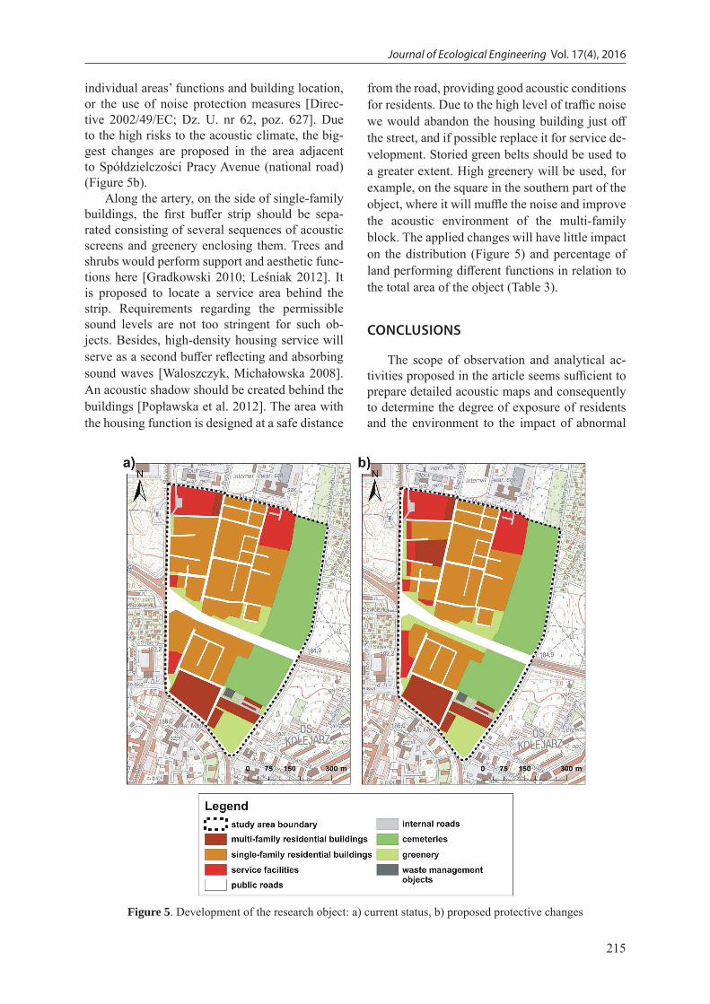
individual areas’ functions and building location, or the use of noise protection measures [Direc-tive 2002/49/EC; Dz. U. nr 62, poz. 627]. Due to the high risks to the acoustic climate, the big-gest changes are proposed in the area adjacent to Spółdzielczości Pracy Avenue (national road) (Figure 5b).
Along the artery, on the side of single-family buildings, the first buffer strip should be sepa-rated consisting of several sequences of acoustic screens and greenery enclosing them. Trees and shrubs would perform support and aesthetic func-tions here [Gradkowski 2010; Leśniak 2012]. It is proposed to locate a service area behind the strip. Requirements regarding the permissible sound levels are not too stringent for such ob-jects. Besides, high-density housing service will serve as a second buffer reflecting and absorbing sound waves [Waloszczyk, Michałowska 2008]. An acoustic shadow should be created behind the buildings [Popławska et al. 2012]. The area with the housing function is designed at a safe distance
from the road, providing good acoustic conditions for residents. Due to the high level of traffic noise we would abandon the housing building just off the street, and if possible replace it for service de-velopment. Storied green belts should be used to a greater extent. High greenery will be used, for example, on the square in the southern part of the object, where it will muffle the noise and improve the acoustic environment of the multi-family block. The applied changes will have little impact on the distribution (Figure 5) and percentage of land performing different functions in relation to the total area of the object (Table 3).
CONCLUSIONS
The scope of observation and analytical ac-tivities proposed in the article seems sufficient to prepare detailed acoustic maps and consequently to determine the degree of exposure of residents and the environment to the impact of abnormal
Figure 5. Development of the research object: a) current status, b) proposed protective changes

Journal of Ecological Engineering Vol. 17(4), 2016
216
sound levels. It also allows the evaluation of the relationship between the state of development and land use and the prevailing acoustic climate.
The specific nature of spatial development of the analyzed area indicates the narrow spectrum of potential noise sources within it. The advantage of housing building surrounded by roads of dif-ferent classes, as well as the lack of industrial ob-jects, testify to the dominant share of traffic noise and its potential threat to the local community. A significant temporal and spatial variability of the acoustic climate has been demonstrated. Large variations exist between different times of the day and days of different character, but it also depends on the position of the site in relation to the noise source. Days with the greatest variability of aver-age equivalent sound level (LA) proved to be the weekend, and the smallest diversity occurred dur-ing the festive days. Daytime of the daily day and weekend is characterised by a significant threat to an above-standard sound level (large areas ex-posed to noise). In both cases, the acoustic cli-mate changes to a milder one in the evenings and at night, while the opposite trend was recorded during festive days. Then, as the time passes, the percentage share of the area exposed to the inten-sity of sound dangerous to health increases.
Spatial variability of average equivalent sound level (LA) depends on the location relative to the main roads. Areas along the communica-tion routes are exposed to high noise levels. Ex-isting buildings, protecting against sound waves, plays an important role in the spatial variability of the acoustic climate (the phenomenon of screen-ing). The method of sound propagation depends on the type of land and the level of housing den-sity. The presence of green areas and a cemetery with many shelterbelts has a soothing impact on
the acoustic climate. Objects of this type form the urban areas’ enclave of relative silence, si-multaneously improving the natural values. The process of spatial planning cannot exclude the analysis of environmental factors. The manage-ment of urban areas especially must take into account contemporary threats, such as noise (re-quired compatibility of concept planning to local acoustic circumstances).
It is possible to form an acoustic climate that is friendly for residents by assigning a suitable function to each section of land. Arrangement of residential areas away from the noise sources and the appropriate design of buffer zones to reduce the sound level near roads are particularly impor-tant. This should effectively reduce the transmis-sion of noise near main transport routes, applying classical screens and roadside vegetation belts and using service development to shield resi-dential areas. Well-conceived planning activities can meet the requirements of spatial order, whilst minimizing the impact of burdensome factors on the natural environment and human habitation.
REFERENCES
1. Ariza-Villaverde A.B., Jiménez-Hornero F.J., Gutiérrez De Ravé E., 2014. Influence of urban morphology on total noise pollution: Multifractal description. Sci. Total Environ. 472, 1–8.
2. Basner M., Babisch W., Davis A., Brink M., Clark Ch., Janssen S., Stansfeld S., 2014. Auditory and non-auditory effects of noise on health. Lancet 383 (9925), 1325–1332.
3. De Kluijver H., Stoter J., 2000. Noise mapping and GIS: Optimising quality, accuracy and efficiency of noise studies. The 29th International Congress and Exhibition on Noise Control Engineering, 27–30 August 2000, Nice, France.
Table 3. Summary of the current state of research object development and the designed surfaces of different functions
Function of the area Current surface [ha]
Participation in the total area (currently) [%] Planned area [ha] Participation in the total
area (project) [%]Multi-family residential buildings 2.897 7.13 3.773 9.29
Single-family residential buildings 15.448 38.03 12.960 31.91
Service facilities 3.168 7.80 3.959 9.75
Public roads 6.473 15.94 6.473 15.94
Internal roads 0.459 1.13 0.459 1.13
Cemeteries 9.299 22.89 9.299 22.89
Greenery 2.776 6.83 3.598 8.86
Waste management objects 0.098 0.24 0.098 0.24
Total 40.618 100 40.618 100

217
Journal of Ecological Engineering Vol. 17(4), 2016
4. Directive 2002/49/EC of the European Parliament and of the Council of 25 June 2002 relating to the assessment and management of environmental noise. Official Journal of the European Communi-ties, L 189 of 18 July 2002.
5. Dz. U. 2012 r., poz. 1109: Regulation of the Min-ister of the Environment of 1 October 2012 chang-ing the regulation on permissible noise levels in the environment (in Polish).
6. Dz. U. nr 62, poz. 627: The Act of 27 April 2001 Environmental protection law (in Polish).
7. Dz. U. nr 80, poz. 717: The Act of 27 March 2003 on spatial planning and development (in Polish).
8. Dz. U. nr 179, poz. 1498: Regulation of the Minis-ter of Environment of 14 October 2002 on detailed conditions to be met under a scheme of the envi-ronment protection against noise (in Polish).
9. Engel Z., 2001. Environment protection against vibrations and noise (in Polish). PWN, Warszawa.
10. Frei P., Mohler E., Röösli M., 2014. Effect of noc-turnal road traffic noise exposure and annoyance on objective and subjective sleep quality. Int. J. Hyg. Environ. Health 217 (2–3), 188–195.
11. geoportal.lublin.eu12. Gradkowski K., 2010. Reduction of noise coming
from means of locomotion (in Polish). Przegląd Komunikacyjny 7–8, 26–31.
13. Gronowicz J., 2003. Environment protection in land transport (in Polish). Wyd. ITE, Poznań.
14. Inspekcja Ochrony Środowiska, 2013. The state of acoustic climate in the country in research of WIOŚ in 2007–2011 (in Polish). Biblioteka Moni-toringu Środowiska, Warszawa.
15. Kompała J., 2002. The utilisation of the GIS and GPS systems in creating acoustical databases for the outer environment. Archives of Acoustics 27 (4), 291–302.
16. Kompała J., 2005. Noise maps as a tool of acoustic climate management in urban areas (in Polisch). II Konferencja Naukowa „Hałas w środowisku”, 21 kwietnia 2005 r., Katowice, Polska, 74–84.
17. Kossakowski P., 2011. Protection against noise in the European Union – general requirements, ap-plied noise indicators and assessment methods. Structure and Environment 4 (3), 38–45.
18. Kwiecień J., Szopińska K., 2012. GIS technology in the creation of a strategic acoustic map (in Pol-ish). In: M. Granops (Ed.). Inżynieria i ochrona
środowiska. Wyd. Uniwersytetu Technologiczno-Przyrodniczego w Bygdoszczy, Bydgoszcz.
19. Leśniak G., 2012. Function and utility of vegetation in structures of transport routes (in Polish). Techni-cal Transactions, Architecture 30 (8-A), 253–261.
20. Longley P., Goodchild M., Maguire D., Rhind D., 2006. GIS – theory and practice (in Polish). PWN, Warszawa.
21. Mirowska M., Mróz E., 1999. Influence of long-term effect of low-frequency noise on health of dewellers in the light of questionnaire investigation (in Polish). Prace Instytutu Techniki Budowlanej 1 (109), 55–62.
22. Nurzyński J., 2005. Acoustic problems of sustain-able development in construction industry and spa-tial planning (in Polish). Prace Instytutu Techniki Budowlanej 3 (135), 45–66.
23. Popławska K., Fijałkowska A., Osińska-Skotak K., 2012. Evaluation of traffic noise buffer zones delimi-tation using GIS technology (in Polish). Archiwum Fotogrametrii, Kartografii i Teledetekcji 23, 327–336.
24. Sadowski J., 1999. Modelling of the environment acoustic climate and its protection against noise and vibrations (in Polish). Prace Instytutu Techniki Budowlanej 2–3 (110–111), 50–61.
25. Silva L.T., Mendes J.F.G., 2012. City Noise-Air: An environmental quality index for cities. Sustain. Cities Soc. 4, 1–11.
26. Stansfeld S., Matheson M., 2003. Noise pollution: non-auditory effects on health. British Medical Bulletin 68, 243–257.
27. Szopińska K., 2011. Influence of acoustic cli-mate on creation process of urban space (in Pol-ish). Studia i Materiały Towarzystwa Naukowego Nieruchomości 19 (1), 155–166.
28. Tokarski Z., Kujawski E., Grucka A., Grucki K., 2012. The impact of the road on environment noise pollution (in Polish). In: M. Granops (Ed.) Inżynieria i ochrona środowiska, Wyd. Uniwer-sytetu Technologiczno-Przyrodniczego w Bydgo-szczy, Bydgoszcz.
29. Trombetta Zannin P.H., de Sant’Ana D.Q., 2011. Noise mapping at different stages of a freeway re-development project – A case study in Brazil. Appl. Acoust. 72 (8), 479–486.
30. Waloszczyk D., Michałowska K., 2008. The part of land use planning in shaping acoustic climate of Gdańsk (in Polish). Prace Komisji Krajobrazu Kulturowego PTG 11, 203–210.
Pracę dofinansowano ze środków Wojewódzkiego Funduszu Ochrony Środowiska i Gospodarki Wodnej w Lublinie.