Embed Size (px)
Citation preview

Timothy S. FarewellIan G. TruckellCaroline A. KeayStephen H. Hallett
July 2011
The use and applications ofthe Soilscapes datasets
National Soil Resources Institute
The Soilscapes Dataset
Edition 1July 2011
cite as:
Farewell, T.S., Truckell, I.G., Keay, C.A. Hallett, S.H (2011) Use and applications of the Soilscapes datasets, Cranfield University
For more information , please contact:
Dr. Timothy S. [email protected](+44) 1234 75 29 78
National Soil Resources InstituteCranfield UniversityCranfield, BedfordshireEnglandMK43 0AL
or alternatively:

www.landis.org.uk/data/soilscapes
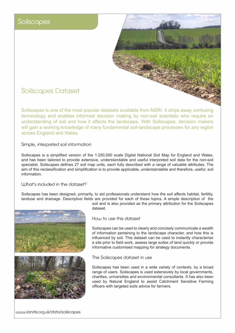
Soilscapes Dataset
Soilscapes is one of the most popular datasets available from NSRI. It strips away confusing terminology and enables informed decision making by non-soil scientists who require an understanding of soil and how it affects the landscape. With Soilscapes, decision makers will gain a working knowledge of many fundamental soil-landscape processes for any region across England and Wales.
Simple, interpreted soil information
Soilscapes is a simplified version of the 1:250,000 scale Digital National Soil Map for England and Wales, and has been tailored to provide extensive, understandable and useful interpreted soil data for the non-soil specialist. Soilscapes defines 27 soil map units, each fully described with a range of valuable attributes. The aim of this reclassification and simplification is to provide applicable, understandable and therefore, useful, soil information.
What’s included in the dataset?
Soilscapes has been designed, primarily, to aid professionals understand how the soil affects habitat, fertility, landuse and drainage. Descriptive fields are provided for each of these topics. A simple description of the
soil and is also provided as the primary attribution for the Soilscapes dataset.
How to use this dataset
Soilscapes can be used to clearly and concisely communicate a wealth of information pertaining to the landscape character, and how this is influenced by soil. This dataset can be used to instantly characterise a site prior to field work, assess large suites of land quickly or provide informative customised mapping for strategy documents.
The Soilscapes dataset in use
Soilscapes has been used in a wide variety of contexts, by a broad range of users. Soilscapes is used extensively by local governments, charities, universities and environmental consultants. It has also been used by Natural England to assist Catchment Sensitive Farming officers with targeted soils advice for farmers.
Soilscapes
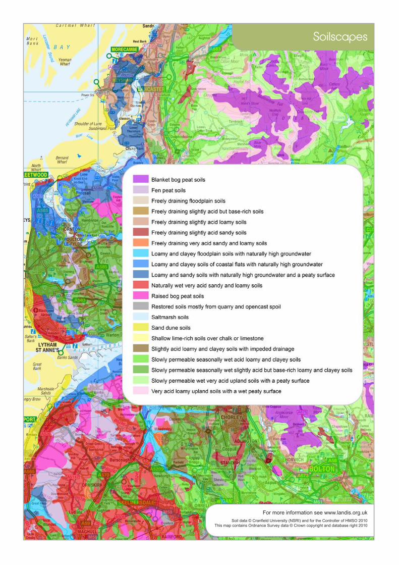
Soil data © Cranfield University (NSRI) and for the Controller of HMSO 2010This map contains Ordnance Survey data © Crown copyright and database right 2010
For more information see www.landis.org.uk
Soilscapes
Soilscapes Metadata
These pages contain more detailed descriptions of this dataset. Formal ISO19115 and ISO19139 metadata is also available from www.landis.org.uk
Scale 1:250,000
Number of Classes 27 soil classes, plus water etc.
Created (updated) 2003 (2010)
Data Format Shapefile
Derived from NATMAPvector, the Digital National Soil Map
Coverage England and Wales
Limitations The properties of soil are spatially variable, even over short distances. Soilscapes is a generalised dataset, and so users should be aware that variation of soil properties is to be expected within the delineated polygons. Soilscapes is not intended as a means for supporting detailed assessments, such as planning applications or site investigations. More detailed datasets are available for lease from NSRI.
Soilscapes
Dates of Field Mapping The field work for the National Soil Map was carried out by a team of surveyors between 1979 and 1982, however areas that had been mapped previously were not necessarily remapped.
Purpose of use NATMAPsoilscapes was designed to provide a simple and easily understood soil map of England and Wales.
Use / Access Constraints The information contained in LandIS is copyright and its use is therefore subject to a specific licensing agreement between NSRI and the user. Depending on the status of the user, the cost can vary from a fully commercial charge for data lease to being royalty free with a small charge for extraction and preparation of the data to meet the user’s needs.
Who created this data? Alongside colleagues at the National Soil Resources Institute of Cranfield University, Dick Thompson and John Hollis were particularly instrumental in the creation of the Soilscapes dataset.
Map copyright statement? Soilscapes data © Cranfield University and for the Controller of HMSO, 2011
More detailed dataset: NATMAPvector with full legend description
Cite as Farewell, T.S., Truckell, I.G., Keay, C.A., Hallett, S.H (2011) The derivation and application of Soilscapes: soil and environmental datasets from the National Soil Resources Institute, Cranfield University
For more information or to access this data, please contact us:The National Soil Resources Institute, Cranfield University, Bedfordshire, UK, [email protected] +44 (0) 1234 75 2978 www.landis.org.uk Soilscapes Dataset Information, Version 1.1Timothy Farewell, March 2011
Soilscapes

www.landis.org.uk/data/drainage
Soilscapes Drainage Dataset
Soil drainage is a natural process by which water moves through and out of the soil as a result of the force of gravity. The Soilscapes Drainage dataset describes this fundamental soil property that influences the water that supports stream base flow and aquifer recharge. Soil water drainage exhibits an enormous influence on the natural environment.
Simple, understandable soil drainage information
This drainage dataset provides users with a general description of the soil hydrology, which influences surface runoff, water-logging, leaching and flood response times. Surface drainage diverts excess water from the soil surface directly to streams, thereby reducing the amount of water that will move into and through the soil. Subsurface drainage, provided by ditches and drain pipes, collects and diverts water from within the soil directly to streams. This dataset describes the drainage characteristics of each of the 27 ‘Soilscape’ classes.
What’s included with the dataset?
The drainage dataset is packaged with the habitat, fertility, landuse, texture and descriptive components of the Soilscapes suite. Soilscapes is a simplified version of the 1:250,000 scale Digital National Soil Map and has been tailored to provide extensive, understandable and useful interpreted soil data for the non-soil specialist.
How to use this dataset
From flood risk management to horticulture, and agronomy to combatting diffuse pollution, Soilscapes Drainage can provide fundamental soil information for environmental professionals. Soil drainage is relevant to river basin management plans, farm operations such as ease of cultivation and pollution prevention policies. The dataset can also be used to predict how soils may respond to future rainfall events. For users requiring extensive knowledge of soil hydrology, more detailed datasets are also available from NSRI.
The Soilscapes Drainage dataset in use
The drainage data has been used in a wide variety of contexts, by a range of users, including local governments, engineers, agronomists and environmental consultants.
Drainage
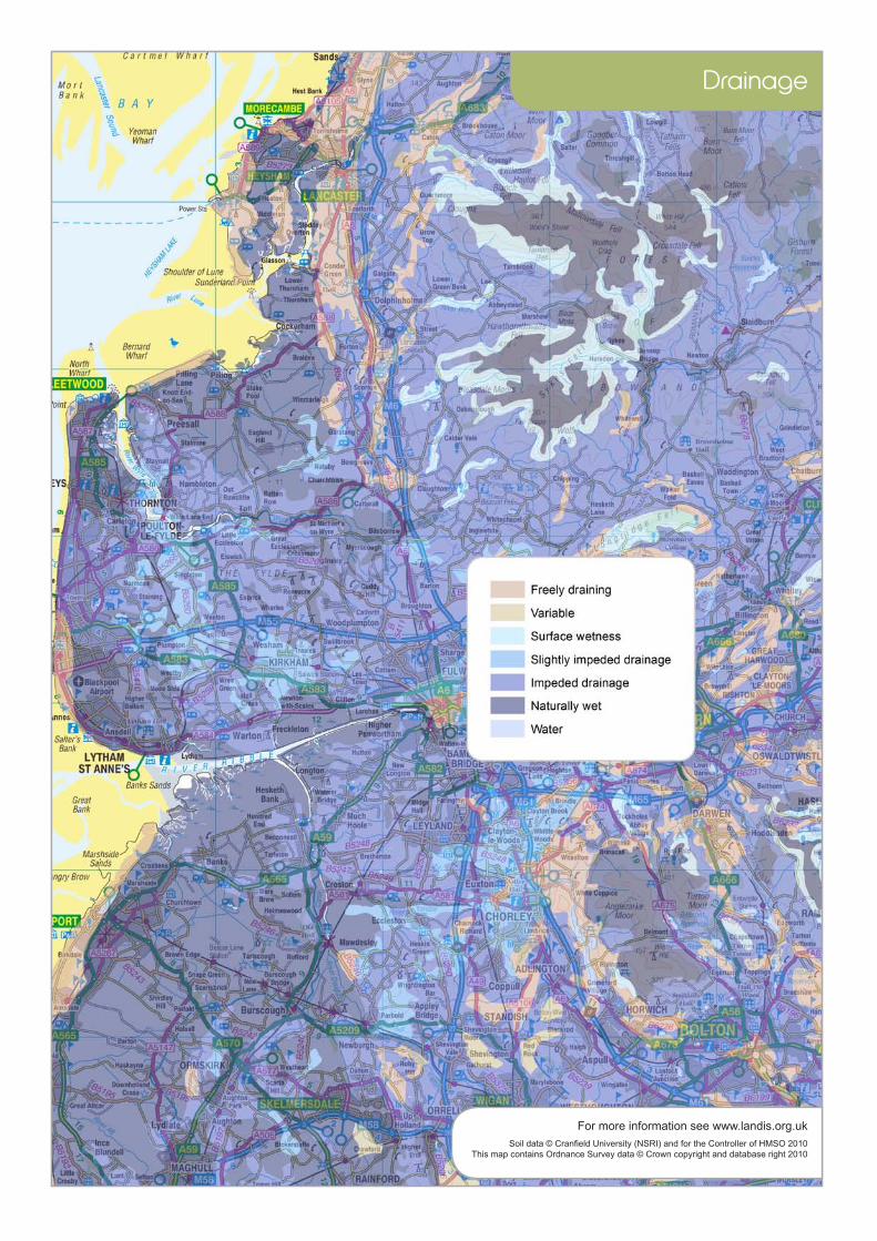
Soil data © Cranfield University (NSRI) and for the Controller of HMSO 2010This map contains Ordnance Survey data © Crown copyright and database right 2010
For more information see www.landis.org.uk
Drainage

Drainage Metadata
These pages contain more detailed descriptions of this dataset. Formal ISO19115 and ISO19139 metadata is also available from www.landis.org.uk
Scale 1:250,000
Number of Classes 6 drainage classes, plus water etc.
Created (updated) 2003 (2010)
Data Format Shapefile
Derived from NATMAPvector, the Digital National Soil Map
Coverage England and Wales
Limitations The properties of soil are spatially variable, even over short distances. Soilscapes is a generalised dataset, and so users should be aware that variation of soil properties is to be expected within the delineated polygons. Soilscapes is not intended as a means for supporting detailed assessments, such as planning applications or site investigations. More detailed datasets are available for lease from NSRI.
Drainage
Dates of Field Mapping The field work for the National Soil Map was carried out by a team of surveyors between 1979 and 1982, however areas that had been mapped previously were not necessarily remapped.
Purpose of use This drainage component of NATMAPsoilscapes was designed to provide a simple indication of typical drainage patterns across England and Wales. More detailed descriptions of soil drainage are provided in the Hydrology of Soil Type (HOST) dataset.
Use / Access Constraints The information contained in LandIS is copyright and its use is therefore subject to a specific licensing agreement between NSRI and the user. Depending on the status of the user, the cost can vary from a fully commercial charge for data lease to being royalty free with a small charge for extraction and preparation of the data to meet the user’s needs.
Who created this data? Alongside colleagues at the National Soil Resources Institute of Cranfield University, Dick Thompson and John Hollis were particularly instrumental in the creation of the Soilscapes dataset.
Map copyright statement? Soilscapes drainage data © Cranfield University and for the Controller of HMSO, 2011
More detailed dataset: NATMAPvector, combined with HOST (Hydrology of soil type) classification.
Cite as Farewell, T.S., Truckell, I.G., Keay, C.A., Hallett, S.H (2011) The derivation and application of Soilscapes: soil and environmental datasets from the National Soil Resources Institute, Cranfield University
For more information or to access this data, please contact us:The National Soil Resources Institute, Cranfield University, Bedfordshire, UK, [email protected] +44 (0) 1234 75 2978 www.landis.org.uk Soilscapes Drainage Dataset Information, Version 1.1Timothy Farewell, March 2011
Drainage

www.landis.org.uk/data/landcover
Soilscapes Landcover Dataset
Landcover represents the physical material at the surface of the earth, and landcover types across the country are strongly influenced by the underlying soils. The Soilscapes Landcover dataset describes the relationship between soil, landscapes and typical landcover, and provides an overview of the patterns that exist.
Simple Landcover Information
This landcover dataset provides users with a general description of the landcover types associated with particular soils during the survey period in the 1980s. Soils and plant communities are inexorably linked and the data shows the structure and make up of the landscape of England and Wales. The landcover dataset describes the typical landcover that is found on each of the 27 ‘Soilscape’ classes.
What’s included with the dataset?
Soilscapes is a simplified version of the 1:250,000 scale Digital National Soil Map and has been tailored to provide extensive, understandable and useful interpreted soil data for the non-soil specialist. Soilscapes has been primarily designed to aid professionals understand how the soil effects habitat, fertility, landuse and more.
How to use this dataset
For policy-related, commercial or academic interests, this landcover map layer can help improve awareness of the natural environment. Spatial data on land cover can show the inter-connectivity of landscape features, their immediate context and the wider neighbourhood in which environmental influences operate. The dataset can be used for various modelling purposes, such as the relationship between land use and biodiversity and also to assess habitat creation and restoration. Please note, while the vast majority of the landcover is unchanged, this dataset does not necessarily display the current landcover, but what was typical for these soils when the survey was undertaken.
Soilscapes Landcover Dataset in use
The landcover data has been used extensively by local government and environmental consultants to understand the regional relationships between habitats, land cover and soil types. Academics have used this dataset to support a wide variety of research projects.
Landcover

Soil data © Cranfield University (NSRI) and for the Controller of HMSO 2010This map contains Ordnance Survey data © Crown copyright and database right 2010
For more information see www.landis.org.uk
Landcover
Landcover Metadata
These pages contain more detailed descriptions of this dataset. Formal ISO19115 and ISO19139 metadata is also available from www.landis.org.uk
Scale 1:250,000
Number of Classes 20 landcover classes, plus water.
Created (updated) 2003 (2010)
Data Format Shapefile
Derived from NATMAPvector, the Digital National Soil Map
Coverage England and Wales
Limitations The properties of soil are spatially variable, even over short distances. Soilscapes is a generalised dataset, and so users should be aware that variation of soil properties is to be expected within the delineated polygons. Soilscapes is not intended as a means for supporting detailed assessments, such as planning applications or site investigations. More detailed datasets are available for lease from NSRI.
Landcover

Dates of Field Mapping The field work for the National Soil Map was carried out by a team of surveyors between 1979 and 1982, however areas that had been mapped previously were not necessarily remapped.
Purpose of use The landcover component of the Soilscapes dataset was designed to provide a general overview of the typical landcover types associated with particular soils.
Use / Access Constraints The information contained in LandIS is copyright and its use is therefore subject to a specific licensing agreement between NSRI and the user. Depending on the status of the user, the cost can vary from a fully commercial charge for data lease to being royalty free with a small charge for extraction and preparation of the data to meet the user’s needs.
Who created this data? Alongside colleagues at the National Soil Resources Institute of Cranfield University, Dick Thompson and John Hollis were particularly instrumental in the creation of the Soilscapes dataset.
Map copyright statement? Soilscapes landcover data © Cranfield University and for the Controller of HMSO, 2011
More detailed dataset: NATMAPvector with full legend description
Cite as Farewell, T.S., Truckell, I.G., Keay, C.A., Hallett, S.H (2011) The derivation and application of Soilscapes: soil and environmental datasets from the National Soil Resources Institute, Cranfield University
For more information or to access this data, please contact us:The National Soil Resources Institute, Cranfield University, Bedfordshire, UK, [email protected] +44 (0) 1234 75 2978 www.landis.org.uk Soilscapes Landcover Dataset Information, Version 1.1Timothy Farewell, March 2011
Landcover
www.landis.org.uk/data/habitats
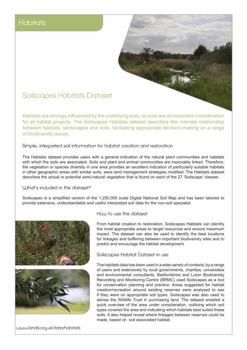
Soilscapes Habitats Dataset
Habitats are strongly influenced by the underlying soils, so soils are an important consideration for all habitat projects. The Soilscapes Habitats dataset describes this intimate relationship between habitats, landscapes and soils, facilitating appropriate decision-making on a range of biodiversity issues.
Simple, interpreted soil information for habitat creation and restoration
The Habitats dataset provides users with a general indication of the natural plant communities and habitats with which the soils are associated. Soils and plant and animal communities are inexorably linked. Therefore, the vegetation or species diversity in one area provides an excellent indication of particularly suitable habitats in other geographic areas with similar soils, were land management strategies modified. The Habitats dataset describes the actual or potential semi-natural vegetation that is found on each of the 27 ‘Soilscape’ classes.
What’s included in the dataset?
Soilscapes is a simplified version of the 1:250,000 scale Digital National Soil Map and has been tailored to provide extensive, understandable and useful interpreted soil data for the non-soil specialist.
How to use this dataset
From habitat creation to restoration, Soilscapes Habitats can identify the most appropriate areas to target resources and ensure maximum impact. The dataset can also be used to identify the best locations for linkages and buffering between important biodiversity sites and to predict and encourage the habitat development.
Soilscapes Habitat Dataset in use
The habitats data has been used in a wide variety of contexts, by a range of users and extensively by local governments, charities, universities and environmental consultants. Bedfordshire and Luton Biodiversity Recording and Monitoring Centre (BRMC) used Soilscapes as a tool for conservation planning and practice. Areas suggested for habitat creation/recreation around existing reserves were analysed to see if they were on appropriate soil types. Soilscapes was also used to advise the Wildlife Trust in purchasing land. The dataset enabled a quick overview of the area under consideration, outlining which soil types covered the area and indicating which habitats best suited these soils. It also helped reveal where linkages between reserves could be made, based on soil associated habitat.
Habitats

Soil data © Cranfield University (NSRI) and for the Controller of HMSO 2010This map contains Ordnance Survey data © Crown copyright and database right 2010
For more information see www.landis.org.uk
Habitats

Habitats Metadata
These pages contain more detailed descriptions of this dataset. Formal ISO19115 and ISO19139 metadata is also available from www.landis.org.uk
Scale 1:250,000
Number of Classes 26 actual and potential habitats are described, plus water
Created (updated) 2003 (2010)
Data Format Shapefile
Derived from NATMAPvector, the Digital National Soil Map
Coverage England and Wales
Limitations The properties of soil are spatially variable, even over short distances. Soilscapes is a generalised dataset, and so users should be aware that variation of soil properties is to be expected within the delineated polygons. Soilscapes is not intended as a means for supporting detailed assessments, such as planning applications or site investigations. More detailed datasets are available for lease from NSRI.
Habitats

Dates of Field Mapping The field work for the National Soil Map was carried out by a team of surveyors between 1979 and 1982, however areas that had been mapped previously were not necessarily remapped.
Purpose of use The habitats component of the Soilscapes dataset was designed to provide a general overview of the typical habitat types associated with particular soils. As this is a simplified dataset, it may or may not represent the present day habitat at any given location.
Use / Access Constraints The information contained in LandIS is copyright and its use is therefore subject to a specific licensing agreement between NSRI and the user. Depending on the status of the user, the cost can vary from a fully commercial charge for data lease to being royalty free with a small charge for extraction and preparation of the data to meet the user’s needs.
Who created this data? Alongside colleagues at the National Soil Resources Institute of Cranfield University, Dick Thompson and John Hollis were particularly instrumental in the creation of the Soilscapes dataset.
Map copyright statement? Soilscapes habitat data © Cranfield University and for the Controller of HMSO, 2011
More detailed dataset: NATMAPvector with full legend description will provide more linework, but less explicit detail on habitat types
Cite as Farewell, T.S., Truckell, I.G., Keay, C.A., Hallett, S.H (2011) The derivation and application of Soilscapes: soil and environmental datasets from the National Soil Resources Institute, Cranfield University
For more information or to access this data, please contact us:The National Soil Resources Institute, Cranfield University, Bedfordshire, UK, [email protected] +44 (0) 1234 75 2978 www.landis.org.uk Soilscapes Habitats Dataset Information, Version 1.1Timothy Farewell, March 2011
Habitats
www.landis.org.uk/data/fertility
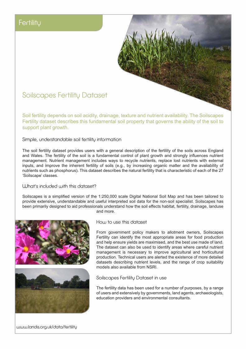
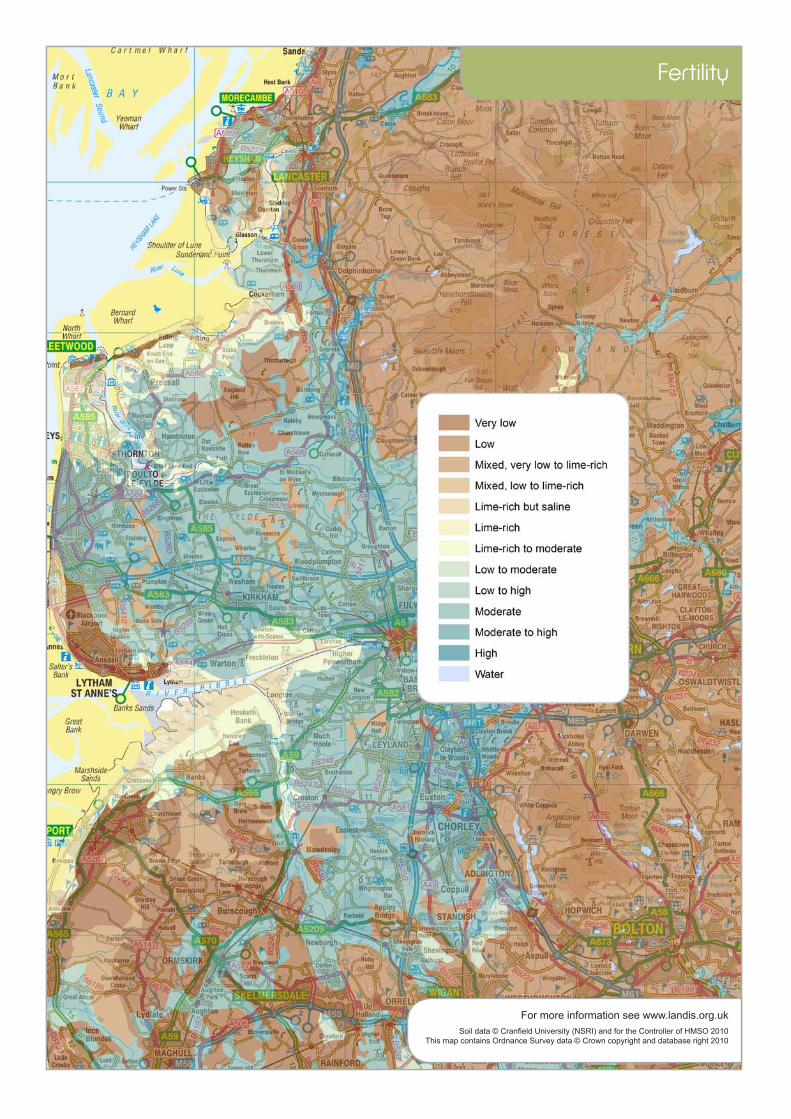
Soilscapes Fertility Dataset
Soil fertility depends on soil acidity, drainage, texture and nutrient availability. The Soilscapes Fertility dataset describes this fundamental soil property that governs the ability of the soil to support plant growth.
Simple, understandable soil fertility information
The soil fertility dataset provides users with a general description of the fertility of the soils across England and Wales. The fertility of the soil is a fundamental control of plant growth and strongly influences nutrient management. Nutrient management includes ways to recycle nutrients, replace lost nutrients with external inputs, and improve the inherent fertility of soils (e.g., by increasing organic matter and the availability of nutrients such as phosphorus). This dataset describes the natural fertility that is characteristic of each of the 27 ‘Soilscape’ classes.
What’s included with this dataset?
Soilscapes is a simplified version of the 1:250,000 scale Digital National Soil Map and has been tailored to provide extensive, understandable and useful interpreted soil data for the non-soil specialist. Soilscapes has been primarily designed to aid professionals understand how the soil effects habitat, fertility, drainage, landuse
and more.
How to use this dataset
From government policy makers to allotment owners, Soilscapes Fertility can identify the most appropriate areas for food production and help ensure yields are maximised, and the best use made of land. The dataset can also be used to identify areas where careful nutrient management is necessary to improve agricultural and horticultural production. Technical users are alerted the existence of more detailed datasets describing nutrient levels, and the range of crop suitability models also available from NSRI.
Soilscapes Fertility Dataset in use
The fertility data has been used for a number of purposes, by a range of users and extensively by governments, land agents, archaeologists, education providers and environmental consultants.
Fertility
Soil data © Cranfield University (NSRI) and for the Controller of HMSO 2010This map contains Ordnance Survey data © Crown copyright and database right 2010
For more information see www.landis.org.uk
Fertility
Fertility Metadata
These pages contain more detailed descriptions of this dataset. Formal ISO19115 and ISO19139 metadata is also available from www.landis.org.uk
Scale 1:250,000
Number of Classes 12 descriptions of natural fertility, plus water.
Created (updated) 2003 (2010)
Data Format Shapefile
Derived from NATMAPvector, the Digital National Soil Map
Coverage England and Wales
Limitations The properties of soil are spatially variable, even over short distances. Soilscapes is a generalised dataset, and so users should be aware that variation of soil properties is to be expected within the delineated polygons. Soilscapes is not intended as a means for supporting detailed assessments, such as planning applications or site investigations. More detailed datasets are available for lease from NSRI.
Fertility

Dates of Field Mapping The field work for the National Soil Map was carried out by a team of surveyors between 1979 and 1982, however areas that had been mapped previously were not necessarily remapped.
Purpose of use The fertility component of the NATMAPsoilscapes dataset seeks to provide a general indication of the range of natural soil fertility found across England and Wales.
Use / Access Constraints The information contained in LandIS is copyright and its use is therefore subject to a specific licensing agreement between NSRI and the user. Depending on the status of the user, the cost can vary from a fully commercial charge for data lease to being royalty free with a small charge for extraction and preparation of the data to meet the user’s needs.
Who created this data? Alongside colleagues at the National Soil Resources Institute of Cranfield University, Dick Thompson and John Hollis were particularly instrumental in the creation of the Soilscapes dataset.
Map copyright statement? Soilscapes fertility data © Cranfield University and for the Controller of HMSO, 2011
More detailed dataset: NATMAPvector with full legend description will provide more detailed linework, but this does not contain a statement of natural fertility. Specific maps are available detailing the suitibiltity under different climatic conditions for a range of crop, tree and plant species.
Cite as Farewell, T.S., Truckell, I.G., Keay, C.A., Hallett, S.H (2011) The derivation and application of Soilscapes: soil and environmental datasets from the National Soil Resources Institute, Cranfield University
For more information or to access this data, please contact us:The National Soil Resources Institute, Cranfield University, Bedfordshire, UK, [email protected] +44 (0) 1234 75 2978 www.landis.org.uk Soilscapes Fertility Dataset Information, Version 1.1Timothy Farewell, March 2011
Fertility