Embed Size (px)
Citation preview

THE UNIVERSITY OF HONG KONGLIBRARIES
This book was a giftfrom
Hong Kong. Civil Engineering Dept,Geotechnical Engineering Office.

Geology of theCO
O
Northeasterni New TerritoriesB
1:20 000 Sheets 3 & 4K.W. Lai, S.D.G. Campbell & R. Shaw
o>
85ojowoo£O *$£*J^^ IK;-1-1 ite^w ;OS Geotechnical Engineering OfficevJ Civil Engineering Departmentffi HONG KONG December 1996

(Q Government of Hong Kong
Published December 1996
Prepared by:
Geotechnical Engineering Office11/F Civil Engineering Building101 Princess Margaret RoadHomantinKowloonHong Kong
Cover: The Pat Sin Leng Escarpment Viewed from the Southwest
This publication is available from:
Government Publications CentreGeneral Post Office BuildingGround FloorConnaught PlaceHong Kong
Overseas orders should be placed with:
Publications (Sales) OfficeInformation Services Department28/F Siu On Centre188LockhartRoadWanchaiHong Kong
Price in Hong Kong: HK$ 98
Price overseas: US$ 17.50 (including surface postage)

ForewordThis memoir describes the geology of the Northeastern New Territories. The district stretches from thenorthern border of the Territory to Chek Mun Hoi Hap (Tolo Channel), with a small area lying to thesouth of the channel. Many islands along the east coast are also included in the district, the mostimportant of which are Kat 0 Chau (Crooked Island), Ngo Mei Chau (Crescent Island), Wong WanChau (Double Island), Chek Chau (Port Island) and Tap Mun Chau (Grass Island). The isolated islandof Ping Chau, which lies about 10 km east-northeast of the mainland, near the eastern border of theTerritory within Tai Pang Wan (Mirs Bay), is also described.
The geology described is shown on 1:20 000 scale sheets 3 (Sheung Shui) and 4 (Kat O Chau). Thememoir forms part of the published results of a programme of systematic geological mappingundertaken by the Geotechnical Engineering Office (GEO), formerly Geotechnical Control Office(GCO), between 1983 and 1992. The programme has studied the onshore and offshore geology of theTerritory in far greater detail than previously attempted. These geological maps and memoirs haveenhanced our understanding of Hong Kong's stratigraphy and structure, and helped to establish ageological database necessary for the continuing economic development of the Territory. The mappingprogramme was undertaken by the Geological Survey Section of the Planning Division of the GEO. Thesection was led by Mr P.J. Strange., Dr I. R, Basham and Dr C.J.N. Fletcher during the periods ofmapping and compilation of this memoir and its accompanying maps; the Division was under thedirection initially of Dr A.D.Burnett and latterly Dr R.P. Martin.
Mr K. W.Lai is the principal author of the memoir and he exclusively undertook the onshore geologicalsurvey of sheets 3 and 4 from 1988-90. Dr Shaw compiled the offshore geology between 1989 and 1992.
Dr S.D.G.Campbell is the principal author of sections on metamorphism and economic geology. He alsoassisted Mr Lai in compiling the section on structural geology and with Dr RJ.Sewell, sections onvolcanic geology and intrusive rocks. Mr J.A.Fyfe similarly assisted in sections on sedimentary geology.Dr R.Shaw is the principal author of the section on offshore superficial deposits and weathering. DrCampbell compiled the memoir while he, and Mr Fyfe, were seconded to the Hong Kong Governmentfrom the British Geological Survey.
Previous studies of the district were carried out as part of the Geotechnical Areas Studies Programme(GASP) of GEO. Reports in this series present geotechnical information on slopes, terrain,geomorphology, vegetation, land use and erosion. These studies used the solid rock geology shown onthe 1:50 000 scale map of Allen & Stephens (1971). This memoir and the two accompanying map sheetssupersede both the solid and superficial geology maps presented in the GASP reports.
The geological field survey benefited from the co-operation of various organisations and manyindividuals. The Government Flying Service (formerly The Royal Hong Kong Auxiliary Air Force)provided helicopter transport to remote and rugged locations. The Water Supplies Department and TheRoyal Hong Kong Police supplemented transport in commercial boats used to map the coastline andsmall islands. Land transport was mostly supplied by the Islands District Office, the City and NewTerritories Administration, and the Highways Department. The co-operation of Electronic andGeophysical Services Ltd in compiling the offshore geology is also acknowledged.
Thanks are due to Mr MJ.Atherton and Mr CMJLee of the Hong Kong Polytechnic University and MrJ.H.Chen, Mr G.X.He and Ms S.Q.Wu of Nanjing Institute of Geology and Palaeontology, AcademiaSinica for providing results of their fossil research. Thanks are also due to the technical officers andcartographers of the GEO.
This memoir, and its accompanying map sheets, will be of interest and value to engineers, planners,educationalists and earth scientists, to those concerned with resource investigations, and to interestedmembers of the general public.
A* W. MalonePrincipal Government Geotechnical Engineer


CONTENTS
Title page
Foreword
Page1
Contents
Map and Memoir Series Notes
Chapter 1 IntroductionLocation and PhysiographyPrevious WorkPresent SurveyArchival Data
Chapter 2 Outline of Geology
Chapter 3 Palaeozoic Sedimentary RocksClassification and Distribution
Bluff Head FormationDetailsPetrographyPalaeontologySedimentary Environment
San Tin GroupLok Ma Chau Formation
PalaeontologySedimentary EnvironmentMai Po MemberDetailsPetrographyTai Shek Mo MemberDetailsPetrography
Chapter 4 Mesozoic Sedimentary and Volcanic RocksClassification and Distribution
Tolo Channel FormationDetailsPalaeontologySedimentary Environment
13
1515171819
23
2929
2930303335
35353536363636373737
3838
41414143
Tsuen Wan Volcanic Group 44

Shing Mun Formation 44Details 44Petrography 45Volcanic Environment 45Age Relationships 46
Tai Mo Shan Formation 46Details 46Petrography 47Volcanic Environment 47Age Relationships 47
Sai Lau Kong Formation 48Details 48Petrography 48Volcanic Environment 48Age Relationships 51
Ngo Mei Chau Formation 51Details 51Petrography 52Volcanic Environment 52Age Relationships 52
Repulse Bay Volcanic Group 52Lai Chi Chong Formation 52Details 55Volcanic and Sedimentary Environment 55
Age Relationships 55
Long Harbour Formation 55Details 56Petrography 56Volcanic Environment 56Age Relationships 56
Pat Sin Leng Formation 57Details 57Petrography 60Sedimentary Environment 60
Port Island Formation 63Details 63Petrography 63Sedimentary Environment 64
Kat 0 Formation 64Details 64Petrography 67Sedimentary Environment 67
Chapter 5 Intrusive Igneous RocksClassification and Distribution
GranodioriteDistribution and LithologyPetrographyAge Relationships
Feldsparphyric RhyoliteDistribution and LithologyPetrography
Quartzphyric RhyoliteDistribution and LithologyPetrography
ApliteDistribution and Lithology
Quartz VeinsDetails
Chapter 6 Cenozoic RocksClassification and Distribution
Ping Chau FormationDetailsPetrographyPalaeontologySedimentary Environment
Chapter 7 StructureIntroduction
Pre-Yanshanian Structures
Yanshanian Structural DevelopmentFolds
FaultsNortheast-trending FaultsNorthwest-trending FaultsEast-trending FaultsSedimentary Basins
Joints
Chapters Metamorphism and AlterationIntroduction
Dynamic Metamorphism
Regional Metamorphism
6969
69696969
707070
737373
7373
7474
7777
7878838386
8787
87
8787
8989969697
98
9999
99
100

Hydrothermal Alteration 100
Thermal (Contact) Metamorphism 101
Chapter 9 Superficial Geology 102Introduction 102
Onshore Superficial Deposits 103Classification and Distribution 103
Alluvium " 103Details 105
Slope (Debris Flow) Deposits 107Details 108
Talus (Rockfall Deposits) 111Details 111
Estuarine and Intertidal Deposits 111Details 111
Beach Deposits 111Details 112
Offshore Superficial Deposits 112Classification and Distribution 112
Chek Lap Kok Formation 113Details 113Age and Sedimentary Environment 115
Hang Hau Formation 115Details 116Age and Sedimentary Environment 118
Weathered Rocks and Sediments 118
Chapter 10 Economic Geology 122Introduction 122
Metalliferous Minerals 122
Non-metalliferous Minerals 123Details 123
Construction Materials 123Details 124
References 125

Appendices
1 Selected Whole-rock XRF Geochemical Analyses of Sedimentary, Volcanic and 13 2Intrusive Rocks from the District. Major Oxides in wt %, Trace Elements in ppm
2 Fossil Plants from the Ping Chau Formation, Ping Chau 1343 Sporo-pollen of the Ping Chau Formation, Ping Chau 1354 Palynological Comparison of the Ping Chau Formation with Strata of the Buxin 137
Group of the Shanshui Basin, Guangdong Province.
Index 138
List of Tables
1 Grain Size Description and Classification of Rocks and Superficial Deposits in 14Hong Kong
2 Solid Rocks and Superficial Deposits of the District 253 Fossil Assemblages from Horizons in the Lower Jurassic Tolo Channel 43
Formation along the South Coast of Pak Kok Shan4 Major Element Analyses of Cretaceous Sedimentary Rocks 685 Major Element Analyses of Samples of Sedimentary Rocks from the Ping Chau 84
Formation, Ping Chau6 Radiocarbon Dates from Quaternary Deposits in the Northeastern New 105
Territories
List of Figures
1 Principal Topographic Features of the District 162 Traverses Undertaken During Field Survey of the District 203 Location of Boreholes and Cone Penetration Tests in the District 214 Location of Seismic Reflection Survey Tracks and Seabed Sampling Stations 22
(Filled Circles) within the District5 Generalised Solid Geology of the District 246a Classification of Pyroclastic Rocks Based on Composition (after Le Maitre, 1989) 3 96b Classification of Pyroclastic Rocks Based on Grain Size (adapted from Schmid, 39
1981 and Fischer & Schminke, 1984)7 Stratigraphy of the Tolo Channel Formation 40
8 Bivalves and ammonoids from the Tolo Channel Formation., South Coast 42(5075 3913)of Pak Kok Shan
9 Generalised Vertical Sections through the Pat Sing Leng Formation 5810 Geological Cross-section of the Pat Sin Leng Formation at Chek Ma Tau 5911 General Classification and Nomenclature of Major and Minor Intrusive 70
Rocks (after Streckeisen, 1974)12 Geological Cross-section of the Cretaceous and Tertiary Basins in 77
Tai Pang Wan (Mirs Bay)13 Stratigraphy of the Ping Chau Formation 7914 Lithostratigraphic Comparison (Not to Scale) of the Ping Chau Formation 80
with the Buxin Group of the Sanshui Basin, Guangdong15 Fossil Plants and Insects from the Ping Chau Formation, Ping Chau 8516 Principal Structural Features of the District 8817 Circular Histograms of Orientation and Length of Faults for the District. 90
Histograms Are Shown by Sheet Number; the Total Length of Each Fault IsPlotted in Kilometres (n) (after Cheeney, 1983)
18 Geological Cross-section across the San Tin Fault 91
. ' .. . ' -. ' . 9 ' ' -

(Figures)19a Equal-area Point Plots for Joints in Volcanic Rocks of the District19b Equal-area Point Plots for Foliation in Volcanic and Sedimentary Rocks in the
Northwest of the District20 Geological Cross-section across the Chek Mun Fault Zone21 Geological Cross-section across the Cheung Pai Tau and Tiu Tang Lung Faults22 Schematic Section Relating Onshore to Offshore Superficial Deposits in the
District23 Thickness of Quaternary Superficial Deposits between Lo Wu and Fanling24 Boomer Seismic Record Showing the Buried Bedrock Channel, Tolo Channel,
Seismic Line D1525 The Relative Proportions (%) of Sand/Gravel, Silt and Clay in Seabed Grab
Samples26 Boomer Seismic Record Showing Bedrock High in Inter-island Gap, Tsing
Tsau Lei, Seismic Line D2227 Boomer Seismic Record Showing the Dipping Sedimentary Bedrock in Tai
Pang Wan (Mirs Bay), Seismic Line D7
List of Plates
9292
9597
102
104114
116
117
121
31Plate 1 - Well-bedded Sandstone and Siltstone with Conglomerate Lenses (5270 4110),and Minor Folds in the Central Part of the Devonian Bluff Head Formation,South of Wong Chuk Kok Tsui (Bluff Head)
Plate 2 - Planar-bedded Quartzitic Sandstones (4984 3839) in the Devonian Bluff HeadFormation 300 m North of Fu Tau Sha on the North Coast of Chek Mun HoiHap (Tolo Channel)
Plate 3 - Well-rounded Vein Quartz Cobbles and Pebbles in Conglomerate (5237 4065)within the Devonian Bluff Head Formation, South of Tai Leng on the NorthCoast of Chek Mun Hoi Hap (Tolo Channel)
Plate 4 - Thin Section of Quartzose Sandy Conglomerate (HK7949, 4889 3792) in theDevonian Bluff Head Formation, South of Ngor Kai Teng; XPL
Plate 5 - Fossil Plant (Protopteridium sp., 4 mm Long) from the Devonian Bluff HeadFormation on the South Coast (4738 3808) of Plover Cove Reservoir
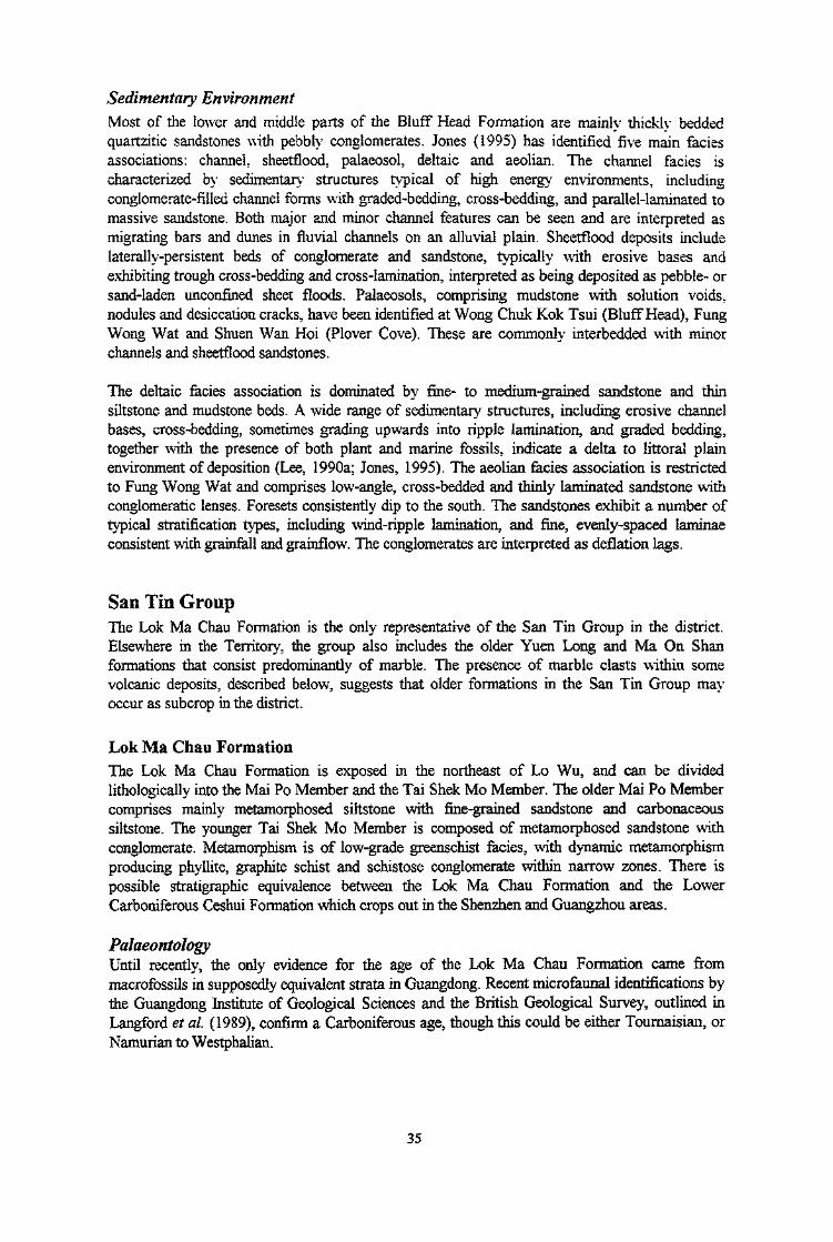
Plate 6 - Fossil Fish Scale (4.5 mm long) from the Devonian Bluff Head Formation onthe South Coast (4708 3752) of Plover Cove Reservoir
Plate 7 - Thin Section of a Lapilli-bearing Coarse Ash Tuff (HK 1880, 3933 4630) fromthe Upper Jurassic Shing Mun Formation, Pak Kung Au; XPL
Plate 8 - Thin Section of a Lapilli-bearing Coarse Ash Lithic Crystal Tuff (HK 2016,3115 3750) within the Upper Jurassic Tai Mo Shan Formation, Kei Lak Tsai;XPL
Plate 9 - Thin Section of a Feldsparphyric Dacite Lava (HK9350, 4652 4319) within theUpper Jurassic Sai Lau Kong Formation, Liu Ko Ngam, PPL
Plate 10 - Flow-banding in Feldspar and Lithic Clast-bearing Dacite Lava (4504 4513)within the Upper Jurassic Sai Lau Kong Formation, Cheung Shek Tsui
Plate 11 - Fiamme in Lapilli-bearing Eutaxitic Fine Ash Vitric Tuff (5084 4372) within the 53Upper Jurassic(?) Ngo Mei Chau Formation, Wan Tsai on Ngo Mei Chau(Crescent Island)
Plate 12 - Rhyolite Block in Lithic-bearing Lapilli-Coarse Ash Crystal Tuff (4869 4466)within the Upper Jurassic (?) Ngo Mei Chau Formation, on Kat 0 Chau(Crooked Island)
Plate 13 - Thin Section of Coarse Ash Crystal Tuff (HK5159 , 5552 3800) within theLower Cretaceous Long Harbour Formation, Che Wan; PPL
31
32
32
34
34
49
49
50
50
53
54
10

(Plates)Plate 14 - Coarse-grained Granite Block in Coarse Ash Crystal Tuff (5486 3968) within 54
the Lower Cretaceous Long Harbour Formation, below the Unconformity withConglomerates of the Port Island Formation, near Hung Ying Tsui on the SouthCoast of Chek Chau (Port Island)
Plate 15 - Breccia (5237 4127) within the Pat Sin Leng Formation, West of Wong Chuk 61Kok Tsui (Bluff Head)
Plate 16 - Unconformity (5244 4130) with Cross-bedded Sandstones and Conglomerates 61(to Left) of the Lower Cretaceous Pat Sin Leng Formation overlying Tuffs ofthe Upper Jurassic Tai Mo Shan Formation (to Right), Wong Chuk Kok Tsui(Bluff Head)
Plate 17 - Thin Section of Lithic Greywacke (HK7406, 4405 3928) within the Lower 62Cretaceous Pat Sin Leng Formation, Chek Ma Tau; XPL
Plate 18 - Well-bedded Conglomerate, Sandstone and Siltstone (5530 4050) within the 62Upper Cretaceous Port Island Formation, on the North Coast of Chek Chau(Port Island)
Plate 19 - Cross-bedding in Sandstones and Subordinate Conglomerates (5506 3967) 65within the Upper Cretaceous Port Island Formation, on the South Coast ofChek Chau (Port Island)
Plate 20 - Conglomerate (5500 3970) within the Upper Cretaceous Port Island Formation 65Unconformably Overlying Tuff of the Long Harbour Formation with theThickly Bedded Palaeo-weathering Zone, South Side of Chek Chau
Plate 21 - Bedded Tuffaceous Breccia (4597 4558) within the Upper Cretaceous Kat O 66Formation, with a Well-developed Wave-cut Notch at the Base of the Cliff,on Ap Chau
Plate 22 - Thin Section of Calcareous, Tuffaceous, Fine-grained, Brecciated Sandstone 66(HK8245, 4597 4558) within the Kat O Formation, Ap Chau; XPL
Plate 23 - Thin Section of Granodiorite (HK7876, 3810 3664), Shuen Wan; XPL 71Plate 24 - Thin Section of Feldsparphyric Rhyolite Dyke (HK8918, 4873 3781), Wong 71
Wan Tsai; XPLPlate 25 - Quartzphyric Rhyolite Dyke (4972 3826) Intruded into Mudstone, Siltstone and 72
Fine-grained Sandstone of the Tolo Channel Formation, in a Fault Zone nearFung Wong Wat on the North Coast of Chek Mun Hoi Hap (Tolo Channel)
Plate 26 - Thin Section of Quartzphyric Rhyolite Dyke (HK2022, 3575 3787), Cloudy 72Hill; XPL
Plate 27 - Well-bedded Calcareous Siltstone and Dolomitic Siltstone (6336 4445 ) of the 75Ping Chau Formation, Kan Lau Shek on Ping Chau
Plate 28 - Soft-sediment Deformation of Laminated Siltstone and Fine-grained Sandstone 75(6260 4490) within the Ping Chau Formation, Ping Chau
Plate 29 - Well-developed, Very Thinly Interlaminated Detrital and Chemical Cyclic 76Deposits of the Ping Chau Formation, Nan Kao Shui (6334 4440) on Ping Chau
Plate 30 - Aegirine-filled (with Calcite and Pyrite) Pseudomorphic Crystals, Possibly after 76Gypsum (6185 4570), within the Ping Chau Formation, Ping Chau
Plate 31 - Greyish White Chert within the Ping Chau Formation, Ngai Kok (6186 4577) on 81Ping Chau
Plate 32 - White Chert, Well-bedded Calcareous Siltstone and Dolomitic Siltstone 81(6210 4460) within the Ping Chau Formation, Lung Lok Shui on Ping Chau
Plate 33 - Thin Section of Aegirine-bearing Laminated Siltstone (HK7314, 6190 4482), 82within the Ping Chau Formation, Nam Tong on Ping Chau; XPL
Plate 34 - Thin Section of Chert with Stylolitic Horizon (HK9115, 6276 4422), within 82the Ping Chau Formation, Chau Tau, Ping Chau; XPL
11

(Plates)Plate 35 - Anticline, Plunging Northeast, in Sandstone and Siltstone of the BlufFHead 93
Formation, on the Coast (5250 4118) South of Wong Chuk Kok Tsui(BlufFHead)
Plate 36 - Fault Zone (4980 3834), 1.5 m Wide, Separating Sandstone of the Devonian 93Bluff Head Formation (to the Left) from Coarse Ash Tuff of the Upper JurassicTai Mo Shan Formation (to the Right), Wong Chuk Kok Tsui (Bluff Head)
Plate 37 - Faulted Contact (5080 3917) between White Sandstone and Reddish Siltstone 94of the Devonian Bluff Head Formation and Dark Grey Siltstone of the JurassicTolo Channel Formation, Pak Kok Tsai, North Coast of Chek Mun Hoi Hap(Tolo Channel)
Plate 38 - Northwest-trending Fault (5040 4550) within the NgoMei Chau Formation, 94Fei Shu Ngam, East of Kat 0 Chau
Plate 39 - Black Organic Mud, Upper Unit of Late Pleistocene Alluvial Terrace Deposits 109Overlying Yellowish Brown Silty Sand with Subrounded Cobbles, Lower Unit,Luen Wo Hui (3263 3972), Fanling
Plate 40 - Pleistocene Slope (Debris Flow) Deposits (4480 3858), Wang Leng Tau 109Plate 41 - Escarpment Formed by Sandstone, Siltstone and Conglomerate of the Lower 110
Cretaceous Pat Sin Leng Formation, Unconformably Overlying Tuff of theJurassic Tai Mo Shan Formation, Wang Leng (4540 3940)
Plate 42 - Natural Rock Arch (4568 4593) in Undercut Cliffs in Conglomerate and 110Tuffaceous Breccia within the Kat 0 Formation, Northern Tip of Ap Chau
12

Map and Memoir Series Notes
* This memoir describes the geology of the Northeastern New Territories, including adjacentislands. It should be read in conjunction with 1:20 000 scale Geological Map sheets 3 (SheungShui) and 4 (Kat 0 Chau).
* The memoir is one of a series that records the findings of the Hong Kong Geological Survey.An index of the memoirs and the 1:20 000 scale Geological Maps to which they relate is shownbelow.
* Individual superficial deposits in onshore areas are not generally considered mappable if lessthan 2 m thick. In the offshore areas the material on the sea-bed is shown, in most casesregardless of thickness.
* Grid references are based on the Hong Kong 1980 Metric Grid as shown on the 1:20 000 scaleGeological Maps. Ten-figure references indicate positions to within 10m, with Eastings followedby Northings, e.g. 80342 84432. Eight-figure references indicate positions to within 100 m. Forconvenience, however, the prefix figures 8, which apply to all eastings and northings in thedistrict, are omitted.
* Hong Kong Principal Datum (PD) is 1.2 m below Mean Sea Level, and 0.15 m aboveAdmiralty Chart Datum. The bathymetric contours shown on the 1:20 000 scale GeologicalMaps are based on Port Works Division surveys, with supplementary data from AdmiraltyCharts, and surveys by Electronic and Geophysical Services Ltd.
* Samples in the Territory-wide rock collection archived by the Hong Kong Geological Surveyare prefixed HK followed by a serial number, e.g. HK 7835.
* Boreholes are generally referred to by the contractor's number followed, in some instances bythe Geotechnical Information Unit (GIU), Civil Engineering Library, accession number for therelevant ground investigation report, e.g. 1201D/03412.
* The system used in this memoir for grain size description and classification is summarised inTable 1
,. 6
«*+*+,3"
17

Table 1 — Grain Size Description and Classification of Rocks and Superficial Deposits in Hong Kong
SuperficialDeposits
Boulders
Cobbles
Gravel
Sand
Mud
Coarse
Medium
Fine
Coarse
Medium
Fine
Silt
Clay
GrainSizemm
200
60
20
6
2
0.6
0,2
0.06
n nfi*>U.UUZ
Solid Rocks
SedimentaryRocks
SedimentaryBreccia,Conglomerate
Sandstone
Siltstorie
ClaystoneMudstone
PyroclasticRocks
PyroclasticBreccia,Agglomerate
LapiliiTuff
Coarse AshTuff
Fine AshTuff
Igneous Rocks
Acid
Very PegmatiteCoarse
Coarse
MediumGranite Granodiorite
Fine
AnlitpMplIlUVeryFine
Rhyolite Dacite
Rhyodacite
Acid-Intermediate
Quartz QuartzSyenite Monzonite
Quartz Quartz TrachyteTrachyte Latite
Trachydacite
Intermediate
Andesite
Basic
Gabbro
Basalt
Other
Lamprophyre
Metamorphic Rocks
Foliated
Schist
Phyllite
Mylonite
Other
Quartzite,Marble,Hornfels

Chapter 1Introduction
Location and PhysiographyThis memoir describes the geology of 1:20 000 scale map sheets 3 (Sheung Shui) and 4 (Kat 0Chau) in the northeastern New Territories. This area is referred to here as the district (Figure 1).Most of the onshore part of the district lies between the northern border of the Territory and ChekMun Hoi Hap (Tolo Channel). There are also smaller onshore areas on the southeast side of ChekMun Hoi Hap and on a large number of islands to the east, the largest of which are Kat 0 Chau(Crooked Island), Wong Wan Chau (Double Island), Chek Chau (Port Island) and Tap MunChau (Grass Island). The isolated island of Ping Chau, which lies some 10 km to theeast-northeast of the mainland, is also described. The offshore geology included on sheets 3 and 4is described in detail, and a brief description of the offshore geology east of Sheet 4, within TaiPang Wan (Mirs Bay), is also presented.
The total land area of the district is approximately 163 km2, while the offshore area describedamounts to about 590 km2.
The area to the north of Chek Mun Hoi Hap (Tolo Channel) is dominated by east-,east-northeast- and, locally, northwest-trending ridges the highest points of which are Wong Leng(639 m), Shun Yeung Fung (591 m), Lai Pek Shan (550 m) and Hsien Ku Fung (511 m), all inthe Pat Sin Leng range in the centre of the district. Other high points include Hung Fa Leng(Robin's Nest, 492 m) in the extreme north, and Kwai Tau Leng (486 m). The eastern part of thedistrict is generally lower-lying although the coastline is often rugged and indented withoccasional sandy inlets and bays. There is also an area of low ground in the west of the district,around Sheung Shui.
In the centre of the district, a broadly radial pattern of drainage emanates from the high ground ofPat Sing Leng. Generally, drainage systems are relatively short, with the exception of the TanShan Ho, which heads north from its source on the western side of Pat Sing Leng, and onreaching lower ground turns west to join the meandering Ng Tung Ho that continues to Fanling,Sheung Shui and beyond. Although many summits and ridges are grassy and easily traversed onfoot, dense vegetation on the lower slopes and in valleys commonly restricts access.
A large part of the district falls within country parks. North of Chek Mun Hoi Hap (ToloChannel), these include the Pat Sin Leng and Plover Cove country parks in the centre and northof the district, and the Plover Cove Extension Country Park covering the offshore islands to theeast. The Sai Kung West and Sai Kung East country parks include that part of the district to thesouth of Chek Mun Hoi Hap. Future development in the district will therefore be restricted, in theforeseeable future, to the limited areas lying outside the country parks.
The Plover Cove Reservoir occupies a broad embayment bounded to the southeast by a southwesttrending peninsula that extends from Fung Wong Wat Teng to Pak Sha Tau Chau.
Kat 0 Chau (Crooked Island), the largest of the islands in the district, has an unusual Z-shapedoutline and covers an area of about 2.5 km2. The large village of Tung 0 is located on itsnorthwest coast; Wong Wan Chau (Double Island), the second largest of the islands, with an areaof approximately 2 km2, rises to a height of 139 m. Ping Chau, which is isolated near the eastern
15

N^J KatOP
'-•—, (Croooked Island)fpb '^
, a/rNgoMeiChau
(Crescent Island)^ PC ;̂̂ )/' DOUBLE HAVEN "t^;^
Wong Wan Chau //I/ - (Double island) //I
H~ JJ£13
TAI PANG WAN(MIRS BAY)
f fv/ Chek Chau\V;'-f <Port lsland>
: <.Tap Mun
\\ IVN (Grass Island)
Scak
Ping Chau
Figure 1 - Principal Topographic Features of the District

edge of the territory in Tai Pang Wan (Mirs Bay) has a crescent-shaped outline and is low-lyingwith a surface area of just over 1 km2 and a maximum elevation of only 48 m. Cliffs extendaround much of the west coast providing spectacular exposures of the shallowly-inclinedsedimentary strata, while there is a wide sandy beach in part of the eastern embayment
Most of the district is sparsely populated. However, the northern edge of the Tai Po conurbationlies in the southwest, the population centres of Fanling and Sheung Shui are situated on low-lyingground in the west, and the northern border town of Sha Tau Kok sits on the north coast of ShaTau Kok Hoi.
Previous WorkThe earliest geological survey of the Territory was carried out between 1923 and 1927 by Brock,Uglow, Schofield and Williams, under an agreement between the Colonial Office and theUniversity of British Columbia. A map was published at 1:84480 scale (Brock et al, 1936).This showed the north of the district and adjoining islands, the north coast of Plover Cove, andthe extreme southwest, to be composed mainly of volcanic rocks of the Rocky HarbourFormation. Sedimentary rocks across the central part of the district and on Chek Chau (PortIsland), and along the northern side of Chek Mun Hoi Hap (Tolo Channel), were assigned eitherto the Mirs Bay Formation, thought then to be of Eocene age, or the Pat Sin Formation ofJurassic age. The sedimentary rocks on Ping Chau were shown as the Tolo Channel Formation,interpreted to be of early Liassic age. Dykes were mapped locally. Unfortunately, no descriptivememoir was produced to accompany this map, although several related publications (Uglow,1926; Brock & Schofield, 1926; Williams, 1943; Williams et aL9 1945) presented many of themain conclusions related to the mapping. A book, based largely on this earlier work, was writtenby Davis (1952), and this was followed by a detailed description of the geology of the TerritorybyRuxton(1960).
A systematic survey of the Territory was undertaken by geologists from the Institute ofGeological Sciences, United Kingdom, which resulted in the publication of two 1:50 000 scalegeological maps and an accompanying memoir (Allen & Stephens, 1971). These were the bestreferences on the geology of the district prior to the remapping described here, which began in1986. The Geotechnical Area Study Programme (GASP), initiated by the Geotechnical ControlOffice in 1979 (Brand et aL, 1982), produced 1:20 000 scale engineering geology and other mapsfor the Territory as a whole. The geology on these maps drew extensively on the work of Allen &Stephens (1971), but also included new interpretations of the superficial deposits andphotolineaments.
Bennett (1984a) made a comprehensive review of the stratigraphy of Hong Kong and the SouthChina region. He also reviewed the superficial deposits and weathering of the Territory (1984b),and its tectonic history, structure and metamorphism (1984c).
In the neighbouring Sha Tin district (Sheet 7), Addison (1986) established a detailedlithostratigraphy for the Repulse Bay Volcanic Group, and divided the granites using lithologicalcriteria. His volcanic lithostratigraphy was modified in the adjoining Kowloon and Hong KongIsland districts to the south (Strange <& Shaw, 1986), and in the western New Territories(Langford et al, 1989), and has now been extended, in its modified form, into parts of thisdistrict. The division of granite intrusions in the district is based on the grain-size classification ofStrange (1984). Palaeontological studies (Leeef al, 1990a-d, 1991a-c; Athertonef aly 1990a-d)have greatly improved the constraints on the ages of several of the formations.
17

Early geological surveys of Hong Kong (Davis, 1952; Allen & Stephens, 1971; Bennett, 1984a)only briefly covered the offshore geology of the Territory, concentrating on the coastal sedimentsin the littoral and sublittoral zones. Several studies broadly assessed the distribution of offshoredeposits in the Territory (e.g. Berry, 1962; Holt, 1962; Lumb, 1977) based on the limitedinformation available at the time. However, it was the undertaking of large offshore engineeringprojects such as the Kai Tak Runway extension (Henry et aL, 1961), the Plover Cove Reservoir,the High Island Reservoir and the Mass Transit Railway within and across limited shallowmarine sections that encouraged further detailed studies of the offshore geology (e.g. Fanshawe &Watkins, 1971; Kendall, 1976; Willis & Shirlaw, 1984; Yim, 1984a, b). Offshore mapping wasbegun by the Hong Kong Geological Survey in 1984 to synthesise the increasing amount ofinformation being produced (Shaw, 1987, 1990; Shaw & Arthurton, 1988).
By the mid-1980s the increasing demand for reclamation fill created problems of supply from thetraditional onshore sources. An offshore seismic and borehole study of a large area of Hong Kongwaters was initiated by the Geotechnical Control Office to investigate marine fill resources(Cheung & Shaw, 1993). This activity stimulated more interpretive research and specialistmeetings (Whyte, 1984; Whiteside & Arthurton, 1986; Whiteside & Wragge-Morley, 1988;Whyte et aL, 1988). Information from these and earlier investigations has been used in thismemoir and in compilation of the accompanying 1:20 000 scale maps.
Present SurveyGeological field mapping in the district started in 1988 and was largely completed by 1990.Geological information for onshore areas was plotted directly onto 1:5 000 scale topographicbase maps. It was then transferred onto 1:10 000 scale maps, and provisional geological mapswere prepared at this scale. These formed the bases for the published 1:20 000 scale geologicalmap sheets.
Traverses were made along most roads and footpaths, and accessible stream courses andcoastlines (Figure 2). Helicopters, provided by the Government Flying Service (formerly RoyalHong Kong Auxiliary Air Force), enabled access to the more inaccessible and mountainous areas.Islands and remote coastal sections were reached using commercially-hired boats, with someadditional assistance provided by the Water Supplies Department and the Royal Hong KongPolice.
Temporary sections were relatively uncommon, except in the urban areas, and groundinvestigation boreholes (Figure 3) are restricted to only a few parts of the district.
Photogeological interpretation of the distribution of superficial deposits and lineaments in thedistrict was undertaken, mainly using 1963, 1964 and 1983-86 photographs.
High resolution seismic reflection profiling, using a boomer source, was the principal techniqueemployed for offshore surveying. This gave a depth of penetration beneath the sea surface ofabout 100 metres. The stratigraphy of the superficial deposits was interpreted from continuousseismic records calibrated by the logging of sediment and rock from reconnaissance boreholes.Figure 4 illustrates the geophysical track lines for the records interpreted for this memoir and theaccompanying published maps, and also shows the positions of seabed sampling stations.
A Territory-wide gravity survey was also carried out (Busby et al.9 1992; Electronic andGeophysical Services Ltd, 1991; Evans, 1990; Busby & Langford, 1994). Marine gravitystations were located on a 2 km grid
18

Archival DataAll records from the survey are held in the archives of the Hong Kong Geological Survey(Planning Division, Geotechnical Engineering Office), and are available for inspection. Theseinclude: 2238 rock samples of which 983 have thin sections; field notes and photographs;manuscript maps; aerial photographs and related interpretations; analytical data (major and traceelements) for 37 samples (analysed by the Institute of Geological Sciences of GuangdongProvince, Guangzhou, P.R.C. and the University of Nottingham, U.K.); and palaeontologicaldetails of fossils (identified by the Nanjing Institute of Geology and Palaeontology, AcademiaSinica). Ground investigation reports, which were used to study the nature and disposition ofonshore and offshore superficial deposits, weathered rocks and rock types, are held in theGeotechnical Information Unit of the Civil Engineering Library.
19

SHENZHEN SPECIAL ECONOMIC ZONE
TAI PANG WAN
(MIRSBAY)
Figure 2 - Traverses Undertaken During Field Survey of the District

Figure 3 - Location of Boreholes and Cone Penetration Tests in the District

CHINA
TAJ PANG WAN(MIPS BAY)
Figure 4 - Location of Seismic Reflection Survey Tracks and Seabed Sampling Stations (Filled Circles) within the District

Chapter 2Outline of Geology
The solid geology of the district (Figure 5; Table 2) is dominated by Mesozoic volcanic andsedimentary rocks. The volcanic rocks, which comprise tuffs and lavas with intercalatedsedimentary rocks, crop out in all parts of the district. Intrusive igneous rocks of Mesozoic ageare relatively rare and consist mainly of granodiorite and rhyolitic dykes. Palaeozoic sedimentaryrocks crop out within a narrow strip trending northeast along the northern side of Chek Mun HoiHap (Tolo Channel), and also occur in the northwest comer of the district. Tertiary sedimentarystrata are exposed on Ping Chau in the far east of the district and these extend in subcrop beneathTai Pang Wan (Mirs Bay). Superficial deposits of Quaternary age (Table 2) form impersistentveneers on hill slopes, but are thicker and more widespread in valleys and lowland areas.Quaternary superficial deposits are extensive offshore.
The Palaeozoic strata comprise the Lower to Middle Devonian Bluff Head Formation and theLower Carboniferous Lok Ma Chau Formation. The Bluff Head Formation consists of sandstone,conglomerate and siltstone. The formation is exposed within an elongate and narrow,northeast-trending, fault-bounded strip; neither its base nor its top are seen in the district.Mesoscale folding is common within the formation.
The Lok Ma Chau Formation comprises two members that crop out in the extreme northwest ofthe district where they have been thrust over younger Jurassic volcanic rocks of the Tai Mo ShanFormation. The older of the two, the Mai Po Member, comprises phyllite, metasiltstone withmetasandstone, and graphitic schist, whereas the younger Tai Shek Mo Member comprisesmetasandstone, with metaconglomerate and phyllite.
Mesozoic sedimentary strata lie above and below the main sequences of volcanic rocks. Belowthe volcanic rocks, only one formation, the Lower Jurassic Tolo Channel Formation, has beenrecognised. This comprises mudstone and siltstone that are exposed within a fault-bounded stripalong the northern coast of Chek Mun Hoi Hap (Tolo Channel). The formation is presumed to lieunconformably on Upper Palaeozoic formations as in adjoining districts.
The Mesozoic volcanic rocks are divided into two groups: the Tsuen Wan Volcanic Group ofmiddle Jurassic age, and the Repulse Bay Volcanic Group of late Jurassic to early Cretaceousage. The Tsuen Wan Volcanic Group within the district includes the Shing Mun, Tai Mo Shan,Sai Lau Kong and Ngo Mei Chau formations. These crop out mainly in the centre, north andnortheast of the district, including exposures on several of the islands along the east coast. TheShing Mun Formation is lithologically varied, and includes fine to coarse ash tuff, tuff breccia,lithic tuff, sandstone, siltstone and mudstone. The main eruptive source of the formation probablylay just to the southwest of the district, but eruptions may also have occurred in the vicinity ofShuen Wan Hoi (Plover Cove). The Tai Mo Shan Formation, which conformably overlie theShing Mun Formation, consists mainly of coarse ash crystal tuff with subordinate vitric and fineash tuff and occasional siltstone. The tuffs were probably erupted from one or more sources tothe west and southwest of the district. The Sai Lau Kong Formation comprises mainly dacitelavas with intercalated tuff, siltstone and sandstone. These rocks lie directly above the Tai MoShan Formation within a restricted northwest-trending outcrop, interpreted as the approximateeruptive source of the lavas and tuffs. The Ngo Mei Chau Formation comprises eutaxitic, fineash vitric tuff, lithic tuff and rhyolite and has a restricted, partly fault-bounded outcrop on
23

Mesozoic to Cenozoic sedimentary rocks
SHENZHEN SPECIAL ECONOMIC ZONE
Figure 5 ~ Generalised Solid Geology of the District
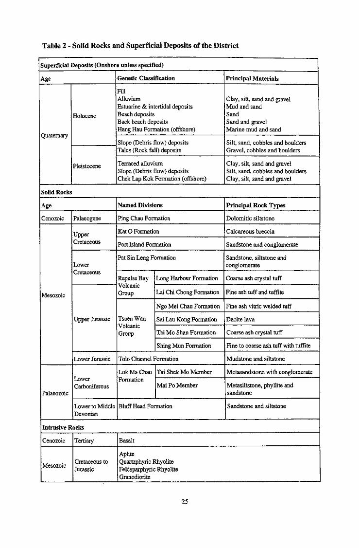
Table 2 - Solid Rocks and Superficial Deposits of the District
Superficial Deposits (Onshore unless specified)
Age
Quaternary
Holocene
Pleistocene
Genetic Classification
FillAlluviumEstuarine & intertidal depositsBeach depositsBack beach depositsHang Hau Formation (offshore)
Slope (Debris flow) depositsTalus (Rock fall) deposits
Terraced alluviumSlope (Debris flow) depositsChek Lap Kok Formation (offshore)
Principal Materials
Clay, silt, sand and gravelMud and sandSandSand and gravelMarine mud and sand
Silt, sand, cobbles and bouldersGravel, cobbles and boulders
Clay, silt, sand and gravelSilt, sand, cobbles and bouldersClay, silt, sand and gravel
Solid Rocks
Age
Cenozoic
Mesozoic
Palaeozoic
Palaeogene
UpperCretaceous
LowerCretaceous
Upper Jurassic
Lower Jurassic
LowerCarboniferous
Lower to MiddleDevonian
Named Divisions
Ping Chau Formation
Kat O Formation
Port Island Formation
Pat Sin Leng Formation
Repulse BayVolcanicGroup
Tsuen WanVolcanicGroup
Long Harbour Formation
Lai Chi Chong Formation
Ngo Mei Chau Formation
Sai Lau Kong Formation
Tai Mo Shan Formation
Shing Mun Formation
Tolo Channel Formation
LokMaChauFormation
Tai Shek Mo Member
Mai Po Member
Bluff Head Formation
Principal Rock Types
Dolomitic siltstone
Calcareous breccia
Sandstone and conglomerate
Sandstone, siltstone andconglomerate
Coarse ash crystal tuff
Fine ash tuff and tuffite
Fine ash vitric welded tuff
Dacite lava
Coarse ash crystal tuff
Fine to coarse ash tuff with tuffite
Mudstone and siltstone
Metasandstone with conglomerate
Metasiltstone, phyllite andsandstone
Sandstone and siltstone
Intrusive Rocks
Cenozoic
Mesozoic
Tertiary
Cretaceous toJurassic
Basalt
ApliteQuartzphyric RhyoliteFeldsparphyric RhyoliteGranodiorite
25
along the east coast. The linear outcrop is interpreted as a fissure-controlled vent complex. Theage relationships of the Ngo Mei Chau with other formations within the Tsuen Wan VolcanicGroup are uncertain, and it is possible that the formation could be related instead to the youngerRepulse Bay Volcanic Group.
The Repulse Bay Volcanic Group is only represented within the district by the Lai Chi Chongand Long Harbour formations that crop out on the south side of Chek Mun Hoi Hap (ToloChannel). The Lai Chi Chong Formation comprises well-bedded, fine ash tuffs and tuffiteswhereas the Long Harbour Formation is a thick succession of lithic lapilli-bearing, coarse ashcrystal tuffs. The tuffs are interpreted as having been ponded in a volcanotectonic depressioncreated in part by downfaulting on the southeast side of a fault, or faults, along Chek Mun HoiHap. The Lai Chi Chong Formation succeeds the Tolo Channel Formation unconformably, and isin turn unconformably overlain by the Long Harbour Formation, although both relationships haveonly been demonstrated in the adjoining district to the south (Strange et al , 1990).
Mesozoic sedimentary rocks overlying the main Mesozoic volcanic sequences include the LowerCretaceous Pat Sin Leng Formation, deposited in the Pat Sin Leng Basin, and the UpperCretaceous Port Island and Kat 0 formations, deposited in the Tai Pang Wan and Ap Chaubasins respectively. Both of the basins are largely preserved offshore. The Pat Sin LengFormation, which comprises sandstone, siltstone and conglomerate, is present in a broad belttraversing the centre of the district, and extending onto some of the islands along the east coast.The formation unconformably overlies the Tai Mo Shan Formation, by which it is alsooverthrust The Port Island Formation is only exposed on islands in the southeast and east of thedistrict. The formation mainly comprises fluvial sedimentary rocks, including channelisedsandstones and conglomerates, interbedded with overbank sandstones and siltstones, andsiltstone-mudstone units, the latter being typically converted to palaeosols. The largest area ofexposure of the formation is on Chek Chau (Port Island) where it unconformably overlies theLong Harbour Formation. The Kat 0 Formation is restricted to a few small outcrops in the northand northeast of the district, which expose calcareous breccia with conglomerate and sandstone.These outliers unconformably overlie the Sai Lau Kong and Ngo Mei Chau formations.
The Mesozoic and Palaeozoic volcanic and sedimentary rocks are in places intruded bygranodiorite stocks, feldsparphyric and quartzphyric rhyolite dykes, and aplite dykes, all of lateJurassic to early Cretaceous age. The granodiorites were comagrnatic with the Shing Mun andTai Mo Shan formations and the location of the intrusions in the southwest of the district isconsidered to indicate the approximate location of the eruptive source of the Shing MunFormation. The rhyolitic dykes trend variably to the northeast, north-northeast and east-northeast.These trends closely match the strike of major fault zones in the vicinity of individual dykes. Noabsolute age dates are available for any of the dykes, but, on the basis of similarities in theirwhole-rock geochemistry, they are interpreted as being of a similar general age as the lateJurassic to early Cretaceous volcanic rocks in the district.
The Cenozoic is represented only by the Lower Palaeogene Ping Chau Formation. Although theformation is only exposed on Ping Chau in the extreme east of the district, it is interpreted tooccur on the seabed around Ping Chau and extends in subcrop under the northern part of TaiPang Wan (Mirs Bay). On Ping Chau, the formation comprises mainly siltstone and clayeydolomitic siltstone, deposited in chemical and detrital cycles in a brackish lake under tropical andsubtropical conditions. The formation also contains an unusual suite of secondary mineralsincluding zeolites and aegirine.
The district is .g^BS^sMb^^ and northvy&st In addition,important northerly-dipping structures occur in the centre of thelistrict and in the offshore areasto the east, northwest- and north-striking structures are dominant. The structural development of
26

the district was mainly related to the Yanshanian Orogeny, which affected a broad belt along thesoutheast coast of China during tlie Jurassic and Cretaceous periods. Some structures in thenorthwest are suspected to be pre-Yanshanian but are poorly constrained. The affects of orogenyincluded fault-controlled volcanism and sedimentary basin development, regional tectonism, and,dynamic metamorphism. Early Craozoic^^basin development may have been associated with theearly stages of Himalayan Orogeny.
In the northwest of the district, a northwest-<ippmg thrust, the San Tin Fault, has emplacedjrpcksof Carboniferous age from the northwest onto Jurassic volcanic rocks. Broad zones of shearingandjiynamcj^^ to the Ernst are ̂ ^^2 j^ jts footwall7 which is occupiedby Jurassic volcanic rocks. In the centre of the district, Jurassic vdcanicjock^have themselvesbeen thrust from the north, onto Cretaceous sedimentary rocks. The deformed sedimentary rocksin the footwall of the thrust may have accumulated contemporaneously with the development ofthe thrust.
A major north-northeast-trending, subvertical zone of faulting, shearing and dynamicmetamorphism transects the area from ShaJTau Kok at the northern limit of the district, to itssouthwest comer and thereafter across most of the Territory. Much of the j
The fault zone is thought to have had a significant jsmst^but little kinematic evidence has been found to support this. However, this movement sense wouldbe kinematically consistent with the southerly-directed thrusting recognised in the centre of thedistrict.
The laterally extensive CheldVhm Fault Zone runs along the northern side of Chek Mun Hoi Hap(Tolo Channel), and forms part of a fault system that extends across most of the Territory to thesouthwest of the district. This fault system was probably ̂ activa^^ev§iailill̂ § and withdiffering movement senses during its evolution. Movement during the eruption of the Tsuen WanVolcanic Group is likely to have been jdextral and ̂ e^ensionala and during the eruption of theRepulse Bay Volcanic Group, mainly extensional also. However, Cretaceousjnovements areconsidered to have been m^y^sinistral. Evidence of later movement is limited, but an offshoreextension of the fault coincides with the northern limit of Ping Chau. In adjoining areas southwestof the district, brittle deformation within the fault zone appears to be related to dextraldisplacement of pre-existing, north-northwest-trending faults.
JFojding^ is mainly related Jo the Yanshanian Orogoay^ Folds within Palaeozoic rocks arecommonly jnesoscale, clog^or^ti^it, and jiofffi^rtheast-plimging. In contrast, folds withinMesozoic rocks are is generally more open, except \^ere"near major faults. Tertiary folding isalmost exclusively open in style, and related to the development of sedimentary basins.
Contact (thermal) metamorphism is relatively rare. A notable exception is in the southwest of thedistrict where block-bearing tuff and tuffite hornfels of Jurassic age can be related to the intrusionof granodiorite, also of Jurassic age.
The dominant form of metamorphism within the district is dynamic metamorphism, mainly of lateJurassic and early Cretaceous age. The deformation, expressed as congressional andshear-related foliation is developed extensively in the northwest of the district, in response tolarge-scale thrusting from the northwest, and within steeply-dipping shear zones. Dynamicmetamorphism is also evident in the centre of the district, as a thick zone of sheared rock withinthe footwall of a northward-dipping thrust, and near the base of the thrust sheet.
Hydrothermal alteration, including silicification and carbonate development, occurs locally,mainly within the Mesozoic volcanic and sedimentary sequences, and particularly adjacent tomajor zones of faulting and shearing, and within areas of volcanotectonic collapse.
27
Quartz veins are present in many parts of the district. They trend mostly to the northwest in thewest of the district, but are more variably trending in the east, where north and north-northeasttrends are also seen.
Superficial deposits of Quaternary age form flat-lying areas onshore, and constitute the sea-bedin most of the offshore area. In hilly terrain, colluvium, including debris flow and other slopedeposits, mostly of Pleistocene age, commonly mantles side slopes and lines valleys. Restrictedalluvial deposits occur in hilly areas, but alluvium more generally occurs as fans developeddownslope of the colluvial deposits. Thick sequences of Pleistocene terraced alluvium areextensively developed in the west of the district, especially around Sheung Shui and Fanling.
Restricted beach deposits of sand, and more common estuarine and intertidal deposits of mud andsand, are developed in front of alluvial deposits and, in some cases, Pleistocene slope deposits,especially in sheltered coastal bays. Pleistocene alluvial deposits also occur offshore, togetherwith slope debris deposits, within the Pleistocene Chek Lap Kok Formation, which generallycomprises complex, interbedded red, yellow and grey clay, silt, sand and gravel, with someorganic material. The formation is dominantly of fluvial origin, containing probable estuarine andintertidal units within. The Chek Lap Kok Formation is overlain by the extensive Holocenemarine deposits of the Hang Hau Formation that comprise mainly dark grey mud with shells, andsome sand. Land reclamations at Sha Tau Kok and the dam walls at Plover Cove Reservoir haveburied some of the estuarine, intertidal and marine deposits.
A regolith, or mantle of weathered rock, occurs over most of the district. The effects ofweathering vary with underlying rock types and this is reflected in topographic relief. Forexample, granodiorite and Palaeozoic fine-grained clastic rocks are the most deeply weatheredand eroded rocks and typically form lower ground. The acidic volcanic rocks are more resistantto deep weathering and erosion, and form rocky hills with boulder fields of large, cuboidalcorestones.
Although there are no active mineral workings in the district, lead and zinc, together withby-product silver and gold, have been mined at Lin Ma Hang in the northwest of the district. Theage of the mineralization, which is hosted by Jurassic volcanic rocks, is unknown. There are alsoother occurrences of galena, sphalerite, quartz and graphite, limonite. Locally offshore, in ChekMun Hoi Hap (Tolo Channel) and in Tai Pang Wan (Mirs Bay), channelised sand bodies withinthe Chek Lap Kok Formation, but beneath a cover of marine mud, provide a potential resourcefor construction, but their exploitation has been rejected for environmental reasons.
28
Chapter 3Palaeozoic Sedimentary Rocks
Classification and DistributionTwo formations of Palaeozoic age occur within the district: the older Bluff Head Formation is ofDevonian age, and the younger Lok Ma Chau Formation is Carboniferous. The Bluff HeadFormation crops out on the northwest side of Chek Mun Hoi Hap (Tolo Channel), between Lo FuWat in the southwest and Wong Chuk Kok Tsui in the northeast. The outcrop is nearly 10 kinlong and 0.5 to 1.5 km wide. The Lok Ma Chau Formation occurs in the northwest comer of thedistrict, in a northeast-trending, fault-bounded belt, 4 km long and 2 km wide, which extends intoShenzhen and northeast Guangdong Province. The formation is represented in the district by theMai Po and Tai Shek Mo members.
The rocks of the Bluff Head Formation were previously known variously as the 'Jurassic ToloCrest Foimation' (Heim, 1929) and 'Mesozoic Volcanic Pat Sin Formation1 (Williams et aL,1945) and were referred to by Davis (1952) simply as 'the Jurassic Sediments'. The present nameof the formation was first defined by Ruxton (I960), and Allen & Stephens (1971) suggested thatthe formation was middle Lower Jurassic. Lee (1982), however, discovered placoderm fish fossilsat Harbour Island and concluded that the strata were Devonian. More recently, the formation hasbeen confirmed as Lower to Middle Devonian (Lee 1990a & 199Gb)1. The Bluff Head Formationcan therefore be correlated with the Devonian Guitou Formation of northern GuangdongProvince. A study carried out by Jones (1995) has defined a number of sedimentary fadesassociations in this formation.
The Lok Ma Chau Formation is the uppermost formation of the Carboniferous San Tin Group,and was first defined by Williams (1942). Initially thought to be Permian by Heim (1929), theformation was later grouped with Lower Jurassic strata by Allen & Stephens (1971). Lai (1977)compared the formation lithologically with Carboniferous strata in Shenzhen and suggested thatthey were of the same age, a conclusion subsequently supported by several authors (Ha et aL,1981; Peng, 1983; Lai & Mui, 1984; Bennett, 1984a; and Lee, 1985). Micropalaeontologicalevidence outlined in Langford et aL (1989) has refined the age of the formation to Tournaisian orNamurian-Westphalian.
Bluff Head FormationThe formation consists of pale grey, fine- to coarse-grained quartzitic sandstone, with subordinatereddish brown and purple sericitic siltstone and greyish white, quartz-pebble conglomerate. Theformation is generally coarser grained in the lower part, comprising fine- to coarse-grainedsandstone, conglomeratic sandstone and up to three beds of conglomerate, and passing up intosandstone with sericite-bearing siltstone, mudstone and lenses of conglomerate.
In the southeast, the base of the formation is faulted along the Chek Mun Fault against the LowerJurassic Tolo Channel Formation. Near the fault, the strata dip steeply to very steeply and arelocally overturned. To the northwest, the regional dip decreases to 30°, but steepens again nearthe upper, faulted boundary of the formation with the Upper Jurassic Tai Mo Shan Formationand the Lower Cretaceous Pat Sin Leng Formation. The formation is estimated to be 800 in thick,
1 Based on fossil collections made between 1988 and 1990 by M J Atherton & C M Lee (HongKong Polytechnic), J H Chen, G X He & S Q Wu (Nanjing Institute of Geology and Palaeontology,Academia Sinica), P S Nau (Hong Kong University) and K W Lai (Hong Kong Geological Survey).
29

but neither the base nor the top of the formation are seen, and the effects of faulting and foldingare hard to assess.
DetailsCheung Pai Tun. The formation here is best exposed on the northern and southern shores (respectively3700 3725,4546 3601) of Cheung Pai Tun. The stratigraphically lower strata are dominantly greyish white, thicklybedded, fine- to medium-grained sandstone with two beds of pebbly conglomerate. The conglomerates, which varyfrom 8 to 13m thick, have erosive bases and well-developed trough and planar cross-bedding, and representchannel features. The conglomerate exposed on the southern sea shore is overturned, dipping at 60° to thesoutheast. Higher in the succession, medium- to fine-grained sandstones are intercalated with siltstone andmudstone. The siltstone varies from reddish brown to reddish purple, greyish white and greyish green. Theyellowish brown mudstone and fine-grained sandstone exposed along the northern shore contain bivalve,brachiopod and fish fragments and plant stems. The sedimentary rocks represent a deltaic facies association (Jones,1995). The formation in this section is 690 m thick, but neither top nor base of the formation are seen.
Wong Wan Tsai to Ngor Kai Teng. The formation is up to 900 m thick in this area. Stratigraphically lower strataare mainly greyish white, quartzitic sandstone with three beds of conglomerate: the lowermost bed, exposed nearthe base of the formation on the shore of Chek Mun Hoi Hap (Tolo Channel), is a massive, thickly bedded,quartz-pebble conglomerate, 12 m thick; the middle bed is also quartz pebble-bearing and is 3 m thick; and theuppermost bed, 0.5 m thick, is a pale reddish brown, fine-grained, polygenetic conglomerate with subrounded tosubangular clasts including quartzite, metasiltstone, and less abundant vein quartz. The upper part of the sequencecomprises dominantly medium- to fine-grained, quartzitic and clayey sandstone with intercalated sericitic siltstone,mudstone and two lensoid beds of conglomerate. There are around 40 individual siltstone beds, each being 0.5 to 10m thick, and the proportion of siltstone in the sequence is nearly 10 %. A thick pebbly conglomerate (4838 3865)occurs 100 m north of Ngor Kai Teng. The pebbles are mainly of quartz, varying from 2 to 150 mm in diameter. Afurther 1 m thick, fine conglomerate occurs 5 m above this bed.
South of Pak Kok Shan. Between the seashore, 550 m south of Pak Kok Shan (5021 3984) and 400 m northeast ofFung Wong Wat (5078 3920), the formation is 670 m thick. The lower strata are overturned and comprise greyishwhite sandstone with a thin breccia and a thick conglomerate. These are succeeded by fine-grained quartzitic(Plate 1) and clayey sandstones with subordinate sericitic siltstone and a lensoid conglomerate. These sedimentaryrocks are considered by Jones (1995) to be dominantly sheetflood deposits. At Fung Wong Wat (4988 3840), thelower part of the succession includes a 20 m thick unit of well-bedded white sandstone, interpreted by Jones (1995)as including aeolian facies.
Wong Chuk Kok Tsui (Bluff Head). The formation is well exposed (Plate 2) along the shore of Wong Chuk KokTsui (527411), where it is 260 m thick. The lower strata comprise greyish white, quartzitic sandstones with twounits of thickly-bedded conglomerate, up to 20 m thick. A quartzphyric rhyolite dyke is intruded into the sandstone.The central part of the formation comprises sandstone with siltstone and a lens of conglomerate, while a series ofminor folds is developed in sandstone with siltstone in the upper part. The top of the formation is faulted againsttuffs of the Upper Jurassic Tai Mo Shan Formation. These sedimentary rocks are dominantly a channel faciesassociation (Jones, 1995), with several major channels and a number of single and multi-storey minor channels.They are interbedded with palaeosols, which are more common in this locality than elsewhere in the district.
Petrography
Conglomerate. The subrounded, typically clast-supported pebbles in conglomerate beds low inthe formation are mainly composed of vein quartz with some quartzite, quartz schist and siltstoneclasts varying from 2 to 150 mm in diameter (Plate 3).
Quartz-pebble conglomerate. HK7949 (4889 3792), from 900 m southeast of Ngor Kai Teng, isgreyish white, massive with a psammitic-psephitic (sandy-pebbly) texture, and contains (Plate 4)subrounded clasts (65 %) of vein quartz and rock fragments in a sandy, cemented matrix (35 %).Grain size is typically 2 to 4 mm but ranges up to 90 mm. In thin section the rock is seen to bepoorly sorted. Vein quartz clasts, comprising 70 % of all of the clasts, are monocrystalline andpolycrystalline, subround, and show intragranular cracks and undulose extinction, The rockfragments comprise 30 % of the clasts, are subrounded to subangular, and comprise sandstoneand quartz schist. The matrix contains sand size (0.3 to 1.5 mm), subrounded to subangularquartz and quartzite grains (30 % of the whole rock) and some pelite, set in a siliceous cement(5 % of the whole rock) that surrounds the clasts.
30

Plate 1 - Well-bedded Sandstone and Siltstone with Conglomerate Lenses (5270 4110), and MinorFolds in the Central Part of the Devonian Bluff Head Formation, South of Wong Chuk KokTsui (Bluff Head)
Plate 2 - Planar-bedded Sandstone (4780 3720) in the Devonian Bluff Head Formation at Fung WongWat 300 m North ofFu Tau Sha on the North Coast ofChekMun Hoi Hap (Tolo Channel)
" • • I
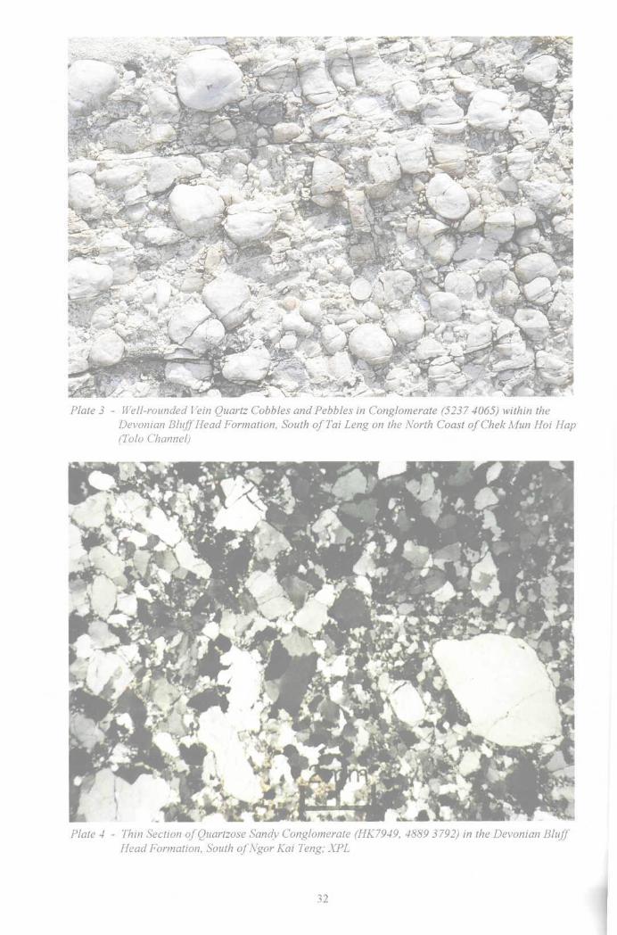
Plate 3 - Well-rounded Vein Quartz Cobbles and Pebbles in Conglomerate (5237 4065) within theDevonian Bluff Head Formation, South ofTai Leng on the North Coast ofChekMun Hoi Hap(Tolo Channel)
Plate 4 - Thin Section of Quartzose Sandy Conglomerate (HK7949, 4889 3792) in the Devonian BluffHead Formation, South ofNgor Kai Teng; XPL

Sandstone. Most sandstones are greyish white litharenites containing mainly quartz grainstogether with 25 to 50 % siliceous rock fragments including quartzite, metasiltstone and quartzschist. However, a few sandstones are quartz arenites or sublitharenites, and a few containlimonite nodules (e.g. HK 8411, 4757 3745).
A hand specimen of sublitharenite (HK7938 from Ngor Kai Teng (4834 3871)), is greyish white,massive, and has a detrital texture. In thin section, it consists of abundant granular quartz(c.85 %) with minor sericite (4 %), sandstone fragments and heavy minerals, including zircon,tourmaline and apatite, and cement (10 %). The subrounded to subangular quartz grains varyfrom 0.07 to 0.6 mm in diameter but are usually 0.15 to 0.2 inm. They show undulose extinctionand subgrain development, both suggesting deformation. The sericite is scaly and curved withgrain size in the range of 0.2 by 0.03 mm and 0.4 by 0.08 mm. The cement is mainly siliceouswith a minor clayey component that has altered to sericite. Whole-rock chemical analysisindicates that Si02 comprises 93.63 % of the rock and A1203 4.04 %.
Siltstone. Most siltstones are reddish to dark reddish brown, although some are purplish red,purplish grey and grey. Limonite nodules and solution voids may occur. The siltstones comprisemainly quartz and sericite (10 to 35 %). The sericite has formed by metamorphism from clayminerals. Some siltstones are sericite-bearing, such as HK7947 (4888 3801), from 500 mnortheast of Wong Wan Tsai, which is reddish brown, thinly bedded and in hand specimen has anaphanitic texture and slaty structure. The sericite has a silky lustre. In thin section, quartz grainsvary from 0.01 to 0.02 mm in diameter and comprise 70 % of the rock. The sericite (30 % of thewhole rock) is scaly, varies from 0.02 to 0.1 nun by 0.005 to 0.03 mm and is of metarnorphicorigin.
PalaeontologyDevonian fossils have been found at 23 localities along the south shore of Shuen Wan (PloverCove) Reservoir stretching between 600 m northwest of Lo Fu Wat (3676 3719) and Siu Kau(4767 3875). About 300 specimens of seven types of fossil have been collected, includingbivalves, ostracods, conchostracans, gastropods, crinoids, fishes (Plate 5) and plants (Plate 6)(Lee et al, 1990a, b). The most abundant and diverse of the fossil groups are bivalves, threeassemblages of which have been recognised:
1. Pseudonuculana zhaoi - Deceptrix guangxiensis assemblage, indicatingupper Lower Devonian.
2. Orthonota guangdongemis - Paracydas rugosa assemblage indicativeof uppermost Lower Devonian.
3. Edmondia aff. subovata assemblage comprising Edmondia aff. subovataHall, Edmondia aff. phillipi Hall and Edmondia sp., of Middle Devonian age.
Three fossil plant assemblages have been identified at many localities:
1. Zosterophyllum - Taeniocrada assemblage indicating Lower Devonian.2. Protopteridium assemblage indicating either uppermost Lower Devonian or
lowermost Middle Devonian.3. Lepidodendropsis assemblage which may indicate the lower Middle Devonian
and which has never been found in the Lower Devonian.
The Bluff Head Formation can be correlated with the lower to middle Devonian Guitou Group ofnorthern Guangdong Province.
33
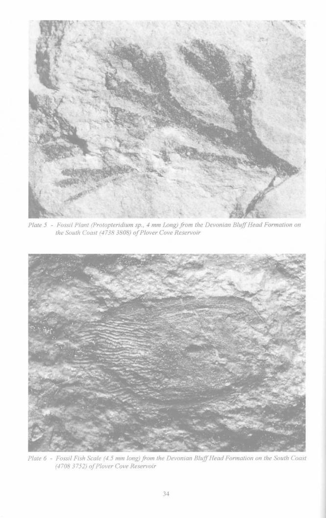
Plate 5 - Fossil Plant (Protopteridium sp., 4 mm Long) from the Devonian Bluff Head Formation onthe South Coast (4738 3808) of Plover Cove Reservoir
Plate 6 - Fossil Fish Scale (4.5 mm long) from the Devonian Bluff Head Formation on the South Coast(4708 3752) of Plover Cove Reservoir
Sedimentary EnvironmentMost of the lower and middle parts of the Bluff Head Formation are mainly thickly beddedquartzitic sandstones with pebbly conglomerates. Jones (1995) has identified five main fadesassociations: channel, sheetfiood, palaeosol, deltaic and aeolian. The channel facias ischaracterized by sedimentary structures typical of high energy environments, includingconglomerate-filled channel forms with graded-bedding, cross-bedding, and parallel-laminated tomassive sandstone. Both major and minor channel features can be seen and are interpreted asmigrating bars and dunes in fluvial channels on an alluvial plain. Sheetflood deposits includelaterally-persistent beds of conglomerate and sandstone, typically with erosive bases andexhibiting trough cross-bedding and cross-lamination, interpreted as being deposited as pebble- orsand-laden unconfined sheet floods. Palaeosols, comprising mudstone with solution voids,nodules and desiccation cracks, have been identified at Wong Chuk Kok Tsui (Bluff Head), FungWong Wat and Shuen Wan Hoi (Plover Cove). These are commonly interbedded with minorchannels and sheetflood sandstones.
The deltaic facies association is dominated by fine- to medium-grained sandstone and thinsiltstone and mudstone beds. A wide range of sedimentary structures, including erosive channelbases, cross-bedding, sometimes grading upwards into ripple lamination, and graded bedding,together with the presence of both plant and marine fossils, indicate a delta to littoral plainenvironment of deposition (Lee, 1990a; Jones, 1995). The aeolian facies association is restrictedto Fung Wong Wat and comprises low?-angle, cross-bedded and thinly laminated sandstone withconglomeratic lenses. Foresets consistently dip to the south. The sandstones exhibit a number oftypical stratification types, including wind-ripple lamination, and fine, evenly-spaced laminaeconsistent with grainfall and grainflow. The conglomerates are interpreted as deflation lags.
San Tin GroupThe Lok Ma Chau Formation is the only representative of the San Tin Group in the district.Elsewhere in the Territory, the group also includes the older Yuen Long and Ma On Shanformations that consist predominantly of marble. The presence of marble clasts within somevolcanic deposits, described below, suggests that older formations in the San Tin Group mayoccur as subcrop in the district.
Lok Ma Chau FormationThe Lok Ma Chau Formation is exposed in the northeast of Lo Wu, and can be dividedlithologically into the Mai Po Member and the Tai Shek Mo Member. The older Mai Po Membercomprises mainly metamorphosed siltstone with fine-grained sandstone and carbonaceoussiltstone. The younger Tai Shek Mo Member is composed of metamorphosed sandstone withconglomerate. Metamorphism is of low-grade greenschist facies, with dynamic metamorphismproducing phyllite, graphite schist and schistose conglomerate within narrow zones. There ispossible stratigraphic equivalence between the Lok Ma Chau Formation and the LowerCarboniferous Ceshui Formation which crops out in the Shenzhen and Guangzhou areas.
PalaeontologyUntil recently, the only evidence for the age of the Lok Ma Chau Formation came frommacrofossils in supposedly equivalent strata in Guangdong. Recent microfaunal identifications bythe Guangdong Institute of Geological Sciences and the British Geological Survey, outlined inLangford et al (1989), confirm a Carboniferous age, though this could be either Tournaisian, orNarnurian to Westphalian.
35

Sedimentary Environment
Sedimentary units within the Lok Ma Chau Formation have been interpreted in terms ofdeposition in neritic swamps within a prograding deltaic environment. Low in the succession,siltstone, fine-grained sandstones and carbonaceous horizons were probably deposited on adeltaic floodplain, the finer grained lithologies representing more distal environments. Somelithologies repeatedly recur but no cyclicity has been established. As the delta advanced, coarsersediments were laid down, culminating in deposition of coarse sand and pebbles in an alluvialenvironment.
Mai Po MemberThe Mai Po Member occurs in a northeast-trending outcrop between the Sheung Shui WaterTreatment Works (303 420) and Lo Shue Ling (324 442). The dominant lithologies are light todark grey metasiltstone, phyllite with metasandstone, thin layers or lenses of graphitic schist. Thegraphitic schists are dark grey to black when fresh, and have a well-developed schistosity. Theiroccurrence characterises the member, which is more than 400 rn thick. Boreholes suggest that thecontact between the Mai Po Member and the underlying marble of the Yuen Long Formation isconformable.
DetailsSheung Shui Water Treatment Works to Cheung Po Tau. The formation is best exposed on the small hill (30624224) northwest of the Water Treatment Works and at Cheung Po Tau (3126 4243), where it comprises phyllite andmetasiltstone with metasandstone, calcareous metasiltsone and graphitic schist. The latter (HK1151, 3043 4231;HK6984, 3061 4221) occurs in five discrete beds, varying from 0.1 to 2 m in thickness and dipping at 30-40° to thenorthwest. The calcareous metasiltstone (HK6981) is present in Borehole BH7/5922 (3081 4277). The contactbetween the formation and the tuff of the Tai Mo Shan Formation is faulted and can be seen at Fu Tei Au Road(3052 4186) and below the service reservoir (3146 4250) at Cheung Po Tau. The metasedimentary rocks are thrustover the tuff, the thrust dipping northwest at 28-40°. Rocks on both sides of the fault are intensely mylonitised.
Kong Nga Po to Lo Shue Ling. All the rocks in this area are metamorphosed, and quartzphyric rhyolite dykestrending 020° that intrude the formation are also foliated. A thin bed of graphitic schist occurs at Kong Nga Po(HK6935, 3186 4288), but the main lithology is phyllite. The outcrop of the formation continues northeast acrossthe Sham Chun River into Shenzhen. At Kong Nga Po, Borehole SL3/6 (GIU report no. 6681, 3192 4291)penetrates metasiltstone (HK3417) overlying mylonitised tuff (HK3418) of the Tai Mo Shan Formation. Thecontact at 13 m is interpreted as a thrust, with the overlying rocks thrust from northwest to southeast.
Cheung Shek Tsui, Kat O Chau (Crooked Island). Two outcrops occur on Kat O Chau, one north of Tung 0 Wan(4815 4595) and one south of Cheung Shek Tsui (4830 4603). Both are bounded by faults and comprise dark greysiltstone with thinly-bedded limestones. The latter occur as eight beds between 50 and 200 mm thick, are grey todark grey with a micritic texture, and have yielded the foramaniniferan Archaesphaem magna Suleymanov(identified by Nanjing Institute of Geology and Palaeontology, Academia Sinica). The rocks in this outcrop arebelieved to belong to the lowermost part of the Mai Po Member.
PetrographyMetasandstone. Most metasandstones are silver-grey to yellowish grey with a blasto-psammitictexture. They comprise dominantly quartz (65-70 %) with minor haematite (5 %), feldspar andheavy minerals including zircon, rutile, epidote, tourmaline, clinopyroxene, magnetite and apatite.The quartz grains are 0.05 to 0.5 mm in size, subangular and often stretched into lenses orribbons with undulose extinction. Haematite, disseminated throughout the rockmass, may beweathered to limonite, giving the rock a yellowish colour. The matrix (15-30 %) was dominantlyclay, but has been recrystallized to sericite which displays a preferred orientation.
Metasiltstone. This has a clastic component mainly of quartz, with a few heavy minerals such astourmaline and magnetite. The clay matrix has recrystallized to sericite, with dispersedmicrogranular haematite. Modal analyses of thin sections show 50-60 % quartz, 30-40 % sericiteand 1-3 % opaque minerals (haematite and pyrite). The quartz grains are often strained and
36

flattened, and show undulose extinction. Preferred orientation of sericite defines the schistosity,and in some thin sections there are two foliations.
Limestone. Specimen HK8100 (4826 5605) is grey to dark grey, comprising microcrystallinecalcite that makes up to 90 % of the rock. The remainder of the rock comprises disseminatedquartz in crystals of 0.02 to 0.04 mm across (5 %), muscovite (1 %), pyrite (3 %) and clayminerals (2 %).
Tai Shek Mo MemberThe outcrop of the Tai Shek Mo Member extends from Sha Leng (Sandy Ridge) (300 431) toMuk Wu (318 444) in the northwest of the district. The member is well exposed in a section onSha Leng. The dominant lithology is greyish white to yellowish white, medium- to fine-grainedmetasandstone, with metaconglomerate and phyllite.
The contact between the Tai Shek Mo Member and the underlying Mai Po Member is covered bysuperficial deposits but boreholes have shown that it is transitional. The Tai Shek Mo Member ismore than 300 m thick.
DetailsSha Leng (Sandy Ridge). The dominant lithologies in the area are metasandstone and conglomeraticmetasandstone with phyllite and metaconglomerate. The sandstone is mainly fine to medium-grained, whereas thesand fraction of the conglomeratic metasandstone is normally coarse. A bed of metaconglomerate^ cropping out on ahill 500 m east of Lo Wu (3011 4333) dips at 27° to the northeast.
Muk Wu, The main lithologies in this area are thickly bedded yellowish brown metasandstone and greyish whiteconglomeratic metasandstone with thinly-bedded metasiltstone, phyllite and sericitic schist. Most of the rocks havebeen foliated with the structural fabric dipping at between 23° and 40° to the northwest. The rocks of the formationare highly to completely weathered and are widely covered by superficial sediments.
PetrographyMetaconglomerate, The rock is greyish white to yellowish grey and comprises pebbles, mainlysubrounded quartzite and vein quartz, varying from 5 to 30 mm in size. The clasts, which makeup 40 to 60 % of the rock, are flattened and elongated with a preferred orientation. The matrixcomprises grains of quartz, feldspar, muscovite, magnetite and haematite with a microgranularquartz and sericitic cement.
Conglomeratic metasandstone. The rock consists of sub-rounded clasts of flattened quartz grainsand elongate quartzite fragments which are strongly foliated. The quartz (60-80 %) has a grainsize mostly between 0.1 and 0.2mm. The larger quartz grains and clasts range from 0.5 to30 mm, and commonly show undulose extinction. The matrix is composed of sericite (15-25 %)and microgranular quartz.
Metasandstone. Sample HK 6943 (3070 4334) is mainly composed of quartz grains (60-80 %)and haematite (5 % or less), with minor feldspar and pyrite. The grain size varies from 0.07 to0.3 mm, with a maximum grain size of 0.7 mm. The quartz grains are strongly aligned and showundulose extinction. The matrix (15-25 % of the rock) has been recrystallized to sericite whichalso displays a preferred orientation.
37

Chapter 4Mesozoic Sedimentary and VolcanicRocks
Classification and DistributionMesozoic rocks are the most widespread of any in the district, accounting for about 90 % of theonshore outcrop. They include the Lower Jurassic Tolo Channel Formation, the Upper JurassicTsuen Wan Volcanic Group, the Upper Jurassic to Lower Cretaceous Repulse Bay VolcanicGroup, the Lower Cretaceous Pat Sin Leng Formation, and the Upper Cretaceous Port Island andKat 0 formations.
The Tolo Channel Formation comprises ammonoid-bearing mudstone with sandstone andincludes the oldest Mesozoic rocks in the district. The formation occurs impersistently along anarrow, northeast-trending fault zone and extends for more than 6.5 km along the south coast ofPak Kok Shan (5090 3930) as far as Lo Wu Wat (4570 3620), and for more than 150 moffshore. The formation is faulted against sandstone of the Bluff Head Formation to thenorthwest and volcanic rocks to the southeast.
Allen & Stephens (1971) defined the Repulse Bay Formation as including all Upper Jurassic toLower Cretaceous volcanic strata in Hong Kong. In the district, this sequence is over 2000 mthick and is equivalent to the Gaoziping Group that crops out to the north in Shenzhen. On earlymaps of the Hong Kong Geological Survey 1:20 000 scale series, and including Sheet 3 (GCO,1991), the Repulse Bay Volcanic Group was also used to encompass all volcanic strata. With thepublication of Sheet 4 (GEO, 1993), however, the Repulse Bay Volcanic Group was subdividedon the basis of iithology: the lower part of the succession was assigned to the new Tsuen WanVolcanic Group while the upper part remained as the Repulse Bay Volcanic Group. Thenomenclature and classification of the pyroclastic rocks used on the published maps and in thismemoir are based on recommendations of the IUGS Subcommission on the Systematics ofIgneous Rocks (Schmid, 1981), and the work of Fisher & Schmincke (1984) (Figures 6a and 6b).
The Upper Jurassic Tsuen Wan Volcanic Group is widespread and particularly dominates thewest side of the district. It includes four distinctive lithostratigraphic formations. The oldest ofthese, the Shing Mun Formation, is lithologically variable, and includes ash crystal tuff withminor siltstone intercalations. The overlying Tai Mo Shan Formation comprises predominantlycoarse ash crystal tuff with subordinate vitric crystal tuff and fine ash crystal tuff. This isoverlain in turn by the Sai Lau Kong Formation, dominated by a dacite lava with tuff andsiltstone. The Ngo Mei Chau Formation is confined to a northwest-trending outcrop in thenortheast of the district. The outcrop is fault bounded on its western side and is mainly composedof eutaxitic fine ash vitric tuff with lapilli tuff.
The Repulse Bay Volcanic Group, which includes Upper Jurassic to Lower Cretaceous strata,occurs only on the southern side of Chek Mun Hoi Hap (Tolo Channel) where two formations arepresent: the Lai Chi Chong Formation, composed of fine ash crystal tuff with tuffite, that cropsout only at Che Lei Pai (Knob Reef); and the Long Harbour Formation, a lithologically uniformcoarse ash crystal tuff
The Pat Sin Leng Formation is almost 500 m thick and mainly comprises conglomerate, pebblysandstone, sandstone and siltstone. These occur within a zone that extends for more than 15 km
38

Pumice, glass
Crystals,crystalfragments
Rockfragments
Figure 6a - Classification ofpyroclastic Rocks Based on Composition (after Le Maitre, 1989)
Blocks and bombsOver 60mm
PYROCLASTIC, BRECCIA, \
/AGGLQMERATEX25,75
Lapilli2-60 mm
TUFF-BRECCIA,
TUFF-AGGLOMERATE
LAPIllA ASH-LAPILLS TUFFTUFF
.75,25
LAPiLLI-ASHTUFF
2575
5050
7525
AshUnder 2 mm
(coarse 0.06-2,fine under 0.06)
Figure 6b •- Classification ofPyroclastic Rocks Based on Grain Size (Adapted from Schmid, 1981 andFischer & Schminke, 1984)
39

Lithology
+ . + . + . + . + ..• + • + • + . + • ++ • -h • -h - + • -f - -
—
x*__ . . . . .
;~̂ .̂ "~7JH Sandstone
Thick-ness(m)
25
22
18
10
Description
Feldsparphyric rhyolite.
Thinly bedded grey to dark grey siltstonewith mudstone.
Grey, bivalve-bearing siltstone.
Thinly bedded, black mudstone with interbeddedgrey siltstone, containing bivalves and ammonites,rich in sandy and pyrite nodules.
Dark grey mudstone containing bivalves, gastropods,ostracods, scaphopods, brachiopods and crinoids,and also pyrite nodules.
Dark grey mudstone containing bivalves andgastropods.
Dark grey mudstone.
Thinly bedded, black, bivalve-bearing mudstone.
-"Black, ammonite-bearing mudstone.Fault
Devonian Bluff Head Formation:Thickly bedded grey sandstone.
Fossilassemblage
Coroniceras-Parainoceramus
Teinonuculana
Oxytoma-Tutcheria
Sphaeriolanipponica
Sulciferites
Note: Fossil data based on Lee et a/., (1 990)
Fossilhorizons
12
1110
9
8
7
6
5
3-4
2
1
r~~ : Siltstone — Mudstone _u . + . - Heldsparphync rhyolite
Figure 7 - Stratigraphy of the Tolo Channel Formation
40
from Bluff Head (524413) in the east, to the Tan Chuk Hang (370410) in the west. Theformation unconformably overlies the Tsuen Wan Volcanic Group.
The Port Island Formation consists of reddish brown clastic rocks and is over 1200 m thick.Although it occupies an area of some 70 km2, exposure can only be seen on a few small islands inTai Pang Wan (Mirs Bay). The Kat 0 Formation similarly comprises reddish brown, calcareous,coarse clastic rocks but is only approximately 130m thick, and the outcrop is restricted to about7 km2 between Chek Kok Tau (480 462) in the east, to Cheung Pai Tai (Ledge Point) (444 456)in the west. From offshore seismic and borehole data (Borehole VDI/9, 5122 4769), it appearsthat the two formations are separated by an outcrop of tuffaceous volcanic rock to the northeastofKatOChau.
Tolo Channel Formation
The earliest published descriptions of the Tolo Channel Formation by Brock and Schofield(1926) and Uglow (1926) were very brief, but a more comprehensive account was given byWilliams (1943). Other descriptions of these strata within the district include those by Grabau(1923), Williams et al (1945), Ruxton (1960) and Allen & Stephens (1971). The ammoniteHongkongites hongkongensis was discovered within the formation by Heanley (1924) andrecently Ammonites Coroniceras sp., ?Sulciferites sp. and the bivalve Parainoceramusmatsumotoi Hayanii have been reported by Lai (1989). Further marine fossils have been recordedby Lee et al (1990), who have assigned the formation to the Lower Sinemurian (Lower Jurassic).
DetailsSouth Coast of Pak Kok Shan. The Tolo Channel Formation crops out in the intertidal zone of a headland on thesouth coast of Pak Kok Shan (5075 3913). The formation is 75 m thick and consists of thinly bedded blackmudstone with grey to dark grey siltstone containing pyritous nodules. The strata dip northwest at 60° but fossilevidence indicates that they are overturned. Biostratigraphical sequences are shown in Figure 7 and Table 3. Afeldsparphyric rhyolite dyke, trending northeast, intrudes the succession parallel to the coast. On the south side ofthe dyke, black mudstones with crushed and silicified sandstone are exposed over a width of 5 m and they extendoffshore.
Fung Wong Wat -Wong Wan Tsai. The formation is exposed on the marine platform, at the base of the adjoininghill, and in the intertidal zone. The outcrop is 30 to 120 m wide between Fung Wong Wat (499 385) and WongWan Tsai (485 377). The sediments comprise sandstone, which is locally pebbly with angular mudclasts, overlyingblack fossiliferous mudstone, which contains abundant pyritous nodules, with siltstone and sandstone. The stratadip at 20°. A feldsparphyric rhyolite dyke intrudes the sedimentary rock near the low tide mark. On the adjoininghillside, bedding dips steeply and is contorted along the faulted contact with the Bluff Head Formation. Moresandstones occur further southwest along the coast.
Lo Wu Wat. South of To Tau Tsui (4635 3660), the Tolo Channel Formation is exposed at low tide in a narrowoutcrop, only 10 m wide, on the foreshore along the north coast of Chek Mun Hoi Hap (Tolo Channel). The thinlybedded siltstone with sandstone is dark grey when fresh, but is yellowish to reddish brown where it is weathered.
PalaeontologyOn the south coast of Pak Kok Shan, sparse but very diverse assemblages of fossils have beenfound in seven beds, containing 13 fossil horizons (Lee et al, 1990 a-e; Figures 7 and 85
Table 3). These include many species of ammonites and bivalves, in addition to gastropods,ostracods, scaphapods, brachiopods and crinoids. A few fossil plant fragments are also present.
Recently, the ammonite Sulciferites hongkongensis (previously identified as Hongkongites byWang & Smith (1986)) and the bivalve Cardinia toriyamai have been found (Lee et al, 1990) inblack mudstone on the foreshore at Fung Wong Wat (4968 3818). This locality is very near tothe ammonite-bearing locality described by Heanley (1924). Based on fossil evidence, the Fung
41

A. Parainoceramus matsumotoi Hayami, x 1.9
B. Parainoceramus matsumotoi Hayami, x 1.9
C. Parainoceramus matsumotoi Hayami, x 5.4
D. Parainoceramus matsumotoi Hayami, x 5.4
E. ? Sulciferites sp., lateral view, x 1.5
F. Coroniceras sp., lateral view, x 2.2
G. Coroniceras sp., umbilical view, x 2.2
H. Coroniceras sp., ventral view, x 2.2
Figure 8 - Bivalves and ammonoids from the Tolo Channel Formation, South Coast (5075 3913) ofPakKokShan

Table 3 - Fossil Assemblages from Horizons in the Lower JurassicTolo Channel Formation along the South Coast of Pak Kok Shan
FossilHorizon
12
11
10
9
8
7
6
5
4
3
2
1
Fossil Assemblage
Parainoceramus amygdaloides
Coroniceras sp., Parainoceramus matsumotoi
Parainoceramus matsumotoi, Palaeoneilo sp.
Limea ?sp.
Palaeonucula cf. navis, Astate sp., Parainoceramus sp.,crinoid stems, gastropods
Teinonuculana graphica, Parainoceramus matsumotoi
Astarte delicata, Entolium cf. calvum, Catella cf. infraliassica, Teinonuculanaelongata, Parainoceramus matsumotoi, P. amygdaloides, Chlamys? subulatus,Palaeonucula sp., brachiopods, scaphopods, ostracods, gastropods
Astarte subvoltzii, Parainoceramus matsumotoi, gastropods, brachiopods, scaphopods,crinoids, trace fossils.
Parainoceramus matsumotoi, Chlamys? subulatus \Palaeoneilo galatea, P, jinjiensis,Mesomitltha? shenzhenensis, Veteranellajinijiensis, Catella cf. infraliassica, Tutcheriasubmulticostata
Lucininola problematica, L cingulata, Oxytoma inequivalve, Astarte subvoltzii,Parainoceramus sp., Tutcheria submulticostata, gastropods
Sphaeriola nipponica
Sulciferitesfsp.
Note : Fossil data based on Lee et al (1990)
Wong Wat sequence is equivalent to strata on the south coast of Pak Kok Shan which bearSulciferites assemblages. The fauna clearly shows that the Tolo Channel Formation wasdeposited during the Lower Sinemurian Stage of the Lower Jurassic, making it a time-equivalentof the Jingji Formation of Central Guangdong (Nau, 1990).
Sedimentary EnvironmentFossil assemblages indicate a dominantly shallow marine, sub-littoral environment. Low-energyconditions predominated with the deposition of mud and silt from suspension. Occasional sandierhorizons, which are more common in the lower part of the succession, suggest periods ofreworking by wave action. The transition from sandstone low in the sequence at Fung Wong Watto mudstone at higher levels may reflect a marine transgression, consistent with the global trendduring the early Jurassic (Hallam, 1981).
43
Tsuen Wan Volcanic Group
The group is represented in the district by the Shing Mun Formation, the extensive Tai Mo ShanFormation, and the relatively restricted Sai Lau Kong and Ngo Mei Chau formations. The basalformation of the group, the Yim Tin Tsai Formation, is not known within the district.
Shing Mun FormationThe Shing Mun Formation is the most lithologically variable formation of the Tsuen WanVolcanic Group. It is dominantly comprised of lithic-bearing, coarse ash to fine ash crystal tuff,block-bearing tuff, tuff breccia and intercalated tuffaceous sedimentary rocks, including tuffiteand tuffaceous sandstone, siltstone and mudstone. The lithic components comprise block tolapilli-sized fragments of sandstone, siltstone and marble, together with tuffite, tuff and lava.
The formation is up to 350 m thick and crops out in two areas: the largest of the two is west andsouthwest of Sha Tau Kok Hoi (Starling Inlet), and the other lies on the northwest side of Tai PoHoi (Tolo Harbour) and Plover Cove Reservoir.
West and southwest of Sha Tau Kok Hoi, the formation is dominated by fine ash to coarse ashcrystals tuffs. Intercalations of tuffaceous siltstone and sandstone are rare. The outcrop is at itsgreatest width of 3.5 km near the northern border of the Territory, from where it trends to thesouthwest, narrowing and splitting into two, largely fault-bounded slices. The formation isvariably tectonised and discrete faults and shear zones, trending mainly northeast to southwest,are present within and alongside the margins of the outcrop. In the central part of the Sha TauKok Fault Zone, the formation is strongly mylonitized, but deformation diminishes towards themargins, where the mylonitization is restricted to minor shear zones.
The formation northwest of Tai Po Hoi (Tolo Harbour) and Plover Cove Reservoir displayscomplex lateral facies variations. Some of these lithofacies are shown on Sheet 3, including fineash to coarse ash crystal tuffs, block and lapilli-bearing ash crystal tuffs, tuff breccias, tuffitesand intercalated beds of sandstone, siltstone and mudstone. Marble clasts occur in block-bearingtuff at several localities around Sheun Wan Hoi (Plover Cove). Siltstone and sandstone beds havebeen mapped in the upper part of the formation. A substantial area of fine ash tuff has beenidentified in the Shing Mun Formation of the district; this is unusual as elsewhere the formation ischaracterized by coarser ash to lapilli grain sizes. However, within the area depicted as fine ashtuff, there are intercalations of coarser volcanic deposits. The contact with the overlying Tai MoShan Formation is gradational, but on the southern flanks of Pat Sin Leng, a laterally continuoussiltstone has been mapped at the junction between the two formations. Isolated outcrops ofmedium-grained granodiorite are spatially associated with the Shing Mun outcrop.
DetailsLeng Pel Tsuen to Pak Kung Au. From Leng Pel Tsuen (3640 4170) to Pak Kung Au (3920 4620), the formationis grey to dark grey in fresh, unaltered outcrop, but pale grey to greenish grey where metamorphosed, The tuffs arecharacterized by the abundance and variety of lithic lapilli and large boulders, including sandstone, siltstone andmudstone fragments, typically 50 to 500 mm in size. The matrix is dominated by coarse to fine ash crystals. Thereare good exposures in a large cut slope at Au Ha (380 410), along a track between the Au Ha cut slope and Hung FaChai (380 450), and along the border road from San Kwai Tin (380 460) to Pak Kung Au and Sha Tau Kok.Sandstone and mudstone intercalations occur at Kung Chu Shan (3675 4187 and 3702 4162), 450 m west of SheungTarn Shui Hang and 200 m northwest of Hung Fa Chai (3785 4495). Large blocks, up to 2 m across, are exposed450 m southwest of Tong To (3940 4460). The faulted contact with the overlying Tai Mo Shan Formation is wellexposed in a road cutting at Au Ha (3805 4295). The northeast-trending fault dips northwest at 40°.
Tung Shan Ha to Hoi Pui Leng. Between Tung Shan Ha (3680 4060) and Hoi Pui Leng (3910 4310), theformation is bounded by northeast-trending faults, along which the tuff is mylonitized. Red beds of the Pat Sin Leng
44
Formation overlie the tuffs. 500 m south of Sheung Wo Hang (3827 4215 and 3834 4200), the tuff contains lithiclapilli and blocks, and thinly bedded intercalations of light red sandstone and greyish white conglomerate.
Hong Lok Yuen to Fung Yuen Lo Tsuen. The lithic block-bearing, ash crystal tuff in this area surrounds agranodiorite intrusion and has been subjected to contact (thermal) metamorphism. At Hong Lok Yuen (344 360),the tuff is characterized by abundant lithic lapilli and blocks, whereas 600 m northwest of Fung Yuen Lo Tsueii(3600 3600), there are abundant sandstone and siltstone intercalations, 0.5 to 1.5 m thick.
Sheun Wan to Tai Mei Tuk Between Shuen Wan (392 364) and Tai Mei Tuk (421 366), the coarse and fine ashcrystal tuffs are characterized by the abundance and variety of lithic lapilli and blocks, and by intercalations, 0.5 to3 m thick, of sandstone and siltstone. Marble clast-bearing fine ash tuff occurs 370 m west of Wai Ha (3857 3650)and 870 m west of Ha Tei Ha (3816 3611). The marble clasts are greyish green to dark grey and vary from cobbleto gravel size. The fine ash crystal tuff is intruded by small bodies of granodiorite.
Wang Leng Tau to Tai Lung. Exposures on the north side of Plover Cove Reservoir are characterized by abundantlithic blocks in a coarse ash crystal tuff. Blocky lithic clasts and intercalations of sandstone and mudstone occur 450m south of Tai Lung (4536 3833) and near Wang Leng Tau (4440 3855,4430 3860 and 4444 3847).
PetrographyIn thin section, the crystal tuffs are characterized by angular to subangular quartz crystals(0.1-2 mm), subordinate alkali feldspar and plagioclase crystals (0.5-1.2 mm), and subangular tosubrounded rock fragments (1-2 mm) set in a fine ash matrix (Plate 7, HK1880). Accessoryminerals include biotite, amphibole, and rare allanite. Altered rocks contain chlorite, epidote, andcalcite. In fresh examples, the quartz grains may locally reach up to 5 mm in diameter, in whichcase the rock is described as lapilli-bearing. Feldspars are generally partly altered to sericite andplagioclase is dominantly andesine in composition. The lithic component includes both volcanicand sedimentary rock fragments. Locally these may be greater than 64 mm in size so that the tuffis described as block-bearing. Sedimentary rock clasts consist mostly of sandstone and siltstone,although marble clasts also occur (e.g. HK10974, 3057 3650; HK7873, 3816 3611). Volcanicrock fragments mostly comprise fine ash tuff, devitrified glass, and lava. Some sedimentary rockfragments are weakly metamorphosed. The tuffaceous strata include crystals of quartz, alkalifeldspar and plagioclase, lithic fragments, secondary epidote and sparse chloritized biotite.
In deformed rocks, metamorphic foliation is defined by granulation of fine ash layers andincipient growth of oriented sericite (HK1941). This fabric is typical of local zones ofmylonitization close to major shear zones.
Volcanic EnvironmentThe common occurrence of coarse tuffaceous lithologies, including block-bearing tuffs and tuffbreccias indicates proximity to the volcanic source, or sources of the deposits. Given the closesimilarities between the whole-rock geochemistry of samples from the Shing Mun Formation andthe granodiorites which intruded the formation, it is likely that the granodiorites represent theprimary magma source of the volcanic rocks. The granodiorite outcrops, together with similargranodiorites, referred to collectively as the Tai Po Granodiorite in adjoining areas to the southand southwest of the district (Sheets 5, 6 and 9), are distributed in fairly continuous and gentlyarcuate chains. These trend variably to the west or west-southwest for about 25 km from PloverCove Reservoir to the west-southwest of the district. The chains of outcrop are interpreted asfollowing major crustal structures that acted as conduits for the magmas, and controlled thelocation of volcanic vents.
The tuffaceous sedimentary rocks intercalated with the tuffs are considered to be of volcaniclasticorigin deposited in ephemeral lakes, possibly within a caldera, during periods of relative volcanicquiescence.
45
Age RelationshipsThe Shing Mun Formation includes the oldest volcanic rocks in the district. The only availableabsolute age for the formation is based on a K-Ar isotopic determination for biotite from a coarseash crystal tuff collected south of Tai Lung (3603 3833). This gave an age of 155 ± 4 Ma (Allen& Stephens, 1971), which is equivalent to the late Jurassic. However, recent high precision U-Pbisotopic determinations of zircon crystals from the Yim Tin Tsai and Tai Mo Shan formations,respectively above and below the Shing Mun Formation, and of the Tai Po Granodiorite in thearea to the southwest of the district, have indicated that the age of the Shing Mun Formation is164.5 ± 0.2 Ma (Davies et a/., in press). The discrepancy with respect to the K-Ar date isprobably due to some loss of argon during deformation of the volcanic rocks.
Tai Mo Shan FormationThe Tai Mo Shan Formation is lithologically uniform and predominantly comprises pale to darkgrey, lapilli-ash to coarse ash crystal tuff with subordinate vitric crystal tuff and impersistentlayers of tuffaceous sandstone and siltstone. Small lithic fragments, of dark aphanitic volcanicrock or sandstone, are common. The matrix is characterized by euhedral white and grey crystalsof feldspar and quartz. The fomiation conformably overlies the Shing Mun Formation, is at least600 m thick, although its top is not seen, and is the most voluminous formation within the TsuenWan Volcanic Group.
The main outcrop of the Tai Mo Shan Formation dominates the western and northern parts of thedistrict. Other substantial outcrops are present: south of Pat Sin Leng and extending eastwards toWang Leng and Fung Wong Wat Teng; on the north side of Wong Wan Chau (Double Island);and on the southwest sides of Kat 0 Chau (Crooked Island) and Ngo Mei Chau (Crescent
Island).
DetailsMa Tau Leng to Wong Mau Hang Shan. From Ma Tau Leng (3350 4160) to Wong Mau Hang Shan (3600 4538),the formation comprises rhyolitic, coarse ash lithic crystal tuffs. As the area is bounded by the San Tin and Sha TauKok faults (Figure 16), however, the tuffs have been subjected to varying degrees of shearing and metamorphism.Near the San Tin Fault in particular, the tuff is mylonitized. The carbonaceous metasandstone, tuffaceousmetasiltstone and phyllite at Wong Mau Hang Shan were deposited in a minor basin that may have been an ancientvolcanic crater lake.
Pak Tai To Yan to Lung Shan. In the area of Pak Tai To Yan (3124 3634) and Lung Shan (3454 3904), therocks are grey to dark grey, lapilli-bearing coarse ash lithic crystal tuff, clasts comprising 50 % and 70 % of therock respectively. Block-bearing coarse ash lithic crystal tuff occurs on the summit of Pak Tai To Yan. The blocks,comprise siltstone and sandstone and are 250 to 1,000 mm in size, suggesting the proximity of a volcanic vent. Nearthe Sha Tau Kok Fault Zone, the rocks are foliated and slightly metamorphosed, the rotation of the foliation intoparallelism with the fault suggesting sinistral movement.
Kau Lung Hang Shan to Hsien Ku Fung. Lithic clasts comprise 45 to 80 % of the crystal lithic tuff betweenKau Lung Hang Shan (3560 3736) and Hsien Ku Fung (4216 3838) at the eastern end of the Pat Sin Leng. Redbeds of the Pat Sin Leng Formation overlie the formation in this area. The contact with the underlying Shing MunFormation is gradational and is defined, as around Kau Lung Hang Shan, on the presence of abundant sedimentaryrock intercalations and sedimentary blocks in the Shing Mun Formation but not in the Tai Mo Shan Formation. Inthe Pat Sin Leng area, the Tai Mo Shan Formation directly overlies a 1 to 5 m-thick siltstone in the Shing MunFormation. Locally, close to the Sha Tau Kok Fault Zone the tuffs are weakly foliated. A thin, reddish brownsiltstone at Hok Tau Reservoir probably represents deposition in a small intermontane lake.
Ma Tau Fung to Wong Chuk Kok Tsui (Bluff Head). Mainly lapilli-bearing coarse ash lithic crystal tuff andsome coarse ash crystal lithic tuff are present in a narrow outcrop, 60 to 600 m wide, in the Kwun Yam Shan area,between Ma Tau Fung (4354 3968) and Wong Chuk Kok Tsui. At Wang Leng Tau, the contact (4520 3878) withthe underlying Shing Mun Formation is gradational, whereas, a northeast-trending fault separates the formationfrom the Bluff Head Formation to the southeast. Due to the intensity of erosion, the formation is seen mainly in
46
small, isolated exposures along streams and in low ground at Shek Tsai Wan (5174 4078) and Won° Chuk KokTsui (5230 4125, 5245 4120).
Tiu Tang Lung to Kei Shan Tsui. The rocks between Tiu Tang Lung (4470 4128) and Kei Shan Tsui (4334 4540)mainly comprise lithic crystal ash tuff, with welded tuff and rhyolite lava. Greenish grey, lithic crystal welded tuffis present at Tiu Tang Lung, and there is a porphyritic rhyolite at Pan Pui Teng (4450 4352). The formation isoverthrust from the north, by the Pat Sin Leng Formation. The tuff is mylonitized close to the fault zone, from southof Tiu Tang Lung to Fan Kei Tok, and from south of Kwai Tau Leng (3808 4014) to Lo Lung Tin (3870 4080).
Wong Wan Chau (Double Island) to Wong Fong Shan, Kat O Chau (Crooked Island). On the islands in theeast of the district, including Kat O Chau (Crooked Island), the northwest of Ngo Mei Chau (Crescent Island), andShau Kei Pai and Tai Lo Pai, the formation mainly comprises lapilli-bearing coarse ash lithic crystal tuffs with afew lapilli tuffs and occasional rhyolite lava. The lapilli are 5 to 50 mm in size, and quartz crystals are 1 to 5 mm. Awhole-rock chemical analysis (HK 9455) confirms that the rock is rhyolitic. The contact with the underlying Pat SinLeng Formation on Wong Wan Chau is a thrust, and that with the Ngo Mei Chau Formation is a northwest-trendingfault.
PetrographyIn thin section, tuffs of the Tai Mo Shan Formation show considerable variation in modalmineralogy (Plate 8, HK2016; HK2057, 3289 4198; HK 3716, 3942 3880; HK74G5, 4410 3912;HK7409, 4471 4128). The crystal and lithic crystal tuffs contain quartz, varying from 8 to28 %, plagioclase from 7 to 22 %, alkali feldspar from 4 to 15 %, and biotite from 3 to 6 %.Total crystal content varies from 22 to 50 %. Quartz is commonly less abundant than feldspar.The quartz crystals, 0.1 to 4 mm in size, are euhedral to anhedral and broken, and variablycorroded and embayed. Some (e.g. HK2003; 3192 3643) show intragranular cracks, wavy-extinction and subcrystal boundaries. Plagioclase, generally 0.3 to 1.2 mm in size butoccasionally up to 6 mm, is platy to elongate, shows polysynthetic twinning and may be weaklyaltered to sericite. Alkali feldspars, including microcline and perthite, are 0.1 to 3 mm in size,angular, platy, are usually strongly clouded and show a slight microperthitic albite exsolution andalteration to sericite and, or, kaolinite, quartz and carbonate, Biotite, 0.2 to 4.5 mm in size, isusually partly chloritized, and sometimes comprises scaly aggregates containing apatite,magnetite and ilmenite.
Lithic clasts (over 10 mm in length) are composed of dark, microcrystalline devitrified glass andmay be flattened. Clasts of mudstone and fine-grained sandstone, biotite schist and quartzite arealso present. The matrix (c. 50 %) is composed of fine ash crystal debris, epidote and iron oxideminerals., and is variably devitrified and altered to microcrystalline aggregates of feldspar, quartz,flaky aggregates of sericite, and may contain carbonate, biotite, -magnetite and zircon.
Volcanic EnvironmentThe uniform lithological character of the formation, dominated by coarse ash tuff, together withits limited stratification and widespread distribution, suggest that it represents the product of verylarge and relatively continuous eruptions that generated pyroclastic flows. Large volumeeruptions of this type are often associated with volcanotectonic collapse and caldera development,which may have occurred southwest of the district around Tai Mo Shan, or west of the district.The tuffaceous sedimentary rock intercalations indicate occasional erosion and redeposition ofunconsolidated tuff during periods of quiescence between major pyroclastic events.
Age RelationshipsThe Tai Mo Shan Formation conformably overlies the Shing Mun Forniation, but agerelationships with younger formations have not been satisfactorily determined. The Sai Lau Kongand Ngo Mei Chau formations are presumed to be younger formations. Recently obtained U-Pbisotopic determinations of zircon crystals from the adjoining district to the southwest (Davies eta/., in press), indicate an imprecise maximum age for the Tai Mo Shan Formation of164.5 ±0.5 Ma, an age equivalent to the Middle Jurassic.
47
Sai Lau Kong FormationThe Sai Lau Kong Formation consists mainly of purple, locally flow-banded, dacite lava withcrystal-bearing vitric tuffs, tuff breccia, and intercalated tuffaceous sedimentary rocks. Thetype section is located at Sai Lau Kong (4750 4280) and the formation has an estimatedminimum thickness of 300 m.
The formation conformably overlies the Tai Mo Shan Formation but its stratigraphicrelationships with other volcanic formations in the district are uncertain.
The formation is exposed in a narrow and elongate, northwest-trending outcrop that includes: thepeninsula on the southwest side of Ap Chau Hoi; several small islands in Kat 0 Hoi (CrookedHarbour); and the promontories on the southwest side of Yan Chau Tong (Double Haven). Theformation is not known outside the district.
DetailsSai Lau Kong to Lai Chi Wo. In the southern area of its outcrop, the formation comprises dacite lavas withrhyolite, tuff, and tuffaceous sedimentary rocks. The feldspar-bearing blocky lava, interbedded with reddish brownto dark grey siltstone and mudstone, occurs at the base of the formation south of Sai Lau Kong (4744 4280). Dacitelava of this formation overlying lithic crystal tuff of the Tai Mo Shan Formation is well exposed 300 m southeast ofChung Wan Tsui (HK9350,4646 4320). Tuff breccia, 100 m northeast of Ngau Shi Wu, is interpreted as infilling avolcanic vent. A tuff breccia dyke, 6 to 20 m wide, is present on both sides of a bay at Lai Chi Wo (4563 4306 to4508 4317). It may represent the infill of a fissure vent. Some small volcanic fissures infilled by veins of lapilli tuffalso occur 300m east of Lai Chi Wo (HK7577, 4525 4291), and at Lo Chi Pai (4610 4370), Fung Chau(4640 4376) and Tsing Chau (4690 4370). Fine ash tuff, sandstone and siltstone of the formation overlie coarse ashtuff of Tai Mo Shan Formation east of Lai Chi Wo and form the core of a plunging anticline at Chung Wan (45954286).
Tai Nim Chau to Sam Kok Tsui. The northern area of outcrop of the formation includes dacite and rhyolite lavaswith crystal tuff and siltstone intercalations. Lava occurs between Cheung Shek Tsui (4498 4516) and Sam KokTsui (4396 4531) while tuff is exposed on Tai Nim Chau (452 447), Siu Nim Chau (456 443) and Ap Tau Pai(4608 4402 ). Siltstone occurs west and north of Kau Ma Shek (4556 4374).
Chi Ma Lung to Kai Kuk Shue Ha. Mainly tuffaceous siltstone and sandstone occur at Chi Ma Lung (4352 4551),west of Tai Wan (4168 4371), Fung Hang (4136 4330), and 400 m north (4076 4323) and 600 m northeast (41004342) of Kai Kuk Shue Ha. The formation directly overlies a reddish brown palaeo-weathering zone within tuff ofthe Tai Mo Shan Formation, west of Tai Wan (4182 4380).
PetrographyIn thin section, the dacites are commonly weakly flow banded and comprise subhedral to anhedralquartz phenocrysts (1 to 3 mm) together with euhedral to subhedral, altered feldspar phenocrysts(1 to 2 mm) and flakes of biotite (<1 mm), set in a devitrified groundmass of anhedral quartz andfeldspar grains (Plate 9, HK9350). Microphenocrysts of amphibole are invariably replaced byaggregates of epidote and iron oxide minerals. The liihic-bearing crystal vitric tuffs are weaklyflow banded and are welded in places. Angular to subangular quartz (10 %) predominate withsubangular, altered, feldspar pseudomorphs composed of granular quartz (5 %), euhedral tosubhedral amphibole pseudomorphs (3 %), and flakes of altered biotite (2 %). Lithic fragments(5 %) are typically rounded to subrounded and consist mostly of siltstone and sandstone, and fineash crystal tuff. In some rocks, the feldspars have been completely replaced by granular quartz.
Volcanic EnvironmentThe Sai Lau Kong Formation lavas are interpreted as having been erupted from a narrow,northwest-trending rift. The tuff breccia and lapilli tuff indicate some associated pyroclasticvolcanism from the same general source area. Sedimentary rocks intercalations between the lava
48

Plate 7 - Thin Section of a Lapilli-bearing Coarse Ash Tuff (HK 1880, 3933 4630) in the UpperJurassic ShingMun Formation, Pak KungAu; XPL
Plate 8 - Thin Section of a Lapilli-bearing Coarse Ash Lithic Crystal Tuff (HK 2016, 3115 3750)within the Upper Jurassic Tai Mo Shan Formation, Kei Lak Tsai; XPL

- : * • • ;
K > .» * •
9 - Thin Section of a Feldsparphyric Dacite Lava (HK9350, 4652 4319) within the UpperJurassic Sai Lau Kong Formation, Liu Ko Ngam, PPL
Plate 10 - Flow-banding in Feldspar and Lithic Clast-bearing Dacite Lava (4504 4513) within theUpper Jurassic Sai Lau Kong Formation, Cheung Shek Tsui

flows record periods of relative volcanic quiescence during which, silt and mud were derivedmainly by erosion of the underlying lavas and were deposited in a lacustrine environment.
Age Relationships
An absolute age for the formation has not been determined. The orientation of stratification andflow banding in the outcrop on the southern side of Ngau Shi Wu Wan, and on islands in Kat OHoi (Crooked Harbour), suggest that the Sai Lau Kong Formation overlies the Tai Mo ShanFormation. Similarly, the general northeast dip of the flow banding (Plate 10) on the peninsula onthe southwest side of Ap Chau Hoi and on small islands in Kat 0 Hoi also suggests that the SaiLau Kong Formation is stratigraphically younger than the Tai Mo Shan Formation.
Ngo Mei Chau Formation
The Ngo Mei Chau Formation consists mainly of eutaxitic fine ash vitric tuff (Plate 1 1), crystaltuff (Plate 12), lapilli tuff and minor intercalated sandstone and siltstone. The type locality is atHok Wan Tsui (5110 4380) on the northeast coast of Ngo Mei Chau. The formation dips 36-60°to the northeast and has an estimated minimum thickness of 450 m.
The formation crops out on the northeast side of Ngo Mei Chau (Crescent Island), on Tui MinChau, on the northwestern side of Kat 0 Chau (Crooked Island), and along the northwesterncoast of Wong Wan Chau (Double Island). The limits of the outcrop to the north and northeast ofthe district beneath Tai Pang Wan (Mirs Bay) are less certain.
The formation is mainly juxtaposed against the Tai Mo Shan Formation along anorthwest-trending fault, as on Kat 0 Chau (Crooked Island) and Ngo Mei Chau (CrescentIsland). On Wong Wan Chau (Double Island), however, the formation stratigraphically overliesthe Tai Mo Shan Formation with no apparent angular discordance. Sandstone is present at thebase of the Ngo Mei Chau Formation and eutaxitic fabric dips in the same direction as thecontact. However, it is uncertain whether this contact is conformable or disconformable.
On northern Kat 0 Chau, narrow, fault-bounded inliers of Carboniferous sedimentary rocks ofthe Mai Po Member occur within the main outcrop of the formation, but the Tai Mo ShanFormation has not been recognised. This suggests that prior to its eruption, the area nowoccupied by the Ngo Mei Chau Formation was uplifted relative to the area to the west, along thefault that now separates the Ngo Mei Chau and Tai Mo Shan formations.
DetailsNgo Mei Chau (Crescent Island) and Wong Wan Chau (Double Island). The rocks on Ngo Mei Chau aremainly fine ash vitric welded (eutaxitic) rhyolitic tuff with rhyolite lava, lapilli tuff, lithic crystal tuff and tufFaceoussiltstone and sandstone. At Chik Mun Tau (5015 4310), sandstone at the base of the formation is interbedded withlapilli-bearing ash lithic crystal tuff. Sedimentary rocks at Lo Kei Wan and Ngau Mei Wan, dip northeast at 30-40°and include minor plunging folds. Fossil wood is present in the dark grey carbonaceous rocks west of Lo Kei Wan(5066 4285). Rhyolite only occurs (5080 4340) 100 m southwest of Wan Tsai .
The formation also occurs on the northeast coast of Wong Wan Chau (5033 4274, 5064 4230). The base of theformation includes fossil wood-bearing dark grey carbonaceous sandstone and siltstone and overlies coarse ash tuffof the Tai Mo Shan Formation.
Kat O Chau and Tui Min Chau (Yeung Chau). In the north and east of Kat O Chau, and on Tui Min Chau(497 445) and Wong Nai Chau (501 447), the rocks are mainly eutaxitic lapilli-bearing lithic crystal welded tuffswith lapilli-bearing lithic tuffs and a few sedimentary rock intercalations. Fiamme within the eutaxitic bands are 10to 200 mm long. Lapilli-bearing crystal lithic tuffs at Mun Tsai Wan (491 440), west (484 447) of O Pui Wan, KaiKung Leng (490 455) and Yung Kok (495 457) mainly comprise pyroclasts (30-60%), including lithic fragments(Plate 11), 10-100 mm across and occasionally up to 800. mm, of rhyolitic lava, crystal tuff, siltstone and sandstone.Sedimentary rock intercalations, including sandstone, siltstone, carbonaceous siltstone and chert, are exposed atTau Tun (4914 4562), 300 m east (5044 4552) of Chung Wan Teng , and west (4817 4585) of Tung O Wan. The
C1

contact between the Ngo Mei Chau Formation and the Tai Mo Shan Formation is a northwest-trending fault in thisarea.
Petrography
In thin section, the eutaxitic, lapilli to fine ash crystal vitric tuffs comprise subangular tosubrounded quartz pyroclasts (15 %, 0.1 to 4 mm), subangular altered feldspar (5 %, 0.5 to1 mm), euhedral to subhedral amphibole (3 %, 0.1 to 0.8 mm) set in a devitrified glassy matrix(77 %) (HK8089). Feldspar is almost always completely altered to sericite and amphibole ispresent only as iron oxide pseudomorphs. Rock fragments are sometimes present and theseconsist of subrounded lapilli composed of tuffaceous siltstone. Accessory minerals include zirconand apatite. Altered rocks sometimes display spherulitic texture comprising sphericules ofrecrystallized quartz. Devitrified glassy rocks also occur and may have originally formedflow-banded obsidian. Many of the rocks have been affected by brecciation close to fault zones.These are typically iron-stained and iron-cemented. Rhyolite lava is typically porphyritic withphenocrysts of bipyramidal quartz set in a devitrified glassy mesostasis. Lapilli tuffs areextremely crystal rich with subangular quartz pyroclasts set in a fine-grained ash matrix. Some ofthe quartz grains are skeletal, indicating post-eruptive crystallisation.
Volcanic EnvironmentThe Ngo Mei Chau Formation marked a renewal of explosive volcanic activity following thesporadic and mainly effusive volcanism of the Sai Lau Kong Formation. The eutaxitic tuffaccumulated from pyroclastic flows presumed to have been erupted from a northwest-trendingfissure-controlled vent, or vents. The lapilli tuffs were also erupted from the same fissures andprobably include vent-fill deposits located along the faulted contact of the formation.
Age RelationshipsInterpretation of the stratigraphy of the Ngo Mei Chau Formation is complicated by faultingagainst other formations, but general structure within the formation is consistent with it beingyounger than the Tai Mo Shan Formation. Although the formation was assigned to the TsuenWan Volcanic Group on the published geological map (Sheet 4), recent age dating using highprecision U-Pb isotopic determination of zircon crystals (Davis et a/., in press), has yielded anage of 142.7 Ma, suggesting that the formation could alternatively be a constituent of the youngerRepulse Bay Volcanic Group, within which eutaxites are far more common.
Fossil wood and sporo-pollen have been found at the north end of Tung Wan (HK8495,5066 4229) and in carbonaceous sedimentary rocks from the west side of Chik Mun Tau(HK9484, 50344274) on Wong Wan Chau (Double Island). Sample HK9484, containsClassopollis annulatus (Verb.) Li, Cingulatisporites sp., Cycadopites sp., Contignisporitesfornicatus Dettman, Lycopodiumsporites sp., Osmundacidites sp., and Reticulatisporites sp.Miospores dominate the flora which indicates a Late Jurassic age.
Repulse Bay Volcanic Group
The Repulse Bay Volcanic Group, which has a widespread outcrop in the central and southernparts of the Territory, is represented in the district only by the Lai Chi Chong and Long Harbourformations. Both formations are thought to lie stratigraphically in the lower part of the group.
Lai Chi Chong FormationThe Lai Chi Chong Formation within the district consists, in the limited exposure available, ofpredominantly greenish grey, fine ash crystal tuff with tuffaceous sedimentary rocks and blackchert. The formation was first described by Strange etal (1990) in the adjoining district to the
52

77 - Fiamme in Lapilli-bearing Eutaxitic Fine Ash Vitric Tuff (5084 4372) within the UpperJurassic(?) Ngo Mei Chau Formation, Wan Tsai on Ngo Mei Chau (Crescent Island)
Plate 12 - Rhyolite Block in Lithic-bearing Lapilli-Coarse Ash Crystal Tuff (4869 4466) within theUpper Jurassic (?) Ngo Mei Chau Formation, on Kat O Chau (Crooked Island)

Mm.
75 - Thin Section of Coarse Ash Crystal Tuff (HK5159, 5552 3800) within the Lower CretaceousLong Harbour Formation, Che Wan; PPL
fc>a, -,s&
r .̂ - i --» '^Sr^-- .«- *7<i*
Coarse-grained Granite Block in Coarse Ash Crystal Tuff (5486 3968) within the LowerCretaceous Long Harbour Formation, below the Unconformity with Conglomerates ofthe\Port Island Formation, near Hung Ying Tsui on the South Coast ofChek Chau (Port Island)

south where it comprises interbedded greenish grey to yellowish fine and coarse ash crystal tuff,tuffaceous sedimentary rocks including pale grey cherty tuffite, and dark grey silly mudstone and*black chert. Rhyolite lava units, thin eutaxitic fine ash tuff and impersistent conglomerates alsooccur in the area to the south and soft sediment deformation is a common characteristic of theformation.
The formation is exposed only on the northern side of Che Lei Pai (Knob Reef) where the verysteep easterly dip is likely to reflect proximity to a fault offshore. However, the formation ispresumed to occur in subcrop also, covered by superficial sediments, on the southern side ofChek Mun Hoi Hap (Tolo Channel), and may have many of the lithological characteristics of theformation as described by Strange et al (1990) in the area to the south.
DetailsChe Lei Pai (Knob Reef). The outcrop on the northern side of this small island comprises predominantlypoorly-bedded, pale greenish grey, fine ash crystal tuff. The outcrop is largely massive, though crudely definedbedding, dipping vertically, is seen on its western side, To the east, the bedding is thinner, dips at 70-80° to thenortheast, and includes thin laminae of coarser crystal tuff containing lapilli and blocks up to 350 mm across.
Volcanic and Sedimentary Environment
The Lai Chi Chong Formation is thought to have accumulated in a lacustrine basin, bounded byan east-northeast-trending fault on its northwest side that runs along Chek Mun Hoi Hap. Thetuffs and tuffaceous sedimentary rocks were deposited mainly as turbidites, though some of thetuffs could represent primary airfall deposits that settled through the water column.
Age RelationshipsIn the adjoining area to the south, the Lai Chi Chong Formation unconformably overlies theLower Jurassic Tolo Channel Formation (Strange et al, 1990).
Diagnostic macrofossils, identified from sedimentary horizons, include plant remains indicative ofan Early Cretaceous age with flora equivalent to the Duoni Formation of eastern Xizang and theWealden flora of western Europe (Atherton, 1989).
Long Harbour FormationThe Long Harbour Formation is a lithologically uniform, lithic-bearing coarse ash tuff containingcharacteristic, abundant pink alkali feldspar crystals. Clasts consist of fine ash tuff, rhyolite lavaand rare, fine to medium-grained granite. The formation has a rmnimum thickness of 400 m.
The term Long Harbour Division was first used in a general sense in the Sai Kung area byWatkins (1979), but was modified to Long Harbour Formation by Strange et al (1990) todescribe only a sequence of fairly uniform, lithic lapilli-bearing coarse ash tuff in the adjoiningarea to the south of the district.
The Long Harbour Formation crops out widely in the southeastern comer of the district. It isrestricted to the southern side of Chek Mun Hoi Hap (Tolo Channel), and crops out around TaiLeng Tun and Heung Lo Kok, as well as on Tap Mun Chau (Grass Island), the west of ChekChau (Port Island) and several other small islands in the vicinity of Long Harbour. The formationis also present in subcrop beneath superficial deposits on the southern side of Chek Mun HoiHap.
The formation rests irnconformably on a rhyolite lava within the Lai Chi Chong Formation,although the contact is not exposed within the district. The relationship of the formation toyounger volcanic formations in the Territory can not be directly established as the Long Harbour
55

Formation is fault bounded. However, isotopic age dating (see below) suggests that the formationpredates most of the other volcanic formations within the Repulse Bay Volcanic Group.
DetailsNgau Kwo Lo and Tai Leng Tun. Mainly lithic-bearing lapilli-coarse ash crystal tuff with lithic tuff and lithicvitric tuff are exposed between Ngau Kwo Lo (511 362) and Tai Leng Tun (Goliath Hill) (534 362). SampleHK8401 (5019 3697), from Ngau Kwo Lo, contains mainly crystals (52 %), including plagioclase, alkali feldspar,quartz and biotite, and also rhyolite (3%) and vitric (15%) clasts. The cement (30%) is volcanic dust,recrystallized to a microcrystalline aggregate of feldspar and quartz. Fine ash vitric tuff at Chuen Lo Kok Tsui,represented by sample HK8407 (5211 3683), contains 64.5 % vitric pyroclasts, 10.5 % crystal tuff and 25 % fineash matrix. A quartzphyric rhyolite dyke intrudes the formation at Chuen Lo Kok Tsui.
Tap Mim Chau (Grass Island), Chek Chau (Port Island) and Kung Chau. The rocks mainly compriselapilli-bearing coarse ash lithic crystal tuff with crystal lithic tuff and crystal vitric tuff. Sample HK7996 (54664003) from 100 m south of Tai Wan, is a vitric crystal tuff, containing 52 % crystal pyroclasts, includingplagioclase, alkali feldspar, quartz and biotite, vitric clasts (24 %), rock fragments (4 %), and cement (20 %). Rocksample HK8000 (5487 3969), from 80 m north of Hung Ying Tsui, is a grey to pale grey, lapilli-bearing vitric lithictuff containing almost equal proportions of rhyolite and tuff clasts, vitric clasts, crystals, and cement. Columnarjoints are always evident. A reddish brown palaeo-weathering crust, up to 12 m thick, is developed in the tuffs atthe top of the formation, which is overlain by red beds of the Upper Cretaceous Port Island Formation.
PetrographyIn thin section, the Long Harbour Formation is typically packed with angular to subangularquartz (20 %), subangular altered feldspar (10 %), subangular fresh to slightly altered greenamphibole (5 %), chloritised biotite (3 %) and euhedral minerals of iron oxide (<1 %) (Plate 13,HK5159). These crystals are set in a poorly sorted granular matrix (61%) comprising mostlyquartz and feldspar. Subrounded lithic fragments are common and these are composed mostly ofporphyritic lava lapilli, although sandstone and rare granite clasts are also present (Plate 14). Acommon feature of the Long Harbour Formation is the presence of skeletal quartz crystalsindicating post-eruptive crystallisation. Some quartz crystals may reach 10 mm in diameter.Accessory minerals include zircon, apatite, and allanite.
Volcanic EnvironmentThe Long Harbour Formation represents a major phase of explosive volcanism with emplacementof deposits largely from large-volume pyroclastic flows. The formation is confined to afault-bounded block interpreted as a volcano-tectonic depression. The depression lies on thesoutheast side of the Chek Mun Fault and southwest of tie Kat 0 Fault. South of the district(Sheet 8), the formation is restricted to the area north of the Chek Keng-Cheung Sheung Fault.This phase of volcanotectonism reflected more general extension across the Chek Mun Fault, oneof the local components of the regional Linhua Shan Fault System.
Age Relationships
The age of the Long Harbour Formation has recently been established (Davis et a/., in press),using high precision U-Pb isotopic determination of four single zircon fractions: they yieldedconcordant or near concordant data points that define an age of 142.9 ± 0.2 Ma, close to thelower limit of the Cretaceous (144 Ma).
Although formerly thought by Strange et al (1990) to be the youngest stratigraphic unit in. theRepulse Bay Volcanic Group in the Sai Rung area, the U-Pb dating of the formation, and ofother formations to the south of the district, indicates that it probably predates most of theformations in the Repulse Bay Volcanic Group. The only exceptions to this are the Lantau andLai Chi Chong formations. Strange et al (1990) suggested that granite clasts within theformation were lithologically similar to granites of the Kowloon Pluton. However, U-Pb datinghas demonstrated that the pluton is significantly younger than the Long Harbour Formation.
56

Pat Sin Leng Formation
The Pat Sin Leng Formation occupies a fault-bounded block, the northern side of which isbounded by a thrust, and the^outheast flank by a normal fault. The thrust on the north side ispart of a broad and complex zone of deformation which affects Cretaceous and older rocks in thenorthern and western parts of the Territory. The southern boundary is preserved as a fault onlyfrom Tai Leng (458 393) to Pak Kok Shan (385 392). To the southwest, the formation liesunconformably on volcanic rocks of the Tai Mo Shan Formation. Boulders of conglomeratebelonging to the Pat Sin Leng Formation are f®nio^ some dist^ce from^outcrop, suggesting that the u n c < ^ o n l y recently been ^e^ therecent erosion, the formation was in faulted contact with the Bluff Head F south.the formation (Figure 9) is thickest (500 m) at the centre of the block, between Wang Leng(458 393) and Sam A Tsuen (459 421), and thins to both the east and west.
The formation comprises conglomerate, breccia (Plate 15), pebbly sandstone, sandstone(including greywacke and litharenite), siltstone and mudstone, and it unconformably overlies theTai Mo Shan Formation. The formation has been divided into three parts, the lowest of whichconsists of grey to dark grey, very thickly bedded conglomerate with greyish white, tuffaceoussandstone, and thinly bedded siltstone. Clasts in the conglomerate typically range in size from 2to 50 mm, though some are up to 600 mm. Pebbles and subrounded boulders form 40 to 60 % ofthe rock and include tuff and lava of the Tsuen Wan Volcanic Group, and sandstone, siltstone ofolder formations, and vein quartz; the matrix is generally pelitic and silty
The middle part is composed of pale greyish red sandstone with purplish red siltstone andoccasional conglomerate, this being greyish to reddish purple, or moderately red to dark red. Thepebbles, cobbles and boulders dominantly comprise red and brown volcanic rocks that aresubrounded to subangular, mostly 5 to 60 mm in size, with some up to 500 mm. The upper partof the formation is composed of reddish purple, clayey siltstone with sandstone. The sandstonesat the margin of the block are mostly greyish white to brownish grey, tuffaceous greywacke,whereas at the centre, they are mainly reddish brown litharenite.
DetailsPing Fung Shan to Luk Keng and Bride's Pool Only the lower part (80 m thick) of the Pat Sin Leng Formationoccurs west of Bride's Pool (4248 4038). At the base of the formation, a very thickly bedded conglomerate withsandstone, overlying tuff of the Tai Mo Shan Formation, is exposed in a steep cliff. The basal conglomerate thinsto the east and is locally absent. In the west, it is generally 25 m thick, but varies from 10 to 30 m. The lower strataare rich in tuffaceous clasts towards the west. Three beds of conglomerate are present at Bride's Pool, but to thewest, at Ping Fung Shan (3870 3922), there is only one. Some of the pebbles are pale greyish red, in contrast to thetypically grey to dark grey matrix. The sandstone is variably greyish white, or pale grey to greyish red towards thetop of the section.
The formation has largely been removed by erosion at Hsien Ku Fung (4215 3837), and to the west, only a fewoutcrops remain as outliers on peaks such as Shun Yeung Fung (4110 3856) and Lai Pek Shan (4023 3894). Thescarp from Wong Leng (3946 3884) to Nam Shan (3744 3988) marks the unconformable contact with theunderlying Tai Mo Shan Formation. Further to the north, fault-bounded isolated outcrops occur 500 m east of TanChuk Hang (371 413), west of Nam Chung (390 426), and along the beach between Wu Shek Kok (400 439) andPok Tau Ha (396 435). On the hill top (3900 4280) west of Nam Chung the strata are less than 40 m thick and dipto the southeast. To the north (394 415,400 413,405 416), three very deeply-dissecting streams locally expose theunderlying tuff.
Chek Ma Tau to Tiu Tang Lung. From Bride's Pool (4248 4038) east to near Hung Shek Mun (474 397) theformation is up to 500 m thick (Figure 10). The basal strata are characterized by a 25 m thick conglomerate andsandstone unit which caps the hill top and forms a lengthy, steep cliff on the south side of the slope. Higher in thesequence, sandstone predominates, with subordinate tuffaceous sandstone and greyish red clayey siltstone, andthere is a gradual transition upwards into greyish red clayey siltstone with sandstone.
57

LOCATION(2)
Chek Ma Tauto
Tiu Tang Lung
(3)Tai Tung
toSam A Tsuen
Scale 1 : 250 000
LEGEND
\ ' $ ' \ • ?
. O . p_. Q__ O
Dark red siltstone
Greyish red sandstone
Greyish white tuffaceoussandstone
Conglomerate
Tuffaceous conglomerate
Tuff
(DPing Fung Shan
toLuk Keng
50
100 m..O... O O. Q_
/• \* /_7o * .$.
^'>£*
Upperpart
Middlepart
Lowerpart
~TLl «Jt/— '„.„- J.1
_ « . , * ._~ w. — «.
— «» -.«» «. — -.
»_ „ »•«. «-. — «.
« . « . « -M. _ — «.
— — —
— "- — —
— —
— — — —
— W —
— «. — „.
"~ — ™
— « » « . - .
- » « , « •
« . « . « . «
— -«. «.
_ . . « . « » _
~ M. ™.
« . « . « . « «
"« — —
— "~ ~" —
""""• " • —
-» — «.«,
:."' ^ r:" ~ - " ~ - —
«« — —— — — —
~" ~ "-" ir— «. —
0 0 0 0 0
— — *~ —~~ ™* ***
0 0 0 0
— "— «." «.
— — —. . . .
— — — —
— . — _
o o o o o
O 0 0 O 0
• / « \ « / • \ «
T-T r". ̂ r
o 0 0 6 o
o O' o o • oQ O ^ 0
« 1 * \ « / . \ •\ « i - \ • / . \
0 / 0 \ 0 / 0 \ C»\ O / -"r i 0 / *.;' \
, \7 x S ̂ ^
Fun
x
/
^\\\\\
(4)g Wong WTeng to
Wu Chau
f£* «. M. «.
..-.. "" -
™ z; 'z.-. MM — «.
« - . « . » - .
- - - -
O 0 0 w O— . » - . - .
«« — « « « -
c- o c o
«, _ —
,,.̂ — ... — ,. — ..„„.,
« _ _
o o o o o
- -"' - -^-' -"" '- ""
^ 0 Cf 0 »
— ~ — ™ — i:
V . . ."-
c e D o0. O ^.0. C: ft
o o o c> oo o o o
o 3 o .6 • o
~^^Tai Mo Shan Formation
Figure 9 - Generalised Vertical Sections through the Pat Sing Leng Formation
58

Conglomeritic sandstone
Greyish red conglomerate
Grey tuffaceous conglomerate
Tuff
Unconformity
Figure 10- Geological Cross-section of the Pat Sin Leng Formation at ChekMa Tau
A typical profile of the lower strata exposed at Chek Ma Tau (4410 3928) is presented in Figure 10. The sequenceis 64,5 m thick and sedimentary cyclicity is evident. Each of the 11 cycles, where complete, includes conglomerate,sandstone and siltstone. The base of the formation comprises mainly pinkish grey, very thick, tuffaceousconglomerate and very light grey or pale red tuffaceous sandstone. Overlying rocks include reddish siltstone whichin each cycle are 1 to 3 m thick.
In the middle of the formation, near Sheung Miu Tin (447 403), sandstone predominates, with subordinatetuffaceous sandstone and greyish red, clayey siltstone. Strata from the upper part of the southern slope of Tiu TangLung (447 412) comprise 120 m of thick, greyish red to reddish, clayey siltstone with four beds of greyish white toreddish purple sandstone, 0.5 to 1 m thick. To the north, thrusting along the Tiu Tang Lung Fault has causedrepetition of strata and the development of minor folding at Wu Kau Tang (437 407).
Tai Tung to Sam A Tsuen. The lower part of the formation is exposed between Tai Tung (462 395) and KwunYam Tung (4693 3979) and consists of 26 m of very thickly bedded pinkish grey to light grey tuffaceous sandstonewith conglomerate and a subordinate siltstone. This passes upwards into a sequence dominated by sandstone withsiltstone and conglomerate at Sam A Chung and then into siltstones from Sam A Wan (463 415) to Sam A Tsuen(460 421). The strata are steeper in the south, dipping at 35° to the north, compared with dips of 17° to thenortheast in the central part of the basin at Sam A Chung (456 407). At Au Yue Tsui (4672 4156) and north of MaNiu Shui (467 410), the sequence is thrust-faulted and is repeated north of the thrust plane.
Fung Wong Wat Teng to Wu Chau. The strata to the north of Fung Wong Wat Teng (497 391) are approximately350 m thick and have been intensely eroded. On the sea shore opposite Wu Chau (493 401), underlying yellowishgrey tuff with a 20 nun-thick, brick red weathered zone is exposed and is overlain by reddish brown conglomerateof the Pat Sin Leng Formation. The proximity of northeast-trending faults parallel to the coastline has led to asteepening of the bedding on the south shore of Wong Chuk Kok Hoi and dips up to 45° to the north are recorded,At Wong Wan Sai Teng (410 490), tuff of the Tai Mo Shan Formation is thrust over the Pat Sin Leng Formation.
Pak Kok Shan to Wong Wan Chau (Double Island). The strata on the peninsula from Pak Kok Shan to. WongChuk Kok Tsui (Bluff Head) are cut by northeast and northwest-trending faults forming a series minor fault blocks.The strata become very steep and are even overturned adjacent to the southeastern marginal fault. The formationhere is relatively thin, and the underlying tuff is exposed at Wong Chuk Kok Tsui (Bluff Head) (5244 4130, Plate
59
16), ShekTsaiWan(51724080), the beach northwest of Ngong Chong Shan (51004046) and northwest of PakKok Shan (5050 4000). The formation at and west of Wong Chuk Kok Tsui comprises conglomerate, sandstone,and rnudstone. The conglomerate has subangular to rounded clasts up to 150 mm across, with some intraformationalmudstone clasts. The sandstone is poorly sorted, fine to coarse-grained, cross-bedded with poorly-developedsmall-scale channels. On Wong Wan Chau, the northern limit of the formation is marked by a thrust zone and isoverlain by tuff of the Tai Mo Shan Formation.
PetrographySandstone. Specimen HK7406 (4405 3928) from Chek Ma Tau is a brownish grey lithicgreywacke (Plate 17) with a psainmitic texture, consisting of quartz (50 %), volcanic fragments(23 %), phyllite clasts (5 %) and matrix (22%). The heavy minerals are dominated by zircon withrare clinopyroxene, epidote, garnet and tourmaline. Quartz grains are generally coarse and aresubrounded to subangular. Tuff and lava fragments are medium grained and angular, whereasphyllite clasts are generally fine grained and subangular, commonly comprising aggregates offine, flaky sericite. The matrix is pelitic, having been completely sericitized, with a finelepidoblastic texture.
Specimen HK8231 (4028 4279) from Luk Keng is a light brown sublitharenite with a psammitictexture. The majority of the grains are very fine to fine-grained quartz, which makes up 85 % ofthe rock. The matrix is pelitic with an aphanitic texture. Occasional pyrite crystals are present,but have been largely weathered to limonite, giving the rock its brown colour.
Siltstone. Specimen HK7415 (4458 4089) from Tiu Tang Lung is a reddish brown phylliticsiltstone. The sediment is poorly-sorted and comprises quartz (40 %), kaolinite and hydromica(40 %), muscovite (15 %) and heavy minerals (5 %). The quartz is angular to subangular, andmostly of coarse silt grade. Kaolinite and hydromica aggregates with relict feldsparpseudomorphs are colourless or brown, and 0.01 to 0.05 mm in size; muscovite grains withphyllitic texture range from 0.005 to 0.1 mm in size. Heavy minerals include ilmenite, magnetite,zircon, apatite, tourmaline, amphibole and monazite. The matrix is composed of pelite,metamorphosed to sericite; dust-sized haematite gives the rock its reddish brown colour.
Tuffaceous siltstones vary from pale red to brick red with increasing haematite content.Tuffaceous siltstone from Luk Wu Tung (HK7962, 4815 3929) contains 30% pyroclasticfragments. The siltstones may contain a few crystals of albite, chlorite and biotite. Some havebeen metamorphosed to phyllite, as at Ping Fung Shan (HK3720, 3933 3988) and Chek Ma Tau(HK7404, 4402 3918).
Sedimentary EnvironmentThe formation occupies a basin referred to here as the Pat Sin Leng Basin. The form of the basinis uncertain, partly because of thrusting along the northern outcrop margin of the formation.Sedimentary rocks at the base of the formation contain large subangular to subrounded bouldersand fill large-scale channels. The clasts are of volcanic rocks, presumed to have been locallyderived, and the lower part of the formation is considered to have been deposited in a piedmontand fluvial environment. Locally, reddish brown siltstone and mudstone are pedogenically alteredto form palaeosols. The sandstone and siltstone beds in middle and upper parts of the fonnationare unconfined sheetflood deposits and represent floodplain, fluvial and lacustrine deposits.Desiccation of the bioturbated siltstone horizons indicates drying out of the plains following floodevents. Changes in rock colour throughout the sequence from pale grey at the base to dark red atthe top suggest a fluctuating climate but, overall, a semi-arid environment is indicated.
60

Plate 15 - Breccia (52375 41275) within the Pat Sin Leng Formation, West of Wong Chuk Kok Tsui(Bluff Head)
Plate 16 - Unconformity (5244 4130) with Cross-bedded Sandstones and Conglomerates (to Left) ofthe Lower Cretaceous Pat Sin Leng Formation overlying Tuffs of the Upper Jurassic Tai
Mo Shan Formation (to right), Wong Chuk Kok Tsui (Bluff Head)

Plate 17 - Thin Section ofLithic Greywacke (HK7406, 4405 3928) within the Lower Cretaceous PatSin Leng Formation, Chek Ma Tau; XPL
Plate IS - Well-bedded Conglomerate, Sandstone cmd Siltstone (55S 405) \v\th\n the Upper CretaceousPort Island Formation, on the North Coast of Chek Chau (Port Island)
Port Island Formation
The Port Island Formation was named by Ruxton (I960), who included within his definition thered beds of Pat Sin Leng, now considered as a separate formation. The Port Island Formationconsists of well-bedded (Plate 18) and cross-bedded (Plate 19) reddish brown conglomerate andsandstone with siltstone and crops out on many of the islands of Tai Pang Wan (Mirs Bay)including Pak Sha Chau (Round Island) (520 446), Chek Chau (Port Island), Cham Pai (ChannelRock) (5556 3896), a reef (5626 3833) northeast of Kung Chau , Shek Ngau Chau (621 363)and Breaker Reef (6130 3577). Boreholes and seismic interpretation have shown that theformation is widespread over most of Tai Pang Wan (Mirs Bay) subcropping the superficialdeposits. The formation is also exposed at Xiasha in the Shenzhen Special Economic Zone on theeast side of Tai Pang Wan, forming a gentle synclinal basin 24 km long and 13 km wide. Theformation is more than 1200 m thick at its maximum development (Figure 12).
DetailsChek Chau (Port Island) to Kung Chau. The type locality of the fonnation forms the outcrop on the eastern coastof Chek Chau. An 8 m-thick conglomerate and conglomeratic sandstone overlies tuff of the Long HarbourFormation, dipping 30° to the east-northeast (Plate 20). The overlying rocks are mainly very thickly to thicklybedded, reddish sandstone. Underlying the unconformity, a 10 to 12 m-thick, dark reddish brown, weathered tuff isexposed on both sides of Hung Ying Tsui (5488 3976, 5500 3970) and on the north coast of the island at Lau ShuiHang Tarn (5518 4056). Some subrounded pebbles, similar to those in the overlying Port Island Fonnation, areembedded in the weathered tuff, suggesting that the tuff was still not lithified when the conglomerate wasdeposited. The remainder of the formation comprises mainly interbedded, very thickly to thickly beddedconglomerate and sandstone with thickly to thinly bedded, reddish siltstone. The strata are cut by normal faultstrending east-northeast and west-northwest. At low tide, reefs are exposed at Cham Pai (Channel Rock)(5556 3896) and to the northeast (5626 3833) of Kung Chau, and comprise reddish brown conglomerate andconglomeratic sandstone, dipping 25° to the northeast. The western side of a submarine rock high (553 390) hasbeen interpreted from seismic data (line D5, fix 2250) as a fault between the Port Island Formation and tuff. This isshown on a cross-section on Sheet 4, but is now thought more likely to represent a scarp formed by a change inlithology, similar to that on Port Island itself where an unconformity is clearly visible.
Pak Sha Chau (Round Island). The island is situated in the northwest of Tai Pang Wan (Mirs Bay). The lithologyin the lower part of the sequence, in the southwest of the island, is a dominantly reddish brown, thickly to verythickly bedded, coarse-grained sandstone with conglomerate. In the northeast of the island, the upper part of thesequence comprises interbedded coarse-grained sandstone and conglomerate, dipping 30-40° to the east-northeastand southeast. Depositional cycles, including conglomerate and sandstone, vary from 30 to 50 mm. Two sets offaults are developed: one trending 320°, parallel to the southwest coast, containing fault breccia and dipping 60-80°;the other trending 340° and dipping 75-85°, forming large fault scarps. Proximity to faults explains the very steep tolocally overturned bedding in the northeast of the island.
Shek Ngau Chau to Breaker Reef. The formation on these islands in the southern part of Tai Pang Wan (MirsBay), comprises reddish brown conglomeratic sandstone and fine to coarse-grained sandstone with conglomeratedipping at 20-26° to the northeast. The strata are cut by minor high-angle normal faults trending 015-128°. Quartzveinlets infill joints along the fault zone.
Tai Pang Wan. Based on interpretation of seismic data and 18 boreholes logs (Geotechnical Information Unit No.12915), the Port Island Formation extends across most parts of Tai Pang Wan (Mirs Bay) and infills a structurereferred to here as the Tai Pang Wan Basin, which is 24 km long and 13 km wide. The main lithologies seen inboreholes are reddish brown siltstone, sandstone and conglomerate. The dip of the sedimentary rocks in the centreof the basin is gentle (14-18°), though near the basin margins is steeper (20-28°), The centre of the basin is locatedbeneath a small Tertiary basin at Ping Chau.
PetrographyConglomerate. Conglomerate usually fills channels and is generally clast-supported. The matrixcomprises medium- to coarse-grained sandstone. Sorting is generally poor and crude gradedbedding is present in some channels. Clasts vary from subangular to rounded and comprisemostly volcanic rocks, the rounded clasts often being quartzose.
Sandstone. Specimen HK7328 (6207 3634) from Shek Ngau Chau, Tai Pang Wan, is a reddishpurple tufifaceous litharenite with psammitic texture. The grains are rounded and moderately well
63

sorted, dominantly 0.5 to 1 mm but occasionally 0.1 to 0.5 mm in size. The grains form 90 % ofthe rock and comprise clasts of devitrified tuff (40 %), rhyolite (30 %), quartz (15 %), biotite andheavy minerals (5%). The heavy minerals include abundant zircon and apatite, with raremagnetite, limonite, clinopyroxene, epidote, garnet, tourmaline and ruffle. The matrix (10 %) ismade up of pelite, silt, quartz and limonite.
Specimen HK8042 (5487 3961) from Chek Chau, Tai Pang Wan, is a reddish tuffaceous sandysiltstone with a psanimitic silty texture. The grains are subrounded, mostly 0.003 to 0.05 mm,with a few 0.02 to 1 mm in size. Clasts comprise tuff, rhyolite, quartz and feldspar, and raremagnetite and zircon. All feldspar grains are metasomatized to a scaly sericite aggregate. Thematrix (20 %) consists of clayey minerals and limonite.
Sedimentary EnvironmentAn environmental interpretation of the Port Island Formation by Jones (1996) identified twosedimentary facies associations representative of channel and floodplain fluvial environments.The succession is considered to be a distal alluvial fan or proximal braidplain. A 12 m-thick,reddish brown weathered zone developed in the underlying tuff indicates a period of quiescencefollowing the volcanic activity.
The channel-fill conglomerates indicate high-energy conditions and channel depths of up to 6 mhave been inferred. The sandstone of the middle and upper parts of the formation are widespreadin the Tai Pang Wan Basin and represent unconfined sheetflood sediments deposited in afloodplain environment. Periods of reduced sedimentation, when channel sedimentation ceased,resulted in the finer-grained floodplain facies and the deposition of silt on the floodplain.Complete cessation of sedimentation led to calcrete development on the abandoned fan. In thelower part of the formation, this change in lithology follows a cyclical pattern, and probablyresulted from rapid tectonic movement flooding the area with coarse detritus. Subsequentupward-fining of the sedimentary rocks reflects adjustment to the tectonic process (Jones, 1996).
Kat O Formation
The Kat 0 Formation was first named by Ruxton (1960) and comprises calcareous breccia,conglomerate and coarse sandstone, with calcite as a very common component of the rock. Theformation fills the Ap Chau Basin (Figures 5 & 16), a small depositional basin bounded byeast-northeast and northwest-trending faults in Ap Chau Hoi and Kat 0 Hoi (Crooked Harbour).Seismic interpretation suggests that this basin is 6.4 km long and 1.6 km wide. The formationoverlies eutaxite and lapilli tuff of the Ngo Mei Chau Formation and the basal unconformity isseen at the Chek Kok Tau (480 461). The breccia and sandstone that make up the formation dipat 5° to the north and are estimated to be 100 m thick. The formation occurs at Ap Chau(Robinson Island) (Plate 21), Sai Ap Chau, Ap Lo Chun, Pak Tun Pai, Cheung Pai Tau (LedgePoint) and Chek Kok Tau (North Point).
DetailsCheung Pai Tau. The formation here comprises calcareous breccia with coarse sandstone. Bedding dips verygently, at 5°, to the north. A 15 m-wide fault zone, marking the southern margin of the basin, dips at 48° to thenorth. There is a block-bearing tuff within the fault zone that includes blocks of limestone, black mudstone, lavaand tuff. The limestone is dark grey to light grey and pink, and is commonly cut by small veins of calcite (Williams,1943). Fossils of Fusulina and Fusulinella of Permian age were recovered from one limestone clast (Lee, inWilliams, 1943). A quarry where the limestone was extracted is now disused and flooded.
Ap Chau (including Sai Ap Chau, Ap Lo Chun, Ap Chau Pak Tun Pai and Ap Chau Mei Pak Tun Pai).The Kat O Formation on these islands is mainly reddish brown, thickly bedded breccia with thinly bedded
64

Plate 19 - Cross-bedding in Sandstones and Subordinate Conglomerates (5506 3967) within the UpperCretaceous Port Island Formation, on the South Coast of Chek Chau (Port Island)
Plate 20 - Conglomerate (5500 3970) within the Upper Cretaceous Port Island FormationUnconformably Overlies Tuff of the Long Harbour Formation with a Thickly BeddedPalaeo-weathering Zone, South Side of Chek Chau
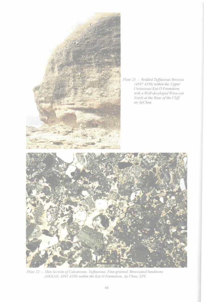
Plate 21 - Bedded Tuffaceous Breccia(4597 4558) within the UpperCretaceous Kat O Formation,\vith a Well-developed Wave-cutNotch at the Base of the Cliff,on ApChau
Plate 22 - Thin Section of Calcareous, Tuffaceous, Fine-grained, Brecciated Sandstone(HK8245, 4597 4558) within the Kat O Formation, Ap Chau; XPL
coarse-grained sandstone, cemented with a calcareous and clayey matrix. Some veins are characterized by largecrystals of calcite. Lithic clasts contain tuff, rhyolite and vein quartz and are 30 to 600 mm across. The bedding isgently dipping at 5-10° to the north. The strata are cut by minor normal faults. The calcareous minerals in the rocksare susceptible to marine erosion leading to the fonnation of sea caves, cliffs, arches and wave-cut platforms (Plate21). A large sea arch occurs at Kau Tau Shek (4563 4603), north of Ap Chau (Plate 42).
Chek Kok Tau. This headland, on the northern coast of Kat O, exposes a widespread, reddish brown breccia andoverlies pale green lapilli tuff of the Ngo Mei Chau Formation. Fine-grained detrital rocks, locally occurring nearthe base of the formation are seen only on the sea shore (4795 4614). Grey to greyish white breccia and coarsesandstone, 1.5 m thick, lie directly on the tuff, passing upwards into 1 m of grey sandy siltstone, 0.5 to 1 m ofgreyish white soft mudstone, and 1 to 2 m of greyish white sandstone. This sequence is overlain by the thicklybedded calcareous reddish brown breccia and coarse-grained sandstone that make up the rest of the headland.
PetrographyCalcareous tuffaceous breccia. Specimen HK8245 (4597 4558) (Plate 22) from Ap Chau, ispurplish red with subangular to angular clasts, dominantly 3 to 5 mm in size, with a few up to15 mm, that constitute up 75 % of the rock. Clast types include rhyolite (25 %), devitrified tuff(35 %), felsite and quartz grains (15 %). The heavy minerals are dominantly zircon and apatite,with rare rutile, tourmaline, garnet, epidote and clinopyroxene. The matrix and cement make up
25 % of the rock and consist of ash tuff, and clayey and calcareous minerals including sericite,calcite, limonite and felsitic aggregate. Calcite fills intergranular space or forms veinlets.Chemical analysis has shown that the breccia is very rich in CaO (21.24%, Table 4).
Sedimentary EnvironmentThe formation fills a small, closed, intermontane basin, surrounded by volcanic rocks, and wasdeposited mainly in a piedmont and fluvial environment, with locally-derived clasts. The reddishbrown colour and carbonate development suggest an arid palaeoclimate.
67
Table 4 - Major Element Analyses of Cretaceous Sedimentary Rocks
Element
Si02
Ti02
AI203
Fe203
FeO
MnO
MgO
CaO
Na2O
K20
P205
LOI*
Total
Pat Sin Leng Formation
White Sandstone
HK7804
Lai PakShan
(4010 3920)
82.50
0.19
9.66
1.68
0.16
0.02
0.41
' 0.07
0.00
3.50
0.03
1.64
99.81
HK8167
LukKengLamUk
(39804190)
77.96
0.24
12.81
1.70
0.08
0.02
0.54
0.06
0.00
4.42
0.00
2.04
99.87
RedSandstone
HK 9397
NgongChong Shan
(51804050)
83.84
0.19
9.18
1.67
0.08
0.03
0.28
0.07
0.00
2.85
0.04
1.58
99.78
Red Siltstone
HK7967
KwunYamYung
(4700 3970)
70.57
0.62
15.50
4.58
0.08
0.02
0.02
0.07
0.09
5.18
0.04
2.36
99.82
HK 8463
PakKokShan
(50104000)
72.45
0.64
14.86
4.45
0.08
0.02
0.42
0.08
0.06
4.38
0.04
2.27
99.76
HK9364
Shek TsaiWan
(51404070)
68.70
0.63
16.72
4.87
0.04
0.09
0.09
0.08
0.18
5.24
0.03
2.52
99.71
HK9376
Ham YueChing
(4830 4060)
71.69
0.62
14.95
4.75
0.04
0.03
0.68
0.07
0.16
4.48
0.03
2.38
99.89
Port Island Formation
Red Sandstone
HK 8045
Chek Chau
(5520 3990)
82.25
0.14
8.57
1.45
0.04
0.04
0.22
0.12
0.03
2.60
0.05
1.46
99.96
HK 8321
Shek NgauChau
(62103630)^
80.92
0.30
10.13
2.44
0.20
0.04
0.56
0.09
0.00
3.20
0.09
1.94
99.82
HK 10084
Pak ShaChau
(52104450)
75.26
0.23
8.98
1.72
0.16
0.07
0.56
4.23
0.07
3.92
0.04
4.66
99.91
KatOFormation
RedConglom.Sandstone
HK 8244
Ap Chau
(4590 4560)
45.15
0.26
8.49
2.15
0.04
0.16
0.54
21.24
0.17
2.92
0.04
19.00
100.15
Osoo
Notes: 1. LOI: Loss on ignition; mainly CO2 and H2O2. All samples were analysed by the University of Nottingham using the XRF fusion bead method

Chapter 5Intrusive Igneous Rocks
Classification
Intrusive igneous rocks are relativelt rare within the district. They comprise small exposures ofgranodionte, isolated dykes of feldspaiphyric rhyolite and quartzphyric rhyolite, and sporadicveins of aphte. These rocks have been classified on the basis of their texture (after Strange, 1984)and modal mineralogy (Figure 11). Occasional quartz veins also occur.
Whole rock major and trace element data for one sample of granodiorite (HK 8932) from TungTsz are included in Appendix 1.
GranodioriteDistribution andLithology
Medium-grained granodiorite is exposed in five areas along the southern margin of the districtand has also been recorded in several offshore boreholes. These scattered exposures form part ofa large suite of intrusions, mainly developed to the south of the district, and collectively referredto as the Tai Po Granodiorite.
The granodiorite is typically dark grey, medium grained, and porphyritic in hand specimen withprominent euhedral to subhedral alkali feldspar, subhedral to anhedral quartz and subhedralplagioclase. Biotite is present in crystal aggregates and single crystals of amphibole are scatteredthroughout the matrix.
Granodiorite intrudes block-bearing tuff and tuffite of the Shing Mun Formation to the east(369 360) and west (358 360) of Mak Uk. The host rocks are thermally metamorphosed tohomfels within 100 m of the granodiorite contact at both localities. Granodiorite also intrudesfine ash tuff of the Shing Mun Formation north (3910 3720, 3925 3730) and west of (3820 3665)Shuen Wan, and on the coast at Shuen Wan Chim Uk (3960 3610). Granodiorite is furtherexposed on the northern tip of Yuen Chau (4095 3605) in Shuen Wan Hoi (Plover Cove) and hasbeen recorded in offshore boreholes near Wong Chuk Tsuen (e.g. BHTK2/18, 41893696,BHTK2/19, 4195 3690).
PetrographyIn thin section, phenocrysts of euhedral plagioclase (10 to 40 %, 1 to 5 mm) and subordinatebipyramidal quartz (20 to 30 %, 1 to 3 mm) are set in a medium-grained granular matrix (10 to20%) of quartz, feldspar, and mafic minerals (Plate, 23. HK7876), La%e (10 fo 12 mm),subhedral megacrysts (5 to 10%) of K-feldspar (orlhoclase) typically have poikilitic rimsenclosing matrix minerals. Plagioclase (labradorite to oligoclase) phenocrysts are strongly zoned,commonly with sericitised, calcium-rich cores and sodic rims. Euhedral brown amphibole (2 %)and pleochroic green to brown biotite (3 %), frequently altered to chlorite and epidote, are thechief mafic constituents. Accessory minerals include zircon, allanite, apatite, titanite, andmagnetite.
Age RelationshipsMedium-grained granodiorite within the district has not been isotopically dated. However, itintrudes block-bearing tuff and tuffite, and fine ash crystal tuff of the Shing Mun Formation, and
69

Q = Quartz
A
P = Plagioclase feldspar(An5-An100)
M < 90%
Alkali feldspar, includingalbite (
QUARTZ SYENITE/QUARTZ MONZONITE\
Quartz trachyte / Quartz iatiteDIORITE, GAB
Andesite, Basal
SYENITE Trachyte / MONZONITE Latite
Figure 11 • General Classification and Nomenclature of Major and Minor Intrusive Rocks (afterStreckeisen, 1974)
on the basis of geochemical similarities, can be correlated with formations of the Tsuen WanVolcanic Group.
Feldsparphyric RhyoliteDistribution andLithologyDykes of feldsparphyric rhyolite have only been observed at two localities, near Pak Kok Shan(5080 3912) and at Wong Wan Tsai (4850 3770), both of which are on the northern coast ofChek Mun Hoi Hap (Tolo Channel). At both localities, the northeast-trending dyke, 5 m wide,inbrii3@3ljia^ of the Tolo Channel Formation. The feldsparphyric rhyoliteis rather weathered and consists of phenocrysts I3f euhedral a&ali feldspar and subhedral quartzin a fine-grained granular matrix.
PetrographyIn thin section, the rock is characterized by large (3 to 5 mm) euhedral to subhedral, altered,alkali feldspar phenocrysts and quartz (2 to 7 mm) phenocrysts (5 %) set in a fine intergranularmatrix dominated by quartz and feldspar. Relict biotite grains are strongly chloritised (Plate 24,HK8918).
70
Plate 23 - Thin Section ofGranodiorite (HK7876, 3810 3664), Shuen Wan; XPL
. A.Plate 24 - Thin Section ofFeldsparphyric Rhyolite Dyke (HK8918, 4873 3781), Wong Wan Tsai; XPL

Plate 25 - Quartzphyric Rhyolite Dyke(4972 3826) Intruded into Mud-stone, Siltstone and Fine-grainedSandstone of the Tolo Channel
Formation, in a Fault Zone nearFung Wong Wat on the NorthCoast ofChekMun Hoi Hap (ToloChannel)
Plate 26 - Thin Section ofQuartzphyric Rhyolite Dyke (HK2022, 35755 3787), Cloudy Hill; XPL

Quartzphyric RhyoliteDistribution and Lithology
Sporadic quartzphyric rhyolite dykes occur throughout the district, intruding a variety of volcanicand pre-volcanic lithologies, but have not been observed in Lower Cretaceous and younger clasticsedimentary rocks in the district. The dykes are generally northeast trending and generally rangein thickness from 2 to 5 m, although rarely they can be up to 60 m thick.
In hand specimen, the lithology is characterized by prominent subhedral to anhedral quartzphenocrysts and subordinate alkali feldspar phenocrysts, both of which are set in a fine-grainedgranular matrix.
The most prominent quartzphyric rhyolite dyke in the district, which is up to 60 m wide, can betraced for nearly 1 km, extends from near Kong Nga Po (320 432) towards the north-northeast(3224 4381). The dyke intrudes Carboniferous metasedimentary strata of the Mai Po Member ofthe Lok Ma Chau Formation and can be traced close to (319 429), but not apparently as far as,the thrust-faulted contact between the metasedimentary rocks and the underlying Jurassicvolcanic rocks of the Tai Mo Shan Formation. A minor dyke occurs within metasedimentaryrocks further to the southwest (3100 4260). North of the main dyke outcrop, a photolineament ofsimilar trend continues for about 1 km, albeit offset slightly to the west, and there is also a morenortheast-trending dyke (3236 4390).
The Tai Mo Shan Formation is intruded by quartzphyric rhyolite dykes at two localities. At onelocality, on the northern flank (3578 3781) of Kau Lung Hang Shan, the dyke strikes in the samegeneral direction as metamorphosed zones in the area, although its strike is slightly oblique to thenearest such zone shown on the published map (Sheet 3). The other dyke also obliquely intrudes ametamorphosed zone west (3494 3988) of Lau Shui Heung. These dykes also intrude the ShingMun Formation south of Pak Kung Au (3955 4545) and the Long Harbour Formation at ChuenLo Kok Tsui (Tide Pole Point) (5210 3690).
Dykes striking variably northeast to east-northeast, and extending for distances of up to severalhundred metres, occur at several localities between Wong Wan Tsai and Wong Chuk Kok Tsuion the northern side of Chek Mun Hoi Hap (Tolo Channel). The most laterally extensive of thesedykes intrudes black mudstone and siltstone of the Lower Jurassic Tolo Channel Formation onthe coast between Wong Wan Tsai (4890 3777) and Fung Wong Wat (4974 3827) (Plate 25).Subparallel dykes intrude the Devonian Bluff Head Formation further to the north (4844 3847,4890 3886) and northeast (5020 3930), and on the coast southeast (5270 4093) of Wong ChukKok Tsui (Bluff Head).
PetrographyIn thin section, the lithology comprises euhedral to subhedral phenocrysts (3 to 5 mm) ofbipyramidal quartz (5 to 8 %), and subhedral (1 to 3 mm), altered alkali feldspar (3 to 6%) set ina fine-grained granular matrix (85 to 90 %) of quartz, feldspar and chloritised biotite (Plate 26,HK2022). Accessory minerals in the matrix include apatite and zircon.
ApliteDistribution and LithologyThin (1-2 m) discontinuous dykes of aplite are widespread in northeastern parts of the districtwhere they mainly intrude the Ngo Mei Chau Formation at Ngo Mei Chau (5018 4309), Tui MunChau (4970 4430) and Kat 0 Chau (4911 4561,-5001 4569, 4973 4431). However, they also
73

intrude the Tai Mo Shan Formation at Chung Wan (4632 4300), Ah Rung Tsui (4304 4558) andat Plover Cove Reservoir (4334 3750). The dykes are leucocratic and aphyric with an averagegrain size of 0.5 mm. The aplite dykes generally have a northeast-southwest trend.
Quartz VeinsDetailsQuartz veins are ubiquitous throughout the district but are particularly common withinCretaceous strata. Although they can be found in any orientation, there is a tendency for them tohave a preferred north-south trend. Quartz veins are also found in association with shear zones.
74

v
Plate 27 - Well-bedded Calcareous Siltstone and Dolomitic Siltstone (6336 4445) of the Ping ChauFormation, Kan Lau Shek on Ping Chau
Plate 28 - Soft-sediment Deformation of Laminated Siltstone and Fine-grained Sandstone (6260 4490)within the Ping Chau Formation, Ping Chau

Plate 29 - Well-developed, Very Thinly Interlaminated Detrital and Chemical Cyclic Deposits of thePing Chau Formation, Nan Kao Shui (6334 4440) on Ping Chau
P/ate 30 - Aegirine-filled (with Calcite and Pyrite) Pseudomorphic Crystals, Possibly after Gypsum(6185 4570), within the Ping Chau Formation, Ping Chau
Chapter 6Cenozoic Rocks
Classification and Distribution
The Ping Chau Formation is the only Cenozoic sedimentary sequence in Hong Kong. It crops outon Ping Chau, an island of low relief, 600 m long and 200 m wide, in the northeast of Tai PangWan (Mirs Bay). Offshore, the Ping Chau Formation can be identified on boomer seismicprofiles as forming an open syncline (Figure 12). Much of the formation crops out on the seafloor or is overlain by a thin layer of of Quaternary sediments, less than 5 m thick. The formationoverlies gently-dipping, coarse-grained, sedimentary rocks of the Port Island Formation.
The Ping Chau Formation was formally defined by Peng (1978, 1983), although the sedimentaryrocks were first described by Williams (1943), who assigned them mainly to the Jurassic, andpossibly Lower Jurassic. Allen & Stephens (1971) considered the formation to be Middle toLower Jurassic. With the discovery of numerous, well-preserved fossils on Ping Chau anddetailed studies of the sequence, a late Cretaceous to early Tertiary age now appears more likely.Recent interpretations of the age include Lower Cretaceous (Zhou et a/., 1990), late Early toearly Late Cretaceous (Wu & Nau 1989; Nau et al, 1990), and Upper Cretaceous (Peng, 1983;Lee et a/., 1990a). Based on the fossil evidence now available, and interpretation of lithology,structure and palaeoclimate (Lai, 1991; Lee et aL, 1990b), Early Tertiary is preferred here.
Upper Cretaceous: Port Island Formation (Hong Kong)KPI rr Nan Xlong Formation (Shenzhen)
Figure 12 - Geological Cross-section of the Cretaceous and Tertiary Basins in Tai Pang Wan
(Mirs Bay)
77

Ping Chau Formation
The Ping Chau Formation has been divided into three members, the middle of which crops out onPing Chau, where it has been further sub-divided into three units. This lithostratigraphy(Figure 13) may be correlated with that of the nearby Shanshui Basin in Guangdong Province(Figure 14). This indicates that the middle stratigraphic member of the Ping Chau Formation isequivalent to the Second Formation of the Eocene Buxin Group.
The Ping Chau Formation consists predominantly of dark grey, thinly bedded siltstone withclayey dolomitic siltstone (Plate 27), together with a layer of chert. All of these rocks are rich indolomite, calcite and feldspar (mainly albite) with variable amounts of aegirine, zeolite, illite,quartz, pyrite, apatite, bitumen and carbonaceous matter (Peng, 1967, 1971, 1978). The strataexhibit a variety of sedimentary structures such as ripple marks, sub-aqueous and sub-aerialshrinkage cracks, cross-bedding, loading and slump structures (Plate 28), and the development ofpyrite nodules.
DetailsPing Chau. The strata on Ping Chau belong to the middle stratigraphic unit of the formation. The formation ischaracterized by thinly bedded strata. In general, each of the beds is only 2 to 6 cm wide but can be traced laterallyfor a distance of several hundred metres. Most beds are composed of very thin, alternating planar laminae, each lessthan 1 mm thick, of detrital and chemical sedimentary rocks (Plate 29). The lowest unit of the member consists ofdark grey, thinly bedded aegirine-bearing siltstone with clayey dolomitic siltstone and a layer of chert and exceed60 m in thickness. Intercalated, pale yellowish brown, dolomitic siltstone is well exposed at Cham Keng Chau (617454) and Chau Bei (625 444). There are also several thin layers containing coarse calcite aggregates that crop out atHok Ngam Teng beach (6320 4430). Calcite veinlets, 0.5 to 1 cm thick, fill minor faults at Cham Keng Chau(6180 4540). Aegirine, calcite and pyrite crystals, some possibly pseudomorphic after gypsum, occur locally (61854570) (Plate 30). Bitumenized plant remains are abundant on bedding planes or scattered within beds ascarbonaceous fragments. A large fossil tree branch, some 60 cm in length, was found at the beach near Tsau Uk(6190 4510). Sedimentary structures, including sub-aqueous and sub-aerial shrinkage cracks, ripple marks and thedevelopment of pyrite nodules are common. Cross-bedding, load structures and other forms of soft-sedimentdeformation (Plate 28) also occur. A greyish white, massive chert forms a well-defined marker bed along the westcoast (Plate 31) and creates a hard and narrow ridge about 1 m thick (Plate 32). Northwards, this horizon thins from1.2 to 0.6m.
The middle part of the member is 46 m thick, and comprises dark grey, thinly bedded siltstone with intercalateddolomitic siltstone and mudstone. Laminae within each of the siltstone beds are also very thin but contain moredetrital minerals. Pyrite is abundant, ranging in size from 0.1 mm cubic crystals to 120 mm nodules. Shrinkagecracks, cross-bedding, rain pitting prints and trace fossils (Fyfe, 1991) are present in the rocks, and fossil plants arealso abundant. A fossil palm leaf, 60 cm long and 50 cm wide, occurs at Nan Kwo Shui (6365 4445).
The upper part of the member is 92 m thick and consists of dark grey, thinly bedded, zeolite- and aegirine-bearingsiltstone (Plate 33). The zeolite-bearing siltstone is well developed along the east coast between Wong Ye Kok(627 449) and Lam Uk (627 446). The zeolite includes natrolite and analcime, and occurs as abundant,rosette-shaped crystal aggregates lying on bedding planes, or forms prismatic and granular crystal aggregates thatfill cracks and "birds eye" structures. Pyrite is present as subspherical nodules and laminae. Cross-bedding iscommon at Wong Ye Kok.
At Chau Mei Kok (623 460), the rocks display a lithofacies change to dark grey, thinly bedded calcareous anddolomitic siltstone, showing a conspicuous decrease of sodium-rich minerals (aegirine and zeolite).
Seabed West of Ping Chau. Seismic interpretation indicates that rock is exposed on the seabed within 200 m ofthe island. Further west, the Ping Chau Formation is overlain by Quaternary sediments. The seismic profilessuggest that the formation offshore comprises mainly thinly bedded, gently dipping strata that resemble thesiltstones exposed on Ping Chau. The strata offshore, estimated as being more than 150 m thick, are assigned to thelowermost member of the Ping Chau Formation. They overlie the Port Island Formation, though the nature of thecontact between the two formations is unknown.
Seabed East of Ping Chau. The upper member of the Ping Chau Formation is overlain by Quaternary sedimentsexcept near the coast, and is presumed to be dominated by siltstone. The thickness of the sequence is more than100m in this area.
78

Member LITHOLOGY
Mainly thinly bedded siltstone and dolomitic siltstone withmudstone, beneath the seabed.
Mainly dark grey thinly bedded zeolite-bearing siltstone withaegirine-bearing siltstone.
h North of Au Kung Shan, there is a lithofacies change to darkgrey thinly bedded dolomitic siltstone with calcareoussiltstone.
Dark grey thinly bedded siltstone and dolomitic siltstonewith mudstone.
Dark grey thinly bedded aegirine-bearing siltstone withdolomitic siltstone and a 1.2 m thick layer of greyish whitemassive chert.
Mainly thinly bedded siltstone and dolomitic siltstone withmudstone, beneath the seabed.
Thickness(m)
Zeolite-bearingsiltstone
Aegirine-bearingsiltstone
Calcareoussiltstone
Chert
Dolomitic siltstone
Siltstone
>100
92
46
62
>150
Mudstone
Figure 13 - Stratigraphy of the Ping Chau Formation
79

PING CHAU, HONG KONG SANSHUi BASIN, GUANGDONG(Song efa/., 1986)
£
i6
D)
£
slan
d F
orm
atio
n
1
A
E
l
.
... .-*-
ib̂
Mainly siltstone, beneath theseabed (detailed rock typeunknown)
- - - ?
Dark grey zeolite- andaegirine-bearing siltstonewith calcareous siltstone,containing bitumen
j 7
Mainly siltstone, beneath theseabed (detailed rock typeunknown)
Purplish red to brick redsandstone and siltstonewith conglomerate
_,_ ,_ ,_ ,_ ,_ ,
-"- = ~
0 0 0 0 0
. . . . ^s-
•_"-
Interbedded greyish whiteand grey sandstone,siltstone, mudstone andcalcareous mudstone
Dark grey to blackcalcareous mudstone,siltstone and marl withsome bitumen.
Interbedded reddish brownand dark grey mudstone,marl and siltstone containinggypsum.
Pale brown conglomerateand sandy conglomerate.
Purplish red siltstone,sandstone and calcareoussiltstone with conglomerate
i
8
Mudstone
- __, '— Siltstone
Calcareous siltstoneor marl
Sandstone
Conglomerate
Figure 14 - Lithostratigraphic Comparison (Not to Scale) of the Ping Chau Formation with the BuxinGroup of the Sanshui Basin, Guangdong
80

Plate 31 - Greyish White Chert within the Ping Chau Formation, Ngai Kok (6186 4577) on Ping Chau
rS^§5&^SM*se*
S^AT:
'•+**< " ,̂̂ 7
==%*: - ;̂iH :̂̂ ^^^^r^^^^:ji^ rs^^^Y^^^SyS^^
Plate 32 - White Chert, Well-bedded Calcareous Siltstone and Dolomitic Siltstone (6210 4460) of thePing Chau Formation, Lung Lok Shui on Ping Chau
Plate 33 - Thin Section ofAegirine-bearing Laminated Siltstone (HK7314, 6190 4482), within the PingChau Formation, Nam Tong on Ping Chau; XPL
Plate 34 - Thin Section of Chert with Stylolitic Horizon (HK9115, 6276 4422), within the Ping ChauFormation, Chau Tau, Ping Chau; XPL

Petrography
Dolomitic silts tone HK 7318 (6271 4486) is composed mainly of dolomite, calcite with quartz,iffite, albite and pyrite. The grain size ranges from 0.01 to 0.03 mm. The albite forms subhedralcrystals whereas the dolomite is euhedral. The rocks generally contain approximately 10 to 45%dolomite. In thin section, they are characterized by very thinly interlaminated detrital deposits,feldspathic siltstone, mudstone and carbonaceous matter, with chemical sedimentary rocks'mainly clayey dolomite. The laminae vary from 0.05 to 0.035 mm thick.
Aegirine-bearing dolomitic siltstone is dark grey and thinly bedded. It contains mainly subhedralalbite and euhedral dolomite associated with accessory calcite, illite, quartz, pyrite andcarbonaceous matter. The rock often contains 10-20 % dolomite and the grain size varies from0.005 to 0.02 mm. The most distinctive feature is the presence of 2-8 % aegirine seen in samplesHK 9107 (6183 4561) and HK 7314 (6190 4482) (Plate 33). The aegirine occurs as sheaves, orradiating aggregates, of green to bluish green needles less than 1 mm in length, which togetherwith calcite, dolomite and albite filling shrinkage cracks and 'birds eye1 structures, or denselyscattered along bedding planes. These siltstones contain Na^: 4.95-6.14 % and MgO + CaO8.27-10.02% (Table 5).
Zeolite-bearing siltstone is dark grey and thinly bedded. Each bed comprises laminae that are 0.1to 0.35 mm thick. In thin section (HK7318, 6270 4485), the main minerals are dolomite withcalcite (5-35 %), illite, albite, pyrite, asphalt and carbonaceous matter. The rock containsNa20: 4.80-5.53 % and MgO + CaO: 10.04 - 13.95 % (Table 5), while grain size is 0.005 to0.02 mm. A distinctive feature is the presence of zeolites (5 - 10 %), including natrolite andanalcime. These occur as abundant, rosette-shaped crystal aggregates lying on bedding planes, or
forming prismatic and granular crystal aggregates up to 4 mm long, filling cracks, cavities and"birds eye" structures.
Chert is greyish white, massive, and very hard with stylolitic structures (Plate 34). In thinsections HK9108 (61884576), HK7313 (62124460), and HK 9115 (62764422), it consistsmainly of anhedral intergrowths of fine to very fine-grained quartz (75-84 %), that was probablyrecrystallized from opal. Rhombs of dolomite and ankerite (5.0-9.5 %) also occur and are asecondary development of late diagenetic origin. Scattered clastic grains of albite (0.015 mm)quartz and accessory zircon form 3-6.5 % of the rock. Occasional zeolite and aegirine crystalsare dispersed throughout in dolomitic crystalline patches. The chemical composition is shown onTableS.
PalaeontologyNumerous fossils have been recovered from the Ping Chau Formation, including specimens ofsome fossil plants (Lee et a/., 1990b) and insects (Figure 15). Identifications of fossil insectmaterial of Cretaceous to Tertiary age (including one fossil specimen and 36 photographs offossils) by Q.B.Lin (Nanjing Institute of Geology and Palaeontology, Academia Sinica) confirmsthe presence of Tettigarctidae gen. et sp., Gyrinidae gen. et sp., Cicadellidae gen. et sp.,Coleoptera sp., Bibiorridae gen. et sp,, and Cupididae gen. et sp. These identifications agreewith CockerelTs original opinion (in Williams, 1943), suggesting that the age of the insect fossilOtiorhynchites mlliamsi Cockerell from Ping Chau is Cretaceous, Eocene or younger.Otiorhynchid weevils are particularly numerous and widespread in the Eocene (Williams, 1943).
A total of 35 fossil plant genera have been recognized from the Ping Chau Formation (Appendix2), including 17 angiospenns, 15 gymnosperms and 3 pteridophytes (Lee et al. 1990b). Tensporo-pollen samples were studied by the Geology Department of Zhongshan University,Guangdong Institute of Geological Sciences and Nanjing Institute of Geology and Palaeontology,
83

Table 5 - Major Element Analyses of Samples of Sedimentary Rocks from thePing Chau Formation, Ping Chau
Major Oxides
SiO2
TiO2
A1,O,
Fe2O,
MnO
MgO
CaO
Na20
K2O
P20s
LOI*
Total
Aegirine-bearing siltstone
HK7316
Tsau Uk
(61904510)
50.8
0.47
16.19
4.88
0.11
232
5.95
6.14
3.54
0.07
9.38
99.85
Zeolite-bearingsiltstone
HK 9679
Wong Ye Kok
(6270 4490)
47.05
0.35
14.41
3.76
0.1
2.34
7.7
5.53
3.76
0.12
14.69
99.81
Chert
HK7313
Lung Lok Shui
(6220 4460)
78.54
0.03
11.04
0.68
0.07
0.23
0.94
5.9
0.63
0.01
1.58
99.65
Note 1. LOI: Loss on ignition; mainly includes CO2 and H2O
2. Samples were analysed by the University of Nottingham using the XRF fusion bead method.
3. Total iron calculated as Fe2O3
Academia Sinica. Among the total of 115 genera (Appendix 3), 55 are angiosperms, 21 % aregymnosperms and 39 are pteridophytes. Angiosperms have been more dominant since the UpperCretaceous, and are especially common in the Cenozoic. Moreover, some of the macroplants suchas Sabalites sp., Cinnamomum sp., Cercis sp., Trapa sp. and sporo-pollen such as Plicapollisgranulatus, Quercordites sp., Engelhardtioidites punctatus and Ulmipollenites minor arerestricted to the Tertiary.
The sporo-pollen assemblage from the Ping Chau Formation comprises Pterisisporites,Verrutetraspora, Inaperturopallenites, Ulmipollenites, Ulmoideipites, Subtriporopollenites andPlicapollis. Palynological comparison of the Ping Chau Formation with strata in the ShanshuiBasin, Guangdong (Appendix 4) indicates that the Ping Chau Formation is similar to thePalaeogene Buxin Group but differs markedly from the Cretaceous Dalang Shan Formation,which is dominated by Pterisisporiter, Schizaeoisporites, Gabonisporis, Exesipollenites,Classopollis and Sporopollis.
84

A Otozamites sp.
B Carpolithus sp.
C Carpolithus sp.
(P129) 15mm'1 D ? Cone scale (P149) 6mm
(P145) 15mm E Tettigarctidae, gen. et. sp. cf. Liutaiprosbole sp. (P712)*2 5mm
(P135) 8mm F Gyrinidae, gen. et. sp. (DBS) 5mm
Note *1 All fossils identified by Nanjing Institute of Geology & Palaeontology, Academia Sinica.Specimen length in mm.
*2 Collected by P.S. Nau
Figure 15 - Fossil Plants and Insects from the Ping Chau Formation, Ping Chau

Sedimentary EnvironmentThe Ping Chau Formation consists mainly of calcareous siltstone with clayey dolomitic siltstoneand possesses a high sodium-rich zeolite and aegirine content. The composition of these rocksindicates that they have been deposited in a tropical to subtropical brackish water lake undersemi-arid conditions. The formation is characterized by well-developed, very thinlyinterlaminated, detrital and chemical cyclical deposits. In the detntal cycles, the presence ofcarbonaceous matter and feldspathic siltstone reflect a relatively humid period. In the chemicaldepositional cycles, the clayey carbonate rocks indicate dry periods. The interlaminated rocks areinterpreted as reflecting seasonal fluctuations of water level and salinity.
Ripple marks and cross-bedding indicate a shallow water environment whereas the rain pittingand subaerial desiccation polygons show that the surface of the sediments was subaeriallyexposed. The presence of pyrite suggests a high water table creating a reducing environment inthe sediment column. Zeolite and aegirine are considered to have crystallised during deposition ofthe sediments. Although no gypsum has been found in the rocks exposed on Ping Chau, thepossible presence of pseudomorphs after gypsum (Peng, 1971) suggest that this mineral may
have occurred.
86

Chapter 7Structure
Introduction
The major structural features of the district (Figure 16), are dominated by northeast-trendingfaults, shear zones and fold axes, with subordinate northwest- and east-trending faults. The mostlaterally extensive of the northeast-trending faults are: the San Tin Fault, a part of the LoWu-Tuen Mun Fault Zone, that extends northeast of the district to Shenzhen and Wuhua in eastGuangdong Province, and beyond into Fujian; the Sha Tau Kok Fault Zone; and the Chek MunFault Zone.
The volcanism in the district evolved in relation to the Yanshanian Orogeny, which occurredduring the Jurassic and Cretaceous, and coeval, voluminous, silicic volcanism and plutonismextended along a broad coastal belt in southeast China. The belt is also characterized bynortheast-trending folds and faults and includes structurally complex basement terranes.
Hong Kong lies within the major, northeast-trending Lianhua Shan Fault System, a part of theYanshanian orogenic belt. The fault system is characterized by numerous individual faults andshear zones, of which thrusts and sinistral strike-slip faults are the dominant components. Theytypically have curvilinear traces and are up to hundreds of kilometres long. The main faults in thedistrict are shown in Figure 16.
Earlier structural development, referred to here as Pre-Yanshanian is possibly related to theIndosinian Orogeny and are thought to have affected Palaeozoic rocks in the northwest of thedistrict. Basin development during the Cenozoic post-dated the Yanshanian orogeny, and waspossibly related to the Himalayan orogeny,
Pre-Yanshanian StructuresPre-Yanshanian structures are thought to occur in the extreme northwest of the district, affectingCarboniferous rocks of the Mai Po Member that lie within the Lo Wu-Tuen Mun Fault Zone, andin the southwest, affecting Devonian rocks of the Bluff Head Formation in the Chek Mun FaultZone. However, due to the intensity of subsequent Yanshanian structural and metamorphicoverprint, these early structures, possibly including folds with northeast-trending fold axes, arehard to define.
Yanshanian Structural DevelopmentYanshanian structural development affected the entire district during the Jurassic and Cretaceous,causing movement along northeast-trending faults, and subsidiary east- and northwest-trendingfaults within the Linhua Shan Fault Zone. Activity on these faults influenced contemporaneousvolcanism and basin development, and widespread foliation and folding also developed.
FoldsFolds in the district are commonly hard to identify as they are often obscured by intense faulting,the effects of magmatism and metamorphic overprint. Lack of exposure, especially in low-lyingareas covered by superficial deposits, also limits their identification.
87

;•;•;•;• ca ;*;«;•;•;•;•:•»
Figure 16 - Principal Structural Features of the District
88
Folds are commonly seen within sedimentary rocks of the Bluff Head Formation Alons thenorthwest shores of Chek Mun Hoi Hap (Tolo Channel), for example, they are typically close andasymmetric, and their axes trend north-northeast or northeast, but the axial zones are generallydisrupted by faulting. Open to close parasitic folds (Plate 35) also occur within the Bluff HeadFormation 200 m south of Bluff Head (5248 4119, 5262 4117, 5250 4118), on the south shore ofPlover Cove Reservoir (4602 3715, 4708 3743, 4709 3759), and at Lo Fu Wat (4660 3685) Theaxes of these minor synclines plunge variably towards 207-235°, whereas axes of minor anticlinesplunge towanlsj^^ 230°.
Folds affecting Upper Jurassic and Lower Cretaceous volcanic and interbedded sedimentaryrocks are typically open. The Cretaceous red beds, by contrast, are gently folded at most.
Faults
The main northeast and northwest fault trends (Figure 16) are well illustrated by circularhistograms (cf. Cheeney, 1983) (Figure 17). The northeast trend is dominant on Sheet 3, but onSheet 4, northwest trends are of greater importance.
Northeast-trending faults are the most laterally continuous structures onshore in the district. Theyvary in strike between 040-060° and include the San Tin Fault, and the Sha Tau Kok Fault Zone.The Chek Mun Fault Zone, which lies just offshore in Chek Mun Hoi Hap (Tolo Channel), isalso of similar trend. The other main structure onshore is the Tiu Tang Lung Thrust which trendsnearly east-west. Major northwest-trending faults mainly occur offshore in the east of the district,and include the Kat 0 Chau Fault on the southwest side of the Tai Pang Wan (Mirs Bay).
Fault activity was complex and constraining the time of individual phases of movement is, inmany cases, uncertain. The main faults were reactivated during both congressional andextensional phases and the northeast-trending faults show evidence of both vertical andhorizontal displacements. Zones of dynamic metamorphism, including foliated, schistose,mylonitized, brecciated and cataclastic rocks, are also typical of the fault zones. Generally, theductile shear fabrics can be interpreted as having formed in deeper crustal environments, possiblyat the end of the late Jurassic and early Cretaceous, whereas brittle structures mainly developedat a later stage, during or after the early Cretaceous.
Northeast-trending FaultsThe main northeast-trending faults in the district (Figure 16) are the San Tin Fault in thenorthwest, the Sha Tau Kok Fault Zone, the Shuen Wan Hoi Fault Zone, and the Chek MunFault Zone. The San Tin Fault is a moderately inclined thrust, but by contrast, the other mainnortheast-trending fault zones in the district are very steeply inclined.
San Tin Fault, The San Tin Fault (Figure 18) occurs in the northwest of the district, where itextends from Fu Tei Au Road (3041 4180) through Cheung Po Tau (3145 4244) to west of PakFu Shan (3462 4645). To the southwest of Cheung Po Tau this fault trends 050°, and dipsnorthwest at angles varying from 20-32°. The fault has thrust Carboniferous sedimentary stratasoutheast over Jurassic tuff of the Tai Mo Shan Formation. This relationship is exposed inroadside sections (3040 4180) on the Fu Tei Au Road, and south of a service reservoir at CheungPo Tau (3146 4244). Northeast of Cheung Po Tau the fault trend changes to 040°, although itcontinues to dip to the northwest. From Chow Tin Tsuen (3300 4404), southwest of Pak FuShan, the fault runs along the Shum Chun River and extends thereafter into the Shenzhen area.Tuff in the footwall of the fault, on its southeast side, is mylonitized within a zone ranging fromtens of metres to one kilometre wide. This zone grades laterally into a slightly sheared zone that
89

3, 4 whole area 3NWn=358.34 n=52.22
3NEn-34.02
3SWn=41.74
3SEn=31.90
4NWn=53.40
4NEn=6.12
4SWn=107.27
4SEn=31.23
Figure 17 - Circular Histograms of Orientation and Length of Faults for the District. Histograms AreShown by Sheet Number; the Total Length of Each Fault Is Plotted in Kilometres (afterCheeney, 1983)
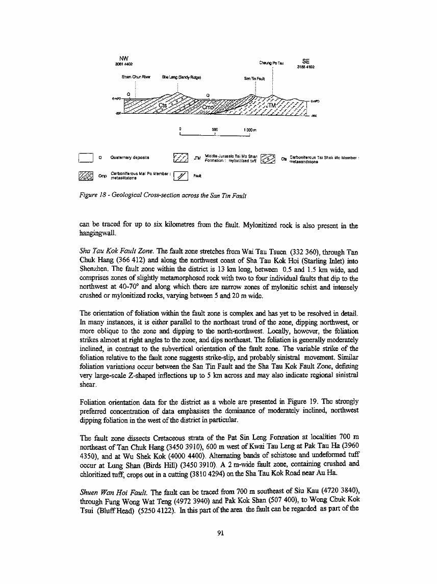
NW3061 4402
Sham Chun River Sha Leng (Sandy Ridge)
500 1000mI
Q Quaternary deposits Middle Jurassic Tai Mo ShanFormation : mylonitized tuff
Carboniferous Tai Shek Mo Membermetasandstone
Carboniferous Mai Po Member :Cmp rnetasiltstone
-_,,,.Fault
Figure 18 - Geological Cross-section across the San Tin Fault
can be traced for up to six kilometres from the fault. Mylonitized rock is also present in thehangingwall.
Sha Tau Kok Fault Zone. The fault zone stretches from Wai Tau Tsuen (332 360), through TanChuk Hang (366 412) and along the northwest coast of Sha Tau Kok Hoi (Starling Inlet) intoShenzhen. The fault zone within the district is 13 km long, between 0.5 and 1.5 km wide, andcomprises zones of slightly metamorphosed rock with two to four individual faults that dip to thenorthwest at 40-70° and along which there are narrow zones of mylonitic schist and intenselycrushed or mylonitized rocks, varying between 5 and 20 m wide.
The orientation of foliation within the fault zone is complex and has yet to be resolved in detail.In many instances, it is either parallel to the northeast trend of the zone, dipping northwest, ormore oblique to the zone and dipping to the north-northwest. Locally, however, the foliationstrikes almost at right angles to the zone, and dips northeast. The foliation is generally moderatelyinclined, in contrast to the subvertical orientation of the fault zone. The variable strike of thefoliation relative to the fault zone suggests strike-slip, and probably sinistral movement. Similarfoliation variations occur between the San Tin Fault and the Sha Tau Kok Fault Zone, definingvery large-scale Z-shaped inflections up to 5 km across and may also indicate regional sinistralshear.
Foliation orientation data for the district as a whole are presented in Figure 19. The stronglypreferred concentration of data emphasises the dominance of moderately inclined, northwestdipping foliation in the west of the district in particular.
The fault zone dissects Cretaceous strata of the Pat Sin Leng Formation at localities 700 mnortheast of Tan Chuk Hang (3450 3910), 600 m west of Kwai Tau Leng at Pak Tau Ha (39604350), and at Wu Shek Kok (4000 4400). Alternating bands of schistose and undeformed tuffoccur at Lung Shan (Birds Hill) (3450 3910). A 2 m-wide fault zone, containing crushed andchloritized tuff, crops out in a cutting (3810 4294) on the Sha Tau Kok Road near Au Ha,
Shuen Wan Hoi Fault The fault can be traced from 700 m southeast of Siu Kau (4720 3840),through Fung Wong Wat Teng (4972 3940) and Pak Kok Shan (507 400), to Wong Chuk KokTsui (Bluff Head) (52504122). In this part of the area the fault can be regarded as part of the
91

Sheet 3 Sheet 4
For Joints
Figure 19a - Equal-area Point Plots for Joints in Volcanic Rocks of the District
For Foliation
Figure 19b - Equal-area Point Plots for Foliation in Volcanic and Sedimentary Rocks in theNorthwest of the District
92

Plate 35 - Anticline, Plunging Northeast, in Sandstone and Siltstone of the Bluff Head Formation, onthe Coast (5250 4118) South of Wong Chuk Kok Tsui (Bluff Head)
Plate 36 - Fault Zone (52504122), 1.5m Wide, Separating Sandstones of the Devonian Bluff HeadFormation (to the Left) from Coarse Ash Tuff of the Upper Jurassic Tai Mo Shan Formation(to the Right), Wong Chuk Kok Tsui (Bluff Head)
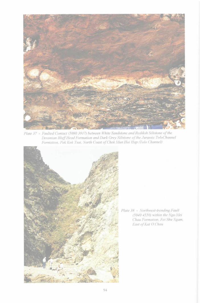
Plate 37 - Faulted Contact (5080 3917) between White Sandstone and Reddish Siltstone of theDevonian Bluff Head Formation and Dark Grey Siltstone of the Jurassic ToloChannelFormation, Pak Kok Tsai, North Coast ofChekMun Hoi Hap (Tolo Channel)
Plate 38 - Northwest-trending Fault(5040 4550) within the Ngo MelChau Formation, Fei Shu Ngam,East ofKat O Chau
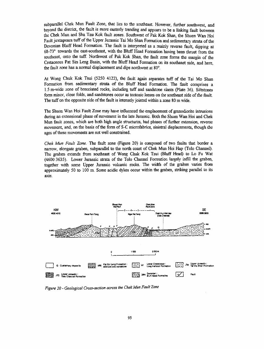
subparallel Chek Mun Fault Zone, that lies to the southeast. However, further southwest, andbeyond the district, the fault is more easterly trending and appears to be a linking fault betweenthe Chek Mun and Sha Tau Kok fault zones. Southwest of Pak Kok Shan, the Shuen Wan HoiFault juxtaposes tuff of the Upper Jurassic Tai Mo Shan Formation and sedimentary strata of theDevonian Bluff Head Formation. The fault is interpreted as a mainly reverse fault, clipping at68-73° towards the east-southeast, with the Bluff Head Formation having been thrust from thesoutheast, onto the tuff. Northwest of Pak Kok Shan, the fault zone forms the margin of theCretaceous Pat Sin Leng Basin, with the Bluff Head Formation on its southeast side, and here,the fault zone has a normal displacement and dips northwest at 80°.
At Wong Chuk Kok Tsui (5250 4122), the fault again separates tuff of the Tai Mo ShanFormation from sedimentary strata of the Bluff Head Formation. The fault comprises a1.5m-wide zone of brecciated rocks, including tuff and sandstone clasts (Plate 36). Siltstonesform minor, close folds, and sandstones occur as tectonic lenses on the southeast side of the fault.The tuff on the opposite side of the fault is intensely jointed within a zone 80 m wide.
The Shuen Wan Hoi Fault Zone may have influenced the emplacement of granodiorite intrusionsduring an extensional phase of movement in the late Jurassic. Both the Shuen Wan Hoi and ChekMun fault zones, which are both high angle structures, had phases of further extension, reversemovement, and, on the basis of the form of S-C microfabrics, sinistral displacements, though theages of these movements are not well constrained.
Chek Mun Fault Zone. The fault zone (Figure 20) is composed of two faults that border anarrow, elongate graben, subparallel to the north coast of Chek Mun Hoi Hap (Tolo Channel).The graben extends from southeast of Wong Chuk Kok Tsui (Bluff Head) to Lo Fu Wat(4600 3635). Lower Jurassic strata of the Tolo Channel Formation largely infill the graben,together with some Upper Jurassic volcanic rocks. The width of the graben varies fromapproximately 50 to 100 m. Some acidic dykes occur within the graben, striking parallel to itsaxis.
Shuen WanHoi Fault
1000
i2000m
I
Q Quaternary deposits
Lower Jurassic :Tolo Channel Formation
Pat Sin Leng Formation :siltstone and sandstone
pY/sVl m Lower Cretaceous :Ffe-J Long Harbour Formation
nau Devonian :u n Bluff Head Formation
R/Tvl JTM i#pt8/ J^asslc : „LbL^J Tai Mo Shan Formation
Figure 20 - Geological Cross-section across the Chek Mun Fault Zone
95

The fault between the Devonian Bluff Head and Tolo Channel formations is a high angle reversefault, dipping northwest at angles varying from 82°, at 100 m south of Fung Wong Wat, to 85°,500 m south of Pak Kok Shan (Plate 37). The fault also shows evidence of sinistral movement.Sedimentary strata of the Bluff Head Formation are steep to overturned adjacent to the faultzone, but further away from it, they are inclined more gently (30-50°) and are cut by strike-slipfaults parallel to the main fault zone.
Northwest-trending FaultsNorthwest-trending faults (trend varying to north-northwest, Figure 16), including the Chek Chauand Kat 0 Chau faults, have a high angle of dip and contain narrow crush zones. Generally, theydisplace the more laterally continuous northeast-trending faults. During the late Jurassic, somenorthwest-trending faults acted as conduits for fissure-controlled volcanism. They also controlledthe margins of late-Yanshanian sedimentary basins (see below) during the Cretaceous and asmall post-Yanshanian basin during the Tertiary, indicating that they were dominantly normalfaults during this time. Elsewhere in the Territory, there is evidence of significant dextral andoccasionally sinistral displacement along faults of this orientation, but within the district, there islittle constraint on lateral movement.
Kat O Chau Fault. The fault trends 310° and can be traced from Sham Chung (4823 4460) onKat 0 Chau, passing west (4972 4368) of Hung Fa Leng on Ngo Mei Chau (Crescent Island)and offshore along Chik Mun Tau Channel to the west of Chek Chau. A 2 m-wide brecciatedzone can be seen within the fault onshore on both sides of Wang Mun Hoi Channel (4973 4365,and 4948 4383). Aplite dykes have been intruded along the fault at Wong Kok Teng (49474386) and on the east shore (4824 4457) of Sham Chung on Kat 0 Chau. Complementarynorthwest-trending faults occur parallel to the southwest coast of the Taipang Peninsula atXiasha. Minor northwest-trending faults on the east side of Kat O Chau (Plate 38) and east ofPak Kok Shan (5080 3980) offset northeast-trending faults. An aplite dyke has been intrudedparallel to these faults at Chung Wan Teng (5020 4560) on Kat O Chau.
Chek Chau Fault. The Chek Chau Fault can be clearly detected on seismic reflection profiles,lying offshore to the east of Kai Kung Tau (507 456) on Kat 0 Chau (Crooked Island). Towardsthe southeast, it passes west of Pak Sha Chau (Round Island) and east of Chek Chau. The fault,which trends 310° and is downthrown on its northeast side, forms the bounding margin of the TaiPang Wan Basin.
East-trending FaultsEast-trending faults include (Figure 16) the Tiu Tang Lung Thrust in the centre of the district,and the Ap Chau Fault.
The Tiu Tang Lung Thrust (Figure 21) trends roughly east-west across the central part of thedistrict, westwards from Kwai Tau Leng (3771 4063), to Luk Keng (4000 4227), Wu Kau Tang(4352 4115), and south of Tiu Tang Lung (4468 4098) towards Wong Wan Chau (DoubleIsland) in the east. The southerly-directed thrust, dips northward at a low angle, and hasemplaced Upper Jurassic volcanic rocks onto red beds of the Lower Cretaceous Pat Sin LengFormation (Figure 21).\The southerly direction of thrust movement is broadly consistent withnorth and northeast-plunging elongation lineations seen in the footwall of the thrust and towardsthe base of the overlying hanging wall bloclc) The southerly movement sense is also consistentwith evidence of sinistral displacements on tile main northeast-trending fault zones in the district. )The thrusting could post-date the Lower Cretaceous. However, it is also possible that the Pat SinLeng Formation was deposited in a basin (the Pat Sin Len Basin, Figure 16), at the toe of thethrust, and this basin was continuously overridden by the thrust as it advanced.
96
fci Ap Chau Basin
4450 4764 '
KKO Kat 0 Formation : breccia KPS P*J fin Len9 Formation : FVv] JTM Tai Mo Snan fVvi Sai Lau Kong^^ s.ltstone and sandstone k'f-\J J1M Formation: tuff KvJ JSK Formation : dacite lava
Fault breccia U>̂ n Mylonitized zone I e/^j Fault
Figure 21 - Geological Cross-section across the Cheung Pai Tau and Tiu Tang Lung Faults
The Ap Chau Fault trends 098°, dipping north at 48-62°, and extends eastwards from CheungPai Tau (Ledge Point), passing to the south of Ap Chau and to the north of Kat 0 Chau. Thefault downthows the Kat 0 Formation against dacite of the Upper Jurassic Sai Lau KongFormation. A crush zone is developed along the fault and is 5 to 10 m wide generally. Locally,the fault is up to 45 m-wide and contains brecciated and silicified block-bearing lapilli tuff,raising the possibility that the fault had also acted as a conduit for volcanism. The lithic clastsinclude Upper Jurassic tuff and lava and Permian limestone.
Sedimentary BasinsThe three sedimentary basins identified in the district are thought to have formed during the lateYanshanian and Himalayan orogenies. They are (Figure 16) the Lower Cretaceous Pat Sin LengBasin, which is preserved mainly onshore, and the Upper Cretaceous Tai Pang Wan and ApChau basins, both of which are preserved largely offshore. The Cenozoic Ping Chau Formationoverlies the Upper Cretaceous sedimentary rocks of the Tai Pang Wan Basin, without anymarked stratigraphic break. However, it is uncertain whether the Ping Chau Formation is theyoungest manifestation of Yanshanian orogeny in the district or, as is more likely, a consequenceof Himalayan orogeny.
Pat Sin Leng Basin. The basin is fault-bounded with the southern boundary occurring along afault stretching southwest from Wong Chuk Kok Tsui (Bluff Head) to Siu Kau, Ma Shi Chauand possibly beyond. The Sha Tau Kok Fault Zone truncates the basin on its west side. Someisolated outcrops of Pat Sin Leng Formation red beds occur within the fault zone, e.g. cappingthe hill south of Hoi Bei Leng (3900 4280), at Pak Tau Ha (3960 4350), at Wu Shek Kok (40004390), and 0.8 km east (3705 4132) of Tan Chuk Hang. On the north side of the basin, the redbeds are overlain along the Tiu Tang Lung Thrust by the Upper Jurassic Tai Mo Shan Formation
(Figures 16 and 21),
Tai Pang Wan Basin. Sedimentary strata within this basin include the Upper Cretaceous PortIsland Formation, exposed on Pak Sha Chau (Round Island), Chek Chau (Port Island), and ShekNgau Chau, and the Cenozoic Ping Chau Formation, exposed on Ping Chau. Lithofacies on bothmargins of the basin indicate deposition as piedmont alluvial fans onto an intermontane plain,
97
while at the centre of the basin, deposition was within a brackish water lake. The Chek ChauFault, which trends 130° and is downthrown on its northeast side, forms the bounding margin ofthe Tai Pang Wan Basin (Figure 12),
Cenozoic strata form a very gentle syncline beneath Tai Pang Wan (Mirs Bay), with stratadipping at 5-20° (Figure 12). The Cenozoic basin, which is approximately 10 km long and istruncated on its northeast side by a northwest-trending fault, is less than that of the underlyingUpper Cretaceous basin. The depositional centre of the Cenozoic basin is approximately at PingChau, and the basin as a whole is interpreted as an asymmetric half-graben.
Ap Chau Basin, This basin is situated on the northern side of Kat 0 Hoi (Crooked Harbour), andextends from Cheung Pai Tau (Ledge Point) (4438 4556) to Ap Chau and North Point on Kat 0Chau (Crooked Island), a distance of 5 km. The basin contains reddish brown calcareous brecciaof the Upper Cretaceous Kat 0 Formation and is bounded by east-trending faults. Of these, theAp Chau Fault is the southern marginal fault of the basin.
Joints
In general, joints are much more pronounced in the volcanic rocks than in the older sedimentaryrocks. Joint orientation data for the district as a whole are presented in Figure 19a, but data areinsufficient to define consistent joints sets for the district as a whole.
98

Chapter 8Metamorphism & Alteration
Introduction
Metamorphism comprises a broad spectrum of fluid, thermal, and mechanical processes whichchange the primary chemistry, mineralogy and texture of rocks. Alteration processes are similar,but involve less extreme physical and chemical gradients, and are usually more localised'However, there is no clear demarcation between metamoiphism and alteration, and they can beregarded as end-members of a continuous spectrum. Superficial weathering also altersmineralogy and chemistry, but its effects are more appropriately described in Chapter 9, withinthe context of other surface processes and involving low temperature fluids as opposed to thehigh temperature fluids typically associated with hydrothermal alteration and metamorphism.
Dynamic metamorphism is the most commonly recognised form of metamorphism in the districtand its development is extensively shown on the published 1:20 000 scale maps (Sheets 3 and 4),mostly designated as slightly metamorphosed rock, but more locally as schist or mylonite. Thesevariably deformed rocks are most widespread in the northwest of the district where they oftenoccur in northeast- and east-trending zones affecting the Upper Jurassic volcanic rocks of the TaiMo Shan Formation. Given the widespread occurrence of dynamic metamorphism affectingCarboniferous and Jurassic rocks, it could be regarded as form of regional metamorphism but ithas been preferred to emphasise the specific association with faulting in this account. Regionalmetamorphism is however described in relation to low grade metamorphism observed inDevonian sedimentary rocks in the area.
In most parts of the district, intrusive igneous rocks are uncommon and typically comprise onlysmall-scale dykes. Consequently, contact metamorphism associated with these intrusions isinsignificant at the scale of the published maps. However, in the south of the district, a morewidespread area of contact metamorphism, developed around a granodiorite intrusion, is shownon Sheet 3.
Limited hydrothermal alteration is probably widespread within the district, especially in thevicinity of volcanic centres, intrusions, faults and shear zones. However, the effects ofhydrothermal alteration are hard to distinguish, particularly from those of dynamic and contactmetamorphism. As a result, no attempt has been made to distinguish areas of hydrothermalalteration on the published maps. The most significant hydrothermal alteration observed in thedistrict occurs in, and around the Lin Ma Hang Mine, on the northern border of the Territory inthe northwest of the district.
Dynamic MetamorphismDynamic metamorphism encompasses a wide spectrum of deformational features, the mostcommon of which in the district are foliation, schistosity and the development of myloniticfabrics. Areas of slightly metamorphosed rock, characterized by foliation, are common to thenorthwest of the Sha Tau Kok Fault Zone. The foliation results from the preferred alignment ofmainly micaceous minerals, due to their physical rotation, and growth of secondary minerals(especially sericite and biotite). The foliation occurs mainly in zones that strike variably northeastto east-northeast. Where foliation occurs, the rocks tend to erode preferentially, forminglow-lying topography bounded by ridges composed of relatively undeformed rocks. The foliation
99
within these slightly metamorphosed areas mostly dips at moderate angles (20-65°, althoughlocally foliation is subvertical) to the northwest or north-northwest.
In the extreme northwest of the district, the foliation becomes more schistose and mylonitic andtends towards subparallelism with the base of the San Tin Fault, which comprises dynamicallymetamorphosed mylonitic schists dipping at about 30° to the northwest. Foliation also occurs inthe hanging wall of the fault, within the Carboniferous sedimentary rocks of the Lok Ma ChauFormation, which comprises metasandstones, metasiltstones, phyllites, metaconglomerates andgraphite schists. These rocks could all be regarded as the product of regional metamorphism butsimilar Carboniferous sedimentary rocks in adjoining areas of Guangdong Province lying beyondthe main zones of faulting and shearing are not metamorphosed. This suggests that themetamorphism is more local and dynamic than regional. Although similar metamorphism in theadjoining district to the west was described as regional metamorphism by Langford et al, (1989),they also considered that the metamorphism was primarily associated with thrusting, i.e. dynamicmetamorphism, albeit on a very large scale. The foliations in the hanging wall and footwall of theSan Tin Fault are presumed to be of the same age. As the youngest formation affected by thedynamic metamorphism along the San Tin Fault Zone is the Tai Mo Shan Formation, of middleor late Jurassic age, the metamorphism probably occurred during or after the late Jurassic.
Foliation associated with fault development is seen in zones near the base of the shallowlynorthward-dipping Tiu Tang Lung Fault in the centre of the district. Mylonitic schists are alsodeveloped near the base of the hanging wall of the fault, within Upper Jurassic rocks of the TaiMo Shan Formation. Foliation also occurs in zones, particularly within fine-grained sedimentarylithologies, subparallel to the Shuen Wan Hoi Fault and the Chek Mun Fault Zone, both in thesoutheast of the district.
Regional MetamorphismAllen & Stephens (1971) considered that regional metamorphism was of greater significance inthe Territory than had been previously suspected. They considered that the Carboniferous LokMa Chau Formation had been regionally metamorphosed during the Mesozoic, but prior togranitoid emplacement. Bennett (1984b) interpreted the regional metamorphism of the Lok MaChau Formation as greenschist facies and also suggested the possibility that the formation couldhave been metamorphosed at an earlier date, before it was tectonically emplaced during theJurassic. However, within the district all the observed metamorphic effects are attributed todynamic metamorphism.
Regional metamorphism is a more appropriate interpretation of the low grade metamorphismevident in the Bluff Head Formation sedimentary rocks in the southeast of the district. Thedevelopment of preferred metamorphic fabrics is generally restricted to finer-grained lithologies,including siltstones and mudstones. The age of the metamorphism is uncertain but is consideredto be of Triassic age (Indosinian), as comparable mineralogical changes are not seen in LowerJurassic sedimentary rocks of the Tolo Channel Formation in the same area.
Hydrothermal AlterationHydrothermal alteration including silicification, carbonatization, the development of quartz veins,and recrystallization is evident locally, in relation to faults, shear zones, volcanic centres andproximity to intrusions. However, it is not generally widespread, nor is it intensely developed.The only significant hydrothermal alteration recognised in the district is seen in and around areasof lead-zinc mineralization centred on the Lin Ma Hang Mine in the northwest of the district.Quartz veins, trending mainly northwest-southeast, and to a lesser extent northeast-southwest, are
100

sporadically developed. These two trends are parallel to the main fault trends in the district, andevidence of fluid migration causing silicification and greisenization within and near to faults andshear zones is common. Hydrothermal alteration would inevitably have been associated with thedominant dynamic metamorphism in the northwest of the district, but its effects are virtuallyimpossible to differentiate.
Thermal (Contact) MetamorphismThermal (contact) metamorphism related to emplacement of granodiorite intrusions and rhyoliticdykes is locally developed, but is rarely sufficiently extensive to be shown on the published mapsof the district. There are, however, zones of thermal metamorphism, west and south-southeast ofFung Yuen Lo Tsuen in the extreme southwest of the district, related to emplacement of agranodiorite intrusion in the south of the district. The hornfelsing and recrystallization haveaffected block-bearing tuff and tuffite of the Shing Mun Formation.
101

Chapter 9Superficial Geology
IntroductionSuperficial deposits are those sediments that have not generally been lithified. The onshore andoffshore superficial deposits of the district are described separately. For the purposes of thismemoir, the boundary between onshore and offshore deposits is taken, regardless of their modeof occurrence, at the pre-reclamation or natural coast, low water line. Beaches, estuarine depositsand mud flats' of the intertidal region are treated as onshore deposits. Relationships between thevarious types of superficial deposits are shown in Figure 22, all of which are believed to haveformed during the Quaternary period. The most important onshore superficial deposits in thedistrict are alluvial and slope deposits, the latter being generalised as debris flow deposits on thepublished 1:20000 scale geological map sheets 3 and 4. These sediment types also occuroffshore, usually beneath marine deposits.
This chapter also includes an account of the weathering products of both the common rock typesand superficial deposits.
AlluviumEstuarine and intertidal deposits
Beach deposits - sandBeach deposits - cobbles and boulders
QHH Hang Hau Formationms Marine sand in QHH
Slope deposits
Talus
Qpa Terraced alluviumQpd Slope depositsQCK Chek Lap Kok Formation
Rock and
weathered rock
Figure 22 - Schematic Section Relating Onshore to Offshore Superficial Deposits in the District
102

Onshore Superficial Deposits
Classification and Distribution
The onshore superficial deposits of the district comprise mainly alluvial, slope (including debrisflow), estuarine, and intertidal deposits of Pleistocene and Holocene age. Alluvium is widespreadalong the Sham Chun and Ng Tung Ho (River Indus) river valleys in the west and northwest ofthe district, forming extensive floodplains. Debris flow and other slope deposits, commonly occurtopographically above the alluvium on valley sides, and in isolated upland areas. Both the alluvialand debris flow deposits are composed of clay, silt, sand and gravel in varying proportions, butthe debris flow deposits usually contain, in addition, subangular to angular cobbles and boulders.Talus or rockfall deposits, dominantly composed of angular blocks, have a very limiteddistribution, occurring only below freefaces on the steep slope south of Ping Fung Shan. Thethickest Quaternary superficial deposits occur along the Ng Tung Ho (River Indus) valley, on theFanling and Sheung Shui plains (Figure 23).
Beach deposits, usually comprising sand with gravel, have accumulated in sheltered embaymentsof the deeply indented and rocky coastlines in the east of the district. Storms have createdelevated beaches of sand and gravel, and even boulders, up to a height of 10 mPD.
Small areas of reclamation on the Sheung Shui and Fanling plains, and at Sha Tau Kok andShuen Wan, and onshore fill deposits are shown on the published geological maps (sheets 3 and4).
Alluvium
Alluvium is widespread along the Sham Chun and Ng Tung Ho (River Indus) valleys andparticularly on the Sheung Shui and Fanling plains. It is rarely exposed in section, but has beenwidely observed in investigation boreholes and construction caissons. The deposits consist mainlyof well-sorted to semi-sorted clay, silt, sand and gravel, and are variably grey to reddish brown,depending on the nature and proximity of the bedrock source.
Alluvial deposits of two ages have been recognised: Pleistocene deposits form several extensivefluvial terraces that can be subdivided, primarily on relative age criteria supported by severalradiocarbon and Optically Stimulated Luminescence (OSL) dates, into lower and upper unitswhile Holocene alluvium occurs mainly along the narrow courses of recent steams incised into theterraced surface.
The lower unit of the fluvial terrace deposits is typically mottled red and brown and supportsboulders and cobbles with a weathered surface rind. These deposits are largely restricted toelevated fluvial terraces. The surface elevation of these deposits ranges from 33.7 mPD inland to-2 mPD towards the coast. The lower unit is from early late to middle Pleistocene in age (OSLage 84 700 to 157 000 years BP, Table 6). They are always overlain by late Pleistocene alluviumand, or debris flow and other slope deposits, and have been classified as Pleistocene alluvium onthe 1:20 000 scale published geological maps (sheets 3 and 4).
Lithofacies of the late Pleistocene fluvial terrace deposits vary across the district. Near the basesof slopes and in upper valley sections, these deposits may pass imperceptibly into late Pleistocenedebris flow deposits. The upper unit of the terrace deposits consist mainly of semi-sorted,yellowish to orangish brown, gravelly silty sand containing pebbles and cobbles (Plate 39),intercalated with layers of dark grey organic mud that may represent lacustrine or marshsediments. On distal plains, fluvial terrace deposits are characterized by well-sorted clayey sandy
103

832
SHENZHEN SPECIAL ECONOMIC ZONE
|TA KWU LING
.,"k
844-
840-
838-
0 - 5m thickness
5 - 10m thickness
> 10m thickness
836
Figure 23 - Thickness of Quaternary Superficial Deposits between Lo Wu and Fanling
104

silt with some sand layers. The deposits are commonly from 3 m to 6 m thick. Radiocarbon
dating of organic mud from Wong Kong Shan (3270 3890) and Lin Wo Hui (3266 3968) on theFanling plain has given ages of between 10 160 ± 340 to 23 950 ± 530 years BP, indicating a latePleistocene age (Table 6). A typical profile of this sediment occurs 150 m west of Wong KongShan near Fanling (see below).
Most of the areas of Holocene alluvium (610 ± 50 to 2 250 ± 90 years BP; Table 6) are relativelylow-lying, being between 5 and 10 mPD, and most are also narrow, incised by between 0.5 m and3 m, into the surrounding Pleistocene terraced alluvium. The deposits comprise semi-sortedsubrounded boulders and gravelly sand in upper stream courses, and yellowish brown,well-sorted silty sand or clayey silt in lower courses. In places along the coast in the east of thedistrict streams are dammed by sand bars or spits, behind which lagoon or back shore depositshave formed.
Table 6 - Radiocarbon and Optically Stimulated Luminescence Dates fromQuaternary Deposits in the Northeastern New Territories
SamplesNumber
HK 11980
HK11979
HK 11978
HK 3744
HK3734
HK 3748
HK 3703
HK 3735
HK 9379
HK9380
Location
Fanling Center
Fanling Center
Fanling Center
Wong Kong Shan,
Fanling
Wong Kong Shan,
Fanling
Lin Wo Market,
Fanling
Po Leng, Fanling
Wong Kong Shan,Fanling
Chim Uk, Tai Po
Chirn Uk, Tai Po
Grid
Reference
3273 2898
3273 2898
3273 2898
3269 3863
32703890
3263 3972
31303880
3270 3890
3943 3608
3943 3608
Landform
Alluvial terrace
Alluvial terrace
Alluvial terrace
Alluvial plain
Alluvial plain
Alluvial plain
Alluvial plain
Alluvial plain
Mud flat
Mud flat
Sample Type
Silty sand with
cobbles
Silty sand with
cobbles
Silty sand with
cobbles
Organic mud
Organic mud
Organic mud
Organic mud
Organic mud
Marine mud
Shell fragment
Depthm
5,5
4.8
4.3
2.1
2.35
2
3.5
1.9
1.55
1.55
ElevationmPD
10.29
10.99
11.49
11.3
11.05
9
15
11.5
-0.5
-0.5
C14 age yearsBP
-
-
-
23,950±530
22,780±530
10,160±340
2,250±90
2,100±90
610±50
610±50
OSL ageyears BP
157,500±36,300
>50,000±14,000
84,700±16,300
-
-
-
-
-
Note : Radiocarbon (C14) samples analysed by the Guangdong Institute of Geological Sciences,Guangzhou, ChinaOptically Stimulated Luminescence (OSL) dating by Institute of Earth Studies,University of Wales, U.K.
DetailsNg Tung Ho (River Indus). At San Wai (3310 4084), the river is fed by two tributaries. One rises on Pat Sin Lengand Hung Fa Leng (Robin's Nest), the other in the Lam Tsuen Valley. The Lam Tsuen River was divertedsoutheastwards from the Lam Tsuen Valley to Tai Po Hoi (Tolo Harbour) by river capture, leaving a river terraceup to 800 m wide, formed of Pleistocene alluvium. Entrenched within the older terrace is a recent stream course,5 m wide, that forms a restricted Holocene alluvial deposit. Two sedimentary units have been recognised in thePleistocene river terrace. The upper unit is composed of pale grey, fine to medium sand and clay, and the lower unitcomprises dark yellowish brown coarse sand, gravel and boulders. Variations in the character of the alluvialdeposits of the Ng Tung Ho downstream from Hong Lok Yuen to Lo Wu are as follows:
105
--Tai Po Road (3338 3595) near Hong Lok Yuen: mainly the lower alluvial unit, 2 to 5 m thick, is present,comprising dense mottled red, yellowish brown and grey sandy, clayey silt with subrounded gravel, cobblesand boulders, some between 300 to 500 mm across. The clasts include completely decomposed aplite,highly to completely decomposed granodiorite and moderately to slightly decomposed tuff. A weatheredrind of up to 30 mm thick is present on many of the boulders. Thermoluminescence dating of two samplesfrom these sediments has given ages of 40 800 ± 3 300 years BP and 76 300 ± 6 200 years BP.
- Tai Hang to Kiu Tau: the alluvium is 5.5 to 7.5 m thick. In Borehole RDH6/GKJ3385 (3387 3771) theupper unit is a silty clay, 2.4 m thick, and the lower unit a reddish brown gravel and cobble bed, 5.6 mthick.
— Wong Kong Shan near Fanling Centre (3274 3898): boreholes, caissons, and trial pits reveal that thePleistocene alluvium is 7 m to 9.8 m thick, and is overlain by 1 m to 3 m of fill. The upper unit contains 2.3to 4 m of dark grey to black organic mud that has given radiocarbon dates of 22 780 ±530 years BP and23 950 ± 530 years BP, and 1-2 m of medium dense, reddish brown, clayey, silty, fine to coarse sand withgravel and cobbles; the lower unit comprises 1-2 m of cobbles and boulders, ranging from 20 to 600 mm indiameter. The matrix is silty and sandy. OSL dates from the lower unit range from 84 700 +16 300 to 157500 + 36 300 years BP.
- Lung Yeuk Tau: In boreholes F4105A (3330 4005) and F4108/GIU3067 (3325 3993) the alluvium variesfrom 5.5 to 5.8 m thick. The upper unit comprises 2.5 m of loose, grey, silty, medium to fine sand , overlainby an intermittent layer, up to 2.2 m thick, of dense, yellowish brown, sandy silt. The lower unit comprises1.1 to 2.9 m of gravel, cobbles and pebbles in a silty coarse sand matrix.
- Luen Wo Hui, Fanling: In borehole F4111/GIU3067 (3265 3954) the alluvium is 7 m thick. The upperunit comprises a 1.5 m thick, black organic mud and 3.5 m of brown to grey clayey silt with some coarsesand. The lower unit comprises 2 m of gravel, cobbles and pebbles in a silty sand matrix. An organic mudsample (HK3748, 3263 3972), from 150 m to the northeast of Borehole F4111 at 2 m below ground level,gave a radiocarbon date of 10 160 ± 34 years BP (Plate 39).
- Shek Wu Hui: In borehole BH3/GIU11799 (3154 4028) the alluvial deposit is 7.7 m thick. The upperunit comprises 2.7 m of firm, dark brown silty clay and 2.6 m of medium dense, grey to light yellowishbrown silty fine sand. The 2.4 m-thick lower unit contains gravel and cobbles within a silty sand matrix.
- Tin Ping Shan: In borehole B/BH3/GIU11688 (3203 4092) the thickness ranges up to 9.3 in, including7.5 m of medium dense, light yellowish brown, silty fine to coarse sand, which overlies 0.46 m ofsubrounded gravel and of quartz cobbles in silty sand matrix and 1.3 m of medium dense, light yellowishbrown, silty fine to coarse sand.
- Sheung Shui Sewerage Treatment Works: In Borehole FL30/11/GIU8276 (3026 4100) at Shek SheungRiver shows that the deposit is 11 m thick, including 3.0 m of pond deposits, overlying dark grey silty finesand with decayed plants, 4.0 m of loose greyish white silty sand and 4.0 m of dense greyish brown siltysand with quartz gravel. In borehole SWH4/4/GIU6670 (3059 4097), at the same site, the alluvium is 7.5 mthick, comprising 2 m of silty medium sand, overlying 5 m of silty sand with gravel and 0.6 m of cobbles.
- Man Shek Tong to Sheung Shui: The alluvium is 9 m thick in Borehole B4/GIU6883 (3106 4154). Theupper unit comprises 4 m of loose, yellowish brown clayey silt with some fine sand, overlying 5 m ofmedium dense, yellowish brown silty sand with gravel and cobbles.
- Sheung Shui Wah Shan: Borehole C/BH7/G3U11701 (3138 4188) reveals a sequence comprising:
4. CLAY, silty, soft, light greyish to yellowish brown, with organic mud 4.0 m3. SAND, fine to coarse, silty, with gravel, medium dense, dark grey 4.0 rn2. COBBLES and GRAVEL, subrounded quartz, with silty sand 0.5 m1. CLAY, silty, soft, light yellowish brown 1.5m
San Wai to Loi Tung (northeastern tributary of the Ng Tung Ho (River Indus).
- Tai Tong Wu: In Borehole BH1/GIU59779 (3619 4227) the deposit is 2.5 m thick and composed ofyellowish brown sandy silt with gravel and cobbles.
106

- Hung Leng: In Borehole B2/N53/GIU 6382 (3518 4148) the thickness of the alluvium varies from 1 to6 m. It consists of 3m of yellowish brown, silty, medium to coarse sand with gravel and cobbles overlying3 m of dense yellowish brown clayey sandy silt.
- Kwan Tei: In Borehole BH1/GKJ11083 (3469 4123) the deposit is 5 m thick. The upper unit consists ofloose, yellowish brown, silly, fine to medium sand. The lower unit is a medium dense light yellowishbrown gravel with silty sand. Nearby, in Borehole BH1/GIU11700 (3421 4113), the deposits 5 m thick andincludes 4.5 m ot silty, fine to coarse sand overlying 0.4 m of gravel cobbles.
- Shek Chung Au: In Borehole STK-H4/GJU10993 (8395 8439) the deposit is 6.9 m thick. It comprisessilty, fine to coarse sand with two 0.5 m layers of gravel and cobbles.
Sham Chun River. In borehole BGS45/GRJ13020 (8334 8453) at Chuk Yuen, the deposit is 4.55 m thick. Theupper unit is a yellowish brown, fine to medium sand with quartz gravel, and the lower unit is a layer of pale grey,yellow and pink, subangular to subround gravel and cobbles. Borehole BH4/GIU14170 at Tong Fong (3350 4421),'on a branch of the Sham Chun River, shows that the deposit consists of 2 m of loose, yellowish brown to light grey[silty, fine sand with gravel overlying a 0.5 m thick basal quartz gravel.
Pat Sin Leng to Wang Leng. Alluvium is confined to stream courses and local deltas. It is thicker on the southside of Pat Sin Leng and Wang Leng than on the north side. Alluvium in the streams and deltas on the south side ofthe ridge and along the coast of Shuen Wan Hoi (Plover Cove) at Po Sam Pai, Ting Kok, Chung Mei and Kam ChukPai varies from 3 to 8 m thick. Borehole TK2/18/GIU 7143 (4189 3696) reveals that the alluvium at Ting Kok deltacomprises 5 m of yellowish brown sandy silt overlying 3 m of cobbles and boulders in a silty sandy matrix. Alongstreams on the north side of the ridge, the alluvium is up to 2 m thick. The courses of the streams at Luk KengChan Uk (4050 4180), Ha Tsat Muk Kiu (4010 4100) and 300 m south of Nam Chung Lo Uk (3940 4170) arelargely eroded.
Slope (Debris Flow) DepositsSlope deposits, are accumulations of material transported by gravitational processes, commonlywater-mobilized. These include debris flow deposits, and have been referred to as such on the1:20 000 scale published geological map sheets (3 and 4) for the district. They are also usuallyreferred to as colluvium in Hong Kong. The deposits are diverse in composition and alsocommonly poorly sorted. Most commonly they consist of boulders and cobbles embedded in agravelly sandy silt matrix. However, grain size can vary between predominantly silt, sand, gravel,cobbles or boulders, depending on the original topography, parent rock type and distancetravelled. Generally, the fine debris occurs on gentle slopes or the upper parts of hillslopes,whereas the boulder deposits lie at the foot of steep slopes or fill the heads of valleys.
The largest expanses of slope (debris flow) deposits occur on the southern slopes of Pat Sin Leng(415 200) and Wong Leng (390 387), with the thickest accumulations at the base of the steepslopes. Other substantial deposits occur around the higher hills in the district, such as in the ShaLo Tung Valley (370 378) and below Pak Tai To Yan (320 378). More restricted deposits,forming dendritic valley fills, have been mapped on the northern slopes of Wong Leng (395 392),to the north of Tiu Tang Lung (445 420) and on the flanks of Hung Fa Chai (385 445). Thesedeposits occur in narrow, confined areas, rarely more than one kilometre long, and generally onlytens of metres wide.
Slope (debris flow) deposits were recognised and studied in the Territory by Berry & Ruxton(1960) and Grant (1960). Allen & Stephens (1971) noted their widespread occurrences on TsingShan and at Shek Kong. They were classified Territory-wide by Lai (1982) as belonging to threeages: middle to early Pleistocene, late Pleistocene, and Holocene. The criteria for thisclassification include particle composition, colour, weathering grade, thickness of weathering rindon boulders, soil texture, strength properties, geomorphological setting and stratigraphical
relationships.
107

Two types of Pleistocene debris flow deposits are present in the district, but are not differentiatedon the published geological maps. The older are stiff to very stiff, mottled, red to brick red,brown and white, or with reticulated streaks, and comprise a matrix of clayey sandy silt,containing highly to completely decomposed cobbles and boulders. The deposits are up to 5 mthick. Larger boulders may be moderately to highly decomposed and often have a weathered rindmore than 20 mm thick. White streaks, consisting mainly of kaolin, infill relict joints within thedecomposed boulders. These deposits are believed to be of middle Pleistocene age and are alwaysoverlain by late Pleistocene deposits. The younger type of slope deposits is considered to be oflate Pleistocene age. They consist of firm to stiff, reddish brown or dark yellowish brown toorangish red, slightly clayey sandy silt, with some subangular, slightly to moderately decomposedboulders (Plate 40). These deposits can be up to 9 m thick and they can grade into latePleistocene alluvial deposits that offshore are in turn overlain by Holocene marine deposits.
By contrast, Holocene slope deposits are soft to firm, light yellowish brown, slightly clayey sandysilt to gravelly silty sand. The clasts are of slightly to moderately decomposed, subangular toangular cobbles and boulders with weathered rinds on the larger boulders never more than a fewmillimetres thick. These deposits, which vary from 1 to 3 m thick, overlie late Pleistocenealluvial and offshore may overlie or be intercalataed with Holocene marine deposits.
DetailsSha Ling to Lo Shu Leng. Debris flow deposits flanking the low hill in metasedimentary rocks vary from 0 to 1 m,but are widespread at the foot of the hill. Borehole BH9/11701 (3088 4204) at Cheung Po Tau shows the deposit is9 m thick, comprising medium dense, light yellowish brown, mottled red and brown very silty fine sand withscattered gravel fragments of tuff.
Wong Mau Hang Shan to Sha Tau Kok. The deposit is a 1 m thick, yellowish brown sandy silt with somesubangular cobbles. In Borehole STK-H8/GIU10993 (3985 4415) at Wu Shek Kok shows the deposit is 3.85 mthick, comprising yellowish brown, silty, fine to coarse sand with slightly to highly decomposed gravel, cobbles andboulders.
At Wong Mau Hang Shan, the slope deposit on the low hill varies from 0.5 to 3.5 m thick. It consists of dense,yellowish brown clayey silt with highly to moderately decomposed subangular gravel containing rootlets.
Pak Tai To Yan. The thickness varies from 0.5 to 5 m, thinnest on the hill top, and thickening at the foot of thehill. Borehole DH19A/GIU5947 (3177 3759) shows the deposit is 7 m thick, and composed of reddish brown siltygravel with cobbles and boulders.
Kau Lung Hang Shan (Cloudy Hill). Along the Tai Po Road, on the western slope of Kau Lung Hang Shan, thedeposit is generally 2 to 3 m thick.
Nam Shan to Lai Pek Shan. Below Nam Shan (3830 3890) and Shan Liu (4040 3770) the deposits form colluvialfans composed of yellowish brown silty sand with more than 50 % of cobbles and large boulders of ruff,conglomerate and siltstone. Some conglomerate boulders are up to 30 m3 and their horizontal transported distancefrom bedrock source is up to 1 200 m.
Pat Sin Leng. Generally the deposit on the southern slope is thicker than on the northern slope of Tung Tsz, thethickness varying from 0.5 to 6.0 m. From Tung Tsz to Ha Hang, along the southern slope of Pat Sin Leng, thedeposit varies from 1 to 3 m thick and is composed of yellowish brown silty sand with gravel and cobbles.
Along the coast between Shuen Wan and Tai Mei Tuk, slope deposits vary from 1 to 3 m thick and may reach 10mat the foot of the hill. They comprise medium dense to dense, mottled red, yellow and white, sandy silt with cobblesand boulders.
Chek Ma Tau, Wang Leng and Kwun Yam Tung. Colluvial deposits also occur at the foot of the southernhillslope. Some boulders, 1 to 4 m across, of sandstone, conglomerate and tuff, are widespread along the reservoirbeach. The boulders have been transported up to 600 m from their source.
108

*«ai • :Plate 39 - Black Organic Mud, Upper Unit of Late Pleistocene Alluvial Terrace Deposits Overlying
Yellowish Brown Silty Sand with Subrounded Cobbles, Lower Unit, Luen Wo Hui(3263 3972), Fan ling
Plate 40 - Pleistocene Slope (Debris Flow) Deposit (4480 3858), Wang Leng Tau
109

Plate 41 - Escarpment Formed by Sandstone, Siltstone and Conglomerate of the Lower CretaceousPat Sin Leng Formation, Unconformably Overlying Tuff of the Jurassic Tai Mo ShanFormation, Wang Leng (454 394)
Plate 42 - Natural Rock Arch (4568 4593) in Undercut Cliffs in Conglomerate and TuffaceousBreccia within the Kat O Formation, Northern Tip ofAp Chan
110

Chek Mun Hoi Hap (Tolo Channel). Most of the hills on both sides of Chek Mini Hoi Hap are deeply eroded Thedeposits are thin, varying up to 3 m thick. Borehole W9/GIU 2621 (5307 3736), north of Tai Leng Tun (GoliathHill), shows the deposits are 5.5 m thick and composed of loose to medium dense silty coarse sand with gravel andcobbles.
Tai Pang Wan (Mirs Bay). Most of the islands in Tai Pan Wan (Mirs Bay) are deeply eroded. The slope depositsare generally thin, varying from 0.5 to 2 m thick. Deposits below the steeper slopes are thicker, such as that north ofMau Ping Shan, Tap Mun Chau (Grass Island) which is greater than 5 m thick.
Talus (Rockfall Deposits)Talus comprises angular cobbles and boulders with a limited matrix of sand and silt. Talus isformed by the accumulation of gravity-transported rockfall debris at the base of a cliff or verysteep rocky slope. These deposits occur at only a few localities in the district, commonlyoverlying Pleistocene debris flow deposits. They are still accumulating and are entirely ofHolocene age.
DetailsPing Fung Shan. Talus mainly occurs on the southern flanks of Ping Fung Shan (380 390). It occurs as two blockyfans at the base of a steep cliff on the flanks of the conglomerate ridge.
Ngau Kwo Lo. Talus deposits are exposed 500 m east of Ngau Kwo Lo (5180 3630). They comprise large angularboulders and cobbles of fresh coarse ash tuff that form a small fan below a steep rocky slope.
Estuarine and Intertidal DepositsEstuarine deposits are of mixed alluvial and marine origin. They generally consist of grey, clayeysilty sand with plant remains, and dark grey, organic silty clay with shell fragments. Thesedeposits mainly occur along tidal rivers and at river mouths. At high tide, water of the ShumChun River can rise to the foot of Lo Shu Leng. These deposits are regarded as Holocene in age.
DetailsSham Chun River. At Man Kam To (3120 4430), the estuarine deposits are up to 6.0 m thick. The sequenceconsists of dark grey, organic estuarine rnud, up to 2.5 m thick, overlying 2.5 to 3 m of loose silty sand to clayeysilt and a 0.3 to 1 m layer of alluvial gravel and boulders.
Shuen Wan Hoi (Plover Cover) and Tolo Channel. Along the coast, the thickness of the intertidal deposits variesfrom 1 to 6 m thick. In Borehole TK1/P6H/GIU5911 (3946 3617) it comprises 3 m of grey to yellowish brown,silty, medium to coarse sand with some shell fragments overlying 3.0 m of soft, dark grey, silty organic mud withsome quartz gravel and shell fragments. Radiocarbon dating of shell fragments and organic mud gave an age of610 ±50 years BP.
Beach DepositsBeach deposits are unconsolidated sediments accumulated by marine action, extending from thelow-tide mark to the uppermost limit of wave action. They are usually composed of well-sortedgravelly, silty sand with shell fragments and form a narrow fringe around the natural coastline.Along the rocky shoreline of islands in Tai Pang Wan (Mirs Bay), these deposits ocur in shelteredbays and comprise gravel to boulders.
Back shore deposits occur behind the contemporary sand beach, especially in the sheltered baysaround some islands. They are composed of gravelly coarse sand with scattered pebbles andexamples occur at Kat 0 Chau, Ap Chau, Ping Chau and Wong Wan Chau (Double Island).
Ill
Storm beach deposits can be recognised on several islands in Tai Pang Wan (Mirs Bay). At KangLau Shek, pebbles and boulders have been deposited high on the shore by storm action. Largeboulders of chert and siltstone, from 1 to 2.6 m3, were moved 150 m from the sea bed to the topof a promontory (6346 4435) over 10 mPD.
Beach rock occurs in small localised pockets, 600 m south of Pak Kok Shan on the north shore ofTolo Channel (5095 3933). The deposit consists of boulders, cobbles, gravel and sand, with aferruginous cement.
DetailsSha Tau KokHoi (Starling Met). Boreholes (BH21/GIU 5881 (4087 4491) and STK11/GIU 6597 (4103 4518) toSTK17 in the northwest tidal beach reveal that the deposit comprises up to 1 m of soft silty mud and 4 to 5 m ofloose, yellowish brown, silty, medium to coarse sand with shell fragments overlying 1.5 to 6.0 m of alluviumcomprising medium dense to dense, yellowish brown sandy silt with gravel and cobbles.
Further from the coast, in Borehole STK14/GIU65979 (4102 4478) the deposit is 6.5 m thick. It is composed ofloose, dark grey, fine to medium sand with shell fragments. The underlying alluvium is a yellowish brown and grey,sandy silt with silty gravel up to 9 m thick.
Along Luk Keng Road, the beach deposit varies from 4 to 9.7 m thick and is composed of dark grey marine mudand silty sand with shell fragments.
Shuen Wan Hoi (Plover Cove). The deposit comprises loose yellowish brown silty sand or clayey silt with pebblesand some shell fragments. In Borehole TK2/21/GIU 7143 it is 6 m thick,
Kat O Hoi (Crooked Harbour), Yan long Hoi (Double Haven) and Tai Pang Wan (Mirs Bay). Most beachesin the sheltered bays are sandy with pebbles. The bays on the eastern side of Ping Chau are composed of mixed,pale yellowish brown quartz and white coral sand. Beach deposits below the steep slopes, cliffs and the erodedrocky coasts, are pebbly or bouldery, such as at Tai Shek Ha (5084 4150) and Wong Wan Chau (Double Island),and some beaches (5230 4050, 5000 3870, 5030 3700 and 5100 3740) on both sides of Chek Mun Hoi Hap (ToloChannel) and in the east of Chek Chau (Port Island) and Tap Mun Chau (Grass Island).
Offshore Superficial Deposits
Classification and Distribution
The offshore superficial deposits of Hong Kong comprise three distinct lithostratigraphicalformations, the Pleistocene Chek Lap Kok Formation, the Upper Pleistocene Sham WatFormation and the largely Holocene Hang Hau Formation.
The oldest, the Chek Lap Kok Formation (Strange & Shaw, 1986), consists of clay, silt, sand andgravel, largely of alluvial or terrestrial origin. Weathering, oxidation, and consolidation aredistinctive characteristics of these deposits, as well as the marked changes and rapid variations ofsediment type. The formationis of almost universal occurrence in the district, and is thickest, at alittle over 20 m in the east in Tai Pang Wan (Mirs Bay), although it thins markedly shorewards.Below it, separated "By a major" erosional break, is bedrock weathered to variable depth anddegree. Commonly, the different lithologies have characteristic weathering patterns that can eachbe identified on seismic profiles by their distinctive geometry.
The Sham Wat Formation (Fyfe & James, 1995) has not been definitively identified in thedistrict, being largely restricted to the thicker marine sequences occurring in the deeper waters ofthe western and southwestern parts of the Territory.
112

The youngest formation, the Hang Hau Formation (Strange & Shaw, 1986), is of marine origin.This formation is characteristically a clayey silt, with minor fine sand, thin bands of shellfragments and scattered intact bivalves. It is generally very sandy at the base, with concentrationsof broken shells, and becomes sandy in areas of stronger current activity, such as in the Tap MunHau (South Channel) and at the heads of bays, such as Pak Sha 0 (Jones Cove). Very few siteinvestigation boreholes have been drilled in the district, due to its relative remoteness, but threevibrocores and one continuously sampled Borehole (Dl/4) were sunk as part of the SeamatStudy, a project designed to locate offshore sources of granular fill (Cheung & Shaw, 1993).
Chek Lap Kok FormationThe Pleistocene Chek Lap Kok Formation (Strange & Shaw, 1986) is named after the typesection of the formation in continuously sampled Borehole B13/B13A (10292 18701), locatednear the former island of Chek Lap Kok (Shaw, 1985; Shaw et al.9 1986). The formation ischaracterized by complex stratigraphy, variable lithology and generally chaotic seismic signature.On seismic records intricate patterns of erosive channelling and channel fills with lateral accretionforesets are usually distinguishable within the intricate pattern of reflector styles and variations inseismic tones (Figure 24).
Lithologically the formation comprises a wide range of grain sizes, from clay and silt, to sand andgravel, which typically exhibit marked vertical and lateral variations. The clay and silt are stiffer,and the sand denser, than in the overlying marine formations. Weathered layers displayingoxidation and mottling have been identified at several levels throughout the formation.Sedimentary features in continuously-sampled boreholes and vibrocore samples include upwardfining sequences, upward coarsening sequences and firm silt with fine sand laminae andinterbedded organic debris. Correlations between seismic reflector patterns and lithologies inboreholes are usually good in the upper levels of the formation, down to about 30m belowseabed, below which resolution is generally poor and the main sequence bounding reflectors areless clearly identifiable. Concave channel forms, laterally-accreting channel fills andwell-laminated sequences near the top of the formation can all be clearly identified on seismicrecords and correlate well with sedimentary units identified in borehole samples. The range ofsedimentary features are consistent with deposition on extensive fluvial palaeo-plains.
Accurately locating the base of the formation commonly poses a problem, due largely to the lossof acoustic energy at depths of about 30 m or more in the sedimentary column. In addition, inareas of deeply weathered granitic and volcanic rocks, there is usually a low acoustic impedancecontrast between the generally sandy basal Quaternary sediments and the sandy and unstructuredweathered mantle. Therefore weak definition, or even the complete absence, of reflectors in therock compound the difficulty of precisely locating the base of the Quaternary sequence. However,in the north and east of the district the well-bedded sedimentary rocks occur at shallow depth andpossess only a thin to non-existent weathered layer. Thus the bedding is clearly displayed onseismic records and it has been possible to calculate confidently the apparent dip of the strataalong the seismic track lines. In these areas the bedrock surface comprises a series ofsub-parallel, miniature escarpments such as can be seen exposed on the coastal rock platformsaround Ping Chau and other islands in the district.
DetailsShau Tau Kok Hoi (Starling Inlet). Seismic surveys were not carried out in this inlet and details of the formationare therefore scarce. However, seismic records confirm that the foimation is between 10 to 15 m thick to the northof Ap Chau at the entrance to the inlet. The large catchment of a stream feeding into the channel, in associationwith the intensely alluviated and debris-filled dendritic valleys on the north and south flanking hills, suggest thatthe formation is probably extensively and thickly developed throughout the inlet.
113
10-
CD
I0
1
1
HANGHAU_FORMATION
CHEK LAP KOKFORMATION
Figure 24 - Boomer Seismic Record Showing the Buried Bedrock Channel, Tolo Channel,Seismic Line D15
Plover Cove Reservoir. The absence of seismic survey information for this former inlet precludes a detaileddescription of the formation, but the restricted catchment, steep surrounding slopes and paucity of alluviated feederstreams suggest that the formation is probably only sporadically developed and thin in this area.
Chek Him Hoi Hap (Tolo Channel). The formation is consistently about 15m thick along the axis of Chek MunHoi Hap (Tolo Channel). It has a relatively horizontal upper surface, upon which a series of longitudinal channels,up to 5 m deep, were eroded. These channels follow the general valley line, indicating an earlier drainage networkon the valley floor. Marginal thinning of the formation results from the rise of the rock floor towards the cliff-linedcoastal slopes, rather than distal thinning of the deposit. The formation maintains a remarkably uniform thicknessdown the centre of the bedrock valley towards the margin of Tai Pang Wan (Mirs Bay).
Kat O Hoi-Yan Chau long (Crooked Harbour-Double Haven). The formation fills a well-defined bedrockchannel that is initially aligned northwards from Tsing Chau Lek, changing to a northeast orientation around thenorthern end of Kat O Chau. Sediments of the formation are about 5m thick near Tsing Chau, thickeningnorthwards to about 15 m in the deepest part of the channel. The lack of seismic data and other evidence from themany bays and inter-island areas does not allow the thickness of the foimation to be measured, but it is probably atleast 5 in thick quite close to the coasts. In Yan Chau Tong (Double Haven) the formation fills a channel that runs
114
northeastwards across the area. Sediments attain a thickness of 5 to 10 m near the centre of the channel, but thinand are cut-out through Wang Mun Hoi (Deep Pass).
Tai Pang Wan (Mirs Bay), hi this area the formation achieves its maximum development in a broad channel thatruns northwest to southeast across the bay. The floor of the channel lies at about -50 mPD to the east of Chek Chau(Port Island), where it is filled with about 15 to 20 m of Chek Lap Kok Formation sediments. The deposit thinstowards the coastline, being about 5 m thick close to the shore, and pinches out rapidly against the steeply-risingbedrock floor and the bounding coastal cliffs.
To the east of the buried channel the formation is about 10 to 15 m thick. A rapid thinning is recorded towards therocky shelf that surrounds Ping Chau. The formation is cut out entirely about 500 m from the west coast of theisland.
Age and Sedimentary Environment
Detailed analyses of continuously-sampled boreholes and correlation with seismic records inother districts have confirmed the complexity of the formation and the range of environmentsrepresented (e.g. Langford et al.9 1996). Generally, it has been demonstrated that microfossils,including diatoms, foraminifera, dinoflagellates, ostracods and sponge spicules are absent orscarce, and where they do occur, they are of very low diversity. Pollen analyses indicate a rangeof terrestrial organic material and palynofloral associations that include mixed forest, floodplainand backswamp environments. These environments are confirmed by sedimentary features suchas vertically accreting channel-fills and migrating channels with lateral accretion foresetsdisplayed on the seismic records.
The exact age of the formation is still a matter of conjecture, but by comparison with adjoiningdistricts (Strange & Shaw, 1986; Langford et aL, 1996) is considered to be middle to latePleistocene.
Hang Hau FormationThe designated type section for the formation was described from Borehole JBS1/1A(4500 1800) in Tseung Kwan 0 (Junk Bay) (Strange & Shaw, 1986), where the sediments of theformation are a characteristic soft to very soft, olive grey, clayey silt with scattered bivalves andbands of broken shells.
Except for a submerged rock platform, from 600 to 900 m wide, around Ping Chau and isolatedrock shoals such as Shau Kei Pai (481 425) and Sha Pai (569 377), the formation makes up thesea bed in the entire district. Outside the extensive areas of littoral sands, the restrictedoccurrence of inter-island channel sands and the inter-island and coastal rock outcrops, it consistsof a homogeneous cover of mud that unconformably overlies the Chek Lap Kok Formation. Insome areas, particularly near coasts or bedrock highs, the formation rests directly on bedrock.
Lithologically, the formation consists of very soft to soft, olive grey, clayey silt (Figure 25) thatcontains articulated and disarticulated bivalves scattered throughout. The muds usually becomefirm where the thickness exceeds about 15 m. Silt commonly constitutes up to 80 % of the mud,with clay and fine sand forming the remaining 20 %. The mud is characteristically massive, withno visible structures such as bedding or lamination, although bands of comminuted shell debrisdo occur and thin, fine sand lenses have been noted. Near the base, the sediments are usuallycoarser with sand and shell debris dominating the lowest levels, a unit interpreted as a basal sanddeposit that accumulated during the erosive and winnowing phase of the Holocene marinetransgression.
On seismic records the formation characteristically displays laterally extensive, continuous,horizontal to sub-horizontal, parallel to sub-parallel, low to moderate amplitude reflectors (Figure26). The reflectors commonly develop an onlapping pattern towards the steep coasts or
115

SAND/GRAVEL
Hong Kong Geological Surveyseabed grab samples
O Gravity core samples
A Vibrocore samples
SILT CLAY
Figure 25 - The Relative Proportions (%) of Sand/Gravel, Silt and Clay in Seabed Grab Samples
bedrock highs, such as in Yan Chau long (430 475). Concave channel forms are developedthroughout the district, for example in Chek Mun Hoi Hap (Tolo Channel). A well-developed,high amplitude reflector normally defines the base of the formation, which commonly cuts acrossthe interfluves of the channelled surface of the underlying Chek Lap Kok Formation, suggesting aphase of marine planation following an earlier channel-filling phase. In some areas aclearly-defined intra-formational reflector occurs within the generally transparent formation (i.e.lacking strong reflectors). This may correspond to a change in current regime, or perhaps to aminor shallowing event identified in the microfossil record (Owen et a/., 1995).
Although the fonnation thins slightly towards the coasts and inter-island gaps, the steeply-inclined rock surface near the coast ensures that the formation remains up to 5 or 10 m thick veryclose to the shore. Away from the coast it rapidly thickens to 15 m and then thickens onlygradually to its maximum of a little over 20 m in the centre of Tai Pang Wan (Mirs Bay).
DetailsShau Tau Kok Hoi (Starling Inlet). This inlet is bordered by extensive, mangrove-covered muddy intertidal flatsup to 800 m wide. The mud flats are channelled and rippled. Minor sand splays emanating from the lateral tributarystreams cross the flats, thus flaser-bedded sequences are common. Seismic surveys were not earned out in the area,so that the true thickness of the fonnation in this area is unknown. By analogy with other inlets in the district it isprobably between 5 and 10 m thick near the centre of the channel. Three seabed grab samples from the inlet (Figure25) demonstrate that the formation is an olive grey, slightly sandy silt with rare bivalves shell fragments
116


Plover Cove Reservoir. Before the creation of the reservoir, this area was a brackish inlet surrounded by extensiveintertidal mudflats fringed by mangroves. The formation is estimated to be up to about 5 m thick near the centre ofthe inlet, consisting of soft, olive grey, clayey silt which will probably be highly organic near the margins, withsandy splays and intercalations near the mouths of tributary streams. Near the main dam, the formation wasdetermined to be 13 m thick in Borehole 101/GIU5349 (4411 3673).
Chek Mim Hoi Hap (Tolo Channel). The formation is about 15 m thick in the centre of the channel in thesouthwest, but thins to about 6 in near the margins of the channel and to about 10 m near the mouth of the channelSeveral seabed grab samples (Figure 25) show the formation to be an olive grey clayey silt at the surface. Onevibrocore off Fung Wong Wat showed a thin, 1 m muddy sequence overlying a 4.5 m thick sandy unit.
Kat O Hoi-Yan Chau long (Crooked Harbour-Double Haven). The formation attains a maximum thickness of alittle over 15 m near the centre of Kat O Hoi (Crooked Harbour), thinning to 5 m close to the coasts. Three seabedgrab samples (Figure 25) showed the sediments at the surface to be clayey silts. In Yan Chau Tong (Double Haven)the formation is 5 m thick near the coast, thickening to 15 m at the centre of the embayment, but thinning markedlyinto Wang Mun Hoi (496 437). Four grab samples in the area (Figure 25) were all muddy.
Tai Pang Wan (Mirs Bay). The formation attains a maximum thickness of almost 20 m in Tai Pang Wan (MirsBay) to the east of Chek Chau (Port Island), but thins northwards to about 10 m thick to the northeast of Pak ShaChau (5210 4465). Marine muds thicken where the formation fills two southeast-trending, sub-parallel channels inthe surface of the Chek Lap Kok Formation. These channels contain the maximum deposits of the formation.Around Ping Chau the formation thins rapidly and is absent on the rocky platform that surrounds the island. Seabedgrab samples consistently showed that the surface of the formation is a very soft, clayey silt.
Age and Sedimentary EnvironmentDetailed analyses from continuously-sampled boreholes in other districts (Strange & Shaw, 1986;Langford et #/., 1996) have shown that the formation has an abundant and diverse microfaunacomprising diatoms, foraminifera and ostracods (Owen et a/., 1995). At several sites, themicrofauna indicate environmental changes associated with fluctuations in sea level or tovariations in fresh and brackish water related to variations in the Pearl River discharge.Macrofauna are equally diverse, with articulated, disarticulated or broken bivalves, and alsogastropods, scaphopods and echinoids.
The formation is marine and intertidal in origin. Seismic records suggest slow sedimentation fromsuspension, with onlapping horizontal reflectors against coasts and shoals. A unifoimity oflithology is apparent, interrupted only by rare, thin sand bands or bands of broken shells thatpossibly represent typhoon events or perhaps changes in current strength or pattern. The latterfluctuations are supported by micropalaeontological evidence of fluctuating salinities.
Radiocarbon dates confirm the Holocene age of the formation. The oldest date of 9 310±8Q yearsBP was obtained from the base of the formation in Borehole HKGS-B (35022 02700) at-34.3 mPD in the central southern waters of Hong Kong (Fyfe et al, in press).
Weathered Rocks and Sediments
Volcanic and sedimentary rocks are the dominate rocks of the district with only a few veryrestricted outcrops of granodiorite in the southwest. The distinctive granite topography socharacteristic of other parts of the Territory is therefore not seen here. Instead, the district hasdeveloped a distinctive suite of landforms, particularly resulting from the differential weatheringand erosion of the bedded sedimentary and volcanic rocks.
The thickness of the weathered mantle varies considerably across the district, depending upon thelithology, structure and topographical location. Weathering profiles tend to be thicker on thevolcanic tuffs than over the sedimentary rocks. In general, the average depth of weathering over
118

the tuffs is about 15 m, with a maximum of over 30 m. The thickest recorded weathering profilesin the district are developed in the Tai Mo Shan Formation volcanic tuffs on the Fanling plain.For example, Borehole BV11/GIU 12141 (3265 3913) on the southern outskirts of Fanling newtown penetrated a weathering zone 47.06 m thick, and Borehole BH16/GIU11799 (3151 4021) atShek Wu Hu near Sheung Shui penetrated 49.3 m of weathered rock. To the north, near thesewage treatment works (303 413), the weathered zone is about 38 m thick. Towards the border,borehole data from the low hill of Wong Mau Hang Shan (360 454) near Lin Ma Hang indicate aweathered profile of between 6 to 15 m thick with a maximum of 26.3 m. Boreholes in the coarseash tuffs of the Long Harbour Formation to the north of Tai Leng Tun revealed a maximumweathering depth of 38 m in Borehole W20/GIU 2621 (5302 3716).
Over the metasandstones and metasiltstones of the Lok Ma Chau Formation the weathered zoneaverages about 10 m thick, reaching a maximum recorded depth of 28.5 m in Borehole SL3/GIU6681 (3191 4310) at Kong Nga Po near Man Kam To. Weathering profiles over the sedimentaryrocks of the hills and islands of the Tolo Channel and Mirs Bay are generally thin. They rangefrom a few metres to about 15 m thick. Along fault zones or in areas of closely jointed rock theweathering is deeper.
The dominant feature of the district is the Pat Sing Leng escarpment (Plate 41), a majorstructural landform with a crest that extends for about 5 km, from Nam Shan (3736 3984)east-southeast to Hsien Ku Fung (4216 3837). It is approximately 500 m high with several minorsummits reaching up to around 600 m. The escarpment is a composite feature. In the west alongthe Ping Fung Shan ridge the resistant sandstones and conglomerates of the Cretaceous Pat SinLeng Formation form the northeast-dipping scarp slope, capping the coarse ash crystal tuffs ofthe Tai Mo Shan Formation. Along the Pat Sin Leng itself the layered strata of the Tai Mo ShanFormation are the capping layer, with weathering and erosion having removed the Pat Sin LengFormation, that crops out on the dip slope about 1 km behind the crest. The resistant cappingstrata are clearly displayed at many localities, in particular at Ping Fung Shan (385 392). In theeast, the resistant Pat Sin Leng Formation sandstones have created a prominent water fall atBride's Pool (4265 4040), the underlying, softer conglomerates having been undercut to develop amarked overhang and plunge pool with deeply potholed outcrops on the lower valley floor.Northeastwards the escarpment crest declines in elevation, being only 200 m high at Wang Leng(454 394). Differential weathering of dipping strata also occurs on smaller scales. This feature isclearly displayed (530400) on Chek Chau (Port Island) (Plate 18), where multiple scarpsdominate the topography both onshore and offshore, around the coastal rock platforms of PingChau (Plate 7) and many other islands in the district. A similar phenomenon has been observedoffshore at the base of the Quaternary sequence where distinctive scarps are well defined on theseismic records (Figure 27).
A range of minor landforms have been developed by weathering. For example, the coasts of manyof the islands are characterized by wide rock platforms that cut across a range of gently dippingsedimentary and volcanic rocks (Owen, 1995). The origin of these is probably largely a result ofsalt weathering in the spray zone. Differential weathering has picked out the individual bedsforming a stepped series of minor escarpments aligned parallel or oblique to the coastline (Plate32). The surface of the beds, the dip slopes, are commonly pitted with weathering pits or pans upto 1 m in diameter (Plate 27). Many are coated with sodium chloride (sea salt) efflorescencesoccurring as thin white films or dense clusters of crystals. Differential weathering has also pickedout primary and secondary structures in the sediment. These include more sandy bands inlaminated muddy sediment, quartz clasts in conglomerate beds (Plate 3) and breccias (Plate 20),bedding in breccias (Plate 21) and mineral box works in quartz- and iron-filled joint and tensiongash patterns. It has also emphasised sedimentary features such as cross-bedding (Plate 15),lateral channel accretion (Plate 18), folding (Plate 35), load structures, fault displacements (Plate37), intraformational slumping (Plate 28), boudinage and gypsum pseudomorphs (Plate 30).
119

Vertical strata have been preferentially picked out by weathering to form slabs or columns, suchas at Wong Chuk Kok Tsui (Bluff Head) (587 410) and Tai Leng (520 404). Other geologicalstructures have been clearly delineated by weathering. These include faults that have weatheredout as linear topographical depressions, such as at Fung Wong Wat (494 383), Wong Chuk KokTsui (Bluff Head) (524 413), Kai Kung Tau (507 456) and Ngo Mei Chau (510 431) (Plate 38).Smaller displacements are emphasised by differential weathering of the adjacent bedded strata.Well developed examples can be observed on the southeast coast of Ap Chau (4595 4560) in theKat 0 Formation conglomerates, and on the western shore of Ping Chau (6179 4540) in PingChau Formation siltstones. Dykes are exposed as upstanding ridges adjacent to the less resistantsedimentary rocks. Erosion has emphasised the differential weathering of the coarse Kat 0Formation sedimentary rocks to form wave-cut notches at the foot of the cliffs. At the northernend of Ap Chau, the process has undermined the promontory to form a natural arch (Plate 42).
The weathered mantle observed onshore also extends offshore beneath the Quaternary superficialdeposits where it can be recognised on seismic reflection profiles. In general, the relativelyunweathered bedrock is characterized by high amplitude reflectors, whereas the overlyingweathered rock records moderate amplitude reflectors. Within the district the offshore buriedbedrock surface commonly has a low amplitude topography with a thin or discontinuousweathered mantle.
Sediments of the predominantly alluvial Chek Lap Kok Formation are characteristically oxidized,and commonly mottled and streaked, indicating subaerial weathering. The weathering is believedto have occurred during, or soon after, deposition, and prior to deposition of the overlying grey,reduced marine muds of the Hang Hau Formation. In places, palaeosols up to 2 m thick can berecognised within the sequence, similar to those preserved in the onshore sedimentary rocks.
120

30-
110
Approximately 250 metressea bed
20-
30-
planar surface at top of channel fill
channelled surface
MudHANG
_HAU^ __"FORMATION
CDE 40
TJCD
CHEK LAP KOKFORMATION
70-
80
multiple of top ofChek Lap Kok Formation
apparent dip of sedimentary bedding
BEDROCK
Figure 27 - Boomer Seismic Record Showing the Dipping Sedimentary Bedrock in Tai Pang Wan (Mirs
Bay), Seismic Line D7
121

Chapter 10Economic Geology
IntroductionThe district is generally poorly endowed with economic minerals and there has been no mineralextraction since 1958. There was, however, an important metalliferous deposit at Lin Ma HangMine, close to the border with China, that used to be worked for its lead and silver content. Thereare also other occurrences of lead, and non-metalliferous mineral occurrences of kaolin, graphiteand haematite.
Small-scale quarries have been worked in the past but none are active. There are no borrow areasin the district but offshore studies have revealed potential sand resources.
Metalliferous MineralsThe only significant metalliferous deposit known in the district is located at the Lin Ma HangMine (centred around 3745 4595). The mine, which was abandoned in 1958, lies near the villageof the same name, close to the border with China. The mine extracted argentiferous galena hostedin quartz veins. The earliest workings at the mine are reported (Davies & Snelgrove, 1956) todate back to the beginning of the 19th century. The mine operated intermittently between 1915and 1936 under various operators, but by far its most active period of production followed theacquisition of the mine by Hong Kong Mines Limited in 1936. 13 990 tons of lead concentrateswere declared between 1937 and 1941. The mine's infrastructure, however, was completelyruined during and immediately after the Japanese occupation (1941-45) and subsequent attemptsby the owners to revive the mine had very limited success. An estimated 16 000 tonnes of leadmetal and 360 000 ounces of silver have been extracted from the mine (Williams, 1991).
There were workings on 6 main levels numbered, unusually, in ascending order through the mine.There is some confusion as to the numbering system used, which appears to have changed withtime. The levels were accessed from adits into the hillsides. Southeast- or south-trendingcrosscuts intersect the orebodies on levels 1 to 3. The configuration of the upper levels is lessclear. The levels are still mostly accessible but locally dangerous.
The orebodies are hosted by coarse ash tuffs of the Tai Mo Shan Formation. Mineralizationoccurs in lensoid en echelon veins, up to several metres thick, that mainly comprise quartz andsericite. Generally the veins dip 15-30° to the northeast, locally steepening to vertical. Theseorebodies mainly trend at a high angle to the regional schistosity which trends northeast tosouthwest, typically dipping 35-55° to the northwest. In the upper levels of the mine, however,some orebodies dip shallowly to the northwest (15-20°, Davies & Snelgrove, 1956). These arereported to strike concordantly with the contacts presumed to be between foliated and unfoliatedcrystal ash tuff. Reverse faults offset these orebodies in the upper levels. The faults strikenorthwestwards (varying from 285° to 345°) and dip to the northeast (65-90°). Slickensides(plunging 45-55° to the northwest) suggest oblique dextral-reverse movements (cf. Davies &Snelgrove, 1956).
Davies and Snelgrove (1956) identified four phases of quartz veining, with the initial vein fillingbeing a coarse, barren, milky quartz. The fine-grained metalliferous mineralization (rarely
122
>10 mm grains), comprising galena, pyrite, sphalerite and chalcopyrite, accompanied a secondphase of fine-grained quartz. Peng (1978) also reported pyrrhotite. The galena carries300-500 g/tonne of silver and concentrate assays contained 1.3 g/tonne of gold and 1.56%copper. Wall rock alteration consists of sericite, with subordinate chlorite, pyrite and galena andother metallic minerals.
Non-metalliferous Minerals
Non-metalliferous minerals have only been extracted on a small scale in the district. Knowledgeof their general distribution and potential is mainly limited to a few established occurrences oflimestone, graphite, haematite and limonite, and the widespread occurrences of quartz veins.
There are records of kaolin occurring in the vicinity of Princess Hill (365 421) or Loi Tung (371423) nearby, but the precise locations are uncertain.
Quartz veins are common within the Tai Mo Shan Formation, typically occurring subparallel tothe dominantly northeast- or eastnortheast-striking regional foliation. In some instances they areassociated with zones of schist. A few quartz veins strike, however, approximately at right anglesto the strike of the foliation. Some also occur within other formations in the district. Most of thesehave been recorded within the Pat Sin Leng Formation, where the dominant vein trends arenorthwest, north-northwest and north-northeast.
DetailsCheung Pai Tai (Ledge Point). A small quarry (4442 4554), now disused and flooded, was the site of limestoneextraction. The limestone occurs as blocks, up to 0.6 m in size, within a tuff, which also contains black mudstone,lava and other tuff blocks. The limestone is dark grey to light grey and pink , and is commonly cut by veins ofcalcite (Williams, 1943). The tuff is restricted to a fault zone, up to 15 m wide, that trends east-west and dipstowards the north at 48°.
Cheung Po Tau. Graphitic schist bands have been recorded at several localities within the Mai Po Member of theLok Ma Chau Formation in the northwest of the district (e.g. 3044 4230 , 3062 4221) 600 m west of near CheungPo Tau, and at Kong Nga Po (3184 4288). The bands are concordant with other stratification in the succession.
Plover Cove Reservoir. Haematite is present in veins within sandstones of the Bluff Head Formation around theshores of Plover Cove Reservoir (Allen & Stephens, 1971). It occurs both as aggregates of thin scales, a fewmillimetres across, of steel-grey brilliant haematite, scattered in white milky quartz (Peng, 1978) and as moremassive lensoid veins of haematite up to 0.5 m thick within the Bluff Head Formation near Fu Tau Sha(4715 3750) on the northwest side of Chek Mun Hoi Hap (Tolo Channel).
Ping Chau. A complex array of non-metalliferous minerals has been identified within the calcareous siltstones andmudstones of the Ping Chau Formation, exposed on Ping Chau, but none are thought to be of economic significance.They include calcite, apatite, aegirine, silicates and zeolites, including analcime and natrolite (Peng, 1978). Theminerals occur on some bedding planes as authigenic pseudomorphs after an unknown lozenge-shaped mineral(possibly gypsum) up to 40 mm in size. Also, goethite forms pseudomorphs after pyrite.
Construction MaterialsThere have only been a few small-scale quarries in the district, mainly developed for building androadmaldng materials. None are active.
Sand resources were located offshore in the district during the Seamat Study (Cheung & Shaw,1993) carried out by the Geotechnical Engineering Office (formerly Geotechnical ControlOffice). Extraction of these resources has been prevented by environmental and otherconsiderations. The principal resources lie in Chek Mun Hoi Hap (Tolo Channel) and in northTai Pang Wan (Mirs Bay), details of which are taken from Cheung & Shaw (1993).
123
DetailsNorth Tai Pang Wan (Mirs Bay). In the northern part of Tai Pang Wan (Mirs Bay) to the east of Kat O Chau, asmall resource was determined (Cheung & Shaw, 1993) that comprises sand averaging about 1.5 m thick thatoccurs above -20 mPD, and a further thickness of 5 m below -20 mPD. The area of the resource is 0.5 km2. Theestimated volumes of sand were 1 Mm3 and 2 Mm3 for the upper and lower deposits respectively. Neither areconsidered viable resources given present circumstances.
Chek Mun Hoi Hap (Tolo Channel). The Chek Mun Hoi Hap resource is overlain by mud. This cover is 10 mthick, and the sand, with an average thickness of 4 m, has a volume of 6 Mm3 below -30 mPD. This resource occursat a relatively shallow depth, and in a sheltered location close to possible future areas of reclamation, it could proveto be an economically viable deposit in the future.
124

References
Addison, R. (1986). Geology of Ska Tin. Geotechnical Control Office, Hong Kong, 85 p. (Hong KongGeological Survey Memoir, No. 1)
Allen, P.M. & Stephens, E.A. (1971). Report on the Geological Survey of Hong Kong. Hong KongGovernment Press, 116 p. plus 2 maps
Atherton, MJ. (1989). Palaeontologists from the Nanjing University Institute of Geology andPalaeontology: Recent fossil finds in Hong Kong. (Report of Geological Society of Hong KongMeeting, 25 April 1989). Geological Society of Hong Kong Newsletter, vol. 7, part 2, pp 42-43.
Atherton, MJ., Chen, J.H. & Lee, C.M. (1990). Discussion on correlation and biogeographicalrelationships of Lower Jurassic Hong Kong fauna. Geological Society of Hong Kong Newsletter,vol. 8, part 4, pp 9-20.
Atherton, M.J., Chen, J.H. Lee, C.M. & He, X.E. (1990). Note on a new locality of the Lower Jurassic inHong Kong with brief discussions, on the correlation and biogeographic relationships of theLower Jurassic Hong Kong fauna. Report on the Stratigraphy of Hong Kong by M. J. Atherton etal, pp E1-E17. Hong Kong Polytechnic, Department of Civil & Structural Engineering.
Atherton, M.J., Lee, C.M., Chen, J.H., He, G.X. & Wu, S.Q. (1990a). Report on the Stratigraphy ofHong Kong. Hong Kong Polytechnic, Department of Civil & Structural Engineering, 114 p.
Atherton, MJ., Lee, C.M., Chen, J.H., He, G.X. & Wu, S.Q. (1990b). Report on the Stratigraphy ofHong Kong, Supplement. Hong Kong Polytechnic, Department of Civil & StructuralEngineering, 24 p.
Bennett, J.D. (1984a). Review of Superficial Deposits and Weathering in Hong Kong. GeotechnicalControl Office, Hong Kong, 51 p. (GCO Publication no. 4/84).
Bennett, J.D. (1984b). Review of Hong Kong Stratigraphy. Geotechnical Control Office, Hong Kong, 62p. (GCO Publication no. 5/84).
Bennett, ID. (1984c). Review of Tectonic History, Structure and Metamorphism of Hong Kong.Geotechnical Control Office, Hong Kong, 63 p. (GCO Publication no. 6/84).
Berry, L. (1962). The physical background to Hong Kong soils. Proceedings of the Symposium on HongKong Soils, Hong Kong, pp 1-8 (plus 1 drg.)
Beny, L. & Ruxton, B. P. (1960). The evolution of Hong Kong Harbour basin. Zeitschrift furGeomorphologie, vol. 4, no. 2, pp 97-115.
Brand, E.W., Burnett, A.D. & Styles, K.A. (1982). The Geotechnical Area Studies Programme in HongKong. Proceedings of the Seventh Southeast Asian Geotechnical Conference, Hong Kong, vol. 1,
pp 107-123.
Brock, R.W. & Schofield, SJ. (1926). The geological history and metallogenetic epochs of Hong Kong.' Proceedings of the Third Pan-Pacific Science Congress, Tokyo, vol. 1, pp 576-581.
Brock, R.W., Schofield SJ., Williams, M.Y. & Uglow, W.L. (1936). Geological Map of Hong Kong(1:84 480). Ordinance Survey, Southampton.
Brock, R.W., Schofield, SJ., Williams, M.Y., Uglow, W.L. & Phemister, T.C. (1936). Geology of Hong9 Kong and Leased Territories. University of British Columbia, Vancouver, 300 p.
125

Busby, J.P. & Langford, R.L. (1994). Interpretation of the regional gravity survey of Hong Kong. HongKong Geologist, vol. 1, no. 2 , pp 52-66.
Busby, IP., Evans, R.B., Lam? M.S., Ridley Thomas, W.N. & Langford, R.L. (1992). The gravity base' station network and regional gravity survey of Hong Kong. Geological Society of Hong Kong
Newsletter, vol. 10, no. 1, pp 2-5.
Cheeney, R. F. (1983). Statistical Methods in Geology for Field and Lab Decisions. George Allen &Unwin, London, 169 p.
Cheung, P.C.T. & Shaw, R. (1993). Secanat Study: Final Report. Geotechnical Engineering Office,Hong Kong, 163 p.
Davis, D.W., Sewell, R.J. & Campbell, S.D.G. (in press). U-Pb dating of Mesozoic igneous rocks fromHong Kong: constraints on crustal evolution in SE China. Journal of the Geological Society ofLondon, vol. 154.
Davis, S.G. (1952). The Geology of Hong Kong. Government Printer, Hong Kong, 231 p. plus 3 maps.
Davis, S.G. & Snelgrove, A.K. (1956). The geology of the Lin Ma Hang lead mine, New Territories,Hong Kong. Mining Magazine, vol. 94, no. 2, pp 73-77.
Electronic and Geophysical Services Ltd. (1991). Regional Gravity Survey of Hong Kong, Final Report.Job Number HK50190, Electronic and Geophysical Services Ltd, Hong Kong.
Evans, R.B. (1990). Hong Kong Gravity Observations in July 1990 -with BGS Lacoste and RombergMeter No. G97 and International Connections to IGSN 7. British Geological Survey, Keyworth,U.K. 57 p. (Technical Report WK/90/24R).
Fanshawe, H.G. & Watkins, M.D. (1971). A sparker survey used to select a marine dam site in HongKong. Quarterly Journal of Engineering Geology, vol. 4, pp 25-36 (plus 4 plates).
Fisher, R.V. & Schmincke, H.U. (1984). Pyrodastic Rocks. Springer-Verlag, New York, 472 p.
Fyfe, I A. (1991). A crawling trace from the Ping Chau Formation, Hong Kong. Geological Society ofHong Kong Newsletter, vol. 9, no. 4, pp 28-30.
Fyfe, I A. & James, J.W.C (1995). The offshore Quaternary Sham Wat Formation of Hong Kong. HongKong Geologist, vol. 1, 30-33.
Fyfe, LA, Neller, R.I, Owen, R.B., Selby, I.C. and Shaw, R. (in press). Sequence stratigraphy: Refiningthe understanding of the offshore Quaternary succession of Hong Kong. Proceedings of theFourth International Conference on the Palaeoenvironment of East Asia, Centre of AsianStudies, University of Hong Kong (In Press).
Geotechnical Control Office (1991). Sheung Shui: solid and superficial geology. Hong Kong GeologicalSurvey, Map Series HGM20, Sheet 3,1:20 000 scale. Geotechnical Control Office, Hong Kong.
Geotechnical Engineering Office (1993). Kat O Chau: solid and superficial geology. Hong KongGeological Survey, Map Series HGM 20, Sheet 4, 1:20000 scale. Geotechnical EngineeringOffice, Hong Kong.
Grabau, A.W. (1923). A lower Cretaceous ammonite from Hong Kong, South China. Bulletin of theGeological Survey of China, vol. 5, pp 199-208.
Grant, CJ. (1960). The Soils and Agriculture of Hong Kong. Government Printer, Hong Kong, 154 p.
126

Ha, T.H.C., Ng S.K.C. & Li, Q.W. (1981). Discovery of Carbonate Rocks in the Yuen Long Area, HongKong. Hong Kong Baptist College A cademic Journal, vol. 8, pp 129-131.
Hallam, A. (1981). A revised sea-level curve for the early Jurassic. Journal of the Geological Society ofLondon, vol. 138, pp 743-753.
Heanley, C.M. (1924). Notes on some fossiliferous rocks near Hong Kong. Bulletin of the GeologicalSociety of China, vol. 3, no. 1, pp 85-87.
Heim, A. (1929). Fragmentary observations in the region of Hong Kong, compared with Canton.Geological Survey ofKwangtung & Kwangsi, Annual Report, vol. 2, pp 1-32 (plus 1 p. errata).
Henry, J.K.M., Villiers, A.W.C. & Gandy, J. (1961). The construction of the new Hong Kong airport.Proceedings of the Institution of Civil Engineers, London, vol. 19, pp 157-184.
Holt, J.K. (1962). The soils of Hong Kong's coastal waters. Proceedings of the Symposium on HongKong Soils, Hong Kong, pp 33-51.
Jones, N.S. (1995). The sedimentology of the (Devonian) Bluff Head Formation, New Territories, HongKong, with sedimentological notes on other strata examined within the area, British GeologicalSurvey Technical Report, Stratigraphy Series, British Geological Survey.
Lai, K.W. (1977). Major geotectonic features of Hong Kong. The Hong Kong Baptist College AcademicJournal, vol. 4, no. 1, pp 241-286 (in Chinese).
Lai? K.W. (1982). Discussion on the colluvium of Hong Kong, 1982, The Hong Kong Baptist CollegeAcademic Journal, vol. 9, pp 139-158.
Lai, K.W. (1990). Preliminary study of the geological age of the karst caves of Yuen Long, Hong Kong.Proceedings of the Conference on Karst Geology in Hong Kong, Hong Kong, pp 89-96.(Published as Geological Society of Hong Kong} Bulletin no. 4,-edited by RJL Langford et a/.,1990). (Abstract published in Geological Society of Hong Kong, Abstracts no. 6, 1990, pp18-20).
Lai, K.W., & Mui, M. (1984). The stratigraphy of the Lok Ma Chau Formation in Hong Kong. TheHong Kong Baptist College Academic Journal, vol. 11, pp 177-185.
Lai, K.W., & Taylor, B.W. (1984). The classification of colluvium in Hong Kong. Proceedings of theMeeting on the Geology ofSurficial Deposits in Hong Kong, Hong Kong, pp 75-85.
Lai, K.W., & Mui, M. (1985). Lithostratigraphic comparison of the Lok Ma Chau Formation of HongKong with Carboniferous strata of Shenzhen and Guangzhou Geological Society of Hong KongNewsletter, vol. 3, no. 2, pp 4-7.
Lai, K.W. (1989). A New Lower Jurassic fossil locality - the south coast of Pak Kok Shan, Hong Kong.Geological Society of Hong Kong Newsletter, vol. 7, no. 3, pp 15-18.
Lai, K.W. (1991). The stratigraphy of Ping Chau Formation, Hong Kong. Geological Society of HongKong Newsletter, vol. 9, no. 2, pp 3-23.
Lai, K.W. (1992). Stratigraphy and petrology of the Ping Chau Formation, Hong Kong. Abstracts of the29th International Geological Congress, vol. 2, Kyoto, Japan, 297 p.
Lai, K.W. (1993). Major fault zones in Shenzhen and nearby area. Geological Society of Hong Kong
Newsletter, vol. 11, no. 1-2, pp 2-7.
127

Lai, K.W. (1996). Early Tertiary depositional basins of Hong Kong. Abstract of the 30th InternationalGeological Congress, Beijing, vol. 2, pp 174.
Lai, K.W. (in press). Quaternary evolution of the onshore superficial deposits of Hong Kong.Proceedings of the Fourth International Conference on the Evolution of the East AsianEnvironment, Hong Kong.
Lai, K.W. & Langford, R.L. (1995). Spatial and temporal characteristics of major faults of Hong Kong.Proceedings of the International Conference on Seismicity in Eastern Asia, (published as HongKong Geological Society Bulletin no. 5).
Langford, R.L., Lai, K.W., Arthurton, R.S., & Shaw, R. (1989). Geology of the Western NewTerritories. Geotechnical Control Office, Hong Kong 140 p. (Hong Kong Geological SurveyMemoir No. 3)
Langford, R.L., James, J.W.C., Shaw, R., Campbell, S.D.G., Kirk, P.A. & Sewell, RJ. (1996). GeologyofLantau District. Geotechnical Engineering Office, Hong Kong, 173 p. (Hong Kong GeologicalSurvey Memoir No. 6)
Lee, C.M. (1982). The occurrence of a Devonian Placodermi fish fossil in Hong Kong. The GeographyBulletin (Hong Kong), no. 16, pp 101-103 (Chinese), 104-106 (English), and 117-118 (plates).(Abstract reprinted in Geological Society of Hong Kong Newsletter, vol. 1, 1983, no. 4, 2 p)
Lee, C.M. (1985). Explanatory notes by C.M.Lee on his stratigraphic column in Table 1. GeologicalSociety of Hong Kong Newsletter, vol. 3, no. 4, pp 8-9.
Lee, C.M., Atherton, M.J., Chen, J.H. & He, G.X. (1990a). A new locality of Lower Jurassic in HongKong. Geological Society of Hong Kong Newsletter, vol. 8, part 4, pp 3-8.
Lee, C.M., Atherton, M.J., He, G.X., Chen, J.H. & Wu, S.Q. (1990b). Discovery of Sulciferiteshongkongenis (Grabau) on the south shore of Tolo Channel and the geological age of thesedimentary rocks, at Nai Chung Pier, New Territories, Hong Kong. Geological Society of HongKong Newsletter, vol. 8, part 3, pp 23-33.
Lee, C.M., Atherton, M.J., Wu, S., He, G. & Chen, J.H. (1991a). On the geological age of the RepulseBay Formation, Hong Kong. Geological Society of Hong Kong Newsletter, vol. 9, no. 2, pp46-51.
Lee, CM.,. Atherton, MI, Wu, S., He, G.? Chen, J.H. & Nau P.S. (199Ib). Discovery of angiospermfossils from Hong Kong - with discussion on the geological age of the Ping Chau Formation.Geological Society of Hong Kong Newsletter, vol. 9, no. 1, pp 50-60.
Lee, CM., Chen, IH., Atherton, M.I, He, G.X. (1990c). A report on the discovery of Lower Devonianfossils in Hong Kong. Geological Society of Hong Kong Newsletter, vol. 8, part 1, pp 5-17.
Lee, C.M., Chen, IH. Atherton, MI,-He, G.X., Wu, S.Q., Lai, K.W. & Nau, P.S. (1990d).Supplementary report on the discovery of Lower and Middle Devonian fossils in Hong Kong.Geological Society of Hong Kong Newsletter, vol. 8, part 2, pp 15-24.
Lee, C.M., Chen, IH., He, G.X., Atherton MJ. & Lai, K.W. (1991c). On the age of the Ping ChauFormation. Geological Society of Hong Kong Newsletter, vol. 9, no. 1, pp 34-49.
Lumb, P. (1977). The marine soils of Hong Kong and Macau. Proceedings of the InternationalSymposium on Soft Clay, Bangkok, pp 45-48. (Published under the title Geotechnical Aspects ofSoft Clays, edited by R.P. Brenner & E.W. Brand, Asian Institute of Technology, Bangkok,1977). (Abstract published in Geotechnical Abstracts, 1979, no, GA 167.04).
128

Nan, Y. (1979). Stratigraphy of Guangdong. Guangdong Institute of Geology, Guangzhou, pp 25-31. (InChinese)
Nau, P.S. (1990). Revision of age of the strata along the shoreline at Nai Chung feny pier, Nai Chung,Hong Kong. Geological Society of Hong Kong Newsletter, vol. 8, part 1, pp 35-36. '
Nau, P.S., Jiang, Q.Q. & Wu, Q.J. (1990). Sporepollen flora from Ping Chau Island, Mirs Bay, HongKong. Geological Society of Hong Kong Newsletter, vol. 8, part 2, pp 25-29.
Owen, R.B. (1995). Rock Platforms - Characteristics and Origins. Hong Kong Geologist vol 1(Spring), pp 43-45. '
Owen, R.B., Neller, R.J., Shaw, R. & Cheung, P.C.T. (1995). Sedimentology, geochemistry and micro-palaeontology of Borehole A5/2, West Lamma Channel. Hong Kong Geologist, vol. 1, pp 13-25.
Peng, CJ. (1967). Occurrence of zeolites in Upper Jurassic rocks of Hong Kong. Abstracts of theMeeting of the International Mineralogical Association, Tokyo, pp 225-226.
Peng, C.J. (1971). Acmite and zeolite-bearing rocks of Hong Kong: a new and unusual occurrence(Abstract). Proceedings of the Eighth International Sedimentological Congress, Heidelberg, pp76-77.
Peng, CJ. (1978). Hong Kong Minerals. Hong Kong Government Printer, 80 p. (English version andChinese version)
Peng, C.J. (1983). Geology, In : A Geography of Hong Kong, T.N. Chiu & C.L. So, editors, OxfordUniversity Press, Hong Kong, pp 1 -21.
Ruxton, B.P. (1960). The geology of Hong Kong. Quarterly Journal of the Geological Society ofLondon, vol. 115, pp 233-260 (plus 2 plates & 1 map).
Schmid, R. (1981). Descriptive nomenclature and classification of pyroclastic deposits and fragments:Recommendations of the IUGS Subcommission on the Systematics of Igneous Rocks.Geologische Rundschau, vol. 70, pp 794-799.
Shaw, R. (1985). Preliminary interpretations of the Quaternary Stratigraphy of the eastern part of thePearl River estuary. In : Marine Geology of Hong Kong and the Pearl River Mouth, P.G.D.Whiteside & R.S. Arthurton, editors, Geological Society of Hong Kong, pp 61-65.
Shaw, R. (1987). Offshore Quaternary geology in Hong Kong, Proceedings of the CCOP Symposium onDevelopments in Quaternary Geological Research in East and Southeast Asia During the LastDecade, Bangkok, Thailand, pp 283-292.
Shaw, R. (1990). Recent advances in Late Quaternary stratigraphical interpretation of Hong Kong'soffshore area. In: Proceedings of the International Conference on Asian Marine Geology,Shanghai, 1988, edited by Wang, P., Lao, Q. & He, Q. China Ocean Press, Beijing, pp 225-239.
Shaw, R. & Arthurton, R.S: (1988), Palaeoenvironmental interpretation of offshore Quaternarysediments in Hong Kong. The Palaeoenvironment of East Asia from the Mid-Tertiary. Centre ofAsian Studies, University of Hong Kong, Occasional Papers and Monographs, no. 77, pp138-150.
Shaw, R., Zhou, K., Gervais, E. & Allen, L.O. (1986). Results of a palaeontological investigation of theChek Lap Kok Borehole (B13/B13A), North Lantau. Geological Society of Hong KongNewsletter, vol. 4, no. 2, pp 1-12.
Song, Z.C., Li, M.Y. & Zhong, L. (1986). Cretaceous and Early Ternary''sporo-pollen9 from the Sanshui Basin, Guangdong Province. Science Press, Beijing, 204 p.
129

Strange, PJ. (1984). Towards a simpler classification of the Hong Kong granites. Proceedings of theConference on Geological Aspects of Site Investigation, Hong Kong, pp 99-103. (Published asGeological Society of Hong Kong, Bulletin no. 2, edited by I. McFeat-Smith, 1985). (Abstractpublished in Geological Society of Hong Kong, Abstracts no. 2, 1984, pp 32)
Strange, PJ. & Shaw, R. (1986). Geology of Hong Kong Island and Kowloon. Geotechnical ControlOffice, Hong Kong, 134 p. (Hong Kong Geological Survey Memoir No. 2)
Strange, PJ., Shaw, R. & Addison, R. (1990). Geology ofSai Kung and Clear Water Bay. GeotechnicalControl Office, Hong Kong, 111 p. (Hong Kong Geological Survey Memoir No. 4)
Streckeisen, A. (1974). Classification and nomenclature of plutonic rocks. Recommendations of theIUGS Subcommission on the Systematics of Igneous Rocks. Geologische Rundschau, vol. 63, pp773-786.
Streckeisen, A. (1980). Classification and nomenclature of volcanic rocks, lamprophyres, carbonatitesand melilitic rocks; IUGS Subcommission on the Systematics of Igneous rocks. GeologischeRundschau vol. 69, pp 194-207.
Uglow, W.L (1926). Geology and mineral resources of the Colony of Hong Kong. Legislative Councilof Hong Kong, Sessional Papers, 1926, pp 73-77.
Watkins, M.D. (1979). Engineering geological mapping for the High Island water scheme in HongKong. Proceedings of the Symposium on Engineering Geological Mapping,Newcastle-upon-Type. (Published in Bulletin of the International Association of EngineeringGeology, no. 19, pp 166-175)
Willlis, AJ. & Shirlaw, J.N. (1984). Deep alluvial deposits beneath Victoria Park, Causeway Bay.Geology of Surficial Deposits in Hong Kong. Geological Society of Hong Kong Bulletin, no. 1,pp 143-152.
Whiteside, P.G.D. & Arthurton, R.S. (Editors) (1986). Marine Geology of Hong Kong and the PearlRiver Mouth, (Proceedings of the Seminar on the Marine Geology of Hong Kong and the PearlRiver Mouth, Hong Kong, September 1985). Geological Society of Hong Kong, 97 p.
Whiteside, P.G.D. & Wragge-Morley, N. (Editors) (1988). Marine Sand and Gravel Resources of HongKong, (Proceedings of the Seminar on Marine Sources of Sand, Hong Kong, December 1987).Geological Society of Hong Kong, 221 p.
Whyte, RO. (Editor) (1984). The Evolution of the East Asian Environment (Proceedings of theConference on the Palaeoenvironment of East Asia from the Mid-Tertiary, Hong Kong, January1983). Centre of Asian Studies, Hong Kong University, 2 volumes, 982 p. (Occasional Papersand Monographs, no. 59)
Whyte, P., Aigner, J.S., Jablonski, N.G., Taylor, G., Walker, D., Wang, P.X. and So, C.L. (1988). TheEvolution of the East Asian Environment. (Proceedings of the Second Conference on thePalaeoenvironment of East Asia from the Mid-Tertiary, Hong Kong, January 1987). Centre ofAsian Studies, University of Hong Kong, 2 volumes, 1219 p. (Occasional Papers andMonographs, no. 77)
Williams, M.Y. (1943). The stratigraphy and palaeontology of Hong Kong and the New Territories.Transactions of the Royal Society of Canada, third series, vol. 37, sect. IV, pp 93-117.
Williams, M.Y., Brock, R.W., Schofield, SJ. & Phemister, T.C. (1945). The physiography and igneousgeology of Hong Kong and the New Territories. Transactions of the Royal Society of Canada,third series, vol. 39, sect. V, pp 91-119.
130
Williams, T. (1992). The story of Lin Ma Hang lead mine, 1915-1962. Geological Society of HongKong Newsletter, vol. 9, no. 4, pp 3-27,
Wu, QJ. & Nau, P.S. (1989). The characteristics of fossil plants and age of the strata of Ping ChauIsland, Mirs Bay, Hong Kong. Geological Society of Hong Kong Newsletter, vol. 7, part 4, pp2-12. (Addendum, vol. 8, part 1, 1990, pp 38).
Yim, W.W.S. (1984a). Evidence for Quaternary environmental changes from sea-floor sediments inHong Kong. In: Whyte, R.O. The Evolution of the Asian Environment - Volume 1, Geology andPalaeoclimatology, Centre of Asian Studies, University of Hong Kong, pp 137-155 (OccasionalPapers and Monographs, no.59)
Yim, W.W.S. (Editor) (1984b). Geology of Surficial Deposits in Hong Kong (Proceedings of theMeeting on Geology of Surficial Deposits in Hong Kong, Hong Kong, September 1983).Geological Society of Hong Kong, Bulletin no. 1, 1984, 183 p.
Zheng, J.S. (1992). Age and Correlation of the Baini Formation in Northern Pearl River Delta.Guangdong Geology, vol. 7, no. 1, pp 60-73.
Zhou, Z.Y., Li, H.M., Cao, Z.Y. & Nau, P.S. (1990). Some Cretaceous plants from Pingzhou (PingChau) Island, Hong Kong. Ada Palaeontologica Sinica, vol. 29, no. 4, pp 415-430, plus 4 plates(in Chinese with English summary)
131

Appendix 1
Selected Whole-rock XRF Geochemical Analyses of Sedimentary, Volcanic andIntrusive Rocks from the District Major Oxides in wt%, Trace Elements in ppm
Sample HK7938
Si02Ti02MAFe203*MnOMgOCaO
93.630.174.040.310.020.090.06
K20 1.19PATotal 99.51
LOI 0.01
HK11573
54.172.24
15.1211.460.153.355.344.372.060.81
99.07
0.65
HK7980
65.110.55
13.734.450.081.593.563.792.810.13
95.80
2.11
HK7436
68.240.50
13.803.900.101.551.204.104.190.13
97.71
1.25
HK10081
66.570.55
11.9113.870.020.390.040.094.440.04
97.92
1.86
HK9478
76.520.16
12.631.100.020.170.182.005.800.02
98.60
1.14
CrNiCoVCuPbZn
SnW
SAs
KRbBaSrGa
NbZrTiYThU
LaCe
332
9879
1019
477
1710144
119115
280
134291510
1644
114169
30493853
3.34
144370200
9
8198
3914.53.7
4190
7788
36302030
4.64.0
3478219315742
9
13179
29983521.1
5.7
3082
16084
438
2116
24
36858230473
21
7143
329726123
64119
168361
3642
48148276286
49
18202959
6135
95153
HK7938 White quartzite, BlufFHead Formation, Ngor Kai TengHK11573 Quartzitic sandstone, Tolo Channel Formation, Fung Wong WatHK7980 Block-bearing fine ash tuff, Shing Mun Foimation, Tung TszHK7436 Lapilli ash lithic crystal tuff, Tai Mo Shan Formation, Shek Wu Hui? BH/B4HK10081 Feldspar-bearing dacite lava, Sai Lau Kong Formation, Fun ChauHK9478 Eutaxitic fine ash vitric crystal tuff, Ngo Mei Chau Formation, Ngo Mei Chau
Grid reference4834 38714979 38363913 37023324 38024660 437551134390
132

Appendix 1 (continued)
Sample HK8932
LOI 2.09
HK8879 HK7804
0.73
HK8045
0.02
HK7313B
SiO2
TiO2
A1AFe203*MnOMgOCaONapK20P205
Total
64.830.68
14.374.190.041.393.350.104.470.02
97.73
71.090.35
13.643.000.070.692.183.004.900.11
99.03
82.500.199.661.860.020.410.070.095.180.04
98.24
85.250.148.571.490.040.220.120.032.600.05
98.51
72.900.09
12.901 26X .Z.VJ
0.040.211.668.530.920.00
98.51
1.28
CrNiCoVCuPbZn
SnW
SAs
KRbBaSrGa
NbZrTiYThU
LaCe
22102-1
165_
4
18417
36692161595230
-
14185
407741244
3763
11562242233
52
.
.
4067623249116115
19173161954305
57107
29055 21583 7637
1139 1559 540
HK8932 Granodiorite, medium-grained, Borrow Area Z, Tung TszHK8879 Coarse ash crystal tuff, Long Harbour Formation, Tai Leng TunHK7804 White sandstone, Pat Sin Leng Formation, Lai Pek ShanHK8045 Sandstone, Port Island Formation, Chek Chau (Port Island)HK7313B Chert, Ping Chau Formation, Lung Lok Shui, Ping Chau
Grid reference3925 37245283 36074007 3918
5520 39916212 4460
* Total iron as Fe203
LOI Loss on ignitionElement not determined
133

Appendix 2Fossil Plants from the Ping Chau Formation, Ping Chau
PTERIDOPHYTAEquisetwn ?sp.Salvina ?sp.Adiantopteris ?sp.
GYMNOSPERMAEOtommites sp. (?nov. sp.); O. ?sp. (?nov. sp.,); 0. ?sp; 0. sp.Dictyozamites ?sp.Brachyphyllum sp. (m?v.sp.); 5. sp.; B. ?sp.Glyptostrobus cf. europaeus (Brongn.) Heer; G. ?sp.Sphenolepis ?densifolis CaoS. cf. kurriam (Dunker) SchenkSchizolepis sp.Pityolepis sp.; P. ?sp.
ANGIOSPERMAECinnamomum sp.,Nectandra quangxiensis GuoOcotea cf. sinensis Guo
1 ?sp.?sp.
Leguminosites ?sp.JuglandaceaeDicotylophyllum spp.; D. ?sp.Sabalites sp.Cyperacites sp.; C. ?spp.Monocotylophyllum spp.; M. ?sp.Antholithes ?sp.; A?sp.Carpites spp.; Carpites ?sp.; C?sp.
Collected by the Fossil Specialized Research Group. (Lee <tf a/., 1990a); Identified by Wu S Q
134

APPENDIX 3 - Sporo-pollen of Ping Chau, Mirs Bay
Sporo-pollen
yTERIDOPHYTA
Pterisisporites sp .P. undulatus Sung & ZhengP. granulatus Sung & ZhengP. trizonatus Sung et al .P. bellus Sung et al.P. tuberus Sung et al .P. cretacius Sung et al .P. fatangularis Liu
Verrutetraspora elegans Sung & ZhengV. verrucosa Ke & ShiV.sp.
Zlivisporis sp.Z. novamexicanum (Anderson)Leffingwell
Echinatisporis sp .Klukisporities sp.Multinodisporities sp.Cicatricosisporites sp.Deltoidospora sp.
D. regularis (Pflug) Sung & ZhengD. microlepioides (kretzsch) WangD. apheles Huger
Lygodiumsporites sp.Lygodioisporites sp.Lophotriletes cf. obscurus Bolch.Rouseisporites reticulatus Bolch.Schizaeoisporites palaeocenious
(Selling) Potonie
S.sp.S. minor Wan & Li
Leptolepidities Verrucatus CouperLap.,
Toroisporis sp .T. (T) lusaticu KrutzschT. (D) brevidivisus Sung et at.
Osmundacidites micanicus (verb.) ZhengAngiopteris sp.Divisisporites sp.Sphagnumsporites sp.Polypodiaceoisporites
volubilispo Sung & ZhengUndulatisporites sp.
GYMNOSPERMAE
Classopollis annulatus (Ver.) LiC. sp.,
Ephedripites sp.E. (E) viesensis KrutzshE. (D) cf. scabratus Sung & ZhengE. (D)fitsiformis Krutzsch
Pinuspollenites sp.P. labdacusf. maximus PotonieP. banksianaeformis (Zakl.) Ke & ShiP. minutus (Zaki) Sung et Zheng
Araucariacites sp.Inaperturopollenites sp.Sciadopityspollenites sp.Parcisporites parvisaccus
Sung & ZhengPodocarpidites nageiaformis
(Zaki) KrutzschP.sp.
Keteleeria ? sp.Rugubivesiculites sp.Taxodiaceaepollenites sp.Abietineaepollenites sp.Exesipollenites sp.
HK9497A
******
*
**
#***
*
*
*
**
*
HK9498A
****
****
*
*
*
****
*
*
**
*
HK9499A
****
*
**
*
*
*
#**
*
**
*
*
HK9500A
****
*
**
*
***
***
**
*
**
HK9661A
#***
*
**
*
*
*
*
**
*
*
**
*
*
*
*
*
*
*
HK8336
*
*
**
*
*
*
*
****
HK9106
*
*
*
***
HK9110
*
*
#
*
*
*
*
*
135

APPENDIX 3 (Continued)
Sporo- pollen
ANGIOSPERMAE
Retitricolporites sp.R. oblongatus Sung etal.
Tricolporopollenites sp.T. satzveyensis Thomas & Pflug
Pentapollenites minor Sung et al .P. pentangulus KrutzschP. laevigatus KrutzschP. dungtaiensis Zhou
Jiangsupollis striatus SungJ. striatus medius SungJ.?sp.
Symplocospollenites sp.Plicapollis granulatus Sung & LeeSubtriporopollenites granulatus
Sung & LeeS.sp.
Ulmipollenites minor J. Groot& R. Groot
U.sp.U. scabratus Sung et al.U. granulatus Stone
Ulmoideipites granulatus Sung et al .U. Krempii AndersonU.sp.
Mynace idites cajupitiformis(Zaki) Zhou
Nuxpollenites bellatus Sung et al.N. corrugis Sung et aL
Chenopadipollis multiparatus(Pflug & Thomson) Zhou
Lonicerapollis sp.L simplex Sung & Zheng
Quercoidites sp.Q. hanrici (Pot.) POL, Thorns. & Thier
Extratriporopollenites perlucidusSkavby
Cupuliferoipollenites puslllus(POL) Potonie
C. pusullus KrutzschGothanipotlis rutungensis LiuCaprifoliipites microratus Sung & LeeSporopollis singularis ZaJdinskajaParanyssapollenites striatus
Sung et al.Beaupreaidites proteaformis
Sung etal.Proteacidites adenathoides GouperCeltispoltenites sp.Triporopollen'aes sp.Magnolipollis grandus Sung & ZhengTriorites sublveoatus CouperTiliaepollenites indubitolilis
R. PotoniePeltandripites davisii WodehouseSapotaceoidaepollenites granulatus
Sung etal.Engelhardtioidites quietus PotonieE, punctatus PotonieE.sp.
Tricolpites sanshuiensis Sung et al.Rhoipites sp.Jianghanpollis sp.Exesipollenites sp.Callistopollenites sp.C radiatus Zhou
HK 9497A
***
**
***
***
*
*
*
*
**f
*
HK 949SA
**
*
****
*
**
HK 9499A
*
#**
**
•I"
#*
*
*
*
*
*
*
%%***
*
*
**
HK 9500A
#
*
**
**
*
*
*
**
*
*
***
*
HK 9661A
*
*
*
*
**
*
*
*
*
*
**
**
11+
HK8336
*
*
*
*
*
*
*
HK 9106
*
*
*
HK9110
*
Note: 1. Samples HK9497A, HK9498A, HK9499A, HK9500A & HK9661A were identified by the Guangdong Institute ofGeological Sciences.
2. Samples HK8336, HK9106 & HK9110 were identified by the Nanjing Institute of Geology and Palaeontology,Academia Sinica.
3. Sample locations: HK9497A, Kan Lau Shek (6342 4450); HK9498A, Kan Lau Shek (6348 4452)- HK9499A ChauMei (6236 4583) HK9500A, Chau Mei (6237 4591); HK9661 A, Cham Keng Chau (6179 4540); HK8336 Nan KwoShui (6336 4445); HK9106, Cham Keng Chau (6183 4548) & HK9110, Chau Mei (6234 4576)
136

APPENDIX 4 - Palynological Comparison of the Ping Chau Formation with Strata of the Buxin Group ofthe Sanshui Basin, Guangdong Province
Sporo-pollen
PTERIDQPHYTAPterisisporitesVerrutetrasporaLygodiumsporitesSchizaeoisporitesGabonisporis
GYMNOSPERMAEInaperturopolleniteslaxodiaceaepollenitesEphedripites
ClassopollisExesipollenitesRugubivesicultes
ANGIOSPERMAEUlmipollenitesUlmoideipitesSubtriporopollenitesPlicapollisTriporopollenitesEngelhardtioiditesQuercoiditesSymplocospollenitesRetitricolporitesTricolporopollenitesSporopollis
Ping Chau
Palaeogene*i
Ping Chau Formation
29.17.31.5--
4.55.34.02.14.54.5
6.82.14.51.50.70.70.7+++-
Sanshui Basin
Upper Cretaceous *2
Dalang Shan Formation
2.4-26.00-3.50-1.6
0.8 - 14.00 - 5.78
_
0-1.60-1.6
0-52.64.3 - 52.91.4-13.2
0 - 8.2-
0-2.51.65-4.35
0-1.4-
0- +---
4.9 - 8.84
Palaeogene Buxin Group *2
Final Formation
0- 10- +0- +0- +
-
3-11-
0- +
0- +0-5
-
17-1917- 191-2016-26
1 -2-
+ -30- +0-6
--
Second Formation
4-500-120-2
--
1 -20-
0-2---
6-176-170-45-161 - 110- +1 - 12
-0-71-14
-
Third Formation
4-70-20-30- +0- +
2 - 90-20-3
---
0-110-110-20 - 40-60- +2-380- 10- 170- 14
-Note: + sparse
*1 sample HK 8336*2 from Song Z.C. et al. (1986), Cretaceous and Early Tertiary Sporo-pollen assemblages from the Sanshui Basin, Guangdong Province
Index
Page numbers in bold refer to major sections on the topic. Page numbers in italics refer toplates, figures and tables.
aegirine 26, 76, 78,81, 83, 86, 123aggregate 56, 64, 67allanite 45, 56, 69alluvial plain 35alluvial fans 97alluvium 28, 103,105-7, 112alteration 27, 47, 99,100, 123ammonite 41amphibole pseudomorphs 48analcime 78, 83, 123Ap Chau (Robinson Island) 26, 48, 51, 64,66, 96-8, 110-14, 120Ap Chau Basin 64, 98Ap Chau Hoi 48,51,64Ap Chau Mei Pak Tun Pai 64Ap Lo Chun 64Ap Tau Pai 48apatite 33, 36, 47, 52, 56, 60, 64, 67-9, 73,78, 123aplite 26, 69, 73, 96, 106AuHa 44,91back shore deposits 105,111beach rock 112beach deposits 28, 103,777birds eye structures 78, 83bitumen 78Bluff Head Formation 23, 29, 31, 32, 34, 38,41, 46, 57, 73, 87, 89, 93-94, 95-6, 100, 123boomer seismic profile 11,114borrow areas 122Breaker Reef 63breccia 23, 26, 30, 44-5, 48, 52, 57, 61, 89,95-8, 770,119Bride's Pool 57, 119Buxin Group 78, 80, 84calcareous breccia 26, 64, 98calcareous tuffaceous breccia 67calcite 37, 45, 64, 67, 76, 83, 123Carboniferous 23, 27-9, 35, 51, 73, 83, 89,97, 99-100Cenozoic 26-7, 77, 84, 87, 97-8Ceshui Formation 35 *
chalcopyrite 123Cham Keng Chau 78Cham Pai (Channel Rock) 63channel(s) 30, 35, 60, 63-4, 113-19ChauBei 78Chau Mei Kok 78Che Lei Pai (Knob Reef) 38, 55Chek Chau (Port Island) 15, 17, 26, 54, 56,62,
63, 65, 77-8, 96-8, 112, 115, 118-19Chek Chau Fault 96Chek Kok Tau (North Point) 41, 64, 67Chek Lap Kok Formation 28, 112, 113,115-20,Chek Ma Tau 57, 58, 62, 108Chek Mun Fault Zone 27, 87, 89, 95, 95, 100Chek Mun Hoi Hap 15, 17, 23, 26-30, 31, 32,
38, 41, 55, 70, 72, 89, 94, 111, 112, 774,115, 775, 119724chemical cyclic deposits 75chert 51-2,55,78,57,52, 112Cheung Pai Tau (Ledge Point) 41, 64, 97,123Cheung Pai Tun 30Cheung Po Tau 36, 89, 108,123Cheung Shek Tsui 36,48,50Chi Ma Lung 48Chik Mun Tau Channel 96Chow Tin Tsuen 89Chuen Lo Kok Tsui 56, 73ChukYuen 107Chung Mei 107Chung Wan 48,51,74,96Chung Wan Teng 51,96Chung Wan Tsui 48clay 26-8, 36-7, 57, 64, 78, 83, 86, 103-8,111-15,118clayey silt 37,59, 105-6, 108, 111-15, 118clinopyroxene 36, 60, 64, 67colluvial fans 108colluvium 28, 107columnar jointing 56
138
conglomerate 23, 26, 31-2, 35-8, 45, 54,59-60, 61-2, 63-4, 65, 100, 108, 70P-70, 111,119-20
-quartz-pebble 29-30- schistose 35-tuffaceous 59
contact (thermal) metamorphism 99; 101coral 112Cretaceous 23 ,26-9, 38, 54, 61-2, 65-6, 73-4,
77, 83-4, 87-9, 91, 95-8,109, 119dacite 48, 97
-lava 38,48, JODalang Shan Formation 84debris flow deposits 102-3, 107-8, 111deltaic facies 30, 35deltaic floodplain 36desiccation 35, 60, 86Devonian 23, 29, 31-2, 34, 73, 87, 93-4, 99dolomite 78, 83dykes 17, 23, 69-70, 95-6, 99, 101,120
- aplite 26, 74, 90- rhyolite 26, 36, 73- quartzphyric rhyolite 26, 30, 36, 56, 72
dynamic metamorphism 27, 35, 89, 99economic minerals 122epidote 36, 45-87 60, 64, 67, 69escarpment 110, 119estuarine deposits 102, 111estuarine intertidal deposits 111eutaxite 64exsolution 47facies
- aeolian 30, 35-deltaic 30,35- channel 30, 35,-greenschist 35, 100
FanKeiTok 47Fanling 15, 17, 28, 103,104,109, 119Fanling plain 105, 119fans 28,97,108,111fault(s) 26-7, 36, 63-4, 67, 78, 89, 95-6, 97
-breccia 63- dextral 27-east-northeast-trending 55- east-trending 96, 98-9- extensional 27, 83, 95- northeast-trending 38, 44-7,,51-2, 55, 89,94, 96-8- northwest-trending 47, 51-2, 59, 64, 87-9,
94,96,98-reverse 95-6, 122
- sinistral 27-strike-slip 87,91,96
feldspar pseudomorphs 48, 60feldsparphyric rhyolite 41, 69, 70, 71felsite 67fiamme 51, 53fill 18,52,60,64,78 106-7, 113floodplain 36,60,64, 115flow banding 50folds 27,30,57,51,87,93, 95foliation 27, 45-6, 87, 91, 92, 99-100, 123fossils 29, 33, 34, 41-3, 51-2, 77-8, 83, 85
-bivalve 33-brachiopod 41- conchostracans 33-crinoids 33,41-diatoms 115- dinoflagellates 115-echinoids 118- fish 29, 34-forminifera 118-gastropods 33,41, 118-insect 83-ostracods 33,41, 115, 118-plant 33,34,41,55,83-scaphopods 118- sponge spicules 115-tree 78-wood 51-2
Fu Tau Sha 37, 123Fujian 87Fung Chau 48Fung Hang 48Fung Wong Wat 30, 37, 35, 41, 72, 118Fung Wong Wat Teng 15,46,59,91Fung Yuen Lo Tsuen 45, 101galena 28, 122-3Gaoziping Group 38garnet 60, 64, 67goethite 123gold 28, 123graben 95, 98granite 17,54-6, 118
- coarse-grained 1 4- fine- to medium-grained 37, 5, 105- medium-grained 60, 69
granitoid 100granodiorite 23, 26-8, 44-6, 69, 77, 95, 99,101, 106,118graphite 28, 35, 100, 122-3gravel 28,45, 103-8, 111-13, 116
139

greywacke 57, 60, 62- lithic 60, 62
Guangdong Province 19, 29, 3, 78, 87, 100Guangzhou 19, 35Ha Hang 108HaTeiHa 45Ha Tsat Muk Kiu 107haematite 36-7, 60, 122-3Hang Fa Leng (Robin's Nest) 15,105Hang Hau Formation 28, 112-3,115,120heavy mineral 33, 36, 60, 64, 67HeungLoKok 55Himalayan orogeny 87, 97Hoi Bei Leng 97Hoi Pui Leng 44Hok Ngam Teng beach 78Hok Tau Reservoir 46Holocene 28, 103, 105-8, 111-12, 115, 118Hong Lok Yuen 45,105-6hornfelsing 101Hsien Ku Leng 15Hung Fa Chai 44, 107Hung Fa Leng (Robin's Nest) 15, 96,105Hung Leng 107Hung Shek Mun 57Hung Ying Tsui 54hydromica 60hydrothermal alteration 27, 99,100illite 78, 83ilmenite 47, 60intertidal deposits 28, 103, 111isotopic age dating 46-7, 52, 56joints 56, 63, 92, 98, 108Junk Bay 115Jurassic 17, 23, 26-30, 38, 41-3, 46-7, 49-50,53, 55, 61, 73, 77, 87-9, 93-4, 95-100,110K-Ar isotopes 46Kai Kuk Shue Ha 48KaiKungLeng 51Kai Kung Tau 96, 120Kam Kok deltaKat 0 Chau (Crooked Island) 15, 36, 41, 46,47, 51, 53, 73, 94, 96-8, 111, 114, 124Kat O Fault 56, 89, 96Kat 0 Hoi (Crooked Harbour) 48, 51, 64, 98,
112,114,118Kau Lung Hang Shan (Cloudy Hill) 46, 73,108Kau Ma Shek 48Kau Tau Shek 67Kei Shan Tsui 47
Kiu Tau 106KongNgaPo 36,73, 119, 123Kung Chau 56, 63Kwai Tau Leng 15,47,91,96KwanTei 107Kwun Yam Shan 46Kwun Yam Tung 59,108lagoon 105Lai Chi Chong Formation 26, 38, 52, 55-6Lai Chi Wo 48LaiPak 108Lai Pek Shan 15,57Lam Tsuen Valley 105LamUk 78Lantau Formation 56Lau Shui Hang Tarn 63Lau Shui Heung 73lead 28, 67, 100, 122Ledge Point 41,64,97-8,123Leng Pei Tsuen 44limestone 36-7, 64, 97, 123limonite 28, 33, 36, 60, 64, 67, 123Linhua Shan Fault System 56Lin Ma Hang 28, 119
- mine 99-100, 122Lin Wo Market 105LoChiPai 48LoFuWat 29,33,89,95Lo Kei Wan 51Lo Lung Tin 47Lo Shu Ling 36,108, 111LoWu 35-8, 41, 87,./04, 105Lo Wu-Tuen Mun Fault Zone 87LoWuWat 38,41load structures 78, 119Loi Tung 106, 123Lok Ma Chau Formation 23, 29, 35, 73, 100,
119, 123Long Harbour formation 26, 38, 52, 54, 55,63, 55,73,119Lower Sinemurian 41, 43Lower Carboniferous 23, 35LuenWoHu 106,709LukWuTung 60LukKeng 57, 60, 96, 107, 112Luk Keng Chan Uk 107Lung Yeuk Tau 106Lung Shan (Birds Hill) 46, 91Ma On Shan 35Ma Shi Chau 97Ma Tau Fung 46
140

Ma Tau Leng 46magnetite 36-7, 47, 60, 64, 69Mai Po Member 23, 35, 36, 51, 73, 87, 123MakUk 69ManKamTo 111, 119ManShekTong 106mangroves 118marble 35-6, 44-5marine planation 116marine transgression 43, 115Mau Ping Shan 111Mesozoic 23, 26-9, 38, 100metaconglomerate 23, 37metalliferous minerals 122metamorphism 17, 27, 33-5, 45-6, 89, 99metasandstones 36, 100, 119
- carbonaceous 35-6, 46-conglomeratic 37
metasiltstones 100, 119-tuffaceous 46
microcline 47microfossils 116mineralization 28, 100,122Mirs Bay formation 17monazite 60mud 28, 43, 51, 102-6, 109, 111-12, 115-16,124mudflats 102,116-118mudstone 23, 26, 29-30, 35, 38, 41-5, 48, 55,57, 60, 64, 67, 70, 72, 73, 78, 83, 123MukWu 37muscovite 37, 60mylonite 90Nam Chung LoUk 107Nam Shan 57,108, 119Namurian-Westphalian 29NanKwoShui 78natrolite 78,83, 123Ng Tung Ho (River Indus) 15, 103, 105-6,113NgauKwoLo 56,111Ngau Mei Wan 51NgauShiWuWan 51Ngo Mei Chau (Crescent Island) 46-7, 51, 53,
73, 96, 120Ngo Mei Chau Formation 23, 26, 38, 44, 47,51, 53,64,67,73Ngong Chong Shan 60Ngor Kai Teng 30, 32non-metalliferous minerals 123OPuiWan51
obsidian 52Optically Stimulated Luminescence 103organic mud 103-6,109PakFuShan 89Pak Kok Shan 30, 38, 41, 42, 57, 59, 70, 91,
95-6,112PakKungAu 44,49,73Pak Sha 0 (Tone's Cove) 113, 135Pak Sha Chau (Round Island)63, 93, 96-7,118Pak Tai To Yan 46, 107,108Pak Tau Ha 91,97PakTunPai 64Palaeogene 26, 84palaeosols 26, 30, 35, 60, 120Palaeozoic 48,56,65, 113Pan Pui Teng 47Pat Sin Leng Basin 26, 60, 95, 97Pat Sin Leng Formation 26, 29, 38, 46-7, 57,58, 61,91,96-1,110,119, 123Pat Sing Leng 15,58, 119Pearl River 118Permian 29, 64perthite 47photolineaments 17phyllite 23, 35-7, 46, 60Ping Chau 15, 17, 23, 26-7, 63, 75-6, 78, 79,
81-2, 85, 97-8, 111-15, 118-20,123Ping Chau Formation 26, 75-6, 77, 78, 79-81,
83-4, 85, 86, 97, 120, 123Ping Fung Shan 57, 60, 103, 111, 119Pleistocene 28, 103-8,109, 111-15Plover Cove Reservoir 15, 18, 28, 33, 34,44-5, 74, 89,114,118,123plutons 56PokTauHa 57pollen 115pond deposits 106poiphyritic lava 56Port Island Formation 26, 41, 54, 62, 63, 65,
77-8,97Post-Yanshanian basin 96Pre-Yanshanian faulting 27Pre-Yanshanian folding 87Princess Hill 123pyrite 36-7, 60, 76, 83, 86, 123pyrite nodules 78pyroclastic flows 47, 52, 56pyrrhotite 123quartz 36-7, 45-7, 52, 56, 60, 64, 67, 69-70,73, 83,106, 112
141

-veins 28, 30, 32, 74, 100, 122-23quartzite 30, 33, 37, 47quartzphyric rhyolite 26, 30, 36, 56, 69, 72,73
Quaternary 23, 28, 77-8, 102-3, 104, 113,119-20radiocarbon dates 106, 118rain pitting prints 78reclamation 18, 103, 124regional metamorphism 99,100regolith 28Repulse Bay formation 38Repulse Bay Volcanic Group 17, 23, 26, 38,52rhyolite 23, 26, 30, 36, 41, 47-8, 51-2, 53,55-6, 64, 67, 69, 70, 71-2, 73rift 48ripple marks 78, 86river capture 105Rocky Harbour formation 17ruffle 36, 64, 67Sai Ap Chau 64SaiKung 15,55-6Sai Lau Kong Formation 23, 38, 48, 50, 97Sam A Tsuen 57, 59SanKwaiTin 44San Tin Fault 27, 46, 87, 89, 91, 100San Tin Group 29, 35San Wai 105,106sand 28-30, 36-7, 105-8, 109, 111-15, 776,118, 122-24sandbars 105sand and gravel 28, 103, 112-13sandstone 23, 26, 31, 33-8, 41-8, 51, 56-60,62, 64, 67, 93-4, 95, 108,110
-conglomeratic 63- fine-grained 30, 35-6, 47, 66, 75- medium-grained 30, 35, 37- quartzitic 29-30, 35- tuffaceous 44, 46, 57, 59, 66
schist 30, 33, 91, 99, 123-biotite 47-graphitic 23,35-6, 123- sericite 37
schistosity 36-7, 99, 122sea arch 67seismic reflectors 113sericite 29, 33, 36-7, 45-7, 52, 60, 645 67, 99,
122-3Sha Leng (Sandy Ridge) 37ShaPai 115
Sha Tau Kok 17, 27-8, 44, 46, 87, 89, 91, 95,97, 99, 103,108Sha Tau Kok Fault ZoneSha Tau Kok Hoi (Starling Inlet) 44, 46, 87,89,91,97,99,112,113,116Sham Chun River 36,107, 111Sham Wat Formation 112Shan Liu 108Shanshui Basin 78, 84ShauKeiPai 47, 115sheetflood deposits 30, 35, 60Shek Chung Au 107ShekKong 107Shek Ngau Chau 63,97Shek Sheung River 106Shek Tsai Wan 44, 45ShekWuHu 106, 119Shenzhen 29, 35-8, 63, 87, 89, 91SheunWan 44,45Sheung Miu Tin 59Sheung Shui 15, 17, 28, 36, 103, 106, 119Sheung Shui Wah Shan 106Sheung Shui Water Treatment Works 36Sheung Tarn Shui Hang 44Shing Mun Formation 23, 26, 38, 44, 45-7,49, 69,73,101shrinkage cracks 78, 83Shuen Wan Chim Uk 69Shuen Wan Hoi Fault Zone 89, 91, 95Shum Chun River 89, 111Shun Yeung Fung 57silicification 27, 100-1silt 28,43,51,60,64, 103-8, 111-15,777siltstone 23,29-30,31,35-8,44-6,51-2, 62,67, 70, 72, 73, 93, 94, 108,770, 112
- aegirine-bearing 78, 82- aegirine-bearing dolomitic 83- carbonaceous 35, 51-cherty 78-clayey 26,57,59,78- dolomitic 26, 75, 78, 81, 83, 86- feldspathic 83, 86-metamorphosed 35-phyllitic 60- sericite-bearing 29, 33- tuffaceous sandy 64- zeolite-bearing 78, 83
siltyclay 106, 111silly sand 103, 106-8,109, 111-12silver 28, 122-23SiuKau 33,91,97
142

Siu Nim Chau 48slope debris deposits 28sphalerite 28, 123spherulitic texture 52storm beach deposits 112sublitharenite 33, 60superficial deposits 17-19, 23, 28, 37, 55, 63,87, 102,103,104,112, 120Tai Leng Tun (Goliath Hill) 55, 56, 111,119Tai Lung 45TaiMeiTuk 45, 108Tai Mo Shan Formation 23, 26, 29-30, 36-8,44, 46, 49, 51-2, 57-60, 73-4, 89, 93,95-100, 122-3Tai Nim Chau 48Tai Pang Wan (Mirs Bay) 15, 17, 23, 26-8,41, 63, 77, 89, 97-8, 111-2, 115, 118, 121,123-4Tai Pang Wan Basin 63-4, 97Tai Po Granodiorite 45-6, 69Tai Po Hoi (Tolo Harbour) 44, 105Tai Po Road 106, 108TaiShekHa 112Tai Shek Mo Member 23, 29, 35, 37Tai Tung 59TaiWan 48,56talus (rock deposits) 103, 111Tan Chuk Hang 41,57,91,97Tan Shan Ho 15Tap Mun Chau (Grass Island) 15, 55, 56,111-12Tap Mun Hau (South Channel) 113TauTun 51terraced alluvium 28, 103, 105,109Tertiary 23, 27, 63, 77, 83-4, 96thermal (contact) metamorphism 99, 101thermoluminescence 106thrust 23, 26-7, 36, 47, 57-60, 73, 87-9, 95-7,100Tin Ping Shan 106TingKok 107titanite 69Tiu Tang Lung 47, 57, 89, 96, 97, 100, 107Tiu Tang Lung Thrust 59, 97, 100ToTauTsui 41Tolo Channel Formation 17, 23, 26, 29, 38,39, 41,42,55,70,73,95-6,100tourmaline 33, 36, 60, 64, 67Tournaisian 29, 35TsauUk 78TsingShan 107
TsingChau 48TsingChauLek 114Tsuen Wan Volcanic Group 23, 26-7, 38, 41,44, 52,57,70tuff 56-60, 65, 89-91, 95, 106-8, 111, 123
-block-bearing 27, 44-5, 64, 69, 101-breccia 23,44,48- coarse ash 47-8, 49, 51, 93, 111, 122- coarse ash crystal 38, 45, 54, 55-6- coarse ash lithic crystal 46, 49-crystal 23,38,45,48,51,56-eutaxitic 51-2, 64- fine ash crystal 38, 44-5, 48, 52, 55, 69- fine ash vitric 23, 38, 53, 56-lapilli 38,48,51,67- lapilli-bearing 97- lapilli-bearing coarse ash 46, 55-6- lapilli ash crystal 47, 53- lithic 23, 46, 56, 64, 67- mylonitized 36, 44, 47- rhyolitic 67-vitric 54-6
tuffite 27, 38, 44, 55, 69, 101Tui Min Chau (Yeung Chau) 51TungO 15Tung 0 Wan 36,51Tung Shan Ha 44Tung Tsz 69, 108Tung Wan 52turbidites 55U-Pb isotopic age dating 47, 52, 56unconformity 54, 57, 61, 63-4, 112Upper Jurassic 29-30, 38, 49-50, 53, 61, 73,89, 93,95-100veins 28, 30, 32, 37, 48, 57, 64, 67, 69, 74,100, 122-23vent 26, 45, 48, 52vibrocores 113volcanotectonic depression 26Wai Ha 45Wai Tau Tsuen 91WanTsai 51,53Wang Leng 46, 57,107,108,110, 119Wang Leng Tau 45,109weathered mantle 113,118,120weathering 17, 28,102, 107, 112, 120
-differential 118-20-zone 48, 65, 118-19
welded tuff 47,51Wong ChukKok Hoi 59
143

Wong Chuk Kok Tsui (Bluff Head) 29, 30-1,35, 46, 59-60, 61, 73, 91, 93, 95-7, 120Wong Chuk Tsuen 69Wong Kong Shan 105-6Wong Leng 15, 57, 107Wong Mau Hang Shan 46,108, 119Wong Mun Hoi (Deep Pass) 115Wong Wan Chau (Double Island) 15, 46, 47,51, 59,96,111-12Wong Wan Sai Teng 59Wong Wan Tsai 30, 33, 41, 70, 71, 73Wong Ye Kok 78WuShekKok 57,91,97, 108Wu Kau Tang 59, 96Wu Chau 59Wuhua 87Xiasha 63, 95Yan Chau Tong (Double Haven) 48,114,118Yanshanian (Orogeny) 27, 87, 96-7Yim Tin Tsai Formation 44Yuen Long 35-6Yuen Chau 69Yuen Long Formation 36Yung Kok 51zeolite 26, 78, 83, 86, 123zinc 28, 100zircon 33, 36, 46-7, 52, 56, 60, 64, 67-9, 73,83
144
This book is due for return or renewal on the date shownunless previously recalled. Fines may be incurred for latereturn.
DATE DUE
cr
;*? - j**•3* *»f. J


![HONG KONG€¦ · GT-HKG EK02 Day 1 กรุงเทพฯ – ฮ่องกง – Symphony of Lights [ชมแสดงไฟ] 10.30 น. พ รอ้ม กันที่](https://img.dokumen.tips/doc/110x75/5e60ac6b5af51e70071055f5/hong-gt-hkg-ek02-day-1-aaaaaaaa-a-aaaaaa-a-symphony.jpg)