Embed Size (px)
Citation preview

Rural Midcoast(Unincorporated) Canada
Whiskey Hill
Kings Mountain
Mountain H
ome
Woodside
Portola
La Honda
Woodside
§̈¦280
·|}ÿ8 4
San MateoCounty
Junipero Serra Fwy
Old La Honda
Skyline
Farm
Hill
Sand Hill
Sky Londa(Uninc.)
Jefferson
Woodside Dr.
Woo
dside
Tripp
Summit Springs
La Honda
Portola
SearsvilleLake
Bear GulchReservoir
·|}ÿ4·|}ÿ4
Skyline
·|}ÿ3 5
·|}ÿ8 4
·|}ÿ8 4
·|}ÿ3 5
Woo
dsid
e
Skyline
~
Olive Hill
Albion
Manuell
a
Las Pulgas Dr.
Ridgeway
Source: Town of Woodside
*Note, there are numerous hiking trails located inthe open space areas surrounding Woodside. For detailed maps of these hiking trails, please contact the appropriate open space management agency.
Thornewood
Wunderlich Park
Portola Valley
Redwood City
Jasper Ridge(Stanford Lands)
Atherton
MenloPark
HuddartPark
Native Plant Preserve
Joan Olson Natural Preserve
Village Hill
Pedestrian Pathways Town of Woodside±
Created By Woodside GIS 5/6/11
0 0.5 10.25Miles
Pedestrian PathwaysPaved
Gravel
Dirt
Shared with Roadway
DRAFT
Pedestrian Trails
TrailTown BoundarySphere of Influence
T h e To w n o f Wo o d s i d e
General Plan 2012

Dedication
The Town of Woodside General Plan 2012 is dedicated to Susan George, Town Manager from 1993-
2012, in recognition of her nineteen years of steadfast leadership, financial acumen, professional
expertise, graciousness, and dedication to the Town’s residents and governance.

3
THE TOWN OF WOODSIDE GENERAL PLAN 2012
Adopted January 10, 2012

ACKNOWLEDGEMENTS
TOWN COUNCIL
Ron Romines, Mayor Deborah C. GordonDave Tanner, Mayor Pro Tem Anne KastenSusan Boynton Peter MasonDave Burow
TOWN MANAGER
Susan George
PLANNING COMMISSION
Daniel Yost, Chairperson Adolph Rosekrans Mary Brasher Sandra Thompson Diane Elder Marilyn Voelke Elizabeth L. Hobson
TOWN PLANNING STAFF
Jackie C. Young, AICP Planning Director General Plan Update Manager
Michele Gibson, CMC Administrative Assistant and Clerk of Planning
CONSULTANTS
Troy Evangelho Sean Mullin GIS and General Plan Design
Nancy Hetrick Emily Baker Management Partners, Task Force Facilitator
Randy D. Waldeck, PE, LEED AP Charles M. Salter Associates, Inc.
Gary Black, AICP Hexagon Transportation Consultants, Inc.
Tom Mahony Coast Range Biological, LLC
Jane Watt Graphic Design, Watt Foug Design
James Milton Photography, James Milton Photography & Video
Joanna Jansen, LEED AP Ben Noble The Planning Center/DC&E
Deborah Dory, AICP Senior Planner
Sage Schaan, AICP Senior Planner

T O W N O F W O O D S I D E GENERAL PLAN 2012
GENERAL PLAN TASK FORCE
Chris Anderson Sten Mawson Nancy Atkinson Jim Milton Glenn Atkinson Suzanne Muller Darleen Barnes John Novitsky Oliver Bock George Offen Chris Cooper Marcia Pade Susan Crocker Bob Page Virginia Dare Steve Patrick Elizabeth Dressel Martha Putman Millo Fenzi Nancy Reyering Lee Ann Gilbert Karen Rongey-Conner Eldona Hamel Peter Rosekrans Jack Helfand Adolph Rosekrans Barbara Hoskinson Jim Spar Patsy Kahl Perry Vartanian Anne Kasten Martin Walker Thalia Lubin Barbara Wood Maggie Mah
“The best way to predict the future… is to create it.” —Abraham Lincoln
The Woodside General Plan Task Force met from March 2009 to May 2010 to
recommend policy changes to the Town Council.


T O W N O F W O O D S I D E GENERAL PLAN 2012 i
TABLE OF CONTENTS
PREFACE ..............................................................................................................................................................xv
HISTORIC OVERVIEW ........................................................................................................................xvii
INTRODUCTIONTOWN FACTS ...............................................................................................................................................................3
FOUNDATiONS OF THE PLAN............................................................................................................................ 21
GENERAL PLAN ELEMENTSLAND USE AND COMMUNiTY DESiGN ELEMENT .................................................................................... 29
HiSTORiC PRESERvATiON ELEMENT ............................................................................................................... 57
CiRCULATiON ELEMENT ...................................................................................................................................... 67
NATURAL HAZARDS AND SAFETY ELEMENT ...........................................................................................109
OPEN SPACE ELEMENT .......................................................................................................................................145
CONSERvATiON ELEMENT ................................................................................................................................173
SUSTAiNABiLiTY ELEMENT ...............................................................................................................................205
NOiSE ELEMENT ....................................................................................................................................................227
PUBLiC UTiLiTiES ELEMENT ..............................................................................................................................239
HOUSiNG ELEMENT.............................................................................................................................................261
APPENDICESCiRCULATiON APPENDix ..................................................................................................................................303
HOUSiNG APPENDix ...........................................................................................................................................305
AREA PLANSSKYLONDA CENTER AREA PLAN ....................................................................................................................397
TOWN CENTER AREA PLAN .............................................................................................................................405

i i C O N T E N T S
OPEN SPACE ELEMENT
Map OS1: Easements ........................................................................153
Map OS2: Open Space inventory ................................................154
CONSERVATION ELEMENT
Map Cv1: Watersheds and Streams ...........................................183
Map Cv2: General Woodside Habitats ......................................185
Map Cv3: 7.5 Minute USGS Quads .............................................199
SUSTAINABILITY ELEMENT
(No Maps)
NOISE ELEMENT
Map N1: 2030 Noise Contour Projections ...............................235
PUBLIC UTILITIES ELEMENT
Map PU1: Woodside Water Districts ..........................................245
Map PU2: Sewer Areas and Districts .........................................247
HOUSING ELEMENT
(No Maps)
APPENDICESCIRCULATION APPENDIX
Map CL(A)1: Traffic Count Locations .........................................304
HOUSING APPENDIX
Map D1: vacant Parcel inventory ................................................353
AREA PLANSSKYLONDA CENTER AREA PLAN
Map SL1: Skylonda Center Plan Area ........................................399
TOWN CENTER AREA PLAN
Map TC1: Town Center Plan Area ................................................407
PREFACE(No Maps)
HISTORIC OVERVIEWMap H1: Woodside Subdivisions .....................................................xxv
INTRODUCTIONTOWN FACTS
Map TF1: Regional Map.......................................................................... 5
Map TF2: Woodside Planning Area ................................................... 6
Map TF3: Urban/Wildland interface ................................................. 7
Map TF4: Woodside Census Tracts ....................................................11
Map TF5: Woodside Town Council Districts .................................13
FOUNDATIONS OF THE PLAN
(No Maps)
GENERAL PLAN ELEMENTSLAND USE AND COMMUNITY DESIGN ELEMENT
Map LU1: General Plan Land Use Designations .........................35
Map LU2: School Districts within Woodside ................................39
Map LU3: Western Hills and Environmentally Sensitive Areas ..........................................................................................43
HISTORIC PRESERVATION ELEMENT
Map HP1: Historic Resources ..............................................................61
CIRCULATION ELEMENT
Map CL1: Roadway System .................................................................75
Map CL2: Scenic Corridors ...................................................................77
Map CL3: Equestrian Trails (Public)...................................................79
Map CL4: Bikeways ..................................................................................81
Map CL5: Pedestrian Pathways and Trails......................................83
NATURAL HAZARDS AND SAFETY ELEMENT
Map NH1: Geologic Hazard Zones ................................................ 117
Map NH2: Fault Zones......................................................................... 119
Map NH3: Flood Zones ....................................................................... 121
Map NH4: very High Severity Fire Hazard Zone ...................... 125
Map NH5: Citizens Emergency Response Preparedness Program (CERPP) ................................................................................... 141
LIST OF MAPS

T O W N O F W O O D S I D E GENERAL PLAN 2012 i i i
iv C O N T E N T S
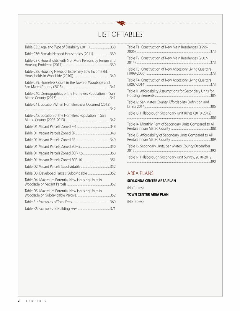
PREFACE(No Tables)
HISTORIC OVERVIEWTable H1: Woodside Subdivisions ..................................................xxiv
INTRODUCTIONTOWN FACTS
Table TF1: Projected Population, Employment, & income ....... 8
Table TF2: Housing Units By Building Type ..................................... 8
Table TC3: Population Trends ................................................................ 9
Table TF4: Woodside Town Council Members .............................12
Table TF5: Woodside Town Managers .............................................12
Table TC6: Planning Milestones .........................................................14
Table TC7: History of General Plan Elements ...............................20
Table TC8: History of Area and Specific Plans ..............................20
FOUNDATIONS OF THE PLAN
Table F1: Milestones in California’s Planning Law ......................24
Table F2: General Plan Elements .......................................................25
GENERAL PLAN ELEMENTSLAND USE AND COMMUNITY DESIGN ELEMENT
Table LU1: Relationship Between General Plan and Zoning .....................................................................48
Table LU2: Zoning Districts ..................................................................49
HISTORIC PRESERVATION ELEMENT
Table HP1: Resources of Historic and Cultural Significance ...............................................................................60
CIRCULATION ELEMENT
Table CL1: 2010 vehiclular Traffic Counts ......................................87
Table CL2: 2030 vehiclular Traffic Projections ..............................88
Table CL3: 2010 Bike Counts ...............................................................89
Table CL4: Desired Bikeway improvements .................................99
Table CL5: Desired Pedestrian Pathway improvements ...... 105
NATURAL HAZARDS AND SAFETY ELEMENT
Table NH1: Potential Geologic Hazard Zones ........................... 116
Table NH2: Relative Groundshaking Potential in the Woodside Planning Area. .................................................................. 118
Table NH3: Risk Classifications of Structures, Occupancies, and Land Uses .....................................................................................128
Table NH4: Levels of Acceptable Risk for Structures, Occupancies, and Land Uses ........................................................129
Table NH5: Location of Structures and Land Uses in Relation to Defined Hazard Areas ...............................................130
OPEN SPACE ELEMENT
Table OS1: Relationship Between General Plan and Zoning Open Space Designations .............................................149
Table OS2: Open Space inventory in Woodside Planning Area ......................................................................................155
Table OS3: Open Space Areas Categories ...............................157
CONSERVATION ELEMENT
Table Cv1: Threatened or Endangered Species in Woodside. ........................................................................178
Table Cv2: Wetlands and Riparian Corridor Habitat ...........184
Table Cv3: Mixed Oak Woodland Habitat ...............................186
Table Cv4: Redwood-Mixed Evergreen Forest Habitat ......187
Table Cv5: Grassland Habitat ........................................................188
Table Cv6: Chaparral Habitat ........................................................189
Table Cv7: Special-Status Flora by USGS Quadrangle in and near Woodside .....................................................................198
Table Cv8: Special-Status Fauna by USGS Quadrangle in and near Woodside ......................................................................198
SUSTAINABILITY ELEMENT
Table S1: Woodside Government Operations Emissions by Sector, 2005 Baseline .................................................................211
Table S2: Woodside Community Wide Operations Emissions by Sector, 2005 Baseline ............................................212
Table S3: Woodside Community Wide Per Capita Emissions, 2005 Baseline ................................................................213
Table S4: Woodside GHG Emissions inventory (Business-as-Usual Scenario) ........................................................214
Table S5: Woodside GHG Emissions inventory (Reduction Scenario) ........................................................................215
NOISE ELEMENT
Table N1: Sound Levels and Human Response ....................230
Table N2: Construction Equipment Noise ...............................231
Table N3: Maximum Ambient Noise Levels (Ldn) by Use .....................................................................................................231
Table N4: Traffic Noise Levels for 1986, 2005, 2010, and 2030 ...................................................................................234
LIST OF TABLES

T O W N O F W O O D S I D E GENERAL PLAN 2012 v
Table C7: Projections for Types of Jobs (2010 – 2040) .......316
Table C8: Race and Ethnicity (2011) ..........................................317
Table C9: Age of Residents (2011) ..............................................317
Table C10: Total Housing Units (2000, 2010, and 2013) ....318
Table C11: Residential Building Types Comparison (2011)....................................................................................................................319
Table C12: Number of Bedrooms Per Unit Comparison (2011) ......................................................................................................319
Table C14: Tenure of Housing (2000 and 2011) ....................320
Table C15: Average Household Size of Owners Compared to Renters (2000 and 2011) ...........................................................321
Table C16: Households by Type (2011) ....................................321
Table C17: Household income (2013).......................................322
Table C18: Town of Woodside Households by income Category and Housing Tenure ....................................................323
Table C19: Home Affordability by Occupation (2013) .......323
Table C20: Workforce Age, Salary and Education ................324
Table C18: Median Single Family Home Sales Prices (2005, 2010, 2012 and 3rd Quarter 2013) .............................................325
Table C22: Median Condominium Sales Prices (2005, 2010, 2012 and 3rd Quarter 2013) ..........................................................326
Table C23: Median Condominium Sales Prices (2005, 2010, 2012 and 3rd Quarter 2013) ..........................................................327
Table C24: Average Rents in Woodside From Craigslist ....327
Table C25: Median Home Sale Prices in 2013 Dollars – Adjusted for inflation (2005-2012) .............................................328
Table C26: Households Overpaying for Housing (2011)...329
Table C27: Number of Overcrowded Units (2011) ..............330
Table C28: Year Structure Built (2011) .......................................330
Table C29: Regional Housing Needs Allocation 2014 - 2023....................................................................................................................331
Table C30: Senior Households by income (2011) ................333
Table C31: Senior Households by Tenure (2011) ..................333
Table C31: Type of Developmental Disability in San Mateo County (2013) ......................................................................................335
Table C32: Age of People with Development Disabilities in San Mateo County (2013) ..............................................................336
Table C33: Living Arrangements of People with Developmental Disabilities (2013) .............................................336
Table C34: Living Arrangements of People with Developmental Disabilities in San Mateo County (2014) 337
PUBLIC UTILITIES ELEMENT
(No Tables)
HOUSING ELEMENT
Table H1: Compliance with RHNA (2007-2014) ...................... 264
Table H2: Changes in Assumptions Regarding the Affordability for Second Units for Housing Element ............. 265
Table H3: Review of Woodside 2007-2014 Housing Element implementing Programs ................................................................... 270
Table H4: Regional Housing Needs Allocation (RHNA) for 2015-2023 ................................................................................................ 276
Table H5: Type of Developmental Disability in San Mateo County (2013) ......................................................................................... 277
Table H6: Age of People with Development Disabilities in San Mateo County (2013) ................................................................. 277
Table H7: Living Arrangements of People with Developmental Disabilities (2013) ................................................ 277
Table H8: San Mateo County Affordability Definition and Limits 2014 .............................................................................................. 278
Table H9: Estimated Construction of New Housing Stock .. 279
Table H10: Estimated Rehabilitation and Conservation of Housing Stock ........................................................................................ 280
Table H11: Affordability Assumptions for Secondary Units for Housing Elements ................................................................................ 283
Table H12: Changes in Assumptions Regarding the Affordability of Second Units for Housing Elements ............. 283
Table H13: Housing Action Plan ..................................................... 297
APPENDICESCIRCULATION APPENDIX
(No Tables)
HOUSING APPENDIX
Table C1: income Category Definitions ....................................... 311
Table C2: San Mateo County income Limits ............................. 311
Table C3: San Mateo County and Cities Population Change (2000 – 2030) .......................................................................................... 312
Table C4: Comparison of Population Growth Trends and Projections (1990-2030)) ................................................................... 313
Table C5: ABAG/MTC Plan Bay Area Projections for Housing, Households and Jobs (2010 – 2040) ............................................ 314
Table C6: Projections for Population and Total Jobs (2010 – 2040) ........................................................................................................... 315
LIST OF TABLES
vi C O N T E N T S
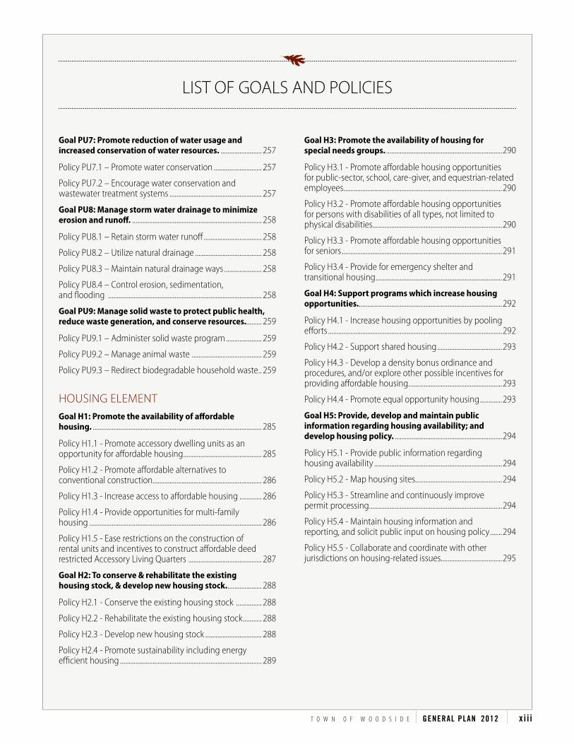
Table C35: Age and Type of Disability (2011) ........................... 338
Table C36: Female Headed Households (2011) ....................... 339
Table C37: Households with 5 or More Persons by Tenure and Housing Problems (2011) .................................................................. 339
Table C38: Housing Needs of Extremely Low income (ELi) Households in Woodside (2010)) .................................................. 340
Table C39: Homeless Count in the Town of Woodside and San Mateo County (2013) ................................................................. 341
Table C40: Demographics of the Homeless Population in San Mateo County (2013) .......................................................................... 341
Table C41: Location When Homelessness Occurred (2013)....................................................................................................................... 342
Table C42: Location of the Homeless Population in San Mateo County (2007-2013) .............................................................. 342
Table D1: vacant Parcels Zoned R-1 .............................................. 348
Table D1: vacant Parcels Zoned SR ................................................ 348
Table D1: vacant Parcels Zoned RR ................................................ 349
Table D1: vacant Parcels Zoned SCP-5 ......................................... 350
Table D1: vacant Parcels Zoned SCP-7.5 ..................................... 350
Table D1: vacant Parcels Zoned SCP-10 ...................................... 351
Table D2: vacant Parcels Subdividable ........................................ 352
Table D3: Developed Parcels Subdividable ............................... 352
Table D4: Maximum Potential New Housing Units in Woodside on vacant Parcels ............................................................ 352
Table D5: Maximum Potential New Housing Units in Woodside on Subdividable Parcels ............................................... 352
Table E1: Examples of Total Fees .................................................... 369
Table E2: Examples of Building Fees ............................................. 371
Table F1: Construction of New Main Residences (1999-2006) ........................................................................................................373
Table F2: Construction of New Main Residences (2007-2014) ........................................................................................................373
Table F3: Construction of New Accessory Living Quarters (1999-2006) ..........................................................................................373
Table F4: Construction of New Accessory Living Quarters (2007-2014) ..........................................................................................373
Table i1: Affordability Assumptions for Secondary Units for Housing Elements .............................................................................385
Table i2: San Mateo County Affordability Definition and Limits 2014 ...........................................................................................386
Table i3: Hillsborough Secondary Unit Rents (2010-2012)....................................................................................................................388
Table i4: Monthly Rent of Secondary Units Compared to All Rentals in San Mateo County .......................................................388
Table i5: Affordability of Secondary Units Compared to All Rentals in San Mateo County .......................................................389
Table i6: Secondary Units, San Mateo County December 2013 .........................................................................................................390
Table i7: Hillsborough Secondary Unit Survey, 2010-2012....................................................................................................................390
AREA PLANSSKYLONDA CENTER AREA PLAN
(No Tables)
TOWN CENTER AREA PLAN
(No Tables)
LIST OF TABLES

T O W N O F W O O D S I D E GENERAL PLAN 2012 vi i

vi i i C O N T E N T S
LIST OF FIGURES
PREFACE(No Figures)
HISTORIC OVERVIEW(No Figures)
INTRODUCTIONTOWN FACTS
Figure TF1: Woodside Population by Age ....................................... 9
FOUNDATIONS OF THE PLAN
(No Figures)
GENERAL PLAN ELEMENTSLAND USE AND COMMUNITY DESIGN ELEMENT
(No Figures)
HISTORIC PRESERVATION ELEMENT
(No Figures)
CIRCULATION ELEMENT
Figure CL1: Bike Turning Movements at Count Locations .....89
NATURAL HAZARDS AND SAFETY ELEMENT
(No Figures)
OPEN SPACE ELEMENT
(No Figures)
CONSERVATION ELEMENT
(No Figures)
SUSTAINABILITY ELEMENT
Figure S1: indicators for a Sustainable San Mateo County, Twelfth Annual Report Card, April 2008 ....................216
NOISE ELEMENT
(No Figures)
PUBLIC UTILITIES ELEMENT
(No Figures)
HOUSING ELEMENT
(No Figures)
APPENDICESCIRCULATION APPENDIX
(No Figures)
HOUSING APPENDIX
Figure C1: Population Growth in Woodside (1990 – 2030) 313
Figure C2: Residential Building Types in Woodside (2011) .318
Figure C3: Tenure of Housing in Woodside (2011) .................320
Figure C4: Distribution of Households in Woodside by income (2010) ........................................................................................322
Figure C5: Woodside Households Overpaying for Housing by income (2011) ........................................................................................329
Figure C6: Number of People Projected to Turn 65 Each Year in the United States (1996-2025) ...................................................332
Figure i1: Monthly Rent of Secondary Units vs. All Rental Units ............................................................................................................388
AREA PLANSSKYLONDA CENTER AREA PLAN
(No Figures)
TOWN CENTER AREA PLAN
(No Figures)

T O W N O F W O O D S I D E GENERAL PLAN 2012 ix

x C O N T E N T S
CIRCULATION ELEMENTGoal CL1: Balance circulation system user needs. ............91
Policy CL1.1 – Encourage cooperation between all users of the circulation system ......................................................91
Policy CL1.2 - Expand the road program ....................................92
Policy CL1.3 - Promote neighborhood safety and tranquility ........................................................................................93
Policy CL1.4 - improve commercial district circulation, traffic flow, and parking .....................................................................93
Policy CL1.5 – Seek and maintain funding and resources ..94
Policy CL1.6 – Collect data................................................................94
Goal CL2: Maintain a safe and convenient roadway system while preserving the Town’s rural and scenic environment. .......................................................................................95
Policy CL2.1 – Maintain and improve Town roadways .........95
Policy CL2.2 - Protect and designate scenic corridors ..........96
Goal CL3: Protect, maintain, and expand the bikeway network. ..................................................................................................97
Policy CL3.1 - Enhance Town bikeways (primarily classes ii and iii) ...............................................................97
Policy CL3.2 - Protect and expand Town bikeways ................98
Policy CL3.3 – Plan and prioritize bikeway improvements, construction, and maintenance while balancing the needs of other users ..............................................98
Goal CL4: Protect, maintain, and expand the equestrian trail network. ....................................................................................100
Policy CL4.1 – Promote and protect the Town equestrian heritage ...........................................................................100
Policy CL4.2 –Enhance the Town equestrian trail network .........................................................................................100
Policy CL4.3 – Protect and expand the Town equestrian trail network .........................................................................................101
Policy CL4.4 – Plan and prioritize equestrian trail maintenance, improvements, and construction .................102
Goal CL5: Protect, maintain, and expand pedestrian pathways and trails. .......................................................................103
Policy CL5.1 - Enhance Town pedestrian pathways and trails.................................................................................................103
LAND USE AND COMMUNITY DESIGN ELEMENTGoal LU1: Preserve and enhance Woodside as a scenic, rural residential community. ..........................................................50
Policy LU1.1 – Give high priority to preservation and conservation of natural resources ....................................................50
Policy LU1.2 - Limit intensity of development ............................50
Policy LU1.3 - Maintain community aesthetics ..........................51
Policy LU1.4 – Emphasize residential land uses consistent with rural environment ........................................................................52
Policy LU1.5 – Thoroughly evaluate changes to parcel boundaries .................................................................................................52
Policy LU1.6 - Emphasize commercial land uses which serve the day-to-day needs of the residents ...............................53
Policy LU1.7 - Limit public and private institutions to those required for the well-being of the community ..........................54
Policy LU1.8 - Encourage and plan parks and recreation in keeping with the rural setting............................................................54
Policy LU1.9 - Monitor and participate in the planning activities of adjacent lands .................................................................55
Policy LU1.10 – Maintain demographic data .............................55
HISTORIC PRESERVATION ELEMENTGoal HP1: Protect historically and archaeologically significant structures, sites, and artifacts................................64
Policy HP1.1 – Protect historic and archaeological resources ......................................................................................................64
Policy HP1.2 - incentivize historic preservation ..........................64
Policy HP1.3 - Promote historic preservation .............................65
Policy HP1.4 – Establish a historic and archaeological resource database....................................................................................65
Policy HP1.5 – Support education ...................................................65
Policy HP1.6 – Augment resources ..................................................65
LIST OF GOALS AND POLICIES

T O W N O F W O O D S I D E GENERAL PLAN 2012 xi
Policy NH2.3 – Facilitate post disaster relief and recovery operations .............................................................................................143
Policy NH2.4 – Support emergency preparedness education ..............................................................................................143
OPEN SPACE ELEMENTGoal OS1: Conserve, protect, and enhance open space system. .....................................................................................168
Policy OS1.1 - Review all development to ensure preservation of open space ...........................................................168
Policy OS1.2 – Enhance connectivity between open space areas............................................................................................169
Policy OS1.3 - Expand the open space system .....................169
Policy OS1.4 – Preserve open space for the protection of public health and safety ............................................................170
Policy OS1.5 - Protect scenic resources ...................................170
Policy OS1.6 - Provide open space for recreation ................171
Policy OS1.7 - Establish educational programs ....................171
Policy OS1.8 - Utilize incentives for open space preservation .........................................................................................172
Policy OS1.9 – Partner to acquire resources...........................172
CONSERVATION ELEMENTGoal CV1: Maintain a healthy natural environment. ..200
Policy Cv1.1 – Plan development to be sensitive to preservation of natural features and landscape ...................200
Policy Cv1.2 – Protect riparian corridors and water quality ........................................................................................200
Policy Cv1.3 – Retain and restore native flora and fauna habitat and populations .................................................................201
Policy Cv1.4 – Consider fire prevention in maintaining native landscape ...............................................................................202
Policy Cv1.5 - Protect air quality ................................................203
Policy Cv1.6 – Pursue collaborative conservation efforts 203
Policy Cv1.7 – Review regulations to implement conservation policies .......................................................................203
Policy Cv1.8 – Collect biological and geological data ......204
Policy Cv1.9 – Promote education and conservation actions ....................................................................................................204
Policy CL5.2 - Protect and expand Town pedestrian pathways and trails .............................................................................. 103
Policy CL5.3 Plan and prioritize pedestrian pathway maintenance, improvements, and construction .................... 104
Goal CL6: Develop a circulation system that encourages and supports vehicle trip reduction. ...................................... 106
Policy CL6.1 – Support regional transit connectivity ............ 106
Policy CL6.2 – Encourage trip reduction .................................... 106
Goal CL7: Manage recreational traffic and special events. ..................................................................................... 107
Policy CL7.1 - Minimize disruption .............................................. 107
NATURAL HAzARDS AND SAFETY ELEMENTGoal NH1: Minimize risks posed by hazards. ...................... 131
Policy NH1.1 – Regulate land use and development to protect lives and property ................................................................ 131
Policy NH1.2 – Require assessment and mitigation of seismic hazards ...................................................................................... 132
Policy NH1.3 – Require assessment and mitigation of landslide hazards................................................................................... 133
Policy NH1.4 – Require assessment and mitigation of ground settlement risks ..................................................................... 133
Policy NH1.5 – Require assessment and mitigation of soil liquefaction risks ........................................................................... 134
Policy NH1.6 – Require assessment and mitigation of flood hazards .......................................................................................... 134
Policy NH1.7 – Seek to minimize erosion and sedimentation ........................................................................................ 135
Policy NH1.8 – Require assessment and mitigation of expansive earth materials risks ....................................................... 135
Policy NH1.9 – Require assessment and mitigation of fire hazards ............................................................................................... 135
Policy NH1.10 – Compile and maintain natural hazard data ............................................................................................. 137
Policy NH1.11 – institute or participate in education related to natural hazards ................................................................. 137
Goal NH2: Emergency preparedness. ...................................... 142
Policy NH2.1 – Preserve the functioning of critical facilities ...................................................................................................... 142
Policy NH2.2 – Develop emergency preparedness plans ... 143
LIST OF GOALS AND POLICIES

xi i C O N T E N T S
PUBLIC UTILITIES ELEMENTGoal PU1: Ensure adequate, safe, and site sensitive utilities. ................................................................................................251
Policy PU1.1 - Ensure adequate utilities .................................251
Policy PU1.2 - install utilities in an environmentally sensitive manner ................................................................................251
Policy PU1.3 - Ensure continuity of utility services .............251
Policy PU1.4 – Coordinate with public utility purveyors ..251
Goal PU2: Promote installation of alternative power sources. ..................................................................................................252
Policy PU2.1 – Promote energy conservation .......................252
Policy PU2.2 Encourage the installation of alternative power systems ....................................................................................252
Policy PU2.3 – Promote safe and site sensitive gas and electric, and alternative power sources. .................................252
Goal PU3: Promote adequate communications access. ....................................................................................................253
Policy PU3.1 – increase access to communications ...........253
Goal PU4: Maintain and improve the adequacy of the water supply. .............................................................................254
Policy PU4.1 - Maintain and improve the adequacy of the water supply and delivery .....................................................254
Policy PU4.2 - Seek adequate maintenance and prompt repair of water supply infrastructure ........................................254
Policy PU4.3 - interconnect water supply infrastructure ..254
Goal PU5: Encourage and support on-site sewage disposal systems. .............................................................................255
Policy PU5.1 – Require on-site sewage disposal systems ..................................................................................................255
Policy PU5.2 – Enforce on-site disposal standards ..............255
Policy PU5.3 – Consider alternative septic systems ..........255
Policy PU5.4 – Promote education and outreach ...............255
Goal PU6: Manage, and allocate the Town’s limited public sanitary sewer allocations appropriately. ...........256
Policy PU6.1 – Manage sewer service allocations ...............256
Policy PU6.2 – Seek increased sanitary sewer capacity ....256
Policy PU6.3 – Conduct environmental review ....................256
SUSTAINABILITY ELEMENTGoal S1: Conserve resources. ........................................................ 219
Policy S1.1 – Protect and conserve water resources ............. 219
Policy S1.2 – Encourage and support renewable clean energy ....................................................................................................... 219
Policy S1.3 – Encourage recycling and waste management .......................................................................................... 219
Goal S2: Reduce greenhouse gas emissions. ....................... 220
Policy S2.1 – Encourage increased building energy efficiency .................................................................................................. 220
Policy S2.2 – Encourage the reuse of buildings and building materials ................................................................................. 220
Policy S2.3 – Maintain carbon absorption resources ........... 220
Policy S2.4 – Reduce vehicle trips ................................................. 221
Policy S2.5 – Reduce Carbon Footprint of All Town Activities .................................................................................................... 221
Policy S2.6 – Reduce the carbon footprint of government operations ..................................................................... 223
Policy S2.7 – Maintain greenhouse gas emissions data ...... 223
Goal S3: Encourage community education. ......................... 224
Policy S3.1 – Encourage community programs and educational opportunities which promote sustainability .. 224
Policy S3.2 – Encourage sustainable Town practices ............ 224
NOISE ELEMENTGoal N1: Protect, maintain and improve the tranquil environment within the Town. ................................. 236
Policy N1.1 – Minimize noise disturbances ............................... 236
Policy N1.2 – Review and mitigate noise exposure on residents .................................................................................................... 236
Policy N1.3 – Review and mitigate noise exposure generated by new development ................................................... 236
Policy N1.4 – Mitigate vehicular noise ........................................ 237
Policy N1.5 – Minimize aircraft noise ........................................... 238
LIST OF GOALS AND POLICIES
T O W N O F W O O D S I D E GENERAL PLAN 2012 xi i i
Goal PU7: Promote reduction of water usage and increased conservation of water resources. ........................ 257
Policy PU7.1 – Promote water conservation ............................ 257
Policy PU7.2 – Encourage water conservation and wastewater treatment systems ...................................................... 257
Goal PU8: Manage storm water drainage to minimize erosion and runoff. ............................................................................ 258
Policy PU8.1 – Retain storm water runoff .................................. 258
Policy PU8.2 – Utilize natural drainage ....................................... 258
Policy PU8.3 – Maintain natural drainage ways ...................... 258
Policy PU8.4 – Control erosion, sedimentation, and flooding .......................................................................................... 258
Goal PU9: Manage solid waste to protect public health, reduce waste generation, and conserve resources.......... 259
Policy PU9.1 – Administer solid waste program ..................... 259
Policy PU9.2 – Manage animal waste ......................................... 259
Policy PU9.3 – Redirect biodegradable household waste .. 259
HOUSING ELEMENTGoal H1: Promote the availability of affordable housing. ................................................................................................... 285
Policy H1.1 - Promote accessory dwelling units as an opportunity for affordable housing .............................................. 285
Policy H1.2 - Promote affordable alternatives to conventional construction................................................................ 286
Policy H1.3 - increase access to affordable housing ............. 286
Policy H1.4 - Provide opportunities for multi-family housing ..................................................................................................... 286
Policy H1.5 - Ease restrictions on the construction of rental units and incentives to construct affordable deed restricted Accessory Living Quarters ........................................... 287
Goal H2: To conserve & rehabilitate the existing housing stock, & develop new housing stock. .................... 288
Policy H2.1 - Conserve the existing housing stock ............... 288
Policy H2.2 - Rehabilitate the existing housing stock ........... 288
Policy H2.3 - Develop new housing stock ................................. 288
Policy H2.4 - Promote sustainability including energy efficient housing ................................................................................... 289
Goal H3: Promote the availability of housing for special needs groups. ....................................................................290
Policy H3.1 - Promote affordable housing opportunities for public-sector, school, care-giver, and equestrian-related employees .............................................................................................290
Policy H3.2 - Promote affordable housing opportunities for persons with disabilities of all types, not limited to physical disabilities ............................................................................290
Policy H3.3 - Promote affordable housing opportunities for seniors ..............................................................................................291
Policy H3.4 - Provide for emergency shelter and transitional housing ..........................................................................291
Goal H4: Support programs which increase housing opportunities. ....................................................................................292
Policy H4.1 - increase housing opportunities by pooling efforts ......................................................................................................292
Policy H4.2 - Support shared housing ......................................293
Policy H4.3 - Develop a density bonus ordinance and procedures, and/or explore other possible incentives for providing affordable housing .......................................................293
Policy H4.4 - Promote equal opportunity housing .............293
Goal H5: Provide, develop and maintain public information regarding housing availability; and develop housing policy. ...............................................................294
Policy H5.1 - Provide public information regarding housing availability ...........................................................................294
Policy H5.2 - Map housing sites...................................................294
Policy H5.3 - Streamline and continuously improve permit processing ..............................................................................294
Policy H5.4 - Maintain housing information and reporting, and solicit public input on housing policy .......294
Policy H5.5 - Collaborate and coordinate with other jurisdictions on housing-related issues....................................295
LIST OF GOALS AND POLICIES

xiv C O N T E N T S
SKYLONDA CENTER AREA PLANPolicy SC1: Buildings and structures ........................................... 400
Policy SC2: Landscaping .................................................................... 400
Policy SC3: Signs .................................................................................... 400
Policy SC4: Lighting ............................................................................. 400
Policy SC5: Land Use ............................................................................ 401
Policy SC6: Circulation ...................................................................... 401
Policy SC7: Motor vehicles ................................................................ 402
Policy SC8: Pedestrians ....................................................................... 402
Policy SC9: Equestrians ....................................................................... 402
Policy SC10: Bicycles ............................................................................ 402
TOWN CENTER AREA PLANPolicy TC1: Buildings and structures ............................................ 408
Policy TC2: Landscaping ..................................................................... 408
Policy TC3: Signs .................................................................................... 409
Policy TC4: Lighting .............................................................................. 409
Policy TC5: Land use ............................................................................. 409
Policy TC6: Circulation ....................................................................... 409
Policy TC7: Motor vehicles ................................................................. 410
Policy TC8: Pedestrians ....................................................................... 410
Policy TC9: Equestrians ....................................................................... 411
Policy TC10: Bicycles ............................................................................ 411
LIST OF GOALS AND POLICIES

T O W N O F W O O D S I D E GENERAL PLAN 2012 xv
HISTORIC OVERVIEWINTRODUCTION
GENERAL PLAN ELEMENTS
APPENDICESAREA PLANS
PREFACEThis General Plan is a long-range, comprehensive general planning guide to the future development
of the Town of Woodside and any land outside its boundaries which have bearing to its planning. It
describes the desired character and quality of the community.
The General Plan is intended to inform public dialog and provide guidance to Town officials as an
embodiment of the hopes, values, and aspirations of the community. It is based upon a vision of
the Town’s future that identifies and integrates the goals of residents, business owners, and public
officials, and provides a comprehensive statement for guiding the management of the natural and
built environment.
Planning has played an important role in the history of Woodside. The citizens of Woodside voted
to incorporate a new town in 1956, largely so they could do their own planning, maintain the rural,
residential character of the community, and preserve its natural beauty and tranquility.
The 2012 General Plan Update, which included three years of engaged dialog and committed
interaction between the community and public officials, has once again confirmed the community’s
desire to uphold the guiding principles first articulated in the Town’s 1958 Master Plan. These
principles aim to preserve, maintain, and enhance Woodside as a small and unique, rural town.

xvi
Original inhabitants, Spanish and Mexican Period ............................................................ ii
Anglo-American Settlers & The Logging industry ............................................................ iii
Early Commercial & Social Development.............................................................................. iv
Early Estates ........................................................................................................................................ v
Subdivisions and Growth of Town Center ........................................................................... vi
Town incorporation and Present Day .................................................................................... vii
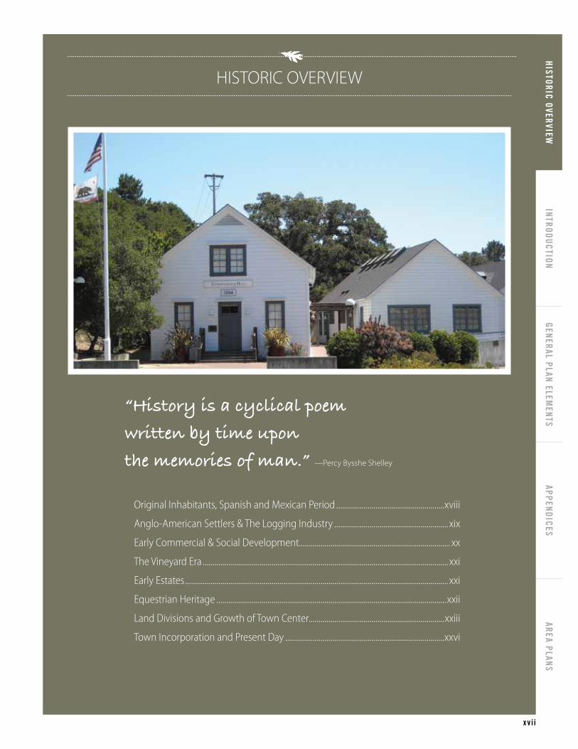
“History is a cyclical poem
written by time upon
the memories of man.” —Percy Bysshe Shelley
HISTORICAL OVERVIEW
HISTORIC OVERVIEWINTRODUCTION
GENERAL PLAN ELEMENTS
APPENDICESAREA PLANS
x v i i
“History is a cyclical poem
written by time upon
the memories of man.” —Percy Bysshe Shelley
HISTORIC OVERVIEW
Original inhabitants, Spanish and Mexican Period .......................................................xviii
Anglo-American Settlers & The Logging industry .......................................................... xix
Early Commercial & Social Development............................................................................. xx
The vineyard Era ............................................................................................................................. xxi
Early Estates ...................................................................................................................................... xxi
Equestrian Heritage .....................................................................................................................xxii
Land Divisions and Growth of Town Center.....................................................................xxiii
Town incorporation and Present Day .................................................................................xxvi

xvi i i H I S T O R I C O V E R V I E W
ORIGINAL INHABITANTS, SPANISH AND MExICAN PERIODThe story of Woodside begins with the local Ohlone/Costanoan indigenous
people, who made their home in this area for thousands of years before
Spanish explorers arrived. These native people were attracted to the
mild climate, plentiful water and abundant food supply. The Lamchin
band of Ohlone made their living by hunting, fishing and gathering in
the lush terrain of grassy meadows and forested hillsides. Their presence
is evidenced by the frequent discovery of burial sites and artifacts near
creeks.
In 1769, a group of explorers led by Gaspar de Portolá set out from Mexico
in search of a great bay that had been noted during earlier sailings up the
coast. That expedition, which camped near present day Woodside, may
have marked the first appearance of Europeans in the area. As exploration
and settlement increased, many of the Ohlone were moved to Mission
Santa Clara to work in the vineyards and orchards and to assist in the
raising of cattle.
Mexico won independence from Spain in 1821, after almost 300 years of
Spanish colonial rule. With independence, California came under Mexican
rule until it was acquired by the United States in 1848. In 1833, the Mexican
government secularized the rich lands and holdings of the missions and
transferred them from the church over to new settlers and colonists, many
of whom were veterans of the Mexican War.
Following secularization of mission lands, Mexican authorities granted to
friends and loyalists some 18 ranchos in what is now San Mateo County.
One of those, Rancho Cañada de Raymundo, was a large parcel in the
middle of the Peninsula. The rancho’s boundaries encompassed much of
present day Woodside.
Local Ohlone/Costanoan Indian people, who made their home in this area for thousands of years before Spanish explorers arrived.
Gaspar de Portola

T O W N O F W O O D S I D E GENERAL PLAN 2012
HISTORIC OVERVIEWINTRODUCTION
GENERAL PLAN ELEMENTS
APPENDICESAREA PLANS
x i x
ANGLO-AMERICAN SETTLERS & THE LOGGING INDUSTRYIn the 1830s, the Woodside area became home to some of the first
English-speaking settlers on the San Francisco Peninsula. Many came to
seek their fortunes in the burgeoning lumber industry, and among them
would emerge community builders and leaders.
John Copinger came to California by ship and made his way to the
Woodside area. He was awarded the rancho after assisting Mexican
government official Juan Bautista Alvarado in a dispute with Mexican
authorities. Copinger married Maria Luisa Soto, the daughter of another
rancho owner whose property included present day downtown Palo
Alto. In 1840, the couple built an adobe home at the corner of Kings
Mountain Road and Woodside Road, which was later destroyed in the
1906 earthquake. Copinger was a respected and industrious man who
made many improvements to the property, including a dam and a grist
mill on Bear Gulch Creek. He also raised cattle and planted many crops. He
died in 1847, at the age of 37.
Around 1840, Charles Brown purchased a major portion of the Copinger
land grant consisting of 2,880 acres of land, which he named “Mountain
Home Ranch”. He is credited with having built one of the first sawmills on
the Peninsula, as well as an 1839 adobe house that still stands near Portola
Road.
Another early resident of note was Dennis Martin, who came in the first
wagon party over the Truckee Pass in 1845. He also bought land from John
Copinger, built sawmills and a house, planted orchards, and built St. Denis
Chapel as a place of worship near Searsville. That area was named for John
Sears, who bought land from Dennis Martin in 1854 and built a hotel and
other businesses there. Searsville was the largest village in this area until
1891, when the Spring Valley Water Company displaced the community
and built a dam creating the reservoir called Searsville Lake. The lake was
a popular recreation spot until 1975, when it was incorporated into the
Jaspar Ridge Biological Reserve.
Dentist Robert Orville Tripp left his native Massachusetts, came west to
San Francisco in 1849 and later to Woodside, establishing a business and
a home. He joined Matthias A. Parkhurst and Charles Ellis to establish a
sawmill and, along with partners from San Francisco, opened a direct road
from the redwood forests to the head of the tidewater in Redwood Creek
— now the heart of Redwood City. Oxen and mules dragged lumber
down this road to the Bay to be floated to San Francisco on ebb tides.
The Charles Brown Adobe still stands along Portola Road
Searsville Lake
Logging in Woodside

xx H I S T O R I C O V E R V I E W
EARLY COMMERCIAL & SOCIAL DEVELOPMENTBy 1852, there was regular stagecoach service line from Woodside to San
Francisco and more people were attracted to the area. Recognizing the
need to service the increased traffic and workers, Tripp and Parkhurst
opened a general food and supply market called the Woodside Store. In
1854, Andre Neuman established a nursery and grocery store on Woodside
Road where it crosses Bear Gulch. Soon after, Tripp and Parkhurst re-
located their store to its present location on the corner of Kings Mountain
and Tripp Roads. That building is now preserved as a San Mateo County
Museum. Dr. Tripp also established the first post office and, in 1858, a
circulating library.
John Greer, an Irish sea captain who arrived in San Francisco in 1850,
explored the creeks and sloughs of the Bay at what is now Redwood City.
He became acquainted with John Copinger’s widow, Maria Luisa. They
married and resided in the Copinger adobe in Woodside. The Greers
became community leaders, and in 1851, donated land for the first
schoolhouse in the area, which is now Woodside Elementary School. It
was originally called Greersburg Elementary School.
The Woodside area consisted of several small clusters of businesses and
residences that developed at important intersections. Like Searsville,
Whiskey Hill grew in importance because it was located between the
redwoods on the hillside and the sawmills and Redwood City. As the more
accessible redwoods were depleted, the mills moved up the steep hills
and over the ridge making it a two-day journey to the Bay. The teamsters
would typically spend the night at hotels at Whiskey Hill and partake of
the beverage from which the name derives. The only surviving hotel, the
Pioneer Hotel, was built by Peter Hudson on Whiskey Hill in 1884.
Along the road known as the Redwood City-Pescadero Road (today’s
Woodside Road), other important additions were added to this young
community. Independence Hall, also built in 1884, was originally located
next to the current Woodside Elementary School. After several moves, it
was placed at its present site next to Town Hall in 1991, and reconstructed
for use as a community meeting space. The Woodside Village Church
Chapel dates from 1893 and has continuously served the community
along with the newer, larger sanctuary added in 1961.
Several of the original commercial buildings are still in use today,
including: Independence Hall, the San Mateo County Museum (formerly
the Woodside Store), and the Pioneer Hotel (now the Pioneer Saloon, a
bank, and office space).
Tripp Store
John Greer
Independence Hall
Woodside Village Church

T O W N O F W O O D S I D E GENERAL PLAN 2012 xxi
HISTORIC OVERVIEWINTRODUCTION
GENERAL PLAN ELEMENTS
APPENDICESAREA PLANS
THE VINEYARD ERABy the 1870s and 1880s, the majestic stands of redwoods in this valley
had been depleted. Entrepreneurs began to seek other uses for the rich
bottomlands and hillsides. One of those entrepreneurs was Emmett H.
Rixford, who purchased land near the corner of Cañada and Woodside
Roads and in 1884 established the 37 acre La Questa Vineyards. His
cabernets, fine enough to win awards in Europe, inspired others to begin
planting grapes. In 1894, John A. Hooper, a San Francisco banker, planted
a thirty acre vineyard on the former Charles Brown property. These efforts
marked the beginning of an interest in viticulture that continues today.
By the turn of the twentieth century there were well over 800 acres of
grapes in the Woodside-Portola Valley area. The west side of Cañada Road,
from Olive Hill to Edgewood, was planted in vineyards and olive groves.
Increasing urbanization of the peninsula gradually forced the wineries
to move to the more agricultural areas, both to the north and south.
Historically, the entire Woodside-Portola Valley area has been considered
a single viticulture unit, with over 100 acres of grapes in production.
Each year, the one remaining acre of the La Questa Vineyard grapevines
produces a modest 50 cases of the coveted La Questa Cabernet Sauvignon.
The handsome stone winery, built 100 years ago, has been remodeled as a
residence. The three remaining acres of the Hooper Vineyard contain the
only other vines that date back to the nineteenth century. These produce
both Cabernet Sauvignon and zinfandel grapes, which like the La Questa
grapes are made into wine by Woodside Vineyards. Chaine d’Or is another
local area winery. Viticulture is limited but still thriving in Woodside, and
in recent years more than thirty backyard vineyards (ranging in size from ½
to 3 acres) have been planted, principally to supply grapes to the two local
wineries. The remaining foundations of the Hooper Winery are located at
one of these vineyard sites.
EARLY ESTATESThe logging of the redwoods opened up tremendous vistas of the valley
and the Bay. This factor, combined with the largely fog-free climate and
ease of access to San Francisco, lured many successful City families to
seek country estates in the Woodside area. Large tracts of land became
available as the original pioneer families passed on and their landholdings
were divided, beginning an era of estate building.
Among the first San Franciscans to locate in Woodside was John A.
Hooper, who purchased the Mountain Home Ranch. Coffee magnate
James Folger II followed with the purchase of 1,500 acres in 1902, which
Vineyard in Woodside
Vineyard in Woodside

xxi i H I S T O R I C O V E R V I E W
he named Hazelwood Hills. About the same time, Charles Josselyn, owner
of a ship chandlery business in San Francisco began building his Vinegrove
Estate. San Francisco banker Mortimer Fleishhacker started building
Green Gables in 1911. Just outside the Town’s limits is one of Woodside’s
largest and most intact estates, Filoli, built between 1915 and 1917. Later
examples of notable estates include the Selah Chamberlain residence,
built in 1912, and the house and stable built by copper magnate Daniel
Jackling in 1925.
EQUESTRIAN HERITAGESince the early twentieth century, Woodside has been known for its idyllic
setting and the presence of horses. Originally, horses were a necessity for
work and transportation, and later for pleasure, leisure, and sport. Starting
in 1931, the development of the current horse trail system began. Early
equestrian activities included the Los Altos Hunt, the Playpen on Fox
Hollow Road and the Junior Riders program for children which continues
to this day. Two parks are adjacent to the Town: Huddart Park, 974 acres
acquired by the County in 1944 from the James M. Huddart Estate; and
Wunderlich Park, 942 acres donated to the County by Martin Wunderlich
in 1972. These parks expand the trail network, and provide increased
access between public and private lands.
The equestrian community has influenced the rural character of the
Town by promoting the values of land conservation, open space and trail
preservation, and private barns and community stables. As part of the
Town’s fabric, the equestrian culture is sustained by the community in
many ways. The restoration of the historic Folger Stable at Wunderlich Park
was energetically supported through financial contributions from a broad
spectrum of Woodsiders, as was the installation of Spring and Sprite, an
impressive bronze sculpture of a mare and foal situated on Village Hill. The
equestrian influence is also clearly evidenced by the annual Day of the
Horse, an event which includes a Horse Fair and Progressive Ride through
the Town. Each October since 2005, as many as 300 horse and rider teams
enjoy the Town’s equestrian trails and provide a colorful spectacle for
the non-equestrian portion of the Woodside Community. Additionally,
the Mounted Patrol of San Mateo County held its sixtieth Junior Rodeo
in 2010. This organization also supports Woodside’s National Center for
Equine Facilitated Therapy (for special needs persons) and the Sherriff’s
Star Program. The Woodside Area Horse Owners Association (WHOA!)
operates the Born Again Barns and Back in the Saddle (BITS) programs to
assist people wanting to get involved with horses on any level. Woodside
Folger Estate
Fleishhacker/Green Gables
Equestrian

T O W N O F W O O D S I D E GENERAL PLAN 2012 xxi i i
HISTORIC OVERVIEWINTRODUCTION
GENERAL PLAN ELEMENTS
APPENDICESAREA PLANS
residents include jockeys, equestrian competitors, Olympians, coaches,
and trainers of national and international acclaim. Horses continue to be a
reminder of Woodside’s frontier past and countrified present.
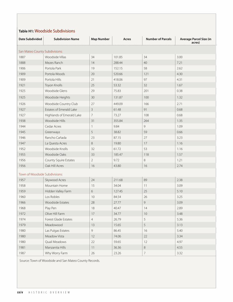
LAND DIVISIONS AND GROWTH OF TOWN CENTERThe first known residential subdivision was laid out in 1888, a tract known
as Woodside Villas. The larger lots were accessed from Albion Avenue and
the smaller half-acre residential lots were located along Woodside Road.
Woodside experienced a surge of subdivision activity and commercial
development during the 1920s (see table H1: Woodside Subdivisions).
Many larger properties were divided into lots, including Portola Woods,
Lakeshore Hills, Portola Hills, Toyon Knolls, Woodside Glens and Country
Club Estates. See Map H1: Subdivisions.
The area stretching along Woodside Road from Whiskey Hill to Mountain
Home Road underwent further commercial development during the
1920s. In addition to the businesses already serving basic community
needs were George E. Shine’s Blacksmith Shop and the Neuman Brothers
General Merchandise store. In 1928, Pacific Telephone and Telegraph
Company built a telephone exchange which brought the first direct dial
telephone service in Woodside.
The Depression and War Years in the 1930s and 1940s slowed development
activity. It was not until 1950 that San Mateo County’s real estate market
fully recovered, unleashing a flood of development in neighboring
communities. Several major tracts of nearby land were subdivided and
developed, especially in areas adjacent to Redwood City. Some of these
included East Greenwood Terrace, Woodside Heights, Woodside Oaks,
Woodside Knolls, Greenways and Woodside Hills.
Table H1 and Map H1 describe 20 subdivisions created between 1887 and
1956 which predate the incorporation of Woodside, and 14 subdivisions
created between 1957 and 1987 which post date incorporation.
Neuman Brothers General Store
Shine Blacksmith
Original Town of Woodside Map
xxiv H I S T O R I C O V E R V I E W
Table H1: Woodside Subdivisions
Date Subdivided Subdivision Name Map Number Acres Number of Parcels Average Parcel Size (in acres)
San Mateo County Subdivisions:
1887 Woodside Villas 34 101.85 34 3.00
1888 Mezes Ranch 14 288.44 40 7.21
1906 Portola Park 19 152.15 58 2.62
1909 Portola Woods 20 520.66 121 4.30
1909 Portola Hills 21 418.06 97 4.31
1921 Toyon Knolls 25 53.32 32 1.67
1925 Woodside Glens 29 75.83 201 0.38
1925 Woodside Heights 30 131.87 100 1.32
1926 Woodside Country Club 27 449.09 166 2.71
1927 Estates of Emerald Lake 3 61.48 91 0.68
1927 Highlands of Emerald Lake 7 73.27 108 0.68
1938 Woodside Hills 31 355.84 264 1.35
1944 Cedar Acres 1 9.84 9 1.09
1945 Greenways 5 38.82 59 0.66
1946 Rancho Cañada 23 87.15 27 3.23
1947 La Questa Acres 8 19.80 17 1.16
1952 Woodside Knolls 32 61.72 53 1.16
1955 Woodside Oaks 33 185.47 118 1.57
1956 County Squire Estates 2 9.72 8 1.21
1956 Oak Hill Acres 16 43.80 16 2.74
Town of Woodside Subdivisions:
1957 Skywood Acres 24 211.68 89 2.38
1958 Mountain Home 15 34.04 11 3.09
1959 Hidden Valley Farm 6 127.45 25 5.10
1960 Los Robles 10 84.54 26 3.25
1966 Woodside Estates 28 27.77 9 3.09
1968 Play Pen 18 40.47 14 2.89
1972 Olive Hill Farm 17 34.77 10 3.48
1974 Forest Glade Estates 4 26.79 5 5.36
1979 Meadowood 13 15.65 5 3.13
1980 Las Pulgas Estates 9 86.45 16 5.40
1980 Meadow Vista 12 74.06 22 3.34
1980 Quail Meadows 22 59.65 12 4.97
1981 Manzanita Hills 11 36.36 8 4.55
1987 Why Worry Farm 26 23.26 7 3.32
Source: Town of Woodside and San Mateo County Records.

T O W N O F W O O D S I D E GENERAL PLAN 2012 xxv
HISTORIC OVERVIEWINTRODUCTION
GENERAL PLAN ELEMENTS
APPENDICESAREA PLANS
Canada
Whiskey Hill
Kings Mountain
Mountain Hom
e
Woodside
PortolaLa Honda
Woodside
§̈¦280
·|}ÿ84 Junipero Serra Fwy
Old La Honda
Skyline
Sand Hill
Sky Londa(Uninc.)
SearsvilleLake
Bear GulchReservoir
Skyline
·|}ÿ35
·|}ÿ84
·|}ÿ84
·|}ÿ35
Woo
dsid
e
§̈¦280
San Mateo County
Source: Town of Woodside and San Mateo County Records
Wunderlich Park
Portola Valley
Redwood City
Jasper Ridge(Stanford Lands)
Atherton
Emerald Lake Hills(Unincorporated)
HuddartPark
27
21
31
20
6
20
24
33
9
19 14
7
30
14
23
10
29
3
12
532
22
25
4
16
3
18
11
17
15
348
28
26
1
214
13
Subdivisions Town of Woodside±
Created By Woodside GIS 01/10/12; Revised 07/15/17
0 0.5 1Miles
Cedar Acres
County Squire Estates
Estates of Emerald Lake
Forest Glade Estates
Greenways
Hidden Valley Farm
Highlands of Emerald Lake
La Questa Acres
Las Pulgas Estates
Los Robles
Manzanita Hills
Meadow Vista
Meadowood
Mezes Ranch
Mountain Home
Oak Hill Acres
Olive Hill Farm
Play Pen
Portola Park
Portola Woods
Portolla Hills
Quail Meadows
Rancho Cañada
Skywood Acres
Toyon Knolls
Why Worry Farm
Woodside Country Club
Woodside Estates
Woodside Glens
Woodside Heights
Woodside Hills
Woodside Knolls
Woodside Oaks
Woodside Villas
Woodside Town Boundary
Sphere of Influence
12345678910111213141516171819202122232425262728293031323334
Map H1: Woodside Subdivisions

xxvi H I S T O R I C O V E R V I E W
TOWN INCORPORATION AND PRESENT DAYThe steady encroachment of suburban development in the post WWII
boom alarmed many Woodside residents and spurred them to revisit
incorporating as a Town (an idea first considered in 1928). A group
called “Woodsiders for Woodside” filed papers, collected signatures, and
established boundaries encompassing twelve square miles. Their stated
goal was to preserve Woodside’s rural character. On October 20, 1956,
residents favored incorporation by a slim margin and elected its first Town
Council. William L. Lowe was elected by the Council to serve as its first
Mayor.
The government of the new Town was quickly pressed into action. Meeting
at the Woodside Elementary School, the Council passed ordinances
setting up building codes, zoning restrictions, established tax rates and
contracted for fire and police protection. The first Town Master Plan, the
predecessor of the General Plan, was adopted in 1958. On November 16,
2006, Woodside celebrated the 50th anniversary of incorporation.
Since incorporation in 1956, five annexations of additional territory have
been approved by the Town Council. These annexations included the
addition of Emerald Hills and Summit Springs in 1962, Skywood Acres
and Stockbridge Avenue in 1975, and the Greenways-Ward Tract in 2002.
Surrounding communities have seen unprecedented growth due to
the success of technology, research, investment, and other industries in
the area, yet thanks to the diligence of Woodside’s citizens and officials
through the years, Woodside maintains its rural charm. With cherished
annual traditions like the May Day Parade dating from the early 1930s, to
more recent events such as the Environment Fest and the annual “Day of
the Horse”, Town celebrations offer residents the opportunity to enjoy and
reflect on the rich history of Woodside.
Town Incorporation
May Day Parade
Day of the Horse

1
HISTORIC OVERVIEWINTRODUCTION
GENERAL PLAN ELEMENTS
APPENDICESAREA PLANS
INTRODUCTION


Original inhabitants, Spanish and Mexican Period .....................................ii
Anglo-American Settlers & The Logging industry .....................................iii
Early Commercial & Social Development...................................................... iv
Early Estates .................................................................................................................v
Subdivisions and Growth of Town Center ................................................... vi
Town incorporation and Present Day ............................................................ vii
“History is a cyclical poem written by time upon the memories of man.” —Percy Bysshe Shelley
HISTORICAL OVERVIEW
3
HISTORIC OVERVIEWINTRODUCTION
GENERAL PLAN ELEMENTS
APPENDICESAREA PLANS
“We can have facts without thinking, but
we cannot have thinking without facts”—John Dewey
TOWN FACTS
Regional Relationship ..................................................................................................................... 4
Woodside Planning Area ............................................................................................................... 6
Demographics .................................................................................................................................... 8
Town Governance ...........................................................................................................................10
Town Planning History and Documents ..............................................................................14
TOWN FACTS

4 T O W N F A C T S
REGIONAL RELATIONSHIPWoodside is closely tied to other parts of the San Francisco Bay Area. Residents
of Woodside draw on other parts of the Bay Area for a wide range of cultural,
commercial and recreational facilities. Major employment centers are within
reasonable commuting distance. Woodside is a unique part of the Bay Area in
that it is an area of great natural beauty relatively close to major activity centers.
It attracts those seeking to reside in a rural environment. Interstate 280 and State
Routes 84 and 35 provide primary highway links to other parts of the Bay Area.
The Midpeninsula consists of diverse and continuous urban uses located
between the Bay and I-280 freeway corridor. The Woodside Planning Area,
situated in the south central portion of the County, consists of the incorporated
Town (11.8 square miles) and the surrounding sphere of influence assigned by
the Local Agency Formation Commission (another approximately 11 square
miles). The lands within the Woodside Planning Area, along with other adjacent
communities, provide a transition or buffer between these more densely
populated urban and suburban areas to the east and the wildland, agricultural,
and watershed areas west of the Skyline Ridge. Multi-family residential and
intense commercial land uses are not compatible with the transitional and
rural nature of the Woodside Planning Area. A wide range of shopping, service
facilities, and employment opportunities, however, is available in other parts of
the Peninsula and the South Bay.
Town of WoodsideCountry: United States
State: California
Region: San Francisco Bay Area
County: San Mateo
Area: 11.8 Square Miles
Elevation: 200 - 1,600 Feet
Population (2010): 5,287 (U.S. Census)
Density: 448 People Per Square Mile
ZIP Code: 94062
Area Code: 650
Incorporated: 1956
Government System: Council–Manager
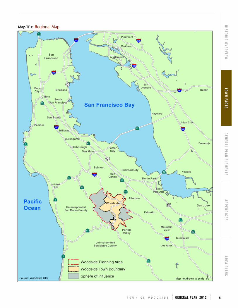
T O W N O F W O O D S I D E GENERAL PLAN 2012 5
HISTORIC OVERVIEWTOW
N FACTSGENERAL PLAN ELEM
ENTSAPPENDICES
AREA PLANS
Map TF1: Regional Map
§̈¦280
·|}ÿ84·|}ÿ35
§̈¦280
·|}ÿ84
·|}ÿ35
·|}ÿ84
·|}ÿ35
§̈¦280
§̈¦280
§̈¦880
§̈¦880
§̈¦580
§̈¦580§̈¦80
·|}ÿ92
·|}ÿ92
·|}ÿ82
·|}ÿ82
·|}ÿ82
Palo Alto
·|}ÿ1
·|}ÿ1
·|}ÿ1
·|}ÿ1
£¤101
£¤101
£¤101
·|}ÿ85
MountainView
Sunnyvale
Los Altos
San Jose
Newark
Fremont
Union City
Dublin
Hayward
SanLeandro
Piedmont
Oakland
AlamedaSan
Francisco
UnincorporatedSan Mateo County
UnincorporatedSan Mateo County
Redwood City
Brisbane
FosterCity
Pacifica
Menlo Park
San Mateo
SouthSan Francisco
Woodside
Belmont
San Bruno
Burlingame
DalyCity
PortolaValley
Atherton
SanCarlos
Hillsborough
Half MoonBay
Millbrae
Colma
EastPalo Alto
Regional Map Town of Woodside±
Created By Woodside GIS 3/22/2011
PacificOcean
San Francisco Bay
Map not drawn to scale
Woodside Planning Area
Woodside Town Boundary
Sphere of InfluenceSource: Woodside GIS

6 T O W N F A C T S
WOODSIDE PLANNING AREAThe Woodside Planning Area is roughly 23 square miles and consists of the lands incorporated as the Town of Woodside, and
the adjoining unincorporated lands assigned as the Town’s sphere of influence (reference Map TF2). While Woodside only
has regulating jurisdiction over its incorporated land, the Town may still utilize the General Plan to cover lands outside its
boundaries which in the Town’s judgment bears relation to its planning. Therefore General Plan 2012 sets forth policies for all
land within the Planning Area.
Woodside Rd
La Honda
Woodside
§̈¦280
·|}ÿ84
Junipero Serra Fwy
Sand Hill
San MateoCounty
Rural Midcoast(Unincorporated)
EdgewoodPark
Sky Londa(Unincorporated)
San Carlos
San MateoCounty
Emerald Lake Hills(Unincorporated) Redwood City
Huddart Park
SearsvilleLake
Bear GulchReservoir
Atherton
Skyline
·|}ÿ35
·|}ÿ84
·|}ÿ84·|}ÿ35
Woo
dsid
e
Skyline
La HondaSkyline
San MateoCounty
Source: Town of Woodside
WunderlichPark
Portola Valley
MenloPark
Woodside Planning Area Town of Woodside±0 0.5 10.25
Miles
Created By Woodside GIS 01/10/12; Revised 02/03/17
Woodside Town Boundary
Sphere of Influence
Map TF2: Woodside Planning Area

T O W N O F W O O D S I D E GENERAL PLAN 2012 7
HISTORIC OVERVIEWTOW
N FACTSGENERAL PLAN ELEM
ENTSAPPENDICES
AREA PLANS
Map TF3: Urban/Wildland Interface
Map TF3 illustrates the urban/wildland interface character of the Woodside Planning Area, with more urban development
to the east and heavily wooded hills to the west.
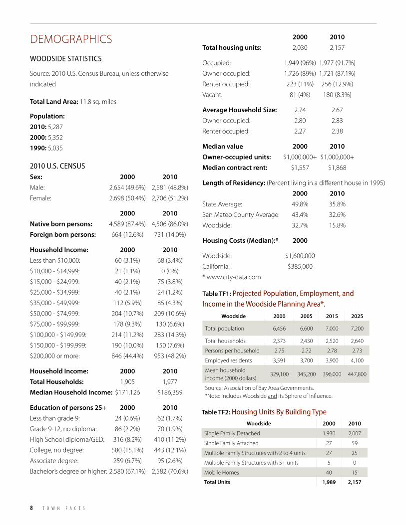
8 T O W N F A C T S
DEMOGRAPHICS
WoodSIde StAtIStIcS
Source: 2010 U.S. Census Bureau, unless otherwise
indicated
Woodside 2000 2010
Single Family Detached 1,930 2,007
Single Family Attached 27 59
Multiple Family Structures with 2 to 4 units 27 25
Multiple Family Structures with 5+ units 5 0
Mobile Homes 40 15
Total Units 1,989 2,157
Table TF2: Housing Units By Building type
Woodside 2000 2005 2015 2025
Total population 6,456 6,600 7,000 7,200
Total households 2,373 2,430 2,520 2,640
Persons per household 2.75 2.72 2.78 2.73
Employed residents 3,591 3,700 3,900 4,100
Mean household income (2000 dollars)
329,100 345,200 396,000 447,800
Source: Association of Bay Area Governments. *Note: Includes Woodside and its Sphere of Influence.
Table TF1: Projected Population, employment, and Income in the Woodside Planning Area*.
Total Land Area: 11.8 sq. miles
Population: 2010: 5,287
2000: 5,352
1990: 5,035
2010 U.S. cenSUSSex: 2000 2010 Male: 2,654 (49.6%) 2,581 (48.8%)
Female: 2,698 (50.4%) 2,706 (51.2%)
2000 2010 Native born persons: 4,589 (87.4%) 4,506 (86.0%)
Foreign born persons: 664 (12.6%) 731 (14.0%)
Household Income: 2000 2010 Less than $10,000: 60 (3.1%) 68 (3.4%)
$10,000 - $14,999: 21 (1.1%) 0 (0%)
$15,000 - $24,999: 40 (2.1%) 75 (3.8%)
$25,000 - $34,999: 40 (2.1%) 24 (1.2%)
$35,000 - $49,999: 112 (5.9%) 85 (4.3%)
$50,000 - $74,999: 204 (10.7%) 209 (10.6%)
$75,000 - $99,999: 178 (9.3%) 130 (6.6%)
$100,000 - $149,999: 214 (11.2%) 283 (14.3%)
$150,000 - $199,999: 190 (10.0%) 150 (7.6%)
$200,000 or more: 846 (44.4%) 953 (48.2%)
Household Income: 2000 2010 Total Households: 1,905 1,977
Median Household Income: $171,126 $186,359
Education of persons 25+ 2000 2010 Less than grade 9: 24 (0.6%) 62 (1.7%)
Grade 9-12, no diploma: 86 (2.2%) 70 (1.9%)
High School diploma/GED: 316 (8.2%) 410 (11.2%)
College, no degree: 580 (15.1%) 443 (12.1%)
Associate degree: 259 (6.7%) 95 (2.6%)
Bachelor’s degree or higher: 2,580 (67.1%) 2,582 (70.6%)
2000 2010 Total housing units: 2,030 2,157
Occupied: 1,949 (96%) 1,977 (91.7%)
Owner occupied: 1,726 (89%) 1,721 (87.1%)
Renter occupied: 223 (11%) 256 (12.9%)
Vacant: 81 (4%) 180 (8.3%)
Average Household Size: 2.74 2.67
Owner occupied: 2.80 2.83
Renter occupied: 2.27 2.38
Median value 2000 2010 Owner-occupied units: $1,000,000+ $1,000,000+
Median contract rent: $1,557 $1,868
Length of Residency: (Percent living in a different house in 1995)
2000 2010State Average: 49.8% 35.8%
San Mateo County Average: 43.4% 32.6%
Woodside: 32.7% 15.8%
Housing Costs (Median):* 2000
Woodside: $1,600,000
California: $385,000
* www.city-data.com

T O W N O F W O O D S I D E GENERAL PLAN 2012 9
HISTORIC OVERVIEWTOW
N FACTSGENERAL PLAN ELEM
ENTSAPPENDICES
AREA PLANS
PoPUlAtIon tRendS The Town of Woodside experienced a population decrease between 2000 and 2010 (-1.2%). Comparatively, population in
the Bay Area as a whole increased 5.4%, and San Mateo County’s population increased 1.6%. The Town's 2010 population
of 5,287 is approximately 0.74% of the County's total 2010 population of 718,451.
Figure TF1: Woodside Population by Age
Table TF3: Population trends
Category Description 1960 Data 1970 Data 1980 Data 1990 Data 2000 Data 2010 Data
Total Population 3,592 4,731 5,291 5,035 5,352 5,287
Population < 18 Years Old *34% 32% 22% 20% 23% 23.5%
Population 18-64 Years Old *57% 60% 69% 66% 61% 56.3%
Population 65+ Years Old 9% 8% 9% 14% 16% 20.2%
Number of Households na 1,481 1,853 1,813 1,949 1,977
Average Household Size na 3.18 2.86 2.78 2.75 2.67
*1960 Population <19, 20-64, 65+ Sources: 1990, 2000, and 2010 U.S. Census, www.bayareacensus.ca.gov/cities/Woodside70.htm, www.nhgis.org
0
200
400
600
800
1000
1200
325 383
364
248
126
366
923 1,04
5
387
330
482
299
74
0-5
5-9
10-14
15-19
20-24
25-34
AGE
200035
-44
45-54
55-59
60-64
65-74
75-84
85+
2010
0
200
400
600
800
1000
1200
220 35
2 423
350
142
274
549
990
472
447
584
328
156
0-5
5-9
10-14
15-19
20-24
25-34
AGE
35-44
45-54
55-59
60-64
65-74
75-84
85+
0
200
400
600
800
1000
1200
325 383
364
248
126
366
923 1,04
5
387
330
482
299
74
0-5
5-9
10-14
15-19
20-24
25-34
AGE
35-44
45-54
55-59
60-64
65-74
75-84
85+
352
220
423
350
20002010
142 27
4
990
472
447
584
328
156
549
0
200
400
600
800
1000
1200
325 383
364
248
126
366
923 1,04
5
387
330
482
299
74
0-5
5-9
10-14
15-19
20-24
25-34
AGE
2000
35-44
45-54
55-59
60-64
65-74
75-84
85+
2010
0
200
400
600
800
1000
1200
220 35
2 423
350
142
274
549
990
472
447
584
328
156
0-5
5-9
10-14
15-19
20-24
25-34
AGE
35-44
45-54
55-59
60-64
65-74
75-84
85+
0
200
400
600
800
1000
1200
325 383
364
248
126
366
923 1,04
5
387
330
482
299
74
0-5
5-9
10-14
15-19
20-24
25-34
AGE
35-44
45-54
55-59
60-64
65-74
75-84
85+
352
220
423
350
20002010
142 27
4
990
472
447
584
328
156
549

10 T O W N F A C T S
The fundamental reasons for the lower growth rate are:
(a) declining household size, due partly to the aging of
the population, (b) a diminution of existing housing
market opportunities due to the high cost of land, and
(c) a characteristic land maturation in which most of the
relatively easily developed land has been built out.
Two years after Town incorporation in 1956, the
Town prepared its first Master Plan (the predecessor
to the General Plan). This 1958 Master Plan cited the
population of the Woodside Plan Area (incorporated
Woodside and its sphere of influence) as "4,500 persons
in the year 1955, with an anticipated build out of 10,000
persons". According to the 2010 Census, more than fifty
years after this projection, the 2010 population of the
Woodside Plan Area was 5,287 persons; and Woodside is
considered to be nearly at complete build out. Although
limiting sprawl and maintaining rural character were
major factors in the residents' push to incorporate in
the mid-twentieth century, it appears that the Town
founders overestimated future population growth.
Factors which have contributed to the low population
growth rates over the last five decades include:
• The large number of constraints (e.g., steep terrain,
seismic hazards, and lack of sewer) to developing or
dividing remaining vacant lands;
• The practice of property owners merging lots;
• The rising cost of land and housing;
• A general aging of the population (i.e., increases in
older age cohorts);
• A steady decrease in the number of persons per
household; and,
• The geographic location of the Town, which
encompasses and is bordered by large tracts of
protected open space.
Other defining characteristics of Woodside include high
housing prices, high household incomes, high levels of
educational attainment, and long lengths of residency.
TOWN GOVERNANCEThe Town of Woodside was incorporated in 1956.
The Town operates under a council-manager form of
government. The council–manager government form is
one of two predominant forms of municipal government
in the United States. The other common form of
local government is the strong mayor government
form, which characteristically occurs in large cities.
The council-manager form of government is used by
approximately half of American cities with populations
of 2,500 or more, according to the International City/
County Management Association (ICMA), a professional
organization for city managers and other top appointed
local government administrators.
Under the council–manager form of government,
the elected governing body (in Woodside, the Town
Council) is responsible for the legislative function of the
municipality such as establishing policy, passing local
ordinances, approving appropriations of funds, and
developing an overall vision.
Woodside is divided into seven Council districts. A
Councilmember is nominated from the district in
which he or she resides, but is elected on a town-wide
basis. Each Councilmember thus represents a different
geographic district of the Town and works for the best
interests of both that district’s distinct circumstances
and the Town as a whole.
Town Council members are elected to staggered four
year terms.The Council appoints a professional manager
to oversee the administrative operations, advise the
council, and implement its policies. The position of
"mayor" is a largely ceremonial title and is selected each
year by the Town Council from among its members.
The manager position (the town manager) in this form
of municipal government is similar to that of corporate
chief executive officer (CEO), providing professional
management to the board of directors (the Town
Council).

T O W N O F W O O D S I D E GENERAL PLAN 2012 11
HISTORIC OVERVIEWTOW
N FACTSGENERAL PLAN ELEM
ENTSAPPENDICES
AREA PLANS
Map TF4: Woodside census tracts
Rural Midcoast(Unincorporated)
Canada
Whiskey Hill
Kings Mountain
Mountain Hom
e
Woodside
PortolaLa Honda
Woodside
§̈¦280
·|}ÿ84
San MateoCounty
Junipero Serra Fwy
Sky Londa(Unincorporated)
Sand H
ill
SearsveilleLake
Bear GulchReservoir
Skyline
·|}ÿ35
·|}ÿ84
·|}ÿ84
·|}ÿ35
Woo
dsid
e
Skyline
~
WunderlichPark
Portola Valley
Redwood City
Jasper Ridge(Stanford Lands)
Atherton
Emerald Lake Hills(Unincorporated)
MenloPark
HuddartPark
Census Tracts Town of Woodside±
Created By Woodside GIS 01/10/12; Revised 07/15/17
0 0.5 10.25Miles
Census Tract 6113
Census Tract 6133
Census Tract 6134
Woodside Town Boundary
Census Tract 6134
Census Tract 6133
Source: 2010 Tiger/Line Data
CensusTract6113
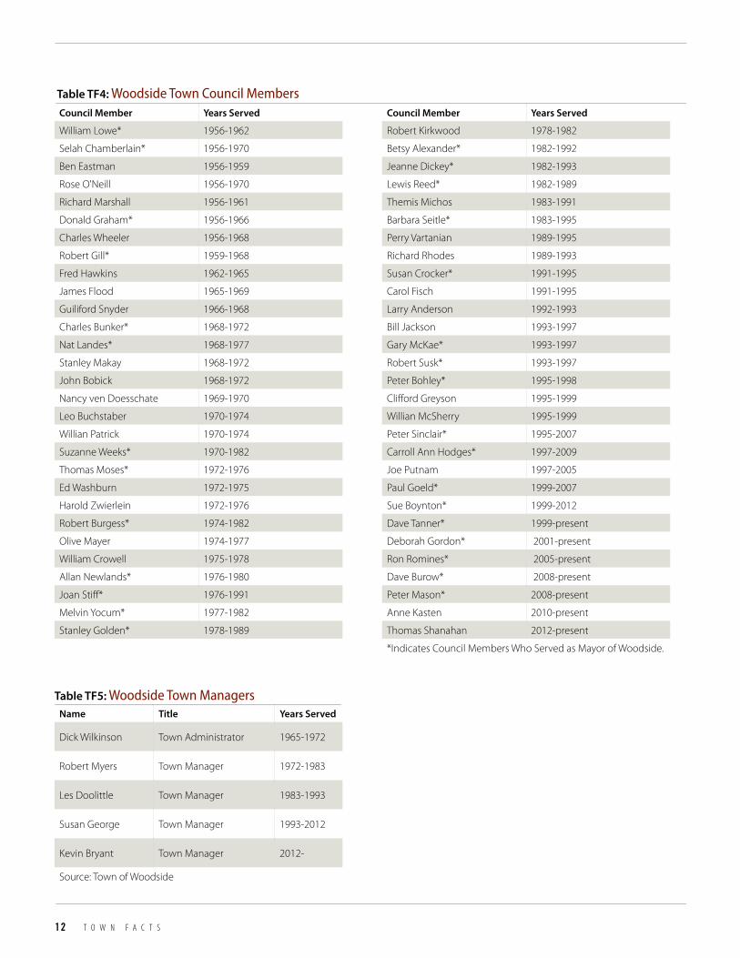
12 T O W N F A C T S
Council Member Years Served
William Lowe* 1956-1962
Selah Chamberlain* 1956-1970
Ben Eastman 1956-1959
Rose O'Neill 1956-1970
Richard Marshall 1956-1961
Donald Graham* 1956-1966
Charles Wheeler 1956-1968
Robert Gill* 1959-1968
Fred Hawkins 1962-1965
James Flood 1965-1969
Guiliford Snyder 1966-1968
Charles Bunker* 1968-1972
Nat Landes* 1968-1977
Stanley Makay 1968-1972
John Bobick 1968-1972
Nancy ven Doesschate 1969-1970
Leo Buchstaber 1970-1974
Willian Patrick 1970-1974
Suzanne Weeks* 1970-1982
Thomas Moses* 1972-1976
Ed Washburn 1972-1975
Harold zwierlein 1972-1976
Robert Burgess* 1974-1982
Olive Mayer 1974-1977
William Crowell 1975-1978
Allan Newlands* 1976-1980
Joan Stiff* 1976-1991
Melvin Yocum* 1977-1982
Stanley Golden* 1978-1989
Table TF4: Woodside town council Members
Name Title Years Served
Dick Wilkinson Town Administrator 1965-1972
Robert Myers Town Manager 1972-1983
Les Doolittle Town Manager 1983-1993
Susan George Town Manager 1993-2012
Kevin Bryant Town Manager 2012-
Source: Town of Woodside
Table TF5: Woodside town Managers
Council Member Years Served
Robert Kirkwood 1978-1982
Betsy Alexander* 1982-1992
Jeanne Dickey* 1982-1993
Lewis Reed* 1982-1989
Themis Michos 1983-1991
Barbara Seitle* 1983-1995
Perry Vartanian 1989-1995
Richard Rhodes 1989-1993
Susan Crocker* 1991-1995
Carol Fisch 1991-1995
Larry Anderson 1992-1993
Bill Jackson 1993-1997
Gary McKae* 1993-1997
Robert Susk* 1993-1997
Peter Bohley* 1995-1998
Clifford Greyson 1995-1999
Willian McSherry 1995-1999
Peter Sinclair* 1995-2007
Carroll Ann Hodges* 1997-2009
Joe Putnam 1997-2005
Paul Goeld* 1999-2007
Sue Boynton* 1999-2012
Dave Tanner* 1999-present
Deborah Gordon* 2001-present
Ron Romines* 2005-present
Dave Burow* 2008-present
Peter Mason* 2008-present
Anne Kasten 2010-present
Thomas Shanahan 2012-present
*Indicates Council Members Who Served as Mayor of Woodside.

T O W N O F W O O D S I D E GENERAL PLAN 2012 13
HISTORIC OVERVIEWTOW
N FACTSGENERAL PLAN ELEM
ENTSAPPENDICES
AREA PLANS
Rural Midcoast(Unincorporated)
WHISKEY HILL
KINGS MOUNTAIN
MO
UN
TAIN
HO
ME
WOODSIDE
PORTOLALA HONDA
WOODSIDE
§̈¦280
·|}ÿ84
San MateoCounty
JUNIPERO SERRA FWY
OLD LA HONDA
La H
onda
Skyline
SAND HILL
Sky Londa(Uninc.)
Skyline
·|}ÿ35
·|}ÿ84
·|}ÿ84
·|}ÿ35
Woo
dsid
e
Skyline
Jefferson
CANADA~
CANADA
~
§̈¦280
KINGS MOUNTAIN
Olive Hill
Farm
Hill
Arbor
Bardet
Fernside
War
d
Bear Gulch Creek
Albion
Tripp
PORTOLASearsville
Lake
Bear GulchReservoir
Stoc
kbrid
ge
Elea
nor
Redwood City
Emerald Lake Hills(Unincorporated)
Jasper Ridge(Stanford Lands)
Portola Valley
WunderlichPark
HuddartPark
Atherton
MenloPark
Manzanita
Source: Town of Woodside
2
3
7
4
6
5
1
Town Council Districts Town of Woodside±
Created By Woodside GIS 4/20/12; Revised 07/15/17
0 0.5 10.25Miles
Council Districts1
2
3
4
5
6
7
Map TF5: Woodside town council districts

14 T O W N F A C T S
TOWN PLANNING HISTORY AND DOCUMENTSGeneral PlansA General Plan expresses the community’s development goals, and embodies public
policy relative to land use. The Town of Woodside has had four previous General
Plans: the 1958 Master Plan, the 1970 General Plan, the 1976 General Plan, and the
1988 General Plan.
1958 toWn of WoodSIde MASteR PlAnIn 1958, the Town of Woodside adopted a Town Master Plan in accordance with
State laws in effect at the time. This was the Town’s first planning document. The Plan
proposed to “maintain Woodside as a rural residential community.”
YEAR 1958:U.S. Population: 174,881,904
CA Population: 14,741,000 (8% of U.S. Population)
U.S. President: Dwight Eisenhower
No. of U.S. States: 48 (Alaska and Hawaii not yet admitted)
U.S. Events:• FirstsuccessfulAmerican
satellite, Explorer I, is launched into orbit.
• U.S.ArmyinductsElvisPresley.
• U.S.Congressformally creates NASA.
Table TC6: Planning Milestones
Planning Document Adopted
1958 Town of Woodside Master Plan 3/11/1959
1970 Town of Woodside General Plan 4/13/1970
1976 Town of Woodside General Plan 8/2/1976
1988 Town of Woodside General Plan 4/6/1988
2012 Town of Woodside General Plan 1/10/2012
Source: Town of Woodside
Placeholder for 1958 newspaper article

T O W N O F W O O D S I D E GENERAL PLAN 2012 15
HISTORIC OVERVIEWTOW
N FACTSGENERAL PLAN ELEM
ENTSAPPENDICES
AREA PLANS
YEAR 1970:U.S. Population: 179,323,175
CA Population: 19,953,000 (11% of U.S. Population)
U.S. President: Richard Nixon
U.S. Events:• FirstEarthDay
• NASA’sExplorerI reenterstheEarth’s atmosphere after 12 years in orbit
• Cigarettetelevision advertisements are banned
• Apollo13
• U.S.invadesCambodia
• KentStateshootings
• VietnamWar demonstrations
• Votingage lowered to 18
• Women’sStrikeforEquality, Fifth Avenue, NYC
• PublicBroadcasting Service begins broadcasting
• UnitedStates Environmental Protection Agency (EPA) begins operations
• OccupationalSafety& Health Act (OSHA) entered into law
1970 toWn of WoodSIde GeneRAl PlAnIn 1970, Woodside comprehensively modified and expanded its General Plan. The Plan
retained the original statement of official community objectives and development
policy set forth in the Master Plan. It also stressed the need for “continuous and
vigorous guidance and control on the part of the local government and the residents”
in order to “maintain the integrity of Woodside as a unique residential community of
unusual natural beauty.” The 1970 Plan included Land Use, Circulation, Public Utilities,
and Housing Elements.

16 T O W N F A C T S
1976 toWn of WoodSIde GeneRAl PlAnThe 1976 General Plan provided updates to the Elements found in the 1970 General
Plan.
YEAR 1976:U.S. Population: 218,035,000
CA Population: 21,936,000 (10% of US Population)
U.S. President: Gerald Ford (Jimmy Carter elected)
U.S. Events:• PattyHearstfoundguilty
of armed robbery
• AppleComputerformedby Steve Jobs and Steve Wozniak
• UnitedStates Bicentennial
• VikingIlandsonMars
• Serialkiller“SonofSam”terrorizes NYC
• Firstoutbreakof Legionnaires’Disease
• TheColdWar
• Microsoftofficially registered in New Mexico
• HotelCaliforniabyTheEagles released

T O W N O F W O O D S I D E GENERAL PLAN 2012 17
HISTORIC OVERVIEWTOW
N FACTSGENERAL PLAN ELEM
ENTSAPPENDICES
AREA PLANS
YEAR 1988:U.S. Population: 244,499,000
CA Population: 28,393,000 (12% of U.S. Population)
U.S. President: Ronald Reagan (George H.W. Bush elected)
U.S. Events:• Iran-ContraAffair
• JesseJackson,US Presidential Candidate
• SonnyBonoelectedmayor of Palm Springs
• Microsoftreleases Windows 2.1
• TheWaronDrugs
1988 toWn of WoodSIde GeneRAl PlAnThe 1988 General Plan was adopted by Town Council on April 6, 1988. Similar to
the previous General Plans, the 1988 General Plan update utilized many of the same
overarching community goals and general policies, focusing on preservation of the
natural environment and community character. The Historic Preservation Element
was added in 2009 to meet the goals and policies for preserving Woodside’s historic
resources.

18 T O W N F A C T S
2012 toWn of WoodSIde GeneRAl PlAnSimilar to earlier General Plans, this 2012 General Plan Update carries forward many
of the same Community Goals and Policies. New to the 2012 General Plan is a
Sustainability Element, and an Implementation Matrix.
The Sustainability Element identifies sustainable concepts found in each Element of
the General Plan. This Element also sets forth new goals, policies, and strategies for
sustainability.
The Implementation Matrix is a tool for guiding the implementation of the General
Plan. For each strategy, the matrix assigns responsible parties, identifies funding
sources, and provides a prioritization and timeframe for implementation.
Area Plans and Specific Plans:In addition to the General Plan, the Town of Woodside also uses Area Plans and
Specific Plans to provide more in-depth direction in planning for certain areas. Area
Plans are part of the General Plan, and are used to provide additional development
and design guidance. Specific Plans are not part of the General Plan (but are still
required to be consistent with the goals and policies of the General Plan). Specific
Plans differ from Area Plans in that they typically include development standards
similar to zoning code regulations.
Area Plans: The Town of Woodside has two Area Plans: the Skylonda Center Area Plan, and the
Town Center Area Plan. These Plans augment the General Plan policies and provide
additional guidelines for the development and replacement of structures within the
YEAR 2010:U.S. Population: 308,400,408
CA Population: 38,827,000 (13% of US Population)
U.S. President: Barack Obama
U.S. Events:• Toyotarecallduetocar
accelerator problems
• 100thAnniversaryoftheBoy Scouts of America
• U.S.Navyendsbanofwomen serving on submarines
• PatientProtectionandAffordableCareActsigned into law aiming to insure 95% of Americans
• Officialtabulationofthe2010 Census begins
• DeepwaterHorizon British Petroleum oil spill in the Gulf of Mexico.

T O W N O F W O O D S I D E GENERAL PLAN 2012 19
HISTORIC OVERVIEWTOW
N FACTSGENERAL PLAN ELEM
ENTSAPPENDICES
AREA PLANS
Town’s two, small commercial areas. During the 2012 General Plan update, the graphic design of the Area Plans were
updated, but the text was not changed.
Area Plans are authorized under §65301(b), which allows individual sections of the General Plan to be devoted to
a particular subject or geographic area. In addition, they are also allowed as optional elements, or subjects, under
§65303. An Area Plan is adopted as a General Plan amendment and is consistent with the General Plan. It refines
the policies of the General Plan as they apply to smaller geographic areas, and is implemented by local ordinances
such as those regulating land use and subdivision. Area Plans also provide forums for resolving local conflicts among
competing interests.
The Town Center Area Plan was adopted in 1970 and was amended in 1973 (approved Plan boundary changes), in
1977 (formal incorporation into the General Plan), and in 1988 (dedicating the Town-owned Village Hill on Woodside
Road to open space).
The Skylonda Center Area Plan was adopted and incorporated into the General Plan in 1985.
Specific Plans: The Town of Woodside has two Specific Plans: the Emerald Lake Specific Plan and the Woodside Glens Specific
Plan. These Plans augment the General Plan policies and provide additional guidelines for the development and
replacement of structures within these two neighborhoods. During the 2012 General Plan update, the graphic design
of the Specific Plans were updated, but the text was not changed.
The Emerald Lake Specific Plan was adopted in 1995.
The Woodside Glens Specific Plan was adopted in 1993, and was amended in 1999 (directed changes to the
residential development standards).
Woodside Municipal CodeThe Woodside Municipal Code sets forth specific Town regulation (law). The majority of land use related regulations
are contained within Chapter 151, Site Development; Chapter 152, Subdivisions; and Chapter 153, zoning. Chapter
151, Site Development, promotes the public safety and general public welfare, and implements the General Plan,
and zoning and subdivision provisions. Chapter 152, Subdivisions, regulates the division of land, and requires certain
prescribed improvements which are needed in consequence of the division of land. Chapter 153, zoning, promotes
and protects the public health, safety, peace, comfort, convenience, and general welfare through the prescription of
allowable land uses and development standards.
Residential Design GuidelinesThe Residential Design Guidelines were developed by the Town in 2000 to provide principles for locating a residence
and related site improvements on a lot, and principles for designing a residence and related structures that will meet
the objectives of the Town. The Guidelines are to be used by prospective homeowners or remodelers and their
architects to assist them in preparing proposals for residential development. The Guidelines are used by the Town’s
Planning Department, Architectural and Site Review Board (ASRB), and Planning Commission to evaluate the merits of
a residential proposal.

20 T O W N F A C T S
Table TC7: History of General Plan elements
Elements1958 Master
Plan1970
General Plan
Amendments to 1970
General Plan1976
General Plan1988
General Plan
Amendments to
1988 General Plan
2012 General Plan
Circulation x x x x x
Conservation x x x x
Historic Preservation x x
Housing x x x
Land Use x x x x x
Natural Hazards/ Safety
x x x
Noise x x x x
Open Space x x x x
Public Utilities x x x x x
Scenic Roads and Highways
x
Sustainability x
Source: Town of Woodside
Table TC8: History of Area and Specific Plans
Plans Adoption Date Amendment Date(s)
Town Center Area Plan 1970
Skylonda Area Plan 1985 1973, 1977, and 1988
Woodside Glens Specific Plan 1993 1995
Emerald Lake Hills Specific Plan 1995 1993 and 1999
Source: Town of Woodside

21
HISTORIC OVERVIEWINTRODUCTION
GENERAL PLAN ELEMENTS
APPENDICESAREA PLANS
“Make no little plans. They have no magic
to stir men’s blood…Make big plans;
aim high in hope and work.” —Daniel Burnmham
FOUNDATIONS OF THE PLAN
Community vision ..........................................................................................................................22
Building Community .....................................................................................................................22
Guiding Principles ...........................................................................................................................22
Purpose of the General Plan ......................................................................................................24
Organization of the Plan ..............................................................................................................25
General Plan Review and Adoption ......................................................................................26
General Plan implementation ..................................................................................................26
FOUNDATIONS OF THE PLAN
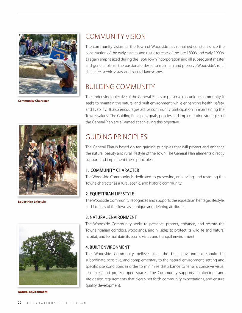
22 F O U N D A T I O N S O F T H E P L A N
COMMUNITY VISIONThe community vision for the Town of Woodside has remained constant since the
construction of the early estates and rustic retreats of the late 1800’s and early 1900’s,
as again emphasized during the 1956 Town incorporation and all subsequent master
and general plans: the passionate desire to maintain and preserve Woodside’s rural
character, scenic vistas, and natural landscapes.
BUILDING COMMUNITYThe underlying objective of the General Plan is to preserve this unique community. It
seeks to maintain the natural and built environment, while enhancing health, safety,
and livability. It also encourages active community participation in maintaining the
Town’s values. The Guiding Principles, goals, policies and implementing strategies of
the General Plan are all aimed at achieving this objective.
GUIDING PRINCIPLESThe General Plan is based on ten guiding principles that will protect and enhance
the natural beauty and rural lifestyle of the Town. The General Plan elements directly
support and implement these principles:
1. coMMUnIty cHARActeRThe Woodside Community is dedicated to preserving, enhancing, and restoring the
Town’s character as a rural, scenic, and historic community.
2. eqUeStRIAn lIfeStyleThe Woodside Community recognizes and supports the equestrian heritage, lifestyle,
and facilities of the Town as a unique and defining attribute.
3. nAtURAl envIRonMent The Woodside Community seeks to preserve, protect, enhance, and restore the
Town’s riparian corridors, woodlands, and hillsides to protect its wildlife and natural
habitat, and to maintain its scenic vistas and tranquil environment.
4. BUIlt envIRonMent The Woodside Community believes that the built environment should be
subordinate, sensitive, and complementary to the natural environment, setting and
specific site conditions in order to minimize disturbance to terrain, conserve visual
resources, and protect open space. The Community supports architectural and
site design requirements that clearly set forth community expectations, and ensure
quality development.
Community Character
Equestrian Lifestyle
Natural Environment
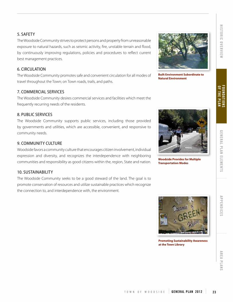
T O W N O F W O O D S I D E GENERAL PLAN 2012 23
HISTORIC OVERVIEWFOUNDATIONS OF THE PLAN
GENERAL PLAN ELEMENTS
APPENDICESAREA PLANS
5. SAfety The Woodside Community strives to protect persons and property from unreasonable
exposure to natural hazards, such as seismic activity, fire, unstable terrain and flood,
by continuously improving regulations, policies and procedures to reflect current
best management practices.
6. cIRcUlAtIon The Woodside Community promotes safe and convenient circulation for all modes of
travel throughout the Town; on Town roads, trails, and paths.
7. coMMeRcIAl SeRvIceS The Woodside Community desires commercial services and facilities which meet the
frequently recurring needs of the residents.
8. PUBlIc SeRvIceS The Woodside Community supports public services, including those provided
by governments and utilities, which are accessible, convenient, and responsive to
community needs.
9. coMMUnIty cUltURe Woodside favors a community culture that encourages citizen involvement, individual
expression and diversity, and recognizes the interdependence with neighboring
communities and responsibility as good citizens within the, region, State and nation.
10. SUStAInABIlIty The Woodside Community seeks to be a good steward of the land. The goal is to
promote conservation of resources and utilize sustainable practices which recognize
the connection to, and interdependence with, the environment.
Woodside Provides for Multiple Transportation Modes
Built Environment Subordinate to Natural Environment
Promoting Sustainability Awareness at the Town Library

24 F O U N D A T I O N S O F T H E P L A N
PURPOSE OF THE GENERAL PLANCalifornia State law requires each city and county to adopt a General Plan "for the
physical development of the county or city, and any land outside its boundaries which
bears relationship to its planning" (California Government Code Section 65300). The
General Plan expresses the community's development goals and embodies public
policy relative to land use. In response to this requirement, the Woodside General Plan
describes the desired character and quality of the community, states the goals and
policies that govern the Town, and sets forth implementing strategies for achieving
those goals and policies. Since the General Plan affects the welfare of current and
future generations, State law requires that the Plan take a long-term perspective. A
typical time horizon for a General Plan is twenty years, with the exception of the
Housing Element which by State law is reviewed every five years.
The Plan contains the Town's official policies on natural resources, land use and
community design, circulation, public health and safety, and housing. It provides
direction on open space and habitat conservation, development intensity of the built
environment, and utility service delivery. Conflicts between mutually desirable goals
are inevitable. For instance, the goal of maintaining a wooded environment in its
natural state may conflict with the goal of promoting fire safety. The Plan intends to
provide guidance to decision-makers for achieving an appropriate balance between
competing goals. In some cases, conflicting goals must be compromised to provide
reasonable adherence to the predominant interests of the Plan. The Town recognizes
that the desires of individuals need to be balanced with the greater needs and goals
of the Community. The General Plan strives for reconciliation of such conflicts in the
best overall interest of the Community.
1907 First Subdivision Map Act enacted.
1917 Initial zoning Law enacted.
1937 All cities and counties required to adopt Master Plans. Cities and counties authorized to prepare "Precise Plans" (similar to Specific Plans of today) to implement the Master Plan.
1967 Housing Element required in the General Plan (effective July 1, 1969).
1970 Conservation and Open Space Elements required in the General Plan.
1971 Safety, Seismic Safety, Noise, and Scenic Highway Elements required in the General Plan. zoning and subdivision approvals required to be consistent with the adopted General Plan.
1984 Planning statutes substantially revised, Seismic Safety and Scenic Highway Elements dropped as required elements, Seismic Safety merged with Safety Element.
Table F1: Milestones in california’s Planning law

T O W N O F W O O D S I D E GENERAL PLAN 2012 25
HISTORIC OVERVIEWFOUNDATIONS OF THE PLAN
GENERAL PLAN ELEMENTS
APPENDICESAREA PLANS
ORGANIzATION OF THE PLANThe General Plan is required to have seven “elements”, or subject categories. These
elements, and the corresponding Town of Woodside elements, are:
GOAL
POLICIES POLICIES
STRATEGIES STRATEGIES STRATEGIES STRATEGIES
Each element includes a general discussion of the relevant topic as it relates to the
Town. Each section also includes goals, policies, and implementing strategies.
A goal is a broad statement of values or aspirations.
A policy provides more precise directions and guides the actions of policy makers,
staff, and property owners, necessary to achieve the goal.
A strategy is a specific task or course of action that the Town may undertake to
implement the policy and contribute to achieving the goal.
Table F2: General Plan elements
Town of Woodside Element Required Element
Preface Optional
Introduction Optional
Land Use and Community Design Land Use
Historic Preservation Optional
Circulation Circulation
Natural Hazards and Safety Safety
Open Space Open Space
Conservation Conservation
Sustainability Optional
Noise Noise
Public Utillites Optional
Housing Housing

26 F O U N D A T I O N S O F T H E P L A N
GENERAL PLAN REVIEW AND ADOPTION The General Plan is adopted or modified after an extensive
public review process and environmental impact analysis.
Public review for this update occurred prior to public
hearings through community meetings, study sessions,
and advisory committee meetings. A General Plan Task
Force consisting of 30 residents was appointed by the
Town Council in 2009 via a community-wide application
process. The Task Force met with Town staff twice a
month from March 2009 through April 2010, reviewed
primers on each Element of the General Plan, and gave
input. During this period, Town staff also met with the
Woodside History Committee to receive comment on
the Historic Overview and Historic Preservation Element,
the Open Space Committee on the Open Space Element,
the Conservation and Environmental Health Committee
on the Conservation Element, and the Bicycle and Trails
Committee on the Circulation Element. Town staff also
held one art contest and coordinated one art project
with the Woodside Elementary School to solicit graphic
input from the school children on community values
which was presented to the Task Force. From April 2010
through January 2011, the Town Council reviewed
General Plan Update drafts at Town Council public study
sessions twice a month to receive and give specific edit
recommendations. In July 2010, a General Plan Graphics
Subcommittee, comprised of two Town Council member
and staff, was formed and met to finalize graphics and
formatting of the new General Plan. Also in July 2010,
a General Plan Update presentation was given by Town
staff to the local Rotary Club. In March and April of 2011, a
Town Council subcommittee comprised of three Council
members and Town staff, met to review the strike-
out edits prepared in response to the Town Council
study sessions. Public hearings before the Planning
Commission in on December 12, 2011 and the Town
Council on January 10, 2012 allowed the community to
express its views prior to Town Council approval.
Woodside Municipal Code requires the Town Council hold
a public hearing before it may consider a General Plan
amendment. State law limits the number of General Plan
amendments to four per year.
GENERAL PLAN IMPLEMENTATION The General Plan is the foundation for planning in
Woodside. All physical development must be consistent
with it. State law also requires that zoning be consistent
with the General Plan. General Plan goals, policies, and
strategies are supported and carried out through the Town’s
planning process, site and architectural review, and public
works projects.
The Implementation Matrix (see Appendix) of the General
Plan is a tool for determining priorities, funding, and
responsible parties for accomplishing General Plan strategies.
An annual General Plan review provides the opportunity
to evaluate the Town’s progress in implementing the plan
and to assess the plan is being followed and if new policy
direction should be considered.