Embed Size (px)
DESCRIPTION
Roger Dixon
Citation preview

83 SUFFOLK GEOCOAST: DUNWICH
Trans. Suffolk Nat. Soc. 49 (2013)
THE SUFFOLK GEOCOAST DUNWICH: SUFFOLK’S LOST CITY – A GEO-TOUR
ROGER DIXON
Although this paper is part of the documentation of Suffolk’s coastal geological heritage, it doubles as the formal report of the Suffolk Naturalists’ Society field excursion on Sunday 7 July, led by myself, Bob Markham and other GeoSuffolk members. The walk is ‘easy’, along fairly level roads and footpaths, but does require walking for about 1 km along beach shingle.
Do follow the Suffolk Naturalists’ Society field excursion guidelines.
Parts of the coastline are rapidly eroding and cliff falls occur at frequent intervals. The cliff is therefore unstable – do not go near the cliff, top or bottom, where there are overhangs.
Trip hazards are common.
Stout footwear is essential, especially for the walk across shingle; dress appropriately for the weather; take plenty of water.
A short version of this account was first published by Dixon (2005). It was expanded to create the hand-out for this field excursion and forms the basis of this report.
Introduction and potted history The history of Dunwich is well-documented by several authors: Comfort (1994) and the much briefer booklet by Chant (1974, reprinted 1986) are recommended. In addition, GeoSuffolk has published a leaflet describing the geology, which may be downloaded (free) from its website, www.geosuffolk.co.uk. Readers should refer to the papers cited for maps detailing the positioning of past coastlines.
Although a Roman camp, possibly known as Sitomagus, existed on the southern shore of the estuary, it was the Saxons who first settled, from the early 5th Century, making use of the broad sheltered estuary. The first church was established c.630 by St Felix – he brought Christianity to East Anglia to convert Angles (ruled from Rendlesham), was made Bishop of Dunwich in 636, established several religious foundations, and died there in 647. The town developed as a thriving port and commercial centre, trading with the Rhineland, France, Holland and Scandinavia. Pottery and metal-ware were key imports; grain and wool were important exports. Viking attacks in the 9th Century led to a brief recession, but the town revived in the early 11th Century under Edward the Confessor.
Dunwich grew rapidly post-conquest, because of its harbour, from c.1000 inhabitants to between 1500–3000 by 1086 to become one of England’s top ten towns. A huge fleet (warships, fishing vessels, cargo boats) was maintained, creating great trading opportunities with the Continent, the town becoming rich and prosperous and attracting further wealth and patronage. Shipbuilding and related industries were of prime importance, with exports of agricultural products (wool, hides, grain, beef, pork) and salt, and imports of wine, Caen stone, alum, potash, pitch, skins, cloth, and wax.

Trans. Suffolk Nat. Soc. 49 (2013)
Suffolk Natural History, Vol. 49 84
Dunwich was also England’s premier fishing port, especially because of abundant North Sea herring.
By the early 13th Century Dunwich was the sixth greatest city in England. It had its own mint, a preceptory of the Knights Templars, a charter by King John in 1199, a Merchant Guild, a population of more than 5000 by 1286, over 800 houses with many shops and tradesmen and one of earliest windmills in Britain.
However, from the times of Henry III (1216–1272) the city was doomed. The growth of Kingsholm spit grew increasingly problematical and other towns, such as Ipswich, grew increasingly important, eclipsing Dunwich.
Kingsholme, the spit across the Blyth River from Southwold, completely blocked the Haven entrance during the great storm of 1249, and a new outlet was forced. Severe storms and floods in 1287 did it again, destroying c.10% of the city, over 200 houses. Dunwich never recovered from this disaster. As much was lost again through further erosion in 1328. With frequent repeats the port declined rapidly and with the Hundred Years War, Black Death and fires the economy was ruined. By 1400, the city had lost over half its people and buildings, the harbour was barely navigable, and all influence gone. People – and the industries and merchants – moved away. After a brief revival in the early 1500s, the dissolution of monasteries proved the final straw. Further storms and erosion and steady decline have continued to the present day.
Almost, for Victorian ‘romantic’ tourism, a notion of which still survives today, has and still is keeping the town on the map.
Figure 1. Sketch map showing places mentioned in the text.

85 SUFFOLK GEOCOAST: DUNWICH
Trans. Suffolk Nat. Soc. 49 (2013)
The Geology of Dunwich Building Stones
The inexorable destruction of the medieval city has left only Greyfriars and the Leper Chapel remaining. Although some of the buildings have earlier origins, the present village is largely Victorian.
Car park Built on the site of Maison Dieu, a half-timbered range of houses with a chapel, built just outside the Palesdyke as a hospital almshouse refuge for the poor, simple and handicapped. It was founded by Henry III in 1251 and possessed a cross reputed to have miraculous healing powers. It was already a ruin by 1700. Some of the foundations and bones have been found near the cafe.
The view to the north from the car park shows the salt marsh and low-lying reclaimed grazing land of the Dunwich River, and the well-developed shingle beach ridge, which protects them from flooding. The shingle ridge is strengthened and maintained with bulldozers by the local authority.
The Village In St. James Street, the Ship Inn is 17th Century and some of the adjacent houses have origins in late medieval times. However, there is a distinctly Victorian look to the village and the Old School (1853–1964) and School House are characteristic of this period. All the houses are built of locally made bricks with tiles and pantiles, some distinctively black-glazed. Many of the garden walls are made with flint pebbles.
The museum was opened in 1972 by the Earl of Stradbroke in one of the Victorian houses. Displays include the Dunwich story, wildlife, natural history, Victorian social history and many photographs. There is also a model of Dunwich as it might have looked in the 12th Century, when the city was at its peak. The anchor outside is from a Napoleonic warship. The museum is well worth a visit.
St. James’ Church Planned by the Barne family, and after nearly 60 years without a parish church, the church was built on the site of the former leper hospital in 1830 to a simple neo-classical design by Robert Appleton. A mass grave was found when work began on the foundations, and may date either from the days of the hospital or from the Black Death in 1349. It was converted in 1839 to its present gothic style, with the exterior clad in stone. The chancel was added in 1881.
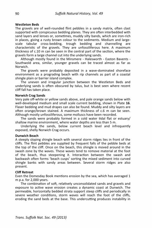
Over 20 different types of building stone, some shown in Plate 13, can be found in the chancel alone. They are mostly white Caen limestone around windows and doors, and local flint. About 35% of the roughly dressed building stones used are, however, not flint, but include red, pink and white granite, black dolerite, basalt and gabbro, white and pink quartzites, gneiss, slate, gritstone, several types of sandstone and limestone, clunch (Totternhoe Stone from the Chalk) and others.
The same rock types can be seen in the rest of the church walls, but local septarian nodules from the London Clay of south Suffolk are much in

Trans. Suffolk Nat. Soc. 49 (2013)
Suffolk Natural History, Vol. 49 86
evidence (over 10% of the materials used) with round flint pebbles from the beach. Original ‘Suffolk White’ bricks can be seen in the tower.
Most of these building stones are recycled from the former leper hospital and previous Dunwich buildings lost to the sea. Some, such as the Caen limestone, were imported from France during Norman times, and some were ballast used by shipping.
A traditional locally made Suffolk pamment floor can be seen inside the church.
The Leper Chapel The chapel, previously a Saxon church, is all that remains of St. James’ Hospital, once over 100 feet long, and with Greyfriars, all that remains of the medieval city. Founded by Richard I at the end of the 12th Century, it was built outside the Palesdyke, away from the city itself – the church ordered that lepers were not allowed to live in towns for fear of the disease. Leprosy was a disease ‘imported’, probably during the Crusades, as Dunwich was a thriving Norman port. The hospital was also used for the poor, sick and aged, and the last leper died in 1536. The chapel was last used in 1685.
The stylish Norman architecture can still be clearly seen, with finely carved Caen stone windows and arches. Of particular note, seen in the external north wall and internal east end, is the fine decorative contrast between imported pale Caen limestone and darker brown Septaria from south Suffolk (Plate 14). The Septaria are often over 30 cm across and some are badly weathered. Elsewhere, flints and other materials are used, partly for restoration and conservation of the ruin.
The Last Buttress In the south-east corner of the church-yard stands the last remaining buttress of All Saints Church. The church was the last-standing of Dunwich’s medieval parish churches, abandoned after the last service in 1755. The final part of the tower was lost to the sea in 1922, but the north-west buttress was saved and moved to its present site in 1923. Of note is the finely dressed ‘chequerboard’ pattern of limestone and flint used in construction.
Greyfriars Monastery One of two former monasteries (Blackfriars was lost to the sea), Greyfriars was built in seven acres just outside the city wall, completed in 1307 and was one of East Anglia’s most important Franciscan centres. The monastery was originally founded in 1228 on an earlier site, which was severely damaged in a great storm in 1287, being finally lost in 1328. It was enclosed by a high wall, using materials recycled from churches and chapels threatened by the sea, with the main gate on the Westleton Road. It soon became a ruin after the dissolution in 1538 and much masonry was carried off by builders for use elsewhere. The main building became a private house; a 3-floor extension built in 1710 using recycled stone and brick was partly used as a civic hall and for prison cells (the originals had been lost to the sea!); and it was mostly demolished in 1815. Anti-aircraft guns were emplaced there during the Second World War.

87 SUFFOLK GEOCOAST: DUNWICH
Trans. Suffolk Nat. Soc. 49 (2013)
The enclosure wall and main arched entry gate contains the same flint, limestone, septaria and many of the ‘exotics’ seen in St. James’ Church, such as clunch, dolerite, gneiss and sandstone. However, part of the eastern section is composed almost entirely of blocks of Pliocene Coralline Crag ‘Rock Bed’ (c.3∙8 million years ago), a soft sandy creamy limestone from the Aldeburgh/Orford area to the south. The tower of the churches at Chillesford and Wantisden are made of the same material and were built at about the same time. Repair and restoration work during 2012/13 used Coralline Crag from Crag Farm in Sudbourne, shown in Plate 15 (see also pp. 92-93).
The Last Gravestone of All Saints The footpath along the eastern boundary of the monastery and cliff top from Middlegate Street to Bridgegate passes along the western edge of the graveyard of All Saints Church. Only one gravestone is left standing, belonging to Jacob Forster, who died in 1796. The church was abandoned after the last service in 1755, but burials still took place until 1826. Bones from the graveyard can sometimes be seen in the cliff as erosion takes place.
Middlegate Street Once a minor branch off the main medieval Westleton to Bridge Gate road (now St. James’ Street), it led to the southern part of the city. It is now only a footpath but one of the originally three rustic bridges can still be seen crossing the path. It is interesting to stand at the end of this road and gaze seawards over ‘Suffolk’s lost city’, reflecting upon what might have been.
Coastal Processes
Background Pye & Blott (2006) give an excellent account of the coastal processes offshore and provide good maps marking the former shorelines. A flood tidal stream runs southwards (c.185˚) at 0∙3 m/sec for neap tides (around 0∙7 m/sec spring tides). The ebb tidal stream runs northwards (c.007˚) at similar velocities. Dominant winds, and therefore waves, are from the north or north-east. About 3/4 of all waves are <2 m high; the highest waves most years are c.5 m high, with 1 in 100 year heights predicted to be c.7∙5 m. Storm surges help raise the mean water level; there have been nine significant surges (e.g. the well-known 1953 surge of over 3∙5 m) in the 20th Century, and surges of <1 m are relatively frequent.
Immediately out from the shore lies a trough over 10 m deep and, some 1∙5–2 km offshore, the Dunwich Bank, which may help to control wave height, amount of erosion and sediment movement, and shelter the coast from storms. Recent reduction in cliff erosion rates, for example, may have resulted from the movement and the growth of this bank. For example from 1992–2003 the crest of Dunwich Bank fell by c.1 m and the bank migrated landward c.150 m.
Sediment transport is largely from the north. At present input from the north and from offshore is limited but does occur significantly from the cliffs. However, in recent years, this has decreased and the cliffs are largely stabilised by growth of vegetation. Estimates of sediment input over the last century vary considerably: input from the Dunwich/Minsmere cliffs could be

Trans. Suffolk Nat. Soc. 49 (2013)
Suffolk Natural History, Vol. 49 88
as much as 40 K m3/year and from southward long-shore drift as much as 65 K m3/year. From 1868–1992 it is estimated that the cliffs supplied 5∙5 km3 of sediment to the nearshore zone.
9000 years ago, the sea level was some 30 m lower, but there have been several significant transgressive and regressive phases since then. The average sea level rise over the last 4,000 years is calculated to be 0∙61 mm/year. More recently, records from Lowestoft show a mean sea level rise 1955–2005 of 13 cm and 20th Century average of 1∙81 mm/year.
Higher sea levels may be due to periods of atmospheric warming and more storm tracks to the north-west, and an increase in frequency of winds from the south and west resulting in less erosion, less sediment transport, and more coastline stability (e.g. during the Medieval Warm Period, 1000–1200AD).
Cooler phases (e.g. the Little Ice Age, 1500–1850AD) bring periods of greater frequency winds from north and north-east, resulting in larger, more frequent storm surges, greater wave energy, greater coastal erosion and flooding, greater long-shore drift and therefore more spit advancement.
Historical geomorphological changes During Roman times the Dunwich and Blyth Rivers fed into a large estuary– this provided ideal potential for port development. However, the Blyth River was deflected southwards by growth of a large spit (Kingsholme) enclosing the estuary, shown in Figure 2, and during a large storm of 1328 the harbour became blocked. The Blyth River forced a new opening near Walberswick. Attempts to cut through shingle to form new a harbour at Dunwich all failed and the town consequently went into decline. From 1587–1753 there was 315 m of cliff recession (c.1∙9 m/yr on average). Late 19th Century/early 20th Century recession rates were faster than average, resulting in significant land loss (1903–1953 average of 1∙3 m/year). Since then rates have declined (1953–2003 average 0∙6 m/yr) and since 1977 cliffs have retreated only a few metres, Dunwich Bank has increased in width, beaches have accreted and the cliffs have stabilised and degraded.
The Cliff Section: Geology The section extends southwards from the car park for some 3 km to the Dunwich Heath visitor centre. The cliffs reach 20 m height and show Westleton Bed gravels (uppermost Norwich Crag Series) overlying and channelled into Norwich Crag sands (Baventian/Antian, Lower Pleistocene, a cold climatic phase), deposited about 1∙6 million years ago, just before the Ice Age. The Norwich Crag Series extends from Chillesford and Orford northwards over much of eastern Suffolk and Norfolk. There are several horizons of pebble and clay beds, such as the Easton Bavents and Chillesford Clays in south-east Suffolk. A picture builds up during the Baventian of a shifting complex of shallow marine, estuarine and muddy lagoonal environments across coastal Suffolk, comparable in many ways to the coast today. Hamblin & Rose (2012) give an excellent account of the Norwich Crag Series (and other beds), and Mottram (2012) discusses the Westleton Beds, both papers with many references for follow-up.

89 SUFFOLK GEOCOAST: DUNWICH
Trans. Suffolk Nat. Soc. 49 (2013)
Figure 2. Sketch map indicating historical coastline positions and geography.
Trans. Suffolk Nat. Soc. 49 (2013)
Suffolk Natural History, Vol. 49 90
Westleton Beds The gravels are of well-rounded flint pebbles in a sandy matrix, often clast supported with conspicuous bedding planes. They are often interbedded with sand layers and lenses or, sometimes, muddy silty bands, which are iron-rich in places, giving a rusty brown colour to the sediments. Medium and large-scale tabular cross-bedding, trough bedding and channelling are characteristic of the gravels. They are unfossiliferous here. A maximum thickness of c.10 m can be seen in the central part of the section, where the gravels form a large channel cut into the underlying sands.
Although mostly found in the Minsmere - Halesworth - Easton Bavents - Southwold area, similar, younger gravels can be traced almost as far as Norwich.
The gravels were probably deposited in a wave-dominated shoreface environment as a prograding beach with rip channels as part of a coastal shingle plain or barrier island complex.
The uneven and irregular junction between the Westleton Beds and underlying sands is often obscured by talus, but is best seen where recent cliff fall has taken place.
Norwich Crag Sands Very pale off-white or yellow sands above, and pale orange sands below with well-developed medium and small scale current bedding, shown in Plate 16. Flaser bedding and mud drapes can also be found. Muddy and silty layers are often orange/brown stained. A maximum thickness of c.6 m can be seen. Although mostly unfossiliferous, some molluscs have been recorded.
The sands were probably formed in a cold water tidal flat or estuary/shallow marine environment, where water depths are less than 5 m.
Underlying the sands, below current beach level and infrequently exposed, shelly Norwich Crag occurs.
Dunwich Beach A steeply sloping shingle beach with several storm ridges lies in front of the cliffs. The flint pebbles are supplied by frequent falls of the pebble beds at the top of the cliff. Once on the beach, this shingle is moved around in the swash zone by the waves. These waves tend to remove material at the foot of the beach, thus steepening it. Interaction between the swash and backwash often forms ‘beach cusps’ sorting the mixed sediment into curved shingle banks with sandy areas between. Several storm ridges are also present.
Cliff Retreat Even the Domesday Book mentions erosion by the sea, which has averaged 1 m p.a. for 2,000 years.
The combination of soft, relatively unconsolidated sands and gravels and exposure to active wave erosion creates a dynamic coast at Dunwich. The permeable, horizontally bedded strata support steep cliffs and periodically in severe weather conditions, storm waves will reach the foot of the cliffs, eroding the sand beds at the base. This undercutting produces instability in

91 SUFFOLK GEOCOAST: DUNWICH
Trans. Suffolk Nat. Soc. 49 (2013)
the pebble beds above, which fall causing the cliff top to recede. On the Suffolk coast the largest waves (i.e. those with the greatest fetch) are produced by storms from the north and north-east resulting in movement of shingle southwards by longshore drift. In this way, Dunwich cliffs supply much of the shingle for beaches to the south.
Recent cliff protection work has stabilised the cliff to a large extent. Erosion is now minimal and the cliff is rapidly degrading.
Endpiece The Suffolk GeoCoast project was launched by GeoSuffolk in 2005 to promote the geology within the Suffolk Coast and Heaths AONB. To date a series of field excursions and leaflets have resulted. The first of a series of guided walks and drives was published in Transactions Volume 47 on the sections at Bawdsey (Dixon, 2012a); the second on the London Clay at Harkstead and Nacton shores in Transactions Volume 48 (Dixon, 2012b). The ultimate aim is to produce a printed geological guide to the Suffolk coast.
References Chant, K. (1974). The History of Dunwich. Dunwich Museum, Suffolk. Comfort, N. (1994). The Lost City of Dunwich. Terence Dalton Ltd, Lavenham. Dixon, R. (2005). Dunwich: the geology of Suffolk’s lost city. GA Magazine 4,
No. 2, 20–21. Dixon, R. (2012a). The Suffolk GeoCoast – Bawdsey East Lane to the Manor.
Trans. Suffolk Nat. Soc. 47, 98–103. Dixon, R. (2012b). The Suffolk GeoCoast – The London Clay of Nacton and
Harkstead Shores. Trans. Suffolk Nat. Soc. 48, 153–156. Dixon, R. 2013. Greyfriars, Dunwich: Coralline Crag in action. GA Magazine 12,
No.4, and this volume pp. 92-93. Hamblin, R. J. O. & Rose, J. (2012). The Red, Norwich and Wroxham Crags of
Northern Suffolk. In: Dixon, R. (Ed) A Celebration of Suffolk Geology. GeoSuffolk, 175–197.
Mottram, H. (2012). The Norwich Crag Geology of the Country around Westleton. In: Dixon, R. (Ed) A Celebration of Suffolk Geology. GeoSuffolk, 251–258.
Pye, K. & Blott, S. J. (2006). Coastal processes and morphological change in the Dunwich-Sizewell area, Suffolk, UK. Journal of Coastal Research, 22 (3), 453–473.
Roger Dixon The White House 7 Chapel Street Woodbridge Suffolk IP12 4NF
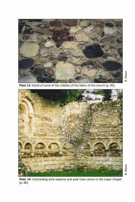
Plate 13: Detail of some of the cobbles of the fabric of the church (p. 85).
R. D
ixo
n
Plate 14: Contrasting dark septaria and pale Caen stone in the Leper Chapel (p. 86).
R. D
ixo
n

Plate 15: Roger Dixon standing in front of the newly repaired boundary wall of Greyfriars monastery which uses Coralline Crag (pp. 87 and 92).
R. D
ixo
n
R. D
ixo
n
Plate 16: Current bedding in the Norwich Crag sands, with Westleton Bed pebbles above (p. 90).