Embed Size (px)
Citation preview
(2007) 97–119www.elsevier.com/locate/margeo
Marine Geology 243
The structure of the Atlantic–Mediterranean transition zone fromthe Alboran Sea to the Horseshoe Abyssal Plain
(Iberia–Africa plate boundary)
L. Iribarren a, J. Vergés a,⁎, F. Camurri b, J. Fullea a, M. Fernàndez a
a Group of Dynamics of the Lithosphere (GDL), Institute of Earth Sciences “Jaume Almera”, CSIC,Lluís Solé i Sabarís s/n, 08028 Barcelona, Spain
b Dipartimento Scienze della Terra, Universita’ di Parma, Parco Area delle Scienze, 157/A, 43100 Parma, Italy
Received 10 November 2006; received in revised form 16 May 2007; accepted 25 May 2007
Abstract
The diffusive plate boundary between Iberia and Africa has been analyzed by means of already published and new 28multichannel seismic profiles covering most of the Atlantic margins of SW Spain and NW Morocco. This region includes theprolongation of the Betic–Rifean tectonic units along the Gibraltar Arc. One of the most characteristic units in the study area is theMiocene seismically chaotic unit that has been divided in a tectonic and a gravitational domains in accordance to previousinterpretation by Torelli et al. [Torelli, L., Sartori, R., Zitellini, N., 1997. The giant chaotic body in the Atlantic Ocean off Gibraltar:new results from a deep seismic reflection survey. Marine and Petroleum Geology 14, 125–138.]. In this work we redefine thelimits of both domains and rename them as the Gulf of Cadiz Imbricate Wedge and the Horseshoe Gravitational Unit. We interpretthe Gulf of Cadiz Imbricate Wedge as a west-migrating thick thrust system that build up in a relatively short period of time. Thisunit constitutes the continuation of the Miocene chaotic units observed onshore to the front of the External Units in the Betics andthe Rif (the Guadalquivir Allochthonous Unit and the Rides Prerifaines). The Horseshoe Gravitational Unit, covering anapproximate area of 18000 km2 with a volume of around 23000 km3, is interpreted as giant submarine debris flows sourced fromthe up-building of the Gulf of Cadiz Imbricate Wedge, surrounding basement highs and the continental Iberian Slope. The fastwestward migration of the Flysch units, the External Units and the Gulf of Cadiz Imbricate Wedge, from the Early Miocene to theLate Tortonian corresponds to a different tectonic process than the protracted but slow NNW to NW convergence of Africa. Ourinterpretation favours the westward slab retreat theory to form the arcuate shape of the Atlantic side of the Iberia–Africa plateboundary. The subduction mechanism as well as potential roll-over was only active from late Early Miocene to Late Miocenespanning about 12 Myr.© 2007 Elsevier B.V. All rights reserved.
Keywords: Gulf of Cadiz; Gibraltar Arc; Betics; Rif; accretionary wedge; olistostromes
⁎ Corresponding author. Tel.: +34 93 409 54 10x241; fax: +34 93411 00 12.
E-mail addresses: [email protected] (L. Iribarren),[email protected] (J. Vergés), [email protected] (J. Fullea),[email protected] (M. Fernàndez).
0025-3227/$ - see front matter © 2007 Elsevier B.V. All rights reserved.doi:10.1016/j.margeo.2007.05.011
1. Introduction
The boundary between Iberian and African plates, inthe Atlantic–Mediterranean transition zone, corre-sponds to a wide deformation band that encompassesthe Atlantic margins of SW Iberia and NWAfrica from
98 L. Iribarren et al. / Marine Geology 243 (2007) 97–119
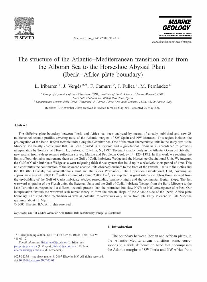
the Gorringe Bank to the Gulf of Cadiz, the BeticCordillera and the Rif mountains and the Alboran Sea(Fig. 1). The present structure as well as the Neogeneevolution of this segment of the plate boundary is still amatter of debate as a consequence of the complexity ofthe Late Cenozoic geodynamic processes (e.g., Calvertet al., 2000; Jiménez-Munt et al., 2001).
The Betic and the Rif thrust belts consist of meta-morphic rocks of the Internal Zones, passive margincover of the External Zones and Flysch Units, and boththe foreland and the intramontane Neogene basins(Fig. 1). The Internal Zones, which are part of theAlboran Crustal Domain, are made of Late Paleozoic toTriassic rocks that were piled up during Tertiary com-pression, followed by a pervasive extensional event thatstarted in the Early Miocene (e.g., García-Dueñas et al.,1992; Crespo-Blanc et al., 1994). The External zones ofthe Betic and Rif thrust belts correspond to the coversequences of the south-west Iberian and north-westMaghrebian paleomargins that were deformed above ahighly arcuate thrust system (e.g., Crespo-Blanc andCampos, 2001; Platt et al., 2003a). The Flysch Unitscomprise deep marine turbidites that were transported
Fig. 1. Main elements of plate boundaries, relative plate kinematics, positionstudy area modified after Rodríguez Fernández (2004) for the Iberian Peninsu(1999) for the Alboran Sea. We also used Rovere (2002), Gràcia et al. (2003aPB: Portimao Bank, GB: Guadalquivir Bank, CPR: Coral Patch Ridge, GCIW
towards the west above an arcuate imbricate system ofthrusts along the Gibraltar Arc (e.g., Mauffret et al.,1992; Crespo-Blanc and Campos, 2001; Michard et al.,2002). These imbricate thrust belts (the External Zonesand the Flysch Units) prolong offshore to the west, ontop of the previously rifted Mesozoic passive margins ofIberia and Africa. The direction of the structure of theExternal Zones swings from the Betic Cordillera to theRif thrust belt through the Gibraltar Strait, giving anarcuate shape that have led different authors to refer thisarea as the Gibraltar Arc.
A large number of well constrained datasets provide,however, contrasting interpretations for the Neogeneevolution of this region (Andrieux et al., 1971; Leblancand Olivier, 1984; Sanz de Galdeano, 1990). Most ofthem try to explain the arcuate geometry of the Betic–Rif system by convective removal and orogenic collapse(e.g., Dewey, 1988; Platt and Vissers, 1989; Visserset al., 1995; Platt et al., 2003b) and mantle delamination(e.g., García-Dueñas et al., 1992; Docherty and Banda,1995; Seber et al., 1996; Mezcua and Rueda, 1997;Calvert et al., 2000). Another group of authors interpretthe region using Miocene slab rollback (e.g., Frizon de
of the Gloria fault and situation of the study area. Geologic map of thela, after Saadi et al. (1985) for the NWMorocco, and after Comas et al.) and Gràcia et al. (2003b) for the Atlantic margin. AB: Algarve basin,: Gulf of Cadiz Imbricate Wedge, HGU: Horseshoe Gravitational Unit.
99L. Iribarren et al. / Marine Geology 243 (2007) 97–119
Lamotte et al., 1991; Lonergan and White, 1997), activesubduction (Gutscher et al., 2002; Duggen et al., 2004;Faccenna et al., 2004), slab break-off (Zeck, 1996;Wortel and Spakman, 2000), or slab rollback combinedwith lithosphere tearing (Spakman and Wortel, 2004;Faccenna et al., 2004; Govers and Wortel, 2005).
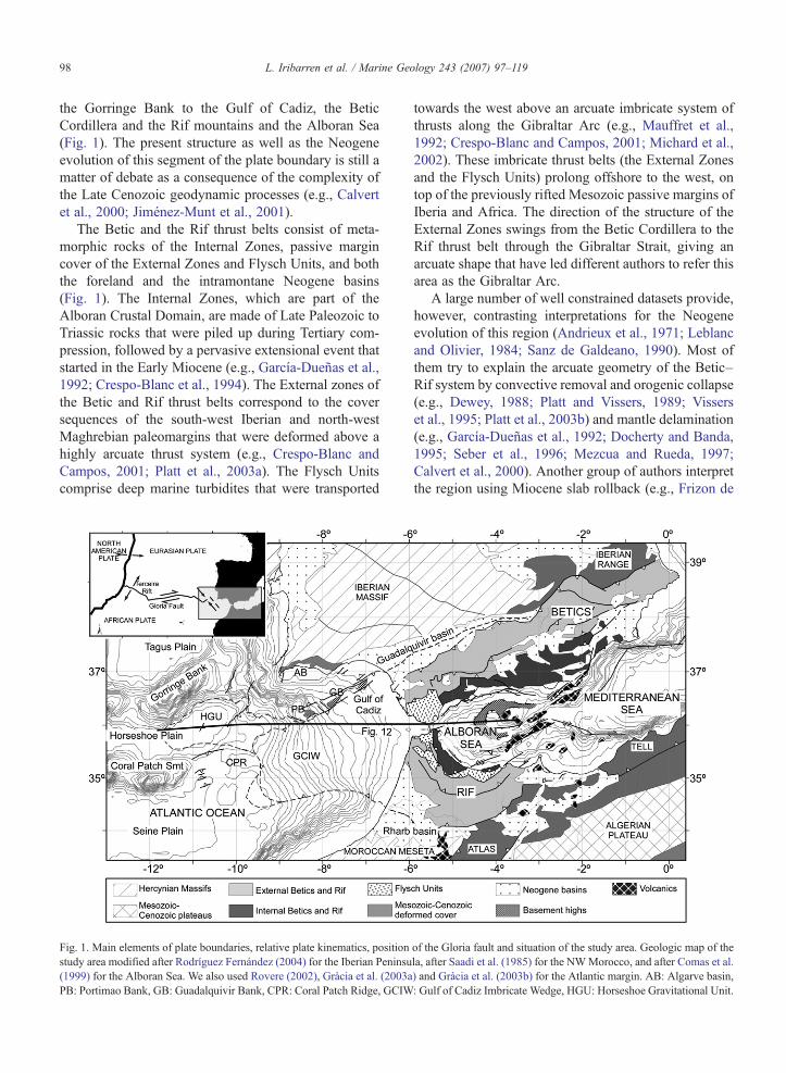
Understanding the tectonic structure of the Atlanticrealm of the Gibraltar Arc is essential to constrainthe displacement to the west of the Alboran CrustalDomain and the consequent formation of the Betic andRifthrust belts in this geodynamic scenario. As a result, alarge effort has been made in the last decade to determinethe shallow and deep crustal structure of the Atlanticmargins of SW Iberia and NW Africa (e.g., Maldonadoet al., 1999; Gràcia et al., 2003b; Medialdea et al., 2004;Contrucci et al., 2004). One of the streaking features ofthis Atlantic region is the presence of large allochthonousmasseswith seismically chaotic reflections at the forefrontof the Gibraltar Arc (e.g., Lajat et al., 1975; Bonnin et al.,
Fig. 2. Bathymetric map of the studied area and all seismic reflection profiles aof some seismic profiles shown in Figs. 3, 4, 5 and 7 are drawn as bold grey linRidge, GoB: Gorringe bank, GB: Guadalquivir bank, PB: Portimao Bank; GCUnit of the Miocene seismically chaotic unit.
1975; Purdy, 1975; Royden, 1993), called in manydifferent ways as “Giant Chaotic Body” (Torelli et al.,1997), “Allochthonous Unit” (González-Fernández et al.,2001; Gràcia et al., 2003b), “Olistostromic Complex”(Maldonado and Nelson, 1999), or “Allochthonous Unitof the Gulf of Cadiz” (Medialdea et al., 2004).
In this work, we try to summarize previous studieswith special emphasis in the structure of the Gulf ofCadiz region in order to link the main structural featuresof the Betics, Rif and Alboran basin. We keep thedivision by Torelli et al. (1997) of the large Mioceneseismically chaotic unit which implies, a tectonicdomain located in the present Gulf of Cadiz continentalslope and a gravitational domain occupying the easternHorseshoe Abyssal Plain. We redefine the limits of bothdomains based on new available seismic data and assignnew names that provide a better accuracy on the internalgeometry and geographic position of both domains.Therefore, hereafter, we will refer to these two domains
nd wells used for this study are depicted. The position of some portionses. GS: Gibraltar Strait, CPS: Coral Patch Seamount, CPR: Coral PatchIW: Gulf of Cadiz ImbricateWedge and HGU: Horseshoe Gravitational

Table 1Published seismic velocities in the Gulf of Cadiz region
Reference Source ofdata
VelocityNeogenesediments
Velocity of Mioceneseismically chaoticunit
Purdy (1975) Refraction 2 km/s 3.1 km/sRyan et al. (1973) Well
(DSDP)1.77 km/s –
González-Fernándezet al. (2001)
Refraction 2 km/s 2–2.4 km/s
Gutscher et al. (2002) Refraction 2 km/s 3 to ±3.5 km/s
100 L. Iribarren et al. / Marine Geology 243 (2007) 97–119
as the Gulf of Cadiz Imbricate Wedge and the HorseshoeGravitational Unit.
The main objectives of the work are: a) to constructisobath and isopach maps of both the Gulf of CadizImbricate Wedge and Horseshoe Gravitational Unit todetermine their geometries, area extent, volumes andpotential structure; b) to propose a unique tectonicframework that integrates the Gulf of Cadiz units withinthe Betic and Rif thrust belts; and c) to integrate theseresults in an E–W trending regional crustal and litho-spheric section from the Alboran Sea to the Atlanticthrough the Strait of Gibraltar. For these purposes, weused seismic information from the relatively large numberof existing surveys along the Atlantic margins of SWIberia and NW Morocco (Fig. 2) and we combinedstructural data sets together with recently publishedcrustal and lithospheric thickness maps (Fullea et al.,2006; Fullea et al., 2007).
2. Data and method
The extend and structure of the Miocene seismicallychaotic unit has been constrained by a dataset that consistsof seismic reflection profiles together with scientific deepsea drilling wells and scientific and commercial oilexplorationwells. A total of 28 regional seismic lines havebeen used to determine the 3-D geometry of both the Gulfof Cadiz Imbricate Wedge and Horseshoe GravitationalUnit represented in both isopach and isobath maps(Fig. 2). These seismic profiles were acquired in differentscientific cruises from 1992 to 2002 including theArrifano lines, acquired in 1992 (Sartori et al., 1994);the IAM lines in 1993 (Banda et al., 1995; Tortella et al.,1997); the BIGSETS lines in 1998 (Zitellini et al., 2001;Gràcia et al., 2003b); the SISMAR lines in 2001(Gutscher et al., 2002); and the Voltaire lines in 2002(Zitellini et al., 2002). The African shelf was analysedusingmultiple seismic lines documented in Flinch (1996).
Two wells from the Deep Sea Drilling Project(DSDP) were drilled in the study area. The DSDP site135 is on top of the Coral Patch Ridge topographic high,750 m above the Horseshoe Abyssal Plain (Hayes et al.,1972), (Fig. 2). DSDP Site 120 is located on thenorthern slope of the Gorringe Bank (Ryan et al., 1973)(Fig. 2). Commercial oil exploration wells were drilledalong the SW Iberian shelf in the Gulf of Cadiz (Lanajaet al., 1987; Terrinha, 1998), that permit to some extentto extrapolate well-known reflectors towards the distalparts of the Gulf of Cadiz.
All these dataset have been integrated and depthconverted to constrain the extent and geometry of thetop and base of the Miocene seismically chaotic unit.
These results were used to construct isobaths maps forthe top and base of both the Gulf of Cadiz ImbricateWedge and Horseshoe Gravitational Unit. With thesemaps we finally constructed isopach maps for bothdomains. For depth conversion we assigned P-waveseismic velocities calculated from published refractionexperiments in the study area, which are summarized inTable 1. Consequently, we have assigned a velocity of3.1 km/s to the Miocene seismically chaotic unit and of2 km/s to the overlying sediments.
3. The geometry and extent of the Mioceneseismically chaotic unit in the Gulf of Cadiz: Gulf ofCadiz imbricate wedge and Horseshoe GravitationalUnit
Despite the general disorganized character of theMiocene seismically chaotic unit it is possible toseparate different domains as has been done in previousworks sometimes reaching contrasting interpretationsthat will be discussed hereinafter.
Bonnin et al. (1975) and Auzende et al. (1981)divided the Miocene seismically chaotic unit into threegravitational domains according to their geographicalposition in the Gulf of Cadiz: olistostromic domains I, IIand III from the Gibraltar Arc to the Horseshoe AbyssalPlain, respectively. Torelli et al. (1997) first attempted toasses the 3-D geometry of the unit. These authorsidentified two different domains: southern domaininterpreted as a tectonic melange in the slopes of theGulf of Cadiz and a gravitational domain in the abyssalplains. The southern domain corresponds to a south-verging accretionary prism related to the Africa–Iberiaconvergence. The unit in the abyssal plains is interpretedas a submarine gravitational unit derived from thebasement highs around the Horseshoe Abyssal plain.Medialdea et al. (2004) proposed 3 different units on thebasis of their seismic architecture, the main internaltectonic features and the continental or oceanic nature oftheir basement. According to these authors, the units

Fig. 3. Seismic interpretation of a segment of the AR92-6 profile. This profile is located to the south-western front of the Gulf of Cadiz Imbricate wedge (GCIW) (see Fig. 2 for location). Faults aredepicted in bold black and internal listric faults within the Gulf of Cadiz Imbricate Wedge are depicted in dashed lines.
101L.Iribarren
etal.
/Marine
Geology
243(2007)
97–119

102 L. Iribarren et al. / Marine Geology 243 (2007) 97–119
were emplaced as a consequence of the NE–SW com-pression during the north-westwards convergence ofAfrica and are: i) the Offshore Betic–Rifean Domain,which corresponds to the offshore extension of theBetic–Rifean external front; ii) the Frontal Slope; andiii) the Oceanic Domain in the distal abyssal plain.Gutscher et al. (2002) interpreted the eastern part of theMiocene seismically chaotic unit as an active accretion-ary prism with a western vergence and developed abovean east-dipping oceanic subduction. This subductionwould still take place currently beneath the GibraltarArc.
In this work we differentiate the Miocene seismicallychaotic unit in two major domains based on their internalstructure, geometry, position and age relationships: thetectonic Gulf of Cadiz Imbricate Wedge and thegravitational Horseshoe Gravitational Unit (Fig. 2).This interpretation mostly agrees with the divisionmade by Torelli et al. (1997) and corresponds to theSouthern Domain and the olistostromes, respectively.With regard to the other studies, the Gulf of CadizImbricate Wedge represents domains I and II of Bonninet al. (1975) and Auzende et al. (1981), the OffshoreBetic–Rifean and Frontal Slope Domains of Medialdeaet al. (2004) and the accretionary prism of Gutscher et al.(2002). The Horseshoe Gravitational Unit is part ofdomain II and the entire domain III of Bonnin et al.(1975) and Auzende et al. (1981), and the OceanicDomain of Medialdea et al. (2004).
3.1. The Gulf of Cadiz Imbricate Wedge
The Gulf of Cadiz Imbricate Wedge occupies about58000 km2 of the Atlantic margins of both NWAfricaand SW Iberia (Gulf of Cadiz), (Figs. 1 and 2). It
Fig. 4. Seismic interpretation of the eastern portion of the AR92-1 seismic proof Cadiz Imbricate wedge (GCIW) and the Horseshoe Gravitational Unit inblack and internal listric faults within the GCIW are depicted in dashed line
displays tongue shape geometry in map view witharound 300 km of length in an ENE–WSW directionand between 150 and 200 km of width in a NW–SEdirection. The Gulf of Cadiz Imbricate Wedge covers theentire Iberian and African margins from the continentalshelves to the ENE, through the continental slopes andreaching the eastern boundaries of the Seine andHorseshoe abyssal plains to the W (Figs. 1 and 2). Itsnorth-western boundary corresponds to the Guadalqui-vir Bank and Portimao Bank basement highs thatpossibly formed a topographic barrier for the Gulf ofCadiz Imbricate Wedge to expand to the north (Gràciaet al., 2003b). This boundary seems to be in continu-ation with the north-western limit of the large outcropsmostly formed by Triassic evaporites cropping out alongthe front of the External Betic thrust belt and beneath theGuadalquivir Basin (e.g., Berástegui et al., 1998;García-Castellanos et al., 2002). The southern boundaryof the Gulf of Cadiz Imbricate Wedge is very rectilinearas expressed by the bathymetry and bends near theAfrican coastline to connect with the outer margin of theExternal Rif thrust belt beneath the Rharb Basin (Fig. 2).Along the west and south-west boundaries, the CoralPatch Ridge produces the same effect than theGuadalquivir and Portimao banks, acting as a bathy-metric barrier to the western advance of this unit, at leastpartially.
The stratigraphy of the distal regions of the Gulf ofCadiz has been interpreted according to Tortella et al.(1997) and Medialdea et al. (2004). Upper Jurassic toLower Cretaceous marls and limestones constitute thelowermost part of the stratigraphic succession above theTriassic evaporites. These are followed by Upper Creta-ceous to Eocene–Oligocene basal carbonates and shales.The Miocene reflective chaotic unit of Late Miocene age
file. Entire seismic line in Torelli et al. (1997). This profile crosses Gulfan E–W direction (see Fig. 2 for location). Faults are depicted in bolds.

103L. Iribarren et al. / Marine Geology 243 (2007) 97–119
followed by the Late Tortonian to recent represent thetopmost part of the sedimentary succession (see alsoHayes et al., 1972; Hayward et al., 1999; Maldonado andNelson, 1999 and Maestro et al., 2003).
Along the shallowest part of the Gulf of Cadiz, nearthe Strait of Gibraltar, the Betic External Units thrustover the Gulf of Cadiz Imbricate Wedge (e.g., Gràciaet al., 2003b). AR92-6 and AR92-1 MCS profiles fromthe ARIFANO survey (Sartori et al., 1994) cross thefront of the Gulf of Cadiz Imbricate Wedge in an ENE–WSW and E–W direction, respectively (Figs. 3 and 4).These lines show that the front of this tectonic unit haswedge geometry and an internal structure characterizedby west-verging listric thrust faults that seem to mergenear the base of the unit. Based on this observation, thebase of the Gulf of Cadiz Imbricate Wedge must corre-spond to a basal low-angle thrust ramp. The footwallconsists of undeformed sedimentary successions thatgently dip to the E (Fig. 3). In the foreland along theAR92-6 line, two diapirs cut through the entireMesozoic and Cenozoic successions and deform thesea bottom (Fig. 3). According to the regional stra-tigraphy, these diapirs are likely formed by Late Triassicevaporites, which would indicate that the SW termina-tion of the Gulf of Cadiz Imbricate Wedge is still overthe African continental crust and not over the younger(Middle Jurassic) oceanic crust. The north-western ter-mination of this tectonic unit is over the Iberiancontinental crust. AR92-1 MCS profile shows that theGulf of Cadiz Imbricate Wedge is structurally above theHorseshoe Gravitational Unit (Fig. 4).
AR92-5 profile crosses the Gulf of Cadiz ImbricateWedge in a NW–SE direction in its westernmost partshowing convex-up geometry for its upper boundary(Fig. 5). Within the unit, we observe two vergencies inthe thrust ramps, to the NW in the N and to the SE in theS (Fig. 5). The Gulf of Cadiz Imbricate Wedge overlaysthe eastern continuation of the Coral Patch ridge causing
Fig. 5. Seismic interpretation of a portion of the AR92-5 seismic profile. EntCadiz Imbricate wedge (GCIW) in a NW–SE direction (see Fig. 2 for locationGCIW are depicted in dashed lines.
the partial embayment of the front and a thinning of theunit on top of the ridge axis (Fig. 5). This disposition isalso observable along MCS profile Tasyo-3 (Medialdeaet al., 2004; Fig. 9). Nevertheless, the ridge continued itsgrowth as observed by the folding of both the footwalland the present day sea floor in a N–S or NW–SEdirection (Fig. 5). The footwall of the Gulf of CadizImbricate Wedge in this direction, appears folded as aconsequence of this compression and thus indicatingthat regional compression continued after the Gulf ofCadiz Imbricate Wedge tectonic emplacement.
Available seismic profiles and wells were used toconstruct isobath and isopach maps in order to obtainthe 3-D geometry of the Gulf of Cadiz Imbricate Wedge(Fig. 6). The top surface of this tectonic domainprogressively deepens to the west (Fig. 6a). From theisobath map it is possible to infer that the top of the Gulfof Cadiz Imbricate Wedge is slightly convex-up in bothE–W and N–S directions, but not symmetric; with thehighest topographic area situated in a NE position(Fig. 6a). This map shows a prominent arcuated depre-ssion to the E of the wedge, from the Guadalquivir to theRharb basins, which is infilled by Miocene to Pliocenesediments. The top of the wedge shows a very irregularsurface spread all over the region, with a large numberof diapirs and mud volcanoes (e.g., Pinheiro et al., 2003;Medialdea et al., 2004). Down-to-basin normal listricfaults are superimposed on the top surface creatingrelatively small Late Miocene to Pliocene sedimentarydepocentres. These normal faults have been previouslydescribed offshore Larache and onshore in the RharbBasin (Flinch, 1996) as well as in the Gulf of Cadiz(Maestro et al., 2003). The basal surface of the Gulf ofCadiz Imbricate Wedge dips towards the east reaching amaximum depth of 11–12 km at 36° north and 7°30′west (Fig. 6b). This basal surface is not imaged in thecentral and in the eastern sectors of the Gulf of CadizImbricate Wedge because of its great thickness that
ire seismic line in Torelli et al. (1997). This profile crosses the Gulf of). Faults are depicted in bold black and internal listric faults within the

Fig. 6. a) Isobath map of the top surface of the Gulf of Cadiz Imbricate Wedge (GCIW). Note the arc-shaped depression to the E of the unit, whichrepresents Late Miocene to Quaternary depocentres on top of the unit. b) Isobath map of the basal surface of the GCIW. The great thickness of the unitavoids obtaining an image of the basal surface towards the E. c) Isopach map of the GCIW in m. All maps show all seismic profiles used to constrainthe 3-D geometry in thin black lines.
104 L. Iribarren et al. / Marine Geology 243 (2007) 97–119
hinders it. Resultant isopach map shows that this unit isat least 10 km thick in its eastern sector (Fig. 6c) inconsonance with values of up to 14 km proposed byThiebot and Gutscher (2006) in the easternmost part ofthe wedge.
3.2. The Horseshoe Gravitational Unit
The gravitational domain of the Miocene seismicallychaotic unit is the so called Horseshoe Gravitational Unitthat occupies around 18000 km2 inmap viewwith a long

105L. Iribarren et al. / Marine Geology 243 (2007) 97–119
axis of about 300 km paralleling the axis of theHorseshoe Abyssal Plain (Fig. 2). The Horseshoe Gravi-tational Unit mostly occupies the Horseshoe AbyssalPlain and is bounded in its northern side by the GorringeBank and in its southern side by the Coral Patch (Fig. 7aand b). Some smaller gravitational units are locatedalong the south-western edge of the Gulf of CadizImbricate Wedge in the Seine Abyssal Plain (Torelliet al., 1997).
The eastern boundary of the Horseshoe GravitationalUnit is located slightly lower than the front of the Gulfof Cadiz Imbricate Wedge (Fig. 4). In some places it isdifficult to clearly separate the tectonic from thegravitational domains as the Horseshoe GravitationalUnit is partially incorporated in the accretionary wedge(Thiebot and Gutscher, 2006). There are evidencesshowing that the Horseshoe Gravitational Unit is not asingle depositional event but some internal disconti-nuities point to separate depositional events (Camurri,2004). However, the lack of a well-defined interdigita-tion along the edges of the gravitational unit shows thatthese multiple episodes were deposited either in arelatively short period of time or occupying smaller
Fig. 7. Line drawing of the IAM-4 seismic profile (a). Entire seismic profile inPlain (see Fig. 2 for location). Faults are depicted in bold black lines andinterpretation showing the NW and SE terminations of the Horseshoe Gravirespectively. (c) Zoom of the profile and interpretation where two basement fpre-growth and growth sequences within the infill.
areas in the gravitational domain, not reaching the mostexternal boundaries. The Horseshoe Gravitational Unitshows a unique pinch-out against the Gorringe Bankthat is well imaged along MCS profile IAM-4 (Fig. 7b),as well as against the Coral Patch Ridge along MCSprofile IAM-4 (Fig. 7d).
The isobath map for the top of the HorseshoeGravitational Unit shows a very distinctive NNE–SSWtrending boundary separating a highest region in the east(about −4800 m) and a lower region to the west (about−5200 m). This boundary coincides with the position ofthe Horseshoe Fault, clearly imaged in MCS profileIAM-4 (Fig. 7) which elevates its eastern hangingwall byabout 400 m as observed in Fig. 8a. Few other faults,parallel to the Horseshoe Fault also contribute to theuplift of the eastern block of the fault (Fig. 7). Theisobath map for the base of the Horseshoe GravitationalUnit shows a maximum depth along the axis of theeastern segment of the Horseshoe Abyssal Plain. Asmaller maximum depth is also observable where theabyssal plain changes its direction from WNW to WSW(Fig. 8b). The isopach map of the Horseshoe Gravita-tional Unit approximately reproduces the isobath map of
Tortella et al. (1997). This profile is located in the Horseshoe Abyssalinferred faults in dashed lines. (b and d) Zoom of the profile and
tational Unit against the Gorringe basement high and the Coral Patch,aults are cutting and deforming the sedimentary sequence. We divide a
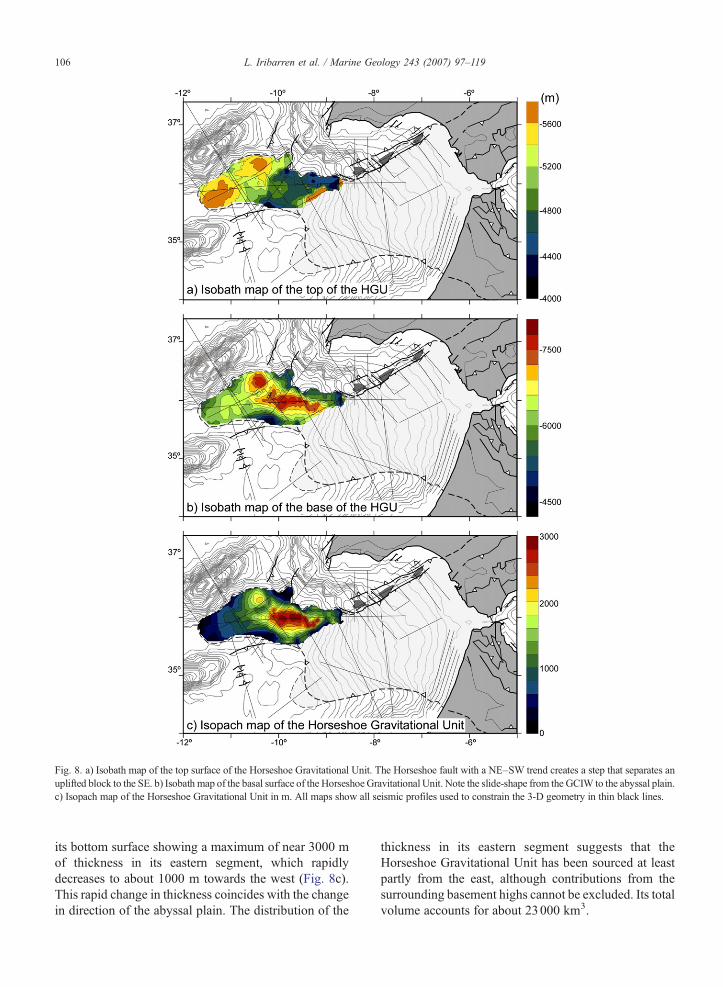
Fig. 8. a) Isobath map of the top surface of the Horseshoe Gravitational Unit. The Horseshoe fault with a NE–SW trend creates a step that separates anuplifted block to the SE. b) Isobath map of the basal surface of the Horseshoe Gravitational Unit. Note the slide-shape from the GCIW to the abyssal plain.c) Isopach map of the Horseshoe Gravitational Unit in m. All maps show all seismic profiles used to constrain the 3-D geometry in thin black lines.
106 L. Iribarren et al. / Marine Geology 243 (2007) 97–119
its bottom surface showing a maximum of near 3000 mof thickness in its eastern segment, which rapidlydecreases to about 1000 m towards the west (Fig. 8c).This rapid change in thickness coincides with the changein direction of the abyssal plain. The distribution of the
thickness in its eastern segment suggests that theHorseshoe Gravitational Unit has been sourced at leastpartly from the east, although contributions from thesurrounding basement highs cannot be excluded. Its totalvolume accounts for about 23000 km3.

107L. Iribarren et al. / Marine Geology 243 (2007) 97–119
4. Structure of the Miocene seismically chaotic unitonshore
Along the front of both Betic and Rif fold belts thereis a large tectonic unit that presents similar character-istics to the Miocene seismically chaotic unit offshoreand seems to connect with the large Gulf of CadizImbricate Wedge offshore. In this section we discuss thesimilarities between offshore and onshore units and theirpotential relationships.
In the Betic Cordillera this unit was firstly recognisedand described as “Olistostromic Zone” by Perconig(1960–1962). Later, the unit was renamed as “Guadal-quivir Allochthon” by Blankenship (1990, 1992), and“lateral diapir” by Berástegui et al. (1998). Firstinterpretations suggested a sedimentary origin for thisunit whereas the “lateral diapir” interpretation assumed atectonic origin for it. In the Rif fold belt, the unit has beennamed as “Nappe Prerifaine”, indicating its tectonic origin(e.g., Frizon de Lamotte et al., 1991; Flinch, 1996).
Onshore, this Miocene seismically chaotic unit ismostly composed of Triassic evaporites and claysenclosing numerous blocks of Triassic carbonates andvolcanic ophites with interbedded Cretaceous to EarlyMiocene marine marls and turbidites (Lanaja et al.,1987; Flinch, 1996; Berástegui et al., 1998). Relativelythin Mesozoic and/or Tertiary sedimentary sequencesonlap the Triassic rocks indicating that the unit mightcorrespond to a relatively high and quiet paleogeo-graphic domain during most of its history later ondeformed along the fronts of the Betic and Rif fold belts(Fig. 1).
Regardless of the mechanism of tectonic emplace-ment the Miocene seismically chaotic unit onshore andoffshore share similar characteristics: internal geometry,cross-cutting relationships, and age of emplacement(Fig. 9). The most important feature of these units is thewedge geometry with a basal contact that dips towardsthe interior of the fold belt. The thickness of this wedgeis 2–3 km onshore increasing dramatically offshorewhere it reaches more than 10 km. The wedge geometryis probably sustained by internal deformation as inferredby discontinuous strong reflectors within the prism(Gutscher et al. 2002). Another important characteristicis the Late Miocene age of emplacement that isconsistent along the entire Betic Cordillera and Gulfof Cadiz Imbricate Wedge. The substantial onlap ofpost-emplacement deposits above the tectonic wedgeand especially against its frontal part indicates that thiswedge has not moved or has moved very little since itstectonic emplacement (Fig. 9). Where available, theages of these post-emplacement deposits are Late
Tortonian (Berástegui et al., 1998), although thesedeposits could be younger (Messinian) in the Rharbbasin (Flinch, 1996).
5. Discussion
In this section we discuss several topics that are ofprime importance to address the structure and tectonicevolution of the study region: 1) the continuity of theBetic units across the Gulf of Cadiz and their connectionwith the north-western African units of the Rif; 2) thenature of the Gulf of Cadiz Imbricate Wedge; 3) theemplacement mechanisms for both the Miocene tectonicand gravitational units; 4) the age of emplacement anddeposition/accumulation of these units, and 5) theintegration of these results in a tectonic crustal andlithospheric E–W cross-section from the western regionof the Alboran Sea to the Horseshoe Abyssal Plainthrough the Gibraltar Strait using geological andgeophysical data.
5.1. Continuity of Betic and Rif tectonic units across theGulf of Cadiz
Although there is a good agreement on thesimilarities between the Betic and Rif tectonic units,their connection has been always difficult to unravel dueto the scarcity of good seismic data along the Strait ofGibraltar. An additional difficulty is the fact that most ofthe tectonic structures are presently buried beneath thickPliocene and Quaternary sedimentary successions(Fig. 10). The map of Fig. 10 summarizes availabledata in both south-west margin of Iberia and north-westmargin of Africa compiled from different authors. TheInternal Units, Flysch Units, and External Units arerepresented in the map and show an equivalentdisposition in both margins. The Miocene seismicallychaotic unit that partly occupies the Guadalquivir andRharb basins is the most external tectonic unit of theExternal zones and continues around 300 km to theWSW along the continental slopes. However, theExternal and Flysch units across the Gibraltar Straitshow a noticeable change in the orientation of thestructures that makes its connection through the Gulf ofCadiz very difficult. The direction of the structures inthe SW Iberian margin is NE–SW (e.g., Gràcia et al.,2003b), whereas in the NW Moroccan margin is mainlyN–S (e.g., Flinch, 1996). One possibility to interpret thismismatch is to invoke the existence of a fault with aroughly E–Worientation that crosses the Gibraltar Straitand would have been active at least during theemplacement of the Gibraltar Arc units.
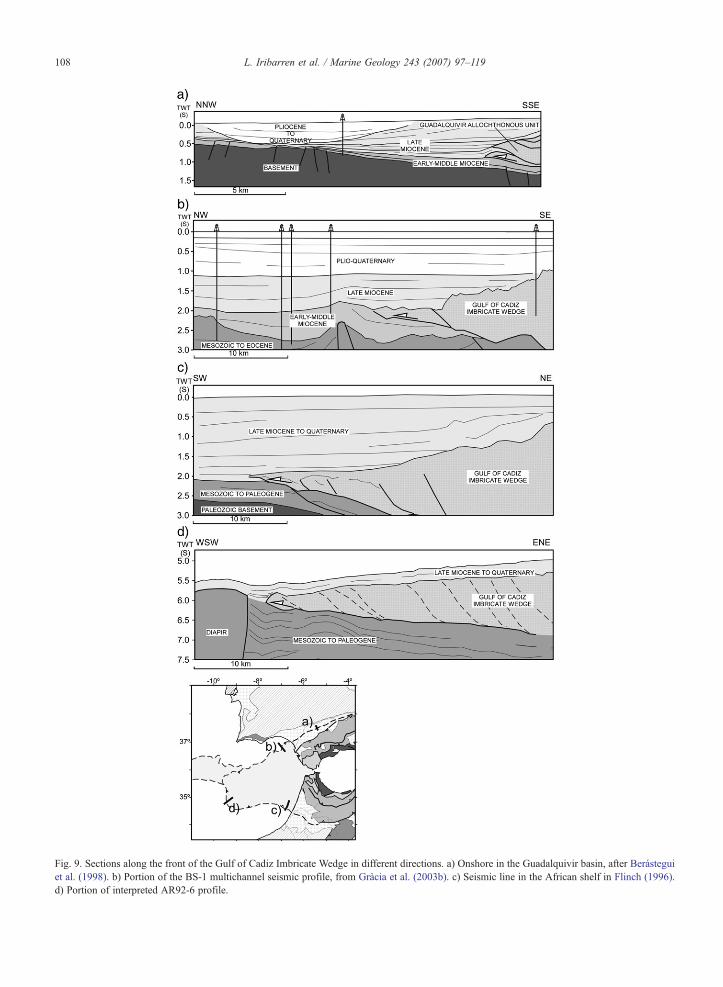
Fig. 9. Sections along the front of the Gulf of Cadiz Imbricate Wedge in different directions. a) Onshore in the Guadalquivir basin, after Berásteguiet al. (1998). b) Portion of the BS-1 multichannel seismic profile, from Gràcia et al. (2003b). c) Seismic line in the African shelf in Flinch (1996).d) Portion of interpreted AR92-6 profile.
108 L. Iribarren et al. / Marine Geology 243 (2007) 97–119

Fig. 10. Structural synthesis map after Garcia-Orellana et al. (2006), Gràcia et al. (2003a), Gràcia et al. (2003b), Flinch (1996) and Rovere (2002).MPF: Marques de Pombal Fault, SVF: San Vicente Fault, HF: Horseshoe Fault, PB: Portimao Bank, GB: Guadalquivir Bank, CPR: Coral PatchRidge.
109L. Iribarren et al. / Marine Geology 243 (2007) 97–119
5.2. The nature of the Gulf of Cadiz Imbricate Wedge
The only information about the nature of rocksforming the Gulf of Cadiz Imbricate Wedge is furnishedby two nearshore wells in which clays and anhydriteswere recovered in the upper 100 to 500 m of the unit(Lanaja et al., 1987). The wedge reaches a great thickness(between 11 and 14 km) and involves thewholeMesozoicto Neogene cover. Seismic profiles in the Atlantic realmshow a seismically chaotic character of the entire tectonicunit. Seismic images also show that diapirs and mudvolcanoes cover the top surface of the unit (e.g., Pinheiroet al., 2003; Medialdea et al., 2004) and that overlyingsediments show a very irregular infill in sub-roundedbasins. These basins are limited by down-to-basin listricfaults developed on the top surface during sedimentation(e.g., Maestro et al., 2003). This kind of down-to-basingrowth faults have been sometimes associated to salt andshale tectonics, as a response to the sediment loading andthe proper nature of the salt (Wu et al., 1990). Accordingto these observations and the correlation with Betic andRif outcrops, we propose that the Gulf of Cadiz ImbricateWedge consists of mainly Triassic evaporites and asuccession of Jurassic to Middle Miocene sedimentaryrocks as documented for the allochthonous units at thefront of the Betic Cordillera.
5.3. Emplacement mechanisms for the Gulf of CadizImbricate Wedge and Horseshoe Gravitational Unit
The tectonic domain of the Miocene seismicallychaotic unit is not only recognizable in the Gulf ofCadiz, where it constitutes the Gulf of Cadiz ImbricateWedge, but it extends all along the Betics and Rif chainsconstituting its frontal External Units.
We consider the tectonic part of the Mioceneseismically chaotic unit as an accretionary wedgeformed in front of the advancing Gibraltar Arc inaccordance with previous interpretations (Flinch, 1996;Zizi, 1996; Gutscher et al., 2002). This tectonic wedgeinvolved and deformed a previous paleogeographic unitmostly constituted by Triassic evaporites and coveredby Mesozoic and Tertiary sedimentary sequences asidentified along the front of the Betic Cordillera.Offshore, the growth of the thick Gulf of CadizImbricate Wedge possibly modulated the presentgeometry of the Gulf of Cadiz continental slope byincreasing its bathymetric angle. This disposition hasbeen changed very little since the end of the LateMiocene growth of this unit because post-emplacementdeposits are thin and parallel to the top of the tectonicwedge as imaged in MCS profile AR92-6 (Fig. 3). Asimilar situation is recorded onshore in the Betics where
110 L. Iribarren et al. / Marine Geology 243 (2007) 97–119
Upper Tortonian sediments fossilize the growth of theMiocene seismically chaotic unit (Berástegui et al.,1998).
To what concerns to this paper, the gravitational unitis constituted by the Horseshoe Gravitational Unit and istherefore restricted to the Horseshoe plain, althoughsmaller gravitational units occur to the Seine Abyssalplain. The calculated volume for the HorseshoeGravitational Unit is of about 23000 km3.
The rapid growth of the Gulf of Cadiz ImbricateWedge could easily create major slope instabilities andlarge failures capable of producing huge submarinegravitational deposits as the one discussed in this paper.If the Horseshoe Gravitational Unit is assumed to beonly sourced from the surrounding basement highs asproposed by Torelli et al. (1997), the pre-gravitationaltopography of the Gorringe Bank and the Coral Patchshould exceed its present elevation above the sea floor inmore than 1500 m. Conversely, if we assume that theunique provenance is the growing Gulf of CadizImbricate Wedge, then its volume would potentiallycorrespond to 400–500 m of erosion regularly distrib-uted over the entire tectonic wedge. This amount wouldincrease if we only suppose that most of this materialshould be derived from the northern and north-westernfronts of the Gulf of Cadiz Imbricate Wedge.
The large available volume of material of the Gulf ofCadiz Imbricate Wedge, its tectonic emplacementduring the Middle and Late Miocene as well as themaximum thickness of the Horseshoe Gravitational Unitnear the front of the tectonic domain seem to favour aclose association between the Gulf of Cadiz ImbricateWedge and the Horseshoe Gravitational Unit, while thewedge is tectonically active. We propose multiplesources including, the Gorringe Bank, the Coral Patchand partial contributions from the Portuguese margin,together with major contributions from the Gulf ofCadiz Imbricate Wedge.
Although many fossil examples of mega-slumpshave been reported in the literature as deposited in frontof advancing accretionary wedges, the recent studiedsubmarine slides along the Atlantic Norwegian passivecontinental margin can provide a better example sincethey have been analysed using modern techniques.Three Holocene slides: the Storegga, Trænadjupet andAndøya (e.g., Bugge et al., 1987; Kenyon, 1987;Dowdeswell et al., 1996; Vorren et al., 1998; Laberget al., 2002) may have similar characteristics to theHorseshoe Gravitational Unit. The Storegga Slide iscomposed of 3 superposed slides with maximum traveldistance of 800 km down slope and an area extentexceeding 88000 km2. The thickness of the slide and the
total accumulated volume is however, smaller than inthe Horseshoe Gravitational Unit (3880 km3 vs.23000 km3). The differences between these two giantgravitational events are related to the context of the twomargins: whereas the Storega Slide developed in thesetting of the Holocene Norwegian passive margin, theMiocene Horseshoe Gravitational Unit developed in thesouth-western Iberian active margin with the rapid buildup of the west to north-west directed Gulf of CadizImbricate Wedge. In this context, large slope instabil-ities during the tectonic growth could produce largesubmarine slope failures along the fronts of the prismtriggering multiple landsliding events. The mid Miocenerough paleogeography of the continental-ocean transi-tion zone characterized by highs and low abyssal plains(similar to the present one) restricted the spreading ofthe large sediment masses to relatively small areas.
5.4. Timing of emplacement of the different units
Within the long-lived convergence of Africa againstEurope the southern margin of Iberia deformed since theLatest Cretaceous (e.g., Dewey et al., 1989). However, themost conspicuous compression can be dated as aroundOligocene when different geological processes seem toaffect the margin. In this frame we document ages ofdeposition and deformation that may help to reproducethe sequence of deformation across the Gibraltar Arc(Fig. 11).
The youngest deposits involved in the GibraltarFlysch thrust units are Early Burdigalian in age of about20 Ma (e.g., Serrano, 1979; Rodríguez-Fernández et al.,1999). Although deformation of these units could startduring the turbiditic deposition it is possible to establishthat shortening of this unit was active after EarlyBurdigalian sedimentation (e.g., Balanyá et al., 1997;Crespo-Blanc and Campos, 2001). This thrust front aswell as the Subbetic front in the Gulf of Cadiz regionbecame inactive in a pre-Early Languian age (Gràciaet al., 2003b) (Fig. 11).
Frontal westward propagation of deformation con-tinued in the Gibraltar Arc during the Middle and LateMiocene forming the Gulf of Cadiz Imbricate Wedge.This fold-and-thrust belt became inactive during LateTortonian times at about 8 Ma (Berástegui et al., 1998;Maldonado et al., 1999; Gràcia et al., 2003b), asevidenced by the massive onlap of Late Tortoniansediments fossilizing the wedge in the eastern sector(Fig. 9). To the W, some deformation is displayed by thetop surface of the Gulf of Cadiz Imbricate Wedge(Thiebot and Gutscher, 2006) (Fig. 9). Nevertheless, thewesternmost front is as well fossilized by the onlap of
Fig. 11. Synthesis of different tectonic events recorded onshore in the Betics and offshore in the Alboran Sea and in the Atlantic margin. The Subbeticfront refers here only to the Atlantic segment of this front. Dashed lines refer to uncertainties in the exact age. GCIW: Gulf of Cadiz Imbricate Wedge.(1) García-Dueñas et al. (1992); Augier et al. (2005); (2) Comas et al. (1999); (3) Crespo-Blanc et al. (1994); Gràcia et al. (2003b); (4) Berástegui et al.(1998); (5) Gràcia et al. (2003b); (6) Gràcia et al. (2003a); Zitellini et al. (2004); (7) Bellon et al. (1981); Hernández et al. (1987); (8) Platzman et al.(2000); Krijgsman and Garcés (2004).
111L. Iribarren et al. / Marine Geology 243 (2007) 97–119
sediments (Fig. 9d). The sedimentation in this sector isoceanic-type and consequently sedimentation rates arelower and deposits more fine-grained. For this reason,reflectors display a parallel pattern that reproduces theshape of the top surface of the Gulf of Cadiz ImbricateWedge.
Partly synchronously to the Early and MiddleMiocene shortening along the Gibraltar Arc fold beltan important extension phase took place in the back arcstarting near the Oligocene–Miocene boundary at∼24 Ma (Rodríguez-Fernández et al., 1999) or slightlylater (e.g., García-Dueñas et al., 1992; Crespo-Blancet al., 1994; Comas et al., 1999). This extension nucle-ated the opening of the rapidly subsiding basins of thewestern Alboran Sea up to the Middle Tortonian (Comaset al., 1999). In the Betics this extension accounts for the
unroofing of the different metamorphic units that formthe Internal Zones, along low angle detachment levels(García-Dueñas et al., 1992; Crespo-Blanc et al., 1994;Vissers et al., 1995; Martínez-Martínez and Azañon,1997; Azañón and Crespo-Blanc, 2000; Booth-Reaet al., 2005). This detachments show a roughly N–Sdirection of extension until Middle Miocene and an E–W extension, with a SW transport of the hangingwall,during Serravallian to Late Tortonian (Fig. 11).
The cessation of the westward propagation of theGulf of Cadiz Imbricate Wedge in the Late Tortonian isconsistent with the end of major paleomagnetic rotationsmeasured in the Betic Cordillera, Gibraltar Arc and Rifthrust belt (Krijgsman and Garcés, 2004), as well as withthe change from calco-alkaline to alkaline volcanism inthe SE of Spain, eastern Alboran Sea and north of

112 L. Iribarren et al. / Marine Geology 243 (2007) 97–119
Morocco at around 7 Ma (e.g., Wilson and Bianchini,1999; Duggen et al., 2004) (Fig. 11).
Compression continued after Late Tortonian affect-ing most of the study area, with a NW–SE component.In the proximal parts of the Gulf of Cadiz, the entireGibraltar Arc thrust system was tightened and reacti-vated as evidenced by a general tilt of the Pliocene–Quaternary depositional units toward the north-west,and by younger folding of the entire thrust system(Gràcia et al., 2003b). In the distal areas of the SWIberian margin as in the Horseshoe Abyssal Plain,compressive basement faults are still active at presentand appear to constitute the southern continuation of theMarques de Pombal and San Vicente faults (Gràciaet al., 2003a; Zitellini et al., 2004; Medialdea et al.,2004, Vizcaino et al., 2006). In particular, the SanVicente Fault seems to correspond to a relatively longfault that possibly crosses the entire Horseshoe AbyssalPlain as recorded by the BIGSET dataset (Gràcia et al.,2003a) and by the MCS profile Tasyo-12 along thesouthernmost limit of the Horseshoe Abyssal Plain(Medialdea et al., 2004, Fig. 10). This post-Tortoniandeformation is responsible for the later deformation ofboth compressive and extensive structures around theGibraltar Arc (e.g., Crespo-Blanc and Campos, 2001)and for the E–W kilometric-scale open folds in the BeticCordillera and in the Alboran Sea (e.g., Weijermarset al., 1985; Comas et al., 1992; Vissers et al., 1995;Martínez-Martínez and Azañon, 1997; Rodríguez-Fer-nández et al., 1999; Augier et al., 2005) (Fig. 11).
This recent tectonic activity is also recorded by faultsaround the Coral Patch (Sartori et al., 1994; Tortellaet al., 1997) accounting only for 3% to 10% ofshortening, which is a very small portion of the totalconvergence between Africa and Europe (Dewey et al.,1989). Moment tensor inversion solutions corroboratethat the whole area from the Alboran Sea to thePortuguese margin, is currently compatible with a NW–SE and NNW–SSE stress regime (Jiménez-Munt andNegredo, 2003; Stich et al., 2003).
5.5. E–W crustal and lithospheric transect from theMediterranean to the Atlantic domains across theGibraltar Strait
In this last section we combine structural geology andgeophysics into an 800 km long regional lithosphericcross-section from the Alboran Sea to the HorseshoeAbyssal Plain following an E–W direction (Fig. 1). Thissection across the Gibraltar Strait has been chosen forthree main reasons: 1) it connects the Mediterranean andAtlantic realms: 2) its direction is perpendicular to the
Gibraltar Arc tectonic grain; and 3) it roughly followsthe trace of previously published regional sections thatresult in contrasting interpretations (Maldonado et al.,1999; Gutscher et al., 2002; Medialdea et al., 2004). Amajor limitation in interpreting a 2-D cross-section is thehighly 3-D geometry affecting the entire region, whichdeserves caution for given conclusions. Nevertheless,major features of tectonic evolution can be figure out.
Maldonado et al. (1999) and Medialdea et al. (2004)base their model on new seismic data (not converted todepth). In their interpretation, the Miocene reflectivechaotic unit represents a rather thin imbricated unit.They propose that the continental slope of the Gulf ofCadiz is located above continental crust (González-Fernández et al., 2001), whereas the continent-oceanboundary is located at the Horseshoe Abyssal Plain. Thecontact between the two different crustal domainscorresponds to an incipient subduction. These authorspropose that the present structure of the Atlantic domainof the section is the product of the protracted and slow Nto NNW convergence of Africa against Europe togetherwith the development of the Gibraltar Arc attributed tomantle delamination (e.g., Docherty and Banda, 1995;Seber et al., 1996).
Gutscher et al. (2002) present a thought-provokingalternative interpretation consisting of an active east-dipping and narrow oceanic subduction beneath theGibraltar Strait. This interpretation is based on newseismic acquisition (SISMAR survey) and OBS datatogether with gravity modelling. Their results present agood fit with previously existing geophysical resultsfrom tomographic studies (Bijwaard and Spakman,2000; Wortel and Spakman, 2000), and earthquakesdistribution (Buforn et al., 1991; Calvert et al., 2000).The Miocene reflective chaotic unit is interpreted as anactively deforming accretionary prism above a relativelylarge basal detachment on top of the oceanic slab. Thislarge detachment thrust would be the triggeringmechanism for the large historical earthquake thatdevastated Lisbon in 1755 (Gutscher, 2004).
In our regional cross-section at lithospheric scale weintegrate upper crustal structure with crustal andlithospheric thicknesses derived from geophysicalmodelling (Fullea et al., 2006; Fullea et al., 2007),(Fig. 12). We describe first the present crustal and uppermantle geometry and then the upper crustal structure.
The positions of the Moho as well as of the base ofthe lithosphere are based on crustal and lithosphericthickness maps covering the entire region of the cross-section. These maps were acquired using a joint inver-sion method of elevation and geoid data (Fullea et al.,2006; Fullea et al., 2007), (Fig. 12). The crustal

Fig. 12. Regional E–W trending crustal and lithospheric section from the Alboran Sea to the Horseshoe Abyssal Plain across the Gibraltar Strait. The base of the lithosphere has been inferred by a two-layer numerical modelling (Fullea et al., 2006). This modelling assumes constant density below the base of the lithosphere and thus, is not able to detect the high density body shown by tomographicimages (Bijwaard and Spakman, 2000; Wortel and Spakman, 2000). The dashed line represents the position of the beginning of the high density anomaly (possible slab) detected by tomography. Thetransition from oceanic to transitional and to continental crust is taken from Rovere et al. (2004). GCIW: Gulf of Cadiz Imbricate Wedge; HGU: Horseshoe Gravitational Unit.
113L.Iribarren
etal.
/Marine
Geology
243(2007)
97–119
114 L. Iribarren et al. / Marine Geology 243 (2007) 97–119
thickness in our cross-section has been additionallyconstrained with available reflection and refractionseismic results (González-Fernández et al., 2001;Rovere et al., 2004), as well as with 2-D geophysicalmodelling (Fernàndez et al., 2004). The crust along theregional cross-section shows relatively thin regions inboth the Alboran Sea and especially along theHorseshoe Abyssal Plain. The thickness of the crustgradually thickens from 9–10 km in the western end ofthe section to a maximum of 30 km beneath theGibraltar Strait. The crustal thickness decreases towardsthe Alboran Sea showing an abrupt thinning down toabout 16 km beneath the western Alboran basin and aminimum of 9–10 km near the contact between theAlboran Sea and the Algerian Basin boundary (Fig. 12).The continental or oceanic nature of the crust beneaththe Atlantic domain is crucial to interpret the region.Existing data suggest a continental character of this crustthat grades into transitional beneath the HorseshoeAbyssal Plain and finally into oceanic crust in thewesternmost 9 km of our section (Purdy, 1975;González et al., 1996; Rovere et al., 2004). The litho-spheric mantle is of about 95 km at the western end ofthe regional section and thickens towards the GibraltarStrait where it reaches a maximum of about 160 kmabout 50 km to the west of the strait. This thickening isnot uniform and shows that most of it occurredeastwards of the front of the Gulf of Cadiz ImbricateWedge (Fig. 12). From this maximum, the lithospherethins again eastwards to the Alboran Sea reaching about95 km at the section termination. Lithospheric thinningcontinues further to the east and reduces to about 50 kmbeneath the Algerian Basin (Torne et al., 2000). Whencombined with tomography a large subvertical positivevelocity anomaly is visualized slightly to the east of theGibraltar Strait (Bijwaard and Spakman, 2000). Becauseof the lack of evidences for an oceanic crust flooring theGulf of Cadiz, we propose a transitional lithospherebetween the oceanic lithosphere in the western Horse-shoe Abyssal Plain to the continental one beneath theGibraltar Arc. Then, both crust and upper mantle arethickened underneath the arc. According to seismictomography, a subvertical slab seems to be attached tothe eastern end of this thickened lithosphere to the westof the Alboran Sea domain (Bijwaard and Spakman,2000; Wortel and Spakman, 2000).
The upper crustal tectonic structure along the sectionis already well-known and shows contrasting styles ofdeformation: a) an extensional domain mostly charac-terized by low-angle normal faults forming the AlboranBasin; and b) amigrating system of thrust belts involvingboth cover and basement rocks that are younger to the
west towards the Horseshoe Abyssal Plain (Fig. 12). Wewill describe first the compressive domain and secondlythe extensive geometry of the Alboran Basin. Two majoraspects are fundamental to understand the compressivedomain: a) the large-scale relationships between internaland external units for tectonic emplacement as well as fortheir timing of emplacement; and b) the strongdecoupling between internal and external units at thelevel of Upper Triassic evaporites.
In our interpretation we link the metamorphic Internalunits of the Betic Cordillera, outcropping along thecoastlines of Iberia and Morocco, with the west-directedGibraltar Flysch fold belt (Fig. 12). Both deformed thrustsystems are located above the same basal thrust thatclimbs from the basement to the cover and emplaced theentire thrust system coevally, in agreement with resultsby Booth-Rea et al. (2005). The submarine tectonicimbrication of these Flysch units was active from the endof Oligocene to the Langhian at ∼16 Ma when thesystem became mostly inactive (Gràcia et al., 2003b).The present high position of this Lower and MiddleMiocene thrust system, above the thickest crust of thesection is interpreted as the consequence of being carriedpassively on top of a younger thrust system involvingbasement and cover rocks. The basal thrust of this LateMiocene system would ramp up branching to the base ofthe west to north-west directed Gulf of Cadiz ImbricateWedge. If correct, this relatively thick crustal block(∼30 km) would move synchronously to the Gulf ofCadiz Imbricate Wedge up to the Late Tortonian time atabout 8 Ma. The large amount of shortening in an E–Wdirection for the Gibraltar Flysch units and the Gulf ofCadiz Imbricate Wedge together with the relatively shortperiod of time of emplacement indicate the involvementof an additional tectonic mechanism on the prolongedNW African convergence. This mechanism would beactive from the Latest Oligocene to Late Tortonian timesat about 8 Ma and thus, for about 12 Myr.
After the Late Tortonian, shortening continued todeform previously emplaced thrusts along the Gulf ofCadiz (e.g., Gràcia et al., 2003b) as well as in the moredistal parts of the cross-section. The Late Miocene,Pliocene and Pleistocene deposits of the HorseshoeAbyssal Plain are deformed by basement thrusts thatshow a relatively important hangingwall uplift (theeasternmost fault is named the Horseshoe Fault). Thesecrustal thrusts seem to correspond to the southerncontinuation of the San Vicente Fault and Marques dePombal Fault (e.g., Gràcia et al., 2003a; Zitellini et al.,2004). If connected, their potential large rupture area aswell as their crustal scale might produce largemagnitude earthquakes such as the Horseshoe Abyssal

115L. Iribarren et al. / Marine Geology 243 (2007) 97–119
Plain earthquake in 1969 with Mw=8.0 (Fukao, 1973)),and the Lisbon earthquake in 1755 with estimatedMw=8.5 (Martins and Mendes Victor, 1980).
To the east of the Gibraltar Strait the structure changesdramatically and is characterized by extensional tecton-ics (e.g., Comas et al., 1999). The Alboran Sea isbounded by large extensional fault systems that followthe arcuate geometry of the Gibraltar Arc (Fig. 1). Thesefault systems initiated around the Late Oligocene at27Ma (Platt et al., 1998; Platt andWhitehouse, 1999), orEarly Miocene at about 22 Ma (Comas et al., 1992) andwere responsible for the formation of the deep westAlboran Basin filled up by more than 8 km of LateCenozoic deposits. The extensional fault planes mostlyfollow previous thrust surfaces and peel up thick slices ofthe Internal units (Alboran Crustal Domain). Comaset al. (1999) and Frizon de Lamotte et al. (2004), amongothers, proposed that the extensional faults cut throughthe upper and middle crust.
The thrust system cut through the crust as well as theextensional system that formed the Alboran Basin in theback arc. This extensional event is mostly coeval withwestwards shortening and produced the reactivation andcollapse of previously formed Internal Unit thrustsystem of the Betic Cordillera. After the cessation ofthe coeval compressional and extensional processes,crustal deformation has a NW–SE component ofshortening and lasts to present times tightening bothearly extensional and compressional structures as wellas affecting distal areas of the study region as theHorseshoe Abyssal Plain.
Within the frame of a long-lived NW slowconvergence of Africa towards Europe we envisagethe Gibraltar Arc tectonic units as formed by thesuperposition of a much shorter but faster geodynamicprocess that produced the migration of the arc to thewest. Although there are no conclusive results on themechanism that produced this rapid westwards tectonicmigration the observed strong decoupling between thecrust and the upper mantle (Fullea et al. 2006), suggeststhat this mechanism occurred at depth. Among potentialmechanisms for this westwards migration of theGibraltar Arc we found that the westwards slabretreating theory may correspond to the best candidatealthough with strong restrictions. Regional tomographyshows a NE–SW trending subvertical high velocityanomaly with a very irregular and discontinuous shapewith depth that makes difficult to image it as acontinuous subducting slab (Calvert et al., 2000). Thisslab retreat would lasted from about 20 Ma to 8 Ma asproved by the thick Latest Miocene, Pliocene and Qua-ternary sedimentary sequences that fossilize the front of
the Gulf of Cadiz Imbricate Wedge and the very littledeformation of the top of the unit towards the west. Ifoceanic crust subducted beneath the Gibraltar Strait thenthe crust was welded to the eastern termination of thethick continental crust. In the restored position, thisoceanic crust would be located between the continentalcrust in the Gulf of Cadiz and the Alboran domainrepresented by the metamorphic Internal Units of theBetic Cordillera.
6. Conclusions
The Miocene seismically chaotic units have beenredefined as the tectonic Gulf of Cadiz Imbricate Wedgeoccupying the continental slope of the Gulf of Cadizwith a total area of around 58000 km2 and thegravitational Horseshoe Gravitational Unit infilling theHorseshoe Abyssal Plain with an approximate area of18000 km2. The Miocene chaotic units observedonshore to the front of the External Units in the Beticsand the Rif, constitute the same tectonic unit than theGulf of Cadiz Imbricate Wedge. This tectonic unitcontains a succession of Mesozoic to Middle Miocenerocks, where Triassic evaporites are abundant.
The Gulf of Cadiz Imbricate Wedge displays a wedgegeometry reaching a maximum thickness of more than11 km. It is interpreted as a tectonic imbricate unit abovea basal detachment that climbs up above a low-anglefootwall ramp. Its western front slightly overthrusts theHorseshoe Gravitational Unit. The Horseshoe Gravita-tional Unit is interpreted as corresponding to massiveand rapid succession of large submarine landslides. It issourced from the surrounding basement highs, thePortuguese margin and the up building of the Gulf ofCadiz Imbricate Wedge that could be the majorcontributor during its tectonic emplacement from Earlyto Late Miocene.
We interpret the study region as produced during arelatively short event of strong westwards tectonicimbrication superimposed on a longer but slower NNWto NW African convergence. The westwards propaga-tion of the tectonic Gibraltar Flysch units, the ExternalUnits and Gulf of Cadiz Imbricate Wedge wascompleted from about 20 Ma (late Early Miocene) tothe Late Tortonian at about 8 Ma (mid Late Miocene).The cessation of both compression of the front andextension in the back arc in the Upper Tortonian (around9–8 Ma), reasonably coincides with the end of thecalco-alkaline volcanism in the eastern side of theAlboran Sea and the major paleomagnetic rotations(around 7 Ma). Although we have no conclusive results,we favour the westwards slab retreat theory, which
116 L. Iribarren et al. / Marine Geology 243 (2007) 97–119
would be active from Middle to Late Miocene time.After the cessation of this fast westwards propagation ofthe Gibraltar Arc, the entire region continued to shortenby the slow motion of Africa to the NNW–NW.
Acknowledgments
This is a contribution of the Team Consolider-Ingenio2010 no. CSD2006-00041. This research was partlyfinanced by Projects MARSIBAL (REN 2001-3868-CO3-MAR), WESTMED (REN 2002-11230-E-MAR),SAGAS (CTM2005-08071-C03-03/MAR) and ESFEurocores-EUROMARGINS (01-LEC-EMA22F). L.Iribarren benefited from a PhD Grant from the Ministryof Educational Science. We are indebted to Prof. NevioZitellini, Prof. Luigi Torelli and Dr. Marzia Rovere forproviding us with seismic profiles and database used inthis paper as well as for helpful suggestions anddiscussion during the writing of the manuscript. Wealso thank Marc-André Gutscher, an anonymous re-viewer and Editor David J.W. Piper for their constructivereview, which helped to improve the original manuscript.
References
Andrieux, J., Fontboté, J.M., Mattauer, M., 1971. Sur un modèleexplicatif de l'Arc de Gibraltar. Earth Planet. Sci. Lett. 12, 191–198.
Augier, R., Jolivet, L., Robin, C., 2005. Late Orogenic doming in theEastern Betics: final exhumation of the Nevado–Filabride complexand its relation to basin genesis. Tectonics 24. doi:10.1029/2004TC001687 (TC4003).
Auzende, J.M., Olivet, J.L., Pastouret, L., 1981. Implicationstructurales et paléogeographiques de la presence de Mesinienal'ouest de Gibraltar. Mar. Geol. 43, 9–18.
Azañón, J.M., Crespo-Blanc, A., 2000. Exhumation during acontinental collision inferred from the tectonometamorphicevolution of the Alpujarride Complex in the central Betics(Alboran Domain, SE Spain). Tectonics 19, 549–565.
Balanyá, J.C., García Dueñas, V., Azañón, J.M., Sánchez Gómez, M.,1997. Alternating contractional and extensional events in theAlpujárride nappes of the Alboran Domain (Betics, Gibraltar Arc).Tectonics 16, 226–238.
Banda, E., Torné, M., 1995. Iberian Atlantic Margins Groupinvestigates deep structure of ocean margins, Eos Trans. AGU 25.
Bellon, H., Bizón, G., Calvo, J.P., Elizaga, E., Gaudant, J., López, N.,1981. Le volcán du cerro del Monagrillo (Province de Murcia):Âge radiométrique et corrélations avec les sediments néogénes dubassin de Hellín (Espagne). C. R. Acad. Sci. Paris t 313 (292),1035–1038 Série II.
Berástegui, X., Banks, C., Puig, C., Taberner, C., Waltham, D.,Fernàndez, M., 1998. Lateral diapiric emplacement of Triassicevaporites at the southern margin of the Guadalquivir Basin, Spain.In: Mascle, A., Puigdefàbregas, C., Luterbacher, H.P., Fernàndez,M.(Eds.), Cenozoic Foreland Basins of Western Europe. Geologicalsociety Special Publications, London, pp. 49–68.
Bijwaard, H., Spakman, W., 2000. Non-linear global P-wave tomo-graphy by iterated linearized inversion. Geophys. J. Int. 141, 71–82.
Blankenship, C.L., 1990. Structural evolution of the central ExternalBetic Cordillera, southern Spain. MA Thesis, Rice University,Houston, 70 pp.
Blankenship, C.L., 1992. Structure and palaeogeography of the Exter-nal Betic Cordillera, southern Spain. Mar. Pet. Geol. 9, 256–264.
Bonnin, J., Olivet, J.L., Auzende, J.M., 1975. Structure en nappe al'ouest de Gibraltar. C.R. Acad. Sci. 280, 559–562.
Booth-Rea, G., Azañon, J.M., Martínez-Martínez, J.M., Vidal, O.,García-Dueñas, V., 2005. Contrasting structural and P-Tevolution oftectonic units in the southeastern Betics: key for understanding theexhumation of the Alboran Domain HP//LT crustal rocks (westernMediterranean). Tectonics 24. doi:10.1029/2004TC001640(TC2009).
Buforn, E., Udias, A., Madariaga, R., 1991. Intermediate and deepearthquakes in Spain. Pure Appl. Geophys. 136, 375–393.
Bugge, T., Befring, S., Belderson, R.H., Eidvin, T., Jansen, E.,Kenyon, N.H., Holtedahl, H., Sejrup, H.P., 1987. A giant three-stage submarine slide off Norway. Geo Mar. Lett. 7, 191–198.
Calvert, A., Sandvol, E., Seber, D., Barazangi, M., Roecker, S.,Mourabit, T., Vidal, F., Alguacil, G., Jabour, N., 2000. Geody-namic evolution of the lithosphere and upper mantle beneath theAlboran region of the western Mediterranean: constraints fromtravel time tomography. J. Geophys. Res. 105, 10871–10898.
Camurri, F., 2004. Struttura ed evoluzione cenozoica del margineatlantico del Marocco settentrionale e sua interazione con leporzioni esterne dell'Arco di Gibilterra, PhD Thesis, Università diParma, Parma, 150 pp.
Comas, M.C., Garcia-Dueñas, V., Jurado, M.J., 1992. Neogenetectonic evolution of the Alboran sea from MCS data. Geo Mar.Lett. 12, 157–164.
Comas, M., Platt, J.P., Soto, J.I., Watts, A.B., 1999. The origin andtectonic history of the Alboran Basin: insights fromLeg 161 results.In: Zahn, R., Comas, M.C., Klaus, A. (Eds.), Proc. ODP, Sci.Results. U.S Govert. Print. Of., Washington D.C., pp. 555–580.
Contrucci, I., Klingelhöfer, F., Perrot, J., Bartolome, R., Gutscher, M.A.,Sahabi, M., Malod, J., Rehault, J.P., 2004. The crustal structureof the NW Moroccan continental margin from wide-angle andreflection seismic data. Geophys. J. Int. 159, 117–128. doi:10.1111/j.1365-246X.2004.02391.x.
Crespo-Blanc, A., Campos, J., 2001. Structure and kinematics of theSouth Iberian paleomargin and its relationship with the FlyschTrough units: extensional tectonics within the Gibraltar Arc fold-and-thrust belt (western Betics). J. Struct. Geol. 23, 1615–1630.
Crespo-Blanc, A., Orozco, M., García-Dueñas, V., 1994. Extensionversus compression during the Miocene tectonic evolution of theBetic chain. Late folding of normal fault systems. Tectonics 13,78–88.
Dewey, J.F., 1988. Extensional collapse of orogens. Tectonics 7,1123–1139.
Dewey, J.F., Helman,M.L., Truco, E., Hutton,D.H.W.,Knott, S.D., 1989.Kinematics of the westernMediterranean. In: Coward,M.P., Dietrich,D., Park, R.G. (Eds.), Alpine Tectonics. Gological Society SpecialPublication Classics. The Geological Society, London, pp. 265–283.
Docherty, C., Banda, E., 1995. Evidence for the eastward migration ofthe Alboran Sea based on regional subsidence analysis: a case forbasin formation by delamination of the subcrustal lithosphere?Tectonics 14, 804–818.
Dowdeswell, J.A., Kenyon, N.H., Elverhøi, A., Laberg, J.S.,Hollender, F.J., Mienert, J., Siegert, M.J., et al., 1996. Large-scale sedimentation on the glacier-influenced Polar North Atlanticmargins: long-range sidescan sonar evidence. Geophys. Res. Lett.23, 3535–3538.
117L. Iribarren et al. / Marine Geology 243 (2007) 97–119
Duggen, D., Hoernle, K., van den Bogaard, P., Harris, C., 2004.Magmatic evolution of the Alboran region: the role of subductionin forming the western Mediterranean and causing the MessinianSalinity Crisis. Earth Planet. Sci. Lett. 218, 91–108.
Faccenna, C., Piromallo, C., Crespo-Blanc, A., Jolivet, J., Rossetti, F.,2004. Lateral slab deformation and the origin of the westernMediterranean arcs. Tectonics 23. doi:10.1029/2002TC001488(TC1012).
Fernàndez, M., Marzán, I., Torne, M., 2004. Lithospheric transitionfrom the Variscan Iberian Massif to the Jurassic oceanic crust of theCentral Atlantic. Tectonophysics 386, 97–115.
Flinch, J.F., 1996. Accretion and extensional collapse of the externalwestern Rif (Northern Morocco). In: Ziegler, P.A., Horvàth, F.(Eds.), Peri-Tethys Memoir 2: Structure and Prospects of AlpineBasins and Forelands. Mémoires du Muséum National d'HistoireNaturelle, Paris, pp. 61–85.
Frizon de Lamotte, D., Andieux, J., Guézou, J.C., 1991. Cinématiquedes chevauchements néogènes dans l'Arc bético-rifain: discussionsur les modèles géodynamiques. Bull. Soc. Géol. Fr. 162, 611–626.
Frizon de Lamotte, D., Crespo-Blanc, A., Saint-Bézar, B., Comas, M.,Fernàndez, M., Zeyen, H., Ayarza, P., Robert-Charrue, C.,Chalouan, A., Zizi, M., Teixell, A., Arboleya, M.L., Álvarez-Lobato, F., Julivert, M., Michard, A., 2004. TRANSMED transectI: Iberian Meseta– Guadalquivir Basin–Betic Cordillera–AlboranSea–Rif–Moroccan Meseta–High Atlas–Sahara platform. CD ofthe Mediterranean Consortium for the 32nd International Geolog-ical Congress. Springer Verlag.
Fukao, Y., 1973. Thrust faulting at a lithospheric plate boundary: thePortugal earthquake of 1969. Earth Planet. Sci. Lett. 18, 205–216.
Fullea, J., Fernàndez, M., Zeyen, H., 2006. Lithospheric structure inthe Atlantic–Mediterranean transition zone (southern Spain,northern Morocco): a simple approach from regional elevationand geoid data. C. R. Geosci. 338, 140–151.
Fullea, J., Fernandez, M., Zeyen, H., Vergés, J., 2007. A rapid methodto map the crustal and lithospheric thickness using elevation, geoidanomaly and thermal analysis. Application to the Gibraltar ArcSystem and adjacent zones. Tectonophysics 430, 97–117.doi:10.1016/j.tecto.2006.11.003.
García-Castellanos, D., Fernàndez, M., Torne, M., 2002. Modeling theevolution of the Guadalquivir foreland basin (southern Spain).Tectonics 21. doi:10.1029/2002TC001339.
García-Dueñas, V., Balanyá, J.C., Martínez-Martínez, J.M., 1992.Miocene extensional detachments in the outcropping basement ofthe AlboranBasin and their implications. GeoMar. Lett. 12, 88–95.
Garcia-Orellana, J., Gràcia, E., Vizcaino, A., Masqué, P., Olid, C.,Martínez Ruiz, F., Piñero, E., Sánchez-Cabeza, J.A., Dañobeitia, J.J.,2006. Identifying instrumental and historical earthquake records inthe SW Iberian Margin using 210Pb turbidite chronology. Geophys.Res. Lett. 33, L24601. doi:10.1029/2006GL028417.
González, A., Torné,M., Córdoba, D., Vidal, N., Matias, L.M., Díaz, J.,1996. Crustal thinning in the southwestern Iberia margin. Geophys.Res. Lett. 23, 2477–2480.
González-Fernández, A., Córdoba, D., Matias, L.M., Torne, M., 2001.Seismic crustal structure in the Gulf of Cadiz (SW IberianPeninsula). Mar. Geophys. Res. 22, 207–223.
Govers, R., Wortel, M.J.R., 2005. Lithosphere tearing at STEP faults:response to edges of subduction zones. Earth Planet. Sci. Lett. 236,505–523.
Gràcia, E., Dañobeitia, J.J., Vergés, J., Team, P., 2003a. Mappingactive faults offshore Portugal (36°N-38°N): implications forseismic hazard assessment in the SW Iberian Margin. Geology 31,83–86.
Gràcia, E., Doñabeitia, J., Vergés, J., Bartolomé, R., Córdoba, D.,2003b. Crustal architecture and tectonic evolution of the Gulf ofCadiz (SW Iberian margin) at the convergence of the Eurasian andAfrican plates. Tectonics 22. doi:10.1029/2001TC901045, 2003.
Gutscher, M.A., 2004. What caused the great Lisbon earthquake?Science 304, 1247–1248 (27 August 2004).
Gutscher, M.A., Malod, J., Rehault, J.P., Contrucci, I., Klingelhoefer, F.,Mendes-Victor, L., Spakman, W., 2002. Evidence for activesubduction beneath Gibraltar. Geology 30, 1071–1074.
Hayes, D.E., Pimm, A.C., Benson, W.E., Berger, W.H., Von Rad, U.,Supko, P.R., Beckman, J.P., Roth, P.H., 1972. Initial Reports of theDeep Sea Drilling Project. U.S. Government Printing Office,Washington, D.C., p. 975.
Hayward, N., Watts, A.B., Westbrook, G.K., Collier, J.S., 1999. Aseismic reflection and GLORIA study of compressional deforma-tion in the Gorringe Bank region, eastern North Atlantic. Geophys.J. Int. 138, 831–850.
Hernández, J., Larouziere, F.D., Bolze, J., Bordet, P., 1987. Lemagmatisme néogène bético-rifain et le couloir de decrochementtrans-Alboran. Bull. Soc. Géol. Fr. 8, 257–267.
Jiménez-Munt, I., Negredo, A., 2003. Neotectonic modelling of thewestern part of the Africa–Eurasia plate boundary: from the Mid-Atlantic ridge to Algeria. Earth Planet. Sci. Lett. 205, 257–271.
Jiménez-Munt, I., Fernàndez, M., Torne, M., Bird, P., 2001. Thetransition from linear to diffuse plate boundary in the Azores–Gibraltar region: results from a thin-sheet model. Earth Planet. Sci.Lett. 192, 175–189.
Kenyon, N.H., 1987. Mass-wasting features on the continental slope ofnorthwest Europe. Mar. Geol. 74, 57–77.
Krijgsman, W., Garcés, M., 2004. Palaeomagnetic constraints on thegeodynamic evolution of the Gibraltar Arc. Terra Nova 16,281–287.
Laberg, J.V., Vorren, T.O., Mienert, J., Bryn, P., Lien, R., 2002. TheTrænadjupet Slide: a large slope failure affecting the continentalmargin of Norway 4,000 years ago. Geo Mar. Lett. 22, 19–24.
Lajat, D., Biju-Duval, B., Gonnard, R., Letouzey, J., Winnock, E.,1975. Prolongement dans l'Atlantique de la partie externe de l'ArcBético-rifain. B.S.G.F. XVII (4), 481–485.
Lanaja, J.M., Querol, R., Navarro, A., 1987. Contribución de laexploración petrolífera al conocimiento de la geología de España.Instituto geológico y minero de españa, pp. 1–465.
Leblanc, D., Olivier, P., 1984. Role of strike slip faults in the Betic–Rifian orogeny. Tectonophysics 101, 345–355.
Lonergan, L., White, N., 1997. Origin of the Betic–Rif mountain belt.Tectonics 16, 504–522.
Maestro, A., Somoza, L., Medialdea, T., Talbot, C.J., Lowrie, A.,Vázquez, J.T., Díaz-del-Río, V., 2003. Large-scale slope failureinvolving Triassic andMiddleMiocene salt and shale in the Gulf ofCádiz (Atlantic Iberian Margin). Terra Nova 15, 380–391.
Maldonado, A., Nelson, C., 1999. Interaction of tectonic anddepositional processes that control the evolution of the IberianGulf of Cadiz margin. Mar. Geol. 155, 217–242.
Maldonado, A., Somoza, L., Pallarés, L., 1999. The Betic orogen andthe Iberian–African boundary in the Gulf of Cadiz: geologicalevolution (central North Atlantic). Mar. Geol. 155, 9–43.
Martins, I., Mendes Victor, L.A., 1980. Contribução para o estudo dasismicidade de Portugal continental: Universidade de Lisboa.Instituto Geofisico do Infante D. Luís, publicacion 18 (67 pp.).
Martínez-Martínez, J.M., Azañon, J.M., 1997. Mode of extensionaltectonics in the southeastern Betics (SE Spain): implications for thetectonic evolution of the peri-Alborán orogenic system. Tectonics16, 205–225.

118 L. Iribarren et al. / Marine Geology 243 (2007) 97–119
Mauffret, A., Maldonado, A., Campillo, A.C., 1992. Tectonicframework of the Eastern Alboran and western Algerian Basins,western Mediterranean. Geo Mar. Lett. 12, 104–110.
Medialdea, T., Vegas, R., Somoza, L., Vázquez, J.T., Maldonado, A.,Díaz-del-Rio, V., Maestro, A., Córdoba, D., Fernández-Puga, M.C.,2004. Structure and evolution of the “Olistostrome” complex of theGibraltarArc in theGulf of Cadiz (easternCentralAtlantic): evidencefrom two long seismic cross-sections. Mar. Geol. 209, 173–198.
Mezcua, J., Rueda, J., 1997. Seismological evidence for a delamina-tion process in the lithosphere under the Alboran Sea. Geophys.J. Int. 129, F1–F8.
Michard, A., Chalouan, A., Feinberg, H., Goffé, B., Montigny, R.,2002. How does the Alpine belt end between Spain and Morocco?Bull. Soc. Géol. Fr. 173, 3–15.
Perconig, E., 1960–1962. Sur la constitution geologique de l'AndalousieOccidentale, en particulier du bassin du Guadalquivir (EspagneMeridionale), Livre Mémoire du Professeur Paul Fallot. Mémoireshors-Série de la Société géologique de France, pp. 229–256.
Pinheiro, L., Ivanov, M.K., Sautkin, A., Akhmanov, G., Magalhaes, V.,Volkonskaya, A., Monteiro, J.H., Somoza, L., Gardner, J.,Hamouni, N., Cunha, M.R., 2003. Mud volcanism in the Gulf ofCadiz: results from the TTR-10 cruise. Mar. Geol. 195, 131–151.
Platt, J.P., Vissers, R.L.M., 1989. Extensional collapse of thickenedcontinental lithosphere: Aworking hypothesis for the Alboran Seaand Gibraltar Arc. Geology 17, 540–543.
Platt, J.P., Whitehouse, M.J., 1999. Early Miocene high-temperaturemetamorphism and rapid exhumation in the Betic Cordillera(Spain): evidence from U–Pb zircon ages. Earth Planet. Sci. Lett.171, 591–605.
Platt, J.P., Soto, J.I., Whitehouse, M.J., Hurford, A.J., Kelley, S.P.,1998. Thermal evolution, rate of exhumation, and tectonicsignificance of metamorphic rocks from the floor of the Alboranextensional basin, western Mediterranean. Tectonics 17, 671–689.
Platt, J.P., Allerton, S., Kirker, A., Mandeville, C., Mayfield, A.,Platzman, E.S., Rimi, A., 2003a. The ultimate arc: differentialdisplacement, oroclinal bending, and vertical axis rotation in theExternal Betic–Rif arc. Tectonics 22, 1017. doi:10.1029/2001TC001321, 2003.
Platt, J.P., Whitehouse, M.J., Kelley, S.P., Carter, A., Hollick, L.,2003b. Simultaneous extensional exhumation across the AlboranBasin: Implications for the causes of late orogenic extension.Geology 31, 251–254.
Platzman, E., Platt, J.P., Kelley, S.P., Allerton, S., 2000. Largeclockwise rotations in an extensional allochthon, Alboran Domain(southern Spain). J. Geol. Soc. (Lond.) 157, 1187–1197.
Purdy, G.M., 1975. The eastern end of the Azores–Gibraltar plateboundary. R. Astron. Soc. Geophys. J. 43, 973–1000.
Rodríguez Fernández, L.R., 2004.MapaTectónico deEspaña 1:2.000.000.In: Vera, J.A. (Ed.), Geología de España. SGE-IGME, Madrid.
Rodríguez-Fernández, J., Comas, M.C., Soria, J.M., Martín-Pérez, J.A.,Soto, J.I., 1999. The sedimentary record of the Alboran Sea; anattempt at sedimentary sequence correlation and subsidence analysis.In: Zhan, R., Comas, M.C., Klaus, A. (Eds.), Proc. ODP Sci. Results,Leg 161. U.S. Govert. Print. Of., Washington D.C., pp. 69–76.
Rovere, M., 2002. Strutturazione del margine atlantico iberico edinversione miocenica in prosimità del limite di placca Eurasia-Africa. PhD Thesis, Università degli Studi di Bologna, Bologna,186 pp.
Rovere, M., Ranero, C.R., Sartori, R., Torelli, L., Zitellini, N., 2004.Seismic images and magnetic signature of the Late Jurassic toEarly Cretaceous Africa–Eurasia plate boundary off SW Iberia.Geophys. J. Int. 158, 554–568.
Royden, L., 1993. The tectonic expression of slab pull at continentalconvergent boundaries. Tectonics 12, 303–325.
Ryan, W.B.F., et al., 1973. Initial Reports of the Deep Sea DrillingProject. U.S. Government Printing Office, Washington, D.C., p. 514.
Saadi, M., Hilali, E.A., Bensaïd, M., Boudda, A., Dahmani, M., 1985.Carte Géologique du Maroc 1:1.000.000. Ministère de l'Énergie etdes Mines. Direction de la Géologie. Editions du ServiceGéologique du Maroc.
Sanz de Galdeano, C., 1990. Geologic evolution of the BeticCordilleras in the western Mediterranean, Miocene to present.Tectonophysics 172, 107–119.
Sartori, R., Torelli, L., Zitellini, N., Peis, D., Lodolo, E., 1994. Easternsegment of the Azores–Gibraltar line (central–eastern Atlantic): anoceanic plate boundary with diffuse compressional deformation.Geology 22, 555–558.
Seber, D., Barazangi, M., Ibenbrahim, A., Demnati, A., 1996.Geophysical evidence for lithospheric delamination beneath theAlboran Sea and Rif–Betic mountains. Nature 379, 785–790.
Serrano, F. 1979. Los foraminíferos planctónicos del Mioceno superiorde la cuenca deRonda y su comparación con los de otras áreas de lasCordilleras Béticas. PhD Thesis, Universidad de Málaga, 272 pp.
Spakman, W., Wortel, R., 2004. A tomographic view on westernMediterranean geodynamics. In: Cavazza, W., Roure, F., Spak-man, W., Stampfli, G.M., Ziegler, P. (Eds.), The TRANSMEDAtlas: the Mediterranean Region from Crust to Mantle. Springer,pp. 31–52.
Stich, D., Ammon, C.J., Morales, J., 2003. Moment tensor solutionsfor small and moderate earthquakes in the Ibero–Maghreb region.J. Geophys. Res. 108 (B3), 2148. doi:10.1029/2002JB002057.
Terrinha, P., 1998. Structural geology and tectonic evolution of theAlgarve Basin, South Portugal. PhD Thesis, Imperial College,London, 400 pp.
Thiebot, E., Gutscher, M.A., 2006. The Gibraltar Arc seismogeniczone (part 1): constraints on a shallow east dipping fault planesource for the 1755 Lisbon earthquake provided by seismic data,gravity and thermal modeling. Tectonophysics 426, 135–152.doi:10.1016/j.tecto.2006.02.024.
Torelli, L., Sartori, R., Zitellini, N., 1997. The giant chaotic body in theAtlantic Ocean off Gibraltar: new results from a deep seismicreflection survey. Mar. Pet. Geol. 14, 125–138.
Torne, M., Fernàndez, M., Comas, M.C., Soto, J.I., 2000. Lithosphericstructure beneath the Alboran Sea Basin:Results from 3D gravitymodeling and tectonic relevance. J. Geophys. Res. 105 (B2),3209–3228.
Tortella, D., Torné, M., Pérez-Estaún, A., 1997. GeodynamicEvolution of the Eastern Segment of the Azores–Gibraltar Zone:the Gorringe Bank and the Gulf of Cadiz Region. Mar. Geophys.Res. 19, 211–230.
Vissers, R.L.M., Platt, J.P., van der Wal, D., 1995. Late orogenicextension of the Betic Cordillera and the Alboran Domain: alithospheric view. Tectonics 14, 786–803.
Vizcaino, A., Gràcia, E., Pallàs, R., Garcia-Orellana, J., Escutia, C.,Casas, D., Willmott, V., Diez, S., Asioli, A., Dañobeitia, J., 2006.Sedimentology, physical properties and ages of mass-transportdeposits associated to the Marquês de Pombal Fault, SouthwestPortuguese Margin. Norwegian Journal of Geology 86, 177–186.
Vorren, T.O., Laberg, J.S., Blaume, F., Dowdeswell, J.A., Kenyon, N.H., Mienert, J., Rumohr, J., Werner, F., 1998. The Norwegian–Greenland Sea continental margins: morphology and late Quater-nary sedimentary processes and environment. In: Elverhøi, A.(Ed.), Glacial and Oceanic History of the Polar North AtlanticMargins. Quat. Sci. Rev., vol. 17, pp. 273–302.

119L. Iribarren et al. / Marine Geology 243 (2007) 97–119
Weijermars, R., Roep, T.B., Van den Eeckhout, B., Postma, G.,Kleverlaan, K., 1985. Uplift history of a Betic fold nappe inferredfrom Neogene–Quaternary sedimentation and tectonics (in theSierra Alhamilla and Almería, Sorbas and Tabernas Basins of theBetic Cordilleras, SE Spain). Geol. Mijnb. 64, 397–411.
Wilson, M., Bianchini, G., 1999. Tertiary–Quaternary magmatismwithin the Mediterranean and surrounding regions. In: Durand, B.,Jolivet, L., Horvath, F., Séranne, M. (Eds.), The MediterraneanBasins: Tertiary Extensions Within the Alpine Orogen. Geol. Soc.Spec. Publ., vol. 134, pp. 141–168.
Wortel, M.J.R., Spakman, W., 2000. Geophysics-subduction and slabdetachment in the Mediterranean–Carpathian region. Science 290,1910–1917.
Wu, S.A., Bally, W., Cramez, C., 1990. Allochthonous salt structureand stratigraphy of the northeastern Gulf of Mexico, part II:. Mar.Pet. Geol. 7, 343–370.
Zeck, H.P., 1996. Betic–Rif orogeny: subduction of Mesozoic Tethyslithosphere under eastward drifting Iberia, slab detachment shortlybefore 22 Ma, and subsequent uplift and extension tectonics.Tectonophysics 254, 1–16.
Zitellini, N., Mendes, L.A., Córdoba, D., Dañobeitia, J.J., Nicolich, R.,Pellis, G., Ribeiro, G., Sartori, R., Torelli, L., et al., 2001. Source of1755 Lisbon earthquake and tsunami investigated. EOS, Trans.Am. Geophys. Union 82, 285–291.
Zitellini, N., Matias, L., Rovere, M., Voltaire team. Voltaire, 2002.Cruise report, Consiglio Nazionale delle Ricerche, Bologna. IGM-CNR Tech. Rep. 79, 33.
Zitellini, N., Rovere, M., Terrinha, P., Chierici, F., Matias, L., Team,B., 2004. Neogene through Quaternary tectonic reactivation of SWIberian passive margin. Pure Appl. Geophys. 161, 565–587.doi:10.1007/s00024-003-2463-4.
Zizi, M., 1996. Triassic–Jurassic extension and Alpine inversion inNorthern Morocco. In: Ziegler, P.A., Horvàth, F. (Eds.), Peri-Tethys Memoir 2: Structure and Prospects of Alpine Basins andForelands. Mémoires du Muséum National d'Histoire Naturelle,Paris, p. 86.