Embed Size (px)
Citation preview

1
The Story of Tidewater Farm
Tidewater Farm (2014)
Summary. The story of Tidewater Farm is the story of Falmouth. It is the story of immigrants
extending back to the first English settlers of our town. It is a story involving some of our most
prominent citizens over the centuries. The story illuminates the close ties between the people
who lived on the farm and the broader community. Tidewater Farm connects us to our town’s
maritime and agricultural heritage.
Farmhouse. There has been a dwelling at the location of the farmhouse since about 1655. The
original farmhouse was probably destroyed around 1690. A new dwelling may have been built
sometime after 1729 but certainly by 1820. The oldest section of the current farmhouse was
probably built between 1806 and 1812. It may have been erected on parts of earlier structures. It
has subsequently undergone some renovation and considerable expansion.
Land and Farm. Little is known about the eastern bank of Scitterygussett Creek prior to the
arrival of English settlers circa 1630. It is telling that the English named the tidal estuary after
the sachem (chief) of the Casco tribe of Wabanaki whose encampment was nearby on the
Presumpscot River.
The story begins on September 10, 1634 when Richard Vines, on behalf of Sir Ferdinando
Gorges, issued a deed for 500 acres on the northeast side of the Presumpscot River estuary to
Arthur Mackworth, Gentleman. The deed conveyed "all that tract of land lying in Casco bay on
the north-east side of the river Pesumsca, which now and for many years is and hath been in
possession of said Macworth, being at the entrance of said river, where his house now standeth,
upon a point of land commonly called or known by the name of Menickoe." The tract extended
2
west to Scitterygusset Creek and the actual area described in the deed appears to have been
closer to 1,300 acres.1
Arthur Mackworth had come from England in 1630. He was one of the most respectable early
settlers and a magistrate for many years. After Mackworth's wife died, he married Jane
Andrews, the widow of his friend, Samuel Andrews. Following Mackworth's death ca. 1657,
Jane conveyed land to the children of their previous marriages consistent with Mackworth's
wishes. She died at Boston in 1676.
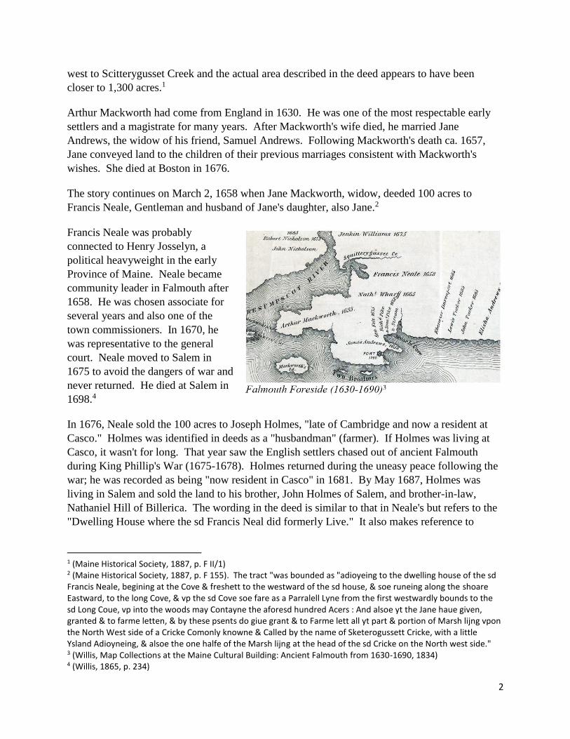
The story continues on March 2, 1658 when Jane Mackworth, widow, deeded 100 acres to
Francis Neale, Gentleman and husband of Jane's daughter, also Jane.2
Francis Neale was probably
connected to Henry Josselyn, a
political heavyweight in the early
Province of Maine. Neale became
community leader in Falmouth after
1658. He was chosen associate for
several years and also one of the
town commissioners. In 1670, he
was representative to the general
court. Neale moved to Salem in
1675 to avoid the dangers of war and
never returned. He died at Salem in
1698.4
In 1676, Neale sold the 100 acres to Joseph Holmes, "late of Cambridge and now a resident at
Casco." Holmes was identified in deeds as a "husbandman" (farmer). If Holmes was living at
Casco, it wasn't for long. That year saw the English settlers chased out of ancient Falmouth
during King Phillip's War (1675-1678). Holmes returned during the uneasy peace following the
war; he was recorded as being "now resident in Casco" in 1681. By May 1687, Holmes was
living in Salem and sold the land to his brother, John Holmes of Salem, and brother-in-law,
Nathaniel Hill of Billerica. The wording in the deed is similar to that in Neale's but refers to the
"Dwelling House where the sd Francis Neal did formerly Live." It also makes reference to
1 (Maine Historical Society, 1887, p. F II/1) 2 (Maine Historical Society, 1887, p. F 155). The tract "was bounded as "adioyeing to the dwelling house of the sd Francis Neale, begining at the Cove & freshett to the westward of the sd house, & soe runeing along the shoare Eastward, to the long Cove, & vp the sd Cove soe fare as a Parralell Lyne from the first westwardly bounds to the sd Long Coue, vp into the woods may Contayne the aforesd hundred Acers : And alsoe yt the Jane haue given, granted & to farme letten, & by these psents do giue grant & to Farme lett all yt part & portion of Marsh lijng vpon the North West side of a Cricke Comonly knowne & Called by the name of Sketerogussett Cricke, with a little Ysland Adioyneing, & alsoe the one halfe of the Marsh lijng at the head of the sd Cricke on the North west side." 3 (Willis, Map Collections at the Maine Cultural Building: Ancient Falmouth from 1630-1690, 1834) 4 (Willis, 1865, p. 234)

3
"lying and being on the North East Side of a Creek Commonly called or known by the Name of
Skittragussets Creek." 5
The families of early Falmouth were closely connected through marriage. For example, the
daughter of Holmes' brother John married the son of George Felt, Francis Neale's brother-in-law.
Familial relationships across successive owners were the norm.
Deeds tell us there was a dwelling on Neale's 100 acre tract before 1658. It was still there in
1687 having escaped burning in 1676 during King Philip's War. It was likely burned around
1690 during King William’s War. A careful reading of the deeds suggests that the dwelling was
located near the southwestern corner of the tract. The most suitable location for a dwelling is
where the farmhouse is located today. The Tidewater farmhouse may have been built on the
rubble of Francis Neale's dwelling.
Records do not reflect English occupation of Holmes' land in the unsettled period between King
William's War (1688-1697) and Queen Anne's War (1702-1713).6
The next chapter in the story of
Tidewater Farm began in 1729 when
the Town of Falmouth granted "90
acres on Squitterygussett Creek in
New Casco” (Falmouth) to James
Wyman. The land was on the east
side of the creek.7
Wyman family history observes that
many Falmouth residents moved to
Gloucester, Mass., about 1690 due to
the looming threat of war. The
situation in Falmouth became more
settled with signing of the Treaty of
Portsmouth in 1713. Many returned to Falmouth about 1729.9
5 (State of Maine, 1909, p. F 81). Holmes may have died shortly after selling the land. No record of further sale of the land was found. Nor was it listed in the probate for Holmes' brother or brother-in-law. 6 (Willis, 1865, pp. 311-318). Falmouth was devoid of English settlers for a decade following the massacre of 1690. Fort New Casco was established on Menikoe Point in 1700 where, in 1703, the governor of Massachusetts signed a peace treaty with the chiefs of five tribes. Within two months, war erupted and "the whole eastern country was in a conflagration, no house standing nor garrison unattacked." The garrison at Fort New Casco barely withstood the ensuing attacks and a siege. Falmouth was otherwise deserted of inhabitants. 7 (Martin & Martin, n.d.). Unfortunately, the sources cited by the web page include unpublished volumes of York Deeds. Details of the grant can probably be found in the Records of the Proprietors at the Cumberland County Registry of Deeds. 8 (The Proprietors of Falmouth, 1732) 9 (Martin & Martin, n.d.). Wording in the Wyman family history is ambiguous, leaving the reader with the impression that James was part of a family that had evacuated. He was born and reached adulthood at Woburn
4
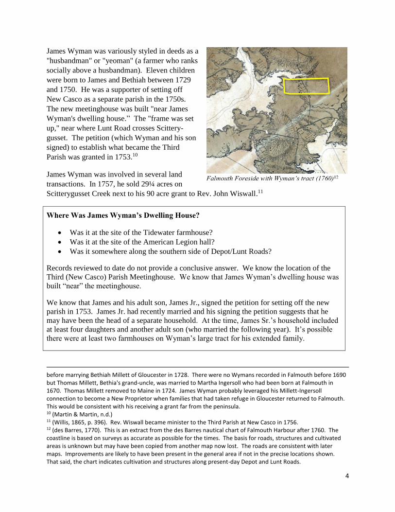
James Wyman was variously styled in deeds as a
"husbandman" or "yeoman" (a farmer who ranks
socially above a husbandman). Eleven children
were born to James and Bethiah between 1729
and 1750. He was a supporter of setting off
New Casco as a separate parish in the 1750s.
The new meetinghouse was built "near James
Wyman's dwelling house.” The "frame was set
up," near where Lunt Road crosses Scittery-
gusset. The petition (which Wyman and his son
signed) to establish what became the Third
Parish was granted in 1753.10
James Wyman was involved in several land
transactions. In 1757, he sold 29¼ acres on
Scitterygusset Creek next to his 90 acre grant to Rev. John Wiswall.11
Where Was James Wyman’s Dwelling House?
Was it at the site of the Tidewater farmhouse?
Was it at the site of the American Legion hall?
Was it somewhere along the southern side of Depot/Lunt Roads?
Records reviewed to date do not provide a conclusive answer. We know the location of the
Third (New Casco) Parish Meetinghouse. We know that James Wyman’s dwelling house was
built “near” the meetinghouse.
We know that James and his adult son, James Jr., signed the petition for setting off the new
parish in 1753. James Jr. had recently married and his signing the petition suggests that he
may have been the head of a separate household. At the time, James Sr.’s household included
at least four daughters and another adult son (who married the following year). It’s possible
there were at least two farmhouses on Wyman’s large tract for his extended family.
before marrying Bethiah Millett of Gloucester in 1728. There were no Wymans recorded in Falmouth before 1690 but Thomas Millett, Bethia's grand-uncle, was married to Martha Ingersoll who had been born at Falmouth in 1670. Thomas Millett removed to Maine in 1724. James Wyman probably leveraged his Millett-Ingersoll connection to become a New Proprietor when families that had taken refuge in Gloucester returned to Falmouth. This would be consistent with his receiving a grant far from the peninsula. 10 (Martin & Martin, n.d.) 11 (Willis, 1865, p. 396). Rev. Wiswall became minister to the Third Parish at New Casco in 1756. 12 (des Barres, 1770). This is an extract from the des Barres nautical chart of Falmouth Harbour after 1760. The coastline is based on surveys as accurate as possible for the times. The basis for roads, structures and cultivated areas is unknown but may have been copied from another map now lost. The roads are consistent with later maps. Improvements are likely to have been present in the general area if not in the precise locations shown. That said, the chart indicates cultivation and structures along present-day Depot and Lunt Roads.

5
The Wymans lived in Falmouth until about 1758 when they removed to Swan Island in what was
then Bowdoinham. On March 24, 1757, James and Bethiah Wyman sold to “Samuel Cobb Jr. of
Falmouth, Gent., and Benjamin Lunt of Falmouth, shipwright … the farm I now live on...
bounded by 20¼ acres that I lately sold to the Revd. Mr. John Wiswall on Presumpscott River &
Squitterygusset Creek with houses Barn Fences out houses & my Right in the school house.”13
Capt. Samuel Cobb Jr. was a prominent shipwright on the peninsula who removed to New Casco
in 1768. He was the son of Deacon Samuel Cobb Sr. who moved to Falmouth from Middleboro,
Mass., in 1717. Samuel Cobb Sr. was a ship carpenter and housewright. For many years he was
an active and influential man in the affairs of the town having served as town clerk, treasurer and
selectman. He died in 1766.14 15
Samuel Cobb Jr.’s title of "Captain" refers to his military service in the Colonial and
Revolutionary Wars. He is said to have built 150 vessels. His shipyard at Falmouth Neck was
on Fore Street near where he lived at the foot of India Street. At New Casco he built vessels near
Scitterygusset Creek.16
Capt. Samuel Cobb died before 1795. The parcel on the Scitterygusset and interest in the
shipyard was divided between his sons. A 50 acre portion of his "home estate" went to his son
William while the remaining 45 acres went to the heirs of his son, Samuel Cobb III.17
In 1795, William Cobb sold his 50 acre portion to Benjamin Moody (1739-1805). It included the
buildings thereon as well as a half interest in the shipyard. In 1798, Benjamin Moody sold a one-
half interest in the 50 acres and shipyard to his son Jonathan.18 19
In1806, Edward, Samuel and Francis Cobb, adult children and heirs of Samuel Cobb III (and
grandsons of Capt. Samuel Cobb Jr.) sold their 45 acres ("southwesterly portion of Samuel
Cobb's 'home estate'") to Jonathan Moody. The deed noted that Jonathan was already in
possession of the half interest in the shipyard.20
Between 1812 and 1818, there was a series of transactions between Jonathan Moody and his
younger brother Samuel (1784-1858), a Mariner. Samuel appears to have inherited the other half
of the 50 acres from their father, Benjamin, who died in 1805. When the dust settled, Jonathan
13 (Martin & Martin, n.d.). Extracted from unpublished York Deeds. Acreage uncertain due to transcription error. 14 (Cobb, 1907, pp. 76-77, 111-112) 15 (Willis, 1865, p. 340) 16 (Society of Colonial Wars in the State of Maine, 1905, pp. 71-72). He commanded a company in Col. Jedidiah Preble's regiment during the Cape Sable campaign of 1758 against Nova Scotia during the French and Indian War (1754-1758). 17 Details are inferred due to the loss of probate records. 18 (Cumberland County (Maine) Registrar of Deeds, 1753-present, p. 23/443) 19 (Cumberland County (Maine) Registrar of Deeds, 1753-present, p. 27/493) 20 (Cumberland County (Maine) Registrar of Deeds, 1753-present, p. 49/126)
6
owned two parcels of land comprising 45 acres on the east side of Scitterygusset Creek and four
acres with buildings and half of a shipyard.21 22 23 24
Jonathan Moody (ca 1773-1835) was styled in deeds as a shipwright (explaining his interest in
the shipyard). He was married first to Judith Merrill (1771-1815) and then Hannah Merrill
(1775-1851), both of Falmouth and daughters of Silas Merrill (1743-1808).25 26
The next major change took place on November 7, 1838, when Silas W. Merrill of Falmouth
purchased about 45 acres comprising what we know as Tidewater Farm from Samuel Moody of
Falmouth, shipmaster and guardian for Silas and Hannah Moody (minor heirs of Jonathan
Moody who died in 1835). The 45 acres included:
7 acres of mowing and tillage
20 acres mowing and tillage
18 acres pasturing
One-quarter acre woodland
Pews in the meetinghouses
That deed was supposed to have included the shipyard but it was left out. So, on September 5,
1839, Samuel Moody, as guardian, conveyed the undivided half interest in a shipyard to Silas W.
Merrill.27 28
Silas Whiton Merrill (1816-1890) was the son of Samuel Merrill (1786-1862) and great-
grandson of James Merrill (1689-1757) who settled in "New Casco" in 1738 (and whose six sons
left many descendants in Falmouth). Silas W. Merrill was styled in deeds as a "joiner" (builder)
and lived in Boston. He appears to have purchased the homestead on behalf of his father. In
subsequent deeds, the 45 acre parcel was referred to as the "Samuel Merrill Homestead.29
On March 9, 1849, Silas W. Merrill conveyed a half interest in the property to his brother, Jacob
Jewett Merrill (1821-1880).30
In the 1850 census, we see Samuel Merrill, farmer, living there with his wife, a daughter, his son
Jacob Jewett and wife, and Samuel's sister (Hannah Moody, Jonathan Moody's widow). By
21 (Cumberland County (Maine) Registrar of Deeds, 1753-present, p. 64/405) 22 (Cumberland County (Maine) Registrar of Deeds, 1753-present, p. 64/466) 23 (Cumberland County (Maine) Registrar of Deeds, 1753-present, p. 72/736) 24 (Cumberland County (Maine) Registrar of Deeds, 1753-present, p. 82/134) 25 (Merrill, 1928, p. 289) 26 We did not explore possible familial connections between the Cobbs and Moodys but there were certainly close business relationships. It is possible that Jonathan learned his trade while working with or for the Cobbs. 27 (Cumberland County (Maine) Registrar of Deeds, 1753-present, p. 165/79) 28 (Cumberland County (Maine) Registrar of Deeds, 1753-present, p. 64/466) 29 (Merrill, 1928, p. 634) 30 (Cumberland County (Maine) Registrar of Deeds, 1753-present, p. 286/95)

7
1860, there are two households: Samuel Merrill, his wife and daughter in one, and his son's
family in the other.31 32
The map shows the approximate locations
of homesteads in 1857 for actors in this
story.
Samuel Merrill at the Tidewater
farmhouse
Samuel Moody on Depot Road near
the present-day location of the
American Legion. Deeds trace the
American Legion property back to
Rachel Moody, wife of Samuel.34
Both homesteads fell within the bounds of
the tract deeded to James Wyman and sold
to Samuel Cobb. The Merrill homestead is
in the 45 acres owned by Jonathan Moody
while the Moody homestead is in the 50 acres owned by Samuel, Jonathan's younger brother.
Falmouth tax records provide more detail about the homesteads. Unfortunately, we have only a
sampling taken from the tax books placed at the Maine Historical Society for safekeeping.
Entries sampled from books covering the first half of the 19th century begin with Jonathan
Moody having ½ house and 1½ barn (which suggests part of the house was being used for
livestock). No mention is made of the shipyard. The next entry show Jonathan Moody have a
house, a barn, and a shipyard with workhouse. After that we find Samuel Merrill having a
house, a barn, and a shipyard with workhouse.35
31 (United States Bureau of the Census, 1850) 32 (United States Bureau of the Census, 1860) 33 (Chace, 1857) 34 (United States Bureau of the Census, 1850) 35 (Town of Falmouth, Maine)
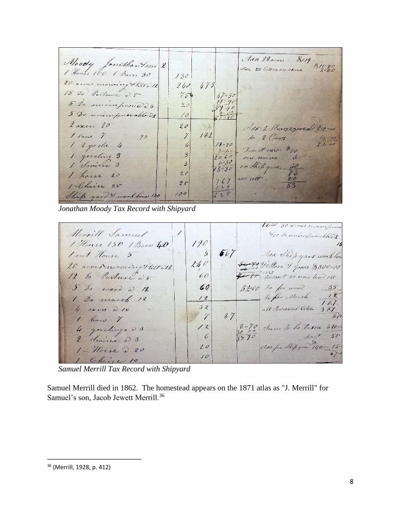
8
Jonathan Moody Tax Record with Shipyard
Samuel Merrill Tax Record with Shipyard
Samuel Merrill died in 1862. The homestead appears on the 1871 atlas as "J. Merrill" for
Samuel’s son, Jacob Jewett Merrill.36
36 (Merrill, 1928, p. 412)

9
Jacob and Silas Merrill purchased an eight-
tenths of an acre strip on the opposite side
of the Squitterygusset giving access to the
"highway" (Middle Road) in 1869. The
bridge across the creek and path to the
road appears on the 1871 atlas.38
The 1870 census shows Jacob living at the
farm with his wife and children. The farm
produced potatoes, apples and dairy.40
Jacob Jewett Merrill died in 1880. This
led to a series of land transfers.
First, Silas W. Merrill (of Boston and
Silas’ brother) conveyed his interest to his
sister Mary Elizabeth Moody Merrill. The
deed described the property as the "Homestead on which my father formerly lived being then
owned by my brother Jacob J. and myself but the deed cannot be found."
a. About 45 acres of mowing and tillage together with the buildings thereon
b. Southerly half of the 28 acre wood lot
c. 20 acres of salt marsh commonly called the Dike conveyed to me by the late Samuel
Moody
Mary Elizabeth immediately conveyed her interest to Henry Jewett and Frederick Whiton
Merrill, Jacob Jewett's sons and her nephews. Jacob Jewett's surviving daughters (Huldah Hall
Norton and Lucretia Merrill) conveyed their interest to their brothers in deeds describing the
property as "one half of a tract of land, one half of all buildings, and one half of the shipyard
attached thereto; about 42 acres."41 42 43
A few years later, Henry J. Merrill (1854-1928) conveys his half interest to his brother.
Frederick W. Merrill (1860-1922) becomes the sole owner of Tidewater Farm. In the 1900
census, he is single and has a servant. By the 1910 census, he is living alone.44 45 46
37 (F.W. Beers, 1871) 38 (Cumberland County (Maine) Registrar of Deeds, 1753-present, p. 362/418) 39 (F.W. Beers, 1871) 40 (United States Bureau of the Census, 1870) 41 (Cumberland County (Maine) Registrar of Deeds, 1753-present, p. 483/444) 42 (Cumberland County (Maine) Registrar of Deeds, 1753-present, p. 483/446) 43 (Cumberland County (Maine) Registrar of Deeds, 1753-present, p. 496/297) 44 (Merrill, 1928, pp. 634-635) 45 (United States Bureau of the Census, 1900)

10
Frederick sold the homestead for $600 to William Wallace Cookson of Washington, D.C., on
January 4, 1911. The Merrill family had been living at Tidewater Farm for 105 years (counting
Jonathan Moody’s wives, both of whom were sisters to Samuel Merrill).47
Cookson (1869-1949), a plate printer at the Bureau of Engraving and Printing, and his wife were
from Maine (hence the connection to F.W. Merrill). In 1914, Cookson sold the homestead to Dr.
Alfred King (1861-1916), a surgeon of Portland. In 1917, Dr. King’s heirs sold the farm to Neils
Kristian Madsen, a mariner.48 49
Madsen (1882-1970) was born in Denmark and immigrated to the United States about 1892. He
served in the U.S. Navy during the Spanish-American War. He would have been 16 years old at
the time. He was probably the Niels Madsen who served aboard the U.S. Revenue Cutter
(USRC) LEVI WOODBURY as a "1st Class Boy." The cutter, a two-masted topsail schooner
based in Maine, was assigned to the North Atlantic Squadron and took place in the blockade of
Havana.50 51 52
Madsen appears in the 1900 census as a seaman and living with his family in Portland. By 1910
he had become a fireman (a qualified member of a ship's engine department). When he
registered for the draft in 1918, Madsen listed his residence as Falmouth and his occupation as
farmer. A year later he had returned to sea—this time as a licensed 1st assistant engineer. He
appears in the 1920 census in New York City as a ship’s engineer. The 1930 census shows him
as a farmer in Falmouth (census taker incorrectly recorded the location as “Falmouth Road”).
His widowed mother was living with him.53 54 55 56 57
On May 26, 1931, Madsen conveyed the farm to Eva J. Grover, a housewife in Portland. A year
later, she conveyed it back. However, Madsen and his mother were living in Portland and he
was working as a janitor. The next year Madsen and his mother were still living in Portland but
he had a wife. On August 11, 1933, he sold the farm to Homar J. Marchildon.58 59 60 61
46 (United States Bureau of the Census, 1910) 47 (Cumberland County (Maine) Registrar of Deeds, 1753-present, p. 869/490) 48 (Cumberland County (Maine) Registrar of Deeds, 1753-present, p. 922/367) 49 (Cumberland County (Maine) Registrar of Deeds, 1753-present, p. 996/96) 50 ("Geoffry", 2010) 51 (United States Bureau of Marine Inspection and Navigation, 1919) 52 (Pendleton & McSherry) 53 (United States Bureau of the Census, 1900) 54 (Portland City Directory, 1910) 55 (United States Selective Service System, 1918) 56 (United States Bureau of the Census, 1920) 57 (United States Bureau of the Census, 1930) 58 (Cumberland County (Maine) Registrar of Deeds, 1753-present, p. 1373/211) 59 (Cumberland County (Maine) Registrar of Deeds, 1753-present, p. 1399/368) 60 (Portland City Directories, 1932-1933) 61 (Cumberland County (Maine) Registrar of Deeds, 1753-present, p. 1425/225)

11
Homar Marchildon (1895-1970) was the son of working class French-Canadian immigrants from
Québec. He enlisted in the Army during WW I. He served in hospital units for two years with
six month overseas. According to Portland directories, he worked as a clerk and machine
operator in Portland while living in Falmouth from 1930 to 1948. The 1946 and 1948 directories
list him as living on Lunt/Lund Road even though deeds show him selling the farm in 1946.
Somehow he escaped being enumerated in the censuses for 1920, 1930 or 1940.62 63
On May 24, 1946, Marchildon sold the farm to Henry & Nancy Finks of Portland.64
Dr. Henry Bayard Finks (1912-2003) was the son of Yiddish-speaking, Lithuanian émigrés. He
grew up in Portland, graduating from Portland High and the University of Maine. He became a
physician with his practice in Portland. He served as a major in the U.S. Army during WWII.
Dr. Finks lived at Tidewater Farm for 57 years—longer than anyone else. Nancy Finks died in
1998 and her share was placed in a revocable trust. Upon Henry's death in 2003, the remainder
of the farm was place in a revocable trust. On October 14, 2005, the farm was sold to Tidewater
LLC. 65
From 2005 until 2019 there ensued the
development of the Tidewater Farm residential
subdivision and Tidewater Village commercial
properties. On October 14, 2005, Tidewater Farms
LLC granted a conservation easement to the Town
of Falmouth for the area designated as “TF1” (not
including the areas designated “TF2” and “TF3”)
on the master plan approved by the town. “TF2”
includes the Tidewater Farm house and barn. On
March 27, 2019, Tidewater LLC sold the area
designated as “TF1” (including “TF2” and “TF3”
excluding Farm Gate Road which had already been
accepted by the town) to the Town of Falmouth.
The town acquired the property with the intention of conveying it to the Falmouth Land Trust.66 67 68
62 The different addresses used by residents of Tidewater Farm during the 20th century posed a bit of a puzzle. Homar Marchildon said he lived at Old Tidewater Farm in Falmouth Foreside. His mailing address was R.F.D. 4. The bridge built by the Merrills across the Scitterygusset must have still been passable in the 1930s and the mailbox for Tidewater Farm was on Middle Road. 63 (Portland City Directories, 1930-1948) 64 (Cumberland County (Maine) Registrar of Deeds, 1753-present, p. 1821/94) 65 (Cumberland County (Maine) Registrar of Deeds, 1753-present, p. 23279/222) 66 (Tidewater LLC, 2019) 67 (Cumberland County (Maine) Registrar of Deeds, 1753-present, p. 35543/207) 68 (Cumberland County (Maine) Registrar of Deeds, 1753-present, p. 25279/235)

12
The Moodys or Merrills would have been shocked
by this view through a front window of the
Tidewater farmhouse.
Two centuries ago, the wetlands at left (beyond
the green lawn) were open water supporting
shipyards.
References.
"Geoffry". (2010, 04 11). Find A Grave. Retrieved from Neil C. Madsen:
https://www.findagrave.com/memorial/50949351
Chace, J. (1857). Map of Cumberland County, Maine. Retrieved from Library of Congress:
http://hdl.loc.gov/loc.gmd/g3733c.la000266
Cobb, P. L. (1907). A History of the Cobb Family. Cleveland.
Cumberland County (Maine) Registrar of Deeds. (1753-present). Recorded Land Volumes. Retrieved from
Cumberland Real Property Records: https://i2a.uslandrecords.com/ME/Cumberland/
des Barres, J. F. (1770). Falmouth Harbour. Retrieved from The Library of Congress:
https://www.loc.gov/item/77692986/
F.W. Beers. (1871). Cumberland County, Maine: Falmouth, West Falmouth, Falmouth Corners. Retrieved
from DigitalMaine Repository: https://digitalmaine.com/atlas_cumberland_1871/39/
Maine Historical Society. (1887). York Deeds, Volume I. Portland, Maine: Hull.
Martin, J., & Martin, P. (n.d.). Wyman. Retrieved from A New England Genealogy:
https://sites.rootsweb.com/~mainegenie/WYMAN.htm
Merrill, S. (1928). A Merrill Memorial. Cambridge, Mass.

13
Pendleton, R., & McSherry, P. (n.d.). The U.S. Revenue Cutter Service in the Spanish American War.
Retrieved from The Spanish American War Centennial Website:
http://www.spanamwar.com/USRCS.htm
Portland City Directories. (1930-1948). Retrieved from Ancestry: https://www.ancestry.com/
Portland City Directories. (1932-1933). Retrieved from Ancestry: https://www.ancestry.com/
Portland City Directory. (1910). Retrieved from Ancestry: https://www.ancestry.com
Portland City Directory. (1933). Retrieved from Ancestry: https://www.ancestry.com
Society of Colonial Wars in the State of Maine. (1905). Register of Officers and Members of the Society of
Colonial Wars in the State of Maine. Portland, Maine: Marks.
State of Maine. (1909). York Deeds Volume XVII. Bethel, Maine: Bowler.
The Proprietors of Falmouth. (1732). A Map of the Town of Falmouth. Retrieved from Osher Map
Library: https://oshermaps.org/map/4000381.0001
Tidewater LLC. (2019, 05 29). Tidewater Master Plan 5.29.2019. Retrieved from Town of Falmouth
Maine: https://www.falmouthme.org/community-development-code-enforcement-
division/files/tidewater-master-plan-5292019
Town of Falmouth, Maine. (n.d.). Town of Falmouth Records, 1773-1980. Maine Historical Society
Stacks, Collection 900, Series 1, Volume 47, Box 1 .
United States Bureau of Marine Inspection and Navigation. (1919, 11 11). Application for Seaman´s
Protection Certificates. Retrieved from Ancestry: https://www.ancestry.com/
United States Bureau of the Census. (1850). 1850 United States Federal Census: Falmouth, Cumberland,
Maine. Retrieved from Ancestry: https://www.ancestry.com/
United States Bureau of the Census. (1860). 1860 United States Federal Census: Falmouth, Cumberland,
Maine. Retrieved from Ancestry: https://www.ancestry.com/
United States Bureau of the Census. (1870). 1870 United States Federal Census: Falmouth, Cumberland,
Maine. Retrieved from Ancestry: https://www.ancestry.com/
United States Bureau of the Census. (1870). Selected Federal Census Non-Population Schedules, 1870:
Falmouth, Cumberland, Maine;. Retrieved from Ancestry: https://www.ancestry.com
United States Bureau of the Census. (1900). 1900 United States Federal Census: Falmouth, Cumberland,
Maine. Retrieved from Ancestry: https://www.ancestry.com
United States Bureau of the Census. (1900). 1900 United States Federal Census: Portland, Cumberland,
Maine. Retrieved from Ancestry: https://www.ancestry.com
United States Bureau of the Census. (1910). 1910 United States Federal Census: Falmouth, Cumberland,
Maine. Retrieved from Ancestry: https://www.ancestry.com
14
United States Bureau of the Census. (1920). 1920 United States Federal Census: Manhattan Assembly
District 1, New York, New York. Retrieved from Ancestry: https://www.ancestry.com/
United States Bureau of the Census. (1930). 1930 United States Federal Census: Falmouth, Cumberland,
Maine. Retrieved from Ancestry: https://www.ancestry.com
United States Selective Service System. (1918). U.S. World War I Draft Registration Cards, 1917-1918.
Retrieved from Ancestry: https:///www.ancestry.com/
Willis, W. (1834). Map Collections at the Maine Cultural Building: Ancient Falmouth from 1630-1690.
Retrieved from DigitalMaine Repository: https://digitalmaine.com/maps/143/
Willis, W. (1865). A History of Portland. Portland, Maine: Bailey & Noyes.