Embed Size (px)
Citation preview

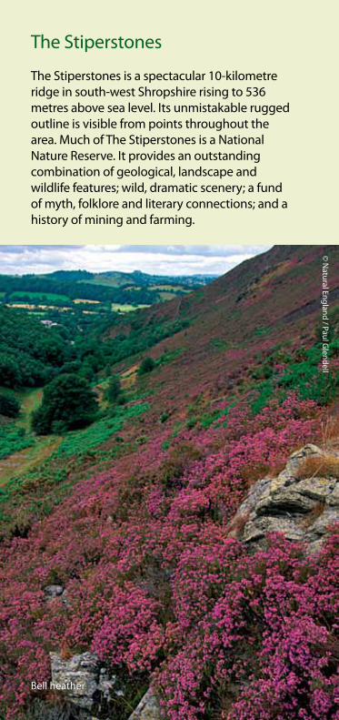
The Stiperstones
National Nature Reserve
The Stiperstones
The Stiperstones is a spectacular 10-kilometre ridge in south-west Shropshire rising to 536 metres above sea level. Its unmistakable rugged outline is visible from points throughout the area. Much of The Stiperstones is a National Nature Reserve. It provides an outstanding combination of geological, landscape and wildlife features; wild, dramatic scenery; a fund of myth, folklore and literary connections; and a history of mining and farming.
Bell heather
© N
atural England / Paul Glendell

Emperor moths
© John M
ason
Other features of note on The Stiperstones are upland hay meadows, oak coppice, and birch and rowan woodland.
These various habitats attract some wonderful animal life. Red grouse, skylark and meadow pipit breed on the open heathland, stonechat and whinchat on the heathland fringe and buzzard, raven, pied flycatcher and wood warbler in the wooded areas. Fox, brown hare, rabbit, common frog and common lizard all live on The Stiperstones, as do many heathland insects. These include grayling and green hairstreak butterflies and fox and emperor moths. Resting Hill is noted for its population of hairy wood ant.
Wildlife
Much of The Stiperstones is heathland. The habitat was created when people first cleared trees to provide rough grazing. The mix of plants changes with altitude and aspect. Bell heather and western gorse are abundant on south-facing slopes, while slopes that face north are dominated by common heather and bilberry (known locally as whinberry). On higher ground, cowberry and crowberry are also frequent. In the few wetter areas, cross-leaved heath, bog mosses, cotton grass, bog asphodel and marsh violet can be seen. In areas converted from heathland to grassland, plants include heath speedwell, heath bedstraw and mountain pansy.

© John M
ason©
Natural England / Paul G
lendell
Green hairstreak
Mountain pansy

Exmoor ponies
© N
atural England / Paul Glendell

Geology & geomorphology
The Stiperstones is important for rocks deposited some 480 million years ago, during the Ordovician period, including Stiperstones Quartzite, which forms the ridge.
Severe and prolonged frost during the last ice age (more than 15,000 years ago) produced today’s shattered, boulder-strewn landscape. The jagged tors, including the Devil’s Chair, are outcrops which proved more resistant, while below them, water, frost and gravity combined to form natural stone striping and stone circles.
Lead has been mined in the area since Roman times. More recently, zinc, barytes and calcite have been extracted too. The legacy of mining is still much in evidence, although extraction finally ceased in the 1950s.
© John M
ason
The rocky spine of The Stiperstones

Status
The most wildlife-rich and geologically dramatic area of The Stiperstones is notified and legally protected as a Site of Special Scientific Interest. Of the 588 hectares of SSSI, 481 comprise a National Nature Reserve (NNR) managed, and mostly owned, by the Government’s wildlife adviser, Natural England. The area is also a Special Area of Conservation under the European Habitats Directive.
© Laurie Cam
pbell
Red grouse
Much effort is devoted to managing the heathland, the most important feature of The Stiperstones. The key to encouraging a high diversity of wildlife is to maintain a range of conditions. The heather plants need to be of varying age and structure – from tender young shoots to large, mature clumps with tough, woody growth. Carefully controlled rotational burning and cutting of mature areas during the winter months promote vigorous new growth. This provides a supply of young heather on which both red grouse and livestock can feed. The older growth that remains provides important shelter for wildlife.
Parts of The Stiperstones NNR are registered common land and are grazed by both sheep and cattle. Burning, cutting and grazing all help to prevent the encroachment of trees which would swamp the heathland and mask the fine landscape.
© John M
ason
Heather-clad scenery at Perkins Beach

Dogs on leads please
© Bill Pinder
Young heather plants at the Gatten Plantation
© Ben O
sborne
‘Back to purple:conserving and restoringThe Stiperstones’
The Stiperstones used to be an unbroken ridge of purple heather heathland running for 10 km. Progressively, since the 1940s, conifer plantations and grassland have broken this continuity. ‘Back to purple’ aims to restore some of this land to heath. The project also involves working to maintain and enrich the wildlife and landscape of the surrounding area, and to encourage recreational uses that are both sustainable and compatible with the wildlife, the landscape and local communities.
‘Back to purple’ started in 1998. It is a long-term project but already, through the work of Natural England, Shropshire Wildlife Trust, the Forestry Commission and private landowners, and with support from the Heritage Lottery Fund and others, 80 hectares of heathland are being re-created. This new heathland is being grazed by Hebridean sheep and Exmoor ponies.

© N
atural England / Paul Glendell
The All-ability Trail
The 650 metre (700 yard) All-ability Trail starts from The Stiperstones NNR car park, near the reserved parking spaces. Take the smaller of the two gates and the trail follows a linear there-and-back route. The steepest gradient is just after the first gate.
There are resting places less than 50 metres apart and a tapping rail is there for visitors with impaired vision. The Trail has an all-weather surface, but please be aware that it is open to horse and bicycle riders and occasional works traffic. The Trail affords fine views to The Stiperstones ridge and The Long Mynd. Listen for the mewing of passing buzzards and the cronk of ravens and you may see Hebridean sheep (black and horned) and Exmoor ponies.

300m
A488 P
P
PP
Castle Ring Fort
Devil's Chair
Gatten Plantation
Green Hill
Viewpoint
Mytton Dingle
Crowsnest
Blakemoorflat
Blakemoorgate
The Paddock
Shepherd's Rock
The Hollies
Brook Vessons
Resting Hill
Oak Hill
Perkins Beach
Manstone Rock 536m
Cranberry Rock
Tankerville Pottery
Pennerley
The Knolls
The Bog Visitor Centre
Rigmoreoak
NNR car park
Snailbeach Mine
Stom
ppa
th
All-a
bilit
ytr
ail
Snailbeach
Stiperstones Village
0 1km
FootpathOther right of way
ParkingPub
ToiletsRock outcrop
Contours at 50m intervals
P
Based upon Ordnance Survey material on behalf of HMSO. Crown copyright and database right 2009. All rights reserved.Natural England OS licence number 100022021 c
Pontesbury
Habberley
Pulverbatch
Bridges
Minsterley
Snailbeach
StiperstonesVillage
The Bog Visitor Centre NNR car
park
Route of shuttle bus
The Stiperstones NNR

The Stiperstones Stomp
To experience The Stiperstones, walkers can try The Stiperstones Stomp – an 8km (5 mile) walk from the National Nature Reserve car park, up and along the broad but rocky ridge, and down to Habberley village.
Both locations lie on the route of the Stiperstones Shuttle Bus service, so you can catch the bus back to your starting point.
Before setting off, please read the important Access and Safety information on the National Nature Reserve section.
If the Stomp sounds too demanding for you, try the All-ability Trail from the NNR car park, or any of the many public rights of way in the area (Ordnance Survey Explorer 216 map recommended)
Catch the Shuttle!
The Stiperstones Shuttle is an ideal way to enjoy the spectacular countryside of The Stiperstones. It is one of the of bus services set up to help you travel round the Shropshire Hills without a car. The service runs round The Long Mynd too. All services run at weekends and Bank Holiday Mondays only, from spring to autumn.
For a timetable of The Stiperstones Shuttle visit Tourist Information providers at The Bog, Bishop’s Castle, Craven Arms or Church Stretton, or call at the shop in Stiperstones village.

Shuttle route services
Pubs close to stops on The Stiperstones Shuttle Bus route:
Horseshoe Inn, Bridges01588 650260
The Stiperstones Inn, Stiperstones village01743 791327
Bridge Hotel, Minsterley01743 791244
Crown & Sceptre, Minsterley01743 791260
Horseshoe Inn, Pontesbury01743 790278
Mytton Arms, Habberley01743 792490
White Horse, Pulverbatch01743 718247
At holiday times, refreshments, information and crafts are available at The Bog Visitor Centre (01743 792484). Toilets, including for disabled people, are available at The Bog Visitor Centre (when it is open), and at Snailbeach (throughout the year).
The Stiperstones Shuttle
© N
atural England / Paul Glendell

History, folklore and fable
Four cairns and a Bronze Age long barrow are evidence of human activity going back three thousand years. There is also an Iron Age hill fort. The Devil, witches and ghosts are prominent in local legends. It is said that if the Devil can flatten The Stiperstones, then all of England will perish. To that end, the Devil is said to fling himself down in his chair on The Stiperstones NNR in the hope that his weight will sink it! Fortunately, sightings of Wild Edric, a saxon nobleman, and his fairy wife Godda charging across the hill on horseback, are rare: they warn of war.
The landscape, wildlife and history have inspired novels by Mary Webb and D H Lawrence, children’s books by Malcolm Saville and Pauline Fisk and a jazz suite.
‘Once upon a hill’: discovering the lost communities of The Stiperstones
In the 19th century, when mining activity was at its height, small ‘squatter’ settlements were established on the fringes of the hill. These were occupied by miners who created small-holdings and grazed the surrounding heathland. By the 20th century mining was on the wane and bit by bit these settlements were abandoned. Two former ‘squatter cottages’ at Blakemoorgate are being restored by Natural England with support from English Heritage, Heritage Lottery Fund and the European Community through a project called ‘Once upon a hill’. Other elements of this project will include a series of self-guided ‘Miners’ trails’ and the recording of oral reminiscences capturing the memories of those who were brought up in these settlements some 80 years ago.

Access to the National Nature Reserve
Visitors are welcome on foot. You can park at The Bog or Snailbeach as well as the main NNR car park. The open hill ground is ‘access land’ over which you have a right to walk, but in the interest of wildlife and livestock, please keep to the network of well-defined footpaths. Access to areas outside the NNR is generally limited to public rights of way.
Wherever you go in this area, please:
n Keep your dog on a lead (this is a legal requirement, other than on rights of way).
n Take litter home.n Park only in car parks to avoid blocking access
for others.n Don’t climb over fences.n Leave gates as you find them.n Guard against fires.
Byelaws protecting the NNR are displayed at all entrances. Anyone wanting to carry out scientific studies or collect specimens should write to the Senior Reserve Manager, Natural England, Rigmoreoak, Pennerley, Minsterley, Shropshire SY5 0NE, tel 01743 792294 or e-mail [email protected]
Educational visits are welcomed and support is available, please use the same contact details as above. Recreational events such as orienteering and rock climbing are by permit only.
Safety firstThe Stiperstones is an upland area where weather conditions can deteriorate rapidly and become severe at any time of year, particularly in winter. The area is also subject to lightning strikes.
Beware of livestock, which may kick, bite, butt and trample, especially if they have young at heel and particularly if you are accompanied by a dog.
Watch your step, as many of the paths are rocky and steep.
Keep an eye open for signs warning of mine workings and heather burning.
Sporting rights are privately owned; these include the rights to shoot game and to shoot, trap and snare those predators of game which are not legally protected, so keep your dog on a lead and watch your step.
Shoots may take place at any time from 12 August to 1 February inclusive.
Make sure you have suitable clothes and footwear (walking boots).
Carry spare clothes and refreshment.
Take a mobile phone or let someone know your route and estimated arrival time.
Only minor roads that link to the NNR are shown.
Bishop's Castle
SHREWSBURY
The Stiperstones NNR
A488 A5
A49
B4371Church Stretton
Pontesbury
Minsterley
Churchstoke
HabberleyPulverbatch
Bridges
Norbury
StiperstonesVillage
A489
A489
A490B4385
B4386
B4499
B4387
B4386
SHROPSHIREWALES
0 5km
A458
Crown copyright and database right 2009.Natural England OS licence no. 100022021c
P

Natural England is here to secure a healthy natural environment for people to enjoy, where wildlife is protected and England’s traditional landscapes are safeguarded for future generations.
ISBN 978-1-84754-306-6 Catalogue Code: NE255
Natural England publications are available as accessible pdfs from: www.naturalengland.org.uk/publications
Should an alternative format of this publication be required, please contact our enquiries line for more information: 0845 600 3078 or email [email protected]
Printed on stock comprising 75% recycled fibre.
www.naturalengland.org.uk
This note/report/publication is published by Natural England under the Open Government Licence for public sector information. You are encouraged to use, and reuse, information subject to certain conditions.
For details of the licence visit
www.naturalengland.org.uk/copyright
Natural England photographs are only available for non-commercial purposes. If any other information, such as maps or data, cannot be used commercially this will be made clear within the note/report/publication.
© Natural England 2013
Front cover image: The Devil’s Chair© Ben Osborne
Back cover image: Bilberry (Whinberry)© Ben Osborne