Embed Size (px)
Citation preview

THE STAGE 1 ARCHAEOLOGICAL ASSESSMENT OF THE PROPOSED WIDENING OF
COUNTY ROAD 22 EAST AND WEST OF THE HORSESHOE VALLEY RESORT MAIN ENTRANCE, TOWNSHIP OF ORO-MEDONTE, SIMCOE COUNTY

THE STAGE 1 ARCHAEOLOGICAL ASSESSMENT OF THE PROPOSED WIDENING OF
COUNTY ROAD 22 EAST AND WEST OF THE HORSESHOE VALLEY RESORT MAIN ENTRANCE,
TOWNSHIP OF ORO-MEDONTE, SIMCOE COUNTY
Prepared by
Archaeological Assessments Ltd. 2227 Wuthering Heights Way, Oakville, Ontario L6M 0A3
Telephone - 905-469-8690 Facsimile - 905-469-8702
Consulting Archaeologist: Chris Brown Archaeological Consulting Licence Number P361
P.I.F. Number P361-069-2013 July 30, 2013
The Stage 1 Archaeological Assessment Of The Proposed Widening Of County Road 22, East And West Of The Horseshoe Valley Resort Main Entrance, Township Of Oro-Medonte, Simcoe County Archaeological Assessments Ltd.
ii
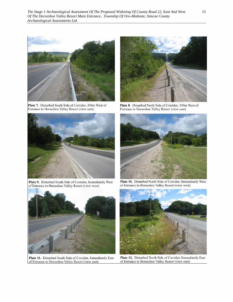
TABLE OF CONTENTS 1.0 PROJECT CONTEXT 1 1.1 Introduction And Development Context 1 1.2 Archaeological Context 1 1.3 Historical Context 4 2.0 FIELD METHODS 5 3.0 RECOMMENDATIONS & COMPLIANCE ADVICE 6 3.1 Recommendations 6 3.2 Compliance Advice 6 4.0 MAPS Figure 1 General Location of the Road Corridor 7 Figure 2 1881 Illustrated Historic Atlas Map of Oro and Medonte Townships 8 Figure 3 Archaeological Potential of the West End of the Road Corridor 9 Figure 4 Archaeological Potential of the Western Section of the Road Corridor 10 Figure 5 Archaeological Potential of the Central Section of the Road Corridor 11 Figure 6 Archaeological Potential of the Eastern Section of the Road Corridor 12 Figure 7 Archaeological Potential of the East End of the Road Corridor 13 5.0 IMAGES Plate 1 Disturbed South Side of Corridor East of Line 3 North 14 Plate 2 Disturbed North Side of Corridor East of Line 3 North 14 Plate 3 Potentially Undisturbed South Side of Corridor West of Line 3 North 14 Plate 4 Potentially Undisturbed North Side of Corridor West of Line 3 North 14 Plate 5 Disturbed South Side of Corridor 350m East of Line 3 North 14 Plate 6 Disturbed North Side of Corridor 500m West of Horseshoe Valley Resort 14 Plate 7 Disturbed South Side of Corridor 350m West of Horseshoe Valley Resort 15 Plate 8 Disturbed North Side of Corridor 350m West of Horseshoe Valley Resort 15 Plate 9 Disturbed South Side of Corridor West of Horseshoe Valley Resort 15 Plate 10 Disturbed North Side of Corridor West of Horseshoe Valley Resort 15 Plate 11 Disturbed South Side of Corridor East of Horseshoe Valley Resort 15 Plate 12 Disturbed North Side of Corridor East of Horseshoe Valley Resort 15 Plate 13 Disturbed Road Corridor West of Country Club Lane 16 Plate 14 Disturbed Road Corridor East of Country Club Lane 16 Plate 15 Disturbed Road Corridor 400m West of Line 4 North 16 Plate 16 Disturbed Road Corridor 150m West of Line 4 North 16 Plate 17 Potentially Undisturbed Road Corridor West of Line 4 North 16 Plate 18 Potentially Undisturbed Road Corridor East of Line 4 North 16 6.0 REFERENCES 17 PROJECT PERSONNEL Project Director Chris Brown (License P361) Report Preparation Rick Sutton (License P013)

The Stage 1 Archaeological Assessment Of The Proposed Widening Of County Road 22, East And West Of The Horseshoe Valley Resort Main Entrance, Township Of Oro-Medonte, Simcoe County Archaeological Assessments Ltd.
iii
EXECUTIVE SUMMARY This report details the rationale, methods and results of the Stage 1 Archaeological Assessment of the Proposed Widening Of County Road 22, East And West Of The Horseshoe Valley Resort Main Entrance, Township Of Oro-Medonte, Simcoe County. The purpose of the assessment was to determine the archaeological potential of the road corridor as part of a Schedule C project in accordance with the Municipal Class Environmental Assessment process. The road corridor that is the focus of this assessment has an approximate length of 4km. The existing right-of-way has a average width of 30 to 40 metres. Details regarding the proposed expansion of the existing right-of-way are still being formulated. For the purposes of this study it was assumed that the proposed right-of-way will be expanded for an average of 10 metres on either side of the existing right-of-way. The results of the Stage 1 assessment indicate that the majority of the proposed right-of-way has already been disturbed by the existing road corridor and no longer has any archaeological potential. However, some areas at the western and eastern ends of the proposed right-of-way may be undisturbed and do have some potential for both aboriginal and Euro-Canadian archaeological resources. It is recommended that the potentially undisturbed sections of the proposed right-of-way should be subjected to a Stage 2 archaeological assessment prior to any construction activities. No soil disturbance or development activities should take place until after a Stage 2 archaeological assessment has been completed.

The Stage 1 Archaeological Assessment Of The Proposed Widening Of County Road 22, East And West Of The Horseshoe Valley Resort Main Entrance, Township Of Oro-Medonte, Simcoe County Archaeological Assessments Ltd.
1
1.0 PROJECT CONTEXT 1.1 INTRODUCTION AND DEVELOPMENT CONTEXT This report details the rationale, methods and results of the Stage 1 Archaeological Assessment of the Proposed Widening Of County Road 22, East And West Of The Horseshoe Valley Resort Main Entrance, Township Of Oro-Medonte, Simcoe County. The purpose of the assessment was to determine the archaeological potential of the road corridor as part of a Schedule C project in accordance with the Municipal Class Environmental Assessment process. The assessment was conducted by Archaeological Assessments Ltd., under archaeological consulting licence No. P361 issued to Chris Brown. The assessment was conducted in accordance with the provisions of the Ontario Heritage Act (Government of Ontario 1980) and the technical guidelines for archaeological assessments formulated by the Ministry of Tourism and Culture (MCL 2011). Archaeological Assessments Ltd. accepts responsibility for the long term curation of any artifacts recovered or documents produced as a result of the assessment. 1.2 ARCHAEOLOGICAL CONTEXT Project Description The study area for this project is a 4km long section of County Road 22 (Horseshoe Valley Road) extending approximately from Line 3 North to Line 4 North, with the entrance to the Horseshoe Valley Resort at its centre (Figure 1). The County of Simcoe is proposing to widen County Road 22 by the addition of a truck climbing lane in this area, along with improvements to the 3rd and 4th Line intersections. The road corridor would be widened from a two lane to a three lane cross section. The existing right-of-way has a average width of 30 to 40 metres. Details regarding the proposed expansion of the existing right-of-way are still being formulated. For the purposes of this study it was assumed that the proposed right-of-way will be expanded for an average of 10 metres on either side of the existing right-of-way. A visual inspection of the road corridor was conducted on July 29, 2013 by consultant archaeologist Chris Brown (Licence P361). The existing road corridor is situated in a rural area associated with the Horseshoe Valley Resort. The existing road corridor consists of a single lane in each direction flanked on both sides by a gravel shoulder. The road corridor is dominated by the topography of the Horseshoe Valley, with a steep grade leading into and out of the valley from the uplands on either side. The western end of the existing right-of-way in the area of Line 3 North is situated on level tablelands. Four hundred metres east of Line 3 North the road quickly slopes down into Horseshoe Valley. The valley floor itself is quite narrow and is associated with the entrance to the Horseshoe Valley Resort and a residential community. Six hundred metres east of the

The Stage 1 Archaeological Assessment Of The Proposed Widening Of County Road 22, East And West Of The Horseshoe Valley Resort Main Entrance, Township Of Oro-Medonte, Simcoe County Archaeological Assessments Ltd.
2
entrance to the resort the road quickly slopes up towards the uplands. The eastern end of the road corridor in the area of Line 4 North consists of relatively level tablelands. The existing road corridor has been created in part by cutting into the hillsides on either side of the valley, and by raising the road corridor along the valley floor. Consequently, most sections of the existing right-of-way are flanked by steep slopes. The western and eastern ends of the road corridor are situated along the edges of a large upland area associated with the Simcoe Uplands physiographic region. The Simcoe Uplands consist of a series of broad rolling till plains which were islands in glacial Lake Algonquin (Chapman and Putman 1984:182). The upland till plains stand 60 m above the adjoining lowland lake plains. The upland areas are encircled by a series of bluffs, terraces and minor beaches which form steps down the hillsides. The central section of the road corridor along the floor of the Horseshoe Valley is situated in the Simcoe Lowlands physiographic region (Chapman and Putnam 1984:176). The Simcoe Lowlands physiographic region consists of a series of steep sided, flat-floored valleys which were flooded by glacial Lake Algonquin. This area is bordered by beaches and bouldery terraces and is floored by sand, silt and clay. The slopes along the western and eastern sections of the road corridor contain a series of springs that drain down into the valley below. The main source of water on the uplands are the numerous springs which issue from part way down the upland slopes and feed the permanent lowland streams. General physiographic features which must be considered when identifying areas of archaeological potential include distance to water, local topography, soil conditions, and other resource specific features. In general, any lands located within 300 metres of any of these physiographic features should be considered to have archaeological potential (MTC 2011: 7). The MTC's Standards and Guidelines for Consultant Archaeologists (2011: 4-5) stipulate that primary water sources (lakes, rivers, streams, creeks, etc.), secondary water sources (intermittent streams and creeks, springs, marshes, swamps, etc.), ancient water sources (glacial lake shorelines indicated by the presence of raised sand or gravel beach ridges, relic river or stream channels indicated by clear dip or swale in the topography, shorelines of drained lakes or marshes, cobble beaches, etc.), as well as accessible or inaccessible shorelines (high bluffs, swamp or marsh fields by the edge of a lake, sandbars stretching into marsh, etc.) are characteristics that indicate archaeological potential. Other geographic characteristics that can indicate archaeological potential include: elevated topography (eskers, drumlins, large knolls, plateau), pockets of well-drained sandy soil, especially near areas of heavy soil or rocky ground, distinctive land formations that might have been special or spiritual places, such as waterfalls, rock outcrops, caverns, mounds, and promontories and their bases. Resource areas are also considered to be characteristics that indicate archaeological potential (MTC 2011: 5).
The Stage 1 Archaeological Assessment Of The Proposed Widening Of County Road 22, East And West Of The Horseshoe Valley Resort Main Entrance, Township Of Oro-Medonte, Simcoe County Archaeological Assessments Ltd.
3
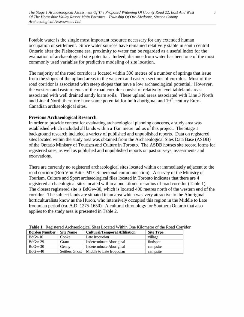
Potable water is the single most important resource necessary for any extended human occupation or settlement. Since water sources have remained relatively stable in south central Ontario after the Pleistocene era, proximity to water can be regarded as a useful index for the evaluation of archaeological site potential. Indeed, distance from water has been one of the most commonly used variables for predictive modeling of site location. The majority of the road corridor is located within 300 metres of a number of springs that issue from the slopes of the upland areas in the western and eastern sections of corridor. Most of the road corridor is associated with steep slopes that have a low archaeological potential. However, the western and eastern ends of the road corridor consist of relatively level tableland areas associated with well drained sandy loam soils. These upland areas associated with Line 3 North and Line 4 North therefore have some potential for both aboriginal and 19th century Euro-Canadian archaeological sites. Previous Archaeological Research In order to provide context for evaluating archaeological planning concerns, a study area was established which included all lands within a 1km metre radius of this project. The Stage 1 background research included a variety of published and unpublished reports. Data on registered sites located within the study area was obtained from the Archaeological Sites Data Base (ASDB) of the Ontario Ministry of Tourism and Culture in Toronto. The ASDB houses site record forms for registered sites, as well as published and unpublished reports on past surveys, assessments and excavations. There are currently no registered archaeological sites located within or immediately adjacent to the road corridor (Rob Von Bitter MTCS: personal communication). A survey of the Ministry of Tourism, Culture and Sport archaeological files located in Toronto indicates that there are 4 registered archaeological sites located within a one kilometre radius of road corridor (Table 1). The closest registered site is BdGw-30, which is located 400 metres north of the western end of the corridor. The subject lands are situated in an area which was very attractive to the Aboriginal horticulturalists know as the Huron, who intensively occupied this region in the Middle to Late Iroquoian period (ca. A.D. 1275-1650). A cultural chronology for Southern Ontario that also applies to the study area is presented in Table 2. Table 1. Registered Archaeological Sites Located Within One Kilometre of the Road Corridor Borden Number Site Name Cultural/Temporal Affiliation Site Type BdGv-10 Cooke Late Iroquoian village BdGw-29 Grant Indeterminate Aboriginal findspot BdGw-30 Genny Indeterminate Aboriginal campsite BdGw-40 Settlers Ghost Middle to Late Iroquoian campsite

The Stage 1 Archaeological Assessment Of The Proposed Widening Of County Road 22, East And West Of The Horseshoe Valley Resort Main Entrance, Township Of Oro-Medonte, Simcoe County Archaeological Assessments Ltd.
4
Table 2. Cultural Chronology For Southern Ontario PERIOD GROUP TIME RANGE COMMENT PALEO-INDIAN Early Fluted 9000 - 8500 B.C.
Big Game Hunters and Small Nomadic Groups Late Non-fluted 8500 - 7500 B.C.
ARCHAIC Early
Nettling 8000 - 7000 B.C. Nomadic Hunters and Gatherers
Bifurcate Based 7000 - 6000 B.C. Middle Stemmed, Otter
Creek and Brewerton
6000 - 2500 B.C. Transition to Territorial Settlement
Late
Narrow Point 2500 - 1800 B.C. More Diverse Resource Base
Broad Point 1800 - 1500 B.C. Small Point 1500 - 800 B.C.
WOODLAND Early Meadowood and
Middlesex 1000 - 300 B.C. Introduction of Pottery
Middle Point Peninsula 300 B.C.- 700 A.D.
Long Distance Trade
Transitional Princess Point 500 - 900 A.D. Early Agriculture Late
Early Iroquoian 900 - 1275 A.D. Transition to Village Life
Middle Iroquoian
1275 - 1400 A.D.
Large Villages and Dependence on Agriculture
Late Iroquoian 1400 - 1650 A.D.
Tribal Development, Warfare, European Contact
HISTORIC Early Odawa, Ojibwa,
Mississauga 1700 - 1875 A.D.
Social Displacement
Late Euro-Canadian 1800 A.D.-present
European Settlement
1.3 HISTORICAL CONTEXT The MTC's Standards and Guidelines for Consultant Archaeologists (2011: 5) stipulate that areas of early Euro-Canadian settlement (pioneer homesteads, isolated cabins, farmstead complexes), early wharf or dock complexes, pioneer churches and early cemeteries, are considered to have archaeological potential. In general, any lands located within 300 metres of any of these cultural features should be considered to have archaeological potential (MTC 2011: 7). Early historical transportation routes (trails, passes, roads, railways, portage routes), properties listed on a municipal register or designated under the Ontario Heritage Act or a federal, provincial, or municipal historic landmark or site, and properties that local histories or informants have identified with possible archaeological sites, historical events, activities, or occupations are also considered to have archaeological potential. Any lands located within 100 metres of early

The Stage 1 Archaeological Assessment Of The Proposed Widening Of County Road 22, East And West Of The Horseshoe Valley Resort Main Entrance, Township Of Oro-Medonte, Simcoe County Archaeological Assessments Ltd.
5
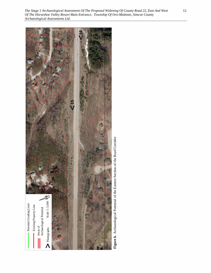
historical transportation routes should also be considered to have archaeological potential (MTC 2011: 7). Information on potential Euro-Canadian archaeological planning concerns for the subject property was derived from an examination of the 1881 Illustrated Historical Atlas of Simcoe County (Beldon 1881). County Road 22 runs along the boundary between what was originally the Townships of Oro and Medonte (Figure 2). There does not appear to have been any homesteads or other buildings located immediately adjacent to the road corridor in 1881. Parts of the road corridor have changed since that time after it was straightened out in the early 20th century. Both Oro and Medonte Townships were surveyed for settlement in 1820 (Hunter 1909). The first settlers arrived in these townships around 1830. County Road 22 was used as a early transportation route and was likely in use as a rough dirt road by the mid 19th century. Consequently, any undisturbed areas along this road corridor have some potential for mid to late 19th century Euro-Canadian archaeological resources. 2.0 FIELD METHODS The study area was visited on July 29, 2013 by consultant archaeologist Chris Brown (Licence P361) under a mixture of sun and cloud and mild weather conditions. General observations of the road corridor were taken from along the existing County Road 22 right-of-way. 2.1 ANALYSIS AND CONCLUSIONS For an assessment of the archaeological potential of any road corridor, examining the extent of previous disturbance is an important factor in determining the potential for archaeological resources. Lands that have been subjected to intensive and deep land alterations due to previous development often no longer have any archaeological potential (MTC 2011:5). The most common forms of previous disturbance include the existing road corridor, building footprints, drainage ditches, utility corridors and infrastructure development. Other activities such as agricultural cultivation, gardening and minor landscaping do not generally affect archaeological potential (MTC 2011:5). The existing road corridor consists of a single lane in each direction flanked on both sides by a gravel shoulder. The road corridor is dominated by the topography of the Horseshoe Valley with a steep grade leading into and out of the valley from the uplands on either side. The existing road corridor has been created in part by cutting into the hillsides on either side of the valley, and by raising the road corridor along the valley floor. Consequently, most sections of the existing right-of-way are flanked by steep slopes. The steep grade and the steep slopes associated with the majority of the road corridor eliminate any archaeological potential in these areas (Figures 3, 4, 5, 6, & 7). The only sections of the proposed right-of-way which are still considered to have some potential are associated with the level tableland areas at the western and eastern ends of the corridor (Figure 3 and 7).

The Stage 1 Archaeological Assessment Of The Proposed Widening Of County Road 22, East And West Of The Horseshoe Valley Resort Main Entrance, Township Of Oro-Medonte, Simcoe County Archaeological Assessments Ltd.
6
3.0 RECOMMENDATIONS & COMPLIANCE ADVICE 3.1 Recommendations The results of the Stage 1 assessment indicate that the majority of the proposed right-of-way has already been disturbed by the existing road corridor and no longer has any archaeological potential. However, some areas at the western and eastern ends of the proposed right-of-way may be undisturbed and do have some potential for both aboriginal and Euro-Canadian archaeological resources. It is recommended that the potentially undisturbed sections of the proposed right-of-way should be subjected to a Stage 2 archaeological assessment prior to any construction activities. No soil disturbance or development activities should take place until after a Stage 2 archaeological assessment has been completed. 3.2 Compliance Advice This report is submitted to the Minister of Tourism and Culture as a condition of licensing in accordance with Part VI of the Ontario Heritage Act, R.S.O. 1990, c 0.18. The report is reviewed to ensure that it complies with the standards and guidelines that are issued by the Minister, and that the archaeological fieldwork and report recommendations ensure the conservation, protection and preservation of the cultural heritage of Ontario. When all matters relating to archaeological sites within the project area of a development proposal have been addressed to the satisfaction of the Ministry of Tourism and Culture, a letter will be issued by the ministry stating that there are no further concerns with regard to alterations to archaeological sites by the proposed development. It is an offence under Sections 48 and 69 of the Ontario Heritage Act for any party other than a licensed archaeologist to make any alteration to a known archaeological site or to remove any artifact or other physical evidence of past human use or activity from the site, until such time as a licensed archaeologist has completed archaeological fieldwork on the site, submitted a report to the Minister stating that the site has no further cultural heritage value or interest , and the report has been filed in the Ontario Public Register of Archaeology Reports referred to in Section 65.1 of the Ontario Heritage Act. Should previously undocumented archaeological resources be discovered, they may be a new archaeological site and therefore subject to Section 48 (1) of the Ontario Heritage Act. The proponent or person discovering the archaeological resources must cease alteration of the site immediately and engage a licensed consultant archaeologist to carry out archaeological fieldwork, in compliance with Section 48 (1) of the Ontario Heritage Act. The Cemeteries Act, R.S.O. 1990 c. C.4 and the Funeral, Burial and Cremation Services Act, 2002, S.O. 2002, c.33 (when proclaimed in force) require that any person discovering human remains must notify the police or coroner and the Registrar of Cemeteries at the Ministry of Consumer Services.

The Stage 1 Archaeological Assessment Of The Proposed Widening Of County Road 22, East And West Of The Horseshoe Valley Resort Main Entrance, Township Of Oro-Medonte, Simcoe County Archaeological Assessments Ltd.
7
4.0 MAPS
Figure 1. General Location of the Road Corridor(Department of Energy, Mines and Resources 2000 Elmvale 31D/12)
Scale 1: 50,000

The Stage 1 Archaeological Assessment Of The Proposed Widening Of County Road 22, East And West Of The Horseshoe Valley Resort Main Entrance, Township Of Oro-Medonte, Simcoe County Archaeological Assessments Ltd.
8
Figure 2. 1881 Historical Atlas Map of Oro and Medonte Townships Showing Location of Road Corridor (Beldon 1881)
Scale 1: 67,500
ORO
MEDONTE

The Stage 1 Archaeological Assessment Of The Proposed Widening Of County Road 22, East And West Of The Horseshoe Valley Resort Main Entrance, Township Of Oro-Medonte, Simcoe County Archaeological Assessments Ltd.
9
Fig
ure
3. A
rcha
eolo
gica
l Pot
entia
l of t
he W
est E
nd o
f the
Roa
d C
orrid
or
Pote
ntia
l Gra
ding
Lim
it
Exis
ting
Prop
erty
Lin
e
Are
as o
f A
rcha
eolo
gica
l Pot
entia
l
Scal
e 1:
3,0
00Ph
otog
raph
s
12
345

The Stage 1 Archaeological Assessment Of The Proposed Widening Of County Road 22, East And West Of The Horseshoe Valley Resort Main Entrance, Township Of Oro-Medonte, Simcoe County Archaeological Assessments Ltd.
10
Figu
re 4
. A
rcha
eolo
gica
l Pot
entia
l of t
he W
este
rn S
ectio
n of
the
Roa
d C
orri
dor
Pote
ntia
l Gra
ding
Lim
it
Exi
stin
g Pr
oper
ty L
ine
Are
as o
f A
rcha
eolo
gica
l Pot
entia
l
Scal
e 1:
3,0
00Ph
otog
raph
s
6
78

The Stage 1 Archaeological Assessment Of The Proposed Widening Of County Road 22, East And West Of The Horseshoe Valley Resort Main Entrance, Township Of Oro-Medonte, Simcoe County Archaeological Assessments Ltd.
11
Figu
re 5
. A
rcha
eolo
gica
l Pot
entia
l of t
he C
entr
al S
ectio
n of
the
Roa
d C
orrid
or
Pote
ntia
l Gra
ding
Lim
it
Exis
ting
Prop
erty
Lin
eA
reas
of
Arc
haeo
logi
cal P
oten
tial
Scal
e 1:
3,0
00Ph
otog
raph
s
9101112
1314
The Stage 1 Archaeological Assessment Of The Proposed Widening Of County Road 22, East And West Of The Horseshoe Valley Resort Main Entrance, Township Of Oro-Medonte, Simcoe County Archaeological Assessments Ltd.
12
Figu
re 6
. A
rcha
eolo
gica
l Pot
entia
l of t
he E
aste
rn S
ectio
n of
the
Roa
d C
orrid
or
Pote
ntia
l Gra
ding
Lim
it
Exis
ting
Prop
erty
Lin
eA
reas
of
Arc
haeo
logi
cal P
oten
tial
Scal
e 1:
3,0
00Ph
otog
raph
s
15
16

The Stage 1 Archaeological Assessment Of The Proposed Widening Of County Road 22, East And West Of The Horseshoe Valley Resort Main Entrance, Township Of Oro-Medonte, Simcoe County Archaeological Assessments Ltd.
13
Figu
re 7
. A
rcha
eolo
gica
l Pot
entia
l of t
he E
ast E
nd o
f the
Roa
d C
orri
dor
Pote
ntia
l Gra
ding
Lim
it
Exis
ting
Prop
erty
Lin
e
Are
as o
f A
rcha
eolo
g ica
l Pot
entia
l
Scal
e 1:
3,0
00Ph
otog
raph
s
1718

The Stage 1 Archaeological Assessment Of The Proposed Widening Of County Road 22, East And West Of The Horseshoe Valley Resort Main Entrance, Township Of Oro-Medonte, Simcoe County Archaeological Assessments Ltd.
14
5.0 IMAGES
The Stage 1 Archaeological Assessment Of The Proposed Widening Of County Road 22, East And West Of The Horseshoe Valley Resort Main Entrance, Township Of Oro-Medonte, Simcoe County Archaeological Assessments Ltd.
15

The Stage 1 Archaeological Assessment Of The Proposed Widening Of County Road 22, East And West Of The Horseshoe Valley Resort Main Entrance, Township Of Oro-Medonte, Simcoe County Archaeological Assessments Ltd.
16

The Stage 1 Archaeological Assessment Of The Proposed Widening Of County Road 22, East And West Of The Horseshoe Valley Resort Main Entrance, Township Of Oro-Medonte, Simcoe County Archaeological Assessments Ltd.
17
6.0 REFERENCES CITED Beldon & Co. 1881 Illustrated Historical Atlas of Simcoe County. Toronto. Chapman, L.J. and D.F. Putnam 1984 The Physiography of Southern Ontario (Third Edition). Ontario Geological Survey Special Volume 2. Ontario Ministry of Natural Resources, Toronto. Government of Ontario 1980 The Heritage Act RSO 1980. Queen's Printer, Toronto. 1990 The Environmental Assessment Act RSO 1990. Queen's Printer, Toronto. 1996 The Planning Act RSO 1996. Queen's Printer, Toronto. Hunter, Andrew 1909 A History of Simcoe County. The County Council, Barrie. Ministry of Tourism and Culture 2011 Standards and Guidelines for Consulting Archaeologists. Ministry of Tourism and Culture, Toronto.