Embed Size (px)
Citation preview

Vandecruys, The Sphinx www.PalArch.nl, archaeology of Egypt/Egyptology, 1, 1, (2006)
The Sphinx: dramatising data … and dating
G. Vandecruys
Everselkiezel 73 3550 Heusden–Zolder
Belgium [email protected]
ISSN 1567–214X
6 figures
Abstract
Geology and archaeology, carefully entwined, form the basis for deciding on a date of construction for the Great Sphinx at Giza. Over a decade after Robert Schoch’s controversial Pre–Dynastic proposal, Colin Reader takes up
the debate again in the new millennium, and suggests a less extreme re–dating to the Early–Dynastic era. In tracing the data that forms the backbone for the ‘older Sphinx’ theories, I have found that a model of
groundwater seepage leading to increased salt weathering rates explains the currently visible erosion morphology without requiring a change in the accepted chronology. On the archaeological side, several surrounding Giza
monuments place an important limit on the possibility for an older Sphinx.
Contents 1. Identifying the deterioration of the rock 2. A structural analysis of Khafre’s pyramid complex 3. Conclusions 4. Acknowledgements 5. Cited literature
PalArch Foundation
Vandecruys, The Sphinx www.PalArch.nl, archaeology of Egypt/Egyptology, 1, 1, (2006)
1. Identifying the deterioration of the rock
Since Boston University geologist Robert Schoch launched his ‘older Sphinx’ theories back in the early nineties, most of the Sphinx–debate has centred on defining the age of the monument, with geology often as the only applied science. Yet geology is insufficiently accurate as a stand–alone dating technique, given the myriad factors that play a role in the erosion and weathering of the Sphinx and its enclosure. There is really no such thing as one single cause, which makes determining the age of the monument by looking at its weathering and erosion patterns particularly complex, and loses its accuracy when all factors have not been fully determined and taken into account. Nevertheless, I would recommend geological data as a proofing tool for conclusions reached by means of archaeological techniques. Additionally, more attention with regards to the actual meaning and location of the Sphinx within the Giza necropolis will undoubtedly help in the determining the age of the monument.
Heated debates have occurred regarding the meaning of the erosion morphology, and focused primarily on the enclosure walls (particularly the western segments). In the sub–vertical fissuring, Schoch sees indisputable evidence of precipitation–induced weathering, which relies on dissolution of calcite in rainwater (weathering mechanism), but also on rainwater washing away the ions and debris produced by it (erosion process). Given the present arid climate in Egypt, Schoch pushes back the date of construction to the wet Pre–Dynastic period, somewhere between 7,000 and 5,000 BC. But how unambiguous is his evidence? Is precipitation truly the single possible explanation? And where is the evidence for the culture that could have quarried this monument in Pre–dynastic times? Schoch’s use of settlements that existed at Çatal Hüyük, Turkey in the late seventh millennium BC and Jericho, Israel in the ninth millennium BC (Schoch, 1992: 59) is inadequate, as there is no evidence for similar settlements in Egypt itself. For that reason, this cannot be accepted as supporting evidence.
More recently, the discussion was reopened with the work of geologist Colin Reader, who suggested that most of the rainfall would be converted to overland flow. Reader suggests that prior to the quarrying west of the Sphinx, water running down the Giza plateau would have entered the enclosure from the west side, and that this sheetwash could be responsible for the erosion morphology. But surface runoff alone does not explain the degradation patterns. Sheet erosion is the removal of surface soil in thin layers by runoff and in this case, water entering the porous limestone rock would cause chemical weathering (in this case mainly salt weathering). Then supplementary runoff would wash the loose parts away, exposing new layers to the different mechanisms of chemical weathering. It is important to realise the difference between weathering and erosion: weathering is the in situ breakdown of the rock, while erosion is the actual removal of rock particles. Erosion in rock even implies weathering as part of the erosion process. This means that Reader’s runoff thesis also relies on salt weathering, because the erosion is significantly intensified by this mechanism, and therefore it would take less time to obtain the same amount of erosion as with the movement of the water alone. In other words, the rate of erosion is dependant on the rate of weathering.
In examining the case for water as the primary ‘cause’ of the visible sub–vertical pattern, the easiest argument to counter is direct rainfall: if this was the cause of the rounded sub–vertical fissuring, we would expect to see the same patterns on those parts of the Sphinx that consist of the same layers of limestone as the enclosure. There are no such obvious traces. Schoch’s call for the “rolling, undulating profile” (Schoch, 1992: 53) of the body as evidence for his precipitation–induced weathering is untenable. Schoch’s problem is that he dismisses salt weathering as merely a modern problem: Gauri (1981: 35) notes that the limestone contains both gypsum (CaSO4 • 2H2O) and halite (NaCl), which absorb moisture and dissolve as the humidity levels increase. The evaporation process of the moisture causes the salts to crystallise, leading to hydrostatic pressure and disruption of the structural stability of the rock. There is absolutely no reason to argue that this mechanism did not take place in ancient times. Schoch’s thesis relies almost entirely on the much slower dissolution of calcite in rainwater. This leads him to an older date of construction, but this pattern of differential weathering due to inconsistencies in the Member II stratum can be readily explained by salt weathering induced niching. This causes the cutting of the weaker beds back into the strata, because as they cut back, more moisture concentrates in the increasing shadows within the niches. This different morphology lends credence to Reader’s runoff hypothesis, because surface runoff would not reach the body of the Sphinx. But would it even reach the enclosure?
The karst topography of the Mokattam formation causes problems for the runoff theory, because the formation of karst would probably result in subsurface drainage channels, sinkholes and depressions (due to dissolution of limestone by groundwater). Much of the surface runoff would quickly sink into the numerous fractures, which would canalise the water underground, leaving little scope for significant quantities of surface runoff to reach the enclosure. This near–absence of surface stream drainage is typical of many karst landscapes. Reader (2001: 14) notes that the karst features on the Giza plateau would soon be saturated, as they may only reach a limited depth in the plateau to the point where they would encounter less permeable marly beds. I
PalArch Foundation 2

Vandecruys, The Sphinx www.PalArch.nl, archaeology of Egypt/Egyptology, 1, 1, (2006)
disagree and do not see why lateral movement of water, percolating through the Mokattam limestone surface, would not be possible. It would probably follow the palaeoslope in the form of interflow. This near surface process would allow the water to emerge again at the western enclosure. Also, El–Aref & Rafai (1987: 375) state: “The surface solution features commonly extend downwards into deeper widened joints and cavities.” Narrow fissures near the surface are not necessarily an indication that a subsurface hydrology has not yet developed. With regards to changes in the water table, mature karst features can still be expected in such regions. Karst landscapes are particularly dynamic and subject to rapid change (partially due to rapid migration of contaminants, like soluble salts), and are characterised by high rates of infiltration recharge and little surface water run–in recharge, because the ongoing development of the subsurface drainage prevents saturation of the pores and fissures. Apart from karst features, aspects like porosity can also influence groundwater migration and act to prevent surface drainage. The presence of an ancient wadi to the north of the Sphinx does not exclude this option, as it could well date back to an era long before the quarrying of the Sphinx enclosure.
Situated at a short distance behind the Sphinx enclosure, we find the 26th Dynasty Campbell’s tomb. Reader, and others have already noted that this tomb does not show the same intense ‘coved’ degradation that is found in the Sphinx enclosure, but I would not even expect this here. Campbell’s tomb is about two whole millennia younger than the Sphinx, and has been buried in sand for most of its existence. Petrie (1883: 138) mentions that originally there was probably a superstructure over this tomb. Together, this leads to the fact that the tomb has had much less exposure than the Sphinx and its enclosure, and it is exactly this exposure that will cause most of the weathering and erosion. Looking at the visible damage in figure 1, it can be seen that the horizontal banding (caused by salt weathering induced niching) is already quite pronounced, and there are joints that have been widened by subsurface flow. I would conclude that prior to the cutting of this tomb, this limestone allowed interflow through the beds towards the Sphinx enclosure. Because the Sphinx and Campbell’s tomb are separated by about 2,000 years, as well as differences in exposure between these two Giza structures, the joints are not as heavily rounded and the niching less deep, but Campbell's tomb shows what kind of damage two millennia less can do, and that in essence the weathering and erosion on the Sphinx and its enclosure is really not that extreme given its position on the plateau.
Figure 1. Photograph showing the erosion morphology on the southern wall of Campbell’s tomb. Photograph courtesy of Jon Bodsworth (http://www.egyptarchive.co.uk).
PalArch Foundation 3

Vandecruys, The Sphinx www.PalArch.nl, archaeology of Egypt/Egyptology, 1, 1, (2006)
Because of the palaeoslope towards the southeast, formed by the original slope of the seafloor when the beds were deposited, it is most probable that the majority of the surface water is converted to interflow that reaches the Sphinx enclosure in that form, in particular causing seepage through the joints of the western enclosure wall. We cannot simply dismiss surface runoff: it certainly played a role in the deterioration of the enclosure, but given the characteristics of the Giza Plateau (geologically and manmade such as quarries), I conclude that groundwater seepage must be more significant with regards to the visible morphology. The quarries to the west of the Sphinx would probably not block such groundwater flows, as explained by Harrell (2000, online http://www.antiquityofman.com/harrell.html): “The Khufu quarry would be no barrier to the subsurface flow of water and might even serve to collect the surface runoff and then channel it through the limestone on the west side of the Sphinx enclosure.”
This means that seepage through the western side of the enclosure is still possible and deterioration can continue even in the post–Khufu era. Groundwater seepage emerging from the joints can also explain the widening of the fissures by dissolution of the limestone rock and even more importantly dissolution of soluble salts, leading to increased salt weathering rates. The actual ‘cause’ of the fractures lies elsewhere, though. Looking at the close–up of label A on figure 2, it becomes evident that many of the cracks are not vertical, and have a similar orientation. For many of the fractures on the rear wall of the Sphinx enclosure, there is an obvious deviation in the direction of the arrow inside the close–up. This shows that they are almost certainly of tectonic origin, and that water can only be responsible for eroding the already existing fissures.
Figure 2. Photograph providing an overview of the Sphinx area, with labels highlighting several aspects. A: Part of the rounded sub–vertical fissuring on the western wall of the Sphinx enclosure, with a close–up indicating the similar orientation many of these fissures share; B: Substantially less weathered part of the cutting, north of the Sphinx Temple; C: More to the West, the same cutting is visibly more weathered. Photograph courtesy of Jon Bodsworth (http://www.egyptarchive.co.uk).
PalArch Foundation 4
Vandecruys, The Sphinx www.PalArch.nl, archaeology of Egypt/Egyptology, 1, 1, (2006)
After atmospheric exposure due to the quarrying of the Sphinx ditch, spheroidal–like weathering would continue to round off the corners of these fractures. This type of stress–induced chemical weathering follows the principle that sharp corners at the intersections of fractures tend to break down first, which results in the rounding of these corners. In case of the Giza limestone, that chemical weathering would be mainly salt weathering and dissolution of the rock by carbonic acid. To a certain extent this is also a ‘water’–theory, as these mechanisms are triggered by any moisture (dew, rain, fog, groundwater etc.) that penetrates into the subsurface of the rock by capillary action. This shows that Schoch’s idea of separating the Sphinx from other limestone structures by an argument of "angularity" versus "roundness of weathered rock profiles" (1995, online http://www.antiquityofman.com/Schoch_Archaeology.html), is not indisputable proof of precipitation–induced weathering, and that there are other mechanisms that do not require turning our view of the ancient Egyptian history upside down.
As for the solution features, I expect that a number of them were formed with the transgression of the Mediterranean Sea, which also formed the Pliocene cliff line bordering the Giza pyramids plateau (Aigner, 1983). Both the tectonic fissures and the solution features were then further widened by dissolution of soluble salts, and also dissolution of limestone due to subsurface water movements in this karstic landscape. Limestone dissolution normally occurs as slightly acidic rainwater penetrates the subsurface of the rock. That does not mean that this process is recent. All rainwater is slightly acidic as it absorbs carbon dioxide (CO2) from the atmosphere and penetrates the subsurface of the rock, which also contains CO2 generated during the decay of organic matter. This carbonic acid is primarily the cause of the limestone dissolution (which mainly consists of CaCO3). As the acidic water flows through the fissures in the limestone, it increases the porosity:
CaCO3 = calcium carbonate or calcite CO2 + H2O = H2CO3 = carbonic acid
CaCO3 + H2CO3 = Ca2+ + 2HCO3– = calcium bicarbonate And what about the influence of microclimates? Rapid temperature and humidity fluctuations increase the rate at which the mechanism of salt weathering occurs. Fractures form free space in the rock through which agents of chemical or mechanical weathering (contaminants like soluble salts) can enter. Moisture from the almost daily mists on the Giza plateau condenses on the rock surface and is drawn into the pores by capillary action, and likewise groundwater is pulled higher in the rock. This means that less surface runoff is needed to produce the present erosion morphology, since other sources of moisture can also wet the rocks and produce weathering, without the need for runoff. As the sun rises, the surface rapidly warms up (in particular the western portion of the enclosure, which faces the morning sun) and accelerates the evaporation process of the moisture, leading to increased salt weathering rates. Clay minerals can also contribute to tensile stress, which leads to rock fragmentation (Gauri, 1981: 2). The microclimatic acceleration of the evaporation process increases the rate at which salt weathering takes place, in particular on the western wall and the western section of the southern wall (given their relevant positions to the sun).
This is supported by the findings of the Getty Conservation Institute, which installed a station to monitor wind, precipitation, relative humidity, and condensation. The results conclusively prove, according to Cultnat (p. 1251) that “both variations in temperature and relative humidity contribute significantly to the deterioration of the Sphinx” and also that “humidity and condensation from late night hours to early dawn are effective in the chemical reactions that lead ultimately to the formation of a crust of salt that may reach 3mm in thickness [...] The crusts lead to flaking”. This is a process that can be observed almost every single day. Although recent, the findings of this station are extremely valuable for our understanding of the different degradation patterns. The fact that data from crack monitors showed a vertical, downward movement of as much as 2mm in most of the northern and north–western parts of the Sphinx over a period of nine months (Cultnat: p. 1252), also indicates that a vertical profile is not merely ancient damage.
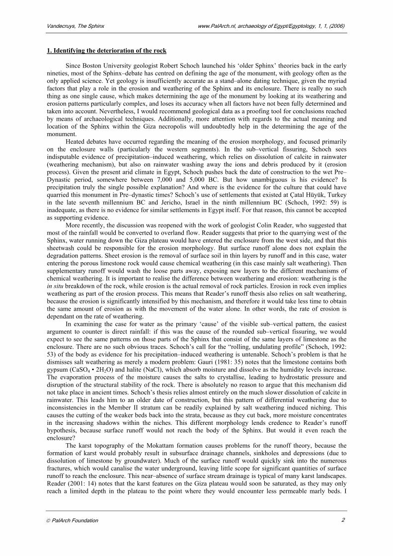
Reader correctly notes that the chest of the Sphinx does not show the same degradation pattern as seen on the western portions of the enclosure, even though it also faces east (see figure 3), and cites this difference as evidence for his runoff theory. But the karstic characteristics of the Mokattam formation would place an important limit on the amount of surface runoff, and convert most of it into groundwater. Groundwater seepage would probably continue to reach the enclosure after the digging of the quarries behind the enclosure, without reaching the chest of the Sphinx (because of the quarried enclosure pit which separates the Sphinx from the western enclosure, as well as the major fissure), which explains the difference in the degradation patterns. In essence, this different origin of the water is highly important, because the runoff theory is a crucial element of Reader’s re–dating argument. Since most of the runoff can no longer reach the enclosure, he concludes that it
1 Not dated, but see http://www.cultnat.org/download/Pdf_strategic_approach.html.
PalArch Foundation 5
2 Not dated, but see http://www.cultnat.org/download/Pdf_strategic_approach.html.
Vandecruys, The Sphinx www.PalArch.nl, archaeology of Egypt/Egyptology, 1, 1, (2006)
must have been quarried before Khufu’s reign. Groundwater flows do not require such a change in the date of construction for the Sphinx.
Figure 3. Photograph showing the degradation on the chest of the Sphinx. Photograph courtesy of Jon Bodsworth (http://www.egyptarchive.co.uk).
PalArch Foundation 6

Vandecruys, The Sphinx www.PalArch.nl, archaeology of Egypt/Egyptology, 1, 1, (2006)
Comparing the Sphinx with its enclosure is not an easy task. Although the same strata also run through the body of the Sphinx, we still have to take into account that there have been various restoration attempts. These could have influenced the weathering and consequently the erosion morphology. The deterioration of the layers is particularly pronounced on the chest of Sphinx, which is carved out of the softer, and thus more vulnerable Member II stratum. The effects of salt weathering–induced niching on the body of the Sphinx can be clearly seen, as well as a spheroidal–like weathering on the harder beds. Sometimes the degradation is significant, such as in 1988 when a three–ton block came off the south shoulder as it was isolated by the intersecting joints. (Hawass & Lehner, 1994b: 45).
As a last point I would like to discuss the slope of the enclosure walls, as this has been a major part of Schoch’s argument for a much older Sphinx. He has overlooked a number of elements in concluding that the original enclosure wall was near vertical. If one examines the horizontal banding of the western wall, along the corner with the southern wall, and on the western portion of the southern enclosure wall (the wall that also forms the base for the Khafre causeway), it can be seen that the depth of the niches is fairly consistent, and thus that the weathering rates are consistent along this part of the enclosure. The south wall is also the base of Khafre’s enclosure wall, and it can be seen that further along the wall where the layers are not as drastically weathered, the slope remains, so we can conclude that Khafre’s workers cut it like this, and thus that the western wall probably never receded as far backwards due to weathering and erosion as Schoch proposes. Also, Schoch argues that the enclosure walls are generally more eroded at the top than at the bottom (1994: 6), which according to Lehner (1994: 45), is incorrect:“It is the Member II layers that West and Schoch claim to be eroded by rain. It is certain that the most drastically recessed layers are those at the bottom of Member II. This is not only visually apparent; anyone can measure the recesses for themselves.”
To sum up, I conclude that neither precipitation–induced weathering, nor surface runoff can be accepted as the ‘cause’ for the sub–vertical fissuring, and that the actual origin lies in tectonic joints that have been widened by subsurface water movements, with salt weathering as the dominant weathering mechanism. Microclimatic conditions increase the rate at which this mechanism takes place. In addition, Schoch’s rainfall argument and especially his dating fail, because he ignores the importance of salt weathering, and even though Reader is correct that the erosion on the western portions of the enclosure is more intense, the reason is more likely groundwater seepage combined with microclimatological effects, leading to increased salt weathering rates. This model does not require a change in the accepted chronology of construction activity in the Sphinx area, as it allows sustained deterioration even in the post–Khufu era.
Cracks and joints are not an anomaly in the subsurface of the karstic Giza plateau. As for dating, the geological case for an older Sphinx remains unproven, and instead of supporting such an attempt for re–dating, there are no geological indications that the conventional chronology should be revised. As an aside, I would like to express my opinion that our principal concern at this moment should not be the dating of the Sphinx, but rather the conservation of this monument, and geology is extremely valuable in the process of determining which measures are the best to be taken. Several previous restorations attempts have caused more harm than good, and it is of the utmost importance that we avoid every possible mistake with this vulnerable piece of history. Without such precautions, there might be nothing left to date within the next few generations. 2. A structural analysis of Khafre’s pyramid complex
It is only fair to say that Reader’s methodology is undoubtedly superior to Schoch’s, because apart from the geological debate, he also attempts to back up his case with archaeological data. Of course, in the case of the Sphinx, neither the archaeology nor the geology is conclusive. For that reason, in order to come to a reliable approximate date of construction, both should be taken into account.
Looking at the building activity surrounding the Sphinx, geology can help solve a few extra parts of the puzzle. Detailed surveys by geologist Thomas Aigner of the geological layers in the Sphinx, and the separate blocks of the Sphinx Temple and Khafre’s valley temple have led towards two interesting conclusions. The first is that the Sphinx Temple was constructed from Member II blocks coming from the layers of rock below the chest of the Sphinx (Lehner, 1997: 126). Khafre’s valley temple was probably constructed from Member III limestone of the upper layers of rock corresponding to those of the Sphinx head and possibly higher (Hawass & Lehner, 1994a: 33). Secondly, Aigner discovered that the structural stratigraphy of the Sphinx Temple, and to some extent Khafre’s valley temple, is generally inverse to the sedimentary stratification in the limestone bedrock (Lehner, 1985a: 140). From the above, we can conclude that at least the Sphinx Temple must be contemporary with the Sphinx. As there still seems to be some discussion about the origin of the limestone used in Khafre’s valley temple, geology cannot conclusively resolve this. But there might be some clues to be found in the archaeological and structural side of the story.
The southern wall of the enclosure runs along Khafre’s causeway, and given the fact that the northern wall and the western wall form an approximately 90–degree angle, I conclude that the southern wall, which
PalArch Foundation 7
Vandecruys, The Sphinx www.PalArch.nl, archaeology of Egypt/Egyptology, 1, 1, (2006)
meets the western wall at an obtuse angle, was carved to fit the already existing structure of Khafre’s causeway. If there had not been a causeway, there would be no reason for such a departure from rectilinearity in the design of the enclosure. Reader also believes the causeway predates the Sphinx quarry (Reader, 2001: 15), but also contends that the Sphinx, the Sphinx Temple and the mortuary temple all predate Khafre’s pyramid complex and also Khufu’s reign. Combined with his geological analysis, he concludes that the time of construction for this ‘complex’ must have been in Early Dynastic times. Although his case seems to be rather solid at first sight, there are other facts that make such an earlier date less certain.
There is an interesting feature that, although Schoch contests it (1995, online http://www.antiquityofman.com/Schoch_Archaeology.html), is very significant. There is a drainage channel running along the north side of Khafre’s causeway, which opens into the southwestern corner of the Sphinx enclosure. It would be odd if the ancient Egyptians let a drainage channel enter the Sphinx enclosure, because regardless of the purpose of this channel, the damaging effects of the water remain. Hassan (1936–1937: 161–162) discusses the origin of this feature and suggests the trench served as a kind of division between the necropolis of Khufu on the north and that of Khafre on the south. The fact that the builders applied great blocks of granite at the edge of this channel shows that they tried to overcome the water problems that came with the channel, and proves that the channel must predate the Sphinx enclosure.
What is sometimes regarded as one of the most convincing arguments in Reader’s thesis is the fact that the southern end of Khufu’s quarry to the north of Khafre’s causeway runs right along this causeway, while on the south side, there is another quarry (the Central Field Quarry) of which the north side runs right along the causeway. In his opinion, this shows that Khufu’s workforce had to take into account the existing causeway when quarrying limestone for his pyramid. Even though the idea is interesting, it involves a fair degree of speculation.
Exactly how certain is the origin of the northern quarry? In Lehner’s ‘The complete pyramids’ (1997: 230), this area is marked as ‘Khafre’s quarry?’ (please note the presence of the question mark). This urged me to conduct further research to find out if there was indeed a consensus about the origin and date of construction of the two parts of this quarry, or not. It turns out that Lehner disagrees with Reader on this point. Lehner (1985b: 124) states that while this quarry may have been started under Khufu (the eastern part), it is likely that it was mostly exploited by Khafre, first of all because of the natural ridge that was left for the Khafre causeway, and secondly because most of the area would have been covered by Khufu’s main supply ramp running from the Central Field Quarry towards his pyramid. Reader (2001: 7, figure 2) draws the northern quarry as being nicely cut in two, while the southern side perfectly aligns with the causeway. This representation is oversimplified, to say the least. Lehner (1985b: 119, figure 3b) does not show the straight southern alignment in Khufu’s time. While he does say that Khufu could have begun the eastern part of this quarry just behind the location of the Sphinx, the question still remains: to what extent? With his permission, I have reproduced two maps that show Khufu’s construction activity on the plateau. This has lead to figure 4 and figure 5, both enlarged relevant parts of maps in Lehner’s article (1985b), which should sufficiently explain my main point.
I asked Lehner if it was possible that in Khafre's time, more blocks were quarried so that the quarry now seems to ‘fit’ the causeway? His response was that this was “most probable” (Lehner, personal communication, 2004). Lehner (1985b: 125) argued that the limestone rubble/clay mortar walls found in the eastern side of this northern quarry could be the remains of supply ramps. If this is correct, and if the main supply ramp from the Central Field Quarry was positioned a bit further to the west, the western limit of what is marked as “Khufu’s quarry” on Reader’s map (2001: 7, figure 2) may well have never been part of Khufu’s work. In other words, Khufu probably never made it that far west to the point of actually leaving just a small ridge between the northern and southern (central field) quarry.
Figure 4 shows the development on the Giza site under Khufu. With a thin line, it shows the space that will later be occupied by Khafre’s pyramid, and likewise the location for the Sphinx. The marking of these two not yet existing features assists in understanding all relevant positions on the plateau, and it must be noted that in this view, they are not physically present on the plateau. The labelling of the visible features on this map has been adapted to clarify the situation, but the original numbers on the map can be traced back in Lehner’s article (1985b). In front of the location for Khafre’s pyramid (B), we find the Central Field Quarry (F), as well as the northern quarry (C). Label D shows the rubble/clay mortar walls that are probably the remains of supply ramps that led to the eastern cemetery. After comparison with figure 5, which shows the ramps that come from the Central Field Quarry and from the eastern part of the northern quarry, it can be deduced that the line that cuts the northern quarry into a large western part, and a rather narrow eastern part (indicated by the arrow on figure 4 inside this northern quarry), indicates how far Khufu probably quarried to the west. Additionally, it can be seen in figure 5, that Khufu’s eastern quarry only comes close to the ridge for the causeway at one point (the thick black dot next to number C), which does not exactly count as an alignment. If one compares this with Reader’s map (2001: 7, figure 2), it is an entirely different case, because there we see an indisputable alignment on both sides of the ridge for the causeway that, in all probability, never came into existence until the reign of Khafre. I
PalArch Foundation 8

Vandecruys, The Sphinx www.PalArch.nl, archaeology of Egypt/Egyptology, 1, 1, (2006)
therefore conclude that that this leaves Khufu with a volumetrically narrow quarry behind the rear of the Sphinx enclosure, with no apparent alignment to the ridge of the causeway, under which circumstances re–dating the causeway is not needed.
Figure 4. Map showing the construction activity during the reign of Khufu (relevant part of Lehner’s map, reproduced with permission. Labels adjusted by the author). A: Khufu’s pyramid; B: Future position of Khafre’s pyramid; C: Northern Quarry; D: Rubble/clay mortar walls (probably remains of supply ramps for the Eastern cemetery); E: Line marking the direction of the natural ridge with Khafre’s causeway; F: Central Field Quarry; G: Future position of the Sphinx; H: Eastern cemetery.
Figure 5. Map reconstructing the probable use of ramps during the reign of Khufu (relevant part of Lehner’s map, reproduced with permission. Labels adjusted by the author). A: Khufu’s pyramid; B: Future position of Khafre’s pyramid; C: Northern Quarry with remains of rubble/clay mortar walls; D: Tracks running from the Central Field Quarry towards the foot of the main supply ramp; E: Position of the Sphinx; F: Eastern cemetery.
PalArch Foundation 9

Vandecruys, The Sphinx www.PalArch.nl, archaeology of Egypt/Egyptology, 1, 1, (2006)
No matter the attractiveness of Reader’s case, it does have a number of other problems. First of all, if we leave the Sphinx Temple out of the debate for a second, we are dealing with three features that are typically part of a pyramid complex: a mortuary temple, a causeway and a valley temple. Reader (2001: 17) does not include the valley temple in his Early Dynastic plan because of the different architectural style and better preservation, so that leaves us with a mortuary temple, from which a causeway leads right next to the enclosure of the Sphinx, but without a clear ‘destination’. In this layout without a valley temple, one would expect it to be connected to the Sphinx Temple. Such a connection is nonexistent. A processional road would have been regarded as highly important, so it is odd that it was never connected to an entrance of the Sphinx Temple. On the other hand, in the existing layout the causeway is clearly connected to the valley temple. This connection adds up to the circumstantial evidence that makes it unlikely that the valley temple was not part of the original design.
As all of these features are so perfectly integrated within the Khafre pyramid complex, as well as their standard appearance within such complexes, the following question arises: where is the factual support that could allow the conclusion that these typical elements of a pyramid complex were ever built as a stand–alone complex? Throughout Egyptian history there is an evolution in mortuary architecture: the causeway becomes a standard pyramid complex element from the pyramid of Meidum onwards, so if one concludes the causeway is pre–Khufu, it is either an earlier but still 4th Dynasty construction, or else we are left with a construction that was very much ahead of its time, and possibly with a different symbolic meaning. Speculating about this ‘different’ symbolic meaning, it has to be noted that an Early Dynastic solar worship is not an accepted viewpoint, either. Current evidence indicates that a solar cult was not significant until the 3rd Dynasty, and not unequivocally implemented in the royal theology until the 4th Dynasty (Wilkinson, 2001: 162). And what a coincidence is it that in later dynasties, an almost exact copy of this layout became standard in the pyramid complex, and that Khafre managed to incorporate this only existing stand–alone Early Dynastic example so perfectly in his own pyramid complex.
Reader (2001: 16) tries to push back the date for the megalithic blocks in Khafre’s mortuary temple. Mortuary temples were already constructed prior to Khafre’s time, but there were still differences in design. The earlier temples would contain a number of, but not all, basic elements of the mature mortuary temple that was eventually perfected by Sahure at Abusir. Khafre’s is the first to show the five typical architectural elements that would mark the standard of later mortuary temples. This includes an entrance hall, an open courtyard, five statue chapels, various store chambers and an offering hall. In other words: because earlier mortuary temples do not yet show this consistent design (they would have a number of these features, but never all of them), it is likely that Khafre’s mortuary temple evolved from them, and this makes it less plausible that its eastern part is Early Dynastic as Reader (ibidem) maintains. He (ibidem) argues that the elevated site on which the megalithic part of the mortuary temple is built obscures the base of Khafre’s pyramid. But that does not qualify as evidence for an older temple at all. On the contrary, if we take the evolution further, we see (starting with Menkaure), that the pyramids became smaller and that more attention was given to the mortuary temples. Khafre’s being the first “complete” mortuary temple and situated on such a prominent position, combined with the fact that Menkaure takes the next step by giving much more importance to his temple, makes it likely that both structures are subsequent steps in the historical chronology. Incorporation of an Early Dynastic megalithic part in a new “complete” mortuary temple is not too unlikely if one does not have to take the position of other Giza structures into account, but since they are there, Reader’s thesis has to rely on a number of highly coincidental aspects.
The, according to Reader, Early Dynastic part of the temple is centred on the east side of Khafre’s pyramid and the causeway starts from here in the appropriate direction. This would not be such a coincidence if the position of Khafre’s pyramid were not limited by two elements: the three Giza pyramids apparently align on the southeastern corners, and the diagonals of the pyramids of Khufu and Khafre seem to form one line. If all this has to be taken into account it is a remarkable coincidence that Khafre managed to incorporate this Early Dynastic megalithic part in his mortuary temple and even more so in his pyramid complex. Also, Khafre introduced the technique of building in megalithic blocks and casing them as a finishing touch, and we see that same building technique applied in his valley temple, a temple Reader agrees to be from the 4th Dynasty. Together, this leads me to conclude that there is no good case for re–dating the megalithic part of Khafre’s mortuary temple.
Reader (2001: 15) references Herbert Ricke for evidence of a two–phase construction for the Sphinx Temple, but does not add that Ricke also pointed out that the temple was left unfinished and may have never been used (Lehner, 1980: 15). Ricke also concluded that apart from a two–phase construction, there was also a two–phase robbery which affected the Sphinx Temple, the earliest being in the reign of Amenemhet I (12th Dynasty) when the alabaster flooring and granite sheathing were ripped from the interior (Lehner, 1980: 15). Reader sees further evidence for his theory in the fact that when Amenhotep II (18th Dynasty) built his temple on the corner of the Sphinx Temple, it was already ruined (otherwise he could not have built on that corner). However, there is a whole millennium separating these structures, so especially with Ricke’s robbery theory, this is not particularly compelling. Reasons why the valley temple is in a better state could be that this temple was
PalArch Foundation 10

Vandecruys, The Sphinx www.PalArch.nl, archaeology of Egypt/Egyptology, 1, 1, (2006)
constructed in a more durable way with huge blocks and robust granite pillars, and that it was not subject to robbery to the same extent as the Sphinx Temple, but we must not forget that the limestone used for the valley temple is probably Member III, while the blocks for the Sphinx Temple are probably Member II. These differences in lithology can also explain the better state of the valley temple, like the difference in erosion between the head and the body of the Sphinx.
Reader (2001: 14, figure 9) shows a photograph that serves as a comparison between the northern wall of the Sphinx Temple and the ‘4th Dynasty’ cutting directly north of that wall. He (Reader, 2001: 15) then references Ricke, saying that “the middle part of the north and south walls were pushed back, and great limestone core blocks were added to the corners of the temple, which were never finished off ”. That would mean that the northern wall of the Sphinx Temple was still worked on in the 4th Dynasty, even in Reader’s theory. How can this comparison be used as an argument then, when Reader compares two walls that in his own view were worked on in the 4th Dynasty? The reason for the difference in the deterioration cannot be explained by a difference in age, because both walls are 4th Dynasty work even in the two–phase theory. The fact that the both the Sphinx Temple and Khafre’s valley temple were faced with Aswan granite, and that different parts of the Sphinx Temple do not show extreme differences in erosion, means that there could not have been a significant period between phase one and two, and support a 4th Dynasty dating for both temples. Ricke’s suggestion of a construction in two phases could well be just a change of the 4th Dynasty plans.
The suggestion that the difference between the erosion pattern on the 4th Dynasty cutting and the northern wall of the Sphinx Temple indicates a difference in age is not conclusive. Reader’s photographs show indeed an abrupt difference between both walls, but atmospheric exposure is another potential influence on weathering rates, as well as the fact that there are differences in lithology (the northern wall being Member I while the blocks for the Sphinx Temple are Member II). As for exposure, the part of this wall immediately to the north of the Sphinx Temple has suffered less from it than a little further to the east. To support this, I refer to figure 2 again, where it can clearly be seen on the right side of the picture how there is a remarkable difference in weathering rates between label B and C on that very same cutting. Where Reader (2001: figure 9) only shows the almost perfectly preserved part (label B), it becomes evident by looking at figure 2 that more to the east, beyond the Sphinx Temple, the same cutting is in fact more severely weathered (label C). This could be related to the walls of the Sphinx Temple shading this particular part of the cutting, or more likely due to this part of the wall being covered by a sedimentary cover for a significant amount of time, which could protect the rock. The ‘corridor’ that is formed between the northern wall of the Sphinx Temple and this cutting could have been buried under debris and sand for a significant amount of time. Further investigation should bring to light how that could work with Harrell’s ‘wet sand hypothesis’.
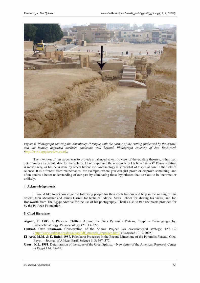
Perhaps even more important is to reconsider the 4th Dynasty dating that has been given to the last activity on this cutting. The difference between the erosion of the Sphinx Temple and the cutting could be explained by a New Kingdom re–carving, dating to the time when Amenhotep II constructed his temple. As we can see on figure 6, the corner of this cutting on the inside of the enclosure (indicated by the arrow) looks contemporary with the temple built on top of it, and not with the 4th Dynasty northern enclosure wall. In ‘Giza before the Fourth Dynasty’, Reader only shows the abrupt change from the corner of this cutting, to the more intensely eroded northern enclosure wall beyond it. The 4th Dynasty ceramic finds on the floor of this corridor ‘could’ indicate the age of the cutting, but this is not conclusive. With regards to the New Kingdom activity, this view might have to be revised. If this is combined with the fact that further along this cutting, there is more severe erosion, and the fact that in Ricke’s two–phase construction, the northern wall of the Sphinx Temple was worked on, it becomes increasingly unlikely that Reader’s analysis of the archaeological data is correct. 3. Conclusions
To summarise, it seems clear that in the existing design, the Khafre mortuary temple is part of the pyramid complex in the traditional layout, with a valley temple at the end of the causeway. The position of Khafre’s pyramid to Khufu’s pyramid with the apparent alignment of their southeastern corners and their diagonals even strengthens the idea that Khafre did not have to take an already existing temple (the megalithic eastern part of the mortuary temple) into account for the location of his pyramid. There is only so much room for coincidence, and for me Reader has not sufficiently closed his case for re–dating these monuments. It would altogether be a different debate if these temples and the causeway did not fit into a ‘standard’ pyramid complex, but since they do, it is not that simple to just extrapolate them and convert them into an Early Dynastic stand–alone complex. An analysis of quarrying activity on the Giza plateau indicates that Reader’s case for re–dating the causeway is unconvincing, and the geological arguments presented in this paper show that degradation of the western enclosure wall probably continued in the post–Khufu era. For all these reasons I must conclude that there is currently not enough clear evidence that can justify a revision of the conventional view that Khafre built the Sphinx.
PalArch Foundation 11
Vandecruys, The Sphinx www.PalArch.nl, archaeology of Egypt/Egyptology, 1, 1, (2006)
Figure 6. Photograph showing the Amenhotep II temple with the corner of the cutting (indicated by the arrow) and the heavily degraded northern enclosure wall beyond. Photograph courtesy of Jon Bodsworth (http://www.egyptarchive.co.uk).
The intention of this paper was to provide a balanced scientific view of the existing theories, rather than determining an absolute date for the Sphinx. I have expressed the reasons why I believe that a 4th Dynasty dating is most likely, as has been done by others before me. Archaeology is somewhat of a special case in the field of science. It is different from mathematics, for example, where you can just prove or disprove something, and often attains a better understanding of our past by eliminating those hypotheses that turn out to be incorrect or unlikely. 4. Acknowledgements
I would like to acknowledge the following people for their contributions and help in the writing of this article: John McArthur and James Harrell for technical advice, Mark Lehner for sharing his views, and Jon Bodsworth from The Egypt Archive for the use of his photography. Thanks also to two reviewers provided for by the PalArch Foundation. 5. Cited literature Aigner, T. 1983. A Pliocene Cliffline Around the Giza Pyramids Plateau, Egypt. – Palaeogeography,
Palaeoclimatology, Palaeoecology 42: 313–322. Cultnat. Date unknown. Conservation of the Sphinx Project. An environmental strategy: 129–139
(http://www.cultnat.org/download/Pdf_strategic_approach.html) (Accessed 10.12.2005) El–Aref, M.M. & E. Rafai. 1987. Paleokarst Processes in the Eocene Limestone of the Pyramids Plateau, Giza,
Egypt. – Journal of African Earth Science 6, 3: 367–377. Gauri, K.L. 1981. Deterioration of the stone of the Great Sphinx. – Newsletter of the American Research Center
in Egypt 114: 35–47.
PalArch Foundation 12

Vandecruys, The Sphinx www.PalArch.nl, archaeology of Egypt/Egyptology, 1, 1, (2006)
Harrell, J.A. 2000. Comments on the geological evidence for the Sphinx’ age. Online http://www.antiquityofman.com/harrell.html (Accessed 02.09.2005)
Hassan, S. 1936–1937. Excavations at Giza. Vol. 8: 161–162. Hawass, Z. & M. Lehner. 1994a. The Sphinx; who built it, and why? – Archaeology 47, 5: 30–42. Hawass, Z. & M. Lehner. 1994b. Remnants of a lost civilization? – Archaeology 47, 5: 45–47. Lehner, M. 1980. The ARCE Sphinx Project. A preliminary report. – Newsletter of the American Research
Center in Egypt 112: 3–35. Lehner, M. 1985a. A contextual approach to the Giza pyramids. – Archiv für Orientforschung 32: 136–158. Lehner, M. 1985b. The development of the Giza necropolis: The Khufu Project. – Mitteilungen des Deutschen
Archäologischen Instituts, Abteilung Kairo 41: 109–143. Lehner, M. 1994. Notes and photographs on the West–Schoch Sphinx hypothesis. – KMT 5, 3: 40–48. Lehner, M. 2003 [1997]. Piramides. – Rijswijk, Uitgeverij Elmar b.v. Petrie, F.W.M. 1883. The pyramids and temples of Gizeh. – London, Field and Teur. Reader, C.D. 2001. Giza before the Fourth Dynasty. – Journal of the Ancient Chronology Forum 9: 5–21. Schoch, R. 1992. Re–dating the Sphinx. – KMT 3, 2: 53–67. Schoch, R. 1994. Response to Harrell. – KMT 5, 2: 5–7. Schoch, R. 1995. Sphinx links. – Archaeology 48, 1: 10–12
(http://www.antiquityofman.com/Schoch_Archaeology.html) (Accessed 02.09.2005). . Wilkinson, T.A.H. 2001. Comment on C.D. Reader, ‘A Geomorphological Study of the Giza necropolis, with
Implications for the Development of the Site’. – Archaeometry 43, 1: 161–163. Submitted: 26 October 2005 Published: 1 January 2006 About www.PalArch.nl (Netherlands scientific journal) copyright. Copyright © 2006 PalArch Foundation
The author retains the copyright, but agrees that the PalArch Foundation has the exclusive right to publish the work in electronic or other formats. The author also agrees that the Foundation has the right to distribute copies (electronic and/or hard copies), to include the work in archives and compile volumes. The Foundation will use the original work as first published at www.PalArch.nl.
The author is responsible for obtaining the permission of the use of illustrations (drawings, photographs or other visual images) made by others than the author. The author can be requested to submit proof of this permission to the PalArch Foundation. Pdf texts (papers and proceedings) are free to download on the conditions that each copy is complete and contains the PalArch copyright statement; no changes are made to the contents and no charge is made. The downloaded (and/or printed) versions of PalArch publications may not be duplicated in hard copy or machine readable form or reproduced photographically, nor may they be redistributed, transmitted, translated or stored on microfilm or in electronic databases other than for single use by the person that obtained the file. Commercial use or redistribution may only be realised after consultation with and with written permission of the PalArch Foundation.
PalArch Foundation 13