Embed Size (px)
Citation preview
CITY OF BURNABY
PLANNING AND BUILDING
REZONING REFERENCE #17-14
2017 MAY 24
ITEM #04
1.0 GENERAL INFORMATION
1.1 Applicant: Boffo DevelopmentLtd.200 - 4580 Hastings StreetBumaby, BC V5C 2K4(Attn: Robert Toth)
2.0
2.1
2.2
1.2 Subject: Application for the rezoning of:Schedule A {attached)
M2 General Industrial District, C6 Gasoline Service Station Districtand R2 Residential District
CD Comprehensive Development District (based on RM5s MultipleFamily Residential District and Brentwood Town CentreDevelopment Plan as guidelines)
1.3
1.4
From:
To:
Address: 5258/5334 Lougheed Highway and 2160/2210 Springer Avenue
Location: The subject site is located on the southeast comer of LougheedHighwayand SpringerAvenue (Sketch#1 attached).
1.5 Size: The site is irregular in shape and has an area of 1.67 hectares (4.12acres) and frontages of 104.72 m (343.6 ft.) and 122.26 m (40LI ft.)on LougheedHighwayand SpringerAvenue respectively.
The Director Engineering will be requested to provide all relevantservicing information.
The purpose of the proposed rezoning bylaw amendment is toestablish a Conceptual MasterPlan for the subject site and a detailedPhase I development plan for a high-rise residential apartmentbuilding withtownhouse units in the southwest portion of the site.
1.6 Services:
1.7 RezoningPurpose:
NEIGHBOURHOOD CHARACTERISTICS
The site is comprised of four individual parcels with five older industrial buildingsranging in size from smallto large (see Sketch #1 attached).
To the west of the site, across Springer Avenue, are two older industrial buildingscurrently proposed for a high-rise residential building with podium level townhouse units

PLANNING AND BUILDING
REZONING REFERENCE »I7-I4
2017 May 24 PAGEl
under Rezoning Reference #16-35 (currently at Initial Report), with two high rise multi-family residential buildings approved under Rezoning Reference #05-47 beyond. Directlyto the east is a truck terminal with Beecher Creek and the Holdom SkyTrain Stationbeyond. Directly to the south are three older industrial buildings frontmg Goring Streetand Douglas Road, currently proposed for two high-rise residential buildings withpodium level live/work townhouse units, under Rezoning Reference #15-40 (currently atThird Reading), and small industrial sites fronting Springer Avenue with Douglas Roadand the BNSF Railway beyond. Immediately to the north along the Lougheed frontage ofthe site is the SkyTrain Millennium Line Guideway, partially located on a statutory right-of-way at the northeast comer of 5334 Lougheed Highway. On the north side ofLougheed Highway are older low-rise multi-family residential, with single and twofamily residential beyond. Vehicular access to the site is from Lougheed Highway andSpringer Avenue.
3.0 BACKGROUlVD INFORMATION
3.1 The subject site is within the Council adopted Brentwood Town Centre DevelopmentPlan and is designated for high density multiple-family residential development under theCD Comprehensive Development District (utilizmg the RM5s Multiple FamilyResidential District as guidelines) (see attached Sketch #2).
3.2 The current landowners, Boffo Development Ltd., acquired the sites over the previousdecade. The landowners are proposing to complete a comprehensive master plan toaccommodate four high-rise residential apartment buildmgs atop podiums with ground-oriented apartment/townhouses fronting on Springer Avenue. Hie Master Plan willinclude a set of detailed development guidelines to aid in the development of the site andsurrounding properties.
4.0 GENERAL INFORMATION
4.1 The scope of the subject rezoning bylaw amendment is twofold: (1) to establish aconceptual Master Plan for the overall site, including defining form, massing, subdivisionpattern, overall site servicing, development phasing, and distribution of applicabledevelopment densities; and (2) to develop a detailed Phase I development plan for thenortheast portion of the site.
The purpose of the preliminary Master Plan concept is to transform the site's existinglight-industrial character, into a multi-family transit oriented neighbourhood surroundingthe Holdom SkyTrain Station that incorporates the sustainability and community planobjectives of the City. Supportive amenity uses, including a child care facility, could alsobe proposed for the site to address on and off-site demand. An approximately one acreopen space is envisioned at the centre of the site. Open space and public realm featuresthat are anticipated for the site include an extension of the Lougheed Parkway conceptalong the south side of Lougheed Highway, a plaza at the intersection of LougheedHighway and Springer Avenue and riparian improvements at the northeast comer of the

PLANNING AND BUILDING
REZONING REFERENCE #17-14
2017 May 24 PAGEZ
site where it falls within the riparian zone of Beecher Creek. Potential street linkagesbetween the west and north sides of the site to Springer Avenue and Lougheed Highwayrespectively will be explored, as will a pedestrian route connecting to a potential BeecherCreek pedestrian bridge, in order to provide greater connectivity between the site,surrounding neighbourhood, Holdom SkyTrain Station and bus stops on Goring Street.The proposed built form and open spaces are envisioned to respond to the site'sgeotechnical conditions which would result in raised parking structures screened by streetfronting townhouses on abutting sites. Details of the Master Plan concept and the Phase Idevelopment plan for the southwest portion of the site will be included in a further reportto Council prior to advancing the rezoning proposal to a Public Hearing. While notcovered under the subject rezoning proposal, the general land use and sustainabilitydkections established by the Master Plan would inform, in the future, the development ofadjacent sites to the east and south, along Goring Street and Springer Avenue.
It should be emphasized that the subject rezoning application does not seek approval forany specific new development, with the exception of Phase I. Separate rezoningapplications for the development of the subsequent three phases of the site will beadvanced for Council consideration at a future date.
4.2 Rezoning requirements related to the conceptual Master Plan component of this rezoningapplication include:
• submission of a Master Servicing Plan for the overall site;
• submission of a Master Traffic and Transportation Study for the overall site;
• submission of a Master Stormwater Management Plan for the overall site;
• submission of a Master Green Building Policy for the overall site;
• submission of a Phasing Plan for the overall site; and,
• registration of a Section 219 Covenant specifying the permitted densities for eachindividual development parcel within the overall site.
4.3 Rezoning requirements related to the detailed Phase 1 component of this rezoningapplication include:
• provision of all necessary servicing to support the Phase 1 development, asdetermined by the Director Engineering;
• provision of all necessary road dedications and statutory right-of-ways to support thePhase 1 development, to be determined by way of detailed road geometries;
PLANNING AND BUILDING
REZONING REFERENCE if17-14
2017 May 24 PAGE A
• closure and consolidation of the north-south lane between 2160 and 2210 SpringerAvenue and a portion of Springer Avenue abutting 2160 and 2210 Springer Avenue,as anticipated in the Brentwood Area Plan (see Sketch #1 attached).
• completion of the necessary subdivision;
• registration of any necessary easements, covenants, and statutory rights-of-way forthe Phase 1 development;
• submission of a Traffic and Transportation Study for the Phase 1 development;
• submission of an on-site Stormwater Management Plan for the Phase 1 development;
• submission of a Green Building strategy for the Phase 1 development;
• submission of a tree survey and arborist's report for the Phase 1 development;
• approval by the Engineering Environmental Services Division of a detailed plan foran engineered sediment control system for the Phase 1 development;
• compliance with the Bumaby Solid Waste and Recycling guidelines, including theprovision of appropriately screened garbage handling and recycling holding areas inthe Phase 1 development;
• written confirmation that Phase 1 development complies with all conditions of theCertificate of Compliance that has been issued for the overall site;
• compliance with the guidelines for surface and underground parking; and,
• payment of the Parkland Acquisition, School Site Acquisition, and GVS & DDSewerage Cost Charges.
4.4 The proposed prerequisite conditions of this rezoning will be detailed in a future report.
5.0 RECOMMENDATION
1. THAT the Planning and Building Department be authorized to continue to work withthe applicant towards the preparation of a suitable plan of development forpresentation to a Public Hearing on the understanding that a more detailed report willbe submitted at a later date.
IW:tn
Attachments
cc: Director Engineering City Solicitor City Clerk
P:\REZONlNG\Applications\2017\17-14 Springer & Lougheed (Master PIan)\Council ReportsMnitial Report 17-14 2017.05.29.doc
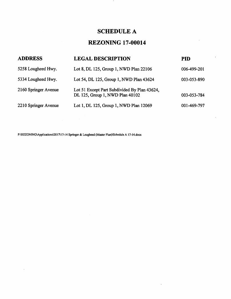
ADDRESS
5258 Lougheed Hwy.
5334 Lougheed Hwy.
2160 Springer Avenue
2210 Springer Avenue
SCHEDULE A
REZONING 17-00014
LEGAL DESCRIPTION
Lot 8, DL 125, Group 1, NWD Plan 22106
Lot 54, DL 125, Group 1, NWD Plan 43624
Lot 51 Except Part Subdivided By Plan 43624,DL 125, Group 1, NWD Plan 40102
Lot 1, DL 125, Group 1, NWD Plan 12069
P:\REZONING\Applications\2017\17-14 Springer & Lougheed (Master Plan)\Schedule A 17-14.docx
PID
006-499-201
003-053-890
003-053-784
001-469-797

—(M2,R2i
5180 MO
^6h
Burnaby
Date:
MAY 18 2017
scale:
1:1,589
Drawn By:
PLIN 22106
Ja69
EX.43624 / 5334
EX.43624
PLANNING & BUILDING DEPARTMENT
REZONING REFERENCE #17-14
5258 AND 5334 LOUGHEED HIGHWAY
2160 AND 2210 SPRINGER AVENUE
M6PLAN 55898
Subject Site Road Closure
Sketch #1

SUBJECT SITE
inMedium Density Multiple Family ResidentialShigh Density Multiple Family ResidentialfTjCommercial
[^Medium Density Mixed Use0High Density Mixed Use
BmuabyPlanning and Building Dept
Printed May 18. 2017
«<««*««ST
Medium or High Density Multi Family Residential
Institutional
Rl| Business Centre|T^ Parkand Public Use/Public School
55 Cemetery[2^ High Density Multiple Family Residential •
Brentwood Succession (RM4s)
Brentwood Plan
Sketch #2
Boffb7 April 2017
City of BurnabyPlanning Department4949 Canada WayBurnaby, BC V5G 1M2
200 - 45B0 Hastings StreetBurnaby, BC V5C 2K4
, 604 299 3443
boffo.ca
RE; LETTER OF INTENT
Master Plan Rezoning & Phase 1 Tower Site Specific Rezoning
5534 Lougheed Hwy ; LOT 54 DL 125 PLAN 43624 ; PID: 003-053-8905258 Lougheed Hwy ; LOT 8 DL 125 PLAN 22106 ; PID: 006-499-2012160 Springer Ave ; LOT 51 DL 125 PLAN 40102 Except Plan 43624 ; PID; 003-053-7842210 Springer Ave ; LOT 1 DL 125 PLAN 12069 ; PID; 001-469-797
Please accept the following Letter of Intent outlining our proposal for the assembly andredevelopment of the above properties. All 4 parcels are presently zoned M2 - General Industrial.It is our intent to work with City Staff to rezone the parcels through a Master Plan Rezoning to CDComprehensive Development District(based on RM5 - Multiple Family Residential).
The current concept envisions a multiphase development consisting of 4 residential towers withheights varying between 25 and 40 storeys, set within a park-like setting.
Located along Lougheed Highway nearly equidistant between Brentwood and Holdom SkyTrainstations, the proposed Master Plan aligns with the City of Burnaby's OCP, Brentwood TownCentre and Holdom Station Area Plans by providing high-density transit-oriented development.The Site Specific Rezoning for the Phase 1 tower is to be advanced in parallel with the MasterPlan Rezoning.
Boffo Developments has a long standing relationship with the City of Burnaby and we lookforward to working together again on another successful project.
Respectfully,
BOFFO DEVELOPMENTS LTD.
Robert Toth, Architect, AIBCDesign & Development
BC'S LiOUTIQUE HOME BUILDERT«