Embed Size (px)
Citation preview

Tel Achziv Preliminary Report - 2015 The Second Season of Excavations
No. G67-2015
Directed by
Michael Jasmin (CNRS), Yifat Thareani (NGSBA)
and Philippe Abrahami (University of Lyon 2)
Contact: Michael Jasmin – [email protected]

Introduction
Tel Achziv (Tell ez-Zib) (1598.2726 Israel Coordination Map) is situated on a natural coastal sandstone
(kurkar) ridge to the south of Nahal Kziv (Wadi Qarn) and to the north of Nahal Sha'al, some 14 km north of
Acco and 25 km south of Tyre. The multi-period site of Achziv occupied between 55-70 dunams, (5.5-7 ha).
Situated on the major route between the Lebanese coast to its north and Palestine's Coastal Plain on the other,
Achziv was a locus of interface between cultures.
Its unique geographical position, with two major trade axes: a north–south axis that follows the coastline and
an east–west inland route that ran from the inner parts of the land toward the Mediterranean, Achzib
constitutes a perfect case study to the exploration of the function and use of a medium-size port towns along
the Mediterranean coast.
Providing that Achziv is one of the last important Phoenician sites in Palestine, which has not yet been
substantially investigated, and given that previous exploration of the site was limited mostly to cemeteries
and tombs with only limited exposed segments of public and domestic architecture, the lion's share of the
city of Achziv still remains unknown.
The primary aim of this project is systematic excavation of Ancient Achziv that will allow understanding the
modality of the settlement along setting its chronological framework as well as its social and cultural
components. Comprehensive excavation will also enable to apprehend the nature of Achziv's coastal
community and a reconstruction of its role in the long durée of the southern Levantine coast.
As an international group of archaeologists and scientists from the Hebrew Union College (HUC), the
French Research Center at Jerusalem (CRFJ), Lyon University 2, Université du Mans, and the University of
Haifa supported by the Honor Frost Foundation (HFF) – we pursued in 2015 our archaeological mission at
Achziv.
Two main areas were chosen in 2015: Area N in its northwestern edge and a new place: Area C in the middle
of the mound close to Prausnitz previous excavations.
Parallel to the archaeological exploration, the site was topographically surveyed by a team of topographers
from university of Lyon 2, directed by Dr. Franck Perrin and Alexandre Rabot. The team produced a
preliminary digitized map of the site that is based upon the new measurements (Fig. 1).
The following is a preliminary report that summarizes the results of the second season of excavations
conducted on the site (Areas C, N and N1) between June 29 th and July 17th, 2015.

Fig. 1: Topographic map of Tel Achziv with areas C and N
Fig. 2: Tel Achziv, the 2014-2015 excavation areas
Tel Achziv
Report 2015
Area C
Area supervisor : Katia Charbit Nataf
assisted by Sophie Dybich-Mattéi
General Overview
Area C is situated in the National Park of Achziv close to the house of Eli Avivi where excavations took
place in the 50’s. During these excavations, some material dated to the Iron Age was found there, as a result
we have good hopes to reach an Iron Age level by digging in this area.
The area is dug by a group of about 13 students most of all coming from the Ecole du Louvre and University
Paris 1. The area is supervised by Katia Charbit Nataf, University Paris 1, La Sorbonne assisted by Sophie
Dybich-Mattéi (associate to UMR 51.40).
This area is a new one and is opened this year. A tractor came previously to open two squares C1 and C2. On
the second day of the season, we decided to open one or two new squares north to the two first ones. After
opening four squares (C1, C2, C3 is not opened, C4 and C5), C5 did not showed any material and was
reclosed.
The excavation starts with 3 squares measuring 5m (N-S) on 4m (E-O). A bulk of 1m is left between C1 and
C2.
The Palestinian village ez-Zib was taking place in this area and the squares opened show remains of the
Palestinian houses, which are the higher level of the excavation. We have decided to keep the material of
these houses as archaeological material, even if they are recent (19 th-beginning of the 20th century).
Results of the Excavations
-Square C1
After three days of cleaning the topsoil outside and inside the square, C1 is dug from the 2nd of July. The
four sections are cut in order to see the stratification before digging. A trench dated to the 70s goes through
the square with pipes. We took of the pipes and dug below the trenches.
In the section it appears clearly that after 20 to 30cm below the top soil, we have the Palestinian occupation
characterized by a grey-white floor of a house. This floor made of concrete or very hard plaster is covered

with a 5cm layer of modern material (locus 310): round light is in situ in the section and many objects in
glass, metal, wood and clay are found. Immediately below this floor, there is a fill of small pebbles, locus
311. This layer is poorly preserved and irregular in the sections West and South. The floor and the fill of
pebbles are cut in the Southern section by a fill of black and sticky earth going down from the top soil (in the
corner S-W) to the middle of the Southern bulk.
Below the fill of pebbles, there is a layer with mixed material on about 90cm (313 in the Western section).
This level corresponds to our inside topsoil C1, locus 301.
The Northern part of the square shows architectural elements.
A first wall 312, formed by 5 big stones parallel to the Northern section (and following it), which
corresponds to the Palestinian occupation. This wall is directly built on another wall 348, 2.19m longer than
wall 312 (1.75m). This second wall which appears at the level of locus 313 could be dated either to the
Palestinian village or to an older occupation (see Western section C1). The mixed material found during the
cleaning of 301 contained a mixed of 20 th century, Medieval and Byzantine pottery. This layer could be a fill
for construction of the Palestinian village.
During the three weeks of excavations, the wall 348 appeared to be connected with two perpendicular
structures, forming a U shape big structure. The orientation of the entire structure is exactly oriented N-S.
The two perpendicular parts of “walls” forming the rest of the structure show three courses of stones at least
at the end of the season. At the end of the season, the base of the structure is not yet visible and it is
impossible to connect it to any surface or floor. The structure is formed by loci 338/W348/340.
A kind of stone pavement has been discovered in this square, however, at the bottom of locus 315. Between
the stones there were many sherds of pottery of which the bulk can be dated from the late Roman to the early
Byzantine Period. This “pavement” is very irregular and not clear everywhere in the square. It is clearer in
the northern part close to the structure, and it is patchy in the southern part of the square in locus 342. We can
nonetheless notice that the structure could be connected to the pavement. It will be necessary to check that on
next season. The level of this “pavement” is about 10, 32/10,22m.
In the South-western corner of the square, two walls appear with a top level 10,60m, forming a straight
angle. These two walls 351(East) and 352 (West), show two states of construction. The lower course is well
built with big regular stones of limestone and one of kurkar. This kurkar stone measures 48cm x 48cm. The
higher course is made of medium to small stones irregularly placed on the first course. Inside the corner
formed by 351 and 352, we have found some other medium to small stones forming a part of a circle.
The excavation of this small area revealed an oval/circular installation visible on the earth and other stones
and made with chalk. The presence of ash and charcoal inside the southern part of the installation suggested
the presence of a hearth that we first dated to the Byzantine period. But the modern material found inside in
the following days in locus 354 (20 th century pottery, metal objects, glass, textile…) pointed to a more recent
date. We concluded that the installation was intrusive in the Byzantine levels and could be a modern pit.
-Square C2
In this square the tractor has dug a smaller part in the North-West corner more deeply, in order to get more
ancient levels. This lower part, called Lower C4, shows at its bottom two big flat white stones with Iron Age

sherds on them. A trench dated to the 70s goes through the square with pipes. We took of the pipes and dug
below the trenches.
The first days of the excavations are dedicated to the cleaning of the top soil outside and inside the square
and to the cutting of the four sections in upper C2 and the ones in lower C2 (southern and eastern ones are
different ones). The sections show a layer below the topsoil, locus 317, certainly situated above the
Palestinian flours that we do not have in this square, except in the Southern section. Below the Palestinian
floors level the following layer is locus 318.
Wall 316 seems to belong to this layer. It is situated in the south-west part of the square. Its top stone is
situated at level 10,39m; the lower one is at level 9,53m, the top stone is 48cm by 40cm. The bottom of this
wall corresponds to locus 344 in this square. In this locus, the pottery is exclusively dated to the
Roman/Byzantine periods. Locus 344 (level 10,05m) seems to be an occupation layer because many sherds
of this period have been found there but we never had a clear floor or pavement in this area of the square as it
was the case in locus 323.
Wall 319 is situated in the northern bulk in the Lower C2. It is formed by four courses of big and irregular
stones, starting immediately below the top soil. The top stone measures 42cm x 65cm and its level is 11,11
situated above the Palestinian floor (319a), but the following stones are situated below this floor as observed
in the Northern section. Its lower stone is at level 10,05m at the level of an accumulation of flat pottery
sherds observed in the Northern and the Western sections after cutting them. This wall is not well built and
needs to be check when square C3 will be open. The fact that the wall goes on below the Palestinian floor
and seems to have its base on the floor locus 320a=349, characterized by the flat pottery sherds. In this layer
the pottery found is dated to Byzantine, Roman and Iron Age periods, Byzantine pottery have been sent to
restoration and is a Terminus Post Quem for this “floor”. This material points to a Byzantine occupation
layer of which the wall 319 belongs. This wall could have been reused as a foundation wall by a Palestinian
house.
Locus 323 is characterized by a “pavement” of medium stones; its thickness is about 20cm (level 10,24m
to 10m). The earth is hard with a lot of pottery sherds mostly dated to the Byzantine period. Even if this
pavement is clear only in the northern part of locus 323 and not in the south of the square (loci 343 and 344)
we can make the hypothesis of a Byzantine occupation there with two walls belonging to this occupation
W316 and W319. We can also think that floor 349 (observed in the northern section) =pavement of locus
323.
There are also other big stones in this square that could belong to walls. In the S-E corner of the square, a
squared stone made of kurkar appears taken in the eastern bulk. It measures 48cm x48cm and its top level is
10,02m. It seems to be linked to others flat stones but they are not aligned with it and are taken in the Eastern
bulk. A limestone stone situated south to the kurkar stone is at top level 10,23m. Both of them correspond in
level to the pavement in northern locus 323. Other stones appears in this area of the square which could have
been aligned but there were smaller and we did find any second course for these supposed walls, we took off
these stones in C2 leaving only the bigger ones. The kurkar stone seems to have the same size as the kurkar
stone in C1 locus 352 (48cm x 48cm), this size could be a model for Byzantine architecture. This needs to be

checked in the following seasons.
At the end of the season three big stones are cleaned and appear at the bottom of Lower C2 at level 9,01m
taken in locus 322 at the beginning of the excavations. These stones could be aligned and form a wall or a
platform because their top is very flat (or the top of a wall). Next season will reveal more about these stones.
-Square C4
There is a slope which goes down from C1 to C4, top soil out of C1 is at level 11,64 and top soil around C4
level is 10,59.
In square C4, like in C2, the tractor dug two different levels in the same square. Lower C4 is situated in the
North-West corner of the square and the rest of the square is upper C4. In the south-west corner a part of the
concrete/plaster Palestinian floor has been left along with two walls: W326 (west) and W325 (south). The
floor is 328a, its level is 9,4m. This part of a Palestinian house or a terrace cannot be dug with a pick axe.
When we cleaned the floor we found a hole which opens on a cave of the Palestinian house (locus 350). The
floor of this cave is situated 2m below (about 7m). All this part of the square cannot be dug this season and
we must go on only in the rest of the square. We also have two trenches dated to the 70s for pipes of the
National Park. We took of the pipes and dug below the trenches.
In lower C4, the sections north and west show a fill of medium to big stones (332) which cuts a layer 333.
This fill is very large (at least 2m x 2m) and could have been done by the Palestinian village works, because
it is connected to the cave.
It is only in the eastern section of Lower C4 that we can observe ancient levels. Against the eastern wall of
the cave, the material is not disturbed and we can find in locus 341 pottery dated to the Iron Age only and
we sampled some olive pits there that can be dated with C14.
The cleaning locus 307 in upper C2 is replaced by locus 331, the excavation of this locus starts at level
9,31m. At level 9,10m the soil is different softer and full of pottery, some of them are taken in a layer of
plaster very hard to take off.
This new layer seems to correspond to an Iron Age destruction layer as we can observe in the eastern
section. It is locus 347. The pottery from this locus is sent to restoration and the earth is sieved. The pottery
is dated to the Iron Age IIA and we found charcoal and bones. Below this layer we have like another layer
(to check) locus 357, from level 9,10m to level 8,92m. The earth is darker and we have more pottery with
entire vessels taken in plaster. One vessel found upside down in a layer of plaster is an Iron Age IIA chalice
with a trumpet foot. (see eastern section of C4). Between levels 8,92m and 8,85 we change locus 357 for
locus 360, in this layer we have still pottery and bones. Most of the pottery is going to restoration.
A layer, observed in the eastern section of lower C4 shows different lines of plaster (horizontal and vertical
ones) along with sherds of storage jars lying horizontally. At the end of the season we do not reach this layer
in locus 360 but it seems that it also belong to the same destruction layer.
Loci 357 and 360 could be equivalents as a stratum of destruction dated to the Iron Age II.
Conclusions

At the end of the season we have reached Iron Age II levels in C2 and C4. In C4 we have a destruction layer
with material in situ, in C2 we cannot be sure that the layer of pottery locus 349 is a floor and we do not have
any Iron Age architecture in relation with the material.
A pavement with Byzantine material has been found in C2 with two walls connected to this layer. Even if the
pavement is not clear everywhere and close to the two walls, we can think, however, that there is a relation
between these remains. We can think that we have a Byzantine occupation layer in C2.
In C1, the things are less clear, the structure 338/348/340 seems to belong to a Byzantine occupation, but we
did not find the bottom of the structure and we are not able to see any connection with a floor or a surface.
Moreover, the pit 354 has disturbed a large part of the square. It will be necessary to dig more in C1 in order
to find the bottom of structure 338/348/340 and it could be useful to dig the 1m bulk between C1 and C2 in
order to clear the shape of the structure.
In C4, it will be interesting to enlarge the square to the East in order to identify the destruction layer and to
find the possible architecture which goes with the Iron Age material.

Tel Achziv
Report 2015
Area N
Area supervisor: Pimprenelle Atlan
Introduction :
The area N was excavated with a team of ten students from different french universities (Ecole du Louvre
and Université Paris 1 Panthéon-Sorbonne in Paris, Université Paris Ouest-Nanterre-La Défense in Nanterre,
the Université du Mans and the Université Le Mirail in Toulouse).
The excavation's of the area N was carried on in order to:
- Understand the stratigraphical relations between several loci already exposed in 2014 as L.222, L.218,
L.211 and L.205 and the walls W.226, W.217, W.225.
- Complete the exposure of these loci and reach their base to determine if they rest on the virgin soil.
- Open a new space of 3 m. to the south and at the east of the square N2 to extend the excavation of several
walls and possibly connected them to the MBII fortification system.
- Precise the different occupation phases of this area, particularly for the Middle Bronze.
Description:
The first four days concerned the reopening of the area with cleaning of the whole excavated area in 2014
(L.250) that covers the two squares N1 and N2.

(Photo AZV_2015-N_067)
Square N1 :
In the square N1 we pursue the excavation of the loci L.222 to expose the lower part of the wall W.226 and
understand the relation with L.210.

(Photo AZV_2015-N_047)
The dig of that space lasted during about ten days and allowed to expose a serie of very thin layers few
centimeters thick, made of sand, shells, (L. 257 ; L. 260 ; L. 263, L. 269 and L.274) that contains few sherds
(Bsk n° 2253 ; n° 2265, n° 2290, n° 2316). These ones seems out of context and let think to a filling installed
at the fortification's base, on its outside. Also it is possible that the dig reached the base of the destruction
layer link to the wall, due to the presence of mudbricks impact (L. 267) in the fill. Moreover, we did not
found a continuation of the facing of the wall W. 226. (photos 72, 76, 78).

(Photo AZV_2015-N_076)
To the west of this zone, we exposed a fill of large stones (30-50 cm of diameter) ( L. 265 and L. 280) but
their disorganization prevent us from interpreting them as a collapse wall.
(Photo AZV_2015-N_070)
The last days was excavated the western side of the square N1 on a depth of 50 cm ( L.250 et L. 275), to
determine if the fortification extend in the direction of the slope toward the sea. This point has not been

clearly solve and future excavation should allow to focus on that question to understand how the
“fortification” wall perpendicular to the sea ends, if not due to erosion.
Conclusion about the square N1 (N.O. part):
The dig of the N1 square resulted into several answers:
Regarding the western part of the square with the loci: L. 265, L. 280, L.250 and L. 275, very few artefacts
were uncovered, only few sherds characteristic of the Bronze Age as the ceramic Tell Yahudiyeh ( Bsk n°
2381 in L. 275). It would be interesting to continue the dig to understand the relation between the nature of
these loci and the fortification wall L. 218.
The east of the square N1, with the loci L.212 and L. 206, was not excavated. A future season would allow
to expose the wall W. 226 by digging and removing the tombs S. 214 and S. 207.
(photo 47).
Square N2:
After the cleaning of that area, several dig operations were planned. In a first step the efforts were employ to
the loci L.259 and L.258, situated in the west part of the square N2. In a second step we were interested to
the south-east part of the square N2 and the loci L.271.
To the north-east of the square N2 (L. 262, L. 255 and L.266): we found again destruction thin layers, where
we collected charcoal in L. 268 (Bsk n°2319), bones (Bsk n°2300) and also sherds (Bsk n°2313). Also two
more courses of the wall W. 225 were exposed.
(Photo AZV_2015-N_056)
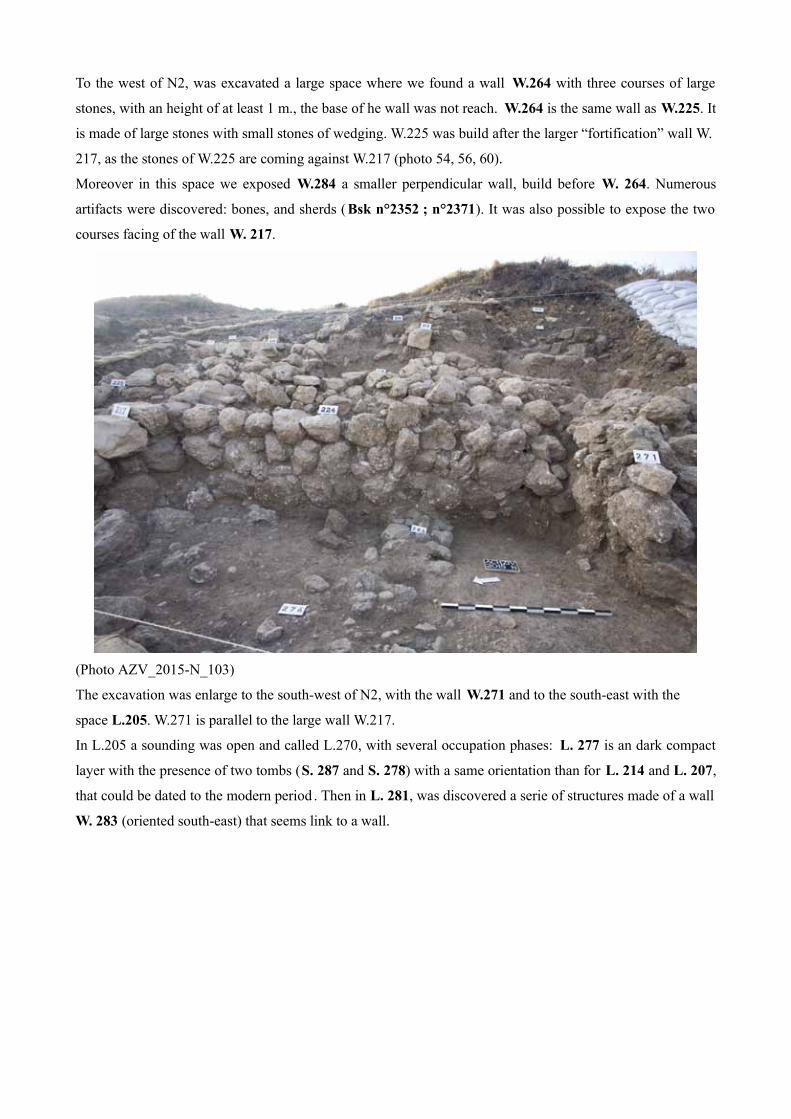
To the west of N2, was excavated a large space where we found a wall W.264 with three courses of large
stones, with an height of at least 1 m., the base of he wall was not reach. W.264 is the same wall as W.225. It
is made of large stones with small stones of wedging. W.225 was build after the larger “fortification” wall W.
217, as the stones of W.225 are coming against W.217 (photo 54, 56, 60).
Moreover in this space we exposed W.284 a smaller perpendicular wall, build before W. 264. Numerous
artifacts were discovered: bones, and sherds (Bsk n°2352 ; n°2371). It was also possible to expose the two
courses facing of the wall W. 217.
(Photo AZV_2015-N_103)
The excavation was enlarge to the south-west of N2, with the wall W.271 and to the south-east with the
space L.205. W.271 is parallel to the large wall W.217.
In L.205 a sounding was open and called L.270, with several occupation phases: L. 277 is an dark compact
layer with the presence of two tombs (S. 287 and S. 278) with a same orientation than for L. 214 and L. 207,
that could be dated to the modern period . Then in L. 281, was discovered a serie of structures made of a wall
W. 283 (oriented south-east) that seems link to a wall.

(Photo AZV_2015-N_108)
Conclusion for the square N2:
The pottery found in the square shows that there is a sequence of occupation from the Middle Bronze to the
Medival period. Few sherds from the Iron age came upon.
L.281 belongs to an upper part of the square that could be excavated while a future season.
Conclusion :
To conclude the 2015 season on the area N allowed to expose many new walls: W. 264, W. 271, W. 284 et
W. 293. All of them belonging to different phases of the Middle Bronze II period.
The excavation need to be continued in this area N in order to understand in a comprehensive way the
different phases of construction and also to connect more precisely walls with floors.

Date No. Square Orientation
07/01/15 L.255 N2 North-Est
07/02/15 L.258 N2 South-West
07/02/15 L.259 N2 North-Est
07/03/15 L.262 N2 North-East
07/06/15 W.264 (W. 225) N2 North-South
07/07/15 L.266 N2 North-East
07/09/15 L.268 N2 South-West
07/10/15 L.270 N2 North-West
07/10/15 W.271 N2 East-West
07/10/15 L.272 N2 Eas-West
07/10/15 L.276 N2 South-West
07/10/15 L.277 N2 North-East
07/10/15 S.278 N2 South-West
07/10/15 S.279 N2 South-West
07/13/2015 L.281 N2 North-East
07/13/2015 L.282 N2 North-South
07/14/2015 L.283 N2 North-East
07/14/2015 W284 N2 North-South
07/14/2015 L.285 N2 North-West
07/15/2015 L.286 N2 North-West
07/15/2015 L.287 N2 North-West

Tel Achziv
Report 2015
Area N1
Area supervisor : Chloé Schmidt
Introduction :
2015 season of archeological excavations at Tel Achziv carried out between June 29 and July 17, under the supervision and the direction of Michael Jasmin, Yifat Thareani and Philippe Abrahami.
A new area - N1 - was opened on the top of the tell, at the north side of the mound.The aim of this area opening was to find other structures located within the ancient city (levels from Bronze and Iron Ages) – that eventually could be connected to the MBII fortification system, in area N.
The area was dug with the help of 5 students from different french universities (Ecole du Louvre and Université Paris 1 Panthéon-Sorbonne in Paris, Université Paris Ouest-Nanterre-La Défense in Nanterre, the Université du Mans and the Université Le Mirail in Toulouse).
Description :
We opened this new excavations area – N1 – and the first square N1-1, on July 3, on the very top of the tell, with the help of a tractor, because the soil was very hard and concreted, certainly related to military infrastructures on the top of that part of the mound.
We cleaned a thick layer (7-20 cm) of topsoil (L.400), orange and strongly concreted, with much mixed material and pottery (MB, IA, Roman and Byzantine). Already appeared big blocks lined up in a straight line, on an east-west axis (Fig. 1).

Fig. 1 : Area N1, Sq. N1-1, L.400, view from west.Immediately below the topsoil layer (L.400), appeared a new thick layer made of loose brown soil (L.401) with mixed material and pottery (LB (or MB?: my comment), IA, Roman, Byzantine, Persian, Medieval, Ottoman). And several structures unearthed, on an east-west axis, which correspond to graves (Fig. 2) :
- S.402 at north (unexcavated), S.405 at northwest, S.406 (unexcavated) at southeast, with vertically arranged blocks, in a semi-circular alignment (side boxing/formwork slabs) ;
- S.403 at west, with very big blocks ;- S.404 at west, with 2 series in parallel of vertically arranged big blocks (side boxing/formwork slabs.
Fig. 2 : Area N1, Sq. N1-1, S.405, S.403, S.404, view from north.
Then 3 structures were excavated: S.403, S.404 and S.405 (mainly in the west side) ; the eastern side of the square was continued to be clean and excavate.
For the 3 structures excavated, the first layer consisted of a brown, hard and dense soil (filling layer) with a lot of very little stones (gravel) and shell fragments. Few material was found : some ceramic sherds from different periods (MB, MBII, LB, IA, Roman, Byzantine, Ottoman), shells, and fragmentary bones.

S.403 and S.405 were empty, but S.404 (linked to L.407) contained an incomplete human skeleton, with a fragmentary skull on the west.
Day by day, new structures appeared very quickly on the east side of the square : series of smaller or larger quadrangular blocks, lined up in a straight line, on an east-west axis (Fig. 3). These structures look like graves with horizontally arranged big blocks (boxing/formwork slabs), from another level : S.408 (northeast), S.409 (east), S.410 (in the north part of the square), S.411 (southeast), S.412 (northeast), S.413 (southeast).
Fig. 3 : Area N1, Sq. N1-1, new structures, view from east.
Then we sampled the structures S.403 (empty), S.404 and S.405 (empty), and we discovered new structures: S.408 (to S.413), S.414 (southwest of the square) under S.404-L.407, S.415 (northwest of the square) under S.405, S.416 at the southwest of the square, S.417 which continues the line of S.408, and S.418 under S.405, at the northwest (Fig. 4).
Every structure is similar : series of smaller or larger quadrangular blocks, lined up in a straight line, on an east-west axis, and correspond certainly to the upper part to graves, except S.415 which is more rectangular and with vertically arranged blocks and one horizontally fragmentary block (in the section at northwest), in which we can see a fragmentary human skull on the soil at west, just under the horizontally block (Fig. 5).
Fig. 4 : Area N1, Sq. N1-1, new structures, view from west.

Fig. 5 : Area N1, Sq. N1-1, S.415, view from north.
Conclusions :
At the end of this season of excavations, the area N1 revealed several structures on 2 levels, corresponding to graves (probably Islamic graves) and 3 phases : - Phase 1 : level with military infrastructures that disappeared and contemporary soil ; - Phase 2 : level with graves from recent periods (modern era - XIX th-XXth centuries ?), without horizontally blocks ; - Phase 3 : level with graves of different architecture with smaller or larger quadrangular blocks, lined up in a straight line, on an east-west axis and horizontally formwork slabs, from probably medieval periods (middle age/ modern era - XVIIth-XVIIIth centuries ?).These phases contained a lot of insignificant material from mixed periods and mainly handles.These structures (Phase 3) have not been excavated this year, but this is the project for the next season.