Embed Size (px)
Citation preview

THE ROUTE Round The Rock will be marked with red / white tape (This will be explained at the briefing) We will be marking the whole route but cannot guarantee that all markers will be still in place, so please read this through, look at maps and refer to links on web site under Route section. We have tried to make this as easy to follow as possible , but cannot guarantee that it is completely ultra proof!Remember the sea should always be on your right!!!All distance are approximate.The maps have been included as a guide only; There are no maps available that would be practical for this event.
You will come across other waymarks on the route will be useful, but our route might vary slightly in places.•There will often be blue painted stripes on way markers, rocks etc which are the ITEX markers.•Way marks which are green topped wooden markers.•Wooden finger signs•Granite signs

Start
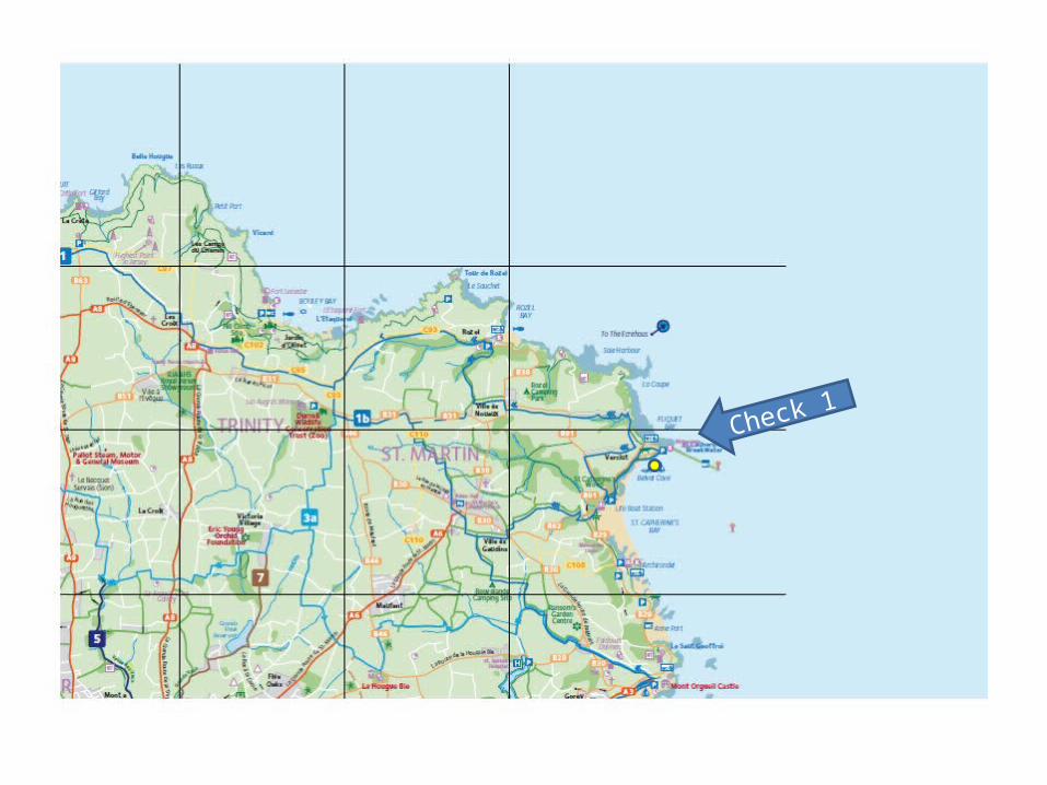
Check 1

Check 3
Check 2

Chec
k 4
Fini
sh

From To Distance Cumulative distance
Cut off time Description of route
Steam Clock St. Catherines (check point 1)
10.9 10.9 8.30 Road, mainly flat.
1. From Steam clock turn right and follow road - harbour on right.2. Continue on towards industrial area and take cycle track on left, between power station
and new incinerator.3. Tarmac path leads onto promenade.4. Continue along promenade and turn right onto pavement along road.5. At small roundabout Turn right - road bends left6. Continue on main coast road to Gorey Castle and Harbour7. On entering harbour area below castle road bends left – on right side of road – steep red
paved foot path next to toilets8. At top – cross over path -up steps -over grass to road – Turn right onto road. - Castle on
right 9. Road continues down. Stay on main road through bays.10. Road drops down through line of pine trees.11. On reaching yellow line TURN RIGHT.12. Continue onto St. Catherines Breakwater taking right hand fork, marked with no entry sign13. Checkpoint 1. Toilets

Landmarks
• Start At Steam Clock
• Gorey Castle with Harbour below
• St. Catherine’s Breakwater

From To Distance Cumulative distance
Cut off time Description of route
St. Catherines La Fontaine 11 miles 22.9 miles 11.00 tarmac(hills) to Rozel and then cliffpaths(hills)
1. With Breakwater on right take small track on right at end of break water wall. ‘La Ruette du Verclut footpath to Flicquet’
2. Turn right at wooden railings and onto path3. Take right turn and continue to road.4. Turn right and drop into Flicquet bay with granite round tower ahead.5. Climb steep hill and continue on road.6. Turn right at junction onto Rue du Scez. 7. Continue down to Le Saie Harbour DO NOT turn right to La Coupe.8. Descend steep hill to Le Couperon and take track along Left hand side of field, ‘La Rue des
Fontenelles footpath to Rozel Hill’9. Continue through woods and climb to road.10. Turn right onto main road and drop down to Rozel Bay taking middle road, do not turn off
to pub or beach. (Toilets at end of Pier)11. Continue through Rozel Bay past houses until road starts to climb up out of bay. On your
right is the road leading to the sea AND a smaller road (Rue de Catel) climbing up above harbour. Take this middle road - Rue de Catel.
12. Road climbs up steeply past houses and then fields.13. Pass fields and then reach granite house “Le Catel” on right is rough road to cliff path, way
marked. Keep on track to White Rock car park.
YOU ARE NOW ON CLIFF PATHS FOR APPROXIMATELY 12 MILES. THEY ARE STEEP AND AREAS ARE EXPOSED, TAKE CARE.
14.Continue through car park and pass gate to reach cliff path.15.After half a mile there is path on the left, DO NOT TAKE this path and continue to the right.16.path rises and meets another wider path at right angles - turn right down to L’Etacquerel Fort 17.The path drops to stream and then climbs up hillside18.At top of steps is a small house on right. Keep house right, cross path to reach some wooden steps and cliff path . DO NOT TAKE PATH ON LEFT MARKED ‘Private’.19.On reaching turn off to left keep right, descend to a stream and a foot bridge. 20.climb out of the valley. 21.At top of hill DO NOT turn left - turn right. 22.Continue up steps and down steps towards sea.23.Path drops into trees and bends left up into woods, DO NOT take small path on right.24.Path climbs through woods until on right a low level sign can be seen, - turn right25.Take care on steps- follow drive to main road. Bouley Bay is to the right and Toilets26. At road turn - left and go up hill for about 50 metres. 27.Turn right onto path signposted’ Cliff Path to Bonne Nuit’, - climb steps. 28.At top follow grass track above fields29.After about 200 metres, turn right up steps (stone way mark). Continue on path.30.Path continues and drops though woods towards stream.
32. Take right hand lower fork (wooden sign) and continue beside stream to small stone house below.
33. Path continues with house on your right. – onto cliffs 34. climb two small sets of steps and turn left onto grass track .35. Turn off path at right hand turn at wooden sign.36. Keep to lower path as you turn headland. 37. Path rises and falls across rocky bay, keep on right hand paths to reach Le Crete Fort.38. Path widens heads left past buildings onto road.39. Turn right and drop towards Bonne Nuit.40. DO NOT turn off right to Bonne Nuit bay (Toilets if needed)41. Follow road as it bends to left and climbs steeply.42. After 100 metres and buildings , Look out for stone way mark that says, ‘Cliff path to La
Saline’43. Turn right onto path and climb steps!44. The path flattens out and you will approach a building site (Wolves Caves), take the right
turn down the headland and up to La Saline Quarries on left.45. Path widens and climbs to road, turn right.46. Continue onto pavement and onto La Fontaine – Checkpoint 2 – Toilets in pub

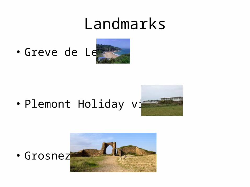
Landmarks
• Le Couperon
• Rozel
• La Fontaine pub

From To Distance Cumulative distance
Cut off time Description of route
La Fontaine Grosnez 6.5miles 29.6 Miles 13.30 Cliff paths with steep hills in places. Some road sections.
1. Leaving La Fontaine turn right onto Rue de Sorel .2. Turn left onto cliff path which is signed as cliff path, private property.3. Continue on and drop to Mourier Valley, cross path over small wooden bridge and climb
around headland.4. On reaching road turn right to Devil’s Hole and pub car park.5. Pass through car park to find small steps climbing up to cliff path. Signed 2.5 miles to
Greve de Lecq . DO NOT take tarmac path on right to Devil’s Hole itself.6. Continue on path and join wider gravel section.7. Continue onto short tarmac section and through kissing gate ont. Here, turn right and
follow the track for a short distance as it bends right and becomes tarmac. Walk a few steps, then bear left through a kissing gate to rejoin the cliff path.
8. Continue on cliff path towards Greve de Lecq9. Path will eventually join a farm track, passing farm on right and joining onto Road.10. Turn right onto road and follow passing rifle range on right.11. Road starts to drop steeply to Greve de Lecq. TOILETS on PROMENADE12. Turn right onto road and follow with café and beach on right. 13. Road climbs at Prince of Wales Pub, take lane on right after pub. “Cliffpath to Plemont”

15. Continue on track which turns to tarmac.16. Turn right at Sign “Cliffpath”17. Lane continues between two houses, Lecq Farm on right.18. Tarmac turns to gravel and rises.19. Turn right down steps into wooded valley.20. Cliff path continues onto disused Plemont Holiday Village and joins tarmac lane.21. Continue on tarmac lane until right hand leading down towards Plemont Beach.22. Keep on tarmac lane past houses on both sides.23. Sign on left “Grosnez”, take this path and climb upwards onto Grosnez Castle -
Check point 3 in car park
Landmarks
• Greve de Lecq
• Plemont Holiday village
• Grosnez

From To Distance Cumulative distance
Cut off time Description of route
Gronez Beauport 9.3 miles 38.9 16.00 Mixture of Beach, cliff paths and tarmac
1. The route leads across headland with way marks towards a large German concrete observation tower.
2. Take the most direct paths across the headland towards tower.3. Cross wooden bridge and on towards large pinnacle of granite set off coast.4. Continue past large gun emplacement and follow large track to left and road.5. Turn right and continue down to yellow line. Turn right and follow road down hill around
large rock, L’Etacq.LOW TIDE7. At carpark turn down onto to far end and take last slip way (4th) up past toilets and to
yellow phonebox and road at La Pulente – right onto trackHIGH TIDE8. continue on road.Turn right to beach, left at slip.9. At junction left and continue until junction, turn right.10. Road bends left, follow track that runs along road to La Pulente (approx 3 miles) Bars,cafes
and toilets along sea front. OR You can follow tracks and promenade above sea wall.

12. Follow track on right hand side of road, pub on left.13. Road bends left, track widens and continues to right and around headland.14. Turn right down steps to slip way, take care along wall.15. Climb short, steep tarmac road to yellow line – turn right onto road.16. Road climbs steeply past Corbiere Lighthouse. On right side after Corbiere cut
across grass to German Observation tower. (Toilets on road).17. Cross carpark and onto headland. Follow path around headland, take care. Do not
turn right down steps.18. Stay on path and continue up to low granite building ahead.19. Keep on right hand path to green fence. Path drops down take care. 20. Carefully take path to left alongside desalination plant - continue up steps & turn
right - cross track and take steps up headland.21. Continue along track, on reaching houses, cross over to cliff path. 22. Follow wider path towards large white golf ball in sky!23. The path turns right to follow green fence beside golf ball.24. Turn right at tarmac road, prison ahead, follow wooden sign Right.25. Left - following signs around field and left at house onto cliffpath.26. Path continues and drops steeply down steps. Take care.27. Path climbs and turn left through gap in wall and hedge at top of hill onto grass.28. Follow path to right and onto Beauport carpark. Checkpoint 4

Landmarks
• Observation tower
• L’Etacq
• Gun emplacement
• Looking across St. Ouens to Corbiere

From To Distance Cumulative distance
Cut off time Description of route
Beauport Finish 9miles 48miles 18.00 Beach, cliff paths and tarmac.
1. Take the tarmac road and Right onto path sign to “St.Brelade’s Church” 2. Continue on track, climb steps and continue to right.3. Take care as path drops steeply down towards road.4. Turn left at road and continue to right past church and cemetery along pavement.5. Turn right past war memorial and continue along road and pavement. 6. Pavement slopes down to promenade. 7. Depends on Tide; Beach to granite cliffs at La Cotte (go to No11) or beach to first headland
and then climb steps to promenade or stay on promenade.8. At end of promenade climb steps to top of hill and continue right along path, dropping
down to Ouaisne bay.9. Continue to La Cotte and right onto slipway below blue restaurant.10. Left below restaurant and follow granite path above beach to cliff path steps.11. Take care across rocks to reach steps below cliff. Green sign “footpath to Portelet
common”12. Climb steep steps to common above- Cross through gap in stones to right and continue
towards granite wall ahead.13. At black gates go to left into woods along high fence.14. Pass metal barrier and head right on to lane and Portelet Hotel.15. Right after Portelet Hotel onto Rue Voisin.16. After 100m road bends right , turn LEFT onto private road past houses.

17. Follow road past Portelet pub- Turn right into large public car park-18. Path starts in far right hand corner of car park.19. Continue on path along headland– Turn right onto road towards Noirmont and
large parking area.20. Head for large gun at far left hand corner of car park.21. Green way mark marks start of path to left of gun.22. Do not take narrow path to right down to the sea. Do not take two paths that go
to left. 23. Take right hand forks as path climbs and curves right. Path meets Green fence,
follow through woods until road.24. Turn right onto main road and turn right down SECOND road on right (first is a
steep hill down). Continue on road, down to St. Aubin, do not turn off.25. Continue on road past harbour – turn right into cobbled parking by parish Hall.26. Pass parish hall and turn left past restaurant and toilets to join promenade.27. Follow promenade to St. Helier (approx 3 miles) or on beach.28. Finish is beside La Fregate Restaurant at Jardins la Mer29. YOU MADE IT!!!!
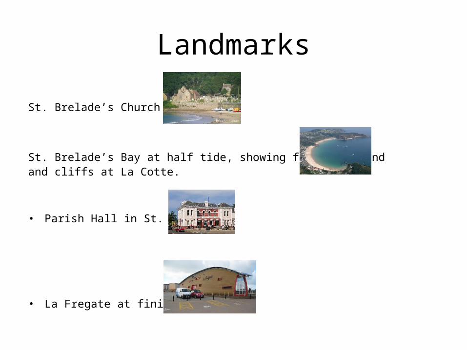
Landmarks
St. Brelade’s Church
St. Brelade’s Bay at half tide, showing first headland and cliffs at La Cotte.
• Parish Hall in St. Aubin
• La Fregate at finish