Embed Size (px)
Citation preview

The River Itself Warns Us: Local Knowledge of Flood Forecasting in the Gandaki River Basin, West Champaran, India
A AREHIHimalayan Adaptation, Water and Resilience Research
Consortium members
HI-AWARE Working Paper 5
About HI-AWARE Working Papers
This series is based on the work of the Himalayan Adaptation, Water and Resilience (HI-AWARE) consortium under the Collaborative Adaptation Research Initiative in Africa and Asia (CARIAA) with financial support from the UK Government’s Department for International Development and the International Development Research Centre, Ottawa, Canada. CARIAA aims to build the resilience of vulnerable populations and their livelihoods in three climate change hot spots in Africa and Asia. The programme supports collaborative research to inform adaptation policy and practice.
HI-AWARE aims to enhance the adaptive capacities and climate resilience of the poor and vulnerable women, men, and children living in the mountains and flood plains of the Indus, Ganges, and Brahmaputra river basins. It seeks to do this through the development of robust evidence to inform people-centred and gender-inclusive climate change adaptation policies and practices for improving livelihoods.
The HI-AWARE consortium is led by the International Centre for Integrated Mountain Development (ICIMOD). The other consortium members are the Bangladesh Centre for Advanced Studies (BCAS), The Energy and Resources Institute (TERI), the Climate Change, Alternative Energy, and Water Resources Institute of the Pakistan Agricultural Research Council (CAEWRI-PARC) and Alterra-Wageningen University and Research Centre (Alterra-WUR). For more details see www.hi-aware.org.
Titles in this series are intended to share initial findings and lessons from research studies commissioned by HI-AWARE. Papers are intended to foster exchange and dialogue within science and policy circles concerned with climate change adaptation in vulnerability hotspots. As an interim output of the HI-AWARE consortium, they have only undergone an internal review process.
Feedback is welcomed as a means to strengthen these works: some may later be revised for peer-reviewed publication.
About the Authors:
Amitangshu Acharya, PhD Scholar, University of Edinburgh, UK
Pradeep Poddar, Programme Officer (MIS), Megh Pyne Abhiyan
Corresponding Author: Amitangshu Acharya, [email protected]
Acknowledgement
This work was carried out by the Himalayan Adaptation, Water and Resilience (HI-AWARE) consortium under the Collaborative Adaptation Research Initiative in Africa and Asia (CARIAA) with financial support from the UK Government’s Department for International Development and the International Development Research Centre, Ottawa, Canada.

The River itself Warns Us: Local Knowledge of Flood Forecasting in the Gandaki River Basin, West Champaran, India
Authors
Amitangshu Acharya
Pradeep Poddar
Himalayan Adaptation, Water and Resilience (HI-AWARE) ResearchKathmandu, Nepal, November 2016
HI-AWARE Working Paper 5

Published by
HI-AWARE Consortium SecretariatHimalayan Adaptation, Water and Resilience (HI-AWARE) c/o ICIMODGPO Box 3226, Kathmandu, Nepal
Copyright © 2016
Himalayan Adaptation, Water and Resilience (HI-AWARE) All rights reserved. Published 2016
ISBN 978 92 9115 433 3 (electronic)
Production teamDoris Canter Vischer (Editor)Debabrat Sukla (Communication Officer, HI-AWARE)Dharma R Maharjan (Graphic designer)Asha Kaji Thaku (Editorial assistant)
Photos: Amitangshu Acharya
Disclaimer: The views expressed in this work are those of the creators and do not necessarily represent those of the UK Government’s Department for International Development, the International Development Research Centre, Canada or its Board of Governors.
In addition, they are not necessarily attributable to ICIMOD and do not imply the expression of any opinion by ICIMOD concerning the legal status of any country, territory, city or area of its authority, or concerning the delimitation of its frontiers or boundaries, or the endorsement of any product.
Creative Commons License
This Working Paper is licensed under a Creative Commons Attribution-NonCommercial-ShareAlike 4.0 International License. Articles appearing in this publication may be freely quoted and reproduced provided that i) the source is acknowledged, ii) the material is not used for commercial purposes, and iii) any adaptations of the material are distributed under the same license.
This publication is available in electronic form at www.hi-aware.org
Citation: Acharya, A., Poddar, P. (2016). The river itself warns us: Local knowledge of flood forecasting in the Gandaki River Basin, West Champaran, India, HI-AWARE Working Paper 5. Kathmandu: HI-AWARE

Contents
Acknowledgements ivSummary v
1. Introduction 1 Indigenous/local/traditional knowledge? Definitional dilemmas 1 Defining local knowledge 1 Local knowledge of early flood warning in South Asia: A literature review 3
2. Study Site and Methodology 6 Peoples perspective of upstream-downstream linkages of flood management 12
3. ‘The River Itself Warns Us’: Local Knowledge and Flood Forecasting in the Gandaki River Basin 15 Phenomenological indicators 16 Ecological indicators 17 Riverine indicators 18 Meteorological indicators 20 Celestial indicators 22 Official indicators 22 Triangulating indicators for early warning 25
4. Conclusions and Recommendations 27
References 30
List of tablesTable 1: Details of sampled tolas 12Table 2: List of key informants interviewed 13Table 3: Categories of local knowledge at study site 16
List of figuresFigure 1: Government of Bihar map of flood prone districts in Bihar 6Figure 2: Gandaki flood affected areas in Nautan 7Figure 3: Data collection sites for research in Nautan Block 8Figure 4: Location of 6 tolas selected for data collection 9Figure 5: Picture of a 1913 revenue map of shyampur kotraha 11Figure 6: Picture of a revenue map of Dakshin Telua, land where Bariarpur is currently settled is shown as vacant 11 Figure 7: Sluice gate at study site 11Figure 8: Bedi/gehedi, grain storage structures in the study site 16Figure 9: Aar/kinara of Gandak River in Chharke village 19Figure 10: 100 year annual average precipitation in Pashchim Champaran 21Figure 11: Patkhaulia Village: rendered ‘bechiragi’ after the 1993 floods 22Figure 12: Map location of Patkhaulia village, now ‘bechiragi’ 23

iv
Acknowledgements
This research would not have been possible without the support and patience of communities, and especially women, in Navrahi, Karisa ka tola, Devraj Yadav ka tola, Bhaiju Bhagat ka tola, Bariarpur and Khutai. They discussed and narrated their worldviews and experiences of living on the floodplains of the Gandaki River and accommodated us within their daily chores. We cannot thank them enough.
We also acknowledge the kindness and support we received from Vinay Kumar, Secretary, Water Action, Bihar for his round the clock support to our research. We also thank Rajkishoreji, who helped us navigate the complex terrain of the Gandaki floodplain with remarkable ease and his family, who very kindly hosted us at their house during our fieldwork. We also acknowledge the generosity of Eklavya Prasad, Managing Trustee of Megh Pyne Abhiyan, a campaign he seeded in 2007 and has nurtured it with passion ever since. We used to talk at length over the mobile phone during our fieldwork and his rich baritone was truly a guiding voice to our research endeavours.
We also thank ICIMOD’s HI-AWARE project for financially supporting this research, and especially Programme Coordinator, Anjal Prakash who not only encouraged us, but actively supported our work. ICIMOD reviewers of this working paper also contributed meaningful suggestions and ideas, which helped firm up the core arguments we make in this paper. We thank them for their time and effort.
Amitangshu Acharya Pradeep Poddar

v
HI-AWARE Working Paper 5
Summary
The flood prone Gandaki river landscape, in the eastern Indian state of Bihar, produces inequities and uncertainties in equal measure. People’s knowledge of forecasting floods has historically evolved through complexities and politics of caste, class, and gender along with the ecological flux inherent to waterscapes. Interestingly, though, very little attention has been paid in literature on disaster risk reduction to local knowledge of flood forecasting and other meteorological phenomena. That local communities are not just consumers but also producers of information on weather and climate seems to have gone mostly unnoticed.
The present study attempts to address that gap in literature, by documenting various, sophisticated methods deployed by local communities to forecast floods and heavy rainfall in the Gandaki River basin. It makes a point that strengthening such local knowledge systems will effectively counterbalance the pitfalls of centralized and mechanized early flood warning systems as much as ensure their recognition and continuation.
This research also seeks to clarify its definition of local knowledge in an effort to move away from the interchangeable use of traditional/indigenous/local knowledge, a flexibility that has created ontological problems.
By documenting the complex interaction between local-knowledge based forecasting and official early warning systems, the study points out (a) a high degree of gender blindness embedded in official early flood warning systems, (b) at knowledge innovation practised by local communities that convert obtuse flood- related information to practical use through a complex process of triangulation, and (c) the change to local knowledge asymmetries being brought in through the rapid proliferation of mobile phones. Finally, it advocates knowledge co-production between local and scientific communities, which would only serve to strengthen one another.

vi

1
HI-AWARE Working Paper 5
Introduction
Indigenous/local/traditional knowledge? Definitional dilemmas
Indigenous/local/ traditional ecological knowledge (TEK) has emerged as a powerful critique and an alternative to the dominant Eurocentric knowledge system in the last few decades. Its emergence has largely been seen as a response to inadequate resource management guided by Western science as well as the steady erosion of indigenous knowledge (Palmer and Wadley 2007; Steele and Shackleton 2010; Raymond et al. 2010). Ellis (2005) traces the need for engagement and incorporation of traditional ecological knowledge into environmental decision-making from (a) informing sustainable environmental management practices (b) predicting possible impacts of environmental changes resulting from human development, and (c) as part of a recognition of indigenous groups, their knowledge systems, and their rights. Given the importance indigenous/ local/traditional ecological knowledge has acquired, it is necessary to unpack its definition and subsequently establish the definitional context in which this research has been anchored.
‘Indigenous’, ‘local’, and ‘traditional ecological knowledge’, all have varied explanations. Davis and Ruddle (2010) assert on the basis of an exhaustive review of research literature on traditional ecological knowledge, that there is little consensus between researchers on the content of these different forms of knowledge. Unfortunately, a number of studies are using a particular definition of TEK without either (a) explaining why one was picked over the other (Dekens 2007(b); Santha et al. 2014) or (b) why the terms were used interchangeably (Mapinduzi et al. 2003; Chalmers and Fabricius 2007; Dekens 2007(a); Failing et al. 2007).
This study recognizes the significant contribution of scholarship to both traditional ecological knowledge (Aikenhead and Ogawa 2007; Chapman 2007; Berkes 2008) and indigenous knowledge (Failing et al. 2007), but chooses to move away from using either to underpin the analyses and methodology in the study. This is not because the above-mentioned are weak in their conceptualization, but because the concept of local knowledge (Sillitoe 1998; Dekens 2007(b); Smith 2011) is more appropriate and relevant, given the current research context and site.
Defining local knowledge
Local knowledge has been defined and redefined over a period of time, as its significance has grown in anthropology (Sillitoe 1998), development studies (Chambers 1994), geography (Smith 2011), and climate change and disaster management studies (Dekens 2007a and b). From a pure intellectual pursuit in anthropology it evolved to its usefulness in solving local problems, to becoming a vehicle for local participation and, through it, local decision-making. Finally, it became an argument for a post-structuralist interrogation of ‘science’ and a demand for a pluralistic understanding of such science.
Yet, several scholars have given caveats on the process of engaging with local knowledge, its analysis, and interpretation. Blaikie et al. (1997) points at how factors such as migration, population growth, disasters, and environmental change affect the production of local knowledge. We recognize this in the context of this paper, as the floodplains of the Gandaki River are witness to frequent displacement and recurring resettlement of entire villages due to floods and river erosion.
The Gandaki River basin in Bihar is definitely one of the most populated regions in South Asia. It is witness to a significantly high level of migration. As a fertile agricultural region, it has been a hub of commodity trade. Moreover, the District of West Champaran, where the study sites are located borders Nepal. Through this District the Gandaki first sets foot in India before merging with the Ganga. The border has been porous for generations, bringing about thriving transborder social and migratory networks.

2
In such a dynamic landscape, researching local knowledge is more appropriate to context than indigenous/TEK. Indigenous knowledge is associated with knowledge held and practised by people who have a legitimate claim over indigeneity (Ericsson et al. 2005). There were no known indigenous groups in the study area. As regards TEK, we agree with Green’s argument (2008:149) - derived from Spiegel and Boonzaier (2008) - that the term ‘traditional’ is problematic especially “for people who have a great deal of knowledge of a place but a weak claim to the notion of ‘traditionality’” (emphasis original).
During fieldwork we understood that, though people may have settled in around the floodplains many generations ago, river erosion had led to their frequent displacement. At the field site, those who were settled there at the time of study were originally from a different state (Uttar Pradesh) or another district within Bihar (Saran, Gopalganj). Women who had married into families at the site had also come from different states (West Bengal, Uttar Pradesh) or from other districts/Blocks in Bihar. So, these communities could not claim a long history of settlement at the specific study site, although their understanding of the local environment was found incredibly deep.
Intergenerational transmissions of knowledge through livelihood-related occupation and of worldviews are also key parameters to define both indigenous knowledge and TEK. In the field area, many of the caste groups associated with an occupation specific to a type of resource (like fishing, carpentry, catching and consuming field rats, and boat making) had moved on to agriculture and agriculture related labour. This had been accompanied by massive migration that had pushed young and middle-aged men out of full-fledged agriculture and traditional occupations into skilled and semi-skilled labour in towns and cities. Such larger systems, such as migration and modernisation affect knowledge production. Interaction of local knowledge with larger systems is well explained by Sillitoe (1998:2005). He states that ‘contemporary communications, revolution and cultural globalization, hybridization is occurring and blurring distinctions between scientific and other knowledge on socio-cultural grounds.’ This was apparent at the study site with the entry of mobile phones, television, and newspapers. This along with an established legitimacy of radio as the only formal source of receiving early warning messages has impacted local knowledge of floods significantly. Hence the concepts of ‘TEK and indigenous knowledge’, which depend on temporal and spatial continuity to define themselves, are not as appropriate to the study site as ‘local knowledge’.
Though different scholars have defined local knowledge differently, there are more commonalities than differences in those definitions. Smith (2011:596) defines local knowledge, strictly within the domain of development, as ‘knowledge that people who live in a particular place have about the area.’ This is perhaps the broadest definition available. Lebel (2012:1058) borrows from different scholars (van Kerkhoff and Lebel 2006; Reid et al. 2006; Bone et al. 2011) to define local knowledge to be about ‘diverse aspects of life, takes several forms and comes from multiple sources’. Sillitoe (1998) gives the following detailed description of local knowledge:
‘Local knowledge in development contexts may relate to any knowledge held collectively by a population, informing interpretation of the world. It may encompass any domain in development, particularly that pertaining to natural resource management. It is conditioned by socio-cultural tradition, being culturally relative understanding inculcated into individuals from birth, structuring how they interface with their environments.’
Such definitions framed the broader contours of our research as also the methodology we used for data collection. But we also broadened our understanding of the concept by incorporating critical concerns around researching local knowledge (Blaikie et al. 1997; Goebel 1998; Green 2000; Myers 2002; Briggs et al. 2007; Smith 2011; Lebel 2012).
First of all, the view of knowledge being held collectively has been criticized in research that points at how gender, social groups, and individuals all have different perspectives on local knowledge. As a consequence, uniformity is not a trait of local knowledge, but is often contested and causes conflict. This highlights the need for a gendered understanding of the production of local knowledge. Secondly, scholars have also pointed out that local knowledge is not held in isolation or a vacuum, but is constantly interacting with wider knowledge networks. Thirdly, and perhaps most importantly, it is recognized that local knowledge is embedded in relations of power and hegemony. For this reason, researchers of local knowledge have to be wary of elites claiming their version to be representative.

3
HI-AWARE Working Paper 5
This also points at how researchers themselves are also embedded in their context of knowledge and power as ‘outsiders’ and ‘experts’, and that there is a need to reflect on this continuously.
Fourthly, it has become evident that the expression of local knowledge is highly context-specific and culturally articulated through myth and metaphor. This necessitates an engagement with and understanding of the local cosmological and linguistic context. Finally, scholars also indicate that, while one should not try scrutinizing local knowledge through the normative lens of ‘science’, the reverse is also true (Huntington 2000:1273), where ‘unquestioning acceptance’ is as problematic as ‘unquestioning rejection’. Such critical concerns are incorporated into the current research framework.
Local knowledge of early flood warning in South Asia: A literature review
Given the recurrence of floods as a disaster and a hazard in India and South Asia, and the scale of its impact, it is interesting to note that local knowledge of flood warning seems to have drawn very little attention in academic research on this region. This gap presented a significant opportunity to our research project but also some risks. In terms of opportunity, our research can contribute to the expansion of a relatively small body of work. At the same time, the absence of literature makes it harder for the researcher to gauge how the current project was situated in view of similar exercises in India and other parts of South Asia.
One of the earliest documents available on this specific issue can be traced back to Schware (1982, 1984). His work in the Subarnarekha and Damodar river basin led him to advocate for the integration of ‘official’ and ‘folk’ information systems around early flood warning. Though he conducted his research in the early days of academic engagement with local knowledge in development, he rightly pointed out that tapping into local knowledge on flood forecasting and other meteorological phenomena had been ignored, whereas that for local development was witnessing a steady rise. Schware’s (ibid.) arguments for engaging with ‘folk’ information systems may sound purely instrumentalist. Yet perhaps at the time of conducting that research, it may have been quite radical, because it solicited a space for local knowledge within the domain of scientific decision-making.
Schware’s research area (ibid.) closely resonates with the study site for our research. He picked villages downstream of the Damodar River, as they were exposed to the vagaries of sudden reservoir releases. This mirrors the reality of villages located inside the embankment and downstream to the Gandaki River in West Champaran, Bihar. For these, too, are vulnerable to sudden releases from the Gandaki Barrage. Schware (ibid.) was convinced that conventional and scientific methods of flood forecasting were not a panacea, because they had several problems. They could not generate information granular enough to be useful. The quantitative terms by which reservoir releases were communicated (in cusecs), did not give any idea of the geographical spread of floodwaters. On top of that, the ‘official’ communication system was dysfunctional and was of no use to the people. Schware (1984) also pointed out that many groups and communities were isolated from the official warning systems because of their position in the local architecture of power and privilege. Most importantly, he indicated that while data on rainfall were collected at the higher reaches, where water was impounded, rainfall and heavy monsoon storms at the lower reaches actually amplified flood related risk. Unfortunately, there was no systematic way to collect data from the downstream area. This meant that the official system was frequently disconnected from the possibility of actual flood events being caused downstream with their sudden reservoir discharges. If there was a heavy shower downstream, it could lead to build-up of waterlogging. This would then amplify into a flood, as fresh release from the reservoir swelling up the river would add to it. Interestingly, Schware (1982) also gave examples of how floods also ushered in local conflicts. Often, by using small bunds and dams, people would prefer to impound floodwater for paddy cultivation in the rabi season (September to February). Such large-scale water impounding made downstream villages far more vulnerable to flash floods resulting from sudden breaches in dams in upstream villages. This finding resonates closely with intra and inter-village conflicts related to the operation of sluice gates in our research area. It will be explored in detail later.
The conclusion that Schware (1982, 1984) drew from his research was that dependence on the ‘official’ system of early flood warning was increasing the risk of flood effects to vulnerable populations. For that reason, ‘folk’ warning systems should be seen as complementary to the former. Schware (1984:61) referred to Chapman’s research

4
(1983) on agricultural practices emerging out of local knowledge systems in Bihar. He argued that people located on the catchment area of the Subarnarekha River could forecast weather conditions or floods similarly, reading ‘environmental cues, farming calendars, cropping sequences, traditional proverbs and customs’. He also gave examples of a few ‘environmental cues’ (ibid.), such as ants leaving river banks and climbing trees and buildings, a sudden surge in mosquito and gnat populations, the flying of bats in large flocks, and a constant howling of wood cats. They were all indicative to the local population of impending floods. Schware (1984) stated that though investments in sophisticated early flood-warning systems were increasing from the Government, their ability to generate dependable data was suspect and dissemination of the generated information was being executed poorly. Strengthening community-based, local knowledge of flood warning, he argued, would give a counterbalance to the pitfalls of centralized and mechanized early flood warning systems.
This very theme finds more nuance and elaboration in Deken’s research (2007b) on local knowledge of disaster preparedness, especially related to floods and flash floods in the eastern Terai of Nepal. Deken’s work (2007a and b) is anchored around establishing a clear process of researching local knowledge. She moves away from an instrumentalist engagement by calling for an investigation of local knowledge in its own right, whether it would serve a specific purpose or not. In her case study, she highlighted the need for understanding landscape history, and more importantly, various socio-economic vulnerabilities that riddle study sites. She also stressed on the need to locate local knowledge with respect to gender and caste issues, recognizing that such contexts could lead to different forms of production and articulation of local knowledge. However, unlike Schware (1982, 1984), she did not specifically engage with local knowledge around the early warning of floods, but stretched her study to before, during, and after floods. This helped her to bring out a rich understanding of local knowledge and disaster preparedness. She categorized local knowledge into anticipation, adaptation, and communication (Deken, 2007b). Early warning was featured in the segment under anticipation, where, like Schware (1984), she documented environmental cues. These included, (i) visual indicators such as floating wood, snakes and other dead animals, and the muddying of waters, (ii) auditory one’s like the sound of water similar to that of a rushing bus, and (iii) olfactory ones, referring to a change in the smell of the flood water. In her section on communication (Deken, 2007b) she looked into the role of songs, poems, and proverbs in storing, archiving and ensuring intergenerational transmission of knowledge and experience of floods.
Similar research had also been conducted in the floodplains of the Jamuna River in Bangladesh (Paul 1984; Paul and Routray 2009). In an effort to understand local knowledge on floods, Paul (1984:9) drew a clear distinction between ‘barsha’ and ‘bonna’. Locals used ‘barsha’ to define a normal flood event, which does not reach homestead land and allows for a good paddy harvest. ‘Bonna’ on the contrary, was defined as an abnormal flood, by the damage it causes to both crops and property. Such examples (in conjunction with our research findings) indicate that discovering a local lexicon for defining and categorizing floods offers a window to local knowledge. Instead of the generic word flood, which needs an adjective to indicate its severity, ‘barsha’ and ‘bonna’ contextualised floods. ‘Barsha’ was seen as beneficial, while ‘bonna’ was not. ‘Barsha’ signifies good harvest while bonna brings hardship. Paul (1984) later went on to show how local coping strategies, especially cropping patterns in the area, were orchestrated around ‘barsha’ and ‘bonna’.
On the one hand, both Paul (1984) and Paul and Routray (2009) investigated local knowledge to explain coping strategies deployed in flood-affected areas. On the other, Irfanullah and Motaleb (2011) looked into predictive and adaptive aspects of local knowledge of disasters among indigenous groups in the Chittagong Hill Tracts in Bangladesh. Like Schware and Deken, Irfanullah and Motaleb discovered a number of environmental cues by which local communities would forecast floods, heavy rainfall, cyclones, and other disasters. The authors organised the examples under two broad categories: ‘hydro-meteorological’ and ‘biological’ (ibid., p. 85). Under ‘hydro-meteorological’ they documented ‘clouds roaring like the sea’ as indicative of cyclones, while ‘very strong winds for three to four days’ would indicate the onset of floods. Under ‘biological’, they documented that the sudden arrival of wild boar and wild cock in the village from uphill was indicative of an imminent flash flood. The behaviour of ants, interestingly, connoted different types of disasters. When ants climbed up houses in a line, it indicated an imminent hailstorm. But when they crossed the road in a straight line, it was deemed to forecast cyclones or thunderstorms (kalboisakhi). When they were seen to exhibit both sets of such behaviour, it was said to indicate heavy rainfall and subsequent floods.

5
HI-AWARE Working Paper 5
Irfanullah and Motaleb (2011) also documented how the indigenous Rakhain community in Bangladesh predicted heavy rainfall by checking three rings on the legs of a particular species of toad. The changing of the first ring to a red colour would indicate rains between the 1st and 10th of July. When the second ring turned red, it was believed that the rains would arrive between the 10th of July and 15th of August. But the third ring turning red indicated heavy rainfall between the 15th of August and 15th of October. This was bound to cause damaging floods. What also marks an interesting turn in Irfanullah’s and Motaleb’s research is that they documented processes and ceremonies that were deemed to have a transformative impact on weather. This included songs and dances, and separate marriage ceremonies for frogs and chickens.
The research of Santha et al. (2014) on local knowledge and early warning on coastal hazards with fish workers in Kerala, India, gives a refreshing framework. His work resonates with the earlier work by Schware (1982, 1984) on recognizing local knowledge as a legitimate source of information and experience. Schware was more instrumentalist, though, in his approach to local knowledge as improving the efficiency of flood forecasting. Santha et al. on their part, sought to contest the homogenizing mainstream narratives of scientific knowledge, which denied marginalized communities their rightful space in knowledge production and had contributed to their disempowerment.
Like Paul (1984), Santha et al. (2014:281) delved into the lexicon of local knowledge. They located ‘kolu’, a comprehensive term used by fish workers to describe all natural phenomena that link to each other to become coastal hazards. This predictive aspect of ‘kolu’ is embedded in different knowledge spheres, and Santha et al. (2014) categorized them as biotic, oceanic, atmospheric, and celestial. This categorization is close to that of Irfanullah’s and Motaleb’s ‘hydro-meteorological’ and ‘biological’ categories, but definitely gives greater space to accommodate cultural and phenomenological experiences.
More importantly, Santha et al. (2014) clearly articulated that these spheres were not disconnected and discrete but were interlinked in complex ways. Hence it would be incorrect to try and understand ‘kolu’ in parts, as its meaning lied in its interrelatedness. Like Schware’s (1982, 1984) analysis of the official system set up for an early warning of floods, Santha et al. (2014) pointed to the dysfunctional nature of a tsunami early warning system for fish workers, since its unreliability impeded its legitimacy and increased end-user scepticism.
The complex interaction between local-knowledge based forecasting and official early warning systems emerges as a leitmotif in the review. What also emerges is the need for knowledge co-production between local and scientific communities.
But there remains a remarkable silence on gendered aspects of local knowledge on early warning systems for floods and other hazards. In fact, discussions on gender originate and end largely at the point of the vulnerability of and differing coping strategies for women. A gender-based production of anticipative or predictive knowledge of floods seems to get side-lined on the research agenda. Though researchers attempt to be nuanced in their methods and alert to caste and gender concerns in the field, the voice that finally carries through to data analysis is that of male respondents (Schware 1982 and 1984; Paul 1984; Mishra 2001; Paul and Routray 2009; Irfanullah and Motaleb 2011; Santha et al. 2014; Madhuri et al. 2015). Dekens (2007a and b) breaks away from this silence, and talks about gendered approaches to engaging with local knowledge, but the focus shifts to gendered aspects of knowledge related to adapting to floods and not to predicting floods.
Recent research by Mustafa et al. (2015) has done much needed justice to gender-based concerns with early flood warning systems. Their methods (sex-disaggregated focus group discussions) brought forward the ‘performativity’ aspects of gender, where roles and responsibilities perceived to be feminine and masculine compromise the coping abilities of individuals within households. They also showed (p. 328) how current early warning systems are gender insensitive in their reach and communication, and how that increases vulnerability during flood events. Schware’s (1982,1984) and Shanta et al.’s (2014) appeal for a hybrid system is echoed in Mustafa et al. (2015) though the latter expanded its scope by arguing in favour of ‘tailoring risk messages more effectively for different gendered contexts.’ Although these arguments help broaden a gendered understanding of risk communication, much still remains to be done in the area of a gendered production of local knowledge of early warning systems.

6
Study Site and Methodology
The HI-AWARE project, which supports this research aims to increase the climate resilience and adaptive capacities of the poor and vulnerable women, men, and children living in the Indus, Ganges, and Brahmaputra river basins. Within the Ganges basin, the HI-AWARE project has selected the Gandaki River for research policy advocacy for the abovementioned outcomes. The Gandaki River basin is flood prone, and the Government of Bihar had notified the district of West Champaran as one of 28 flood affected districts in the state (GoB 2013, see Figure 1). Within West Champaran, the River Gandaki cuts across the lower end of the administrative unit of Nautan Block (see Figure 2). The Hazard, Vulnerability and Capacity Assessment (henceforth HVCA) Report prepared by the West Champaran Administration and The District Disaster Management Plan (GoB, 2013), both list Nautan as ‘High’ in their assessment of risk and hazard from floods (GoB 2013). That is why Nautan Block had been selected for data collection.
The fieldwork for our research was split into two different phases. The first one in February 2016 was for a period of 5 days and the other in March 2016 for a period of 15 days. The first phase was a scoping exercise. The first phase of fieldwork explored the use of qualitative data collection tools. Data was collected through in-depth interviews and focus-group discussions with respondents in Rakhai Mangalpur village in Jogapatti Block and Chharke Bishambharpur village in Nautan Block in the West Champaran district of Bihar, eastern India. In Chharke Bishambharpur village, fieldwork consisted of a village transect, focus- group discussions and in-depth interviews with male village elders from Schedule Caste/Other Backward Caste communities. This process was repeated in Rakhai Mangalpur, where in-depth interviews with women members from a Muslim household was followed by a focus group discussion with a mixed gender group from the Mala, i.e. Mahadalit1 community. The first phase pointed at a knowledge variance across caste and gender groups. It also lent further support to the need for qualitative research tools.
Within Nautan Block, 10 out of the 20 Gram Panchayats2 (Census 2011) were officially listed as flood affected (GoB 2013). These were Shivrajpur, Mangalpur Kalha, Mangalpur Gudariya, Bhagwanpur, Dakshin Telua, Uttar Telua, Eastern Nautan, Western Nautan, Dabaria, and Shyampur Kotraha. Given that each Gram Panchayat is composed of several revenue villages and those revenue villages are made up of various tolas (i.e. habitations), data collection had to be scaled down to two representative Gram Panchayats, and within those to a specified number of ‘tolas’. For this reason, multiple consultations with local elected representatives were conducted. They were asked to pick the most affected Gram Panchayat and most socio-economically diverse and affected tola.
1 The State Government of Bihar constituted the State Mahadalit Commission under whose recommendations 21 caste groups were identified as the most deprived sections among Scheduled Castes. The category of Mahadalit is only recognized within the state of Bihar. (http://www.mahadalitmission.org/BMVM-Introduction.php)2 A Gram Panchayat is the lowest unit of local government in rural India, constituted of elected representatives. It is governed by the 73rd Amendment to the constitution.
Source: Government of Bihar
Figure 1: Government of Bihar map of flood prone districts in Bihar

7
HI-AWARE Working Paper 5
Figure 2: Gandaki flood affected areas in Nautan
Source: NIC

8
Figure 3: Data collection sites for research in Nautan Block
Source: NIC
Based on these consultations, Shyampur Kotraha and Dakshin Telua Gram Panchayats were selected (See Figure 3). Within these two, six tolas were selected, three in each Panchayat (see Figure 4). The key criteria, as was discussed in these consultations, were:
a) the location of these tolas inside3 the embankment,
b) the intensity and regularity of floods affecting them, and
c) the socio-economic diversity and presence of village elders, both male and female. In fact, that villages located inside embankments are by default considered more vulnerable than those located outside
The selection of these tolas is an indication of the complexity of the landscape. The concept of ‘tola’ is not 3 ‘Inside’: means these villages are located between the river and the embankment. Villages located behind the embankment and so, protected by it, are known to be located ‘outside’.

9
HI-AWARE Working Paper 5
recognized formally by the administrative system. The lowest administrative unit that enjoys formal recognition is that of a ‘Revenue Village’. The lowest electoral constituency is that of a ‘Ward’ which comprises Revenue Villages. So, a ‘tola’, which is a lived reality and a boundary by which people in these areas define their identities and their everyday activities, is largely invisible in administrative processes. In larger villages such has Dakshin Telua, which has a total of 15857 households, tolas are further divided into sub-tolas. Understanding the distribution of such tolas is critical to framing disaster risk and response measures as also to analysing the feasibility of setting up early warning systems.
Tolas were, at one point of time, mostly composed of specific caste groups, and their names still carry such a legacy. In fact, the name of a tola continues to be associated either with a local elite or a ’strongman’ of a specific caste, who helped settled that village. Over a period of time, because of a growing population, an increasing incidence of flood related displacement, and changing occupations (for most backward caste groups had moved into agriculture related livelihoods) caste boundaries in tolas had become blurred. As a result, they are now a vibrant microcosm of larger entities such as villages and Gram Panchayats. But as we understood from fieldwork interactions, certain tolas continue to be exclusively single-caste specific. One such example is that of Musahar Tola, where only the Mahadalit Musahar reside, since no other caste group would like to share space occupied by them.
The need for taking tolas as the basic unit of data collection opened up the possibility of understanding the micro-history of such habitations. The etymology of tola names gave interesting insights into each tola’s history. When tolas are named Bariarpur, Khutai, Khaptola, Baiju Bhagat ka tola, they resonate with history as much as with humour. They are also subject to multiple etymological interpretations. Khaptola: as the narrative goes, during colonial rule, the British believed that the residents of Khaptola (who originally hailed from Majhauliya in Uttar Pradesh) were not very intelligent. ‘Khap’ is derived from ‘uchat’, which means unintelligent people. They were juxtaposed with inhabitants of Budhwaliya (derived from ‘Buddhi wala) where people with buddhi (i.e. intelligence) used to live. A number of stories to establish the idiocy of Khaptola residents are also recounted. But in-between it had been mentioned that people from Khaptola used to stay away from the British, because they were afraid of being forced into indigo farming. Did the name then get attached, because people of Khaptola were unwilling to cooperate with the British government? Yet, an alternate perspective also exists. In the alternate version, ‘Khaptola’ was derived from ‘khal’ or low-lying land, since early settlers had little choice. It also means that the land used to be very close to the river, and the current elevation had only increased because successive floods had brought in silt that had raised the soil bed. Further, Khaptola was believed to be much closer to the river than now, as the waters are now moving away in channels from the village, since the volume in the river receded.
Baiju Bhagat ka Tola
Figure 4: Location of 6 tolas selected for data collection
Source: Google Maps
Khutai
Navrahi
Bariarpur
Devraj Yadav ka Tola
Karisa ka Tola
Gandaki River
Champaran Embankment

10
Khutai also has an interesting etymology. People believed that 120 or more years ago, the Gandak flowed next to it. The queen of Bettiah, whenever she needed to go to Gopalganj, used to reach there on her royal elephant and take a boat. The elephant had to be tied to a heavy wooden pole, or ‘khuta’. The village ‘Khutai’ derives its name from it.
Bariarpur, which is a prosperous tola, derives its name from ‘bariar’. This means a physically powerful and respected individual. The tola was settled in its current location only in 1973, when the Gandaki displaced people from Mangalpur. At that time the area was wild and forested, and because of its isolation, was used for burning dead bodies near the river. Clearing that kind of land to make it productive for agriculture took serious effort. Besides, people in surrounding villages were also eyeing that piece of land. This meant that fending off local interests required the new settlers to show physical might. One Indra Dev Rai was a well-known ‘bariar’, who was known to be able to fight off 10 adversaries. It was because of such members, that the tola took up the name of Bariarpur, which translates into ‘residence of strong men’. The name was an assertion of power for the new settlers, and by getting it permanently etched into Government land records, they established their claim to land. Even today, Bariarpur, consisting mostly of Rajput families, is considered to be the wealthiest and most powerful habitation in the area.
The role of the ‘bariar’ in establishing a family or caste group in a new area is further visible. For example, Baiju Bhagat ka tola, Devraj Yadav ka tola, Aniruddh Rai ka tola, all are named after a ‘bariar’ who used his physical might and political power to settle and establish habitations.
As waters of the Gandaki continuously erase human habitations, power, and politics prove to be reliable anchors for residents of this fluid landscape. The social legitimacy of occupation and settlement is a necessary precursor to legal recognition of land ownership. The etymology of tolas indicates several social and ecological aspects of people’s association with the Gandaki River. It points at the course of the river shifting away from the embankment in the last 100 years. The shifting of the course is often correlated with the construction of the Gandaki Barrage. It was perceived locally that this barrage, and through it the sarkar (i.e., Government), had lowered the depth of the river and chhit (i.e.,) split the river into three shalow branches. This ‘splitting’ had led to increased uncertainty of river erosion, as it became harder to predict the flow of the flood.
Apart from a reference to perceived shifting of the river course, tola names also give a snapshot of history of habitation and settlement in the local landscape. While ‘Khaptola’ would hint at forced labour for indigo plantation during colonial rule, it also indicates changes brought in by the river that was building new landscapes by transporting matter. Each layer of silt brought by the river through floods is a timestamp on the landscape. The earlier low-lying Khaptola, now located at a higher elevation, is indicative.
The etymology of Khutai gives credence to the claim that the river used to flow at a closer distance to the tolas where data collection took place. The story of the Queen’s elephant gives an approximate timestamp of such an event. Tolas named after people who established them, reflect the contested nature of landscapes, where caste politics and brute force were deployed to legitimize resettled habitations.
So, the etymology of tolas, and their mapping, can give interesting insights into the underlying history of habitation and settlement in flood-affected areas. This is especially helpful when the history of a landscape is poorly documented, and secondary data, available with the Government, is unreliable. The revenue maps available for this entire Block date back to 1913. This means recent histories of settlements are invisible in official records, yet they have been recorded in great detail by the ‘amin’4.
Unreliability of secondary data in the fieldwork area (Figures 5 and 6) is not just problematic for research but also from a vulnerability perspective. Revenue villages or Gram Panchayats are often recognized as basic units for planning; in reality, they are composed of a rich mosaic of tolas.
Vulnerability in the Gandaki River basin is tola specific. In tolas populated by larger numbers of dalit families with low land holding, adult male outmigration was significantly more prevalent. In upper-caste tolas, where land
4 Amin is an Indian revenue department staff, responsible largely with measurement of land
11
HI-AWARE Working Paper 5
holding was high, male outmigration was low. Women in dalit tolas were more vulnerable being unable to receive help from men in their own household during floods, since most men of the family would be in another
somewhere else. Such conditions would also affect their ability to access relief on the embankment.
Since the research focus was on local knowledge of early warning of floods available with village elders, respondents for focus group discussions were taken from that category, both men and women, across different caste groups. The selection of six tolas helped ensure representation of different caste groups. In each tola, two focus group discussions of village elders took place. One was exclusively male, the other female. A total of 24 focus group discussions were conducted as part of the data collection.
Conducting exclusive female focus group discussions generally prove hard for male researchers. In some tolas we were fortunate not to have any male presence or interference during the discussions. In other cases, we first had to clarify to men who were attending, that we were certainly interested in their perspectives and would be speaking to them after we completed the exercise with the women. This helped to have uninterrupted discussions.
The selection of respondents was mostly decided within the tola. Non-inclusion of members of specific caste groups is either explained as (a) unavailability, because many were working in the fields at the time of discussion, or (b) because elites within the tola may have excluded some communities from participating. But by keeping the tola as the basic unit of data collection we had managed to minimize exclusion to a large degree.
Source: Amitangshu Acharya
Figure 5: Picture of a 1913 revenue map of Shyampur Kotraha
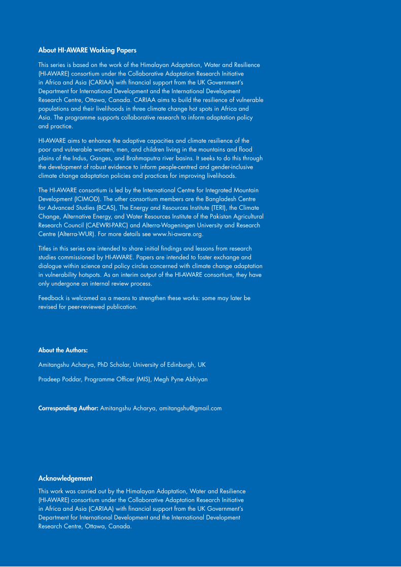
Figure 6: Picture of a revenue map of Dakshin Telua, land where Bariarpur is currently settled is shown as vacant
Source: Amitangshu Acharya
Present day Bariarpur
Source: Amitangshu Acharya
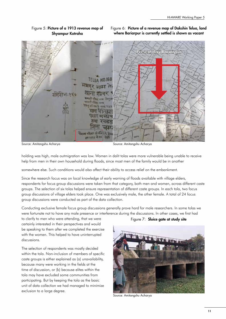
Figure 7: Sluice gate at study site

12
Before field data collection commenced, we had already acquired data on different caste groups residing in each tola. We would always double- check the numbers of participants at the beginning of every meeting and in the process ask if the group was representative. If it were was not, we would request for different caste group members to be approached and made a part of the meeting. Using these techniques, we managed to keep the focus discussion groups representative of the actual demography of the tolas.
For the discussions, permission to use a digital voice recorder for data collection was solicited at the very onset. In most cases, people agreed to it. But we also realized that the act of taking notes was far more subject to scrutiny than the use of a recorder. Taking notes gave the discussions an air of ‘official enquiry’, and made the data collection team look like government representatives. This often led to responses that tried to steer the conversation towards issues that was related to Government programmes or services, and not necessarily about our research questions. For example, in many discussions, men and women focused on talking about their grievances about the impending construction of a bridge on the Gopalganj highway. Most people thought that the bridge, when constructed, would lead to devastating floods. Our field visit coincided with a time when agitation against construction of the bridge was at its peak. In some villages, we were seen as Government representatives, and the meeting would start with people speaking out against the construction of the bridge. In fact, gaining confidence of people to commence with group discussions on local knowledge around flood-related issues took a significant amount of time, because we had to deal patiently with concerns about this bridge construction. But it also gave a window to understanding changing landscapes, people’s aspirations, and their understanding of floods.
Apart from focus group discussions, in-depth interviews of key informants were also conducted. These were selected primarily to understand the study area, institutional processes, and responses relating to floods, flood history, and local warning systems, all of which were difficult to capture separately through group discussions. The selection of key informants was based on a stakeholder list related to flood information systems drawn from literature and contacts available with local NGOs. The list was then expanded through snowball sampling. Prior consent for interviewing each respondent was requested and each were presented with the choice of keeping their individual identities anonymous. Unfortunately, since the key informants were mostly found to be performing an institutional role, it made it very difficult to gender-balance the sample.
This highlights the absence of women in institutional positions related to the formal circulation of information on floods.
The 12 focus group discussions took place in the 6 selected tolas, while the 12 key informant interviews spilled over to other Gram Panchayats, which were all inside Nautan Block, though.
Peoples perspective of upstream-downstream linkages of flood management
It is important to understand how people in the study site construct their idea of upstream and downstream, before delving into its complexities. In the study site there were two predominant conceptualisations of upstream-downstream linkages. One is related to the increase and decrease of the volume of water in the Gandaki, which they largely ascribe to operations of the Gandaki barrage upstream in Nepal. It was noted that across the study
Table 1: Details of sampled tolas
Gram Panchayat
Revenue village Total No of tolas
No of selected tolas
Name of tola Name of subtola Total households
Shyampur Kotaraha
Shyampur Kotaraha 11 3 Karisa ka tola NA 50
Baiju Bhagat ka tola NA 80
Devraj Yadav ka tola NA 55
Dakshin Telua Telua 19 3
Bariarpur Anniruddh Rai ka tola 66
Navrahi Muniram ka tola 220
Khutai Yadav ka tola 30
Total 30 6

13
HI-AWARE Working Paper 5
site, people correlated floods with release of water from the Gandaki barrage. It was well established within the communities that floods were a product of a sudden discharge of large quantities of water from the barrage. ‘Nepal ne paani chhor diya’ (Nepal has released water) is a common refrain in the area. Radio was the main source cited for the formation of such beliefs. Early flood warning messages usually communicated the quantum of water released and the place of origin. People reported that this message always sounded like this: ‘x cusecs of water released from Bhaisa Lotan, Nepal.’ Though it was not possible for the research team to check the veracity of the radio messages, people at the study site held Nepal as the primary agent behind floods. At certain focus group discussions, we were requested to convey a message to the Nepal Government so that they refrained from releasing water suddenly, which led to floods. But there was also some nuance in this perception. In some cases, people said that if it rained much in the hills, then the volume of water that would be added to the Nepali side of the Gandaki would be impossible for the barrage to hold. So it was natural for large amounts of water to be released, except that it was often too much and too sudden.
The other conceptualisation of upstream-downstream is centred on the tolas/villages located inside the embankment vis-a-vis those located outside the embankment. In a landscape where contour lines are as flattened as beaten rice, inscrutable gradient between two habitations poses a challenge to mainstream conceptualisation of upstream-downstream linkages. Hence even locally occurring upstream and downstream conflicts may seem improbable. Except that they do exist but are conceptualized differently. Schware (1982) had highlighted such a conflict in the Subarnarekha Basin, where impounding of floodwater by upstream villages for their paddy crop often posed a serious risk to downstream villages. If breached, it could lead to flash floods in villages downstream.
Similarly, at the study site, conflicts emerged between villages located outside the embankment and those within during floods. In 1993, floods resulted in escalated violence, when a breach of the embankment at Laukariya led to the flooding of the villages outside the embankment. As the villages outside the embankment started to get inundated, they wanted to ease out the water by breaching the embankment. But some of the people located on the inside, whose homes and homestead lands would be exposed to severe inundation, opposed the move. This led to a conflict between these two groups, which even led to firearm discharge and the death of someone. The villagers on the outside (i.e. upstream) managed to overcome those inside the embankment (i.e. downstream), and the resulting breach completely washed away the home of one Nathuni Yadav. Such incidents are only flashpoints emerging out of a long history of embankment politics, where, during floods, careful watch needs to be maintained on the embankment on people trying to breach it.
In this context of ‘outside-inside’ an embankment, as part of the upstream-downstream discourse, the operations of a sluice gate become critical. They are an integral part of maintaining water levels in the drainage channels. The sluice gate operators negotiate water flows between upstream and downstream in such situations and become mediators in the process.
Table 2: List of key informants interviewed
Serial No
Name Age Gender Occupation Gram Panchayat
1 Ramchandra Saini 65 Male Ex-Mukhiya, Dakshin Telua Dakshin Telua
2 Ram Agya Yadav 80 Male Ex-Mukhiya, Bhagwanpur Shivrajpur
3 Wakil Rao 45 Male Ex-Mukhiya, Shivrajpur Shivrajpur
4 Ram Pirit Rao 102 Male Farmer and oldest living person in Dakshin Telua Dakshin Telua
5 Chandrika Mahato 65 Male Ex-Chowkidar, Bihar Water Resources Department Bairia
6 Devender Shrivastav 65 Male Ex-Amin, Shyampur Kotraha Shyampur Kotraha
7 Shankar Gour 65 Male Ex-Chowkidar, Bihar Police, Nautan Thana Shivrajpur
8 Ambika Yadav 60 Male Mukhiya, Shyampur Kotraha Shyampur Kotraha
9 Mukesh Kumar 38 Male Thana Officer in Charge, Nautan Nautan
10 Krishna Ram 38 Male BDO, Nautan Block Nautan
11 Shiv Balak Singh 64 Male Amin, Dakshin Telua Dakshin Telua
12 Ravinder Misir 50 Male Panchayat Member, Shivrajpur Shivrajpur

14
At the study site, these operators are mostly embankment ‘chowkidars’ (i.e guards), hired by the Bihar Water Resources Department. They operate under a thin veneer of legitimacy simply because they are paid by the Department. On paper, their status as government employees is doubtful, since their tenuous contracts are managed through a muster roll for temporary hiring. Embankment chowkidar Chandrika Mahato explained the struggles of managing a sluice gate because of an upstream-downstream conflict this way:
‘In 2007, I was beaten up. I was asked not to open the sluice gates by people from outside the embankment. I told them I had to do what the Government had instructed me to. Still, they assaulted my children and me. When I complained to the Junior Engineer, he sent two jawans (policemen) from the Home Guard Division. But it turned out that these men were related to a family among the villagers outside the embankment. So they took their side. The sluice gate, if closed, would have allowed the upstream villagers to retain water in their fields for their paddy crop. But it was creating problems with flood management, yet the people outside the embankment refused to recognize that.’
The conflicts between ‘outside-inside’, which can be viewed as an upstream-downstream conflict, seem to play out every flood event, varying in intensity and scale. Local caste and class politics also play a role. The ‘outside’ villages are known to be in ‘sukhar’, i.e. the dry area, and tend to maximize their water access during floods accordingly. On the contrary, the low-lying ‘inside’ villages close to the river would prefer to see less inundation, because more would lead to crop damage. Since rainfall patterns are reported to have decreased in the last ten years, as reported by residents at the study site, this may affect such conflicts in different ways.
The upstream-downstream perspective on flood management in the study area reflects two kinds of perspectives. One, a macro-perspective, relates floods with the control of water by a different country, and is produced through a political discourse that is picked up by media and reproduced. So, this process reifies the belief that Nepal is responsible for floods in Bihar. Shifting away the cause to a larger entity, beyond the reach of flood-affected villagers, seems to have absolved political systems, hydro-bureaucracy, and other systems created for flood management of their accountability to flood affected populations.
This was quite evident in all discussions, where agitation against the Government or state agencies was mostly for not providing adequate relief on time. Not a single discussion even hinted that floods could be caused by mismanagement by state officials. The single-minded focus on Nepal as a causal agent for floods at the study site is interesting and worth further investigation.
The second perspective, which may be considered micro, is far more real to the people at the study site. This involves the dynamics between people outside the embankment and those within. The embankment is not just a hydrological separation, but also a socio-economic one. It animates deep-rooted caste and class conflicts, which flood events seem to amplify. While people can be alerted to flood occurrences in advance, flash floods prove much more difficult to predict, and the history of the landscape tells us that flash floods seem to have their origin in embankment breaches. As rainfall and flood patterns at the study site start to change due to climate change, upstream-downstream conflicts at local level will need persistent and more in-depth investigation.

15
HI-AWARE Working Paper 5
‘The River Itself Warns Us’: Local Knowledge and Flood Forecasting in the Gandaki River Basin
In the small habitation of Karisa ka tola located by the Gandaki River, the gentle heat of a retreating winter sun toasts freshly harvested mustard piled up against a mud-plastered wall. It has been a fairly chatty morning with men from the village. Our discussions get interrupted midway with the entry of much awaited tea in small steel glasses. ‘Let me put it across to you simply’, Chotelal Sahu speaks while sipping on the milky, sugar packed concoction, ‘whenever there is a possibility of a flood, we can tell it in in advance because the river itself warns us.’
Local knowledge of flood forecasting in the Gandaki river basin is deeply rooted in livelihood struggles, the memory of displacement, and experience of surviving floods. The Gandaki floodplains are a water-produced landscape or ‘waterscape’ (Swyngedouw 1999) and a ‘phenomenon whereby water and power shape each other to generate a continuously evolving socio-nature’ (Acharya 2015:374). In waterscapes, knowledge co-evolves with political and ecological changes. As discussed in the literature review, the use of the term ‘local knowledge’ is appropriate in such a waterscape, because with constant spatial and temporal changes to ecology and society, both claims to ‘traditional’ and ‘indigenous’ are rendered weak. But it does not diminish claims to robustness or rigour. It should be recognized as a form of a sophisticated knowledge system that continuously accommodates change.
The classification, collection, and representation of indigenous (and in our case local) knowledge systems through brief encounters are a contested process (Smith 2012). There are also larger concerns of intellectual property and ownership of knowledge.
For these reasons, our research attempted to be self-critical and was sympathetic to the concerns of the local population. It paid attention to the need to address a glaring gap in research on early warning systems and hazards. Our review of local disaster management policies revealed that concern with ‘local’ seems to have been to find out how to provide people with early warning information rather than to understand local forecasting knowledge. Our research aimed to question such a top-down approach to local people, as it denies them agency and depicts them as helpless without advanced information from sophisticated models and systems. On the contrary, as our study on the Gandaki river basin proves, ‘local’ should emerge as a site of generation of knowledge on flood forecasting rather than of dissemination. The hyper-local reality of floods in the Gandaki river basin provides a basis for a fine-tuned and time-tested local approach to early warning.
Also, while efforts at community-based early warning systems (CARE, 2015; Shrestha et al. 2014) seek to project a more granular and participatory approach, the agenda within such efforts was largely to find appropriate means to communicate a message effectively rather than acquire an understanding of and strengthen local knowledge systems.
This paper attempts to categorize local knowledge by borrowing from earlier works (Deken, 2007b; Irfanullah and Motaleb, 2011; Santha et al.,et al. 2014) but contextualizing it to the study site. Deken (2007b) categorizes local knowledge of early warning of hazards as visual indicators (like floating wood, snakes and other [dead] animals, and the muddying of waters), auditory (one’s like the sound of water similar to that of a rushing bus), and olfactory. Irfanullah and Motaleb (2011) categorize them indicators under the broad umbrella of hydro-meteorological and biological, while Santha et al. (2014) prefers categories such as biotic, oceanic, atmospheric, and celestial. However, such categorization is also problematic, for indicators often cross over or sits across different categories. This prompted Santha et al. (2014) to stress on how a holistic system of ‘kolu’ incorporated all the different indicators in different categories, which made the knowledge system flexible and iterative.

16
In the Gandaki River basin, documenting different flood forecasting indicators lead to formulating the following categories:
Phenomenological indicators
‘Halla’ (‘noise’ in Bhojpuri language in Bihar) emerged as the principal early warning indicator at the study sites. As water from the rivers starts to rise and approach the nearest house, the residents start shouting: ‘saria li ho, baad abatani’ (‘get your things, the flood is coming’). The house next to it picks it up and shouts it out further. This circulates across the village. It is important here to note that ‘halla’ is just not a warning shout but also a significant amount of noise coming from each house or tola, as the flood damage starts to take its toll. That is, warning shouts are just one component of ‘halla’. The other is the noise coming from the collapse of geheri/bedi (mud and bamboo grain storage structures, see Figure 8).
The bedi is important to a household as it stores an entire season’s supply of food grain. The collapse of a bedi, due to the weakening of its base, not only generates noise of its own, but is also accompanied by anxious cries from the household as they desperately try to recover as much of the stored grain from the floodwaters. The noise that is generated is significant and runs across long distances. The collapse of a bedi in a house is also considered to be a marker for the next household on how fast the water is approaching them. So, halla not only conveys a warning but also important information on the basis of which households take precautionary steps.
This is further exemplified by the way a message is circulated. It can contain things like: ‘water has reached at the roof of X’s house’ or ‘the bedi has collapsed in X’s house’ or ‘X has lost a buffalo’. News of such events gives valuable information to the neighbouring households on the nature of the flood. Awareness of the elevation of homestead land of neighbours or the height of a roof or cattle shed, and so on, allows for calculations on how soon the water will reach one’s own house, and if it does, the height to which the flood water will reach. This then helps prioritize which items will need to be protected. Notably in the case of flash floods, ‘halla’ is considered to be the most reliable system of early warning.
Table 3: Categories of local knowledge at study site
Category Explanation
Phenomenological Relating to human sensation and sensory qualities - seeing, hearing, feeling, etc. But it is not restricted to physical sensations alone, it also investigates a wider range of elements such as memory, sense of belonging, events, imaginations, and social activity
Ecological Relating to non-human behaviour, phenomena, and patterns
Riverine Relating to observations and measurements related to the river and its interaction with smaller streams and the flood plains. Any ecological aspect of flood forecasting that is related to the river is covered here.
Meteorological Related to wind movements, cloud and rain patterns
Celestial Related to appearance of specific constellations in the sky
Official Related to information provided by the government through radio, television, and newspapers, and circulated through word of mouth or mobile phones
Triangulating indicators This category attempts to capture the dynamism of local knowledge. It relates to knowledge produced through the interaction of the other categories, such as analysing ‘official’ early warning messages against ‘riverine’ or ‘ecological’ observations. It accounts for forecasting a flood event by bringing together different forms of information procured locally, and not any one indicator alone.
Figure 8: Bedi/gehedi, grain storage structures in the study site
Source: Amitangshu Acharya

17
HI-AWARE Working Paper 5
Apart from noise, specific sounds were also mentioned as an indicator of floods. Women were telling that if they went to their agricultural fields, located close to the river bank, for work in the morning during the flood season (mostly August), and found ‘chhap chhap paani’, they would immediately understand that a flood was imminent. ‘Chhap-chhap’ is an onomatopoeic term for the sound feet make while stepping in ankle-deep water. ‘Paani’ means water. So, the sound produced in ankle-deep water in an agricultural field served to indicate floods
At the study site, communities felt that, earlier, they could draw a strong correlation between heavy rains and floods. Respondents repeatedly and forcefully said that earlier the principal causal agent for floods was rainfall. Heavy rains would lead to standing water, and all the small creeks and streams used to fill up. This meant that as the river swelled from the rainwater it received, it started overflowing, for the smaller streams/channels could no longer absorb the water coming in from the river. People now believe rainfall has decreased significantly in the last two decades, and current flood events are a result of sudden releases from the reservoir (formed by the Gandaki barrage). Since rainfall and floods used to strongly correlate, forecasting rainfall was an important precursor to forecasting floods.
The words ‘umas’ and ‘ghaam’ were frequently referred to as an indicator of impending heavy rains. Both indicate humidity and heat. People believed if there was an excess of ‘umas’ and ‘ghaam’ close to the rainy season, it was a precursor to heavy rains.
‘Umas’ and ‘ghaam’ is not a simple meteorological or weather-based indicator but a specific bodily sensation experienced through sweating and enervation. When respondents were asked if this always correlated with high temperatures outside, they said no. ‘It could be a very hot day or week according to the newspapers, but that doesn’t mean it will rain.’ ‘Rain is predicted only when ‘umas’ is felt on the skin.’
While forecasting rains was critical for an understanding if a flood would follow, there were also specific practices that were still prevalent at the study site. These were meant to stop excess rains, which would lead to floods that, in turn, would damage crops.
One such practice was narrated to us as follows:
‘Earlier, we used to get nonstop rainfall for seventeen days. We haven’t witnessed such heavy rains in the last 10 years. Now, heavy rains barely last for an hour. But in earlier days, we used to get really worried, because it could lead to a flood that would damage our crops. So, anyone in the village who had only one son, had to take off all his clothes and stand in the middle of his field naked, in the early morning hours. In that state he had to tie a piece of cloth to a henga (a wooden plank or leveller) and then push it upright into the soil and leave it there. We believe that if Indra Dev (god of thunder and lightning) saw the henga planted in the soil with the cloth hanging from it, he would get scared and run away from that place, taking the rains with him. This we know, used to work, and some people would still do it today if it rained like that. But there was one big risk. If someone spotted the naked man, it would undo all the effort, and then it would rain even more. So, whoever planned to do it, had to make absolutely sure he wouldn’t get spotted. If he did, he would bring trouble to the whole village.’
Ecological indicators
Across the study site, a large number of ecological indicators were reported. As Schware (1984:61) discussed the utility of ‘environmental cues’ such as ants leaving the river banks and climbing trees and buildings prior to floods, likewise at the study site, the movement of ants was mentioned widely as a forecasting indicator.
But there was variance in the patterns across tolas. Some tolas reported that a rapid movement of ants either indicated heavy rain or floods. In another, the sight of small red ants moving with their eggs in their mouths indicated an imminent flood.

18
As Chandrika Mahato, ex-chowkidar of the embankment, narrated:
‘There is a special type of black ant that is visible just before (and during) the onset of heavy rains. They start coming out of the ground in large numbers with their eggs in their mouths and only travel in a straight line, like a railway track. But if they do not travel in a straight line, then it is indicative of some other disturbance. If they do, then it indicates either heavy rains or a flood.’
Another type of ant was also mentioned in different discussions. It is red in colour, has light wings, and flies in large numbers just before the rains. Insects as such were cited as reliable rainfall indicators across the study site. The notion of ‘barsati keeda’ (i.e. insects of rain) was widespread. Either the sudden emergence of a specific insect and their proliferation or increasing intensity of their activity was seen as indicative of rainfall. Among the insects whose emergence itself indicated the onset of rain was the ‘kutki’, an insect smaller than a mosquito but with a much more painful bite, which would lead to an immediate swelling and a reddish inflammation known locally as ‘chakta’. Another is an insect, which was referred to as ‘bhuchain’ in some tolas and ‘jholaheen’ at other places. Their sudden emergence in large numbers was also thought to be indicative of rainfall.
In terms of intensified activity, apart from the behaviour of ants, which has been discussed in detail, respondents mentioned the jhingur. (It is an insect that may be related to a type of cicada). It is known to intensify its singing just before the rains.
Interestingly, in every group discussion with women, one particular insect was mentioned repeatedly as a guaranteed indicator of heavy rains. Known locally as fatinga or fatingi (possibly dragonflies or damselflies), they told that just before heavy rains, the insect would gather and fly around in huge groups as if ‘dauri ka dauri’, (i.e. innumerable, traditional storage boxes) containing dragonflies had been opened up. Passing reference was also made to a sudden proliferation of mosquitoes and flies just before rains.
Another ecological indicator of rainfall was a specific type of frogs. It was believed that the croaking of a ‘peela mendak’ (yellow-bellied frog) was a common indicator of rain. This frog was referred to as ‘byagar byang’ in another discussion. Locally, it was believed that: ‘agar byagar bang boli, to khub barish ho jayee’ (‘if the byagar frog croaks, heavy rains will arrive soon’). This frog is supposed to be unique, because it mostly stays near standing water after the first brief spell of rain at the onset of the monsoon, and when it senses a heavy rainfall croaks very loudly. But once heavy rainfall occurs, it completely goes silent. Another type of frog mentioned in different tolas was the ‘bengchi’, a smaller variety of frogs, which suddenly arrive before the rains. In one tola, they were said to be very small and hard to locate, but before heavy rains or floods it would make a tremendous amount of noise. This difference between two tolas is interesting - one believing that the ‘bengchi’ brings normal rain and the other stating it to be an indicator of a possible flood from a heavy downpour. As most of our research proved, while some indicators were cutting across all tolas, some were very specific to one tola, where an indicator was mentioned only once.
An odd behaviour of the house sparrow (Passer domesticus), locally referred to as ‘gauriya’, is also indicative of rain. This involves the sparrow taking repeated ‘dust baths’.It rolls in the dust on the ground repeatedly and gets coated in it. The sudden mooing of several cows together for a longer duration of time was perceived as a bad omen; so it is also an indicator of floods during monsoons.
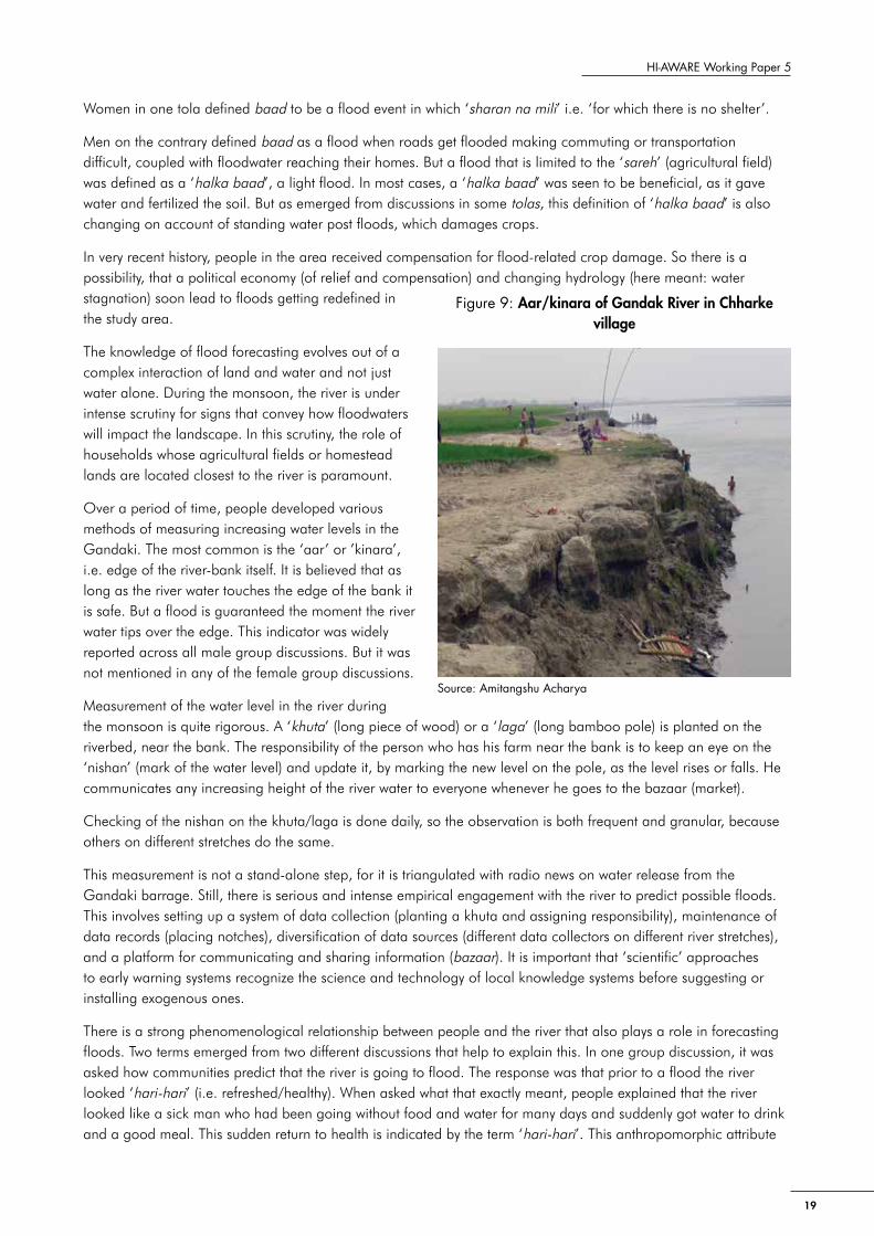
Riverine indicators
The river is definitely the most reliable indicator of flood forecasting. The close relationship that people share with the Gandaki River is evident in the variety of ways the river is observed and understood. But it is important here to distinguish different types of floods. The local word for flood is ‘baad’, but there is a significant amount of nuance in that word. If floodwaters are restricted to agricultural fields, and do not reach or submerge homestead land, they are generally not considered a ‘baad’. This word is used only to define events in which significant damage to home and livestock has taken place.
19
HI-AWARE Working Paper 5
Women in one tola defined baad to be a flood event in which ‘sharan na mili’ i.e. ‘for which there is no shelter’.
Men on the contrary defined baad as a flood when roads get flooded making commuting or transportation difficult, coupled with floodwater reaching their homes. But a flood that is limited to the ‘sareh’ (agricultural field) was defined as a ‘halka baad’, a light flood. In most cases, a ‘halka baad’ was seen to be beneficial, as it gave water and fertilized the soil. But as emerged from discussions in some tolas, this definition of ‘halka baad’ is also changing on account of standing water post floods, which damages crops.
In very recent history, people in the area received compensation for flood-related crop damage. So there is a possibility, that a political economy (of relief and compensation) and changing hydrology (here meant: water stagnation) soon lead to floods getting redefined in the study area.
The knowledge of flood forecasting evolves out of a complex interaction of land and water and not just water alone. During the monsoon, the river is under intense scrutiny for signs that convey how floodwaters will impact the landscape. In this scrutiny, the role of households whose agricultural fields or homestead lands are located closest to the river is paramount.
Over a period of time, people developed various methods of measuring increasing water levels in the Gandaki. The most common is the ‘aar’ or ’kinara’, i.e. edge of the river-bank itself. It is believed that as long as the river water touches the edge of the bank it is safe. But a flood is guaranteed the moment the river water tips over the edge. This indicator was widely reported across all male group discussions. But it was not mentioned in any of the female group discussions.
Measurement of the water level in the river during the monsoon is quite rigorous. A ‘khuta’ (long piece of wood) or a ‘laga’ (long bamboo pole) is planted on the riverbed, near the bank. The responsibility of the person who has his farm near the bank is to keep an eye on the ‘nishan’ (mark of the water level) and update it, by marking the new level on the pole, as the level rises or falls. He communicates any increasing height of the river water to everyone whenever he goes to the bazaar (market).
Checking of the nishan on the khuta/laga is done daily, so the observation is both frequent and granular, because others on different stretches do the same.
This measurement is not a stand-alone step, for it is triangulated with radio news on water release from the Gandaki barrage. Still, there is serious and intense empirical engagement with the river to predict possible floods. This involves setting up a system of data collection (planting a khuta and assigning responsibility), maintenance of data records (placing notches), diversification of data sources (different data collectors on different river stretches), and a platform for communicating and sharing information (bazaar). It is important that ‘scientific’ approaches to early warning systems recognize the science and technology of local knowledge systems before suggesting or installing exogenous ones.
There is a strong phenomenological relationship between people and the river that also plays a role in forecasting floods. Two terms emerged from two different discussions that help to explain this. In one group discussion, it was asked how communities predict that the river is going to flood. The response was that prior to a flood the river looked ‘hari-hari’ (i.e. refreshed/healthy). When asked what that exactly meant, people explained that the river looked like a sick man who had been going without food and water for many days and suddenly got water to drink and a good meal. This sudden return to health is indicated by the term ‘hari-hari’. This anthropomorphic attribute
Source: Amitangshu Acharya
Figure 9: Aar/kinara of Gandak River in Chharke village

20
to describe a river in full sway was also apt. When the river was ‘hari-hari’, the ‘sotis’ (i.e. small river channels) started to fill up with water, which indicated an imminent flood. The terms almost brought to the fore an image of blood rushing in full force through human veins.
Another term used to indicate a river about to flood is ‘chamak’. This translates into ‘shine’, but also indicates a change of colour of the river water. It was generally agreed that the river started to acquire a ‘gerua’ (ochre) or ‘peela’ (yellow) ‘colour’ before floods, which indicated to local people that much water was coming from Nepal. This was largely ascribed to rains in the hills of Nepal, where heavy rains would wash off soil and enter the river. While the main river carried soil and silt and acquired a ‘gerua’ colour, smaller river channels were ‘shaola’ (i.e., dark). This means it had a darkish, transparent colour, very similar to that of Krishna’s5 skin.
The river water is usually transparent but loses that quality when it is going to flood. The ‘shayar ka paani’ (i.e. rain water), which fills up the smaller streams, moves towards the river and is very ‘saaf’ (i.e. clear). When smaller streams carrying rainwater start to lose their transparency, people know that floodwater from the river has entered the village. It may also mean that an embankment has breached somewhere.
Clouding of the water in smaller streams means that ‘mitti’ (i.e. soil) from the main river (referred to sometimes as dariya) has entered habitation area and floods are imminent.
The importance of the interaction of smaller streams and the main river is also apparent in the behaviour of ‘baikhi’6 fish. As the water in the river rises, it carries fish with it, which is then transferred to the streams. The fish is thought to understand that they are close to ‘naya paani’ or clearer/fresher water, and they start to jump to enter the smaller streams. This jumping of ‘baikhi’ fish is a sure indicator of the onset of floods. If it doesn’t jump, it means that water from the river will not overflow into the land. Its jumping indicates that the river is rising. If the fish is not at all visible, it means that the river water has receded and there will be no flood.
The fact that one species of fish can indicate three different types of river behaviour, is an example of the fine-grained observation that emerges out of a long period of engagement and experience. The presence and absence aspects of an indicator are at display here. The presence of baikhi indicates rising water levels, its jumping indicates imminent floods, and its absence indicates river water receding, thereby nullifying the possibility of a flood.
Such experience also allowed local communities to distinguish patterns by observing the flow and turn of the river. There are references to elders like the late Puran Yadav in Shyampur Kotraha, who could look at the river and accurately estimate where it would erode (katai) the bank. People believed there is generally a lean period of 3 years, after which the water of the river again swells up. On very rare occasions some had seen a deviation from this pattern. Since the last flood was witnessed in 2013, it was assumed that this year, 2016, would definitely be a flood year (which is now proved to be correct).
Interestingly, some mentioned that, earlier, people not only knew how to predict river flows and floods better, they also knew how to deal with floods.
Chotelal Sahu from Karisa ka tola says:
‘We are no longer capable (‘dheet’) of dealing with floods. Earlier, our forefathers kept a large number of livestock, and could manage them and take care of them during floods. They could dismantle an entire house, transport it somewhere else, and set it up again. We can’t do all that. Our children won’t even be able to imagine it.’
Meteorological indicators
In the study area, knowledge of the movement and pattern of wind, clouds, and rainfall also played a significant role in forecasting either floods or heavy rains that could cause floods or amplify damages caused by them. There was complete consensus across all discussions and interviews that rainfall had decreased significantly in the study
5 Dark-skinned human incarnation of Lord Vishnu, a god worshipped in India and other parts of South Asia.6 Scientific name of baikhi could not be established

21
HI-AWARE Working Paper 5
area since the 1990s, more so in the last ten years. Interestingly, this correlates with meteorological data published by the Indian Meteorological Department between 1901-2002 (see Figure 10). Earlier, rains were described as continuous for a minimum of a week, and maximum for 15-17 days. In this period, it was rare to see a sunny day in-between. Because of walking in ‘pak’ (mud) all day, people used to get boils between their toes, for which crushed ‘desibabool ke patte’ (leaves of the Acacia nilotica) used to be applied for healing. Elderly women mentioned that earlier it used to rain so much that they had to sit in waist-deep water to plant paddy.
Such anecdotes are coupled with the belief that a decade or two ago, floods had a strong correlation with rainfall. Heavy rains used to result in floods, as the entire area used to get waterlogged including the streams. This meant, when the river swelled, it had nothing to absorb its excess water and slow down its progress. As a result, it would spread over a larger area. This meant that understanding rainfall was integral to forecasting, because continuous rain for 24 hours over a few days always led to floods.
Jan Mohammed from Khutai believed that rainfall patterns can be gauged easily by looking at the ‘rang’ (colour) and ‘ruab’ (shape/form) of clouds. Dark clouds, unlike what is commonly believed, ‘fat jate hain’, i.e. crack/dissipate easily. So they do not bring heavy rains. The light-coloured clouds are deemed to bring rain. The same is heard in Navrahi in Muniram ka Tola: ‘Light-coloured clouds bring more rain’, people said.
Source: India Water Portal
Figure 10: 100 year annual average precipitation in Pashchim Champaran

22
Local communities also believe that the direction from where clouds emerge tells them if it is going to rain or not. The northwest corner of the sky is known as ‘bhandarkon’, and clouds emerging from there are believed to bring rains surely. Interestingly, people mentioned that clouds emerging from the southern corner of the sky usually do not bring rain. But if they do, it can lead to a deluge. Chandrika Mahato’s comment on clouds aptly summarized the discussion on clouds: ‘Badalon mein bhi pran hain’, meaning ‘even clouds have life in them’.
As regards wind movement, it was believed that the west wind (purbi/purba hawa) is an assured indicator of imminent rain.
Celestial indicators
‘Jab purwa purbaiyya pabe tab sukhli gadaiya nao chalabe’
This saying translates as: ‘When the west wind (purbaiyya) starts blowing under the Purwa constellation, there will be so much rain one can sail a boat (nao) in the low-lying dry river channels (sukhli gadaiya).’
The saying, mentioned in a group discussion with men in Aniruddh Rai ka tola in Bariarpur, opens a window to how different indicators are triangulated to come to a definite conclusion about a weather event. It also points at problems of pinning down specific articulations and experiences into separate categories.
It was believed that the reason for inadequate rains was the disappearance of rain-related constellations in the last ten years. The Purwa constellation was reported not having been spotted for several years. Neither was the Hathiya (elephant’s trunk) constellation, which is visible in October. It is believed that under the latter, a spell of rain improves soil quality significantly.
Official indicators
The previous indicators describe a hyper-local, community-based, and gender-specific knowledge of forecasting floods. In this section, the optics turn to official forms of early warning and forecasting of floods communicated to communities at the study site.
Research clearly points to the importance of radio as the key medium for warning communities about an impending flood, or its possibility. It is hard to pinpoint when exactly radio warnings started getting aired, but people in the study area believe that to be the 1990’s. Official records may show radio alerts having been aired much before, but people seem to remember hearing flood alerts only after the infamous breach of the Champaran embankment at Laukariya in 1993. It had inundated areas outside and inside the embankment and rendered several villages ‘bechiragi’7 (a village where lamps have been extinguished, so: desolate, see Figures 11 and 12)*. The flood had
7 * ‘Bechiragi’ (literally: without lamplight) is a poignant term for loss, when in an entire area the warm light of a lamp inside a house, once indicating habitation, hope, and hospitality, has been wiped out in a moment?.
Figure 11: Patkhaulia Village: rendered ‘bechiragi’ after the 1993 floods
Source: Amitangshu Acharya

23
HI-AWARE Working Paper 5
Figure 12: Map location of Patkhaulia village, now ‘bechiragi’
Source: Google maps

24
eroded both agricultural fields and homestead land, leading to mass evacuation of all villagers, deserting the village. The information was broadcast over the radio. This may be the reason for associating radio alerts with floods.
According to the local community, the nature of the floods changed from rainfall- dependent to that of water discharged from the Gandaki Barrage at Valmiki Nagar. During the monsoon season announcements are aired on the radio, which give information on how much water has been released from the barrage. This is expressed in cusecs or cubic feet per second. (One cusec equals approximately 28 litres per second.)
In the last 3 decades, dependence on formal sources of information such as radio and newspapers, which track water releases from the barrage, has increased substantially.
Granted that information on how much water has been released is communicated through radio, how that information travels to a radio station, newspapers, and Government officials is still quite unclear. At District level, the information reaches the District Magistrate who then passes it on to the Block Development Officer (BDO) and District Superintendent of Police (DSP). The BDO shares the information with the local mukhia (i.e., village headman) and others with cell phones. The news to the Block Police Station comes to the Station In-Charge, although he receives his information directly from the District Police Headquarters. He alerts the village chowkidar on his mobile phone.
Finally, there is another source of information for the village, which is the Bihar Jal Sansadhan Bibhag or the Bihar Water Resources Department. They get their information directly from the barrage, and then the Junior Engineer (JE) informs the local embankment chowkidar to alert people. If the risk is significant, these kinds of alerts are amplified through announcements made from the local police station, from where a police constable goes around the villages alerting people in a hired vehicle. At the same time, the embankment chowkidar also shouts out an alert, when he receives information of a possible flood situation from the JE.
At the study site, there was a high degree of faith in the early flood warning on radio. But the local samachar, or local news, is aired in only two slots, early morning and late evening, mostly at 8 a.m. and 7:30 p.m.. In between it is rare for alerts to be aired, unless it is a serious emergency. In case a large volume of water is released and there is imminent danger to life or habitations from an impending flood, the local administration is supposed to give that information.
During data collection, it appeared that the perception of formal early warning systems outside radio and newspaper was bleak. In most cases, news on the radio was heard within a family or a tola only. The message would only give an estimate of the total volume of water released. It did not tell people if they were in danger or not. This has led to people working out a way to assess their risk.
There was almost consensus that people rarely saw a Government official announcing early flood warnings, though an elected mukhiya advised not to believe that. His perception was that people generally prefer to mention some absence of state services, while in fact, in case of emergencies, officials or representatives would come to villages to make announcements. Clarity came from a former elected mukhiya, who said that if officials arrived to the village at all, they would come by vehicle over motorable roads only. This meant that most tolas spread across and located far away from such roads never heard the announcements. This was mentioned in all the focus group discussions in Karisa ka Tola and Baiju Bhagat ka Tola, both of which are located closest to the river in the study area. This area, a large patch of silted land that receives floodwater, is known as diara area. Such areas are mostly not connected to roads nor do they have an electricity network. People said no official ever came to the diara area, especially in the rainy season when ‘kutcha’ (i.e., earthen) roads are impossible to negotiate.
Given the social complexity and spatial spread of the tolas, formal early warning systems seemed not to be working very well. Moreover, there seemed very little coordination between different arms of the state bureaucracy machinery. This means that, even if information reached the village, it would have come from multiple sources, each source not necessarily communicating with each other.

25
HI-AWARE Working Paper 5
The bazaar or marketplace remains an important news exchange platform. Early warning is heard either on the radio or read in a broadsheet and discussed. As people get back to their tolas, they circulate the news.
It is important to note that the entire official early warning system is androcentric. Women talk about how they do not get ‘paani ka khabar’ (water or flood news) directly from any official, but have to wait for the men to bring it in. This is because the way a message is conveyed on radio, mentioning obscure numbers, requires mediation and interpretation. This is a role the men in the house play. Accessing news from the bazaar is not possible for women, as social and cultural barriers do not allow them to move around in such spaces. So, women are totally dependent on men to give them information procured from official sources about a possible flood event.
This raises a question on how households from which most men have migrated or women-headed households can access information that is vital to their survival. Though the halla is a community process, it may be sometimes too late for adequate preparations. An elderly woman was asked if she knew of incidents where women had not received information. She replied: ‘Suchna na mili, to suthle rahein gayee, khana na mili’ (‘If a woman doesn’t receive information, she is left behind while sleeping, and has to go without food.’
If one were to do a detailed analysis of the official early warning system at the study site, it would perhaps reveal the degree of gender-blindness embedded in it, which gets reproduced continuously. The lack of clarity both at village level and with Government officials on how exactly the early warning system works, points to a need for a full-fledged institutional and communication design study that can help understand how such formal systems, on which so much depends, can be made more efficient, gender responsive, and transparent.
Triangulating indicators for early warning
It was more than obvious during fieldwork that local knowledge of flood forecasting had not been built on a single indicator alone but by triangulating different ones. In most cases, official indicators were triangulated with ecological, riverine, and more of such indicators to increase reliability and make decisions. This process was based on a long exposure to a shifting landscape. It was coupled with accommodating new knowledge being produced outside their immediate surroundings and made available through television, mobile phone and newspaper.
Another exogenous source of knowledge are migrant workers returning from different parts of India and abroad with new information, technology, and ideas. Fieldwork clearly showed that the process of triangulation was largely androcentric, since men had access to formal and official early-warning information and riverine forecasting indicators and most women had not. So, halla for example, was an end product of triangulating different types of information. Women and children could be part of circulating this ‘noise’ all right, but were not necessarily in a position to contribute to information for its production.
Tracing how information is processed till it becomes a ‘halla’ is difficult. As it is, such an exercise is tola or community specific. In some group discussions, the practice of the so-called 25%-formula came up. It was described like this:
Usually, the only information available from the radio is the quantity of water released. It does not communicate which areas will be inundated and when that will happen. The community only has an obscure number to base their decisions on, which is the total volume of water released in cusecs. Over a period of time, as was observed in our study area also, it takes an average 3-4 days from the day the announcement of the release of the water is made on the radio, for the news to reach villages. But this estimate is based on the volume of water released only. The more volume released, the faster the water may reach a village. In most cases though, so it was believed, only 25% of the total water released would reach a village. So, if 10 lakh cusecs were released, only 2.5 lakhs would reach the area. Similarly, if only 2-3 lakhs were released, it would take more time to reach, and would have much less, if not negligible impact. Once the water level in the river starts to rise, people who live close to it begin to measure it using a ‘laga’ or a bamboo pole. They intermittently share the information of the height of the river in terms of the measuring tool, like ek laga, do laga, teen laga (:one, two, three lagas).

26
The flow of the river is also observed carefully. If the current is flowing towards Gopalganj, it is believed it will not flood the villages on this side. But if it also rains heavily and water is also released from the barrage, then the chance of a flood occurrence goes up. Even if the volume of release is deemed safe going by the 25% rule, the fact that the smaller streams are already full with rainwater means that these conditions could still lead to a flood.
Based on these factors (and perhaps much more) communities would work out the possible height of the floodwater in terms of ‘feet’. This message would then be circulated through the ‘halla’. The higher the measurement is in ‘feet’, the greater the risk. Many preparations for the floods are made on the basis of these calculations, like the amount of food to be stocked on the roof, or whether livestock needs to be shifted or not.
It is important to note here that with these complex calculations involving several indicators, local people have managed to deal with floods. What they have suffered from, and what seems to evade such complex and nuanced calculations, are flash floods that occur from a breach in the embankment. The 1993 flood, which caused much death and destruction, was because of a breach of the embankment at Laukariya. But people did say they had spotted the possible point where the river was cutting into the embankment at that time, and loads of sacks full of soil were put to keep the embankment intact, yet the river finally won. It devastated the habitations in higher areas, but left the lower areas relatively safe, much to the surprise of the local population. On the other hand, there are examples of how people had predicted a flood incorrectly and suffered for the same. The local knowledge system is not fool proof, but it is definitely the best people have.

27
HI-AWARE Working Paper 5
Conclusion and Recommendations
The visible presence of the state in altering the river through infrastructure of various kinds, such as a barrage, canals, embankments, and roads is a paradox to its complete absence from people’s lives already rendered uncertain due to such infrastructure development. The Government continues to build infrastructure and alter hydrological regimes, and people continue to adapt. This is not a linear narrative of helplessness and lack of agency, but a reflection of how people affected with floods develop practical knowledge to survive in challenging circumstances.
Understanding such complex knowledge systems, their production and consumption, requires a significant amount of time. Our research merely touched on issues that deserve serious follow-up. There is little doubt that people living in the Gandaki river basin have developed a highly evolved knowledge system to forecast floods. Understanding and appreciating that should be a precursor to any discussion of early flood warning systems. Strengthening such systems through inter-generational transmission would ensure longevity.
But more importantly, much work needs to be done to improve the quality and content of official early warning alerts that do give accurate numbers but make little sense otherwise. To make it fully usable, local populations deploy a complex, interpretive logic. Given that they are making the most of what they have, strengthening the weak components within the present system will make it more effective rather than trying a freshly minted exogenous one. This will require, foremost, that local populations be recognized as knowledge holders and producers, and not mere consumers of some knowledge system.
The entry of cellular services into the landscape is reshaping the flow of communication. It is allowing women to call doctors to their doorsteps during floods, coordinate with their family members, and keep their husbands and relatives updated about their well-being. Mobile phones have also brought in significant improvements in communication for different departments. For instance, BDOs now directly inform ‘mukhias’ of possible floods, and they get regular updates of the extent of floods and plan relief in return. Sluice gate operations are now faster, because a quick call to the chowkidar from the engineer ensures faster operation.
All this, interestingly, is not state endorsed. Government staff is investing in mobile phones themselves. Engineers are buying mobile phones for embankment chowkidars from their own pockets. Officially, there is no budget for such technology, even though it is far-reaching and critical for adoption. Strengthening and improving the existing system of local knowledge on flood forecasting, coupled with practical ways to include new technologies such as mobile phones, could make things easier for people in the Gandaki flood plains, especially women.
There is little or no doubt that the official early flood warning system is gender-blind. Men occupy most of the official positions (as listed in the methodology section in this report) within the local political and administrative systems. The absence of women in such positions, by default, keeps them out of the information loop. The circulation of early warning information within largely male circles in villages creates a clear dependence on them for information on floods. As was articulated in group discussions, by the time such news reaches women in the village, the flood waters may have already approached close by, which means they have very little time to prepare. This is especially true for single women, with or without children, and married or not, who are most affected. With male members of the family away for work, they are completely disconnected from the androcentric network of early flood warning systems. The indicators that women use to predict heavy rainfall or floods are no buffer for them against large floods brought about by operations on the Gandaki Barrage. For this information only reaches the village, and specifically the men, through radio and newspapers, all of which this particular group of women has no access to.
We observed during fieldwork that a change in such local knowledge asymmetries was being brought about through the rapid proliferation of mobile phones. In Navrahi, dalit women extolled their virtue. Access to such

28
phones enables them to call their husbands and brothers in a flood situation to update them of their status. They use the phone to call a doctor if a woman in the tola is in labour during floods. If the doctor needs a boat to come to the tola, they have the phone number of the boatman to direct him to pick up the doctor and bring him to the house. Women also recounted how, in 2012, news of possible floods in their area had reached them through relatives. They had then watched TV and called the mobile phones of women in Navrahi to alert them of a news flash about an impending flood. Though the flood never took place, it is an interesting insight into how mobile phones are increasingly helping women and how they are breaking into the largely androcentric network of information and services because of these phones.
Local knowledge around flood forecasting is operating within a continuously evolving socio-ecological and technological system. The triangulation one sees in action in the study area is evidence of this at work. But such knowledge is largely ignored. This cognitive blind side is global phenomenon and not unique to the study site. But such blind-sidedness has its inherent dangers. Given the shifting rainfall patterns in the area, coupled with a notorious course shifting river system of the Gandaki, there is a need for a close-grained observation of clues to improved and adaptive flood management.
The wealth of indicators and knowledge that emerged from a remarkably small study area is compelling evidence that substantially more will be available in a bigger catchment. The usability of local knowledge lies in its hyper-local context. It is doubtful if centralized flood prediction systems can give such granular data to people in the Gandaki flood plains. In fact, the current, official system of early warning does not deal with granularity at all. It actually warns a significantly large area of an impending flood and leaves it to local people to arrive at their own arithmetic. Yet, the argument can also be reversed. Usable local knowledge is so rooted in its context: would it still be usable to areas or contexts beyond its area of production and consumption?
These are larger questions, which this report is not geared to address. Still, the following set of recommendations appear self-evident from the data and observations from our fieldwork:
Recognition of local knowledge: The science of flood forecasting has largely sanitized itself of local knowledge. Very little attention has been paid to people’s ability to contribute their knowledge and experience on forecasting. There is a need to set up a platform between flood forecasting scientists and local knowledge holders to understand how knowledge exchange can be shaped that will be useful to people in flood-prone areas. This kind of an exercise is fraught with the risk of ‘scientization’, though (Agarwal 2002). Because, then, local knowledge would be valued for its parts rather than the whole.
More detailed research into local knowledge can give an understanding of how such dialogues can be made to acquire the required nuance. Recognition and interaction with such knowledge systems will only serve to strengthen climate change adaptation measures. But perhaps equally important is the sharing of current research findings back to people at the study site, or with a larger audience in the flood-prone plain. It will not only ensure a flow of research findings back to the community, but also hopefully rekindle interest and enthusiasm for local knowledge and flood forecasting within village communities themselves.
Early warning at scale: It is evident from the study that water release from the Gandaki barrage is the fundamental cause of floods in the area. Unfortunately, the present centralized early warning system is only constituted of bits of empirical information. While people at the study site are trying to make the most of such parsimonious data sharing, much can be done to improve the messaging of radio, tv, and newspapers. This will require rigorous engagement with unwieldy bureaucracies but can lead to working and improving early warning systems at scale. A calibrated radio message that gives information on specific areas that could be inundated as also when and how long flood waters would stand, etc., will be useful.
Smaller engagements and studies: These can add value to larger engagements such as working on an early warning system at scale. For example: • A study of radio communication of floods in Bihar from All India Radio Archives• Workshop/training for local newspaper and tv journalists on interpreting and presenting flood data• Researching the full administrative set-up of how information on flood forecasting is shared within the
Government and disseminated to people. Our fieldwork revealed that there seemed to be a great deal of ambiguity in understanding this, even with Government functionaries.

29
HI-AWARE Working Paper 5
Studying Outside-Inside Conflicts for flash flood insights: The study site had a number of incidents in the recent past related to conflicts between villages located inside the embankment and those outside during a flood event. In many cases, competing interests frame such conflicts. Such issues are essentially a different version of an upstream-downstream conflict at a micro level. Studying this in greater detail can give useful insights into embankment politics and causative agents that trigger flash floods.
30
References
Agrawal, A (2002) ‘Indigenous knowledge and the politics of classification’. International Social Science Journal, 173: 287-97
Aikenhead, GS; Ogawa, M (2007) ‘Indigenous science and knowledge revisited’. Cultural Studies of Science and Education, 2: 539-620
CARE (2015) ‘Integrating disaster risk reduction and adaptation to climate change: Community-based early warning systems in Dakoro, Niger’. Practitioner Brief 2
Berkes, F (2008) Sacred ecology. Routledge, New York, USA
Blaikie, P; Brown, K; Stocking, Ml; Tang, L; Dixon, P; Sillitoe, P (1997) ‘Knowledge in action: Local knowledge as a development resource and barriers to its incorporation in natural resource research and development’. Agricultural Systems, 55(2): 217-237
Chambers, R (1994) ‘Participatory Rural Appraisal (PRA): Challenges, potential and paradigm’. World Development, 22(10): 1437-1454
Chalmers, N; Fabricius, C (2007) ‘Expert and generalist local knowledge about land cover change on South Africa’s Wild Coast: can local ecological knowledge add value to science?’ Ecology and Society, 12(1):10
Chapman, GP (1983) ‘The folklore of the perceived environment in Bihar’. Environment and Planning A, 15: 945-968
Chapman, PM (2007) ‘Traditional ecological knowledge (TEK) and scientific weight of evidence determinations’. Marine Pollution Bulletin, 54: 1839-1840
Davis, A; Ruddle, K (2010) ‘Constructing confidence: rational skepticism and systematic enquiry in local ecological knowledge research’. Ecological Applications, 20(3): 880–894
Dekens, J (2007a) Local Knowledge for Disaster Preparedness: A literature Review. Kathmandu: International Centre for Integrated Mountain Development
Dekens, J (2007b) The snake and the river don’t run straight: Local knowledge on disaster preparedness in the Eastern Terai of Nepal. Kathmandu: International Centre for Integrated Mountain Development
Ellis, SC (2005) ‘Meaningful consideration? A review of traditional knowledge in environmental decision making’. Arctic, 58(1): 66-77
Failing, L; Gregory, R; Harstone, M (2007) ‘Integrating science and local knowledge in environmental risk management: A decision-focused approach’. Ecological Economics, 64: 47-60
Goebel, A (1998) ‘Process, perception and power: notes from ‘participatory’ research in a Zimbabwean resettlement area’. Development and Change, 29(277): 305
Government of Bihar (2013) Hazard, Vulnerability and Capacity Assessment Report.
Government of Bihar, (2013) District Disaster Management Plan, West Champaran.
Green, LJF (2008) ‘Indigenous Knowledge’ and ‘Science’: Reframing the Debate on Knowledge Diversity’. Archaeologies: Journal of the World Archaeological Congress, 4(1): 144-163
Huntington, HP (2000) ‘Using Traditional Ecological Knowledge in Science: Methods and Applications’. Ecological Applications, 10(5): 1270-1274
Irfanullah, MH; Motaleb, AH (2011) ‘Reading nature’s mind: disaster management by indigenous peoples of Bangladesh’. Indian Journal of Traditional Knowledge, 10(1): 80-90
Lebel, L (2013) ‘Local knowledge and adaptation to climate change in natural resource-based societies of the Asia-Pacific’. Mitigation Adaptation Strategies Global Change, 18:1057-1076

31
HI-AWARE Working Paper 5
Mapinduzi, AL; Oba, G; Weladji, RB; Colman, JE (2003) ‘Use of indigenous ecological knowledge of the Maasai pastoralists for assessing rangeland biodiversity in Tanzania’. African Journal of Ecology, 41: 329-336
Mustafa, D; Gioli, G; Qazi, S; Waraich, R; Rehman, A; Zahoor, R (2015). ‘Gendering early flood warning systems: the case of Pakistan’. Environmental Hazards, 14(4): 312-328
Palmer, CT; Wadley, RL (2007) ‘Local Environmental Knowledge, Talk and Skepticism: Using ‘LES’ to Distinguish ‘LEK’ from ‘LET’ in Newfoundland’. Human Ecology, 35: 749-760
Paul, BK (1984) ‘Perception of and agricultural adjustment to floods in Jamuna floodplain, Bangladesh’. Human Ecology, 12(1): 3-9
Paul, SK; Routray, JK (2010) ‘Flood proneness and coping strategies: the experiences of two villages in Bangladesh’. Disasters, 34(2): 489-508
Raymond, CM; Fazey, I; Reed, MS; Stringer, LC; Robinson, GM; Evely, AC (2010). ‘Integrating local and scientific knowledge for environmental management’. Journal of Environmental Management, 91: 1766-1777
Santha, SD; Gahana, P; Aswin, VS (2014) ‘Local knowledge, early warning and coastal hazards: Participatory inquiry among fish workers in Kerala, India’. Action Research, 12(3): 273-292
Schware, R (1982) ‘Official and folk flood warning systems: an assessment’. Environmental Management, 6(3): 209-2016
Schware, R (1984) ‘Flood information systems: Needs and improvements in Eastern India’. Environmental Management, 8(1): 55-66
Shrestha, MS; Kafle, S; Gurung, M; Nibanupudi, HK; Khadgi, VR; Rajkarnikar, G (2014) Flood early warning systems in Nepal: A gendered perspective. ICIMOD Working Paper 2014/4, Kathmandu: ICIMOD
Sillitoe, P (1998) ‘What, know natives? Local knowledge in development’. Social Anthropology, 6(2): 203-220
Smith, LT (2012) Decolonizing Methodologies: Research and Indigenous Peoples. Zed Books, London
Smith, TA (2011) ‘Local knowledge in development (Geography)’. Geography Compass, 5(8): 595-609
Steele, MZ; Shackleton, CM (2010) ‘Using local experts as benchmarks for household local ecological knowledge: Scoring in South African savannas’. Journal of Environmental Management, 91:1641-1646
Shrestha et al. 2014 (DETAILS MISSING)

32
© HI-AWARE 2016
Himalayan Adaptation, Water and Resilience (HI-AWARE) Research
c/o ICIMOD
GPO Box 3226, Kathmandu, Nepal
Tel +977 1 5003222
Email: [email protected]
Web: www.hi-aware.org