Embed Size (px)
Citation preview

John Mock, “The Red Buddha Hall Road Revisited: New Information about the Tibetan and Tang Empires in Afghanistan Wakhan”, Revue d’Etudes Tibétaines, no. 45, Avril 2018, pp. 89-109.
The Red Buddha Hall Road Revisited: New Information
about the Tibetan and Tang Empires in Afghanistan Wakhan
John Mock
(Independent Scholar)
gog. yul. du. rgya’i. byim. po. byungste/ bru. sha. dang. gog. stord/ “The Chinese byim-po arrived at Wakhan (Kog-yul). Bru-sha and Wakhan
(Gog) were lost.”1
his brief entry in the Old Tibetan Annals for the year 747-748 CE records the Tang Empire’s campaign against the Tibetan Empire in Wakhan, in which General Kao Hsien-chih’s 10,000
troops defeated a similarly-sized Tibetan force near present-day Sarhad-e Broghil in the Wakhan District of Afghanistan’s Badakhshan Province, an event more fully recorded in the Tang Annals2.
Departing from Kucha, General Kao led his army via Kashgar and Tashkurgan to the Pamir. At a valley called Te-le-man3, he divided his army into three. His strategic aim was to attack the Tibetan-occupied fort Lien-yün4 at the northern base of the Broghil Pass in Wakhan. Three thousand horsemen went via the “northern gorge”5; a second group went via the “Red Buddha Hall Road”6; and the general himself and the Imperial Commissioner went via the “kingdom of Hou-mi”, which Chavannes (2006, p. 184) identified as the kingdom of Wakhan.
1 Dotson 2009, p. 127-8. Original text available online at otdo.aa-ken.jp/ 2 Found in the biography of Kao Hsien-chih in the Chiu T’ang shu chapter 104 and
translated by É. Chavannes (Chavannes 1903/2006, p. 183-187. Page numbers refer to the internet edition.). M. A. Stein (1922) interprets the narrative in conjunction with his (Stein’s) 1906 visit to Wakhan. C. Beckwith (1987, p. 130-133) offers a revised reading of the original biographic narrative. Transcription of Chinese names follows that used by Chavannes, Stein and Beckwith.
3 For an alternate reading and possible identification of this toponym see Mock 2016, p. 124.
4 For more on Lien-yün, see Mock 2017. 5 For more on the northern gorge route, see Mock 2016. 6 Chavannes’ phrase is “la salle du Bouddha rouge” (Chavannes 2006, p. 184). The
Chinese phrase is transcribed as Ch‘ih-fo-t‘ang. Stein (1922, p. 118) notes that Giles’ Chinese-English Dictionary, p. 1330, translates fo-t‘ang as “a family shrine or oratory for worship of the Buddha”.
T

Revue d'Etudes Tibétaines 90
The questions of the route of the “Red Buddha Hall Road” and of the location of a “Hall of the Red Buddha” have never been resolved. Stein assumed the route followed the Wakhan River between the Little Pamir and Sarhad-e Broghil and that the Red Buddha Hall was located along this route. This route is the standard route used today by Wakhi and Kirghiz herders (Mock et al. 2007). It is the route Stein followed in 1906 on his way to Dunhuang and is the only feasible route for a large force to move from the Little Pamir to Sarhad-e Broghil. I have traveled it on foot seven times. New material I discovered along this route (discussed below) indicates it was strategically important, that it was used and occupied by Tibetan forces and provides information on a location for the Red Buddha Hall.
Figure 1, map of Wakhan and surrounding regions After defeating the Tibetan forces at Lien-yün, General Kao and most of his army crossed the Broghil and Darkot7 passes into Little Balur8, leaving 3,000 troops who were unfit in Lien-yün. The King of Little
7 For more on the Darkot Pass see Mock 2013a. 8 Also known as Palola, this kingdom was divided into Little Balur and Great Balur
sometime in the late 7th century (Beckwith 1987, p. 96, fn. 62). The Old Tibetan Annals refer to it as Bru-zha (Dotson 2009, p. 120). For detailed discussions on this kingdom see Denwood 2008, p. 13-15; Zeisler 2009, p. 381-388; Schuh 2011, p. 198-223.
The Red Buddha Hall Road Revisited 91
Balur was married to a Tibetan princess9 and allied with Tibet. The general and his troops pacified Little Balur and took the king and queen prisoner (Chavannes 2006, p. 188-9), after which they returned to their comrades at Lien-yün via the Red Buddha Hall Road. However, it is geographically difficult for General Kao’s return route to Lien-yün to be along the Wakhan River in Wakhan. The issues have been discussed in detail by Denwood (2008, p. 13-15) and space does not allow me to go into them here. Suffice it to say that the problem is the rope bridge over the Ghizar River near present-day Gupis (which is 25 km by road from the town of Yasin, matching the Chinese account). If, as described in the Tang Annals, Kao Hsien-chih’s troops destroyed the bridge, thereby preventing Tibetan troops from attacking the Chinese army, then how could Kao Hsien-chih subsequently continue down the Ghizar River towards Gilgit to follow either the Ishkoman River or the Hunza River north to the Little Pamir and the Wakhan River to return to Lien-yün?10 Denwood (2008) suggests the army might have crossed one of the passes connecting the Yasin Valley with the Ishkoman Valley11 and continued up the Ishkoman Valley to the Khora Bhort Pass12, thereby reaching the route along the Wakhan River in the Pamir – Stein’s “Red Buddha Hall Road”. This is a roundabout way to return to Sarhad-e Broghil. The more direct route is to continue up the Ishkoman Valley to the grassy Karambar Pass13 and descend easily to Lashkar Goz, Wakhi for “the grassy field of the army”, located near the southern side of the Broghil Pass. Despite exploring these routes and passes on foot (Mock and O’Neil 1996/2002), the contradictions seem irreconcilable and I will leave the matter here. Of more interest is the route Stein suggested, even though his identification presents difficulties. 9 The king was called the Bruzha-rje (Bruzha Lord) in the Old Tibetan Annals and
named Su-shi-li-chih in the Tang Annals; his Tibetan wife was Khri-ma-lod (Dotson 2009, p. 121-122).
10 Stein grasped the problem and recognized that it was impossible for General Kao to proceed to Gilgit if he had destroyed the bridge (Stein 1928, p. 42, fn. 3).
11 The gentle grassy Asumbar Pass (4560 m) is an easier and more likely route than the glaciated Punji Pass (4680m) suggested by Denwood. See Mock and O’Neil 1996/2002 for detailed route descriptions.
12 Haruko Tsuchiya (1998, p. 124-127) also provides arguments for the Khora Bhort Pass, although anyone crossing the Asumbar Pass from the Yasin Valley would have to cross the Ishkoman River, which is not fordable in summer, to reach the Khora Bhort Pass. Khora Bhort is the Khowar language name, meaning “mill stone”. The Wakhi language name is Khodarg Wurth, which also means mill stone. I have used the Khowar name as it appears more frequently on maps.
13 Stein crossed the Karambar Pass in 1913, but rejected the Ishkoman Valley route due to “rock walls on either side … impassable for any but cragsmen unencumbered by loads” (Stein 1928, p. 48). One assumes that the Wakhi porters, who came to meet him in the upper valley, were such cragsmen.

Revue d'Etudes Tibétaines 92
Stein assumed that the Chinese army went to Gilgit and returned to Lien-yün via the Hunza and Chapursan valleys, crossing the Irshad Pass to the Little Pamir. He also considered the Ishkoman Valley route to the Khora Bhort Pass possible, and noted that “both routes would have brought Kao Hsien-chih to the same place on the uppermost Ab-i Panja [Wakhan River], near Karwan-balasi. … This leads me to believe that the ‘shrine of the red Buddha,’ … must be looked for in this vicinity” (Stein 1922, p. 129). He proposed that Karwan-balasi, a small tomb along the true right bank of the upper Wakhan River below Bozoi Gumbaz in the Little Pamir, should be identified as the location of the “chapel of the red Buddha” (Stein 1921, p. 72). Wakhi herders told me that Karwan-balasi, evidently intact when Stein visited, was subsequently dug by “illegal excavators”, although the exterior structure remains standing. The herders said that it is the tomb of the young son of an Afghani who traded with China14 and that it dates from the late 19th century.
Karwan-balasi seemed to me an unlikely place for a Buddhist shrine, located in a rather obscure and recessed spot. Stein never visited the Wakhan River’s true left bank and did not explore the route leading to the Irshad and Khora Bhort passes. If those passes were used by Tibetans, whether as part of the “Red Buddha Hall Road” or as routes to Brusha/Balur/Palola, then, I thought, there might be some rock carvings or perhaps a watch tower along the route15.
14 The Japanese physician Go Hirai heard a similar story (Hirai 2015, p. 46). The
caravan trade route linking Afghanistan with Kashgar and Khotan via the Wakhjir Pass closed in 1949 after the Chinese Revolution.
15 Stein visited the Chapursan Valley in 1913, reaching it via the difficult Chilinji Pass (5160 m) from the upper Ishkoman Valley. He noted the rock markings “resembling padukas” (Buddha’s footprints), which are found at several shrines in Chapursan and concluded that the Chapursan Valley-Irshad Pass route was the route Kao Hsien-chih must have taken (Stein 1928, p. 52). He did not visit the Irshad Pass. For more on Chapursan shrines, see Mock 1998, p. 304-309.

The Red Buddha Hall Road Revisited 93
Figure 2, chorten with “easier to go” inscription. As one walks along the trail above the true left side of the Wakhan River, there is a large, patinated rock outcrop with numerous ibex and yak figures carved on it16. On one rock is a simple chorten (Tibetan mchod-rten) with a 16.5 cm tall mast but no finial (see figure 2). The chorten has five complete rectangular stages totaling 53 cm in height. The top stage is 7.6 cm wide, and the bottom stage is 28 cm wide. Beneath them is a sixth stage, 36.8 cm wide and open at the bottom. This stage frames an inscription written beneath. The inscription reads 'gro sla ba. The occurrence of a double tsheg between 'gro and sla is notable. According to Sam van Schaik (n.d.), the double tsheg was not used with any regularity at Dunhuang after 812 CE, making it useful for dating. The short phrase translates into English as “easier to go”, possibly an indication that as a traveler moves onward, the traveling gets easier. Standing at this spot, one looks out over the entire Little
16 This rock art site is discussed in Mock 2013b.
Revue d'Etudes Tibétaines 94
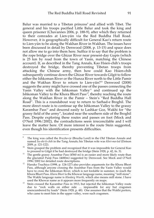
Pamir, a vast upland plain that stretches for many days’ foot or horse travel (see figure 3). That way is indeed easier to go. However, in the other direction are the Lupsuk River and the Irshad and Khora Bhort passes17. That way is considerably more difficult to go and the Tibetan phrase incised on the rock suggests the Tibetans had a similar impression of the route.
Figure 3, the Little Pamir viewed from rock with “easier to go” inscription. As one approaches the Lupsuk River, at a high point, elevation 4125 m, and away from the Wakhan River, is another rock art site18. The site has a commanding view of the entire western half of the Little Pamir, the lower Wakhjir Valley, and the upper part of the route along the Wakhan River to Sarhad-e Broghil. It would be an excellent place for hunters to stop and watch for game. It would also be an excellent place for soldiers to see any movement along the routes through the Little Pamir and to guard the approach to the Irshad and Khora Bhort passes. The rock panels at the site are extensively incised with several chorten, Tibetan inscriptions and Buddhist imagery. Underlying them are some
17 From my own experience, I know that the Lupsuk River is very deep and swift in
summer and impossible to cross on foot. Wakhi and Kirghiz who use the Irshad Pass route cross the Lupsuk River only on yak or on horse and never at the height of the summer flood. The Irshad Pass, which I crossed in 2005, is subject to avalanche in spring and late autumn after snowfall, making the route treacherous in early and late season when water level in the Lupsuk River is lower.
18 This site has never been photographed or documented previously and, to the best of my knowledge, never visited by any non-Afghan person. Wakhi and Kirghiz people in Wakhan are either unaware of it or uninterested in it. I found the same local perspective expressed at the Chap Dara site in Wakhan (Mock 2016, p. 129).

The Red Buddha Hall Road Revisited 95
older figures of ibex and hunters, indicating the site was significant to people using the Little Pamir before the Tibetans arrived19.
Figure 4, rock art panels 1 & 2. A large rock panel (panel 1) at the site is inscribed with three chorten, two adjacent inscriptions, a separate finial-like structure with Buddhist symbols, and a large multi-petalled flower. A separate rock (panel 2) has a chorten with an inscription and two multi-petalled flowers. (See figure 4).
On the large rock, the lower left chorten has a three-stage base, a central pillar, and two upper projecting stages or tiers. An oval dome extends from the top stage and a mast with an orb and a three-pronged finial crown the chorten (see figure 5). The upper stages that project outward beyond the pillar are characteristic of a design termed “cross like” (Francke 1928, p. 1051). This design is found on many chorten elsewhere in Wakhan and also along the upper Indus River and its tributaries extending as far east as Baltistan20. Denwood (2007, p. 45)
19 Rock art sites are often palimpsests in places with extensive views, suggesting they
served as loci of ceremonial or ritual activity for a sequence of cultures, each of whom left their own distinctive art. For more on similar such sites in Wakhan, see Mock 2016, p. 126-128.
20 For the several Wakhan chorten, see Mock 2016, figures 8 & 9. For the Darkot chorten, see Mock 2013a, p. 12. For the chorten at Gakuch along the Ghizar River near Gilgit, see Jettmar and Sagaster 1993, figure 8, republished in Denwood 2007, figure 5. Chorten of similar design, some with Tibetan inscriptions, have been identified in Baltistan, notably at the villages of Nor, Parkutta and Gol. For more on the rock art of Baltistan, see Schuh 2011. For the several chorten near Alchi in Ladakh, see Denwood 2007, figure 3 and Orofino 1990, figures 17, 18, 30, 39, 40.

Revue d'Etudes Tibétaines 96
noted that this design is typical of the western Himalaya and Karakoram. Jettmar (1990, p. 809) considered the design to be an innovation made during the time of imperial Tibetan rule in the region. Laurianne Bruneau (personal communication) commented that the design is actually quite rare in the rock art of both Gilgit and Ladakh, which makes the frequency of this design in Wakhan and its association with Old Tibetan inscriptions significant.
Figure 5, Panel 1. The lower left chorten is deeply pecked into the rock surface and executed in a proportional, balanced manner, indicative of skillful artistic production. The rock on which the chorten is inscribed has cracked after composition, and so the finial is now separated from the chorten. Figure 6 presents an artistic rendition of the chorten as it would have originally appeared. The chorten measures 48 cm from base to top of dome, with the mast and finial adding 20 cm more. The base is 30.5 cm wide and the widest upper stage tier is 31.75 cm wide. The bottom base line is 2.5 cm thick, and other lines are about 1.25 cm thick.

The Red Buddha Hall Road Revisited 97
Figure 6, rendering of “cross-like” chorten. The Tibetan inscription on the right side of the chorten is also carefully executed, with proportional and neatly curved strokes (see figure 7). It reads rye shin pya ligsteng gi yon, adhering to a standard offering formula. Rye shin pya ligs steng21 appears to be the name of the donor. The name rye shIn is found in the Old Tibetan Annals version 1, OTJ 0750, line 69, in the Ox year 677-678 CE (Dotson 2009, p. 92) and also on a rock inscription at Alchi (Denwood 1980b, p. 158-169, figure 84E). Dotson notes that the name is connected with the revolt of Zhang Zhung and Denwood observes that it is a non-Tibetan Central Asian name.
21 Although lig is written, constraints of spacing and compactness evidently result in
the elision of final sa before the initial sa of steng. I am grateful to Karma T. Ngodup for discussing abbreviation, contraction and elision with me.

Revue d'Etudes Tibétaines 98
Figure 7, rye shin pya ligs steng offering inscription. To the right and above the inscription is a second chorten with a Tibetan inscription below it. There is a third chorten partially above and to the right of this chorten, but it has no adjacent inscription. The two chorten are congruously composed so that the upper tiers of the lower chorten fit the lotus petals and base of the upper chorten (see figure 8). Given their arrangement, the same inscription seems associated with both chorten.
Figure 8, two adjacent chorten.
The Red Buddha Hall Road Revisited 99
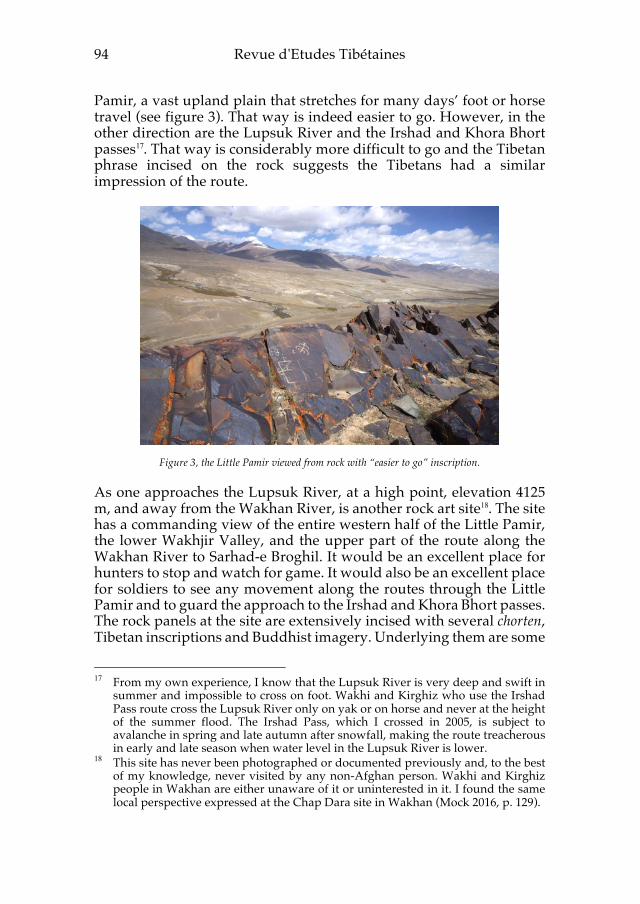
The inscription consists of a name with an offering formula. The name appears to be mug ligs cung (see figure 9) and was inscribed over an earlier carving of an ibex. The curve of the ibex horn is discernable where it arcs across the lower left petals of the lotus base of the chorten above and the body of the ibex appears as a horizontal line above mug22 (see figure 10).
Figure 9, mug ligs cung yon inscription.
Figure 10, DStretch® enhancement of mug ligs cung yon inscription using the YRE matrix. The underlying ibex figure is visible above mug, with the ibex horns curving into the petals of the chorten
above.
22 The software algorithim DStetch® was employed to enable visual separation of the
underlying ibex figure. See Harman 2005 and Le Quellec et al. 2015 for more on the use of DStretch® in rock art.

Revue d'Etudes Tibétaines 100
The name is followed by the more faintly inscribed syllable yon, as would be expected for an offering, with the genitive elided in a contracted form. The name mug ligs has a Turkic quality to it23. A Uighur identity for the donor named in the inscription is not implausible.
The two chorten (see figure 8) above the mug ligs cung inscription have the general cross-shaped design, but are strikingly different from other Wakhan chorten in that they both have a lotus-petal base and a more massive and angular architecture to them. The chorten with the inscription beneath has a two-stage base on a lotus flower, a tall central pillar, and three upper projecting stages, with the middle stage projecting farther. The base is 24.3 cm wide and the chorten measures 50.8 cm from base to top of dome. The widest upper stage tier is 29.2 cm. It has a small hemispherical dome and a mast with three orbs arraigned along its 28 cm length and topped with a trident-like (crescent moon and sword) finial. The remarkable features of this chorten are the two vertically aligned windows in the center of the column and the parallel outline around the base, pillar and upper stages.
The third chorten on the same rock panel, while not outlined, has a massive quality to it, with a 38 cm wide triple-tier base resting on a lotus flower, a very short and narrow 9 cm wide pillar and a massive five stage upper section, with the middle protrusion extending 26.6 cm. The small hemispherical dome has a mast with three successive orbs and a trident-like finial totaling 30.5 cm in length. An earlier ibex figure underlies the middle orb. Beneath the chorten is a large eight-petalled flower. Each petal has a central dot. The center of the flower is stippled and was pecked, rather than incised.
These two chorten draw from a different architectural vocabulary than the other chorten depicted on the lower left of this rock panel. Denwood notes that “the Bonpo stupa [has] something of the form of a building … a hollow construction with a means of entry”, with expanded upper tiers below the dome, which is reduced in size or even absent (Denwood 1980a, p. 176-179), a description that matches the architecture depicted on this rock panel. It is also worth noting that Fussman has examined the architectural style and construction of the stupa in which the Gilgit manuscripts were found. He concluded that it was “a stone tower with a wooden framework built according to the well-known building tradition of the Hindukush and Karakoram
23 The name Mug lig occurs in Pelliot tibétain 1283, Content Report of the mission
consisting of five Uighur envoys sent to the North Asia (ll. 533-642). Federica Venturi (2008, p. 22, fn. 53) comments on “The name Mug lig, corresponding to the Turkic Bükli of the Orkhon inscriptions…”.
The Red Buddha Hall Road Revisited 101
higher valleys. This tower might have been both the chapel and lodgings of an acarya…” (Fussman 2004, p.144). The two chorten depicted on the Wakhan rock panel may be representations of buildings not far from Wakhan in which monks studied, resided and practiced.
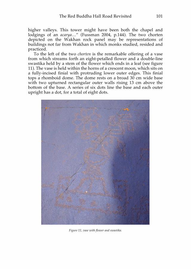
To the left of the two chorten is the remarkable offering of a vase from which streams forth an eight-petalled flower and a double-line swastika held by a stem of the flower which ends in a leaf (see figure 11). The vase is held within the horns of a crescent moon, which sits on a fully-incised finial with protruding lower outer edges. This finial tops a rhomboid dome. The dome rests on a broad 30 cm wide base with two upturned rectangular outer walls rising 13 cm above the bottom of the base. A series of six dots line the base and each outer upright has a dot, for a total of eight dots.
Figure 11, vase with flower and swastika.

Revue d'Etudes Tibétaines 102
This composition is executed with a remarkable fluidity for a rock medium and is an artistic representation of auspicious Buddhist symbols, suggesting that the rock served as a locus of religious significance for the Tibetan Empire’s soldiers stationed at this location or passing through the Pamir. Although it is not possible currently to say where the Red Buddha Hall24 was located, or if it even existed, this site seems closer to that tradition than any other site in the Little Pamir of Afghanistan. Further archaeological investigation could yield evidence of the extent of usage of this site.
The second rock panel at this site has a chorten with a donation inscription and two multi-petalled flowers (see figure 12).
Figure 12, panel 2 chorten and inscription.
24 The red Buddha of the west, Amitabha, ‘Boundless Light’, is connected to Ahura
Mazda, and the Amitabha cult “seems to have started in North-West India” (Snellgrove 1978, p. 134). The paradise of Amitabha was popular in Dunhuang, where “the earliest example is found in Cave 220, dating from 642 A.D.” (Gaulier et al. 1976, p. 10).

The Red Buddha Hall Road Revisited 103
The chorten, like the upper chorten on the first panel, has a lotus-petal base. Its general shape, however, is that of a cross-shaped chorten, with an oval dome, a single protruding upper tier, a short central pillar and a two-tier base. It measures 38 cm from base to top of dome. The base is 23 cm wide. What is unusual is that it shares with the middle chorten on the first panel a parallel outline around the base, upper tier and dome, which appears like some sort of nimbus. The chorten is not architecturally massive, rather, it exhibits an almost delicate structure, even though it appears to have been pecked out, and is proportionally suggestive of a human form seated in a meditative posture. The dome has a mast with a central orb and above it is a trident whose outer arms seem to converge at the top and hold another small orb. The mast and finial measure 24 cm. To the left of the chorten is a large, eight-petalled flower, with considerable stippling beneath it. Above it is a smaller, ten-petalled flower. The centers of these flowers are not stippled like the flower on the first panel.
Below the chorten is a four-line offering inscription. The size of the space on the rock below the chorten evidently constrained the composition and length of the lines. In the first line, the initial na has a superscript circle, which is the Tibetan character used for Sanskrit anusvara, although here it seems employed for saving space rather than indicating a Sanskrit term. The next character is clearly po, followed by shud, giving the name naM-po shud25. In light of this reading, I would revise the reading of the Chap Dara inscription shown in figure 7 of Mock 2016, which on closer examination has the same name, although it is spelled with ma and not with the anusvara circle. Hence, we have two instances of nam-po shud in Wakhan26. Philip Denwood (personal communication) kindly informed me of a Pu shud noble family who held an estate in Yarlung in medieval times, and a Shud pu family who provided a Tibetan minister in the 8th century and is also known from later times, pointing to a Tibetan identity for this individual. The second line reads 'phan zi, and continues onto the third line with gs, giving us the full name of nam-po shud 'phan zigs. The final line is shifted to the left due to space constraints and is the expected dedicatory ending of gyi yon. The syllables of this final line, in particular na, are near the bottom of the rock and appear to have weathered more than the syllables in the upper three lines.
25 Following Imaeda 2011, p. 42, using M to transliterate the anusvara circle.
Transliterations in this article follow the system outlined at Old Tibetan Documents Online, otdo.aa-ken.jp/
26 Stone 6 at Gakuch (Jettmar and Sagaster 1993, p. 130 and fig. 9) appears to have the same name in line 1, nam pu shud, suggesting individuals with this family name were involved in Tibetan occupation of both Wakhan and Balur.

Revue d'Etudes Tibétaines 104
The extensive Buddhist rock art with accompanying Tibetan inscriptions at this site on the high point above the route to the Irshad and Khora Bhort passes obviously required more than a few days to compose and inscribe. Three names are recorded in the inscriptions. What were these men doing at this high-elevation remote location? About 100 m below the site is a small ruined rock wall enclosure (see figure 13).
Figure 13, small rock-wall structure. The walls are composed of stacked flat stones, 1 m high where still standing, and form a 1.8 m by 3.8 m rectangular enclosure. There is an opening in one long wall. One corner has a dilapidated projecting rock enclosure. One possibility is that this could be a ruined herders’ shelter, but there are larger herder settlements located within a few hours’ walk, and such a high, exposed location is not a typical herders’ camping place. The other possibility is that it is connected to the nearby rock art. If so, it may have been a temporary post for individuals manning a hill-station watch post or ri-zug in Tibetan. I have elsewhere proposed that a network of such hill stations and watchtowers extended through Wakhan and continued into Chitral (Mock 2017). Takeuchi, who studied hill stations near Miran and Mazar-tagh along the southern side of the Tarim Basin, noted that a unit of watchmen, called a tshugs, usually consisted of four men, with a Tibetan (or Zhang Zhung) commander and sub-commander and a cook and assistant cook who were local conscripts. Sometimes there were only three men (Takeuchi 2004, p. 51-55). The onomastics of the

The Red Buddha Hall Road Revisited 105
three names at this Wakhan site, one probably Tibetan, one probably Zhang Zhung and one probably Uighur fit with the personnel composition described by Takeuchi. Evidently the route was important enough to warrant the substantial effort put into producing the rock art and inscriptions and was used enough to warrant the Tibetan “road sign” telling travelers that the difficult part was over and an easier road lay ahead (see figure 14).
Figure 14, the Irshad Pass on the Afghanistan-Pakistan border with its distinctive red mountain.
Conclusion
A precise identification of the actual “Red Buddha Hall Road” remains elusive, due to divergence between the Tang Annals narrative and on-the-ground realities. However, it is clear that the route along the Wakhan River from the Little Pamir to Sarhad-e Broghil and Lien-yün is the only route that Tang troops could have taken, and hence must form a significant part of what was termed the “Red Buddha Hall Road”. It is also clear that Tibetans were using valleys other than the Yasin Valley to and from Wakhan. An important site with several large chorten, Buddhist iconography and Tibetan inscriptions all depicted on smooth rock surfaces demonstrates that Tibetans were moving between Palola/Balur/Bru-zha and the Pamir via the Irshad Pass, the Khora Bhort Pass, or both. Paleography of an inscription along that route provides a basis for dating Tibetan movement to the late 8th century or the early 9th century CE. Onomastic elements in inscriptions and the presence of a nearby walled structure suggest the site may have been a Tibetan hill station along the route. Stylistic elements of the rock art show linkages with the upper Indus area and suggest that Wakhan - Gog-yul - may have been a locus for a distinctive rock-art
Revue d'Etudes Tibétaines 106
chorten design. The totality of the rock art and inscriptions at one site along that route suggests it may have played a ceremonial role akin to that of a shrine.
Acknowledgements This article developed from talks given at the American Institute of Pakistan Studies, Islamabad in 2010, the UCLA Religions of the Silk Road Lecture Series in 2011, the International Conference on Archaeology and Cultural Heritage in Pakistan and Adjacent Regions, Islamabad in 2012 and at the Centre de recherche sur les civilisations de l’Asie orientale – CRCAO/Collège de France in 2016. My thanks to the organizers for their kind invitations. Thanks also to John Vincent Bellezza, Senior Research Fellow at the Tibet Center, University of Virginia; Dr. Philip Denwood of the School of Oriental and African Studies, University of London; Karma T. Ngodup of the University of Chicago; and Dr. Mark Tatz, formerly of the California Institute of Integral Studies, for their readings and interpretations of inscriptions. Discussions with Nils Martin, PhD candidate at the École Pratique des Hautes Études, led me to re-examine Tibetan inscriptions at Gakuch. The rendition of the “cross-like” chorten (figure 6) is by Lee Birch, whose artistic insight is greatly appreciated. All photographs are by John Mock©. Thanks to the W. L. Gore Inc. Shipton-Tilman Grant program, the Deutsche Gesellschaft für Technische Zusammenarbeit (GTZ), the Aga Khan Foundation - Afghanistan, the Wildlife Conservation Society, The Christensen Fund and Untamed Borders U.K. for enabling seven visits to Wakhan between 2004 and 2016. Thanks also for the opportunity to discover and share these rock carvings and inscriptions that have remained for so long forgotten on the roof of the world.
References
Beckwith, Christopher, The Tibetan Empire in Central Asia: A History of the Struggle for Great Power Among Tibetan, Turks, Arabs and Chinese During the Early Middle Ages. Princeton, Princeton University Press, 1987.
Chavannes, Édouard, Documents sur les Tou-kiue (Turcs) occidentaux, St.
Petersburg, 1903, internet edition, classiques.uqac.ca/ classiques/index.php, Quebec, 2006. Denwood, Philip, “Stupas of the Tibetan Bonpos”, in A.L.Dallapiccola,
ed., The stūpa: Its religious, historical and architectural significance, Wiesbaden, Steiner 1980a, p. 175-182.

The Red Buddha Hall Road Revisited 107
_____ “Temple and Rock Inscriptions of Alchi”, in D.L. Snellgrove &
T. Skorupski, The Cultural Heritage of Ladakh, vol. 2, Zangskar and the cave temples of Ladakh, Warminster, Aris & Phillips, 1980b, p. 117-164.
_____ “The Tibetans in the Western Himalayas and Karakoram,
Seventh-Eleventh Centuries: Rock Art and Inscriptions”, The Journal of Inner Asian art and archaeology, 2:2, 2007, p. 49-57.
_____ “Tibetans in the West, Part I”, The Journal of Inner Asian art and
archaeology, 3:3, 2008, p. 7-21. Dotson, Brandon, The Old Tibetan Annals: An Annotated Translation of
Tibet’s First History, Vienna, Verlag der osterreichischen Akademie der Wissenschaften, 2009.
Francke, Auguste H., “A Tibetan Inscription on the Darkot Pass”,
Appendix L in M.A. Stein, Innermost Asia, Oxford, Clarendon, 1928, p. 1050-1051.
Fussman, Gérard, “Dans Quel Type de Bâtiment Furent Trouvés les
Manuscrits de Gilgit?”, Journal Asiatique 292, 1-2, 2004, p. 101-150.
Gaulier, Simone, Robert Jera-Bezard, and Monique Maillard, Buddhism
in Afghanistan and Central Asia, Leiden, Brill, 1976. Harman, Jon, “Using Decorrelation Stretch to Enhance Rock Art
Images”, American Rock Art Research Association Annual Meeting May 28, 2005, internet resource at www.DStretch.com.
Hirai, Go, The Wakhan Corridor - In the Footsteps of Hsüang-tsang and
Marco Polo: Nature and Inhabitants, Tokyo, Kasumigaseki Publishing, 2015.
Imaeda, Yoshiro, “Towards a Comprehensive and Unambiguous
Transliteration Scheme of Tibetan,” Imaeda et al., eds., New Studies of the Old Tibetan Documents: Philology, History and Religion, Old Tibetan Documents Online Monograph Series, vol. III, Tokyo, Research Institute for Languages and Cultures of Asia and Africa, Tokyo University of Foreign Studies, 2011, p. 39-43.
Jettmar, Karl, “Exploration in Baltistan”, in M. Taddei, ed., South Asian
Archaeology 1987: Proceedings of the Ninth International Conference of the Association of South Asian Archaeologists in Western Europe, Part 2, Rome, Instituto Italiano per Il Medio Ed

Revue d'Etudes Tibétaines 108
Estremo Oriente, 1990, p. 801-813. Jettmar, Karl and Klaus Sagaster, “Ein Tibetisches Heiligtum in
Punyal”, in K. Jettmar, ed., Antiquities of Northern Pakistan: Reports and Studies, vol. 2, Mainz, Philipp von Zabern, 1993, p. 123-140.
Le Quellec, Jean-Loïc, Frédérique Duquesnoy, Claudia Defrasne,
“Digital image enhancement with DStretch®: Is complexity always necessary for efficiency?”, Digital Applications in Archaeology and Cultural Heritage, no. 2, 2015, p. 55-67.
Mock, John, “The Discursive Construction of Reality in the Wakhi
Community of Northern Pakistan”, unpublished PhD dissertation, Berkeley, University of California, 1998.
_____ “Darkot Revisited: New Information on a Tibetan Inscription
and mchod-rten”, Revue d'Etudes Tibétaines, no. 27, October 2013a, p. 11-19.
_____ “New Discoveries of Rock Art in Afghanistan’s Wakhan
Corridor and Pamir: A Preliminary Study”, The Silk Road vol. 11, 2013b, p. 36-53 + Plates III, IV.
_____ “Tibetans in Wakhan: New Information on Inscriptions and
Rock Art”, Revue d’Etudes Tibétaines, no. 36, October 2016, p. 121-141.
_____ “Raising the Alarm: Defensive Communication Networks and
the Silk Roads through Wakhan and Chitral”, The Silk Road, vol. 15, 2017, p. 1-12.
Mock, John and Kimberley O'Neil, Trekking in the Karakoram &
Hindukush: A Lonely Planet walking guide, Hawthorn Australia, Lonely Planet Publications, 1996, second edition 2002.
Mock, John, Kimberley O’Neil, Inayat Ali, Socioeconomic Survey &
Range Use Survey of Wakhi Households Using the Afghan Pamir, Wakhan District, Badakhshan Province, Afghanistan, Kabul, Wildlife Conservation Society, 2007, internet resource at afghanistan.wcs.org/Publications.aspx
Orofino, Giacomella, “A Note on Some Tibetan Petroglyphs of the
Ladakh Area”, East and West, 40:1-4, 1990, p. 173-200. Schaik, Sam van (n.d.), Reading Tibetan Manuscripts: Punctuation and
Ornamentation: the double tsheg, internet resource at readingtibetan.wordpress.com/resources/punctuation/

The Red Buddha Hall Road Revisited 109
Schuh, Deiter, Reise in die Geschichte Baltistans, Expedition in ein immer
noch unbekanntes Land (Journey into the History of Baltistan, Expedition to a still unknown country), 3 volumes, Andiast, International Institute for Tibetan and Buddhist Studies, 2011, limited content internet edition www.tibetinstitut.de/ste-4-baltistan.html
Snellgrove, David, ed., The Image of the Buddha, Kodansha, UNESCO,
1978. Stein, Marc Aurel, Serindia: Detailed report of Explorations in Central Asia
and Westernmost China Carried Out and Described Under the Orders of H.M. Indian Government, Oxford, Clarendon, 1921.
_____ “A Chinese Expedition across the Pamirs and Hindukush, A. D.
747”, The Geographical Journal, 59:2, 1922, p. 112-31. _____ Innermost Asia: Detailed Report of Explorations in Central Asia,
Kan-su, and Eastern Iran Carried Out and Described Under the Orders of H.M. Indian Government, vol. 1, Oxford, Clarendon, 1928, repr. 1981, New Delhi, Cosmo, 1981.
Takeuchi, Tsuguhito, “The Tibetan Military System and its Activities
from Khotan to Lop-Nor”, S. Whitfield, ed., The Silk Road: Trade, Travel, War and Faith, Chicago, Serindia Publications, 2004, p. 50-56.
Tsuchiya, Haruko, “Ancient Route Between Gandhara and China Via
Pamir: A route of dissemination of Gandharan art through Pamir”, Journal of Asian Civilizations, 11:2, 1998, p. 119-135.
Venturi, Federica, “Old Tibetan Document on the Uighurs: A New
Translation and Interpretation”, Journal of Asian History, vol. 42, no.1, 2008, p. 1-35.
Zeisler, Bettina, “East of the Moon and West of the Sun? Approaches
to a Land with Many Names, North of Ancient India and South of Khotan”, The Tibet Journal, 34/35: 3-4/1-2, 2009, p. 371-463.
v