Embed Size (px)
Citation preview

The Pleistocene Geology of Amchitka Island, Aleutian Islands, Alaska
By LEONARD M. GARD, JR.
G E O L O G I C A L S U R V E Y B U L L E T I N 1 4 7 8
--
UNITED STATES GOVERNMENT PRINTING OFFICE, WASHINGTON : 1980

UNITED STATES DEPARTMENT OF THE INTERIOR
CECIL D. ANDRUS, Secretary
GEOLOGICAL SURVEY
H. William Menard, Director
Library of Congress Cataloging in Publication Data
Gard, Leonard Meade, 1923- The Pleistocene geology of Amchitka Island,
Aleutian Islands, Alaska.
(~eolo~ical Survey bulletin ; 1478) Includes bibliographical references. Supt. of Docs. no.: I 19.3:1478 1. Geology, Stratigraphic--Pleistocene. 2. Glacial
epoch--Alaska--Amchitka Island. 3. Geology--Alaska --Amchitka Island. I. Title. 11. Series: United States . Geological Survey. Bulletin ; 1478. ~ , ~ 7 5 . ~ g no.1478[&~84.A381 557.3s 80A07888
[ 551.7'92 '0979841
For sale by the Superintendent of Documents, U. S. Government Printing Office Washington, I). C. 20402

Page
Abstract --------------------------------------------.------.---. 1 Introduction . ____ - - - - - - - - - - - - - - - - - - - - - . . - . - - - - - - - . - - 1 Deposits a t South Bight _----------------- . . . . . . . . - . . . - . - - 5
Lacustrine and fluvial deposits of early Pleistocene age _ - - - _ 5 Marine deposit of the South Bight I transgression - - . . . . - - - - - - - - 11 Beach deposit of the South Bight I transgression ___. . . . - . - - - - - - 11 Beach deposit of the South Bight I1 transgression . . 14
Terraces on Amchitka . - . . - - . . . . . 17 High plateaus _ - - - - - - -- ---- - - - - - - - -. . - -- - - - --. . - - 18 The 12% to 131-m surface . . 19 The 67- to 76-m terrace ------.-.-....---------------------------------. 19 The 37- to 49-m terrace ___...-_-___--------------------------------.... 20 Other marine terraces .____---------------------..--...--------- 20
Subaerial terraces ----------.-.___. ._ .__---.. .. . . . . . . . . . . . . . . . . . . . . .
Intertidal bench --------__...___..__-_-----_---------------------.-.
Submarine terraces --------------....-....-...--------------------- Correlation of terraces with marine deposits a t South Bight - - - - - - - - - - - - - -
Deposits a t Constantine graben ..__..._------------------------------------
Older glacial deposits ----...----------------------------------- South Bight I(?) marine deposit _...__-------------------------------.--
Younger glacial deposits ----------------------------_-__.____-----------
Glacial outwash a t Rifle Range fault . . . . . . . . . . . . . . . . . . . . . . . . . . . . . . . . . . . . . . . . Glaciation of central and western Amchitka . . . . . . . . . . . . . . . . . . . . . . . . . . . . . . . .
Extent of glaciation __-- - - - - - - - - - - - - - - - - - - - - - - - - - - - - - - - - - - - - - - - - - - - - - - - - - - - -
Pleistocene tectonism --------------------------.------------------- Correlation of marine transgressions _ - _ - - - - - - - - - - - 34 References cited _-_-_---------------.---.---------------------------- 37
Page
FIGURE 1. Index map of the Aleutian Island chain . . . . - - . - . 3 2. Map showing surfaces of planation, Amchitka Island - - . - - 4 3. Photograph showing sea cliff a t South Bight . . . . . . . - _ 5 4. Diagrammatic geologic cross section of South Bight Graben, Am-
chitka Island .--..-------------.._..-_-_-------_ 6 5. Photograph showing stratum of logs projecting from tilted
lakebeds of early Pleistocene age at South Bight _ 10 6. Map showing distribution of marine terraces, east end of Am-
chitka Island .--.------------__.__------------_.._...... 12 7.-11. Photographs showing:
7. Faulted South Bight I marine sand in cliff a t South Bight 13 8. The South Bight I beach deposit 1.5 km northwest of
South Bight .____--- - - - - - - - -___. . . . . . . 14

Iv CONTENTS
FIGURES 7-11, -Continued Page
9. Intertidal bench, cut on breccia of Banjo Point Forma- tion, exposed at low tide -----------------------.- 21
10. Sea cliff retreat owing to freeze and thaw -----_-__-.- 22 11. Rhythmically bedded glacial pond deposit of alternating
sand and silt overlain by 2-m-thick till of unsorted stony clayey sand . . . . . . . . . . . . . . . . . . . . . . . . . . . . . 29
TABLES
Page
TABLE 1. Diatoms collected from lower part of lacustrine deposits of early Pleistocene age at South Bight, Amchitka Island, Alaska .--- 7
2. Number of pollen and spores collected from lacustrine deposits of early Pleistocene age a t South Bight, Amchitka Island, Alaska . . . . . . . . . . . . . . . . . . . . . . . . . . . . . . . . . . . 9
3. Correlation of Pleistocene deposits, Amchitka Island _ - - - - - - - 25 4. Correlation of Quaternary marine transgressions on Amchitka
Is land-------___---------------------------------------- 35

THE PLEISTOCENE GEOLOGY OF AMCHITKA ISLAND, ALEUTIAN ISLANDS,
ALASKA
Tilted and faulted lakebeds of early Pleistocene age, overlain by two interglacial marine deposits, have been downfaulted and thereby preserved in a graben at South Bight, Amchitka Island, Alaska. During the early Pleistocene, trees grew on this now treeless Aleutian Island, and the pollen assemblage reflects an average July tempera- ture several degrees warmer than at present.
The two marine deposits were laid down during high-level stands of the sea, here named the South Bight I and South Bight I1 marine transgressions. These transgressions carved two broad terraces on Amchitka Island. The older of these, South Bight I, which is undated, is tentatively correlated with Termination 111 of Broecker and VanDonk (1970). The fossiliferous South Bight I1 deposit, dated by the uranium- series method at 127,000r8,OOO years, is correlated with Broecker and VanDonk's Termination 11. Two small terraces on Amchitka a t 6-9 m and 15-18 m are thought to represent high sea stands that formed the Barbados I and I1 reef tracts 82,000 and 105,000 years ago. High terrace remnants a t 125-131 m are tentatively correlated with Termination IV of Broecker and VanDonk.
Evidence of two glaciations is found on Amchitka Island. The earlier glaciation, represented by well-indurated diamictite of unknown age, appears to have occurred prior to the South Bight I marine transgression and may be as old as Kansan. The later glaciation, which is younger than the South Bight I1 transgression, probably covered the island in late Wisconsin time. Several thin icecaps probably were present simulta- neously during the Wisconsin, and distribution of distinctive erratics indicates that one ice sheet, centered at the low east end of the island, moved from east to west at least 8 km and had a source area that could have been no higher than 73 m above present sea level.
INTRODUCTION
Multidisciplinary earth science studies by the USGS (U.S. Geologi- cal Survey), conducted on and near Amchitka Island from 1964 to 1972, were made in support of the development of the island as an underground nuclear test site by what was then the USAEC (U.S. Atomic Energy Commission, now the U.S. Department of Energy). These investigations were the first comprehensive geologic studies made in the Aleutians since the reconnaissance mapping by the

2 PLEISTOCENE GEOLOGY O F AMCHITKA ISL.AND, ALASKA
USGS during the 1940's and 1950's. The original reconnaissance geologic reports (Coats, 1956; Powers and others, 1960) included de- scriptions of glacial and interglacial deposits.
During the course of the more recent investigations, the Pleis- tocene geology was studied in detail, mainly to determine the Quaternary tectonic stability of Amchitka. This paper summarizes the results of that study.
The Aleutian Islands are probably one of the least accessible areas in the world. Weather and logistics make geologic operations difficult, often unpleasant, and very expensive. Many of the islands display flights of marine terraces; yet, because of inaccessibility, little at- tempt has been made to study those terraces and their relationship to worldwide Pleistocene marine transgressions. To date, Pleistocene marine deposits are virtually unrecognized by any studies on these islands.
Amchitka Island, one of the western Aleutian Islands, lies at about lat 51'30' N. and long 179" E. (fig. 1). It is the second most southerly island in the chain and lies only slightly north of the latitude of the northern tip of Vancouver Island, British Columbia. The island is about 65 km long and 5-8 km wide and trends northwest. The south- eastern half is low lying, generally less than 150 m above sea level, while the western half of the island rises to a rugged mountainous segment 356 m high that gives way northwestward to a plateau about 250 m above sea level.
Although the Pleistocene history is far from complete, geologic strata on Amchitka Island reveal more than has been reported so far from any other Aleutian island. Graben faulting has preserved an unusual series of Pleistocene deposits near the eastern end of the is- land. Sediments are preserved at and near South Bight, at Constantine Harbor, and along the Rifle Range fault (fig. 6). Evidence is found for a t least two glaciations separated by a fossiliferous marine deposit.
Marine transgressions have carved a t least four well-developed marine terraces on Amchitka Island (fig. 2), two of which are warped, tilted, and faulted and are correlated with fossiliferous marine and beach deposits. Marine regressions have cut one broad extensive sur- face and at least two smaller discontinuous terraces, now all below sea level.
Subaerial marine terraces are much better developed on the east- ern half of Amchitka Island, perhaps because erosion and beveling during late Oligocene or early Miocene time had already reduced the rocks of earlier Tertiary age to a low gently sloping surface. On the steep flanks of the mountainous western end, formed by Miocene volcanic rocks, the Pleistocene terraces are restricted to narrow dis- continuous ledges and notches.

BERING SEA - PRlBlLOF Q ISLANDS
0 200 400 600 K I L O M E T E R S I I I I I I I I
/ / 1 I I I I I 50"
FIGURE 1.-Index map of the Aleutian Island chain. Amchitka Island lies at about lat 51°30'N and long 179"E.

BERING SEA
I Qls Landslide I
FIGURE 2.-The planation surfaces (patterns) of Amchitka Island and offshore. Altitudes determined at bases of abandoned sea cliffs, except for surfaces between 152 and 214 m and between 214 and 275 m. Altitudes from Holmes and Narver unpublished topographic map, 1:6,000.

DFPOSITS A T SOL.1 H BICH I 5
DEPOSITS AT SOUTH BIGHT
LACUSTRINE AND FLUVIAL DEPOSITS OF EARLY PLEISTOCENE AGE
South Bight graben, about 800 m wide, was once a closed structural depression which, in early Pleistocene time, formed a quiet tree- flanked lake along what is now the south shore of the island. Sub- marine contours suggest that the depression may have been as much as 7 km long, Since then, coastal erosion has destroyed the south- and west-bounding bedrock shores of the lake and has left a cross section of sediments that were deposited in the subsiding graben exposed in the sea cliff at the head of the bight (fig. 3).
The earliest Pleistocene record to be found is more than 80 m of tilted and faulted lacustrine and fluvial sediments exposed in the lower part of the sea cliff (fig. 4). These sediments constitute the lower part of strata referred to by Powers, Coats, and Nelson (1960, p. 541) as "tilted sedimentary rock at South Bight," I have divided this lower part into three units: The lowest unit consists of more than 63 m of fine-grained carbonaceous lake sediments; the middle unit is com- posed of 28 m of fluvial sand and pebble gravel; and the highest unit, only 3.5 m thick, resembles the carbonaceous lacustrine sediments of the lowest unit.
FIGURE 3.-Sea cliff a t South Blght. Lakebeds (1) of early Pleistocene age form lower part of cliff a t left (north) and are conformably overlam by South Blght I interglacial marine deposlts (2). Both are tilted and faulted (3) and beveled (4). Unconformity (41 has been t~l ted down to south (right) and is overlain by South Bight I1 interglacial beach deposits (5). Sea cow localities a t (6) White sand bed above unconforml& a t right of picture is compased of cross-stratified shell fragments. Photograph by Robert H. Morris, U.S. Geologmtl Survey.

NNW METERS
EXPLANATION
Quaternary deposits:
Dune sand
South Blght I1 interglacial beach deposit
South Bight I interglacial -
Lacustrine and flurial (?) deposit
Tertiary deposits:
Amchitka Formation
40
20
SEA LEVEL
0 100 200 METERS I I
FIGURE 4.-Diagrammatic geologic cross section of South Bight graben, Amchitka Island. Faults (heavy lines) generalized in part; arrows show direction of movement. Black triangle, Hydrodamalis location. Vertical exaggeration x 2.

DEPOSITS .4l' SOL'1-H BI(;H1 7
The lowest unit, mainly carbonaceous clayey silt and sand, records graben subsidence and quiet water conditions. The base of this unit is not exposed. These strata contain freshwater diatoms, pollen, car- bonized logs, and wood fragments. Thin layers of altered ash indicate contemporaneous intermittent eruptions of nearby volcanoes.
A sample containing diatoms (table 1) was collected from near the
TABLE 1.-Diatoms collected from lower part of lacustrine deposits of early Pleistocene age at South Bight, Amchitka Island, Alaska
[f, frequent. R rare. No taxa are common or abundant F freshwater forms. M, marlne forms. S, saline or brackish-dater forms, X, no ecologic information ldentlfied by G. W. Andrews, written commun , 19741
Achnanthes coarctata Brebisson . _ _ _ _ _ - . .. - Achnanthes flexella (Kuetzing) Brun -------------_-.. . .__-. .--
Achnanthes oestrupii (A . Cleve) Hustedt ____..._-_-------
Achnanthes sp. A ___~~~_~~~~----------------_-__.._.__-.---
Brebissonia a f f . B. boeckii (Ehrenberg) Grunow - - - - - - - - - - - - - - - -
Cocconeis sp. A _~_~~~~~~~~~~- - - - - - - - - - - -_ - -_____ ._~_~_- - - - -
Cocconeissp. B . . . . . . . . . . . . . . . . . . . . . . . . . . . . . . . . . . . . . . . . . . . . Cosc~md~scus sp. A --------- .---------------------
Cymbella cistula (Hemprich) Grunow - - _ _ _ - - - - - - _ - - _ - - - - Cymbella laevis Naegeli ___._---.------------------_-__--...
Cymbella naviculiformis Auerswald - - - .--. .------------------
Cymbella t u m i d ~ (Brebisson) V a n Heurck . . . _ _ . _ - - - -
Didymosphenia a f f . D. geminata (Lyngbge) M. Schmidt - - - - - - - -
Diploneis finnica (Ehrenberg) Cleve -.. . - .. ..-.--------------- Diploneis ovalis (Hilse) Cleve ----------------------...-.----- Diploneis sp. A ---------_-----_-----._---...-.....------_----
Epithemia t u r g i d ~ (Ehrenberg) Keutzing _ - . _ . _ _ - - - .
Eunotza robusta Ralfs _ - . _ . _ . . _ _ _ . ~ ~ ~ ~ ~ ~ ~ ~ ~ ~ ~ ~ _ - _ - _
Eunotia sp. A _____-__--.-..--------------_-._._---..
Fragilaria construens var. Bimdls (Ehrenberg) Grunow- _ _ - -. -. Frustulia rhomboides var. Amphipleuroides Grunow - - - - - - - - -. Gomphonema intricatum Kuetzing -.- .-----------_____. --. .-
Grammatophora angulosa Ehrenberg ___. . . . ..-_--------_-__.
Gyrosigma strigile ( W . Smith) Cleve __._.. ..-_------._.._..__
Hydrosera sp. __________-- - - - - - - - - - - -____. .~~~~~~-- - - -
Melosira distans var. Lirata f. seriata Mueller ._ .__ .__- - -
Melosira granulata (Ehrenberg) Ralfs _ _ _ _ ._ - - - - _ - - - -
Navicula bacillum Ehrenberg ._....-----------____------_----
Navicula inflexa (Gregory) Ralfs -.-.-.-------------._._-------
Navicula peregrina (Ehrenberg) Keutzing _ _ _ _ _ _ - - - - - - _ _ _. _ _ _ Navicula pseudoscutiformis Hustedt _. . _ _ -. _ _ - - - - - - _ _ _ _. _ _ _ - - -
Nitzschia a f f . N . amphibia Grunow -.-.---_------.__.__-----
Nitzschia plana W . Smith -----_-----_. . .______--------___--.-
Pinnularia gibba Ehrenberg _-----__._. . .__.-_----------_-_
Pinnularia mesolepta (Ehrenberg) W . Smith _._.___-----------
Pinnularia nodosa Ehrenberg _-----___-_. ._.__.__-----------
Pinnularia sp. A ____.________---------------____.~~~~~~----
Raphoneis angustata Pantocsek . . . . . . --- - - - ---- --- - - -. . . - - - - - Rhopalodia gzbba (Ehrenberg) 0. Mueller ..___-----------_.__
Strauroneis salina W . Smith _ . _ . _ _ _ _ ~ ~ ~ ~ ~ ~ ~ ~ _ ~ _ _ . _ . . _
Surirella ovalis Brebisson ------------.---. .------------------
Tetracyclus emarginatus (Ehrenberg) W . Smith _ _ _ - - - - - - - - - - - Tetracyclus lacustris Ralfs _ - _ _ _ _ _ _ _ _ - - - - - - - - - _ _ _ _ _ _ _ - - - - - Tetracyclus rupestris ( A . Braun) Grunow - - - - - - - - - - - _______ - - - -
Frequency Ecology
S X X X F F F F F
FIS FIS X
FIS F
M F F F S S
FIS F S F F F X M F S S F F F

8 PLEISTOCENE GEOLOGY OF AMCHITKA ISLAND, ALASKA
lowest part of the exposed lakebeds. These fossils were identified by G. W. Andrews, USGS, who reported on the collection as follows:
This is an unusual assemblage in that it contains a relatively large number of taxa, none of which could be considered more than "frequent" in the sample examined. Many of the specimens are broken, which suggests that they may have been transported to the site of deposition, rather than having been deposited a t the place of growth.
Geologic age: Only one extinct species was identified, Rhaphoneis angustata, pre- viously known only from rocks of Miocene age. On the basis of the occurrence of Epithemia and Rhopalodia, the assemblage cannot be older than middle Pliocene. All of the taxa, with the one exception, are known to be living today, which is in accord with your early Pleistocene age determination. Late Pliocene and Pleistocene non- marine diatom assemblages are so similar to living assemblages that I cannot make detailed age determinations in this interval.
Paleoecology: This assemblage contains a preponderance of freshwater diatoms, and many of the taxa are cool-water forms. It also contains a sizable percentage of salt- tolerant freshwater species as well as some that prefer saline or brackish water. The three rare species of marine diatoms are probably of little significance. Deposition possibly occurred in the slightly saline upper reaches of an estuary or perhaps in a slightly saline or brackish pond. The largely broken nature of the diatom valves, as well as the trace number of marine species, may indicate that some diatoms were blown into the deposit. This may also account for the low frequency of many species, as well as the mixing of freshwater, saline, and marine species.
Spruce, pine, and perhaps alder and birch grew on Amchitka at least part of the time that the lake was in existence; ferns appear to have dominated the local vegetation. Two samples collected from dif- ferent horizons and submitted for analysis (table 2) contained tree pollen. According to Estella B. Leopold (USGS, written commun., 1971):
The absence of dicotyledon Tertiary relicts indicates that these samples are post Miocene and probably post Pliocene. The presence of spruce and pine pollen (total tree count of 12 percent in Sample No. D4615) indicates that these trees, and perhaps alder, grew at Amchitka at the time of deposition. The great abundance of Polypodiaceae spores suggests that ferns dominated the local vegetation. The remainder of the as- semblage includes plant groups typical of your Quaternary samples from the Amchitka area. The spruce count in Sample No. D4615 is like that from modern surface samples taken at latitudinal tree line in the Brooks Range. The presence of pine pollen, however, makes this assemblage of particular interest, because the nearest pine is either in the interior of the upper Yukon of Canada (Pinus banksiana) or in Chukotka in Siberia (Pinus pumilla).
The assemblage suggests that average July temperatures during the Tertiary were warmer by 2°C than now. These samples could be either Pliocene or early Quaternary in age, and of these an early Quaternary age seems more likely.
Subsequently, I collected a series of six samples from throughout the section. Remarkably, none of the six samples contained tree pol- len. Certainly the presence of four separate layers containing logs as much as 20 cm in diameter indicates that trees were at least intermit- tently present during the life of the lake. Of these six samples, Leopold said:
All six samples contain abundant monolete spores of the Polypodiaceae type and

DEPOSITS A T SOL'I'H B I G H T 9
TABLE 2.-Number of pollen and spores collected from lacustrine deposits of early Pleis- tocene age at South Bight, Amchitka Island, Alaska
[identified by Estella B. Leopold, written commun., 1971. , not found or absent; +, very rare or present but not as a whole pollen grain]
U.S. Geological Survey Paleobot. Loc. Nos.
Pollen or spores D4615 D4614
(WC-54-70) (WC-53-70]
constitute about 95 percent of the count; sparse herbaceous pollen grains are present; that is, Galium, Cyperaceae. No tree pollen of any kind was seen.
It is of interest that tree pollen is noted in two samples lower down in this section (USGS Paleobot. Sample Nos. D4614 and D4615), but the pollen seems to be completely absent in these six samples. The assemblage includes few plant types and, therefore, is a bit dangerous to interpret ecologically. But it does seem probable that the assemblage represents tundra and that a t the time of deposition the trees were absent from or very rare on this island. If this conclusion is valid, we can presume that the climate has worsened following the deposition of Sample Nos. D4614 and D4615.
A specimen of the lakebeds that contains a thin altered ash layer was carefully oriented and removed, and its remanent magnetism was determined using a spinner magnetometer. Two samples were cut from the specimen and both were determined to be reversely magnetized. According to G. D. Bath (USGS, written commun., 1974), "The directions suggest that this particular section of the lakebeds was deposited a t a time when the Earth's field was generally opposite to its present direction." Results from a single sample are generally considered to be inconclusive by most paleomagnetic investigators; however, these magnetic data tend to confirm an early Pleistocene age for these deposits.
Thin beds of angular boulders, wood fragments, and logs extend into the fine-grained lake sediments from the north "shore," probably recordingtimes of graben subsidence and sloughing of debris from the north-bounding fault scarp. The layers consist of wood fragments and sharply angular boulders as much as 30 cm in diameter. These layers

10 PL.EISTOCENF C;FOI.O(:'I' O F A Z I C H I T K A ISLAND, ALtlSK.4
extend laterally into the lakebeds for about 30 m from the fault, and this sloughing is marked farther out from "shore" by a stratum of logs (fig. 5). Four such horizons were noted in the exposed section of lakebeds. Wood from one of these horizons, collected by H. T. Shacklette for radiocarbon dating (Sample No. W2250), produced a date in excess of 38,000 years (Spiker and others, 1977, p. 349, Sam- ple No. W2250). Either the graben block must have been subsiding evenly during this time, as no angular unconformities have been observed in the lakebeds, or the graben already had subsided before the beds were deposited. In the latter case, the debris layers may have been produced by earthquakes or by normal bank sloughing. Even- ness of the bedding suggests that the lake was deep enough that the bottom sediments were not disturbed by wave action.
Overlying the lacustrine deposits with slight erosional unconfor- mity are 28 m of cross-stratified sand and strongly iron-stained and weathered pebble gravel; these deposits document changed conditions of deposition. Whether this deposition records uplift nearby or whether i t is outwash from an early glaciation noted a t Constantine Harbor is uncertain. Subsequently, the graben again reverted to quiet lacustrine conditions for a short time and 3.5 m more of car- bonaceous sand and silt were deposited conformably on the sand and gravel.
FIGURE 5.-Stratum of logs projecting from tilted lakebeds of early Pleistocene age at South Bight. Arrows point to prominent logs. "Shore" was to left.

DEPOSITS .A7 SOL.1-H RI(;H-I 11
These beds of early Pleistocene age may correlate with carbona- ceous conglomerate and tuff layers on Tanaga Island, which contain a similar pollen assemblage (Fraser and Barnett, 1959, table 1, locality 14).
MARINE DEPOSIT OF THE SOUTH BIGHT I TRANSGRESSION
Overlying the lacustrine deposits with apparent conformity, as much as 18 m of even-bedded well-compacted marine sand and gravel (fig. 4) provide the first depositional record of a Pleistocene intergla- cial rise of the sea level a t Amchitka. This rise in sea level is here named the South Bight I marine transgression. These marine sedi- ments constitute the upper part of the "tilted sedimentary rock a t South Bight" of Powers, Coats, and Nelson (1960, p. 541).
A basal deposit of about 3.5 m of well-rounded, iron-stained, sandy gravel, composed of local rock types averaging 10- 14 cm in diameter, grades upward without a definite break to even-bedded sand with scarce, discontinuous stringers of well-rounded pebbles. The sand contains unworn spicules of the siliceous tetraxial marine sponge Dichotriaenes (R. M. Finks, Queens College, written commun., 1972). Although these sponge spicules are not diagnostic of age, water depth, or temperature, they do indicate that the sediment is of marine origin, according to Finks. No other fossils were found in these strata. The sand is fine to medium grained, well compacted, but not lithified. The sand is rarely cross-stratified, and cut-and-fill structures and ripplemarks are lacking. These conditions suggest that sea-level rise was swift and that the lake in the graben was rapidly overwhelmed and transformed into a closed depression on the sea bottom lying offshore. The lake was relatively unaffected by currents or wave ac- tion. Initially, gravel and then sand were trapped in the depression as sea level rose. No evidence of contemporaneous volcanism is pre- served. I have correlated this apparently deepwater marine deposit with a prominent marine terrace whose sea-cliff base now lies a t about 67-76 m above present sea level (figs. 2 and 6), for reasons that will be given later.
Renewed, but now asymmetrical, subsidence of the South Bight graben tilted the entrapped marine deposit and underlying lacustrine and fluvial deposits southward. During tilting, the beds were broken by a myriad of small normal faults having less than 3 m of displace- ment, generally downthrown on the north side (fig. 7). Density of these faults increases toward the south boundary of the graben.
BEACH DEPOSIT OF THE SOUTH BIGHT I TRANSGRESSION
A deposit of very coarse gravel, which includes subangular boul- ders as large as 1.5 m in diameter and which contains only a minor

179'15'
Area of South
51" 15' 30"
0 1 2 3KlLOMETERS - Fault-bar and ball on
downthrown side a Closed depression
I
FIGURE 6.-Distribution of marine terraces (patterns), eastern end of Amchitka Island. Note closed sea-bottom depres- sions in Constantine Harbor and St. Makarius Bay. Solid lines indicate bases of abandoned sea cliffs, dashed where indistinct or absent. Numbers on solid lines indicate altitude of base of sea cliff, in meters. Altitudes converted from feet to nearest whole meter. Altitudes from Holmes and Narver unpublished topographic map, 1:6,000.

DEI'OSIT'S A?' SOIITH RIGH7 ' 13
FIGURE 7.-Faulted South Bight I marine sand in cliff at South Bight. Note offset in uncommon pebble bed.
amount of sand, lies on the 67- to 76-m terrace a t 65-m altitude in a gravel pit 1.5 km northwest of South Bight. This deposit was thought to be of glacial origin by Powers, Coats, and Nelson (1960, p. 544) because of the presence of "exotic rocks." ' They speculated that it might have been reworked by marine action subsequent to deposi- tion. The presence of battered sponge spicules, which I found in a rare pocket of iron-stained sand, coupled with the coarseness of the gravel, leads me to conclude that this is a beach deposit and that it is related to the 67- to 76-m terrace on which i t lies. Unfortunately for future students of this area, marine shell material now lying on the floor of a gravel pit in the deposit was in gravel dug from the South Bight I1 deposit 1.5 km to the southeast and stockpiled here during the AEC occupation.
This coarse beach gravel lies on a smoothly eroded, undulating bedrock surface that is composed of apophyses of East Cape pluton and metamorphosed host rock. This surface is now exposed in many places by excavation. Nowhere could I find striations on the bedrock; i t appears to be a wave-worn surface. Schafer (in Gates and others,
'It should be noted here that, wtth but one exceptton to be discussed later, I have never found any rocks exotlc to Amchttka m the Pleistocene depostts Those referred to by Powers, Coats, and Nelson (1960, p 542 and 544) can all be accounted for as vanous factes of a quartz dlomte pluton a t East Cape (Carr and others, 1970) and rts metamor- phosed roof pendants and aureoles In fact, the exrstence of I=-rased off-lsland exotlc rocks would present the paradox of therr somehow havtng been depostted 30 m above present sea level durlng glaclal tlmea when aea level may have been as much as 90 m lower or would require that extensive Ice or tree rafting took place during rnterglac~al tunes

1971, p. 783) described a similar situation on Shemya Island, for which he hypothesized that "the bedrock was cut by marine erosion, covered by marine deposits, and then glaciated." Indeed, the Am- chitka gravel deposit also appears to have been glaciated, as it not only shows evidence of frost stirring in the upper part of the deposit (fig. 8) but also is overlain by scattered striated boulders (none was found within the deposit). The gravel owes its preservation to its unusual coarseness, which is due to the relatively wide spacing of joints in the hard, homogeneous underlying rock from which it was derived.
BEACH DEPOSIT OF THE SOUTH BIGHT I1 TRANSGRESSION
At South Bight, the South Bight I marine deposit and underlying lakebeds of early Pleistocene age were tilted, faulted, and then trun- cated by erosion during a new eustatic high-level stand of the sea. The resultant angular unconformity (fig. 4) must represent a consid- erable hiatus for which no depositional record has been found. During that time, a t least one glacial period must have occurred. This high- level stand of the sea, here named the South Bight I1 marine transgression, must have persisted for a considerable length of time,
FIGURE 8.-South B ~ g h t I beach deposlt 1.5 km northwest of South B~ght . Gravel above base of entrenching tool 1s Iron stalned, and many elongate cobbles have been turned vert~cally by frost act~on (center of picture).

for i t cut a broad terrace whose sea-cliff base now generally lies be- tween 37 and 49 m above sea level (figs. 2 and 6). The basis for correlating this terrace with the South Bight I1 transgression will be discussed in the section entitled "Correlation of Terraces with Marine Deposits a t South Bight."
This transgressive sea deposited a 6- to 30-m-thick wedge of highly fossiliferous coarse sand- to boulder-sized beach gravel conformably on the erosion surface (fig. 3). Continued uneven subsidence of the graben lowered the erosion surface and the overlying deposit and tilted them southward. The erosion surface beneath the South Bight I1 beach deposit, in the graben, ranges from 34 m above sea level a t the north side of the graben to 15 m above sea level a t the south side. The thin northern part of this beach gravel crosses the north- bounding graben fault with no apparent offset, implying that move- ment on that fault ceased before the end of South Bight I1 time. Here Powers, Coats, and Nelson (1960, p. 542) observed that the beds in the gravel pit a t the north side of the graben were covered by several feet of rounded to angular cobbles and boulders, "many of them mica schist and biotite granite, entirely foreign to the bedrock exposed in the Aleutian Islands." (See footnote, p. 13) Some of these boulders are faceted, and those of a finer grained nature commonly display stria- tions. This exposure has since been destroyed by excavation, but fa- ceted and striated boulders can be found scattered on the surface of the beach deposit in this area.
Some beds, especially in the lower part of the beach deposit near the south end of the exposure, are composed mainly of cross-stratified shell fragments and broken urchin tests and spines. Discontinuous pods as much as 1 m thick, composed almost entirely of unbroken pecten shells, are also present. At the base of the deposit, subrounded boulders partly coated with kelp-secreted carbonate have blocks of algal carbonate and thick oyster shells wedged in between them. Near the south end of the exposure, the middle part of the deposit contains beds of subangular boulders as much as 60 cm in diameter that probably were derived from the south-bounding fault, perhaps during fault movement, and deposited in deeper water before they could become rounded. The deposit generally decreases in grain size upward and northward, although scattered subrounded boulders are present throughout. In the central part of the exposure, several 30- cm-thick beds of pumice pebbles crop out. The pebbles are well- rounded, hornblende-bearing, white frothy pumice that average 2.5 cm in diameter but may be as large as 7 cm in diameter. The pumice originated in eruptions of one of the nearby active volcanoes. The buoyant, low-density fragments apparently floated to this area, were rounded by wave action, and were stranded on the interglacial beach.

16 PLEISTOCENE GEOLOGY OF AMCHITKA ISLAND, ALASKA
Other than the pumice gravel, the sand and gravel of the beach deposit appear to be all of local origin, with one exception. This excep- tion is an angular cobble of fossiliferous limy argillite that was found about 6 m above sea level near the south end of the sea cliff a t South Bight. The cobble was not found in place but was lying on the slope composed of South Bight I sands. It apparently had fallen from the bouldery South Bight I1 beds above although the possibility that it came from South Bight I sands cannot be ruled out. In thin section, the argillite is seen to be composed of about 50 percent angular to subangular chert, slate, and schist fragments "floating" in a calcare- ous matrix, according to F. M. Byers, J r . (USGS, written commun., 1973). Fossils are Clinocardium cf. C. decoratum (Grewink), Macoma? fragments, and "teredo borings" in silicified wood frag- ments. According to W. 0. Addicott (USGS, written commun., Janu- ary 24,1972), the "Clinocardium in this sample is similar to a species recorded from strata of Miocene and Pliocene age from the Aleutian Islands and the Bering Sea area." Rocks of this description are foreign to Amchitka, but the above description of the rock composition and fossil content is similar to the description of the Miocene(?) Chunik- sak Formation of Attu Island (Gates and others, 1971, p. 731). Be- cause of these facts and the angularity of the specimen, I conclude that this exotic rock was tree rafted to the South Bight area during the South Bight I1 transgression. If this conclusion is correct, pres- ence of this exotic rock a t Amchitka implies that trees may have been present in the Aleutians during this interglacial period.
The beach deposit contains both vertebrate and invertebrate fossils (Cushman and Todd, 1947; Powers and others, 1960; Allison, 1973), as well as the fossil coralline algae Lithothamnion. Uranium-series dating of bone and shell material indicated an age of 127,000+8,000 years for this deposit (Szabo and Gard, 1975). A recent study by Alli- son (1973) of the rich invertebrate fauna provides evidence for paleotemperatures and paleoecology. He reported that the mean Feb- ruary water temperature probably was about 3.9"C, and that the mean August sea temperature was between 10.O"C and 11.7"C; these compare with present-day temperatures of 3.9% for February and 10.O"C for August.
Remains of four marine mammal taxa have been found in this deposit (Gard and others, 1972). These are Steller's Sea Lion (Eumetopias cf. E. jubata Schreber), walrus (Odobenus rosmarus Lin- naeus), whale, and Steller's Sea Cow (Hydrodamalis gigas Zimmer- mann).
The sea cow bones found here are the first recorded discovery of Steller's Sea Cow remains in situ in Pleistocene deposits. Stejneger (1883) described the excavation of a partial sea cow skeleton from

TERRACES O N ASICHITKA 17
what probably is a Pleistocene terrace deposit about 12 feet (3.7 m) above sea level and 500 feet (152 m) inland on Bering Island. The giant beast, now extinct, was discovered in 1741 by the German natu- ralist G. W. Steller along the coast of Bering Island, one of the Komandorskiye Islands, the most westerly islands in the Aleutian chain (fig. 1). The sea cow, whose closest living relatives are the manatee and dugong, probably had survived the onslaughts of hunt- ing man only because the Komandorskiye Islands were unknown to man until the Bering expedition was shipwrecked there in 1741. After that, it was only a matter of time-27 years-until these huge sluggish beasts were slaughtered to extinction. They were easy to catch and good to eat, and Russian ships regularly stopped there for victualing.
Parts of the skeleton of a young, but apparently nearly full-grown individual, as well as parts of two others, were found in the deposits of the South Bight I1 marine transgression (Whitmore and Gard, 1977). The Pleistocene animal was toothless, as was his 18th century coun- terpart, and undoubtedly also subsisted on kelp. The South Bight specimen is indistinguishable from the modern species although it was probably somewhat larger. A female specimen measured by Stel- ler was 25 feet (7.5 m) long and weighed as much as 22,000 pounds (10 metric tons) (Scheffer, 1972).
TERRACES ON AMCHITKA
At least seven planar surfaces lying well above sea level exist on Amchitka (fig. 2). The two highest of these are the plateaus that top the mountainous western third of the island; they probably were not formed by marine erosion. A third surface, lying between 131 m and 74 m above sea level, lower than the high plateaus but found only on the eastern two-thirds of the island, is of indeterminate origin but has an indistinct suggestion of a sea cliff at 125-131 m above sea level near the middle of the island.
The four lowest surfaces have unquestionably been carved by marine transgressions and are backed by distinct sea cliffs. These terraces are increasingly more dissected from lowest to highest, sug- gesting that they decrease in age downward. The upper two are broad and well developed, indicating that, at least twice during the Pleis- tocene, sea level stood higher than at present for long periods of time. The lower two are small and discontinuous, generally best preserved on promontories, and are virtually undissected. The terraces have been identified by the altitudes of the knickpoints a t the base of their sea cliffs. The main terrace surfaces, of course, lie a t lower altitudes.
These four terraces are best developed on the eastern two-thirds of the island, because that part of the island has had low subdued topog-
18 PLEISTOCENE GEOLOGY OF AMCHITKA ISLAND, ALASKA
raphy since Miocene time and is composed of readily eroded Tertiary mudflows and turbidites; hence, broad terraces were more readily carved there by high sea stands. The steep, mountainous western third of the island is composed mainly of hard lava flows and breccias, and these high sea stands are represented there only by small benches and notches, probably because the steep slopes on hard rocks prevented the formation of broad terraces. Many of the small benches probably have been destroyed by subsequent coastal erosion.
HIGH PLATEAUS
The western third of Amchitka consists of a mountain segment and high plateaus (Powers and others, 1960). The mountain segment is a sinuous ridge that rises as high as 366 m above sea level and roughly parallels the northwest-trending island axis. The ridge is a remnant of a Miocene volcanic complex that has been sapped by valley glaciers on the north and south.
Northwest of the mountain segment, a high dissected plateau, cut on the Miocene volcanic rocks and ranging in altitude from 214 to 275 m, extends to the northwest (fig. 2). Several isolated, high, relatively planar areas, ranging from 152 to 214 m in altitude, are found west, south, and east of the mountain segment. It is uncertain whether the lower surface should be considered separately from the higher one. Although Powers, Coats, and Nelson (1960, p. 525) considered them one surface, I have separated them, mainly because the segments to the south and east are isolated from the higher plateau.
Powers, Coats, and Nelson (1960, p. 532) suggested that the high plateau is modified from a marine platform that has been elevated about 800 feet (244 m). To me, this seems unlikely. Relative sea level during the Miocene was at least 23 m lower and probably was as much as 90 m lower than at present. A subaerial basalt flow of prob- able Pliocene age near present sea level further indicates that Pliocene sea level also was at or below its present position. These relations would require that during late Miocene and early Pliocene time the island sank 244 m relative to sea level, was eroded, and was then elevated to about its present altitude. Except for some rounded cobbles scattered on a high mesa about 220 m above sea level at the northwestern end of the island (Powers and others, 1960, p. 5251, evidence is lacking that the island has ever been 244 m lower since the Miocene. The cobbles could easily be lag from Miocene bedrock conglomerate (Powers and others, 1960, p. 525) or, more likely, rem- nants of outwash from glaciers covering the plateau. Altiplanation seems to offer a simpler explanation for the origin of these high sur- faces than large-scale lowering and raising of the island relative to sea level.

TERRACES O N ,451CHITK.4 19
Sand and gravel composed of hornblende andesite, lying south of Chitka Point between about 152 and 183 m, was interpreted by Pow- ers, Coats, and Nelson (1960, p. 541) as a possible littoral-zone depos- it, although they stated that the deposit might be correlative with the Miocene Chitka Point Formation. I examined this deposit in detail in several fresh excavations made for road construction during the AEC occupation of the island and concluded that this unfossiliferous, poorly sorted, strongly weathered, and iron-stained sand and gravel is part of the Chitka Point Formation in which conglomerates and lahars are common.
Similar material makes up at least part of the large landslide lying 2 km north of this exposure. Where it is well exposed on the shoreline, however, the interstitial particles are tuffaceous, unlike those seen at 152 m.
THE 125- TO 131-M SURFACE
Remnants of this warped and dissected surface are found at only four places on the eastern two-thirds of Amchitka (fig. 2). No rem- nants at the 125- to 131-m altitude were noted on the western third of the island, although a few notches are seen at about 152 m that might be upwarped remnants of this surface. At the northwestern end of the surface, south of Chitka Point, only two indistinct scarps are found that are suggestive of ancient sea cliffs. Bases of these scarps lie between 125 and 131 m above sea level, and the surface is identified relative to these bases.
The surface generally slopes to the southeast, probably owing to post-terrace deformation; it descends from 131 m near Chitka Point to 84 m near mid-island. Only three small remnants are found on the eastern end of the island, where they have been notched by the sea cliff bounding the next lower surface. Two of these eastern remnants reach altitudes of 74 and nearly 107 m above sea level on the island block south of Constantine graben, and the third one lies 77 m above sea level near East Cape (fig. 6). Whether this surface was the product of Pleistocene wave erosion is uncertain because marine deposits were not found on it.
THE 67- TO 76-M TERRACE
This wave-cut terrace is found on the eastern two-thirds of Am- chitka from Chitka Cove eastward (fig. 2). In the central part of the island, it is backed by a 5-km-long sea cliff whose base lies 70-76 m above sea level. Curiously, I have been unable to identify this terrace anywhere on the mountainous western third of the island; it has probably been obliterated by coastal erosion.

20 P1,EISTOCENE GEOLOGY OF AMCHITKA ISLAND, ALASKA
The 67- to 76-m terrace is best developed near the eastern end of the island on the island block that lies south of Constantine graben (fig. 6). Here it forms most of the surface of that segment and displays well-developed sea cliffs which are cut on the remnants of the 125- to 131-m surface. One of these sea cliffs was described by Powers, Coats, and Nelson (1960, p. 527). A 7-m-high conical knob, lying about 1.5 km west of this cliff near the airport terminal building, is interpreted as an ancient sea stack whose base lies 67 m above sea level. Near East Cape, another small rise is surrounded by a less well-developed cliff whose base lies about 70 m above sea level. On this terrace, at an altitude of 65 m, lies the coarse, bouldery beach deposit of the South Bight I marine transgression.
THE 37- TO 49-M TERRACE
This prominent terrace is best developed on the low central part of the island, where it displays a 13-km-long sea cliff facing the Pacific coast. It is dotted with lakes and ponds, many of which are entirely confined by turf. Unlike the higher terraces, the 37- to 49-m terrace is present as narrow benches on both the north and south sides of the mountainous western third of the island and as a 700-m-wide bench around the northwestern tip. This terrace was cut during the South Bight I1 marine transgression. It was erroneously reported as lying at 52 m above sea level in an earlier paper (Gard and others, 1972).
Although present on both sides of Chitka Cove at an altitude of 40 m, the terrace is absent in the cove itself. Across the island, on the Pacific Coast, it lies at only 27 m above sea level. This disjunction suggests that faulting or tilting may have occurred in this area. The part that lies at 27 m occurs in conjunction with a segment of thel5- m terrace (too small to show in fig. 2) or else it might have been misidentified.
OTHER MARINE TERRACES
SUBAERIAL TERRACES
Two brief high-level stands of the sea cut terraces at 15-18 m and 6-9 m above sea level on Amchitka. The terraces are discontinuous but at most places have well-developed sea cliffs; they are best manifested at Rifle Range and Omega Points (fig. 6). At a few places, especially near the western end of the island, the 15- to 18-m terrace seems to be as high as 25 m. No known deposits or fossil records are associated with either terrace; their undissected surfaces and sea cliffs suggest that they may be quite young, and they may represent brief interstadial high-sea stands during the Wisconsin Glaciation.

Carbon-14 dates of 9,810k160 yr B.P. on a soil lying at 5 m above sea level near Silver Salmon Lake (R. F. Black, 1974, Sample No. 13902) and 8,500+250 yr B.P. (Meyer Rubin, written commun., January 26, 1972, Sample No. W2660) for a peat sample collected as part of this study from 2.6 m above sea level a t Rifle Range Point provide minimum ages for the lower terrace.
I t has been suggested (Powers, 1961) that a small marine terrace is present a t 3-5 m above sea level on islands in the Aleutians and elsewhere around the Pacific Ocean. Although scattered remnants of flat surfaces a t about this altitude are found a t the mouths of some streams on Amchitka, i t is debatable whether these were surfaces formed by a high-level stand of the sea or whether they are merely related to storm berms. If the terrace to which Powers referred elsewhere in the Pacific is the 6- to 9-m terrace of this paper, then the island has undergone minor tectonic uplift since that terrace was cut.
The intertidal bench actively being developed around Amchitka (fig. 9) and other Aleutian Islands was inferred by Powers, Coats, and Nelson (1960, p. 527) to be the result of frost action on the sea cliffs and abrasion of loose stones on the ramp that lies between the ac- tively retreating cliff and the bench, rather than by direct action of waves on the cliff face. The frost-riven rubble is then removed by
FIGURE 9.-Intertidal bench, cut on brecc~a of Banjo Point Format~on, exposed at low tide. Firmly cemented eroslon-resistant boulders project above bench surface. Berm a t outer edge of bench probably preserved from freeze-thaw mechanical weathering by constant wave splash. Note water-filled eroded joints.

2 2 PLEISTOCENE GI;OLOGI O F 4\1(,HITK-\ ISLAYD. ALASKA
storm waves. Direct evidence of cliff retreat by frost action is dis- played on the Pacific coast of Amchitka. The actively retreating cliff shown in figure 10 is interrupted by a cone of bedrock that is being preserved from frost action by a stream cascading over its surface.
The Holocene bench is better developed along the Pacific coast than it is along the Bering coast of the island. This same phenomenon holds true for the fossil sea cliffs and terraces, which are also better developed on the south side of Amchitka than they are on the north side. I believe this is true mainly because the more southerly expo- sure to the low winter sun allows more repetitive thawing and freez- ing to occur on the south-facing cliffs during the winter months when the sea cliffs are commonly ice coated. Pacific storms are probably stronger and generate larger, more powerful waves, which would aid by more rapid removal of frost-riven rubble. Fraser and Barnett (1959, p. 240) also noted the better development of the tide-level bench on the south side of Kanaga Island, but they attributed it mainly to southward tilting of that island, which they believed would favor water-level and subaerial weathering.
During glacial advances, sea level was considerably lower than a t present, because large volumes of water were stored in massive con- tinental glaciers. Around Amchitka Island, detailed bathymetric
FIGURE 10.-Sea cliff retreat owing to freeze and thaw. Bedrock cone is protected from freezing by stream cascading over its surface. Bedrock is breccia of Banjo Point Formation. Note low-angle joint that extends from cliff a t right across bedrock cone. Ocean a t near high tide covers intertidal bench.

charts (compiled by Continental Shelf Data Systems Division of Doeringsfeld, Amuedo, and Ivey, Denver, Colo.) indicate the presence of several submerged marine terraces; the two that are best developed are shown in figure 2. The largest of these is very prominent and is found on both the Bering and Pacific sides of the island. It consists of a smooth platform displaying many shallow closed depressions lying between -91 m and - 100 m and is nearly 3 km wide on the Pacific side of the island.
The width and continuity of the -91 m submarine terrace suggest that it is far too large to have been formed by only one proglacial marine regression. In fact, the present submarine distribution of the subaerially deposited lavas of the Chitka Point Formation suggests that sea level may have been relatively as much as 91 m lower during Miocene time and that the terrace may actually have been formed a t that time and may subsequently have been enhanced by one or more proglacial regressions. A wave-cut origin in mid-Tertiary time for this surface was first suggested by Gates and Gibson (1956, p. 134).
Areas of smooth, hummocky sea-bottom topography, with numer- ous closed depressions lying above the -91 m terrace, are seen in places on the bathymetric map; these areas suggest the presence of submerged glacial deposits on the slopes surrounding the island. Pos- sibly the reason that terraces shallower than -46 m are poorly devel- oped is that when sea level stood lower during the height of glacia- tion, the presence of glacial ice along the shoreline inhibited terrace development.
A distinct change in the submarine topography occurs a t about -45 to - 50 m around the island. Above this depth, the topography is very rugged and irregular; below, it is smooth. A scarp occurs a t this break and on the Pacific side of the island; a narrow, discontinuous bench lies a t the base of the scarp. This change in topography was noted by Powers, Coats, and Nelson (1960, p. 531) who observed that the rugged topography suggested a stream-dissected slope.
Less well-developed scarps and benches are found a t -25 and -77 m. Other small notches doubtless are present; but lack of density of soundings, especially near shore, prevent adequate delineation of such features.
No terraces appear to lie below the -91 m terrace; however, a t the outer edge of that terrace, a t -100 m, the contour interval on the bathymetric charts changes to 5 fathoms (9 m) and any small terrace might not easily be detected.
CORRELATION OF TERRACES WITH MARINE DEPOSITS AT SOUTH BIGHT
The thick, well-exposed marine deposits a t South Bight owe their preservation to subsidence of the graben, and thus they now lie
DEPOSITS AT CONSTANTINE GRABEN 25
sponge spicule-bearing sand a t South Bight is not a beach deposit but probably was deposited in an offshore submarine depression. Pres- ence of sponge spicules in the coarse boulder beach gravel, which lies on the 67- to 76-m terrace, suggests that this deposit is the beach equivalent of the spicule-bearing marine deposit in the graben (table 3). Thus, I have correlated the 67- to 76-m terrace with the South Bight I transgression.
DEPOSITS AT CONSTANTINE GRABEN
Glacial deposits are uncommon on Amchitka and, like the intergla- cial deposits, are generally restricted to topographically low and pro- tected areas. Hummocky sea-bottom topography and closed depres- sions suggest that glacial deposits lie in greater quantity offshore than on the island. The most extensive glacial deposits above sea level are found in Constantine graben.
Till-like sheets of distinctly different age, separated by fossiliferous marine sand and gravel, crop out for about 400 m along the cliff at the northwest corner of Constantine Harbor. These were first described by Coats (1956, p. 92) as "three successive layers of till and interbed- ded fluvioglacial sediments." Later, Powers, Coats, and Nelson (1960, p. 544) also noted that "three thin sheets of bouldery till are separated by irregular lenses of sorted cobbles." I have been able to distinguish only two tills here.
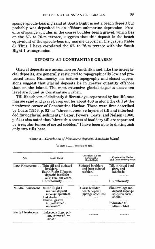
TABLE 3.--Correlation of Pleistocene deposits, Arnchitka Island
[~eaders (-.....l indicate no data]
South Bight Gravel pit 1.5 km
northwest of Constantine Harbor South Bight and Constantine graben
Late Pleistocene -- Thin till and striated Striated boulders Till, striated boul- boulders. and frost-stirred ders, and
South Bight I1 beach cobbles. lakebeds. deposit; fossilifer- ------ ------ ous; 125,000 years.
Unconformity - - - - - - ------ Unconformity . --
Middle Pleistocene South Bight I Coarse boulder Shallow lagoonal marine deposit beach deposit deposit (sponge (sponge spicules). (sponge spicules). s icules, fossil
Lakebeds - - - - - - - - - - ------ sgells). Fluvial gravel ------ ------
(iron-stained) Indurated till outwash?. (diamictite).
Early Pleistocene Lakebeds (logs, pol- ------ ------ len, reversed po- larity).

26 t'I.EIS7OCENE GEOLOGY O F AMCHITKA ISI.AND, ALASKA
OLDER GLACIAL DEPOSITS
The lowest Pleistocene unit exposed here consists of 2-10 m of well-indurated bouldery diamictite that lies on a smooth surface of obsidian breccia bedrock of the Amchitka Formation. As noted by Powers, Coats, and Nelson (1960, p. 544), the diamictite is primarily composed of material derived from the glassy underlying bedrock and is "well cemented, probably by secondary minerals weathered from the finely ground andesitic glass that is so abundant in the matrix." The diamictite displays rude stratification, and contains discontinu- ous, chaotically distorted, thin sandstone beds and subangular to round cobbles and boulders set in a well-indurated muddy matrix. About 50 percent of the stones are weathered obsidian breccia derived locally, a few are fresh diorite, and the remainder are unweathered basalt and andesite, which are smoothly worn and commonly faceted and striated. One medium-grained, granitic-type rock is deeply weathered. Facies changes and the rude stratification apparently led Powers, Coats, and Nelson (1960) to conclude that this unit consisted of more than one till. I believe that this is all one unit and, because of the rude stratification it displays, I refer to i t as a diamictite. That the deposit was closely associated with ice is shown by its heterogeneous texture and content of striated and faceted rocks; perhaps it was let down from thin, melting sediment-rich ice. This is the lower of my two tills. At one place, it is overlain by about 1 m of extremely well indurated varved clay, which is, in turn, overlain by 0.3 m of unfos- siliferous sand, well cemented by iron oxide. The diamictite sheet has been downdropped about 10-15 m to the south by an east-trending fault.
SOUTH BIGHT I(?) MARINE DEPOSIT
The diamictite a t Constantine Harbor is unconformably overlain by as much as 12 m of fossiliferous, shallow-water marine silt, sand, and gravel on the south side of the fault. The marine deposit is absent on the north side of the fault; but, because the fault is not exposed, it could not be determined whether the marine sediments are displaced by or deposited against the fault. A section measured in this deposit is as follows:
0.9-3.7 m Cross-stratified, fine-grained sand. Laminae dip northeast. Contains sponge spicules. Uppermost bed.
0.3-0.9 m Pebble to cobble gravel, well-rounded; many peb- bles and cobbles have weathering rinds.
1.8 m Sand and gravel, even-bedded. No fossils. 0.9 m Sandy silt. No fossils.

DEPOSITS A T COKSTANTINE GRABEN 27
0.6 m Fine-grained sand, even-bedded. Contains pelecy- pod molds from which the carbonate is leached.
3.5-4.0 m Silt, yellowish-brown, well-compacted. No fossils. 8-12 m Total thickness
All beds in this marine deposit are firmly compacted and moderately iron stained but not cemented. Poorly preserved pelecypods, from which the carbonate has been leached, collected from this deposit were identified by W. 0. Addicott (USGS, Cenozoic Sample No. M5005) as follows:
Macoma cf. M. inquinata (Deshayes) Macoma cf. M. nasuta (Conrad) ? Maco m a ?Spisula
This poorly preserved assemblage is suggestive of a Pleistocene or Holocene age according to W. 0. Addicott (written commun., 1972), who further stated that "Macoma nasuta has never been recorded from Hopkins' (1967) Pleistocene transgressions and is restricted today to areas east and southeast of the Aleutian Chain. The other doubtfully identified species, M. inquinata, is a circum-North Pacific bivalve and ranges northward into the Bering Sea." Neither these pelecypods nor sponge spicules were reported in the South Bight I1 deposit (Allison, 1973).
Addicott stated further that "this association of Macoma spp. is suggestive of very shallow water conditions-intertidal or upper reaches of the inner sublittoral zone * * * . Assemblages such as this in which Macomas are the dominant element are often indicative of shallow water bays or marine estuaries." The fact that these fossils are not recorded from other transgressions suggested to Addicott that they might be very young-possibly very late Pleistocene or Holocene. A Holocene age is not likely, however, because this deposit underlies a till which appears to be of Wisconsin age. Further, weath- ering rinds on cobbles, compaction of beds, and iron staining suggest considerable antiquity for this deposit. Amchitka lies 8"-14" south of the latitude of most of the type localities of other recorded transgressions (Hopkins, 1967), which suggests that water tempera- tures and ocean currents a t Amchitka may have restricted these bivalves to this more southerly latitude.
This marine deposit, presumably interglacial, cannot be correlated with certainty with either the South Bight I or South Bight I1 inter- glacial deposits. I t is certainly not Holocene; and its apparent an- tiquity, discussed above, suggests that it is older than the South Bight I1 transgression.
It is tempting to correlate these beds with the South Bight I transgression, owing to the presence of sponge spicules. Although this

28 PLEISTOCENE GEOLOGY O F AMCHITKA ISLAND, ALASKA
is a tenuous correlation because of the lack of time significance of sponges, nevertheless, South Bight I deposits are the only deposits on Amchitka in which I have found sponge spicules; they were looked for but not found in the South Bight I1 deposits. Until new evidence is found, therefore, I am tentatively correlating these beds with the South Bight I transgression (table 3).
The altitude of the base of this shallow water deposit is lower than one would expect for such an old deposit; it is only 9 m above sea level. If it is of South Bight I age, it has either been downfaulted more than 50 m from the 67- to 76-m terrace level, or (more reasonably) it was deposited during a brief pause in the transgressive or regressive phases of South Bight I transgression.
YOUNGER GLACIAL DEPOSITS
A thin till overlies the marine deposit and older faulted diamictite at the northwest corner of Constantine Harbor, but it has not been offset by the fault there. This till, traceable intermittently through- out much of Constantine graben, generally is less than 2 m thick. It consists of a heterogeneous mixture of brown clayey sand containing less than 10 percent rounded to subrounded, unweathered, polished pebbles and cobbles randomly distributed throughout. It is compact but not indurated. On fresh exposures, bedding is not apparent, but on weathered surfaces a faint suggestion of stratification can be seen (fig. 11).
A sandy and silty, rhythmically bedded, unconsolidated lake depos- it (fig. l l ) , containing random pebbles and cobbles, underlies the till throughout much of Constantine graben. This deposit was described in detail by Powers, Coats, and Nelson (1960, p. 544-546). Individual beds average about 30 mm in thickness. The deposit is as much as 6 m thick, but the base is not exposed. The generally fine-grained aspect and even bedding suggest that it was deposited in a pond or lake at the margin of a retreating ice sheet. About 350 m inland from Con- stantine Harbor, where varvelike layers of sand and silt are well exposed, the clayey silt layers throughout several meters of section contain vertical tubes filled with sand from the overlying layers. These tubes are about 5 mm wide by 25 mm long, are round in cross section, and terminate in rounded bottoms. No bifurcations of the tubes were observed. They are lined with about 1 mm of iron-oxide- cemented silt, which helps to preserve them. Their origin is uncer- tain, as no organic material was found in any of them.
Random subangular pebbles and cobbles, distributed throughout the section, disrupt some of the thin beds; their presence suggests that these rocks had been dropped from floating ice. Powers, Coats, and Nelson (1960, p. 546) concluded, correctly, I believe, that the

DEPOSI'I'S A T C0SS.TZSTINF. GRABEN 2 9
FIGURE 11.-Rhythmically bedded glacial pond deposit of alternating sand and silt overlain by 2-m-thick till of unsorted, stony, clayey sand. Weathered surface of till a t right shows faint trace of layermg, whlch suggests that it may not have been directly deposited from melting ice. Dark band a t top of face is peat containing thin ash layers. Shovel a t lower r ~ g h t is about 1.3 m long.
deposit probably "was accumulated in a local pond, largely of glacial melt water, and derived almost wholly from ice-transported mate- rial." These lakebeds, which commonly dip south or southeast toward the Constantine fault, are offset in places by small faults.
Extensive excavation for construction material has exposed glacial striations on bedrock surfaces in Constantine graben (Powers and others, 1960, p. 545). Although not conclusive evidence, the location and attitude of the striations suggest that ice moved from east to west here. No till was observed here, but striated boulders are scattered on the higher ground surface to both the north and south.
Till about 3 m thick underlies the lake deposit. This till, exposed in only a few places low on the north side of the graben 450 m inland from the harbor, is a brownish-gray stiff clay containing scattered rounded and polished stones ranging from 2 to 25 cm in diameter. Across the graben to the south, sandy outwash and gray to brown clayey till, containing polished pebbles, are in fault contact with bed- rock along the Constantine Fault.
In most places, the glacier that deposited this drift left only ran- domly scattered erratic boulders and cobbles, whereas till(?), less than 0.5 m thick, and scattered faceted and striated boulders overlie the South Bight I1 beach sediments a t South Bight. In and near Con- stantine graben, a concentration of erratics is lying on the ground surface. Many of them are distinctive quartz diorite from a pluton,

which crops out near East Cape, and associated contact- metamorphosed breccia of the Amchitka Formation. These rock types could only have come from near South Bight where these rocks crop out.
The presence of these erratics a t Constantine graben (one faceted and striated boulder of metabreccia measured about 3 x 2 x 1 m) indi- cates that the transporting glacial ice must have moved a distance of at least 8 km from east to west. Although this ice sheet apparently was extensive on the eastern end of the island, there is no indication that it extended much farther west than the Constantine graben area. It must have been thin and incapable of much erosion as it overrode, but failed to completely remove, the boulder beach gravel of the South Bight I transgression at the gravel pit near South Bight. In fact, this beach deposit probably was the source of many of the erratics found at Constantine graben. Such evidence indicates that the snow line, a t least on Amchitka, must have been substantially lower than the 183 m estimated for the Near Islands (Schafer, in Gates and others, 1971) or the 122 m estimated for Unalaska (Drewes and others, 1961, p. 647). I know of no evidence to support the sugges- tion (Coats, 1956, p. 96; D. M. Hopkins, written commun., 1968, cited in Pewe, 1975, p. 21) that Illinoian(?) ice or ice of any other age came from present ocean areas off Amchitka Island and overrode the east end of the island. Indeed, the ocean depths alone preclude such an occurrence.
This younger glaciation has not been directly dated, yet it must have occurred between 127,000 and 10,000 years ago, as it overlies dated deposits of the South Bight I1 marine transgression and is over- lain by carbon-14 dated soils. It must be of Wisconsin age. Soils older than about 10,000 years have not been found on Amchitka. The oldest carbon-14 date determined was reported by Everett (1971) as 10,5502 160 yr B.P. from sapric organic material directly overlying bedrock; however, the exact location was not reported. A date of 9,800?160 yr B.P. (Sample No. 13902) was reported by Black (1974) for a soil lying on weathered bedrock about 5 m above sea level near Silver Salmon Lake, and a date of 9,200k130 years (Sample NO. 13905) was obtained from a peat sample, collected by Black, that directly overlies the marine deposit at the northwest corner of Constantine Harbor. At this place, the younger till had been removed by erosion prior to accumulation of this peat.
A carbon-14 date of 8,090?300 years (Meyer Rubin, written com- mun., 1974, Sample No. W2849) was determined for a sample from a 15-cm-thick, strongly undulating soil that lies on about 0.6-1.2 m of eroded crossbedded dune(?) sand. The dune sand overlies the younger till 14 m above sea level at a point 550 m inland from Constantine

GLACIATION O F CENTRAL X S D \VESTERN AMCHITKA 31
Harbor. The soil horizon was, in turn, overlain by 2-3 m of apparent dune sand, which contains several thin soil horizons. The dune sand that overlies the sampled soil conforms to that undulating surface, but the layers gradually flatten upward until they become horizontal. The very unevenness of the sampled soil and the underlying sand suggest that the undulations might have been caused by downslope slumping of the dune sand.
GLACIAL OUTWASH A T RIFLE RANGE FAULT
On the north side of the Rifle Range Fault, a deposit of sand and gravel (not shown in fig. 6) covers an area of as much as 0.5 km2. This deposit was mainly destroyed by excavation during World War 11, but fresh exposures in the remaining portion were created by subsequent excavation during the AEC occupation. The deposit is as much as 6 m thick and consists of firmly compacted, even-bedded sand with in- terstratified gravel beds. No fossils were found. Cut-and-fill struc- tures are common and, in one exposure, sand and cobble gravel dis- play steep initial dips similar to those seen in kame deposits. This deposit is presumed to be glacial outwash; its age is not known but it is probably related to the last glaciation.
The deposit is broken by several normal faults seen in fresh expo- sures. These faults roughly parallel the Rifle Range Fault and display the same sense of movement, down to the north. A few faceted and striated boulders were found scattered on top of this deposit. As no erratics from the distinctive outcrops near South Bight were found, I infer that the eastern ice sheet never reached this far west.
GLACIATION OF CENTRAL AND WESTERN AMCHITKA
The Quaternary geology of the central and western parts of Am- chitka Island has been studied in less detail, but it is reasonable to assume that ice also covered those parts of the island, as they are topographically higher than the eastern end. Except for scattered striated cobbles of local rock, depositional evidence of glaciation northwest of the Rifle Range Fault is sparse; erosional evidence in the form of rock-defended lakes lying west of the middle of the island suggests that ice also covered that part of the island. In the mountainous western third of the island, glacially eroded U-shaped valleys, heading in cirques, indicate that glaciers filled the valleys, but glacial deposits are uncommon on land. Near the western end of the island, scattered erratic boulders lie on the weathered and altered dissected plateau surface. These boulders of fresh andesite, as large as 1.5 m in diameter, appear to have come from an outcrop of Miocene

32 PLEISTOCENE GEOLOGY O F AMCHITKA ISLAND, ALASKA
lava about 5 km to the east. Scattered well-rounded cobbles on Square Bluff, at the northwestern tip of the island (Powers and others, 1960, p. 525), are probably either remnants of conglomerate of the Chitka Point Formation of Miocene age or, more likely, lag concentrate of outwash from ice that covered the plateau.
EXTENT OF GLACIATION
The sea-bottom topography suggests that glaciers extended perhaps as much as 8 km beyond the present shoreline on the south side of the island. More than 200 closed depressions, mostly much less than 0.5 km across, lie on the south side of the island between -9 m and -91 m, as shown on bathymetric charts where the contour inter- val is 1 fathom (1.83 m). As many as 20 large depressions, averaging about 2 km in maximum dimension, are seen on the -91 m terrace where the contour interval is 5 fathoms (9.15 m). These depressions have 4-8 m of closure. Perhaps they represent some pre-Wisconsin glaciation.
Closed submarine depressions, almost nonexistent on the north side of the island, suggest that ice extended much farther to the south than it did to the north. This asymmetry is consistent with the asymmetry of glaciation on the Alaska Peninsula (Coulter and others, 1965).
Most of the closed depressions above - 91 m probably represent ice plucking of bedrock, but in several coves and bays the depressions are very suggestive of closure by moraines, in that the topography there is very smooth. Constantine Harbor and St. Makarius Bay each have two sets of closed depressions (fig. 6). At Constantine Harbor, the inner depression has 2.7 m of closure, with a lip at -33 m; the outer depression also has 2.7 m of closure, with a lip at -39 m. At St. Makarius Bay, the inner depression has a closure of 10 m, with the lip at -32 m; the outer depression has 8.25 m of closure, with the lip at -34 m. I infer these closed depressions lie behind terminal moraines, probably of the east-end icecap. Similar occurrences of closed depres- sions were also noted at Kiska Harbor and at Tanaga Bay at those respective islands.
PLEISTOCENE TECTONISM
Local movement on faults at South Bight and Constantine grabens and at the Rifle Range Fault is recorded in the Pleistocene deposits. Till and outwash of the Wisconsin age are in fault contact with bed- rock along the Constantine Fault, and a deposit of outwash(?) sand and gravel near the Rifle Range Fault is broken by minor faulting.

At South Bight, the north-bounding fault, which had been moving since at least early Pleistocene time, apparently ceased to move be- fore the end of South Bight I1 time, as the upper part of these deposits are unaffected by that fault. Movement continued for some time on the south-bounding fault. The 37- to 49-m terrace at ~ o r t h Bight has been downdropped about 10 m by this south-bounding fault, but movement ceased before cutting of the 15- to 18-m terrace, which is not offset a t North Bight where it crosses the south-bounding fault (fig. 6).
Southward tilting of the island segment lying between Constantine and South Bight grabens is demonstrated by variation in sea-cliff altitudes (fig. 6). The 67- to 76-m (South Bight I) terrace is tilted more than 6" southward, whereas the 37- to 49-m (South Bight 11) terrace is tilted less than lo to the southeast. Tilting started after South Bight I time and continued until shortly after South Bight I1 time, as demon- strated both by these terraces and by the structure in the South Bight graben.
Lack of widely divergent altitudes of most abandoned sea cliffs suggests that differential tectonic movement on the island during the Pleistocene has been minor. The fact that the terraces appear to be older in ascending altitude suggests that the entire island may have been rising throughout the Pleistocene; yet the proximity to sea level of the lower Pleistocene lakebeds, although obviously downfaulted, tends to contradict, this conclusion. Several islands in the Delarof Islands, east of Amchitka, have conspicuously tilted prominent ter- races (Morris, 1971) not seen on Amchitka. Correlation of terraces between different islands in the Aleutians cannot be made on the basis of common altitudes, as differential movement of the islands has obviously occurred.
The -91 m submarine terrace, so prominent around Amchitka, also extends around Rat and Kiska Islands to the west, yet it is either poorly developed or absent around the Delarof Islands east of Am- chitka Pass. This suggests that the Rat Island block has been more stable tectonically than the Delarof Island block during the Pleis- tocene and possibly longer.
Powers, Coats, and Nelson (1960, p. 531) recognized variations in depth of the submerged terraces around Amchitka, but lack of density of soundings hampers attempts to refine these observations. They noted that most of the segments of divergent depths lie around the eastern half of the island; this fact suggests that fault activity may have been more recent there.
Sea level is believed to have been relatively stable for the past 2,000-4,000 years. The presence of a broad intertidal bench found at many places around Amchitka and other Aleutian Islands indicates

34 PLEISTOCENE GEOLOGY OF AMCHITKA ISLAND, ALASKA
that, despite the high seismicity of the Aleutian Arc, most of the islands have remained isostatically stable during this time. Certain abandoned sea cliffs on some of the Delarof Islands, however, suggest that several meters of uplift may have occurred there during the past several thousand years (Morris and Bucknam, 1972).
CORRELATION OF MARINE TRANSGRESSIONS
Any evaluation of the Pleistocene geology on Amchitka Island would be incomplete without an attempt to correlate events there with well-documented Pleistocene events elsewhere in the world. Certainly the termination concept of Broecker and VanDonk (1970) provides a reasonable sequence of high sea levels of middle and late Pleistocene age with which to correlate.
The flight of marine terraces on Amchitka indicates that at least four and possibly five high sea stands occurred there during the Pleis- tocene. Although only one of these terraces is dated, their order of succession and relative sizes are such that we can at least speculate on the correlation of the other terraces with high sea stands elsewhere (table 4).
The uranium-series date of 127,000 years (Szabo and Gard, 1975) for the South Bight I1 transgression leads me-to correlate that event with Broecker and VanDonk's (1970) Termination I1 and Mesolella and others' (1969) Barbados 111, which presumably are related to the Sangamon Interglaciation of the central United States. Even disre- garding the uranium-series date, the extent and size of the South Bight I1 terrace (37-49 m), the lowest major terrace on the island, indicate that it represents a lengthy high sea stand that apparently was never followed by a marine transgression of nearly the same magnitude.
I tentatively correlate the 6- to 9-m and the 15- to 18-m terraces on Amchitka with the Barbados I and I1 reef tracts (Mesolella and others, 1969) on the basis of their relative position, size, and lack of dissection. These lowest Amchitka terraces, both younger than the 127,000-year-old South Bight I1 transgression, represent only brief marine transgressions on Amchitka. The Barbados I and I1 reef tracts also are less extensive than the 125,000-year-old Barbados I11 tract (Mesolella and others, 1969, p. 272) and presumably represent less time of development.
The South Bight I transgression (67- to 76-m terrace) on Amchitka is difficult to correlate with a well-established Pleistocene event, as it
'Despite skepticism voiced by certain workers tKaufman and others. 1971, of the validity of uran~um-senes dating of marine mollusks in noncarbonate semments this date is ur general agreement w ~ t h the present mnce t of the age of the last major interglac~ation throughout widely separated areas (Broecker and VanDonk, 1970, tab; 6) .

TABLE 4.--Correlation of Quaternary marine transgressions on Amchitka Island
[Leaders (--. . . - 1 indlcate no data]
This paper Broecker and
VanDonk, 1970 (fig. 3)
Mesolella and others, 1969 Hopkins, 1973
(table 1) (fig. 10)
Termination I 11,000?600 yrs.
6- to 9-m terrace
15- to 18-m terrace
South Bight I1 37- t o 49-m terrace 127,000?8,000 yrs.
South Bight I 67- to 76-m terrace
125- t o 131-m terrace
Termination I1 127,000?6,000 yrs.
Termination 111 225,000?15,000 yrs.
Termination IV
Barbados I 82,000 yrs.
Barbados I1 105,000 yrs.
Barbados 111 125,000 yrs.
------
Pelukian 11.
Pelukian I .
Kotzebuan.'
Einahnuhtan.
'Recent dating by B. J. Szabo (written commun., 19801 of mollusks collected from Kotzebuan deposlts by D. M Hopkins suggests that the Kotzebuan transgress~on may be considerably younger than indicated previously by Hopkins (19731.
lacks diagnostic fossils and is undated. Yet, because of its size, it obviously represents a major marine transgression preceding the South Bight I1 transgression. It must have been followed by two glaciations: the older occurred during the hiatus represented by the unconformity a t South Bight, which was caused by lowering of sea level and erosion (but for which no deposits are recognized), and the younger overlies the South Bight I1 deposits. Assuming that the ter- race sequence represents a complete record of transgressions on Am- chitka, I tentatively correlate the South Bight I transgression with Termination I11 of Broecker and VanDonk (1970, p. 194), which oc- curred about 225,000 years ago. If my tentative correlation of the marine deposits at Constantine Harbor with the South Bight I transgression is valid, then the underlying diamictite must be pre- Illinoian-possibly Kansan-in age.
Correlation of the Amchitka marine transgressions with those of mainland Alaska is made separately here because there is consider- able uncertainty in this regard.
Allison (1973) stated that the fossil mollusks in the South Bight I1 deposit "offer evidence in favor of a Kotzebuan or possibly even a Pelukian age" for the South Bight I1 transgression. Because the pres- ence of till overlying the deposit was believed by D. M. Hopkins to preclude a Pelukian (Sangamon) age for the deposit (Allison, 1973, p. 45), Allison concluded that the South Bight I1 fauna "probably" were Kotzebuan (pre-Illinoian). I feel this is not a valid conclusion. Pre- sumably, Hopkins assumed that the overlying till would have to be Illinoian because, on mainland Alaska, Illinoian ice was far more

36 PLEISTOCENE GEOLOGY OF AMCHITKA ISLAND, ALASKA
extensive than was Wisconsin ice. However, there is good evidence for extensive Wisconsin ice sheets on islands in the Aleutians.
On mainland Alaska, there seems little doubt that glaciation of pre-Wisconsin (Illinoian?) age was far more extensive than that of Wisconsin age (see, for example, Coulter and others, 1965). It ap- pears, however, that Wisconsin glaciers were extensive enough in the Aleutians to have covered most of what is now land surface and to have removed most evidence of the pre-Wisconsin glaciation. On Umnak Island, in the eastern Aleutians, earlier studies by Byers (1959, p. 349) suggested that extensive glaciation of the Nikolski plain "was late Pleistocene, possibly Wisconsinan in age." Extensive Wisconsin Glaciation there is further substantiated by Black (1974, p. 126), who stated that on Umnak "no glacial deposits have been recognized earlier than late Wisconsinan, when an extensive ice sheet covered all but the highest peaks up to 10,000 or 11,000 years ago." Soils and peat older than 10,000 years have not been found on Umnak. In the western Aleutians, Schafer (in Gates and others, 1971) recognized that extensive ice sheets covered the Near Islands (Attu, Agattu, and the Semichi Islands); he suggested that they were "no older than Wisconsinan."
Lack of organic material yielding carbon-14 dates older than about 10,000 years, not only on Amchitka Island but also on 13 other is- lands from Kiska to Tanaga in the central Aleutians (Gard, unpub. data, 1974), strongly suggests that icecaps or permanent snowfields must have covered most of these islands during late Wisconsin time.
Thus, evidence from other islands at the extremities of the Aleu- tian chain supports findings on Amchitka that an ice sheet of Wiscon- sin and probably late Wisconsin age covered Amchitka Island.
In a recent paper, Hopkins (1973) has compared the later part of his Beringian marine transgressions with Broecker and VanDonk's climatic curves. He recognized two stages of the Pelukian transgres- sion. He correlated Pelukian I with the 127,000-year-old Termination 11 of Broecker and VanDonk (1970), and he believed (1973, p. 536) Pelukian I1 "may correspond to either Barbados I or I1 and thus may be either 80,000 or 105,000 years old." If the 127,000-year-old South Bight I1 transgression is correctly correlated with Termination 11, then it could also be correlative with the Pelukian I transgression.
Correlation of the higher and older Amchitka transgressions with Beringian transgressions is less certain. The South Bight I transgres- sion (67- to 76-m terrace) was obviously one of major proportions and immediately preceded the South Bight I1 transgression. Table 4 shows that Hopkins (1973) correlated the Einahnuhtan transgression with Termination I11 of Broecker and VanDonk. I am strongly tempt- ed to correlate South Bight I with Hopkins' Kotzebuan transgression

REFERENCES CITED 3 7
although he did not correlate Kotzebuan with any of the transgressions at Barbados, This correlation remains unresolved.
It must be emphasized again that all the above correlations of Am- chitka transgressions are based on the relative positions and sizes of the terraces with the one dated major transgression-the South Bight 11 transgression.
Correlating terraces between islands on the basis of corresponding altitudes is unreliable because of differential Quaternary tectonic movement between islands and island blocks; sequences of terraces on each island will need to be studied on their own. Only then can reliable correlations between the effects of marine transgressions on different islands be attempted.
It is hoped that this paper will inspire and aid future students of the Aleutian Pleistocene not only to expand this work on Amchitka, espe- cially the early Pleistocene history, but also to study the terraces and search for marine deposits on other islands. Such work will greatly extend our knowledge of the Pleistocene in the Aleutians and will help to further determine the Pleistocene tectonic history of the Aleu- tian chain.
REFERENCES CITED
Allison, R. C., 1973, Marine paleoclimatology and paleoecology of a Pleistocene inver- tebrate fauna from Amchitka Island, Aleutian Islands, Alaska: Palaeogeography, Palaeoclimatology, Palaeoecology, v. 13, no. 1, p. 15-48.
Black, R. F., 1974, Geology and ancient Aleuts, Amchitka, and Umnak Islands, Aleu- tians: Arctic Anthropology, v. 11, no. 2, p. 126-140.
Broecker, W. S., and VanDonk, Jan, 1970, Insolation changes, ice volumes, and the OIR record in deep-sea cores: Geophysics and Space Physics Reviews, v. 8, no. 1, p. 169-198.
Byers, F. M., Jr., 1959, Geology of Umnak and Bogoslof Islands, Aleutian Islands, Alaska: U.S. Geological Survey Bulletin 1028-L, p. L267-L365.
Carr, W. J., Quinlivan, W. D., and Gard, L. M., Jr., 1970, Age and stratigraphic relations of Amchitka, Banjo Point, and Chitka Point Formations, Amchitka Is- land, Aleutian Islands, Alaska, in Changes in stratigraphic nomenclature by the U.S. Geological Survey, 1969, by G. V. Cohee, R. G. Bates, and W. B. Wright: U.S. Geological Survey Bulletin 1324-A, p. A16-A22.
Coats, R. R., 1956, Reconnaissance geology of some western Aleutian Islands, Alaska: U.S. Geological Survey Bulletin 1028-E, p. E83-E100.
Coulter, H. W., Hopkins, D. M., Karlstrom, T. N. V., Pewe, T. L., Wahrhaftig, Clyde, and Williams, J. R., compilers, 1965, Map showing extent of glaciations in Alaska: U.S. Geological Survey Miscellaneous Geologic Investigations Map 1-415.
Cushman, J . A., and Todd, M. R., 1947, A foraminifera1 fauna from Amchitka Island, Alaska: Cushman Laboratory for Foraminifera1 Research Contributions, v. 23, pt. 3, p. 60-72.
Drewes, Harald, Fraser, G. D., Snyder, G. L., and Barnett, H. F., Jr., 1961, Geology of Unalaska Island and adjacent insular shelf, Aleutian Islands, Alaska: U.S. Geological Survey Bulletin 1028-S, p. S583LS676.

38 PLEISTOCENE GEOLOGY OF AMCHITKA ISLAND, ALASKA
Everett, K. R., 1971, Composition and genesis of the organic soils of Amchitka Island, Aleutian Islands, Alaska: Arctic and Alpine Research, v. 3, no. 1, p. 1-16.
Fraser, G. D., and Barnett, H. F., Jr., 1959, Geology of the Delarof and westernmost Andreanof Islands, Aleutian Islands, Alaska: U.S. Geological Survey Bulletin 1028-1, p. 1211-1248.
Gard, L. M., Jr., Lewis, G. E., and Whitmore, F. C., Jr. , 1972, Steller's Sea Cow in Pleistocene interglacial beach deposits on Amchitka, Aleutian Islands: Geological Society of America Bulletin, v. 83, no. 3, p. 867-869.
Gates, Olcott, and Gibson, W. M., 1956, Interpretation of the configuration of the Aleutian ridge [ ~ l a s k a ] : Geological Society of American Bulletin, v. 67, no. 2, p. 127-146.
Gates, Olcott, Powers, H. A,, Wilcox, R. E., and others, 1971, Geology of the Near Islands, Alaska, with a section on Surficial geology, by J. P. Schafer: U.S. Geologi- cal Survey Bulletin 1028-U, p. U709-U822.
Hopkins, D. M., 1967, Quaternary marine transgressions in Alaska, in Hopkins, D. M., ed., The Bering Land Bridge: Stanford University Press, p. 47-90. - 1973, Sea level history in Beringia during the past 250,000 years: Quaternary
Research, v. 3, no. 4, p. 520-540. Kaufman, Aaron, Brocker, W. S., Ku, T. L., Thurber, D. L., and others, 1971, The
status of U-series methods of mollusk dating: Geochemica et Cosmochimica Acta, v. 35, no. 11, p. 1155-1183.
Mesolella, K. J., Matthews, R. K., Brocker, W. S., and Thurber, D. L., 1969, The astronomical theory of climatic change-Barbados data: Journal of Geology, v. 77, no. 3, p. 250-274.
Morris, R. H., 1971, Marine terraces of the western Aleutian Islands, Alaska: U.S. Geological Survey Report USGS-474-139, 23 p.; available from U.S. Department of Commerce National Technical Information Service, Springfield, VA 22161.
Morris, R. H., and Bucknam, R. C., 1972, Geomorphic evidence of late Holocene verti- cal stability in the Aleutian Islands, Alaska: Seismological Society of America Bulletin, v. 62, no. 6, p. 1365-1375.
Pewe, T. L., 1975, Quaternary geology of Alaska: U.S. Geological Survey Professional Paper 835, 145 p.
Powers, H. A., 1961, The emerged shoreline at 2-3 meters in the Aleutian Islands, in Russell, R. J., ed., Symposium, Baton Rouge, Pacific island terraces-eustatic?: Zeitschrift fiir Geomorphologie Supplementband 3, p. 36-38.
Powers, H. A., Coats, R. R., and Nelson, W. H., 1960, Geology and submarine physiog- raphy of Amchitka Island, Alaska: U.S. Geological Survey Bulletin 1028-P, p. P521-P554.
Scheffer, V. B., 1972, The weight of the Steller sea cow: Mammalogy Journal, v. 53, no. 4, p. 912-913.
Spiker, Elliott, Kelley, Lea, Oman, Charles, and Rubin, Meyer, 1977, U.S. Geological Survey radiocarbon age dates XII: Radiocarbon, v. 19, no. 2, p. 332-353.
Stejneger, Leonhard, 1883, Contributions to the history of the Commander Islands, No. 1-Notes on the natural history, including descriptions of new cetaceans: U.S. National Museum Proceedings, v. 6, p. 58-89.
Szabo, B. J., and Gard, L. M., Jr., 1975, Age of the South Bight 11 marine transgression a t Amchitka Island, Aleutians: Geology, v. 3, no. 8, p. 457-459.
Whitmore, F. C., Jr., and Gard, L. M., Jr., 1977, Steller's sea cow (Hydrodamalis gigas) of late Pleistocene age from Amchitka, Aleutian Islands, Alaska: U.S. Geological Survey Professional Paper 1036, 19 p.