Embed Size (px)
Citation preview

The Palace Centre of Sago City: Utti Batue Site, Luwu,Sulawesi, Indonesia
F. David Bulbeck, Doreen Bowdery, John Field and Bagyo Prasetyo
Chapter 12
INTRODUCTION
Archaeological remains rarely preserve well in humid equatorial regions, apart from those in a few favouredlocations such as anaerobic swamps. One of the best known of these sites is Kuala Selinsing, in PeninsularMalaysia, an important offshore trading and industrial centre occupied from c. 2000–1000 yr BP (NikHassan Shuhaimi 1991). In this paper we briefly describe a second site of comparable significance – UttiBatue, which evidently served as the palace centre of Luwu, a prominent Bugis kingdom, during its pre-Islamic heyday in the fifteenth and sixteenth centuries. The site has major implications for historians ofSulawesi in view of Luwu’s widely held reputation as the oldest and most prestigious Bugis kingdom (e.g.Pelras 1996). It also has great archaeological significance as it is, to our knowledge, the best preservedSoutheast Asian palace centre which dates to the ‘early modern period’. Following its abandonment c. AD1600 and the shift of Luwu’s capital to Palopo between 1610 and 1630 (Bulbeck and Caldwell 2000, 70),Utti Batue became sealed beneath approximately 1 m of sediment, and its material remains were virtuallyfree of degradation from subsequent habitation or agricultural disturbance.
Utti Batue is located at 2o 47’ 50” S, 120o 24’ 00” E in Kecamatan Malangke Barat, Kabupaten LuwuUtara, in the province of South Sulawesi (Fig. 12.1). The site lies at 1–2 m above sea-level, in anenvironment of oppressively high temperatures and humidity, and an average annual rainfall of 2500–3000mm. It was first recorded in 1997 during a preliminary survey by the ‘Origin of Complex Society in SouthSulawesi’ (OXIS) project (Bulbeck and Prasetyo 1998), and in 1999 a borehole survey estimated its extentas 4 ha. During this survey, test pits were excavated to the north of the site, adjacent to the drainage ditchwhich had previously exposed its existence; this paper describes the artefacts and ecofacts recoveredthrough excavation.
One of the hypotheses formulated by the OXIS project is that the dominant plant food of the Utti Batueinhabitants was sago (Bulbeck and Caldwell 2000, 14–5); the coastal swamps surrounding the site are oneof the main sources of sago in South Sulawesi, exporting over 1000 tons of wet sago in 1984 (Osazawa1986). It is also estimated that the population stood at about 10,000 inhabitants in the fifteenth century, and10–15,000 in the sixteenth century, on the basis of looted pre-Islamic cemeteries in the Malangke sitecomplex, and the size of the two main settlements of Utti Batue and Pattimang Tua (Fig. 12.2) (Bulbeck and

F. David Bulbeck, Doreen Bowdery, John Field and Bagyo Prasetyo120
Caldwell 2000, 73–6). These urban population levels, in conjunction with a monumental structure withbrick foundations at Tampung Jawa, a centralised economy and the well-established literary tradition inpre-Islamic Luwu, would satisfy all four of Fagan’s (1995, 343) criteria for a ‘civilisation’. Utti Batuewould accordingly rank with the famous fifteenth century entrepôt of Melaka, in Peninsular Malaysia,whose inhabitants also established the capital of a civilisation in an environment too brackish for wet-ricecultivation, and instead turned to sago for their staple diet (Wheatley 1961, 311–2).
SURVEY AND EXCAVATION
Immediately north of Utti Batue lies the site referred to as the Dato Sulaiman Islamic Cemetery. It featuresthe tombs of the first sultan of South Sulawesi, Matinroe ri Ware Sultan Muhammad Wali Muzahir, andhis teacher Dato Sulaiman who converted his royal pupil to Islam in 1605. This major Islamic site, notedby Caldwell (1993), was subsequently shown to abut a rich, looted, late pre-Islamic cemetery (Bulbeck1996–7). The tombs face a large fishpond, excavated by the local inhabitants in 1997 and containing a lock-controlled drainage ditch in which buried posts of massive dimensions were unearthed. Pottery and otherdebris were also reported.
The OXIS team was able to survey the bottom of the ditch, and in addition to observing an abundanceof earthenware pottery, an iron knife with a curved blade and other iron fragments were collected. A water-
Fig. 12.1 Luwu, South Sulawesi, and main locations mentioned in the text.

The Palace Centre of Sago City 121
Fig. 12.2 Malangke (above) and Utti Batue (below).

F. David Bulbeck, Doreen Bowdery, John Field and Bagyo Prasetyo122
buffalo bone, a pottery fragment with dammar gum adhering to it,1 and imported ceramic shards dating tothe fifteenth and sixteenth centuries were also retrieved (Bulbeck and Prasetyo 1998, 1999, 25). The site’sproximity to the tomb of Muhammad Wali Muzahir strongly suggested that it represented Luwu’s last pre-Islamic palace, and the range of organic and barely corroded iron remains indicated excellent preservationconditions, brought about by the deposition of flood sediments since the site’s abandonment.
To determine the extent of the main habitation area at Utti Batue 35 boreholes were sunk along transectsrunning through the mandarin orchard at the site, and the surrounding rawa forest. The boreholes weredrilled to a depth of 1.5–2.0 m, or until evidence of habitation, in the form of pot shards or food remains,was encountered (between 0.6 and 1.9 m depth). A boundary drawn around the productive boreholelocations produced a shoehorn-shaped site, called North Utti Batue, covering approximately 3 ha (Fig.12.2). A second area a short distance to the south, reportedly yielded a stone board with engraved squares,evidently designed for playing macang (a Bugis game similar to chess), and an extraordinary concentrationof imported ceramic shards from a 2 × 2 m illegal excavation, totalling 29 g of glass and 31.4 kg ofimported ceramics. It was tentatively inferred that this area, designated South Utti Batue, would havecovered around 1 ha and probably served as an elite compound.
An initial test pit (Selatan 4–5/Barat 25–26) (Fig. 12.2) failed to reveal any archaeological traces, buta second, 9 m2 test pit (Selatan 23–25/Barat 2–4) yielded an abundance of materials (Fig. 12.3). The top 0.7m of this pit was removed by shovel until the first archaeological trace, an earthenware shard, was exposed(Fig. 12.3). Subsequent deposits were removed in spits of approximately 5 cm depth. The first three such
Fig. 12.3 Stratigraphic section of Utti Batue Test Pit 2 (northern wall).

The Palace Centre of Sago City 123
spits, which yielded very sparse remains, covered the entire exposure. Spits 4 to 18, which were excavatedthrough the main cultural deposit to sterile deposits at about 1.6 m depth, were restricted in area to the 4m2 in the centre of the test pit. Most of the pit was excavated at levels below the water table, and excavationwas only possible by regularly pumping out the groundwater.
In describing the materials retrieved, along with the more interesting finds from the surface survey, wemust stress that the work at Utti Batue provides only a very partial view of a site whose total materialcontents may be in the order of 10,000 times larger than the sample that OXIS was able to extract; basedon the second test pit’s excavated finds of approximately 45 kg, the total artefactual and ecofactual contentof Utti Batue could conceivably lie in the region of 400–500 tonnes.
Site environment and sediments
In the 1980s, Utti Batue lay in a mixed forest of Rhizophora apiculata, Avicennia marina and Xylocarpusgranatum, within a 12,000 ha expanse of mangrove forest which was, at the time, the largest in Sulawesi(cf. Whitten et al. 1987, 125, 190). Intuitively it is assumed that at the time of occupation the Utti Batuesite also lay in a mangrove setting, but closer to the shoreline which may then have reached severalkilometres to the west of its present position. The colour contrast in the excavated deposits, frompredominantly grey in the lowest metre to olive brown in the upper layers (Fig. 12.3), would be consistentwith the transition from a hydromorphic alluvium to a gley humus, which Whitten et al. (1987, 110)associate respectively with the seaward and terrestrial zones of the Malangke mangrove forest.
The majority of sediment samples (labelled SS in Fig. 12.3) comprised clay-rich, silty fine sands, and allare acidic, increasing in acidity with depth (cf. Whitten et al. 1987, 110). Clay samples from spits 2 and3 (post-occupation), 7 and 8 (late occupation), 12 and 13 (middle occupation), and 17 and 18 (pre-occupation) were analysed by X-ray diffractometry, and the results from a representative sample (spit 2) areillustrated in Fig. 12.4. Mineralogically the samples are virtually identical, containing orthoclase andplagioclase feldspar, quartz, mica (biotite and muscovite), amphibole, chlorite, kaolinite, smectite,vermiculite and inter-layered clay (in a biotite/chlorite phase). These minerals are consistent with derivationof the sediments from the granodiorite hills which abut the coastal plain where the Rongkong and Baebuntarivers leave the ranges before flowing towards Malangke. The lack of variation in the samples suggests thatthe same sedimentation regime has prevailed from the time of initial settlement until the present, andchronological indications are consistent with this scenario. The c. 0.5 m of sediment deposited during theperiod of occupation of the site, i.e. the 200 years between AD 1400 and 1600, and the overlying 1 m ofsediment deposited during the 400 following years, both correspond to an average deposition rate of 0.25cm yr-1.
Consequently, the abandonment of Utti Batue cannot be attributed to a disastrous flood or other majornatural event, and is more likely due to socio-political changes, as the local oral history would suggest(Bulbeck and Caldwell 2000, 70). Moreover, the excellent preservation of organic materials at the sitewould appear to reflect anaerobic, waterlogged conditions at the time of occupation, rather than the creationof such conditions through the deposition of a sealing cap of sediment at the time of the site’s abandonment.
Site contents
The primary means of dating the period of site occupation come from consideration of the 466 shards ofimported stoneware and porcelain ceramics identified from the site. While the vast majority of these pieces(434) were recovered from the illegal excavation (noted above) in South Utti Batue, they are entirelyconsistent with the smaller body of finds recovered from North Utti Batue. Sixteenth century wares dominatethe assemblage (Table 12.1). The single fourteenth century shard could have arrived at the site later thanits identified age of manufacture, and is thus insufficient evidence of occupation before the fifteenth

F. David Bulbeck, Doreen Bowdery, John Field and Bagyo Prasetyo124
century. As no wares definitely post-date the sixteenth century, the total period of occupation can bebracketed between c. AD 1400 and 1600, suggestive of sudden abandonment at the end of the site’ssixteenth century heyday. The variety of imported wares is great (Table 12.1), and includes all manner oflarge and small jars, jarlets, vases, plates, bowls and covered bowls, with many of the pieces being ofexcellent quality. The assemblage gives the impression that imported wares served as a regular componentof the domestic chattels, although the excavated finds show that earthen vessels greatly outnumberedimported ceramics in daily use (Table 12.2).
A few of the surface finds collected near the test pit in 1998 merit attention. One is a fragment of a brick16.4 cm wide and 3.85 cm thick, with a length in excess of 19 cm. Its breadth and thickness fall in the rangerecorded on brick fragments from Tampung Jawa, which are interpreted to have been used in erecting athirteenth to fifteenth century monumental structure at Malangke (Bulbeck and Prasetyo 1999, 27). Anotherfind is a beautifully polished ‘axe’ with a square cross-section and dimensions of 149 × 37 × 35 mm, madeof a hard, mottled pink and reddish brown stone. Even though it was surely a ceremonial piece (with notraces of use), its appearance at Utti Batue appears anachronistic, and it must have been brought on to thesite as a curio or heirloom. The two other surface finds of polished stone are a heat-cracked river pebble(from a hearth or earth oven?), subsequently utilised as a pestle, and a soft river pebble with use-wearstriations on one face and transverse fractures along its sharper edge (probably used as a pestle-cum-scraper). Stone tools are rare at this site and the only other identified example is a small polished stone fromspit 17 of the test pit. This peg-like chaplet or pin measures 48 mm long × 28 mm maximum diameter, andhas been shaped to only a slight degree from a suitably proportioned pebble blank (Fig. 12.5, UTB.2.17.4).
Fig. 12.4 X-ray diffractogram of the clay sample from spit 2.

The Palace Centre of Sago City 125
14th 14th–15th 15th 15th–16th 15th–18th 16th 16th–17th Undated
Chinese whiteware 1 1 0 13 0 17 16 0
Jizhou black-and-white 0 3 0 0 0 0 0 0
Chinese blue-and-white 0 2 1 5 0 239 8 0
Chinese lead-glazed 0 0 2 0 0 0 0 0
Chinese celadon 0 0 1 7 0 1 0 0
Chinese monochrome 0 0 0 4 0 10 0 0
Sawankhalok 0 0 0 18 0 0 0 0
Sukothai 0 0 0 2 0 0 0 0
Vietnamese 0 0 0 46 0 41 0 0
Pegu (Burma) plainware 0 0 0 0 2 0 0 0
Coarse stoneware jar 0 0 0 1 0 1 0 4
Chinese blueware 0 0 0 0 0 1 0 0
Chin. overglaze enamels 0 0 0 0 0 16 3 0
Total 1 6 4 96 2 326 27 4
Spit Gravels and
misc. pebbles
Ironstone
pebbles
Baked/indurated
earth
Earthen
shards
Ceramic
shards
Glass bead
5 1.1 g
6 4.0 g 34.1 g
7 1.0 g 541.5 g
8 25.0 g 596.1 g
9 20.0 g 5.0 g 1082.0 g
10 210.0 g 117.0 g 3015.0 g 17.0 g
11 160.0 g 86.0 g 2937.8 g 210.9 g
12 564.0 g 174.0 g 3120.9 g 2.7 g
13 120.0 g 196.7 g 3305.3 g 19.0 g
14 247.2 g 105.0 g 2512.0 g 86.5 g
15 26.0 g 1263.1 g 0.1 g
16 6.0 g 6.6.g 681.3 g 37.4 g
17 38.0 g
18 9.6 g
Total 1.4 kg 86.0 g 604.3 g 19.8 kg 379.8 g 0.1 g
Table 12.1 Imported stoneware and porcelain identified from Utti Batue. Summarised from Bulbeck andPrasetyo (1999), and Bulbeck and Caldwell (2000: 119–20), apart from a few coarse stoneware shardssubsequently identified among the excavated earthen pottery.
Table 12.2 Weight of inorganic finds from the Utti Batue test pit. Earthenware total includes 0.7 kg of shardscollected from the wall, and the total of imported ceramic shards includes one from the wall.
Various pebbles and gravels, weighing 1.4 kg in total, were collected during the excavation. Theiroccurrence rises and falls with that of the artefacts and ecofacts (Tables 12.2 and 12.3), indicating that theyhad been transported manually on to the site. Some of the rocks show traces of exposure to heat and othersmay be spalls from used pebbles, confirming their role in the material culture of the occupants. A singlejagged pebble of ironstone (Table 12.2) is of interest for its possible suggestion that iron ore had beenimported to Malangke. The 600 g of baked and/or indurated earth point to some lighting of fires in the
F. David Bulbeck, Doreen Bowdery, John Field and Bagyo Prasetyo126
Fig. 12.5 Representative artefacts excavated from Utti Batue Test Pit 2.

The Palace Centre of Sago City 127
vicinity of the settlement, notwithstanding the waterlogged terrain that surrounded the site. The mostprominent class of finds is earthenware shardage which, at nearly 20 kg, accounts for almost half of allrecorded finds. The excellent preservation conditions probably account for the observation (detailed below)that a dammar coating1 has been better preserved on the local pottery at Utti Batue than at other excavatedsites in Luwu.
The organic finds include over 1 kg of charcoal, about 13 kg of timber, over 330 g of other plantmacrofossils, about 6.6 kg of faunal remains, and a lump of dammar gum (Table 12.3). Closer study of theplant macrofossils (which were identified only in the field) would quite likely reveal a greater variety thanthose shown here, but the direct evidence for the consumption of canarium nuts and coconuts is of interestin dietary reconstruction. Many of these fragments were recorded as burnt, as were all the faunal fragments.The wood had been deposited in large blocks of up to 2.7 kg in weight, and two pieces were observed toshow clearly planed surfaces, as would be expected if the timber had been used for constructing houses onthe site. According to the workers at a sawmill near the Makassar Archaeology Office in Sudiang, the typeof wood represented is locally named taluttu, a mangrove timber of fine quality for carpentry andconstruction.
In view of the incomplete nature of the reference collection and the lack of a specialist analyst toundertake faunal identification, we attempted to be conservative in our identifications (Table 12.4). However,it is clear that bovids account for almost two-thirds of the faunal remains by weight. Large mammals,including pigs and deer, dominate the assemblage, while the contribution from medium-sized mammals,apparently including monkeys and dogs, but possibly also cuscus, was modest.
Few small fauna were recorded, and of these the rats were probably unwelcome guests. Fish and turtlemake up a restricted but recognisable marine component of the assemblage, but no shellfish were recorded.This contrasts with the archaeological excavation of shellfish middens in Luwu, which are both
Spit Charcoal Canarium
nut husks
Carbonised
seed
Coconut
shell
Wood Dammar
lumps
Faunal
fragments
Organic
lumps
2 8.5 g 8.0 g
3 1.4 g
5 3.5 g 0.3 g
6 0.6 g 15.0 g
7 77.0 g 2.0 g 124.7 g
8 53.0 g 1.2 g 2.7 kg 104.5 g
9 76.0 g 9.0 g 4.5 kg 700.6 g 15.0 g
10 193.0 g 7.0 g 30.0 g 1629.9 g 11.0 g
11 112.0 g 33.0 g 33.0 g 3.1 kg 641.4 g 26.0 g
12 240.0 g 27.0 g 677.6 g 3.0 g
13 293.7 g 33.3 g 1.0 g 2.1 kg 1.3 g 387.5 g 9.0 g
14 162.0 g 68.0 g 118 g 853.4 g 18.0 g
15 106.0 g 35.0 g 4.0 g 148 g 177.9 g 5.0 g
16 69.0 g 19.0 g 2.0 g 100 g 59.6 g 8.0 g
17 10.0 g 1.0 g 62 g 26.7 g 2.0 g
18 131 g
Total 1.4 kg 260.5 g 0.3 g 70.0 g 13.0 kg 1.3 g 6.95 kg 97.0 g
Table 12.3 Weight of organic finds by spit from the Utti Batue test pit (spits 1 and 4 were sterile). Totalsinclude 12.4 g of charcoal, 2 g of canarium fragments, 6.6 g of wood, and 1.55 kg of bone fragmentscollected from the test pit wall.

F. David Bulbeck, Doreen Bowdery, John Field and Bagyo Prasetyo128
contemporary with Utti Batue (Salabu, Tampinna) and younger than it (Surutanga, in Palopo) (Bulbeck andCaldwell 2000). The identifications at Utti Batue suggest an animal protein diet dominated by domesticanimals, especially bovids, along with some exploitation of resources from the adjacent sea. It is assumedthat the bovids were mainly water-buffalo, which would have thrived in the wet conditions at Utti Batue,rather than cattle.
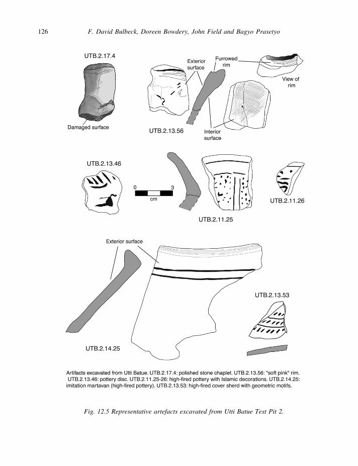
The term ‘organic lumps’ is used for the 97 g of rounded cylindrical objects (Table 12.3) which theexcavators tentatively identified as coprolites, but this was later demonstrated not to be the case at thePalynology Laboratory of Texas A&M University, although their identification remains uncertain. X-raymineralogical analysis showed that one specimen consisted entirely of amorphous material, a second waspredominantly of amorphous matter but included some quartz, possibly accompanied by some chloriticmaterial and a little kaolin, and a third specimen consisted of an outer skin, which is mineralogicallyidentical to the surrounding sediments, and inner matter which produced the same essentially amorphousX-ray spectrum as observed for the other two samples (Fig. 12.6). The most plausible identificationcurrently comes from Malcolm Lillie at the University of Hull, who observed pockets of oil in the matrixand inferred that the specimens sent to him could be some sort of seed or fruit.
Phytolith analysis
Analysis of phytoliths (plant biogenic silica microfossils) was carried out on nine sediment samples fromthe test pit, in particular to determine whether sago palm (Metroxylon sagu) was part of the vegetativelandscape when occupation at the site was flourishing. Illustrated references of phytoliths extracted fromtropical material are limited. Nonetheless, leaf material from a small phytolith reference collection oftropical economic plants indicates that sago palm is a high volume producer of small, spherical echinatephytoliths in three sizes, c. 5, 8 and 10 mm diameter. However, as small spherical echinate and similarphytoliths are also identified in other palms (e.g. coconut), use of a higher magnification scanning electronmicroscope would be required to distinguish phytoliths of less than 10 mm. In this instance an assumptionhas been made that the presence of high numbers of phytoliths within the size range noted in sago referencematerial, and the current presence of sago palms throughout this area, indicate a probable continuouspresence through time, as reflected by the high numbers of phytoliths with small palm type morphology.The sago palm also produces starch grains which can and do migrate and cluster on the slide, but notnecessarily in the count transect. While phytoliths classified to a morphological group are not necessarilyidentical, their size, shape and ornamentation place them within the various groups.
Identification Weight (g) NISP Identification Weight (g) NISP
Bovid 4234.2 272 Bovid? 112.4 15
Pig 39.8 8 Pig? 21.8 5
Deer 299.0 1 Large 912.9 302
Large/Medium 680.5 422 Medium 87.1 49
Macaque? 12.4 2 Dog? 2.0 1
Medium/Small 14.3 8 Small 3.1 7
Rat 1.0 7 Rat? 2.0 5
Bat? 1.8 1 Turtle/tortoise 5.7 4
Fish 110.8 52 Unidentified 413.1 352
TOTAL 6953.9 1513
Table 12.4 Recorded weights and numbers of individual specimens (NISP) of fauna from the Utti Batueexcavation.
The Palace Centre of Sago City 129
Given the high rainfall, high water table, low relief and likely regular inundation of the area throughtime, it is suggested that the excavation area has always experienced various degrees of wetness, similar tothe existing swampy conditions. In the Utti Batue phytolith assemblage (Table 12.5) two morphologies areindicative of wet conditions. These are the spherical echinate palm types of less than 10 mm (Group 1) andgrass arc/triangle cells (Groups 69–71).
Where possible, plant names are tentatively identified to the groups. Groups 1–8 are palms with Group1, which dominates the phytolith assemblage, probably sago palm and Group 7 probably coconut palm.Also tentatively identified are Groups 29 (Barringtonia), 33 (wild banana) and 34 (ginger). These plants,along with a variety of palms and other flora, are all to be found in disturbed areas of Indonesia (Whittenet al. 1987). Group 25, Cuticle 2 is identified (Fahn 1989) as from the Iridiaceae family, whose membersare swamp plants in their native habitat (Dykes 1974). Rectangles (Groups 36–48) are ubiquitous andunidentified to plant in this assemblage. ‘Grasses’ (Groups 50–71) follow a classification scheme devisedby Bowdery (1998) to identify short cell morphology. Group 55 and Angular groups 58–67 in this instanceare tentatively associated with bamboo. The arc/triangle morphology of Groups 69–71 identifies hydrophylicgrasses such as Imperata, Phragmites and bamboo. It is suggested that, given the short chronology of thedeposit, morphologies occurring in all nine samples (final column, Table 12. 5) may be considered as partof the phytolith ‘noise’ for the site. Omitting Group 72 (‘others’), this gives 27 morphologies occurring asnoise.
Table 12.6 gives relative frequencies of phytoliths obtained from a count of one 10 mm transect for each
Fig. 12.6 X-ray diffractogram of an ‘organic lump’ sample contrasting the outer skin (with peaks) and theinner matter (amorphous spectrum).
F. David Bulbeck, Doreen Bowdery, John Field and Bagyo Prasetyo130
Tab
le 1
2.5
Utt
i B
atue
phy
toli
th p
rese
nce.
Sp
it #
5
8
9
10
11
1
2
13
1
4
1
8
db
s cm
1
05
120
1
25
1
30
13
5
14
0
14
5
15
0
17
0
Sli
de
ID
713
723
7
14
7
15
71
6
71
7
71
8
71
9
72
0
PH
YT
OL
ITH
MO
RP
HO
LO
GY
G
p #
Occ
urr
ence
in
sed
s
Sp
her
ical
(m
ax.
9)
ec
hin
ate
(pal
m)
-
<1
0µ
(s
ago
)
1
x
x
x
x
x
x
x
x
x
9
-
<2
0µ
2
x
x
x
x
x
x
x
x
x
9
-
<3
0µ
3
x
x
x
x
x
x
x
x
x
9
-
<4
0µ
4
x
x
x
x
x
x
x
7
-
<5
0µ
5
x
1
-
<7
5µ
6
x
x
2
-
Se1
(co
conu
t)
7
x
x
x
x
x
x
x
x
x
9
-
Se
2
8
x
x
x
x
x
x
x
x
x
9
p
sila
te (
arb
ore
al)
-
< 1
0µ
9
x
x
x
x
x
x
x
x
x
9
-
< 2
0µ
1
0
x
x
x
x
x
5
-
< 3
0µ
1
1
x
x
x
x
x
5
-
< 4
0µ
1
2
x
x
x
x
x
5
-
< 5
0µ
1
3
x
x
x
x
x
x
6
-
< 6
0µ
1
4
x
x
x
3
-
< 7
5µ
1
5
x
x
x
3
-
< 1
00
µ
16
x
1
-
< 1
00
µ
17
x
1
3D
chu
nks
18
x
x
x
x
x
x
x
x
x
9
Sh
eet
19
x
x
x
x
x
x
x
7
Fac
ette
d
20
x
x
2
Cre
scen
t 2
1
x
x
2
Per
fora
ted
- c
lear
2
2
x
x
x
x
x
x
x
x
8
-
bro
wn
opaq
ue
23
x
x
x
x
x
x
x
x
8
Cu
ticl
e -
C1
24
x
x
x
x
x
x
x
7
Cu
ticl
e -
C2 I
ridac
eae
25
x
x
x
x
x
x
6

The Palace Centre of Sago City 131
Tab
le 1
2.5
cont
inue
d.
Cu
ticl
e -
3
26
x
4
Cu
ticl
e -
C4
27
x
4
Cu
ticl
e C
5 -
oth
er
28
x
x
x
x
x
x
x
7
Ba
rrin
gto
nia
? 2
9
x
x
x
x
x
x
x
x
8
Orn
amen
ted
. re
ct.
- ar
bo
real
3
0
x
x
x
x
x
x
x
x
x
9
Orn
amen
ted
rec
t. -
gra
sses
3
1
x
x
x
x
x
x
x
x
x
9
Adia
nta
ceae
ty
pe
32
x
x
x
x
x
5
Wil
d b
anan
a?
33
x
x
x
x
x
x
x
x
x
9
Gin
ger
3
4
x
x
x
x
x
x
x
x
x
9
Tri
chom
e/hai
r 3
5
x
x
x
x
x
x
x
x
x
9
Rec
tang
les
- s
hort
- n
arro
w
36
x
x
x
x
x
x
x
x
x
9
-
med
ium
3
7
x
x
x
x
x
x
x
x
x
9
-
wid
e 3
8
x
x
x
x
x
x
x
x
x
9
- m
ediu
m -
n
39
x
x
x
x
x
x
x
x
x
9
-
med
ium
4
0
x
x
x
x
x
x
x
x
x
9
-
wid
e 4
1
x
x
x
x
x
x
x
x
x
9
- l
ong
- n
arro
w
42
x
x
x
x
x
x
x
x
8
-
med
ium
4
3
x
x
x
x
x
x
x
x
x
9
-
wid
e 4
4
x
x
2
- t
aper
ed
45
x
x
x
x
x
x
x
x
x
9
- s
inu
ou
s 4
6
x
x
x
x
x
x
x
x
8
- r
ou
nd
ed
47
x
x
x
x
x
x
x
x
8
- s
quar
e 4
8
x
x
x
x
x
x
x
x
x
9
- o
val
4
9
x
x
x
x
x
x
6
GR
ASS
ES
Bil
obe
gro
up -
1
50
x
x
x
x
x
x
x
x
8
-
B2
5
1
x
x
x
x
x
x
x
x
8
-
B3
5
2
x
x
x
x
x
5
-
B4
5
3
x
x
x
x
x
x
x
x
8
-
B5
5
4
x
x
x
x
x
5
-
B6
5
5
x
x
x
x
x
x
x
x
x
9
-
B7
5
6
x
x
x
x
x
x
x
x
8
-
B8
5
7
x
x
x
x
4

F. David Bulbeck, Doreen Bowdery, John Field and Bagyo Prasetyo132
Tab
le 1
2.5
cont
inue
d.
A
ng
ula
r gro
up
-1
58
x
x
x
x
x
x
x
x
x
9
-
A2
59
x
x
x
x
x
x
6
-
A3
60
x
x
x
x
x
x
x
x
8
-
A4
61
x
x
x
x
x
x
x
x
x
9
-
A5
6
2
x
x
x
x
x
x
x
x
x
9
-
A6
6
3
x
x
x
x
x
5
-
A7
64
x
x
x
x
x
x
x
x
8
-
A8
65
x
x
2
-
A9
66
x
x
x
x
x
x
x
x
8
-
A10
6
7
x
x
x
x
x
x
x
x
8
-
A o
ther
6
8
x
x
x
x
x
x
x
x
x
9
Arc
/tri
angle
- A
T1
69
x
x
x
x
x
x
x
x
x
9
-
AT
2 (
bam
bo
o)
70
x
x
x
x
x
x
x
x
8
-
AT
3 (
Ph
rag
mit
es/T
yph
a)
71
x
x
x
x
x
x
x
x
7
OT
HE
RS
- n
ot
clas
sifi
ed
72
x
x
x
x
x
x
x
x
x
9
TO
TA
L G
RO
UP
S (
71
): P
rese
nce
44
61
59
58
56
5
6
52
4
9
4
8
TO
TA
L G
RO
UP
S (
71
): T
able
6
29
44
42
44
47
4
6
39
3
5
3
6
OT
HE
R B
IOG
EN
IC S
ILIC
A M
ICR
OF
OS
SIL
S
Dia
tom
s -
D1
x
x
x
x
x
x
x
x
-
D2
x
x
x
x
x
x
-
D3
x
x
x
x
-
D4
x
x
x
Sp
on
ge
spic
ule
s
x
x
x
x
x
x
x
OT
HE
R M
ICR
OF
OS
SIL
S
Nem
ato
da
x
x
x
x
x
x
x
x
x
Sta
rch g
rain
s
x
x
x
x
x
x
x
x
x
x =
pre
sen
ce

The Palace Centre of Sago City 133
Sp
it #
5
8
9
10
1
1
12
13
1
4
18
db
s cm
105
1
20
12
5
130
13
5
14
0
14
5
150
1
70
Sli
de
ID
7
13
7
23
71
4
715
71
6
71
7
71
8
719
7
20
PH
YT
OL
ITH
MO
RP
HO
LO
GY
%
%
%
%
%
%
%
%
%
Sp
her
ical
-
ech
inat
e (p
alm
)
sago
392
7
6.3
21
5
43.3
2
45
39
.9
18
1
40
.8
351
3
7.6
18
5
33
.2
250
6
3.3
4
0
19
.7
97
38.3
coco
nut
1
0.2
4
0.8
18
2
.9
6
1.4
15
1.6
1
0
1.8
1
0.3
2
1
.0
1
0.4
pal
m t
ype
oth
er
20
3.9
1
0
2.0
10
1
.6
16
3.6
25
2.7
1
2
2.2
14
3.5
9
4
.4
5
2.0
-
psi
late
(ar
bo
real
)
9
1.8
1
0
2.0
15
2
.4
6
1.4
12
1.3
1
0
1.8
7
1.8
3
1
.5
Cu
ticl
es
3
0.6
11
1
.8
2
0.5
12
1.3
4
0.7
1
0.3
5
2
.5
Rec
tang
les
14
2.7
6
3
12.7
80
13
.0
67
15
.1
123
1
3.2
8
0
14
.4
24
6.1
2
3
11
.3
27
10.7
Gra
sses
Bil
obe
2
0.4
2
9
5.8
26
4
.2
24
5.4
49
5.2
3
4
6.1
5
1.3
4
2
.0
6
2.4
Ang
ula
r
23
4.5
4
8
9.6
78
12
.7
56
12
.6
112
1
2.0
7
3
13
.1
18
4.6
1
7
8.4
1
8
7.1
Arc
/tri
angle
6
1.2
16
2
.6
1
0.2
24
2.6
7
1.3
8
2.0
2
3
11
.3
10
4.0
Gra
ss o
ther
s
2
0.4
6
1.2
13
2
.1
8
1.8
14
1.5
9
1.6
4
1.0
2
3
11
.3
7
2.8
Oth
ers
- id
enti
fied
13
2.5
4
2
8.5
43
7
.0
20
4.5
74
7.9
5
6
10
.1
7
1.8
1
6
7.9
1
2
4.7
Oth
ers
- no
t id
enti
fied
38
7.4
6
1
12.3
59
9
.6
57
12
.8
123
1
3.2
7
7
13
.8
56
1
4.2
3
8
18
.7
70
27.7
TO
TA
L
PH
YT
OL
ITH
S
5
14
10
0.0
49
7
99.9
6
14
1
00
.0
44
4
10
0.0
9
34
1
00.0
55
7
100
.0
395
10
0.0
20
3
100
.0
25
3
10
0.0
OT
HE
R B
IOG
EN
IC S
ILIC
A M
ICR
OF
OS
SIL
S
Dia
tom
s -
D1
x
-
D2
x
-
D3
x
-
D4
x
Sp
on
ge
spic
ule
s
x
x
x
OT
HE
R M
ICR
OF
OS
SIL
S
Nem
ato
da
x
x
x
x
Sta
rch g
rain
s
c91
c188
c52
c14
3
c3
78
c93
c2
68
c3
02
c56
x =
pre
sen
ce
Tab
le 1
2.6
Utt
i B
atue
phy
toli
th r
elat
ive
freq
uenc
y.
F. David Bulbeck, Doreen Bowdery, John Field and Bagyo Prasetyo134
sampled spit. Counts were made using the morphologies listed in Table 12.5; these were then consolidatedinto broader groups. The number of groups observed during the count for each spit is shown in Table 12.5in the row headed ‘TOTAL GROUPS observed in count’. These numbers are lower than those observed foreach spit, recorded in the adjacent row headed ‘TOTAL GROUPS Presence’. Of importance is the numberof groups not shown by the transect count. In a possible presence of 639 groups (over all sampled spits),inspection of the entire slide returned 483 groups (75.6%) compared to the 362 groups (56.7%) observed inthe transects – a difference of 18.9 percent of the morphologies not reflected by the counts. For this reasonit is suggested that phytolith presence as reported in Table 12.5 is a more reliable indication of phytolithdiversity than the 10 mm transect counts. The difference may be attributed to how phytolith morphologyaffects migration across the cover slip when mounted. The small palm type has an even distribution amongstall other shapes and sizes and this may cause bias in a count. It will be seen from Table 12.6 that palms(groups 1–8) dominate the assemblage with sago palm (group 1) in turn dominating the palms.
Of the other microfossils, diatoms, sponge spicules and Nematoda are associated with water. At leastfour species of diatoms were noted. Their presence in spits 13, 8 and 5 suggests that these were relativelywetter periods. There were few sponge spicules or Nematoda. Starch grain size fell within the range notedin reference material, i.e. up to 32 mm in diameter.
The cultural sediments in spits 8–17 are positively correlated with phytolith diversity. Group numbersrise from spit 14 to spit 8, with the highest diversity of phytoliths, most indicative of a human presence,occurring in spit 8. The phytolith presence data in spits 12–10 suggest that these sediments were the driestin the column. This inference is confirmed by the excavated materials, at least in spits 10 and 12, wherethe finds include over 100 g of baked or indurated earth (Table 12.2), but no wood (Table 12.3). The datafrom Tables 12.5 and 12.6 are combined below to provide a summary of phytolith presence through theassemblage.
170 cm, Spit 18: Non-cultural spit. Lowest phytolith diversity, low palm and coconut. High bamboo presence.Few other grasses represented. Possibly no standing water but high precipitation.
150 cm, Spit 14: Similar to 170 cm but with increased phytolith diversity related to cultural presence. Firstappearance of eight phytolith groups including various palms. The appearance of diatoms, sponge spicules andNematoda indicates an increase in water availability. Wetter than spit 18.
145 cm, Spit 13: Increase in phytolith diversity but with less bamboo (bilobes and angular types). First appearanceof Iridaceae cuticle. Complete specimens of diatoms (all four species), and sponge spicules with two terminationsintact, indicate little movement likely to cause damage, i.e. probably standing water.
140 cm, Spit 12: Further increase in phytolith variety. The increase in tree/shrub morphologies and grasses otherthan bamboo possibly indicates some clearance and drier conditions. Fewer small palm and starch grain numbers.
135 cm, Spit 11: Highest number of small palm phytoliths in the cultural levels. All grass groups present, andmany cuticle fragments. Canarium trichome tentatively identified.
130 cm, Spit 10: Grass presence maintained, increase in Barringtonia (tree) morphology, fewer cuticles.
125 cm, Spit 9: Highest coconut count. Grass presence maintained, increase in cuticle types. Increase in waterindicated by an increase in hydrophylic AT cells and three species of diatoms noted.
120 cm, Spit 8: Highest phytolith diversity. Many arboreal ornamented rectangles. Fewer grass groups representedwith many hydrophylic AT, all groups.
105 cm, Spit 5: Non-cultural. Drop in phytolith diversity to less than that of spit 18 at the base of the excavation.Highest number of sago phytoliths present in the column. Possible extension of sago palm cultivation withincreasingly swampy conditions.
From the summary above it can be seen that phytolith presence changed continuously throughout thecolumn. At the same time the available water changed from still, to drier to wetter (for example, spits 13,

The Palace Centre of Sago City 135
12–10, and 9 respectively). However, the phytolith assemblage indicates that this variation is modest, andthe site has always been wet to varying degrees. The sago palm dominates at all levels and increases to itshighest numbers in spit 5 above the habitation layers. It may be the case that some clearing of bamboooccurred during a drier interval corresponding to spit 12, and this clearance enabled expansion of sagopalm, by natural or anthropogenic means, as water availability subsequently increased (represented by thehigher spits). This argument would support the hypothesised importance of sago to the inhabitants of UttiBatue. The continuing high numbers of sago phytoliths may have possibly been maintained by naturalregeneration of Metroxylon sp. in the increasingly swampy conditions after the abandonment of the site.
Pottery analysis
Owing to time constraints, the local pottery was only recorded in detail in spit 14 and especially spit 13.These two assemblages appear to be dominated by shards from storage vessels, some of which may havebeen used in storing water and victuals at the site, but many of which were perhaps related to cartage ofgoods. In support of this claim, only 33 shards (22.9 g) of the >5.8 kg of earthen pottery bore traces ofcharring attributable to cooking fires, and an apparent ceramic disc from spit 13 may have functioned asa marker of merchandise (Fig. 12.5, UTB.2.13.46). When this incised disc is excluded, along with shardsbearing simple ridges and horizontal incisions, and rims with marginally decorated notches, the number ofclearly decorated shards is reduced to two – a tiny number possibly more compatible with outdoor utilitarianwares than with domestic utensils.
A wide variety of fabrics was encountered, and these were grouped into five ‘wares’: soft white, softpink, fine, coarse, and high-fired. Soft white grades into soft pink, soft pink into fine, fine into coarse andhigh-fired, and coarse into high-fired. The soft pottery (whose shards typically have water-rounded edges)was recorded at about the same frequency as the high-fired pottery, and either the fine or the coarse potterywas the most commonly observed class (Table 12.7). Dammar is the suspected resinous agent on dark-surfaced ware (see note 1), based on reports of its continued use in coating locally made vessels at LakeMatano (field observation), and its historically attested role as a major forest product from Luwu (Caldwell1993, 1995, but see Bulbeck 1993).
Table 12.7 Pottery counts and weights from spits 13 and 14. *Includes many shards which may belong toa single large jar represented in both spits, and so are not enumerated separately. #Total includes 54 rimand base shards (~598 g) not classified into sub-classes.
Fabric class (spit 13) No. Weight (g) Fabric class (spit 14) No. Weight (g)
Soft white 27 37.3 Soft white 37 54.1
Soft pink 262 542.8 Soft pink 143 167.0
Utti Batue fine 433 1597.8 Utti Batue fine 204 544.6
Utti Batue coarse 67 511.7 Utti Batue coarse 169 1035.0
High-fired* 16 615.7 High-fired* 3 113.5
Surface effects (13) Surface effects (14)
None 429 1084.1 None 386 887.0
Textile-impressed 66 218.1 Textile-impressed 16 20.7
Red-slipped 27 161.6 Red-slipped 20 83.9
Dark-surfaced 265 1194.8 Dark-surfaced 126 758.4
Dark-surfaced and
decorated*
11 598.0 Dark-surfaced and
decorated*
1 110.8
Other decorated 7 48.7 Other decorated 6 52.9
Total 805 3305.3 Total# 608 2512.0

F. David Bulbeck, Doreen Bowdery, John Field and Bagyo Prasetyo136
Textile impressions were first observed on the spit 13 pottery curated in Makassar, and studied in moredetail on the spit 14 pottery brought to Canberra. Some of the cloth impressions were of a plain weave witha single warp and weft, i.e. 1/1 tabby. Some shards were impressed with coarse fibres and others with finefibres. A number of shards were impressed with fine netting, made from a single set of interlinked elements.The more angled and curvilinear patterns (Fig. 12.5, UTB.2.13.56) could reflect irregularities in theweaving, or creasing and distension of the textiles. The more regular patterns resemble the textileimpressions on the interior of shards from a late prehistoric context at Gunung Kidul, Java, related by vander Hoop (1941, fig. 96) to palm cloth. Although cotton has evidently replaced the traditional bast fibresused by local groups in South Sulawesi, matting and textiles woven from Metroxylon sagu (sago palm),Corypha palm and Borassus flabellifer are still being produced on nearby islands. Analysis is continuing,with impressions from woven palm textiles being used for comparative purposes.
Brian Vincent of the University of Otago, New Zealand, has suggested that the cloth may have beenemployed to cover the surface of a vessel to keep it separate from clay that was packed on to the cloth. Theinner vessel would thus have acted as the mould for the new vessel formed around it. After shaping, the newvessel could have been bisected to dislodge it, and fired after the two halves were luted back together.Vincent’s suggestion would explain the occurrence of the impressions only on the interior face of the vessel,which rules out cord-marking or any other decoration as the cause, as well as the curved and angledorientation of the thread impressions. The manufacture technique he proposed would also tally with theirregular appearance of the shards’ exterior face, the dominance of geometrically simple forms (lids,inverted jars and, possibly, boxes) and the use of easily moulded clay with remarkably little of the tempergenerally required for structural support. The vessels in question could have been rapidly producedcontainers designed to traffic their contents, with little consideration given to use-life beyond the intendeddestination. In support of this interpretation, ‘soft’ pottery has been observed in c. fifteenth century contextsat Bola Merajae and Matano, two sites which are suspected to have been linked to Malangke in theexportation of Luwu’s iron (Bulbeck and Caldwell 2000).
In an attempt to quantify the impressions, Bulbeck calculated the average warp and weft on 65 shardsby measuring the extent of the affected area in both directions, and dividing the linear distances by thenumber of thread impressions. The resulting 130 observations showed that the average distance betweenthreads was 0.74 mm, with a standard deviation of 0.20 mm, and a range from 0.4 to 1.3 mm (apart froman outlier at 2.1 mm). The average distance between threads of the example of particularly fine palm clothillustrated by van der Hoop (1941, fig. 96) is about 0.3 mm. The comparable measurement for a fragmentof fine, historical cotton (Bulbeck and Caldwell 2000, 25) from the Pontanoa Bangka cemetery in Luwu,studied by Cameron (2000), is 0.4 mm. Thus the Utti Batue impressions have a distance between threadswhich is equal to or greater than the between-thread distance of fine palm cloth and cotton. This result isreadily understood because old, less valuable cloth that had lost its structural resilience, but which waseasier to stretch and distend, would probably have been used in the vessel manufacturing techniquesuggested by Vincent. Further, coarser cloth of lesser value might have been used for this utilitarian task,and Bulbeck’s counts of the number of threads may be too low when the impressions are faint. Cameron’sopinion (pers. comm.) that cotton is probably responsible for similar textile impressions on the ‘soft orange’pot shards from Bola Merajae, suggests that cotton was surely one of the textiles which left its impressionsat Utti Batue. However, local palm cloth was probably involved too.
Some of the shards from the higher spits of the excavation, identified as ‘special’, deserve comment.Spits 6 and 10 both produced single examples of shards from ‘cogwheel pots’. This is the name given byClune and Bulbeck (1999) for serving dishes with nipples spaced evenly around the circumference, at aninterval that is ideal for clasping the vessel with the fingers. A complete example has been recorded byBulbeck from the looted Mangge pre-Islamic cemetery in Malangke. Previously, cogwheel pots had been

The Palace Centre of Sago City 137
documented solely in fifteenth to sixteenth century contexts from the Makasar-speaking area along thesouth coast of South Sulawesi, and not from any Bugis haunts (Clune and Bulbeck 1999, 46). The Malangkespecimens are distinct in being high-fired, dark-surfaced wares, in having the cogwheel band luted onrather than moulded, and in the position of the band along the shoulder. Along with a shard from avertically gouged pot excavated in spit 10 at Utti Batue, which is a decoration characteristic of the southeastlowlands of the peninsula (Clune and Bulbeck 1999, Table 12.3), the cogwheel pots hint at a link betweenpre-Islamic Luwu and its Makasar counterparts.
Spits 8 and 11 yielded three shards from what is probably the same vessel, an everted jar with arabesquedecorations in vertical and horizontal panels along the inside of its mouth (Fig. 12.5, UTB.2.11.25/26).This apparently local vessel suggests influences from one of the Islamic trading polities already establishedwidely across the archipelago by the sixteenth century. One possible source of inspiration would be Banten(see Ambary et al. 1993, 136–42) or another of Java’s north-coast ports. Spit 11 produced another high-fired, dark-surfaced shard, the only decorated cover knob yet recorded from Utti Batue. More prosaically,spit 10 yielded a shard from what was probably the cover of a heavy pottery stove, made of Utti Batue‘coarse’ fabric. Stoves such as these have been commonly carried around on sailing vessels in the archipelago(Bellwood 1997, 227), so the shard is consonant with the inferred maritime focus of Utti Batue.
In summary, the local Utti Batue pottery is highly variable, and rich in its potential to yield socio-economic information on the site. It provides evidence on textiles unknown through other avenues, and mayhint at the importance of dammar resins in the local economy. Links are suggested with the Makasar beltalong the south coast of South Sulawesi, as insinuated in the historical texts (Caldwell and Druce 1998),and possibly with early Islamic polities in the region. The assemblage as a whole testifies to systematicmaritime trade, and the soft ware reiterates the case for a connection via Ussu to the iron-producing centreof Lake Matano.
DISCUSSION AND CONCLUSIONS
Sago is identified as a major plant species at Utti Batue before, during and, particularly, after the site’speriod of occupation. While there is little indication that arboricultural practices had ever promoted thegrowth of sago at Utti Batue, its natural abundance would have provided an immediately available, majorsource of food. Coconuts and canarium nuts were also evidently available, but presumably of much lessersignificance than sago. Rice and other imported plant foods may also have been consumed, but they werenot identified among the macro-botanical remains, and the phytolith record would be unlikely to registertheir presence as processed imports. Water-buffalo seems to have been the major source of animal protein,based on the high rate of bovid identifications and the wet conditions that prevailed at the site. Marineresources such as fish and turtle are also reflected in the faunal assemblage. Overall, the ecofactual evidenceis consistent with the claim that the subsistence regime at Utti Batue, and presumably more widely inMalangke, had relied heavily on sago. The subsistence economy at Malangke would appear broadly similarto that at Melaka in Peninsular Malaysia where, according to eye-witness accounts, the dietary staple ofsago was supplemented with vegetables, sugar cane and various tree crops such as bananas and jackfruit,as well as marine foods provided by the fishermen attached to the entrepôt (Wheatley 1961, 311–2).Malangke and Melaka pair together as trading settlements with the social complexity of a ‘civilisation’, anda diverse subsistence economy centred on sago, as witnessed by the archaeological record in one case andthe textual record in the other.
Large quantities of timber were recorded only between spits 13 and 8, though not in spits 12 and 10which may correspond to intervals when conditions at the site were relatively dry (and hence less ideal forpreserving wood). Other organic remains, and the pottery shards, were most concentrated slightly lower in

F. David Bulbeck, Doreen Bowdery, John Field and Bagyo Prasetyo138
the deposits, between spits 14 (or 15) and 9. These distributional data are consistent with a situation inwhich the residents lived in timber structures and discarded their waste on to the surrounding terrain.Replenishment of their housing, and abandonment at the end of the occupation period, would accordinglyhave led to the extensive overlap between wood and other remains, with the wood tending to lie slightlyhigher in the profile. The phytolith identifications are also consistent with a model in which the sedimentsaccumulated steadily and applied their ‘seal of preservation’ to the incorporated material.
The accumulation of nearly 2 m of sediment between the base of the excavation and the present-daysurface would not appear to correspond in any straightforward way with an increasing elevation above theprevailing water table, despite the very low altitude of the site above sea-level. Spit 18 at the base wasidentified as drier than spit 5 above the habitation levels, on the basis of phytoliths. Small variations in thelocal sea-level, secular fluctuations in Luwu’s precipitation, and changing proximity of the passing streamsand rivers to the site, could all explain this counter-intuitive finding. Almost certainly, the inhabitants ofUtti Batue lived in houses erected on wooden piles. This inference is based on the massive posts recordedduring survey along the ditch that cuts through the site, the large quantities of excavated timber (makingup the second-heaviest category of finds), and all of the relevant historical and ethnographic observationsknown on the Bugis. Pile housing would have allowed the residents to adjust readily to changes in thedegree of waterlogging at the site.
The material record reflects the inhabitants’ pottery, both locally produced and imported from overseas,access to textiles, use of stone (with usually minimal preparatory shaping) for a range of purposes, andabundant access to dammar. Glass beads and glass vessels would appear to have served only as minorconstituents of the material culture. Iron was not recovered from the excavation, and this suggests that itmay not have been particularly common, at least in particular contexts. Certainly, no evidence has beenrecovered of iron-working at Utti Batue, in contrast to the evident focus on working iron at Pattimang Tuaslightly further inland (Bulbeck and Caldwell 2000). The Utti Batue pottery is interpreted to have includedabundant storage vessels, and ad hoc ‘soft ware’ vessels moulded around bundles of goods intended fortransport. This soft ware in particular links Utti Batue to the suspected trade route for iron from LakeMatano through Ussu to Malangke. The details of the array of artefacts from Utti Batue, as well as theirdiversity, accordingly confirm the site’s hypothesised role as the maritime node in Luwu’s pre-Islamic,export-based economy, where iron and other hinterland produce were centralised for onward distribution toLuwu’s trading partners. Full excavation of this unique site would provide unparalleled information on thespatial organisation and material culture of an Indo-Malaysian palace centre during the period whenEuropean colonists first moved into the archipelago.
NOTE
1 Reference to the possibility of a dammar coating on some of the pottery sherds recovered from Utti Batue,inferred from the presence of a dark resinous layer, was not confirmed during recent analysis by CynthiaLampert. To date, no indication of an organic coating has been forthcoming from her analysis of the pottery, fromwhich confirmation of the initial field observations could be substantiated.
ACKNOWLEDGEMENTS
Robin Westcott of CRCLEME, Geology Department, ANU, executed the clay separation and mineralogicalanalysis of the bulk samples and the organic lumps, and prepared Figures 4 and 6. John Vickers sectionedthe organic lumps for analysis. Vaughn M. Bryant, Jr. and Dawn Marshall of the Palynology Laboratory,Texas A&M University, carried out the organic tests on these lumps that first disproved any identification

The Palace Centre of Sago City 139
as coprolites. Karaeng Demmanari of the Makassar Archaeology Office assisted FDB in the identificationof the imported ceramics. Tanwir Wolman of the Archaeology Department of Hasanuddin University inMakassar supplied most of the faunal identifications. Geoff Hope, Archaeology and Natural History, ANU,provided advice on the site’s likely geomorphological history based on his field inspection, and put FDBinto contact with JF. Judith Cameron, in Hope’s department, provided advice on textile impressions inLuwu. Peter Bellwood and Campbell Macknight of the ANU, and Truman Simanjuntak of the NationalResearch Centre for Archaeology, also inspected the site and proposed suggestions on how to excavate it.Moh. Ali Fadillah of the Makassar Archaeology Office organised the permits to excavate in Luwu andfacilitated FDB’s laboratory work in Makassar. Funding for the entire OXIS project was provided by anAustralian Research Council grant to FDB and Ian Caldwell (University of Hull), and by Wenner-GrenFoundation for Anthropological Research International Collaborative Grant No. 19 to FDB and DarmawanMas’ud Rahman (Universitas Negeri Makassar). Grants from the Australia-Indonesia Institute to FDB, andfrom the ANU Faculties Research Grant Scheme to FDB and Geoff Hope, respectively defrayed the costsof FDB’s laboratory work in Makassar and DB’s phytolith analysis.
REFERENCES
Ambary, H. M., S. Takashi, H. Michrob, M. T. N. Wibisono & O. Kohji 1993. Banten, Pelabuhan Keramik Jepang:situs kota pelabuhan Islam di Indonesia (Banten and the port’s Japanese ceramics: an Islamic port city in Indonesia).Jakarta: Pusat Penelitian Arkeologi Nasional.
Bellwood, P. 1997. Prehistory of Indo-Malaysian Archipelago (revised edition). Honolulu: University of HawaiiPress.
Bowdery, D. 1998. Phytolith Analysis applied to Pleistocene-Holocene Archaeological Sites in the Australian AridZone. Oxford: British Archaeological Reports International Series 695.
Bulbeck, D. 1993. New perspectives on early South Sulawesi history. Baruga 9, 10–18.Bulbeck, D. 1996–7. The Bronze-Iron Age of South Sulawesi, Indonesia: mortuary traditions, metallurgy and trade, in
F. D. Bulbeck & N. Barnard (eds) Ancient Chinese and Southeast Asian Bronze Age Cultures, 1007–76. Taipei:Southern Materials Center Inc.
Bulbeck, D. & I. Caldwell 2000. The Land of Iron: the historical archaeology of Luwu and the Cenrana Valley.Results of the Origin of Complex Society in South Sulawesi Project (OXIS). Hull: University of Hull Centre forSouth-East Asian Studies.
Bulbeck, D. & B. Prasetyo 1998. Survey of pre-Islamic historical sites in Luwu, South Sulawesi. Walennae 1, 29–42.Bulbeck, F. D. & B. Prasetyo 1999. The Origins of Complex Society in South Sulawesi (OXIS): tentative final report
to Lembaga Ilmu Pengetahuan Indonesia. Unpublished Report.Caldwell, I. 1993. Untitled. Baruga 9, 6–8.Caldwell, I. 1995. Power, state and society among the pre-Islamic Bugis. Bijdragen tot de Taal-, Land- en Volkenkunde
151, 396–421.Caldwell, I. & S. Druce 1998. The tributary and domain lists of Luwuq, Binamu and Bangkala. Unpublished report
to the South-East Asian Panel of the British Academy.Cameron, J. 2000. Report of Microscopic Analysis of Prehistoric Textile Fragments from Pontanoa Bangka, Sulawesi.
Canberra: Australian National University, Department of Archaeology and Natural History.Clune, G. & D. Bulbeck 1999. Description and preliminary chronology of Macassar historical earthenware decorations.
Walennae 3, 39–60.Dykes, W. R. 1974. The Genus Iris. New York: Dover Publications Inc.Fagan, B. M. 1995. People of the Earth: an introduction to world prehistory (eighth edition). New York: Harper
Collins College Publishers.Fahn, A. 1989. Plant Anatomy. Oxford: Pergamon Press.Nik Hassan Shuhaimi b. N. A. R. 1991. Recent research at Kuala Selinsing, Perak. Bulletin of the Indo-Pacific

F. David Bulbeck, Doreen Bowdery, John Field and Bagyo Prasetyo140
Prehistory Association 11, 141–52.Osazawa, S. 1986. Sago production in kabupaten Luwu, South Sulawesi – a trial for upgrading the economic capability
of a traditional sago-producing society, in K. Tanaka, M. Maeda & N. Maeda (eds) Environment, Landuse andSociety in Wallacea, 51–63. Kyoto: Kyoto University.
Pelras, C. 1996. The Bugis. Oxford: Blackwell.van der Hoop, A. N. J. 1941. Catalogus der Praehistorische Verzameling. Bandung: A.C. Nix & Co.Wheatley, P. 1961. The Golden Khersonese. Studies in the Historical Geography of the Malay Peninsula Before A.D.
1500. Kuala Lumpur: University of Malaya Press.Whitten, A. K., M. Mustafa & G. S. Henderson 1987. The Ecology of Sulawesi. Yogyakarta: Gadjah Mada University
Press.