Embed Size (px)
Citation preview
EARm SCIENCE JOURNAL Vol. 5, No. 2, 1971
THE ORIGIN OF BEACH SEDIMENTS ON THE N'ORTH QUEENSLAND COAST
E. C. F. BIRD Reader in Geograpby, University of Melbourne
Abstract Petrographic and granulometric analyses of North Queensland beach sediments indicate
their affinity with sediments delivered to the . coast by rivers, and it is shown that the beaches are largely derived from fluvial sediment reworked, sorted and distributed by the dominant south-easterly waves in coastal waters. Beach sediments are generally quartzose, with subordinate felspars and: admixtures of coralline sediment near fringing reefs and lithic material near . river mouths and rocky shore sectors. The prevailing northerly drift of shore sediment is reduced, and locally reversed, on sectors sheltered from the dominant south-easterly waves by headlands, reefs and islands. Variations in beach sediment are related to wave conditions, distance from river-mouth sources, and patterns of drift. Four Mile Beach, near Port Douglas, is identified as anomalous in its morphological and sedi-mentological characteristics. It has been cut off from former sources of sediment, both fluvial and longshore, as a result of reef extension around the mouth of Mowbray River, and is now essentially a relict beach system attaining sedimentological maturity.
INTRODUCTION
The North Queensland coast between Townsville and Cape Kimberley (Fig. 1) includes sandy beach sectors interspersed with rocky and boulder-stre\Yn shores. giving place to mangrove-fringed shores where wave action is reduced in ~he lee of headlands. islands, or fringing reefs. Some of the sandy beach~s line ~teep and cliffed sectors of the coast; others form the seaward fringe of . depositiooal sandy barriers, Dn which stages in progradation are marked by beach ridge patterns. Ocean swell is largely excluded from this part of the coast by .. the Great Barrier Reef, and the sandy formations are built by locally generated waveson a smaller scale, with more intricate variation, than the 'surf beaches' shaped by ocean waves on the east coast of Australia south from Fraser Island.
BEACH SEDIMENTS
In the course of a traverse along the North Queensland coast samples of beach material were collected for petrographic and granulometric study, and determination of carbonate content. The aim was to use sedimentologicaJ evid~nce to show where the beach material had come from and how it was delivered.
There is often considerable variation in petrography and · granulometry over the surface of a beach. In North Queensland there is typically an upper beach of coarser sand, with a relatively steep gradient, above mid-tide level, and a lower beach or foreshore of finer sand, often accompanied by silt and clay, with a gentler gradient. Withjn each of these zones there are further variations related to minor morphological features such as berms, beach cusps, ripples, . and bars. Vertical sections in a beach often show contrasted laminae, each .. of which repre~ sentsa particular depositional phase in the recent history of the beach, related to wave· and current effects accompanying fluctuations of weather and tide. ~ome of the coarser laminae may however be lag deposits, produced when a layer
95
deposited under one set of wave conditions has been subsequently winnowed and deprived of its finer fraction under another set of wave conditions.
These variations within a beach sector complicate the task of obtaining information on the general petrographic and granulometric characteristics of beach sediments along the North Queensland coast. Ideally the beaches should all be sampled intensively and systematically, and these norms derived from statistical analysis of the results, but this would be a huge task over more than 300 kilometres of coast. Instead, a practical method was devised for beach sampling designed to avoid the more obvious local variations. Within each beach sector, samples were taken from the upper and lower beach zones near the northern and southern ends, and at the middle of the sector. At each site, samples were taken from the beach surface at the centre of a circle of radius 3 metres, within which the superficial sediment appeared to be uniform. This procedure was tested at four sites by taking ten samples within such a circle and comparing the results of granulometric analyses. On beaches of coarse, medium and fine sand these were almost identical; Dn a beach of very coarse sand there was slight variation, the . mean grain size differing by up to ± 0.10 ~ from that of the first sample taken. Comparability of samples along the length of the coast was sought by carrying out the sampling programme within a ten day periDd of calm weather conditions. However, similar petrographic and granulDmetric results were obtained from samples taken at each of four selected beach sites on five different occasions over a period of four years, suggesting that variation in the derived parameters over time would, be limited.
The samples taken are therefore considered to Ce representative of prevailing sedimentology on North Queensland beaches. The carbonate content of each sample was calculated from IDSS of weight following treatment with dilute hydro-chloric acid. The relative proportions of quartz, felspar, other minerals, and lithic grains were estimated from samples inspected under a microscope, and heavy minerals separated in bromDform. A fraction of each sample was washed, dried and passed through a set of quarter-phi sieves to determine granulometric parameters for descriptive purposes, following the method of Folk and Ward (1957). Table 1 gives relevant data from selected samples, illustrating the follow-;ng generalisations.
Sandy beach material on the North Queensland coast is predominantly quartzose. Felspars are also present, especially in the coarser sediments close to river mouths (samples 73, 98, 237), but they rarely exceed 5% of a sample. Lithic fragments (slate, schist, granite, basalt) are common near rocky shore outcrops (sample 3'5), where they are typically angular or subangular, and near river mouths (samples 69, 98), where they are typically well rounded. The finer beach and foreshore sediments contain bleached mica, mainly biDtite (samples 42, 74, 81, 102). Heavy minerals are rare (no sample yielding more than 0.01%), ilmenite and magnetite being the most frequent, with hornblende, rutile and zircon only occasional.
There is a close relationship between the petfography of the beach sands and of fluvial sands in the beds of the major rivers draining to' the coast (samples 6, 26, 67, 96, 122, 172). The fluvial sands are also predominantly quartzose, with subordinate felspar, lithic fragments, and minor quantities of heavy minerals, usually ilmenite and magnetite. The contrast is in granulometry (Fig. 2). Beach sands are generally better sorted than fluvial sands, and are usually negatively-skewed, whereas fluvial sands tend to be positively-skewed (et Friedman 1962,
96

Table 1. CharactenstIcs ot beach matenals. Sample Modal Mean Sorting Quartz Carbonates Other Main
No. Locality Site Class (0) Coefficient Skewness % % Constituents 6 Herbert River shoal v.c.s. ~.37 0.79 +0.19 >80 0.1 F.L.
18 Allingham upper beach m.s. 1.19 0.54 -0.17 >90 0.7 F.L. 19 Allingham lower beach f.s. 2.05 0.35 -0.20 >80 8.1 F.L. 24 Cardwell N. upper beach m.s. 1.88 0.48 +0.38 >90 0.8 F.M. 25 Cardwell S. upper beach v.c.s. ~.86 0.55 -0.13 >90 0.2 F.L. 26 Tully River shoal v.C.S. ~.46 0.61 +0.26 >80 0.1 F.L. 32 Mission Beach upper beach m.s. 1.54 0.70 +0.09 >90 2.9 F.M.H. 35 Clump Point near rocks f.s. 2.42 0.32 -0.09 <10 90.0 L.M.H. 41 Garners Beach upper beach f.s. 2.09 0.49 -0.02 >70 20.4 F.L. 42 Garners Beach lower beach f.s. 2.71 0.57 -0.09 >60 27.5 M.L. 43 Garners Beach behind reef c.s. 0.38 1.10 +0.22 >50 41.5 L.F. 52 Kurrimine upper beach v.c.s. ~.59 0.57 -0.26 >80 2.8 F.L. 53 Kurrimine lower beach f.s. 2.22 0.46 -0.04 >80 5.4 F.L. 60 Etty Bay beach in cove f.s. 2.42 0.44 -0.27 >70 11.2 L.M. 67 lohnstone River shoal . C.s. 0.89 0.78 +0.01 >70 0.1 F.L.H. 69 G ladys Inlet upper beach c.s. 0.63 0.49 -0.02 >90 0.2 F.L.H. 73 Ella Bay upper beach v.c.s. ~.09 0.49 -0.10 >80 0.5 F.L.H. 74 Ella Bay lower beach c.s. 0.94 0.96 -0.64 >80 12.1 M.F.L.H. 80 Bramston Beach upper beach c.s. 0.16 0.46 - 0.26 >90 0.8 F.L. 81 Bramston Beach lower beach f.s. 2.32 0.62 -0.26 >80 2.6 M.L.H. 96 Russell River shoal c.s. 0.58 0.86 +0.08 >90 0.1 F.L.H. 98 Mutchero Inlet upper beach c.s. 0.82 0,48 -0.26 >80 0.9 F.L.
100 Oombunghi upper beach C.s. 0.53 0.32 -0.34 >80 0.4 F.L. 101 Oombunghi lower beach f.s. 2.15 0.45 -0.51 >80 3.2 M.F.H. 102 Oombunghi near rocks f.s. 2.48 0.40 -0.10 >80 2.7 M.F.H. 122 Barron River shoal v.c.s. -0.09 0.51 +0.02 >90 0.2 F.L. 154 Holloways Beach upper beach Ls. 2.06 0.86 -0.28 >90 2.0 F.L. 155 Holloways Beach lower beach v.f.s. 3.21 0.59 -0.36 >90 2.2 M.F.L. 162 Buchan Point upper beach C.s. 0.98 0.56 +0.18 >80 10.8 F.L. 163 Buchan Point lower beach v.Ls. 3.16 0.46 -0.13 >70 15.6 M.F.L.H. 164 Yule Point upper beach f.s. 2.20 0.50 -0.20 >80 7.3 F.L. 166 Yule Point behind reef m.s. 1.39 0.63 -0.17 <10 90.3 L. 167 Yule Point on reef m.s. 1.55 0.29 +0.11 >80 7.9 F.L. 172 Mowbray River shoal 0.15 2.06 +0.10 >80 0.1 L.F. 191 Four Mile Beach mid-beach Ls. 2.29 0.36 --0.03 >90 6.6 L. 192 Four Mile Beach rear of beach f.s. 2.43 0.25 -0.08 >90 4.2 L. 193 Four Mile Beach foredune f.s. 2.17 0.29 +0.35 >90 5.4 L. 194 Four Mile Beach north end f.s. 2.42 0.36 -0.16 >60 31.9 L.M. 195 Four Mile Beach south end m.s. 1.82 0.40 -0.20 >50 44.8 L.M. 202 Port Douglas upper beach f.s. 2.38 0.38 -0.16 >70 22.3 F.L.H. 203 Port Douglas lower beach Ls. 2.75 0,88 -0.01 >70 21.2 M.F.L.B. 222 Cooyar upper beach C.s. 0.17 0.63 +0.05 >90 3.8 F.L.H. 223 Cooyar lower beach f.s. 2.25 2.55 -0.11 >80 14.3 M.F.L.H. 237 Wonga upper beach granules -3.95 1.42 -0.21 >90 0.5 L.F. 238 Wonga lower beach f.s. 2.89 0.45 -0.02 >90 6.2 M.L.H. 251 Snapper Island upper beach pebbles -5.60 1.80 -0.68 < 5 96.5 L.
Notes on Table 1. Parameters derived by the method of Folk and Ward (1957). M odal class is expressed ill terms of the Wentworth scale (very coarse sand, medium sand, fine sand, etc.). Sorting coefficients can be classified as very well sorted (less than 0.35), well sorted (0.35 to 0.50), moderately sorted (0.50 to 1.00), poorly sorted (1.00 to 2.00) and very poorly sorted (over 2.00). Other main constituents, given in order of decreasing abundance, are Felspars (F), Lithic grains (L), Micas (M), and Heavy Minerals (H).
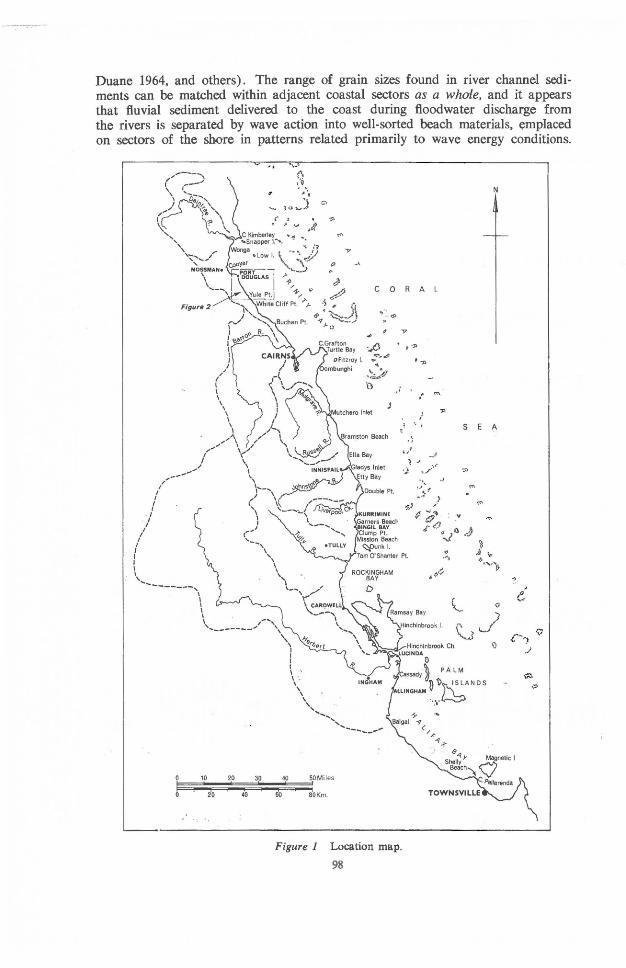
Duane 1964, and others). The range of grain sizes found in river channel sedi-ments can be matched within adjacent coastal sectors as a whole, and it appears that fluvial sediment delivered to the coast during floodwater discharge from the rivers is separated by wave action into well-sorted beach materials. ~mplaced on sectors of the shore in patterns related primarily to wave energy conditions.
o ,9 '. '\ G> ~ fJ. 1:..0-,,7
\':(' / \i ~4 C Kimberley ~ .. ~ '-Snapper I........ .. ... : i"1
Wonga • Low I. ~ -. ' , ~J
, ,
\,,'"~ 4f\ ,
, '\
I I I I \ \ . , ,
\ \
" ... , ... ,
10 20 3p 40 50Miles
~~~~~~: 20 40 60 80 Kill .
c 0
f~ ~_ (j) , "
'4() QI>~',e!i
" .. ~~/l
J
N
R A L
)7
, ."
l m '
" • SEA ..
"
LUCINDA
...... !
o
)
~J Q
cassadY'~ PAL M ~ 1) ISLANDS
"LLINGHAM., •• ~ , t
' .... _-.... _-,,.
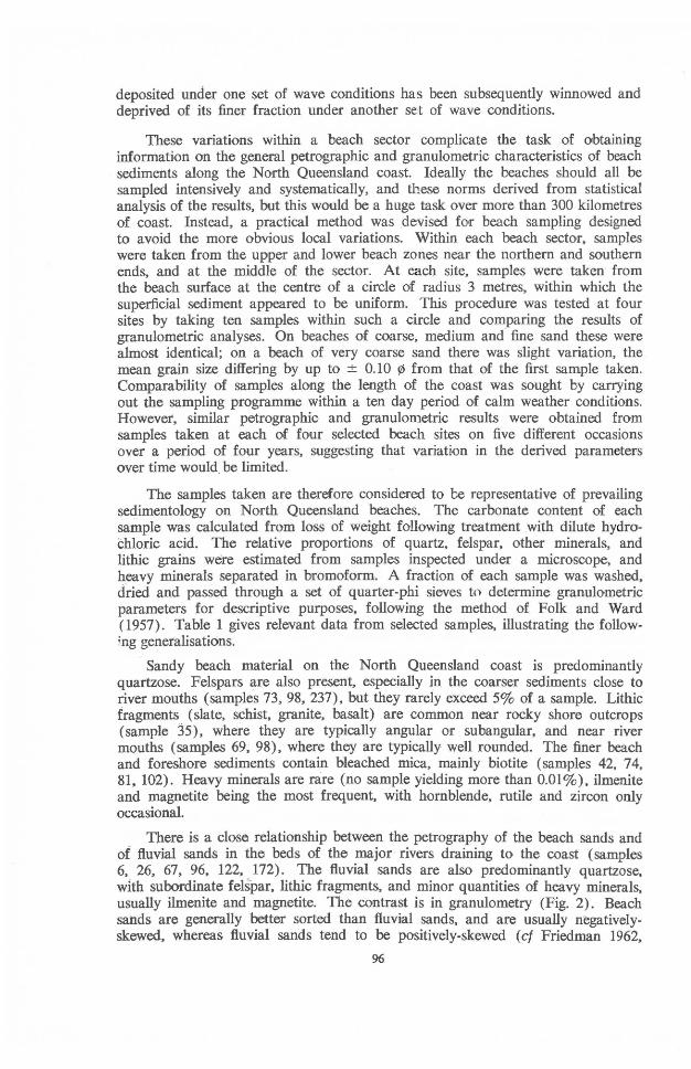
Figure 1 Location map. 98
.. i
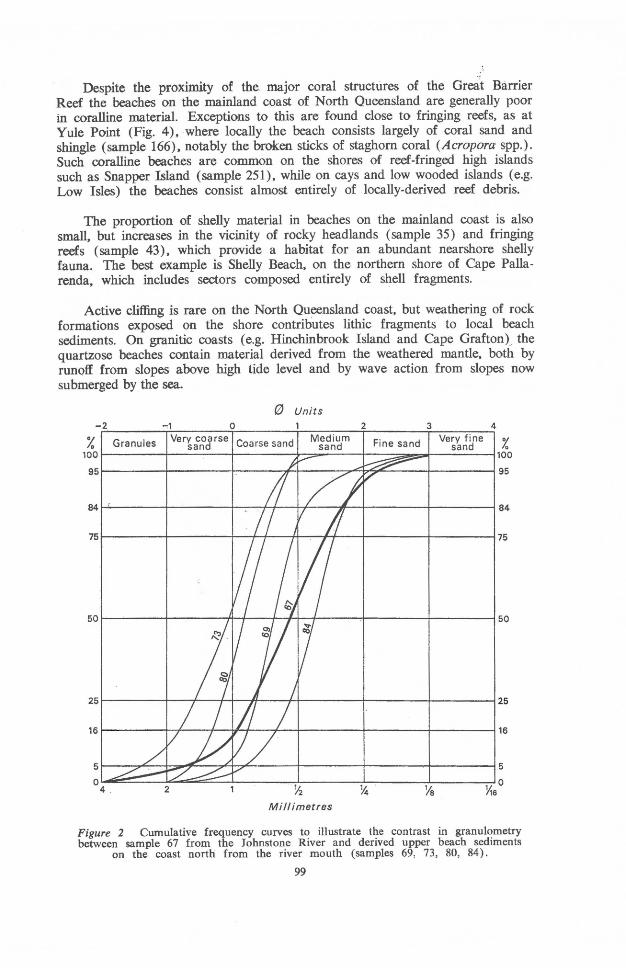
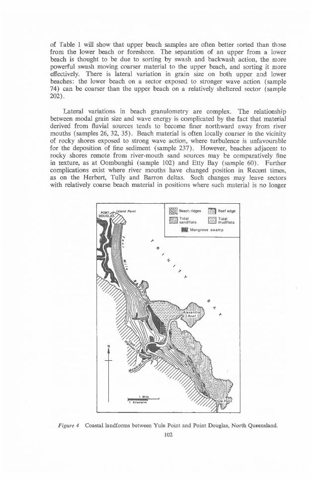
Despite the proximity of the major coral structllres of the Great Barrier Reef the beaches on the mainland cO'ast of North Queensland are generally poor in coralline material. Exceptions to this are found close to fringing reefs, as at Yule Point (Fig. 4), where locally the beach consists largely of coral sand and shingle (sample 166), notably the broken sticks of staghorn coral (Acropora spp.). Such coralline beaches are common on the shores of reef-fringed high islands such as Snapper Island (sample 251), while on cays and low wooded islands (e.g. Low Isles) the beaches consist almost entirely of locally-derived reef debris.
The proportion of shelly material in beaches on the mainland coast is also small, but increases in the vicinity of rocky headlands (sample 35) and fringing reefs (sample 43), which provide a habitat for an abundant nearshore shelly fauna. The best example is Shelly Beach, on the northern shore of Cape Palla-renda, which includes sectors composed entirely of shell fragments.
Active cliffing is rare on the North Queensland coast, but weathering of rock formations exposed O'n the shore contributes lithic fragments to local beach sediments. On granitic coasts (e.g. Hinchinbrook Island and Cape Grafton}. the quartzose beaches contain material derived from the weathered mantle. both by runo·if from slopes above high tide level and by wave action from slopes now submerged bY,the sea.
eJ Units -2 o 2 3 4
% Granules Ver~i~Jrse Coarse sand M~~~~m Fine sand ve~~~~ne % 1oor----------II---~---~---------~~~~~_t~~~~r_~~~~100
95 95
84~---------~~------~-----~---~~--~_+------------~---------~B4
75r-----------r---------~~~+_---A_~~---_+------------+_---------~75
50r----------~---------~~---~~+_~------_+----------~---------~50
25 25
16 16
5 5
0 Y, 0 4 . 2 ' ~ % Ye 16
Millimetres
Figure 2 Cumulative frequency curves to illustrate the contrast in granulometry between sample 67 from the Johnstone River and derived upper beach sediments
on the coast north from the river mouth (samples 69, 73, 80, 84).
99
The richest variety of beach material is Dn':Garners Beach (samples 41, 42, 43), which in addition to. quartz-felspar sand has coralline and shelly material from an adjacent reef, lithic fragments from local rock outcrops, particles of disintegrated beach rock, ferruginous sandrock derived from nearby outcrops of Pleistocene barrier sands, and micaceous sand and mud amid sparse mangroves on the foreshore. This is exceptional. In general, the sedimentological evidence supports the geomorphoJogical conclusion that the beaches of North Queensland have been mainly derived from sediment supplied to the coast by rivers (Bird 1969, Bird & Hopley, 1969).
Emplacement of beach materials
The major rivers draining to the North Queensland coast (Daintree, BarrOon, Mulgrave, Russell, Johnstone, Tully, and Herbert) all have sandy material in their channels, derived largely from erosion of weathering mantles of granitic and arenaceous rock outcrops in their headwater regions. During the floods which follow episodes of heavy rainfall, mainly in the wet summer season, quantities of fluvial sediment are washed down to the mouths of these rivers, and into the sea. As the floods subside, this material is reworked, sorted, and distributed by wave actiOon. Much of the sandy fraction is delivered to beaches., but the silt and clay also delivered by these rivers remains longer in suspension, and is more
~2
Granules
-1 o o units
1
Very coarse Coarse sand sand Medium
sand
2 3 4 Fine sand Very fine 0/
0 sand ID
'====l====l====t====t=:~~~~~=jJOO ~ 95
~-------r------~~------+-------~~~-H~+-------~84
~-------r------~--------~--~'4-+~~~--+_------~75
~-------r------~--~----+----~--++~~----+-------~50
r-----~~--------~----------~--~--~~------+_------~25
r---~---r------~--------+---7;r---+f+H-------+-------~16
r,,-------r------~--~~~+----~~~--------+_------~5
~------~--==~~~------~~~--~------~L-----__ ~O 2 ~ Ye Y1s
Millimetres
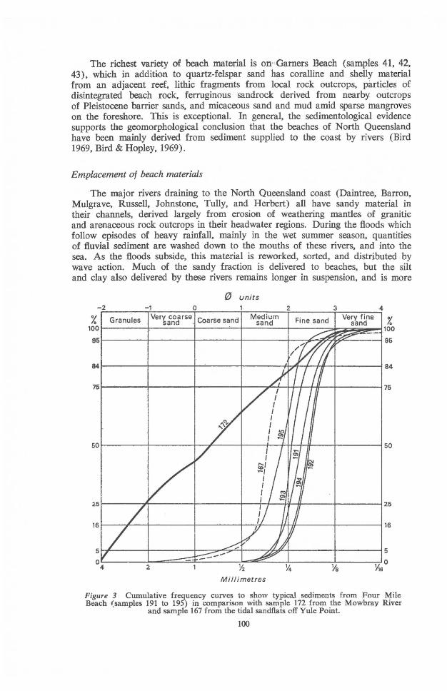
Figure 3 Cumulative frequency curves to show typical sediments from Four Mile Beach (samples 191 to 195) in comparison with sample 172 from the Mowbray River
and sample 167 from the tidal sandflats off Yule Point.
100
widely dispersed. SDme of it is deposited on the foreshore on sheltered sectors of the cO'ast, often as mudflats colonised by mangrQlves, but much of it Comes to rest eventually on the sea floDr in a zone of fine-grained sediment lying between the coarser shore sediments and the outlying reefs and associated cO'ralline material (Maxwe1l1968, Maxwell & Swinchatt 1970).
The dominant waves in coastal waters are generated by the prevailing south-easterly winds. At LDW Isles, for example, winds from the south-eastern quadrant represent 73.6% Df all winds recorded .over the years 1957-61 . The result is that waves tend to mDve beach material nDrthwards alDng east-facing sectors of the coast, so that beaches of fluvially-derived sand extend nO'rth from each of th~ major river mouths. The Johnstone, for example, has delivered sand to Gladys Inlet, and this has been spread northwards alDng the coast from Flying Fish Point to nourish the extensive beach system in Ella Bay, whereas the coast south of Gladys Inlet remains rocky, with very little beach development.
The predominant northward drifting diminishes in the lee of headlands, islands or fringing reefs, which partly or wholly exclude the south-easterly waves from shore sectors. Within such sectors the less frequent waves from northerly or north-easterly directions may become dominant, reversing the pattern of drifting. This has been shDwn in the Cairns district, in the lee of Cape Grafton peninsula, where the sand yield from the Barron River is moved southwards by wave action. At stages when the Barron opened farther ncrth, cn the cDastal sectDr more expcsed to' south-easterly wave acticn, its sandy yield was carried nO'rthward along the shore and delivered tD the beaches bordering Trinity Bay (Bird 1969, 1971a). The presence Df very coarse quartzose sand on the shores Df Rockingham Bay south of the Tully River at Cardwell (sample 25) may be related to' the similar exc1usion of sO'uth-easterly wave actiDn by Hinchinbreok Island, enabling fluvial sand to drift southwards here. The Daintree, which delivers sand to' the nO'rthern part of Trinity Bay, opens to a sector cf the coast which has been built up by sandy depesition along a shoreline orthogonal to' the south-easterly waves, which here have a fetch Df more than 80 kilometres. The Daintree mO'uth lies in the 'shadDw' of LDW Isles to' the south-east, and is now deflected southwards by a sand spit. Sand delivered to' the coast by the Daintree has mO'ved southwards rather than northwards, because wave refractiDn areund Snapper Island and the prevalence of a current frDm the north-east thrO'ugh the intervening Penguin Channel have impeded nO'rthward movement of sand towards Cape Kimberley;
The Great Barrier Reef does nDt completely exclude ocean waves from these coastal waters. Swell enters through gaps in the Reef such as Trinity Opening, north of Cairns, and reaches sectors of the mainland coast, albeit in a fDrm much attenuated by wave refraction. Waves from this SDurce can be detected on calm days meving in to the coast between Buchan PDint and Yule PQlint, and they are responsible for the gently-curved sandy shDreline at Hartley's Beach, just south of White Cliff Point. Arriving frDm the nerth-east, they contribute to the southward drifting of beach material already mentioned on the Barron delta shoreline, leading to the rapidly-growing spit at Casuarina Point (Bird 1971a).
LOCAL VARIATIONS
Mention has been made of the local variaticns encountered within beach sectO'rs on the North Queensland coast. A full analysis of these is beyend the scepe of the present paper, but certain relationships may be noted. Inspection
101
of Table 1 will show that upper beach samples are often better sorted than those from the lower beach or- foreshore. The separation of an upper from a lower beach is thought to be due to sorting by swash and backwash action, the more powerful swash moving coarser material to the upper beach, and sorting it mo're effectively. There is lateral variation in grain size on both upper and lower beaches: the lower beach on a sector exposed to stronger wave action (sample 74) can be coarser than the upper beach on a relatively sheltered sector- (sample 202).
Lateral variations in beach granulometry are complex. The relationship between modal grain size and wave energy is complicated by the fact that material derived from fluvial sources tends to become finer northward away from river mouths (samples 26, 32, 35). Beach material is .often locally coarser in the vicinity of rocky shor-es exposed to strong wave action, where turbulence is unfavourable for the deposition of fine sediment (sample 237). However, beaches adjacent to rocky shores remote from river-mouth sand sources may be comparatively fine in texture, as at Oombunghi (sample 102) and Etty Bay (sample 60). Further complications exist where river mouths have changed position in Recent times, as on the Herbert, Tully and Barron deltas. Such changes may leave sectors with relatively coarse beach material in positions where such material is no longer
~ Beach ridges IlTITI Reef edge
ruBJ !~~~Iflats ~ ~e~~lats 11 Mangrove swamp
/
/
N
1 Mile I I
1 Kilometre
Figure 4 Coastallandforms between Yule Point and Point Douglas, North Queensland.
102
being supplied. The curious transition from fine to coarse upper beach sand southward along the shore of Rockingham Bay near Cardwell (samples 24, 25) may be explicable in terms of changes in the position of outflow from the Tully.
In general there is less variation in petrography than in granulometry along the North Queensland beaches. It was noted however that felspars tend to be commoner in the coarser beach sands, and that mica and heavy minerals are more abundant in the finer shore sediments. With the exception of slate fragments, lithic grains are also commoner in the coarser beach sands.
In analysing and attempting to explain variations in petrography and granulo-metry of beach sediments on the North Queensland coast, certain sectors stand out as anomalies. Prominent among these is Four Mile Beach, near Port Douglas (Fig. 4). The fact that this is the only beach in North Queensland along which one can easily drive an ordinary car is an indication of its unusual morphological and sedimentologicaJ features.
Four Mile Beach
The beach extends southwards from the rocky headland at Island Point and curves out to a cuspate foreland in the lee of a fringing coral reef before passing behind mangroves at the mouth of a tidal creek. Farther south, the coast has an extensive fringe of mangroves on either side of the estuary of Mowbray River, which opens to the sea by way of a channel flanked by coral reefs. The mangroves front a sandy beach ridge system which continues south-eastward to Yule POlint, another rocky headland. An account has already been given of the fringing reefs near Yule Point (Bird 1971b). They originated as nearshore reefs which became attached to the mainland as the result of progradation of the depositional shoreline, with the formation of sandy beach ridges and mangrove swamps. The reefs have grown seaward on either side of the Mowbray outflow, and the pattern of their growth has, in turn, influenced the configuration of the prograding shore-line.
Four Mile Beach is also backed by sand ridges parallel to the shoreline. These developed as beach ridges, emplaced by wave action, and surmounted by dunes up to 3 metres high. Island Point has been tied to the mainland by this sandy barrier, and thus constitutes a tombolo. On its landward side is an extensi,ve mangrove-fringed tidal creek system opening northward into MOlssman Bay.
Port Douglas has a mean spring tide range of 1 ~8 metres (Admiralty Tide Tables 1971). Four Mile Beach is up to 100 metres wide at low spring tides, and thus has an average transverse gradient of about 1 in 55, a little over 10. The profile steepens slightly towards the rear of the beach, approaching the first foredune, but this distinction between an upper and lower beach is barely per-ceptible, except near the southern end where coarser material is present as an upper beach and the foreshore becomes. muddy.
Four Mile Beach is thus a remarkably uniform sand deposit (Fig. 3). It consists of fine pale grey quartzose sand, very well sorted (sample 191), firmly packed and thus readily trafficable, especially on the damp zone exposed at low tide (cf. Krumbein 1959). The chief petrographic variation is in the proportion of
103
carbonate sand derived from shells and coral. which increases towards the northern and southern ends of the beach (samples 194, 195), where these organisms are abundant in coastal waters.
Four Mile Beach thus differs from other beaches on the North Queensland coast in being relatively uniform, firmly-packed sand, and in its pale grey colour, the sand grains being bereft of the yellow-brown iron oxide staining characteristic of most North Queensland beach sands. It is rarely subject to strong wave action, partly because the extensive reefs near Yule Point shelter. it from the direct, impact of south-easterly waves, and partly because the offshore prO'file is very gentle: at low spring tides the water a kilometre offshore is barely 3 metres deep.
The parallel ridges behind Four Mile Beach represent a Holocene sand accumulation, for they overlap a coral reef which has yielded a radiocarbon age of 4130 ± 110 years B.P. (Bird 1971c). The older ridges, exposed in sections on the north bank of the Mowbray River downstream from the Cook Highway bridge, include coarse sand and gravel of the type carried by the Mowbray (sample 172) but the younger ridges to seaward consist entirely of sand (sample 193). This transitiO'n indicates a change in the nature of sediment delivered to the pro grading shoreline. Fluvial sand and gravel supplied by the Mowbray is now channelled out to the sea floor off Alexandra Reef, and is no longer supplied to adjacent beaches. Another source of beach material has been the quartzose and coralline sediment O'n the tidal sandflats at Yule Point (samples 166, 167). This is drifting northwards, and may formerly have reached Four Mile Beach, but under existing conditions it is intercepted and carried seaward in the outflow channel from the Mowbray (Fig. 4).
It is therefore suggested that Four Mile Beach has become largely a relict beach, cut off from former fluvial and longshore sand supply, and now receiving only fine-grained biogenic material. Repeated reworking of a beach sand in such a situation has led to its becoming very well sorted and relatively uniform, to the loss of iron oxide coatings on the sand grains, and to a reduction in felspar content. In these terms, Four Mile Beach is attaining sedimentological maturity in the sense defined by Pettijohn (1949); it stands in contrast with the immaturity of actively-nourished beaches on other parts of the North Queensland coast.
ACKNOWLEDGEMENTS
I am grateful to Graham Walshaw for assistance with the anaysis of sediments and to Dr A . . W. Beasley for commenting on the mineral content of beach samples. The paper includes the results of work supported by A. R. G. C. Grant 67/16405.
104
REFERENCES
Bird, E. C. F., 1969: The deltaic shoreline near Cairns, Queensland. Australian Geographer 11 (2); pp. 138-47.
-----, 1971a: Coastal evolution in the Cairns district. Australian Geographer 11 (3) : pp. 327-35.
-----, 1971b: The fringing reefs near Yule Point, North Queensland. Australian Geogr. Studies 9: pp. 107-15.
-----, 1971c: Holocene shore features at Trinity Bay, North Queensland. Search 2(1): pp. 27-28.
Bird, E. C. F., and Hopley, D., 1969: Geomorphologica1 features on a humid tropical sector of the Australian coast. Australian Geogr. Studies 7: pp. 89-108
Duane, D. B., 1964: Significance of skewness in recent sediments, Western Pamlico Sound, North Carolina. !. Sedim. Petrol., 34: pp. 864-74.
Folk, R. L., and Ward, M. C., 1957: Brazos River bar: study of the significance of grain size parameters. !. Sedim. Petrol., 27: pp. 3-26.
Friedman, G. M., 1962: On sorting, sorting coefficients and the lognormality of grain-size distributions of sandstones. !. Geol., 70: pp. 737-53.
Krumbein, W. c., 1959: The 'sorting-out' of geological variables illustrated by regression analysis of factors controlling beach firmness. !. Sedim. Petrol., 29: pp. 575-87.
Maxwell, W. G. H., 1968: Atlas ot the Great Barrier Reef. Elsevier, Amsterdam.
Maxwell, W. G. H., and Swinchatt, I. P., 1970: Great Barrier Reef: regional variation in a terrigenous-carbonate province. Bull. Geol. Soc. America, 81: pp. 691-724.
Pettijohn, F. I., 1949: Sedimentary Rocks. New York.
105


![INTERPRETING SEDIMENTS WORKSHOP: GLACIAL SEDIMENTS … · [Image: Tim Cope] Northern Maine till. [Image: G. Larson] 8 . Michigan puddingstone. Precambrian in age. Origin is Lorrain](https://img.dokumen.tips/doc/110x75/6039828bd965dd5ad0512007/interpreting-sediments-workshop-glacial-sediments-image-tim-cope-northern-maine.jpg)